Ph ton 335 The Journal of Ecology. Photon 107 (2013) 335-348 https://sites.google.com/site/photonfoundationorganization/home/the-journal-of-ecology Original Research Article. ISJN: 6853-3275 The Journal of Ecology Ph ton Climate Change and Sustainable Livelihood Programmes: A case study from the Indian Sundarbans Atanu Kumar Raha a *, Sufia Zaman b , Kasturi Sengupta c , Subhra Bikash Bhattacharya d , Srilekha Raha a , Kakoli Banerjee e , Abhijit Mitra f a Department of Forest & Environmental Sciences, Techno India University, Saltlake Campus, Kolkata- 7000 091, West Bengal, India b Department of Science & Technology Scheme, Govt. of India, also attached to Department of Oceanography, Techno India University, Saltlake Campus, Kolkata- 7000 091, India c Department of Marine Science, University of Calcutta, 35 B.C. Road, Kolkata-700019, West Bengal, India d Central Institute of Brackish water, Aquaculture, Govt. of India, Kakdwip, South 24 Parganas, West Bengal, also attached to Department of Oceanography, Techno India University, Saltlake Campus, Kolkata- 7000 091, India e School of Biodiversity & Conservation of Natural Resources, Central University of Orissa, Landiguda, Koraput 76402, India f Department of Marine Science, University of Calcutta, 35 B.C. Road, Kolkata-700019, West Bengal India, also attached to Department of Oceanography, Techno India University, Saltlake Campus, Kolkata- 7000 091, India The authors receive Thomas Edison Award-2013 in Ecology for Inspiration and Knowledge Distribution among young research scholars. Article history: Received: 10 October, 2013 Accepted: 17 October, 2013 Available online: 23 November, 2013 Keywords: Sundarbans, Climate Change, Sea level, Mangrove, Eco- development, Forest Protection Committee, Adaptation, Mitigation, Biosphere Reserve, Sundarban tiger, JMM Corresponding Author: Raha A.K. Emeritus Professor Email: [email protected] Phone: +919830173802 Zaman S. Principal Email: [email protected] Phone: +919830501959 Sengupta K. Senior Research Scholar Email: [email protected] Phone: +919831413249 Bhattacharya S.B. Senior Scientist Email: [email protected] Phone: +919474399791 Raha S. Adjunct Assistant Professor Email: [email protected] Phone: +919831130528 Banerjee K. Assistant Professor Email: [email protected] Phone: +919439185655 Fax No: +916852288255 Mitraf A. Associate Professor Email: [email protected] Phone: +919831269550 Abstract The impact of global warming, through the predicted sea level rise, on Sundarbans estuary, in the Bay of Bengal is an inevitable phenomenon. While the mitigation measures have to be primarily at the global level as well as at local level, the adaptation strategy will also involve participation of global and local communities. This study has clearly shown that the people living around the mangrove forests have to be provided with a sustainable alternate livelihood to cope with the increasing salinity in the region. As regards the destructive livelihood activities practiced by the villagers of Sundarbans, generating employment through other livelihood options and training in skill development have to be resorted to. However, all these socio-economic activities need huge amount of fund support at the beginning. Since Sundarbans mangrove, if properly conserved, can store billions of tonnes of carbon thus mitigating the effect of global warming, the people of the region also need to be duly compensated under REDD+ projects. The study has shown the prospect of conservation of Sundarbans mangrove flora and fauna through active participation of local people. The global community cannot avoid their commitment for conserving one of the largest sink for atmospheric carbon. Citation: Raha A.K., Zaman S., Sengupta K., Bhattacharya S.B., Raha S., Banerjee K., Mitraf A., 2013. Climate Change and Sustainable Livelihood Programmes: A case study from the Indian Sundarbans. The Journal of Ecology. Photon 107, 335-348.

Welcome message from author
This document is posted to help you gain knowledge. Please leave a comment to let me know what you think about it! Share it to your friends and learn new things together.
Transcript

Ph ton 335
The Journal of Ecology. Photon 107 (2013) 335-348 https://sites.google.com/site/photonfoundationorganization/home/the-journal-of-ecology Original Research Article. ISJN: 6853-3275
The Journal of Ecology Ph ton Climate Change and Sustainable Livelihood Programmes: A case study from the Indian Sundarbans Atanu Kumar Rahaa*, Sufia Zamanb, Kasturi Senguptac, Subhra Bikash Bhattacharyad, Srilekha Rahaa, Kakoli Banerjeee, Abhijit Mitraf a Department of Forest & Environmental Sciences, Techno India University, Saltlake Campus, Kolkata- 7000 091, West Bengal, India b Department of Science & Technology Scheme, Govt. of India, also attached to Department of Oceanography, Techno India University, Saltlake Campus, Kolkata- 7000 091, India c Department of Marine Science, University of Calcutta, 35 B.C. Road, Kolkata-700019, West Bengal, India d Central Institute of Brackish water, Aquaculture, Govt. of India, Kakdwip, South 24 Parganas, West Bengal, also attached to Department of Oceanography, Techno India University, Saltlake Campus, Kolkata- 7000 091, India e School of Biodiversity & Conservation of Natural Resources, Central University of Orissa, Landiguda, Koraput 76402, India f Department of Marine Science, University of Calcutta, 35 B.C. Road, Kolkata-700019, West Bengal India, also attached to Department of Oceanography, Techno India University, Saltlake Campus, Kolkata- 7000 091, India The authors receive Thomas Edison Award-2013 in Ecology for Inspiration and Knowledge Distribution among young research scholars. Article history: Received: 10 October, 2013 Accepted: 17 October, 2013 Available online: 23 November, 2013 Keywords: Sundarbans, Climate Change, Sea level, Mangrove, Eco-development, Forest Protection Committee, Adaptation, Mitigation, Biosphere Reserve, Sundarban tiger, JMM Corresponding Author: Raha A.K. Emeritus Professor Email: [email protected] Phone: +919830173802 Zaman S. Principal Email: [email protected] Phone: +919830501959 Sengupta K. Senior Research Scholar Email: [email protected] Phone: +919831413249 Bhattacharya S.B. Senior Scientist Email: [email protected] Phone: +919474399791 Raha S. Adjunct Assistant Professor Email: [email protected] Phone: +919831130528 Banerjee K. Assistant Professor Email: [email protected] Phone: +919439185655 Fax No: +916852288255
Mitraf A. Associate Professor Email: [email protected] Phone: +919831269550 Abstract The impact of global warming, through the predicted sea level rise, on Sundarbans estuary, in the Bay of Bengal is an inevitable phenomenon. While the mitigation measures have to be primarily at the global level as well as at local level, the adaptation strategy will also involve participation of global and local communities. This study has clearly shown that the people living around the mangrove forests have to be provided with a sustainable alternate livelihood to cope with the increasing salinity in the region. As regards the destructive livelihood activities practiced by the villagers of Sundarbans, generating employment through other livelihood options and training in skill development have to be resorted to. However, all these socio-economic activities need huge amount of fund support at the beginning. Since Sundarbans mangrove, if properly conserved, can store billions of tonnes of carbon thus mitigating the effect of global warming, the people of the region also need to be duly compensated under REDD+ projects. The study has shown the prospect of conservation of Sundarbans mangrove flora and fauna through active participation of local people. The global community cannot avoid their commitment for conserving one of the largest sink for atmospheric carbon. Citation: Raha A.K., Zaman S., Sengupta K., Bhattacharya S.B., Raha S., Banerjee K., Mitraf A., 2013. Climate Change and Sustainable Livelihood Programmes: A case study from the Indian Sundarbans. The Journal of Ecology. Photon 107, 335-348.

Ph ton 336
1. Introduction
The Sundarban deltaic complex in India is located between 21°13′N and 22°40′N latitude and 88°03′E and 89°07′E longitude (Figs. 3 and 4). It is bounded by the river Hooghly on the west, Ichamati-Kalindi-Raimangal on the east, Dampier-Hodges line on the north and the Bay of Bengal on the south. The Sundarban mangrove ecosystem covering about one million ha in the deltaic complex of the Rivers Ganga, Brahmaputra and Meghna is shared between Bangladesh (62%) and India (38%) and is the world’s largest coastal wetland. Enormous load of sediments carried by the rivers contribute to its expansion and dynamics. The Indian Sundarbans (between 21013'N and 22040' N latitude and 88003'E and 89007'E longitude) is bordered by Bangladesh in the east, the Hooghly River (a continuation of the River Ganga) in the west, the Dampier and Hodges line in the north, and the Bay of Bengal in the south. The total area of Indian Sundarbans region is about 9630 sq. km., out of which the Reserve Forest occupies nearly 4260 sq. km. At present, out of 108 islands of the Sundarbans region, 54 are inhabited with a population of about 4.5 million (2011 census), spread over 1093 mouzas (parcels of land). The region is spread over two administrative districts, namely South 24-Parganas (13 blocks) and North 24-Parganas (6 blocks) (Chaudhuri, and Choudhury, 1994). 1.1 Past history and management There has been premature reclamation of mangrove forest land in the region from 1883 onwards, with more than 3500 km. of earthen embankments protecting the settlements in the region. Most of the reclaimed areas, guarded by the embankments, are lying at lower depth than the riverbeds. The aquifer of potable water lies at a depth of about 350 m from the ground level (Working Plan Division, West Bengal 1949-50). . 1.2 Geology and geography of Sundarbans Two great rivers, the Ganges and Brahmaputra meet the Bay of Bengal along India and Bangladesh to form an intertidal zone, developed by the accretion of alluvium deposited by these rich systems, covering an area of nearly 26000 sq. km., which is known as the Sundarbans (Figs. 3 and 4). The area contains a rich intertidal mangrove forest which provides appropriate habitat and sanctuary to many rare and endangered animals including about 500 to 600 Royal Bengal Tigers.
The Indian part of this Sundarban region covers an area of 9630 sq. km., which is bounded in the north by an imaginary line, called Dampier-Hodges line (which runs continuously from Kakdwip in the west to Basirhat in the east), the south by Bay of Bengal, the east by Ichamati-Kalindi-Raimangal rivers and in the west by river Hooghly. It falls within two district of 24-Parganas North and South, in the State of West Bengal and consists of an expanse of low flat islands and mud banks separated by a network of anastomotic tidal channels and rivers. This ramified riverine system has carved out about 102 small islands harboring different habitat conditions, which has encouraged establishment and growth of mangrove forests of a very rich bio-diversity and displaying multiple associations and zonations. Initially the whole of this Sundarbans region was under mangrove forest. Its history is a continuous process of reclamation of mangrove forests for agriculture and settlement. Reclamation started during the 18th century (Working Plan Division, West Bengal 1949-50; Chaudhuri and Choudhury, 1994). Sundarban estuary is still in the process of formation. As per the natural process, silt carried from the catchment of the rivers, draining into the estuary, get deposited and the islands are built up. Simultaneously, because of tidal waves and oceanic current, shape of the islands keeps on changing and accretion/ erosion go hand-in-hand. The effect of high tide causes the water level in the tidal rivers rise as high as 12 ft – 15 ft every six hours and large parts of the islands containing mangrove forest get inundated. Species like Avicennia sp and Ceriops sp, which tolerate prolonged water logging and high degree of salinity, come up naturally in such inter-tidal mud flats. A study of island formation process for two southernmost islands of Jambudwip and Thakuran Char, over a period of more than 20 years, using the satellite imageries, shows that while the elongated shape of the former has changed into Bell-shape, the latter has grown from below the low-tide level to an island of more than 3 sq. km. Similarly, large char land have come up in the coastal regions near Kalas, Chaimari and Baghmara under

Ph ton 337
Sundarban Tiger Reserve, while erosion of river banks / coastal region has taken place in Goasaba Blocks of STR and Sagar island of 24 Parganas (South) Forest Division. Many small islands like New Char, Haribhanga etc. have come up within/ just outside the estuary over last few decades (Raha et al., 2002). 1.3 Human habitation Out of the 102 islands in Sundarban region, 48 islands in southern-most region are declared as Reserve Forest and is out of bounds for human settlement. In the rest 54 islands, settlements were established by the British Rulers, by cutting down mangrove forests as early as in the late eighteenth century. These islands are now densely populated with a population of 4.5 million (2011 census), and there are 3500 km long embankment, all around these islands, to prevent entry of saline water into the villages during high tide. As a result, while the natural island formation process is continuing un-hindered in the forested islands, the silt-load from the fresh water river cannot get deposited on the inhabited islands due the embankment and the same are deposited on the river bed thus gradually raising the river beds even above the village ground level. If, therefore, there is a breach in embankment, the saline tidal water will inundate the villages and won’t be able to come out even during low tide. 1.4 Importance of Sundarban estuary International status of Sundarbans is evident from the laurels it has acquired from the national and international communities (i) Sundarban National Park in India is a World Heritage Site which is well protected by Reserved Forest as Buffer all around. (ii) Sundarban region in India is a Global Biosphere Reserve, recognised by UNESCO in 2001 (iii) Indian Sundarbans is proposed for inclusion as Ramsar Site, i.e wetland of international importance. (iv) Sundarban Tiger Reserve in India is part of Project Tiger of Govt. of India. The ecological and socio-economic importances of Sundarban Forest are highlighted below: • Sundarban is the only mangrove forest of the world having largest floral and faunal diversity • It is the only mangrove forest having a Tiger population • It supports the single largest tiger population in the country • It is the home of several endangered, threatened and endemic floral and faunal species
• A few million people depend on the mangrove forest for livelihood • Sundarban mangrove acts as a large, natural fish nursery and supports coastal fisheries along Bay of Bengal and Indian Ocean • Sundarban forest acts as a sink for the pollutants from mega-metropolitan city of Kolkata • The mangrove forest provides protection to inland habitations against the periodic fury of cyclones 2. Objective of Research The primary objective of this case study is to highlight the biodiversity, stress and management of the resources of Sundarban in the scenario of changing climate. Another objective of this study is to focus on sustainable development of livelihood for the long term benefit of the island dwellers. 2.1 Flora and Fauna 2.1.1 Floral Diversity of Sundarban Mangroves According to Champion & Seth classification, the Sundarbans forest falls under the sub group 4B tidal swamp forest, with sub-divisions namely, Mangrove type 4B/TS1, 4B/TS2, Salt water type mixed forests 4B/TS3, Brackish type 4B/TS4 and Palm type 4B/E1. In general, the northern boundary and new depositions are characterized by Baen (Avicennia marina, A. alba, A. officinalis) flanked by foreshore grassland of Oryza coarctata (Dhani grass). Baen is gradually replaced by Genwa (Excoecaria agallocha) and then Goran (Ceriops spp.). The southern and eastern associates include Garjan (Rhizophora spp.), Kankra (Bruguiera spp.), and few patches of Sundari (Heritiera fomes). Pure Hental (Phoenix spp.) forest exists in relatively high land and compact soil. Dhundul (Xylocarpus granatum), Passur (Xylocarpus mekongensis) and Nypa sp (Golpata) palm swamps are extremely limited in existent. • True Mangrove species = 26 • Mangrove associates = 29 • Back mangrove species= 29 • Family = 40 Genera = 60 • Total Species = 84 2.2 Mangrove and aquatic Fauna 2.2.1 History of Faunal Changes over the last two centuries According to Hunter’s Statistical Account of Sundarban, written in 1878, “Tigers, leopards, rhinoceros, wild buffaloes, wild hogs, wild cats, barasinga, spotted deer, hog deer, barking
Ph ton 338
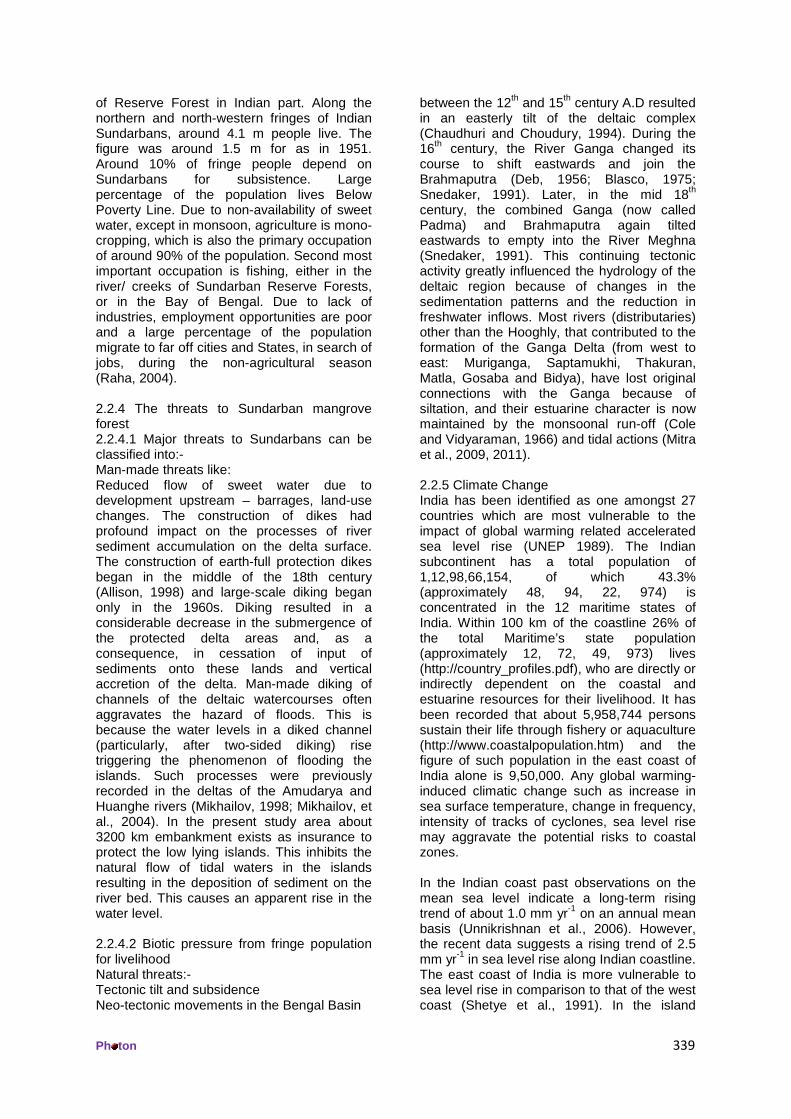
deer, and monkeys are the principal varieties of wild animals found in Sundarbans”. However, over the last 100 years or so, due to habitat degradation and ecological changes, the faunal compositions in Indian Sundarbans have undergone sea changes. Some of these animals in Sundarbans which became extinct during the last two centuries are Javan Rhino, wild buffalo, swamp deer and barking deer. 2.2.2 Present status of faunal resources Sundarban mangrove forest is the single largest home of the Royal Bengal Tiger. Sundarban is also the only mangrove forest in the world having the tiger as its indigenous population. As per the latest estimation made through Camera Trap experiment, the tiger population in Indian Sundarbans is more than 105, out of which Sundarban Tiger Reserve has at least 82 tigers and South 24-Parganas Forest Division has at least 23 tigers. There are 15 species of mammals, 8 species of birds and 17 species of reptiles, which are included in the Schedules I & II of Wildlife (Protection) Act, 1972. Total no. of species, included in Appendix I of CITES Regulation, are 14. Sundarban also harbors a good number of rare and globally threatened animals including Estuarine Crocodile (Crocodilus porosus), Fishing Cat (Felis viverrina Bennett), Salvatore Lizard / Water Monitor (Varanus salvator), Gangetic Dolphin (Platinista gangetica), River Terrapin (Batagur Baska), marine turtles like Olive Ridley (Lepidochelys olivacea), Ground Turtle, Hawksbill Turtle and King Crab (Horse Shoe). These indicate that Sundarbans Reserve Forest is a natural biodiversity hot spot. The forest floor is the domain of the Royal Bengal Tiger (Panthera tigris). Among other mammals, ground fauna comprises of wild boars, spotted deer, porcupines, otter and monkeys. Among the reptiles, the king cobra, the common cobra, banded krait, Russells Viper comprise the community of venomous reptiles, while the Python, Chequered Kil-Back, Dhaman, Green Whip Snake and several other species constitute the non-venomous snakes. The tidal creeks harbour Homalopsid snakes adapted to living in water, the common being the Cereberus rhynchops. The lizards are mainly Varanus salvator which is a rare monitor, attaining about 2.4 mt in length. The sea-facing beach of the Reserve Forest forms the nesting ground for Olive Ridley Turtles (Lepidochelys olivacea). The water monitors along with wild pigs, terns and sea gulls are the greatest predators of their
eggs and hatchlings. The endangered River Terrapin (Batagur baska) also uses the beaches as their nesting ground. Avifauna: The birds are in plenty including a large number of migrants from the higher latitudes that visit the area in winter. It consists of herons, egrets, cormorants, storks, green pigeons, sand pipers, large and small spoonbills, darters, seagulls, teal, partridges and a great variety of wild geese and ducks. The cetaceans like Gangetic Dolphin (Platinista gangetica) are frequently found in the eastern side, particularly in the Raimangal River. The Black Finless Porpoise (Necmeris porosus) is also found in the rivers near the estuary. The marshes and river offer asylum to the Estuarine Crocodile, one of the most endangered and the largest of crocodiles. A wide variety and assortments of fish, molluscs, crabs and prawns inhabit the estuaries. The amphibious mud-skipper fish such as Peripthalmus and Boleopthalmus arouse considerable interest. Also found are Whale Shark, Tiger Shark, Hammer Headed Shark, saw fish, Guitar Fish and some common edible fish e.g., Hilsa ilisha, Setipinna breviceps, S. taty, Gudusia chapra etc. Among the crustaceans, commonly found are the One Armed Fiddler Crab (Uca sp) and the two species of trilobite (Tachepleursgygus and Carcinoscropius rotundicauda). The latter is also known as the Horse Shoe Crab, which are living fossils and now protected owing to its medicinal value. Insects abound in the forests amongst which the honey bee (Apis dorsata) is a source of considerable income for the poor fringe people. Faunal Diversity of Sundarbans at a glance Total No of Species = 1586 Vertebrate Spp = 481 Hemichordate Spp = 1 Invertebrate Spp = 1104 Protozoan species = 106 Species included in Schedule I & II of Wildlife Protection Act, 1972 Mammals = 1 Birds = 8 Reptiles = 17 Total number of species included in Appendix I of CITES Regulation = 14 2.2.3 People around Sundarbans forest 2.2.3.1 Socio-economic status of fringe population There is no human habitation in 4260 sq. km
Ph ton 339
of Reserve Forest in Indian part. Along the northern and north-western fringes of Indian Sundarbans, around 4.1 m people live. The figure was around 1.5 m for as in 1951. Around 10% of fringe people depend on Sundarbans for subsistence. Large percentage of the population lives Below Poverty Line. Due to non-availability of sweet water, except in monsoon, agriculture is mono-cropping, which is also the primary occupation of around 90% of the population. Second most important occupation is fishing, either in the river/ creeks of Sundarban Reserve Forests, or in the Bay of Bengal. Due to lack of industries, employment opportunities are poor and a large percentage of the population migrate to far off cities and States, in search of jobs, during the non-agricultural season (Raha, 2004). 2.2.4 The threats to Sundarban mangrove forest 2.2.4.1 Major threats to Sundarbans can be classified into:- Man-made threats like: Reduced flow of sweet water due to development upstream – barrages, land-use changes. The construction of dikes had profound impact on the processes of river sediment accumulation on the delta surface. The construction of earth-full protection dikes began in the middle of the 18th century (Allison, 1998) and large-scale diking began only in the 1960s. Diking resulted in a considerable decrease in the submergence of the protected delta areas and, as a consequence, in cessation of input of sediments onto these lands and vertical accretion of the delta. Man-made diking of channels of the deltaic watercourses often aggravates the hazard of floods. This is because the water levels in a diked channel (particularly, after two-sided diking) rise triggering the phenomenon of flooding the islands. Such processes were previously recorded in the deltas of the Amudarya and Huanghe rivers (Mikhailov, 1998; Mikhailov, et al., 2004). In the present study area about 3200 km embankment exists as insurance to protect the low lying islands. This inhibits the natural flow of tidal waters in the islands resulting in the deposition of sediment on the river bed. This causes an apparent rise in the water level. 2.2.4.2 Biotic pressure from fringe population for livelihood Natural threats:- Tectonic tilt and subsidence Neo-tectonic movements in the Bengal Basin
between the 12th and 15th century A.D resulted in an easterly tilt of the deltaic complex (Chaudhuri and Choudury, 1994). During the 16th century, the River Ganga changed its course to shift eastwards and join the Brahmaputra (Deb, 1956; Blasco, 1975; Snedaker, 1991). Later, in the mid 18th century, the combined Ganga (now called Padma) and Brahmaputra again tilted eastwards to empty into the River Meghna (Snedaker, 1991). This continuing tectonic activity greatly influenced the hydrology of the deltaic region because of changes in the sedimentation patterns and the reduction in freshwater inflows. Most rivers (distributaries) other than the Hooghly, that contributed to the formation of the Ganga Delta (from west to east: Muriganga, Saptamukhi, Thakuran, Matla, Gosaba and Bidya), have lost original connections with the Ganga because of siltation, and their estuarine character is now maintained by the monsoonal run-off (Cole and Vidyaraman, 1966) and tidal actions (Mitra et al., 2009, 2011). 2.2.5 Climate Change India has been identified as one amongst 27 countries which are most vulnerable to the impact of global warming related accelerated sea level rise (UNEP 1989). The Indian subcontinent has a total population of 1,12,98,66,154, of which 43.3% (approximately 48, 94, 22, 974) is concentrated in the 12 maritime states of India. Within 100 km of the coastline 26% of the total Maritime’s state population (approximately 12, 72, 49, 973) lives (http://country_profiles.pdf), who are directly or indirectly dependent on the coastal and estuarine resources for their livelihood. It has been recorded that about 5,958,744 persons sustain their life through fishery or aquaculture (http://www.coastalpopulation.htm) and the figure of such population in the east coast of India alone is 9,50,000. Any global warming-induced climatic change such as increase in sea surface temperature, change in frequency, intensity of tracks of cyclones, sea level rise may aggravate the potential risks to coastal zones. In the Indian coast past observations on the mean sea level indicate a long-term rising trend of about 1.0 mm yr-1 on an annual mean basis (Unnikrishnan et al., 2006). However, the recent data suggests a rising trend of 2.5 mm yr-1 in sea level rise along Indian coastline. The east coast of India is more vulnerable to sea level rise in comparison to that of the west coast (Shetye et al., 1991). In the island

Ph ton 340
system of Indian Sundarban delta, some islands are fast vanishing from the map rendering thousands of people permanently homeless and displaced from their original habitat. The rate of relative sea level rise is presently approaching 3.14 mm per year near Sagar Island (88°03'06.17" longitude and 21°38'54.37" latitude), the largest island in the western sector of Indian Sundarbans and this could increase to 3.5 mm per year over the next few decades due to global warming, including the other global and local factors. The exact reason for sea level rise is not pinpointed in case of Indian Sundarbans (Mitra et al., 2009a), but for Bangladesh Sundarbans the dominant factors are the monsoonal rains and land subsidence (Singh, 2002). Slow tectonic sinking of the entire Bengal basin and rather intense land subsidence (more than 15 mm/years in some areas of the delta) caused by compaction of loose deltaic deposits often results in the depletion of the deposited sediment height (Hazra, 2002). The joint impact of the eustatic sea level and more intense subsidence of deltaic deposits results in the so-called relative sea level rise, which reaches 10-20 mm yr-1 in the seaward part of the delta of the Ganga and Brahmaputra rivers (Allison, 1998; Coleman, 1969). The relative sea level rise in deltaic Sundarbans is more intense than in some other large deltas of the world (1-5 mm yr-1 in the deltas of the Nile Delta, and up to 10 mm yr-1 in the Mississippi Delta) (Dowell and Rickards, 1993), which may be largely due to land subsidence. Continuous and long term data of land subsidence is however lacking for Bengal basin and hence its direct correlation with relative sea level rise is difficult to ascertain. 3. Effects of climate change Climate change is being experienced intensely in the mangrove dominated deltaic complex of Indian Sundarbans. Deglaciation of Gangotri glacier in the Himalayan range and several anthropogenic influences has accelerated the phenomenon since last two decades. Two important indicators namely surface water temperature and salinity considered in the present study exhibited significant correlations with climate change and caused considerable alteration of hydrological parameters over a period of 27 years. Owing to varied geographical features in the western and central sectors of the deltaic complex, the foot prints of climate change were perceived in different pattern and scale. The surface water temperature showed increasing trend in both sectors (6.14% and 6.12% rise in western and
central sectors respectively). The salinity exhibited contradictory trends in the western and central sectors, which may be attributed to dilution of the system regulated by Farakka barrage. The blockage of the major rivers in the central Indian Sundarbans by heavy silt and solid wastes from the adjacent city of Kolkata posed serious problems to the island dwellers by way of increasing salinity. Documentation of stenohaline phytoplankton species in upstream regions of eastern Indian Sundarbans (secondary source) confirmed the intrusion of sea water from Bay of Bengal. Also a major shift in the fish diversity is observed with more trash fishes in the central sector. Such events may pose serious adverse effect on the livelihood of the local people. 3.1 Surface Water temperature The Third Assessment Report of the Intergovernmental Panel on Climate Change stated that “there is new and stronger evidence that most of the warming observed over the last 50 years is attributable to human activities”. Detecting climate change is difficult because any climate change “signal” is superimposed on the background “noise” of natural climate variability. Nevertheless, there is now good evidence that the climate is changing. The global average land and sea surface temperature increased by 0.6 ± 0.2° C over the 20th century. Nearly all of this increase occurred in two periods: 1910–1945 and more specifically since 1976. At the regional scale, warming has been observed in all continents, with the greatest temperature changes occurring at middle and high latitudes in the Northern Hemisphere. The mangrove dominated deltaic complex of Indian Sundarbans is no exception to this. The surface water temperatures in both the sectors of Indian Sundarbans have shown a rising trend (Fig. 1), a signal of global is warming in this part of the Indian sub-continent at the apex of Bay of Bengal. Figure 1: Increasing trend of surface water temperature (in °C) in western (red) and central (black) Indian Sundarbans
Ph ton 341
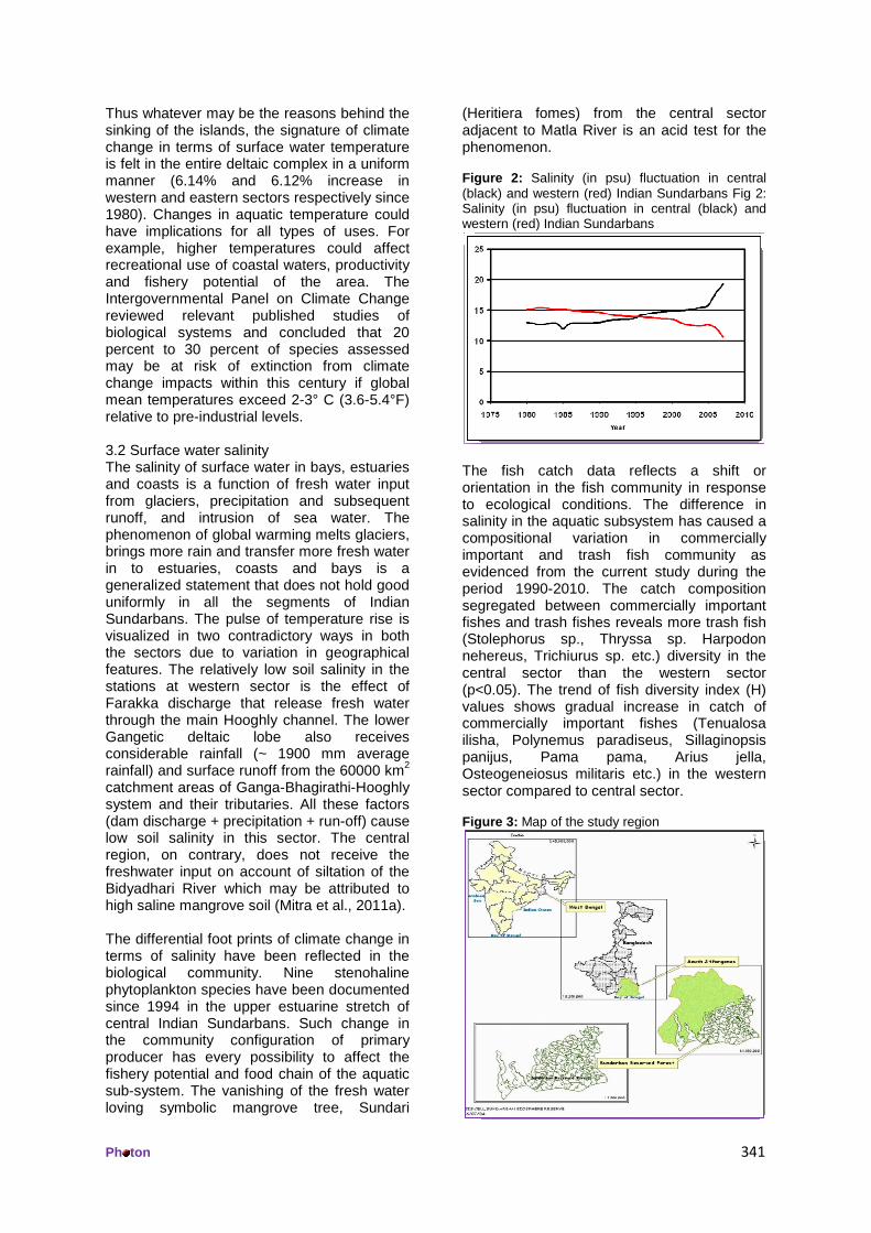
Thus whatever may be the reasons behind the sinking of the islands, the signature of climate change in terms of surface water temperature is felt in the entire deltaic complex in a uniform manner (6.14% and 6.12% increase in western and eastern sectors respectively since 1980). Changes in aquatic temperature could have implications for all types of uses. For example, higher temperatures could affect recreational use of coastal waters, productivity and fishery potential of the area. The Intergovernmental Panel on Climate Change reviewed relevant published studies of biological systems and concluded that 20 percent to 30 percent of species assessed may be at risk of extinction from climate change impacts within this century if global mean temperatures exceed 2-3° C (3.6-5.4°F) relative to pre-industrial levels. 3.2 Surface water salinity The salinity of surface water in bays, estuaries and coasts is a function of fresh water input from glaciers, precipitation and subsequent runoff, and intrusion of sea water. The phenomenon of global warming melts glaciers, brings more rain and transfer more fresh water in to estuaries, coasts and bays is a generalized statement that does not hold good uniformly in all the segments of Indian Sundarbans. The pulse of temperature rise is visualized in two contradictory ways in both the sectors due to variation in geographical features. The relatively low soil salinity in the stations at western sector is the effect of Farakka discharge that release fresh water through the main Hooghly channel. The lower Gangetic deltaic lobe also receives considerable rainfall (~ 1900 mm average rainfall) and surface runoff from the 60000 km2 catchment areas of Ganga-Bhagirathi-Hooghly system and their tributaries. All these factors (dam discharge + precipitation + run-off) cause low soil salinity in this sector. The central region, on contrary, does not receive the freshwater input on account of siltation of the Bidyadhari River which may be attributed to high saline mangrove soil (Mitra et al., 2011a). The differential foot prints of climate change in terms of salinity have been reflected in the biological community. Nine stenohaline phytoplankton species have been documented since 1994 in the upper estuarine stretch of central Indian Sundarbans. Such change in the community configuration of primary producer has every possibility to affect the fishery potential and food chain of the aquatic sub-system. The vanishing of the fresh water loving symbolic mangrove tree, Sundari
(Heritiera fomes) from the central sector adjacent to Matla River is an acid test for the phenomenon. Figure 2: Salinity (in psu) fluctuation in central (black) and western (red) Indian Sundarbans Fig 2: Salinity (in psu) fluctuation in central (black) and western (red) Indian Sundarbans
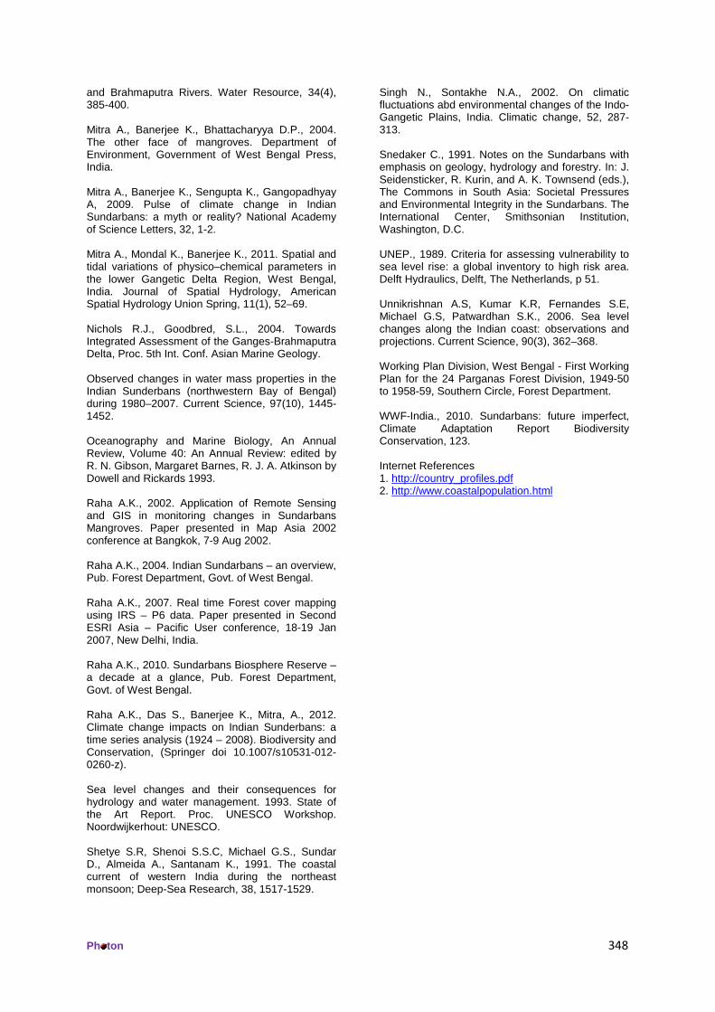
The fish catch data reflects a shift or orientation in the fish community in response to ecological conditions. The difference in salinity in the aquatic subsystem has caused a compositional variation in commercially important and trash fish community as evidenced from the current study during the period 1990-2010. The catch composition segregated between commercially important fishes and trash fishes reveals more trash fish (Stolephorus sp., Thryssa sp. Harpodon nehereus, Trichiurus sp. etc.) diversity in the central sector than the western sector (p<0.05). The trend of fish diversity index (H) values shows gradual increase in catch of commercially important fishes (Tenualosa ilisha, Polynemus paradiseus, Sillaginopsis panijus, Pama pama, Arius jella, Osteogeneiosus militaris etc.) in the western sector compared to central sector. Figure 3: Map of the study region

Ph ton 342
Figure 4: Map of Indian Sundarban
4. Historical data on global warming and Sundarbans There have been at least 17 major glacial advances (glaciations) in the last 1.6 million years alone. The most recent and the last glacial, reached its peak some 20,000 to 18,000 years ago and came to an end about 10,000 years ago (Goudie 1983). Glaciations are followed by ‘interglacial’ periods, during which the glacier ice retreats as a result of global warming. The interglacials typically continue for about 10,000 years before the cooling or the next glaciation begins. During this phase, sea level rise becomes extremely prominent as evidenced in the case of Ganga – Brahmaputra basin. Evidently, the delta at the mouth of the rivers of Ganga and Brahmaputra existed at all times at any level of the ocean and any climatic variations in the water flow and sediment run-off, while the delta coastline was always confined to the ocean level, which became more than 100 m higher in the last 18,000 years (Goodbred and Kuehl 2000; UNESCO 1993). The exact location (i.e. at which present depth of the ocean) of the Ganga-Brahmaputra delta at low levels of the ocean during the Glacial epoch and the form of that delta are still unknown. However, the fact that such delta had been available at that time is evident (Mikhailov and Dotsenko 2007). As the ocean level rose in the postglacial period, location of the area of accumulation of river sediments and the location of the delta proper, its dimension, and structure changed. The development of the modern Holocene delta began, when the ocean level reached the
elevations of the top of Pleistocene deposits, which represented the surface of the old delta formed in the Bengal basin during the previous interglacial epoch (Mikhailov and Dotsenko 2007). According to Goodbred and Kuehl (2000) the elevations of this surface were 50-70 m lower than the present ocean level. Partial submergence of this surface, sedimentation, and formation of the modern delta began 11,000 years ago. The ensuring years featured the formation of a thick layer of deposits (exceeding 50-60 m, on the average) and a dynamic channel network of the modern delta. According to Nicholls and Goodbred (2004), the considerable sediment runoff of the Ganga and Brahmaputra rivers compensates for the sea level rise and reduces the impact of this rise within the range of about 30 m at the rate of rise up to 1 cm yr-1. In addition to this, the considerable sediment runoff of these rivers compensates the impact of the tectonic sinking and land subsidence in the delta; it also reduces the impact of dynamic factors (waves and even intense tidal currents) on the nearshore zone (Mikhailov and Dotsenko, 2007). During the maximum last Glaciation period (about 18,000 years ago), the ocean level was nearly 120 m lower than the present day level (Raha et al., 2012). The land and shelf surface was no less than 60 m lower than the present surface. Most likely, water and sediments of both rivers entered the ocean in the form of a combined flow through the erosional channel inherited by the present Swatch of No Ground Canyon (Goodbred and Kuehl, 1999; Goodbred and Kuehl, 2000).

Ph ton 343
About 11,000 years ago, the ocean level rose to the elevation of -55 m and the backup began its propagation to the Bengal basin. Simultaneously, the accumulation of deposits and the Holocene delta formation began on its surface (Raha et al., 2012). Over the period of 11,000 – 7,000 years ago, the deposited sediment layer on the Bengal basin surface exceeded 50 m; and in the last 7,000 years, the layer thickness was more than 15 m (Goodbred and Kuehl, 1999; Goodbred and Kuehl, 2000). If one examines the sea level rise in this deltaic region since geologic time scale, it becomes evident that the sea level alteration is a natural phenomenon in the present study area and has become almost stabilized in recent times. The Indian Sundarbans is presently facing erosional features in the western sector, which may be attributed to sediment run-off, water flow and current pattern regulated mostly by Farakka barrage. It may have very feeble connection with the so-called sea level rise due to climatic variations as the central Indian Sundarbans is experiencing high salinity trend and more sedimentation due to complete blockage of the Bidyadhari channel since the 15th century (Chaudhuri and Choudhury, 1994). Gradual disappearance of sweet water loving mangrove floral species like Heritiera fomes (locally called Sundari) and Nypa fruticans (locally referred to as Golpata) is a confirmatory test of such salinity variation between western and central Indian Sundarbans. The biomass of mangroves, species composition of phytoplankton and fishes are also being influenced by salinity fluctuation. 4.1 Effects on Mangrove forest The development and functioning of mangrove ecosystem is regulated by salinity. Salinity affects plant growth in a variety of ways: 1) by limiting the availability of water against the osmotic gradient, 2) by reducing nutrient availability, 3) by causing accumulation of Na+ and Cl- in toxic concentration causing water stress conditions, enhancing closure of stomata and reduced photosynthesis (Mitra et al., 2009b). The impact of salinity in the deltaic Sundarbans is significant since it controls the distribution of species and productivity of the forest considerably (Raha, 2010). Due to increase in salinity, Heritiera fomes (Sundari) and Nypa fruticans (Golpata) are declining rapidly from the present study area (Mitra et al., 2011). The primary cause for top-dying of the species is believed to be the increasing
level of salinity (UNEP 1989; Unnikrishnan et al., 2006; WWF-India, 2010). Salinity, therefore, is a key player in regulating the distribution, growth and productivity of mangroves (Raha, 2010). The present study reveals that the central region of Indian Sundarbans is more saline compared to the western part. The reduced fresh water flows in central region of the Sundarbans have resulted in increased salinity of the river waters and has made the rivers shallower (particularly Matla) over the years. This caused significant effect on the biomass of the selected species thriving along these hypersaline river banks. Interestingly, the effects are species–specific. Increased salinity caused reduced growth in S. apetala whereas the positive influence of salinity was observed on A. alba and E. agallocha. Such differential adaptability of mangrove species to salinity was also reported from Bangladesh Sundarbans. Ball 1995 also pointed out the species-specificity in relation to range of salinity tolerance. 4.2 Impact of climate change on people Increasing salinity and lack of surface sweet water is seriously affecting the conventional agricultural practices in the villages around Sundarbans. The entire Sundarbans region is criss-crossed with rivers and creeks which receive fresh water from the rivers, draining into Sundarban, as well as salt water rushing into the estuary during high tide. However, with gradual reduction of sweet water in the Indian part of Sundarbans, the average salinity level of surface water is slowly increasing. Due to absence of artificial irrigation facilities in the region, entire agricultural activity is monsoon-based. However, with increasing salinity of surface water, the production of major crop paddy is also getting seriously affected as the present cultivated varieties are not salt tolerant. Increasing water level in the estuary is threatening inundation of villages surrounded by embankments. As discussed earlier, all the 54 islands, containing habitations, are surrounded by nearly 3,500 km long embankments. As the average sea level rises, the heights of embankments have also to be increased continually, to prevent the water during high tide enter into the villages over-toppling the embankments. Moreover, since the sea water, rushing back into the rivers during high tide, cannot deposit the silt on to the islands, preventing the island build-up process, the sediment get deposited on the river floor, gradually raising the river bed. This

Ph ton 344
has resulted into rising of river bed levels above the village ground level. As a result, whenever there is a breach of embankment, allowing the flood water to enter the village, the water does not come out naturally into the rivers even after the flood has subsided, and the village remains water-logged for days together and the water has to be artificially pumped out of the villages. Due to effects of Climate Change, there have been increased occurrences of cyclonic storms and storm surges in the recent years. The un-protected embankments, Road map for Sundarbans • The climate change may adversely affect around 1 million (25%) of the population directly. • The threats are magnified by the Biotic factors arising out of poverty and unemployment. • Mitigation measures will have to focus on conservation of mangrove Biodiversity as well as embankment protection. • Adaptation will have to focus on sustainable alternate livelihood practices. 5. Adaptation and Mitigation strategies 5.1 Mitigation Measures Adaptation and mitigation are complementary. Adaptation deals with the consequences of climate change while mitigation deals with the causes. Though Sundarbans is severely threatened with the impact of climate change, yet it can hardly be made responsible for the bane. The global warming caused by unsustainable industrialization and deforestation elsewhere is having the fall out on Sundarbans region through sea level rise and frequent cyclonic storm emanating from Bay of Bengal. Hence, adaptation strategies here will be more important than the mitigation measures, as the later have much limited scope. However, mitigation strategies that need to be resorted to include the following:- 1) Strengthening protection machinery to prevent further deforestation and degradation of mangroves within the Reserved Forest boundaries. 2) Planting new trees in the villages, along the embankments and the degraded mangrove sites, to sequester carbon and provide protection to the embankments against storm surges and tidal erosion 3) Stop conversion of mangrove areas into brackish water aquaculture (preferably shrimp culture which are mostly prone to viral attack)
4) Strengthen and maintain nearly 3500 km long embankments around 54 non-forest islands 5) Prevent dumping of un-treated sewage from the city and industries upstream, into Sundarbans estuary, which may cause bio-accumulation of conservative pollutants in the fish tissue. 5.2 Adaptation strategies Adaptation strategies assume primary importance in the surrounding villages of Sundarban mangrove forest since the inhabited region is one of the most densely populated regions of the country. Since large section of the people, especially in the buffer zone of mangrove forest, depends on the natural resources of Sundarban estuary for their livelihood, developing alternate livelihood in the changed climate scenario is of paramount consequence. Sundarban region receives around 2000 mm of rainfall per year but the sweet rain water is lost as run off to the saline tidal rivers, while, there is hardly any perennial fresh water available in the villages for drinking or irrigation purposes. This naturally available water resource can be converted into its strength while planning adaptation strategies. 1) Rain water harvesting in the villages through construction of irrigation channels and pond. The stored rain water can be used for drinking water as well as irrigation water for raising second crop in dry months. Digging channels and pond, as well as cultivation of post-monsoon crop will generate large employment during the winter season and reduce biotic pressure on mangrove eco-system. 2) Encourage cultivation of salt-tolerant, indigenous varieties of paddy and vegetables which will act as insurance against the vagaries of rainfall and flood. 3) Stress on cultivation of cash crops including chilly, sunflower etc which are less perishable and can be stored and marketed as per convenience. 4) Construction of multi-purpose cyclone shelters to provide shelter to villagers in case of flooding of villages during storm surges. In other times, these buildings can be used as schools/ community centers for the villagers. 5) In order to make the villagers less dependent on the mangrove forests, like fishing, tiger prawn seed collection etc, the village women folk are being trained up in village-based activities like sewing/ stitching, poultry/ duckery/ piggery and raising of seedlings for afforestation purpose.

Ph ton 345
6. Sustainable alternate livelihood development 6.1 Eco-Development and JMM support activities No governmental efforts to conserve and create assets/ resources can be successful and sustainable unless the people concerned actively participate in planning and management of the resources. Participatory or Joint Mangrove Management (JMM) is thus the basis of sustainable Conservation of Mangrove Eco-system. On the basis of the experiences of peoples’ participation in forest management in South West Bengal, West Bengal Forest Department has issued Govt. orders facilitating the formation of Forest Protection Committees (FPC) around the Reserved/ Protected Forests, and Eco-Development Committees (EDC) around the National Park and Sanctuaries of Sundarbans region also. Till now, 34 FPCs and 14 EDCs have been registered and functioning in Sundarbans Reserve Forest Members of the FPCs and EDCs participate in protection of the forests against exploitations. However, since large population in the fringe villages are intensively dependent on the resources of the mangrove eco-system, closure of the resource against exploitation will lead to further unemployment and starvation of the people BPL. Such actions are bound to alienate the people below PL and PPL, and will go against the concept of conservation. Therefore, our effort is to create “alternate livelihood options” for these target groups and dilute the biotic pressure on the ecologically fragile mangrove ecosystem. Whatever development funds are made available for the forest fringe villages, will be utilized for creating resources through the process of Micro-level Planning and participatory implementation. Socio-economic and natural resource survey of the region shows that sweet water for irrigation and drinking purpose is a scarce commodity. Due to shortage of sweet water, agriculture in the region is highly under-developed and productivity is very low. Mere provision of fresh, sweet water can bring revolution in the agricultural practices and generate tremendous employment and resources. Since the region is blessed with moderately high rainfall, well-distributed, conservation of the rainwater through impounding in canals and ponds should receive the topmost priorities in the resource generation sector. Availability of irrigation water during dry months can convert the mono-cropped areas into multiple cropping.
Construction of irrigation canals and ponds constitute important component of Eco-Development activities. The sweet water ponds and canals can also be simultaneously used for fresh water aqua-culture to generate additional income for the beneficiaries selected from the landless families and marginal farmers. Vocational training and training and input in cottage industries, apiculture, mushroom cultivation, floriculture etc can strive to make the forest-dependent people more self-sufficient. Efforts will also be made to encourage the poorer section of the people form Self-Help Groups to avail of bank loans to start their own ventures/trades. The FPC/EDC members will be encouraged to create Community Fund, through their contributions from the benefits derived out of JFM support services, which will help sustain the development activities in the villages even after the withdrawal of the Project Fund (Raha 2010). 6.2 Confidence-building activities Building up of trust between the foresters and forest fringe dwellers form the key to success of JFM/ JMM. Activities like construction of village brick paths greatly facilitate communication and help better marketing of agricultural and other produces. Similarly, construction of pucca jetties, installation of Solar lights, Janata Insurance coverage of the FPC/ EDC members and organizing regular medical camps in remote locations, where medical help is not readily available, help in creation of goodwill and makes the people more responsive towards protection of the mangrove eco-system. Like the forests in other parts of the State, Govt Resolutions have also been issued for adoption of Joint Forest Management in Sundarbans Reserved Forests of India. The Resolutions provide guidelines for formation of Forest Protection Committees and Eco-Development Committees and implementation of development activities within and outside the Forest Areas. Various JFM Support activities and Eco-Development activities can be categorized as follows:- Community Development Projects: 1. Construction of irrigation canals for rain-water harvesting. 2. Construction of sweet water ponds for irrigation as well as fresh water pisciculture.

Ph ton 346
3. Construction of village brick paths to improve communication. 4. Construction of jetties. 5. Digging of tube-wells for drinking water supply. 6. Supply of solar lights. 7. Organising regular medical camps in remote areas. 8. Construction of embanks for protection of villages. Individual beneficiaries oriented schemes: 1. Apiary, mushroom cultivation. 2. Piggery, Goatary, Duckery, Poultry. 3. Vocational training for Cottage industries. 4. Development of Self Help Groups. 5. Training and input for vocations/ professions like tailoring, cycle repairing etc. Research Highlights (i) Sundarban estuary in the coastal region of West Bengal is definitely going to be affected by the sea level rise. The study shows that the impact will be more pronounced in those islands, having settlements and where mangrove is absent, as compared to the southernmost islands which are not inhabited and contains only mangrove vegetation. (ii) Continuous maintenance of the embankments, surrounding the inhabited islands, is the lifeline for the people of Sundarban and the cost of maintenance will keep on increasing with the increasing sea level. (iii) Since around 4.5 million people live along the northern and north western fringe of Sundarban mangrove forest, their livelihood security has to be ensured through development of sustainable alternative livelihood options. (iv) This will also help in reducing tremendous biotic pressure on the vulnerable mangrove forest from the forest fringe population and act as main strategy for conserbvation of the forest and its biodiversity (v) Application of Remote Sensing Technology for monitoring the remote and inaccessible mangrove terrain will facilitate formulation of REDD+ projects for this coastal region. Limitations (i) The study could not explore many other alternate livelihood options, which could be more cost effective, sustainable in nature and technically more efficient. (ii) Another limitation of the study is that the threat of climate change for the people, flora and fauna of Sundarban region emanates from
global action on which there is no possibility of local control. Hence the study could not highlight any mitigation measures for the Sundarban region and more stress has been given on adaptation strategies (iii) The study also could not highlight the details of changes in flora and fauna of Sundarban mangrove forest as a result of impact of climate change. Recommendations We recommend that: (i) More intensive and extensive study may be carried out for development of sustainable alternative livelihood for the forest fringe population to be affected by the sea level rise and its impact on the coastal region. (ii) More detailed study be taken up to enumerate the changes in the flora and fauna of Sundarban mangrove forest due to impact of global warming and sea level rise on the forested islands of the Sundarban estuary. Conclusion While formulating the adaptation/ mitigation strategies for Sundarbans region, the key issues that need to be addressed are: • Conservation of mangroves help sequester atmospheric carbon for global community, but the local community looses the livelihood. • Proportionate funding is required to make the community forest-independent, through development of sustainable alternate livelihood. • Unless the International community and developed nations evolve mechanism to compensate the cost of conservation, the effort to conserve this rich mangrove estuary may not be sustainable. The impact of global warming, through the predicted sea level rise, on Sundarbans is an inevitable phenomenon. Emission of green house gases, through deforestation/ degradation as well as industrial pollution and burning of fossil fuel elsewhere in the globe has put this mangrove estuary, along with many other coastal forests and habitations, under severe threat of degradation. While the mitigation measures have to be primarily at the global level as well as at local level, the adaptation strategy will also involve participation of global and local communities. This study has clearly shown that the people living around the mangrove forests have to be provided with a sustainable alternate livelihood to cope with the increasing salinity in the

Ph ton 347
region. Moreover, regular and scientific maintenance of the embankments around the island-villages can only enable the villagers to withstand the increasing storm surges and cyclones threatening the embankments and inundation of villages with saline tidal water. Such flooding also spoils the productivity of the agricultural field, due to increased salinity, for a few subsequent years. Adoption of endemic paddy varieties and salt – tolerant paddy/ vegetables/ cash crops are the solution for livelihood sustainability. Harvesting of rain water is also an extremely important adaptation strategy in Sundarban villages. The area receives around 2000 mm of rainfall per year on an average, though only during 3 monsoon months, yet the sweet water is lost as run-off into the tidal rivers. If the rain water could be stored to the maximum possible amount, the region could be brought under multiple cropping systems, generating large scale employment in lean months. As regards the destructive livelihood activities practiced by the villagers of Sundarbans, generating employment through other livelihood options and training in skill development have to be resorted to. However, all these socio-economic activities need huge amount of fund support at the beginning. Since Sundarban mangrove, if properly conserved, can store billions of tones of carbon thus mitigating the effect of global warming, the people of the region also need to be duly compensated under REDD+ projects. The study has shown the prospect of conservation of Sundarbans mangrove flora and fauna through active participation of local people. The global community cannot avoid their commitment for conserving this World Heritage Site and one of the largest sink for atmospheric carbon. Author’s Contribution and Competing Interests: Dr. A.K. Raha is the prime backbone of the manuscript. The other authors helped in collecting secondary data and information on Indian Sundarbans. The climate change scenario in Indian Sundarbans has been equally contributed by all the authors. The authors do not have any conflict of interest. References Allison M.A., 1998. Historical Changes in the Ganges-Brahmaputra Delta, Journal of Coastal Research, 14(4), 1269-1275.
Ball M.C, Pidsley S.M., 1995. Growth responses to salinity in relation to distribution of two mangrove species, Sonneratia alba and Sonneratia lanceolata in Northern Australia. Functional Ecology, 9(1), 77-85. Blasco F., 1975. The mangroves of India. Institut Français Pondichery Travaux Section Scientifique et Technologie, 14, 1-175. Brahmaputra River: Channel processes and sedimentation Edited by James M. Coleman, 3, (2–3), 129-239, 1969. Chakraborty R., Raha A.K., et al., 2004-05. Status of Phytopigment in Indian Sundarbans. Sea Explorers, (7 & 8), 80 – 90. Chaudhuri A.B., and Chiudhury A., 1994. Wetland Ecology- Resources, Research and Conservation- An Indian Scenario- MEPS Publishers Cole C.V., Vaidyaraman P.P., 1966. Salinity distribution and effect of freshwater flows in the Hooghly River. Proceedings Tenth Conference on Coastal Engineering, Tokyo (American Society of Civil Engineers, New York): 1312–1434. Deb S.C., 1956. Paleoclimatology and geophysics of the Gangetic delta. Geographical Reviews India 18, 11–18. Field Director, Sundarbans Tiger Reserve- Draft Management Plan of STR for the period 2000-2001 to 2005-2006. Goodbred S.L., Kuehl S.A., 1999. Holocene and Modern Sediment Budgets for the Ganges-Brahmaputra River System: Evidence for High stands Dispersal to Flood- Plain, Shelf, and Deep-Sea Depocenters, Geology, 27, (6), 559–562. Goodbred S.L., Kuehl S.A., 2000. Enormous Ganges–Brahmaputra Sediment Discharge during Strengthened Early Holocene Monsoon, Geology, 28 (12), 1083-1086. Goudie A., 1983. Environmental Change. Second Edition. Clarendon Press, Oxford. 258 pp. Hazra S., Tuhin, G, Rajashree D., Sen G., 2002. Sea level and associated changes in Sundarbans, Science and Culture, 309-321. Hunter W.W., 1998. A Statistical Account of Bengal, Sundarbans- Vol. I, Pt. II, W.W. District Gazetteers, Department of Higher Education, Govt. of West Bengal. Mikhailov V.N., Kravtsova V.I., Magritskii D.V., et al., 2004. Deltas of Caspian Rivers and their response to sea level variations. Vestn Kaspiya, 6, 60-10. Mikhailov V.N, Dotsenko M.A., 2007. Processes of delta formation in the mouth area of the Ganges
Ph ton 348
and Brahmaputra Rivers. Water Resource, 34(4), 385-400. Mitra A., Banerjee K., Bhattacharyya D.P., 2004. The other face of mangroves. Department of Environment, Government of West Bengal Press, India. Mitra A., Banerjee K., Sengupta K., Gangopadhyay A, 2009. Pulse of climate change in Indian Sundarbans: a myth or reality? National Academy of Science Letters, 32, 1-2. Mitra A., Mondal K., Banerjee K., 2011. Spatial and tidal variations of physico–chemical parameters in the lower Gangetic Delta Region, West Bengal, India. Journal of Spatial Hydrology, American Spatial Hydrology Union Spring, 11(1), 52–69. Nichols R.J., Goodbred, S.L., 2004. Towards Integrated Assessment of the Ganges-Brahmaputra Delta, Proc. 5th Int. Conf. Asian Marine Geology. Observed changes in water mass properties in the Indian Sunderbans (northwestern Bay of Bengal) during 1980–2007. Current Science, 97(10), 1445-1452. Oceanography and Marine Biology, An Annual Review, Volume 40: An Annual Review: edited by R. N. Gibson, Margaret Barnes, R. J. A. Atkinson by Dowell and Rickards 1993. Raha A.K., 2002. Application of Remote Sensing and GIS in monitoring changes in Sundarbans Mangroves. Paper presented in Map Asia 2002 conference at Bangkok, 7-9 Aug 2002. Raha A.K., 2004. Indian Sundarbans – an overview, Pub. Forest Department, Govt. of West Bengal. Raha A.K., 2007. Real time Forest cover mapping using IRS – P6 data. Paper presented in Second ESRI Asia – Pacific User conference, 18-19 Jan 2007, New Delhi, India. Raha A.K., 2010. Sundarbans Biosphere Reserve – a decade at a glance, Pub. Forest Department, Govt. of West Bengal. Raha A.K., Das S., Banerjee K., Mitra, A., 2012. Climate change impacts on Indian Sunderbans: a time series analysis (1924 – 2008). Biodiversity and Conservation, (Springer doi 10.1007/s10531-012-0260-z). Sea level changes and their consequences for hydrology and water management. 1993. State of the Art Report. Proc. UNESCO Workshop. Noordwijkerhout: UNESCO. Shetye S.R, Shenoi S.S.C, Michael G.S., Sundar D., Almeida A., Santanam K., 1991. The coastal current of western India during the northeast monsoon; Deep-Sea Research, 38, 1517-1529.
Singh N., Sontakhe N.A., 2002. On climatic fluctuations abd environmental changes of the Indo-Gangetic Plains, India. Climatic change, 52, 287-313. Snedaker C., 1991. Notes on the Sundarbans with emphasis on geology, hydrology and forestry. In: J. Seidensticker, R. Kurin, and A. K. Townsend (eds.), The Commons in South Asia: Societal Pressures and Environmental Integrity in the Sundarbans. The International Center, Smithsonian Institution, Washington, D.C. UNEP., 1989. Criteria for assessing vulnerability to sea level rise: a global inventory to high risk area. Delft Hydraulics, Delft, The Netherlands, p 51. Unnikrishnan A.S, Kumar K.R, Fernandes S.E, Michael G.S, Patwardhan S.K., 2006. Sea level changes along the Indian coast: observations and projections. Current Science, 90(3), 362–368. Working Plan Division, West Bengal - First Working Plan for the 24 Parganas Forest Division, 1949-50 to 1958-59, Southern Circle, Forest Department. WWF-India., 2010. Sundarbans: future imperfect, Climate Adaptation Report Biodiversity Conservation, 123. Internet References 1. http://country_profiles.pdf 2. http://www.coastalpopulation.html
Related Documents