i n t r o d u c t i o n clear lake pedestrian and bicyclist study CLEAR LAKE PEDESTRIAN AND BICYCLIST STUDY PUBLIC MEETING ONE: ISSUES AND EXISTING CONDITIONS About the Project The Houston Bikeway Program, within the Department of Public Works and Engineering, is partnering with the Houston- Galveston Area Council to conduct a bicyclist-pedestrian study of the Clear Lake Area. The focus of the study is to develop priorities to address the safety and mobility needs of pedestrians and bicyclists within the Clear Lake area of Houston as funding becomes available. The limits of the study area are El Dorado and Space Center Boulevards to the north and northeast, IH- 45 to the west, and NASA Road One in the South. Take the Survey It’s easy, fun and will help determine what kinds of bicycle and pedestrian improvements are made. Use one of the available computers or visit our website at: www.walkbikeclearlake.com Stay Connected Ask questions, provide feedback and gain access to all of our materials! www.walkbikeclearlake.com [email protected] www.facebook.com/HoustonBikeways www.twitter.com/walkbikecltx Study Area

Welcome message from author
This document is posted to help you gain knowledge. Please leave a comment to let me know what you think about it! Share it to your friends and learn new things together.
Transcript

8/6/2019 Clear Lake Public Meeting One
http://slidepdf.com/reader/full/clear-lake-public-meeting-one 1/8clear lake pedestrian and bicyclist study
CLEAR LAKE PEDESTRIAN AND BICYCLIST STUDY
PUBLIC MEETING ONE: ISSUES AND EXISTING CONDITIONS
About the Project The Houston Bikeway Program, within
the Department of Public Works andEngineering, is partnering with the Houston-
Galveston Area Council to conduct a
bicyclist-pedestrian study of the Clear Lake
Area.
The focus of the study is to develop
priorities to address the safety and mobility
needs of pedestrians and bicyclists within
the Clear Lake area of Houston as funding
becomes available. The limits of the studyarea are El Dorado and Space Center
Boulevards to the north and northeast, IH-
45 to the west, and NASA Road One in the
South.
Take the SurveyIt’s easy, fun and will help determine
what kinds of bicycle and pedestrian
improvements are made.Use one of the available computers or
visit our website at:
www.walkbikeclearlake.com
Stay ConnectedAsk questions, provide feedback and gain
access to all of our materials!
www.facebook.com/HoustonBikeways
www.twitter.com/walkbikecltx
Study Area

8/6/2019 Clear Lake Public Meeting One
http://slidepdf.com/reader/full/clear-lake-public-meeting-one 2/8clear lake pedestrian and bicyclist study
WHERE DO WE LIVE, WORK AND PLAY?
single-family residential
multi-family residential
ofce
retail
public and institutional
park and open space
industrial
utilities
vacant or undeveloped
index
0.5 Miles
ParksShoppingHospitalsSchools Transit
Clear Lake
How can bicycling make adifference?59% of the population and 75% of thejobs in our 8 county region are located
within a 30 minute bicycle ride of 25activity centers! Our study area contains
two of the centers.
Source: 2000 US Census, compiled by Houston Tomorrow
Source: Harris County Appraisal District
Johnson
Space Center

8/6/2019 Clear Lake Public Meeting One
http://slidepdf.com/reader/full/clear-lake-public-meeting-one 3/8clear lake pedestrian and bicyclist study
WHAT ARE OUR GOALS?
Safety
To provide safe facilities for walking and biking andimprove current areas that have a history of crashes
or feel unsafe.
ChoiceTo ensure walking and cycling is a convenient
transportation option for a broad set of users and
trips.
ConnectivityTo eliminate barriers to walking and cycling by
creating better connections between where people
are and where they want to go.
Opportunities for allTo provide walking and biking opportunities with allusers in mind including bicyclists and pedestrians of
all ages and abilities.

8/6/2019 Clear Lake Public Meeting One
http://slidepdf.com/reader/full/clear-lake-public-meeting-one 4/8
pp
clear lake pedestrian and bicyclist study
WHO BIKES?
% b i k e c om
m u t er s
existing users
potential users
% 0 c ar h o u s eh ol d s
% un d er 1 0 mi n u t e c om
m u t e
% un d er 1 6 y e ar s ol d
Sophia, 8 years old, kid
Sophie learned to bike 4 years ago
and loves to bike recreationally with
her parents and her friends. Her
parents let her bike on the streets in
her neighborhood and in the park.
Sometimes she bikes to school with otherchildren and a parent.
Ron, 42 years old, accountant
Ron took up biking in his 30s as a good
low impact workout. He spends money
on the best equipment and regularly
rides 30 miles a day during the week
and even longer on weekends. He
enjoys taking part in group rides and is a
member of the local cycling club.
James, 16 years old, high school student
Although James just got his drivers license,
his parents only have 2 cars, and they don’t
let him use one often. He uses his bike to
get to and from his part-time job at the mall,
to spend time with his friends and to get
to school. He likes the amount of freedomriding his bike gives him.
Jennifer, 28 years old, nurse
Jennifer works at a local hospital. As a nurse,
she’s concerned about both her health and
her pocketbook. At the same time, she also
knows what it looks like when a car hits a
cyclist. She’d like to ride her bike to work for
exercise, but she’s a little nervous to try it out
for the rst time.
Sources: 2000 US Census Data
8/6/2019 Clear Lake Public Meeting One
http://slidepdf.com/reader/full/clear-lake-public-meeting-one 5/8
pp
clear lake pedestrian and bicyclist study
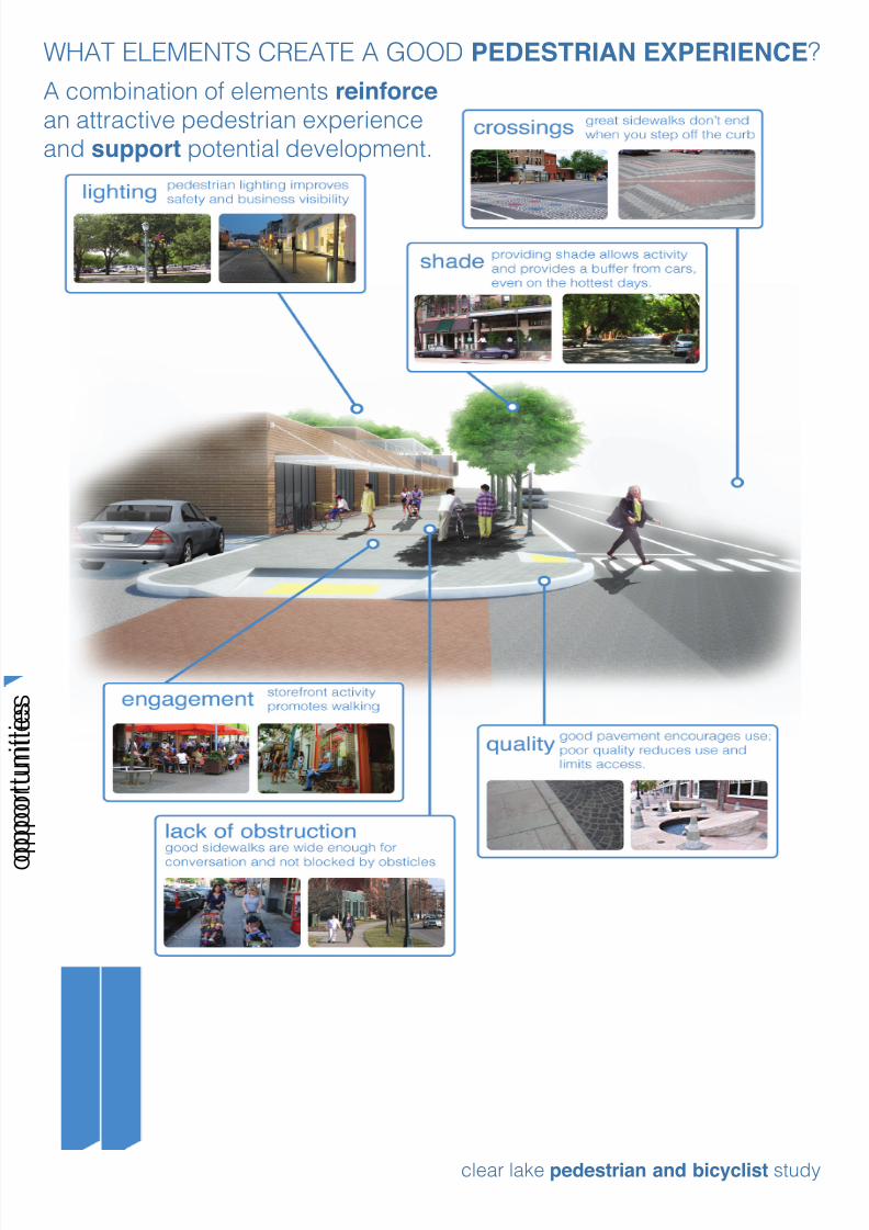
WHAT ELEMENTS CREATE A GOOD PEDESTRIAN EXPERIENCE?
pp
A combination of elements reinforcean attractive pedestrian experience
and support potential development.

8/6/2019 Clear Lake Public Meeting One
http://slidepdf.com/reader/full/clear-lake-public-meeting-one 6/8
pp
clear lake pedestrian and bicyclist study
WHAT MAKES A GOOD BIKING DISTRICT?offroad trails
residential streets
main streets
state highways
City of Houston Design Manual
City of Houston Design Manual
City of Houston Design Manual
This type of road makes up much of
Clear Lake. They are typically low
volume, low speed and feel comfortable
for many types of users.
This type of road makes up the main
commercial backbones of Clear Lake.
Speeds are higher and volumes greater.
Without facilities, some experienced
cyclists will use them, but few beginners.
State Highway 3 carries a high volume
of trafc at very high speed, but it also
has a large shoulder. Cyclists may feel
comfortable biking next to the road, but
crossing is more difcult.
Bayous, drainage and utility easements
and other green spaces can provide
wonderful opportunities for recreation
and transportation. In Clear Lake, these
opportunities abound.
Boulder, CO
Houston, TX
Portland, OR
Charlotte, NC
Tempe, AZ
Los Angeles, CA
Dallas, TX
Bastrop, TX
Buffalo Bayou Master Plan

8/6/2019 Clear Lake Public Meeting One
http://slidepdf.com/reader/full/clear-lake-public-meeting-one 7/8
g
clear lake pedestrian and bicyclist study
WHAT FACTORS EFFECT WALKING AND BIKING TODAY?
Areas with higher concentrations of vehicle crashes can be perceived as unsafe for
pedestrians and cyclists. Between 2003 and 2009, automobile crashes have been
concentrated along Bay Area Boulevard where high trafc volumes and many driveway
openings increase potential conicts. Pedestrian and bicycle crashes are moreconcentrated near the CCISD schools, likely due to the high percentage of walking and
biking usage in that area.
Within the study area trafc volumes increase closer to IH-45, with Bay Area Boulevard
and NASA Parkway carrying the most trafc. These high volume thoroughfares provideaccess to many activity centers but can also serve as barriers to walking and biking.
Trafc signals can provide safe places to cross major roadways but are not always located
near destinations.
Trafc Volume Trafc Signals
Automobile Crashes Bike and Ped Crashes
0-10k vehicles10-20k vehicles
>20k vehicles
All Way StopTrafc Signals
Pedestrian Crossing
Pedestrian Crash
Bicycle Crash
Less CrashesMore Crashes
4545
45 45
Source: H-GAC, 2009-2010 Data Source: Field Observation
Sources: 2003-2009 Crash Record Information System, TxDOT

8/6/2019 Clear Lake Public Meeting One
http://slidepdf.com/reader/full/clear-lake-public-meeting-one 8/8
pp
clear lake pedestrian and bicyclist study
WHERE DO YOU WANT TO SEE IMPROVEMENTS?
Study Area in Google Earth
Use the computer station to let us know exactly whereyou have an idea for improvements.
It can be:
We will produce a map of all the ideas that will be
available after the meeting at:
www.walkbikeclearlake.com
An activity center
A gap in the system A potential route
A specic location
or destination
Related Documents