Clay mineral distribution in surface sediments of the northeastern South China Sea and surrounding fluvial drainage basins: Source and transport Zhifei Liu a, ⁎, Christophe Colin b , Xiajing Li a , Yulong Zhao a,b , Shouting Tuo a , Zhong Chen c , Fernando P. Siringan d , James T. Liu e , Chi-Yue Huang f , Chen-Feng You f , Kuo-Fang Huang f a State Key Laboratory of Marine Geology, Tongji University, Shanghai 200092, China b Laboratoire IDES, UMR 8148 CNRS, Université de Paris XI, Orsay 91405, France c South China Sea Institute of Oceanology, Chinese Academy of Sciences, Guangzhou 510301, China d Marine Science Institute, University of the Philippines, Diliman, Quezon City 1101, Philippines e Institute of Marine Geology and Chemistry, National Sun Yat-sen University, Kaohsiung 80424, Taiwan f Department of Earth Sciences, National Cheng Kung University, Tainan70101, Taiwan abstract article info Article history: Received 11 February 2010 Received in revised form 5 August 2010 Accepted 17 August 2010 Available online 26 August 2010 Communicated by D.J.W. Piper Keywords: clay minerals deep water current Taiwan Pearl River Luzon South China Sea Clay mineralogy of surface samples throughout the northeastern South China Sea (SCS) and surrounding fluvial drainage basins has been investigated to reveal source and transport of detrital fine-grained sediments. Three characteristic end-members in clay mineral compositions were observed from three major provenances, respectively: major kaolinite and moderate illite and chlorite from the Pearl River, predominant illite and chlorite from Taiwan, and principal smectite from the Luzon arc system. The transport of four clay mineral species in the northeastern SCS is influenced by various mechanisms. Smectite derived from the Luzon arc system is transported mainly by surface current with significant influence of the Kuroshio intrusion, illite and chlorite from Taiwan are mainly carried by deep water current, while kaolinite from the Pearl River is affected obviously by the westward Guangdong Coastal Current and longshore current. A westerly tongue-shaped distribution of high contents of illite and chlorite mainly from Taiwan on the eastern shelf may result from the westward Guangdong Coastal Current during the winter. The results suggest that clay mineral assemblages in the northeastern SCS are mainly controlled by provenance supply and current transport and their downcore records do not bear contemporaneous paleoclimatic features. The implication of clay minerals for proxies of the late Quaternary East Asian monsoon evolution is realized through both the provenance supply and current transport processes. © 2010 Elsevier B.V. All rights reserved. 1. Introduction As part of the South China Sea (SCS), the largest marginal sea in the western Pacific, the northeastern portion has offered an unique attraction for marine geologists because of the complexity of detrital sediment provenances, the interaction of surface current patterns with East Asian monsoon winds, and the intrusion of the subsurface Kuroshio and deep waters from the western Pacific through the Luzon Strait (e.g., Webster, 1994; Fang et al., 1998; Caruso et al., 2006; Qu et al., 2006; Liu, Z. et al., 2008)(Fig. 1). The river-borne terrigenous sediments compose ~ 80% of total SCS surface sediments (Huang, 2004) and have produced high sedimentation-rate deposition in the geological past (Wang et al., 2000), especially for sediment drifts on the northern continental slope southeast of the Dongsha Islands (Fig. 1), where the Holocene sedimentation rate can reach as high as 70 cm/kyr (Bühring et al., 2004). Determining the provenance of these detrital sediments in the region has become a main issue in a recent decade because of the difficulty that the geology of two major potential source areas, South China and Taiwan, is similar with same cratonic Mesozoic–Cenozoic sedimentary rocks (Commission for the Geological Map of the World, 1975) and Nd isotopic values (Li et al., 2003; Boulay et al., 2005). Most of previous studies mainly at SONNE Cruise 95 (1994) cores and Ocean Drilling Program (ODP) Leg 184 (1999) sites in the northeastern SCS considered the Pearl River as the main sedimentary source (Wang et al., 1999; Clift et al., 2002; Wehausen and Brumsack, 2002; Boulay et al., 2003; Li et al., 2003; Tamburini et al., 2003) with an additional volcanic source (Boulay et al., 2005). However, recent investigations on clay mineralogy and elemental geochemistry emphasized a significant contribution derived from the northeast sources, i.e., Taiwan and/or the Yangtze River (Liu et al., 2003a; Shao et al., 2007; Wan et al., 2007). The input of detrital fine-grained sediments from the Pearl River to the northern slope of the SCS was recently estimated to be much less important than previously thought (Liu et al., 2007a). By examining clay mineralogy and its reflective chemical weathering intensity in source areas, Liu, Z. et al. (2008) recognized three characteristic end-members in clay mineral Marine Geology 277 (2010) 48–60 ⁎ Corresponding author. Tel.: + 86 21 6598 4877; fax: + 86 21 6598 8808. E-mail address: [email protected] (Z. Liu). 0025-3227/$ – see front matter © 2010 Elsevier B.V. All rights reserved. doi:10.1016/j.margeo.2010.08.010 Contents lists available at ScienceDirect Marine Geology journal homepage: www.elsevier.com/locate/margeo

Welcome message from author
This document is posted to help you gain knowledge. Please leave a comment to let me know what you think about it! Share it to your friends and learn new things together.
Transcript

Marine Geology 277 (2010) 48–60
Contents lists available at ScienceDirect
Marine Geology
j ourna l homepage: www.e lsev ie r.com/ locate /margeo
Clay mineral distribution in surface sediments of the northeastern South China Seaand surrounding fluvial drainage basins: Source and transport
Zhifei Liu a,⁎, Christophe Colin b, Xiajing Li a, Yulong Zhao a,b, Shouting Tuo a, Zhong Chen c,Fernando P. Siringan d, James T. Liu e, Chi-Yue Huang f, Chen-Feng You f, Kuo-Fang Huang f
a State Key Laboratory of Marine Geology, Tongji University, Shanghai 200092, Chinab Laboratoire IDES, UMR 8148 CNRS, Université de Paris XI, Orsay 91405, Francec South China Sea Institute of Oceanology, Chinese Academy of Sciences, Guangzhou 510301, Chinad Marine Science Institute, University of the Philippines, Diliman, Quezon City 1101, Philippinese Institute of Marine Geology and Chemistry, National Sun Yat-sen University, Kaohsiung 80424, Taiwanf Department of Earth Sciences, National Cheng Kung University, Tainan70101, Taiwan
⁎ Corresponding author. Tel.: +86 21 6598 4877; faxE-mail address: [email protected] (Z. Liu).
0025-3227/$ – see front matter © 2010 Elsevier B.V. Adoi:10.1016/j.margeo.2010.08.010
a b s t r a c t
a r t i c l e i n f oArticle history:Received 11 February 2010Received in revised form 5 August 2010Accepted 17 August 2010Available online 26 August 2010
Communicated by D.J.W. Piper
Keywords:clay mineralsdeep water currentTaiwanPearl RiverLuzonSouth China Sea
Clay mineralogy of surface samples throughout the northeastern South China Sea (SCS) and surroundingfluvial drainage basins has been investigated to reveal source and transport of detrital fine-grainedsediments. Three characteristic end-members in clay mineral compositions were observed from three majorprovenances, respectively: major kaolinite and moderate illite and chlorite from the Pearl River,predominant illite and chlorite from Taiwan, and principal smectite from the Luzon arc system. Thetransport of four clay mineral species in the northeastern SCS is influenced by various mechanisms. Smectitederived from the Luzon arc system is transported mainly by surface current with significant influence of theKuroshio intrusion, illite and chlorite from Taiwan are mainly carried by deep water current, while kaolinitefrom the Pearl River is affected obviously by the westward Guangdong Coastal Current and longshorecurrent. A westerly tongue-shaped distribution of high contents of illite and chlorite mainly from Taiwan onthe eastern shelf may result from the westward Guangdong Coastal Current during the winter. The resultssuggest that clay mineral assemblages in the northeastern SCS are mainly controlled by provenance supplyand current transport and their downcore records do not bear contemporaneous paleoclimatic features. Theimplication of clay minerals for proxies of the late Quaternary East Asian monsoon evolution is realizedthrough both the provenance supply and current transport processes.
: +86 21 6598 8808.
ll rights reserved.
© 2010 Elsevier B.V. All rights reserved.
1. Introduction
As part of the South China Sea (SCS), the largest marginal sea in thewestern Pacific, the northeastern portion has offered an uniqueattraction for marine geologists because of the complexity of detritalsediment provenances, the interaction of surface current patternswith East Asian monsoon winds, and the intrusion of the subsurfaceKuroshio and deep waters from the western Pacific through the LuzonStrait (e.g., Webster, 1994; Fang et al., 1998; Caruso et al., 2006; Quet al., 2006; Liu, Z. et al., 2008) (Fig. 1). The river-borne terrigenoussediments compose ~80% of total SCS surface sediments (Huang,2004) and have produced high sedimentation-rate deposition in thegeological past (Wang et al., 2000), especially for sediment drifts onthe northern continental slope southeast of the Dongsha Islands(Fig. 1), where the Holocene sedimentation rate can reach as high as70 cm/kyr (Bühring et al., 2004). Determining the provenance of these
detrital sediments in the region has become a main issue in a recentdecade because of the difficulty that the geology of two majorpotential source areas, South China and Taiwan, is similar with samecratonic Mesozoic–Cenozoic sedimentary rocks (Commission for theGeological Map of the World, 1975) and Nd isotopic values (Li et al.,2003; Boulay et al., 2005). Most of previous studies mainly at SONNECruise 95 (1994) cores and Ocean Drilling Program (ODP) Leg 184(1999) sites in the northeastern SCS considered the Pearl River as themain sedimentary source (Wang et al., 1999; Clift et al., 2002;Wehausen and Brumsack, 2002; Boulay et al., 2003; Li et al., 2003;Tamburini et al., 2003) with an additional volcanic source (Boulayet al., 2005). However, recent investigations on clay mineralogy andelemental geochemistry emphasized a significant contribution derivedfrom the northeast sources, i.e., Taiwan and/or the Yangtze River (Liuet al., 2003a; Shao et al., 2007; Wan et al., 2007). The input of detritalfine-grained sediments from the Pearl River to the northern slope of theSCS was recently estimated to be much less important than previouslythought (Liu et al., 2007a). By examining clay mineralogy and itsreflective chemical weathering intensity in source areas, Liu, Z. et al.(2008) recognized three characteristic end-members in clay mineral
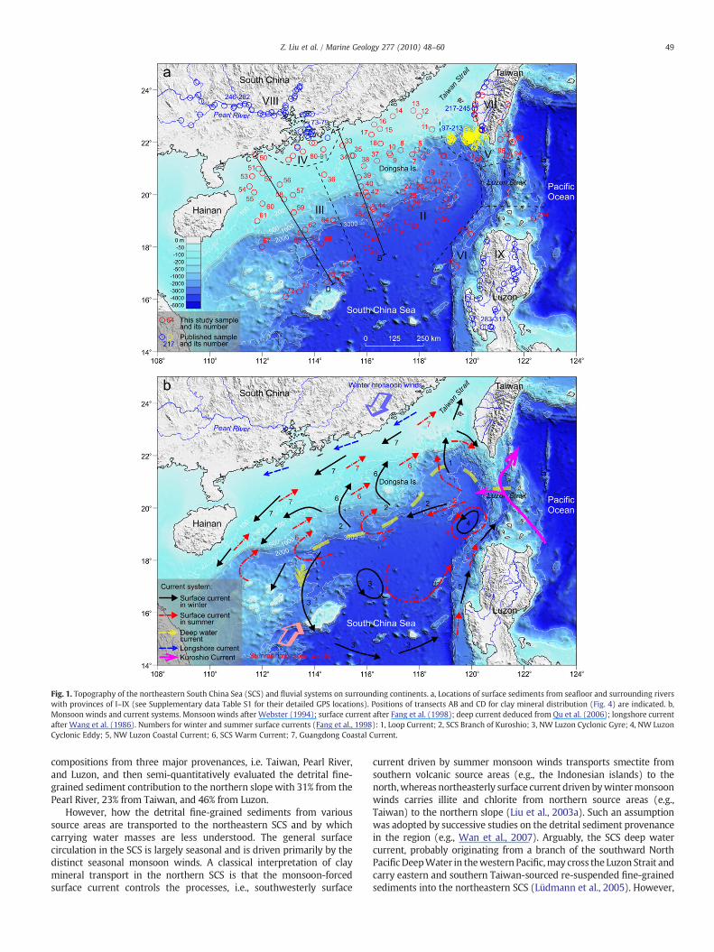
Fig. 1. Topography of the northeastern South China Sea (SCS) and fluvial systems on surrounding continents. a, Locations of surface sediments from seafloor and surrounding riverswith provinces of I–IX (see Supplementary data Table S1 for their detailed GPS locations). Positions of transects AB and CD for clay mineral distribution (Fig. 4) are indicated. b,Monsoon winds and current systems. Monsoon winds after Webster (1994); surface current after Fang et al. (1998); deep current deduced from Qu et al. (2006); longshore currentafter Wang et al. (1986). Numbers for winter and summer surface currents (Fang et al., 1998): 1, Loop Current; 2, SCS Branch of Kuroshio; 3, NW Luzon Cyclonic Gyre; 4, NW LuzonCyclonic Eddy; 5, NW Luzon Coastal Current; 6, SCS Warm Current; 7, Guangdong Coastal Current.
49Z. Liu et al. / Marine Geology 277 (2010) 48–60
compositions from three major provenances, i.e. Taiwan, Pearl River,and Luzon, and then semi-quantitatively evaluated the detrital fine-grained sediment contribution to the northern slope with 31% from thePearl River, 23% from Taiwan, and 46% from Luzon.
However, how the detrital fine-grained sediments from varioussource areas are transported to the northeastern SCS and by whichcarrying water masses are less understood. The general surfacecirculation in the SCS is largely seasonal and is driven primarily by thedistinct seasonal monsoon winds. A classical interpretation of claymineral transport in the northern SCS is that the monsoon-forcedsurface current controls the processes, i.e., southwesterly surface
current driven by summer monsoon winds transports smectite fromsouthern volcanic source areas (e.g., the Indonesian islands) to thenorth,whereas northeasterly surface current driven bywintermonsoonwinds carries illite and chlorite from northern source areas (e.g.,Taiwan) to the northern slope (Liu et al., 2003a). Such an assumptionwas adopted by successive studies on the detrital sediment provenancein the region (e.g., Wan et al., 2007). Arguably, the SCS deep watercurrent, probably originating from a branch of the southward NorthPacificDeepWater in thewestern Pacific,may cross the Luzon Strait andcarry eastern and southern Taiwan-sourced re-suspended fine-grainedsediments into the northeastern SCS (Lüdmann et al., 2005). However,
50 Z. Liu et al. / Marine Geology 277 (2010) 48–60
these transport processes either by monsoon-forced surface current orby intruded deepwater current are short of evidence from sedimentaryrecords in the northeastern SCS.
In this study, clay mineralogy of densely distributed surfacesediments has been established throughout the northeastern SCS andsurrounding fluvial drainage basins by investigating many newsamples (mainly in the northeastern SCS) and compiling publishedclaymineral data (mainly in surrounding source areas). The objectivesof this study include: (1) to give an overview on clay mineraldistribution patterns in marine surface sediments and on detrital fine-grained sediment supply from the individual provenance; (2) todeduce spatial transport processes of the main clay mineral species,relating to surface, deep, and longshore currents in the northeasternSCS; (3) to imply the knowledge for interpretation of late Quaternaryclay mineral assemblages in terms of the East Asian monsoonevolution.
2. Environmental background
2.1. Climatic conditions and oceanography
The East Asianmonsoon is the prevailing climate feature in the SCSand surrounding region. Seasonally reversing summer and wintermonsoon winds drive seasonal precipitation and runoff regimeswhich determine, in part, the soil and vegetation distribution(Webster, 1994; Wang et al., 2003). The winter monsoon ischaracterized by continental cooling and the development of highpressure over northern Asia, resulting in northeast winds across theSCS (Fig. 1b). In contrast, the summer monsoon is characterized bycontinental heating, the development of low pressure over centralChina, and moderate southwesterly winds passing through the SCS.Nowadays, the strong winter monsoon lasts nearly six months(November to April), while the relatively weaker summer monsoonlasts only nearly four months (mid-May to mid-September) (Chu andWang, 2003).
The general surface circulation in the northern SCS is largelyseasonal and is driven primarily by the distinct seasonal monsoonwinds, with strong influence from the Kuroshio intrusion (Shaw andChao, 1994; Fang et al., 1998; Su, 2004) (Fig. 1b). In winter, a basin-wide cyclonic gyre (NW Luzon Cyclonic Gyre) exists in the northernSCS with two cores, one located immediately to the northwest ofLuzon (called NWLuzon Cyclonic Eddy) and the other located at about17°N and 116°E (Fang et al., 1998). A series of mesoscale anticycloniceddies distributed along the continental slope from the southwest ofTaiwan to the west of the Dongsha Islands (called Loop Current andSCS Branch of Kuroshio/SCS Warm Current, respectively) weresuggested as the detachment of warm rings from the Kuroshio (Huet al., 2000; Caruso et al., 2006; Yuan et al., 2006). The northeastwardSCS Warm Current is a flow separated from the SCS Branch ofKuroshio. The coastal current mainly on the northern shelf (calledGuangdong Coastal Current) follows along the northeasterly directionof the winter monsoon winds. In summer, the NW Luzon CyclonicGyre still exists in the northern SCS but is reduced and shifts eastward,and the NW Luzon Cyclonic Eddy keeps at the same location (Fanget al., 1998). The mesoscale anticyclonic SCS Branch of Kuroshio/SCSWarm Current eddies also shift southeastward. Instead, the reversedGuangdong Coastal Current merged with the SCS Warm Currentbecomes prevailing southeasterly surface current forced apparentlyby the summer monsoon winds. Influenced probably by the NWLuzon Cyclonic Gyre, the coastal current west of Luzon (called NWLuzon Coastal Current) flows to the north regardless of any change inmonsoon winds. There is a longshore current south of South Chinathat flows southwestward during all seasons of a year (Wang et al.,1986).
The intrusion of the Kuroshio may occur all year long but is atransient phenomenon with less than 30% of the time on average
(Yuan et al., 2006). The dominant path of the Kuroshio intrusion inwinter was observed as a direct route from northeast of Luzon tosouthwest of Taiwan and then westward along the northern slope ofthe SCS, while in summer deviating from the winter's dominant pathsouthward (Yuan et al., 2006). The path is approximately along theboundary between the NW Luzon Cyclonic Gyre/Eddy in the southand the SCS Branch of Kuroshio/Loop Current in the north (Fig. 1b),without a strong seasonal difference but only a southeastward shiftand becoming weak during the summer. Although the Kuroshiointrusion may have different appearances reported by variousresearchers, like a SCS branch of the Kuroshio, a loop current, acyclonic eddy, or a seasonally reversing Guangdong coastal current(see review by Hu et al., 2000), the westwardmovement of mesoscaleeddies originated from the Kuroshio intrusion is important for themass, heat, salt, and especially sediment transport in the northernSCS.
The Luzon Strait with a sill depth of about 2400 m is the only deeppassage connecting the SCS with the western Pacific. Sedimenttransport carried by the deep water current from the Luzon Straitwestward to the northern slope of the SCS has been already deducedfrom previous studies (Lüdmann et al., 2005; Shao et al., 2007).However, there is virtually no direct observation indicative of anydistribution route of the Pacific DeepWater into the deep SCS. Qu et al.(2006) reported the density field based on the synthetic salinity datathat may throw some light on the deep SCS circulation. They deducedthat the deep water current (2000–2500 m) once enters the SCSthrough the Luzon Strait, first turns northwestward and then turnssouthwestward along the continental margins off southeast China andeast Vietnam (Qu et al., 2006) (Fig. 1b). The existence of this deeplayer circulation in the SCS is clearly seen in high-resolution generalcirculation models (Qu et al., 2004). The deep SCS water is thenbelieved to upwell into the intermediate SCS water between 250 and1350 m, which is finally exported out of the SCS through the LuzonStrait again (Su, 2004).
2.2. Terrigenous sediment supply to the northeastern SCS
Numerous rivers including both the world's largest rivers (e.g.,Mekong River, Pearl River, and Red River) and small mountainousrivers (e.g., rivers in southwestern Taiwan) supply asmuch as 570 Mt/yr of suspended (fine-grained) sediments to the SCS, representing2.8% of estimated global suspended sediment discharge to the worldoceans (Milliman and Syvitski, 1992; Dadson et al., 2003). However,the northeastern SCS alone receives no less than 260 Mt/yr ofsuspended river sediments mainly from three prominent sources,i.e. Pearl River, southwestern Taiwan, and Luzon arc system (Fig. 1;Table 1), occupying almost half of total terrigenous discharge to theentire SCS.
Among the three sources, southwestern Taiwan makes the largestsuspended sediment discharge directly to the SCS (Dadson et al., 2003).The majority of illite and chlorite in clay mineral components insouthwestern Taiwan river sediments (Wan et al., 2007; Liu, Z. et al.,2008) implies a strong physical weathering due mainly to extremelyhigh erosion rates triggered by earthquake and storm activities (Dadsonet al., 2003; Liu et al., 2006;Huhet al., 2009). ThePearl River actingas thelargest river surrounding the northeastern SCS contributes significantsuspended sediments with abundant kaolinite in clay mineral compo-nents, indicating an intensive chemical weathering affected by warmclimate with heavy monsoon precipitation and stable tectonics as well(Liu et al., 2007a,b). Although two rivers (Pampanga andAngoRivers) inLuzon providemuch less suspended sediments to the SCS (Table 1), thedischarge data of the largest river in Luzon (Cagayan River) is notavailable from literatures (Liu et al., 2009). Furthermore, widelydistributed smectite in the northeastern SCS was suggested derivingfrom chemical weathering of the Luzon arc system, which includesLuzon in the south, subsurface volcanic system in the Luzon Strait in the

Table 1Drainage area, runoff, and suspended sediment discharge of major rivers flowingdirectly into the northeastern South China Sea (SCS).
River Drainagearea (km2)
Runoff(m/yr)
Suspendedsedimentdischarge
Data source
(Mt/yr)
Ta-An (Taiwan) 633 1.6 7.1 Dadson et al. (2003)Wu (Taiwan) 1981 1.9 9.8Cho-Shui (Taiwan) 2989 1.2 54.1Pei-Kang (Taiwan) 597 1.3 2.2Pa-Chang (Taiwan) 441 1.5 6.3Tseng-Wen (Taiwan) 1157 1.1 25.1Erh-Jen (Taiwan) 175 1.8 30.2Kao-Ping (Taiwan) 3067 2.5 49Tung-Kang (Taiwan) 175 2.9 0.4Lin-Pien (Taiwan) 310 2.5 3.3Total SW Taiwan 187.5PampangaRiver (Luzon) 8625 3.5 Liu et al. (2009)Agno River (Luzon) 6340 4.7Vigan River (Luzon) 5208 Not
availableCagayan River (Luzon) 30,416 Not
availableTotal Luzon N8.2Pearl (South China) 440,000 6.9 69 Milliman and Syvitski
(1992)
51Z. Liu et al. / Marine Geology 277 (2010) 48–60
middle, and the Coastal Range of eastern Taiwan in the north (Liu, Z. etal., 2008). Apart from the two rivers in Luzon, other components of theLuzon arc system are not evaluated for the weathered productdischarge.
3. Materials and methods
A set of 317 surface samples throughout the northeastern SCS andsurrounding fluvial drainage basins are analyzed for clay mineralogy,including 98 new samples (mainly in the northeastern SCS) and 219samples with our previously published clay mineral data (mainly insurrounding source areas) (Fig. 1a; Supplementary data Table S1), inorder to determine the provenance of clay minerals and to give anoverview on clay mineral distribution patterns in the northeasternSCS. The new samples (shown as red circles in Fig. 1a) mainly include71 samples from the northeastern SCS and 7 samples from the PearlRiver offshore, which were collected mainly by the SONNE Cruise 95during 1994, the Multidisciplinary Oceanography Expedition to theNorthern Continental Slope of the South China Sea (Chinese Academyof Sciences) during 1979–1982, the Northern South China Sea OpenCruise by R/V Shiyan 3 of South China Sea Institute of Oceanology(Chinese Academy of Sciences) during 2004–2006, and the NationalNatural Science Foundation of China (NSFC) South China Sea OpenCruise during 2010. Four samples off southeast Taiwan and 5 sampleson the eastern slope off South China were taken by the R/V OceanResearcher I during 1998–1999 (Huang et al., 1992). Ten additionalsurface samples from middle-southern Taiwan rivers were collectedduring the summer season of 2008.
The referred samples with published clay mineral data aredistributed mainly in surrounding drainage basins and their offshoreareas, including 37 samples from the Pearl River (Liu et al., 2007b), 12samples from the Pearl River offshore (Liu et al., 2007a), 19 samplesfrom southwest Taiwan rivers and 119 samples from its offshore (Liu, Z.et al., 2008), and 35 samples from Luzon rivers (Liu et al., 2009). In orderto classify the locations of all surface samples, nine provinces (I–IX) aredivided geographically as: Luzon Strait (Province I), Eastern NE SCS(Province II), Western NE SCS (Province III), Pearl River Offshore(Province IV), Taiwan Offshore (Province V), Luzon Offshore (ProvinceVI), Taiwan Rivers (Province VII), Pearl River (Province VIII), and LuzonRivers (Province IX) (Fig. 1a; Supplementary data Table S1).
Clay minerals were identified by X-ray diffraction (XRD) using aPANalytical diffractometermainly at the Laboratoire IDES, Université deParis XI,with only 18 samples (collected during theNSFCOpenCruise in2010) at the State Key Laboratory of Marine Geology, Tongji University,on oriented mounts of non-calcareous clay-sized (b2 μm) particles(Holtzapffel, 1985). The oriented mounts were obtained following themethods described in detail by Liu et al. (2004). Three XRD runs wereperformed, following air-drying, ethylene-glycol solvation for 24 h, andheating at 490 °C for 2 h. Identification of clay minerals was mademainly according to the position of the (0 0 1) series of basal reflectionson the three XRDdiagrams. Semi-quantitative estimates of peak areas ofthe basal reflections for the main clay mineral groups of smectite(including mixed-layers) (15–17 Å), illite (10 Å), and kaolinite/chlorite(7 Å)were carried out on the glycolated curve (Fig. 2) using theMacDiffsoftware (Petschick, 2000). Mixed-layers mainly of smectite-illite(15–16 Å) are included in “semctite” (e.g., Fig. 2a). However, mixed-layersmainly of chlorite-illite (11–13 Å)withveryminor abundancearenot calculated (e.g., Fig. 2b). Relative proportions of kaolinite andchloritewere determined based on the ratio from the 3.57/3.54 Å peakareas. Following the laboratory routine at both the Laboratoire IDES ofUniversité de Paris XI and the Laboratoire PBDS of Université de Lille I(Liu et al., 2003a, 2007b), the weighting factors introduced by Biscaye(1965) or Holtzapffel (1985) are not used when generating relativeweight percentages of each clay mineral, because such regularweighting factors actually do not exist by systemic experiences(Gensac, 2008). Replicate analyses of a few selected samples gave aprecision of ±2% (2σ). Based upon the XRD method, the semi-quantitative evaluation of each clay mineral has an accuracy of ~5%.Additionally, illite crystallinity was obtained from half height width ofthe 10 Å peak on the glycolated curve (Fig. 2a) to track source regionsand transport paths (Petschick et al., 1996).
All the referred published clay mineral data were generated underexactly the same analytical method using the same PANalyticaldiffractometer at the Laboratoire IDES, Université de Paris XI, keepingthe consistency of data comparison. The semi-quantitative calculationof clay minerals on the literature data was repeated using the MacDiffsoftware (Petschick, 2000) in order to unify the baseline (Fig. 2),which may significantly change the result. The updated clay mineralassemblages on the set of samples keep the consistent values to thepreviously published values with a difference of b5%. The completedataset including this study and re-calculated literature data can befound at Supplementary data Table S1.
4. Results
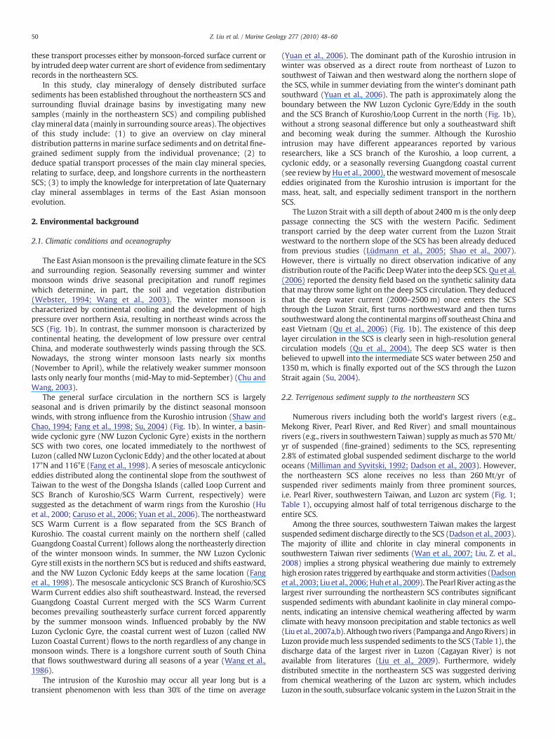
The clay mineral assemblages in the northeastern SCS andsurrounding fluvial drainage basins are similar in each province orsub-province, but largely diverse between different provinces.Therefore, we group the clay mineral components in each provinceor sub-province and present them as average mineral assemblagesindicated by histograms in Fig. 3. The sub-province in the northeast-ern South China Sea was decided visually in a certain geographicalarea with similar clay mineral assemblages of neighboring samplingsites. The average clay mineral data calculated from various provincesare listed in Table 2.
4.1. Pearl River and its offshore
The Pearl River (Province VIII) sediments consist mainly of kaolinite(average 46%), illite (31%), and chlorite (18%)with scarce smectite (5%)(Fig. 2b) (Liu et al., 2007a,b). Each clay mineral content from differentriver sections may vary by not more than 10% (Supplementary dataTable S1). But at some locations in the eastern and northern parts of theriver, kaolinite can reach as high as 68–72% (e.g., No. 250, PR05),whereas at a location in thewestern part, illite can reach even 55% (e.g.,No. 282, PR41-1). The dominant kaolinite content throughout the Pearl

Fig. 2. Multiple X-ray diffractograms of typical samples from the northeastern SCS and surrounding major river drainages basins, showing interpretation of major clay mineralspecies from the three classical runs, i.e. in air-dried, glycolated, and heated conditions. a, Northeastern SCS (No. 44, sample nameMD05-2904). b, Pearl River (No. 265, sample namePR21). c. Taiwan river (No. 222, sample name FG5). d. Luzon river (No. 295, sample name LZ16, after Liu et al., 2009). The unified baseline is shown on the glycolated curve for semi-quantitative calculation. See Fig. 1a and Supplementary data Table S1 for their detailed locations and clay mineral assemblages.
52 Z. Liu et al. / Marine Geology 277 (2010) 48–60
River basin suggests an intensive chemical weathering of exposed rocksincluding granites in the east as well as sedimentary rocks in the entirebasin (Liu et al., 2007a,b). Warm and humid climate conditionscombined with a low-relief and stable (cratonic) morphology in thePearl River basin should contribute to the intensive weatheringprocesses (Liu et al., 2007b).
The Pearl River offshore (Province IV) sediments present lesskaolinite (37%), a little more smectite (10%) and chlorite (23%), andsimilar content of illite (30%) comparing with the clay mineralassemblages in the Pearl River basin (Liu et al., 2007a). Because thesample locations in this province change widely from the innerestuary (Lingdingyang) to the middle continental shelf, relativelylarge difference in clay contents exists in smectite (3–26%) andkaolinite (28–42%), with more smectite away from the river mouthandmore kaolinite within the estuary (Supplementary data Table S1).
4.2. Taiwan rivers and its offshore
Taiwan rivers' (Province VII) sediments from all 13 major tomoderate rivers in the middle-southern island consist dominantly ofillite (53%) and chlorite (37%), with scarce smectite (5%) and kaolinite(5%) (Fig. 2c) (Liu, Z. et al., 2008). The smectite and kaolinite contentsare very rare in some southwestern rivers (e.g., the Kao-Ping River)with their percentages less than 3%, respectively (Supplementary dataTable S1). But in some middle-western rivers, the smectite contentcan reach 17% and the kaolinite content may reach 14% (e.g., the Ba-Chang River). Rivers in southeastern Taiwan also show a relativelyhigh content of smectite (13%) (i.e., the Hsiu-Ku-Luan River). Themajority of illite and chlorite in clay mineral components in Taiwanriver sediments implies a strong physical weathering of exposedCenozoic sedimentary rocks under rapid uplift activities since the
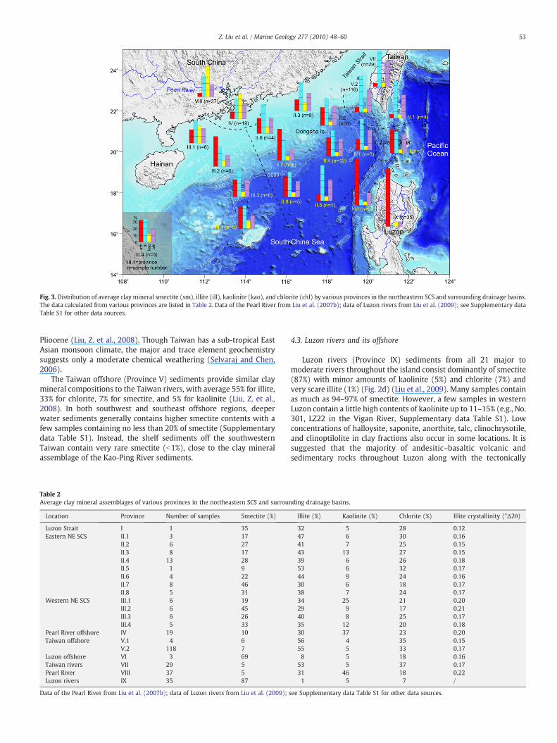
Fig. 3. Distribution of average clay mineral smectite (sm), illite (ill), kaolinite (kao), and chlorite (chl) by various provinces in the northeastern SCS and surrounding drainage basins.The data calculated from various provinces are listed in Table 2. Data of the Pearl River from Liu et al. (2007b); data of Luzon rivers from Liu et al. (2009); see Supplementary dataTable S1 for other data sources.
53Z. Liu et al. / Marine Geology 277 (2010) 48–60
Pliocene (Liu, Z. et al., 2008). Though Taiwan has a sub-tropical EastAsian monsoon climate, the major and trace element geochemistrysuggests only a moderate chemical weathering (Selvaraj and Chen,2006).
The Taiwan offshore (Province V) sediments provide similar claymineral compositions to the Taiwan rivers, with average 55% for illite,33% for chlorite, 7% for smectite, and 5% for kaolinite (Liu, Z. et al.,2008). In both southwest and southeast offshore regions, deeperwater sediments generally contains higher smectite contents with afew samples containing no less than 20% of smectite (Supplementarydata Table S1). Instead, the shelf sediments off the southwesternTaiwan contain very rare smectite (b1%), close to the clay mineralassemblage of the Kao-Ping River sediments.
Table 2Average clay mineral assemblages of various provinces in the northeastern SCS and surrou
Location Province Number of samples Smectite (%)
Luzon Strait I 1 35Eastern NE SCS II.1 3 17
II.2 6 27II.3 8 17II.4 13 28II.5 1 9II.6 4 22II.7 8 46II.8 5 31
Western NE SCS III.1 6 19III.2 6 45III.3 6 26III.4 5 33
Pearl River offshore IV 19 10Taiwan offshore V.1 4 6
V.2 118 7Luzon offshore VI 3 69Taiwan rivers VII 29 5Pearl River VIII 37 5Luzon rivers IX 35 87
Data of the Pearl River from Liu et al. (2007b); data of Luzon rivers from Liu et al. (2009);
4.3. Luzon rivers and its offshore
Luzon rivers (Province IX) sediments from all 21 major tomoderate rivers throughout the island consist dominantly of smectite(87%) with minor amounts of kaolinite (5%) and chlorite (7%) andvery scare illite (1%) (Fig. 2d) (Liu et al., 2009). Many samples containas much as 94–97% of smectite. However, a few samples in westernLuzon contain a little high contents of kaolinite up to 11–15% (e.g., No.301, LZ22 in the Vigan River, Supplementary data Table S1). Lowconcentrations of halloysite, saponite, anorthite, talc, clinochrysotile,and clinoptilolite in clay fractions also occur in some locations. It issuggested that the majority of andesitic–basaltic volcanic andsedimentary rocks throughout Luzon along with the tectonically
nding drainage basins.
Illite (%) Kaolinite (%) Chlorite (%) Illite crystallinity (°Δ2θ)
32 5 28 0.1247 6 30 0.1641 7 25 0.1543 13 27 0.1539 6 26 0.1853 6 32 0.1744 9 24 0.1630 6 18 0.1738 7 24 0.1734 25 21 0.2029 9 17 0.2140 8 25 0.1735 12 20 0.1830 37 23 0.2056 4 35 0.1555 5 33 0.178 5 18 0.16
53 5 37 0.1731 46 18 0.221 5 7 /
see Supplementary data Table S1 for other data sources.
54 Z. Liu et al. / Marine Geology 277 (2010) 48–60
active geological setting and sub-tropical East Asian monsoon climateare responsible for the predominance of smectite (Liu et al., 2009).
Three samples in the Luzon offshore (Province VI) both in thenorth and west present high content of smectite (69%), with lesschlorite (18%) and minor amounts of illite (8%) and kaolinite (5%).Relatively, chlorite and illite contents slightly increase seawards andthe smectite content decreases accordingly, while the kaolinitecontent keeps a very low value (5%) (Fig. 3).
4.4. Luzon Strait
Only one sample (No. 1, RC14-88, Supplementary data Table S1) isreported in the Luzon Strait (Province I) with a clay mineralassemblage of major smectite (35%), illite (32%), and chlorite (28%),and minor kaolinite (5%). The sample is situated in the forearc basinbetween the Luzon arc system in the east and the accretionary prismin the west (Fig. 1a), where suspended detrital sediments fromTaiwan rivers in the north and Luzon rivers in the south are mixed.Therefore, the contents of all four main clay mineral species arebetween those of two islands (Fig. 3; Table 2).
4.5. Northeastern SCS
The clay mineral distribution in the northeastern SCS presentslarge diverseness between different locations, and therefore twoprovinces with 11 sub-provinces are divided in order to better displaytheir spatial changes (Fig. 3; Table 2).
4.5.1. Eastern NE SCSIn the eastern NE SCS (Province II), clay mineral assemblages vary
greatly from the deep basin to the continental slope and shelf (Fig. 4a).In the deep basin (sub-provinces II.1 and II.5), smectite contents(b12%) are very low, while illite (50%) and chlorite (32%) are quitehigh. Along with low kaolinite contents (6%), the clay mineralassemblage in the deep basin is very close to that of Taiwan and itsoffshore sediments. Towards the slope (sub-provinces II.2, II.4, II.7,and II.8) and shelf (sub-provinces II.3 and II.6), the smectite contentincreases greatly from ~12% in the deep basin to ~40% on the slope,and then decreases to ~20% on the shelf (Fig. 4a). On the contrary, theillite and chlorite contents decrease largely from the deep basin to thecontinental slope and shelf (illite, 32–41%; chlorite, 20–37%). Instead,
Fig. 4. Clay mineral distribution along depth transects in the northern SCS. a
the kaolinite content keeps very low values (6–10%) in the entireeastern NE SCS, except for the inner shelf close to the Pearl Riverestuary with values higher than 20% (Fig. 4a), indicating the influenceof the Pearl River sediment discharge.
4.5.2. Western NE SCSIn the western NE SCS (Province III), clay mineral assemblages are
stable in the lower slope (sub-provinces III.3 and III.4) with moderatesmectite (27–33%), illite (35–40%), and chlorite (20–24%), and minorkaolinite (9–12%) (Fig. 3). Towards the upper slope (sub-provinceIII.2), the smectite content increases to 45%, while illite and chloritecontents decrease averagely to 29% and 17%, respectively (Fig. 4b).Similarly to the eastern NE SCS, the kaolinite content doesn't changefrom the lower to upper slopewith an average value of 9%. To the shelfof the western NE SCS (sub-province III.1), however, the kaolinitecontent increases to 25%, while the smectite contents decreases to19%. Illite and chlorite contents don't vary significantly from the slopeto shelf.
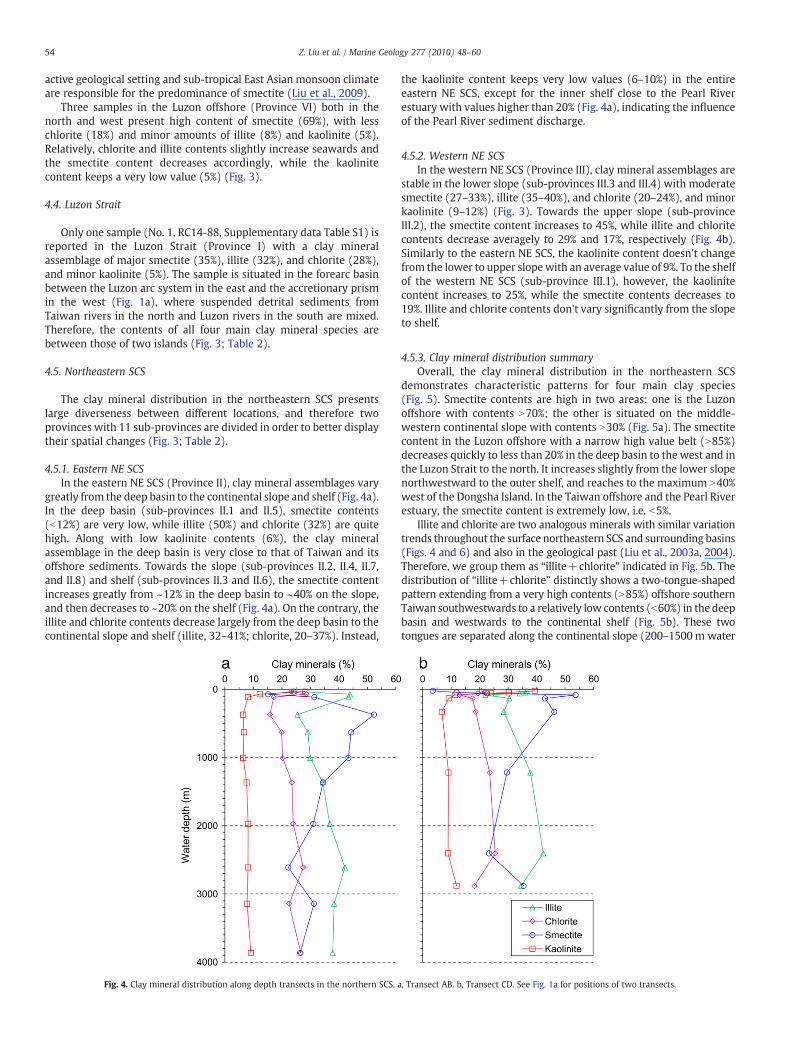
4.5.3. Clay mineral distribution summaryOverall, the clay mineral distribution in the northeastern SCS
demonstrates characteristic patterns for four main clay species(Fig. 5). Smectite contents are high in two areas: one is the Luzonoffshore with contents N70%; the other is situated on the middle-western continental slope with contents N30% (Fig. 5a). The smectitecontent in the Luzon offshore with a narrow high value belt (N85%)decreases quickly to less than 20% in the deep basin to the west and inthe Luzon Strait to the north. It increases slightly from the lower slopenorthwestward to the outer shelf, and reaches to the maximum N40%west of the Dongsha Island. In the Taiwan offshore and the Pearl Riverestuary, the smectite content is extremely low, i.e. b5%.
Illite and chlorite are two analogous minerals with similar variationtrends throughout the surface northeastern SCS and surrounding basins(Figs. 4 and 6) and also in the geological past (Liu et al., 2003a, 2004).Therefore, we group them as “illite+chlorite” indicated in Fig. 5b. Thedistribution of “illite+chlorite” distinctly shows a two-tongue-shapedpattern extending from a very high contents (N85%) offshore southernTaiwan southwestwards to a relatively low contents (b60%) in the deepbasin and westwards to the continental shelf (Fig. 5b). These twotongues are separated along the continental slope (200–1500m water
, Transect AB. b, Transect CD. See Fig. 1a for positions of two transects.
Fig.
5.Sp
atiald
istributionof
clay
mineral
conten
tco
ntou
rs(%
)an
dillitecrystallinity
(°Δ2θ
)in
theno
rthe
astern
SCS.
a,Sm
ectite.b
,Illite
+ch
lorite.c
,Kao
linite.
d,Illitecrystallinity.
55Z. Liu et al. / Marine Geology 277 (2010) 48–60
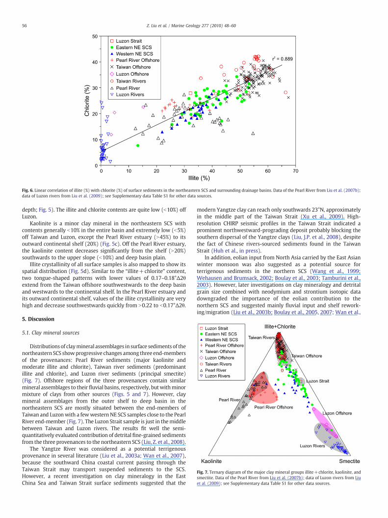
Fig. 6. Linear correlation of illite (%) with chlorite (%) of surface sediments in the northeastern SCS and surrounding drainage basins. Data of the Pearl River from Liu et al. (2007b);data of Luzon rivers from Liu et al. (2009); see Supplementary data Table S1 for other data sources.
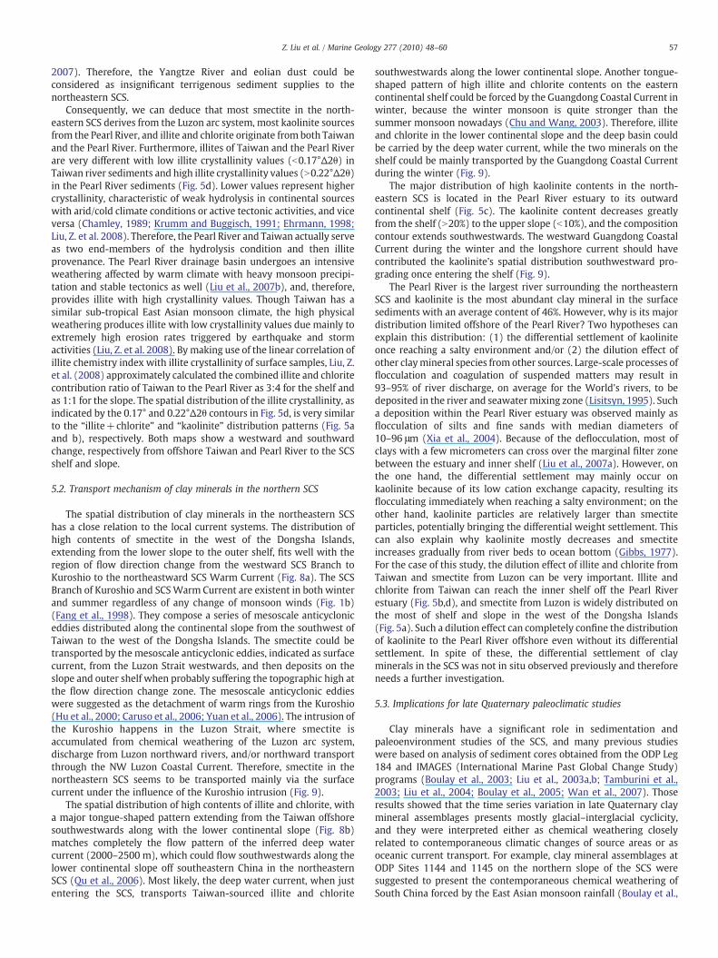
Fig. 7. Ternary diagram of the major clay mineral groups illite+chlorite, kaolinite, andsmectite. Data of the Pearl River from Liu et al. (2007b); data of Luzon rivers from Liuet al. (2009); see Supplementary data Table S1 for other data sources.
56 Z. Liu et al. / Marine Geology 277 (2010) 48–60
depth; Fig. 5). The illite and chlorite contents are quite low (b10%) offLuzon.
Kaolinite is a minor clay mineral in the northeastern SCS withcontents generally b10% in the entire basin and extremely low (b5%)off Taiwan and Luzon, except the Pearl River estuary (N45%) to itsoutward continental shelf (20%) (Fig. 5c). Off the Pearl River estuary,the kaolinite content decreases significantly from the shelf (N20%)southwards to the upper slope (b10%) and deep basin plain.
Illite crystallinity of all surface samples is also mapped to show itsspatial distribution (Fig. 5d). Similar to the “illite+chlorite” content,two tongue-shaped patterns with lower values of 0.17–0.18°Δ2θextend from the Taiwan offshore southwestwards to the deep basinand westwards to the continental shelf. In the Pearl River estuary andits outward continental shelf, values of the illite crystallinity are veryhigh and decrease southwestwards quickly from N0.22 to b0.17°Δ2θ.
5. Discussion
5.1. Clay mineral sources
Distributions of claymineral assemblages in surface sediments of thenortheastern SCS showprogressive changes among three end-membersof the provenances: Pearl River sediments (major kaolinite andmoderate illite and chlorite), Taiwan river sediments (predominantillite and chlorite), and Luzon river sediments (principal smectite)(Fig. 7). Offshore regions of the three provenances contain similarmineral assemblages to their fluvial basins, respectively, but withminormixture of clays from other sources (Figs. 5 and 7). However, claymineral assemblages from the outer shelf to deep basin in thenortheastern SCS are mostly situated between the end-members ofTaiwan and Luzonwith a fewwestern NE SCS samples close to the PearlRiver end-member (Fig. 7). The Luzon Strait sample is just in themiddlebetween Taiwan and Luzon rivers. The results fit well the semi-quantitatively evaluated contribution of detrital fine-grained sedimentsfrom the three provenances to the northeastern SCS (Liu, Z. et al., 2008).
The Yangtze River was considered as a potential terrigenousprovenance in several literature (Liu et al., 2003a; Wan et al., 2007),because the southward China coastal current passing through theTaiwan Strait may transport suspended sediments to the SCS.However, a recent investigation on clay mineralogy in the EastChina Sea and Taiwan Strait surface sediments suggested that the
modern Yangtze clay can reach only southwards 23°N, approximatelyin the middle part of the Taiwan Strait (Xu et al., 2009). High-resolution CHIRP seismic profiles in the Taiwan Strait indicated aprominent northwestward-prograding deposit probably blocking thesouthern dispersal of the Yangtze clays (Liu, J.P. et al., 2008), despitethe fact of Chinese rivers-sourced sediments found in the TaiwanStrait (Huh et al., in press).
In addition, eolian input from North Asia carried by the East Asianwinter monsoon was also suggested as a potential source forterrigenous sediments in the northern SCS (Wang et al., 1999;Wehausen and Brumsack, 2002; Boulay et al., 2003; Tamburini et al.,2003). However, later investigations on clay mineralogy and detritalgrain size combined with neodymium and strontium isotopic datadowngraded the importance of the eolian contribution to thenorthern SCS and suggested mainly fluvial input and shelf rework-ing/migration (Liu et al., 2003b; Boulay et al., 2005, 2007; Wan et al.,
57Z. Liu et al. / Marine Geology 277 (2010) 48–60
2007). Therefore, the Yangtze River and eolian dust could beconsidered as insignificant terrigenous sediment supplies to thenortheastern SCS.
Consequently, we can deduce that most smectite in the north-eastern SCS derives from the Luzon arc system, most kaolinite sourcesfrom the Pearl River, and illite and chlorite originate from both Taiwanand the Pearl River. Furthermore, illites of Taiwan and the Pearl Riverare very different with low illite crystallinity values (b0.17°Δ2θ) inTaiwan river sediments and high illite crystallinity values (N0.22°Δ2θ)in the Pearl River sediments (Fig. 5d). Lower values represent highercrystallinity, characteristic of weak hydrolysis in continental sourceswith arid/cold climate conditions or active tectonic activities, and viceversa (Chamley, 1989; Krumm and Buggisch, 1991; Ehrmann, 1998;Liu, Z. et al. 2008). Therefore, the Pearl River and Taiwan actually serveas two end-members of the hydrolysis condition and then illiteprovenance. The Pearl River drainage basin undergoes an intensiveweathering affected by warm climate with heavy monsoon precipi-tation and stable tectonics as well (Liu et al., 2007b), and, therefore,provides illite with high crystallinity values. Though Taiwan has asimilar sub-tropical East Asian monsoon climate, the high physicalweathering produces illite with low crystallinity values due mainly toextremely high erosion rates triggered by earthquake and stormactivities (Liu, Z. et al. 2008). By making use of the linear correlation ofillite chemistry index with illite crystallinity of surface samples, Liu, Z.et al. (2008) approximately calculated the combined illite and chloritecontribution ratio of Taiwan to the Pearl River as 3:4 for the shelf andas 1:1 for the slope. The spatial distribution of the illite crystallinity, asindicated by the 0.17° and 0.22°Δ2θ contours in Fig. 5d, is very similarto the “illite+chlorite” and “kaolinite” distribution patterns (Fig. 5aand b), respectively. Both maps show a westward and southwardchange, respectively from offshore Taiwan and Pearl River to the SCSshelf and slope.
5.2. Transport mechanism of clay minerals in the northern SCS
The spatial distribution of clay minerals in the northeastern SCShas a close relation to the local current systems. The distribution ofhigh contents of smectite in the west of the Dongsha Islands,extending from the lower slope to the outer shelf, fits well with theregion of flow direction change from the westward SCS Branch toKuroshio to the northeastward SCS Warm Current (Fig. 8a). The SCSBranch of Kuroshio and SCSWarm Current are existent in both winterand summer regardless of any change of monsoon winds (Fig. 1b)(Fang et al., 1998). They compose a series of mesoscale anticycloniceddies distributed along the continental slope from the southwest ofTaiwan to the west of the Dongsha Islands. The smectite could betransported by the mesoscale anticyclonic eddies, indicated as surfacecurrent, from the Luzon Strait westwards, and then deposits on theslope and outer shelf when probably suffering the topographic high atthe flow direction change zone. The mesoscale anticyclonic eddieswere suggested as the detachment of warm rings from the Kuroshio(Hu et al., 2000; Caruso et al., 2006; Yuan et al., 2006). The intrusion ofthe Kuroshio happens in the Luzon Strait, where smectite isaccumulated from chemical weathering of the Luzon arc system,discharge from Luzon northward rivers, and/or northward transportthrough the NW Luzon Coastal Current. Therefore, smectite in thenortheastern SCS seems to be transported mainly via the surfacecurrent under the influence of the Kuroshio intrusion (Fig. 9).
The spatial distribution of high contents of illite and chlorite, witha major tongue-shaped pattern extending from the Taiwan offshoresouthwestwards along with the lower continental slope (Fig. 8b)matches completely the flow pattern of the inferred deep watercurrent (2000–2500 m), which could flow southwestwards along thelower continental slope off southeastern China in the northeasternSCS (Qu et al., 2006). Most likely, the deep water current, when justentering the SCS, transports Taiwan-sourced illite and chlorite
southwestwards along the lower continental slope. Another tongue-shaped pattern of high illite and chlorite contents on the easterncontinental shelf could be forced by the Guangdong Coastal Current inwinter, because the winter monsoon is quite stronger than thesummer monsoon nowadays (Chu and Wang, 2003). Therefore, illiteand chlorite in the lower continental slope and the deep basin couldbe carried by the deep water current, while the two minerals on theshelf could be mainly transported by the Guangdong Coastal Currentduring the winter (Fig. 9).
The major distribution of high kaolinite contents in the north-eastern SCS is located in the Pearl River estuary to its outwardcontinental shelf (Fig. 5c). The kaolinite content decreases greatlyfrom the shelf (N20%) to the upper slope (b10%), and the compositioncontour extends southwestwards. The westward Guangdong CoastalCurrent during the winter and the longshore current should havecontributed the kaolinite's spatial distribution southwestward pro-grading once entering the shelf (Fig. 9).
The Pearl River is the largest river surrounding the northeasternSCS and kaolinite is the most abundant clay mineral in the surfacesediments with an average content of 46%. However, why is its majordistribution limited offshore of the Pearl River? Two hypotheses canexplain this distribution: (1) the differential settlement of kaoliniteonce reaching a salty environment and/or (2) the dilution effect ofother claymineral species from other sources. Large-scale processes offlocculation and coagulation of suspended matters may result in93–95% of river discharge, on average for the World's rivers, to bedeposited in the river and seawatermixing zone (Lisitsyn, 1995). Sucha deposition within the Pearl River estuary was observed mainly asflocculation of silts and fine sands with median diameters of10–96 μm (Xia et al., 2004). Because of the deflocculation, most ofclays with a few micrometers can cross over the marginal filter zonebetween the estuary and inner shelf (Liu et al., 2007a). However, onthe one hand, the differential settlement may mainly occur onkaolinite because of its low cation exchange capacity, resulting itsflocculating immediately when reaching a salty environment; on theother hand, kaolinite particles are relatively larger than smectiteparticles, potentially bringing the differential weight settlement. Thiscan also explain why kaolinite mostly decreases and smectiteincreases gradually from river beds to ocean bottom (Gibbs, 1977).For the case of this study, the dilution effect of illite and chlorite fromTaiwan and smectite from Luzon can be very important. Illite andchlorite from Taiwan can reach the inner shelf off the Pearl Riverestuary (Fig. 5b,d), and smectite from Luzon is widely distributed onthe most of shelf and slope in the west of the Dongsha Islands(Fig. 5a). Such a dilution effect can completely confine the distributionof kaolinite to the Pearl River offshore even without its differentialsettlement. In spite of these, the differential settlement of clayminerals in the SCS was not in situ observed previously and thereforeneeds a further investigation.
5.3. Implications for late Quaternary paleoclimatic studies
Clay minerals have a significant role in sedimentation andpaleoenvironment studies of the SCS, and many previous studieswere based on analysis of sediment cores obtained from the ODP Leg184 and IMAGES (International Marine Past Global Change Study)programs (Boulay et al., 2003; Liu et al., 2003a,b; Tamburini et al.,2003; Liu et al., 2004; Boulay et al., 2005; Wan et al., 2007). Thoseresults showed that the time series variation in late Quaternary claymineral assemblages presents mostly glacial–interglacial cyclicity,and they were interpreted either as chemical weathering closelyrelated to contemporaneous climatic changes of source areas or asoceanic current transport. For example, clay mineral assemblages atODP Sites 1144 and 1145 on the northern slope of the SCS weresuggested to present the contemporaneous chemical weathering ofSouth China forced by the East Asian monsoon rainfall (Boulay et al.,
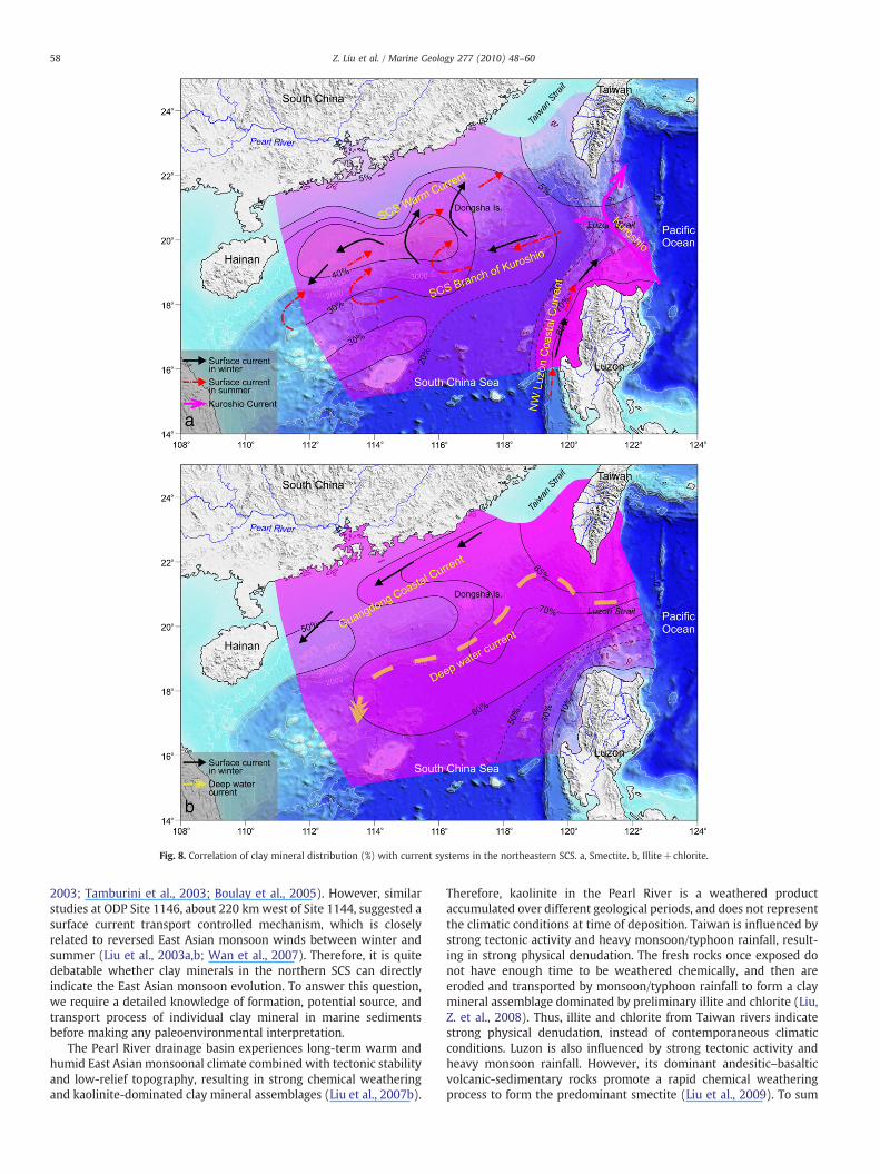
Fig. 8. Correlation of clay mineral distribution (%) with current systems in the northeastern SCS. a, Smectite. b, Illite+chlorite.
58 Z. Liu et al. / Marine Geology 277 (2010) 48–60
2003; Tamburini et al., 2003; Boulay et al., 2005). However, similarstudies at ODP Site 1146, about 220 km west of Site 1144, suggested asurface current transport controlled mechanism, which is closelyrelated to reversed East Asian monsoon winds between winter andsummer (Liu et al., 2003a,b; Wan et al., 2007). Therefore, it is quitedebatable whether clay minerals in the northern SCS can directlyindicate the East Asian monsoon evolution. To answer this question,we require a detailed knowledge of formation, potential source, andtransport process of individual clay mineral in marine sedimentsbefore making any paleoenvironmental interpretation.
The Pearl River drainage basin experiences long-term warm andhumid East Asian monsoonal climate combined with tectonic stabilityand low-relief topography, resulting in strong chemical weatheringand kaolinite-dominated clay mineral assemblages (Liu et al., 2007b).
Therefore, kaolinite in the Pearl River is a weathered productaccumulated over different geological periods, and does not representthe climatic conditions at time of deposition. Taiwan is influenced bystrong tectonic activity and heavy monsoon/typhoon rainfall, result-ing in strong physical denudation. The fresh rocks once exposed donot have enough time to be weathered chemically, and then areeroded and transported by monsoon/typhoon rainfall to form a claymineral assemblage dominated by preliminary illite and chlorite (Liu,Z. et al., 2008). Thus, illite and chlorite from Taiwan rivers indicatestrong physical denudation, instead of contemporaneous climaticconditions. Luzon is also influenced by strong tectonic activity andheavy monsoon rainfall. However, its dominant andesitic–basalticvolcanic-sedimentary rocks promote a rapid chemical weatheringprocess to form the predominant smectite (Liu et al., 2009). To sum
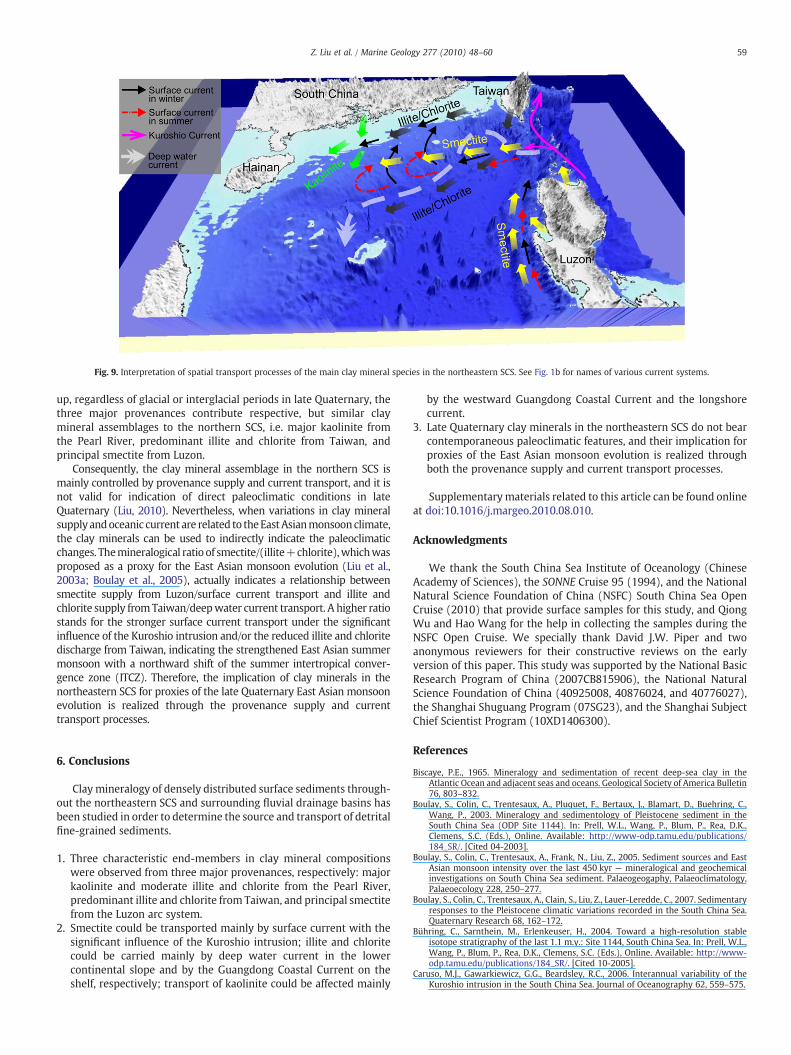
Fig. 9. Interpretation of spatial transport processes of the main clay mineral species in the northeastern SCS. See Fig. 1b for names of various current systems.
59Z. Liu et al. / Marine Geology 277 (2010) 48–60
up, regardless of glacial or interglacial periods in late Quaternary, thethree major provenances contribute respective, but similar claymineral assemblages to the northern SCS, i.e. major kaolinite fromthe Pearl River, predominant illite and chlorite from Taiwan, andprincipal smectite from Luzon.
Consequently, the clay mineral assemblage in the northern SCS ismainly controlled by provenance supply and current transport, and it isnot valid for indication of direct paleoclimatic conditions in lateQuaternary (Liu, 2010). Nevertheless, when variations in clay mineralsupplyandoceanic current are related to theEastAsianmonsoonclimate,the clay minerals can be used to indirectly indicate the paleoclimaticchanges. Themineralogical ratio of smectite/(illite+chlorite),whichwasproposed as a proxy for the East Asian monsoon evolution (Liu et al.,2003a; Boulay et al., 2005), actually indicates a relationship betweensmectite supply from Luzon/surface current transport and illite andchlorite supply fromTaiwan/deepwater current transport. A higher ratiostands for the stronger surface current transport under the significantinfluence of the Kuroshio intrusion and/or the reduced illite and chloritedischarge from Taiwan, indicating the strengthened East Asian summermonsoon with a northward shift of the summer intertropical conver-gence zone (ITCZ). Therefore, the implication of clay minerals in thenortheastern SCS for proxies of the late Quaternary East Asian monsoonevolution is realized through the provenance supply and currenttransport processes.
6. Conclusions
Claymineralogy of densely distributed surface sediments through-out the northeastern SCS and surrounding fluvial drainage basins hasbeen studied in order to determine the source and transport of detritalfine-grained sediments.
1. Three characteristic end-members in clay mineral compositionswere observed from three major provenances, respectively: majorkaolinite and moderate illite and chlorite from the Pearl River,predominant illite and chlorite from Taiwan, and principal smectitefrom the Luzon arc system.
2. Smectite could be transported mainly by surface current with thesignificant influence of the Kuroshio intrusion; illite and chloritecould be carried mainly by deep water current in the lowercontinental slope and by the Guangdong Coastal Current on theshelf, respectively; transport of kaolinite could be affected mainly
by the westward Guangdong Coastal Current and the longshorecurrent.
3. Late Quaternary clay minerals in the northeastern SCS do not bearcontemporaneous paleoclimatic features, and their implication forproxies of the East Asian monsoon evolution is realized throughboth the provenance supply and current transport processes.
Supplementarymaterials related to this article can be found onlineat doi:10.1016/j.margeo.2010.08.010.
Acknowledgments
We thank the South China Sea Institute of Oceanology (ChineseAcademy of Sciences), the SONNE Cruise 95 (1994), and the NationalNatural Science Foundation of China (NSFC) South China Sea OpenCruise (2010) that provide surface samples for this study, and QiongWu and Hao Wang for the help in collecting the samples during theNSFC Open Cruise. We specially thank David J.W. Piper and twoanonymous reviewers for their constructive reviews on the earlyversion of this paper. This study was supported by the National BasicResearch Program of China (2007CB815906), the National NaturalScience Foundation of China (40925008, 40876024, and 40776027),the Shanghai Shuguang Program (07SG23), and the Shanghai SubjectChief Scientist Program (10XD1406300).
References
Biscaye, P.E., 1965. Mineralogy and sedimentation of recent deep-sea clay in theAtlantic Ocean and adjacent seas and oceans. Geological Society of America Bulletin76, 803–832.
Boulay, S., Colin, C., Trentesaux, A., Pluquet, F., Bertaux, J., Blamart, D., Buehring, C.,Wang, P., 2003. Mineralogy and sedimentology of Pleistocene sediment in theSouth China Sea (ODP Site 1144). In: Prell, W.L., Wang, P., Blum, P., Rea, D.K.,Clemens, S.C. (Eds.), Online. Available: http://www-odp.tamu.edu/publications/184_SR/. [Cited 04-2003].
Boulay, S., Colin, C., Trentesaux, A., Frank, N., Liu, Z., 2005. Sediment sources and EastAsian monsoon intensity over the last 450 kyr — mineralogical and geochemicalinvestigations on South China Sea sediment. Palaeogeogaphy, Palaeoclimatology,Palaeoecology 228, 250–277.
Boulay, S., Colin, C., Trentesaux, A., Clain, S., Liu, Z., Lauer-Leredde, C., 2007. Sedimentaryresponses to the Pleistocene climatic variations recorded in the South China Sea.Quaternary Research 68, 162–172.
Bühring, C., Sarnthein, M., Erlenkeuser, H., 2004. Toward a high-resolution stableisotope stratigraphy of the last 1.1 m.y.: Site 1144, South China Sea. In: Prell, W.L.,Wang, P., Blum, P., Rea, D.K., Clemens, S.C. (Eds.), Online. Available: http://www-odp.tamu.edu/publications/184_SR/. [Cited 10-2005].
Caruso, M.J., Gawarkiewicz, G.G., Beardsley, R.C., 2006. Interannual variability of theKuroshio intrusion in the South China Sea. Journal of Oceanography 62, 559–575.

60 Z. Liu et al. / Marine Geology 277 (2010) 48–60
Chamley, H., 1989. Clay Sedimentology. Springer, New York. 623 pp.Chu, P.C., Wang, G., 2003. Seasonal variability of thermohaline front in the central South
China Sea. Journal of Oceanography 59, 65–78.Clift, P., Lee, J.I., Clark, M., Blusztajn, J., 2002. Erosional response of South China to arc
rifting and monsoonal strengthening; a record from the South China Sea. MarineGeology 184, 207–226.
Commission for the Geological Map of the World, 1975. Geological World Atlas, scale1:10000000, U. N. Educ. Sci. and Cult. Org., Paris.
Dadson, S.J., Hovius, N., Chen, H., Dade, W.B., Hsieh, M.-L., Willett, S.D., Hu, J.-C., Horng,M.-J., Chen, M.-C., Stark, C.P., Lague, D., Lin, J.-C., 2003. Links between erosion, runoffvariability and seismicity in the Taiwan orogen. Nature 426, 648–651.
Ehrmann, W., 1998. Implications of late Eocene to early Miocene clay mineralassemblages in McMurdo Sound (Ross Sea, Antarctica) on paleoclimate and icedynamics. Palaeogeogaphy, Palaeoclimatology, Palaeoecology 139, 213–231.
Fang, G., Fang, W., Fang, Y., Wang, K., 1998. A survey of studies on the South China Seaupper ocean circulation. Acta Oceanography of Taiwanica 37 (1), 1–16.
Gensac, E., 2008. Mise à jour des facteurs de corrections de Biscaye utilisés lors ladétermination semi-quantitative de la composition de la fraction argileuse pardiffraction des rayons X. Master Thesis at Université de Lille I, 25 pp.
Gibbs, R.J., 1977. Clay mineral segregation in the marine environment. Journal ofSedimentary Petrology 47, 237–243.
Holtzapffel, T., 1985. Les Minéraux Argileux: Préparation, Analyse Diffractométrique etDetermination. Soc. Géol. Nord Publ. 12, 136 pp.
Hu, J., Kawamura, H., Hong, H., Qi, Y., 2000. A reveiw on the currents in the South ChinaSea: seasonal circulation, South China Sea warm current and Kuroshio intrusion.Journal of Oceanography 56, 607–624.
Huang,W., 2004. Sediment Distributional Patterns and Evolution in the South China Seasince the Oligocene. Doctoral Dissertation. Shanghai: Tongji University. 113 pp.
Huang, C.-Y., Shyu, C.T., Lin, S.B., Lee, T.-Q., Sheu, D.D., 1992. Marine geology in the arc-continent collision zone off southeastern Taiwan: implications for Late Neogeneevolution of the Coastal Range. Marine Geology 107, 183–212.
Huh, C.-A., Lin, H.-L., Lin, S.-W., Huang, Y.-W., 2009. Modern accumulation rates and abudget of sediment off the Gaoping (Kaoping) River, SW Taiwan: a tidal and flooddominated depositional environment around a submarine canyon. Journal ofMarine Systems 76, 405–416.
Huh, C.-A., Chen, W., Su, C.-C., Hsu, F.-H., Chiu, J.-K., Lin, S., Liu, C.-S., Huang, B.-J., inpress. Mordern (b100 years) sedimentation in the Taiwan Strait: rates, transportpathways and a sediment budget. Continental Shelf Research.
Krumm, S., Buggisch, W., 1991. Sample preparation effects on illite crystallinitymeasurements: grain size gradation and particle orientation. Journal of Metamor-phic Geology 9, 671–677.
Li, X.-h., Wei, G., Shao, L., Liu, Y., Liang, X., Jian, Z., Sun, M., Wang, P., 2003. Geochemicaland Nd isotopic variations in sediments of the South China Sea: a response toCenozoic tectonism in SE Asia. Earth and Planetary Science Letters 211, 207–220.
Lisitsyn, A.P., 1995. The marginal filter of the ocean. Oceanology (English Translation)34, 671–682.
Liu, Z., 2010. Clay mineral assemblages in sediments of the South China Sea: East Asianmonsoon evolution proxies? Acta Sedimentologica Sinica 28, 1012–1019 (inChinese with English abstract).
Liu, Z., Trentesaux, A., Clemens, S.C., Wang, P., 2003a. Quaternary clay mineralogy in thenorthern South China Sea (ODP Site 1146): implications for oceanic currenttransport and East Asian monsoon evolution. Science in China Series D: EarthScience 46 (12), 1223–1235.
Liu, Z., Trentesaux, A., Clemens, S.C., Colin, C., Wang, P., Huang, B., Boulay, S., 2003b. Claymineral assemblages in the northern South China Sea: implications for East Asianmonsoon evolution over the past 2 million years. Marine Geology 201, 133–146.
Liu, Z., Colin, C., Trentesaux, A., Blamart, D., Bassinot, F., Siani, G., Sicre, M.-A., 2004.Erosional history of the eastern Tibetan Plateau over the past 190 kyr: claymineralogical and geochemical investigations from the southwestern South ChinaSea. Marine Geology 209, 1–18.
Liu, J.T., Lin, H.-L., Hung, J.-J., 2006. A submarine canyon conduit under typhoonconditions off Southern Taiwan. Deep-Sea Research Part I 53, 223–240.
Liu, Z., Colin, C., Huang, W., Chen, Z., Trentesaux, A., Chen, J., 2007a. Clay minerals insurface sediments of the Pearl River drainage basin and their contribution to theSouth China Sea. Chinese Science Bulletin 52 (8), 1101–1111.
Liu, Z., Colin, C., Huang, W., Le, K.P., Tong, S., Chen, Z., Trentesaux, A., 2007b. Climatic andtectonic controls on weathering in South China and the Indochina Peninsula: claymineralogical and geochemical investigations from the Pearl, Red, and Mekongdrainage basins. Geochemistry, Geophysics, Geosystems 8, Q05005. doi:10.1029/2006GC001490.
Liu, J.P., Liu, C.S., Xu, K.H., Milliman, J.D., Chiu, J.K., Kao, S.J., Lin, S.W., 2008a. Flux and fateof small mountainous rivers derived sediments into the Taiwan Strait. MarineGeology 256, 65–76.
Liu, Z., Tuo, S., Colin, C., Liu, J.T., Huang, C.-Y., Selvaraj, K., Chen, C.-T.A., Zhao, Y., Siringan,F.P., Boulay, S., Chen, Z., 2008b. Detrital fine-grained sediment contribution fromTaiwan to the northern South China Sea and its relation to regional oceancirculation. Marine Geology 255, 149–155.
Liu, Z., Zhao, Y., Colin, C., Siringan, F.P., Wu, Q., 2009. Chemical weathering in Luzon,Philippines from clay mineralogy and major-element geochemistry of riversediments. Applied Geochemistry 24, 2195–2205.
Lüdmann, T., Wong, H.K., Berglar, K., 2005. Upward flow of North Pacific DeepWater inthe northern South China Sea as deduced from the occurrence of drift sediments.Geophysical Research Letters 32, L05614. doi:10.1029/2004GL021967.
Milliman, J.D., Syvitski, J.P.M., 1992. Geomorphic/tectonic control of sediment dischargeto the ocean: the importance of small mountainous rivers. Journal of Geology 100,525–544.
Petschick, R., 2000. OnlineAvailable: http://servermac.geologie.un-frankfurt.de/Rainer.html2000[Cited 01-12-2001].
Petschick, R., Kuhn, G., Gingele, F., 1996. Clay mineral distribution in surface sedimentsof the South Atlantic: sources, transport, and relation to oceanography. MarineGeology 130, 203–229.
Qu, T., Kim, Y.Y., Yaremchuk, M., Tozuka, T., Ishida, A., Yamagata, T., 2004. Can LuzonStrait transport play a role in conveying the impact of ENSO to the South China Sea?Journal of Climate 17, 3644–3657.
Qu, T., Girton, J.B., Whitehead, J.A., 2006. Deepwater overflow through Luzon Strait.Journal of Geophysical Research 111, C01002. doi:10.1029/2005JC003139.
Selvaraj, K., Chen, C.-T.A., 2006. Moderate chemical weathering of subtropical Taiwan:constraints from solid-phase geochemistry of sediments and sedimentary rocks.Journal of Geology 114, 101–116.
Shao, L., Li, X., Geng, J., Pang, X., Lei, Y., Qiao, P., Wang, L., Wang, H., 2007. Deep waterbottom current deposition in the northern South China Sea. Science in China SeriesD: Earth Science 50, 1060–1066.
Shaw, P.-T., Chao, S.-Y., 1994. Surface circulation in the South China Sea. Deep SeaResearch Part I 41, 1663–1683.
Su, J., 2004. Overview of the South China Sea circulation and its influence on the coastalphysical oceanography near the Pearl River Estuary. Continental Shelf Research 24,1745–1760.
Tamburini, F., Adatte, T., Föllmi, K., Bernasconi, S.M., Steinmann, P., 2003. Investigatingthe history of East Asian monsoon and climate during the last glacial interglacialperiod (0–140, 000 years): mineralogy and geochemistry of ODP Sites 1143 and1144, South China Sea. Marine Geology 201, 147–168.
Wan, S., Li, A., Clift, P.D., Stuut, J.-B.W., 2007. Development of the East Asian monsoon:mineralogical and sedimentologic records in the northern South China Sea since20 Ma. Palaeogeogaphy, Palaeoclimatology, Palaeoecology 254, 561–582.
Wang, Y., Ren, M.-E., Zhu, D., 1986. Sediment supply to the continental shelf by themajor rivers of China. Journal of the Geological Society of London 143, 935–944.
Wang, L., Sarnthein, M., Erlenkeuser, H., Grimalt, J., Grootes, P., Heilig, S., Ivanova, E.,Kienast, M., Pelejero, C., Pflaumann, U., 1999. East Asian monsoon climate duringthe Late Pleistocene: high-resolution sediment records from the South China Sea.Marine Geology 156, 245–284.
Wang, P., Prell, W.L., Blum, P., et al. (Eds.), 2000. Proc. ODP, Init. Rept. 184 [CD-ROM].Available from: Ocean Drilling Program, Texas A&M University, College Station TX77845-9547, USA.
Wang, B., Clemens, S.C., Liu, P., 2003. Contrasting the Indian and East Asian monsoons:implications on geological timescales. Marine Geology 201, 5–21.
Webster, P.J., 1994. The role of hydrological processes in ocean – atmosphereinteractions. Reviews of Geophysics 32, 427–476.
Wehausen, R., Brumsack, H.-J., 2002. Astronomical forcing of the East Asian monsoonmirrored by the composition of Pliocene South China Sea sediments. Earth andPlanetary Science Letters 201, 621–636.
Xia, X.M., Li, Y., Yang, H., Wu, C.Y., Sing, T.H., Pong, H.K., 2004. Observations on the sizeand settling velocity distributions of suspended sediment in the Pearl River Estuary,China. Continental Shelf Research 24, 1809–1826.
Xu, K., Milliman, J.D., Li, A., Liu, J.P., Kao, S.-J., Wan, S., 2009. Yangtze- and Taiwan-derived sediments on the inner shelf of East China Sea. Continental Shelf Research29. doi:10.1016/j.csr.2009.08.017.
Yuan, D., Han, W., Hu, D., 2006. Surface Kuroshio path in the Luzon Strait area derivedfrom satellite remote sensing data. Journal of Geophysical Research 111, C11007.doi:10.1029/2005JC003412.
Related Documents