Remote Sensing of Meadow Hydrogeomorphic Types Using LiDAR and Multispectral Imagery Austen A. Lorenz Dr. Leo Blesius and Dr. Jerry Davis

Welcome message from author
This document is posted to help you gain knowledge. Please leave a comment to let me know what you think about it! Share it to your friends and learn new things together.
Transcript

Remote Sensing of Meadow
Hydrogeomorphic Types Using
LiDAR and Multispectral
Imagery
Austen A. Lorenz
Dr. Leo Blesius and Dr. Jerry Davis

• Introduction • Background Information • Research Questions
• Methods • Hydrogeomorphic Classification • Study Area • Software and Data • Data Processing • Detection and Classification
• Results
• Discussion and Conclusion
Contents

• Can be found in the
Northern Sierra 300 to
2,750 m elevation
• Meadows range in size from
few m2 to several km2
Geography of Sierra Nevada Meadows
Introduction

Can Sierra Nevada meadows be detected with OBIA?
Can meadows be classified by hydrogeomorphic types with OBIA?
Research Questions
Introduction

• Most use multispectral imagery
• Many use DEM or LiDAR
• Ancillary data such as hydrography, soil data, USGS topographic maps
Remote Sensing of Wetlands Data
Introduction
Data Type Article(s)
Multispectral Air Photos Rampi et al. 2014, Szantoi et al. 2015
DEM Dingle Robertson et al. 2015, Li and Chen 2005, Mui et al. 2015, Sader et al. 1995
USGS Topo Maps Torbik et al. 2008
Geo Eye1 Mui et al. 2015
Indian IRS LISS-II Kindscher et al. 1998
Land Use Data Torbik et al. 2008
Landsat 7 Frohn et al. 2009, Li and Chen 2005, Mahoney et al. 2007, Torbik et al. 2008
Landsat TM Basham May et al. 1997, Sader et al. 1995
LiDAR Rampi et al. 2014
NAIP Halabisky et al. 2011
Hydrography Data Frohn et al. 2009, Sader et al. 1995
Soils Data Torbik et al. 2008, Sader et al. 1995
SPOT Basham May et al. 1997
Radarsat-1 Li and Chen 2005, Mahoney et al. 2007
Radarsat-2 Dingle Robertson et al. 2015
WorldView-2 Dingle Robertson et al. 2015, Mui et al. 2015

• Pixel based classification classifies pixels based on spectral signatures
• Object-based image analysis (OBIA)
Remote Sensing of Wetlands Methods
Introduction

Methods

• 40 x 25 km
• Includes many known meadows of varying sizes
• 25 km north-west of Lake Tahoe
• Average elevation 2000m
Study Area
Methods
Source: Esri, DigitalGlobe, GeoEye, Earthstar Geographics, CNES/Airbus DS, USDA,USGS, AEX, Getmapping, Aerogrid, IGN, IGP, swisstopo, and the GIS User Community
¯ 0 10 20 km
Study Area
ASTER
LiDAR
Lake
Tahoe

Software
• ArcGIS 10.4: LiDAR processing and maps
• ERDAS Imagine 2015: Image processing
• eCognition 9.1: OBIA
Data
• LiDAR
• ASTER
Software and Data
Methods

• From Tahoe National Forest, USDA Forest Service
• Collected in 2013
• Point density 7-8 points m-2
• Point spacing 0.29-0.48 m
• Horizontal accuracy of 0.02-0.72 m (1 sigma)
• Vertical accuracy 5-35 cm (1 sigma)
• Specific flight date was not available in metadata
• The LiDAR was processed using the NSF NCALM (The National Center for Airborne Laser Mapping)
LiDAR
Methods

• From EarthExplorer
• Collected in 7/24/08
• Level- 1B geometric and radiometric corrections applied
• 0% cloud cover
• 15 m resolution at nadir
ASTER
Methods

Data Processing
Methods
DSM
First returns Classified bare
ground
LiDAR
data
DTM
Canopy
Percent slope
Orthorectification
Atmospheric
correction
Corrected
image
Red/NIR NDVI
ASTER
Curvature
NDWI Brightness
Flow
Accumulation

• Expert system
• OBIA creates groups of similar pixels into segments
• Segments act as objects
• Objects classified based shape, relationship to other objects, spectral value inside object, etc.
Object-based image analysis (OBIA)
Methods

Meadow Detection
Methods
Find Lakes
Find None
Meadows
Candidate
Meadows
Meadow
Segment
Images Brightness,
Slope, NDWI,
Canopy,
Elliptic Fit
Curvature,
Red/NIR,
Slope, NDVI
Flow
Accum.,Slope,
Canopy, NDVI,
Red/NIR, Area

Hydrogeomorphic Classification
Methods
HGM Class Definition Landform Major Water Source
Lacustrine Fringe
(LAC)
Meadow adjacent to large waterbody Lakes Groundwater
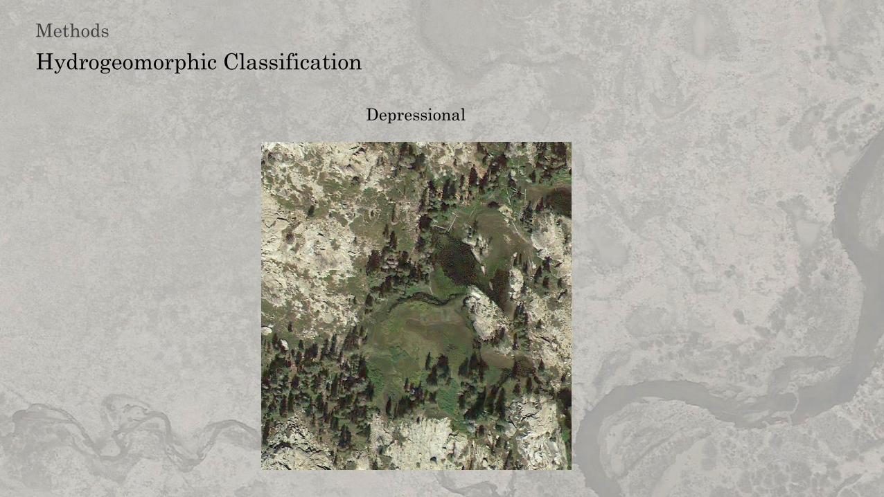
Depressional (DEP) Meadow in depression where water
does not flow through most of the year.
Often with small seasonal waterbody
Topographic
depressions
Runoff, precipitation
Riparian (RIP) Meadow with developed channel
throughout
Topographic
flowlines
Over bank flow from channel,
throughflow
Subsurface (SUB) Meadows that does not have develop
stream channel throughout. Can have
channel for portions
Topographic
flowlines
Groundwater, throughflow, and
overland flow
Discharge Slope
(DS)
Meadow found at toe slopes. Channels
may be present to move water from
discharge area
Toeslopes Groundwater, overland flow
from hillslope

Hydrogeomorphic Classification
Methods
Lacustrine Fringe
Hydrogeomorphic Classification
Methods
Depressional

Hydrogeomorphic Classification
Methods
Riparian

Hydrogeomorphic Classification
Methods
Subsurface

Hydrogeomorphic Classification
Methods
Discharge Slope

Hydrogeomorphic Classification
Methods
Meadow
Next to
waterbody?
Yes
No
Depressional
> 450 m2? Yes
Lacustrine
Fringe
In a
depression?
Yes
Yes
Has developed
channel
throughout?
Yes
Riparian Subsurface
No
No
No
Discharge
slope
In topographic
flowline?

Meadow detection accuracy
• Compared detected meadows to Google Earth
• Compared detected meadows to TNF
Hydrogeomorphic accuracy
• Compared classified meadows to Google Earth
• Compared classified meadows to TNF
Accuracy Assessment
Methods

Results

Results
Source: Esri, DigitalGlobe, GeoEye, Earthstar Geographics, CNES/Airbus DS, USDA, USGS, AEX,Getmapping, Aerogrid, IGN, IGP, swisstopo, and the GIS User Community
HGM Class
DEP
DS
LAC
RIP
SUB
0 2 4 km

Reference (TNF) User's Accuracy
Meadow Other Total
Classified Meadow 174 42 216 81%
Other 138 246 384 64%
Total 312 288 600
Producer's
Accuracy
56% 85% Overall Accuracy 70%
Meadow Detection
Results

Meadow Detection
Results
Reference (Google Earth) User's Accuracy
Meadow Other Total
Classified Meadow 188 12 200 94%
Other 3 297 300 99%
Total 191 309 500
Producer's
Accuracy
98% 96% Overall Accuracy 97%

Meadow HGM Classification
Results
Reference (Google Earth) User's Accuracy
DEP DS LAC RIP SUB Total %
Classified DEP 8 0 0 0 1 9 89%
DS 3 41 0 5 19 68 60%
LAC 2 0 21 0 0 23 91%
RIP 0 0 0 47 10 57 82%
SUB 3 8 1 10 102 124 82%
Total 16 49 22 62 132 281
Producer's
Accuracy
% 50% 84% 95% 76% 77%
Overall Accuracy 78%

Reference (TNF) User's Accuracy
DEP DS LAC RIP SUB Total %
Classified DEP 1 0 0 1 0 2 50%
DS 0 3 0 20 8 31 10%
LAC 2 1 6 4 0 13 46%
RIP 0 0 0 48 0 48 100%
SUB 3 3 2 68 4 80 5%
Total 6 7 8 141 12 174
Producer's
Accuracy
% 17% 43% 75% 34% 33%
Overall Accuracy 36%
Meadow HGM Classification
Results

Discussion & Conclusion


• Misdetection and Misclassification
• Algae
• Clear cuts
• Other human influences
• Precipitation
• Elevation
Sources of Error
Discussion

Sources of Error
Discussion
• Class Definitions cause difference from classified HGM to TNF HGM

Sources of Error
Discussion
• Class Definitions cause difference from classified HGM to TNF HGM

• LiDAR detection errors
• LiDAR preprocessing errors
• Misclassified LiDAR ground points
• Interpolation of LiDAR points to raster
• Multispectral imagery blunders
• Scale
• Accuracy assessment errors
Sources of Error
Discussion

• Meadows can be detected with OBIA
• Meadow can be classified by HGM with OBIA but more work is needed to refine
• LiDAR is a power tool for analyzing landforms
• Future models should include precipitation and elevation
Conclusion
Holland, Robert F. 1986. “Preliminary Description of the Terrestrial Natural Communities of California.” Sacramento.
Kindscher, K., A. Fraser, M. E. Jakubauskas, and D. M. Debinski. 1998. “Identifying Wetland Meadows in Grand Teton National Park Using Remote Sensing and Average Wetland Values.”
Wetlands Ecology and Management 5: 265–73.
Li, Junhua, and Wenjun Chen. 2005. “A Rule-Based Method for Mapping Canada ’s Wetlands Using Optical, Radar and DEM Data.” International Journal of Remote Sensing 26 (22): 5051–69.
doi:10.1080/01431160500166516.
Mahoney, Matthew L., Alan R. Hanson, and Scott Gilliland. 2007. “An Evaluation of a Methodology for Wetland Classification and Inventory for Labrador.” Technical Report Series No. 480.
Sackville. papers2://publication/uuid/0EEEBCC3-9139-423B-934F-31EA3A89A098.
Moffett, Kevan B, and Steven M Gorelick. 2013. “Distinguishing Wetland Vegetation and Channel Features with Object-Based Image Segmentation.” International Journal of Remote Sensing
34 (4): 1332–54.
Mui, Amy, Yuhong He, and Qihao Weng. 2015. “An Object-Based Approach to Delineate Wetlands across Landscapes of Varied Disturbance with High Spatial Resolution Satellite Imagery.”
ISPRS Journal of Photogrammetry and Remote Sensing 109. International Society for Photogrammetry and Remote Sensing, Inc. (ISPRS): 30–46. doi:10.1016/j.isprsjprs.2015.08.005.
Ouyang, Zu-Tao, Mo-Qain Zhang, Xiao Xie, Qi Shen, Hai-Qiang Gou, and Bin Zhao. 2011. “A Comparison of Pixel-Based and Object-Oriented Approaches to VHR Imagery for Mapping
Saltmarsh Plants.” Ecological Informatics 6 (2): 136–46.
Ozesmi, Stacy L., and Marvin E. Bauer. 2002. “Satellite Remote Sensing of Wetlands.” Wetlands Ecology and Management 10: 381–402.
Rampi, Lian P., Joseph F. Knight, and Keith C. Pelletier. 2014. “Wetland Mapping in the Upper Midwest United States : An Object-Based Approach Integrating Lidar and Imagery Data.”
Photogrammetric Engineering & Remote Sensing 80 (5): 439–49. doi:10.14358/PERS.80.5.439.
Ratliff, Raymond D. 1982. “A Meadow Site Classification for the Sierra Nevada , California.” General Technical Report PSW. Berkeley, CA.
———. 1985. “Meadows in the Sierra Nevada of California: State of Knowledge.” General Technical Report PSW-84. Berkeley, CA.
http://www.fs.fed.us/psw/publications/documents/psw_gtr084/.
Sader, Steven A., Douglas Ahl, and Wen Shu Liou. 1995. “Accuracy of Landsat-TM and GIS Rule-Based Methods for Forest Wetland Classification in Maine.” Remote Sensing of Environment
53 (3): 133–44. doi:10.1016/0034-4257(95)00085-F.
Szantoi, Zoltan, Francisco J Escobedo, Amr Abd-Elrahman, Leonard Pearlstine, Bon Dewitt, and Scot Smith. 2015. “Classifying Spatially Heterogeneous Wetland Communities Using Machine
Learning Algorithms and Spectral and Textural Features.” Environmental Monitoring and Assessment 187 (5): 262. doi:10.1007/s10661-015-4426-5.
Torbik, Nathan, Patrick Lawrence, and Kevin Czajkowski. 2008. “Application and Assessment of a GIScience Model for Wetlands Identification.” In Wetlands and Water Resource Modeling
and Assessment: A Watershed Perspective, edited by Wei Ji, 3–13. Boca Raton: CRC Press.
Usmerjena, Objektno, Analiza Podatkov, and Daljinskega Zaznavanja. 2011. “Object-Based Image Analysis of Remote Sensing.” Geodetski Vestnik 55 (4): 665–88.
Wiexelman, Dave, Barry Hill, David Cooper, Eric Berlow, Joshua H. Viers, Sabra E. Purdy, Amy Merril, and Shana Gross. 2011. “A Field Key to Meadow Hydrogeomorphic Types for the
Sierra Nevada and Southern Cascade Ranges in California.” Vallejo, CA.
Wood, Spencer H. 1975. “Holocene Stratigraphy and Chronology of Mountain Meadows, Sierra Nevada, California.” California Institute of Technology. http://thesis.library.caltech.edu/5570/
Adam, Elhadi, Onisimo Mutanga, and Denis Rugege. 2010. “Multispectral and Hyperspectral Remote Sensing for Identification and Mapping of Wetland Vegetation: A Review.” Wetlands
Ecology and Management 18 (3): 281–96. doi:10.1007/s11273-009-9169-z.
Allen, Barbara H. 1987. “Forest and Meadow Ecosystems in California.” Rangelands 9 (3): 125–28.
“Aster Level 1 Data Products Specification (GDS Version) Version 1.3.” 2001. AG-E-E-2209-R03.
Basham May, A. Michele, J. E. Pinder, and G. C. Kroh. 1997. “A Comparison of Landsat Thematic Mapper and SPOT Multi-Spectral Imagery for the Classification of Shrub and Meadow
Vegetation in Northern California, USA.” International Journal of Remote Sensing 18 (18): 3719–28. doi:Doi 10.1080/014311697216577.
Benedict, Nathan B. 1981. “The Vegetation and Ecology of Subapline Meadows of the
Southern Sierra Nevada, California.” University of California, Davis.
Benedict, NB B, and Jack Major. 1982. “A Physiographic Classification of Subalpine Meadows of the Sierra Nevada, California.” Madrono 29 (1): 1–12. http://agris.fao.org/agris-
search/search/display.do?f=2012/OV/OV201201669001669.xml;US19830843003.
Benz, Ursula C, Peter Hofmann, Gregor Willhauck, Iris Lingenfelder, and Markus Heynen. 2004. “Multi-Resolution, Object-Oriented Fuzzy Analysis of Remote Sensing Data for GIS-Ready
Information.” Journal of Photogrammetry & Remote Sensing 58: 239–58. doi:10.1016/j.isprsjprs.2003.10.002.
Chapot, Brian F., and W. D. Billings. 1972. “Origins and Ecology of the Sierran Alpine Flora and Vegetation.” Ecological Monographs 42 (2): 163–99.
Dingle Robertson, Laura, Douglas J. King, and Chris Davies. 2015. “Object-Based Image Analysis of Optical and Radar Variables for Wetland Evaluation.” International Journal of Remote
Sensing 36 (23): 5811–41. doi:10.1080/01431161.2015.1109727.
Dronova, Iryna. 2015. “Object-Based Image Analysis in Wetland Research: A Review.” Remote Sensing 7: 6380–6413. doi:10.3390/rs70506380.
Dwire, Kathleen a., J. Boone Kauffman, and John E. Baham. 2006. “Plant Species Distribution in Relation to Water-Table Depth and Soil Redox Potential in Montane Riparian Meadows.”
Wetlands 26 (1): 131–46. doi:10.1672/0277-5212(2006)26[131:PSDIRT]2.0.CO;2.
Fites-Kaufman, J., P. Rundel, N. Stephenson, and D. A. Weixelman. 2007. “Montane and Subalpine Vegetation of the Sierra Nevada and Cascade Ranges.” In Terrestrial Vegetation of
California, edited by Michael Barbour, 3rd ed., 456–501. Berkeley: University of California Press.
Frohn, Robert C., Molly Reif, Charles Lane, and Brad Autrey. 2009. “Satellite Remote Sensing of Isolated Wetlands Using Object-Oriented Classification of Landsat-7 Data.” Wetlands 29 (3):
931–41. doi:10.1672/08-194.1.
Fryjoff-Hung, A, and Joshua H. Viers. 2012. “Sierra Nevada Multi-Source Meadow Polygons Compilation (v 1.0).”
Halabisky, Meghan, L. Monika Moskal, and Sonia A. Hall. 2011. “Object-Based Classification of Semi-Arid Wetlands.” Journal of Applied Remote Sensing 5 (1): 053511–053511.
References

• Sierra Fund
• Tahoe National Forest
• Dave Weixelman
• American Rivers
• San Francisco State
• And many more
Thank You

Questions?
Related Documents


