Journal of Geological Resource and Engineering 6 (2018) 151-159 doi:10.17265/2328-2193/2018.04.003 Classification of Coal Resources Using Drill Hole Spacing Analysis (DHSA) Iskandar Zulkarnain and Waterman Sulistyana Bargawa Master of Mining Engineering, UPN Veteran Yogyakarta, Jl. SWK 104 Yogyakarta 55283, Indonesia Abstract: The classification of coal resources generally is based on geometric factors and the complexity of geological structures. The classification has not considered coal quality factors such as ash content, sulphur content, caloric value. The development of international classification standards has required a geostatistical analysis for the estimation and classification of coal resources. The purpose of this research is to apply geostatistics method to determine optimal drill hole distance, and to analyze classification of coal resource based on data of coal quality and quantity. Based on global estimation variance (GEV) approach from geostatistics, relative error value was obtained. Drill hole spacing analysis (DHSA) results in optimal drill hole spacing on each coal seam for the coal resources classification. Estimation using kriging block results in the value of kriging relative error. Coal resources classification was based on relative error of 0-10% for measured resources, 10-20% for indicated resources and > 20% for inferred resources. Based on a case study in a coal field consisting of three coal seams, the geostatistical approach produced the smallest distance on seam-3 as the optimal borehole range in the research area. This classification yields a greater area of influence than the SNI standard on simple geological complexity. Key words: Geostatistics, bore hole spacing analysis, SNI (5015:2011), GEV, kriging relative error. 1. Introduction Several international classification systems [1-4] have been developed in the past, the main ones are the American USGS Circular 831 (USGS, 1980) and SME Guide (SME, 1999), the South-African SAMREC Code (SAMREC, 2000), the Canadian CIM Guidelines (CIM, 2000) and National Instrument 43-101 (CSA, 2001), the European Code (EURO, 2002), the Australasian JORC Code (JORC, 2012), and Indonesia SNI (5015:2011). All these codes are broadly similar, although some differences in their definitions remain. The JORC code is with little doubt the one that has found wider acceptance in countries that do not have their own code. Generally, the basic classification of resources and reserves for coal is a factor of quantity, geometry, and the complexity of geological structures [5]. Limiting factors do not consider coal quality Corresponding author: Waterman Sulistyana Bargawa, Ph.D., Mr., research field: geostatistics and mining environment. factors such as ash content, sulphur content, caloric value. Geometry parameter, and coal quality aspects become an important aspect to determine the classification of coal resources [6]. Applying the approach to any coal basin with certain geological settings will have certain resource classification parameters as well. The area of influence on each coal basin will differ in different geological settings [7, 8]. The development of resource classification standards and coal reserves requires the use of geostatistical approaches. Coal resources classification research has been widely developed using a geostatistical approach [9-13]. 2. Objective The objective of this research is to make the classification of coal resources based on global estimation variance (GEV) approach related to drill hole spacing analysis. The results of the analysis will be compared with SNI 5015:2011 to evaluate the D DAVID PUBLISHING

Welcome message from author
This document is posted to help you gain knowledge. Please leave a comment to let me know what you think about it! Share it to your friends and learn new things together.
Transcript

Journal of Geological Resource and Engineering 6 (2018) 151-159 doi:10.17265/2328-2193/2018.04.003
Classification of Coal Resources Using Drill Hole
Spacing Analysis (DHSA)
Iskandar Zulkarnain and Waterman Sulistyana Bargawa
Master of Mining Engineering, UPN Veteran Yogyakarta, Jl. SWK 104 Yogyakarta 55283, Indonesia
Abstract: The classification of coal resources generally is based on geometric factors and the complexity of geological structures. The classification has not considered coal quality factors such as ash content, sulphur content, caloric value. The development of international classification standards has required a geostatistical analysis for the estimation and classification of coal resources. The purpose of this research is to apply geostatistics method to determine optimal drill hole distance, and to analyze classification of coal resource based on data of coal quality and quantity. Based on global estimation variance (GEV) approach from geostatistics, relative error value was obtained. Drill hole spacing analysis (DHSA) results in optimal drill hole spacing on each coal seam for the coal resources classification. Estimation using kriging block results in the value of kriging relative error. Coal resources classification was based on relative error of 0-10% for measured resources, 10-20% for indicated resources and > 20% for inferred resources. Based on a case study in a coal field consisting of three coal seams, the geostatistical approach produced the smallest distance on seam-3 as the optimal borehole range in the research area. This classification yields a greater area of influence than the SNI standard on simple geological complexity. Key words: Geostatistics, bore hole spacing analysis, SNI (5015:2011), GEV, kriging relative error.
1. Introduction
Several international classification systems [1-4]
have been developed in the past, the main ones are the
American USGS Circular 831 (USGS, 1980) and SME
Guide (SME, 1999), the South-African SAMREC
Code (SAMREC, 2000), the Canadian CIM Guidelines
(CIM, 2000) and National Instrument 43-101 (CSA,
2001), the European Code (EURO, 2002), the
Australasian JORC Code (JORC, 2012), and Indonesia
SNI (5015:2011). All these codes are broadly similar,
although some differences in their definitions remain.
The JORC code is with little doubt the one that has
found wider acceptance in countries that do not have
their own code. Generally, the basic classification of
resources and reserves for coal is a factor of quantity,
geometry, and the complexity of geological structures
[5]. Limiting factors do not consider coal quality
Corresponding author: Waterman Sulistyana Bargawa,
Ph.D., Mr., research field: geostatistics and mining environment.
factors such as ash content, sulphur content, caloric
value.
Geometry parameter, and coal quality aspects
become an important aspect to determine the
classification of coal resources [6]. Applying the
approach to any coal basin with certain geological
settings will have certain resource classification
parameters as well. The area of influence on each coal
basin will differ in different geological settings [7, 8].
The development of resource classification standards
and coal reserves requires the use of geostatistical
approaches. Coal resources classification research has
been widely developed using a geostatistical approach
[9-13].
2. Objective
The objective of this research is to make the
classification of coal resources based on global
estimation variance (GEV) approach related to drill
hole spacing analysis. The results of the analysis will
be compared with SNI 5015:2011 to evaluate the
D DAVID PUBLISHING
Classification of Coal Resources Using Drill Hole Spacing Analysis (DHSA)
152
classification of resources.
3. Methods and Material
GEV yields global relative error values [14, 15].
The nomogram determines the value of the extension
variance ( 2K ) dot against the square plane for the
spherical model with the variance nugget being 0 and
the sill value is 1 (see Fig. 1). Furthermore, point
variance estimates of the 2K (r) field considering the
value of the nugget variance and sill of each parameter
[15]:
22 *0 eE CCr (1)
The estimation variance value divided by the
number of blocks (N) yields a GEV value:
NrR EE /22 (2)
The calculation of GEV values yields a relative
error:
Relative error = ±1.96∙ ∙100%/mean (3)
The GEV obtained based on the nomogram is then
used to estimate the relative error value. Then plotting
between the relative error values against the drill hole
spacing is to create a drill hole spacing analysis
(DHSA) graph [6]. The DHSA graph analysis
considers the value of drill spacing and relative error
when it reaches 10%, 20% and 50% as the optimum
distance. Based on the DHSA graph and relative error
values, the distance or area of influence for measured,
indicated, and inferred resources can be evaluated.
Fig. 1 Nomogram of extension variance/estimation [14, 15] values ( ), point to square area for spherical models.

Classification of Coal Resources Using Drill Hole Spacing Analysis (DHSA)
153
Geostatistical approach is generally used for
estimation of ore mineral grade [16-18]. Another
result of kriging is the use of kriging relative error of
the ordinary kriging estimation method for
classification of coal resources [19]. The classification
of coal resources uses the value of the kriging relative
error of the ordinary kriging estimation method.
Kriging is an estimation method of regionalized
variable at point, or volume by using criteria to
minimize variance estimation. The kriging procedure
needs to consider the following [20]:
(a) estimated value using the equation:
i
n
ii Zw
1
= * Z (4)
(b) equation to calculate the weight, wi:
n
ii
n
ii wdanVvvvw
11
1),(),(. (5)
(c) Kriging variance can be expressed by equation:
),(),(.1
2VVVvw
n
iiK (6)
Based on kriging variance we get the following
equation:
MwVVK
12 ),( (7)
(d) kriging relative error is expressed by equation:
%100*
96.1 =error relative kriging Z
K (8)
where:
Z*: estimated value 2K : kriging variance
: kriging standard deviation
The calculation of the value of kriging relative error
is obtained from the standard deviation value of the
block unit divided by the value of the kriging estimate
of the block unit, multiplied by the 95% confidence
interval factor of 1.96 while the standard deviation
value is the square root of the estimated variance
value obtained from the ordinary kriging method.
According to Ref. [21] the classification of
resources (Table 1) is based on confidence interval
and tolerance of relative error.
Meanwhile, according to Ref. [24] the classification
of resources and coal reserves is an effort to group
resources and coal reserves based on geological
confidence and economic feasibility. Table 2 shows
the classification of resources based on the distance of
the point of information according to geological
conditions.
The research area is located in East Kalimantan
Province Indonesia. Fig. 2 shows a map of drill hole
distribution in the study area.
Based on the geological model the research area
consists of 3 (three) coal seams.
Table 1 Resource classification [22, 23] based on drill hole distance and error tolerance.
Resource classification Max. extrapolation Max. spacing between information point Error tolerance
Measured 500 m +1 km < 500 m 0 - 10 %
Indicated 1,000 m +2 km < 1 km 10 -20 %
Infernal 2,000 m +4 km > 20%
Table 2 Resource classification [22] based on distance of information points according to geological condition.
Geological Criteria (m)
Resources
condition Inferred Indicated Measured
Simple Distance of information point 1,000 < x ≤ 1,500 500 < x ≤ 1,000 x ≤ 1,500
Moderate Distance of information point 500 < x ≤ 1,000 250 < x ≤ 500 x ≤ 250
Complex Distance of information point 200 < x ≤ 400 100 < x ≤ 400 x ≤ 100

Classification of Coal Resources Using Drill Hole Spacing Analysis (DHSA)
154
Fig. 2 Map of the distribution of drill hole in the study area.
4. Results
Table 3 shows descriptive statistics on coal seam.
Variogram model is spherical used for all data of coal
quality (ash, total sulphur, relative density, calorific
value) and thickness for the three seams of coal.
Table 4 shows the variographic results for each coal
quality parameter.
Table 5 shows the calculation of relative error values
by the method of GEV. The research area consisted of
3 (three) coal seams. DHSA and GEV methods
produce optimal borehole spacing at each seam. The
classification of measured resources in Seam-1 is 950
m at relative error of 10%, 1,650 m for indicated
resources at relative error of 20%, and 2,650 m for
inferred resources at relative error of 50%. At Seam-2
the classification of measured resources is 1,150 m at
relative error of 10%, 1,850 m for indicated resources
at relative error of 20%, and 4,300 m for inferred
resources at relative error 50% while the classification
of measured resources at seam-3 is 750 m at relative
error of 10%, 1,100 m for indicated resources at
relative error 20% and 2,150 m for inferred resources at
relative error of 50%. Fig. 4 shows a drill hole spacing
analysis (DHSA) graph for Seam-3.
Fig. 4 is an example of DHSA chart analysis to
determine the optimum distance in Seam-3 with
classification of measured resources being 750 m,
1,100 m for indicated resources and 2,150 m for
inferred resources. Fig. 5 shows a histogram of
comparison of measured, indicated, and inferred
resource classification based on the borehole distance
(area of influence). Relative error values are obtained
from the results of reading DHSA graphics for Seam 1,
Seam 2, and Seam 3. Drill hole distance based on the
calculation of relative error values showed higher
values compared with the standard of SNI.
Based on the comparison of measured, indicated,
and inferred resource classifications in Fig. 5, the
optimal distance for the research area using the result
of the relative error value analysis on Seam 3: distance
measured resource classification is 750 m at ER 10%,
indicated is 1,100 m at ER 20%, and inferred is 2,150
m at ER 50%. Based on Fig.5 the classification of
measured resources in this study produces the same
distance or area of influence as Saraji, but is higher
than the Peak Down Bowen Basin, Coal Guideline and
SNI. For the classification of indicated resources, this
research is more conservative than Saraji and Peak
Down Bowen Basin, but the distance is higher than the

Classification of Coal Resources Using Drill Hole Spacing Analysis (DHSA)
155
Table 3 Descriptive statistics for Seam-1, Seam-2, and Seam-3.
No Parameter Seam 1 Seam 2 Seam 3
Thick CV TS RD Ash Thick CV TS RD Ash Thick CV TS RD Ash
1 Mean 9 4.408 0.3 1.3 2.5 17 4.742 0.2 1.3 2.1 2.2 4.712 0.9 1.3 4.1
2 Median 10.5 4.320 0.3 1.3 2.5 19.9 4.573 0.2 1.3 2.1 2.3 4.575 0.2 1.3 3.7
3 Mode 11 4.218 0.2 1.3 2.7 26 5.470 0.1 1.3 2.2 2.7 4.393 0.2 1.3 3.1
4 Variance 11.9 61.763 0 0 0.2 65.1 176.226 0 0 0.3 0.5 188.591 1.5 0 1.9
5 Standard Deviation
3.5 248.5 0.2 0 0.5 8.1 419.8 0.2 0 0.6 0.7 434.3 1.2 0 1.4
6 Minimum 0.7 4,110 0.1 1.3 1.2 2 4.252 0.1 1.3 1.2 0.3 4.073 0.1 1.3 2
7 Maximum 16 5,170 1.1 1.3 4.1 28.8 5.593 0.8 1.3 3.7 5 5.762 4 1.4 9.5
8 Count 213 36 36 36 36 134 67 67 67 67 330 49 49 49 49
9 Coefficient of variation
0.4 0.1 0.5 0 0.2 0.5 0.1 0.7 0 0.3 0.3 0.1 1.4 0 0.3
10 Weighted avg 4.400 0.3 1.3 2.5 4.597 0.2 1.3 2.1 4.675 0.7 1.3 40
11 sign. weighted Average
0 0 0 0 0 -0.2 0 0 0 -0.2 0 0
Table 4 Variogram parameter using spherical model.
Seam Parameter Co Sill Range CV
1
Ash 0 0.24 950 0.2
Calorific value 0 61763 1,600 0.06
Relative density 0 0.00033 2,550 0.01
Thickness 3.4 8 1,800 0.38
Total sulphur 0 0.038 1,300 0.47
2
Ash 0 0.3046 850 0.26
Calorific value 0 215000 3,000 0.09
Relative density 0.000225 0.000125 735 0.01
Thickness 11 50 1,800 0.48
Total sulphur 0 0.0228 2,950 0.7
3
Ash 0 1.9 1,650 0.34
Calorific value 0 210000 3,010 0.09
Relative density 0.00006 0.000339 1,300 0.02
Thickness 0.14 0.47 1,700 0.33
Total sulphur 0 0.02111 2,820 1.43
Co: nugget variance, CV: coefficient of variation

Classification of Coal Resources Using Drill Hole Spacing Analysis (DHSA)
156
Table 5 Relative error value calculation using GEV method.
Parameter Mean h l _X _Y N a Co C h/a l/a Varians σ2Er σ2ER σER Error
9 100 100 54 49 2,646 1,800 3.4 8 0.056 0.056 0.020 3.560 0,001 0.037 0.80%
Thickness 9 200 200 27 25 6,75 1,800 3.4 8 0.111 0.111 0.040 3.720 0,006 0.074 1.62%
9 300 300 18 17 306 1,800 3.4 8 0.167 0.167 0.056 3.848 0,013 0.112 2.44%
2.5 100 100 54 49 2,646 950 0 0.24 0.105 0.105 0.030 0.007 0,000 0.002 0.13%
Ash 2.5 200 200 27 25 675 950 0 0.24 0.211 0.211 0.070 0.017 0,000 0.005 0.40%
2.5 300 300 18 17 306 950 0 0.24 0.316 0.316 0.110 0.026 0,000 0.009 0.74%
4.408 100 100 54 49 2,646 1,600 0 61.763 0.063 0.063 0.023 1389.668 0,525 0.725 0.03%
CV 4.408 200 200 27 25 675 1,600 0 61.763 0.125 0.125 0.045 2779.335 4,118 2.029 0.09%
4.408 300 300 18 17 306 1,600 0 61.763 0.188 0.188 0.065 4014.595 13,120 3.622 0.16%
1.3 100 100 54 49 2,646 2,550 0 0.00033 0.039 0.039 0.011 0.000 0,000 0.000 0.01%
RD 1.3 200 200 27 25 675 2,550 0 0.00033 0.078 0.078 0.021 0.000 0,000 0.000 0.02%
1.3 300 300 18 17 306 2,550 0 0.00033 0.118 0.118 0.042 0.000 0,000 0.000 0.03%
0.3 100 100 54 49 2,646 1,300 0 0.038 0.077 0.077 0.025 0.001 0,000 0.001 0.36%
TS 0.3 200 200 27 25 675 1,300 0 0.038 0.154 0.154 0.050 0.002 0,000 0.002 1.00%
0.3 300 300 18 17 306 1,300 0 0.038 0.231 0.231 0.080 0.003 0,000 0.003 1.88%
Fig. 3 Drill hole spacing analysis (DHSA) graph of Seam-3.
0%
0%
1%
10%
100%
100
200
300
400
500
600
700
800
900
1000
1100
1200
1300
1400
1500
1600
1700
1800
1900
2000
2100
2200
2300
2400
2500
2600
2700
2800
2900
3000
ER
RO
R R
EL
AT
IVE
(%
)
DRILL HOLE SPACING
D H S A : S E A M - 3
Thickness
Ash
CV
RD
TS

Classification of Coal Resources Using Drill Hole Spacing Analysis (DHSA)
157
Fig. 4 Area of influence (or distance) on coal resource classification.
Fig. 5 Various studies: Saraji, Bowen Basin (Bertolli 2013), coal guideline, and SNI 5015:2011 to compare the optimum drill range for resource classification based on relative error.
950
1650
2650
1150
1850
4300
750
1100
2150
250 500
1000
0
500
1000
1500
2000
2500
3000
3500
4000
4500
5000
MEASURED INDICATED INFERRED
Dis
tanc
e of
are
a of
infl
uenc
e (m
)
Distance of area of influencebased on relative error
Seam 1 Seam 2 Seam 3 SNI
Classification of Coal Resources Using Drill Hole Spacing Analysis (DHSA)
158
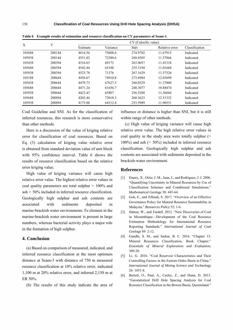
Table 6 Example results of estimation and resource classification on CV parameters of Seam-1.
X Y CV (Calorific value)
Estimate Variance Stdv Relative error Classification
105688 208144 4614.56 75608.6 274.9702 11.67915 Indicated
105938 208144 4551.02 72280.6 268.8505 11.57866 Indicated
105438 208394 4516.63 69172 263.0057 11.41318 Indicated
105688 208394 4542.44 65188 255.3194 11.01668 Indicated
105938 208394 4523.78 71376 267.1629 11.57526 Indicated
105188 208644 4456.67 74910.8 273.6984 12.03699 Indicated
105438 208644 4479.73 67627.5 260.0529 11.37800 Indicated
105688 208644 4471.24 61656.7 248.3077 10.88474 Indicated
105938 208644 4423.43 65807 256.5288 11.36666 Indicated
105688 208894 4203.44 72018.3 268.3623 12.51332 Indicated
105938 208894 4175.06 64312.4 253.5989 11.90531 Indicated
Coal Guideline and SNI. As for the classification of
inferred resources, this research is more conservative
than other methods.
Here is a discussion of the value of kriging relative
error for classification of coal resources. Based on
Eq. (3) calculation of kriging value relative error
is obtained from standard deviation value of unit block
with 95% confidence interval. Table 6 shows the
results of resource classification based on the relative
error kriging value.
High value of kriging variance will cause high
relative error value. The highest relative error values in
coal quality parameters are total sulphur > 100% and
ash > 50% included in inferred resource classification.
Geologically high sulphur and ash contents are
associated with sediments deposited in
marine-brackish water environments. Fe element in the
marine-brackish water environment is present in large
numbers, whereas bacterial activity plays a major role
in the formation of high sulphur.
4. Conclusion
(a) Based on comparison of measured, indicated, and
inferred resource classification at the most optimum
distance at Seam-3 with distance of 750 m measured
resource classification at 10% relative error, indicated
1,100 m at 20% relative error, and inferred 2,150 m at
ER 50%.
(b) The results of this study indicate the area of
influence or distance is higher than SNI, but it is still
within range of other methods.
(c) High value of kriging variance will cause high
relative error value. The high relative error values in
coal quality in the study area were totally sulphur (>
100%) and ash (> 50%) included in inferred resource
classification. Geologically high sulphur and ash
contents are associated with sediments deposited in the
brackish-water environment.
References
[1] Emery, X., Ortiz, J. M., Juan, J., and Rodríguez, J. J. 2006. “Quantifying Uncertainty in Mineral Resources by Use of Classification Schemes and Conditional Simulations.” Mathematical Geology 38: 445-64.
[2] Goh, E., and Effendi, S. 2017. “Overview of an Effective
Governance Policy for Mineral Resource Sustainability in
Malaysia.” Resources Policy 52: 1-6.
[3] Hatton, W., and Fardell. 2012. “New Discoveries of Coal in Mozambique—Development of the Coal Resource Estimation Methodology for International Resource Reporting Standards.” International Journal of Coal Geology 89: 2-12.
[4] Gandhi, S. M., and Sarkar, B. C. 2016. “Chapter 13: Mineral Resources Classification, Book Chapter.” Essentials of Mineral Exploration and Evaluation, 309-20.
[5] Li, G. 2016. “Coal Reservoir Characteristics and Their Controlling Factors in the Eastern Ordos Basin in China.” International Journal of Mining Science and Technology 26: 1051-8.
[6] Bertoli, O., Paul, A., Casley, Z., and Dunn, D. 2013. “Geostatistical Drill Hole Spacing Analysis for Coal Resource Classification in the Bowen Basin, Queensland.”

Classification of Coal Resources Using Drill Hole Spacing Analysis (DHSA)
159
International Journal of Coal Geology 112: 107-13. [7] Eble, C. F., and Greb, S. F. 2018. “Geochemical,
Petrographic and Palynologic Characteristics of Two Late Middle Pennsylvanian (Asturian) Coal-to-Shale Sequences in the Eastern Interior Basin, USA.” International Journal of Coal Geology 190: 99-125.
[8] O'Keefe, J. M. K., Bechtel, A., Christanis, K., Dai, S., and Hower, J. C. 2013. “On the Fundamental Difference between Coal Rank and Coal Type.” International Journal of Coal Geology 118: 58-87.
[9] Srivastava, R. M. 2013. “Geostatistics: A Toolkit for Data Analysis, Spatial Prediction and Risk Management in the Coal Industry.” International Journal of Coal Geology (Special Issue on Geostatistics).
[10] Sabourin, R. 1983. “Geostatistics as a Tool to Define Various Categories of Resources.” Journal of the International Association for Mathematical Geology 15: 131-43.
[11] Cornah, A., Vann, J., and Driver, I. 2013. “Comparison of Three Geostatistical Approaches to Quantify the Impact of Drill Spacing on Resource Confidence for a Coal Seam (with a Case Example from Moranbah North, Queensland, Australia).” International Journal of Coal Geology 112: 114-24.
[12] Silva, D. S. F., and Boisvert, J. B. 2014). “Mineral Resource Classification: A Comparison of New and Existing Techniques.” The Journal of the Southern African Institute of Mining and Metallurgy 144: 3.
[13] Jain, P. K. 2017. “Valuation of Mineral Resources with Special Reference to India.” Mineral Economics, 1-9.
[14] Annels, A. E. 1991. Mineral Deposit Evaluation: A
Practical Approach. Netherlands: Springer. [15] Michel, D. 1977. Geostatistical Ore Reserve Estimation.
New York: Oxford. [16] Bargawa, W. S., and Amri, N. A. 2016. “Mineral
Resources Estimation Based on Block Modeling.” Presented at Progress on applied mathematics in science and engineering, AIP Conf. Proc. 1705, 020001.
[17] Bargawa, W. S., Rauf, A., and Amri, N. A. 2016. “Mineral Resource Modeling Using Pod Indicator Kriging.” Presented at Progress on Applied Mathematics in Science and Engineering, AIP Conf. Proc. 1705, 020025.
[18] Bargawa, W. S. 2016. “Mineral Resource Estimation Using Weighted Jackknife Kriging.” AIP Conf. Proc. 1755, 120001.
[19] Blackwell, G. 1999. “Relative Kriging Errors—A Basis for Mineral Resource Classification.” Exploration and Mining Geology 7: 99-105.
[20] Armstrong, M. 1998. Theory of Kriging Chapter of Basic Linear Geostatistics. Berlin Heidelberg: Springer, 83-102.
[21] Diehl, P., and David, M. 1982. “Classification of Ore Reserves/Resources Based on Geostatictical Methods.” CIM. Bull. 75 (838): 127-35.
[22] JORC. 2012. “Reporting for Exploration Results, Mineral Resources and Ore Reserve.”
[23] Souza, L. E., Costa, J. F. C. L., and Koppe, J. C. 2010. “Comparative Analysis of the Resource Classification Techniques: Case Study of the Conceicao Mine, Brazil.” Applied Earth Science (Trans. Inst. Min. Metall. B) 119: 166-75.
[24] Standard Nasional Indonesia. 2011. Pedoman pelaporan sumberdaya dan cadangan batubara, SNI 5015:2011.
Related Documents