Top Banner
Clandestine Cartography Clandestine Cartography CORONA: The Hidden First CORONA: The Hidden First Decade of Remote Sensing Decade of Remote Sensing
34

Clandestine Cartography CORONA: The Hidden First Decade of Remote Sensing Clandestine Cartography CORONA: The Hidden First Decade of Remote Sensing.

Dec 19, 2015

Download

Documents

Welcome message from author
This document is posted to help you gain knowledge. Please leave a comment to let me know what you think about it! Share it to your friends and learn new things together.
Transcript
Page 1: Clandestine Cartography CORONA: The Hidden First Decade of Remote Sensing Clandestine Cartography CORONA: The Hidden First Decade of Remote Sensing.

Clandestine CartographyClandestine Cartography

CORONA: The Hidden First CORONA: The Hidden First Decade of Remote SensingDecade of Remote Sensing

Page 2: Clandestine Cartography CORONA: The Hidden First Decade of Remote Sensing Clandestine Cartography CORONA: The Hidden First Decade of Remote Sensing.

How CORONA workedHow CORONA workedThe Space Segment: Thor/Atlas/Agena The Payload: Itek cameras, film return, aerial

recoveryCamera series: Keyhole, Argon, Lanyard Films:

spectral suites, spatial coverage, resolutions etc.CORONA's overlapping successors: SAMOS,

GAMBIT (KH-7 41 missions, KH-8 53 mission), HEXAGON (KH-9 20 missions, 1971-86), DORIAN (KH-10) MOL, KENNAN/CRYSTAL (9 missions 1976-88)

Page 3: Clandestine Cartography CORONA: The Hidden First Decade of Remote Sensing Clandestine Cartography CORONA: The Hidden First Decade of Remote Sensing.

CORONA:Space SegmentCORONA:Space Segment

Cover story (Discoverer)Thor/AgenaKH-4 lift required THORADFilm Recovery systemFailure history

Page 4: Clandestine Cartography CORONA: The Hidden First Decade of Remote Sensing Clandestine Cartography CORONA: The Hidden First Decade of Remote Sensing.

Discoverer at VandenbergDiscoverer at Vandenberg

Page 5: Clandestine Cartography CORONA: The Hidden First Decade of Remote Sensing Clandestine Cartography CORONA: The Hidden First Decade of Remote Sensing.

Launch: Vandenberg AFBLaunch: Vandenberg AFB

Page 6: Clandestine Cartography CORONA: The Hidden First Decade of Remote Sensing Clandestine Cartography CORONA: The Hidden First Decade of Remote Sensing.

Thor launch padThor launch pad

Page 7: Clandestine Cartography CORONA: The Hidden First Decade of Remote Sensing Clandestine Cartography CORONA: The Hidden First Decade of Remote Sensing.

Launch sequenceLaunch sequence

Page 8: Clandestine Cartography CORONA: The Hidden First Decade of Remote Sensing Clandestine Cartography CORONA: The Hidden First Decade of Remote Sensing.

Thirteen failuresThirteen failures

Page 9: Clandestine Cartography CORONA: The Hidden First Decade of Remote Sensing Clandestine Cartography CORONA: The Hidden First Decade of Remote Sensing.

Unanticipated CircumstancesUnanticipated Circumstances

“We were all operating in those days in a field in which we didn’t really believe it could be done, we were just going to try.” John Wolfe, Itek camera program manager (A Point in Time)

“Overnight, we went from famine to feast” Richard M. Bissell, Jr.

“By 1965, the rate of success was phenomenal. On the average three or four recoveries were made every month. The seven years of frustration and effort were paying off.” (A Point in Time)

Page 10: Clandestine Cartography CORONA: The Hidden First Decade of Remote Sensing Clandestine Cartography CORONA: The Hidden First Decade of Remote Sensing.

Orbit: Timing, PredictabilityOrbit: Timing, Predictability

Page 11: Clandestine Cartography CORONA: The Hidden First Decade of Remote Sensing Clandestine Cartography CORONA: The Hidden First Decade of Remote Sensing.

Thorad in ProductionThorad in Production

Page 12: Clandestine Cartography CORONA: The Hidden First Decade of Remote Sensing Clandestine Cartography CORONA: The Hidden First Decade of Remote Sensing.

Thorad/AgenaThorad/Agena

Page 13: Clandestine Cartography CORONA: The Hidden First Decade of Remote Sensing Clandestine Cartography CORONA: The Hidden First Decade of Remote Sensing.

Operational schematicOperational schematic

Page 14: Clandestine Cartography CORONA: The Hidden First Decade of Remote Sensing Clandestine Cartography CORONA: The Hidden First Decade of Remote Sensing.
Page 15: Clandestine Cartography CORONA: The Hidden First Decade of Remote Sensing Clandestine Cartography CORONA: The Hidden First Decade of Remote Sensing.

OperationsOperations

Page 16: Clandestine Cartography CORONA: The Hidden First Decade of Remote Sensing Clandestine Cartography CORONA: The Hidden First Decade of Remote Sensing.

CORONA “Bucket”CORONA “Bucket”

Page 17: Clandestine Cartography CORONA: The Hidden First Decade of Remote Sensing Clandestine Cartography CORONA: The Hidden First Decade of Remote Sensing.

NRO HQ ExhibitNRO HQ Exhibit

Page 18: Clandestine Cartography CORONA: The Hidden First Decade of Remote Sensing Clandestine Cartography CORONA: The Hidden First Decade of Remote Sensing.

RecoveryRecovery

Page 19: Clandestine Cartography CORONA: The Hidden First Decade of Remote Sensing Clandestine Cartography CORONA: The Hidden First Decade of Remote Sensing.

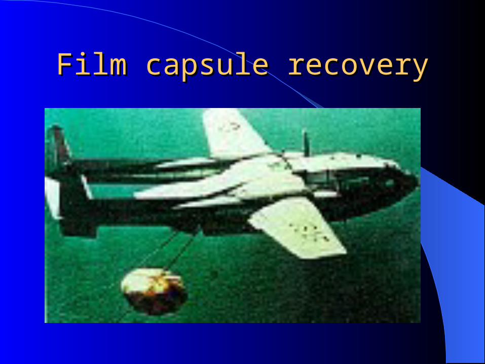
Film capsule recoveryFilm capsule recovery

Page 20: Clandestine Cartography CORONA: The Hidden First Decade of Remote Sensing Clandestine Cartography CORONA: The Hidden First Decade of Remote Sensing.

C-130 Air Catch: 6594C-130 Air Catch: 6594thth Squadron Squadron

Page 21: Clandestine Cartography CORONA: The Hidden First Decade of Remote Sensing Clandestine Cartography CORONA: The Hidden First Decade of Remote Sensing.

Capture HooksCapture Hooks

Page 22: Clandestine Cartography CORONA: The Hidden First Decade of Remote Sensing Clandestine Cartography CORONA: The Hidden First Decade of Remote Sensing.

Testing the salt plugs (Santa Barbara?)Testing the salt plugs (Santa Barbara?)

Page 23: Clandestine Cartography CORONA: The Hidden First Decade of Remote Sensing Clandestine Cartography CORONA: The Hidden First Decade of Remote Sensing.

CORONA’s CORONA’s Cameras: Cameras: KEYHOLEKEYHOLE

Page 24: Clandestine Cartography CORONA: The Hidden First Decade of Remote Sensing Clandestine Cartography CORONA: The Hidden First Decade of Remote Sensing.

KEYHOLE Camera EvolutionKEYHOLE Camera Evolution

Page 25: Clandestine Cartography CORONA: The Hidden First Decade of Remote Sensing Clandestine Cartography CORONA: The Hidden First Decade of Remote Sensing.

Image resolutionImage resolution

System

Dates Best resolution # Missions Film footage

KH-1 Aug 60 40 ft 1 3,548

KH-2 Dec60-Jul61 30 ft 3 17,949

KH-3 Aug61-Dec61 25 ft 5 24,676

KH-4 Feb62-Dec63 25 ft 20 239,299

KH-4A Aug63-Oct69 9 ft 92 1,293,025

KH-4B Sep67-May72 6 ft 32 505,970

KH-5 ARGON May62-Jul64 460 ft 7 22,503

KH-6 LANYARD

Jul63-Aug63 2 ft 1 2,251

Page 26: Clandestine Cartography CORONA: The Hidden First Decade of Remote Sensing Clandestine Cartography CORONA: The Hidden First Decade of Remote Sensing.

A platform and a systemA platform and a system

Page 27: Clandestine Cartography CORONA: The Hidden First Decade of Remote Sensing Clandestine Cartography CORONA: The Hidden First Decade of Remote Sensing.

Imagery typesImagery types

Page 28: Clandestine Cartography CORONA: The Hidden First Decade of Remote Sensing Clandestine Cartography CORONA: The Hidden First Decade of Remote Sensing.

CORONA 1959-72CORONA 1959-72 145 total flights At Vandenberg

– Pad 75-1-1 -> SLC 2E– Pad 75-3-4 -> SLC 1W– Pad 75-3-5 -> SLC 1E– Pad 75-1-2 -> SLC 2W– Point Arguello Launch Complex -> SLC 3W

First Launch 28 Feb 1959 Failed to orbit 10 Aug 1960 Discoverer 13 Operations # 1035

– Separation on orbit 17– Water recovery on 11 Aug

Last flight 25 May 1972 (2 RVs)

Page 29: Clandestine Cartography CORONA: The Hidden First Decade of Remote Sensing Clandestine Cartography CORONA: The Hidden First Decade of Remote Sensing.

CORONA by the numbersCORONA by the numbers

Length of program in years: 12 Number of successful missions: 103 Number of images taken: 800,000 Mapped image coverage in sq. nm: 750 million Number of film canisters in the archive:39,000 Length of film strips in feet: 2.1 million

Page 30: Clandestine Cartography CORONA: The Hidden First Decade of Remote Sensing Clandestine Cartography CORONA: The Hidden First Decade of Remote Sensing.

GAMBIT and HEXAGONGAMBIT and HEXAGON High resolution KH-7 (and KH-8) system flown

July 1963 to June 1967 Used for large scale mapping of specific targets 0.46

m and 0.5 m resolution, 2 SRVs, 50 days missions. KH-9 was a low resolution system specifically for

cartography “Big Bird” 2 x 1.52 m focal length cameras with 0.6

m resolution. Four capsules. Final mission life of 275 days.

Declassified in 2002

Page 31: Clandestine Cartography CORONA: The Hidden First Decade of Remote Sensing Clandestine Cartography CORONA: The Hidden First Decade of Remote Sensing.

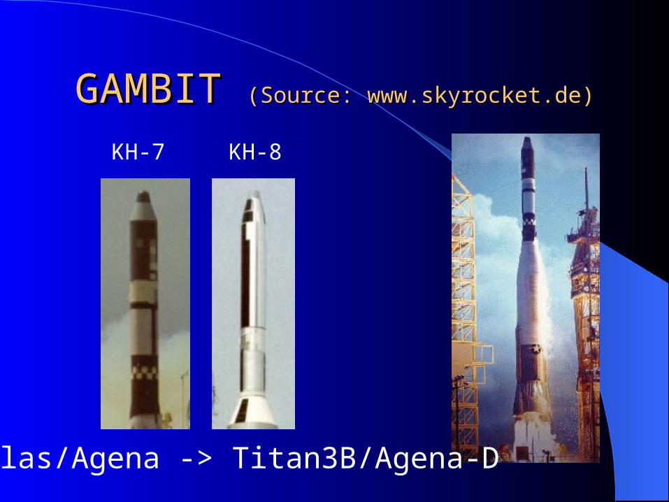
GAMBIT GAMBIT (Source: www.skyrocket.de)(Source: www.skyrocket.de)

KH-7 KH-8

Atlas/Agena -> Titan3B/Agena-D

Page 32: Clandestine Cartography CORONA: The Hidden First Decade of Remote Sensing Clandestine Cartography CORONA: The Hidden First Decade of Remote Sensing.

HEXAGONHEXAGON

BIG BIRDWeight 11,400kgUsed TITAN 3-D

Page 33: Clandestine Cartography CORONA: The Hidden First Decade of Remote Sensing Clandestine Cartography CORONA: The Hidden First Decade of Remote Sensing.

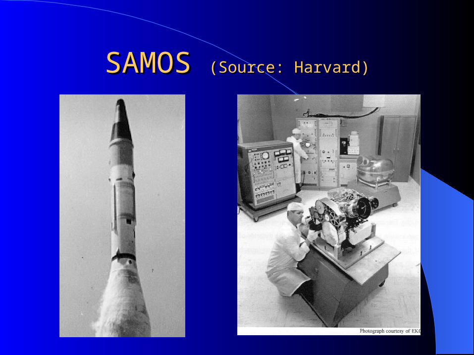
SAMOS SAMOS (Source: Harvard)(Source: Harvard)

Page 34: Clandestine Cartography CORONA: The Hidden First Decade of Remote Sensing Clandestine Cartography CORONA: The Hidden First Decade of Remote Sensing.

SAMOSSAMOS

• 12 launches, 3 readout 9 recovery• Resolutions 100, 20, 5 and 8 feet• Film developed and scan converted• 5 days-4 months missions• 1958-1961 then cancelled• 1966-7 went to the Moon as the Apollo

Lunar Mapping Camera