T:\6734000\Documents\Civil\Reports, Briefs, Letters & Registers\Design Reports\6734000-WS+P-CS-RP-0001 - Liverpool Civic Place Phase A Main Works DA Report [02].docx 25 SEPTEMBER 2020 CIVIL ENGINEERING SERVICES Liverpool Civic Place, 52 Scott Street, Liverpool Phase A Main Works Development Application Report

Welcome message from author
This document is posted to help you gain knowledge. Please leave a comment to let me know what you think about it! Share it to your friends and learn new things together.
Transcript

T:\6734000\Documents\Civil\Reports, Briefs, Letters & Registers\Design Reports\6734000-WS+P-CS-RP-0001 - Liverpool Civic Place Phase A Main Works DA Report [02].docx
25 SEPTEMBER 2020
CIVIL ENGINEERING SERVICES
Liverpool Civic Place, 52 Scott Street, Liverpool
Phase A Main Works
Development Application Report
T:\6734000\Documents\Civil\Reports, Briefs, Letters & Registers\Design Reports\6734000-WS+P-CS-RP-0001 - Liverpool Civic Place Phase A Main Works DA Report [02].docx
DOCUMENT CONTROL
02 25th September 2020 Issue for Development Application Current
01 11th September 2020 Issue for Development Application Superseded
Rev # Date Description of Change Status
APPROVALS
02 Martyna Czarnota Graduate Engineer – Civil & Water Engineering
Laura Shaughnessy Partner – Civil & Water Engineering
01 Martyna Czarnota Graduate Engineer – Civil & Water Engineering
Laura Shaughnessy Partner – Civil & Water Engineering
Rev # Author Approver
PREPARED BY: PREPARED FOR:
WARREN SMITH & PARTNERS PTY LTD BUILT PTY LIMITED
Consulting Engineers
ACN 002 197 088 ABN 36 300 430 126 ABN 24 083 928 045
Level 9, 233 Castlereagh Street 343 George Street
Sydney 2000 NSW Australia Sydney, NSW 2000
T 61 2 9299 1312 T 02 8332 4111
T:\6734000\Documents\Civil\Reports, Briefs, Letters & Registers\Design Reports\6734000-WS+P-CS-RP-0001 - Liverpool Civic Place Phase A Main Works DA Report [02].docx
CONTENTS
1. INTRODUCTION .................................................................................................................................. 1
2. ABBREVIATIONS AND DEFINITIONS ................................................................................................ 4
3. EXISTING DRAINAGE INFRASTRUCTURE ...................................................................................... 5
4. AUTHORITY AND REGULATORY REQUIREMENTS ........................................................................ 6
5. PROPOSED STORMWATER SYSTEM ............................................................................................ 10
6. WATER QUALITY REQUIREMENTS AND PROPOSED TREATMENT SYSTEM .......................... 13
7. SEDIMENT AND EROSION CONTROL ............................................................................................ 18
SCHEDULES
SCHEDULE 1 CONCEPT DA CONDITIONS & PRE-DEVELOPMENT APPLICATION MEETING MINUTES
SCHEDULE 2 CORRESPONDENCE WITH LIVERPOOL COUNCIL REGARDING OSD
SCHEDULE 3 FLOOD STUDY
SCHEDULE 4 ACO K200 TRENCH DRAIN SIZING4
SCHEDULE 5 MUSIC MODELLING RESULTS

T:\6734000\Documents\Civil\Reports, Briefs, Letters & Registers\Design Reports\6734000-WS+P-CS-RP-0001 - Liverpool Civic Place Phase A Main Works DA Report [02].docx
> 1
CIVIL ENGINEERING SERVICES 1. INTRODUCTION
Warren Smith & Partners (WS+P) have been engaged by Built Development Group to assist the design team with the planning and design of Liverpool Civic Place Phase A, relating to the following civil services:
Proposed site levels and grading; Private stormwater drainage system;
Proposed connection to existing Council stormwater infrastructure;
Stormwater quality treatment, and;
Sediment and Erosion Controls.
1.1 BACKGROUND This Civil and Stormwater Services Development Application Report is submitted to Liverpool City Council (Council) on behalf of Built Development Group in support of the Stage 2 Development Application (DA) for Phase A of the Liverpool Civic Place development located at 52 Scott Street, Liverpool. It follows the approval of a Concept Proposal / Stage 1 DA (DA-585/2019) for the broader Liverpool Civic Place master plan that has determined land uses, building envelopes, public domain and a multi-level common basement across the site. The full Liverpool Civic Place site, subject to the Concept Proposal / Stage 1 DA approval is illustrated at Figure 1.1, however the scope of this Stage 2 DA is limited to Phase A, as illustrated in Figure 1.2. Phase B and Phase C will be subject to future Phase 2 DA(s).
Figure 1.1: Liverpool Civic Place Master Plan Site (Source: FJMT)

T:\6734000\Documents\Civil\Reports, Briefs, Letters & Registers\Design Reports\6734000-WS+P-CS-RP-0001 - Liverpool Civic Place Phase A Main Works DA Report [02].docx
> 2
Figure 1.2: Liverpool Civic Place Stage 1 Site (subject site) (Source: FJMT)
This Stage 2 DA seeks approval for:
Construction and use of a six (6) storey information and education facility (public library);
Construction and use of a fourteen (14) storey mixed use building comprising: o Eight (8) storeys of public administration building floor space to be occupied by
Liverpool City Council; o Four (4) storeys of commercial premises (office) floor space; o Single storey above ground child care centre on Level 6, and; o Single storey of rooftop plant.
Partial construction and use of the overall site’s common basement;
Landscaping and public domain works including: o an internal shared road connecting to Scott Street with basement access; o a public plaza fronting Scott Street, and; o an elevated pocket park fronting Terminus Street.
This DA reflects the staged planning approval pathway for the Liverpool Civic Place redevelopment which has included two previously approved DAs, as outlined below. Concept DA DA-585/2019 The planning approval pathway for the Liverpool Civic Place development commenced in in 2019, with the submission of a Concept Proposal / Stage 1 DA for the Liverpool Civic Place master plan. On 31 August 2020, the Concept Proposal / Stage 1 DA (DA-585/2019) was approved by the Sydney Western City Planning Panel. The Concept Proposal / Stage 1 DA consent sets out the future development concept of the site, including the approved land uses, building envelopes, an expanse of public domain and a common basement. The Concept Proposal / Stage 1 DA did not approve any physical works. Early Works DA DA-906/2019 Development Application DA-906/2019 was approved by the Sydney Western City Planning Panel on 29 June 2020. The development consent relates to demolition of all structures, select tree removal and bulk earthworks including shoring through the use of piles. Early works commenced on site in September 2020 and are scheduled for completion in August 2021. Refer to Schedule 1 for Concept DA conditions and Pre-DA meeting minutes.
T:\6734000\Documents\Civil\Reports, Briefs, Letters & Registers\Design Reports\6734000-WS+P-CS-RP-0001 - Liverpool Civic Place Phase A Main Works DA Report [02].docx
> 3
1.2 SITE ANALYSIS
1.2.1. SITE LOCATION AND CONTEXT
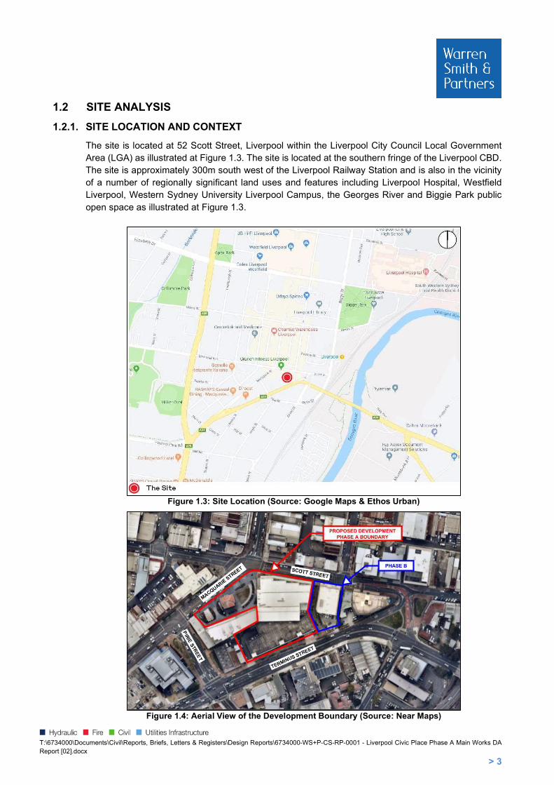
The site is located at 52 Scott Street, Liverpool within the Liverpool City Council Local Government Area (LGA) as illustrated at Figure 1.3. The site is located at the southern fringe of the Liverpool CBD. The site is approximately 300m south west of the Liverpool Railway Station and is also in the vicinity of a number of regionally significant land uses and features including Liverpool Hospital, Westfield Liverpool, Western Sydney University Liverpool Campus, the Georges River and Biggie Park public open space as illustrated at Figure 1.3.
Figure 1.3: Site Location (Source: Google Maps & Ethos Urban)
Figure 1.4: Aerial View of the Development Boundary (Source: Near Maps)

T:\6734000\Documents\Civil\Reports, Briefs, Letters & Registers\Design Reports\6734000-WS+P-CS-RP-0001 - Liverpool Civic Place Phase A Main Works DA Report [02].docx
> 4
2. ABBREVIATIONS AND DEFINITIONS AEP Annual Exceedance Probability AHD Australian Height Datum ARI Average Recurrence Interval DN Diameter (mm) EY Exceedances per Year IFD Intensity-Frequency-Duration L/s Litres per second m/s Metres per second MUSIC Model for Urban Stormwater Improvement Conceptualisation OSD On-Site Detention PSD Permissible Site Discharge RCP Reinforced Concrete Pipe RWT Rainwater Reuse Tank SID Safety In Design SSR Site Storage Requirement WSC Water Services Coordinator WSUD Water Sensitive Urban Design The Use of Must, Shall & Should: In accordance with the international Organisation for Standardisation (ISO) Directives, the word “shall” is used to state that a requirement is strictly to be followed in order to conform to a Performance Requirement. Consequently, there can be no deviation from that requirement, other than a specific tolerance. It is noted that in legislation and specifications it is common to use the word “must” to express a requirement. The word “shall” in this document should be considered as equivalent to “must” in the legislation. The word “should” introduces a suggestion or recommendation that is not a requirement. It is not necessary that such recommendations or suggestions be followed in order to comply with the Performance Requirement.
T:\6734000\Documents\Civil\Reports, Briefs, Letters & Registers\Design Reports\6734000-WS+P-CS-RP-0001 - Liverpool Civic Place Phase A Main Works DA Report [02].docx
> 5
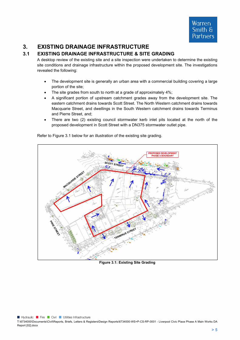
3. EXISTING DRAINAGE INFRASTRUCTURE 3.1 EXISTING DRAINAGE INFRASTRUCTURE & SITE GRADING
A desktop review of the existing site and a site inspection were undertaken to determine the existing site conditions and drainage infrastructure within the proposed development site. The investigations revealed the following:
The development site is generally an urban area with a commercial building covering a large portion of the site;
The site grades from south to north at a grade of approximately 4%;
A significant portion of upstream catchment grades away from the development site. The eastern catchment drains towards Scott Street. The North Western catchment drains towards Macquarie Street, and dwellings in the South Western catchment drains towards Terminus and Pierre Street, and;
There are two (2) existing council stormwater kerb inlet pits located at the north of the proposed development in Scott Street with a DN375 stormwater outlet pipe.
Refer to Figure 3.1 below for an illustration of the existing site grading.
Figure 3.1: Existing Site Grading
T:\6734000\Documents\Civil\Reports, Briefs, Letters & Registers\Design Reports\6734000-WS+P-CS-RP-0001 - Liverpool Civic Place Phase A Main Works DA Report [02].docx
> 6
4. AUTHORITY AND REGULATORY REQUIREMENTS
4.1 DESIGN CRITERIA Table 4.1: Design Criteria
Item Design Criteria
Stormwater Drainage Works AS/NZS 3500.3 – 2015 – Stormwater Drainage
Liverpool Council Development Design Specification for Stormwater Design (DCP) 2003
Water Quality Requirements and Proposed Treatment System
Draft NSW MUSIC Modelling Guidelines 2010 Liverpool Council Water Management Policy (2016)
Sediment and Erosion Control Landcom ‘Blue Book’ – Managing Urban Stormwater Soils and
Construction Guideline Edition 4
The proposed development application design has considered the concept DA conditions set out in Table 4.2. Table 4.2: Concept Development Application Conditions
Condition Description
14. Stormwater Management A concept stormwater drainage system must be designed to ensure that stormwater runoff from upstream properties is conveyed through the site without adverse impact on the development or adjoining properties.
15. Stormwater Management Engineering plans and supporting calculations for the stormwater drainage system are to be prepared by a suitably qualified engineer.
17. Stormwater Management A stormwater pre-treatment system shall be incorporated on the proposed stormwater plans and that the design meets pollutant retention criteria in accordance with Council’s Development Control Plan.
18. Stormwater Management
On site water quality treatment facilities shall be provided to ensure that stormwater runoffs leaving the site comply with Council’s water quality standards. The treatment facilities shall capture all gross pollutants and liquid contaminants from the stormwater before discharging it to downstream. Water quality treatment works shall be designed using MUSIC modelling software and the water quality treatment system performance shall be verified using Council’s MUSIC link.
19. Stormwater Management
The below pollutant reduction targets are to be satisfied:
45% reduction in the baseline annual pollutant load of total nitrogen (TN);
65% reduction in the baseline annual pollutant load of total phosphorous (TP);
85% reduction in the baseline annual pollutant load of total suspended solids TSS); and 90% reduction in the baseline annual pollutant load of litter and vegetation larger than 5mm (gross pollutants).
25. Traffic and Access Detailed design drawings of the driveways and ramps, demonstrating that the design has been carried out in accordance with Australian Standards is to be submitted to Council with the detailed development applications.

T:\6734000\Documents\Civil\Reports, Briefs, Letters & Registers\Design Reports\6734000-WS+P-CS-RP-0001 - Liverpool Civic Place Phase A Main Works DA Report [02].docx
> 7
The proposed development application design has considered the items relating to civil and stormwater outlined in the pre-DA meeting minutes, refer to Table 4.3. Table 4.3: Pre-Development Application Meeting Minutes – Items Relating to Civil & Stormwater
Condition Description
i) Flooding
Water Sensitive Urban Design / on site water quality treatment trains shall be incorporated in the stormwater design. Water quality treatment works shall be designed using MUSIC modelling software and the water quality treatment system performance shall be verified using Council’s MUSIC link.
j) Development engineering Stormwater
Stormwater drainage for the site must be in accordance with Council’s Development Control Plan.
A detailed stormwater concept plan shall be submitted with the application.
The stormwater concept plan shall be accompanied by a supporting report and calculations including relevant DRAINS digital model. (Note: Onsite Detention is not expected to be required give the existing site coverage).
The proposed basement car park shall ensure that the stormwater drainage system has been designed in accordance with the requirements for pumped systems in AS3500.3:2003 and Council’s Stormwater Drainage Design Specifications for pump out systems for basement carparks.
A water quality treatment device shall be provided in accordance with Council’s Development Control Plan. A MUSIC model shall be submitted with the development application.
17. Stormwater Management A stormwater pre-treatment system shall be incorporated on the proposed stormwater plans and that the design meets pollutant retention criteria in accordance with Council’s Development Control Plan.
4.2 STORMWATER DRAINAGE AND ON SITE DETENTION (OSD) REQUIREMENTS With reference to the following documents, the Council requirements are presented in the sub-sections below:
Liverpool City Council Development Control Plan (DCP), dated 2008;
Liverpool City Council Development Design Specification, Section D5 Stormwater Drainage Design, dated January 2003, and;
Liverpool City Council Development Design Specification, Section D2 Pavement Design, dated October 2003.

T:\6734000\Documents\Civil\Reports, Briefs, Letters & Registers\Design Reports\6734000-WS+P-CS-RP-0001 - Liverpool Civic Place Phase A Main Works DA Report [02].docx
> 8
4.3 STORMWATER DRAINAGE REQUIREMENTS
The piped system must be capable of conveying stormwater up to, and including, the 20% AEP storm event, and overland flow paths must be capable of conveying stormwater up to, and including, the 1% AEP storm event;
As per the correspondence with Liverpool Council, an OSD is not required for the proposed development. Refer to Schedule 2 for the Council Correspondence, and;
Post-development flows shall not exceed pre-development flows. Liverpool City Council stormwater drainage design specification (2003) outlines standards for design of minor and major systems. Since the proposed development is located within the Liverpool CBD, the design specifications require minor systems to be designed for 20-year ARI. Design of minor systems require the following:
Pipe gradient to be a minimum 1% and maximum 10%. Velocity within pipelines to be minimum 0.6m/s and maximum 6m/s.
Water surface level within drainage pits to be 0.15m below gutter invert.
Angle between inlet and outlet at pit junction to be greater than 90 degrees.
Maximum Pit bypass flow rate to be 10l/s.
Allowance for blockage for grated pits at both sag and continuous grades are 50%. For side entry pits, blockage allowance at both sag and continuous grades is 80%. For Combination pits, blockage allowance at continuous grade is 90%, and only the grate is assumed to be fully blocked at sag.
Design of major systems require provision of safe, well defined overland flow paths for extreme storm events.
4.4 FLOODING & FREEBOARD REQUIREMENTS The proposed development in Liverpool Civic is outside of the flooding zone, therefore no freeboard requirements are required for the proposed development. Refer to the Figure 4.1 for the location of the proposed development on the flooding map and to Schedule 3 for Liverpool CBD Floodplain Management Study.

T:\6734000\Documents\Civil\Reports, Briefs, Letters & Registers\Design Reports\6734000-WS+P-CS-RP-0001 - Liverpool Civic Place Phase A Main Works DA Report [02].docx
> 9
Figure 4.1: Location of the proposed development on the flooding map (Source: Liverpool CBD
Floodplain Management Study)
4.5 WATER SENSITIVE URBAN DESIGN (WSUD) REQUIREMENTS Table 4.4: WSUD Stormwater Quality Reduction Targets as per Liverpool Council DCP
Pollutant Type Reduction Target (%)
Gross Pollutants (GP) 90%
Total Suspended Solids (TSS) 85%
Total Phosphorus (TP) 65%
Total Nitrogen (TN) 45%
Additional requirements from Liverpool Civic Place Sustainability Services Design Brief, dated 3 June 2020 are presented in Table 4.5. Table 4.5: WSUD Stormwater Quality Reduction Targets as per ESD Framework
Pollutant Type Reduction Target (%)
Gross Pollutants (GP) 90%
Total Suspended Solids (TSS) 80%
Total Phosphorus (TP) 60%
Total Nitrogen (TN) 45%
Free Oils 90%
TPH 90%

T:\6734000\Documents\Civil\Reports, Briefs, Letters & Registers\Design Reports\6734000-WS+P-CS-RP-0001 - Liverpool Civic Place Phase A Main Works DA Report [02].docx
> 10
5. PROPOSED STORMWATER SYSTEM The total site development area is 0.5156 Ha. A breakdown of the proposed development area is presented in Table 5.1. Table 5.1: Breakdown of Proposed Development Site Catchment
Catchment Impervious (Ha) Pervious (Ha) Total Area (Ha)
Driveway, Main Ground & Hardstands 0.2155 - 0.2155
Roof Library 0.0653 - 0.0653
Roof Council Office 0.2173 - 0.2173
Bypass 0.0112 0.0063 0.0175
Total Area 0.5093 0.0063 0.5156
It is proposed that there will be two (2) combination treatment tanks installed for the proposed development located in the Council office building and Library building. The tank located in the Council Office building will be 2.5 m long by 1.3 m wide by 1.35 m high. The roof catchment from the building will be discharging into the proposed tank and the catchments from the hardstand areas Terminus Pocket Park will be captured and pumped up into the proposed combination tank via the internal hydraulic system. Refer to Figure 5.1 for an illustration of the combination tank location and site drainage.
Figure 5.1: Stormwater Layout – Southern Portion of Site
The tank located in the Library building will be 2.2 m long by 1.0 m wide by 1.35 m high. The roof catchment from the building will be discharging into the proposed tank and the hardstand areas located at the west of the Library building which will discharge to the existing council stormwater kerb inlet pit in Scott Street. Refer to Figure 5.2 for an illustration of the combination tank location and site drainage.
T:\6734000\Documents\Civil\Reports, Briefs, Letters & Registers\Design Reports\6734000-WS+P-CS-RP-0001 - Liverpool Civic Place Phase A Main Works DA Report [02].docx
> 11
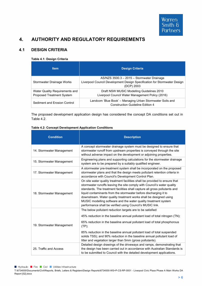
Figure 5.2: Stormwater Layout – Northern Portion of Site
The Civil Plaza and shared driveway drain north towards Scott Street and stormwater runoff will be captured by two (2) ACO K200 grated trench drains located immediately inside the boundary of the proposed development along Scott Street. The grated drains will have three (3) DN150 outlet points that discharge to a DN300 carrier pipe which will reticulate to a treatment pit located to the north east of the Library building. The treatment pit will discharge to the existing kerb inlet pit located in Scott Street at IL 21.37. Refer to Schedule 4 for ACO K200 trench drain sizing.
5.1 STORMWATER SYSTEM DESIGN
5.1.1 DRAINS INPUT PARAMETERS
The drainage system has been modelled utilising DRAINS to ensure the system is designed to meet Council and the ESD framework stormwater requirements. DRAINS is a stormwater drainage design and analysis program which performs hydraulic grade line analysis and generates the flows which would occur for a particular Annual Exceedance Probability (AEP) storm event. The catchment characteristic factor values which have been used in the DRAINS model are summarised below:
Paved (impervious) Area Depression Storage 1mm
Supplementary Area Depression Storage 1mm
Grassed (Pervious) Area Depression Storage 5mm
Soil Type - Normal 3.0
Antecedent Moisture Condition (AMC) 3.0 Minimum Pit Freeboard 300mm
Blockage Factor for On-Grade Pits 20%
Blockage Factor for Sag Pits 50%

T:\6734000\Documents\Civil\Reports, Briefs, Letters & Registers\Design Reports\6734000-WS+P-CS-RP-0001 - Liverpool Civic Place Phase A Main Works DA Report [02].docx
> 12
5.2 RESULTS The proposed development has been designed to ensure that the post development stormwater runoff from the total development area does not exceed the pre-development runoff. Refer to Table 5.2 for the development area’s site discharge results. Table 5.2: Development Area’s Site Discharge Results
Scenario 50% AEP
Storm Event (L/s)
20% AEP Storm
Event (L/s)
10% AEP Storm
Event (L/s)
5% AEP Storm
Event (L/s)
2% AEP Storm
Event (L/s)
1% AEP Storm
Event (L/s)
Pre-Development 113 155 182 207 250 277
Post Development 109 146 173 207 237 268

T:\6734000\Documents\Civil\Reports, Briefs, Letters & Registers\Design Reports\6734000-WS+P-CS-RP-0001 - Liverpool Civic Place Phase A Main Works DA Report [02].docx
> 13
6. WATER QUALITY REQUIREMENTS AND PROPOSED TREATMENT SYSTEM In order to comply with Liverpool Council’s requirements for the adequate treatment of stormwater runoff, treatment solutions have been provided to remove suspended solids, hydrocarbons, and nutrients prior to being discharged from site. The pollutants that could potentially be generated as a result of the development are as follows:-
Litter;
Sediment; Nutrients (Phosphorus and Nitrogen), and;
Hydrocarbons. The development has been modelled to demonstrate the performance of the stormwater treatment system utilising a program called MUSIC. MUSIC models the proposed stormwater treatment devices and estimates their respective performance against the performance targets of the project. The pollutants modelled in MUSIC are Gross Pollutants (GP), Total Suspended Solids (TSS), Total Phosphorus (TP), Total Nitrogen (TN), and Total Petroleum Hydrocarbons (TPH).
6.1 RAINFALL A continuous simulation of ten (10) years was run with a six (6) minute time step. The time period for which the model was run is 1st January 1967 to 31st December 1976. The rainfall station utilised was 067035 Liverpool (Whitlam Centre). The average potential evapotranspiration (PET) data used in the MUSIC model was based on the average Sydney PET and is presented in Table 6.1 below. Table 6.1: Evapotranspiration Data for MUSIC Modelling
Month Jan Feb Mar Apr May Jun Jul Aug Sep Oct Nov Dec
PET (mm) 180 135 128 85 58 43 43 58 88 127 152 163

T:\6734000\Documents\Civil\Reports, Briefs, Letters & Registers\Design Reports\6734000-WS+P-CS-RP-0001 - Liverpool Civic Place Phase A Main Works DA Report [02].docx
> 14
6.2 RAINFALL RUNOFF PROPERTIES In accordance with the Draft NSW MUSIC Modelling Guidelines, dated August 2010, the following Table 6.2 and Table 6.3 presents the rainfall runoff properties which have been used in the MUSIC model. Table 6.2: MUSIC Rainfall Runoff Properties
Parameter Unit Value
Impervious Area Parameters
Rainfall Threshold mm 1.0 (for roads/paths etc.) 1.5 (for roadways) 0.3 (for roofs)
Pervious Area Parameters
Soil Storage Capacity mm 120
Initial Storage Capacity % 30
Field Capacity mm 80
Infiltration Capacity co-efficient a 200
Infiltration Capacity co-efficient b 1.0
Groundwater Properties
Initial depth mm 10
Daily recharge rate % 25
Daily base seepage rate % 5
Daily seepage rate (%) % 0
Table 6.3: Pollutant Concentration Parameters for MUSIC Source Nodes
Land Use Category
Concentration (mg/L-log10)
Total Suspended Solids
Total Phosphorus Total Nitrogen
Storm Flow
Base Flow Storm Flow
Base Flow Storm Flow
Base Flow
General Urban (incl public open space)
Mean 2.15 1.20 -0.60 -0.85 0.30 0.11
Standard Deviation
0.32 0.17 0.25 0.19 0.19 0.12
Roofs
Mean 1.30 * -0.89 * 0.30 *
Standard Deviation
0.32 * 0.25 * 0.19 *
*Base flows are only generated from pervious areas; therefore these parameters are not relevant to impervious areas.

T:\6734000\Documents\Civil\Reports, Briefs, Letters & Registers\Design Reports\6734000-WS+P-CS-RP-0001 - Liverpool Civic Place Phase A Main Works DA Report [02].docx
> 15
6.3 MUSIC MODEL CATCHMENT AREAS AND STORMWATER TREATMENT PLAN The MUSIC model’s total catchment area to be treated is 0.5156 Ha. Refer to Table 6.4 for a breakdown of the MUSIC model catchment areas. Table 6.4: Breakdown of MUSIC Model Catchment
Catchment Impervious (Ha) Pervious (Ha) Total Area (Ha)
Driveway, Main Ground & Hardstands 0.2155 - 0.2155
Roof Library 0.0653 - 0.0653
Roof Council Office 0.2173 - 0.2173
Bypass 0.0112 0.0063 0.0175
Total Area 0.5093 0.0063 0.5156
The proposed site treatment will utilise two (2) different products by Ocean Protect: OceanGuard and 690mm PSORB Stormfilter, and one (1) product by MyCelx: Oil Soak. The first level of treatment will include three (3) OceanGuards, which intercept surface water runoff at the pit grates and filter the runoff prior to entering the piped stormwater system. It is proposed that an Ocean Guard filter basket will be fitted in each of the two (2) combination tanks, each located in the proposed council building and library. An additional OceanGuard filter basket will be fitted in the 1.2m square pit, located at the downstream end of the Civic Plaza. The OceanGuard is fitted with a monofilament 200 micron pore size filter bag that removes gross pollutants such as sediment, trash and debris, as well as suspended solids. Please refer to Figure 6.1 below for an illustration of a typical Ocean Guard.
Figure 6.1: Typical OceanGuard Filter
The second treatment device to be utilised are the total number of eight (8) 690mm PSORB StormFilters. There will be four (4) Psorb 690mm fitted in the combination tank (2.5 m long, 1.3 m wide and 1.35 m high), which will capture the roof water from the proposed council office building. There will be two (2) Psorb 690mm fitted in the combination tank (2.2 m long, 1.3 m wide, and 1.35 m high) located in the library building. There will be another two (2) Psorb 690mm fitted in 1.2m square pit, located at the downstream end of Civil Plaza.
T:\6734000\Documents\Civil\Reports, Briefs, Letters & Registers\Design Reports\6734000-WS+P-CS-RP-0001 - Liverpool Civic Place Phase A Main Works DA Report [02].docx
> 16
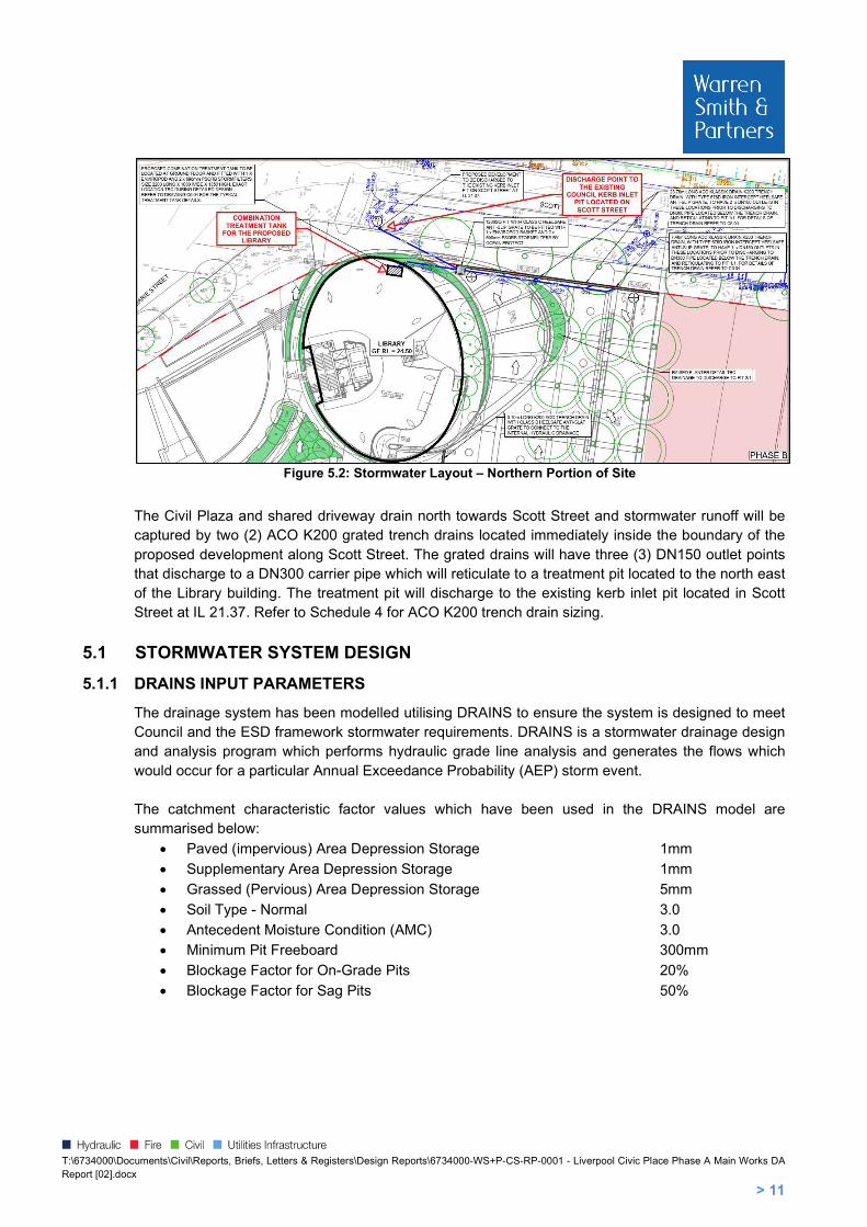
A Psorb StormFilter cartridge system is provided to remove any remaining suspended sediments, hydrocarbons and nutrients which have entered the stormwater system. Please refer to Figure 6.2 below for an illustration of a typical Psorb StormFilter.
Figure 6.2: Typical PSorb StormFilter
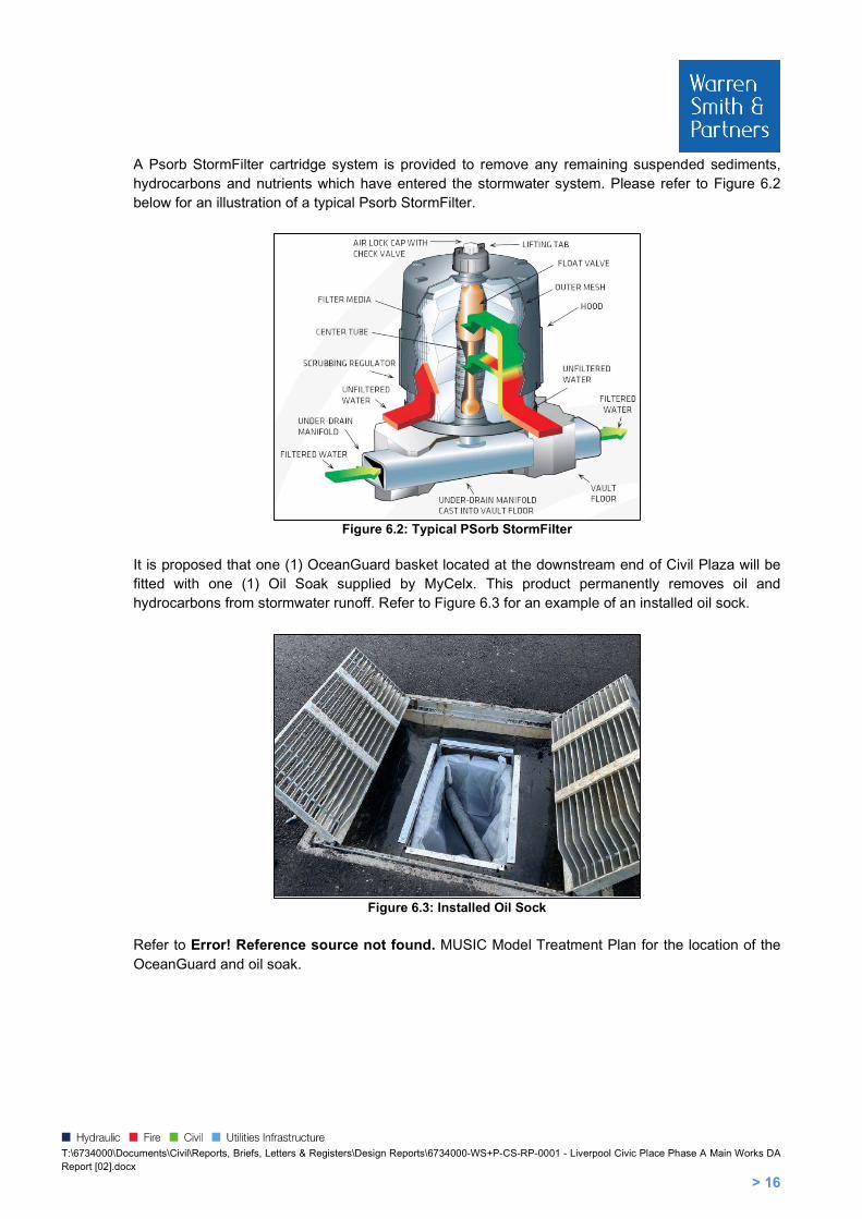
It is proposed that one (1) OceanGuard basket located at the downstream end of Civil Plaza will be fitted with one (1) Oil Soak supplied by MyCelx. This product permanently removes oil and hydrocarbons from stormwater runoff. Refer to Figure 6.3 for an example of an installed oil sock.
Figure 6.3: Installed Oil Sock
Refer to Error! Reference source not found. MUSIC Model Treatment Plan for the location of the OceanGuard and oil soak.
T:\6734000\Documents\Civil\Reports, Briefs, Letters & Registers\Design Reports\6734000-WS+P-CS-RP-0001 - Liverpool Civic Place Phase A Main Works DA Report [02].docx
> 17
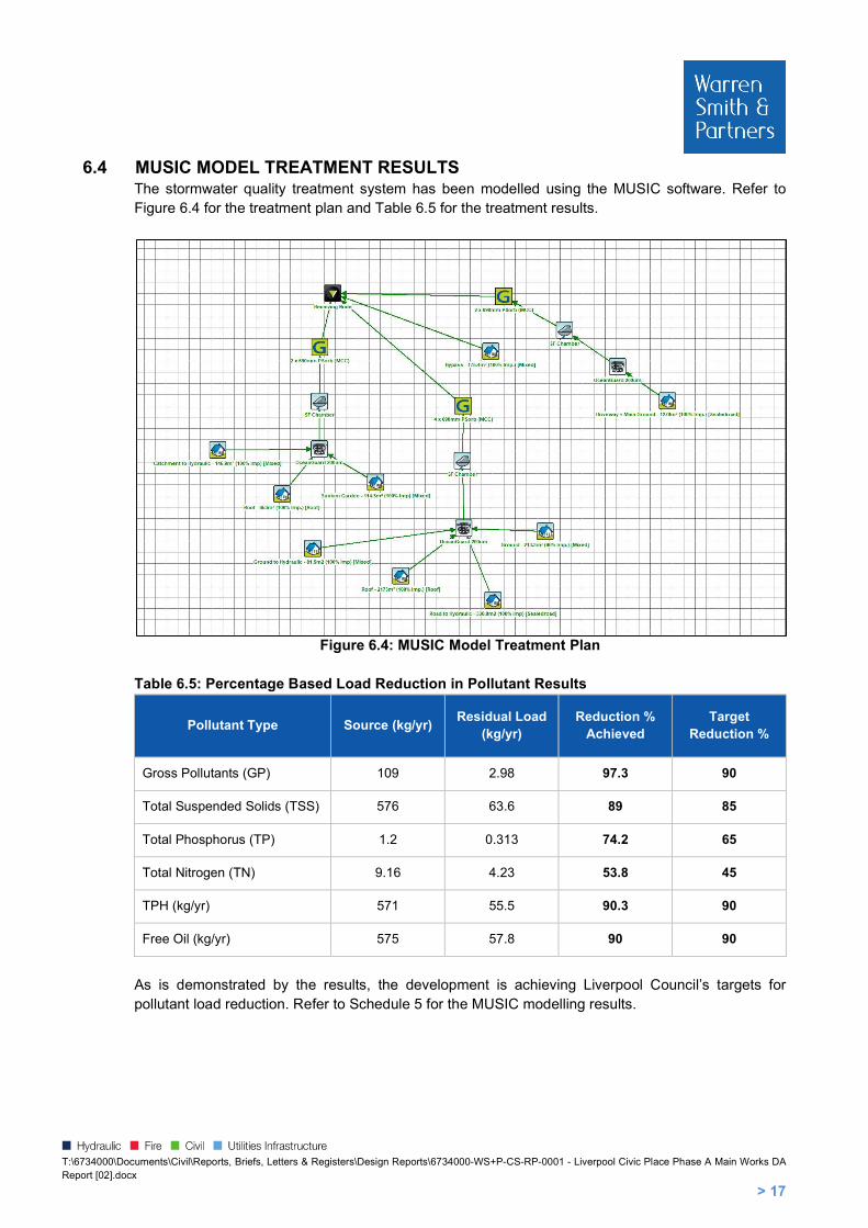
6.4 MUSIC MODEL TREATMENT RESULTS The stormwater quality treatment system has been modelled using the MUSIC software. Refer to Figure 6.4 for the treatment plan and Table 6.5 for the treatment results.
Figure 6.4: MUSIC Model Treatment Plan
Table 6.5: Percentage Based Load Reduction in Pollutant Results
Pollutant Type Source (kg/yr) Residual Load
(kg/yr) Reduction %
Achieved Target
Reduction %
Gross Pollutants (GP) 109 2.98 97.3 90
Total Suspended Solids (TSS) 576 63.6 89 85
Total Phosphorus (TP) 1.2 0.313 74.2 65
Total Nitrogen (TN) 9.16 4.23 53.8 45
TPH (kg/yr) 571 55.5 90.3 90
Free Oil (kg/yr) 575 57.8 90 90
As is demonstrated by the results, the development is achieving Liverpool Council’s targets for pollutant load reduction. Refer to Schedule 5 for the MUSIC modelling results.
T:\6734000\Documents\Civil\Reports, Briefs, Letters & Registers\Design Reports\6734000-WS+P-CS-RP-0001 - Liverpool Civic Place Phase A Main Works DA Report [02].docx
> 18
7. SEDIMENT AND EROSION CONTROL The Contractor for the works is required to provide Sedimentation and Erosion Control in accordance with the general requirements outlined below.
7.1 SITE PROTECTION MEASURES It is proposed to provide the following in order to inhibit the movement of sediment off the site during the demolition and construction phases.
7.1.1 SITE ACCESS
Construction vehicles leaving the site shall be required to pass over a Temporary Construction Vehicle Entry consisting of a 1.5m long by 3m wide ‘cattle rack’.
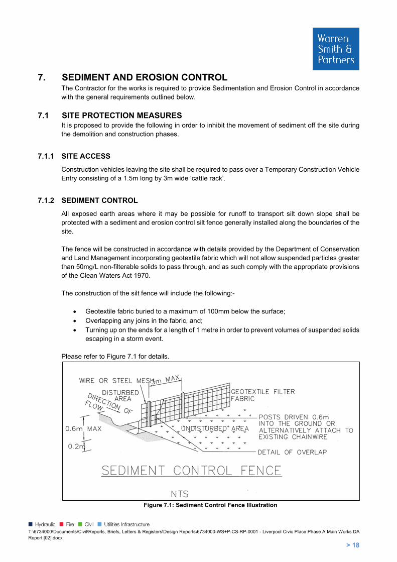
7.1.2 SEDIMENT CONTROL
All exposed earth areas where it may be possible for runoff to transport silt down slope shall be protected with a sediment and erosion control silt fence generally installed along the boundaries of the site. The fence will be constructed in accordance with details provided by the Department of Conservation and Land Management incorporating geotextile fabric which will not allow suspended particles greater than 50mg/L non-filterable solids to pass through, and as such comply with the appropriate provisions of the Clean Waters Act 1970. The construction of the silt fence will include the following:-
Geotextile fabric buried to a maximum of 100mm below the surface;
Overlapping any joins in the fabric, and;
Turning up on the ends for a length of 1 metre in order to prevent volumes of suspended solids escaping in a storm event.
Please refer to Figure 7.1 for details.
Figure 7.1: Sediment Control Fence Illustration

T:\6734000\Documents\Civil\Reports, Briefs, Letters & Registers\Design Reports\6734000-WS+P-CS-RP-0001 - Liverpool Civic Place Phase A Main Works DA Report [02].docx
> 19
Existing stormwater infrastructure is also to be protected from incoming sediment using the following methods:
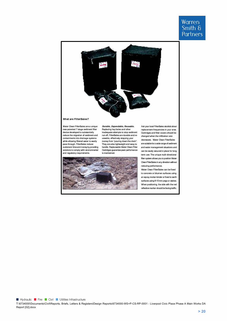
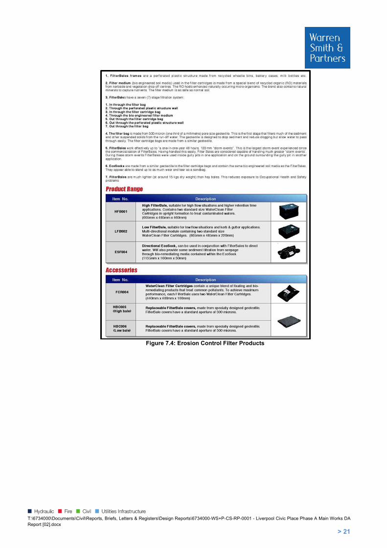
Any Council owned road kerb entry and/or gully pits will be protected by Filter Bales and EcoSocks. Additional protection will be provided by inserting Water Clean Filter Cartridges into the gully opening, and;
Internal site drainage pits shall be protected by Sediment Traps consisting of hay bales. Please refer to Figure 7.2, Figure 7.3 and Figure 7.4 for details.
Figure 7.2: Stormwater Pit Sediment Trap (NTS)
Figure 7.3: Geotextile Filter Fabric Drop Inlet Sediment Trap (NTS)
T:\6734000\Documents\Civil\Reports, Briefs, Letters & Registers\Design Reports\6734000-WS+P-CS-RP-0001 - Liverpool Civic Place Phase A Main Works DA Report [02].docx
> 20
T:\6734000\Documents\Civil\Reports, Briefs, Letters & Registers\Design Reports\6734000-WS+P-CS-RP-0001 - Liverpool Civic Place Phase A Main Works DA Report [02].docx
> 21
Figure 7.4: Erosion Control Filter Products
T:\6734000\Documents\Civil\Reports, Briefs, Letters & Registers\Design Reports\6734000-WS+P-CS-RP-0001 - Liverpool Civic Place Phase A Main Works DA Report [02].docx
> 22
7.2 TEMPORARY STORMWATER SYSTEM (WHERE REQUIRED) Site runoff within the zones of the excavation will be drained into a central holding well within the excavation. Runoff will be allowed to settle out suspended particles and debris, and an acceptable water of 50mg per litre of Non Filterable Residues (NFR) is required to be achieved prior to discharge.
7.2.1 DUST CONTROL
The following dust control procedures will be adhered to:
Loose loads entering or leaving the site will be securely covered by a tarpaulin or like material in accordance with RMS and local Council Guidelines.
Soil transport vehicles will use the single main access to the site.
There will be no burning of any materials on site. Water sprays will be used across the site to suppress dust. The water will be applied either by
water sprinklers or water carts across ground surfaces whenever the surface has dried out and has the potential to generate visible levels of dust either by the operation of equipment over the surface or by wind. The watercraft will be equipped with a pump and sprays.
Spraying water at the rate of not less than three (3) L/s and not less than 700kPa pressure. The area covered will be small enough that surfaces are maintained in a damp condition and large enough that runoff is not generated. The water spray equipment will be kept on site during the construction of the works.
During excavation all trucks/machinery leaving the site will have their wheels washed and/or agitated prior to travelling on Council Roads.
Fences will have shade cloth or similar fabric fixed to the inside of the fence.
7.2.2 MAINTENANCE
Generally, the following maintenance measures shall be adhered to during construction:-
It will be the responsibility of the contractor to ensure sediment and erosion control devices on site are maintained. The devices shall be checked daily and the appropriate maintenance undertaken as necessary.
Prior to the closing of the site each day, the road shall be swept and materials deposited back onto the site.
Gutters and roadways will be kept clean regularly to maintain them free of sediment.
Appropriate covering techniques, such as the use of plastic sheeting will be used to cover excavation faces, stockpiles and any unsealed surfaces;
If dust is being generated from a given surface, and water sprays fail;
If fugitive emissions have the potential to cause the ambient as quality to foul the ambient air quality;
The area of soils exposed at any one time will be minimised wherever possible by excavating in a localised progressive manner over the site; and,
Materials processing equipment suitably comply with regulatory requirements. The protection will include the covering of feed openings with rubber curtains or socks.
It is considered that by complying with the above, appropriate levels of protection are afforded to the site, the adjacent public roads, footpaths, and environment.

T:\6734000\Documents\Civil\Reports, Briefs, Letters & Registers\Design Reports\6734000-WS+P-CS-RP-0001 - Liverpool Civic Place Phase A Main Works DA Report [02].docx
SCHEDULE 1 CONCEPT DA CONDITIONS & PRE-DEVELOPMENT APPLICATION MEETING MINUTES

ATTACHMENT A
CONDITIONS OF CONSENT TO CONCEPT DEVELOPMENT APPLICATION
A. GENERAL CONDITIONS
Approved Plans / Documents
1. Development the subject of this determination notice must be carried out strictly in accordance with the following approved plans / reports marked as follows, except where modified by the undermentioned conditions.
Plan Name Plan Number Date Prepared By
Basement Envelope Plan MP-002 2/05/2020 FJMT
Envelope Plan MP-001 2/05/2020 FJMT
Envelope Section A MP-005 2/05/2020 FJMT
Envelope Section B & C MP-006 2/05/2020 FJMT
Envelope Perspective North MP-003 2/05/2020 FJMT
Envelope Perspective South MP-004 2/05/2020 FJMT
Envelope Perspective East MP-007 2/05/2020 FJMT
Environmental Planning and Assessment Act 1979 2. In accordance with section 4.22(4) of the EP&A Act all development under the Concept
Proposal must be subject of future application(s). This consent does not permit the carrying out of any works.
Land uses 3. This consent does not approve any residential land uses on the subject site.
Public Domain and Landscaping – Design Excellence 4. A Public Domain Design Panel is to be convened and a Public Domain Plan prepared:
a) Prior to the determination of any Detailed DA subject to this Concept Approval, a detailed
Public Domain and Landscape Plan must be prepared by a suitably qualified AILA Registered Landscape Architect or Urban Designer, in accordance with the requirements of this condition.
b) A design review process is to be undertaken for the Public Domain and Landscape Plan
with the purpose of achieving design excellence of the public domain in accordance with Clause 7.5 of Liverpool Local Environmental Plan 2008.

DA No. 585/2019 Page 2 of 15
c) As part of the design review process, a Public Domain Design Panel is to be convened, that is to be chaired by the nominated chair of Council’s Design Excellence Panel or his or her nominee, and whose other members are to include (at least):
• A representative of or person nominated by Government Architect NSW;
• A suitably qualified landscape architect and urban designer;
• A representative of Liverpool City Council’s City Design and Public Domain team.
d) At least two public domain design workshops are to be convened for attendance by members of the Public Domain Design Panel, the Applicant, and other relevant technical officers of Liverpool City Council which may include officers responsible for Heritage, Traffic, Public Art, Community Planning, Indigenous Culture and Heritage, and Community Development.
e) At the conclusion of the public domain design workshops, the Public Domain Design Panel
is to record its recommendations.
f) The recommendations of the Public Domain Design Panel are to be incorporated into a Public Domain and Landscape Plan to be prepared by the Applicant.
g) The Public Domain and Landscape Plan is to be endorsed by the Chair of the Public Domain Design Panel as satisfactorily responding to the outcome of the public domain workshops, prior to the determination of any future Detailed DA under this Concept Approval.
5. The Public Domain and Landscape Plan is to:
a) Identify any landscape constraints, including (but not limited to) setbacks, existing street trees, landscape features, screening / buffer requirements
b) Include public domain design guidelines that are to be implemented across the subject site
c) Identify the location of public domain areas within the site, providing detail on their role, character and extent
d) Set aspirations and principles for each public domain area in order to achieve Design Excellence in accordance with Clause 7.5 of Liverpool Local Environmental Plan 2008
e) Identify the location of trees, planters, water sensitive urban design treatments, deep soil and direct sunlight to public domain areas
f) Detail design principles for roof terraces, including (but not limited to) how planting, deep soil, access and shade would be implemented
g) Identify any intended design elements such as green roofs and walls, water sensitive landscape design treatments and sustainability targets
h) Demonstrate consistency with the relevant landscape provisions of the Liverpool Development Control Plan 2008 and Liverpool City Centre Public Domain Master Plan
i) Demonstrate how the public domain areas will relate to proposed future built form within site, including consideration of pedestrian movements to and between buildings within the site
6. All future detailed Development Applications subject to this Concept approval will need to demonstrate to the consent authority consistency with the endorsed Public Domain and

DA No. 585/2019 Page 3 of 15
Landscape Plan.
Traffic and Access 7. Prior to the determination of a Detailed DA, a Local Area Traffic Management Plan is to be
submitted to Council’s Traffic and Transport Section and to the Liverpool Pedestrian Active Transport and Traffic Committee for endorsement. The Local Area Traffic Management Plan is to identify traffic infrastructure improvements including changes to the adjoining traffic signals, signs, line markings and timed parking restrictions.
Transport for NSW Conditions 8. Future Detailed DAs subject to this Concept Approval shall comply with all conditions
provided by Transport for NSW dated 12 August 2020. A copy of the conditions is attached to this decision notice (Attachment 1). Note: the conditions do not constitute a Section 138 concurrence under the Roads Act 1993.

DA No. 585/2019 Page 4 of 15
B. CONDITIONS TO BE SATISFIED PRIOR TO THE SUBMISSION OF FUTURE DEVELOPMENT APPLICATIONS
Pre-Development Application Meeting 9. Prior to the submission of a development application which seeks approval for any detailed
design of a building under this Concept Approval, a Pre-Development Application meeting is to be convened with representatives of Liverpool City Council. Advice of the subject Pre-Development application meeting is to accompany the development application when lodged.
Amended Plans
10. Prior to the lodgement of any Detailed DA subject to this Concept Approval, the plans outlined
in Condition 1 must be amended to reflect the following:
a. The extent of the building envelope titled ‘Masterplan Envelope – Information & Education Facility’ must be reduced to a maximum of 4 metres from the eastern edge of Lot 201 in DP 1224084, also known as 306-310 Macquarie Street (excluding any decorative architectural features above ground level). Evidence is to be provided to Liverpool City Council’s Manager Development Assessment that satisfactorily demonstrates the plans have been amended to reflect this condition.

DA No. 585/2019 Page 5 of 15
C. CONDITIONS TO BE SATISFIED IN FUTURE DEVELOPMENT APPLICATIONS
Building Envelopes 11. Built form proposed in any future Detailed DA subject to this Concept Approval is not permitted
to extend beyond the building envelopes approved under DA-585/2019.
12. Any built form proposed within the building envelope titled ‘Masterplan Envelope – Information
& Education Facility’ must incorporate the following requirements: a. Floors facing the north western façade of the existing mixed-use building at 300
Macquarie Street, Liverpool, are to incorporate design features that limits overlooking into existing residential areas.
Public Domain and Landscaping – Design Excellence 13. All future detailed Development Applications subject to this Concept Approval are to
demonstrate consistency with an endorsed Public Domain Plan, detailed in Conditions 4 and 5. Stormwater Management 14. A concept stormwater drainage system must be designed to ensure that stormwater runoff
from upstream properties is conveyed through the site without adverse impact on the development or adjoining properties.
15. Engineering plans and supporting calculations for the stormwater drainage system are to be
prepared by a suitably qualified engineer and shall accompany the application for a Construction Certificate.
16. The stormwater drainage system for the basement car park is to be designed in accordance
with the requirements for pumped systems in AS3500.3:2003 and Council’s Stormwater Drainage Design Specifications for pump out systems in basement carparks.
17. A stormwater pre-treatment system shall be incorporated on the proposed stormwater plans
and that the design meets pollutant retention criteria in accordance with Council’s Development Control Plan.
18. On site water quality treatment facilities shall be provided to ensure that stormwater runoffs
leaving the site comply with Council’s water quality standards. The treatment facilities shall capture all gross pollutants and liquid contaminants from the stormwater before discharging it to downstream. Water quality treatment works shall be designed using MUSIC modelling software and the water quality treatment system performance shall be verified using Council’s MUSIC link.
19. The below pollutant reduction targets are to be satisfied:
45% reduction in the baseline annual pollutant load of total nitrogen (TN); 65% reduction in the baseline annual pollutant load of total phosphorous (TP); 85% reduction in the baseline annual pollutant load of total suspended solids TSS); and 90% reduction in the baseline annual pollutant load of litter and vegetation larger than 5mm (gross pollutants).

DA No. 585/2019 Page 6 of 15
Planting Schedule 20. A full planting schedule details and specifications are to be provided including planting details
and specifications, maintenance, planting pits, pots and structural elements to be certified by an appropriately qualified person where appropriate.
Social Impact Assessment 21. A comprehensive social impact assessment (CSIA) is to be submitted in accordance with
Liverpool City Council’s Development Control Plan 2008 and Social Impact Assessment Policy. Heritage Considerations 22. The Lachlan Macquarie Statue on the corner of Scott Street and Macquarie Street is to be
retained at its existing location. Traffic and Access 23. Revised Traffic Impact Assessment (TIA) reports are to accompany future Detailed DAs for the
site. The revised TIAs are to include the following:
• Updated SIDRA analysis using traffic generation rates in the TfNSW Guide (1.6 and 1.2 vehicular trips per hour per 100m2 GFA during the morning and afternoon peak period, respectively) for the ‘Developer Buildings’ component, at the minimum, to understand the traffic impact of the development under an alternative scenario.
• Endorsed vehicular access arrangements – The revised reports are to outline and provide details of the endorsed left in/left out access arrangement off Terminus Street addressing all the requirements contained in the letter from TfNSW to Council in Attachment 1 of this consent.
• Allocation of car parking spaces - information regarding the allocation of car parking spaces to the various land uses, including adequate provisions for bicycle and motorcycle parking in the revised TIA.
24. Car parking provision – future Detailed DAs are to provide car parking provisions in accordance
with the car parking rates set out in the Liverpool LEP 2008 and Liverpool DCP 2008 as well as provide for the replacement of the existing public car parking spaces at the site as outlined in the TIA, as prepared by PTC, dated 22 April 2020.
25. Detailed design drawings of the driveways, ramps, aisles, loading bays and parking spaces, as
well as for swept path analysis, footpath paving, street lighting, sign and line marking scheme, demonstrating that the design has been carried out in accordance with RMS Guidelines, DCP and AS: 2890 is to be submitted to Council with the detailed development applications.
26. The drawings must be certified by a qualified traffic engineer and are to comply with the requirements of the DCP and Australian Standards in relation to the Terminus Street access.
27. A Travel Plan that contains specific measures to promote the use of more sustainable modes
of travel including walking, cycling, public transport and car sharing are to be submitted as part of any future Detailed DA.
DA No. 585/2019 Page 7 of 15
Urban Design Considerations
28. Provide a footpath design that ensures pedestrian priority along Scott Street. The pavement
design at driveway locations must include: a. The design of the driveway must be delivered with Granite pavement in 100x100mm
sets (refer to Figure 6.254, page 268, Liverpool City Centre Master Plan) b. The driveway is to be designed flush with the pedestrian pavement along Scott
Street and only demarcated by the change in pavement c. The pedestrians have priority over vehicle movements. And the space must be
demarcated as such
29. Weather protection is required to be provided along Scott Street (east of the driveway access)
to allow pedestrian movements along the street in all-weather situations. Street trees must be provided and designed into the street awning.
30. Include sun-shading and façade treatments are functional in reducing heat-gain from sun exposure.
Wind Study 31. Any future development application is to be accompanied by a wind report prepared by a
suitably qualified consultant. Wind tunnel testing and mitigation measures are to be provided as part of the wind study, with consideration of wind impacts on public areas and roof gardens.
Acoustic Report 32. Any future development application is to be accompanied by an acoustic report prepared by
a suitably qualified acoustic consultant that demonstrates compliance with the relevant provisions of the State Environmental Planning Policy (Infrastructure) 2007, as well as consideration of impacts on surrounding sensitive receivers.
Contamination 33. The Preliminary Site Investigation prepared by Douglas Partners, dated April 2019, submitted
with the application has identified asbestos contamination on the site. Any future Detailed DA subject to this Concept Approval that proposes excavation requires a Stage 2 – Detailed Site Investigation to fully delineate the contamination issues prior to the preparation of a Remediation Action Plan. The relevant assessments are to be undertaken by a suitably qualified and experienced contaminated land consultant with regard to the potential effects of any contaminants on public health, the environment and building structures and shall meet the sampling density outlined in the NSW EPA Contaminated Sites Sampling Design Guidelines (1995).
Sydney Water 34. Future Detailed DAs subject to this Concept Approval shall comply with the advice provided
by Sydney Water dated 26 June 2020. A copy of the advice is attached to this decision notice (Attachment 2).

DA No. 585/2019 Page 8 of 15
ATTACHMENT 1 – Transport for NSW conditions
DA No. 585/2019 Page 9 of 15

DA No. 585/2019 Page 10 of 15
DA No. 585/2019 Page 11 of 15
DA No. 585/2019 Page 12 of 15

DA No. 585/2019 Page 13 of 15
ATTACHMENT 2 – Sydney Water advice

DA No. 585/2019 Page 14 of 15

DA No. 585/2019 Page 15 of 15
200909_Pre-Lodgement Letter_Liverpool Civic Place_Stage 1 Detailed DA Page 1 of 11
10 September 2020
Built Group C/o Ethos Urban 7/343 George Street
Sydney NSW 2000
To: Luke Feltis Liverpool Civic Place (52 Scott Street, Liverpool)
Pre-Lodgement Review – Stage 1 Detailed DA
Dear Luke,
Architectus has been engaged by Liverpool City Council (‘Council’) to undertake the independent assessment of the proposed mixed-use development at Liverpool Civic Place.
This letter provides an overview of comments and key issues identified by Architectus and Council technical officers following a review of the Liverpool Civic Place (Stage 1 Detailed DA) Pre-Lodgement package presented by Built Group (the applicant) and the project team on 19 August 2020. The Pre-Lodgement package was reviewed by the following Council departments:
Environmental Health Urban Design
Economic Development Community Planning
Heritage Traffic Development Engineering Flooding
The issues and comments presented in this letter should be further considered or resolved prior to lodgement of the DA to Council.
1. Background
The development subject to the Pre-Lodgement review is for the proposed Stage 1 Detailed DA for Liverpool Civic Place, which encompasses the western half of the subject site, and includes:
Public Domain including a new civic square (approximately 1,000 sqm in area) Liverpool City Library (approximately 5,000 sqm GFA) Commercial Tower (approximately 17,500 sqm GFA), including:
o Childcare facility (90 places) o Council customer service centre o Council chambers o Council offices o Office lease
It is noted that the proposed Stage 1 Detailed DA is subject to the Concept DA for the site (DA-585/2019), which was considered for determination by the Sydney Western City Planning Panel

200909_Pre-Lodgement Letter_Liverpool Civic Place_Stage 1 Detailed DA Page 2 of 11
(SWCPP) on 31 August 2020, and is currently pending finalisation by the SWCPP. The Concept DA proposed land uses, maximum building envelopes and vehicular site access points for the site. The Stage 1 Detailed DA will be subject to a Concept DA approval for the site and conditions of consent.
A Pre-Lodgement meeting with the applicant and Liverpool City Council’s Design Excellence Panel (DEP) was held separately on 20 August 2020. The DEP has noted the proposal is supported and that all recommendations of the DEP are addressed and incorporated in the DA. Refer to Design Excellence Panel Minutes appended at Attachment A.
2. Comments and key issues
a) Terminus Street vehicular access
The proposed Terminus Street vehicular / basement access point has been shifted west, away from the pocket park named ‘Upper Civic Plaza’. This is generally supported as this limits the interface between key public domain on the site (the pocket park and through site link) and the Terminus Street basement entrance, enabling further opportunities to improve pedestrian amenity along this frontage and potentially reducing conflicts between pedestrians and vehicles entering the basement.
It is noted, however, the following issues for further consideration and / or action by the applicant:
The proposed Terminus Street basement access is now located at a closer distance to the Terminus / Pirie Street intersection. Agreement from Transport for NSW would be required for the proposed location of the basement access from Terminus Street.
It is noted that any variances from an approved Concept DA would require a S4.55 modification of that approval. This applies to the proposed location of the Terminus Street access, if it is not proposed in the same location indicated on the stamped plans of the Concept DA.
b) Public car park
The public car park accessible from Terminus Street needs to ensure that it has appropriate access separation from the private car park(s) servicing the remaining uses on the site. This is to ensure alignment with Transport for NSW’s agreement of supporting the vehicular access point from Terminus Street as part of the assessment of DA-585/2019. Detailed basement plans and supporting documentation are to be provided with DA lodgement, demonstrating how vehicular access will be separated and managed between the public and private car parks.
The proposed number of public car parking spaces should be consistent with the number of existing public car parking spaces on site.
c) Wind impacts
To enable a rigorous assessment of wind impacts, the DA is to provide a detailed assessment of potential wind impacts on the public domain, building entrances and roof top gardens. Wind tunnel testing and mitigation measures are to be provided as part of the wind study, with particular consideration of wind impacts on the proposed civic plaza, the Terminus Street pocket park and Augusta Cullen Plaza.
d) Lot consolidation
It is noted that the area subject to the proposed Stage 1 Detailed DA should be appropriately consolidated into a single lot.

200909_Pre-Lodgement Letter_Liverpool Civic Place_Stage 1 Detailed DA Page 3 of 11
e) Terminus Street ground floor interface
Based on the Upper Ground floor plan presented in the Pre-Lodgement package, it appears that the building frontage to Terminus Street primarily consists of plant, services and basement entrance. While it is acknowledged that there are limitations to the interface along this frontage, the DA should demonstrate how a high level of pedestrian amenity can be achieved along Terminus Street. Detail of the public domain approach to Terminus Street should be provided with further consideration of public domain treatments, landscaping, green infrastructure and public art.
f) Urban design
The following urban design matters are to be considered:
Review the Library entrance to increase the civic nature of the building entry. Investigate options for including brick as the contrasting pedestrian pavement within the
plaza area. Further consider brick elements as part of the furniture suite within the plaza. Confirm that Lagerstroemia (Crepe Myrtle) as proposed within the plaza off Scott Street
(near the driveway entry) is of a scale appropriate to the building and achieves the desired design outcome.
Ensure adequate soil and drainage is provided to the sunken courtyard. Ensure use of Aboriginal elements (e.g. plant and tree species that have special uses)
in the plaza and building design are designed and agreed through collaboration with the local Aboriginal elders to ensure approval and meaningful integration is achieved.
Review the layout of the Terminus Street pocket park and ensure it is a comfortable space for pedestrians to move through.
Ensure wind movements do not negatively impact pedestrians within the plaza. Consider tree planting or building design elements to minimise impacts if required.
Confirm solar access and views are appropriate with the extent of glass in the building façade.
Strongly support the further development of the art / interpretation elements.
g) Traffic
The applicant is requested to submit a Traffic Impact Assessment (TIA) report addressing the traffic and parking issues associated with Stage 1 development, including:
Allocation of parking spaces to the various land uses and access arrangements. Proposed traffic management plan to assist access to the site. It is to be noted access
off Scott Street and Terminus Street are to be restricted to left in / left out only. Swept path analysis incorporating the comments made by PTC on the draft presentation
(for the pre-DA) and certification by independent qualified professional that the access, ramp and parking areas are designed in compliance with the requirements of Council’s DCP and Australian Standards.
Public transport and other sustainable modes of travel. Proposed Travel Plan for the site to support sustainable modes of travel to the site and
reduce dependence on single occupant vehicle travel. The application must demonstrate that access, car parking and manoeuvring details
comply with AS2890 Parts 1, 2 & 6 and Council’s Development Control Plan. The application shall be supported by turning paths in accordance with AS2890 clearly
demonstrating satisfactory manoeuvring on-site and forward entry and exit to and from the public road.
h) Heritage
The applicant is to include a Statement of Heritage Impact addressing materiality, and the relationship between the new development and the School of Arts heritage building.
200909_Pre-Lodgement Letter_Liverpool Civic Place_Stage 1 Detailed DA Page 4 of 11
i) Flooding
Water Sensitive Urban Design / on site water quality treatment trains shall be incorporated in the stormwater design. Water quality treatment works shall be designed using MUSIC modelling software and the water quality treatment system performance shall be verified using Council’s MUSIC link.
j) Development engineering
Stormwater
Stormwater drainage for the site must be in accordance with Council’s Development Control Plan.
A detailed stormwater concept plan shall be submitted with the application. The stormwater concept plan shall be accompanied by a supporting report and
calculations including relevant DRAINS digital model. (Note: Onsite Detention is not expected to be required give the existing site coverage).
The proposed basement car park shall ensure that the stormwater drainage system has been designed in accordance with the requirements for pumped systems in AS3500.3:2003 and Council’s Stormwater Drainage Design Specifications for pump out systems for basement carparks.
A water quality treatment device shall be provided in accordance with Council’s Development Control Plan. A MUSIC model shall be submitted with the development application.
Earthworks
No retaining walls or filling is permitted for this development which will impede, divert or concentrate stormwater runoff passing through the site.
Earthworks and retaining walls must comply with Council’s Development Control Plan.
Roadworks and Road Reserve Works
The development will require the following external road works: o Footpath treatment works in accordance with Council current specifications and
requirements. o Stormwater Drainage connections and upgrades with Council’s road reserve.
k) Economic development
The DA is to address Council’s City Activation Strategy, with commentary on how the development will contribute towards the achievement of an 18-hour economy in the CBD.
The CBD Retail study provides guidance on various precincts throughout the CBD. The applicant is advised to address the recommendations found in this study.
Council’s Destination Management Plan (DMP) also has a vision for Liverpool to be ‘A place locals are proud to call home; celebrating and sharing our diversity, heritage and nature’, containing five key strategic directions which are: promote, support, celebrate, attract and leverage. The applicant is encouraged to therefore consider and respond to the DMP’s underlying ethos of ‘loving local’, by exploring how the development, in particular any retail opportunities, can support local businesses and offerings that are reflective of Liverpool’s cultural diversity and dynamic demographic make-up.
Liverpool has a range of specific cultural characteristics that set it apart from other LGAs in Greater Sydney. There is already a significant “visiting friends and relatives” market in Liverpool and a growing medical and business visitors market. Such unique characteristics should be leveraged, expanded, and celebrated, in any new development in the city centre.
Liverpool Civic Place will be a key location for city activations and will “secure” the southern end of the CBD. The proponent provides opportunity for passive and programmed activation of the

200909_Pre-Lodgement Letter_Liverpool Civic Place_Stage 1 Detailed DA Page 5 of 11
space. This includes providing flexible furniture that can be moved when programming events in the different spaces on offer, which is supported. The City Economy Unit though suggests a considered and proactive approach to addressing Council’s ambitions for an activated and vibrant 18-hour city centre. The applicant is encouraged to explore ways that the development can be activated through the following additional specific means:
Consider innovative design that actively invites the public into semi-private/public spaces. i.e. integrating enhanced greenery (i.e. less pavers, more grass and ground cover), more plantar boxes with edible gardens or public art.
Programs of events and activities that will attract local workers and students and make use of the area.
Provide for a mix of retail offerings (reflecting the recommendations in the Retail Study) that have extended trading hours and are planned to activate the night-time economy, whilst being sensitive to residential receivers in proximity of the Civic Place.
A view to collaborating with neighbouring developments and retailers to activate the entire precinct and improve linkages throughout the city centre.
Reconsider design of the Pocket Park to allow for it be fully activated and utilised. The current design/location of Pocket Park could potentially lead it to becoming just a thoroughfare or used for unwanted activities. The proponent could consider how the space could be activated perhaps with two to three shipping containers or kiosks, which could be occupied by social enterprises, not for profits or creative businesses. The space would then provide a unique visitor experience and offering. The space and offerings could also complement the activations at the main Civic Plaza and Augusta Cullen Plaza and add to the ambience and potential for local pop up market type activity.
Multiple strategic power locations and accessibility to power should be identified, to allow for activations and larger temporary events to occur on the site.
Any planned permanent movie screen is discouraged but opportunity for temporary projections is supported. i.e. There is already an existing screen in Macquarie Mall which costs Council money to maintain. If a screen is to be included, maintenance and programming budget for the screen must be accounted for.
A “Maker’s Space” could be considered in the library area, to attract creative businesses, entrepreneurs and artists to engage and contribute to the creativity, business development potential and vibrancy of the precinct.
No smoking is suggested for in the whole precinct, to ensure it is a place which is welcoming to all workers, families and community members.
Increase grassed areas in the Scott Street Square to allow for more passive activation and be a more inviting location for recreational activity.
Storage areas for moveable furniture and other event infrastructure needs, should be considered in the design of the library and/or the civic building.
l) Environmental health
Acoustic Assessment
The proposed development may be a source of offensive noise and potentially impact upon human health and amenity. An acoustic report shall be prepared by a suitably qualified acoustic consultant in accordance with the NSW Environment Protection Authority’s (EPA) ‘Noise Policy for Industry’ (2017), with consideration for the Noise Guide for Local Government (2013) (including Noise Guide for Local Government Update: Changes arising from the noise control Regulation 2017 (2018)) published by the NSW EPA. The cumulative effect of noise must be considered when assessing the impact upon receivers.
As part of the proposed development and ongoing use of the site, several activities that are likely to create offensive noise will be occurring. The suitably qualified acoustic consultant must consider, however not limit the assessment to, the following activities;

200909_Pre-Lodgement Letter_Liverpool Civic Place_Stage 1 Detailed DA Page 6 of 11
Use of the amphitheatre for events/ markets, as well as media screenings/ weekend events (with consideration for the Liverpool City Council City Activation Strategy 2019-2024)
Increased traffic generation Construction noise Outdoor dining (if applicable)
When assessing noise levels at commercial or industrial premises, the noise level shall be determined at the most affected point on or within the property boundary. Alternatively, when gauging noise levels at residences, the noise level shall be assessed at the most affected point on or within the residential property boundary. Where necessary, sound levels shall be adjusted in accordance with NSW Environment Protection Authority’s guidelines for tonality, frequency weighting, impulsive characteristics, fluctuations and temporal content.
Construction Noise Assessment
A site-specific Construction Noise, Vibration Assessment and Management Plan prepared by a suitably qualified acoustic consultant is required to be submitted. The Construction Noise, Vibration Assessment and Management Plan must include an assessment of expected noise impacts and detail feasible work practices to be adopted to avoid, remedy or mitigate construction noise and vibration impacts.
The Construction Noise, Vibration Assessment and Management Plan shall be consistent with the ‘Interim Construction Noise Guideline’ published by the Department of Environment and Climate Change NSW (DECC 2009/265) dated July 2009 and include, but not necessarily be limited to the following information:
Identification of nearby residences and other noise sensitive land uses; Assessment of expected noise impacts; Detailed examination of feasible and reasonable work practices that will be implemented
to minimise noise impacts; Strategies to promptly deal with and address noise complaints; Details of performance evaluating procedures (for example, noise monitoring or
checking work practices and equipment); Methods for receiving and responding to complaints about construction noise; Procedures for notifying nearby residents of forthcoming works that are likely to produce
noise impacts; and Reference to relevant licence and consent conditions.
Road Traffic Noise Road traffic noise impacts are to be assessed in accordance with the NSW Environment Protection Authority’s ‘Noise Policy for Industry’ (2017) and ‘NSW Road Noise Policy’ prepared by the Department of Environment, Climate Change and Water NSW (DECCW NSW) dated March 2011. The project noise trigger levels for the proposed development shall be selected according to the most stringent intrusive or amenity criteria. If required, recommendations and noise control measures shall be specified to achieve compliance with the assessment criteria.
Where applicable, consideration must be given to Sections 87 and 102 of State Environmental Planning Policy (Infrastructure) 2007 and Department of Planning’s ‘Development Near Rail Corridors and Busy Roads– Interim Guideline’ dated December 2008. The proposed development may generate additional traffic and affect existing residential or other noise-sensitive land uses. Therefore, road traffic noise impacts may need to be assessed in accordance with the ‘NSW Road Noise Policy’ prepared by the Department of Environment, Climate Change and Water NSW (DECCW NSW) dated March 2011.
Centre-Based Child Care Facility
The proposed childcare facility may be a source of offensive noise within the commercial building and potentially impact upon amenity. Consequently, the suitably qualified acoustic

200909_Pre-Lodgement Letter_Liverpool Civic Place_Stage 1 Detailed DA Page 7 of 11
consultant to assess the facility in accordance with the ‘Association of Australasian Acoustical Consultants Guideline for Child Care Centre Acoustic Assessment’ (AAAC) (Version 2.0) dated October 2013 and NSW Environment Protection Authority’s ‘Noise Policy for Industry’ (2017) where applicable. The consultant is to consider that the nearest sensitive receivers are within the same building.
If the predicted level of noise exceeds the criteria or it is concluded that the noise from the facility may be offensive, recommendations and noise control measures shall be specified to achieve compliance. Management measures that may be incorporated in a Noise Management Plan as outlined in the AAAC Guideline.
Internal sound absorption elements to be provided for the amenity of children within the internal spaces.
Sleeping/ cot rooms should be located where they are unlikely to be impacted by road traffic noise.
Noise Management Plan
The Application shall be supported by a Noise Management Plan prepared under the supervision of a suitably qualified acoustic consultant. The Noise Management Plan must identify and implement strategies to minimise noise from the proposed development and incorporate: approaches for promoting noise awareness by patrons and staff; training procedures; a complaint lodgement procedure to ensure that members of the public and local residents are able to report noise issues; an ongoing review process and a plan for responding to noise complaints. The Noise Management Plan shall clearly specify the responsibilities of site personnel in managing noise and include a detailed list of steps taken to manage potential noise impacts.
Note: ‘Suitably qualified acoustic consultant’ means a consultant who possesses Australian Acoustical Society membership or are employed by an Association of Australasian Acoustical Consultants (AAAC) member firm.
The report's cover or title page must confirm membership details or include a watermark for the relevant certification body.
Council is unable to recommend specific consultants or auditors.
Air Handling and Water Systems
The design and construction of the cooling tower is to be in accordance with AS3666.1:2011 Air Handling and Water Systems of Buildings – Microbial Control – Design, Installation and Commissioning.
Food Premises Construction Details (if applicable)
Detailed floor and section plans for the food premises are to be submitted to Council for review. The plans are to demonstrate compliance with the following:
AS4674-2004 – Design, construction and fit-out of food premises Food Standards Code (Australia) Building Code of Australia
In this regard, the submitted plans shall make provisions for the following:
I. Construction details/finishes for the floors (including coving), walls, ceiling, fixtures and fittings in the food preparation area of the premises;
II. Location and construction details of all light fittings and any floor wastes within the food preparation area;
III. A designated hand washing facility, accessible and no further than 5 metres, except for toilet hand basins, from any place where food handlers are handling open food, fitted with a single spout capable of delivering a supply of warm running water;

200909_Pre-Lodgement Letter_Liverpool Civic Place_Stage 1 Detailed DA Page 8 of 11
IV. A double-bowl wash sink suitable for cleaning and sanitising food contact surfaces and equipment;
V. Details of proposed cooking appliances and mechanical ventilation system; VI. Please note: In addition to the requirements of AS/NZS 1668.1 and AS 1668.2, an
extraction system shall be provided where there is any dishwasher and other washing and sanitising equipment that vents steam into the area to the extent that there is, or is likely to be, condensation collecting on walls and ceilings;
VII. A cleaner’s sink for disposal of liquid waste (which is not to be located in areas where open food is handled); and
VIII. Details of storage facilities for cleaning equipment and staff personal belongings. The following documentation is to be submitted as part of the development application;
Detailed Acoustic Assessment (including construction noise, vibration assessment and management plan)
Food construction details (if applicable)
m) Community Planning Childcare outdoor play area: Regulation 108 of NSW Childcare Planning
Guidelines 2017 states that, ‘Outdoor play areas are important for growth and development. An education and care service premises must provide for every child being educated and cared for within the facility to have a minimum of 7.0m2 of unencumbered outdoor space. Proponents should aim to provide the requisite amount of unencumbered outdoor space in all development applications. A service approval will only be granted in exceptional circumstances when outdoor space requirements are not met. For an exemption to be granted, the preferred alternate solution is that indoor space be designed as a simulated outdoor environment. Simulated outdoor space must be provided in addition to indoor space and cannot be counted twice when calculating areas’i. The proposed 90 place childcare centre is located on level 6 in an enclosed premise. We recommend ensuring adequate and safe outdoor space for the children.
Aboriginal stakeholder involvement: The public domain art works and places should be designed and delivered ensuring adequate consultation and involvement with Aboriginal stakeholders.
As expressed by Nomra Burrows, ‘Nice one, fingers cross acknowledgement of Aboriginal culture features thought-out the civic place. I’ll have to get my creative mind working, maybe a open it up to a local artist competition to cater for a number of opportunity across the LGA, I will look into funding opportunity and have them up my sleeve. “love your workii”
We recommend involving Norma in the Aboriginal stakeholder consultation process, Her contact details are given below.
Norma Burrows, Community Development Worker ATSI, Liverpool City Council, Tel: 0287117477, Email: [email protected],, Customer Service: 1300 36 2170, 52 Scott Street, Liverpool, NSW 2170
Accessibility: The new public domain and library arenas are expected to create scope of great collaborations across Council and the overlay it has for the community. It is good to see the concept of Civic Place also including Access and Inclusion as part of the development with respect to accessible parking, a lift and change facility, mobility access and bus drop offs for our Seniors and women with prams.
Existing Stock of Arts & Crafts: Councils’ existing stock of arts and crafts in library and CPAC can be reviewed to check whether any part of these can be utilized in the proposed premises rather than sourcing all new. We recommend involving the Casula Powerhouse Arts Centre (CPAC) in the process if they are not already involved. The existing stock of CPAC collection can be reviewed onlineiii

200909_Pre-Lodgement Letter_Liverpool Civic Place_Stage 1 Detailed DA Page 9 of 11
3. Conclusion
We trust the feedback provided in this letter and during the Pre-Lodgement meeting held on 19 August 2020 assists Built Group in preparing a comprehensive and responsive Stage 1 Detailed DA for Liverpool Civic Place.
If you wish to discuss any of the above matters further, feel free to contact Geoff Kwok, Urban Planner at [email protected] or 8252 8400.
Yours sincerely,
Jane Fielding Senior Associate, Planning Architectus Group Pty Ltd

200909_Pre-Lodgement Letter_Liverpool Civic Place_Stage 1 Detailed DA Page 10 of 11
Attachment A – Design Excellence Panel Pre-Lodgement Minutes

Minutes
Page 1 of 5
MINUTES OF DESIGN EXCELLENCE PANEL MEETING Thursday 20th August 2020
DEP PANEL MEMBERS PRESENT: Rory Toomey Chairperson Government Architect NSW Geoff Baker Panel Member GBDC Kim Crestani Panel Member Order Architects
APPLICANT REPRESENTITIVES: Andrew Morse Andrew Duggan Annie Hensley Barry Teeling Chris Bridge
PT Consultants Ethos Urban FJMT Studio Built Development Group FJMT Studio
Grace Goh FJMT Studio Luis Betancor Luke Feltis Mona Zhang Richard Francis-Jones Richard Tripolone Sarah Gruedl
FJMT Studio Ethos Urban FJMT Studio FJMT Studio FJMT Studio FJMT Studio
OBSERVERS: Boris Santana Principal Planner Liverpool City Council Scott Sidhom David Petrie John F. Morgan Neeraj Kumar
Coordinator Urban Design Manager City Design and Public Domain Director Property and Commercial Development Senior Project Manager Property and Commercial Development
Liverpool City Council Liverpool City Council Liverpool City Council Liverpool City Council
Danielle Hijazi Geoff Kwok Jane Fielding
Panel Support Officer Urban Planner Senior Associate, Urban Planning
Liverpool City Council Architectus Architectus

Minutes
Page 2 of 5
ITEM DETAILS: • Application Reference Number: PL-60/2020; • Property Address: 52 Scott Street, Liverpool, NSW, 2170;
• Council’s Planning Officer: Architectus (Overseen by Boris Santana);
• Applicant: BUILT; and
• Proposal: Construction of a 13-level commercial Tower, public domain, 4 story basement & Public Library.
1.0 WELCOME, ATTENDANCE, APOLOGIES AND OPENING The Chairperson introduced the Panel and Council staff to the Applicant Representatives. Attendees signed the Attendance Registration Sheet. The Liverpool Design Excellence Panel’s (the Panel), comments are to assist Liverpool City Council in its consideration of the Development Application. The absence of a comment under any of the principles does not necessarily imply that the Panel considers the particular matter has been satisfactorily addressed, as it may be that changes suggested under other principles will generate a desirable change. All nine design principles must be considered and discussed. Recommendations are to be
made for each of the nine principles, unless they do not apply to the project. If repetition of
recommendations occurs, these may be grouped together but must be acknowledged.
2.0 DECLARATIONS OF INTEREST NIL.
3.0 PRESENTATION The applicant presented their proposal for PL-60/2020, 52 Scott Street Liverpool NSW 2170.
4.0 DEP PANEL RECOMMENDATIONS The nine design principles were considered by the panel in discussion of the Development Application. These are 1] Context, 2] Built Form + Scale, 3] Density, 4] Sustainability, 5] Landscape, 6] Amenity, 7] Safety, 8] Housing Diversity + Social Interaction, 9] Aesthetics. The Design Excellence Panel makes the following recommendations in relation to the project:
4.1. Context • The panel fully supports the much-improved entrance to the civic building (as previously
discussed). The proposed library is also a significant civic building, and the current scale
Minutes
Page 3 of 5
and design of its entrance could be further improved to reflect that significance – it seems understated and subservient as currently designed;
• The panel is concerned that the scale of the library entrance, might not comfortably accommodate movement of people at peak times. It would be prudent to carry out some further pedestrian modelling at peak times, to interrogate whether the ramp width and aperture is appropriate. Consider, for example, a situation where multiple school groups and library users are using the library entrance simultaneously;
• The ramp to the library entrance needs to be better contextualised in the public space. Explore alternative landscape hierarchies such as increased integration (i.e. both formally and materially), of the library entrance and verandah plaza spaces;
• The panel is concerned about stages two and three of the development, and notes that it is important that these stages of the development relate to the public spaces within and around the site;
• The panel supports the high aspirations, in terms of the buildings serving the public space and notes that the design of stage one of the development needs to facilitate and support following through on these aspirations, in the subsequent stages of the development;
• The panel takes comfort in learning that FJMT will be the lead architects for the subsequent stages of the development;
• The panel supports and commends the response and proposal to Indigenous and European heritage for the site;
• The incorporation of a digital screen in the civic plaza space is supported;
• The panel notes that a highly functional and robust treatment is proposed for the Terminus Street boundary condition, at street level. However, the proposal should consider and improve upon, the current condition at this part of the site, including with the proposed large graphic print artwork. This will help make this part of the development a landmark and help to culturally activate a part of the site that cannot be physically activated. Consider the experience of motorists as well as pedestrians;
• The panel notes that the application of the scale of the buildings around the civic plaza is working well, and the parapet heights of the buildings will frame the space effectively.
• The panel notes that the relationship between the existing School of Arts building and proposed library building is working well.
4.2. Built Form + Scale • The panel notes that the approved building envelope controls are successfully
translating into the more detailed scheme; • The articulation of the Council Administration Building entrance, twisting of the upper
built form, and the high-quality materiality that is proposed in the scheme are supported;
• As noted in 4.1 Context, the public space between the Council Administration Building and Library Building needs further development, in terms of the dialogue between the two building entrances.
• The approved building envelopes allow for awnings or other forms of articulation to distinguish the building uses. Explore how to use the surplus within the building envelopes, to define and distinguish the built form around the entrances.

Minutes
Page 4 of 5
4.3. Density • The proposed density for the site is supported, noting that it was resolved at earlier
stages of the design process. 4.4. Sustainability
• The panel supports the rigorous and highly ambitious approach to sustainability that is proposed for the site, and looks forward to seeing how these strategies are integrated into the design.
• Concerns exist regarding the performance of the glazing and reliance on mechanised blinds for the library building. Explore the opportunity to incorporate external sun shading of the façade of the building;
• It is recommended that a peer review of the façade treatments is undertaken by a suitably qualified sustainability expert;
• Incorporation of the proposed large photovoltaic array system is supported; • The panel supports and commends the landscape approach, particularly the
incorporation of indigenous and Cumberland Plain vegetation species and microclimatic design, which is low maintenance and low cost to maintain.
• The panel recommends incorporating Water Sensitive Urban Design measures into the public spaces, in the detailed design stage. Liverpool has a hot and dry climate, and the panel recommends maximising opportunities to harvest rainwater, to water the trees and other vegetation on site.
• The panel is supportive of a “timber” look materiality in the public domain, subject to suitable selection of low maintenance options.
4.5. Landscape • The panel supports the landscape approach for the site, and commends the rigorous
approach that has been taken. • Whilst indigenous plantings are encouraged, there may also be a role for deciduous
trees, which provide summer shade and winter sun control at no cost.
4.6. Amenity • The panel notes that there is a diverse offering of public space experiences proposed
within the project, and woven into the experience of the site; and • The proposed elevated pocket park located on Terminus Street, does not have the same
level of development and function/role as the other areas of public domain in the proposal. This could be a well-used and intimate space on a hot day. Explore options for a small retail pop-up café with seating. This will make the space more interesting and mediate the level differences within this space.
4.7. Safety • The panel has concerns about sightlines and the 24-hour day experience for a
pedestrian moving through the site. In particular, the family of entrances and the pinch point between the entrances to the Council Administration Building and Library entrances.

Minutes
Page 5 of 5
• The panel supports the proposed safe and equitable lift access. Please confirm hours of operation for lifts.
4.8. Housing Diversity + Social Interaction • N/A.
4.9. Aesthetics • The panel supports the proposed material palette, and differentiation in materials for the
different buildings and uses.
5.0 OUTCOME The panel have determined the outcome of the DEP review and have provided final direction to the applicant as follows:
The project is supported. Respond to recommendations made by the panel, then the proposal must return to the DEP, with all feedback incorporated or addressed.

200909_Pre-Lodgement Letter_Liverpool Civic Place_Stage 1 Detailed DA Page 11 of 11
ENDNOTES
i Delivering quality childcare for NSW, August 2017, NSW Government, pg 32-34, https://www.google.com/search?q=Delivering+quality+childcare+for+NSW%2C+August+2017%2C&oq=Delivering+quality+childcare+for+NSW%2C+August+2017%2C+&aqs=chrome..69i57j33.1577j0j15&sourceid=chrome&ie=UTF-8, accessed on 27/08/20
iii Explore the Collection, Casula Powerhouse Arts Centre, https://collection.casulapowerhouse.com/explore

T:\6734000\Documents\Civil\Reports, Briefs, Letters & Registers\Design Reports\6734000-WS+P-CS-RP-0001 - Liverpool Civic Place Phase A Main Works DA Report [02].docx
SCHEDULE 2 CORRESPONDENCE WITH LIVERPOOL COUNCIL REGARDING OSD

1
Laura Shaughnessy
From: Michael CahalaneSent: Tuesday, 7 April 2020 10:41 AMTo: [email protected]: Barry Teeling; Aston Weber; Laura Shaughnessy; [email protected]; Neeraj KumarSubject: 6734000 | Liverpool Civic Place | Stormwater DrainageAttachments: 6734000_WS+P-CS-SC-0001-LCP-Civil Services-Planning [02].pdf
Categories: Liverpook Civic Place
Hi Jason, Many thanks for the chat about Liverpool Civic Place. As discussed, the site is currently fully impervious and therefore no on-site detention will be required as we will be compliant with council policy in relation to pre v post development flow rates. Attached is a drawing illustrating the proposed development and existing drainage. Please note that this is a prelim draft and the extent of works are to be confirmed. We have shown an extension of the council system on Terminus Street but this may be reduced, or deleted, depending on how we reticulate the stormwater through the development. It would be appreciated if you could provide any information on the existing drainage network, including two CDS GPT units located in Scott Street, from your asset team. Please give me a call if you wish to discuss further. Regards,
Michael Cahalane Director - Civil & Water Engineering
Mobile +61 433 522 569 Address: Level 9, 233 Castlereagh St, Sydney NSW 2000

T:\6734000\Documents\Civil\Reports, Briefs, Letters & Registers\Design Reports\6734000-WS+P-CS-RP-0001 - Liverpool Civic Place Phase A Main Works DA Report [02].docx
SCHEDULE 3 FLOOD STUDY

Liverpool City Council
Liverpool CBD Floodplain Management Study
Report
January 2006

Contents
Executive Summary iv
1. Introduction 1
1.1 Background 1 1.2 Study Area 3 1.3 NSW Government’s Floodplain Management Process 3 1.4 Specific Project Characteristics 3 1.5 Report Structure 4
2. Background Information 5
2.1 Previous Studies 5 2.2 History of Flooding 5
3. Modelling of the Flood Behaviour 7
3.1 Existing Stormwater System 7 3.2 History of Stormwater Models 7 3.3 Site Visit 8 3.4 Model Development 10 3.5 Simulation Results 11
4. Flood Behaviour Categorisation 13
4.1 Hydraulic Flood Categorisation 13 4.2 Hazard Flood Categorisation 14
5. Community Consultation 22
5.1 Approach to Consulting the Community 22 5.2 Key Community and Stakeholder Issues 24
6. Socio-Economic Effects 26
6.1 Social Setting and Characteristics 26 6.2 Socio-Economic Impact of Flooding 28
7. Floodplain Management Measures 36
7.1 Floodplain Management Options 36 7.2 Property Modification 36 7.3 Response Modification 37
21/13153/108836 Liverpool CBD Floodplain Management Study

7.4 Flood Modification 38 7.5 Previously Proposed Management Measures 38 7.6 Additional Structural Management Measures 41
8. Review and Assessment of Floodplain Management Measures 43
8.1 Cost of Floodplain Management Options 43 8.2 Assessment of Options 44
9. Funding, Implementation and Planning/Development Controls 47
9.1 Funding 47 9.2 Implementation 47 9.3 Planning and Development Controls 48
10. Summary and Conclusions 50
11. References 52
Table Index Table 1 Modelling Parameters 11 Table 2 Floodways within Liverpool CBD 13 Table 3 Flood Storage Areas within Liverpool CBD 14 Table 4 Flood Hazard Matrix 15 Table 5 1% AEP High Hazard Areas 21 Table 6 Key Stakeholders identified 23 Table 7 Potential Socio-economic Impacts 29 Table 8 Method for Determining Flood Affected Properties 30 Table 9 Approximate Relationships between Depth of
Flooding and Damage (Based on Gissing 2002) 30 Table 10 Percentage Breakdown of Flood Damage (Georges
River Floodplain and Risk Management Plan) 34 Table 11 Floodplain Risk Management Options 36 Table 12 Upgrade Options considered in Previous Studies 39 Table 13 Works proposed in Liverpool CBD Trunk Drainage
Report: Detailed Design Report 40 Table 14 High Hazard areas should previous proposed
works be adopted 41 Table 15 Social, Economic and Environmental issues for
assessing Options 45
21/13153/108836 Liverpool CBD Floodplain Management Study
Table 16 Floodplain Risk Management Option Assessment Matrix 46
Figure Index Figure 1 - Study Area and Drainage Catchments 2 Figure 2 - Photographs of local CBD Flooding in 2000 and 2001
(George Street) 6 Figure 3 - Drainage Sub-Catchments & Existing Stormwater
Network 9 Figure 4 - Floodways and Flood Storage Areas 16 Figure 5 - Flood Hazard Categorization 17 Figure 6 - Flood Affected Lots 31 Figure 7 – Flood Damage Results 35
Appendices A Liverpool City Council IFD Rainfall Charts B Detailed DRAINS Simulation Results C Community Submissions D Floodplain Risk Management Option Assessment Matrix E Public Meeting Presentation F Submissions
21/13153/108836 Liverpool CBD Floodplain Management Study

GLOSSARY
100-year flood - A flood that occurs on average once every 100 years. Also known as a 1% flood. See annual exceedance probability (AEP) and average recurrence interval (ARI).
50-year flood - A flood that occurs on average once every 50 years. Also known as a 2% flood. See annual exceedance probability (AEP) and average recurrence interval (ARI).
20-year flood - A flood that occurs on average once every 20 years. Also known as a 5% flood. See annual exceedance probability (AEP) and average recurrence interval (ARI).
Afflux - The increase in flood level upstream of a constriction of flood flows. A road culvert, a pipe or a narrowing of the stream channel could cause the constriction.
Annual exceedance probability (AEP) - AEP (measured as a percentage) is a term used to describe flood size. AEP is the long-term probability between floods of a certain magnitude. For example, a 1% AEP flood is a flood that occurs on average once every 100 years. It is also referred to as the ‘100 year flood’ or 1 in 100 year flood’. The terms 100-year flood, 50-year flood, 20-year flood etc, have been used in this study. See also average recurrence interval (ARI).
Australian Height Datum (AHD) - A common national plane of level approximately equivalent to the height above sea level. All flood levels; floor levels and ground levels in this study have been provided in meters AHD.
Average annual damage (AAD) - Average annual damage is the average flood damage per year that would occur in a nominated development situation over a long period of time.
Average recurrence interval (ARI) - ARI (measured in years) is a term used to describe flood size. It is a means of describing how likely a flood is to occur in a given year. For example, a 100-year ARI flood is a flood that occurs or is exceeded on average once every 100 years. The terms 100-year flood, 50-year flood, 20-year flood etc, have been used in this study. See also annual exceedance probability (AEP).
Catchment - The land draining through the main stream, as well as tributary streams.
Development Control Plan (DCP) - A DCP is a plan prepared in accordance with Section 72 of the Environmental Planning and Assessment Act, 1979 that provides detailed guidelines for the assessment of development applications.
Design flood level - A flood with a nominated probability or average recurrence interval, for example the 100-year flood.
DIPNR Department of Infrastructure, Planning and Natural Resources - Now incorporates the floodplain management responsibilities of the former Department of Land and Water Conservation (DLWC).
Discharge - The rate of flow of water measured in terms of volume per unit time, for example, cubic metres per second (m3/s). Discharge is different from the speed or velocity of flow, which is a measure of how fast the water is moving.
DLWC Department of Land and Water Conservation - Since May 1995, this was the name for the Department of
Flood Study - A study that investigates flood behaviour, including identification of flood extents, flood levels and flood velocities for a range of flood sizes.
Floodplain - The area of land that is subject to inundation by floods up to and including the Probable Maximum Flood event, that is, flood prone land or flood liable land.
Floodplain Risk Management Study – Studies carried out in accordance with the Floodplain Management Manual and assess options for minimising the danger to life and property during floods.
Floodplain Risk Management Plan - The outcome of a Floodplain Management Risk Study.
Floodway - Those areas of the floodplain where a significant discharge of water occurs during floods. Floodways are often aligned with naturally defined channels. Floodways are areas that, even if only partially blocked, would cause a significant redistribution of flood flow, or a significant increase in flood levels.
Freeboard - A factor of safety expressed as the height above the design flood level. Freeboard provides a factor of safety to compensate for uncertainties in the estimation of flood levels across the floodplain, such as wave action, localised hydraulic behaviour and impacts that are specific event related, such as levee and embankment settlement, and other effects such as “greenhouse” and climate change.
High Flood Hazard - For a particular size flood, there would be a possible danger to personal safety, able-bodied adults would have difficulty wading to safety, evacuation by trucks would be difficult and there would be a potential for significant structural damage to buildings.
Hydraulics Term - given to the study of water flow in waterways, in particular, the evaluation of flow parameters such as water level and velocity.
Hydrology Term - given to the study of the rainfall and runoff process; in particular, the evaluation of peak discharges, flow volumes and the derivation of hydrographs (graphs that show how the discharge or stage/flood level at any particular location varies with time during a flood).
LGA - Local Government Area, or Council boundary.
Local catchments - Local catchments are river sub-catchments that feed river tributaries, creeks, and watercourses and channelised or piped drainage systems.
Local Environmental Plan (LEP) – A Local Environmental Plan is a plan prepared in accordance with the Environmental Planning and Assessment Act, 1979, that defines zones, permissible uses within those zones and specifies development standards and other special matters for consideration with regard to the use or development of land.
Local overland flooding - Local overland flooding is inundation by local runoff within the local catchment.
Local runoff - local runoff from the local catchment is categorised as either major drainage or local drainage in the NSW Floodplain Management Manual, 2001.
Low flood hazard - For a particular size flood, able-bodied adults would generally have little difficulty wading and trucks could be used to evacuate people and their possessions should it be necessary.
i 21/13153/108836 Liverpool CBD Floodplain Management Study

Water Resources (DWR), the Department of Conservation and Land Management (CALM) and flood sections of the Public Works Department (PWD). The former DLWC is now incorporated in DIPNR.
DUAP The former Department of Urban Affairs and Planning (NSW) - Previously the Department of Planning (NSW). Now called Planning NSW.
DWR The former Department of Water Resources - This department became a major component of the Department of Land and Water Conservation (DLWC) in May 1995.
Ecologically sustainable development (ESD) - Using, conserving and enhancing natural resources so that ecological processes, on which life depends, are maintained, and the total quality of life, now and in the future, can be maintained or increased. A more detailed definition is included in the Local Government Act 1993.
Effective warning time - The time available after receiving advice of an impending flood and before the floodwaters prevent appropriate flood response actions being undertaken. The effective warning time is typically used to move farm equipment, move stock, raise furniture, evacuate people and transport their possessions.
Emergency management - A range of measures to manage risks to communities and the environment. In the flood context it may include measures to prevent, prepare for, respond to and recover from flooding.
EP&A Act- Act Environmental Planning and Assessment Act, 1979
Extreme flood - An estimate of the probable maximum flood (PMF), which is the largest flood likely to occur.
Flood - A relatively high stream flow that overtops the natural or artificial banks in any part of a stream, river, estuary, lake or dam, and/or local overland flooding associated with major drainage before entering a watercourse, and/or coastal inundation resulting from super-elevated sea levels and/or waves overtopping coastline defences excluding tsunami.
Flood awareness - An appreciation of the likely effects of flooding and knowledge of the relevant flood warning, response and evacuation procedures.
Flood hazard - The potential for damage to property or risk to persons during a flood. Flood hazard is a key tool used to determine flood severity and is used for assessing the suitability of future types of land use.
Flood level - The height of the flood described either as a depth of water above a particular location (eg. 1m above a floor, yard or road) or as a depth of water related to a standard level such as Australian Height Datum (eg the flood level was 7.8m AHD). Terms also used include flood stage and water level.
Flood liable land - Land susceptible to flooding up to the Probable Maximum Flood (PMF). Also called flood prone land. Note that the term flood liable land now covers the whole of the floodplain, not just that part below the flood planning level, as indicated in the superseded Floodplain Development Manual (NSW Government, 1986).
Flood Planning Levels (FPLs) - The combination of flood levels and freeboards selected for planning purposes, as determined in floodplain management studies and incorporated in floodplain management plans. The concept of flood planning levels supersedes the designated flood or
Flows or discharges - It is the rate of flow of water measured in terms of volume per unit time.
Merit approach- The principles of the merit approach are embodied in the Floodplain Management Manual (NSW Government, 2001) and weigh up social, economic, ecological and cultural impacts of land use options for different flood prone areas together with flood damage, hazard and behaviour implications, and environmental protection and well being of the State’s rivers and floodplains.
Overland flow path - The path that floodwaters can follow if they leave the confines of the main flow channel. Overland flow paths can occur through private property or along roads. Floodwaters travelling along overland flow paths, often referred to as ‘overland flows’, may or may not re-enter the main channel from which they left — they may be diverted to another watercourse.
Peak discharge - The maximum flow or discharge during a flood.
Planning NSW - Formerly the Department of Urban Affairs and Planning (NSW) and the Department of Planning (NSW), at present DIPNR (since March 2003).
Present value - In relation to flood damage, is the sum of all future flood damages that can be expected over a fixed period (usually 20 years) expressed as a cost in today’s value.
Probable Maximum Flood (PMF) - The largest flood likely to ever occur. The PMF defines the extent of flood prone land or flood liable land, that is, the floodplain.
PWD - Public Works Department - Formerly the State Government Department responsible for floodplain management matters in tidal waterways.
Reliable access - During a flood, reliable access means the ability for people to safely evacuate an area subject to imminent flooding within effective warning time, having regard to the depth and velocity of floodwaters, the suitability of the evacuation route, and other relevant factors.
REP - Regional Environmental Plan. A plan prepared in accordance with the EPA Act that provides objectives and controls for a region, or part of a region. For example, the Georges River REP.
Risk - Chance of something happening that will have an impact. It is measured in terms of consequences and likelihood. In the context of this study, it is the likelihood of consequences arising from the interaction of floods, communities and the environment.
RORB/RAFTS - The software programs used to develop a computer model that analyses the hydrology (rainfall–runoff processes) of the catchment and calculates hydrographs and peak discharges. Known as a hydrological models.
Runoff - the amount of rainfall that ends up as flow in a stream, also known as rainfall excess.
SES - State Emergency Service of New South Wales
Stage–damage curve - A relationship between different water depths and the predicted flood damage at that depth.
Velocity - the term used to describe the speed of floodwaters, usually in m/s (metres per second). 10km/h = 2.7m/s.
Water surface profile - A graph showing the height of the flood (flood stage, water level or flood level) at any given location along a watercourse at a particular time.
ii 21/13153/108836 Liverpool CBD Floodplain Management Study

the flood standard used in earlier studies.
Flood Prone Land - Land susceptible to flooding up to the Probable Maximum Flood (PMF). Also called flood liable land.
Flood Proofing - A combination of measures incorporated in the design, construction and alteration of individual buildings or structures subject to flooding, to reduce or eliminate damages during a flood.
Flood stage see flood level.
iii 21/13153/108836 Liverpool CBD Floodplain Management Study
Executive Summary
GHD Pty Ltd was engaged by Liverpool City Council to prepare a Floodplain Management Study for the Liverpool Central Business District (CBD) in accordance with the NSW Floodplain Management Manual. The Liverpool Central Business District (CBD) is at risk of extensive overland flooding, potentially affecting commerce and public safety. During larger events, stormwater runoff from within the CBD catchment exceeds the capacity of the existing local stormwater network. This eventuates in flooding of buildings and business premises, which in turn could lead to expensive clean-up costs, loss of stock, and loss of revenue.
Flood behaviour and flood categorisation was undertaken based on DRAINS model simulations, and a number of floodways and flood storage areas have been categorised throughout the Liverpool CBD. The most severely affected areas include Macquarie, George and Moore Streets. Overland flow in these areas has been simulated at depths in excess of 0.5 m in places and these have been designated as High Hazard areas.
A key objective was to consult with the community and relevant stakeholders to determine the community’s attitude to past flooding, to document anecdotal history about flooding, and to assist in developing recommendations that are suitable and acceptable for the community. Businesses were surveyed and a public meeting was held in the Liverpool City Council Chambers on the 28th June 2005. Of the sample of 30 surveyed businesses, all of which were identified in flood affected areas, only six 6 indicated that they had experienced flood impacts. The majority had little awareness of the potential flood impacts to their property. Whilst the low level of flood awareness may be indicative of a turnover of business management, ownership or tenancy, overall this indicates that the CBD business community may not be suitably prepared for flood impacts. The degree of social impact is likely to be greater in a community that is not aware or prepared for the flood event.
A number of flood management options have been investigated, namely property modification, response modification and flood modification. In addition a number of structural drainage solutions have been considered in this and other reports. Works, which divert flow from the South-East catchment away from the main system in Northumberland Street and diverting flow from the Central-North catchment. A new outlet is provided to the Georges River at Moore Street.
Appropriate flood management options and issues were evaluated using a benefit/cost analysis. The results showed that the two structural drainage solutions (Section A works and both Section A and B works) have highest benefit/cost ratio. These are followed by a public flood awareness scheme.
Flood planning levels (FPLs) are an important tool in the management of flood risk .It is recommended that FPLs and controls be adopted for the Liverpool CBD in particular to manage re-development. These should recognise that flooding in the Liverpool CBD is
iv 21/13153/108836 Liverpool CBD Floodplain Management Study

on account of local overland flow and key planning parameters would need to account for the predominantly commercial land use in the CBD.
The total cost of implementing the structural works associated with this study is approximately $7.39M (Section A works only) and $9.89M (Section A and B works) A variety of potential funding sources include the Department of Infrastructure, Planning and Natural Resources through the subsidised Flood Mitigation Program, Council funds, Section 94 contributions from future development, contributions from residents or businesses.
v 21/13153/108836 Liverpool CBD Floodplain Management Study

1. Introduction
1.1 Background The Liverpool Central Business District (CBD) is at risk of extensive overland flooding, potentially affecting commerce and public safety. Historically flooding has been above the footpath level and businesses have been inundated during significant rainfall events. The CBD drainage system consists of standard pit and pipe networks, mostly under capacity as will be shown in this study. Roof runoff either enters the systems via pits, or discharges to kerb and gutter. The drainage network is routed to the Georges River via two outlets. During larger events, stormwater runoff from within the CBD catchment exceeds the capacity of the existing local stormwater network. This eventuates in flooding of buildings and business premises, which in turn could lead to expensive clean-up costs, loss of merchandise/stock and loss of revenue. In response to the potential impact of flooding within the CBD area, Liverpool City Council has recognised the need to undertake floodplain risk management to manage the existing and future flood hazards effectively.
GHD Pty Ltd was engaged by Liverpool City Council to prepare a Floodplain Management Study for the Liverpool Central Business District (CBD) in accordance with the NSW Floodplain Management Manual1.
Key objectives of the study were to:
Review and supplement existing flood data;
Calculate flood levels;
Categorise floodplain risk;
Examine social and economic effects;
Assess the impact of existing upgrade design proposals;
Examine planning or policy mitigation measures;
Develop other management options;
Provide cost estimates;
Analyse potential works and measures; and
Undertake a community consultation process.
1 Flood Management Manual: The Management of Flood Liable Land, NSW Government, January 2001
1 21/13153/108836 Liverpool CBD Floodplain Management Study

0.20.1
kilometres
0DRAWN
DATEDWG REF
CHECKED SCALE
REVISION
21/13153/MI01
HTR A
SEE SCALE BAR
27/04/2005
STUDY AREA
LIVERPOOL CBD FLOODPLAINMANAGEMENT STUDY
North
Copyright: This document is and shall remainthe property of GHD Pty Ltd. The document mayonly be used for the purpose for which it wascommissioned and in accordance with the termsof engagement for the commission.
Unauthorised use of this document in any wayis prohibited.
LIVERPOOL CITY COUNCIL
SIZEA4
FIGURE 1
CLIENT
PROJECT
TITLE
LOCATION

1.2 Study Area Referring to Figure 1, the CBD area of Liverpool approximately covers the area from Terminus Street in the south to Campbell Street in the north, and is bounded by the Great Southern Railway to the east and by Bathurst Street to the west. It incorporates commercial development, some residential areas to the west, Liverpool TAFE College, Liverpool District Hospital, parks, schools, and churches.
1.3 NSW Government’s Floodplain Management Process The prime responsibility for planning and management of flood prone lands in NSW rests with local government. The NSW Government provides assistance with statewide policy issues and technical support. Financial assistance is also provided to undertake flood behaviour and floodplain management studies, such as the current study, and for the implementation of works identified in these studies.
A Flood Prone Land Policy and a Floodplain Management Manual (NSW Government, 2001) forms the basis of floodplain management in NSW. The objectives of the Policy include:
Reducing the impact of flooding and flood liability on existing developed areas by flood mitigation works and measures, including ongoing emergency management measures, voluntary purchase and house raising programs, flood mitigation works, and development controls; and
Reducing the potential for flood losses in new development areas by the application of ecologically sensitive planning and development controls.
The policy provides some legal protection for Councils and other public authorities and their staff against claims for damages resulting from their issuing advice or granting approvals on floodplains, providing they have acted substantially in accordance with the principles contained in the Floodplain Management Manual.
The implementation of the Flood Prone Lands Policy generally culminates in the preparation and implementation of a Floodplain Management Plan.
1.4 Specific Project Characteristics In discussion with Liverpool City Council2 the following project specific characteristics were required by the Brief:
The study was to rely, as much as possible, on existing information and models. Council provided contour information for the flood study at 0.5m intervals;
The existing modelling regime was based on ILSAX and DRAINS. Council was in favour of maintaining these modelling regimes;
2 Mr Steven Martin, Liverpool City Council
3 21/13153/108836 Liverpool CBD Floodplain Management Study

The flood study was to provide best estimates of overland flood level data. This approach provides indicative results not of an appropriate accuracy to be used for deriving Flood Planning Levels, however recommendations of adopting Flood Planning Level controls in response to flooding hazards were to be a task in the study; and
While there are modelling regimes that may provide a higher level of accuracy to calculated overland flow path flood levels, these would require more detailed survey and more complex hydraulic model configuration at increased costs. As a result, Council nominated to build on their existing data to reduce costs.
1.5 Report Structure This report is structured so that:
Section 2: provides background information;
Section 3: describes modelling of the flood behaviour;
Section 4: describes the flood behaviour;
Section 5: describes the community consultation process;
Section 6: examines social and economic effects;
Section 7: examines floodplain management measures;
Section 8: reviews and assesses floodplain management measures; and
Section 9: examines implementation and planning/policy issues.
4 21/13153/108836 Liverpool CBD Floodplain Management Study

2. Background Information
2.1 Previous Studies There have been a number of previous studies undertaken by other consultants that have been referred to in this report. The key documents are:
Liverpool City Council, 1992, Investigation and Design of Liverpool CBD Trunk Drainage, November 1992;
Liverpool City Council, 1995, CBD Catchment – Drainage Strategy Study – Summary Report, Webb McKeown and Associates, April 1995;
Liverpool City Council, 2003, Liverpool CBD Trunk Drainage – Concept Design Report”, Cardno Willing, October 2003; and
Liverpool City Council, 2004, Liverpool CBD Trunk Drainage – Detailed Design Report Cardno Willing, June 2004.
2.2 History of Flooding A number of documented historic flood events in the Liverpool local government area are described in the Georges River Floodplain Risk Management Study and Plan3. Many of the floods will have been associated with the Georges River adjacent to the Liverpool CBD. Some key historic events include:
The largest observed flooding is thought to have occurred in February 1873;
The February 1956 flood, which was estimated to be less than a 1% AEP event. The Sydney Morning Herald referred to this flood as the “biggest Sydney storm in living memory”. It also refers to properties worth millions of pounds being destroyed, with 8,000 people left homeless;
The August 1986 and April 1988 floods. These are the largest floods to have occurred over the last 30 years, and are estimated to be about a 20 year flood5. The 1988 flood was estimated to have inundated over 1,000 residential properties along the Georges River, Prospect Creek and Cabramatta Creek, with an estimated damage of over $18M (1988 values);
It is highly likely that associated flooding within the CBD would have occurred during these times, on account of local runoff or backwater from the Georges River. During the community consultation process the following photographs were obtained from a business owner on George Street. The photographs show local flooding at and above kerb level in George Street near Hanwell Street.
3 Liverpool City Council, 2004, Georges River Floodplain Risk Management Study and Plan, May 2004
5 21/13153/108836 Liverpool CBD Floodplain Management Study

Figure 2 - Photographs of local CBD Flooding in 2000 and 2001 (George Street)
6 21/13153/108836 Liverpool CBD Floodplain Management Study
3. Modelling of the Flood Behaviour
3.1 Existing Stormwater System Referring to Figure 3, the existing stormwater network servicing the Liverpool CBD, whilst mostly under capacity:
Collects stormwater from Terminus and Macquarie Streets and conveys this to Bathurst and Northumberland Streets;
Collects additional local runoff from Bathurst and Northumberland Streets and conveys stormwater via Bathurst and Northumberland Streets to the corner of Moore Street and Macquarie and George Streets;
Collects additional local runoff from Moore, Macquarie and George Streets and conveys stormwater via George and Macquarie Streets to Elizabeth Street; and
Collects additional local runoff from Bigge and Goulburn Streets and conveys stormwater via Elizabeth Streets to the Georges River.
In addition,
Stormwater is collected from Campbell Street and side roads and discharged to the Georges River via the Liverpool Hospital grounds.
For the purpose of this study, the existing CBD was divided into five sub-catchments similar to those derived for previous studies undertaken4. These catchments are as follows:
South East – East of Macquarie Street and south of Scott Street;
South West – South of Memorial Avenues and west of Bathurst Street inclusive of Bathurst Street. This catchment discharges to existing stormwater pipes on Castlereagh Street (the receiving catchment is beyond the scope of this report);
Central South – Between Moore Street and Memorial Avenue, bounded by Bigge and Bathurst Streets. This catchment receives flows from the South East catchment;
Central North – Between Moore and Campbell Streets. This catchment discharges to the Georges River, and receives flows from the Central South catchment; and
North – Within and north of Campbell Street and includes the Liverpool Hospital. This catchment discharges to the Georges River.
3.2 History of Stormwater Models It is understood that Webb McKeown first configured a basic stormwater model for the Liverpool CBD using ILSAX. Cardno Willing upgraded this model (also using ILSAX) in 1993, incorporating inlet capacities for each catchment and allowing for localised
4 Liverpool City Council, 2003, Liverpool CBD Trunk Drainage Concept Design Report, Cardno Willing,
October 2003
7 21/13153/108836 Liverpool CBD Floodplain Management Study

ponding and overland flow. The ILSAX model is a predecessor of the DRAINS stormwater model, and while it requires a number of key data items, it does not rely on invert and ground level data for simulations. However, the ILSAX model provides valuable information such as:
Catchments - sizes, impervious/pervious percentages, lag times;
Pipe - diameters, slopes, lengths;
Stormwater overflow - routes, travel times; and
Basin/low point – volume, depth, area, discharge at various heights.
3.3 Site Visit A number of site visits were undertaken during the course of the study. Site visits were an essential component to the study in order to understand the topography, identify drainage routes, constraints, and provide the required background data to establish representative hydrological and hydraulic models. Of particular interest were known hydraulic controls. Site visits allowed the identification of overflow path, flow controls, upstream, downstream and sections where critical flow conditions might occur.
8 21/13153/108836 Liverpool CBD Floodplain Management Study
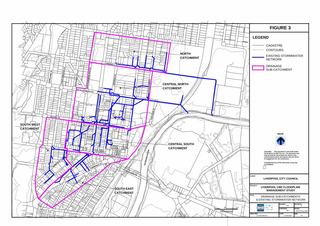
CO
LLEG
E ST
CO
LLEG
E ST
CO
LLEG
E ST
CO
LLEG
E ST
CO
LLEG
E ST
CO
LLEG
E ST
CO
LLEG
E ST
CO
LLEG
E ST
CO
LLEG
E ST
GEO
RG
E ST
GEO
RG
E ST
GEO
RG
E ST
GEO
RG
E ST
GEO
RG
E ST
GEO
RG
E ST
GEO
RG
E ST
GEO
RG
E ST
GEO
RG
E ST
CAMPBELL STCAMPBELL STCAMPBELL STCAMPBELL STCAMPBELL STCAMPBELL STCAMPBELL STCAMPBELL STCAMPBELL ST
GO
ULB
UR
N S
TG
OU
LBU
RN
ST
GO
ULB
UR
N S
TG
OU
LBU
RN
ST
GO
ULB
UR
N S
TG
OU
LBU
RN
ST
GO
ULB
UR
N S
TG
OU
LBU
RN
ST
GO
ULB
UR
N S
T
GEO
RG
ES R
IVER
GEO
RG
ES R
IVER
GEO
RG
ES R
IVER
GEO
RG
ES R
IVER
GEO
RG
ES R
IVER
GEO
RG
ES R
IVER
GEO
RG
ES R
IVER
GEO
RG
ES R
IVER
GEO
RG
ES R
IVER
BIG
GE
STB
IGG
E ST
BIG
GE
STB
IGG
E ST
BIG
GE
STB
IGG
E ST
BIG
GE
STB
IGG
E ST
BIG
GE
ST
NEW BRIDGE
NEW BRIDGE
NEW BRIDGE
NEW BRIDGE
NEW BRIDGE
NEW BRIDGE
NEW BRIDGE
NEW BRIDGE
NEW BRIDGE
MEMORIAL AVEMEMORIAL AVEMEMORIAL AVEMEMORIAL AVEMEMORIAL AVEMEMORIAL AVEMEMORIAL AVEMEMORIAL AVEMEMORIAL AVE
NORFOLK ST
NORFOLK ST
NORFOLK ST
NORFOLK ST
NORFOLK ST
NORFOLK ST
NORFOLK ST
NORFOLK ST
NORFOLK ST
TERMINUS ST
TERMINUS ST
TERMINUS ST
TERMINUS ST
TERMINUS ST
TERMINUS ST
TERMINUS ST
TERMINUS ST
TERMINUS ST
CAS
TLER
EAG
H S
TC
ASTL
EREA
GH
ST
CAS
TLER
EAG
H S
TC
ASTL
EREA
GH
ST
CAS
TLER
EAG
H S
TC
ASTL
EREA
GH
ST
CAS
TLER
EAG
H S
TC
ASTL
EREA
GH
ST
CAS
TLER
EAG
H S
T
BAT
HU
RST
ST
BAT
HU
RST
ST
BAT
HU
RST
ST
BAT
HU
RST
ST
BAT
HU
RST
ST
BAT
HU
RST
ST
BAT
HU
RST
ST
BAT
HU
RST
ST
BAT
HU
RST
ST
NO
RTH
UM
BER
LAN
D S
TN
OR
THU
MBE
RLA
ND
ST
NO
RTH
UM
BER
LAN
D S
TN
OR
THU
MBE
RLA
ND
ST
NO
RTH
UM
BER
LAN
D S
TN
OR
THU
MBE
RLA
ND
ST
NO
RTH
UM
BER
LAN
D S
TN
OR
THU
MBE
RLA
ND
ST
NO
RTH
UM
BER
LAN
D S
T
MOORE STMOORE STMOORE STMOORE STMOORE STMOORE STMOORE STMOORE STMOORE ST
DR ELIZABETH STDR ELIZABETH STDR ELIZABETH STDR ELIZABETH STDR ELIZABETH STDR ELIZABETH STDR ELIZABETH STDR ELIZABETH STDR ELIZABETH ST
MA
CQ
UA
RIE
ST
MA
CQ
UA
RIE
ST
MA
CQ
UA
RIE
ST
MA
CQ
UA
RIE
ST
MA
CQ
UA
RIE
ST
MA
CQ
UA
RIE
ST
MA
CQ
UA
RIE
ST
MA
CQ
UA
RIE
ST
MA
CQ
UA
RIE
ST
CO
PELA
ND
ST
CO
PELA
ND
ST
CO
PELA
ND
ST
CO
PELA
ND
ST
CO
PELA
ND
ST
CO
PELA
ND
ST
CO
PELA
ND
ST
CO
PELA
ND
ST
CO
PELA
ND
ST
0.1 0.2
kilometres0
CENTRAL SOUTHCENTRAL SOUTHCENTRAL SOUTHCENTRAL SOUTHCENTRAL SOUTHCENTRAL SOUTHCENTRAL SOUTHCENTRAL SOUTHCENTRAL SOUTHCATCHMENTCATCHMENTCATCHMENTCATCHMENTCATCHMENTCATCHMENTCATCHMENTCATCHMENTCATCHMENT
SOUTH WESTSOUTH WESTSOUTH WESTSOUTH WESTSOUTH WESTSOUTH WESTSOUTH WESTSOUTH WESTSOUTH WESTCATCHMENTCATCHMENTCATCHMENTCATCHMENTCATCHMENTCATCHMENTCATCHMENTCATCHMENTCATCHMENT
CENTRAL NORTHCENTRAL NORTHCENTRAL NORTHCENTRAL NORTHCENTRAL NORTHCENTRAL NORTHCENTRAL NORTHCENTRAL NORTHCENTRAL NORTHCATCHMENTCATCHMENTCATCHMENTCATCHMENTCATCHMENTCATCHMENTCATCHMENTCATCHMENTCATCHMENT
NORTHNORTHNORTHNORTHNORTHNORTHNORTHNORTHNORTHCATCHMENTCATCHMENTCATCHMENTCATCHMENTCATCHMENTCATCHMENTCATCHMENTCATCHMENTCATCHMENT
SOUTH EASTSOUTH EASTSOUTH EASTSOUTH EASTSOUTH EASTSOUTH EASTSOUTH EASTSOUTH EASTSOUTH EASTCATCHMENTCATCHMENTCATCHMENTCATCHMENTCATCHMENTCATCHMENTCATCHMENTCATCHMENTCATCHMENT
DRAWN
DATEDWG REF
CHECKED SCALE
REVISION
21/13153/MI03
HTR A
SEE SCALE BAR
27/04/2005
DRAINAGE SUBCATCHMENTS& EXISTING STORMWATER NETWORK
LIVERPOOL CBD FLOODPLAINMANAGEMENT STUDY
North
Copyright: This document is and shall remainthe property of GHD Pty Ltd. The document mayonly be used for the purpose for which it wascommissioned and in accordance with the termsof engagement for the commission.
Unauthorised use of this document in any wayis prohibited.
LIVERPOOL CITY COUNCIL
SIZEA4
FIGURE 3
CLIENT
PROJECT
TITLE
LEGEND
DRAINAGESUBCATCHMENT
EXISTING STORMWATERNETWORK
CONTOURSCADASTRE
RB
3.4 Model Development
3.4.1 Model Compilation
For the modelling of flood behaviour and to undertake the flood categorisation, it was deemed necessary to convert the ILSAX model to a DRAINS model. This would provide the required depth and velocity data on overland flow paths. For the conversion further data was required, in particular, reduced levels of the pits and invert levels of the pipes. The DRAINS model compilation was undertaken as follows:
Liverpool Council provided GHD with a number of CAD drawings that included detailed survey for selected areas within the CBD. These survey files were imported and merged within the 12D Digital Terrain Model (DTM) software, to provide a ground surface model. Given the fragmented nature of the survey, a number of gaps existed where no detailed survey data was available. To infill theses areas, the available Land and Property Information 2m contours of the Liverpool CBD area were also merged. The result was not always successful given the coarser accuracy of the 2m contours, however this was accepted in the absence of other information;
Pit locations were shown on a drawing in the Cardno Willing reports. In some cases the locations were an aggregation of a number of inlet pits to simplify the ILSAX modelling. The pits were located in 12D along with the connecting pipe links. Using the ground surface model, the pits were allotted ground levels based on their location and exported to DRAINS via a 12D interface. Where the pit type was unknown, it was assumed that the pit inlet capacity was unrestricted, due to the difficulty of identifying the percentage of flows enter the pit below ground level (typically roofed flows) and the percentage of flows that enter the pit above ground (typically road runoff);
Pipe invert levels were determined, using selected pit locations (where the invert level was known), pipe lengths and slopes obtained from the ILSAX model. Calculations were undertaken upstream and downstream from the known pit to populate the pipe invert databases. These levels were checked with the ground level created in the 12d model to avoid ‘day lighting’ of pipes above the ground surface; and
Overland flow paths were identified, utilising the flow paths determined in the ILSAX model, the survey data and observation from the site visits.
10 21/13153/108836 Liverpool CBD Floodplain Management Study

3.4.2 Model Parameters
Adopted modelling parameters are listed in Table 1.
Table 1 Modelling Parameters
Feature Value
Soil Type 3 (slow infiltration rates)
Impervious area depression storage 1 mm
Pervious area depression storage 5 mm
Rainfall Data Data recommended by Liverpool City Council (see Appendix A)
Travel time in overland flow paths Based on 1m/s velocity
Pipe roughness 0.3 mm
Pit inlet capacity Unrestricted
As noted in Table 1 above, design storms were derived from rainfall Intensity Frequency Duration (IFD) charts recommended for Liverpool City Council (see Appendix A). Design storms were compiled for the 20%, 5% and 1% AEP events. The design storm temporal distributions recommended in the Australian Rainfall and Runoff (ARR) were adopted.
3.4.3 Model Calibration
In the absence of corresponding rainfall (hyetograph) and runoff data, calibration of the DRAINS model was not possible. Furthermore no historic flood markers were available for calibrating of overland flood depths. Calibration of the models was thus limited to checking the “reasonableness” of the overland flow routes and depths, and qualitatively comparing the findings to known CBD flooding occurrences.
3.5 Simulation Results The existing CBD stormwater system was simulated for the 20%, 5% and 1% AEP design storm events. The results confirmed that many of the pipes are undersized for the 20% AEP event. Findings on a catchment-by-catchment basis were:
South-East Catchment - Ponding occurs at two low points in Terminus Street and overflows through commercial property westward to Macquarie Street. These overflows continue northward along Macquarie Street, westward along Memorial Avenue, and northward along Northumberland Street;
South-West Catchment - Overflows from Norfolk Street travel north along Castlereagh Street and through the intersection with Memorial Avenue (this is the boundary of the catchment network modelled). Overflows from the southern end of Bathurst Street travel north along Bathurst Street to a low point in Bathurst Street
11 21/13153/108836 Liverpool CBD Floodplain Management Study

north of Memorial Avenue. Ponding greater than 0.15m within the roadway would overtop the kerb and gutter system and potentially flood road-front properties. The original ILSAX model simulated the low point as a 1m deep basin. However it is considered, from a site inspection, that this is an overestimation of the ponding;
Central-South Catchment - Overflows from the Southeast catchment enter the Central-South Catchment from Northumberland Street. Overflows from Huckstepp Serviceway also flow into Northumberland Street. A significant low-point exists on Northumberland Street, which is bisected by a raised pedestrian crossing. Overflows from this low point spill through a small serviceway mall to Northumberland Serviceway.
Large overflows arrive at the intersection of Macquarie and Moore Streets, where the pipe capacity is severely undersized. This area is the junction for pipes coming from Northumberland Street, Macquarie Street and Moore Street and the cumulative effects from overflows from these catchments are significant. Whilst overflows will travel eastward along Moore Street (into the Central North Catchment), large flood events could overtop the kerb and enter into the Macquarie Street Mall, leading to flooding of commercial premises;
Central-North Catchment - Overflows from the Central-South Catchment, the southern end of George Street, and the eastern end of Moore Street discharge along Moore Street. There is a low point within George Street adjacent to the Hanwell Serviceway where ponding occurs. Overflows from this low point will flood neighbouring premises and flow eastward along Elizabeth Drive and through the Liverpool Hospital grounds before discharging into the Georges River. Additional overflows discharge from the undersized stormwater systems to the north of Elizabeth Street from Bigge and Goulburn Streets; and
North-Catchment - Significant overflows occur from the undersized piped network in the North Catchment. Overflows travel eastward along Elizabeth and Campbell Streets before discharging to the Georges River, via the Liverpool Hospital grounds.
Detailed results of the DRAINS simulations are provided in Appendix B.
12 21/13153/108836 Liverpool CBD Floodplain Management Study

4. Flood Behaviour Categorisation
4.1 Hydraulic Flood Categorisation The NSW Floodplain Management Manual provides three categories in the determination of hydraulic flood risks. These are outlined below:
Floodways – Areas that convey a significant portion of the flow. These are areas that, even if partially blocked, would cause a significant increase in flood levels or a significant redistribution of flood flows, which may adversely affect other areas;
Flood Storage – Areas that are important in the temporary storage of floodwaters during the passage of a flood. If the area is substantially removed by levees or filled it will result in elevated water levels and/or elevated discharges. Flood storage areas, if completely blocked, would cause peak flood levels to increase by 0.1m and/or would cause the peak discharge to increase by more than 10%; and
Flood Fringe – Remaining areas of flood prone land, after floodway and flood storage areas have been defined. Blockage or filling of this area will not have any significant affect on the flood pattern or flood levels.
While these categories generally apply to floodplains, where the major flooding is caused by extreme water levels in a river system, they can be adapted to some extent to a catchment with a piped system and overland flows. Floodways would be roads, pathways, drainage depressions, easements and other routes conveying overland flows. Flood storage areas could be low points and blocked sag pits where temporary or permanent ponding occurs. Figure 4 shows the locations of floodways and flood storage areas identified in the Liverpool CBD.
4.1.1 Identified Floodways
The following roads have been categorised as floodways based on the simulation results. In designating floodways, the minimum criteria adopted was for the road to convey overland flows in excess of 0.5 m3/s (for example, a 15 m wide road discharging at a velocity of 0.2m/s would flow at a depth of 0.17m). Table 2 summarises floodways within the Liverpool CBD.
Table 2 Floodways within Liverpool CBD
AEP
20% 5% 2% 1%
Memorial Ave (Northumberland Macquarie * * * *
Macquarie St (Bathurst Pirie) * * * *
Macquarie St (Scott Moore) * * * *
Moore St (Macquarie George) * * * *
George St (Moore Elizabeth) * * * *
13 21/13153/108836 Liverpool CBD Floodplain Management Study

Elizabeth St (George Georges River) * * * *
Campbell St (Bigge Georges River) * * * *
Bigge St (100m north of Elizabeth Elizabeth) * * * *
Goulburn St (100m north of Elizabeth Elizabeth) * * * *
Castlereagh St (Norfolk Memorial) * * *
Northumberland St (Memorial 200m north of Memorial)
* * *
Bigge St (100m south of Elizabeth Elizabeth) *
Northumberland St (Memorial 200m north of Memorial)
*
4.1.2 Identified Flood Storage Areas
Flood storage areas are listed in Table 3 below. These were determined through site visits and from information obtained in previous studies. The storage and depth data listed in the table are based on the 1% AEP peak design storm.
Table 3 Flood Storage Areas within Liverpool CBD
DRAINS ID Location Storage (m3) Depth (m)
A2 Terminus Street 50 0.28
AC1 Terminus Street 130 0.45
G2 Bathurst Street 230 1.05
A14 Northumberland Street 40 0.28
AF1 Northumberland Serviceway 12 0.24
A19 George Street 245 0.31
W1 Bigge Street 100 0.27
NJ4 Campbell Street 450 0.49
X2.2 Bathurst Street (south) 150 0.33
4.2 Hazard Flood Categorisation The NSW Floodplain Management Manual provides two categories in the determination of flood hazard categories:
High Hazard: Possible danger to personal safety; evacuation by trucks difficult; able-bodied adults would have difficulty in wading to safety; potential for significant structural damage to buildings.
Low Hazard: Should it be necessary, trucks could evacuate people and their possession; able-bodied adults would have little difficulty in wading to safety.
14 21/13153/108836 Liverpool CBD Floodplain Management Study

The following factors were considered when determining the flood hazard within the Liverpool CBD area:
AEP of flood – in this the 20%, 5%, and 1% flood events;
Depth and velocity of floodwaters;
Warning time –Floods through the Liverpool CBD are generated by short duration storms, and runoff peaks arrive after 15-25 minutes, depending on location;
Flood readiness;
Duration of flooding;
Evacuation problems – special evacuation needs, level of occupant awareness, potential for damage and danger to personal safety;
Effective flood access; and
Type of development – number of people, distance to flood free ground, lack of suitable evacuation equipment.
Other factors that need special consideration in the CBD context are:
Proximity to pedestrian crossings;
Shop levels;
Traffic islands;
Footpaths; and
Outdoor malls.
Flood hazards in the Liverpool CBD can be separated into two different sections – hazard to property and hazard to personal safety.
A high hazard for properties has been identified to be any depth of flow that exceeds 0.15 m (i.e. the height of a kerb) adjacent to a road (i.e. a floodway). Low hazard for properties will be any depth that exceeds 0.1 m (i.e. possibility of exceeding kerb, cars moving through the water can also create surges of water). Hazards for personal safety are determined by velocity and depth, with exemptions and additions made for particular locations. The matrix below describes the general hazard categorisation for personal safety adopted in this study.
Table 4 Flood Hazard Matrix
Velocity (m/s) Depth (m)
0 - 0.25 0.25 - 0.5 0.5 – 1.0 >1.0
>0.6 High High High High
0.4-0.6 Low High High High
0.2-0.4 Low Low High High
0-0.2 Low Low Low Low
15 21/13153/108836 Liverpool CBD Floodplain Management Study

FLOODWAYS ANDFLOOD STORAGE AREAS
LIVERPOOL CBD FLOODPLAINMANAGEMENT STUDY
CO
LLEG
E ST
CO
LLEG
E ST
CO
LLEG
E ST
CO
LLEG
E ST
CO
LLEG
E ST
CO
LLEG
E ST
CO
LLEG
E ST
CO
LLEG
E ST
CO
LLEG
E ST
GEO
RG
E ST
GEO
RG
E ST
GEO
RG
E ST
GEO
RG
E ST
GEO
RG
E ST
GEO
RG
E ST
GEO
RG
E ST
GEO
RG
E ST
GEO
RG
E ST
CAMPBELL STCAMPBELL STCAMPBELL STCAMPBELL STCAMPBELL STCAMPBELL STCAMPBELL STCAMPBELL STCAMPBELL ST
GO
ULB
UR
N S
TG
OU
LBU
RN
ST
GO
ULB
UR
N S
TG
OU
LBU
RN
ST
GO
ULB
UR
N S
TG
OU
LBU
RN
ST
GO
ULB
UR
N S
TG
OU
LBU
RN
ST
GO
ULB
UR
N S
T
GEO
RG
ES R
IVER
GEO
RG
ES R
IVER
GEO
RG
ES R
IVER
GEO
RG
ES R
IVER
GEO
RG
ES R
IVER
GEO
RG
ES R
IVER
GEO
RG
ES R
IVER
GEO
RG
ES R
IVER
GEO
RG
ES R
IVER
BIG
GE
STB
IGG
E ST
BIG
GE
STB
IGG
E ST
BIG
GE
STB
IGG
E ST
BIG
GE
STB
IGG
E ST
BIG
GE
ST
NEW BRIDGE
NEW BRIDGE
NEW BRIDGE
NEW BRIDGE
NEW BRIDGE
NEW BRIDGE
NEW BRIDGE
NEW BRIDGE
NEW BRIDGE
MEMORIAL AVEMEMORIAL AVEMEMORIAL AVEMEMORIAL AVEMEMORIAL AVEMEMORIAL AVEMEMORIAL AVEMEMORIAL AVEMEMORIAL AVE
NORFOLK ST
NORFOLK ST
NORFOLK ST
NORFOLK ST
NORFOLK ST
NORFOLK ST
NORFOLK ST
NORFOLK ST
NORFOLK ST
TERMINUS ST
TERMINUS ST
TERMINUS ST
TERMINUS ST
TERMINUS ST
TERMINUS ST
TERMINUS ST
TERMINUS ST
TERMINUS ST
CAS
TLER
EAG
H S
TC
ASTL
EREA
GH
ST
CAS
TLER
EAG
H S
TC
ASTL
EREA
GH
ST
CAS
TLER
EAG
H S
TC
ASTL
EREA
GH
ST
CAS
TLER
EAG
H S
TC
ASTL
EREA
GH
ST
CAS
TLER
EAG
H S
T
BAT
HU
RST
ST
BAT
HU
RST
ST
BAT
HU
RST
ST
BAT
HU
RST
ST
BAT
HU
RST
ST
BAT
HU
RST
ST
BAT
HU
RST
ST
BAT
HU
RST
ST
BAT
HU
RST
ST
NO
RTH
UM
BER
LAN
D S
TN
OR
THU
MBE
RLA
ND
ST
NO
RTH
UM
BER
LAN
D S
TN
OR
THU
MBE
RLA
ND
ST
NO
RTH
UM
BER
LAN
D S
TN
OR
THU
MBE
RLA
ND
ST
NO
RTH
UM
BER
LAN
D S
TN
OR
THU
MBE
RLA
ND
ST
NO
RTH
UM
BER
LAN
D S
T
MOORE STMOORE STMOORE STMOORE STMOORE STMOORE STMOORE STMOORE STMOORE ST
DR ELIZABETH STDR ELIZABETH STDR ELIZABETH STDR ELIZABETH STDR ELIZABETH STDR ELIZABETH STDR ELIZABETH STDR ELIZABETH STDR ELIZABETH ST
MA
CQ
UA
RIE
ST
MA
CQ
UA
RIE
ST
MA
CQ
UA
RIE
ST
MA
CQ
UA
RIE
ST
MA
CQ
UA
RIE
ST
MA
CQ
UA
RIE
ST
MA
CQ
UA
RIE
ST
MA
CQ
UA
RIE
ST
MA
CQ
UA
RIE
ST
CO
PELA
ND
ST
CO
PELA
ND
ST
CO
PELA
ND
ST
CO
PELA
ND
ST
CO
PELA
ND
ST
CO
PELA
ND
ST
CO
PELA
ND
ST
CO
PELA
ND
ST
CO
PELA
ND
ST
0 0.1 0.2
kilometres
NJ.4NJ.4NJ.4NJ.4NJ.4NJ.4NJ.4NJ.4NJ.4
AF.1AF.1AF.1AF.1AF.1AF.1AF.1AF.1AF.1
A.2A.2A.2A.2A.2A.2A.2A.2A.2
A.14A.14A.14A.14A.14A.14A.14A.14A.14
G.2G.2G.2G.2G.2G.2G.2G.2G.2
X2.2X2.2X2.2X2.2X2.2X2.2X2.2X2.2X2.2
AC.1AC.1AC.1AC.1AC.1AC.1AC.1AC.1AC.1
A.19A.19A.19A.19A.19A.19A.19A.19A.19
W.1W.1W.1W.1W.1W.1W.1W.1W.1
DRAWN
DATEDWG REF
CHECKED SCALE
REVISION
21/13153/MI04
HTR A
SEE SCALE BAR
27/04/2005
North
Copyright: This document is and shall remainthe property of GHD Pty Ltd. The document mayonly be used for the purpose for which it wascommissioned and in accordance with the termsof engagement for the commission.
Unauthorised use of this document in any wayis prohibited.
LIVERPOOL CITY COUNCIL
SIZEA4
FIGURE 4
CLIENT
PROJECT
TITLE
LEGEND
FLOODWAYS
FLOOD STORAGE AREA
RB
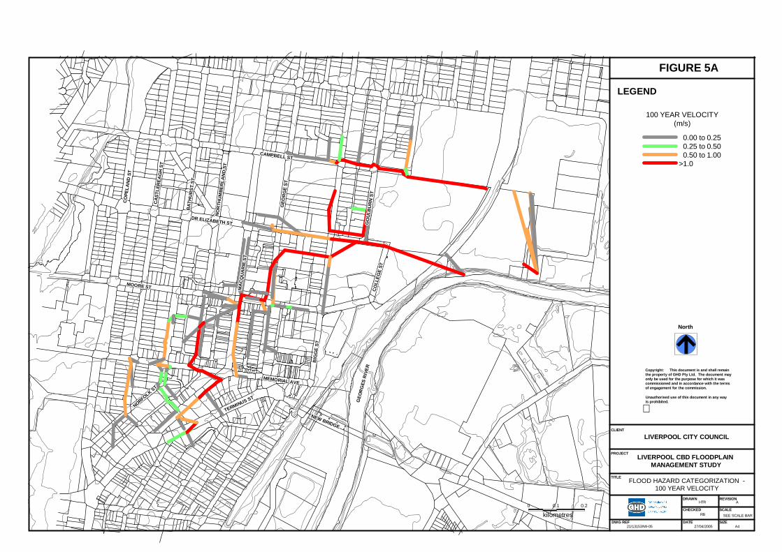
CO
LLEG
E ST
CO
LLEG
E ST
CO
LLEG
E ST
CO
LLEG
E ST
CO
LLEG
E ST
CO
LLEG
E ST
CO
LLEG
E ST
CO
LLEG
E ST
CO
LLEG
E ST
GEO
RG
E ST
GEO
RG
E ST
GEO
RG
E ST
GEO
RG
E ST
GEO
RG
E ST
GEO
RG
E ST
GEO
RG
E ST
GEO
RG
E ST
GEO
RG
E ST
CAMPBELL STCAMPBELL STCAMPBELL STCAMPBELL STCAMPBELL STCAMPBELL STCAMPBELL STCAMPBELL STCAMPBELL ST
GO
ULB
UR
N S
TG
OU
LBU
RN
ST
GO
ULB
UR
N S
TG
OU
LBU
RN
ST
GO
ULB
UR
N S
TG
OU
LBU
RN
ST
GO
ULB
UR
N S
TG
OU
LBU
RN
ST
GO
ULB
UR
N S
T
GEO
RG
ES R
IVER
GEO
RG
ES R
IVER
GEO
RG
ES R
IVER
GEO
RG
ES R
IVER
GEO
RG
ES R
IVER
GEO
RG
ES R
IVER
GEO
RG
ES R
IVER
GEO
RG
ES R
IVER
GEO
RG
ES R
IVER
BIG
GE
STB
IGG
E ST
BIG
GE
STB
IGG
E ST
BIG
GE
STB
IGG
E ST
BIG
GE
STB
IGG
E ST
BIG
GE
ST
NEW BRIDGE
NEW BRIDGE
NEW BRIDGE
NEW BRIDGE
NEW BRIDGE
NEW BRIDGE
NEW BRIDGE
NEW BRIDGE
NEW BRIDGE
MEMORIAL AVEMEMORIAL AVEMEMORIAL AVEMEMORIAL AVEMEMORIAL AVEMEMORIAL AVEMEMORIAL AVEMEMORIAL AVEMEMORIAL AVE
NORFOLK ST
NORFOLK ST
NORFOLK ST
NORFOLK ST
NORFOLK ST
NORFOLK ST
NORFOLK ST
NORFOLK ST
NORFOLK ST
TERMINUS ST
TERMINUS ST
TERMINUS ST
TERMINUS ST
TERMINUS ST
TERMINUS ST
TERMINUS ST
TERMINUS ST
TERMINUS ST
CAS
TLER
EAG
H S
TC
ASTL
EREA
GH
ST
CAS
TLER
EAG
H S
TC
ASTL
EREA
GH
ST
CAS
TLER
EAG
H S
TC
ASTL
EREA
GH
ST
CAS
TLER
EAG
H S
TC
ASTL
EREA
GH
ST
CAS
TLER
EAG
H S
T
BAT
HU
RST
ST
BAT
HU
RST
ST
BAT
HU
RST
ST
BAT
HU
RST
ST
BAT
HU
RST
ST
BAT
HU
RST
ST
BAT
HU
RST
ST
BAT
HU
RST
ST
BAT
HU
RST
ST
NO
RTH
UM
BER
LAN
D S
TN
OR
THU
MBE
RLA
ND
ST
NO
RTH
UM
BER
LAN
D S
TN
OR
THU
MBE
RLA
ND
ST
NO
RTH
UM
BER
LAN
D S
TN
OR
THU
MBE
RLA
ND
ST
NO
RTH
UM
BER
LAN
D S
TN
OR
THU
MBE
RLA
ND
ST
NO
RTH
UM
BER
LAN
D S
T
MOORE STMOORE STMOORE STMOORE STMOORE STMOORE STMOORE STMOORE STMOORE ST
DR ELIZABETH STDR ELIZABETH STDR ELIZABETH STDR ELIZABETH STDR ELIZABETH STDR ELIZABETH STDR ELIZABETH STDR ELIZABETH STDR ELIZABETH ST
MA
CQ
UA
RIE
ST
MA
CQ
UA
RIE
ST
MA
CQ
UA
RIE
ST
MA
CQ
UA
RIE
ST
MA
CQ
UA
RIE
ST
MA
CQ
UA
RIE
ST
MA
CQ
UA
RIE
ST
MA
CQ
UA
RIE
ST
MA
CQ
UA
RIE
ST
CO
PELA
ND
ST
CO
PELA
ND
ST
CO
PELA
ND
ST
CO
PELA
ND
ST
CO
PELA
ND
ST
CO
PELA
ND
ST
CO
PELA
ND
ST
CO
PELA
ND
ST
CO
PELA
ND
ST
0 0.1 0.2
kilometres
DRAWN
DATEDWG REF
CHECKED SCALE
REVISION
21/13153/MI05
HTR A
SEE SCALE BAR
27/04/2005
FLOOD HAZARD CATEGORIZATION 100 YEAR VELOCITY
LIVERPOOL CBD FLOODPLAINMANAGEMENT STUDY
North
Copyright: This document is and shall remainthe property of GHD Pty Ltd. The document mayonly be used for the purpose for which it wascommissioned and in accordance with the termsof engagement for the commission.
Unauthorised use of this document in any wayis prohibited.
LIVERPOOL CITY COUNCIL
SIZEA4
FIGURE 5A
CLIENT
PROJECT
TITLE
LEGEND
100 YEAR VELOCITY(m/s)
0.00 to 0.250.25 to 0.500.50 to 1.00
>1.0
RB
CO
LLEG
E ST
CO
LLEG
E ST
CO
LLEG
E ST
CO
LLEG
E ST
CO
LLEG
E ST
CO
LLEG
E ST
CO
LLEG
E ST
CO
LLEG
E ST
CO
LLEG
E ST
GEO
RG
E ST
GEO
RG
E ST
GEO
RG
E ST
GEO
RG
E ST
GEO
RG
E ST
GEO
RG
E ST
GEO
RG
E ST
GEO
RG
E ST
GEO
RG
E ST
CAMPBELL STCAMPBELL STCAMPBELL STCAMPBELL STCAMPBELL STCAMPBELL STCAMPBELL STCAMPBELL STCAMPBELL ST
GO
ULB
UR
N S
TG
OU
LBU
RN
ST
GO
ULB
UR
N S
TG
OU
LBU
RN
ST
GO
ULB
UR
N S
TG
OU
LBU
RN
ST
GO
ULB
UR
N S
TG
OU
LBU
RN
ST
GO
ULB
UR
N S
T
GEO
RG
ES R
IVER
GEO
RG
ES R
IVER
GEO
RG
ES R
IVER
GEO
RG
ES R
IVER
GEO
RG
ES R
IVER
GEO
RG
ES R
IVER
GEO
RG
ES R
IVER
GEO
RG
ES R
IVER
GEO
RG
ES R
IVER
BIG
GE
STB
IGG
E ST
BIG
GE
STB
IGG
E ST
BIG
GE
STB
IGG
E ST
BIG
GE
STB
IGG
E ST
BIG
GE
ST
NEW BRIDGE
NEW BRIDGE
NEW BRIDGE
NEW BRIDGE
NEW BRIDGE
NEW BRIDGE
NEW BRIDGE
NEW BRIDGE
NEW BRIDGE
MEMORIAL AVEMEMORIAL AVEMEMORIAL AVEMEMORIAL AVEMEMORIAL AVEMEMORIAL AVEMEMORIAL AVEMEMORIAL AVEMEMORIAL AVE
NORFOLK ST
NORFOLK ST
NORFOLK ST
NORFOLK ST
NORFOLK ST
NORFOLK ST
NORFOLK ST
NORFOLK ST
NORFOLK ST
TERMINUS ST
TERMINUS ST
TERMINUS ST
TERMINUS ST
TERMINUS ST
TERMINUS ST
TERMINUS ST
TERMINUS ST
TERMINUS ST
CAS
TLER
EAG
H S
TC
ASTL
EREA
GH
ST
CAS
TLER
EAG
H S
TC
ASTL
EREA
GH
ST
CAS
TLER
EAG
H S
TC
ASTL
EREA
GH
ST
CAS
TLER
EAG
H S
TC
ASTL
EREA
GH
ST
CAS
TLER
EAG
H S
T
BAT
HU
RST
ST
BAT
HU
RST
ST
BAT
HU
RST
ST
BAT
HU
RST
ST
BAT
HU
RST
ST
BAT
HU
RST
ST
BAT
HU
RST
ST
BAT
HU
RST
ST
BAT
HU
RST
ST
NO
RTH
UM
BER
LAN
D S
TN
OR
THU
MBE
RLA
ND
ST
NO
RTH
UM
BER
LAN
D S
TN
OR
THU
MBE
RLA
ND
ST
NO
RTH
UM
BER
LAN
D S
TN
OR
THU
MBE
RLA
ND
ST
NO
RTH
UM
BER
LAN
D S
TN
OR
THU
MBE
RLA
ND
ST
NO
RTH
UM
BER
LAN
D S
T
MOORE STMOORE STMOORE STMOORE STMOORE STMOORE STMOORE STMOORE STMOORE ST
DR ELIZABETH STDR ELIZABETH STDR ELIZABETH STDR ELIZABETH STDR ELIZABETH STDR ELIZABETH STDR ELIZABETH STDR ELIZABETH STDR ELIZABETH ST
MA
CQ
UA
RIE
ST
MA
CQ
UA
RIE
ST
MA
CQ
UA
RIE
ST
MA
CQ
UA
RIE
ST
MA
CQ
UA
RIE
ST
MA
CQ
UA
RIE
ST
MA
CQ
UA
RIE
ST
MA
CQ
UA
RIE
ST
MA
CQ
UA
RIE
ST
CO
PELA
ND
ST
CO
PELA
ND
ST
CO
PELA
ND
ST
CO
PELA
ND
ST
CO
PELA
ND
ST
CO
PELA
ND
ST
CO
PELA
ND
ST
CO
PELA
ND
ST
CO
PELA
ND
ST
0 0.1 0.2
kilometres
DRAWN
DATEDWG REF
CHECKED SCALE
REVISION
21/13153/MI05
HTR A
SEE SCALE BAR
27/04/2005
FLOOD HAZARD CATEGORIZATION 100 YEAR FLOW DEPTH
LIVERPOOL CBD FLOODPLAINMANAGEMENT STUDY
North
Copyright: This document is and shall remainthe property of GHD Pty Ltd. The document mayonly be used for the purpose for which it wascommissioned and in accordance with the termsof engagement for the commission.
Unauthorised use of this document in any wayis prohibited.
LIVERPOOL CITY COUNCIL
SIZEA4
FIGURE 5B
CLIENT
PROJECT
TITLE
LEGEND
100 YEAR FLOW DEPTH(m)
0.0 to 0.20.2 to 0.40.4 to 0.6> 0.6
RB

CO
LLEG
E ST
CO
LLEG
E ST
CO
LLEG
E ST
CO
LLEG
E ST
CO
LLEG
E ST
CO
LLEG
E ST
CO
LLEG
E ST
CO
LLEG
E ST
CO
LLEG
E ST
GEO
RG
E ST
GEO
RG
E ST
GEO
RG
E ST
GEO
RG
E ST
GEO
RG
E ST
GEO
RG
E ST
GEO
RG
E ST
GEO
RG
E ST
GEO
RG
E ST
CAMPBELL STCAMPBELL STCAMPBELL STCAMPBELL STCAMPBELL STCAMPBELL STCAMPBELL STCAMPBELL STCAMPBELL ST
GO
ULB
UR
N S
TG
OU
LBU
RN
ST
GO
ULB
UR
N S
TG
OU
LBU
RN
ST
GO
ULB
UR
N S
TG
OU
LBU
RN
ST
GO
ULB
UR
N S
TG
OU
LBU
RN
ST
GO
ULB
UR
N S
T
GEO
RG
ES R
IVER
GEO
RG
ES R
IVER
GEO
RG
ES R
IVER
GEO
RG
ES R
IVER
GEO
RG
ES R
IVER
GEO
RG
ES R
IVER
GEO
RG
ES R
IVER
GEO
RG
ES R
IVER
GEO
RG
ES R
IVER
BIG
GE
STB
IGG
E ST
BIG
GE
STB
IGG
E ST
BIG
GE
STB
IGG
E ST
BIG
GE
STB
IGG
E ST
BIG
GE
ST
NEW BRIDGE
NEW BRIDGE
NEW BRIDGE
NEW BRIDGE
NEW BRIDGE
NEW BRIDGE
NEW BRIDGE
NEW BRIDGE
NEW BRIDGE
MEMORIAL AVEMEMORIAL AVEMEMORIAL AVEMEMORIAL AVEMEMORIAL AVEMEMORIAL AVEMEMORIAL AVEMEMORIAL AVEMEMORIAL AVE
NORFOLK ST
NORFOLK ST
NORFOLK ST
NORFOLK ST
NORFOLK ST
NORFOLK ST
NORFOLK ST
NORFOLK ST
NORFOLK ST
TERMINUS ST
TERMINUS ST
TERMINUS ST
TERMINUS ST
TERMINUS ST
TERMINUS ST
TERMINUS ST
TERMINUS ST
TERMINUS ST
CAS
TLER
EAG
H S
TC
ASTL
EREA
GH
ST
CAS
TLER
EAG
H S
TC
ASTL
EREA
GH
ST
CAS
TLER
EAG
H S
TC
ASTL
EREA
GH
ST
CAS
TLER
EAG
H S
TC
ASTL
EREA
GH
ST
CAS
TLER
EAG
H S
T
BAT
HU
RST
ST
BAT
HU
RST
ST
BAT
HU
RST
ST
BAT
HU
RST
ST
BAT
HU
RST
ST
BAT
HU
RST
ST
BAT
HU
RST
ST
BAT
HU
RST
ST
BAT
HU
RST
ST
NO
RTH
UM
BER
LAN
D S
TN
OR
THU
MBE
RLA
ND
ST
NO
RTH
UM
BER
LAN
D S
TN
OR
THU
MBE
RLA
ND
ST
NO
RTH
UM
BER
LAN
D S
TN
OR
THU
MBE
RLA
ND
ST
NO
RTH
UM
BER
LAN
D S
TN
OR
THU
MBE
RLA
ND
ST
NO
RTH
UM
BER
LAN
D S
T
MOORE STMOORE STMOORE STMOORE STMOORE STMOORE STMOORE STMOORE STMOORE ST
DR ELIZABETH STDR ELIZABETH STDR ELIZABETH STDR ELIZABETH STDR ELIZABETH STDR ELIZABETH STDR ELIZABETH STDR ELIZABETH STDR ELIZABETH ST
MA
CQ
UA
RIE
ST
MA
CQ
UA
RIE
ST
MA
CQ
UA
RIE
ST
MA
CQ
UA
RIE
ST
MA
CQ
UA
RIE
ST
MA
CQ
UA
RIE
ST
MA
CQ
UA
RIE
ST
MA
CQ
UA
RIE
ST
MA
CQ
UA
RIE
ST
CO
PELA
ND
ST
CO
PELA
ND
ST
CO
PELA
ND
ST
CO
PELA
ND
ST
CO
PELA
ND
ST
CO
PELA
ND
ST
CO
PELA
ND
ST
CO
PELA
ND
ST
CO
PELA
ND
ST
0.1 0.2
kilometres0
DRAWN
DATEDWG REF
CHECKED SCALE
REVISION
21/13153/MI05
HTR A
SEE SCALE BAR
27/04/2005
FLOOD HAZARD CATEGORIZATION 100 YEAR FLOW DEPTH X VELOCITY
LIVERPOOL CBD FLOODPLAINMANAGEMENT STUDY
North
Copyright: This document is and shall remainthe property of GHD Pty Ltd. The document mayonly be used for the purpose for which it wascommissioned and in accordance with the termsof engagement for the commission.
Unauthorised use of this document in any wayis prohibited.
LIVERPOOL CITY COUNCIL
SIZEA4
FIGURE 5C
CLIENT
PROJECT
TITLE
LEGEND
100 YEAR DEPTH X VELOCITY(m2/s)
< 0.4> 0.4
RB

CO
LLEG
E ST
CO
LLEG
E ST
CO
LLEG
E ST
CO
LLEG
E ST
CO
LLEG
E ST
CO
LLEG
E ST
CO
LLEG
E ST
CO
LLEG
E ST
CO
LLEG
E ST
GEO
RG
E ST
GEO
RG
E ST
GEO
RG
E ST
GEO
RG
E ST
GEO
RG
E ST
GEO
RG
E ST
GEO
RG
E ST
GEO
RG
E ST
GEO
RG
E ST
CAMPBELL STCAMPBELL STCAMPBELL STCAMPBELL STCAMPBELL STCAMPBELL STCAMPBELL STCAMPBELL STCAMPBELL ST
GO
ULB
UR
N S
TG
OU
LBU
RN
ST
GO
ULB
UR
N S
TG
OU
LBU
RN
ST
GO
ULB
UR
N S
TG
OU
LBU
RN
ST
GO
ULB
UR
N S
TG
OU
LBU
RN
ST
GO
ULB
UR
N S
T
GEO
RG
ES R
IVER
GEO
RG
ES R
IVER
GEO
RG
ES R
IVER
GEO
RG
ES R
IVER
GEO
RG
ES R
IVER
GEO
RG
ES R
IVER
GEO
RG
ES R
IVER
GEO
RG
ES R
IVER
GEO
RG
ES R
IVER
BIG
GE
STB
IGG
E ST
BIG
GE
STB
IGG
E ST
BIG
GE
STB
IGG
E ST
BIG
GE
STB
IGG
E ST
BIG
GE
ST
NEW BRIDGE
NEW BRIDGE
NEW BRIDGE
NEW BRIDGE
NEW BRIDGE
NEW BRIDGE
NEW BRIDGE
NEW BRIDGE
NEW BRIDGE
MEMORIAL AVEMEMORIAL AVEMEMORIAL AVEMEMORIAL AVEMEMORIAL AVEMEMORIAL AVEMEMORIAL AVEMEMORIAL AVEMEMORIAL AVE
NORFOLK ST
NORFOLK ST
NORFOLK ST
NORFOLK ST
NORFOLK ST
NORFOLK ST
NORFOLK ST
NORFOLK ST
NORFOLK ST
TERMINUS ST
TERMINUS ST
TERMINUS ST
TERMINUS ST
TERMINUS ST
TERMINUS ST
TERMINUS ST
TERMINUS ST
TERMINUS ST
CAS
TLER
EAG
H S
TC
ASTL
EREA
GH
ST
CAS
TLER
EAG
H S
TC
ASTL
EREA
GH
ST
CAS
TLER
EAG
H S
TC
ASTL
EREA
GH
ST
CAS
TLER
EAG
H S
TC
ASTL
EREA
GH
ST
CAS
TLER
EAG
H S
T
BAT
HU
RST
ST
BAT
HU
RST
ST
BAT
HU
RST
ST
BAT
HU
RST
ST
BAT
HU
RST
ST
BAT
HU
RST
ST
BAT
HU
RST
ST
BAT
HU
RST
ST
BAT
HU
RST
ST
NO
RTH
UM
BER
LAN
D S
TN
OR
THU
MBE
RLA
ND
ST
NO
RTH
UM
BER
LAN
D S
TN
OR
THU
MBE
RLA
ND
ST
NO
RTH
UM
BER
LAN
D S
TN
OR
THU
MBE
RLA
ND
ST
NO
RTH
UM
BER
LAN
D S
TN
OR
THU
MBE
RLA
ND
ST
NO
RTH
UM
BER
LAN
D S
T
MOORE STMOORE STMOORE STMOORE STMOORE STMOORE STMOORE STMOORE STMOORE ST
DR ELIZABETH STDR ELIZABETH STDR ELIZABETH STDR ELIZABETH STDR ELIZABETH STDR ELIZABETH STDR ELIZABETH STDR ELIZABETH STDR ELIZABETH ST
MA
CQ
UA
RIE
ST
MA
CQ
UA
RIE
ST
MA
CQ
UA
RIE
ST
MA
CQ
UA
RIE
ST
MA
CQ
UA
RIE
ST
MA
CQ
UA
RIE
ST
MA
CQ
UA
RIE
ST
MA
CQ
UA
RIE
ST
MA
CQ
UA
RIE
ST
CO
PELA
ND
ST
CO
PELA
ND
ST
CO
PELA
ND
ST
CO
PELA
ND
ST
CO
PELA
ND
ST
CO
PELA
ND
ST
CO
PELA
ND
ST
CO
PELA
ND
ST
CO
PELA
ND
ST
0.1 0.2
kilometres0
DRAWN
DATEDWG REF
CHECKED SCALE
REVISION
21/13153/MI05
HTR A
SEE SCALE BAR
28/04/2005
FLOOD HAZARD CATEGORIZATION
LIVERPOOL CBD FLOODPLAINMANAGEMENT STUDY
North
Copyright: This document is and shall remainthe property of GHD Pty Ltd. The document mayonly be used for the purpose for which it wascommissioned and in accordance with the termsof engagement for the commission.
Unauthorised use of this document in any wayis prohibited.
LIVERPOOL CITY COUNCIL
SIZEA4
FIGURE 5D
CLIENT
PROJECT
TITLE
LEGEND
FLOOD HAZARD CATEGORISATION
LOWHIGH
RB
4.2.1 Summary of 1% AEP High Hazard Areas
The areas listed in Table 5 have been identified as high hazard areas during the 1% AEP event, based on the flood hazard matrix, results of the simulations and identified through the study.
Table 5 1% AEP High Hazard Areas
Location Comments
Campbell Street From Goulburn Street through the hospital grounds to the Georges River outlet.
Elizabeth Street From Bigge Street through the hospital grounds to the Georges River outlet.
George Street From Moore Street to Elizabeth Street.
Moore Street From Macquarie Street to George Street
Northumberland Street, Northumberland Serviceway, Bathurst Street, Terminus Street, Norfolk Street, Bigge Street
Low points
Macquarie Street Mall Shop premises with low frontages. Overflows travelling through Macquarie Street / Moore Street intersection would be likely to spill over the kerb and into the mall. This area has heavy pedestrian numbers. However, with rain, the number of pedestrians is likely to be reduced.
Mall between Northumberland Street and Northumberland Avenue
The mall/serviceway is an enclosed drainage path for overland flows from ponding at a low point in Northumberland Street to spill through to Northumberland Avenue. Shops within this mall have low frontages and are highly susceptible to flooding by even minor flows through the mall.
21 21/13153/108836 Liverpool CBD Floodplain Management Study
5. Community Consultation
5.1 Approach to Consulting the Community A key objective of the Liverpool CBD Floodplain Management Study is to consult with the community and relevant stakeholders to determine the community’s attitude to past flooding, to document anecdotal history about flooding, and to assist in developing recommendations that are suitable and acceptable for the community. This process included discussing the experiences of affected business operators, consulting with stakeholders to identify issues of concern, and discussing possible measures to address flood impacts.
Key elements of the consultation process were:
Stakeholder Notification and Consultation;
Business Community survey;
Public Meeting; and
Public Exhibition and Submissions Review.
The issues identified throughout the community consultation process are summarised in Section 5.2, Community Issues and Concern.
5.1.1 Liverpool CBD Floodplain Management Committee
The Liverpool CBD Floodplain Management Committee is a representative committee co-ordinated to oversee the development of the Liverpool CBD Floodplain Management Study. The committee is responsible for reviewing the study documents and recommending the outcomes to be considered by Council. Members of the Liverpool Floodplain Management Committee include representatives from:
Liverpool Council;
Department of Infrastructure, Planning and Natural Resources (DIPNR);
State Emergency Services (SES); and
Community members.
5.1.2 Stakeholder Notification
Stakeholders are individuals or groups who have specific interest in the study or its outcomes. As part of the study, conducting a community scan identified the key stakeholders.
The community of the study area comprises business owners and operators, residents and visitors to the area. Key stakeholders identified during the community scan and community consultation activities were:
22 21/13153/108836 Liverpool CBD Floodplain Management Study
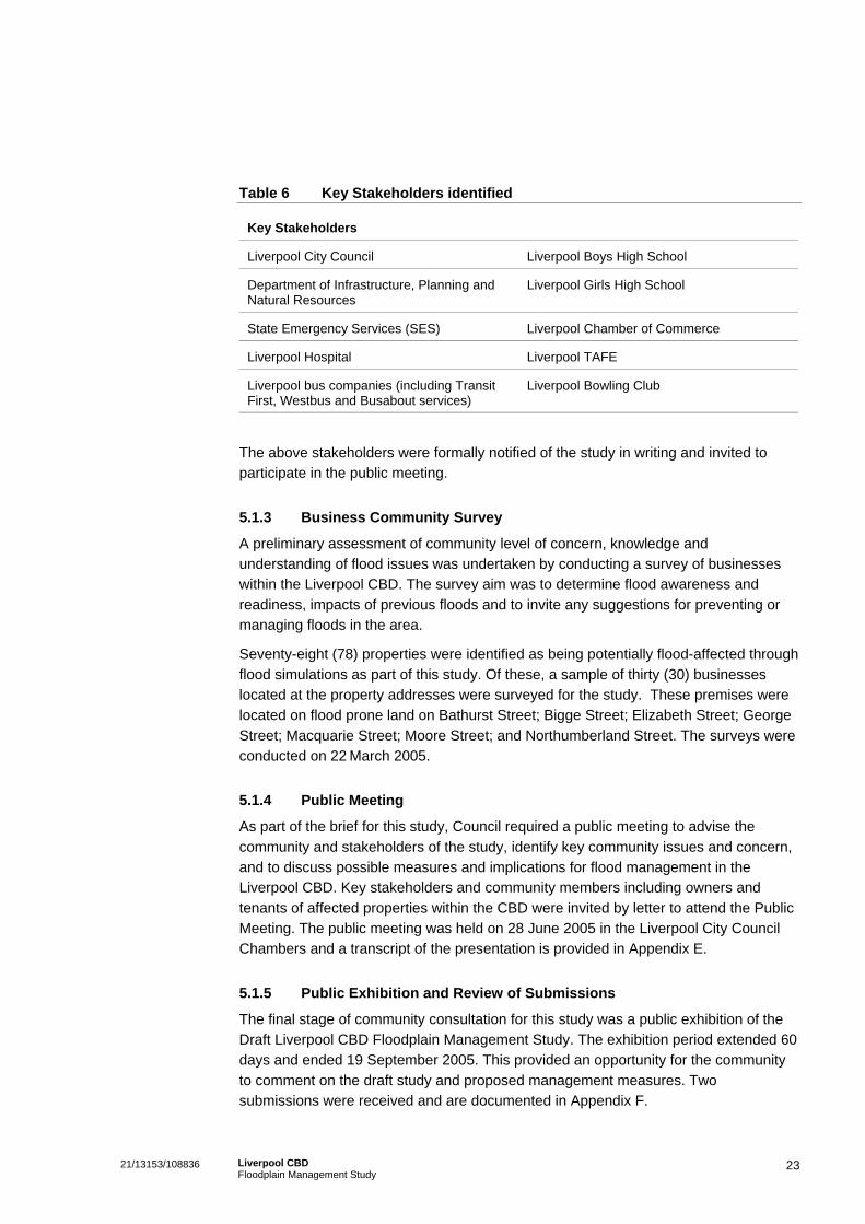
Table 6 Key Stakeholders identified
Key Stakeholders
Liverpool City Council Liverpool Boys High School
Department of Infrastructure, Planning and Natural Resources
Liverpool Girls High School
State Emergency Services (SES) Liverpool Chamber of Commerce
Liverpool Hospital Liverpool TAFE
Liverpool bus companies (including Transit First, Westbus and Busabout services)
Liverpool Bowling Club
The above stakeholders were formally notified of the study in writing and invited to participate in the public meeting.
5.1.3 Business Community Survey
A preliminary assessment of community level of concern, knowledge and understanding of flood issues was undertaken by conducting a survey of businesses within the Liverpool CBD. The survey aim was to determine flood awareness and readiness, impacts of previous floods and to invite any suggestions for preventing or managing floods in the area.
Seventy-eight (78) properties were identified as being potentially flood-affected through flood simulations as part of this study. Of these, a sample of thirty (30) businesses located at the property addresses were surveyed for the study. These premises were located on flood prone land on Bathurst Street; Bigge Street; Elizabeth Street; George Street; Macquarie Street; Moore Street; and Northumberland Street. The surveys were conducted on 22 March 2005.
5.1.4 Public Meeting
As part of the brief for this study, Council required a public meeting to advise the community and stakeholders of the study, identify key community issues and concern, and to discuss possible measures and implications for flood management in the Liverpool CBD. Key stakeholders and community members including owners and tenants of affected properties within the CBD were invited by letter to attend the Public Meeting. The public meeting was held on 28 June 2005 in the Liverpool City Council Chambers and a transcript of the presentation is provided in Appendix E.
5.1.5 Public Exhibition and Review of Submissions
The final stage of community consultation for this study was a public exhibition of the Draft Liverpool CBD Floodplain Management Study. The exhibition period extended 60 days and ended 19 September 2005. This provided an opportunity for the community to comment on the draft study and proposed management measures. Two submissions were received and are documented in Appendix F.
23 21/13153/108836 Liverpool CBD Floodplain Management Study

5.2 Key Community and Stakeholder Issues A Business Community Survey and the Public Meeting were undertaken to identify key stakeholder and community issues and concern. These consultation procedures are outlined in Section 5. The key issues are summarised as follows.
5.2.1 Previous Flood Experiences
Of the sample of thirty (30) businesses selected to be surveyed for this study, only six (6) indicated that they had experienced flood impacts. Although the surveyed businesses included a sample selected from Council’s flood complaints database, the low number of surveyed businesses having experienced flood impacts could be indicative of a change of ownership, tenancy or management.
Of the six businesses that indicated they had experienced the impacts of flooding, 3 were located on George Street (towards the corner of Moore Street) and 3 were located on Bathurst Street (towards the corner of Memorial Avenue). Although it was unclear how frequently flooding impacted these premises, it appears that flooding has occurred at least once over the last 3 years in these locations. It was also indicated that flood depths were approximately 0.3-0.5m and lasted for a period of 30 minutes to a few hours.
More specifically, one business owner indicated that their business had been flooded 6 times over 27 years of ownership. The most recent flood occurred in 2004 and accrued $5,000 worth of damages and an estimated clean-up cost of $2,000-5,000.
Overall, respondents that had experienced flooding to their premises mentioned they had experienced the following impacts:
Internal damages to walls, carpets, furniture, equipment and furnishings;
External damages to paving and doors;
Damages to retail stock;
Restricted access to their premises during flooding period;
Loss of business during clean-up time;
Health and contamination concerns; and
Continued anxiety about repeated flooding.
5.2.2 Flood Awareness and Flood Readiness
Flood awareness and flood readiness is critically important to enabling a community to reduce the impact of floods. In general, a flood aware community is more likely to be prepared for the impact of flooding and is more able to avoid and minimise potential flood damage.
Whilst a small number of businesses surveyed for this study were aware of, and had experienced flood impacts, overall the majority of surveyed businesses had little
24 21/13153/108836 Liverpool CBD Floodplain Management Study
awareness of the potential flood impacts to their property. This may be due to a turnover of staff or business ownership suggested by the high mobility rates of the local community discussed above. The diversity of languages spoken by a high proportion of the Liverpool CBD community may have impacted on the understanding of potential flood impacts in the area. As a consequence of low flood awareness, there appears to be a low level of ‘flood readiness’ and little attention given to flood prevention procedures within the CBD business community.
However the operators that had experienced flood impacts were more likely to be flood ready and prepared to reduce the potential of flood damage. For example during one particular flood, one such operator was able to minimise potential flood damage by endeavouring to block all water access points and elevating all valuable electrical equipment off the ground.
5.2.3 Community concern regarding Flooding and Mitigation
Previously flood affected business operators surveyed as part of this study were of the opinion that flooding in the area was due to poor drainage systems, over-development of land (particularly nearby residential development), and lack of permeable land in the vicinity of their premises.
Concerns were raised at the public meeting regarding the impact of construction works on the patronage and accessibility of local businesses, particularly the Liverpool Bowling Club. It was suggested that Liverpool Council liaise with business owners to minimise potential impacts during the construction phase.
During the public meeting a representative of the State Emergency Services (SES) also indicated that the SES are considering an early warning systems for the Liverpool area. It was acknowledged that the information provided in this study would be a useful source of information when considering a flood warning systems for Liverpool area.
Queries were also raised regarding the potential use of stormwater, which could be held in detention tanks, for use by the local fire brigade and Liverpool Council. However, this was not considered an option due to the limited capacity of the Liverpool CBD to accommodate detention systems and that these tanks would need to be of considerable size, designed for the dual purposes of detaining runoff and to providing storage supply.
25 21/13153/108836 Liverpool CBD Floodplain Management Study

6. Socio-Economic Effects
6.1 Social Setting and Characteristics The Liverpool CBD acts as a business hub for the local community, accommodating business activity such as retail, commercial, and community service industries. The study area also comprises a number of community facilities including a hospital, schools, TAFE, church, and parklands. Macquarie Street Mall leading up to the Westfield Shopping Mall acts as a focal point to the CBD where a number of community activities and performances are held. Surrounding the study area is predominantly residential development to the north, west and south whilst to the east is the Georges River and Liverpool Railway Line.
6.1.1 Population Profile
Analysis of the study area population was drawn from the Australian Bureau of Statistics, 2001 Population and Housing Census. Five collector districts (1290911; 1290909; 1290706; 1290903; 1290705) covering the Liverpool Floodplain CBD were used for comparative analysis against the Liverpool Statistical Local Area (SLA). It should be noted that the boundaries of these collector districts extend slightly beyond the floodplain to the north, south and west and do not include properties to the east of the railway line.
In 2001, the study area population comprised 2,444 people. A notably higher proportion of this population was aged 25-29 years (10%) compared to the Liverpool SLA (8.1%). There were also a comparatively lower proportion (5.8-7.8%) of children and adolescents (0-19 years) in the study area.
In 2001, a substantially lower proportion of the population spoke English only (18.1%), compared to the Liverpool SLA (50.5%). Other than English, the key languages spoken within the study area included: Serbian (16.5%), Arabic (including Lebanese) (7.1%), Hindi (4.4%), and Spanish (4.0%). This also reflects the proportion of the population who were born in Australia and those born overseas.
In 2001, the Labourforce Participation Rate (LFPR) of the study area was 80.0%, which is considerably lower than Liverpool SLA of 91.7%. Of the 790 people who were employed in the study area in 2001, the majority were involved in the following listed industries:
Manufacturing (184 people or 23.3% of those employed);
Retail trade (103 people or 13.0%);
Property and business services (103 people or 13.0%);and
Construction (82 people or 10.4%).
This is comparable to Liverpool SLA, however the study area has a slightly higher proportion of population in property and business services, and construction.
26 21/13153/108836 Liverpool CBD Floodplain Management Study
In each of the five collector districts, the unemployment rate in 2001 ranged between 12.5-25.0%. This was higher than the Liverpool SLA of 8.3%. In general, the majority of people who were unemployed were aged between 25-44 years for both the study area and Liverpool SLA.
6.1.2 Land Use
The study area predominantly comprises land for business activity. Under the Liverpool Council Local Environment Plan, 1997 most of the study area is zoned 3(a) Business. Exceptions to this are special use zones such as the Liverpool Hospital, Liverpool TAFE, and Bigge Park. Also existing within the study area is the Liverpool Girls and Boys High School, zoned 2(c) Residential-Flat Buildings and some residential land. The predominant land use surrounding the study area is residential.
In 2001, there were a total of 999 dwellings identified in the five collector districts covering the study area. The main dwelling type were flats, units or apartment buildings (88.1% of all dwellings), housing 94.2% of the study area population. This is notably higher than Liverpool SLA (12.5% of total dwellings).
In general, residents in the study area are more mobile than those in Liverpool SLA. 58.5% of the study area population recorded the same address between 1996 and 2001 compared to 76.1% at Liverpool SLA. Similarly, only 24.8% of the study area population recorded the same address between 1996 and 2001 compared to 41.9% of Liverpool SLA.
6.1.3 Business and Community Facility Profile
The Liverpool CBD accommodates a range of businesses and community services. The flood affected properties identified in this study offer a variety of retail, commercial and community service facilities to the local community. Such retail outlets include for example newsagencies, clothes shops, cafes, book shops, scuba diving shop, florist, fabric store, motor cycle outlet, window covering shop, bottle shop, supermarket and computer stores. The CBD also accommodates commercial businesses such as solicitors, real estates, accountants, funeral services, construction businesses and travel agents. Community services in the area include healthcare facilities, police, RSL Club, careers centre, and rehabilitation centre.
In addition, key community facilities that have been identified as flood affected are:
Macquarie Street Mall consisting of a range of retail, commercial and community service facilities;
Liverpool Hospital;
Liverpool Bowling Club;
Liverpool TAFE; and
Liverpool Boys High School and Liverpool Girls High School.
27 21/13153/108836 Liverpool CBD Floodplain Management Study

6.2 Socio-Economic Impact of Flooding Flood damages are either social or financial and can be categorised as:
‘Direct’ costs- Direct damages can be quantified in monetary terms. These include damages such as structural damage, contents damage and clean-up costs;
‘Indirect’ costs - Indirect damages can also be translated into monetary values but are secondary impacts such as the loss of business revenue and changes to employment patterns; and
‘Intangible’ costs - Intangible damages are difficult to quantify in meaningful dollar terms and include impacts such as individual health impacts and the loss of sentimental items.
6.2.1 Land Use Impacts
Whilst a number of businesses and residential areas within the Liverpool CBD have been, and may potentially be impacted by flooding, there is limited indication that the land use within the CBD has been altered as a result.
In considering the future development of land within the study area, potential flooding may have an impact on property values and decisions to maximise the development potential of the flood-prone allotments within the CBD. This may have implications for promoting the CBD as a business and commercial centre and possibly increasing residential densities if flood management and mitigation measures are not implemented.
6.2.2 Social Impacts
Major flooding typically causes a great deal of distress to people’s lives. Social costs are often intangible damages and relate to changes to social networks, lifestyles, community activities and individual state of well-being. The degree of disruption to people’s lives depends on the severity of flooding and the ability of the community and individuals to recover from the flood event.
Impaired accessibility and availability of community services such as schools, healthcare services and the hospital within the Liverpool CBD has the potential to cause substantial social impacts for the broader community. This may include changes to the employee working patterns, schooling routines, and access to medical assistance. This has the potential to cause further disruption as resources from other areas may be sought.
Damages to businesses within the Liverpool CBD also have the potential to cause disruption to business activities such as trading capacity and employment routines. Residential damages may also have the potential to cause lifestyle changes as members of the community adjust personal activities to address flood damages.
Flooding may also cause stress and depression for individual community members related to the loss of sentimental and personally valuable items. These social costs are particularly difficult to quantify as the personal and emotional value of loss often
28 21/13153/108836 Liverpool CBD Floodplain Management Study

exceeds that of material value. Anxiety, panic and insecurity may also increase amongst the community as a response to the possibility of future flood events.
It is generally acknowledged that the degree of social impact caused by flooding is likely to reduce if the community is prepared for a flood event and has adequate access to support services. Given the low level of flood ‘awareness’ and flood ‘readiness’ within the study area community, it can be estimated that the social impacts in the Liverpool CBD would be greater than that of a flood aware community.
6.2.3 Economic Impacts
Whilst consideration of direct economic impacts is important, it is not unusual to proceed with urban flood mitigation schemes on largely social grounds such as intangible costs and social disruption. Economic costs would depend on the level of physical flood damage, the nature of the premises impacted, level of community flood ‘readiness’, and the level of readily available assistance.
In addition to damages to individual properties, there may also be disruptions to infrastructure such as roads, sewage systems, gas, electricity telephones and water supply. Identified damages from previous floods are mentioned in Section 5.2.1. A summary of the potential impact on the socio-economic workings of the community is summarized in Table 7.
Table 7 Potential Socio-economic Impacts
Direct Indirect Intangible
Residential Areas:
Structural Damages Relocation costs Stress and Anxiety
Contents Damages Loss of ability to work Loss of sentimental items
Outside damages Changes to work routines Lifestyle changes
Clean-up costs Disruption to social capital Loss of amenity
Replacement and repairs Restricted access
Commercial Businesses and Community Facilities:
Structural Damages Loss of revenue/profit Stress and Anxiety
Contents Damages Loss of productivity Loss of sentimental items
Outside Damages Disruption to employment Lifestyle changes
Clean-up costs Loss of patronage Loss of amenity
Infrastructure damages Drop in property values
Restricted Access Disruption to community services and social capital
29 21/13153/108836 Liverpool CBD Floodplain Management Study
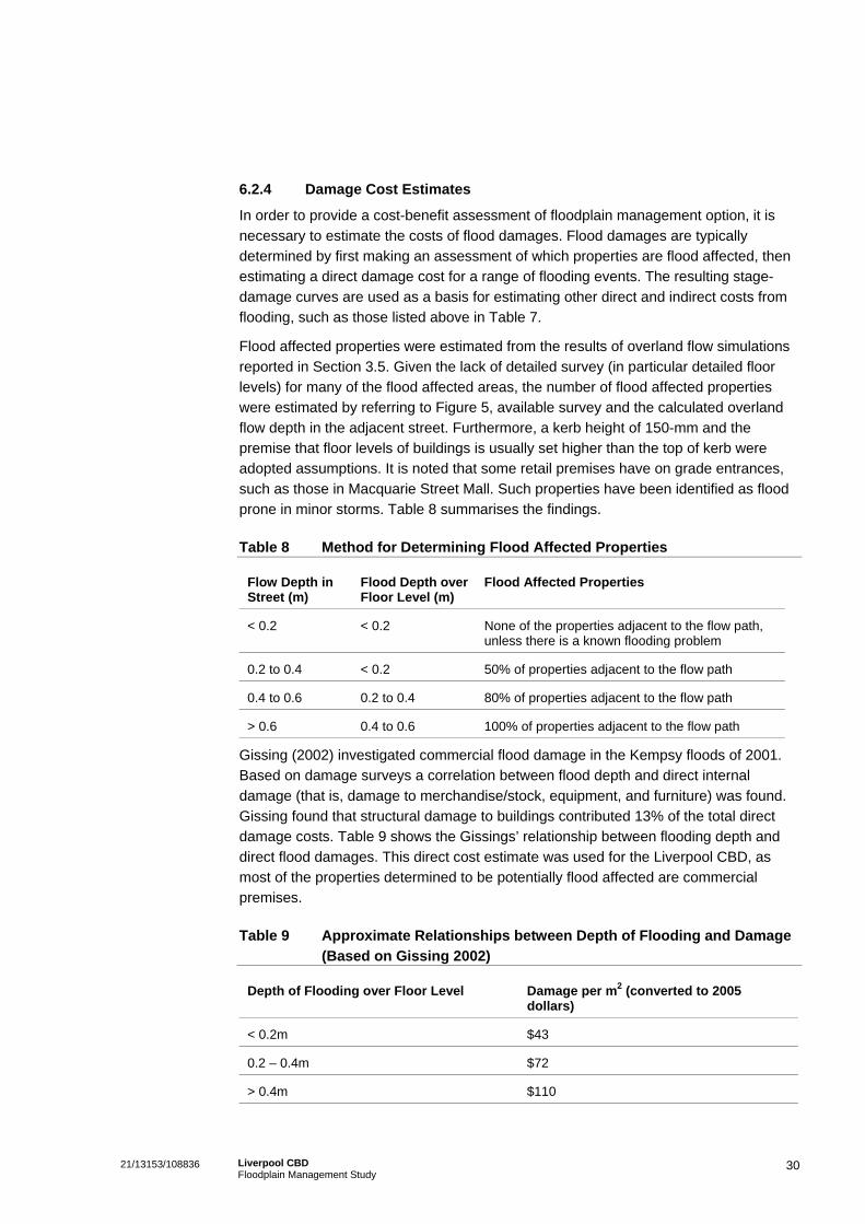
6.2.4 Damage Cost Estimates
In order to provide a cost-benefit assessment of floodplain management option, it is necessary to estimate the costs of flood damages. Flood damages are typically determined by first making an assessment of which properties are flood affected, then estimating a direct damage cost for a range of flooding events. The resulting stage-damage curves are used as a basis for estimating other direct and indirect costs from flooding, such as those listed above in Table 7.
Flood affected properties were estimated from the results of overland flow simulations reported in Section 3.5. Given the lack of detailed survey (in particular detailed floor levels) for many of the flood affected areas, the number of flood affected properties were estimated by referring to Figure 5, available survey and the calculated overland flow depth in the adjacent street. Furthermore, a kerb height of 150-mm and the premise that floor levels of buildings is usually set higher than the top of kerb were adopted assumptions. It is noted that some retail premises have on grade entrances, such as those in Macquarie Street Mall. Such properties have been identified as flood prone in minor storms. Table 8 summarises the findings.
Table 8 Method for Determining Flood Affected Properties
Flow Depth in Street (m)
Flood Depth over Floor Level (m)
Flood Affected Properties
< 0.2 < 0.2 None of the properties adjacent to the flow path, unless there is a known flooding problem
0.2 to 0.4 < 0.2 50% of properties adjacent to the flow path
0.4 to 0.6 0.2 to 0.4 80% of properties adjacent to the flow path
> 0.6 0.4 to 0.6 100% of properties adjacent to the flow path
Gissing (2002) investigated commercial flood damage in the Kempsy floods of 2001. Based on damage surveys a correlation between flood depth and direct internal damage (that is, damage to merchandise/stock, equipment, and furniture) was found. Gissing found that structural damage to buildings contributed 13% of the total direct damage costs. Table 9 shows the Gissings’ relationship between flooding depth and direct flood damages. This direct cost estimate was used for the Liverpool CBD, as most of the properties determined to be potentially flood affected are commercial premises.
Table 9 Approximate Relationships between Depth of Flooding and Damage (Based on Gissing 2002)
Depth of Flooding over Floor Level Damage per m2 (converted to 2005 dollars)
< 0.2m $43
0.2 – 0.4m $72
> 0.4m $110
30 21/13153/108836 Liverpool CBD Floodplain Management Study
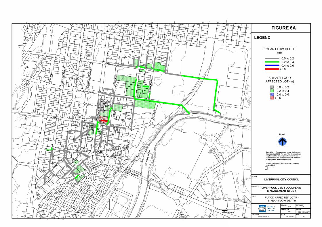
CO
LLEG
E ST
CO
LLEG
E ST
CO
LLEG
E ST
CO
LLEG
E ST
CO
LLEG
E ST
CO
LLEG
E ST
CO
LLEG
E ST
CO
LLEG
E ST
CO
LLEG
E ST
GEO
RG
E ST
GEO
RG
E ST
GEO
RG
E ST
GEO
RG
E ST
GEO
RG
E ST
GEO
RG
E ST
GEO
RG
E ST
GEO
RG
E ST
GEO
RG
E ST
CAMPBELL STCAMPBELL STCAMPBELL STCAMPBELL STCAMPBELL STCAMPBELL STCAMPBELL STCAMPBELL STCAMPBELL ST
GO
ULB
UR
N S
TG
OU
LBU
RN
ST
GO
ULB
UR
N S
TG
OU
LBU
RN
ST
GO
ULB
UR
N S
TG
OU
LBU
RN
ST
GO
ULB
UR
N S
TG
OU
LBU
RN
ST
GO
ULB
UR
N S
T
GEO
RG
ES R
IVER
GEO
RG
ES R
IVER
GEO
RG
ES R
IVER
GEO
RG
ES R
IVER
GEO
RG
ES R
IVER
GEO
RG
ES R
IVER
GEO
RG
ES R
IVER
GEO
RG
ES R
IVER
GEO
RG
ES R
IVER
BIG
GE
STB
IGG
E ST
BIG
GE
STB
IGG
E ST
BIG
GE
STB
IGG
E ST
BIG
GE
STB
IGG
E ST
BIG
GE
ST
NEW BRIDGE
NEW BRIDGE
NEW BRIDGE
NEW BRIDGE
NEW BRIDGE
NEW BRIDGE
NEW BRIDGE
NEW BRIDGE
NEW BRIDGE
MEMORIAL AVEMEMORIAL AVEMEMORIAL AVEMEMORIAL AVEMEMORIAL AVEMEMORIAL AVEMEMORIAL AVEMEMORIAL AVEMEMORIAL AVE
NORFOLK ST
NORFOLK ST
NORFOLK ST
NORFOLK ST
NORFOLK ST
NORFOLK ST
NORFOLK ST
NORFOLK ST
NORFOLK ST
TERMINUS ST
TERMINUS ST
TERMINUS ST
TERMINUS ST
TERMINUS ST
TERMINUS ST
TERMINUS ST
TERMINUS ST
TERMINUS ST
CAS
TLER
EAG
H S
TC
ASTL
EREA
GH
ST
CAS
TLER
EAG
H S
TC
ASTL
EREA
GH
ST
CAS
TLER
EAG
H S
TC
ASTL
EREA
GH
ST
CAS
TLER
EAG
H S
TC
ASTL
EREA
GH
ST
CAS
TLER
EAG
H S
T
BAT
HU
RST
ST
BAT
HU
RST
ST
BAT
HU
RST
ST
BAT
HU
RST
ST
BAT
HU
RST
ST
BAT
HU
RST
ST
BAT
HU
RST
ST
BAT
HU
RST
ST
BAT
HU
RST
ST
NO
RTH
UM
BER
LAN
D S
TN
OR
THU
MBE
RLA
ND
ST
NO
RTH
UM
BER
LAN
D S
TN
OR
THU
MBE
RLA
ND
ST
NO
RTH
UM
BER
LAN
D S
TN
OR
THU
MBE
RLA
ND
ST
NO
RTH
UM
BER
LAN
D S
TN
OR
THU
MBE
RLA
ND
ST
NO
RTH
UM
BER
LAN
D S
T
MOORE STMOORE STMOORE STMOORE STMOORE STMOORE STMOORE STMOORE STMOORE ST
DR ELIZABETH STDR ELIZABETH STDR ELIZABETH STDR ELIZABETH STDR ELIZABETH STDR ELIZABETH STDR ELIZABETH STDR ELIZABETH STDR ELIZABETH ST
MA
CQ
UA
RIE
ST
MA
CQ
UA
RIE
ST
MA
CQ
UA
RIE
ST
MA
CQ
UA
RIE
ST
MA
CQ
UA
RIE
ST
MA
CQ
UA
RIE
ST
MA
CQ
UA
RIE
ST
MA
CQ
UA
RIE
ST
MA
CQ
UA
RIE
ST
CO
PELA
ND
ST
CO
PELA
ND
ST
CO
PELA
ND
ST
CO
PELA
ND
ST
CO
PELA
ND
ST
CO
PELA
ND
ST
CO
PELA
ND
ST
CO
PELA
ND
ST
CO
PELA
ND
ST
0 0.1 0.2
kilometres
DRAWN
DATEDWG REF
CHECKED SCALE
REVISION
21/13153/MI06
HTR A
SEE SCALE BAR
13/05/2005
FLOOD AFFECTED LOTS 5 YEAR FLOW DEPTH
LIVERPOOL CBD FLOODPLAINMANAGEMENT STUDY
North
Copyright: This document is and shall remainthe property of GHD Pty Ltd. The document mayonly be used for the purpose for which it wascommissioned and in accordance with the termsof engagement for the commission.
Unauthorised use of this document in any wayis prohibited.
LIVERPOOL CITY COUNCIL
SIZEA4
FIGURE 6A
CLIENT
PROJECT
TITLE
LEGEND
5 YEAR FLOODAFFECTED LOT (m)
0.0 to 0.20.2 to 0.40.4 to 0.6
>0.6
5 YEAR FLOW DEPTH(m)
0.0 to 0.20.2 to 0.40.4 to 0.6
>0.6
ND
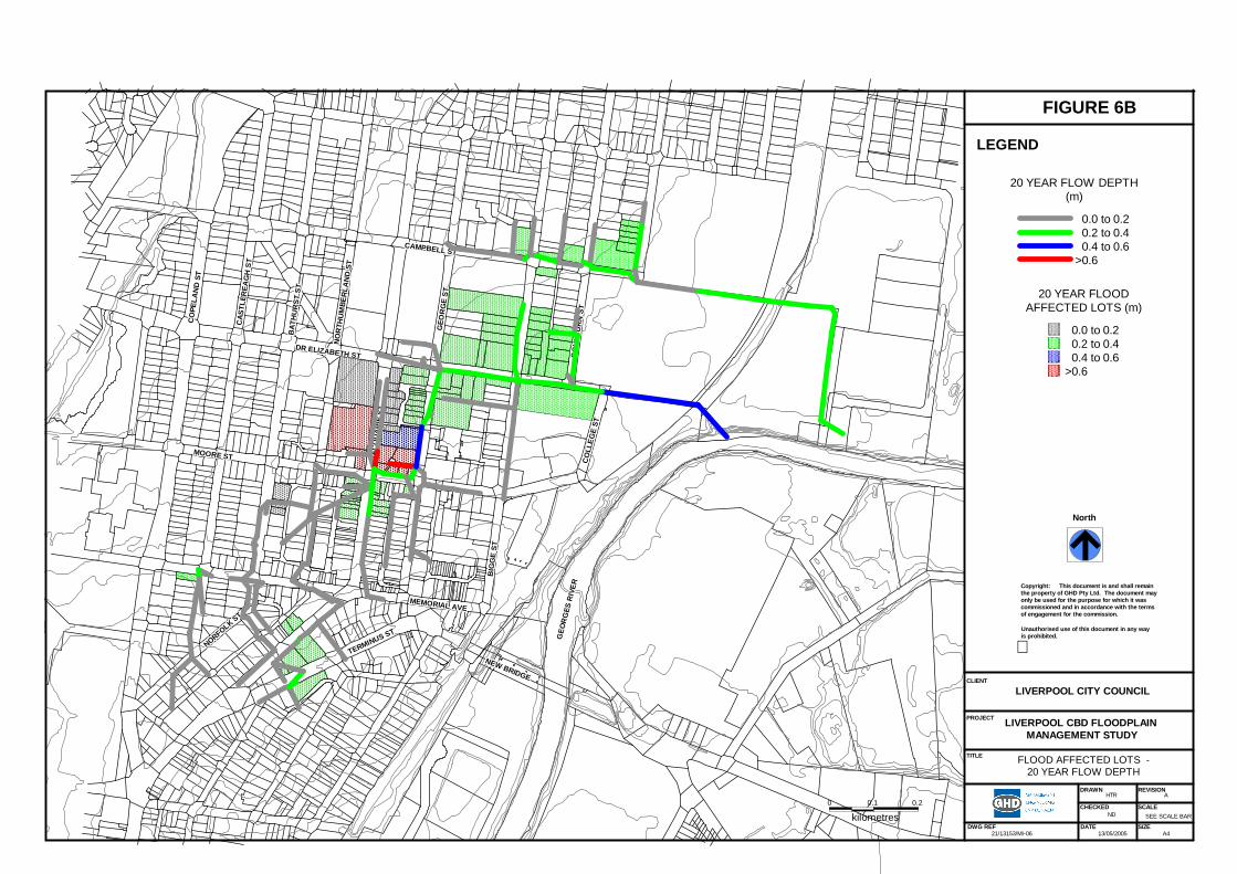
CO
LLEG
E ST
CO
LLEG
E ST
CO
LLEG
E ST
CO
LLEG
E ST
CO
LLEG
E ST
CO
LLEG
E ST
CO
LLEG
E ST
CO
LLEG
E ST
CO
LLEG
E ST
GEO
RG
E ST
GEO
RG
E ST
GEO
RG
E ST
GEO
RG
E ST
GEO
RG
E ST
GEO
RG
E ST
GEO
RG
E ST
GEO
RG
E ST
GEO
RG
E ST
CAMPBELL STCAMPBELL STCAMPBELL STCAMPBELL STCAMPBELL STCAMPBELL STCAMPBELL STCAMPBELL STCAMPBELL ST
GO
ULB
UR
N S
TG
OU
LBU
RN
ST
GO
ULB
UR
N S
TG
OU
LBU
RN
ST
GO
ULB
UR
N S
TG
OU
LBU
RN
ST
GO
ULB
UR
N S
TG
OU
LBU
RN
ST
GO
ULB
UR
N S
T
GEO
RG
ES R
IVER
GEO
RG
ES R
IVER
GEO
RG
ES R
IVER
GEO
RG
ES R
IVER
GEO
RG
ES R
IVER
GEO
RG
ES R
IVER
GEO
RG
ES R
IVER
GEO
RG
ES R
IVER
GEO
RG
ES R
IVER
BIG
GE
STB
IGG
E ST
BIG
GE
STB
IGG
E ST
BIG
GE
STB
IGG
E ST
BIG
GE
STB
IGG
E ST
BIG
GE
ST
NEW BRIDGE
NEW BRIDGE
NEW BRIDGE
NEW BRIDGE
NEW BRIDGE
NEW BRIDGE
NEW BRIDGE
NEW BRIDGE
NEW BRIDGE
MEMORIAL AVEMEMORIAL AVEMEMORIAL AVEMEMORIAL AVEMEMORIAL AVEMEMORIAL AVEMEMORIAL AVEMEMORIAL AVEMEMORIAL AVE
NORFOLK ST
NORFOLK ST
NORFOLK ST
NORFOLK ST
NORFOLK ST
NORFOLK ST
NORFOLK ST
NORFOLK ST
NORFOLK ST
TERMINUS ST
TERMINUS ST
TERMINUS ST
TERMINUS ST
TERMINUS ST
TERMINUS ST
TERMINUS ST
TERMINUS ST
TERMINUS ST
CAS
TLER
EAG
H S
TC
ASTL
EREA
GH
ST
CAS
TLER
EAG
H S
TC
ASTL
EREA
GH
ST
CAS
TLER
EAG
H S
TC
ASTL
EREA
GH
ST
CAS
TLER
EAG
H S
TC
ASTL
EREA
GH
ST
CAS
TLER
EAG
H S
T
BAT
HU
RST
ST
BAT
HU
RST
ST
BAT
HU
RST
ST
BAT
HU
RST
ST
BAT
HU
RST
ST
BAT
HU
RST
ST
BAT
HU
RST
ST
BAT
HU
RST
ST
BAT
HU
RST
ST
NO
RTH
UM
BER
LAN
D S
TN
OR
THU
MBE
RLA
ND
ST
NO
RTH
UM
BER
LAN
D S
TN
OR
THU
MBE
RLA
ND
ST
NO
RTH
UM
BER
LAN
D S
TN
OR
THU
MBE
RLA
ND
ST
NO
RTH
UM
BER
LAN
D S
TN
OR
THU
MBE
RLA
ND
ST
NO
RTH
UM
BER
LAN
D S
T
MOORE STMOORE STMOORE STMOORE STMOORE STMOORE STMOORE STMOORE STMOORE ST
DR ELIZABETH STDR ELIZABETH STDR ELIZABETH STDR ELIZABETH STDR ELIZABETH STDR ELIZABETH STDR ELIZABETH STDR ELIZABETH STDR ELIZABETH ST
MA
CQ
UA
RIE
ST
MA
CQ
UA
RIE
ST
MA
CQ
UA
RIE
ST
MA
CQ
UA
RIE
ST
MA
CQ
UA
RIE
ST
MA
CQ
UA
RIE
ST
MA
CQ
UA
RIE
ST
MA
CQ
UA
RIE
ST
MA
CQ
UA
RIE
ST
CO
PELA
ND
ST
CO
PELA
ND
ST
CO
PELA
ND
ST
CO
PELA
ND
ST
CO
PELA
ND
ST
CO
PELA
ND
ST
CO
PELA
ND
ST
CO
PELA
ND
ST
CO
PELA
ND
ST
0 0.1 0.2
kilometres
DRAWN
DATEDWG REF
CHECKED SCALE
REVISION
21/13153/MI06
HTR A
SEE SCALE BAR
13/05/2005
FLOOD AFFECTED LOTS 20 YEAR FLOW DEPTH
LIVERPOOL CBD FLOODPLAINMANAGEMENT STUDY
North
Copyright: This document is and shall remainthe property of GHD Pty Ltd. The document mayonly be used for the purpose for which it wascommissioned and in accordance with the termsof engagement for the commission.
Unauthorised use of this document in any wayis prohibited.
LIVERPOOL CITY COUNCIL
SIZEA4
FIGURE 6B
CLIENT
PROJECT
TITLE
LEGEND
20 YEAR FLOODAFFECTED LOTS (m)
0.0 to 0.20.2 to 0.40.4 to 0.6
>0.6
20 YEAR FLOW DEPTH(m)
0.0 to 0.20.2 to 0.40.4 to 0.6
>0.6
ND

CO
LLEG
E ST
CO
LLEG
E ST
CO
LLEG
E ST
CO
LLEG
E ST
CO
LLEG
E ST
CO
LLEG
E ST
CO
LLEG
E ST
CO
LLEG
E ST
CO
LLEG
E ST
GEO
RG
E ST
GEO
RG
E ST
GEO
RG
E ST
GEO
RG
E ST
GEO
RG
E ST
GEO
RG
E ST
GEO
RG
E ST
GEO
RG
E ST
GEO
RG
E ST
CAMPBELL STCAMPBELL STCAMPBELL STCAMPBELL STCAMPBELL STCAMPBELL STCAMPBELL STCAMPBELL STCAMPBELL ST
GO
ULB
UR
N S
TG
OU
LBU
RN
ST
GO
ULB
UR
N S
TG
OU
LBU
RN
ST
GO
ULB
UR
N S
TG
OU
LBU
RN
ST
GO
ULB
UR
N S
TG
OU
LBU
RN
ST
GO
ULB
UR
N S
T
GEO
RG
ES R
IVER
GEO
RG
ES R
IVER
GEO
RG
ES R
IVER
GEO
RG
ES R
IVER
GEO
RG
ES R
IVER
GEO
RG
ES R
IVER
GEO
RG
ES R
IVER
GEO
RG
ES R
IVER
GEO
RG
ES R
IVER
BIG
GE
STB
IGG
E ST
BIG
GE
STB
IGG
E ST
BIG
GE
STB
IGG
E ST
BIG
GE
STB
IGG
E ST
BIG
GE
ST
NEW BRIDGE
NEW BRIDGE
NEW BRIDGE
NEW BRIDGE
NEW BRIDGE
NEW BRIDGE
NEW BRIDGE
NEW BRIDGE
NEW BRIDGE
MEMORIAL AVEMEMORIAL AVEMEMORIAL AVEMEMORIAL AVEMEMORIAL AVEMEMORIAL AVEMEMORIAL AVEMEMORIAL AVEMEMORIAL AVE
NORFOLK ST
NORFOLK ST
NORFOLK ST
NORFOLK ST
NORFOLK ST
NORFOLK ST
NORFOLK ST
NORFOLK ST
NORFOLK ST
TERMINUS ST
TERMINUS ST
TERMINUS ST
TERMINUS ST
TERMINUS ST
TERMINUS ST
TERMINUS ST
TERMINUS ST
TERMINUS ST
CAS
TLER
EAG
H S
TC
ASTL
EREA
GH
ST
CAS
TLER
EAG
H S
TC
ASTL
EREA
GH
ST
CAS
TLER
EAG
H S
TC
ASTL
EREA
GH
ST
CAS
TLER
EAG
H S
TC
ASTL
EREA
GH
ST
CAS
TLER
EAG
H S
T
BAT
HU
RST
ST
BAT
HU
RST
ST
BAT
HU
RST
ST
BAT
HU
RST
ST
BAT
HU
RST
ST
BAT
HU
RST
ST
BAT
HU
RST
ST
BAT
HU
RST
ST
BAT
HU
RST
ST
NO
RTH
UM
BER
LAN
D S
TN
OR
THU
MBE
RLA
ND
ST
NO
RTH
UM
BER
LAN
D S
TN
OR
THU
MBE
RLA
ND
ST
NO
RTH
UM
BER
LAN
D S
TN
OR
THU
MBE
RLA
ND
ST
NO
RTH
UM
BER
LAN
D S
TN
OR
THU
MBE
RLA
ND
ST
NO
RTH
UM
BER
LAN
D S
T
MOORE STMOORE STMOORE STMOORE STMOORE STMOORE STMOORE STMOORE STMOORE ST
DR ELIZABETH STDR ELIZABETH STDR ELIZABETH STDR ELIZABETH STDR ELIZABETH STDR ELIZABETH STDR ELIZABETH STDR ELIZABETH STDR ELIZABETH ST
MA
CQ
UA
RIE
ST
MA
CQ
UA
RIE
ST
MA
CQ
UA
RIE
ST
MA
CQ
UA
RIE
ST
MA
CQ
UA
RIE
ST
MA
CQ
UA
RIE
ST
MA
CQ
UA
RIE
ST
MA
CQ
UA
RIE
ST
MA
CQ
UA
RIE
ST
CO
PELA
ND
ST
CO
PELA
ND
ST
CO
PELA
ND
ST
CO
PELA
ND
ST
CO
PELA
ND
ST
CO
PELA
ND
ST
CO
PELA
ND
ST
CO
PELA
ND
ST
CO
PELA
ND
ST
0 0.1 0.2
kilometres
DRAWN
DATEDWG REF
CHECKED SCALE
REVISION
21/13153/MI06
HTR A
SEE SCALE BAR
13/05/2005
FLOOD AFFECTED LOTS 100 YEAR FLOW DEPTH
LIVERPOOL CBD FLOODPLAINMANAGEMENT STUDY
North
Copyright: This document is and shall remainthe property of GHD Pty Ltd. The document mayonly be used for the purpose for which it wascommissioned and in accordance with the termsof engagement for the commission.
Unauthorised use of this document in any wayis prohibited.
LIVERPOOL CITY COUNCIL
SIZEA4
FIGURE 6C
CLIENT
PROJECT
TITLE
LEGEND
100 YEAR FLOODAFFECTED LOTS (m)
0 to 0.20.2 to 0.40.4 to 0.60.6 to 1
100 YEAR FLOW DEPTH(m)
0.0 to 0.20.2 to 0.40.4 to 0.6
>0.6
ND
The Georges River Floodplain and Risk Management Plan was used as a guide to the apportionment of flood damage components, as listed in Table 10.
Table 10 Percentage Breakdown of Flood Damage (Georges River Floodplain and Risk Management Plan)
Component Percentage of Total Damage
Direct Property Damage (including structural damage, damage to stock, equipment and furniture)
60 %
Indirect Damage 15 %
Infrastructure and Public Sector Damage 20 %
Social Damage 5 %
Total 100 %
Using the above information, the following methodology was used to estimate the Average Annual Damage (AAD) and present value of the AAD over a 20-year period:
The count and area of the lots adjacent to flooded overland flow paths in the 20%, 5%, and 1% AEP storms was estimated from the DRAINS simulations and GIS model;
Assuming 80% of each lot is occupied by a building structure, the number and area of the buildings, together with the flooding depth was estimated for each design storm;
The cost of damage for the flooding was estimated for each design storm and depth range by multiplying the building area by the damage per square meter;
A direct damage bill for each storm was calculated;
A total damage bill was apportioned based on Table 10;
Flood AEP was plotted against storm damage and integrated to find the area under the graph, which provides the AAD; and
A present value for the AAD was estimated based on a 6% discount rate over a 20-year period.
34 21/13153/108836 Liverpool CBD Floodplain Management Study
Figure 7 – Flood Damage Results
Flood Damage
$0.00
$0.50
$1.00
$1.50
$2.00
$2.50
$3.00
$3.50
0% 5% 10% 15% 20% 25%
Annual Exceedence Probability (AEP)
Dam
age
(mill
)
100-Year ARI
Area under graph = Average Annual Damage
20-Year ARI 5-Year ARI
Referring to Figure 7, the area under the line is equal to the potential Average Annual Damage (AAD). For the Liverpool CBD, the AAD is estimated as $542,000. Over a 20-year period, this has a present value of $6.22 million.
35 21/13153/108836 Liverpool CBD Floodplain Management Study

7. Floodplain Management Measures
7.1 Floodplain Management Options In accordance with the NSW Government Floodplain Management Manual (2001), this report considers various floodplain risk management measures. Risk management measures can be broadly categorised into three categories as shown in Table 11.
Table 11 Floodplain Risk Management Options
Category Potential Floodplain Management Measures
Property Modification Land Use Planning
House raising or flood proofing of buildings
Voluntary purchase of high hazard properties
Response Modification Flood warning systems and evacuation plans
Flood insurance and recovery
Public flood awareness schemes
Flood Modification Retro fitting On-Site Detention tanks and detention basins
Structural drainage solutions
Each of the above floodplain management options is examined in the following sections. An additional “do nothing” option is also considered.
7.2 Property Modification
7.2.1 Land use planning
Land use planning limits and controls are an essential element in managing flood risk and the most effective way of ensuring future flood risk is managed appropriately. A detailed discussion on appropriateness of development controls and Flood Planning Levels (FPLs) for the Liverpool CBD is provided in Section 9.3.
7.2.2 House Raising or Flood Proofing of Buildings
House raising is a structural solution to lift buildings above the flood planning level to avert damage to buildings, improve personal safety and reduce stress and post-flood trauma. Since house raising is not suitable for commercial properties and blocks of units, this option is not considered appropriate for the Liverpool CBD.
Flood proofing of buildings involves designing and constructing buildings with appropriate water resistant building materials to reduce flood damage. This solution reduces damage to the building structure but in most cases does not protect building contents. In this situation, flood proofing will need to be retro fitted to existing buildings
36 21/13153/108836 Liverpool CBD Floodplain Management Study
or included as a development control. Flood affected properties tend to be commercial premises so the contents are likely to be costly to replace if flood damaged.
Flood proofing has been considered as an option.
7.2.3 Voluntary Purchase of High Hazard Properties
To avoid the economic and social expenses of flooding in high hazard areas, it may be viable for Council to purchase flood affected properties at an equitable price where voluntarily offered. The property should then be rezoned to a flood compatible use, such as open space. This will have little impact on reducing flood hazards but will reduce annual flood damage to the affected properties.
While this option may be expensive and limiting on account of the high densities and zoning, voluntary purchase has been considered as an option.
7.3 Response Modification
7.3.1 Flood Warning Systems and Evacuation Plans
Flood warning systems and evacuation plans are used to prepare a community for an impending flood. Depending on warning time and resources available, flood warning systems and evacuation plans can be used to protect buildings, evacuate people, provide relief to evacuees and recover the flood affected areas.
The critical storm event for this catchment is the 25-minute storm. A storm of this duration in a catchment of this size is not considered conducive to flood warning systems and evacuation plans.
Flood warning has not considered been considered as an option.
7.3.2 Flood Insurance and Recovery
Insuring properties against flooding is a method of transferring the flood financial risk to the insurer. There is limited benefit in this flood risk management option because insurance does not mitigate flooding. Therefore, issues of community disruption, property values, flood hazards and safety remain.
Flood insurance has been considered as an option.
7.3.3 Public Flood Awareness Scheme
A public awareness scheme will assist in raising flood awareness and readiness, and increase the appreciation of the flood problem and prevention activities. Implementation of a flood awareness scheme will also assist in minimizing the social and economic impacts of flooding in the Liverpool CBD. Measures to increase flood awareness could be for example:
The dissemination of a Flood Information Pack that could be sent to all business owners, operators and residents of potential flood impacted properties (this information should be provided in a range of different languages);
37 21/13153/108836 Liverpool CBD Floodplain Management Study

The dissemination of flood certificates on a regular basis which would inform each property owner of the flood situation at their particular property, flood data and advice (this information should be provided in a range of different languages); and
Signage in flood prone areas giving notification of potential flood levels.
A flood awareness scheme has been considered as an option.
7.4 Flood Modification
7.4.1 Retro Fitting On-Site Detention Tanks and Detention Basins
On-Site Detention tanks and detention basins attenuate the peak discharge in a storm by temporarily storing the stormwater and discharging it a slower rate. This will reduce the demand on existing drainage infrastructure and potentially mitigate flooding. The Liverpool CBD catchment is predominantly medium and high-density residential and commercial premises. This type of development provides limited opportunity for retro fitting on-site detention tanks and detention basins.
Retro fitting on-site detention tanks and detention basins has not been considered as an option.
7.4.2 Structural Drainage Solutions
The purpose of structural drainage solutions is to mitigate flooding and associated economic and social consequences of flooding. For the Liverpool CBD, there are opportunities to improve the drainage system to reduce the impact of flooding on the community. Structural solutions will also provide an opportunity to provide and improve the water quality of Georges River through the use of structural water quality devices such as Gross Pollutant Traps. As identified by the simulations, the underlying problems within the CBD is an under-capacity drainage system and a trend amongst commercial premises to have their floor levels set at ground level.
Structural drainage solutions are further discussed in Sections 7.5 and 7.6, and have been considered as options.
7.5 Previously Proposed Management Measures The Liverpool CBD Trunk Drainage Report: Concept Design Report5 considered 10 options for upgrade of the existing stormwater system within the catchments comprising the Liverpool CBD. Options investigated aimed at ensuring flood protection to properties up to the 5% AEP event. Table 12 summarises the options considered.
5 Liverpool City Council, 2003, Liverpool CBD Trunk Drainage Concept Design Report, Cardno Willing,
October 2003
38 21/13153/108836 Liverpool CBD Floodplain Management Study
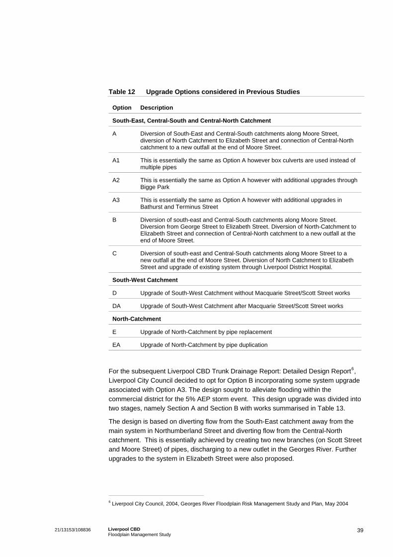
Table 12 Upgrade Options considered in Previous Studies
Option Description
South-East, Central-South and Central-North Catchment
A Diversion of South-East and Central-South catchments along Moore Street, diversion of North Catchment to Elizabeth Street and connection of Central-North catchment to a new outfall at the end of Moore Street.
A1 This is essentially the same as Option A however box culverts are used instead of multiple pipes
A2 This is essentially the same as Option A however with additional upgrades through Bigge Park
A3 This is essentially the same as Option A however with additional upgrades in Bathurst and Terminus Street
B Diversion of south-east and Central-South catchments along Moore Street. Diversion from George Street to Elizabeth Street. Diversion of North-Catchment to Elizabeth Street and connection of Central-North catchment to a new outfall at the end of Moore Street.
C Diversion of south-east and Central-South catchments along Moore Street to a new outfall at the end of Moore Street. Diversion of North Catchment to Elizabeth Street and upgrade of existing system through Liverpool District Hospital.
South-West Catchment
D Upgrade of South-West Catchment without Macquarie Street/Scott Street works
DA Upgrade of South-West Catchment after Macquarie Street/Scott Street works
North-Catchment
E Upgrade of North-Catchment by pipe replacement
EA Upgrade of North-Catchment by pipe duplication
For the subsequent Liverpool CBD Trunk Drainage Report: Detailed Design Report6, Liverpool City Council decided to opt for Option B incorporating some system upgrade associated with Option A3. The design sought to alleviate flooding within the commercial district for the 5% AEP storm event. This design upgrade was divided into two stages, namely Section A and Section B with works summarised in Table 13.
The design is based on diverting flow from the South-East catchment away from the main system in Northumberland Street and diverting flow from the Central-North catchment. This is essentially achieved by creating two new branches (on Scott Street and Moore Street) of pipes, discharging to a new outlet in the Georges River. Further upgrades to the system in Elizabeth Street were also proposed.
6 Liverpool City Council, 2004, Georges River Floodplain Risk Management Study and Plan, May 2004
39 21/13153/108836 Liverpool CBD Floodplain Management Study

Table 13 Works proposed in Liverpool CBD Trunk Drainage Report: Detailed Design Report
Section A Works Section B Works
Moore Street from Macquarie Street to College Street;
Upgrade from Bathurst Street to Northumberland Street through easements and Huckstepp Serviceway;
Scott Street from 50m east of Macquarie Street to George Street;
George Street from adjacent to the Police Station to Elizabeth Street
George Street from Scott Street to Moore Street;
Upgrade works from Terminus Street through easements to Macquarie Street and west (typo, should be east) along Macquarie Street to Scott Street;
Elizabeth Street from 55m east of George Street to College Street;
Macquarie Street between Memorial Avenue and Moore Street;
College Street from Elizabeth Street to Moore Street; and
Elizabeth Street between Northumberland Street and George Street;
Outlet pipeline from College Street to Georges River.
Campbell Street from 35m west of Bigge Street to Goulburn Street;
Goulburn Street from Campbell Street to Elizabeth Street; and
Bigge Street between Campbell and Elizabeth Street (- continued south along Goulburn Street to Elizabeth Street).
7.5.1 Comments on Previously Proposed Management Measures
To test the options proposed, Cardno Willing developed a DRAINS model. A review of this DRAINS model showed that only new pipe upgrades and existing pipes in the vicinity of the proposed upgrade options, were configured in the model and simulated. Hydrographs from the ILSAX models were configured as inflows and were allowed to discharge to upstream nodes in the model.
However, from the review, it appears that the inflows did not include overland flows from the upstream catchments. These overland flows form part of the total flow that needs to be conveyed, and should not be omitted. To further investigate this anomaly, the proposed Section A works were configured into the new DRAINS model developed for the present study. This showed that there were numerous locations within the study area that did not conform to the adopted design standard, namely prevent flooding in the 5% AEP event.
If these areas, proposed to be mitigated as part of the Section B works, are upgraded then the downstream system would be unable to cope with the additional inflows. Should the works detailed in the Liverpool CBD Trunk Drainage Report: Detailed Design Report be adopted, then Table 14 summarises floodways that would be classified as “high hazard” using the categorisation developed in Section 4.2.
40 21/13153/108836 Liverpool CBD Floodplain Management Study
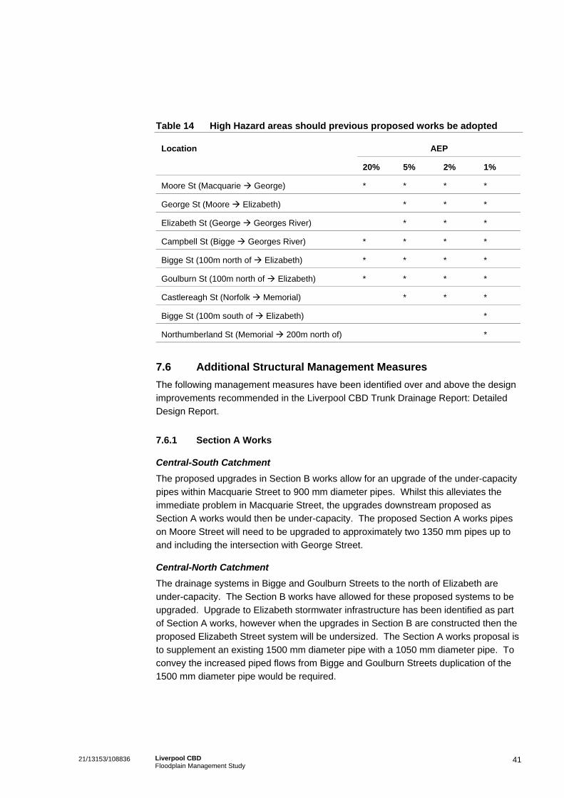
Table 14 High Hazard areas should previous proposed works be adopted
AEP Location
20% 5% 2% 1%
Moore St (Macquarie George) * * * *
George St (Moore Elizabeth) * * *
Elizabeth St (George Georges River) * * *
Campbell St (Bigge Georges River) * * * *
Bigge St (100m north of Elizabeth) * * * *
Goulburn St (100m north of Elizabeth) * * * *
Castlereagh St (Norfolk Memorial) * * *
Bigge St (100m south of Elizabeth) *
Northumberland St (Memorial 200m north of) *
7.6 Additional Structural Management Measures The following management measures have been identified over and above the design improvements recommended in the Liverpool CBD Trunk Drainage Report: Detailed Design Report.
7.6.1 Section A Works
Central-South Catchment The proposed upgrades in Section B works allow for an upgrade of the under-capacity pipes within Macquarie Street to 900 mm diameter pipes. Whilst this alleviates the immediate problem in Macquarie Street, the upgrades downstream proposed as Section A works would then be under-capacity. The proposed Section A works pipes on Moore Street will need to be upgraded to approximately two 1350 mm pipes up to and including the intersection with George Street.
Central-North Catchment The drainage systems in Bigge and Goulburn Streets to the north of Elizabeth are under-capacity. The Section B works have allowed for these proposed systems to be upgraded. Upgrade to Elizabeth stormwater infrastructure has been identified as part of Section A works, however when the upgrades in Section B are constructed then the proposed Elizabeth Street system will be undersized. The Section A works proposal is to supplement an existing 1500 mm diameter pipe with a 1050 mm diameter pipe. To convey the increased piped flows from Bigge and Goulburn Streets duplication of the 1500 mm diameter pipe would be required.
41 21/13153/108836 Liverpool CBD Floodplain Management Study
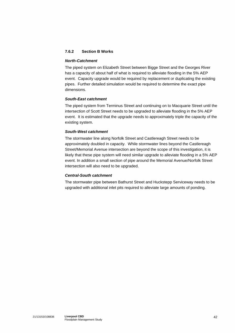
7.6.2 Section B Works
North-Catchment The piped system on Elizabeth Street between Bigge Street and the Georges River has a capacity of about half of what is required to alleviate flooding in the 5% AEP event. Capacity upgrade would be required by replacement or duplicating the existing pipes. Further detailed simulation would be required to determine the exact pipe dimensions.
South-East catchment The piped system from Terminus Street and continuing on to Macquarie Street until the intersection of Scott Street needs to be upgraded to alleviate flooding in the 5% AEP event. It is estimated that the upgrade needs to approximately triple the capacity of the existing system.
South-West catchment The stormwater line along Norfolk Street and Castlereagh Street needs to be approximately doubled in capacity. While stormwater lines beyond the Castlereagh Street/Memorial Avenue intersection are beyond the scope of this investigation, it is likely that these pipe system will need similar upgrade to alleviate flooding in a 5% AEP event. In addition a small section of pipe around the Memorial Avenue/Norfolk Street intersection will also need to be upgraded.
Central-South catchment The stormwater pipe between Bathurst Street and Huckstepp Serviceway needs to be upgraded with additional inlet pits required to alleviate large amounts of ponding.
42 21/13153/108836 Liverpool CBD Floodplain Management Study

8. Review and Assessment of Floodplain Management Measures
8.1 Cost of Floodplain Management Options From the discussion in Section 7, the following were identified as options:
Flood proofing of buildings;
Voluntary purchase of high hazard properties;
Flood insurance and recovery;
Public flood awareness scheme; and
Structural drainage solutions.
8.1.1 Flood Proofing of Buildings
Cost estimates for the flood proofing of buildings should consider a range of the variables, such as the physical characteristics of the building (existing building materials, age, size and dimensions), the costs associated with downtime while buildings are being flood proofed, and the costs of maintaining flood proofed buildings. Given the complexity of these variables, the flood proofing was estimated at 3% of the property value, based on consideration of typical works.
Flood damage costs after buildings have been flood proofed would then exclude direct structural damage costs. Based on the breakdown of direct, indirect and other flooding costs in Table 10, the direct structural damage costs equal 50% of the total flood damages. Therefore, potential savings in flood damage is equal to the 50% of the total flood damages.
8.1.2 Voluntary Purchase of High Hazard Properties
Including negotiation fees, legal fees, survey and demolition, the cost of commercial properties in the Liverpool CBD is estimated in the order of $7500 per m2. Based on Table 5, a number of properties in Macquarie Street Mall, Northumberland Street, and between George and Bigge Streets are identified as high hazard areas and could suffer from regular flooding. This option would involve the rezoning and purchase of these properties.
8.1.3 Flood Insurance and Recovery
Flood insurance premiums cost approximately $1000 per annum per $100,000 property value. It is assumed that property values are in the order of $6000 per square metre. The average annual insurance cost can be estimated by calculating the product of the integral of the Flood Affected Properties Area versus AEP graph with the insurance cost per annum per $100,000 property value and the property value. For the Liverpool CBD, this equates to $379,000 per annum or a present value of $4.34 million over 20 years.
43 21/13153/108836 Liverpool CBD Floodplain Management Study

Flood damages that are not insured include damage to goods, equipment, furniture, infrastructure, indirect damage and social damages. Recovery costs include cleaning, repairing or replacing uninsured structures and goods, as well as the unquantifiable costs of miscellaneous flood relief efforts. Based on Table 10, these uninsured damages make up about 50% of total damages. Therefore, insurance will give savings of 50% of total flood damages.
8.1.4 Public Flood Awareness Scheme
A public flood awareness scheme as described in Section 7.3.3 could be implemented in a cost effective manner. For the purpose of this study it is estimated that the scheme would cost approximately $25 000 to implement and $4000 per annum to maintain (based on costs documented in the Georges River Floodplain Risk Management Study and Plan).
A public flood awareness scheme will assist the public prepare for flooding and reduce the potential flood damages. Damage will primarily be borne in the direct costs of damage to equipment, stock and furniture, with some savings potentially made to building structures. The short critical storm duration for the catchment will counter much of these potential gains. For the Liverpool CBD, the anticipated savings in flood damage were estimated to be 1%.
8.1.5 Structural Drainage Solutions
The construction cost of the Section A works is approximately $7.11 million, as documented by Liverpool City Council. The major component is the thrust boring of pipes and the amount of traffic control required on busy commercial streets. The costs of GHD’s recommended improvements to Section A, as described in Section 7.6.1, are estimated as:
Central South Catchment – Additional $141,000; and
Central North Catchment – Additional $140,000.
These costs were estimated assuming that the work will be carried out in the same construction staging as the other Section A works. This brings the total for Section A of the structural design solution to $7.39 million.
The Section B design is still to be finalised. A preliminary cost estimate for the works as identified thus far is in the order of $2.5 million.
The total (Section A and B works) for the structural design solution is thus estimated to be $9.89 million. Savings in flood damage for Section A works only are considered proportional to the capital costs.
8.2 Assessment of Options A number of social, economic and environmental issues were considered while assessing the floodplain risk management options. These are listed in Table 15.
44 21/13153/108836 Liverpool CBD Floodplain Management Study

Table 15 Social, Economic and Environmental issues for assessing Options
Category Issues
Social The capacity of the option to reduce flood hazards and personal safety risks to the community,
How the option will influence property values;
The capacity of the option to promote community growth; and
The level of disruption to the community, either through implementing the option or through the resulting floodplain behaviour.
Economic and Financial The capital costs associated with implementing the option;
The ongoing or maintenance costs of the option; and
The costs or savings of flood damage after the option is implemented.
Environmental Change to ecology, habitats, riparian vegetation, and the “natural state” of the river;
Pollution;
Energy and resources required to implement the option
Energy and resources required for maintaining and decommissioning the option.
The above options and issues were rated and weighted as a score of 1 to 5 (where 5 is the best). Details of the assessment matrix and costing are provided in Appendix D. The result of the assessment matrix is listed in Table 16.
45 21/13153/108836 Liverpool CBD Floodplain Management Study

Table 16 Floodplain Risk Management Option Assessment Matrix
Option Benefit/Cost Ratio Factored with Intangible Score
Do Nothing 0
Flood Proofing of Buildings 0.32
Voluntary Purchase of High Hazard Properties 0.07
Flood Insurance and Recovery 0.42
Public Flood Awareness Scheme 0.46
Structural drainage solution – Section A 0.58
Structural drainage solution – Section A+B 0.63
Referring to Table 16, the structural drainage solution with Section A and Section B works result in the highest benefit/cost ratio. Albeit that the cost benefit ratio is less than 1, these options have the highest intangible score.
46 21/13153/108836 Liverpool CBD Floodplain Management Study
9. Funding, Implementation and Planning/Development Controls
9.1 Funding The total cost of implementing the structural works associated with this study is approximately $7.39M (Section A works only) and $9.89M (Section A and B works). There are a variety of sources of funding that could be considered for implementation. These include:
State funding for flood risk management measures through the Department of Infrastructure, Planning and Natural Resources through the subsidised Flood Mitigation Program;
Council funds;
Section 94 contributions from future development where a link can be established between that development and flooding; and
Contributions from residents or businesses to fund measures from which they will benefit.
Council can expect to receive the majority of financial assistance through the Department of Infrastructure, Planning and Natural Resources. These funds are available to implement measures that contribute to reducing existing flood problems. Funding assistance is usually provided on a 2:1 basis (State:Council). Although much of the proposal may be eligible for Government assistance, funding cannot be guaranteed. Government funds are allocated on an annual basis to competing projects throughout the State. Funding of investigation and design activities as well as any works and on-going programs such as voluntary purchase schemes is normally available.
9.2 Implementation The next steps in progressing the floodplain management process from this point are:
The Floodplain Management Committee reviews the comments and submissions received on the draft study;
Any amendments considered necessary are made, and a final report prepared and submitted to Council for adoption;
Council determines a program of works, based on overall priority, available Council funds and any other constraints;
Council submits an application for funding assistance to the Department of Infrastructure, Planning and Natural Resources and negotiates other sources of funding; and
Implementation of the Plan proceeds, as funds become available and in accordance with established priorities.
47 21/13153/108836 Liverpool CBD Floodplain Management Study
9.3 Planning and Development Controls Flood planning levels (FPLs) are an important tool in the management of flood risk, and are derived from a combination of a flood event of certain AEP and a freeboard. FPLs do not, however, ensure that development is located in areas where it will not have significant adverse impacts on flooding nor do they address personal danger issues.
The decision on appropriate FPLs for commercial and industrial developments would relate more to economic benefits versus costs. Therefore, there is greater potential for FPLs for these developments to be based on event more common that the 1% AEP flood. The greater flexibility of business in managing risk and recovering financially from flooding, means that FPLs for industrial and commercial development may be based upon a more frequent flood events. However, danger to personal safety for personnel and clients still requires careful consideration, particularly where more frequent events are used as the basis for FPLs.
New development and relatively undeveloped areas provide more flexibility in decision making than developed areas. Greenfield sites provide an excellent opportunity to set appropriate FPLs. However, as land is developed, the options for changing its use and management are greatly reduced. This is due to the significant investment, both public and private, in existing development and associated infrastructure, such as buildings, roads, drainage, water supply, sewerage and electricity. The scale of existing investment is frequently such that the development cannot reasonably be abandoned, even if it is does have a high potential for flood damage.
In the context of the Liverpool CBD, key considerations affecting the suitability of planning controls and policies include:
The significant existing development in the Liverpool CBD;
The nature of flooding, which is short-duration overland flow due to surcharged pipe systems; and
The fact that imposing of FPLs would likely not lead to reduction in flood damage costs.
Nevertheless, FPLs and controls could influence future development (and redevelopment) and therefore some benefits will accrue gradually over time. For example, redevelopment of buildings within the CBD, building extensions, or sub-division and redevelopment. In such cases FPLs and controls would determine:
Floor level requirements;
Requirements on appropriate freeboard;
Entry levels to underground car parks and driveways;
Requirements on flood proofing building;
Requirements on structural soundness;
Requirements on flood effects and impacts, in terms of flood storage and changes in flood levels and velocities;
48 21/13153/108836 Liverpool CBD Floodplain Management Study

Appropriate development types, for example critical use facilities not being appropriate; and
Evacuation requirements.
Based on the above discussion, it is recommended that FPLs and controls be adopted for the Liverpool CBD in particular to manage re-development. These should be along the lines of the Proposed Planning Matrix (other floodplains), provided in Figure 9.3 of the Georges River Floodplain Risk Management Study & Plan7. The matrix however should be adjusted to recognise that:
The flooding in the Liverpool CBD is on account of local overland flow, and not mainstream Georges River flooding; and
That adjustment of key planning parameters would likely be required to take account of the predominantly commercial land use, for example the frequency of flooding adopted to set FPLs and setting of appropriate freeboard requirements.
7 Liverpool City Council, 2004b, Georges River Floodplain Risk Management study and Plan, Volume 1 Main
Report, May 2004
49 21/13153/108836 Liverpool CBD Floodplain Management Study
10. Summary and Conclusions
GHD Pty Ltd was engaged by Liverpool City Council to prepare a Floodplain Management Study for the Liverpool Central Business District (CBD) in accordance with the NSW Floodplain Management Manual. Key objectives were to review and supplement existing flood data, calculate flood levels, categorise floodplain risk, examine social and economic effects, assess the impact of existing upgrade design proposals, examine planning or policy mitigation measures, develop other management options, provide cost estimates, analyse potential works and measures and undertake a community consultation process;
The Liverpool Central Business District (CBD) is at risk of extensive overland flooding, potentially affecting commerce and public safety. During larger events, stormwater runoff from within the CBD catchment exceeds the capacity of the existing local stormwater network. This eventuates in flooding of buildings and business premises, which in turn potentially leads to expensive clean-up costs, loss of stock, and loss of revenue;
Webb McKeown first configured a basic ILSAX stormwater model for the Liverpool CBD. Cardno Willing updated this model in 1993. For this study, to model flood behaviour and to undertake the flood categorisation, these ILSAX models were upgraded and converted to a DRAINS software;
A number of floodways and flood storage areas have been categorised throughout the Liverpool CBD. The most severely affected areas include Macquarie, George and Moore Streets. Overland flow in these areas has been simulated at depths in excess of 0.5 m in places and these have been designated as High Hazard areas;
A key objective of the Liverpool CBD Floodplain Management Study was to consult with the community and relevant stakeholders to determine the community’s attitude to past flooding, to document anecdotal history about flooding, and to assist in developing recommendations that are suitable and acceptable for the community. Key elements of the consultation process included engaging the stakeholders, undertaking a business community survey, a public meeting and public exhibition and reviewing submissions. A public meeting was held in the Liverpool Council Chambers on the 28th June 2005. Key findings were:
– Of the sample of 30 businesses surveyed only 6 indicated that they had experienced flood impacts. The low number could be indicative of a change of ownership, tenancy or management; and
– A small number of businesses were aware of, and had experienced flood impacts. However the majority of surveyed businesses had little awareness of the potential flood impacts to their property;
Social and economic effects were examined. Key findings were:
– Whilst a number of businesses and residential areas within the Liverpool CBD have been, and may potentially be impacted by flooding, there is limited indication that the land use within the CBD has been altered as a result; and
50 21/13153/108836 Liverpool CBD Floodplain Management Study

– The degree of social impact caused by flooding is likely to reduce if the community is prepared for a flood event. Given the low level of flood ‘awareness’ and flood ‘readiness’ within the study area, it can be estimated that the social impacts in the Liverpool CBD would be greater than that of a flood aware community.
A number of flood management options have been investigated:
– Property Modification: land use planning, house raising or flood proofing of buildings, voluntary purchase of high hazard properties
– Response Modification: flood warning systems and evacuation plans, flood insurance and recovery, public flood awareness scheme
– Flood Modification: retro fitting on-site detention tanks and detention basins, structural drainage solutions
A number of structural drainage solutions have been considered, in this, and other reports. Numerous options and sub options have been investigated, arriving at works which divert flow from the South-East catchment away from the main system in Northumberland Street and diverting flow from the Central-North catchment. A new outlet is provided to the Georges River at Moore Street. The works have been divided into two phases, namely Section A works being trunk conveyance infrastructure, and Section B works being local infrastructure;
A benefit/cost analysis has been undertaken for appropriate flood management options and issues were rated and weighted. The results show that the two structural drainage solutions (Section A works and both Section A and B works) have highest benefit/cost ratio. These are followed by the public flood awareness scheme;
Flood planning levels (FPLs) are important tools in the management of flood risk. It is recommended that FPLs and controls be adopted for the Liverpool CBD in particular to manage re-development. These should recognise that flooding in the Liverpool CBD is on account of local overland flow and key planning parameters would need to account for the predominantly commercial land use in the CBD.
The total cost of implementing the structural works associated with this study is approximately $7.39M (Section A works only) and $9.89M (Section A and B works) A variety of potential funding sources include the Department of Infrastructure, Planning and Natural Resources through the subsidised Flood Mitigation Program, Council funds, Section 94 contributions from future development, contributions from residents or businesses to fund measures from which they will benefit..
51 21/13153/108836 Liverpool CBD Floodplain Management Study
11. References
Liverpool City Council, 1992, Investigation and Design of Liverpool CBD Trunk Drainage, November 1992;
Liverpool City Council, 1995, CBD Catchment – Drainage Strategy Study – Summary Report, Webb McKeown and Associates, April 1995;
Liverpool City Council, 2003, Liverpool CBD Trunk Drainage – Concept Design Report”, Cardno Willing, October 2003; and
Liverpool City Council, 2004, Liverpool CBD Trunk Drainage – Detailed Design Report Cardno Willing, June 2004.
Liverpool City Council, 2004b, Georges River Floodplain Risk Management study and Plan, Volume 1 Main Report, May 2004.
NSW Gov, 2001, Floodplain Management Manual, Management of Flood Liable Land, January 2001,
AR&R, Australian Rainfall and Runoff, 2001
52 21/13153/108836 Liverpool CBD Floodplain Management Study
Appendix A
Liverpool City Council IFD Rainfall Charts
21/13153/108836 Liverpool CBD Floodplain Management Study
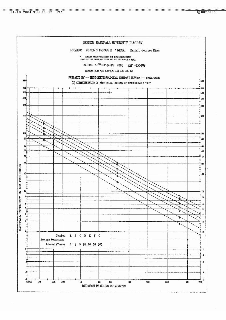

Appendix B
Detailed DRAINS Simulation Results
21/13153/108836 Liverpool CBD Floodplain Management Study

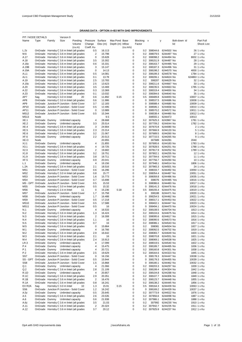
Liverpool CBD Floodplain Management Study 21/13153
DRAINS DATA OPTION A+B3 WITH GHD IMPROVEMENTS
PIT / NODE DETAILS Version 9Name Type Family Size Ponding Pressure Surface Max Pond Base Blocking x y Boltdown id Part Full
Volume Change Elev (m) Depth (m) Inflow Factor lid Shock Loss(cu.m) Coeff. Ku (cu.m/s)
L.2z OnGrade Hornsby Council Inlets (KI+grate), 3% crossfall, all grades3.6 m lintel (all grades) 0.5 16.113 0 0.2 308044.6 6244502 Yes 26 1 x KuM.6 OnGrade Hornsby Council Inlets (KI+grate), 3% crossfall, all grades3.6 m lintel (all grades) 2 15.798 0 0.2 308079.5 6244497 Yes 27 1 x KuA.17 OnGrade Hornsby Council Inlets (KI+grate), 3% crossfall, all grades3.6 m lintel (all grades) 0 15.628 0 0.2 308098.2 6244494 No 8002 1 x KuA.18 OnGrade Hornsby Council Inlets (KI+grate), 3% crossfall, all grades3.6 m lintel (all grades) 3.5 15.302 0 0.2 308151.9 6244487 No 28 1 x KuA.18z OnGrade Hornsby Council Inlets (KI+grate), 3% crossfall, all grades3.6 m lintel (all grades) 0.6 15.331 0 0.2 308163.7 6244485 Yes 29 1 x KuA.19B OnGrade Hornsby Council Inlets (KI+grate), 3% crossfall, all grades3.6 m lintel (all grades) 3 15.147 0 0.2 308187.3 6244496 Yes 31 1 x KuA.19A OnGrade Hornsby Council Inlets (KI+grate), 3% crossfall, all grades3.6 m lintel (all grades) 0 14.13 0 0.2 308198.2 6244570 Yes 4000 1 x KuA.L1 OnGrade Hornsby Council Inlets (KI+grate), 3% crossfall, all grades3.6 m lintel (all grades) 0.5 14.081 0 0.2 308199.3 6244578 Yes 1784 1 x KuAJ.1 OnGrade Hornsby Council Inlets (KI+grate), 3% crossfall, all grades2.4 m lintel (all grades) 0.1 13.78 0 0.2 308206.1 6244624 No 624863 1 x KuA.19 OnGrade Hornsby Council Inlets (KI+grate), 3% crossfall, all grades3.6 m lintel (all grades) 2.5 13.783 0 0.2 308207 6244629 No 32 1 x KuA.19z OnGrade Hornsby Council Inlets (KI+grate), 3% crossfall, all grades3.6 m lintel (all grades) 2.5 13.623 0 0.2 308211.6 6244667 Yes 33 1 x KuA.20 OnGrade Hornsby Council Inlets (KI+grate), 3% crossfall, all grades3.6 m lintel (all grades) 3.5 13.469 0 0.2 308235.5 6244663 No 1785 1 x KuA.22 OnGrade Hornsby Council Inlets (KI+grate), 3% crossfall, all grades3.6 m lintel (all grades) 0.3 13.369 0 0.2 308319.4 6244650 No 34 1 x KuA.23 OnGrade Hornsby Council Inlets (KI+grate), 3% crossfall, all grades3.6 m lintel (all grades) 0.1 13.032 0 0.2 308394.6 6244640 No 35 1 x KuAP7 Sag Hornsby Council Inlets (KI+grate), 3% crossfall, all grades3.0 m lintel (all grades)20 0.6 11.892 0.15 0 0.5 308489.8 6244693 No 10007 1 x KuAP8 OnGrade Hornsby Council Inlets (KI+grate), 3% crossfall, all grades3.0 m lintel (all grades) 0.6 11.986 0 0 308537.5 6244686 No 10008 1 x KuAP9 OnGrade Junction Pit Solid CoverJunction Solid Cover 3.7 12.183 0 0 308588.4 6244680 No 10009 1 x KuAP10 OnGrade Junction Pit Solid CoverJunction Solid Cover 0.5 12.495 0 0 308595.1 6244658 No 10010 1 x KuAP11 OnGrade Junction Pit Solid CoverJunction Solid Cover 0 13.989 0 0 308570.2 6244572 No 10011 1 x KuMS12 OnGrade Junction Pit Solid CoverJunction Solid Cover 0.5 15.344 0 0 308538.4 6244480 No 10012 1 x KuMS13 Node 9.5 0 308555.1 6244472 10013XE.1 OnGrade Dummy Unlimited capacity 4 28.668 0 0.2 307625.3 6243967 No 1781 1 x KuXE.2 OnGrade Dummy Unlimited capacity 3.3 25.514 0 0.2 307709.2 6244044 No 1782 1 x KuXE.4 OnGrade Hornsby Council Inlets (KI+grate), 3% crossfall, all grades3.6 m lintel (all grades) 3 24.904 0 0.2 307670.8 6244080 No 2 1 x KuXE.5 OnGrade Hornsby Council Inlets (KI+grate), 3% crossfall, all grades3.6 m lintel (all grades) 2.3 23.314 0 0.2 307666.9 6244133 No 5 1 x KuXE.6 OnGrade Hornsby Council Inlets (KI+grate), 3% crossfall, all grades3.6 m lintel (all grades) 3.2 21.067 0 0.2 307689.5 6244260 No 8 1 x KuXF.6 OnGrade Dummy Unlimited capacity 2.2 20.513 0 0.2 307715.5 6244265 No 9 1 x KuXE.O Node 20.955 0 307689 6244281 2040XJ.1 OnGrade Dummy Unlimited capacity 4 21.855 0 0.2 307695.6 6244183 No 1783 1 x KuX3.1 OnGrade Hornsby Council Inlets (KI+grate), 3% crossfall, all grades3.6 m lintel (all grades) 4 19.725 0 0.2 307828.5 6244251 No 1788 1 x KuX2.3 OnGrade Hornsby Council Inlets (KI+grate), 3% crossfall, all grades3.6 m lintel (all grades) 2 19.682 0 0.2 307817.9 6244252 No 1789 1 x KuX1.8 OnGrade Hornsby Council Inlets (KI+grate), 3% crossfall, all grades3.6 m lintel (all grades) 3.2 19.751 0 0.2 307802.1 6244255 No 12 1 x KuX1.9 OnGrade Hornsby Council Inlets (KI+grate), 3% crossfall, all grades3.6 m lintel (all grades) 3.8 19.711 0 0.2 307784.6 6244257 No 11 1 x KuXF.5 OnGrade Dummy Unlimited capacity 0.9 20.041 0 0.2 307756.7 6244260 No 10 1 x KuL.1 OnGrade Dummy Unlimited capacity 4 19.156 0 0.2 307948.1 6244514 No 1806 1 x KuL.2A OnGrade Hornsby Council Inlets (KI+grate), 3% crossfall, all grades3.6 m lintel (all grades) 2.1 18.516 0 0.2 307965.3 6244501 No 24 1 x KuMS1 OnGrade Junction Pit Solid CoverJunction Solid Cover 0.6 16.296 0 0 308033.7 6244492 No 10050 1 x KuMS2 OnGrade Hornsby Council Inlets (KI+grate), 3% crossfall, all grades3.0 m lintel (all grades) 0.8 15.77 0 0.2 308054.4 6244487 No 10051 1 x KuMS3 OnGrade Junction Pit Solid CoverJunction Solid Cover 1.6 15.773 0 0 308059.8 6244486 No 10035 1 x KuMS4 OnGrade Junction Pit Solid CoverJunction Solid Cover 0.7 15.698 0 0 308076 6244485 Yes 10016 1 x KuMS GPT OnGrade Junction Pit Solid CoverJunction Solid Cover 0.5 15.53 0 0 308086.6 6244483 No 10017 1 x KuMS5 OnGrade Hornsby Council Inlets (KI+grate), 3% crossfall, all grades3.0 m lintel (all grades) 0.5 15.32 0 0 308141.3 6244476 No 10018 1 x KuMS6 Sag Hornsby Council Inlets (KI+grate), 3% crossfall, all grades2.4 m lintel (all grades)11 0 15.236 0.18 0 0.5 308155.4 6244475 No 10019 1 x KuMS7 OnGrade Junction Pit Solid CoverJunction Solid Cover 1.7 15.758 0 0 308188 6244471 No 10020 1 x KuMS8 OnGrade Dummy Unlimited capacity 1.7 16.488 0 0 308254.5 6244462 No 10021 1 x KuMS9 OnGrade Junction Pit Solid CoverJunction Solid Cover 0.5 17.218 0 0 308317.1 6244453 No 10022 1 x KuMS10 OnGrade Junction Pit Solid CoverJunction Solid Cover 0.5 17.588 0 0 308402.1 6244447 No 10023 1 x KuMS11 OnGrade Junction Pit Solid CoverJunction Solid Cover 0.5 16 0 0 308494.1 6244470 No 10024 1 x KuN.1 OnGrade Dummy Unlimited capacity 4 16.533 0 0.2 308108.5 6244704 No 1813 1 x KuN.2 OnGrade Hornsby Council Inlets (KI+grate), 3% crossfall, all grades3.6 m lintel (all grades) 1.3 16.424 0 0.2 308104.6 6244675 No 1814 1 x KuN.3 OnGrade Hornsby Council Inlets (KI+grate), 3% crossfall, all grades3.6 m lintel (all grades) 2 16.308 0 0.2 308095.6 6244617 No 1815 1 x KuN.4 OnGrade Hornsby Council Inlets (KI+grate), 3% crossfall, all grades3.6 m lintel (all grades) 1.1 16 0 0.2 308090.5 6244573 No 1816 1 x KuN.5 OnGrade Hornsby Council Inlets (KI+grate), 3% crossfall, all grades3.6 m lintel (all grades) 0.7 16 0 0.2 308086.1 6244543 No 1817 1 x KuM.5 OnGrade Hornsby Council Inlets (KI+grate), 3% crossfall, all grades3.6 m lintel (all grades) 0 15.864 0 0.2 308081 6244504 No 1827 1 x KuM.1 OnGrade Dummy Unlimited capacity 4 16.766 0 0.2 308092.5 6244702 No 1819 1 x KuM.2 OnGrade Hornsby Council Inlets (KI+grate), 3% crossfall, all grades3.6 m lintel (all grades) 2.9 16.642 0 0.2 308083.7 6244649 No 1820 1 x KuM.3 OnGrade Hornsby Council Inlets (KI+grate), 3% crossfall, all grades3.6 m lintel (all grades) 2.1 16 0 0.2 308070.8 6244551 No 1821 1 x KuM.4 OnGrade Hornsby Council Inlets (KI+grate), 3% crossfall, all grades3.6 m lintel (all grades) 2.4 15.913 0 0.2 308069.1 6244538 No 1825 1 x KuLR.3 OnGrade Dummy Unlimited capacity 4 17.099 0 0.2 308019.5 6244540 No 1822 1 x KuP.4 OnGrade Dummy Unlimited capacity 4 15.475 0 0.2 308189.7 6244495 No 1836 1 x KuP.1 OnGrade Dummy Unlimited capacity 4 20.721 0 0.2 308160.8 6244301 No 1838 1 x KuP.2 OnGrade Hornsby Council Inlets (KI+grate), 3% crossfall, all grades3.6 m lintel (all grades) 2.5 19.629 0 0.2 308164.6 6244323 No 1845 1 x KuSS7 OnGrade Junction Pit Solid CoverJunction Solid Cover 0 16.156 0 0 308178.3 6244447 No 10038 1 x KuSS GPT OnGrade Junction Pit Solid CoverJunction Solid Cover 0.5 15.944 0 0 308179.3 6244455 No 10039 1 x KuSS8 OnGrade Junction Pit Solid CoverJunction Solid Cover 1.5 15.868 0 0 308180.1 6244462 No 10032 1 x KuQ.1 OnGrade Dummy Unlimited capacity 4 21.066 0 0.2 308203.3 6244297 No 1839 1 x KuQ.2 OnGrade Hornsby Council Inlets (KI+grate), 3% crossfall, all grades3.6 m lintel (all grades) 2.8 21.109 0 0.2 308199.4 6244304 No 1842 1 x KuR.1D OnGrade Dummy Unlimited capacity 4 20.857 0 0.2 308104.8 6244288 No 1848 1 x KuR.1C OnGrade Hornsby Council Inlets (KI+grate), 3% crossfall, all grades3.6 m lintel (all grades) 2.9 20.351 0 0.2 308107.7 6244306 No 1849 1 x KuR.1B OnGrade Hornsby Council Inlets (KI+grate), 3% crossfall, all grades3.6 m lintel (all grades) 2 16.476 0 0.2 308123.7 6244448 No 1855 1 x KuR.1A OnGrade Hornsby Council Inlets (KI+grate), 3% crossfall, all grades3.6 m lintel (all grades) 0.8 16.241 0 0.2 308138.2 6244445 No 1856 1 x KuEX R2A Sag Hornsby Council Inlets (KI+grate), 3% crossfall, all grades3.0 m lintel (all grades)10 1.3 15.91 0.15 0 0.5 308164.3 6244439 No 10063 1 x KuSS6 OnGrade Junction Pit Solid CoverJunction Solid Cover 1.2 16.242 0 0 308169.2 6244439 No 10037 1 x KuA.5z OnGrade Dummy Unlimited capacity 0.5 25.645 0 0.2 307773.9 6244022 No 1876 1 x KuA.5 OnGrade Hornsby Council Inlets (KI+grate), 3% crossfall, all grades3.6 m lintel (all grades) 2.6 23.535 0 0.2 307856.6 6244098 No 1887 1 x KuA.6 OnGrade Dummy Unlimited capacity 0.6 21.938 0 0.2 307986.1 6244208 No 1888 1 x KuA.6z OnGrade Hornsby Council Inlets (KI+grate), 3% crossfall, all grades3.6 m lintel (all grades) 3.5 21.03 0 0.2 307992 6244230 Yes 1910 1 x KuA.11 OnGrade Hornsby Council Inlets (KI+grate), 3% crossfall, all grades3.6 m lintel (all grades) 2 20.324 0 0.2 307942.7 6244235 No 1911 1 x KuA.12 OnGrade Hornsby Council Inlets (KI+grate), 3% crossfall, all grades3.6 m lintel (all grades) 3.7 20.12 0 0.2 307925.9 6244237 No 1912 1 x Ku
OpA with GHD improvements data Page 1 of 15j:\excel\drains.xls

Liverpool CBD Floodplain Management Study 21/13153
A.12z OnGrade Hornsby Council Inlets (KI+grate), 3% crossfall, all grades3.6 m lintel (all grades) 1.2 19.62 0 0.2 307927.5 6244251 No 1915 1 x KuA.13 OnGrade Hornsby Council Inlets (KI+grate), 3% crossfall, all grades3.6 m lintel (all grades) 2.3 18.535 0 0.2 307932.2 6244291 No 1916 1 x KuA.14 OnGrade Hornsby Council Inlets (KI+grate), 3% crossfall, all grades2.4 m lintel (all grades) 3.1 17.3 0 0.2 307948.3 6244401 No 624839 1 x KuA.15 OnGrade Hornsby Council Inlets (KI+grate), 3% crossfall, all grades3.6 m lintel (all grades) 2 17.061 0 0.2 307999.2 6244430 No 1931 1 x KuEX A15A OnGrade Junction Pit Solid CoverJunction Solid Cover 0.5 15.913 0 0 308059.4 6244472 Yes 10014 1 x KuEX A15B OnGrade Junction Pit Solid CoverJunction Solid Cover 0.5 15.754 0 0 308072.8 6244483 Yes 10015 1 x KuA.A1 OnGrade Dummy Unlimited capacity 4 26.125 0 0.2 307910.5 6243972 No 1877 1 x KuA.2 OnGrade Hornsby Council Inlets (KI+grate), 3% crossfall, all grades2.4 m lintel (all grades) 2.4 25.926 0 0.2 307885.8 6244018 No 624766 1 x KuA.3 OnGrade Hornsby Council Inlets (KI+grate), 3% crossfall, all grades3.6 m lintel (all grades) 3.5 25.576 0 0.2 307880 6244030 No 1884 1 x KuA.4 OnGrade Hornsby Council Inlets (KI+grate), 3% crossfall, all grades3.6 m lintel (all grades) 3.4 24.061 0 0.2 307854.1 6244070 No 1886 1 x KuAB.1 OnGrade Hornsby Council Inlets (KI+grate), 3% crossfall, all grades3.6 m lintel (all grades) 4 25.934 0 0.2 307904.1 6244027 No 1879 1 x KuA.1 OnGrade Dummy Unlimited capacity 4 26.25 0 0.2 307822.3 6243982 No 1880 1 x KuA.2A OnGrade Hornsby Council Inlets (KI+grate), 3% crossfall, all grades3.6 m lintel (all grades) 2.6 25.966 0 0.2 307879.3 6244015 No 1881 1 x Kuc.1 OnGrade Dummy Unlimited capacity 4 26.347 0 0.2 308014 6244079 No 1890 1 x KuB.4A OnGrade Hornsby Council Inlets (KI+grate), 3% crossfall, all grades3.6 m lintel (all grades) 2.6 22.452 0 0.2 307954.1 6244160 No 1896 1 x KuB.4 OnGrade Hornsby Council Inlets (KI+grate), 3% crossfall, all grades3.6 m lintel (all grades) 2.6 22.031 0 0.2 307986.9 6244189 No 1898 1 x KuB.5A OnGrade Hornsby Council Inlets (KI+grate), 3% crossfall, all grades3.6 m lintel (all grades) 2.4 22.084 0 0.2 307995.9 6244195 No 1899 1 x KuB.5 OnGrade Hornsby Council Inlets (KI+grate), 3% crossfall, all grades3.6 m lintel (all grades) 3.7 21.972 0 0.2 308008.5 6244203 No 1908 1 x KuB.5z OnGrade Dummy Unlimited capacity 0.5 21.884 0 0.2 308000.6 6244216 No 1909 1 x KuJ.1 OnGrade Hornsby Council Inlets (KI+grate), 3% crossfall, all grades3.6 m lintel (all grades) 4 18.706 0 0.2 307875.5 6244340 No 1919 1 x KuJ.1z OnGrade Hornsby Council Inlets (KI+grate), 3% crossfall, all grades3.6 m lintel (all grades) 2.9 18.572 0 0.2 307880.5 6244358 No 1922 1 x KuJ.2 OnGrade Hornsby Council Inlets (KI+grate), 3% crossfall, all grades3.6 m lintel (all grades) 2.4 17.668 0 0.2 307932.7 6244392 No 1923 1 x KuK.1 OnGrade Dummy Unlimited capacity 4 18.595 0 0.2 307882.6 6244344 No 1921 1 x KuAG.1 OnGrade Dummy Unlimited capacity 4 16.995 0 0.2 308012.5 6244466 No 1928 1 x KuAH.1z OnGrade Dummy Unlimited capacity 4 16 0 0.2 308113.6 6244516 No 1947 1 x KuAH.1 OnGrade Hornsby Council Inlets (KI+grate), 3% crossfall, all grades3.6 m lintel (all grades) 3.5 15.213 0 0.2 308173 6244510 No 1949 1 x KuAH.2 OnGrade Hornsby Council Inlets (KI+grate), 3% crossfall, all grades3.6 m lintel (all grades) 3.4 13.971 0 0.2 308186.4 6244598 No 1951 1 x KuT.1 OnGrade Dummy Unlimited capacity 4 17.115 0 0.2 308087.2 6244762 No 1952 1 x KuT.2z OnGrade Hornsby Council Inlets (KI+grate), 3% crossfall, all grades3.6 m lintel (all grades) 3.9 14.423 0 0.2 308188.5 6244746 No 1954 1 x KuT.2 OnGrade Hornsby Council Inlets (KI+grate), 3% crossfall, all grades3.6 m lintel (all grades) 2.7 13.982 0 0.2 308195 6244736 No 1955 1 x KuAP2 OnGrade Junction Pit Solid CoverJunction Solid Cover 1.6 12.814 0 0 308288.1 6244721 No 10001 1 x KuAP GPT OnGrade Junction Pit Solid CoverJunction Solid Cover 0.5 12.544 0 0 308340.6 6244714 No 10002 1 x KuAP3 OnGrade Junction Pit Solid CoverJunction Solid Cover 1.9 12.318 0 0 308384.9 6244708 No 10003 1 x KuAP5 OnGrade Junction Pit Solid CoverJunction Solid Cover 1.4 12.267 0 0 308404.8 6244707 No 10005 1 x KuAP6 OnGrade Junction Pit Solid CoverJunction Solid Cover 0.5 12.105 0 0 308423.7 6244702 No 10006 1 x KuU.1y OnGrade Dummy Unlimited capacity 0.5 16.298 0 0.2 308143.6 6244790 No 1956 1 x KuU.1z OnGrade Hornsby Council Inlets (KI+grate), 3% crossfall, all grades3.6 m lintel (all grades) 3.5 15.223 0 0.2 308194.9 6244783 No 1958 1 x KuU.1 OnGrade Hornsby Council Inlets (KI+grate), 3% crossfall, all grades3.6 m lintel (all grades) 2 14.672 0 0.2 308190.3 6244754 No 1959 1 x KuZ.1 OnGrade Dummy Unlimited capacity 4 17.821 0 0.2 308368.8 6244439 No 1972 1 x KuV.1 OnGrade Hornsby Council Inlets (KI+grate), 3% crossfall, all grades3.6 m lintel (all grades) 2.8 13.479 0 0.2 308391.4 6244610 No 1974 1 x KuW.1z OnGrade Dummy Unlimited capacity 0.5 13.249 0 0.2 308413.7 6244874 No 1976 1 x KuW.1 OnGrade Hornsby Council Inlets (KI+grate), 3% crossfall, all grades2.4 m lintel (all grades) 2.5 12.353 0 0.2 308404.1 6244805 No 624885 1 x KuW.1y OnGrade Hornsby Council Inlets (KI+grate), 3% crossfall, all grades3.6 m lintel (all grades) 2.9 12.114 0 0.2 308393.6 6244732 No 1979 1 x KuW.3z OnGrade Dummy Unlimited capacity 0.5 12.54 0 0.2 308534.9 6244862 No 1981 1 x KuW.3 OnGrade Hornsby Council Inlets (KI+grate), 3% crossfall, all grades3.6 m lintel (all grades) 1.6 11.989 0 0.2 308526.5 6244806 No 1984 1 x KuW.3y OnGrade Dummy Unlimited capacity 2.5 11.942 0 0.2 308536.1 6244805 No 1985 1 x KuEX ESF1 OnGrade Hornsby Council Inlets (KI+grate), 3% crossfall, all grades2.4 m lintel (all grades) 2 11.614 0 0.2 308514 6244711 No 10062 1 x KuW.2 OnGrade Dummy Unlimited capacity 4 11.98 0 0.2 308474.1 6244812 No 1983 1 x KuNA.1 OnGrade Dummy Unlimited capacity 4 17.813 0 0.2 308242.8 6245009 No 1989 1 x KuNA.2 OnGrade Hornsby Council Inlets (KI+grate), 3% crossfall, all grades3.6 m lintel (all grades) 1.4 17.441 0 0.2 308256.5 6245001 No 1990 1 x KuNA.3 OnGrade Hornsby Council Inlets (KI+grate), 3% crossfall, all grades3.6 m lintel (all grades) 1.9 15.63 0 0.2 308389.6 6244982 No 1994 1 x KuNA.4 OnGrade Hornsby Council Inlets (KI+grate), 3% crossfall, all grades3.6 m lintel (all grades) 2.8 15.474 0 0.2 308416.9 6244974 No 1996 1 x KuNA.5 OnGrade Hornsby Council Inlets (KI+grate), 3% crossfall, all grades3.6 m lintel (all grades) 3.2 15.767 0 0.2 308429.1 6244984 No 1998 1 x KuNA.6 OnGrade Hornsby Council Inlets (KI+grate), 3% crossfall, all grades3.6 m lintel (all grades) 2.7 15.778 0 0.2 308443.2 6244982 No 1999 1 x KuNA.6z OnGrade Hornsby Council Inlets (KI+grate), 3% crossfall, all grades3.6 m lintel (all grades) 2.5 15.825 0 0.2 308446.5 6244973 No 2000 1 x KuNA.7 OnGrade Hornsby Council Inlets (KI+grate), 3% crossfall, all grades3.6 m lintel (all grades) 1.9 15.307 0 0.2 308494 6244967 No 2003 1 x KuNA.9 OnGrade Hornsby Council Inlets (KI+grate), 3% crossfall, all grades3.6 m lintel (all grades) 2.6 14.605 0 0.2 308542.9 6244961 No 2005 1 x KuNA.10 OnGrade Hornsby Council Inlets (KI+grate), 3% crossfall, all grades3.6 m lintel (all grades) 2.6 14.669 0 0.2 308549.5 6244968 No 2006 1 x KuNA.11 OnGrade Hornsby Council Inlets (KI+grate), 3% crossfall, all grades3.6 m lintel (all grades) 0.8 14.263 0 0.2 308562.2 6244964 No 2009 1 x KuNA.11z OnGrade Hornsby Council Inlets (KI+grate), 3% crossfall, all grades3.6 m lintel (all grades) 2.1 13.963 0 0.2 308568.5 6244955 No 2010 1 x KuNA.12 OnGrade Hornsby Council Inlets (KI+grate), 3% crossfall, all grades3.6 m lintel (all grades) 2.6 11.944 0 0.2 308650.7 6244943 No 2011 1 x KuNA.13 OnGrade Hornsby Council Inlets (KI+grate), 3% crossfall, all grades3.6 m lintel (all grades) 0.7 11.657 0 0.2 308656.9 6244932 No 2012 1 x KuPit22 OnGrade Dummy Unlimited capacity 0.8 11.586 0 0.2 308670.5 6244922 No 624755 1 x KuNA.15 OnGrade Hornsby Council Inlets (KI+grate), 3% crossfall, all grades3.6 m lintel (all grades) 0.8 10 0 0.2 308808.4 6244904 No 2018 1 x KuNA.17 OnGrade Hornsby Council Inlets (KI+grate), 3% crossfall, all grades3.6 m lintel (all grades) 1.1 10 0 0.2 308863 6244895 No 2019 1 x KuNA.18 OnGrade Hornsby Council Inlets (KI+grate), 3% crossfall, all grades3.6 m lintel (all grades) 0.9 10 0 0.2 308944.4 6244885 No 2020 1 x KuNA.20 OnGrade Hornsby Council Inlets (KI+grate), 3% crossfall, all grades3.6 m lintel (all grades) 0.7 8.463 0 0.2 309047.9 6244871 Yes 2021 1 x KuNA.19 OnGrade Hornsby Council Inlets (KI+grate), 3% crossfall, all grades3.6 m lintel (all grades) 1.7 8.66 0 0.2 309103.8 6244867 Yes 2022 1 x KuNA.21 OnGrade Hornsby Council Inlets (KI+grate), 3% crossfall, all grades3.6 m lintel (all grades) 0.6 8.7 0 0.2 309107.3 6244862 Yes 2023 1 x KuNA.21z OnGrade Hornsby Council Inlets (KI+grate), 3% crossfall, all grades3.6 m lintel (all grades) 0.5 8.759 0 0.2 309111.5 6244854 Yes 2024 1 x KuNA.22 OnGrade Hornsby Council Inlets (KI+grate), 3% crossfall, all grades3.6 m lintel (all grades) 0.6 9.041 0 0.2 309104.6 6244812 Yes 2025 1 x KuNA.23 OnGrade Hornsby Council Inlets (KI+grate), 3% crossfall, all grades3.6 m lintel (all grades) 0.2 9.448 0 0.2 309095.2 6244737 Yes 2026 1 x KuNA.24 OnGrade Hornsby Council Inlets (KI+grate), 3% crossfall, all grades3.6 m lintel (all grades) 0.7 10 0 0.2 309080.7 6244615 Yes 2027 1 x KuNA.24z OnGrade Hornsby Council Inlets (KI+grate), 3% crossfall, all grades3.6 m lintel (all grades) 0.5 10 0 0.2 309073.5 6244579 Yes 2028 1 x KuN.AO Node 1.489 0 309081 6244553 2029NB.1 OnGrade Dummy Unlimited capacity 4 17.009 0 0.2 308395.3 6245060 No 1991 1 x KuNB.2 OnGrade Hornsby Council Inlets (KI+grate), 3% crossfall, all grades3.6 m lintel (all grades) 2.1 16.882 0 0.2 308394.4 6245052 No 1992 1 x KuND.1 OnGrade Dummy Unlimited capacity 4 17.658 0 0.2 308439.4 6245067 No 1997 1 x KuNF.1 OnGrade Dummy Unlimited capacity 4 17.675 0 0.2 308509.4 6245075 No 2001 1 x KuNF.2 OnGrade Hornsby Council Inlets (KI+grate), 3% crossfall, all grades3.6 m lintel (all grades) 1.3 16.563 0 0.2 308502.6 6245024 No 2002 1 x KuNH.1 OnGrade Dummy Unlimited capacity 4 16.307 0 0.2 308574.4 6245050 No 2008 1 x KuNJ.1 OnGrade Dummy Unlimited capacity 4 13.956 0 0.2 308685.6 6245101 No 2013 1 x KuNJ.2 OnGrade Hornsby Council Inlets (KI+grate), 3% crossfall, all grades3.6 m lintel (all grades) 1.4 13.072 0 0.2 308679.2 6245049 No 2014 1 x KuNJ.3 OnGrade Hornsby Council Inlets (KI+grate), 3% crossfall, all grades3.6 m lintel (all grades) 1 12.038 0 0.2 308664.5 6244951 No 2015 1 x KuO XE.6 Node 21.067 0 307686.3 6244279 8027
OpA with GHD improvements data Page 2 of 15j:\excel\drains.xls

Liverpool CBD Floodplain Management Study 21/13153
N361 Node 30 0 309128.9 6244583 476728N365 Node 30 0 308237.7 6244651 588808N428 Node 30 0 307638.6 6244033 588881XZ.1 OnGrade Hornsby Council Inlets (KI+grate), 3% crossfall, all grades3.6 m lintel (all grades) 2.2 26.926 0 0.2 307629.2 6244042 No 1 1 x KuN429 Node 30 0 307674.1 6244059 588888N430 Node 30 0 307696.3 6244128 588899N434 Node 30 0 307673.8 6244268 588915N439 Node 30 0 307839 6244123 588922X1.2 OnGrade Hornsby Council Inlets (KI+grate), 3% crossfall, all grades3.6 m lintel (all grades) 3.9 22.314 0 0.2 307830.6 6244125 No 1790 1 x KuX1.3 OnGrade Hornsby Council Inlets (KI+grate), 3% crossfall, all grades3.6 m lintel (all grades) 3.6 21.991 0 0.2 307817.2 6244142 No 1793 1 x KuX1.4 OnGrade Hornsby Council Inlets (KI+grate), 3% crossfall, all grades3.6 m lintel (all grades) 2.9 21.24 0 0.2 307796.5 6244171 No 1794 1 x KuX1.5 OnGrade Hornsby Council Inlets (KI+grate), 3% crossfall, all grades3.6 m lintel (all grades) 2.5 20.66 0 0.2 307794.7 6244195 No 1798 1 x KuX1.6 OnGrade Hornsby Council Inlets (KI+grate), 3% crossfall, all grades3.6 m lintel (all grades) 1.5 20.378 0 0.2 307796 6244217 No 1799 1 x KuX1.7 OnGrade Hornsby Council Inlets (KI+grate), 3% crossfall, all grades3.6 m lintel (all grades) 0.7 19.989 0 0.2 307799.8 6244238 No 1800 1 x KuN440 Node 30 0 307816.5 6244118 588930X5.1 OnGrade Hornsby Council Inlets (KI+grate), 3% crossfall, all grades3.6 m lintel (all grades) 2.7 22.342 0 0.2 307822 6244125 No 1791 1 x KuX5.2 OnGrade Hornsby Council Inlets (KI+grate), 3% crossfall, all grades3.6 m lintel (all grades) 4.3 22.141 0 0.2 307814.5 6244130 No 1792 1 x KuN441 Node 30 0 307855.9 6244136 588933X1.1 OnGrade Dummy Unlimited capacity 2 21.737 0 0.2 307850.1 6244137 No 8001 1 x KuN442 Node 30 0 307809 6244127 588939N443 Node 30 0 307822.2 6244144 588945N444 Node 30 0 307788.2 6244167 588948N445 Node 30 0 307775.3 6244169 588956X4.1 OnGrade Hornsby Council Inlets (KI+grate), 3% crossfall, all grades3.6 m lintel (all grades) 2.9 21.258 0 0.2 307786.1 6244174 No 1796 1 x KuX4.2 OnGrade Hornsby Council Inlets (KI+grate), 3% crossfall, all grades3.6 m lintel (all grades) 1.2 20.874 0 0.2 307788.4 6244188 No 1797 1 x KuN446 Node 30 0 307780.6 6244190 588964N447 Node 30 0 307815.1 6244188 588967X6.1 OnGrade Hornsby Council Inlets (KI+grate), 3% crossfall, all grades3.6 m lintel (all grades) 3.1 20.682 0 0.2 307808.6 6244188 No 1795 1 x KuN448 Node 30 0 307803.4 6244196 588979N449 Node 30 0 307786 6244218 588984N450 Node 30 0 307821.5 6244227 588987X2.1 OnGrade Hornsby Council Inlets (KI+grate), 3% crossfall, all grades3.6 m lintel (all grades) 3.4 20.011 0 0.2 307814.4 6244227 No 1786 1 x KuX 2.2 OnGrade Hornsby Council Inlets (KI+grate), 3% crossfall, all grades2.4 m lintel (all grades) 2.5 19.84 0 0.2 307818.2 6244241 No 624794 1 x KuN452 Node 30 0 307786.6 6244238 588995N454 Node 30 0 307819.9 6244250 589012N455 Node 30 0 307802.9 6244264 589015N456 Node 30 0 307774.2 6244250 589026N457 Node 30 0 307818.7 6244277 589027G.1 OnGrade Hornsby Council Inlets (KI+grate), 3% crossfall, all grades3.6 m lintel (all grades) 2.9 19.352 0 0.2 307806.4 6244277 No 13 1 x KuG.2A OnGrade Hornsby Council Inlets (KI+grate), 3% crossfall, all grades3.6 m lintel (all grades) 3.3 19.149 0 0.2 307811.7 6244315 No 14 1 x KuG.2 OnGrade Hornsby Council Inlets (KI+grate), 3% crossfall, all grades2.4 m lintel (all grades) 2.6 18.3 0 0.2 307814.2 6244335 No 624820 1 x KuG.2z OnGrade Hornsby Council Inlets (KI+grate), 3% crossfall, all grades3.6 m lintel (all grades) 2.5 19.345 0 0.2 307827 6244333 Yes 16 1 x KuG.3 OnGrade Hornsby Council Inlets (KI+grate), 3% crossfall, all grades3.6 m lintel (all grades) 2.1 18.797 0 0.2 307837.7 6244406 No 17 1 x KuG.4 OnGrade Hornsby Council Inlets (KI+grate), 3% crossfall, all grades3.6 m lintel (all grades) 2 18.571 0 0.2 307841.6 6244431 No 18 1 x KuG.5 OnGrade Hornsby Council Inlets (KI+grate), 3% crossfall, all grades3.6 m lintel (all grades) 1 18.173 0 0.2 307894.9 6244427 No 20 1 x KuG.6 OnGrade Hornsby Council Inlets (KI+grate), 3% crossfall, all grades3.6 m lintel (all grades) 2 17.852 0 0.2 307938.3 6244420 No 21 1 x KuG.6A OnGrade Hornsby Council Inlets (KI+grate), 3% crossfall, all grades3.6 m lintel (all grades) 1.7 18.576 0 0.2 307944.7 6244465 No 22 1 x KuG.7 OnGrade Dummy Unlimited capacity 2.2 18.993 0 0.2 307949 6244500 No 23 1 x KuN458 Node 30 0 307830.1 6244314 589033N460 Node 30 0 307787 6244361 589045H.1 OnGrade Hornsby Council Inlets (KI+grate), 3% crossfall, all grades3.6 m lintel (all grades) 4 19.1 0 0.2 307817.6 6244353 No 8000 1 x KuN461 Node 30 0 307846 6244405 589048N462 Node 30 0 307811.5 6244417 589053I.1 OnGrade Hornsby Council Inlets (KI+grate), 3% crossfall, all grades3.6 m lintel (all grades) 0.7 18.855 0 0.2 307825.6 6244414 No 8003 1 x KuN463 Node 30 0 307829.2 6244444 589057N464 Node 30 0 307896.2 6244452 589060N468 Node 30 0 307892.9 6244355 589069N469 Node 30 0 307938.3 6244386 589073N472 Node 30 0 307869.5 6244015 589088N473 Node 30 0 307870.8 6244029 589093N475 Node 30 0 307842.7 6244066 589100N476 Node 30 0 307855.3 6244108 589105N477 Node 30 0 307914.3 6244113 589108B.1 OnGrade Hornsby Council Inlets (KI+grate), 3% crossfall, all grades3.6 m lintel (all grades) 3.4 23.205 0 0.2 307905.1 6244116 No 1893 1 x KuB.2 OnGrade Hornsby Council Inlets (KI+grate), 3% crossfall, all grades3.6 m lintel (all grades) 3.2 22.997 0 0.2 307915.1 6244126 No 1894 1 x KuB.3 OnGrade Hornsby Council Inlets (KI+grate), 3% crossfall, all grades3.6 m lintel (all grades) 2.9 22.692 0 0.2 307933 6244141 No 8005 1 x KuN478 Node 30 0 307923.8 6244121 589112N479 Node 30 0 307941.1 6244136 589116N480 Node 30 0 307952.6 6244152 589120N481 Node 30 0 307996.9 6244181 589124N482 Node 30 0 308008.7 6244190 589129N483 Node 30 0 308019.6 6244198 589134N488 Node 30 0 307939.8 6244230 589141N489 Node 30 0 307918 6244236 589147N490 Node 30 0 307896.5 6244247 589150K.1A OnGrade Hornsby Council Inlets (KI+grate), 3% crossfall, all grades3.6 m lintel (all grades) 2 19.734 0 0.2 307896.3 6244255 No 1914 1 x KuN491 Node 30 0 307916 6244284 589155AD.1 OnGrade Hornsby Council Inlets (KI+grate), 3% crossfall, all grades3.6 m lintel (all grades) 2 18.544 0 0.2 307921.2 6244293 No 8004 1 x KuN492 Node 30 0 307939.4 6244289 589161N493 Node 30 0 308134.1 6244301 589164N494 Node 30 0 308215.9 6244303 589168N495 Node 30 0 308176.3 6244329 589172N496 Node 30 0 308067.9 6244206 589176D.2 OnGrade Hornsby Council Inlets (KI+grate), 3% crossfall, all grades3.6 m lintel (all grades) 2.2 21.689 0 0.2 308065.7 6244219 No 1904 1 x KuN497 Node 30 0 308067.9 6244288 589180
OpA with GHD improvements data Page 3 of 15j:\excel\drains.xls
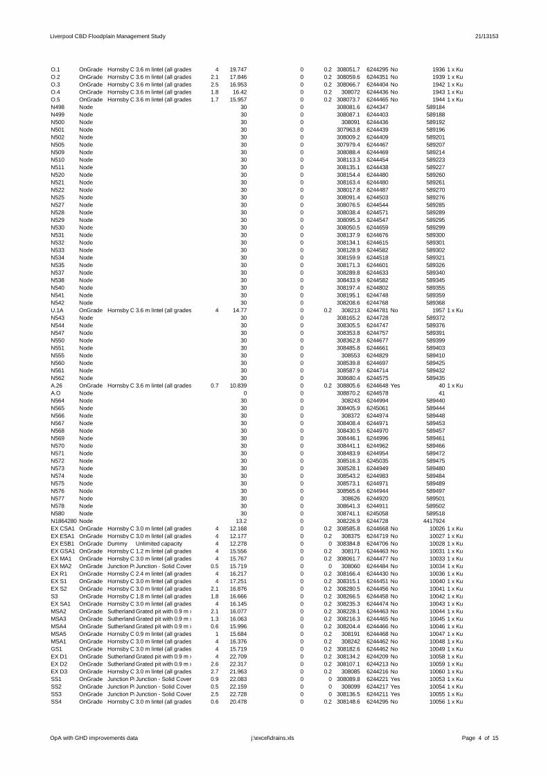
Liverpool CBD Floodplain Management Study 21/13153
O.1 OnGrade Hornsby Council Inlets (KI+grate), 3% crossfall, all grades3.6 m lintel (all grades) 4 19.747 0 0.2 308051.7 6244295 No 1936 1 x KuO.2 OnGrade Hornsby Council Inlets (KI+grate), 3% crossfall, all grades3.6 m lintel (all grades) 2.1 17.846 0 0.2 308059.6 6244351 No 1939 1 x KuO.3 OnGrade Hornsby Council Inlets (KI+grate), 3% crossfall, all grades3.6 m lintel (all grades) 2.5 16.953 0 0.2 308066.7 6244404 No 1942 1 x KuO.4 OnGrade Hornsby Council Inlets (KI+grate), 3% crossfall, all grades3.6 m lintel (all grades) 1.8 16.42 0 0.2 308072 6244436 No 1943 1 x KuO.5 OnGrade Hornsby Council Inlets (KI+grate), 3% crossfall, all grades3.6 m lintel (all grades) 1.7 15.957 0 0.2 308073.7 6244465 No 1944 1 x KuN498 Node 30 0 308081.6 6244347 589184N499 Node 30 0 308087.1 6244403 589188N500 Node 30 0 308091 6244436 589192N501 Node 30 0 307963.8 6244439 589196N502 Node 30 0 308009.2 6244409 589201N505 Node 30 0 307979.4 6244467 589207N509 Node 30 0 308088.4 6244469 589214N510 Node 30 0 308113.3 6244454 589223N511 Node 30 0 308135.1 6244438 589227N520 Node 30 0 308154.4 6244480 589260N521 Node 30 0 308163.4 6244480 589261N522 Node 30 0 308017.8 6244487 589270N525 Node 30 0 308091.4 6244503 589276N527 Node 30 0 308076.5 6244544 589285N528 Node 30 0 308038.4 6244571 589289N529 Node 30 0 308095.3 6244547 589295N530 Node 30 0 308050.5 6244659 589299N531 Node 30 0 308137.9 6244676 589300N532 Node 30 0 308134.1 6244615 589301N533 Node 30 0 308128.9 6244582 589302N534 Node 30 0 308159.9 6244518 589321N535 Node 30 0 308171.3 6244601 589326N537 Node 30 0 308289.8 6244633 589340N538 Node 30 0 308433.9 6244582 589345N540 Node 30 0 308197.4 6244802 589355N541 Node 30 0 308195.1 6244748 589359N542 Node 30 0 308208.6 6244768 589368U.1A OnGrade Hornsby Council Inlets (KI+grate), 3% crossfall, all grades3.6 m lintel (all grades) 4 14.77 0 0.2 308213 6244781 No 1957 1 x KuN543 Node 30 0 308165.2 6244728 589372N544 Node 30 0 308305.5 6244747 589376N547 Node 30 0 308353.8 6244757 589391N550 Node 30 0 308362.8 6244677 589399N551 Node 30 0 308485.8 6244661 589403N555 Node 30 0 308553 6244829 589410N560 Node 30 0 308539.8 6244697 589425N561 Node 30 0 308587.9 6244714 589432N562 Node 30 0 308680.4 6244575 589435A.26 OnGrade Hornsby Council Inlets (KI+grate), 3% crossfall, all grades3.6 m lintel (all grades) 0.7 10.839 0 0.2 308805.6 6244648 Yes 40 1 x KuA.O Node 0 0 308870.2 6244578 41N564 Node 30 0 308243 6244994 589440N565 Node 30 0 308405.9 6245061 589444N566 Node 30 0 308372 6244974 589448N567 Node 30 0 308408.4 6244971 589453N568 Node 30 0 308430.5 6244970 589457N569 Node 30 0 308446.1 6244996 589461N570 Node 30 0 308441.1 6244962 589466N571 Node 30 0 308483.9 6244954 589472N572 Node 30 0 308516.3 6245035 589475N573 Node 30 0 308528.1 6244949 589480N574 Node 30 0 308543.2 6244983 589484N575 Node 30 0 308573.1 6244971 589489N576 Node 30 0 308565.6 6244944 589497N577 Node 30 0 308626 6244920 589501N578 Node 30 0 308641.3 6244911 589502N580 Node 30 0 308741.1 6245058 589518N1864280 Node 13.2 0 308226.9 6244728 4417924EX CSA1 OnGrade Hornsby Council Inlets (KI+grate), 3% crossfall, all grades3.0 m lintel (all grades) 4 12.168 0 0.2 308585.8 6244668 No 10026 1 x KuEX ESA1 OnGrade Hornsby Council Inlets (KI+grate), 3% crossfall, all grades3.0 m lintel (all grades) 4 12.177 0 0.2 308375 6244719 No 10027 1 x KuEX ESB1 OnGrade Dummy Unlimited capacity 4 12.278 0 0 308384.8 6244706 No 10028 1 x KuEX GSA1 OnGrade Hornsby Council Inlets (KI+grate), 3% crossfall, all grades1.2 m lintel (all grades) 4 15.556 0 0.2 308171 6244463 No 10031 1 x KuEX MA1 OnGrade Hornsby Council Inlets (KI+grate), 3% crossfall, all grades3.0 m lintel (all grades) 4 15.767 0 0.2 308061.7 6244477 No 10033 1 x KuEX MA2 OnGrade Junction Pit Solid CoverJunction Solid Cover 0.5 15.719 0 0 308060 6244484 No 10034 1 x KuEX R1 OnGrade Hornsby Council Inlets (KI+grate), 3% crossfall, all grades2.4 m lintel (all grades) 4 16.217 0 0.2 308166.4 6244430 No 10036 1 x KuEX S1 OnGrade Hornsby Council Inlets (KI+grate), 3% crossfall, all grades3.0 m lintel (all grades) 4 17.251 0 0.2 308315.1 6244451 No 10040 1 x KuEX S2 OnGrade Hornsby Council Inlets (KI+grate), 3% crossfall, all grades3.0 m lintel (all grades) 2.1 16.876 0 0.2 308280.5 6244456 No 10041 1 x KuS3 OnGrade Hornsby Council Inlets (KI+grate), 3% crossfall, all grades1.8 m lintel (all grades) 1.8 16.666 0 0.2 308266.5 6244458 No 10042 1 x KuEX SA1 OnGrade Hornsby Council Inlets (KI+grate), 3% crossfall, all grades3.0 m lintel (all grades) 4 16.145 0 0.2 308235.3 6244474 No 10043 1 x KuMSA2 OnGrade Sutherland grated sag pit (sags only)Grated pit with 0.9 m x 0.45 m Durham cast iron grate2.1 16.077 0 0.2 308228.1 6244463 No 10044 1 x KuMSA3 OnGrade Sutherland grated sag pit (sags only)Grated pit with 0.9 m x 0.45 m Durham cast iron grate1.3 16.063 0 0.2 308216.3 6244465 No 10045 1 x KuMSA4 OnGrade Sutherland grated sag pit (sags only)Grated pit with 0.9 m x 0.45 m Durham cast iron grate0.6 15.996 0 0.2 308204.4 6244466 No 10046 1 x KuMSA5 OnGrade Hornsby Council Inlets (KI+grate), 3% crossfall, all grades0.9 m lintel (all grades) 1 15.684 0 0.2 308191 6244468 No 10047 1 x KuMSA1 OnGrade Hornsby Council Inlets (KI+grate), 3% crossfall, all grades3.0 m lintel (all grades) 4 16.376 0 0.2 308242 6244462 No 10048 1 x KuGS1 OnGrade Hornsby Council Inlets (KI+grate), 3% crossfall, all grades3.0 m lintel (all grades) 4 15.719 0 0.2 308182.6 6244462 No 10049 1 x KuEX D1 OnGrade Sutherland grated sag pit (sags only)Grated pit with 0.9 m x 0.45 m Durham cast iron grate4 22.709 0 0.2 308134.2 6244209 No 10058 1 x KuEX D2 OnGrade Sutherland grated sag pit (sags only)Grated pit with 0.9 m x 0.45 m Durham cast iron grate2.6 22.317 0 0.2 308107.1 6244213 No 10059 1 x KuEX D3 OnGrade Hornsby Council Inlets (KI+grate), 3% crossfall, all grades3.0 m lintel (all grades) 2.7 21.963 0 0.2 308085 6244216 No 10060 1 x KuSS1 OnGrade Junction Pit Solid CoverJunction Solid Cover 0.9 22.083 0 0 308089.8 6244221 Yes 10053 1 x KuSS2 OnGrade Junction Pit Solid CoverJunction Solid Cover 0.5 22.159 0 0 308099 6244217 Yes 10054 1 x KuSS3 OnGrade Junction Pit Solid CoverJunction Solid Cover 2.5 22.728 0 0 308136.5 6244211 Yes 10055 1 x KuSS4 OnGrade Hornsby Council Inlets (KI+grate), 3% crossfall, all grades3.0 m lintel (all grades) 0.6 20.478 0 0.2 308148.6 6244295 No 10056 1 x Ku
OpA with GHD improvements data Page 4 of 15j:\excel\drains.xls
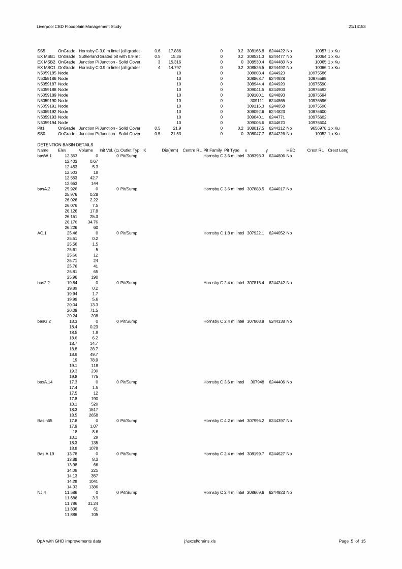
Liverpool CBD Floodplain Management Study 21/13153
SS5 OnGrade Hornsby Council Inlets (KI+grate), 3% crossfall, all grades3.0 m lintel (all grades) 0.6 17.886 0 0.2 308166.8 6244422 No 10057 1 x KuEX MSB1 OnGrade Sutherland grated sag pit (sags only)Grated pit with 0.9 m x 0.45 m Durham cast iron grate0.5 15.36 0 0.2 308531.3 6244477 No 10064 1 x KuEX MSB2 OnGrade Junction Pit Solid CoverJunction Solid Cover 3 15.316 0 0 308530.4 6244480 No 10065 1 x KuEX MSC1 OnGrade Hornsby Council Inlets (KI+grate), 3% crossfall, all grades0.9 m lintel (all grades) 4 14.797 0 0.2 308526.5 6244492 No 10066 1 x KuN5059185 Node 10 0 308808.4 6244923 10975586N5059186 Node 10 0 308863.7 6244928 10975589N5059187 Node 10 0 308944.4 6244920 10975590N5059188 Node 10 0 309041.5 6244903 10975592N5059189 Node 10 0 309100.1 6244893 10975594N5059190 Node 10 0 309111 6244865 10975596N5059191 Node 10 0 309116.3 6244858 10975598N5059192 Node 10 0 309092.6 6244823 10975600N5059193 Node 10 0 309040.1 6244771 10975602N5059194 Node 10 0 309005.6 6244670 10975604Pit1 OnGrade Junction Pit Solid CoverJunction Solid Cover 0.5 21.9 0 0.2 308017.5 6244212 No 9656978 1 x KuSS0 OnGrade Junction Pit Solid CoverJunction Solid Cover 0.5 21.53 0 0 308047.7 6244226 No 10052 1 x Ku
DETENTION BASIN DETAILSName Elev Volume Init Vol. (cu.m)Outlet Type K Dia(mm) Centre RL Pit Family Pit Type x y HED Crest RL Crest Length(m)basW.1 12.353 0 0 Pit/Sump Hornsby Council Inlets (KI+grate), 3% crossfall, all grades3.6 m lintel (all grades)308398.3 6244806 No
12.403 0.6712.453 5.312.503 1812.553 42.712.653 144
basA.2 25.926 0 0 Pit/Sump Hornsby Council Inlets (KI+grate), 3% crossfall, all grades3.6 m lintel (all grades)307888.5 6244017 No25.976 0.2826.026 2.2226.076 7.526.126 17.826.151 25.326.176 34.7626.226 60
AC.1 25.46 0 0 Pit/Sump Hornsby Council Inlets (KI+grate), 3% crossfall, all grades1.8 m lintel (all grades)307922.1 6244052 No25.51 0.225.56 1.525.61 525.66 1225.71 2425.76 4125.81 6525.96 190
bas2.2 19.84 0 0 Pit/Sump Hornsby Council Inlets (KI+grate), 3% crossfall, all grades2.4 m lintel (all grades)307815.4 6244242 No19.89 0.219.94 1.719.99 5.620.04 13.320.09 71.520.24 208
basG.2 18.3 0 0 Pit/Sump Hornsby Council Inlets (KI+grate), 3% crossfall, all grades2.4 m lintel (all grades)307808.8 6244338 No18.4 0.2318.5 1.818.6 6.218.7 14.718.8 28.718.9 49.7
19 78.919.1 11819.3 23019.8 775
basA.14 17.3 0 0 Pit/Sump Hornsby Council Inlets (KI+grate), 3% crossfall, all grades3.6 m lintel (all grades)307948 6244406 No17.4 1.517.5 1217.8 19018.1 52018.3 151718.5 2658
Basin65 17.8 0 0 Pit/Sump Hornsby Council Inlets (KI+grate), 3% crossfall, all grades4.2 m lintel (all grades)307996.2 6244397 No17.9 1.07
18 8.618.1 2918.3 13518.8 1078
Bas A.19 13.78 0 0 Pit/Sump Hornsby Council Inlets (KI+grate), 3% crossfall, all grades2.4 m lintel (all grades)308199.7 6244627 No13.88 8.313.98 6614.08 22514.13 35714.28 104114.33 1386
NJ.4 11.586 0 0 Pit/Sump Hornsby Council Inlets (KI+grate), 3% crossfall, all grades2.4 m lintel (all grades)308669.6 6244923 No11.686 3.911.786 31.2411.836 6111.886 105
OpA with GHD improvements data Page 5 of 15j:\excel\drains.xls
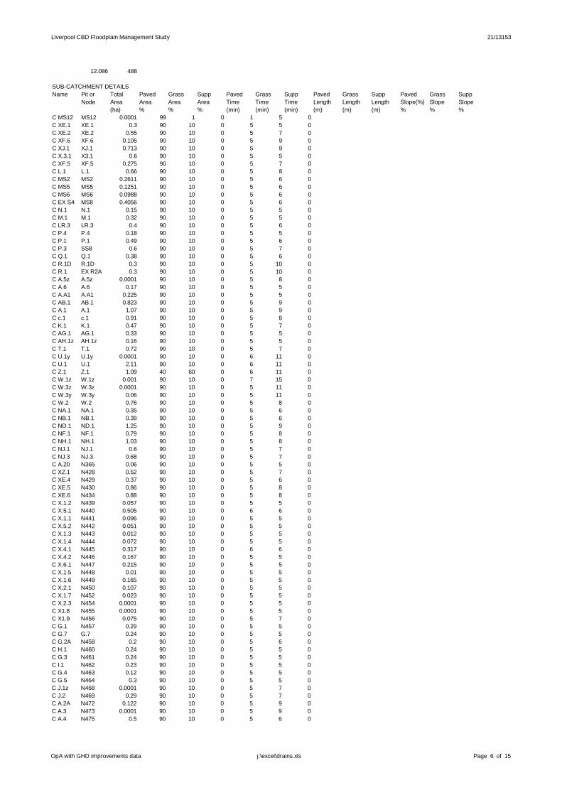
Liverpool CBD Floodplain Management Study 21/13153
12.086 488
SUBCATCHMENT DETAILSName Pit or Total Paved Grass Supp Paved Grass Supp Paved Grass Supp Paved Grass Supp
Node Area Area Area Area Time Time Time Length Length Length Slope(%) Slope Slope(ha) % % % (min) (min) (min) (m) (m) (m) % % %
C MS12 MS12 0.0001 99 1 0 1 5 0C XE.1 XE.1 0.3 90 10 0 5 5 0C XE.2 XE.2 0.55 90 10 0 5 7 0C XF.6 XF.6 0.105 90 10 0 5 9 0C XJ.1 XJ.1 0.713 90 10 0 5 9 0C X.3.1 X3.1 0.6 90 10 0 5 5 0C XF.5 XF.5 0.275 90 10 0 5 7 0C L.1 L.1 0.66 90 10 0 5 8 0C MS2 MS2 0.2611 90 10 0 5 6 0C MS5 MS5 0.1251 90 10 0 5 6 0C MS6 MS6 0.0988 90 10 0 5 6 0C EX S4 MS8 0.4056 90 10 0 5 6 0C N.1 N.1 0.15 90 10 0 5 5 0C M.1 M.1 0.32 90 10 0 5 5 0C LR.3 LR.3 0.4 90 10 0 5 6 0C P.4 P.4 0.18 90 10 0 5 5 0C P.1 P.1 0.49 90 10 0 5 6 0C P.3 SS8 0.6 90 10 0 5 7 0C Q.1 Q.1 0.38 90 10 0 5 6 0C R.1D R.1D 0.3 90 10 0 5 10 0C R.1 EX R2A 0.3 90 10 0 5 10 0C A.5z A.5z 0.0001 90 10 0 5 8 0C A.6 A.6 0.17 90 10 0 5 5 0C A.A1 A.A1 0.225 90 10 0 5 5 0C AB.1 AB.1 0.823 90 10 0 5 9 0C A.1 A.1 1.07 90 10 0 5 9 0C c.1 c.1 0.91 90 10 0 5 8 0C K.1 K.1 0.47 90 10 0 5 7 0C AG.1 AG.1 0.33 90 10 0 5 5 0C AH.1z AH.1z 0.16 90 10 0 5 5 0C T.1 T.1 0.72 90 10 0 5 7 0C U.1y U.1y 0.0001 90 10 0 6 11 0C U.1 U.1 2.11 90 10 0 6 11 0C Z.1 Z.1 1.09 40 60 0 6 11 0C W.1z W.1z 0.001 90 10 0 7 15 0C W.3z W.3z 0.0001 90 10 0 5 11 0C W.3y W.3y 0.06 90 10 0 5 11 0C W.2 W.2 0.76 90 10 0 5 8 0C NA.1 NA.1 0.35 90 10 0 5 6 0C NB.1 NB.1 0.39 90 10 0 5 6 0C ND.1 ND.1 1.25 90 10 0 5 9 0C NF.1 NF.1 0.79 90 10 0 5 8 0C NH.1 NH.1 1.03 90 10 0 5 8 0C NJ.1 NJ.1 0.6 90 10 0 5 7 0C NJ.3 NJ.3 0.68 90 10 0 5 7 0C A.20 N365 0.06 90 10 0 5 5 0C XZ.1 N428 0.52 90 10 0 5 7 0C XE.4 N429 0.37 90 10 0 5 6 0C XE.5 N430 0.86 90 10 0 5 8 0C XE.6 N434 0.88 90 10 0 5 8 0C X.1.2 N439 0.057 90 10 0 5 5 0C X.5.1 N440 0.505 90 10 0 6 6 0C X.1.1 N441 0.096 90 10 0 5 5 0C X.5.2 N442 0.051 90 10 0 5 5 0C X.1.3 N443 0.012 90 10 0 5 5 0C X.1.4 N444 0.072 90 10 0 5 5 0C X.4.1 N445 0.317 90 10 0 6 6 0C X.4.2 N446 0.167 90 10 0 5 5 0C X.6.1 N447 0.215 90 10 0 5 5 0C X.1.5 N448 0.01 90 10 0 5 5 0C X.1.6 N449 0.165 90 10 0 5 5 0C X.2.1 N450 0.107 90 10 0 5 5 0C X.1.7 N452 0.023 90 10 0 5 5 0C X.2.3 N454 0.0001 90 10 0 5 5 0C X1.8 N455 0.0001 90 10 0 5 5 0C X1.9 N456 0.075 90 10 0 5 7 0C G.1 N457 0.29 90 10 0 5 5 0C G.7 G.7 0.24 90 10 0 5 5 0C G.2A N458 0.2 90 10 0 5 6 0C H.1 N460 0.24 90 10 0 5 5 0C G.3 N461 0.24 90 10 0 5 5 0C I.1 N462 0.23 90 10 0 5 5 0C G.4 N463 0.12 90 10 0 5 5 0C G.5 N464 0.3 90 10 0 5 5 0C J.1z N468 0.0001 90 10 0 5 7 0C J.2 N469 0.29 90 10 0 5 7 0C A.2A N472 0.122 90 10 0 5 9 0C A.3 N473 0.0001 90 10 0 5 9 0C A.4 N475 0.5 90 10 0 5 6 0
OpA with GHD improvements data Page 6 of 15j:\excel\drains.xls
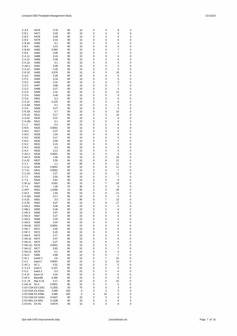
Liverpool CBD Floodplain Management Study 21/13153
C A.5 N476 0.78 90 10 0 5 8 0C B.1 N477 0.33 90 10 0 5 5 0C B.2 N478 0.29 90 10 0 5 5 0C B.3 N479 0.43 90 10 0 5 6 0C B.4A N480 0.1 90 10 0 5 5 0C B.4 N481 0.21 90 10 0 5 5 0C B.5A N482 0.092 90 10 0 5 7 0C B.5 N483 0.46 90 10 0 5 7 0C A.11 N488 0.24 90 10 0 5 5 0C A.12 N489 0.46 90 10 0 5 6 0C K.1A N490 0.1 90 10 0 5 5 0C AD.1 N491 0.08 90 10 0 5 5 0C A.13 N492 0.33 90 10 0 5 5 0C R.1C N493 0.076 90 10 0 5 10 0C Q.2 N494 0.35 90 10 0 5 6 0C P.2 N495 0.16 90 10 0 5 5 0C D.2 N496 0.31 90 10 0 5 5 0C O.1 N497 0.68 90 10 0 5 7 0C O.2 N498 0.27 90 10 0 5 5 0C O.3 N499 2.31 90 10 0 6 11 0C O.4 N500 0.48 90 10 0 5 6 0C G.6 N501 0.3 90 10 0 5 5 0C A.15 N502 0.225 90 10 0 5 8 0C G.6A N505 0.1 90 10 0 5 5 0C O.5 N509 0.27 90 10 0 5 5 0C R.1B N510 0.7 90 10 0 5 10 0C R.1A N511 0.17 90 10 0 5 10 0C A.18 N520 0.37 90 10 0 5 6 0C A.18z N521 0.1 90 10 0 5 6 0C L.2 N522 0.4 90 10 0 5 6 0C M.5 N525 0.0001 90 10 0 5 6 0C M.4 N527 0.37 90 10 0 5 6 0C M.3 N528 1.04 90 10 0 5 8 0C N.5 N529 0.17 90 10 0 5 5 0C M.2 N530 0.66 90 10 0 5 7 0C N.2 N531 0.15 90 10 0 5 5 0C N.3 N532 0.3 90 10 0 5 5 0C N.4 N533 0.21 90 10 0 5 5 0C AH.1 N534 0.0001 90 10 0 5 5 0C AH.2 N535 1.56 90 10 0 5 10 0C A.22 N537 2.55 90 10 0 6 12 0C V.1 N538 1.1 40 60 0 6 11 0C U.1z N540 0.0001 90 10 0 6 11 0C T.2z N541 0.0001 90 10 0 5 7 0C U.1A N542 0.27 90 10 0 6 11 0C T.2 N543 0.53 90 10 0 5 7 0C T.3 N544 0.81 90 10 0 5 9 0C W.1y N547 0.001 90 10 0 7 15 0C T.4 N550 1.35 70 30 0 5 9 0C AP7 N551 1.4458 10 90 0 5 20 0C W.3 N555 1.92 90 10 0 5 11 0C A.24z N560 0.17 90 10 0 5 5 0C A.25 N561 3.3 10 90 0 7 13 0C A.26 N562 6.07 90 10 0 8 17 0C NA.2 N564 0.09 90 10 0 5 5 0C NB.2 N565 0.46 90 10 0 5 6 0C NA.3 N566 0.97 90 10 0 5 8 0C NA.4 N567 0.27 90 10 0 5 5 0C NA.5 N568 0.33 90 10 0 5 5 0C NA.6 N569 0.24 90 10 0 5 5 0C NA.6z N570 0.0001 90 10 0 5 5 0C NA.7 N571 0.45 90 10 0 5 6 0C NF.2 N572 0.25 90 10 0 5 5 0C NA.9 N573 0.17 90 10 0 5 5 0C NA.10 N574 0.47 90 10 0 5 6 0C NA.11 N575 0.27 90 10 0 5 5 0C NA.11z N576 0.0001 90 10 0 5 5 0C NA.12 N577 0.63 90 10 0 5 7 0C NA.13 N578 0.1 90 10 0 5 5 0C NJ.2 N580 0.68 90 10 0 5 7 0C W.1 basW.1 4.8 90 10 0 7 15 0C A.2 basA.2 0.0001 90 10 0 5 10 0C AC.1 AC.1 0.31 90 10 0 5 5 0C X.2.2 bas2.2 0.137 90 10 0 5 5 0C G.2 basG.2 0.3 90 10 0 5 6 0C A.14 basA.14 0.19 90 10 0 5 5 0C AF.5 Basin65 0.495 90 10 0 5 8 0C A. 19 Bas A.19 0.17 90 10 0 5 10 0C NA.14 NJ.4 0.0001 90 10 0 5 5 0C EX CSA1EX CSA1 0.1932 30 70 0 5 3 0C EX ESA1EX ESA1 0.095 100 0 0 5 0 0C EX ESB1EX ESB1 0.665 100 0 0 10 0 0C EX GSA1EX GSA1 0.0247 90 10 0 5 6 0C EX MA1 EX MA1 0.1338 90 10 0 5 6 0C EX R1 EX R1 0.0579 90 10 0 5 6 0
OpA with GHD improvements data Page 7 of 15j:\excel\drains.xls
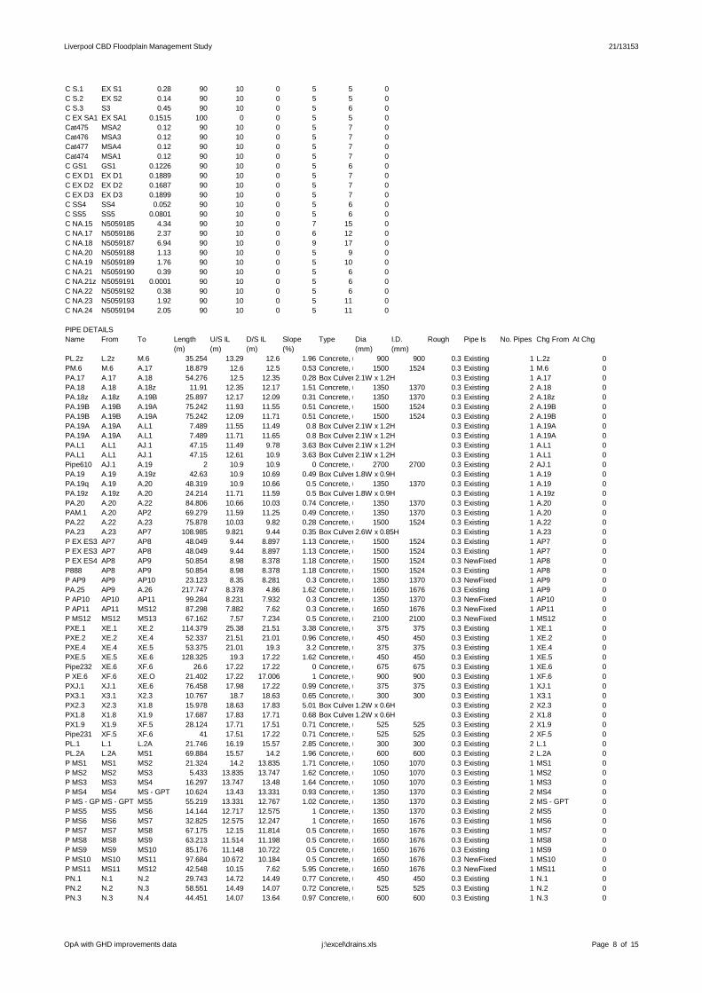
Liverpool CBD Floodplain Management Study 21/13153
C S.1 EX S1 0.28 90 10 0 5 5 0C S.2 EX S2 0.14 90 10 0 5 5 0C S.3 S3 0.45 90 10 0 5 6 0C EX SA1 EX SA1 0.1515 100 0 0 5 5 0Cat475 MSA2 0.12 90 10 0 5 7 0Cat476 MSA3 0.12 90 10 0 5 7 0Cat477 MSA4 0.12 90 10 0 5 7 0Cat474 MSA1 0.12 90 10 0 5 7 0C GS1 GS1 0.1226 90 10 0 5 6 0C EX D1 EX D1 0.1889 90 10 0 5 7 0C EX D2 EX D2 0.1687 90 10 0 5 7 0C EX D3 EX D3 0.1899 90 10 0 5 7 0C SS4 SS4 0.052 90 10 0 5 6 0C SS5 SS5 0.0801 90 10 0 5 6 0C NA.15 N5059185 4.34 90 10 0 7 15 0C NA.17 N5059186 2.37 90 10 0 6 12 0C NA.18 N5059187 6.94 90 10 0 9 17 0C NA.20 N5059188 1.13 90 10 0 5 9 0C NA.19 N5059189 1.76 90 10 0 5 10 0C NA.21 N5059190 0.39 90 10 0 5 6 0C NA.21z N5059191 0.0001 90 10 0 5 6 0C NA.22 N5059192 0.38 90 10 0 5 6 0C NA.23 N5059193 1.92 90 10 0 5 11 0C NA.24 N5059194 2.05 90 10 0 5 11 0
PIPE DETAILSName From To Length U/S IL D/S IL Slope Type Dia I.D. Rough Pipe Is No. Pipes Chg From At Chg
(m) (m) (m) (%) (mm) (mm)PL.2z L.2z M.6 35.254 13.29 12.6 1.96 Concrete, under roads900 900 0.3 Existing 1 L.2z 0PM.6 M.6 A.17 18.879 12.6 12.5 0.53 Concrete, under roads1500 1524 0.3 Existing 1 M.6 0PA.17 A.17 A.18 54.276 12.5 12.35 0.28 Box Culverts2.1W x 1.2H 0.3 Existing 1 A.17 0PA.18 A.18 A.18z 11.91 12.35 12.17 1.51 Concrete, under roads1350 1370 0.3 Existing 2 A.18 0PA.18z A.18z A.19B 25.897 12.17 12.09 0.31 Concrete, under roads1350 1370 0.3 Existing 2 A.18z 0PA.19B A.19B A.19A 75.242 11.93 11.55 0.51 Concrete, under roads1500 1524 0.3 Existing 2 A.19B 0PA.19B A.19B A.19A 75.242 12.09 11.71 0.51 Concrete, under roads1500 1524 0.3 Existing 2 A.19B 0PA.19A A.19A A.L1 7.489 11.55 11.49 0.8 Box Culverts2.1W x 1.2H 0.3 Existing 1 A.19A 0PA.19A A.19A A.L1 7.489 11.71 11.65 0.8 Box Culverts2.1W x 1.2H 0.3 Existing 1 A.19A 0PA.L1 A.L1 AJ.1 47.15 11.49 9.78 3.63 Box Culverts2.1W x 1.2H 0.3 Existing 1 A.L1 0PA.L1 A.L1 AJ.1 47.15 12.61 10.9 3.63 Box Culverts2.1W x 1.2H 0.3 Existing 1 A.L1 0Pipe610 AJ.1 A.19 2 10.9 10.9 0 Concrete, under roads2700 2700 0.3 Existing 2 AJ.1 0PA.19 A.19 A.19z 42.63 10.9 10.69 0.49 Box Culverts1.8W x 0.9H 0.3 Existing 1 A.19 0PA.19q A.19 A.20 48.319 10.9 10.66 0.5 Concrete, under roads1350 1370 0.3 Existing 1 A.19 0PA.19z A.19z A.20 24.214 11.71 11.59 0.5 Box Culverts1.8W x 0.9H 0.3 Existing 1 A.19z 0PA.20 A.20 A.22 84.806 10.66 10.03 0.74 Concrete, under roads1350 1370 0.3 Existing 1 A.20 0PAM.1 A.20 AP2 69.279 11.59 11.25 0.49 Concrete, under roads1350 1370 0.3 Existing 1 A.20 0PA.22 A.22 A.23 75.878 10.03 9.82 0.28 Concrete, under roads1500 1524 0.3 Existing 1 A.22 0PA.23 A.23 AP7 108.985 9.821 9.44 0.35 Box Culverts2.6W x 0.85H 0.3 Existing 1 A.23 0P EX ES3 AP7 AP8 48.049 9.44 8.897 1.13 Concrete, under roads1500 1524 0.3 Existing 1 AP7 0P EX ES3 AP7 AP8 48.049 9.44 8.897 1.13 Concrete, under roads1500 1524 0.3 Existing 1 AP7 0P EX ES4 AP8 AP9 50.854 8.98 8.378 1.18 Concrete, under roads1500 1524 0.3 NewFixed 1 AP8 0P888 AP8 AP9 50.854 8.98 8.378 1.18 Concrete, under roads1500 1524 0.3 Existing 1 AP8 0P AP9 AP9 AP10 23.123 8.35 8.281 0.3 Concrete, under roads1350 1370 0.3 NewFixed 1 AP9 0PA.25 AP9 A.26 217.747 8.378 4.86 1.62 Concrete, under roads1650 1676 0.3 Existing 1 AP9 0P AP10 AP10 AP11 99.284 8.231 7.932 0.3 Concrete, under roads1350 1370 0.3 NewFixed 1 AP10 0P AP11 AP11 MS12 87.298 7.882 7.62 0.3 Concrete, under roads1650 1676 0.3 NewFixed 1 AP11 0P MS12 MS12 MS13 67.162 7.57 7.234 0.5 Concrete, under roads2100 2100 0.3 NewFixed 1 MS12 0PXE.1 XE.1 XE.2 114.379 25.38 21.51 3.38 Concrete, under roads375 375 0.3 Existing 1 XE.1 0PXE.2 XE.2 XE.4 52.337 21.51 21.01 0.96 Concrete, under roads450 450 0.3 Existing 1 XE.2 0PXE.4 XE.4 XE.5 53.375 21.01 19.3 3.2 Concrete, under roads375 375 0.3 Existing 1 XE.4 0PXE.5 XE.5 XE.6 128.325 19.3 17.22 1.62 Concrete, under roads450 450 0.3 Existing 1 XE.5 0Pipe232 XE.6 XF.6 26.6 17.22 17.22 0 Concrete, under roads675 675 0.3 Existing 1 XE.6 0P XE.6 XF.6 XE.O 21.402 17.22 17.006 1 Concrete, under roads900 900 0.3 Existing 1 XF.6 0PXJ.1 XJ.1 XE.6 76.458 17.98 17.22 0.99 Concrete, under roads375 375 0.3 Existing 1 XJ.1 0PX3.1 X3.1 X2.3 10.767 18.7 18.63 0.65 Concrete, under roads300 300 0.3 Existing 1 X3.1 0PX2.3 X2.3 X1.8 15.978 18.63 17.83 5.01 Box Culverts1.2W x 0.6H 0.3 Existing 2 X2.3 0PX1.8 X1.8 X1.9 17.687 17.83 17.71 0.68 Box Culverts1.2W x 0.6H 0.3 Existing 2 X1.8 0PX1.9 X1.9 XF.5 28.124 17.71 17.51 0.71 Concrete, under roads525 525 0.3 Existing 2 X1.9 0Pipe231 XF.5 XF.6 41 17.51 17.22 0.71 Concrete, under roads525 525 0.3 Existing 2 XF.5 0PL.1 L.1 L.2A 21.746 16.19 15.57 2.85 Concrete, under roads300 300 0.3 Existing 2 L.1 0PL.2A L.2A MS1 69.884 15.57 14.2 1.96 Concrete, under roads600 600 0.3 Existing 2 L.2A 0P MS1 MS1 MS2 21.324 14.2 13.835 1.71 Concrete, under roads1050 1070 0.3 Existing 1 MS1 0P MS2 MS2 MS3 5.433 13.835 13.747 1.62 Concrete, under roads1050 1070 0.3 Existing 1 MS2 0P MS3 MS3 MS4 16.297 13.747 13.48 1.64 Concrete, under roads1050 1070 0.3 Existing 1 MS3 0P MS4 MS4 MS GPT 10.624 13.43 13.331 0.93 Concrete, under roads1350 1370 0.3 Existing 2 MS4 0P MS GPTMS GPT MS5 55.219 13.331 12.767 1.02 Concrete, under roads1350 1370 0.3 Existing 2 MS GPT 0P MS5 MS5 MS6 14.144 12.717 12.575 1 Concrete, under roads1350 1370 0.3 Existing 2 MS5 0P MS6 MS6 MS7 32.825 12.575 12.247 1 Concrete, under roads1650 1676 0.3 Existing 1 MS6 0P MS7 MS7 MS8 67.175 12.15 11.814 0.5 Concrete, under roads1650 1676 0.3 Existing 1 MS7 0P MS8 MS8 MS9 63.213 11.514 11.198 0.5 Concrete, under roads1650 1676 0.3 Existing 1 MS8 0P MS9 MS9 MS10 85.176 11.148 10.722 0.5 Concrete, under roads1650 1676 0.3 Existing 1 MS9 0P MS10 MS10 MS11 97.684 10.672 10.184 0.5 Concrete, under roads1650 1676 0.3 NewFixed 1 MS10 0P MS11 MS11 MS12 42.548 10.15 7.62 5.95 Concrete, under roads1650 1676 0.3 NewFixed 1 MS11 0PN.1 N.1 N.2 29.743 14.72 14.49 0.77 Concrete, under roads450 450 0.3 Existing 1 N.1 0PN.2 N.2 N.3 58.551 14.49 14.07 0.72 Concrete, under roads525 525 0.3 Existing 1 N.2 0PN.3 N.3 N.4 44.451 14.07 13.64 0.97 Concrete, under roads600 600 0.3 Existing 1 N.3 0
OpA with GHD improvements data Page 8 of 15j:\excel\drains.xls

Liverpool CBD Floodplain Management Study 21/13153
PN.4 N.4 N.5 29.956 13.64 13.28 1.2 Concrete, under roads675 675 0.3 Existing 1 N.4 0PN.5 N.5 M.5 39.731 13.28 12.63 1.64 Concrete, under roads750 750 0.3 Existing 1 N.5 0PM.5 M.5 M.6 6.663 12.63 12.6 0.45 Concrete, under roads1350 1370 0.3 Existing 1 M.5 0PM.1 M.1 M.2 53.249 14.73 14.28 0.85 Concrete, under roads525 525 0.3 Existing 1 M.1 0PM.2 M.2 M.3 99.314 14.28 13.61 0.67 Concrete, under roads750 750 0.3 Existing 1 M.2 0PM.3 M.3 M.4 12.779 13.61 13.51 0.78 Concrete, under roads1050 1070 0.3 Existing 1 M.3 0PM.4 M.4 M.5 36.172 13.51 12.63 2.43 Concrete, under roads1050 1070 0.3 Existing 1 M.4 0PLR.3 LR.3 M.4 49.57 14.2 13.51 1.39 Concrete, under roads300 300 0.3 Existing 1 LR.3 0PP.4 P.4 A.19B 2.424 12.12 12.09 1.24 Concrete, under roads750 750 0.3 Existing 1 P.4 0PP.1 P.1 P.2 22.596 18.78 17.91 3.85 Concrete, under roads375 375 0.3 Existing 1 P.1 0PP.2 P.2 SS7 127.212 17.91 12.45 4.29 Concrete, under roads525 525 0.3 Existing 1 P.2 0P SS7 SS7 SS GPT 8.118 12.439 12.358 1 Concrete, under roads1350 1370 0.3 Existing 1 SS7 0P SS GPTSS GPT SS8 7.63 12.358 12.282 1 Concrete, under roads1350 1370 0.3 Existing 1 SS GPT 0P SS8 SS8 MS7 11.584 12.262 12.146 1 Concrete, under roads1350 1370 0.3 Existing 1 SS8 0PQ.1 Q.1 Q.2 8.173 19.16 18.94 2.69 Concrete, under roads450 450 0.3 Existing 1 Q.1 0PQ.2 Q.2 P.2 39.909 18.94 17.91 2.58 Box Culverts0.6W x 0.3H 0.3 Existing 1 Q.2 0PR.1D R.1D R.1C 17.908 18.5 18 2.79 Concrete, under roads375 375 0.3 Existing 1 R.1D 0PR.1C R.1C R.1B 143.427 17.986 13.97 2.8 Concrete, under roads375 375 0.3 Existing 1 R.1C 0PR.1B R.1B R.1A 14.844 13.969 13.68 1.95 Concrete, under roads600 600 0.3 Existing 1 R.1B 0PR.1A R.1A EX R2A 29.416 13.671 13.1 1.94 Concrete, under roads600 600 0.3 Existing 1 R.1A 0P EX R2A EX R2A SS6 26 13.1 12.58 2 Concrete, under roads600 600 0.3 NewFixed 1 EX R2A 0P SS6 SS6 SS7 12.078 12.58 12.459 1 Concrete, under roads1200 1200 0.3 Existing 1 SS6 0PA.5z A.5z A.5 112.5 23.906 22.5 1.25 Concrete, under roads450 450 0.3 Existing 1 A.5z 0PA.5 A.5 A.6 169.681 22.5 20.36 1.26 Concrete, under roads450 450 0.3 Existing 1 A.5 0PA.6 A.6 A.6z 22.726 20.36 19.53 3.65 Concrete, under roads525 525 0.3 Existing 1 A.6 0PA.6z A.6z A.11 49.57 19.53 17.37 4.36 Concrete, under roads525 525 0.3 Existing 1 A.6z 0PA.11 A.11 A.12 16.981 17.73 17.17 3.3 Concrete, under roads825 825 0.3 Existing 1 A.11 0PA.12 A.12 A.12z 13.347 17.17 17.03 1.05 Concrete, under roads525 525 0.3 Existing 1 A.12 0PA.12z A.12z A.13 40.915 17.03 16.59 1.08 Concrete, under roads525 525 0.3 Existing 1 A.12z 0PA.13 A.13 A.14 111.092 16.59 15.4 1.07 Concrete, under roads525 525 0.3 Existing 2 A.13 0PA.14 A.14 A.15 58.382 15.4 14.56 1.44 Concrete, under roads1050 1070 0.3 Existing 1 A.14 0PA.15 A.15 EX A15A 99.302 14.56 13.62 0.95 Concrete, under roads1050 1070 0.3 Existing 1 A.15 0P EX A15AEX A15A EX A15B 16.901 13.62 13.47 0.89 Concrete, under roads1050 1070 0.3 Existing 1 EX A15A 0P EX A15BEX A15B MS4 3.744 13.467 13.43 0.99 Concrete, under roads1050 1070 0.3 NewFixed 1 EX A15B 0PAA.1 A.A1 A.2 52.867 24.76 24.48 0.53 Concrete, under roads375 375 0.3 Existing 1 A.A1 0PA.2 A.2 A.3 12.994 24.48 24.41 0.54 Concrete, under roads375 375 0.3 Existing 1 A.2 0PA.3 A.3 A.4 47.59 23.45 22.85 1.26 Concrete, under roads375 375 0.3 Existing 1 A.3 0PA.4 A.4 A.5 28.097 22.85 22.5 1.25 Concrete, under roads450 450 0.3 Existing 1 A.4 0PAB.1 AB.1 A.2 20.425 24.59 24.48 0.54 Concrete, under roads375 375 0.3 Existing 1 AB.1 0PA.1 A.1 A.2A 65.835 24.85 23.56 1.96 Concrete, under roads375 375 0.3 Existing 1 A.1 0PA.2A A.2A A.2 7.168 23.56 23.45 1.53 Concrete, under roads375 375 0.3 Existing 1 A.2A 0Pc.1 c.1 B.4A 101.388 24.098 21.29 2.77 Concrete, under roads375 375 0.3 Existing 1 c.1 0PB.4A B.4A B.4 43.389 21.29 20.65 1.48 Concrete, under roads525 525 0.3 Existing 1 B.4A 0PB.4 B.4 B.5A 10.924 20.65 20.49 1.46 Concrete, under roads525 525 0.3 Existing 1 B.4 0PB.5A B.5A B.5 15.127 20.49 20.41 0.53 Concrete, under roads525 525 0.3 Existing 1 B.5A 0PB.5 B.5 B.5z 14.866 20.41 19.99 2.83 Concrete, under roads525 525 0.3 Existing 1 B.5 0Pipe829 B.5 Pit1 10 20.41 19.65 7.6 Concrete, under roads1200 1200 0.3 Existing 1 B.5 0PB.5z B.5z A.6z 16.105 19.99 19.53 2.86 Concrete, under roads525 525 0.3 Existing 1 B.5z 0PJ.1 J.1 J.1z 19.455 17.11 16.82 1.49 Concrete, under roads900 900 0.3 Existing 1 J.1 0PJ.1z J.1z J.2 62.081 16.82 15.9 1.48 Concrete, under roads900 900 0.3 Existing 1 J.1z 0PJ.2 J.2 A.14 18.249 15.9 15.4 2.74 Concrete, under roads900 900 0.3 Existing 1 J.2 0PK.1 K.1 J.1z 14.845 18.08 17.78 2.02 Concrete, under roads450 450 0.3 Existing 1 K.1 0PAG.1 AG.1 A.15 37.92 15.71 15.52 0.5 Concrete, under roads375 375 0.3 Existing 1 AG.1 0PAH.1z AH.1z AH.1 59.775 11.81 11.51 0.5 Concrete, under roads750 750 0.3 Existing 1 AH.1z 0PAH.1 AH.1 AH.2 89.129 11.51 11.07 0.49 Concrete, under roads750 750 0.3 Existing 1 AH.1 0PAH.2 AH.2 AJ.1 33.115 11.07 10.9 0.51 Box Culverts1.2W x 0.6H 0.3 Existing 1 AH.2 0PT.1 T.1 T.2z 102.378 16.08 11.54 4.43 Concrete, under roads375 375 0.3 Existing 1 T.1 0PT.2z T.2z T.2 12.636 11.54 11.5 0.32 Concrete, under roads675 675 0.3 Existing 1 T.2z 0PT.2 T.2 AP2 84.779 11.5 11.25 0.29 Concrete, under roads675 675 0.3 Existing 2 T.2 0P AP2 AP2 AP GPT 46.7 11.25 10.863 0.83 Box Culverts2.1W x 0.9H 0.3 NewFixed 1 AP2 0P920 AP2 AP GPT 46.7 11.25 10.863 0.83 Concrete, under roads1350 1370 0.3 Existing 1 AP2 0P AP GPTAP GPT AP3 44.728 10.863 10.49 0.83 Box Culverts2.1W x 0.9H 0.3 NewFixed 1 AP GPT 0P925 AP GPT AP3 44.728 10.863 10.49 0.83 Concrete, under roads1350 1370 0.3 New 1 AP GPT 0P AP3 AP3 AP5 20 10.602 10.422 0.9 Box Culverts2.1W x 0.9H 0.3 NewFixed 1 AP3 0P929 AP3 AP5 20 10.486 10.306 0.9 Concrete, under roads1500 1524 0.3 New 1 AP3 0P EX ES1 AP5 AP6 22.055 10.24 9.969 1.23 Concrete, under roads1500 1524 0.3 Existing 1 AP5 0P EX ES1 AP5 AP6 22.055 10.24 9.969 1.23 Concrete, under roads1500 1524 0.3 Existing 1 AP5 0P EX ES2 AP6 AP7 64.952 9.969 9.44 0.81 Concrete, under roads1500 1524 0.3 NewFixed 1 AP6 0P958 AP6 AP7 64.952 9.969 9.44 0.81 Concrete, under roads1500 1524 0.3 Existing 1 AP6 0PU.1y U.1y U.1z 51.777 11.88 11.68 0.39 Concrete, under roads525 525 0.3 Existing 1 U.1y 0PU.1z U.1z U.1 29.969 11.68 11.57 0.37 Concrete, under roads525 525 0.3 Existing 1 U.1z 0PU.1 U.1 T.2z 7.478 11.57 11.54 0.4 Concrete, under roads675 675 0.3 Existing 2 U.1 0PZ.1 Z.1 V.1 172.364 13.81 11.52 1.33 Concrete, under roads450 450 0.3 Existing 1 Z.1 0PV.1 V.1 AP5 94.254 11.523 10.26 1.34 Concrete, under roads450 450 0.3 Existing 1 V.1 0PW.1z W.1z W.1 70.581 10.67 10.48 0.27 Concrete, under roads450 450 0.3 Existing 1 W.1z 0PW.1 W.1 W.1y 72.94 10.67 10.48 0.26 Concrete, under roads1050 1070 0.3 Existing 2 W.1 0PW.1y W.1y AP6 44.524 10.477 9.965 1.15 Concrete, under roads1050 1070 0.3 Existing 2 W.1y 0PW.3z W.3z W.3 56.25 10.79 10.45 0.6 Concrete, under roads450 450 0.3 Existing 1 W.3z 0PW.3 W.3 W.3y 9.674 10.45 10.39 0.62 Concrete, under roads1050 1070 0.3 Existing 1 W.3 0PW.3y W.3y EX ESF1 104.959 10.39 9.75 0.61 Concrete, under roads1050 1070 0.3 Existing 1 W.3y 0P EX ESF1EX ESF1 AP8 34.607 9.756 9.4 1.03 Concrete, under roads1200 1200 0.3 Existing 1 EX ESF1 0PW.2 W.2 W.3 52.747 10.67 10.45 0.42 Concrete, under roads525 525 0.3 Existing 1 W.2 0PNA.1 NA.1 NA.2 15.622 14.52 14.31 1.34 Concrete, under roads375 375 0.3 Existing 1 NA.1 0PNA.2 NA.2 NA.3 134.498 14.31 12.12 1.63 Concrete, under roads375 375 0.3 Existing 1 NA.2 0PNA.3 NA.3 NA.4 28.433 11.836 11.551 1 Concrete, under roads750 750 0.3 New 2 NA.3 0
OpA with GHD improvements data Page 9 of 15j:\excel\drains.xls

Liverpool CBD Floodplain Management Study 21/13153
PNA.4 NA.4 NA.5 15.821 11.322 11.164 1 Concrete, under roads1050 1070 0.3 New 2 NA.4 0PNA.5 NA.5 NA.6 14.295 10.224 10.081 1 Concrete, under roads1350 1370 0.3 New 2 NA.5 0PNA.6 NA.6 NA.6z 8.995 9.876 9.786 1 Concrete, under roads1500 1524 0.3 New 2 NA.6 0PNA.6z NA.6z NA.7 47.931 9.756 9.277 1 Concrete, under roads1350 1370 0.3 Existing 1 NA.6z 0PNA.7 NA.7 NA.9 49.212 9.247 8.755 1 Concrete, under roads1500 1524 0.3 New 2 NA.7 0PNA.9 NA.9 NA.10 9.383 8.725 8.631 1 Concrete, under roads1650 1676 0.3 New 2 NA.9 0PNA.10 NA.10 NA.11 13.397 8.601 8.467 1 Concrete, under roads1650 1676 0.3 New 2 NA.10 0PNA.11 NA.11 NA.11z 11.214 8.437 8.325 1 Concrete, under roads1650 1676 0.3 New 2 NA.11 0PNA.11z NA.11z NA.12 83.003 8.295 7.465 1 Concrete, under roads1650 1676 0.3 New 2 NA.11z 0PNA.12 NA.12 NA.13 12.561 7.435 7.309 1 Concrete, under roads1800 1800 0.3 New 2 NA.12 0PNA.13 NA.13 Pit22 15.586 7.279 7.05 1.47 Concrete, under roads1800 1800 0.3 New 2 NA.13 0PNA.14 Pit22 NA.15 140.153 5.866 4.464 1 Concrete, under roads1800 1800 0.3 New 2 Pit22 0PNA.15 NA.15 NA.17 55.186 4.434 3.882 1 Concrete, under roads1800 1800 0.3 New 2 NA.15 0PNA.17 NA.17 NA.18 82.044 3.852 3.032 1 Concrete, under roads1800 1800 0.3 New 2 NA.17 0PNA.18 NA.18 NA.20 104.377 3.002 1.958 1 Concrete, under roads1800 1800 0.3 New 2 NA.18 0PNA.20 NA.20 NA.19 56.129 1.928 1.367 1 Concrete, under roads1800 1800 0.3 New 2 NA.20 0PNA.19 NA.19 NA.21 6.043 1.337 1.276 1 Concrete, under roads2700 2700 0.3 New 2 NA.19 0PNA.21 NA.21 NA.21z 8.677 1.246 1.159 1 Concrete, under roads2700 2700 0.3 New 2 NA.21 0PNA.21z NA.21z NA.22 43.367 1.129 0.696 1 Concrete, under roads2700 2700 0.3 New 2 NA.21z 0PNA.22 NA.22 NA.23 75.109 0.666 0.085 1 Concrete, under roads2700 2700 0.3 New 2 NA.22 0PNA.23 NA.23 NA.24 123.299 0.115 1.348 1 Concrete, under roads2700 2700 0.3 New 2 NA.23 0PNA.24 NA.24 NA.24z 36.54 1.378 1.744 1 Concrete, under roads2700 2700 0.3 New 2 NA.24 0PNA.24z NA.24z N.AO 27.25 1.774 2.046 1 Concrete, under roads2700 2700 0.3 New 2 NA.24z 0PNB.1 NB.1 NB.2 8.178 14.89 14.87 0.24 Concrete, under roads375 375 0.3 Existing 1 NB.1 0PNB.2 NB.2 NA.3 69.96 14.87 12.12 3.93 Concrete, under roads375 375 0.3 Existing 1 NB.2 0PND.1 ND.1 NA.5 83.856 14.14 11.22 3.48 Concrete, under roads375 375 0.3 Existing 1 ND.1 0PNF.1 NF.1 NF.2 52.091 13.7 12.38 2.53 Concrete, under roads375 375 0.3 Existing 1 NF.1 0PNF.2 NF.2 NA.7 57.567 12.38 10.21 3.77 Concrete, under roads450 450 0.3 Existing 1 NF.2 0PNH.1 NH.1 NA.11 87.431 12.82 8.84 4.55 Concrete, under roads375 375 0.3 Existing 1 NH.1 0PNJ.1 NJ.1 NJ.2 52.447 10.48 9.61 1.66 Concrete, under roads375 375 0.3 Existing 1 NJ.1 0PNJ.2 NJ.2 NJ.3 98.957 9.61 7.57 2.06 Concrete, under roads450 450 0.3 Existing 1 NJ.2 0PNJ.3 NJ.3 Pit22 28.657 7.57 7.06 1.78 Concrete, under roads600 600 0.3 Existing 1 NJ.3 0Pipe264 N365 A.20 10 29.065 12.534 165.31 Concrete, under roads300 300 0.3 New 1 N365 0Pipe268 N428 XZ.1 10 29.065 25.991 30.74 Concrete, under roads300 300 0.3 New 1 N428 0PXZ.1 XZ.1 XE.4 56.471 22.88 21.01 3.31 Concrete, under roads375 375 0.3 Existing 1 XZ.1 0P271 N429 XE.4 10 29.065 23.969 50.96 Concrete, under roads300 300 0.3 New 1 N429 0Pipe288 N430 XE.5 10 29.065 22.379 66.86 Concrete, under roads300 300 0.3 New 1 N430 0Pipe290 N434 XE.6 10 29.065 20.132 89.33 Concrete, under roads300 300 0.3 New 1 N434 0Pipe292 N439 X1.2 10 29.065 21.379 76.86 Concrete, under roads300 300 0.3 New 1 N439 0PX1.2 X1.2 X1.3 21.707 18.96 18.74 1.01 Concrete, under roads375 375 0.3 Existing 1 X1.2 0PX1.3 X1.3 X1.4 35.738 18.74 18.38 1.01 Concrete, under roads375 375 0.3 Existing 1 X1.3 0PX1.4 X1.4 X1.5 23.67 18.62 18.38 1.01 Concrete, under roads375 375 0.3 Existing 1 X1.4 0PX1.5 X1.5 X1.6 22.214 18.38 18.16 0.99 Concrete, under roads525 525 0.3 Existing 1 X1.5 0PX1.6 X1.6 X1.7 21.695 18.16 17.94 1.01 Concrete, under roads525 525 0.3 Existing 1 X1.6 0PX1.7 X1.7 X1.8 16.284 17.94 17.83 0.68 Box Culverts1.2W x 0.6H 0.3 Existing 2 X1.7 0Pipe294 N440 X5.1 10 29.065 21.407 76.58 Concrete, under roads300 300 0.3 New 1 N440 0PX5.1 X5.1 X5.2 9.313 19.08 18.99 0.97 Concrete, under roads375 375 0.3 Existing 1 X5.1 0PX5.2 X5.2 X1.3 12.328 18.99 18.74 2.03 Concrete, under roads375 375 0.3 Existing 1 X5.2 0Pipe296 N441 X1.1 10 29.065 20.802 82.63 Concrete, under roads300 300 0.3 New 1 N441 0PX1.1 X1.1 X1.2 22.876 19.19 18.96 1.01 Concrete, under roads375 375 0.3 Existing 1 X1.1 0Pipe298 N442 X5.2 10 29.065 21.206 78.59 Concrete, under roads300 300 0.3 New 1 N442 0Pipe300 N443 X1.3 10 29.065 21.056 80.09 Concrete, under roads300 300 0.3 New 1 N443 0Pipe302 N444 X1.4 10 29.065 20.305 87.6 Concrete, under roads300 300 0.3 New 1 N444 0P305 N445 X4.1 10 29.065 20.323 87.42 Concrete, under roads300 300 0.3 New 1 N445 0PX4.1 X4.1 X4.2 14.307 18.85 18.57 1.96 Concrete, under roads375 375 0.3 Existing 1 X4.1 0PX4.2 X4.2 X1.5 9.315 18.57 18.38 2.04 Concrete, under roads450 450 0.3 Existing 1 X4.2 0P309 N446 X4.2 10 29.065 19.939 91.26 Concrete, under roads300 300 0.3 New 1 N446 0P316 N447 X6.1 10 29.065 19.747 93.18 Concrete, under roads300 300 0.3 New 1 N447 0PX6.1 X6.1 X1.5 15.649 18.54 18.38 1.02 Concrete, under roads375 375 0.3 Existing 1 X6.1 0Pipe322 N448 X1.5 10 29.065 19.725 93.4 Concrete, under roads300 300 0.3 New 1 N448 0Pipe325 N449 X1.6 10 29.065 19.443 96.22 Concrete, under roads300 300 0.3 New 1 N449 0Pipe327 N450 X2.1 10 29.065 19.076 99.89 Concrete, under roads300 300 0.3 New 1 N450 0PX2.1 X2.1 X 2.2 15.219 18.81 18.7 0.72 Concrete, under roads375 375 0.3 Existing 1 X2.1 0PX2.2 X 2.2 X2.3 10.851 18.7 18.63 0.65 Concrete, under roads375 375 0.3 Existing 1 X 2.2 0Pipe331 N452 X1.7 10 29.065 19.054 100.11 Concrete, under roads300 300 0.3 New 1 N452 0Pipe333 N454 X2.3 10 29.065 18.63 104.35 Concrete, under roads300 300 0.3 New 1 N454 0Pipe335 N455 X1.8 10 29.065 18.816 102.49 Concrete, under roads300 300 0.3 New 1 N455 0Pipe337 N456 X1.9 10 29.065 18.776 102.89 Concrete, under roads300 300 0.3 New 1 N456 0Pipe339 N457 G.1 10 29.065 18.417 106.48 Concrete, under roads300 300 0.3 New 1 N457 0PG.1 G.1 G.2A 38.521 17.67 17.45 0.57 Concrete, under roads375 375 0.3 Existing 1 G.1 0PG.2A G.2A G.2 20.512 17.45 17.34 0.54 Concrete, under roads375 375 0.3 Existing 1 G.2A 0PG.2 G.2 G.2z 12.678 17.34 17.21 1.03 Concrete, under roads525 525 0.3 Existing 1 G.2 0PG.2z G.2z G.3 73.467 17.21 16.79 0.57 Concrete, under roads375 375 0.3 Existing 1 G.2z 0PG.3 G.3 G.4 25.195 16.79 16.48 1.23 Concrete, under roads525 525 0.3 Existing 1 G.3 0PG.4 G.4 G.5 53.402 16.48 16.13 0.66 Concrete, under roads600 600 0.3 Existing 1 G.4 0PG.5 G.5 G.6 44.215 16.13 15.82 0.7 Concrete, under roads600 600 0.3 Existing 1 G.5 0PG.6 G.6 G.6A 46.164 15.82 15.7 0.26 Concrete, under roads825 825 0.3 Existing 1 G.6 0PG.6A G.6A G.7 34.962 15.7 15.61 0.26 Concrete, under roads825 825 0.3 Existing 1 G.6A 0PG.7 G.7 L.2A 16.349 15.61 15.57 0.24 Concrete, under roads900 900 0.3 Existing 1 G.7 0Pipe341 N458 G.2A 10 29.065 18.214 108.51 Concrete, under roads300 300 0.3 New 1 N458 0Pipe346 N460 H.1 10 29.065 18.165 109 Concrete, under roads300 300 0.3 New 1 N460 0PH.1 H.1 G.2 18.52 17.56 17.34 1.19 Concrete, under roads375 375 0.3 Existing 1 H.1 0Pipe348 N461 G.3 10 29.065 17.862 112.03 Concrete, under roads300 300 0.3 New 1 N461 0Pipe350 N462 I.1 10 29.065 17.92 111.45 Concrete, under roads300 300 0.3 New 1 N462 0PI.1 I.1 G.3 14.196 18.07 16.79 9.02 Concrete, under roads375 375 0.3 Existing 1 I.1 0
OpA with GHD improvements data Page 10 of 15j:\excel\drains.xls

Liverpool CBD Floodplain Management Study 21/13153
Pipe352 N463 G.4 10 29.065 17.636 114.29 Concrete, under roads300 300 0.3 New 1 N463 0Pipe354 N464 G.5 10 29.065 17.238 118.27 Concrete, under roads300 300 0.3 New 1 N464 0Pipe356 N468 J.1z 10 29.065 17.637 114.28 Concrete, under roads300 300 0.3 New 1 N468 0Pipe358 N469 J.2 10 29.065 16.733 123.32 Concrete, under roads300 300 0.3 New 1 N469 0Pipe364 N472 A.2A 10 29.065 25.031 40.34 Concrete, under roads300 300 0.3 New 1 N472 0Pipe366 N473 A.3 10 29.065 24.641 44.24 Concrete, under roads300 300 0.3 New 1 N473 0Pipe370 N475 A.4 10 29.065 23.126 59.39 Concrete, under roads300 300 0.3 New 1 N475 0Pipe372 N476 A.5 10 29.065 22.5 65.65 Concrete, under roads300 300 0.3 New 1 N476 0Pipe374 N477 B.1 10 29.065 22.27 67.95 Concrete, under roads300 300 0.3 New 1 N477 0PB.1 B.1 B.2 13.814 21.71 21.57 1.01 Concrete, under roads300 300 0.3 Existing 1 B.1 0PB.2 B.2 B.3 23.481 21.57 21.41 0.68 Concrete, under roads375 375 0.3 Existing 1 B.2 0PB.3 B.3 B.4A 28.544 21.41 21.29 0.42 Concrete, under roads450 450 0.3 Existing 1 B.3 0Pipe376 N478 B.2 10 29.065 22.062 70.03 Concrete, under roads300 300 0.3 New 1 N478 0Pipe378 N479 B.3 10 29.065 21.757 73.08 Concrete, under roads300 300 0.3 New 1 N479 0Pipe380 N480 B.4A 10 29.065 21.517 75.48 Concrete, under roads300 300 0.3 New 1 N480 0Pipe382 N481 B.4 10 29.065 21.096 79.69 Concrete, under roads300 300 0.3 New 1 N481 0Pipe384 N482 B.5A 10 29.065 21.149 79.16 Concrete, under roads300 300 0.3 New 1 N482 0Pipe386 N483 B.5 10 29.065 21.037 80.28 Concrete, under roads300 300 0.3 New 1 N483 0Pipe388 N488 A.11 10 29.065 19.389 96.76 Concrete, under roads300 300 0.3 New 1 N488 0Pipe390 N489 A.12 10 29.065 19.185 98.8 Concrete, under roads300 300 0.3 New 1 N489 0Pipe392 N490 K.1A 10 29.065 18.799 102.66 Concrete, under roads300 300 0.3 New 1 N490 0PK.1A K.1A A.12z 31.436 18.3 17.99 0.99 Concrete, under roads750 750 0.3 Existing 1 K.1A 0Pipe394 N491 AD.1 10 29.065 17.609 114.56 Concrete, under roads300 300 0.3 New 1 N491 0PAD.1 AD.1 A.13 11.14 17.66 17.55 0.99 Concrete, under roads375 375 0.3 Existing 1 AD.1 0Pipe396 N492 A.13 10 29.065 17.6 114.65 Concrete, under roads300 300 0.3 New 1 N492 0Pipe398 N493 R.1C 10 29.065 19.416 96.49 Concrete, under roads300 300 0.3 New 1 N493 0Pipe400 N494 Q.2 10 29.065 20.174 88.91 Concrete, under roads300 300 0.3 New 1 N494 0Pipe402 N495 P.2 10 29.065 18.694 103.71 Concrete, under roads300 300 0.3 New 1 N495 0Pipe404 N496 D.2 10 29.065 20.754 83.11 Concrete, under roads300 300 0.3 New 1 N496 0PD.2 D.2 B.5 59.313 20.89 20 1.5 Concrete, under roads525 525 0.3 Existing 1 D.2 0Pipe406 N497 O.1 10 29.065 18.812 102.53 Concrete, under roads300 300 0.3 New 1 N497 0PO.1 O.1 O.2 56.54 17.44 15.6 3.25 Concrete, under roads450 450 0.3 Existing 1 O.1 0PO.2 O.2 O.3 53.559 15.6 14.3 2.43 Concrete, under roads450 450 0.3 Existing 1 O.2 0PO.3 O.3 O.4 32.793 14.3 13.96 1.04 Concrete, under roads900 900 0.3 Existing 1 O.3 0PO.4 O.4 O.5 28.422 13.96 13.64 1.13 Concrete, under roads900 900 0.3 Existing 1 O.4 0PO.5 O.5 MS4 25.582 13.64 13.48 0.63 Concrete, under roads900 900 0.3 Existing 1 O.5 0Pipe408 N498 O.2 10 29.065 16.911 121.54 Concrete, under roads300 300 0.3 New 1 N498 0Pipe410 N499 O.3 10 29.065 16.018 130.47 Concrete, under roads300 300 0.3 New 1 N499 0Pipe412 N500 O.4 10 29.065 15.485 135.8 Concrete, under roads300 300 0.3 New 1 N500 0Pipe414 N501 G.6 10 29.065 16.917 121.48 Concrete, under roads300 300 0.3 New 1 N501 0Pipe416 N502 A.15 10 29.065 16.126 129.39 Concrete, under roads300 300 0.3 New 1 N502 0Pipe418 N505 G.6A 10 29.065 17.641 114.24 Concrete, under roads300 300 0.3 New 1 N505 0Pipe420 N509 O.5 10 29.065 15.022 140.43 Concrete, under roads300 300 0.3 New 1 N509 0Pipe422 N510 R.1B 10 29.065 15.541 135.24 Concrete, under roads300 300 0.3 New 1 N510 0Pipe424 N511 R.1A 10 29.065 15.306 137.59 Concrete, under roads300 300 0.3 New 1 N511 0Pipe440 N520 A.18 10 29.065 14.367 146.98 Concrete, under roads300 300 0.3 New 1 N520 0P443 N521 A.18z 10 29.065 14.396 146.69 Concrete, under roads300 300 0.3 New 1 N521 0Pipe446 N522 MS1 10 29.065 15.361 137.04 Concrete, under roads300 300 0.3 New 1 N522 0Pipe448 N525 M.5 10 29.065 14.929 141.36 Concrete, under roads300 300 0.3 New 1 N525 0Pipe454 N527 M.4 10 29.065 14.978 140.87 Concrete, under roads300 300 0.3 New 1 N527 0Pipe456 N528 M.3 10 29.065 15.065 140 Concrete, under roads300 300 0.3 New 1 N528 0Pipe460 N529 N.5 10 29.065 15.065 140 Concrete, under roads300 300 0.3 New 1 N529 0P467 N530 M.2 10 29.065 15.707 133.58 Concrete, under roads300 300 0.3 New 1 N530 0P466 N531 N.2 10 29.065 15.489 135.76 Concrete, under roads300 300 0.3 New 1 N531 0P465 N532 N.3 10 29.065 15.373 136.92 Concrete, under roads300 300 0.3 New 1 N532 0Pipe462 N533 N.4 10 29.065 15.065 140 Concrete, under roads300 300 0.3 New 1 N533 0Pipe476 N534 AH.1 10 29.065 14.278 147.87 Concrete, under roads300 300 0.3 New 1 N534 0Pipe478 N535 AH.2 10 29.065 13.036 160.29 Concrete, under roads300 300 0.3 New 1 N535 0Pipe484 N537 A.22 10 29.065 12.434 166.31 Concrete, under roads300 300 0.3 New 1 N537 0Pipe486 N538 V.1 10 29.065 12.544 165.21 Concrete, under roads300 300 0.3 New 1 N538 0Pipe492 N540 U.1z 10 29.065 14.288 147.77 Concrete, under roads300 300 0.3 New 1 N540 0Pipe494 N541 T.2z 10 29.065 13.488 155.77 Concrete, under roads300 300 0.3 New 1 N541 0Pipe497 N542 U.1A 10 29.065 13.835 152.3 Concrete, under roads300 300 0.3 New 1 N542 0PU.1A U.1A U.1z 18.271 11.75 11.68 0.38 Concrete, under roads525 525 0.3 Existing 1 U.1A 0Pipe499 N543 T.2 10 29.065 13.047 160.18 Concrete, under roads300 300 0.3 New 1 N543 0Pipe501 N544 AP2 10 29.065 11.879 171.86 Concrete, under roads300 300 0.3 New 1 N544 0Pipe507 N547 W.1y 10 29.065 11.179 178.86 Concrete, under roads300 300 0.3 New 1 N547 0Pipe509 N550 AP5 10 29.065 11.332 177.33 Concrete, under roads300 300 0.3 New 1 N550 0Pipe511 N551 AP7 10 29.065 10.957 181.08 Concrete, under roads300 300 0.3 New 1 N551 0Pipe513 N555 W.3 10 29.065 11.054 180.11 Concrete, under roads300 300 0.3 New 1 N555 0Pipe519 N560 AP8 10 29.065 11.051 180.14 Concrete, under roads300 300 0.3 New 1 N560 0Pipe521 N561 AP9 10 29.065 11.248 178.17 Concrete, under roads300 300 0.3 New 1 N561 0Pipe523 N562 A.26 10 28.99 9.829 191.61 Concrete, under roads375 375 0.3 New 1 N562 0PA.26 A.26 A.O 95.217 4.86 3.778 1.14 Concrete, under roads1650 1676 0.3 Existing 1 A.26 0Pipe525 N564 NA.2 10 29.065 16.506 125.59 Concrete, under roads300 300 0.3 New 1 N564 0Pipe527 N565 NB.2 10 29.065 15.947 131.18 Concrete, under roads300 300 0.3 New 1 N565 0Pipe529 N566 NA.3 10 29.065 14.695 143.7 Concrete, under roads300 300 0.3 New 1 N566 0Pipe532 N567 NA.4 10 29.065 14.539 145.26 Concrete, under roads300 300 0.3 New 1 N567 0Pipe534 N568 NA.5 10 29.065 14.832 142.33 Concrete, under roads300 300 0.3 New 1 N568 0Pipe536 N569 NA.6 10 29.065 14.843 142.22 Concrete, under roads300 300 0.3 New 1 N569 0Pipe539 N570 NA.6z 10 29.065 14.89 141.75 Concrete, under roads300 300 0.3 New 1 N570 0Pipe542 N571 NA.7 10 29.065 14.372 146.93 Concrete, under roads300 300 0.3 New 1 N571 0Pipe544 N572 NF.2 10 29.065 15.628 134.37 Concrete, under roads300 300 0.3 New 1 N572 0Pipe546 N573 NA.9 10 29.065 13.67 153.95 Concrete, under roads300 300 0.3 New 1 N573 0Pipe549 N574 NA.10 10 29.065 13.734 153.31 Concrete, under roads300 300 0.3 New 1 N574 0
OpA with GHD improvements data Page 11 of 15j:\excel\drains.xls
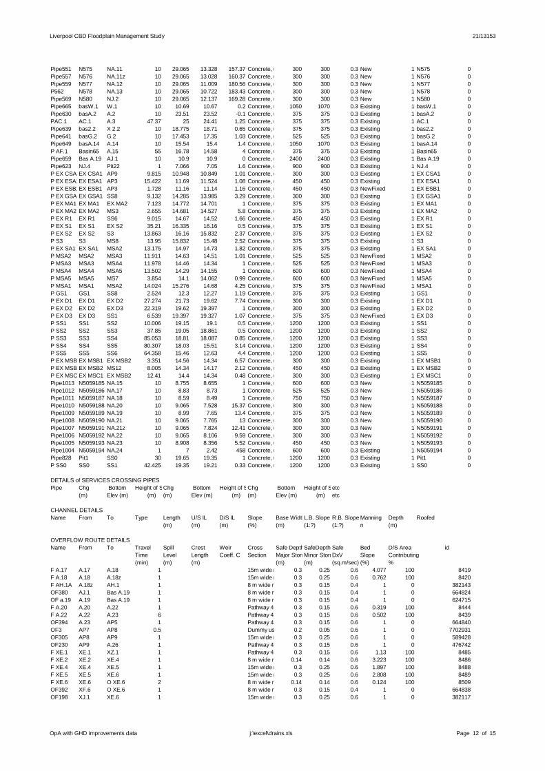
Liverpool CBD Floodplain Management Study 21/13153
Pipe551 N575 NA.11 10 29.065 13.328 157.37 Concrete, under roads300 300 0.3 New 1 N575 0Pipe557 N576 NA.11z 10 29.065 13.028 160.37 Concrete, under roads300 300 0.3 New 1 N576 0Pipe559 N577 NA.12 10 29.065 11.009 180.56 Concrete, under roads300 300 0.3 New 1 N577 0P562 N578 NA.13 10 29.065 10.722 183.43 Concrete, under roads300 300 0.3 New 1 N578 0Pipe569 N580 NJ.2 10 29.065 12.137 169.28 Concrete, under roads300 300 0.3 New 1 N580 0Pipe665 basW.1 W.1 10 10.69 10.67 0.2 Concrete, under roads1050 1070 0.3 Existing 1 basW.1 0Pipe630 basA.2 A.2 10 23.51 23.52 0.1 Concrete, under roads375 375 0.3 Existing 1 basA.2 0PAC.1 AC.1 A.3 47.37 25 24.41 1.25 Concrete, under roads375 375 0.3 Existing 1 AC.1 0Pipe639 bas2.2 X 2.2 10 18.775 18.71 0.65 Concrete, under roads375 375 0.3 Existing 1 bas2.2 0Pipe641 basG.2 G.2 10 17.453 17.35 1.03 Concrete, under roads525 525 0.3 Existing 1 basG.2 0Pipe649 basA.14 A.14 10 15.54 15.4 1.4 Concrete, under roads1050 1070 0.3 Existing 1 basA.14 0P AF.1 Basin65 A.15 55 16.78 14.58 4 Concrete, under roads375 375 0.3 Existing 1 Basin65 0Pipe659 Bas A.19 AJ.1 10 10.9 10.9 0 Concrete, under roads2400 2400 0.3 Existing 1 Bas A.19 0Pipe623 NJ.4 Pit22 1 7.066 7.05 1.6 Concrete, under roads900 900 0.3 Existing 1 NJ.4 0P EX CSA1EX CSA1 AP9 9.815 10.948 10.849 1.01 Concrete, under roads300 300 0.3 Existing 1 EX CSA1 0P EX ESA1EX ESA1 AP3 15.422 11.69 11.524 1.08 Concrete, under roads450 450 0.3 Existing 1 EX ESA1 0P EX ESB1EX ESB1 AP3 1.728 11.16 11.14 1.16 Concrete, under roads450 450 0.3 NewFixed 1 EX ESB1 0P EX GSA1EX GSA1 SS8 9.132 14.285 13.985 3.29 Concrete, under roads300 300 0.3 Existing 1 EX GSA1 0P EX MA1 EX MA1 EX MA2 7.123 14.772 14.701 1 Concrete, under roads375 375 0.3 Existing 1 EX MA1 0P EX MA2 EX MA2 MS3 2.655 14.681 14.527 5.8 Concrete, under roads375 375 0.3 Existing 1 EX MA2 0P EX R1 EX R1 SS6 9.015 14.67 14.52 1.66 Concrete, under roads450 450 0.3 Existing 1 EX R1 0P EX S1 EX S1 EX S2 35.21 16.335 16.16 0.5 Concrete, under roads375 375 0.3 Existing 1 EX S1 0P EX S2 EX S2 S3 13.863 16.16 15.832 2.37 Concrete, under roads375 375 0.3 Existing 1 EX S2 0P S3 S3 MS8 13.95 15.832 15.48 2.52 Concrete, under roads375 375 0.3 Existing 1 S3 0P EX SA1 EX SA1 MSA2 13.175 14.97 14.73 1.82 Concrete, under roads375 375 0.3 Existing 1 EX SA1 0P MSA2 MSA2 MSA3 11.911 14.63 14.51 1.01 Concrete, under roads525 525 0.3 NewFixed 1 MSA2 0P MSA3 MSA3 MSA4 11.978 14.46 14.34 1 Concrete, under roads525 525 0.3 NewFixed 1 MSA3 0P MSA4 MSA4 MSA5 13.502 14.29 14.155 1 Concrete, under roads600 600 0.3 NewFixed 1 MSA4 0P MSA5 MSA5 MS7 3.854 14.1 14.062 0.99 Concrete, under roads600 600 0.3 NewFixed 1 MSA5 0P MSA1 MSA1 MSA2 14.024 15.276 14.68 4.25 Concrete, under roads375 375 0.3 NewFixed 1 MSA1 0P GS1 GS1 SS8 2.524 12.3 12.27 1.19 Concrete, under roads375 375 0.3 Existing 1 GS1 0P EX D1 EX D1 EX D2 27.274 21.73 19.62 7.74 Concrete, under roads300 300 0.3 Existing 1 EX D1 0P EX D2 EX D2 EX D3 22.319 19.62 19.397 1 Concrete, under roads300 300 0.3 Existing 1 EX D2 0P EX D3 EX D3 SS1 6.539 19.397 19.327 1.07 Concrete, under roads375 375 0.3 NewFixed 1 EX D3 0P SS1 SS1 SS2 10.006 19.15 19.1 0.5 Concrete, under roads1200 1200 0.3 Existing 1 SS1 0P SS2 SS2 SS3 37.85 19.05 18.861 0.5 Concrete, under roads1200 1200 0.3 Existing 1 SS2 0P SS3 SS3 SS4 85.053 18.81 18.087 0.85 Concrete, under roads1200 1200 0.3 Existing 1 SS3 0P SS4 SS4 SS5 80.307 18.03 15.51 3.14 Concrete, under roads1200 1200 0.3 Existing 1 SS4 0P SS5 SS5 SS6 64.358 15.46 12.63 4.4 Concrete, under roads1200 1200 0.3 Existing 1 SS5 0P EX MSB1EX MSB1 EX MSB2 3.351 14.56 14.34 6.57 Concrete, under roads300 300 0.3 Existing 1 EX MSB1 0P EX MSB2EX MSB2 MS12 8.005 14.34 14.17 2.12 Concrete, under roads450 450 0.3 Existing 1 EX MSB2 0P EX MSC1EX MSC1 EX MSB2 12.41 14.4 14.34 0.48 Concrete, under roads300 300 0.3 Existing 1 EX MSC1 0Pipe1013 N5059185 NA.15 10 8.755 8.655 1 Concrete, under roads600 600 0.3 New 1 N5059185 0Pipe1012 N5059186 NA.17 10 8.83 8.73 1 Concrete, under roads525 525 0.3 New 1 N5059186 0Pipe1011 N5059187 NA.18 10 8.59 8.49 1 Concrete, under roads750 750 0.3 New 1 N5059187 0Pipe1010 N5059188 NA.20 10 9.065 7.528 15.37 Concrete, under roads300 300 0.3 New 1 N5059188 0Pipe1009 N5059189 NA.19 10 8.99 7.65 13.4 Concrete, under roads375 375 0.3 New 1 N5059189 0Pipe1008 N5059190 NA.21 10 9.065 7.765 13 Concrete, under roads300 300 0.3 New 1 N5059190 0Pipe1007 N5059191 NA.21z 10 9.065 7.824 12.41 Concrete, under roads300 300 0.3 New 1 N5059191 0Pipe1006 N5059192 NA.22 10 9.065 8.106 9.59 Concrete, under roads300 300 0.3 New 1 N5059192 0Pipe1005 N5059193 NA.23 10 8.908 8.356 5.52 Concrete, under roads450 450 0.3 New 1 N5059193 0Pipe1004 N5059194 NA.24 1 7 2.42 458 Concrete, under roads600 600 0.3 Existing 1 N5059194 0Pipe828 Pit1 SS0 30 19.65 19.35 1 Concrete, under roads1200 1200 0.3 Existing 1 Pit1 0P SS0 SS0 SS1 42.425 19.35 19.21 0.33 Concrete, under roads1200 1200 0.3 Existing 1 SS0 0
DETAILS of SERVICES CROSSING PIPESPipe Chg Bottom Height of ServiceChg Bottom Height of ServiceChg Bottom Height of Serviceetc
(m) Elev (m) (m) (m) Elev (m) (m) (m) Elev (m) (m) etc
CHANNEL DETAILSName From To Type Length U/S IL D/S IL Slope Base WidthL.B. Slope R.B. Slope Manning Depth Roofed
(m) (m) (m) (%) (m) (1:?) (1:?) n (m)
OVERFLOW ROUTE DETAILSName From To Travel Spill Crest Weir Cross Safe DepthSafeDepth Safe Bed D/S Area id
Time Level Length Coeff. C Section Major StormsMinor StormsDxV Slope Contributing(min) (m) (m) (m) (m) (sq.m/sec) (%) %
F A.17 A.17 A.18 1 15m wide road (full section)0.3 0.25 0.6 4.077 100 8419F A.18 A.18 A.18z 1 15m wide road (full section)0.3 0.25 0.6 0.762 100 8420F AH.1A A.18z AH.1 1 8 m wide road (full section)0.3 0.15 0.4 1 0 382143OF380 AJ.1 Bas A.19 1 8 m wide road (full section)0.3 0.15 0.4 1 0 664824OF a.19 A.19 Bas A.19 1 8 m wide road (full section)0.3 0.15 0.4 1 0 624715F A.20 A.20 A.22 1 Pathway 4 m wide0.3 0.15 0.6 0.319 100 8444F A.22 A.22 A.23 6 Pathway 4 m wide0.3 0.15 0.6 0.502 100 8439OF394 A.23 AP5 1 Pathway 4 m wide0.3 0.15 0.6 1 0 664840OF3 AP7 AP8 0.5 Dummy used to model flow across road low points0.2 0.05 0.6 1 0 7702931OF305 AP8 AP9 1 15m wide road (full section)0.3 0.25 0.6 1 0 589428OF230 AP9 A.26 1 Pathway 4 m wide0.3 0.15 0.6 1 0 476742F XE.1 XE.1 XZ.1 1 Pathway 4 m wide0.3 0.15 0.6 1.13 100 8485F XE.2 XE.2 XE.4 1 8 m wide road (full section)0.14 0.14 0.6 3.223 100 8486F XE.4 XE.4 XE.5 1 15m wide road (full section)0.3 0.25 0.6 1.897 100 8488F XE.5 XE.5 XE.6 1 15m wide road (full section)0.3 0.25 0.6 2.808 100 8489F XE.6 XE.6 O XE.6 2 8 m wide road (full section)0.14 0.14 0.6 0.124 100 8509OF392 XF.6 O XE.6 1 8 m wide road (full section)0.3 0.15 0.4 1 0 664838OF198 XJ.1 XE.6 1 15m wide road (full section)0.3 0.25 0.6 1 0 382117
OpA with GHD improvements data Page 12 of 15j:\excel\drains.xls
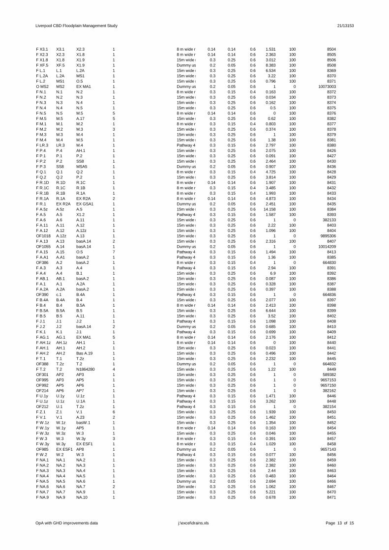
Liverpool CBD Floodplain Management Study 21/13153
F X3.1 X3.1 X2.3 1 8 m wide road (full section)0.14 0.14 0.6 1.531 100 8504F X2.3 X2.3 X1.8 1 8 m wide road (full section)0.14 0.14 0.6 2.363 100 8505F X1.8 X1.8 X1.9 1 15m wide road (full section)0.3 0.25 0.6 3.012 100 8506F XF.5 XF.5 X1.9 1 Dummy used to model flow across road low points0.2 0.05 0.6 8.383 100 8508F L.1 L.1 L.2A 1 15m wide road (full section)0.3 0.25 0.6 6.534 100 8369F L.2A L.2A MS1 1 15m wide road (full section)0.3 0.25 0.6 3.22 100 8370F L.2 MS1 O.5 1 15m wide road (full section)0.3 0.25 0.6 0.796 100 8371O MS2 MS2 EX MA1 1 Dummy used to model flow across road low points0.2 0.05 0.6 1 0 10073003F N.1 N.1 N.2 1 8 m wide road (half section)0.3 0.15 0.4 0.163 100 8372F N.2 N.2 N.3 1 15m wide road (full section)0.3 0.25 0.6 0.034 100 8373F N.3 N.3 N.4 1 15m wide road (full section)0.3 0.25 0.6 0.162 100 8374F N.4 N.4 N.5 1 15m wide road (full section)0.3 0.25 0.6 0.5 100 8375F N.5 N.5 M.5 5 8 m wide road (full section)0.14 0.14 0.6 0 100 8376F M.5 M.5 A.17 5 15m wide road (full section)0.3 0.25 0.6 0.62 100 8382F M.1 M.1 M.2 1 8 m wide road (half section)0.3 0.15 0.4 0.803 100 8377F M.2 M.2 M.3 3 15m wide road (full section)0.3 0.25 0.6 0.374 100 8378F M.3 M.3 M.4 1 15m wide road (full section)0.3 0.25 0.6 1 100 8379F M.4 M.4 M.5 1 15m wide road (full section)0.3 0.25 0.6 1.38 100 8381F LR.3 LR.3 M.4 1 Pathway 4 m wide0.3 0.15 0.6 2.797 100 8380F P.4 P.4 AH.1 1 15m wide road (full section)0.3 0.25 0.6 2.075 100 8426F P.1 P.1 P.2 1 15m wide road (full section)0.3 0.25 0.6 0.091 100 8427F P.2 P.2 SS8 1 15m wide road (full section)0.3 0.25 0.6 2.464 100 8430F P.3 SS8 MSA5 1 Dummy used to model flow across road low points0.2 0.05 0.6 0.907 100 8436F Q.1 Q.1 Q.2 1 8 m wide road (half section)0.3 0.15 0.4 4.725 100 8428F Q.2 Q.2 P.2 1 15m wide road (full section)0.3 0.25 0.6 3.814 100 8429F R.1D R.1D R.1C 1 8 m wide road (full section)0.14 0.14 0.6 1.907 100 8431F R.1C R.1C R.1B 1 8 m wide road (half section)0.3 0.15 0.4 3.485 100 8432F R.1B R.1B R.1A 1 8 m wide road (full section)0.3 0.15 0.4 1.993 100 8433F R.1A R.1A EX R2A 2 8 m wide road (full section)0.14 0.14 0.6 4.873 100 8434F R.1 EX R2A EX GSA1 1 Dummy used to model flow across road low points0.2 0.05 0.6 2.451 100 8435F A.5z A.5z A.5 1 15m wide road (full section)0.3 0.25 0.6 14.158 100 8384F A.5 A.5 X1.2 1 Pathway 4 m wide0.3 0.15 0.6 1.587 100 8393F A.6 A.6 A.11 1 15m wide road (full section)0.3 0.25 0.6 1 0 382133F A.11 A.11 A.12 1 15m wide road (full section)0.3 0.25 0.6 2.22 100 8403F A.12 A.12 A.12z 1 15m wide road (full section)0.3 0.25 0.6 1.096 100 8404OF1018 A.12z A.13 1 15m wide road (full section)0.3 0.25 0.6 1 0 9895306F A.13 A.13 basA.14 2 15m wide road (full section)0.3 0.25 0.6 2.316 100 8407OF1055 A.14 basA.14 1 Dummy used to model flow across road low points0.2 0.05 0.6 1 0 10014209F A.15 A.15 O.5 7 Pathway 4 m wide0.3 0.15 0.6 1.494 100 8413F A.A1 A.A1 basA.2 1 Pathway 4 m wide0.3 0.15 0.6 1.36 100 8385OF386 A.2 basA.2 1 8 m wide road (full section)0.3 0.15 0.4 1 0 664830F A.3 A.3 A.4 1 Pathway 4 m wide0.3 0.15 0.6 2.94 100 8391F A.4 A.4 B.1 1 15m wide road (full section)0.3 0.25 0.6 6.9 100 8392F AB.1 AB.1 basA.2 1 15m wide road (full section)0.3 0.25 0.6 0.087 100 8386F A.1 A.1 A.2A 1 15m wide road (full section)0.3 0.25 0.6 0.328 100 8387F A.2A A.2A basA.2 1 15m wide road (full section)0.3 0.25 0.6 0.397 100 8388OF390 c.1 B.4A 1 Pathway 4 m wide0.3 0.15 0.6 1 0 664836F B.4A B.4A B.4 1 15m wide road (full section)0.3 0.25 0.6 2.077 100 8397F B.4 B.4 B.5A 1 8 m wide road (full section)0.14 0.14 0.6 2.413 100 8398F B.5A B.5A B.5 1 15m wide road (full section)0.3 0.25 0.6 6.644 100 8399F B.5 B.5 A.11 1 15m wide road (full section)0.3 0.25 0.6 3.52 100 8402F J.1 J.1 J.2 1 Pathway 4 m wide0.3 0.15 0.6 1.098 100 8408F J.2 J.2 basA.14 2 Dummy used to model flow across road low points0.2 0.05 0.6 0.685 100 8410F K.1 K.1 J.1 1 Pathway 4 m wide0.3 0.15 0.6 0.699 100 8409F AG.1 AG.1 EX MA1 5 8 m wide road (full section)0.14 0.14 0.6 2.176 100 8412F AH.1z AH.1z AH.1 1 8 m wide road (full section)0.14 0.14 0.6 0 100 8440F AH.1 AH.1 AH.2 1 15m wide road (full section)0.3 0.25 0.6 0.023 100 8441F AH.2 AH.2 Bas A.19 1 15m wide road (full section)0.3 0.25 0.6 0.496 100 8442F T.1 T.1 T.2z 1 15m wide road (full section)0.3 0.25 0.6 2.232 100 8445OF388 T.2z T.2 1 Dummy used to model flow across road low points0.2 0.05 0.6 1 0 664832F T.2 T.2 N1864280 4 15m wide road (full section)0.3 0.25 0.6 1.22 100 8449OF301 AP2 AP3 1 15m wide road (full section)0.3 0.25 0.6 1 0 589382OF995 AP3 AP5 1 15m wide road (full section)0.3 0.25 0.6 1 0 9657153OF992 AP5 AP6 1 15m wide road (full section)0.3 0.25 0.6 1 0 9657150OF214 AP6 AP7 1 15m wide road (full section)0.3 0.25 0.6 1 0 382162F U.1y U.1y U.1z 1 Pathway 4 m wide0.3 0.15 0.6 1.471 100 8446F U.1z U.1z U.1A 1 Pathway 4 m wide0.3 0.15 0.6 3.262 100 8448OF212 U.1 T.2z 1 Pathway 4 m wide0.3 0.15 0.6 1 0 382154F Z.1 Z.1 V.1 6 15m wide road (full section)0.3 0.25 0.6 1.939 100 8450F V.1 V.1 A.23 2 15m wide road (full section)0.3 0.25 0.6 1.462 100 8451F W.1z W.1z basW.1 1 15m wide road (full section)0.3 0.25 0.6 1.354 100 8452F W.1y W.1y AP5 1 8 m wide road (full section)0.14 0.14 0.6 0.163 100 8454F W.3z W.3z W.3 1 15m wide road (full section)0.3 0.25 0.6 0.046 100 8455F W.3 W.3 W.3y 3 8 m wide road (half section)0.3 0.15 0.4 0.391 100 8457F W.3y W.3y EX ESF1 1 8 m wide road (half section)0.3 0.15 0.4 1.029 100 8458OF985 EX ESF1 AP8 1 Dummy used to model flow across road low points0.2 0.05 0.6 1 0 9657143F W.2 W.2 W.3 1 Pathway 4 m wide0.3 0.15 0.6 0.077 100 8456F NA.1 NA.1 NA.2 1 15m wide road (full section)0.3 0.25 0.6 2.382 100 8459F NA.2 NA.2 NA.3 1 15m wide road (full section)0.3 0.25 0.6 2.382 100 8460F NA.3 NA.3 NA.4 1 15m wide road (full section)0.3 0.25 0.6 2.44 100 8463F NA.4 NA.4 NA.5 1 15m wide road (full section)0.3 0.25 0.6 0.483 100 8464F NA.5 NA.5 NA.6 1 Dummy used to model flow across road low points0.2 0.05 0.6 2.694 100 8466F NA.6 NA.6 NA.7 2 15m wide road (full section)0.3 0.25 0.6 1.062 100 8467F NA.7 NA.7 NA.9 1 15m wide road (full section)0.3 0.25 0.6 5.221 100 8470F NA.9 NA.9 NA.10 1 15m wide road (full section)0.3 0.25 0.6 0.678 100 8471
OpA with GHD improvements data Page 13 of 15j:\excel\drains.xls

Liverpool CBD Floodplain Management Study 21/13153
F NA.10 NA.10 NA.11 1 8 m wide road (full section)0.14 0.14 0.6 0.288 100 8472F NA.11 NA.11 NA.11z 1 15m wide road (full section)0.3 0.25 0.6 1.006 100 8474F NA.11z NA.11z NA.12 1 15m wide road (full section)0.3 0.25 0.6 0.279 100 8475F NA.12 NA.12 NA.13 1 Dummy used to model flow across road low points0.2 0.05 0.6 0.396 100 8476F NA.13 NA.13 NJ.4 1 15m wide road (full section)0.3 0.25 0.6 2.493 100 8477F NA.15 NA.15 NA.17 1 8 m wide road (full section)0.14 0.14 0.6 0 100 8482F NA.17 NA.17 NA.18 1 8 m wide road (full section)0.14 0.14 0.6 0 100 8483F NA.18 NA.18 NA.20 1 8 m wide road (full section)0.14 0.14 0.6 0 100 8484OF228 NA.20 NA.19 1 Dummy used to model flow across road low points0.2 0.05 0.6 1 0 476740OF226 NA.19 NA.21 1 Dummy used to model flow across road low points0.2 0.05 0.6 1 0 476738OF224 NA.21 NA.21z 1 Dummy used to model flow across road low points0.2 0.05 0.6 1 0 476736OF222 NA.21z NA.22 1 Dummy used to model flow across road low points0.2 0.05 0.6 1 0 476734OF218 NA.22 NA.23 1 Dummy used to model flow across road low points0.2 0.05 0.6 1 0 476730OF217 NA.23 NA.24 1 Dummy used to model flow across road low points0.2 0.05 0.6 1 0 476729OF216 NA.24 N361 1 Dummy used to model flow across road low points0.2 0.05 0.6 1 0 476727F NB.1 NB.1 NB.2 2 8 m wide road (full section)0.14 0.14 0.6 1.597 100 8461F NB.2 NB.2 NA.3 1 Pathway 4 m wide0.3 0.15 0.6 1.53 100 8462F ND.1 ND.1 NA.5 1 15m wide road (full section)0.3 0.25 0.6 2.16 100 8465F NF.1 NF.1 NF.2 1 8 m wide road (half section)0.3 0.15 0.4 2.346 100 8468F NF.2 NF.2 NA.7 1 8 m wide road (half section)0.3 0.15 0.4 2.039 100 8469F NH.1 NH.1 NA.11 1 15m wide road (full section)0.3 0.25 0.6 2.559 100 8473F NJ.1 NJ.1 NJ.2 1 15m wide road (full section)0.3 0.25 0.6 1.587 100 8478F NJ.2 NJ.2 NJ.3 1 15m wide road (full section)0.3 0.25 0.6 0.264 100 8479F NJ.3 NJ.3 NJ.4 1 8 m wide road (full section)0.14 0.14 0.6 0.316 100 8480F XZ.1 XZ.1 XE.4 1 8 m wide road (full section)0.14 0.14 0.6 2.078 100 8487F X1.2 X1.2 X5.1 1 Pathway 4 m wide0.3 0.15 0.6 3.644 100 8491F X1.3 X1.3 X1.4 1 8 m wide road (full section)0.14 0.14 0.6 2.43 100 8494F X1.4 X1.4 X4.1 1 8 m wide road (full section)0.14 0.14 0.6 1.346 100 8495F X1.5 X1.5 X1.6 1 8 m wide road (full section)0.14 0.14 0.6 1.786 100 8499F X1.6 X1.6 X1.7 1 8 m wide road (full section)0.14 0.14 0.6 1.273 100 8500F X1.7 X1.7 X1.9 1 8 m wide road (full section)0.14 0.14 0.6 2.054 100 8501F X5.1 X5.1 X5.2 1 Dummy used to model flow across road low points0.2 0.05 0.6 1.019 100 8492F X5.2 X5.2 X1.3 1 8 m wide road (full section)0.14 0.14 0.6 1.938 100 8493F X1.1 X1.1 X6.1 1 8 m wide road (full section)0.3 0.15 0.4 6.416 100 8490F X4.1 X4.1 X4.2 1 8 m wide road (full section)0.14 0.14 0.6 2.731 100 8497F X4.2 X4.2 X1.5 1 8 m wide road (full section)0.14 0.14 0.6 4.407 100 8498F X6.1 X6.1 X2.1 1 8 m wide road (full section)0.14 0.14 0.6 10.275 100 8496F X2.1 X2.1 bas2.2 1 8 m wide road (full section)0.14 0.14 0.6 1.753 100 8502OF384 X 2.2 bas2.2 1 8 m wide road (full section)0.3 0.15 0.4 1 0 664828OF275 G.1 G.2A 1 15m wide road (full section)0.3 0.25 0.6 1 0 589031F G.2A G.2A basG.2 1 15m wide road (full section)0.3 0.25 0.6 4.449 100 8359OF382 G.2 basG.2 1 8 m wide road (full section)0.3 0.15 0.4 1 0 664826F G.3 G.3 G.4 2 15m wide road (full section)0.3 0.25 0.6 0.9 100 8363F G.4 G.4 G.5 5 Pathway 4 m wide0.3 0.15 0.6 0.9 100 8364F G.5 G.5 G.6 2 Pathway 4 m wide0.3 0.15 0.6 0.239 100 8365F G.6 G.6 J.2 1 15m wide road (full section)0.3 0.25 0.6 2.006 100 8366F G.6A G.6A G.6 1 15m wide road (full section)0.3 0.25 0.6 2.724 100 8367F G.7 G.7 G.6A 2 15m wide road (full section)0.3 0.25 0.6 2.629 100 8368F H.1 H.1 I.1 1 15m wide road (full section)0.3 0.25 0.6 0.816 100 8360F I.1 I.1 G.4 1 Dummy used to model flow across road low points0.2 0.05 0.6 0.863 100 8362F B.1 B.1 B.2 1 15m wide road (full section)0.3 0.25 0.6 0.061 100 8394F B.2 B.2 B.3 1 15m wide road (full section)0.3 0.25 0.6 1.321 100 8395F B.3 B.3 B.4A 2 15m wide road (full section)0.3 0.25 0.6 30.95 100 8396F K.1A K.1A AD.1 1 15m wide road (full section)0.3 0.25 0.6 1.295 100 8405F AD.1 AD.1 A.13 1 15m wide road (full section)0.3 0.25 0.6 2.422 100 8406F D.2 D.2 O.1 2 Dummy used to model flow across road low points0.2 0.05 0.6 1.205 100 8401F O.1 O.1 O.2 2 15m wide road (full section)0.3 0.25 0.6 3.674 100 8414F O.2 O.2 O.3 1 8 m wide road (full section)0.14 0.14 0.6 1.662 100 8415F O.3 O.3 O.4 1 15m wide road (full section)0.3 0.25 0.6 1.667 100 8416F O.4 O.4 O.5 1 15m wide road (full section)0.3 0.25 0.6 1.632 100 8417F O.5 O.5 M.5 5 15m wide road (full section)0.3 0.25 0.6 0.926 100 8418F U.1A U.1A N1864280 1 Dummy used to model flow across road low points0.2 0.05 0.6 3.413 100 8447OF231 A.26 A.O 1 Pathway 4 m wide0.3 0.15 0.6 1 0 476743F W.1 basW.1 W.1y 1 12.503 15m wide road (full section)0.3 0.25 0.6 0.376 100 8453F A.2 basA.2 AC.1 1 26.151 15m wide road (full section)0.3 0.25 0.6 0.367 100 8389F AC.1 AC.1 A.4 1 25.71 Pathway 4 m wide0.3 0.15 0.6 2.5 100 8390F X2.2 bas2.2 X3.1 1 20.19 8 m wide road (full section)0.14 0.14 0.6 0.933 100 8503F G.2 basG.2 H.1 2 19.1 15m wide road (full section)0.3 0.25 0.6 0.22 100 8361F A.14 basA.14 A.15 5 17.8 Pathway 4 m wide0.3 0.15 0.6 0.509 100 8411F AF.1 Basin65 A.15 1 18.1 15m wide road (full section)0.3 0.25 0.6 1 0 624700F A.19 Bas A.19 N1864280 2 14.13 15m wide road (full section)0.3 0.25 0.6 0.272 100 8437F NA.14 NJ.4 NA.15 1 11.836 8 m wide road (full section)0.14 0.14 0.6 1.793 100 8481OF773 N1864280 AP2 1 15m wide road (full section)0.3 0.25 0.6 1 0 4417929OF1050 EX CSA1 EX MSC1 3 15m wide road (full section)0.3 0.25 0.6 1 0 9895338OF1048 EX ESA1 AP3 1 Dummy used to model flow across road low points0.2 0.05 0.6 1 0 9895336OF1057 EX ESB1 AP3 1 Dummy used to model flow across road low points0.2 0.05 0.6 1 0 10014211OF1036 EX GSA1 MS6 1 15m wide road (full section)0.3 0.25 0.6 1 0 9895324OF1045 EX MA1 O.5 1 Dummy used to model flow across road low points0.2 0.05 0.6 1 0 9895333F EX R1 EX R1 EX R2A 0.5 Dummy used to model flow across road low points0.2 0.05 0.6 1 0 12100325F S.1 EX S1 EX S2 1 15m wide road (full section)0.3 0.25 0.6 0.916 100 8421F S.2 EX S2 S3 1 15m wide road (full section)0.3 0.25 0.6 1.371 100 8422F S.3 S3 MSA1 1 15m wide road (full section)0.3 0.25 0.6 15.262 100 8423OF939 EX SA1 MSA2 1 Dummy used to model flow across road low points0.2 0.05 0.6 0.01 100 9656917F S.4 MSA2 MSA3 1 15m wide road (full section)0.3 0.25 0.6 1.429 100 8424OF948 MSA3 MSA4 1 15m wide road (full section)0.3 0.25 0.6 1 0 9656926
OpA with GHD improvements data Page 14 of 15j:\excel\drains.xls

Liverpool CBD Floodplain Management Study 21/13153
OF949 MSA4 MSA5 1 15m wide road (full section)0.3 0.25 0.6 0.8 0 9656927F S.5 MSA5 P.4 1 15m wide road (full section)0.3 0.25 0.6 3.611 100 8425OF937 MSA1 MSA2 1 15m wide road (full section)0.3 0.25 0.6 2.1 0 9656915OF1041 GS1 SS8 1 8 m wide road (half section)0.3 0.15 0.4 1 0 9895329OF1000 EX D1 EX D2 1 Dummy used to model flow across road low points0.2 0.05 0.6 1 0 9776244OF1001 EX D2 EX D3 1 15m wide road (full section)0.3 0.25 0.6 1 0 9776245F D.1 EX D3 D.2 1 15m wide road (full section)0.3 0.25 0.6 11.717 100 8400OF1005 SS4 P.1 1 Dummy used to model flow across road low points0.2 0.05 0.6 1 0 9776255OF1007 SS5 EX R1 1 15m wide road (full section)0.3 0.25 0.6 1 0 9776257
OpA with GHD improvements data Page 15 of 15j:\excel\drains.xls

Appendix C
Community Submissions
21/13153/108836 Liverpool CBD Floodplain Management Study


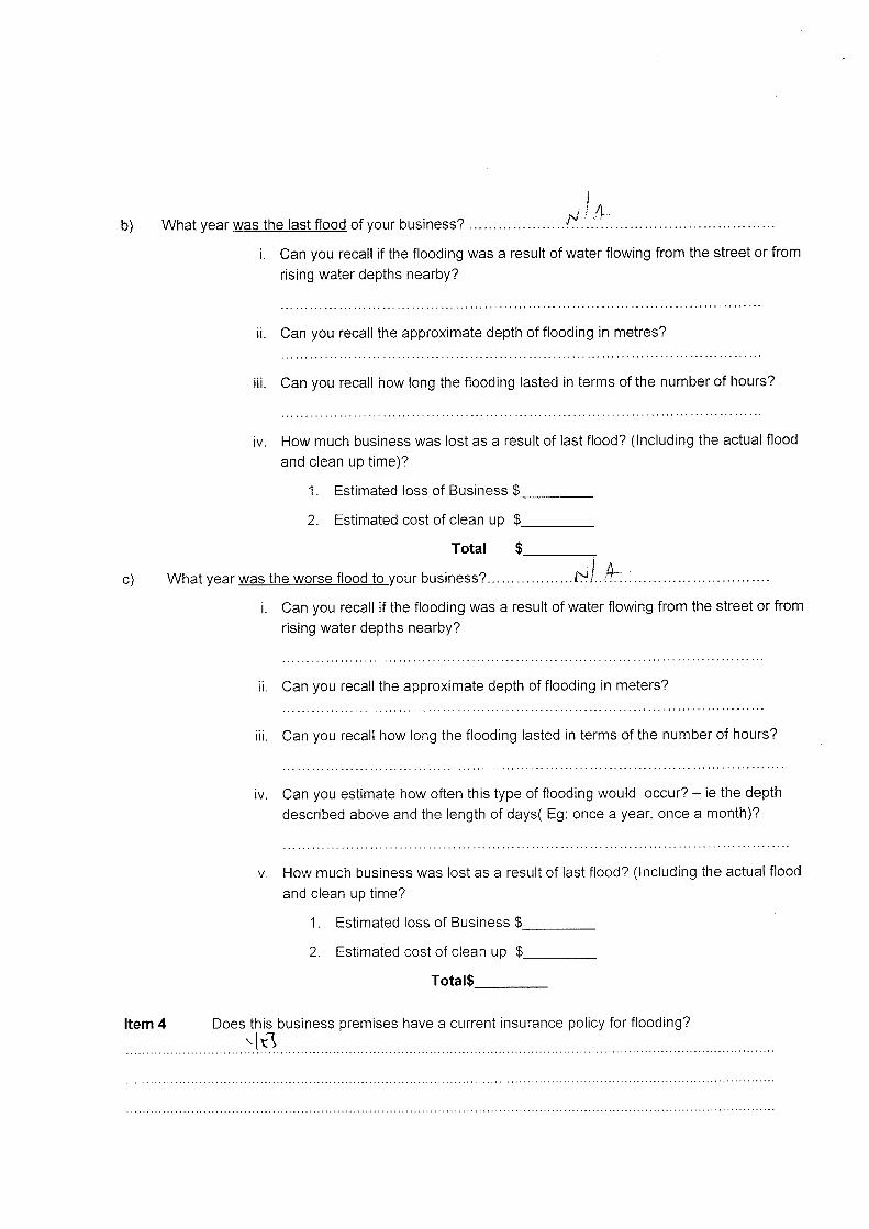


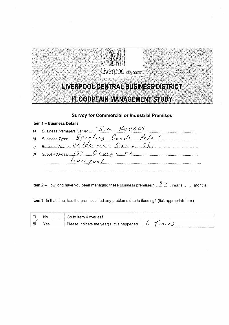

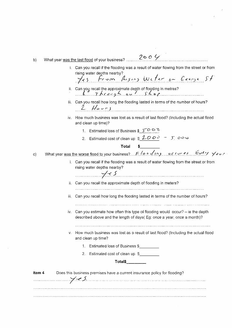


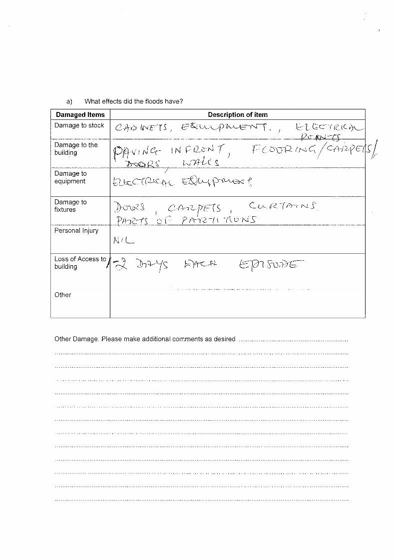


Appendix D
Floodplain Risk Management Option Assessment Matrix
21/13153/108836 Liverpool CBD Floodplain Management Study

Liverpool CBD Floodplain Management Study 21/13153
Liverpool CBD Floodplain Management Study
Floodplain Risk Management Option Assessment MatrixRevision: Draft
Options
Do NothingFlood Proofing of
BuildingsVoluntary Purchase of
High Hazard PropertiesFlood Insurance and
RecoveryPublic Flood Awareness
SchemeStructural Drainage Solution - Section A
Structural Drainage Solution - Section A + B
Social issuesFlood hazard reduction 5 1 1 2 1 1 4 5Increase in property values 1 1 4 4 2 1 4 5Community growth 3 1 3 3 3 1 4 5Short Term Community disruption 3 5 2 2 4 4 2 1Long Term Community disruption 3 1 3 3 1 2 4 5
Environmental issuesEcology, WSUD 4 3 3 5 3 3 2.5 2Pollution 3 2 2 4 2 2 3 4Energy and resources to implement 2 5 3 2 5 4 3 2Future energy and resources 2 5 5 4 5 4 4 4
Weighted Intangible Score 68% 71% 86% 73% 64% 92% 100%
Economic IssuesCostsPresent Value Capital Costs -$ 6,953,000$ 73,755,000$ -$ 40,000$ 7,395,000$ 9,895,000$ Present Value Ongoing Costs -$ -$ 229,000$ 5,428,000$ 46,000$ -$ -$ Total -$ 6,953,000$ 73,984,000$ 5,428,000$ 86,000$ 7,395,000$ 9,895,000$
BenefitsSavings in Average Annual Damage -$ 202,000$ 405,000$ 202,000$ 4,000$ 303,000$ 405,000$ Present Value in Damage Savings -$ 3,109,000$ 6,217,000$ 3,109,000$ 62,000$ 4,646,000$ 6,217,000$
Benefit/ Cost Ratio 0.00 0.45 0.08 0.57 0.72 0.63 0.63
BCR Factored with Intangible Score 0.00 0.32 0.07 0.42 0.46 0.58 0.63
Issues Weighting
Matrix Page 1 of 1j:\costings\fmmatrix.xls

Liverpool CBD Floodplain Management Study 21/13153
Liverpool CBD Floodplain Management Study
Additional WorksRevision: Draft
NOTE: The preliminary cost estimates presented in this section have been developed for the purposes of comparing options and may be used for preliminary budgeting. They are not to be used for any other purpose. The scope and quality of the works has not been fully defined and therefore the estimates are not warranted by GHD. These estimates are typically developed
based on cost curves, budget quotes for some equipment items, extrapolation of recent similar project pricing and GHD experience. The accuracy of the estimates is not expected to be better than about ± 30% for the items described in this report. A functional design is recommended for budget setting purposes.
SCHEDULE OF ESTIMATED QUANTITIESPAY ITEM DESCRIPTION OF WORK QTY UNIT RATE AMOUNT NOTES
1 Establishment1.1 Establishment 1 item 30000 $ 30,000 Allowance only
SUBTOTAL $ 30,000 2 Demolition
2.1 Demolition - break up and remove bitumen paving (small quantity) 500 m2 6 $ 3,000 Disposal extra2.2 Disposal charge for surplus material 150 m3 45 $ 6,750 Assume no contamination
SUBTOTAL $ 9,750 3 Earthworks
3.1Excavate 1200mm wide trench by machine, backfill with same material and compact, up to 3.0m deep 327 m 210 $ 68,670 Assuming clay soil
3.2Excavate 900mm wide trench by machine, backfill with same material and compact, up to 2.0m deep 65 m 95 $ 6,175 Assuming clay soil
SUBTOTAL $ 74,845 4 Services Diversions and Relocations4.1 Relocate Telstra services 1 item 10000 $ 10,000 -
SUBTOTAL $ 10,000 5 Drainage
5.1 Pipe - Supply, deliver, lay and join 900mm RCP (Class 3) 327 m 610 $ 199,470 Rubber ring joint; excavation excluded
5.2Manhole/pit - supply and install junction pit; large; with heavy duty cover 5 each 2600 $ 13,000 -
5.3 Pipe - Supply, deliver, lay and join 600mm RCP (Class 2) 65 m 240 $ 15,600 Rubber ring joint; excavation excluded
5.4 Break into existing pit and make good 7 each 230 $ 1,610 -SUBTOTAL $ 229,680
6 Reinstatement
6.1
Pavement - Asphalt; 40mm AC10 wearing course, 175mm basecourse (1 layer AC10 over 2 layers AC20), 195mm sub-base lean mix, 7mm primer seal, 300mm select material CBR>15% 460 m2 170 $ 78,200 -
SUBTOTAL $ 78,200 7 Miscellaneous7.1 Erosion and sediment control 1 item 5000 $ 5,000 Allowance only7.2 Traffic control 1 item 20000 $ 20,000 Allowance only
SUBTOTAL $ 25,000 SUBTOTAL ITEMS 1-7 $ 457,475
8 Supervision, Project Management & Contractor On-Costs
8.1 Supervision, Project Management & Contractor On-Costs (10%) 10 % - $ 45,748 -SUBTOTAL $ 45,748
9 Contingencies9.1 Contingencies - General (25%) 25 % - $ 114,369 -
SUBTOTAL $ 114,369 TOTAL (Ex-GST) $ 617,591
Southeast Page 1 of 1j:\costings\nick's cost estimate.xls
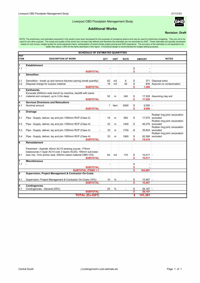
Liverpool CBD Floodplain Management Study 21/13153
Liverpool CBD Floodplain Management Study
Additional WorksRevision: Draft
NOTE: The preliminary cost estimates presented in this section have been developed for the purposes of comparing options and may be used for preliminary budgeting. They are not to be used for any other purpose. The scope and quality of the works has not been fully defined and therefore the estimates are not warranted by GHD. These estimates are typically developed
based on cost curves, budget quotes for some equipment items, extrapolation of recent similar project pricing and GHD experience. The accuracy of the estimates is not expected to be better than about ± 30% for the items described in this report. A functional design is recommended for budget setting purposes.
SCHEDULE OF ESTIMATED QUANTITIESPAY ITEM DESCRIPTION OF WORK QTY UNIT RATE AMOUNT NOTES
1 Establishment1.1 - - $ -
SUBTOTAL $ - 2 Demolition
2.1 Demolition - break up and remove bitumen paving (small quantity) 62 m2 6 $ 371 Disposal extra2.2 Disposal charge for surplus material 19 m3 45 $ 835 Assume no contamination
SUBTOTAL $ 1,206 3 Earthworks
3.1Excavate 2000mm wide trench by machine, backfill with same material and compact, up to 3.0m deep 52 m 340 $ 17,528 Assuming clay soil
SUBTOTAL $ 17,528 4 Services Diversions and Relocations4.1 Nominal amount 1 item 5000 $ 5,000 -
SUBTOTAL $ 5,000 5 Drainage
5.1 Pipe - Supply, deliver, lay and join 1350mm RCP (Class 2) 19 m 950 $ 17,575 Rubber ring joint; excavation excluded
5.2 Pipe - Supply, deliver, lay and join 1350mm RCP (Class 4) 33 m 1400 $ 46,276 Rubber ring joint; excavation excluded
5.3 Pipe - Supply, deliver, lay and join 1500mm RCP (Class 4) - 33 m 1700 -$ 55,803 Rubber ring joint; excavation excluded
5.4 Pipe - Supply, deliver, lay and join 1650mm RCP (Class 4) 33 m 1900 $ 62,368 Rubber ring joint; excavation excluded
SUBTOTAL $ 70,416 6 Reinstatement
6.1
Pavement - Asphalt; 40mm AC10 wearing course, 175mm basecourse (1 layer AC10 over 2 layers AC20), 195mm sub-base lean mix, 7mm primer seal, 300mm select material CBR>15% 62 m2 170 $ 10,517 -
SUBTOTAL $ 10,517 7 Miscellaneous7.1 - - $ -
SUBTOTAL $ - SUBTOTAL ITEMS 1-7 $ 104,667
8 Supervision, Project Management & Contractor On-Costs
8.1 Supervision, Project Management & Contractor On-Costs (10%) 10 % - $ 10,467 -SUBTOTAL $ 10,467
9 Contingencies9.1 Contingencies - General (25%) 25 % - $ 26,167 -
SUBTOTAL $ 26,167 TOTAL (Ex-GST) $ 141,301
Central South Page 1 of 1j:\costings\nick's cost estimate.xls
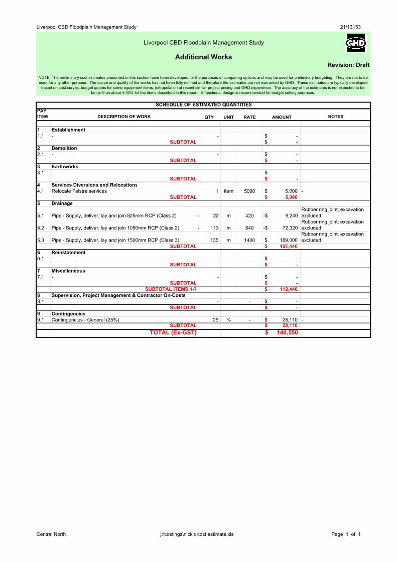
Liverpool CBD Floodplain Management Study 21/13153
Liverpool CBD Floodplain Management Study
Additional WorksRevision: Draft
NOTE: The preliminary cost estimates presented in this section have been developed for the purposes of comparing options and may be used for preliminary budgeting. They are not to be used for any other purpose. The scope and quality of the works has not been fully defined and therefore the estimates are not warranted by GHD. These estimates are typically developed
based on cost curves, budget quotes for some equipment items, extrapolation of recent similar project pricing and GHD experience. The accuracy of the estimates is not expected to be better than about ± 30% for the items described in this report. A functional design is recommended for budget setting purposes.
SCHEDULE OF ESTIMATED QUANTITIESPAY ITEM DESCRIPTION OF WORK QTY UNIT RATE AMOUNT NOTES
1 Establishment1.1 - - $ -
SUBTOTAL $ - 2 Demolition2.1 - - $ -
SUBTOTAL $ - 3 Earthworks3.1 - - $ -
SUBTOTAL $ - 4 Services Diversions and Relocations4.1 Relocate Telstra services 1 item 5000 $ 5,000 -
SUBTOTAL $ 5,000 5 Drainage
5.1 Pipe - Supply, deliver, lay and join 825mm RCP (Class 2) - 22 m 420 -$ 9,240 Rubber ring joint; excavation excluded
5.2 Pipe - Supply, deliver, lay and join 1050mm RCP (Class 2) - 113 m 640 -$ 72,320 Rubber ring joint; excavation excluded
5.3 Pipe - Supply, deliver, lay and join 1500mm RCP (Class 3) 135 m 1400 $ 189,000 Rubber ring joint; excavation excluded
SUBTOTAL $ 107,440 6 Reinstatement6.1 - - $ -
SUBTOTAL $ - 7 Miscellaneous7.1 - - $ -
SUBTOTAL $ - SUBTOTAL ITEMS 1-7 $ 112,440
8 Supervision, Project Management & Contractor On-Costs8.1 - - - $ -
SUBTOTAL $ - 9 Contingencies9.1 Contingencies - General (25%) 25 % - $ 28,110 -
SUBTOTAL $ 28,110 TOTAL (Ex-GST) $ 140,550
Central North Page 1 of 1j:\costings\nick's cost estimate.xls

Liverpool CBD Floodplain Management Study 21/13153
Liverpool CBD Floodplain Management Study
Additional WorksRevision: Draft
NOTE: The preliminary cost estimates presented in this section have been developed for the purposes of comparing options and may be used for preliminary budgeting. They are not to be used for any other purpose. The scope and quality of the works has not been fully defined and therefore the estimates are not warranted by GHD. These estimates are typically developed
based on cost curves, budget quotes for some equipment items, extrapolation of recent similar project pricing and GHD experience. The accuracy of the estimates is not expected to be better than about ± 30% for the items described in this report. A functional design is recommended for budget setting purposes.
SCHEDULE OF ESTIMATED QUANTITIESPAY ITEM DESCRIPTION OF WORK QTY UNIT RATE AMOUNT NOTES
1 Establishment1.1 Establishment 1 item 30000 $ 30,000 Allowance only
SUBTOTAL $ 30,000 2 Demolition
2.1 Demolition - break up and remove bitumen paving (small quantity) 214 m2 6 $ 1,285 Disposal extra2.2 Disposal charge for surplus material 64 m3 45 $ 2,892 Assume no contamination
SUBTOTAL $ 4,177 3 Earthworks
3.1Excavate 600mm wide trench by machine, backfill with same material and compact, up to 2.0m deep 237 m 63 $ 14,931 Assuming clay soil
3.2Excavate 900mm wide trench by machine, backfill with same material and compact, up to 2.0m deep 80 m 95 $ 7,600 Assuming clay soil
SUBTOTAL $ 22,531 4 Services Diversions and Relocations4.1 Nominal amount 1 item 5000 $ 5,000 -
SUBTOTAL $ 5,000 5 Drainage
5.1 Pipe - Supply, deliver, lay and join 375mm RCP (Class 2) 52 m 120 $ 6,240 Rubber ring joint; excavation excluded
5.2 Pipe - Supply, deliver, lay and join 450mm RCP (Class 3) 185 m 180 $ 33,300 Rubber ring joint; excavation excluded
5.3 Pipe - Supply, deliver, lay and join 600mm RCP (Class 3) 80 m 270 $ 21,600 Rubber ring joint; excavation excluded
5.4Manhole/pit - supply and install junction pit; large; with heavy duty cover 5 each 2600 $ 13,000 -
5.4 Break into existing pit and make good 6 each 230 $ 1,380 -SUBTOTAL $ 75,520
6 Reinstatement
6.1
Pavement - Asphalt; 40mm AC10 wearing course, 175mm basecourse (1 layer AC10 over 2 layers AC20), 195mm sub-base lean mix, 7mm primer seal, 300mm select material CBR>15% 214 m2 170 $ 36,414 -
SUBTOTAL $ 36,414 7 Miscellaneous7.1 Erosion and sediment control 1 item 5000 $ 5,000 Allowance only7.2 Traffic control 1 item 10000 $ 10,000 Allowance only
SUBTOTAL $ 15,000 SUBTOTAL ITEMS 1-7 $ 188,642
8 Supervision, Project Management & Contractor On-Costs
8.1 Supervision, Project Management & Contractor On-Costs (10%) 10 % - $ 18,864 -SUBTOTAL $ 18,864
9 Contingencies9.1 Contingencies - General (25%) 25 % - $ 47,160 -
SUBTOTAL $ 47,160 TOTAL (Ex-GST) $ 254,667
Southwest Page 1 of 1j:\costings\nick's cost estimate.xls

Appendix E
Public Meeting Presentation
21/13153/108836 Liverpool CBD Floodplain Management Study

Liverpool CBD Floodplain Management Study
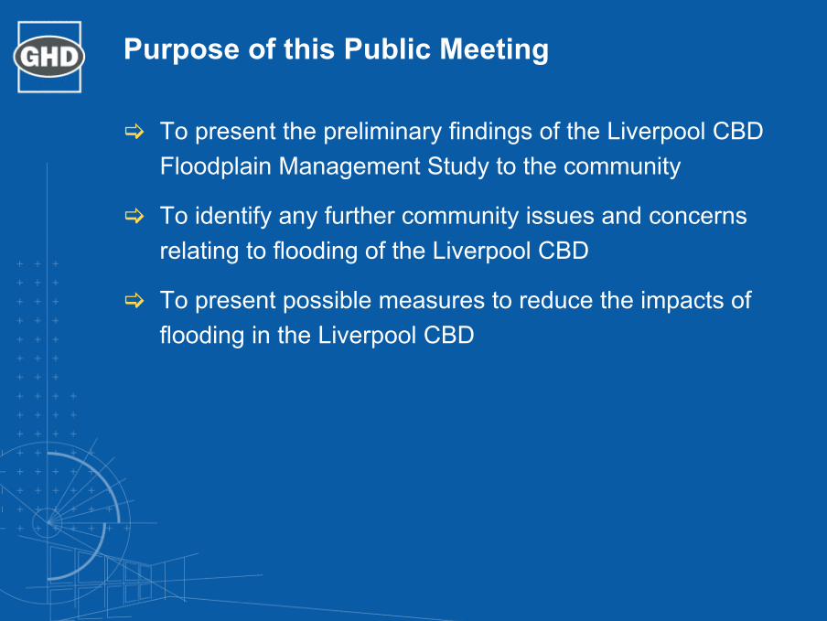
Purpose of this Public Meeting
To present the preliminary findings of the Liverpool CBD Floodplain Management Study to the community
To identify any further community issues and concerns relating to flooding of the Liverpool CBD
To present possible measures to reduce the impacts of flooding in the Liverpool CBD

Liverpool CBD Floodplain Management Study
“The Liverpool CBD is at risk of extensive overland flooding potentially affecting commerce and public safety”

Study Area:

Purpose of Study
Review flood data & calculate flood levels
Categorise flood risk
Undertake community consultation
Examine social/economic effects
Develop flood management options
Assess flood management options
Make recommendations on flood management options
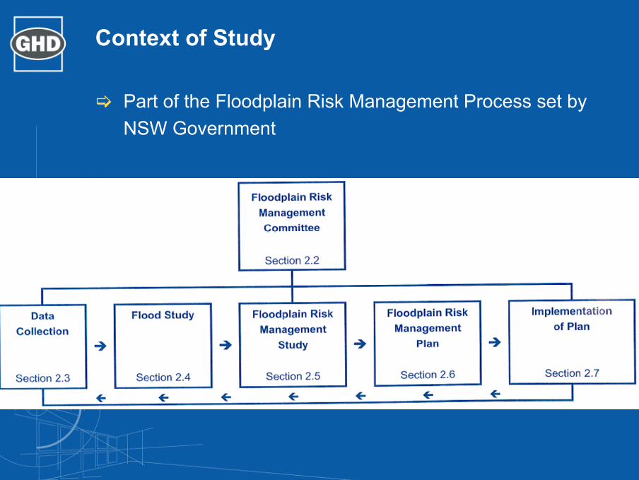
Context of Study
Part of the Floodplain Risk Management Process set by NSW Government
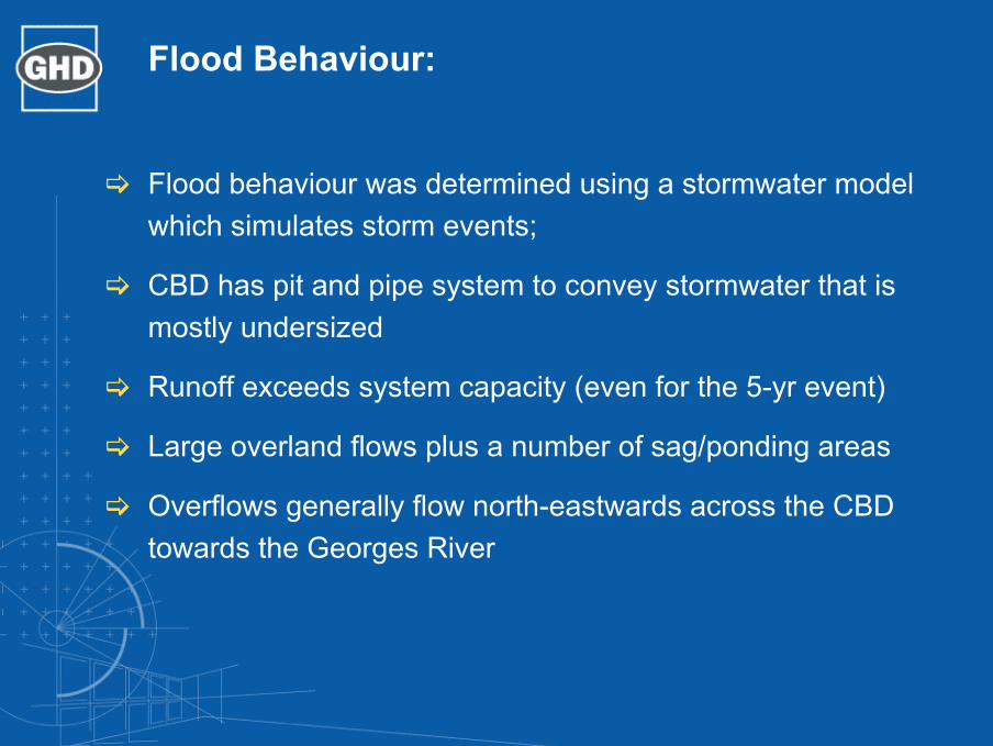
Flood Behaviour:
Flood behaviour was determined using a stormwater model which simulates storm events;
CBD has pit and pipe system to convey stormwater that is mostly undersized
Runoff exceeds system capacity (even for the 5-yr event)
Large overland flows plus a number of sag/ponding areas
Overflows generally flow north-eastwards across the CBD towards the Georges River

Flood Behaviour
Flood Categorization
Identify Floodways & Flood Storage Areas
Undertake Flood Hazard Categorization
High Hazard: Possible danger to personal safety; evacuation by trucks difficult; able-bodied adults would have difficulty in wading to safety; potential for significant structural damage tobuildings. (D > 0.6m)
Low Hazard: Should it be necessary, trucks could evacuate people and their possession; able-bodied adults would have little difficulty in wading to safety. (D<0.2m)
CBD Context:depth, velocity, flood readiness,evacuation, pedestrian movements, shop levels, foot paths, flood duration, access
Flood Hazard Categorization

Community Consultation
Community Consultation activities:
Stakeholder NotificationBusiness Community SurveyPublic MeetingPublic Exhibition & Submission Review
Findings to date
A low percentage of businesses surveyed for the study indicated that they had experienced flood impacts
This may be due to changes in ownership, tenancy or management
Low level of ‘flood awareness’ and ‘flood readiness’Previous flooding had ranged from 0.3-0.5m and lasted
approx 30 minutes to a few hoursImpacts have included damages to buildings, retail stock,
furnishings, clean-up, access, and anxiety
Social and Economic ImpactsTangible impacts (Direct and Indirect) and Intangible impacts
Direct:Structural damageStock and equipment damageClean-up costsInfrastructure damage
Indirect:Loss of revenue/profitDisruption to employmentLoss of productivityDrop in property values
Intangible:Stress and anxietyLoss of sentimental itemsLifestyle changesLoss of amenity
Flood Management Options
Category Potential Floodplain Management Measures
Property Modification
•Land Use Planning•House raising or flood proofing of buildings•Voluntary purchase of high hazard properties
Response Modification
•Flood warning systems and evacuation plans•Flood insurance and recovery•Public flood awareness schemes
Flood Modification •Retro fitting On-Site Detention tanks and detention basins•Structural drainage solutions
Assessment Criteria
Category Issues
Social •The capacity of the option to reduce flood hazards and personal safety risks to the community, •How the option will influence property values;•The capacity of the option to promote community growth; and•The level of disruption to the community, either through implementing the option or through the resulting floodplain behaviour.
Economic and Financial
•The capital costs associated with implementing the option;•The ongoing or maintenance costs of the option; and•The costs or savings of flood damage after the option is implemented.
Environmental •Change to ecology, habitats, riparian vegetation, and the “natural state” of the catchment;•Pollution;•Energy and resources required to implement the option•Energy and resources required for maintaining and decommissioning the option.
Option Assessment
Option Benefit/Cost Ratio Factored with Intangible Score
Do Nothing 0
Flood Proofing of Buildings 0.32
Voluntary Purchase of High Hazard Properties 0.07
Flood Insurance and Recovery 0.42
Public Flood Awareness Scheme 0.46
Structural drainage solution – Section A 0.58
Structural drainage solution – Section A+B 0.63

Structural Drainage Solution
ConclusionsThe Liverpool Central Business District (CBD) is at risk of extensive overland flooding, potentially affecting commerce and public safety. Runoff exceeds the capacity of the existing local stormwater network.
A number of floodways and flood storage areas exist throughout the CBD. (Macquarie, George and Moore Streets). Overland flow have been designated as High Hazard areas.
Social and economic investigation revealed that the impact by flooding is likely to reduce if the community is prepared for a flood event.
Flood management options include:
Property ModificationResponse ModificationFlood Modification
The study has shown that the flood modification option is the most desirable solution.
In particular, the two structural drainage solutions (Section A works and both Section A and B works) have highest benefit/cost ratio followed by the public flood awareness scheme.

21/13153/108836 Liverpool CBD Floodplain Management Study
Appendix F
Submissions

Summary of submissions
Two (2) submissions were received during the exhibition period (attached). A summary of the key issues raised and the respective responses are detailed in the table below:
Issues Presented Response
Property owners were not notified of the Floodplain Management Study
All owners identified in the study as affected by flooding were sent written notification of the study and invited to a public meeting. As well as being sent to the owners address the invite was also sent to the property address, so that all relevant stakeholders would be notified.
On the completion of the Study, Council placed the Draft report on exhibition for 60 days at the CBD Offices, the Liverpool Library and Council’s Administration Centre. Advertisements for the exhibition were placed in the Liverpool Leader on 24th August, 31st August and the 7th September 2005.
Major property owners, and those worst affected should have been approached specifically.
A large proportion of the most severely affected properties were surveyed during the study.
Some major property owners affected by flooding had not been specifically surveyed during the study, but in response to this point discussions have now been held with representatives from the Liverpool RSL Club, Peter Warren Properties and M&M Prpic Pty Ltd.
Owners were not surveyed The survey was undertaken on foot and randomly captured a range of tenants and property owners within the CBD. All property owners and tenants however were informed in writing about the study and invited to a public meeting for further information and comments.
No Flooding has been experienced at some properties within the CBD
Council has received a number of complaints about flooding in the CBD and has witnessed flooding events in recent years. The study modelled storm events larger than has been experienced previously in the CBD in order to assess the likely impact of such events and plan how best to manage the risk. This approach is in accordance with the State Government Guidelines for the development of Floodplain Management Plans
Request that owners are again notified in writing and allowed time for comment.
A 60 day public exhibition period has been undertaken with widespread community notification. Specific stakeholders identified in the submission as not previously being consulted have now been approached.
Low flood awareness attributed to change in tenancy or ownership a false conclusion.
Wording of report has been changed to reflect that the statements are one possible explanation of the low flood awareness.
Council will obtain funds for mitigation works through developer contributions
The study was aimed at assessing the current flooding conditions and the works required to mitigate the current risks. Any future development is unlikely to contribute significant additional stormwater to the network as the area
21/13153/108836 Liverpool CBD Floodplain Management Study

Issues Presented Response is already substantially impervious. There is no proposal to seek specific contributions for the mitigation works from developers.
Photos in report indicate flooding from a drain that is not cleaned, and do not indicate high flood waters.
The photos provided were from a business that regularly experiences flooding due to the inadequate capacity of the system. The drainage pipes have been checked for blockages and none exist. The pictures were taken during a minor storm well below the intensity of the storms modeled in this report.
Table 6 List of Stakeholders does not include major landowners in CBD.
Landowners are identified in the text as the major stakeholder in the project, and the major reason for the study being undertaken. Table 6 details other stakeholders.
Flood damages calculations using research based on the Kempsey flooding is not an accurate comparison.
The research completed on flood damages at Kempsey represents best data available for estimating flood damages in this setting. Considering the nature and setting of the flooding it is considered that the estimates provided are a reasonable indication of likely flood damages.
21/13153/108836 Liverpool CBD Floodplain Management Study

GHD Pty Ltd ABN 39 008 488 373
10 Bond Street Sydney NSW 2000 - T: 2 9239 7100 F: 2 9239 7199 E: [email protected]
© GHD Pty Ltd 2005
This document is and shall remain the property of GHD Pty Ltd. The document may only be used for the purposes for which it was commissioned and in accordance with the Terms of Engagement for the commission. Unauthorised use of this document in any form whatsoever is prohibited.
Document Status
Reviewer Approved for Issue Rev No. Authors
Name Signature Name Signature Date
DRAFT for Council Review only.
K Wilkinson, N Deeks, R Berg
N Deeks onfile R Berg onfile 28/04/2005
DRAFT 1 N Deeks R Berg N Deeks onfile R Berg onfile 23/05/2005
Report (public meeting issue)
R Cottrell R Berg Minor changes na R Berg na 05/07/2005
Report (FPM issue) R Berg Minor changes na R Berg na 14/07/2005
Final issue R Berg Minor changes na R Berg onfile 11/01/2006
21/13153/108836 Liverpool CBD Floodplain Management Study

T:\6734000\Documents\Civil\Reports, Briefs, Letters & Registers\Design Reports\6734000-WS+P-CS-RP-0001 - Liverpool Civic Place Phase A Main Works DA Report [02].docx
SCHEDULE 4 ACO K200 TRENCH DRAIN SIZING
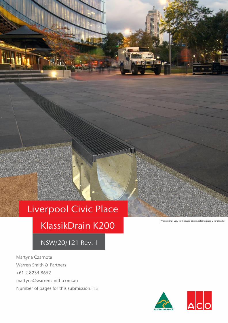
Martyna Czarnota
Warren Smith & Partners
+61 2 8234 8652
Number of pages for this submission: 13
Liverpool Civic Place [Product may vary from image above, refer to page 2 for details]
KlassikDrain K200
NSW/20/121 Rev. 1

Surface Drainage Recommendation
NSW 134-140 Old Bathurst Road Emu Plains NSW 2750 Telephone: 02 4747 4000
QLD 467 Tufnell Road Banyo QLD 4014 Telephone: 07 3267 8700
VIC/TAS 9 Overseas Drive Noble Park VIC 3174 Telephone: 03 9795 3666
WA 33-35 Sorbonne Crescent Canning Vale WA 6155 Telephone: 08 6250 3700
SA/NT Unit 14 17-19 Churchill Road North Dry Creek SA 5094 Telephone: 08 8162 7800
NZ Unit F 6 Percival Gull Place Mangere, Auckland 2022 Telephone: 64 (0)9815 9500
Name:
Martyna Czarnota
Phone:
+61 2 8234 8652
Company:
Warren Smith & Partners
Mobile:
-
Project Name:
Liverpool Civic Place
Email:
ACO Ref. No.:
NSW/20/121 Rev. 1
Date:
15/09/2020
ACO Contact:
Brad Ryan
ACO Contact No.:
0413 750 704
Specification Clause “The trench drain shall be the KlassikDrain K200 Sloped Depth System with Type 676D Iron Intercept Heelsafe Anti-Slip grates.” The trench drains shall consist of K200 sloped and neutral channels. The K200 channels have an internal/overall width of 200mm/260mm. Refer to the Data & Results Table for recommended channels and Spec Info sheets for other channel dimensions. The catchment hydraulics was calculated based on the provided data. The recommended system will discharge the required flows with no ponding anticipated. A summary of the trench hydraulics is contained in the Data & Results Table and Hydraulic “HYDRO” Plots attached. Also ‘GIC’ Grate Intake Calculation has been provided. Installation Recommendation: https://www.acodrain.com.au/products/klassikdrain-
removable-grates/ Data Rainfall Intensity, I (mm/hr): 203mm/hr (ARI of 1 in 100 years) Catchment Area, A (m2): Refer to Data & Results Table Runoff Coefficient, C: 1 Surface Run-off Scenario: Constant Lateral Runoff, see Runoff Scenario Customer’s Data derived from (DWG no. Etc): BR in correspondence with MC
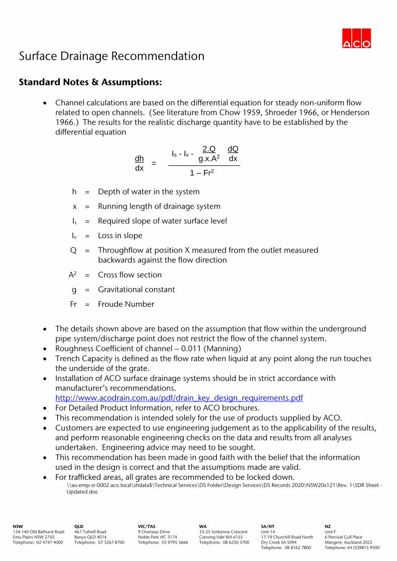
Surface Drainage Recommendation
NSW 134-140 Old Bathurst Road Emu Plains NSW 2750 Telephone: 02 4747 4000
QLD 467 Tufnell Road Banyo QLD 4014 Telephone: 07 3267 8700
VIC/TAS 9 Overseas Drive Noble Park VIC 3174 Telephone: 03 9795 3666
WA 33-35 Sorbonne Crescent Canning Vale WA 6155 Telephone: 08 6250 3700
SA/NT Unit 14 17-19 Churchill Road North Dry Creek SA 5094 Telephone: 08 8162 7800
NZ Unit F 6 Percival Gull Place Mangere, Auckland 2022 Telephone: 64 (0)9815 9500
Standard Notes & Assumptions:
Channel calculations are based on the differential equation for steady non-uniform flow related to open channels. (See literature from Chow 1959, Shroeder 1966, or Henderson 1966.) The results for the realistic discharge quantity have to be established by the differential equation
h = Depth of water in the system
x = Running length of drainage system
Is = Required slope of water surface level
Iv = Loss in slope
Q = Throughflow at position X measured from the outlet measured backwards against the flow direction
A2 = Cross flow section
g = Gravitational constant
Fr = Froude Number
The details shown above are based on the assumption that flow within the underground
pipe system/discharge point does not restrict the flow of the channel system. Roughness Coefficient of channel – 0.011 (Manning) Trench Capacity is defined as the flow rate when liquid at any point along the run touches
the underside of the grate. Installation of ACO surface drainage systems should be in strict accordance with
manufacturer’s recommendations. http://www.acodrain.com.au/pdf/drain_key_design_requirements.pdf
For Detailed Product Information, refer to ACO brochures. This recommendation is intended solely for the use of products supplied by ACO. Customers are expected to use engineering judgement as to the applicability of the results,
and perform reasonable engineering checks on the data and results from all analyses undertaken. Engineering advice may need to be sought.
This recommendation has been made in good faith with the belief that the information used in the design is correct and that the assumptions made are valid.
For trafficked areas, all grates are recommended to be locked down. \\au-emp-sr-0002.aco.local\shdata$\Technical Services\DS Folder\Design Services\DS Records 2020\NSW20x121\Rev. 1\SDR Sheet - Updated.doc
dh
dx =
Is - Iv - 2.Q
g.x.A2
dQ
dx
1 – Fr2
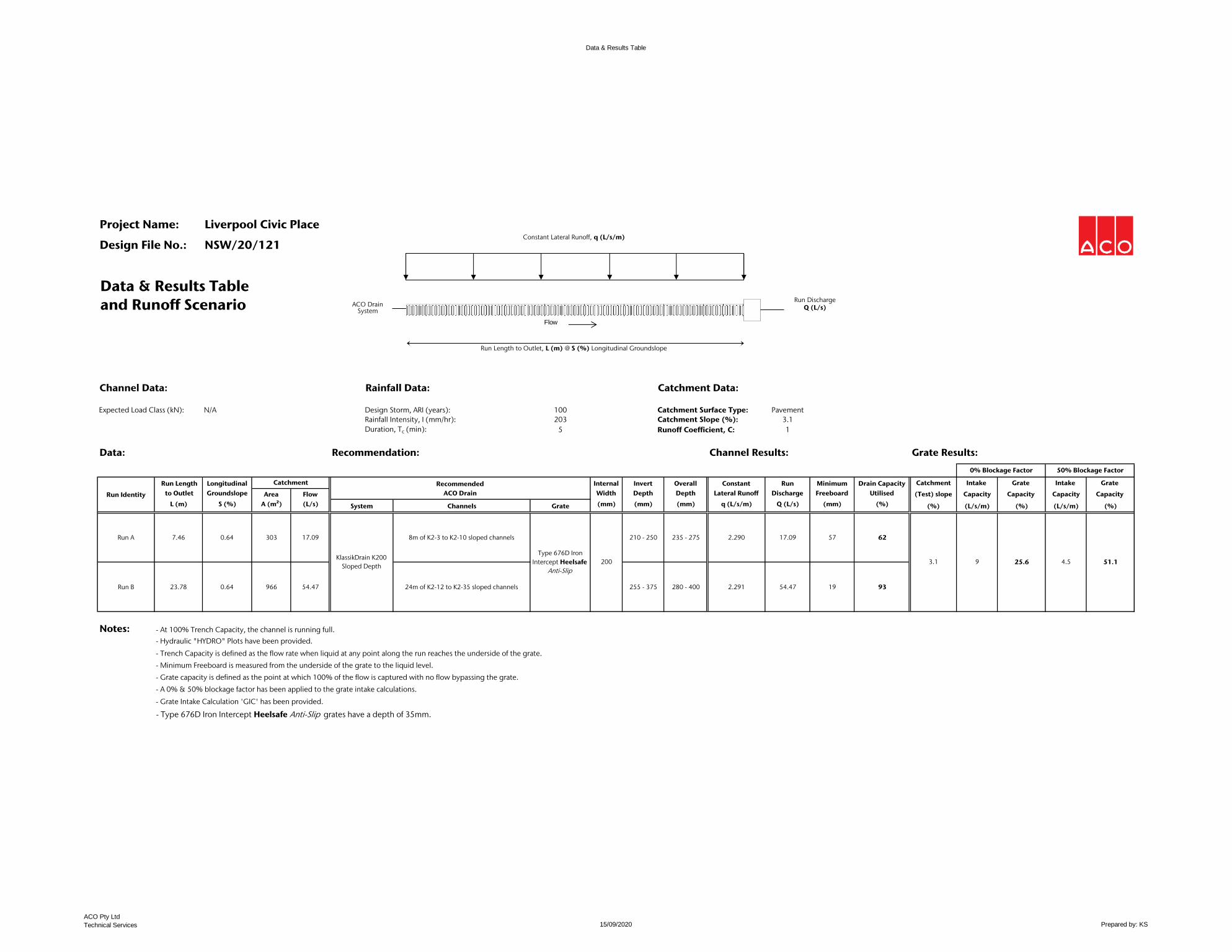
Data & Results Table
Project Name: Liverpool Civic Place
Design File No.: NSW/20/121
Data & Results Tableand Runoff Scenario
Channel Data: Rainfall Data: Catchment Data:
Expected Load Class (kN): N/A Design Storm, ARI (years): 100 Catchment Surface Type: PavementRainfall Intensity, I (mm/hr): 203 Catchment Slope (%): 3.1Duration, Tc (min): 5 Runoff Coefficient, C: 1
Data: Recommendation: Channel Results: Grate Results:
Run Length Longitudinal Internal Invert Overall Constant Run Minimum Drain Capacity Catchment Intake Grate Intake Grate to Outlet Groundslope Area Flow Width Depth Depth Lateral Runoff Discharge Freeboard Utilised (Test) slope Capacity Capacity Capacity Capacity
L (m) S (%) A (m²) (L/s) System Channels Grate (mm) (mm) (mm) q (L/s/m) Q (L/s) (mm) (%) (%) (L/s/m) (%) (L/s/m) (%)
Run A 7.46 0.64 303 17.09 8m of K2-3 to K2-10 sloped channels 210 - 250 235 - 275 2.290 17.09 57 62
Run B 23.78 0.64 966 54.47 24m of K2-12 to K2-35 sloped channels 255 - 375 280 - 400 2.291 54.47 19 93
Notes: - At 100% Trench Capacity, the channel is running full. - Hydraulic "HYDRO" Plots have been provided.- Trench Capacity is defined as the flow rate when liquid at any point along the run reaches the underside of the grate.- Minimum Freeboard is measured from the underside of the grate to the liquid level.- Grate capacity is defined as the point at which 100% of the flow is captured with no flow bypassing the grate.- A 0% & 50% blockage factor has been applied to the grate intake calculations.- Grate Intake Calculation 'GIC' has been provided.
- Type 676D Iron Intercept Heelsafe Anti-Slip grates have a depth of 35mm.
200 3.1
0% Blockage Factor 50% Blockage Factor
9 25.6 4.5 51.1
Catchment
Run IdentityRecommended
ACO Drain
KlassikDrain K200 Sloped Depth
Type 676D Iron Intercept Heelsafe
Anti-Slip
Run DischargeQ (L/s)
Run Length to Outlet, L (m) @ S (%) Longitudinal Groundslope
Flow
Constant Lateral Runoff, q (L/s/m)
ACO Drain System
ACO Pty Ltd
Technical Services 15/09/2020 Prepared by: KS

and
Flow Velocity (m/s) Flow Rate (l/s)
Flow Rate
Discharge : 17.09
Flow Velocity : 1.46
Minimum Freeboard : 57.33, X = 2.73 m
Drain Capacity Utilised : 62.44
[l/s]
[m/s]
[mm]
[%]
Results
All depths are in mm
(Freeboard Depth)
Level of Flow
Flow Velocity
Run A
1300 765 226 (Aus)
+61 2 4747 4000 (Export)
0800 448 080 (NZ)
Project: Liverpool Civic Place
Consultant: Warren Smith & Partners
ACO Ref/Project No: NSW/20/121 Rev. 1
Date: 15/09/2020
K200System:
Run:
Copyright ACO Polycrete Pty LtdUnauthorised reproduction strictly prohibited.
Gnd level
0
50
100
150
0
50
100
150
200
250
Clear Height (mm)
Flow Depth (mm)
215
81
211
131
207
137
203
139
199
138
194
136
191
133
187
129
183
124
179
118
175
110
7.46 m
0.64 %
0
2
4
6
8
10
12
14
16
18(l/s)
0
2
4
6
8
10
12
14
16
18(l/s)
0 0.5 1 1.5 2 2.5 3 3.5 4 4.5 5 5.5 6 6.5 7 (m)
0
0.2
0.4
0.6
0.8
1
1.2
1.4
1.6(m/s)

and
Flow Velocity (m/s) Flow Rate (l/s)
Flow Rate
Discharge : 54.47
Flow Velocity : 2.06
Minimum Freeboard : 19.29, X = 10.22 m
Drain Capacity Utilised : 92.62
[l/s]
[m/s]
[mm]
[%]
Results
All depths are in mm
(Freeboard Depth)
Level of Flow
Flow Velocity
Run B
1300 765 226 (Aus)
+61 2 4747 4000 (Export)
0800 448 080 (NZ)
Project: Liverpool Civic Place
Consultant: Warren Smith & Partners
ACO Ref/Project No: NSW/20/121 Rev. 1
Date: 15/09/2020
K200System:
Run:
Copyright ACO Polycrete Pty LtdUnauthorised reproduction strictly prohibited.
Gnd level
0
100
200
0
100
200
300
400
Clear Height (mm)
Flow Depth (mm)
340
163
328
267
315
275
304
274
292
269
280
260
268
248
256
234
244
218
232
198
220
174
23.78 m
0.64 %
0
5
10
15
20
25
30
35
40
45
50
55(l/s)
0
5
10
15
20
25
30
35
40
45
50
55(l/s)
0 2 4 6 8 10 12 14 16 18 20 22 (m)
0
0.2
0.4
0.6
0.8
1
1.2
1.4
1.6
1.8
2
2.2(m/s)
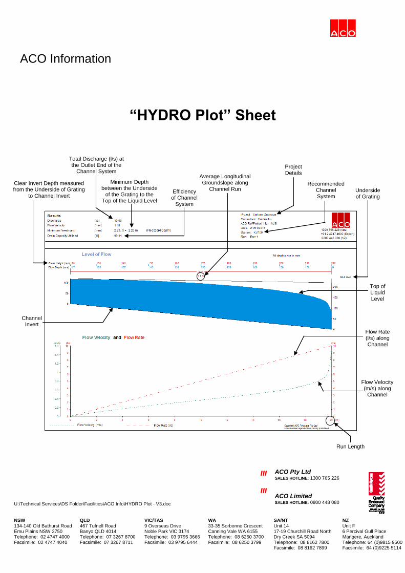
ACO Information
U:\Technical Services\DS Folder\Facilities\ACO Info\HYDRO Plot - V3.doc
III
III
ACO Pty Ltd SALES HOTLINE: 1300 765 226
ACO Limited SALES HOTLINE: 0800 448 080
NSW 134-140 Old Bathurst Road Emu Plains NSW 2750 Telephone: 02 4747 4000 Facsimile: 02 4747 4040
QLD 467 Tufnell Road Banyo QLD 4014 Telephone: 07 3267 8700 Facsimile: 07 3267 8711
VIC/TAS 9 Overseas Drive Noble Park VIC 3174 Telephone: 03 9795 3666 Facsimile: 03 9795 6444
WA 33-35 Sorbonne Crescent Canning Vale WA 6155 Telephone: 08 6250 3700 Facsimile: 08 6250 3799
SA/NT Unit 14 17-19 Churchill Road North Dry Creek SA 5094 Telephone: 08 8162 7800 Facsimile: 08 8162 7899
NZ Unit F 6 Percival Gull Place Mangere, Auckland Telephone: 64 (0)9815 9500 Facsimile: 64 (0)9225 5114
“HYDRO Plot” Sheet
Clear Invert Depth measured from the Underside of Grating
to Channel Invert
Flow Rate (l/s) along Channel
Recommended Channel System
Efficiency of Channel
System
Minimum Depth between the Underside
of the Grating to the Top of the Liquid Level
Flow Velocity (m/s) along
Channel
Run Length
Channel Invert
Top of Liquid Level
Underside of Grating
Project Details
Average Longitudinal Groundslope along
Channel Run
Total Discharge (l/s) at the Outlet End of the
Channel System

© 2016 ACO Copyright. Unauthorised reproduction is strictly prohibited. All reasonable care has been taken in compiling and calculating the information issued in this document.
Grate (slot) Intake Calculator (GIC)ACO Technical Services Department
Project & Contact DetailsProject Name: Liverpool Civic PlaceProject City: Liverpool
Zip/Post Code:
Customer Name: Martyna Czarnota
Company: Warren Smith & PartnersPhone: +61 2 8234 8652
ACO Contact: Brad Ryan
Contact Phone: 0413 750 704ACO No.: NSW/20/121 Rev. 1Date: Sep 15, 2020
Design Details
Catchment Slope A: 3.1 %
Uniform Lateral Flow: 2.291 L/s/mBlockage Factor: 50 %Note: Intake capacity is based on the flow approaching one side of the grate (slot) only.The intake capacity is defined as the point at which 100% of the flow is captured with noflow bypassing the grate (slot).
Recommended Grate (slot)ACO Grate Type: 676D Part No.: 142173
Iron Intercept Heelsafe Anti-Slip Grate
Intake Area: 46193 mm²/m 39 % open area of grate
ACO Channel System: K200
ResultsGrate Capacity Utilised: 51.1 %
Click here for: Grate Test ImageGrate Intake Capacity: 4.5 L/s/m
Click here for: Grate Test Video
Notes GIC Operator: KS
General InformationThe illustration on the right describe the scenarios beforeand after 100% capture.The grate (slot) recommended must be used in a channelthat has adequate hydraulic capacity.For further information on the correct sizing of channels,please contact your nearest ACO Office.This information is generated from empirically tested dataat an independent source.
ACO Pty Ltdhttp://www.acoaus.com.au
Head Office134-140 Old Bathurst Road
Emu Plains, NSW 2750Tel: +61 2 4747 4000

ACO Information
U:\Technical Services\DS Folder\Facilities\ACO Info\GIC Sheet - One Way 2017.doc
III
III
ACO Pty Ltd SALES HOTLINE: 1300 765 226
ACO Limited SALES HOTLINE: 0800 448 080
NSW 134-140 Old Bathurst Road Emu Plains NSW 2750 Telephone: 02 4747 4000 Facsimile: 02 4747 4040
QLD 467 Tufnell Road Banyo QLD 4014 Telephone: 07 3267 8700 Facsimile: 07 3267 8711
VIC/TAS 9 Overseas Drive Noble Park VIC 3174 Telephone: 03 9795 3666 Facsimile: 03 9795 6444
WA 33-35 Sorbonne Crescent Canning Vale WA 6155 Telephone: 08 6250 3700 Facsimile: 08 6250 3799
SA/NT Unit 14 17-19 Churchill Road North Dry Creek SA 5094 Telephone: 08 8162 7800 Facsimile: 08 8162 7899
NZ Unit F 6 Percival Gull Place Mangere, Auckland Telephone: 64 (0)9815 9500 Facsimile: 64 (0)9225 5114
“GIC” Sheet
Catchment Slope Perpendicular to Grate/Slot
(eg. Road Crossfall)
Capture Type Explanation
Clear Intake Area per Metre of
Grate/Slot
Efficiency of the
Grate/Slot
Flow from Catchment
Grate/Slot Illustration & Dimensions
Project Specific Notes
Project Details
Customer Contact Details
Recommended Grate/Slot
System
ACO Contact Details
Catchment Scenario (One-way slope)
Maximum Intake Capacity per
Metre of Grate/Slot
Link to Spec Info
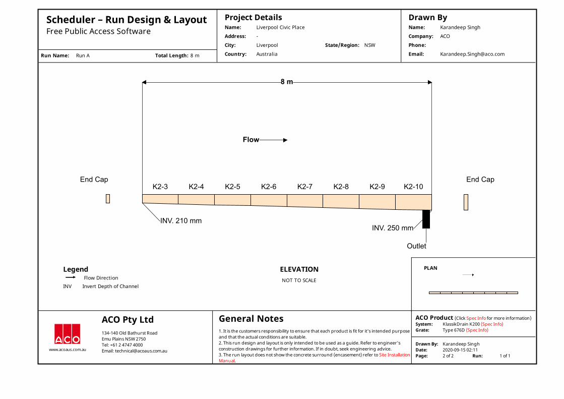
Scheduler – Run Design & Layout Free Public Access Software
Run Name: Run A Total Length: 8 m
Project DetailsName: Liverpool Civic Place
Address: -
City: Liverpool State/Region: NSW
Country: Australia
Drawn ByName: Karandeep Singh
Company: ACO
Phone:
Email: [email protected]
K2-3
INV. 210 mm
K2-4 K2-5 K2-6 K2-7 K2-8 K2-9 K2-10
Outlet
INV. 250 mm
8 m
Flow
End Cap End Cap
LegendFlow Direction
INV Invert Depth of Channel
ELEVATIONNOT TO SCALE
PLAN
www.acoaus.com.au
ACO Pty Ltd 134-140 Old Bathurst RoadEmu Plains NSW 2750Tel: +61 2 4747 4000Email: [email protected]
General Notes 1. It is the customers responsibility to ensure that each product is fit for it's intended purposeand that the actual conditions are suitable.2. This run design and layout is only intended to be used as a guide. Refer to engineer'sconstruction drawings for further information. If in doubt, seek engineering advice.3. The run layout does not show the concrete surround (encasement) refer to Site InstallationManual.
ACO Product (Click Spec Info for more information)System: KlassikDrain K200 (Spec Info)Grate: Type 676D (Spec Info)
Drawn By: Karandeep SinghDate: 2020-09-15 02:11Page: 2 of 2 Run: 1 of 1

Scheduler – Run Design & Layout Free Public Access Software
Run Name: Run A Total Length: 8 m
Project DetailsName: Liverpool Civic Place
Address: -
City: Liverpool State/Region: NSW
Country: Australia
Drawn ByName: Karandeep Singh
Company: ACO
Phone:
Email: [email protected]
K2-3
INV. 210 mm
K2-4 K2-5 K2-6 K2-7 K2-8 K2-9 K2-10
Outlet
INV. 250 mm
8 m
Flow
End Cap End Cap
LegendFlow Direction
INV Invert Depth of Channel
PLANNOT TO SCALE
ELEVATION
www.acoaus.com.au
ACO Pty Ltd 134-140 Old Bathurst RoadEmu Plains NSW 2750Tel: +61 2 4747 4000Email: [email protected]
General Notes 1. It is the customers responsibility to ensure that each product is fit for it's intended purposeand that the actual conditions are suitable.2. This run design and layout is only intended to be used as a guide. Refer to engineer'sconstruction drawings for further information. If in doubt, seek engineering advice.3. The run layout does not show the concrete surround (encasement) refer to Site InstallationManual.
ACO Product (Click Spec Info for more information)System: KlassikDrain K200 (Spec Info)Grate: Type 676D (Spec Info)
Drawn By: Karandeep SinghDate: 2020-09-15 02:11Page: 1 of 2 Run: 1 of 1

Scheduler – Run Design & Layout Free Public Access Software
Run Name: Run B Total Length: 24 m
Project DetailsName: Liverpool Civic Place
Address: -
City: Liverpool State/Region: NSW
Country: Australia
Drawn ByName: Karandeep Singh
Company: ACO
Phone:
Email: [email protected]
K2-12
INV. 255 mm
K2-13 K2-14 K2-15 K2-16 K2-17 K2-18 K2-19 K2-20 K2-21 K2-22 K2-23 K2-24 K2-25 K2-26 K2-27 K2-28 K2-29 K2-30 K2-31 K2-32 K2-33 K2-34 K2-35
Break intoExistingPit/Sump
INV. 375 mm
24 m
Flow
End Cap
LegendFlow Direction
INV Invert Depth of Channel
ELEVATIONNOT TO SCALE
PLAN
www.acoaus.com.au
ACO Pty Ltd 134-140 Old Bathurst RoadEmu Plains NSW 2750Tel: +61 2 4747 4000Email: [email protected]
General Notes 1. It is the customers responsibility to ensure that each product is fit for it's intended purposeand that the actual conditions are suitable.2. This run design and layout is only intended to be used as a guide. Refer to engineer'sconstruction drawings for further information. If in doubt, seek engineering advice.3. The run layout does not show the concrete surround (encasement) refer to Site InstallationManual.
ACO Product (Click Spec Info for more information)System: KlassikDrain K200 (Spec Info)Grate: Type 676D (Spec Info)
Drawn By: Karandeep SinghDate: 2020-09-15 02:29Page: 2 of 2 Run: 2 of 2
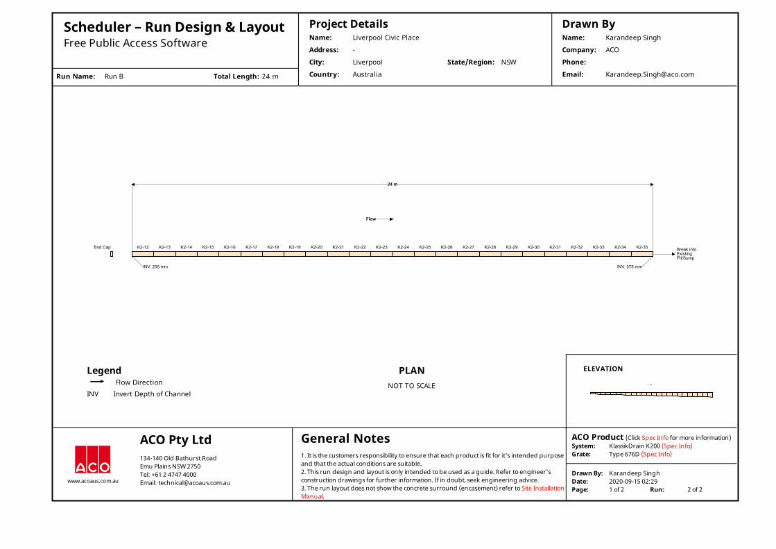
Scheduler – Run Design & Layout Free Public Access Software
Run Name: Run B Total Length: 24 m
Project DetailsName: Liverpool Civic Place
Address: -
City: Liverpool State/Region: NSW
Country: Australia
Drawn ByName: Karandeep Singh
Company: ACO
Phone:
Email: [email protected]
K2-12
INV. 255 mm
K2-13 K2-14 K2-15 K2-16 K2-17 K2-18 K2-19 K2-20 K2-21 K2-22 K2-23 K2-24 K2-25 K2-26 K2-27 K2-28 K2-29 K2-30 K2-31 K2-32 K2-33 K2-34 K2-35 Break intoExistingPit/Sump
INV. 375 mm
24 m
Flow
End Cap
LegendFlow Direction
INV Invert Depth of Channel
PLANNOT TO SCALE
ELEVATION
www.acoaus.com.au
ACO Pty Ltd 134-140 Old Bathurst RoadEmu Plains NSW 2750Tel: +61 2 4747 4000Email: [email protected]
General Notes 1. It is the customers responsibility to ensure that each product is fit for it's intended purposeand that the actual conditions are suitable.2. This run design and layout is only intended to be used as a guide. Refer to engineer'sconstruction drawings for further information. If in doubt, seek engineering advice.3. The run layout does not show the concrete surround (encasement) refer to Site InstallationManual.
ACO Product (Click Spec Info for more information)System: KlassikDrain K200 (Spec Info)Grate: Type 676D (Spec Info)
Drawn By: Karandeep SinghDate: 2020-09-15 02:29Page: 1 of 2 Run: 2 of 2
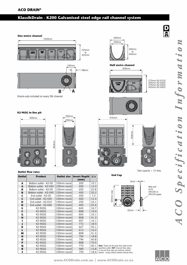
www.ACODrain.com.au | www.ACODrain.co.nz
AC
O S
pe
cifi
cati
on
In
form
ati
on
ACO DRAIN®
KlassikDrain - K200 Galvanised steel edge rail channel system
Outlet flow rates
Outlet Product Outlet size Invert Depth(mm)
L/s
A Bottom outlet - K2-00 100mm round 200 10.1A Bottom outlet - K2-040 100mm round 400 14.3B Bottom outlet - K2-00 150mm round 200 22.8B Bottom outlet - K2-040 150mm round 400 32.2C End outlet - K2-00 100mm round 200 7.2C End outlet - K2-040 100mm round 400 12.4D End outlet - K2-010 150mm round 250 16.1D End outlet - K2-040 150mm round 400 25.4E K2-902G 100mm round 643 16.7F K2-902G 100mm round 808 19.0G K2-902G 100mm round 604 16.1H K2-902G 150mm round 808 41.3I K2-902G 100mm round 607 16.1J K2-902G 100mm round 772 18.5K K2-902G 150mm round 627 35.1L K2-902G 100mm round 613 16.2M K2-902G 150mm round 808 41.3N K2-902G 100mm round 794 18.8O K2-902G 150mm round 794 40.8P K2-902G 200mm round 808 70.5Q K2-902G 150mm round 770 40.1R K2-902G 100mm round 589 15.8S K2-902G 100mm round 759 18.4
Half metre channel
End Cap
Total capacity = 72 litres
DC
Knock-outs included on every 5th channel
275mm K2-0103325mm K2-0203375mm K2-0303425mm K2-0403
A
One metre channel
B
K2-902G In-line pit
J
KL Q
IM
N OP
S
R
HF
GE
Note: These are the pipe flow rates at the specified outlet, NOT channel flow rates. In-line pit flow rates are without rubbish basket - using rubbish basket reduces flow.
1000mm
225mmto
425mm
200mmto
400mm
260mm
200mm
160mm
68mm
500mm260mm
576mm
5mm
32mm
Bell endto fitDN100 orDN150 pipes
42
0m
m m
ax
200mm
843m
m
404m
m
500mm

AC
O S
pe
cifi
cati
on
In
form
ati
on
© February, 2014 ACO Polycrete Pty Ltd. All reasonable care has been taken in compiling the information in this document. All recommendations and suggestions on the use of ACO products are made without guarantee since the conditions of use are beyond the control of the company. It is the customer’s responsibility to ensure that each product is fit for its intended purpose and that the actual conditions are suitable. ACO Polycrete Pty Ltd. pursues a policy of continuous product development and reserves the right to amend specifications without notice.
ACO Polycrete Pty LtdAustralia
Ph: 1300 765 [email protected]
ACO LimitedNew Zealand
Ph: 0800 448 [email protected]
www.ACODrain.com.au | www.ACODrain.co.nz
ACO DRAIN®
KlassikDrain - K200 Galvanised steel edge rail channel system
Notes:1. This channel offers bottom knockout feature; 100mm & 150mm round. 2. Inverts shown are male end, for female invert depths - subtract 5mm from male invert (except neutral channels where it will be the same as the male invert). To calculate overall channel depth add 25mm to invert depth. 3. In-line pit assembly (polymer concrete top with galvanised steel edge rail, plastic base & removable QuickLok Bar). Select appropriate QuickLok grate to suit. 4. Overall depth of in-line pit and end caps.
Description Part No. Invert2
(mm)Weight
(kg)
K2-00 Neutral channel - (1m)1 145041 200 37.9K2-1 Sloped channel - (1m) 145001 205 37.9K2-2 Sloped channel - (1m) 145002 210 38.4K2-3 Sloped channel - (1m) 145003 215 38.9K2-4 Sloped channel - (1m) 145004 220 39.4K2-5 Sloped channel - (1m)1 145005 225 39.9K2-6 Sloped channel - (1m) 145006 230 40.4K2-7 Sloped channel - (1m) 145007 235 40.9K2-8 Sloped channel - (1m) 145008 240 41.4K2-9 Sloped channel - (1m) 145009 245 41.9K2-10 Sloped channel - (1m)1 145010 250 42.4K2-010 Neutral channel - (1m)1 145043 250 42.4K2-0103 Neutral channel - (0.5m)1 145044 250 25.4K2-11 Sloped channel - (1m) 145011 255 42.9K2-12 Sloped channel - (1m) 145012 260 43.4K2-13 Sloped channel - (1m) 145013 265 43.9K2-14 Sloped channel - (1m) 145014 270 44.4K2-15 Sloped channel - (1m)1 145015 275 44.9K2-16 Sloped channel - (1m) 145016 280 45.4K2-17 Sloped channel - (1m) 145017 285 45.9K2-18 Sloped channel - (1m) 145018 290 46.4K2-19 Sloped channel - (1m) 145019 295 46.9K2-20 Sloped channel - (1m)1 145020 300 47.4K2-020 Neutral channel - (1m)1 145045 300 47.4K2-0203 Neutral channel - (0.5m)1 145046 300 29.0K2-21 Sloped channel - (1m) 145021 305 47.9K2-22 Sloped channel - (1m) 145022 310 48.4K2-23 Sloped channel - (1m) 145023 315 48.9K2-24 Sloped channel - (1m) 145024 320 49.4K2-25 Sloped channel - (1m)1 145025 325 49.9K2-26 Sloped channel - (1m) 145026 330 50.4K2-27 Sloped channel - (1m) 145027 335 50.9
Description Part No. Invert2
(mm)Weight
(kg)
K2-28 Sloped channel - (1m) 145028 340 51.4K2-29 Sloped channel - (1m) 145029 345 51.9K2-30 Sloped channel - (1m)1 145030 350 52.4K2-030 Neutral channel - (1m)1 145047 350 52.4K2-0303 Neutral channel - (0.5m)1 145048 350 30.8K2-31 Sloped channel - (1m) 145031 355 52.9K2-32 Sloped channel - (1m) 145032 360 53.4K2-33 Sloped channel - (1m) 145033 365 53.9K2-34 Sloped channel - (1m) 145034 370 54.4K2-35 Sloped channel - (1m)1 145035 375 54.9K2-36 Sloped channel - (1m) 145036 380 55.4K2-37 Sloped channel - (1m) 145037 385 55.9K2-38 Sloped channel - (1m) 145038 390 56.4K2-39 Sloped channel - (1m) 145039 395 56.9K2-40 Sloped channel - (1m)1 145040 400 57.4K2-040 Neutral channel - (1m)1 145049 400 57.4K2-0403 Neutral channel - (0.5m)1 145050 400 34.9K2-902G In-line pit (0.5m)3 141819 8434 30.8Type 900 In-line plastic rubbish basket 13999 - 0.5Universal end cap 96821 4204 0.6Debris strainer for 100mm knockout 93488 - 0.1Installation device 97478 - 1.8Grate removal tool 01318 - 0.1QuickLok bar 10457 - 0.1
Specifications
GeneralThe surface drainage system shall be ACO’s KlassikDrain K200 polymer concrete V-profile channel system with galvanised steel edge rails as manufactured by ACO.
Materials K200 channels shall be manufactured from polyester resin polymer concrete with integrally cast-in galvanised steel edge rails. Properties of polymer concrete will be as follows with supporting documentation: Compressive Strength: 98 MPa
Flexural Strength: 26 MPaTensile Strength: 14 MPaWater Absorption: 0.07%Frost Proof: YESCoefficient of Expansion/ Contraction: 2.02x10⁻⁵/°CWater Vapour Transmission: 0.0364g/m2
Non Flammable: YESRoughness (Mannings): n=0.011Resistant to Weathering: YESDilute Acid and Alkali Resistant: YESSF Sealant Groove: YES
ChannelsK200 channel shall be 200mm nominal internal width with an overall width of 260mm. Channel invert shall have a V-profile to allow efficient
drainage. K200 sloped channels shall have a built-in slope of 0.5%. All channels shall be interlocking with a male/female joint.
Grates Insert specification for the selected grate. Refer to the relevant ACO Specification Information sheet, click: http://www.acodrain.com.au/resources
Installation The complete drainage system shall be by ACO and to be installed for its intended purpose. Any deviation or partial use of the specified system and/or improper installation will void all warranties provided by ACO.

www.ACODrain.com.au | www.ACODrain.co.nz
AC
O S
pe
cifi
cati
on
In
form
ati
on
ACO DRAIN®
Type 676D Iron Intercept Heelsafe® Anti-Slip grate
Certified to AS 3996 Load Class D (210kN) (NATA endorsed load test reports available)
AS 3996 (Clause 3.3.5) compliant for surface openings in pedestrian areas ASME A112.6.3 (Section 7.12) compliant - American high heel standard
AS 4586: P2 – Slip resistance classification for Wet Pendulum Test AS 4586: R10/R91 - Slip resistance classification for Oil-Wet Inclining Platform Test
AS 1428.2 (Clause 9c) compliant for wheelchair and walking cane safety
AS 3996 (Clause 3.3.6) compliant for bicycle tyre penetration resistance
• Recesses in the edge rail fit around ‘anti-shunt’ lugs on the grate to prevent longitudinal movement
• DrainLok barless and boltless locking system
• Suitable for use with K200, KS200, H200K, H200KS channels
• Manufactured from ductile iron to AS 1831 Grade 500-71. Test direction (perpendicular/parallel) relative to the grate’s length
(NATA endorsed test reports available)
Product Features
SpecificationsThe grate shall be ACO Type 676D Iron Intercept Heelsafe® Anti-Slip grate with DrainLok barless and boltless locking system as manufactured by ACO. This grate has an overall width of 238mm and overall length of 500mm. Slot widths measure at a maximum of 7mm.
Materials & DesignThe grate shall be manufactured from ductile iron and have minimum properties and characteristics as follows:
• Recesses in the edge rail fit around ‘anti-shunt’ lugs on the grate to prevent longitudinal movement• Manufactured from ductile iron to AS 1831 Grade 500-7• Certified to AS 3996 Load Class D (210kN)2
• AS 4586: P2 – Slip resistance classification for Wet Pendulum Test2
• AS 4586: R10/R91 – Slip resistance classification for Oil-Wet Inclining Platform Test2
• Meets AS 1428.2 (Clause 9c); AS 3996 (Clause 3.3.5 & 3.3.6); ASME A112.6.3 (Section 7.12)• Intake area of 25,300mm2 per half metre of grate1 Test direction (perpendicular/parallel) relative to the grate’s length2 NATA endorsed test reports available
For the specification of the ACO Drain channel system selected, click: http://www.acodrain.com.au/resources
This grate is part of ACO’s Heelsafe® Anti-Slip range. For more information visit
www.heelsafe.com.au

AC
O S
pe
cifi
cati
on
In
form
ati
on
www.ACODrain.com.au | www.ACODrain.co.nz
© October 2017 ACO Pty Ltd. All reasonable care has been taken in compiling the information in this document. All recommendations and suggestions on the use of ACO products are made without guarantee since the conditions of use are beyond the control of the company. It is the customer’s responsibility to ensure that each product is fit for its intended purpose and that the actual conditions are suitable. ACO Polycrete Pty Ltd. pursues a policy of continuous product development and reserves the right to amend specifications without notice.
ACO Pty LtdAustralia
Ph: 1300 765 [email protected]
ACO LimitedNew Zealand
Ph: 0800 448 [email protected]
ACO DRAIN®
Type 676D Iron Intercept Heelsafe® Anti-Slip grate
Description Part No. Length Width Weight (mm) (mm) (kg)
DrainLok grateType 676D Iron Intercept Heelsafe® Anti-Slip 142173 500 238 10.0Grate removal tool 01318 - - 0.1
ACO DrainLok™ is a patented,
boltless locking system that
removes the need for bolts and
bars and improves the hydraulic
capacity of the channel. The
DrainLok™ mechanism simply
clips into the channel edge rail for
rapid installation. ACO DrainLok™
grates are fitted with an anti-shunt
mechanism that restricts unwanted
grate movement when installed,
improving durability and longevity
of the system.
‘DrainLok’ locking mechanism
Channel
DrainLok clip
500mm
6mm
53mm
238mm
30mm35mm
Plan view
Side elevation

T:\6734000\Documents\Civil\Reports, Briefs, Letters & Registers\Design Reports\6734000-WS+P-CS-RP-0001 - Liverpool Civic Place Phase A Main Works DA Report [02].docx
SCHEDULE 5 MUSIC MODELLING RESULTS
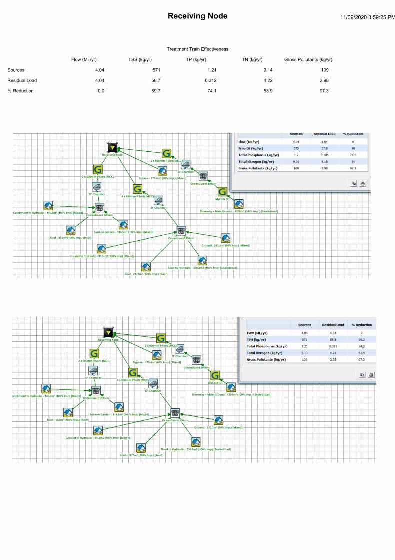
Related Documents