Civil Air Search And Civil Air Search And Rescue Association Rescue Association ForeFlight ForeFlight Creating User Waypoints Creating User Waypoints C A SA R A

Civil Air Search And Rescue Association ForeFlight Creating User Waypoints.
Dec 14, 2015
Welcome message from author
This document is posted to help you gain knowledge. Please leave a comment to let me know what you think about it! Share it to your friends and learn new things together.
Transcript

Civil Air Search And Rescue Civil Air Search And Rescue AssociationAssociation
ForeFlightForeFlight
Creating User WaypointsCreating User Waypoints
C ASARA
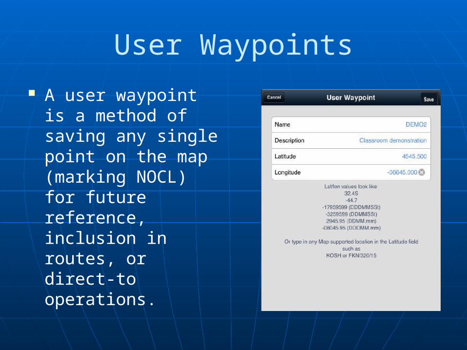
User Waypoints
A user waypoint is a method of saving any single point on the map (marking NOCL) for future reference, inclusion in routes, or direct-to operations.

User Waypoints-Touch Planning
While using touch-planning, create your own custom waypoint from a point on the map:
Tap-and-hold the point until a pop-up is displayed.
User Waypoints-Touch Planning
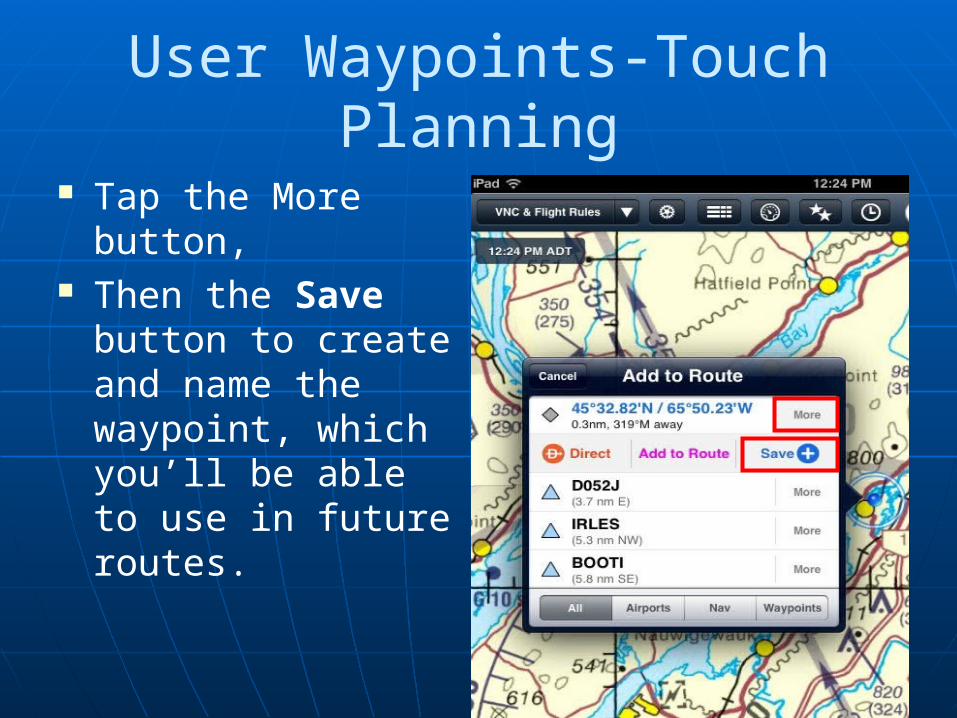
Tap the More button,
Then the Save button to create and name the waypoint, which you’ll be able to use in future routes.

User Waypoints-Touch Planning Create a recognizable
name for the waypoint. Note: Names must be one
word with no spaces and must contain at least one letter.
Once a waypoint has been named, you’ll be able to reference it while creating routes just as you would any other waypoint.
NOTE: “D” and “CAP” are reserved and may not be used as User Waypoint names.

User Waypoints-Touch Planning
Description: Provide a brief description of the waypoint.
The description appears in the waypoint callout when you tap that waypoint in route in the Maps view.
User Waypoints -Touch Planning
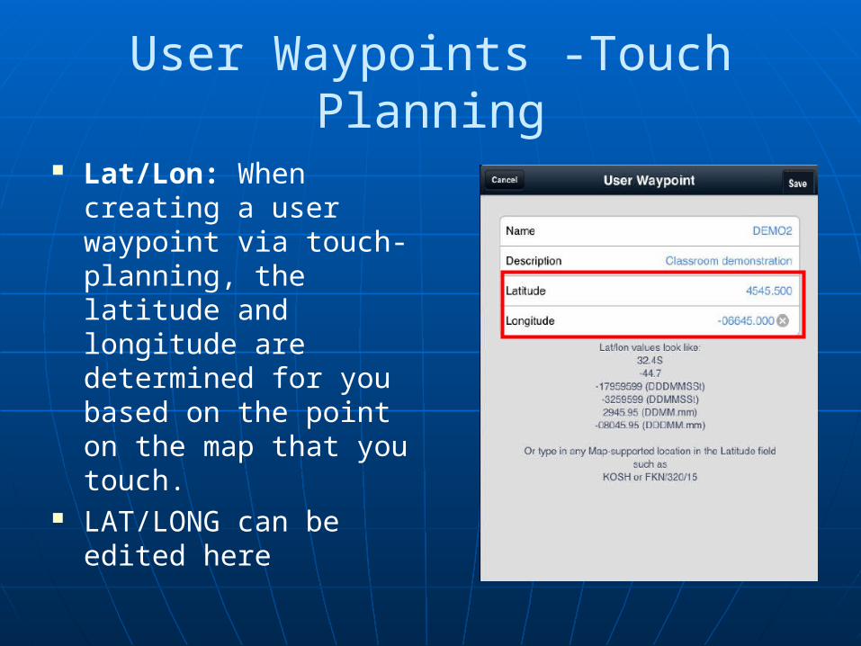
Lat/Lon: When creating a user waypoint via touch-planning, the latitude and longitude are determined for you based on the point on the map that you touch.
LAT/LONG can be edited here
User Waypoints -Lat / Long Formats
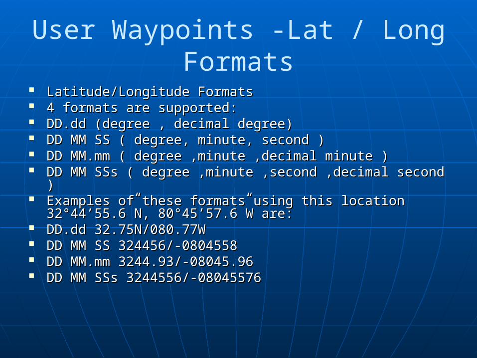
Latitude/Longitude FormatsLatitude/Longitude Formats 4 formats are supported:4 formats are supported: DD.dd (degree , decimal degree)DD.dd (degree , decimal degree) DD MM SS ( degree, minute, second )DD MM SS ( degree, minute, second ) DD MM.mm ( degree ,minute ,decimal minute )DD MM.mm ( degree ,minute ,decimal minute ) DD MM SSs ( degree ,minute ,second ,decimal second )DD MM SSs ( degree ,minute ,second ,decimal second ) Examples of these formats using this location Examples of these formats using this location
32°44’55.6”N, 80°45’57.6”W are:32°44’55.6”N, 80°45’57.6”W are: DD.dd 32.75N/080.77WDD.dd 32.75N/080.77W DD MM SS 324456/-0804558DD MM SS 324456/-0804558 DD MM.mm 3244.93/-08045.96DD MM.mm 3244.93/-08045.96 DD MM SSs 3244556/-08045576DD MM SSs 3244556/-08045576
User Waypoints -Lat / Long Formats
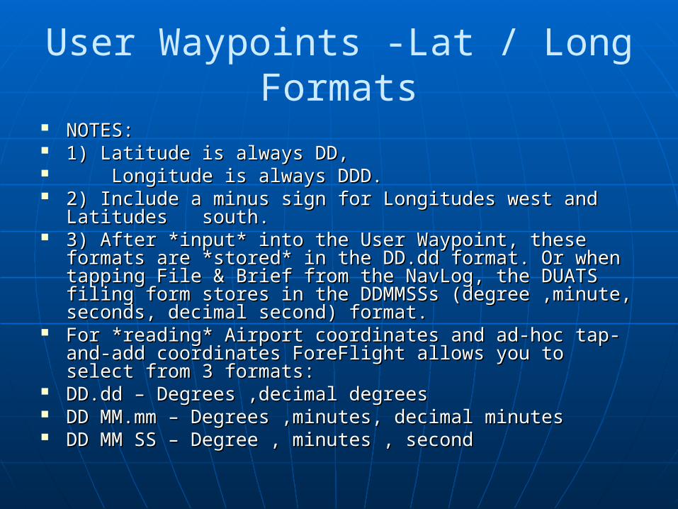
NOTES: NOTES: 1) Latitude is always DD, 1) Latitude is always DD, Longitude is always DDD.Longitude is always DDD. 2) Include a minus sign for Longitudes west and Latitudes 2) Include a minus sign for Longitudes west and Latitudes
south.south. 3) After *input* into the User Waypoint, these formats are 3) After *input* into the User Waypoint, these formats are
*stored* in the DD.dd format. Or when tapping File & Brief *stored* in the DD.dd format. Or when tapping File & Brief from the NavLog, the DUATS filing form stores in the from the NavLog, the DUATS filing form stores in the DDMMSSs (degree ,minute, seconds, decimal second) DDMMSSs (degree ,minute, seconds, decimal second) format.format.
For *reading* Airport coordinates and ad-hoc tap-and-add For *reading* Airport coordinates and ad-hoc tap-and-add coordinates ForeFlight allows you to select from 3 formats:coordinates ForeFlight allows you to select from 3 formats:
DD.dd – Degrees ,decimal degreesDD.dd – Degrees ,decimal degrees DD MM.mm – Degrees ,minutes, decimal minutesDD MM.mm – Degrees ,minutes, decimal minutes DD MM SS – Degree , minutes , secondDD MM SS – Degree , minutes , second
User Waypoints Creating Waypoints
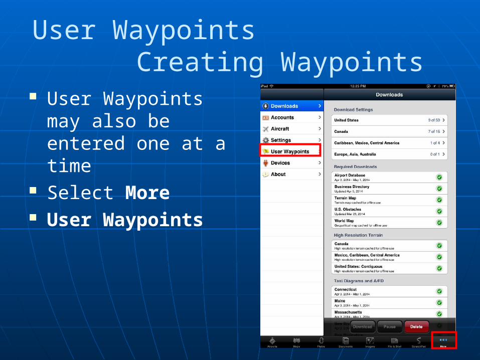
User Waypoints may also be entered one at a time
Select More User Waypoints
User Waypoints Creating Waypoints
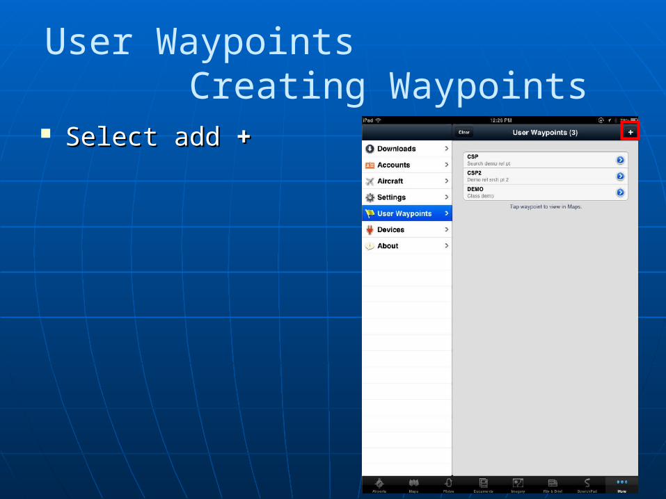
Select add Select add ++

User Waypoints Creating Waypoints
Enter required infoEnter required info Lat/long enter as follow using Lat/long enter as follow using
DDMM.mmm formatDDMM.mmm format Include a minus sign for Include a minus sign for
Longitudes west and Latitudes Longitudes west and Latitudes south. south.
Eg: 4545.500Eg: 4545.500 -06645.000-06645.000 For latest version of Foreflight For latest version of Foreflight
mobile the letter W can be mobile the letter W can be used when entering longitudeused when entering longitude
Eg: 4545.500Eg: 4545.500 W06645.000W06645.000 Tap the save button to finish
creating the user waypoint. Once the waypoint is created,
it functions just as any other waypoint in ForeFlight Mobile.
User Waypoints Finding Waypoints
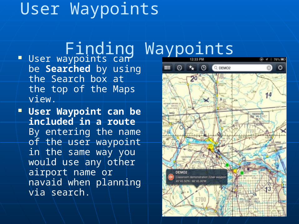
User waypoints can be Searched by using the Search box at the top of the Maps view.
User Waypoint can be included in a route By entering the name of the user waypoint in the same way you would use any other airport name or navaid when planning via search.

User Waypoints Projecting Waypoints
You can also enter a user waypoint as a distance and radial from an aviation point or a user waypoint
By entering the waypoint / radial / distance information in Latitude and leaving Longitude blank.

User Waypoints Projecting Waypoints
Eg: entering YFC/106/10 in Latitude would create a user waypoint 10 NM away from the YFC VOR on the 106 Radial

User Waypoints Projecting Waypoints
Once the waypoint is created, it functions just as any other waypoint saved in ForeFlight Mobile.

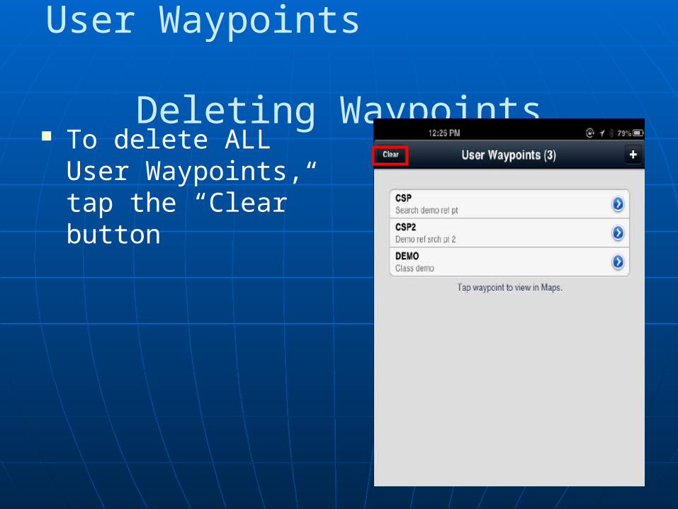
User Waypoints Deleting Waypoints
To delete a single user waypoint, use the swipe-to-delete gesture: swipe your finger across the name of the waypoint, then tap the red Delete button.
User Waypoints Deleting Waypoints
To delete ALL User Waypoints, tap the “Clear” button
ForeFlightForeFlight
Creating User WaypointsCreating User Waypoints
QuestionsQuestions
ForeFlightForeFlight
Creating User WaypointsCreating User Waypoints
Thank youThank you
Related Documents