Institut für Kartographie und Geoinformation, Uni Bonn Lehrstuhl für Geoinformation CityGML – Background and Design Dr. Thomas H. Kolbe OWS-4 Kickoff Meeting June 14, 2006 Institut für Kartographie und Geoinformation, Uni Bonn Lehrstuhl für Geoinformation, Prof. Dr. Lutz Plümer

Welcome message from author
This document is posted to help you gain knowledge. Please leave a comment to let me know what you think about it! Share it to your friends and learn new things together.
Transcript
Institut für Kartographie und Geoinformation, Uni BonnLehrstuhl für Geoinformation
CityGML – Background and Design
Dr. Thomas H. Kolbe
OWS-4 Kickoff MeetingJune 14, 2006
Institut für Kartographie und Geoinformation, Uni BonnLehrstuhl für Geoinformation, Prof. Dr. Lutz Plümer
Dr. Thomas H. Kolbe - CityGML - Standard für 3D-Stadtmodelle 2
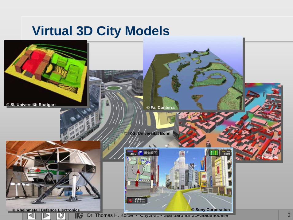
Virtual 3D City Models
© Rheinmetall Defence Electronics
© SI, Universität Stuttgart
© T-Mobile
© Sony Corporation
© IKG, Universität Bonn
© Fa. Conterra
Dr. Thomas H. Kolbe - CityGML - Standard für 3D-Stadtmodelle 3
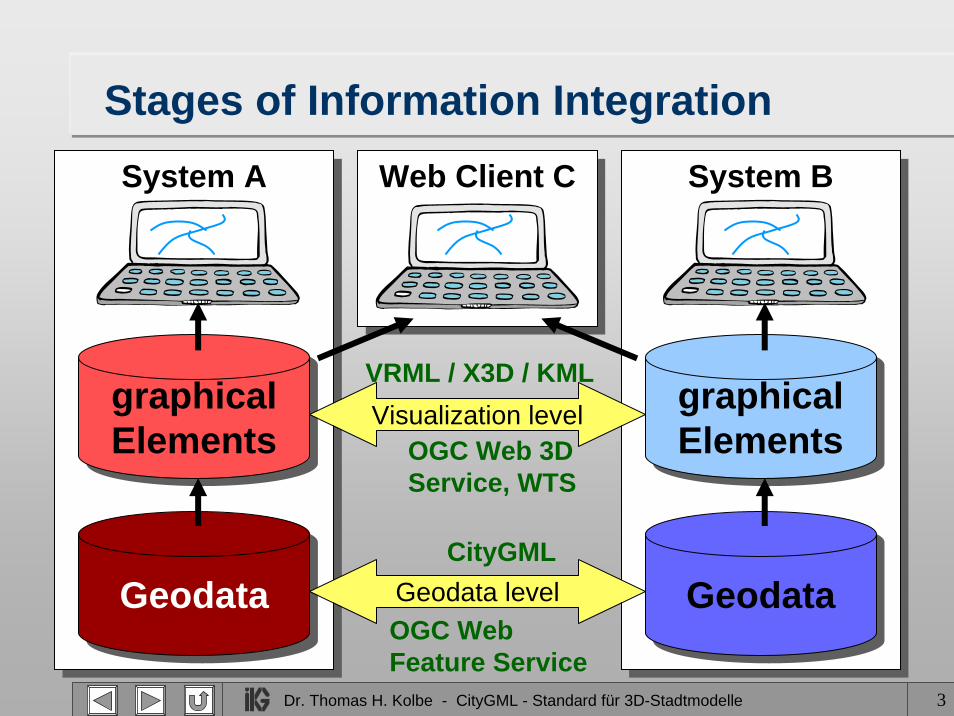
OGC Web Feature Service
CityGML
OGC Web 3DService, WTS
VRML / X3D / KML
System A
Stages of Information IntegrationSystem A
GeodataGeodata
graphicalElementsgraphicalElements
System BSystem B
GeodataGeodata
graphicalElementsgraphicalElements
Geodata level
Visualization level
Web Client CWeb Client C
Dr. Thomas H. Kolbe - CityGML - Standard für 3D-Stadtmodelle 4
Goals of CityGML (I)
• Establish high degree of semantic (and syntactic) interoperability– enabling multifunctional usage of 3D city models– definition of a common information model– „3D geo base data“ (in the tradition of most European
2D digital landscape models, cadastre models)
• Representation of 3D topography as observed– explicit 3D shapes; mainly surfaces & volumes– identification of most relevant feature types usable
in a wide variety of applications– limited inclusion of functional aspects in base model
Dr. Thomas H. Kolbe - CityGML - Standard für 3D-Stadtmodelle 5
Goals of CityGML (II)• Suitability for Spatial Data Infrastructures
– mapping to appropriate exchange format -> GML3• needs high degree of expressivity wrt. OO models• must be usable in the context of OGC Web Services
– possibility to link any CityGML feature to more specialised, functional models / external data sources
• Must be simple to use for applications– well-defined semantics for feature types; however
semantic structure not too fine-grained– subset of GML3 geometries (no curved lines, surfaces)
• Boundary representation with absolute coordinates• advantage: directly manageable within 3D GIS / geo DB
Dr. Thomas H. Kolbe - CityGML - Standard für 3D-Stadtmodelle 6
Originator: GDI NRW and the SIG 3D
Geodata Infrastructure North Rhine-Westphalia• PPP founded in 1999 by the state government• more than 100 institutions organized in
6 Special Interest Groups• very active in OGC (GML3, WPOS, Gazetteer, Metadata)
Special Interest Group 3D (SIG 3D)• open group with >70 active members; 3 working groups
– from industry, government, municipalities and academia– participants from all over Germany, Austria, Switzerland, and UK
• aims: interoperable visualization → Web 3D Serviceand exchange of 3D geodata → CityGML
Dr. Thomas H. Kolbe - CityGML - Standard für 3D-Stadtmodelle 7
SIG 3D members (excerpt)Municipalities• Berlin• Hamburg• Köln• Düsseldorf• Bremen• Essen• Wuppertal• Bochum• StuttgartAdministration• State mapping
agencies (DE)• Ordn.Survey UK
Companies• T-Mobile• Bayer Industry
Services• Rheinmetall Defence• 3D Geo• CPA Geoinformation• Con Terra• GIStec• GTA Geoinformatik• Inpho• Citygrid (AT)• CyberCity (CH)• Snowflake (UK)
Science• Univ. of Bonn• Univ. of Hamburg• Univ. of Potsdam• Univ. of Hannover• Univ. of Dortmund• Univ. of Münster• Fraunhofer Institute
for Computer Graphics, Darmstadt
• Helmholtz Research Center Karlsruhe
• Univ. of Applied Sciences Stuttgart
Dr. Thomas H. Kolbe - CityGML - Standard für 3D-Stadtmodelle 8
Design Principles (I)• Representation of the 4 most important aspects of
virtual 3D city models wrt. multifunctional usage:– Geometry– Topology– Semantics– Appearance
• Usage of topology, appearance should be optional• Semantics restricted to general classifications
– limited inclusion of functional aspects– further functional aspects should be covered by
application specific extensions to CityGML

Dr. Thomas H. Kolbe - CityGML - Standard für 3D-Stadtmodelle 9
Design Principles (II)• Adaptibility to different information communities
– values of enumerative attributes are represented in external codelists (increase of semantic & syntactic interoperability)
– communities may redefine the codelists without changing the CityGML schema / data model
• Coherent spatial / semantic modeling– Features are decomposed both wrt. their spatial and
semantic properties
• Balance between simplicity and need for structure
• Multiscale model
Dr. Thomas H. Kolbe - CityGML - Standard für 3D-Stadtmodelle 10
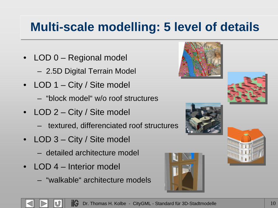
Multi-scale modelling: 5 level of details
• LOD 0 – Regional model– 2.5D Digital Terrain Model
• LOD 1 – City / Site model– “block model“ w/o roof structures
• LOD 2 – City / Site model– textured, differenciated roof structures
• LOD 3 – City / Site model– detailed architecture model
• LOD 4 – Interior model– “walkable“ architecture models
Dr. Thomas H. Kolbe - CityGML - Standard für 3D-Stadtmodelle 11
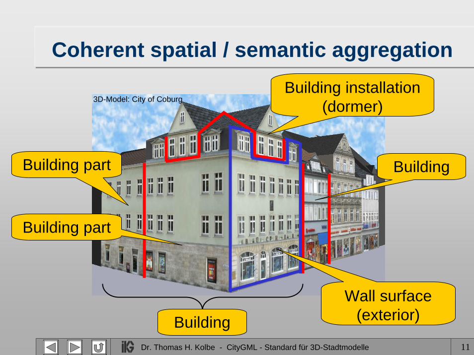
Coherent spatial / semantic aggregation
Building
Building installation (dormer)
Building part
Building part
Building
Wall surface (exterior)
3D-Model: City of Coburg
Dr. Thomas H. Kolbe - CityGML - Standard für 3D-Stadtmodelle 12
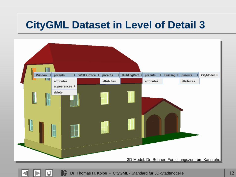
CityGML Dataset in Level of Detail 3
3D-Model: Dr. Benner, Forschungszentrum Karlsruhe
Dr. Thomas H. Kolbe - CityGML - Standard für 3D-Stadtmodelle 13
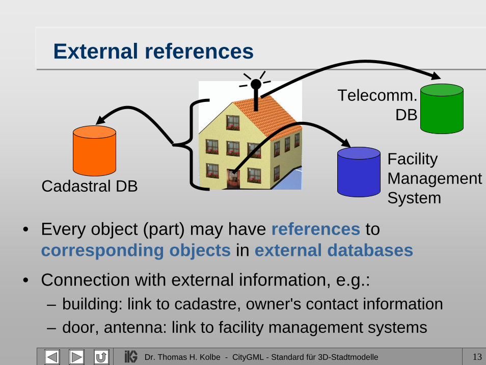
External references
• Every object (part) may have references to corresponding objects in external databases
• Connection with external information, e.g.:– building: link to cadastre, owner's contact information – door, antenna: link to facility management systems
Cadastral DB
Facility ManagementSystem
Telecomm.DB
Dr. Thomas H. Kolbe - CityGML - Standard für 3D-Stadtmodelle 14
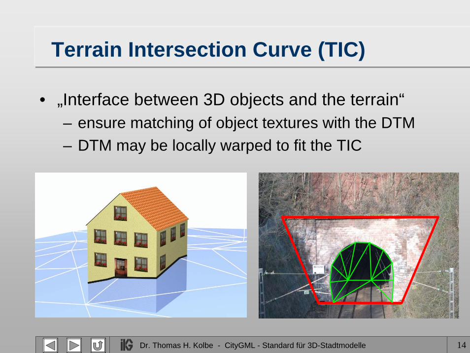
Terrain Intersection Curve (TIC)
• „Interface between 3D objects and the terrain“– ensure matching of object textures with the DTM– DTM may be locally warped to fit the TIC
Dr. Thomas H. Kolbe - CityGML - Standard für 3D-Stadtmodelle 15
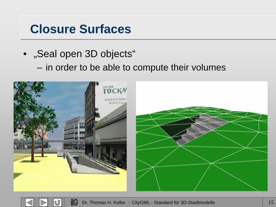
Closure Surfaces
• „Seal open 3D objects“– in order to be able to compute their volumes

Dr. Thomas H. Kolbe - CityGML - Standard für 3D-Stadtmodelle 16
Thematic Schema: UML DiagramExternalReference
- informationSystem: anyURI- externalReference:
ExternalObjectReferenceType
ComplexRelief loD1GeometryProperty
loD3GeometryProperty
loD2GeometryPropertyGeometry
<<FeatureCollection>>CityModel
_Vegetation
<<Feature>>_CityObject
_Site_Water Bodies
_City Furniture
_Transpor-tation
Objects
CityObjectGroup
Dr. Thomas H. Kolbe - CityGML - Standard für 3D-Stadtmodelle 17
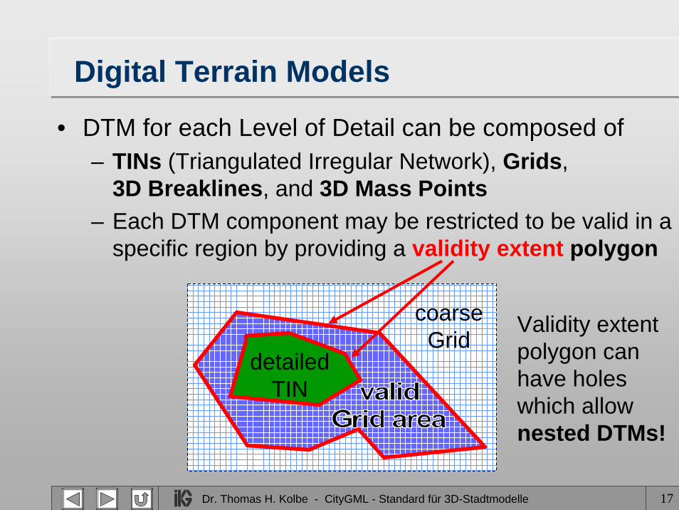
Digital Terrain Models
• DTM for each Level of Detail can be composed of – TINs (Triangulated Irregular Network), Grids,
3D Breaklines, and 3D Mass Points– Each DTM component may be restricted to be valid in a
specific region by providing a validity extent polygon
coarseGrid
detailedTIN
Validity extentpolygon can have holeswhich allownested DTMs!
Dr. Thomas H. Kolbe - CityGML - Standard für 3D-Stadtmodelle 18
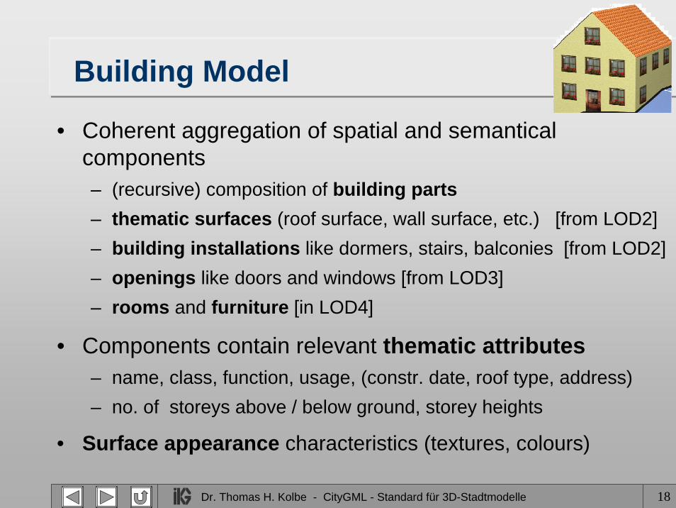
Building Model
• Coherent aggregation of spatial and semantical components– (recursive) composition of building parts– thematic surfaces (roof surface, wall surface, etc.) [from LOD2]– building installations like dormers, stairs, balconies [from LOD2]– openings like doors and windows [from LOD3] – rooms and furniture [in LOD4]
• Components contain relevant thematic attributes– name, class, function, usage, (constr. date, roof type, address)– no. of storeys above / below ground, storey heights
• Surface appearance characteristics (textures, colours)
Dr. Thomas H. Kolbe - CityGML - Standard für 3D-Stadtmodelle 19
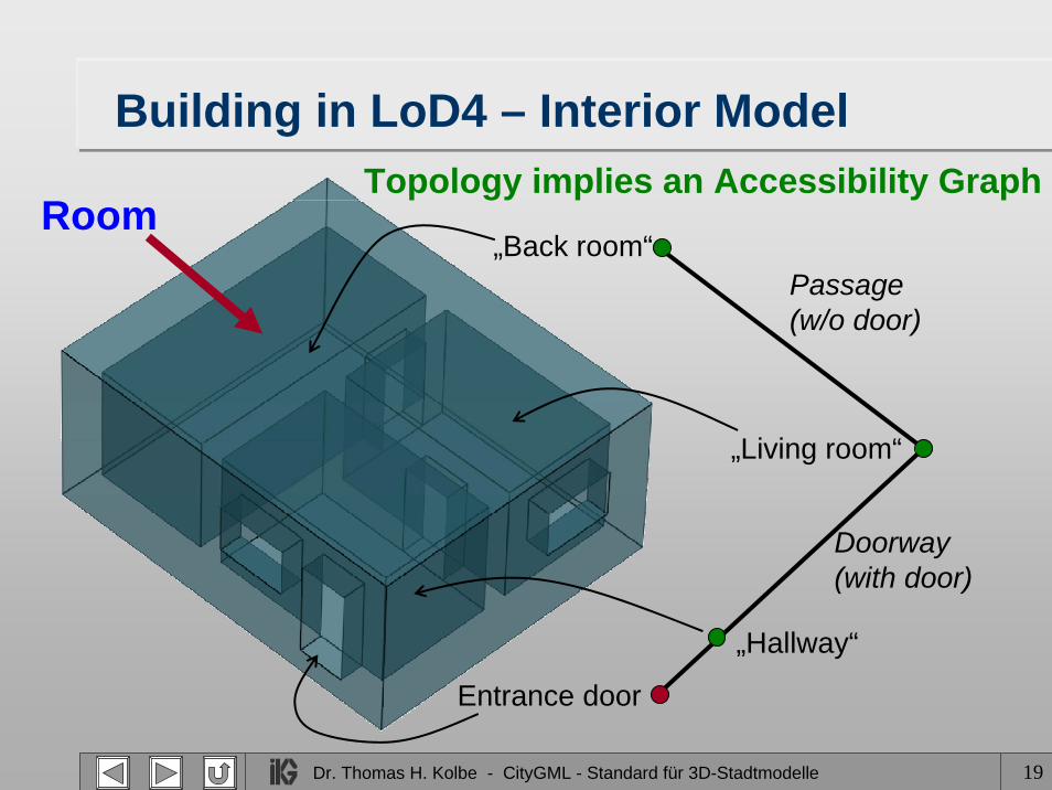
Building in LoD4 – Interior Model
Entrance door
„Hallway“
„Back room“
„Living room“
Doorway(with door)
Passage(w/o door)
Topology implies an Accessibility GraphRoom
Dr. Thomas H. Kolbe - CityGML - Standard für 3D-Stadtmodelle 20
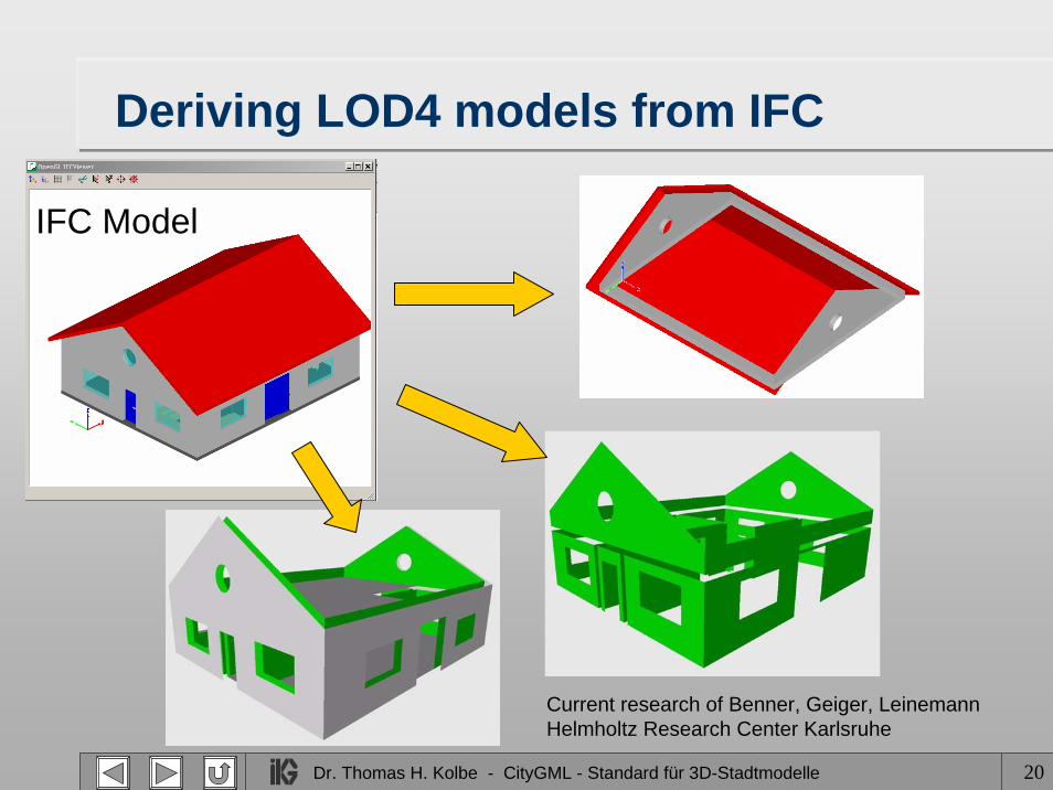
Deriving LOD4 models from IFC
IFC Model
Current research of Benner, Geiger, LeinemannHelmholtz Research Center Karlsruhe
Dr. Thomas H. Kolbe - CityGML - Standard für 3D-Stadtmodelle 21
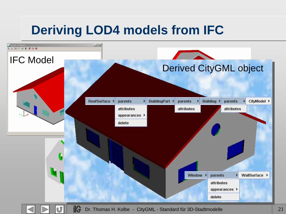
Deriving LOD4 models from IFC
IFC Model
Current research of Benner, Geiger, LeinemannHelmholtz Research Center Karlsruhe
Derived CityGML object

Dr. Thomas H. Kolbe - CityGML - Standard für 3D-Stadtmodelle 22
Generic CityObjects and Attributes
• Explicitly modeled feature types have the advantage of well-defined object semantics
• However, often concrete models comprise additional attributes or features not covered by the model
• Incorporation of generic CityObjects and attributes– every CityObject can have an arbitrary number of
generic attributes (string, int, real, date, URI)– GenericCityObject is subclass of CityObject
• arbitrary GML3 geometry for each LOD
– may only be used, if there is no appropriate concept provided by CityGML (problematic wrt. semantic inter.)
Dr. Thomas H. Kolbe - CityGML - Standard für 3D-Stadtmodelle 23
Grouping of CityObjects
• Feature type CityObjectGroup– has arbitrary CityObjects as members
• CityObjectGroup is a CityObject– can become again member of another group– every member can denote its role in a group
• usable for user-defined aggregations– e.g. results of classifications or selection
• usable also to group CityObjects wrt. some function or area, e.g. – city districts, building storeys, or evacuation areas
Dr. Thomas H. Kolbe - CityGML - Standard für 3D-Stadtmodelle 24
“Backdoor Topology“• How to allow for flexible usage of topology?
– Until now, most 3D city models do consider topology– need to represent city models with geometry only
• Topology model of GML3 sophisticated, but complex– would make it necessary to implement 2 options for
the representation of spatial properties
• Approach in CityGML:– topological connections are represented by Xlinks– GML3 geometries are objects; composites/aggregates
can include subgeometries by value or by reference; – references express topological relations
Dr. Thomas H. Kolbe - CityGML - Standard für 3D-Stadtmodelle 25
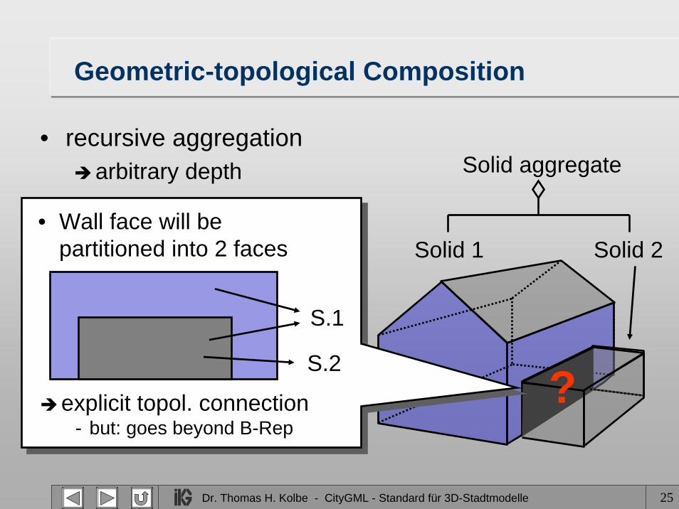
Geometric-topological Composition
• recursive aggregationarbitrary depth
Solid 1 Solid 2
Solid aggregate
?
SolidGeometry
Solid
SolidAggregate
• Wall face will be partitioned into 2 faces
S.1
S.2
explicit topol. connection- but: goes beyond B-Rep

Dr. Thomas H. Kolbe - CityGML - Standard für 3D-Stadtmodelle 26
Semantic Relations by Topology
• Multiple referencing of geometry (components)– realizes topological, but also semantic relations– redundancy free description of space and surfaces possible,
thus no overlaps occur
This surface is part ofthe geometries of the bridge object and the
road object
© Rheinmetall Defence Electronics

Dr. Thomas H. Kolbe - CityGML - Standard für 3D-Stadtmodelle 27
Extensions to GML3
• Surface Materials– Colors, Textures (adopted from X3D)– TexturedSurface is subclass of gml:OrientableSurface
• Implicit geometries (Prototypic shapes)– Shape of a 3D object in local coordinates– Instancing at anchor points (+ further transformations)
• Both are concepts used in scene graphs– directly transformable to VRML, X3D, U3D etc.– however only simple & limited extensions– tailored to the demand of 3D city models– easy to support by exporting / importing applications
Dr. Thomas H. Kolbe - CityGML - Standard für 3D-Stadtmodelle 28
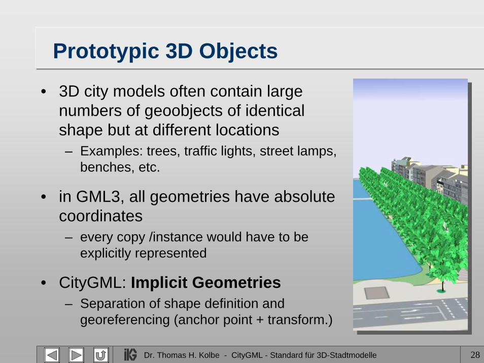
Prototypic 3D Objects
• 3D city models often contain large numbers of geoobjects of identical shape but at different locations – Examples: trees, traffic lights, street lamps,
benches, etc.
• in GML3, all geometries have absolute coordinates– every copy /instance would have to be
explicitly represented
• CityGML: Implicit Geometries– Separation of shape definition and
georeferencing (anchor point + transform.)
Dr. Thomas H. Kolbe - CityGML - Standard für 3D-Stadtmodelle 29
CityGML (Partial) Implementations
• LandXPlorer (3dgeo) • CityServer 3D (GIStec / FhG IGD)• SupportGIS (CPA Geo-Information)• Tridicon (GTA Geoinformatik)• GoPublisher (Snowflake Software UK)• Aristoteles GML3 3D Viewer (IKG Uni Bonn)• Open Source Framework Deegree, WFS 1.1.0 (lat/lon, in
preparation)• 3D Geo DB of the cities Berlin & Bonn;
Oracle Spatial and PostGIS (IKG Uni Bonn, in prep.)
Dr. Thomas H. Kolbe - CityGML - Standard für 3D-Stadtmodelle 30

Dr. Thomas H. Kolbe - CityGML - Standard für 3D-Stadtmodelle 31
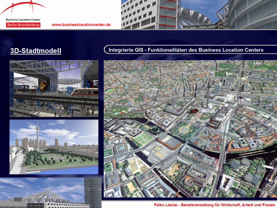
The Official 3D City Model of Berlin
• Background: Need for 3D city model for urban planning, city marketing, and recruiting of new enterprises
• Integration of existing 3D models of the departments of business development and town planning
• Contribution to the SDI Berlin in the field of 3D
• European EFRE Pilot Project from 2003 to 2005
• Currently introduction into regular operation
Dr. Thomas H. Kolbe - CityGML - Standard für 3D-Stadtmodelle 32
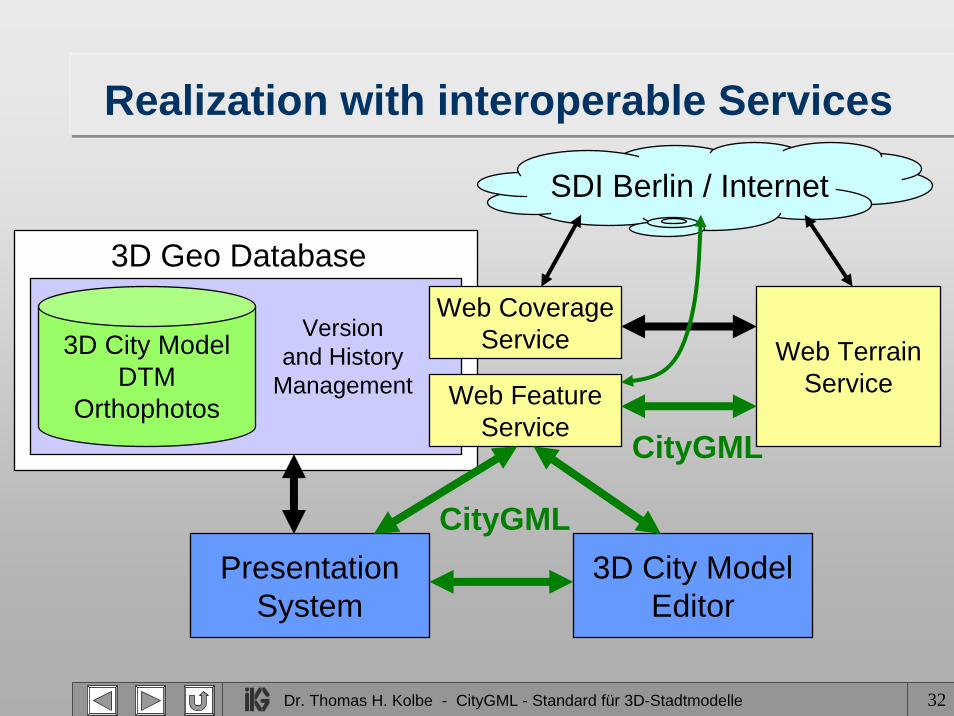
Realization with interoperable Services
3D City ModelDTM
Orthophotos
3D Geo Database
Versionand History
Management
PresentationSystem
3D City ModelEditor
CityGML
Web FeatureService
Web CoverageService Web Terrain
Service
CityGML
SDI Berlin / Internet
Dr. Thomas H. Kolbe - CityGML - Standard für 3D-Stadtmodelle 33
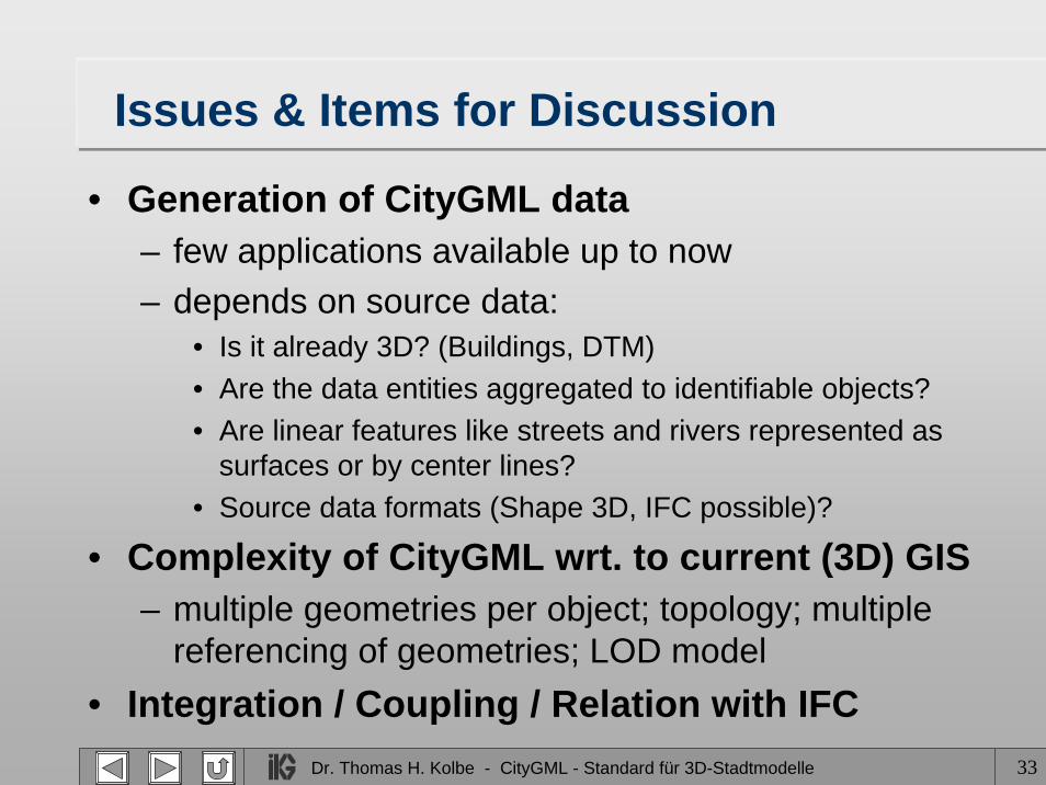
Issues & Items for Discussion
• Generation of CityGML data– few applications available up to now– depends on source data:
• Is it already 3D? (Buildings, DTM)• Are the data entities aggregated to identifiable objects?• Are linear features like streets and rivers represented as
surfaces or by center lines?• Source data formats (Shape 3D, IFC possible)?
• Complexity of CityGML wrt. to current (3D) GIS– multiple geometries per object; topology; multiple
referencing of geometries; LOD model• Integration / Coupling / Relation with IFC
Related Documents