CITY OF VADER LEWIS COUNTY WASHINGTON SHORELINE RESTORATION PLAN ECOLOGY GRANT G1200046 G&O #11253 DECEMBER 2014

Welcome message from author
This document is posted to help you gain knowledge. Please leave a comment to let me know what you think about it! Share it to your friends and learn new things together.
Transcript

CITY OF VADER LEWIS COUNTY WASHINGTON
SHORELINE RESTORATION PLAN
ECOLOGY GRANT G1200046 G&O #11253
DECEMBER 2014

CITY OF VADER LEWIS COUNTY WASHINGTON
SHORELINE RESTORATION PLAN
ECOLOGY GRANT G1200046 G&O #11253
DECEMBER 2014

ACKNOWLEDGMENTS The City of Vader would like to acknowledge the many public and private agencies that
have developed information on the shorelines of Lewis County that was used in this report.
This report was prepared with Grant Funding from the Washington State Department of
Ecology SMA Grant Agreement No. G1200046

i
TABLE OF CONTENTS INTRODUCTION .....................................................................................................................1
Background ..............................................................................................................1 Context .....................................................................................................................2
RESTORATION GOALS, POLICIES AND DEVELOPMENT STANDARDS ......................................3 RESTORATION OPPORTUNITIES .............................................................................................4
Priority 1: Opportunity Site A ................................................................................5 Priority 2: Opportunity Site B .................................................................................6 Priority 3: Opportunity Site C .................................................................................7
IMPLEMENTATION STRATEGIES .............................................................................................7 Primary Restoration Partners ...................................................................................7 Additional Potential Restoration Partners ................................................................8 Funding Opportunities ...........................................................................................10
OTHER RESTORATION MEASURES .......................................................................................11 CONCLUSION .......................................................................................................................11 REFERENCES .......................................................................................................................12
LIST OF TABLES No. Table Page 1 Timeline for the Shoreline Master Program Update for the City of Vader .............2 2 Potential Restoration Projects in Vader ...................................................................4 3 Primary Restoration Partners ...................................................................................8 4 Additional Potential Restoration Partners ................................................................8 5 Potential Funding Opportunities ............................................................................10
LIST OF FIGURES No. Figure Page 1 Conceptual View of the Objectives of the Shroeline Management Act
(Source, WA Department of Ecology)...............................................................1
LIST OF MAPS No. Map Follows Page 1 Potential Shoreline Restoration Projects ................................................................12

City of Vader 1 Shoreline Restoration Plan December 2014
INTRODUCTION BACKGROUND This report is the proposed restoration plan for the City of Vader, including a 13 acre site purchased by the city and named McMurphy Park located just outside the City limits. The document has been prepared to comply with the state’s Shoreline Master Program guidelines for restoration planning (WAC 173-26-201(2)) and is meant to provide a planning-level framework for understanding how and where shoreline ecological functions can be restored1 in the City and its urban growth area. The plan is not a regulatory document or a set of regulatory requirements, and is only meant to be used as a resource for future shoreline restoration efforts. Guidelines for the creation of Shoreline Master Programs require that master programs contain goals, policies and actions for restoration of impaired ecological functions. Beyond preventing further loss of ecological functions, master programs provisions should be designed to “…achieve overall improvements in shoreline ecological functions over time when compared to the status upon adoption of the master program.2” A visual depiction of this overall improvement or restoration of shoreline ecological functions is displayed within Figure 1.
FIGURE 1
Conceptual view of the Objectives of the Shoreline Management Act (Source, WA Department of Ecology)
1 Restoration is defined under the shoreline guidelines as “reestablishment or upgrading of impaired ecological shoreline processes or functions.” It is important to note that, for the purposes of shoreline management, the term does not imply returning shoreline areas to aboriginal or pre-European settlement conditions. 2 The mandate to improve ecological functions over time provides the basis for restoration planning and creates the distinction between project-related mitigation and environmental restoration in the context of the SMP. Under the Shoreline Management Act, applicants for shoreline permits must fully mitigate new impacts caused by their proposed development, but are not required to restore past ecosystem damages as a condition of permit approval. Project applicants are also not required to implement the restoration measures identified in this plan as mitigation for project-related impacts, except in those instances where restoration is deemed appropriate. The two white arrows within Figure 1 display this distinction: the upward portion of the left white arrow represents project-related mitigation, while the right white arrow displays restoration.

Gray & Osborne, Inc., Consulting Engineers
2 City of Vader December 2014 Shoreline Restoration Plan
To achieve this overall improvement, the guidelines recommend that restoration plans:
• Identify degraded areas, impaired ecological functions, and sites with potential for restoration;
• Establish overall goals and priorities for restoration of degraded areas and impaired ecological functions;
• Identify existing and ongoing projects and programs that are currently being implemented, or are reasonably assured of being implemented (based on an evaluation of funding likely in the foreseeable future), which are designed to contribute to local restoration goals;
• Identify additional projects and programs needed to achieve local restoration goals, and implementation strategies, including identifying prospective funding sources for those projects and programs;
• Identify timelines and benchmarks for implementing restoration projects and achieving local restoration goals; and
• Provide mechanisms or strategies to ensure that restoration projects and programs will be implemented according to plans and to appropriately review the effectiveness of the projects and programs in meeting the overall restoration goals.
CONTEXT This restoration plan has been created as part of the Shoreline Master Program update for the City of Vader and is included in Phase 4 of the overall update. A timeline for the update is shown below:
TABLE 1
Timeline for the Shoreline Master Program Update for the City of Vader Phase Update Schedule Timeline
1 • Prepare Jurisdiction Maps • Prepare a Public Participation Plan Fall 2012
2 • Analyze and characterize shoreline conditions Winter 2012
3 • Complete Draft Shoreline Master Program Update • Complete Cumulative Impact Analysis Report Spring 2013
4 • Complete Draft Restoration plan and Implimentation Strategy • Complete No Net Loss Report
Winter 2013 Spring 2014
5 • Conduct public hearings • Planning Commission Recommendation • City Council Action
Spring - Summer
2014
6 • Ecology Review • Ecology Action • Final Adoption by Ecology and the City Council
Winter 2014/2015

Gray & Osborne, Inc., Consulting Engineers
City of Vader 3 Shoreline Restoration Plan December 2014
RESTORATION GOALS, POLICIES AND DEVELOPMENT STANDARDS This restoration plan builds upon the identification of degraded areas, impaired ecological functions, and sites with the potential for ecological restoration as identified in the Shoreline Inventory and Characterization for Vader (2013) conducted in Phase 2 of the update and is based on the following restoration goals found within section 5 of the Proposed Shoreline Master Program:
1. Improve impaired shoreline ecological functions and/or processes through voluntary and incentive-based public and private programs and actions that are consistent with the Shoreline Master Program and other approved restoration plans.
2. Provide fundamental support to restoration work by various organizations
by identifying shoreline restoration priorities, and by organizing information on available funding sources for restoration opportunities.
3. Target restoration and enhancement towards improving habitat
requirements of priority and/or locally important wildlife species. The plan also builds on the priorities for restoration projects identified in subsection E of the Restoration and Enhancement Policies in Section 8 of the Proposed Shoreline Master Program . This policy states that restoration actions and stand alone projects are prioritized in the following order:
1. Create dynamic and sustainable ecosystems.
2. Preserve and restore natural channel patterns, connectivity between side channels, floodplains and hyporheic zones.
3. Restore natural channel-forming geomorphologic processes. 4. Look for ways to augment low summer flows and provide additional
salmonid rearing habitat. 5. Reduce sediment input to streams and rivers and associated impacts. 6. Improve water quality. 7. Restore native vegetation and natural hydrologic functions of degraded
and former wetlands.

Gray & Osborne, Inc., Consulting Engineers
4 City of Vader December 2014 Shoreline Restoration Plan
8. Replant native vegetation in riparian areas to restore functions, and retain intact habitat by continuing to protect well vegetated shorelines.
9. Remove obsolete and no longer needed shoreline modifications.
RESTORATION OPPORTUNITIES Sites with the potential for restoration, along with a short description of potential restoration projects on the site, and the restoration priority that the projects would address are presented within Table 2. The location of these projects is shown in Map 1 (found at the back of this document).3
TABLE 2
Potential Restoration Projects in Vader
Shoreline Opportunity
Site Potential
Project Description Restoration
Priority Olequa Creek
Site A Replant riparian vegetation and trees along the creek. Regrade and vegetate the bend to functionas a floodplain. Create a potential outdoor classroom with interpretative trail for the elementary, middle and high school students.
• Create dynamic and sustainable ecosystems (Priorities 1 and 2)
• Reduce sediment input into the Creek (Priority 5)
• Restore native vegetation and natural hydrologic functions of degraded riparian areas (Priorities 7 and 8)
Site B Replant riparian vegetation and trees along the creek. Create a potential outdoor classroom trail access to shoreline.
• Reduce sediment input into the Creek (Priority 5)
• Replant native vegetation in riparian areas to restore functions (Priority 8)
Site C Fence steep sloped riparian buffer areas for safety and to restrict access.and replant riparian vegetation and trees along the creek. Create a potential outdoor classroom trail access to shoreline.
• Restore native vegetation and natural hydrologic functions of degraded and former wetlands and riparian areas (Priorities 7 and 8)
3 In addition to these opportunity sites, additional private riparian restoration efforts have a similar potential to enhance the shoreline habitat along Olequa Creek. Private restoration opportunities would be consistent with Restoration Goal 1 of the Shoreline Master Program, which seeks to improve impaired shoreline ecological functions and/or processes through voluntary and incentive-based public and private programs, but these types of projects were not specifically analyzed in Table 2 due to the lage number and variety of potential restoration efforts that could occur. If the city was interested in facilitating private restoration efforts among landowners, the City could coordinate with a non-profit organization toconduct a project such as the planting of riparian vegetation (trees and shrubs) along the shore.

Gray & Osborne, Inc., Consulting Engineers
City of Vader 5 Shoreline Restoration Plan December 2014
Currently, there are no restoration projects planned and no funding currently available for restoration projects within the City’s corporate limits. The priority restoration projects listed in the following sections are identified as opportunities that could be performed on City owned property with moderate funding and would contribute to the restoration goals outlined in the SMP. These three potential restoration projects have similar priority rankings, but have different levels of access. The potential priority rankings (listed in order of priority) are: Opportunity Site A, Opportunity Site B and Opportunity Site C. Projects planned for these sites should incorporate plantings that will add LWD and take advantage of any opportunities to provide additional storage capacity to help mitigate the low flow conditions in late summer and early fall. PRIORITY 1: OPPORTUNITY SITE A Opportunity Site A currently has good public access as it is the City’s newest park. This site provides the potential to enhance habitat along the creek and create an environment for outdoor education. The site has moderate quality riparian habitat, including small stands of fir and alder trees adjacent to a large gravel shoreline; however, the ecological functions of the upper site are minimized due to the previous clearing as a result of past agricultural activities. Restoration of the area would enhance ecological functions and could provide educational opportunities for the adjacent school district. In an effort to restore natural channel patterns, the City could also choose to pull the park improvements back from the creek, recontour the shoreline, and allow the channel to reconnect with historic floodplains and wetlands that may regenerate along the shoreline.
Opportunity Site A – Looking West Towards Olequa Creek from McMurphy Park Property
Gray & Osborne, Inc., Consulting Engineers
6 City of Vader December 2014 Shoreline Restoration Plan
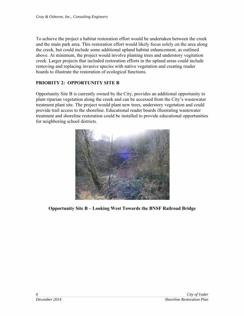
To achieve the project a habitat restoration effort would be undertaken between the creek and the main park area. This restoration effort would likely focus solely on the area along the creek, but could include some additional upland habitat enhancement, as outlined above. At minimum, the project would involve planting trees and understory vegitation creek. Larger projects that included restoration efforts in the upland areas could include removing and replacing invasive species with native vegetation and creating reader boards to illustrate the restoration of ecological functions. PRIORITY 2: OPPORTUNITY SITE B Opportunity Site B is currently owned by the City, provides an additional opportunity to plant riparian vegetation along the creek and can be accessed from the City’s wastewater treatment plant site. The project would plant new trees, understory vegetation and could provide trail access to the shoreline. Educational reader boards illustrating wastewater treatment and shoreline restoration could be installed to provide educational opportunities for neighboring school districts.
Opportunity Site B – Looking West Towards the BNSF Railroad Bridge
Gray & Osborne, Inc., Consulting Engineers
City of Vader 7 Shoreline Restoration Plan December 2014
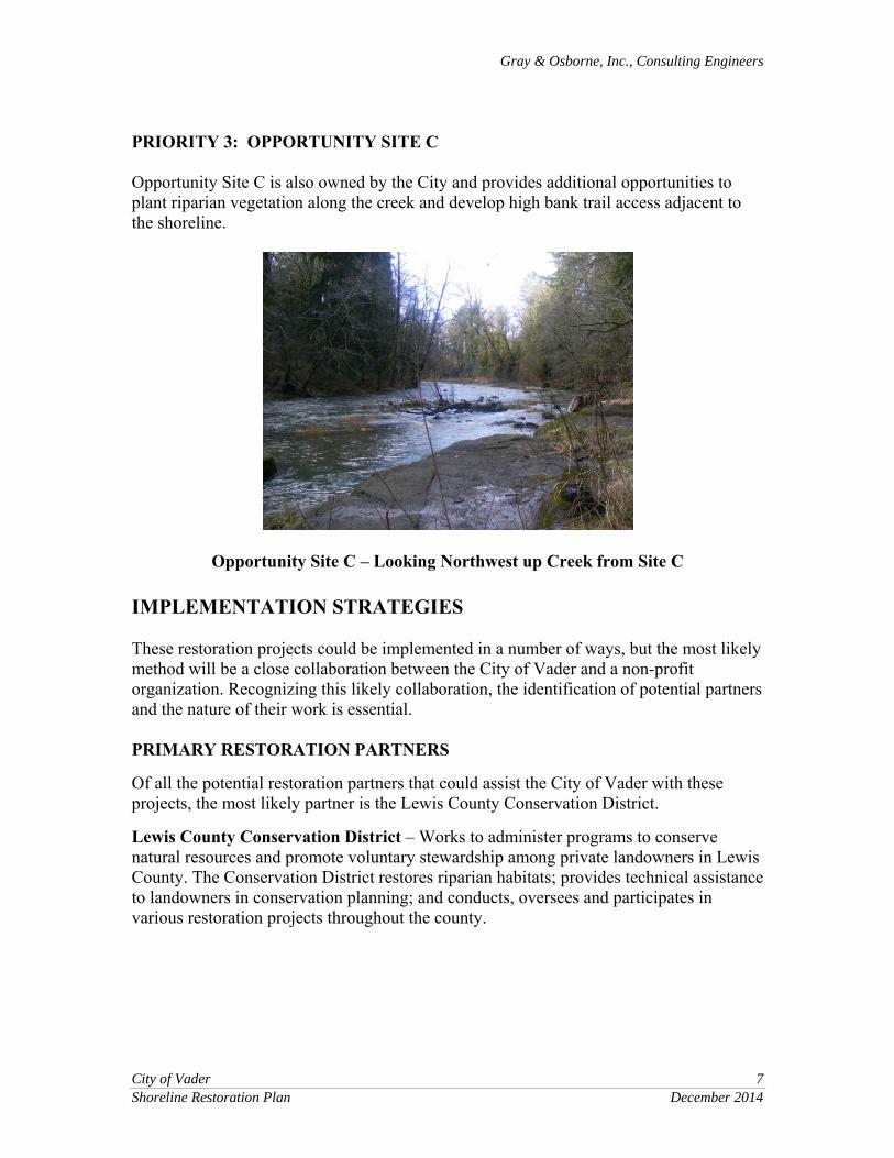
PRIORITY 3: OPPORTUNITY SITE C Opportunity Site C is also owned by the City and provides additional opportunities to plant riparian vegetation along the creek and develop high bank trail access adjacent to the shoreline.
Opportunity Site C – Looking Northwest up Creek from Site C IMPLEMENTATION STRATEGIES These restoration projects could be implemented in a number of ways, but the most likely method will be a close collaboration between the City of Vader and a non-profit organization. Recognizing this likely collaboration, the identification of potential partners and the nature of their work is essential. PRIMARY RESTORATION PARTNERS Of all the potential restoration partners that could assist the City of Vader with these projects, the most likely partner is the Lewis County Conservation District. Lewis County Conservation District – Works to administer programs to conserve natural resources and promote voluntary stewardship among private landowners in Lewis County. The Conservation District restores riparian habitats; provides technical assistance to landowners in conservation planning; and conducts, oversees and participates in various restoration projects throughout the county.

Gray & Osborne, Inc., Consulting Engineers
8 City of Vader December 2014 Shoreline Restoration Plan
TABLE 3
Primary Restoration Partner
Group Description Restoration Activities Lewis County Conservation District
The Lewis County Conservation District (LCCD) promotes voluntary stewardship among private landowners in Lewis County. Conservation Districts are governmental entities that administer programs to conserve or restore natural resources.
The LCCD oversees and participates in various restoration projects throughout Lewis County. The conservation district works to restore riparian habitats; and is involved with agricultural assessments, education and outreach.
ADDITIONAL POTENTIAL RESTORATION PARTNERS Additional restoration partners beyond these primary partners include a number of government and non-profit groups that provide funding for restoration projects. Several of these groups are listed in Table 4.
TABLE 4
Additional Potential Restoration Partners
Group Description Restoration Activities American Rivers American Rivers has been
involved in the discussion and conservation activities in the Pacific Northwest for over 20 years. Their Northwest offices are located in Seattle Washington and Portland Oregon.
American Rivers is working with Volcano Country Wild and Scenic Rivers Coalition to protect 200 miles of rivers and streams in Southwest Washington under the federal wild and Scenic rivers Act.
The Volcano Country Wild River Coalition
The Volcano Country Wild River Coalition is working to build support for their proposal to protect 200 miles of rivers and streams in Southwest Washington. The coalition includes 11 other organizations interested in protecting and restoring shorelines.
Developed proposal to protect 200 miles of rivers and streams in Southwest Washington under the federal wild and Scenic rivers Act. The proposal does not include the Cowlitz River and Olequa Creek but does address portions of the following rivers: Cispus, Green, Lewis and White Salmon. The proposal also covers portions of the following creeks: Clear, Pine, Quarit, Rush, Siouxon, Smith and yellowjacket.

Gray & Osborne, Inc., Consulting Engineers
City of Vader 9 Shoreline Restoration Plan December 2014
TABLE 4 – (continued)
Additional Potential Restoration Partners
Group Description Restoration Activities Forterra The Forterra group’s mission
is to protect, enhance and steward communities and landscapes. As one of the largest conservation organizations in Washington State, Forterra has successfully led efforts over the last 20 years to conserve nearly 234,000 acres of forests, farms, shorelines, parks and natural areas and restore critical landscapes. Forterra offices are locatedin seattle, Tacoma and Ellensburg.
Forterra works with private landowners, local governments and non-profits to help them become more effective managers and stewards of their natural areas. Specific services include partnering with municipalities to develop volunteer-based stewardship programs for forested parklands and other green infrastructure; creating and implementing restoration and management plans; developing and delivering training programs, best management practices and forest and natural area stewardship guides and outreach publications; and convening a wide variety of stakeholders to help solve complex landscape problems. Ecological Restoration Forterra partners with multiple stakeholders to identify ecological restoration priorities, create restoration plans and designs, coordinate project planning and implementation, manage project contractors and oversee project monitoring to help ensure restoration results are maintained over time.
These partners have their own distinct capacities (whether fundraising, land acquisition or habitat enhancement) and could be asked to provide technical assistance or support to any of the projects identified. Additionally, individuals that live within the City or the surrounding area that possess these or similar capacities could also be identified and solicited to support restoration efforts.

Gray & Osborne, Inc., Consulting Engineers
10 City of Vader December 2014 Shoreline Restoration Plan
FUNDING OPPORTUNITIES Opportunities for funding these or other restoration projects within the City’s shoreline area are limited. The most relevant funding sources have been listed in Table 5.
TABLE 5
Potential Funding Opportunities Funding Source Description Restoration Activities
Salmon Recovery Funding Board (SRFB)
Created in 1999 by the Washington State Legislature, the Salmon Recovery Funding Board (SRFB) provides grant funds to protect or restore salmon habitat and assist in related activities. These funds are administerd thorugh the Recreation and Conservation Office (RCO) formerly Interagency Committee for Outdoor Recreation (IAC). The RCO works closely with local watershed groups known as lead entities. The SRFB board is composed of five citizens appointed by the Governor and five state agency directors.
The SRFB Board supports salmon recovery by funding habitat protection and restoration projects. It also supports programs and activities that produce sustainable and measurable benefits for fish and their habitat. The SRFB has helped finance over 900 projects. The SRFB has funded one project in the vicinity of Vader – Lewis County’s Curtis Creek (tributary to Olequa Creek) barrier culvert replacement project (approx. 4 miles upstream of Vader). Two other culvert fish barrier correction projects in this vicinity are in the preapplication phase, and two undersized, perched culverts on Curtis Creek are in the process of being replaced.
Aquatic Lands Enhancement Account (ALEA)
The Aquatic Lands Enhancement Account funds are handled through the WA Department of Natural Resopurces (WDNR).
There are no known ALEA funded projects in or near Vader.
Washington Wildlife and Recreation Program (WWRP)
The Washington Wildlife and Recreation Program is a state grant program that provides funding to protect habitat, preserve working farms and create new local and state parks. It is administered by the Recreation and Conservation Office (RCO). WWRP is funded by the legislature in the state’s capital construction budget.
There are no known WWRP grant funded projects in or near Vader.

Gray & Osborne, Inc., Consulting Engineers
City of Vader 11 Shoreline Restoration Plan December 2014
OTHER RESTORATION MEASURES Beyond the restoration opportunities listed above, the restoration of shoreline ecological functions could also occur as a result of mitigation of impacts from new or expanded development projects, and the creation and observation of standards that are based on the environmental characteristics of the shoreline environment. Mitigation and mitigation sequencing requirements can be found throughout the Proposed Shoreline Master Program, with compensatory mitigation being required where an impact to the shoreline environment is anticipated as a result of development. In most instances this mitigation is meant to alleviate the impacts of development, however in some instances mitigation and the consideration of mitigation sequencing will allow the overall functioning of the environment to improve. For instance, if an individual sought to enlarge a home that was a nonconforming use under the Proposed Shoreline Master Program, their addition would have to expand landward or upwards. If the expansion had an impact on shoreline ecological functions, the project would require mitigation of those impacts, which could take the form of shoreline restoration. If a situation like this occurred, most of the impacts are likely to occur away from the immediate shoreline (where less impact to shoreline functions is likely) and most of the mitigation would occur near the the shoreline (where a higher level of shoreline ecological function is possible). If the project was completed in this manner, the mitigation would mitigate the potential impacts of the additional building square footage, and potentially provide some additional restoration value, as depicted above within Figure 1. Required setback standards and vegetation retention standards within the Proposed Shoreline Master Program further provide the opportunity for shoreline functions to be enhanced over time. As plants grow, age and die, they naturally improve shoreline ecological functions by creating habitat and vegetation layers that vary in age, shading the river, and eventually creating large wood that provides shoreline habitat. Vegetation retention standards also may, over time, contribute to a more diverse vertical habitat structure in the shoreline environment. Critical area buffers and setbacks will ensure these areas are preserved to the extent feasible so that vegetative growth and regeneration are given the opportunity to occur. CONCLUSION When considering current conditions, the standards articulated within the Proposed Shoreline Master Program, and the potential restoration partners and projects that are available for the Vader shoreline, it is possible that the enhancement of shoreline functions compared with the current ecological conditions could occur. The City of Vader has several areas that could see some small scale habitat restoration, as well as some larger projects that could contribute to the overall quality and functions of the Olequa Creek shoreline environment. This plan has sought to articulate the key pieces of property on which these various types of restoration could occur, and has articulated

Gray & Osborne, Inc., Consulting Engineers
12 City of Vader December 2014 Shoreline Restoration Plan
some of the partners that could be utilized to assist in the process. The completion of the projects will not be easy but, with the strength of the potential partners and the benefits of the protential projects, the successful implementation of the efforts is promising.
REFERENCES Washington State Recreation and Conservation website,
http://www.rco.wa.gov/boards/rcfb.shtml Accessed – December 10, 2013. American Rivers website www.americanrivers.org Volcano Country Wild Rivers Coalition website www.volcanocountryrivers.org Forterra website www.forterra.org

LEGEND URBAN CONSERVANCY ENVIRONMENT*
RESTORATION OPPURTUNITIES ON PRIVATE PROPERTIES
SITE A
SITE B
SITE C
CITY LIMITS
UGA
ROADS
RIVER & STREAMS
GGGG G
7th
7th7th7th7th
A
n
n
o
n
e
n
A
n
n
o
n
e
n
A
n
n
o
n
e
n
A
n
n
o
n
e
n
A
n
n
o
n
e
n
Annonen
Annonen
Annonen
Annonen
Annonen
W
e
s
t S
id
e
W
e
s
t S
id
e
W
e
s
t S
id
e
W
e
s
t S
id
e
W
e
s
t S
id
e
O
lequa
O
lequa
O
lequa
O
lequa
O
lequa
O
l
e
q
u
a
O
l
e
q
u
a
O
l
e
q
u
a
O
l
e
q
u
a
O
l
e
q
u
a
O
l
e
q
u
a
O
l
e
q
u
a
O
l
e
q
u
a
O
l
e
q
u
a
O
l
e
q
u
a
E
n
c
h
a
n
t
e
d
V
a
l
l
e
y
E
n
c
h
a
n
t
e
d
V
a
l
l
e
y
E
n
c
h
a
n
t
e
d
V
a
l
l
e
y
E
n
c
h
a
n
t
e
d
V
a
l
l
e
y
E
n
c
h
a
n
t
e
d
V
a
l
l
e
y
E
n
ch
a
n
te
d
V
a
lle
y
E
n
ch
a
n
te
d
V
a
lle
y
E
n
ch
a
n
te
d
V
a
lle
y
E
n
ch
a
n
te
d
V
a
lle
y
E
n
ch
a
n
te
d
V
a
lle
y
O
l
e
q
u
a
O
l
e
q
u
a
O
l
e
q
u
a
O
l
e
q
u
a
O
l
e
q
u
a
P
a
r
k
P
a
r
k
P
a
r
k
P
a
r
k
P
a
r
k
O
le
q
u
a
O
le
q
u
a
O
le
q
u
a
O
le
q
u
a
O
le
q
u
a
Park
ParkParkParkPark
FFFF F
Park
ParkParkParkPark
EEEE E
West S
ide H
wy
West S
ide H
wy
West S
ide H
wy
West S
ide H
wy
West S
ide H
wy
L
ittle
P
in
to
L
ittle
P
in
to
L
ittle
P
in
to
L
ittle
P
in
to
L
ittle
P
in
to
DDDD D
Alpine
Alpine
Alpine
Alpine
Alpine
A
AAAA
CCCC C
BBBB B
10th
10th10th10th10th
HHHH H
10th
10th10th10th10th
GGGG G
EEEE E
D S
tD
S
tD
S
t
D S
tD
S
t
C S
t A
lley
C S
t A
lley
C S
t A
lley
C S
t A
lley
C S
t A
lley
10th St
10th St10th St
10th St
10th St
BBBB BAAAA A
IIII I
IIII I
9th
9th9th9th9th
GGGG G
FFFF F
Enchantment
EnchantmentEnchantment
Enchantment
Enchantment
9th
9th9th9th9th
Main
Main
Main
Main
Main
Enchantment
EnchantmentEnchantment
Enchantment
Enchantment
F
i
r
g
r
o
v
e
F
i
r
g
r
o
v
e
F
i
r
g
r
o
v
e
F
i
r
g
r
o
v
e
F
i
r
g
r
o
v
e
8th
8th8th8th8th
IIII I
8th St
8th St8th St8th St8th St
W
e
s
t
S
i
d
e
H
w
y
W
e
s
t
S
i
d
e
H
w
y
W
e
s
t
S
i
d
e
H
w
y
W
e
s
t
S
i
d
e
H
w
y
W
e
s
t
S
i
d
e
H
w
y7
th7
th
7
th
7
th
7
th
S
T
A
T
E
5
0
6
S
T
A
T
E
5
0
6
S
T
A
T
E
5
0
6
S
T
A
T
E
5
0
6
S
T
A
T
E
5
0
6
7th
7th7th7th7th
C S
t A
lley
C S
t A
lley
C S
t A
lley
C S
t A
lley
C S
t A
lley
Main
Main
Main
Main
Main
7th
7th7th7th7th
Annonen R
d
Annonen R
dA
nnonen R
d
Annonen R
dA
nnonen R
d
STATE 506
STATE 506STATE 506
STATE 506
STATE 506
S
T
A
T
E
5
0
6
S
T
A
T
E
5
0
6
S
T
A
T
E
5
0
6
S
T
A
T
E
5
0
6
S
T
A
T
E
5
0
6
Winlock V
ader
Winlock V
ader
Winlock V
ader
Winlock V
ader
Winlock V
ader
M
ilit
a
r
y
M
ilit
a
r
y
M
ilit
a
r
y
M
ilit
a
r
y
M
ilit
a
r
y
5
0
6
5
0
6
5
0
6
5
0
6
5
0
6
FFFF F
EEEE E
DDDD D
BBBB B
6th St
6th St6th St6th St6th St
AAAA A
5th S
t
5th S
t
5th S
t
5th S
t
5th S
t
EEEE E
AAAA A
Main
Main
Main
Main
Main
W
illm
ar
W
illm
ar
W
illm
ar
W
illm
ar
W
illm
ar
5
0
6
5
0
6
5
0
6
5
0
6
5
0
6
AAAA A
Noble
Noble
Noble
Noble
Noble
Miracle
Miracle
Miracle
Miracle
Miracle
Noble
Noble
Noble
Noble
Noble
Winlock V
ader
Winlock V
ader
Winlock V
ader
Winlock V
ader
Winlock V
ader
Saari
Saari
Saari
Saari
Saari
O
l
e
q
u
a
C
r
e
e
k
O
l
e
q
u
a
C
r
e
e
k
O
l
e
q
u
a
C
r
e
e
k
O
l
e
q
u
a
C
r
e
e
k
O
l
e
q
u
a
C
r
e
e
k
O
l
e
q
u
a
C
r
e
e
k
O
l
e
q
u
a
C
r
e
e
k
O
l
e
q
u
a
C
r
e
e
k
O
l
e
q
u
a
C
r
e
e
k
O
l
e
q
u
a
C
r
e
e
k
O
le
q
u
a
C
r
e
e
k
O
le
q
u
a
C
r
e
e
k
O
le
q
u
a
C
r
e
e
k
O
le
q
u
a
C
r
e
e
k
O
le
q
u
a
C
r
e
e
k
S
t
i
l
l
w
a
t
e
r
C
r
e
e
k
S
t
i
l
l
w
a
t
e
r
C
r
e
e
k
S
t
i
l
l
w
a
t
e
r
C
r
e
e
k
S
t
i
l
l
w
a
t
e
r
C
r
e
e
k
S
t
i
l
l
w
a
t
e
r
C
r
e
e
k
S
t
i
l
l
w
a
t
e
r
C
r
e
e
k
S
t
i
l
l
w
a
t
e
r
C
r
e
e
k
S
t
i
l
l
w
a
t
e
r
C
r
e
e
k
S
t
i
l
l
w
a
t
e
r
C
r
e
e
k
S
t
i
l
l
w
a
t
e
r
C
r
e
e
k
M
c
M
u
r
p
h
y
C
r
e
e
k
M
c
M
u
r
p
h
y
C
r
e
e
k
M
c
M
u
r
p
h
y
C
r
e
e
k
M
c
M
u
r
p
h
y
C
r
e
e
k
M
c
M
u
r
p
h
y
C
r
e
e
k
McM
urphy C
reek
McM
urphy C
reek
McM
urphy C
reek
McM
urphy C
reek
McM
urphy C
reek
O
l
e
q
u
a
C
r
e
e
k
O
l
e
q
u
a
C
r
e
e
k
O
l
e
q
u
a
C
r
e
e
k
O
l
e
q
u
a
C
r
e
e
k
O
l
e
q
u
a
C
r
e
e
k
O
l
e
q
u
a
C
r
e
e
k
O
l
e
q
u
a
C
r
e
e
k
O
l
e
q
u
a
C
r
e
e
k
O
l
e
q
u
a
C
r
e
e
k
O
l
e
q
u
a
C
r
e
e
k
SCALE: 1" = 800'
All features depicted on this map are approximate. They have not been
formally delineated or surveyed and are intended for planning purposes
only. Additional site-specific evaluation may be needed to confirm/ verify
information shown on this map.
0 800' 1600'
SITE A
SITE B
SITE C
*INCLUDES PROPERTIES THAT INTERSECT THE 200' FLOODWAY BUFFER,
THE 100 YEAR FLOODPLAIN AND THE 200' OHW BUFFER
Related Documents


