City of Springfield 2035 Transportation System Plan City of Springfield 225 5 th Street Springfield, OR 97477 July 21, 2014

Welcome message from author
This document is posted to help you gain knowledge. Please leave a comment to let me know what you think about it! Share it to your friends and learn new things together.
Transcript
City of Springfield
2035 Transportation System Plan
City of Springfield 225 5th Street Springfield, OR 97477
July 21, 2014

Table of contents
Acknowledgements ..................................................................................................................... vi Acronyms and abbreviations .................................................................................................... viii Chapter 1: Introduction ................................................................................................................. 1
Plan overview ......................................................................................................................... 1 The City’s first TSP .................................................................................................................... 2
Regional coordination ............................................................................................ 2 Transportation project development ................................................................... 3 Public and agency involvement .......................................................................... 3
Economic development priority areas ............................................................................. 3 Planning context .................................................................................................................... 3
Transportation planning environment.................................................................. 4 Financial environment ............................................................................................ 7
Organization of the 2035 TSP ............................................................................................... 8 Chapter 2: Goals and policies ..................................................................................................... 9
Creating goals, policies, and action items ....................................................................... 9 2035 TSP goals, policies, and action items ........................................................................ 9
Chapter 3: Transportation System Plan process ....................................................................... 17 Existing and future needs ................................................................................................... 17 Existing conditions analyses ............................................................................................... 17 2035 forecast analysis ......................................................................................................... 18 No Build transportation system assumptions .................................................................. 19 Traffic Volume Development ............................................................................................ 19 No Build analyses ................................................................................................................. 19 Evaluation process .............................................................................................................. 20
Evaluation framework ........................................................................................... 20 Project identification and screening .................................................................. 21 Project evaluation ................................................................................................. 22
Chapter 4: Transportation planning tool box ............................................................................ 23 Tool box ................................................................................................................................. 23
Land use .................................................................................................................. 23 Connectivity ............................................................................................................ 24 Enhancing and increasing non-auto travel modes ........................................ 24 Transportation demand management ............................................................. 28 Transportation system management ................................................................. 29 Neighborhood traffic management .................................................................. 31
Chapter 5: Transportation plan ................................................................................................... 33 Plan area ............................................................................................................................... 33 State and regional planning context .............................................................................. 33
Facilities .................................................................................................................... 34 Related plans and policies .................................................................................. 34 Coordination with plans and infrastructure ...................................................... 36
Guiding principles for street design and operations .................................................... 37 Functional classification of roadways ................................................................ 37 Street design standards ........................................................................................ 41 Truck routes ............................................................................................................. 41 Intersection performance standards ................................................................. 45 Access management guidelines ........................................................................ 45
iii

07.21.14
Connectivity guidelines ........................................................................................ 46 Transit service .......................................................................................................... 47 Parking ..................................................................................................................... 48 Safety........................................................................................................................ 48
Multi-modal improvement projects ................................................................................. 49 20-year projects ...................................................................................................... 51 Beyond 20-year projects....................................................................................... 63 Study projects ......................................................................................................... 64 Transit projects ........................................................................................................ 65 Other travel modes................................................................................................ 66
Chapter 6: Funding and implementation ................................................................................. 77 20-year estimated revenue stream .................................................................................. 77 Cost of 20-year needs......................................................................................................... 78
Potential funding sources ..................................................................................... 78 Chapter 7: Code and policy updates ....................................................................................... 83
Tables 1 Land use estimates ................................................................................................................. 18 2 Evaluation framework ............................................................................................................ 20 3 Priority projects in the 20-year project list ........................................................................... 51 4 Opportunity projects in the 20-year project list ................................................................ 53 5 As development occurs projects in the 20-year project list ........................................... 55 6 Beyond 20-year projects ....................................................................................................... 63 7 Study projects .......................................................................................................................... 64 8 Frequent transit network projects ........................................................................................ 65 9 Springfield revenue assumptions ......................................................................................... 78 10 Project cost estimates ............................................................................................................ 78 11 Potential local funding mechanisms .................................................................................. 79 12 Potential state and federal grants ...................................................................................... 81
Figures 1 Plan area map ........................................................................................................................... 5 2 Functional classification map ............................................................................................... 39 3 Local truck routes map .......................................................................................................... 42 4 Priority projects in the 20-year project map ....................................................................... 57 5 Opportunity projects in the 20-year project map ............................................................. 59 6 As development occurs projects in the 20-year project map ....................................... 61 7 Beyond 20-year project map ................................................................................................ 67 8 Transit and study project map .............................................................................................. 69 9 Recommended frequent transit network map ................................................................. 71 10 Roadway project map ........................................................................................................... 73 11 Pedestrian and bicycle project map .................................................................................. 75
Volume 2 Appendix I Plan implementation and recommended ordinance/code language Appendix II Detailed cost estimates and funding analyses Appendix III TSP Projects on Lane County Facilities
iv
07.21.14
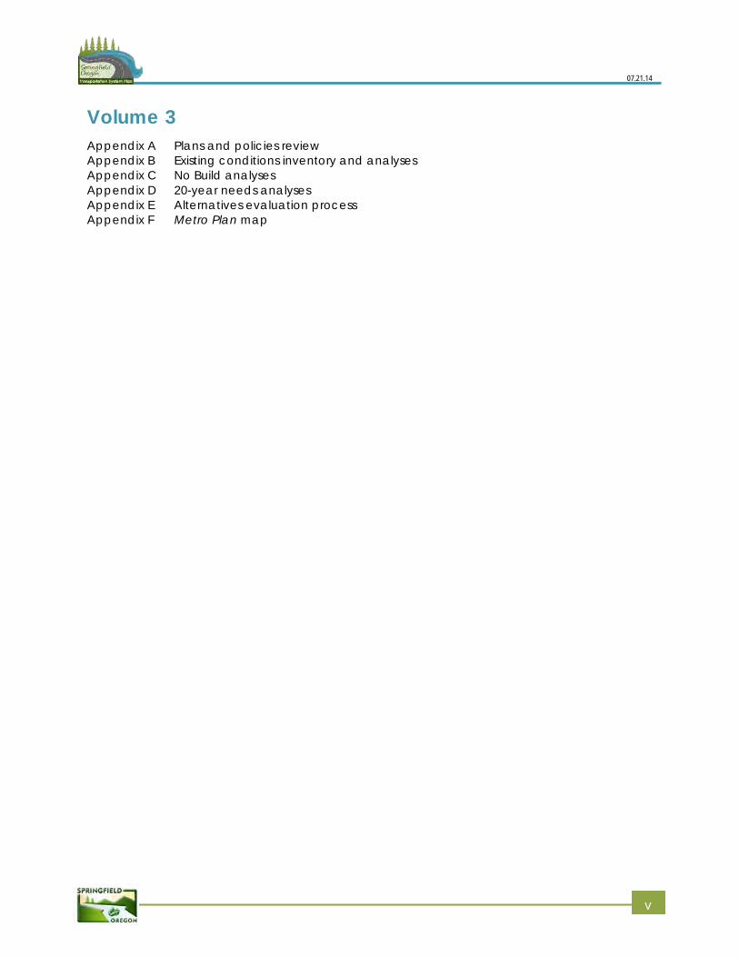
Volume 3 Appendix A Plans and policies review Appendix B Existing conditions inventory and analyses Appendix C No Build analyses Appendix D 20-year needs analyses Appendix E Alternatives evaluation process Appendix F Metro Plan map
v
Acknowledgements
Stakeholder Advisory Committee (SAC) The City of Springfield wishes to acknowledge and sincerely thank the members of the Stakeholder Advisory Committee (SAC), whose guidance was critical to the development of this plan.
Kenneth Hill, freight interest
Brock Nelson, rail interest
Phil Farrington, Springfield Chamberof Commerce
Richard Hunsaker, developer interest
George Grier, environmental interest
Allie Camp, bike and pedestrianinterest
Jim Yarnall, pedestrian interest(former)
Neal Zoumboukos (former) andDave Roth, bicycle interest (former)
Michael Eyster, transit interest
Tim Vohs, City of Springfield PlanningCommission
Dave Jacobson and DianaAlldredge, Metropolitan PlanningOrganization Citizen AdvisoryCommittee
Bob Brew, City of Springfield CityCouncil
Mike Schlosser, Springfield PublicSchool District
Lane Branch, Downtown businessinterest
Sean Van Gordon, PlanningCommission liaison (former)
Technical Advisory Committee (TAC) George Walker, Chuck Gottfried
(retired), and Bill Hamann, City ofSpringfield Environmental ServicesDivision
Richard Perry and Brian Barnett, Cityof Springfield Traffic Engineering
Ken Vogeney City of Springfield CityEngineer
Matt Stouder, City of SpringfieldEngineering Supervisor
Linda Pauly and Jim Donovan, Cityof Springfield Development andPublic Works Department
Al Gerard, City of Springfield Fire andLife Safety
Andrea Riner (former) and PaulThompson, Lane Council ofGovernments
Celia Barry, Lydia McKinney, andSarah Wilkinson, Lane County
Kurt Yeiter, City of Eugene
Will Mueller (retired), Sasha Luftig,and Mary Archer (former), LaneTransit District
Greg Hyde and Rebecca Gershow,Willamalane Park and RecreationDistrict
Chris Watchie, Point2point Solutions
Ed Moore and Chris Cummings,Oregon Department of LandConservation and Development
vi
07.21.14
Project team
City of Springfield David Reesor, Project Manager
Tom Boyatt
Molly Markarian
Brian Conlon
Len Goodwin
John Tamulonis
Ken Vogeney, PE
Greg Mott
Brian Barnett, PE, PTOE
Oregon Department of Transportation (ODOT) Savannah Crawford, Project
Manager Terry Cole
CH2M HILL Kristin Hull, Project Manager
Darren Hippenstiel, PE
Brandy Steffen
Darren Muldoon, AICP
Kittelson and Associates Julia Kuhn, PE
Joe Bessman, PE
Matt Kittelson, PE
vii
Acronyms and abbreviations
2035 TSP Springfield 2035 Transportation System Plan
AASHTO American Association of State Highway and Transportation Officials
ADA Americans with Disabilities Act
COPR Central Oregon and Pacific Railroad
DLCD Oregon Department of Land Conservation and Development
EWEB Eugene Water and Electric Board
FTN Frequent Transit Network
HSIP Highway Safety Improvement Program
I-5 Interstate 5
LCDC Land Conservation and Development Commission
LID Local Improvement District
LOS level of service
LTD Lane Transit District
Metro Plan Springfield’s current comprehensive planning document, 2004 update
MPO Metropolitan Planning Organization
MUTCD 2009 Manual of Uniform Traffic Control Devices
NTM Neighborhood Traffic Management
ODOT Oregon Department of Transportation
OHP Oregon Highway Plan
OR 126 Oregon State Highway 126
ORS Oregon Revised Statutes
OTP Oregon Transportation Plan
RRFB rectangular rapid flashing beacon
RTP Regional Transportation Plan
RTSP Regional Transportation System Plan, currently being updated
SAC Stakeholder Advisory Committee
SDC Systems Development Charge
SOV single-occupancy vehicle
STIP State Transportation Improvement Program
TAC Technical Advisory Committee
TAP Transportation Alternatives Program
TDM Transportation Demand Management
viii
07.21.14
TGM Transportation and Growth Management
TIF Tax Increment Financing
TPR Transportation Planning Rule
TransPlan Joint Transportation System Plan for Eugene and Springfield, last amended in 2002
TSM Transportation System Management
TSP Transportation System Plan
UGB urban growth boundary
UP Union Pacific Railroad
v/c volume to capacity
ix
Chapter 1: Introduction
The Springfield 2035 Transportation System Plan (2035 TSP) meets state requirements for a transportation system plan and is a resource for future transportation decision making. The 2035 TSP identifies the preferred future multi-modal transportation system and the City’s policies related to the transportation system. It also identifies the function, capacity, and location of future facilities, as well as planning-level costs for needed improvements to support expected development and growth and possible sources of funding. This TSP provides the City with flexibility as staff, the public, and decision makers prioritize and fund critical transportation investments.
This TSP provides:
A blueprint for transportation investment
A tool for coordination with regional agencies and local jurisdictions
Information to ensure prudent and effective land use choices
Solutions to address existing and future transportation needs for bicycles, pedestrians,transit, vehicles, freight, and rail
The 2035 TSP is the transportation element of and a supporting document to Springfield’s current comprehensive planning document (Metro Plan, 2004 update) as required by state law. The City updated the 2035 TSP goals and policies during the planning process and implemented the Goal 12: Transportation element of the Metro Plan. The primary purpose of the goals and policies is to guide future transportation related decisions in Springfield. Together with the Metro Plan, the Springfield 2035 TSP helps the City accommodate new growth, and maintain and rebuild infrastructure over the next 20 years consistent with a long-term vision.
Plan overview This TSP identifies the recommended future multi-modal transportation system and the City’s policies related to the transportation system.
The recommended set of transportation improvements contained in this Plan are divided into those projects that the City expects to construct in the 20-year planning horizon and those that may not be constructed in this time. Because of uncertainty around transportation funding and land development discussions, some longer-term priority projects could be implemented in the next 20 years.
20-year projects (the 2035 TSP planning horizon): Projects needed to serve expectedtransportation growth over the next 20 years. These projects have planning-level costestimates included in this Plan.
- Priority projects: Higher-cost and scale roadway, urban standards, and pedestrian/bicycle projects that would generally require additional right-of-way.
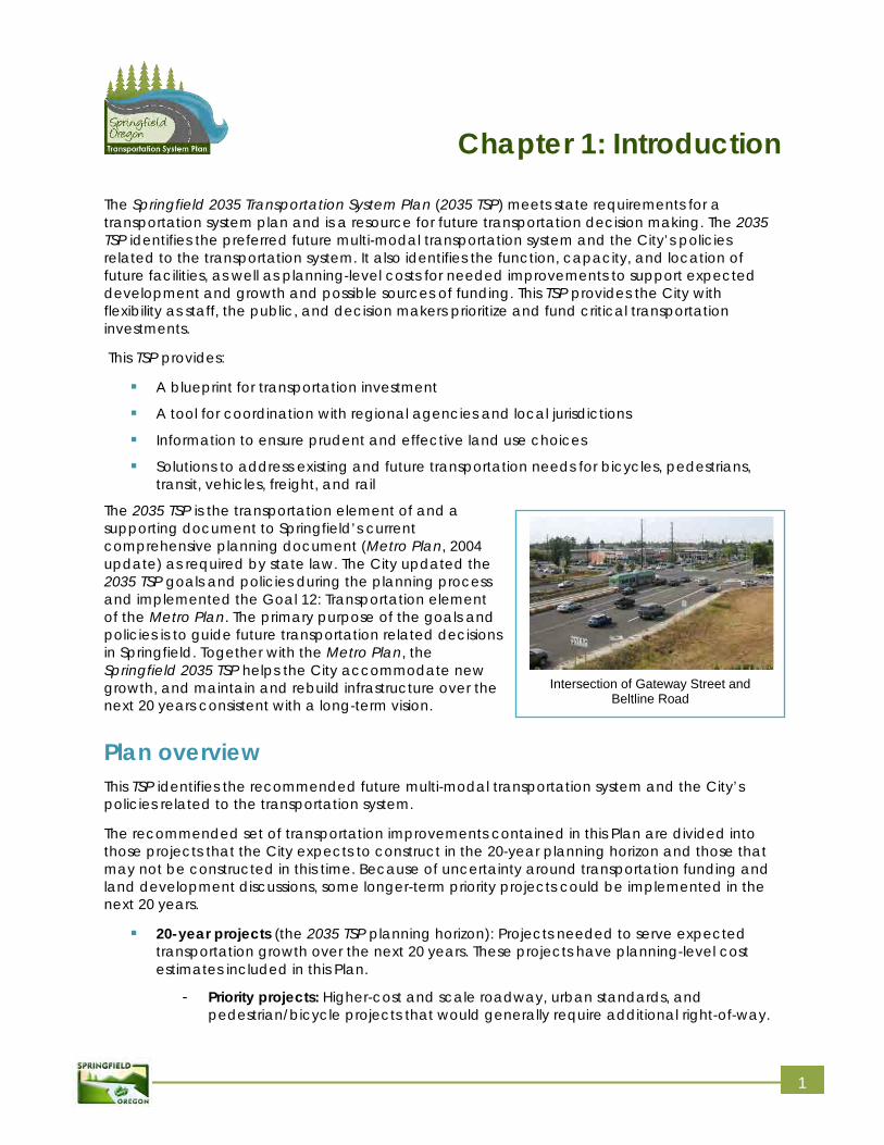
Intersection of Gateway Street and Beltline Road
1
07.21.14
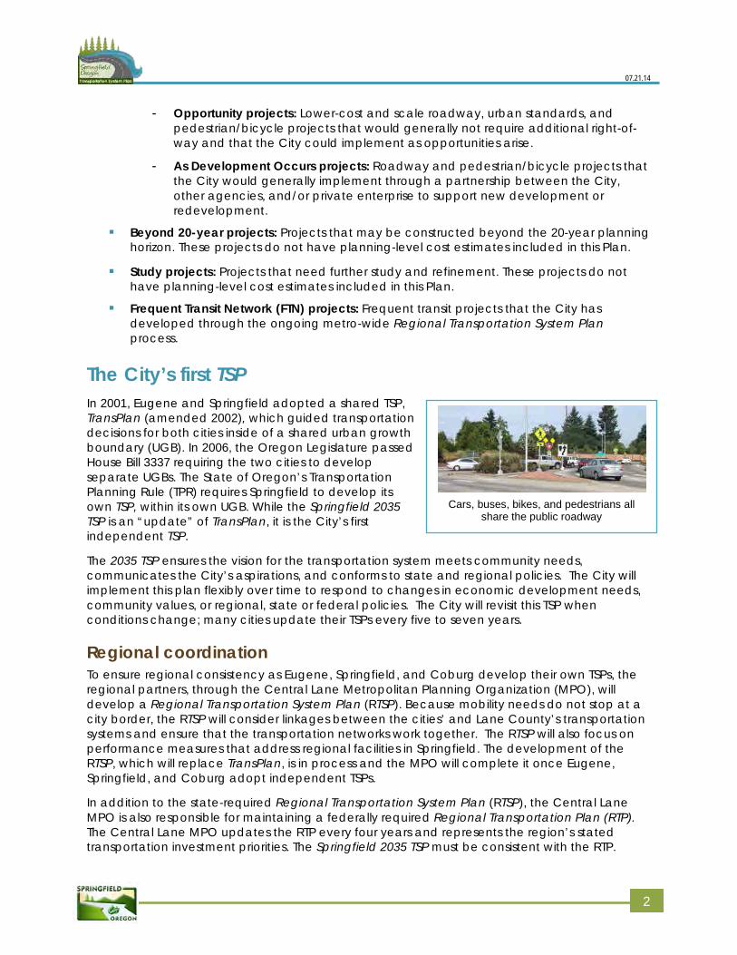
Cars, buses, bikes, and pedestrians all
share the public roadway
- Opportunity projects: Lower-cost and scale roadway, urban standards, and pedestrian/bicycle projects that would generally not require additional right-of-way and that the City could implement as opportunities arise.
- As Development Occurs projects: Roadway and pedestrian/bicycle projects that the City would generally implement through a partnership between the City, other agencies, and/or private enterprise to support new development or redevelopment.
Beyond 20-year projects: Projects that may be constructed beyond the 20-year planning horizon. These projects do not have planning-level cost estimates included in this Plan.
Study projects: Projects that need further study and refinement. These projects do not have planning-level cost estimates included in this Plan.
Frequent Transit Network (FTN) projects: Frequent transit projects that the City has developed through the ongoing metro-wide Regional Transportation System Plan process.
The City’s first TSP In 2001, Eugene and Springfield adopted a shared TSP, TransPlan (amended 2002), which guided transportation decisions for both cities inside of a shared urban growth boundary (UGB). In 2006, the Oregon Legislature passed House Bill 3337 requiring the two cities to develop separate UGBs. The State of Oregon’s Transportation Planning Rule (TPR) requires Springfield to develop its own TSP, within its own UGB. While the Springfield 2035 TSP is an “update” of TransPlan, it is the City’s first independent TSP.
The 2035 TSP ensures the vision for the transportation system meets community needs, communicates the City’s aspirations, and conforms to state and regional policies. The City will implement this plan flexibly over time to respond to changes in economic development needs, community values, or regional, state or federal policies. The City will revisit this TSP when conditions change; many cities update their TSPs every five to seven years.
Regional coordination To ensure regional consistency as Eugene, Springfield, and Coburg develop their own TSPs, the regional partners, through the Central Lane Metropolitan Planning Organization (MPO), will develop a Regional Transportation System Plan (RTSP). Because mobility needs do not stop at a city border, the RTSP will consider linkages between the cities’ and Lane County’s transportation systems and ensure that the transportation networks work together. The RTSP will also focus on performance measures that address regional facilities in Springfield. The development of the RTSP, which will replace TransPlan, is in process and the MPO will complete it once Eugene, Springfield, and Coburg adopt independent TSPs.
In addition to the state-required Regional Transportation System Plan (RTSP), the Central Lane MPO is also responsible for maintaining a federally required Regional Transportation Plan (RTP). The Central Lane MPO updates the RTP every four years and represents the region’s stated transportation investment priorities. The Springfield 2035 TSP must be consistent with the RTP.
2 2
07.21.14
Economic development priority
areas Four areas – Glenwood, Gateway, Downtown, and the Main Street Corridor – represent considerable growth opportunities and significant transportation challenges.
The City is focused on achieving mixed-used development and investing in a multi-modal transportation system that supports transit, walking, and biking in these areas.
Throughout the process of developing the 2035 TSP, the City of Springfield coordinated with the City of Eugene, Lane County, Lane Transit District, Central Lane MPO, and Oregon Department of Transportation (ODOT).
Transportation project development This Plan includes projects that will support expected growth in the City. While the Plan does not prioritize projects, the City will prioritize investments through annual updates to the Capital Improvement Program. Once the City identifies a project for implementation through the Capital Improvement Program and project development begins, the City will conduct project-level planning, public involvement, and engineering to confirm the need, define the project limits and develop a design for the project.
Public and agency involvement The public and staff from other partner agencies were extensively involved in the development of the 2035 TSP. Opportunities for engagement included:
Project website (including web-based surveys)
Seven Stakeholder Advisory Committee (SAC) meetings
Seven Technical Advisory Committee (TAC) meetings
Two public open houses and one listening booth at the Sprout! Farmers Market
Targeted outreach with local community service organizations
Planning Commission, City Council and Lane County Board of Commissioners publichearings, as part of the adoption process
Through these public involvement activities, the City provided the citizens of Springfield with a variety of forums to identify their priorities for future transportation projects. The City’s project website (as well as an email list of interested citizens, businesses, City staff, boards/commissions, and agencies) announced public meetings, disseminated information, and solicited input and feedback from the community. In addition, City staff met with the Planning Commission and City Council at each major milestone leading up to the 2035 TSP.
Planning context Opportunities and constraints provided by the physical environment, community vision, City, regional, and state policies, and the current and anticipated financial climate have shaped the Springfield 2035 TSP. The sections below describe how these characteristics may influence the implementation of the projects, programs, and policies included in the TSP.
3 3
07.21.14
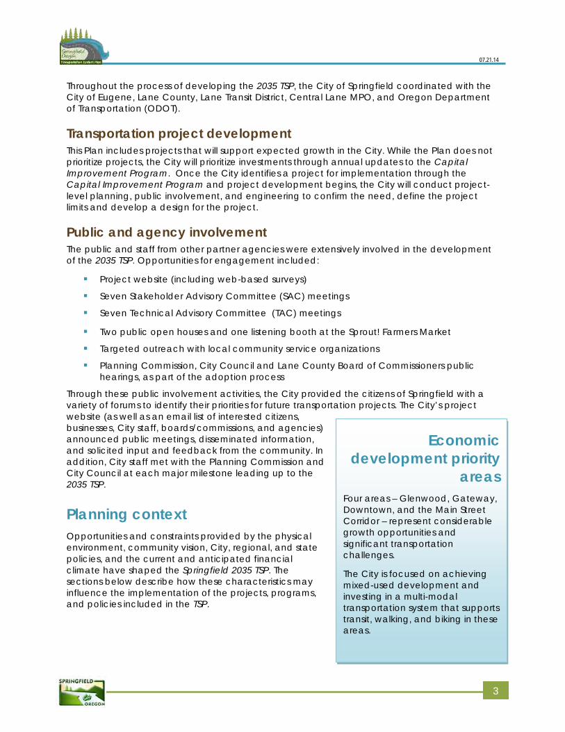
Participants at the first workshop use an interactive mapping tool to list issues and
concerns
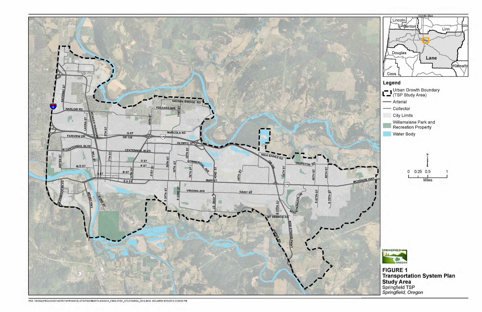
Transportation planning environment The City of Springfield is located within urban Lane County and is part of the Central Lane MPO area. Springfield’s current boundaries are generally defined by the McKenzie River to the north, Interstate 5 (I-5) to the west, the Willamette River to the south, and rural Lane County to the east. Figure 1 presents a map of the Plan area that includes the City of Springfield and sections of unincorporated Lane County that are part of the Springfield UGB. The TPR requires inclusion of these urban unincorporated areas in the 2035 TSP.
The City of Springfield developed along an east-west spine between the McKenzie and Willamette Rivers. Land use patterns in the City, surrounding areas, and the metro region as a whole are mostly suburban, with relatively low-density residential areas often separated from commercial areas. This development pattern results in heavy travel to and from residential areas during morning and evening rush hours.
The Springfield 2035 TSP supports land use strategies to mitigate the strain on the roadways by shortening home-to-work trips, supporting transit service, and making walk/bike trips more practical for working, shopping, and other activities. With Metro Plan’s focus on more compact development, significant future residential development is likely to occur in the Glenwood Riverfront District, Jasper-Natron area, and along the Main Street corridor (see Volume 3, Appendix F: Metro Plan map).
Regional and local travel within Springfield’s UGB is shaped by three primary highways: OR 126 Expressway, OR 126 Business Route (Main Street), and Interstate 5 (I-5), which forms the western boundary of the UGB. While these highways provide access to, from, and through Springfield, they also create significant barriers and constraints. ODOT operates and maintains these highways; the City has no direct operational authority over these highways or their interchange ramp areas. OR 126 Expressway and I-5 are both limited access highways. Running the length of the City, OR 126 Business Route (Main Street) provides the primary route for continuous east-west travel in Springfield providing access to hundreds of jobs and homes. Congestion is commonplace along all of these highways and recorded crash rates on OR 126 Business Route suggest potential safety-related challenges for bicyclists and pedestrians. More information is included in Volume 3, Appendix B: Existing conditions inventory and analysis.
In Springfield, as in the rest of the country, officials, and community members recognize the importance of providing transportation options for local and regional travel and better management of existing facilities. Providing users with non-auto modes and managing existing facilities prior to adding new and/or costly infrastructure reduces congestion, saves money, and provides health benefits for Springfield citizens and visitors. A balanced transportation system with a range of choices that includes both demand and system management techniques can reduce the need for roadway widening projects that can have high costs or significant community impacts.
4 4
07.21.14
5 5

07.21.14
Financial environment A combination of federal, state, county, city, and private funds have traditionally supported transportation capital improvements. While this remains the case, the overall funding paradigm at both the state and national levels is currently in flux. The recent national recession, reduction or elimination of federal subsidies for timber counties, state-legislated revenue dedicated to discrete projects, the overhaul of the State Transportation Improvement Program (STIP), and Congress’ move away from federal earmarks for infrastructure have all combined to make revenue forecasting an uncertain exercise. Today, as in the past, revenue streams are insufficient to address both the backlog of maintenance and preservation needs across Oregon and the needs of future transportation investments that support the future economic, health, and well-being of its communities.
Given these uncertainties, it is nearly impossible to forecast accurately how much funding is likely to be available for transportation investments and what projects or programs will receive funding. At one end of the financial spectrum, the nation could view future investments in transportation infrastructure as paramount to ensuring America’s prosperity. Under this scenario, an infusion of federal transportation funds, unseen since the freeway-building era of the 1950s, could result in a substantial increase in dollars available for state and local projects. This could allow for increased and broader investments in projects that enhance the “active” transportation network as well as those that provide new capacity on the roadway system to benefit freight and private automobile travel. Something similar, although at a much smaller scale, occurred when Oregon received one of the last federal earmarks for the specific purpose of bridge rehabilitation and replacement along the I-5 corridor. The recent Transportation Investments Generating Economic Recovery (TIGER) grant funding is also reflective of this approach.
At the other end of the financial spectrum, the federal government could choose not to invest in transportation infrastructure. Should this be the case, funds available locally from the Highway Trust Fund and other federal funding sources will continue to diminish. This approach will materially affect the ability of state and local governments to make network and system improvements that support all modes of travel.
The most likely financial future for the City, and the nation, lies between these two bookends. It is unclear whether federal, state, and local governments will find the means to reinvest in transportation infrastructure in the future consistent with the vision and priorities in the Oregon Transportation Plan (OTP). The level of uncertainty faced by local planners and decision makers is unprecedented in the recent history of transportation planning. Recognizing this context, the Springfield 2035 TSP includes the City’s best thinking about potential funding sources but acknowledges that adequate funding to implement needed improvements over the next 20 years is unlikely to be available and that predicting the funding streams and types of projects that can be funded is nearly impossible.
It is unlikely that the City will construct every project contained in the 2035 TSP in the next 20 years. While the 2035 TSP does prioritize planned projects, the City may choose to advance any of the identified projects as opportunities arise. These opportunities may present themselves as:
changes in policy or funding at the federal, state, or local level
local development priorities
public-private or public-public partnerships
7 7
07.21.14
Projects are sorted into a 20-year list versus those that could occur beyond 20-years to allow the City the flexibly to make wise investments consistent with the overall vision contained in the 2035 TSP and to leverage opportunities as they arise. The TSP goals and policies can serve as a guide when making these decisions over the life of the Plan.
Organization of the 2035 TSP The Springfield 2035 TSP is comprised of a main document (Volume 1) and two volumes of technical appendices (Volumes 2 and 3). A separate Executive Summary was also created.
Volume 1 (this document) is the “final report” and includes items that will be of interest to the broadest audience. It is also the portion of the Plan, which is officially “adopted.” The main volume includes:
Chapter 1: Provides a brief overview of the planning context for the 2035 TSP and thepublic process that supported its development
Chapter 2: Discusses the goals and policies that express the City’s long-range vision forthe transportation system
Chapter 3: Summarizes the process undertaken to develop the 2035 TSP, including thedetailed analysis of existing and future conditions and the screening and evaluation oftransportation strategies and projects
Chapter 4: Provides a transportation planning “tool box” of principles and strategies thatcan guide future project implementation
Chapter 5: Includes recommended policy guidelines and standards and multi-modalimprovement projects to address existing and forecast transportation needs
Chapter 6: Provides a summary of transportation revenues and expenses, past trends,and forecasts of potential future trends
Chapter 7: Summarizes required changes in the Springfield codes and policies to neededto implement the TSP
Volume 2 includes technical information that directly supplements Volume 1, including the specific implementing ordinances for the 2035 TSP and elements from related plans.
Volume 3 includes the technical memoranda that were prepared in the development of the Springfield 2035 TSP as well as the detailed data and analysis used to prepare the final report.
8 8
Chapter 2: Goals and policies
Creating goals, policies, and action items The 2035 Transportation System Plan (TSP) goals reflect the community’s vision for Springfield’s future transportation system and offer a framework for policies and action items. The goals are aspirational and are unlikely fully attained within the 20-year planning horizon.
The policies, organized by goal, provide high-level direction for the City’s policy and decision-makers and for City staff. The policies will be implemented over the life of the Plan.
The action items offer direction to the City about steps needed to implement recommended policies. Not all policies include action items. Rather, action items outline specific projects, standards, or courses of action for the City and/or for its partner agencies to take to implement the TSP. These action items will be updated over time and provide guidance for future decision-makers to consider. Many of the action items respond directly to the needs and deficiencies identified in the TSP (Volume 3, Appendix C: No Build analysis and Appendix D: 20-year needs analysis). Other action items reflect the need for future transportation planning efforts, such as refinement plans, updating ongoing studies, etc.
The City vetted the goals, policies, and action items through an extensive engagement process. Previously adopted goals, objectives, and policies found in the joint TSP for Eugene and Springfield (TransPlan; amended 2002) were used as a foundation to begin the update. Staff also incorporated City Council and Planning Commission input from previous work sessions, as well as input from the Stakeholder Advisory Committee (SAC), Technical Advisory Committee (TAC), City staff, and the public to develop goals, policies, and action items. The City revised the goals, policies, and action items several times during the planning process. Specific details of this process are in Volume 3 of this Plan.
2035 TSP goals, policies, and action items Goal 1: Community development Provide an efficient, sustainable, diverse, and environmentally sound transportation system that supports and enhances Springfield’s economy and land use patterns.
Goals Goal 1: Community development - Provide an efficient, sustainable, diverse, and environmentally sound transportation system that supports and enhances Springfield’s economy and land use patterns.
Goal 2: System management - Preserve, maintain, and enhance Springfield’s transportation system through safe, efficient, and cost-effective transportation system operations and maintenance techniques for all modes.
Goal 3: System design - Enhance and expand Springfield’s transportation system design to provide a complete range of transportation mode choices.
Goal 4: System financing - Create and maintain a sustainable transportation funding plan that provides implementable steps towards meeting Springfield’s vision.
9
07.21.14
Policy 1.1: Manage Springfield’s street, bike, pedestrian, rail, and transit system tofacilitate economic growth of existing and future businesses in Springfield.
- Action 1: When evaluating needed roadway improvements, consider the economic viability of existing commercial and industrial areas.
Policy 1.2: Consider environmental impacts of the overall transportation system and striveto mitigate negative effects and enhance positive features.
- Action 1: Strive to reduce vehicle-related greenhouse gas emissions and congestion through more sustainable street, bike, pedestrian, transit, and rail network design, location, and management.
- Action 2: Coordinate the transportation network with new alternative energy infrastructure such as electric vehicle charging stations, natural gas, and hydrogen cell fueling stations.
Policy 1.3: Provide a multi-modal transportation system that supports mixed-use areas,major employment centers, recreation, commercial, residential, and publicdevelopments, to reduce reliance on single-occupancy vehicles (SOVs).
Policy 1.4: Strive to increase the percentage of bicycle and pedestrian system users byplanning, designing, and managing systems to support the needs of diverse populationsand types of users, including meeting Americans with Disabilities Act (ADA) needs.
- Action 1: Create a network of bicycle and pedestrian routes and way-finding signage that guides users to destination points.
Goal 2: System Management Preserve, maintain, and enhance Springfield’s transportation system through safe, efficient, and cost-effective transportation system operations and maintenance techniques for all modes.
Policy 2.1: Manage the roadway system to preserve safety, longevity, and operationalefficiency.
- Action 1: Evaluate, update, and implement access management regulations for new or modified access to the roadway system.
- Action 2: Monitor and adjust signal timing along key corridors as needed to improve traffic flow and safety.
- Action 3: Evaluate and adjust traffic control systems to optimize bicycle travel along strategic bicycle routes.
- Action 4: Coordinate with LTD and Oregon Department of Transportation (ODOT) to provide auto, pedestrian, and bicycle connections to the transit network.
Policy 2.2: Manage traffic operation systems for efficient freight and goods movementalong designated freight, truck, and rail routes in Springfield.
- Action 1: Adjust traffic control systems to discourage through truck traffic on residential streets.1
1 “Residential Streets” are commonly defined as those with a street classification of “local” passing through a residentially zoned area.
110
07.21.14
- Action 2: Coordinate with rail providers to upgrade at-grade rail crossing treatments to improve traffic flow and manage conflict points; create grade-separated rail crossings when possible
Policy 2.3: Expand existing Transportation Demand Management (TDM) programs relatedto carpooling, alternate work schedules, walking, bicycling, and transit use in order toreduce peak hour congestion and reliance on SOVs.
- Action 1: Coordinate with adopted strategies in the Regional Transportation Options Plan to increase opportunities for transportation options in Springfield.
- Action 2: Coordinate with Springfield Public Schools to implement the solutions outlined in Safe Routes to School Action Plans.
Policy 2.4: Maintain and preserve a safe and efficient bike and pedestrian system inSpringfield.
- Action 1: Coordinate with Willamalane Park and Recreation District to maintain and preserve the off-street path system.
- Action 2: Prioritize lighting in strategic areas with high pedestrian and bicycle traffic.
Policy 2.5: Coordinate with LTD to increase the transit system’s accessibility andconvenience for all users, including the transportation-disadvantaged population.
- Action 1: When possible, manage traffic control systems to reduce travel time for transit and other high-occupancy vehicles along key corridors.
- Action 2: Monitor and adjust bus stop locations as needed to support surrounding land uses and provide more efficient and safe service.
- Action 3: Coordinate with LTD to reflect LTD’s long-range plans in Springfield’s transportation system.
Policy 2.6: Manage the on-street parking system to preserve adequate capacity andturnover for surrounding land uses.
- Action 1: Implement Springfield’s adopted July 2010 Downtown Parking Management Plan.
Policy 2.7: Manage the off-street parking system to assure major activity centers meettheir parking demand through a combination of shared, leased, and new off-streetparking facilities and TDM programs.
- Action 1: Modify parking requirements to assure that they are appropriate for land uses. The purpose of this action is to reduce parking requirements to utilize land for economic development.
- Action 2: Consider bike parking recommendations from the 2013 Regional Bike Parking Study when updating Springfield’s bike parking standards.
Policy 2.8 Maximize the use and utility of existing infrastructure through efficientmanagement of traffic control devises.
Policy 2.9: Use motor vehicle LOS standards to evaluate acceptable and reliableperformance on the roadway system. These standards shall be used for:
Identifying capacity deficiencies on the roadway system.
111
07.21.14
Evaluating the impacts on roadways of amendments to transportation plans,acknowledged comprehensive plans and land-use regulations, pursuant to theTransportation Planning Rule (TPR; Oregon Administrative Rules [OAR] 660-12-0060).
Evaluating development applications for consistency with the land-use regulationsof the applicable local government jurisdiction.
Under peak hour traffic conditions, acceptable and reliable performance isdefined as LOS D.
Performance standards from the Oregon Highway Plan (OHP) shall be applied onstate facilities in the Springfield metropolitan area and alternative mobility targetswill be sought as necessary.
Policy 2.10: The City of Springfield values a safe and efficient travel experience forbicycle, pedestrian, transit, freight, and auto travel. It is the intent of the City to balancethe needs of these modes through creation of a multi-modal LOS methodology for allmodes and to facilitate and encourage intermodal connections where mostappropriate. Multi-modal LOS generally is reflective of the following:
Transit –LOS is based on a combination of the access, waiting, and ride experience,as well as travel time, frequency, safety, and reliability.
Bicycle –LOS is a combination of the bicyclists’ experiences at intersections and on-street and off-street segments in between the intersections. Safety is also aconsideration.
Pedestrian –LOS is based on a combination of pedestrian experience, density ofland use, and other factors including efficiency, safety, and pedestrian comfortlevel.
Auto –LOS is based on a combination of travel time, delay, stops, safety, andqueues.
Freight –LOS is based on a combination of travel time, delay, stops, safety, andqueues.
Intermodal –LOS is based on an evaluation of the frequency and convenience ofconnections between different travel modes.
- Action 1: Develop and adopt a multi-modal LOS methodology based on stakeholder input and considerations for land use decisions. Policy 2.9 in the 2035 TSP will apply until the new standard is adopted and in areas where the evaluation of a multi-modal LOS is not necessary.
- Action 2: Once developed, multi-modal LOS methodology will apply to Gateway, Glenwood, and Downtown and may apply to other specific geographic areas in the future subject to City Council review and approval. The intent of this action is to encourage diverse development types such as more mixed-use development and higher densities in these high-priority economic growth areas of Springfield and to provide a balanced approach to measuring LOS beyond just motor vehicles.
- Action 3: Develop a process to allow for alternative means of meeting LOS standards as part of public project development and the land use decision-making process.
112
07.21.14
Goal 3: System Design Enhance and expand Springfield’s transportation system design to provide a complete range of transportation mode choices.
Policy 3.1: Adopt and maintain a Conceptual Street Map
- Action 1: Update and maintain the Conceptual Street Map to address transportation system deficiencies, goals, and policies. The Conceptual Street Map should provide flexibility in connecting destination points, while also providing assurance to adjacent property owners to the degree possible.
- Action 2: The Conceptual Street Map will indicate the approximate location of planned “local” classified streets on the adopted map. These “local” streets are not intended to be adopted on the map. Rather, they are shown as reference. Streets classified as collectors and arterials will be adopted on the map and are considered part of the 2035 TSP.
- Action 3: Ensure that land use decisions conform to the Conceptual Street Map.
Policy 3.2: Expand and enhance Springfield’s bikeway system and provide bicyclesystem support facilities for both new development and redevelopment/expansion.
- Action 1: Require bike lanes and/or adjacent paths along new and reconstructed arterial and major collector streets.
- Action 2: Provide bike lanes on collector and arterial streets; provide parallel routes and bike boulevards on adjacent streets where appropriate.
- Action 3: Create frequent bike and pedestrian crossings on wide or high-speed streets using approved design techniques.
- Action 4: Require bike lanes and paths to connect new development with nearby neighborhood activity centers and major destinations. Connectivity should include connecting bike facilities to each other as well as to major destinations.
- Action 5: Install shared-roadway facilities, markings, and/or signage for bicyclists along roadways with slow vehicular traffic. On-street pavement markings and traffic calming measures should be considered along such routes.
- Action 6: Create city-wide bike parking stations in strategic locations such as along major transit routes and in Springfield’s central business district.
- Action 7: Design bike transportation routes that separate bicycle traffic from large volumes of fast-moving automobile traffic.
Policy 3.3: Street design standards should be flexible and allow appropriate-sized local,collector, and arterials streets based upon traffic flow, geography, efficient land use,social, economic, and environmental impacts
- Action 1: Conduct a comprehensive review and update of Springfield street standards, and develop code to address transportation system deficiencies, adopted goals, and policies.
- Action 2: Consider effects of stormwater runoff in street design and reduce runoff through environmentally sensitive street designs for new and reconstructed streets.
113
07.21.14
- Action 3: Incorporate traffic calming measures into street designs and standards where appropriate, considering the needs of emergency services vehicles. Traffic calming measures should reduce vehicular speeds and bypass traffic while encouraging safe bicycle and pedestrian travel.
- Action 4: Integrate pedestrian amenities into street designs that create pedestrian refuges and allow safe and continuous pedestrian travel.
- Action 5: Provide mid-block pedestrian crossings where appropriate between major pedestrian destinations and along major pedestrian corridors.
- Action 6: Develop criteria in which to evaluate alternative street design concepts.
Policy 3.4: Provide for a continuous transportation network with reasonably direct travelroutes to destination points for all modes of travel.
- Action 1: Design new streets to provide a connected grid network, including alleyways, when technically feasible.
- Action 2: Construct sidewalks or other suitable pedestrian facilities along local streets and along urban area arterial and collector roadways, except freeways.
Policy 3.5: Address the mobility and safety needs of motorists, transit users, bicyclists,pedestrians, freight, and the needs of emergency vehicles when planning andconstructing roadway system improvements.
- Action 1: Ensure that current design standards address mobility needs and meet ADA standards.
Policy 3.6: Preserve corridors, such as rail rights-of-way, private roads, and easementsthat are identified for future transportation-related uses.
Policy 3.7: Provide for a pedestrian environment that supports adjacent land uses and isdesigned to enhance the safety, comfort, and convenience of walking by providingdirect routes and removing barriers when possible.
- Action 1: Update and maintain the ADA Transition Plan to address deficiencies in the existing system and to assist in planning for new system improvements.
- Action 2: Utilize safety studies such as the Main Street Safety Study and the City of Springfield Safety Study to improve pedestrian conditions along major pedestrian corridors.
Policy 3.8: Coordinate the design of Springfield’s transportation system with relevantlocal, regional, and state agencies.
- Action 1: Work with ODOT, Lane County, and LTD to improve pedestrian and bicycle facilities along state highways and major transit routes where appropriate.
- Action 2: Coordinate with Springfield Public Schools to provide key bicycle, pedestrian, and transit facilities near schools to ensure safe, convenient, and well-connected routes to schools.
114
07.21.14
- Action 3: Partner with LTD to provide frequent transit network2 connections along major corridors. Frequent transit network should connect to local neighborhood bus service and major activity centers to provide viable alternatives to vehicle trips.
- Action 4: Coordinate existing and planned transportation system and land uses with LTD to expand the park-and-ride system where appropriate within Springfield.
- Action 5: Coordinate with the Willamalane Park and Recreation District to address bicycle and pedestrian system deficiencies and address new transportation system goals and policies in the Willamalane Park and Recreation District Comprehensive Plan, including providing improved connectivity to parks and open space areas.
- Action 6: Develop and implement criteria that trigger jurisdictional phasing and transfer of roads, highways, and other applicable transportation facilities.
- Action 7: Coordinate with Lane County to ensure transition between rural and urban transportation facilities within the Springfield urban growth boundary (UGB).
- Action 8: Coordinate with ODOT and the City of Eugene to ensure regional transportation system connectivity.
Policy 3.9: Support provision of rail-related infrastructure improvements as part of theCascadia High-Speed Rail Corridor project.
- Action 1: In coordination with agency partners, develop a Passenger Rail Plan in support of Springfield’s Downtown District Urban Design Plan. Areas in Springfield outside of Downtown should be considered, as appropriate.
- Action 2: Further consider regional high speed passenger rail needs coordinated with the Springfield Downtown District Urban Design Plan and implementation strategy.
2 The Frequent Transit Network (FTN) represents the highest orders of transit service within the region. The FTN represents corridors where transit service would be provided, but does not presume specific street alignments. Street alignments will be determined in future studies. FTN stops will be located closest to the highest density development within the corridor. FTN Corridors will have the following characteristics:
• Enables a well-connected network that provides regional circulation• Compatible with and supportive of adjacent urban design goals• Operates seven days a week in select corridors• Service hours are appropriate for the economic and social context of the area served• Coverage consists of at least 16 hours a day and area riders trip origins or destinations are within ¼ of a mile-
straight line distance• Frequency is at least every 10-15 minutes in peak travel times• Speed is no less than 40 percent of the roadway speed limit• Coverage throughout the region is geographically equitable and serves Title VI protected populations• Transit service is reliable and runs on schedule• Transit vehicles are branded• Transit stations are of high quality with amenities, including bicycle and pedestrian connections to stations and
end-of-trip facilities, such as bike parking. Park and rides are provided at key termini.
115
07.21.14
Policy 3.10: When a project includes planning, reconstructing, or constructing newintersections, all intersection control types are to be evaluated including statutorycontrol, sign control, geometric control, and signal control. The City’s recommendedalternative will be selected primarily on safety and operational efficiency in the contextof mobility needs for all users, adjacent existing and planned land uses, accessconsiderations, site constraints, availability of right-of-way, environmental factors,phasing, future needs, safety, construction, and operational costs.
- Action 1: When analyzing the appropriate treatment for a new or reconstructed intersection, the City will consider the needs consistent with policy 3.10.
Goal 4: System Financing: Create and maintain a sustainable transportation-funding plan that provides implementable steps towards meeting Springfield’s vision.
Policy 4.1: Support development of a stable and flexible transportation finance systemthat provides adequate resources for transportation needs identified in the Springfield2035 TSP.
- Action 1: Develop criteria that support adopted 2035 TSP goals and policies and that help prioritize transportation maintenance, preservation, and construction projects.
- Action 2: Give funding priority to bicycle and pedestrian projects that address significant gaps in the network and that provide key linkages to other transportation modes.
- Action 3: Give funding priority to safety actions and operations to maximize use and utility of existing system.
- Action 4: Provide financial incentives, improvements and programs at discretion of City to new and existing local businesses that encourage multi-modal transportation options to employees and/or customers.
- Action 5: Require that new development pay for its proportional capacity impact on the transportation system through ongoing rate updates of Springfield’s system development charge and through proportional exactions as part of the land development process.
116
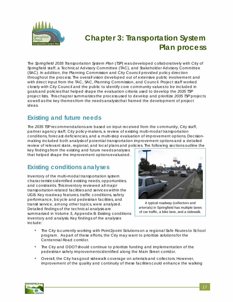
A typical roadway (collectors and arterials) in Springfield has multiple lanes of car traffic, a bike lane, and a sidewalk.
Chapter 3: Transportation System Plan process
The Springfield 2035 Transportation System Plan (TSP) was developed collaboratively with City of Springfield staff, a Technical Advisory Committee (TAC), and Stakeholder Advisory Committee (SAC). In addition, the Planning Commission and City Council provided policy direction throughout the process. The overall vision developed out of extensive public involvement and with direct input from the TAC, SAC, Planning Commission, and Council. Project staff worked closely with City Council and the public to identify core community values to be included in goals and policies that helped shape the evaluation criteria used to develop the 2035 TSP project lists. This chapter summarizes the process used to develop and prioritize 2035 TSP projects as well as the key themes from the needs analysis that framed the development of project ideas.
Existing and future needs The 2035 TSP recommendations are based on input received from the community, City staff, partner agency staff, City policy-makers, a review of existing multi-modal transportation conditions, forecast deficiencies, and a multi-step evaluation of improvement options. Decision-making included both analysis of potential transportation improvement options and a detailed review of relevant state, regional, and local plans and policies. The following sections outline the key findings from the existing and future needs analyses that helped shape the improvement options evaluated.
Existing conditions analyses Inventory of the multi-modal transportation system characteristics identified existing needs, opportunities, and constraints. This inventory reviewed all major transportation-related facilities and services within the UGB. Key roadway features, traffic conditions, safety performance, bicycle and pedestrian facilities, and transit service, among other topics, were analyzed. Detailed findings of the technical analysis are summarized in Volume 3, Appendix B: Existing conditions inventory and analysis. Key findings of the analyses include:
The City is currently working with Point2point Solutions on a regional Safe Routes to Schoolprogram. As part of these efforts, the City may want to prioritize solutions for theCentennial Road corridor.
The City and ODOT should continue to prioritize funding and implementation of thepedestrian safety improvements identified along the Main Street corridor.
Overall, the City has good sidewalk coverage on arterials and collectors. However,improvement of the quality and continuity of these facilities could enhance the walking
17
07.21.14
and cycling experience within the City. In addition, sidewalk gaps on routes that provide direct access to schools, such as Yolanda Road, are notable deficiencies in the network.
Approximately half of the City’s arterials and collectors have some form of designatedbike facility. Notable gaps include Game Farm Road, sections of Harlow Road, 28th
Street, 30th Street/Commercial and Jasper Road. The Glenwood mixed use area also hasminimal bicycle facilities. The most significant gaps are along Franklin and Glenwoodboulevards.
The shared-use path system is an asset to the community for both pedestrian and bicycletravel and recreation. However, connections to and between paths could be improvedcity-wide. Limited wayfinding at critical points (such as from the I-5 Pedestrian andBicycle Bridge at Gateway Mall) limits usefulness. A connection between the easternterminus of the EWEB path and the McKenzie Levee path could expand access to bothpaths and provide a separated facility to improve east/west travel.
Existing land uses north of Main Street and west of Thurston present barriers forpedestrians and cyclists. Given the current location of large industrial uses and the OR126Expressway, pedestrians and cyclists are forced to travel east-west on Main Street, whichpresents logistical and potential safety challenges. A new multi-use path connection atthe oxbow of the McKenzie River, near OR126 Expressway would provide an essentialeast-west connection north of Main Street.
The majority of the intersections studied meet applicable performance standards underexisting conditions. Five intersections studied would require modification if theperformance standards remain as they are today (Laura/Q streets, Pioneer Parkway/OR126 eastbound, Mohawk Boulevard/OR 126 eastbound ramps, 42nd Street/OR 126westbound ramps, and S 42nd/Daisy streets).
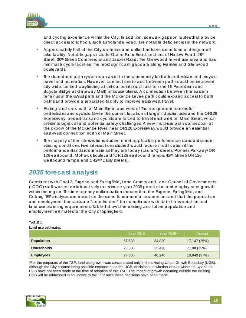
2035 forecast analysis Consistent with Goal 2, Eugene and Springfield, Lane County and Lane Council of Governments (LCOG) staff worked collaboratively to estimate year 2035 population and employment growth within the region. This interagency collaboration ensures that the Eugene, Springfield, and Coburg TSP analyses are based on the same fundamental assumptions and that the population and employment forecasts are “coordinated” for compliance with state transportation and land use planning requirements. Table 1 shows the existing and future population and employment estimates for the City of Springfield.
TABLE 1 Land use estimates
Year 2010 Year 2035* Growth
Population 67,683 84,830 17,147 (25%)
Households 28,300 35,490 7,190 (25%)
Employees 29,300 40,240 10,940 (37%)
*For the purposes of the TSP, land use growth was concentrated only in the existing Urban Growth Boundary (UGB).Although the City is considering possible expansions to the UGB, decisions on whether and/or where to expand the UGB have not been made at the time of adoption of this TSP. The impact of growth occurring outside the existing UGB will be addressed in an update to the TSP once these decisions have been made.
118
07.21.14
No Build transportation system assumptions City of Springfield plans, TransPlan and the Regional Transportation Plan (RTP) have previously identified a variety of street, pedestrian, bicycle, and transit projects that could be implemented in the future. At this point, there are no guaranteed funding sources for any major projects that will materially affect traveler behaviors and traffic volumes on the City’s street network in the future. As such, the No Build assumes that the existing street, pedestrian, bicycle and transit system is in-place in the year 2035.
Traffic volume development Based on estimates of future job and household growth, LCOG developed traffic volume forecasts for the City’s collector and arterial street system, using an “emme” travel demand model. This model is calibrated to actual traffic volume counts recently measured on streets within the City. In addition to land use and street network inputs, the model also relies on information about existing traveler behavior and trip-making characteristics to forecast how people might use the transportation system in the future.
Based on information obtained from LCOG, coupled with measured traffic counts at 44 intersections and roadways within the City, year 2035 intersection and roadway volumes were analyzed using a procedure consistent with guidance from ODOT’s Analysis and Procedures Manual (APM).
No Build analyses The results of the year 2035 No Build analyses are summarized in Volume 3, Appendix C: No Build analysis. A summary of the key findings include:
Glenwood Mixed Use Neighborhood: Franklin Boulevard, Glenwood Boulevard, andMcVay Highway and the primary intersections along these streets are anticipated toexperience congestion in the future given the role that they serve in both the regionaland local transportation system.
42nd Street Corridor: Five of the seven intersections along this corridor are anticipated toexceed performance standards. Additionally, congestion is projected in the vicinity ofOR 126 as well as Main Street.
OR 126 Expressway: This corridor is anticipated to experience congestion throughoutmuch of its length between I-5 and 58th Street. This corridor serves as a key east-westroute for intracity, intercity, and statewide trips to/from Central Oregon.
Main Street (OR 126 Business): The 42nd Street, OR 126, and 58th Street intersections areforecast to exceed capacity. In addition, the corridor segments between 21st and 48th
Streets as well as in the vicinity of the OR 126 intersection are anticipated to experiencecongestion.
Centennial Boulevard: The intersections and corridor are forecast to operate acceptablyalthough the recorded crash history indicates that the corridor experiences higher thantypical rear-end crashes, especially between Pioneer Parkway and Mohawk Boulevard.
Corridor Strategies: In addition to projected levels of congestion at intersections andalong corridors, the No Build analyses also include the identification of a variety ofpossible strategies related to improving the walking and cycling environment, improving
119
07.21.14
connectivity, enhancing freight mobility, improving the efficiency of the existing roadway system (i.e., transportation system management measures) and reducing the need for single occupancy vehicle travel through transportation demand management.
Evaluation process Using the existing and No Build opportunities and constraints analysis and input from the public, the team identified potential projects ideas. The multistep process used to screen and evaluate projects is described below.
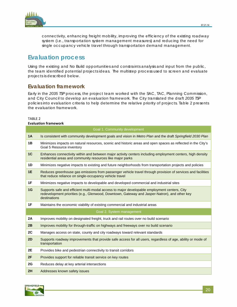
Evaluation framework Early in the 2035 TSP process, the project team worked with the SAC, TAC, Planning Commission, and City Council to develop an evaluation framework. The City translated the draft 2035 TSP policies into evaluation criteria to help determine the relative priority of projects. Table 2 presents the evaluation framework.
TABLE 2 Evaluation framework
Goal 1. Community development
1A Is consistent with community development goals and vision in Metro Plan and the draft Springfield 2030 Plan
1B Minimizes impacts on natural resources, scenic and historic areas and open spaces as reflected in the City’s Goal 5 Resource inventory
1C Enhances connectivity within and between major activity centers including employment centers, high density residential areas and community resources like major parks
1D Minimizes negative impacts to existing and future neighborhoods from transportation projects and policies
1E Reduces greenhouse gas emissions from passenger vehicle travel through provision of services and facilities that reduce reliance on single-occupancy vehicle travel
1F Minimizes negative impacts to developable and developed commercial and industrial sites
1G Supports safe and efficient multi-modal access to major developable employment centers, City redevelopment priorities (e.g., Glenwood, Downtown, Gateway and Jasper-Natron), and other key destinations
1F Maintains the economic viability of existing commercial and industrial areas
Goal 2. System management
2A Improves mobility on designated freight, truck and rail routes over no build scenario
2B Improves mobility for through-traffic on highways and freeways over no build scenario
2C Manages access on state, county and city roadways toward relevant standards
2D Supports roadway improvements that provide safe access for all users, regardless of age, ability or mode of transportation
2E Provides bike and pedestrian connectivity to transit corridors
2F Provides support for reliable transit service on key routes
2G Reduces delay at key arterial intersections
2H Addresses known safety issues
220
07.21.14
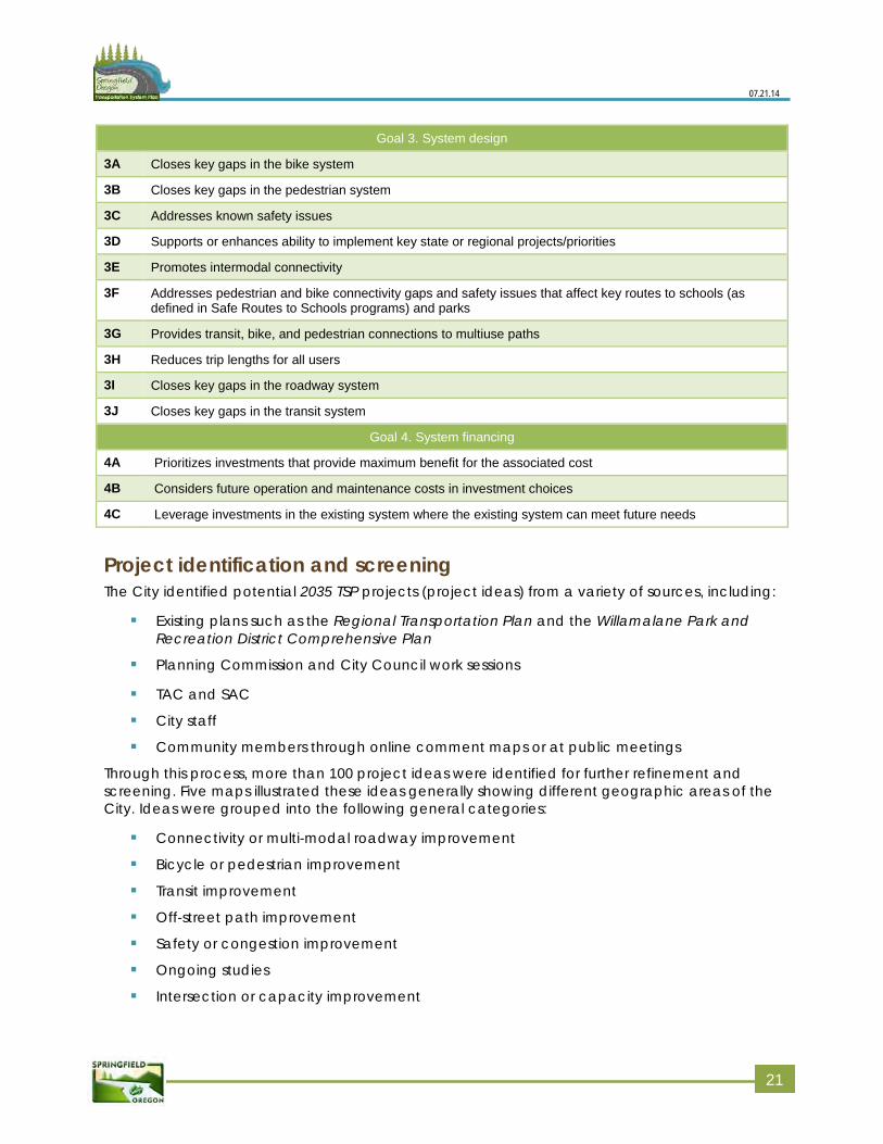
Goal 3. System design
3A Closes key gaps in the bike system
3B Closes key gaps in the pedestrian system
3C Addresses known safety issues
3D Supports or enhances ability to implement key state or regional projects/priorities
3E Promotes intermodal connectivity
3F Addresses pedestrian and bike connectivity gaps and safety issues that affect key routes to schools (as defined in Safe Routes to Schools programs) and parks
3G Provides transit, bike, and pedestrian connections to multiuse paths
3H Reduces trip lengths for all users
3I Closes key gaps in the roadway system
3J Closes key gaps in the transit system
Goal 4. System financing
4A Prioritizes investments that provide maximum benefit for the associated cost
4B Considers future operation and maintenance costs in investment choices
4C Leverage investments in the existing system where the existing system can meet future needs
Project identification and screening The City identified potential 2035 TSP projects (project ideas) from a variety of sources, including:
Existing plans such as the Regional Transportation Plan and the Willamalane Park andRecreation District Comprehensive Plan
Planning Commission and City Council work sessions
TAC and SAC
City staff
Community members through online comment maps or at public meetings
Through this process, more than 100 project ideas were identified for further refinement and screening. Five maps illustrated these ideas generally showing different geographic areas of the City. Ideas were grouped into the following general categories:
Connectivity or multi-modal roadway improvement
Bicycle or pedestrian improvement
Transit improvement
Off-street path improvement
Safety or congestion improvement
Ongoing studies
Intersection or capacity improvement
221
07.21.14
Initially, “fat lines” graphically represented these project ideas. The ideas were not developed into specific projects. Rather, City staff, the TAC, and SAC discussed the ideas conceptually.
Once a complete initial list of ideas was developed, City staff and the project team screened project ideas based on the following questions:
Does the project idea address a transportation problem?
Is the project idea within the control/influence of the City to implement?
Is the project idea technically and politically feasible?
Could the project idea be constructed at a reasonable cost?
If the answer to any question was “no,” the project idea was set aside; all others were advanced for further study. The SAC and TAC reviewed the screened set of project ideas.
In addition to this formal screening process, staff eliminated a few projects later in the process because they recognized that a project did not meet one of the evaluation criteria. Generally, this was because more detailed transportation operations analysis showed that a project did not address a transportation need. In addition, staff added a few project ideas later to respond to transportation needs that were not identified initially.
Project evaluation The City moved several types of projects forward without applying the evaluation criteria. These projects fell into the following categories:
Study projects
Frequent transit network projects The team then qualitatively applied the evaluation criteria to the remaining projects, including all urban standards projects, higher cost and scale roadway projects, and higher cost and scale pedestrian and bicycle projects. The team initially considered all evaluation criteria, but the following criteria were most useful in differentiating among projects:
Impacts to developable parcels, developed properties, and neighborhoods
Support for new development and redevelopment priorities
Mobility benefits for freight, through-traffic, and local traffic
Connectivity for all modes, particularly around major activity centers
Closing gaps on pedestrian and bicycle routes and improving pedestrian and bicycleroutes near major activity centers and schools
Safety benefits for all users
Using the qualitative evaluation, the team differentiated projects as those that could be implemented in the next 20 years and those that could be implemented beyond the 20-year planning horizon. The SAC, TAC, Planning Commission, and City Council reviewed the results of the evaluation. The outcomes of this process are presented in Chapter 5.
222
Chapter 4: Transportation planning tool box
This chapter summarizes a range of transportation-related strategies and solutions for the City to consider as it implements projects and makes policy and financial decisions in the future. The type of solutions included are intended to help the community maximize prior investments in the existing infrastructure, enhance the quality and availability of the pedestrian and bicycle facilities, and plan for the long-term transportation needs of the community.
This “tool box” provides context for the recommended projects included in Chapter 5. The tool box can guide the City as it evaluates projects that were not contemplated at the time the TSP was written, and provide tools specifically applicable for the management of local streets and neighborhood traffic issues.
Tool box The tool box measures fall into the following categories:
Land use
Connectivity of the transportation network
“Active” transportation (i.e., walking, cycling, and transit)
Transportation demand management
Transportation system management and operations
Intersection control
Neighborhood traffic management
Land use The types and intensities of land uses are important factors influencing travel demand and the way that people get around. Low-density development tends to be linked to high motor vehicle use compared to dense, mixed-use developments, which usually lead to shorter trips and use of a greater variety of modes.
In Eugene and Springfield, these dense, mixed-use neighborhoods are sometimes referred to as “nodes.” The “nodal concept” was accepted by the Land Conservation and Development Commission (LCDC) as a regional measure to reduce vehicle miles traveled in compliance with the 2001Oregon Transportation Planning Rule (TPR). As described in Springfield’s current comprehensive planning document (Metro Plan; 2004 update), the nodal concept calls for mixed-use, pedestrian-friendly developments that increase the density of people and jobs along major transportation corridors to combine a mix of diverse and compatible land uses with public and private improvements designed to be pedestrian- and transit-oriented.
The 2002 update of TransPlan identified more than 50 potential neighborhood node sites throughout the Eugene-Springfield metropolitan area. Currently there are about 430 acres of mixed-use zoning in the nodes designated at Riverbend, Mohawk, Marcola Meadows, Downtown, and Glenwood. An additional node is planned for the Jasper-Natron area in southeast Springfield. Implementation Action 2.4 in the 2011 adopted Springfield 2030
23
07.21.14
Refinement Plan Residential Land Use and Housing Element calls for Springfield to increase opportunities for mixed-use nodal development.
Along with the strategies identified below, the City’s plans to increase density in these nodes, especially in Glenwood, could move more residences closer to jobs, increase mixed-use development, and help mitigate the strain on east-west streets by shortening home-to-work trips, supporting transit service, and making walk/bike trips more viable for work, shopping, and other activities.
Connectivity A well-connected network reduces the need for “out-of-direction travel” while supporting efficient distribution of travelers among multiple travel ways (roads, trails, sidewalks, etc.). Connectivity improvements for bicycle and pedestrian networks are effective enhancements to the transportation system, including improved access to transit. A common example of efficient street connectivity is the traditional grid system, with north-south and east-west streets spaced at generally equal distances.
In Springfield, the existing arterials and collectors, along with topography, natural resources, and land development patterns preclude this type of network on a large scale. However, it is possible to plan for improved connectivity by preserving right-of-way for future connections and prioritizing funding to alleviate existing and future bottlenecks at key crossing locations. In fact, the 2012 Phase I Glenwood Refinement Plan calls for establishing a grid block pattern of streets to support redevelopment in the Glenwood Riverfront to provide multi-modal internal circulation, disperse traffic, facilitate walking and biking, orient development to a public realm, and enable clear and direct physical and visual routes between major arterials and the riverfront.
Enhancing and increasing non-auto travel modes The following outlines examples of pedestrian, bicycle, and transit improvements that can enhance the quality of travel experience, provide more travel options, reduce the number of automobile trips, and improve overall safety of the transportation system.
Pedestrian system Pedestrian facilities enable people to walk (or use mobility devices) safely and efficiently between their homes, work, shopping, schools, and recreational activities. A well-planned pedestrian network includes walkways (sidewalks, mixed-use paths), safe crossing locations, and convenient connections to other modal facilities, such as transit stops.
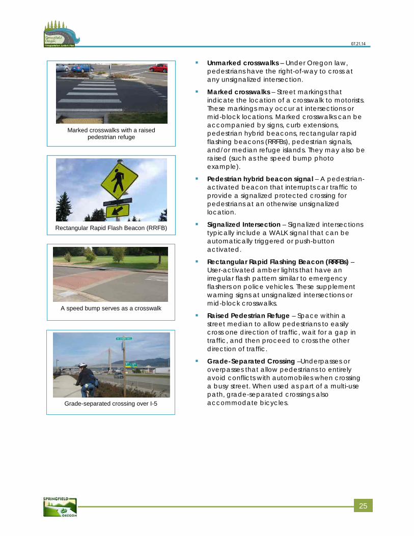
Sidewalks and multiuse pathways and trails provide the backbone of the walkway and multi-modal facility connections. A variety of pedestrian crossing treatments are available for implementation, each applicable under a different range of factors. Below is a brief description of the various pedestrian crossing types.
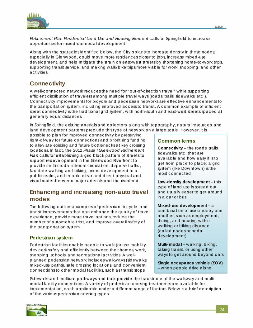
Common terms Connectivity – the roads, trails, sidewalks, etc. that are available and how easy it is to get from place to place; a grid system (like Downtown) is the most connected
Low-density development – this type of land use is spread out and usually easier to get around in a car or bus
Mixed-use development – a combination of uses nearby one another; such as employment, dining, and housing within walking or biking distance (called nodes or nodal development)
Multi-modal – walking, biking, taking transit, or using other ways to get around beyond cars
Single occupancy vehicle (SOV) – when people drive alone
224
07.21.14
Unmarked crosswalks – Under Oregon law,pedestrians have the right-of-way to cross atany unsignalized intersection.
Marked crosswalks – Street markings thatindicate the location of a crosswalk to motorists.These markings may occur at intersections ormid-block locations. Marked crosswalks can beaccompanied by signs, curb extensions,pedestrian hybrid beacons, rectangular rapidflashing beacons (RRFBs), pedestrian signals,and/or median refuge islands. They may also beraised (such as the speed bump photoexample).
Pedestrian hybrid beacon signal – A pedestrian-activated beacon that interrupts car traffic toprovide a signalized protected crossing forpedestrians at an otherwise unsignalizedlocation.
Signalized Intersection – Signalized intersectionstypically include a WALK signal that can beautomatically triggered or push-buttonactivated.
Rectangular Rapid Flashing Beacon (RRFBs) –User-activated amber lights that have anirregular flash pattern similar to emergencyflashers on police vehicles. These supplementwarning signs at unsignalized intersections ormid-block crosswalks.
Raised Pedestrian Refuge – Space within astreet median to allow pedestrians to easilycross one direction of traffic, wait for a gap intraffic, and then proceed to cross the otherdirection of traffic.
Grade-Separated Crossing –Underpasses oroverpasses that allow pedestrians to entirelyavoid conflicts with automobiles when crossinga busy street. When used as part of a multi-usepath, grade-separated crossings alsoaccommodate bicycles.
Rectangular Rapid Flash Beacon (RRFB)
A speed bump serves as a crosswalk
Marked crosswalks with a raised pedestrian refuge
Grade-separated crossing over I-5
225
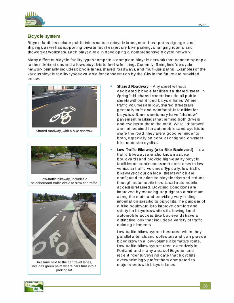
07.21.14
Bicycle system Bicycle facilities include public infrastructure (bicycle lanes, mixed-use paths, signage, and striping), as well as supporting private facilities (secure bike parking, changing rooms, and showers at worksites). Each plays a role in developing a comprehensive bicycle network.
Many different bicycle facility types comprise a complete bicycle network that connects people to their destinations and allows bicyclists to feel safe riding. Currently, Springfield’s bicycle network primarily includes bicycle lanes, shared roadways, and multi-use paths. Examples of the various bicycle facility types available for consideration by the City in the future are provided below.
Shared Roadway – Any street withoutdedicated bicycle facilities is a shared street. InSpringfield, shared streets include all publicstreets without striped bicycle lanes. Wheretraffic volumes are low, shared streets aregenerally safe and comfortable facilities forbicyclists. Some streets may have “sharrow”pavement markings that remind both driversand cyclists to share the road. While “sharrows”are not required for automobiles and cyclists toshare the road, they are a good reminder toboth, especially on popular or signed on-streetbike routes for cyclists.
Low-Traffic Bikeway (aka Bike Boulevard) – Low-traffic bikeways are also known as bikeboulevards and provide high-quality bicyclefacilities on continuous street corridors with lowvehicular traffic volumes. Typically, low-trafficbikeways occur on local streets which areconfigured to prioritize bicycle trips and reducethrough automobile trips. Local automobileaccess is retained. Bicycling conditions areimproved by reducing stop signs to a minimumalong the route and providing way-findinginformation specific to bicyclists. The purpose ofa bike boulevard is to improve comfort andsafety for bicyclists while still allowing localautomobile access. Bike boulevards have adistinctive look that includes a variety of trafficcalming elements.
Low-traffic bikeways are best used when theyparallel arterials and collectors and can providebicyclists with a low-volume alternative route.Low-traffic bikeways are used extensively inPortland and many areas of Eugene, andrecent rider surveys indicate that bicyclistsoverwhelmingly prefer them compared tomajor streets with bicycle lanes.
Shared roadway, with a bike sharrow
Bike lane next to the car travel lanes, includes green paint where cars turn into a
parking lot
Low-traffic bikeway, includes a neighborhood traffic circle to slow car traffic
226
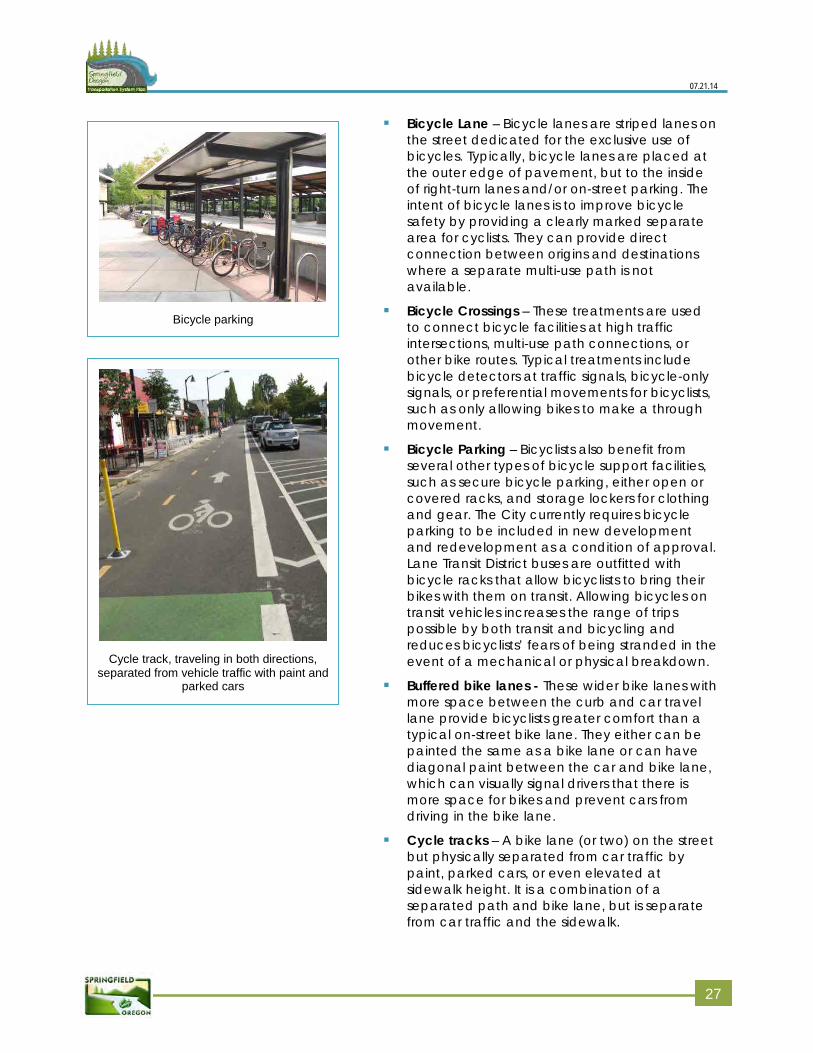
07.21.14
Bicycle Lane – Bicycle lanes are striped lanes on the street dedicated for the exclusive use of bicycles. Typically, bicycle lanes are placed at the outer edge of pavement, but to the inside of right-turn lanes and/or on-street parking. The intent of bicycle lanes is to improve bicycle safety by providing a clearly marked separate area for cyclists. They can provide direct connection between origins and destinations where a separate multi-use path is not available.
Bicycle Crossings – These treatments are used to connect bicycle facilities at high traffic intersections, multi-use path connections, or other bike routes. Typical treatments include bicycle detectors at traffic signals, bicycle-only signals, or preferential movements for bicyclists, such as only allowing bikes to make a through movement.
Bicycle Parking – Bicyclists also benefit from several other types of bicycle support facilities, such as secure bicycle parking, either open or covered racks, and storage lockers for clothing and gear. The City currently requires bicycle parking to be included in new development and redevelopment as a condition of approval. Lane Transit District buses are outfitted with bicycle racks that allow bicyclists to bring their bikes with them on transit. Allowing bicycles on transit vehicles increases the range of trips possible by both transit and bicycling and reduces bicyclists’ fears of being stranded in the event of a mechanical or physical breakdown.
Buffered bike lanes - These wider bike lanes with more space between the curb and car travel lane provide bicyclists greater comfort than a typical on-street bike lane. They either can be painted the same as a bike lane or can have diagonal paint between the car and bike lane, which can visually signal drivers that there is more space for bikes and prevent cars from driving in the bike lane.
Cycle tracks – A bike lane (or two) on the street but physically separated from car traffic by paint, parked cars, or even elevated at sidewalk height. It is a combination of a separated path and bike lane, but is separate from car traffic and the sidewalk.
Bicycle parking
Cycle track, traveling in both directions, separated from vehicle traffic with paint and
parked cars
2
27
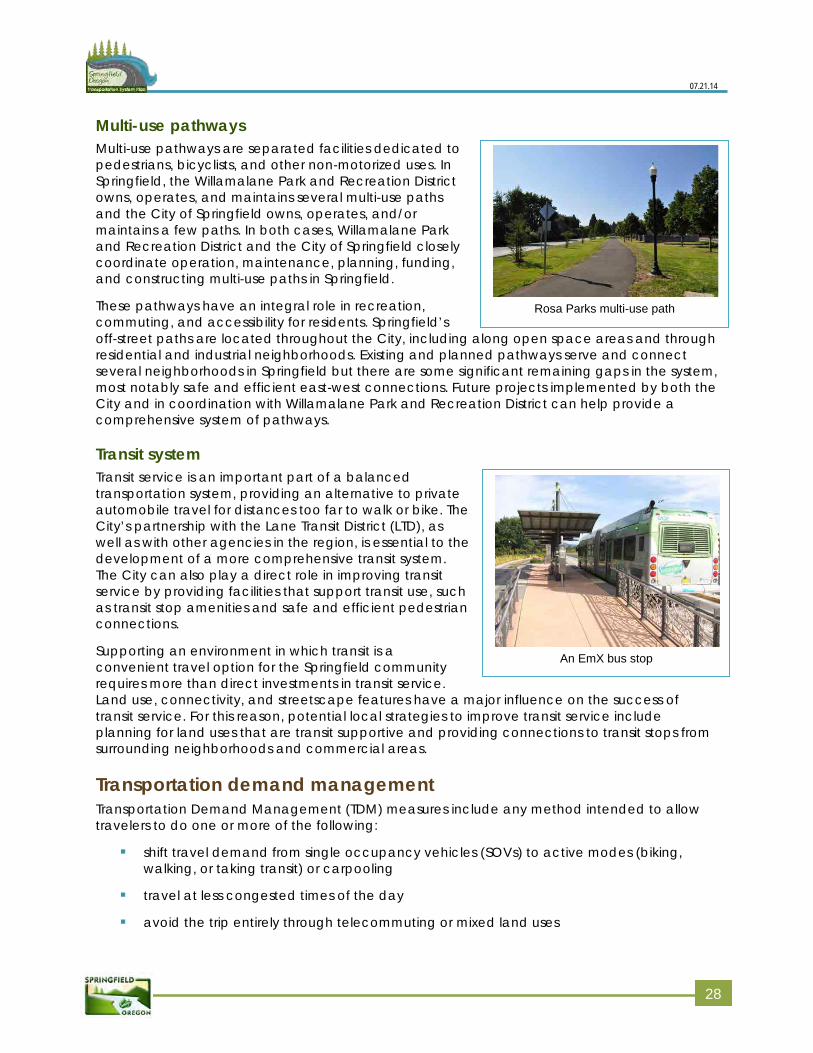
07.21.14
An EmX bus stop
Rosa Parks multi-use path
Multi-use pathways Multi-use pathways are separated facilities dedicated to pedestrians, bicyclists, and other non-motorized uses. In Springfield, the Willamalane Park and Recreation District owns, operates, and maintains several multi-use paths and the City of Springfield owns, operates, and/or maintains a few paths. In both cases, Willamalane Park and Recreation District and the City of Springfield closely coordinate operation, maintenance, planning, funding, and constructing multi-use paths in Springfield.
These pathways have an integral role in recreation, commuting, and accessibility for residents. Springfield’s off-street paths are located throughout the City, including along open space areas and through residential and industrial neighborhoods. Existing and planned pathways serve and connect several neighborhoods in Springfield but there are some significant remaining gaps in the system, most notably safe and efficient east-west connections. Future projects implemented by both the City and in coordination with Willamalane Park and Recreation District can help provide a comprehensive system of pathways.
Transit system Transit service is an important part of a balanced transportation system, providing an alternative to private automobile travel for distances too far to walk or bike. The City’s partnership with the Lane Transit District (LTD), as well as with other agencies in the region, is essential to the development of a more comprehensive transit system. The City can also play a direct role in improving transit service by providing facilities that support transit use, such as transit stop amenities and safe and efficient pedestrian connections.
Supporting an environment in which transit is a convenient travel option for the Springfield community requires more than direct investments in transit service. Land use, connectivity, and streetscape features have a major influence on the success of transit service. For this reason, potential local strategies to improve transit service include planning for land uses that are transit supportive and providing connections to transit stops from surrounding neighborhoods and commercial areas.
Transportation demand management Transportation Demand Management (TDM) measures include any method intended to allow travelers to do one or more of the following:
shift travel demand from single occupancy vehicles (SOVs) to active modes (biking,walking, or taking transit) or carpooling
travel at less congested times of the day
avoid the trip entirely through telecommuting or mixed land uses
228
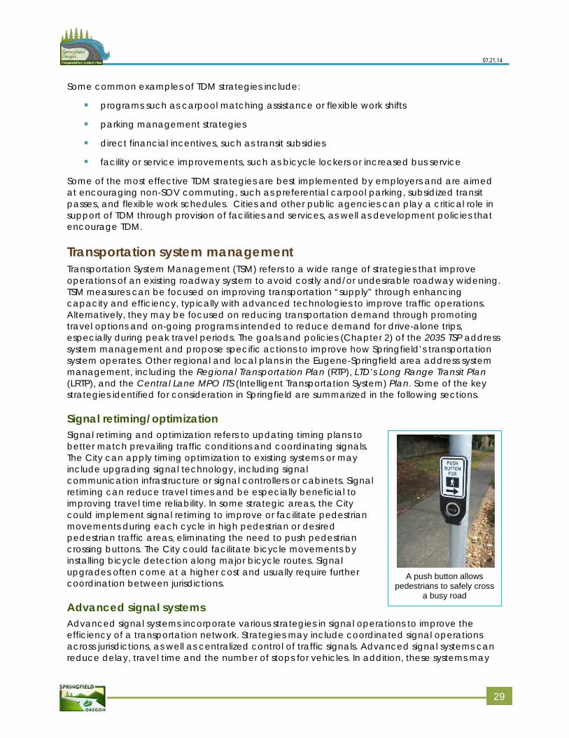
07.21.14
A push button allows
pedestrians to safely cross a busy road
Some common examples of TDM strategies include:
programs such as carpool matching assistance or flexible work shifts
parking management strategies
direct financial incentives, such as transit subsidies
facility or service improvements, such as bicycle lockers or increased bus service
Some of the most effective TDM strategies are best implemented by employers and are aimed at encouraging non-SOV commuting, such as preferential carpool parking, subsidized transit passes, and flexible work schedules. Cities and other public agencies can play a critical role in support of TDM through provision of facilities and services, as well as development policies that encourage TDM.
Transportation system management Transportation System Management (TSM) refers to a wide range of strategies that improve operations of an existing roadway system to avoid costly and/or undesirable roadway widening. TSM measures can be focused on improving transportation “supply” through enhancing capacity and efficiency, typically with advanced technologies to improve traffic operations. Alternatively, they may be focused on reducing transportation demand through promoting travel options and on-going programs intended to reduce demand for drive-alone trips, especially during peak travel periods. The goals and policies (Chapter 2) of the 2035 TSP address system management and propose specific actions to improve how Springfield’s transportation system operates. Other regional and local plans in the Eugene-Springfield area address system management, including the Regional Transportation Plan (RTP), LTD’s Long Range Transit Plan (LRTP), and the Central Lane MPO ITS (Intelligent Transportation System) Plan. Some of the key strategies identified for consideration in Springfield are summarized in the following sections.
Signal retiming/optimization Signal retiming and optimization refers to updating timing plans to better match prevailing traffic conditions and coordinating signals. The City can apply timing optimization to existing systems or may include upgrading signal technology, including signal communication infrastructure or signal controllers or cabinets. Signal retiming can reduce travel times and be especially beneficial to improving travel time reliability. In some strategic areas, the City could implement signal retiming to improve or facilitate pedestrian movements during each cycle in high pedestrian or desired pedestrian traffic areas, eliminating the need to push pedestrian crossing buttons. The City could facilitate bicycle movements by installing bicycle detection along major bicycle routes. Signal upgrades often come at a higher cost and usually require further coordination between jurisdictions.
Advanced signal systems Advanced signal systems incorporate various strategies in signal operations to improve the efficiency of a transportation network. Strategies may include coordinated signal operations across jurisdictions, as well as centralized control of traffic signals. Advanced signal systems can reduce delay, travel time and the number of stops for vehicles. In addition, these systems may
2
29
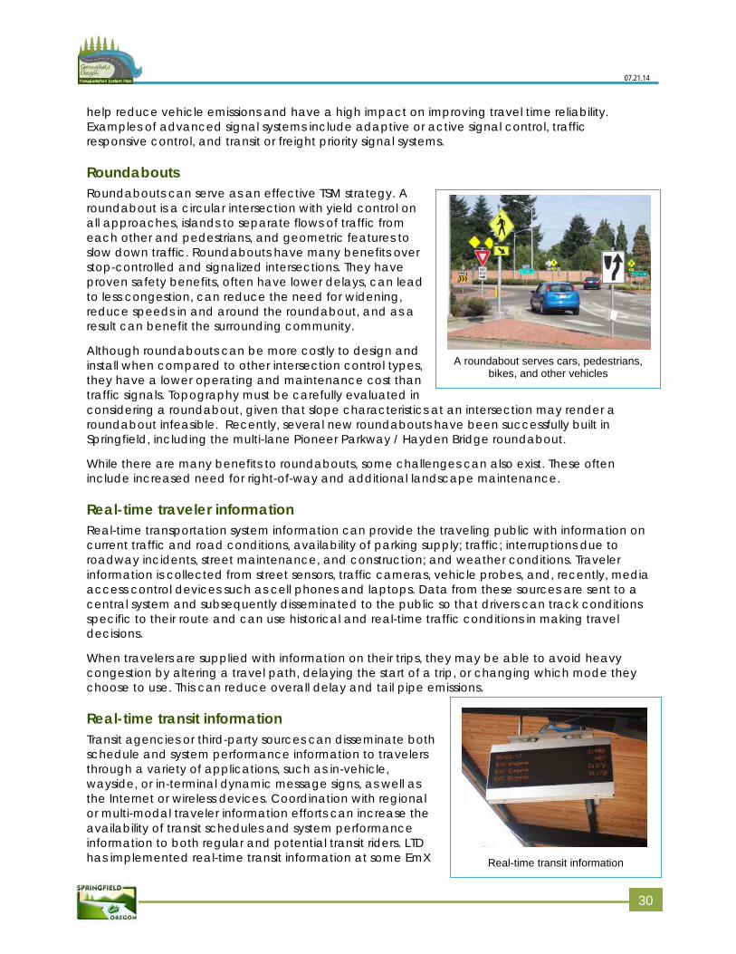
07.21.14
Real-time transit information
A roundabout serves cars, pedestrians, bikes, and other vehicles
help reduce vehicle emissions and have a high impact on improving travel time reliability. Examples of advanced signal systems include adaptive or active signal control, traffic responsive control, and transit or freight priority signal systems.
Roundabouts Roundabouts can serve as an effective TSM strategy. A roundabout is a circular intersection with yield control on all approaches, islands to separate flows of traffic from each other and pedestrians, and geometric features to slow down traffic. Roundabouts have many benefits over stop-controlled and signalized intersections. They have proven safety benefits, often have lower delays, can lead to less congestion, can reduce the need for widening, reduce speeds in and around the roundabout, and as a result can benefit the surrounding community.
Although roundabouts can be more costly to design and install when compared to other intersection control types, they have a lower operating and maintenance cost than traffic signals. Topography must be carefully evaluated in considering a roundabout, given that slope characteristics at an intersection may render a roundabout infeasible. Recently, several new roundabouts have been successfully built in Springfield, including the multi-lane Pioneer Parkway / Hayden Bridge roundabout.
While there are many benefits to roundabouts, some challenges can also exist. These often include increased need for right-of-way and additional landscape maintenance.
Real-time traveler information Real-time transportation system information can provide the traveling public with information on current traffic and road conditions, availability of parking supply; traffic; interruptions due to roadway incidents, street maintenance, and construction; and weather conditions. Traveler information is collected from street sensors, traffic cameras, vehicle probes, and, recently, media access control devices such as cell phones and laptops. Data from these sources are sent to a central system and subsequently disseminated to the public so that drivers can track conditions specific to their route and can use historical and real-time traffic conditions in making travel decisions.
When travelers are supplied with information on their trips, they may be able to avoid heavy congestion by altering a travel path, delaying the start of a trip, or changing which mode they choose to use. This can reduce overall delay and tail pipe emissions.
Real-time transit information Transit agencies or third-party sources can disseminate both schedule and system performance information to travelers through a variety of applications, such as in-vehicle, wayside, or in-terminal dynamic message signs, as well as the Internet or wireless devices. Coordination with regional or multi-modal traveler information efforts can increase the availability of transit schedules and system performance information to both regular and potential transit riders. LTD has implemented real-time transit information at some EmX
330
07.21.14
stations and is continuing to expand this service through their website and mobile site.
These systems enhance passenger convenience and may increase the attractiveness of transit to the public by encouraging travelers to consider transit because of ease of use, lower costs for wear and tear to a car, and time to read or do work instead of driving. They do require cooperation and integration between agencies for disseminating the information.
Access management Access management describes a practice of managing the number, placement, and allowed turn movements of intersections and driveways that provide access to adjacent land uses. Access points are considered in context with traffic flow, safety, capacity, and speed on the surrounding street system. Within developed areas, access management strategies may include shared or consolidated access points, restrictions on access point turn movements (medians, channelized movements), or closing access points. Access management provides several potential benefits, such as reducing crashes and crash rates, as well as increasing capacity on arterial and collector streets by maintaining vehicle flows and travel time.
In addition, well-deployed access management strategies can improve travel conditions for pedestrians and bicycles. Eliminating the number of access points on streets reduces the number of potential interruptions and conflict points between pedestrians, bicyclists, transit, and cars.
Access management is adopted typically as a policy in development guidelines. Springfield’s specific access management standards are provided in the Springfield Development Code. The Oregon Highway Plan (OHP) should be referenced for state highway access requirements.
Neighborhood traffic management Neighborhood Traffic Management (NTM) describes a set of tools applicable for use in residential neighborhoods to slow traffic or possibly reduce the volume of traffic. NTM is often called ‘traffic calming’ due to its ability to contribute to neighborhood livability. 2035 TSP goals and policies found in Chapter 2 of the 2035 TSP support traffic calming measures being further developed in Springfield, in close coordination with emergency management officials. Some local and regional examples of traffic calming that can potentially be used more in Springfield are as follows:
Speed trailer (reader board that displays vehicle speeds)
Speed table
Speed humps
Mini roundabouts
Entrance treatments
Raised crosswalks
Raised intersections
Traffic diverters
Medians
Landscaping and trees
Chicanes
331
07.21.14
Chokers (narrow roadways in short sections)
Narrow streets
Closing streets
Half street closure
Photo radar
On-street parking
On-street protected bicycle facilities
Selective enforcement
Neighborhood watch
Curb extensions
Pavement texturing
Tighter intersection curb radii
Channelization
There are many opportunities, as well as challenges, with NTM. If planned and implemented correctly, NTM can provide safer, more convenient bike and pedestrian routes on low-traffic volume streets, and can help reduce automobile speeds. On the contrary, if not planned and implemented correctly, NTM can create challenges for emergency vehicles attempting to respond to an emergency and can result in shifting a problem from one neighborhood to another. Measures are available to enable effective NTM deployment while also allowing necessary emergency response time to neighborhoods. A number of streets in Springfield are identified in the functional classification as neighborhood routes. These streets are typically longer than the average local street and might otherwise attract cut-through traffic. These may be appropriate locations for NTM applications.
332
Chapter 5: Transportation plan
This chapter presents the multi-modal Springfield 2035 Transportation System Plan (TSP). The elements included in the 2035 TSP support the goals and policies presented in Chapter 2 by logically providing for the efficient care and expansion of the City’s multi-modal transportation system. This chapter provides regulatory framework to guide the expansion of the system and improvement projects identified to meet the future travel needs within the community.
This chapter includes the:
State and regional planning context
Regulatory elements for management and design of roadways
Multi-modal improvement projects
Plan area The City of Springfield is located within urban Lane County and is part of the Central Lane Metropolitan Planning Organization (MPO) area. In general, Springfield’s current boundaries are defined by the McKenzie River to the north, Interstate 5 (I-5) to the west, the Willamette River to the south, and rural Lane County to the east.
Figure 1 presents a map of the Plan area that includes the City of Springfield and sections of unincorporated Lane County that are part of the Springfield urban growth boundary (UGB). The unincorporated areas within the City’s UGB are required to be included in the 2035 TSP by the Transportation Planning Rule (TPR).
The City of Eugene, located directly west of the Springfield Plan area, is currently undertaking its own TSP process. The City of Springfield coordinated its TSP directly with City of Eugene, and other appropriate public agencies, to ensure coordination for regional facilities and issues.
State and regional planning context While the focus of the Springfield 2035 TSP is the transportation system within the Springfield UGB, the transportation facilities within the Plan area also have an important role in the state and regional transportation system. In keeping with statewide planning goals related to interagency coordination, the TSP is consistent with statewide, county, and regional transportation plans, policies, and requirements.
The Oregon Revised Statutes (ORS) require that the 2035 TSP addresses the City’s current comprehensive plan (Metro Plan; update 2004) land uses and that it provide for a transportation system that accommodates the expected growth in population and employment that will result from implementation of the land use plan. Development of the 2035 TSP was guided by ORS 197.712 and the Oregon Department of Land Conservation and Development (DLCD) Transportation Planning Rule (TPR) (Oregon Administrative Rules [OAR] 660-012).
The TPR requires that the 2035 TSP include provisions for safe and efficient travel by all travel modes. City prioritization of enhancing the walking, biking and transit systems is essential to the implementation of the TSP. The TPR also requires that local jurisdictions adopt land use and subdivision ordinance amendments to protect transportation facilities and to provide bicycle
33
07.21.14
and pedestrian facilities between residential, commercial, and employment/institutional areas. It is further required that local communities coordinate their respective plans with the applicable county, regional, and state transportation plans.
The 2035 TSP is further consistent with the Central Lane 2035 Regional Transportation Plan (RTP), which is a federally required plan that provides a regional framework for transportation planning, coordination, and investment. The Springfield 2035 TSP has been developed in close coordination with the 2035 RTP update process to ensure consistency at the state and regional levels. A memorandum summarizing how the 2035 TSP and implementing ordinances are compliant with the TPR and other regulatory requirements is provided in Volume 3, Appendix A: Plan and policies review.
Facilities Four major regional transportation facilities are located within or adjacent to the City of Springfield: I-5, OR 126 Business Route, Pioneer Parkway (between South A Street and OR 126), and OR 126 Expressway. These are state highways under the jurisdiction of the Oregon Department of Transportation (ODOT) and subject to State operational and design requirements. Plans for improvements to the highways and interchanges, as well as changes to adjacent land uses and access points must be developed in a manner consistent with ODOT plans, guidelines, and standards.
Related plans and policies City of Springfield staff reviewed relevant plans and policies in current state, regional, and local documents that could affect transportation planning in Springfield. This review highlighted guidelines and procedures relevant to the development of the 2035 TSP and provided a baseline to begin forming policies for the 2035 TSP. In addition to reviewing relevant state and regional plans such as TransPlan and the Metro Plan (2004 update), the following local plans (including refinement plans) were reviewed:
Local Lane County Transportation Plan (2004)
Springfield Bicycle Plan (1998)
Springfield Capital Improvement Program (2014-2018 – updated annually)
Springfield Development Code (2010-2013 – periodically updated)
Willamalane Park and Recreation Plan (2013)
Non-City facility implications This Plan, including the Plan’s project lists, does not have any legal or regulatory effect on right-of-way or transportation facilities that the City does not own.
However, the planning process evaluated some facilities that are not under the City’s jurisdiction. As such, the Plan includes proposed improvements to non-City facilities. Without additional action by the governmental entity that owns the subject facility or right-of-way (i.e., Lane County) any project in this Plan that involves a non-City facility is merely a recommendation.
As in most facility planning efforts, moving towards and planning for, a well connected network depends on the cooperation of multiple jurisdictions; the Plan is intended to facilitate discussions between the City and its governmental partners as we work together to achieve a well-connected network. The Plan, however, does not obligate its governmental partners to take any action or construct any projects.
334
07.21.14
Refinement plans East Kelly Butte Neighborhood (1982)
East Main (1988)
Gateway (1995)
Glenwood Refinement Plan (1999)
Glenwood Refinement Plan Phase I Update (2012)
Mid-Springfield (1986)
Q Street (1987)
Springfield Downtown District Urban Design Plan and Implementation Strategy (2010)
A full list of applicable plans, goals, and policies, including the ones listed above, are in Volume 3, Appendix A: Plan and policies review. Highlights of regional plans are listed below.
Central Lane MPO Regional Transportation Plan (RTP): 2011 The Central Lane MPO RTP meets federal requirements for the plan area and guides regional transportation system planning and agency coordination. The RTP currently has a planning horizon that goes beyond the planning horizons of the Metro Plan and TransPlan. The RTP is updated every four years. The Springfield 2035 TSP must be consistent with the most currently updated RTP.
Central Lane MPO Regional Transportation System Plan (RSTP): In process The Central Lane MPO RSTP will update the policies, projects, and strategies that guide transportation planning and investments within the Central Lane MPO, through 2031 (a new plan building from TransPlan and serving the same regional purpose). The RTSP will be updated after Eugene, Coburg, and Springfield complete their TSP processes.
Lane County Transportation System Plan (TSP): 2004 The 2004 Lane County TSP is an update to the County’s 1980 Transportation Plan. The TSP is a 20-year planning document used to facilitate the orderly and efficient management of the County’s transportation system. The Lane County TSP is a component of the County’s Comprehensive Plan, which includes all City-adopted comprehensive plans and transportation system plans (e.g., TransPlan). The County TSP looks to the TransPlan, until the Springfield TSP is adopted, when decisions are needed regarding transportation facilities within the Springfield UGB. County roads within the UGB must comply with the Lane County TSP and applicable Lane County rules, regulations, and standards.
Eugene-Springfield Metropolitan Area General Plan (Metro Plan): 2004 update Metro Plan serves as the comprehensive plan for both Eugene and Springfield. The 2004 Metro Plan is the third update since 1990. The plan serves as Eugene, Springfield, and metropolitan Lane County’s long range policy document; guiding land use for all three jurisdictions within the plan’s boundaries. Metro Plan addresses all applicable statewide planning goals either in the plan itself or through supporting facility or master plans such as local TSPs and parks plans. To comply with state regulations, Metro Plan provides a 20-year land supply. After Eugene and Springfield created separate UGBs, each city is now creating separate, city‐wide refinement plans to Metro Plan.
335
07.21.14
Metro Plan outlines regional goals, findings, objectives, and policies. Those policies with the most impact on Springfield’s overall transportation system are listed in Volume 3, Appendix A: Plan and policies review. These policies are grouped into three sections: Growth Management, Transportation, and Citizen Involvement.
Eugene-Springfield Metropolitan Area Transportation Plan (TransPlan): amended 2002 Because TransPlan served as the locally adopted TSP for Springfield during the creation of the 2035 TSP, the City analyzed all of its policies as part of the 2035 TSP. Upon adoption, the 2035 TSP replaces TransPlan as the City’s TSP. For now, TransPlan is in place until a new plan is approved by the local jurisdictions.
TransPlan is the transportation element of Metro Plan. TransPlan is a system plan that guides local and regional transportation system planning and development in the Eugene-Springfield metropolitan area. TransPlan also serves as the City’s facilities plan (or TSP) to identify projects needed to meet transportation needs over a 20-year planning horizon, while addressing transportation issues and proposing changes that can contribute to improvements in the region’s quality of life and economic vitality. In addition to roadway facilities, TransPlan also calls for significant increases in the amount and convenience of transit service, bikeways, sidewalks, and an expansion of the existing program of transportation demand management (TDM) travel incentives. TransPlan is a jointly adopted document that serves as a local transportation system plan for both Springfield and Eugene. 2007 legislation allowed the two cities to develop separate UGBs; Springfield’s was adopted in 2011.
The TransPlan theme, ‘Improving Our Transportation Choices,’ reflects the plan’s focus to provide citizens with a range of safe, convenient, and efficient transportation options characterized by smooth connections between modes. TransPlan strives to support the need to diversify transportation choices, while avoiding reliance on any one transportation mode or method of managing the transportation system. TransPlan establishes the framework upon which all public agencies can make consistent and coordinated planning decisions regarding inter- and intra-jurisdictional transportation.
Coordination with plans and infrastructure The planning efforts noted above and other future efforts by neighboring jurisdictions may have an impact on Springfield’s transportation system. In the future, the City of Springfield will coordinate and collaborate with other planning efforts, as appropriate, to ensure integration of any recommended transportation related projects with the future vision for the City. Coordinating these plans with implementation of other 2035 TSP elements can provide opportunities for additional efficiencies in funding, construction, and system impacts during project construction.
To the extent possible, the City of Springfield will coordinate transportation system infrastructure improvements with other types of infrastructure projects within the City (e.g., water, storm drainage, sewer, power, and other utilities) to save costs and minimize disruptions to residents, businesses, and travelers.
336
07.21.14
Common terms Access - the ability for travelers to enter/leave land uses and destinations
Mobility - actual physical travel that occurs between destinations
Functional classification - defines a roadway’s primary role in terms of providing mobility and access for all modes of travel, directing the design and management of the roadway
Guiding principles for street design and operations A number of additional transportation related elements will guide development review and project development in Springfield in the future. These elements are discussed in more detail below:
Functional classification of roadways
Street design standards
Truck routes
Intersection performance standards
Access management guidelines
Connectivity guidelines
Transit service
Parking
Safety
Functional classification of roadways Functional classification defines a roadway’s primary role in terms of providing mobility and access for all modes of travel. Mobility refers to the actual physical travel that occurs between destinations like home, shopping, and work, whereas access is the ability for travelers to access those land uses to meet daily needs. For example, a freeway provides the highest level of mobility (high speeds) with access limited to interchange ramps that may be a mile apart or more. A neighborhood street is on the opposite end of the spectrum, providing the highest level of access (driveways accessing every property) and with very low mobility (low traffic volumes and speeds).
An individual street’s classification directs the design and management of the roadway, including right-of-way needs, the number of travel lanes, bicycle and pedestrian facilities, on-street parking, and access management guidance. Figure 2 shows the functional classification for each roadway in Springfield.
The functional classification system for streets within Springfield is generally guided by this TSP, the Regional Transportation Plan (RTP), the Oregon Highway Plan (OHP), and the City of Springfield Development Code (see Figure 2). A general description of functional classifications is provided below:
Interstate highways: These facilities provide fortravel among major cities, regions of the state,and areas outside the state. The primary objectivefor interstate highways is mobility. Within urbanareas such as Springfield, the secondary functionof interstate highways is to provide for regional trip-making.
337
07.21.14
Major arterials: These facilities are intended to carry high volumes of traffic and primarilyprovide mobility and not access. Major arterials provide continuity for intercity trafficthrough the urban area and are often multi-lane highway facilities.
Minor arterials: These facilities interconnect with and augment the major arterial systemand accommodate trips of somewhat shorter length. Minor arterials interconnectresidential, shopping, employment, and recreational activities within the community.
Major and minor collectors: These streets provide both land access and movementwithin residential, commercial, and industrial areas. They gather traffic from local streetsand serve as connectors to arterials.
Local streets: These facilities have the primary function of providing access to adjacentland uses. Local streets often have several driveways along them and are not intendedfor long-distance trips. Through traffic on local streets is managed by street design. Theyalso often serve as ideal bicycle and pedestrian routes given their often low trafficvolumes.
Alleys: These provide local access and services for residences and businesses.
The City of Springfield roadway functional classification system is intended to organize the roadway network as a balanced system that provides a hierarchy of mobility and access to, through and between different types of land uses. Some of the factors that are considered in setting a roadway’s functional class are land use patterns, roadway volumes, density of accesses along a particular segment, the mix and amounts of different modes on a typical segment (i.e. freight, bikes), safety trends, traffic speeds, intersection spacing distances and intersection types, and right of way availability and constraints. Over time, as the community continues to grows and mature, the functional classification should periodically be revisited to insure that particular classifications are most appropriate to current and forecast conditions.
338
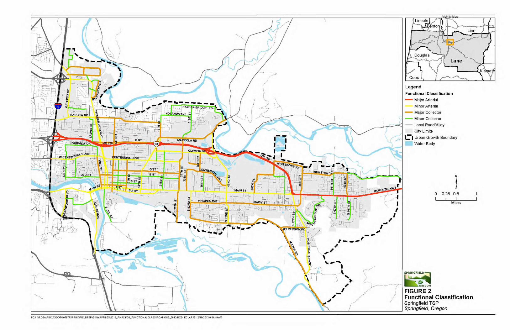
07.21.14
339

07.21.14
Street design standards Street design standards provide information on how streets “look and feel.” These standards indicate how existing streets can be modified and new streets can be constructed to accommodate the needs of people with disabilities, riding bicycles, riding transit, walking, and driving automobiles and freight vehicles. Chapter 2 of the 2035 TSP, Policy, 3.3, Action 1 states that citywide street standards will be updated subsequent to the 2035 TSP. The goals, policies, and action items in the 2035 TSP provide overall guidance for the street standards update.
The City should consider the following as part of the street standards update:
Travel lanes: When arterial and collector streets are improved to City standards, traveland turn lanes should be consistent with best practices at the time of improvementsunless flexibility is required to minimize impacts or better accommodate expected users.
Bicycle and pedestrian facilities: As discussed in Chapter 4, bicycle facilities on arterialsand collectors can be constructed as bike lanes, buffered bike lanes, shared lanes,or cycle-tracks, depending on context. Minimum widths of bicycle lanes and multi-usepaths should use best practice standards found in National Association of CityTransportation Officials (NACTO) Urban Bikeway Design Guide, AASHTO, and the OregonBike and Pedestrian Plan.
Landscaping: Both collectors andarterials may include landscapedmedians and/or street trees.
Green streets: Green streettreatments, such as bioswales, mayalso be used in place of thelandscaping strip or tree wells.Bioswales can help slow the flow of stormwater, ensuring that drainagesystems are not overwhelmed during heavy rain, which can result in improved statewidewater quality. In many areas of Springfield, landscaping strips may be replaced withswales that will absorb stormwater runoff.
Context sensitive variation: The street sections should vary depending on whether theyare located in a mixed use, higher density, or more suburban part of Springfield. Somevariations may be allowed, subject to City Traffic Engineer and City Engineer approval,depending on case specific issues such as topography and environmental constraints.
Truck routes Both TransPlan and the Oregon Transportation Plan (OTP) recognize the role that an efficient and reliable transportation system plays in supporting the region’s economy, growth, and quality of life. Within the Eugene-Springfield area, highways, city streets, air, pipeline, and railways provide freight mobility. Each of these modes must function together to ensure the efficient and timely movement of freight to, within, and through the community.
Within Springfield, “through” truck freight travel occurs primarily on I-5 and OR 126 Expressway. Both OR 126 Expressway and I-5 have federal truck route designations and are identified as state freight routes. For I-5, both the federal and state designations apply throughout the UGB. For OR 126, the federal designation applies throughout the UGB and the state freight designation is applicable from I-5 to the intersection with Main Street. The state and federal freight
Landscaping along the Gateway EmX bus line
441
07.21.14
designations necessitate more stringent design and mobility standards for these facilities to accommodate goods movement.
Within Springfield, truck freight travel occurs primarily on the designated City truck routes. These local truck routes are shown in Figure 3.
442
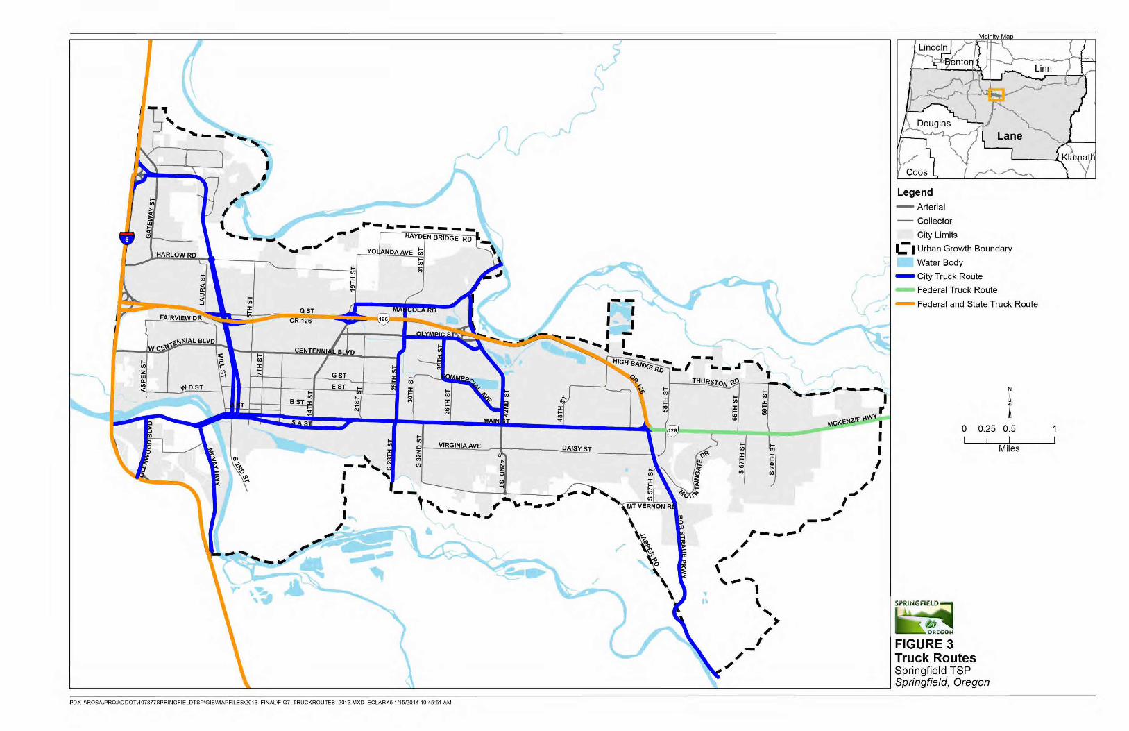
07.21.14
443

07.21.14
Intersection performance standards Although most intersections in Springfield are under the City’s jurisdiction, many of the larger volume intersections are under state jurisdiction. Some unincorporated area intersections are under Lane County jurisdiction, as are some intersections within the City that are at least partially under the County’s jurisdiction (e.g., Glenwood Boulevard and 17th Avenue).
Policy 2.9 of this TSP (Chapter 2) notes that the City of Springfield will use motor vehicle LOS standards to evaluate for acceptable and reliable performance on the roadway system. Lane County facilities in Springfield use the volume to capacity ratio (v/c) as the peak hour performance standard for evaluation. LOS analysis may also be required pursuant to Lane Code 15.696. Under peak hour traffic conditions, acceptable and reliable performance is defined as LOS D.
The Oregon Highway Plan (OHP) outlines specific performance measures to be maintained along ODOT facilities in the Springfield metropolitan area as part of adopted Highway Mobility Standards. These standards are aimed at maintaining mobility along important road corridors and vary according to functional classification, location, posted speed, and role within the National Highway System (NHS). The mobility standards are based on a calculated volume to capacity (v/c) ratio.
Per the OHP, the following intersection performance measures are applicable for facilities within Springfield (subject to change with any future ODOT planning effort):
For I-5, v/c ratio of 0.80 because of its classification as an interstate facility within aMetropolitan Planning Organization (MPO). For the I-5 ramp terminals, the applicable v/cratio is dependent on the crossroad standard. If the crossroad requires a v/c less than0.85, then the crossroad dictates the ramp terminal standard; otherwise the applicableramp terminal standard is a v/c of 0.85.
For OR 126 Expressway, v/c of 0.80 given its classification as a statewide Expresswaywithin a MPO.
For the OR 126 ramp termini and OR 126 Business (McKenzie Highway, ODOT Highway No.15, Main Street), v/c ratio of 0.85.
For OR 528 (Pioneer Parkway) and OR 225 (McVay Highway), v/c ratio of 0.90 given theirclassification as District Highways within a MPO.
The highway standards above are for signalized intersection performance standards. At stop-controlled intersections, the appropriate mobility standard is based on the classification of the intersecting roadway. Recognizing that some intersections on the state system will fail to meet Oregon Highway Plan targets, the City will need to request alternate mobility targets from the Oregon Transportation Commission.
Access management guidelines The City of Springfield’s access management standards are listed in the City’s Engineering and Design Standards and Procedures Manual (EDPSM). The Springfield Development Code identifies the spacing standards for roadways. Driveway access spacing is measured from the center of each driveway to the center of the upstream or downstream driveway or intersection on one side of the roadway. These ideal standards can be difficult to achieve on roadways with existing development.
445
07.21.14
Lane County Code also outlines access regulations for roads under the County’s jurisdiction (Chapter 15.130 through 15.140). The OHP includes guidance and requirements for all ODOT facilities within the City, including OR 126 Business Route (i.e. Main Street); OR 126 Expressway; Pioneer Parkway (OR 528); McVay Highway; and Franklin Boulevard (McKenzie Highway).
Connectivity guidelines In order to promote the development of a well-connected transportation network while maintaining desirable neighborhood characteristics, the following strategies can be used for new development within the City of Springfield:
Where feasible, new developmentsshould include a highly connectednetwork of local streets to provide directaccess to local destinations, such asschools, parks, and neighborhoodamenities.
The City should limit the use of cul-de-sacs and dead-end streets in newdevelopments, except wheretopographical or natural featuresconstraints make connections infeasible.
New developments should connect tothe stub streets of prior developments toprovide continuous streets and includestub streets for connection with futuredevelopment.
The City can design block size in newdevelopments to maximize connectivity.Smaller block sizes, from 250-500 feet,provide better access for all modes.
Increased connectivity in existing areas can occur over time. The following strategies can be implemented to enhance connectivity in currently developed areas:
In updating refinement plans or creatingcorridor plans in Springfield, the Cityshould consider local street connectivityas a primary goal in the development ofthe street network.
Multi-use paths and sidewalkconnections should be used as a way toprovide additional connectivity for pedestrians and bicyclists.
The City should consider using traffic calming strategies in existing residential areas tominimize traffic impacts.
Common terms Access – the ability for travelers to access/leave destinations, like a driveway into a business
Access management – a set of measures regulating access to streets, roads, and highways from public roads and private driveways
Access points – driveways, median openings, interchanges, roundabouts, and street connections to a roadway
Capacity – the amount of vehicles that a street can handle
Conflict points – while there may be crashes (or near misses) anywhere for cars, bikes, pedestrians, and transit, these conflict points are more dangerous sections of the road
Functional classification – defines a roadway’s primary role in terms of providing mobility and access for modes of travel, directing the design and management of the roadway
Mobility – actual physical travel that occurs between destinations
Stub streets – dead-end or cul-de-sac streets that do not provide connections to the rest of the transportation system
Upstream/Downstream – the direction of travel on the road either in the same direction (upstream) or opposite direction (downstream)
446
07.21.14
In existing neighborhoods with cul-de-sac or dead end streets, the City should work with property owners to establish right-of-way easements for pedestrian and bicycle connections, prioritizing completion of pedestrian and bicycle routes to destinations (see Chapter 4 for more information on these treatments).
Transit service Transit plays an important role in providing a balanced transportation system within the City. Transit can provide an alternative to private automobile travel for distances too far to walk or bike and for transportation-disadvantaged travelers. Existing transit service in the City of Springfield is limited to areas north of Main Street. Lane Transit District (LTD) provides public transit service in Springfield and throughout the region.
The City of Springfield will continue to work with LTD to identify suitable transit corridors as development and land use densities create demand. Potential corridors for future transit improvements may include:
Centennial Boulevard – I-5 to Mohawk Boulevard
Franklin Boulevard/Main Street/South A Street to OR 126/Main Street
Franklin Boulevard – McVay Highway to 30th Ave. (a portion of this route is outside the Springfield UGB)
Mohawk Boulevard – Centennial Boulevard to 19th Street
Marcola Road – 19th to 28th
Olympic – Mohawk to 42nd Street
32nd/Jasper Road to Main Street – South 32nd/Jasper Road/Bob Straub Parkway/Main Street
To support convenient transit service, future development of potential transit corridors must consider transit-supportive land-use, connectivity, and streetscape features, such as:
Residential density of at least 4-5 dwelling units per acre to provide enough ridership to support local transit service or densities of about 15 units per acre to support frequent service
Commercial activity nodes with a mix of uses to provide access to multiple amenities within walking distance of a single transit stop
A highly connected street network that enables people to easily access transit stops on foot or by bicycle
Streetscaping with comfortable space for people on foot, bicycle, and waiting at transit stop locations, including wide sidewalks, bike lanes or cycle tracks, street trees, and benches or shelters
LTD bases system development on a number of considerations, with service priority focused on affordable housing, medical service centers, major employment centers, and major commercial activity centers. Routing is also based on dense housing areas and concentrations of student populations. LTD strives to respond to opportunities depending on resources available.
Planned transit improvements in Springfield include the development of the Frequent Transit Network (FTN). Springfield, along with its regional partners, is developing the FTN through the Regional Transportation System Plan (RTSP) process. The FTN consists of average frequent service of 15 minutes or better all day long. The purpose of the FTN is to use it as a policy tool to define
4
47
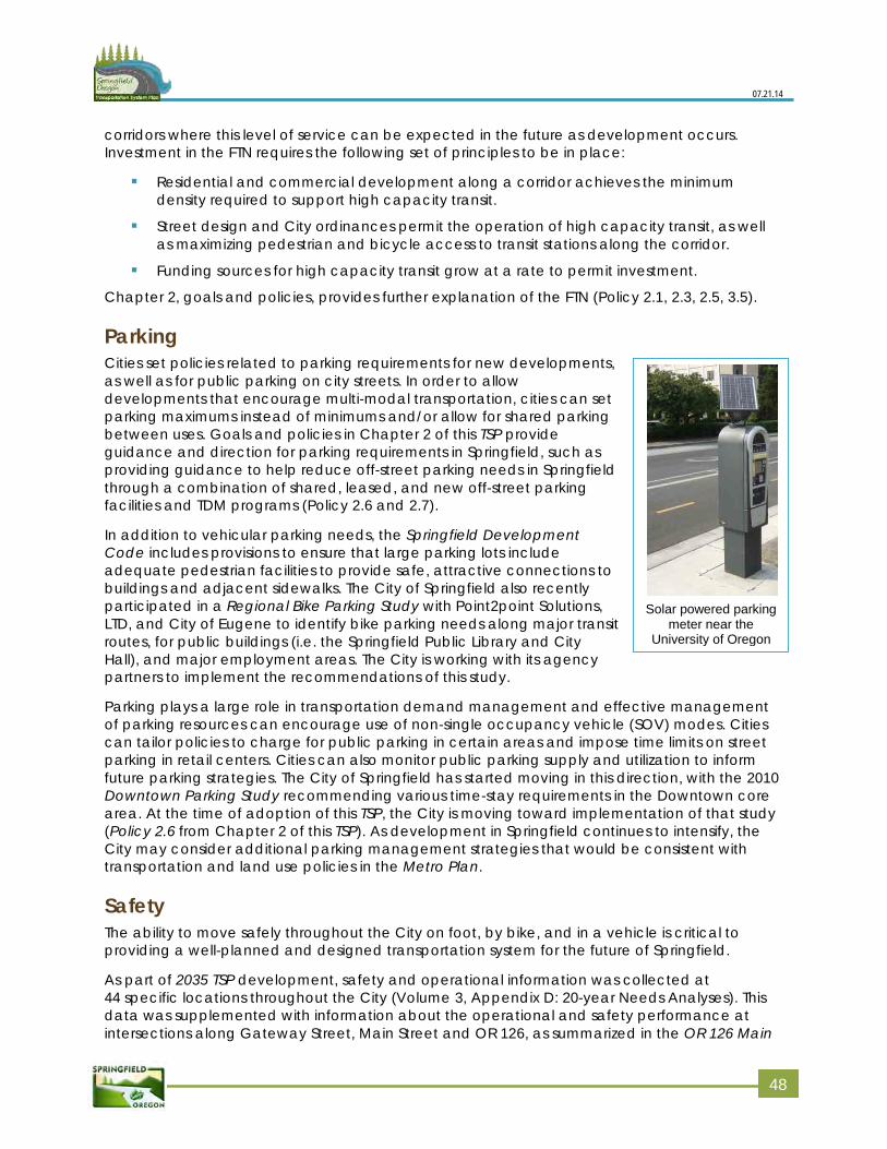
07.21.14
Solar powered parking meter near the
University of Oregon
corridors where this level of service can be expected in the future as development occurs. Investment in the FTN requires the following set of principles to be in place:
Residential and commercial development along a corridor achieves the minimumdensity required to support high capacity transit.
Street design and City ordinances permit the operation of high capacity transit, as wellas maximizing pedestrian and bicycle access to transit stations along the corridor.
Funding sources for high capacity transit grow at a rate to permit investment.
Chapter 2, goals and policies, provides further explanation of the FTN (Policy 2.1, 2.3, 2.5, 3.5).
Parking Cities set policies related to parking requirements for new developments, as well as for public parking on city streets. In order to allow developments that encourage multi-modal transportation, cities can set parking maximums instead of minimums and/or allow for shared parking between uses. Goals and policies in Chapter 2 of this TSP provide guidance and direction for parking requirements in Springfield, such as providing guidance to help reduce off-street parking needs in Springfield through a combination of shared, leased, and new off-street parking facilities and TDM programs (Policy 2.6 and 2.7).
In addition to vehicular parking needs, the Springfield Development Code includes provisions to ensure that large parking lots include adequate pedestrian facilities to provide safe, attractive connections to buildings and adjacent sidewalks. The City of Springfield also recently participated in a Regional Bike Parking Study with Point2point Solutions, LTD, and City of Eugene to identify bike parking needs along major transit routes, for public buildings (i.e. the Springfield Public Library and City Hall), and major employment areas. The City is working with its agency partners to implement the recommendations of this study.
Parking plays a large role in transportation demand management and effective management of parking resources can encourage use of non-single occupancy vehicle (SOV) modes. Cities can tailor policies to charge for public parking in certain areas and impose time limits on street parking in retail centers. Cities can also monitor public parking supply and utilization to inform future parking strategies. The City of Springfield has started moving in this direction, with the 2010 Downtown Parking Study recommending various time-stay requirements in the Downtown core area. At the time of adoption of this TSP, the City is moving toward implementation of that study (Policy 2.6 from Chapter 2 of this TSP). As development in Springfield continues to intensify, the City may consider additional parking management strategies that would be consistent with transportation and land use policies in the Metro Plan.
Safety The ability to move safely throughout the City on foot, by bike, and in a vehicle is critical to providing a well-planned and designed transportation system for the future of Springfield.
As part of 2035 TSP development, safety and operational information was collected at 44 specific locations throughout the City (Volume 3, Appendix D: 20-year Needs Analyses). This data was supplemented with information about the operational and safety performance at intersections along Gateway Street, Main Street and OR 126, as summarized in the OR 126 Main
448
07.21.14
Street Safety Study, the I-5/Beltline Interchange Area Management Plan, and the Draft OR 126 Expressway Management Plan.
The Main Street (OR 126B) corridor has been a focal point of safety concerns for many years. Because of the continued occurrence of pedestrian/vehicle collisions between 20th Street and 73rd Street (including nine pedestrian fatalities within the last 10 years), there is particular public concern for pedestrian safety. The 2011 OR 126 Main Street Safety Study completed by ODOT, City of Springfield, and LTD outlines multiple strategies to improve safety along this vital transportation and land use corridor. Pedestrian safety improvements such as mid-block pedestrian crossings, vehicular speed reduction, and improved street lighting were just some of the many recommendations from the study. The City of Springfield is working closely with ODOT to implement the study recommendations.
In addition to the Main Street safety issues, analysis of recent crash history at key collector/arterial intersections throughout Springfield helped identify potential improvement projects for the 2035 TSP. The City of Springfield will continue to monitor the safety of the system and will plan and prioritize transportation system improvements with safety as a priority.
Multi-modal improvement projects Over the next 20 years, a variety of multi-modal transportation improvement projects can support the continued economic development and vitality of the City of Springfield. These improvements are intended to enhance the movement of people, goods, and services within the City and the region, as well as provide people of all ages and abilities with a variety of ways to access their neighborhoods, schools, places of work, shopping, and recreational opportunities.
The recommended projects vary in terms of physical size, geographic area, type of users, and project cost but all work together to meet the vision of the community as expressed through its plans and policies. The actual construction timing of the projects will depend on future development within the City and region, the ability to secure funding through partnerships with other agencies and with the private sector, and overall community priorities.
Some of the projects have been identified to support key redevelopment opportunity areas within the City, such as the Glenwood Riverfront Area, Downtown, Gateway, and Jasper-Natron. Other projects serve more localized needs such as specific intersections or segments of a multi-use path. Over the next 20 to 40 years, the implementation of these projects will help support the overall economic health and well-being of Springfield.
Within the 2035 TSP, improvement projects have been divided into the following categories (project lists):
20-year projects (the 2035 TSP planning horizon): projects needed to serve expectedtransportation growth over the next 20 years. These projects have planning-level costestimates included in this Plan.
- Priority projects: Higher-cost and scale roadway, urban standards, and pedestrian/bicycle projects that would generally require additional right-of-way (Table 3, Figure 4).
- Opportunity projects: Lower-cost and scale roadway, urban standards, and pedestrian/bicycle projects that would generally not require additional right-of-way and the City could implement as opportunities arise (Table 4, Figure 5).
449
07.21.14
- As Development Occurs projects: Roadway and pedestrian/bicycle projects that the City would generally implement through a partnership with the City, other agencies, and/or private enterprise to support new development or redevelopment (Table 5, Figure 6).
Beyond 20-year projects: projects that may be constructed beyond the 20 year planninghorizon. These projects do not have planning-level cost estimates included in this Plan(Table 6, Figure 7).
Study projects: Projects that need further study and refinement (Table 7, Figure 8).
Frequent Transit Network (FTN) projects: Frequent transit projects that the City and LTDhave developed through the ongoing Regional Transportation System Plan process(Table 8, Figures 8 and 9).
Members of the community, the Stakeholder Advisory Committee (SAC), and Technical Advisory Committee (TAC) screened and evaluated the projects included in each of these categories. The process used to identify, screen, and evaluate the projects is described in Volume 3, Appendix E: Alternative evaluation process.
Approximately 136 projects comprise the project lists. These projects address existing and future multi-modal transportation system deficiencies and can serve as direction for future transportation investments. Many of these projects are necessary under current conditions, while the list identifies others to address the transportation needs that will become more important as the community grows. The project lists may identify proposed changes to the transportation system or may recommend further study related to topography, environmental, right-of-way, and construction constraints; value engineering; and practical design review to identify specific treatments and alignments. New facilities and roadway alignments, as well as major upgrades, will require City Council review and approval before construction.
The projects are listed (Tables 3 to 5) and mapped by category (Figures 4 to 6). In adopting the 2035 TSP project list, the City’s objective is to be in the best position to build or implement projects when the timing is right and funding is available. Examples of this type of opportunity are changes to federal and state funding and policy priorities, public-private partnerships, agency partnerships, work on subsurface infrastructure systems that leverage a transportation project, and City development priorities that may change over time. This approach to transportation investments will allow the City the greatest degree of efficiency and creativity in making transportation investment decisions. More information about the cost estimates is provided in Volume 2, Appendix II: Detailed cost estimates and funding analysis.
Within the tables and figures, each project list is subdivided into the following categories:
Roadway - these projects generally are needed to meet capacity needs or to serveconnectivity for multi-modal travel. This project category includes the construction of anew collector or arterial to City standards and the modification of existing streets andintersections. All new construction would incorporate bicycle facilities, sidewalks, vehicletravel lanes, planter strips (where appropriate), and other street design featurescommensurate with the intended functional classification of the street. To view only theroadway improvements see Figure 10.
Bicycle and pedestrian - these projects are needed to improve pedestrian and bicycleconnectivity between primary destinations within the City or to fill in gaps in the off-streettrail system; coordination with Willamalane Park and Recreation District will be importantto implementing these projects. To see only bike and pedestrian projects refer to Figure11.
550
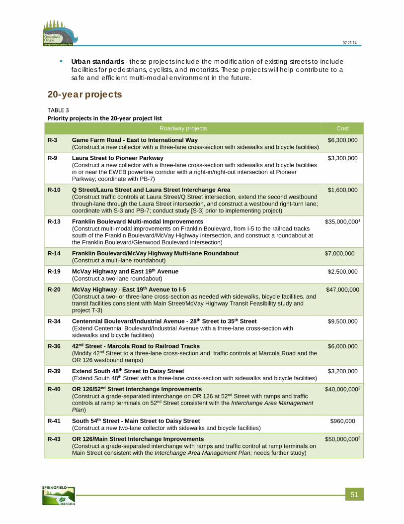
07.21.14
Urban standards - these projects include the modification of existing streets to includefacilities for pedestrians, cyclists, and motorists. These projects will help contribute to asafe and efficient multi-modal environment in the future.
20-year projects TABLE 3 Priority projects in the 20-year project list
Roadway projects Cost
R-3 Game Farm Road - East to International Way (Construct a new collector with a three-lane cross-section with sidewalks and bicycle facilities)
$6,300,000
R-9 Laura Street to Pioneer Parkway (Construct a new collector with a three-lane cross-section with sidewalks and bicycle facilities in or near the EWEB powerline corridor with a right-in/right-out intersection at Pioneer Parkway; coordinate with PB-7)
$3,300,000
R-10 Q Street/Laura Street and Laura Street Interchange Area (Construct traffic controls at Laura Street/Q Street intersection, extend the second westbound through-lane through the Laura Street intersection, and construct a westbound right-turn lane; coordinate with S-3 and PB-7; conduct study [S-3] prior to implementing project)
$1,600,000
R-13 Franklin Boulevard Multi-modal Improvements (Construct multi-modal improvements on Franklin Boulevard, from I-5 to the railroad tracks south of the Franklin Boulevard/McVay Highway intersection, and construct a roundabout at the Franklin Boulevard/Glenwood Boulevard intersection)
$35,000,0001
R-14 Franklin Boulevard/McVay Highway Multi-lane Roundabout (Construct a multi-lane roundabout)
$7,000,000
R-19 McVay Highway and East 19th Avenue (Construct a two-lane roundabout)
$2,500,000
R-20 McVay Highway - East 19th Avenue to I-5 (Construct a two- or three-lane cross-section as needed with sidewalks, bicycle facilities, and transit facilities consistent with Main Street/McVay Highway Transit Feasibility study and project T-3)
$47,000,000
R-34 Centennial Boulevard/Industrial Avenue - 28th Street to 35th Street (Extend Centennial Boulevard/Industrial Avenue with a three-lane cross-section with sidewalks and bicycle facilities)
$9,500,000
R-36 42nd Street - Marcola Road to Railroad Tracks (Modify 42nd Street to a three-lane cross-section and traffic controls at Marcola Road and the OR 126 westbound ramps)
$6,000,000
R-39 Extend South 48th Street to Daisy Street (Extend South 48th Street with a three-lane cross-section with sidewalks and bicycle facilities)
$3,200,000
R-40 OR 126/52nd Street Interchange Improvements (Construct a grade-separated interchange on OR 126 at 52nd Street with ramps and traffic controls at ramp terminals on 52nd Street consistent with the Interchange Area Management Plan)
$40,000,0002
R-41 South 54th Street - Main Street to Daisy Street (Construct a new two-lane collector with sidewalks and bicycle facilities)
$960,000
R-43 OR 126/Main Street Interchange Improvements (Construct a grade-separated interchange with ramps and traffic control at ramp terminals on Main Street consistent with the Interchange Area Management Plan; needs further study)
$50,000,0002
551
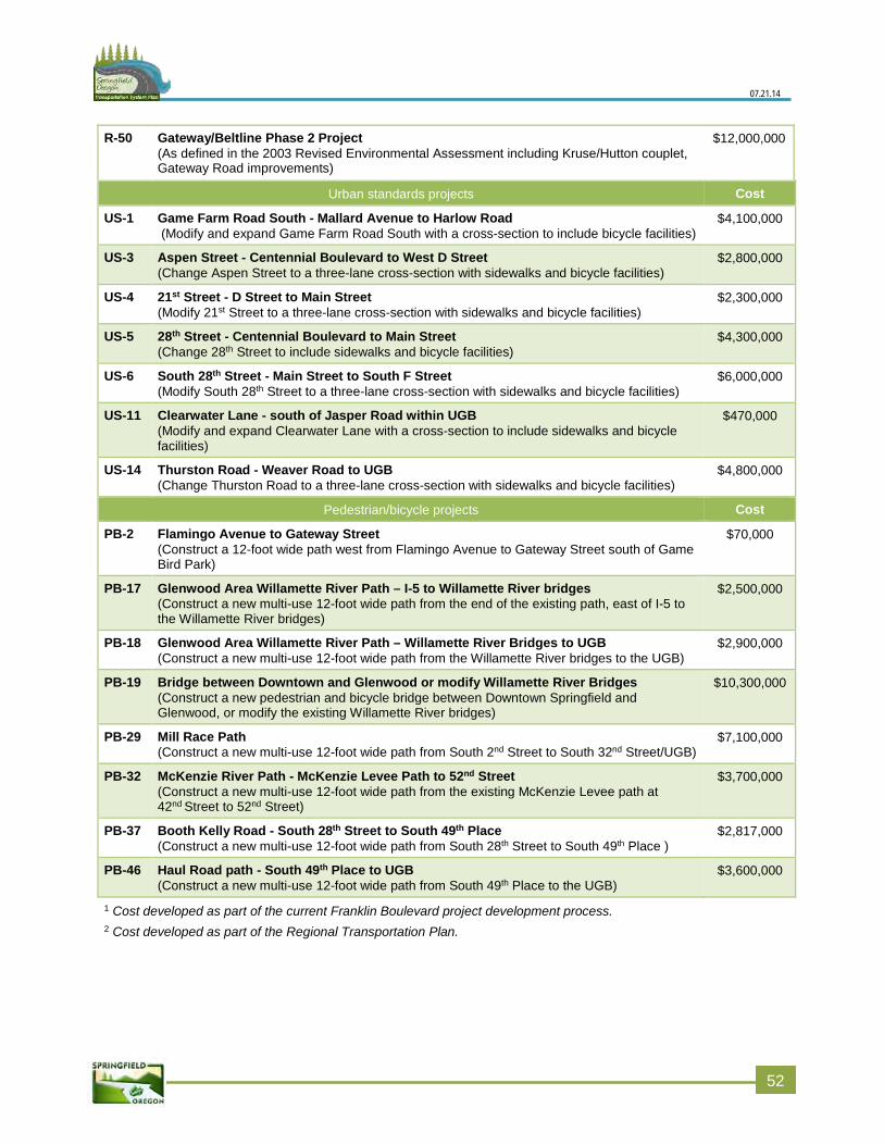
07.21.14
R-50 Gateway/Beltline Phase 2 Project (As defined in the 2003 Revised Environmental Assessment including Kruse/Hutton couplet, Gateway Road improvements)
$12,000,000
Urban standards projects Cost
US-1 Game Farm Road South - Mallard Avenue to Harlow Road (Modify and expand Game Farm Road South with a cross-section to include bicycle facilities)
$4,100,000
US-3 Aspen Street - Centennial Boulevard to West D Street (Change Aspen Street to a three-lane cross-section with sidewalks and bicycle facilities)
$2,800,000
US-4 21st Street - D Street to Main Street (Modify 21st Street to a three-lane cross-section with sidewalks and bicycle facilities)
$2,300,000
US-5 28th Street - Centennial Boulevard to Main Street (Change 28th Street to include sidewalks and bicycle facilities)
$4,300,000
US-6 South 28th Street - Main Street to South F Street (Modify South 28th Street to a three-lane cross-section with sidewalks and bicycle facilities)
$6,000,000
US-11 Clearwater Lane - south of Jasper Road within UGB (Modify and expand Clearwater Lane with a cross-section to include sidewalks and bicycle facilities)
$470,000
US-14 Thurston Road - Weaver Road to UGB (Change Thurston Road to a three-lane cross-section with sidewalks and bicycle facilities)
$4,800,000
Pedestrian/bicycle projects Cost
PB-2 Flamingo Avenue to Gateway Street (Construct a 12-foot wide path west from Flamingo Avenue to Gateway Street south of Game Bird Park)
$70,000
PB-17 Glenwood Area Willamette River Path – I-5 to Willamette River bridges (Construct a new multi-use 12-foot wide path from the end of the existing path, east of I-5 to the Willamette River bridges)
$2,500,000
PB-18 Glenwood Area Willamette River Path – Willamette River Bridges to UGB (Construct a new multi-use 12-foot wide path from the Willamette River bridges to the UGB)
$2,900,000
PB-19 Bridge between Downtown and Glenwood or modify Willamette River Bridges (Construct a new pedestrian and bicycle bridge between Downtown Springfield and Glenwood, or modify the existing Willamette River bridges)
$10,300,000
PB-29 Mill Race Path (Construct a new multi-use 12-foot wide path from South 2nd Street to South 32nd Street/UGB)
$7,100,000
PB-32 McKenzie River Path - McKenzie Levee Path to 52nd Street (Construct a new multi-use 12-foot wide path from the existing McKenzie Levee path at 42nd Street to 52nd Street)
$3,700,000
PB-37 Booth Kelly Road - South 28th Street to South 49th Place (Construct a new multi-use 12-foot wide path from South 28th Street to South 49th Place )
$2,817,000
PB-46 Haul Road path - South 49th Place to UGB (Construct a new multi-use 12-foot wide path from South 49th Place to the UGB)
$3,600,000
1 Cost developed as part of the current Franklin Boulevard project development process. 2 Cost developed as part of the Regional Transportation Plan.
552
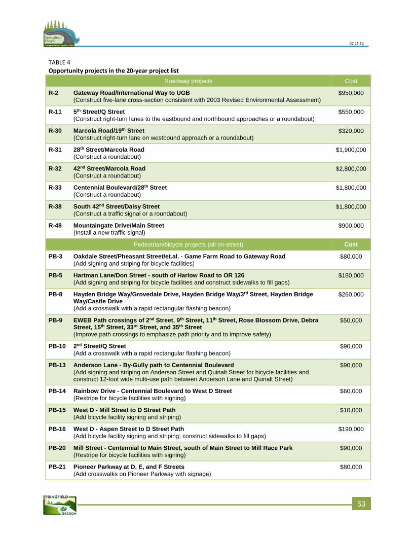
07.21.14
TABLE 4 Opportunity projects in the 20-year project list
Roadway projects Cost
R-2 Gateway Road/International Way to UGB (Construct five-lane cross-section consistent with 2003 Revised Environmental Assessment)
$950,000
R-11 5th Street/Q Street (Construct right-turn lanes to the eastbound and northbound approaches or a roundabout)
$550,000
R-30 Marcola Road/19th Street (Construct right-turn lane on westbound approach or a roundabout)
$320,000
R-31 28th Street/Marcola Road (Construct a roundabout)
$1,900,000
R-32 42nd Street/Marcola Road (Construct a roundabout)
$2,800,000
R-33 Centennial Boulevard/28th Street (Construct a roundabout)
$1,800,000
R-38 South 42nd Street/Daisy Street (Construct a traffic signal or a roundabout)
$1,800,000
R-48 Mountaingate Drive/Main Street (Install a new traffic signal)
$900,000
Pedestrian/bicycle projects (all on-street) Cost
PB-3 Oakdale Street/Pheasant Street/et.al. - Game Farm Road to Gateway Road (Add signing and striping for bicycle facilities)
$80,000
PB-5 Hartman Lane/Don Street - south of Harlow Road to OR 126 (Add signing and striping for bicycle facilities and construct sidewalks to fill gaps)
$180,000
PB-8 Hayden Bridge Way/Grovedale Drive, Hayden Bridge Way/3rd Street, Hayden Bridge Way/ Castle Drive (Add a crosswalk with a rapid rectangular flashing beacon)
$260,000
PB-9 EWEB Path crossings of 2nd Street, 9th Street, 11th Street, Rose Blossom Drive, Debra Street, 15th Street, 33rd Street, and 35th Street (Improve path crossings to emphasize path priority and to improve safety)
$50,000
PB-10 2nd Street/Q Street (Add a crosswalk with a rapid rectangular flashing beacon)
$90,000
PB-13 Anderson Lane - By-Gully path to Centennial Boulevard (Add signing and striping on Anderson Street and Quinalt Street for bicycle facilities and construct 12-foot wide multi-use path between Anderson Lane and Quinalt Street)
$90,000
PB-14 Rainbow Drive - Centennial Boulevard to West D Street (Restripe for bicycle facilities with signing)
$60,000
PB-15 West D - Mill Street to D Street Path (Add bicycle facility signing and striping)
$10,000
PB-16 West D - Aspen Street to D Street Path (Add bicycle facility signing and striping; construct sidewalks to fill gaps)
$190,000
PB-20 Mill Street - Centennial to Main Street, south of Main Street to Mill Race Park (Restripe for bicycle facilities with signing)
$90,000
PB-21 Pioneer Parkway at D, E, and F Streets (Add crosswalks on Pioneer Parkway with signage)
$80,000
553
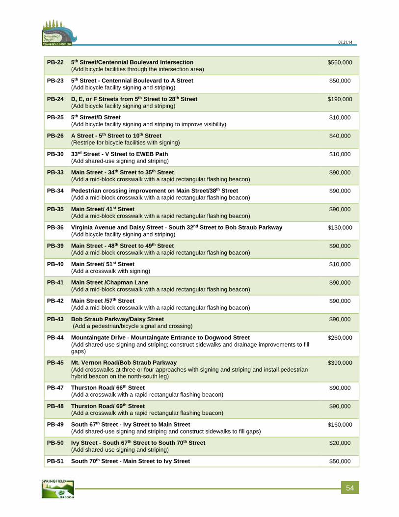
07.21.14
PB-22 5th Street/Centennial Boulevard Intersection (Add bicycle facilities through the intersection area)
$560,000
PB-23 5th Street - Centennial Boulevard to A Street (Add bicycle facility signing and striping)
$50,000
PB-24 D, E, or F Streets from 5th Street to 28th Street (Add bicycle facility signing and striping)
$190,000
PB-25 5th Street/D Street (Add bicycle facility signing and striping to improve visibility)
$10,000
PB-26 A Street - 5th Street to 10th Street (Restripe for bicycle facilities with signing)
$40,000
PB-30 33rd Street - V Street to EWEB Path (Add shared-use signing and striping)
$10,000
PB-33 Main Street - 34th Street to 35th Street (Add a mid-block crosswalk with a rapid rectangular flashing beacon)
$90,000
PB-34 Pedestrian crossing improvement on Main Street/38th Street (Add a mid-block crosswalk with a rapid rectangular flashing beacon)
$90,000
PB-35 Main Street/ 41st Street (Add a mid-block crosswalk with a rapid rectangular flashing beacon)
$90,000
PB-36 Virginia Avenue and Daisy Street - South 32nd Street to Bob Straub Parkway (Add bicycle facility signing and striping)
$130,000
PB-39 Main Street - 48th Street to 49th Street (Add a mid-block crosswalk with a rapid rectangular flashing beacon)
$90,000
PB-40 Main Street/ 51st Street (Add a crosswalk with signing)
$10,000
PB-41 Main Street /Chapman Lane (Add a mid-block crosswalk with a rapid rectangular flashing beacon)
$90,000
PB-42 Main Street /57th Street (Add a mid-block crosswalk with a rapid rectangular flashing beacon)
$90,000
PB-43 Bob Straub Parkway/Daisy Street (Add a pedestrian/bicycle signal and crossing)
$90,000
PB-44 Mountaingate Drive - Mountaingate Entrance to Dogwood Street (Add shared-use signing and striping; construct sidewalks and drainage improvements to fill gaps)
$260,000
PB-45 Mt. Vernon Road/Bob Straub Parkway (Add crosswalks at three or four approaches with signing and striping and install pedestrian hybrid beacon on the north-south leg)
$390,000
PB-47 Thurston Road/ 66th Street (Add a crosswalk with a rapid rectangular flashing beacon)
$90,000
PB-48 Thurston Road/ 69th Street (Add a crosswalk with a rapid rectangular flashing beacon)
$90,000
PB-49 South 67th Street - Ivy Street to Main Street (Add shared-use signing and striping and construct sidewalks to fill gaps)
$160,000
PB-50 Ivy Street - South 67th Street to South 70th Street (Add shared-use signing and striping)
$20,000
PB-51 South 70th Street - Main Street to Ivy Street $50,000
554
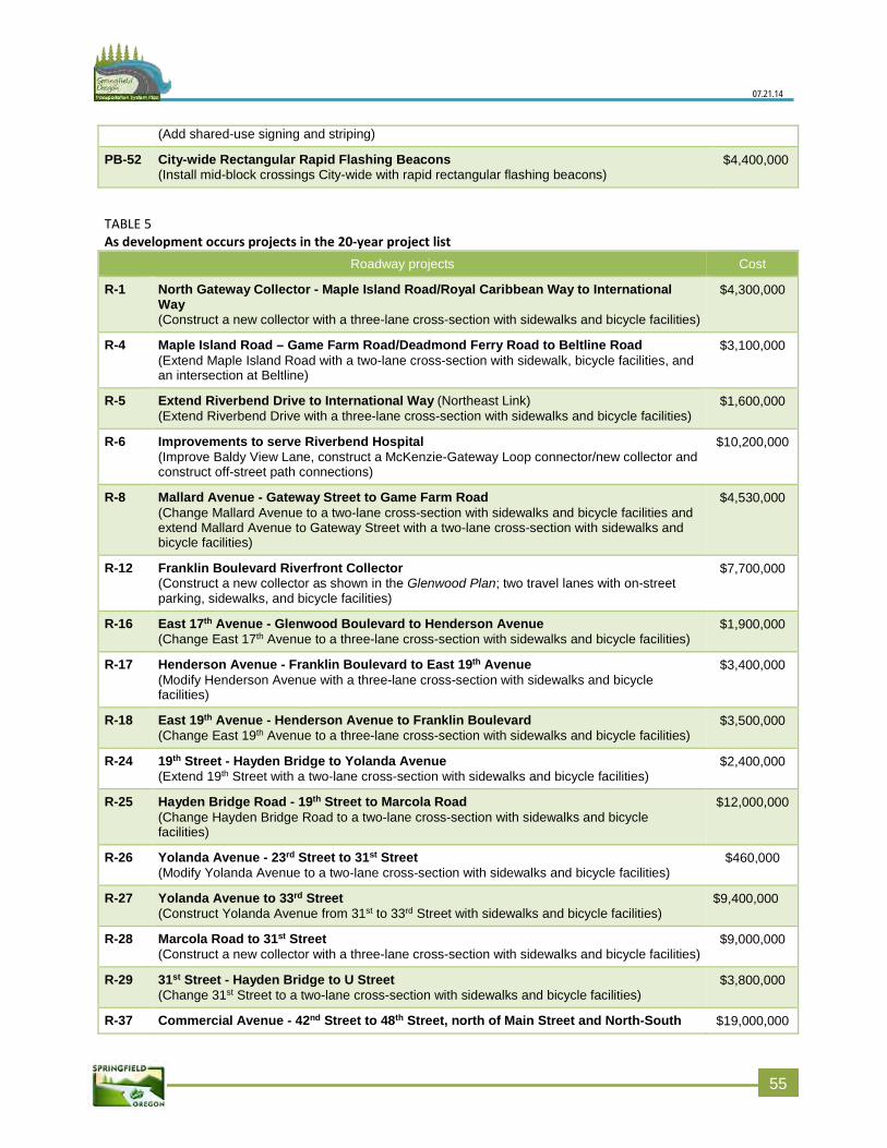
07.21.14
(Add shared-use signing and striping)
PB-52 City-wide Rectangular Rapid Flashing Beacons (Install mid-block crossings City-wide with rapid rectangular flashing beacons)
$4,400,000
TABLE 5 As development occurs projects in the 20-year project list
Roadway projects Cost
R-1 North Gateway Collector - Maple Island Road/Royal Caribbean Way to International Way (Construct a new collector with a three-lane cross-section with sidewalks and bicycle facilities)
$4,300,000
R-4 Maple Island Road – Game Farm Road/Deadmond Ferry Road to Beltline Road (Extend Maple Island Road with a two-lane cross-section with sidewalk, bicycle facilities, and an intersection at Beltline)
$3,100,000
R-5 Extend Riverbend Drive to International Way (Northeast Link) (Extend Riverbend Drive with a three-lane cross-section with sidewalks and bicycle facilities)
$1,600,000
R-6 Improvements to serve Riverbend Hospital (Improve Baldy View Lane, construct a McKenzie-Gateway Loop connector/new collector and construct off-street path connections)
$10,200,000
R-8 Mallard Avenue - Gateway Street to Game Farm Road (Change Mallard Avenue to a two-lane cross-section with sidewalks and bicycle facilities and extend Mallard Avenue to Gateway Street with a two-lane cross-section with sidewalks and bicycle facilities)
$4,530,000
R-12 Franklin Boulevard Riverfront Collector (Construct a new collector as shown in the Glenwood Plan; two travel lanes with on-street parking, sidewalks, and bicycle facilities)
$7,700,000
R-16 East 17th Avenue - Glenwood Boulevard to Henderson Avenue (Change East 17th Avenue to a three-lane cross-section with sidewalks and bicycle facilities)
$1,900,000
R-17 Henderson Avenue - Franklin Boulevard to East 19th Avenue (Modify Henderson Avenue with a three-lane cross-section with sidewalks and bicycle facilities)
$3,400,000
R-18 East 19th Avenue - Henderson Avenue to Franklin Boulevard (Change East 19th Avenue to a three-lane cross-section with sidewalks and bicycle facilities)
$3,500,000
R-24 19th Street - Hayden Bridge to Yolanda Avenue (Extend 19th Street with a two-lane cross-section with sidewalks and bicycle facilities)
$2,400,000
R-25 Hayden Bridge Road - 19th Street to Marcola Road (Change Hayden Bridge Road to a two-lane cross-section with sidewalks and bicycle facilities)
$12,000,000
R-26 Yolanda Avenue - 23rd Street to 31st Street (Modify Yolanda Avenue to a two-lane cross-section with sidewalks and bicycle facilities)
$460,000
R-27 Yolanda Avenue to 33rd Street (Construct Yolanda Avenue from 31st to 33rd Street with sidewalks and bicycle facilities)
$9,400,000
R-28 Marcola Road to 31st Street (Construct a new collector with a three-lane cross-section with sidewalks and bicycle facilities)
$9,000,000
R-29 31st Street - Hayden Bridge to U Street (Change 31st Street to a two-lane cross-section with sidewalks and bicycle facilities)
$3,800,000
R-37 Commercial Avenue - 42nd Street to 48th Street, north of Main Street and North-South $19,000,000
5
55
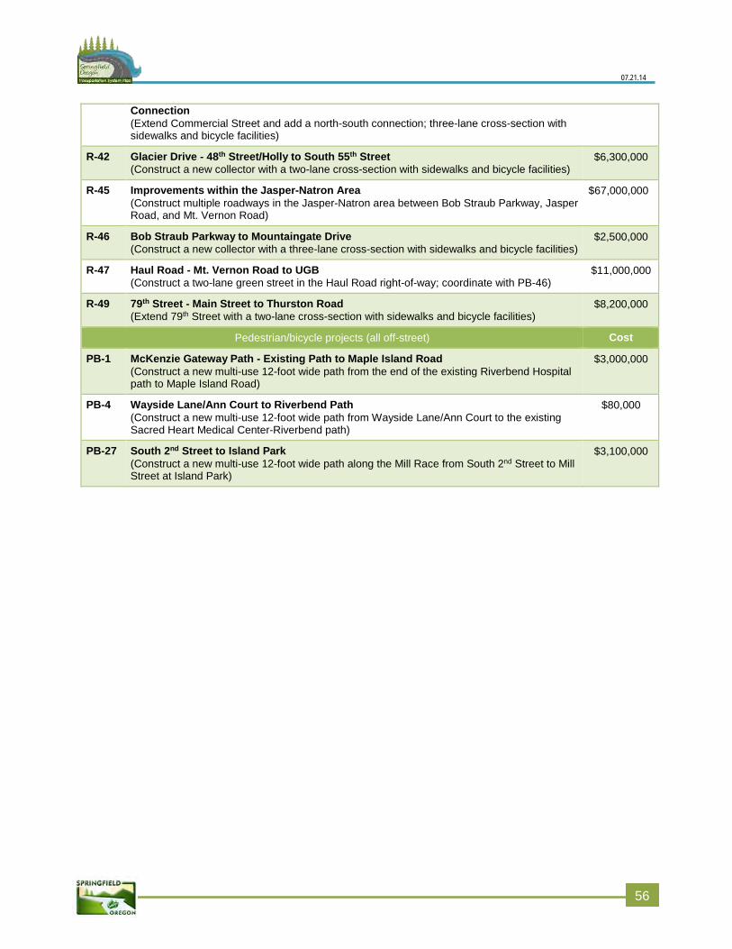
07.21.14
Connection (Extend Commercial Street and add a north-south connection; three-lane cross-section with sidewalks and bicycle facilities)
R-42 Glacier Drive - 48th Street/Holly to South 55th Street (Construct a new collector with a two-lane cross-section with sidewalks and bicycle facilities)
$6,300,000
R-45 Improvements within the Jasper-Natron Area (Construct multiple roadways in the Jasper-Natron area between Bob Straub Parkway, Jasper Road, and Mt. Vernon Road)
$67,000,000
R-46 Bob Straub Parkway to Mountaingate Drive (Construct a new collector with a three-lane cross-section with sidewalks and bicycle facilities)
$2,500,000
R-47 Haul Road - Mt. Vernon Road to UGB (Construct a two-lane green street in the Haul Road right-of-way; coordinate with PB-46)
$11,000,000
R-49 79th Street - Main Street to Thurston Road (Extend 79th Street with a two-lane cross-section with sidewalks and bicycle facilities)
$8,200,000
Pedestrian/bicycle projects (all off-street) Cost
PB-1 McKenzie Gateway Path - Existing Path to Maple Island Road (Construct a new multi-use 12-foot wide path from the end of the existing Riverbend Hospital path to Maple Island Road)
$3,000,000
PB-4 Wayside Lane/Ann Court to Riverbend Path (Construct a new multi-use 12-foot wide path from Wayside Lane/Ann Court to the existing Sacred Heart Medical Center-Riverbend path)
$80,000
PB-27 South 2nd Street to Island Park (Construct a new multi-use 12-foot wide path along the Mill Race from South 2nd Street to Mill Street at Island Park)
$3,100,000
556
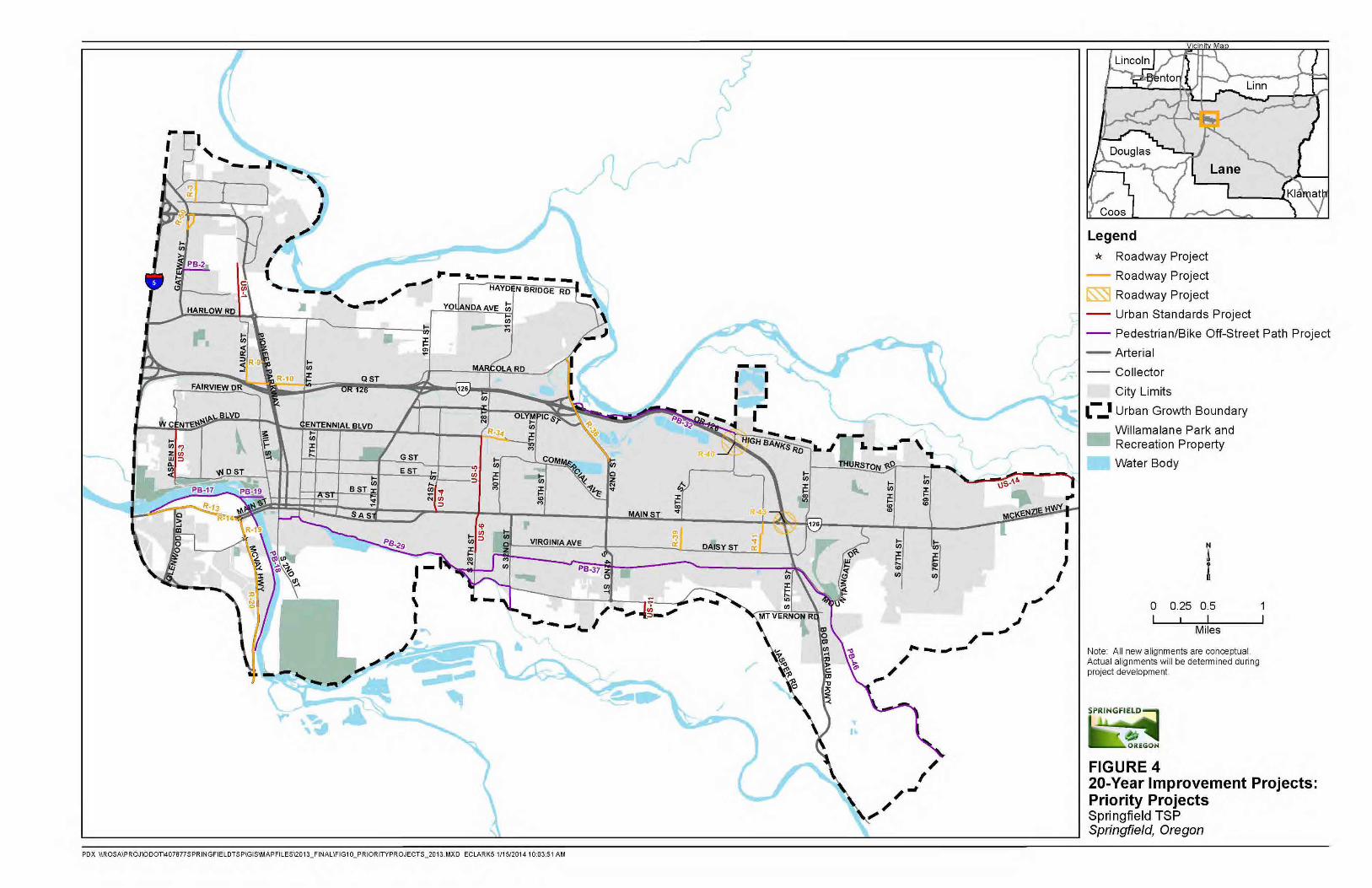
07.21.14
557

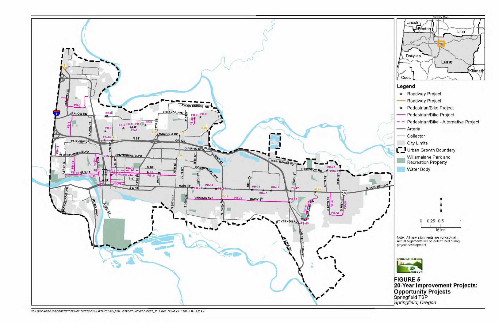
07.21.14
559

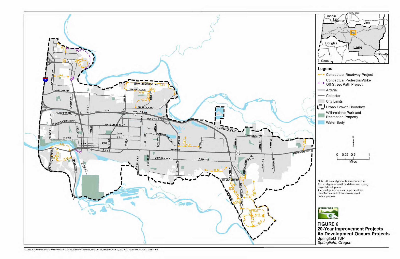
07.21.14
661

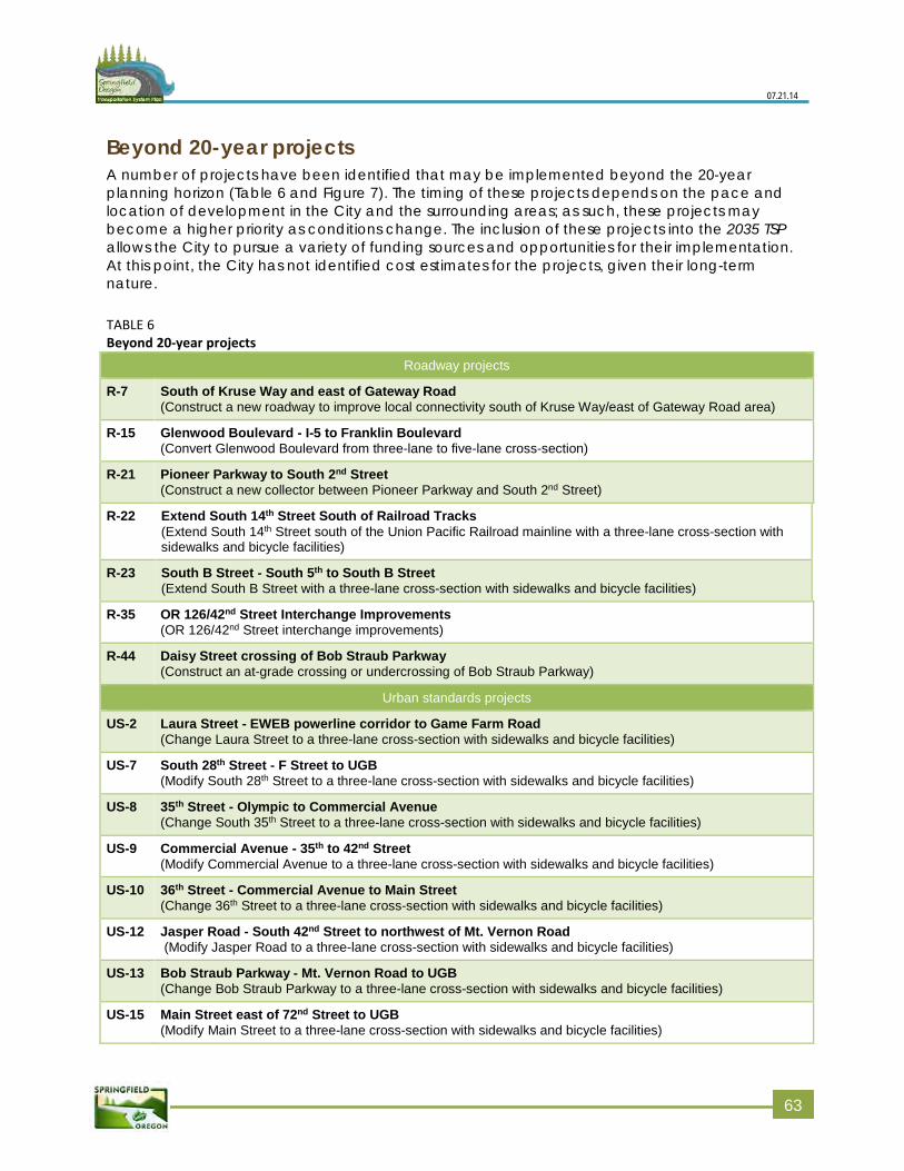
07.21.14
Beyond 20-year projects A number of projects have been identified that may be implemented beyond the 20-year planning horizon (Table 6 and Figure 7). The timing of these projects depends on the pace and location of development in the City and the surrounding areas; as such, these projects may become a higher priority as conditions change. The inclusion of these projects into the 2035 TSP allows the City to pursue a variety of funding sources and opportunities for their implementation. At this point, the City has not identified cost estimates for the projects, given their long-term nature.
TABLE 6 Beyond 20-year projects
Roadway projects
R-7 South of Kruse Way and east of Gateway Road (Construct a new roadway to improve local connectivity south of Kruse Way/east of Gateway Road area)
R-15 Glenwood Boulevard - I-5 to Franklin Boulevard (Convert Glenwood Boulevard from three-lane to five-lane cross-section)
R-21 Pioneer Parkway to South 2nd Street (Construct a new collector between Pioneer Parkway and South 2nd Street)
R-22 Extend South 14th Street South of Railroad Tracks (Extend South 14th Street south of the Union Pacific Railroad mainline with a three-lane cross-section with sidewalks and bicycle facilities)
R-23 South B Street - South 5th to South B Street (Extend South B Street with a three-lane cross-section with sidewalks and bicycle facilities)
R-35 OR 126/42nd Street Interchange Improvements (OR 126/42nd Street interchange improvements)
R-44 Daisy Street crossing of Bob Straub Parkway (Construct an at-grade crossing or undercrossing of Bob Straub Parkway)
Urban standards projects
US-2 Laura Street - EWEB powerline corridor to Game Farm Road (Change Laura Street to a three-lane cross-section with sidewalks and bicycle facilities)
US-7 South 28th Street - F Street to UGB (Modify South 28th Street to a three-lane cross-section with sidewalks and bicycle facilities)
US-8 35th Street - Olympic to Commercial Avenue (Change South 35th Street to a three-lane cross-section with sidewalks and bicycle facilities)
US-9 Commercial Avenue - 35th to 42nd Street (Modify Commercial Avenue to a three-lane cross-section with sidewalks and bicycle facilities)
US-10 36th Street - Commercial Avenue to Main Street (Change 36th Street to a three-lane cross-section with sidewalks and bicycle facilities)
US-12 Jasper Road - South 42nd Street to northwest of Mt. Vernon Road (Modify Jasper Road to a three-lane cross-section with sidewalks and bicycle facilities)
US-13 Bob Straub Parkway - Mt. Vernon Road to UGB (Change Bob Straub Parkway to a three-lane cross-section with sidewalks and bicycle facilities)
US-15 Main Street east of 72nd Street to UGB (Modify Main Street to a three-lane cross-section with sidewalks and bicycle facilities)
663
07.21.14
Pedestrian/bicycle projects (all off-street)
PB-6 Springfield Christian School Channel Path - Dornoch Street to Laura Street (Construct a new multi-use 12-foot wide path from Dornoch Street to Laura Street)
PB-7 Extend EWEB Trail - Pioneer Parkway to Don Street (Construct a new multi-use 12-foot wide path in the EWEB powerline corridor from Pioneer Parkway to Don Street with a crossing of Pioneer Parkway and Laura Street)
PB-11 By-Gully Path Extension - Pioneer Parkway to 5th Street (Construct a new multi-use 12-foot wide path from the existing By-Gully path at Pioneer Parkway to 5th Street)
PB-12 I-5 Path – Willamette River Area Path to By-Gully Path (Construct a new multi-use 12-foot wide path parallel to I-5 from Willamette River area path/Eastgate Woodlands to the end of the By-Gully path)
PB-28 South 3rd Street to South 5th Street (Construct a new multi-use 12-foot wide path from South 3rd Street to South 5th Street)
PB-31 Quarry Ridge Lane to Marcola Road (Construct a new multi-use 12-foot wide path Quarry Ridge Lane to Marcola Road)
PB-38 Haul Road - Daisy Street to Booth Kelly Road (Construct a new multi-use 12-foot wide path in the Haul Road right-of-way from Daisy Street to Booth Kelly Road)
Study projects The 2035 TSP has identified a number of potential projects that need more study before the community and local decision-makers considers specific recommendations (Table 7 and Figure 8). This TSP cannot cover the issues and level of detail that would be needed to create project recommendations for these concepts. Therefore, the City of Springfield would need to create individual refinement plans for each project as timing allows and funding becomes available. These refinement plans can identify specific recommendations, cost estimates, potential funding sources, and the timing for implementation.
TABLE 7 Study projects Projects
S-1 Phase 2 of Beltline/Gateway improvements
S-2 OR 126 Expressway Management Plan
S-3 Pioneer Parkway/Q Street/Laura Street circulation study to improve Q Street/Laura Street/Ramp safety, access, and capacity
S-4 Study a new crossing of OR 126 between 5th and 15th Streets
S-5 Centennial Boulevard - Prescott Lane to Mill Street operational improvements study
S-6 Pioneer Parkway/Centennial Boulevard intersection study to improve pedestrian safety
S-7 Centennial Boulevard - Mohawk Boulevard to Pioneer Parkway operational improvements study
S-8 Study safety and operational improvements in Mohawk Boulevard/Olympic Street/ 18th Street/Centennial triangle
S-9 Study a new bridge - Walnut Road/West D Street to Glenwood Boulevard/Franklin Boulevard intersection
664
07.21.14
S-10 Study Main Street/South A Street improvements - Mill Street to 21st Street
S-11 Refinement study for Glenwood industrial area
S-12 Pedestrian/bicycle bridge study between Glenwood and Dorris Ranch
S-13 Access plan study on Main Street between 21st Street and 48th Street
S-14 Study east-west connectivity between 28th Street and 32nd Street
S-15 Study a new crossing of OR 126 near Thurston High School
S-16 Connectivity study south of OR 126 and Jessica Street
Transit projects The Springfield 2035 TSP incorporates the frequent transit network (FTN) projects included in the RTSP (Table 8 and Figure 9). No additional capital transit projects were identified as part of the Springfield 2035 TSP. The FTN projects are listed below in Table 8.
At this point, cost estimates for the frequent transit network projects have not been identified.
TABLE 8 Frequent transit network projects Projects
T-1 Transit on Centennial Boulevard - I-5 to Mohawk Boulevard
T-2 Transit on Franklin Boulevard/Main Street/South A Street to OR 126/Main Street (east-west)
T-3 Transit on Franklin Boulevard and McVay Highway to 30th Avenue (north-south)
T-4 Transit on Mohawk Boulevard - Centennial Boulevard to 19th Street/Marcola Road to 28th Street/ Olympic Street to Mohawk Boulevard
Note: These projects are included in the current Regional Transportation System Plan. The final transit network will be developed through the Regional Transportation System Plan process.
665
07.21.14
Other travel modes This section addresses the rail, air, pipeline, and surface water plans for the City of Springfield. Each subsection below describes the respective network and how it operates within the City. No future projects have been identified for these modes as the service is provided by other entities beyond the City’s jurisdiction.
Rail service There are two freight rail service providers in Springfield: Central Oregon and Pacific (COPR), and Union Pacific (UP). COPR provides east-west freight service on track located just south of Main Street and crossing over to slightly north of Franklin Boulevard west of the UGB. UP operates freight service on a north-south line east of I-5 that intersects with the COPR line near the OR 126/OR 225 junction (near Franklin Boulevard/E 19th Avenue). The tracks run north to the Portland metropolitan area and southeast to Oakridge, Klamath Falls, and into California. UP operates approximately 20 freight trains per day along these tracks.
Amtrak also provides passenger service through Springfield to the Eugene station in Downtown Eugene. Amtrak provides intercity passenger rail service between the City of Eugene and cities north and south. The Amtrak Cascades route travels from Eugene to Vancouver, Canada and the Coast Starlight route travels from Seattle to Los Angeles. Amtrak operates on the UP line. Current higher speed rail plans may consider a station in Downtown Springfield, consistent with the policies and actions in this TSP (Chapter 2).
Air service There are no public or private airports in Springfield. The Eugene Airport at Mahlon Sweet Field (EUG), the closest airport that provides commercial service, is located near Oregon Highway 99 about 11 miles northwest of Downtown Springfield.
Pipeline service and surface water transportation Waterways and pipelines also provide transportation opportunities in Springfield. Because the Willamette River and McKenzie River are not navigable waterways, there are no ports or navigational facilities within Springfield. The public primarily uses these waterways for recreational purposes, as neither river is a major stream for commercial activity. The McKenzie River is frequented by anglers and rafters. Neither of these waterways provides direct access to the ocean.
Springfield has no major pipelines. Natural gas is available to residential and commercial sites throughout the community on a regular service-line basis.
666
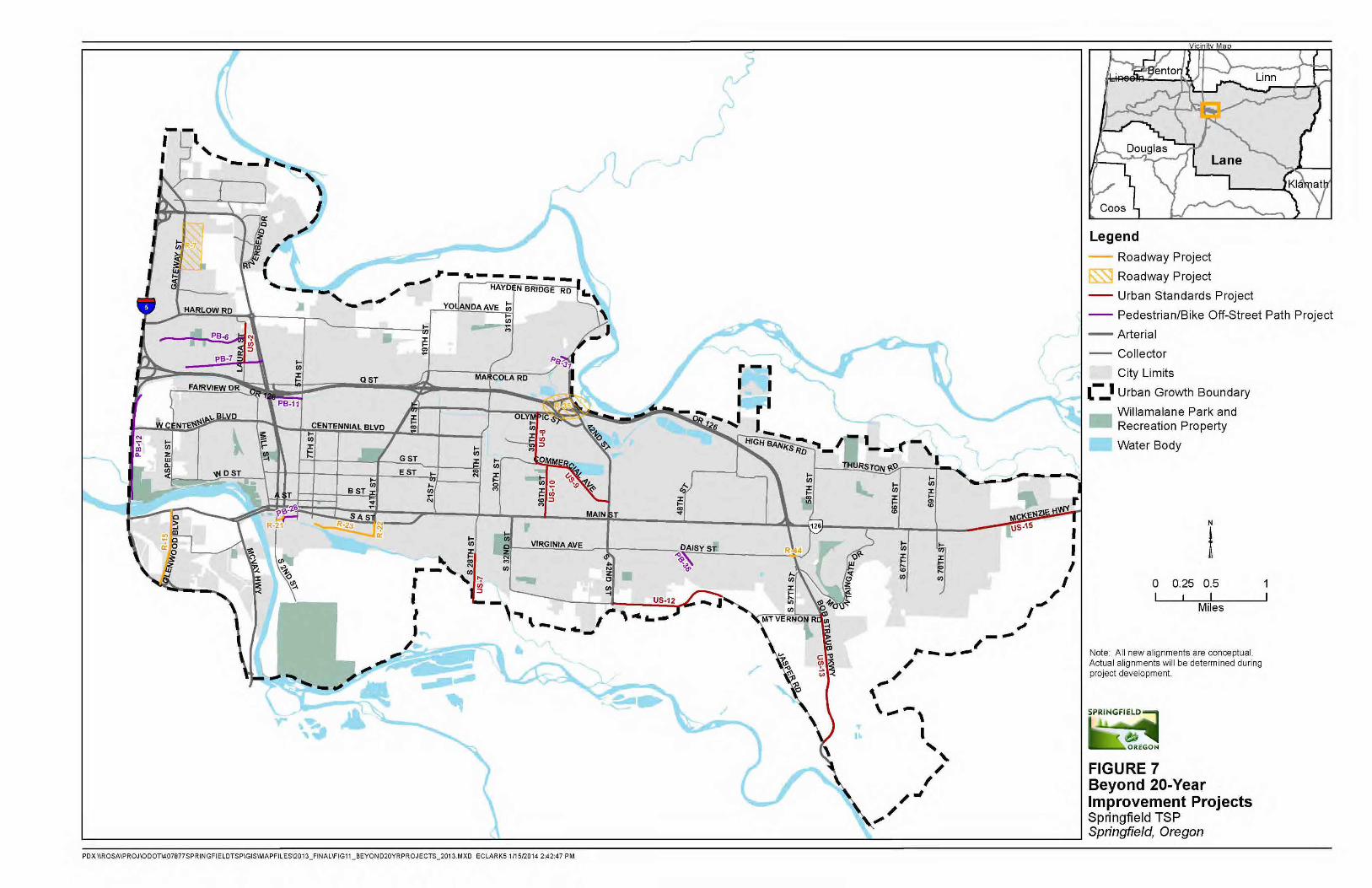
07.21.14
667

07.21.14
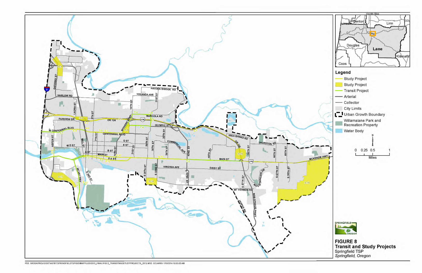
07.21.14
669

07.21.14
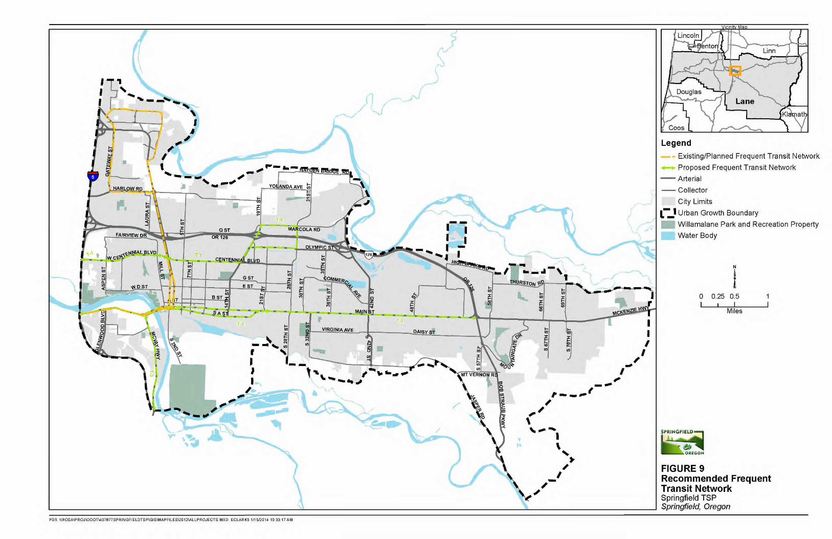
07.21.14
771

07.21.14
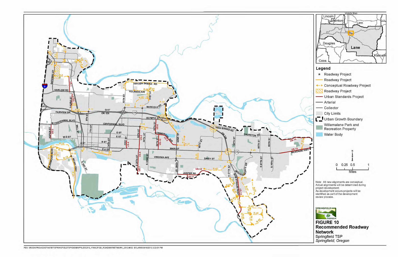
07.21.14
773

07.21.14
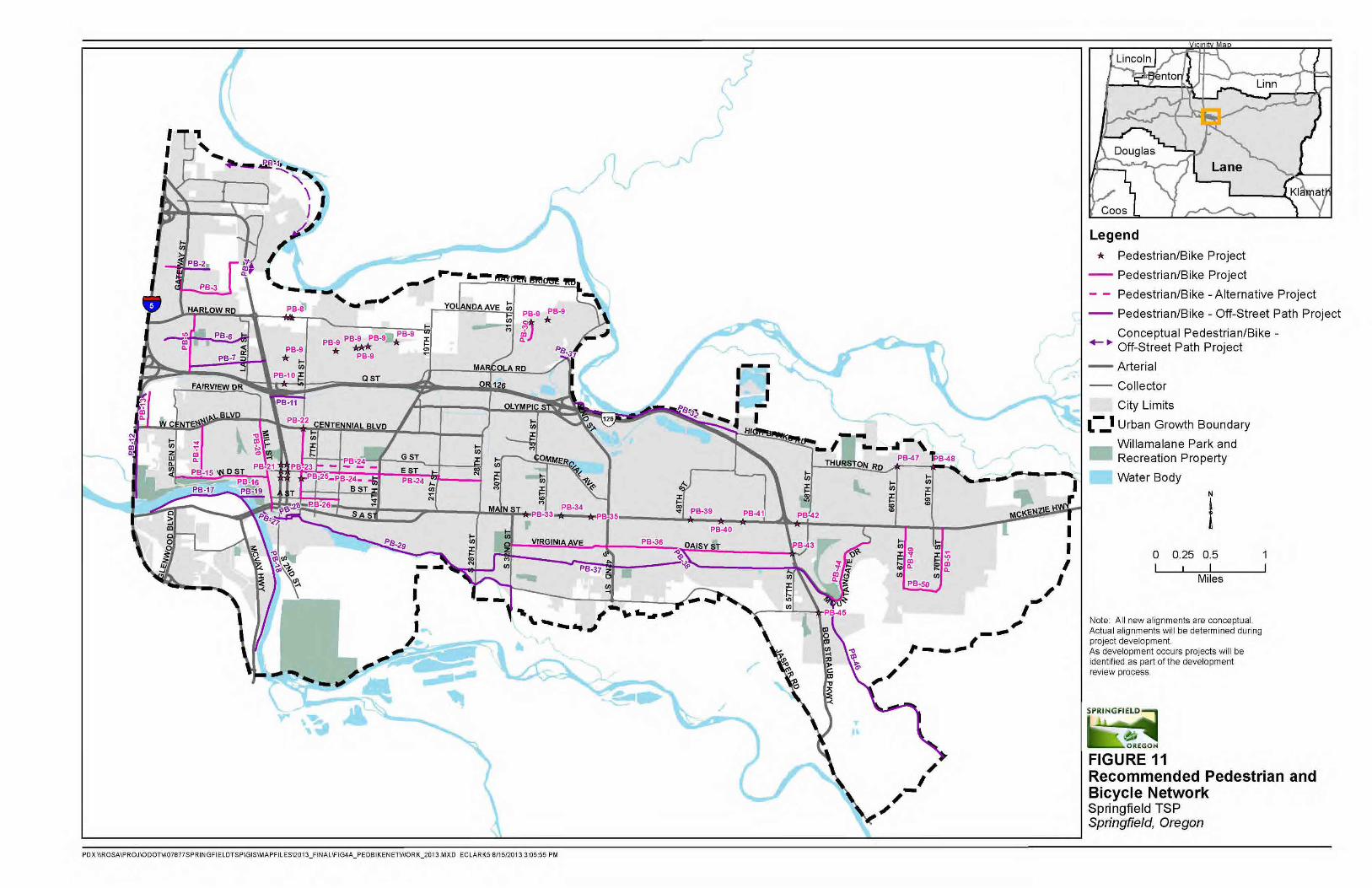
07.21.14
775

07.21.14
Chapter 6: Funding and implementation
The Springfield 2035 Transportation System Plan (TSP) includes projects under the jurisdiction and ownership of the state, county, City, Lane Transit District (LTD), and Willamalane Park and Recreation District, as well as some projects that may include privately owned property. Each project may be funded through a different combination of federal, state, City, county, or private sources. This chapter discusses current and possible new funding mechanisms that may be available to implement projects at some point during the life of the 2035 TSP. A complete list of projects anticipated to be constructed in the 20-year life of the 2035 TSP and planning-level cost estimates for each project is provided in Chapter 5 (Tables 3-5).
It is unlikely that every project contained in the TSP will be constructed in the next 20 years. While the TSP does prioritize planned projects, the city may advance projects as opportunities arise. These opportunities could include changes in policy or funding at the federal, state or local level; changes in local development priorities; or public-private or public-public partnerships. The categories of projects, specifically 20-year priority projects and beyond 20-year priority projects are intended to be interpreted flexibly to allow the city to make wise investments consistent with the overall vision contained in this TSP.
20-year estimated revenue stream RTP forecasts The 2011 RTP forecasts constrained revenues for the transportation system in the Metropolitan Planning Organization (MPO) boundary for the 20-year planning horizon. It includes:
Local funding from Eugene, Springfield, and Lane County (operations, maintenance,and preservation; bike improvements; and system improvements)
LTD funding (system improvements only)
Oregon Department of Transportation (ODOT) funding (planning studies and systemimprovements only)
Approximate transportation revenues for the City of Springfield Setting aside expected revenues for operations, maintenance, preservation, and transit system improvements, the RTP anticipates just under $600 million in funding for bike, pedestrian, and roadway system improvements in the MPO area through 2035. Assuming that Springfield receives roughly one-third of regional funding, the City may receive as much as $186 million in transportation revenues for non-transit projects in the next 20 years as shown in Table 9.
77
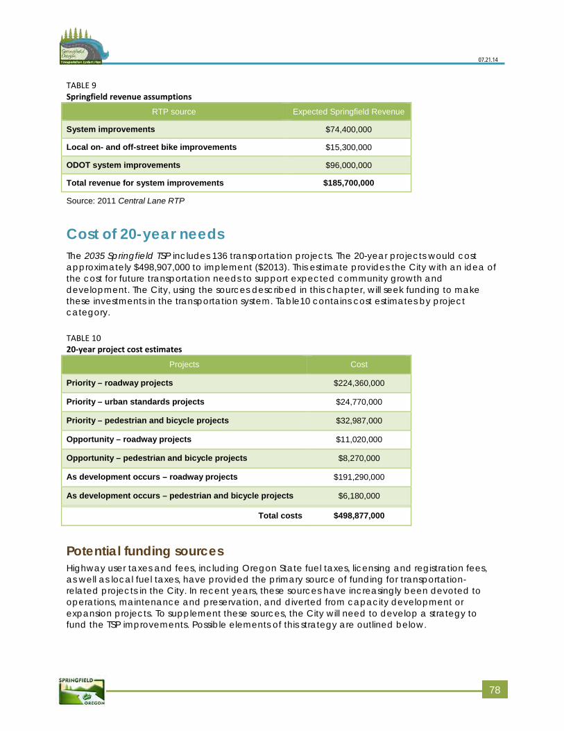
07.21.14
TABLE 9 Springfield revenue assumptions
RTP source Expected Springfield Revenue
System improvements $74,400,000
Local on- and off-street bike improvements $15,300,000
ODOT system improvements $96,000,000
Total revenue for system improvements $185,700,000
Source: 2011 Central Lane RTP
Cost of 20-year needs The 2035 Springfield TSP includes 136 transportation projects. The 20-year projects would cost approximately $498,907,000 to implement ($2013). This estimate provides the City with an idea of the cost for future transportation needs to support expected community growth and development. The City, using the sources described in this chapter, will seek funding to make these investments in the transportation system. Table10 contains cost estimates by project category.
TABLE 10 20-year project cost estimates
Projects Cost
Priority – roadway projects $224,360,000
Priority – urban standards projects $24,770,000
Priority – pedestrian and bicycle projects $32,987,000
Opportunity – roadway projects $11,020,000
Opportunity – pedestrian and bicycle projects $8,270,000
As development occurs – roadway projects $191,290,000
As development occurs – pedestrian and bicycle projects $6,180,000
Total costs $498,877,000
Potential funding sources Highway user taxes and fees, including Oregon State fuel taxes, licensing and registration fees, as well as local fuel taxes, have provided the primary source of funding for transportation-related projects in the City. In recent years, these sources have increasingly been devoted to operations, maintenance and preservation, and diverted from capacity development or expansion projects. To supplement these sources, the City will need to develop a strategy to fund the TSP improvements. Possible elements of this strategy are outlined below.
778
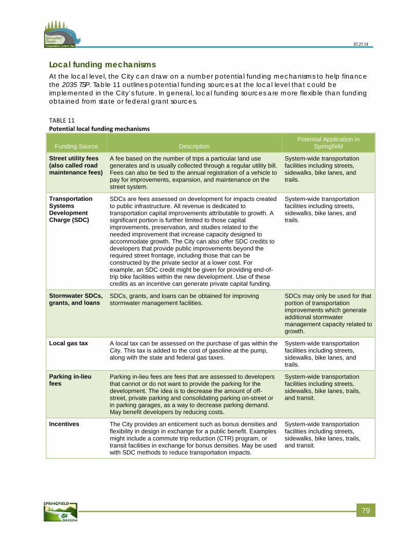
07.21.14
Local funding mechanisms At the local level, the City can draw on a number potential funding mechanisms to help finance the 2035 TSP. Table 11 outlines potential funding sources at the local level that could be implemented in the City’s future. In general, local funding sources are more flexible than funding obtained from state or federal grant sources.
TABLE 11 Potential local funding mechanisms
Funding Source Description Potential Application in
Springfield
Street utility fees (also called road maintenance fees)
A fee based on the number of trips a particular land use generates and is usually collected through a regular utility bill. Fees can also be tied to the annual registration of a vehicle to pay for improvements, expansion, and maintenance on the street system.
System-wide transportation facilities including streets, sidewalks, bike lanes, and trails.
Transportation Systems Development Charge (SDC)
SDCs are fees assessed on development for impacts created to public infrastructure. All revenue is dedicated to transportation capital improvements attributable to growth. A significant portion is further limited to those capital improvements, preservation, and studies related to the needed improvement that increase capacity designed to accommodate growth. The City can also offer SDC credits to developers that provide public improvements beyond the required street frontage, including those that can be constructed by the private sector at a lower cost. For example, an SDC credit might be given for providing end-of-trip bike facilities within the new development. Use of these credits as an incentive can generate private capital funding.
System-wide transportation facilities including streets, sidewalks, bike lanes, and trails.
Stormwater SDCs, grants, and loans
SDCs, grants, and loans can be obtained for improving stormwater management facilities.
SDCs may only be used for that portion of transportation improvements which generate additional stormwater management capacity related to growth.
Local gas tax A local tax can be assessed on the purchase of gas within the City. This tax is added to the cost of gasoline at the pump, along with the state and federal gas taxes.
System-wide transportation facilities including streets, sidewalks, bike lanes, and trails.
Parking in-lieu fees
Parking in-lieu fees are fees that are assessed to developers that cannot or do not want to provide the parking for the development. The idea is to decrease the amount of off-street, private parking and consolidating parking on-street or in parking garages, as a way to decrease parking demand. May benefit developers by reducing costs.
System-wide transportation facilities including streets, sidewalks, bike lanes, trails, and transit.
Incentives The City provides an enticement such as bonus densities and flexibility in design in exchange for a public benefit. Examples might include a commute trip reduction (CTR) program, or transit facilities in exchange for bonus densities. May be used with SDC methods to reduce transportation impacts.
System-wide transportation facilities including streets, sidewalks, bike lanes, trails, and transit.
779
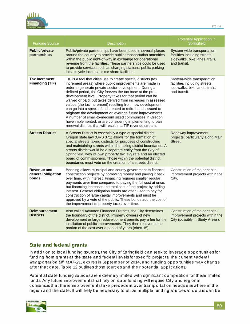
07.21.14
Funding Source Description Potential Application in
Springfield
Public/private partnerships
Public/private partnerships have been used in several places around the country to provide public transportation amenities within the public right-of-way in exchange for operational revenue from the facilities. These partnerships could be used to provide services such as charging stations, public parking lots, bicycle lockers, or car share facilities.
System-wide transportation facilities including streets, sidewalks, bike lanes, trails, and transit.
Tax Increment Financing (TIF)
TIF is a tool that cities use to create special districts (tax increment areas) where public improvements are made in order to generate private-sector development. During a defined period, the City freezes the tax base at the pre-development level. Property taxes for that period can be waived or paid, but taxes derived from increases in assessed values (the tax increment) resulting from new development can go into a special fund created to retire bonds issued to originate the development or leverage future improvements. A number of small-to-medium sized communities in Oregon have implemented, or are considering implementing, urban renewal districts that will result in a TIF revenue stream.
System-wide transportation facilities including streets, sidewalks, bike lanes, trails, and transit.
Streets District A Streets District is essentially a type of special district. Oregon state law (ORS 371) allows for the formation of special streets taxing districts for purposes of constructing and maintaining streets within the taxing district boundaries. A streets district would be a separate entity from the City of Springfield, with its own property tax levy rate and an elected board of commissioners. Those within the potential district boundaries must vote on the creation of a streets district.
Roadway improvement projects, particularly along Main Street.
Revenue and general obligation bonds
Bonding allows municipal and county government to finance construction projects by borrowing money and paying it back over time, with interest. Financing requires smaller regular payments over time compared to paying the full cost at once, but financing increases the total cost of the project by adding interest. General obligation bonds are often used to pay for construction of large capital improvements and must be approved by a vote of the public. These bonds add the cost of the improvement to property taxes over time.
Construction of major capital improvement projects within the City.
Reimbursement Districts
Also called Advance Financed Districts, the City determines the boundary of the district. Property owners of new development or large redevelopment permits pay a fee for the instillation of public improvements. They then recover some portion of the cost over a period of years (often 15).
Construction of major capital improvement projects within the City (possibly in Study Areas).
State and federal grants In addition to local funding sources, the City of Springfield can seek to leverage opportunities for funding from grants at the state and federal levels for specific projects. The current Federal Transportation Bill, MAP-21, expires in September of 2014, and funding opportunities may change after that date. Table 12 outlines those sources and their potential applications.
Potential state funding sources are extremely limited with significant competition for these limited funds. Any future improvements that rely on state funding will require City and regional consensus that these improvements take precedent over transportation needs elsewhere in the region and the state. It will likely be necessary to utilize multiple funding sources so dollars can be
880
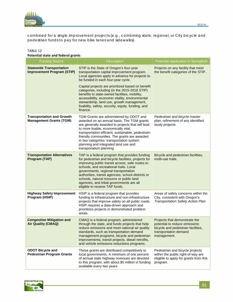
07.21.14
combined for a single improvement projects (e.g., combining state, regional, or City bicycle and pedestrian funds to pay for new bike lanes and sidewalks).
TABLE 12 Potential state and federal grants
Funding Source Description Potential Application in Springfield
Statewide Transportation Improvement Program (STIP)
STIP is the State of Oregon’s four-year transportation capital improvement program. Local agencies apply in advance for projects to be funded in each four-year cycle.
Capital projects are prioritized based on benefit categories, including (in the 2015-2018 STIP) benefits to state-owned facilities, mobility, accessibility, economic vitality, environmental stewardship, land use, growth management, livability, safety, security, equity, funding, and finance.
Projects on any facility that meet the benefit categories of the STIP.
Transportation and Growth Management Grants (TGM)
TGM Grants are administered by ODOT and awarded on an annual basis. The TGM grants are generally awarded to projects that will lead to more livable, economically vital, transportation efficient, sustainable, pedestrian-friendly communities. The grants are awarded in two categories: transportation system planning and integrated land use and transportation planning.
Pedestrian and bicycle master plan, refinement of any identified study projects.
Transportation Alternatives Program (TAP)
TAP is a federal program that provides funding for pedestrian and bicycle facilities, projects for improving public transit access, safe routes to schools, and recreational trails. Local governments, regional transportation authorities, transit agencies, school districts or schools, natural resource or public land agencies, and tribal governments are all eligible to receive TAP funds.
Bicycle and pedestrian facilities, multi-use trails.
Highway Safety Improvement Program (HSIP)
HSIP is a federal program that provides funding to infrastructure and non-infrastructure projects that improve safety on all public roads. HSIP requires a data-driven approach and prioritizes projects in demonstrated problem areas.
Areas of safety concerns within the City, consistent with Oregon’s Transportation Safety Action Plan.
Congestion Mitigation and Air Quality (CMAQ)
CMAQ is a federal program, administered through the state, and funds projects that help reduce emissions and meet national air quality standards, such as transportation demand management programs, bicycle and pedestrian improvements, transit projects, diesel retrofits, and vehicle emissions reductions programs.
Projects that demonstrate the potential to reduce emissions: bicycle and pedestrian facilities, transportation demand management.
ODOT Bicycle and Pedestrian Program Grants
These grants are distributed competitively to local governments. A minimum of one percent of annual state highway revenues are devoted to this program, with about $5 million in funding available every two years.
Pedestrian and bicycle projects within the public right-of-way are eligible to apply for grants from this program.
881
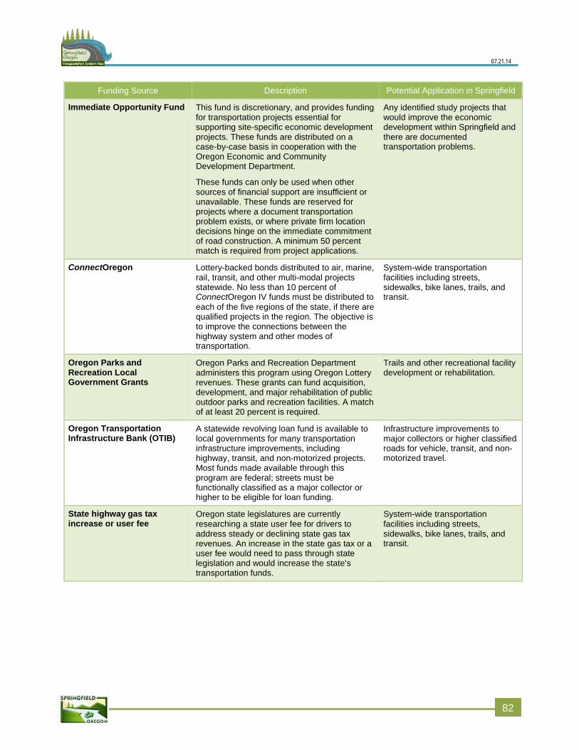
07.21.14
Funding Source Description Potential Application in Springfield
Immediate Opportunity Fund This fund is discretionary, and provides funding for transportation projects essential for supporting site-specific economic development projects. These funds are distributed on a case-by-case basis in cooperation with the Oregon Economic and Community Development Department.
These funds can only be used when other sources of financial support are insufficient or unavailable. These funds are reserved for projects where a document transportation problem exists, or where private firm location decisions hinge on the immediate commitment of road construction. A minimum 50 percent match is required from project applications.
Any identified study projects that would improve the economic development within Springfield and there are documented transportation problems.
ConnectOregon Lottery-backed bonds distributed to air, marine, rail, transit, and other multi-modal projects statewide. No less than 10 percent of ConnectOregon IV funds must be distributed to each of the five regions of the state, if there are qualified projects in the region. The objective is to improve the connections between the highway system and other modes of transportation.
System-wide transportation facilities including streets, sidewalks, bike lanes, trails, and transit.
Oregon Parks and Recreation Local Government Grants
Oregon Parks and Recreation Department administers this program using Oregon Lottery revenues. These grants can fund acquisition, development, and major rehabilitation of public outdoor parks and recreation facilities. A match of at least 20 percent is required.
Trails and other recreational facility development or rehabilitation.
Oregon Transportation Infrastructure Bank (OTIB)
A statewide revolving loan fund is available to local governments for many transportation infrastructure improvements, including highway, transit, and non-motorized projects. Most funds made available through this program are federal; streets must be functionally classified as a major collector or higher to be eligible for loan funding.
Infrastructure improvements to major collectors or higher classified roads for vehicle, transit, and non-motorized travel.
State highway gas tax increase or user fee
Oregon state legislatures are currently researching a state user fee for drivers to address steady or declining state gas tax revenues. An increase in the state gas tax or a user fee would need to pass through state legislation and would increase the state’s transportation funds.
System-wide transportation facilities including streets, sidewalks, bike lanes, trails, and transit.
882
Chapter 7: Code and policy updates
The Transportation Planning Rule (TPR), as codified in Oregon Administrative Rules (OAR) 660‐012‐0020(2)(h), requires that local jurisdictions identify land use regulations and code amendments needed to implement the Springfield 2035 Transportation System Plan (TSP) and include them as the implementation element of the 2035 TSP. To that end, recommended changes to the City’s planning regulations needed to implement the 2035 TSP are provided in Volume 2, Appendix I: Plan implementation and recommendation ordinance/code language.
The City bases the implementation measures primarily on a review of the 2035 TSP for consistency with Springfield Community Development Code and regulatory requirements. The implementation measures also reflect projects and recommendations in the 2035 TSP as well as discussions with project team members.
The recommended implementation measures address the following. Most of the measures involve changes to the Springfield Development Code.
Needs of the transportation dependent and disadvantaged
System connectivity
Ways of supporting and promoting walking, biking, and taking transit
Treatment of transportation facilities in the land use planning and permitting process
Update and adapt the Conceptual Street map
The implementation measures that reflect strategies identified in the 2035 TSP emphasize maximizing the capacity of existing and recommended facilities. In particular, the 2035 TSP encourages modes other than driving alone through an increase in transit, walk, and bike modes, which is essential to the future transportation system in Springfield. These measures constitute a combination of potential amendments to the Springfield Development Code or Comprehensive Plan, as well as the City coordinating additional planning, administration, and programming.
83
Related Documents


