City of Sedro-Woolley Shoreline Management Program Update Shoreline Management Program SEPTEMBER 2013 City of Sedro-Woolley Department of Ecology Grant No. G1100233

Welcome message from author
This document is posted to help you gain knowledge. Please leave a comment to let me know what you think about it! Share it to your friends and learn new things together.
Transcript
City of Sedro-WoolleyShoreline Management Program Update
Shoreline Management ProgramSEPTEMBER 2013
City of Sedro-WoolleyDepartment of Ecology Grant No. G1100233
- 2 -
ContentsChapter 1 – Introduction.............................................................................................................. 4Chapter 2 – Definitions................................................................................................................ 6Chapter 3 – Shoreline Management Goals............................................................................ 18
A. INTRODUCTION ............................................................................................................... 18B. SPECIFIC SHORELINE GOALS .................................................................................... 18
1. Economic Development Element ................................................................................ 182. Public Access Element ................................................................................................. 193. Recreation Element ....................................................................................................... 194. Circulation Element ....................................................................................................... 205. Shoreline Land Use Element ....................................................................................... 206. Conservation Element................................................................................................... 207. Historic/Cultural/Scientific/Educational Element ....................................................... 218. Flood Hazard Management Element.......................................................................... 21
Chapter 4 – Shoreline Environment Designations................................................................ 22I. General ................................................................................................................................. 22II. “Urban Conservancy” environment ................................................................................. 23III. “Aquatic” Environment ..................................................................................................... 24IV. Shoreline Environment Designation Maps ................................................................... 25V. Consistency with Comprehensive Plan ......................................................................... 25VI. Preferred Uses.................................................................................................................. 26VII. Shoreline Use Preferences and Shorelines of Statewide Significance .................. 27
Chapter 5 – Policies and Regulations..................................................................................... 305.1 – General Policies and Regulations ............................................................................. 30
A. Policies and Regulations Applicable to all Shorelines............................................. 30B. Archaeological and Historic Resources ..................................................................... 31C. Critical Areas.................................................................................................................. 32D. Flood Hazard Reduction .............................................................................................. 33E. Public Access................................................................................................................. 34F. Vegetation Conservation .............................................................................................. 37G. Water Quality ................................................................................................................. 38
5.2 – Shoreline Use and Modification Tables .................................................................... 39A. Permitted Use and Modification Table ....................................................................... 39B. Shoreline Modification Table ....................................................................................... 40
5.3 – Specific Shoreline Use Policies and Regulations ................................................... 41A. Introduction..................................................................................................................... 41B. Prohibited Uses ............................................................................................................. 41C. Agriculture ...................................................................................................................... 41D. Boating Facilities ........................................................................................................... 43E. Commercial Development............................................................................................ 44F. In-Stream Structures ..................................................................................................... 46G. Recreational Development .......................................................................................... 47H. Residential Development ............................................................................................. 48I. Transportation Facilities................................................................................................. 49J. Utilities ............................................................................................................................. 50
5.4 Shoreline Modification Provisions ................................................................................. 52

- 3 -
A. Introduction..................................................................................................................... 52B. General Policies and Regulations .............................................................................. 52C. Shoreline Stabilization .................................................................................................. 54D. Piers and Docks ............................................................................................................ 56E. Fill..................................................................................................................................... 58F. Breakwaters, Jetties and Weirs................................................................................... 59G. Dredging and Dredge Material Disposal ................................................................... 60H. Shoreline Habitat and Natural Systems Enhancement Projects ........................... 61
Chapter 6 – Administrative Provisions .................................................................................... 63A. General ............................................................................................................................... 63B. SHORELINE SUBSTANTIAL DEVELOPMENT PERMITS........................................ 63C. CONDITIONAL USE PERMITS...................................................................................... 67D. VARIANCES ...................................................................................................................... 69E. NONCONFORMING USE AND DEVELOPMENT....................................................... 70F. REVISIONS TO PERMITS............................................................................................... 72G. ENFORCEMENT .............................................................................................................. 73
Appendix A – Shoreline Characterization and Analysis & Cumulative Impacts (Notadopted as part of the SMP)
Appendix B - Restoration Plan
Appendix C - Shoreline Critical Areas Regulations

- 4 -
Chapter 1 – Introduction
Washington’s Shoreline Management Act (SMA) was passed by the State Legislature in1971 and adopted by the public in a referendum. The SMA was created in response toa growing concern among residents of the state that serious and permanent damagewas being done to shorelines by unplanned and uncoordinated development. The goalof the SMA was “to prevent the inherent harm in an uncoordinated and piecemealdevelopment of the state’s shorelines.” While protecting shoreline resources byregulating development, the SMA is also intended to provide for appropriate shorelineuse by encouraging land uses that enhance and conserve shoreline functions andvalues.
The SMA has three broad policies:
1. Encourage water-dependent and water-oriented uses: "uses shall be preferredwhich are consistent with control of pollution and prevention of damage to thenatural environment, or are unique to or dependent upon use of the states'shorelines....”
2. Promote public access: “the public’s opportunity to enjoy the physical andaesthetic qualities of natural shorelines of the state shall be preserved to thegreatest extent feasible consistent with the overall best interest of the state andthe people generally."
3. Protect shoreline natural resources, including "...the land and its vegetation andwildlife, and the water of the state and their aquatic life...."
Under the SMA, the shoreline jurisdiction includes water areas that have beendesignated as either “shorelines of statewide significance” or “shorelines” and theiradjacent shorelands, defined as the upland area within 200 feet of the OHWM andfloodways and contiguous floodplain areas landward two hundred feet from suchfloodways, as well as any associated wetlands (RCW 90.58.030). The Skagit River isregulated under the SMA and the City’s Shoreline Master Program (SMP). The SkagitRiver is also designated as “shoreline of statewide significance” under the SMA.
The primary responsibility for administering the SMA is assigned to local governmentsthrough the mechanism of local shoreline master programs, adopted under guidelinesestablished by Ecology. The guidelines (WAC 173-26) establish goals and policies thatprovide a framework for development standards and use regulations in the shoreline.The SMP is based on state guidelines but tailored to the specific conditions and needsof individual communities. The SMP is also meant to be a comprehensive vision of howthe shoreline area will be managed over time.
The SMP provides both policies and regulations to govern development and otheractivities in the City’s shorelines. The SMP (or “Master Program”) consists ofenvironmental designations for the shoreline segments and goals, policies, andregulations applicable to uses and modifications within the Shoreline Management Zone

- 5 -
(SMZ – synonymous with shoreline jurisdiction). Appendices to the SMP include aninventory of existing shoreline conditions; analysis and characterization of theshorelines of the City; a shorelines restoration planning report; and shoreline criticalarea regulations. The restoration plan and critical area regulations are considered partof the officially adopted SMP.
In 2003, the state legislature established funding, timelines, and guidelines requiring allcities and counties to update their SMP. The City of Sedro-Woolley has developed acomprehensive SMP update with the assistance of a grant administered by theWashington State Department of Ecology. The document has been prepared consistentwith the SMA and its implementing guidelines. The City’s SMP provides goals, policies,development regulations, and permitting procedures for “shorelines of the state” in thecity of Sedro-Woolley. RCW 36.70A.480 governs the relationship between shorelinemaster programs and development regulations to protect critical areas that are adoptedunder Chapter 36.70A RCW.
Consistent with state guidelines (WAC 173-26-201, Comprehensive Process to Prepareor Amend Shoreline Master Programs) a first step in the comprehensive MasterProgram update process is development of a shoreline inventory and characterization.The inventory and characterization documents current shoreline conditions andprovides a basis for updating the City’s Master Program goals, policies, and regulations.The characterization identifies existing conditions, evaluates existing functions andvalues of shoreline resources, and explores opportunities for conservation andrestoration of ecological functions.
State guidelines also require that local governments develop Master Program policiesthat promote “restoration” of damaged shoreline ecological functions and develop a“real and meaningful” strategy to implement restoration objectives. Planning forshoreline restoration includes identifying opportunities (both programmatic and site-specific), establishing goals and policies, working cooperatively with other regionalentities, and supporting restoration through other regulatory and non-regulatoryprograms.
This document has been reviewed to ensure that property rights shall not be infringedupon (as demonstrated by the use of such techniques as administrative reductions andvariances) and meets the principals of the SMA (WAC173.26-186(5)).
During the development of the SMP update the City worked with a Citizen’s AdvisoryCommittee for several months. Special thanks go out to Committee members PatHuggins, Rick Judd, Jim Johnson, Stephanie Lokkebo, Jennifer Aylor, Eric Johnson,and Joe Franett.

- 6 -
Chapter 2 – Definitions
“Accessory structure” means a structure, either attached or detached, from a principalor main building and located on the same lot and which is customarily incidental andsubordinate to the principal building or use.
"Act" or “SMA” means the Washington State Shoreline Management Act, Chapter90.58 RCW.
"Agricultural activities" means agricultural uses and practices including, but not limitedto: Producing, breeding, or increasing agricultural products; rotating and changingagricultural crops; allowing land used for agricultural activities to lie fallow in which it isplowed and tilled but left unseeded; allowing land used for agricultural activities to liedormant as a result of adverse agricultural market conditions; allowing land used foragricultural activities to lie dormant because the land is enrolled in a local, state, orfederal conservation program, or the land is subject to a conservation easement;conducting agricultural operations; maintaining, repairing, and replacing agriculturalequipment; maintaining, repairing, and replacing agricultural facilities, provided that thereplacement facility is no closer to the shoreline than the original facility; andmaintaining agricultural lands under production or cultivation.
"Agricultural products" includes, but is not limited to, horticultural, viticultural,floricultural, vegetable, fruit, berry, grain, hops, hay, straw, turf, sod, seed, and apiaryproducts; feed or forage for livestock; Christmas trees; hybrid cottonwood and similarhardwood trees grown as crops and harvested within twenty years of planting; andlivestock including both the animals themselves and animal products including, but notlimited to, meat, upland finfish, poultry and poultry products, and dairy products.
"Agricultural equipment" and "agricultural facilities" includes, but is not limited to:
(a) The following used in agricultural operations: Equipment; machinery; constructedshelters, buildings, and ponds; fences; upland finfish rearing facilities; water diversion,withdrawal, conveyance, and use equipment and facilities including, but not limited to,pumps, pipes, tapes, canals, ditches, and drains;
(b) Corridors and facilities for transporting personnel, livestock, and equipment to,from, and within agricultural lands;
(c) Farm residences and associated equipment, lands, and facilities; and
(d) Roadside stands and on-farm markets for marketing fruit or vegetables;
"Agricultural land" means those specific land areas on which agricultural activities areconducted as of the date of adoption of a local master program pursuant to theseguidelines as evidenced by aerial photography or other documentation. After the

- 7 -
effective date of the master program, land converted to agricultural use is subject tocompliance with the requirements of the master program.
"Amendment" means a revision, update, addition, deletion, and/or reenactment to anexisting shoreline master program.
"Aquaculture" means the culture or farming of fish, shellfish, or other aquatic plantsand animals. Aquaculture does not include the harvest of wild geoduck associated withthe state managed wildstock geoduck fishery.
“Associated wetlands” means those wetlands which are in proximity to and eitherinfluence or are influenced by a lake or stream subject to the Shoreline ManagementAct.
“Best available science” refers to information gathered, analyzed and presented basedon professional experience, expertise, and judgment, and established scientificprinciples and practices. Such principles and practices include peer review, use ofscientific methodology, logical analysis and reasonable inference, statistical analysis,rigorous referencing within the scientific literature, and conclusions drawn from within anaccepted scientific framework and placed in an appropriate scientific context.
“Best management practices (BMPs)” refer to physical, structural, and/or managerialpractices, that when used singly or in combination, prevent or reduce water pollution.Source control BMPs include those which keep the pollutant from ever coming incontact with stormwater, and stormwater treatment BMPs include those which consist ofvarious methods of treating stormwater. See also Chapters 13.36 and 13.40 SWMC(Stormwater Management).
"Bioengineering" means project designs or construction methods which use live woodyvegetation or a combination of live woody vegetation and specially developed natural orsynthetic materials to establish a complex root grid within the existing bank which isresistant to erosion, provides bank stability, and maintains a healthy riparianenvironment with habitat features important to fish life. Use of wood structures or limiteduse of clean angular rock may be allowable to provide stability for establishment of thevegetation.
"Channel migration zone (CMZ)" means the area along a river within which thechannel(s) can be reasonably predicted to migrate over time as a result of natural andnormally occurring hydrological and related processes when considered with thecharacteristics of the river and its surroundings.“Channelization” means the straightening, deepening, or widening of a stream channelfor the purpose of increasing the stream’s carrying capacity.
“City” means the city of Sedro-Woolley.

- 8 -
“Community pier” or “community dock" means a pier or dock including a gangwayand/or float which is intended for use in common by lot owners or residents of asubdivision or residential planned development district.
Consumer Price Index means for any calendar year, that year's annual averageconsumer price index, Seattle Washington area, for urban wage earners and clericalworkers, all items, compiled by the Bureau of Labor and Statistics, United StatesDepartment of Labor.
County is Skagit County outside the city limits of Sedro-Woolley.
"Critical areas" as defined under chapter 36.70A RCW includes the following areas andecosystems:
(a) Wetlands;
(b) Areas with a critical recharging effect on aquifers used for potable waters;
(c) Fish and wildlife habitat conservation areas;
(d) Frequently flooded areas; and
(e) Geologically hazardous areas.
"Development" means a use consisting of the construction or exterior alteration ofstructures; dredging; drilling; dumping; filling; removal of any sand, gravel, or minerals;bulkheading; driving of piling; placing of obstructions; or any project of a permanent ortemporary nature which interferes with the normal public use of the surface of thewaters overlying lands subject to the act at any stage of water level.
"Development regulations" means the controls placed on development or land usesby a county or city, including, but not limited to, zoning ordinances, critical areasordinances, all portions of a shoreline master program other than goals and policiesapproved or adopted under chapter 90.58 RCW, planned unit development ordinances,subdivision ordinances, and binding site plan ordinances together with any amendmentsthereto.
“Director” means the city of Sedro-Woolley Planning Director or his/her designee.
“Dock” means a structure that abuts the shoreline and floats upon the water and is usedas a landing or moorage place for recreational purposes.
"Ecological functions" or "shoreline functions" means the work performed or roleplayed by the physical, chemical, and biological processes that contribute to themaintenance of the aquatic and terrestrial environments that constitute the shoreline'snatural ecosystem.

- 9 -
"Ecology" means the Washington State Department of Ecology.
"Ecosystem-wide processes" means the suite of naturally occurring physical andgeologic processes of erosion, transport, and deposition; and specific chemicalprocesses that shape landforms within a specific shoreline ecosystem and determineboth the types of habitat and the associated ecological functions.
"Exempt" developments are those set forth in WAC 173-27-040 and RCW 90.58.030(3)(e), 90.58.140(9), 90.58.147,90.58.355 , and 90.58.515 which are not required toobtain a substantial development permit but which must otherwise comply withapplicable provisions of the act and the local master program.
"Fair market value" of a development is the open market bid price for conducting thework, using the equipment and facilities, and purchase of the goods, services andmaterials necessary to accomplish the development. This would normally equate to thecost of hiring a contractor to undertake the development from start to finish, includingthe cost of labor, materials, equipment and facility usage, transportation and contractoroverhead and profit. The fair market value of the development shall include the fairmarket value of any donated, contributed or found labor, equipment or materials.
"Feasible" means, for the purpose of this chapter, that an action, such as adevelopment project, mitigation, or preservation requirement, meets all of the followingconditions:
(a) The action can be accomplished with technologies and methods that have beenused in the past in similar circumstances, or studies or tests have demonstrated insimilar circumstances that such approaches are currently available and likely to achievethe intended results;
(b) The action provides a reasonable likelihood of achieving its intended purpose;and
(c) The action does not physically preclude achieving the project's primary intendedlegal use.
In cases where these guidelines require certain actions unless they are infeasible,the burden of proving infeasibility is on the applicant.
In determining an action's infeasibility, the reviewing agency may weigh the action'srelative public costs and public benefits, considered in the short- and long-term timeframes.
"Fill" means the addition of soil, sand, rock, gravel, sediment, earth retaining structure,or other material to an area waterward of the OHWM, in wetlands, or on shorelands in amanner that raises the elevation or creates dry land.
- 10 -
“Flood hazard reduction” activities include actions taken to reduce flood damage orhazards. Flood hazard reduction measures may consist of nonstructural or indirectmeasures, such as setbacks, land use controls, wetland restoration, dike removal, userelocation, bioengineering measures, and storm water management programs; and ofstructural measures, such as dikes, levees, and floodwalls intended to contain flowwithin the channel, channel realignment, and elevation of structures consistent with theNational Flood Insurance Program.
"Flood plain" is synonymous with one hundred-year flood plain and means that landarea susceptible to inundation with a one percent chance of being equaled or exceededin any given year. The limit of this area shall be based upon flood ordinance regulationmaps or a reasonable method which meets the objectives of the SMA.
"Floodway" means the area, as identified in this Master Program, that has beenestablished in the most current federal emergency management agency flood insurancerate maps (FIRM) or floodway maps.
"Geotechnical report" or "geotechnical analysis" means a scientific study orevaluation conducted by a qualified expert that includes a description of the ground andsurface hydrology and geology, the affected land form and its susceptibility to masswasting, erosion, and other geologic hazards or processes, conclusions andrecommendations regarding the effect of the proposed development on geologicconditions, the adequacy of the site to be developed, the impacts of the proposeddevelopment, alternative approaches to the proposed development, and measures tomitigate potential site-specific and cumulative geological and hydrological impacts of theproposed development, including the potential adverse impacts to adjacent and down-current properties. Geotechnical reports shall conform to accepted technical standardsand must be prepared by qualified professional engineers or geologists who haveprofessional expertise about the regional and local shoreline geology and processes.
"Grading" means the movement or redistribution of the soil, sand, rock, gravel,sediment, or other material on a site in a manner that alters the natural contour of theland.
“Hazardous substances” means those wastes designated by WAC 173-340-200, andregulated as hazardous substances by the Department of Ecology.
"Hearings board" means the shorelines hearings board established by Chapter 90.58RCW.
"Height" means a measurement from average grade level to the highest point of astructure: provided, that television antennas, chimneys, and similar appurtenances shallnot be used in calculating height, except where such appurtenances obstruct the view ofthe shoreline of a substantial number of residences on areas adjoining such shorelines,
- 11 -
or the master program specifically requires that such appurtenances be included:provided further, that temporary construction equipment is excluded in this calculation.
“In-stream structural uses” means a structure placed by humans within a stream orriver waterward of the ordinary high-water mark that either causes or has the potentialto cause water impoundment or the diversion, obstruction, or modification of water flow.Instream structures may include those for hydroelectric generation, irrigation, watersupply, flood control, transportation, utility service transmission, fish habitatenhancement, or other purpose.
"Master Program," "shoreline master program" or “SMP” means the City of Sedro-Woolley’s Shoreline Master Program.
"May" means the action is acceptable, provided it conforms to the provisions of thischapter.
“Mineral resource lands” means lands primarily devoted to the extraction of mineralsor that have known or potential long-term commercial significance for the extraction ofminerals.
"Must" means a mandate; the action is required.
"Nonwater-oriented uses" means those uses that are not water-dependent, water-related, or water-enjoyment.
“Nonconforming use and development” means a shoreline use or development whichwas lawfully constructed or established prior to the effective date of the SMA or theapplicable master program or amendments thereto, but which do not confirm to presentregulations or standards of the program.
"Ordinary high water mark" on all lakes, streams, and tidal water is that mark that willbe found by examining the bed and banks and ascertaining where the presence andaction of waters are so common and usual, and so long continued in all ordinary years,as to mark upon the soil a character distinct from that of the abutting upland, in respectto vegetation as that condition exists on June 1, 1971, as it may naturally changethereafter, or as it may change thereafter in accordance with permits issued by a localgovernment or the department: PROVIDED, That in any area where the ordinary highwater mark cannot be found, the ordinary high water mark adjoining salt water shall bethe line of mean higher high tide and the ordinary high water mark adjoining freshwatershall be the line of mean high water.
“Permit” means a Substantial Development Permit, shoreline conditional use permit, orshoreline variance issued in compliance with the SMA and the Sedro-Woolley ShorelineMaster Program.

- 12 -
“Pier” means a structure that abuts the shoreline and is built over the water on pilingsand is used as a landing or moorage place for recreational purposes.
“Primary association” means the use of a habitat area by a species for breeding,nesting, rearing young, roosting, feeding, or foraging on a regular basis.
"Priority habitat" means a habitat type with unique or significant value to one or morespecies. An area classified and mapped as priority habitat must have one or more of thefollowing attributes:
• Comparatively high fish or wildlife density;• Comparatively high fish or wildlife species diversity;• Fish spawning habitat;• Important wildlife habitat;• Important fish or wildlife seasonal range;• Important fish or wildlife movement corridor;• Rearing and foraging habitat;• Important marine mammal haul-out;• Refugia habitat;• Limited availability;• High vulnerability to habitat alteration;• Unique or dependent species; or• Shellfish bed.
A priority habitat may be described by a unique vegetation type or by a dominantplant species that is of primary importance to fish and wildlife (such as oak woodlandsor eelgrass meadows). A priority habitat may also be described by a successional stage(such as, old growth and mature forests). Alternatively, a priority habitat may consist ofa specific habitat element (such as a consolidated marine/estuarine shoreline, talusslopes, caves, snags) of key value to fish and wildlife. A priority habitat may containpriority and/or nonpriority fish and wildlife.
"Priority species" means species requiring protective measures and/or managementguidelines to ensure their persistence at genetically viable population levels. Priorityspecies are those that meet any of the criteria listed below.
(a) Criterion 1. State-listed or state proposed species. State-listed species are thosenative fish and wildlife species legally designated as endangered (WAC 232-12-014),threatened (WAC 232-12-011), or sensitive (WAC 232-12-011). State proposed speciesare those fish and wildlife species that will be reviewed by the department of fish andwildlife (POL-M-6001) for possible listing as endangered, threatened, or sensitiveaccording to the process and criteria defined in WAC 232-12-297.
(b) Criterion 2. Vulnerable aggregations. Vulnerable aggregations include thosespecies or groups of animals susceptible to significant population declines, within aspecific area or statewide, by virtue of their inclination to congregate. Examples include
- 13 -
heron colonies, seabird concentrations, and marine mammal congregations.
(c) Criterion 3. Species of recreational, commercial, and/or tribal importance. Nativeand nonnative fish, shellfish, and wildlife species of recreational or commercialimportance and recognized species used for tribal ceremonial and subsistencepurposes that are vulnerable to habitat loss or degradation.
(d) Criterion 4. Species listed under the federal Endangered Species Act as eitherproposed, threatened, or endangered.
"Provisions" means policies, regulations, standards, guideline criteria or environmentdesignations.
"Public interest" means the interest shared by the citizens of the state or community atlarge in the affairs of government, or some interest by which their rights or liabilities areaffected including, but not limited to, an effect on public property or on health, safety, orgeneral welfare resulting from a use or development.
“Public facilities” mean and include streets, roads, highways, sidewalks, street androad lighting systems, traffic signals, domestic water systems, storm and sanitary sewersystems, parks and recreation facilities, and schools.
“Qualified expert” means a person having substantially demonstrated experience as apracticing specialist with a minimum of five years experience working full time in theprofession and who has a degree in a related field from an accredited college oruniversity or who has equivalent training.
"Restore," "restoration" or "ecological restoration" means the reestablishment orupgrading of impaired ecological shoreline processes or functions. This may beaccomplished through measures including, but not limited to, revegetation, removal ofintrusive shoreline structures and removal or treatment of toxic materials. Restorationdoes not imply a requirement for returning the shoreline area to aboriginal or pre-European settlement conditions.
"Shall" means a mandate; the action must be done.
”Shorelands” or ”shoreland areas” means those lands extending landward for twohundred feet in all directions as measured on a horizontal plane from the ordinary highwater mark; floodways and contiguous floodplain areas landward two hundred feet fromsuch floodways; and all wetlands and river deltas associated with the streams, lakes,and tidal waters that are subject to the provisions of RCW 90.58.030; the same as tolocation by the Department of Ecology.
"Shoreline areas" and "shoreline jurisdiction" is synonymous with "ShorelinesManagement Zone" (SMZ) as defined in this master program.

- 14 -
"Shorelines of the state" are the total of all "shorelines" and "shorelines of statewidesignificance" within the state.
“Shorelines of statewide significance” in Sedro-Woolley are identified as the SkagitRiver within the city limits, shorelands, and wetlands associated with the Skagit River(see RCW 90.58.030(2)(e)).
“Shoreline Management Zone (SMZ)” as used in this document, is meant to define thearea of the City’s shoreline jurisdiction as allowed by RCW 90.58.030. The SMZextends a minimum of 200 feet upland from the line of the ordinary high water mark(OHWM) of the Skagit River and floodways and contiguous floodplain areas landwardtwo hundred feet from such floodways. The floodplain and floodway are defined by thecurrent effective US Army Corps of Engineers Flood Insurance Rate Maps (FIRM). TheSMZ includes associated wetlands, but not wetland buffers. The SMZ extendswaterward of the OHWM to mid-channel of the Skagit River.
"Shoreline modifications" means those actions that modify the physical configurationor qualities of the shoreline area, usually through the construction of a physical elementsuch as a dike, breakwater, pier, weir, dredged basin, fill, bulkhead, or other shorelinestructure. They can include other actions, such as clearing, grading, or application ofchemicals.
"Should" means that the particular action is required unless there is a demonstrated,compelling reason, based on policy of the SMA, against taking the action.
"Significant vegetation removal" means the removal or alteration of trees, shrubs,and/or ground cover by clearing, grading, cutting, burning, chemical means, or otheractivity that causes significant ecological impacts to functions provided by suchvegetation. The removal of invasive or noxious weeds does not constitute significantvegetation removal. Tree pruning, not including tree topping, where it does not affectecological functions, does not constitute significant vegetation removal.
"State master program" means the cumulative total of all shoreline master programsand amendments thereto approved or adopted by rule by the department.
"Structure" means a permanent or temporary edifice or building, or any piece of workartificially built or composed of parts joined together in some definite manner, whetherinstalled on, above, or below the surface of the ground or water, except for vessels.
"Substantially degrade" means to cause significant ecological impact.
"Substantial development" shall mean any development of which the total cost or fairmarket value exceeds six thousand four hundred and sixteen dollars (or the value asamended or adjusted for inflation per RCW 90.58.030 (3) (e)), or any developmentwhich materially interferes with the normal public use of the water or shorelines of the

- 15 -
state. As further defined in Chapter 6, Section B, the following shall not be consideredsubstantial developments for the purpose of this chapter:
(a) Normal maintenance or repair of existing structures or developments, includingdamage by accident, fire, or elements;
(b) Construction of the normal protective bulkhead common to single-familyresidences;
(c) Emergency construction necessary to protect property from damage by theelements;
(d) Construction and practices normal or necessary for farming, irrigation, andranching activities, including agricultural service roads and utilities on shorelands, andthe construction and maintenance of irrigation structures including but not limited tohead gates, pumping facilities, and irrigation channels. A feedlot of any size, allprocessing plants, other activities of a commercial nature, alteration of the contour ofthe shorelands by leveling or filling other than that which results from normal cultivation,shall not be considered normal or necessary farming or ranching activities. A feedlotshall be an enclosure or facility used or capable of being used for feeding livestock hay,grain, silage, or other livestock feed, but shall not include land for growing crops orvegetation for livestock feeding and/or grazing, nor shall it include normal livestockwintering operations;
(e) Construction or modification of navigational aids such as channel markers andanchor buoys;
(f) Construction on shorelands by an owner, lessee, or contract purchaser of asingle-family residence for his own use or for the use of his or her family, whichresidence does not exceed a height of thirty-five feet above average grade level andwhich meets all requirements of the state agency or local government having jurisdictionthereof, other than requirements imposed pursuant to this chapter;
(g) Construction of a dock, including a community dock, designed for pleasure craftonly, for the private noncommercial use of the owner, lessee, or contract purchaser ofsingle and multiple-family residences. This exception applies in freshwaters, if the fairmarket value of the dock does not exceed ten thousand dollars, but if subsequentconstruction having a fair market value exceeding two thousand five hundred dollarsoccurs within five years of completion of the prior construction, the subsequentconstruction shall be considered a substantial development for the purpose of thischapter;
(h) Operation, maintenance, or construction of canals, waterways, drains, reservoirs,or other facilities that now exist or are hereafter created or developed as a part of anirrigation system for the primary purpose of making use of system waters, includingreturn flow and artificially stored groundwater for the irrigation of lands;
(i) The marking of property lines or corners on state owned lands, when suchmarking does not significantly interfere with normal public use of the surface of thewater;
(j) Operation and maintenance of any system of dikes, ditches, drains, or otherfacilities existing on September 8, 1975, which were created, developed, or utilizedprimarily as a part of an agricultural drainage or diking system;

- 16 -
(k) Site exploration and investigation activities that are prerequisite to preparation ofan application for development authorization under this chapter, if:
(i) The activity does not interfere with the normal public use of the surfacewaters;(ii) The activity will have no significant adverse impact on the environment
including, but not limited to, fish, wildlife, fish or wildlife habitat, water quality, andaesthetic values;
(iii) The activity does not involve the installation of a structure, and uponcompletion of the activity the vegetation and land configuration of the site are
restored to conditions existing before the activity;(iv) A private entity seeking development authorization under this section first
posts a performance bond or provides other evidence of financial responsibility to thelocal jurisdiction to ensure that the site is restored to preexisting conditions; and
(v) The activity is not subject to the permit requirements of RCW 90.58.550;
(l) The process of removing or controlling an aquatic noxious weed, as defined inRCW 17.26.020, through the use of an herbicide or other treatment methods applicableto weed control that are recommended by a final environmental impact statementpublished by the department of agriculture or the department jointly with other stateagencies under chapter 43.21C RCW.
“Unavoidable impacts” refer to affecting critical areas where site conditions precludeavoidance because of density requirements, critical areas that bisect parcels such asstreams or linear wetlands, or parcels that contain many small wetlands.
"Vessel" includes ships, boats, barges, or any other floating craft which are designedand used for navigation and do not interfere with the normal public use of the water.
"Water-dependent use" means a use or portion of a use which cannot exist in alocation that is not adjacent to the water and which is dependent on the water by reasonof the intrinsic nature of its operations.
"Water-enjoyment use" means a recreational use or other use that facilitates publicaccess to the shoreline as a primary characteristic of the use; or a use that provides forrecreational use or aesthetic enjoyment of the shoreline for a substantial number ofpeople as a general characteristic of the use and which through location, design, andoperation ensures the public's ability to enjoy the physical and aesthetic qualities of theshoreline. In order to qualify as a water-enjoyment use, the use must be open to thegeneral public and the shoreline-oriented space within the project must be devoted tothe specific aspects of the use that fosters shoreline enjoyment.
"Water-oriented use" means a use that is water-dependent, water-related, or water-enjoyment, or a combination of such uses.
"Water quality" means the physical characteristics of water within shoreline jurisdiction,

- 17 -
including water quantity, hydrological, physical, chemical, aesthetic, recreation-related,and biological characteristics. Where used in this Master Program, the term "waterquantity" refers only to development and uses regulated under this Master Program andaffecting water quantity, such as impermeable surfaces and storm water handlingpractices. Water quantity, for purposes of this chapter, does not mean the withdrawalof ground water or diversion of surface water pursuant to RCW 90.03.250 through90.03.340.
"Water-related use" means a use or portion of a use which is not intrinsicallydependent on a waterfront location but whose economic viability is dependent upon awaterfront location because:
(a) The use has a functional requirement for a waterfront location such as the arrivalor shipment of materials by water or the need for large quantities of water; or
(b) The use provides a necessary service supportive of the water-dependent usesand the proximity of the use to its customers makes its services less expensive and/ormore convenient.
“Wetland” or “wetlands” means areas that are inundated or saturated by surface wateror groundwater at a frequency and duration sufficient to support, and that under normalcircumstances do support, a prevalence of vegetation typically adapted for life insaturated soil conditions. Wetlands generally include swamps, marshes, bogs, andsimilar areas. Wetlands do not include those artificial wetlands intentionally created fromnonwetland sites, including, but not limited to, irrigation and drainage ditches, grass-lined swales, canals, detention facilities, wastewater treatment facilities, farm ponds,and landscape amenities, or those wetlands created after July l, 1990, that wereunintentionally created as a result of the construction of a road, street or highway.However, wetlands may include these artificial wetlands intentionally created fromnonwetland areas created to mitigate conversion of wetlands, if permitted by the City.

- 18 -
Chapter 3 – Shoreline Management Goals
A. INTRODUCTION
The Shoreline Management Act recognizes that the shorelines and the waters theyencompass are valuable for economically productive industrial and commercial uses,recreation, navigation, residential amenity, scientific research and education. The SMAalso recognizes that they are fragile in that they depend upon balanced physical,biological, and chemical systems that may be adversely altered by natural forces(earthquakes, volcanic eruptions, landslides, storms, droughts, floods) and humanconduct. Sedro-Woolley’s Shoreline Goals are intended to acknowledge and balancethe conflicting nature of the shoreline use.
The SMA identifies eight program elements that must be addressed (if applicable) toeffectuate the policies of the Act: Economic Development, Public Access, Recreational,Shoreline Land Use, Conservation, Circulation, Historic / Cultural / Scientific /Educational and Flood Hazard Management (RCW90.58.100(2)). For each of thoseprogram elements, the City of Sedro-Woolley has identified shoreline goals. Thesegoals establish the basis from which the environmental designations, policies,regulations, and administrative procedures of the Shoreline Master Program aredeveloped. The goal statements are listed below under their corresponding shorelineelements and have been reviewed for consistency with the Goals of the CompressivePlan.
B. SPECIFIC SHORELINE GOALS
1. Economic Development Element
Per RCW 90.58.100(2)(a) master programs shall include “an economic developmentelement for the location and design of industries, projects of statewide significance,transportation facilities, port facilities, tourist facilities, commerce and otherdevelopments that are particularly dependent on their location on or use of theshorelines of the state.” The city owns the majority of the land within the SMZ. TheSedro-Woolley SMZ does not contain any commercial or industrial development.However, there are a few residential parcels at the edge of the SMZ and a coupleindustrially zoned parcels that are adjacent to wetlands in the flood plain that may bejurisdictional.
- 19 -
Shoreline Economic Development Goals:
SED1: Promote tourism through park-oriented recreational opportunities in thoseshoreline areas that can reasonably tolerate such uses during peak use periods withoutdestroying the integrity and character of the shoreline.
SED2: Increase economic opportunities in Sedro-Woolley by encouraging compatiblerecreational opportunities within the SMZ as a means to support local businesses.
SED3: Support the continued use of industrial properties for such purposes.
2. Public Access Element
Per RCW 90.58.100(2)(b) master programs shall include “a public access elementmaking provision for public access to publicly owned areas.” The majority of the Sedro-Woolley SMZ is publicly owned. Public access is a major part of the shoreline plan.
Shoreline Public Access Goals:
SPA1: Increase and enhance public access to publicly-owned shoreline areas so thepublic may enjoy the amenities of the shoreline, consistent with the natural shorelinecharacter, private rights, and public safety.SPA2: Integrate public access to shorelines as a part of a public recreational systemthroughout Sedro-Woolley and Skagit County.SPA3: Maintain the existing water access such as the boat launch and developadditional pedestrian-only river access.
3. Recreation Element
Per RCW 90.58.100(2)(c) master programs shall include “a recreational element for thepreservation and enlargement of recreational opportunities, including but not limited toparks, tidelands, beaches, and recreational areas.”
Shoreline Recreation Goals:
SR1: Encourage diverse, water-oriented recreational opportunities in those shorelineareas that can reasonably tolerate such uses during peak use periods withoutdestroying the integrity and character of the shoreline.SR2: Maintain and improve Riverfront Park and adjacent recreational lands as aregional recreational destination.SR3: Create public access to the Skagit River through the park and trail system that willnot endanger life or property, nor impair the rights of owners of private property in theSMZ.
- 20 -
4. Circulation Element
Per RCW 90.58.100(2)(d) master programs shall include “a circulation elementconsisting of the general location and extent of existing and proposed majorthoroughfares, transportation routes, terminals, and other public utilities and facilities, allcorrelated with the shoreline use element.”
Shoreline Circulation Goals:
SC1: Encourage routes for non-motorized transportation to and throughout the city-owned shoreline resources.SC2: Maintain safe, reasonable, and adequate vehicular, bicycle, and pedestriancirculation systems to shoreline.SC3: Maintain the existing circulation system through the SMZ while ensuring thatroutes accessing the SMZ will have the least possible adverse effect on unique orfragile shoreline features and existing ecological systems, and, when possible,contribute to the functional and visual enhancement of the shoreline.
5. Shoreline Land Use Element
Per RCW 90.58.100(2)(e) master programs shall include “a use element whichconsiders the proposed general distribution and general location and extent of the useon shorelines and adjacent land areas for housing, business, industry, transportation,agriculture, natural resources, recreation, education, public buildings and grounds, andother categories of public and private uses of the land.”
Shoreline Land Use Goals:
SLU1: Promote land and water uses that will honor the existing and ongoing humanuses and protect the natural environment as intended by the Shoreline ManagementAct.SLU2: Promote land and water uses consistent with the SMA, the Sedro-WoolleyComprehensive Plan, and Sedro-Woolley Zoning Code.
6. Conservation Element
Per RCW 90.58.100(2)(f) master programs shall include “a conservation element for thepreservation of natural resources, including but not limited to scenic vistas, aesthetics,and vital estuarine areas for fisheries and wildlife protection.”

- 21 -
Shoreline Conservation Goals:
SCo1: Comply with SMA rules regarding restoration of areas which are biologically andaesthetically degraded to the greatest extent feasible while maintaining appropriate useof the shoreline.SCO2: Protect and preserve the unique and nonrenewable resources and amenities ofthe shoreline for the use and enjoyment of present and future generations.
7. Historic/Cultural/Scientific/Educational Element
Per RCW 90.58.100(2)(g) master programs shall include “an historic, cultural, scientific,and educational element for the protection and restoration of buildings, sites, and areashaving historic, cultural, scientific, or educational values.”
Shoreline Historical/Cultural/Scientific/Educational Goals:
SH1: Identify, protect, preserve, and restore important archaeological, historical, andcultural sites located in the city’s SMZ for their educational and scientific value, as wellas for the recreational enjoyment of the general public.SH2: Encourage organized educational projects and programs that use the city-ownedshoreline resources.
8. Flood Hazard Management Element
Per RCW 90.58.100(2)(h) master programs shall include “an element that givesconsideration to the statewide interest in the prevention and minimization of flooddamages.”
Flood Hazard Management Goals:
FHM1: Comply with and complement the city’s Flood Damage Prevention regulationsfound in Chapter 17.66 SWMC.FHM2: To safely accommodate compatible uses in the flood plain and flood way whileprotecting integrity and character of the shoreline.
- 22 -
Chapter 4 – Shoreline Environment Designations
I. General
Under the SMA, all shorelines of the state meeting the criteria established arecategorized into a shoreline environment designation. These designations are used toplan and manage shoreline resources through the development of the SMP. Thissystem applies appropriate policies and regulations to distinctively different shorelineareas.
The purpose of shoreline environment designations is to differentiate between areaswhose geographical, hydrological, topographical, or other features imply differingobjectives for the use and future development of the city’s shorelines.
The assignment of each geographical area into an environmental category is based on,and is reflective of, the existing use pattern; the biological and physical character of theshoreline; the goals and aspirations of the local citizenry; and the criteria in the SMAguidelines (WAC 173-26-211).
Each environment designation represents a particular emphasis in the type of uses anddevelopment that should be allowed. The environment designation system is designedto encourage uses in each environment that enhance or are compatible with thecharacter of the environment, while at the same time requiring reasonable standardsand restrictions on development so that the character of the environment is notadversely impacted.
Each environment designation category includes: (1) a purpose statement whichclarifies the meaning and intent of the designation; (2) criteria to be used as a basis forclassifying a specific shoreline area with that environment designation; and (3) generalmanagement policies designed to guide management decisions and developmentconsistent with the character of the environment.
The state recommends six basic environmental designations in WAC 173-26-211(5).Those designations are "high-intensity," "shoreline residential," "urban conservancy,""rural conservancy," "natural," and "aquatic."
There is only one reach of shoreline in the Sedro-Woolley SMZ. That reach is usedalmost entirely for park purposes and is shown in Figure 1- SMZ. Therefore the mostappropriate designation for the terrestrial lands in this reach is urban conservancy. Theregulatory jurisdiction, referred to herein as the Shoreline Management Zone (SMZ),extends a minimum of 200 feet upland from the line of the ordinary high water mark(OHWM) of the Skagit River and floodways and contiguous floodplain areas landwardtwo hundred feet from such floodways. The floodplain and floodway are defined by the
- 23 -
US Army Corps of Engineers 1989 Flood Insurance Rate Maps (Firm). The SMZincludes associated wetlands within the flood plain, but not wetland buffers. Wetlandbuffers in the floodplain will be regulated under the city’s critical areas ordinance andnot the SMP. The City of Sedro-Woolley’s SMZ extends beyond the ordinary high watermark to the approximately to the middle of the Skagit River. The submerged landwaterward of the ordinary water mark shall be assigned the aquatic environmentdesignation. WAC 173-26-211(5)(e) defines the urban conservancy environmentdesignation. WAC 173-26-211(5)(c) defines the aquatic designation. Both of thosedesignations are detailed below.
II. “Urban Conservancy” environment
A. Purpose. The purpose of the "urban conservancy" environment is to protect andrestore ecological functions of open space, flood plain and other sensitive lands wherethey exist in urban and developed settings, while allowing a variety of compatible usessuch as urban parks.
B. Management policies.
(1) Uses that preserve the natural character of the area or promote preservation ofopen space, flood plain or sensitive lands either directly or over the long term should bethe primary allowed uses. Uses that result in restoration of ecological functions shouldbe allowed if the use is otherwise compatible with the purpose of the environment andthe setting.
(2) Standards should be established for shoreline stabilization measures, vegetationconservation, water quality, and shoreline modifications within the "urban conservancy"designation. These standards shall ensure that new development does not result in anet loss of shoreline ecological functions or further degrade other shoreline values.
(3) Public access and public recreation objectives should be implemented wheneverfeasible and significant ecological impacts can be mitigated.
(4) Water-oriented uses should be given priority over nonwater-oriented uses. Forshoreline areas adjacent to commercially navigable waters, water-dependent usesshould be given highest priority.
C. Designation criteria. Assign an "urban conservancy" environment designation toshoreline areas appropriate and planned for development that is compatible withmaintaining or restoring of the ecological functions of the area, that are not generallysuitable for water-dependent uses and that lie in incorporated municipalities, urbangrowth areas, or commercial or industrial "limited areas of more intensive ruraldevelopment" if any of the following characteristics apply:
(1) They are suitable for water-related or water-enjoyment uses;

- 24 -
(2) They are open space, flood plain or other sensitive areas that should not be moreintensively developed;
(3) They have potential for ecological restoration;
(4) They retain important ecological functions, even though partially developed; or
(5) They have the potential for development that is compatible with ecologicalrestoration.
Lands that may otherwise qualify for designation as urban conservancy and whichare designated as "mineral resource lands" pursuant to RCW 36.70A.170 and WAC365-190-070 may be assigned a designation within the "urban conservancy"environment that allows mining and associated uses in addition to other uses consistentwith the urban conservancy environment.
D. Designated Area. The entirety of the Sedro-Woolley SMZ landward of the ordinaryhigh water mark.
III. “Aquatic” Environment
A. Purpose. The purpose of the "aquatic" environment is to protect, restore, andmanage the unique characteristics and resources of the areas waterward of the ordinaryhigh-water mark.
B. Management policies.
(1) New over-water structures allowed only for water-dependent uses, public access,or ecological restoration.
(2) The size of new over-water structures should be limited to the minimumnecessary to support the structure's intended use.
(3) In order to reduce the impacts of shoreline development and increase effectiveuse of water resources, multiple use of over-water facilities should be encouraged.
(4) All developments and uses on navigable waters or their beds should be locatedand designed to minimize interference with surface navigation, to consider impacts topublic views, and to allow for the safe, unobstructed passage of fish and wildlife,particularly those species dependent on migration.
(5) Uses that adversely impact the ecological functions of critical freshwater habitatsshould not be allowed except where necessary to achieve the objectives of RCW90.58.020, and then only when their impacts are mitigated according to the sequencedescribed in WAC 173-26-201 (2)(e) as necessary to assure no net loss of ecological

- 25 -
functions.
(6) Shoreline uses and modifications should be designed and managed to preventdegradation of water quality and alteration of natural hydrographic conditions.
(7) Shoreline space should be reserved primarily for shoreline preferred uses. Suchplanning should consider upland and in-water uses, water quality, navigation, presenceof aquatic vegetation, existing shellfish protection districts and critical habitats,aesthetics, public access and views.
C. Designation criteria. Assign an "aquatic" environment designation to lands waterwardof the ordinary high-water mark.
D. Designated Area. The stretch of the Skagit River adjacent to the City of Sedro-Woolley, waterward of the ordinary high water mark extending half-way across the widthof the river.
IV. Shoreline Environment Designation Maps
The City of Sedro-Woolley Shoreline Environment Designations Map (Map 4.1)indicates the location of both the Urban Conservancy and the Aquatic Environmentsunder the jurisdiction of this SMP. The official copy of this map shall be kept by thePlanning Department. This official copy shall be available for public inspection at alltimes during normal business hours. Unofficial copies shall be included as part of alldistributed copies of this SMP.Per WAC 173-27-211(2)(e), all areas within SMZ that are not mapped and/ordesignated are automatically assigned a "urban conservancy" designation if within amunicipality or urban growth area, or the comparable environment designation of theapplicable master program until the shoreline can be re-designated through a masterprogram amendment.
V. Consistency with Comprehensive Plan
RCW 90.58.340 requires that policies for lands adjacent to the shorelines be consistentwith the SMA, implementing rules, and the city’s SMP. Conversely, local comprehensiveplans constitute the underlying framework within which master program provisionsshould fit. The Growth Management Act, where applicable, designates shoreline masterprogram policies as an element of the comprehensive plan and requires that allelements be internally consistent. The GMA also requires development regulations tobe consistent with the comprehensive plan.The Shoreline Guidelines identify three criteria for use in evaluating the consistencybetween master program environment designation provisions and the correspondingcomprehensive plan elements and development regulations. In order for shorelinedesignation provisions, local comprehensive plan land use designations, and

- 26 -
development regulations to be internally consistent, all three of the conditions belowshould be met:A. Provisions not precluding one another.Comprehensive plan provisions and shoreline environment designation provisionsshould not preclude one another. To meet this criterion, the provisions of both thecomprehensive plan and the master program must be able to be met. Further, whenconsidered together and applied to any one piece of property, the master program usepolicies and regulations and the local zoning or other use regulations should not conflictin a manner that all viable uses of the property are precluded.B. Use compatibility.Land use policies and regulations should protect preferred shoreline uses from beingimpacted by incompatible uses. The intent is to prevent water oriented uses, especiallywater dependent uses, from being restricted on shoreline areas because of impacts tonearby non-water-oriented uses. To be consistent, master programs, comprehensiveplans, and development regulations should prevent new uses that are not compatiblewith preferred uses from locating where they may restrict preferred uses ordevelopment.C. Sufficient infrastructure.Infrastructure and services provided in the comprehensive plan should be sufficient tosupport allowed shoreline uses. Shoreline uses should not be allowed where thecomprehensive plan does not provide sufficient roads, utilities, and other services tosupport them. Infrastructure plans must also be mutually consistent with shorelinedesignations. Where they do exist, utility services routed through shoreline areas shallnot be a sole justification for more intense development.
VI. Preferred Uses
The SMA establishes policy that preference be given to uses that are unique to ordependent upon a shoreline location. Consistent with this policy, these guidelines usethe terms "water-dependent," "water-related," and "water-enjoyment," (see WAC 173-26-020), when discussing appropriate uses for various shoreline areas.
Shoreline areas, being a limited ecological and economic resource, are the setting forcompeting uses and ecological protection and restoration activities. Consistent withRCW 90.58.020 and WAC 173-26-171 through 173-26-186, local governments shall,when determining allowable uses and resolving use conflicts on shorelines within theirjurisdiction, apply the following preferences and priorities in the order listed below:
A. Reserve appropriate areas for protecting and restoring ecological functions to controlpollution and prevent damage to the natural environment and public health. In reservingareas, local governments should consider areas that are ecologically intact from theuplands through the aquatic zone of the area, aquatic areas that adjoin permanentlyprotected uplands, and tidelands in public ownership. Local governments should ensurethat these areas are reserved consistent with constitutional limits.

- 27 -
B. Reserve shoreline areas for water-dependent and associated water-related uses.Harbor areas, established pursuant to Article XV of the state Constitution, and otherareas that have reasonable commercial navigational accessibility and necessarysupport facilities such as transportation and utilities should be reserved for water-dependent and water-related uses that are associated with commercial navigationunless the local governments can demonstrate that adequate shoreline is reserved forfuture water-dependent and water-related uses and unless protection of the existingnatural resource values of such areas preclude such uses. Local governments mayprepare master program provisions to allow mixed-use developments that include andsupport water-dependent uses and address specific conditions that affect water-dependent uses.
C. Reserve shoreline areas for other water-related and water-enjoyment uses that arecompatible with ecological protection and restoration objectives.
D. Locate single-family residential uses where they are appropriate and can bedeveloped without significant impact to ecological functions or displacement of water-dependent uses.
E. Limit nonwater-oriented uses to those locations where the above described uses areinappropriate or where nonwater-oriented uses demonstrably contribute to theobjectives of the Shoreline Management Act.
Evaluation pursuant to the above criteria, local economic and land use conditions, andpolicies and regulations that assure protection of shoreline resources, may result indetermination that other uses are considered as necessary or appropriate and may beaccommodated provided that the preferred uses are reasonably provided for in thejurisdiction (WAC 173-26-201(2)(d).
VII. Shoreline Use Preferences and Shorelines of Statewide Significance
In addition to the preferences above, RCW 90.58.020 and WAC 173-26-181 alsorequire that in developing master programs for shorelines of statewide significance, thelocal jurisdiction give preferences to uses in the following order:
A. Recognize and protect the statewide interest over local interest;B. Preserve the natural character of the shoreline;C. Result in long term over short term benefit;D. Protect the resources and ecology of the shoreline;E. Increase public access to publicly owned areas of the shorelines;F. Increase recreational opportunities for the public in the shoreline;G. Provide for any other element as defined in RCW 90.58.100 deemed appropriate ornecessary. (WAC 173-26-251(2))

- 28 -
Shoreline ecological resources are linked to other environments, thus implementation ofecological objectives requires effective management of whole ecosystems. The SMArequires adherence to the concept of “optimum implementation;” an imperative toidentify, understand, and manage ecosystem-wide processes and ecological functionsthat sustain resources of statewide importance. Sedro-Woolley SMP provides foroptimum implementation of the statewide interest as set forth in the policy of RCW90.58.020 and the applicable guidelines.

- 29 -

- 30 -
Chapter 5 – Policies and Regulations
5.1 – General Policies and Regulations
A. Policies and Regulations Applicable to all Shorelines
1. Applicabilitya. The goals listed in Section III of this Master Program provide broad guidance anddirection and have been used by the City in developing the following SMP policies.b. The goals and policies, taken together, constitute the Shoreline Element of theSedro-Woolley Comprehensive Plan.c. It is through the regulations that the SMP policies are implemented. The regulationsdescribe the standards required for all shoreline uses and modifications in the City’s twoenvironmental designations and are part of the Municipal Code.
2. Policiesa. The Director of the Planning Department (Director) will periodically initiate review ofconditions on the shoreline and conduct appropriate analysis to determine whether ornot other actions are necessary to protect and restore the ecology, protect humanhealth and safety, upgrade visual qualities, and enhance residential, commercial, andrecreational uses on the City’s shorelines. Specific issues to address in suchevaluations include, but are not limited to:i. Upland vegetation;ii. Conservation of aquatic vegetation (control of noxious weeds and enhancement ofvegetation that supports more desirable ecological and recreational conditions);iii. Water quality;iv. Changing visual character as a result of new development, including redevelopmentand individual vegetation conservation practices; andv. Shoreline stabilization and modifications.b. Where appropriate, the Planning Department will implement the policies of thisMaster Program in all land use activities, such as development permitting, publicconstruction, and public health and safety. Specifically, such activities include, but arenot limited to:i. Water quality and storm water management activities, including those outside SMZ,but affecting the shorelines of statewide significance;ii. Aquatic vegetation management;iii. Health and safety activities; andiv. Public works and utilities development.c. The Planning Department will notify affected federal, state, county, and tribalgovernments when shoreline development permit applications are submitted.
3. Regulationsa. All proposed shoreline uses and developments, including those uses anddevelopments that do not require a shoreline permit, shall conform to the provisions ofthe Shoreline Management Act, Chapter 90.58 RCW, as such provisions are

- 31 -
implemented by the specific regulations of the Master Program applicable to such uses,as more fully described herein.b. All new shoreline modifications must be in support of an allowable shoreline use thatconforms to the provisions of the Master Program. Except as otherwise noted herein, allproposed shoreline modifications not associated with a legally existing or an approvedshoreline use are prohibited.c. Shoreline uses, modifications, and conditions listed as "prohibited" shall not beeligible for consideration as a shoreline variance or for a shoreline conditional usepermit.d. Where regulations included in this Master Program appear to produce conflictingrequirements, the shoreline regulations that are most consistent with the City’s existingzoning requirements and its Comprehensive Plan shall be applied, absent clear andconvincing evidence that application of such regulations would violate the provisions ofthe Shoreline Management Act, as expressed in RCW 90.58.020.e. See Administrative Provisions (Section VI of SMP) for regulations pertaining toshoreline exemptions, variances, conditional uses, and nonconforming uses.
B. Archaeological and Historic Resources
1. ApplicabilityThe following provisions apply to archaeological and historic resources that are eitherrecorded with the Washington State Department of Archaeology and HistoricPreservation (DAHP) or are revealed during the course of development or modificationactivity within the Sedro-Woolley SMZ.
2. PoliciesDue to the limited and irreplaceable nature of the resource, public or private uses,activities, and development should be prevented from destroying or damaging any sitehaving historic, cultural, scientific, or educational value as identified by the appropriateauthorities and deemed worthy of protection and preservation.
3. Regulationsa. All shoreline permits shall contain provisions that require developers to immediatelystop work and notify the Planning Department if any sites or items of possiblearchaeological value are uncovered during excavation. In such cases, the developershall be required to provide a site inspection and evaluation by a professionalarchaeologist to ensure that all possible valuable archaeological data are properlysalvaged or mapped.b. Archaeological sites located in the Sedro-Woolley SMZ are subject to Chapter 27.44RCW (Indian Graves and Records) and Chapter 27.53 RCW (Archaeological Sites andResources) and shall comply with Chapter 25-48 WAC (Archaeological Excavation andRemoval Permit), as well as the provisions of the Master Program.c. All shoreline permits and exemptions issued in areas documented to containarchaeological resources require a site inspection or evaluation by a professionalarchaeologist in coordination with affected tribes.
- 32 -
d. In the event that unforeseen factors constituting an emergency as defined in RCW90.58.030 necessitate rapid action to retrieve or preserve artifacts or data identifiedabove, the project may be exempted from the permit requirement of these regulations.The City shall notify the State Department of Ecology, the State Attorney General'sOffice, and the DAHP of such a waiver.e. Archaeological excavations may be permitted, subject to the provisions of thisprogram.
C. Critical Areas
1. Applicabilitya. Wetlands occurring in the City’s SMZ, [Note: The City is not opting for the expansionof the SMZ, as provided for in RCW 90.58.030(2)(d)(ii)].b. Fish and wildlife habitat conservation areas are regulated by SWMC 17.65.500-530,“Article V. Fish and Wildlife Habitat Conservation Areas,” which has been incorporatedinto Appendix C – “Shoreline Critical Areas Regulations.”c. The main stem of the Skagit River, which is designated an Aquatic Environment inthis SMP, and provides the critical ecological function of fish passage to upstreamspawning and rearing habitats.d. The language adopted as part of this SMP has been reviewed and determined tomeet the standard of no net loss of ecological functions.
2. Policiesa. In implementing this Master Program, the Planning Department will take necessarysteps to ensure compliance with Chapter 43.21C RCW, the Washington StateEnvironmental Policy Act of 1971, and its implementing guidelines.b. All significant adverse impacts to the shoreline should follow recommended mitigationsequencing provided for in Appendix C.c. Applicable sections of the Critical Area Ordinance (CAO) pertaining to wetlands havebeen incorporated into the SMP and have been included as Appendix C.d. If provisions of the Shoreline Wetland Regulations (Appendix C), and other parts ofthe Master Program seem to conflict, the regulations most directly implementing theobjectives of the Shoreline Management Act, as determined by the PlanningDepartment, shall apply unless specifically stated otherwise.e. In as much as the main stem of the Skagit River serves the critical function of fishpassage, the SMP shall be applicable for the purposes of protection of this function byminimizing and avoiding any adverse impacts waterward of the ordinary high watermark.
3. Regulationsa. All project proposals that occur within the Shoreline Management Zone (see Figure1), shall comply with Chapter 17.66 SWMC, Flood Damage Prevention and theprovisions of this SMP.b. All project proposals that involve alteration of wetlands within the SMZ must complywith the wetland regulations in Appendix C of the SMP.

- 33 -
c. All project proposals that may alter fish and wildlife conservation areas shall complywith Fish and Wildlife Habitat Conservation Areas regulations in Appendix C and theprovisions of this SMP.d. All project proposals shall comply with Chapter 43.21C RCW, the Washington StateEnvironmental Policy Act.
D. Flood Hazard Reduction
1. Applicabilitya. The provisions in this section apply to those areas within the SMZ lying along theSkagit River floodplain corridor and as identified on Federal Emergency ManagementAgency (FEMA) floodplain maps. The provisions in this section are intended to addresstwo concerns especially relevant to river shorelines:i. Protecting human safety and minimizing flood hazard to human activities andproperty; andii. Protecting and contributing to the restoration of ecosystem-wide processes andecological functions found in the applicable watershed or sub-basin.
2. Policiesa. Implement a comprehensive program to manage the City’s floodplain corridor thatintegrates the following City ordinances and activities:i. Regulations of the Master Program as codified in the SWMC;ii. The Floodplain Management Prevention, Chapter 17.66 SWMC;iii. The development standards of the underlying zoning district;iv. The City stormwater management plan and implementing regulations; andvii. The City’s participation in flood risk management programs, including the FederalEmergency Management Act and the Washington State Flood Control AssistanceAccount Program.b. In regulating development on shorelines within SMA jurisdiction, endeavor to achievethe following:i. Maintenance of human safety;ii. Protection and, where appropriate, the restoration of the physical integrity of theecological system processes;iii. Protection of water quality and natural groundwater movement;iv. Protection of fish, vegetation, and other life forms and their habitat vital to the aquaticfood chain;v. Protection of existing legal uses unless the City determines, in the exercise of itsreasonable discretion, that relocation of an existing, non-conforming use or structure isthe only feasible option based on a written determination of the State Department ofEcology that such use presents a substantial and imminent hazard to the shoreline, andviolates the requirements of the Shoreline Management Act; andvi. Protection of recreational resources and scenic values.c. Continue to undertake flood risk management planning in a coordinated manner withaffected property owners and public agencies.d. In designing publicly financed or subsidized works, give consideration to providingpublic pedestrian access to the shoreline, particularly in the City-owned park properties.

- 34 -
3. Regulationsa. Uses that may be appropriate and/or necessarily located in the channel migrationzone or floodway include uses delineated in WAC 173-26-221(3)(c)(i) when consistentwith language elsewhere in the SMP.b. New structural flood hazard reduction measures shall be allowed only wheredemonstrated to be necessary, and when non-structural methods are infeasible andmitigation is accomplished.c. New structural flood hazard reduction measures shall be allowed only landward ofassociated wetlands and buffer areas except where no alternative exists asdocumented in a geotechnical analysis per WAC 173-26-221(3)(c)(ii) & (iii).d. Designs for flood hazard management and shoreline stabilization measures in rivercorridors must be prepared by qualified professional engineers, geologists, and/orhydrologists who have expertise in local riverine processes.e. Existing hydrological connections to the floodplain and associated wetlands shall bemaintained where feasible.f. New publicly funded dikes or levees are required to dedicate and improve publicaccess per WAC-173-26-221(3)(c)(iv).g. Removal of gravel from the Skagit River for purposes of flood risk reduction is notallowed unless a biological and geomorphological study demonstrates a long-termbenefit to flood hazard reduction, no net loss of ecological functions, and extraction ispart of a comprehensive flood management solution.
E. Public Access
1. Applicabilitya. Shoreline public access is the physical ability of the general public to reach and touchthe water's edge and/or the ability to have a view of the water and the shoreline fromupland locations. Public access facilities may include picnic areas, pathways and trails,floats and docks, promenades, viewing platforms, boat launches, and improved streetends.b. The City owns most of the river’s edge property in the SMZ. Public access to theshoreline is of high priority when and where access can be safely accommodated. Thestretch of Skagit River through the SMZ is fast moving, cold and varies in bank heightand volume. The bank is typically steep in the SMZ. These factors make recreation onthe shores of or in the waters of the river perilous at times, thus direct access to theriver should be carefully managed.
2. Policiesa. Public access should be considered in the review of all private and publicdevelopments with the exception of the following:i. Residential developments of four or fewer lots; orii. Where deemed inappropriate due to health, safety, and environmental concerns.b. Developments, uses, and activities on or near the shoreline should not impair ordetract from the public's right to access the water or the rights of navigation.
- 35 -
c. Public access should be provided as close as possible to the water's edge withoutcausing significant ecological impacts or placing users in harms-way and should bedesigned in accordance with the Americans with Disabilities Act.d. Opportunities for public access should be identified on publicly-owned shorelines.e. Public access should be designed to provide for public safety and comfort and toensure no adverse impacts on adjoining private property and the individual privacy ofsuch property owners. Where public access is provided, a physical barrier or othermeans of separation should be utilized that clearly delineates public and private space,and which will discourage trespass onto adjoining private property.f. Views from the upland areas adjacent to the shoreline should be enhanced andpreserved to the extent practical and where they do not conflict with other goals andprovisions of the Master Program. Enhancement of views should not be construed tomean excessive removal of existing native vegetation that partially impairs views.g. Development projects should demonstrate that views from public properties, publicstreets, and/or a significant number of residences are not adversely impacted.h. Public access and interpretive displays should be provided as part of publicly-fundedrestoration projects where significant adverse ecological impacts can be avoided.i. The acquisition of suitable upland properties to provide access to publicly-ownedshorelands should be encouraged where feasible and practical.
3. Regulationsa. Except as provided in regulations ‘b’ and ‘c’ below, shoreline substantialdevelopments and/or shoreline conditional uses shall provide public access based onnexus and proportionality where any of the following conditions are present:i. Where a development or use will create increased demand for public access to theshoreline, the development or use shall provide public access to mitigate this impact;ii. Where a development or use will interfere with existing public access, thedevelopment or use shall provide public access to mitigate this impact. Impacts to publicaccess may include blocking access or discouraging use of existing on-site or nearbyaccesses;iii. Where a use that is not a priority shoreline use under the Shoreline Management Actlocates on a shoreline of statewide significance, the use or development shall providepublic access to mitigate this impact;iv. Where a use or development will interfere with a public use of lands or waterssubject to the Public Trust Doctrine, the development shall provide public access tomitigate this impact; orv. Where the development is proposed by a public entity or on public lands.b. An applicant need not provide public access where the Planning Departmentdetermines that one or more of the following conditions apply:i. Residential developments of four or fewer lots;ii. The new use is accessory to an existing primary permitted use;iii. If access were provided, unavoidable health or safety hazards to the public wouldexist that cannot be prevented by any practical means;iv. Inherent security requirements of the use cannot be satisfied through the applicationof alternative design features or other solutions;

- 36 -
v. The cost, as determined by the Planning Department, of providing the access,easement, or an alternative amenity is unreasonably disproportionate to the total long-term cost of the proposed development;vi. Significant ecological impacts would result from the public access that cannot bemitigated;vii. Significant undue and unavoidable conflict between any access provisions and theproposed use and/or adjacent uses would occur and cannot be mitigated; orviii. Public access requirements have already been satisfied via prior transfer of propertyrights to the City by the applicant, or the applicant’s predecessor in interest, whichproperty rights have been or will be used, to provide public access to the Skagit River.c. In order to meet any of the conditions ‘i’ through ‘viii’ above, the applicant must firstdemonstrate, and the Planning Department determine in its findings, that all reasonablealternatives have been exhausted, including, but not limited to:i. Regulating access by such means as maintaining a gate and/or limiting hours of use;ii. Designing separation of uses and activities (e.g. fences, terracing, use of one-wayglazing, hedges, landscaping, etc.); andiii. Developing provisions for access at a site geographically separated from theproposal such as a street end, vista, or trail system.d. Public access provided by shoreline street ends, public utilities, and rights-of-wayshall not be diminished.e. Public access sites shall be connected directly to the nearest public street or publicright-of-way and shall include provisions for physically impaired persons, wherefeasible.f. Public access easements and permit conditions shall be recorded on the deed of titleand/or on the face of a plat or short plat as a condition of approval of the authorizedland use, in perpetuity.g. Minimum width of public access easements shall be 20 feet, unless the Citydetermines that undue hardship would result. In such cases, easement width may bereduced only to the minimum extent necessary to relieve the hardship.h. Approved signs that indicate the public's right of access and hours of access shall beinstalled, and maintained by the applicant in conspicuous locations at public accesssites. Signs may control or restrict public access as a condition of permit approval.i. Future actions by the successors in interest or other parties shall not diminish theusefulness or value of the public access provided.j. Building heights shall be limited to protect view corridors where applicable and shallbe consistent with bulk restrictions of the underlying zoning designation; 35 feet is thestandard maximum height in all zoning designations.h. Public access shall be required for all shoreline development by public entities,including the City, Port District, county and state agencies, and public utility districts,unless the public access is shown to be incompatible due to reasons of safety, security,or impact to the shoreline environment.

- 37 -
F. Vegetation Conservation
1. Applicabilitya. The following provisions apply to any activity that results in the removal of or impactto shoreline vegetation, whether or not that activity requires a shoreline permit, exceptas noted herein. Such activities include clearing, grading, grubbing, and trimming ofvegetation. These provisions also apply to vegetation protection and enhancementactivities.
2. Policiesa. Vegetation within the City shoreline areas should be enhanced over time to provide agreater level of ecological function, human safety, and property protection. To this end,shoreline management activities, including the provisions and implementation of theMaster Program, should be based on a comprehensive approach that considers theecological functions currently and potentially provided by vegetation on differentsections of the shoreline, as described in the Shoreline Inventory and CharacterizationReport of the SMP (Appendix A).b. The Master Program, in conjunction with other City development regulations, shouldestablish a coordinated and effective set of provisions and programs to protect andrestore functions provided by shoreline vegetation.c. Aquatic weed management should stress prevention first. Where active removal ordestruction is necessary, it should be the minimum to allow water-dependent activitiesto continue, minimize negative impacts to native plant communities, and includeappropriate handling or disposal of weeds.
3. Regulationsa. All development, including clearing and grading, shall minimize vegetation removal inareas of SMZ to that necessary to accommodate the proposed development. In order toimplement this regulation, applicants proposing development that includes significantvegetation removal, clearing, or grading within areas of SMZ must provide, as a part ofa Substantial Development Permit application or a shoreline exemption certificateapplication, a site plan drawn to scale, indicating existing and proposed land contours,dimensions and locations of all existing and proposed structures and improvements, ageneral indication of the character of vegetation found on the site, and the extent ofproposed clearing and/or grading. (WAC173-27-180(9)) The City may require that theproposed development or extent of clearing and grading be modified to reduce theimpacts to ecological functions. Note that this provision does not apply to the removal ofnoxious and invasive plant species.b. Vegetation restoration of disturbed shorelines shall use diverse native plant materialsimilar to that which originally occurred on-site, unless the City finds that such materialis not appropriate.c. A condition of all development shall be that those shorelands on the site not occupiedby structures, city park-uses, landscaping, accessory uses, or other areas dedicated tohuman activities shall be revegetated with native vegetation, to the extent reasonablypracticable given the applicable shoreline conditions and the likelihood of long termsurvival of such vegetation if it is reintroduced; except that such revegetation is notrequired landward of a flood risk reduction structure.

- 38 -
d. The enhancement of vegetation shall be a condition of all development in theshoreline environments, except where the City finds that:i. Vegetation enhancement is not feasible on the project site when such enhancementwill impede views of the river from city parks or will impede the recreational uses of cityparks.ii. The restoration of ecological processes and functions can be better achieved throughother measures.iii. Sufficient native vegetation already exists.e. Selective pruning and removal of trees for purposes of safety and protection of publicviews of the river is allowed, provided such pruning is the minimum necessary.f. Aquatic weed control shall only occur when native plant communities and associatedhabitats are threatened or where an existing water dependent use is restricted by thepresence of weeds. Aquatic weed control shall occur in compliance with all otherapplicable laws and standards.g. The control of aquatic weeds by hand pulling, mechanical harvesting, or placement ofaqua screens shall be considered normal maintenance and repair and, therefore,exempt from the requirement to obtain a shoreline substantial development permit.h. Use of herbicides to control aquatic weeds shall be prohibited, except where noreasonable alternative exists and weed control is demonstrated to be in the publicinterest. A conditional use permit shall be required in such case.
G. Water Quality
1. ApplicabilityThe following section applies to all development and uses in areas of SMZ that mayaffect water quality.
2. Policiesa. All shoreline uses and activities should be located, designed, constructed, andmaintained to avoid significant ecological impacts by alteration of water quality, quantity,or hydrology.b. The City should require reasonable setbacks, buffers, stormwater storage and, whereappropriate, encourage low impact development techniques and materials to achievethe objective of lessening negative impacts on water quality.c. All measures for controlling erosion, stream flow rates, or flood waters through theuse of flood risk reduction works should be located, designed, constructed, andmaintained so that net off-site impacts related to water do not degrade existing waterquality.d. As a general policy, the City should seek to improve water quality, quantity, and flowcharacteristics in order to protect and restore ecological functions and ecosystem-wideprocesses of shorelines within the SMZ.e. All measures for the treatment of runoff for the purpose of maintaining and/orenhancing water quality should be completed on-site before shoreline developmentimpacts waters off-site.
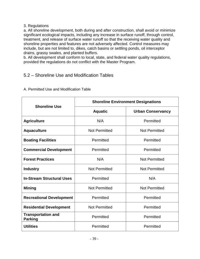
- 39 -
3. Regulationsa. All shoreline development, both during and after construction, shall avoid or minimizesignificant ecological impacts, including any increase in surface runoff, through control,treatment, and release of surface water runoff so that the receiving water quality andshoreline properties and features are not adversely affected. Control measures mayinclude, but are not limited to, dikes, catch basins or settling ponds, oil interceptordrains, grassy swales, and planted buffers.b. All development shall conform to local, state, and federal water quality regulations,provided the regulations do not conflict with the Master Program.
5.2 – Shoreline Use and Modification Tables
A. Permitted Use and Modification Table
Shoreline UseShoreline Environment Designations
Aquatic Urban Conservancy
Agriculture N/A Permitted
Aquaculture Not Permitted Not Permitted
Boating Facilities Permitted Permitted
Commercial Development Permitted Permitted
Forest Practices N/A Not Permitted
Industry Not Permitted Not Permitted
In-Stream Structural Uses Permitted N/A
Mining Not Permitted Not Permitted
Recreational Development Permitted Permitted
Residential Development Not Permitted Permitted
Transportation andParking
Permitted Permitted
Utilities Permitted Permitted

- 40 -
B. Shoreline Modification Table
Shoreline ModificationsShoreline Environment Designations
Aquatic Urban Conservancy
Piers and Docks Permitted Permitted
Shoreline Stabilization Conditional Permitted
Fill Conditional Conditional
Breakwaters, Jetties andWeirs
Conditional Not Applicable
Dredging Conditional Not Applicable
Dredge Material Disposal Not Permitted Conditional
Enhancement Projects Permitted Permitted
- 41 -
5.3 – Specific Shoreline Use Policies and Regulations
A. Introduction
Shoreline use activities are developments or activities that exist or are anticipated tooccupy shoreline locations. Regulations are developed on the premise that allappropriate shoreline uses require some degree of control to minimize adverse effectsto the shoreline environment and adjoining properties. Each proposed developmentwithin the Shoreline Management Act’s jurisdiction will be evaluated to determine itsconformance with the use activity policies and regulations, as well as the ShorelineManagement Element goals and policies, the SMA, and the SMP.Even uses and activities that are exempt from the requirements for a shorelinesubstantial development permit must be consistent with the policies and regulations ofthe SMP, the SMA, and its provisions.
B. Prohibited Uses
The following uses are prohibited in all shoreline environments unless addressedseparately in this shoreline master program under another use.
1. Aquaculture. There are no aquaculture activities in the SMZ. Per zoning regulationson the lands within the SMZ, aquaculture is not a permitted use, therefore aquacultureis not allowed in the SMZ;2. Mining. There are no mining activities or mining lands in the SMZ, therefore mining isnot allowed in the SMZ;3. Forest Practices. There are no forestry lands in the SMZ, therefore forest practicesare not allowed in the SMZ; and4. Industrial development. There is no industrially zoned property in the SMZ, thereforethere are no industrial activities allowed in the SMZ.
C. Agriculture
1. Applicabilitya. Agriculture includes, but is not limited to, the production of horticultural, vinicultural,floricultural, livestock, dairy, apiary, vegetable, or animal products or of berries, grain,hay, straw, turf, seed, or Christmas trees; the operation and maintenance of farm andstock ponds, drainage ditches, or irrigation systems; normal crop rotation and cropchange; and the normal maintenance and repair of existing structures, facilities, andlands currently under production or cultivation. Excluded are agricultural processingindustries.b. Uses and shoreline modifications associated with agriculture that are identified asseparate use activities in this program, such as industry, shoreline stabilization, andflood risk management, are subject to the regulations established for those uses inaddition to the standards established in this section.

- 42 -
c. new agricultural uses shall be located and designed to assure no net loss ofecological functions and not have a significant adverse impact on other shorelineresources and values.d. Conversion of agricultural land to non-agricultural uses is consistent with theenvironment designation, and regulations applicable to the proposed use do not resultin a net loss of ecological functions.
2. Policiesa. A vegetative buffer should be maintained between agricultural lands and waterbodies or wetlands in order to reduce harmful bank erosion and resulting sedimentation,enhance water quality, reduce flood risk, and maintain habitat for fish and wildlife.b. Animal feeding operations, retention and storage ponds associated with agriculturalactivities, and feedlot waste and manure storage should be located out of the SMZ andconstructed to prevent contamination of water bodies and degradation of the adjacentshoreline environment.c. Appropriate farm management techniques and new development construction shouldbe utilized to prevent contamination of nearby water bodies and adverse effects onvaluable plant, fish, and animal life from fertilizer and pesticide use and application.d. Where ecological functions have been degraded, new development should beconditioned with the requirement for ecological restoration.
3. Regulationsa. Agricultural uses are allowed in the Urban Conservancy environment as a permitteduse.b. Agricultural development shall conform to applicable state and federal policies andregulations, provided they are consistent with the Shoreline Management Act and thisMaster Program.c. New manure lagoons, confinement lots, feeding operations, lot wastes, stockpiles ofmanure solids, aerial spraying, and storage of noxious chemicals are prohibited withinthe SMZ.d. A buffer of natural or planted native vegetation shall be maintained between areas ofnew development for crops, grazing, or other agricultural activity and adjacent waters,channel migration zones, and wetlands. The City’s critical areas regulations (AppendixC) will be used to determine the extent and composition of the buffer when theapplication for a permit or letter of exemption is submitted.e. Stream banks and water bodies shall be protected from damage due to concentrationand overgrazing of livestock by providing the following:i. Suitable bridges, culverts, or ramps for stock crossing.ii. Ample supplies of clean fresh water in tanks on dry land for stock watering.iii. Fencing or other grazing controls to prevent bank compaction, bank erosion, or theovergrazing of or damage to buffer vegetation.f. Agricultural practices shall prevent and control erosion of soils and bank materialswithin shoreline areas and minimize siltation, turbidity, pollution, and otherenvironmental degradation of watercourses and wetlands.g. Agricultural chemicals shall be applied in a manner that prevents the direct runoff ofchemical-laden waters into water bodies or aquifer recharge areas.
- 43 -
h. The creation of new agricultural lands by diking, draining, or filling channel migrationzones and associated wetlands shall be prohibited.i. Development on agricultural land that does not meet the definition of agriculturalactivities and the conversion of agricultural land to nonagricultural uses, shall beconsistent with the environment designation, and the general and specific useregulations applicable to the proposed use and do not result in a net loss of ecologicalfunctions associated with the shoreline per WAC 173-26-241(3)(a)(iv).
D. Boating Facilities
1. Applicabilitya. Existing boat launches and future piers, docks and boat launches.b. For the purposes of this section, the term “boating facilities” excludes docks servingfour or fewer single-family residences. Shoreline master programs shall containprovisions to assure no net loss of ecological functions as a result of development ofboating facilities while providing the boating public recreational opportunities on watersof the state.
2. Policiesa. Boating facilities should be located only at sites with suitable environmentalconditions, shoreline configuration, access, and neighboring uses.b. Boating facilities should meet health, safety, and welfare requirements.c. Boating facilities should be sited and designed to avoid or minimize potentiallysignificant ecological impacts, including impacts on sediment movement, watercirculation and quality, and fish and wildlife habitat.d. The proposed size of the structure and intensity of use or uses of any boating facilityshould be compatible with the surrounding environment and land and water uses.e. Signage in the Aquatic Designation should be limited non-commercial, directionaltype signs.f. Public access is required for new boating facilities.
3. Regulationsa. Proposals for boating facilities shall include, at a minimum, the following information:i. Description of the proposed structure, including its size, location, design, and anyshoreline stabilization or other modification required by the project;ii. Ownership of shorelands and/or bedlands;iii. Proposed location of piers or docks relative to property lines and the OHWM; andiv. Location, width, height, and length of piers or docks on adjacent properties within300 feet.b. Piers and docks shall not be allowed in critical freshwater aquatic habitats, unless itcan be established that the dock or pier project, including auxiliary impacts andestablished mitigation measures, will not be detrimental to the natural habitat or speciesof concern, and will not result in loss of ecological function.c. Regulations specific to piers and docks are found in Section 5.4(D) of this chapter.d. Boating facilities may not be used for extended moorage and/or live aboard vessels.e. Boating facilities shall not significantly interfere with use of navigable waters.
- 44 -
f. Boating facilities shall be allowed only for water-dependent uses or public access.g. Boating facilities shall use construction techniques and be constructed of materialsand use coatings that conform to best management practices for the situation asrecommended by the appropriate state and federal agencies, as well as conform to Citybuilding codes.h. All boating facilities shall be maintained in a safe and sound condition so as to notconstitute a hazard to the public.i. Pilings employed shall be installed so that the top elevation is at least one foot aboveextreme high water.j. When potentially toxic or hazardous materials are used in boating facilitiesconstruction, precautions shall be taken to ensure their containment.k. Signs on boating facilities shall be limited to water craft navigation information anddirectional and/or public safety information.l. Lighting shall be the minimum necessary to locate the boating facilities at night. Lightsshall be directed to prevent light spillage onto water surfaces.m. No boating facilities shall be designed or constructed without consulting with all localflood risk reduction authorities.m. Permit applications for boating facilities shall demonstrate that no increase inpotential flood damage would result from construction, use, or maintenance of theproposed structures, including during seasonal changes in stream flow.n. No boating facilities proposed on beds or shores owned by the State of Washingtonshall be designed or constructed without prior authorization of the Department ofNatural Resources, which is the leasing authority. (RCW 79.105.210)o. All boating facilities must comply with the Clean Water Act and the EndangeredSpecies Act.
E. Commercial Development
1. Applicabilitya. Commercial development means those uses that are involved in business tradeincluding, but are not limited to, occupied building space used for the conducting ofretail, office, artisan, restaurant, lodging, childcare, professional business, governmentservices, entertainment, and privately operated recreational uses.b. Because current access to the Skagit River within Sedro-Woolley is publicly owned,commercial activities on the water may include public-private partnerships between thepublic entity and private commercial entity.c. At the time of adoption of the SMP, existing commercial uses in the SMZ consist ofnon-water-oriented uses.d. Piers and docks, bulkheads, shoreline stabilization, flood risk managementmeasures, and other shoreline modifications are sometimes associated with commercialdevelopment and are subject to shoreline modification regulations, in addition to thestandards for commercial development established herein.e. Temporary activities such as events, fairs and shows (and activities associated withsuch events) are not considered commercial development for the purposes of thissection.

- 45 -
2. Policiesa. New commercial development, either private of public/private partnerships, onshorelines should be reviewed and permitted by the City of Sedro-Woolley.b. Commercial development should be encouraged to utilize existing transportationcorridors and minimize the number of ingress/egress points. Ingress/egress should bedesigned to minimize potential conflicts with and impact on regular corridor traffic.c. Multiple use concepts, which include open space and recreation, should beencouraged in commercial developments.d. Commercial development should be visually compatible with the surrounding area.e. Preference should be given first to water-dependent uses, then to water-orientedcommercial uses.
3. Regulationsa. The Planning Department shall require and utilize the following information in itsreview of commercial development proposals:i. The nature of the commercial activity (e.g., water-dependent, water-related, water-enjoyment, non-water-oriented), including an accounting of specific shoreline usecomponents;ii. The economic and land use justification for a shoreline location;iii. Design measures to take advantage of the proposed location;iv. Provisions for public visual and/or physical access to the shoreline;v. Provisions to ensure that the development will not cause significant adverseenvironmental impacts;vi. Layout, size, height, materials, colors, and general appearance, including massing,bulk, and relative scale of all proposed structures; andvii. Pedestrian and vehicular circulation, public access, site furniture and other features,such as pavement, landscaping, view corridors.b. Non-water-oriented commercial developments shall be permitted in accordance withthe provisions of the Master Program, where at least two of the following three criteriaare satisfied:i. A water-oriented use is not reasonably expected to locate on the proposed site due totopography, applicable zoning code restrictions, incompatible surrounding land uses,physical features, or the site’s separation from the water;ii. The proposed development does not displace existing, authorized water-orienteduses;iii. The proposed development will be of appreciable public benefit by improving orproviding public use, enjoyment, or access to the shoreline.c. Commercial development shall be designed to avoid or minimize ecological impacts,to protect human health and safety, and to avoid significant adverse impacts tosurrounding uses and the area’s visual qualities. To this end, the Planning Departmentmay adjust the project dimensions and/or prescribe operation intensity and screeningstandards as deemed appropriate. Need and special considerations for landscaping andbuffer areas shall also be subject to review.d. Non-water-dependent commercial development shall be required to provide physicalor visual access to the shoreline or other opportunities for the public to enjoy theshorelines of the state.

- 46 -
e. All new commercial development and redevelopment proposals will be reviewed bythe Planning Department for ecological restoration and public access opportunitieswhere practical and feasible. When restoration and/or public access plans indicateopportunities exist, the Planning Department may require that those opportunities areeither implemented as part of the development project or that the project design bealtered so that those opportunities are not diminished.f. All commercial loading and service areas shall be located on the upland side of thecommercial activities, or provisions must be made to set back and screen the loadingand service area from the shoreline and water body.
F. In-Stream Structures
1. Applicabilitya. In-stream structures are constructed waterward of the OHWM and either cause orhave the potential to cause water impoundment or diversion, obstruction, or modificationof water flow.b. In-stream structures may include those for hydroelectric generation, irrigation, watersupply, flood risk reduction, transportation, utility service transmission, fish habitatenhancement, or other purpose. (WAC 173-26-241(3)(g))c. This section is applicable to both the structures themselves and their support facilitiesand applies to their construction, operation, and maintenance, as well as the expansionof existing structures and facilities.
2. PoliciesIn-stream structures should provide for the protection, preservation, and restoration ofecosystem-wide processes, ecological functions, and cultural resources, including, butnot limited to, fish and fish passage, wildlife and water resources, hydrogeologicprocesses, and natural scenic vistas.
3. Regulationsa. Unless specifically allowed elsewhere in the SMP, in-stream structures are permittedonly for the purposes of environmental restoration and bridge maintenance.b. In-stream structures may be required to provide public access, if public accessimprovements do not create significant ecological impacts or other adverseenvironmental impacts to and along the affected shoreline or create a safety hazard tothe public.c. Public access provisions shall include, but not be limited to, any combination of trails,vistas, parking, and any necessary sanitation facilities.d. In-stream structures shall be designed and constructed to protect and preserveecosystem-wide processes, ecological functions, and cultural resources, including, fishand fish passage, wildlife and water resources, hydrogeologic processes, and naturalscenic vistas.
- 47 -
G. Recreational Development
1. Applicabilitya. Recreational development includes public and private (commercial) facilities forpassive recreational activities such as hiking, fishing, photography, viewing, and bird-watching. It also includes facilities for active or more intensive uses, such as parks withsports facilities, and other outdoor recreation areas.b. This section applies to both public and privately-owned shoreline facilities intendedfor use by the public or private club, group, association or individual.
2. Policiesa. Shoreline recreational development should be given priority and should be primarilyrelated to access, enjoyment, and use of the water and shorelines.b. Recreational developments and plans should promote the primacy of preserving thenatural character, resources, and ecological functions and processes of shorelineenvironments.c. A variety of compatible recreational experiences and activities should be encouragedto satisfy diverse recreational needs.d. Water-dependent recreational uses (such as fishing and boating) and water-enjoyment uses (such as viewing and picnicking) should have priority over non-water-oriented recreational uses, such as baseball or soccer.e. The linkage of shoreline parks, recreation areas, and public access points with linearsystems, such as hiking trails, bicycle paths, and easements should be encouraged.f. Recreational facilities should be integrated with public access systems.g. Due to steep banks and swift currents in the stretch of the Skagit River in Sedro-Woolley, in-water recreation such as swimming and wading should be discouraged.
3. Regulationsa. Non-water-oriented recreational developments may be permitted only where it can bedemonstrated that:i. A water-oriented use is not reasonably expected to locate on the proposed site due totopography and/or other physical features, surrounding land uses, or the site’sseparation from the water.ii. The proposed use does not usurp or displace land currently occupied by a water-oriented use and will not interfere with adjacent water-oriented uses.iii. The proposed use will be of appreciable public benefit by maintaining ecologicalfunctions together with public use, enjoyment, or access to the shoreline.b. Accessory structures and parking associated with recreational uses shall not belocated in the SMZ unless the City determines there is no other practical option.c. All new recreational development proposals will be reviewed by the City for ecologicalrestoration and public access opportunities. When restoration and/or public accessplans indicate opportunities exist, the City may require that those opportunities areeither implemented as part of the development project or that the project design bealtered so that those opportunities are not diminished.

- 48 -
d. All new non-water-oriented recreational development, where allowed, shall beconditioned with the requirement to provide public access and ecological restorationwhere practical.e. Recreation facilities shall demonstrate that they are located, designed and operatedin a manner consistent with the purpose of the environmental designation in which theyare located and will result in no net loss of shoreline ecological functions or ecosystem-wide processes (WAC 173-26-241(3)(i)).
H. Residential Development
1. Applicabilitya. The Shoreline Management Act identifies single-family residences as a priority usewhen (and only when) developed in a manner consistent with the control of pollutionand prevention of damage to the natural environment. Although some owner-occupied,single-family residences are exempt from the substantial development permit process,they still must comply with all of the provisions of the Master Program. Subdivisions andshort subdivisions must also comply with all of the provisions of this section and theMaster Program. All development is subject to the variance and conditional userequirements and permit processes, when indicated.b. Existing single-family residential development along the shoreline is limited in extent..
2. Policiesa. Recognizing the single-purpose, irreversible, and space-consumptive nature ofsingle-family, detached residential development in the SMZ, new development of thistype should provide adequate setbacks and natural buffers from the water and ampleopen space between structures to provide space for outdoor recreation, to protect andrestore ecological functions and ecosystem-wide processes where feasible, to preserveviews, and to minimize use conflicts.b. New residential development should be designed so as to not cause significantecological impacts or significant adverse impacts to shoreline characteristics, publicaccess and views, and to improve public use of the shoreline and the water.c. Multi-family and single-family attached residential development should be designed totake advantage of public access opportunities to the shoreline, including joint use forcommunity recreation facilities, provided such access does not conflict with residentialprivacy, and does not present a life safety or security issue.d. Access, utilities, and public services shall be available and adequate to serve existingneeds and/or planned future development.
3. Regulationsa. Over-water residences and floating homes are prohibited.b. Multi-family and single-family attached residential uses are allowed where identifiedas permitted uses in the underlying zoning district. Community and/or public accessshall be provided for new multi-family residential development and for subdivision ofland for more than four parcels consistent with the Public Access section of this MasterProgram.

- 49 -
c. The creation of new lots shall be prohibited unless all of the following can bedemonstrated.i. A primary residence can be built on each new lot without any of the following beingnecessary:
a.) New structural shoreline stabilization;b.) New structures in the required shoreline setback, geologically hazardous
areas, wetland, required wetland buffer, critical habitat, or critical habitat buffer;c.) Causing significant erosion or reduction in slope stability; andd.) Causing increased flood risk or erosion in the new development or to other
properties.ii. Adequate sewer, water, access, and utilities can be provided.iii. The intensity and type of development is consistent with the Comprehensive Planand development regulations.iv. Potential significant adverse environmental impacts (including significant ecologicalimpacts) can be avoided or mitigated to achieve no net loss of ecological functions.
I. Transportation Facilities
1. Applicabilitya. Transportation facilities are those structures and developments that aid in land andwater surface movement of people, goods, and services. They include roads andhighways, bridges and causeways, bikeways, trails, and railroad facilities.b. The policies and regulations identified in this section pertain to any project, within anyenvironment, that proposes to change existing transportation facilities or introduce newsuch facilities.
2. Policiesa. Circulation routes to and on shorelands should include systems for pedestrian,bicycle, and public transportation where appropriate.b. Circulation systems should support existing and proposed shoreline uses that areconsistent with the Master Program.c. Trail and bicycle paths should be encouraged along shorelines and should beconstructed in a manner compatible with the natural character, resources, and ecologyof the shoreline.d. When existing transportation corridors are abandoned, they should be reused forwater-dependent use or public access.e. Abandoned or unused road or railroad rights-of-way that offer opportunities for publicaccess to the water should be acquired and/or retained for such use.
3. Regulationsa. Applications for redevelopment of transportation facilities in the SMZ shall include thefollowing information:i. Demonstration of the need for the facility.ii. An analysis of alternative alignments or routes including, where feasible, alignmentsor routes outside the SMZ.

- 50 -
iii. An analysis of potential impacts complying with the State Environmental Policy Act,including an analysis of comparative impacts of feasible alternative routes.iv. Description of construction, including location, construction type, and materials.v. If needed, description of mitigation and restoration measures.b. All new and expanded transportation facilities development shall be conditioned withthe requirement to mitigate significant adverse impacts consistent with this MasterProgram.c. All redeveloped transportation facilities in the SMZ shall be consistent with theComprehensive Plan and applicable Capital Improvement Plans.d. Redeveloped transportation facilities shall include provisions for pedestrian, bicycle,and public transportation where appropriate as determined by the City.e. Circulation planning and projects shall support existing and proposed shoreline usesthat are consistent with the Master Program.f. Redeveloped transportation facilities shall not diminish, but may modify public accessto the shoreline.g. Parking is only allowed in support of an allowed use.
J. Utilities
1. Applicabilitya. Utilities are services and facilities that produce, transmit, carry, store, process, ordispose of electric power, natural gas, water, sewage, solid waste, telecommunications,etc.b. The provisions in this section apply to primary uses and activities, such as solidwaste handling and disposal, sewage treatment plants and outfalls, public high tensionutility lines on public property or easements, power generating or transfer facilities, gasdistribution lines and storage facilities, and wireless telecommunications.
2. Policiesa. New utility facilities should be located so as not to require extensive shorelineprotection works.b. Utility facilities and corridors should be located so as to protect scenic views.Whenever possible, such facilities should be placed underground or alongside or underbridges.c. Utility facilities and rights-of-way should be designed to preserve the naturallandscape and to minimize conflicts with present and planned land uses.
3. Regulationsa. Applications for new or expanded utility facility development in areas of shorelinejurisdiction shall include the following:i. Demonstration of the need for the facility;ii. An analysis of alternative alignments or routes including, where feasible, alignmentsor routes outside the SMZ;iii. An analysis of potential impacts complying with the State Environmental Policy Act,including an analysis of comparative impacts of feasible alternative routes or locations;iv. Description of construction, including location, construction type, and materials;
- 51 -
v. Location of other utility facilities in the vicinity of the proposed project and plans toinclude the facilities of other types of utilities in the project;vi. Plans for reclamation of areas disturbed during construction;vii. Plans for control of erosion and turbidity during construction and operation; andviii. Identification of potential for locating the proposed facility at an existing utility facilitysite or within an existing utility right-of-way.b. All utility facilities shall be designed and located to minimize harm to shorelineecological functions, preserve the natural landscape, and minimize conflicts withpresent and planned land and shoreline uses while meeting the needs of futurepopulations in areas planned to accommodate growth. The Planning Department mayrequire the relocation or redesign of proposed utility development in order to ensure nonet loss of ecological functions.c. Transmission facilities for the conveyance of services, such as power lines, cables,and pipelines, shall be located to cause minimum harm to the shoreline and shall belocated outside of the SMZ where feasible.d. Utilities should be located in existing rights-of-way and corridors whenever possible.e. Restoration of ecological functions shall be a condition of new and expanded non-water-dependent utility facilities.f. Utility development shall, through coordination with local government agencies,provide for compatible, multiple use of sites and rights-of-way. Such uses includeshoreline access points, trail systems, and other forms of recreation and transportation,providing such uses will not unduly interfere with utility operations, endanger publichealth and safety, or create a significant and disproportionate liability for the owner.g. Existing above-ground lines shall be moved underground during normal replacementprocesses.h. Transmission and distribution facilities shall cross areas of shoreline jurisdiction bythe shortest, most direct route feasible, unless such route would cause significantenvironmental damage.i. Clearing of vegetation for the installation or maintenance of utilities shall be kept to aminimum and upon project completion any disturbed areas shall be restored to theirpre-project condition or better.j. Wireless telecommunication towers, such as radio and cell phone towers, arespecifically prohibited in the SMZ.

- 52 -
5.4 Shoreline Modification Provisions
A. Introduction
1. Shoreline modifications are actions that modify the physical configuration or qualitiesof the shoreline area. They are typically construction activities such as building a dike ordredging a basin, but they can include other actions such as clearing, grading, orapplication of chemicals.2. Shoreline modifications are undertaken in support of or in preparation for shorelineuses. Shoreline uses generally are ongoing and the policies and regulations related tothem must deal with functional relationships inherent in the individual uses, and pertainto long term management. Modifications represent a physical alteration of the shorelineso the regulations related to them must deal with more immediate, time-limited physicalimpacts. Shoreline modifications usually are undertaken in support of or in preparationfor a shoreline use; for example, fill (shoreline modification) required for a cargo terminal(industrial use) or dredging (shoreline modification) to allow for a marina (boating facilityuse). Generally, shoreline modification activities are undertaken for the followingreasons:a. To prepare a site for a shoreline useb. To provide shoreline stabilization or shoreline protectionc. To support developed upland areas3. The policies and regulations in this section are intended to prevent or mitigate theadverse environmental impacts of proposed shoreline modifications. Generalprovisions, which apply to all shoreline modification activities, are followed by provisionstailored to specific shoreline modification activities. This chapter provides policies andregulations that apply to all shoreline modifications within shoreline jurisdiction includingshoreline stabilization measures, piers and docks, fill, breakwaters, jetties and weirs,dredging and dredging material disposal and SMZ.
B. General Policies and Regulations
1. ApplicabilityThe following provisions apply to all shoreline modification activities, whether suchproposals address a single property or multiple properties.
2. Policiesa. Structural shoreline modifications should be limited in number and extent and allowedonly where they are demonstrated to be necessary to support or protect an allowedprimary structure or existing development and uses that are in danger of loss orsubstantial damage or are necessary for reconfiguration of the shoreline for mitigationor enhancement purposes.b. The Planning Department should ensure that shoreline modifications individually andcumulatively do not result in a net loss of ecological functions. This is to be achieved bygiving preference to those types of shoreline modifications that have a lesser impact on

- 53 -
ecological functions and by requiring mitigation of identified impacts resulting fromshoreline modifications.c. Where applicable, the Planning Department should require provisions be based on“best available science,” scientific and technical information, and a comprehensiveanalysis of site specific conditions for river and stream systems.d. Ecological functions impaired by development activities should be enhanced and/orrestored where feasible and appropriate while accommodating permitted uses. Asshoreline modifications occur, the Planning Department should incorporate all feasiblemeasures to protect ecological shoreline functions and ecosystem-wide processes.e. When shoreline modifications are necessary, they should be as compatible aspossible with ecological shoreline processes and functions.
3. Regulationsa. In reviewing shoreline permits, the Planning Department shall require steps to reducesignificant ecological impacts according to the mitigation sequence in WAC 173-26-201(2)(e) (Environmental Impact Mitigation).b. In areas where the river system is not constrained by existing flood risk reductionstructures, structural shoreline modification measures shall be permitted only ifnonstructural measures are unable to achieve the same purpose. Nonstructuralmeasures considered shall include alternative site designs, increased setbacks,drainage improvements, relocation, and vegetation enhancement.c. Proponents of shoreline modification projects shall obtain all applicable federal andstate permits and shall meet all permit requirements.d. In addition to the permit information required by WAC 173-27-190 (Permits forSubstantial Development, Conditional Use, or Variance), the City shall require andconsider the following information when reviewing shoreline modification proposals:i. Construction materials and methods;ii. Project location relative to the ordinary high water mark;iii. General direction and speed of prevailing winds;iv. Profile rendition of beach and uplands;v. Upland soil type, slope, and material;vi. Physical or geologic stability of uplands; andvii. Potential impact to natural shoreline processes, adjacent properties, and uplandstability.e. Shoreline modification materials shall be only those approved by applicable stateagencies. No toxic (e.g. creosote) or quickly degradable materials, or those thatdeteriorate under ultraviolet exposure (plastic or fiberglass) shall be used.f. Only shoreline activities that are appropriate to the specific type of shoreline andenvironmental conditions for which they are proposed shall be allowed.

- 54 -
C. Shoreline Stabilization
1. Applicabilitya. Shoreline stabilization includes actions taken to address erosion impacts to property,dwellings, or essential structures caused by natural processes, such as current, flood,wind, or wave action. These include both nonstructural and structural methods.b. Nonstructural methods include building setbacks, relocation of the structure to beprotected, groundwater management, and planning and regulatory measures to avoidthe need for structural stabilization.c. New stabilization measures include the enlargement of existing stabilizationstructures. WAC 173-27-040(2)(b) (Developments Exempt from SubstantialDevelopment Permit Requirement) defines normal replacement and repair of existingstructures and notes that normal maintenance and repair actions are not exempt fromsubstantial development permits if they are anticipated to “cause substantial adverseeffects to shoreline resources or the environment.”
2. Policiesa. Shoreline stabilization and flood risk management measures would be allowed onlywhen adequate evidence is presented that one of the following conditions exist:i. High water or erosion threatens public works and properties, including roads, bridges,railroads, and utility systems.ii. High water or significant erosion damages or threatens existing homes and residentialareas.iii. High water or significant erosion damages or threatens to damage existingcommercial and industrial uses and developments.b. Dikes, levees, revetments and other flood risk reduction structures should be theminimum size necessary and be designed and constructed primarily as a means tominimize damage to existing development.c. Ensure that publicly financed or subsidized shoreline erosion control measures do notrestrict appropriate public access to the shoreline except where such access isdetermined to be infeasible because of incompatible uses, safety, security, or harm toecological functions.d. Structural or “hard” shoreline stabilization techniques and structures should beallowed only after it is demonstrated that non-structural or “soft” shoreline protectionmeasures are not feasible.e. New development (including newly created parcels) is to be designed and located toprevent the need for future shoreline stabilization, based upon geotechnical analysis.f. Impacts to sediment transport should be avoided or minimized.
3. Regulationsa. Shoreline stabilization measures along the shoreline that incorporate ecologicalrestoration through the placement of rocks, gravel or sand and native shorelinevegetation may be allowed.b. New or enlarged structural shoreline stabilization measures for an existingdevelopment shall not be allowed unless there is conclusive evidence, documented by ageotechnical analysis that the structure is in danger from shoreline erosion. The

- 55 -
geotechnical report must include estimates of erosion rates and damage within threeyears and must evaluate on-site drainage issues and address drainage problems awayfrom the shoreline edge before considering structural shoreline stabilization. The projectdesign and analysis must also evaluate vegetation enhancement as a means ofreducing erosion and promoting bank stability. The report must demonstrate that “soft”shoreline protection measures or bioengineering erosion control designs will not provideadequate upland protection of existing structures or would pose a threat or risk toadjacent property.c. An existing shoreline stabilization structure shall not be replaced with a similarstructure unless there is need to protect primary structures from erosion caused bycurrents or waves. At the discretion of the City Engineer, the demonstration of needdoes not necessarily require a geotechnical report by a licensed geotechnical engineeror related licensed professional. The replacement structure shall be designed, located,sized, and constructed to minimize harm to ecological functions. Replacement walls orbulkheads shall not encroach waterward of the OHWM or existing structures unless theresidence was occupied prior to January 1, 1992 and there are overriding safety orenvironmental concerns. In such cases, the replacement structure shall abut theexisting shoreline stabilization structure and be the minimum size necessary. Softshoreline stabilization that restores ecological functions may be permitted waterward ofthe OHWM.d. Provided that regulation #3c above has been met, the replacement of lawfullyestablished, existing bulkheads or revetments shall be allowed, subject to the followingpriority system:i. First priority. The first priority for replacement of bulkheads or revetments shall be toinstall “soft” shoreline protection measures or bioengineering erosion control designs.ii. Second priority. The second priority for replacement of existing bulkheads orrevetments shall be to install “hard” shoreline protection measures only when “soft”measures would not provide adequate upland protection of existing structures or wouldpose a threat or risk to adjacent property.iii. Third priority. The third priority for replacement of bulkheads or revetments shall belandward of the existing bulkhead.iv. Fourth Priority. The fourth priority for replacement of existing bulkheads orrevetments shall be to replace in place (at the bulkhead’s existing location).v. Fifth Priority. The fifth and last priority for replacement of existing bulkheads shall bea one-time replacement no greater than three feet waterward of the existing bulkhead.Under this fifth priority, documentation must be provided that habitat will not beadversely impacted and habitat friendly materials shall be used. The property ownershall also demonstrate that removing the existing structure would either causeirreversible environmental damages, or undermine and damage the residential structureon the property.e. When evaluating a proposal against the above priority system, at a minimum thefollowing criteria shall be considered:i. Existing topography;ii. Existing development;iii. Location of abutting bulkheads; andiv. Impact to habitat.
- 56 -
g. Whenever feasible, trees and vegetation shading streams and rivers shall be retainedwhen riprap is placed.h. No work may commence without the responsible person or agency having obtainedeither a shoreline permit or statement of exemption from the Planning Department.i. Flood risk reduction structures shall conform to all City, state, and federal policies andregulations including the U.S. Army Corps of Engineers criteria for design.j. Bulkheads or revetments shall be designed, constructed and maintained in a mannerthat does not degrade ecological function including fish habitat, and shall conform to therequirements of the Washington State Department of Fish and Wildlife criteria andguidelines.k. The City may require and utilize the following information, in addition to the standardpermit information required by WAC 173-27 (Shoreline Management Permit andEnforcement Procedures), in its review of all bioengineering projects:i. Proposed construction timing;ii. Hydrologic analysis, including predicted flood flows;iii. Site vegetation, soil types, and slope stability analysis;iv. Proposed project materials, including rock size, shape, and quantity; plant types; andsoil preparation;v. Existing and proposed slope profiles, including location of OHWM;vi. Proposed designs for transition areas between the project site and adjacentproperties; andvii. Documentation (including photographs) of existing (preconstruction) shorelinecharacteristics.l. Bioengineering projects shall use native trees, shrubs, and/or grasses, unless such anapproach is infeasible.m. All bioengineering projects shall include a program for monitoring and maintenance.n. No structures will be permitted or constructed without consulting with all local floodagencies (i.e. City of Sedro-Woolley, Dike Districts, and Skagit County).
D. Piers and Docks
1. Applicabilitya. Piers are built on fixed platforms above the water, while docks float upon the water.b. The beds and shores (aquatic lands) of all navigable waters in the state, except thosesold according to law, are under the ownership of the State of Washington. Priorauthorization for their use must be obtained from the Department of Natural Resources.
2. Policiesa. Pier and dock construction should be restricted to the minimum size necessary tomeet the needs of the proposed use.b. Multiple-use and expansion of legally existing piers, wharves, and docks should beencouraged over the addition of new facilities. Joint-use facilities are preferred over newsingle-use piers, docks, and floats.c. Piers and docks should be sited and designed to avoid or minimize potentiallysignificant ecological impacts, including impacts on sediment movement, watercirculation and quality, and fish and wildlife habitat.
- 57 -
d. The proposed size of the structure and intensity of use or uses of any pier or dockshould be compatible with the surrounding environment and land and water uses.
3. Regulationsa. Proposals for piers or docks shall include, at a minimum, the following information:i. Description of the proposed structure, including its size, location, design, and anyshoreline stabilization or other modification required by the project;ii. Ownership of shorelands and/or bedlands;iii. Proposed location of piers or docks relative to property lines and the OHWM; andiv. Location, width, height, and length of piers or docks on adjacent properties within300 feet.b. Piers and docks shall not be allowed in critical freshwater aquatic habitats, unless itcan be established that the dock or pier project, including auxiliary impacts andestablished mitigation measures, will not be detrimental to the natural habitat or speciesof concern, and will not result in loss of ecological function.c. Piers and docks shall not significantly interfere with use of navigable waters.d. Boating facilities may not be used for extended moorage and/or live aboard vessels.e. The length of piers and docks shall be limited in constricted water bodies to assurenavigability and protect public use of the river. The Planning Department may requirereconfiguration of pier and dock proposals, where necessary, to protect navigation,public use, or ecological functions.f. New piers and docks shall be allowed only for water-dependent uses or public access.Water-related and water-enjoyment uses may be allowed as part of mixed-usedevelopment on over-water structures where they are clearly auxiliary to and in supportof water-dependent uses, provided the minimum size requirement needed to meet thewater-dependent use is not violated. New pier or dock construction shall be permittedonly when the applicant has demonstrated that a specific need exists to support theintended water-dependent uses.g. New residential development of more than two dwellings shall provide joint use orcommunity docks, rather than individual docks.h. Piers and docks shall use construction techniques and be constructed of materialsand use coatings that conform to best management practices for the situation asrecommended by the appropriate state and federal agencies, as well as conform to Citybuilding codes.i. All piers and docks shall be maintained in a safe and sound condition so as to notconstitute a hazard to the public.j. Abandoned or unsafe piers and docks shall be removed or repaired promptly by theowner. No over-water field applications of paint, preservative treatment, or otherchemical compounds shall be permitted, except in accordance with best managementpractices set forth by applicable state agencies.j. Pilings employed shall be installed so that the top elevation is at least one foot aboveextreme high water.k. When potentially toxic or hazardous materials are used in pier or dock construction,precautions shall be taken to ensure their containment.l. Overhead wiring or plumbing is not permitted on piers or docks.

- 58 -
m. Lighting shall be the minimum necessary to locate the dock at night. Lights shall bedirected to prevent light spillage onto water surfaces.n. Other than safety railings and safety equipment and lighting, no structures areallowed on over-water portions of piers and docks.o. No piers or docks shall be designed or constructed without consulting with all localflood risk reduction authorities (City of Sedro-Woolley, Dike Districts, and SkagitCounty).p. Permit applications for new piers or docks shall demonstrate that no increase inpotential flood damage would result from construction, use, or maintenance of theproposed structures, including during seasonal changes in stream flow.q. No piers or docks proposed on beds or shores owned by the State of Washingtonshall be designed or constructed without prior authorization of the Department ofNatural Resources, which is the leasing authority. (RCW 79.105.210)r. All piers and docks must comply with the Clean Water Act and the EndangeredSpecies Act.
E. Fill
1. Applicabilitya. Fill is the addition of soil, sand, rock, gravel, sediment, earth retaining structure, orother material to an area waterward of the OHWM, in wetlands, or on shore lands in amanner that raises the elevation or creates dry land.b. Any fill activity conducted within the SMZ must comply with the provisions herein.
2. PoliciesFills waterward of OHWM should be allowed only when necessary to facilitate water-dependent and/or public access uses, cleanup and disposal of contaminated sediments,consistent with this Master Program.
3. Regulationsa. Applications for fill permits shall include the following:i. Proposed use of the fill area;ii. Physical, chemical and biological characteristics of the fill material;iii. Source of fill material;iv. Method of placement and compaction;v. Location of fill relative to natural and/or existing drainage patterns and wetlands;vi. Location of the fill perimeter relative to the OHWM;vii. Perimeter erosion control or stabilization means; andviii. Type of surfacing and runoff control devices.b. Fill waterward of OHWM may be permitted only when:i. In conjunction with a water-dependent use or public access permitted by this MasterProgram;ii. In conjunction with a bridge or navigational structure for which there is ademonstrated public need and where no feasible upland sites, design solutions, orroutes exist; oriii. As part of an approved shoreline restoration project.

- 59 -
c. Waterward of OHWM, pile or pier supports shall be utilized whenever feasible inpreference to fills. Fills for approved road development in floodways or wetlands shallbe permitted only if pile or pier supports are proven infeasible.d. Fills landward of the OHWM should be allowed as part of the construction andreconstruction of public recreational uses in the Urban Conservancy environment.e. Fills landward of the OHWM should be allowed as part of the construction andreconstruction of dikes, levees, revetments and other flood risk reduction structuresconsistent with plans approved by the Dike District and the City of Sedro-Woolley SMP.f. Fills landward of flood risk reduction measures may be permitted.g. Shoreline fill shall be designed and located so there will be no significant ecologicalimpacts and no alteration of local currents, surface water drainage, channel migration,or flood waters that would result in a hazard to adjacent life, property, and naturalresource systems.h. Environmental cleanup action involving excavation/fill, as part of an interagencyenvironmental clean-up plan, as authorized by the Planning Department, may bepermitted.i. Sanitary fills shall not be located in areas of the SMZ.j. A shoreline conditional use permit is required for fill in the Urban Conservancyshoreline environment. Fill is not permitted in the Aquatic environment.k. Proposed fills on beds and/or shores of navigable waters owned by the State ofWashington shall require prior authorization of the Washington Department of NaturalResources.
F. Breakwaters, Jetties and Weirs
1. Applicabilitya. Jetties are structures that are generally perpendicular to shore extending through orpast the intertidal zone. They are built singly or in pairs at harbor entrances or rivermouths mainly to prevent shoaling or accretion from littoral drift in entrance channels,which may or may not be dredged. Jetties also serve to protect channels from stormwaves or cross currents, and stabilize inlets through barrier beaches.b. Breakwaters are an offshore structure that is generally built parallel to shore that mayor may not be connected to land, and may be floating or stationary. Their primarypurpose is to protect harbors, moorages and navigation activity from wave and windaction by creating stillwater areas along shore. A secondary purpose is to protectshorelines from wave caused erosion.c. Groins are a barrier type structure extending from back shore into the water, thepurpose of which is to interrupt sediment movement along the shore.
2. PoliciesBreakwaters, jetties, groins, and weirs located waterward of the OHWM are allowedonly where necessary to support water-dependent uses, public access, shorelinestabilization, or other specific public purpose, such as fish and wildlife habitatenhancement.

- 60 -
3. Regulationsa. A conditional use permit shall be required, except for those structures installed toprotect or restore ecological functions, such as woody debris installed in streams.b. Breakwaters, jetties, groins, and weirs shall be designed to protect critical areas andshall provide for mitigation according to the sequence defined in WAC 173-26-201(2)(e).
G. Dredging and Dredge Material Disposal
1. ApplicabilityDredging is the removal or displacement of earth or sediment (gravel, sand, mud, siltand/or other material or debris) from a river, stream, or associated wetland.
2. Policiesa. Dredging operations should be planned and conducted to so as to avoid adverseimpacts to other shoreline uses, properties, and values.b. When allowed, dredging and dredge material disposal within the SMZ should belimited to the minimum amount necessary.
3. Regulationsa. Dredging will only be permitted in the following situations:i. In conjunction with a water-dependent use of water bodies or adjacent shorelands.New development siting and design shall avoid the need for new and maintenancedredging; andii. For projects associated with MTCA or CERCLA habitat restoration, oriii. Any other significant restoration effort approved by a shoreline CUP.b. Dredging in wetlands is prohibited unless it is part of an approved habitat restorationor enhancement project.c. Dredged materials must be deposited on an approved upland site.d. Dredging and dredge disposal within the SMZ shall be permitted only where it isdemonstrated that the proposed actions will not:i. Result in significant and/or ongoing damage to water quality, fish, and other essentialaquatic biological elements;ii. Adversely alter natural drainage and circulation patterns, currents, river flows orsignificantly reduce flood water capacities; oriii. Cause other significant adverse ecological impacts.e. Dredging shall utilize techniques that cause minimum dispersal and broadcast ofbottom material.f. When dredging is permitted, the dredging shall be the minimum necessary toaccommodate the proposed use and unavoidable impacts shall be mitigated.g. Permit applications for shoreline dredging and dredge material disposal may berequired to include the following information:i. Physical, chemical, and biological assessment of the proposed dredged materialapplicable to the particular dredging site.ii. Specific data to be considered include:
a) Physical - Grain size, clay, silt, sand, or gravel as determined by sieve analysis;

- 61 -
b) Chemical - Including conventional parameters, metals, and organics;c) Biological - Bioassays to determine the suitability of dredged material for a
selected disposal option;d) Dredging volumes, methods, schedule, frequency, hours of operation and
procedures;e) Method of disposal, including the location, size, capacity, and physical
characteristics of the disposal site, transportation method and routes, hours ofoperation, schedule;
f) Stability of bedlands adjacent to proposed dredging area;g) Hydraulic analyses, including current flows, direction and projected impacts.
Hydraulic modeling studies are required for large scale, extensive dredgingprojects, in order to identify existing hydrological and geological patterns andprobable effects of dredging;
h) Assessment of water quality impacts; andi) Biological assessment including migratory, seasonal, and spawning use areas.
h. New development shall be located and designed to avoid or minimize the need fornew or maintenance dredging where feasible.i. Maintenance dredging of established navigation channels, public access facilities, andbasins is restricted to maintaining previously dredged and/or existing authorizedlocation, depth, and width.j. Dredging of beds or shores of navigable waters owned by the State of Washingtonshall require prior authorization of the Washington Department of Natural Resources.k. Disposal of dredge material in the Urban Conservancy requires a shorelineconditional use permit.
H. Shoreline Habitat and Natural Systems Enhancement Projects
1. Applicabilitya. Shoreline restoration and/or enhancement is the improvement of the naturalcharacter and ecological functions of the shoreline.b. Where appropriate, using native vegetation is encouraged. The materials used aredependent on the intended use of the restored or enhanced shoreline area.c. The Shoreline Restoration Plan (Appendix B) identifies ecological enhancement andrestoration measures.
2. Policiesa. Shoreline enhancement and/or restoration should be considered as an alternative tostructural shoreline stabilization and protection measures where feasible.b. All shoreline restoration and/or enhancement projects should protect the integrity ofadjacent natural resources including aquatic habitats and water quality.c. Where possible, shoreline restoration and/or enhancement should use maintenance-free or low-maintenance designs.d. The recommendations of the Shoreline Restoration Report, prepared as part of theSMP, should be promoted wherever feasible.

- 62 -
e. Shoreline restoration and/or enhancement should not extend waterward more thannecessary to achieve the intended results.
3. Regulationsa. Shoreline enhancement may be permitted if the project proponent demonstrates thatno significant change to sediment transport or river current will result that wouldadversely affect ecological processes, properties, or habitat.b. Shoreline restoration and/or enhancement projects shall use best available scienceand best management practices.c. Shoreline restoration and ecological enhancement projects may be permitted in allshoreline environments, provided:i. The project’s purpose is the restoration of natural character and ecological functionsof the shoreline, andii. It is consistent with the implementation of an approved comprehensive restorationplan, or the project will provide a proven ecological benefit and is consistent with thisMaster Program.d. Shoreline restoration and ecological enhancement must meet the U.S. Army Corps ofEngineers PL8499 flood structure maintenance regulations.

- 63 -
Chapter 6 – Administrative Provisions
A. General
1. All proposed uses and development occurring within the SMZ must conform toChapter 90.58 RCW, the Shoreline Management Act and the provisions of this SMP,whether or not a permit is required.
2. The City will periodically review the cumulative effect of actions taken within theshoreline to ensure that the goal of no net loss of shoreline environmental functionsis being met.
3. “The City,” for the purposes of making administrative decisions and processingpermits as may be required by the SMP, means the Planning Department and itsDirector or Administrator.
4. The process of reviewing proposals shall be designed to assure that regulatory oradministrative actions do not unconstitutionally infringe upon private property rightsin accordance with WAC 173-26-186(5).
5. As per RCW 36.70B.110(11), the City of Sedro-Woolley has adopted procedures foradministrative interpretation of its development regulations (SWMC 2.90.070 andSWMC 17.04.040). Such procedures shall include Shoreline Master Programregulations. Administrative interpretations are Type I processes.
6. Substantial development applications are subject to Type II permit review; shorelineexemptions and substantial development permit revisions are Type I permits; andconditional use permits and variances require Type III review.
7. The regulations of the SMP shall be used in conjunction with the regulationscontained in the Sedro-Woolley Municipal Code (SWMC). Where there is a conflictbetween the SWMC and the SMP, the SMP shall control.
B. SHORELINE SUBSTANTIAL DEVELOPMENT PERMITS1. A shoreline substantial development permit shall be required for projects occurring
within the City’s shoreline jurisdiction pursuant to the requirements and procedurescontained in Chapter 173-27 WAC (Shoreline Management Permit and EnforcementProcedures); except that:
a) A substantial development permit is not required for projects that are belowthe threshold levels established in WAC 173-27-040(2), “DevelopmentsExempt from Substantial Development Permit Requirement,” as follows:
i. Any development of which the total cost or fair market value, whichever ishigher, does not exceed $6,416, if such development does not materiallyinterfere with the normal public use of the water or shorelines of the state.[Note: The State of Washington requires that every five years the dollarthreshold for this exemption be adjusted for inflation by the WashingtonOffice of Financial Management (OFM). The adjustment is based uponchanges in the Consumer Price Index during that time period. (seeChapter 2, Definitions) The OFM must calculate the new dollar thresholdand transmit it to the Office of the Code Reviser for publication in the
- 64 -
Washington State Register at least one month before the new dollarthreshold is to take effect. WAC 173-27-040(2)(a)] For purposes ofdetermining whether or not a permit is required, the total cost or fairmarket value shall be based on the value of development that is occurringon shorelines of the state as defined in RCW 90.58.030(2)(c). The totalcost or fair market value of the development shall include the fair marketvalue of any donated, contributed or found labor, equipment or materials;
ii. Normal maintenance or repair of existing structures or developments,including damage by accident, fire or elements. "Normal maintenance"includes those usual acts to prevent a decline, lapse, or cessation from alawfully established condition. "Normal repair" means to restore adevelopment to a state comparable to its original condition, including butnot limited to its size, shape, configuration, location and externalappearance, within a reasonable period after decay or partial destruction,except where repair causes substantial adverse effects to shorelineresource or environment. Replacement of a structure or development maybe authorized as repair where such replacement is the common method ofrepair for the type of structure or development and the replacementstructure or development is comparable to the original structure ordevelopment including but not limited to its size, shape, configuration,location and external appearance and the replacement does not causesubstantial adverse effects to shoreline resources or environment;
iii. Emergency construction necessary to protect property from damage bythe elements. An “emergency” is an unanticipated and imminent threat topublic health, safety, or the environment which requires immediate actionwithin a time too short to allow full compliance with the applicable chapter(Chapter 173-27 WAC);
iv. Construction and practices normal or necessary for farming, irrigation, andranching activities, including agricultural service roads and utilities onshorelands, construction of a barn or similar agricultural structure, and theconstruction and maintenance of irrigation structures including, but notlimited to head gates, pumping facilities, and irrigation channels. Provided,that a feedlot of any size; all process plants; other activities of acommercial nature; alteration of the contour of the shorelands by levelingor filling other than that which results from normal cultivation, shall not beconsidered normal or necessary farming or ranching activities;
v. Construction or modification of navigational aids such as channel markersand anchor buoys;
vi. Construction on shorelands by an owner, lessee or contract purchaser ofa single-family residence for their own use or for the use of their family,which residence does not exceed a height of thirty-five feet above averagegrade level and which meets all requirements of the state agency or localgovernment having jurisdiction thereof, other than requirements imposedpursuant to Chapter 90.58 RCW;
vii. Construction of a dock, including a community dock, designed for pleasurecraft only, for the private noncommercial use of the owner, lessee, or

- 65 -
contract purchaser of single-family and multiple-family residences. Thisexception applies if the fair market value of the dock does not exceed tenthousand dollars, but if subsequent construction having a fair market valueexceeding two thousand five hundred dollars occurs within five years ofcompletion of the prior construction, the subsequent construction shall beconsidered a substantial development for the purpose of this chapter;
viii. Operation, maintenance, or construction of canals, waterways, drains,reservoirs, or other facilities that now exist or are hereafter created ordeveloped as part of an irrigation system for the primary purpose ofmaking use of system waters, including return flow and artificially storedground water from the irrigation of lands;
ix. The marking of property lines or corners on state-owned lands, when suchmarking does not significantly interfere with normal public use of thesurface of the water;
x. Operation and maintenance of any system of dikes, ditches, drains, orother facilities existing on September 8, 1975, which were created,developed or utilized primarily as a part of an agricultural drainage ordiking system;
xi. Any project with a certification from the governor pursuant to Chapter80.50 RCW;
xii. Site exploration and investigation activities that are prerequisite topreparation of an application for development authorization, if:
a. The activity does not interfere with the normal public use of thesurface waters;
b. The activity will have no significant adverse impact on theenvironment including, but not limited to fish, wildlife, fish or wildlifehabitat, water quality, and aesthetic values;
c. The activity does not involve the installation of any structure, andupon completion of the activity the vegetation and land configurationof the site are restored to conditions existing before the activity;
d. A private entity seeking development authorization under this sectionfirst posts a performance bond or provides other evidence of financialresponsibility to the local jurisdiction to ensure that the site is restoredto preexisting conditions; and
e. The activity is not subject to the permit requirements of RCW90.58.550.
xiii. The process of removing or controlling aquatic noxious weeds, as definedin RCW 17.26.020, through the use of an herbicide or other treatmentmethods applicable to weed control that are recommended by a finalenvironmental impact statement published by the Department ofAgriculture or the Department of Ecology jointly with other state agenciesunder Chapter 43.21C RCW;
xiv. Watershed restoration projects as defined within the SMP (See Sedro-Woolley Restoration Plan);
xv. A public or private project that is designed to improve fish or wildlifehabitat or fish passage, when all of the following apply;

- 66 -
a. The project has been approved in writing by the Department of Fishand Wildlife;
b. The project has received hydraulic project approval by theDepartment of Fish and Wildlife pursuant to Chapter 77.55 RCW; and
c. The project has been determined to be substantially consistent withthe Sedro-Woolley Shoreline Master Program.
xvi. Standard subdivisions and short plats; however, physical improvementsbeing made as part of a plat’s conditions of approval that meet thedefinition of substantial development, require a shoreline permit beforeany construction activities can occur.
b) A substantial development permit is not required for those actions describedin WAC 173-27-045 (Developments Not Subject to the ShorelineManagement Act), as follows:
i. Pursuant to RCW 90.58.485, regarding Environmental ExcellenceProgram agreements, notwithstanding any other provision of law, anylegal requirement under the Shoreline Management Act, including anystandard, limitation, rule, or order is superseded and pre-placed inaccordance with the terms and provisions of an Environmental ExcellenceProgram agreement, entered into under Chapter 43.21K RCW.
ii. Pursuant to RCW 90.58.355 regarding hazardous substance remedialactions, the procedural requirements of the SMA shall not apply to anyperson conducting a remedial action at a facility pursuant to a consentdecree, order, or agreed order issued pursuant to Chapter 70.105D RCW.
iii. The holder of a certification from the governor pursuant to Chapter 80.50RCW shall not be required to obtain a permit under Chapter 90.58 RCW.
2. A shoreline substantial development permit application is a Type II permit, as perSWMC 2.90.070, “Permit Classifications.”
3. All projects proposed within the SMZ require a pre-application meeting inaccordance with the requirements of SWMC 2.90.070.
4. Applications for Shoreline Substantial Development Permits shall be accompaniedby the materials listed in SWMC 2.90.100, unless waived by the PlanningDepartment according to the process outlined within SWMC 2.90.050.
5. The “effective date of a Substantial Development Permit” is the date of receipt. Thedate of receipt is the date the Department of Ecology receives the City’s finaldecision. The date of receipt starts the two-year clock for beginning of constructionand establishes the appeal period of the permit to the Shoreline Hearings Board.The effective date does not include periods of pendency for other related permits orlegal actions.
6. Upon the review of materials submitted by an applicant, the Director can, at his orher discretion, require peer review be completed by a consultant chosen by theDirector, at the sole expense of the applicant.
7. Notification of the public shall be as required by SWMC 2.90.075, “Public noticerequirements.”

- 67 -
8. Type II applications are those applications where a final decision is made by theDirector or the Director’s designee after public notice, but without a public hearing.The decision may be appealed in an open record appeal hearing to the HearingExaminer. (SWMC 2.90.090)
9. Time requirements for Substantial Development Permits are as follows (See WAC173-27-090 for complete language.):
a) Construction activities shall commence, or where no construction activitiesare involved, the use or activity shall commence within two years of theeffective date of a Substantial Development Permit.
b) The period for commencement of construction or use may be extended oncefor a one year period, if a request based on reasonable factors is filed beforethe expiration date and notice of the proposed extension is given to parties ofrecord.
c) The authorization to conduct development activities shall terminate five yearsafter the effective date of a Substantial Development Permit.
d) The authorization period to conduct development activities may be extendedonce for a one year period, if a request based on reasonable factors is filedbefore the expiration date and notice of the proposed extension is given toparties of record.
e) The time periods in sections (a) and (c), above, do not include the time duringwhich a use or activity was not actually pursued due to the pendency ofadministrative appeals or legal actions or due to the need to obtain any othergovernment permits and approvals for the development that authorize thedevelopment to proceed, including all reasonably related administrative orlegal actions on any such permits or approvals.
10.Permit Review Procedures shall be as follows:a) The Planning Department maintains records of project review actions
resulting in issuance of permits, including shoreline substantial developmentpermits.
b) Copies of Shoreline Management Act Permit Data Sheet and TransmittalLetters forwarded to the Department of Ecology shall be utilized for evaluationof the potential cumulative effects of previous and proposed actions inshoreline areas.
11.Appeals to the Shorelines Hearings Board, as per SWMC 2.90.090(G), shall beconsistent with RCW 90.58.140.
C. CONDITIONAL USE PERMITS1. The purpose of a conditional use permit is to allow greater flexibility in administering
the use regulations of the Master Program in a manner consistent with the policies ofthe SMA. Conditional use permits may also be granted in circumstances wheredenial of the permit would result in a thwarting of the policy enumerated in the SMA.
2. A shoreline conditional use permit is a Type III permit, as per SWMC 2.90.070.

- 68 -
3. The Hearing Examiner shall, following an open record public hearing, have theauthority to make the final decision. The Hearing Examiner decision may beappealed in a closed record appeal to the City Council.
4. The application for a shoreline conditional use permit shall be processed pursuantto:
a) The legislative policies stated in the Shoreline Management Act, RCW90.58.020 (Legislative Findings—State Policy Enunciated—Use Preference)and
b) The Shoreline Master Program of the City of Sedro-Woolley5. The criteria for approving conditional uses shall be consistent with WAC 173-27-160
(Review Criteria for Conditional Use Permits) and include the following:a) That the proposed use is consistent with the policies of RCW 90.58.020, the
Master Program, and the SWMC;b) That the proposed use will not interfere with the normal public use of public
shorelines;c) That the proposed use of the site and design of the project is compatible with
other authorized uses within the area and with uses planned for the areaunder the Comprehensive Plan and the SMP;
d) That the proposed use will cause no significant adverse effects to theshoreline environment in which it is to be located; and
e) That the public interest suffers no substantial detrimental effect.
6. To ensure compliance with the applicable criteria stated in the Sedro-WoolleyMunicipal Code, the Hearing Examiner shall have the authority to require andapprove a specific plan for a proposed use, to impose performance standards in theform of conditions of approval that make the use compatible with other permitteduses in the area, and to expand the requirements set forth in the Sedro-WoolleyMunicipal Code, by means of conditions that are applicable to the proposed use. Inno case shall the City have the authority to decrease the requirements of the City’smunicipal code when considering an application for a conditional shorelinedevelopment permit; any such decrease shall only be granted upon the issuance ofa variance.
7. Where plans are required to be submitted and approved as part of the application fora shoreline conditional use permit, modifications of the original plans may be madeonly after a review has been conducted and approval granted by the HearingExaminer.
8. In the granting of all conditional use permits, consideration shall be given to thecumulative impact of additional requests for like actions in the area. For example, ifconditional use permits were granted for other developments in the area wheresimilar circumstances exist, the total of the conditional uses shall also remainconsistent with the policies of RCW 90.58.020 and shall not produce substantialadverse effects to the shoreline environment.
9. Other uses which are not classified or set forth in the Master Program may beauthorized as conditional uses provided the applicant can demonstrate consistencywith the requirements of WAC 173-27-160 and the requirements for conditional usescontained in the Master Program.

- 69 -
10.After approval of a conditional use permit, the Planning Department shall submit thepermit to Ecology for the Ecology's approval, approval with conditions, or denial.Ecology shall render and transmit to the Planning Department and the applicant itsfinal decision approving, approving with conditions, or disapproving the permit withinthirty days of the date of submittal by local government pursuant to WAC 173-27-110.
11.The “effective date of variances and conditional use permits” is the date of theEcology’s decision letter.
12.The Planning Department shall provide notification of the Ecology's final decision tothose interested persons having requested notification.
D. VARIANCES1. The purpose of a shoreline variance is strictly limited to granting relief to specific
bulk, dimensional, or performance standards set forth in the Master Program wherethere are extraordinary or unique circumstances relating to the physical character orconfiguration of the property such that the strict implementation of the MasterProgram would impose unnecessary hardship on the applicant or thwart the policiesset forth in the SMA.
2. Variances from the use regulations of the Master Program are prohibited.3. Shoreline variances are Type III permits, as per SWMC 2.90.070.4. The Hearing Examiner shall, following an open record public hearing, have the
authority to make the final decision. The Hearing Examiner decision may beappealed to the City Council.
5. The criteria for granting shoreline variances shall be consistent with WAC 173-27-170 (Review Criteria for Variance Permits) and include the following:
a) Shoreline variances should be granted in a circumstance where denial ofthe permit would result in a thwarting of the policy enumerated in the SMA.In all instances, extraordinary circumstances should be shown, and thepublic interest shall suffer no substantial detrimental effect.
b) Variances for development that will be located landward of the ordinaryhigh water mark may be authorized provided the applicant candemonstrate all of the following:
i. That the strict application of the bulk, dimensional, or performancestandards as set forth in the Master Program precludes or significantlyinterferes with reasonable permitted use of the property.
ii. That the hardship is specifically related to the property and is the resultof unique conditions, such as irregular lot shape, size, or naturalfeatures, and the application of the Master Program, and not, forexample, from deed restrictions or the applicant’s own actions.
iii. That the design of the project is compatible with other permittedactivities in the area and will not cause adverse effects to adjacentproperties or the shoreline environmental designation.
iv. That the variance authorized does not constitute a grant of specialprivilege not enjoyed by other properties in the area.
- 70 -
v. That the variance requested will be the minimum necessary to affordrelief.
vi. That the public interest will suffer no substantial detrimental effect.c) Variances for development that will be located waterward of the OHWM
may be authorized, provided the applicant can satisfy all of the criteriaspecified in Subsection ‘b’ of this section. The applicant must alsodemonstrate that the public rights of navigation and use of the shorelineswill not be adversely affected by the granting of the variance, and that thestrict application of the bulk, dimensional, or performance standards setforth in the Master Program precludes all reasonable use of the property.
d) In granting of all shoreline variances, consideration shall be given to thecumulative impact of additional requests or like actions in the area.
6. After approval of a variance permit, the Planning Department shall submit the permitto Ecology for the Ecology's approval, approval with conditions, or denial. Ecologyshall render and transmit to the Planning Department and the applicant its finaldecision approving, approving with conditions, or disapproving the permit withinthirty days of the date of submittal by local government pursuant to WAC 173-27-110.
7. The “effective date of variances and conditional use permits” is the date of theEcology’s decision letter.
8. The Planning Department shall provide notification of the Ecology's final decision tothose interested persons having requested notification.
E. NONCONFORMING USE AND DEVELOPMENT1. The following definitions and standards shall apply to nonconforming structures and
uses regulated by this Master Program:a) “Nonconforming use or development" means a shoreline use or
development that was lawfully constructed or established prior to theeffective date of the Sedro-Woolley Shoreline Master Program oramendments thereto, but does not conform to current regulations orstandards of the program.
b) Structures that were legally established and are used for a conforminguse, but are nonconforming with regard to shoreline setback requirementsmay be maintained and repaired and may be enlarged or expandedprovided that any such enlargement or expansion:
i. will not extend the footprint of the structure any closer to the shorelinethan the current design;
ii. will not interfere with, or obstruct dedicated public access routes to theshoreline, per applicable requirements set out herein;
iii. will meet any construction standards enacted by the City to protectadjacent flood risk management structures,
iv. will be consistent with the current, or another authorized, conforminguse; and
v. will adhere to underlying Municipal Code and building regulations.

- 71 -
c) Uses and development that were legally established and arenonconforming with regard to the use regulations of the Master Programmay continue as legal nonconforming uses. Such uses shall not beenlarged or expanded unless otherwise permitted in Subsection E exceptthat nonconforming single-family residences that are located landward ofthe ordinary high water mark may be enlarged or expanded inconformance with applicable bulk and dimensional standards by theaddition of space to the main structure or by the addition of normalappurtenances as defined in WAC 173-27-040(2)(g), “DevelopmentsExempt from Substantial Development Permit Requirement, Single-familyResidence,” upon approval of a shoreline conditional use permit.
d) A use that is listed as a shoreline conditional use, but existed prior toadoption of the Master Program or any relevant amendment and for whicha conditional use permit has not been obtained shall be considered anonconforming use.
e) A use that is listed as a shoreline conditional use, but existed prior to theapplicability of the Master Program to the site and for which a conditionaluse permit has not been obtained shall be considered a nonconforminguse.
f) A structure for which a variance has been issued shall be considered alegal nonconforming structure and the requirements of this section shallapply as they apply to preexisting nonconformities.
g) A structure that is being used, or has been used for a nonconforming use,may be used for a different nonconforming use only upon the approval ofa shoreline conditional use permit. A shoreline conditional use permit forany such new nonconforming use may be approved only upon a findingthat:
i. No reasonable alternative conforming use is practical; andii. The proposed use will be at least as consistent with the policies and
provisions of the SMA and the Master Program and as compatible withthe uses in the area as the preexisting use.
In addition, such conditions may be attached to the permit as aredeemed necessary to assure compliance with the above findings, the
requirements of the Master Program and the Shoreline Management Act, andto assure that the use will not become a nuisance or a hazard.h) A nonconforming structure that is moved any distance within the SMZ
must be brought into conformance with the Master Program, unless suchrelocation has been expressly authorized through a previous shorelinepermit.
i) If a nonconforming development in the SMZ is damaged to an extent notexceeding seventy-five percent of the replacement cost of the originaldevelopment, it may be reconstructed to those configurations existingimmediately prior to the time the development was damaged, providedthat application is made for the permits necessary to restore thedevelopment within six months of the date the damage occurred, all

- 72 -
permits are obtained and the restoration is completed within two years ofpermit issuance.
j) An undeveloped lot, tract, parcel, site, or division of land located landwardof the OHWM that was established in accordance with local and statesubdivision requirements prior to the effective date of the Sedro-WoolleyShoreline Master Program, but does not conform to the present lot sizestandards or is not configured to allow for reasonable use that would meetcurrent shoreline setback requirements, may be developed if permitted byother land use regulations of the SWMC and so long as such developmentconforms to all other requirements of the Master Program and the SMA. Inthis case, a SMP variance shall be required.
F. REVISIONS TO PERMITS1. When an applicant seeks to revise a shoreline substantial development permit,
shoreline conditional use permit, or shoreline variance, whether such permit orvariance was granted under this SMP, or under the Skagit County SMP utilized priorto adoption of the Sedro-Woolley SMP, the Planning Department shall request fromthe applicant detailed plans and text describing the proposed changes to the project.If the staff determines that the proposed changes are within the general scope andintent of the original substantial development permit, conditional use permit orvariance, as the case may be, the revision may be approved by the PlanningDirector, without the need for the applicant to file a new Substantial DevelopmentPermit application, provided the development is consistent with the SMA, WAC 173-27-100 (Revisions to Permits), and the Master Program.
2. “Within the scope and intent of the original permit” means the following:a) No additional over-water construction will be involved, except that pier,
dock, or float construction may be increased by 500 square feet or 10percent from the provisions of the original permit, whichever is less.
b) Lot coverage and height may be increased a maximum of 10 percent fromthe provisions of the original permit,
c) The revised permit shall not authorize development to exceed height, lotcoverage, setback, or any other requirements of the Master Programexcept as authorized under a variance granted as the original permit or apart thereof.
d) Additional or revised landscaping is consistent with the conditionsattached to the original permit and with the Shoreline Master Program.
e) The use authorized pursuant to the original permit is not changed.f) No adverse environmental impact will be caused by the project revision.
3. If the revision, or the sum of the revision and any previously approved revisions, willviolate the criteria specified above, the Planning Department shall require theapplicant to apply for a new shoreline substantial development or conditional usepermit or variance, as appropriate, in the manner provided for herein.
4. If proposed revisions to the original permit involve a conditional use or variance, thePlanning Department shall submit the proposed revision to the Ecology for review.

- 73 -
The Planning Department shall indicate that the revision is being submitted underthe requirements of WAC 173-27-100. Ecology shall respond with its final decisionon the proposed revision request within 15 days of the date of receipt by the DOE.WAC 173-27-100(6).
G. ENFORCEMENT1. In the event of failure to comply with the plans approved by the Planning Department
or with any conditions imposed upon the shoreline development permit, the permitshall immediately become void and any continuation of the use activity shall beconstrued as being in violation of Sedro-Woolley Municipal Code and subject to theprovisions of Title 18 SWMC, “Code Enforcement.”
Any person failing to conform to the terms of a permit issued in accordance with theSMP or who undertakes development on the shorelines of the state without firstobtaining any permit required by the SMP shall be subject to a civil penalty as per RCW90.58.210 and WAC 173-27-280.
Related Documents


