CITY OF GALLATIN COUNCIL COMMITTEE MEETING April 13, 2021 6:00 pm ELECTRONIC MEETING Pursuant to Governor Lee’s Executive Orders No. 16 and subsequent orders and the need to limit the community spread of COVID-19, the April 13, 2021 Gallatin Council Committee Meeting will be held by electronic means. The meeting will be live-streamed to protect the public health, safety and welfare of the Council and citizens of Gallatin. Join the Zoom Meeting at https://us02web.zoom.us/j/87622490994, dial +1 470 250 9358 or +1 470 381 2552, and enter Webinar ID: 876 2249 0994. Call to Order – Councilman Hayes Roll Call: Alexander – Fann – Vice Mayor Fennell – George – Hayes– Love – Overton – Mayor Brown Approval of Minutes: January 12, 2021 Council Committee Electronic Meeting; March 09, 2021 Council Committee Electronic Meeting; March 23, 2021 Council Committee Electronic Meeting Public Recognition Mayor’s Comments AGENDA 1. Ordinance No. O21Ø4-22 Rezoning Two (2) Parcels Totaling 17.82 +/- Acres from the R20-Low Density Residential District to the MRO-Multiple Residential and Office District with a Preliminary Master Development Plan for Northfield Church on 20.20 Acres (Bill McCord, City Planner) 2. Ordinance No. O21Ø4-23 Approving an Amended Preliminary Master Development Plan for Lowe’s Home Center and Approving a Preliminary Master Development Plan for the Vinewood Townhomes on a 7.24 +/- Acre Lot and a Portion of a 3.9 +/- Acre Lot (Bill McCord, City Planner) 3. Ordinance No. O21Ø4-24 Rezoning Two (2) Lots and a Portion of a Lot Comprising 2.30 +/- Acres (Tax Map 135D, Group D, Parcels 001.00 and 002.00) from the MRO-Multiple Residential and Office District to the PGC-Planned General Commercial District with a Preliminary Master Development Plan for Hangar Unlimited (Bill McCord, City Planner) 4. Ordinance No. O21Ø4-25 Approving an Amended Preliminary Master Development Plan for Woods Commons for Andy’s Frozen Custard Final Master Development Plan (Bill McCord, City Planner) 5. Resolution No. R21Ø4-35 Accepting Public Improvements by the City of Gallatin, Tennessee – Village Green Crossing (Nick Tuttle, City Engineer) 6. Resolution No. R21Ø4-36 Accepting Public Improvements by the City of Gallatin, Tennessee – Greensboro Village North, Tracts 1A, 1B, 1C (Nick Tuttle, City Engineer) 7. Ordinance No. O21Ø4-26 Appropriating $230,000 for the Installation of a Traffic Signal at the Intersection of Airport Road and Cairo Road (Nick Tuttle, City Engineer) 8. Monthly Financial Reports for February (Rachel Nichols, Finance Director) Other Business Department Head Reports Adjourn 04/13/21 Council Work Session Agenda

Welcome message from author
This document is posted to help you gain knowledge. Please leave a comment to let me know what you think about it! Share it to your friends and learn new things together.
Transcript
CITY OF GALLATIN COUNCIL COMMITTEE MEETING
April 13, 2021 6:00 pm ELECTRONIC MEETING
Pursuant to Governor Lee’s Executive Orders No. 16 and subsequent orders and the need to limit the community spread of COVID-19, the April 13, 2021 Gallatin Council Committee Meeting will be held by electronic means. The meeting will be live-streamed to protect the public health, safety and welfare of the
Council and citizens of Gallatin. Join the Zoom Meeting at https://us02web.zoom.us/j/87622490994, dial +1 470 250 9358 or +1 470 381 2552, and enter Webinar ID: 876 2249 0994.
Call to Order – Councilman Hayes
Roll Call: Alexander – Fann – Vice Mayor Fennell – George – Hayes– Love – Overton – Mayor Brown
Approval of Minutes: January 12, 2021 Council Committee Electronic Meeting; March 09, 2021 CouncilCommittee Electronic Meeting; March 23, 2021 Council Committee Electronic Meeting
Public Recognition
Mayor’s Comments
AGENDA
1. Ordinance No. O21Ø4-22 Rezoning Two (2) Parcels Totaling 17.82 +/- Acres from the R20-Low DensityResidential District to the MRO-Multiple Residential and Office District with a Preliminary MasterDevelopment Plan for Northfield Church on 20.20 Acres (Bill McCord, City Planner)
2. Ordinance No. O21Ø4-23 Approving an Amended Preliminary Master Development Plan for Lowe’sHome Center and Approving a Preliminary Master Development Plan for the Vinewood Townhomes ona 7.24 +/- Acre Lot and a Portion of a 3.9 +/- Acre Lot (Bill McCord, City Planner)
3. Ordinance No. O21Ø4-24 Rezoning Two (2) Lots and a Portion of a Lot Comprising 2.30 +/- Acres (TaxMap 135D, Group D, Parcels 001.00 and 002.00) from the MRO-Multiple Residential and Office Districtto the PGC-Planned General Commercial District with a Preliminary Master Development Plan forHangar Unlimited (Bill McCord, City Planner)
4. Ordinance No. O21Ø4-25 Approving an Amended Preliminary Master Development Plan for WoodsCommons for Andy’s Frozen Custard Final Master Development Plan (Bill McCord, City Planner)
5. Resolution No. R21Ø4-35 Accepting Public Improvements by the City of Gallatin, Tennessee – VillageGreen Crossing (Nick Tuttle, City Engineer)
6. Resolution No. R21Ø4-36 Accepting Public Improvements by the City of Gallatin, Tennessee –Greensboro Village North, Tracts 1A, 1B, 1C (Nick Tuttle, City Engineer)
7. Ordinance No. O21Ø4-26 Appropriating $230,000 for the Installation of a Traffic Signal at theIntersection of Airport Road and Cairo Road (Nick Tuttle, City Engineer)
8. Monthly Financial Reports for February (Rachel Nichols, Finance Director)
Other Business
Department Head Reports
Adjourn04/13/21 Council Work Session Agenda

The City of GallatinCouncil Committee Electronic Meeting
Tuesday, January'12, 202:I
Councilman Steve Fann calied the meeting to order at 6:03 P.M.
Pursuant to Tennessee Governor Bill Lee's Executive Order #1,6 and subsequent ordersand the need to limit the community spread of COVID-19, the January 1.2,202L GallatinCity Council Committee Meeting was held by electronic means. The meeting was live-streamed to protect the public health, safety and welfare of the Council and citizens ofGallatin. Instructions for public participation in the meetings were available on theCity's website.
Councilman Overton made motion to allow the meeting electronically; Vice MayorFennell seconded.
Councilman Fann requested a roll call vote to allow the meeting electronically
City Recorder Connie Kittrell calied the roll cali vote
YesYesYesYesYes
CS
CS
*tr tr*rr**** *** * * ** t(****)k )t*)k**)k*rr*t< tr ***** * X** *tr*rr**** X *******)k***trtr)krrtrrrtrtr*r( tr trtr * trrk* tr*rktr*tr* trJr *trtrtr trrk)k** ***
Councilman Fann asked for a roll call of those present.
City Recorder Connie Kittrell called the roll and the following were present
Vice Mayor FennellCouncilman AlexanderCouncilman FannCouncilwoman GeorgeCouncilman HayesCouncilwoman LoveCouncilman Overton
Vice Mayor Shawn FennellCouncilman John D. AlexanderCouncilman Steve FannCouncilwoman Eileen GeorgeCouncilman Craig HayesCouncilwoman Lynda LoveCouncilman Jimrny Overton
YY
Motion passed withT ayes and 0 nays.
PresentPresentPresentPresentPresentPresentPresent
04/13/21 Council Work Session Agenda
Council Committee MinutesJanuary 12,2021
Department Heads and Others Present:
Bili McCord, City PlannerChuck Stuart, Building OfficialConnie Flood, H.R. DirectorConnie Kittrell, City RecorderDavid Brown, Parks & Rec. DirectorDavid Gregory, Public Utilities DirectorDon Bandy, Police Chief
James Fenton, EDA Director
Jeff Hentschel, Communications DirectorLori Smiley, I.T . DirectorNick Tuttle, City EngineerRachel Nichois, Finance DirectorSusan High-McAuley, City AttorneyVictor Williams, Fire ChiefZachWiikinson, Public Works Superintendent
Approval of Minutes
Councilman Fann presented the December 8, 2020 Council Committee Minutes forapproval.
Councilman Alexander made motion to approve; Councilman Overton seconded
City Recorder Connie Kittrell cailed the roll call vote:
Vice Mayor FennellCouncilman AlexanderCouncilman FannCouncilwoman GeorgeCouncilman HayesCouncilwoman LoveCouncilman Overton
YesYesYesYesYesYesYes
Motion passed withT ayes and 0 nays
Public Recognition
Councilman Fann opened public recognition.
Communications Director Jeff Hentschel called upon those wishing to speak
With no one wishing to speak public recognition was closed
2
04/13/21 Council Work Session Agenda
Council Committee MinutesJanuary 12,2021
Mayor's Comments
Mayor announced this was the last meeting for Public Utilities SuperintendentDavid Gregory and thanked him for all the hard work throughout his career.
a
Public Utilities Superintendent David Gregory thanked the council for theirsupport and stated he didn't do it, the employees did it all.
Economic Development Agency Director James Fenton stated if it was not forMr. Gregory's leadership and making sure the city had what it needed, theindustries that moved to Gallatin would have never come.
Agenda
1. Resolution #R2101-L Authorizing the Mayor to Sign Contract '720",2020 withInfinity Pipeline, Inc.
Public Utilities Superintendent David Gregory presented this resolution.
Councilman Overton made motion to move to council; Councilman Alexanderseconded.
City Recorder Connie Kittrell called the roll call vote:
Vice Mayor FennellCouncilman AlexanderCouncilman FannCouncilwoman GeorgeCouncilman HayesCouncilwoman LoveCouncilman Overton
YesYesYesYesYesYesYes
Motion passecl with 7 ayes and 0 nays
2. Resolution #R2L01-2 Authorizing the Mayor to Sign Contract "820",2020 withCleary Construction, I4c.
Public Utilities Superintendent David Gregory presented this resolution
J
04/13/21 Council Work Session Agenda
Council Committee MinutesJanuary 12,2021
Councilman Overton made motion to move to council; Councilwoman Georgeseconded.
City Recorder Connie Kittrell called the roll call vote:
Vice Mayor FennellCouncilman AlexanderCouncilman FannCouncilwoman GeorgeCouncilman HayesCouncilwoman LoveCouncilman Overton
YesYesYesYesYesYesYes
Motion passed with7 ayes and 0 nays
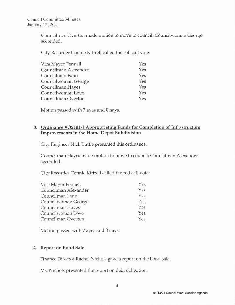
3. Ordinance #021.01.-L Appropriating Funds for Completion of InfrastructureImprovements in the Home Depot Subdivision
City Engineer Nick Tuttle presented this ordinance.
Councilman Hayes made motion to move to council; Councilman Alexanderseconded.
City Recorder Connie Kittrell called the roll call vote:
Vice Mayor FennellCouncilman AlexanderCouncilman FannCouncilwoman GeorgeCouncilman HayesCouncilwomar-r LoveCouncilman Overton
YesYesYesYesYesYesYes
Motion passed withT ayes and 0 nays
4. Report on Bond Sale
Finance Director Rachel Nichols gave a report on the bond sale
Ms. Nichols presented the report on debt obligation
4
04/13/21 Council Work Session Agenda
Council Committee MinutesJanuary 12,2021
Councilman Overton made motion to accept the obligation; CouncilmanAlexander seconded.
Council discussed.
No vote required so both motions were withdrawn.
Ms. Nichols asked council for approval for Parks and Recreation Director DavidBrown to start the golf irrigation system on January 13,2021..
Councilman Overton made motion to move to council; Vice Mayor Fennellseconded.
Vice Mayor Fennell asked when the fund would be appropriated for the GallatinPolice Department and Gallatin Fire Department training range.
Ms. Nichols stated she was going to draft that ordinance within the next twoweeks.
Council continued discussion.
City Recorder Connie Kittrell called the roll call vote:
Vice Mayor FennellCouncilman AlexanderCouncilman FannCouncilwoman GeorgeCouncilman HayesCouncilwoman LoveCouncilman Overton
YesYesYesYesYesYesYes
Motion passed withT ayes and 0 nays
5. Monthly Financial Reports for November
Finance Director Rachel Nichols presented the report
5
04/13/21 Council Work Session Agenda
Council Committee MinutesJanuary 72,2027
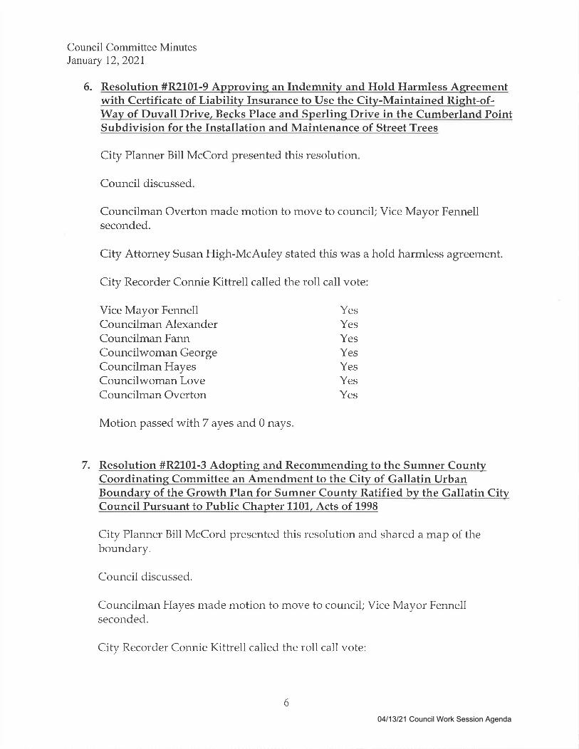
6. Resolution #R2101-9 Approvine an IndemniW and Hold Harmless Agreementwith Certificate of Liabilitv Insurance to Use the City-Maintained Rieht-of-Way of Duvall Drive, Becks Place and Sperlins Drive in the Cumberland PointSubdivision for the Installation and Maintenance of Street Trees
City Planner Bill McCord presented this resolution
Council discussed
Councilman Overton made motion to move to council; Vice Mayor Fennellseconded.
City Attorney Susan High-McAuley stated this was a hold harmless agreement
City Recorder Connie Kittrell called the roll call vote
Vice Mayor FennellCouncilman AlexanderCouncilman FannCouncilwoman GeorgeCouncilman HayesCouncilwoman LoveCouncilman Overton
YesYesYesYesYesYesYes
Motion passed with7 ayes and 0 nays
7. Resolution #R2101-3 Adopting and Recommending to the Sumner CountyCoordinatine Committee an Amendment to the City of Gallatin UrbanBoundarv of the Growth Plan for Sumner County Ratified by the Gallatin CityCouncil Pursuant to Public Chapter 11.0'1., Acts of 1998
City Planner Bill McCord presented this resolution and shared a map of theboundary.
Council discussed.
Councilman Hayes made motion to move to council; Vice Mayor Fennellseconded.
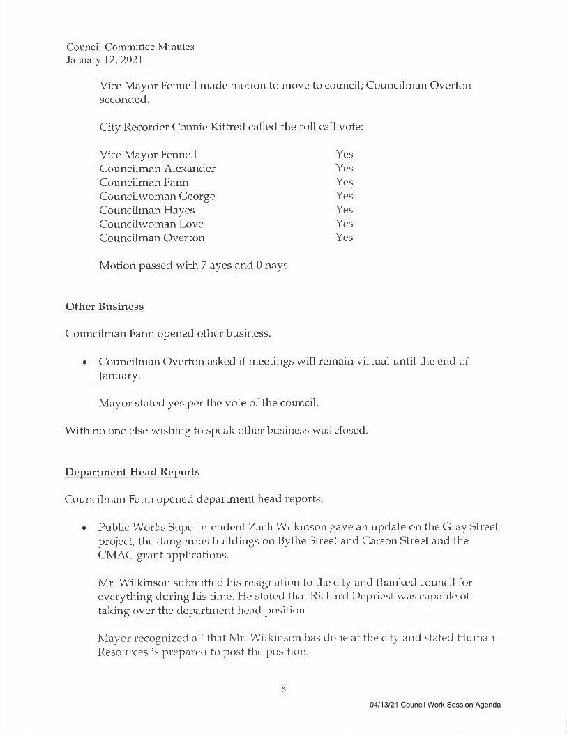
City Recorder Connie Kittrell called the roll call vote:
6
04/13/21 Council Work Session Agenda

Council Committee MinutesJanuary 12,2021
Vice Mayor FennellCouncilman AlexanderCouncilman FannCouncilwoman GeorgeCouncilman HayesCouncilwoman LoveCouncilman Overton ES
8. Reappointments to the Industrial Development Board and the Health
YesYesYesYesYes
CSYY
Motion passed with 7 ayes and 0 nays.
Educational and Housine Facilities Board.
Economic Development Agency Director James Fenton asked councii toreappoint Len Assante and Larry Wise to the board for six years.
City Attorney Susan High-McAuley clarified the six year term was a state statue
Councilwoman Love made motion to move to council; Councilman Hayesseconded.
Council discussed
City Recorder Connie Kittrell cailed the roll call vote
Vice Mayor FennellCouncilman AlexanderCouncilman FannCouncilwoman GeorgeCouncilman HayesCouncilwoman LoveCouncilman Overton
YesYesYesYesYesYesYes
Motion passed withT ayes and 0 nays
9. Gallatin Department of Electricitv Board Aooointment.
Mayor Brown appointed Beth Bennett to the board to serve the remainder of AlBennett's term.
7
04/13/21 Council Work Session Agenda
Council Committee MinutesJanuary 12,2021
Vice Mayor Fennell made motion to move to council; Councilman Overtonseconded.
City l{ecorder Connie Kittrell called the roil call vote:
Vice Mayor FennellCouncilman AlexanderCouncilman FannCouncilwoman GeorgeCouncilman HayesCouncilwoman LoveCouncilman Overton
YesYesYesYesYes
CS
ES
YY
Motion passed with7 ayes and 0 nays.
Other Business
Councilman Fann opened other business
Councilman Overton asked if meetings will remain virtual until the end of
January.
a
Mayor stated yes per the vote of the council
With no one else wishing to speak other business was closed
Department Head Renorts
Councilman Fann opened department head reports
Public Works Superintendent Zach Wilkinson gave an update on the Gray Streetproject, the dangerous buildings on Bythe Street and Carson Street and theCMAC grant applications.
Mr. Wilkinson submitted his resignation to the city and thanked council foreverything during his tirne. He stated that Richarrl Depriest was capable oftaking over the department head position.
Mayor recognized all that Mr. Wilkinson has done at the city and stated HurnanResources is prepared to post the position.
a
8
04/13/21 Council Work Session Agenda
Council Cornmittee MinutesJanuary 72,2021
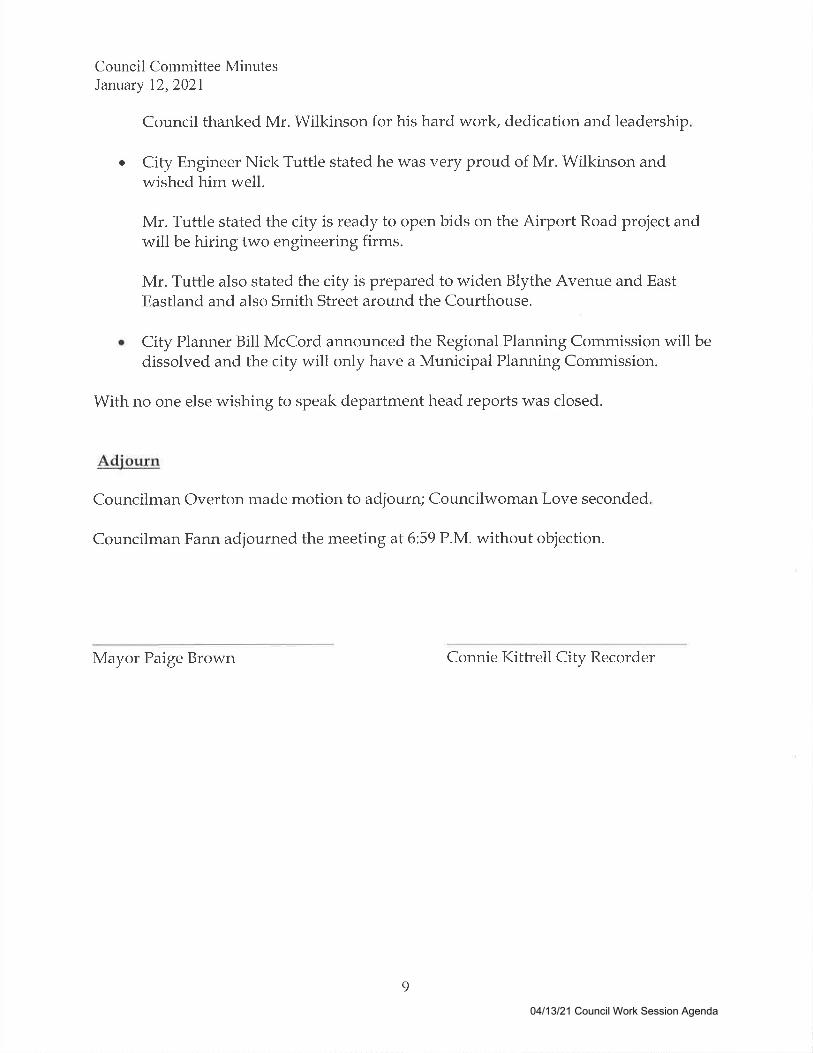
Council thanked Mr. Wilkinson for his hard work, dedication and leadership
City Engineer Nick Tuttle stated he was very proud of Mr. Wilkinson andwished him well.
Mr. Tuttle stated the city is ready to open bids on the Airport Road project andwill be hiring two engineering firms.
Mr. Tuttle also stated the city is prepared to widen Blythe Avenue and EastEastland and also Smith Street around the Courthouse.
City Planner Bill McCord announced the Regional Planning Commission will bedissolved and the city will only have a Municipal Planning Commission.
With no one else wishing to speak department head reports was closed.
Adjourn
Councilman Overton made motion to adjourn; Councilwoman Love seconded
Councilman Fann adjourned the meeting at 6:59 P.M. without objection.
Mayor Paige Brown Connie Kittrell City Recorder
a
9
04/13/21 Council Work Session Agenda

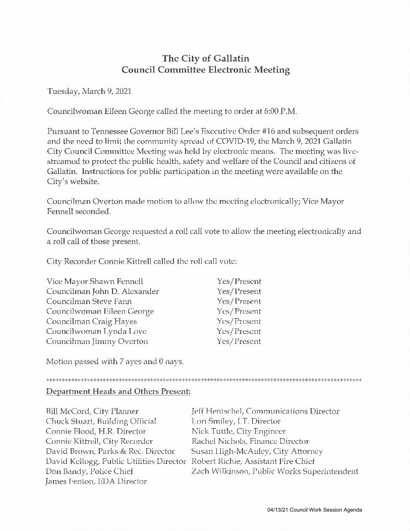
The City of GallatinCouncil Committee Electronic Meeting
Tuesday, March 9,2027
Councilwoman Eileen George called the meeting to order at 6:00 P.M.
Pursuant to Tennessee Governor Bill Lee's Executive Order #L6 and subsequent ordersand the need to limit the community spread of COVID-19, the March 9,2021. GallatinCity Council Committee Meeting was held by electronic means. The meeting was live-streamed to protect the public health, safety and welfare of the Council and citizens ofGallatin. Instructions for public participation in the meeting were available on theCity's website.
Councilman Overton made motion to allow the meeting electronically; Vice MayorFennell seconded.
Councilwoman George requested a roll call vote to allow the meeting electronically anda roll call of those present.
City Recorder Connie Kittreil called the roll call vote:
Vice Mayor Shawn FennellCouncilman John D. AlexanderCouncilman Steve FannCouncilwoman Eileen GeorgeCouncilman Craig HayesCouncilwoman Lynda LoveCouncilman Jimmy Overton
Motion passed withT ayes and 0 nays
Bill McCord, City PlannerChuck Stuart, Building OfficialConnie Flood, H.R. DirectorConnie Kittrell, City RecorderDavid Brown, Parks & Rec. DirectorDavid Kellogg, Public Utilities DirectorDon Bandy, Police ChiefJarnes Fenton, EDA Director
Yes/PresentYes/PresentYes/PresentYes/PresentYes/PresentYes/PresentYes/Present
Jeff Hentschel, Communications DirectorLori Smiley, l.T . DirectorNick Tuttle, City EngineerRachel Nichols, Finance DirectorSusan High-McAuley, City AttomeyRobert Richie, Assistant Fire ChiefZach Wilkinson, Public Works Superintendent
)k*****tr*******************rr)k*)krrtrtr*trt(trrrrr)k)btrtr)trr)ktr)k)k**************************)kr<>ktr*trtr*t(rr**trrktr****)k*rrtrrr*
Department Heads and Others Present:
04/13/21 Council Work Session Agenda
Council Committee MinutesMarch 9,2021
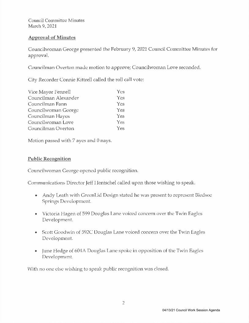
Approval of Minutes
Councilwoman George presented the February 9,2021. Council Committee Minutes forapproval.
Councilman Overton made motion to approve; Councilwoman Love seconded
City Recorder Connie Kittrell called the roll call vote:
Vice Mayor FennellCouncilman AlexanderCouncilman FannCouncilwoman GeorgeCouncilman HayesCouncilwoman LoveCouncilman Overton
YesYesYesYesYes
es
CS
YY
Motion passed with 7 ayes and 0 nays.
Public Recosnition
Councilwoman George opened public recognition.
Communications Director Jeff Hentschel called upon those wishing to speak
Andy Leath with Greenlid Design stated he was present to represent BledsoeSprings Development.
Victoria Hagen of 599 Douglas Lane voiced concern over the Twin EaglesDevelopment.
Scott Goodwin of 592C Douglas Lane voiced concern over the Twin EaglesDevelopment.
June Hedge of 604,4 Douglas Lane spoke in opposition of the Twin EaglesDevelopment.
Witl-r no one else wishing to speak public recognition was closed
a
a
a
a
2
04/13/21 Council Work Session Agenda
Council Committee MinutesMarch 9,2027
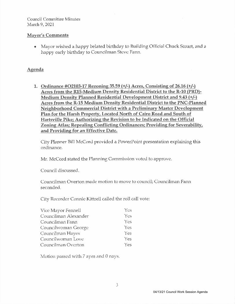
Mayor's Comments
Mayor wished a happy belated birthday to Building Official Chuck Stuart, and ahuppy early birthday to Councilman Steve Fann.
Agenda
a
1 7 35.59 Consi of 26.L6 +
Acres from the R15-Medium DensiW Residential District to the R-10 (PRD)-
Medium Residential Develo District and,9.43
Nei borhood with a Pre Master DevePlan for the d orth of Cairo Road and South ofHartsville Pike; Authorizine the to be Indicated on the OfficialZoning Atlas; Repealing Conflicting Ordinances; Providing for Severability,and Providine for an Effective Date.
City Planner Bill McCord provided a PowerPoint presentation expiaining thisordinance.
Mr. McCord stated the Pianning Commission voted to approve.
Council discussed
Councilman Overton made motion to move to council; Councilman Fannseconded.
City Recorder Connie Kittrell called the roll call vote:
Vice Mayor FennellCouncilman AlexanderCouncilman FannCouncilwoman GeorgeCouncilman HayesCouncilwoman LoveCouncilman Overton
Motion passed with7 ayes and 0 nays.
YesYesYesYesYesYesYes
J
04/13/21 Council Work Session Agenda
Council Committee MinutesMarch 9,2021
Items #2, #3 and #4 were presented together
2. Resolution #R2103-28 Adopting a Plan of Services for the Annexation of a44.79 (+/-) Acre Parcel (Tax Map 112 Parcel015.00) and an Adiacent 3.1(+/-lAcre Segme nt of Abandoned Railroad Rieht-of-Wav, Located North ofHartsville Pike and East of Airport Road, and Providine for an Effective Date.
3. Resolution #R2103-29 Annexins a 44.79 (+/-) Acre Parcel (Tax Map l1.2Parcel015.00) and an Adiacent 3.1. (+/-l Acre Sesment of Abandoned Railroad Rieht-of-Wav, Located North of Hartsville Pike and East of Airport Road, into theCity of Gallatin; Authorizing the Annexed Property to be Indicated on theOfficial Zoning Atlas; Assigning the Annexed Area to a Council District;Repealing Conflicting Ordinances; Providing for Severability, and Providingfor an Effective Date.
4. Ordinance #02103-L8 Rezonins,44.79 (+/-) Acres and an Adiacent 2.04 (+/-lAcre Seqment of Abandoned CSX Railroad Risht-of-Wav from the RR-RuralResidential (County) District to R8-PRDMedium Densitv Residential PlannedResidential Development District with a Preliminarv Master DevelopmentPlan for Bledsoe Sprines and Zonins a 1.06 (+/-) Acre Portion of AbandonedCSX Railroad form RR-Rural Residential (Countv) District to IR-Industrial
ct Located North of Hartsville Pike and East of RoaRevision to be Indicated on the Official
Repealing Conflicting Ordinances; Providing for Severability, and Providingfor an Effective Date.
City Planner Bill McCord presented items #2, #3 and #4 by providing aPowerPoint presentation.
Mr. McCord stated the Planning Commission did not recommend approvai, butthe Planning Department did.
Council agreed to suspend the rules to allow Developer Representatives AndyLeath and Marty Cook to speak.
Mr. Cook explained the significant changes with the project since the last time itwas before Council.
Councilman Overton made motion to move to council; Councilman Alexanderseconded.
4
There was much discussion
04/13/21 Council Work Session Agenda
Council Committee MinutesMarch 9,2021
Traffic Engineer Richard Phillips provided information in regards to the trafficstudy completed.
City Recorder Connie Kittrell called the roll call vote
YesYesYesYesYes
CS
CS
5. Ordinance #02103-L5 Approving an Amended Preliminary MasterDevelopment Plan for Winston Place, on a L9.84 (+/-) Acre Parcel (Tax Map 1"14,
Parcel 046.021, Located East of Highr4la-y 109 and South of Red River Road;Authorizing the Revision to be Indicated on the Official Zoning Atlas;Repealine Conflictine Ordinances; Providine for Severability, and Providins
Vice Mayor FennellCouncilman AlexanderCouncilman FannCouncilwoman GeorgeCouncilman HayesCouncilwoman LoveCouncilman Overton
YY
Motion passed with 7 ayes and 0 nays.
for an Effective Date.
City Planner Bill McCord presented this ordinance by providing a PowerPointpresentation.
Mr. McCord stated the Planning Commission recommended approval
Councilman Alexander made motion to move to council; Councilman Overtonseconded.
City Recorder Connie Kittrell called the roll call vote
Vice Mayor FennellCour-rcihnan AlexanderCouncilman FannCouncilwoman GeorgeCouncihnan HayesCouncilwoman LoveCouncihnan Overton
Motion passed withT ayes and 0 nays.
YesYesYesYesYesYesYes
5
04/13/21 Council Work Session Agenda
Council Committee MinutesMarch 9,2021
6. Presentation and Discussion of the Findings of an Annexation Study for ThreeParcels, Totaling 655.44 (+/-) Acres (Tax Map 113, Parcel 001.00, 002.00, and045.00) for the Proposed Bowles Property Preliminary Master DevelopmentPIan, Located North of Red River Road and East of Highway L09.
City Planner Bill McCord presented the findings of the annexation study for theBowles Property by providing a PowerPoint presentation.
7. Presentation and Discussion of the Findines of an Annexation Studv for a
59.10 (+/-) Acre Parcel (Tax Map 1"14, Parcel 015.03) for Proposed Twin EaelesPhase L5, Located North of Wildcat Run and East of Douglas Lane.
City Planner Bill McCord presented the findings of the annexation study forTwin Eagles by providing a PowerPoint presentation.
8. Resolution #R2103-26 Authorizing the Mayor to Sign Contract with Scotty'sContracting for Phase I of the Police/Fire Training Facility.
Public Works Superintendent Zach Wilkinson presented this resolution.
Councilman Overton made motion to move to council; Councilman Alexanderseconded.
Council discussed.
City Recorder Connie Kittrell called the roll call vote:
Vice Mayor FennellCouncilman AlexanderCouncilman FannCouncilwoman GeorgeCouncilman HayesCouncilwoman LoveCouncilman Overton
Motion passed with 6 ayes and 0 nays.
YesYesYesYesDid Not Vote (Left Meeting)YesYes
6
04/13/21 Council Work Session Agenda

Council Committee MinutesMarch 9,2021
9. Resolution #R2103-25 Acceptine Public Improvements by the City if Gallatin,Tennessee - Revere at Hidden Creek.
City Engineer Nick Tuttle presented this resolution.
Councilman Overton made motion to move to council; Councilwoman Loveseconded.
City Recorder Connie Kittrell called the roll call vote:
Vice Mayor FennellCouncilman AlexanderCouncilman FannCouncilwoman GeorgeCouncilwoman LoveCouncilman Overton
YesYesYesYes
ES
ES
10. Risht of Wav Use.
City Engineer Nick Tuttle explained and provided information onMemorandums of Understanding.
EDA Director James Fenton requested a reasonable fee
11. Ordinance #02103-19 Appropriatins $53,355.68 from Miracle Park DonationsRevenue Fund to Miracle Park Expense Fund.
Parks and Recreation Director David Brown presented this ordinance.
Councilman Alexander macle motion to move to council; Councilman Overtonseconded.
City Recorder Connie Kittrell called the roll call vote:
YY
Motion passed with 6 ayes and 0 nays.
Vice Mayor FennellCouncilman AlexanderCouncilman FannCouncilwoman GeorgeCouncilwoman Love
YesYesYesYesYes
7
04/13/21 Council Work Session Agenda
Council Committee MinutesMarch 9,2021
Councilman Overton Yes
Motion passed with 6 ayes and 0 nays.
L2. Financial Reports for Tanuarv
Finance Director Rachel Nichols presented the financial report for January
Other Business
Councilwoman George opened other business
Mayor congratulated Councilwoman George on her first meeting.a
Mayor advised council that a decision will need to be made to continuevirtual meetings or resume in-person.
Mayor announced Fire Chief Victor Williams resigned and suggested acall for interest for those willing to serve as Interim Fire Chief.
With no one else wishing to speak other business was closed
Department Head Reports
Councilwoman George opened department head reports
City Planner Bill McCord announced a possible park donation fromVintage Baker's Crossing.
Mr. McCord stated Planning was moving forward with Comp Plan and a
draft would be coming soon.
Mr. McCord also stated proposals are being accepted for the rewriting ofthe Zonir-rg Plan.
Mr. McCord explained TDOT is moving forward with hiring a consultantfor the Urban Transportation Grant and creating an Adrrisory Committee.
With no orle else wishir-rg to speak departrnent head reports was closed
a
a
a
8
04/13/21 Council Work Session Agenda

Council Committee MinutesMarch 9,2027
Adjourn
Councilman Overton made motion to adjourn; Vice Mayor Fennell seconded.
Councilwoman George adjourned the meetingat7:37 P.M. without objection.
Mayor Paige Brown Connie Kittrell City Recorder
9
04/13/21 Council Work Session Agenda

The City of GallatinCouncil Committee Electronic Meeting
Tuesday, March 23,2021
Councilwoman Eileen George called the meeting to order at 6:02 P.M.
Pursuant to Tennessee Governor Bill Lee's Executive Order #L6 and subsequent ordersand the need to limit the community spread of COVID-19, the March 23,202'1, GaliatinCity Council Committee Meeting was held by electronic means. The meeting was live-streamed to protect the public health, safety and welfare of the Council and citizens ofGallatin. Instructions for public participation in the meeting were available on theCity's website.
Councilman Overton made motion to allow the meeting electronically; CouncilmanAlexander seconded.
Councilwoman George requested a roll call vote to allow the meeting electronically anda roll call of those present.
City Recorder Connie Kittreil called the roll call vote:
Vice Mayor Shawn FennellCouncilman John D. AlexanderCouncilman Steve FannCouncilwoman Eileen GeorgeCouncilman Craig HayesCouncilwoman Lynda LoveCouncilman Jimmy Overton
Motion passed withT ayes and 0 nays
Yes/PresentYes/PresentYes/PresentYes/PresentYes/PresentYes/PresentYes/Present
rkt trrr*trtrtrtrrrrr)ktrrrrr***tr*tr!ktr)k)k***)k>krl*)k*
Department Heads and Others Present:
Chuck Stuart, Building OfficialSusan High-McAuley, City AttorneyAaron Hickson, Engineer Project ManagerBill McCord, City PlannerConnie Kittrell, City Recorder
Jeff Hentschel, Comrnunications DirectorJames Fenton, EDA DirectorRachel Nichols, Finance Director
Tracy Townsend, Interim Fire ChiefConnie Flood, H.R. DirectorLori Smiley, I.T . DirectorDavid Brown, Parks & Rec. DirectorDonald Bandy, Police ChiefDavid Kellogg, Public Utilities DirectorZach Wilkinson, Public Works Director
04/13/21 Council Work Session Agenda

Council Committee MinutesMarclr 23,2027
Approval of Minutes
Councilwoman George presented the February 23,2021 Council Committee minutes forapproval.
Councilman Overton made motion to approve; Vice Mayor Fennell seconded.
City Recorder Connie Kittrell called the roll call vote:
Vice Mayor FennellCouncilman AlexanderCouncilman FannCouncilwoman GeorgeCouncilman HayesCouncilwoman LoveCouncilman Overton
YesYesYesYesYes
ES
CS
YY
Motion passed with7 ayes and 0 nays
Public Recognition
Councilwoman George opened public recognition.
Communications Director Jeff Hentschel called upon those wishing to speak.
Pascal Jouvence of 1335 Long Hollow Pike spoke about last week's meeting andthe temporary appointment of the interim fire chief.
Michelle Jouvence of 1335 Long Hollow Pike voiced concern over the annexationof Bledsoe Springs and Twin Eagles.
Patrick Reeners of 317 Malone Drive addressed commenters and advised on howto work better with the city.
With no one else wishing to speak public recognition was closed
Mayor's Comments
Mayor congratulated Gap, Inc. for hiring more employees and thanked them fortheir long tenn investment in Gallatin.
a
a
a
2
a
04/13/21 Council Work Session Agenda
Council Committee MinutesMarch 23,2021
a Mayor announced the Miss Tennessee Outstanding Teen Scholarship Pageantwas held in Gallatin and congratulated Gallatin resident Taylor Black for beingcrowned queen.
Agenda
1. Presentation and Discussion of the Findings of an Annexation Studv for a
44.79 + 11 Parcel 015 and an Ad acent 3.1 AcreSegment of Abandoned Railroad Right-of-Way for the Bledsoe SpringsPreliminary Master Development Plan, Located North of Hartsville Pike andEast of Airnort Road.
City Planner Bill McCord provided a PowerPoint presentation and explained thefindings of the annexation study.
2. Airport Road./Cairo Road Traffic Sienal Warrant Analvsis.
Engineering Project Manager Aaron Hickson presented this analysis and statedthe next step is to provide a cost estimate to council.
Council discussed.
J. Gracie Lake Drainaee Discussion.
Former Public Works Superintendent Zach Wilkinson provided a history of thedrainage issues. Mr. Wilkinson stated the city has not been able to resolve theissue as this is private property.
HOA representative Vaughn Oakley of L041. Jarman Lane presented his case tocouncil.
City Attorney Susan High-McAuley stated pubic funds cannot be used onprivate property.
J
There was much discussion
04/13/21 Council Work Session Agenda

Council Committee MinutesMarch 23,2021
4. Resolution #R2103-30 Supporting the Gallatin Beautiful Application for a
Walmart Local Community Grant to be Used to Purchase Litter CleanupSupplies for Volunteers.
Former Public Works Superintendent Zach Wilkinson presented this resolution.
Councilman Overton made motion to move to council; Councilman Alexanderseconded.
City Recorder Connie Kittrell calied the roll call vote
Vice Mayor FennellCouncilman AlexanderCouncilman FannCouncilwoman GeorgeCouncilman HayesCouncilwoman LoveCouncilman Overton
YesYesYesYesYesYesYes
Motion passed with7 ayes and 0 nays.
5. Discussion of Appointment of Public Works Superintendent.
Mayor stated this is for the council to agree on an appointment and present theappointment and salary at the next council meeting.
Councilman Overton made motion to appoint Richard Depriest as Public WorksSuperintendent; Councilman Hayes seconded.
City Recorder Connie Kittrell called the roll call vote
Vice Mayor FennellCouncilman AlexanderCouncilman FannCouncilwoman GeorgeCouncilman HayesCouncilwoman LoveCouncilman Overton
Motion passed withT ayes and 0 nays
YesYesYesYesYesYesYes
4
04/13/21 Council Work Session Agenda
Council Committee MinutesMarch 23,2021
Other Business
Councilwoman George opened other business.
Councihnan I Iayes asked council to consider allowing car shows in theCity Hall parking lot starting the weekend after Square Fest.
a
a
a
Council discussed.
Councilman Hayes made motion to move to council; Councilman Fannseconded.
City Recorder Connie Kittrell called the roll call vote
Vice Mayor FennellCouncilman AlexanderCouncilman FannCouncilwoman GeorgeCouncilman HayesCouncilwoman LoveCouncilman Overton
Vice Mayor FennellCouncilman AlexanderCouncilman FannCouncilwoman CeorgeCouncilman Hayes
YesYesYesYesYesYesAbstain
Motion passed with 6 ayes,0 nays and 1 abstention.
Mayor introduced Interim Fire Chief Tracy Townsend
Mr. Townsend thanked council for the opportunity to serve
Former Public Works Superintendent Zach Wilkinson presented the costsfor the lighted crosswalks downtown.
Mayor stated there are unused bond funds available.
Councilman Overton made motion to move to council; CouncilmanAlexander seconded.
City Recorder Connie Kittrell called the roll call vote:
YesYesYesYesYes
5
04/13/21 Council Work Session Agenda

Council Committee MinutesMarch 23,2021
a
a
Councilwoman LoveCouncilman Overton
YesYes
Motion passed with7 ayes and 0 nays
Mayor presented an ordinance by EDA Director James Fenton forGateway Drive extension for Facebook.
Councilman Alexander made motion to move to council; CounciiwomanLove seconded.
City Recorder Connie Kittrell called the roll call vote:
Vice Mayor FennellCouncilman AlexanderCouncilman FannCouncilwoman GeorgeCouncilman HayesCouncilwoman LoveCouncilman Overton
YesYesYesYesYesYesYes
Motion passed with7 ayes and 0 nays.
Mayor announced the Morning Rotary Club is disbanding and the cityneeds to decide whether to take over maintaining Liberty Branch Park.
EDA Director James Fenton stated this will be discussed at the next NoonRotary meeting.
Parks and Recreation Director David Brown stated the city can mow thegrass but there are no funds for any type of improvements.
There was much discussion.
Councihnan Alexander asked for an update on Clearview Park
Mayor stated she is working witl-r Parks and Recreation Director DavidBrown on an idea for Clearview Park.
Mayor asked council if Kona Ice could do a giveaway at city hall.
6
a
Council agreed
04/13/21 Council Work Session Agenda

Council Committee MinutesMarch 23,2021
a
a
a
o
a
Mayor asked councils thought to proceed with fireworks on July 4th.
Council agreed
Mayor announced the Senior Advocacy Committee is working to becomeAARP certified.
Mayor asked council when they would like to resume in-person meetings.
Council discussed.
Councilman Overton made motion to resume in-person meetings startingMay 1.,202'1. and broadcast on cable TV; Councilman Alexander seconded.
City Recorder Connie Kittrell called the roll call vote:
Vice Mayor FennellCouncilman AlexanderCouncilman FannCouncilwoman GeorgeCouncilman HayesCouncilwoman LoveCouncilman Overton
YesYesYesYesYes
CS
CS
YY
Motion passed with Z ayes and 0 nays.
Councilman Alexander asked Former Public Works Superintendent ZachWilkinson about the drainage issue on Carson Street.
Forrner Public Works Superir-rtendent Zach Wilkinson stated he wouldcheck and get back to Councilman Alexander.
Councilmau Alexander apologized to all during the last council meetingas he was ill, and stated he was very collcerned about all issues presented
Councilman Overton asked Human Resource Director Connie Flood toprovide council with all department head job descriptions.
There was much drscussron
With no one else wishing to speak other business was closed
a
7
04/13/21 Council Work Session Agenda
Council Committee MinutesMarch 23,2021
Department Head Reports
Councilwoman George opened department head reports
City Planner Bill McCord provided a PowerPoint presentation withinformation on the cost to maintain the Vintage Baker's Crossing Parkdonation.
Council was in agreement to accept the donation.
Council discussed and asked Mr. McCord to bring this back to council formore discussion.
a
With no one else wishing to speak department head reports was closed.
Adjourn
Councilman Alexander made motion to adjourn
Councilwoman George adjourned the meetingatT:48 P.M. without objection.
Mayor Paige Brown Connie Kittrell City Recorder
8
04/13/21 Council Work Session Agenda
CITY OF GALLATINCOUNCIL COMMITTEE AGENDA
APRIL I3,2O2I
DEPARTMENT: PLANNING DEPARTMENT AGENDA #
SUBJECT:An Ordinance No. O2lO4-22 of the City of Gallatin, Sumner County, Tennessee, rezoning two (2)
parcels totaling 17.82 +l- acres from the R20-Low Density Residential District to the MRO-MultipleResidential and Office District with a Preliminary Master Development Plan for Northfield Church
on 20.20 acres.
SUMMARY:An Ordinance of the City of Gallatin, Sumner County, Tennessee, rezoning two (2) parcels totaling
17.82 +l- acres from the R2O-Low Density Residential District to the MRO-Multiple Residential and
Office District and approving a Preliminary Master Development Plan for Northfield Church, on
20.20 */- acres, located North of Nashville Pike and West of Pilot View; authorizing the revision to
the Official ZoningAtlas; repealing conflicting ordinances; providing for severability; and providing
an effective date.
RECOMMENDATION:On March 22,2021, the Gallatin Municipal-Regional Planning Commission recommended approval
of the rezoning and master development plan in GMRPC Resolution No. 2021-033 (ZONE-2020'003 1 ).
ATTACHMENT:
ResolutionOrdinance
CorrespondenceContract
Bid TabulationOther
ApprovedRejectedDeferred
Notes:
04/13/21 Council Work Session Agenda
1
ORDINANCE NO. O2IO4.22
AN ORDINANCE OF' THE CITY OF' GALLATIN, SUMNER COUNTY, TENNESSEE,
REZONING TWO (2) PARCELS TOTALING 17.851 +/- ACRES FROM THE R20-LOW
DENSITY RESIDENTIAL DISTRICT TO THE MRO.MULTIPLE RESIDENTIAL AND
OF'FICE DISTRICT AND APPROVING A PRELIMINARY MASTER DEVELOPMENT
PLAN FOR NORTHFIELD CHURCH, ON 20.20 +/- ACRES, LOCATED NORTH OF
NASHVILLE PIKE AND WEST OF PILOT VIEW; AUTHORIZING THE REVISION TO
BE INDICATED ON THE OFFICIAL ZONING ATLAS; REPEALING CONFLICTING
ORDINANCES; PROVIDING FOR SEVERABILITY' AND PROVIDING FOR AN
EFFECTIVE DATE.
WHEREAS, the owner of the property submitted a complete application to rezone 17.851
*/- acres with a Preliminary Master Development Plan for Northfield Church on20.20 acres, located
in the City of Gallatin, Tennessee; and
WHEREAS, the zoningmap amendment conforms to the general plan of the area including
the established Commercial Coridor Community Character Area and the Gateway Corridor
Overlay Character Area and that the public necessity, convenience, and general welfare, will be
served by approving the proposed amendment; and
WHEREAS, the property proposed for rezoning has adequate public utilities, infrastructure
and private or municipal services necessary to serve the existing and proposed development and
population permitted by the requested zoning or such necessary services and facilities will be
provided upon development of the property; and
WHEREAS, the rezoning will be compatible with the surrounding environment and willprotect the public health, safety and welfare and will not be injurious to other property orimprovements in the areain which the property is located; and
WHEREAS, the Gallatin Municipal-Regional Planning Commission reviewed and
recommended approval of the proposed rezoning with Preliminary Master Development Plan in
GMRPC Resolution No.202l-033; and
WHEREAS, a public hearing was held following public notice as prescribed by the Gallatin
ZoningOrdinance and Tenn. Code Ann. $ 13-7-203; and
WHEREAS, the City Council approved by majority vote of the members present the rezoning
request ofthe described property; and
NOW, THEREFOREO BE IT ORDAINED BY THE CITY COUNCIL OF THE CITYOF GALLATIN, SUMNER COUNTY' TENNESSEE as follows:
Section 1. The City Council of the City of Gallatin does hereby rezone two (2) parcels
totaling 17.851 */- acres from the R20-Low Density Residential District to the MRO-Multiple
04/13/21 Council Work Session Agenda
Residential and Office District and approves a Preliminary Master Development Plan for Northfield
Church, on20.20 */- acres as described in Exhibit'B'.
Section 2. The City Council of the City of Gallatin does hereby approve, authorize and
direct the revision of the City's Official ZoningAtlas to show the classification for the area as hereby
rezoned.
Section 3. All ordinances or parts of ordinances in conflict with the provisions of this
ordinance are hereby repealed to the extent ofsuch conflict.
Section 4. If any provision of this ordinance or the application thereof to any person or
circumstance is held invalid, the invalidity shall not affect other provisions or applications of this
ordinance which can be given without the invalid provision or applicationo and to this end the
provisions of this ordinance are declared severable.
Section 5. This ordinance shall become effective immediately upon passage, the public
welfare requiring such.
PASSED FIRST READING:
PASSED SECOND READING:
MAYOR PAIGE BROWN
ATTEST:
CONNIE KITTRELLCITY RECORDER
APPROVED AS TO FORM:
SUSAN HIGH-MACAULEYCITY ATTORNEY
Exhibit A: Legal DescriptionExhibit B: Desuiption of PMDP
04/13/21 Council Work Session Agenda

EXHIBIT'A'
R-20 Low Density Residential to MRO-Multiple Residential and Office - 17.851 */- Acres
THE LAND REFERRED TO HEREIN IS SITUATED IN SUMNER COUNTY, STATE
OF TENNESSEE, ANDIS DESCRIBED AS FOLLOWS:
TRACT I:
Beginning at a point on the North side of Highway 31-E, being the Southeast
comer of the described tract; thence North 44 deg. 38' West 400 feet to a
point; thence South 50 deg. 22' West 300 feet to a point; thence South 44 deg.
38'East, 400 feet to a point, thence North 48 deg. 17' East 26.79 fee't.to a
point; thence North 50 deg. 34' East 273.21feet to the point of beginning,
according to a survey made by Don Shanklin Engineering on the 2nd of March,
1971.
For informational purposes only: prior deed referenced subject property to contain 2,741
acres.
Being the same property conveyed to Trustees of College Heights Baptist
Church by Warranty Deed from Vernon D. Reader and wife, Naomi S.
Reader, dated October 31, 1988, recorded October 31, 1988, ofrecord in
Record Book 51, Page 524, Register's Office for Sumner County, Tennessee
Further being the same property conveyed to Grace Point Church ofGallatin f/k/a College Heights Baptist Church, a nonprofit corporation by
Quitclaim Deed from The Trustees of the College Heights Baptist Church,
dated September 22,2006, recorded October 13,2006, of record In Book
2614,Page 673, as corrected by Scrivener's Affidavit of record in Record Book
302l,Page 545, Register's Office for Sumner County, Tennessee.
TRACT 2:
Beginning at a post in the North and East margin of a lane in the South West
corner of this plot and the North West corner of a building lot running with a
fence North 53o 30' East,296 feet to a post;thence South 42o 00' East, 397
feet to a stake near a post In the North and West margin of Highway 31-E;
thence with said margin or ROW North 55o 00' East 325 feet to a stake; thence
North 42' 00' West 800 feet to a stake; thence South 55o 00' West, 351feet to
a stake in a fence at said lane; thence with the fence and lane South 4o 50
West, 363 feet to a post; thence South 44" 30' East,132 feet to beginning.
For lnformational purposes only: prior deed references subject property to contain 7.87
04/13/21 Council Work Session Agenda

acres
Being the same property conveyed to College Heights Baptist Church, a
Tennessee nonprofit corporation by Quitclaim Deed from Trustees of the
Cof lege Heights Baptist Church, dated March 6,2012, recorded March 19,
2012, of record in Record Book 3551, Page 450, Register's Office for Sumner
County, Tennessee.
Further being the same property conveyed to Trustees of the College Heights
Baptist Church, Gallatin, Tennessee by Warranty Deed from Trustees of the First
Baptist Church of Gallatin,
Tennessee, dated April 19,1978,recorded May 1,1978, of record in Deed
Book 395, Page 337 ,
Register's Office for Sumner County, Tennessee.
TRACT 3:
Beginning at an iron pinthe West right of way of U.S. Highway 31-E, same
beingthe Southeast corner ofthe herein described tract, and being the
Northeast corner of the College Heights Baptist Church tract, of record in
Deed Book 395,Page337,inthe Register's Office of SumnerCounty,
Tennessee; thence with the North line of said church tract North 42" 00'
West, 793.58feet to a fence corner;thence along a new line with Branham ofrecord In Deed Book 239, Page 556, in the ROSCT, North 54o 40' East, 300.00
feetto an iron pin; thence South 4lo 58' East,
796.67 feet to an iron pin in the West right of way of U.S. Highway 31-E;
thence along a curve to the left having a central angle of 1 o I l' 41 "0 a radius of
14,387 .95 feet, a length of 300.00 feet, a tangent of 150.01 feet, and a chord
of South 55o l6' West, 299.99 feet to the point of beginning, according to a
survey dated April 15, 1983, by Caldwell Engineering and Surveying.
For informational purposes only: prior deed references subject property to contain 5.43
acres.
Being the same property conveyed to Trustees of the College Heights Baptist
Church, Gallatin,Tennessee by Warranty Deed from E.C. Branham, Sr., E.C.
Branham, Jr., and Buford Branham, dated April 27,1983,recorded April 28,
1983, of record in Deed Book 467, Page 818, Register's Office for Sumner
County, Tennessee.
TRACT4:
Beginning at an existing iron pin in the West right of way of U.S. Highway
3l E, pin being 4 inches Northeast of existing U.S. Concrete highway marker
and also being Northeast corner ofthe College Heights Baptist Church Tract
2; thence with the North line of Church Tract2 North 41o 58'West, 796.67
04/13/21 Council Work Session Agenda
feet to an existing iron pin; thence North 54" 40' East, 100 feet to a metal pin;
thence South 41o 58' East, 795.5 feet to a metal pin in the West right of way
of U.S. Highway 3lE;thence with a curve of right of way a chord distance
of 100 feet to the point of beginning, according to survey by Wayne Diel, No.
1077, dated October 22,1985.
For informational purposes only: prior deed references subject property to contain 1.81
acres.
Beingthe same property conveyed to Trustees ofthe College Heights Baptist
Church, Gallatin, Tennessee by Warranty Deed from E.C. Branham, Sr., E.C.
Branham, Jr., and Buford Branham, dated Octobet 29,1985, recorded October
31, 1985, of record in Deed Book 509, Page 458, Register's Office for
Sumner County, Tennessee.
PROPERTY ADDRESS: 2100 NASHVILLE PIKE, GALLATIN, TN 37066
Legal description istaken from theprevious deeds ofrecord
04/13/21 Council Work Session Agenda
EXHIBIT'B'
The rezoning shall be substantially consistent with the Preliminary Master Development Plan for
Northfield Church consisting of eight (8) sheet plan, prepared by GreenllD Design ot'Gallatin, 'l'N,
with job number 20.090G, dated February 8,2021, with a final revision date of March 25,2021, and
with the following conditions:
1. Correct the acreage to be rezoned to match the legal description.
2. Provide the Type 15 Bufferyard along Nashville Pike (including between the
parking lot and right-of-way andlor along the property boundary) as required.
Bufferyards plantings shall avoid the overhead power lines.
3. Provide a 6' wide sidewalk along the Nashville Pike right-of-way.
4. Submit digital files consisting of the PDF and AutoCAD (dwg.) drawings of the
Preliminary Master Development Plan to the Planning Department.
04/13/21 Council Work Session Agenda
STAFF REPORT TO CITY COUNCILRezoning with Preliminary Master Development Plan for Northfield Church(zoNE-2021-0031)Located North of Nashville Pike and West of Pilot ViewDate: April 13,2021
Reeunsr: owNER AND AppLrcANT REeuESTS To REZoNE Two (2) PARCELS ToTALING 17.851 +l-
ACRES FRoM THE R2O-Low DENsrry RpstopNrtel DISTRICT To rHE MRO-MuI-TIPLE RESIDENTIAL
AND OFFICE DISTRICT AND APPRoVING A PRPI-IVINARY MASTPR DPVELOPVPNT PI-AN FOR
NonrHFrplD CFTURCH, ON 20.20 +/- ACRES, LOCATED NORTH OF NASHVILIE Ptrp AND WEST OF Plt OtVrew.
Owxnn: NonrHntpln CHuRcu
Applrcaxr: GREENLID DESIGN
Sunp RBconnrunNDATroN: RncourrlnND AppRovAL oF OnuxaNcn No. O2lO4-22
Srnnn Coxrnct: JIlltlN OconN, AICP
PuNxrllc Comrrrtsston Darn: MlRcu 22'2021
Coulrcrl Commtrtnn DltB: Apnll l3r202l
PRopnnrv OvnRvtnw: The owner and applicant requests to rezone two (2) parcels totaling17.851 */- acres from the R20-Low Density Residential District to the MRO-MultipleResidential and Office District and approval of a Preliminary Master Development Plan forNorthfield Church, on 20.20 */- acres, located North of Nashville Pike and West of Pilot View.A Place of Worship and its accessory uses and the Multi-Family use are permitted uses in theMRO zone district (Attachment I and 2).
The owner and applicant request approval of a conceptual Alternative Bufferyard Plan perSection 13.04.f 00.C of the Gallatin Zoning Ordinance.
The architectural elevations do not meet the required 70 percent brick or stone on each
building facade per the Basic Design Criteria of the Gallatin Zoning Ordinance, Section13.08.010.A, Materials. The owner and applicant requests approval of a conceptual AlternativeArchitectural Plan.
The Planning Commission recommended approval of the Ordinance as described in GMRPCResolution No. 2021-033 (Attachment 3).
Clsn BacxcnouNn:Property History and DescriptionOn November 3, l97l,the City Council approved Ordinance No.071-15 annexing the NashvillePike coridor for a distance extending 800' from both sides of Nashville Pike. This included thesubject properties.
04/13/21 Council Work Session Agenda
Rezoning with PMDP - Northfietd Church (MDP-2021-0031) Council Committee - April 13, 2021
R-20 Low Density Residential zoningwas established on the property priorto adoption of the 1979
Gallatin Zoning Map.
On December 21,1983. the Gallatin Board of Zoning Appeals approved a Conditional Use Permit
(File# B-11-83) for the Place of Worship and Community Facility use. Northfield Church was
originally established as College Heights Baptist Church. Since that time, several plans have been
approved with the most recent being in 2004.
On July 26, 1993, the Planning Commission recommended approval of a rezoning of multiple
parcels along Nashville Pike from R20-Low Density Residential District to MRO-MultipleResidential and Office District (3-8-93). This included Tax Map 146, Parcel 033.07. On December
7,lgg3,the City Council approved the request (Ord. No. 093-917). No master plan was approved at
that time.
On October 25,2004, the Gallatin Board of Zoning Appeals approved a Conditional Use Permit
(File# 8-5-04) to construct the youth facility for the existing church. The site plan was approved by
the Planning Commission, at a separate meeting, on the same date (File #8-21-04).
On July 13,2005, the Branham Corner, Section Two, a minor subdivision plat, was recorded and
included Tax Map 146, Parcel 033.07) (P.8.22, PG 240).
On July 25, 2016, the Planning Commission approved an Alternative Sign Plan for NorthfieldChurch (8-2152-16).
Drscusstox:Proposed DevelopmentThe owner and applicant requests to rezone two (2) parcels totaling 17.851 */- acres from the R20-
Low Density Residential District to the MRO-Multiple Residential and Office District and approval
of a Preliminary Master Development Plan for Northfield Church, on 20.20 +/- acres, located North
of Nashville Pike and West of Pilot View. A Place of Worship and its accessory uses and the Multi-Family use are permitted uses in the MRO zone district.
The proposed master plan will include the remodel and expansion of the existing church space, the
addition of a pre-school and office building, and the creation of The Villages Community at
Northfield, a 3}-unit multi-family housing community for two categories of persons or families withspecific needs. The church related activities and the housing program will be operated and
maintained by the church (Attachment 4).
Construction is projected to begin in September of 2022 and end in May of 2025.
The complex will include the following existing and proposed facilities:
BUILDINGS AND STRUCTURES SOUARE FOOTAGEExistins
Worship Center 45,142 sqft
Education Building 6,595 sqft
2
04/13/21 Council Work Session Agenda
Rezoning with PMDP - Northfield Church (MDP-2021-0031) Council Committee - April 13, 2021
The Sumner Center 45"142 sqftStudent Buildine 6.049 sqftShed 1,519 sqft
ProposedGathering Area 13.405 sqftPre-School 16,068 sqftWorship Center Support Addition 6,644 sqftCovered Pavilion 6.653 sqftMaintenance Shed 1"825 sqftThe Villaees at Northfield (4 buildines) 38,400 sqft
Nsturul FeaturesThe subject property is partially developed with the existing church facilities. The land is generallyflat in the area of the development and includes low points in a large ditch along Nashville Pike andthe existing stream that bisects the east half of the property, particularly in the area of Pilot View.
Most of the trees exist along the stream and along the north and west property boundaries. Staffwould encourage natural vegetation be maintained throughout where possible.
Based on FEMA FIRM Maps 47165C0406G, 47165C0407C, 47165C0408G, and 47165C0409G,dated of April17,2012, shows no portion of the site is located within a special flood hazard area.
Adjucent or Area UsesTo the north is the Gallatin/Hendersonville city limits boundary and vacant land, zoned RR-RuralResidential. Some of this property is used by the Rogers Group quarry. To the east is a formerbowling alley/skating rink (not a church) and office buildings in the Branham Corner Subdivision,zoned MRO-Multiple Residential and Office. To the south across Nashville Pike is SavannahMarketplace, which includes a Honda dealership, Taco Bell, Wash N Roll, an Oil Express, and aretail building, zoned PGC-Planned General Commercial, and to the west is an existing buildingowned by Rogers Group, zoned MRO-Multiple Residential and Office.
Gullatin on the Move 2020 General Development and Transportation PlanThe Gallatin on the Move 2020 General Development and Transportation Plan designates this area
as part of the Commercial Corridor Community Character Area and the Gateway Corridor OverlayCharacter Area. The Plan describes the Commercial Corridor Community Character Area as a mixof large-scale commercial development to include retail and office with vertical mixed use andmulti-fam i lyltownhomes.
The Gateway Corridor overlay character area encourages thorough review of the streetscape,landscaping, signage, and lighting along the main entry corridors into the city.
The church is an existing use on the property. The zoning and master development plan meet theintent and adhere to all of the development strategies of the Commercial Corridor CommunityCharacter Area and Gateway Corridor Overlay Character Area (Attachment 5).
3
04/13/21 Council Work Session Agenda
Rezoningwith PMDP - NorthfieldChurch (MDP-2021-0031) Council Committee *April 13, 2021
Access and EasementsThe PMDP shows one full access point along Nashville Pike and a one-way-in/one-way-out access
(separated by a median) across from Gordon's Crossing. Two fitll access points are also proposed on
Pilot View. One will be the primary access for The Villages Community.
A public sidewalk is already installed along Pilot View. The Engineering and Planning Departments
made additional comments at the work session about the need for a sidewalk along Nashville Pike,
particularly in the area of Gordon's Crossing due to a potential signal in the future. The PMDP
shows a private sidewalk from the church facility to that intersection but does not show a sidewalk
along Nashville Pike. The Planning Commission recommends that the sidewalk be installed along
the entire length of Nashville Pike adjacent to or on an easement within the church property.
The PMDP also shows a private concrete path between the church facility and the VillagesCommunity and a crushed rock path in the area of the outdoor playground and picnic area but does
not include a sidewalk connecting the Village with Pilot View.
Stormwater DetentionThe stormwater detention and water quality areas are located adjacent to the main parking area and
adjacent to the stream that extends through the interior ofthe site.
A hydrologic determination has not been performed for the conveyance shown on the master plan in
the area of the existing stream. Should this conveyance be determined to be a jurisdictional stream,
appropriate water quality stream buffers will be provided.
All stormwater conveyance, detention, and treatment shall meet the current stormwater ordinance
requirements. The final drainage and stormwater system along with the construction plans and
drainage calculations shall be submitted and reviewed with the FMDPs.
Bufferyard and Landscaping PlanBufferyards are included in the general landscaping plans for the mixed-use development. These are
intended to minimize the potential impacts of the proposed development on the adjacent properties
as outlined in Article 13 of the Gallatin Zoning Ordinance.
Alternative bufferyards are requested for certain portions of the plan as follows:
BUFFERYARD REOUIRED/PROVIDED :
MRO ZONING;o MRO TO RR (NORTH-HENDERSONVILLE): TYPE 35/ALTERNATIVE 35 (TYPE l0 - 20' WIDE) AND
TYPE 10
o MRO TO MRO (EAST):TYPE I0/TYPE l0o MRO TO MRO (LOCAL): TYPE lSITYPE l5o MRO TO PGC (ARTERIAL): TYPE lSINIONE PROVIDED*r MRO TO MRO (WEST): TYPE I0/TYPE l0r MRO TO R20 (WEST): TYPE 30/ALTERNATIVE 30 (TYPE l0 - 20' WIDE)
4
04/13/21 Council Work Session Agenda
Rezoning with PMDP - Northfield Church (MDP-2021-0031) Council Committee - April I 3, 2021
*Adequate green space is shown between the right-of-way and the parking lot, but there is no visible vegetation (trees,
shrubs, etc.).
The owner and applicant request approval of a conceptual Alternative Bufferyard Plan per Section
13.04.100.C of the Gallatin Zoning Ordinance. The applicant proposes no bufferyard along
Nashville Pike and condensed bufferyards along the rear of the site. The plan indicates a pervious
(grassed) area between US31E right-of-way and the parking lot that could be landscaped to meet orsubstantially comply with the bufferyard design standards. A bufferyard adjacent to Nashville Pike
should be installed to not conflict with the utility lines.
Existing vegetation in the area of some bufferyards could be used to meet the requirements. Staffwould encourage natural vegetation be maintained throughout where possible.
All interior bufferyard and landscaping will be addressed with the final landscaping plans at the
FMDP stage.
Architectural DesignsThe PMDP includes conceptual architectural elevations for both the church facility and the multi-family units proposed for this development.
Northfie ld C hurc h Expans ion
The church expansion includes a variety of buildings from one to three stories in the area of theexisting church. The proposed buildings will include parapet roofs and materials to match theexisting church (Fiber Cement Siding and 5-Coat Acrylic Finish).
The pre-school portions of the building will be three-stories at a height of 38'-5". Due to the lowertopography of the site as it extends away from Nashville Pike, the building height appearance fromNashville Pike will look similar to a two-story building. While a height variance is technicallyneeded here, the building will not be taller in height than the existing gathering space as seen fromNashville Pike. See the attached elevations for this illustration (Attachment 2).
The Villages at Northfield
The Villages Community will consist of four (4) two-story buildings containing eight (8) units each
located near the rear of the site around a shared parking area. The buildings will include a pitched
roof and private balconies and will be comprised of hardieboard and harristone on the facades.
The architectural elevations for both the church facilities and the Villages Community do not meetthe required 70 percent brick or stone on each building facade per the Basic Design Criteria of theGallatin Zoning Ordinance, Section 13.08.010.A, Materials. The existing church includes some
older brick buildings and newer EIFS buildings. The owner and applicant requests approval of aconceptual Alternative Architectural Plan.
The Planning Commission supports the alternative architecture designs. The final architecturalelevations will be submitted and reviewed as part of the FMDP.
5
04/13/21 Council Work Session Agenda
Rezoning with PMDP - Northfield Church (MDP-2021-0031) Council Committee - April 13, 2021
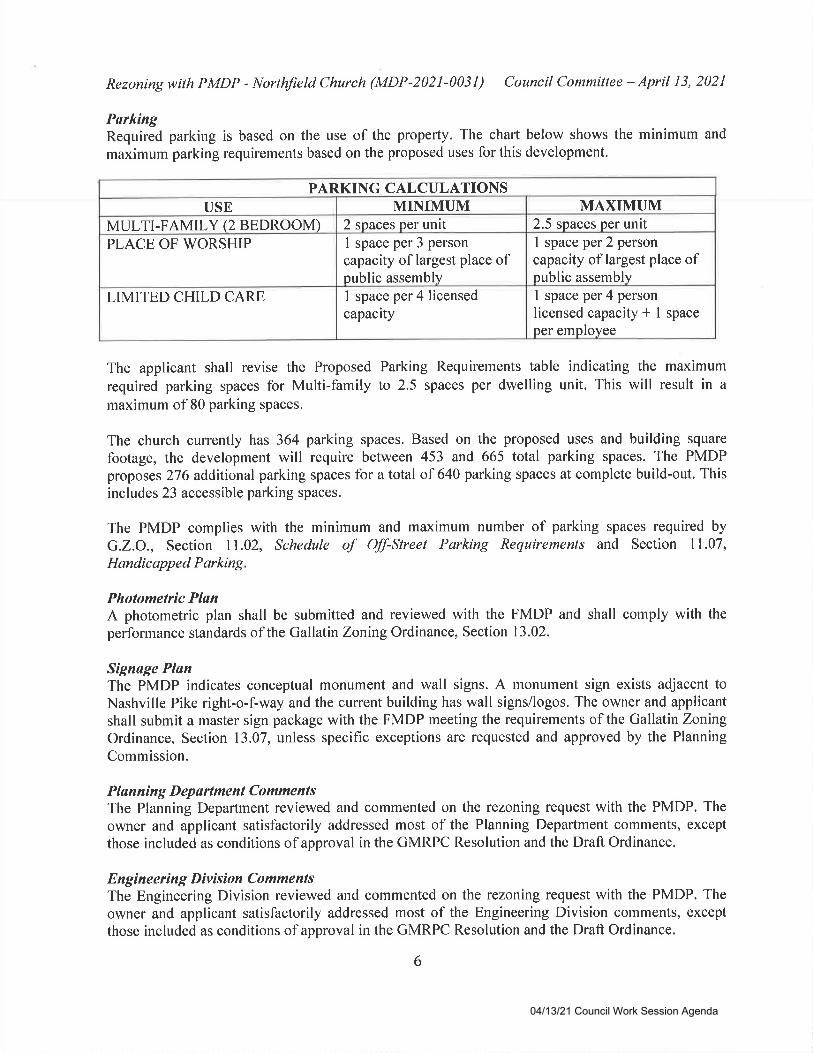
ParkingRequired parking is based on the use of the property. The chart below shows the minimum and
maximum parking requirements based on the proposed uses for this development.
PARKING CALCULATIONSUSE MINIMUM MAXIMUM
MULTI-FAMILY (2 BEDROOM) 2 spaces per unit 2.5 spaces per unit
PLACE OF WORSHIP I space per 3 person
capacity of largest place ofpublic assembly
1 space per 2 personcapacity of largest place ofpublic assembly
LIMITED CHILD CARE 1 space per 4 licensedcapacity
1 space per 4 person
licensed capacity * 1 spaceper employee
The applicant shall revise the Proposed Parking Requirements table indicating the maximum
required parking spaces for Multi-family to 2.5 spaces per dwelling unit. This will result in a
maximum of 80 parking spaces.
The church currently has 364 parking spaces. Based on the proposed uses and building square
footage, the development will require between 453 and 665 total parking spaces. The PMDPproposes 276 additional parking spaces for atotal of 640 parking spaces at complete build-out. Thisincludes 23 accessible parking spaces.
The PMDP complies with the minimum and maximum number of parking spaces required by
G.Z.O., Section 11.02, Schedule oJ' Off-Street Parking Requirements and Section 11.07,
Handicapped Parking.
Photometric PlanA photometric plan shall be submitted and reviewed with the FMDP and shall comply with the
performance standards of the Gallatin Zoning Ordinance, Section 13.02.
Signage PlanThe PMDP indicates conceptual monument and wall signs. A monument sign exists adjacent toNashville Pike right-o-f-way and the current building has wall signs/logos. The owner and applicantshall submit a master sign package with the FMDP meeting the requirements of the Gallatin ZonlngOrdinance, Section 13.07, unless specific exceptions are requested and approved by the Planning
Commission.
Pla n n i n g D ep artme nt Co mme nt sThe Planning Department reviewed and commented on the rezoning request with the PMDP. The
owner and applicant satisfactorily addressed most of the Planning Department comments, except
those included as conditions of approval in the GMRPC Resolution and the Draft Ordinance.
Engineering Division CommentsThe Engineering Division reviewed and commented on the rezoning request with the PMDP. The
owner and applicant satisfactorily addressed most of the Engineering Division comments, exceptthose included as conditions of approval in the GMRPC Resolution and the Draft Ordinance.
6
04/13/21 Council Work Session Agenda
Rezoning with PMDP - Northfield Church (MDP-202 I -003 I ) Council Committee - April I 3, 202 l
Other Departmental CommentsOther Departments reviewed and commented on the rezoning request with the PMDP. The applicant
satisfactorily addressed all comments, or these will be addressed at the FMDP stage.
I@:Ttre Planning Department and Planning Commission recommend that City Council approve
Ordinance No. O2lO 4-22.
ATTACHMENTSAttachment 1
Attachment 2Attachment 3Attachment 4Attachment 5
Location MapPMDP for Northfield Church (ZONE-2021-0031)GMRPC Resolution No. 2021-033Project Prospectus from the Developer Following PC InputCommercial Corridor Community Character Area and GatewayCorridor Overlay Character Area
7
04/13/21 Council Work Session Agenda
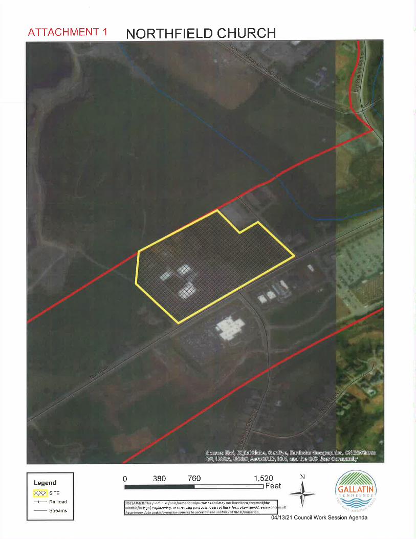
ATTACHMENT 1 NORTHFIELD CHURCH
Legend
xx> srrE
---r- Railroad
-
Streams
1,520 N
ptoductislegol, engineering, ot surveying purposes. Use6 oJ this inlormotion should rcview
utposes moy
0 380 760Feet CALLATIN
04/13/21 Council Work Session Agenda
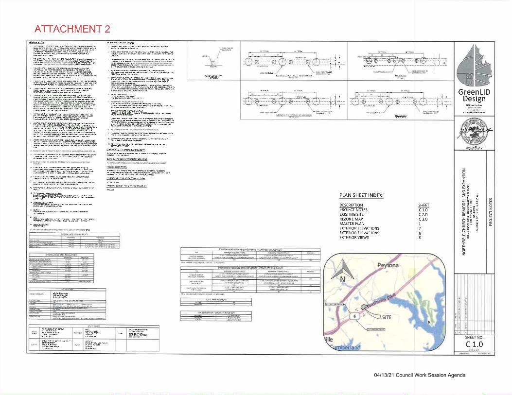
ATTACHMENT 2
GreenLlDDesign
z6z
z
oo&IelIU6
IFt
z
3- =i:z':
;sgd
a>
FzFU
I
c 1.0
/''"$"$r-
iol
,ll-i-r-l--tl
ffi
-lLJ r-I-'l--
I
I
9eNEdsrP ^rp
M^TNEMNCT PiovrioNt
ffircn
@.6!MJrrrurffir'rd's
@'b Er uilh ru r ao{(' e
5M^re0 coMrtrnoN or coNriufi roil
PLAN SHEET INDEX:
DESCRIPTIONPROJECI NOTESEXISTING SITE
REZONE MAPMASTER PLANEXTERIOR ELEVATIONSEXTERIOR ELEVATIONSEXTERIOR VIEWS
SHEETc1.oc)1c 3.01,
789
04/13/21 Council Work Session Agenda
ATTACHMENT 2
44GreenLlD
Design
zIz
z>
oa:=1>orE--;3*3r<:'uu >ts qE>A 2la >o=
trIFtz
t(,ztr2x
NO.
c 2.o
trEfE=rE=-=
Io
€
o
\...,/...-/'& ft.or'a
ooEo
o
a
$*i;*ri$,il,.
04/13/21 Council Work Session Agenda
o-mz-{N)
EXISTING SITE
T
iz9
c)LA)
b
NORTHFIELD CHURCH REMODEL AND EXPANSIONPRELIMINAfiY MASI€R DTVELOPMENT PUN
21OO NAsHVILLE PIKE
GALLATINSUMNER COUNil, IENNESSTE
6)PAUooaa)-I
i:&!2I
t
c'I
I
I
I
I
I
IE
l6
M3lA10lld
\
\
\\
tlilil
1{ilI
iE
sEdO@OXsoaEOJoq
L--..-
I
,i
,)I
I
I
i
I
I
I
I
l
I
I
I
lI
II
i
r1iE .-
?!EFt;::;:EEite:a
04/13/21 Council Work Session Agenda
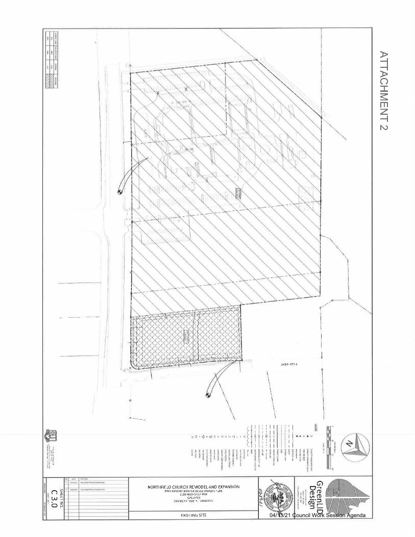
-l-lo-mz-lN)
a
sIIt,IIIIIIIII
o
otlr
HgtjJq.Jltl
::'-ililrt
:I-it:ltt l
!6!r 'tE.. I=ti: I-tl
;rjl-.rli
{-mf
Fom@
sFa gaEa
'qgE3EE
f,a$Eg!
*gF3iE
O
O
------..,
r.loR I ll.lLl l) cl llJlr(lll &Br BGlrld
O
Iillfr: Fl;i"tz:t .t lr:^tlm'j ,t t6,,!t2P,"
lwi9i:,,:
9R
III
at"lr
I
$:3q
Elr;
I
ARCHIIECTSConstruction
Mosler Plon
04/13/21 Council Work Session Agenda
ATTACHMENT 2
GENERAL NOTES:
1. ALTERNATIVE ARCHITECTURE PLAN IS
BEING REOUESTED WITH THIS PMDP
2. SIGNS SHOWN WITHTHIS PMDPARE
CONCEPTUAL. ALL SIGNS SHALL MEET
THE GALLATIN ZONING ORDINANCE
UNLESS SPECIFIC EXCEPTIONS ARE
GR,ANTED BYTHE >LANNING
COMMISSION ATTHE FI\IDP SIAGE
=ts6
aFCJL!FI(J
m€6E
".i]z
9i
IOu:fIOouIFuoz
e
@D
s-COATACRYLIC FINISH LOW E GTAZING
v,coootlt
ooXEI
7
EtD
m
RTHF,RC*
ffi
FIBER CEMENT SIDINGVINTAGilOOD CEDAROR
'O
S.COATACRYLIC FINISH
FINISH PALETTE
ARCHITECTURAL SHINGLES MEIAL FLASHING
20' 40' 60
04/13/21 Council Work Session Agenda
ATTACHMENT 2
coo=E
O
C')FCJL!FrOE
=\5a
ECfr
IOulIUo)UuIuoz
vlg
E#OEQ)-
to.9oE8X=r',5
GENERAL NOTESI
1 ALTERNATIVE ARCIITECTURE PLAN IS
BEING REOUESTED WITH THIS PMDP
-
'-:?z
|Gl'ni'
L:t=1-@
-LOW E GLAZINGHARRISTONE
8
lI
EACK TLEVAIION
ut
,!h&a
" g,lr;:Si
HARDIEBOARD HARDIEBOARD
FINISH PALETTE
ARCHITECTURAL SHINGLES METAL FLASHING
- -
04/13/21 Council Work Session Agenda

-l-{o-mzN
oz
@>B2izaiio=@
3?5a_io
6mrl<!9Z3a;
Exterior ViewsVilloqe @ Northfield
fllilH
NORTHFIELD CHTJRCH $,Br BGW"o
ConstructionARCHITECTS
04/13/21 Council Work Session Agenda
ATTACHMENT 3
GMRPC Resolution No. 2021-033
A RESOLUTION OF THE CITY OF' GALLATIN MUNICIPAL-REGIONAL PLANNINGCOMMISSION RECOMMENDING APPROVAL TO GALLATIN CITY COUNCIL OF ANORDINANCE RT,ZONTNG TWO (2) PARCELS TOTALING 17.82 +l- ACRES FROM THER2O.LOW DENSITY RESIDENTIAL DISTRICT TO THE MRO-MULTIPLE RESIDENTIALAND OF'F'ICE DISTRICT WITH A PRELIMINARY MASTER DEVELOPMENT PLAN FORNORTHFIELD CHURCH, ON 20.20 +/- ACRES, LOCATED NORTH OF NASHVILLE PIKEAND WEST OF PILOT VIEW. (ZONE-2021-0031)
WHEREAS' the applicant submitted an application for a rezoning with a PreliminaryMaster Development Plan consistent with Section 15.07.030 of the City of Gallatin Zoning Ordinance;
and
WHEREAS, THE CITY OF GALLATIN MUNICIPAL-REGIONAL PLANNINGCOMMISSION considered the rezoning with a Preliminary Master Development Plan submitted by the
applicant, GreenLID Design, at its regular meeting on March 22,2021; and
WHEREASO THE CITY OF GALLATIN MUNICIPAL-REGIONAL PLANNINGCOMMISSION reviewed the rezoning with a Preliminary Master Development Plan application,
materials and supporting documentation submitted by the applicant, the analysis, findings and
recommendations presented by City Staff in the Planning Commission Staff Report and the evidence
and testimony presented during the meeting, and
NOW, THEREFORE, BE IT RESOLVED BY THE GALLATIN MUNICIPAL-REGIONAL PLANNING COMMISSION as follows:
Section The Gallatin Municipal-Regional Planning Commission in itsdeliberations makes the following findings pursuant to Tenn. CodeAnnotated $13-3-413, $13-4-310, $13-7-201 and $13-7-202 and Section15.07.030 of the City of Gallatin Zoning Ordinance:
The owner and applicant submitted a completed application with required
attachments to the City requesting approval of the zoning change with a PreliminaryMaster Development Plan as required by Section 15.07.030 of the Gallatin ZoningOrdinance and complies with the twelve (12) design standards required of the code.
2. The rezoning and Preliminary Master Development Plan is in agreement and
consistent with the intent and land use recommendations of the Gallatin on the Move2020 General Development and Transportation Plan Update 2008-2020 including the
Commercial Corridor Community Character Area and the Gateway Corridor OverlayCharacter Area.
3. The Preliminary Master Development Plan is consistent with the purpose and intentof the MRO-Multiple Residential and Office zone district and complies with the use
restrictions, minimum bulk and height regulations, minimum lot dimensions, yard
lines, and minimum building setback line requirements established in said zone
district except where exceptions have been granted.
04/13/21 Council Work Session Agenda
ATTACHMENT 3
4. The property proposed for rezoning has adequate public utilities, infrastructure and
municipal services necessary to serve the proposed development and population
permitted by the requested zoning and such necessary services and facilities will be
provided upon development of the property.
5. The zoning and Preliminary Master Development Plan will not adversely affect
adjoining property owners or any such adverse effect can be mitigated by applying
design and performance standards or is justified by the public good or welfare.
6. The Gallatin Regional-Municipal Planning Commission received public comment and
reviewed the application and recommended to the City Council action on the
proposed rezoning request.
7. The Preliminary Master Development Plan complies with the Design and
Performance Standards of the Gallatin Zoning Ordinance as described in Section
13.02.
8. The rezoning with Preliminary Master Development Plan will be compatible with the
surrounding environment and will protect the public health, safety and welfare and
will not be injurious to other property or improvements in the area in which the
property is located.
9. The legal purposes for which zoning regulations exist have not been contravened.
l0.No one property owner or small group of property owners will benefit materiallyfrom the approval to the detriment of the general public.
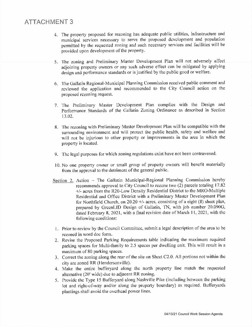
Section 2. Action - The Gallatin Municipal-Regional Planning Commission hereby
recommends approval to City Council to rezone two (2) parcels totaling 17.82
*/- acres from the R20-Low Density Residential District to the MRO-MultipleResidential and Office District with a Preliminary Master Development Plan
for Northfield Church, on20.20 -fl- acreso consisting of a eight (8) sheet plan,
prepared by GreenLID Design of Gallatin, TN, with job number 20.090G,
dated February 8, 2021, with a final revision date of March I I , 2021, with thefollowing conditions:
l. Prior to review by the Council Committee, submit a legal description of the area to be
rezoned in word doc form.2. Revise the Proposed Parking Requirements table indicating the maximum required
parking spaces for Multi-family to 2.5 spaces per dwelling unit. This will result in amaximum of 80 parking spaces.
3. Conect the zoning along the rear of the site on Sheet C2.0. All portions not within the
city are zoned RR (Hendersonville).4. Make the entire bufferyard along the north property line match the requested
alternative (20'wide) due to adjacent RR zoning.
5. Provide the Type l5 Bufferyard along Nashville Pike (including between the parking
lot and righfof-way and/or along the property boundary) as required. Bufferyardsplantings shall avoid the overhead power lines.
04/13/21 Council Work Session Agenda
ATTACHMENT 3
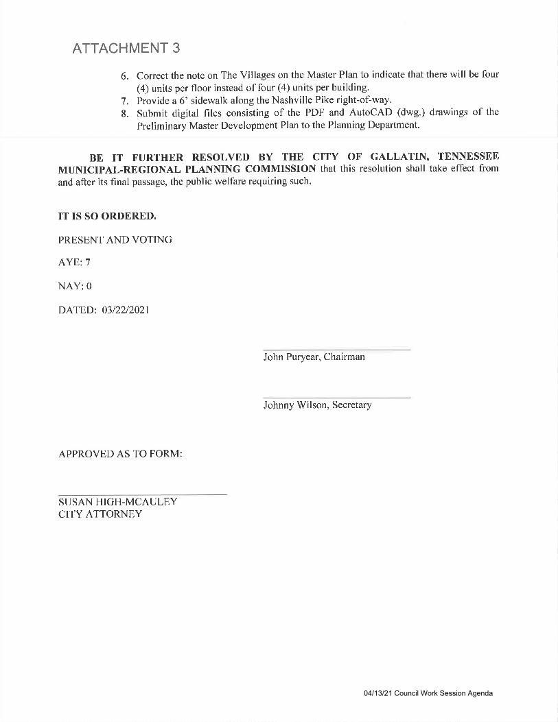
6. Correct the note on The Villages on the Master Plan to indicate that there will be four(4) units per floor instead of four (4) units per building.
7. Provide a 6' sidewalk along the Nashville Pike right-of-way.
8. Submit digital files consisting of the PDF and AutoCAD (dwg.) drawings of the
Preliminary Master Development Plan to the Planning Department.
BE IT FURTHER RESOLVED BY THE CITY OF GALLATIN, TENNESSEEMUNICIPAL-REGIONAL PLANNING COMMISSION that this resolution shall take effect from
and after its final passage, the public welfare requiring such.
IT IS SO ORDERED.
PRESENT AND VOTING
AYE:7
NAY:0
DATED: 03/22/2021
John Puryear, Chairman
Johnny Wilson, Secretary
APPROVED AS TO FORM:
SUSAN HIGH-MCAULEYCITY ATTORNEY
04/13/21 Council Work Session Agenda

ATTACHMENT 4NorthField Church Master Plan - Resubmission Post-March 8th City of Gallatin Planning Commission session
Proiect Obiective: to obtain City of Gallatin zoning approval for the NorthField S-year Masterplan. The NorthField
Masterplan is in support of the NorthField mission to love God, love people, and make Jesus known. The plan optimizes
the use of our 2g-acre parcel, with particular focus on serving and being connected in community with Sumner County.
Key elements include The Sumner Center @NF (TSC), which is a remodeling and repurposing of an existing building to
provide a variety of services and programs for two specific community groups; a) families with young adults with Special
Needs, and b) families who are working towards stability and thriving, but need a few years of support to thrive (this is a
category of families called A.L.l.C.E - Asset Limited, lncome Constrained, Employed by the United Way, who are
employed, living above poverty level,.i.e. in the $35-60K annual income range, but cannot yet afford basic necessities
like permanent housing, food coverage, insurances, etc.). TSC programming includes a Dental Lab (no cost basic dental),
a daily Food Pantry (for food insecurities), classes on how to properly develop/manage a monthly budget, free legal
counsel, mental health screening, and job acquisition/advancement skill training. TSC programming will also include
Special Needs programming like GiGi's Playhouse for Downs Syndrome families and a variety of Special Olympics
programs in the gymnasium. The location includes a commercial kitchen for events and ministry rooms.
Future key aspects of the NF Masterplan include the development of the Villages Community at NorthField, which will
be directly connected to qualifying participants in TSC programming. The Village living units (32) will allow TSC qualified
participants time to save and afford permanent housing (approx, 16-24 months) while they are in the TSC programming.
The Villages will also provide a permanent housing location for young adults with Special Needs, so that their local
families can be at peace with their special needs family member living on their own in case of a 'change of life' event
with the parent(s), This Villages @NF community will be directly connected to, and part of the NorthField campus and
programming including handicap accessible sidewalks into the Sumner Center, access to the outdoor Pavilion, grass
picnic areas, accessible playground, and future pre-school'
Finally, the NF master plan includes a new Pre-School/Kids/Office Building to facilitate growth in the Pre-School, Kids
programming that will offer a unique weekday Pre-School curriculum to integrates S.T.E.A.M. curriculum with Christian
programming and learning. The NF Masterplan also includes the expansion of NF Gathering Space to enable expansion
of worship space (from 700 to 1050) and additional support space in the rear of the worship facility in the future.
MAJOR ADJUSIMEIIIs based on 318/202t City of Gallatin Planning Commission lnputs;
t. Villaees @ Sumner Center CONNECTIVITY to NorthField Campus - based on input, we have added a 300 ft.
concrete sidewalk from the central gazebo of The Villages @NF area, flowing directly to the NF crosswalk at The
Sumner Center Entry. This handicap accessible passageway will be path lighted at night, & include benches for
stopping which overlook the Grass Picnic Area in the center of the campus. The NF sidewalk system will also
allow access to the Pavilion (grills, covered picnic area, etc.), the lnclusive Playground, and the basketball court.
ln addition, we will be adding a natural trail path on the upper part of the grounds from the gazebo to the
basketball, playground, and pavilion...for those that want to have a more natural walking experience.
2. Villages @ Sumner Center CONNECTIVITY to Gordon Crossine Retail - a stated objective of the Planning Council
was to ensure residents of TSC have efficient and safe access to the new Gallatin traffic light being installed at
Nashville Pike/Gordon Landing intersection. Our proposal is to have residents use the new 300 ft Villages
concrete sidewalk to access the sidewalks on the NorthField campus that lead to the "Entryf Exit" at the frontage
of NorthField where the crosswalk will be installed onto Gordon Crossing. This approach is a total distance of
892 feet, with verv little srade. minimal traffic flow. and the entire travel path is illuminated (bv sidewalk
liehts. and parking lot lishtsl in the evenine. The other option discussed was to add sidewalk along Nashville
Pike from Pilot View Rd to the Gordon Crossing lntersection. This option and route are a total distance of 1387
feet (+55% longer than our proposal), with a very steep grade (up Pilot View, up Nashville Pike), is not lighted,
and potentially less safe by walking along busy Nashville Pike without guard rails & 50+ MPH speeds.
04/13/21 Council Work Session Agenda
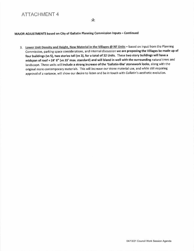
ATTACHMENT 4
MAJOR ADJUSTMENTS based on City of Gallatin Planning commission lnputs - continued
3. Lower Unit Densitv and HeiFht, New Material in the VillaRes @ NF Units - based on input from the Planning
Commission, parking space considerations, and internal discussion we are proposing the Villages be made up of
four buildings (vs 5), two stories tall (vs 3), for a total of 32 Units. These two story buildings will have a
midspan of roof =24' 6" (vs 35' max. standard) and will blend in well with the surrounding naturaltrees and
landscape. These units will include a strong increase of the 'Gallatin-like' stonework looks, along with the
original more contemporary materials. This will increase our stone material use, and while still requiring
approval of a variance, will show our desire to listen and be in touch with Gallatin's aesthetic evolution.
-2-
04/13/21 Council Work Session Agenda
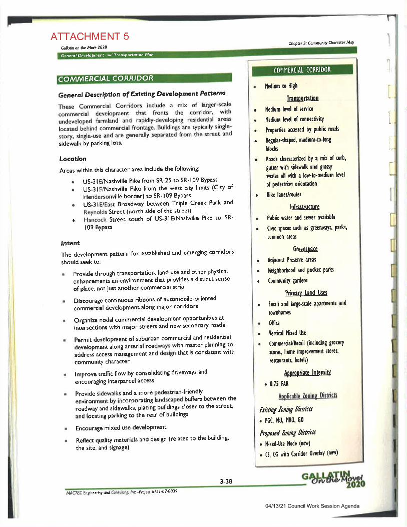
ATTACHMENT 5Gollotin on the Move 2020
lntent
The development Pattern for established and emerging corridors
should seek to:
Chs|let 3: Communv Chatoclet l'titq
Generol Description of Existing Development Potterns
These Commercial Corridors include a mix of larger-scale
commercial development that fronts the corridor' with
undeveloped farmland and rapidly'developlng resldential areas
located behind commercial frontage' Buildings are typically single-
story, single-use and are generally separated from the street and
sidewalk bY Parking lots.
Locotlon
Areas within this character area include the following
r US-3 lE/Nashville Pike from SR-25 to SR- 109 Bypass
e US-3lEiNashville Pike from the west ciry limits (City of
Hendersonville border) to SR-109 Bypass
o US-3 lE/East Broadway between Triple Creek Park and
Reynolds Street (north side of the street)
. Hancock Sreet south of US-3lE/Nashville Pike to SR-
109 Bypass
I
,lI
Provide through transPortation, land use and other physical
enhancementian environment that provides a distinct sense
of place, not iust another commercial strip
Discourage continuous ribbons of automobile-oriented
commercial development along maior corridors
Organize nodal commercial development opportunities at
intJrsections with maior streets and new secondary roads
Permit development of suburban commercial and residential
development along arterial roadways with master planning to
addressaccessmanaSementanddesignthatisconsistentwithcommunity character
lmprove traflic flow by consolidating driveways and
encouraging interParcel access
Provide sidewalks and a more pedestrian-friendly
environment by incorporating iandscaped buffers between the
ro.dw"y and sidewalks, placing buildings closer to the street'
and locating parking to the rear of buildings
Encourage mixed use develoPment
Reflect qualiry matedds and design (related to the building'
the site, and signage)
a
I
t
I
COMMERC,AL CORR'DOR
Generol Development ond Tronsponotion Plon
lledium to High
Iransportation
I'ledium level of senice
l{edium levd of connectivitY
Properties ac€c$ed by public roads
Regular-$aped, mcdium'to'long
blocks
Roads tharacterired by a mix ol curb,
gutter with sidewalk and grasY
swales all with a low'to-medium level
of pedestrian orientation
Bike lanes/toutel
lnfiastructure
Public water and sewer available
Civic lpaces tuch as Sreenvlays, parks,
common areat
GreensPace
Adiacent Presene arcas
lleighboftood and Pocket Parfts
Community gardcns
Primary land Uns
Small and lalge*cale apartments and
townhomel
Office
Tertical l'lixed llse
Commercial/Retail (including grocery
storcs, home imProvement stores'
restaurant$ hoteh)
ABproPriate lntensitl
o 0,15 fAR
Applimble loning Diltrictt
fxhting loning Dridas
. PGC I'lU, I'1R0, G0
Propaed loning Dbtrkts
r I'lixed-Use llode (new)
. C5, CG with ftnidor 0vedaY (new)
COI,Il,lIRCIAL CORRIDOR
a
a
a
a
t
a
a
o
a
a
a
a
a
a
a
t
I
i
t
MACTEC Engineering and tn -Prclect 6 l 5 l -07'0039
3-38
04/13/21 Council Work Session Agenda
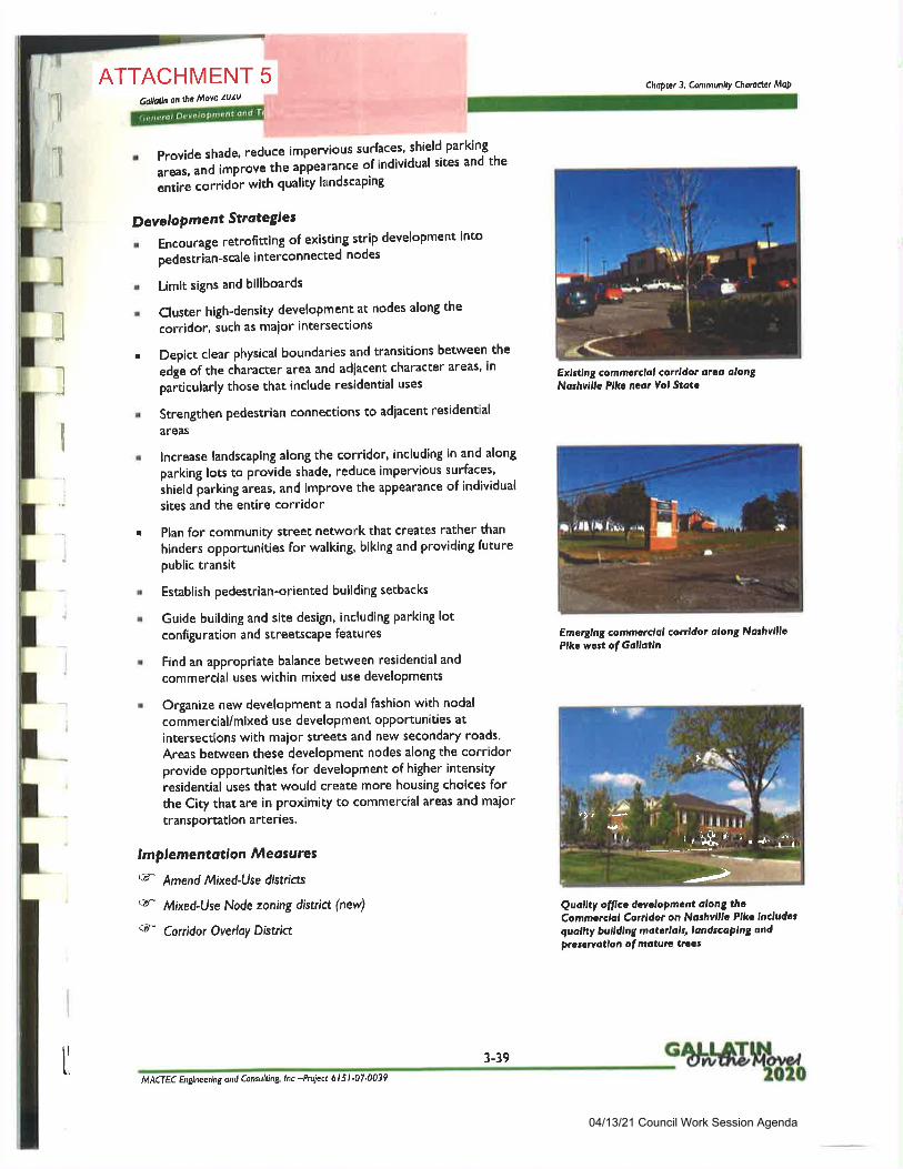
ATTACHMENT 5CoilaAn on he Move lulu
r Provide shade, reduce impervious surfaces' shield parking
areas, and improve th" "pp"""nce
of individual sites and the
lntit" ."ttiaor with quality landscaping
D evel oPm ent Stroteg'|es
r Encourage retrofittint of existing strip developm€nt into
pedestrian-scale interconnected nodes
r Limit signs and billboards
. Cluster high-density development at nodes along the
corridor, such as maior intersections
r Depict clear physical boundaries and transitions between the
edge of the character area and adiacent character areas' in
particularly those that include residential uses
r StrenSthen pedestrian connections to adiacent residential
areas
r lncrease landscaping along the corridor, including in and along
parking lots to provide shade, reduce impervious surfaces,
strietd parting areas, and improve the appearance of individual
sites and the entire corridor
r Plan for community street network that creates rather than
hinders opportunities for walking, biking and providing futurepublic transit
r Establishpedestrian-orientedbuildingsetbacks
r Guide building and site design, including parking lotconfiguration and streetscape features
r Find an appropriate balance between residential and
commercial uses within mixed use developments
. OrSanize new development a nodal fashion with nodal
commercial/mixed use development oPPortunities at
intersections with maior streets and new secondary roads.
Areas between these development nodes along the corridorprovide opportunities for development of higher intensity
residential uses that would create more housing choices forthe City that are in proximity to commercial areas and maior
transPortation arteries'
lmpleme ntotlon Meosures
F Amend lVixed-Use districts
cd" Mixed-Use Node zoning distria (new)
<F Corridor Overloy District
Chapter 3: Communily Chotodet MoP
Exlstlng commcrelol corrldot orca alongNorhvillc Plkc ncot Vol Stotc
Emarglng commcrclol conldor alorg NorhvlllcPlt. wcat of Gallotln
Quollty offlcc dcvclopmcnt along thcCommcrclal Conldor on Noshvlllc Plkc lncludcrquallty bulldlng matcdals, londscoplng ond
Prata'a/otlon of moturc truas
,l
1
llII
.'
.-
I
ll
Q, r7r.l, ,
,:Fry-*1S"r';'"^"il
trt
'&rsi.
--t>
*Q\
ir
MACrEC Englneeilng ond Consulting lnc -Prciea 6 I 5 I .07.0039
3-39
04/13/21 Council Work Session Agenda
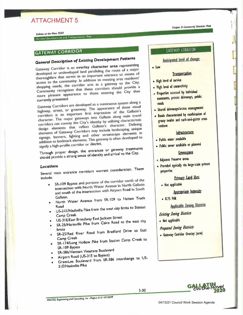
Generol Develo Prnent dnd TronsPonotron Plon
ATTACHMENT 5
Gollotin onthe Move 2020
Chaq|.rt 3: CommunltY Choroaet MoP
I
Generol Description of Existing Dcvclopment Potterns
Gateway Corridor is.an overlay charactor area rePresentlng
developed or undevelopi'f""a p"tUeling the route of a maior
thoroughfare that serves as an important entrance or means of
access to the communr;;'ili;il ; e.TJ'f fi:tffi:;;.*,* ";f: - :T-i'ili."l*li S,.,.io:::'ff:,,; i'*,q'":il"il:T'.1T1-#lil";;u- *
-'no'" "nt"'ins
tt'" bitv than
.urr"nily presented'
Gateway Corridors are developed as a continuous system along a
;;il{*,"u1L^{*;;Jt",ll,::l:l'"","hT%i.,li.',:1fi :::lil:Tn:"':[?*r;;*1l.;;"111'l:*0'^t."1i-:'-1"-'",icorrrdors can convey .fr" cryt identrty by utirrzing charactertsttc
::iff ;;i:;; rt.f[i::,"6#*fi ,"11ffi::il"ff1il1!:[:U:: ;J'*::"i1,I"s "J-.1*';1 ::::::;il"
ereiren'cs. in
additlon to landmarr "t"r"i"no' Thls gateway is often developed to
;;;,;;; iiet'pt"nu corridor or district'
Through ProPer design' the entrances or' tateway treatments
should provld" " "'ontj''"n;
;il;;ily and a-rrival to the city'
Locotlons
Several main entrance corridors warrant consideration' These
include:
o SR-109 Bypass and portigl; of the-corridor north of the
intersection iiitrt'rl!"tt Water Avenue in North Gallatln
and south "fT:ill.rsettJi *i'tt Airport Road in South
. i,lffhater Avenue from SR'109 to Hatten Track
Roado US-3 I E/Nashville Pike from the west city limits to Station
CamP Creek
' US-3lE/East B'oud"'uy EastJackson Street
r sR'25/Ha"i"Tu"?il"'t-mttito Road to the east city
. lillltu,*"d River Road from Bradford Drive to East
. liigriJ:i!'""on' Pike from Station camp creek to
SR-109 BYPass
. SR-3g61/iJtnamVeteransBoulevardo Airport Road (US-3lE to Byp-ass)
^r GreenLeatJ;; irot 'sn"iao interchange to us-
3lE/Nashville Pike
DORCORR'GATEWAY GATEWAY iORRI DOR
Anticipattd levsl ol chanle:
IransPortation
. lligh hvel of senicc
. lligh ltvel ol connecivitY
o Prooerties accesscd by individual
euements, pilvate driveways' public
roads
. Shared driveways/acces management
. Roadl charactedzed by combination ol
grasy swales and curb'and'guttel crotl
tectiont
lnfiasuucture
. Public warcr aYailablc
. Public sewer available or planned
Greenspace
. Adiacent Prcsewc areu
. Provided typically via large+cale private
PoPerties
Primary land Uses
. llot aPPlicrbh
APProPriate lntensitl
. 0.75 fAR
APPliable Zoning Districts
Exising loning histiat
. llot aPPlicable
Pnpond hning Dbtricts
. Ga$waY Conidor 0vedaY (new)
. low
MACTEC hglneerng ond lnc -Prclea 6 I 5t-070039
3-30
04/13/21 Council Work Session Agenda
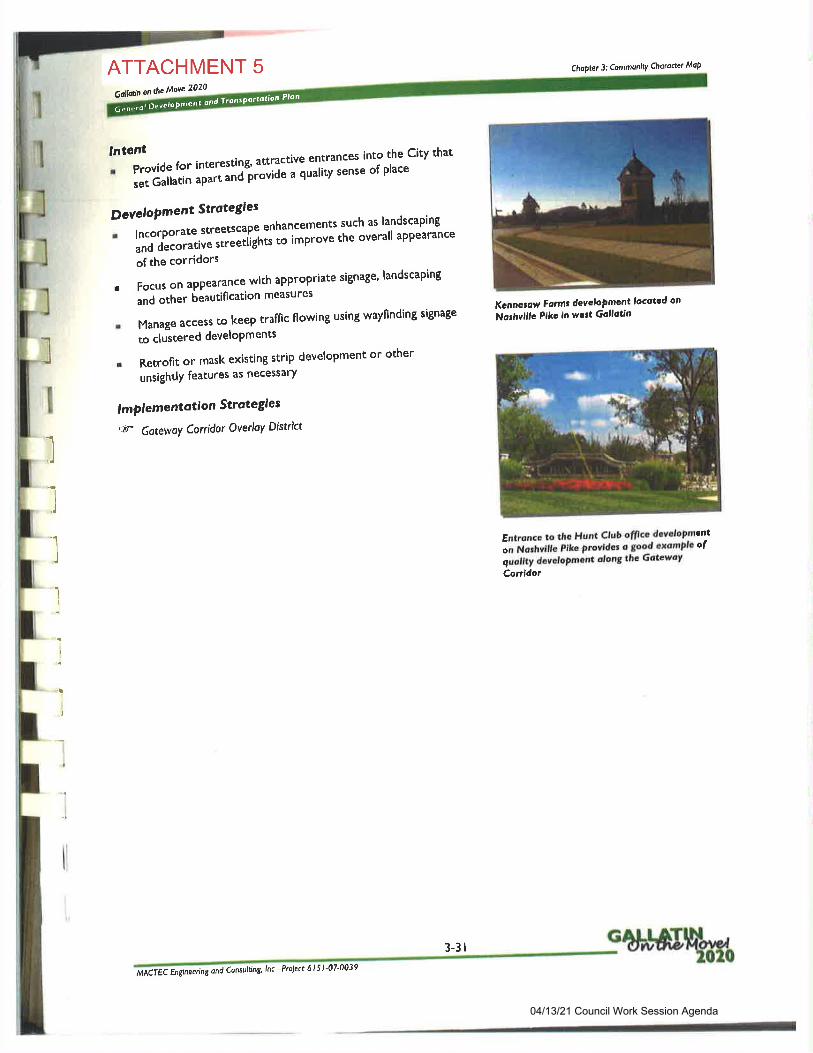
6entrol OeveloPnren' ond fnntPoraotjon Plan
'J'"lrt ",o"
for interesting' aftractive entrancesinto the City that
set Gallarin "pr* "ni"ii"viJe a quatity sense of place
DcveloPment Strotegies
r lncorporate stree$cape enhancements such as landscaping
and decorativ" t"uiit''gtt* to improve the overall aPPearance
of the corridors
r Focus on aPPearance with appropriat'e signage, landscaping-
and other beautification measures
r Manage access to keep traffic flowing using wayfinding signage
to clustered develoPments
r Retrofit or mask existing strip development or other
unsightlY features as necessarY
I mPl e me ntation Strotegles
G- Gatewoy Cortidor Ovedoy District
ATTACHMENT 5Golla/n on the Move 2020
Choplet 3: CommunilY Chardctct MoP
Kcnnolaw Formr developmcnt locotcd on
Norhvlllc Plks ln wcrt Gotlottn
I
l
I
I
I
,]
Entrdnce to lhe Hunt Club ofllcc dcvalopment
."-rvitirril. Pike provide: o good axamplc ofguollty dcvelopment d,on8 the Gotcwoy
Conidor
,]
a
)
3-3 I
lnc -Pto)ect 6 I 5 I -07'0039MACTEC Englneering ond Consufing
04/13/21 Council Work Session Agenda

CITY OF GALLATINCOUNCIL COMMITTEE AGENDA
APRIL 13,2O2I
DEPARTMENT: PLANNING DEPARTMENT AGENDA #
SUBJECT:An Ordinance No. O21Q4-23 of the City of Gallatin, Sumner County, Tennesseeo approving an
Amended Preliminary Master Development Plan for Lowe's Home Center and approving a
Preliminary Master Development Plan for the Vinewood Townhomes on a 7.24 +l- acre lot and a
portion of a 3.9 */- acre lot.
SUMMARY:An Ordinance of the City of Gallatin, Sumner County, Tennessee, approving an Amended
Preliminary Master Development Plan for Lowe's Home Center and approving a Preliminary Master
Development Plan for the Vinewood Townhomes on a 7.24 +l- acre lot (Tax Map 136, Parcel
037.00) and a portion of a 3.9 +l- acre lot (Tax Map 136, Parcel 038.00), zoned MRO-MultipleResidential and Office and PGC-Planned Ceneral Commercial, located south of Nashville Pike and
east of Browns Lane; authorizing the revision to be indicated on the Official ZoningAtlas; repealing
conflicting ordinances; providing for severability; and providing an effective date.
On March 22,2021, the Gallatin Municipal-Regional Planning Commission recommended approval
of the Preliminary Master Development Plan in GMRPC Resolution No.2021-036. (MDP-2021-0 1 43).
RECOMMENDATION:
ATTACHMENT:
OrdinanceCorrespondenceContract
Bid TabulationOther
I.x_
ApprovedRejectedDeferred
Notes:
04/13/21 Council Work Session Agenda
2
ORDINANCE NO. O2IA4-23
AN ORDINANCE OF THE CITY OF GALLATIN, SUMNER COUNTY, TENNESSEE,APPROVING AN AMENDED PRELIMINARY MASTER DEVELOPMENT PLAN FORLOWEOS HOME CENTER AND APPROVING A PRELIMINARY MASTERDEVELOPMENT PLAN FOR THE VINEWOOD TOWNHOMES ON A 7.24 +/. ACRELOT (TAX MAP 136, PARCEL 037.00) AND A PORTION OF A 3.9 +l- ACRE LOT (TAXMAp 136, PARCEL 038.00), LOCATED SOUTH OF NASHVILLE PIKE AND EAST OFBROWNS LANE; AUTHORIZING THE REVISION TO BE INDICATED ON THEOF'FICIAL ZONING ATLAS; REPEALING CONFLICTING ORDINANCES;PROVIDING FOR SEVERABILITYO AND PROVIDING FOR AN EFFECTIVE DATE.
WHEREAS, the applicant submitted a complete application for a Preliminary Master
Development Plan on a portion of two (2) parcels totaling ll.l4 +lacres located south of NashvillePike and east of Browns Lane in Gallatin, Tennessee; and
WHEREAS, the propefty is currently zoned MRO-Multiple Residential and Office; and
WHEREAS, the Gallatin Municipal-Regional Planning Commission reviewed and
recommended approval of the Amended PMDP and the proposed Preliminary Master
Development Plan in GMRPC Resolution No 2021-036; and
WHEREAS, a public hearing was held following public notice as prescribed by the
Gallatin ZoningOrdinance and Tennessee Code Annotated, Section l3-7-203; and
NOW, THEREFORE' BE IT ORDAINED BY THE CrTY COUNCIL OF THECITY OF GALLATIN, SUMNER COUNTY' TENNESSEE as follows:
Section 1. The City Council of the City of Gallatin does hereby approve an amendment
to the Lowe's Home Center PMDP and the Preliminary Master Development Plan for the
Vinewood Townhomes on a portion of two (2) parcels totaling 11.14 +l- acres, zoned
MRO-Multiple Residential and Office and PGC-Planned General Commercial, as
described in Exhibit'A'.
Section 2. The City Council of the City of Gallatin does hereby approve, authorize and
direct the revision of the City's Official Zoning Atlas to show the classification withpreliminary master development plan for the property.
Section 3. All ordinances or parts of ordinances in conflict with the provisions of thisordinance are hereby repealed to the extent of such conflict.
Section 4. If any provision of this ordinance or the application thereof to any person
or circumstance is held invalid, the invalidity shall not affect other provision or applications
of this ordinance which can be given without the invalid provision or application, and tothis end the provisions of this ordinance are declared severable.
04/13/21 Council Work Session Agenda
Section 5. This Ordinance shall take effect upon final passage, the public welfarerequiring such.
PASSED FIRST READING
PASSED SECOND READING:
MAYOR PAIGE BROWN
ATTEST:
CONNIE KITTRELLCITY RECORDER
APPROVED AS TO FORM
SUSAN HIGH.MCAULEYCITY ATTORNEY
04/13/21 Council Work Session Agenda

EXHIBIT'AO
The Preliminary Master Development Plan for the Vinewood Townhomes, consists of a nine (9)
sheet plan prepared by GreenLID Design of Gallatin, TN, with job number 19.026G, dated
February 8,2021with a revision date of March 25,2021, with the following conditions:
l. Fill in the ordinance lot widtho lot area, and yard requirements for MRO zoningin the site data chart on Sheet C1.0.
2. Ensure that all open space tracts and setback designations match the Site Plan
Sheet on all sheets.
3. Submit revised digital files consisting of the PDF and AutoCAD (dwg.)drawings of the Preliminary Master Development Plan to the Planning
Department addressing all conditions of approval.
04/13/21 Council Work Session Agenda
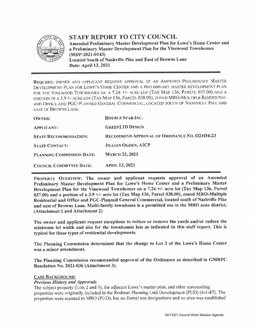
STAFF REPORT TO CITY COUNCILAmended Preliminary Master Development Plan for Lowe's Home Center and
a Preliminary Master Development Plan for the Vinewood Townhomes(MDP-2021-0143)Located South of Nashville Pike and East of Browns LaneDate: April 13,2021
Rneuosr: owNER AND AppLlcANT REeuEST ApPRovAL oF AN AMENDED PRELIMINARY MesrpnDgveLopN4gNT PLAN FoR LowE'S HOME CPNTPR AND A PRELIMINARY MASTER DEVELOPMENT PLAN
FoR THE VrNpwooo TowNuovps oN A 7.24 +l- ACRE Lor (Tax Mae 136, PeRcpl- 037.00) AND ApoRTroN oF A 3.9 +- ACRE Lor (TAX Map 136, PARCEL 038.00), zoNED MRO-MulrlPLE RESDENTIAL
AND OFFICE AND PGC-PLANNED GpNpnal ConanapRctAl-, LOCATED souTH oF NASHVILLE PIKE AND
EAST OF BROWNS LNNE.
OwnnR:
Appr,tc.lxt:
Surr RncomnanNDATIoN:
Srann CoNracr:
PuNnlnlc CourrltsstoN Darn:
Coutttcll, Conarrltrrpn Darn:
DOUBLE SraN INC.
GnnnNLID DESIGN
RncovunND AppRovAL oF ORutNaNcnNo. O2lb4-23
Jrllr.rN OconNo AICP
Mnncu 22,2021
ApRII- 13,2021
PRopnRry Ovnnvrnw: The owner and applicant requests approval of an AmendedPreliminary Master Development Plan for Lowe's Home Center and a Preliminary MasterDevelopment Plan for the Vinewood Townhomes on a 7,24+l- acre lot (Tax Map 136, Parcel
037.00) and a portion of a 3.9 +/- acre lot (Tax Map 1360 Parcel 038.00)' zoned MRO-MultipleResidential and Office and PGC-Planned General Commercial, Iocated south of Nashville Pike
and east of Browns Lane. Multi-family townhome is a permitted use in the MRO zone district.(Attachment I and Attachment 2)
The owner and applicant request exceptions to reduce or remove the yards and/or reduce theminimum lot width and size for the townhomes lots as indicated in this staff report. This is
typical for these types of residential developments.
The Planning Commission determined that the change to Lot 3 of the Lowe's Home Centerwas a minor amendment.
The Planning Commission recommended approval of the Ordinance as described in GMRPCResolution No. 2021-036 (Attachment 3).
Caso Bncrcnouno:Previous History and ApprovalsThe subject property (Lots 2 and 3), the adjacent Lowe's master plan, and other surroundingproperties were originally included in the Rodman Planning Unit Development (PUD) (4-l-87). The
properties were rezoned to MRO (PUD), but no formal use designations and no plan was established
04/13/21 Council Work Session Agenda
Vinewood Townhomes PMDP (MDP-202 I -0 I 43) Council Committee - April 13, 2021
at the time on Lot 2.The PUD expired on July 7,2000 due to inactivity, and the PUD was removedfrom the 7 .243 +l- acres (Lot 2) with the condition that no development can occur on the property
untila Master Development Plan is submitted and approved by the Planning Commission and CityCouncil.
On July 6,2004, the Lowe's Home Center property including Lot 3 was rezonedto PGC-PlannedGeneral Commercial with a Preliminary Master Development Plan (Ord. No. 00406-036) (3-l 1-04).The Lowe's Home Center, Inc. Final Plat was recorded December 3, 2004 (P.8. 22, Pg. 80-81)(Attachment 4). However, Lot 2 was not included in the Lowe's Master Development Plan and was
reverted back to its original MRO zoning. The owner retained ownership of this lot but did not haveplans to develop it at that time.
On August 26,2019, the Planning Commission did not recommend approval of a Preliminary MasterDevelopment Plan for a proposed Fairfield Inn on Lot2. The City Council also did not approve thisrequest (3-11274-19).
Drscussron:Proposed DevelopmentThe owner and applicant requests approval of an Amended Preliminary Master Development Plan
for Lowe's Home Center and a Preliminary Master Development Plan for the VinewoodTownhomes on a 7.24 +l- acre lot (Tax Map 136, Parcel 037.00) and a portion of a 3.9 +l- acre lot(Tax Map 136, Parcel038.00), zoned MRO-Multiple Residentialand Office and PGC-PlannedGeneral Commercial, located south of Nashville Pike and east of Browns Lane. Multi-familytownhome is a permitted use in the MRO zone district.
The PMDP proposes 50 fee-simple townhome units on fee-simple lots with driveways, single cargarage spaces, and various open space tracts, one of which consists of the private street andsidewalks.
Lot 2 of the Lowe's Home Center final plat will include the townhomes. The southerly portion ofLot 3 (Tax Map 136, Parcel038.00), which is within the Lowe's master plan, willonly be used forstormwater management.
The owner and applicant request exceptions to reduce or remove the yards andlot reduce theminimum lot width and size for the townhomes lots as indicated in this staff report. This is typical ofmost townhome developments.
The construction schedule anticipates construction will occur over a one-year time span.
Natural FeaturesThe property is currently vacant and, based on FEMA FIRM Map 47165C0426G, no portion of thesite is located within a flood hazard area. The natural topography for the existing vacant land slopesfrom the high point in the middle of the site (513') downward in all directions to the lowest pointalong the northeast property line (468'). Lot 2 was used as a fill site during the construction ofadjacent properties and sits above the Lowe's site (Lot l) but generally matches the elevation ofBrowns Lane along the west property line. There are existing tree lines along the south and northeastthat the developer intends to retain.
2
04/13/21 Council Work Session Agenda
Vinewood Townhomes PMDP (MDP-202 I -0 I 43) Council Committee - April 13, 2021
Adjacent or Area Uses
The Lot 2 is located behind the Lowe's Home Center and is zoned MRO-Multiple Residential andOffice, but is not part of the Lowe's master plan. Lot 3 is zoned PGC-Planned General Commercialand is within the Lowe's master plan. Only a portion of Lot 3 will be used for stormwatermanagement for the Vinewood project. To the west is The Villages condominium complex, zonedMRO-Multiple Residential and Office; to the south is The Cottages condominium complex, zonedMRO-Multiple Residential and Office; and to the east is a medical office and vacant lot currently,zoned MRO-Multiple Residential and Office.
Gallatin on the Move 2020 General Development and Tronsportation PlsnThis property is designed as Commercial Corridor on the Community Character Area Map. One ofthe intents of the Commercial Corridor is to provide a mix of larger-scale commercial developmentthat fronts the corridor and permit development of suburban commercial and residential projectsalong arterial roadways with master planning to address access management and design that isconsistent with community character and to encourage mixed-use development. Primary land usesinclude small and large-scale apartments and townhomes, office, vertical mixed use, andcommercial/retail development. This also applies the development strategy to provide an appropriatebalance between residential and commercial uses within mixed-use developments. The proposeddevelopment is consistent with the Character Area.
Lot LayoutThe plan includes ten (10) townhome buildings consisting of three, five, or six attached unitsfronting interior to the private street. Listed in the table below is the required and provided bulkregulations for the townhome development. An (*) indicates requested exceptions.
Attached Townhomes - MRO' Regulations:
Required Provided
Front Yard 20 feet 20 feet
Side Yard I 0 feet *0 feet
Rear Yard 1 5 feet *5 feet
Minimum Lot Area 6,000 s.f, * 1,872 s.f.
Minimum Lot Width 60 feet *24 feet*Request Exception from Section 07.02,020
Even though the lots will be approximately 1,872 square feet each, code requires a minimum lot sizeof 6,000 square feet per unit per lot. However, including all open space tracts, 6,307 square feet perunit will be provided onLot2.
These lot layouts are consistent with similar developments within Gallatin such as Oxford Station,Villas on the Greens, and Noble Park.
Stormwater ManagementStormwater will be treated through a water quality/detention area on Lot 3. An easement for theconveyance of stormwater will be required.
3
04/13/21 Council Work Session Agenda
Vinewood Townhomes PMDP (MDP-202 I -0 I 4 3) Council Committee - April 13, 2021
Access and Easements (P.U.D.E.)The PMDP shows a private street/driveway connecting to Browns Lane. The 20'-24' wide privatestreet will be placed within an open space tract. A 20' wide one-way loop provides vehicular access
to all of the townhomes. Sidewalks will be included along both sides of the private street whereresidences are proposed.
All land not within an individual lot will be included in an open space tract and PUDE to be
controlled and maintained by a homeowners association. Alltracts will include PUDEs.
Architectural DesignsThe PMDP includes conceptual architectural elevations for the proposed townhomes. Thetownhomes (with three to six units attached) will be two-stories with a front-loaded one-car garage
and a gabled roof. Although one car garages are provided for each unit, the front portion of the unitswill contain a driveway width to accommodate two cars. All facades will contain primarily brick orstone with some siding detailingthroughout. The applicant indicated thatat least l0'of elevation inthe center of the property will be excavated to reduce the height of the finished floor of the units.
The architectural elevations meet the required 70 percent brick or stone on each building facade perthe Basic Design Criteria of the Gallatin Zoning Ordinance, Section 13.08.010.A, Materials.
The final architectural elevations will be submitted and reviewed as part of the Final MasterDevelopment Plan.
Ope n Sp ace/B uffery ar ds/L an ds cap ingBufferyards are included in the general landscaping plan for the townhome development. These areintended to minimize the potential impacts of the proposed development on the adjacent propertiesas outlined in Article 13 of the Gallatin Zoning Ordinance.
Alternative bufferyards are requested for certain portions of the plan as follows:
BUFF'ERYARD REOUIRED/PROVIDED :
o MRO TO PGC (NORTH): TYPE l5/TYPE l5o MRO TO MRO (EAST): TYPE l0/ TYPE 10 (RETAIN EXISTINC VEGETATION)o MRO TO MRO (SOUTH): TYPE l0/ TYPE l0 (RETAIN EXISTING VEGETATION)o MRO TO MRO (COLLECTOR): TYPE l5lTYPE l0 (MAKE A TYPE l5 WITH CONDITION OF
APPROVAL)
Existing vegetation will be retained and used along the southern and eastern bufferyards. Some
vegetation will be removed in the area of the townhomes lots, A tree survey will be provided withthe FMDP, and additional evergreens will be added as required to meet the bufferyard requirements
Due to the constricted configuration of Lot 2,Lot 3 will be used for stormwater and to accommodatethe bufferyard adjacent to the private street and sidewalk.
Staff recommends the bufferyard adjacent to Browns Lane meet the Type 15 design requirements.The ooAlternative" designation should also be removed from the south and east property boundaries
4
04/13/21 Council Work Session Agenda
Vinewood Townhomes PMDP (MDP-202 I -0 I 4 3) Council Committee - April 13, 2021
as using existing vegetation is acceptable by code. The final landscaping plans will be submitted and
reviewed with the FMDP.
PurkingRequired parking is based on the use of the property. Townhomes require a minimum of 2 spaces per
unit. Parking for this development will be accommodated through single car garages in each unit and
the accompanying 20' driveway in front of each unit/lot. The parking meets the off-street parkingand loading regulations requirements of Section I I .0 I of the G .2.O.
Staff recommends that the developer consider guest parking with the FMDP.
Photometric Plan and Lighting FixturesA photometric plan that complies with the G.Z.O. shall be submitted with the FMDP
Muster Signage PlanSignage will be addressed at the FMDP stage. A final sign package must be submitted to thePlanning Department for review and approval prior to the installation of any signage on site. Allsignage installed on the site must comply with Section 13.07, Sign Regulation, of the GallatinZoning Ordinance.
Planning Department CommentsThe Planning Department reviewed and commented on the Preliminary Master Development Plan.
The owner and applicant satisfactorily addressed all Planning Department comments, except thoselisted as conditions of approval.
E ng inee ring D iv is io n Co mme ntsThe Engineering Division reviewed and commented on the Preliminary Master Development Plan.The owner and applicant satisfactorily addressed all Engineering Division comments.
Ot h er D epart me ntal C o mme nt sOther City Departments reviewed and commented on the Preliminary Master Development Plan. Allconditions have been satisfied, included as conditions of approval, or will be addressed at the FMDPstage.
Detailed water and sanitary sewer plans and specifications shall be submitted to the Gallatin PublicUtilities Department for review and approved. The plan shall meet the GDE underground policies.
Any of GDE's existing facilities that are required to be relocated will be at the developer's expense.
RnconauBnnlrlon:The Planning Commission and Planning Department recommends that City Council approveOrdinance No. O2lb4-23"
ATTACHMENTS:Attachment 1
Attachment 2
Attachment 3Attachment 4
Location MapPMDP for Vinewood Townhomes (MDP-2021-0143)GMRPC Resolution No. 2021-036Lowes Final Plat (P.8.22, Pg. 80-81)
5
04/13/21 Council Work Session Agenda
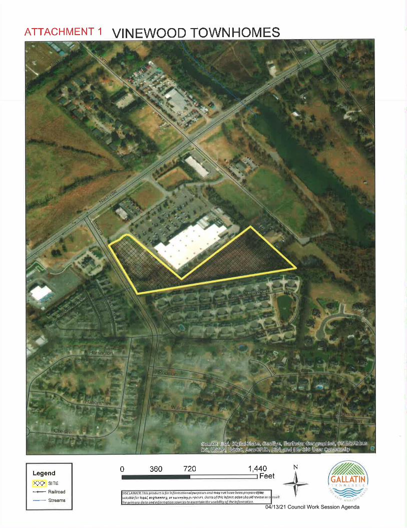
ATTACHMENT t VINEWOOD TOWNHOMES
Legend
XX) stre--i-- Railroad
- Streams
1,440 N
GALLATIN'ILNNLSSII
legal,engineeing,otsutveyingputposes.Usersolthisinlormationshouldrcviewmoy not
0 360 720Feet
'tW;'', /?
^,,1; , \r,.
04/13/21 Council Work Session Agenda

ATTACHMENT 2
44GreenllD
Design1148 West Main Strc*. Gallarln. TN 37056
51 5-230-7269 . 8r€en I id d esi8n. com
Vinewood Townhomes - PMDP
801. Browns Lane
Gallatin, TN 37065
19.025G
MDP-2021-OX43
04/13/21 Council Work Session Agenda
ATTACHMENT 2
-t-2q- 2t
o= s
= a21a
=g3k-;oo=aE
R Igi0Xz=LeY:;"E>a >z=>-
FozFuo
SHEET NO.
c 1.0
4GreenLlD
Design'qr,',fl
MDP-2021{143
PLAN SHEET INDEX:
DESCRIPTION
ryryElrgr$gsgljj
SHEET
PROJECT NOTES
EXISTING CONDITIONS & DEMOLITION PLAN
SITE PLAN
GRADING PLAN
SITE DETAIL5
TANDSCAPING PI.AN
EXTERIOR ELEVATIONS
COLOR PERSPECTIVE
c 1.0
c 2.0
c 3.0
c 4.0
c 5.0
t 1.0
PD.1
PD-2
!$!rE!-!9gq9E!gq
@J.dr!M'^
Iffi sl{ !F r{ G.o ^ros'u
eau& r AiMr
a
Itk'9
+"-.-
!;
A€
a
6I
aa
J
;
04/13/21 Council Work Session Agenda
-.t
o-mz-lN)
VINEWOOD TOWNHOMESPRFLIMINANY MASTER DEVELOPMENI PUN
&t BROWNS hNtCIfr OF GALUTIN
SUMNTR COUNW, ItNNI55EE
(.)N)b
EXISTING CONDITIONS & DEMO!ITION PLAN
oPd,ia
cra =I
q.Ei:
iIiI
:
e
IE
I
E
T
!
I33
I;a
ad
I
o
illlil
Iiltlil
::i
5,
F
I!
Iti
I6
A
;rI
e
?
t
..iiltiIi!ti;Eici;?iiiE"
!FiEi
l-tt;EE}N
a! i i;:;.,":;r!:!it!:;iel$!E i^:3 5
{
:E9-
?:;i i:.":F 3 fi:E
,t; -t! iE:qr;r;ii{r
;i!i:'e lE-e
6:i:
v
I
(
f..\
I
I
:;:I!e!
::ti:
I
,t
(
Fi,\1
I
)
-t'1-
\
I
l
i
I
)
I
II
6.--
;:;;: d E
ti!E.lro ^
04/13/21 Council Work Session Agenda
-lo-rnzt\)
T
a
VINEWOOD TOWNHOMESPREUMINARY MA5TER OEVTLOPMENI PUN
801 8nOWN5 LANE
CIN OF GATUTINsUMNTR COUNfl, ItNNE55f F
(')UJ
bSITE PLAN
6)
FHcra 1-t I
"!i:+e
t!1
t
lhl9
o
tllil
iilltlil
9
:2
6a6O0oasoa0oJuo
:g
E
l
!tt
t!
@
@
o
:!
o
o!;-e
oo
oooo
!i:!,l
I
I
a;i!ili6-:i;iili:;0:
FB::i::E
T
t.
;;3,l;1-;9 r -
:::igi: c:'
,i. iaiiri:'i!i!:61iil;8i:! i:'c
\
-r3.'+
3!
:i
5ar1;6 7,E: i
{
:l
I
I
H:
. "iHiEr;lti::!i:i;iii
ar:9*Etr?
;a
9"q=r:l
04/13/21 Council Work Session Agenda

-l
o-mz-lN)
VINEWOOD TOWNHOMESPRTUMINANY MASTTR DEVELOPMENI PUN
EOl BROWNS UNECIflOFGATUTIN
SUMNER COUNfl, TENNESSTE
r)Fo
GRADING PLAN
6)
FAcro 3JI
UE
t
;
t:1
?W)
s
e
_t
l9
a
I
!
c5
E
II
illil
{lilI
9:
I!3
e
tiI:tt
E
E:
a
!eItG
9
tE
t
".1: i E;l:tIiEiI!!:il!
E;iii
-tiEiiE
r:iilEI-. r:;i: I
::!5
{
!EQ
,-tseEIiiF:Eq
lr!li
.!E !E
. "e!!6 i€iiiSiEc;"E:!E:
:'E:-l
f-[
\
I
ti:t!a!l:;: t
}
i'
li
,\
I
I
l
6.--l:ll
.,8!E:G
!:i!i!g
i:;r
oo
-6 !!5!
a)ool
04/13/21 Council Work Session Agenda
oTmzN)
VINEWOOD TOWNHOMESPREUMINARY MASIER DEVELOPMENI PIAN
801 BROWNS UNECIfl OF GATUTIN
SUMNER COUNW, IENNE5SET
()(,b
SITE DETAILS
oFHoo3-t)-U
i
ta
!b
J
o
l!
J;
l4l9
Ei
*E
:E
l!ls
dEl3dHFt8
IT
IF
I,tII c
o
ffi.= ti': ltI
'19
c5
(-
r*=,tilE
iE:ii;:;il6!F:A EE ir:'igEq! ; E
t" + '
ltl--+\.-
T::a
I
I
3!I
-1"+
+F
.-lJ
.l:J]
HE
l*r?
l-
I
EI
'lI
EEIE;15
flit:
l!!f
s;3!
:iiirnt9dE-r6
:idli3;ii F;ii; E:
r;8 4
5g:;
td
Iir
t:lp
3t
lrIt
"-t;eJd
i€!E
Ele
1E
9i:!
_l-l | ',Fh
l8t1c
IE
I
I
IE
5lld8ql3
:
t
!I
I
9
I
a
ee
Et
l3
lg
;i!i
1t
04/13/21 Council Work Session Agenda
-loImz-lN)
VINEWOOD TOWNHOMESPRELIMINARY MASIER DEVELOPMENT PLAN
801 BffOWNS UNECIN OFGALUTIN
SUMNER COUNil, TENN[55IE
t-Fb
LANDSCAPING PLAN
oPA,iaooa_l)-
Ui
Ia
1
:
U
{
4
leIE
ill!il
ltililrl
9
EX6OEot6otsuoJ0u
5
33
5
e
I
g
t:
rt:
,"lir:Ei:il;iieir=3i!l
:Fie:
E:ti
!!i:iil=;u::iii;:;
E=
---"\'
" "t;?bii i:;EiEriEl!
.i;' "
:E: lE:i;:r
. "::'t € E
;: i;F i: e
:; Eii E:-
,ti, _h:;!is!i;iiEi:iI;i!
1ia.:
--!Eq:;!:;;;g 5u *':i; i
%
I
.t;iieE
;!l
I
I
I
{
/.
I.'t,I,t',l'
, 'f't'
rIi
;;
lll,rll:i
$II
q
e- !. ":E!F;
E;l!:it!-"!
:I
tI
a.__
?i!i;i
:!
04/13/21 Council Work Session Agenda
ATTACHMENT 2
4g
=
E
e
.q
?
M&A
936 Fralhn RoadGallatrn TN i70666li/451-1505
VINEWOODTOUNHOMES
Dilc 2ll2uT
3/8/: I %olmasonn
PD-1
ExlcriorEle\ations
801
Brosns
Gatlatin.
Matchetland
!ital!rilt
tntlrilrlilIur
Iit!!ttrt
Ltfl
IE
!ittttPilttt
iilE
Asehaii
5h ngles
tap Srdrng Shake sidrng Front Elevation3/16"=1'_A
Board and Satien Stone
S ding
shake Sldhq Lap Srdrng Bnck
Exterior Material Summary:
Slde Masonry CF Srdinq
Shrngles
83%
t00%
r00%
84%
81%Asphali
Shrngles
4FIhL
Left Elevation vro'=r,-o' 8r ck Riqht Elevation :zte'=t'o'
AsphallSf ngle:
Shake S dLng
il!rEI EI
nsI
E!t
Iil Iitllt rr!ttg tt!!tt ttt
EIEsxm
Erlck Brick
04/13/21 Council Work Session Agenda
ATTACHMENT 2
tffitfiffiffitMrtchettddAssocirlesArchibb
936 Frellin RoadGallatir TN 37061
615/451-1505
VINEWOODTO\\TNHOMES
E0lBosu
Cnllditr.
ColorPe6p€tir c
Dop 2J5l2O2l
R€lisios:
3/t/21 Mem
PD-2
Front Perspective
Rear Persoective
\
llEg
=ti
E
*
04/13/21 Council Work Session Agenda
ATTACHMENT 3
GMRPC Resolution No. 2021-036
A RESOLUTION OF THE GALLATIN MUNICIPAL.REGIONAL PLANNINGCOMMISSION APPROVING AN AMENDtrD PRJILIMINARY MASTER DEVELOPMENTPLAN FOR LOWE'S IIOME CENTER AND A PRELIMINARY MASTERDEVELOPMENT PLAN FOR THE VINEWOOD TOWNHOMES ON A 7,24 +I- ACRE LOT(TAX MAp 136, PARCEL 037.00) AND A PORTION OF A 3.9 +l- ACRE LOT (TAX MAP136, PARCEL 038.00), LOCATED SOUTH OF NASHVILLE PIKE AND EAST OFBROWNS LANE. (MDP-2021-0143)
WHEREAS, the applicant submitted a Preliminary Master Development Plan consistent
with Section 15.07.030 of the City of GallatinZoningOrdinance;and
WHEREAS, THE CITY OF GALLATIN MUNICIPAL-REGIONAL PLANNINGCOMMISSION considered the Preliminary Master Development Plan submitted by the applicant,
GreenllD Design, at its regular meeting on March 22,2021; and
WHEREAS, THE CITY OF GALLATIN MUNICIPAL-REGIONAL PLANNINGCOMMISSION reviewed the application materials and supporting documentation submitted by the
applicant, the analysis, findings and recommendations presented by City Staff and in the Planning
Commission Staff Report and the evidence and testimony presented during the meeting.
NOW, THEREFORE, BE IT RESOLVED BY THE GALLATIN MUNICIPAL-REGIONAL PLANNING COMMISSION as follows.
Section l. The Gallatin Municipal-Regional Planning Commission in itsdeliberations makes the following findings pursuant to T.C.A. $ 13-3-
413, $ 13-4-310, $13-7-201, and $13-7-202 and $15.07 of the City ofGallatin Zoning Ordinance :
The Preliminary Master Development Plan is in agreement and is consistent withthe intent and recommendations of the Gallatin on the Move 2020 GeneralDevelopment and Transportation Plan for the area, and in particular, the
Commercial Corridor Character Area.
2. The Preliminary Master Development Plan is consistent with the purpose and
intent of the MRO-Multiple Residential and Office zone district and complieswith the use restrictions, minimum bulk and height regulations, minimum lotdimensions, yard lines and minimum building setback line requirementsestablished in said zone district except where exceptions have been granted.
3. The project will be designed, constructed, operated, and maintained so as to be
harmonious and appropriate in appearance with the existing uses in the general
vicinity. As designed, the Preliminary Master Development Plan will not change
the essential character of the uses approved on the property and will not be
detrimental to the public safety, health, or welfare, or injurious to other propertyor improvements in the neighborhood, with conditions of approval.
04/13/21 Council Work Session Agenda
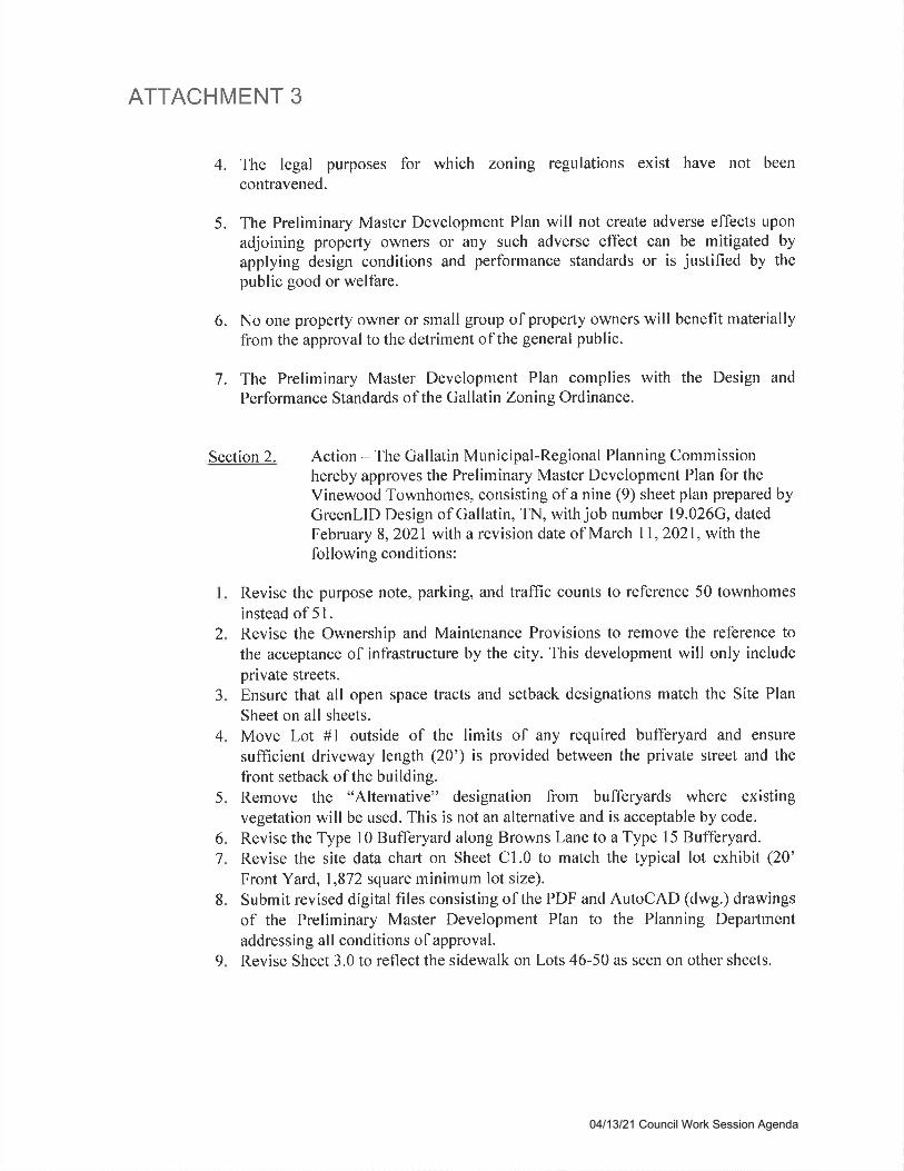
ATTACHMENT 3
4. The legal purposes for which zoning regulations exist have not been
contravened.
5. The Preliminary Mastcr Dcvclopmcnt Plan will not cre&te adverse effects uponadjoining property owners or any such adverse effect can be mitigated by
applying design conditions and performance standards or is justified by thepublic good or welfare.
6. No one property owner or small group of property owners will benefit materiallyfrom the approval to the detriment of the general public.
7. The Preliminary Master Development Plan complies with the Design and
Performance Standards of the Gallatin Zoning Ordinance.
Section 2. Action - The Gallatin Municipal-Regional Planning Commissionhereby approves the Preliminary Master Development Plan for the
Vinewood Townhomes, consisting of a nine (9) sheet plan prepared byGreenLID Design of Gallatin, TN, with job number 19.026G, datedFebruary 8,2021 with a revision date of March I I , 2021 , with thefollowing conditions:
Revise the purpose note, parking, and traffic counts to reference 50 townhomes
instead of 5l .
Revise the Ownership and Maintenance Provisions to remove the reference to
the acceptance of infrastructure by the city. This development will only include
private streets.Ensure that all open space tracts and setback designations match the Site Plan
Sheet on all sheets.
Move Lot #l outside of the limits of any required bufferyard and ensure
sufficient driveway length (20') is provided between the private street and the
front setback of the building.Remove the "Alternative" designation from bufferyards where existingvegetation will be used. This is not an alternative and is acceptable by code.
Revise the Type l0 Bufferyard along Browns Lane to a Type 15 Bufferyard.Revise the site data chart on Sheet Cl.0 to match the typical lot exhibit (20'Front Yard, 1,872 square minimum lot size).
Submit revised digital files consisting of the PDF and AutoCAD (dwg.) drawings
of the Preliminary Master Development Plan to the Planning Department
addressing all conditions of approval.Revise Sheet 3.0 to reflect the sidewalk on Lots 46-50 as seen on other sheets.
2
J
4
5
6
7
8
I
04/13/21 Council Work Session Agenda
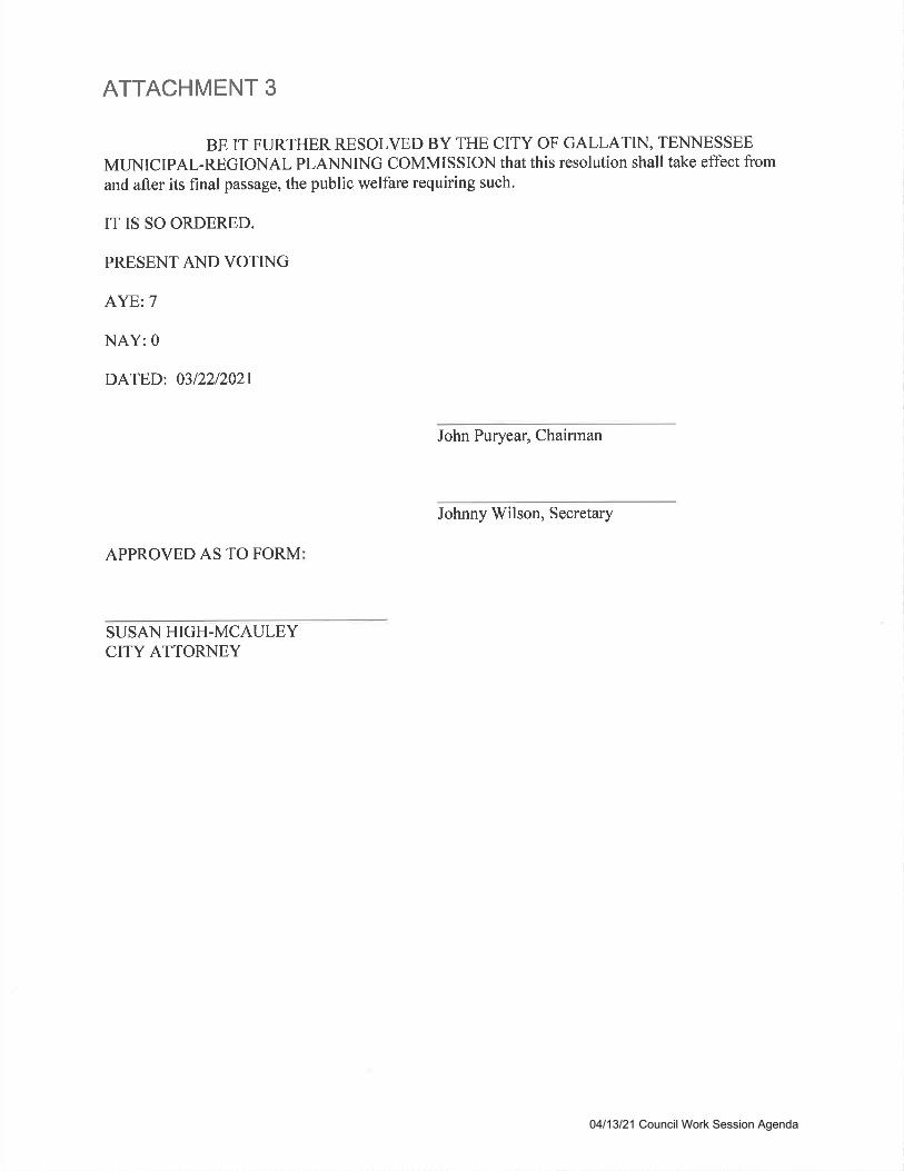
ATTACHMENT 3
BE IT FURTHER RESOLVED BY THE CITY OF GALLATIN, TENNESSEE
MUNICIPAL-REGIONAL PLANNING COMMISSION that this resolution shall take effect from
and after its final passage, the public welfare requiring such.
IT IS SO ORDERED.
PRESENT AND VOTING
AYE: 7
NAY: 0
DATED: 0312212021
John Puryear, Chairman
Johnny Wilson, Secretary
APPROVED AS TO FORM
SUSAN HIGH-MCAULEYCITY ATTORNEY
04/13/21 Council Work Session Agenda
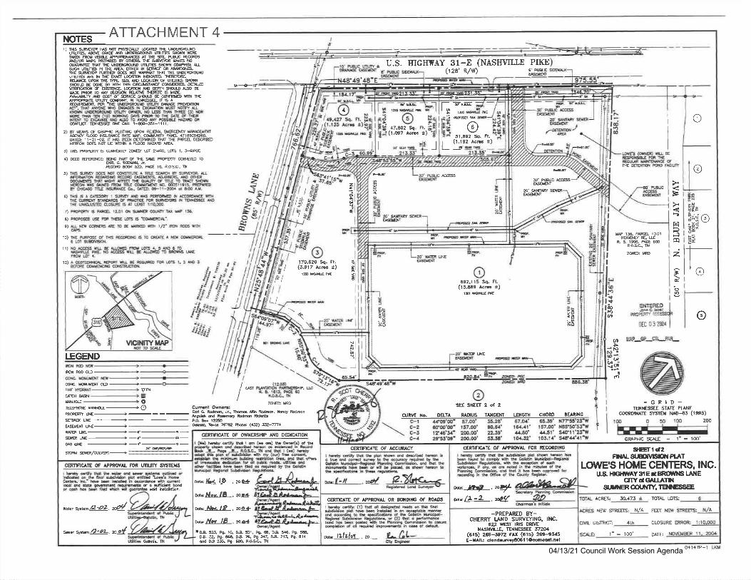
ATTACHMENT 4NOTESr) rcffisMmruYt@EEqffi
ijlli.mffffiNDUMlmslmffiT{qruEUffiATffiffiruMRffiN/ffiffi rerctrm.8ffiH6rcffiMTruUllmpru6ffiffi[5smm6Nffif&mnNffimffiNEsffi ffiM6AffiMTBElJmDlJllffi&Nffirc|suW@ffiRlrclRsEffismgmslJffiffisru@rN9mn6ffiffiF@m&mtrg5ErcE mloilNDDmruNtrWMMONM Brullm6Wlvffiru6f s&6w@ EdrewBEffi WW qW. NINEL N 6
^ffiM.TEIJWDlJlwMffiET.ruTffiWreNSAV^MKWUnm |)|lM |ffimER,m E]NnE (5) ffiImw6(io)re$EffircruuEdffiMrcgqUEN€D^MNMffiffiru.Effitrru t-N51-1t11.
U.S. HIGIITTAY 31-E (NASIIWLTE PIKE(128'Rlw) €' ruruc
gff
2)WffSWmlsmUffiWffim N$rc ilE W, mfrPlE 471654S.um 1r-2r{z r s m ffiNlD BT ff Pm mHEF€S M MUEWN ^W lr@&
5)rcffiSmYZS&BTm,S1.ffi4)lEffieffiPm6BE*mmmro&G m.*-ffi ffig. re rq eosc.,n
I
IEJ
@tr
5)
6)
a
=E
t'lD-1ca
2
=to0
I
@roU'
E)
9)
l0)
V*ug,ij OiseKF
r[w rs, PfE toot
HSBLY FE. rc&alsPr@RO$, il
l1)zffim
12)
LEGEND
I (2nt/ NffimPffiB, R&1E15.PES
/ rcsqB
ETfiERED I.mc@t IPFCPEr.y 1SS=SS€F
orc o: zoor I
I'AP-GP_CIIJAR-
@
oJii"i"1t
(t
lt
Ilb,{l
-J
5N
(J{ (,a
rMMmmru++@G Ktxw @ .+-------g-NG vRqBS+Ew+ottllmwru+@ffiUE+SffiHE+-
wEW+-f-r-ffiff+-d-s-NN +-f-G-
*'etuEslwffi/4w+
h G. M6&- llffi & M, &q umnrEe d bq tulm fffiPObt25oqTreE7&k (e)e-m+
rc
zffim SEE SHEEI 2 ot 2
cURvE llo- DELT R Irlt S T NGENI I.ENGTH CHORD BE RING
.\ c-2 ffm'oo' t57.m' 90,64' 161.11' t57.O0'il&150'53'W\ c-c i?,ts'5,(' 2q).oo' 2,.3s' 4{60' ,a4.51' s4orl'2s'rv
c-4 2953'o,t' 2(n.@' 53.34' ro,+.32' lo3.1,l's!F41'l\
-GRID-1TXTESSEE S'AIE FTANE
cooRDrxATE sYst€u NAD-$ (1995)
GRAPHTC SCA|-E - l'= 100'
200
v'rurucffiw
zo'$F8MS
C€RT|FrcATE OF APPflOVA! FOR RECOROING
rtd-@b nrd bcmDt ff tu &16 ltftjPd-kidffi|@[email protected]@DEintud&dtuPffih-ab..hdffiftbboFldldldithhfrdb6rtytugl-.
LOWES HOME CENTERS, INC.
-PREPARED 8Y-CHERRY I-AND SURVEYING, INC.
622 WESI lRrS oRMNASHVTLLE, rENIESSEE 5t20,4
(61s) 269-5972 FAX (6rs) 269-e3,.sE-yAlU clond.uil.y3061 lC@[email protected]
1' = 1OO' OAIE
TOTI LOTSACRES: 30-473 a
NE{/ SIREEIS: N/A FET NE\Y
DISTRICT: 4th CLOSIIRE
SEETl.a2FIXALST.BDilTS(I| PI.AT
w P€ .n$w/z-2.P9
us. Hleil,AY 3rE a mtils LANECITYdGALI.ATTII
g.mtER COIX{TY, TEI{IE6SEE
smN
ril
!E
E=
=*
692,115 Sq. Ft.(l5iE9 lcc *)
3*
6
a'w&ffi
1 t;:l$i-'t -'L
Fl.r)
17fiz(r.os7
_f_!aBL ---4
Ft.r)
Sc. @51,E92 Sq.
(1.192 AcG_t
H5'
fl
u-l
-.t
170.620 Sq. Fl.(3.917 Ac6 t)
ffR
LI
I
I
gi
6t
tct,l
kI
r lw€6rtiNb !&i dm d dchu lff hotuddrybh@qtubyhffillffi-SqdhiEffidHhlffihbtrdbpE6tullabhFdf-fubtbql,&
*I'tt ."a e.Xh<'-togtu ld Sryv
CEMTCAIE OF APPROVA! OR SOXDINO OF ROAI'S
I h-$r crr$r 0) H d dd@H 'd d b fmlffipidtubill@in6qtbbffiffid ssdE b h.Dtu d h M. &rici9d-toMffi R-llfur(2)MoFffitg*6brdsetuB*{hffibo$@ffi do! Rtu ffi hceddo*
cEinfrc^lE oF Accul^cY
w tNlilol .m-
cERflFrC lE OF OTYIERSH|P ANO Dm(CAtlON
B g P+ lC B 51. P9- S. N * P9 5€&or.g P9.864, Da 76, Pg $7, 03.215, P9. 414d 05 255, F9. ffi, R.GC- A
rcll4i!-. pe4'
wlJs,-ll-.pslwl{t l9 ,mgtwds-lL-.m4n
CERTIFICA'E OF APPROVAL FOR UNUTY SYSIEYS
dffihddwffiofudd*.tuffi#d*, 1ililroDk-hbnffiherilod
ffinn* sta^/2'oL, n4
t*s*/2'22.d
w
o11+P-104/13/21 Council Work Session Agenda

ATTACHMENT 4NOTESI)NffiNrc]ruY&THUWrc. MfrA&roNUNffircffiffiffirmruw8uRffiATffEn mffi
N/msreaDwmFffiffiwsrcffiurfful{WDlJreffiffiussMlffifiMMEAffiNffffiME.ffi $Mfr ruffi ffi W WNMTffi UroDffsffiNmrc@mmmffieWlmBET\PE%NgrcNSlJrl|mffis@DENE$WrcffiffiM Of,I@mmtrqffiE lmmmwDNtrW RffircNffi @MBM 6 lEAWNffif ffiru8ffiffifi€ffitrElffi@Uw. lf,TEffiEL rSAEffim,m'rEumffiremACr,Urffiffio reNEnumKNm&trf,il uMlJWffiR,m6]Nrc(J)mrcEmr{ro)rcrcuEffircffMEfffiIWrc dWAEN €rc Aru N M ffi 6ffi.AWqEru l-ffi1-1111.
2lilffoFGffiffilRmffill{ffi' ffi m rlis]ffi iltE w. mxfr m 4716g8.u@ 1r-21{2 F N ffi m@ Ul nE Pm Ec@H&ABffiUEWtrArel{mE
3)mffiB@RmYZoEg2rc,tGt.34E4)FW M,&.ffi 5A, P€ rO, ROSG, il
;:ir, J;*|lt@ l: ?r?n
o
o
F
t?
trlFIlq
2
=Ebn
,at
Ao,
SEE SHEEI I of 2
ENTERED
FmEr aqscrssoa
o
sEE SHEET i o{ 2
I
I
I
I
I
tI
I
o
@
talo;
l*I
16
2E
E
5) BtS$ffi rc rcTffiArusm ffffi &NfuMMEffiffiffi.ffiSffiMffiBTWffiffiqNGWPrwffi Iffi wMmrudlmrs.o05r19r5.ffi ;ryq@ruw6-uE@-ll-&dmu I
w 156, Pm 1mtHSRY RE rcgElnP&@
&osa ilzil& m o
k!6)
n8)
e)
10)
tl)
mm
ffi vBqBs+l
EffiIM.-Offiffi+sww
v-v(oaorywo,
ar) -.=
\ \ 515515 Sq. Fr.-(7213 k6 *)
LEGEND
-\
(r2!tWPWAM Pffi. rc
& E tat3, P& @ROSC- ilzffim .
(n5l!(l
r
uLc 0 3 2001
MAP_GP_CII-PAR-
(roc)Wf IW&WAFnEcom ffi a54, PE t58R6qn
zffirc
-GRID-IEIINESSEE SIAIE PTANE
@oRDrilArE SVslEra N^tH,l' (1995)
GRAPHIC SCAIE - 1- = 10O'
rgmmm++tr- nffiw+-----=--l-ffiMOD++ 'ffi
Csrret OraaE6eU|r@&-]lffiStM,bqtumrrqdd brytuttE ruP&& t8&'l|etEmQW-lel3pm1
CURVE Xo. DEttA RrDUs TANC€N' I.ENGII{ CHORD SE RING
c-t .t4'09'oo' a7.oo' 55.2a' 67.04 65.39' S7Z55'23'EffiS+TAEUE+ffiffi+
stprffi ffi,/a|ffi+===:==---==
c-2 60@'00' r57.oo' 00.54' t6,aJl' 157.00' sas5o'53'E
slE +*f-c-
ffi
tffidffibffi!HtulwEh r6cd b.d$|y tr tu ffi kiorPC-tugbElffi fta6rl 6 bc.ttord dtur.iry. ae'd ln6ffidhffi h'dRd ffit b h @d brcdfahftfrdhMyR.*-.
gEr2d2FI{ALstEDllrHctl PI.AT
LOVI'E'S HOME CENTERS, INC.
CERTIFICAIE Of APPROVAL fOR RSd)RDTXG
1'= 1OO' DATE
CLOSURE ERROR: 1:1DISIRICT: ,+th
ACRES 30-473 * TOTAL LOIS
NEN' STREF{S: N./A FETT NE:III
DRTVE422
FAX
w t2-l .n21f*/L-l .^2{
U.S HIGHN'AY 3IE T BR(NUlls LETGCITYdGAIIAT}I
S,MGR OOtl{TY. TEI{iESSEE
-PREPARED 8Y-CHERRY IJ|ND SURVEYING, INC.
s7m1269-9345
lffiyc.dyehpbn h d dlmboBdaidryb&ryqtuteffildod-&qdkr$offidHbmffib&[email protected]|ffihhqufu
*r(-tl .-8 28h<-*<RqffidsrEld V
I hctly dqr (1) ffi dr dgffi 'd
o ft tuld*ndhdhiffih@oqldbmffiddq b h.pffi db&6 lbtft*d-eqhrsdtu tusbua d(2)h o F@*bbreftetumfrEhffib@dnpeddqdif,Fffih@d@
C€RffTCAIE OF ACCURACY
ru 'iltlor . a-
CER-NNGAIE OF OWNENgilP AND DETXCATIOX
CER1ICATE OF APPROVAL OR 8OI{DITG OF ROADS
*!& DA S, P9. S.&& 214 P9! 414
wflrt::l€-. rccj
*flc-l0-. -"*mlSr-l.o-, rc4m l.Lv 18 . rg-:l
g, P9- 10, D.A $1, fr9. 6&gP!|EDenPg*ZU&Po!@,@U
n
CER-IIFICAIE OF APPROVA! FOI I'IIUTY SYSTBTS
uw sya /1'9L,
* rtu"Q'ol.
o1147P-2 t](N04/13/21 Council Work Session Agenda
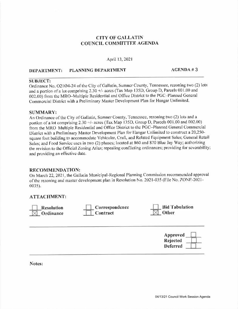
CITY OF GALLATINCOUNCIL COMMITTEE AGENDA
April 13,2021
DEPARTMENT: PLANNING DEPARTMENT AGENDA #
SUBJECT:Ordinance No. 02lO4 -24 of the City of Gallatin, Sumner County, Tennessee, rezoning two (2) lots
and a portion of a lot comprisingZ.3O */- acres (Tax Map 135D, Group D, Parcels 001.00 and
002.00) from the MRO-Multiple Residential and Office District to the PGC-Planned General
Commercial District with a Preliminary Master Development Plan for Hangar Unlimited.
SUMMARY:An Ordinance of the City of Gallatin, Sumner County, Tennessee, rezoning two (2) lots and a
portion of a lot comprising 2.30 +l- acres (Tax Map 135D, Group D, Parcels 001.00 and 002.00)
from the MRO-Multiple Residential and Office District to the PGC-Planned General Commercial
District with a Preliminary Master Development Plan for Hangar Unlimited to construct a20,250'square foot building to accommodate Vehicular, Craft, and Related Equipment Sales; General Retail
Sales; and Food Service uses in two (2) phases; located at 860 and 870 Blue Jay Way; authorizingthe revision to the Official ZoningAtlas; repealing conflicting ordinances; providing for severability;
and providing an effective date.
RECOMMENDATION:On March 22,2021,the Gallatin Municipal-Regional Planning Commission recommended approval
of the rezoning and master development plan in Resolution No. 2021-035 (File No. ZONE-2021'0035).
ATTACHMENT:
tionOrdinance
CorrespondenceContract
Bid TabulationOther
ApprovedRejectedDeferred
Notes:
04/13/21 Council Work Session Agenda
3
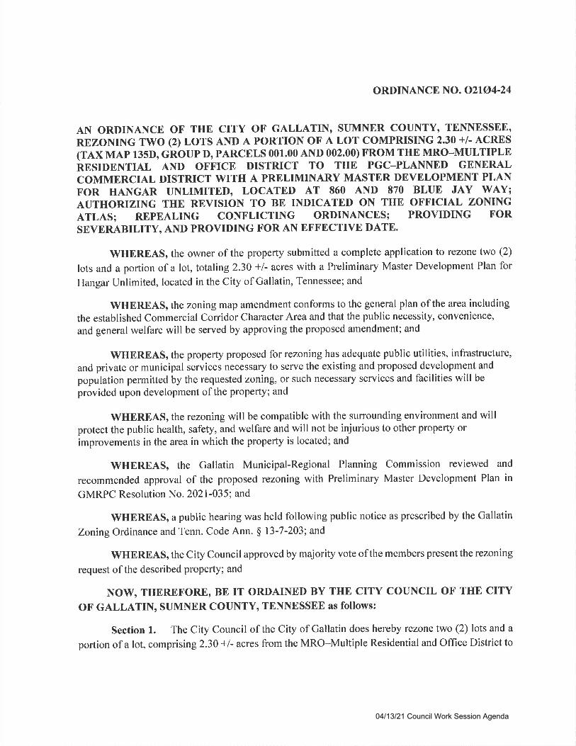
ORDINANCE NO. O2IO4-24
AN ORDINANCE OF THE CI'I'Y OF GALLATIN, SUMNER COUNTY, TENNESSEE,
REZONING TWO (2) LOTS AND A PORTION OF A LOT COMPRISING 2,30 +l- ACRES(TAX MAp 135D, cROUp D, PARCELS 001.00 AND 002.00) FROM THE MRO-MULTIPLERESIDENTIAL AND OFFICE DISTRICT TO THE PGC_PLANNED GENERALCOMMERCIAL DISTRICT WITH A PRELIMINARY MASTER DEVELOPMENT PLANFOR HANGAR UNLIMITED, LOCATED AT 860 AND 870 BLUE JAY WAY;AUTHORIZING THE REVISION TO BE INDICATED ON THE OFFICIAL ZONINGATLAS; REPEALING CONFLICTING ORDINANCES; PROVIDING FOR
SEVERABILITY, AND PROVIDING FOR AN EFFECTIVE DATE.
WHER-EAS' the owner of the property submitted a complete application to rezone two (2)
lots and a portion of a lot, totaling 2.30 +l- acres with a Preliminary Master Development Plan for
Hangar Unlimited, located in the City of Gallatin, Tennessee; and
WHEREAS, the zoning map amendment conforms to the general plan of the area including
the established Commercial Coryidor Character Area and that the public necessity, convenience,
and general welfare will be served by approving the proposed amendment; and
WHEREAS, the property proposed for rezoning has adequate public utilities, infrastructure,
and private or municipal services necessary to serve the existing and proposed development and
population permitted by the requested zoning, or such necessary services and facilities will be
provided upon development of the property; and
WHEREAS, the rezoning will be compatible with the surrounding environment and willprotect the public health, safety, and welfare and will not be injurious to other property or
improvements in the area in which the property is located; and
WHEREAS, the Gallatin Municipal-Regional Planning Commission reviewed and
recommended approval of the proposed rezoning with Preliminary Master Development Plan in
GMRPC Resolution No. 2021-035; and
WHEREAS, a public hearing was held following public notice as prescribed by the Gallatin
ZoningOrdinance and Tenn. Code Ann. $ l3-7-203; and
WHEREAS, the City Council approved by majority vote of the members present the rezoning
request ofthe described property; and
NOWO THEREFORE, BE IT ORDAINED BY THE CITY COUNCIL OF THE CITY
OF GALLATIN, SUMNER COUNTY, TENNESSEE as follows:
Section l. The City Council of the City of Gallatin does hereby rezone two (2) lots and a
portion of a lot, comprising 2.30 +l- acres from the MRO-Multiple Residential and Office District to
04/13/21 Council Work Session Agenda
the PGC-Planned General Commercial District as described in Exhibit 'A' with a Preliminary Master
Development Plan for Hangar Unlimited, as described in Exhibit'B.'
Section 2. The City Council of the City of Gallatin does hereby approve, authorize, and
direct the revision of the City's Official ZoningAtlas to show the classification for the area as hereby
rezoned.
Section 3. All ordinances or parts of ordinances in conflict with the provisions of this
ordinance are hereby repealed to the extent ofsuch conflict.
Section 4. If any provision of this ordinance or the application thereof to any person or
circumstance is held invalid, the invalidity shall not affect other provisions or applications of this
ordinance which can be given without the invalid provision or application, and to this end the
provisions of this ordinance are declared severable.
Section 5. This ordinance shall become effective immediately upon adoption.
PASSED FIRST READING:
PASSED SECOND READING:
MAYOR PAIGE BROWN
ATTEST:
CONNIE KITTRELLCITY RECORDER
APPROVED AS TO FORM:
SUSAN HIGH-MACAULEYCITY ATTORNEY
Exhibit A: Legal DescriptionExhibit B: Description of PMDP with conditions
04/13/21 Council Work Session Agenda
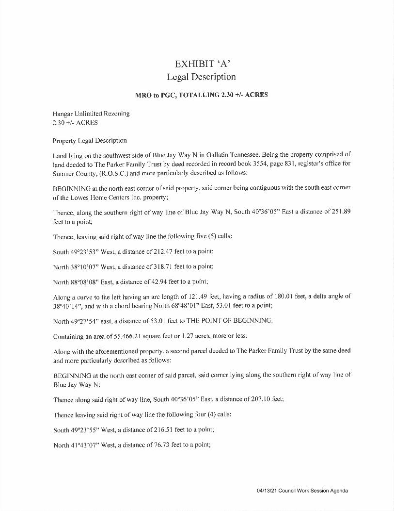
EXHIBIT'A'Legal Description
MRO to PGC, TOTAI,LING 2.30 +l- ACRES
Hangar Unlimited Rezoning
230 +1. ACRES
Property Legal Description
Land lying on the southwest side of Blue Jay Way N in Gallatin Tennessee. Being the property comprised ofland deeded to The Parker Family Trust by deed recorded in record book 3554, page 831, register's office for
Sumner County, (R.O.S.C.) and more particularly described as follows:
BEGINNING at the north east corner of said property, said corner being contiguous with the south east corner
of the Lowes Home Centers Inc. property;
Thence, along the southern right of way line of Blue Jay Way N, South 40'36'05" East a distance of 251'89
feet to a point;
Thence, leaving said right of way line the following five (5) calls:
South 49o23'53" West, a distance of 212.47 feet to a point;
North 38'10'07" West, a distance of 3 18.71 feet to a point;
North 88"08'08" East, a distance of 42.94 feet to a point;
Along a curve to the left having an arc length of 121.49 feet, having a radius of 180.01 feet, a delta angle of38o40'14", and with a chord bearing North 68o48'01" East, 53.01 feet to a point;
North 49"27'54" east, a distance of 53.01 feet to THE POINT OF BEGINNING.
Containing an area of 55,466.21 square feet or 1.27 acres, more or less.
Along with the aforementioned property, a second parcel deeded to The Parker Family Trust by the same deed
and more particularly described as follows:
BEGINNING at the north east corner of said parcel, said corner lying along the southern right of way line ofBlue Jay Way N;
Thence along said right of way line, South 40o36'05" East, a distance of 207.10 feet;
Thence leaving said right of way line the following four (4) calls:
South 49o23'55" West, a distance of 216.51 feet to a point;
North 4l'43'07" West, a distance of 76.73 feet to a point;
04/13/21 Council Work Session Agenda
North 38"10'07" West, a distance of 130.50 feet to a point;
North 49"23'53" West a distance of 212.47 feet to THE POINT OF BECINNING.
Containing an area of 44,730.31square feet or 1.03 acres, more or less, for a combined total of
100,196.52 square feet or 2.30 acres.
04/13/21 Council Work Session Agenda

EXHIBIT'B'
The Preliminary Master Development Plan for Hangar Unlimited consists of a five (5) sheet plan,
prepared by CSDG of Nashville, TN, with project number 21-01l-01, dated February 8, 2021, with
a revision date of March 11,2021 .
04/13/21 Council Work Session Agenda

STAFF'REPORT TO CITY COUNCILRezoning with Preliminary Master Development Plan for Hangar Unlimited(zoNE-2021-003s)Located at 860 and 870 Blue JaY WaYDate: April 13,2021
Rneunsr: Ownnn AND AppLrcANT REeuEsr AppRovAL To REzoNE Two (2) Lors AND A PORTION
oF A Lor coMpRrsrNc 2.30 +/- ACRES (T.rx Mar 135D, Gnoup D, PlRcnls 001.00 AND 002.00)
FRoM THE MRO-MuluplE RESTDENTIAL AND Onrtcn DtsrRtct ro rHE PGC-PL,q'xNrp
GnxenII CoumnnclAl DISTRICT wITH A PRELIMINARY MISTOR DNVNIOPVTENT PLAN FOR
HANGAR UNLtrrttrou, LocATED AT 860 AND 870 Blun JaY Wlv.
OwnnR: Srnvn M. P.lnrnn, JR.o LARRY M. PARKER, AND As Awtp
Flltrr,v Tnusr
ApplrclNt: CSDG
Srl nn RBCOTU PTNNDATION : Appnovu or Onotnancn No. O2lg4-24
Surr CoNtlct: Dusrn SuaNn, AICP
MrRcu 22,2021
Apnrr 13,2021
Pr,lNllrNc Conavtsstox Dlrn:
Couucu, ComrutrrBn Dlrn:
PnopBRry OvnRvrnw: Owner and applicant request approval to rezone two (2) lots and a
portion of a lot comprising 2.30 +l- acres (Tax Map 135D0 Group I), Parcels 001.00 and 002.00)
from the MRO-Multiple Residential and Office District to the PGC-Planned General
Commercial District with a Preliminary Master Development Plan for Hangar Unlimitedo
located at 860 and 870 Blue Jay Way. The Vehicularo Craft, and Related Equipment Saleso
General Retail Sales and Services, and Food Service uses are permitted uses in the PGC-Planned General Commercial Zoning District (Attachment 1 and Attachment 2).
The Planning Commission and Planning Department recommend approval of Ordinance No.
o2lo4-24.
ClsB BacrcRouNo:Property History snd Previous ApprovalsOn September 2, 1970, the Gallatin City Council approved the annexation of the northwestern two-
thirds of the property as part of a larger multi-property annexation (Area II) (Ordinance No. 070'4),
and the area was zoned R2O-Low Density Residential District.
On August 15, 1978, the Gallatin City Council approved the annexation of the remainder of the
property as part of a larger multi-property annexation (Area J) (Ord. No. 078-84), and this area was
zoned A-Agricultural Residential District.
04/13/21 Council Work Session Agenda
Rezoning with PMDP for Hangar lJnlimited (ZONE-2021-0035) Council Committee-April 13, 2021
On August l, 1989, the Gallatin City Council approved the rezoning of both portions of the property
to MRO-Multiple Residential and Office District as part of a multi-property rezoning (Ord. No. 089-
54s).
On January 10, 2005, the Heavenly RE, LLC, subdivision was recorded (P.8. 22,P9.124). This lotincludes a portion of the site. On August 19,2005, Lot 2 was subdivided into Lots I through 5 of the
Heavenly RE, LLC, Resubdivision of Lot 2 (P.8. 22, Pg.306), and in January 2006 the lots were
resubdivided into three (3) lots (P.B. 23,P9.55).
Drscussron:Proposed DevelopmentThe owner and applicant request to rezone two (2) lots and a portion of a lot (Lot 3), comprising2.30 +l- acres (Tax Map 135D, Croup D, Parcels 001.00 and 002.00) from the MRO-MultipleResidential and Office District to the PGC-Planned General Commercial District with a PreliminaryMaster Development Plan for Hangar Unlimited. The applicant intends to construct a20,250-squarefoot building to accommodate Vehicular, Craft, and Related Equipment Sales; General Retail Sales;
and Food Service uses in two (2) phases. PGC zoning requires the applicant to submit a PreliminaryMaster Development Plan, per Section 15.07.030.C, G.Z.O.
Phase I includes a one (1)-story, 11,85O-square foot building containing an automobile sales
(specialty/custom autos) and showcase floor with an auto detailing area and a parking lot with 44
parking spaces for customers and employees. Phase 2 includes general retail sales space totaling5,880 square feet and restaurant space totaling2,520 square feet.
The PGC zoning allows for the Vehicular, Craft, and Related Equipment Sales use. Theowner/developer intends for the northerly portion of the site to be used for vehicle sales consisting ofupscale, exotic, luxury, and sport vehicles rather than traditional car lot offerings. If the vehicle sales
uses ceases, another type of Vehicular, Craft, and Related Equipment Sales, such as a used car lot, ispermitted to operate on this site. However, the site's limited visibility to Nashville Pike does notlend itself to this use.
The construction schedule anticipates construction occurring between summer 2021 and summer2022.
Natural FeoturesThis property is curently grassy vacant land. It slopes from a highest elevation of 469' in thenorthwestern corner of the site to a lowest elevation of 455' in the southeastern corner of the site. Arow of mature trees extends along the western property line adjacent to the Lowe's HomeImprovement Warehouse property.
Based on FEMA FIRM Map 471650426G, dated April 17,2012, no portion of the site is locatedwithin a special flood hazard area.
Adjacent or Area Uses
The adjacent/surrounding uses include developed and vacant lots zoned for commercial uses. To thenorth is Lot 3 of the Heavenly RE, LLC, subdivision (P.8.22,P9. 124), zoned MRO, which is an
access drive between Blue Jay Way and the Lowes parking lot. To the north of Lot 3 is Lot I of theHeavenly RE, LLC, subdivisiono zoned PCC. To the east across Blue Jay Way are Lots 3, 4,5, and 6
2
04/13/21 Council Work Session Agenda
Rezoning with PMDP for Hangar lJnlimited (ZONE-2021-0035) CouncilCommittee-April 13,2021
of the East Camp Business Park (P.B. 21, Pg,225), zoned MRO. Lot 3 contains the Drivers License
Testing Center. To the south is the remainder of Lot 3 of the Heavenly RE, LLC, Resubdivision ofLot 2 Revised Final Plat (P.B. 23,Pg.55), containing the Patient Partners Surgery Center and zoned
MRO. To the west is Lot 1 of the Lowe's Home Centers, Inc., subdivision (P.8. 22,Pg.80), zoned
PGC (Attachment 3).
Galtatin on the Move 2020 General Development und Transportation PlanThe Gallatin on the Move 2020 General Development and Transportation Plan designates this area
as part of the Commercial Corridor Community Character Area (Attachment 4).
The zoning with master development plan is consistent with the characteristics and generally adheres
to the development strategies of the Commercial Coridor Community Character Area. The proposed
zoning and PMDP meets the overall intent of Gallatin on the Move 2020 General Development andTransportation Plan and is consistent with the area uses and zoning districts.
Access and Easements (P.U.D.E.)The PMDP shows one (l) curb cut onto Blue Jay Way and one (l) curb cut onto the Lowe's access
drive that is contingent on an agreement with Lowe's. Blue Jay Way is a collector street, whichrequires a minimum of 185 feet between driveways. The interior of the site will have a two (2)-way
drive along the side and rear to facilitate the movement of vehicles around the building and into and
out of the bay doors at the back of the building. A two (2)-way drive aisle is proposed for Phase 2 to
allow access to a proposed parking arca at the southern end of the site. Ten (10)-foot-wide P.U.D.E.s
are proposed along all property boundaries.
Stormwater DetentionThe PMDP shows stormwater runoff will be conveyed by storm sewers that will extend to a waterquality/detention area at the southeast corner of the property. More detailed drainage plans will be
provided with the FMDP (Attachment 2).
Bufferyard and Landscaping PlanBufferyards comply with the requirements of Article 13 of the Gallatin Zoning Ordinance as
indicated in the table below:
REQ UIRED/PROPOSED BUFFERYARDSADJACENT ZONING REOUIRED BUFFERYARD PROPOSED BUFFERYARD
PCC (North) l2' wide buffer (per Sec. 08.04.050.4(l)) l2' wide buffer (oer Sec. 08.04.050.4(l))PGC (West) Type l0 Type I 0
MRO (South) Tvpe 15 Type I 5
MRO (East, abuttine ROW) l5'wide buffer (per Sec. 08.04.050.4(l)) l5' wide Buffer (oer Sec. 08.04.050.4(l))
The plans indicate the additional landscaping required in the PGC zoning district as described in
Section 08.04.050 of the G.Z.O. will be provided. This includes additional shrubbery and floweringtrees throughout the interior of the site with landscaping in the parking lot area.
A Final Landscaping plan will be submitted with the FMDP
ParkingThe PMDP indicates 77 parking spaces including four (4) van-accessible ADA spaces. The parking
spaces will serve as employee and customer parking. Phase I includes 43 spaces built simultaneously
3
04/13/21 Council Work Session Agenda
Rezoning with PMDP for Hangar lJnlimited (ZONE-2021-0035) CouncilCommittee-April 13, 2021
with the I 1,85O-square foot vehicular sales use (18 spaces minimum and 23 spaces maximum), and
Phase II includes 34 spaces built simultaneously with the 5,880-square foot general retail (19 spaces
minimum and23 spaces maximum) and2,520-square foot restaurant (25 spaces minimum and 33
spaces maximum). The minimum total parking required for the site is 62 spaces, and the maximumtotal permitted is 79 spaces.
Architectural DesignsThe architectural elevations consists of a one (1)-story commercial storefront building featuringprimarily a two (2)-tone brick and stone construction. The building and layout are similar in style to
the recently approved Blue Jay Way Retail Center to the north at 840 Blue Jay Way (Attachment 2).
The building architecture meets the Design Criteria of the Gallatin Zoning Ordinance, Section
13.08.010.A, requiring T}Yobrick or stone. The final architectural elevations will be submitted and
reviewed as part of the Final Master Development Plan.
Photometric Plan and Lighting FixturesA final photometric plan that conforms to the lighting requirements of Section 13.02.080 of the
Gaf latin Zoning Ordinance shall be submitted with the FMDP.
Master Signage PlanThe applicant did not provide a conceptual signage package with this PMDP but indicated that one
will be submitted at the time of application for permits. A final sign package must be submitted tothe Planning Department for review and approval prior to the installation of any signage on site. Allsignage installed on the site must comply with Section 13.07, Sign Regulations, of the GallatinZoning Ordinance.
Planning Department CommentsThe Planning Department reviewed and commented on the rezoning and Preliminary Master
Development Plan. The owner and applicant satisfactorily addressed all Planning Departmentcomments, except those included as conditions of approval.
E ngineering Division CommentsThe Engineering Division reviewed and commented on the rezoning and Preliminary MasterDevelopment Plan. The owner and applicant satisfactorily addressed all Engineering Divisioncomments, except those included as conditions of approval.
Other Departmental CommentsThe Other City Departments reviewed and commented on the rezoning and Preliminary MasterDevelopment Plan. They commented as follows:
r GDE: The development is subject to the Gallatin Department of Electricity's UndergroundPolicy, and any of GDE's existing facilities that are required to be relocated will be at the
developer's expense.o GPU: Detailed water and sanitary sewer plans and specifications must be submitted to GPU
for review and approval, and the proposed project must comply with all applicable cross-
connection control and sewer use regulations.o Sumner E91 l: The addresses listed did not come from Sumner E91 l. Please call them at 615-
451-1200 to resolve addressing
4
04/13/21 Council Work Session Agenda

Rezoning with PMDP for Hangar Unlimited (ZONE-2021-0035) Council Committee-April 13, 2021
I@,:The Planning Commission and Planning Department recommend approval of GMRPC Ordinance
No. O2lA4-24.
ATTACHMENTSAttachment IAttachment 2
Attachment 3
Attachment 4
Location MapHangar Unlimited PMDPCurrent Zoning MapCommercial Corridor Community Character Area description
5
04/13/21 Council Work Session Agenda
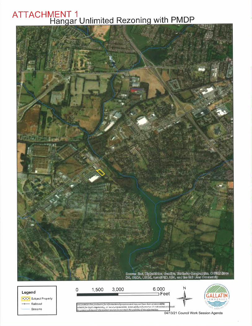
ATTACHMENT 1
Legend
XX) Subject Property
_+- Railroad
'- Streams
Han ar Unlimited Rezonin With PMDP
6,000
GALLATIN
legol, engineeilng, o( sutueying putposes. lJsets of this infotmotion should
0 1,500 3,000Feet
N
t:N\l-rii:
04/13/21 Council Work Session Agenda

ATTACHMENT 2
n-FLl-L..]
136D, PARCEE 001.00 &
APmIEO AENCHMARK:
VDsifrft-
*?\a-l
e
SITE
es r olso sDvEHlcuur, cilf,, nd EutD tau'frffi ecPtrE 2 (5,ESOGEIEru Tf,AL*N€ ? (2,520 sq ErAUsN
TOTAL AREA: +2.3O ACRES
@a@ oF @ 1$D 6 Ar AUIdOBU DroUtG &1 ATD COTMUd SOMOE GENE@
NOTES:ffiPERnEsHomS P^F
IL
A Bc
_t___BLUE JAY WAY N.
**\ (50'ROW
PUBL c i ow F'G^L4rN 2o 6q 60)1
l l iLN:H-ll lt)t
G I L]
.il'f.4 i
I
I
D
,// **;ff\ /
--/
_*j
F\
1
\
-;-fficD
G
rctPMTDBUbNCgt,&sF
t1.27 Acres
2 - 124 {LOT !l2- U4toT3)
21- 2EILOI4l21 %TEIqMRO
22-&fLOT1)PGC
MRO
MRO
7147 - 94433- 24271. A
31D maoc /G.m
15 / g3-ms/M.m
M SLUE JAY WAY N
rc BUT JAY WAY N
] AtU€ IAY WAY N
PI€RCE
LGN REATD LLC
HOMECTNES INC
I..qliliii.lll:,...g':'M.t
,4*r""TidJ.r i--zEr\7l1. W.+-s'z lta o2\z:j s
"'z'; iil'l.J
6DG
HangarUnlimited
S0/870 N Blue Jry ftyGallatin. Sumner Courlty,
INITIAL PIVIDP
g@-..:-=rfs
DATA & PHASING
c1.00
04/13/21 Council Work Session Agenda
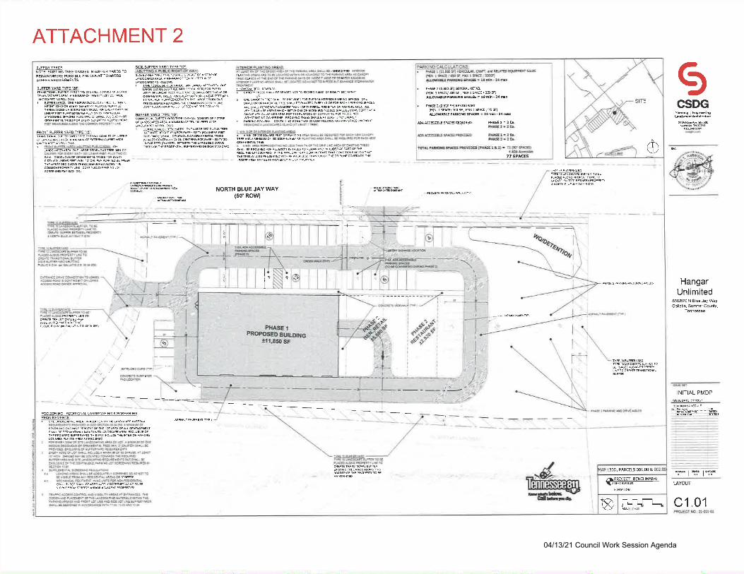
ATTACHMENT 2
il{_r+r.
136D, PARCELS 001.00 &
effi-*!!^L
ba
o
SITE-|lo]ffimEEMNsEs
rN &FFER YARDS roREMAIN MERE SSIBLE ANOCOUNT TOWARSBUFFER REOUIREMENTS
BUFFER YARDWPE'2tr
F v€(7t lNaR FefiTHiEEG) M€O!M ryEFGREEN TR
SIDE &FFER YARD ME1A.(ABUMNG A PUSLIC RIGHT'F WAi
CAOEF)FOR WERYsrxr 160) UNEAR FE- PLUSrw(1)sMAr! O€Crolousd
BUEEEISIIEEg
Frlsrw(:) sM^Lr D€Croutus*Rs)FS EV€RYsdr160l
$AR FEfl (PUNTED) EffENT
cEo Not ro scEEo a xa oF e6an (&)^PARINE 2 (58 SD GENEML ROM(MIN 1 SPAG/XOSF, W 1SPrcE/2S5DAIOW8E P^NIG SPA6 : 19 min - 24 mx
P#E 2 (2,520 SO ffiAUN(MIN. 1 SPrc/ $0 SF, W I SPKE / 75 50A&Wff PMIG SPACE = 25 min - 34 dt
OA ACCE$E SPrc6 REQUTRED: P#E 1 : 2 b.
77 SPACES
,,,i
NORTH BLUE JAY WAY(50'ROW)
FRONT BUFFER YARDME'1'
.H. uRG. oEcrDuoos rRfs) Ma
E
t
i
!i
+-
,.1. ,
EOESTFLAN CFOSWAL(OP)
__l
--\1,,
9
$,.s
HltL
"o*""or",oe. .lo"r
ill
"/
/-anuoeDcuFsoF)'
1,
puelcFow FrGALuiN2o @so$)
reC ZONING. ADOfrIONAL UNDSSHNG A $REENINGREOUIREMENTS:
^^9,UNMIa*H* V
GilftrFdr
ICSDG
HangarUnlimited
S0/870 N BlueJ4 WayGallatin, Sumner County,
INITIAL PIVIDP
NIR'rtfr
LAYOUT
c1.01
04/13/21 Council Work Session Agenda
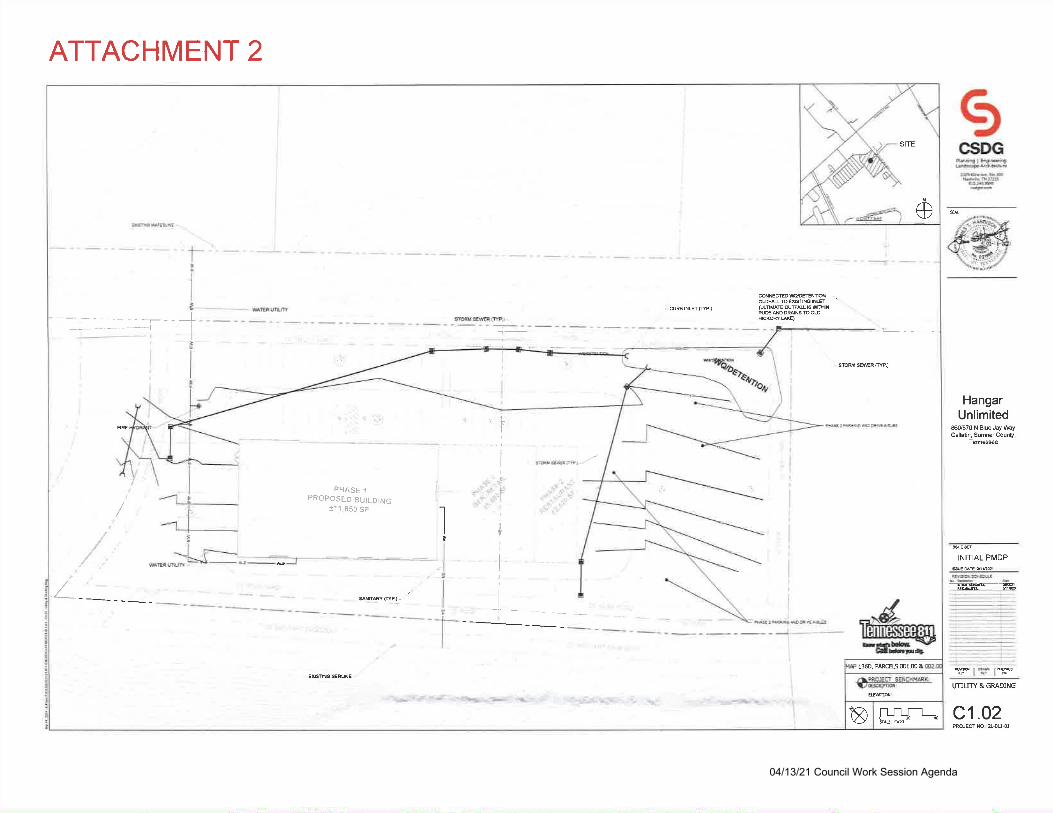
ATTACHMENT 2
ICSDG
'f#ffi#rf
HangarUnlimited
sffi70 N BlueJay myGalldn, Sumner Counly,
I'NUTY & GRADING
c1.02
INITIAL PMDP
-e!s9{91!r391_
--rrrt_..]
1360, PARCELS MLM &
APRO]EO BENCHMMK:VEiffifi,
a
o
SITE
@NEMOWEftNid -..ouF[!Toq6ireNET '
@LMAE @Fru F UBINPff NDDMNSrcOD
-f,s
.bI
II
I
^J G' F=^'-l
I
III
I
I
;
I
I
ravsam@pt'_-
PHASE 1.,Y .s
!.w ,1'
"!PROPOSED BUILDING11 1 .850 sF
l/
/_ $llr.R@)-
^^d"lHfirfrqf:fiInrlh. \f
GIffitpqr
--- _
-v*g - :r ,: J" -.:'ir?. * b' .( - _,:r j,:- s ." .!I
€lsnres&NE -
'i....:'-q-'4. ' .
ROECT NO,ra{11-01
04/13/21 Council Work Session Agenda
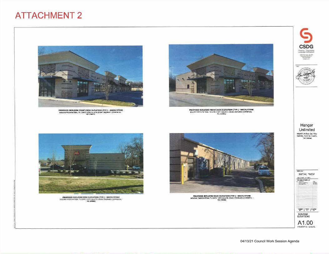
ATTACHMENT 2
PROGED BUDIf,G FROM/SDE EWAMT FYP.) . AdC('lSilEB@!G WTCdPLYwfrruNN ZSNG@lNE {CdMR@-
BZmO
PROffiEO MDIflG FROffi/gDG EWANOT CM.) - BECK/MTEB@SGMHMEULTCdPLYWMBdNG@INCE (CdilA@.
KZN)
PROMED PROrcED UDrrG UR EWAmt Cm.) - BUC{/SflEa@NG
'WLbCdPTY@@B dSG @]lt& (@MMERAL-
ezNEZmq
ICSDG
PbdE I ED#Elllr@6@F*w"
*-."qriiiide:..-r
,#v#*ffits..,.ii,,fi::;s
INITIAL PMDP
-g9E:S53:l4gt--
HangarUnlimited
s0/870 N Aue Jay ftyGalldn, Sumner County,
BUITDINGELEVANONS
A1.00PRdECTNO. I{1I{1
04/13/21 Council Work Session Agenda

ATTACHMENT 3
7
rc
uhCI
04/13/21 Council Work Session Agenda
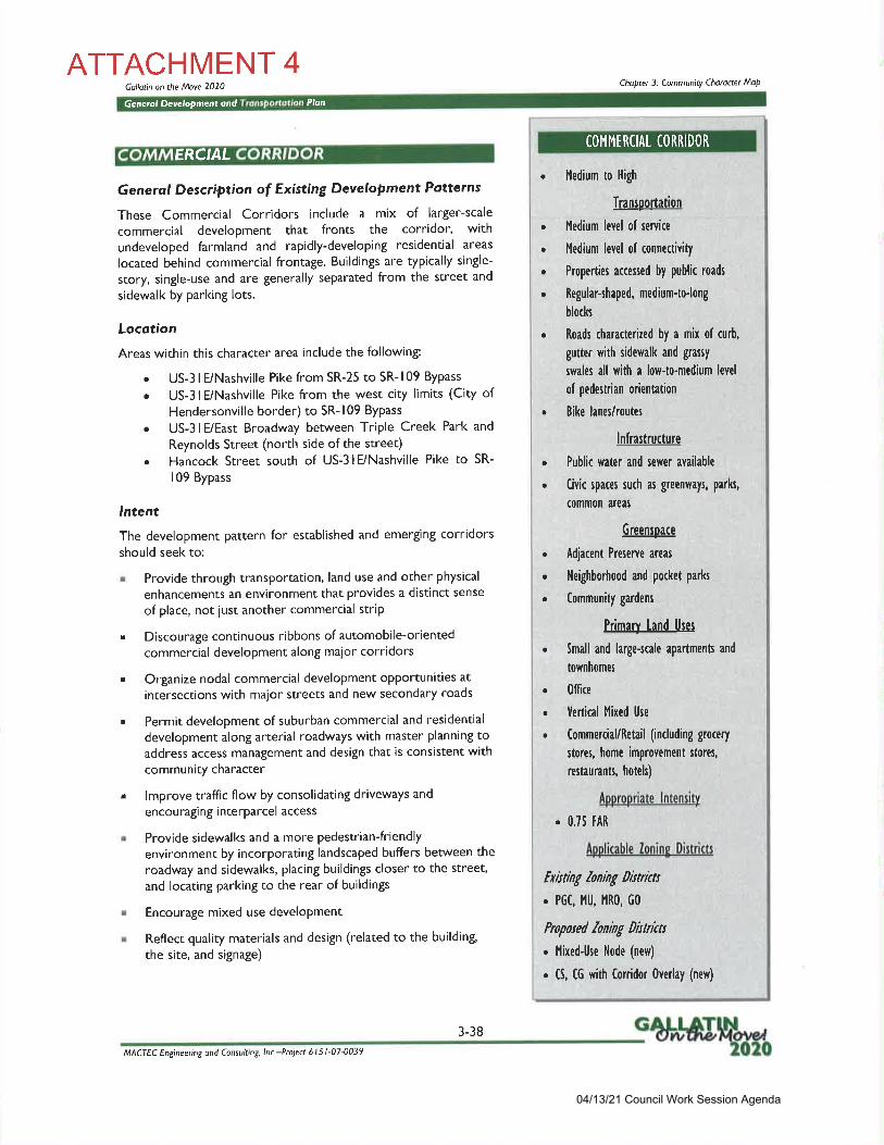
ATTACHMENT 4Gallotin on the Move 2020 Chopter 3: Community Choracter MoP
Ge n erol Dev eloPment ond Plon
COI'Il'lERCIAL CORRIDORERCIAL
General Description of Existing Development Potterns
These Commercial Corridors incltlde a mix of larger-scale
commercial development that fronts the corridor, with
undeveloped farmland and rapidly-developing residential areas
located behind commercial frontage. Buildings are tyPically single-
story, single-use and are generally separated from the street and
sidewalk by parking lots.
Locotion
Areas within this character area include the following:
. US-3 lE/Nashville Pike from SR-25 to SR- 109 Bypass
. US-3 lE/Nashville Pike from the west city limits (City ofHendersonville border) to SR-109 Bypass
. US-3 lE/East Broadway between Triple Creek Park and
Reynolds Street (north side of the street). Hancock Street south of US-3lE/Nashville Pike to SR-
109 Bypass
,ntent
The development pattern for established and emerging corridorsshould seek to:
. Provide through transportation, land use and other physical
enhancements an environment that provides a distinct sense
of place, not iust another commercial strip
. Discourage continuous ribbons of automobile-orientedcommercial development along major corridors
. Organize nodal commercial development oPPortunities at
intersections with major streets and new secondary roads
. Permit development of suburban commercial and residential
development along arterial roadways with master planning toaddress access management and design that is consistent withcommunity character
. lmprove traffic flow by consolidating driveways and
encouragi ng interparcel access
. Provide sidewalks and a more pedestrian-friendlyenvironment by incorporating landscaped buffers between the
roadway and sidewalks, placing buildings closer to the street,
and locating parking to the rear of buildings
. Encourage mixed use development
. Reflect quality materials and design (related to the building
the site, and signage)
l'ledium to High
Transoortation
I'ledium level of service
l'ledium level of connectivity
Properties accessed by public roads
Regular-shaped, medium-tolong
blocks
Roads characterized by a mix of curb,
gutter with sidewalk and grassy
srvales all with a low-to-medium level
of pedestrian orientation
Bike lanes/routes
lnfra$ructure
. Public tvater and sewer available
. Civic spaces such as greenvlays, parks,
common areas
Greensoace
. Adiacent Preserve areas
. Neighborhood and pocket parks
. Community gardens
Primarv land Uses
. Small and large-scale apartments and
townhomes
. Office
. Vertical I'lixed Use
. Commercial/Retail(indudinggrocery
stores, home improvement stores,
restaurants, hoteh)
Aoorooriate lntensitv
. 0.75 tAR
Aoolicable lonins Dirtricts
txit ting loning Dit trittr
. PGC, l'lU, I'1R0, G0
Propwed loning Dhtrittt
. l''lixed-Use l'lode (new)
. 6, CG with Corridor 0verlay (new)
a
a
o
a
a
a
a
MACTEC Engineering ond Consulting, lnc -Projea 6l 5 l-07-0039
3-38
04/13/21 Council Work Session Agenda
ATTACHMENT 4Gollotin on the Move 2020 Choptet 3: Community Choroctet MoP
Generol Development ond Tronsportotion Plan
! Provide shade, reduce impervious surfaces, shield parking
areas, and improve the appearance of individual sites and the
entire corridor with quality landscaping
D ev e lopment Strotegies
r Encourage retrofittint of existing strip development intopedestrian-scale interconnected nodes
r Limit signs and billboards
. Cluster high-density development at nodes along the
corridor, such as maior intersections
r Depict clear physical boundaries and transitions between the
edge of the character area and adlacent character areas, in
particularly those that include residential uses
. Strengthen pedestrian connections to adjacent residential
areas
r lncrease landscaping along the corridor, including in and along
parking lots to provide shade, reduce impervious surfaces,
shield parking areas, and improve the appearance of individual
sites and the entire corridor
. Plan for community street network that creates rather than
hinders opportunities for wdking biking and providing futurepublic transit
. Establish pedestrian-oriented buildingsetbacks
r Guide building and site design, including parking lotconfiguration and streetscape features
. Find an appropriate balance between residential and
commercial uses within mixed use developments
r Organize new development a nodal fashion with nodal
commercial/mixed use development opportunities at
intersections with maior streets and new secondary roads.
Areas between these development nodes along the corridorprovide opportunities for development of higher intensity
residential uses that would create more housing choices forthe City that are in proximity to commercial areas and maiortransPortation arteries.
I mpl e me ntation /Vleosures
"F Amend Mixed-Use districts
e Mixed-Use Node zoning district (new)
'F Corridor Overloy District
Existing commerciol corridor oreo olongNoshville Pike near Vol Stote
Emerging commerciol corridor olong NoshvillePike west of Gollotin
Quolity office development olong theCommerciol Corridor on Noshville Pike includesquality building materiolE landscoping ond
Preservotion of moture trees
'>NRr y
;-rlr'F* ' -
rrlt
F
,*4 :1*t.
-3
liliiiir.l !I ! r*.u L
r "t\'\ ',sb.&",
ll
MACTEC Engineering ond Consulting lnc -Ptojea 6l 5l-07-0039
3-39
04/13/21 Council Work Session Agenda

CITY OF GALLATINCOUNCIL COMMITTEE AGENDA
Aprll13,2021
DEPARTMENT: PLANNING DEPARTMENT AGENDA #
SUBJECT:Ordinance No. O2lQ4-25 of the City of Gallatin, Sumner County, Tennessee, approving an
Amended Preliminary Master Development Plan for Wood's Commons/Final Master Development
Plan for Andy's Frozen Custard.
SUMMARY:An Ordinance of the City of Gallatin, Sumner County, Tennessee, approving an Amended
Preliminary Master Development Plan for Wood's Commons/Final Master Development Plan forAndy's Frozen Custard to construct a food service (ice cream) store and appurtenant parking on a
1.504 +l- acre lot, located south of Nashville Pike and west of Brown's Lane; authorizing the
revision to the Official ZoningAtlas; repealing conflicting ordinances; providing for severability;
and providing an effective date.
RECOMMENDATION:On March 22,2021, the Gallatin Municipal-Regional Planning Commission recommended approval
of the Amended Preliminary Master Development Plan/Final Master Development Plan inResolution No. 2021-037 (File No. MDP-2021-0145).
ATTACHMENT:
nx_
ResolutionOrdinance
CorrespondenceContract
Bid TabulationOther
I-_,x_
ApprovedRejectedDeferred
Notes:
04/13/21 Council Work Session Agenda
4

ORDINANCE NO. O2IO4.25
AN ORDINANCU OT,' THE CITY OF GALLATIN, SUMNER COUNTY, TENNESSEE,APPROVING AN AMENDED PRELIMINARY MASTER DEVELOPMENT PLAN FOR
WOOD'S COMMONS WITH A FINAL MASTER DEVELOPMENT PLAN FOR ANDY'SFROZEN CUSTARD, ON A 1.504 +/- ACRE LOT (TAX MAP 136, PARCEL 012.01),
LOCATED SOUTH OF NASHVILLE PIKE AND WEST OF BROWNS LANE;AUTHORIZING THE REVISION TO BE INDICATED ON THE OFFICIAL ZONINGATLAS; REPEALING CONFLICTING ORDINANCES; PROVIDING FORSEVERABILITY, AND PROVIDING FOR AN EFFECTIVE DATE.
WHEREAS, the applicant submitted a complete application for an Amended Preliminary
Master Development Plan for Wood's Commons and a Final Master Development Plan for Andy'sFrozen Custard on a 1 .504 +l- acre lot (Tax Map 136, Parcel 012.01), located south of Nashville Pike
and west of Browns Lane in Gallatin, Tennessee; and
WHEREAS' the property is currently zoned PGC-Planned General Commercial, whichpermits food service uses; and
WHEREAS, the Gallatin Municipal-Regional Planning Commission reviewed and
recommended approval of the proposed Amended Preliminary Master Development Plan/Final
Master Development Plan as a major amendment in GMRPC Resolution No. 2021-037; and
WHEREAS' a public hearing was held following public notice as prescribed by the GallatinZoningOrdinance and Tennessee Code Annotated, Section 13-7-203; and
NOW, THEREFORE, BE IT ORDAINED BY THE CITY COUNCIL OF THE CITYOF GALLATIN, SUMNER COUNTY, TENNESSEE as follows:
Section l. The City Council of the City of Gallatin does hereby approve the Amended
Preliminary Master Development Plan for Wood's Commons/Final Master Development Plan
for Andy's Frozen Custard, on a L504 +l- acre lot, zoned PGC-Planned General CommercialDistrict, as described in Exhibit 'A'.
Section 2. The City Council of the City of Gallatin does hereby approve, authorize, and
direct the revision of the City's Official ZoningAtlas to show the classification with Amended
Preliminary Master Development Plan for the property.
Section 3. All ordinances or parts of ordinances in conflict with the provisions of this
ordinance are hereby repealed to the extent ofsuch conflict.
Section 4. If any provision of this ordinance or the application thereof to any person orcircumstance is held invalid, the invalidity shall not affect other provision or applications ofthis ordinance which can be given without the invalid provision or application, and to this end
the provisions ofthis ordinance are declared severable.
04/13/21 Council Work Session Agenda
Section 5. This Ordinance shall take effect upon final passage, the public welfare
requiring such.
PASSED FIRST READING:
PASSED SECOND READING:
MAYOR PAIGE BROWN
ATTEST:
CONNIE KITTRELLCITY RECORDER
APPROVED AS TO FORM:
SUSAN HIGH-MACAULEYCITY ATTORNEY
Exhibit A: Description of PMDP with conditions
04/13/21 Council Work Session Agenda
EXHIBITOA'
The Amended Preliminary Master Development Plan for Wood's Commons and Final MasterDevelopment Plan for Andy's Frozen Custard consists of a seventeen (17) sheetplan prepared byGreenLID Design of Gallatin, TN, with Project No. 21.003G, dated March 11,2021, with a revisiondate of April l,202l,with the following conditions:
l. For final approval, sign and record a Stormwater Maintenance Agreement for the project.
Contact the Engineering Division for a copy of the storm water maintenance agreement
form.2. Prior to the issuance of a building permit, record a plat to vacate the existing detention
easement, provide a pedestrian access easement for the sidewalk located outside of thepublic right-of-way, remove platted minimum building setback line, and provide a drainageeasement for water passing through the site from the south (Parcel 12.00) consistent with the
latest approved MDP.3. Provide a site surety per Section 15.03.080, G.Z.O.
04/13/21 Council Work Session Agenda
STAFF REPORT TO CITY COUNCILAmended Preliminary Master Development Plan for Wood's Commons/FinalMaster Development Plan for Andyos Frozen Custard (MDP-2021-0145)
Located south of Nashville Pike and wcst of Browns LaneDate: April 13,2021
Rnqunsr: OwnnR AND AppLrcANT REeuEST APPRovAL oF AN AMENDno PRnUUINARY MasrnnDnvnloprvrENT PLAN FoR WooD's CotvttvtoNS/FINAL Mnsrrn DnvnloptuENT PLAN FoR ANDY'S
FRoznn CusrARo, oN A 1.504 +/- AcRE Lor (TAx Mar 136, Pancu 012.01), LocATED sourH oF
Nesnvnlr Pxt auo wEST or BRowNS LANE.
OwNnn: Suunnn Plnrnuns
Appr-rcaNt: GnTBxLID Dnslcx
Srarr RncoruunNDATIoN : AppRovrl or ORnmaNcr No. O2lg4-25
Srlnn Coxract: Dusrn SHlNn, AICP
Pr-nrNrnc C otrltvttssroN D.rrn : Mnncn 22,2021
ApRtr 13,2021CouNcrc Connrvnrtnr Darn:
PnopnRry Ovrnvlpw: Owner and applicant request approval of an Amended PreliminaryMaster Development Plan for Wood's Commons/Final Master Development Plan for Andy'sFrozen Custard, on a 1.504 */- acre lot (Tax Map 136, Parcel 012.01)' located south ofNashville Pike and west of Browns Lane. Food Service is a permitted use in the PGC-PlannedGeneral CommercialZoningDistrict (Attachment I and Attachment 2).
The presence of GDE easements along the northern and western property boundariesprohibits the installation of large trees within these areas. The applicant requests an
alternative bufferyard plan to omit large trees from this area which reduces the overallnumber of tree plantings required. The Planning Commission determined that the proposed
alternative bufferyard plan meets the purpose and intent of the requirements of Article 13 and
is clearly superior to a plan that would be in strict compliance with the requirements of Article13. The Planning Commission voted to consider the item as a major amendment to thepreviously approved PMDP. Therefore, the City Council must act upon the requested
Amended MDP.
The Planning Commission and Planning Department recommend approval of Ordinance No.
o2la4-25.
Casn BacxcRouNt:Property History and Previous ApprovalsOn November 27, 2006, the Gallatin Municipal-Regional Planning Commission (GMRPC)
recommended approval of a rczoning with Preliminary Master Development Plan for Wood's
04/13/21 Council Work Session Agenda
Amend. PMDP Woods Commons/FMDP Andy's Frozen Custard (MDP-2021-0145) April 13, 2021
Commons Commercial Subdivision to City Council with conditions (File No. 3-26-06). On January
16, 2007, Gallatin City Council approved the rezoning with Preliminary Master Development Plan
for Wood's Commons Commercial (Ordinance No. 00612-82) changing the zoning of the 13.89 +/-
acre property from CS-Commercial Services and MRO-Multiple Residential and Office districts topCC-ptanned General Commercial district with a master plan indicating six (6) lots and two (2)
public rights-of-way.
On January 22, 2007, the GMRPC approved the Final Master Development Plan for Wood's
Commons Commercial Subdivision containing six (6) lots, bufferyards, and a S0-foot-wide public
roadway, on 13.89 */- acres (File No. 8-69-06). No uses were identified at that time.
On December 31, 2014,the Gallatin Planning Department approved a minor subdivision plat forWoods Commons Section Two creating two (2) lots on 10.05 */- acres by combining proposed Lots
3, 4, 5, and a portion of Lot 6 shown on the FMDP into a single lot (Lot 2) and the remainder of Lot
6 and an adjacent lot, owned by Sumner Bank & Trust, into a separate lot (Lot 1) (File No. 2-126-
l4S). The minor subdivision plat also changed the 50-foot-wide public roadway to a S0-foot-wide
Public Utility and Access Easement. The minor subdivision plat was recorded on December 29,
2014, atthe Sumner County Register of Deeds office (P'8. 28, Pg. 298).
On August 27,2018, the GMRPC approved an Amended PMDP/FMDP for Gallatin Subaru on a
portion of Lot 2 of the Woods Commons, Section Two Subdivision as a minor amendment to the
Wood's Commons Commercial Subdivision PMDP (File No. 8-9170-18).
On December 74,2018, the Planning Department approved a minor subdivision plat for Woods
Commons, Section Two ReplatLot2, which split Lot 2 of the previous Woods Commons plat into
Lot 2A and 2p.. Gallatin Subaru was constructed on Lot 2A. The minor subdivision plat was
recorded on December 19,2018 (P.8. 31, Pg. 214) (File No. 2-10322-185) (Attachment 3).
Drscusstot't:Proposed DevelopmentThJ owner and applicant request approval of an Amended Preliminary Master Development Plan for
Wood's Commons and an FMDP for Andy's Frozen Custard, on Lot 2B of Woods Commons
Section Two Replat Lot2 (a 1.504 *l- acre lot) (Tax Map 136, Parcel 012.01), located south ofNashville Pike and west of Browns Lane, for construction of a food service (ice cream) store and
appurtenant parking. Food Service is a permitted use in the PGC-Planned General Commercial
Zoning District
The Amended PMDP/FMDP for Andy's Frozen Custard includes a one (1)-story, 1,986-square foot
building containing a fast food ice cream shop and a parking lot with 33 parking spaces forcustomers and employees.
The construction schedule anticipates construction being completed by March 2022.
Natursl FeaturesThis property is currently a grassy vacant lot with nine (9) mature trees. It slopes from a highest
elevation of 510' in the northeastern corner of the site to a lowest elevation of 498' in the western
corner of the site.
2
04/13/21 Council Work Session Agenda
Amend. PMDP Woods Commons/FMDP Andy's Frozen Custard (MDP-2021-0145) April 13, 2021
Based on FEMA FIRM Map 471650426G, dated April 17,2012, no portion of the site is located
within a special flood hazard area.
Adjac.ent or Area Uses
The adjacent/surrounding uses include commercial uses. To the east is Lot I of Woods Commons
Section Two (P.B. 28, Pg. 298), split zoned PGC and MRO, and containing Sumner Bank and Trust.
To the south and southwest is Lot 2A of Woods Commons Section Two Re-PlatLot2 (P.B. 31, Pg.
214), zoned PGC, containing Gallatin Subaru. To the northwest across Nashville Pike is Lot 2 ofNelle Evelyn Hackett Tuttle subdivision (P.B. 16, Pg. 188), zoned PGC, and containing Miracle
Ford, and to the northeast across Nashville Pike is avacant property (R.8. 1001, Pg. 371), zoned
PGC, owned by Gap (Attachment 4).
Gullatin on the Move 2020 General Development and Transportation PlanThe Gallatin on the Move 2020 General Development and Transportation Plan designates this area
as part of the Commercial Corridor Community Character Area (Attachment 5).
The plan and use is consistent with the characteristics and generally adheres to the development
strategies of the Commercial Corridor Community Character Area. The proposed Amended
PMDP/FMDP meets the overall intent of Gallatin on the Move 2020 General Development and
Transportation Plan and is consistent with the area uses andzoningdistricts.
Access and Easements (P.U.D.E.)The Amended PMDP/FMDP shows two (2) curb cuts onto the adjacent private drive. The interior ofthe site will have a one (1)-way drive-thru along the front (Nashville Pike) and sides of the site. An
additional two (2)-way drive aisle is proposed to allow access to the parking spaces within the site.
Ten (10)-foot-wide P.U.D.E.s are proposed along all property boundaries. The presence of GDE
easements along the northern and western property boundaries prohibit the installation of trees along
these boundaries.
Stormwater DetentionThe Amended PMDP/FMDP shows storm sewers that will convey stormwater runoff to a
bioretention pond at the northeast corner of the property, Final outfall will occur to the ditch along
Nashville Pike (Attachment 2).
Buffiryard and Landscaping PlanBufferyards are required to comply with the requirements of Article 13 of the Gallatin ZoningOrdinance. The applicant requests exceptions to the bufferyard design because of the restrictive
easements encumbering much of the lot (Attachment 2). The presence of GDE easements along the
northern and westem property boundaries prohibit the installation of trees along these boundaries.
The applicant is requesting an alternative bufferyard plan to allow shrubs in these locations, as
indicated in the table below:
REQUIRED/PROPOS ED BUFFERYARDSADJACENTZONING REOUIRED BUFFERYARD PROPOSED BUFFERYARD
PGC (North, abuttine ROW) 20' wide buffer (per Sec. 08.04.050.A(l)) Alternate 20' wide buffer (oer Sec. 08.04.050.4(l ))
PGC (West. East. South) Type l0 Tvne l0 & Altemate Tvpe I 0
3
04/13/21 Council Work Session Agenda
Amend. PMDP Woods Commons/FMDP Andy's Frozen Custard (MDP-2021-0145) April 13, 2021
Section 08.04.050.4 requires PGC-zoned properties to provide a special 2O-foot-wide bufferyard in
front yards adjacent to public rights-of-way classified as arterials. The remaining bufferyards
adjacent to other PGC-zoned properties are required to be Type 10. Section 08.04.050.8.3 requires
50 shrubs per acre of lot/site area. The shrubs within bufferyards count to meet this requirement.
Section 08.04.050.8.2 requires a minimum of one medium deciduous or ornamental tree per 500
square feet of landscaping area exclusive of the bufferyard areas, which are also only partiallyprovided. The total landscaping required (including parking lot landscaping) and provided for thisproject is indicated in the table below:
REQUIRED/PROPOSED LANDSCAPTNGREQUIRED LANDSCAPING PROPOSED LANDSCAPING
Large or canopy trees 9 9
Understory trees 30 2t
Shrubs 50 t01
The Planning Commission determined that the proposed alternative landscaping plan meets the
purpose and intent of the requirements of Article 13. In addition, the PGC zoning requires greater
amounts of interior landscaping which was a condition of approval that the applicant satisfied priorto the Council Committee meeting.
ParkingThe PMDP indicates 33 parking spaces including two (2) van accessible ADA spaces on site. The
parking spaces will serve as employee and customer parking. The 1,986-square foot restaurant use
requires a minimum of 19 parking spaces and maximum of 26. Seven (7) spaces are required to be
constructed of permeable pavers per Section 11.09.025.B.1,G.2.O. The plans indicate that25 spaces
will be constructed of permeable pavers. Since excess parking is proposed, interior landscaping
within the parking area was required by the Planning Commission and subsequently provided by the
applicant.
Architectural DesignsThe architectural elevations consists of a one (l)-story commercial building featuring a brickveneered main structure with extensive glazing around the front end and a canted "blade" accent
structure clad in fiber cement paneling which projects from the front fagade. The architectural design
is mid-century modern and is meant to evoke a 1950s ice cream parlor (Attachment 2).
The building architecture meets the Design Criteria of the Gallatin Zoning Ordinance, Section
13.08.010.A, since at least T\Yobrick or stone materials are provided.
The Planning Commission recommended approval of the conceptual architectural designs forAndy's Frozen Custard. However, because of the unique architecture in combination with the
alternative bufferyards and landscaping, the Planning Commission determined that the amended
PMDP should be considered as a major amendment to the MDP requiring Council review and
approval.
Photometric Plan and Lighting FixturesThe photometric plan conforms to the lighting requirements of Section I 3.02.080
4
Master Signage Plan
04/13/21 Council Work Session Agenda
Amend. PMDP Woods Commons/FMDP Andy's Frozen Custard (MDP-2021-0145) April 13, 2021
The applicant provided a conceptual signage package with the Amended PMDP/FMDP that
conforms to the requirements of Section 13.07 of the Gallatin Zoning Ordinance. A final sign
package must be submitted to the Planning Department for review and approval prior to the
installition of any signage on site. All signage installed on the site must comply with Section 13.07,
Sign Regulations, of the Gallatin Zoning Ordinance.
Planning D ep artm e nt C omm entsThe Planning Department reviewed and commented on the Amended Preliminary Master
Development Plan/FMDP. The owner and applicant satisfactorily addressed most Planning
Department eomments, except those included as conditions of approval.
E ngin eering Division CommentsThe Engineering Division reviewed and commented on the Amended Preliminary Master
Development Plan/FMDP. The owner and applicant satisfactorily addressed all Engineering
Division comments, except those included as conditions of approval.
Oth er D ep artm ental C omm entsThe Other City Departments reviewed and made the following comments on the Amended
Preliminary Master Development Plan/FMDP:o GDE: The development is subject to the Gallatin Department of Electricity's Underground
Policy, and any of GDE's existing facilities that are required to be relocated will be at the
developer's expense.o GPU: Detailed water and sanitary sewer plans and specifications must be submitted to GPU
for review and approval, and the proposed project must comply with all applicable cross-
connection control and sewer use regulations.o Sumner 891 1: Verify whether this building is accessed off Record Row or not.
RncoiunnnNnarloN:The Planning Commission and Planning Department recommend approval of Ordinance No.
o21A4-25.
ATTACHMENTSAttachment IAttachment 2Attachment 3
Attachment 4Attachment 5
Location MapAmended PMDP Wood's Commons/FMDP Andy's Frozen CustardWoods Commons, Section Two ReplatLot2Current Zoning MapCommercial Corridor Community Character Area description
5
04/13/21 Council Work Session Agenda
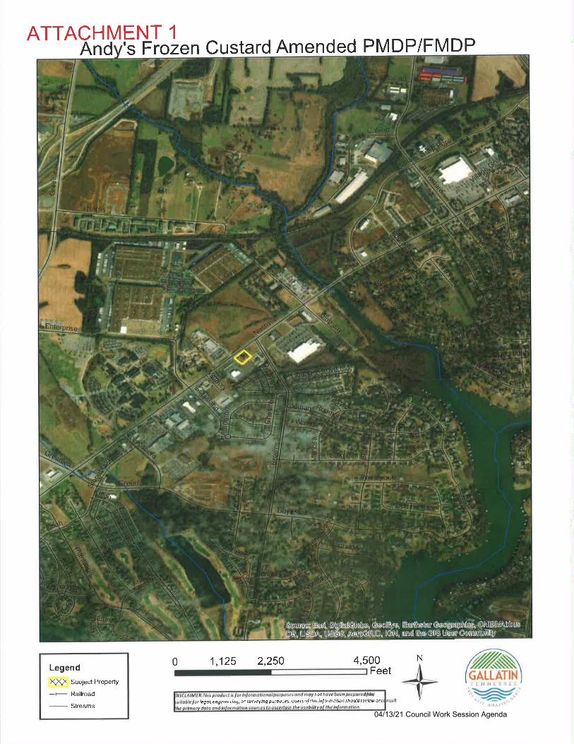
ATTACHMENT 1
And 's F rozen Custard Amended PMDP/FMDP
Legend
XX> Subject Property
-r- Railroad
-
Streams
4,500
GALLATINi l! ll I 'i I 1. ,
:{leqol,engineeilng,otsurveyingpurposes lJsetsolthisinJormotionthouldrcviewotnot
0 1,125 2,250Feet
N
04/13/21 Council Work Session Agenda
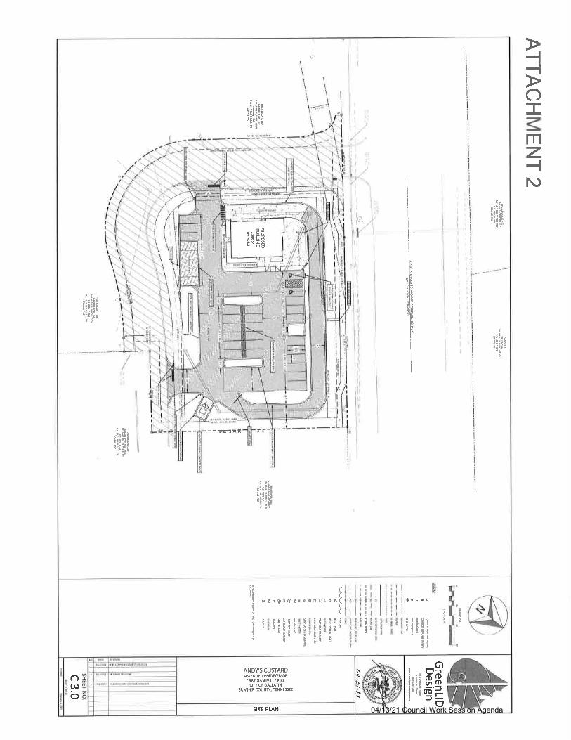
-l-{
o-
mz-lN)
s\J
c)(.Ll
bSITE PLAN
ANDY's CUSTARDAMENDEO PMDP/FMOP
1S7 NNHVILIT flKEcrflot GAtuTrN
SUMNER COUNft, TENNE$EE
6)
Edclo=(f
IIt
Ic
a\WTF-
C
-
II
illtlt
t{IilI
It:
i!iF
I
a
ItrI
I
:
t
s&EOEOSEo6oOJoB
I:i
:IP
E
It!!
t!;I
:,
tit
E
3
ia E:!IE.EC!E
ii:9
iiiiE
-rl-Iti6ia;Fi:"t
I
!
I
I
I
I
l"i
h
,lE
iEilF
EI!k
li
i
I
i
;,;:;
I
I
I
I
i*
l1
I
(i
i;*EE
*iili
--rfirE,i
*iiEr
iniilE
HB=B
04/13/21 Council Work Session Agenda
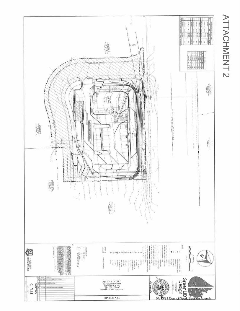
-l-lo-
mz-llv
GRADING PLAN
()Fb
I
Izo
ANDY'S CUSTARDAMENDED PMDP/FMDP
1387 NNHVILLE PIKC
CIT OT GALSTINSUMNCR COUNfl, lTNNESSEE
\S:
6)Pdiiocra a
I
tI!
"9E!6;
,;I
i
N[,-]
E
a
cI
t": t: ""
3;€l:cEI!d'i'!i: -:;B:
":qt
E3!id
a:
e?E";gJitriilii i?rt*.a
a,I
ft,
ti
ti
!t!a
a
*
Ie
E
I18
p
E
a
:
!
E
et9
t;I6
IE
ir.::i:l=i;ti:!:iI- uEi:
t:ir"E;; T
e
l"
,lE
ili;IE;ti.l;
li
1r
l
I
\i ,
'iii
I
li\i1
i;i
iL:
ii'iii
l
Ji
lil'4EiItiii€:;
i-!*t:;; ii 5rl;i!i
I4-L
tltrL
I
I
l
tl
I
1
I
1l
ii
i\
ii
ti
1i
il
: c'ti,tit
!:{ !; i,;E
: i.-r:;€Eqi:ilElA:; !;!
I
I
.i1
.4E3
6'g
33t5EErBl
!
i*gI
trilr
I
'l'ilc
-t-'t-,,l:"t'-t-I-t-rlr
04/13/21 Council Work Session Agenda
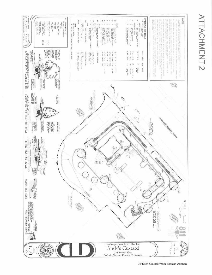
-l-{
o-
mz-{N)
Lantlscape Compliance Plan for:
Andy's Custard(ialladn, Sumner
124 Rccord
2t
=4 zZ
a!
\rvt6q.Irc-
61
65
I
af€!a,ciil
F'Iq
ii
e8q;
ti.6
a
=F I :i-l
ig 3€
Fl {ic: Foa- a
iE ";; 9
i
a
r-i!-'
F"'FS 9- E' ;F ?FE!;f in ,! 'i
rFr' F:. li P: Ei S'diE i;;lii5;
.n6 \{Y_: i: o;Yi{ P dEt qi:;;5 iqr I \\ r i
i
=54
5
h
5;<4f6:i
PEgd
53 1
Iai
i! i9q5 !;Eg ieE9 E4';
"
PO
-si98;
:3
I
tI
?q
iiS:.!-
{r
s
s
II
9I
I
66
z1 iri o
:l :l:
I i.I Pi: .):
I :lF:I
i.
t;
'.i>.-
ttt: t ::
1" ":'
'i. :i
'il s!ii ;:rl: ' -li .''l
1::
.iii .irra
'ti
,1
::i.
:il
zit.i
!l
g
!
7-i
'li. '-, ;.
2-:
-i:
...:
r:l
ni
t;F
nrcvrrz:a
--t -.8 . " . ,:si ili nl ni el alEXE EEt re sl se ri
;;E'ir"i>; h: i r,
@
T
fiFI3
o &
?F
tP*i
5
nococa+nmml,Fz+zc)or'lt.r< 8Jmrln2t9il9!r
. !i;IInair-rrt|Fl;1tzt!ol
6q(f;;r;R+ti>EF
aInc(!Ttz+zo('rt
-
t
iEitiii;[:i!litlli
It6[!tl;tffi!rid!
iFlerqitl
a:
tlrf
'P
t{lrEz
iE6lll't
lr
t6
t Ir$iili
'E
tiii::
iili;
!'ilia
{
ii
EN!E&H L l[l'
I ittli
i!l|t!
ciiiiiiHI;ltl .
Bl! ,llfil lil> i!{ I-H
F;if;tlt;iri!
ii:Ell{:l;{r;ii;ililil
:illitiiii
iriiililrfil
q"q.*.tknL1j.ql
",.,
I
iJ,\ t1'
\t '$,. I _
"(.niV.,\
T
iv
riIAlt6F
$d
"16BECErfl!r*L
"-t''*r1,t*
dec6"iHaigqaelu !tg;blsF !d
/
'\
TE
Isli06:lr'tit
llilrlrlrttcI
!!
I
c5j
r;l
It
lII
"lII
a\
iEIIH{og!fr:tc6
tq9J-9I
!gi
!5\
$r
$iI
4ili'i
L
flffits#
4f#;' \.' I
AI
!il
0i9E
5E'{il*i
o t;t!it{lH!:g
rEi11F
&irn\
'":7],"i81!.1-'#$
r'{tJ
bo
04/13/21 Council Work Session Agenda
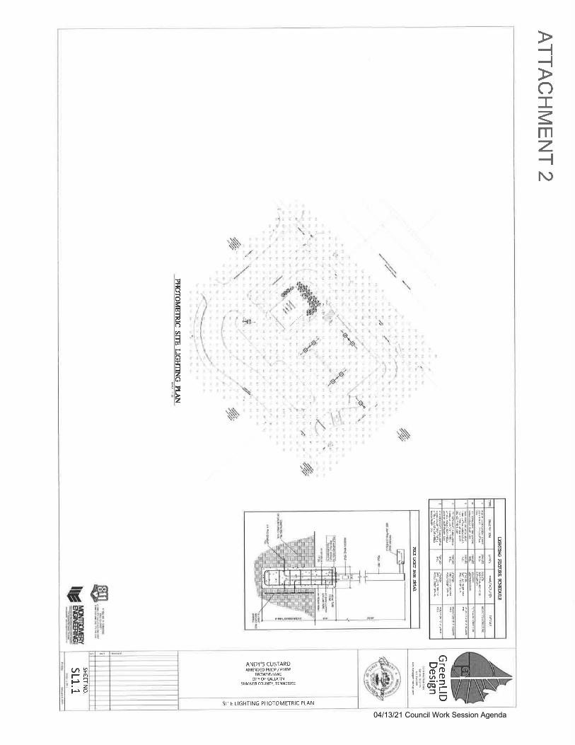
-l-loTmz-{N)
ANDY'5 CUSTARDAMENOEDPMDP/FMOP
SROWN5 UNEctfr of GALurlN
SUMNER COUNfl, TENNES5EE
-Iz
(t1t-rP
SITE LIGHTING PHOTOMETRIC PLAN
6)PdAacrc3
Ii
i!it{
a\(fp-
EtI
3
B
atEvln
q
6
Ia
Ii
I
i
E5
E
dIdE
8n
!I
trlii'tF
!i
iiE
E:;Bgt9J;t
tiigot
;Eit
ta!PnlcDlqJ
;e
5a
p;rir!
g
l
'E;9lc!
iE
ir
ig
i!t;iEI
qciF
!;Ei
;;i;tE!
E;iEFEEi
ln:;t!iF
a
3i!eqr
Eq;
cr!
E
I
!
E
EFF
'N
't\
,l)
': :.'i: i.,1 ,,l€;it.b: .
ti:
..es6t '
\T.
J'-
z
, ,9n'f' '
'$.$:
.t
d
:t
i
\
t..
{
f
\1.
:.,9,d-.
?.
\\\\
,/.''. :.'.:
1,
r$\
. /rlt.
l/.,
,\.-|:
lxtotd
IEIElolal=lrdItrlo
EloIt
lE
!
tr€i'ffifiHli';
04/13/21 Council Work Session Agenda
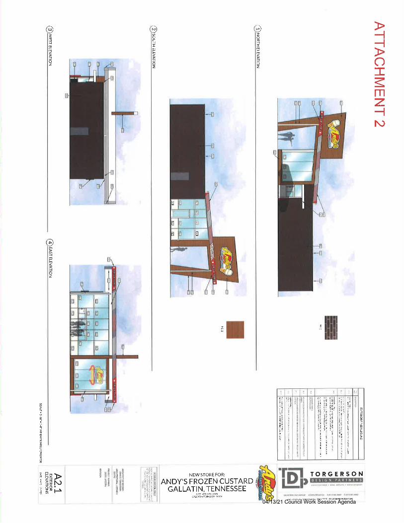
-l-lo-
mz-lN)
)zon4Im-mi6z
ffi
t2of6
"iEl ie
:zil i:"5:l i1i:l j;t ii;
"ri i-!. I I
;: I :: l:'ll:l,a
)
ri;,i:."d;! ;: ::e
il i; ?!'
3i i; :=
'l 't'a:.F
:il;:i::::s
!q
I
:i!-
!
:
:
i
IN,2:;i!tV
t'.:
5i
TORGERSON'E!,
)oc-tIrrrfI6z
NEW STORE FOR:
ANDY'S FROZEN CUSTARDGALLATIN, TENNESSEE
tJ95N SjlVtrtFflktcALrAllN.ltilNt95ra !?04
I
fl=t
IEI
I a4
IT
xII
ffi\\\
D{m4n
t6z
-e:i.1i; i
Iitgli;i!,i
N)ts
Em
+mr
ioz
i frq-<12 F
i99u6
:I
2z
oz
04/13/21 Council Work Session Agenda
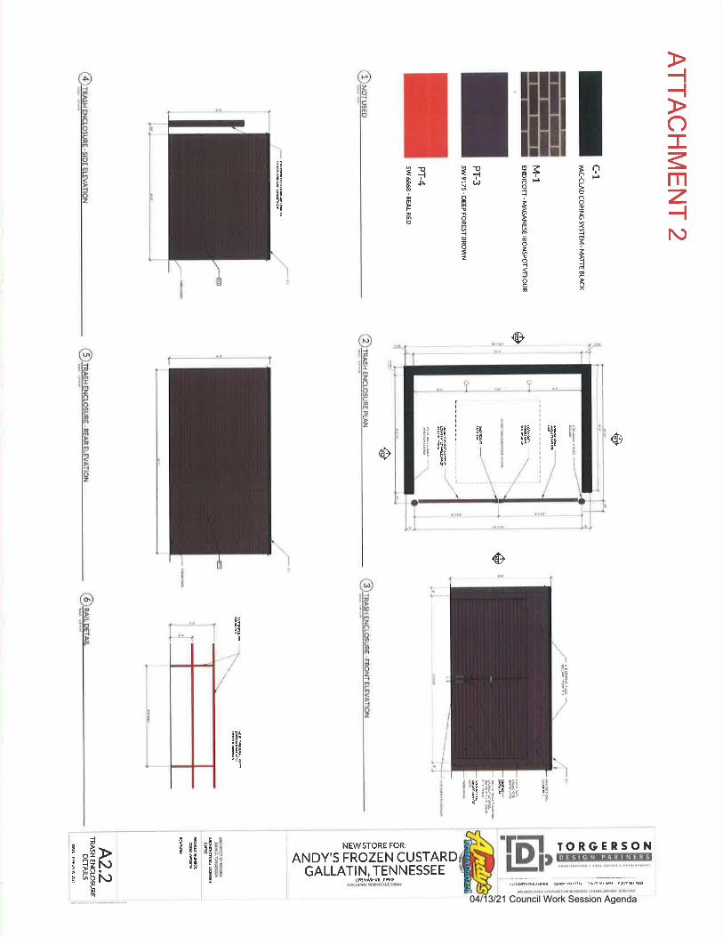
-{-lo-
mz-{N)
ots
BooFIo!zo
+
F
I{@
F
={0d!!
4@F
=z
z,so'6Flioz
;oz!
in6ca
1Jio)
9a<J3:A
i;fitltit:
@
@@
NEWSTORE FOR:
ANDY'S FROZEN CUSTARDGALLATIN, TENNESSEE
IORGERSONt
t9
!E
!e"i!tit
6
L
Nir!I
9!!
i;i61i
I
EE*
E!e
:TE I1Al I
sriIt
t!t'
I
t
I
Bint
N'N
{nP>
t imEi6!6Hc
!m
fI
I
IIIIIIII
I
I
I
I
I
I
l
r5i'ti:
'IIer
$ltt{'
;i2iti
:9r
:!iiic
itE!
Dl)s.e.5ttt pr.tt$rdt t(.rn!rs1
-iIIIE
E
h6
EI
04/13/21 Council Work Session Agenda
ATTACHMENT 3cmc^norDffitrmmmo\!oilddrb& n(E&&ld!)((&,@b:{d 6dnls5&dbd!&Ili,*tAtu/Il#.@dul F)6&0'olofdti6'd ry(il)tud@ E@h&3l*&b. dUGdtu.r*.btuiltdrddIBd &dEhbtu6qdb *[email protected]@tk@
@GSIEOF/{@CY
RaMtuuLlljHP*].Wsurur{aB&.1 E-r}rr
CERMftNOF SPP.ryALrcRruM}lN
I hb!dt d,d Sr3uds$nA ll@h bb tu b@Vd&ql.h r|dMdSebhb.f&&qroldsr..i dry, rcdb &tudd:@tub.d Ulibbrrdtu,dna.tuftdstut|wr
SBUEssDA 16:. reSANGRS
mlrrc6
!tut-rt+9
I Sdr: d)ud.,r@do& bdla' Pb'kkdEEli=*'lEd.|4b-si6.'e.rtua.rl* vF6nid'n hhi*
ilEGF NCoBlm1. re91
CRS.GEOFffiov[C'tW.{P-WSM C:RIEAEO| APPRDYAI oFSnRvWS @ffiEOtsroAROV.U@ SWft rolmm tmr oFBnam
r@4scF6d@n.@nrtuddEry6G@ry&M@!ryr@tu-dd'iugsshbod&96tubabdrF.fu!tu@
ws-ffi^-
GIVN mCms Uc
r0ft6nB6ffi
dLYNSTdffiME NiE:.EmEi*ffi
!f U !. rrcs^Y lrr ra !!3-v L-E P,kE)// -*--*""
N 48'54'14' E 49753', IOTA-
s 48"4.+'41' W
€ wGF{*@Ar@
@TrioE tr sAE aFc.{mN
7L)4L/----z.tL'.'lje 11 k
/L
-Mrva'f-UIWrcG
_J_
6F
&3 1l'
$N!RNNmusTm@
LOT1.ffiSMBAreAzdrc rec
li
YOU'IG. HOBESItD
a,sgocrarEs
1202 CROSSIIT\DAVE.CLTRKS\IIUE, Tr\ 370{0
PHO|IE 93:_6492524FAX 931645-2768
dil@younghcbbs.@m
r,*ia-c I ;;
ssgww t lfl.s'laF_L
ar
i!3!c!__s uaadw
! 3€2qF- w
FI
E1
BASIS OFEEARII{6-NNESSEE ST. ATE 'LA{E(sPc 41 00 TN) NAD S
ffiSCALE 1" . 60'14!q,w
LEGENDss 'E)o
a/l
-P.K
IALruD{+)Sfimp K ssf Ks)
+o
-€ffiMNOE-€ffiMCU'
'al1660
i.:e
caDffiorBF@!
LOT!,Wresr.Fczl.re9/
grcilR&EUNLfrNO@
?3EW
!.E-tlc-tu4.re
i i6 12lrw2r * r:g D€d: 26 31:od-
emswsm$6@
LOTl,lYlre@@re6,re8dftGE
ffiffiB4reE
rcEAffiFrcffi
_Rffi!r
-sHremN
- -ffiuB
6As L|DE,A\!mME LtN€. /€ SF4
E@Ib
lffiMffifsr4s
F 3E4EtoTol.vrlJ€6r
F20,re&ffi6W
zrerda@sflfrHErud s r&ffi@!9&w63 El@l&mtrffis@'2.r16
! luEEr&G*ruffig1.P6t6aqdP&EAC@^ rnts'rsILS#ESbls
s.ffircffffifat{ [email protected]&
SURVEYSRS NOTES:iE@-;GEFD@EMLGWP6$|ffiffi^6ffi
? ^r
ffir!ffiasar$effiMsFcNflDilgB:inre@f,rcslMESnBfrT€MFruNN NWEsEffi
'3,QffidtEs6Fl1ff
ATEWffilffiNreNffifTJffim,$@qffia@&ftGM=sg& TffidNDffiG
r2*'@EfuEreEfiAF*IffiFffifl.mmqnrRlff@w^Y€wrcruEut8@Nffiffi(-d6)fl@sl@aNrrotrc&wsl,sffia*oew€ffiEffi:FEffiN^@@.MffiioffigAre(NroGEMF6IGME@E@TFi- - /- t4b.l4 i,-.r 4^.^t'/r5 rcffi*KEl&@Sfftl,Ltr43i{tEre#OffiEst4rcM ES*F Sm g.ry* WARF 1|n
6lreSArffiff€AYM@rcffiAAffiNSF6TS'Effiq'A 6ffi,wAMESff$ffiffitry17 rFl@CTr6tur@\'gEN&l/KH rd!l@JFpr z@Ns swo@Rfu7ad4P&aro !oTa63mGvff ff aEc uE nfr m
-
$
-$rffiffiArc@-
Sr
-SIWSEffiRFENiqEOWNER/DEVELOPER
SUMNER PAHTNERS, -607 Colviio.ls DFIVE
GALLA1IN TENNESSEE 37066(61 5) 452-8256
FINAL PLATwooDs coMf,ioNs
SECTION TWO FE-PLAT LOT 21395 NASHVILTE PIKE
U.S. HGHWAY 31 E ANf, BFTOVIINS LANE4TH CIVIL DISTRICT
GATTATN SUMNER COUI.iTY, TENNESSEEDATE: OCTOBER 5, 2018, .G| # 120-18
SHEET 1 OF 1
o ircYffir*uitH€&RBssawffiat E@@ m@ tl.ffi.N Rlft6sffiffi668ffi*dM#NEFF
'KTdF..rwl suffi&*sft6rem6ff&[ImREN EBffifuN I:1J.@4gffEFEQ.
o
LOT 281.504: AC - 55.519i SF
13'7 NASNLL: PIKF
{SEE I'OTE 161
E-
--ilrqF7'
7€13|lffi
r"loe I,o o.r.o.a.l-
t. .. ,:
gPn.csrrwNArF
Ilst3
Bnilvt)).**r I
rl
o
(l\
I
LOT 2A5.821r AC - 253,580r SF
ZONEDPDG1 395 NASFML.E PIKE
D*gutf E@6nENffimffiftsffiBMr[^#4E@l@AE
10.64RreTBOWffNWMNSADffN-q3@@
04/13/21 Council Work Session Agenda
ATTACHMENT 4
04/13/21 Council Work Session Agenda
ATTACHMENT 5Gollotin on the Move 2020 Chopter 3: Community Chotocter Mop
Generol Development ond Tronrportotlon Plon
COMMERCI,AL CORR'DOR
Generol Description of Existing Development Potterns
These Commercial Corridors include a mix of larger-scale
commercial development that fronts the corridor, withundeveloped farmland and rapidly-developing residential areas
located behind commercial frontage. Buildings are typically single-
story, single-use and are generally separated from the street and
sidewalk by parking lots.
Locotion
Areas within this character area include the following:
. US-3 lE/Nashville Pike from SR-25 to SR- 109 Bypass
. US-3 lE/Nashville Pike from the west city limits (City ofHendersonville border) to SR- 109 Bypass
r US-3 lE/East Broadway between Triple Creek Park and
Reynolds Street (north side of the street). Hancock Street south of US-3 lE/Nashville Pike to SR-
I 09 Bypass
lntent
The development pattern for established and emerging corridorsshould seek to:
r Provide through transporcation, land use and other physical
enhancements an environment thac provides a distinct sense
of place, not just another commercial strip
r Discourage continuous ribbons of automobile-orientedcommercial development along major corridors
r Organize nodal commercial development opportunities atintersections with major streets and new secondary roads
r Permit development of suburban commercial and residentialdevelopment along arterial roadways with master planning toaddress access management and design that is consistent withcommunity character
. lmprove traffic flow by consolidating driveways and
encouraging interparcel access
r Provide sidewalks and a more pedestrian-friendlyenvironment by incorporating landscaped buffers between theroadway and sidewalks, placing buildings closer to the street,and locating parking to the rear of buildings
r Encourage mixed use development
. Reflect quality materials and design (related to the building,the site, and signage)
CO1414IRCIAL CORRIDOR
a
a
a
a
l'ledium to High
Transportation
Hedium level of scwice
l'ledium level of connectivity
Properties a(c€ssed bI public roads
Regular-shaped, medium+o-long
blocks
Roads characterized by a mix of curb,
gutter with sidewalk and grasy
swales all with a low+o-medium level
of pedestdan orientation
Bike lanes/routesO
lnfrastructure
. Public water and sewer available
. Civic spaces sud u greenways, park,
common areas
Greensoace
. Adiacent Preserve areas
. l{eighborhood and pocket parks
. [ommunity gardenl
Primarv Land Uses
. Small and large*cale apartments and
townhomes
. 0ffice
. Vertical l'lixed Use
. Commercial/Retail(indudinggrocery
stores, home improvement stores,
restaurants, hotek)
Appropriate Intensity
. 0.75 IAR
Applicable loning Districts
fxhttng loning Dbtrkts
. PGC, l'lU, llR0, G0
Propwed loning httrim. l,lixed.Ule Node (new)
. [S, [G with Conidor Oveday (new)
MACTEC Engineering ond Consuhing, lnc -Project 6 I 5 I -07-0039
3-38
04/13/21 Council Work Session Agenda
ATTACHMENT 5Gallatin on the Move 2020 Chopter 3: Communtty Chorocter Mop
Generdl Development ond Tronsportatlon Pldn
Provide shade, reduce impervious surfaces, shield parkingareas, and improve the appearance of individual sites and theentire corridor with quality landscaping
D ev elop ment Strotegies
r Encourage retrofitting of existing strip development intopedestrian-scale interconnected nodes
r Limit signs and billboards
. Cluscer high-density development ac nodes along thecorridor, such as maior intersections
r Depict clear physical boundaries and transitions between theedge of the character area and adjacent character areas, in
particularly those that include residential uses
r Strengthen pedestrian connections to adjacent residential
r lncrease landscaping along the corridor, including in and alongparking lots to provide shade, reduce impervious surfaces,shield parking areas, and improve the appearance of individual
sites and the entire corridor
. Plan for community street network that creates rather than
hinders opportunities for walking, biking and providing futurepublic transit
r Establish pedestrian-oriented buildingsetbacks
r Guide building and site design, including parking lotconfiguration and streetscape features
r Find an appropriate balance between residential andcommercial uses within mixed use developments
r Organize new development a nodal fashion with nodalcommercial/mixed use development opportunities atintersections with malor streets and new secondary roads.Areas between these development nodes along the corridorprovide opportunities for development of higher intensityresidential uses that would create more housing choices forthe City that are in proximity to commercial areas and maiortransPortation arteries.
I mpleme ntation /Vleosures
''F Amend Mixed-Use districts
(s' Mixed-Use Node zoning distria (new)
tF Corridor Overloy District
Exlstlng commerclal corrldor oreo olongNoshville Pike near Vol Stote
Emerglng commerclal corrldor along NoshylllePlke west of Gallotln
Quallty office development along theCommerclal Conidor on Noshville Pike includesquotity building materiols, londscoping ondpreservdtron of rnoture trees
I ftr':'gst '?a
illtlti, ),t,tt ,r,/rtr*.qI
.rcF f,&5 |
L
;t 'l'
MACTEC Engineering ond Consuhing, lnc -Prclect 6 I 5 l-07-0039
3-39
04/13/21 Council Work Session Agenda
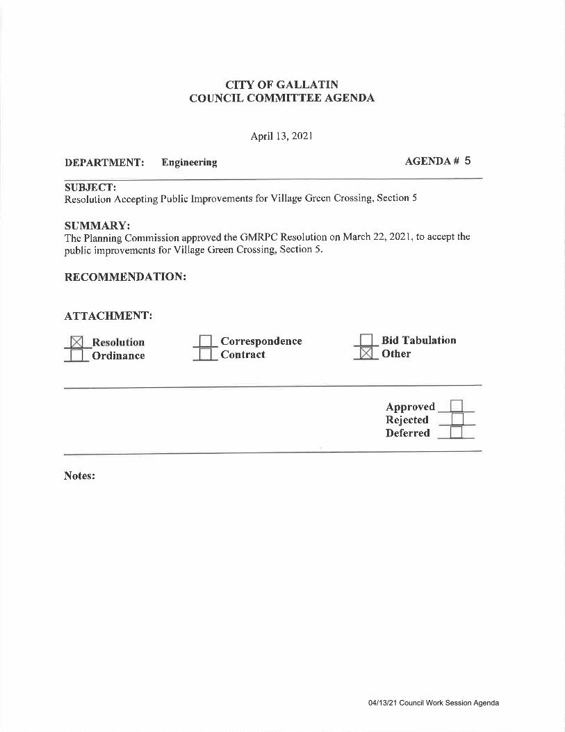
CITY OF GALLATINCOUNCIL COMMITTEE AGENDA
April 13,2A2l
DEPARTMENT: Engineering AGENDA #
SUBJECT:Resolution Accepting Public Improvements for Village Green Crossing, Section 5
SUMMARY:The Planning Commission approved the GMRPC Resolution on March 22,2021, to accept the
public improvements for Village Green Crossing, Section 5.
RECOMMENDATION:
ATTACHMENT:
OrdinanceCorrespondenceContract
Bid TabulationOther
ApprovedRejectedDeferred
Notes:
04/13/21 Council Work Session Agenda
5
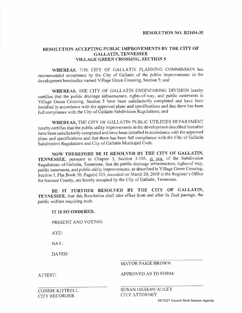
RESOLUTION NO. R21A435
RESOLUTION ACCEPTING PUBLIC IMPROVEMENTS BY THE CITY OFGALLATIN, TENNESSEE
VILLAGE GREEN CROSSTNG, SECTION 5
WHEREAS, THE CITY OF GALLATIN PLANNING COMMISSION hAS
recommended acceptance by the City of Gallatin of the public improvements in the
development hereinafter named Village Green Crossing, Section 5; and
WHEREAS, THE CITY OF GALLATIN ENGINEERING DIVISION hETEbY
certifies that the public drainage infrastructure, rights-of-way, and public easements in
Village Green Crossing, Section 5 have been satisfactorily completed and have been
installed in accordance with the approved plans and specifications and that there has been
full compliance with the City of Gallatin Subdivision Regulations; and
WHEREAS, THE CITY OF GALLATTN PUBLIC UTILITIES DEPARTMENT
hereby certifies that the public utility improvements in the development described hereafter
have been satisfactorily completed and have been installed in accordance with the approved
plans and specifications and that there has been full compliance with the City of Gallatin
Subdivision Regulations and City of Gallatin Municipal Code.
NOW THEREFORE BE IT RESOLVED BY THE CITY OF GALLATIN'TENNESSEE, pursuant to Chapter 3, Section 3-105, et seq. of the Subdivision
Regulations of Gallatin, Tennessee, that the public drainage infrastructure, rights-of way,
puUti" easements, and public utility improvements, as described in Village Green Crossing,^section
5, Plat Book 30, Page(s) 325,recorded on March2l,2018 in the Register's Office
for Sumner County, are hereby accepted by the City of Gallatin' Tennessee.
BE IT FURTHER RESOLVED BY THE CITY OF GALLATIN'TENNESSEE, that this Resolution shall take effect from and after its final passage, the
public welfare requiring such.
IT IS SO ORDERED.
PRESENT AND VOTING
AYE
NAY
DATED
MAYOR PAIGE BROWN
ATTEST APPROVED AS TO FORM
CONNIE KITTRELLCITY RECORDER
SUSAN HIGH-MCAULEYCITY ATTORNEY
04/13/21 Council Work Session Agenda
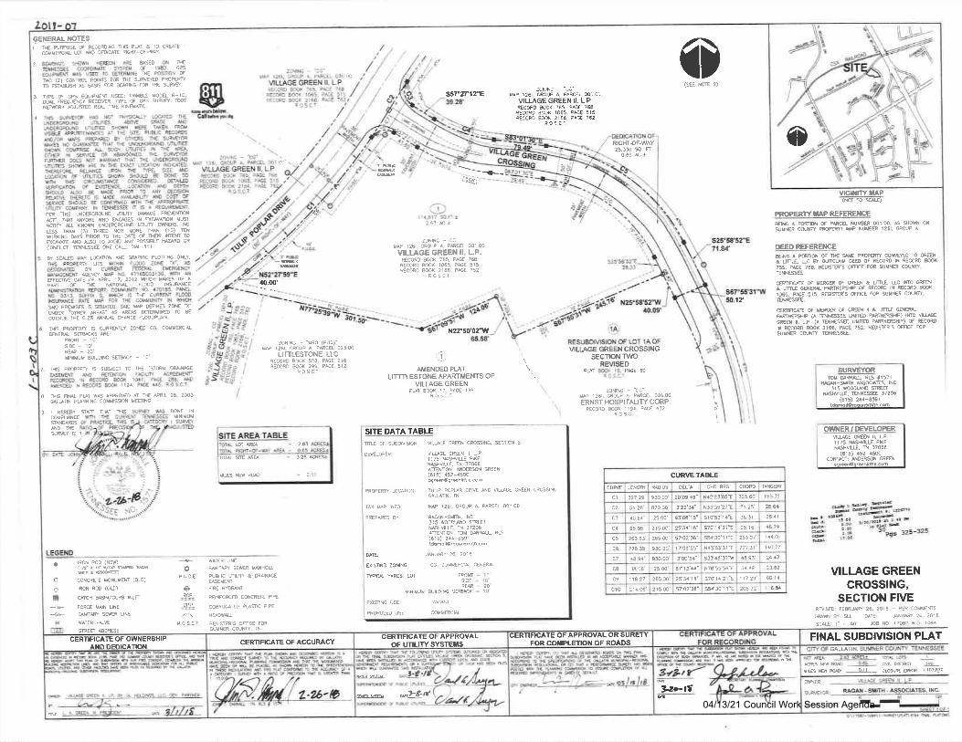
GEIGRAL NOTES1 ru ry@s s Recomltc rHrs PUT 15 rO
cwvErca L6 A0 Iff E qrcfr-oF-w Y.CRAE 1 o2, ffi6 ffi 8TI€ON ARE ND il fiE- mrcsse cffiDlME ffi! Ot 19EJ 6P5
eourrurm ws us rc omR$N€ ftE WN SfuO .2) @NTRq rcIffi FOR ftE $&ffiD PrcPffiro esimr AS S6 .G BARNG Ff qE Iffi.
f mE of ffi EoutPUM @ RMU MOffiL R-10.I)W ftOUSfi ftCMR Fe tr eS sU+6 DrNMfl NUffD Rru IilE KNMNC,
TH6 SUMW # rcT PHSIruY trAE DEuNm(ruNo flm6. tr c@E aDJriFcmND nmEs Sim vEE TMEN mrysgtr mtrtlwEs Ar nE sre, Pu&c recmsNo/ffiffiffiPffiFOfiEreruSuMmffis No affi a^r N Nl)trcs frmESHOM @PR$ U $Cts UIWIES IN THE MA,EIfr* !X SEreE OR ANMEO SE SUffitrFJMA 006 Nq T|MT HI BE UNffiUNDwlms slffi mE N ff€ Effi i@nfr Norgm.frEFgffiE. RANCE UPON N€ W. SA NDL@ION 6 WLN6 sWN Y@D ff rcilE 9tin rH6 ctRcuNM cosrm. m6wRrcAns f sfficE. LNAION N0 ffiSHOU@ SO BE WE PRPR TO N ffiISFTUTE ffiO IS W€, AVNreIfr ND C6 tr$ME S@D tr CilFTRVO Wts UE pffiEww qPM. ril wEsss r 6
^ ftNlaff.
ffi .THE UNffiRCruIO WLIT IME PWg'. ruT NONE W EllffiS rN EXGV mN XUSN@ft U Kl{m UNDMROUND MLfr ffi' NO
css lh {3) mffi NOR ffiE Ts (10) B*onxrpc ur -RoR rc HE SE Ol UER rW TO
aqv^ff ND N TO AVOD N P6l&E llffO 0RcoNaufi nilNEssEE oNE cu. 0[ 61 I
fl SM tr LOqNON NO GSHC *OMre ONLY'
HS IffEW U6 tlftlN FffD ZOilE 'X'. 6OE9GM@ ON CUffi€M ffiru ffiYuwffi sENfi w No. 47lffiOfl$, m Nffiff STE OF €RIL I7, 2Ot? SICB WE UP A
PM OF NE MIOW F@O INSUWESCNmmN ffffir cilrUNfr N0. 47OlE5. PNELrc Of1J. SUFFIT G. WHICH 6 TAE CURRN NMDtslffi! ilE W FOF TrE COtlUNrft lN ffii6qo PRssF 6 ruEO. ilD W mil6 ZSI a-sD* rfrft are- 6 sw I)RN$ ro BE
owm rBE o.zt Nlw cMNcE t(wHN.
:JNTNC -'C!"(rAP i26, GFCUP A PARCiL @1 0r'
VILLAGE GREEN II. L.PRECoFD aCC( '55, zSE 7ATCoQD aoox 1065. oAc€ 515PECORD mk Z1ee. ?&t 162
ROS.C.T
00
sCdhp4
(sffi2)s57"T12'e
RIGfr-OF.WAY2a,ls s. n
0.65 €.*m-
-t--i.qt!-
vlcNrvtaP(NOT rO ru)
PROPERW XAP REFEREilCE
Elre^mfPmaNMSfRml.m.SW8 COUW reEfl W NW€R 126I.
63 ACt N SHOS qroP A.
_---103-
zoNnc - cGw 126r. GPOUP A. Pfta ml.@
VILLAGE GREEN II, L.P.trcoRo mK 765, PG 7SRECGD @( 1065, PG 515€cffiD lw 2166- P^GE 752
tos.cT.
N2?50'02-W
.u'
17
CURVE TAALE
TAG€F
165_3:
23.il2611
€.79
1q.2:
24 17
2J,E2
@14
r 15.&
cHorc
325.60
36.3r'
95 16
253.07
217 _3t
€.9134 49
1 17.29
205 J2
CTD 8RG
N4223'05"E
il3t:9'27-E
srcsJ r4'E
9014'21t
N.'sJ 31ts3t48'17lf
N7r55'56'a
S7Cl4 2l'E
ssa l0 ! r'E
DElTA
2q6'a9"
!22'31"
93'S'15'
2f34 r6'
57Q/56'
170A'55"
tm 5a"
E713 11'
2tv la"
5702'3a'
MDIUS
9lo 00'
a70.@
25.00'
2r 5.@
265.00'
9$.C0
9S.m
2S.@'
265.@
2r5 m'
ur6Ht27 -29'
51 2E
40.64'
95.95
251.&
27E.35'
€.94'
3A.06'
11827'
?r4.S'
CUM
clc2
c5
c6
c7
CE
c9
c10
DEED REFEREIICEErm A Pfffifr d ffi *E PR@m COWD rO ffiA& ru M & QTCUM ED OF RECORD IN RECORD ffi7is- PreE 756. roOsffi'S ffilCE FOR SUMNR COUNftEN€S.
CMFilI q IffiER OF GR4N & frLE. UC IFO WEilA tru G€NM PMEEHIP S RECOrc IN RECORD MKt$5, PreE 5I5. REGffi.S MCE Fffi SUVNff CEW.msE.ffinaT6vffiOFOffin&ffffruffiiffirP (A B6gE Ulm PmfisHF) lrc uLEcffi !!. L.P (^ EUESE Ulm PmffilP) tr RECmU RE(m MX 2166, PG 762. REGI$IRS OFrcE FOR
suvrn cow. BffiE.6 BrS ffiffiff 6 ilRRSLY ZdD re. CilU8C'aL
ENru SfrgAC{S ARE:
nN-10srE - 10'Rffi-20uilrvuM 8urorrc ffik - 10'
7 SE Pffim s su&Efr To ff€ 'sToil mw€SEMff ND MMIS FrcIW rcRflEtrRECdDD rN RECOm 8q 10a1, PreE 2S, ADMNm N RECORD @( 1194, PSE 95 R.OS-C]'
I ilrs Fru Put *6 pmo€o AT ftE fRl 26. zmJruurN ffiNlN6 COrll$EN Vmrc
zoN,NG - aFo (PUD)"uP 126r- GROUP A. PARCEL 02500
LITTLESTONE. LLCtE@Rg goq 52f,, PACE 216aEccco ffik 299. PsE 81 2
'.1.1
AMENDEO PLATLITTTLESTONE APARTMENTS OF
VILLAGE GREENPW BoOk rr. P,GE r99
F5S'T
LO.S.C r
MLI.AGE GREEN CROSSING
\ sEcTl'oNT\ /o\ REVISED\. o;.- il{ t9, p&.69
zoNtrc - -cG'
UP r2ol, CROUP A, PARCE! 026.00
ERNST HOSP]TALITY CORP,R€CCRC 8@( lr94 PACI 432
R.O S.a.r
SURVEYORTOM Sru ru ,1571
M-vfH MhES. INC
3r5 v@wo ffifllWU. TENNESSE 37b6
(61 5) 2e-ESrrerul&edn.m;lh.6m
OWI{ER' DEVELOPERUWE Mil [, L,P.ll75 WUE PIXENWU, n J7065
(615) 452-€@co$Afl: NDfi$N CREN
doffir!.nli8..com
9. I HEreYCWPWCE$N0mdDw
$AE &T nts MNE IN
I
$ffits1
oP!D.E
"1cl=.ci3=
R.O.S.C.T,
a
ooI
IrcN ROD (Nil)('2'r rf r/*n^@ u
CONCRM MONUVEM (OTD)
rrcil RoD (OS)
qTcH usrN/cuRg rNLfl
FORCE WN LINE
SNtrfr SMR lNE
*ES 00R6S
*ITR SEWER WHOUPUSUC MLfr & D&WEffiEVEN]NRE MruTREINFORCSD CONCRFE P'PE
CORFUGATEO PUflC AP€
REGIWF'S OMCE FORSUUIER COUNW, ]N
SITE DATA TABLEmu oF SuaDMsloN
DMLOP€Rl
vLucE CREN cRO$tilG, SCTloN 5
V['GE GREN il, !,P1i75 NASMUE Pi(EN SHVU. fr 37065ANMS' NOFS GREEN(615) 452-r5ooSr66ngg.snlittc cch
PR@€RN LOCANCN: TUIIP FOPUR CRffi ANO ULffi GR€€N CrcSSINGGAUIN. n
PREPNM BY
uP 126r CRCUP A. pAFCEL 001 00
e6N-Svtfr. rNC.J!5 WoCDWO SmGiNHVIUE, iN 37?06AMMrcN TOM 94WL RLS(615) 2r4-659rtConollOr.qon.o{h.com
DAE:
EXISING ZONING.
ftPlru YARDS: lOT I
CC, 'OIMEPCI{
CENERA{
FPOMSrCf
!Mk
t0:0
MINIMU! AUIL9'NC20'10'
EXI$NC USE
PROPOSED USE .OMMERCAL
H,"Y'f,*"ffi'"'VILLAGE GREEN
cRosslNG,SECTION FIVE
Rils@i FSRUS 26 zolE - m couM€Ms
DUm W: SLL oAIE: JNW 2e 2018
rur l " - 60 SB NO l7OA7 I Oi 1094
FINAL SUBDIVISION PLATGALLANN.
6r Drs6 .&{ES NS M: ------sL1-- A6U& eiM I 103.670
WNER
lOT MA 263
0,1 I
TOTt ffi NA
IIIES ilEW RN
o
9ao-tte-
(rlHtul)€ffiM6trtulldilrsrbF.@id@dHiDdtu*ftftffilwdKrusM-Grus6i;ii ft@uffi&offi^[email protected][rEd@'@?aqa6)fi*'ur*** LLj,:+*"tf nln
CERTIFICATE OF APPROYAL OR SUREI YFOR CilPLETIOT{ OF ROADS
@ -,J€''r
CERTIFICATE OF APPROVALOF UTILITY SYSTEf,SCERTIFCAIE OF ACCURACYCERTIFICATE OF OWNERSHIP
AiID DEDICATION
SCALE: i"-60
lNc-
04/13/21 Council Work Session Agenda

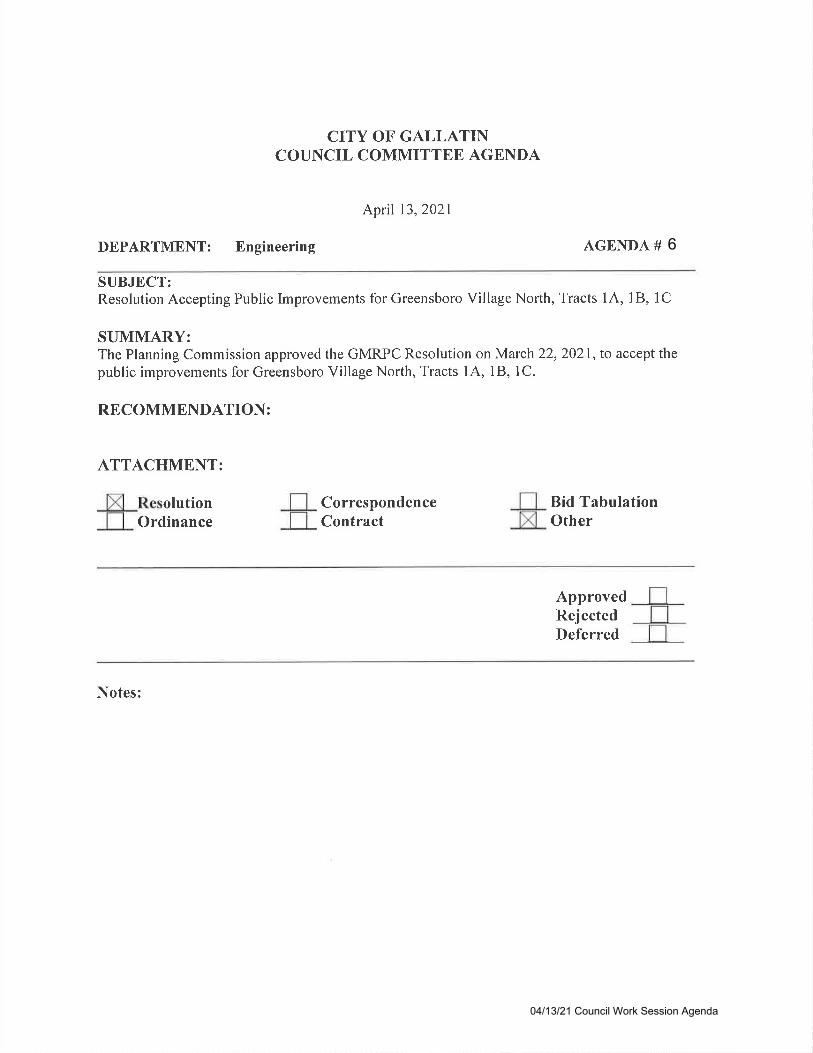
CITY OF GALLATINCOUNCIL COMMITTEE AGBNDA
April 13,2021
DEPARTMENT: Engineering AGENDA #
SUBJECT:Resolution Accepting Public Improvements for Greensboro Village North, Tracts I A, 1 B, I C
SUMMARY:The Planning Commission approved the GMRPC Resolution on March 22,2021, to accept thepublic improvements for Greensboro Village North, Tracts I A, 1B, I C.
RECOMMENDATION:
ATTACHMENT:
olutionOrdinance
CorrespondenceContract
Bid TabulationOther
ApprovedRejectedDeferred
Notes:
04/13/21 Council Work Session Agenda
6
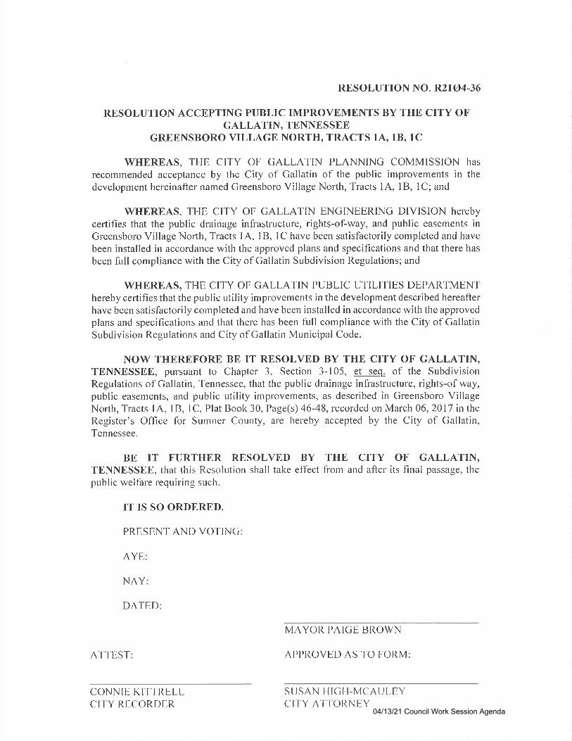
RESOLUTION NO. R2IA446
RESOLUTION ACCBPTING PUBLIC IMPROVEMENTS BY THB CITY OFGALLATIN, TENNESSEE
GREBNSBORO VILLAGE NORTH, TRACTS lAo lB, lC
WHEREAS, THE CITY OF GALLATIN PLANNING COMMISSION hAS
recommended acceptance by the City of Gallatin of the public improvements in thedevelopment hereinafter named Greensboro Village North, Tracts 1A, lB, 1C; and
WHEREAS, THE CITY OF GALLATIN ENGINEERING DIVISION heTeby
certifies that the public drainage infrastructure, rights-of-way, and public easements inGreensboro Village North, Tracts 1A, I B, 1C have been satisfactorily cornpleted and have
been installed in accordance with the approved plans and specifications and that there has
been full compliance with the City of Gallatin Subdivision Regulations; and
WHEREAS, THE CITY OF GALLATIN PUBLIC UTILITIES DEPARTMENThereby certifies that the public utility improvements in the development described hereafterhave been satisfactorily completed and have been installed in accordance with the approvedplans and specifications and that there has been full cornpliance with the City of GallatinSubdivision Regulations and City of Gallatin Municipal Code.
NOW THBRBFORE BB IT RBSOLVED BY THE CITY OF GALLATIN,TENNBSSBE, pursuant to Chapter 3, Section 3-105, et seq. of the SubdivisionRegulations of Gallatin, Tennessee, that the public drainage infrastructure, rights-of way,public easements, and public utility improvements, as described in Greensboro VillageNorth, Tracts lA, lB, lC, Plat Book 30, Page(s) 46-48, recorded on March 06,2017 intheRegister's Office for Sumner County, are liereby accepted by the City of Gallatin,Tennessee.
BE IT FURTHER RESOLVED BY THB CITY OF GALLATIN,TBNNESSEE, that tlris Resolution shall take effect from and after its final passage, thepublic welfare requiring such.
IT IS SO ORDERED.
PRESENT AND VOTINC
AYE
NAY
DATED
MAYOR PAIGE BROWN
ATTEST APPROVED AS TO FORM:
CONNIE KIT'TRELLCITY RECORDER
S USAN I'I IGI_I-MCAU LEYCITY ATTORNEY
04/13/21 Council Work Session Agenda
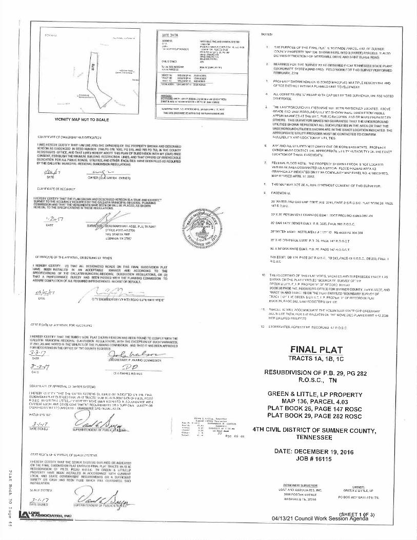
trOJ
du,oo
oruD
tqo
VICINITY MAP NOT TO SCALE
r/z.lt
SITE DATA
rqtuo) rulTrru AESrOaNrht a oFflcETA T'S I$ , PARCEI q.B46.re rlttP! €re2D
lola $EACR&GE: $sac t!,F _!7 $tTOT^T P&ELS
MNAY:rEMmrwrsrF{0silf,Es)oRaffi${o&rGEs}sTfi sFRn^oFDrrlR r 6.lttFoac4cE5l
FEMn! PAEI NO .tiMO.o7G. O TEO ApRtL lr, 2Or ?
IHE PURPOSE OF THIS FINAL PST IS TO DIVIDE PARCEL4,03, OF SUMNERCOUNTY PROPERry MAP I$, SHOWN HERE INTO 3 (THREE} PARCELS. IIALSODEFINES DEDICATION FOR MERRAMILL DRIVE AND SAINT BUISE ROAD
AEARINGS FOR THIS SURVEY WERE OBTAINEO FROM TENNESSEE STATE PTANECOOROINATE SYSTEM (NADIgS) FIELO WORK FOR THIS SURWY PERFORMEDFEBRUARY,2016
PROPERN SHOWN HEREON IS ZONED MRO(PUO). MULTIPLE RESIDENTIAL ANDOFFICE OISTRICTWTHINA PLANNED UNIT OEVELOPMENT
ALL CORNERS ARE /]' REBAR WTH *P SET BY THIS SURVEYOR. UNLESS NOTEDOTHERWSE.
THE UNDERGROUND UTILITIES HAVE NOT BEEN PHYSICALIY LOCATED- ABOVEGRADE ANO UNDERGROUND UTILITIES SHOWN WERE TAKEN FROM VISIELEAPPURIENANCES AT THE SITE, PUBLIC RECORDS, AND OR MAPS PREPARED BYOTHERS, IHIS SURVEYOR MAKES NO GUAMNTEE THAT THE UNDERGROUNDUTILITIES SHOM REPRESENTALL SUCH UTILITIES IN THE AREA OR THAT THEUNDERGROUND UTILITIES SHOWN ARE IN THE ENCT LOCATION INDICATED. THEAPPROPRIATE UTILIry PROVIDER MUST BE CONTACTED TO CONFIRMAVAISBILITY AND LOCATION OF UTIIITIES
ANYANDALL UTILITIES MAY CARRY ONE OR MORE EASEMENTS. PROPERNOWER MUST CONTAC] THE APPROPRhTE UTILIilAUTHORIry FOR THE ENCTLOCATION OF THESE EASEMENTS.
FEDEML FLOOD NOIE: THE pROpERil SHOW HEREON lS NOT LOCATEDWTHIN AN AREA DESIGNATED AS A SPECIAL FLOOD H&ROAREA ASGRAPHICALLY INDICATED ON FEMACOMMUNIW MAP PANEL NO.47165C&07G,MAP REVISED APRIL 17. 2012.
THIS MAP MAY NOT AE ALTEREO WITHOUTCONSENTOF THIS SURVEYOR
EASEMENTS:
20'WATER AND GAS LINE ESMT: R a. 2741. PAGE 318 R.O.S.C. PLAT BoOK 26, PAGE147 R O.S.C.
30'X 36 PERMANENT DRATNAGE ESMT: TOoT PROJ NO s395G2651{4
30'SANITARY SEWER ESMT.R.A. S35, PAGE 503 R,O.S.C.
20'WATER ESMTj TNSTRUMENT * i 1771 t2 , RB 44S pG $4-s9
35'X 40' DRAINAGE ESMT: P B. 26, PAGE I47 R.O.S C.T.
30 x 50' DRAINAGE ESMT: p.B. 26. PAGE 147 R.o.S.c.T.
TVA ESMT: DB 1 74, PAGE 247 R.o.S,c, D8 243, PAGE 43 R.o.s.c., DB 259, PAGE 1R.O.S.C
THE RECORDING OF fHIS PLAT VOIDS, VACATES AND SUPERSEDES fMCT 1 ASSHOWN ON THE PLAT ENfITTEO'BOUNDARY SURVEY OF THEGREEN & LINLE, L.P, PROPERry'OF RECORO IN PUTBOOK26 PAGE 147. REGISTERS OFFICE FOR SUMNER COUNry. TENNESSEE, ANDTMCT lAAND IMCT iB ON THE PUT ENTITLEO"BOUNDARY SURVEY OFTMCT 1 OF THE GREEN & LINTE, L P PROPERTY. OF RECORD IN PSTAOOK 29, PAGE 282, SAID REGISTER'S OFFICE
PARCEL IC WLLACCOMMODATE THE VOLUNTEER STATE/GAP GREENWAYMULTI.USE PATH. PER THE GALLATIN ON THE MOVE 2O2O PHN EXHIBIT4.12 2OO8MTP BIKE/PED PROJECTS
STORMWATER AGREEMEN] RECORDED AT R O.S,C,
FINAL PLATTRACTS 1A, 18, 1C
RESUBD]VISION OF P.B, 29, PG 282R.O.S.C., TN
GREEN & LITTLE, LP PROPERTYMAP 136, PARCEL 4.03
PLAT BOOK 26, PAGE 147 ROSCPLAT BOOK 29, PAGE 282 ROSC
4TH CIVIL DISTRICT OF SUMNER COUNTY,TENNESSEE
DATE: DECEMBER 19,2016JOB # 16115
2.
3.
5.
NOTEST
10
12
CERTIFICATE OF OWNERSHIP AND DEOICATION
I,(W€) HEREB] CERTfY NAT I M (WE ARE) THE OWNER(S) OF THE PROPERry SHOWN AND DESCRIBEDHEREoN as EvTDENcED rN D€ED NUMBER zrm,pe ezo. triss, re sts, ero ros ic zoi, ni rne cournl!gg1tt! oFFrcE, AND THAr r (wE) HEREsy ADopr rHrs puN or buaDrvrdrcN w;i ;iiaunr rneecoNsENT, ESTABLTSH rHE MTNTMUM BUTLDTNG REsrRrcnoN rrnes,nlo rnlr orreis dr iiiivoaareDEociroN FoRALLpuBlrcR&DS, urlilEs.ANDonen recrrires neveceeruriribeJieourneoEYTHE GATLATIN MUNICIPA. REGIONISUEDIVISION REGUU]IONS.
6.
OWNER GREEN.OMER)
ctry
MARSMLLAGEE, PLS| TN;2871
COUW ROAO SUPERINTENOENT
PWNING COMMISSION
-7->
PG282
o?/oz-/rtDATE
2.2, rtOATE
7-a17OATE
DATE
CERTIFICATE OFACCUMCY
ffi;5i:$*'itmff*ffi$ffip.$.T+iillffi*'qiifli'i: "'
!2b:ttDATE
oFFtcE f615.143.77S6
IO12 SPffiTA PIKE
LEBANON TN 37087
CERIIFICATE OF ffEAPPROVALORBONDING OF ROMS
I HETEBY CERnry: (t) ilAT ALr DESTGNATED ROADS ON THIS FtNAt SUBD|V|S|ON phTHAVE BEEN rNsr[LED rN AN AccEprABlE MANNER AND eCionorni
-io ire
spEcrFrcATroNs oF THE G ILATTN MUNTcTeAL-REGToNAL suoorvrsroN nicuuiond,-on 1z1THAT A pERFoRMNcE suRETy HN BEEN posrED wrTH frE punnnciouuis-s'ro-n'roASSURE COMPLETION OFALL REOUIRED IMPROVEMENIS IN CASE OFDEFAULT
O
11
CERTIFICATE OF APPROVAL FOR RECORDING
I HEREBY CERTIry T8A1 THE SUBDIVISION PUT SHOWN HEREON HAS BEEN FOUND TO COMPLY WITH THEc[urrN MUNrclpAt,REGroNAr sugorvrsroN REGuuroNs.wrHTHEExcepiioroii-uiixvnnrnucrs,F ANy, As ARE NorED rN THE MTNUTEs oF tHE pwNrNG coMMr$roN, nro rnein ras iiin nppnovEoFOR RECORDING IN THE OFFICEOF frE COUNW REGISTER.
ChAIRMAN'S INITIATS
C€RTIFICATE OF APMOVAL OF WATER SYSTEMS
HEREgY C€RTIFY THAT THE trhTER SYSTEMS OUTLINED OR INDICATED ON THESUBDIVISION PLAT ENTI]IED PUI TmCTS 1A,1B,1C RESUSDIV|SION OF p8.8.
CASH HAS BEEN FILEI SAID INSTALUIION
WATER SYSTEM'
3 -/-r7DAIESIGNED
R.O.S.C IN GREEN 8 LITTTE,LPCURRENT TOCAL AND STATE GOVERNMENT
PROPERry MVE BEEN INSTALTED IN ACCORDANCE WITHREQUIR€MENTS OR A SUFFICJENT SUREry OR
.i4 L &rrq, h!t<.
30
CERTIFICATE OFAPPROVAL OF SEWER SYSTEMS
I HEREEY CERTIFY IHAT THE SEWER SYSTEiIS OUTLINED OR INOICATEOON THE FINAL SUEOIVISION PU] ENTITLEO FINAL PST ]MCTS 1A.18,1CREsuBorvrsroN oF pl.n, pc2l2 n.o.s.c. rru cateru a rrmi,rppRopERTy HAVE BEEN TNSTALLED rN AccoRDANcE wrx cunntirIOCAL ND S]AT€ GOVERNIIENT REOUIREMENTS OR A SUFFICIENTSUREry OR CASH HAS 8€EN FILED WHICH UNLL GUAMNTEE SAIOINSTALLATION
SEWER SYSTEM
DESIGNE& SURVEYOR
LOSE AND ASSOCIATES. INC.
2809 FOSTER AVENUE
NASHVILLE TN. 3721O
OWNER:GREEN 8 LITTLE, LP
PO BOX 8037 GALLATIN TN.f:1:/?DATE SIGNED
E\ffieesr=:,.Lrs---.rl||!:i!-----.-:=qr-_-
Pgs 46-48
(SHEET 1 0F 3)04/13/21 Council Work Session Agenda
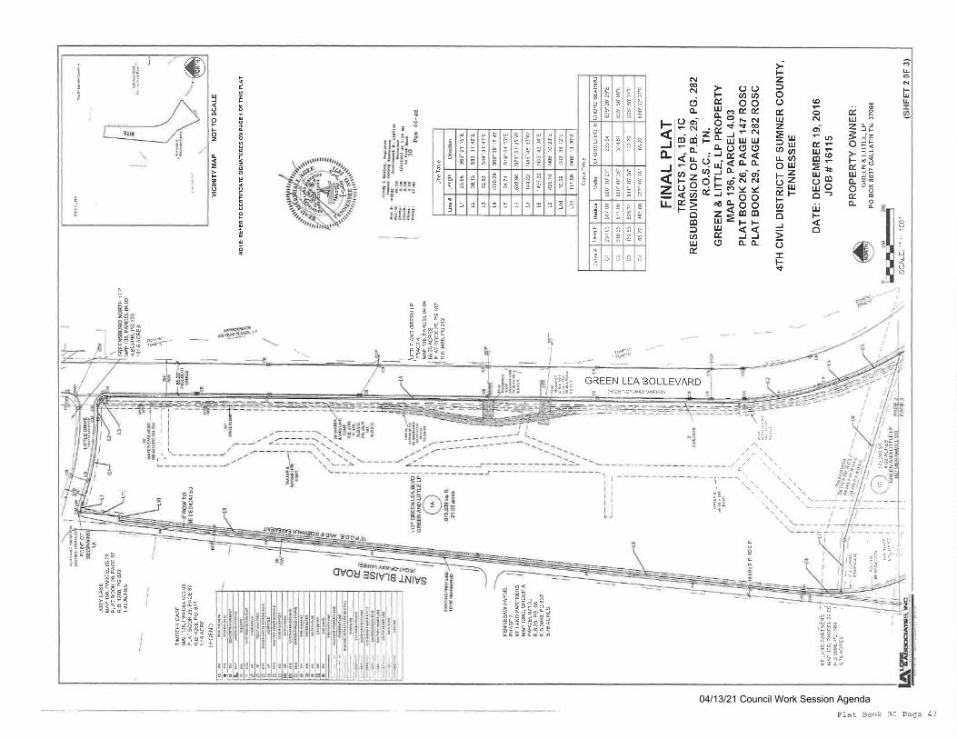
uaqFt!UJ
e.FuJ:2d2
E.l =o i!: i-1i;-*EZYu H3
o- q-o "5t@o-P
(o
oNdt'u)cEeHEErrHmiloO-)iiFo
Fzf,ootruzE.,,o$r!(,)ouJ,2Yulu. )-FU)
oJ
oIFr+
qr BBo E ooo- lucoE(3$,Hi:t^.1^J@EF*ulUJUl-o- +ooof i;itr **h A O t de{ N
?;o::PXXr= :3s8o lu<FFA H J5lu.J o o. o-E
FJo-
zLL
I
,E
,E
,9
3 i
z
v3
z
I
zp
a
a
2
0
os
n
oo
E
F
I
o
gzo
Fz6
Itr
o
Fo
I
:E: i{ b
tt..r-j q
ii!l;rsi3.:l 33BBB
;iu!ii.iirtl
uJ
ooFEz
E
E2o
lr
tri
Oa@
':*.?k'iiaoJ_
EFBr
,&cr
,;fruSvdo3s.HeBqEIpS
q3>
o 9oN)i
ut9<69FEtI5c
lp*r-'d 9
c>caPfl
:g;P
g gqF 3dc-il;-lFiESeqqz:9ldg96fitFcqF
!N
lu
;flU ?*Ii:3*?
=:1<oie 6tria'trJ g
,*S"#!ll*'3F';
?&?t
!'e
iq
;":
o
=ItE
i16r; il
ItaI
?!!i
l3|i; GREEN LEA BOULEVARD(RIGHT,OF.WAY VARIES)
I
I
I
I
I
\o
6o
l-
L
il;:T:9
*------L-
J/\\
Plat Book 30 Page 47
04/13/21 Council Work Session Agenda
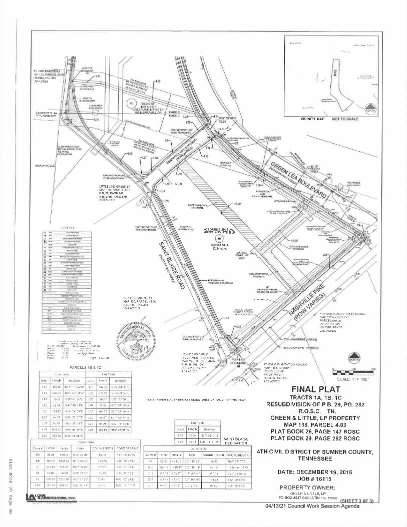
F LANDIAP 136,:.8 38S, PG. 39.76ACRES
MM BRIK
^afi$
VICINITY MAP
-\
LIfrLE AND GREEN LPMAP 136, PARCEL4.O3P.a.26, PAGE 147R.8.2166, PAGE 6702_80 ACRES
LEGEND
KF UNO PARTNERSMAP 136, PmCEL45.00R.8.3866, PG.3&
FAIRVUE PUNTATIONS HOA INC.MAP 136N, GROUP C,PARCEL 048,MP8.22, PG 341Ra 336. PG 4262.37ACRES
en4 L Errr4, F€r,ts
30Pgs 46-48
PARCELS 1B & 1C
KENNESAW FARMSINVESTMENT EANKERSMAP 136, PARCELq6,O4P B 2A PG1O9R.B.3255, PG.713
l26.0 r ROW{WOIH
A\Iv
L€ngilr
L12 110 S
66S 12
L21 1a422 s85 48 33"E
t13 N25' 42 39"W 122 532 90 s73' 03 35 E
1.14 38 61 N16'47 18"E L23 2A.A7 s32', 37 02-E
t15 NA7'45 1r"E t24 22.95 s08' 57 5€ W
L16 124 90 N54'04 04"E L25 101 75
44
118 24 50
N50" 22 36"E L26 49.07 97'45 il'W
s64', 37 04 E
s58'6',55"E
6r ?5
L19 , 612 95
120 835 50 s4a'44 35 W
Deta CORO LENGTH
8828 , 46804 010 .8 26" 88.1 5 N31'06 52 rry
155 75 5535 53 001'36 44" 155 75 N44 39 07-E
Qi 249 e2 82574 017'20 03 24e A1 s49', 2a 4'E
c8 19 90 26 00 o40 4x 21" l! 49 s3i'i5 r?"E
c9 230 09 5025 00 oo2'37 25" 230 07 N49_ 03 54"E
c10 !85 1c .14 \f 052 45 n 311 67 N?6'1n it.&
s87" 14 a9-E
NOTE: REFER To cERTlFlcArE SIGNATURES ON PAGE 1 oF THIS PLAT
SCALE: 1"= 100
FINAL P TTRACTS 14, 18, 1C
RESUBDIVIS]ON OF P.B. 29, PG. 282R.O.S.C. TN.
GREEN & LITTLE, LP PROPERTYMAP 136, PARCEL 4.03
PLAT BOOK 26, PAGE 147 ROSCPLAT BOOK 29, PAGE 282 ROSC
4TH CIVIL DISTRICT OF SUMNER COUNTY,TENNESSEE
DATE: DECEMBER 19,2016JOB # 16115
PROPERTY OWNER:GREEN & LITTLE, LP
PO BOX 8037 GALLATIN TN,37066
FAIRVUE PLANTATION HOA INCMf 1$J, GROUPAPARCEL OO1.O1
PB_ 21, PG 211R.B 3326, PG.4261.OO ACRESo
idF0rdtnooif
oE0rQo
@
\\\
/,
62.00'
12.64€crce
959 GREEN LEA ALVDGREENANO LINLE LP
'-av^y
Lenglh
132 35 3-. N37', 35 1 1"E
35 11133
Length CHORD LENCTH
c4 65 27 441 00 oo1" 46 24 N00'?2 37"E
c10 385 14 416 17 o52', 46 11" 37 1.61 N26'14 r7"!V
ct 157 r3 453 27 619'51 44' 156 g N21'55 55 W
c17 162 41 453.57 020'04'25" 161.58 sn2'00 55 E
cr3 9i 9a 453 2 r' g€0 s05'59 53 E
t28 196 55 N50'28 05 W
SAINT BLAISEDEDICATION
04/13/21 Council Work Session Agenda

CITY OF GALLATINCOUNCIL COMMITTEE AGENDA
April13,2021
DEPARTMENT: Engineering AGENDA #
SUBJECT:Ordinance Appropriating $230,000 for the installation of a Traffic Signal at the intersection ofAirport Rd and Cairo Rd
SUMMARY:At the last Council Committee Meeting, atraffic signal analysis study was presented for the
intersection of Airport Rd and Cairo Rd. A traffic signal was deemed marginally warranted. Council
requested Engineeiing bring back information regarding cost to the next Committee Meeting. The
Engineering Department is prepared to pay for design of the signal from the curuent funded
professional r"rui..r budget. Attached is an Ordinance to appropriate funds for the signal
construction in the amount of $230,000.
RECOMMENDATION:
ATTACHMENT:
ResolutionOrdinance
CorrespondenceContract
Bid TabulationOther
ApprovedRejectedDeferred
Notes:
04/13/21 Council Work Session Agenda
7
ORDINANCE NO. 02I@4-26
ORDINANCE APPROPRIATING $23O,OOO FOR THE INSTALLATION OF ATRAFFIC SIGNAL AT THE INTERSECTION OF AIRPORT RD AND CAIRO RD
BE IT ORDAINED BY THE CITY OF GALLATIN, TENNESSEE, thAt thE SUM
of $230,000 is hereby appropriated from the Undesignated Fund Balance of the General
Fund for the construction of a traffic signal at the intersection of Airport Rd and Cairo
Rd; and,
BE IT FURTHER ORDAINED BY THE CITY OF GALLATIN, TENNESSEE,
that the sum of $230,000 be appropriated to account number 11041670-926-268, Airport
Rd/Cairo Rd Signal.
BE IT FURTHER ORDAINED BY THE CITY OF GALLATIN, TENNESSEE,
that this Ordinance shall take effect upon passage, the public welfare requiring such.
PASSED FIRST READING:
PASSED SECOND READING:
MAYOR PAIGE BROWN
ATTEST:
CONNIE KITTRELLCITY RECORDER
APPROVED AS TO FORM:
SUSAN HIGH-MCAULEYCITY ATTORNEY
04/13/21 Council Work Session Agenda

CITY OF GALLATINCOUNCIL COMMITTEE AGENDA
April13,2021
DEPARTMENT: Finance AGENDA #
SUBJECT:monthly financial reports
SUMMARYIFinancial reports for FebruarY
RECOMMENDATION:Acceptance
ATTACHMENT:
utionOrdinance
CorrespondenceContract
Bid TabulationOther
_[X
ApprovedRejectedDeferred
Notes:
04/13/21 Council Work Session Agenda
8

04/13/21 Council Work Session Agenda
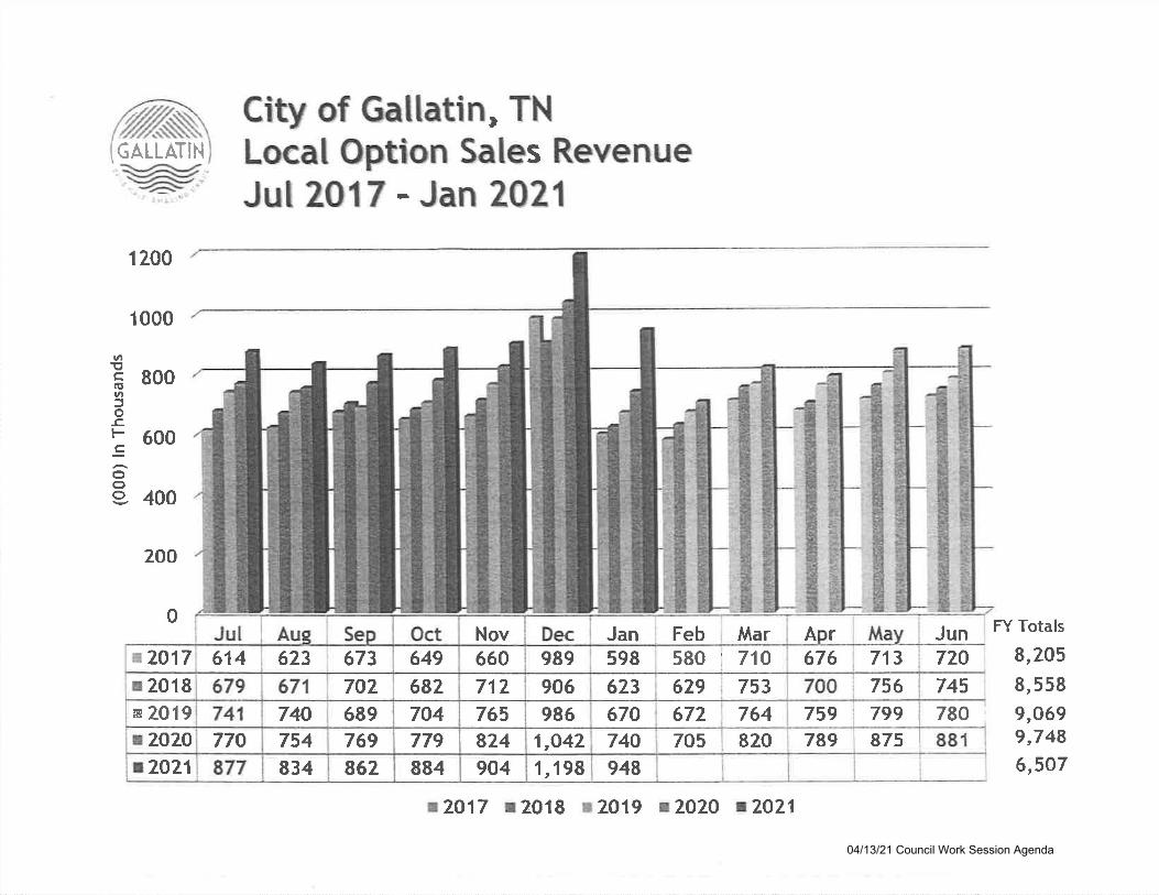
p.GALLATIN
1 200
1 000
800
600
400
200
City of Gallatin, TNLocal Option Sales RevenueJul 2017 - Jan 2021
vl
c.uvl5os.
:ooo
0A r Jun
713 720745780 ;
FY Totals
9,205
9,5589,0699,7486,5O7
756
875
676
759 799789
764672
948
Feb MarJan580 ' 710598
753629623674
705740 820
906986
1,O42
1,198
989
765824904
Nov660712682
704779884
649
689769862
702
834
673623
740754770
614
t2921
e2O17
r2018s 2019t2O2O
t2O17 12018 t7019 t2A2O t7O21
04/13/21 Council Work Session Agenda
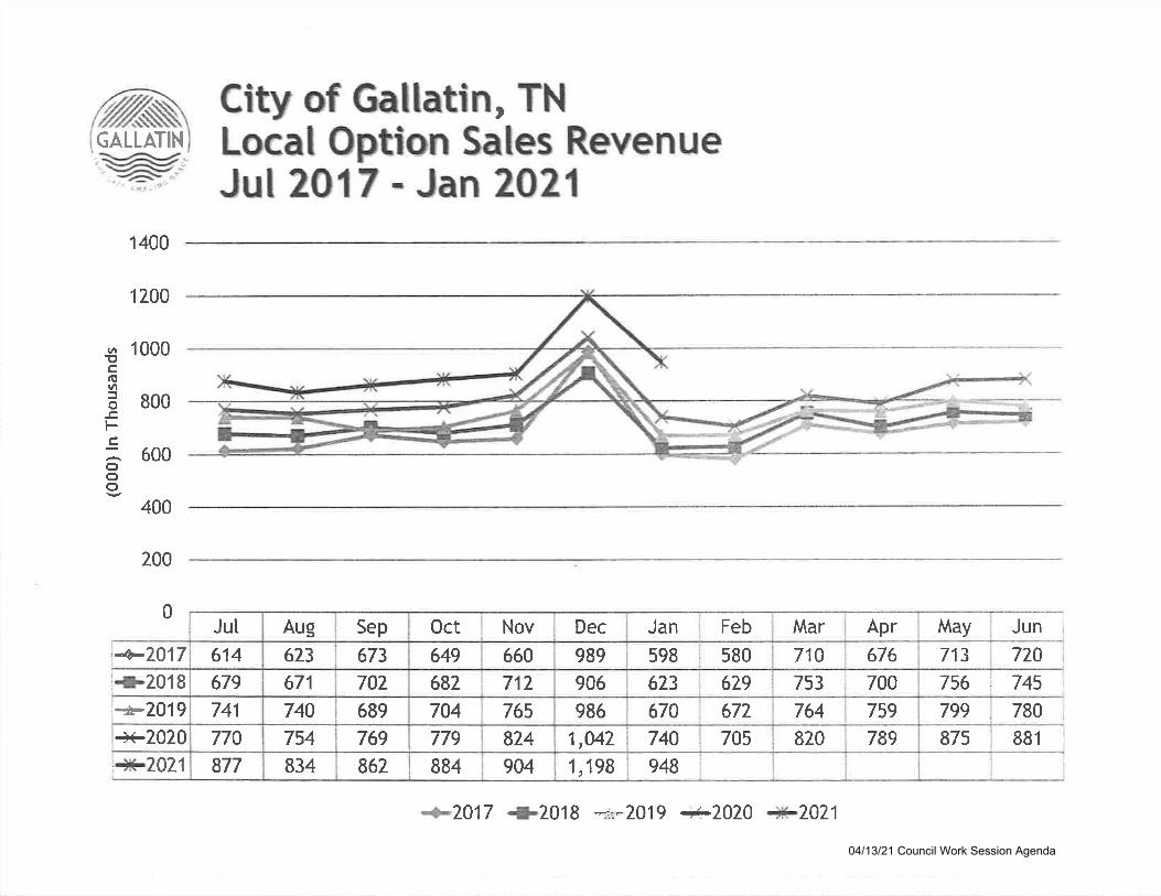
GALLATIN
1400
1200
1 000
800
600
400
200
'4p7417l{-2018i":F2019
+2020
City of Crallatin, TNLocal Option Sales RevenueJul 20 17 r Jan 2021
r^!,c(tlttt5o
!t-cooo
0May n
0
uJ
72713
756 "
745
780799
Apr
676
759
789820
Mar
753 740
764
710580
679
672
705
FebJan
598
623
67A
740948
906
986
1,042
1,198
Dec
989660
712765
824
904
I
i NovOct
649
682
704779
884862
5ep
673
702689
769
740754834
Aug
623
671
Jut
614
679
741
770
877, + 7071
t 2417 +2018 *:-2019 a-/Q/Q 4f!-2021
875 881
04/13/21 Council Work Session Agenda
o4lo7 /2rache]--
Q2l A1:21aicho]'s
lCity of GallatinIYE.AR-TO-DATE BI'DGET REPORT
ORIGIIIAIAPPROP
RE\'ITSEDBI'DGET
A\ZATI,ABI,SBTIDGET
Pglytdbud
PCTUSED
TRJA}IERS/EDJST!{TS
-5,187,515?? 1AA12,6332r,594
380,1s95,97 6
l-37, ggg7,161
4,7 60 ,55L0
52, 905126,36L131,376355,021
0'74,62'7
148,995
315,174111,132
t,16"1 ,98'l
1
FOR 2021 08
ACCOT'NTS FOR:110 G:EIIERAT I.T'IID
110 GENERAL FUND]-10r'.13]" O CITY ADMINISTRATIONi1C415OO PINANCE110415]"0 CITY RECORDER11041590 TNSURANCES11041620 CITY ATTORNEY11041640 INFOR}4ATION TECHNOLOGY11041650 HUMAN RESOURCES],I.04157 O ENGINEEF,ING11041690 PLANNING COMMISSION11041700 PLANNING11041800 GEN GOVERNMENT BUILDINGS11041 990 CODES ADMIN]STRATIONi1042110 POLICE DEPARTMENTI|O42I24 A.C.E.S. PROGRAMIIO4222O FIRE DEPARTMENTI1043OOO PUBLIC'{ORKS ADMINISTRATIO11043120 STREET MATNTENANCE & REPAI11043]"60 STREET LIGIITING & SIGNALS11043170 VEHTCLE MAINTENANCE7IO442OO COMM ENHANCEMENT11044300 COI\O,I SERVTCES110444].0 LEISURE SERVICEIIO4442O C]VIC CENTER1104_4450 coLF COURSE11044720 FARKS110471OO ECONOMIC COMMUNITY DEVE11047200 ECONOMIC DEVELOPMEI{T UTTLIIi-0412i0 TOURTSM11049OOO BOND EXPENSES
TOTAL GENERAL FUND
YTD ACTUAI. ENCWBRA}TCES
-36,37 4, O22r,0r9, 944
107 , B-7 3519,311845, ooo527,818
1,52A,6,91311,042
2, 423, 68329,114
875,10?455,381
1,,326, 8299,595,913
110,0007,844,340
- 4r , 561 , 53-l1,053,688'720,506
540,9057,225 ,759
533, 8531,1 62, 688
312,2491,r84,234
29 ,1 14928,0L?581,1 42
1,, 458 ,204g, 95o, 94o
110,000't ,9L8,967
502,69]-
-21,225,469-51530,580-564!6,263,88 6,284,
L,062,206,90 3,
o
4!4,294,816,
5 ,9!6,35,
4 ,863 , 052 . 62288,901 .97"703,843 .23
87r -54029.16213 -81230 -25282 -3"7201-59081.67856.50[10.4'7069.06444.561s3 - 58599.00
- 0043, ?50 _ 00
3, 300 .00.00.00-00
182,755.93.00
!,23'7 ,735.30.00
9.571. 686 -150.43
-00
-r4 ,336,0 57 - 354'79,25't -35300,334 - 5527't ,815.89338,885.13249,622 -945r1 ,649 .87166,006.91
5,043,416.8319. 857.50
49L,34r .1"1212,751-54636,543.04
3,132,985. 6l-74, 301 - 00
2,945 ,1 55 - 2 1t40 ,91 0 .20't'70,1,02.332L7, 545 - 48258,942-9r
50, 800.0027 ,925.00
-129 - s988r,"126-48514,045.86
1,078,165.05-2,362,019.50
'7 ,366.2925, C00 - 00
484 . 98
5?5g3q6t
55515848
lZt15,
q
301,
12.3253.2*10 .6255.4%20 a,33 -2241.L453 -2256.3962 -5\32.5%62 _BZ12 -0252.'1257.8960. 6t66.8411 .tZ
r00 - 0e54.5?52.9269 -62
2"70 -2296 -72
.02100.0t
49522LbU
3 53,7, 49L,
480,623,236,28,
00000000660031
39851s200
8351??0013
165000000
0
029'731
nn
1362034
-8393
69691r.591394000925
0
8s0486000000135
, 360 1,, 623,297,666 50r,25-i
110,758.9?'72,8L2-3'7
154,345.8328,2r3 -OO
10,500
306,24215,854
r6a,'7 662,940,535.0?
116,693.89.00.00
26r,3 98,!02,
.82- 59.00
TOTAL REVENUESTOTAI, EXPENSES
!,56!,349
1 q?? aq?
-36,3'7 4,02238 ,30'1 , 4'r 5
9!4,r ,'7'7 6 ,
38 3,15,l)r
657, 559153,000r2r,925
0I,931 ,723\,092,7553 , 544,1_,381 ,
236,
2, O80,
83, 500.00L29 - 59
749,153 - 80562,255 -24
2,305 ,90 5 .2880B,999.44
52, t17 .lO.00
2 ,01 9 ,650 . 022,080 ,
1
10
1,004,161,
4 ,1 44, 06A 6, 611 ,5r2 -r ,926 | 632 - 63
-5, 187, 515 -41, 561,537 -21,225t 469 -519,931,575 48,239,049 25,298,835.88
5,789,301_.82 2,8]-4,343-26 57.8%
.00 -14, 336,)61 .355,189,30\ -82 17,l-50, 910 - 61
04/13/21 Council Work Session Agenda

o4lo7l2A2L 07--27racbet'-aichols
rroR 2021 08
ACCOUNTS FOR:122 sPECrlr rslrDs
122 SPECIAL FTJNDS12242t22 SaR12242150 POLICE SPECIAT
TOTAI SPECIAI FUNDS
lCity of GaLLatiolEeR-ro-Dllr BI'DGET REPORf,
TIUANFRS/aDitgnEs
RSI,IISgDBI'DGST
0
Pglrtdbud
PCBT'SED
ORIGI
OUoll2i2l 07:.27rac,trel -aicbo]-s
FOR 2021 08
lCity of GallatiaIYEAR-TO-DEIE B{'DGET REPORT
ORIGIIIAT..UPPROP
m:anrRs/aDatsrtEs
-52,26466,72L
506,544
521, 001
-52t2645'13,265
RE\ESEDBI,DGET
e\/AILaBLEBIIDGET
-550,494 -4633L.355-61
1,115,044.98
885, 9L0 - 13
-560,490.46L,446,400-59
Pghrtdbud
PetI'SED
?0 .1t61 .1924-44
-96 - 9r
3
ACCII'NTS FOR:L23 SIOBTmSER rgrD
123 STORMWATER EUND12343150 STORMWATER MAINTENANCE1.23438 OO STORMWATER ADMINTSTRATION
TOTAI STORMWATER FUND
vtD acfrual. Ex@uBR:errcEs
-L, g25, ooo1 86, L46967,829
-7t,425-1,925,000!,1 53,97 5
-r,871 ,264852,861
tr4'l 4r373
449 ,97 6
-7.877,2642,327,240
-1,316,28s,185,
-00235,897 -91173,834 .'7 6
4O9,132 -73
.004O9,732 -'73
773.54613.22493.37
TOTAL REVEM'ESTOTAI EXPENSE5
-845, 566 - 95
-1,316,773.54471 / 10 6. 59
04/13/21 Council Work Session Agenda
O4lO7l2O2L O7:21racbeL-nicihols
FOR 2021 08
ac@urcrs EoR:L24 ID3 E EEETB
124 IDB E HEHEB12447220 rDB12447260 HEHFB
TOTAL IDB E HEIIFB
lCity of Ga]-]-atinlrEeR-lo-Dl3E BITDGGI REPOR:I
ORIGITSAI.APPROP
TRANFRS/nDitslras
fP4lgl-yEdbud
PCtUSED
RErtIgEDBUDGET
-266,525205,260
A\ZTII,ABI,EBT'DGEI
-266,450.'12tr,43I -42151_r520.00
-103,509-30
-266,460 -72762,95r-42
-266,525a4,970
L60,290*61,265
-266,525205,260
.002tO1"7 -O8
.00
2,077 -O8
-002,O7'7 -08
-266,52544.97 0
1"60,290
o -51,265 40,t67 -22
YTD AC'I'AT ETTCING}RENCES
-64 -2840,231.50
-64 -28461".50?70.00
31rI,
000
00
.0*74.625.5r
-69 - 0t
TOTAI,TOTAL
REVENUESEXPENSES
04/13/21 Council Work Session Agenda
A4lO7l202l O7:27racbel,-uichols
EbR 2021 08
ICCODTSS FOR:L25 ETilrIRONUENlf,EI SERVTGS
lCity of Gal.]-atiaI13,AR-TO.DAEE BT'DGET REPORI
AVEIITE{T,ESUDGET
-612, 337 . 1063,27 6.66
753,885 - 11
204 , 824 .51
-6L2,337.108I'1 ,r6t-'1'7
pgUrtdbud
BCEUSED
71-1*45.0*66 -4*
-r".5*
5
ORIGIIIALAPPROP
$UAIIERS/ RglrtSEDI&'S':USS BITDGET
-40,0000
22r,982
181,982 24L,636
YTD ACT]UAI,, ETCSUBRENCES
125 ENVIRONMENTI25432L0 ENVIRO12543230 TiASTE
AL SERVICESSERV ADMIN
COLLECTTON
-!t541 t662.905L,123.34
1, 459, 355 - 45
-36,583.11
-1 ,547,662-90i.,511, O79 -79
.00-00
33,394 -14
33,394.14
-0033,394.14
-2,!20,115,
2, O24,
_a11
2,2
50,00015,00046,636
000065
00
TOTAL ENVIRONMENTA], SERVTCES
TOTAL RE\j'ENT}ESTOTAI EXPENSES
L9,654
-2,120,o0o2,!39,554
-2,'J,60,0OO2,367,636
-40,00022L,982
04/13/21 Council Work Session Agenda

O4lA7l2O2l A7:27rachef--aicbols
lCity of GallatinIEJER-TO-DA:TE BI'DGET REPORT
P6gilytdbud
Pef,T'SED
rloR 2021 08
AC@ITINTS FOR:T27 DRT'G FT'I|D
127 DRUG F'T'ND72'742129 DRUG INVESTIGATION 6 CONTR
TOTAI DRUG FUND
TOTAL REVENUESTOTAI EXPENSES
ORIGIIT}I.APSROP
-1.08,000108,000
0
-108,000108,000
-108,000108,000
rReNrRs/eDJSSf,S
RETrISEDBSDGEI
-108,000108,000
0
-57 ,286r25,455
68, 1 59. 75
-5'1 ,286.86125,456.61
.004,995 -40
.004, 995 - 00
T\TAIIAT}I.EBTIDGET
-50, ?L3 - 14-22,451 -61,
-50,?13-L4-22,45t -6L
r':8D AerraJ, E
O4lO7I2O2l O7:,27racihe.I. -aidho].s
EOR 2021 08
ACCOIINSS FOR:311 Crprsar PRorEcfs
311 CAP]TAL PROJECTS31141670 ENGINEER CAPITAT,31.143000 PUBLIC WORKS CAPTTA],
TOTAI CAPITAL PRO.fECTS
lCiQr of GallatialYtan-xro-DA:lE BIIDGET RTPORI
ORTGINATAEPROP YlD ACaUAT EIICSUBRIANCES
P1glytdbud
PCTUSED
rOTAI REVENI'ESTOTA], EXPENSES
[tl ]FR.S/aDarssfls
000 16,593,0750 13,640
0 16, 606, ?l_5
016, 606,715
RE\rtSADH'DGET
016,593,075
]'3,640
16, 606,715
0l_5, 606,7L5
-2 ,364 t'1 64 -7 O
3 , 682 , 212 .9'7-00
-2,364,754-703,682,212.97
-00!0,828,82"1 .15
.00
-00L0,828,82'l -75
E\IAII.ABI.EBI'DGET
4,460,438 - 95
2.354t754.'102.095 | 6'14.25
2,364,764-102,082,034 -25
13,640.00
100,0*87 .58
.0*73-1t! , 3L't , 448 -27 lO , 828 ,821 .7 5
00
04/13/21 Council Work Session Agenda
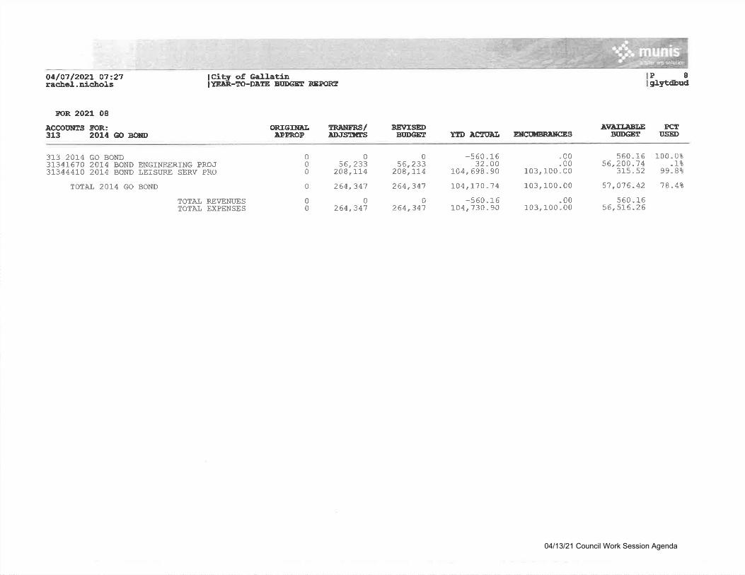
OalO71202L 07:27racbel.-uicho].s
rcR 2021 08
ICCOUIIAS FOR:313 2014 GO BdD
313 201"4 GO BOND3134],670 201-4 BOND ENGINEERTNG PROJ31344410 201.4 BOND LEISURE SERV PRO
TOTAI 2014 GO BOND
lCity of GallatiDIYSAR-TO-DATE BI'DGE3 REPORT
ORIGINETIPPROP
TRJENFRS/tDJSUES
056,233
208,L74
264,341
0264,347
RE\rISEDBI'DGET
056,233
208,t14
264,347
0264,347
AVAII,ABf,,EBI'DGET
5"1 ,076-42550-15
56t5r5.26
P8gry'tdbud
rcTI'SED
100.
gg'-
78 -4*
YIDN TUEIJ EITCIruBRANCES
000
-560.l-632-00
104, 698 - 90
r04,r7o.74
-550 - 15L04, 730 . 90
.c0-c0
103, 100- c0
103, 100 - 00
.00103, 100 - 00
560.1656 ,200 .7 4
315 - 52
0t1*8*
TOTAI REVENUESTOTAI, EXPENSAS
0
00
04/13/21 Council Work Session Agenda
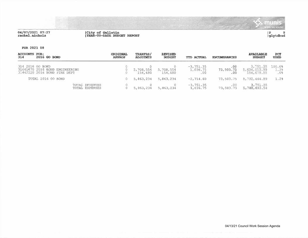
o4lo7l2rachet.-
A2L O7=27oicho].s
ACCOUNTS314
FO&:2016 GO BOND
ORTGIIAI.APPROP
Pglyedbud
PCTUSID
TRAIIFR'S/lDitslrEs
05.708,554
154, 680
5,863 "2340
5,963,234
REIrISEDBUDGET
05.708,554
1"54, 580
5,863,234
05,863,234
AITAII,ABIJEBI'DGET
3,751.35 1s ,634,013 . 99
154, 67 9.55
5 ,1 92. 444 .89
3, ?51 - 355,188,593.54
lCity of Ga1].atinIYE:eR-IO-De.rs FUDGET REPORT
FOR 2021 08
YTD ACTT'AI, tNcxtuBRllrcEs
3L4 201,6 GO BOND31441670 2016 BOND ENGTNEERING3L44222O 2016 BOND FIRE DEPT
TOTAI 2016 GO BOND
000
0
0tt
-00?3, 503 - ?5
-00
-3 111r0
51-3536-75
-00
001
0t3t0t
-2,7L4.60 73,503.75
-3, ?51.351, 03 6.75
00?3,503.75
L-2*
1OTAT REVENUESTOTAI EXPENSES
04/13/21 Council Work Session Agenda

oalo7l2O2t O7:27racbel-aicbol-s
roR 2021 08
ICCOIINTS FOR:315 2021 @ BOm FmrD
375 2027 GO BOND rlND315413J.0 2021 BOND CITY ADMTNISTRAT3154].670 2021 BOND ENGINEERING31544450 2021 BOND GOIF IRRIGATION
TOTAT 2021 GO BOND F'T'ND
lCity of Gal-l.atialrEaR-to-Derts BoDGET REpORI
ORIGINALEPPROP
rR:elrrRs/eDJSUNXS
RE\TISEDAI'DGET
IVEIIABI.EBT'DGEE
P10gbrtdbud
DCtUSED
0 -11,112,853 -7-1,rL2,853 -11,001.143-410 3,61"L,710 3,6LL,'1!O .000 '1 ,001,143 7 ,0Ar,r43 .00o 5o0, ooo 5oo,0oo .oo
0 0 0 -11, 001, l-43 - 41
0 -11,112,853 -L7,7-!2,853 -11,001,143-41o 1!.112,853 11,1,12,853 .oo
YID ACII'AL NrcU{BRNCCES
-00-00-00
499, 000.00
.00499, 000.00
499,000.00 !0,502,143.41 100 - 0t
*111,7093, 6r!,'lo97, 001, 143
L, 000
99.0*_0*"0t
99. 8t
B4844L00
TOTAI REVENI,IESTOTE-T, EXPENSES
-11L,709 - 8410, 613,853.25
04/13/21 Council Work Session Agenda

oUoll202t O7:27rachel'--ichoLs
lCitfr of Galt'atia|rteR-To-DAss BttDGar REPoRT
ORIGfiEI,EPPROP
IRilIFRS/aD,tSllSS
RSTrISEDBUDEET
AVAII,ASI,EBI'DGET
575 - 00
675.00
575. 00
lP 11lglytdbud
PefUSED
100.0*
100 - 0&
FOR 2021 08
ACCOUIiES EIOR:319 20L4 I'l9 Rsv BOIID
319 2014 W/S REV BOND
TOTAI 2OL4 Vl/S REV BOND
TOTAT REVENUES
I:TD ACTUAJ. ENCT'IIBRAT{CES
0
0
0
0
0
0
0
0
0
-575.00
-675.00
-675 - 00
.00
.00
.00
04/13/21 Council Work Session Agenda
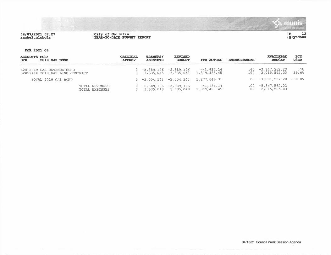
OelO7l2O2L 07:27racheL-aicbols
FOR 2021 08
ACCOUITTS FOR.:320 2019 GAS BOD|D
320 201.9 GAS RSVENUE BOND32052414 2019 GAS I,INE CONTRACT
TOTAI 2019 GAS BOND
lCity of Gall.atinI YE;rR-ro-DA,rE BITDGET REPOS{I
ORIGIIIAI.EPPROP
TRAUERS/ID.ISIIES
RS\rISEDBI'DGET
-5,889,1963,335,048
-2,554,!48-5,999,1963,335,048
A\rAITEBI,EBI'DGET
-5,847,562"232, 015,565 - 03
-3,831, 991 .2A
-5,81'l ,562 -232,0r5t555.03
lI glytdbud
PerUSED
,?839.6t
-50.0*
a2P
ylD eeflta3 ENclDlsRaNcEs
0 *5,889.1960 3,335.048
0 -2,554,1480 -5,889,1950 3,335.048
"00.00
.00
-00-00
-4r,634 -!41,319,483-45
7,277,849.31
TOTAL REVENUESTOTAI EXPENSES
t, 634.t49,483 - 45
-4311
04/13/21 Council Work Session Agenda
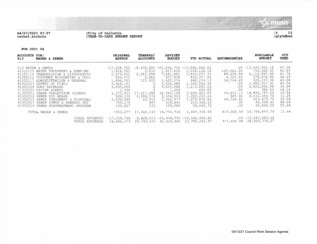
O4lA7l2A2l 07227raclre]- -aicrbols
FOR 2021 08
ACCOI'NTS T13R:413 I{IIER E SEITER
413 WATER & SEWER413521]-3 WATER TREATMENT & PUMPING41352].74 TRANSMISSION & DISTRIBUTIO4\352LT6 CUSTO}4ER ACCOT'NTING & COLL4135211? ADMINISTRATiON E GENERAL4L352!23 DEPREC ON TIXED41352724 BOND EXPENSES4L352I25 PAYING AGENTS4\3522II SEWER COLLECTION (],INES)41.352212 SEWER SYS REHAB413522T3 SEWER TREATMENT & DISPOSAI41352217 SEWER ADMIN & GENERAL EXP4L352219 SEWER PRETREATI.,IENT PROGRAM
TOTAL IVATER & SEV|IER
lcity of GallatinII.EJAR-IO-DATE BI'DGET REPC'RT
P 13
TRANTRS/ADJSTIfrS
RSUTSEDBI'DGEI
gl-ytdbud
Pe[I'SED
ORIGINAI"APPROP
-L1,236,150L6,686,4'73
A\TAII,ABI,EBI'DGET
3 't7 6
YID ACTUEI, ENCT'UBRANCES
-t1,235,L,9L4,!,615,
8 06,!, 495,3, 428,3,035,
-8, 400, 0003, 033
5,385, 9901,866
l_25,933000
11 ,27-l ,2862,996,37 4
!2,01r467233
-25 , 636 ,'l 50L,97'7 ,4761t067,89!
807,9381",622,3163, 428,7843, 035.086
1, 35018,593,l-993,504,5042,042,O77
309,645106,060
-00720,02t -06
88, 556 - 994,122 -50
56,1 44 -65-00.00.00
99, 851 .16945.80
46,"724.82.00.00
-13, 543, 883 - 187 59 , 266 .65
4, tL9,997 . 0B370,878-86925,331.36
1,883,91'1 -42!,825,ooo.98
700 - 001,3501r 3?5r 913
508,1302,030,066
309,1?g105,827
L4,892,74'7.02,470,354.'l
9L9 , 413 -199,208 .446,894.5
19. 9*3t.2\55-0t68.0t55. 8t
4t -7*54.1?43-0t45-0839.9r48. r%
?50383901
383184085
-12,092,866.821, 038, 128 . 1 92,853,23'7 -33
432t331.04640,234.L9
L,544,265-58t,2r0,085.02
6s0. 003,600,601.00!, o93,203 -26r,0'15t878.02
2t0,435 -L259,165 .72
4'7 .2160-4t
44B
8
-550,27't !7,343,L93 L6,792.9L6 7,665,355.65 4L7,666-98 14,'709,893-?9 12-4*
TOTAL REVENUESTOTAL EXPENSES
-8,400,25 ,7 43,
8383000193
5425
-13.28'
8241
-zJ42
,636,150 -12,092,866.,429,666 t3,158,222.
.004r1 ,666 -98
04/13/21 Council Work Session Agenda
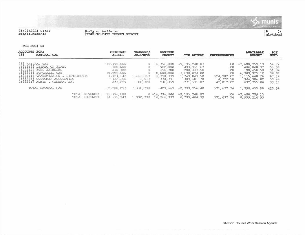
o4/O7l2o2t 07'27rachel.nicihols
FOR 2021 08
rccootgts FoR:415 NA'TURAIJ GES
415 NATURAL GAS41.552723 DEPREC ON FIXBD4T552724 BOND EXPENSES4155241]" PURCHASED GAS415524T4 ?RANSMISSION E DISTRIBUTIO4L5524I6 CUSTOMER ACCOUNT]NG415524l.7 ADMIN E GENERAL EXP
TOTAL NATURAT GAS
lCilir of GallaliaIYE:AR-IO-DAEE BI'DGE! REPORIT
Pglytdbud
PCTUSED
t4
TO?AL REVENUESTOTAI, BXPENSES
ORIGIIIAI.APPROP
-16,796,00074.595,941
0 -16, ?96,000r ,7"7 0 , 390 16 , 366 ,337
-9, L96,"19
4084 39
87
}\TAII.ABI,EBIID@I
-7,600,759-138.999,2I4 -93
IRNIFRS/AD.'SItES
REVIS@BUDGET YllD ECTIIAI ENCIN'BRETTCES
-16,
10.!,
7 96,900,390,000.72't,732,845,
0 -L6, ?96,0000 900,0000 390,7880 10,000,000L,663,157 31 390,3996,533 738,19l.
100,700 946,359
-9,I95,24Q -87493, 951 - 63200, 337.50
3 , 690 ,074 . 881,'7 49,847.58
389 , 68't- .7 82'1t,59'J".02
-2 ,399 ,7 56 . 48
.c0
.c0-c0.c0
524,902 -824,722 -50
42,0r2.C2
-7,600,759-L3406, 048.37190, 450.50
6,309 , 925 .121,115, 548.26
344,386 -82632,755 - 86
54.7*54-9t51-3*36-9t6?.1-t53-4*33.1t
0000007880002422sB659
-2,200,053 I,110,390 -429,663 57t,637.34 1,398,455.80 425-5\
5r2514
-c057L,631 -34
04/13/21 Council Work Session Agenda
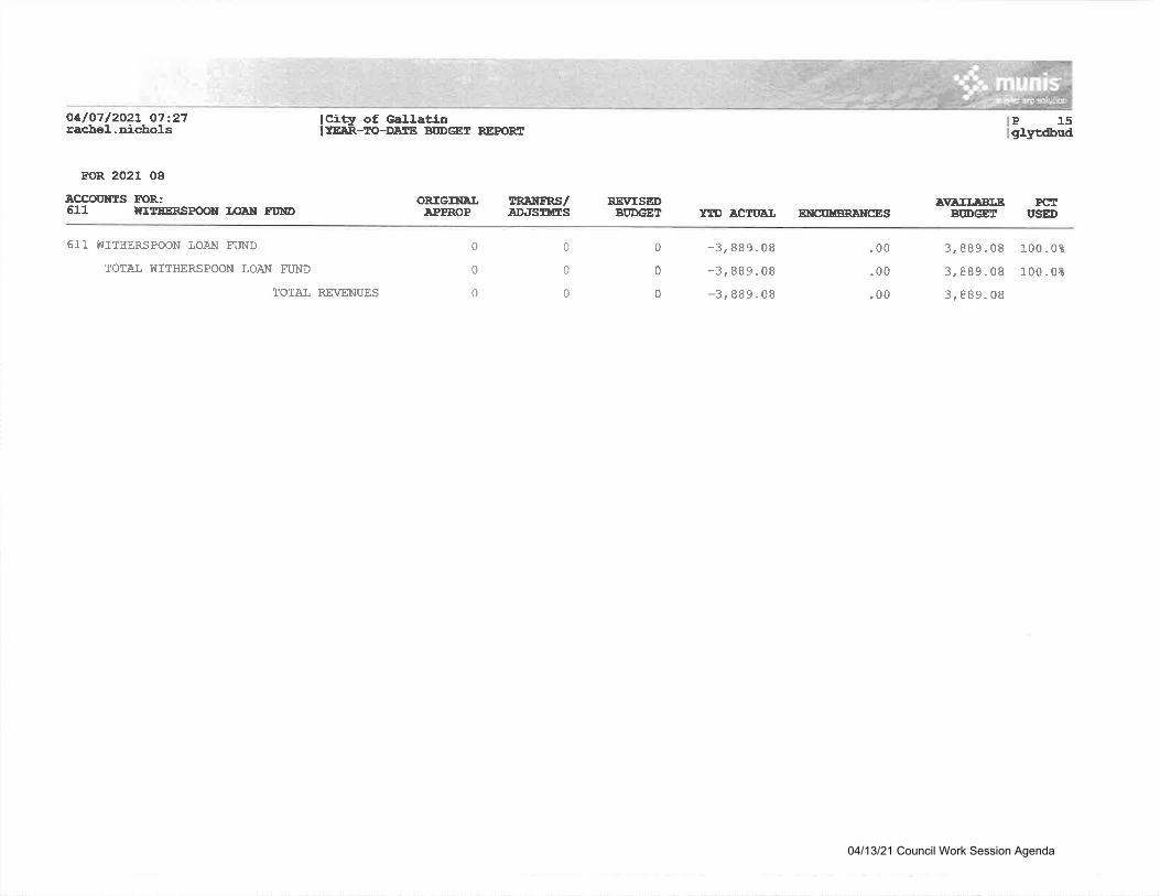
O4lO7l2O2t O7:27raeleel.-nicbo].s lCitfr of Ga!.J.ati-n
It-EAR-IO-DAIE BUDGET REPOFUT15D
Pet
FOR 2021 08
ACCOOIIES EIOR:611 N:ITEERSPOON T€AN TUND
611 WITHERSPOON LOAN FUND
TOTAI WITHERSPOON LOAN FT'ND
TOTAI REVENUES
ORIGIIIALAPPROP
TITATERS/eDatsTtfas
RSI'"ISEDBI'DGET
AVAII.ABI.EBIIDCET
3,8B9-08
3,889.08
3,889-08
ghrtdbud
USED
1"00.0*
100.0*
YrD ecruAl, EttcttuBRNrcEs
0
0
0
0
0
0
0
0
0
-3,889-08
-3,889.08
-3,889.08
.00
.00
.00
04/13/21 Council Work Session Agenda
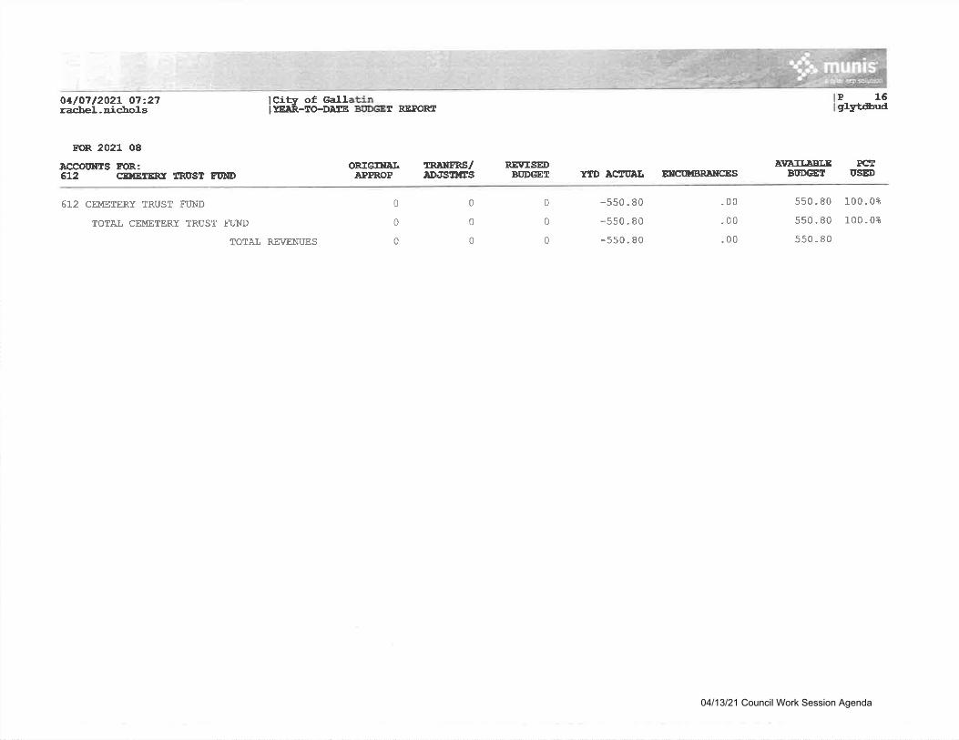
O4lO7l202t 07227racbel.nichol-s
lCity of GallatinIrEeR-ro-Desr Bt'DGET REPORT
ORIGIilNLAPPROP
meNFRS/aDJSntts
RE\ESEDBI'DGET
A\'AII,DBI.EBI'DGET
550.80
550.80
550 - 80
Pt6gtyt&ud
FCrI'SGD
100.0*
100 - 0t
FOR 2021 08
.eccouNrs EoR:6L2 CEI{EIERI X'RI'SI ET'ND
612 CEMETERY TRUST FUND
TOTAL CEMETERY TRUST TUND
TOTAI, REVENUES
YtD ASN'AI, EIICOUBR}}ICES
0
0
0
0
0
0
0
0
0
-s50 - 80
-550 - 80
-550.80
- 00
.00
-00
04/13/21 Council Work Session Agenda
Related Documents


