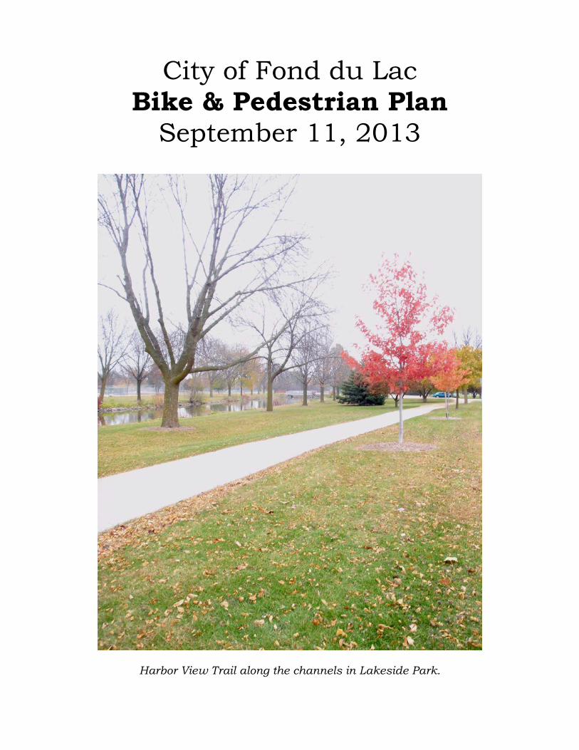
City of Fond du Lac Bike & Pedestrian Plan September 11, 2013 Harbor View Trail along the channels in Lakeside Park.

Welcome message from author
This document is posted to help you gain knowledge. Please leave a comment to let me know what you think about it! Share it to your friends and learn new things together.
Transcript
City of Fond du Lac Bike & Pedestrian Plan
September 11, 2013
Harbor View Trail along the channels in Lakeside Park.
City of Fond du Lac Bike/Pedestrian Plan September 11, 2013
City of Fond du Lac Bike & Pedestrian Plan
September 11, 2013
APPROVING CITY COUNCIL Samuel Meyer, President Catherine Block Lee Ann Lorrigan Daniel Manning Karyn Merkel Gary Miller
TABLE OF CONTENTS I. Program Summary………………………………………………..……………………………….….…… 2 II. Benefits of Having a Bike/Pedestrian-Friendly Community…………………………..… 2 III. Bike & Pedestrian Facilities—Recent Accomplishments…………………….……….….. 4 IV. Proposed Bicycle/Multi-Use Trail Improvements……………………………………….….. 5
a. The Loop…………………………………………………………………………………………...…….. 6 i. Prairie Trail…………………………………………………….…………………….……... 6
ii. Camelot Trail………………………………………………………………………..……... 6 iii. Pioneer Road Trail………………………………………………..……………..……….. 7 iv. Link to Brooke Street Trail……………………………………………………...……..7 v. Brooke Street Trail………………………………………..………………………...…... 7
vi. Lakeside Park Trail………………………………………..…………………………...…. 7 vii. Peebles Trail…………………………………………………….…………………………... 8
b. Links to State Trails…………………………………..………………………………….………….. 8 i. Wild Goose Trail………………………………………………………..……………….... 8
ii. Old Plank Trail……………………………………………………………………………... 9 iii. Mascoutin Trail………………………………………………………………………..…… 9 iv. Eisenbahn Trail………………………………………………………………………….…. 9
c. Future Improvements Under State/County/Development Projects……..…… 9 d. City Bike Routes………………………………………………………………………..……..………. 11
V. Proposed Pedestrian Improvements………………………………………….……….……..….. 11 VI. Strategic Goals and Ideas………………………………………………………………………………. 13 VII. Signage/Map Improvements…………………………………………………….………………….... 15 VIII. Associated Plans……………………………………………………………………….………..…….……. 16 IX. Grant Opportunities………………………………………………………………….…………….……… 17 X. Related Resources…………………………………………………………………………..……………… 18
EXHIBITS 1. “The Loop” Map 2. Links to State Trails Map 3. In-Town Bike Routes Map 4. Proposed Pedestrian Improvements Map 5. Proposed Project Listing 6. Safe Routes to School Support Materials
1

City of Fond du Lac Bike/Pedestrian Plan September 11, 2013
City of Fond du Lac Bike & Pedestrian Plan
I. Program Summary Fond du Lac is a picturesque community of 43,000, situated on the south shore of Lake Winnebago in southeastern Wisconsin. Fond du Lac is blessed to have connections to four extensive rural bike trails (Peebles, Prairie, Wild Goose, and Mascoutin), with a fifth one—the Old Plank Trail—scheduled to be extended to the Prairie Trail under a 2017 Hwy 23 project. Fond du Lac also has a sprawling, well-cultivated network of City parks, including the breathtaking 390 acre Lakeside Park which boasts an extensive series of multi-purpose trails. Like all communities, Fond du Lac struggles to fund stand-alone bike and pedestrian improvements. This document is intended to identify gaps in the grid of bike and pedestrian accommodations, establish a program to address those gaps, and communicate that vision to the State of Wisconsin and other partners to undertake joint projects to meet common goals using minimal funds. This plan resolves to use the following tools to achieve its goals:
• Baby Steps: Many of the bike and pedestrian improvements that are needed can be done in small bites. A small amount of the City’s budget should be designated toward these goals.
• Larger Projects: A plan like this often allows the City to advocate for bike and pedestrian accommodations to be included in State or County projects.
• Partnerships: Local bike enthusiasts, Dept. of Transportation (DOT) specialists, school officials, County engineers, and environmental advocates can all work together to join resources and vision to meet common goals.
• Solid Policies: City officials should enact policies consistent with American Association of State Highway and Transportation Officials (AASTHO) guidelines that make financial sense while also constructing or protecting bike and pedestrian facilities, making them safer and easier to follow.
It should be noted that Fond du Lac County also has many plans for bike and pedestrian facilities that should be coordinated with this plan to complement the City’s efforts whenever possible. In addition, the East Central Wisconsin Regional Planning Commission (ECWRPC) anticipates developing a long-range bike plan as part of their Long Range Transportation/Land Use Plan for the Fond du Lac Urbanized Area. The City’s Plan is smaller and simpler in scope, and is only intended to document specific concerns and opportunities within the City. The County and ECWRPC have been involved in the development of this Plan, and should continue to be as projects develop to ensure that our efforts complement each other. II. Benefits of Having a Bike/Pedestrian-Friendly Community: Despite the predominance of automobiles as the most common form of travel in Fond du Lac, human-powered travel by foot, bicycle or wheelchair remains an indispensable part of our daily lives. Several important
2

City of Fond du Lac Bike/Pedestrian Plan September 11, 2013
economic, environmental and social benefits result from increased bicycle and pedestrian activity.
• Economic Benefits: Bicycling and walking are an inexpensive means of transportation. Walking is essentially free, and bikes are available to most residents (as opposed to the $7,800/year it takes to operate a vehicle) 1. Policies and improvements that make biking and walking more attractive can cut down the number of car trips a family takes and, in some cases, eliminate the need for a second car. Many of our most expensive street projects are necessitated by traffic volume; decreasing the number of vehicles using our streets could delay or minimize expensive projects. The quality of life that comes with enhanced bicycle and pedestrian activity can produce indirect economic benefits such as improving quality life, encouraging bicycling visitors to patronize local businesses, and boosting property values.1 One article articulates that “protected bike lanes are part of the path to prosperity” by increasing retail visibility and volume, making workers healthier and more productive, making real estate more desirable, and helping companies attract talented workers.2
• Environmental Benefits: Walking and bicycling are clean modes of transportation. Reports3 show that motor vehicle emissions account for 31% of total carbon dioxide, 81% of carbon monoxide, and 49% of nitrogen oxides released into the atmosphere in the United States. Studies also indicate that short trips are disproportionately high in generating pollution because pollution control devices do not have time to begin working effectively.3 Encouraging people to walk or bike when making short trips will cut down on these harmful auto emissions.
• Social and Health Benefits: Having more people outside in Fond du Lac’s public spaces gives the community a lively air that can generate more social and commercial activity. Increased walking and biking can also help people gain a deeper appreciation for Fond du Lac’s built and natural environment. Children exposed to traffic pollution are more likely to have asthma, permanent lung deficits, and a higher risk of heart and lung problems as adults.4 Over the last 25 years, among children ages five to 14, there has been a 74% increase in asthma cases.5 In addition, 14 million days of school are missed every year due to asthma.6 One third of schools are in “air pollution danger zones.”7 In
_____________________________ 1 www.bicyclinginfo.org/why/benefits_economic.cfm 2 http://greenlaneproject.org/blog/view/here-are-the-four-reasons-protected-bike-lanes-help- local-businesses 3 www.bicyclinginfo.org/why/benefits_economic.cfm 4 Gauderman, W.J., E. Avol, F. Lurmann, N. Kuenzli, F. Gilliland, J. Peters and R. McConnell, “Childhood Asthma and Exposure to Traffic and Nitrogen Dioxide,” Epidemiology, Volume 16, No. 6, November 2005 5 Centers for Disease Control and Prevention. Surveillance for Asthma—United States, 1960-1995: CDC Surveillance Summaries, April 24, 1998. MMWR Morbidity and Mortality Weekly Report, Vol. 47 (SS-1), 1998, pp. 1-27. 6 Centers for Disease Control and Prevention. Healthy Youth! Health Topics: Asthma. Available at http://www.cdc.gov/HealthyYouth/asthma/index.htm. 7 Appatove, A. S., Ryan, P., LeMasters, G., Grinshpun, S. “Proximal exposure of public schools and students to major roadways: a nationwide US survey,” Journal of Environmental Planning and Management, Volume 51, Issue 5, 2008
3

City of Fond du Lac Bike/Pedestrian Plan September 11, 2013
a state where over 20% of the adults are obese, the City should be doing everything it can to encourage people to exercise.1 Increased fitness would also cut down on the growing health care costs that are plaguing so many areas.
• Health Care Cost Benefits: Today, approximately one-fourth of health care costs in the United States are attributable to obesity,2 with costs for childhood obesity alone estimated at approximately $14 billion per year.3 People living in auto-oriented suburbs drive more, walk less, and are more obese than people living in walkable communities. For each hour of driving per day, obesity increases 6%; walking for transportation reduces that risk.4
• Safety Benefits: There will always be people who want or need to bike and walk in a community. They will benefit from having a well-planned, well-communicated grid of facilities available to them. Furthermore, increasing the number of bikers and walkers in a community makes motorists more aware of them, and reduces accident rates. A Wisconsin Bike Federation report noted that “a motorist is less likely to collide with a person walking and bicycling if more people walk or bicycle. . . Improving the streets and street networks to better accommodate bicycles may lead to a self-reinforcing cycle that can help enhance overall safety for all road users.”5 Safe Routes to School (SRTS) documents indicate that “infrastructure installed is proven to reduce pedestrian and bicycle deaths and injuries. For example, adding a sidewalk cuts in half the risk that a pedestrian will be struck by a car.”6 It continues to point out that “preventing just one death of a child while walking or biking is estimated to save approximately $1.1 million in lifetime medical and work-loss costs.”7
III. Bike & Pedestrian Facilities, Recent Accomplishments
• Safe Routes to School (Wisconsin DOT and Federally funded program): In addition to education and encouragement programs that the Fond du Lac Area School District is offering, the City of Fond du Lac is improving several school crosswalk areas in 2013 with pavement markings and electronic signage. The Fond du Lac Area Safe Kid Zone completes annual safety assessments at each of the schools within the district. The
__________________________________ 1 www.legis.state.wi.us/LRB/pubs//wb/05wb7.pdf 2 Trasande L and S Chatterjee. “The impact of obesity on health service utilization and costs in childhood.” Obesity 17 (2009): 1749-54. 3 Marder, William and Stella Chang. “Childhood Obesity: Costs, Treatment Patterns, Disparities in Care and Prevalent Medical Conditions. New York: Thomson Medstat Research Brief, 2006. Accessed June 3, 2011, www.medstat.com. 4 Frank LD, Andresen MA, Schmid TL. “Obesity relationships with community design, physical activity, and time spent in cars.” American Journal of Preventative Medicine 2004; 27: 87-96.
5 http://wisconsinbikefed.org/2013/08/26/fatal-crash-in-seymour-raises-questions-about-safety-on-rural-roads 6 Knoblauch, R, B Tustin, S Smith, and M Pietrucha. “Investigation of Exposure-Based Pedestrian Accident Areas: Crosswalks, Sidewalks, Local Streets, and Major Arterials.” Washington DC: U.S. Department of Transportation, 1987. 7 WISQARS (Web-based Injury Statistics Query and Reporting System). 2005 Cost of Injury Reports. Centers for Disease Control and Prevention, National Center for Injury Prevention and Control, Office of Statistics and Programming. Database accessed June 2, 2011, http://wisqars.cdc.gov:8080/costT/.
4

City of Fond du Lac Bike/Pedestrian Plan September 11, 2013
School District has also included walking school bus programs at four elementary schools.
• Pioneer Road: This is a critical link that someday may provide bike and pedestrian access from Scott Street to Hwy 45. The first phase of this route was accomplished in 2011, when a multi-purpose trail was constructed on the south side of Pioneer Road. from the Fond du Lac River to Main Street. In 2013, this trail will extend west to Hickory Street and connect with the Wild Goose Trail and the City’s signed bike routes.
• Wild Goose Trail: In 2012, Fond du Lac County extended the Wild Goose Trail from Hwy 41’s bike bridge (constructed in 2009) to Pioneer Road. Here, it will connect with the Pioneer Trail heading east, and in a few years, continuing west to Military Road. The DOT recently made this parking lot a Park & Ride, an ideal place to park and access the trail.
• Bell Street Bridge: This bridge was resurfaced in 2012 and is part of a former railroad bed converted to a City trail.
• Division Street Crossing: Formerly offset from the intersection, the bike trail crossing at Division & Macy was shifted in 2012, providing for a safer crossing.
• Noon Rotary Funding: This service organization funded several phases of this plan, including extending the Prairie Trail to Martin Avenue (and parking lot), extending an on-street bike lane and signage on Hickory Street from Pioneer to Dixie to the Brooke Street Trail, and improving the connection from the Peebles Trail to Lakeside Park.
• Downtown Bike Racks: A 2013 Leadership Fond du Lac team installed the first 20 bike racks from a 41-rack plan the City put together in 2009. These small racks, customized with a lighthouse and bike silhouette, were placed in front of 20 businesses in the downtown in 2013, as well as in a city-owned green space in a vacant lot where a business burned down in 2012.
• Fourth Street: In 2013, Fond du Lac County paved the shoulders of 4th Street from National Avenue toward Southview Road. Although wider shoulders would be helpful and there are still no paved shoulders from this point to Hwy 151, the work that has been done is a significant improvement.
• East Pioneer Road: In 2013, Fond du Lac County resurfaced the 1.7 mile stretch of Pioneer Road from the railroad tracks east of Main Street to Hwy 45. Bike lanes were painted on both sides, with a portion of the Noon Rotary Club’s funds used to widen the intersection at Park Avenue. This allows for a safer path through the crossing.
IV. Proposed Bicycle/Multi-Use Trail Improvements: Adequate bicycle access can be provided in a number of ways. Some accommodations that allow a bicyclist to feel safe include shared lanes on low-speed/low volume streets, wide outside lanes, paved shoulders, designated bike lanes, separate multi-use paths, and traffic calming devices. Some of these ideas may be good options for the following weaknesses in Fond du Lac’s bicycle grid. Refer to the attached maps for the locations of these improvements.
5

City of Fond du Lac Bike/Pedestrian Plan September 11, 2013
a. “The Loop”: (Exhibit 1) Thanks to the guidance and fundraising of local bike advocates and organizations, one of the first initiatives that this Plan is intended to accomplish involves the development of a 15-mile loop that circles Fond du Lac. It is intended to provide a safe, convenient, scenic and clear route into and around the community. The Loop will be composed of existing bike trails and on-road facilities, as well as temporary measures and future trail improvements. This initiative includes infrastructure improvements, improved communication (signs, maps, pavement markings, etc.), and marketing to promote this exciting resource to the community.
The key legs of The Loop—including some alternative routes and future projects—include the following:
i) Prairie Trail a) Summary: The Prairie Trail forms the east backbone of The Loop, and runs for six
miles parallel to Hwy 151 from Martin Avenue to the Peebles Trail. b) Projects Needed: Create a future connection to the Camelot Trail using the existing
Martin Avenue railroad overpass. Consider a cloverleaf connection from the Prairie Trail driveway to the Martin Avenue Bridge sidewalks to shorten the connection south.
c) Alternate Routes: None. ii) Camelot Trail:
a) Summary: This 1.8 mile segment of The Loop extends from Martin Avenue to Main Street using a proposed bike trail alongside a future street from Camelot Drive to Martin. Another path will be constructed along the east side of Camelot to the Ledgeview Trail, which returns to Camelot before intersecting with Mihill Avenue. Sharrows will be used to direct bicycles north on Mihill to Pioneer Road. (“Sharrows” are shared lane pavement markings, consisting of chevrons and bicycle symbols painted in a parking or travel lane. Although not as family-friendly as designated trails, they serve to remind motorists to watch for bicycles and communicate to bicyclists that this is a route intended for them.) The existing Pioneer Road Trail begins only 200’ west of this intersection.
b) Projects Needed: Determine the best location of a future City street between Martin and Camelot, and obtain the necessary right of way. Grade for and construct a bike trail that is consistent with the future street, requiring extensive surveying and design work. (Note that this right of way is not yet dedicated, and that a significant portion of this future roadway is currently not within City limits.) Construct a bike trail along the east and north sides of Camelot Drive. Improve the width and surface of the existing Ledgeview Trail. If the Ledgeview Trail is not appropriate for widening or paving, a future multi-use trail can be extended farther west and north along Camelot Drive to Mihill Avenue. Place sharrows on Mihill to connect Camelot to Pioneer. Extend the Pioneer Road Trail between Main Street and Mihill (either along Pioneer or at a point south), or even further east to the railroad tracks. Bike lanes were recently added east of the railroad tracks.
6

City of Fond du Lac Bike/Pedestrian Plan September 11, 2013
c) Alternate Routes: Until funds are available to construct the Camelot Trail, on-street markings can be used on Park Avenue and Pioneer Road to reach the Main & Pioneer intersection. Pioneer Road has been repaved—with bike lanes added—from the railroad tracks east of Main Street to Hwy 45. On-street markings can be used to direct bicyclists along Camelot Drive from the new street to Mihill until the off-street trails can be constructed. A sub-loop in this area can include a route around the Ledgeview stormwater pond, instead of remaining south of it.
iii) Pioneer Road Trail: a) Summary: Although this trail will be extended in both directions under future
projects, for now the off-street trail runs from Main Street to the Wild Goose Trail just west of Hickory Street, a distance of 0.7 miles. Bicyclists can continue on the trail west to the Wild Goose, or can connect to the Brooke Street Trail to the north by following Hickory Street and Dixie Street.
b) Projects Needed: None. c) Alternate Routes: None.
iv) Link to Brooke Street Trail: a) Summary: This important link will extend from the new roundabout at Hickory &
Pioneer to the Brooke Street Trail, a distance of 0.8 miles. Lanes can be striped on both sides of Hickory Street from Pioneer to Dixie. Signage and sharrows can be utilized on Dixie to direct cyclists east to the trail.
b) Projects Needed: Stripe lanes, paint sharrows, and install signage. c) Alternate Routes: None.
v) Brooke Street Trail a) Summary: This former railroad bed runs through the heart of the city for 2.1 miles,
offering a convenient and safe route that avoids crossing Hwy 23. b) Projects Needed: Update the safety signage along the route. Widen the curb cut at
Military Road. c) Alternate Routes: Pedestrians and cyclists may choose to get to work or visit the
downtown by heading east from Brooke Street to the trail along the Fond du Lac River. A key segment of this loop near Oak Place is intended to be improved under the City’s 2014 Capital Improvement Plan. This will include removing a fenced corner of the former Quick Freeze site to straighten out that segment of the trail.
vi) Lakeside Park Trail: a) Summary: Lakeside Park is the crown jewel of the Fond du Lac community. A
project planned for 2017 would expand its existing trails to complete a 2.2 mile bike path along the Fond du Lac River, Lake Winnebago, internal water channels, and Marina. It is hoped that this project’s timeline could be accelerated and have it start as soon as 2014. The need for a trail like this was confirmed by a five-county effort in 2013 to identify the needs and opportunities to be found in and around Lake Winnebago; one of the major needs mentioned was for recreational trails along the lake.
b) Projects Needed: Create a safe crossing of Scott Street at Brooke using a speed table, pedestrian beacon, or a pedestrian-activated Rectangular Rapid Flashing Beacon. Use on-street markings or a new trail to direct bicyclists along Water Street
7
City of Fond du Lac Bike/Pedestrian Plan September 11, 2013
north of Scott. Obtain right of way to continue the trail along the Fond du Lac River. Construct a path along Lake Winnebago east from Frazier Point toward the Pavilion, then crossing Promen Drive to Fountain Island. Existing trails would be used to cross east to Oven Island, south to Baseball Island, and then east again to Park Avenue. A multi-use trail on the east side of Park Avenue would be constructed to connect with the existing Harbor View Trail. Except for the Harbor View Trail, the existing pathways would have to be widened and improved under this project. On the east end of the Park, crosswalks, curb cuts and signage are needed to direct bicyclists to use paved, striped outside lanes on Winnebago Drive to reach the Peebles Trail (where a flashing pedestrian beacon would improve the safety of that crossing), while pedestrians would be directed to the sidewalk on the south side of the road. A future project could extend an off-street trail on the north side of Winnebago Drive. A more direct route could extend the Peebles Trail further west along the same abandoned railroad corridor, directly into Lakeside Park. This would require raising funds for a bike/pedestrian bridge to cross DeNeveu Creek.
c) Alternate Routes: Until this major project can be completed, relatively small projects can allow existing pathways along Harbor View Drive to complete The Loop. It would extend from Water Street to Spring Street, follow a proposed bike route through the parking lot at the Municipal Service Center (MSC), and then use Doty Street to the north to the existing trails in Lakeside Park. It should be noted that if these improvements are difficult to fund, on-street accommodations can be signed and painted along Doty, across Scott, to Sibley Street and then west to the Brooke Street Trail. As funds allow, a trail crossing the vacant lot north of the new Children’s Museum site could provide a safe alternative to Doty Street. In addition, a path can continue along the lakeshore from the Pavilion to the Lighthouse. Such a project would benefit from finding a way to widen or add a sidewalk to the existing Promen Bridge. Finally, sharrows painted along Main Street from the park to the downtown may provide a safer way to cross Scott Street.
vii) Peebles Trail: a) Summary: The Peebles Trail extends from the unincorporated town of St. Peter to
Winnebago Drive. The portion of this trail included in The Loop runs 2.1 miles from Winnebago Drive to the Prairie Trail, and is constructed of limestone screenings.
b) Projects Needed: None. c) Alternate Routes: The limestone surface is not very suitable for road bikes, so
bicyclists may want to use the Prairie Trail north to Hwy WH (Winnebago Drive). The paved and striped shoulders of Hwy WH are great for biking, although the striped lane tapers to nothing at key intersections. Sharrows could be used at these intersections to increase the visibility of bicyclists.
b. Links to State Trails: (Exhibit 2) In addition to The Loop, which utilizes portions of several established multi-use trails, there are other State trails that serve Fond du Lac. A significant goal of this Plan is to improve the internal connections between these trails.
i) Wild Goose Trail: This gravel trail extends southwest from Fond du Lac through Oakfield and past Waupun before ending at Clyman Junction. The portion from
8

City of Fond du Lac Bike/Pedestrian Plan September 11, 2013
Rolling Meadows Drive to Pioneer Road has been paved, and a designated bike bridge now crosses Hwy 41. This trail can be linked to the Mascoutin Trail via future shoulder paving projects on Pioneer Road and/or Rolling Meadows Drive. In the meantime, a marked in-town route that uses Hickory Street, Western Avenue, Seymour Street, Arndt Street, Peters Avenue, Security Drive and Pearl Lane to Scott Street offers a good route to the Mascoutin despite the heavy volume of traffic on Scott Street. The Wild Goose Trail should be linked to the Prairie Trail via The Loop as discussed above.
ii) Old Plank Trail: This trail will be extended to Fond du Lac through a 2017 DOT project on Hwy 23, extending the existing trail to Hwy 151 from Plymouth. This trail will extend under Hwy 151 to the Prairie Trail. The roundabouts’ walkways at Hwy K will extend 1,000 feet north and 400 south from Hwy 23, providing access to St. Mary’s Spring High School and allowing for future extensions as appropriate. The State is widening the rural road from Whispering Springs to Hwy UU to accommodate bike traffic. This project should address safety concerns for bicyclists looking to cross Hwy 23 for both the Old Plank and Prairie Trails. The Hwy 23 project will also construct a Park & Ride at Hwy UU.
iii) Mascoutin Trail: As discussed above, another major trail that spokes out of Fond du Lac is the Mascoutin Trail, heading west from the northwest part of the City. A future improvement on Scott Street should provide bike accommodations to connect this trail to the Lakeside Park Trail by adding bike lanes from west of Rolling Meadows to Main Street. In the short term, paving the shoulders on the bridge approach of Scott Street from Pioneer Road to Rolling Meadows Drive is a key link in this sector of the City.
iv) Eisenbahn Trail: This active railroad extends south of Fond du Lac to Eden. South of Eden, it has been converted to a bike trail. When it is no longer needed as a railroad, it should be converted to a trail, providing a connection from south of Hwy 151 to the Prairie Trail and on to the Brooke Street Trail.
c. Future Improvements Under State/County/Development Projects (Exhibit 2, Con’t)
i. Pioneer Road (Hickory – Military): The 2013 Pioneer Road project will extend a joint use path along the south side of the road from the Wild Goose Trail to the Fond du Lac River. A project is scheduled for 2016 that will extend this trail through Military Road to Rogersville Road. Future expansions of Pioneer both northwest and east should continue that trail.
ii. Military Road (Hickory – Western): A future reconstruction project here would likely use Surface Transportation Program funds, and would therefore be a great opportunity to have a project coordinated and largely funded by the DOT. Such projects are expected to include multi-modal improvements such as bike and pedestrian accommodations. A complementary project should provide bike accommodations on Military from Pioneer to Hickory, as well.
iii. Hwy T/Fourth Street: The DOT is proposing an overpass of Hwy 151. A multi-use path will connect to the Prairie Trail and extend westerly to the intersection of
9

City of Fond du Lac Bike/Pedestrian Plan September 11, 2013
Country Lane. Sidewalks are also included from Country Lane to the east limits of the DOT project.
iv. Hwy V/Hwy 45/Hwy 151: The DOT is proposing improvements on Hwy 151 and the interchanges with Hwy V and Hwy 45. A re-routing of the existing Prairie Trail will be done through the project limits and connections to existing City sidewalk should be included. In particular, connecting sidewalk on Hwy V to Mustang Lane and on the new streets west of Hwy V should be provided. A Park & Ride lot will provide an ideal place for bicyclists to access the trails. Future improvements to Hwy V and/or Hwy 45 heading north into the City should include bike and pedestrian accommodations.
v. Martin Avenue: This is another location where the Hwy 151 connection will be converted to an overpass. Bike and pedestrian access over this overpass should be provided. Additional signage may be needed here, as well.
vi. Hwy V/Rienzi Road: This connection to Hwy 151 will be discontinued over the coming decade, but bike and pedestrian accommodations should extend from National Avenue to the Prairie Trail. Perhaps the new termini can serve as a trailhead and parking area. Bicyclists have noted how dangerous it is to cross Hwy 151 at this intersection, as there is no curb cut in the median. Bicyclists are forced to dismount their bikes and walk over the raised median. This should be corrected when work is done in the area.
vii. DuCharme Parkway: This connection to Hwy 151 is planned to be reconstructed in 2015, and extended to the subdivision to the east. This sheltered left-turn configuration should allow for bicycle and pedestrian traffic to cross the highway safely, especially as this may be a key link from neighborhoods east of Hwy 151 to the high school and college campuses. Having a curb cut in the median is important in allowing bike traffic to cross safely.
viii. Hwy 23 crossing of Hwy 41: Currently, Hwy 23 is not conducive to bike traffic. However, when the bridge structure over USH 41 is reconstructed, bike accommodations should be added in the event that other improvements are made on Hwy 23 or on Rolling Meadows Drive and Pioneer Road.
ix. Main Street (Merrill to Hwy 23): As this project is designed (intended for 2020 construction), if only one southbound travel lane is needed, consider adding bike lanes on this two-block stretch. This would only be effective if it connected to bike accommodations to the north and south—possibly by striping Main Street north of Johnson for bicyclists to reach Lakeside Park and by creating one-way bike lanes following Hwy 45 on Macy and Marr through the downtown.
x. Fond du Lac Avenue (Hwy V to 4th Street): Most of this stretch of Hwy 45 is being resurfaced by the DOT in 2018, and is planned to have a 5’ shoulder included south as far as Reinhardt Road. In the urban area, sidewalk should also be added to the project design. A critical improvement in this project will be a safer intersection of Hwy V, Hwy 45, and National Avenue. Continuing the bike route north to 4th Street will connect to a local bike route.
10

City of Fond du Lac Bike/Pedestrian Plan September 11, 2013
xi. Vacant Land between Hunters Grove Subdivision and Hwy 23: When developed, bike and pedestrian accommodations should be included to link this area to the Old Plank Trail.
xii. Scott Street: Although there are no current plans to widen or reconstruct Scott Street between Main Street and Rolling Meadows Drive, when a future project is designed here it should include bike and pedestrian accommodations. This is an important link in the northwest part of the City, and a segment of it serves as Hwy 45.
xiii. North Fond du Lac: If the Village of North Fond du Lac undertakes bike or pedestrian improvements near its connections with the City (Rolling Meadows Drive, Pioneer Road, Peters Avenue, Van Dyne Road, or Hwy 45), the City should coordinate for the extension of those improvements to Scott Street.
d. City Bike Routes: (Exhibit 3) There are many streets within the City of Fond du Lac that are low in traffic volume and speed, making them very suitable for bicyclists to share the roadway with vehicles. Such routes are especially important for people seeking to bike to a particular destination such as work or school, and not just looking for convenient recreational opportunities. To assist bicyclists in this area, the City has laid out a grid of recommended bike routes to serve each part of the City. These routes will be laid out with signs and sharrows. Residents are also encouraged to explore parts of their own neighborhoods or work areas for safe roads to bike. The attached map not only shows these in-town bike routes, but also indicates some roadways that are generally too busy and narrow for bicyclists. Residents are encouraged to find parallel routes to avoid these less desirable routes. V. Proposed Pedestrian Improvements (Exhibit 4) When deciding which projects to include in a plan—and in which priority—the City considers public safety (focusing on critical areas like schools, commercial centers, and highways), demand (do a lot of people walk in an area without a sidewalk?), connectivity (eliminating gaps in the sidewalk grid), access to scenic and cultural values, and outside funding sources (grants, inclusion in planned developments, etc.).
a. Add sidewalk on Pioneer Road near Thiesen Middle School. Currently on Pioneer from Main Street to Hwy 45, only the short stretches near Thiesen and from Park Avenue to Hawthorne Drive have sidewalk. The remaining 1.6 miles of a busy county highway is completely devoid of pedestrian accommodations. Completing a system of bike lanes and adding sidewalk appears to be an ideal candidate for a Safe Routes to School (SRTS) infrastructure project.
b. Develop safety improvements on Arndt Street near Sadoff Industries, including shifting pedestrian traffic to the south side of the street, providing safe crossings at Packer Street and Lincoln Avenue, changing the appearance of the north side to no longer look like a sidewalk, and to design a future replacement bridge with these changes in mind. This may also be an ideal candidate for a SRTS infrastructure project.
11

City of Fond du Lac Bike/Pedestrian Plan September 11, 2013
c. Add sidewalk on the south side of E. Johnson Street from National Avenue to the Prairie Trail (there is currently one block of sidewalk between University and Prairie), and on the north side of Johnson from Kairis Court to the Prairie Trail. On a related note, Fond du Lac High School and UW Fond du Lac have identified a goal of connecting their two campuses more directly for pedestrians to Hwy 23 and Hwy 151. This may be accomplished by extending a sidewalk or multi-use trail along University Drive or paving the Gottfried Arboretum Trail and connecting it to Country Lane’s sidewalk via a new sidewalk on Pine Lake Drive.
d. Marr & Macy Streets: add crossing signals for pedestrians crossing against traffic (i.e. northbound on Macy). These are one-way streets that lack crossing signals for pedestrians walking on the sidewalk against traffic.
e. Harbor View Drive: Add sidewalks on at least one side of this street between Doty and Main under a future project. This area sees heavy pedestrian use during summer events.
f. Rolling Meadows Drive from the Wild Goose Trail to Hwy 23 is a very busy roadway, with gravel shoulders in poor condition. Future improvements to this roadway should include sidewalks with bike lanes or an off-street multi-use trail. Off-street bike and pedestrian accommodations are more appropriate for the urban section roadway from Hwy 23 to Scott Street.
g. Pioneer Road to side streets (north of Military): Grove, Forest and Security have sidewalks that terminate before reaching Pioneer; this should be addressed if Pioneer gets sidewalks.
h. National Avenue: The existing sidewalk on National Avenue stops approximately 250’ north of Hwy 45 (Fond du Lac Avenue). This gap should be filled.
i. Martin Avenue: This area is very heavily travelled during the annual County fair and for families using the Fairgrounds Pool, yet there is no sidewalk along the Fairgrounds on the east side of the street. Sidewalk or a multi-use trail should be constructed between 9th Street and 17th Street.
j. Military & Hickory: There is a “desire line” or “cowpath” on a short stretch of lawn between this intersection and where 11th Street has been terminated to the east. This indicates that people are walking on this segment, and sidewalk should be provided for them.
k. Country Lane north of Hwy 23 has a sidewalk that was allowed to be deferred; this should be completed to Pine Lake Drive. As the rest of the subdivision is developed, sidewalk is to be installed on both sides of the street north to DuCharme Parkway. Similarly, sidewalk should be extended on DuCharme from Country Lane west to the Taycheedah Creek.
l. The east side of Martin Avenue does not have sidewalk from south of Willsher Drive south to Park Avenue. This should be completed as these subdivisions are built up.
m. Although this area is currently outside City limits, efforts should be made to extend sidewalks along Winnebago Drive (approximately 1,300’) and Luco Road (approximately 375’) to where they intersect. The north stretch of Winnebago is a dense residential area within City limits, and should have sidewalk. The extension along Luco would provide a connection to the sidewalk to the south. Short-term projects could include
12
City of Fond du Lac Bike/Pedestrian Plan September 11, 2013
extending both the sidewalk on Luco 50’ north to Peebles Trail, and sidewalk on Winnebago east 100’ to the Peebles Trail.
n. Marian University committed to constructing sidewalk along the east side of Prairie Road and the south side of Division Street by its new sports complex under its approved site plan. The Prairie side of this project should begin soon, but the Division work is deferred until the City determines it is necessary.
o. A project to add a walking trail through Buttermilk Creek Park is anticipated in a future Capital Improvement Plan.
p. New development on the south side of Arndt Street between Bell and Hickory is scheduled to add sidewalk. If redevelopment occurs at the property on the southwest corner of Hickory & Arndt, this should add sidewalk to complete this grid.
q. A short segment of Morris Street has a gap in the west side of its sidewalk grid, just north of 12th Street. This should be connected when the opportunity arises.
r. State/County Highway Gaps: The City should work with its County and State partners to ensure that sidewalks are included in joint projects whenever practicable, especially in these locations:
1. Military Road (Pioneer – Rogersville Road): This busy roadway will have new sidewalk or a multi-purpose trail installed under a 2016 Pioneer Road project, but small gaps may still need to be filled.
2. Pioneer Road (Military – Scott Street): This is a busy commercial corridor with no pedestrian accommodations. When this highway is reconstructed, a multi-use path should be added on at least one side or bike lanes and sidewalk completed.
3. Future improvements to bridges over Hwy 41 and Hwy 151 should include pedestrian access at Scott Street, Hwy 23, Military Road, Hickory Street, Main Street, Martin Road, Hwy V, Hwy 45, and 4th Street, and connect to adjacent sidewalk grids, where applicable.
4. Hwy V (Fond du Lac Avenue to Pioneer Road): Sidewalk should be extended on both sides of the road when this road is reconstructed. This sidewalk will also be extended south of Pioneer past Hwy 151 as part of a 2015 DOT project.
5. In addition to the State project already programmed from Hwy V to 6th Street, the stretch of Hwy 45 south of here should have sidewalks and bike lanes at least across Hwy 151. (Lanes are currently programmed for a 2018 resurfacing project.) The east side mostly fronts a golf course, and would have very little neighborhood use.
VI. Strategic Goals and Ideas
a. The City should advocate for future State and County highway projects to include bike and pedestrian accommodations whenever practicable. Acknowledging that a significant segment of our population has mobility limitations, projects should be completed with the recognition that infrastructure designed for vulnerable users will also meet the needs of the rest of the population.
b. Where the need is documented and/or new construction is being done, rural-section roads should have paved shoulders to accommodate bicycles.
13

City of Fond du Lac Bike/Pedestrian Plan September 11, 2013
c. In order to be consistent with this Plan, new urban section roadways should be wide enough to allow shared use with bicycles, and to complete a sidewalk grid where appropriate. Although this Plan does not include detailed plans for future subdivisions or highway projects that may occur some distance from current bike/pedestrian facilities, each project or development should be reviewed with the goal of extending and connecting these grids wherever practicable. As a rule of thumb, newly classified streets (collector, arterial, highway, etc.) should have sidewalks on at least one side, no residence should be more than two blocks from the nearest sidewalk, and bike accommodations should be provided. Similarly, new bridges should have such accommodations included.
d. Local Road Improvement Program (LRIP) grant funding now includes a consideration of bike/pedestrian accommodations, and can be used to ensure that facilities are provided where practicable.
e. Transit Partnership: Fond du Lac Area Transit is a key partner in providing varied transportation options to the citizens of Fond du Lac in an efficient, environmentally-friendly way. It has recently replaced its entire coach fleet, complete with bike racks to allow for bicyclists to complete their journey via bus. It also plans to install decorative bike racks at the transit transfer center.
f. Park Improvements: Several parks have been dedicated to the City, yet remain undeveloped. The plans for a park on S. Park Avenue, Meadowlands Park and Hunters Grove Park include walking trails that can be developed as time and budgets allow. Brookfield Park, Galloway Park, Greenway Arboretum and newly dedicated park land off S. Main Street also present opportunities for walking trails.
g. Waterways: The City owns land alongside waterways even outside of official park land. Opportunities should be sought to extend walking trails along waterways in the City.
h. Downtown Bikes: The Downtown Fond du Lac Partnership is a valued partner in the heart of the City, and shares the goal of seeing more use of the River Trail. Currently, the configuration of travel lanes and parking lanes in the downtown are too narrow to accommodate bike lanes. Proposed ordinance changes would allow bikes to be operated on sidewalks—including in the downtown—as long as cyclists ride safely. Some steps that may allow this to be done safely include stenciling reminders on corner sidewalks for bicyclists to walk their bikes, adding bike racks at the entrances to the downtown, or creating on-street bike lanes on Macy Street and Marr Street. These two streets are Hwy 45, and form a one-way loop through the downtown. A long-term goal may be to limit parking to one side on these side streets and create one-way bike lanes to bring bicyclists to the downtown.
i. Future Annexations: As Town areas annex, sidewalks and bike accommodations are infrastructure improvements that should be considered to be required depending on the nature of the area, traffic volumes, and distance to adjacent accommodations.
j. Bike Racks: As funds allow or as part of larger projects, the City should install bike racks at key locations such as parks, City facilities, and the entrance to the downtown.
k. Trail Maintenance: At this time, the City does not plan to plow multi-use trails consistently over the winter. The City reserves the right to change this policy or require adjacent property owners to do so in the future. An “adopt-a-trail” program is
14

City of Fond du Lac Bike/Pedestrian Plan September 11, 2013
encouraged to provide basic maintenance such as weed removal, litter collection, and sweeping.
l. Parking Restrictions: The City Council may be asked periodically to change parking restrictions to facilitate some of the bike improvements outlined in this Plan.
VII. Signage/Map Improvements: Any signs on DOT right of way will need to meet DOT rules and regulations for size, placement and wording. This information can be found in the Manual of Uniform Traffic Control Devices (MUTCD) at mutcd.fhwa.dot.gov/.
a. Brooke & Scott: Local bicyclists have noted that the corner of Brooke Street and Scott Street is not a safe crossing for bicycles at this time. Until improvements are made and The Loop continues north on Water Street, the designated bike route will cross Scott at Doty, accessing Brooke via Sibley.
b. Trail/Mileage Signs: As bikers travel through the community, small signs can be placed along in-town routes to direct them to the main trails. Along the main trails, mileage signs can be a popular feature for joggers and cyclists.
c. Trail Kiosks: Large maps of the bike facilities in Fond du Lac could be placed on kiosks at the trail heads for the Wild Goose, Prairie, Old Plank and Peebles trails. The Association of Commerce or other partners may want to participate in this effort for their publicity efforts.
d. Map Handouts: Smaller, less-detailed maps could be provided at key locations for visitors to take with them, highlighting local routes and popular destinations.
e. Festival Foods: There is a paved link from Festival Foods’ parking lot to the Prairie Trail, just northwest of the Hwy 23 interchange with Hwy 151. Signage and designated parking here may encourage more awareness and use of the trail.
f. Sharrows: There are many neighborhoods where parking is allowed on the street, but the low traffic volumes and number of cars parked allow for safe use by bicyclists without designated accommodations. A sharrow may be an appropriate way to designate such routes without having to prohibit parking. Sharrows are planned to be used on marked in-town bike routes, as well as along busy roadways where the striped shoulder tapers to the curb at intersections.
g. Regulatory/Safety Signage: Signs along City bike trails should follow the MUTCD. It has been noted that the signage along the Brooke Street Trail and River Trail is inconsistent, and should either be maintained.
h. Signage needs to be improved along Martin Road to Willsher Drive to Park Avenue to bring cyclists from the Prairie Trail to Pioneer Road.
i. Wayfinding Signs: The Downtown Fond du Lac Partnership, Convention & Visitors Bureau, and City of Fond du Lac are working together to create wayfinding signage to direct motorists to key parts of the City. A complementary system could be created for bike facilities, especially between trails.
j. Destination Signs: Many of Fond du Lac’s finest features are near established bike routes. Signs could be created to direct visitors to local attractions, arboretums, parks, schools, the Fairgrounds, etc. These are likely best paid for by outside funds or sponsors.
15

City of Fond du Lac Bike/Pedestrian Plan September 11, 2013
k. Side Trails: Several side trails provide alternative routes for cyclists using The Loop, and these should be signed adequately.
l. City Bike Routes: As covered above, a grid of local streets has been signed as bike routes. The route and signage should be reviewed and modified as necessary, and sharrows should be painted on these routes.
m. Blind Curves: Centerline pavement stripes at the blind curves on multi-use trails are encouraged to keep bicyclists on their side of the trail in these dangerous locations. Signs are an alternative here to avoid slippery paint markings.
n. Motorist Education: Signage and pavement markings can be used to inform and educate both bicyclists and motorists alike about potential hazards.
VIII. Associated Plans
• Safe Routes to School (SRTS) is a federal program that provides grant funding for plans, programs and infrastructure improvements within a 2-mile radius of elementary and junior high schools within a community. Now worked into the State’s Transportation Alternatives Program, SRTS emphasizes the Five E’s (education, engineering, enforcement, encouragement and evaluation) to promote increased activity in these students by encouraging them to bike or walk to school. A SRTS initiative traditionally involves a partnership between school districts, law enforcement, engineering/public works staff, County health officers, and citizen/parent groups. Fond du Lac has a plan in place—known as the Fond du Lac Safe Kid Zone—identifying many of the needs and opportunities near its schools. Recent initiatives include establishing education and encouragement programs in the schools, and upgrading key crosswalks and electronic speed signs near schools. Some additional recent efforts include a comprehensive review of crossing guard locations and effectiveness, and consistent action between the school and City in enacting and enforcing parking ordinances near schools to improve traffic safety and efficiency. For more information on SRTS, see Exhibit 6.
• Fond du Lac County has done an outstanding job of developing a system of trails and routes for bicyclists and other outdoor enthusiasts to enjoy. One map—entitled “Physical Activities in Fond du Lac County”—is especially helpful to bicyclists who want to enjoy a longer ride. This Plan is also referenced in the recently updated County Recreation Plan.
• Other City plans that share this Plan’s goals and philosophy include a 2010 Recreation Plan, 2010 Downtown Development Plan, and the latest Comprehensive Plan.
• Summary of Complete Streets Requirements: In 2009, the State of Wisconsin passed Administrative Code Trans 75, in accordance with Federal policy, that requires bicycle accommodations and pedestrian facilities to be included on all new construction and reconstruction highway projects funded in whole or in part with state or federal funds unless an exception applies. The bicycle accommodations could be in the form of bicycle lanes, paved shoulders, wider outside travel lanes, and in some cases, multi-use paths. Sidewalks have some basic guidelines and there is a priority schedule if there are conflicts between sidewalks and bicycle accommodations. There are five exceptions allowed to the Complete Streets provision and all require specific details as to the
16

City of Fond du Lac Bike/Pedestrian Plan September 11, 2013
reason for the exception. While having this Bicycle & Pedestrian Plan does not specifically give right to exceptions nor a guarantee to obtain funding, it is our goal to use this Plan in evaluation of state and federally funded projects to install accommodations where appropriate and practical.
• The State of Wisconsin recently added the Fond du Lac area to a list of only four municipalities where city maps will complement the 2010 Rural Bike Map. This map can be found at www.dot.state.wi.us/travel/bike-foot/docs/fonddulac-urban.pdf.
IX. Grant Opportunities: The City may want to pursue the following grants in its attempts to plan for and complete future improvements to its walking and biking infrastructure. This list is not exhaustive and new opportunities should be researched periodically.
• Surface Transportation Program (Wisconsin DOT): These programs have a 20% local match, and focus on reconstructing arterial or collector streets. Bike lanes and sidewalks are usually included as part of these larger projects.
• Local Roads Improvement Program (Wisconsin DOT): The City typically receives these funds for a local street reconstruction project every two years. The law requires that most reconstruction projects receiving these funds must include bicycle accommodations, as of January 1, 2011.
• Transportation Alternatives Program (TAP)—formerly Transportation Enhancement Grants (Wisconsin DOT): Combination bike/pedestrian projects are eligible. Funding may also be used for planning, scenic easements, transportation museums, or landscaping. This may be a good source for trail development funding. (http://www.dot.wisconsin/gov/localgov/aid/tap.htm)
o Any application is also reviewed for Bicycle and Pedestrian Facilities Program funding.
o Safe Routes to School: The Fond du Lac Area School District and the City have already teamed up to develop a plan and obtain some infrastructure grant funds. These grants are 80% federal funds and 20% local funds, and are now combined with the TAP.
• Recreational Trail Grants (Wisconsin DNR): projects are more competitive if the trail has more than one use (biking, walking, skiing, snowmobiles, ATVs, etc.).
• Highway Safety Improvement Program (Wisconsin DOT): This funding encourages low-cost treatments, and requires accident data to support applications. Work that may qualify for this funding includes improving intersection safety, extending sight distance, creating turn lanes, providing signage, and funding pedestrian signals.
• Community Development Block Grant (City of Fond du Lac): The City of Fond du Lac is eligible to receive funds through this program’s annual entitlement and through a revolving public facilities fund related to economic development. Handicap ramps and sidewalk improvements should be intended to benefit neighborhoods serving low- to moderate-income families.
17

City of Fond du Lac Bike/Pedestrian Plan September 11, 2013
• Stewardship Grant (Wisconsin DNR): This program offers up to 50% funding for land and water conservation initiatives, recreational trails, and associated projects. A number of the projects outlined in this Plan may be strong candidates for Stewardship grants.
X. Related Resources Design-related resources o Facilities Development Manual chapter 11-46
(http://roadwaystandards.dot.wi.gov/standards/ fdm/11-46.pdf) o Wisconsin Bicycle Facility Design Handbook
(http://www.dot.wisconsin.gov/projects/state/docs/ bike-facility.pdf) o Trans 75 (https://docs.legis.wisconsin.gov/code/admin_code/trans/75) o Wisconsin guide to pedestrian best practices
(http://www.dot.wisconsin.gov/projects/state/ped-guide.htm) o WisDOT county bicycle maps (http://www.dot.wisconsin.gov/travel/bike-
foot/countymaps.htm) o 2010 ADA Standards for accessible design
(http://www.ada.gov/2010ADAstandards_index.htm) o AASHTO Guide for the development of bicycle facilities, 2012 edition (https://bookstore.
transportation.org/item_details.aspx?id=1943) o National Association of City Transportation Officials (NACTO) Urban Bikeway Design Guide
(http://nacto.org/cities-for-cycling/design-guide/)
Organizations • National Complete Streets Coalition (www.completestreets.org) • Pedestrian and Bicycle Information Center (http://www.walkinginfo.org/) • Pedestrian and Bicycle Information Center (http://www.bicyclinginfo.org/) • Association of Pedestrian and Bicycle Professionals (APBP) (http://www.apbp.org) • Free Webinars from APBP (http://www.apbp.org/?page=Free_Webinars) • Bicycle Federation of Wisconsin (http://www.bfw.org) • Federal Highway Administration (FHWA)
(www.fhwa.dot.gov/environment/bikeped/design.htm) • National Transportation Alternatives Clearinghouse (NTAC): (http://www.ta-
clearinghouse.info/index) • National Center for Safe Routes to School (http://www.saferoutesinfo.org) • Safe Routes to School National Partnership (http://www.saferoutespartnership.org/) • America Walks (http://americawalks.org) • Alliance for Biking and Walking (http://www.peoplepoweredmovement.org/site/) • League of American Bicyclists (http://www.bikeleague.org)
18
City of Fond du Lac Bike/Pedestrian Plan September 11, 2013
People • WisDOT Bicycle-Pedestrian Coordinators
(http://www.dot.wisconsin.gov/projects/state/docs/bike-ped-coordinators-map.pdf) • East Central Regional Safe Routes to School Program (http://eastcentralsrts.org/)
Local Contacts • City of Fond du Lac
o Joe Moore, City Manager 920-322-3407 [email protected] o Jordan Skiff, Director of Public Works 920-322-3472 [email protected] o Paul DeVries, City Engineer 920-322-3473 [email protected] o Steve Kees, Public Works Dir. of Operations 920-322-3542 [email protected] o Gene Olig, Chad Churchill, GIS Specialists 920-322-3485 [email protected] o John Kiefer, Park & Forestry Superintendent 920-322-3592 [email protected] o Capt. Robb Duvenick, FdL Police Department 920-322-3706 [email protected]
• Fond du Lac Loop Coalition o John McDowell, President 920-251-0499
[email protected] o Pete Doll, Vice-President 920-251-1618 [email protected]
• Fond du Lac County o Sam Tobias, Director of Parks & Planning 920-929-3138
[email protected] o Tom Janke, Highway Commissioner 920-929-3485
[email protected] • Agnesian Health Care—Steve Little, CEO 920-926-5402 [email protected] • Downtown Fond du Lac Partnership—Amy Hansen 920-322-2006
[email protected] • Convention & Visitors Bureau—Craig Molitor 920-904-1683 [email protected] • Fond du Lac Area Foundation—Sandi Roehrig 920-921-2215
[email protected] • Fond du Lac YMCA—Greg Giles, Executive Dir. 920-922-7658 [email protected] • School District—Marian Sheridan, Health/Safety Coord. 920-906-6506
[email protected] • Wisconsin Dept. of Transportation—Matt Halada 920-492-7725
[email protected] • East Cent. Wis. Regional Planning Comm.—Kolin Erickson 920-539-0741 [email protected] Reports & Publications • “Where we live matters for our health”
(http://www.commissiononhealth.org/PDF/888f4a18-eb90-45be-a2f8-159e84a55a4c/Issue%20Brief%203%20Sept%2008%20-%20Neighborhoods%20and%20Health.pdf)
• Proven Countermeasures for Pedestrian Safety (http://www.fhwa.dot.gov/publications/publicroads/ 12marapr/04.cfm)
• Rightsizing streets guide http://www.pps.org/reference/rightsizing/
19

City of Fond du Lac Bike/Pedestrian Plan September 11, 2013
• “A New direction: Our changing relationship with driving and the Implications for America’s Future.” (http://uspirg.org/sites/pirg/files/reports/A%20New%20Direction%20vUS.pdf)
• “The new majority: Pedaling Towards Equity” (http://www.bikeleague.org/news/equity_report.pdf)
• http://www.bikesbelong.org/resources/stats-and-research/statistics/health-statistics/ • Fond du Lac map on State web site: http://www.dot.wisconsin.gov/travel/bike-foot/urban.htm
20

##*
Æ"K
Æ"H
Æ"V
Æ"K
Æ$23
¡¢151
¡¢45
¡¢45
¡¢41
¡¢151
Z

IA
IA
!
##*
##*
## *
IA
!
!
!
!
##*
IA
IA##*
Æ"V
Æ"KÆ"D
Æ"UU
Æ$23Æ$23
¡¢45
¡¢45
¡¢41 ¡¢151
¡¢151
Z

IA
#
Æ"V
Æ"UU
Æ"KÆ"D
Æ$23Æ$23
¡¢45
¡¢41¡¢151
Z

Æ"V
Æ"KÆ"D
Æ"UU
Æ$23
¡¢45
¡¢41 ¡¢151
¡¢151
Z

September 11, 2013City of Fond du Lac
Bike Pedestrian Plan--Recommended Projects Page 1 of 5
ID # Street From To Project Category1
Plan Section2 Project Description Sign Changes Policy Changes
Urgency/ Oppor- tunity3
IV.a.i).1 Martin Ave. Prairie Trail new st. B L Add pavement markings over RR overpass L/P
IV.a.i).2 Martin Ave. Prairie Trail bridge M L Add trail under bridge, up abutments to cloverleaf into bridge walk L/E, L/F
IV.a.ii).1 new st. Martin Camelot M L Survey, engineer, obtain R/W for trail along proposed E/W street L/E, L/F
IV.a.ii).2 Camelot Dr. new st. Ledgeview Tr M L Construct trail on E side of Camelot L/F
IV.a.ii).3 Ledgeview Tr Camelot (S) Camelot (W) M L Widen and pave existing trail L/F
IV.a.ii).4 Mihill Ave. Camelot Pioneer B L Paint sharrows on both sides of street Consider NP? L/PIV.a.ii).5 Pioneer Rd. Mihill Main M L Construct trail on S side of street I/SIV.a.ii).6 Park Ave. Martin Pioneer B L Paint sharrows on both sides of street Alternate loop I/M
IV.a.ii).7 Pioneer Rd. Park Main B L Encourage County to add bike lanes on re- surfaced Pioneer (completed September 2013 ). Alternate loop I/M, I/F
IV.a.ii).8 Camelot Dr. new st. Mihill B L Until Ledgeview Tr. can be improved, paint sharrows on Camelot
In meantime, NP on Camelot? L/P
IV.a.ii).9 Ledgeview Tr Ledgeview Tr.
Ledgeview Tr M L Widen and pave existing trail as it goes around the pond. Alternate loop L/F
IV.a.iv).1 Hickory St. Pioneer Dixie B L Paint lanes & symbols add signage NP to Council 9/11 I/F
IV.a.iv).2 Dixie St. Hickory Brooke Tr. B L Paint sharrows, add signage I/FIV.a.v).1 Brush St. Morris Brooke Tr. B L Paint sharrows, add signage Alternate loop I/MIV.a.v).2 Oak Pl. Western FdL River M L Improve path, Quick Freeze corner Alternate loop I/FIV.a.v).3 Brooke St. Military Morris M L Widen curb cut for trail users. I/MIV.a.vi).1 Brooke St. Scott C L Improve crossing at Scott & Brooke. Rap. Flashing Beacon I/S, I/MIV.a.vi).2 Water St. Scott Spring M L Create path on W side of Water Stripe lanes for now? L/F
IV.a.vi).3 FdL River Spring Promen M L Create path thru Merc property or WWTP, through park toward Pavilion L/F, LE
IV.a.vi).4 channels Promen Park M L Improve existing paths thru 3 islands L/F
IV.a.vi).5 Park Ave. bridge Harbor View M L Create off-street trail on E side of Park L/F
IV.a.vi).6 Harbor View Mohawk M L Improve NW corner crossing I/S
IV.a.vi).7 Winnebago DeNevue Cr Peebles Tr B L Create curb cut to allow cyclists to get onto park trails at furthest E point.
Crosswalks, inform cyclists to use road I/S, I/F
IV.a.vi).8 Winnebago DeNevue Cr Peebles Tr M L Construct multi-use trail N of Winnebago from creek to Peebles. Add beacon @ Peebles x-ing. L/F
IV.a.vi).9 Spring St. Water St. Doty B L Stripe existing pavement for bikes, and create a lane through or south of MSC parking lot Alternate loop I/M
1 Project Category: S = sidewalk only, B = on-street bike accommodations only, M = multi-purpose trail, C = Communication (signs, markings) only.2 Plan Section: L = bike loop, State = Links to State trails, DOT =part of State/County project, B = local bike need, S = local sidewalk need, P = policies, C = Communication (signs, markings) only.3 Urgency/Opportunity: I/S = immediate need for safety reasons, I/F = immediate opportunity as funding is available, I/M = immediate opportunity as the project is minor, L/F = long-term goal with funding challenges, L/E = long-term goal with engineering challenges, L/P = long-term goal as this should be tied to a larger project.
September 11, 2013City of Fond du Lac
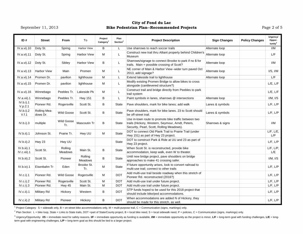
Bike Pedestrian Plan--Recommended Projects Page 2 of 5
ID # Street From To Project Category1
Plan Section2 Project Description Sign Changes Policy Changes
Urgency/ Oppor- tunity3
IV.a.vi).10 Doty St. Spring Harbor View B L Use sharrows to reach soccer trails Alternate loop I/M
IV.a.vi).11 Doty St. Spring Harbor View M L Construct new trail thru Alliant property behind Children's Museum Alternate loop L/F
IV.a.vi).12 Doty St. Sibley Harbor View B L Sharrows/signage to connect Brooke to park if no $ for trails. Main = possible crossing of Scott? Alternate loop I/M
IV.a.vi).13 Harbor View Main Promen M L NE corner of Main & Harbor View--wider turn paved Oct 2013, add signage? Alternate loop I/S, I/M
IV.a.vi).14 Promen Dr. pavilion lighthouse M L Extend lakeside trail to lighthouse Alternate loop L/F
IV.a.vi).15 Promen Dr. pavilion lighthouse M L Modify existing Promen Bridge to allow bikes to cross alongside (cantilevered structure?) L/E, L/F
IV.a.vi).16 Winnebago Peebles Tr. Lakeside Pk M L Construct trail and bridge directly from Peebles to park trail system L/E, L/F
IV.a.vii).1 Winnebago Peebles Tr. Hwy 151 B L Paint symbols in lanes, sharrows @ intersections Alternate loop I/M, I/SIV.b.i).1 V.p.2.1 Pioneer Rd. Rogersville Scott St. B State Pave shoulders, mark for bike lanes; add walk Lanes & symbols L/F, L/P
IV.b.i).2 V.f.1
Rolling Mea- dows Dr. Wild Goose Scott St. B State Pave shoulders, mark for bike lanes. 23 to Scott should
be off-street trail. Lanes & symbols L/F, L/P
IV.b.i).3 multiple Wild Goose Tr. Mascoutin Tr B State
Use in-town route to promote bike traffic between two trails (Hickory, Western, Seymour, Arndt, Peters, Security, Pearl, Scott, Rolling Meadows).
Sharrows & signs I/M
IV.b.ii).1 Johnson St. Prairie Tr. Hwy UU M State DOT to connect Old Plank Trail to Prairie Trail (under Hwy 151) as part of Hwy 23 project.
L/F, L/E, L/P
IV.b.ii).2 Hwy 23 Hwy UU State DOT to construct Park & Ride at UU and 23 as part of Hwy 23 project. L/F, L/P
IV.b.iii).1 IV.c.xii).1 Scott St. Rolling
Meadows Main St. B State When Scott St. is reconstructed, provide bike accommodation, keep walk, even W to theater.
L/F, L/P, L/E
IV.b.iii).2 Scott St. Pioneer Rolling Meadows B State Until new bridge project, pave shoulders on bridge
approaches to make 41 crossing safer. I/M, I/S
IV.b.iv).1 Eisenbahn Tr Eden Brooke St. Tr. M State If future opportunity arises, look to convert railroad to
multi-use trail; connect to other trails L/F, L/P
IV.c.i).1 Pioneer Rd. Wild Goose Rogersville M DOT Add multi-use trail beside roadway when this stretch of Pioneer Rd. reconstructed (2016?) L/F, L/P
IV.c.i).2 Pioneer Rd. Rogersville Scott St. M DOT Add multi-use trail under future project. L/F, L/PIV.c.i).3 Pioneer Rd. Hwy 45 Main St. M DOT Add multi-use trail under future project. L/F, L/P
IV.c.ii).1 Military Rd Hickory Western B DOT STP funds hoped to be used for this 2018 project that should include bike/ped accommodations. L/F, L/P
IV.c.ii).2 Military Rd Pioneer Hickory B DOT When accommodations are added N of Hickory, they should be made for this stretch, as well. L/F, L/P
1 Project Category: S = sidewalk only, B = on-street bike accommodations only, M = multi-purpose trail, C = Communication (signs, markings) only.2 Plan Section: L = bike loop, State = Links to State trails, DOT =part of State/County project, B = local bike need, S = local sidewalk need, P = policies, C = Communication (signs, markings) only.3 Urgency/Opportunity: I/S = immediate need for safety reasons, I/F = immediate opportunity as funding is available, I/M = immediate opportunity as the project is minor, L/F = long-term goal with funding challenges, L/E = long-term goal with engineering challenges, L/P = long-term goal as this should be tied to a larger project.
September 11, 2013City of Fond du Lac
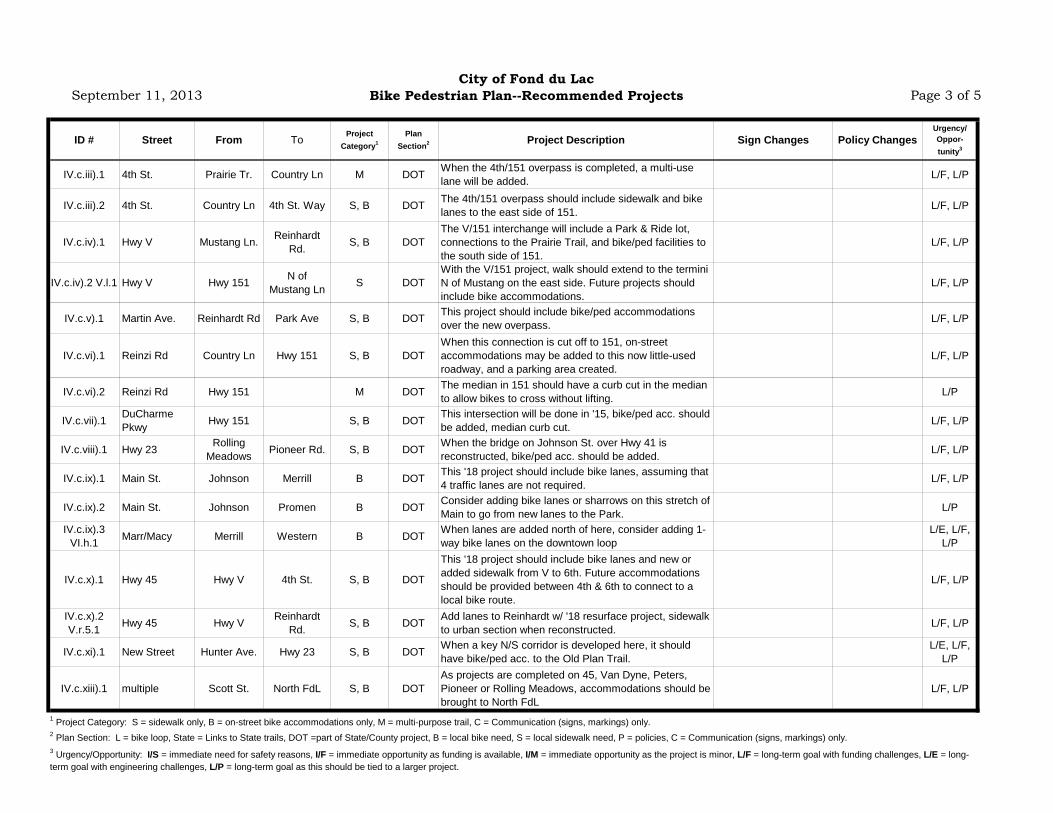
Bike Pedestrian Plan--Recommended Projects Page 3 of 5
ID # Street From To Project Category1
Plan Section2 Project Description Sign Changes Policy Changes
Urgency/ Oppor- tunity3
IV.c.iii).1 4th St. Prairie Tr. Country Ln M DOT When the 4th/151 overpass is completed, a multi-use lane will be added. L/F, L/P
IV.c.iii).2 4th St. Country Ln 4th St. Way S, B DOT The 4th/151 overpass should include sidewalk and bike lanes to the east side of 151. L/F, L/P
IV.c.iv).1 Hwy V Mustang Ln. Reinhardt Rd. S, B DOT
The V/151 interchange will include a Park & Ride lot, connections to the Prairie Trail, and bike/ped facilities to the south side of 151.
L/F, L/P
IV.c.iv).2 V.l.1 Hwy V Hwy 151 N of Mustang Ln S DOT
With the V/151 project, walk should extend to the termini N of Mustang on the east side. Future projects should include bike accommodations.
L/F, L/P
IV.c.v).1 Martin Ave. Reinhardt Rd Park Ave S, B DOT This project should include bike/ped accommodations over the new overpass. L/F, L/P
IV.c.vi).1 Reinzi Rd Country Ln Hwy 151 S, B DOTWhen this connection is cut off to 151, on-street accommodations may be added to this now little-used roadway, and a parking area created.
L/F, L/P
IV.c.vi).2 Reinzi Rd Hwy 151 M DOT The median in 151 should have a curb cut in the median to allow bikes to cross without lifting. L/P
IV.c.vii).1 DuCharme Pkwy Hwy 151 S, B DOT This intersection will be done in '15, bike/ped acc. should
be added, median curb cut. L/F, L/P
IV.c.viii).1 Hwy 23 Rolling Meadows Pioneer Rd. S, B DOT When the bridge on Johnson St. over Hwy 41 is
reconstructed, bike/ped acc. should be added. L/F, L/P
IV.c.ix).1 Main St. Johnson Merrill B DOT This '18 project should include bike lanes, assuming that 4 traffic lanes are not required. L/F, L/P
IV.c.ix).2 Main St. Johnson Promen B DOT Consider adding bike lanes or sharrows on this stretch of Main to go from new lanes to the Park. L/P
IV.c.ix).3 VI.h.1 Marr/Macy Merrill Western B DOT When lanes are added north of here, consider adding 1-
way bike lanes on the downtown loopL/E, L/F,
L/P
IV.c.x).1 Hwy 45 Hwy V 4th St. S, B DOT
This '18 project should include bike lanes and new or added sidewalk from V to 6th. Future accommodations should be provided between 4th & 6th to connect to a local bike route.
L/F, L/P
IV.c.x).2 V.r.5.1 Hwy 45 Hwy V Reinhardt
Rd. S, B DOT Add lanes to Reinhardt w/ '18 resurface project, sidewalk to urban section when reconstructed. L/F, L/P
IV.c.xi).1 New Street Hunter Ave. Hwy 23 S, B DOT When a key N/S corridor is developed here, it should have bike/ped acc. to the Old Plan Trail.
L/E, L/F, L/P
IV.c.xiii).1 multiple Scott St. North FdL S, B DOTAs projects are completed on 45, Van Dyne, Peters, Pioneer or Rolling Meadows, accommodations should be brought to North FdL
L/F, L/P
1 Project Category: S = sidewalk only, B = on-street bike accommodations only, M = multi-purpose trail, C = Communication (signs, markings) only.2 Plan Section: L = bike loop, State = Links to State trails, DOT =part of State/County project, B = local bike need, S = local sidewalk need, P = policies, C = Communication (signs, markings) only.3 Urgency/Opportunity: I/S = immediate need for safety reasons, I/F = immediate opportunity as funding is available, I/M = immediate opportunity as the project is minor, L/F = long-term goal with funding challenges, L/E = long-term goal with engineering challenges, L/P = long-term goal as this should be tied to a larger project.

September 11, 2013City of Fond du Lac
Bike Pedestrian Plan--Recommended Projects Page 4 of 5
ID # Street From To Project Category1
Plan Section2 Project Description Sign Changes Policy Changes
Urgency/ Oppor- tunity3
IV.d.1 VII.l.1 multiple B B The in-town bike route grid should be confirmed for
signage, add sharrowsAdd signs and sharrows as needed I/M
V.a.1 Pioneer Rd. Main St. Hwy 45 S S Add walk on at least one side of this busy road near schools. Safe Routes to School funding? L/E, L/F
V.b.1 Arndt St. Packer St. Lincoln Av S S Remove walk on N side to avoid safety conflicts, cross to S side on either side, bridge. L/E, L/F
V.c.1 Johnson St. National Ave Prairie Tr. S S Add walk on S side of Hwy 23 where not currently. Some homes front other street. L/F, L/P
V.c.2 Johnson St. Kairis Ct. Prairie Tr. S S Add walk on N side of Hwy 23 near Festival. L/F, L/P
V.c.3 University Ave Campus Dr. Pine Lake Dr. S S Add walk through UW-FdL campus, pave Arboretum
Trail, complete walk on Pine Lake Dr.L/E, L/F,
L/P
V.d.1 Marr & Macy Merrill Western C S Add ped countdown at signalized intersections, include for peds walking opposite 1-way traffic. L/F, L/P
V.e.1 Harbor View Doty Main S S Add sidewalk on at least one side of this block under future reconstruction project. L/F, L/P
V.f.1 Rolling Meadows
Wild Goose Trail Scott St. S S A future reconstruction of this roadway should include a
sidewalk or multi-use trail. L/F, L/P
V.g.1 Pioneer Rd. Grove Security Dr. S S Connect to walk on Grove, Forest, Security when Pioneer sidewalk added. L/F, L/P
V.h.1 National Ave Reinzi Hwy 45 S S Fill in 250' gap in sidewalk here. I/M
V.i.1 Martin Ave. 9th St. 17th St. S S There is no walk on this busy 1/2 mile stretch of Fairgrounds property (east side). L/F, L/P
V.j.1 11th St. Military Rd. Hickory St. S S 11th has been terminated east of Military, but people still walk there. Walk should be added. I/M
V.k.1 Country Ln Johnson DuCharme S S Sidewalk will be added as this subdivision is built. L/P
V.k.2 DuCharme Pkwy Country Ln. Tay-
cheedah Cr S S Sidewalk will be added as this subdivision is built. L/P
V.l.1 Martin Ave. Willsher Dr. Park Ave S S Add sidewalk as subdivisions are developed. L/F, L/P
V.m.1 Winnebago Willow Luco S S Add sidewalk to complete this grid (360' W side of Luco, 1,200' S side of Winnebago).
L/E, L/F, L/P
V.n.1 Division St. Prairie Rd. Mariearl S S S side, add walk to serve Marian sports complex. L/F, L/PV.o.1 S S Add a walking trail through the park. L/F
V.p.1 Arndt St. Bell St. Hickory St. S S Add sidewalk on S side E from Bell w/ development; connect to Hickory in future. L/F
V.q.1 Morris St. 9th St. 12th St. S S A 300' gap in the sidewalk grid on the west side of the street should be connected. L/P, L/F
V.r.1.1 Military Rd. Pioneer Rogersville S S If '16 project doesn't complete entire sidewalk grid to NE, fill those gaps. L/F, L/P
Buttermilk Cr
1 Project Category: S = sidewalk only, B = on-street bike accommodations only, M = multi-purpose trail, C = Communication (signs, markings) only.2 Plan Section: L = bike loop, State = Links to State trails, DOT =part of State/County project, B = local bike need, S = local sidewalk need, P = policies, C = Communication (signs, markings) only.3 Urgency/Opportunity: I/S = immediate need for safety reasons, I/F = immediate opportunity as funding is available, I/M = immediate opportunity as the project is minor, L/F = long-term goal with funding challenges, L/E = long-term goal with engineering challenges, L/P = long-term goal as this should be tied to a larger project.

September 11, 2013City of Fond du Lac
Bike Pedestrian Plan--Recommended Projects Page 5 of 5
ID # Street From To Project Category1
Plan Section2 Project Description Sign Changes Policy Changes
Urgency/ Oppor- tunity3
V.r.3.1 41, 151 S SAs bridges are completed over 41 on Scott, Johnson, Military, Hickory, & Main, and over 151 on Main, Martin, V, 45, and 4th, add bike/ped acc.
L/E, L/F, L/P
V.r.4.1 Hwy V FdL Ave Pioneer Rd. S S Sidewalk should be added on this highway near a school. L/F, L/P
VI.f.1 S P Add a walking trail through the park. L/FVI.f.2 S P Add a walking trail through the park. L/FVI.f.3 S P Add a walking trail through the park. L/FVI.f.4 S P Add a walking trail through the park. L/FVI.f.5 S P Improve on walking trails; obtain public access. L/FVI.f.6 S P Add walking trails, recently donated park land L/FVI.h.1 Main St. Merrill Western C P Stencil "walk your bike" onto downtown walk I/MVI.h.2 Downtown various B P Install larger bike racks at downtown entrances. I/MVI.j.1 Parks various B P Install bike racks in various City parks I/M
VII.b.1 Various C C I/MVII.c.1 Various C C I/MVII.d.1 Various C C I/M
VII.e.1 Festival Foods parking lot Prairie Tr. C C I/M
VII.g.1 Various C C I/M, I/S
VII.h.1 Martin Ave. Willsher Park Ave. C C I/M
VII.h.2 Hampton/Willsher Hwy V Martin C C
VII.i.1 Various C C I/M
VII.j.1 Various C C I/M
VII.k.1 Various C C I/MVII.m.1 Prairie Tr. various C C I/M
Meadowlands Park
S. Main St. park land
various bridge projects
Hunters Grove ParkBrookfield ParkGalloway Park
Add signage to direct bikers/joggers from Festival parking lot to trail, and perhaps to designate parking; acts as Park & RideAdd regulatory/warning signage to bike trails. Especially inconsistent on Brooke and River trails now.
Improve signage to connect Pioneer & Prairie trails
Work w/ DFP, CVB to coordinate wayfinding signs specifically for bicyclists and pedestrians.
Greenway Arboretum
Add trail/mileage signs around system.Add information kiosks at trailheads of State trailsDevelop maps, place at businesses, kiosks, web
Install destination signs to direct people to parks, attractions, school, arboretums, etc.
Improve signage on this part of the in-town marked routes.
3 Urgency/Opportunity: I/S = immediate need for safety reasons, I/F = immediate opportunity as funding is available, I/M = immediate opportunity as the project is minor, L/F = long-term goal with funding challenges, L/E = long-term goal with engineering challenges, L/P = long-term goal as this should be tied to a larger project.
Sign "alternative loops" uniquely (Park Ave., Harbor View, Hwy WH, etc.).Stripe centerline or install warning signs at blind corners of Prairie Trail
1 Project Category: S = sidewalk only, B = on-street bike accommodations only, M = multi-purpose trail, C = Communication (signs, markings) only.2 Plan Section: L = bike loop, State = Links to State trails, DOT =part of State/County project, B = local bike need, S = local sidewalk need, P = policies, C = Communication (signs, markings) only.

The Safe Routes to School Program: Broad Reach and Great Demand Today, just 13% of children ages 5 to 14 walk and bicycle to and from school—a dramatic drop from 1969 when nearly 50% of children walked to school.1 As a result, school districts and families spend billions on transportation and the volume of vehicles around schools creates traffic congestion, air pollution and wear and tear. The federal Safe Routes to School program, created in 2005 through the SAFETEA-LU transportation law, makes it safer for children to walk and bicycle to and from school.
From 2005 to 2012, approximately $1.1 billion has been allocated to state departments of transportation (DOTs) for Safe Routes to School. Under the new transportation bill, MAP-21, Safe Routes to School projects are eligible under the Transportation Alternatives program. State DOTs award these funds to local governments and school systems for comprehensive efforts to improve safety and increase walking and bicycling to school.
The vast majority (70 to 90%) is spent on infrastructure improvements near schools, such as sidewalks, bike paths, crosswalks, school zone signage and traffic calming. The remaining 10 to 30% is for programs to teach children traffic safety skills, ensure that motorists are driving safely around schools and to encourage more children to walk and bicycle.
The availability of Safe Routes to School funding has galvanized a focus on prioritizing safety improvements around schools, resulting in improvements for traffic congestion, busing costs and physical activity.
Improving Safety and Preventing Tragedy Safe Routes to School is a tool to help communities protect children and prevent tragedies. With limited funds available to address traffic safety, it makes sense to concentrate resources around schools where children spend a lot of time.
In 2009, more than 23,000 children (ages 5 to 15) were injured and 250 killed by cars when they were struck while walking or bicycling. This represents 25% of all children’s traffic fatalities and 15% of all children’s traffic injuries.2
In 2005, the medical costs of hospitalization and treatment for children’s bicycle and pedestrian fatalities and injuries totaled $839 million—4.5 times what we spend annually on Safe Routes to School.3
Preventing just one death of a child while walking or bicycling is estimated to save approximately $1.1 million in lifetime medical and work-loss costs.4
Infrastructure installed with Safe Routes to School funding is proven to reduce pedestrian and bicycle deaths and injuries. For example, adding a sidewalk cuts in half the risk that a pedestrian will be struck by a car.5
Safe Routes to School:
Helping Communities Save Lives and Dollars
As of June 2012, 76% of available funds have been awarded, with 6,100 awards averaging $128,000 per award.
Because many awards include multiple schools, an estimated 13,300 schools and 4.8 million children are benefiting from these federal funds.1
Due to limited funds, just 13% of schools in the nation have benefited from Safe Routes to School funding.
Following the tragic death of a 12-year-old girl killed riding her bicycle home from school, Robertsville Middle School in Oak Ridge, TN used $238,000 in federal Safe Routes to School funding to add sidewalks, curb cuts and crosswalks near the school to improve safety for kids walking and bicycling.
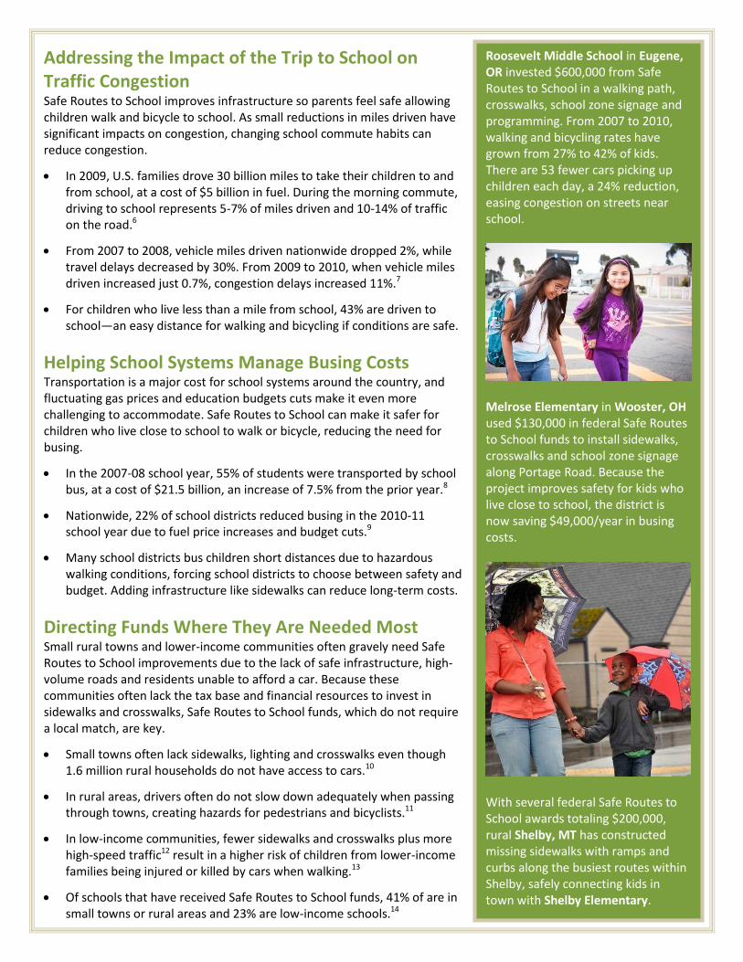
Addressing the Impact of the Trip to School on Traffic Congestion Safe Routes to School improves infrastructure so parents feel safe allowing children walk and bicycle to school. As small reductions in miles driven have significant impacts on congestion, changing school commute habits can reduce congestion.
In 2009, U.S. families drove 30 billion miles to take their children to and from school, at a cost of $5 billion in fuel. During the morning commute, driving to school represents 5-7% of miles driven and 10-14% of traffic on the road.6
From 2007 to 2008, vehicle miles driven nationwide dropped 2%, while travel delays decreased by 30%. From 2009 to 2010, when vehicle miles driven increased just 0.7%, congestion delays increased 11%.7
For children who live less than a mile from school, 43% are driven to school—an easy distance for walking and bicycling if conditions are safe.
Helping School Systems Manage Busing Costs Transportation is a major cost for school systems around the country, and fluctuating gas prices and education budgets cuts make it even more challenging to accommodate. Safe Routes to School can make it safer for children who live close to school to walk or bicycle, reducing the need for busing.
In the 2007-08 school year, 55% of students were transported by school bus, at a cost of $21.5 billion, an increase of 7.5% from the prior year.8
Nationwide, 22% of school districts reduced busing in the 2010-11 school year due to fuel price increases and budget cuts.9
Many school districts bus children short distances due to hazardous walking conditions, forcing school districts to choose between safety and budget. Adding infrastructure like sidewalks can reduce long-term costs.
Directing Funds Where They Are Needed Most Small rural towns and lower-income communities often gravely need Safe Routes to School improvements due to the lack of safe infrastructure, high-volume roads and residents unable to afford a car. Because these communities often lack the tax base and financial resources to invest in sidewalks and crosswalks, Safe Routes to School funds, which do not require a local match, are key.
Small towns often lack sidewalks, lighting and crosswalks even though 1.6 million rural households do not have access to cars.10
In rural areas, drivers often do not slow down adequately when passing through towns, creating hazards for pedestrians and bicyclists.11
In low-income communities, fewer sidewalks and crosswalks plus more high-speed traffic12 result in a higher risk of children from lower-income families being injured or killed by cars when walking.13
Of schools that have received Safe Routes to School funds, 41% of are in small towns or rural areas and 23% are low-income schools.14
Roosevelt Middle School in Eugene, OR invested $600,000 from Safe Routes to School in a walking path, crosswalks, school zone signage and programming. From 2007 to 2010, walking and bicycling rates have grown from 27% to 42% of kids. There are 53 fewer cars picking up children each day, a 24% reduction, easing congestion on streets near school.
Melrose Elementary in Wooster, OH used $130,000 in federal Safe Routes to School funds to install sidewalks, crosswalks and school zone signage along Portage Road. Because the project improves safety for kids who live close to school, the district is now saving $49,000/year in busing costs.
With several federal Safe Routes to School awards totaling $200,000, rural Shelby, MT has constructed missing sidewalks with ramps and curbs along the busiest routes within Shelby, safely connecting kids in town with Shelby Elementary.

Increasing Physical Activity through Changes in the Built Environment The high rates of childhood obesity in America affect health care costs, academic achievement and future work productivity. Communities that are more walkable and bikeable have higher physical activity rates.
Childhood obesity has increased among children ages 6 to 11 from 4% in 1969 to 19.6% in 2007.15 Now 23 million children and teens—nearly one-third of all young people in the U.S.—are overweight or obese.16
Today, one-quarter of health care costs are attributable to obesity,17 with direct costs for childhood obesity as high as $14 billion annually.18
Overweight and obese children, on average, have lower GPAs, more school absences and more disciplinary referrals.19
Studies show that children who walk and bicycle to school are more physically active,20 have lower body mass index scores, 21 lower obesity levels22 and are more likely to meet physical activity guidelines23 than students who are driven or bused to school.
Tallying the Financial Benefits of Safe Routes to School Safe Routes to School infrastructure improvements create lasting benefits, which improve the routes to school, increase safety and add opportunities for physical activity for everyone. These benefits impact the budgets of schools and governments nationwide.
Reducing the miles parents drive to school by just 1% would reduce 300 million miles of vehicle travel and save an estimated $50 million in fuel costs each year—reducing traffic congestion.24
Conservatively assuming that 5% of today’s school busing costs are for hazard busing, making it safe for those children to walk or bicycle instead could save approximately $1 billion per year in busing costs.25
Given the up to $14 billion in annual direct medical costs to treat childhood obesity, creating more opportunities for children to be physically active can reduce the burden on our public health system.26
Safe Routes to School projects require the assistance of engineering, planning and construction firms, which creates jobs and private sector benefits. Bicycle and pedestrian infrastructure create more jobs per million dollars spent than road repair and construction projects.27
In a recent survey of mayors in 176 cities, 60% said that the lack of additional funding for bicycle and pedestrian infrastructure was hindering their efforts to reduce congestion, improve livability and increase economic competitiveness.28
The federal Safe Routes to School program gives communities and parents safe, healthy and economical transportation solutions, which is particularly critical in challenging economic times.
Alpine Elementary in Alpine, UT used $71,500 in Safe Routes to School funding to add a safe walking path and to implement bicycling and walking education and encouragement. The number of students regularly walking and bicycling has increased from 32% in 2008 to 50% in 2011. In just six months, students walked 28,000 miles and got 500,000 minutes of physical activity.
As a small rural town, Saint Joe, IN lacked the tax base for sidewalks, forcing Riverdale Elementary students to walk in the street. With $250,000 from Safe Routes to School, Saint Joe installed 1.5 miles of sidewalks—which would have taken 15 years to complete using only local funds. The town council views the new sidewalks as an asset to attract new businesses and residents and increase property values.

End Notes 1 McDonald, Noreen, Austin Brown, Lauren Marchetti, and Margo Pedroso. “U.S. School Travel 2009: An Assessment of Trends.” American Journal
of Preventive Medicine 41 (August 2011): 2, 146-151. 2 “Pedestrians: 2009 Data” and “Bicyclists and Other Cyclists: 2009 Data” Washington, DC: National Highway Traffic Safety Administration, 2009.
Available at http://www-nrd.nhtsa.dot.gov/Pubs/811394.pdf and http://www-nrd.nhtsa.dot.gov/pubs/811386.pdf. 3 Lawrence, Bruce, Soma Bhattacharya, Eduward Zaloshnja, Paul Jones, Ted Miller, Phaedra Corso, and Claudia Steiner. “Medical and Work Loss
Cost Estimation Methods for the WISQARS Cost of Injury Module.” Calverton, MD: Pacific Institute for Research and Evaluation (PIRE), September 2009. 4 WISQARS (Web-based Injury Statistics Query and Reporting System). 2005 Cost of Injury Reports. Centers for Disease Control and Prevention,
National Center for Injury Prevention and Control, Office of Statistics and Programming. Database queried for injuries and fatalities to child pedestrians and bicyclists ages 5 to 14, accessed June 2, 2011, http://wisqars.cdc.gov:8080/costT/. 5 Knoblauch, R, B Tustin, S Smith, and M Pietrucha. “Investigation of Exposure-Based Pedestrian Accident Areas: Crosswalks, Sidewalks, Local
Streets, and Major Arterials.” Washington DC: US Department of Transportation, 1987. 6 McDonald, Noreen, Austin Brown, Lauren Marchetti, and Margo Pedroso. “U.S. School Travel 2009: An Assessment of Trends.” American Journal
of Preventive Medicine 41 (August 2011): 2, 146-151. 7 INRIX, Inc. “INRIX National Traffic Scorecard 2010 Annual Report, Key Scorecard Findings.” Accessed June 2, 2011,
http://www.inrix.com/scorecard/summary.asp; and Federal Highway Administration. “Traffic Volume Trends, December 2010.” Accessed May 29, 2011, http://www.fhwa.dot.gov/ohim/tvtw/10dectvt/10dectvt.pdf. 8 Digest of Education Statistics, 2010. Tables 184, 186 and 187. Washington, DC: U.S. Department of Education, National Center for Education
Statistics, 2011. 9 Babcock, Stephane. “STN Fuel Survey: Schools feeling pinch from rise in prices.” STN Online, March 14, 2011. Accessed June 1, 2011,
http://www.stnonline.com/home/top-stories/3218-stn-fuel-survey-schools-feeling-pinch-from-rise-in-prices. 10
Dabson, Brian, Thomas G. Johnson, and Charles W. Fluharty. A RUPRI Policy Brief: Rethinking Federal Investments in Rural Transportation: Rural Considerations Regarding Reauthorization of the Surface Transportation Act. Columbia, MO: Rural Policy Research Institute, April 2011. 11
Hallmark, Shauna, Eric Fitzsimmons, David Plazak, Tom Michael Welch, and Eric Petersen. “Use of Physical Devices for Calming Traffic Along Major Roads through Small Rural Communities in Iowa.” Transportation Research Record: Journal of the Transportation Research Board 2078 (January 16, 2009): 100-107. 12
Zhu, Xuemei and Chanam Lee. “Walkability and safety around elementary schools: Economic and ethnic disparities.” American Journal of Preventive Medicine 34 (January 2008): 282-290. 13
Macpherson, Alison, Ian Roberts and Barry Pless. “Children’s exposure to traffic and pedestrian injuries.” American Journal of Public Health 88 (December 1998). 14
National Center for Safe Routes to School. Federal Safe Routes to School Program Progress Report. Raleigh, NC: August 2011. 15
Ogden, Cynthia and Margaret Carroll. “Prevalence of Obesity among Children and Adolescents: United States, Trends 1963-1965 through 2007-2008.” Atlanta: Centers for Disease Control and Prevention. National Center for Health Statistics, June 2010. 16
Ogden, Cynthia, M Carroll, LR Curtin, MA McDowell, CJ Tabak, and KM Flegal. “Prevalence of Overweight and Obesity in the United States, 1999-2004.” Journal of the American Medical Association 295 (2006): 1549-55. 17
Trasande L and S Chatterjee. “The impact of obesity on health service utilization and costs in childhood.” Obesity 17 (2009): 1749–54. 18
Marder, William and Stella Chang. “Childhood Obesity: Costs, Treatment Patterns, Disparities in Care and Prevalent Medical Conditions. New York: Thomson Medstat Research Brief, 2006. Accessed June 3, 2011, www.medstat.com/pdfs/childhood_obesity.pdf. 19
Shore, Stuart, Michael Sachs, Jeffrey Lidicker, Stephanie Brett, Adam Wright and Joseph Libonati. “Decreased scholastic achievement in overweight middle school students.” Obesity 16 (2008): 7, 1535-1538. 20
Cooper AR, LB Andersen, N Wedderkopp, AS Page, and K Froberg. “Physical activity levels of children who walk, cycle or are driven to school.” American Journal of Preventive Medicine 29 (2005): 3, 179-184. 21
Rosenberg DE, JF Sallis, TL Conway, KL Cain, and TL McDenzie. “Active transportation to school over 2 years in relation to weight status and physical activity.” Obesity 14 (2006): 10, 1771-1776. 22
Mendoza JA, K Watson, N Nguyen, E Cerin, T Baranowski, and TA Nicklas. “Active Commuting to School and Association with Physical Activity and Adiposity Among US Youth.” Journal of Physical Activity and Health 8 (May 2011): 4, 488-495. 23
Sirard JR, WF Riner, KL McIver, and RR Pate. “Physical activity and active commuting to elementary school.” Medicine and Science in Sports and Exercise 37 (2005): 12, 2062-2069. 24
Calculated based on the current miles drive to school as cited in McDonald, Noreen, Austin Brown, Lauren Marchetti, and Margo Pedroso. “U.S. School Travel 2009: An Assessment of Trends.” American Journal of Preventive Medicine 41 (August 2011): 2, 146-151, and with gasoline at $4 per gallon. 25
Digest of Education Statistics, 2010. Tables 184, 186 and 187. Washington, DC: U.S. Department of Education, National Center for Education Statistics, 2011. 26
Marder, William and Stella Chang. “Childhood Obesity: Costs, Treatment Patterns, Disparities in Care and Prevalent Medical Conditions. New York: Thomson Medstat Research Brief, 2006. Accessed June 3, 2011, www.medstat.com/pdfs/childhood_obesity.pdf. 27
Garrett-Peltier, Heidi. “Pedestrian and Bicycle Infrastructure: A National Study of Employment Impacts.” Amherst, MA: Political Economy Research Institute, June 2011. 28
Parsons Brinkerhoff. “Metropolitan Transportation Infrastructure Survey.” Washington, DC: U.S. Conference of Mayors, May 2011. Accessed June 3, 2011, http://usmayors.org/transportationsurvey/documents/survey.pdf.

SAFE ROUTES TO SCHOOL NATIONAL PARTNERSHIP
WHAT IS SAFE ROUTES TO SCHOOL? Background and Statistics
Safe Routes to School (SRTS) is a national and international movement to create safe, convenient, and fun opportunities for children to bicycle and walk to and from schools. The program has been designed to reverse the decline in children walking and bicycling to schools. Safe Routes to School can also play a critical role in reversing the alarming nationwide trend toward childhood obesity and inactivity.
In 1969, approximately 50% of children walked or bicycled to school, with approximately 87% of children living within one mile of school walking or bicycling. Today, fewer than 15% of schoolchildren walk or bicycle to school. As a result, kids today are less active, less independent, and less healthy. As much as 10 to 14% of morning traffic can be generated by parents driving their children to schools, and traffic-related crashes are the top cause of death and major injury for children in the U.S. ages 1 to 17.
Concerned by the long-term health and traffic consequences of this trend, in 2005, the U.S. Congress approved $612 million in funding for five years of state implementation of SRTS programs in all 50 states and the District of Columbia. Communities are using this funding to construct new bike lanes, pathways, and sidewalks, as well as to launch Safe Routes to School education, promotion and enforcement campaigns in K-8 schools.
Safe Routes to School programs are built on collaborative partnerships among many stakeholders that include educators, parents, students, elected officials, engineers, city planners, business and community leaders, health officials, and bicycle and pedestrian advocates. The most successful SRTS programs incorporate the five E’s—evaluation, education, encouragement, engineering, and enforcement. The goal of Safe Routes to School is to get more children bicycling and walking to schools safely every day. Helpful Statistics on Safe Routes to School
Traffic Congestion: Neighborhoods are becoming increasingly clogged by traffic. By boosting the number of children walking and bicycling, Safe Routes to School projects reduce traffic congestion.
Within the span of one generation, the percentage of children walking or bicycling to school has dropped precipitously, from approximately 50% in 19691 to just 13% in 2009.2
While distance to school is the most commonly reported barrier to walking and bicycling3, private vehicles still account for half of school trips between 1/4 and 1/2 mile4—a distance easily covered on foot or bike.
In 2009, American families drove 30 billion miles and made 6.5 billion vehicle trips to take their children to and from schools, representing 10-14 percent of traffic on the road during the morning commute.5
A California study showed that schools that received infrastructure improvements through the Safe Routes to School program yielded walking and bicycling increases in the range of 20 to 200 percent.6
Safety: Safe Routes to School projects focus on infrastructure improvements, student traffic education, and driver enforcement that improve safety for children, many of whom already walk or bicycle in unsafe conditions.
Pedestrians are more than twice as likely to be struck by a vehicle in locations without sidewalks.7
In 2009, approximately 23,000 children ages 5-15 were injured and more than 250 were killed while walking or bicycling in the United States.8
From 2000-2006, 30% of traffic deaths for children ages 5-15 occurred while walking or bicycling.9
The medical costs for treating children’s bicycle and pedestrian fatalities cost $839 million in 2005 and another $2.2 billion in lifetime lost wage costs.10
A safety analysis by the California Department of Transportation estimated that the safety benefit of the SRTS was up to a 49 percent decrease in the childhood bicycle and pedestrian collision rates.11

Health and Obesity: Children today are simply not getting enough physical activity, contributing to growing rates of obesity and obesity-related health problems, such as diabetes. Safe Routes to School projects make it safer for more children to walk and bicycle to school, which will help address this obesity crisis among children by creating increases in physical activity.
Over the past 40 years, rates of obesity have soared among children of all ages in the United States, and approximately 25 million children and adolescents—more than 33%—are now overweight or obese or at risk of becoming so.12
Kids are less active today, and 23% of children get no free time physical activity at all.13
The prevalence of obesity is so great that today’s generation of children may be the first in over 200 years to live less healthy and have a shorter lifespan than their parents.14
Today, approximately one-quarter of health care costs in the United States are attributable to obesity, 15 and health care costs just for childhood obesity are estimated at approximately $14 billion per year.16
People living in auto-oriented suburbs drive more, walk less, and are more obese than people living in walkable communities. For each hour of driving per day, obesity increases 6 percent, but walking for transportation reduces the risk of obesity.17
Walking one mile to and from school each day is two-thirds of the recommended sixty minutes of physical activity a day. Children who walk to school have higher levels of physical activity throughout the day.18 19
Environment: Safe Routes to School projects increase the number of children walking and bicycling to school, which also cuts down on the number of cars. As cars emit pollutants for each mile traveled, reducing traffic can improve the quality of air that children breathe in and around their schools.
Children exposed to traffic pollution are more likely to have asthma, permanent lung deficits, and a higher risk of heart and lung problems as adults. 20
Over the last 25 years, among children ages 5 to 14, there has been a 74 percent increase in asthma cases.21 In addition, 14 million days of school are missed every year due to asthma.22
One-third of schools in “air pollution danger zones.”23
Schools that are designed so children can walk and bicycle have measurably better air quality. 24
A 5% increase in a neighborhood’s “walkability” reduces vehicle miles traveled by 6%.25
Returning to 1969 levels of walking and bicycling to school26 would save 3.2 billion vehicle miles, 1.5 million tons of carbon dioxide and 89,000 tons of other pollutants27—equal to keeping more than 250,000 cars off the road for a year.
Bus Transportation Costs: Schools often make cutbacks in bus routes to save money—meaning that more children will be walking and bicycling in potentially unsafe conditions, or more parents will drive their children, which increases traffic congestion and air quality concerns.
Approximately 55% of children are bused, and we spend $21.5 billion nationally each year on school bus transportation, an average of $854 per child transported per year.28
Eliminating one bus route, based on average per-pupil expenditure and average number of pupils per bus, would save a school district approximately $45,000 per year.29
Nationwide, approximately 22 percent of school districts made busing reductions during the 2010-2011 school year due to fuel price increases.30
About the Safe Routes to School National Partnership Launched in August 2005, the Safe Routes to School National Partnership is a fast-growing network of hundreds of organizations, government agencies and groups working to set goals, share best practices, secure funding, and provide educational materials to agencies that implement Safe Routes to School programs. The Safe Routes to School National Partnership’s mission is to serve a diverse national community of organizations that advocates for safe bicycling and walking to and from schools throughout the United States. www.saferoutespartnership.org

End Notes 1 Transportation Characteristics of School Children, Report no. 4. Washington, DC: Nationwide personal Transportation Study, federal
Highway Administration, July 1972. 2 McDonald, Noreen, Austin Brown, Lauren Marchetti, and Margo Pedroso. “U.S. School Travel 2009: An Assessment of Trends.” American
Journal of Preventive Medicine (August 2011) (In press). 3 U.S. Centers for Disease Control and Prevention, Morbidity and Mortality Weekly Report September 30, 2005, “Barriers to Children
Walking to or from School, United States 2004.” Available at www.cdc.gov/mm wr/preview/mmwrhtml/mm5438a2.htm. 4 Federal Highway Administration, National Household Travel Survey 2001; NHTS Brief on Travel to School, January 2008.
5 McDonald, Noreen, Austin Brown, Lauren Marchetti, and Margo Pedroso. “U.S. School Travel 2009: An Assessment of Trends.” American
Journal of Preventive Medicine (August 2011) (In press). 6 Marla R. Orenstein, Nicolas Gutierrez, Thomas M. Rice, Jill F. Cooper, and David R. Ragland, "Safe Routes to School Safety and Mobility
Analysis" (April 1, 2007). UC Berkeley Traffic Safety Center. Paper UCB-TSC-RR-2007-1. http://repositories.cdlib.org/its/tsc/UCB-TSC-RR-2007-1 7 R. Knoblauch, B. Tustin, S. Smith, and M. Pietrucha. “Investigation of Exposure-Based Pedestrian Accident Areas: Crosswalks, Sidewalks,
Local Streets, and Major Arterials.” Washington DC: US Dept of Transportation; 1987. 8 “Pedestrians: 2009 Data” and “Bicyclists and Other Cyclists: 2009 Data” Washington, DC: National Highway Traffic Safety Administration,
2009. Available at http://www-nrd.nhtsa.dot.gov/Pubs/811394.pdf and http://www-nrd.nhtsa.dot.gov/pubs/811386.pdf. 9 Borse, N, et al., CDC Childhood Injury Report. Patterns of Unintentional Injuries among 0-19 Year Olds in the United States, 2000-2006,
December 2008. Available at http://www.cdc.gov/SafeChild/images/CDC-ChildhoodInjury.pdf 10
WISQARS (Web-based Injury Statistics Query and Reporting System). 2005 Cost of Injury Reports. Centers for Disease Control and Prevention, National Center for Injury Prevention and Control, Office of Statistics and Programming. Database queried for injuries and fatalities to child pedestrians and bicyclists ages 5 to 14, accessed June 2, 2011, http://wisqars.cdc.gov:8080/costT/. 11
Marla Orenstein, Nicolas Gutierrez, Thomas Rice, Jill Cooper, and David Ragland, "Safe Routes to School Safety and Mobility Analysis" (April 1, 2007). UC Berkeley Traffic Safety Center. Paper UCB-TSC-RR-2007-1. http://repositories.cdlib.org/its/tsc/UCB-TSC-RR-2007-1 12
Ogden, C.L. et al., “Prevalence of Overweight and Obesity in the United States, 1999-2004.” Journal of the American Medical Association, 295, no. 13 (2006). Available at http://jama.ama-assn.org/cgi/content/full/295/13/1549#JOC60036T2. 13 “Physical activity levels among children aged 9-13 years—United States, 2002.” Morbidity and Mortality Weekly Report 2003;
52[33]:785-8. 14
S. Jay Olshansky, Ph.D., Douglas J. Passaro, M.D., Ronald C. Hershow, M.D., Jennifer Layden, M.P.H., Bruce A. Carnes, Ph.D., Jacob Brody, M.D., Leonard Hayflick, Ph.D., Robert N. Butler, M.D., David B. Allison, Ph.D., and David S. Ludwig, M.D., Ph.D., “A Potential Decline in Life Expectancy in the United States in the 21st Century,” New England Journal of Medicine: Volume 352: 1138-1145, March 17, 2005. 15
Trasande L and S Chatterjee. “The impact of obesity on health service utilization and costs in childhood.” Obesity 17 (2009): 1749–54. 16
Marder, William and Stella Chang. “Childhood Obesity: Costs, Treatment Patterns, Disparities in Care and Prevalent Medical Conditions. New York: Thomson Medstat Research Brief, 2006. Accessed June 3, 2011, www.medstat.com/pdfs/childhood_obesity.pdf. 17
Frank LD, Andresen MA, Schmid TL. “Obesity relationships with community design, physical activity, and time spent in cars.” American Journal of Preventative Medicine 2004; 27: 87-96. 18
Alexander et al., The broader impact of walking to school among adolescents. BMJonline. 19
Cooper et al., Commuting to school: Are children who walk more physically active? Amer Journal of Preventative Medicine 2003: 25 (4) 20
Gauderman, W. J., E. Avol, F. Lurmann, N. Kuenzli, F. Gilliland, J. Peters and R. McConnell, “Childhood Asthma and Exposure to Traffic and Nitrogen Dioxide,” Epidemiology, Volume 16, No. 6, November 2005. AND Gauderman, W.J., H. Vora, R. McConnell, K. Berhane, F. Gilliland, D. Thomas, F. Lurmann, E. Avol, N. Kunzli, M. Jerrett, and J. Peters, “Effect of exposure to traffic on lung development from 10 to 18 years of age: a cohort study,” The Lancet, Volume 368, February 2007. 21 Centers for Disease Control and Prevention. Surveillance for Asthma—United States, 1960-1995: CDC Surveillance Summaries, April 24, 1998. MMWR Morbidity and Mortality Weekly Report, Vol. 47 (SS-1), 1998, pp. 1-27. 22
Centers for Disease Control and Prevention. Healthy Youth! Health Topics: Asthma. Available at http://www.cdc.gov/HealthyYouth/asthma/index.htm. 23
Appatova, A. S., Ryan, P., LeMasters, G., Grinshpun, S. “Proximal exposure of public schools and students to major roadways: a nationwide US survey,” Journal of Environmental Planning and Management, Volume 51, Issue 5, 2008. 24
US EPA. Travel and Environmental Implications of School Siting, October 2003. Available at www.smartgrowth.umd.edu/pdf/SchoolLocationReport.pdf.
25 Lawrence D. Frank, James F. Sallis, et al. "Many Pathways from Land Use to Health" Journal of the American Planning Association, Volume
72, Issue 1, Winter 2006. 26
McDonald, N. “Active Transportation to School: Trends among U.S. Schoolchildren, 1969-2001,” American Journal of Preventive Medicine, Volume 32, Number 6, June 2007. 27
“Emission Facts: Average Annual Emissions and Fuel Consumption for Passenger Cars and Light Trucks,” U.S Environmental Protection Agency. Available at http://www.epa.gov/otaq/consumer/f00013.htm. 28 Digest of Education Statistics, 2010. Tables 184, 186 and 187. Washington, DC: U.S. Department of Education, National Center for Education Statistics, 2011. 29
Digest of Education Statistics, 2010. Table 184. U.S. Department of Education, National Center for Education Statistics, 2011 AND “School Bus Safety Overview.” School Transportation News, http://www.stnonline.com/stn/data_statistics/safetyoverview/index.htm 30
Babcock, Stephane. “STN Fuel Survey: Schools feeling pinch from rise in prices.” STN Online, March 14, 2011. Accessed June 1, 2011, http://www.stnonline.com/home/top-stories/3218-stn-fuel-survey-schools-feeling-pinch-from-rise-in-prices.
Related Documents