Welcome message from author
This document is posted to help you gain knowledge. Please leave a comment to let me know what you think about it! Share it to your friends and learn new things together.
Transcript
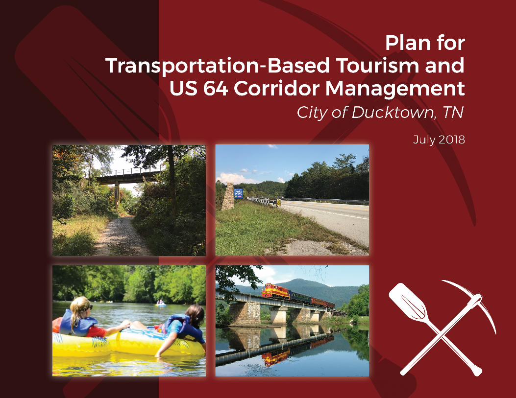
On the cover: Trail linking the solar farm to the Ducktown Basin Mining Museum (photo by Ross Daniels, WSP)
Terminus of the Ocoee Scenic Byway along US 64 (photo by Ross Daniels, WSP)
Tubing on the Lower Ocoee (photo courtesy of Outdoor Adventure Rafting)
Hiwassee River Rail Adventures (photo courtesy of Tennessee Valley Railroad)
The preparation of this report has been financed in part through a grant from the Federal Highway Administration and Federal Transit
Administration, U.S. Department of Transportation, under Section 104(f) of Title 23 of the U.S. Code. The contents of this report do not
necessarily reflect the official views or policy of the U.S. Department of Transportation.
PLAN FOR TRANSPORTATION-BASED TOURISM
AND US 64 CORRIDOR MANAGEMENT Page 1
TABLE OF
CONTENTS 1 EXISTING PLANS, PROJECTS AND ACTIVITIES
1.1 Project Purpose ................................................................................................ 2
1.2 Ducktown’s Location, History and Context ........................................................ 4
1.3 Stakeholder Input (SWOT Analysis) .................................................................. 8
1.4 Plans and Grants Recently Completed or Underway ....................................... 16
1.5 Existing Development Patterns ....................................................................... 17
2 TRANSPORTATION-BASED TOURISM
2.1 Roads and Driving Routes .............................................................................. 21
2.2 Rail ................................................................................................................. 24
2.3 River ............................................................................................................... 25
2.4 Trails ............................................................................................................... 26
3 3 RECOMMENDATIONS FOR VISITOR ROUTING, SIGNAGE, & CONNECTIONS
3.1 Gateway at the US 64/SR 68 Interchange ....................................................... 28
3.2 Improve Signage and Reduce Sign Clutter ..................................................... 31
3.3 Enhance Connections Among Key Points In and Around Downtown .............. 38
4 RECOMMENDATIONS FOR US 64 DEVELOPMENT AND DESIGN
4.1 Compatibility of Development with Scenic Byway ........................................... 47
4.2 Transportation Safety and Mobility .................................................................. 51
PLAN FOR TRANSPORTATION-BASED TOURISM
AND US 64 CORRIDOR MANAGEMENT Page 2
1 EXISTING PLANS, PROJECTS & ACTIVITIES
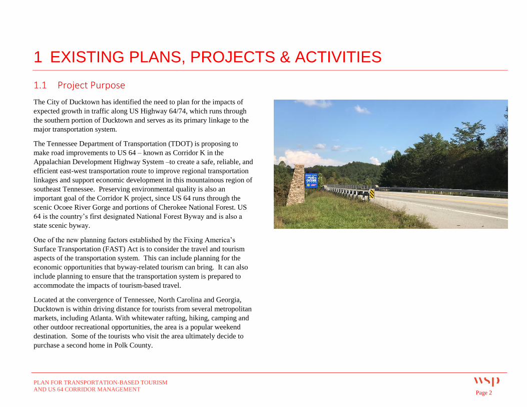
1.1 Project Purpose
The City of Ducktown has identified the need to plan for the impacts of
expected growth in traffic along US Highway 64/74, which runs through
the southern portion of Ducktown and serves as its primary linkage to the
major transportation system.
The Tennessee Department of Transportation (TDOT) is proposing to
make road improvements to US 64 – known as Corridor K in the
Appalachian Development Highway System –to create a safe, reliable, and
efficient east-west transportation route to improve regional transportation
linkages and support economic development in this mountainous region of
southeast Tennessee. Preserving environmental quality is also an
important goal of the Corridor K project, since US 64 runs through the
scenic Ocoee River Gorge and portions of Cherokee National Forest. US
64 is the country’s first designated National Forest Byway and is also a
state scenic byway.
One of the new planning factors established by the Fixing America’s
Surface Transportation (FAST) Act is to consider the travel and tourism
aspects of the transportation system. This can include planning for the
economic opportunities that byway-related tourism can bring. It can also
include planning to ensure that the transportation system is prepared to
accommodate the impacts of tourism-based travel.
Located at the convergence of Tennessee, North Carolina and Georgia,
Ducktown is within driving distance for tourists from several metropolitan
markets, including Atlanta. With whitewater rafting, hiking, camping and
other outdoor recreational opportunities, the area is a popular weekend
destination. Some of the tourists who visit the area ultimately decide to
purchase a second home in Polk County.
PLAN FOR TRANSPORTATION-BASED TOURISM
AND US 64 CORRIDOR MANAGEMENT Page 3
The recent opening of a new Harrah’s casino in Murphy, NC has resulted
in some traffic increase along US 64. This activity has helped to draw the
City’s attention to the importance of planning for the future impacts of
Corridor K. It is also the City’s desire to work with TDOT to plan for
appropriate access and design along this section of US 64. Since the
corridor is commercially zoned, the city anticipates development will occur
in the area as regional tourism and other traffic continues to increase.
Ducktown recognizes the importance of sound planning to ensure that its
economic development goals can be met (1) without compromising the
safety and mobility benefit of Corridor K, and (2) while remaining
consistent with the purpose of the nationally and state-designed scenic
byway.
To support these planning efforts, the City of Ducktown was awarded a
TDOT Community Transportation Planning Grant to analyze the potential
to capitalize on transportation-based tourism and to develop a US 64
corridor plan. The scope of this project includes:
A summary of existing plans, projects and activities in the
Ducktown vicinity;
Identification of transportation-based tourist assets in the area
Recommendations for the City to capitalize on these
transportation assets through improved connections, circulation,
and traveler guidance;
Recommended policies for future development along Ocoee
Scenic Byway (US 64) to meet traveler needs, improve safety for
walking and cycling, and promote consistency with the byway’s
scenic purpose.
PLAN FOR TRANSPORTATION-BASED TOURISM
AND US 64 CORRIDOR MANAGEMENT Page 4
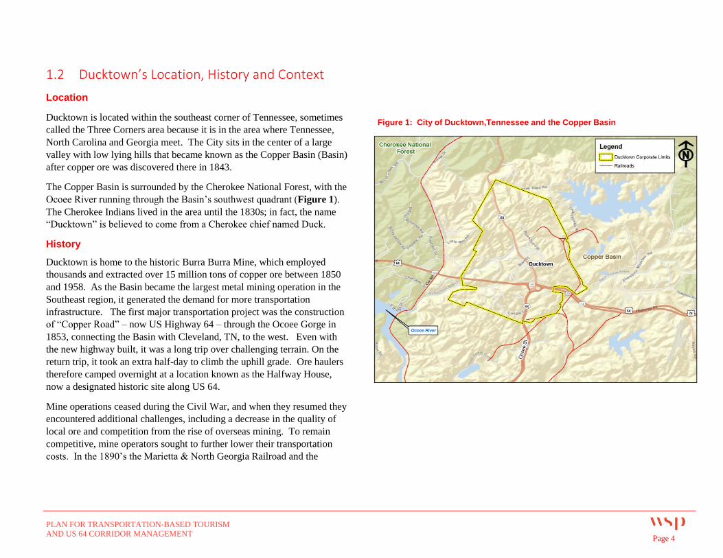
1.2 Ducktown’s Location, History and Context
Location
Ducktown is located within the southeast corner of Tennessee, sometimes
called the Three Corners area because it is in the area where Tennessee,
North Carolina and Georgia meet. The City sits in the center of a large
valley with low lying hills that became known as the Copper Basin (Basin)
after copper ore was discovered there in 1843.
The Copper Basin is surrounded by the Cherokee National Forest, with the
Ocoee River running through the Basin’s southwest quadrant (Figure 1).
The Cherokee Indians lived in the area until the 1830s; in fact, the name
“Ducktown” is believed to come from a Cherokee chief named Duck.
History
Ducktown is home to the historic Burra Burra Mine, which employed
thousands and extracted over 15 million tons of copper ore between 1850
and 1958. As the Basin became the largest metal mining operation in the
Southeast region, it generated the demand for more transportation
infrastructure. The first major transportation project was the construction
of “Copper Road” – now US Highway 64 – through the Ocoee Gorge in
1853, connecting the Basin with Cleveland, TN, to the west. Even with
the new highway built, it was a long trip over challenging terrain. On the
return trip, it took an extra half-day to climb the uphill grade. Ore haulers
therefore camped overnight at a location known as the Halfway House,
now a designated historic site along US 64.
Mine operations ceased during the Civil War, and when they resumed they
encountered additional challenges, including a decrease in the quality of
local ore and competition from the rise of overseas mining. To remain
competitive, mine operators sought to further lower their transportation
costs. In the 1890’s the Marietta & North Georgia Railroad and the
Figure 1: City of Ducktown,Tennessee and the Copper Basin
PLAN FOR TRANSPORTATION-BASED TOURISM
AND US 64 CORRIDOR MANAGEMENT Page 5
Knoxville Southern Railroad were built to connect the Basin to Knoxville,
TN and Marietta, GA. Part of this railroad connection was a difficult
switchback that was eventually replaced in 1898 with an 8,000-foot circle
around Bald Mountain in Farner, TN. This famous “engineering marvel,”
Hiwassee Loop, is a highlight of the Hiwassee River Rail Adventure which
now operates between Etowah and Copperhill, TN.
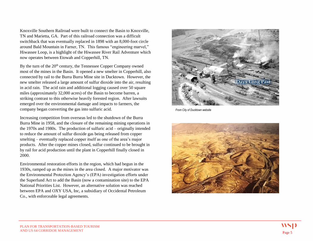
By the turn of the 20th century, the Tennessee Copper Company owned
most of the mines in the Basin. It opened a new smelter in Copperhill, also
connected by rail to the Burra Burra Mine site in Ducktown. However, the
new smelter released a large amount of sulfur dioxide into the air, resulting
in acid rain. The acid rain and additional logging caused over 50 square
miles (approximately 32,000 acres) of the Basin to become barren, a
striking contrast to this otherwise heavily forested region. After lawsuits
emerged over the environmental damage and impacts to farmers, the
company began converting the gas into sulfuric acid.
Increasing competition from overseas led to the shutdown of the Burra
Burra Mine in 1958, and the closure of the remaining mining operations in
the 1970s and 1980s. The production of sulfuric acid – originally intended
to reduce the amount of sulfur dioxide gas being released from copper
smelting – eventually replaced copper itself as one of the area’s major
products. After the copper mines closed, sulfur continued to be brought in
by rail for acid production until the plant in Copperhill finally closed in
2000.
Environmental restoration efforts in the region, which had begun in the
1930s, ramped up as the mines in the area closed. A major motivator was
the Environmental Protection Agency’s (EPA) investigation efforts under
the Superfund Act to add the Basin (now a contamination site) to the EPA
National Priorities List. However, an alternative solution was reached
between EPA and OXY USA, Inc, a subsidiary of Occidental Petroleum
Co., with enforceable legal agreements.
From City of Ducktown website
PLAN FOR TRANSPORTATION-BASED TOURISM
AND US 64 CORRIDOR MANAGEMENT Page 6
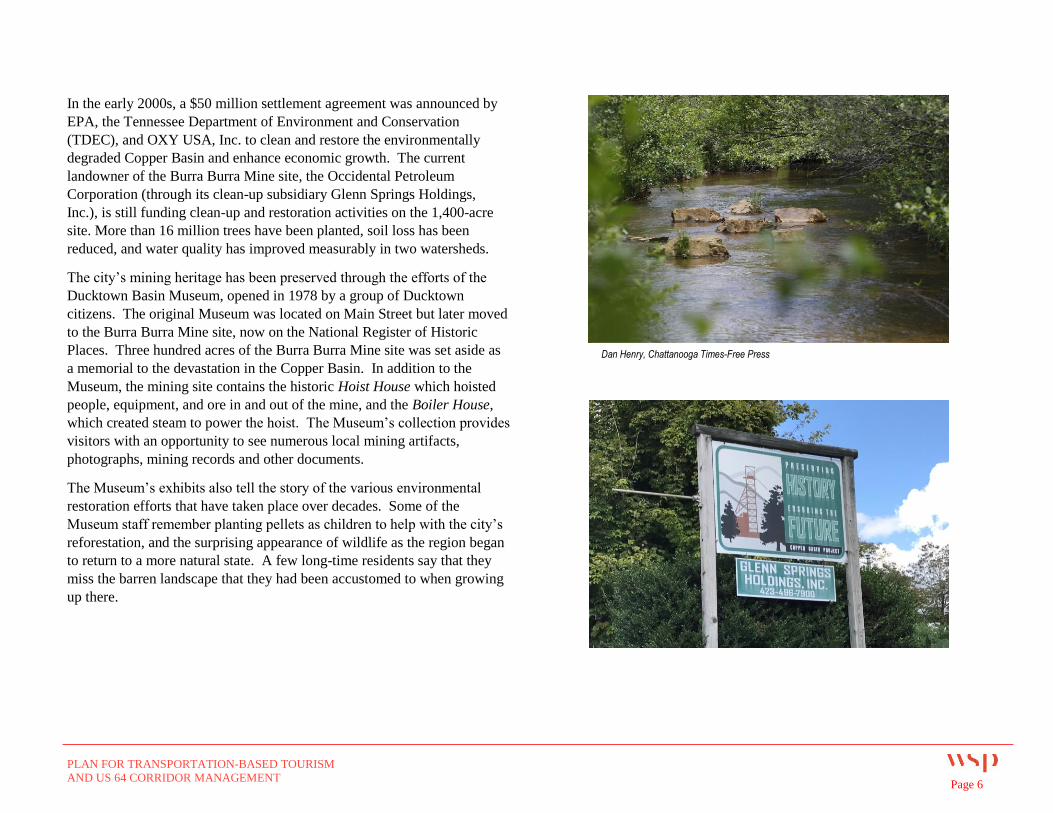
In the early 2000s, a $50 million settlement agreement was announced by
EPA, the Tennessee Department of Environment and Conservation
(TDEC), and OXY USA, Inc. to clean and restore the environmentally
degraded Copper Basin and enhance economic growth. The current
landowner of the Burra Burra Mine site, the Occidental Petroleum
Corporation (through its clean-up subsidiary Glenn Springs Holdings,
Inc.), is still funding clean-up and restoration activities on the 1,400-acre
site. More than 16 million trees have been planted, soil loss has been
reduced, and water quality has improved measurably in two watersheds.
The city’s mining heritage has been preserved through the efforts of the
Ducktown Basin Museum, opened in 1978 by a group of Ducktown
citizens. The original Museum was located on Main Street but later moved
to the Burra Burra Mine site, now on the National Register of Historic
Places. Three hundred acres of the Burra Burra Mine site was set aside as
a memorial to the devastation in the Copper Basin. In addition to the
Museum, the mining site contains the historic Hoist House which hoisted
people, equipment, and ore in and out of the mine, and the Boiler House,
which created steam to power the hoist. The Museum’s collection provides
visitors with an opportunity to see numerous local mining artifacts,
photographs, mining records and other documents.
The Museum’s exhibits also tell the story of the various environmental
restoration efforts that have taken place over decades. Some of the
Museum staff remember planting pellets as children to help with the city’s
reforestation, and the surprising appearance of wildlife as the region began
to return to a more natural state. A few long-time residents say that they
miss the barren landscape that they had been accustomed to when growing
up there.
Dan Henry, Chattanooga Times-Free Press
PLAN FOR TRANSPORTATION-BASED TOURISM
AND US 64 CORRIDOR MANAGEMENT Page 7
Regional Context
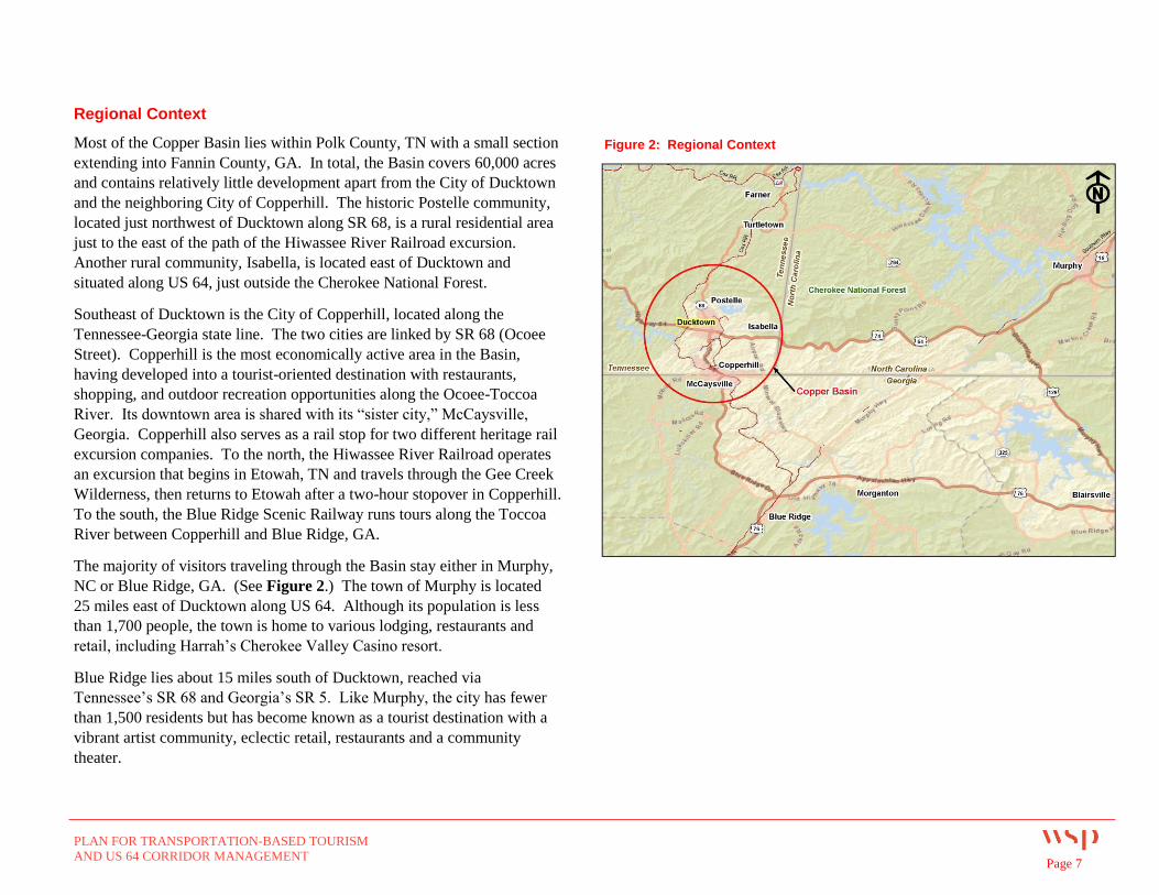
Most of the Copper Basin lies within Polk County, TN with a small section
extending into Fannin County, GA. In total, the Basin covers 60,000 acres
and contains relatively little development apart from the City of Ducktown
and the neighboring City of Copperhill. The historic Postelle community,
located just northwest of Ducktown along SR 68, is a rural residential area
just to the east of the path of the Hiwassee River Railroad excursion.
Another rural community, Isabella, is located east of Ducktown and
situated along US 64, just outside the Cherokee National Forest.
Southeast of Ducktown is the City of Copperhill, located along the
Tennessee-Georgia state line. The two cities are linked by SR 68 (Ocoee
Street). Copperhill is the most economically active area in the Basin,
having developed into a tourist-oriented destination with restaurants,
shopping, and outdoor recreation opportunities along the Ocoee-Toccoa
River. Its downtown area is shared with its “sister city,” McCaysville,
Georgia. Copperhill also serves as a rail stop for two different heritage rail
excursion companies. To the north, the Hiwassee River Railroad operates
an excursion that begins in Etowah, TN and travels through the Gee Creek
Wilderness, then returns to Etowah after a two-hour stopover in Copperhill.
To the south, the Blue Ridge Scenic Railway runs tours along the Toccoa
River between Copperhill and Blue Ridge, GA.
The majority of visitors traveling through the Basin stay either in Murphy,
NC or Blue Ridge, GA. (See Figure 2.) The town of Murphy is located
25 miles east of Ducktown along US 64. Although its population is less
than 1,700 people, the town is home to various lodging, restaurants and
retail, including Harrah’s Cherokee Valley Casino resort.
Blue Ridge lies about 15 miles south of Ducktown, reached via
Tennessee’s SR 68 and Georgia’s SR 5. Like Murphy, the city has fewer
than 1,500 residents but has become known as a tourist destination with a
vibrant artist community, eclectic retail, restaurants and a community
theater.
Figure 2: Regional Context
PLAN FOR TRANSPORTATION-BASED TOURISM
AND US 64 CORRIDOR MANAGEMENT Page 8
1.3 Stakeholder Input
In the first stage of this study, the project team spoke with Ducktown city
staff, the Tennessee Department of Transportation (TDOT), the Southeast
Tennessee Development District, US Forest Service, Polk County Chamber
of Commerce, The Lyndhurst Foundation, the Ducktown Basin Museum,
Tennessee Overhill Heritage Association, Southeast Tennessee Tourism
Association, Glenn Springs Holdings, Inc., and various local business
owners. These agency and stakeholder interviews provided insight on
Ducktown’s strengths, weaknesses, opportunities, and potential threats in
relation to transportation and tourism, further discussed below.
STRENGTHS
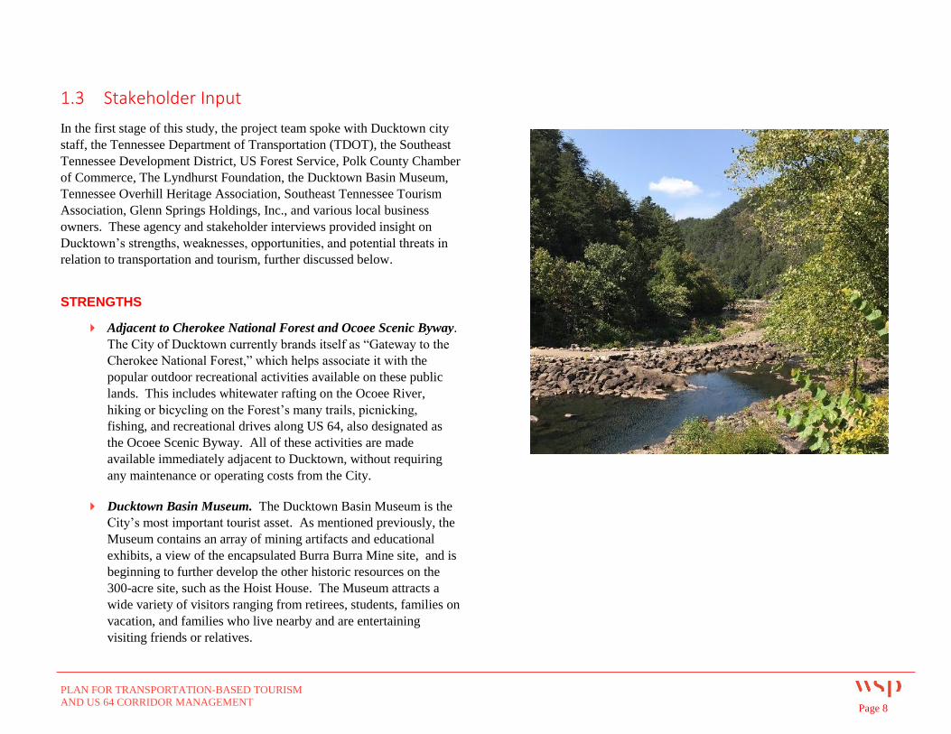
Adjacent to Cherokee National Forest and Ocoee Scenic Byway.
The City of Ducktown currently brands itself as “Gateway to the
Cherokee National Forest,” which helps associate it with the
popular outdoor recreational activities available on these public
lands. This includes whitewater rafting on the Ocoee River,
hiking or bicycling on the Forest’s many trails, picnicking,
fishing, and recreational drives along US 64, also designated as
the Ocoee Scenic Byway. All of these activities are made
available immediately adjacent to Ducktown, without requiring
any maintenance or operating costs from the City.
Ducktown Basin Museum. The Ducktown Basin Museum is the
City’s most important tourist asset. As mentioned previously, the
Museum contains an array of mining artifacts and educational
exhibits, a view of the encapsulated Burra Burra Mine site, and is
beginning to further develop the other historic resources on the
300-acre site, such as the Hoist House. The Museum attracts a
wide variety of visitors ranging from retirees, students, families on
vacation, and families who live nearby and are entertaining
visiting friends or relatives.
PLAN FOR TRANSPORTATION-BASED TOURISM
AND US 64 CORRIDOR MANAGEMENT Page 9
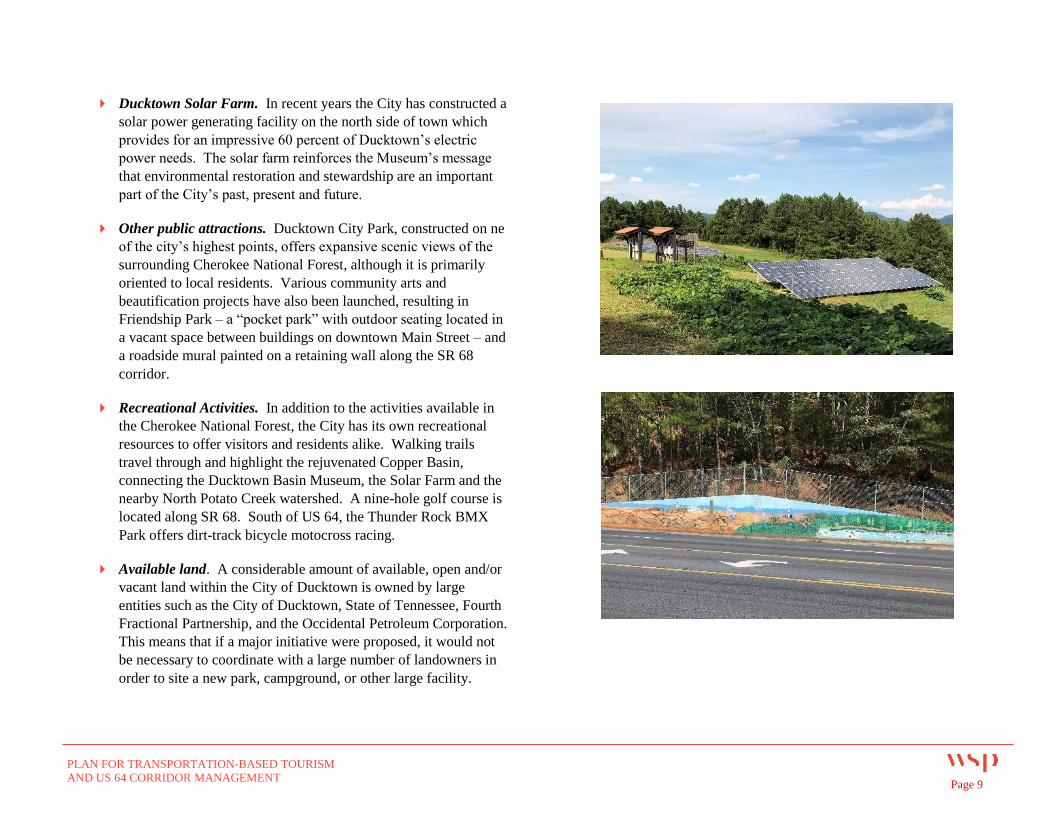
Ducktown Solar Farm. In recent years the City has constructed a
solar power generating facility on the north side of town which
provides for an impressive 60 percent of Ducktown’s electric
power needs. The solar farm reinforces the Museum’s message
that environmental restoration and stewardship are an important
part of the City’s past, present and future.
Other public attractions. Ducktown City Park, constructed on ne
of the city’s highest points, offers expansive scenic views of the
surrounding Cherokee National Forest, although it is primarily
oriented to local residents. Various community arts and
beautification projects have also been launched, resulting in
Friendship Park – a “pocket park” with outdoor seating located in
a vacant space between buildings on downtown Main Street – and
a roadside mural painted on a retaining wall along the SR 68
corridor.
Recreational Activities. In addition to the activities available in
the Cherokee National Forest, the City has its own recreational
resources to offer visitors and residents alike. Walking trails
travel through and highlight the rejuvenated Copper Basin,
connecting the Ducktown Basin Museum, the Solar Farm and the
nearby North Potato Creek watershed. A nine-hole golf course is
located along SR 68. South of US 64, the Thunder Rock BMX
Park offers dirt-track bicycle motocross racing.
Available land. A considerable amount of available, open and/or
vacant land within the City of Ducktown is owned by large
entities such as the City of Ducktown, State of Tennessee, Fourth
Fractional Partnership, and the Occidental Petroleum Corporation.
This means that if a major initiative were proposed, it would not
be necessary to coordinate with a large number of landowners in
order to site a new park, campground, or other large facility.
PLAN FOR TRANSPORTATION-BASED TOURISM
AND US 64 CORRIDOR MANAGEMENT Page 10
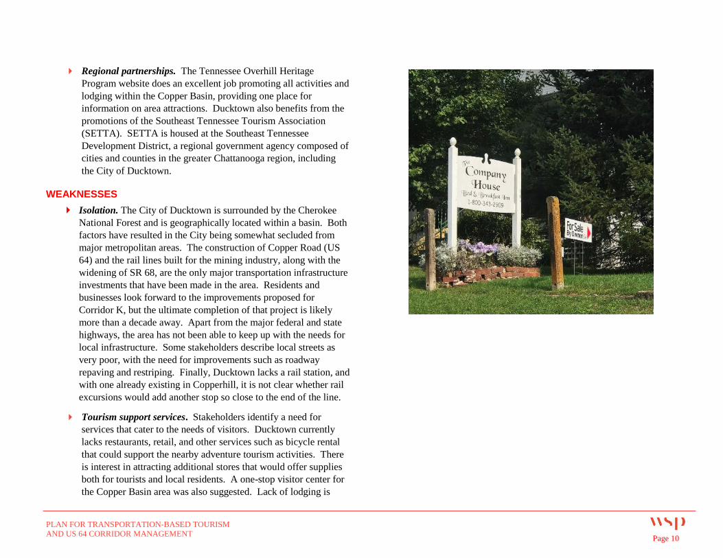
Regional partnerships. The Tennessee Overhill Heritage
Program website does an excellent job promoting all activities and
lodging within the Copper Basin, providing one place for
information on area attractions. Ducktown also benefits from the
promotions of the Southeast Tennessee Tourism Association
(SETTA). SETTA is housed at the Southeast Tennessee
Development District, a regional government agency composed of
cities and counties in the greater Chattanooga region, including
the City of Ducktown.
WEAKNESSES
Isolation. The City of Ducktown is surrounded by the Cherokee
National Forest and is geographically located within a basin. Both
factors have resulted in the City being somewhat secluded from
major metropolitan areas. The construction of Copper Road (US
64) and the rail lines built for the mining industry, along with the
widening of SR 68, are the only major transportation infrastructure
investments that have been made in the area. Residents and
businesses look forward to the improvements proposed for
Corridor K, but the ultimate completion of that project is likely
more than a decade away. Apart from the major federal and state
highways, the area has not been able to keep up with the needs for
local infrastructure. Some stakeholders describe local streets as
very poor, with the need for improvements such as roadway
repaving and restriping. Finally, Ducktown lacks a rail station, and
with one already existing in Copperhill, it is not clear whether rail
excursions would add another stop so close to the end of the line.
Tourism support services. Stakeholders identify a need for
services that cater to the needs of visitors. Ducktown currently
lacks restaurants, retail, and other services such as bicycle rental
that could support the nearby adventure tourism activities. There
is interest in attracting additional stores that would offer supplies
both for tourists and local residents. A one-stop visitor center for
the Copper Basin area was also suggested. Lack of lodging is
PLAN FOR TRANSPORTATION-BASED TOURISM
AND US 64 CORRIDOR MANAGEMENT Page 11
frequently cited as a challenge for drawing visitors to the
Ducktown area. More campgrounds, cabins, and short-term
rentals by homeowners are viewed as the best answer to this need.
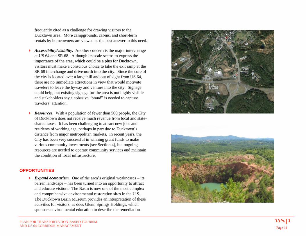
Accessibility/visibility. Another concern is the major interchange
at US 64 and SR 68. Although its scale seems to express the
importance of the area, which could be a plus for Ducktown,
visitors must make a conscious choice to take the exit ramp at the
SR 68 interchange and drive north into the city. Since the core of
the city is located over a large hill and out of sight from US 64,
there are no immediate attractions in view that would motivate
travelers to leave the byway and venture into the city. Signage
could help, but existing signage for the area is not highly visible
and stakeholders say a cohesive “brand” is needed to capture
travelers’ attention.
Resources. With a population of fewer than 500 people, the City
of Ducktown does not receive much revenue from local and state-
shared taxes. It has been challenging to attract new jobs and
residents of working age, perhaps in part due to Ducktown’s
distance from major metropolitan markets. In recent years, the
City has been very successful in winning grant funds to make
various community investments (see Section 4), but ongoing
resources are needed to operate community services and maintain
the condition of local infrastructure.
OPPORTUNITIES
Expand ecotourism. One of the area’s original weaknesses – its
barren landscape – has been turned into an opportunity to attract
and educate visitors. The Basin is now one of the most complex
and comprehensive environmental restoration sites in the U.S.
The Ducktown Basin Museum provides an interpretation of these
activities for visitors, as does Glenn Springs Holdings, which
sponsors environmental education to describe the remediation
PLAN FOR TRANSPORTATION-BASED TOURISM
AND US 64 CORRIDOR MANAGEMENT Page 12
efforts to enhance the biological integrity of the area. A cohesive
brand having to do with Ducktown’s history and/or ecotourism
would help market to tourists traveling through the area.
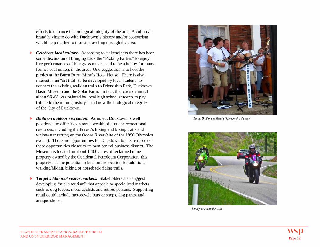
Celebrate local culture. According to stakeholders there has been
some discussion of bringing back the “Picking Parties” to enjoy
live performances of bluegrass music, said to be a hobby for many
former coal miners in the area. One suggestion is to host the
parties at the Burra Burra Mine’s Hoist House. There is also
interest in an “art trail” to be developed by local students to
connect the existing walking trails to Friendship Park, Ducktown
Basin Museum and the Solar Farm. In fact, the roadside mural
along SR-68 was painted by local high school students to pay
tribute to the mining history – and now the biological integrity –
of the City of Ducktown.
Build on outdoor recreation. As noted, Ducktown is well
positioned to offer its visitors a wealth of outdoor recreational
resources, including the Forest’s hiking and biking trails and
whitewater rafting on the Ocoee River (site of the 1996 Olympics
events). There are opportunities for Ducktown to create more of
these opportunities closer to its own central business district. The
Museum is located on about 1,400 acres of reclaimed mine
property owned by the Occidental Petroleum Corporation; this
property has the potential to be a future location for additional
walking/hiking, biking or horseback riding trails.
Target additional visitor markets. Stakeholders also suggest
developing “niche tourism” that appeals to specialized markets
such as dog lovers, motorcyclists and retired persons. Supporting
retail could include motorcycle bars or shops, dog parks, and
antique shops.
Smokymountainrider.com
Barker Brothers at Miner’s Homecoming Festival
PLAN FOR TRANSPORTATION-BASED TOURISM
AND US 64 CORRIDOR MANAGEMENT Page 13
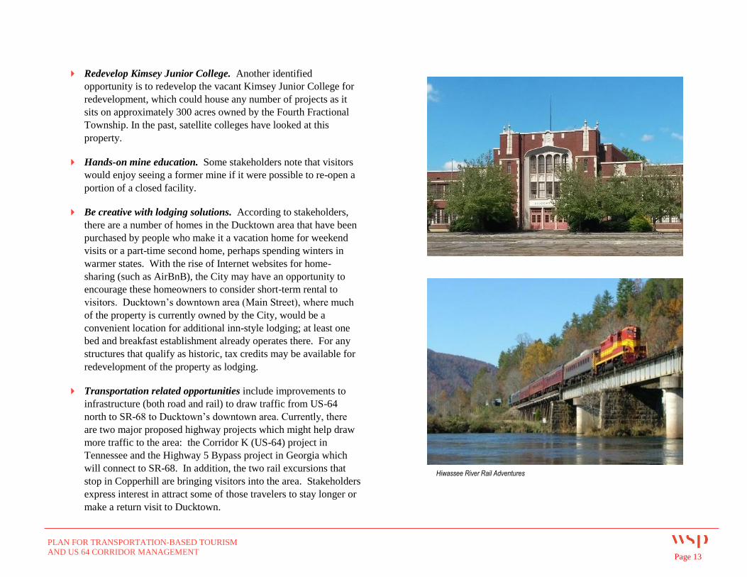
Redevelop Kimsey Junior College. Another identified
opportunity is to redevelop the vacant Kimsey Junior College for
redevelopment, which could house any number of projects as it
sits on approximately 300 acres owned by the Fourth Fractional
Township. In the past, satellite colleges have looked at this
property.
Hands-on mine education. Some stakeholders note that visitors
would enjoy seeing a former mine if it were possible to re-open a
portion of a closed facility.
Be creative with lodging solutions. According to stakeholders,
there are a number of homes in the Ducktown area that have been
purchased by people who make it a vacation home for weekend
visits or a part-time second home, perhaps spending winters in
warmer states. With the rise of Internet websites for home-
sharing (such as AirBnB), the City may have an opportunity to
encourage these homeowners to consider short-term rental to
visitors. Ducktown’s downtown area (Main Street), where much
of the property is currently owned by the City, would be a
convenient location for additional inn-style lodging; at least one
bed and breakfast establishment already operates there. For any
structures that qualify as historic, tax credits may be available for
redevelopment of the property as lodging.
Transportation related opportunities include improvements to
infrastructure (both road and rail) to draw traffic from US-64
north to SR-68 to Ducktown’s downtown area. Currently, there
are two major proposed highway projects which might help draw
more traffic to the area: the Corridor K (US-64) project in
Tennessee and the Highway 5 Bypass project in Georgia which
will connect to SR-68. In addition, the two rail excursions that
stop in Copperhill are bringing visitors into the area. Stakeholders
express interest in attract some of those travelers to stay longer or
make a return visit to Ducktown.
Hiwassee River Rail Adventures
PLAN FOR TRANSPORTATION-BASED TOURISM
AND US 64 CORRIDOR MANAGEMENT Page 14
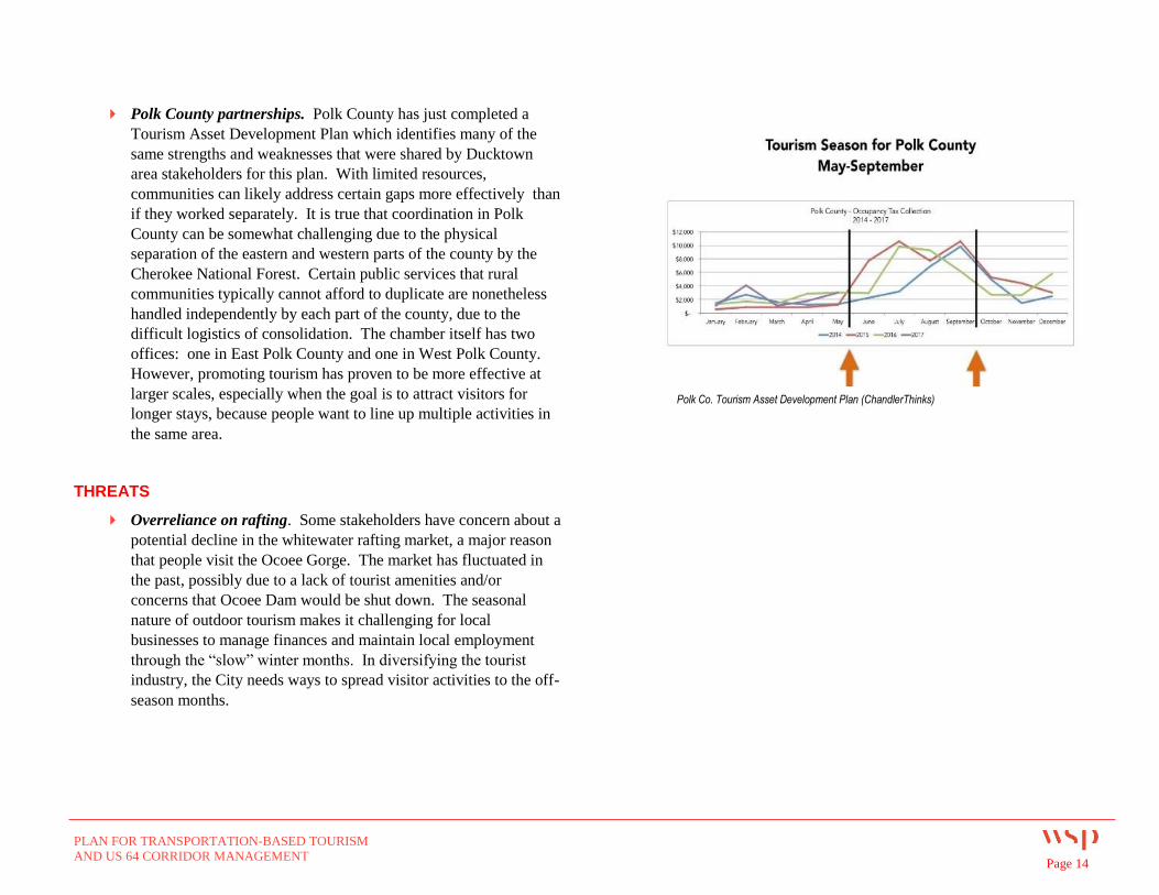
Polk County partnerships. Polk County has just completed a
Tourism Asset Development Plan which identifies many of the
same strengths and weaknesses that were shared by Ducktown
area stakeholders for this plan. With limited resources,
communities can likely address certain gaps more effectively than
if they worked separately. It is true that coordination in Polk
County can be somewhat challenging due to the physical
separation of the eastern and western parts of the county by the
Cherokee National Forest. Certain public services that rural
communities typically cannot afford to duplicate are nonetheless
handled independently by each part of the county, due to the
difficult logistics of consolidation. The chamber itself has two
offices: one in East Polk County and one in West Polk County.
However, promoting tourism has proven to be more effective at
larger scales, especially when the goal is to attract visitors for
longer stays, because people want to line up multiple activities in
the same area.
THREATS
Overreliance on rafting. Some stakeholders have concern about a
potential decline in the whitewater rafting market, a major reason
that people visit the Ocoee Gorge. The market has fluctuated in
the past, possibly due to a lack of tourist amenities and/or
concerns that Ocoee Dam would be shut down. The seasonal
nature of outdoor tourism makes it challenging for local
businesses to manage finances and maintain local employment
through the “slow” winter months. In diversifying the tourist
industry, the City needs ways to spread visitor activities to the off-
season months.
Polk Co. Tourism Asset Development Plan (ChandlerThinks)
PLAN FOR TRANSPORTATION-BASED TOURISM
AND US 64 CORRIDOR MANAGEMENT Page 15
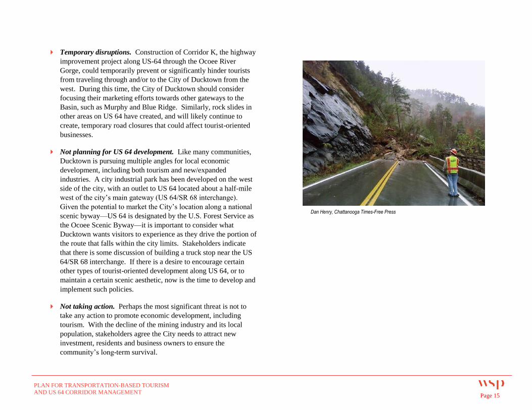
Temporary disruptions. Construction of Corridor K, the highway
improvement project along US-64 through the Ocoee River
Gorge, could temporarily prevent or significantly hinder tourists
from traveling through and/or to the City of Ducktown from the
west. During this time, the City of Ducktown should consider
focusing their marketing efforts towards other gateways to the
Basin, such as Murphy and Blue Ridge. Similarly, rock slides in
other areas on US 64 have created, and will likely continue to
create, temporary road closures that could affect tourist-oriented
businesses.
Not planning for US 64 development. Like many communities,
Ducktown is pursuing multiple angles for local economic
development, including both tourism and new/expanded
industries. A city industrial park has been developed on the west
side of the city, with an outlet to US 64 located about a half-mile
west of the city’s main gateway (US 64/SR 68 interchange).
Given the potential to market the City’s location along a national
scenic byway—US 64 is designated by the U.S. Forest Service as
the Ocoee Scenic Byway—it is important to consider what
Ducktown wants visitors to experience as they drive the portion of
the route that falls within the city limits. Stakeholders indicate
that there is some discussion of building a truck stop near the US
64/SR 68 interchange. If there is a desire to encourage certain
other types of tourist-oriented development along US 64, or to
maintain a certain scenic aesthetic, now is the time to develop and
implement such policies.
Not taking action. Perhaps the most significant threat is not to
take any action to promote economic development, including
tourism. With the decline of the mining industry and its local
population, stakeholders agree the City needs to attract new
investment, residents and business owners to ensure the
community’s long-term survival.
Dan Henry, Chattanooga Times-Free Press
PLAN FOR TRANSPORTATION-BASED TOURISM
AND US 64 CORRIDOR MANAGEMENT Page 16
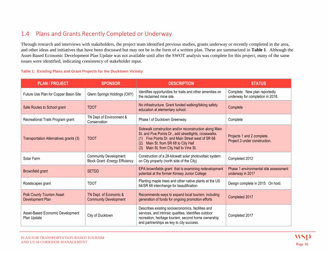
1.4 Plans and Grants Recently Completed or Underway
Through research and interviews with stakeholders, the project team identified previous studies, grants underway or recently completed in the area,
and other ideas and initiatives that have been discussed but may not be in the form of a written plan. These are summarized in Table 1. Although the
Asset-Based Economic Development Plan Update was not available until after the SWOT analysis was complete for this project, many of the same
issues were identified, indicating consistency of stakeholder input.
Table 1: Existing Plans and Grant Projects for the Ducktown Vicinity
PLAN / PROJECT SPONSOR DESCRIPTION STATUS
Future Use Plan for Copper Basin Site Glenn Springs Holdings (OXY) Identifies opportunities for trails and other amenities on the reclaimed mine site.
Complete. New plan reportedly underway for completion in 2018.
Safe Routes to School grant TDOT No infrastructure. Grant funded walking/biking safety education at elementary school .
Complete
Recreational Trails Program grant TN Dept of Environment & Conservation
Phase I of Ducktown Greenway. Complete
Transportation Alternatives grants (3) TDOT
Sidewalk construction and/or reconstruction along Main St. and Five Points Dr., add streetlights, crosswalks. (1) Five Points Dr. and Main Street west of SR 68 (2) Main St. from SR 68 to City Hall (3) Main St. from City Hall to Vine St.
Projects 1 and 2 complete. Project 3 under construction.
Solar Farm Community Development Block Grant -Energy Efficiency
Construction of a 28-kilowatt solar photovoltaic system on City property (north side of the City)
Completed 2012
Brownfield grant SETDD EPA brownfields grant that is examining redevelopment potential at the former Kimsey Junior College
Phase 1 environmental site assessment underway in 2017
Roadscapes grant TDOT Planting maple trees and other native plants at the US 64/SR 68 interchange for beautification
Design complete in 2015. On hold.
Polk County Tourism Asset Development Plan
TN Dept. of Economic & Community Development
Recommends ways to expand local tourism, including generation of funds for ongoing promotion efforts
Completed 2017
Asset-Based Economic Development Plan Update
City of Ducktown
Describes existing socioeconomics, facilities and services, and intrinsic qualities. Identifies outdoor recreation, heritage tourism, second home ownership and partnerships as key to city success.
Completed 2017
PLAN FOR TRANSPORTATION-BASED TOURISM
AND US 64 CORRIDOR MANAGEMENT Page 17
1.5 Existing Development Patterns
Land Use and Zoning Regulations
In its zoning ordinance, the City of Ducktown promulgates permitted land
uses, prohibited land uses, and land uses permitted on appeal for properties
in each district. Each zoning district also establishes yard area, lot width,
height, parking, access control, and signage requirements for each
property.
The Ducktown zoning ordinance provides for six designated land use
districts in the city:
Central Business District: Established to provide for the
placement of retail and service businesses. It is envisioned that the
Central Business District will contain businesses within close
proximity to each other, and to generate significant pedestrian
traffic.
Highway Commercial: Intended for amusement, specialized
sales, and travel accommodations to serve vehicle travelers. Lot
sizes and development standards in the Highway Commercial
District will be of sufficient size to allow for the free movement of
traffic to continue unimpeded.
Industrial: Intended for the location of manufacturing/assembly
plants, processing, storage, warehousing, and distribution. The
Industrial Zoning District is designed for most of the noise, odor,
dust, and glare of operations to be confined within their buildings,
with limited interaction with adjoining residential or commercial
districts.
Low Density Residential: Intended for single family residential
dwellings. Located in areas with relatively low population
densities, the Low Density Residential District is designed to be
protected from the encroachment of adjoining districts that contain
land uses incompatible to a residential environment.
PLAN FOR TRANSPORTATION-BASED TOURISM
AND US 64 CORRIDOR MANAGEMENT Page 18
Medium Density Residential: Intended for a combination of single
family and multifamily residential dwellings in areas with medium
population densities. A key goal of land use regulation in the
Medium Density Residential District is to prevent overcrowded
buildings, traffic congestion, and overburdened sanitary facilities.
Single- and two-family dwellings are permitted in the Medium
Residential District, as well as bed and breakfasts. The Ducktown
zoning ordinance provides an area requirement of 15,000 square feet
for lots containing two dwelling units (20,000 square feet for lots on
septic), with an additional 5,000 square feet for each additional unit.
High Density Residential: Intended for a combination of single
family and multifamily residential dwellings in areas with high
population densities. A key goal of land use regulation in the High
Density Residential District is to prevent overcrowded buildings,
traffic congestion, and overburdened sanitary facilities. The primary
distinctions between the High Density Residential and Medium
Density Residential District are the permitted uses and area
requirements that promote greater density in the High Density
Residential District. The High Density Residential District allows for
the same uses as allowed in the Medium Density Residential District.
It also allows for multi-family dwellings and single-wide
manufactured homes on single lots. The Ducktown zoning ordinance
provides an area requirement of 10,000 square feet for lots
containing two dwelling units (25,000 square feet for lots on septic),
with an additional 5,000 square feet for each additional unit.
PLAN FOR TRANSPORTATION-BASED TOURISM
AND US 64 CORRIDOR MANAGEMENT Page 19
Existing Land Use and Zoning
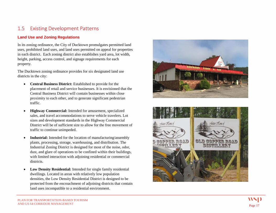
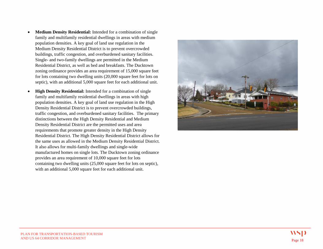
As identified earlier, the City includes a significant amount of undeveloped
land and vacant properties such as the commercial buildings in the
northwest quadrant of the US 64/SR 68 interchange (a former motel and a
tanning salon/video store). On the far north side of Ducktown, the former
site of Kimsey Junior College is being evaluated for potential
redevelopment. The City also owns several vacant or undeveloped
properties along Main Street.
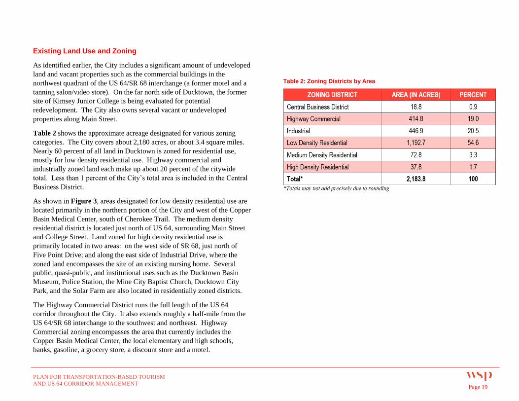
Table 2 shows the approximate acreage designated for various zoning
categories. The City covers about 2,180 acres, or about 3.4 square miles.
Nearly 60 percent of all land in Ducktown is zoned for residential use,
mostly for low density residential use. Highway commercial and
industrially zoned land each make up about 20 percent of the citywide
total. Less than 1 percent of the City’s total area is included in the Central
Business District.
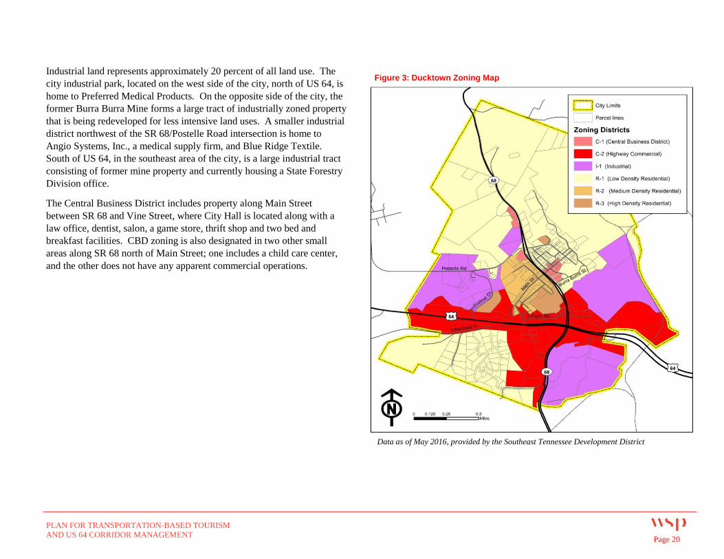
As shown in Figure 3, areas designated for low density residential use are
located primarily in the northern portion of the City and west of the Copper
Basin Medical Center, south of Cherokee Trail. The medium density
residential district is located just north of US 64, surrounding Main Street
and College Street. Land zoned for high density residential use is
primarily located in two areas: on the west side of SR 68, just north of
Five Point Drive; and along the east side of Industrial Drive, where the
zoned land encompasses the site of an existing nursing home. Several
public, quasi-public, and institutional uses such as the Ducktown Basin
Museum, Police Station, the Mine City Baptist Church, Ducktown City
Park, and the Solar Farm are also located in residentially zoned districts.
The Highway Commercial District runs the full length of the US 64
corridor throughout the City. It also extends roughly a half-mile from the
US 64/SR 68 interchange to the southwest and northeast. Highway
Commercial zoning encompasses the area that currently includes the
Copper Basin Medical Center, the local elementary and high schools,
banks, gasoline, a grocery store, a discount store and a motel.
Table 2: Zoning Districts by Area
PLAN FOR TRANSPORTATION-BASED TOURISM
AND US 64 CORRIDOR MANAGEMENT Page 20
Industrial land represents approximately 20 percent of all land use. The
city industrial park, located on the west side of the city, north of US 64, is
home to Preferred Medical Products. On the opposite side of the city, the
former Burra Burra Mine forms a large tract of industrially zoned property
that is being redeveloped for less intensive land uses. A smaller industrial
district northwest of the SR 68/Postelle Road intersection is home to
Angio Systems, Inc., a medical supply firm, and Blue Ridge Textile.
South of US 64, in the southeast area of the city, is a large industrial tract
consisting of former mine property and currently housing a State Forestry
Division office.
The Central Business District includes property along Main Street
between SR 68 and Vine Street, where City Hall is located along with a
law office, dentist, salon, a game store, thrift shop and two bed and
breakfast facilities. CBD zoning is also designated in two other small
areas along SR 68 north of Main Street; one includes a child care center,
and the other does not have any apparent commercial operations.
Figure 3: Ducktown Zoning Map
Data as of May 2016, provided by the Southeast Tennessee Development District
PLAN FOR TRANSPORTATION-BASED TOURISM
AND US 64 CORRIDOR MANAGEMENT Page 21
2 TRANSPORTATION-BASED TOURISM
This section discusses the multiple transportation-based tourism assets that
are located within or within a few miles of Ducktown, and suggests
strategies for the City to capitalize on them.
2.1 Roads and Driving Routes
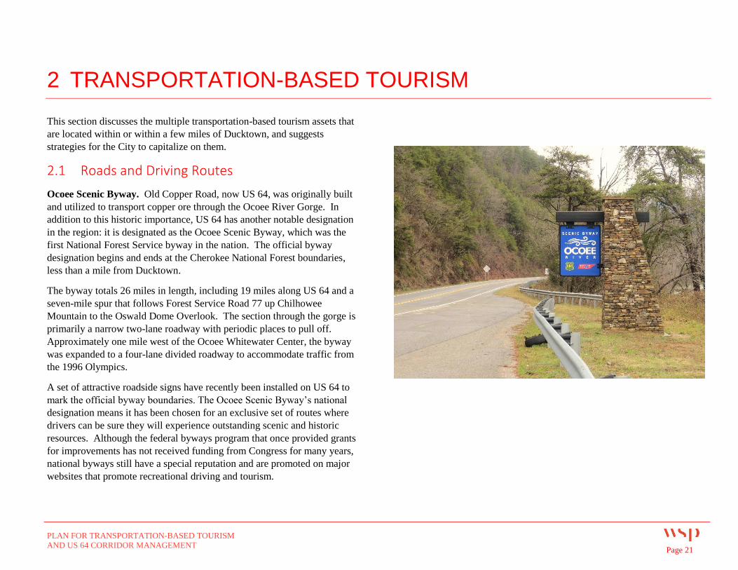
Ocoee Scenic Byway. Old Copper Road, now US 64, was originally built
and utilized to transport copper ore through the Ocoee River Gorge. In
addition to this historic importance, US 64 has another notable designation
in the region: it is designated as the Ocoee Scenic Byway, which was the
first National Forest Service byway in the nation. The official byway
designation begins and ends at the Cherokee National Forest boundaries,
less than a mile from Ducktown.
The byway totals 26 miles in length, including 19 miles along US 64 and a
seven-mile spur that follows Forest Service Road 77 up Chilhowee
Mountain to the Oswald Dome Overlook. The section through the gorge is
primarily a narrow two-lane roadway with periodic places to pull off.
Approximately one mile west of the Ocoee Whitewater Center, the byway
was expanded to a four-lane divided roadway to accommodate traffic from
the 1996 Olympics.
A set of attractive roadside signs have recently been installed on US 64 to
mark the official byway boundaries. The Ocoee Scenic Byway’s national
designation means it has been chosen for an exclusive set of routes where
drivers can be sure they will experience outstanding scenic and historic
resources. Although the federal byways program that once provided grants
for improvements has not received funding from Congress for many years,
national byways still have a special reputation and are promoted on major
websites that promote recreational driving and tourism.
PLAN FOR TRANSPORTATION-BASED TOURISM
AND US 64 CORRIDOR MANAGEMENT Page 22
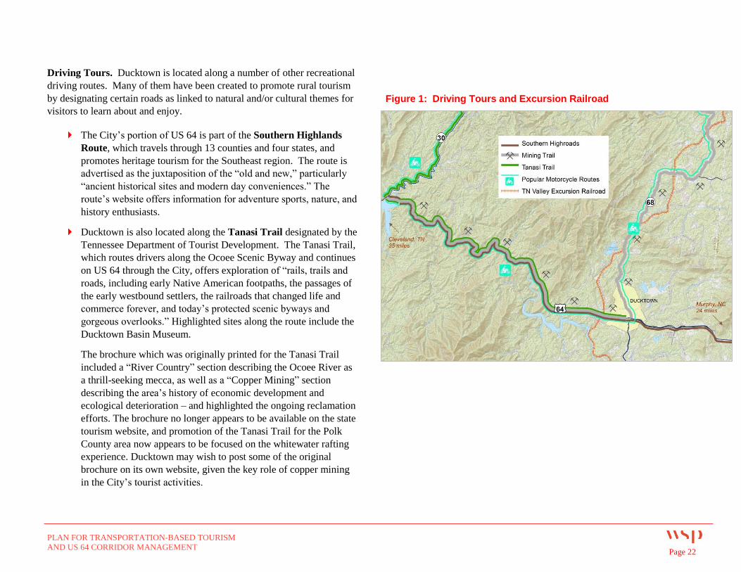
Driving Tours. Ducktown is located along a number of other recreational
driving routes. Many of them have been created to promote rural tourism
by designating certain roads as linked to natural and/or cultural themes for
visitors to learn about and enjoy.
The City’s portion of US 64 is part of the Southern Highlands
Route, which travels through 13 counties and four states, and
promotes heritage tourism for the Southeast region. The route is
advertised as the juxtaposition of the “old and new,” particularly
“ancient historical sites and modern day conveniences.” The
route’s website offers information for adventure sports, nature, and
history enthusiasts.
Ducktown is also located along the Tanasi Trail designated by the
Tennessee Department of Tourist Development. The Tanasi Trail,
which routes drivers along the Ocoee Scenic Byway and continues
on US 64 through the City, offers exploration of “rails, trails and
roads, including early Native American footpaths, the passages of
the early westbound settlers, the railroads that changed life and
commerce forever, and today’s protected scenic byways and
gorgeous overlooks.” Highlighted sites along the route include the
Ducktown Basin Museum.
The brochure which was originally printed for the Tanasi Trail
included a “River Country” section describing the Ocoee River as
a thrill-seeking mecca, as well as a “Copper Mining” section
describing the area’s history of economic development and
ecological deterioration – and highlighted the ongoing reclamation
efforts. The brochure no longer appears to be available on the state
tourism website, and promotion of the Tanasi Trail for the Polk
County area now appears to be focused on the whitewater rafting
experience. Ducktown may wish to post some of the original
brochure on its own website, given the key role of copper mining
in the City’s tourist activities.
Figure 1: Driving Tours and Excursion Railroad
PLAN FOR TRANSPORTATION-BASED TOURISM
AND US 64 CORRIDOR MANAGEMENT Page 23
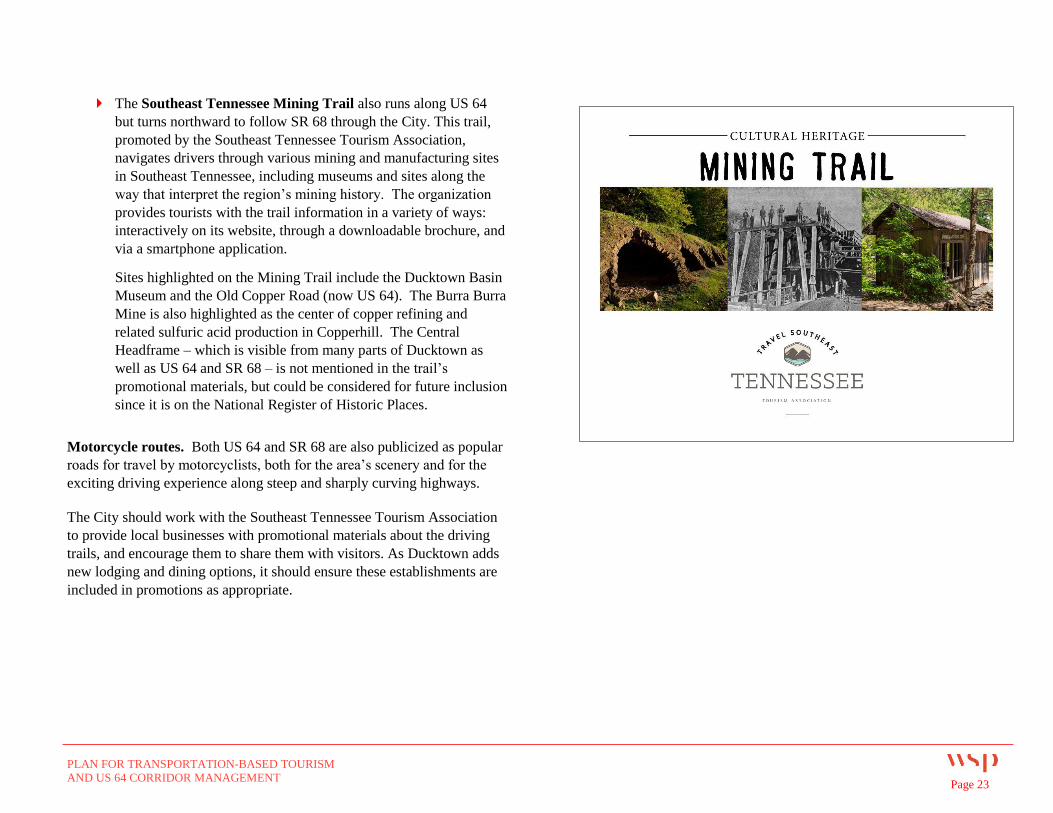
The Southeast Tennessee Mining Trail also runs along US 64
but turns northward to follow SR 68 through the City. This trail,
promoted by the Southeast Tennessee Tourism Association,
navigates drivers through various mining and manufacturing sites
in Southeast Tennessee, including museums and sites along the
way that interpret the region’s mining history. The organization
provides tourists with the trail information in a variety of ways:
interactively on its website, through a downloadable brochure, and
via a smartphone application.
Sites highlighted on the Mining Trail include the Ducktown Basin
Museum and the Old Copper Road (now US 64). The Burra Burra
Mine is also highlighted as the center of copper refining and
related sulfuric acid production in Copperhill. The Central
Headframe – which is visible from many parts of Ducktown as
well as US 64 and SR 68 – is not mentioned in the trail’s
promotional materials, but could be considered for future inclusion
since it is on the National Register of Historic Places.
Motorcycle routes. Both US 64 and SR 68 are also publicized as popular
roads for travel by motorcyclists, both for the area’s scenery and for the
exciting driving experience along steep and sharply curving highways.
The City should work with the Southeast Tennessee Tourism Association
to provide local businesses with promotional materials about the driving
trails, and encourage them to share them with visitors. As Ducktown adds
new lodging and dining options, it should ensure these establishments are
included in promotions as appropriate.
PLAN FOR TRANSPORTATION-BASED TOURISM
AND US 64 CORRIDOR MANAGEMENT Page 24
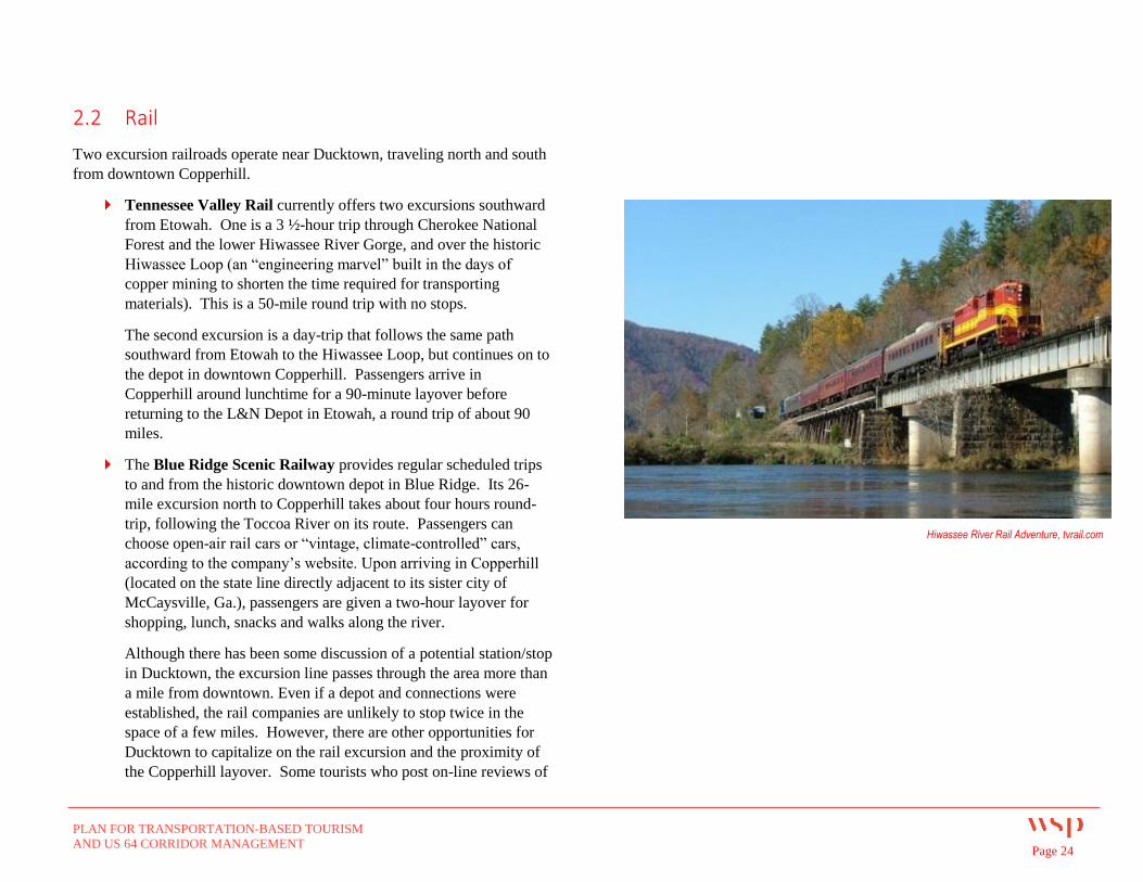
2.2 Rail
Two excursion railroads operate near Ducktown, traveling north and south
from downtown Copperhill.
Tennessee Valley Rail currently offers two excursions southward
from Etowah. One is a 3 ½-hour trip through Cherokee National
Forest and the lower Hiwassee River Gorge, and over the historic
Hiwassee Loop (an “engineering marvel” built in the days of
copper mining to shorten the time required for transporting
materials). This is a 50-mile round trip with no stops.
The second excursion is a day-trip that follows the same path
southward from Etowah to the Hiwassee Loop, but continues on to
the depot in downtown Copperhill. Passengers arrive in
Copperhill around lunchtime for a 90-minute layover before
returning to the L&N Depot in Etowah, a round trip of about 90
miles.
The Blue Ridge Scenic Railway provides regular scheduled trips
to and from the historic downtown depot in Blue Ridge. Its 26-
mile excursion north to Copperhill takes about four hours round-
trip, following the Toccoa River on its route. Passengers can
choose open-air rail cars or “vintage, climate-controlled” cars,
according to the company’s website. Upon arriving in Copperhill
(located on the state line directly adjacent to its sister city of
McCaysville, Ga.), passengers are given a two-hour layover for
shopping, lunch, snacks and walks along the river.
Although there has been some discussion of a potential station/stop
in Ducktown, the excursion line passes through the area more than
a mile from downtown. Even if a depot and connections were
established, the rail companies are unlikely to stop twice in the
space of a few miles. However, there are other opportunities for
Ducktown to capitalize on the rail excursion and the proximity of
the Copperhill layover. Some tourists who post on-line reviews of
Hiwassee River Rail Adventure, tvrail.com
PLAN FOR TRANSPORTATION-BASED TOURISM
AND US 64 CORRIDOR MANAGEMENT Page 25
the rail excursions say they became impatient with the length of
the trip. This is especially true for families with children since the
novelty of a train ride can wear off after a couple of hours.
Ducktown could market itself as another excursion for passengers
who are ready to stop after the first leg of their rail trip. The City
would provide a shuttle pickup in downtown Copperhill, when
passengers are dropped off at lunchtime, to take visitors up to the
Ducktown Basin Museum. Visitors could browse Main Street
before or after touring the museum, then be driven back in the late
afternoon to the rail station where they began their trip. Since the
rail company collects its ticket fare at the beginning of the
excursion, intercepting passengers at Copperhill will not affect its
revenue.
Blue Ridge Scenic Railway passengers may be a better opportunity
for Ducktown to target for an afternoon museum excursion. The
road trip from the museum back to Blue Ridge is only a half-hour,
as opposed to more than an hour’s travel to the Etowah depot.
However, the trip to Etowah could be marketed as an opportunity
for visitors to be driven along the Ocoee Scenic Byway, whose
impressive views can be difficult to appreciate if you are the driver
and must pay attention to the sharp curves.
2.3 River
The Ocoee River is perhaps the best-known tourism asset the City has, and
one that is already well-marketed by the state, the Southeast Tennessee
Tourism Association, Tennessee Overhill, and other partners. Multiple
whitewater rafting companies are located in or at the edge of the City, and
use US 64 to access the river put-in sites.
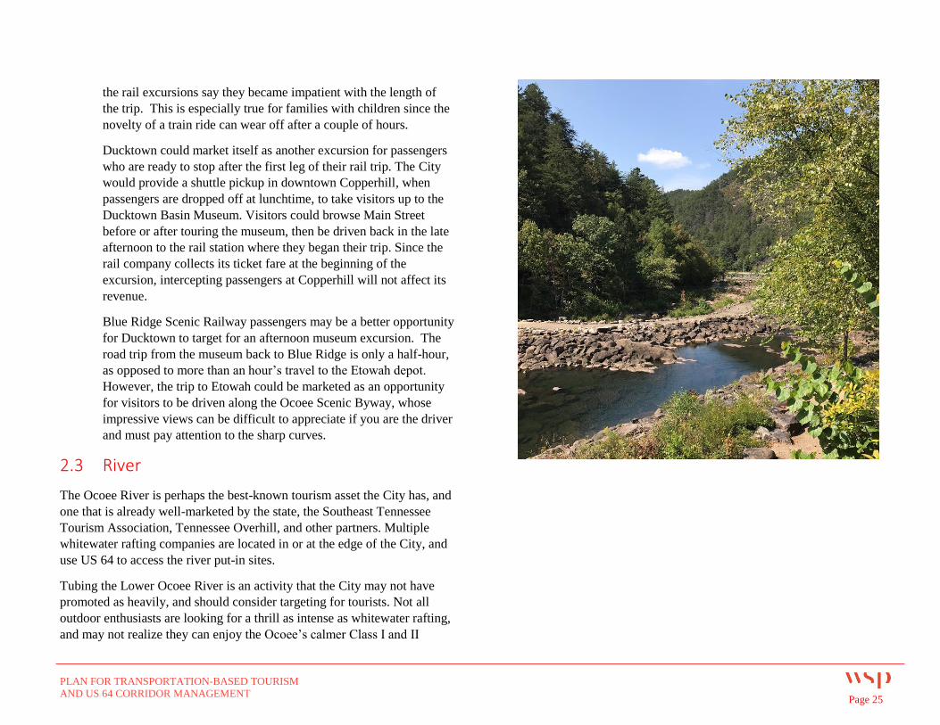
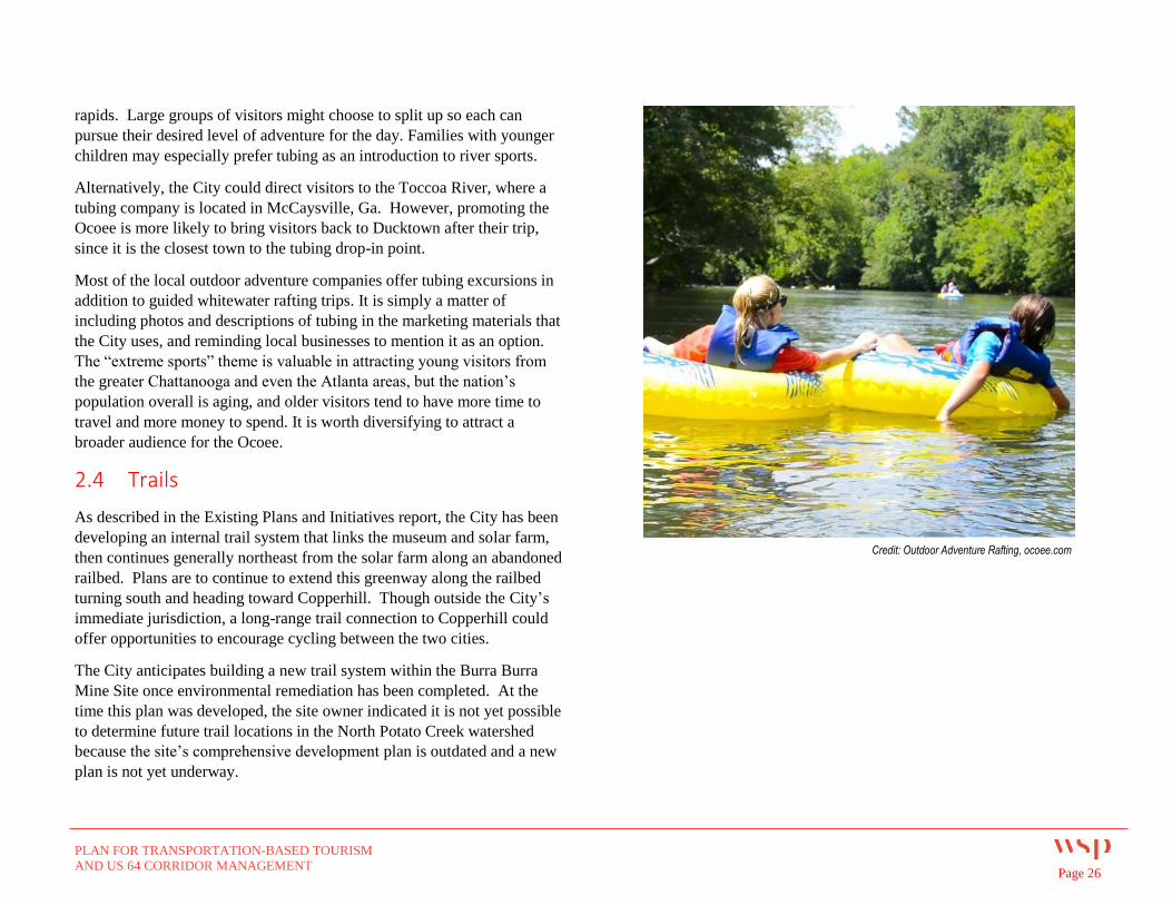
Tubing the Lower Ocoee River is an activity that the City may not have
promoted as heavily, and should consider targeting for tourists. Not all
outdoor enthusiasts are looking for a thrill as intense as whitewater rafting,
and may not realize they can enjoy the Ocoee’s calmer Class I and II
PLAN FOR TRANSPORTATION-BASED TOURISM
AND US 64 CORRIDOR MANAGEMENT Page 26
rapids. Large groups of visitors might choose to split up so each can
pursue their desired level of adventure for the day. Families with younger
children may especially prefer tubing as an introduction to river sports.
Alternatively, the City could direct visitors to the Toccoa River, where a
tubing company is located in McCaysville, Ga. However, promoting the
Ocoee is more likely to bring visitors back to Ducktown after their trip,
since it is the closest town to the tubing drop-in point.
Most of the local outdoor adventure companies offer tubing excursions in
addition to guided whitewater rafting trips. It is simply a matter of
including photos and descriptions of tubing in the marketing materials that
the City uses, and reminding local businesses to mention it as an option.
The “extreme sports” theme is valuable in attracting young visitors from
the greater Chattanooga and even the Atlanta areas, but the nation’s
population overall is aging, and older visitors tend to have more time to
travel and more money to spend. It is worth diversifying to attract a
broader audience for the Ocoee.
2.4 Trails
As described in the Existing Plans and Initiatives report, the City has been
developing an internal trail system that links the museum and solar farm,
then continues generally northeast from the solar farm along an abandoned
railbed. Plans are to continue to extend this greenway along the railbed
turning south and heading toward Copperhill. Though outside the City’s
immediate jurisdiction, a long-range trail connection to Copperhill could
offer opportunities to encourage cycling between the two cities.
The City anticipates building a new trail system within the Burra Burra
Mine Site once environmental remediation has been completed. At the
time this plan was developed, the site owner indicated it is not yet possible
to determine future trail locations in the North Potato Creek watershed
because the site’s comprehensive development plan is outdated and a new
plan is not yet underway.
Credit: Outdoor Adventure Rafting, ocoee.com
PLAN FOR TRANSPORTATION-BASED TOURISM
AND US 64 CORRIDOR MANAGEMENT Page 27
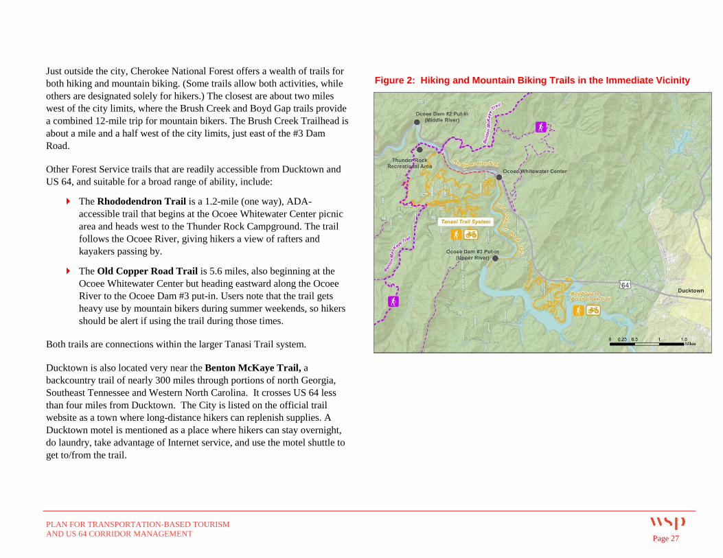
Just outside the city, Cherokee National Forest offers a wealth of trails for
both hiking and mountain biking. (Some trails allow both activities, while
others are designated solely for hikers.) The closest are about two miles
west of the city limits, where the Brush Creek and Boyd Gap trails provide
a combined 12-mile trip for mountain bikers. The Brush Creek Trailhead is
about a mile and a half west of the city limits, just east of the #3 Dam
Road.
Other Forest Service trails that are readily accessible from Ducktown and
US 64, and suitable for a broad range of ability, include:
The Rhododendron Trail is a 1.2-mile (one way), ADA-
accessible trail that begins at the Ocoee Whitewater Center picnic
area and heads west to the Thunder Rock Campground. The trail
follows the Ocoee River, giving hikers a view of rafters and
kayakers passing by.
The Old Copper Road Trail is 5.6 miles, also beginning at the
Ocoee Whitewater Center but heading eastward along the Ocoee
River to the Ocoee Dam #3 put-in. Users note that the trail gets
heavy use by mountain bikers during summer weekends, so hikers
should be alert if using the trail during those times.
Both trails are connections within the larger Tanasi Trail system.
Ducktown is also located very near the Benton McKaye Trail, a
backcountry trail of nearly 300 miles through portions of north Georgia,
Southeast Tennessee and Western North Carolina. It crosses US 64 less
than four miles from Ducktown. The City is listed on the official trail
website as a town where long-distance hikers can replenish supplies. A
Ducktown motel is mentioned as a place where hikers can stay overnight,
do laundry, take advantage of Internet service, and use the motel shuttle to
get to/from the trail.
Figure 2: Hiking and Mountain Biking Trails in the Immediate Vicinity
PLAN FOR TRANSPORTATION-BASED TOURISM
AND US 64 CORRIDOR MANAGEMENT Page 28
3 RECOMMENDATIONS FOR VISITOR ROUTING, SIGNAGE,
AND CONNECTIONS
This section of the plan recommends projects and strategies to help Ducktown
boost its visibility along the US 64 corridor and provide visitors with a clear
set of routes and signage to find their way among its key destinations. It also
recommends new connections and downtown area enhancements to help
attract and keep visitors close to redeveloping businesses along Main Street.
3.1 Gateway at the US 64/SR 68 interchange
The Issue
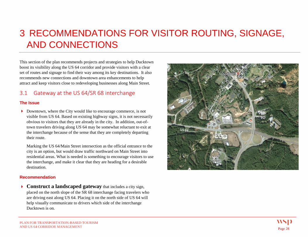
Downtown, where the City would like to encourage commerce, is not
visible from US 64. Based on existing highway signs, it is not necessarily
obvious to visitors that they are already in the city. In addition, out-of-
town travelers driving along US 64 may be somewhat reluctant to exit at
the interchange because of the sense that they are completely departing
their route.
Marking the US 64/Main Street intersection as the official entrance to the
city is an option, but would draw traffic northward on Main Street into
residential areas. What is needed is something to encourage visitors to use
the interchange, and make it clear that they are heading for a desirable
destination.
Recommendation
Construct a landscaped gateway that includes a city sign,
placed on the north slope of the SR 68 interchange facing travelers who
are driving east along US 64. Placing it on the north side of US 64 will
help visually communicate to drivers which side of the interchange
Ducktown is on.
PLAN FOR TRANSPORTATION-BASED TOURISM
AND US 64 CORRIDOR MANAGEMENT Page 29
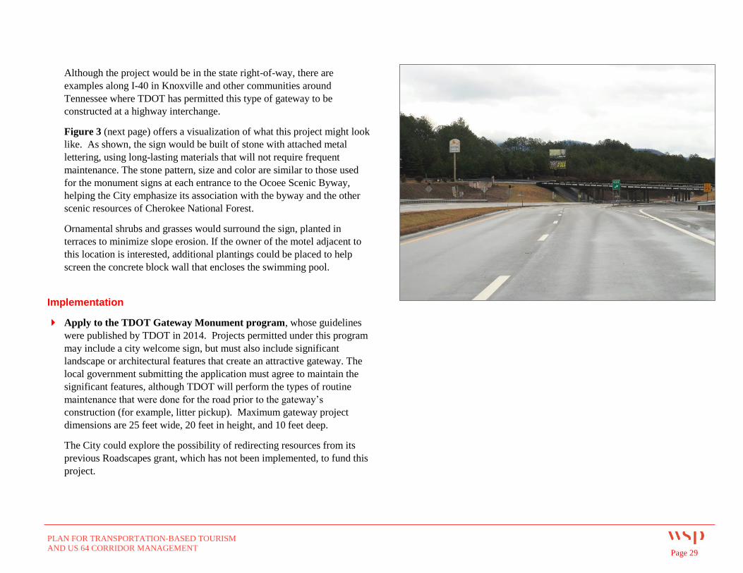
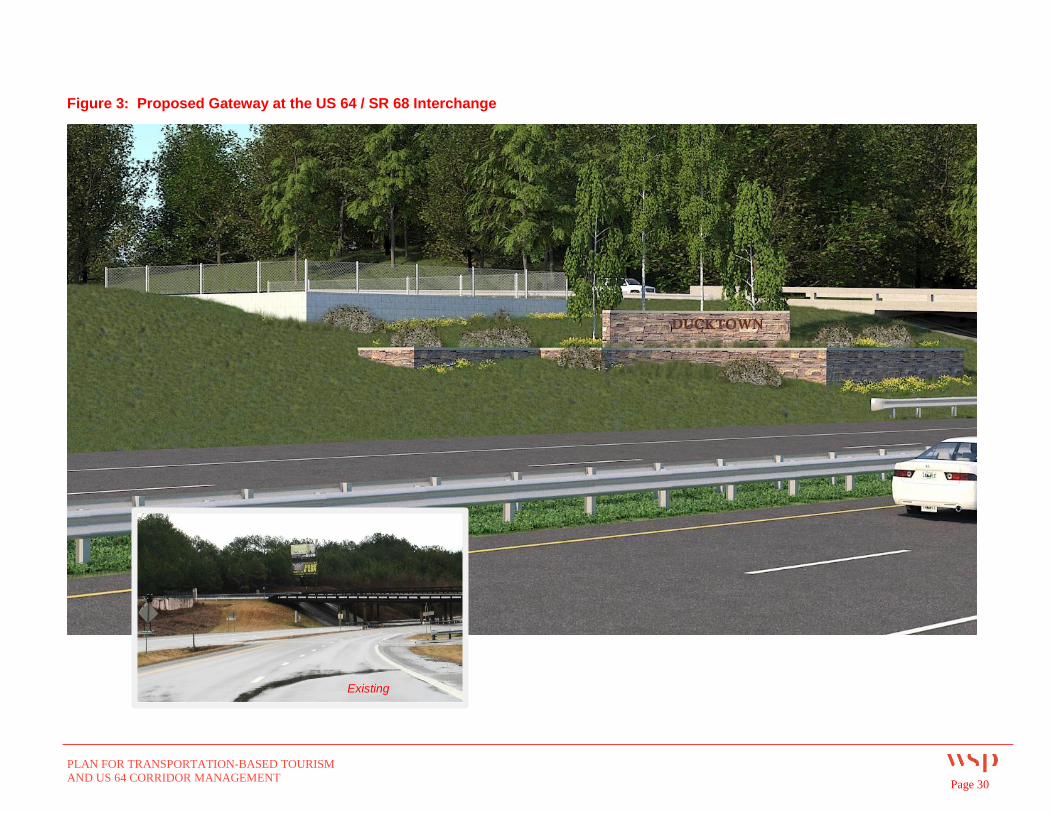
Although the project would be in the state right-of-way, there are
examples along I-40 in Knoxville and other communities around
Tennessee where TDOT has permitted this type of gateway to be
constructed at a highway interchange.
Figure 3 (next page) offers a visualization of what this project might look
like. As shown, the sign would be built of stone with attached metal
lettering, using long-lasting materials that will not require frequent
maintenance. The stone pattern, size and color are similar to those used
for the monument signs at each entrance to the Ocoee Scenic Byway,
helping the City emphasize its association with the byway and the other
scenic resources of Cherokee National Forest.
Ornamental shrubs and grasses would surround the sign, planted in
terraces to minimize slope erosion. If the owner of the motel adjacent to
this location is interested, additional plantings could be placed to help
screen the concrete block wall that encloses the swimming pool.
Implementation
Apply to the TDOT Gateway Monument program, whose guidelines
were published by TDOT in 2014. Projects permitted under this program
may include a city welcome sign, but must also include significant
landscape or architectural features that create an attractive gateway. The
local government submitting the application must agree to maintain the
significant features, although TDOT will perform the types of routine
maintenance that were done for the road prior to the gateway’s
construction (for example, litter pickup). Maximum gateway project
dimensions are 25 feet wide, 20 feet in height, and 10 feet deep.
The City could explore the possibility of redirecting resources from its
previous Roadscapes grant, which has not been implemented, to fund this
project.
PLAN FOR TRANSPORTATION-BASED TOURISM
AND US 64 CORRIDOR MANAGEMENT Page 30
Figure 3: Proposed Gateway at the US 64 / SR 68 Interchange
Existing
PLAN FOR TRANSPORTATION-BASED TOURISM
AND US 64 CORRIDOR MANAGEMENT Page 31
3.2 Improve signage and reduce sign clutter
The Issues
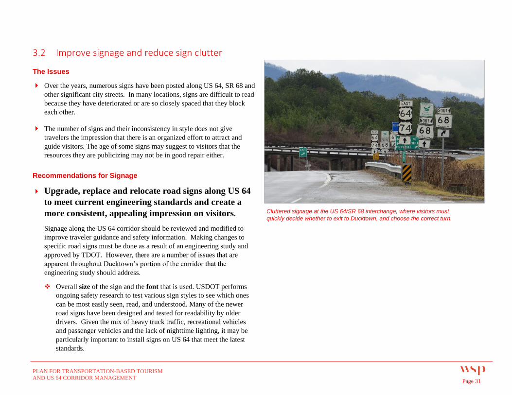
Over the years, numerous signs have been posted along US 64, SR 68 and
other significant city streets. In many locations, signs are difficult to read
because they have deteriorated or are so closely spaced that they block
each other.
The number of signs and their inconsistency in style does not give
travelers the impression that there is an organized effort to attract and
guide visitors. The age of some signs may suggest to visitors that the
resources they are publicizing may not be in good repair either.
Recommendations for Signage
Upgrade, replace and relocate road signs along US 64
to meet current engineering standards and create a
more consistent, appealing impression on visitors.
Signage along the US 64 corridor should be reviewed and modified to
improve traveler guidance and safety information. Making changes to
specific road signs must be done as a result of an engineering study and
approved by TDOT. However, there are a number of issues that are
apparent throughout Ducktown’s portion of the corridor that the
engineering study should address.
Overall size of the sign and the font that is used. USDOT performs
ongoing safety research to test various sign styles to see which ones
can be most easily seen, read, and understood. Many of the newer
road signs have been designed and tested for readability by older
drivers. Given the mix of heavy truck traffic, recreational vehicles
and passenger vehicles and the lack of nighttime lighting, it may be
particularly important to install signs on US 64 that meet the latest
standards.
Cluttered signage at the US 64/SR 68 interchange, where visitors must
quickly decide whether to exit to Ducktown, and choose the correct turn.
PLAN FOR TRANSPORTATION-BASED TOURISM
AND US 64 CORRIDOR MANAGEMENT Page 32
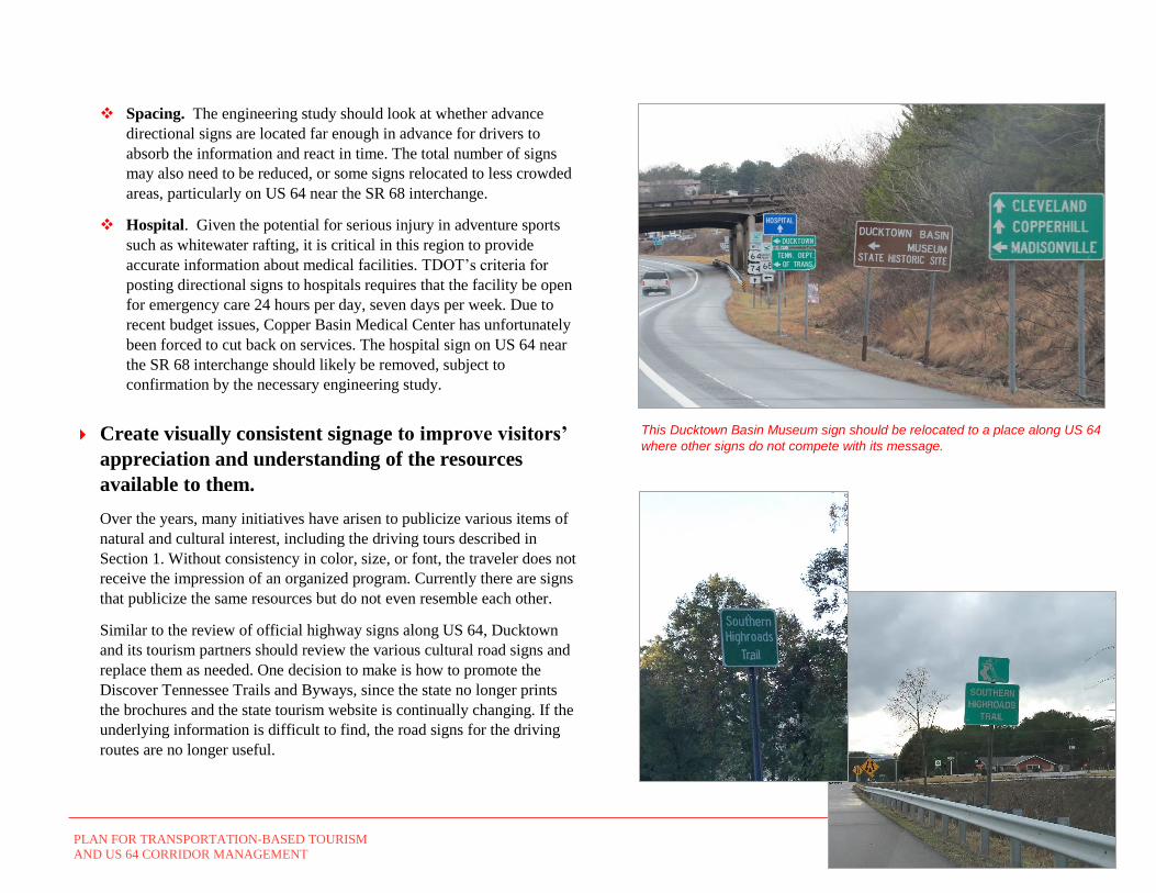
Spacing. The engineering study should look at whether advance
directional signs are located far enough in advance for drivers to
absorb the information and react in time. The total number of signs
may also need to be reduced, or some signs relocated to less crowded
areas, particularly on US 64 near the SR 68 interchange.
Hospital. Given the potential for serious injury in adventure sports
such as whitewater rafting, it is critical in this region to provide
accurate information about medical facilities. TDOT’s criteria for
posting directional signs to hospitals requires that the facility be open
for emergency care 24 hours per day, seven days per week. Due to
recent budget issues, Copper Basin Medical Center has unfortunately
been forced to cut back on services. The hospital sign on US 64 near
the SR 68 interchange should likely be removed, subject to
confirmation by the necessary engineering study.
Create visually consistent signage to improve visitors’
appreciation and understanding of the resources
available to them.
Over the years, many initiatives have arisen to publicize various items of
natural and cultural interest, including the driving tours described in
Section 1. Without consistency in color, size, or font, the traveler does not
receive the impression of an organized program. Currently there are signs
that publicize the same resources but do not even resemble each other.
Similar to the review of official highway signs along US 64, Ducktown
and its tourism partners should review the various cultural road signs and
replace them as needed. One decision to make is how to promote the
Discover Tennessee Trails and Byways, since the state no longer prints
the brochures and the state tourism website is continually changing. If the
underlying information is difficult to find, the road signs for the driving
routes are no longer useful.
This Ducktown Basin Museum sign should be relocated to a place along US 64
where other signs do not compete with its message.
PLAN FOR TRANSPORTATION-BASED TOURISM
AND US 64 CORRIDOR MANAGEMENT Page 33
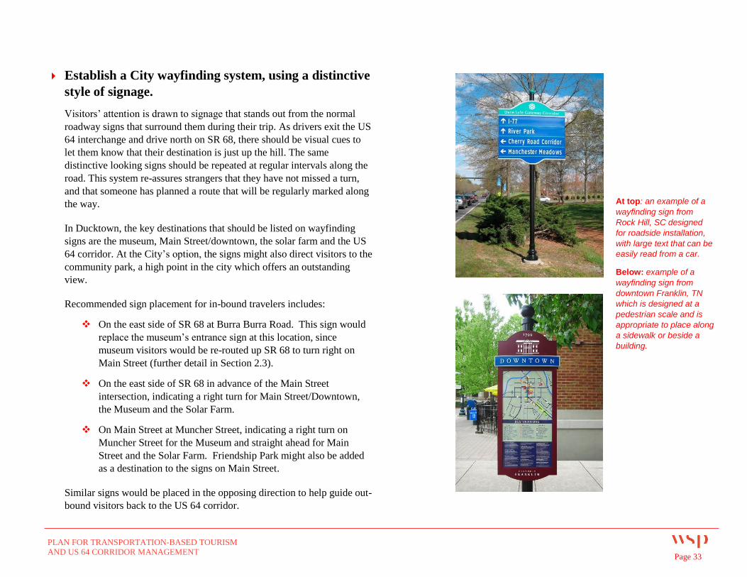
Establish a City wayfinding system, using a distinctive
style of signage.
Visitors’ attention is drawn to signage that stands out from the normal
roadway signs that surround them during their trip. As drivers exit the US
64 interchange and drive north on SR 68, there should be visual cues to
let them know that their destination is just up the hill. The same
distinctive looking signs should be repeated at regular intervals along the
road. This system re-assures strangers that they have not missed a turn,
and that someone has planned a route that will be regularly marked along
the way.
In Ducktown, the key destinations that should be listed on wayfinding
signs are the museum, Main Street/downtown, the solar farm and the US
64 corridor. At the City’s option, the signs might also direct visitors to the
community park, a high point in the city which offers an outstanding
view.
Recommended sign placement for in-bound travelers includes:
On the east side of SR 68 at Burra Burra Road. This sign would
replace the museum’s entrance sign at this location, since
museum visitors would be re-routed up SR 68 to turn right on
Main Street (further detail in Section 2.3).
On the east side of SR 68 in advance of the Main Street
intersection, indicating a right turn for Main Street/Downtown,
the Museum and the Solar Farm.
On Main Street at Muncher Street, indicating a right turn on
Muncher Street for the Museum and straight ahead for Main
Street and the Solar Farm. Friendship Park might also be added
as a destination to the signs on Main Street.
Similar signs would be placed in the opposing direction to help guide out-
bound visitors back to the US 64 corridor.
At top: an example of a
wayfinding sign from
Rock Hill, SC designed
for roadside installation,
with large text that can be
easily read from a car.
Below: example of a
wayfinding sign from
downtown Franklin, TN
which is designed at a
pedestrian scale and is
appropriate to place along
a sidewalk or beside a
building.
PLAN FOR TRANSPORTATION-BASED TOURISM
AND US 64 CORRIDOR MANAGEMENT Page 34
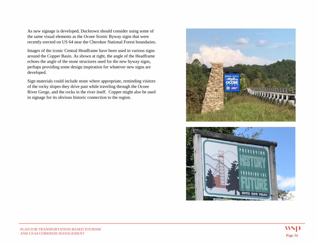
As new signage is developed, Ducktown should consider using some of
the same visual elements as the Ocoee Scenic Byway signs that were
recently erected on US 64 near the Cherokee National Forest boundaries.
Images of the iconic Central Headframe have been used in various signs
around the Copper Basin. As shown at right, the angle of the Headframe
echoes the angle of the stone structures used for the new byway signs,
perhaps providing some design inspiration for whatever new signs are
developed.
Sign materials could include stone where appropriate, reminding visitors
of the rocky slopes they drive past while traveling through the Ocoee
River Gorge, and the rocks in the river itself. Copper might also be used
in signage for its obvious historic connection to the region.
PLAN FOR TRANSPORTATION-BASED TOURISM
AND US 64 CORRIDOR MANAGEMENT Page 35
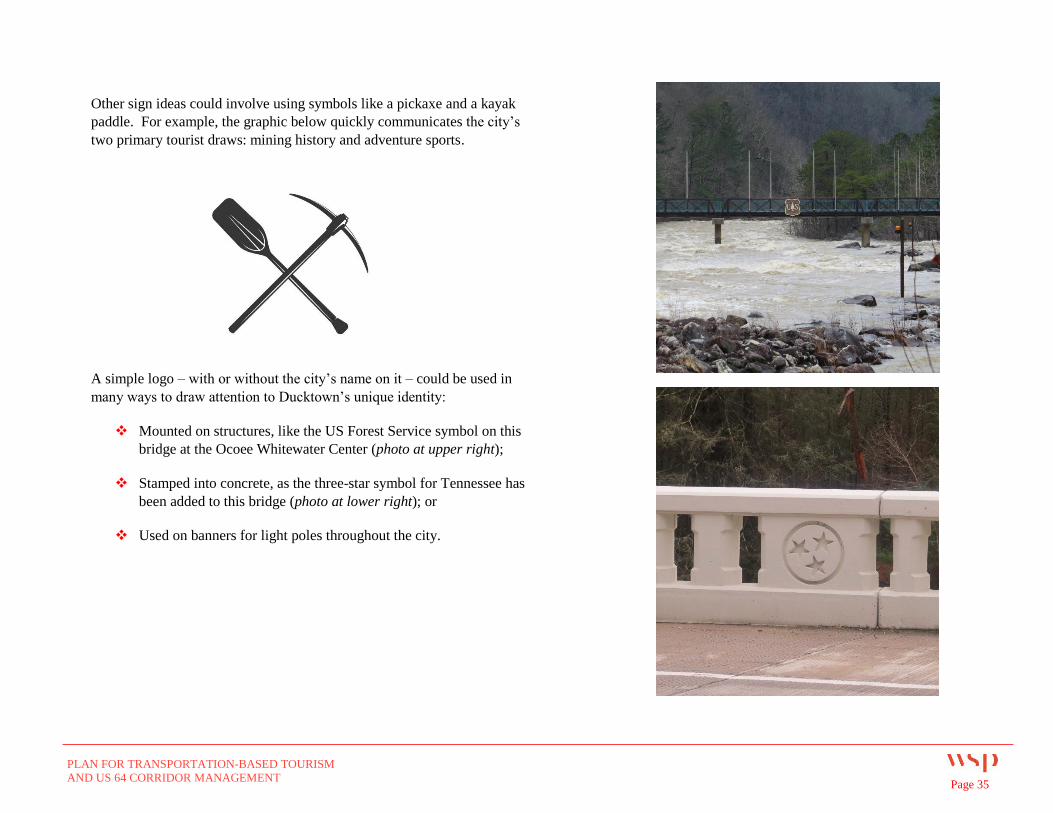
Other sign ideas could involve using symbols like a pickaxe and a kayak
paddle. For example, the graphic below quickly communicates the city’s
two primary tourist draws: mining history and adventure sports.
A simple logo – with or without the city’s name on it – could be used in
many ways to draw attention to Ducktown’s unique identity:
Mounted on structures, like the US Forest Service symbol on this
bridge at the Ocoee Whitewater Center (photo at upper right);
Stamped into concrete, as the three-star symbol for Tennessee has
been added to this bridge (photo at lower right); or
Used on banners for light poles throughout the city.
PLAN FOR TRANSPORTATION-BASED TOURISM
AND US 64 CORRIDOR MANAGEMENT Page 36
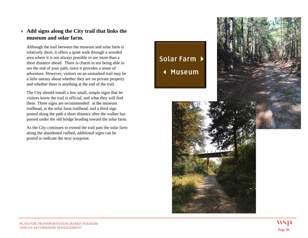
Add signs along the City trail that links the
museum and solar farm.
Although the trail between the museum and solar farm is
relatively short, it offers a quiet walk through a wooded
area where it is not always possible to see more than a
short distance ahead. There is charm in not being able to
see the end of your path, since it provides a sense of
adventure. However, visitors on an unmarked trail may be
a little uneasy about whether they are on private property
and whether there is anything at the end of the trail.
The City should install a few small, simple signs that let
visitors know the trail is official, and what they will find
there. Three signs are recommended: at the museum
trailhead, at the solar farm trailhead, and a third sign
posted along the path a short distance after the walker has
passed under the old bridge heading toward the solar farm.
As the City continues to extend the trail past the solar farm
along the abandoned railbed, additional signs can be
posted to indicate the next waypoint.
PLAN FOR TRANSPORTATION-BASED TOURISM
AND US 64 CORRIDOR MANAGEMENT Page 37
Implementation – Signage Recommendations
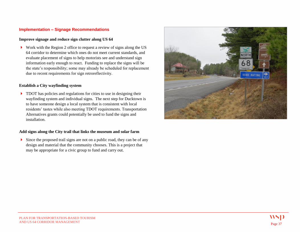
Improve signage and reduce sign clutter along US 64
Work with the Region 2 office to request a review of signs along the US
64 corridor to determine which ones do not meet current standards, and
evaluate placement of signs to help motorists see and understand sign
information early enough to react. Funding to replace the signs will be
the state’s responsibility; some may already be scheduled for replacement
due to recent requirements for sign retroreflectivity.
Establish a City wayfinding system
TDOT has policies and regulations for cities to use in designing their
wayfinding system and individual signs. The next step for Ducktown is
to have someone design a local system that is consistent with local
residents’ tastes while also meeting TDOT requirements. Transportation
Alternatives grants could potentially be used to fund the signs and
installation.
Add signs along the City trail that links the museum and solar farm
Since the proposed trail signs are not on a public road, they can be of any
design and material that the community chooses. This is a project that
may be appropriate for a civic group to fund and carry out.
PLAN FOR TRANSPORTATION-BASED TOURISM
AND US 64 CORRIDOR MANAGEMENT Page 38
3.3 Enhanced connections among key points in and around downtown
The Issues
The City wants to revitalize downtown commerce, especially along the
Main Street corridor. It has taken a number of steps toward that goal,
adopting design standards to help preserve downtown’s historic character,
reconstructing and adding sidewalks along Main Street, and actively
recruiting new businesses to occupy city-owned buildings. Private
property owners have made attractive improvements such as Friendship
Park, a landscaped mini-park created on a vacant lot.
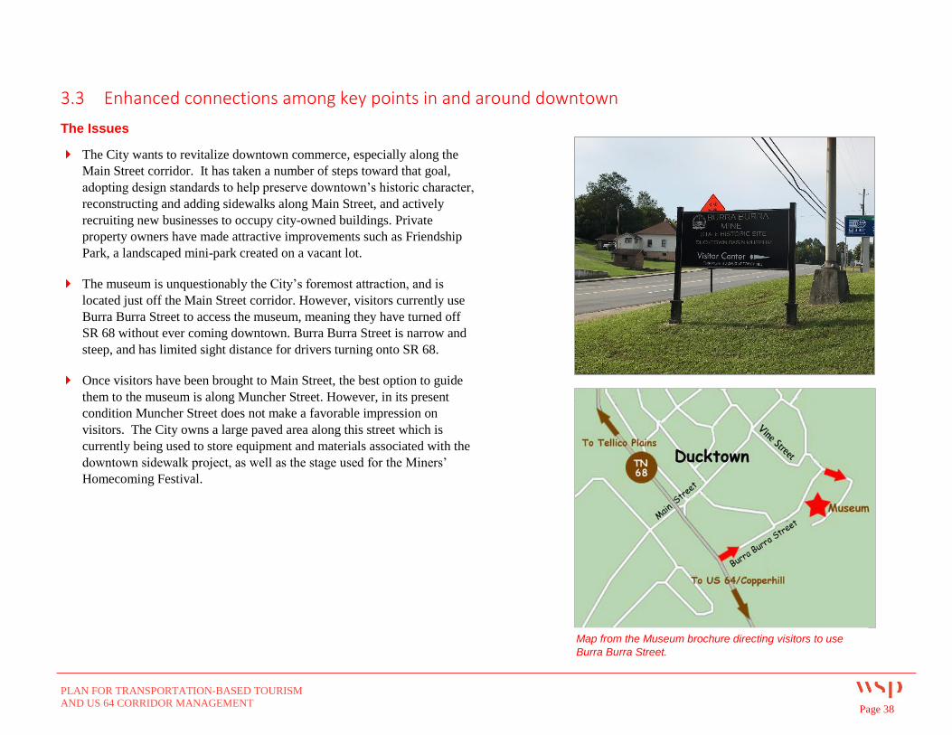
The museum is unquestionably the City’s foremost attraction, and is
located just off the Main Street corridor. However, visitors currently use
Burra Burra Street to access the museum, meaning they have turned off
SR 68 without ever coming downtown. Burra Burra Street is narrow and
steep, and has limited sight distance for drivers turning onto SR 68.
Once visitors have been brought to Main Street, the best option to guide
them to the museum is along Muncher Street. However, in its present
condition Muncher Street does not make a favorable impression on
visitors. The City owns a large paved area along this street which is
currently being used to store equipment and materials associated with the
downtown sidewalk project, as well as the stage used for the Miners’
Homecoming Festival.
Map from the Museum brochure directing visitors to use
Burra Burra Street.
PLAN FOR TRANSPORTATION-BASED TOURISM
AND US 64 CORRIDOR MANAGEMENT Page 39
Recommendations for Enhanced Connections:
Re-route museum traffic to Main
Street, then Muncher Street, in order
to bring visitors downtown.
As mentioned in Section 2.2, the museum sign on
SR 68 at Burra Burra Street would be replaced by a
wayfinding sign pointing the way to downtown
(including the museum and solar farm).
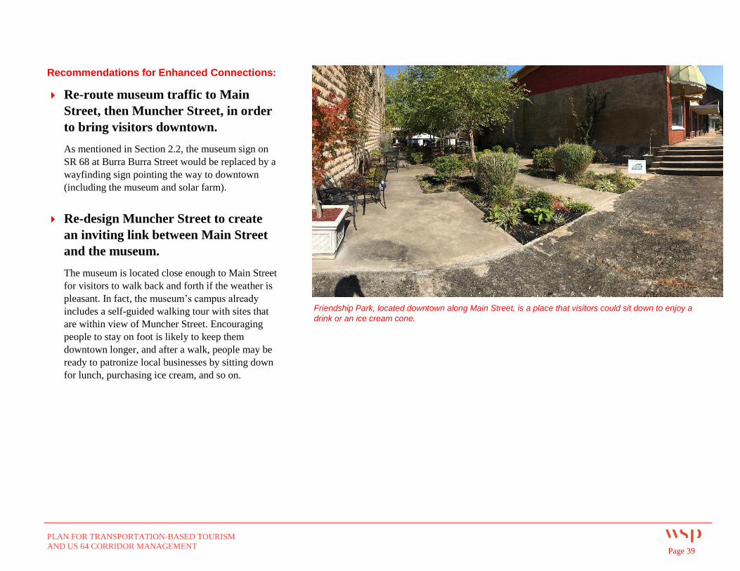
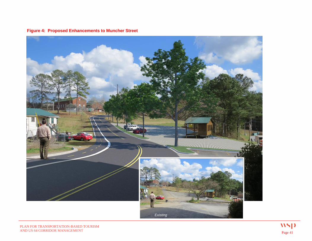
Re-design Muncher Street to create
an inviting link between Main Street
and the museum.
The museum is located close enough to Main Street
for visitors to walk back and forth if the weather is
pleasant. In fact, the museum’s campus already
includes a self-guided walking tour with sites that
are within view of Muncher Street. Encouraging
people to stay on foot is likely to keep them
downtown longer, and after a walk, people may be
ready to patronize local businesses by sitting down
for lunch, purchasing ice cream, and so on.
Friendship Park, located downtown along Main Street, is a place that visitors could sit down to enjoy a
drink or an ice cream cone.
PLAN FOR TRANSPORTATION-BASED TOURISM
AND US 64 CORRIDOR MANAGEMENT Page 40
To serve as the connection, Muncher Street needs
to be designed to safely accommodate both
vehicular traffic and pedestrians and cyclists. It also
needs trees, not just for appearance, but to provide
welcome shade for people walking along the street
in summertime.
The paved area currently being used for equipment
and material storage can be retained for parking.
While there is not typically a shortage of parking at
the museum, it would be wise to plan for it. Based
on its location, the parking area would also
accommodate overflow from the parallel spaces
along Main Street as new businesses continue to
locate downtown.
Larger vehicles such as tour buses and RVs could
also be directed to park in the lot on Muncher
Street. This would allow them to avoid driving the
steep hill going up to the museum, or trying to use
on-street parking along Main Street. If the City
decides to create a shuttle to transport railroad
excursion passengers from Copperhill, this parking
area would also be an ideal location for pickup and
drop-off in Ducktown.
As shown, Muncher Street would be re-designed
and striped to include a multimodal path. The
parking area would be reconstructed using
environmentally friendly pervious pavers and lined
with trees. For a photosimulation, see Figure 4 on
the following page.
PLAN FOR TRANSPORTATION-BASED TOURISM
AND US 64 CORRIDOR MANAGEMENT Page 41
Figure 4: Proposed Enhancements to Muncher Street
Existing
PLAN FOR TRANSPORTATION-BASED TOURISM
AND US 64 CORRIDOR MANAGEMENT Page 42
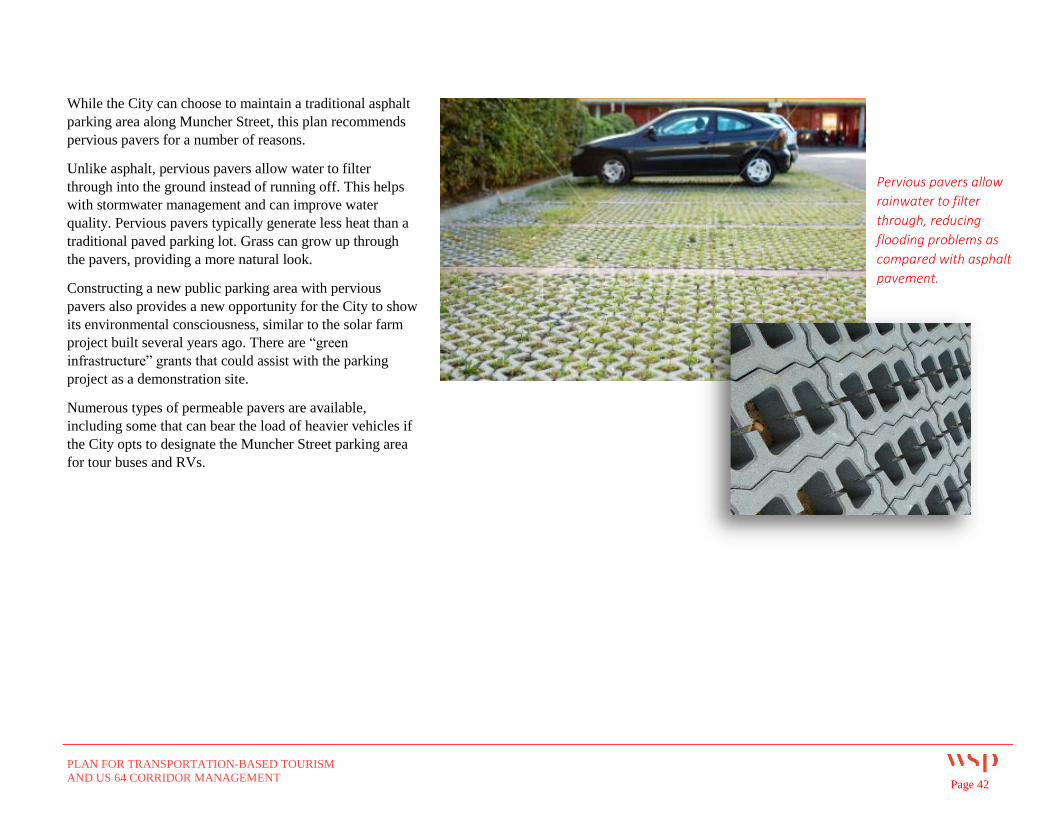
While the City can choose to maintain a traditional asphalt
parking area along Muncher Street, this plan recommends
pervious pavers for a number of reasons.
Unlike asphalt, pervious pavers allow water to filter
through into the ground instead of running off. This helps
with stormwater management and can improve water
quality. Pervious pavers typically generate less heat than a
traditional paved parking lot. Grass can grow up through
the pavers, providing a more natural look.
Constructing a new public parking area with pervious
pavers also provides a new opportunity for the City to show
its environmental consciousness, similar to the solar farm
project built several years ago. There are “green
infrastructure” grants that could assist with the parking
project as a demonstration site.
Numerous types of permeable pavers are available,
including some that can bear the load of heavier vehicles if
the City opts to designate the Muncher Street parking area
for tour buses and RVs.
Pervious pavers allow
rainwater to filter
through, reducing
flooding problems as
compared with asphalt
pavement.
PLAN FOR TRANSPORTATION-BASED TOURISM
AND US 64 CORRIDOR MANAGEMENT Page 43
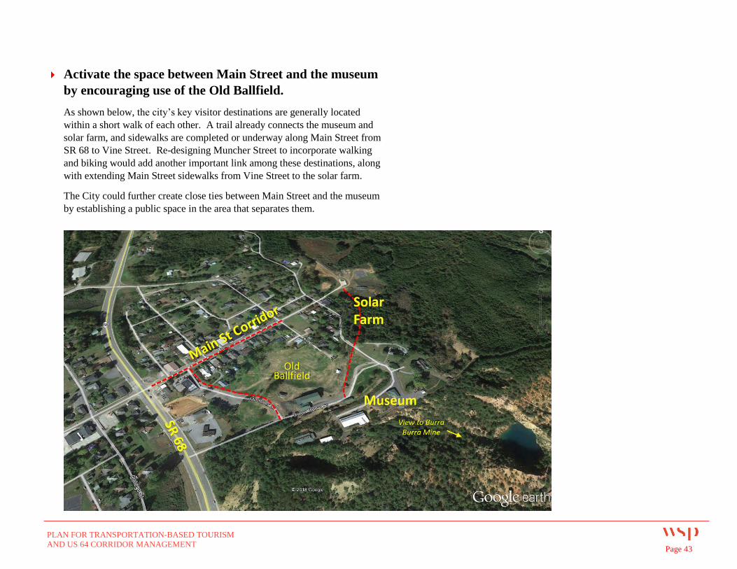
Activate the space between Main Street and the museum
by encouraging use of the Old Ballfield.
As shown below, the city’s key visitor destinations are generally located
within a short walk of each other. A trail already connects the museum and
solar farm, and sidewalks are completed or underway along Main Street from
SR 68 to Vine Street. Re-designing Muncher Street to incorporate walking
and biking would add another important link among these destinations, along
with extending Main Street sidewalks from Vine Street to the solar farm.
The City could further create close ties between Main Street and the museum
by establishing a public space in the area that separates them.
Old Ballfield
PLAN FOR TRANSPORTATION-BASED TOURISM
AND US 64 CORRIDOR MANAGEMENT Page 44
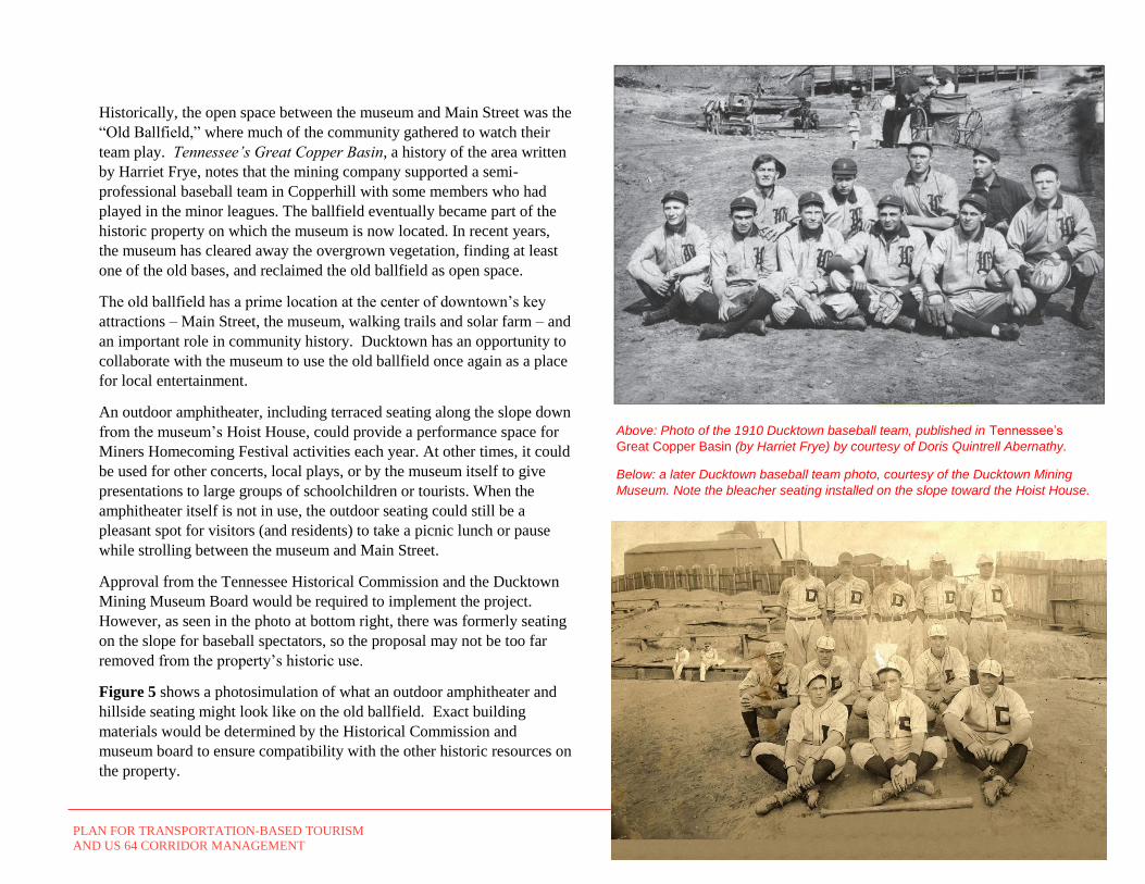
Historically, the open space between the museum and Main Street was the
“Old Ballfield,” where much of the community gathered to watch their
team play. Tennessee’s Great Copper Basin, a history of the area written
by Harriet Frye, notes that the mining company supported a semi-
professional baseball team in Copperhill with some members who had
played in the minor leagues. The ballfield eventually became part of the
historic property on which the museum is now located. In recent years,
the museum has cleared away the overgrown vegetation, finding at least
one of the old bases, and reclaimed the old ballfield as open space.
The old ballfield has a prime location at the center of downtown’s key
attractions – Main Street, the museum, walking trails and solar farm – and
an important role in community history. Ducktown has an opportunity to
collaborate with the museum to use the old ballfield once again as a place
for local entertainment.
An outdoor amphitheater, including terraced seating along the slope down
from the museum’s Hoist House, could provide a performance space for
Miners Homecoming Festival activities each year. At other times, it could
be used for other concerts, local plays, or by the museum itself to give
presentations to large groups of schoolchildren or tourists. When the
amphitheater itself is not in use, the outdoor seating could still be a
pleasant spot for visitors (and residents) to take a picnic lunch or pause
while strolling between the museum and Main Street.
Approval from the Tennessee Historical Commission and the Ducktown
Mining Museum Board would be required to implement the project.
However, as seen in the photo at bottom right, there was formerly seating
on the slope for baseball spectators, so the proposal may not be too far
removed from the property’s historic use.
Figure 5 shows a photosimulation of what an outdoor amphitheater and
hillside seating might look like on the old ballfield. Exact building
materials would be determined by the Historical Commission and
museum board to ensure compatibility with the other historic resources on
the property.
Above: Photo of the 1910 Ducktown baseball team, published in Tennessee’s
Great Copper Basin (by Harriet Frye) by courtesy of Doris Quintrell Abernathy.
Below: a later Ducktown baseball team photo, courtesy of the Ducktown Mining
Museum. Note the bleacher seating installed on the slope toward the Hoist House.
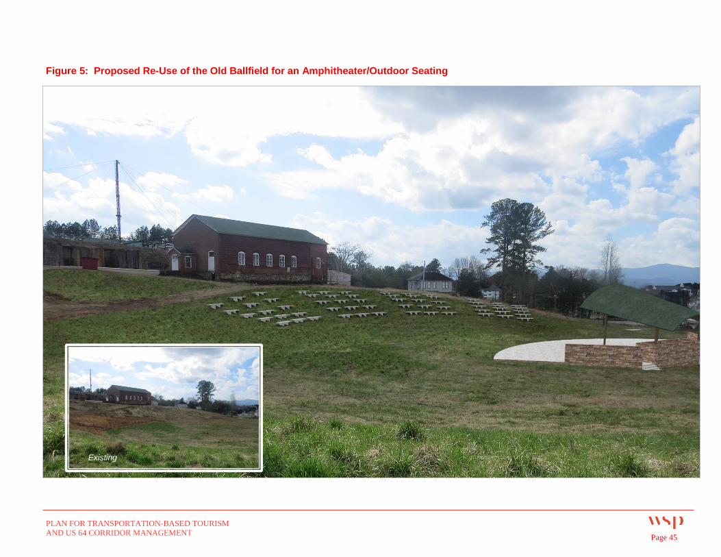
PLAN FOR TRANSPORTATION-BASED TOURISM
AND US 64 CORRIDOR MANAGEMENT Page 45
Figure 5: Proposed Re-Use of the Old Ballfield for an Amphitheater/Outdoor Seating
Existing
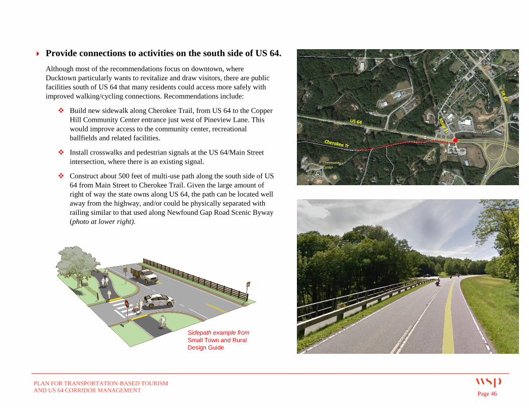
PLAN FOR TRANSPORTATION-BASED TOURISM
AND US 64 CORRIDOR MANAGEMENT Page 46
Provide connections to activities on the south side of US 64.
Although most of the recommendations focus on downtown, where
Ducktown particularly wants to revitalize and draw visitors, there are public
facilities south of US 64 that many residents could access more safely with
improved walking/cycling connections. Recommendations include:
Build new sidewalk along Cherokee Trail, from US 64 to the Copper
Hill Community Center entrance just west of Pineview Lane. This
would improve access to the community center, recreational
ballfields and related facilities.
Install crosswalks and pedestrian signals at the US 64/Main Street
intersection, where there is an existing signal.
Construct about 500 feet of multi-use path along the south side of US
64 from Main Street to Cherokee Trail. Given the large amount of
right of way the state owns along US 64, the path can be located well
away from the highway, and/or could be physically separated with
railing similar to that used along Newfound Gap Road Scenic Byway
(photo at lower right).
Sidepath example from
Small Town and Rural
Design Guide
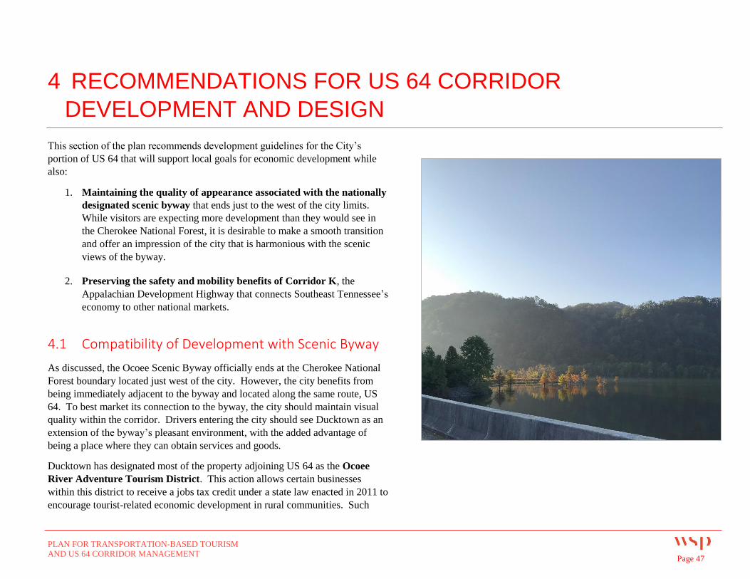
PLAN FOR TRANSPORTATION-BASED TOURISM
AND US 64 CORRIDOR MANAGEMENT Page 47
4 RECOMMENDATIONS FOR US 64 CORRIDOR
DEVELOPMENT AND DESIGN
This section of the plan recommends development guidelines for the City’s
portion of US 64 that will support local goals for economic development while
also:
1. Maintaining the quality of appearance associated with the nationally
designated scenic byway that ends just to the west of the city limits.
While visitors are expecting more development than they would see in
the Cherokee National Forest, it is desirable to make a smooth transition
and offer an impression of the city that is harmonious with the scenic
views of the byway.
2. Preserving the safety and mobility benefits of Corridor K, the
Appalachian Development Highway that connects Southeast Tennessee’s
economy to other national markets.
4.1 Compatibility of Development with Scenic Byway
As discussed, the Ocoee Scenic Byway officially ends at the Cherokee National
Forest boundary located just west of the city. However, the city benefits from
being immediately adjacent to the byway and located along the same route, US
64. To best market its connection to the byway, the city should maintain visual
quality within the corridor. Drivers entering the city should see Ducktown as an
extension of the byway’s pleasant environment, with the added advantage of
being a place where they can obtain services and goods.
Ducktown has designated most of the property adjoining US 64 as the Ocoee
River Adventure Tourism District. This action allows certain businesses
within this district to receive a jobs tax credit under a state law enacted in 2011 to
encourage tourist-related economic development in rural communities. Such

PLAN FOR TRANSPORTATION-BASED TOURISM
AND US 64 CORRIDOR MANAGEMENT Page 48
businesses include restaurants and lodging establishments, and attractions that
make the minimum required capital investment of $500,000. In addition to being
eligible for special tax credits, businesses in certified Adventure Tourism
Districts may also receive promotional support from the state Department of
Tourist Development.
All of the land within the Ocoee River Adventure Tourism District is zoned C-2
Highway Commercial except the parcel where Life Care Center of the Copper
Basin is located, which is zoned R-2 Medium Density Residential. According to
the City’s zoning ordinance, the intent of the C-2 district is to provide services to
travelers and local residents who will typically be accessing the establishment by
vehicle. This classification makes sense in terms of where these uses should be
located within the city, since SR 68 and US 64 are the two major highways.
The Issues
Most of the properties in this district, especially along US 64, enjoy high
visibility from the road. To some degree, they serve as advertisement for the
rest of the city’s attractions. Their appearance will affect drivers’ level of
interest in turning off the highway to visit the rest of the city.
Numerous stakeholders interviewed for this plan identified a need to provide
a greater variety of lodging and dining facilities in the area. However, C-2
zoning does not list hotels, motels or restaurants as permitted uses. The
zoning ordinance says that the city may consider allowing commercial
activities similar to the ones permitted by right, but not unless the Board of
Mayors and Commissioners amend the zoning ordinance to allow them.
The C-2 Highway Commercial zone does permit certain land uses which
likely would detract from the scenic environment desirable to attract visitors.
For example, C-2 permits:
- Sales of building materials, hardware, and garden supplies
- Auto repair and parking
Figure 6: Existing Zoning
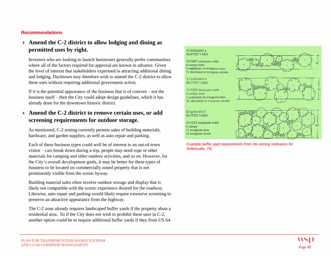
PLAN FOR TRANSPORTATION-BASED TOURISM
AND US 64 CORRIDOR MANAGEMENT Page 49
Recommendations
Amend the C-2 district to allow lodging and dining as
permitted uses by right.
Investors who are looking to launch businesses generally prefer communities
where all of the factors required for approval are known in advance. Given
the level of interest that stakeholders expressed in attracting additional dining
and lodging, Ducktown may therefore wish to amend the C-2 district to allow
these uses without requiring additional government action.
If it is the potential appearance of the business that is of concern – not the
business itself – then the City could adopt design guidelines, which it has
already done for the downtown historic district.
Amend the C-2 district to remove certain uses, or add
screening requirements for outdoor storage.
As mentioned, C-2 zoning currently permits sales of building materials,
hardware, and garden supplies, as well as auto repair and parking.
Each of these business types could well be of interest to an out-of-town
visitor – cars break down during a trip, people may need rope or other
materials for camping and other outdoor activities, and so on. However, for
the City’s overall development goals, it may be better for these types of
business to be located on commercially zoned property that is not
prominently visible from the scenic byway.
Building material sales often involve outdoor storage and display that is
likely not compatible with the scenic experience desired for the roadway.
Likewise, auto repair and parking would likely require extensive screening to
preserve an attractive appearance from the highway.
The C-2 zone already requires landscaped buffer yards if the property abuts a
residential area. So if the City does not wish to prohibit these uses in C-2,
another option could be to require additional buffer yards if they front US 64.
Example buffer yard requirements from the zoning ordinance for
Nolensville, TN
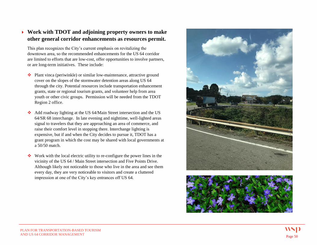
PLAN FOR TRANSPORTATION-BASED TOURISM
AND US 64 CORRIDOR MANAGEMENT Page 50
Work with TDOT and adjoining property owners to make
other general corridor enhancements as resources permit.
This plan recognizes the City’s current emphasis on revitalizing the
downtown area, so the recommended enhancements for the US 64 corridor
are limited to efforts that are low-cost, offer opportunities to involve partners,
or are long-term initiatives. These include:
Plant vinca (periwinkle) or similar low-maintenance, attractive ground
cover on the slopes of the stormwater detention areas along US 64
through the city. Potential resources include transportation enhancement
grants, state or regional tourism grants, and volunteer help from area
youth or other civic groups. Permission will be needed from the TDOT
Region 2 office.
Add roadway lighting at the US 64/Main Street intersection and the US
64/SR 68 interchange. In late evening and nighttime, well-lighted areas
signal to travelers that they are approaching an area of commerce, and
raise their comfort level in stopping there. Interchange lighting is
expensive, but if and when the City decides to pursue it, TDOT has a
grant program in which the cost may be shared with local governments at
a 50/50 match.
Work with the local electric utility to re-configure the power lines in the
vicinity of the US 64 / Main Street intersection and Five Points Drive.
Although likely not noticeable to those who live in the area and see them
every day, they are very noticeable to visitors and create a cluttered
impression at one of the City’s key entrances off US 64.
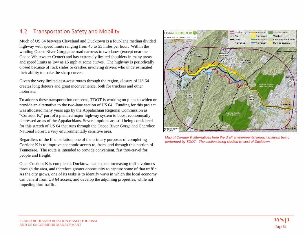
PLAN FOR TRANSPORTATION-BASED TOURISM
AND US 64 CORRIDOR MANAGEMENT Page 51
4.2 Transportation Safety and Mobility
Much of US 64 between Cleveland and Ducktown is a four-lane median divided
highway with speed limits ranging from 45 to 55 miles per hour. Within the
winding Ocoee River Gorge, the road narrows to two lanes (except near the
Ocoee Whitewater Center) and has extremely limited shoulders in many areas
and speed limits as low as 15 mph at some curves. The highway is periodically
closed because of rock slides or crashes involving drivers who underestimated
their ability to make the sharp curves.
Given the very limited east-west routes through the region, closure of US 64
creates long detours and great inconvenience, both for truckers and other
motorists.
To address these transportation concerns, TDOT is working on plans to widen or
provide an alternative to the two-lane section of US 64. Funding for this project
was allocated many years ago by the Appalachian Regional Commission as
“Corridor K,” part of a planned major highway system to boost economically
depressed areas of the Appalachians. Several options are still being considered
for this stretch of US 64 that runs through the Ocoee River Gorge and Cherokee
National Forest, a very environmentally sensitive area.
Regardless of the final solution, one of the primary purposes of completing
Corridor K is to improve economic access to, from, and through this portion of
Tennessee. The route is intended to provide convenient, fast thru-travel for
people and freight.
Once Corridor K is completed, Ducktown can expect increasing traffic volumes
through the area, and therefore greater opportunity to capture some of that traffic.
As the city grows, one of its tasks is to identify ways in which the local economy
can benefit from US 64 access, and develop the adjoining properties, while not
impeding thru-traffic.
Map of Corridor K alternatives from the draft environmental impact analysis being
performed by TDOT. The section being studied is west of Ducktown.
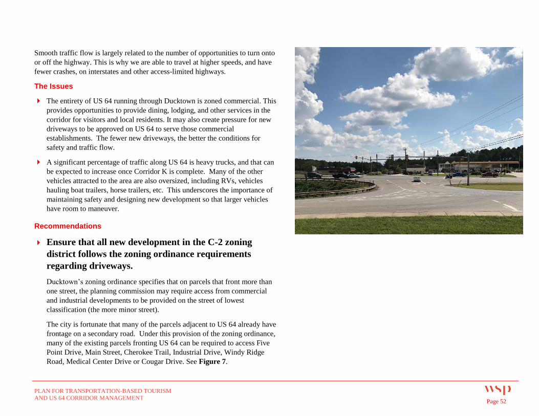
PLAN FOR TRANSPORTATION-BASED TOURISM
AND US 64 CORRIDOR MANAGEMENT Page 52
Smooth traffic flow is largely related to the number of opportunities to turn onto
or off the highway. This is why we are able to travel at higher speeds, and have
fewer crashes, on interstates and other access-limited highways.
The Issues
The entirety of US 64 running through Ducktown is zoned commercial. This
provides opportunities to provide dining, lodging, and other services in the
corridor for visitors and local residents. It may also create pressure for new
driveways to be approved on US 64 to serve those commercial
establishments. The fewer new driveways, the better the conditions for
safety and traffic flow.
A significant percentage of traffic along US 64 is heavy trucks, and that can
be expected to increase once Corridor K is complete. Many of the other
vehicles attracted to the area are also oversized, including RVs, vehicles
hauling boat trailers, horse trailers, etc. This underscores the importance of
maintaining safety and designing new development so that larger vehicles
have room to maneuver.
Recommendations
Ensure that all new development in the C-2 zoning
district follows the zoning ordinance requirements
regarding driveways.
Ducktown’s zoning ordinance specifies that on parcels that front more than
one street, the planning commission may require access from commercial
and industrial developments to be provided on the street of lowest
classification (the more minor street).
The city is fortunate that many of the parcels adjacent to US 64 already have
frontage on a secondary road. Under this provision of the zoning ordinance,
many of the existing parcels fronting US 64 can be required to access Five
Point Drive, Main Street, Cherokee Trail, Industrial Drive, Windy Ridge
Road, Medical Center Drive or Cougar Drive. See Figure 7.
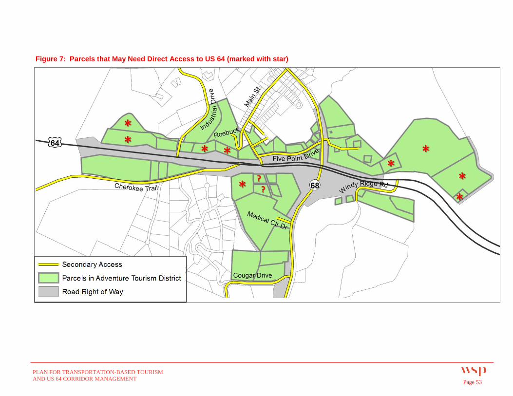
PLAN FOR TRANSPORTATION-BASED TOURISM
AND US 64 CORRIDOR MANAGEMENT Page 53
Figure 7: Parcels that May Need Direct Access to US 64 (marked with star)
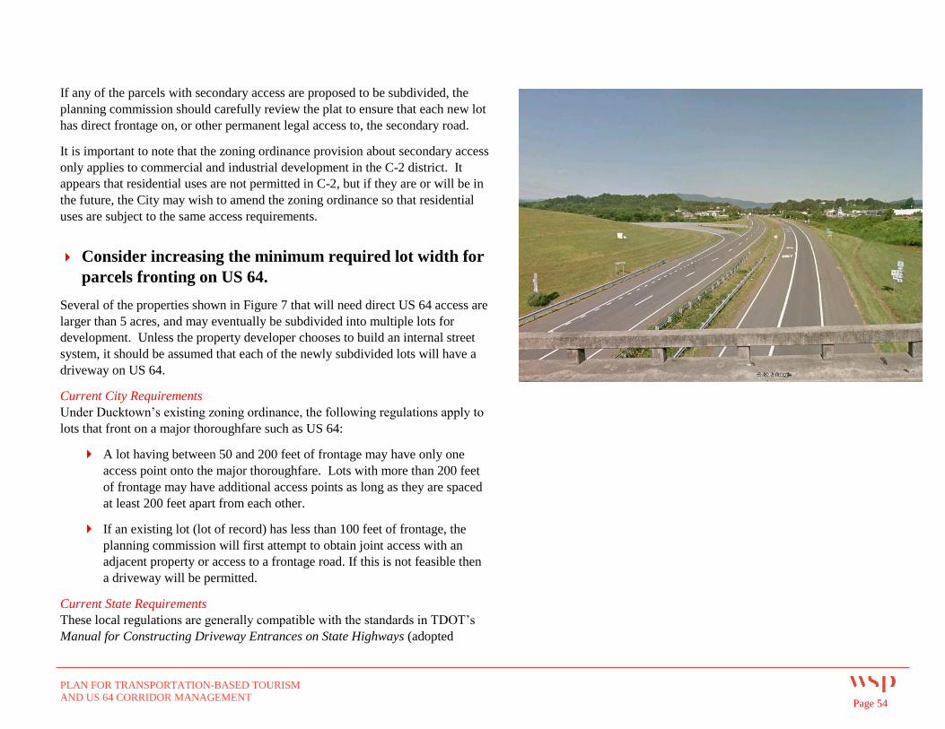
PLAN FOR TRANSPORTATION-BASED TOURISM
AND US 64 CORRIDOR MANAGEMENT Page 54
If any of the parcels with secondary access are proposed to be subdivided, the
planning commission should carefully review the plat to ensure that each new lot
has direct frontage on, or other permanent legal access to, the secondary road.
It is important to note that the zoning ordinance provision about secondary access
only applies to commercial and industrial development in the C-2 district. It
appears that residential uses are not permitted in C-2, but if they are or will be in
the future, the City may wish to amend the zoning ordinance so that residential
uses are subject to the same access requirements.
Consider increasing the minimum required lot width for
parcels fronting on US 64.
Several of the properties shown in Figure 7 that will need direct US 64 access are
larger than 5 acres, and may eventually be subdivided into multiple lots for
development. Unless the property developer chooses to build an internal street
system, it should be assumed that each of the newly subdivided lots will have a
driveway on US 64.
Current City Requirements
Under Ducktown’s existing zoning ordinance, the following regulations apply to
lots that front on a major thoroughfare such as US 64:
A lot having between 50 and 200 feet of frontage may have only one
access point onto the major thoroughfare. Lots with more than 200 feet
of frontage may have additional access points as long as they are spaced
at least 200 feet apart from each other.
If an existing lot (lot of record) has less than 100 feet of frontage, the
planning commission will first attempt to obtain joint access with an
adjacent property or access to a frontage road. If this is not feasible then
a driveway will be permitted.
Current State Requirements
These local regulations are generally compatible with the standards in TDOT’s
Manual for Constructing Driveway Entrances on State Highways (adopted
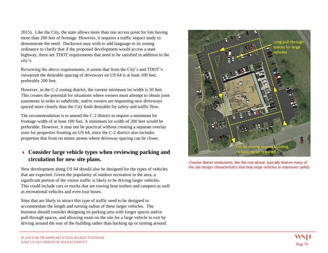
PLAN FOR TRANSPORTATION-BASED TOURISM
AND US 64 CORRIDOR MANAGEMENT Page 55
2015). Like the City, the state allows more than one access point for lots having
more than 200 feet of frontage. However, it requires a traffic impact study to
demonstrate the need. Ducktown may wish to add language to its zoning
ordinance to clarify that if the proposed development would access a state
highway, there are TDOT requirements that need to be satisfied in addition to the
city’s.
Reviewing the above requirements, it seems that from the City’s and TDOT’s
viewpoint the desirable spacing of driveways on US 64 is at least 100 feet,
preferably 200 feet.
However, in the C-2 zoning district, the current minimum lot width is 50 feet.
This creates the potential for situations where owners must attempt to obtain joint
easements in order to subdivide, and/or owners are requesting new driveways
spaced more closely than the City finds desirable for safety and traffic flow.
The recommendation is to amend the C-2 district to require a minimum lot
frontage width of at least 100 feet. A minimum lot width of 200 feet would be
preferable. However, it may not be practical without creating a separate overlay
zone for properties fronting on US 64, since the C-2 district also includes
properties that front on minor streets where driveway spacing can be closer.
Consider large vehicle types when reviewing parking and
circulation for new site plans.
New development along US 64 should also be designed for the types of vehicles
that are expected. Given the popularity of outdoor recreation in the area, a
significant portion of the visitor traffic is likely to be driving larger vehicles.
This could include cars or trucks that are towing boat trailers and campers as well
as recreational vehicles and even tour buses.
Sites that are likely to attract this type of traffic need to be designed to
accommodate the length and turning radius of these larger vehicles. The
business should consider designing its parking area with longer spaces and/or
pull-through spaces, and allowing room on the site for a large vehicle to exit by
driving around the rear of the building rather than backing up or turning around.
Cracker Barrel restaurants, like the one above, typically feature many of
the site design characteristics that help large vehicles to maneuver safely.
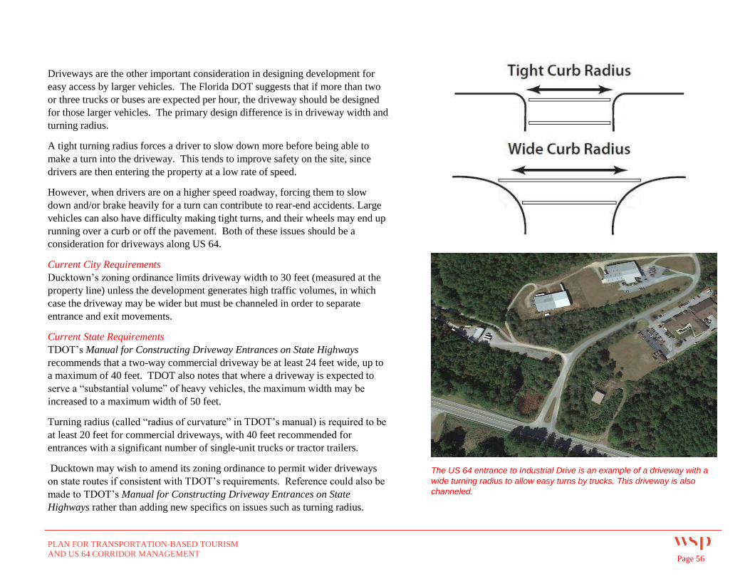
PLAN FOR TRANSPORTATION-BASED TOURISM
AND US 64 CORRIDOR MANAGEMENT Page 56
Driveways are the other important consideration in designing development for
easy access by larger vehicles. The Florida DOT suggests that if more than two
or three trucks or buses are expected per hour, the driveway should be designed
for those larger vehicles. The primary design difference is in driveway width and
turning radius.
A tight turning radius forces a driver to slow down more before being able to
make a turn into the driveway. This tends to improve safety on the site, since
drivers are then entering the property at a low rate of speed.
However, when drivers are on a higher speed roadway, forcing them to slow
down and/or brake heavily for a turn can contribute to rear-end accidents. Large
vehicles can also have difficulty making tight turns, and their wheels may end up
running over a curb or off the pavement. Both of these issues should be a
consideration for driveways along US 64.
Current City Requirements
Ducktown’s zoning ordinance limits driveway width to 30 feet (measured at the
property line) unless the development generates high traffic volumes, in which
case the driveway may be wider but must be channeled in order to separate
entrance and exit movements.
Current State Requirements
TDOT’s Manual for Constructing Driveway Entrances on State Highways
recommends that a two-way commercial driveway be at least 24 feet wide, up to
a maximum of 40 feet. TDOT also notes that where a driveway is expected to
serve a “substantial volume” of heavy vehicles, the maximum width may be
increased to a maximum width of 50 feet.
Turning radius (called “radius of curvature” in TDOT’s manual) is required to be
at least 20 feet for commercial driveways, with 40 feet recommended for
entrances with a significant number of single-unit trucks or tractor trailers.
Ducktown may wish to amend its zoning ordinance to permit wider driveways
on state routes if consistent with TDOT’s requirements. Reference could also be
made to TDOT’s Manual for Constructing Driveway Entrances on State
Highways rather than adding new specifics on issues such as turning radius.
The US 64 entrance to Industrial Drive is an example of a driveway with a
wide turning radius to allow easy turns by trucks. This driveway is also
channeled.
Related Documents