CITY OF BELMONT Local Planning Scheme No. 15 Updated to include AMD 11 GG 12/01/2021 Prepared by the Department of Planning, Lands and Heritage Original Town Planning Scheme Gazettal 01 December 2011 Disclaimer This is a copy of the Local Planning Scheme produced from an electronic version of the Scheme held and maintained by the Department of Planning, Lands and Heritage. Whilst all care has been taken to accurately portray the current Scheme provisions, no responsibility shall be taken for any omissions or errors in this documentation. Consultation with the respective Local Government Authority should be made to view a legal version of the Scheme. Please advise the Department of Planning, Lands and Heritage of any errors or omissions in this document. Department of Planning, Lands and Heritage Gordon Stephenson House 140 William Street Perth WA 6000 Locked Bag 2506 Perth WA 6001 website: www.dplh.wa.gov.au email: [email protected] tel: 08 6551 9000 fax: 08 6551 9001 National Relay Service: 13 36 77 infoline: 1800 626 477 Version: 23, Version Date: 03/11/2021 Document Set ID: 1897636

Welcome message from author
This document is posted to help you gain knowledge. Please leave a comment to let me know what you think about it! Share it to your friends and learn new things together.
Transcript

CITY OF BELMONTLocal Planning Scheme No. 15
Updated to include AMD 11 GG 12/01/2021
Prepared by theDepartment of Planning, Lands and Heritage
Original Town Planning Scheme Gazettal01 December 2011
Disclaimer
This is a copy of the Local Planning Scheme produced from an electronic version of the Scheme held and maintained by the Department of Planning, Lands and Heritage. Whilst all care has been taken to accurately portray the current Scheme provisions, no responsibility shall be taken for any omissions or errors in this documentation.
Consultation with the respective Local Government Authority should be made to view a legal version of the Scheme.
Please advise the Department of Planning, Lands and Heritage of any errors or omissions in this document.
Department of Planning, Lands and Heritage Gordon Stephenson House 140 William StreetPerth WA 6000
Locked Bag 2506Perth WA 6001
website: www.dplh.wa.gov.auemail: [email protected]
tel: 08 6551 9000fax: 08 6551 9001
National Relay Service: 13 36 77infoline: 1800 626 477
Version: 23, Version Date: 03/11/2021Document Set ID: 1897636

CITY OF BELMONT LPS 15 – TEXT AMENDMENTSUPDATEDAMD
NOGAZETTAL
DATE WHEN BYDETAILS
3 28/02/14 19/03/14 ML Clause 5.5.1 text deleted and replaced with amended text.
5 28/11/14 10/09/15 MLD Amend Table I (Use Class Table) - Child Family Day Care.Amend the scheme map to remove the underlying zoning of 'Residential' from all Special Development Precincts and creating a new legend delineation for 'Special Development Precinct' on the LPS15 Scheme Map under Local Scheme Zones.Amend Clause 5.18.1 (c) to clarify the City's development standards.Amend Schedule 2 to include the use of 'Horse Sales' and 'Stables' as Additional Use 18.Amend the scheme Map to rezone Lot 401 (20) Gladstone Road, Rivervale as Residential with a density coding of 'R20/R60'.
4 24/03/2015 24/04/15 MLD Deleted clause 5.3.2(2) and inserted amended Clause 5.3.2(2).
1 15/12/15 13/01/16 RO Amended Table 1 (use class table) – Aged or Dependent Persons Dwelling, Bed and Breakfast, Betting Agency, Civic Use, Club Premises, Consulting Rooms, Health Centre, Health Studio, Home Store, Medical Centre, Night Club, Pet Day Care, Services Apartments, Studio and Transport Depot.Amended Clause 5.3.2 – (1), (2), & (3).Amended Clause 5.3.4 – (2) & (3).Amended Clause 5.7.3.Amended Clause 5.7.6.Amended Table 2 and Table 3, deleting land use category ‘Bank’ and inserting land use category ‘Health Studio’.Amended Clause 6.3.1.Amended Clause 8.2 – (1) – (16).Amended Schedule 2, updating street no. for Lot 151 Great Easter Highway, Ascot and Lot 1 Kewdale Road, Kewdale.Amended Schedule 6 to include MRS Form 1 – Form of Application for Planning Approval.
7 1/11/16 14/11/16 GM Amended Table 1 (Use Class Table).Amended Schedule 1 to add new definitions in relation to Planning and Development Regulations 2015.
9 11/11/16 15/11/16 GM Amend Clause 5.3.2 (2)(c).
2 07/02/17 13/02/17 GM Amended Schedule No. 16.
6 21/02/17 28/02/17 GM Rezoned Lots 10, 30, 33, 36, 37, 38, 39, 40, 41, 75, 76, 95, 125, 126, 166 and 500 Belvidere Street, Lot 77 Gardiner Street, Belmont from 'Commercial' to 'Special Development Precinct'. Rezoned Lots 17, 18 and 19 Somers Street, Lot 12, 13, 14, 15 and 16 Belvidere Street, Lots 10 and 11 Keymer Street, Lots 67, 68 and 130 Leake Street, Lot 94 Gardiner Street, Belmont from 'Residential' to 'Special Development Precinct'.Amended Clause 5.8.1.Amended Schedule 2 to include additional uses No. 19 and No. 20.
8 18/08/17 22/08/17 MLD Modify the Scheme Map to change the zoning of Lot 242 (1) Ballantyne Road, Kewdale from 'Industrial' to 'Service Station' zone.
10 15/01/19 17/01/19 GM Clause 5.12.1 (a) deleted and replaced.
12 06/03/2020 09/03/2020 MLD Amend the Scheme Text to delete the Development Area 8 precinct from Schedule 14 – Development Areas.
Amend the Scheme Map to remove the ‘Development Area’ notation applicable to the Development Area 8 precinct.
Amend Scheme Map to reclassify Lot 603 Fauntleroy Avenue, Ascot from ‘Residential R20’ to ‘Local Reserve – Parks and Recreation’.
13 9/6/2020 9/6/2020 MLD Modifying the Zoning Table in the Scheme Text, as follows:
To change the land use classification for ‘Trade Supplies’ in the ‘Mixed Business’ zone from an ‘X’ to a ‘D’ use classification.
11 12/01/2021 25/01/2021 MLD Omnibus amendment that:1. Amended the Scheme Text to remove provisions that are obsolete
and/inconsistent with the Planning and Development (Local PlanningSchemes) Regulations 2015.
2. Amended Clause 4.7.7 to clarify requirements for the subdivision ofland in flexible coded areas.
Version: 23, Version Date: 03/11/2021Document Set ID: 1897636

3. Amended the Scheme Map to encompass and zone land transferredfrom the City of Swan to the City of Belmont through a localgovernment boundary realignment.
4. Amended the Scheme Map to correct minor errors and anomalies.
Version: 23, Version Date: 03/11/2021Document Set ID: 1897636

- Table of Contents -
i
PART 1 - PRELIMINARY.........................................................................................................11.1 Citation ...............................................................................................................11.2 Responsible Authority ......................................................................................11.3 Scheme Area ......................................................................................................11.4 Contents of Scheme ..........................................................................................11.5 Purposes of Scheme .........................................................................................11.6 The Aims of the Scheme ...................................................................................21.7 Definitions ..........................................................................................................21.8 Relationship with Local Laws...........................................................................21.9 Relationship with Other Schemes....................................................................31.10 Relationship with the Metropolitan Region Scheme ......................................3
PART 2 - RESERVES ..............................................................................................................42.1 Reserves .............................................................................................................42.2 Regional Reserves.............................................................................................42.3 Local Reserves ..................................................................................................42.4 Use and Development of Local Reserves .......................................................4
PART 3 - ZONES AND THE USE OF LAND...........................................................................53.1 Zones ..................................................................................................................53.2 Objectives of the zones.....................................................................................53.3 Zoning Table ......................................................................................................63.4 Interpretation of the Zoning Table ...................................................................7Table 1 - Zoning Table ........................................................................................................83.5 Additional Uses................................................................................................113.6 Restricted Uses................................................................................................113.7 Special Use Zones ...........................................................................................113.8 Non-Conforming Uses.....................................................................................113.9 Extensions and Changes to a Non-Conforming Use ...................................113.10 Discontinuance of Non-Conforming Use ......................................................123.11 Termination of a Non-Conforming Use..........................................................123.12 Destruction of Non-Conforming Use Buildings ............................................12
PART 4 - GENERAL DEVELOPMENT REQUIREMENTS....................................................134.1 Compliance with Development Standards and Requirements....................134.2 Residential Design Codes...............................................................................134.3 Special Application of Residential Design Codes ........................................134.4 Restrictive Covenants .....................................................................................144.5 Variations to Site and Development Standards and Requirements ...........154.6 Environmental Conditions ..............................................................................154.7 Residential Zone ..............................................................................................164.8 Special Development Precincts .....................................................................174.9 Residential and Stables Zone .........................................................................184.10 Town Centre and Commercial Zone ..............................................................18
Version: 23, Version Date: 03/11/2021Document Set ID: 1897636
- Table of Contents -
ii
4.11 Mixed Use Zone ...............................................................................................194.12 Mixed Business Zone .......................................................................................214.13 Industrial Zone .................................................................................................234.14 Public Assembly Zone ....................................................................................264.15 Service Station Zone .......................................................................................264.16 Vehicle Parking and Loading..........................................................................27Table 2 - Car Parking Requirements ...............................................................................294.17 Bicycle Parking ................................................................................................33Table 3 - Bicycle Parking Requirements.........................................................................344.18 Parking of Commercial Vehicles on Residential Land .................................374.19 Development on Great Eastern Highway ......................................................384.20 Structures Height Control Contours Map......................................................384.21 Prohibited Signage ..........................................................................................38
PART 5 – SPECIAL CONTROL AREAS...............................................................................395.1 Operation of Special Control Areas ...............................................................395.2 Development Contribution Areas...................................................................39
SCHEDULES..........................................................................................................................46Schedule A - Supplemental Provisions to the Deemed Provisions .............................46Schedule No. 1 - Dictionary of Defined Words and Expressions .................................49Schedule No. 2 - Additional Uses ....................................................................................62Schedule No. 3 - Restricted Uses ....................................................................................77Schedule No. 4 - Special Use Zones ...............................................................................78Schedule No. 5 - Exempted Advertisements ..................................................................79Schedule No. 6 - Environmental Conditions ..................................................................81Schedule No. 7 - Car Parking Layout ..............................................................................82Schedule No. 8 - Structures Height Control Contours Map ..........................................83Schedule No. 9 – Special Control Areas - Development Areas ....................................84Schedule No. 10 - Statutory Static Feasibility Assessment Model ..............................85Schedule No. 11 – Special Control Areas - Development Contribution Plans ............87FINAL APPROVAL.............................................................................................................90
List of Tables
Table 1 - Zoning Table ............................................................................................................................8Table 2 - Car Parking Requirements .....................................................................................................29Table 3 - Bicycle Parking Requirements ...............................................................................................34
Version: 23, Version Date: 03/11/2021Document Set ID: 1897636

City of Belmont Local Planning Scheme No. 15 – Scheme Text
1
PART 1 - PRELIMINARY
1.1 Citation
1.1.1 The City of Belmont Local Planning Scheme No. 15 (the Scheme) comes into operation on its Gazettal date.
1.1.2 The following Scheme is revoked:
City of Belmont Town Planning Scheme No. 14 - District Zoning Scheme gazetted 10 December 1999.
1.2 Responsible Authority
The City of Belmont is the responsible authority for implementing the Scheme.
1.3 Scheme Area
The Scheme applies to the Scheme Area which covers all of the local government district of the City as shown on the Scheme Map.
Note: The Scheme Area is also subject to the Metropolitan Region Scheme.
1.4 Contents of Scheme
The Scheme comprises:
(a) the Scheme Text;
(b) the Scheme Map(s).
The Scheme is to be read in conjunction with the Local Planning Strategy.
1.5 Purposes of Scheme
The purposes of the Scheme are to:
(a) set out the local government’s planning aims and intentions for the Scheme Area;
(b) set aside land as reserves for public purposes;
(c) zone land within the Scheme Area for the purposes defined in the Scheme;
(d) control and guide land use and development;
(e) set out procedures for the assessment and determination of planning applications;
(f) make provision for the administration and enforcement of the Scheme; and
(g) address other matters set out in the Seventh Schedule to the Planning Act.
Version: 23, Version Date: 03/11/2021Document Set ID: 1897636

City of Belmont Local Planning Scheme No. 15 – Scheme Text
2
1.6 The Aims of the Scheme
The aims of the Scheme are:
(a) to assist the effective implementation of regional plans and policies including the State Planning Strategy;
(b) to ensure there is a sufficient supply of serviced and suitable land for housing, employment, commercial activities, community facilities, recreation and open space;
(c) to provide for housing choice and variety in neighbourhoods with a community identity and high levels of amenity;
(d) to assist employment and economic growth by facilitating the timely provision of suitable land for retail, commercial, industrial, entertainment and tourist developments, as well as providing opportunities for home-based employment;
(e) to protect and enhance the environmental values and natural resources of the local government and to promote ecologically sustainable land use and development;
(f) to safeguard and enhance the character and amenity of the built and natural environment of the local government;
(g) to incorporate public art to enhance the character and amenity of the built and natural environment of the local government;
(h) to maximise the built-in safety of the local government;
(i) to protect and maximise efficacy of existing and future community infrastructure needs.
1.7 Definitions
1.7.1 Unless the context otherwise requires words and expressions used in the Scheme have the same meaning as they have:
a) in the Planning and Development Act 2005; or
b) if they are not defined in that Act:
(i) in the Dictionary of defined words and expressions in Schedule 1; or(ii) in the Residential Design Codes.
1.7.2 If there is a conflict between the meaning of a word or expression in the Dictionary of defined words and expressions in Schedule 1 and the meaning of that word or expression in the Residential Design Codes:
a) in the case of residential development, the definition in the Residential Design Codes shall prevail; and
b) in any other case the definition in the Dictionary prevails.
1.7.3 Notes, and instructions printed in italics, are not part of the Scheme.
1.8 Relationship with Local Laws
Where a provision of the Scheme is inconsistent with a local law, the provision of the Scheme prevails.
Version: 23, Version Date: 03/11/2021Document Set ID: 1897636
City of Belmont Local Planning Scheme No. 15 – Scheme Text
3
1.9 Relationship with Other Schemes
By way of information, the following other Schemes of the City of Belmont are, at the Gazettal date of the Scheme, complementary to the Scheme:
Scheme No. Gazettal date
There are no other Schemes of the City of Belmont which apply to the Scheme area.
1.10 Relationship with the Metropolitan Region Scheme
The Scheme is complementary to the Metropolitan Region Scheme and the provisions of the Metropolitan Region Scheme continue to have effect.
Note: The authority responsible for implementing the Metropolitan Region Scheme is the Western Australian Planning Commission.
Version: 23, Version Date: 03/11/2021Document Set ID: 1897636

City of Belmont Local Planning Scheme No. 15 – Scheme Text
4
PART 2 - RESERVESAMD 11 GG 12/01/2021
2.1 Reserves
Certain lands within the Scheme Area on the Scheme Map are classified as:
(a) Regional Reserves; or
(b) Local Reserves.
2.2 Regional Reserves
2.2.1 The lands shown as “Regional Reserve” on the Scheme Map are lands reserved under the Metropolitan Region Scheme and are shown on the Scheme Map for the purposes of the Planning and Development Act 2005. These lands are not reserved under the Scheme.
2.2.2 The approval of the local government under the Scheme is not required for the commencement or carrying out of any use or development on a Regional Reserve.
Note: The provisions of the Metropolitan Region Scheme continue to apply to such Reserves and approval is required under the Metropolitan Region Scheme from the Commission for the commencement or carrying out of any use or development on a Regional Reserve unless specifically excluded by the Region Scheme.
2.3 Local Reserves
“Local Reserves” are delineated and depicted on the Scheme Map according to the legend on the Scheme Map.
2.4 Use and Development of Local Reserves
2.4.1 A person must not:
a) use a Local Reserve; or
b) commence or carry out development on a Local Reserve;
without first having obtained Development Approval under Part 8 Schedule 2 of the Planning and Development (Local Planning Schemes) Regulations 2015.
2.4.2 In determining an application for Development Approval the local government is to have due regard to -
a) the matters set out in Clause 67 of the Planning and Development (Local Planning Schemes) Regulations 2015 Schedule 2; and
b) the ultimate purpose intended for the Reserve.
2.4.3 In the case of land reserved for the purposes of a public authority, the local government is to consult with that authority before determining an application for Development Approval.
Version: 23, Version Date: 03/11/2021Document Set ID: 1897636

City of Belmont Local Planning Scheme No. 15 – Scheme Text
5
PART 3 - ZONES AND THE USE OF LANDAMD 11 GG 12/01/2021
3.1 Zones
3.1.1 The Scheme area is classified into the zones shown on the Scheme Map.
3.1.2 The zones are delineated and depicted on the Scheme Map according to the legend on the Scheme Map.
3.2 Objectives of the zones
The objectives of the zones are:
Residential Zone
The purpose and intent of the Residential Zone is to increase the population base of the City of Belmont by permitting a mix of single housing and other housing types to reflect household composition and thereby increase the resident population.
Special Development Precinct Zone
The ‘Special Development Precinct’ Zone is intended to allow for the development of predominantly residential precincts which also allows for a mix of varied but compatible supporting land uses such as offices, showrooms and eating establishments which do not generate nuisances detrimental to the amenity of the precincts’ residents. Buildings should be of a very high standard of architectural design.
Residential and Stables Zone
The Residential and Stables Zone is intended to provide for compatible and environmentally responsible use of land in proximity to the Ascot Racecourse and the Swan River by residential accommodation and stables and ancillary functions of the horse racing industry.
Town Centre and Commercial Zones
The Town Centre and Commercial Zones are intended to provide for the retail commercial function and entertainment.
Mixed Use Zone
The Mixed Use Zone is intended to allow for the development of a mix of varied but compatible land uses such as housing, offices, showrooms, amusement centres, eating establishments and appropriate industrial activities which do not generate nuisances detrimental to the amenity of the district or to the health, welfare and safety of its residents. Buildings should be of a high standard of architectural design set in pleasant garden surrounds with limited vehicular access from properties to primary roads.
Mixed Business Zone
The ‘Mixed Business’ zone is intended to allow for the development of a mix of varied but compatible business uses such as offices, showrooms, amusement centres, eating establishments and appropriate industrial activities which do not generate nuisances detrimental to the amenity of the district or to the health, welfare and safety of residents and workforce. Uses can mix on adjacent lots of land or on the same lot and uses may mix horizontally on the same or separate lots and/or vertically in buildings. Buildings should be of a high standard of architectural design set in pleasant garden surrounds with limited vehicular access from properties to primary roads.
Version: 23, Version Date: 03/11/2021Document Set ID: 1897636

City of Belmont Local Planning Scheme No. 15 – Scheme Text
6
Industrial Zone
The Industrial Zone is intended to provide for the industrial development of the Kewdale Industrial Estate and the Redcliffe Industrial Estate. The significance of the Kewdale Industrial Estate as a transport and logistics hub as part of the Kewdale-Hazelmere Integrated Masterplan is acknowledged. The local government may approve a wide range of industrial activities within this zone subject to conditions designed to achieve a high standard of industrial environment.
Service Station Zone
The ‘Service Station’ zone is intended to allow for the development of service stations and appropriate support activities which do not generate nuisances detrimental to the amenity of the district and having particular regard for the health, welfare and safety of any residents and workforce associated with any immediately abutting zoned land.
Places of Public Assembly Zone
The ‘Places of Public Assembly’ zone is intended to allow for special places of assembly, such as halls, private schools, grounds for athletics, sports grounds with provision for spectators, racecourses, trotting track, stadia and/or showgrounds.
3.3 Zoning Table
3.3.1 The Zoning Table indicates, subject to the provisions of the Scheme, the uses permitted in the Scheme area in the various zones. The permissibility of any uses is determined by cross reference between the list of use classes on the left hand side of the Zoning Table and the list of zones at the top of the Zoning Table.
3.3.2 Symbols
The symbols used in the cross-reference in the Zoning Table, and where used elsewhere in the Scheme have the following meanings:
‘P’ means that the use is permitted by the Scheme providing the use complies with the relevant development standards and the requirements of the Scheme;
‘D’ means that the use is not permitted unless the local government has exercised its discretion by granting Development Approval;
‘A’ means that the use is not permitted unless the local government has exercised its discretion by granting Development Approval after giving special notice in accordance with the provisions contained in Clause 64 of the Planning and Development (Local Planning Schemes) Regulations 2015 Schedule 2;
‘X’ means a use that is not permitted by the Scheme.
3.3.3. A change in the use of land from one use to another is permitted if:
a) the local government has exercised its discretion by granting Development Approval;
b) the change is to a use which is designated with the symbol ‘P’ in the cross reference to that zone in the Zoning Table and the proposed use complies with all the relevant development standards and any requirements of the Scheme;
c) the change is an extension of a use within the boundary of the lot which does not change the predominant use of the lot; or
d) the change is to an incidental use that does not change the predominant use of the land.
Note: 1. The Development Approval of the local government is required for the development of land in addition to any approval granted for the use of land. In normal circumstances one application is made for both the use and development of land.
Version: 23, Version Date: 03/11/2021Document Set ID: 1897636

City of Belmont Local Planning Scheme No. 15 – Scheme Text
7
2. The local government will not refuse a ‘P’ use because of the unsuitability of the use for the zone but may impose conditions on the use of the land to comply with any relevant development standards or requirements of the Scheme, and may refuse or impose conditions on any development of the land.
3. In considering a ‘D’ or ‘A’ use, the local government will have regard to the matters set out in Clause 67 of the Planning and Development (Local Planning Schemes) Regulations 2015 Schedule 2;
4. The local government must refuse to approve any ‘X’ use of land. Approval to an ‘X’ use of land may only proceed by way of an amendment to the Scheme.
3.4 Interpretation of the Zoning Table
3.4.1. Where a specific use is mentioned in the Zoning Table, it is deemed to be excluded from the general terms used to describe any other use.
3.4.2. If a person proposes to carry out on land any use that is not specifically mentioned in the Zoning Table and cannot reasonably be determined as falling within the type, class or genus of activity of any other use category the local government may:
a) determine that the use is consistent with the objectives of the particular zone and is therefore permitted;
b) determine that the use may be consistent with the objectives of the particular zone and thereafter follow the advertising procedures contained in Clause 64 of the Planning and Development (Local Planning Schemes) Regulations 2015 Schedule 2; or
c) determine that the use is not consistent with the objectives of the particular zone and is therefore not permitted.
Version: 23, Version Date: 03/11/2021Document Set ID: 1897636

City of Belmont Local Planning Scheme No. 15 – Scheme Text
8
Table 1 - Zoning TableAMD 7 GG 1/11/16, AMD 11 GG 12/01/2021
ZONES
USE CLASSES
Res
iden
tial
Tow
n C
entr
e
Com
mer
cial
Mix
ed U
se
Mix
ed B
usin
ess
Indu
stria
l
Serv
ice
Stat
ion
Plac
es o
f Pub
lic A
ssem
bly
Res
iden
tial a
nd S
tabl
es
Spec
ial D
evel
opm
ent
Prec
inct
Aged or Dependent Persons Dwelling D X D D A X X X D DAmusement Facility X P D D D X X X X XAmusement parlour X P X D D X X X X XAncillary DwellingAMD 11 GG 12/01/2021
P X X D D X X X D D
Art Gallery X D D D D X X X X DAuction Mart X X X A D D X X X XBed and Breakfast AMD 11 GG 12/01/2021 D X X A X X X X A ABetting Agency X P D D D X X X X DCar Park D D D D D D D D D DCaravan Park X X X X X X X X X XCaretaker's Dwelling X X D D D D X P D DChild Care Premises A D D D D D X D A AChild Family Day Care D X X D D X X D D DCinema/Theatre X A X X X X X X X XCivic Use D D D D D D X X D DClub Premises X D D D D D X D X XCommunity Home D X X D D X X A X DConsulting Rooms X D D D D D X A X AConvenience Store X A X A X X A X X ACorrective Institution X X X X X X X X X XDog Kennels X X X X X X X X X XDry-cleaning Premises X D D D D D X X X XEducational Establishment A X D D D X X D D XExhibition Centre X D D A A X X A X AFast Food Outlet/Lunch Bar X D D A A X A X X AFuel Depot X X X X X D X X X XFuneral Parlour X X X D D D X X X XGarden Centre X D D D D D X X X XGrouped Dwelling D D D D A X X X D DHealth Centre X X X D D D X X X XHealth Studio X D D D D X X X X DHoliday Accommodation X X X X X X X X X XHome Business D D P P D X X X D DHome Occupation P D P P D X X X P PHome Store A X X D D X X X A DHospital A X X A A X X X X XHotel X D X D A X X X X AIndustry - General X X X X X D X X X X
Version: 23, Version Date: 03/11/2021Document Set ID: 1897636

City of Belmont Local Planning Scheme No. 15 – Scheme Text
9
ZONES
USE CLASSES
Res
iden
tial
Tow
n C
entr
e
Com
mer
cial
Mix
ed U
se
Mix
ed B
usin
ess
Indu
stria
l
Serv
ice
Stat
ion
Plac
es o
f Pub
lic A
ssem
bly
Res
iden
tial a
nd S
tabl
es
Spec
ial D
evel
opm
ent
Prec
inct
Industry - Hazardous X X X X X X X X X X
Industry - Light X X X D D D X X X XIndustry - Noxious X X X X X A X X X XIndustry - Service X X X D D D X X X XLaundromat X P D D D D X X X XLiquor Store – Small X A D A X X X A X ALiquor Store – Large X A A X A X X X X XLogistics Centre X X X X A D X X X XLunch Bar X P D D D D X X X DMassage Parlour X X X A D D X X X XMedical Centre X X D D D D X X X AMining Operations X X X X X X X X X XMobile Phone Tower & Associated Facilities X D D D D D X D X AMotel X X X D A X X X X AMotor Vehicle, Boat or Caravan Sales X X X X X D X X X XMotor Vehicle Hire X X X X X D X X X XMotor Vehicle Repair X X X A D D D X X XMotor Vehicle Wash X X X X X D D X X XMotor Vehicle Wrecking X X X X X X X X X XMultiple Dwelling D D D D A X X X X DNight Club X A X A A D X X X XNursing Home D X X D A X X X X AOffice X D D D D D X X X DOpen Air Display X X X X X D X X X XPet Day Care X A X A A D X X A XPrivate Recreation X X X D D D X D X APlace of Worship X A X A D X X D X XPublic Amusement X D A D D X X D X XRadio or TV Installation D D D D D D X D D XReception Centre X X X A D X X D X XResidential Building D X X D A X X X D DRestaurant/Cafe X D D D D X X X X DRestricted Premises X D D D D X X X X XSalvage Yard X X X X X X X X X XService Station X A X A X X D X X XServiced Apartments D X X D A X X X X DShop X D D X X X X X X DShowroom X D D D D D X X X DSingle House P X D D A X X X D D
Version: 23, Version Date: 03/11/2021Document Set ID: 1897636

City of Belmont Local Planning Scheme No. 15 – Scheme Text
10
ZONES
USE CLASSES
Res
iden
tial
Tow
n C
entr
e
Com
mer
cial
Mix
ed U
se
Mix
ed B
usin
ess
Indu
stria
l
Serv
ice
Stat
ion
Plac
es o
f Pub
lic A
ssem
bly
Res
iden
tial a
nd S
tabl
es
Spec
ial D
evel
opm
ent
Prec
inct
Small Bar X A A A X X X X X AStables X X X X X X X X D XStudio X X X D D D X X D DTrade Display X X X X X X X X X XTavern X D A A D A X X X ATelecommunications Infrastructure P P P P P P P P P PTrade Supplies AMD 13 GG 9/6/2020 X X X X D D X X X XTransport Depot X X X X D D X X X XTruck Stop X X X X D D X X X XVeterinary Centre X X A A D D X X A XVet Consulting Rooms X D D D D D X X D XVet Hospital X X X A D D X X A XVideo Store X P P D P X D X X DWarehouse X X X D D D X X X XWaste Storage Facility X X X X X A X X X X
Version: 23, Version Date: 03/11/2021Document Set ID: 1897636

City of Belmont Local Planning Scheme No. 15 – Scheme Text
11
3.5 Additional Uses
Despite anything contained in the Zoning Table, the land specified in Schedule 2 may be used for the specific use or uses that are listed in addition to any uses permissible in the zone in which the land is situated subject to the conditions set out in Schedule 2 with respect to that land.
Note: An additional use is a land use that is permitted on a specific portion of land in addition to the uses already permissible in that zone that applies to the land.
3.6 Restricted Uses
Despite anything contained in the Zoning Table, the land specified in Schedule 3 may only be used for the specific use or uses that are listed and subject to the conditions set out in Schedule 3 with respect to that land.
There are no restricted uses which apply to the Scheme.
Note: A restricted use is the only use or uses that is permitted on a specific portion of land and other uses that would otherwise be permissible in the zone are not permitted.
3.7 Special Use Zones
3.7.1. Special Use zones are set out in Schedule 4 and are in addition to the zones in the Zoning Table.
3.7.2. A person must not use any land, or any structure or buildings on land, in a special use zone except for the purpose set out against that land in Schedule 4 and subject to compliance with any conditions set out in Schedule 4 with respect to that land.
Note: Special use zones apply to special categories of land use which do not comfortably sit within any other zone in the Scheme.
3.8 Non-Conforming Uses
Except as otherwise provided in the Scheme, no provision of the Scheme is to be taken to prevent -
(a) the continued use of any land for the purpose for which it was being lawfully used immediately prior to the Gazettal date;
(b) the carrying out of any development on that land for which, immediately prior to the Gazettal date, an approval or approvals, lawfully required to authorise the development to be carried out, were duly obtained and are current; or
(c) subject to the provisions contained in Clause 80 of the Planning and Development (Local Planning Schemes) Regulations 2015, Schedule 2, the continued display of advertisements which were lawfully erected, placed or displayed prior to the Gazettal date.
AMD 11 GG 12/01/2021
Note: “Land” has the same meaning as in the Planning and Development Act 2005 and includes houses, buildings and other works and structures.
3.9 Extensions and Changes to a Non-Conforming Use
3.9.1. A person must not:
a) alter or extend a non-conforming use;
b) erect, alter or extend a building used in conjunction with or in furtherance of a non-conforming use; or
Version: 23, Version Date: 03/11/2021Document Set ID: 1897636

City of Belmont Local Planning Scheme No. 15 – Scheme Text
12
c) change the use of land from a non-conforming use to another non-conforming use;without first having applied for and obtained Development Approval under the Scheme.
3.9.2. An application for Development Approval under this clause is to be advertised in accordance with the provisions contained in Clause 64 of the Planning and Development (Local Planning Schemes) Regulations 2015 Schedule 2.
3.9.3. Where an application is for a change of use from an existing non-conforming use to another non-conforming use, the local government is not to grant its Development Approval unless the proposed use is less detrimental to the amenity of the locality than the existing non-conforming use and is, in the opinion of the local government, closer to the intended purpose of the zone.
3.10 Discontinuance of Non-Conforming Use
Where a non-conforming use of any land has been discontinued for a period of 6 months the land must not be used after that period otherwise than in conformity with the provisions of the Scheme.
3.11 Termination of a Non-Conforming Use
The local government may affect the discontinuance of a non-conforming use by the purchase of the land, or by the payment of compensation to the owner or occupier or to both the owner and occupier of that land, and may enter into an agreement with the owner for that purpose.
Note: Clause 190 and 191 of the Planning and Development Act 2005 enables the local government to purchase, or, with the consent of the Governor, compulsorily acquire land for the purpose of a town planning scheme, subject to Part 9 of the Land Administration Act 1997, that section and the Scheme.
3.12 Destruction of Non-Conforming Use Buildings
If a building used for a non-conforming use is destroyed to 75% or more of its value, the building is not to be repaired, rebuilt, altered or added to for the purpose of being used for a non-conforming use or in a manner not permitted by the Scheme, except with the Development Approval of the local government.
Version: 23, Version Date: 03/11/2021Document Set ID: 1897636

City of Belmont Local Planning Scheme No. 15 – Scheme Text
13
PART 4 - GENERAL DEVELOPMENT REQUIREMENTS
4.1 Compliance with Development Standards and Requirements
Any development of land is to comply with the provisions of the Scheme.
4.2 Residential Design Codes
4.2.1. A copy of the Residential Design Codes is to be kept and made available for public inspection at the offices of the local government.
4.2.2. Unless otherwise provided for in the Scheme, the development of land for any of the residential purposes dealt with by the Residential Design Codes is to conform with the provisions of those Codes.
4.2.3. The Residential Design Codes density applicable to land within the Scheme area is to be determined by reference to the Residential Design Codes density number superimposed on the particular areas contained within the borders shown on the Scheme Map or where such an area abuts another area having a Residential Design Code density, as being contained within the area defined by the centre line of those borders.
4.3 Special Application of Residential Design Codes
4.3.1 Residential Design Codes - Variations and Inclusions
The Residential Design Codes (R Codes) are hereby varied as set out hereunder.
4.3.2 Residential ZoneAMD 1 GG 15/12/15
(1) Where an existing R20 coded lot is 450m² or less, the local government will:
(a) allow a minimum front setback of 2 metres and an average of 4 metres; and
(b) allow a minimum open space requirement of 45%.
(2) The local government may permit the development, or support the subdivision of, an existing R20-coded corner lot to a maximum density of R30 provided:
(a) The existing lot has frontage to two constructed roads; and
(b) Any existing improvement/s which in the opinion of the local government is:
(i) of low quality or incapable of being upgraded to a standard commensurate with new development; or
(ii) poorly sited and fails to maximise opportunities in relation to proposed lot boundaries;
is demolished; and
(c) The created lots are of a regular shape, or it can be demonstrated that a dwelling can be accommodated on any new lot.
Development of Multiple Dwellings at the R30 density is not permitted on R20 coded corner lots.’ AMD 9 GG 11/11/16
Version: 23, Version Date: 03/11/2021Document Set ID: 1897636

City of Belmont Local Planning Scheme No. 15 – Scheme Text
14
(3) With the exception of minor boundary realignments, the amalgamation of abutting lots with an existing R20-coded corner lot in order to create a larger lot for the purpose of development and/or subdivision at a higher density is not consistent with the intent of the provisions of Clause 4.3.2.2 and the R20 code shall apply to the amalgamated lot.
4.3.3 Residential and Stables Zone
The provisions of the R10 Code with regard to “Open Space” and “Minimum Setbacks from Boundaries” only, shall apply to any residential development to the Residential and Stables Zone. These requirements may be varied by the local government in order to allow the satisfactory development of a residence and stables on a lot.
The local government in exercising such discretion must be satisfied in regard to the following matters:
a) That the landowner within the zone will develop the lot for both a residence and stables and that this intention be supported by an application to commence development.
b) The standard of the proposed development is of a sufficiently high quality appropriate for the area.
c) That acceptable standards of residential amenity and health will be maintained or improved.
d) The appearance of the streetscape will in the opinion of the local government be either maintained or enhanced.
4.3.4 Special Development PrecinctsAMD 1 GG 15/12/15
(1) The provisions of the R Codes relating to front and rear setbacks, car parking and open space may be varied at the discretion of the local government in the four Special Development Precincts provided Local Planning Policies are adopted for each of the Precincts pursuant to provisions contained in Part 2, Division 2 of the Planning and Development (Local Planning Schemes) Regulations 2015 Schedule 2.
(2) The provisions of the R Codes relating to plot ratio may be varied at the discretion of the local government on land within the Ascot Waters Special Development Precinct and The Springs Special Development Precinct where the local government considers the development to be in accordance with the character and intent of the Ascot Waters or The Springs locality respectively.
(3) The local government in exercising any such discretion, and in consideration of any application for Development Approval, shall make its decision having regard to relevant Structure Plans and local government Policies adopted under this Scheme.
(4) Development, strata survey or subdivision within the Belgravia Parklands Precinct will achieve a high degree of compliance with the Subdivision and Development Plan contained in the relevant Local Planning Policy.
4.4 Restrictive Covenants
4.4.1. Subject to clause 4.4.2, a restrictive covenant affecting any land in the Scheme area by which, or the effect of which is that, the number of residential dwellings which may be constructed on the land is limited or restricted to less than that permitted by the Scheme, is hereby extinguished or varied to the extent that it is inconsistent with the provisions of the Residential Design Codes which apply under the Scheme.
Version: 23, Version Date: 03/11/2021Document Set ID: 1897636

City of Belmont Local Planning Scheme No. 15 – Scheme Text
15
4.4.2. Where clause 4.4.1 operates to extinguish or vary a restrictive covenant the local government is not to grant Development Approval to the development of the land which would, but for the operation of clause 4.4.1, have been prohibited unless the application has been dealt with as an ‘A’ use and has complied with all of the advertising requirements contained in Part 8 of the Planning and Development (Local Planning Schemes) Regulations 2015 Schedule 2.
4.5 Variations to Site and Development Standards and Requirements
4.5.1. If a development is the subject of an application for Development Approval and does not comply with a standard or requirement prescribed under the Scheme, the local government may, despite the non-compliance, approve the application unconditionally or subject to such conditions as the local government thinks fit. AMD 3 GG 28/02/14
4.5.2. In considering an application for Development Approval under this clause, where, in the opinion of the local government, the variation is likely to affect any owners or occupiers in the general locality or adjoining the site which is the subject of consideration for the variation, the local government is to:
a) consult the affected parties by following one or more of the provisions for advertising uses contained in Clause 64 of the Planning and Development (Local Planning Schemes) Regulations 2015 Schedule 2.
b) have regard to any expressed views prior to making its determination to grant the variation.
4.5.3. The power conferred by this clause may only be exercised if the local government is satisfied that:
a) approval of the proposed development would be appropriate having regard to the criteria set out in Clause 67 of the Planning and Development (Local Planning Schemes) Regulations 2015 Schedule 2; and
b) the non-compliance will not have an adverse effect upon the occupiers or users of the development, the inhabitants of the locality or the likely future development of the locality.
4.6 Environmental Conditions
4.6.1. Environmental conditions to which the Scheme is, or amendments to the Scheme are, subject are incorporated into the Scheme by Schedule 6 of the Scheme.
4.6.2. Where appropriate, the environmental conditions are indicated on the Scheme Map by the symbol EC to indicate that environmental conditions apply to the land.
4.6.3. The local government is to:
a) maintain a register of all relevant statements published under sections 48F and 48G of the Environmental Protection Act 1986; and
b) make the statements available for public inspection at the offices of the local government.
There are no environmental conditions imposed by the Minister for Environment which apply to the Scheme.
Note: Environmental conditions are those required to be incorporated into a Scheme or an amendment to a Scheme following assessment under the Environmental Protection Act 1986.
Version: 23, Version Date: 03/11/2021Document Set ID: 1897636

City of Belmont Local Planning Scheme No. 15 – Scheme Text
16
4.7 Residential Zone
4.7.1 Where residential land abuts a regional road reserve, vehicular access to that road shall not be permitted for residential development other than for a single house, unless a vehicular access plan has been approved by the responsible authority.
4.7.2 All residential development apart from a single house or an existing development (in an unsewered area) is required to be connected to a reticulated sewerage system. If no sewerage is available, development in excess of the single house is not permitted unless such development complies with the requirements of the Government Sewerage Policy.
4.7.3. In dealing with development applications involving or contemplating development of land within any of the flexible coded area up to a maximum density of R50 depicted on the Scheme Map, the base R20 code shall apply to any dwelling but may, at the discretion of local government, be increased to a higher code up to the maximum specified provided:
a) The frontage of the lot is not less than 16 metres.
b) Any existing building or development which, in the opinion of the local government, is of low quality and incapable of being upgraded to a standard commensurate with new development is demolished; and
c) Development comprising of two or more dwellings in a front to rear arrangement achieves a minimum side setback of 6 metres between the side wall of the first dwelling fronting the public street and the side boundary of the parent lot.
d) Rear dwellings are designed so that significant sections of the front elevations have an outlook to, and are visible from, the public street.
e) A minimum of 50% of the total number of dwellings in the development are two storey where the density exceeds R30.
f) Solid external or internal fencing is not permitted where, in the opinion of the local government, views from dwellings to the public street will be limited.
g) Dwellings located on the front portion of a lot, or where there is more than one street frontage, are oriented and designed to address all public street(s).
h) Dwellings located adjacent to public open space, right of ways, pedestrian access ways and other public spaces are oriented and designed to provide views and surveillance of those public areas; and
i) Solar design principles are incorporated in the design and orientation of each dwelling.
j) Carports and garages visible from the street are incorporated into the dwelling design so that they are not the dominant feature of the appearance of the dwelling and the streetscape.
k) Development on corner lots, or lots with more than one street frontage, have vehicle access provided from the street with lesser traffic.
l) The number of crossovers for any development is minimised, having regard to the relevant local planning policy.
m) Dwellings that are orientated in a side by side configuration comply with the vehicle access requirements contained within the relevant local planning policy. AMD 1 GG 15/12/15
4.7.4. The local government may vary the requirement that single storey dwellings are permitted only up to an R30 density where not less than one-third of the dwellings are to be used by aged or dependent persons.
Version: 23, Version Date: 03/11/2021Document Set ID: 1897636

City of Belmont Local Planning Scheme No. 15 – Scheme Text
17
4.7.5. No density bonus for Aged or Dependent Persons’ Dwellings or Single Bedroom Dwellings, which is in addition to the increased density from the minimum site area being reduced by up to one-third, shall be granted on any land within any of the flexible coded areas depicted on the Scheme Map with the exception of the Town Centre Precinct. Any such additional bonus within the Town Centre Precinct shall be subject to compliance with the performance-based criteria contained in the relevant local planning policy.
4.7.6. In dealing with development applications involving or contemplating development of land within any of the flexible coded areas other than those with a maximum density of R50 depicted on the Scheme Map, the base R20 code shall apply to any dwelling but may, at the discretion of the local government, be increased to a higher code up to the maximum specified provided:
a) compliance with the requirements of clause 4.7.3 above.
b) in the opinion of the local government there is a high degree of compliance with the performance-based criteria contained in the relevant local planning policy.
AMD 1 GG 15/12/15
4.7.7. In dealing with subdivision of land within any of the flexible coded areas depicted on the Scheme Map, the local government may support subdivision provided:
AMD 11 GG 12/01/2021a) (i) a maximum density of R30 is not exceeded; and
(ii) the application for subdivision approval demonstrates that development on the subdivided lots is capable of compliance with the requirements of clause 4.7.3, where applicable;
or
b) development on the land has been constructed to plate height in accordance with a Development Approval granted by the local government, and the subdivision is consistent with the Development Approval.
4.7.8 Floodway Limit Boundary
No building shall be constructed upon any land within the floodway limit boundary prescribed on the Western Australia Water-Authority Swan River Flood Study Review 1985 or those maps as modified by the Department of Water.
4.8 Special Development Precincts
4.8.1 There are five Special Development Precincts which are delineated on the Scheme Map and named as follows: AMD 6 GG 21/02/17
‘Ascot Waters’ (generally bound by Grandstand Road, Stoneham Street, Great Eastern Highway and the Swan River, Ascot).
‘Invercloy Estate’ (generally bounded by Tibradden Circle, Hay Road, Fauntleroy Avenue and Great Eastern Highway, Ascot).
‘The Springs’ (generally bound by Graham Farmer Freeway, Great Eastern Highway, Brighton Road and the Swan River, Rivervale).
‘Belgravia Residential Estate’ (generally bounded by Belgravia Street, Barker Street, Daly Street and Mixed Use zoned lots fronting Daly Street and Belgravia Street.
'Belvidere Main Street Precinct' (generally adjacent to Belvidere Street between Leake Street and Keymer Street).
4.8.2 All development, including single houses, within the Special Development Precincts shall require the Development Approval of the local government.
Version: 23, Version Date: 03/11/2021Document Set ID: 1897636

City of Belmont Local Planning Scheme No. 15 – Scheme Text
18
4.8.3 All development shall be subject to compliance with the performance-based criteria contained in the relevant local planning policy.
4.9 Residential and Stables Zone
4.9.1 In the absence of a specific residential density coding for the zone, the minimum lot area shall be 1000 square metres with no more than one dwelling unit per 1000m2.
4.9.2 For requirements relating to “Open Space” and “minimum setbacks from boundaries” under the Residential Design Codes refer to clause 4.3.3.
4.9.3 Use Controls: Notwithstanding provision of the Zoning Table to the contrary, uses permitted within the zone are:
The stabling and training of horses, and with the approval of the local government:
a) the storage of commercial vehicles used in the transport of stock; and
b) any other use incidental to the horse racing industry.
4.9.4 Setback of Stables and Yards from Site Boundaries
(1) No part of any stable shall be sited less than:
(a) 24m from the frontage of the lot;
(b) 6m from any other street boundary of the lot. The local government may allow zero setbacks on the other boundaries; and
(2) Yards may at the discretion of the local government be located up to a secondary street boundary provided a 1.8 metre high brick wall is erected on the property boundary.
4.9.5 Proposals for Stables or Residence Only
An application for Development Approval for a stables use only or a residence only shall comply with subclause 4.9.4 and make provision for the possibility of locating both a residence and a minimum of two stables on the lot.
4.10 Town Centre and Commercial Zone
4.10.1 Proposals for land use and development are to demonstrate good urban design by:
a) the presentation of buildings and facades that are attractive and inviting, and which harmoniously relate with each other, and have regard to climate; and
b) the creation of spaces which encourage pedestrian movement and provide places for pedestrians to congregate.
4.10.2 Site and Development Requirements
a) The extent of development shall be governed by the local government’s requirements for car parking and landscaping determined in the light of the circumstances of any particular application.
b) The local government, may as a condition(s) of Development Approval, require amongst other things the integration of building layout and design with adjoining development and determine car parking layout, vehicular access and pedestrian circulation.
Version: 23, Version Date: 03/11/2021Document Set ID: 1897636

City of Belmont Local Planning Scheme No. 15 – Scheme Text
19
c) No part of any building shall be built upon that area of land between the street alignment and the building setback line drawn parallel thereto a distance of two metres within the site.
4.11 Mixed Use Zone
4.11.1 Site and Development Requirements: The following site and development requirements shall apply within the Mixed Use Zone with the exception of residential development which, subject to subclause 4.11.6 shall conform with the provisions of the Residential Design Codes.
a) External Space: The use of external space for storage or the conduct of any business activity associated with a premises is prohibited.
b) Lot Area and Dimensions: The minimum lot area shall be 2000 square metres with a minimum effective frontage of 30 metres. However, the local government may support subdivision or approve development of a lot with a lesser area or a lesser effective frontage in circumstances where:
(i) The lot existed prior to the approval of this Scheme, or
(ii) The local government is satisfied that the proposal appropriately addresses issues relating to:
(1) Motor vehicle access, parking and circulation;
(2) Easements in gross for the creation of shared accessways;
(3) Rubbish disposal; and
(4) Building footprints and design, or
(iii) The Commission has approved a subdivision of the subject land which creates a lot or lots with an area or effective frontage less than those nominated in this clause.
c) Lot Coverage: Building including accessory buildings shall not cover a total of more than 60 percent of the area of any lot. The local government may consider an increase to 70 percent of the area of any lot where the coverage includes a multi storey car park associated with the development which consists of a ground floor and uncovered upper deck.
d) Setbacks of Buildings from Site Boundaries: No part of any building shall be built upon that area of land between the street alignment and the building setback line drawn parallel thereto a distance of 15 metres within the site. In regard to any site having more than one street frontage, the minimum setback from the street alignment shall apply to the frontage of the site to the road or roads of higher category as determined by the local government and the setback from the lesser roads shall not be less than a distance of 7.5 metres.
The local government will only permit averaging of building setbacks in those cases where it is satisfied that the functioning of any proposed use will be improved without detriment to the appearance of the development or the street scene or to the safe movement of traffic on or about the site and in case will the local government permit a part of any building to be built closer to the street than one half of an average building setback.
e) Setback Areas: No use of the area between the street alignment and building setback lines shall be permitted other than for planting or for pedestrian and vehicular circulation and vehicle parking in accordance with the provisions of this Scheme, except that an area up to 25 percent of the building setback area may be used for trade display purposes with the approval of the local government.
f) Pedestrian and Garden Areas: No less than 3 metres of the building setback area to the primary street frontage and 1 metre to the secondary street frontage must be set
Version: 23, Version Date: 03/11/2021Document Set ID: 1897636

City of Belmont Local Planning Scheme No. 15 – Scheme Text
20
aside, developed and maintained as garden space for pedestrian use only. A landscaping and reticulation plan must be submitted to the local government for approval. The landscaping subsequently carried out shall be in accordance with the approved plan. The local government will require as a condition of Development Approval the reticulation and landscaping of the street verge.
4.11.2 Parking and Loading Requirements
Adequate off-street parking shall be provided on site in accordance with the requirements of Table 2, together with adequate parking space for customers and visitors as required by the local government. The local government shall also require adequate space for parking, loading and unloading of trade vehicles to be provided on site.
4.11.3 Vehicular Cross Access
Where necessary vehicular cross access shall be provided over all parcels of land to give customer and service traffic access to streets wherever access to Great Eastern Highway or other important roads is inappropriate or should be minimised. Cross access provision shall take the form of easements in gross or encumbrances on titles granting right of carriageway with the local government a party to the agreements. All documentation costs shall be met by respective owners.
4.11.4 Building Facades
The primary street frontage of all buildings must have a facade predominantly constructed of brick, concrete, glass or steel or a combination of these materials acceptable to the local government. Where a proposed structure is to extend from one street frontage to another, as distinct from the double street frontage of a corner lot, there must be a full height facade to both street frontages of the above materials or similar materials to acceptable to the local government.
In the cases of walls fronting secondary streets, the construction must be as above to a minimum height of two metres except that in the case of a building having walls in excess of five metres to plate height the construction must be increased to half the vertical height of the wall. The local government shall retain the discretion to determine which is a primary and which is a secondary street frontage.
4.11.5 Fencing and Walls
(1) It is the local government’s intention that in the Mixed Use zone fencing facing any street frontage should be kept to a minimum to allow for an attractive and open streetscape. In special circumstances, the local government may allow fencing facing a street frontage or along a secondary street frontage, provided that in the opinion of the local government it is of exceptionally high quality, is visually permeable, and visually appealing.
(2) Notwithstanding clause 4.5, in the Mixed Use zone:
(a) the use of cyclone link mesh fencing is prohibited for any fence other than a boundary fence; and
(b) the use of barbed wire in any fence is prohibited.
4.11.6 Discretion to Vary Standards:
Without affecting the generality of clause 4.2.3, for residential development in the Mixed Use Zone the local government may allow a relaxation or variation of the standards and requirements applicable to the Mixed Use Zone if the local government is satisfied that the matters referred to in items (a) and (b) conditioning the discretion in clause 4.5.3 are complied with.
Version: 23, Version Date: 03/11/2021Document Set ID: 1897636

City of Belmont Local Planning Scheme No. 15 – Scheme Text
21
4.12 Mixed Business Zone
4.12.1 Site and Development Requirements
The following site and development requirements shall apply within the ‘Mixed Business’ zone with the exception of residential development which, subject to subclause 4.12.6 shall conform with the provisions of the Residential Design Codes.
a) External Space: AMD 10 GG 15/01/19
(i) The use of any space external to a building for the conduct of any business activity such as fabrication, or manufacturing, or servicing of vehicles or equipment is prohibited.
(ii) The outdoor storage of goods, materials, liquid, machinery, equipment or any other thing is prohibited, except where approved by the local government pursuant to an application or development approval.
An application for outdoor storage may only be approved if the proposed development complies with all the following provisions:
(1) Visual Amenity: Outdoor storage areas must be screened from public view, and must not be located between the street alignment(s) and the building setback line(s). Where trees are used for screening they must be mature trees otherwise non-visually permeable screens will be required; and
(2) Site Function: Outdoor storage shall be in a designated area and not conflict with areas used or needed for vehicle parking, loading, manoeuvring or access, landscaping, drainage or effluent disposal, and any other thing or area considered by the local government to be necessary for the proper functioning of the development approved on the land; and
(3) Natural Environment: Outdoor storage areas must be located on an adequately paved and drained surface. If in the view of the local government the things to be stored, or the proposed method of storage, pose an unacceptable risk to the natural environment, the outdoor storage shall not be permitted; and
(4) Health and Safety: Where appropriate an application for outdoor storage shall be accompanied by a report which addresses matters such as fire risk, impact on human health and safety, drainage, and compliance with relevant legislation. The local government may require an applicant to prepare such a report, and/or a management plan to address any matter associated with the outdoor storage which in the view of the local government requires ongoing management; and
(5) if outdoor storage involves the use of sea containers: the sea containers may only be stored at ground level; may not be stacked one on top of the other; must be screened off and behind the primary street building line.
(iii) Where outdoor storage is approved, the outdoor storage area shall be maintained in a tidy, safe and orderly condition, and in accordance with any approved management plan.
b) Lot Area and Dimensions: The minimum lot area shall be 2,000 square metres with a minimum effective frontage of 30 metres. However, the local government may support subdivision or approve development of a lot with a lesser area or a lesser effective frontage in circumstances where:
(i) the lot existed prior to the approval of this Scheme, or
(ii) the local government is satisfied that the proposal appropriately addresses issues relating to:
Version: 23, Version Date: 03/11/2021Document Set ID: 1897636

City of Belmont Local Planning Scheme No. 15 – Scheme Text
22
(1) Motor vehicle access, parking and circulation;
(2) Easements in gross for the creation of shared accessways;
(3) Rubbish disposal; and
(4) Building footprints and design, or
(iii) The Commission has approved a subdivision of the subject land which creates a lot or lots with an area or effective frontage less than those nominated in this clause.
c) Lot Coverage: Building including accessory buildings shall not cover a total of more than 60 percent of the area of any lot. The local government may consider an increase to 70 percent of the area of any lot where the coverage includes a multi storey car park associated with the development which consists of a ground floor and uncovered upper deck.
d) Setbacks of Buildings from Site Boundaries: No part of any building shall be built upon that area of land between the street alignment and the building setback line drawn parallel thereto a distance of 15 metres within the site. In regard to any site having more than one street frontage, the minimum setback from the street alignment shall apply to the frontage of the site to the road or roads of higher category as determined by the local government and the setback from the lesser roads shall not be less than a distance of 7.5 metres.
The local government will only permit averaging of building setbacks in those cases where it is satisfied that the functioning of any proposed use will be improved without detriment to the appearance of the development or the street scene or to the safe movement of traffic on or about the site and in no case will the local government permit a part of any building to be built closer to the street than one half of an average building setback.
e) Setback Areas: No use of the area between the street alignment and building setback lines shall be permitted other than for planting or for pedestrian and vehicular circulation and vehicle parking in accordance with the provisions of this Scheme, except that an area up to 25 percent of the building setback area may be used for Trade Display purposes with the approval of the local government.
f) Pedestrian and Garden Areas: No less than 3 metres of the building setback area to the primary street frontage and 1 metre to the secondary street frontage must be set aside, developed and maintained as garden space for pedestrian use only. A landscaping and reticulation plan must be submitted to the local government for approval. The landscaping subsequently carried out shall be in accordance with the approved plan. The local government will require as a condition of Development Approval the reticulation and landscaping of the street verge.
4.12.2 Parking and Loading Requirements
Adequate off-street parking shall be provided on site in accordance with the requirements of Table 2 of the Scheme, together with adequate parking space for customers and visitors as required by the local government. The local government shall also require adequate space for parking, loading and unloading of trade vehicles to be provided on site.
4.12.3 Vehicular Cross Access
Where necessary vehicular cross access shall be provided over all parcels of land to give customer and service traffic access to streets wherever access to Great Eastern Highway or other important roads is inappropriate or should be minimised. Cross access provision shall take the form of easements in gross or encumbrances on titles granting right of carriageway with the local government a party to the agreements. All documentation costs shall be met by respective owners.
Version: 23, Version Date: 03/11/2021Document Set ID: 1897636

City of Belmont Local Planning Scheme No. 15 – Scheme Text
23
4.12.4 Building Facades
(1) The primary street frontage of all buildings must have a facade predominantly constructed of brick, concrete, glass or steel or a combination of these materials acceptable to the local government. Where a proposed structure is to extend from one street frontage to another, as distinct from the double street frontage of a corner lot, there must be a full height facade to both street frontages of the above materials or similar materials acceptable to the local government.
(2) In the cases of walls fronting secondary streets, the construction must be as above to a minimum height of two metres except that in the case of a building having walls in excess of five metres to plate height the construction must be increased to half the vertical height of the wall. The local government shall retain the discretion to determine which is a primary and which is a secondary street frontage.
4.12.5 Fencing and Walls
(1) It is the local government’s intention that in the Mixed Business zone fencing facing any street frontage should be kept to a minimum to allow for an attractive and open streetscape. In special circumstances, the local government may allow fencing facing a street frontage or along a secondary street frontage, provided that in the opinion of the local government it is of exceptionally high quality, is visually permeable, and visually appealing.
(2) Notwithstanding clause 4.5, in the Mixed Business zone:
(a) the use of cyclone link mesh fencing is prohibited for any fence other than a boundary fence; and
(b) the use of barbed wire in any fence is prohibited.
4.12.6 Discretion to Vary Standards:
Without affecting the generality of clause 4.2.3, for residential development in the ‘Mixed Business’ zone the local government may allow a relaxation or variation of the standards and requirements applicable to the ‘Mixed Business’ zone if the local government is satisfied that the matters referred to in items (a) and (b) conditioning the discretion in clause 4.5.3 are complied with.
4.13 Industrial Zone
4.13.1 Site and Development Requirements: The following site and development requirements shall apply to all applications for Development Approval within the Industrial Zone.
a) Amenity: No use or other development of land within the Industrial Zone shall cause in the opinion of the local government nuisance or annoyance by way of noise or other emissions beyond the site on which it is conducted.
When considering the design of a building proposed to be erected in the Industrial Zone the local government shall have regard to and comply with the following provisions:
(i) the local government must be satisfied that the building will comply with any objectives adopted by the local government from time to time for industrial development, and if appropriate, be aesthetically compatible and integrated with the exterior design of neighbouring buildings;
(ii) in considering the design of any building the local government must give consideration to the relationship which the shape and siting of the building bears to the shape of the lot (or lots) on which erection is to take place.
(iii) The storage of goods and the carrying out of industrial activities in open yard areas visible from a street is not permitted. Such areas must be screened from
Version: 23, Version Date: 03/11/2021Document Set ID: 1897636

City of Belmont Local Planning Scheme No. 15 – Scheme Text
24
public view by a closed wall or fence constructed of materials approved by the local government.
b) Maximum Building Height: No part of any building shall exceed a height fixed in accordance with clause 4.20 ‘Structures Height Control Contours Map’ as a maximum height in relation to the safe operation of Perth International Airport.
c) Maximum Site Cover: No site shall be built upon so as to exceed a site coverage of 70 percent.
d) Setback of Buildings from Site Boundaries: No part of any building shall be built upon that area of land between the street alignment and the building setback line drawn parallel thereto an average distance of 15 metres within the site.
In regard to any lots having multiple street frontages, the minimum setback from the street alignment shall apply to the frontage of the site to the road or roads of higher category as determined by the local government and the setback from the lesser roads shall not be less than an average of 9 metres.
Parapet walls may be erected on side and/or rear boundaries if constructed of brick or concrete panels coloured to the satisfaction of the local government.
In the case of walls set back from side and/ or rear boundaries, the local government shall require the use of materials of a colour and texture consistent with the intention of the zone and complementary to existing or surrounding developments.
e) Building Setback Areas: No use of the area between the street alignment and building setback lines shall be permitted other than for planting or for pedestrian and vehicular circulation and parking in accordance with the requirements of Table 2 except that not more than 25 percent of the setback area may be used for trade display purposes approved by the local government.
4.13.2 Parking and Loading Requirements
(1) Any person undertaking any development within the Industrial Zone shall submit a plan for the approval of the local government showing the number, layout and dimensions of parking and loading spaces and the proposed access thereto. In those cases where the local government is satisfied that a number of spaces less than those stipulated in Table 2 is appropriate, it may grant approval, subject to the number of spaces required being not less than 50 percent of the requirements of Table 2 and then only on the condition that adequate space is reserved to meet the full parking requirement should it be needed at any future time.
(2) The local government shall consider such plans having regard to the adequacy, efficiency and safety of proposals for employee, visitor and customer parking, for the loading and unloading of vehicles and for access to and from the site.
4.13.3 Pedestrian and Garden Areas
No less than 3 metres of the building setback area to the primary street frontage and 2 metres to the secondary street frontage must be set aside, developed and maintained as garden space for pedestrian use only. A landscaping and reticulation plan must be submitted to the local government for approval. The landscaping subsequently carried out shall be in accordance with the approved plan. The local government may require as a condition of Development Approval the reticulation and landscaping of the street verge.
4.13.4 Facades
(1) The local government shall require the primary street frontage of all buildings to have a facade predominantly constructed of brick, concrete, glass or steel or combinations of those or similar materials acceptable to the local government. Where a proposed
Version: 23, Version Date: 03/11/2021Document Set ID: 1897636

City of Belmont Local Planning Scheme No. 15 – Scheme Text
25
structure is to extend from one street frontage to another, as distinct from the double street frontage of a corner lot, the local government shall require a full height facade of the above or similar materials to both street frontages.
(2) In the case of walls fronting secondary streets, the local government shall require construction to be as above to a minimum height of two metres except that in the case of a building having walls in excess of five metres to plate height the local government shall require the brickwork to be increased to half the vertical height of the wall. The local government shall retain the discretion to determine which is a primary and which is a secondary street.
4.13.5 Fencing and Walls
(1) It is the local government’s intention that in the Industrial Zone, fencing facing any street frontage should be kept to a minimum to allow for an attractive and open streetscape. In special circumstances the local government may allow fencing facing a street frontage, provided that in the opinion of the local government it is of exceptionally high quality, is visually permeable and is visually appealing.
(2) In the Industrial Zone, fencing shall be constructed only out of high quality materials, such as brick piers with open infill, which open infill may include wrought iron, powder coated steel, painted wood pickets or other comparable materials specifically approved by the local government.
(3) Notwithstanding the desirability of allowing fencing only if it is visually permeable and otherwise compliant with the provisions of this clause, sections of solid fencing will be permitted where they are required in order for a development to comply with sub-clause 4.13.1a)(ii). In these cases the local government may require the solid fencing to be visually enhanced and complemented by landscaping areas.
(4) Notwithstanding clause 4.5, in the Industrial zone:
(a) the use of cyclone link mesh fencing is prohibited for any fence other than a boundary fence; and
(b) the use of barbed wire in any fence is prohibited.
4.13.6 Subdivision of land in the Kewdale Industrial Estate
When considering applications for the subdivision of land in the Kewdale Industrial Estate the local government shall have regard to the provisions of any Local Planning Policy and the objectives which the policy is designed to achieve. Where reticulated sewerage is available the local government will support the creation of lots less than 4000sqm in area provided:
a) no lot is less than 2000sqm in area with a minimum frontage of 25 metres;
b) an overall plan of subdivision is prepared in order to demonstrate the subdivision potential of the superlot in which the subdivision is to take place;
c) no lot is permitted direct access to a regional road;
d) vehicular cross easements are granted in appropriate circumstances as determined by the local government; and
e) an environmental assessment of the land to be subdivided is carried out.
4.14 Public Assembly Zone
4.14.1 Proposals for land use and development are to demonstrate good urban design by:
Version: 23, Version Date: 03/11/2021Document Set ID: 1897636

City of Belmont Local Planning Scheme No. 15 – Scheme Text
26
a) the presentation of buildings and facades that are attractive and inviting, and which harmoniously relate with each other, and have regard to climate; and
b) the creation of spaces which encourage pedestrian movement and provide places for pedestrians to congregate.
4.14.2 Site and Development Requirements
(1) The extent of development shall be governed by the local government’s requirements for car parking and landscaping determined in the light of the circumstances of any particular application.
(2) The local government, may as a condition(s) of Development Approval, require amongst other things the integration of building layout and design with adjoining development and determine car parking layout, vehicular access and pedestrian circulation.
(3) Setbacks of Buildings from Site Boundaries: No part of any building shall be built upon that area of land between the street alignment and the building setback line drawn parallel thereto a distance of 15 metres within the site. In regard to any site having more than one street frontage, the minimum setback from the street alignment shall apply to the frontage of the site to the road or roads of higher category as determined by the local government and the setback from the lesser roads shall not be less than a distance of 7.5 metres.
Side or rear setbacks where a Residential land use abuts shall be a minimum of 4 metres and shall have regard to the potential impact of existing and future uses on the amenity of those residents.
(4) Pedestrian and Garden Areas: No less than 3 metres of the building setback area to the primary street frontage and 1 metre to the secondary street frontage must be set aside, developed and maintained as garden space for pedestrian use only. A landscaping and reticulation plan must be submitted to the local government for approval. The landscaping subsequently carried out shall be in accordance with the approved plan. The local government will require as a condition of Development Approval the reticulation and landscaping of the street verge.
4.15 Service Station Zone
4.15.1 Site and Development Requirements:
a) External Space: The use of external space for storage or the conduct of any business activity associated with a premises is prohibited.
b) Lot Coverage: Building including accessory buildings and petrol bowser shade shall not cover a total of more than 60 percent of the area of any lot.
c) Setbacks of Buildings from Site Boundaries: No part of any building shall be built upon that area of land between the street alignment and the building setback line drawn parallel thereto a distance of 15 metres within the site. In regard to any site having more than one street frontage, the minimum setback from the street alignment shall apply to the frontage of the site to the road or roads of higher category as determined by the local government and the setback from the lesser roads shall not be less than a distance of 7.5 metres.
Side or rear setbacks where a Residential land use abuts shall be a minimum of 4 metres and shall have regard to the potential impact of existing and future uses on the amenity of those residents.
d) Pedestrian and Garden Areas: No less than 3 metres of the building setback area to the primary street frontage and 1 metre to the secondary street frontage must be set aside, developed and maintained as garden space for pedestrian use only. A
Version: 23, Version Date: 03/11/2021Document Set ID: 1897636

City of Belmont Local Planning Scheme No. 15 – Scheme Text
27
landscaping and reticulation plan must be submitted to the local government for approval. The landscaping subsequently carried out shall be in accordance with the approved plan. The local government will require as a condition of Development Approval the reticulation and landscaping of the street verge.
4.15.2 Parking and Loading Requirements
Adequate off-street parking shall be provided on site in accordance with the requirements of Table 2, together with adequate parking space for customers and visitors as required by the local government. The local government shall also require adequate space for parking, loading and unloading of trade vehicles to be provided on site.
4.15.3 Vehicular Cross Access
Where necessary vehicular cross access shall be provided over all parcels of land to give customer and service traffic access to streets wherever access to Great Eastern Highway or other important roads is inappropriate or should be minimised. Cross access provision shall take the form of easements in gross or encumbrances on titles granting right of carriageway with the local government a party to the agreements. All documentation costs shall be met by respective owners.
4.15.4 Building Facades
The primary street frontage of all buildings must have a facade predominantly constructed of brick, concrete, glass or steel or a combination of these materials acceptable to the local government. Where a proposed structure is to extend from one street frontage to another, as distinct from the double street frontage of a corner lot, there must be a full height facade to both street frontages of the above materials or similar materials to acceptable to the local government.
In the cases of walls fronting secondary streets, the construction must be as above to a minimum height of two metres except that in the case of a building having walls in excess of five metres to plate height the construction must be increased to half the vertical height of the wall. The local government shall retain the discretion to determine which is a primary and which is a secondary street frontage.
Where a development abuts residential land use the design must have regard for the minimisation of noise and light spill.
4.15.5 External Storage
External Space: The use of external space for storage or the conduct of any business activity associated with a premises is prohibited.
4.16 Vehicle Parking and Loading
4.16.1 Any person who constructs or substantially reconstructs, alters or adds to a building or changes the use of any land or building shall make provision in accordance with the requirements of subclause 4.16.3 for vehicles used in conjunction with the site (whether by the occupiers, their employees or invitees or other persons) to stand on or, in the opinion of the local government, sufficiently close to the site but not on a street, while being loaded or unloaded or awaiting use.
4.16.2 In circumstances where alterations and/or extensions to an existing development give rise to the need for temporary car parking on land not associated with the alterations and or extensions, the local government may approve the establishment of temporary parking subject to such conditions and time limits as it deems appropriate.
4.16.3 Size and Location of Car Spaces and Loading Facilities:
Version: 23, Version Date: 03/11/2021Document Set ID: 1897636

City of Belmont Local Planning Scheme No. 15 – Scheme Text
28
When considering any Development Application, the local government must have regard to and impose conditions to the location and design of the car parking spaces and loading facilities. In particular, the local government must take into account, and may impose conditions concerning:
a) the proportion of spaces to be roofed or covered;
b) the proportion of spaces to be below natural ground level;
c) the means of access to each space and the adequacy of any manoeuvring area;
d) the location of the spaces on the site and their effect if spaces should later be roofed or covered;
e) the adequacy of proposed screening or planting;
f) the extent to which spaces are located within required setback areas;
g) the incorporation of Crime Prevention through Environmental Design principles;
h) the location of proposed footpaths and the effect on traffic movement and safety; and
i) the location of proposed accessways on and off public roads and the effect on traffic movement and safety.
4.16.4 Number and Layout of Parking and Loading Spaces to be Provided
(1) The number of spaces to be provided in respect of any particular site shall be determined by the local government, having regard to the nature of the use and the known or likely volume of goods, material or people moving to and from the site. Subject to any provision of the Scheme to the contrary the number of car parking spaces shall be in accordance with the requirements of Table 2.
(2) Layout of parking spaces shall be in accordance with Schedule No. 7 or, at the discretion of local Government, the relevant Australian Standard.
(3) When making decisions relative to parking provision, the local government shall at all times have regard to any existing or proposed public parking facilities nearby.
Version: 23, Version Date: 03/11/2021Document Set ID: 1897636

City of Belmont Local Planning Scheme No. 15 – Scheme Text
29
Table 2 - Car Parking Requirements
Land Use/Use Class Minimum Parking Provision
Amusement Centre/ Betting Agency
1 space for every 10m2 of NLA
Auction Mart Parking to be at the discretion of the local government
Automotive & Marine Sales Premises
1 space for every 40m2 of vehicle display showroom plus 1 space per 50m2 outdoor trade display.
Bank AMD 1 GG 15/12/15 Deleted
Caretaker’s Dwelling 1 space per dwelling
Child Day Care Centre 1 space for every employee plus 1 space per every 8 children allowed under maximum occupancy.
Civic Use/
Club Premises/
Night Club/
Public Amusement/
Public Worship/
Reception Centre
1 space for every 4 persons whom the building is designed to accommodate.
Community Home 1 space per employee or staff member plus 1 space for every 3 beds
Community Purposes Parking to be negotiated with the local government
Consulting Rooms &
Consulting Rooms - Group
4 spaces for every practitioner
Convenience Store 6 spaces per 100m2 of GLA for any shop plus 1 space per petrol pump
Corner Shop/ Home Store 5 spaces in addition to residential requirement
Educational Establishment Education Establishment (Private Primary School)1 space per classroom.
Education Establishment (Private Secondary School)1 space per classroom, plus 1 space for every 25 students the school is designed to accommodate for the final year of secondary education.
Education Establishment (Private Tertiary)1 space for every 6 students the building is designed to accommodate, plus 1 for each faculty staff member, or employee, plus additional requirements for auditoriums or stadiums.
Education Establishment (Other)1 space for every 4 students the establishment is designed to accommodate.
Version: 23, Version Date: 03/11/2021Document Set ID: 1897636

City of Belmont Local Planning Scheme No. 15 – Scheme Text
30
Land Use/Use Class Minimum Parking Provision
Family Day Care A paved pick-up area in addition to residential requirements
Fuel Depot/
Transport Depot
1 space per 75m2 GFA or 1 space per employee whichever is the greater
Funeral Parlour 6 spaces plus 1 space for every 4 persons where a chapel is included
Health Centre 4 spaces for every practitioner plus 1 bay per 20m2 GFA available to the public
Health StudioAMD 1 GG 15/12/15
1 space for every 20m² of NLA
Hospital 1 space for every 4 hospital beds plus 1 space for each staff member on duty
Hotel/Motel 1 space for every 2m2 of bar and lounge floor area. (1 space for every 4m2 of seating only areas) plus 1 space for every bedroom. Where other facilities are provided parking is to be negotiated with the local government.
Industry – Cottage 1 space per employee in addition to residential requirements
Industry – Light 1 space for every 50m2 of open space used for industrial purposes, plus 1 space for every 50m2 of GFA; or 1 space for each employee, whichever is the greater.
Industry – Service 1 space for every 50m2 of open space used for industrial purposes, plus 1 space for every 50m2 of GFA; or 1 space for each employee, whichever is the greater.
Industry/Workshop/Factory 1 space for every 50m2 of open space used for industrial purposes, plus 1 space for every 50m2 of GFA; or 1 space for each employee, whichever is the greater.
Laundromat 1 per 20m2 of NLA
Lunch Bar 6 spaces for every 100m2 of NLA
Nursing Homes/Aged Persons Hostels
1 space for every 4 beds 1 space for every employee
Office 1 space for every 30m2 of NLA or 1 space for each employee, whichever is greater
Plant Nursery 1 space for every 50m2 of display and sales area
Restaurant 1 space for every 4 seats
Restricted Premises 6 spaces for every 100m2 NLA
Service Station 1 space for every service bay plus 1 space for every employee (bowser bays shall be excluded from any calculation of parking
Version: 23, Version Date: 03/11/2021Document Set ID: 1897636

City of Belmont Local Planning Scheme No. 15 – Scheme Text
31
Land Use/Use Class Minimum Parking Provisionbays)
Shop 6 spaces per 100m2 of NLA
Showroom 1 space for every 40m2 of NLA
Studio 1 space per 40m2 display area plus 1 bay per employee
Take Away/ Fast Food Outlet 6 spaces for every 100m2 of NLA plus 1 space for every 4 seated customers (car queuing areas may be permitted to be calculated as parking spaces)
Tavern 1 space for every 2m2 of bar and lounge floor area (1 space for every 4m2 of seating only areas)
Vet Consulting Rooms 4 spaces for every practitioner
Vet Hospital 2 spaces for every employee
Video Store 6 spaces for every 100 m2 NLA
Warehouse 1 space for every 100m2 of GFA plus 1 space for every 100m2 of open space used for warehousing purpose.
Warehouse Retail Outlet 6 spaces per 100m2 of Gross Floor Area (GFA) plus 1 space per 100m2 of open space used for warehousing (storage) purpose.
Any other use To be determined by the local government
Version: 23, Version Date: 03/11/2021Document Set ID: 1897636

City of Belmont Local Planning Scheme No. 15 – Scheme Text
32
4.16.5 Cash In Lieu of Car Parking
(1) An applicant for development approval may, if the local government so agrees, make a shortfall cash payment to the local government in lieu of the provision of all or any of the number of car parking spaces required by the Scheme.
(2) In this clause:
“Bay Size” means the area of land, in square metres, which in the opinion of the local government is required for the provision of a standard car parking space;
“Construction Cost” means the estimated cost of constructing and developing a car parking space of the Bay Size including the manoeuvring area and associated services as determined by an engineer or architect appointed by the local government. The construction cost shall include the aisle and reversing space and servicing of the car parking facility;
“Land Value per m2” means the estimated value per square metre of land in the locality as determined by a licensed valuer appointed by the local government;
“Shortfall” means the difference between the number of the car parking spaces required by the Scheme and the number of car parking spaces to be provided by the applicant.
(3) In this clause:
“Shortfall Cash Payment” means
(a) the amount fixed as such in a planning policy made by the local government; or
(b) where the local government has not made such a planning policy within the period of 12 months preceding the grant of the development approval, means an amount calculated according to the following formula:
Shortfall x [(Bay Size x Land Value per m2) + Construction Cost]
(4) In deciding to fix the Shortfall Cash Payment the local government is to have regard to:
(a) the amount calculated in accordance with the formula set out in subclause (3); and
(b) any factors which the local government considers justify varying that amount including, without limitation, the existence of any specified area rate or service charge imposed by the local government to secure increased public parking areas.
(5) The local government may make a planning policy specifying the areas within which it may require or accept payment of a Shortfall Cash Payment.
(6) The monies received by the local government under this clause shall be paid into a reserve fund and shall only be used:
(a) for the provision of public parking;
(b) for reimbursing the local government for any expenses incurred for the purpose of paragraph (a) including loan repayments.
(7) An applicant may, prior to the commencement of the development which is the subject of the development approval, refer any dispute concerning the Construction Cost or the Land Value per m2 for determination by a single arbitrator agreed by the parties, or failing agreement, nominated by the Minister at the request of either the applicant or the local government, to be determined in accordance with the Commercial Arbitration Act 1985.
Version: 23, Version Date: 03/11/2021Document Set ID: 1897636

City of Belmont Local Planning Scheme No. 15 – Scheme Text
33
4.17 Bicycle Parking
4.17.1 In the case of Uses listed in Table 3, having regard to the likely demand, the local government may require bicycle parking bays to be provided at the ratio specified in that table in addition to the number of car parking bays to be provided.
4.17.2 When considering an application for Development Approval for development in respect of which bicycle parking bays are required to be provided under the Scheme, the local government shall have regard to, and may impose conditions as to the design and location of such bays.
4.17.3 Where bicycle parking spaces are required to be provided for the use of staff, shower and changing facilities shall be provided, the design and location of such facilities being to the satisfaction of the local government, and the number of such facilities being at the following ratios:
a) number of secure well ventilated equipment lockers 1 per cycle parking space;
b) number of showers: 1 male and 1 female shower in separate change rooms per 10 cycle parking spaces, 2 male and 2 female showers in separate change rooms 10-30 cycle parking spaces, 3 male and 3 female showers in separate change room 30+ cycle parking spaces.
Version: 23, Version Date: 03/11/2021Document Set ID: 1897636

City of Belmont Local Planning Scheme No. 15 – Scheme Text
34
Table 3 - Bicycle Parking Requirements
Land Use/Use Class Employee/ResidentParking Spaces
Visitor Parking Spaces
District Centre At discretion of local government 1 per 200m2 NLA for visitors
Amusement Centre / Betting Agency
At discretion of local government At discretion of local government
Auction Mart At discretion of local government At discretion of local government
Automotive & Marine Sales Premises
At discretion of local government At discretion of local government
BankAMD 1 GG 15/12/15
Deleted Deleted
Caretakers Dwelling N/A N/A
Child Care Day Centre At discretion of local government At discretion of local government
Civic Use/
Night Club/
Public Amusement/
Public worship/
Reception Centre/
At discretion of local government At discretion of local government
Club premises N/A 1 per 40m2 GFA
Community Home
Community purposes At discretion of local government 2 + 1 Per 1500 m2 GFA
Consulting Rooms & Consulting Rooms -Group
At discretion of local government 1 per 4 practitioners
Convenience Store N/A 1 per 25 m2 GFA
Corner shop / home store N/A 1 per 25 m2 GFA
Educational Establishment-
Primary School
All other
At discretion of local government
At discretion of local government
1 per 5 pupils
1 per 3 students
Family Day care At discretion of local government At discretion of local government
Fuel Depot / Transport Depot
At discretion of local government At discretion of local government
Funeral Parlour N/A N/A
Health Care centre 1 per 400m2 GFA 1 per 200m2 GFA
Version: 23, Version Date: 03/11/2021Document Set ID: 1897636

City of Belmont Local Planning Scheme No. 15 – Scheme Text
35
Land Use/Use Class Employee/ResidentParking Spaces
Visitor Parking Spaces
Health StudioAMD 1 GG 15/12/15
1 space for every 200m² of GFA 1 space for every 200m²
Hotel/Motel 1 per 25m2 GFA bar floor area 1 per 100m2 GFA of lounge, dining and function areas
Industry – Cottage At discretion of local government At discretion of local government
Industry - Light Workshop/Factory
2 per 1000m2 NLA N/A
Industry – Service 2 per 1000m2 NLA N/A
Industry General 3 per 1000m2 NLA N/A
Laundromat N/A At discretion of local government
Nursing Homes / Aged Persons
At discretion of local government At discretion of local government
Office 1 per 200m2 GFA;
Less than 200m2 GFA At discretion of local government
1 per 750m2 GFA; Less than 750m2 GFA At discretion of local government
Plant Nursery At discretion of local government At discretion of local government
Restaurant 1 per 100 seats;
Less than 100 seats – At discretion of local government
1 per 50 seats; less than <50 seats At discretion of local government
Restricted Premises At discretion of local government At Discretion Of local government
Service Station At discretion of local government 1 per 25 GFA of retail component
Shop At discretion of local government 1 per 25m2 GFA
Showroom 1 per 1000m2 sales floor 1 per 1000m2 sales floor
Studio At discretion of local government At discretion of local government
Takeaway / Fast Food Outlet
1 per 100m2 GFA 1 per 50m2 GFA
Tavern 1 per 25m2 bar area 1 per 100m2 lounge, dining and function area
Vet Consulting rooms At discretion of local government N/A
Vet Hospital At discretion of local government N/A
Video store At discretion of local government 1 per 25m2 GFA
Warehouse 1 per 10 employees;
Less than 10 employees – At
At discretion of local government
Version: 23, Version Date: 03/11/2021Document Set ID: 1897636

City of Belmont Local Planning Scheme No. 15 – Scheme Text
36
Land Use/Use Class Employee/ResidentParking Spaces
Visitor Parking Spaces
discretion of local government
Any other use At discretion of local government At discretion of local government
Version: 23, Version Date: 03/11/2021Document Set ID: 1897636

City of Belmont Local Planning Scheme No. 15 – Scheme Text
37
4.18 Parking of Commercial Vehicles on Residential Land
4.18.1 No commercial vehicle shall be parked, cleaned or serviced on any lot within the Residential zone or the Residential and Stables zone, or which is otherwise used exclusively for residential purposes unless:
(a) the commercial vehicle is registered in respect of the lot under clause 4.18.3;
(b) the lot on which the vehicle is parked and/or cleaned or serviced, contains only a single house with or without associated outbuildings;
(c) The vehicle is parked and/or cleaned or serviced entirely on the subject lot and is to be located directly behind the front of the main building on the primary and/or secondary street frontage;
(d) the vehicle does not exceed 3 metres in height (including the load);
(e) in the case of servicing and cleaning, only minor servicing, including minor mechanical repairs and adjustments, and/or cleaning that generates easily contained liquid waste is carried out on the lot. Liquid waste shall be as defined in the Environmental Protection (Unauthorised Discharges) Regulations 2004 and shall be disposed of in accordance with those Regulations;
(f) while on the lot, there is no transfer of goods or passengers from one vehicle to another, unloading or loading of the vehicle, or storage of goods associated with the use of the vehicle.
4.18.2 A Commercial vehicle shall be taken to be parked on the land for the purpose of the preceding subclause if:
(a) it is present on the land for any period of time without the driver being present and visibly in control of the vehicle; and
(b) within seven days of the owner being notified, the City of Belmont is not provided with information in writing sufficient to satisfy it that the vehicle was undergoing servicing or cleaning or delivering goods at the relevant time.
4.18.3 Register of Commercial Vehicles
For a commercial vehicle to be parked on residential land without a breach of clause 4.18.1, it shall be registered in accordance with the following provisions. Without affecting the generality of clause 4.18.1 a commercial vehicle may be parked on a lot within the Residential zone or the Residential and Stables zone or on a lot which is otherwise used exclusively for residential purposes if it is registered in accordance with the following provisions:
a) Any such commercial vehicle to be parked on residential land must be registered in a register of commercial vehicles parking on residential land maintained at the Administrative Offices of the local government, and the register shall be made available for public inspection during office hours.
b) An application to register a vehicle for the purpose of this clause shall be submitted to the local government in writing, and the application shall provide sufficient details to identify the land with certainty; the place where the commercial vehicle is proposed to be parked on the land; the tare weight; the make/model; and the unloaded height of the commercial vehicle.
c) Where the local government is satisfied that the commercial vehicle in respect of which application is made will be the only commercial vehicle parking at any time on the subject lot, and is ordinarily driven by a person resident in the house on the lot, and that clause 4.18.1 is otherwise complied with, the local government shall record details of the commercial vehicle on the register.
Version: 23, Version Date: 03/11/2021Document Set ID: 1897636

City of Belmont Local Planning Scheme No. 15 – Scheme Text
38
4.18.4 Where a commercial vehicle is registered in respect of residential land in accordance with this clause, no other Development Approval is required under this Scheme in respect of the parking of that commercial vehicle on that land.
4.18.5 The registration of a commercial vehicle under this clause in respect of any residential land is not transferable and shall be valid only while that commercial vehicle continues to be driven and parked on the land by the person nominated in the application as the driver resident in the house on the land.
4.19 Development on Great Eastern Highway
4.19.1 In addition to other matters to which the local government is required to have regard, in considering applications for multi-storey buildings along Great Eastern Highway, the local government shall also have regard to the following:
a) the purpose of the proposed building;
b) the bulk and height of adjoining and nearby buildings;
c) potential impact of overlooking and/or overshadowing;
d) potential impact of the proposal on the existing and proposed streetscape; and
e) the effect of the proposed building on the amenity of adjoining and nearby properties.
4.19.2 In addition to other matters to which the local government is required to have regard, in considering applications any development along Great Eastern Highway, the local government shall also have regard to the requirement for a limited number of crossovers to the Highway and shall require any applicant to gain the approval of a vehicular access plan by the responsible authority.
4.20 Structures Height Control Contours Map
The height of structures within the Scheme Area shall be subject to the requirements of the Westralia Airports Corporation Structures Height Control Contours Map (Schedule No. 8). Structures erected in the Scheme Area shall not exceed in height the contour level indicated on the map. Where indicated on the map all applications for development shall be referred to the Westralia Airports Corporation for comment.
4.21 Prohibited Signage
Within the district the following signs and advertising are prohibited and shall not be approved by the local government:
a) roof signs; or
b) any sign, hoarding or advertising device whatsoever which does not comply with any other local law of the local government.
Version: 23, Version Date: 03/11/2021Document Set ID: 1897636
City of Belmont Local Planning Scheme No. 15 – Scheme Text
39
PART 5 – SPECIAL CONTROL AREAS
5.1 Operation of Special Control Areas
5.1.1 The following special control areas are shown on the Scheme Map:
a) Development Areas shown on the Scheme Map as SCA-DA with a number and included in Schedule 9.
b) Development Contribution Areas shown on the Scheme Map as SCA-DCA with a number and included in Schedule 11.
5.1.2 In respect of a special control area shown on a Scheme Map, the provisions applying to the special control area apply in addition to the provisions applying to any underlying zone or reserve and any general provisions of the Scheme.
5.2 Development Contribution Areas
5.2.1 Interpretation
In clause 5.2, unless the context otherwise requires —
‘Administrative costs’ means such costs as are reasonably incurred for the preparation and (with respect to standard infrastructure items) implementation of the development contribution plan.
‘Administrative items’ means the administrative matters required to be carried out by or on behalf of the local government in order to prepare and (with respect to standard infrastructure items) implement the development contribution plan, including legal, accounting, planning engineering, and other professional advice.
‘Cost apportionment schedule’ means a schedule prepared and distributed in accordance with clause 5.2.10.
‘Cost contribution’ means the contribution to the cost of infrastructure and administrative costs.
‘Development contribution area’ means shown on the scheme map as SCA-DCA with a number and included in schedule 11.
‘Development contribution plan’ means a development contribution plan prepared in accordance with the provisions of State Planning Policy 3.6 Development Contributions for Infrastructure and the provisions of this clause 5 of the scheme (as incorporated in schedule 11 to this scheme).
‘Development contribution plan report’ means a report prepared and distributed in accordance with clause 5.2.10.
‘Infrastructure’ means the standard infrastructure items (services and facilities set out in appendix 1 of the Western Australian Planning Commission State Planning Policy 3.6) and community infrastructure, including recreational facilities; community centres; child care and after school centres; libraries and cultural facilities and such other services and facilities for which development contributions may reasonably be requested having regard to the objectives, scope and provisions of Western Australian Planning Commission State Planning Policy 3.6.
AMD 1 GG 15/12/15
‘Infrastructure costs’ means such costs as are reasonably incurred for the acquisition and construction of infrastructure.
Version: 23, Version Date: 03/11/2021Document Set ID: 1897636

City of Belmont Local Planning Scheme No. 15 – Scheme Text
40
‘Local government’ means the local government or local governments in which the development contribution area is located or through which the services and facilities are provided.
‘Owner’ means an owner of land that is located within a development contribution area.
5.2.2 Purpose
The purpose of having development contribution areas is to:
a) provide for the equitable sharing of the costs of infrastructure and administrative costs between owners;
b) ensure that cost contributions are reasonably required as a result of the subdivision and development of land in the development contribution area; and
c) coordinate the timely provision of Infrastructure.
5.2.3 Development contribution plan required
A development contribution plan is required to be prepared for each development contribution area.
5.2.4 Development contribution plan part of scheme
The development contribution plan is incorporated in Schedule 11 as part of this scheme.
5.2.5 Subdivision, strata subdivision and development
The local government shall not withhold its support for subdivision, strata subdivision or refuse to approve a development solely for the reason that a development contribution plan is not in effect, there is no approval to advertise a development contribution plan, or that there is no other arrangement with respect to an owner’s contribution towards the provision of community infrastructure.
5.2.6 Guiding principles for development contribution plans
The development contribution plan for any development contribution area is to be prepared in accordance with the following principles:
a) Need and the nexus
The need for the infrastructure included in the plan must be clearly demonstrated (need) and the connection between the development and the demand created should be clearly established (nexus).
b) Transparency
Both the method for calculating the development contribution and the manner in which it is applied should be clear, transparent and simple to understand and administer.
c) Equity
Development contributions should be levied from all developments within a development contribution area, based on their relative contribution to need.
d) Certainty
All development contributions should be clearly identified and methods of accounting for cost adjustments determined at the commencement of a development.
e) Efficiency
Version: 23, Version Date: 03/11/2021Document Set ID: 1897636

City of Belmont Local Planning Scheme No. 15 – Scheme Text
41
Development contributions should be justified on a whole of life capital cost basis consistent with maintaining financial discipline on service providers by precluding over recovery of costs.
f) Consistency
Development contributions should be applied uniformly across a development contribution area and the methodology for applying contributions should be consistent.
g) Right of consultation and review
Owners have the right to be consulted on the manner in which development contributions are determined. They also have the opportunity to seek a review by an independent third party if they believe the calculation of the costs of the contributions is not reasonable.
AccountableThere must be accountability in the manner in which development contributions are determined and expended.
5.2.7 Recommended content of development contribution plans
5.2.7.1 The development contribution plan is to specify:
(a) the development contribution area to which the development contribution plan applies;
(b) the infrastructure and administrative items to be funded through the development contribution plan;
(c) the method of determining the cost contribution of each owner; and
(d) the priority and timing for the provision of infrastructure.
5.2.8 Period of development contribution plan
A development contribution plan shall specify the period during which it is to operate.
5.2.9 Land excluded
In calculating both the area of an owner’s land and the total area of land in a development contribution area, the area of land provided in that development contribution area for:
a) roads designated under the Metropolitan Region Scheme as primary regional roads and other regional roads;
b) existing public open space;
c) existing government primary and secondary schools; and
d) such other land as is set out in the development contribution plan, is to be excluded.
5.2.10 Development contribution plan report and cost apportionment schedule
5.2.10.1 Within 90 days of the development contribution plan coming into effect, the local government is to adopt and make available a development contribution plan report and cost apportionment schedule to all owners in the development contribution area.
5.2.10.2 The development contribution plan report and the cost apportionment schedule shall set out in detail the calculation of the cost contribution for each owner in the development contribution area, based on the methodology provided in the development contribution plan, and shall take into account any proposed staging of the development.
Version: 23, Version Date: 03/11/2021Document Set ID: 1897636

City of Belmont Local Planning Scheme No. 15 – Scheme Text
42
5.2.10.3 The development contribution plan report and the cost apportionment schedule do not form part of the scheme, but once adopted by the local government they are subject to review as provided under clause 5.2.11.
5.2.11 Cost contributions based on estimates
5.2.11.1 The determination of Infrastructure costs and administrative costs is to be based on amounts expended, but when expenditure has not occurred, it is to be based on the best and latest estimated costs available to the local government and adjusted accordingly, if necessary.
5.2.11.2 Where a cost apportionment schedule contains estimated costs, such estimated costs are to be reviewed at least annually by the local government —
(a) in the case of land to be acquired, in accordance with clause 5.2.12; and
(b) in all other cases, in accordance with the best and latest information available to the local government, until the expenditure on the relevant item of infrastructure or administrative costs has occurred.
5.2.11.3 The local government is to have such estimated costs independently certified by appropriate qualified persons and must provide such independent certification to an owner when requested to do so.
5.2.11.4 Where any cost contribution has been calculated on the basis of an estimated cost, the local government:
(a) is to adjust the cost contribution of any owner in accordance with the revised estimated costs; and
(b) may accept a cost contribution, based upon estimated costs, as a final cost contribution and enter into an agreement with the owner accordingly.
5.2.11.5 Where an owner’s cost contribution is adjusted under clause 5.2.11.4, the local government, on receiving a request in writing from an owner, is to provide the owner with a copy of estimated costs and the calculation of adjustments.
5.2.11.6 If an owner objects to the amount of a cost contribution, the owner may give notice to the local government requesting a review of the amount of the cost contribution by an appropriate qualified person (‘independent expert’) agreed by the local government and the owner at the owner’s expense, within 28 days after being informed of the cost contribution.
5.2.11.7 If the independent expert does not change the cost contribution to a figure acceptable to the owner, the cost contribution is to be determined—
(a) by any method agreed between the local government and the owner; or
(b) if the local government and the owner cannot agree on a method pursuant to (a) or on an independent expert, by arbitration in accordance with the Commercial Arbitration Act 1985, with the costs to be shared equally between the local government and owner.
5.2.12 Valuation
5.2.12.1 Clause 5.2.12 applies in order to determine the value of land to be acquired for the purpose of providing Infrastructure.
5.2.12.2 In clause 5.2.12:
‘Value’ means the fair market value of land, at a specified date, which is defined as the capital sum that would be negotiated in an arm’s length transaction in an open and unrestricted market, assuming the highest and best use of the land with all its potential and limitations (other than the limitation arising from the transaction for which the land
Version: 23, Version Date: 03/11/2021Document Set ID: 1897636

City of Belmont Local Planning Scheme No. 15 – Scheme Text
43
is being valued), wherein the parties act knowledgeably, prudently and without compulsion to buy or sell.
The net land value is to be determined by a static feasibility valuation model, using the working sheet model attached to this scheme as Schedule No 10. As part of that feasibility an appropriate profit and risk factor is to be determined from which a 10 per cent profit factor is to be excluded from the calculation.
‘Valuer’ means a licensed valuer agreed by the local government and the owner, or, where the local government and the owner are unable to reach agreement, by a valuer appointed by the President of the Western Australian Division of the Australian Property Institute.
5.2.12.3 If an owner objects to a valuation made by the valuer, the owner may give notice to the local government requesting a review of the amount of the value, at the owner’s expense, within 28 days after being informed of the value.
5.2.12.4 If, following a review, the valuer’s determination of the value of the land is still not a figure acceptable to the owner, the value is to be determined:
(a) by any method agreed between the local government and the owner; or
(b) if the local government and the owner cannot agree, the owner may apply to the State Administrative Tribunal for a review of the matter under part 14 of the Planning and Development Act 2005.
5.2.13 Liability for cost contributions
5.2.13.1 An owner must make a cost contribution in accordance with the applicable development contribution plan and the provisions of clause 5.2.
5.2.13.2 An owner’s liability to pay the owner’s cost contribution to the local government arises on the earlier of:
(a) the Western Australian Planning Commission endorsing its approval on the deposited plan or survey strata plan of the subdivision of the owner’s land within the development contribution area;
(b) the commencement of any development on the owner’s land within the development contribution area;
(c) the approval of any strata plan by the local government or Western Australian Planning Commission on the owner’s land within the development contribution area; or
(d) the approval of a change or extension of use by the local government on the owner’s land within the development contribution area.
The liability arises only once upon the earliest of the above listed events.
5.2.13.3 Notwithstanding clause 5.2.13.2, an owner’s liability to pay the owner’s cost contribution does not arise if the owner commences development of the first single house or outbuildings associated with that first single house on an existing lot which has not been subdivided or strata subdivided since the coming into effect of the development contribution plan.
5.2.13.4 Where a development contribution plan expires in accordance with clause 5.2.8, an owner’s liability to pay the owner’s cost contribution under that development contribution plan shall be deemed to continue in effect and be carried over into any subsequent development contribution plan which includes the owner’s land, subject to such liability.
5.2.14 Payment of cost contribution
Version: 23, Version Date: 03/11/2021Document Set ID: 1897636
City of Belmont Local Planning Scheme No. 15 – Scheme Text
44
5.2.14.1 The owner, with the agreement of the local government, is to pay the owner’s cost contribution by:
(a) cheque or cash;
(b) transferring to the local government or a public authority land in satisfaction of the cost contribution;
(c) the provision of physical infrastructure;
(d) some other method acceptable to the local government; or
(e) any combination of these methods.
5.2.14.2 The owner, with the agreement of the local government, may pay the owner’s cost contribution in a lump sum, by instalments or in such other manner acceptable to the local government.
5.2.14.3 Payment by an owner of the cost contribution, including a cost contribution based upon estimated costs in a manner acceptable to the local government, constitutes full and final discharge of the owner’s liability under the development contribution plan and the local government shall provide certification in writing to the owner of such discharge if requested by the owner.
5.2.15 Charge on land
5.2.15.1 The amount of any cost contribution for which an owner is liable under clause 5.2.13, but has not paid, is a charge on the owner’s land to which the cost contribution relates, and the local government may lodge a caveat, at the owner’s expense, against the owner’s certificate of title to that land.
5.2.15.2 The local government, at the owner’s expense and subject to such other conditions as the local government thinks fit, can withdraw a caveat lodged under clause 5.2.15.1 to permit a dealing and may then re-lodge the caveat to prevent further dealings.
5.2.15.3 If the cost contribution is paid in full, the local government, if requested to do so by the owner and at the expense of the owner, is to withdraw any caveat lodged under clause 5.2.15.
5.2.16 Administration of funds
5.2.16.1 The local government is to establish and maintain a reserve account in accordance with the Local Government Act 1995 for each development contribution area into which cost contributions for that development contribution area will be credited and from which all payments for the infrastructure costs and administrative costs within that development contribution area will be paid.
The purpose of such a reserve account or the use of money in such a reserve account is limited to the application of funds for that development contribution area.
5.2.16.2 Interest earned on cost contributions credited to a reserve account in accordance with clause 5.2.16.1 is to be applied in the development contribution area to which the reserve account relates.
5.2.16.3 The local government is to publish an audited annual statement of accounts for that development contribution area as soon as practicable after the audited annual statement of accounts becomes available.
5.2.17 Shortfall or excess in cost contributions
Version: 23, Version Date: 03/11/2021Document Set ID: 1897636

City of Belmont Local Planning Scheme No. 15 – Scheme Text
45
5.2.17.1 If there is a shortfall in the total of cost contributions when all cost contributions have been made or accounted for in a particular development contribution area, the local government may:
(a) make good the shortfall;
(b) enter into agreements with owners to fund the shortfall; or
(c) raise loans or borrow from a financial institution;
but nothing in paragraph 5.2.17.1(a) restricts the right or power of the local government to impose a differential rate to a specified development contribution area in that regard.
5.2.17.2 If there is an excess in funds available to the development contribution area when all cost contributions have been made or accounted for in a particular development contribution area, the local government is to refund the excess funds to contributing owners for that development contribution area. To the extent, if any, that it is not reasonably practicable to identify owners and/or their entitled amount of refund, any excess in funds shall be applied, to the provision of additional facilities or improvements in that development contribution area.
5.2.18 Powers of the local government
The local government in implementing the development contribution plan has the power to:
a) acquire any land or buildings within the scheme area under the provisions of the Planning and Development Act 2005; and
b) deal with or dispose of any land which it has acquired under the provisions of the Planning and Development Act 2005 in accordance with the law and for such purpose may make such agreements with other owners as it considers fit.
5.2.19 Arbitration
Subject to clauses 5.2.12.3 and 5.2.12.4, any dispute between an owner and the local government in connection with the cost contribution required to be made by an owner is to be resolved by arbitration in accordance with the Commercial Arbitration Act 1985.
Version: 23, Version Date: 03/11/2021Document Set ID: 1897636

City of Belmont Local Planning Scheme No. 15 – Scheme Text
46
SCHEDULES
Schedule A - Supplemental Provisions to the Deemed ProvisionsAMD 11 GG 12/01/2021
Clause 2a Local Planning Framework
Except to the extent that the Local Planning Strategy is inconsistent with the Scheme, determinations of the local government under the Scheme are to be consistent with the Local Planning Strategy.
Clause 13A Tree Preservation Orders and Planting of Trees.
Clause 13A(1)(a) The local government may resolve that an Order (“Tree Preservation Order”) be served upon the owner of any land requiring the preservation of a tree or group of trees growing wholly or partly on that land.
Clause 13A(1)(b) If portion of the canopy of a tree, the subject of a Tree Preservation Order, overhangs property adjoining that on which the tree is growing, the local government may also resolve that a Tree Preservation Order be served upon the owner of that adjoining property and the order with any necessary modification shall have the same effect in respect of that owner as the order referred to in paragraph (a).
Clause 13A(1)(c) If the owner of land on which any tree affected by a Tree Preservation Order is situated or the owner of land which any such tree overhangs is not also the occupier of that land the local government may additionally or alternatively serve a copy of the order on the occupier of such land, and the order shall have the same effect in respect of the occupier as the orders referred to in paragraph (a) and (b) in relation to owners.
Clause 13A(1)(d) No person served with an order or a copy of an order in accordance with this subclause, and no person who has knowledge of such an order may remove or otherwise destroy, or cut, break or otherwise damage any part of a tree affected by the order, or cause or permit such removal, destruction, cutting, breaking or damaging except with the prior approval in writing of the local government.
Clause 13A(2) An owner of land affected by a Tree Preservation Order may, within 28 days of the serving of the order on that owner, request in writing that local government reconsider the Tree Preservation Order and revoke or modify the Order in a manner specified in the request. If the local government within 60 days of receipt of such a request fails or refuses to revoke or modify the order as requested, the owner may apply for review of the decision to the State Administrative Tribunal.
Clause 13A(3)(a) The local government may at any time reconsider a Tree Preservation Order and either as a result of a request by an owner or of its own motion, may resolve to revoke or modify the order.
Clause 13A(3)(b) A revocation or modification under the preceding paragraph may be in relation to any one or more of all the lands affected by the original Tree Preservation Order.
Clause 13A(3)(c) The fact of a Tree Preservation order being revoked or modified shall be notified to any owner and occupier of land affected by the original Tree Preservation Order.
Version: 23, Version Date: 03/11/2021Document Set ID: 1897636

City of Belmont Local Planning Scheme No. 15 – Scheme Text
47
Clause 13A(4) The local government may keep and maintain a register of trees which includes the description and location of any tree or group of trees the subject of a Tree Preservation Order, and the name and address of the landowner or occupier on whom any order has been served in accordance with this clause. The register shall be kept available for public inspection at the administrative office of the local government.
Clause 13A(5) When the local government resolves to serve a Tree Preservation Order on the owner or occupier of any land, the local government may without any further resolution deliver a copy of the Tree Preservation Order to the Registrar of Titles.
Clause 13A(6) Upon the revocation or modification of a Tree Preservation Order which has the effect that any land is no longer affected by the Order, the local government shall deliver a notification of the fact that the land is no longer affected in the same way and to the same officers as a copy of an order is delivered under the preceding subclause. Such notification shall specify the date on which the revocation or modification took place and the land to which it relates.
Clause 13A(7)(a) On receiving a copy of a Tree Preservation Order delivered under the provisions of this clause, the Registrar of Titles shall register the order and endorse or note accordingly the appropriate register book in respect of the land stipulated in the order as the land to which it relates.
Clause 13A(7)(b) On receiving a notification of revocation or modification of a Tree Preservation Order delivered under the provisions of this clause, the Registrar of Titles shall cancel or modify (as the notification requires) the registration of the Tree Preservation Order in relation to the land specified and endorse or note accordingly the appropriate register books in respect of the land so specified.
Clause 13A(7)(c) The local government may require assessment or certification by an arboriculturist to be carried out prior to issuing an approval to cut, break or remove or damage a tree subject to a Preservation Order, in accordance to Clause 13A(1)(d).
Clause 13A(8) Without affecting the generality of any other provision in this Scheme giving power to make agreements, the local government may enter into agreements with any applicant or owner or occupier of land for the purpose of supporting or reinforcing a Tree Preservation Order.
Clause 61(1)(c)(vi) Partially or wholly within the 25-30 ANEF (Aircraft Noise Exposure Forecast) contours; or where the extension to an existing single house, partially or wholly within the 25-30 ANEF contours, involves more than two additional habitable rooms or more than 25% increase of habitable floorspace.
Clause 61(1)(k) The demolition of any building or structure not included in subclause (1)(e) unless the demolition is-
(i) located in a place that is entered in the Register of Heritage Places under the Heritage of Western Australia Act 1990; or
(ii) the subject of an order under the Heritage of Western Australia Act 1990 Part 6; or
(iii) included on a heritage list prepared in accordance with this Scheme; or(iv) located within an area designated under this Scheme as a heritage area;
or(v) the subject of a heritage agreement entered into under the Heritage of
Western Australia Act 1990 section 29;
Version: 23, Version Date: 03/11/2021Document Set ID: 1897636

City of Belmont Local Planning Scheme No. 15 – Scheme Text
48
Clause 61(1)(l) The signage and advertisements contained in Schedule 4 of this Scheme;
Clause 61(1)(m) The erection of a boundary fence in a zone where no residential density code applies to land on either side of the boundary, except where the boundary fence is –
(i) located in the street setback area of the lot; or(ii) within the Residential and Stables zone, located within the street setback;
and exceeds 1.8 metres in height or is not visually permeable above 1.2 metres above natural ground level.
Clause 61(1)(n) The erection of a patio or pergola on the same lot as a single house, a grouped or a multiple dwelling, whether or not the patio or pergola satisfies the deemed-to-comply requirements of the Residential Design Codes; except where the patio or pergola is located within the primary street setback area of the lot.
Clause 61(1)(o) The erection of a carport associated with a single house, grouped or multiple dwelling, provided that:
(i) the carport is located no closer than 2.0 metres from the primary street boundary; and
(ii) the pitch and colour of the roof of the carport matches that of the dwelling to which it relates.
Clause 61(1)(p) The carrying out of works urgently necessary for public safety, the safety or security of plant or equipment, or the maintenance of essential services.
Clause 61(1)(q) Small scale receiving and transmission equipment that meets the following criteria –
(i) satellite dishes that are not visible from the public realm, are located behind the front setback, do not exceed a maximum diameter of 1.0 metre; and that do not project above the ridge line of a building located in the same property;
(ii) microwaves antennas and aerials that do not exceed a maximum width or diameter of 500mm; and do not project more than 3.0 metres above the ridge line of a building located in the same property.
Clause 61(1)(r) The installation of security shutters and grills on non-residential buildings provided that –
(i) the shutters or grills are visually permeable to a minimum of 50% when viewed from the public realm;
(ii) the shutters or grills are compatible with colours and materials of existing development on the lot;
(iii) the shutter box is fixed internally.
Clause 61(1)(s) The erection of a cubby house on the same lot as a single house or grouped dwelling provided that –
(i) the maximum wall height is not greater than 1.6 metres above natural ground level;
(ii) the maximum floor area is not greater than 9 square metres;(iii) the floor is not more than 600mm above natural ground level.
Version: 23, Version Date: 03/11/2021Document Set ID: 1897636

City of Belmont Local Planning Scheme No. 15 – Scheme Text
49
Schedule No. 1 - Dictionary of Defined Words and Expressions
Schedule No. 1General Definitions Meaningauthorised officer:AMD 11 GG 12/1/2021
means an officer of the local government, authorised by the local government to exercise all or some of the powers of the local government under this Scheme;
building envelope:AMD 7 GG 1/11/16
means the area of land within which all buildings and effluent disposal facilities on a lot must be contained;
building height:AMD 7 GG 1/11/16
In relation to a building –
(a) If the building is used for residential purposes, has the meaning given in the R-Codes; or
(b) If the building is used for purposes other than residential purposes, means the maximum vertical distance between the natural ground level and the finished roof height directly above, excluding minor projections as that term is defined in the R-Codes;
building line: means the line between which and any public place or public reserve a building may not be erected except by or under the authority of a written law and the term “building set-back line” has a like meaning;
cabin: AMD 7 GG 1/11/16
means a dwelling forming part of a tourist development or caravan park that is —
(a) an individual unit other than a chalet; and (b) designed to provide short-term accommodation for guests;
chalet: AMD 7 GG 1/11/16
means a dwelling forming part of a tourist development or caravan park that is —
(a) a self-contained unit that includes cooking facilities, bathroom facilities and separate living and sleeping areas; and
(b) designed to provide short-term accommodation for guests;
commencement day: AMD 7 GG 1/11/16
means the day this Scheme comes into effect under section 87(4) of the Act;
commercial vehicle: AMD 7 GG 1/11/16
means a vehicle, whether licenced or not, that has a gross vehicle mass of greater than 4.5 tonnes including —
(a) a utility, van, truck, tractor, bus or earthmoving equipment; and (b) a vehicle that is, or is designed to be an attachment to a vehicle
referred to in paragraph (a);facade: means an exposed face of a building orientated towards a road or other
public land or the outward appearance of the building where it does not face a road or other public land;
floor area:(gross floor area)AMD 7 GG 1/11/16
has meaning given in the Building Code;
frontage:AMD 7 GG 1/11/16
in relation to a building —
(a) if the building is used for residential purposes, has the meaning given in the R-Codes; or
(b) if the building is used for purposes other than residential purposes, means the line where a road reserve and the front of a lot meet and, if a lot abuts 2 or more road reserves, the one to which the building or proposed building faces;
Version: 23, Version Date: 03/11/2021Document Set ID: 1897636

City of Belmont Local Planning Scheme No. 15 – Scheme Text
50
Schedule No. 1General Definitions Meaningground level:(natural ground level)
the level of the ground on the site prior to any building work other than subdivisional site works, and average natural ground level is the average level ascertained by averaging the natural ground levels at all points of intersection of lines drawn from opposite corners of the site. For a site with odd numbers of corners, the corner furthest from the major street boundary is ignored. For the height of a wall, the measurement is taken from the natural ground level at the centre point of the wall to the highest point of the wall whether that be above the centre point or not.
health consultant: a legally qualified medical doctor, dentist, physiotherapist, podiatrist, acupuncturist, naturopath, or other persons ordinarily associated with medical practises, in the prevention or treatment of physical or mental injuries or ailments;
hoarding: means a detached or detachable structure other than a pylon sign that is erected for the sole purpose of displaying advertising, but does not include a hoarding within the meaning of section 377 of the Local Government (Miscellaneous Provisions) Act 1960 unless such a hoarding is used for the purpose of displaying advertising;
incidental use:AMD 7 GG 1/11/16
means a use of premises which is consequent on, or naturally attaching, appertaining or relating to, the predominant use;
minerals:AMD 7 GG 1/11/16
has the meaning given in the Mining Act 1978 section 8(1);
net lettable area (nla):AMD 7 GG 1/11/16
means the area of all floors within the internal finished surfaces of permanent walls but does not include the following areas —
(a) stairs, toilets, cleaner’s cupboards, lift shafts and motor rooms, escalators, tea rooms and plant rooms, and other service areas;
(b) lobbies between lifts facing other lifts serving the same floor; (c) areas set aside as public space or thoroughfares and not for the
exclusive use of occupiers of the floor or building; (d) areas set aside for the provision of facilities or services to the floor
or building where those facilities are not for the exclusive use of occupiers of the floor or building;
non-conforming use:AMD 7 GG 1/11/16
has the meaning given in the Planning and Development Act 2005 section 172;
park: in relation to vehicles, means to leave stationary on land, and inflexions of the term have corresponding meanings;
plot ratio:AMD 7 GG 1/11/16
means the ratio of the floor area of a building to an area of land within the boundaries of the lot or lots on which the building is located;
Precinct: AMD 7 GG 1/11/16
means a definable area where particular planning policies, guidelines or standards apply;
predominant use:AMD 7 GG 1/11/16
means the primary use of premises to which all other uses carried out on the premises are incidental;
public utility: means any work or undertaking constructed or maintained by a public authority or the local government as may be required to provide water, sewerage, electricity, gas, drainage, communications or other similar services;
pylon sign: means a sign supported by one or more piers and not attached to a building and includes a detached sign framework supported by one or more piers to which sign infills may be added;
Version: 23, Version Date: 03/11/2021Document Set ID: 1897636
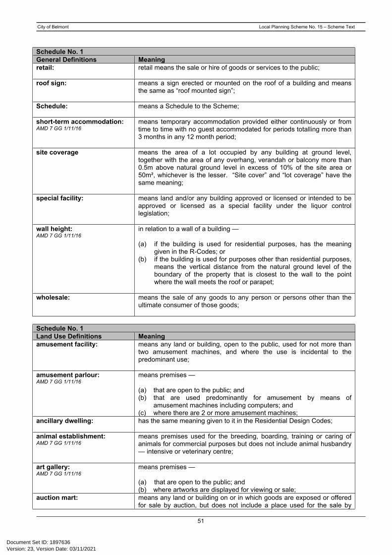
City of Belmont Local Planning Scheme No. 15 – Scheme Text
51
Schedule No. 1General Definitions Meaningretail: retail means the sale or hire of goods or services to the public;
roof sign: means a sign erected or mounted on the roof of a building and means the same as “roof mounted sign”;
Schedule: means a Schedule to the Scheme;
short-term accommodation: AMD 7 GG 1/11/16
means temporary accommodation provided either continuously or from time to time with no guest accommodated for periods totalling more than 3 months in any 12 month period;
site coverage means the area of a lot occupied by any building at ground level, together with the area of any overhang, verandah or balcony more than 0.5m above natural ground level in excess of 10% of the site area or 50m², whichever is the lesser. “Site cover” and “lot coverage” have the same meaning;
special facility: means land and/or any building approved or licensed or intended to be approved or licensed as a special facility under the liquor control legislation;
wall height:AMD 7 GG 1/11/16
in relation to a wall of a building —
(a) if the building is used for residential purposes, has the meaning given in the R-Codes; or
(b) if the building is used for purposes other than residential purposes, means the vertical distance from the natural ground level of the boundary of the property that is closest to the wall to the point where the wall meets the roof or parapet;
wholesale: means the sale of any goods to any person or persons other than the ultimate consumer of those goods;
Schedule No. 1Land Use Definitions Meaningamusement facility: means any land or building, open to the public, used for not more than
two amusement machines, and where the use is incidental to the predominant use;
amusement parlour:AMD 7 GG 1/11/16
means premises —
(a) that are open to the public; and (b) that are used predominantly for amusement by means of
amusement machines including computers; and (c) where there are 2 or more amusement machines;
ancillary dwelling: has the same meaning given to it in the Residential Design Codes;
animal establishment: AMD 7 GG 1/11/16
means premises used for the breeding, boarding, training or caring of animals for commercial purposes but does not include animal husbandry — intensive or veterinary centre;
art gallery: AMD 7 GG 1/11/16
means premises — (a) that are open to the public; and (b) where artworks are displayed for viewing or sale;
auction mart: means any land or building on or in which goods are exposed or offered for sale by auction, but does not include a place used for the sale by
Version: 23, Version Date: 03/11/2021Document Set ID: 1897636

City of Belmont Local Planning Scheme No. 15 – Scheme Text
52
Schedule No. 1Land Use Definitions Meaning
auction of fresh food, fruit, vegetables, livestock or motor vehicles;bed and breakfast:AMD 7 GG 1/11/16
means a dwelling —
(a) used by a resident of the dwelling to provide short-term accommodation, including breakfast, on a commercial basis for not more than 4 adult persons or one family; and
(b) containing not more than 2 guest bedrooms;
betting agency:AMD 7 GG 1/11/16
means an office or totalisator agency established under the Racing and Wagering Western Australia Act 2003;
Brewery: AMD 7 GG 1/11/16
means premises the subject of a producer’s licence authorising the production of beer, cider or spirits granted under the Liquor Control Act 1988;
camping area: means any land used for the accommodation of persons in tents or other temporary shelter;
caravan: means any vehicle whether currently equipped with wheels or not, together with attachments, designed or adapted for human habitation and includes a mobile home which fits the foregoing description;
caravan park:AMD 7 GG 1/11/16
means premises that are a caravan park as defined in the Caravan Parks and Camping Grounds Act 1995 section 5(1);
caretaker's dwelling: means a dwelling on the same site as a building, operation, or plant, and occupied by a supervisor of that building, operation or plant;
carpark:AMD 7 GG 1/11/16
means premises used primarily for parking vehicles whether open to the public or not but does not include — (a) any part of a public road used for parking or for a taxi rank; or (b) any premises in which cars are displayed for sale;
child care premises means premises where —
(a) an education and care service as defined in the Education and Care Services National Law (Western Australia) section 5(1), other than a family day care service as defined in that section, is provided; or
(b) a child care service as defined in the Child Care Services Act 2007 section 4 is provided;
child family day care: family day care means premises where a family day care service as defined in the Education and Care Services National Law (Western Australia) is provided;
cinema/theatre: AMD 7 GG 1/11/16
means premises where the public may view a motion picture or theatrical production;
civic use: means land or buildings used by a Government Department, an agency or instrumentality of the State, or the local government, for administrative, recreational or other purpose;
club premises: means any land or buildings used or designed for use by a legally constituted club or association or other body of persons united by a common interest;
commercial vehicle: means a vehicle whether licensed or not and which is used or designed for use for business purposes or otherwise in conjunction with a trade or profession and without limiting the generality of the foregoing includes
Version: 23, Version Date: 03/11/2021Document Set ID: 1897636

City of Belmont Local Planning Scheme No. 15 – Scheme Text
53
Schedule No. 1Land Use Definitions Meaning
any trailer, tractor and an attachment to any of them and any bus or earthmoving machine whether self-propelled or not but shall not include a vehicle designed for use as a passenger car, a van, utility or light truck which is rated by the manufacturer as being suitable to carry loads of up to 1.5 tonnes;
commercial vehicle parking:AMD 7 GG 1/11/16
means premises used for parking of one or 2 commercial vehicles but does not include —
(a) any part of a public road used for parking or for a taxi rank; or (b) parking of commercial vehicles incidental to the predominant use of
the land;
community home: means a building used primarily for living purposes by a group of physically or intellectually handicapped or socially disadvantaged persons living together with or without paid supervision or care and by a constituted community based organisation, a recognised voluntary, charitable or religious organisation, a government department or an agency or instrumentality of the State or a local government body;
community purpose: means the use of any land or building primarily for the provision of educational, social or recreational facilities or services by organisations involved in activities for community benefit;
consulting rooms:AMD 7 GG 1/11/16
means premises used by no more than 2 health practitioners at the same time for the investigation or treatment of human injuries or ailments and for general outpatient care;
convenience store:AMD 7 GG 1/11/16
means premises —
(a) used for the retail sale of convenience goods commonly sold in supermarkets, delicatessens or newsagents; and
(b) operated during hours which include, but may extend beyond, normal trading hours; and
(c) the floor area of which does not exceed 300 m2 net lettable area;
corrective institution means premises used to hold and reform persons committed to it by a court, such as a prison or other type of detention facility;
cultural use: means any use aimed at the improvement or refinement of people by entertainment and/or education;
display home centre: means a group of two or more dwellings which are intended to be open for public inspection for a limited period of time;
dog kennels: means any land and building used for the boarding or breeding of dogs where such premises are registered or required to be registered by the local government under any written law; and may include the sale of dogs where such use is incidental to the predominant use;
dry cleaning premises: means any land and building used for the cleaning of garments and other fabrics by chemical processes;
educational establishment: means premises used for the purposes of education and includes a school, tertiary institution, business college, academy or other educational centre;
exhibition centre: AMD 7 GG 1/11/16
means premises used for the display, or display and sale, of materials of an artistic, cultural or historical nature including a museum;
fast food/take-away outlet: fast food outlet/lunch bar means premises, including premises with a
Version: 23, Version Date: 03/11/2021Document Set ID: 1897636

City of Belmont Local Planning Scheme No. 15 – Scheme Text
54
Schedule No. 1Land Use Definitions MeaningAMD 7 GG 1/11/16 facility for drive-through service, used for the preparation, sale and
serving of food to customers in a form ready to be eaten —
(a) without further preparation; and(b) primarily off the premises;
fuel depot:AMD 7 GG 1/11/16
means premises used for the storage and sale in bulk of solid or liquid or gaseous fuel but does not include premises used —
(a) as a service station; or (b) for the sale of fuel by retail into a vehicle for use by the vehicle;
funeral parlour:AMD 7 GG 1/11/16
means premises used —
(a) to prepare and store bodies for burial or cremation; (b) to conduct funeral services;
garden centre:AMD 7 GG 1/11/16
means premises used for the propagation, rearing and sale of plants, and the storage and sale of products associated with horticulture and gardens;
health centre: means any building used as a maternity centre, a district clinic, an x-ray or ultrasound centre, or pathology centre, or the like of any of those, but does not include the consulting rooms or a medical centre use classes;
health studio: means any land and building designed and equipped for physical exercise, recreation or sporting activities, but does not include the private recreation or public recreation use classes;
holiday accommodation: AMD 7 GG 1/11/16
means 2 or more dwellings on one lot used to provide short term accommodation for persons other than the owner of the lot;
holiday house: AMD 7 GG 1/11/16
means a single dwelling on one lot used to provide short-term accommodation but does not include a bed and breakfast;
home business:AMD 7 GG 1/11/16
means a dwelling or land around a dwelling used by an occupier of the dwelling to carry out a business, service or profession if the carrying out of the business, service or profession —
(a) does not involve employing more than 2 people who are not members of the occupier’s household; and
(b) will not cause injury to or adversely affect the amenity of the neighbourhood; and
(c) does not occupy an area greater than 50 m2; and (d) does not involve the retail sale, display or hire of any goods unless
the sale, display or hire is done only by means of the Internet; and (e) does not result in traffic difficulties as a result of the inadequacy of
parking or an increase in traffic volumes in the neighbourhood; and (f) does not involve the presence, use or calling of a vehicle of more
than 4.5 tonnes tare weight; and (g) does not involve the use of an essential service that is greater than
the use normally required in the zone in which the dwelling is located;
home occupation:AMD 7 GG 1/11/16
means a dwelling or land around a dwelling used by an occupier of the dwelling to carry out an occupation if the carrying out of the occupation that —
(a) does not involve employing a person who is not a member of the
Version: 23, Version Date: 03/11/2021Document Set ID: 1897636

City of Belmont Local Planning Scheme No. 15 – Scheme Text
55
Schedule No. 1Land Use Definitions Meaning
occupier’s household; and (b) will not cause injury to or adversely affect the amenity of the
neighbourhood; and (c) does not occupy an area greater than 20 m2; and (d) does not involve the display on the premises of a sign with an area
exceeding 0.2 m2; and (e) does not involve the retail sale, display or hire of any goods unless
the sale, display or hire is done only by means of the Internet; and (f) does not —
(i) require a greater number of parking spaces than normally required for a single dwelling; or
(ii) result in an increase in traffic volume in the neighbourhood; and
(g) does not involve the presence, use or calling of a vehicle of more than 4.5 tonnes tare weight; and
(h) does not include provision for the fuelling, repair or maintenance of motor vehicles; and
(i) does not involve the use of an essential service that is greater than the use normally required in the zone in which the dwelling is located;
home office:AMD 7 GG 1/11/16
means a dwelling used by an occupier of the dwelling to carry out a home occupation if the carrying out of the occupation —
(a) is solely within the dwelling; and (b) does not entail clients or customers travelling to and from the
dwelling; and (c) does not involve the display of a sign on the premises; and (d) does not require any change to the external appearance of the
dwelling;
home store:AMD 7 GG 1/11/16
means a shop attached to a dwelling that —
(a) has a net lettable area not exceeding 100 m2; and (b) is operated by a person residing in the dwelling;
hospital:AMD 7 GG 1/11/16
means premises used as a hospital as defined in the Hospitals and Health Services Act 1927 section 2(1);
hotel:AMD 7 GG 1/11/16
means premises the subject of a hotel licence other than a small bar or tavern licence granted under the Liquor Control Act 1988 including any betting agency on the premises;
industry:AMD 7 GG 1/11/16
means premises used for the manufacture, dismantling, processing, assembly, treating, testing, servicing, maintenance or repairing of goods, products, articles, materials or substances and includes facilities on the premises for any of the following purposes —
(a) the storage of goods; (b) the work of administration or accounting; (c) the selling of goods by wholesale or retail;(d) the provision of amenities for employees; (e) incidental purposes;
industry – cottage:(or cottage industry)
means a trade or light industry producing arts and crafts goods which does not fall within the definition of home occupation and which:
(a) does not cause injury to or adversely affect the amenity of the neighbourhood;
Version: 23, Version Date: 03/11/2021Document Set ID: 1897636

City of Belmont Local Planning Scheme No. 15 – Scheme Text
56
Schedule No. 1Land Use Definitions Meaning
(b) where operated in a residential zone, does not employ any person other than a member of the occupier's household;
(c) is conducted in a building or an out-building which is compatible with the principal uses to which land in the zone in which it is located may be put;
(d) does not occupy an area in excess of 50 square metres; and(e) does not display a sign exceeding 0.2 square metres in area;
industry - extractive:(or extractive industry)
means an industry which involves the extraction, quarrying or removal of sand, gravel, clay, hard rock, stone or similar material from the land and includes the treatment and storage of those materials, or the manufacture of products from those materials on, or adjacent to, the land from which the materials are extracted, but does not include industry - mining;
industry - general:(or general industry)
means an industry other than an extractive, hazardous, light, noxious, rural or service industry;
industry - hazardous:(or hazardous industry)
means an industry which, when in operation and when all measures proposed to minimise its impact on the locality have been employed (including measures to isolate the industry from existing or likely future development on other land in the locality), would pose a significant risk in relation to the locality, to human health, life or property, or to the biophysical environment. Examples of such industry include oil refineries and chemical plants but would generally exclude light, rural or service industries;
industry - light:(or light industry)
means an industry:
(a) in which the processes carried on, the machinery used, and the goods and commodities carried to and from the premises do not cause any injury to or adversely affect the amenity of the locality;
(b) the establishment or conduct of which does not, or will not, impose an undue load on any existing or proposed service for the supply or provision of essential services;
industry – noxious:(or noxious industry)
means any industry which causes premises to be defined as “Prescribed Premises” or “Premises Subject to Registration” under the Environment Protection Act 1986;”
industry – service:(or service industry)
means:
(a) an industry - light carried out from premises which may have a retail shop front and from which goods manufactured on the premises may be sold; or
(b) premises having a retail shop front and used as a depot for receiving goods to be serviced;
laundromat: means any land and building, open to the public in which washing machines, with or without provision for drying clothes, are available for use;
liquor store:AMD 7 GG 1/11/16
liquor store — large means premises the subject of a liquor store licence granted under the Liquor Control Act 1988 with a net lettable area of more than 300 m2; liquor store — small means premises the subject of a liquor store licence granted under the Liquor Control Act 1988 with a net lettable area of not more than 300 m2;
Version: 23, Version Date: 03/11/2021Document Set ID: 1897636

City of Belmont Local Planning Scheme No. 15 – Scheme Text
57
Schedule No. 1Land Use Definitions Meaninglodging house: has the meaning given to the term in the Health Act 1911, save that in
this Scheme the term also includes premises providing board or lodging to 6 persons or less, but the term does not include the bed and breakfast use;
logistics centre means land within which all activities relating to transport, logistics, warehousing and the distribution of goods are carried out and includes premises on the same land used for :
(a) the work of administration or accounting;(b) the provision of amenities for employees,
incidental to any of those logistics operations;
lunch bar: means premises or part of premises used for the sale of takeaway food (in a form ready to be consumed without further preparation) within industrial or commercial areas;
marina:AMD 7 GG 1/11/16
means —
(a) premises used for providing mooring, fuelling, servicing, repairing, storage and other facilities for boats, including the associated sale of any boating gear or equipment; and
(b) all jetties, piers, embankments, quays, moorings, offices and storerooms used in connection with the provision of those services;
marine filling station: means premises used for the storage and supply of liquid fuels and lubricants for marine craft;
market: means premises used for the display and sale of goods from stalls by independent vendors;
massage parlour means a use of land involving the massaging manipulation or other treatment of body parts for therapeutic or remedial purposes, of a kind generally administered in association with medical treatment. The term does not include the provision of any sexual services;
medical centre:AMD 7 GG 1/11/16
means premises other than a hospital used by 3 or more health practitioners at the same time for the investigation or treatment of human injuries or ailments and for general outpatient care;
mining operations:AMD 7 GG 1/11/16
means premises where mining operations, as that term is defined in the Mining Act 1978 section 8(1) is carried out;
mobile phone tower & associated facilities
mobile phone towers and associated facilities that are considered “non low impact” under the Telecommunications Act 1997;
motel:AMD 7 GG 1/11/16
means premises, which may be licenced under the Liquor Control Act 1988 —
(a) used to accommodate guests in a manner similar to a hotel; and (b) with specific provision for the accommodation of guests with motor
vehicles;
motor vehicle, boat or caravan sales:
means premises used to sell motor vehicles, boats or caravans;
motor vehicle hire: means any land or building used for the hiring out of motor vehicles and when conducted on the same site, the storage and cleaning of motor vehicles for hire but does not include mechanical repair or servicing of such vehicles;
Version: 23, Version Date: 03/11/2021Document Set ID: 1897636

City of Belmont Local Planning Scheme No. 15 – Scheme Text
58
Schedule No. 1Land Use Definitions Meaningmotor vehicle repair:AMD 7 GG 1/11/16
means premises used for or in connection with —
(a) electrical and mechanical repairs, or overhauls, to vehicles other than panel beating, spray painting or chassis reshaping of vehicles; or
(b) repairs to tyres other than recapping or re-treading of tyres;
motor vehicle wash: means premises where the primary use is the washing of motor vehicles;
motor vehicle wrecking: means any land or building used for the storage, breaking up or dismantling of motor vehicles and includes the sale of second-hand motor vehicle accessories and spare parts on the same premises;
night club:AMD 7 GG 1/11/16
means premises the subject of a nightclub licence granted under the Liquor Control Act 1988;
nursing home: means any building used for the medical treatment and/or care of sick, aged or handicapped persons, whether resident or not, but does not include the hospital, consulting rooms, medical centre or health centre uses;
office: means premises used for administration, clerical, technical, professional or other like business activities;
open air display: means the use of land as a site for the display and/or sale of goods and equipment;
outbuilding: a non-habitable building being a private garage, carport, shed or the like associated with a residential use, but detached from the main dwelling unit;
park home park:AMD 7 GG 1/11/16
means premises used as a park home park as defined in the Caravan Parks and Camping Grounds Regulations 1997 Schedule 8;
pet day care: involves the use of any land or building for the day time care of pet animals, but does not involve the boarding of animals overnight, or the provision of substantial meals. The term may include limited and incidental provision of food by way of “treats” as part of play or training, or as an adjunct to the administration of an animal’s requirement for medication. The term does not include a use that involves injury or risk of injury or prejudicial impact upon the amenity of the relevant locality by reason of the emission noise, smell, waste water or other waste products;
place of worship: means premises used for religious activities such as a church, chapel, mosque, synagogue or temple;
public amusement: means the use of any land or building for the amusement or entertainment of the public, with or without charge, but the term does not include an amusement parlour;
public assembly - place of:(or place of public assembly)
means any special place of assembly, , hall, grounds for athletics, all sports grounds with provision for spectators, a racecourse, a trotting track, stadia and/or showgrounds;
radio or TV installation: means any land or building used to accommodate any part of the infrastructure of a radio or TV network and includes any line, equipment, apparatus, tower, antenna, tunnel, duct, hole, pit or other structure used, or intended for use in or in connection with, a radio or TV network;
Version: 23, Version Date: 03/11/2021Document Set ID: 1897636

City of Belmont Local Planning Scheme No. 15 – Scheme Text
59
Schedule No. 1Land Use Definitions Meaningreception centre:AMD 7 GG 1/11/16
means premises used for hosted functions on formal or ceremonial occasions;
recreation private:(or private recreation)AMD 7 GG 1/11/16
means premises that are —
(a) used for indoor or outdoor leisure, recreation or sport; and (b) not usually open to the public without charge;
recreation public:(or public recreation)
means any land and buildings used for a public park, public gardens, foreshore reserve, playground or other grounds for recreation which are usually open to the public without charge;
residential building: has the same meaning as in the Residential Design Codes;
restaurant:AMD 7 GG 1/11/16
restaurant/cafe means premises primarily used for the preparation, sale and serving of food and drinks for consumption on the premises by customers for whom seating is provided, including premises that are licenced under the Liquor Control Act 1988;
restricted premises:AMD 7 GG 1/11/16
means premises used for the sale by retail or wholesale, or the offer for hire, loan or exchange, or the exhibition, display or delivery of —
(a) publications that are classified as restricted under the Classification (Publications, Films and Computer Games) Act 1995 (Commonwealth); or
(b) materials, compounds, preparations or articles which are used or intended to be used primarily in or in connection with any form of sexual behaviour or activity; or
(c) smoking-related implements;
retirement village: means any land and buildings containing accommodation for aged and/or dependent persons together with ancillary facilities;
salvage yard: means any land or building used for the storage or sale of materials salvaged from the erection, demolition, dismantling or renovating of, or fire or flood damage to structures including (but without limiting the generality of the foregoing) buildings, machinery, and motor and marine vehicles;
service station:AMD 7 GG 1/11/16
means premises other than premises used for a transport depot, panel beating, spray painting, major repairs or wrecking, that are used for —
(a) the retail sale of petroleum products, motor vehicle accessories and goods of an incidental or convenience nature; and/or
(b) the carrying out of greasing, tyre repairs and minor mechanical repairs to motor vehicles;
serviced apartment:AMD 7 GG 1/11/16
means a group of units or apartments providing —
(a) self-contained short stay accommodation for guests; and (b) any associated reception or recreational facilities;
shop:AMD 7 GG 1/11/16
means premises other than a bulky goods showroom, a liquor store — large or a liquor store — small used to sell goods by retail, to hire goods, or to provide services of a personal nature, including hairdressing or beauty therapy services;
short stay accommodation means the accommodation of short stay guests providing on site facilities for the convenience of guests and, management of the
Version: 23, Version Date: 03/11/2021Document Set ID: 1897636

City of Belmont Local Planning Scheme No. 15 – Scheme Text
60
Schedule No. 1Land Use Definitions Meaning
development, where occupation by any person is limited to a maximum of three months in any 12 month period, and excludes any other use falling within a use class specifically defined in this scheme;
showroom: means premises used to display, sell by wholesale or retail, or hire, automotive parts and accessories, camping equipment, electrical light fittings, equestrian supplies, floor coverings, furnishings, furniture, household appliances, party supplies, swimming pools or goods of a bulky nature;
single house: has the same meaning as in the Residential Design Codes;
Small bar: AMD 7 GG 1/11/16
means premises the subject of a small bar licence granted under the Liquor Control Act 1988;
stable: means any land, building or structure used for the housing, keeping or feeding of horses, asses or mules and associated incidental activities;
studio: means a building or part of a building used as a work-room by a painter, photographer, sculptor or craftsperson in the conduct of his/her profession and includes incidental display and sale of things made, decorated or adapted therein;
tavern:AMD 7 GG 1/11/16
means premises the subject of a tavern licence granted under the Liquor Control Act 1988;
telecommunications infrastructure:AMD 7 GG 1/11/16
means premises used to accommodate the infrastructure used by or in connection with a telecommunications network including any line, equipment, apparatus, tower, antenna, tunnel, duct, hole, pit or other structure related to the network;
tourist development:AMD 7 GG 1/11/16
means a building, or a group of buildings forming a complex, other than a bed and breakfast, a caravan park or holiday accommodation, used to provide —
(a) short-term accommodation for guests; and (b) onsite facilities for the use of guests; and (c) facilities for the management of the development;
trade display: means premises used for the display of trade goods or equipment for the purpose of advertising;
trade supplies:AMD 7 GG 1/11/16
means premises used to sell by wholesale or retail, or to hire, assemble or manufacture any materials, tools, equipment, machinery or other goods used for the following purposes including goods which may be assembled or manufactured off the premises —
(a) automotive repairs and servicing; (b) building including repair and maintenance; (c) industry; (d) landscape gardening; (e) provision of medical services; (f) primary production; (g) use by government departments or agencies, including local
government;
transport depot:AMD 7 GG 1/11/16
means premises used primarily for the parking or garaging of 3 or more commercial vehicles including —
Version: 23, Version Date: 03/11/2021Document Set ID: 1897636

City of Belmont Local Planning Scheme No. 15 – Scheme Text
61
Schedule No. 1Land Use Definitions Meaning
(a) any ancillary maintenance or refuelling of those vehicles; and(b) any ancillary storage of goods brought to the premises by those
vehicles; and (c) the transfer of goods or persons from one vehicle to another;
truck stop means land used for the parking of commercial vehicles and may include facilities for ancillary dwelling of drivers and the retail sale of petroleum products and convenience goods, but excludes the garaging, maintenance, management, and repair of any motor vehicle;
vet consulting room:AMD 7 GG 1/11/16
means any land and/or building where a veterinary surgeon or veterinarian treats the minor ailments of domestic animals and household pets as patients but in which animals or pets do not remain overnight, and may include a dispensary of medications incidental thereto;
veterinary centre:AMD 7 GG 1/11/16
means premises used to diagnose animal diseases or disorders, to surgically or medically treat animals, or for the prevention of animal diseases or disorders;
veterinary hospital: means any land and/or building used in connection with the treatment of animal injuries and ailments, and includes the care and accommodation of animals during or after such treatment;
video store: means any building, or part of a building used for the purpose of sale by retail or wholesale, or the offer for hire, loan or exchange, or the exhibition, display or delivery of pre-recorded video material;
warehouse: means premises used to store or display goods and includes premises on the same land used for:
(a) the work of administration or accounting;(b) the selling of goods by wholesale; or(c) the provision of amenities for employees,
incidental to any of those warehouse operations;
waste storage facility:AMD 7 GG 1/11/16
means premises used to collect, consolidate, temporarily store or sort waste before transfer to a waste disposal facility or a resource recovery facility on a commercial scale;
Version: 23, Version Date: 03/11/2021Document Set ID: 1897636

City of Belmont Local Planning Scheme No. 15 – Scheme Text
62
Schedule No. 2 - Additional Uses
No. Location and Additional Uses1(a) For all land included in the town centre frame which is zoned Residential R20/50/100 and detailed in
the plan below, the local government may approve the following additional land uses:
art gallery consulting rooms office studio
When considering applications for the establishment of the abovementioned uses, the following shall be taken into consideration:
(i) Opportunities for upgrading and renovations of existing buildings to achieve a high architectural standard;
(ii) Development or redevelopment to have a high level of regard for the recommendations of the Town Centre Frame Study;
(iii) The potential impact of any proposal on the amenity of abutting and nearby residential properties;
(iv) The extent to which the design of the proposal harmonises with adjoining and nearby buildings and the general streetscape within the same precinct area.
1(b) For land within Precinct A, the local government may approve the following two additional land uses:
showroom video outlet
When considering applications for the establishment of showroom or video outlet uses, the following requirements shall be met:
(i) Lots shall be amalgamated to achieve a minimum lot size of 1,500m2 and all existing
Version: 23, Version Date: 03/11/2021Document Set ID: 1897636

City of Belmont Local Planning Scheme No. 15 – Scheme Text
63
No. Location and Additional Usesimprovements on the property shall be demolished;
(ii) Development or redevelopment to have a high level of regard for the recommendations of the Town Centre Frame Study;
(iii) The potential impact of any proposal on the amenity of abutting and nearby residential properties;
(iv) The extent to which the design of the proposal harmonises with adjoining and nearby buildings and the general streetscape within the same precinct area;
(v) Demonstration that adequate car parking can be provided on site in accordance with Table 2 of the City of Belmont Local Planning Scheme No. 15;
(vi) Prior to any development of a site, the local government may require the formulation of vehicular access plan for the property and abutting sites;
(vii) As a condition of Development Approval, the local government may require that a public easement in gross be provided to promote shared vehicular access between lots;
(viii) For showroom uses, provision of a loading/unloading bay and provision of a truck movement plan demonstrating adequate manoeuvrability and turning circles;
(ix) Adequate landscaping along the frontage of the lot with a minimum width of 1.5 metres;
(x) Landscaping plans to use species consistently used for existing developments in the same precinct.
1(c) For land within Precinct C, the local government may approve retail floor space for new development that meets the following criteria:
(i) Lots shall be amalgamated to achieve a minimum lot size of 1,000m2 and all existing improvements on the property shall be demolished;
(ii) The total area of retail floor space shall not exceed 35% of the gross floor area of the development, and the gross floor area shall not include any portion of the development to be used for residential purposes;
(iii) Development or redevelopment to have a high level of regard for the recommendations of the Town Centre Frame Study;
(iv) Parking, vehicular access and easements in gross to be in accordance with the City of Belmont Access Policy Plan for Fulham Street (Belmont Avenue to Robinson Avenue).
1(d) For land within Precinct E, the local government may approve a percentage of retail floor space for mixed use developments that include a substantial residential component up to a maximum density of R60, subject to the following requirements being met:
(i) The total area of retail floor space shall not exceed 35% of the gross floor area of the development. For the purpose of calculating permissible retail floor space, the gross floor area shall not include any portion of the development to be used for residential purposes;
(ii) Lots shall be amalgamated to achieve a minimum area of 1,000m2 and all existing improvements on the property shall be demolished;
(iii) Development or redevelopment to have a high level of regard for the recommendations of the Town Centre Frame Study;
(iv) Development shall have a minimum of two storeys;
(v) Development shall incorporate a mixture of land uses and in the opinion of the local government, include a substantial residential component;
(vi) Development to achieve a high standard of development through imaginative layout, variation in roof height and building design;
Version: 23, Version Date: 03/11/2021Document Set ID: 1897636
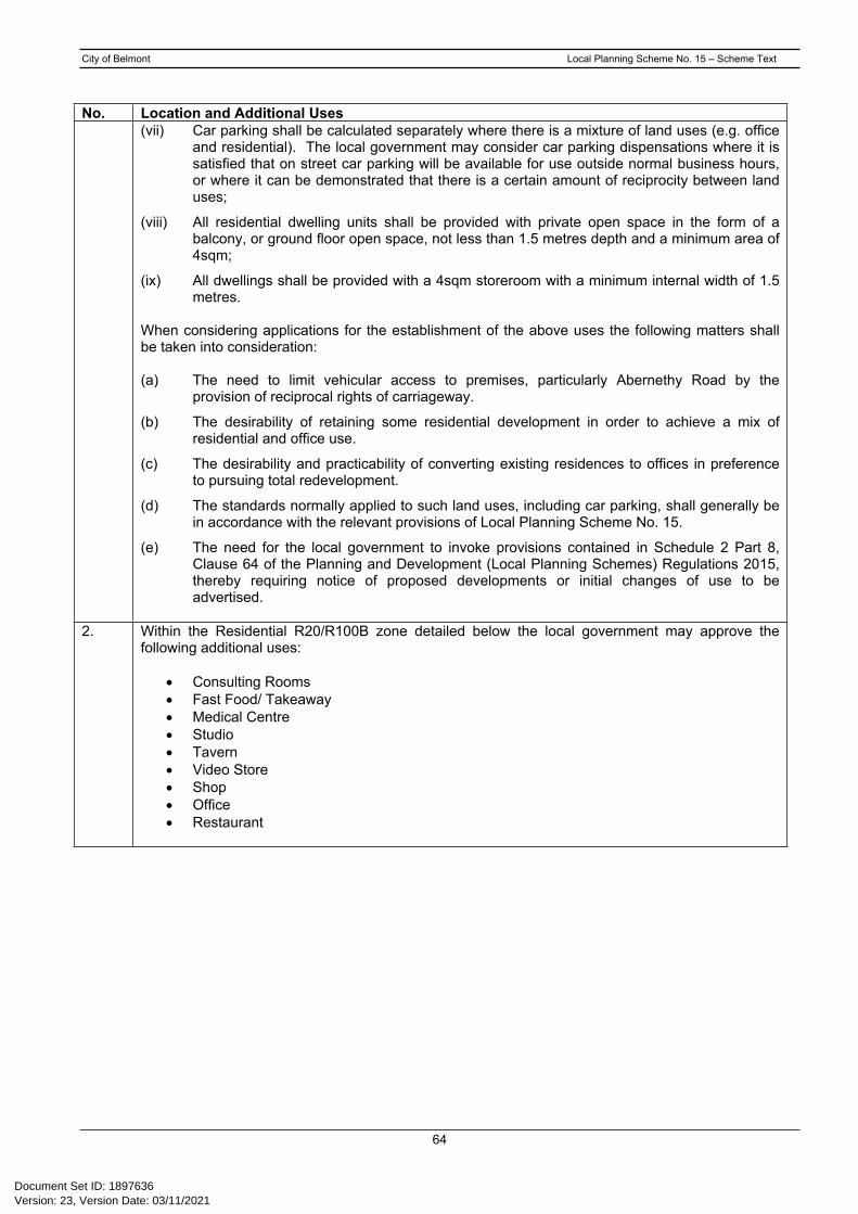
City of Belmont Local Planning Scheme No. 15 – Scheme Text
64
No. Location and Additional Uses(vii) Car parking shall be calculated separately where there is a mixture of land uses (e.g. office
and residential). The local government may consider car parking dispensations where it is satisfied that on street car parking will be available for use outside normal business hours, or where it can be demonstrated that there is a certain amount of reciprocity between land uses;
(viii) All residential dwelling units shall be provided with private open space in the form of a balcony, or ground floor open space, not less than 1.5 metres depth and a minimum area of 4sqm;
(ix) All dwellings shall be provided with a 4sqm storeroom with a minimum internal width of 1.5 metres.
When considering applications for the establishment of the above uses the following matters shall be taken into consideration:
(a) The need to limit vehicular access to premises, particularly Abernethy Road by the provision of reciprocal rights of carriageway.
(b) The desirability of retaining some residential development in order to achieve a mix of residential and office use.
(c) The desirability and practicability of converting existing residences to offices in preference to pursuing total redevelopment.
(d) The standards normally applied to such land uses, including car parking, shall generally be in accordance with the relevant provisions of Local Planning Scheme No. 15.
(e) The need for the local government to invoke provisions contained in Schedule 2 Part 8, Clause 64 of the Planning and Development (Local Planning Schemes) Regulations 2015, thereby requiring notice of proposed developments or initial changes of use to be advertised.
2. Within the Residential R20/R100B zone detailed below the local government may approve the following additional uses:
Consulting Rooms Fast Food/ Takeaway Medical Centre Studio Tavern Video Store Shop Office Restaurant
Version: 23, Version Date: 03/11/2021Document Set ID: 1897636
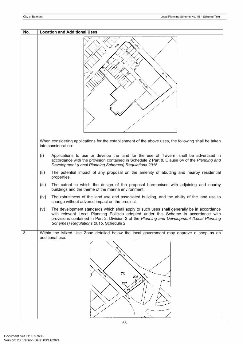
City of Belmont Local Planning Scheme No. 15 – Scheme Text
65
No. Location and Additional Uses
When considering applications for the establishment of the above uses, the following shall be taken into consideration:
(i) Applications to use or develop the land for the use of ‘Tavern’ shall be advertised in accordance with the provision contained in Schedule 2 Part 8, Clause 64 of the Planning and Development (Local Planning Schemes) Regulations 2015..
(ii) The potential impact of any proposal on the amenity of abutting and nearby residential properties.
(iii) The extent to which the design of the proposal harmonises with adjoining and nearby buildings and the theme of the marina environment.
(iv) The robustness of the land use and associated building, and the ability of the land use to change without adverse impact on the precinct.
(v) The development standards which shall apply to such uses shall generally be in accordance with relevant Local Planning Policies adopted under this Scheme in accordance with provisions contained in Part 2, Division 2 of the Planning and Development (Local Planning Schemes) Regulations 2015. Schedule 2.
3. Within the Mixed Use Zone detailed below the local government may approve a shop as an additional use.
Version: 23, Version Date: 03/11/2021Document Set ID: 1897636

City of Belmont Local Planning Scheme No. 15 – Scheme Text
66
No. Location and Additional Uses4. Within that portion of the Forrestfield Marshalling Yard Office Park and Service Commercial Site
detailed below, the local government may approve the following additional uses.
Fast food / Take away; Consulting room - Group; Restaurant; Service station; Shop, provided that the Gross Leasable Area set aside for the purposes of Shop other than
Fast Food does not exceed 500m2 in total; and Tavern.
5(a) Within the lots detailed in the plan below the local government may approve the following additional uses.
Consulting Rooms Medical Centre Office Serviced Apartments Showroom where no single tenancy exceeds 200m2 NLA Studio
Version: 23, Version Date: 03/11/2021Document Set ID: 1897636

City of Belmont Local Planning Scheme No. 15 – Scheme Text
67
No. Location and Additional Uses5(b) Within the lots detailed in the plan below the local government may approve the following additional
uses.
Consulting Rooms Restaurant Medical Centre Office Serviced Apartments Showroom where no single tenancy exceeds 200m2 NLA Studio
5(c) Within the lots detailed in the plan below the local government may approve the following additional uses.
Consulting Rooms Medical Centre Office Serviced Apartments Showroom where no single tenancy exceeds 200m2 NLA Studio
Within the Residential Zone localities detailed in the above plans under 5(a), 5(b) and 5(c) the local government may approve the following additional uses having regard for the degree of compliance with the criteria contained in the relevant local planning policy.
Version: 23, Version Date: 03/11/2021Document Set ID: 1897636

City of Belmont Local Planning Scheme No. 15 – Scheme Text
68
No. Location and Additional Uses
6. On Lot 2 (234-236) Epsom Avenue, Belmont as detailed in the below plan the local government may approve the additional use ‘Public Worship’.
7. Within the Residential zone localities detailed in the below plan the local government may approve the following additional uses having regard for the degree of compliance with the criteria contained in the relevant local planning policy.
Consulting rooms Office Showroom Studio
Version: 23, Version Date: 03/11/2021Document Set ID: 1897636

City of Belmont Local Planning Scheme No. 15 – Scheme Text
69
No. Location and Additional Uses
8. On Lot 85 (329) Orrong Road, Kewdale as detailed in the below plan the local government may approve the additional use ‘Public Worship’.
9. On Lot 25 Strata Lots 1-15 (Units 1-15/398) Great Eastern Highway, Ascot as detailed in the below plan the local government may approve the additional use ‘Shop’ up to a maximum floor area of 300m2 over the total site.
Version: 23, Version Date: 03/11/2021Document Set ID: 1897636

City of Belmont Local Planning Scheme No. 15 – Scheme Text
70
No. Location and Additional Uses
10. On Lots 801 (108), Lot 1 (110), Lot 66 (122), Lot 114 (124), Lot 115 (126), Lot 70 (130), Lot 98 (132), Lot 10 (136) Belmont Avenue and Lot 11 (185) Alexander Road, local Government may consider approving the additional uses of office, consulting rooms and studio where the development incorporates a residential component.
11. On Lot 151 (210) Great Eastern Highway, Ascot as detailed in the below plan, local Government may approve the additional uses of ‘convenience store’ and ‘motor vehicle wash’.
– AMD 1 GG 15/12/15
When considering applications for the establishment of the above uses, the following shall be taken into consideration:
The extent to which building(s) and structures on the site incorporate noise attenuation measures to limit the potential impact of noise on adjacent existing and future residential landuses.
Version: 23, Version Date: 03/11/2021Document Set ID: 1897636

City of Belmont Local Planning Scheme No. 15 – Scheme Text
71
No. Location and Additional Uses Limiting the hours of operation of the ‘motor vehicle wash’ so as to limit the impact of noise
on adjacent existing and future residential landuses. The extent to which the ‘motor vehicle wash’ is designed to limit the potential for water
spray impacts on adjoining existing and future residential landuses.
The extent to which the design and layout of proposed building/s and structures on the site are sympathetic to adjoining residential landuses.
The implementation of management measures on-site so as to assist with reducing the possibility of water-borne disease.
Incorporation of security measures designed to discourage anti-social behaviour.
12. On portion of Lot 142 (No. 128) Tibradden Circle, Ascot as detailed in the below plan, local Government may approve an additional density bonus up to R40 subject to any development on site addressing noise attenuation and a high standard of design.
13. On Lot 288 (137) Kewdale Road, Kewdale, the local government may approve the following additional uses:
Consulting Rooms Health Centre Liquor Store Lunch Bar Medical Centre Office Restaurant Tavern
Version: 23, Version Date: 03/11/2021Document Set ID: 1897636

City of Belmont Local Planning Scheme No. 15 – Scheme Text
72
No. Location and Additional Uses
14. On Lots 11, 10, 275 and 1 (118, 126, 128 and 133) Kewdale Road, Kewdale as detailed in the plan below the local government may approve the following additional use ‘Office’.
AMD 1 GG 15/12/15
15. On Lot 1 (524) Kewdale Road, Kewdale as detailed in the plan below the local government may approve the following additional use ‘Office’.
Version: 23, Version Date: 03/11/2021Document Set ID: 1897636

City of Belmont Local Planning Scheme No. 15 – Scheme Text
73
No. Location and Additional Uses
16. On Lot 3 and Lot 4 (2 and 4) Aitken Way, Kewdale and Lots 1, 393, 394, 395 and 396 (1, 3, 5, 7 and 9) Tipping Road, Kewdale as detailed in the plan below the local government may approve the following additional use ‘Office’.
17. On Lot 8 (99) Leach Highway, Kewdale as detailed in the plan below the local government may approve the following additional use ‘Office’.
Version: 23, Version Date: 03/11/2021Document Set ID: 1897636

City of Belmont Local Planning Scheme No. 15 – Scheme Text
74
No. Location and Additional Uses
18. On Lot 9002 and Lot 7705 (71) Grandstand Road and Lot 100 (1) Raconteur Drive, the local government may consider the following additional uses;
Horse Sales Stables
19. On Lots 30 and 33 Belvidere Street as detailed in the plan below, the use class of ‘Service Station’ may be considered as a ‘D’ Use for the purpose of clause 4.3 and Table 1.
Version: 23, Version Date: 03/11/2021Document Set ID: 1897636

City of Belmont Local Planning Scheme No. 15 – Scheme Text
75
No. Location and Additional Uses
AMD 6 GG 21/02/17
20. On Lots 10, 12, 13, 14, 15, 16, 30, 33, 36, 37, 38, 39, 40, 41, 75, 76, 95, 125, 126, 166 and 500 Belvidere Street; Lots 67, 68 and 130 Leake Street; Lots 77 and 94 Gardiner Street; Lots 17, 18 and 19 Somers Street; and Lots 10 and 11 Keymer Street, as detailed in the plan below, the following use classes may be considered as ‘D’ uses for the purposes of Clause 4.3 and Table 1:
Dry-cleaning premises Educational Establishment Health Centre Laundromat Public Amusement Vet Consulting Rooms.
Version: 23, Version Date: 03/11/2021Document Set ID: 1897636

City of Belmont Local Planning Scheme No. 15 – Scheme Text
76
No. Location and Additional Uses
AMD 6 GG 21/02/17
Version: 23, Version Date: 03/11/2021Document Set ID: 1897636

City of Belmont Local Planning Scheme No. 15 – Scheme Text
77
Schedule No. 3 - Restricted Uses
There are no restricted uses which apply to the Scheme.
Version: 23, Version Date: 03/11/2021Document Set ID: 1897636

City of Belmont Local Planning Scheme No. 15 – Scheme Text
78
Schedule No. 4 - Special Use Zones
There are no Special Use Zones which apply to the Scheme.
Version: 23, Version Date: 03/11/2021Document Set ID: 1897636

City of Belmont Local Planning Scheme No. 15 – Scheme Text
79
Schedule No. 5 - Exempted Advertisements
LAND USE AND/OR DEVELOPMENT
REQUIRING ADVERTISEMENT
EXEMPTED SIGN TYPE AND NUMBER (includes the change of posters on poster signs and applies to non-illuminated signs unless otherwise stated)
MAXIMUM AREA OF EXEMPTED SIGN
DWELLINGS One professional name-plate as appropriate. 0.2m2
HOME OCCUPATION One advertisement describing the nature of the home occupation.
0.2m2
(a) Advertisement signs (illuminated and non-illuminated) relating to the functions of government, a public authority or local Government of a municipality, excluding those of a promotional nature constructed or exhibited by or on behalf of any such body; and
Not applicable
(b) Advertisement signs (illuminated and non-illuminated) required for the management or control of traffic on any public road, car park, cycleway, railway, or waterway where such advertisement has been constructed or exhibited by or at the direction of a government department, public authority, or the local Government of a municipality; and
Not applicable
(c) Advertisement signs (illuminated or non-illuminated) required to be exhibited by or pursuant to any statute or regulation or the like made pursuant to powers contained within a Statute provided that any such advertisement is constructed and/or exhibited strictly in accordance with the requirements specified herein.
Not applicable
PUBLIC PLACES AND RESERVES
(d) Advertisement signs (illuminated or non-illuminated) to promote a significant project and/or public work undertaken by the City of Belmont.
15m2
RAILWAY PROPERTY AND RESERVES
Advertisement signs exhibited on such land provided that each such advertisement is directed only at persons at or upon a railway station.
No sign shall exceed 2m2 in area
ADVERTISEMENTS WITHIN BUILDINGS
All advertisements placed or displayed within buildings which cannot ordinarily be seen by a person outside of those buildings.
Not applicable
(i) DwellingsOne advertisement per street frontage containing details of the project and professional consultants and the contractors undertaking the construction work.
2m2BUILDING CONSTRUCTION SITES (ADVERTISEMENT SIGNS DISPLAYED ONLY FOR THE DURATION OF THE CONSTRUCTION AS FOLLOWS): (ii) Multiple dwellings, shops, commercial and
industrial projectsOne sign as for i) above.
5m2
Version: 23, Version Date: 03/11/2021Document Set ID: 1897636

City of Belmont Local Planning Scheme No. 15 – Scheme Text
80
LAND USE AND/OR DEVELOPMENT
REQUIRING ADVERTISEMENT
EXEMPTED SIGN TYPE AND NUMBER (includes the change of posters on poster signs and applies to non-illuminated signs unless otherwise stated)
MAXIMUM AREA OF EXEMPTED SIGN
(iii) Large development/re-development projects involving shopping centres, offices, or other buildings exceeding three stories in height. One sign as for i) above, and One additional sign showing the name
of the project building.5m2
10m2
Advertisement signs displayed for the duration of the period over which property transactions are offered and negotiated, as follows:
(i) DwellingsOne sign per street frontage for each property relating to the sale, leasing or impending auction of the property at or upon which the sign is or the signs are displayed.
Each sign shall not exceed an area of 2m2
(ii) Multiple dwellings, shops, commercial and industrial propertiesOne sign as for (i) above
Each sign shall not exceed an area of 5m2
PROPERTY TRANSACTIONS
(iii) Large properties comprised of shopping centres, buildings in excess of four storeys, and rural properties in excess of 5haOne sign as for (i) above.
Each sign shall not exceed an area of 10m2
Advertisement signs displayed for the period which homes are on display for public inspection
(i) One sign for each dwelling on display 2m2
DISPLAY HOMES
(ii) In addition to (i) above, one sign for each group of dwellings displayed by a single project builder giving details of the project building company and details of the range of dwellings on display.
5m2
Version: 23, Version Date: 03/11/2021Document Set ID: 1897636

City of Belmont Local Planning Scheme No. 15 – Scheme Text
81
Schedule No. 6 - Environmental Conditions
There are no environmental conditions imposed by the Minister for Environment which apply to the Scheme.
Version: 23, Version Date: 03/11/2021Document Set ID: 1897636

City of Belmont Local Planning Scheme No. 15 – Scheme Text
82
Schedule No. 7 - Car Parking Layout
Version: 23, Version Date: 03/11/2021Document Set ID: 1897636
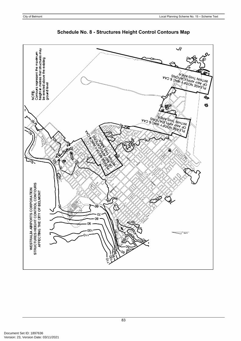
City of Belmont Local Planning Scheme No. 15 – Scheme Text
83
Schedule No. 8 - Structures Height Control Contours Map
Version: 23, Version Date: 03/11/2021Document Set ID: 1897636

City of Belmont Local Planning Scheme No. 15 – Scheme Text
84
Schedule No. 9 – Special Control Areas - Development Areas
AMD 11 GG 12/01/2021
REF. NO. AREA PROVISIONSSCA-DA3 Land fronting Kew Street and
abutting Dod Reserve.An approved Structure Plan together with all approved amendments shall apply to the land in order to guide subdivision and development.
SCA-DA 4 Land bounded by Ryans Court, Morrison Street, Stanton Road and Tonkin Highway Redcliffe.
1. An approved Structure Plan together with all approved amendments shall apply to the land in order to guide subdivision and development.
2. To provide for residential development.
3. Not less than seventy-five percent (75%) of all land within the Residential Zone shall be developed for the purpose of single houses.
SCA-DA 5 Land bounded by Stanton Road, Morrison Street, Greenshields Way and Tonkin Highway.
1. An approved Structure Plan together with all approved amendments shall apply to the land in order to guide subdivision and development.
2. To provide for residential development.
SCA-DA 6 Land bounded by Tonkin Highway, Great Eastern Highway, Coolgardie Avenue, Redcliffe Road, Fauntleroy Avenue and Precincts 1A and 1B as defined under the Perth Airport Masterplan 2004.
An approved Structure Plan together with all approved amendments shall apply to the land in order to guide subdivision and development.
SCA-DA 7 Land bounded by Tibradden Circle, Coolgardie Parade, Central Avenue, Garvey Park, and the back of lots 57 to 75 Fernridge Cove.
1. An approved Structure Plan together with all approved amendments shall apply to the land in order to guide subdivision and development.
2. To provide for residential development.
SCA-DA 8 DELETED BY AMENDMENT 12 GG 06/03/2020SCA-DA 9 Land bounded by Fauntleroy
Avenue, Hay Road, Lot 185 Hay Road and the rear of the Mixed Use zoned lots fronting Great Eastern Highway.
1. An approved Structure Plan together with all approved amendments shall apply to the land in order to guide subdivision and development.
2. To provide for residential development.
SCA-DA 10 Lot 120 Epsom Avenue and Lot 111 Nisbet Street, Ascot(Ascot Inn)
1. An approved Structure Plan together with all approved amendments shall apply to the land in order to guide subdivision and development.
2. To incorporate the existing heritage place in any structure plan for the area.
SCA-DA 11 The Springs bounded by the Swan River, Brighton Road, Great Eastern Highway and Graham Farmer Freeway
An approved Structure Plan together with all approved amendments shall apply to the land in order to guide subdivision and development.
Version: 23, Version Date: 03/11/2021Document Set ID: 1897636

City of Belmont Local Planning Scheme No. 15 – Scheme Text
85
Schedule No. 10 - Statutory Static Feasibility Assessment Model
STATUTORY STATIC FEASIBILITY ASSESSMENT MODELGross realisationNet lot yield @ average market value per lot“X” lots @ “$Y” per lot $ (1)Less GST @ standard / normal rates(1) Multiplied by GST rate/(100+GST rate) $ (2)(1-2) $ (3)Less selling, marketing, advertising & settlement fees@ market % multiplied by (1) $ (4)Add back Input Tax Credit on selling fees(4) Multiplied by GST rate/(100+GST rate) $ (5)(4-5) $ (6)Balance after selling costs etc & Input Tax Credit (3-6) $ (7)Less adjusted profit & risk allowance as per SPP 3.6Market determined profit & risk allowance % (8)Less fixed profit allowance per SPP3.6 10% (9)Risk rate applied (8-9) = % (10)EXPLANATION: (10) to be expressed as a whole number eg 15% = 15ie Risk = (7) multiplied by (10)/100+(10) $ (11)Balance after profit & risk factor (7-11) $ (12)Less development costs @ “X” lots multiplied by “$Z” per lot $ (13)Add back Input Tax Credit on (13)(13) Multiplied by GST rate/(100+GST rate) $ (14)Development cost after Input Tax Credit (13-14) $ (15)Add interest on net development costs (15)For 1/2 development and 1/2 selling term@ Applicable market rates(15) Multiplied by % rate $ (16)(15+16) $ (17)Balance after deduction of development costs & interest (12-17) $ (18)
Less interest on land value, rates & taxes and stamp dutyAssessed over 1/2 development and 1/2 selling term@ Applicable market rates(18) Multiplied by (% rate/100+%rate) $ (19)Balance after interest on the land (18-19) $ (20)Less rates & taxes $ (21)Balance after rates & taxes (20-21) $ (22)Less Stamp Duty @ current statutory rates(22) Multiplied by stamp duty rate/(100+stamp duty rate) $ (23)Residual Land Value prior to GST considerations (22-23) $ (24)Add GST (24) + GST at prevailing statutory rate $ (25)
ASSESSED STATUTORY CONTRIBUTION PER SPP 3.6 (22+23) $
The Static Feasibility Model is based upon:(i) The number of lots yielded from the land will have a gross sale price which, when multiplied by the
number of lots created, establishes the Gross Realisation (i).(ii) GST will be calculated by the standard/normal method.(iii) Selling, marketing, advertising and settlement fees expressed as a percentage shall be added and
then expressed as a total percentage against the gross realisation.(iv) The adjusted risk component applied in the model is the established market profit and risk at the date of
valuation less the fixed 10 per cent profit applied in SPP 3.6.
Version: 23, Version Date: 03/11/2021Document Set ID: 1897636

City of Belmont Local Planning Scheme No. 15 – Scheme Text
86
(v) Development costs will be established as an appropriate servicing cost per lot at the date of valuation, multiplied by the lots realised from the land.
(vi) Interest against the development costs will be established by the application of bank lending rates for such projects at the date of valuation.
(vii) Interest against the land in development will be established by the application of bank lending rates for such development acquisitions at the date of valuation.
(viii) Rates and taxes will be applied for the full term of acquisition, development and sale. (ix) Stamp Duty will be applied at the statutory rate as applicable at the date of valuation.(x) GST will be applied at the appropriate rate adopted at the date of valuation.
Version: 23, Version Date: 03/11/2021Document Set ID: 1897636

City of Belmont Local Planning Scheme No. 15 – Scheme Text
87
Schedule No. 11 – Special Control Areas - Development Contribution PlansAMD 2 GG 07/02/17; AMD 11 GG 12/01/2021
1. Reference No Development Contribution Area 1
Area name: The Springs Special Development Precinct (The Development Contribution Area (SCA-DCA) comprises all the land referred to as The Springs Special Development Precinct identified by scheme maps as SCA-DCA1).
Relationship to other planning instruments:
The development contribution plan generally conforms to the following endorsed plans:
• City of Belmont Strategic Community Plan 2016 - 2036;
• Local Planning Scheme No, 15;• Western Australian Planning Commission State Planning Policy
3.6 (Development Contributions for Infrastructure); and
The Springs Structure Plan.
Infrastructure and administrative costs to be funded:
Contributions shall be made towards the following items by all landowners:
1. Civil construction costs relating to the provision and upgrading of necessary and shared public infrastructure, specifically:
• Mobilisation
• Site works
• Retaining walls
• Sewer reticulation
• Stormwater and drainage
• Water reticulation
• Road works to existing roads (excluding Riversdale Road east of Rowe Avenue and west of Brighton Road).
2. Electrical infrastructure costs, including high voltage reinforcement where necessary.
3. Landscaping construction and remediation costs, specifically:
• Public open space
• Streetscape and public realm.
4. Professional and administrative fees relating to:
• Environmental Remediation fees associated with the (remediation of public open space only);
• Civil Engineering fees associated with: (relating to civil design and public utility upgrades);
• Civil and landscaping design;
Version: 23, Version Date: 03/11/2021Document Set ID: 1897636

City of Belmont Local Planning Scheme No. 15 – Scheme Text
88
1. Reference No Development Contribution Area 1
• Infrastructure upgrades;• Hydrological and urban water management; and
• Parking & Traffic Impact System.
• Urban Water Management
• Landscape Architecture (associated with public open space, streetscape and public realm)
• Civil Construction (relating to management of civil works).
Method for calculating contributions:
The development contribution for each lot within The Springs shall be calculated on the basis of Infrastructure Costs+Electricity Upgrade Costs, as follows:
Infrastructure Cost: The contribution for individual lots for Infrastructure Costs shall be apportioned pro-rata based on the square meterage of each lot;
Electricity Costs: The contribution for individual lots for Electricity Upgrade Costs shall be calculated pro-rata based on the anticipated demand generated by each lot (based on development potential) less the current electricity capacity; and
High Voltage Electricity Reinforcement: The contribution for high voltage electricity reinforcement shall be apportioned to lots designated as ‘Mixed Use’ under The Springs Structure Plan and calculated pro-rata based on the anticipated demand generated by each lot (based on development potential) less the current electricity capacity.
The following areas shall be excluded from the land area calculations of both the total land area in the Development Contribution Area and the Owner’s land in the Development Contribution Area:
Roads designated under the Metropolitan Region Scheme as Primary Regional Roads and Other Regional Roads
Existing public open space
Drainage reserves
Public utility sites
Other land required for Infrastructure Works
Period of operation: The Development Contribution Plan shall operate for a period of 5 years from the date of gazettal.
Priority and timing: Clearing and Earthworks (Complete)
Drainage Basin Retaining Walls (Complete)
Roads (Complete)
Drainage (Complete)
Water Reticulation (Complete)
Version: 23, Version Date: 03/11/2021Document Set ID: 1897636

City of Belmont Local Planning Scheme No. 15 – Scheme Text
89
1. Reference No Development Contribution Area 1
Sewer Reticulation (Complete)
Street Lighting and Power (Complete)
Landscaping (Stage 2)
Review process: The Development Contribution Plan will be reviewed 5 years from the date of gazettal of the amendment to incorporate the plan, or earlier should the local government consider it appropriate having regard to the rate of development in the area and the degree of development potential still existing.
The estimated infrastructure costs contained in the cost apportionment schedule will be reviewed at least annually to reflect changes in funding and revenue sources and indexed based on the Building Cost Index or other appropriate index as approved by the qualified person undertaking the certification of costs referred to in Clause 5.2.11.3 of Local Planning Scheme No 15.
Version: 23, Version Date: 03/11/2021Document Set ID: 1897636

City of Belmont Local Planning Scheme No. 15 – Scheme Text
90
Approved by Resolution of the Council of the City of Belmont at the Special Meeting of Council held on the 25th day of November 2008.
_________________________ ______________Mayor Date
_________________________ ______________Chief Executive Officer Date
FINAL APPROVAL
1. Adopted by Resolution of the Council of the City of Belmont at the Special Meeting of the Council held on 14th day of February 2011 and the seal of the Municipality was pursuant to the Resolution hereto in the presence of:
_________________________ ______________Mayor Date
_________________________ ______________Chief Executive Officer Date
2. Recommended/Submitted for Final Approval by the Western Australian Planning Commission.
____________________________ ______________Chairperson, Western Australian DatePlanning Commission
3. Final Approved granted.
____________________________ ______________Minister for Planning Date
Version: 23, Version Date: 03/11/2021Document Set ID: 1897636
Related Documents