Welcome message from author
This document is posted to help you gain knowledge. Please leave a comment to let me know what you think about it! Share it to your friends and learn new things together.
Transcript
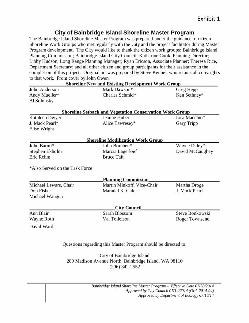
Exhibit 1
Bainbridge Island Shoreline Master Program – Effective Date 07/30/2014
Approved by City Council 07/14/2014 (Ord. 2014-04)
Approved by Department of Ecology 07/16/14
City of Bainbridge Island Shoreline Master Program
The Bainbridge Island Shoreline Master Program was prepared under the guidance of citizen
Shoreline Work Groups who met regularly with the City and the project facilitator during Master
Program development. The City would like to thank the citizen work groups; Bainbridge Island
Planning Commission; Bainbridge Island City Council; Katharine Cook, Planning Director;
Libby Hudson, Long Range Planning Manager; Ryan Ericson, Associate Planner; Theresa Rice,
Department Secretary; and all other citizen and group participants for their assistance in the
completion of this project. Original art was prepared by Steve Kennel, who retains all copyrights
to that work. Front cover by John Owen.
_______________Shoreline New and Existing Development Work Group_______________
John Anderson Mark Dawson* Greg Hepp
Andy Mueller* Charles Schmid* Ken Sethney*
Al Solonsky
_____________Shoreline Setback and Vegetation Conservation Work Group____________
Kathleen Dwyer Jeanne Huber Lisa Macchio*
J. Mack Pearl* Alice Tawresey* Gary Tripp
Elise Wright
_______________________Shoreline Modification Work Group_______________________ John Barutt* John Bomben* Wayne Daley*
Stephen Ekholm Marcia Lagerloef David McCaughey
Eric Rehm Bruce Taft
*Also Served on the Task Force
______________________________Planning Commission_____________________________
Michael Lewars, Chair Martin Minkoff, Vice-Chair Martha Droge
Don Fisher Maradel K. Gale J. Mack Pearl
Michael Wangen
___________________________________City Council________________________________
Ann Blair Sarah Blossom Steve Bonkowski
Wayne Roth Val Tollefson Roger Townsend
David Ward
Questions regarding this Master Program should be directed to:
City of Bainbridge Island
280 Madison Avenue North, Bainbridge Island, WA 98110
(206) 842-2552
2 Bainbridge Island Shoreline Master Program – Effective Date 07/30/2014
Approved by City Council 07/14/2014 (Ord. 2014-04)
Approved by Department of Ecology 07/16/14
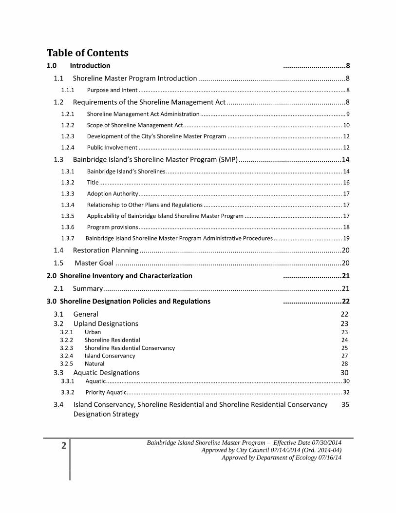
Table of Contents 1.0 Introduction ............................... 8
1.1 Shoreline Master Program Introduction .........................................................................8
1.1.1 Purpose and Intent ......................................................................................................................... 8
1.2 Requirements of the Shoreline Management Act ...........................................................8
1.2.1 Shoreline Management Act Administration ..................................................................................... 9
1.2.2 Scope of Shoreline Management Act ............................................................................................. 10
1.2.3 Development of the City’s Shoreline Master Program ................................................................... 12
1.2.4 Public Involvement ....................................................................................................................... 12
1.3 Bainbridge Island’s Shoreline Master Program (SMP) ...................................................14
1.3.1 Bainbridge Island’s Shorelines ....................................................................................................... 14
1.3.2 Title .............................................................................................................................................. 16
1.3.3 Adoption Authority ....................................................................................................................... 17
1.3.4 Relationship to Other Plans and Regulations ................................................................................. 17
1.3.5 Applicability of Bainbridge Island Shoreline Master Program ......................................................... 17
1.3.6 Program provisions ....................................................................................................................... 18
1.3.7 Bainbridge Island Shoreline Master Program Administrative Procedures ........................................ 19
1.4 Restoration Planning ....................................................................................................20
1.5 Master Goal ................................................................................................................20
2.0 Shoreline Inventory and Characterization ............................. 21
2.1 Summary ......................................................................................................................21
3.0 Shoreline Designation Policies and Regulations ............................. 22
3.1 General 22 3.2 Upland Designations 23 3.2.1 Urban 23 3.2.2 Shoreline Residential 24 3.2.3 Shoreline Residential Conservancy 25 3.2.4 Island Conservancy 27 3.2.5 Natural 28
3.3 Aquatic Designations 30 3.3.1 Aquatic .......................................................................................................................................... 30
3.3.2 Priority Aquatic .............................................................................................................................. 32
3.4 Island Conservancy, Shoreline Residential and Shoreline Residential Conservancy 35 Designation Strategy
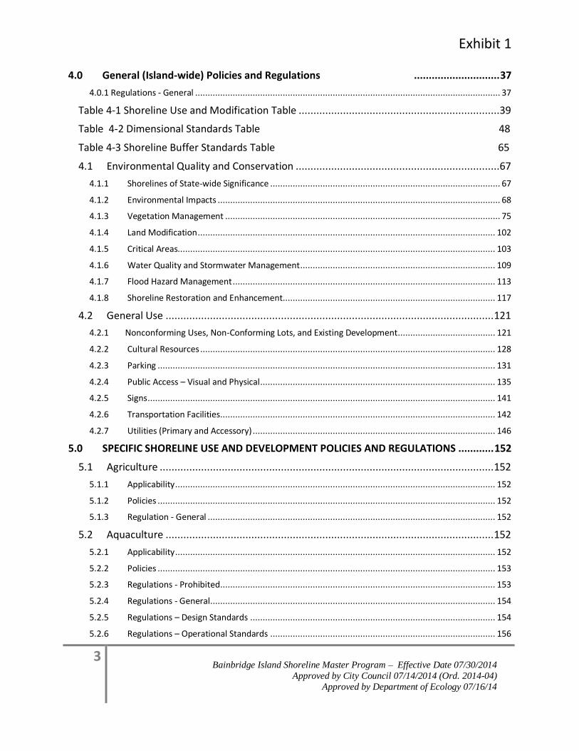
Exhibit 1
3 Bainbridge Island Shoreline Master Program – Effective Date 07/30/2014
Approved by City Council 07/14/2014 (Ord. 2014-04)
Approved by Department of Ecology 07/16/14
4.0 General (Island-wide) Policies and Regulations ............................. 37
4.0.1 Regulations - General .......................................................................................................................... 37
Table 4-1 Shoreline Use and Modification Table ....................................................................39
Table 4-2 Dimensional Standards Table 48
Table 4-3 Shoreline Buffer Standards Table 65
4.1 Environmental Quality and Conservation .....................................................................67
4.1.1 Shorelines of State-wide Significance ............................................................................................ 67
4.1.2 Environmental Impacts ................................................................................................................. 68
4.1.3 Vegetation Management .............................................................................................................. 75
4.1.4 Land Modification ....................................................................................................................... 102
4.1.5 Critical Areas............................................................................................................................... 103
4.1.6 Water Quality and Stormwater Management .............................................................................. 109
4.1.7 Flood Hazard Management ......................................................................................................... 113
4.1.8 Shoreline Restoration and Enhancement..................................................................................... 117
4.2 General Use ............................................................................................................... 121
4.2.1 Nonconforming Uses, Non-Conforming Lots, and Existing Development ....................................... 121
4.2.2 Cultural Resources ...................................................................................................................... 128
4.2.3 Parking ....................................................................................................................................... 131
4.2.4 Public Access – Visual and Physical .............................................................................................. 135
4.2.5 Signs ........................................................................................................................................... 141
4.2.6 Transportation Facilities .............................................................................................................. 142
4.2.7 Utilities (Primary and Accessory) ................................................................................................. 146
5.0 SPECIFIC SHORELINE USE AND DEVELOPMENT POLICIES AND REGULATIONS ............ 152
5.1 Agriculture ................................................................................................................. 152
5.1.1 Applicability ................................................................................................................................ 152
5.1.2 Policies ....................................................................................................................................... 152
5.1.3 Regulation - General ................................................................................................................... 152
5.2 Aquaculture ............................................................................................................... 152
5.2.1 Applicability ................................................................................................................................ 152
5.2.2 Policies ....................................................................................................................................... 153
5.2.3 Regulations - Prohibited .............................................................................................................. 153
5.2.4 Regulations - General .................................................................................................................. 154
5.2.5 Regulations – Design Standards .................................................................................................. 154
5.2.6 Regulations – Operational Standards .......................................................................................... 156
4 Bainbridge Island Shoreline Master Program – Effective Date 07/30/2014
Approved by City Council 07/14/2014 (Ord. 2014-04)
Approved by Department of Ecology 07/16/14
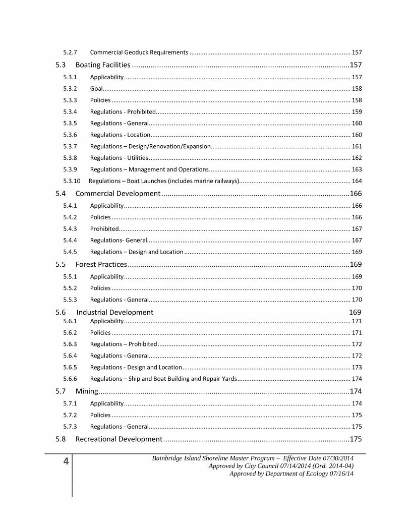
5.2.7 Commercial Geoduck Requirements ........................................................................................... 157
5.3 Boating Facilities ........................................................................................................ 157
5.3.1 Applicability ................................................................................................................................ 157
5.3.2 Goal ............................................................................................................................................ 158
5.3.3 Policies ....................................................................................................................................... 158
5.3.4 Regulations - Prohibited .............................................................................................................. 159
5.3.5 Regulations - General .................................................................................................................. 160
5.3.6 Regulations - Location ................................................................................................................. 160
5.3.7 Regulations – Design/Renovation/Expansion ............................................................................... 161
5.3.8 Regulations - Utilities .................................................................................................................. 162
5.3.9 Regulations – Management and Operations ................................................................................ 163
5.3.10 Regulations – Boat Launches (includes marine railways)............................................................... 164
5.4 Commercial Development .......................................................................................... 166
5.4.1 Applicability ................................................................................................................................ 166
5.4.2 Policies ....................................................................................................................................... 166
5.4.3 Prohibited................................................................................................................................... 167
5.4.4 Regulations- General................................................................................................................... 167
5.4.5 Regulations – Design and Location .............................................................................................. 169
5.5 Forest Practices .......................................................................................................... 169
5.5.1 Applicability ................................................................................................................................ 169
5.5.2 Policies ....................................................................................................................................... 170
5.5.3 Regulations - General .................................................................................................................. 170
5.6 Industrial Development 169 5.6.1 Applicability ................................................................................................................................ 171
5.6.2 Policies ....................................................................................................................................... 171
5.6.3 Regulations – Prohibited ............................................................................................................. 172
5.6.4 Regulations - General .................................................................................................................. 172
5.6.5 Regulations - Design and Location ............................................................................................... 173
5.6.6 Regulations – Ship and Boat Building and Repair Yards ................................................................ 174
5.7 Mining........................................................................................................................ 174
5.7.1 Applicability ................................................................................................................................ 174
5.7.2 Policies ....................................................................................................................................... 175
5.7.3 Regulations - General .................................................................................................................. 175
5.8 Recreational Development ......................................................................................... 175
Exhibit 1
5 Bainbridge Island Shoreline Master Program – Effective Date 07/30/2014
Approved by City Council 07/14/2014 (Ord. 2014-04)
Approved by Department of Ecology 07/16/14
5.8.1 Applicability ................................................................................................................................ 175
5.8.2 Goal ............................................................................................................................................ 175
5.8.3 Policies ....................................................................................................................................... 175
5.8.4 Regulations – Prohibited ............................................................................................................. 177
5.8.5 Regulations - General .................................................................................................................. 177
5.8.6 Regulations – Design and Location .............................................................................................. 179
5.8.7 Regulations – Operations ............................................................................................................ 180
5.8.8 Regulations – Golf Courses – Design & Location .......................................................................... 180
5.9 Residential Development ........................................................................................... 181
5.9.1 Applicability ................................................................................................................................ 181
5.9.2 Goal ............................................................................................................................................ 181
5.9.3 Policies ....................................................................................................................................... 181
5.9.4 Regulations - Prohibited .............................................................................................................. 183
5.9.5 Regulations - General .................................................................................................................. 183
5.9.6 Regulations – Primary Residential Design and Location ............................................................... 184
5.9.7 Regulations – Accessory Design and Location .............................................................................. 186
5.9.8 Regulations – Residential Subdivisions (Single-Family and Multifamily, including ADU) ................ 186
5.9.9 Regulations – Residential Development Overwater ..................................................................... 187
6.0 SHORELINE MODIFICATION POLICIES AND REGULATIONS ........................... 189
6.1 General Shoreline Modification Provisions ................................................................. 189
6.1.1 Applicability ................................................................................................................................. 189
6.1.2 Goal ............................................................................................................................................ 189
6.1.3 Policies ........................................................................................................................................ 189
6.1.4 Regulations – Prohibited Uses ...................................................................................................... 190
6.1.5 Regulations - General................................................................................................................... 190
6.2 Shoreline Stabilization ................................................................................................ 191
6.2.1 Principles ..................................................................................................................................... 191
6.2.2 Applicability ................................................................................................................................. 192
6.2.3 Policies ........................................................................................................................................ 193
6.2.4 Regulations – Prohibited .............................................................................................................. 194
6.2.5 Regulations - General................................................................................................................... 195
6.2.6 Regulations – Location and Design of Shoreline Stabilization ........................................................ 195
6.2.7 Regulations --Repair of Existing Shoreline Stabilization 194
6.2.8 Regulations – New or Replacement Shoreline Stabilization .......................................................... 197
6.2.9 Regulations – Subdivisions ........................................................................................................... 200
6 Bainbridge Island Shoreline Master Program – Effective Date 07/30/2014
Approved by City Council 07/14/2014 (Ord. 2014-04)
Approved by Department of Ecology 07/16/14
6.2.10 Submittal Requirements for Shoreline Stabilization Project Applications ...................................... 200
6.3 Overwater Structures ................................................................................................ 201
6.3.1 Applicability ................................................................................................................................. 201
6.3.2 Goal ............................................................................................................................................ 202
6.3.3 Policies ........................................................................................................................................ 202
6.3.4 Regulations - Prohibited 201
6.3.5 Regulations - General................................................................................................................... 204
6.3.6 Regulations – Location, Design and Construction Standards – Pier, Dock, Float............................. 205
6.3.7 Regulations – Specific .................................................................................................................. 206
6.4 Dredging and Dredge Material Disposal ..................................................................... 213
6.4.1 Applicability ................................................................................................................................. 213
6.4.2 Goal ............................................................................................................................................ 214
6.4.3 Policies ........................................................................................................................................ 214
6.4.4 Regulations – Prohibited .............................................................................................................. 214
6.4.5 Regulations - General................................................................................................................... 215
6.4.6 Regulations – Specific Dredging ................................................................................................... 216
6.4.7 Regulations – Dredge Material Disposal ....................................................................................... 217
6.5 Fill .............................................................................................................................. 217
6.5.1 Applicability ................................................................................................................................. 217
6.5.2 Policies ........................................................................................................................................ 217
6.5.3 Prohibited ................................................................................................................................... 218
6.5.4 Regulations - General................................................................................................................... 218
6.5.5 Regulations – Location, Design and Construction ......................................................................... 219
7.0 VIOLATIONS, ENFORCEMENT, AND PENALTIES ........................... 220
7.1 General ...................................................................................................................... 220
7.2 Regulations ............................................................................................................... 220
7.2.1 Site Investigations........................................................................................................................ 220
7.2.2 Violations -- General .................................................................................................................... 220
7.2.3 Violations -- Specific .................................................................................................................... 220
7.2.4 Stop Work Order ......................................................................................................................... 221
7.2.5 After the Fact Permit Fee ............................................................................................................. 221
7.2.6 Violation Mitigation/Restoration Plan .......................................................................................... 221
7.2.7 Civil Infraction ............................................................................................................................. 221
7.2.8 Misdemeanor .............................................................................................................................. 221
Exhibit 1
7 Bainbridge Island Shoreline Master Program – Effective Date 07/30/2014
Approved by City Council 07/14/2014 (Ord. 2014-04)
Approved by Department of Ecology 07/16/14
7.2.9 Civil Penalty ................................................................................................................................. 222
7.2.10 General Penalties......................................................................................................................... 222
7.2.11 Additional Remedies .................................................................................................................... 222
7.2.12 Conflicts ...................................................................................................................................... 222
7.2.13 Financial Surety Procedure .......................................................................................................... 223
8.0 DEFINITIONS ........................... 224
Appendix A Shoreline Designation Map ........................... 263
Appendix B Critical Areas Regulations ........................... 264
Appendix C Buffer Recommendation Memorandums ........................... 314
Marine Shoreline Buffers and Riparian Areas ....................................................................... 318
Scientific Importance of Marine Shoreline Buffers and Riparian Areas ................................. 319
Marine Shoreline Buffers .................................................................................................................... 319
Riparian Areas ....................................................................................................................................... 320
Marine Shoreline Buffer and Riparian Protection Zone Recommendations .......................... 322
Agreed Principles ................................................................................................................. 325
Buffer Assumptions and Recommendations ........................................................................ 327
References ........................................................................................................................... 330
Attachment A to Herrera Memo
16.20.130 Fish and wildlife habitat conservation areas: .............................................................................. 333
SMP Table 4-2. Use-related Development Standards Matrix from Chapter 16.12 BIMC. .............................. 333
Scientific Recommendations for Marine Riparian Buffers ........................................................................... 335
Scientific Basis for 30-foot Riparian Protection Zone ................................................................................... 337
References ................................................................................................................................................. 338
Appendix D Single-Family Residence Mitigation Manual ........................... 341
Appendix E Special Area Maps ........................... 378
Port Madison Harbor Structure Line 379 Eagle Harbor Harbor Structure Line 380 Point Monroe District Shoreline Stabilization Areas 381
8 Bainbridge Island Shoreline Master Program – Effective Date 07/30/2014
Approved by City Council 07/14/2014 (Ord. 2014-04)
Approved by Department of Ecology 07/16/14
1.0 Introduction
1.1 Shoreline Master Program Introduction This Shoreline Master Program (SMP) establishes regulations, enforcement procedures and
policies for protection and development of Bainbridge Island’s shoreline areas. The
regulations in the SMP state specific legal requirements which future development must
follow. The regulations in the SMP are part of the City’s development regulations. The
policies in the SMP state the underlying objectives the regulations are intended to accomplish.
The policies are a component of the City’s Comprehensive Plan and guide the interpretation
and enforcement of the Shoreline Master Program’s regulations. The policies are not
regulations in themselves and, therefore, do not impose requirements beyond those set forth in
the regulations.
1.1.1 Purpose and Intent
The Shoreline Master Program is intended to implement the Shoreline Management Act of 1971
(Chapter 90.58 Revised Code of Washington) by:
● Planning for and guiding the orderly development of the shoreline in a positive,
effective, and equitable manner, protecting and restoring shoreline resources, and
helping to assure public access to the shoreline;
● Promoting the health, safety, and general welfare of the community by providing
long range, comprehensive policies and effective, reasonable regulations for use
and development of Bainbridge Island’s shorelines;
● Ensuring, at minimum, no net loss of shoreline ecological functions and
ecosystem-wide processes;
● Planning for the restoration of shorelines that have been impaired or degraded in
the past and in a manner that educates the community in the use and protection of
its shorelines;
● Adhering to and fostering the policies of the Act contained in RCW 90.58.020 for
shorelines of the state; and
● Improving the water quality of the Puget Sound.
1.2 Requirements of the Shoreline Management Act In June 1971, the Washington State Legislature approved a comprehensive regulatory program
for shorelines of the state with the adoption of the Shoreline Management Act of 1971 (“SMA”
or “Act”). The Act carried with it provisions for a vote by the people and in November 1972,
the people of the State of Washington enacted the Shoreline Management Act (Chapter 90.58
RCW). The Act’s paramount objectives are to protect and restore the valuable natural
resources that shoreline represent, and to plan for and foster all “reasonable and appropriate
uses”, including single-family development, that are dependent upon a waterfront location or
Exhibit 1
9 Bainbridge Island Shoreline Master Program – Effective Date 07/30/2014
Approved by City Council 07/14/2014 (Ord. 2014-04)
Approved by Department of Ecology 07/16/14
that offer the opportunities for the public to enjoy the state’s shoreline. With this clear
mandate, the Shoreline Management Act establishes a planning and regulatory program,
initiated at the local level under state guidelines.
1.2.1 Shoreline Management Act Administration
Administration of the Act is a cooperative effort balancing local and statewide interest in the
management and development of shoreline areas by requiring local government to plan (via the
SMP) and regulate (via permits) shoreline development. Local government actions are
monitored by the Washington State Department of Ecology (Ecology), which approves new or
amended SMPs, reviews substantial development permits, and approves shoreline Conditional
Use permits and Variances. The SMP is essentially a shoreline comprehensive plan with
distinct environmental orientation applicable to shoreline areas and customized to local
circumstances. Collectively, the local master programs comprise the State SMP. By law, the
City is responsible for the following:
1. Preparation of a SMP in accordance with the policies and requirements of the Act and
the State Master Program Approval/Amendment Procedures and Master Program
Guidelines (the “Guidelines” or “Shoreline Master Program Guidelines”; Chapter 173-
26 WAC). The purpose of a SMP is to protect shoreline resources, manage the uses and
activities on local shorelines, and assure continued public use of waters of the state.
2. The Act specifies that local SMPs include goals and policy statements for each of the
required elements and take into account economic development, public access,
circulation and transportation, and recreation. Local government is further encouraged
to identify any other elements that are deemed appropriate and necessary to implement
the intent of the Act, and to develop goals and policies for those additional elements.
3. Master program regulations are developed and adopted by local government to
implement the goals and policies for each of the elements. These regulations address
various types of shoreline development, including agriculture, aquaculture, forest
management, commercial development, marinas, mining, outdoor advertising and signs,
residential development, utilities, ports and water-related industries, bulkheads,
breakwaters, jetties and groins, landfills, solid waste disposal.
4. Administration of a shoreline permit system to further the goals and policies of both the
Act and the local SMP for proposed substantial development within two hundred (200)
feet of the ordinary high water mark (OHWM) of designated water bodies. [Local
government has the option to adopt the administrative process as part of the SMP or as a
reference document not considered part of the SMP. This allows local government to
make changes without the need of a SMP amendment. See WAC 173-26-
191(2)(a)(iii)(C).]
5. Development of an inventory of natural characteristics and land use patterns along those
designated water bodies. Local governments are required to prepare a detailed
shoreline inventory that provides the foundation for development of a system that
classifies the shoreline into distinct shoreline “environments” These environments, or
10 Bainbridge Island Shoreline Master Program – Effective Date 07/30/2014
Approved by City Council 07/14/2014 (Ord. 2014-04)
Approved by Department of Ecology 07/16/14
designations, provide the framework for implementing shoreline policies and regulatory
measures.
6. Local governments have the primary responsibility for initiating the planning program
and administering the regulatory requirements. The City of Bainbridge Island SMP
must be consistent with the policies and requirements of the Act and the Guidelines.
The role of the Department of Ecology is to provide support and review of the SMP and
subsequent shoreline development permits and approvals and ensure compliance with
the policies and provisions of the Act.
1.2.2 Scope of Shoreline Management Act
The Act covers all shorelines of the state, including “shorelines” and “shorelines of state-wide
significance.” Figure 1-1 illustrates shoreline jurisdiction on coastal shorelines.
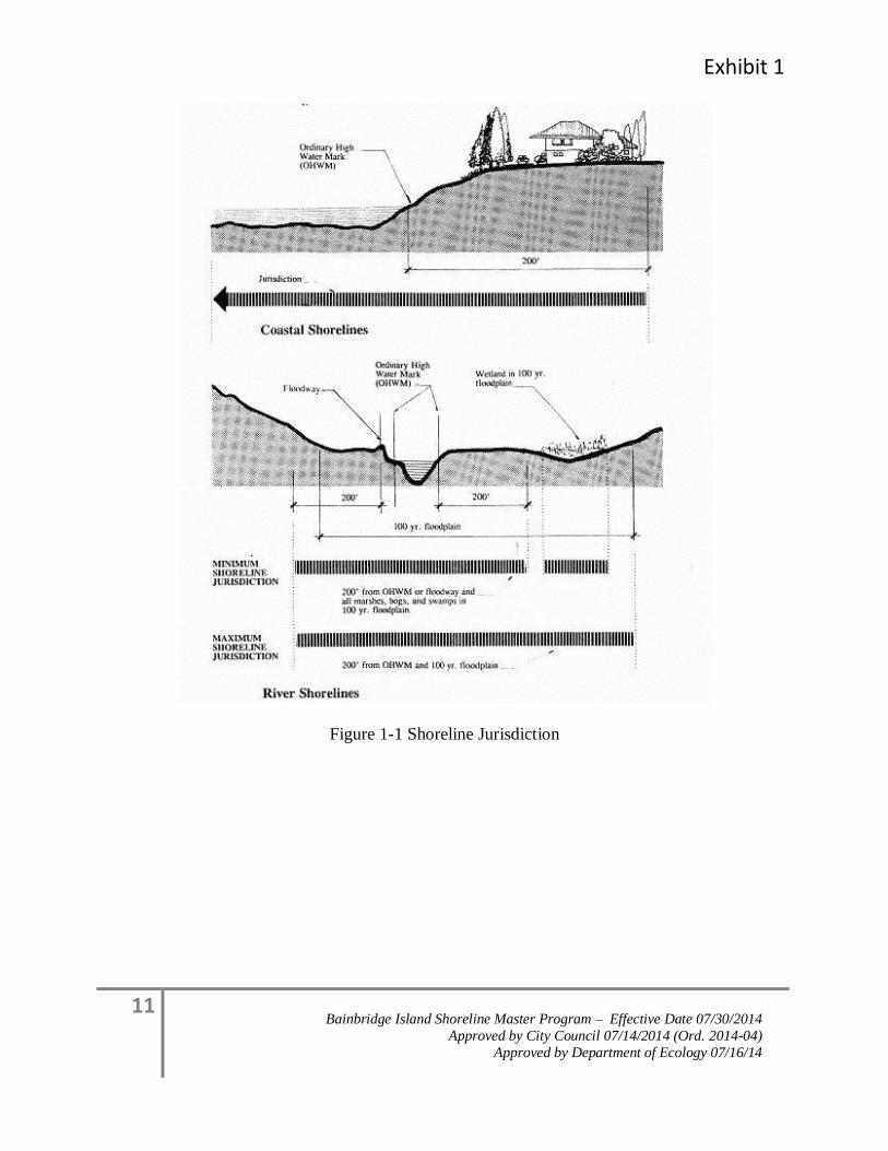
Exhibit 1
11 Bainbridge Island Shoreline Master Program – Effective Date 07/30/2014
Approved by City Council 07/14/2014 (Ord. 2014-04)
Approved by Department of Ecology 07/16/14
Figure 1-1 Shoreline Jurisdiction
12 Bainbridge Island Shoreline Master Program – Effective Date 07/30/2014
Approved by City Council 07/14/2014 (Ord. 2014-04)
Approved by Department of Ecology 07/16/14
Provisions of the Act apply to the following geographical shoreline areas:
1. All marine waters of the state, together with the lands underlying them;
2. Segments of streams and rivers where the mean annual flow is more than 20 cubic feet
per second (cfs);
3. Lakes and reservoirs 20 acres and greater in area;
4. Shorelands extending landward for two hundred feet in all directions as measured on a
horizontal plane from the ordinary high water mark; floodways and contiguous flood
plain areas landward two hundred feet from such floodways; and all wetlands and river
deltas associated with the streams, lakes, and tidal waters; and
5. Shorelines of state-wide significance as defined in RCW 90.58.030 or its successor. This
includes those areas of Puget Sound lying seaward from the line of extreme low tide.
1.2.3 Development of the City’s Shoreline Master Program
The City of Bainbridge Island adopted a SMP in 1996 after annexation of the entire Island
occurred in March 1991. Prior to annexation, Bainbridge Island’s shorelines were managed
under the Kitsap County SMP and the City of Winslow SMP. The goals and policies in the
SMP are an element of the City’s Comprehensive Plan. All other portions of the SMP,
including the use of regulations, are part of the City’s development regulations.
The “precautionary principle” was employed as guidance in updating the policies and
regulations of this SMP. The “precautionary principle” is cited in the State Shoreline
Guidelines under WAC 173-26-201(3)(g) and states, in part that “as a general rule, the less
known about existing resources, the more protective shoreline master program provisions
should be to avoid unanticipated impacts to shoreline resources.”
1.2.4 Public Involvement
Public participation strategies were used in developing the SMP adopted in 1996, and updating
the SMP in 2012.
For the 1996 SMP, the City convened a citizen committee that worked from 1991-1993 to
develop the first SMP for the City of Bainbridge Island. In addition, approximately 45 citizen
volunteers participated in a shoreline survey. The City used a variety of tools for public
outreach, and conducted several public meetings, special topic meetings, and public hearings.
In updating this SMP, the City first developed a public participation plan with the community
in March 2010. The public participation plan was accepted by the City Council in May, 2010,
and the City used the plan as a guide for public involvement and notification throughout the
update process. An SMP Ad Hoc Committee composed of two members from the City Council
and two members from the Planning Commission also helped guide the public participation
process.
Exhibit 1
13 Bainbridge Island Shoreline Master Program – Effective Date 07/30/2014
Approved by City Council 07/14/2014 (Ord. 2014-04)
Approved by Department of Ecology 07/16/14
The public participation plan developed with the community identified the following key
challenges and opportunities:
● Build Common Understanding
● Clearly Address the Use of Science
● Engage the Community
● Allow Respectful Dialog
● Sustain Community Involvement
● Formed Ad Hoc Committee
To meet these challenges, the City developed the following outreach components:
● Set up the SMP Update web page
● Identified stakeholders in the SMP Update process
● Created community outreach list
● Developed a Shoreline Education series to inform the community and decision makers
about the natural resource processes and the legal requirements of updating the SMP.
At the Shoreline Education series, experts in the field presented information related to the SMP
Update and Bainbridge Island. At the end of each presentation, there was an open discussion
with the presenter related to issues of the SMP Update. Each of these educational events was
advertised and filmed, and the video was made available on the City’s SMP Update webpage.
The education series included the following topics:
● June 3, 2010, Event #1 Ecology’s Role in the SMP Update with Department of Ecology
representatives Geoff Tallent, Regional Manager, and Barbara Nightingale, the City’s
Ecology Project Officer and primary contact;
● June 17, 2010, Event #2, Shoreline Processes with Hugh Shipman, coastal geologist with
the Dept. of Ecology’s Shorelands and Environmental Assistance program and Jeff Adams,
Marine Water Quality Specialist with Washington Sea Grant;
● June 22, 2010, Event #3, Property Rights/Listening Session with Dawn Findlay Reitan,
Interim City Attorney from the firm of Inslee Best;
● July 8, 2010, Event #4, Coastal Bluffs and Beaches with Jim Johannesen, principal
scientist at Coastal Geological Services; and
● July 27, 2010, Event #5, Nearshore Assessment with Ron Thom, who leads the Coastal
Assessment and Restoration group at Battelle’s Marine Sciences Laboratory.
Citizen Committees
The City solicited citizen volunteers and formed topic-based workgroups to assist in drafting
revisions to SMP policies and regulations that reflected the requirements of the State SMP
Guidelines and community values. Four community organizations (Bainbridge Shoreline
14 Bainbridge Island Shoreline Master Program – Effective Date 07/30/2014
Approved by City Council 07/14/2014 (Ord. 2014-04)
Approved by Department of Ecology 07/16/14
Property Owners, Bainbridge Concerned Citizens, Association for Bainbridge Communities,
and Bainbridge Island People for Puget Sound) self-selected members to represent their
organization on the SMP Workgroups. The remaining volunteers were selected by the SMP Ad
Hoc Committee. The three topic-based workgroups focused on major issues of the program. A
fourth committee, the SMP Task Force, was formed from members selected from each of the
three topic-based workgroups. The committees drafted the revisions between September 2010
and August 2011, over the course of approximately 45 public meetings. The citizen
committee’s recommendations were made available on the City’s website for public review and
forwarded to the Planning Commission in July 2011. Public comment was accepted throughout
the process, and comments were posted on the City’s website.
From July 2011 through March 2012, the Planning Commission reviewed the recommendations
and made amendments. Public comment opportunity was provided at each of the Planning
Commission’s seventeen study sessions. A public hearing on the draft amendments was held
on March 29, 2012. The Commission considered public comment and approved the draft on
April 12, 2012, and forwarded their recommendation to the City Council for consideration.
The City Council considered the Planning Commission recommendations conducting eleven
(11) study sessions from May 2012 to April 2013, and holding a public hearing on May 8,
2013. The Council approved the amendments on May 15, 2013 and forwarded the program to
the Department for review on June 7, 2013. After the City held a final public hearing on the
draft on July 14, 2014, the Department of Ecology approved the amended program on July 16,
2014.
1.3 Bainbridge Island’s Shoreline Master Program (SMP)
1.3.1 Bainbridge Island’s Shorelines
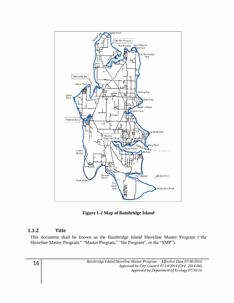
Bainbridge Island has approximately 53 miles of waterfront. (See Figure 1-2 Map of
Bainbridge Island.) It has seven harbors or bays, each having a long and interesting history and
a wide variety of uses. Eagle Harbor has the most activity, including a ferry landing, boatyard
repair, a boatyard, numerous marinas and restaurants, a waterfront park, a Superfund site,
condominiums, detached homes, and a live-aboard community. Most of the Bainbridge
Island’s shorelines have been developed with single-family residences, from small summer
cabins to large mansions. Their locations range from below ordinary high water to high water
cliffs nearly 200 feet above the water. At the north end of the island is a large sand spit called
Point Monroe, while at the south end is Restoration Point, composed of raised bedrock located
on the Seattle fault.
Bainbridge Island’s shorelines exhibit many uses and geologic characteristics. The shoreline is
home for about twenty percent of the island residents, as well as numerous species of fish and
wildlife. Bald eagles, herons, seals, otters, and numerous waterfowl depend on the shoreline.
There are also salmon streams and bays necessary for fish, shellfish, clams, and vegetation to
survive. At the south end of the island is an aquaculture farm for salmon. In short, Bainbridge
Island’s shorelines support a wide variety of life.
Exhibit 1
15 Bainbridge Island Shoreline Master Program – Effective Date 07/30/2014
Approved by City Council 07/14/2014 (Ord. 2014-04)
Approved by Department of Ecology 07/16/14
Located on the eastern border of Kitsap County, Bainbridge Island is connected to the rest of
Kitsap County by one bridge and to Seattle (King County) by a 35-minute ferry ride. Because
of its proximity to Seattle, the island has close cultural and economic ties to Seattle.
Approximately 23,000 people currently live on Bainbridge Island. The population increased
from 15,846 in 1990 to 23,090 in 2012. Until 2008 with the national economic decline, the
Island grew at a fairly steady rate of approximately 300 people each year. This increased
growth, reflected in higher waterfront land values and taxes, along with a growing concern for
the environment, motivated citizen participation in the update of the SMP. The program must
strike a balance between imposing regulatory powers for the benefit of the community at large
and the rights of the individual property holder. Fortunately, the Act and the public trust
doctrine provide the guidance to create a program which recognizes both of these values.
16 Bainbridge Island Shoreline Master Program – Effective Date 07/30/2014
Approved by City Council 07/14/2014 (Ord. 2014-04)
Approved by Department of Ecology 07/16/14
Figure 1-2 Map of Bainbridge Island
1.3.2 Title
This document shall be known as the Bainbridge Island Shoreline Master Program (“the
Shoreline Master Program,” “Master Program,” “the Program”, or the “SMP”).
Exhibit 1
17 Bainbridge Island Shoreline Master Program – Effective Date 07/30/2014
Approved by City Council 07/14/2014 (Ord. 2014-04)
Approved by Department of Ecology 07/16/14
1.3.3 Adoption Authority
This Bainbridge Island Shoreline Master Program is adopted under the authority granted by
Chapter 90.58 RCW and Chapter 173-26 WAC.
1.3.4 Relationship to Other Plans and Regulations
The Shoreline Master Program regulations are used as an overlay to other City policies and
regulations for properties within shoreline jurisdiction. The following provisions apply to this
program in relationship to other plans and regulations:
1. In addition to compliance with the provisions of the Shoreline Management Act of 1971
(also called “the Act”; RCW 90.58) and the State Master Program Approval/Amendment
Procedures and Master Program Shoreline Guidelines (the “Guidelines” or “Shoreline
Master Program Guidelines”; WAC 173-26);, this Shoreline Master Program must be
consistent with local plans and policy documents, specifically, the City’s Comprehensive
Plan and the City’s critical areas regulations. This Shoreline Master Program must be
consistent with the regulations developed by the City to implement its plans, such as the
zoning code and subdivision code, as well as regulations relating to building construction
and safety.
2. Uses and developments regulated by this Program may also be subject to other provisions
of the Bainbridge Island Municipal Code, the City of Bainbridge Island Comprehensive
Plan, the Washington State Environmental Policy Act (Chapter 43.21C RCW and
Chapter 197-11 WAC), Chapter 173-27 WAC Shoreline Management Permit and
Enforcement Procedures, and other local, state and federal laws.
3. Project proponents are responsible for complying with all applicable laws prior to
commencing any use, development or activity.
4. Where this Program makes reference to any RCW, WAC, or other state or federal law or
regulation the most recent amendment or current edition shall apply.
5. In the event of a conflict between the provisions of this program and the laws,
regulations, codes or rules of any other authority having jurisdiction within the City, the
regulations that provide more protection to the shoreline area shall apply, except when
constrained by federal or state law, or where specifically provided otherwise in this
Program.
6. Other activities that could occur along the shoreline (starting bonfires, disposing or
spilling/releasing of regulated or hazardous waste products, use of pesticides, activities
within wetlands) may require other permits, review, or approval not identified here.
1.3.5 Applicability of Bainbridge Island Shoreline Master Program
1. The Bainbridge Island Shoreline Master programs applies to 200 feet landward of ordinary
high water mark and all marine waters out to the midline of Puget Sound, Port Madison,
Agate Pass, Port Orchard and Rich Passage. The SMP does not apply to freshwater lakes or
streams on Bainbridge Island.
18 Bainbridge Island Shoreline Master Program – Effective Date 07/30/2014
Approved by City Council 07/14/2014 (Ord. 2014-04)
Approved by Department of Ecology 07/16/14
2. The provisions of the Program apply to new development and activities and are not
retroactive. All existing legally constructed single-family residences and accessory
structures, including lawns, landscaping and recreation areas, which do not meet the
adopted standards of this Shoreline Master Program are allowed to continue, and may be
maintained, repaired, and remodeled if destroyed or damaged by natural causes as provided
in Section 4.2.1 Nonconforming Uses, Nonconforming Lots, and Existing Development.
Residences may be expanded, provided the expansion meets the provisions of this
Program, including addressing environmental impacts and meeting the standard for no net
loss of ecological functions and ecosystem-wide processes as provided in Section 4.1.2,
Environmental Impacts. All proposed uses and development occurring within shoreline
jurisdiction must conform to Chapter 90.58 RCW, the Shoreline Management Act and this
Shoreline Master Program. All uses, even those not meeting the definition of development,
are subject to the provisions and development regulations of this Shoreline Master
Program, even though a permit may not be required.
3. Any person wishing to undertake activities constituting “development” within shoreline
jurisdiction shall apply to the Administrator for a Shoreline Permit. Based on the
provisions of this Master Program, the Administrator shall determine if a Letter of
Exemption, a Substantial Development Permit, a Shoreline Conditional Use Permit, and/or
a Shoreline Variance is required. Substantial development shall not be undertaken within
the jurisdiction of the Act and this Master Program unless a Substantial Development
Permit has been obtained and the appeal period has been completed and any appeals have
been resolved and/or the project proponent is allowed to proceed under the provisions of
the Act or by court order. “Substantial development” shall be defined as it is by the Act
(RCW 90.58.030) and supplementing provisions of the Washington Administrative Code
(WAC 173-27-040).
4. Developments exempt from a Substantial Development Permit, which are outlined in
BIMC Section 2.16.165, shall require a Letter of Exemption. A project that qualifies as
“exempt development” may also require a Shoreline Conditional Use Permit, and/or a
Shoreline Variance.
5. This Master Program shall apply to every individual, firm, partnership, association,
organization, corporation, local or state governmental agency, public or municipal
corporation, or other entity which develops, owns, leases or administers lands, wetlands, or
waters that fall under the jurisdiction of the Act.
6. Applicability of this Master Program to federal lands and agencies shall be consistent with
WAC 173-27-060.
1.3.6 Program provisions
1. Exempt developments shall not be undertaken within the jurisdiction of the Act and this
Master Program, unless a Letter of Exemption has been obtained documenting that the
Exhibit 1
19 Bainbridge Island Shoreline Master Program – Effective Date 07/30/2014
Approved by City Council 07/14/2014 (Ord. 2014-04)
Approved by Department of Ecology 07/16/14
development is consistent with the policies and procedures of the Act, all applicable state
regulations and this Master Program.
2. The request for a Letter of Exemption shall be in writing, on forms required by the
Administrator, and include the information required by the Administrator.
3. Approved shoreline restoration projects that cause a landward shift in the ordinary high
water mark may be relieved from the standards of this Program pursuant to RCW
90.58.580.
4. The “policies” in this Master Program provide broad guidance and direction and will be
used by the City in applying the “regulations.”
1.3.7 Bainbridge Island Shoreline Master Program Administrative Procedures
As described in the adopted Ordinance 2014-04, with the exception of specific enforcement
procedures, the general administrative sections of Shoreline Master Program as listed below are
included in Title 2 of the Bainbridge Island Municipal Code. The use of separate local
administrative and enforcement procedures is consistent with the 2003 Washington State
Shoreline Master Program Guidelines, Administrative provisions [WAC 173-26-
191(2)(a)(iii)(C)]:
Local governments may include administrative, enforcement, and permit review
procedures in the master program or the procedures may be defined by a local
government ordinance separate from the master program. In either case, these
procedures shall conform to the Shoreline Management Act, specifically RCW
90.58.140, 90.58.143, 90.58.210 and 90.58.220 and to Chapter 173-27 WAC.
This allows the City to revise local administrative procedures (fees, application meetings,
authority of Administrator, etc.) without another formal SMP amendment process. These
chapters must still be consistent and remain consistent with the related provisions in the
Shoreline Management Act and state shoreline rules (WAC’s). In the event of a conflict, the
state RCW or WAC, as amended, will prevail over the local ordinance.
The following administrative sections are part of the Bainbridge Island Municipal Code, BIMC
1.26, Code Enforcement, and BIMC 2.16.165, Shoreline Master Program Administration:
1. Permit or Exemption Required- Before Undertaking Development or Activity
2. Applications
3. Statement of Exemptions from Shoreline Substantial Development Permit
4. Shoreline Substantial Development Permit
5. Shoreline Variance
6. Shoreline Conditional Use Permits
7. Shoreline Application Appeals
20 Bainbridge Island Shoreline Master Program – Effective Date 07/30/2014
Approved by City Council 07/14/2014 (Ord. 2014-04)
Approved by Department of Ecology 07/16/14
8. Enforcement
1.4 Restoration Planning To achieve island-wide improvements in ecological functions and ecosystem-wide processes as
required by WAC 173-26-201(2)(f) and meet the no net loss standard of WAC 173-26-
201(2)(c), the City developed a Restoration Plan that guides improvements of degraded
shoreline areas over time by restoring shoreline ecological functions and processes over time.
The Restoration Plan is linked to the goals and policies of Section 4.1.8, Shoreline Restoration
and Enhancement, and is intended to be accomplished through voluntary and incentive-based
public and private programs that restore and enhance shoreline areas identified and prioritized
for improvement. The Restoration Plan can be found on the City’s web page:
www.ci.bainbridge-isl.wa.us.
The Restoration Plan provides the following information for shoreline improvements:
1. Identification of degraded areas and opportunities for restoration.
2. Identification of development that is adversely impacting shorelines.
3. Opportunities for protection and conservation.
4. Identification of programmatic restoration strategies.
5. A summary of ongoing and proposed restoration projects.
6. A summary of completed restoration projects.
1.5 Master Goal The City’s shorelines are among the most valuable and fragile of our natural resources and their
use, protection, restoration, and preservation is of public interest to all residents of the City.
The Island shorelines provide for a significant part of our way of life as a place of residence,
recreational enjoyment, and occupation. It is the intent of this program to manage the
shorelines of Bainbridge Island consistent with the requirements of the Shoreline Management
Act, the Shoreline Master Program Guidelines, and the Growth Management Act, giving
preference to water-dependent and water-related uses, and to encourage all reasonable and
appropriate development and other activities to occur in a manner which will promote and
enhance the public interest and protect environmental resources. An over-arching goal of this
master program is to ensure that future use and development of the City’s shoreline maintain a
balance between competing uses, results in no net loss of shoreline ecological functions, and
achieves a net ecosystem improvement over time.
Exhibit 1
21 Bainbridge Island Shoreline Master Program – Effective Date 07/30/2014
Approved by City Council 07/14/2014 (Ord. 2014-04)
Approved by Department of Ecology 07/16/14
2.0 Shoreline Inventory and Characterization
2.1 Summary To characterize the Island’s 53 miles of shoreline, the City initiated a series of studies to
update the Shoreline Master Program with the most current science. A shoreline structure
inventory and two shoreline characterization reports were completed. The primary inventory
and characterization data is found in the Nearshore Habitat Characterization and Assessment,
Management Strategy Prioritization, and Monitoring Recommendations produced by Battelle
Laboratories for the City of Bainbridge Island in 2004 (Battelle 2004). The assessment uses a
conceptual model to determine potential level of impact from alterations to the nearshore
environment. The conceptual model identifies nine controlling factors which represent
physical, biological, and chemical attributes of the nearshore marine habitats. The integrated
spread-sheet model and geographical information system developed by Battelle, quantifies
existing anthropogenic impacts by converting qualitative factor values to standardized scores.
The model’s scoring approach uses a 5-point scale to assign qualitative categories to potential
impacts for the nine controlling factors identified in the nearshore conceptual model.
The model divides the shoreline into 201 reaches, which are then grouped into nine (9)
management units. The controlling factor score for each represents the predicted impacts
affecting nearshore processes. To allow island-wide comparison across different types of
shorelines, a normalized index was calculated called the cumulative reach index. Controlling
factor scores are best used to prioritize conservation and restoration efforts in the nearshore as
indicators for identifying the probability for successful conservation and restoration strategies
(Battelle 2004).
The model uses ecological information collected by Washington Department of Natural
Resources (WDNR) for a regional shoreline inventory. The data is available through the
Department of Ecology’s Coastal Atlas. Additional datasets from the City’s shoreline
structural inventory and other sources are listed in Table 3 in the Battelle document.
An Island-wide inventory of current geomorphic features and an accompanying analysis of
historic conditions were produced for the City in 2010 by Coastal Geological Services. This
study maps coastal geomorphic shore types (such as “feeder bluffs”) and prioritizes
restoration and conservation sites. The study includes current and historic mapping of coastal
processes and process-impaired areas. Report conclusions integrate a qualitative, coastal
processes-based prioritization with an objective of restoring and preserving coastal processes
that sustain and maintain critical habitats.
These documents can be accessed from the City’s website (www.bainbridgewa.gov).
22 Bainbridge Island Shoreline Master Program – Effective Date 07/30/2014
Approved by City Council 07/14/2014 (Ord. 2014-04)
Approved by Department of Ecology 07/16/14
3.0 Shoreline Designation Policies and Regulations 3.1 General
The Master Program establishes seven shoreline designations based on a combination of
existing shoreline features and conditions and types of existing and potential future use. When
applied to geographic areas of the island, these designations form an overlay for addressing
shoreline considerations to the City’s land use regulations. Uses which are consistent with a
particular designation are encouraged, while uses which are in conflict are discouraged or
prohibited. A conditional use process is available when further review is needed to determine
whether the use is compatible with the particular designation at the proposed site. Table 4.1, Shoreline Use and Modification Table, provides a summary of uses in relation to the various
shoreline designations. Legally existing uses and activities which are incompatible with their
shoreline designation are subject to provisions for shoreline uses and structures which do not
conform to the SMP. (See Section 4.2.1, Nonconforming Uses, Non-Conforming Lots, and
Existing Development)
Shoreline Designation Map
The official Bainbridge Island Shoreline Designation Map (Appendix A) shall be in the custody
of the Department of Planning and Community Development and shall be available for public
inspection during normal business hours.
The purpose of the map is to depict those areas of Bainbridge Island within the jurisdiction of
the Master Program and the various shoreline designations.
Designation Boundaries
Where the shoreline jurisdiction or designation is uncertain, the official shoreline designation
map shall be used to determine boundary location. If the conflict cannot be resolved using the
shoreline designation map, the following rules shall apply:
1. Boundaries indicated as approximately following the center lines of streets, highways,
alleys or other roadways shall be construed to follow such center lines.
2. Boundaries indicated as approximately following lot, fractional section, or other
subdivision lines shall be construed as following such subdivision lines.
3. Boundaries indicated as parallel to or extensions of features identified in subsections 1
and 2 above shall be so construed.
4. When not specifically indicated on the Shoreline Designation Map, distances shall be
determined by the scale of the map.
5. If there is no designation on the map, then the Shoreline Residential Conservancy
designation applies.
Where existing physical or cultural features are at variance with those shown on the Shoreline
Designation Map and cannot be determined with certainty by applying subsections 1 through 4
Exhibit 1
23 Bainbridge Island Shoreline Master Program – Effective Date 07/30/2014
Approved by City Council 07/14/2014 (Ord. 2014-04)
Approved by Department of Ecology 07/16/14
above, the Department shall determine the location or existence of such feature utilizing any
appropriate criteria contained in the Master Program.
3.2 Upland Designations
3.2.1 Urban
3.2.1.1 Purpose
The purpose of Urban is to provide for high-intensity water-oriented commercial,
transportation, industrial, mixed-use, multi-family residential, public access and
recreational uses while protecting existing natural resources, ecological functions and
ecosystem-wide processes, and restoring ecological functions in areas that have been
previously degraded.
3.2.1.2 Designation Criteria
Areas to be designated Urban should not have biophysical limitations to development such
as wetlands and estuaries, floodplains, steep slopes, landslide hazard areas, and/or other
sensitive areas; and must meet one or more of the following criteria:
1. Shorelines used or designated for high intensity commercial, industrial, recreational
use, or for multifamily residential development.
2. Areas where adjacent land use is urban and urban services are available or areas
designated for higher intensity use under the comprehensive plan.
3. Shorelines used for water-oriented and port activities.
3.2.1.3 Management Policies
1. Priority should be given to the following uses in order of preference: water-dependent,
water-related, and water-enjoyment uses. Uses which derive minimal benefit from a
water location should be discouraged or prohibited. Nonwater-oriented uses should be
allowed only if the use is otherwise compatible with the purpose of the Urban
designation and the setting, does not displace water-dependent uses, and results in no
net loss of ecological functions and ecosystem-wide processes.
2. New development applications should demonstrate they will not result in a net loss of
shoreline ecological functions and ecosystem-wide processes.
3. Environmental remediation and restoration priorities should be established for the
shoreline that comply with relevant state and federal law.
4. Because urban use tends to preclude other shoreline uses, emphasis should be given to
directing new development into already developed areas consistent with the Master
Program.
24 Bainbridge Island Shoreline Master Program – Effective Date 07/30/2014
Approved by City Council 07/14/2014 (Ord. 2014-04)
Approved by Department of Ecology 07/16/14
5. Full utilization of existing urban areas should be achieved before additional areas are
designated Urban.
6. Visual and physical public access should be required and implemented where feasible.
Industrial and commercial facilities should be designed to permit pedestrian waterfront
activities. Planning for the acquisition of land for permanent public access to the
water in the Urban designation should be encouraged and implemented, where
feasible.
7. To protect shoreline character and promote compatible development within the Urban
designation, aesthetic considerations should be actively promoted by mechanisms such
as sign control regulations, appropriate development siting, screening and architectural
standards, flexible lot design process, and through the maintenance of Shoreline
Buffer and Site Specific Vegetation Management Areas.
8. In order to make maximum use of the available shoreline resource and to
accommodate future water-dependent uses, redevelopment and restoration for a net
ecosystem improvement of degraded urban shoreline areas should be encouraged.
9. Developments within the Urban designation should be compatible with uses and
activities in adjacent designations, including Aquatic and Priority Aquatic.
3.2.2 Shoreline Residential
3.2.2.1 Purpose
The purpose of Shoreline Residential is to provide for residential development and
appurtenant structures, appropriate public access and recreational use, which are consistent
with the Shoreline Management Act, while protecting existing natural resources, ecological
functions and ecosystem-wide process, and restoring ecological functions in previously
degraded areas.
3.2.2.2 Designation Criteria
Areas to be designated Shoreline Residential should be presently zoned, platted or
developed for residential use, and should meet one or more of the following criteria:
1. Areas having the physical ability to support low to medium density residential uses
and associated recreational and public service facilities; and/or
2. Areas which can provide, and have the capabilities to support, the necessary public
services, utilities, and access to accommodate low to medium density residential
development. Sewage disposal and water supply facilities may be provided on an
individual or community basis.
3.2.2.3 Management Policies
Exhibit 1
25 Bainbridge Island Shoreline Master Program – Effective Date 07/30/2014
Approved by City Council 07/14/2014 (Ord. 2014-04)
Approved by Department of Ecology 07/16/14
1. Development and new uses should assure no net loss of shoreline ecological function
by compliance with:
a. Minimum frontage width, setbacks, and buffers;
b. Lot coverage limitations;
c. Shoreline stabilization standards; and
d. Protective measures for vegetation conservation, critical areas and water
quality.
2. New development should be permitted only in those shoreline areas that are capable of
supporting the proposed use in a manner which protects or enhances the shoreline
environment, and reflects the character of the surrounding area such as providing open
space and maintaining shoreline vegetation buffers.
3. Public access to shorelines should be required for multi-family residences, apartments,
and subdivisions. Common access for single-family residential short subdivisions
should be encouraged and should be required where feasible.
4. Recreational developments should provide shoreline areas for community or public
open space and public access to shorelines.
5. Access, utilities and public services should be available and adequate to serve existing
needs and planned future development.
6. Developments within the Shoreline Residential designation should be compatible with
uses and activities in adjacent designations, including Aquatic and Priority Aquatic.
7. Restoration of shoreline ecological functions and ecosystem-wide processes should be
encouraged through non regulatory programs.
3.2.3 Shoreline Residential Conservancy
3.2.3.1 Purpose
The purpose of Shoreline Residential Conservancy is to accommodate compatible
residential uses while protecting, conserving, and restoring shoreline ecological functions
and processes of open space, floodplains or other flood prone areas, and other sensitive
lands. It is the further purpose to conserve and manage valuable historic and cultural
resources where they exist. Due to the more sensitive characteristics of these areas, a
higher level of development standards is warranted.
3.2.3.2 Designation Criteria
Areas to be designated Shoreline Residential Conservancy should include the following
criteria:
26 Bainbridge Island Shoreline Master Program – Effective Date 07/30/2014
Approved by City Council 07/14/2014 (Ord. 2014-04)
Approved by Department of Ecology 07/16/14
1. Areas that are appropriate and planned for water-related or water-enjoyment uses that
are compatible with maintaining or restoring ecological functions and processes; or
2. Areas that are not generally suitable for commercial/industrial water-dependent uses
or more intensive uses due to the potential impacts these uses may have on the existing
shoreline characteristics; and one or more of the following criteria:
a. Areas subject to severe biophysical limitations such as:
i. Sediment sources for littoral cell (Feeder Bluffs).
ii. Flood-prone areas.
iii. Geo-hydraulic shoreforms (e.g., accretion beaches, barrier beaches, and
sand spits).
iv. Wetlands and estuaries
v. Areas important to the maintenance of surface water level groundwater
flow, and water quality.
vi. Biodiversity maintenance.
b. Areas that retain important ecological functions and processes, even though
partially developed.
c. Areas with valuable historic or cultural features.
3.2.3.3 Management Policies
1. New residential and other development that preserves the natural character of the area,
maintains shoreline vegetation buffers and/or promotes preservation of open space,
floodplains or sensitive lands, either directly or over the long-term, should be the
principal uses. Development that enhances or results in restoration of ecological
functions and ecosystem-wide processes should be encouraged if the use is otherwise
compatible with the purpose of the designation, the setting, and with adjacent uses and
activities, including aquatic designations.
2. Standards should be established for protecting the sensitive shoreline characteristics in
this designation to assure no net loss of shoreline ecological functions and ecosystem-
wide process, including measures that provide the following:
a. Minimum frontage width, setbacks, and shoreline buffers;
b. Lot coverage limitations;
c. Shoreline modification standards; and
d. Protective measures for vegetation conservation, critical areas and water
quality.
Exhibit 1
27 Bainbridge Island Shoreline Master Program – Effective Date 07/30/2014
Approved by City Council 07/14/2014 (Ord. 2014-04)
Approved by Department of Ecology 07/16/14
3. Water-oriented uses should be given priority over nonwater-oriented uses. For
shoreline areas adjacent to navigable waters, water-dependent uses should be given
highest priority.
4. Public access, common access and public recreation objectives should be implemented
as required whenever feasible and significant ecological impacts can be mitigated.
5. High intensity development should be prohibited and commercial uses should be
limited to those that are water-oriented, consistent with zoning regulations.
6. Recreational developments should provide shoreline areas for community or public
open space and public access to shorelines.
3.2.4 Island Conservancy
3.2.4.1 Purpose
The purpose of Island Conservancy is to accommodate a variety of private or public
recreational uses that might have a higher level of impact than would be allowed in the
Natural designation. Uses should incorporate elements compatible with protecting,
conserving and restoring ecological functions and ecosystem-wide processes of open
space, floodplains or other flood prone areas, and other sensitive lands, and manage
valuable historic and cultural resources where they exist.
3.2.4.2 Designation Criteria
Areas to be designated Island Conservancy should include the following criteria:
1. Areas that are in public ownership such as open space or parks or in private ownership
which are voluntarily designated and one of the following:
a. Areas that are appropriate and planned for recreational or cultural development
that is compatible with maintaining or restoring ecological functions and
processes; or
b. Areas that are suitable for water-oriented recreational or cultural uses, but not
generally suitable for intensive uses due to the potential impacts these uses
may have on the existing shoreline characteristics.
c. Areas of high scenic or recreational value such as shoreline parks including
urban parks, active use parks, passive use parks, and those privately held
recreation areas that voluntarily agree to the designation.
2. Areas with extensive or unique historic or cultural resources.
3. Areas where intensive development or use would interfere with natural processes and
result in significant damage to other resources.
3.2.4.2 Management Policies
28 Bainbridge Island Shoreline Master Program – Effective Date 07/30/2014
Approved by City Council 07/14/2014 (Ord. 2014-04)
Approved by Department of Ecology 07/16/14
1. New recreational uses that preserve the natural character of the area or promote
preservation of open space, floodplain or sensitive lands either directly or over the
long-term should be the principal uses. Uses that enhance or result in restoration of
ecological functions and ecosystem-wide processes should be strongly encouraged if
the use is otherwise compatible with the purpose of the designation, the setting, and
with adjacent uses and activities, including aquatic environments.
2. When required by this Program or other land use covenants, public access and public
recreation objectives should be implemented whenever feasible and when significant
ecological impacts can be mitigated.
3. Uses in the “Island Conservancy” should be limited to those which sustain the
shoreline area’s physical and biological resources and uses of a nonpermanent nature,
except those preferred uses in 3.2.4.2(4) below, that do not substantially degrade
ecological functions or natural character of the shoreline area.
4. Water- recreation facilities that do not deplete the resource over time, such as boating
facilities, recreational fishing, wildlife viewing trails, and swimming beaches, are
preferred uses, provided shoreline resources are conserved over time and significant
adverse cumulative impacts to the shoreline are mitigated.
5. Commercial and industrial uses are not permitted except that low intensity, water-
oriented commercial uses may be permitted in limited instances where sites possess
shoreline conditions and available services to support the development.
6. Construction of new structural shoreline stabilization and flood control works should
only be allowed where there is a documented need to protect an existing primary
structure or park use (Section 6.2, Shoreline Stabilization) and mitigation is applied,
consistent with WAC 173-26-231, Shoreline Modifications. New development should
be designed and located to preclude the need for such work.
7. When allowed, new shoreline stabilization, flood control measures, vegetation
removal, and other shoreline modifications should be designed and managed
consistent with these guidelines to ensure that the natural shoreline functions and
ecosystem-wide processes are protected. Such shoreline modification should be
consistent with planning provisions for the restoration of shoreline ecological
functions and processes.
3.2.5 Natural
3.2.5.1 Purpose
The purpose of the Natural designation is to protect those shoreline areas where the
majority of natural ecological functions and/or shoreline ecosystem-wide processes are
retained, often evidenced by the shoreline configuration and the presence of native
vegetation. Generally, but not necessarily, they include ecologically intact shorelines that
Exhibit 1
29 Bainbridge Island Shoreline Master Program – Effective Date 07/30/2014
Approved by City Council 07/14/2014 (Ord. 2014-04)
Approved by Department of Ecology 07/16/14
are free of structural shoreline modifications, structures, and intensive human uses or have
potential for restoration.
3.2.5.2 Designation Criteria
Areas to be designated Natural shall meet the following criteria:
1. Areas that perform irreplaceable shoreline ecological functions or ecosystem-wide
process that would be damaged by human activity, including areas that contain largely
undisturbed or restored shoreline features or unique natural features, such as wetlands,
estuaries, unstable bluffs, coastal dunes, sand spits, and ecologically intact shoreline
habitats, and one or more of the following:
a. Wildlife Habitats.
i. A shoreline area that provides food, water, or cover and protection for any
rare, endangered, or diminishing species, or for significant populations of
flora or fauna during critical stages of their life cycle.
ii. A seasonal area for concentration of native animals, fish, or fowl such as a
migration route, breeding site, rearing ground, or spawning site.
b. Areas of Scientific and Educational Value.
i. Areas considered to best represent basic ecosystems and geologic types that
are of particular scientific and educational interest.
ii. Areas which best represent undisturbed natural areas.
iii. Areas with established histories of scientific research.
c. Areas of Scenic and Recreational Value
i. Those areas having an outstanding or unique scenic feature in their natural
state.
ii. Areas having a high value for wilderness experience.
iii. Areas which in their natural state have a high value for low intensity
recreational use.
d. Areas with Restoration Potential.
i. Areas which have been degraded, but which have a high potential of being
successfully restored to a natural or near natural condition, or are capable of
natural regeneration if left undisturbed.
3.2.5.3 Management Policies
1. Any use that would substantially degrade the ecological functions and ecosystem-wide
processes or natural character of the shoreline area should not be allowed. The
following new uses should not be allowed in the Natural designation:
30 Bainbridge Island Shoreline Master Program – Effective Date 07/30/2014
Approved by City Council 07/14/2014 (Ord. 2014-04)
Approved by Department of Ecology 07/16/14
a. Residential uses.
b. Agriculture uses.
c. Commercial uses.
d. Industrial uses.
e. Nonwater-oriented recreation.
f. Roads, utility corridors, and parking areas that can be located outside of
Natural designated shorelines.
2. Limited access should be permitted for scientific, cultural, educational, and passive
recreational purposes, provided that no significant, adverse impact on the area will
result.
3. Physical alterations, including new development or “significant removal of
vegetation”, should only be considered when: a) they serve to protect a significant,
unique, or highly valued feature which might otherwise be degraded or destroyed; and
b) when alterations would not result in a net loss of shoreline ecological functions and
ecosystem-wide processes; and c) alterations would not further degrade other
shoreline values; and d) vegetation removal would not reduce the capability of
vegetation to perform normal ecological functions and processes.
4. Uses and activities within the Natural designation should be compatible with uses and
activities in adjacent, including aquatic designations.
5. A single active use area should be allowed with appropriate compensatory mitigation
to accommodate cultural events and passive recreational uses near the log pond at
Blakely Harbor Park.
3.3 Aquatic Designations
3.3.1 Aquatic
3.3.1.1 Purpose
The purpose of the Aquatic designation is to protect, restore and manage the sensitive and
unique characteristics and resources of the waters of the Puget Sound, tidelands, and
submerged intertidal areas located waterward of the ordinary high water mark. The
Aquatic designation may allow either multiple water-dependent uses or specific dominant
water-dependent uses. It is intended to promote sustainable use of the natural features and
resources of Aquatic areas which are substantially different in character from those of the
adjoining uplands and backshores.
3.3.1.2 Designation Criteria
Aquatic areas include:
Exhibit 1
31 Bainbridge Island Shoreline Master Program – Effective Date 07/30/2014
Approved by City Council 07/14/2014 (Ord. 2014-04)
Approved by Department of Ecology 07/16/14
1. All marine areas waterward of the OHWM which have not been designated Priority
Aquatic.
2. All wetlands associated to the above which have not been designated priority aquatic.
3.3.1.3 Management Policies
1. Uses that adversely impact the ecological functions of critical saltwater and freshwater
habitats should not be allowed except where necessary to achieve the restoration
objectives, and then only when the impacts are mitigated to assure no net loss of
ecological functions and ecosystem-wide processes. Compatibility between upland
and aquatic uses should be confirmed.
2. New over-water structures are allowed only for water-dependent uses, public access or
ecological restoration and such structures must be limited to the minimum size
necessary to support the structure’s intended use while protecting and conserving
aquatic resources.
3. Diverse public access opportunities should be encouraged and developed and should
be compatible with the existing shoreline and aquatic uses.
4. Aquaculture practices, should be limited to those activities that can demonstrate that
significant impacts to ecological functions, ecosystem-wide processes, and adjacent
land uses will not occur. Aquaculture should be encouraged in those tidelands, waters
and beds most suitable for such use.
5. Multiple use of over-water facilities or tidelands is preferred over a single industry
use. In appropriate areas, fishing and water recreation should be protected from
competing uses.
6. All developments and uses on navigable waters, tidelands or bedlands should be
located to avoid and designed to minimize interference with navigation.
7. Development and uses on navigable waters, tidelands or bedlands should be located to
avoid and designed to minimize impacts to public views.
8. Development and uses on navigable waters, tidelands or bedlands should be designed
and located for the safe, unobstructed passage of fish and wildlife, including species
whose life cycles are dependent on migration that would be impacted by in-water
development.
9. Uses that accommodate deep draft vessels and/or require placement of fill, if allowed,
should not occur in areas requiring extensive initial or maintenance dredging or if
significant adverse environmental impacts cannot be mitigated.
10. Development of underwater pipelines and cables on tidelands should be discouraged
except where adverse environmental impacts can be shown to be less than the impact
of upland alternatives. When permitted, such facilities should include adequate
32 Bainbridge Island Shoreline Master Program – Effective Date 07/30/2014
Approved by City Council 07/14/2014 (Ord. 2014-04)
Approved by Department of Ecology 07/16/14
provisions to ensure against substantial or irrevocable damage to the environment and
no net loss of ecological functions and ecosystem-wide processes.
11. Abandoned and/or neglected structures which cause adverse visual impacts or are a
hazard to public health, safety, and welfare should be removed or restored to a useable
condition consistent with the provisions of this Program.
12. Restoration or enhancement of aquatic resources and adjacent uplands is encouraged.
3.3.2 Priority Aquatic
3.3.2.1 Purpose
The purpose of the Priority Aquatic designation is to protect, preserve, restore and manage
aquatic areas of sensitive and unique ecological value that include those portions of the
marine waters of the City that exist in a relatively natural state, free of human influence, or
which contain resources, biological diversity, or other features that are particularly
sensitive to human activity, or which contain unique, historical, archeological, cultural, or
educational features that merit special protection.
3.3.2.2 Designation Criteria
A number of separate criteria are required to define the diverse character of Priority
Aquatic types. Tidal lagoons and sensitive portions of tidal inlets will require protection in
terms of water salinity and quality, sediment quality and quantity, native vegetation on
adjacent shorelines, and remaining areas of native salt-tolerant vegetation. Other types,
such as aquatic vegetation, have similar requirements. The Priority Aquatic designation
requires additional restrictions than the Aquatic designation on the intensity and type of
permitted uses to maintain the integrity of the shoreline environment. Two subcategories
of Priority Aquatic will be established in order to recognize the level of development
adjacent to the Priority Aquatic and provide an appropriate level protection for the critical
habitat. Priority Aquatic shall be designated as follows:
1. Priority Aquatic Category A is more protective and intended to be the default
classification.
a. Those areas previously designated Aquatic Conservancy are designated
Priority Aquatic Category A.
2. Priority Aquatic areas located adjacent to upland areas with a high level of existing
development are classified as Priority Aquatic B.
The City shall map the limits of the designations with assistance from state resource
agencies and other cooperating agencies. Any aquatic area in which actions have been
taken under an approved permit that create, restore, or enhance characteristics of the
aquatic area that meet any of these criteria shall be designated Priority Aquatic through an
amendment to this program as specified in BIMC Section 2.16.200. Where there is a
conflict between the map and criteria, the criteria will prevail provided a report is prepared
Exhibit 1
33 Bainbridge Island Shoreline Master Program – Effective Date 07/30/2014
Approved by City Council 07/14/2014 (Ord. 2014-04)
Approved by Department of Ecology 07/16/14
within three years by a qualified professional verifying that the map is in error. The report
will be the responsibility of the party requesting the map change. The City may require a
third party review at the applicant’s expense. If areas are determined to be appropriate for
designation, an amendment to this Program is required to designate Priority Aquatic and
shall be processed as specified in Shoreline Master Program Administration, BIMC
Section 2.16.200.
3.3.2.3 Type 1: Embayment: Barrier Estuary, Barrier Lagoons, or Closed Lagoon and Marshes
The upland boundary of Type 1 Priority Aquatic shall be the OHWM. There are two
barrier lagoons currently identified on the Island; “Point Monroe Lagoon” and “Battle
Point Lagoon”; two closed lagoons and marshes “Wing Point Lagoon” and “Tolo
Lagoon”; and one barrier estuary “Fletcher Bay”.
3.3.2.4 Type2: Salt marshes and mud flats in Open Coastal Inlets
Embayments and related intertidal areas subject to the daily influence of tides where they
support salt-tolerant vegetation and/or exposed mudflats. Open coastal inlets areas should
be designated Priority Aquatic if they meet either Criterion I or II below. Only those areas
designated will be subject to the Priority Aquatic management policies and regulations.
This type of Priority Aquatic designation shall extend from the OHWM to six (6) feet
below mean lower low water (MLLW). If the inlet is less than six hundred (600) feet
wide, or less then (6) feet deep at the MLLW, the resource should be considered to be a
single system encompassing both sides and the channel. In these cases, boundaries should
be drawn from the OHWM to a line perpendicular to the average direction of the tidal flow
where the criteria are no longer met. Parts of tidal inlets that do not fit either criterion, and
do not fit other types of Priority Aquatic designation, shall be designated Aquatic.
Criterion I: The area between the OHWM and MLLW that provides a habitat
for at least one quarter (1/4) acre of salt-tolerant vegetation.
Vegetated patches may be smaller than one quarter (1/4) acre, but
the total vegetated area must be at least one quarter (1/4) acre.
Criterion II: At least one quarter (1/4) acre of exposed flats is exhibited between
OHWM and MLLW whose sediments are at least thirty (30)
percent muds.
3.3.2.5 Type 3: Marine Vegetation
Areas waterward of the MLLW that support a sustainable community of kelp, or eelgrass
and/or other submerged aquatic vegetation in sufficient quantities to provide special value
as habitat for marine life.
Consideration for Priority Aquatic designation under Type 3 may be initiated by any
interested person, group, or the City. A petition for nomination shall be submitted by an
34 Bainbridge Island Shoreline Master Program – Effective Date 07/30/2014
Approved by City Council 07/14/2014 (Ord. 2014-04)
Approved by Department of Ecology 07/16/14
interested person or group. The following information shall be used by the City to
determine when an area meets the criteria for Priority Aquatic under Type 3:
1. Delineation of proposed area, including aerial extent and bathymetric contours.
2. Inventory of submerged aquatic vegetation. Use percent coverage for macro algae and
shoot density for eelgrass.
3. Further information, as determined by the Administrator, may be required in addition to
the above including but not limited to:
a. Relationship of proposed area to nearby ecosystems.
b. List of species utilizing the proposed area.
c. Abundance and diversity of species in the proposed area.
The City shall keep a record and review data annually to determine whether sites are
appropriate for nomination under Type 3. If areas are determined to be appropriate for
designation, an amendment to this program is required to designate Priority Aquatic and
shall be processed as an amendment as specified in the Shoreline Master Program
Administration, BIMC Section 2.16.200.
3.3.2.6 Type 4 Other areas
Areas, as designated through the Shoreline Master Program amendment process [BIMC
Section 2.16.200], whose existing natural state is relatively free of human influence, or in
which resources, biological diversity, or other features are particularly sensitive to human
activity, or in which unique ecology, historical, archeological, cultural, or educational
features merit special protection. Designation under this type shall be based on a report
documenting the presence, function, and distribution of the resources in the area to be
designated.
3.3.2.7 Priority Aquatic Category A Management Policies
1. The City should develop a program that identifies critical saltwater habitat appropriate
for greater protection under the provisions of the Priority Aquatic designation. The
program should include a process to review citizen petitions for Priority Aquatic
designation.
2. Uses and activities which would potentially degrade or significantly alter the natural or
visual character or ecological functions and ecosystem-wide processes of the shoreline
should be severely restricted or prohibited and only allowed if adverse impacts can be
mitigated to ensure no net loss of ecological functions and processes.
3. Public use and access should be permitted for scientific, cultural, educational, and
recreational purposes if such use is compatible with the purposes of this designation and
no significant adverse impact to the biological and visual resources of the areas will
result. Motorized vessels should not be allowed.
Exhibit 1
35 Bainbridge Island Shoreline Master Program – Effective Date 07/30/2014
Approved by City Council 07/14/2014 (Ord. 2014-04)
Approved by Department of Ecology 07/16/14
4. In conjunction with the Island-wide shoreline restoration plan, physical alterations
should only be considered when they serve to protect or enhance significant, unique, or
highly valued features which might otherwise be degraded or destroyed.
5. Uses and activities adjacent to shorelines designated Priority Aquatic should be
compatible with and not compromise the integrity of the Priority Aquatic designation.
6. Protection of shoreline vegetation should be established in all adjacent upland
designations to protect the ecological functions, ecosystem-wide processes and
characteristics of the Priority Aquatic designation. (See Section 4.1.5, Critical Areas.)
7. A management study of each area should be conducted with appropriate agencies and
residents to determine possible refinements to the adopted types, changes in the
boundaries of the designated areas, and/or inclusion of additional management
strategies.
8. Restoration of enhancement of aquatic resources and adjacent uplands is encouraged.
3.3.2.8 Priority Aquatic Category B Management Policies
1. Implement policy number 1 in Priority Aquatic A management policies (3.3.2.7).
2. Uses and activities which would potentially degrade or significantly alter the natural or
visual character or ecological functions and ecosystem-wide processes of the shoreline
should be limited and only allowed when adverse impacts can be mitigated to ensure no
net loss of ecological functions.
3. Public use and access should be permitted for:
a. Scientific, cultural, educational purposes;
b. Recreational shellfish harvesting of a de minimis nature;
c. When vessels are operated to limit wake and noise impacts; and
d. Uses compatible with the purpose of this designation, provided that no significant,
adverse impact to the biological and visual resources of on the area will result.
4. In conjunction with the part of an Island-wide shoreline restoration plan, physical
alterations should only be considered when they serve to protect or enhance significant,
unique, or highly valued features which might otherwise be degraded or destroyed.
5. Protection and enhancement of shoreline buffers should be established in all adjacent
upland designation to protect the ecological functions, ecosystem-wide processes and
characteristics of the Priority Aquatic designation areas. (See 4.1.5 Critical Areas)
6. Restoration or enhancement of aquatic resources and adjacent uplands is encouraged.
3.4 Island Conservancy, Shoreline Residential and Shoreline Residential Conservancy Designation Strategy
36 Bainbridge Island Shoreline Master Program – Effective Date 07/30/2014
Approved by City Council 07/14/2014 (Ord. 2014-04)
Approved by Department of Ecology 07/16/14
In general, shoreline designations criteria are based on the existing use, characteristics of
the shoreline environment, and modified by the expected land use. To ensure consistent
application of shoreline residential designation criteria a framework was developed to meet
natural resource management strategies recommended by the Environmental Technical
Advisory Committee. The committee recommended using a broad stroke approach to
manage natural resources in an attempt to avoid a piecemeal development pattern. The
following rules apply:
1. For properties zoned single family residential, the default shoreline designation is
Shoreline Residential.
2. Properties within the Winslow Master Plan area will be designated Shoreline
Residential to accommodate the comprehensive plan policy of focusing new
residential development into the plan’s service area.
3. If less than ten parcels or 1,000 linear feet exist between Shoreline Residential
Conservancy designations, then the properties between the two designations will also
be designated Shoreline Residential Conservancy to avoid fragmented management
of ecological functions and ecosystem-wide processes.
4. If a property has a conservation easement and is adjacent to either a Shoreline
Residential Conservancy or Island Conservancy designation, then the property is
designated Shoreline Residential Conservancy.
5. All publicly owned open space or park properties shall be designed Island
Conservancy or Natural.
6. All publicly owned saltwater road ends shall be designated Island Conservancy.
Exhibit 1
37 Bainbridge Island Shoreline Master Program – Effective Date 07/30/2014
Approved by City Council 07/14/2014 (Ord. 2014-04)
Approved by Department of Ecology 07/16/14
4.0 General (Island-wide) Policies and Regulations Introduction
The following general policies and regulations apply to all designations. These provisions are to
be used in conjunction with the more specific shoreline use (referred to as “uses”) and shoreline
modification activity (referred to as “activities”) policies and regulations found in Sections 4.0
and 5.0 respectively.
4.0.1 Regulations - General
1. All new shoreline uses and shoreline modification activities, including those that do not
require a Shoreline Substantial Development Permit, must conform to all applicable
goals, policies, shoreline designations (including the shoreline designation map), and
regulations and use tables provided in this Master Program.
2. Shoreline modification activities must be in support of an allowable shoreline use which
conforms to the provisions of the Master Program. Except as otherwise noted, all
shoreline modification activities not associated with a legally existing or approved
shoreline use are prohibited.
3. Shoreline uses, modification activities, and conditions listed as “prohibited” in Table 4-1
shall not be eligible for consideration as a Shoreline Variance or Shoreline Conditional
Use Permit.
4. Uses, modification activities, and conditions that are not “prohibited” and not listed in
Table 4-1 shall be reviewed through the Shoreline Conditional Use process.
5. The policies listed in the Master Program shall provide broad guidance and direction and
shall be used by the Director in interpreting the “regulations.”
6. BIMC Title 18 Zoning or its successor also apply to shoreline parcels.
7. Where provisions of this Master Program or other provision in BIMC conflict, the more
restrictive provisions shall apply unless specifically stated otherwise.
8. The use table (Table 4-1), shoreline setback table (Table 4-2), and the shoreline buffer
table (Table 4-3) provide regulatory use and dimensional provisions for each shoreline
designation.
9. An increase in the dimensional height standard (Table 4-2) for essential public facilities
shall be reviewed through a Shoreline Conditional Use. Submittal requirements are in
Section 4.1.2.9(2).
10. Submittal requirements for all shoreline development permits or shoreline exemptions are
in BIMC Title 2 and the Administrative Manual.
38 Bainbridge Island Shoreline Master Program – Effective Date 07/30/2014
Approved by City Council 07/14/2014 (Ord. 2014-04)
Approved by Department of Ecology 07/16/14
EXPLANATION OF TABLE ABBREVIATIONS1
The abbreviations used in the Permitted Use Table have the following meanings:
o “P” in a cell indicates that the use is permitted by right in that designation. Permitted
uses are subject to all other applicable regulations of this Program, including the use-
specific standards.
o “C” in a cell indicates that, in the respective designation, the use is a conditional use
that is allowed only if reviewed and approved in accordance with the procedures set
forth in BIMC Title 2. Unless otherwise stated in this Program or in a conditional use
approval, conditional uses are subject to all other applicable regulations of this Code,
including the use-specific standards.
o An “A” in a cell indicated that the use is permitted as an accessory use to a permitted
use or to an approved conditional use in the same designation. In the case of
approved conditional uses, accessory uses listed in the table are permitted unless the
terms of the conditional use permit prohibit that accessory use.
o A “CA” in a cell indicated that the use is permitted as an accessory use to a permitted
use or to an approved conditional use, but that a conditional use permit is always
required.
o An “X” indicated that the use is prohibited in the respective designation. The use may
be allowed outside the shoreline jurisdiction, see Title 18 Zoning.
o The column headed “Use Specific Standards” identifies a subsection within BIMC
16.12 that imposes additional standards with which the use must comply. The use
specific standard may limit the “P” or “C” designation to certain areas.
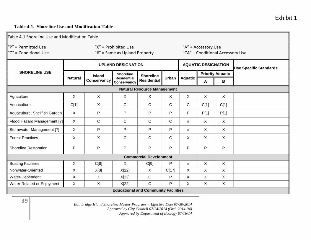
Exhibit 1
39 Bainbridge Island Shoreline Master Program – Effective Date 07/30/2014
Approved by City Council 07/14/2014 (Ord. 2014-04)
Approved by Department of Ecology 07/16/14
Table 4-1. Shoreline Use and Modification Table
Table 4-1 Shoreline Use and Modification Table
“P” = Permitted Use “C” = Conditional Use
“X” = Prohibited Use “#” = Same as Upland Property
“A” = Accessory Use “CA” – Conditional Accessory Use
SHORELINE USE
UPLAND DESIGNATION AQUATIC DESIGNATION Use Specific Standards
Natural Island
Conservancy
Shoreline Residential
Conservancy
Shoreline Residential
Urban Aquatic Priority Aquatic
A B
Natural Resource Management
Agriculture X X X X X X X X
Aquaculture C[1] X C C C C C[1] C[1]
Aquaculture, Shellfish Garden X P P P P P P[1] P[1]
Flood Hazard Management [7] X C C C C # X X
Stormwater Management [7] X P P P P # X X
Forest Practices X X C C C X X X
Shoreline Restoration P P P P P P P P
Commercial Development
Boating Facilities X C[8] X C[9] P # X X
Nonwater-Oriented X X[8] X[22] X C[17] X X X
Water-Dependent X X X[22] C P # X X
Water-Related or Enjoyment X X X[22] C P X X X
Educational and Community Facilities
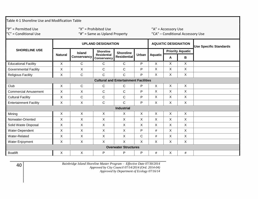
40 Bainbridge Island Shoreline Master Program – Effective Date 07/30/2014
Approved by City Council 07/14/2014 (Ord. 2014-04)
Approved by Department of Ecology 07/16/14
Table 4-1 Shoreline Use and Modification Table
“P” = Permitted Use “C” = Conditional Use
“X” = Prohibited Use “#” = Same as Upland Property
“A” = Accessory Use “CA” – Conditional Accessory Use
SHORELINE USE
UPLAND DESIGNATION AQUATIC DESIGNATION Use Specific Standards
Natural Island
Conservancy
Shoreline Residential
Conservancy
Shoreline Residential
Urban Aquatic Priority Aquatic
A B
Educational Facility X C C C P X X X
Governmental Facility X X C C P X X X
Religious Facility X C C C P X X X
Cultural and Entertainment Facilities
Club X C C C P X X X
Commercial Amusement X X C C P X X X
Cultural Facility X C C C P X X X
Entertainment Facility X X C C P X X X
Industrial
Mining X X X X X X X X
Nonwater-Oriented X X X X X X X X
Solid Waste Disposal X X X X X X X X
Water-Dependent X X X X P # X X
Water-Related X X X X C # X X
Water Enjoyment X X X X X X X X
Overwater Structures
Boatlift X X P P P # X #
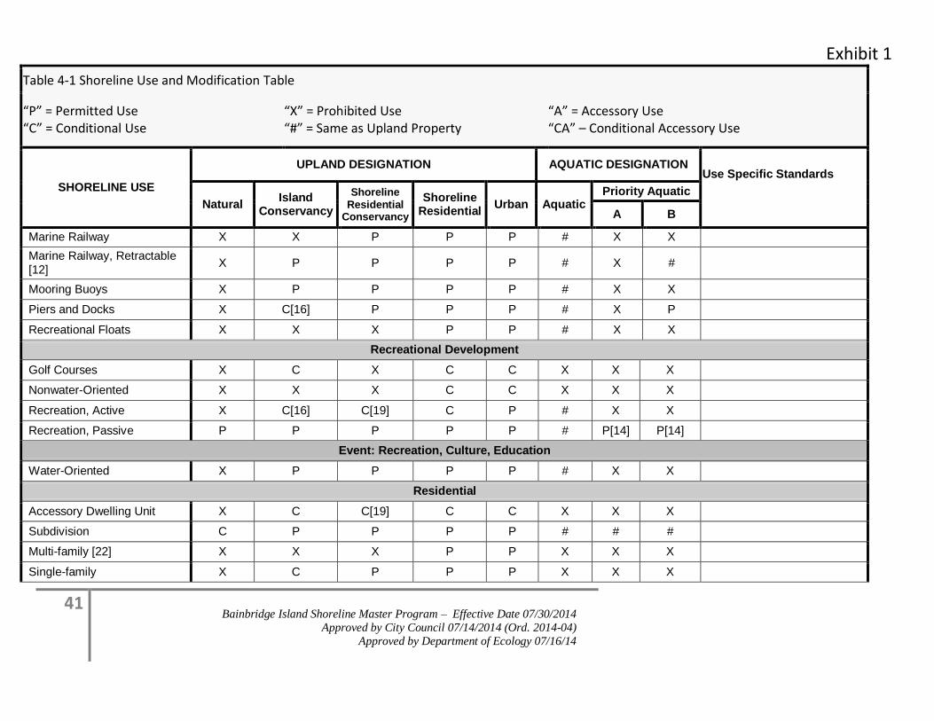
Exhibit 1
41 Bainbridge Island Shoreline Master Program – Effective Date 07/30/2014
Approved by City Council 07/14/2014 (Ord. 2014-04)
Approved by Department of Ecology 07/16/14
Table 4-1 Shoreline Use and Modification Table
“P” = Permitted Use “C” = Conditional Use
“X” = Prohibited Use “#” = Same as Upland Property
“A” = Accessory Use “CA” – Conditional Accessory Use
SHORELINE USE
UPLAND DESIGNATION AQUATIC DESIGNATION Use Specific Standards
Natural Island
Conservancy
Shoreline Residential
Conservancy
Shoreline Residential
Urban Aquatic Priority Aquatic
A B
Marine Railway X X P P P # X X
Marine Railway, Retractable [12]
X P P P P # X #
Mooring Buoys X P P P P # X X
Piers and Docks X C[16] P P P # X P
Recreational Floats X X X P P # X X
Recreational Development
Golf Courses X C X C C X X X
Nonwater-Oriented X X X C C X X X
Recreation, Active X C[16] C[19] C P # X X
Recreation, Passive P P P P P # P[14] P[14]
Event: Recreation, Culture, Education
Water-Oriented X P P P P # X X
Residential
Accessory Dwelling Unit X C C[19] C C X X X
Subdivision C P P P P # # #
Multi-family [22] X X X P P X X X
Single-family X C P P P X X X
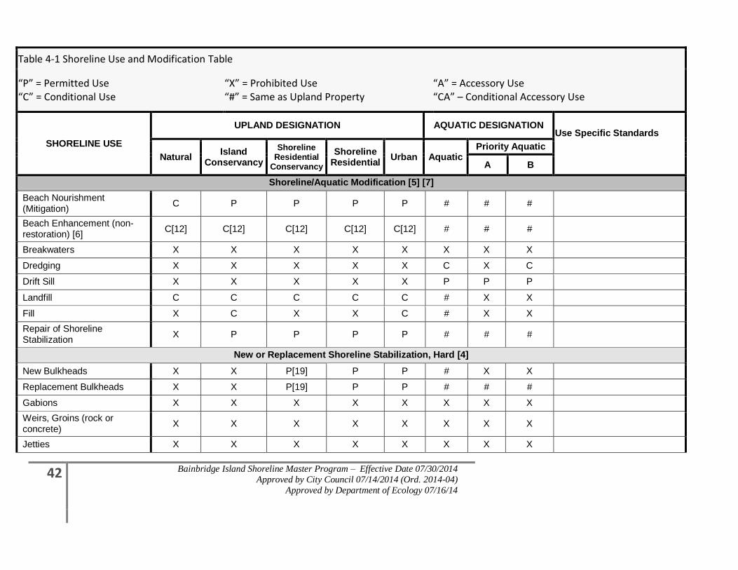
42 Bainbridge Island Shoreline Master Program – Effective Date 07/30/2014
Approved by City Council 07/14/2014 (Ord. 2014-04)
Approved by Department of Ecology 07/16/14
Table 4-1 Shoreline Use and Modification Table
“P” = Permitted Use “C” = Conditional Use
“X” = Prohibited Use “#” = Same as Upland Property
“A” = Accessory Use “CA” – Conditional Accessory Use
SHORELINE USE
UPLAND DESIGNATION AQUATIC DESIGNATION Use Specific Standards
Natural Island
Conservancy
Shoreline Residential
Conservancy
Shoreline Residential
Urban Aquatic Priority Aquatic
A B
Shoreline/Aquatic Modification [5] [7]
Beach Nourishment (Mitigation)
C P P P P # # #
Beach Enhancement (non-restoration) [6]
C[12] C[12] C[12] C[12] C[12] # # #
Breakwaters X X X X X X X X
Dredging X X X X X C X C
Drift Sill X X X X X P P P
Landfill C C C C C # X X
Fill X C X X C # X X
Repair of Shoreline Stabilization
X P P P P # # #
New or Replacement Shoreline Stabilization, Hard [4]
New Bulkheads X X P[19] P P # X X
Replacement Bulkheads X X P[19] P P # # #
Gabions X X X X X X X X
Weirs, Groins (rock or concrete)
X X X X X X X X
Jetties X X X X X X X X
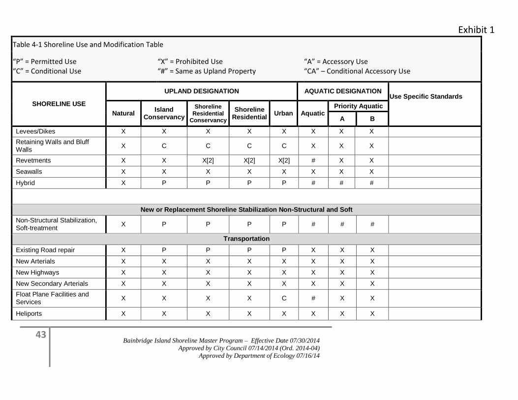
Exhibit 1
43 Bainbridge Island Shoreline Master Program – Effective Date 07/30/2014
Approved by City Council 07/14/2014 (Ord. 2014-04)
Approved by Department of Ecology 07/16/14
Table 4-1 Shoreline Use and Modification Table
“P” = Permitted Use “C” = Conditional Use
“X” = Prohibited Use “#” = Same as Upland Property
“A” = Accessory Use “CA” – Conditional Accessory Use
SHORELINE USE
UPLAND DESIGNATION AQUATIC DESIGNATION Use Specific Standards
Natural Island
Conservancy
Shoreline Residential
Conservancy
Shoreline Residential
Urban Aquatic Priority Aquatic
A B
Levees/Dikes X X X X X X X X
Retaining Walls and Bluff Walls
X C C C C X X X
Revetments X X X[2] X[2] X[2] # X X
Seawalls X X X X X X X X
Hybrid X P P P P # # #
New or Replacement Shoreline Stabilization Non-Structural and Soft
Non-Structural Stabilization, Soft-treatment
X P P P P # # #
Transportation
Existing Road repair X P P P P X X X
New Arterials X X X X X X X X
New Highways X X X X X X X X
New Secondary Arterials X X X X X X X X
Float Plane Facilities and Services
X X X X C # X X
Heliports X X X X X X X X
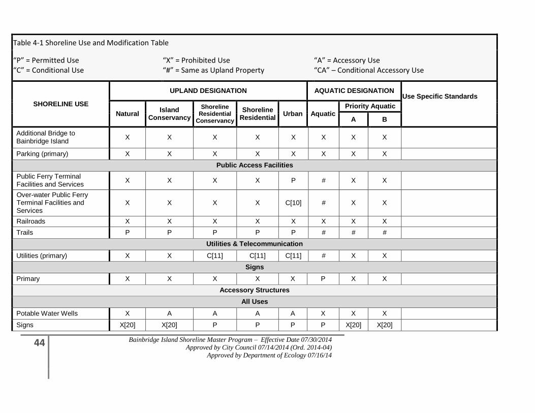
44 Bainbridge Island Shoreline Master Program – Effective Date 07/30/2014
Approved by City Council 07/14/2014 (Ord. 2014-04)
Approved by Department of Ecology 07/16/14
Table 4-1 Shoreline Use and Modification Table
“P” = Permitted Use “C” = Conditional Use
“X” = Prohibited Use “#” = Same as Upland Property
“A” = Accessory Use “CA” – Conditional Accessory Use
SHORELINE USE
UPLAND DESIGNATION AQUATIC DESIGNATION Use Specific Standards
Natural Island
Conservancy
Shoreline Residential
Conservancy
Shoreline Residential
Urban Aquatic Priority Aquatic
A B
Additional Bridge to Bainbridge Island
X X X X X X X X
Parking (primary) X X X X X X X X
Public Access Facilities
Public Ferry Terminal Facilities and Services
X X X X P # X X
Over-water Public Ferry Terminal Facilities and Services
X X X X C[10] # X X
Railroads X X X X X X X X
Trails P P P P P # # #
Utilities & Telecommunication
Utilities (primary) X X C[11] C[11] C[11] # X X
Signs
Primary X X X X X P X X
Accessory Structures
All Uses
Potable Water Wells X A A A A X X X
Signs X[20] X[20] P P P P X[20] X[20]
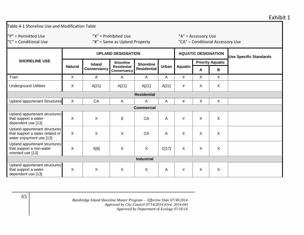
Exhibit 1
45 Bainbridge Island Shoreline Master Program – Effective Date 07/30/2014
Approved by City Council 07/14/2014 (Ord. 2014-04)
Approved by Department of Ecology 07/16/14
Table 4-1 Shoreline Use and Modification Table
“P” = Permitted Use “C” = Conditional Use
“X” = Prohibited Use “#” = Same as Upland Property
“A” = Accessory Use “CA” – Conditional Accessory Use
SHORELINE USE
UPLAND DESIGNATION AQUATIC DESIGNATION Use Specific Standards
Natural Island
Conservancy
Shoreline Residential
Conservancy
Shoreline Residential
Urban Aquatic Priority Aquatic
A B
Tram X A A A A # X X
Underground Utilities X A[21] A[21] A[21] A[21] # X X
Residential
Upland appurtenant Structures X CA A A A # X X
Commercial
Upland appurtenant structures that support a water-dependent use [13]
X X X CA A # X X
Upland appurtenant structures that support a water related or water enjoyment use [13]
X X X CA A X X X
Upland appurtenant structures that support a non-water oriented use [13]
X X[8] X X C[17] X X X
Industrial
Upland appurtenant structures that support a water-dependent use [13]
X X X X A # X X
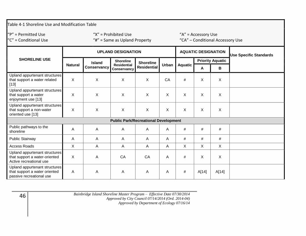
46 Bainbridge Island Shoreline Master Program – Effective Date 07/30/2014
Approved by City Council 07/14/2014 (Ord. 2014-04)
Approved by Department of Ecology 07/16/14
Table 4-1 Shoreline Use and Modification Table
“P” = Permitted Use “C” = Conditional Use
“X” = Prohibited Use “#” = Same as Upland Property
“A” = Accessory Use “CA” – Conditional Accessory Use
SHORELINE USE
UPLAND DESIGNATION AQUATIC DESIGNATION Use Specific Standards
Natural Island
Conservancy
Shoreline Residential
Conservancy
Shoreline Residential
Urban Aquatic Priority Aquatic
A B
Upland appurtenant structures that support a water related [13]
X X X X CA # X X
Upland appurtenant structures that support a water enjoyment use [13]
X X X X X X X X
Upland appurtenant structures that support a non-water oriented use [13]
X X X X X X X X
Public Park/Recreational Development
Public pathways to the shoreline
A A A A A # # #
Public Stairway A A A A A # # #
Access Roads X A A A A X X X
Upland appurtenant structures that support a water-oriented Active recreational use
X A CA CA A # X X
Upland appurtenant structures that support a water oriented passive recreational use
A A A A A # A[14] A[14]
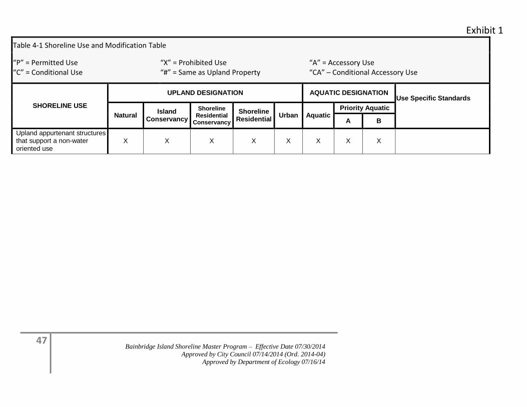
Exhibit 1
47 Bainbridge Island Shoreline Master Program – Effective Date 07/30/2014
Approved by City Council 07/14/2014 (Ord. 2014-04)
Approved by Department of Ecology 07/16/14
Table 4-1 Shoreline Use and Modification Table
“P” = Permitted Use “C” = Conditional Use
“X” = Prohibited Use “#” = Same as Upland Property
“A” = Accessory Use “CA” – Conditional Accessory Use
SHORELINE USE
UPLAND DESIGNATION AQUATIC DESIGNATION Use Specific Standards
Natural Island
Conservancy
Shoreline Residential
Conservancy
Shoreline Residential
Urban Aquatic Priority Aquatic
A B
Upland appurtenant structures that support a non-water oriented use
X X X X X X X X
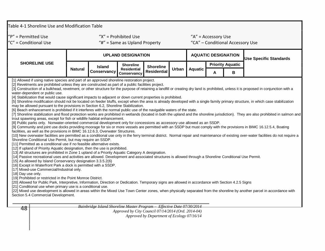
48 Bainbridge Island Shoreline Master Program – Effective Date 07/30/2014
Approved by City Council 07/14/2014 (Ord. 2014-04)
Approved by Department of Ecology 07/16/14
Table 4-1 Shoreline Use and Modification Table
“P” = Permitted Use “C” = Conditional Use
“X” = Prohibited Use “#” = Same as Upland Property
“A” = Accessory Use “CA” – Conditional Accessory Use
SHORELINE USE
UPLAND DESIGNATION AQUATIC DESIGNATION Use Specific Standards
Natural Island
Conservancy
Shoreline Residential
Conservancy
Shoreline Residential
Urban Aquatic Priority Aquatic
A B
[1] Allowed if using native species and part of an approved shoreline restoration project. [2] Revetments are prohibited unless they are constructed as part of a public facilities project. [3] Construction of a bulkhead, revetment, or other structure for the purpose of retaining a landfill or creating dry land is prohibited, unless it is proposed in conjunction with a water-dependent or public use. [4] Stabilization that would cause significant impacts to adjacent or down current properties is prohibited. [5] Shoreline modification should not be located on feeder bluffs, except when the area is already developed with a single family primary structure, in which case stabilization may be allowed pursuant to the provisions in Section 6.2, Shoreline Stabilization. [6] Beach enhancement is prohibited if it interferes with the normal public use of the navigable waters of the state. [7] Shoreline stabilization and flood protection works are prohibited in wetlands (located in both the upland and the shoreline jurisdiction). They are also prohibited in salmon and trout spawning areas, except for fish or wildlife habitat enhancement. [8] Public parks only. Nonwater-oriented commercial development only for concessions as accessory use allowed as an SSDP. [9] Community and joint use docks providing moorage for six or more vessels are permitted with an SSDP but must comply with the provisions in BIMC 16.12.5.4, Boating facilities, as well as the provisions in BIMC 16.12.6.3, Overwater Structures. [10] New overwater facilities are permitted as a conditional use only in the ferry terminal district. Normal repair and maintenance of existing over-water facilities do not require a Shoreline Conditional Use Permit, but may require an SSDP. [11] Permitted as a conditional use if no feasible alternative exists. [12] If upland of Priority Aquatic designation, then the use is prohibited. [13] All structures are prohibited in Zone 1 upland of a Priority Aquatic Category A designation. [14] Passive recreational uses and activities are allowed. Development and associated structures is allowed through a Shoreline Conditional Use Permit. [15] As allowed by Island Conservancy designation 3.3.5.2(6) [16] Except in Waterfront Park a dock is permitted with a SSDP. [17] Mixed-use Commercial/Industrial only. [18] Day use only. [19] Prohibited or restricted in the Point Monroe District. [20] Allowed for Public Park, Interpretive, Information, Direction or Dedication. Temporary signs are allowed in accordance with Section 4.2.5 Signs [21] Conditional use when primary use is a conditional use. [22] Mixed use development is allowed in areas within the Mixed Use Town Center zones, when physically separated from the shoreline by another parcel in accordance with Section 5.4 Commercial Development.
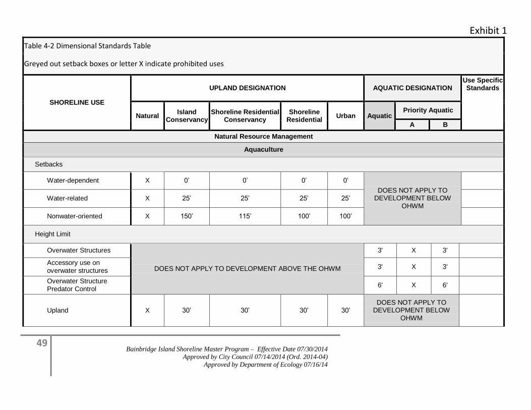
Exhibit 1
49 Bainbridge Island Shoreline Master Program – Effective Date 07/30/2014
Approved by City Council 07/14/2014 (Ord. 2014-04)
Approved by Department of Ecology 07/16/14
Table 4-2 Dimensional Standards Table
Greyed out setback boxes or letter X indicate prohibited uses
SHORELINE USE
UPLAND DESIGNATION AQUATIC DESIGNATION Use Specific Standards
Natural Island
Conservancy Shoreline Residential
Conservancy Shoreline
Residential Urban Aquatic
Priority Aquatic
A B
Natural Resource Management
Aquaculture
Setbacks
Water-dependent X 0’ 0’ 0’ 0’
DOES NOT APPLY TO DEVELOPMENT BELOW
OHWM
Water-related X 25’ 25’ 25’ 25’
Nonwater-oriented X 150’ 115’ 100’ 100’
Height Limit
Overwater Structures
DOES NOT APPLY TO DEVELOPMENT ABOVE THE OHWM
3' X 3'
Accessory use on overwater structures
3' X 3'
Overwater Structure Predator Control
6' X 6'
Upland X 30’ 30’ 30’ 30’ DOES NOT APPLY TO
DEVELOPMENT BELOW OHWM
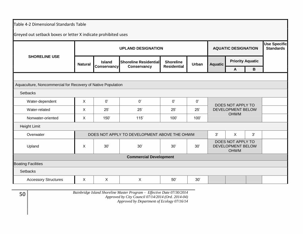
50 Bainbridge Island Shoreline Master Program – Effective Date 07/30/2014
Approved by City Council 07/14/2014 (Ord. 2014-04)
Approved by Department of Ecology 07/16/14
Table 4-2 Dimensional Standards Table
Greyed out setback boxes or letter X indicate prohibited uses
SHORELINE USE
UPLAND DESIGNATION AQUATIC DESIGNATION Use Specific Standards
Natural Island
Conservancy Shoreline Residential
Conservancy Shoreline
Residential Urban Aquatic
Priority Aquatic
A B
Aquaculture, Noncommercial for Recovery of Native Population
Setbacks
Water-dependent X 0’ 0’ 0’ 0’ DOES NOT APPLY TO
DEVELOPMENT BELOW OHWM
Water-related X 25’ 25’ 25’ 25’
Nonwater-oriented X 150’ 115’ 100’ 100’
Height Limit
Overwater DOES NOT APPLY TO DEVELOPMENT ABOVE THE OHWM 3' X 3'
Upland X 30’ 30’ 30’ 30’ DOES NOT APPLY TO
DEVELOPMENT BELOW OHWM
Commercial Development
Boating Facilities
Setbacks
Accessory Structures X X X 50’ 30’
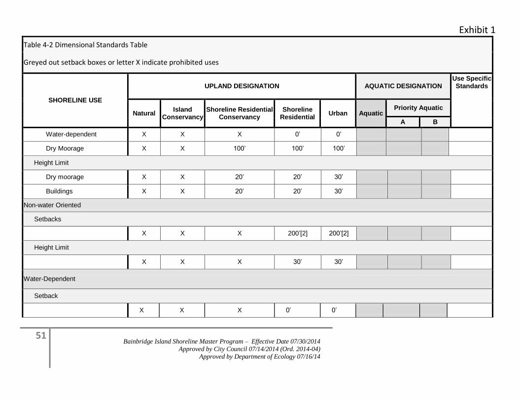
Exhibit 1
51 Bainbridge Island Shoreline Master Program – Effective Date 07/30/2014
Approved by City Council 07/14/2014 (Ord. 2014-04)
Approved by Department of Ecology 07/16/14
Table 4-2 Dimensional Standards Table
Greyed out setback boxes or letter X indicate prohibited uses
SHORELINE USE
UPLAND DESIGNATION AQUATIC DESIGNATION Use Specific Standards
Natural Island
Conservancy Shoreline Residential
Conservancy Shoreline
Residential Urban Aquatic
Priority Aquatic
A B
Water-dependent X X X 0’ 0’
Dry Moorage X X 100’ 100’ 100’
Height Limit
Dry moorage X X 20’ 20’ 30’
Buildings X X 20’ 20’ 30’
Non-water Oriented
Setbacks
X X X 200’[2] 200’[2]
Height Limit
X X X 30’ 30’
Water-Dependent
Setback
X X X 0’ 0’
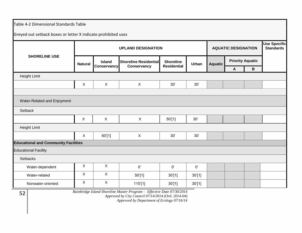
52 Bainbridge Island Shoreline Master Program – Effective Date 07/30/2014
Approved by City Council 07/14/2014 (Ord. 2014-04)
Approved by Department of Ecology 07/16/14
Table 4-2 Dimensional Standards Table
Greyed out setback boxes or letter X indicate prohibited uses
SHORELINE USE
UPLAND DESIGNATION AQUATIC DESIGNATION Use Specific Standards
Natural Island
Conservancy Shoreline Residential
Conservancy Shoreline
Residential Urban Aquatic
Priority Aquatic
A B
Height Limit
X X X 30’ 30’
Water-Related and Enjoyment
Setback
X X X 50’[1] 30’
Height Limit
X 50’[1] X 30’ 30’
Educational and Community Facilities
Educational Facility
Setbacks
Water-dependent X X 0’ 0’ 0’
Water-related X X 50’[1] 30’[1] 30’[1]
Nonwater-oriented X X 115’[1] 30’[1] 30’[1]
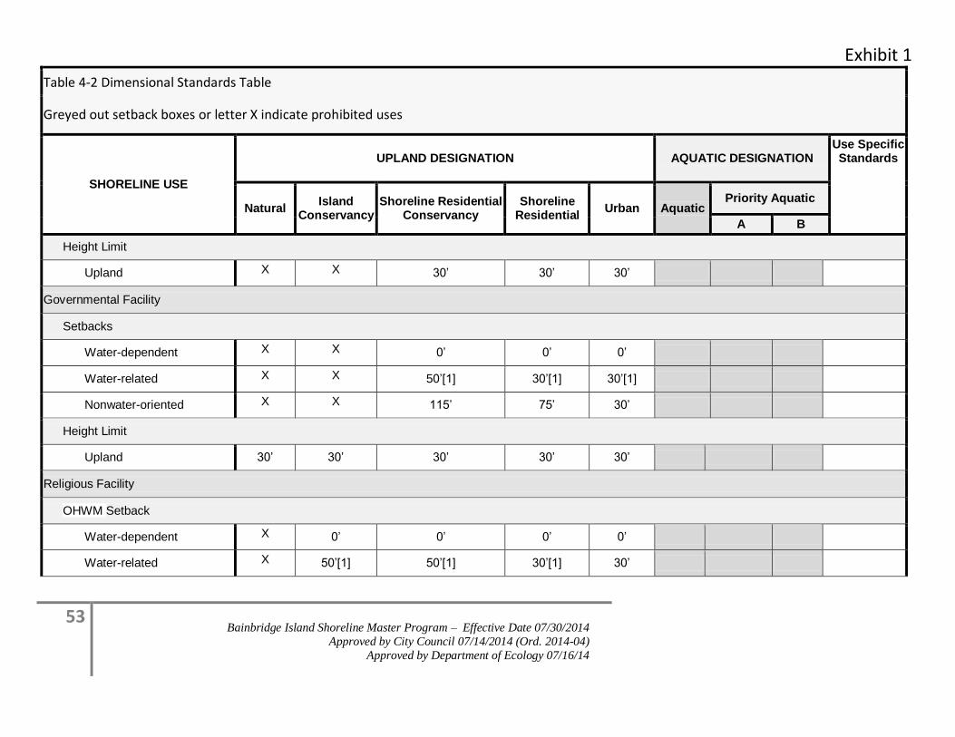
Exhibit 1
53 Bainbridge Island Shoreline Master Program – Effective Date 07/30/2014
Approved by City Council 07/14/2014 (Ord. 2014-04)
Approved by Department of Ecology 07/16/14
Table 4-2 Dimensional Standards Table
Greyed out setback boxes or letter X indicate prohibited uses
SHORELINE USE
UPLAND DESIGNATION AQUATIC DESIGNATION Use Specific Standards
Natural Island
Conservancy Shoreline Residential
Conservancy Shoreline
Residential Urban Aquatic
Priority Aquatic
A B
Height Limit
Upland X X 30’ 30’ 30’
Governmental Facility
Setbacks
Water-dependent X X 0’ 0’ 0’
Water-related X X 50’[1] 30’[1] 30’[1]
Nonwater-oriented X X 115’ 75’ 30’
Height Limit
Upland 30’ 30’ 30’ 30’ 30’
Religious Facility
OHWM Setback
Water-dependent X 0’ 0’ 0’ 0’
Water-related X 50’[1] 50’[1] 30’[1] 30’
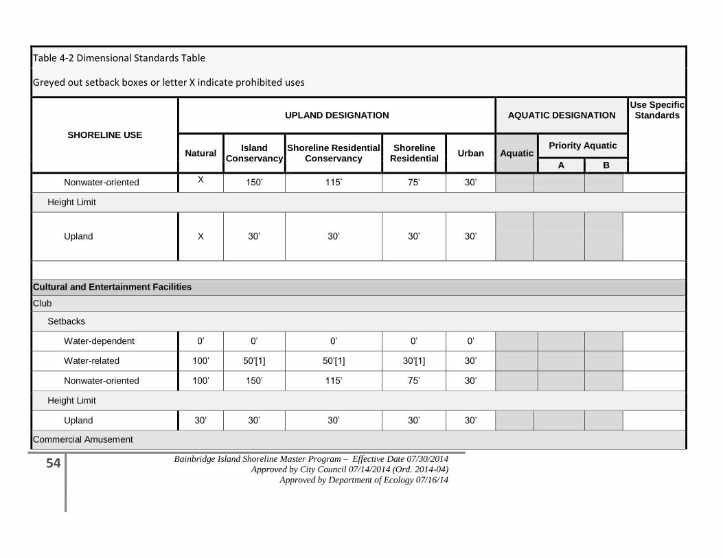
54 Bainbridge Island Shoreline Master Program – Effective Date 07/30/2014
Approved by City Council 07/14/2014 (Ord. 2014-04)
Approved by Department of Ecology 07/16/14
Table 4-2 Dimensional Standards Table
Greyed out setback boxes or letter X indicate prohibited uses
SHORELINE USE
UPLAND DESIGNATION AQUATIC DESIGNATION Use Specific Standards
Natural Island
Conservancy Shoreline Residential
Conservancy Shoreline
Residential Urban Aquatic
Priority Aquatic
A B
Nonwater-oriented X 150’ 115’ 75’ 30’
Height Limit
Upland X 30’ 30’ 30’ 30’
Cultural and Entertainment Facilities
Club
Setbacks
Water-dependent 0’ 0’ 0’ 0’ 0’
Water-related 100’ 50’[1] 50’[1] 30’[1] 30’
Nonwater-oriented 100’ 150’ 115’ 75’ 30’
Height Limit
Upland 30’ 30’ 30’ 30’ 30’
Commercial Amusement
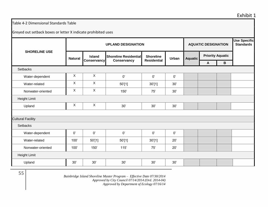
Exhibit 1
55 Bainbridge Island Shoreline Master Program – Effective Date 07/30/2014
Approved by City Council 07/14/2014 (Ord. 2014-04)
Approved by Department of Ecology 07/16/14
Table 4-2 Dimensional Standards Table
Greyed out setback boxes or letter X indicate prohibited uses
SHORELINE USE
UPLAND DESIGNATION AQUATIC DESIGNATION Use Specific Standards
Natural Island
Conservancy Shoreline Residential
Conservancy Shoreline
Residential Urban Aquatic
Priority Aquatic
A B
Setbacks
Water-dependent X X 0’ 0’ 0’
Water-related X X 50’[1] 30’[1] 30’
Nonwater-oriented X X 150’ 75’ 30’
Height Limit
Upland X X 30’ 30’ 30’
Cultural Facility
Setbacks
Water-dependent 0’ 0’ 0’ 0’ 0’
Water-related 100’ 50’[1] 50’[1] 30’[1] 20’
Nonwater-oriented 100’ 150’ 115’ 75’ 20’
Height Limit
Upland 30’ 30’ 30’ 30’ 30’
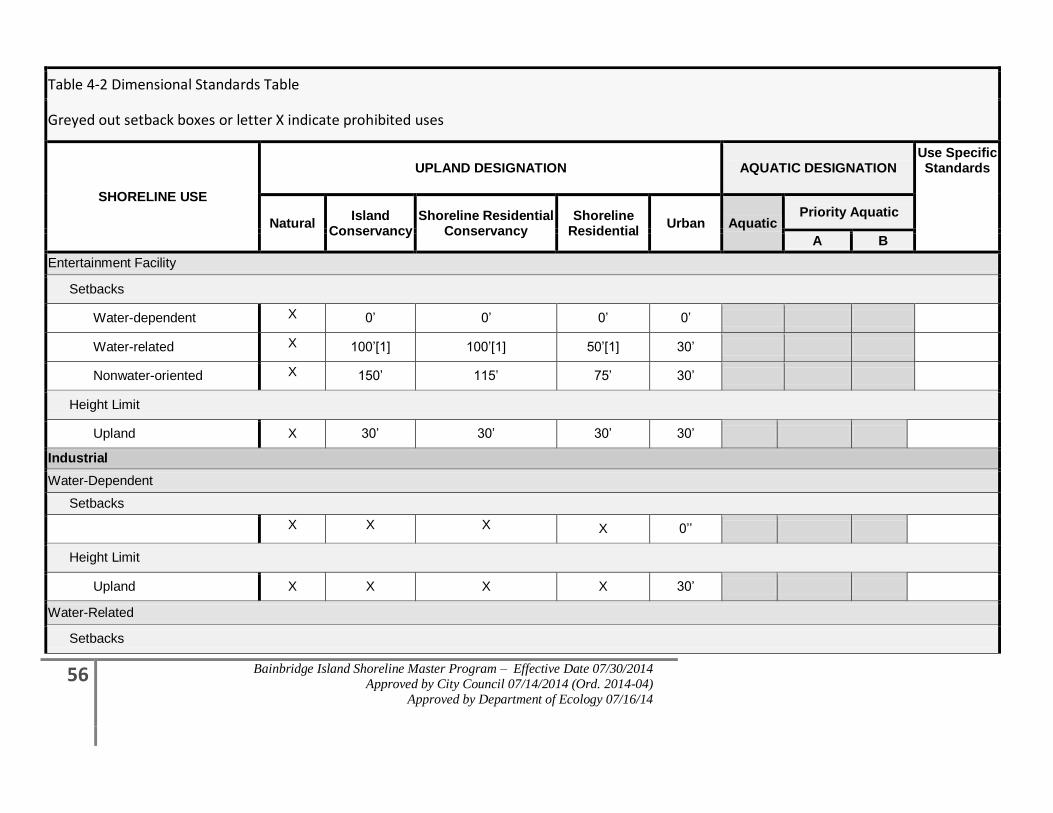
56 Bainbridge Island Shoreline Master Program – Effective Date 07/30/2014
Approved by City Council 07/14/2014 (Ord. 2014-04)
Approved by Department of Ecology 07/16/14
Table 4-2 Dimensional Standards Table
Greyed out setback boxes or letter X indicate prohibited uses
SHORELINE USE
UPLAND DESIGNATION AQUATIC DESIGNATION Use Specific Standards
Natural Island
Conservancy Shoreline Residential
Conservancy Shoreline
Residential Urban Aquatic
Priority Aquatic
A B
Entertainment Facility
Setbacks
Water-dependent X 0’ 0’ 0’ 0’
Water-related X 100’[1] 100’[1] 50’[1] 30’
Nonwater-oriented X 150’ 115’ 75’ 30’
Height Limit
Upland X 30’ 30’ 30’ 30’
Industrial
Water-Dependent
Setbacks
X X X X 0’’
Height Limit
Upland X X X X 30’
Water-Related
Setbacks
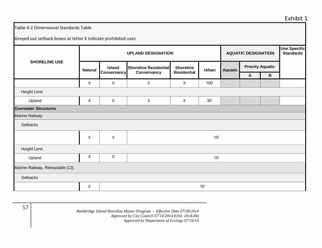
Exhibit 1
57 Bainbridge Island Shoreline Master Program – Effective Date 07/30/2014
Approved by City Council 07/14/2014 (Ord. 2014-04)
Approved by Department of Ecology 07/16/14
Table 4-2 Dimensional Standards Table
Greyed out setback boxes or letter X indicate prohibited uses
SHORELINE USE
UPLAND DESIGNATION AQUATIC DESIGNATION Use Specific Standards
Natural Island
Conservancy Shoreline Residential
Conservancy Shoreline
Residential Urban Aquatic
Priority Aquatic
A B
X X X X 100’
Height Limit
Upland X X X X 30’
Overwater Structures
Marine Railway
Setbacks
X X 10’
Height Limit
Upland X X 10’
Marine Railway, Retractable [12]
Setbacks
X 10’
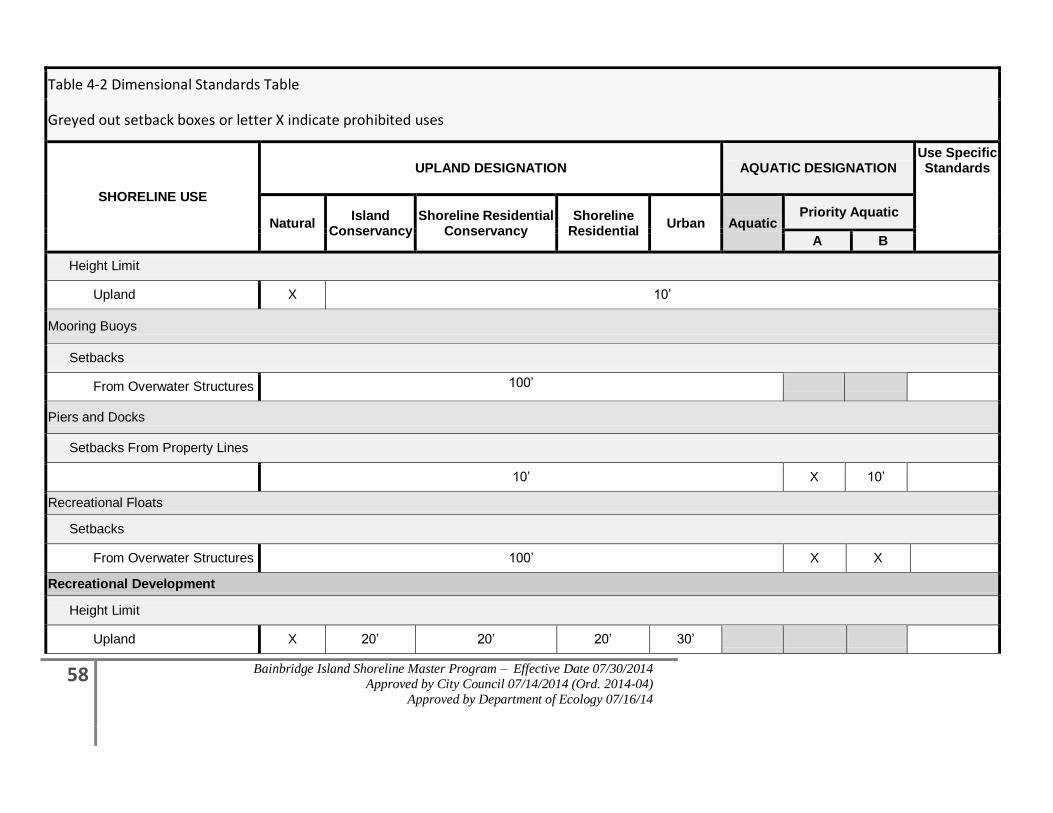
58 Bainbridge Island Shoreline Master Program – Effective Date 07/30/2014
Approved by City Council 07/14/2014 (Ord. 2014-04)
Approved by Department of Ecology 07/16/14
Table 4-2 Dimensional Standards Table
Greyed out setback boxes or letter X indicate prohibited uses
SHORELINE USE
UPLAND DESIGNATION AQUATIC DESIGNATION Use Specific Standards
Natural Island
Conservancy Shoreline Residential
Conservancy Shoreline
Residential Urban Aquatic
Priority Aquatic
A B
Height Limit
Upland X 10’
Mooring Buoys
Setbacks
From Overwater Structures 100’
Piers and Docks
Setbacks From Property Lines
10’ X 10’
Recreational Floats
Setbacks
From Overwater Structures 100’ X X
Recreational Development
Height Limit
Upland X 20’ 20’ 20’ 30’
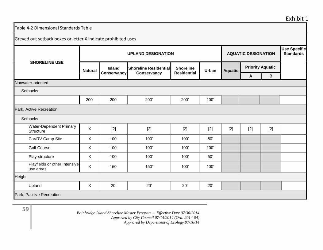
Exhibit 1
59 Bainbridge Island Shoreline Master Program – Effective Date 07/30/2014
Approved by City Council 07/14/2014 (Ord. 2014-04)
Approved by Department of Ecology 07/16/14
Table 4-2 Dimensional Standards Table
Greyed out setback boxes or letter X indicate prohibited uses
SHORELINE USE
UPLAND DESIGNATION AQUATIC DESIGNATION Use Specific Standards
Natural Island
Conservancy Shoreline Residential
Conservancy Shoreline
Residential Urban Aquatic
Priority Aquatic
A B
Nonwater-oriented
Setbacks
200’ 200’ 200’ 200’ 100’
Park, Active Recreation
Setbacks
Water-Dependent Primary Structure
X [2] [2] [2] [2] [2] [2] [2]
Car/RV Camp Site X 100’ 100’ 100’ 50’
Golf Course X 100’ 100’ 100’ 100’
Play-structure X 100’ 100’ 100’ 50’
Playfields or other Intensive use areas
X 150’ 150’ 100’ 100’
Height
Upland X 20’ 20’ 20’ 20’
Park, Passive Recreation
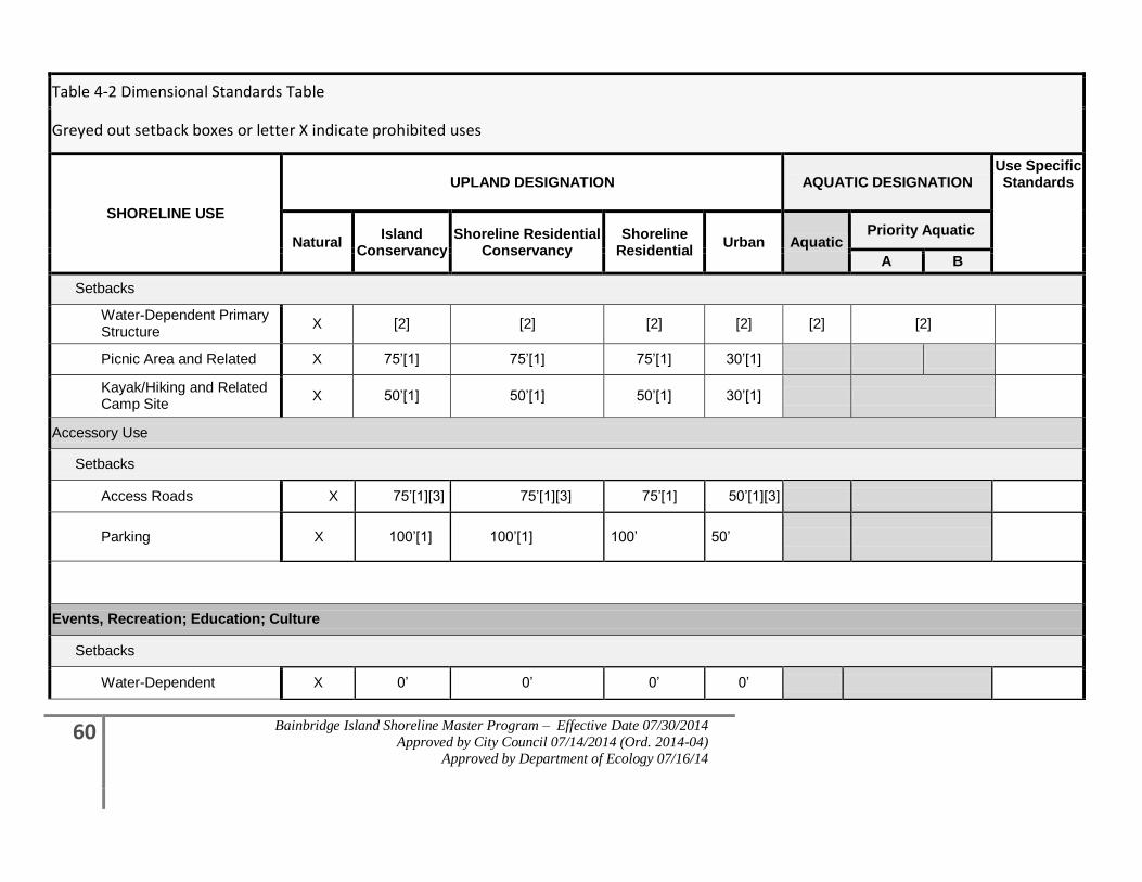
60 Bainbridge Island Shoreline Master Program – Effective Date 07/30/2014
Approved by City Council 07/14/2014 (Ord. 2014-04)
Approved by Department of Ecology 07/16/14
Table 4-2 Dimensional Standards Table
Greyed out setback boxes or letter X indicate prohibited uses
SHORELINE USE
UPLAND DESIGNATION AQUATIC DESIGNATION Use Specific Standards
Natural Island
Conservancy Shoreline Residential
Conservancy Shoreline
Residential Urban Aquatic
Priority Aquatic
A B
Setbacks
Water-Dependent Primary Structure
X [2] [2] [2] [2] [2] [2]
Picnic Area and Related X 75’[1] 75’[1] 75’[1] 30’[1]
Kayak/Hiking and Related Camp Site
X 50’[1] 50’[1] 50’[1] 30’[1]
Accessory Use
Setbacks
Access Roads X 75’[1][3] 75’[1][3] 75’[1] 50’[1][3]
Parking X 100’[1] 100’[1] 100’ 50’
Events, Recreation; Education; Culture
Setbacks
Water-Dependent X 0’ 0’ 0’ 0’
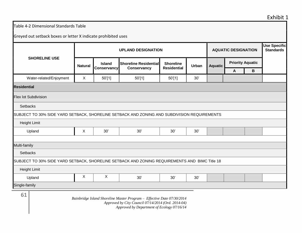
Exhibit 1
61 Bainbridge Island Shoreline Master Program – Effective Date 07/30/2014
Approved by City Council 07/14/2014 (Ord. 2014-04)
Approved by Department of Ecology 07/16/14
Table 4-2 Dimensional Standards Table
Greyed out setback boxes or letter X indicate prohibited uses
SHORELINE USE
UPLAND DESIGNATION AQUATIC DESIGNATION Use Specific Standards
Natural Island
Conservancy Shoreline Residential
Conservancy Shoreline
Residential Urban Aquatic
Priority Aquatic
A B
Water-related/Enjoyment X 50’[1] 50’[1] 50’[1] 30’
Residential
Flex lot Subdivision
Setbacks
SUBJECT TO 30% SIDE YARD SETBACK, SHORELINE SETBACK AND ZONING AND SUBDIVISION REQUIREMENTS
Height Limit
Upland X 30’ 30’ 30’ 30’
Multi-family
Setbacks
SUBJECT TO 30% SIDE YARD SETBACK, SHORELINE SETBACK AND ZONING REQUIREMENTS AND BIMC Title 18
Height Limit
Upland X X 30’ 30’ 30’
Single-family
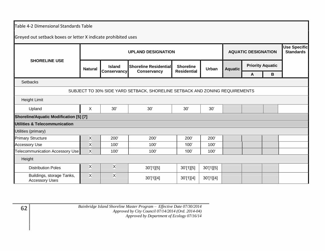
62 Bainbridge Island Shoreline Master Program – Effective Date 07/30/2014
Approved by City Council 07/14/2014 (Ord. 2014-04)
Approved by Department of Ecology 07/16/14
Table 4-2 Dimensional Standards Table
Greyed out setback boxes or letter X indicate prohibited uses
SHORELINE USE
UPLAND DESIGNATION AQUATIC DESIGNATION Use Specific Standards
Natural Island
Conservancy Shoreline Residential
Conservancy Shoreline
Residential Urban Aquatic
Priority Aquatic
A B
Setbacks
SUBJECT TO 30% SIDE YARD SETBACK, SHORELINE SETBACK AND ZONING REQUIREMENTS
Height Limit
Upland X 30’ 30’ 30’ 30’
Shoreline/Aquatic Modification [5] [7]
Utilities & Telecommunication
Utilities (primary)
Primary Structure X 200' 200' 200' 200'
Accessory Use X 100' 100' 100’ 100'
Telecommunication Accessory Use X 100' 100' 100’ 100'
Height
Distribution Poles X X 30’[1][5] 30’[1][5] 30’[1][5]
Buildings, storage Tanks, Accessory Uses
X X 30’[1][4] 30’[1][4] 30’[1][4]
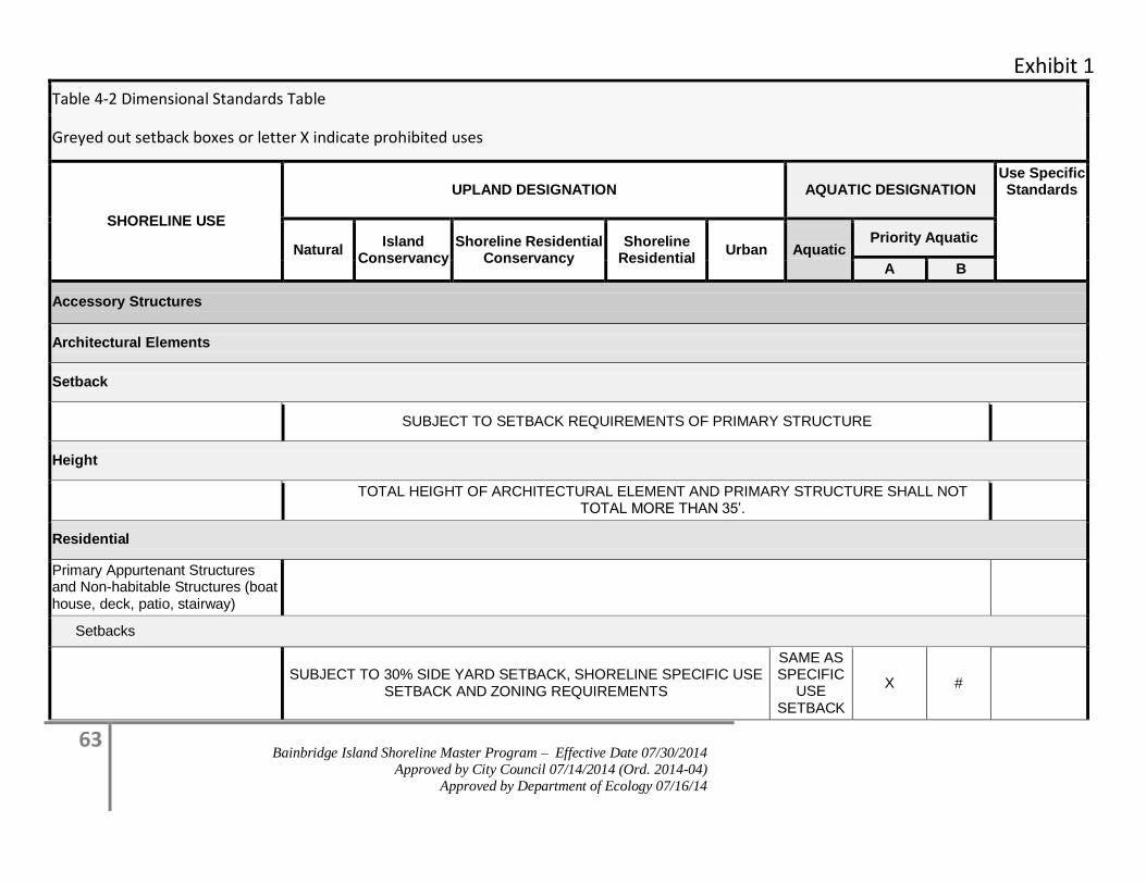
Exhibit 1
63 Bainbridge Island Shoreline Master Program – Effective Date 07/30/2014
Approved by City Council 07/14/2014 (Ord. 2014-04)
Approved by Department of Ecology 07/16/14
Table 4-2 Dimensional Standards Table
Greyed out setback boxes or letter X indicate prohibited uses
SHORELINE USE
UPLAND DESIGNATION AQUATIC DESIGNATION Use Specific Standards
Natural Island
Conservancy Shoreline Residential
Conservancy Shoreline
Residential Urban Aquatic
Priority Aquatic
A B
Accessory Structures
Architectural Elements
Setback
SUBJECT TO SETBACK REQUIREMENTS OF PRIMARY STRUCTURE
Height
TOTAL HEIGHT OF ARCHITECTURAL ELEMENT AND PRIMARY STRUCTURE SHALL NOT
TOTAL MORE THAN 35’.
Residential
Primary Appurtenant Structures and Non-habitable Structures (boat house, deck, patio, stairway)
Setbacks
SUBJECT TO 30% SIDE YARD SETBACK, SHORELINE SPECIFIC USE
SETBACK AND ZONING REQUIREMENTS
SAME AS SPECIFIC
USE SETBACK
X #
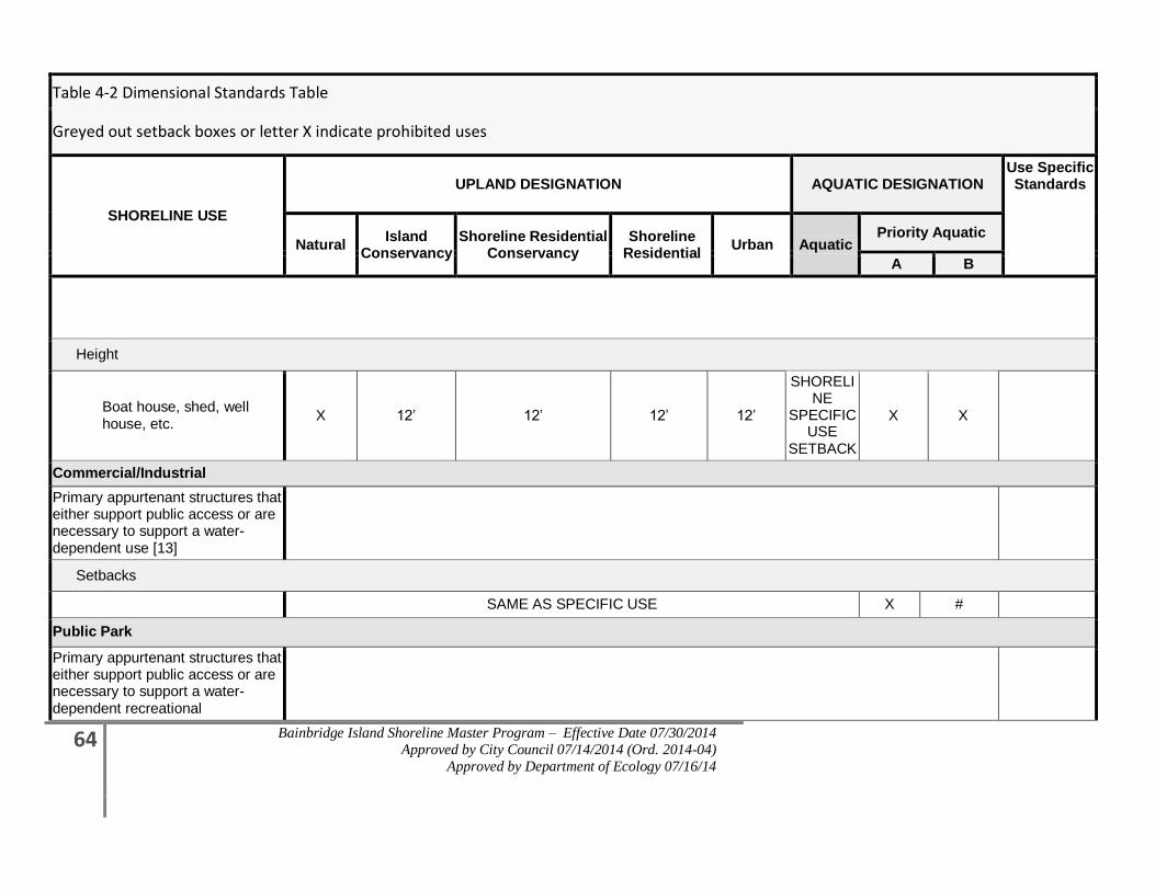
64 Bainbridge Island Shoreline Master Program – Effective Date 07/30/2014
Approved by City Council 07/14/2014 (Ord. 2014-04)
Approved by Department of Ecology 07/16/14
Table 4-2 Dimensional Standards Table
Greyed out setback boxes or letter X indicate prohibited uses
SHORELINE USE
UPLAND DESIGNATION AQUATIC DESIGNATION Use Specific Standards
Natural Island
Conservancy Shoreline Residential
Conservancy Shoreline
Residential Urban Aquatic
Priority Aquatic
A B
Height
Boat house, shed, well house, etc.
X 12’ 12’ 12’ 12’
SHORELINE
SPECIFIC USE
SETBACK
X X
Commercial/Industrial
Primary appurtenant structures that either support public access or are necessary to support a water-dependent use [13]
Setbacks
SAME AS SPECIFIC USE X #
Public Park
Primary appurtenant structures that either support public access or are necessary to support a water-dependent recreational
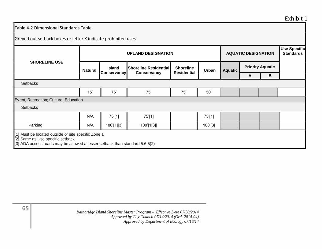
Exhibit 1
65 Bainbridge Island Shoreline Master Program – Effective Date 07/30/2014
Approved by City Council 07/14/2014 (Ord. 2014-04)
Approved by Department of Ecology 07/16/14
Table 4-2 Dimensional Standards Table
Greyed out setback boxes or letter X indicate prohibited uses
SHORELINE USE
UPLAND DESIGNATION AQUATIC DESIGNATION Use Specific Standards
Natural Island
Conservancy Shoreline Residential
Conservancy Shoreline
Residential Urban Aquatic
Priority Aquatic
A B
Setbacks
15’ 75’ 75’ 75’ 50’
Event, Recreation; Culture; Education
Setbacks
N/A 75’[1] 75’[1] 75’[1]
Parking N/A 100’[1][3] 100’[1[3]] 100’[3]
[1] Must be located outside of site specific Zone 1 [2] Same as Use specific setback [3] ADA access roads may be allowed a lesser setback than standard 5.6.5(2)
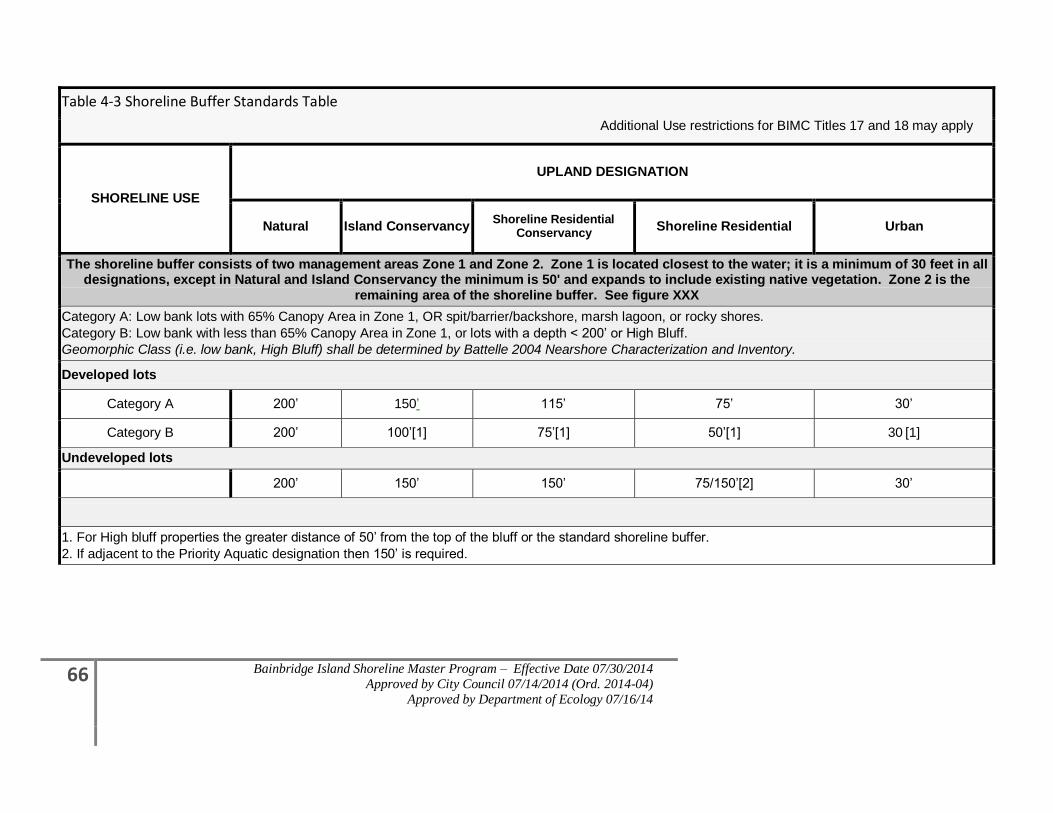
66 Bainbridge Island Shoreline Master Program – Effective Date 07/30/2014
Approved by City Council 07/14/2014 (Ord. 2014-04)
Approved by Department of Ecology 07/16/14
Table 4-3 Shoreline Buffer Standards Table
SHORELINE USE
UPLAND DESIGNATION
Natural Island Conservancy Shoreline Residential
Conservancy Shoreline Residential Urban
The shoreline buffer consists of two management areas Zone 1 and Zone 2. Zone 1 is located closest to the water; it is a minimum of 30 feet in all designations, except in Natural and Island Conservancy the minimum is 50' and expands to include existing native vegetation. Zone 2 is the
remaining area of the shoreline buffer. See figure XXX
Category A: Low bank lots with 65% Canopy Area in Zone 1, OR spit/barrier/backshore, marsh lagoon, or rocky shores.
Category B: Low bank with less than 65% Canopy Area in Zone 1, or lots with a depth < 200’ or High Bluff.
Geomorphic Class (i.e. low bank, High Bluff) shall be determined by Battelle 2004 Nearshore Characterization and Inventory.
Developed lots
Category A 200’ 150’ 115’ 75’ 30’
Category B 200’ 100’[1] 75’[1] 50’[1] 30 [1]
Undeveloped lots
200’ 150’ 150’ 75/150’[2] 30’
1. For High bluff properties the greater distance of 50’ from the top of the bluff or the standard shoreline buffer.
2. If adjacent to the Priority Aquatic designation then 150’ is required.
Additional Use restrictions for BIMC Titles 17 and 18 may apply
Exhibit 1
67 Bainbridge Island Shoreline Master Program – Effective Date 07/30/2014
Approved by City Council 07/14/2014 (Ord. 2014-04)
Approved by Department of Ecology 07/16/14
4.1 Environmental Quality and Conservation
4.1.1 Shorelines of State-wide Significance
4.1.1.1 Purpose
The Shoreline Management Act of 1971 designated certain shoreline areas as shoreline of
state-wide significance (SSWS). Because these shorelines are resources from which all
people in the state derive benefit, preference is given to uses which favor public and long-
range goals.
4.1.1.2 Applicability
Within the City’s jurisdiction all those areas lying waterward from the line of extreme low
tide are shorelines of state-wide significance. [RCW 90.58.030(2)(f)(iii)or its successor].
Development, use, or activities located within shorelines of statewide significance shall
follow all the provisions of this program. Proposed development, use, and activity within
shorelines of statewide significance shall be reviewed in accordance with preferred policies
listed in 4.1.1.3. The Administrator may reduce, alter, or deny proposed development, use,
or activity to satisfy the preferred policy.
4.1.1.3 Policies (In order of preference)
1. Recognize and protect the state-wide interest over local interest.
a. Solicit comments and opinions from groups and individuals representing state-
wide interests by circulating the Master Program, and any amendments thereof
affecting Shorelines of State-wide Significance, to state agencies, adjacent
jurisdictions, citizen’s advisory committees, local officials, and state-wide interest
groups.
b. Recognize and take into account state agencies’ policies, programs, and
recommendations in developing and administering use regulations, and in
approving shoreline permits.
c. Solicit comments, opinions, and advice from individuals with expertise in
ecology, geology, limnology, aquaculture, and other scientific fields pertinent to
shoreline management.
2. Preserve the natural character of the shoreline.
a. Designate and administer shoreline designation and use regulations to minimize
damage to the ecology and environment of the shoreline as a result of man-made
intrusions on the shorelines.
3. Result in long-term over short-term benefit.

68 Bainbridge Island Shoreline Master Program – Effective Date 07/30/2014
Approved by City Council 07/14/2014 (Ord. 2014-04)
Approved by Department of Ecology 07/16/14
a. Evaluate the short-term economic gain or convenience of developments relative to
the long-term and potentially costly impairments to the natural shoreline.
b. In general, preserve resources and values of shoreline of state-wide significance
for future generations and restrict or prohibit development that would irreversibly
damage shoreline resources.
c. Actively promote aesthetic considerations when contemplating new development,
redevelopment of existing facilities, or general enhancement of shoreline areas.
4. Protect the resources and ecology of the shoreline.
a. Minimize development activity that will interfere with the natural functioning of
the shoreline ecosystem including, but not limited to, stability, drainage, aesthetic
values, and water quality.
b. All shoreline development should be located, designed, constructed, and managed
to avoid disturbance of, and to minimize adverse impacts on, fish and wildlife
resources including spawning, nesting, rearing, and habitat areas and migratory
routes.
c. Restrict or prohibit public access onto areas which cannot be maintained in a
natural condition under human uses.
d. Shoreline materials including, but not limited to, bank substrate, soils, beach
sands, and gravel bars should be left undisturbed by shoreline development.
5. Increase public access to publicly owned areas of the shorelines.
a. Give priority to developing paths and trails to shoreline areas, linear access along
the shorelines, and to upland parking.
b. Locate development landward of the ordinary high water mark.
c. Limit public access when environmental or habitat values warrant such
limitations.
6. Increase recreational opportunities for the public on the shoreline.
a. Plan for and encourage development of facilities for recreational use of the
shorelines.
4.1.2 Environmental Impacts
4.1.2.1 Applicability
All shoreline development and activity shall be located, designed, constructed, and managed
in a manner that avoids, minimizes and/or mitigates adverse impacts to the shoreline
environment. The preferred mitigation sequence (avoid, minimize, rectify, reduce, or
compensate for the environmental impact) shall follow that listed in WAC 173-26-201(2)(e).
See definition of “Mitigation” listed in this Master Program, in Section 8.0, Definitions.
Exhibit 1
69 Bainbridge Island Shoreline Master Program – Effective Date 07/30/2014
Approved by City Council 07/14/2014 (Ord. 2014-04)
Approved by Department of Ecology 07/16/14
In approving shoreline development, the City shall ensure that shoreline development, use,
and/or activities will result in no net loss of ecological functions and ecosystem-wide
processes necessary to sustain shoreline resources, including loss that may result from the
cumulative impacts of similar developments over time consistent with constitutional and
statutory limitations on the regulation of private property. To this end, the City may require
modifications to the site plan and/or adjustments to proposed project dimensions, intensity
of use, and screening, as deemed appropriate. If impacts cannot be avoided through design
modifications, the City shall require compensatory mitigation commensurate with the
project’s adverse impacts.
4.1.2.2 Goal
Minimize impacts of shoreline development, uses and activities on the environment during
all phases of development (e.g. design, construction, and management).
4.1.2.3 Policies
1. Ensure all shoreline uses, activities and developments are designed and located in a
manner that prevents or mitigates adverse impacts to shoreline ecological functions and
ecosystem-wide processes, including the use of the mitigation sequence (avoid,
minimize, rectify, reduce, compensate); and make available flexible alternatives to
accommodate preferred shoreline uses.
2. Ensure, through appropriate monitoring and enforcement measures that all required
conditions are met, and improvements are installed and properly maintained.
3. Promote shoreline uses and activities within critical areas which do not cause significant
adverse impacts to ecological functions and ecosystem-wide processes, such as public
access on publicly owned lands.
4. In assessing the potential for new uses, activities and developments to cause adverse
impacts, take into account all of the following:
a. Effects on ecological functions and ecosystem-wide processes, including temporal
loss of functions; and
b. Effects that occur on-site and effects that may occur off-site; and
c. Direct and indirect effects and long-term effects of the project; and
d. Effects of the project and the incremental or cumulative effects resulting from the
project added to other past, present, and reasonably foreseeable future actions; and
e. Compensatory mitigation actions that offset adverse impacts of the development
action and/or use.
5. To provide for comprehensive management strategies for shoreline areas, integrate
planning and regulatory measures, such as those within the comprehensive plan, regional
watershed plans, or state and federal regulations.
70 Bainbridge Island Shoreline Master Program – Effective Date 07/30/2014
Approved by City Council 07/14/2014 (Ord. 2014-04)
Approved by Department of Ecology 07/16/14
4.1.2.4 Regulations-Impact Analysis and No Net Loss Standard
1. All shoreline development, use and activities, including preferred uses, and uses that are
exempt from a shoreline substantial permit, shall be located, designed, constructed, and
maintained in a manner that protects ecological functions and ecosystem-wide processes.
All proposed shoreline development, uses and activities shall:
a. Utilize the required mitigation sequence of Section 4.1.2.6, Regulations –
Mitigation; and
b. Utilize effective erosion and scour control methods during project construction
and operation; and
c. Minimize adverse impacts to critical salt water habitat, fish and wildlife
conservation areas, and/or other ecological functions and ecosystem-wide
processes, such as those provided by shoreline vegetation; and
d. Minimize interference with beneficial natural shoreline processes, such as water
circulation, sand and gravel transport movement, erosion, and accretion; and
e. Avoid hazards to public health and safety; and
f. Minimize the need for shoreline stabilization measures and flood protection in the
future; and may require a geotechnical analysis to ensure that the proposed
activity meets this regulation (See Section 6.2, Shoreline Stabilization); and
g. Result in no net loss of ecological functions and processes necessary to sustain
shoreline resources, including loss that may result from the cumulative impacts of
similar developments over time.
2. In reviewing and approving shoreline development, use or activity, regardless of whether
a permit is required the following shall apply:
a. The Administrator shall condition the shoreline development, use, and/or
activities such that it will:
i. Meet provisions in subsection 1 above; and
ii. Employ measures to mitigate adverse impacts on shoreline functions and,
processes, if necessary; and
iii. Modify the site plan and/or adjust the project dimensions, intensity of use,
or screening as deemed appropriate to address impacts. If impacts cannot
be avoided through design modification, the Administrator shall require
compensatory mitigation, pursuant to regulations in Sections 4.1.2.5,
Regulations – Revegetation Standards, and 4.1.2.6, Regulations –
Mitigation; and
b. If a proposed shoreline development, use or activity is determined by the
Administrator to result in significant short-term, long-term, or cumulative
Exhibit 1
71 Bainbridge Island Shoreline Master Program – Effective Date 07/30/2014
Approved by City Council 07/14/2014 (Ord. 2014-04)
Approved by Department of Ecology 07/16/14
adverse environmental impacts lacking appropriate compensatory mitigation, it
shall be sufficient reason for the Administrator to deny a permit.
3. To assure that development activities contribute to meeting the no net loss provisions
pursuant to subsection 1 and 2 above, an applicant is required to submit a site-specific
analysis of potential impacts and a mitigation plan that includes compensatory mitigation
measures when determined necessary as a result of the analysis. The site-specific analysis
shall be prepared in accordance with Section 4.1.2.9, Submittal Requirements – Site-
Specific Impact Analysis and Mitigation Plan.
4. To mitigate anticipated impacts and meet the no net loss standards in subsection 1 and 2
above, an applicant for a single family residential development or accessory structures
may choose to use the Standard Residential Mitigation Manual in Appendix D in lieu of a
site-specific impact analysis and mitigation plan. If an applicant uses the Single Family
Residential Mitigation Manual, compensatory mitigation requirements provided in the
manual shall be included in the project submittal.
4.1.2.5 Regulations – Revegetation Standards
1. Vegetation replanting is required for all development, uses or activities within the 200-
foot shoreline jurisdiction that either alters existing native vegetation or any vegetation in
the required Shoreline Buffer or Vegetation Management Areas, whether a permit is
required or not. This includes invasive species removal. Minimum requirements for
planting plans can be found in the City’s Administrative Vegetation Management
Manual. The following information shall be submitted for approval prior to vegetation
disturbance as part of a project proposal or clearing permit pursuant to BIMC 15.18, Land
Clearing:
a. Residential, Industrial and Commercial Development.
i. Vegetation disturbance of 200 square feet or less requires submittal of an
annotated list of proposed plants and their spacing specifications and location.
ii. Vegetation disturbance greater than 200 square feet requires that the planting
plan shall be completed by a qualified professional or the applicant may use the
single-family residential mitigation manual.
b. Public Park and City Maintained Areas.
i. Vegetation disturbance of 2,500 square feet or less requires submittal of an
annotated list of proposed plants and their spacing specifications and location.
ii. Vegetation disturbance greater than 2,500 square feet requires that the planting
plan shall be completed by a qualified professional.
2. For vegetation mitigation in the Shoreline Buffer or Site-specific Vegetation
Management Areas, all new plantings shall meet the provisions in Section 4.1.3.5(5),
except for the Point Monroe District which shall meet special provisions in subsection 6,
72 Bainbridge Island Shoreline Master Program – Effective Date 07/30/2014
Approved by City Council 07/14/2014 (Ord. 2014-04)
Approved by Department of Ecology 07/16/14
3. If the Shoreline Buffer is altered or reduced pursuant to provisions of Section 4.1.3,
Vegetation Management or Section 4.2.1, Nonconforming Uses, Non-Conforming Lots,
and Existing Development, the following shall occur in Zone 1:
a. Retain existing native vegetation; and
b. Plant the entire area of Zone 1. Obtain 65% vegetation canopy coverage within
10 years.
4. When vegetation mitigation is required for new upland development, uses, or activities
the mitigation plan shall include new plantings that are protective of views from the
primary structure of the subject property and in proportion to the identified impact.
Mitigation shall be located in the following sequence, except for the Point Monroe
District which shall meet special provisions in subsection 6,
a. Within Zone 1, plant vegetation to obtain a minimum of 65% native vegetation
canopy coverage;
b. In Zone 2, plant to increase canopy coverage, in a manner that promotes
contiguous native vegetation or in areas nearest the shoreline;
c. In the Shoreline Buffer, plant in a manner that promotes a contiguous native
vegetated corridor that connects to the shoreline;
d. Outside of the Shoreline Buffer, plant in a manner that promotes a contiguous
native vegetated corridor to the shoreline;
e. Outside of the Shoreline Buffer; or
f. At an off-site location approved by the Administrator, within Zone 1, plant to
meet the standard of subsection a.
5. When mitigation is required for shoreline stabilization projects due to site disturbance,
the required planting plan shall also include the following, unless an alternative planting
plan is approved by the Administrator:
a. Replant 75% of the shoreline area located along the upland edge of the shoreline
stabilization structure to a minimum depth of ten (10) feet, unless demonstrated
to be infeasible to the Administrator;
i. The depth may be reduced to five (5) feet to allow for landscape design
variation, provided that the total square footage of the area planted equals
the required 75% of the shoreline;
b. Planting plans shall meet provisions in Section 4.1.3.5(5), and shade bearing
plants shall be provided at suitable fish spawning sites; and
c. Include plantings equivalent to one tree per ever 20 linear feet of shoreline and
one shrub per ever five linear feet, which may be planted with due consideration
of views from the primary structure of the subject property.
Exhibit 1
73 Bainbridge Island Shoreline Master Program – Effective Date 07/30/2014
Approved by City Council 07/14/2014 (Ord. 2014-04)
Approved by Department of Ecology 07/16/14
6. Special Mitigation Provisions for Point Monroe District. When vegetation
mitigation is required for new development, uses, or activities in the Point
Monroe District, the mitigation plan shall include new vegetation communities
appropriate for dune, sand spit, barrier beach, barrier estuary, or barrier lagoon,
including salt marsh that shall be installed within the spit-specific vegetation
management area (SVMA) as defined in Section 4.1.3.5(9), thirty (30) foot
setback between the OHWM and the primary structure, or where area is
available on the site.
4.1.2.6 Regulations – Mitigation
1. Mitigation Sequence: Mitigation shall include the following actions in order of priority
(a-e), and (f) is required for all mitigation activities:
a. Avoiding the impact altogether by not taking a certain action or parts of an
action;
b. Minimizing impacts by limiting the degree or magnitude of the action and its
implementation by using appropriate technology or by taking affirmative steps
to avoid or reduce impacts;
c. Rectifying the impact by repairing, rehabilitating, or restoring the affected
environment;
d. Reducing or eliminating the impact over time by preservation and maintenance
operations;
e. Compensating for the impact by replacing, enhancing, or providing substitute
resources or environments; and
f. Monitoring the impact and the compensation projects and taking appropriate
corrective measures.
2. When compensatory mitigation is necessary to offset impacts, mitigation measures in the
immediate vicinity of the impact shall be the preferred mitigation option. Property
owners may be required to perform the balance of compensatory mitigation off-site if the
property cannot support required mitigation or when off-site mitigation can be
demonstrated to the satisfaction of the Administrator to be more beneficial to shoreline
ecological functions and processes. For example, off-site mitigation may be the better
choice if large, cohesive areas are available off-site while only small fragmented areas are
available on-site for mitigation.
3. Mitigation actions shall not have a significant adverse impact on other preferred shoreline
uses promoted by the policies of the Shoreline Management Act.
4. When compensatory mitigation measures are required, all of the following shall apply:
a. The quality and quantity of the replaced, enhanced, or substituted resources shall
be the same or better than the affected resources; and
74 Bainbridge Island Shoreline Master Program – Effective Date 07/30/2014
Approved by City Council 07/14/2014 (Ord. 2014-04)
Approved by Department of Ecology 07/16/14
b. The mitigation site and associated vegetative planting shall be nurtured and
maintained such that healthy native plant communities can grow and mature
over time; and
c. Unless the Single-family Residential Mitigation Manual is being used for single-
family residential development and accessory structures pursuant to Section
4.1.2.4(4), the mitigation shall be informed by pertinent scientific and technical
studies, including but not limited to the Shoreline Inventory and
Characterization Report, the Shoreline Restoration Plan and other background
studies prepared in support of this Program; and
d. The mitigation activity shall be monitored and maintained to ensure that it
achieves its intended functions and values, pursuant to Section 4.1.2.7, Surety
Regulations.
5. To encourage shoreline property owners to remove bulkheads and perform other
beneficial shoreline restoration actions in advance of shoreline development or
redevelopment, the City may give mitigation credit to any beneficial restoration action
that occurred within 10 years of the proposed development/redevelopment activity
provided that:
a. The applicant/property owner declares the intent of the restoration or
enhancement project as mitigation credit at the time of the restoration permit
application; and
b. The City can confirm via site inspection, photographs, or other evidence that the
restoration actions have improved shoreline conditions.
6. Where feasible, replacement compensatory mitigation should be required prior to impact
and, if applicable, prior to final inspection and approval of building occupancy; and to
ensure no net loss, the mitigation shall replace the functions as quickly as possible
following the impact.
4.1.2.7 Regulations – Surety
1. The applicant/property owner shall provide assurance to the satisfaction of the
Administrator, that the restoration area (including off-site mitigation) will be maintained
in perpetuity. The assurance can be in the form of notice on title, conservation easement,
or similar mechanism as approved by the City Attorney.
2. Except for projects undertaken by public entities, performance and/or maintenance bonds
or other security shall be required by the City to assure that work is completed,
monitored, and maintained. The bond/surety shall be refunded to the depositor upon
completion of the mitigation activity and any required monitoring.
4.1.2.8 Regulations – Monitoring and Maintenance
1. When mitigation is required, a periodic monitoring program shall be included as a
component of the required mitigation plan. To ensure the success of the required
Exhibit 1
75 Bainbridge Island Shoreline Master Program – Effective Date 07/30/2014
Approved by City Council 07/14/2014 (Ord. 2014-04)
Approved by Department of Ecology 07/16/14
mitigation, monitoring shall occur for a minimum duration of five years from the date of
the completed development. The monitoring plan may also require that periodic
maintenance measures be included as recommended by a qualified professional. The
duration of monitoring may be extended if the project performance standards set forth in
the approved mitigation plan fail to be accomplished, or, due to project complexity, the
approved mitigation plan requires a longer period of monitoring.
2. Monitoring programs may be forwarded for review and comment to state and/or federal
resource agencies and affected tribes with jurisdiction.
3. Monitoring programs shall meet the requirements established in Monitoring
Requirements, Appendix B, B-6(C)(2)(e).
4. All new and replacement shoreline stabilization projects shall complete and submit a
minimum five-year monitoring and maintenance program that addresses the shoreline
stabilization mitigation measures, and shall at a minimum include:
a. An annual site visit by a qualified professional for each of the five (5) years to
assess the effectiveness of the mitigation; and
b. A progress report submitted to the Administrator annually, which includes any
monitoring or maintenance recommendations of the qualified professional.
4.1.3 Vegetation Management
4.1.3.1 Applicability
Vegetation management is required for protection and conservation within the shoreline
jurisdiction. Dimensional and other development standards, including buffers, are
established based on site-specific development and conditions or as specified for that
particular shoreline designation. The purpose of vegetation management is to protect and
enhance the Island’s natural character, water quality, native plant communities, and wildlife
habitat within the shoreline jurisdiction. Vegetation management activities will be reviewed
under the no net loss provisions of Section 4.1.2, Environmental Impacts, and may also be
reviewed under Section 4.0, General (Island-wide) Policies and Regulations; Section 4.1.4,
Land Modification; Section 4.1.5, Critical Areas; Section 4.1.6, Water Quality and
Stormwater Management; Appendix B; and BIMC Chapter 15.18, Land Clearing, when
applicable. Other portions of this Program may also apply.
Vegetation management includes conservation activities to protect and restore vegetation
along or near marine and freshwater shorelines that contribute to the ecological functions
and processes of shoreline areas. Vegetation management provisions include vegetation
restoration, the prevention or restriction of plant clearing and earth grading, and the control
of invasive weeds and nonnative vegetation species.
The Vegetation Management provisions apply to all shoreline development, and regulated
uses and activities, including those that do not require a shoreline permit. Similar to other
master program provisions, vegetation standards do not apply retroactively to existing uses
76 Bainbridge Island Shoreline Master Program – Effective Date 07/30/2014
Approved by City Council 07/14/2014 (Ord. 2014-04)
Approved by Department of Ecology 07/16/14
and structures unless changes or alterations are proposed. Standards for vegetation
management are established using current scientific and technical information pursuant to
WAC 173-26-221(5)(b) and173-26-201(2)(a), and are based on the use category, shoreline
characterization and the designation. Standards are provided in Section 4.0, and Tables 4-2
and 4-3.
4.1.3.2 Goal
Protect and restore shoreline vegetation to maintain and enhance ecological functions and
processes, shoreline views and vistas, human safety, and personal property.
4.1.3.3 Policies
1. Maintain existing shoreline vegetation to protect ecological functions and/or processes
from adverse impacts of uses, activities and developments within the shoreline
jurisdiction.
2. Emphasize the use of native vegetation species to maintain the ecological functions
and/or processes and mitigate the direct, indirect, and/or cumulative impacts of shoreline
development, uses and activities.
3. Provide flexible dimensional standards for buffers and setbacks that are based on
performance standards designed to protect ecological functions and ecosystem-wide
processes, including considering alternatives to planting native vegetation species if it can
be demonstrated that the equivalent ecological functions can be provided.
4. Use monitoring programs to ensure the protection of shoreline ecological functions and
ecosystem-wide processes, particularly when non-native vegetation species are used as an
alternative to native vegetation.
5. Encourage the restoration or enhancement of shoreline vegetation through incentive
programs.
6. Establish buffers immediately upland of OHWM for each shoreline designation,
recognizing the pattern of development, shoreline ecological functions and ecosystem-
wide processes, and using current science and technical information, as described in
WAC 173-26-201(2)(a). In establishing buffers, consideration should be given to the land
use patterns to minimize the number of existing structures that would not conform to
buffer dimensional standards.
7. At the time of a proposal, allow site-specific dimensional standards for vegetation
management areas for shoreline development, use or activity. Dimensional standards
must protect shoreline ecological functions and ecosystem-wide processes.
8. Implement a public education program emphasizing the importance of shoreline
vegetation management.
9. Allow selective vegetation clearing for views for new development and to maintain views
from existing residences when slope stability and ecological functions and ecosystem-
Exhibit 1
77 Bainbridge Island Shoreline Master Program – Effective Date 07/30/2014
Approved by City Council 07/14/2014 (Ord. 2014-04)
Approved by Department of Ecology 07/16/14
wide processes are not compromised. Trimming and pruning are generally preferred over
removal of native shoreline vegetation.
10. Develop specific regulations for Point Monroe, based on vegetation and management
practices appropriate for dune communities, sand spits, barrier beaches, barrier estuaries
or barrier lagoons.
4.1.3.4 Regulations – Exceptions
1. Vegetation management standards shall not apply retroactively to existing lawfully
established conforming and nonconforming uses and developments, including
maintenance of existing residential landscaping, such as lawns and gardens. Property
owners are strongly encouraged to voluntarily improve shoreline vegetation conditions
over the long term.
2. Existing buffers and setbacks that have been established through previously approved
subdivisions and indicated on the face of an approved plat shall be recognized and
adhered to.
3. The following shall be exempt from the provisions of Section 4.1.3.
a. Maintenance trimming of vegetation that has a main stem or supporting structure
which is less than three (3) inches in diameter; except that tree topping or other
vegetation removal is not exempt.
b. Buffer enhancement through the removal of noxious or invasive weeds, provided
the following are met:
i. The vegetation removal is based on consultation with the Kitsap County
Noxious Weed Board or the species being removed are on the Washington
State Noxious Weed List (WAC 16-750, or its successor); and
ii. The vegetation removal is conducted in a manner consistent with best
management practices (BMP); and
iii. Replanting occurs in the disturbed area in accordance with Section 4.1.2.5,
Revegetation Standards.
c. Removal of hazard trees, as defined in Appendix B, where a report by an
arborist or other qualified professional demonstrates to the satisfaction of the
Administrator that trimming is not sufficient to address the hazard provided:
i. Mitigation is provided in accordance with Section 4.1.2, Environmental
Impacts, including:
A. Requiring that the downed tree be retained on the site to provide or
enhance wildlife or marine habitat; and/or
B. When possible, require that the hazard tree be topped for safety and
remain as a wildlife snag; or
ii. When a hazard tree is located in a geologically hazardous area, the
applicant shall submit a Bluff Management Plan pursuant to Section 4.1.5,
Critical Areas. The hazard tree may be removed prior to the approval of
the plan if it is necessary to protect life and property.
78 Bainbridge Island Shoreline Master Program – Effective Date 07/30/2014
Approved by City Council 07/14/2014 (Ord. 2014-04)
Approved by Department of Ecology 07/16/14
d. Commercial forest practices and the removal of trees pursuant to a Forest
Practices Permit (Class II, III and IV-S only) issued by the Washington State
Department of Natural Resources under the Washington State Forest Practices
Act (RCW 76.09), except where such activities are associated with a conversion
to other uses or other forest practice activities over which local governments
have authority. For the purposes of this Program, preparatory work associated
with the conversion of land to non-forestry uses and/or developments shall not
be considered a forest practice and shall be reviewed in accordance with the
provisions for the proposed non-forestry use, the general provisions of this
Program, including Appendix B, and shall be limited to the minimum necessary
to accommodate an approved use.
4.1.3.5 Regulations - General
1. Development within the shoreline jurisdiction shall be located and designed to protect
existing native vegetation from disturbance to the fullest extent possible, to mitigate
impacts to existing vegetation, and to meet the standard of no net loss of ecological
functions and processes, Section 4.1.2, Environmental Impacts.
2. Vegetation clearing, or grading, may not be undertaken within the shoreline jurisdiction
without prior review and approval by the Administrator, unless otherwise exempt under
Section 4.1.3.4, Regulations – Exceptions, or as provided in subsection 7 below, with an
approved Standard Operation Procedure (SOP) manual. Clearing and grading may be
subject to Section 4.1.4, Land Modification.
3. Two alternative methods may be used to meet the goals and policies of the Vegetation
Management Section, as provided below, except the Point Monroe District shall meet the
special provisions provided in subsection 9:
a. Site-Specific Vegetation Management Areas
i. As an alternative to the Shoreline Buffer dimensions provided in
subsection b, below, an applicant may propose specific dimensional
standards that meet the Vegetation Management goals and policies as
determined through a Habitat Management Plan prescribed in Appendix
B, Section B-4, provided that the plan demonstrates the following:
A. The proposed development is for a residential use.
B The site-specific proposal assures there is no net loss of the
property’s specific shoreline ecological functions and associated
ecosystem-wide processes pursuant to Section 4.1.2, Impact
Analysis and No Net Loss; and
C. The site-specific proposal uses the scientific and technical
information* compiled to support the Shoreline Buffer standards of
Section 4.1.3.5(3)(b), and/or other appropriate technical information
which, as determined by a qualified professional, demonstrates how
Exhibit 1
79 Bainbridge Island Shoreline Master Program – Effective Date 07/30/2014
Approved by City Council 07/14/2014 (Ord. 2014-04)
Approved by Department of Ecology 07/16/14
the proposal protects ecological functions and processes and how it
meets the goals and policies of this Section.
ii. The Habitat Management Plan shall be reviewed by the Administrator in
accordance with provisions in Appendix B. The Administrator may
approve, approve with conditions, or deny the request. The Administrator
shall have the Habitat Management Plan reviewed by an independent third
party, the cost of which will be borne by the applicant.
iii. If the Site-specific Vegetation Management Area is approved, prior to
permit issuance, the applicant shall record with the County Auditor a notice
on title, or other similar document subject to the approval of the
Administrator.
*Footnote: Scientific and technical information supporting the Shoreline Buffer
standards is provided in the following documents available at the
City of Bainbridge Island’s Department of Planning and Community
Development: Documentation of Marine Shoreline Buffer
Recommendation Discussions, Memorandum, 2011, Herrera
Environmental; Addendum to Summary of Science, 2011, Herrera
Environmental; Bainbridge Island Current and Historic Coastal
Geomorphic/Feeder Bluff Mapping, 2010, Coastal Geologic
Services, Inc.; Best Available Science, 2003, Battelle; Bainbridge
Island Nearshore Habitat Characterization and Assessment, 2004
Battelle.
b. As an alternative to a Site-specific Vegetation Management Area, a Shoreline
Buffer shall be maintained immediately landward of the OHWM and managed
according to provisions of this section. The Shoreline Buffer shall meet the
location and design standards of Section 4.1.3.6, Regulations – Shoreline Buffer
– Location and Design Standard. The Shoreline Buffer shall be composed of two
zones:
i. Zone 1, an inner protective buffer area located immediately abutting the
OHWM; and
ii. Zone 2, the remaining portion of the Shoreline Buffer located
immediately abutting Zone 1.
4. The Shoreline Buffer or Site-specific Vegetation Management Area shall be maintained
in a predominantly natural, undisturbed and vegetated condition. Unless specifically
allowed by this program, the following standards shall apply:
a. All existing native groundcover, shrubs and significant trees located within the
Shoreline Buffer or Site-specific Vegetation Management Area shall be
retained;
b. All activities shall be performed in compliance with the applicable standards
contained in the Vegetation Management Section, unless the applicant
80 Bainbridge Island Shoreline Master Program – Effective Date 07/30/2014
Approved by City Council 07/14/2014 (Ord. 2014-04)
Approved by Department of Ecology 07/16/14
demonstrates that alternate measures or procedures are equal or superior in
accomplishing the purpose and intent of the Vegetation Management Section,
including no net loss of ecological functions and ecosystem-wide processes.
c. The use of pesticides are prohibited unless specifically allowed in Section 4.1.6,
Water Quality and Stormwater Management.
5. New vegetation planted in the Shoreline Buffer or Site-specific Vegetation Management
Area, unless otherwise provided for in zone-specific requirements Section 4.1.3.6 (6),
shall be:
a. Native species using a native plant-community approach of multi-storied, diverse
plant species that are native to the Central Puget Lowland marine riparian zone.
b. Other plant species may be approved that are similar to the associated native
species in diversity, type, density, wildlife habitat value, water quality
characteristics, and slope stabilizing qualities, excluding noxious/invasive species
provided that, as submitted by a qualified professional, it is demonstrated to the
satisfaction of the Administrator that the selected ornamental plants can serve the
same ecological function as native plant species.
6. Significant trees located outside the Shoreline Buffer or Site-specific Vegetation
Management Area but within the shoreline jurisdiction, shall be retained unless allowed
to be removed under the exceptions or other provisions of this program provided:
a. The Administrator may require alterations of a site plan in order to retain significant
trees outside the Shoreline Buffer or Vegetation Management Area. This may include
minor adjustments to the location of building footprints, the location of driveways and
access ways, or the location of walkways, easements or utilities.
7. Vegetation clearing and maintenance activities, except those which are part of new
construction, are allowed consistent with an approved SOP manual for vegetation
maintenance and management of public parks, public trails, public rights-of-way or
easements, publicly-owned property, and/or other areas normally maintained by the City.
A shoreline substantial development permit may be required for the SOP manual. The
SOP manual shall include the following prescriptive elements:
a. Procedures for maintaining vegetation on shoreline properties, shoreline trails or
shoreline rights-of-way and easements, including procedures for noxious weed
removal;
b. Procedures for maintaining vegetation in Critical Areas, Shoreline Buffers, or
Site-specific Vegetation Management Areas, or other sensitive land areas,
including areas with cultural resources;
c. Procedures for mitigation and vegetation replanting including appropriate species
list; and
Exhibit 1
81 Bainbridge Island Shoreline Master Program – Effective Date 07/30/2014
Approved by City Council 07/14/2014 (Ord. 2014-04)
Approved by Department of Ecology 07/16/14
d. Procedures for review and approval of allowed activities occurring under the
scope of the SOP, including procedures for documenting activities.
8. Minor vegetation removal outside the shoreline buffer or site-specific vegetation
management area on a developed property not associated with new construction may be
allowed, as provided in this program with an approved clearing permit provided:
a. The Administrator may grant approval of minor vegetation clearing if it meets the
provisions of this Program and the following:
i. The minor vegetation clearing allowed within a three (3) year period will
include an area no greater than 200 square feet in area and/or no more than 3
non-significant trees per 20,000 square feet up to a maximum of six (6)
trees; and
ii. Native vegetation will not be removed from the Shoreline Buffer or
Vegetation Management Area; and
iii All applicable standards of an approved Vegetation Management Plan are
met; and
iv. The replanting is performed pursuant to Section 4.1.2.5, Revegetation
Standards; and
v. A Bluff Management Plan is provided pursuant to Section 4.1.5, Critical
Areas for any vegetation alteration in a geologically hazardous area.
b. Proposed clearing must meet the provisions of Sections 4.1.2, Environmental
Impacts and 4.1.4, Land Modification.
9. Special Provisions for Point Monroe District. Shoreline Buffers or Site-specific
Vegetation management Areas are not required for properties located in the Point Monroe
District; the following specific vegetation provisions shall apply:
a. All properties in the Point Monroe District shall retain existing native vegetation
and shall be subject to a Point Monroe vegetation management area (PVMA).
b. The PVMA shall include areas that are:
i. Within thirty (30) feet of the OHWM and within the required side yard and the
salt marsh fringe; and
ii. Outside any designated development area as approved pursuant to Section
5.9.6(2).
c. The PVMA shall be managed and maintained in vegetation communities
appropriate to dune, sand spit, barrier beach, barrier estuary, or barrier lagoon,
including salt marsh.
d. Developed properties shall retain existing native vegetation (including dune grass
and salt marsh plant communities) in those areas that are not developed with
legally established impervious surfaces.
e. Any new development or alterations and expansion of existing development shall
assess impacts to existing vegetation and meet the no net loss standard pursuant to
Section 4.1.2, Environmental Impacts.
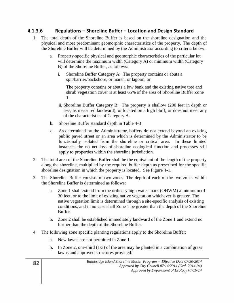
82 Bainbridge Island Shoreline Master Program – Effective Date 07/30/2014
Approved by City Council 07/14/2014 (Ord. 2014-04)
Approved by Department of Ecology 07/16/14
4.1.3.6 Regulations – Shoreline Buffer – Location and Design Standard
1. The total depth of the Shoreline Buffer is based on the shoreline designation and the
physical and most predominant geomorphic characteristics of the property. The depth of
the Shoreline Buffer will be determined by the Administrator according to criteria below.
a. Property-specific physical and geomorphic characteristics of the particular lot
will determine the maximum width (Category A) or minimum width (Category
B) of the Shoreline Buffer, as follows:
i. Shoreline Buffer Category A: The property contains or abuts a
spit/barrier/backshore, or marsh, or lagoon; or
The property contains or abuts a low bank and the existing native tree and
shrub vegetation cover is at least 65% of the area of Shoreline Buffer Zone
1.
ii. Shoreline Buffer Category B: The property is shallow (200 feet in depth or
less, as measured landward), or located on a high bluff, or does not meet any
of the characteristics of Category A.
b. Shoreline Buffer standard depth in Table 4-3
c. As determined by the Administrator, buffers do not extend beyond an existing
public paved street or an area which is determined by the Administrator to be
functionally isolated from the shoreline or critical area. In these limited
instances the no net loss of shoreline ecological function and processes still
apply to properties within the shoreline jurisdiction.
2. The total area of the Shoreline Buffer shall be the equivalent of the length of the property
along the shoreline, multiplied by the required buffer depth as prescribed for the specific
shoreline designation in which the property is located. See Figure 4-1.
3. The Shoreline Buffer consists of two zones. The depth of each of the two zones within
the Shoreline Buffer is determined as follows:
a. Zone 1 shall extend from the ordinary high water mark (OHWM) a minimum of
30 feet, or to the limit of existing native vegetation whichever is greater. The
native vegetation limit is determined through a site-specific analysis of existing
conditions, and in no case shall Zone 1 be greater than the depth of the Shoreline
Buffer.
b. Zone 2 shall be established immediately landward of the Zone 1 and extend no
further than the depth of the Shoreline Buffer.
4. The following zone specific planting regulations apply to the Shoreline Buffer:
a. New lawns are not permitted in Zone 1.
b. In Zone 2, one-third (1/3) of the area may be planted in a combination of grass
lawns and approved structures provided:
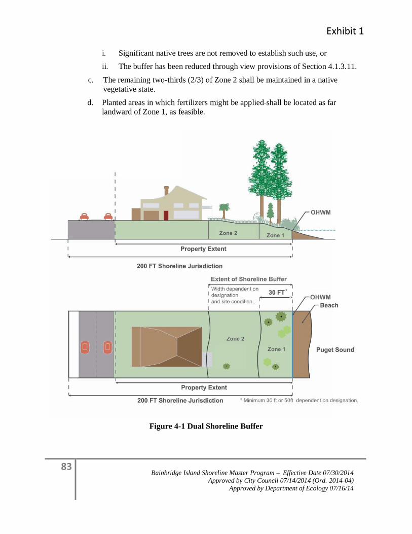
Exhibit 1
83 Bainbridge Island Shoreline Master Program – Effective Date 07/30/2014
Approved by City Council 07/14/2014 (Ord. 2014-04)
Approved by Department of Ecology 07/16/14
i. Significant native trees are not removed to establish such use, or
ii. The buffer has been reduced through view provisions of Section 4.1.3.11.
c. The remaining two-thirds (2/3) of Zone 2 shall be maintained in a native
vegetative state.
d. Planted areas in which fertilizers might be applied shall be located as far
landward of Zone 1, as feasible.
Figure 4-1 Dual Shoreline Buffer
84 Bainbridge Island Shoreline Master Program – Effective Date 07/30/2014
Approved by City Council 07/14/2014 (Ord. 2014-04)
Approved by Department of Ecology 07/16/14
4.1.3.7 Regulations – General Vegetation Alterations in Shoreline Buffers or Site-specific Vegetation Management Areas
1. The following activities are allowed within the Shoreline Buffer and Site-specific
Vegetation Management Area with an approved clearing permit. Such activities shall
meet the standards of Section 4.1.4, Land Modification.
a. Existing landscape areas may be retained within the Shoreline Buffer or Site-
specific Vegetation Management Area. However, any changes from the existing
landscape to a different landscaping use or activity will require that the modified
area comply with the provisions of 4.1.3, Vegetation Management, and the
intent of providing native vegetation to maintain ecological functions and
processes.
b. Minor Pruning. Tree pruning, including thinning of lateral branches to enhance
views, or trimming, shaping, thinning or pruning necessary for plant health and
growth and which does not harm the plant, is allowed consistent with the
following standards:
i. All pruning shall meet the American National Standard Institute (ANSI)
tree pruning standards;
ii. In no circumstance shall removal of more than one-fourth (1/4) of the
original crown be permitted within a three year period;
iii. Pruning shall not include topping, stripping of branches or creation of an
imbalanced canopy; and
iv. Pruning shall retain branches that overhang the water.
c. Vegetation Removal Related to Construction. Tree or vegetation removal
within the Shoreline Buffer or Site-Specific Vegetation Management Area that
is associated with new construction may be allowed, but must retain significant
trees and shall meet the requirements of Section 4.1.2, Environmental Impacts,
including replanting provisions.
d. Vegetation Removal Related to Public Facility Maintenance. Tree or vegetation
removal within the Shoreline Buffer or Site-specific Vegetation Management
Area that is associated with maintenance of existing public facilities (including:
roads, paths, bicycle ways, trails, bridges, sewer infrastructure facilities, storm
drainage facilities, fire hydrants, water meters, pumping stations, street
furniture, potable water facilities, and other similar public infrastructure), may
be approved by the Administrator if no significant trees are removed, the
requirements of Section 4.1.2, Environmental Impacts are met, and the
maintenance is measures meet the goals and policies of Section 4.1.3,
Vegetation Management, or as approved in a SOP manual as provided in
Section 4.1.3.5(7). The following activities are exempt from this requirement:
Exhibit 1
85 Bainbridge Island Shoreline Master Program – Effective Date 07/30/2014
Approved by City Council 07/14/2014 (Ord. 2014-04)
Approved by Department of Ecology 07/16/14
i. Removal of vegetative obstructions required for sight distance and visual
clearance at street intersections provided in the Public Works Design and
Construction Standards and Specifications.
e. Underground Utilities. Utilities that run approximately perpendicular to the
buffer (for example, a stormwater tightline to the water to protect a slope or a
sewer line to a marina), may be allowed within the Shoreline Buffer or Site-
specific Vegetation Management Area, provided that disturbance is minimized
and the disturbed area is revegetated after construction; and
f. Other Approved Development in the Shoreline Buffer or Site-specific
Vegetation Management Area.
i. Potable water wells; and
ii. Approved shoreline stabilization;
2. Shoreline Buffer Reductions.
a. When the prescriptive buffer depth is reduced or dimensions altered through
provisions of this Program, the applicant shall record a notice on title, or other
similar document with the County Auditor prior to permit issuance, subject to
the approval of the Administrator.
b. If the required depth of a Shoreline Buffer for a single-family residential
property is reduced in accordance with the Shoreline Structure Setback
provisions of Section 4.1.3.11 or other reductions allowed through this Program,
Zone 1 must be restored in accordance with provisions of Section 4.1.2.5.
3. Stairways to the shoreline shall not exceed 300 square feet for private use, the minimum
necessary for public use and are not included in the total square footage allocations
prescribed in subsections 4.1.3.8(3) of this Program.
a Larger stairways serving a single-family residence may only be allowed through
approval of a Shoreline Variance.
i. As an alternative to a stairway larger than 300 square feet and to reduce
environmental impacts, a tram may be allowed without a variance.
b. Stairway design shall meet the following minimum criteria:
i. International Codes for:
A. Hand Railings;
B. Stairway width; and
C. Tread Depth.
ii. Landings are required, unless demonstrated not to be necessary, and shall be
determined by:
A. Existing site topography;
86 Bainbridge Island Shoreline Master Program – Effective Date 07/30/2014
Approved by City Council 07/14/2014 (Ord. 2014-04)
Approved by Department of Ecology 07/16/14
B. Personal safety; and
C. Slope stability.
4.1.3.8 Vegetation Alterations Standards – Residential Development
Minor clearing, grading or construction may be allowed within the Shoreline Buffer or Site-
specific Vegetation Management Plan for a residential development with approval of the
Administrator pursuant to Section 4.1.3.7(1)(a), and only for the following activities as
prescribed below and pursuant to Section 4.1.4, Land Modification:
1. Maintenance of existing residential landscaping is allowed subject to Sections 4.1.3.5(8)
and 4.1.3.7. 2. One (1) hand installed pervious trail to the shoreline not more than four
(4) feet in width, which may include hand installed steps, and shall be designed to
minimize environmental impacts. No significant trees shall be removed. The trail may be
wider when required for handicapped or public access. For single-family residential
development vegetation trimming is limited to two (2) feet on either side of the trail.
3. Non-habitable structures appurtenant to a single-family use, such as a boat house,
deck/patio and/or stairway may be allowed consistent with the following standards,
except that all structures are prohibited in Zone 1 when upland of a Priority Aquatic –
Category A designation.
a. For Site-specific Vegetation Management Areas, the total square footage of all
buildings or structures must not exceed 300 square feet in area.
b. For Shoreline Buffer areas, the total square footage of all buildings or structures
must not exceed 400 square feet or 10% of the Shoreline Buffer area, whichever
is less.
c. For Shoreline Buffer areas, only 10% of the total allowed square footage or 300
square feet, whichever is less, can be located in Zone 1, except when upland of
Priority Aquatic B, the total allowable square footage is 5% of Zone 1 or 150
square feet, whichever is less.
d. All structures must be designed to not significantly impact views from adjoining
property primary buildings.
e. All structures must meet the following standards:
i. Only water-related structures are allowed within 30 feet of the OHWM or in
Zone 1, including a boathouse, permeable deck, boat storage, or staircase.
ii. Shall not exceed 12 feet in height above existing grade.
iii. Decks and/or patios shall be permeable and shall not exceed 30 inches in
height above existing grade.
4. View Maintenance – Single-family Residential Only.
Exhibit 1
87 Bainbridge Island Shoreline Master Program – Effective Date 07/30/2014
Approved by City Council 07/14/2014 (Ord. 2014-04)
Approved by Department of Ecology 07/16/14
Shoreline residential use and development shall use all feasible techniques to maximize
retention of existing native shoreline vegetation within the Shoreline Buffer and the Site-
specific Vegetation Management Area.
a. Limited removal of existing trees or vegetation located on the same property as
a single-family residence may be allowed for maintenance of a pre-existing
view from the primary structure, or to establish a view for a new primary
structure provided the following are met:
i. The applicant demonstrates to the satisfaction of the Administrator that the
vegetation removal is the minimum necessary to re-establish or establish a
view of the water similar to that enjoyed by other residences in the area and
that pruning methods are not sufficient to provide an adequate view of the
water similar to that enjoyed by other residences in the area; and
ii. Existing significant native trees are not removed within the Shoreline
Jurisdiction, unless exempt; and
iii. In no instance, including accounting for other approved alterations as
provided in Section 4.1.3, shall vegetation removal exceed twenty (20)
percent of the required Shoreline Buffer area or Site-specific Vegetation
Management Area or reduce the vegetation canopy coverage to less than
65% in the Shoreline Buffer or Vegetation Management Area.
A. Vegetation removal occurring adjacent to the shoreline shall also be
limited to fifteen (15) linear feet of the water frontage; and
iv. The applicant shall obtain an approved Bluff Management Plan pursuant to
Section 4.1.5, Critical Areas for any vegetation alteration in a geologically
hazardous area. The cost and preparation of the plan is the responsibility of
the applicant; and
v. All vegetation removal complies with other applicable requirements of this
Program (such as clearing and grading, forest practices, and protection
standards for fish and wildlife habitat), including the no net loss and/or
revegetation standards in Section 4.1.2.
b. The Administrator my deny a request or condition approval for vegetation
alteration proposals for view maintenance if it is determined that the action will
result in an adverse effect to any of the following:
i. Slope stability;
ii. Habitat value;
iii. Health of surrounding vegetation;
iv. Risk of wind damage to surrounding vegetation;
v. Nearby surface or ground water; or
88 Bainbridge Island Shoreline Master Program – Effective Date 07/30/2014
Approved by City Council 07/14/2014 (Ord. 2014-04)
Approved by Department of Ecology 07/16/14
vi. Water quality of a nearby water body.
4.1.3.9 Vegetation Alteration Standards – Commercial and Industrial Development in Shoreline Buffers
Minor clearing, grading, or construction may be approved within the Shoreline Buffer for a
commercial or industrial development with approval of the Administrator pursuant to
Section 4.1.3.7(1)(a) and only for the following activities as prescribed below and pursuant
to Section 4.1.4, Land Modification:
1. Primary appurtenant structures to a commercial use that either support public access or
are necessary to support a water-dependent use shall be allowed within the buffer when
the applicant has demonstrated a need for the shoreline location, except that all structures
are prohibited in Zone 1 when upland of a Priority Aquatic designation.
2. When appurtenant structures are allowed they must be the minimum necessary to meet
the needs of the water-dependent use or public access requirements of Section 4.2.4,
Public Access.
4.1.3.10 Vegetation Alteration Standards – Public Park Development in Shoreline Buffers
Minor clearing, grading, or construction may be allowed within the Shoreline Buffer for a
public park development with approval of the Administrator consistent with the following or
pursuant to Section 4.1.3.7:
1. Vegetation clearing and maintenance is allowed in accordance with an approved SOP
manual that meets Section 5.1.3.5(7) and the standards of this Program.
2. Maintenance of existing public trails, provided the vegetation trimming is limited to four
(2) feet on either side of the trail and no significant trees are removed.
3. Alterations that are included in a Park Development or Concept Plan. Minor clearing,
grading, or construction for which the size and extent of proposed disturbed areas located
within the Shoreline Buffer have been determined as part of a park development plan or
concept park plan, with due consideration of the intended park use; and provided all
proposed disturbance areas meet the no net loss standards pursuant to in accordance with
Section 4.1.2. Environmental Impacts; and provided appropriate permits are obtained,
including those pursuant to Section 4.1.4, Land Modification;
4. Alterations that are not part of a Park Development or Concept Plan. The following
minor clearing, grading, or construction activities may be allowed without an approved
park development plan or conceptual park plan:
a. Maintenance of existing public trails is allowed, provided maintenance is
limited to the existing size of the trail, any vegetation trimming is limited to four
(4) feet on either side of the trail, and no significant trees are removed.
Exhibit 1
89 Bainbridge Island Shoreline Master Program – Effective Date 07/30/2014
Approved by City Council 07/14/2014 (Ord. 2014-04)
Approved by Department of Ecology 07/16/14
b. New public pathways or trails to the shoreline provided it is demonstrated that
the size and extent of the public pathways has been determined with due
consideration of the intended park use.
c. Structures.
i. Primary appurtenant structures to a public park and recreational use that
either support public access or are necessary to support a water-dependent
recreation use shall be allowed within the Shoreline Buffer when a need for
the shoreline location is demonstrated, except that all structures are
prohibited in Zone1 when upland of a Priority Aquatic designation. When
appurtenant structures are allowed, they must be the minimum necessary to
meet the needs of the water-dependent use or public access requirements of
Section 4.2.4, Public Access.
ii. The total square footage of all buildings or structures must not exceed 6,000
square feet or 10% of the Shoreline Buffer area, whichever is less.
A. Only 10% of the total allowed square footage or 1,000 square feet,
whichever is less, can be located in Zone 1.
iii. All structures must be designated to not significantly impact views from
adjoining property primary buildings.
iv. All structures must meet the following standards:
A. Only water-related recreational furniture, amenities and structures
are allowed in Zone 1, including but not limited to, picnic tables,
benches, interpretive kiosks, viewing platforms, boardwalks,
pervious trails or staircases, recreational furniture, signs, pervious
trails, and staircases are not included in the maximum square
footage allocations prescribed in subsection 4.c.ii, above;
B. Accessory recreation buildings, including restrooms, picnic
pavilions and service roads that serve such structures may be
allowed in Zone 2 and buildings shall not exceed 12 feet in height
above existing grade;
C. Stairways may exceed 300 square feet, provided that it is
demonstrated that a greater area is necessary to meet public access
and public use demands Stairways shall conform to the standards
of the Building Code as adopted in BIMC Chapter 15.04.; and
D. Boat ramps and other boating facilities may be allowed pursuant to
Section 5.4, Boating Facilities.
90 Bainbridge Island Shoreline Master Program – Effective Date 07/30/2014
Approved by City Council 07/14/2014 (Ord. 2014-04)
Approved by Department of Ecology 07/16/14
4.1.3.11 Regulations – Shoreline Structure Setback View Requirement
1. To protect existing predominate shoreline views and accommodate shoreline views for a
new single-family primary residential structure or addition to a primary residential
structure, the Administrator may allow Zone 2 of the Shoreline Buffer to be altered when
there is an existing primary residential structure located within 100 feet of the property
line of the subject property and topographical or other relevant information indicates that
the view of the shoreline from the subject property or the adjacent residence would be
impacted by existing or proposed development. The shoreline structure setback line may
also require that new structures be set farther away from the shoreline to preserve existing
views enjoyed by an adjoining single-family primary structure that was established
earlier. These provisions apply to single-family residences only, except in the Point
Monroe District.
a. Setbacks for the purpose of this subsection are based on the location of primary
residential structure(s) existing at the time a new primary residential building
permit is submitted. A primary residential structure constructed in compliance
with the required shoreline setback is not made nonconforming by the later
construction of a primary residential structure in a different location on an
adjoining lot.
b. The shoreline structure setback provisions apply only to primary single-family
residential structures located within the 200-foot shoreline jurisdiction, where an
existing primary single-family residential structure is located within 100 feet of
the subject property line. All measurements are to the closest primary
residential structure on either side of the subject property as measured parallel to
the shoreline.
c. In determining the shoreline structure setback line, the Administrator may also
consider topography or other physical property constraints in addition to the
provisions of subsection 4 and 5, below. Applicants may submit detailed
information regarding how property constraints impact the predominate
shoreline views from either the subject property’s proposed primary residential
structure or adjoining properties’ primary residential structure(s).
2. The Shoreline Buffer on the subject property may be reduced below the depth
requirements identified in Table 4-3 to allow a new primary residential structure to be
located within Zone 2 provided the conditions in Section 4.1.3.7(2) are met. Mitigation of
proposed residential development shall be required pursuant to Section 4.1.2,
Environmental Impacts.
3. In no case shall the subject property be permitted to locate a new primary residential
structure within the site’s specified Zone 1 of the Shoreline Buffer, unless a Shoreline
Variance is granted.
Exhibit 1
91 Bainbridge Island Shoreline Master Program – Effective Date 07/30/2014
Approved by City Council 07/14/2014 (Ord. 2014-04)
Approved by Department of Ecology 07/16/14
4. Adjoining Development Located Within Shoreline Buffer. The setback requirement for
the subject property shall be based on the location of the adjoining properties’ primary
residential structure(s) as described in subsections (a) through (d) below.
a. Primary Residential Structure Located on One Side. When an existing primary
residential structure is located on one side of the subject property, the shoreline
structure setback line shall be determined as follows:
i. If the adjoining primary residence is partially or wholly located within Zone
2, the shoreline setback line is determined by drawing a line from the most
waterward point of the adjoining primary residential structure to the point at
which the subject property’s Shoreline Buffer boundary intersects the
subject property’s opposite property line. (See Figure 4.1.a below).
ii. If the adjoining primary residence is located partially or wholly in Zone 1,
the shoreline structure setback line shall be determined by drawing a line
from the point of intersection of the subject property and the adjoining
property’s Zone 1 boundary, to the point at which the subject property’s
Shoreline Buffer boundary intersects the subject property’s opposite
property line. (See Figure 4.1.b, below).
b. Primary Residential Structure Located on Both Sides. When existing primary
residential structures are located on both sides of the subject property, the
shoreline structure setback line shall be determined as follows:
i. If both the adjoining primary residential structures are located partially or
wholly in Zone 2, then the shoreline structure setback line shall be
determined by drawing a line between the most waterward points of each of
the adjoining primary residential structures. (See Figure 4.1.b, below)
ii. If one of the adjoining primary residences is partially or wholly in Zone 1,
and the other adjoining primary residence is partially or wholly in Zone 2,
the shoreline structure setback line shall be determined by drawing a line
from the point of intersection of the subject property and the adjoining
property’s Zone 1 boundary (for that adjoining residence located in Zone 1),
to the most waterward point of the other adjoining primary residential
structure located in Zone 2. (See Figure 4.1.b, below).
iii. If both of the adjoining primary residences are located partially or wholly
within Zone 1, the shoreline structure setback line shall be determined by
drawing a line from the point of intersection of the subject property’s Zone
1 boundary and the adjoining property’s Zone 1 boundary to the same
intersection point on the subject property’s opposite property line. (See
Figure 4.1.c. below)
c. Primary Residential Structure Located on a Shoreline Forming a Cove or
Headland. The Administrator shall make the determination whether a shoreline
forms a cove or headland. When existing primary residential structures are
92 Bainbridge Island Shoreline Master Program – Effective Date 07/30/2014
Approved by City Council 07/14/2014 (Ord. 2014-04)
Approved by Department of Ecology 07/16/14
located on a cove or headland, the shoreline structure setback line shall be
determined as follows:
i. If there is a primary residential structure on only one side of the subject
property, then the shoreline structure setback line for the subject property
shall be either the distance from the OHWM to the most waterward portion
of the primary residence structure of the adjoining property, or the subject
property’s Zone 1, whichever is greater.
ii. If there are adjoining primary residential structures located on both sides of
the subject property, the shoreline structure setback line shall be determined
by averaging the distance from OHWM to the most waterward portion of
the two adjoining property’s primary residential structures. (See Figure
4-1(c) ii, below)
5. Adjoining Development Located Outside the Shoreline Buffer. The setback requirement
for the subject property shall be based on the location of the adjoining properties’ primary
residential structure(s) as described in subsections (a) and (b) below.
a. Primary Structure Located on One Adjoining Property, Outside Shoreline
Buffer. When an existing primary residential structure is located on one side of
the subject property, the shoreline structure setback line shall be determined by
drawing a line from the most waterward point of the primary residential
structure of the adjoining property to a point at which the subject property’s
Shoreline Buffer boundary intersects the subject property’s opposite property
line. (See Figure 5-1(a), below).
b. Primary Structures Located on Both Adjoining Properties, Outside the Shoreline
Buffer. When existing primary residential structures are located on both sides of
the subject property, the shoreline structure setback line shall be determined by
drawing a line between the most waterward points of each of the adjoining
primary residential structures. (See Figure 5-1(b), below).
c. Primary Structures Located on Both Adjoining Properties, Outside the
Shoreline on a Cove or Headland. When existing primary residential structures
are located on both sides of the subject property, the shoreline structure setback
line shall be determined by averaging the distance from OHWM to the most
waterward portion of the two adjoining property’s primary residential structures.
(See Figure 5-1(c), below).
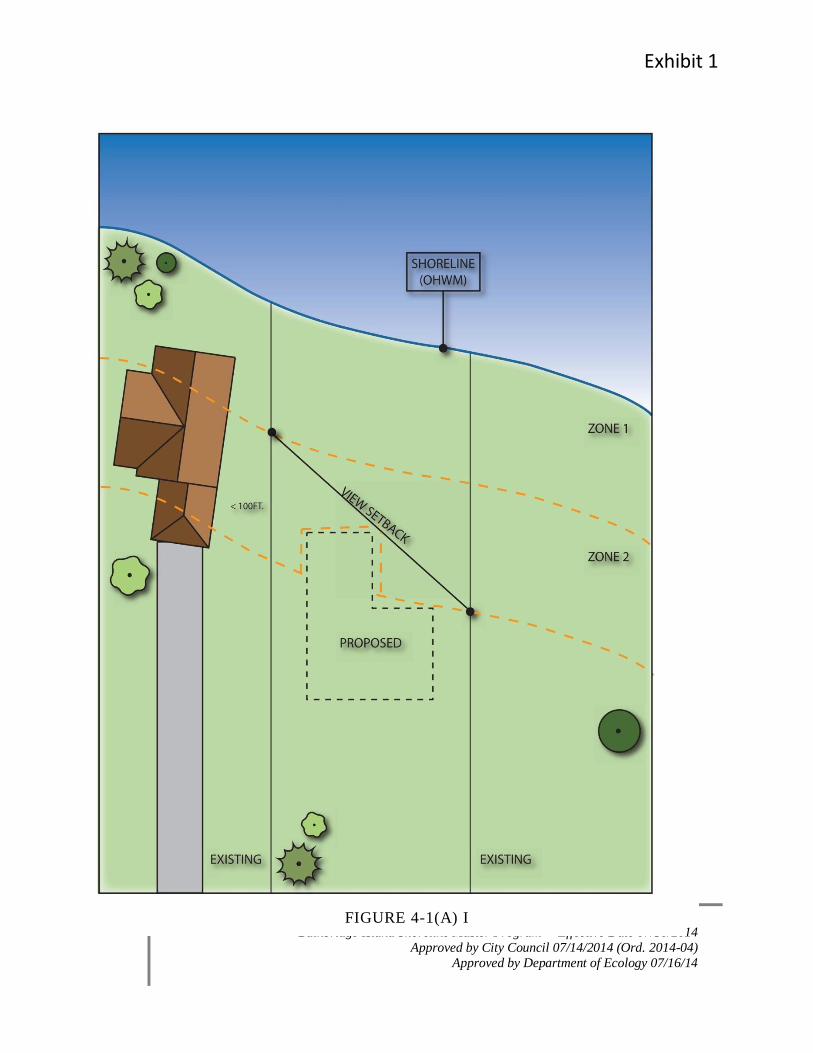
Exhibit 1
93 Bainbridge Island Shoreline Master Program – Effective Date 07/30/2014
Approved by City Council 07/14/2014 (Ord. 2014-04)
Approved by Department of Ecology 07/16/14
FIGURE 4-1(A) I
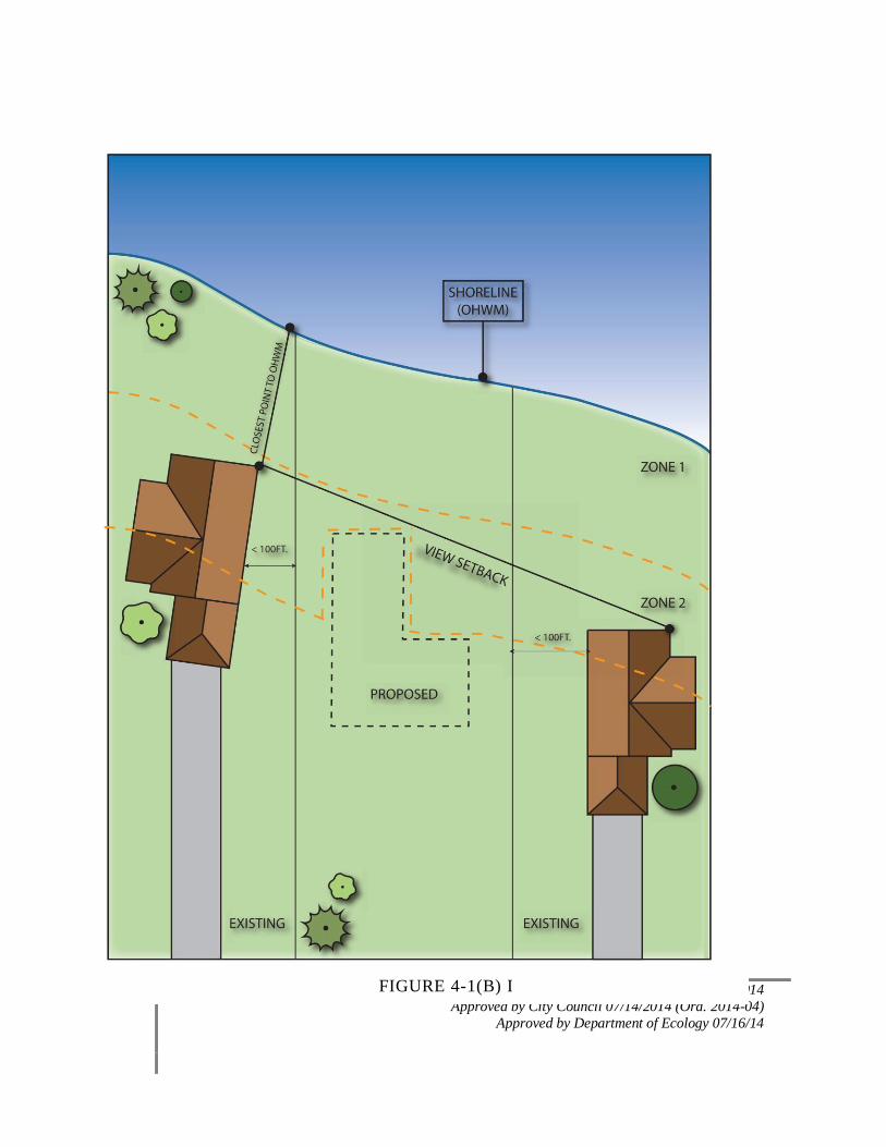
94 Bainbridge Island Shoreline Master Program – Effective Date 07/30/2014
Approved by City Council 07/14/2014 (Ord. 2014-04)
Approved by Department of Ecology 07/16/14
FIGURE 4-1(B) I
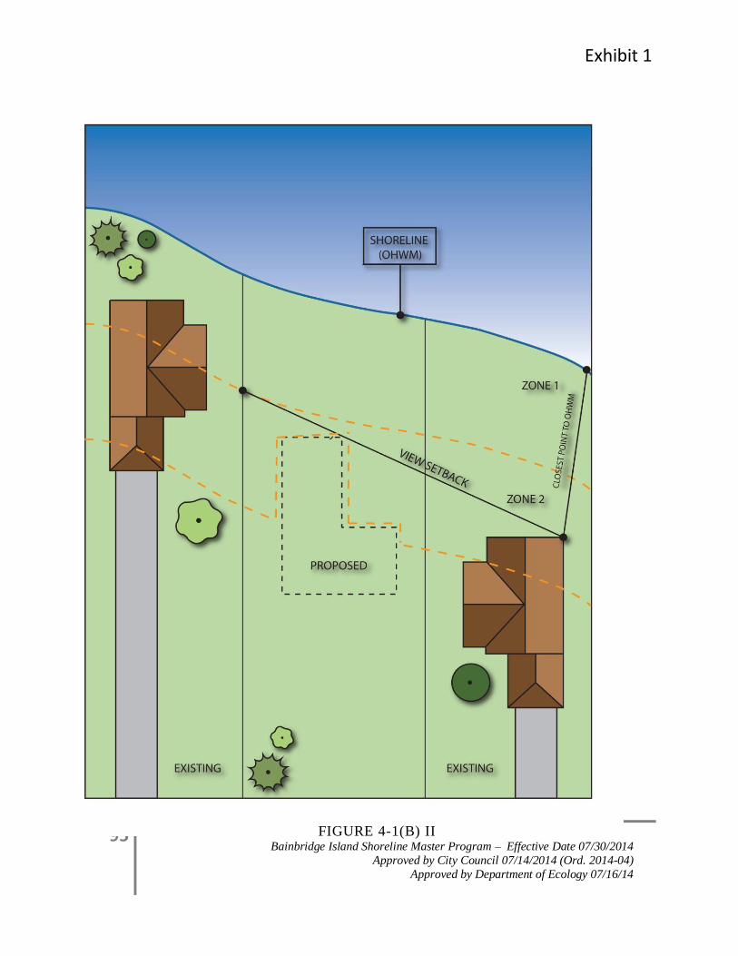
Exhibit 1
95 Bainbridge Island Shoreline Master Program – Effective Date 07/30/2014
Approved by City Council 07/14/2014 (Ord. 2014-04)
Approved by Department of Ecology 07/16/14
FIGURE 4-1(B) II
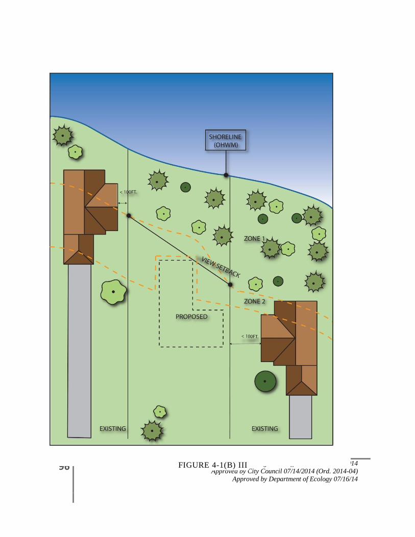
96 Bainbridge Island Shoreline Master Program – Effective Date 07/30/2014
Approved by City Council 07/14/2014 (Ord. 2014-04)
Approved by Department of Ecology 07/16/14
FIGURE 4-1(B) III
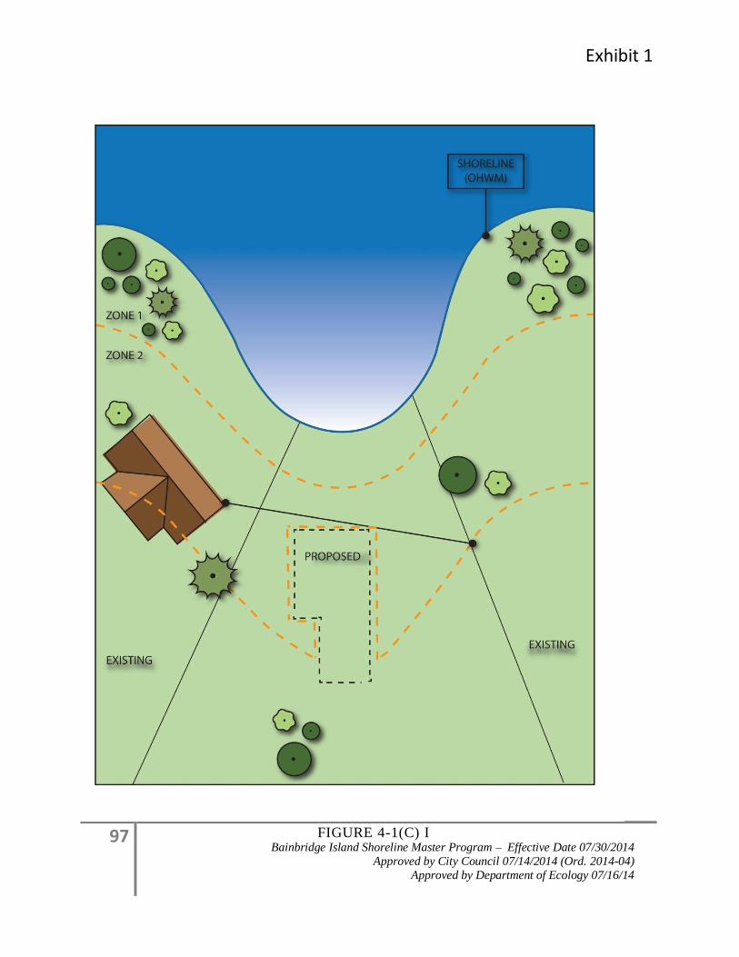
Exhibit 1
97 Bainbridge Island Shoreline Master Program – Effective Date 07/30/2014
Approved by City Council 07/14/2014 (Ord. 2014-04)
Approved by Department of Ecology 07/16/14
FIGURE 4-1(C) I
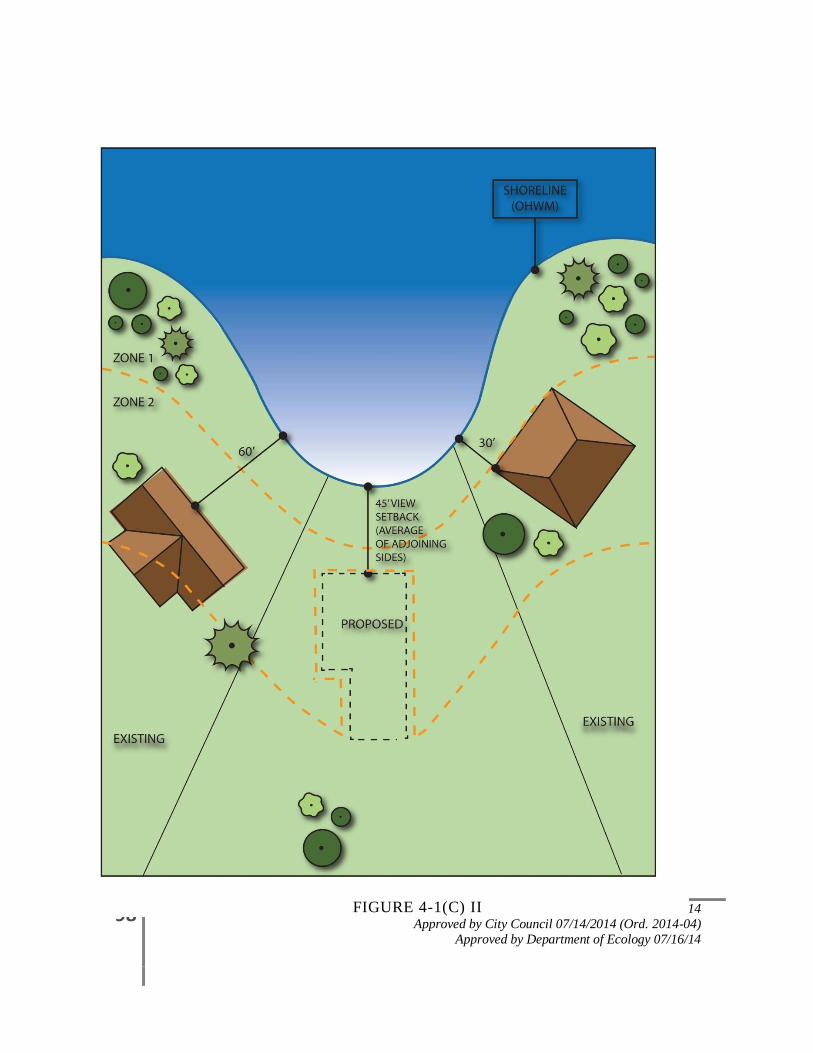
98 Bainbridge Island Shoreline Master Program – Effective Date 07/30/2014
Approved by City Council 07/14/2014 (Ord. 2014-04)
Approved by Department of Ecology 07/16/14
FIGURE 4-1(C) II
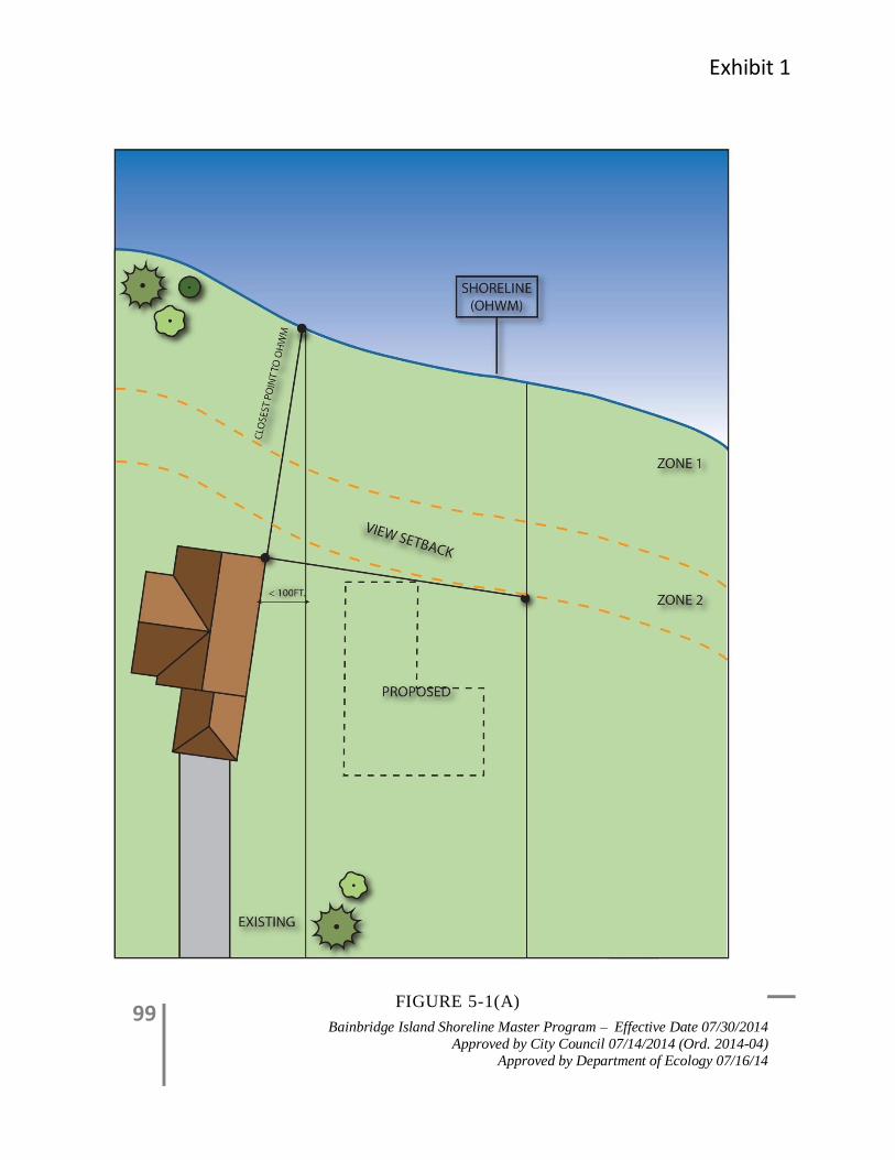
Exhibit 1
99 Bainbridge Island Shoreline Master Program – Effective Date 07/30/2014
Approved by City Council 07/14/2014 (Ord. 2014-04)
Approved by Department of Ecology 07/16/14
FIGURE 5-1(A)

100 Bainbridge Island Shoreline Master Program – Effective Date 07/30/2014
Approved by City Council 07/14/2014 (Ord. 2014-04)
Approved by Department of Ecology 07/16/14
FIGURE 5-1 B
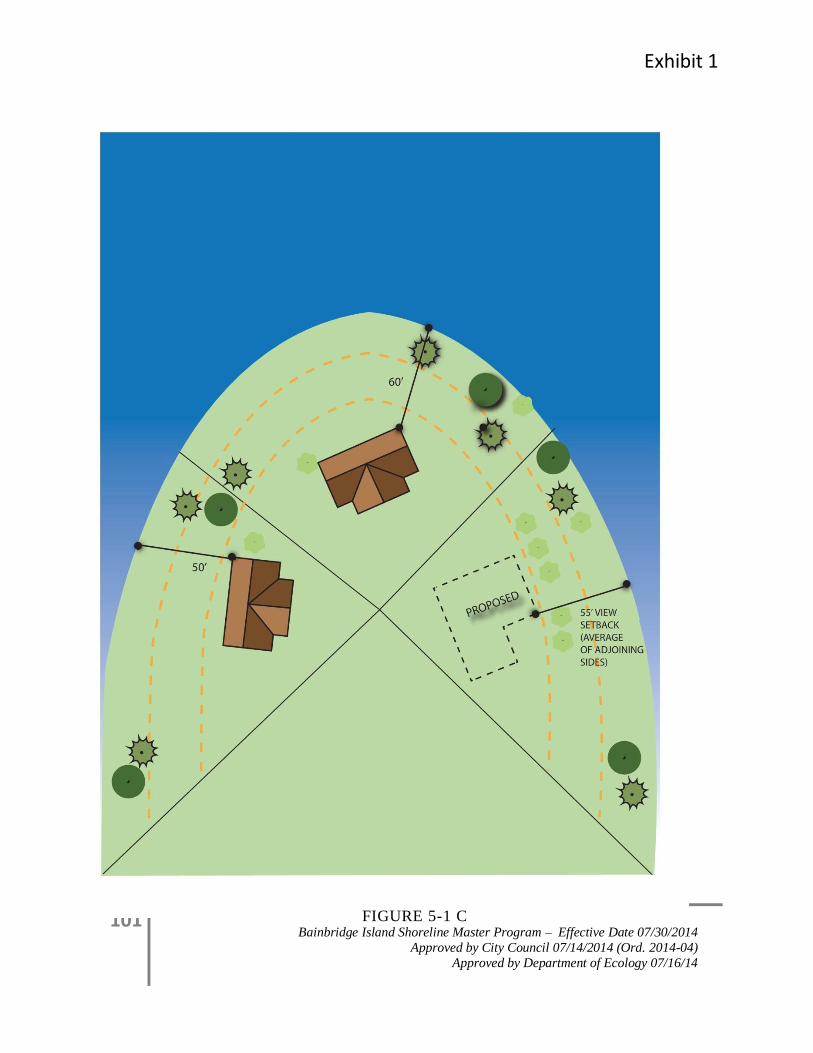
Exhibit 1
101 Bainbridge Island Shoreline Master Program – Effective Date 07/30/2014
Approved by City Council 07/14/2014 (Ord. 2014-04)
Approved by Department of Ecology 07/16/14
FIGURE 5-1 C
102 Bainbridge Island Shoreline Master Program – Effective Date 07/30/2014
Approved by City Council 07/14/2014 (Ord. 2014-04)
Approved by Department of Ecology 07/16/14
4.1.4 Land Modification
4.1.4.1 Applicability
All shoreline uses and activities must conform to the clearing and grading provisions herein,
including development which does not require a shoreline permit. Shoreline development
and land modification activities will be reviewed under the no net loss provisions of Section
4.1.2, Environmental Impacts, and may also be reviewed under Section 4.0, General (Island
Wide) Policies and Regulations; Section 4.1.5, Critical Areas; Section 4.1.6, Water Quality
and Stormwater Management; Section 4.1.3, Vegetation Management; Appendix B; and
BIMC Chapter 15.18, Land Clearing, when applicable. Other portions of this Program may
also apply.
4.1.4.2 Policies
1. Allow alteration of the natural landscape only in association with existing legal uses or
new permitted or allowed shoreline use/or development. Prohibit speculative clearing,
grading, or vegetation removal.
2. Avoid and minimize potential adverse impacts from land surface modification activities
through proper site planning, construction timing practices, and use of erosion and
drainage control methods. Generally, these activities should limit alteration of the natural
landscape to the minimum extent necessary to accommodate the proposed use, and
should be designed and located to protect shoreline ecological functions and ecosystem-
wide processes.
3. Assure clearing and grading activities are consistent with the Stormwater Manual to
prevent adverse impact to wildlife habitat, streams, lakes, and wetlands from erosion.
4. For clearing and grading proposals, provide a clearing and grading plan addressing
vegetation removal, erosion and sedimentation control, and protection of critical areas
and shoreline vegetation conservation and management zones. Use low impact
development techniques to minimize adverse impacts to natural hydrologic conditions,
such as soil compaction and transpiration.
5. Promptly replant disturbed areas following project completion. Replanting with native
shoreline vegetation should be a priority, however, flexible planting plans that
incorporate non-native plant species which provide similar functions and ecosystem-wide
processes can be considered.
4.1.4.3 Regulations – Prohibited
1. All clearing and/or grading not associated with an approved development, use or activity,
unless specifically provided for in this program.
Exhibit 1
103 Bainbridge Island Shoreline Master Program – Effective Date 07/30/2014
Approved by City Council 07/14/2014 (Ord. 2014-04)
Approved by Department of Ecology 07/16/14
4.1.4.4 Regulations - General
1. Clearing and/or grading within shoreline jurisdiction shall require an approved clearing
or grading permit in association with an existing legal use or a new permitted or allowed
shoreline use or development. Such activities shall meet the mitigation and revegetation
provisions in Section 4.1.2, Environmental Impacts and Section 4.1.3, Vegetation
Management.
2. Upon completion of development, use or activity, the remaining cleared areas shall be
replanted within the first applicable planting season.
3. All vegetation that is intended to be retained but may likely be disturbed by the clearing
and grading activity shall be protected in accordance with the standards of BIMC Chapter
18.15.010, Landscaping, Screening, and Tree Retention, Protection and Replacement.
4. Land alteration (clearing, grading, and filling) shall be limited to the minimum extent
necessary for the proposed development, use or activity. All land alteration must meet
the standards of BIMC Chapter 15.20 Surface and Storm Water Management.
4.1.5 Critical Areas
4.1.5.1 Applicability
This section provides policies and regulations that apply to critical areas including critical
saltwater and freshwater habitats as defined by WAC 173-26-221(2)(c)(iii) and (iv),
including those portions of streams and wetlands, and flood plains or other flood prone areas
within the shoreline jurisdiction. These policies and regulations apply in addition to the
critical areas protection standards for fish and wildlife habitat conservation areas found in
Appendix B. All shoreline uses and activities, including development which does not
require a shoreline permit, must conform to these provisions. Shoreline development and
activities associated with critical areas will be reviewed under the no net loss provisions of
Section 4.1.2, Environmental Impacts, and may also be reviewed under Section 4.0, General
(Island-wide) Policies and Regulations; Section 4.1.6, Water Quality and Stormwater
Management; Section 4.1.3, Vegetation Management; and BIMC Chapter 15.18, Land
Clearing, when applicable. Other portions of this Program may also apply.
4.1.5.2 Goal
Comprehensively manage shoreline uses and activities to protect, enhance, and restore
existing ecological functions and ecosystem-wide processes of critical areas by utilizing the
most current, accurate, and complete scientific and technical information.
4.1.5.3 Policies
1. Protect shoreline resource areas, including but not limited to critical areas, including:
a. Critical Aquifer Recharge Areas
104 Bainbridge Island Shoreline Master Program – Effective Date 07/30/2014
Approved by City Council 07/14/2014 (Ord. 2014-04)
Approved by Department of Ecology 07/16/14
b. Fish and Wildlife Habitat Conservation Areas
c. Frequently Flooded Areas
d. Geologically Hazardous Areas
e. Wetlands
f. Critical Saltwater and Freshwater Habitat Areas
g. Critical Habitat
2. Encourage development proposals to include elements of preservation, conservation,
restoration, or enhancement of critical areas, including saltwater habitat and fish and
wildlife conservation areas, through incentives and ecosystem-wide restoration planning.
3. Locate, design, construction, and manage all shoreline uses and activities in ways that
assure no net loss of shoreline ecological functions and ecosystem-wide processes, and
protect critical saltwater habitat, including fish and wildlife habitat conservation areas.
4. Locate and design shoreline uses, activities, and/or development to avoid risks to people
and property. See also Section 3.0, Shoreline Designation Policies and Regulations, for
additional provisions.
5. Ensure that proposed shoreline uses, activities and/or development proposed adjacent to
critical areas or their buffers, will not adversely impact shoreline ecological functions
and/or ecosystem-wide process or critical areas, fish and wildlife habitat conservation
areas and critical saltwater habitat.
6. Promote and manage shoreline uses and activities, such as public access and recreation
that are compatible with critical areas, provided they do not adversely impact ecological
function.
7. Monitor critical areas, including critical saltwater habitats, and fish and wildlife habitat
conservation areas, to assure that these areas are not being adversely impacted by
approved development or restoration projects.
4.1.5.4 Regulations – General
1. Development, uses, and activities proposed within shorelines of the state shall meet the
requirements of the City’s shoreline-specific Critical Areas Regulations as contained in
Appendix B, in addition to the requirements found elsewhere in the Master Program.
2. Development, uses, and activities adjacent to critical areas, including critical saltwater
habitats and fish and wildlife habitat conservation areas, proposed within shorelines of
the state shall be monitored to assure that these areas are not being adversely impacted by
approved development or restoration projects, consistent with Section 4.1.2 monitoring
and mitigation requirements and the monitoring and mitigation requirements in Appendix
B.
Exhibit 1
105 Bainbridge Island Shoreline Master Program – Effective Date 07/30/2014
Approved by City Council 07/14/2014 (Ord. 2014-04)
Approved by Department of Ecology 07/16/14
3. Special Reports. For development proposed on property with marine bluffs, steep slopes,
erosion hazard areas and/or landslide hazard areas, a geotechnical report shall be required
to assess potential hazards and propose measures to mitigate such hazards consistent with
the requirements of this Master Program and attached appendices.
4.1.5.5 Regulations – Fish and Wildlife Habitat Conservation Areas and Critical Saltwater Habitat
1. Water-dependent development and uses, including marinas, docks, piers, mooring areas,
underwater parks, utility crossings, and shoreline modifications, shall not intrude into or
be built over critical saltwater habitat unless:
a. The applicant can show that all of the following criteria can be met:
i. The use preferences of Section 4.1.1 shall be utilized for uses in Shorelines of
State-wide Significance; and
ii. The need for such a structure is clearly demonstrated and an alternative alignment
or location on the property that would avoid impacts to critical saltwater habitats
is not feasible or would result in unreasonable and disproportionate cost to
accomplish the same general purpose, as demonstrated through an alternatives
analysis. The analysis should include in part, shoreline bathymetry, shoreline
features at the site, and substrate composition;
iii. It can be demonstrated that the project is consistent with the state’s interest in
resource protection and species recovery; and
iv. Impacts to critical saltwater habitat functions and processes are mitigated to result
in equal or better ecological function; or
b. The proposal is for private, non-commercial, residential docks for single use,
community, or joint-use, which may be authorized, provided that:
i. Avoidance of impacts to critical saltwater habitats by an alternative alignment or
location is not feasible; and
ii. The project, including any required mitigation, will result in no net loss of
ecological functions and processes associated with critical saltwater habitat.
c. New or expanded overwater structures shall be located the greater or most protective
of:
i. A horizontal distance of 25 feet from the outside edge of the structure to native
aquatic vegetation attached to or rooted in substrate;
ii. A horizontal distance equal to the maximum distance shade will be cast by the
structure and vessel;
iii. A 4-foot vertical distance from eelgrass or relevant submerged aquatic vegetation;
iv. A distance the diameter of the turning circle, if the structure is to be utilized for
motorized vessels. The turning circle is defined as 3.5 times the length of the
longest vessel to use the structure.
106 Bainbridge Island Shoreline Master Program – Effective Date 07/30/2014
Approved by City Council 07/14/2014 (Ord. 2014-04)
Approved by Department of Ecology 07/16/14
v. Alternative measures that demonstrate no net loss of ecological functions.
d. For projects within WDFW documented Pacific herring spawning locations, in-water
activities that would affect herring spawn should be restricted to WDFW’s approved
work window for Bainbridge Island (May 1 through January 14). For aquaculture
projects, the City may consider alternative methods that are contained in federal
and/or state aquaculture permits for reducing impacts to herring spawning habitat and
other forage fish spawning habitat.
e. For projects other than commercial aquaculture within WDFW documented sand
lance and surf smelt spawning locations, no activities should occur during spawning
windows as identified by WDFW. For commercial aquaculture projects within
WDFW documented sand lance and surf smelt spawning locations, no harvesting may
occur during the surf smelt or sand lance spawning seasons until a spawning survey is
conducted. If surf smelt or sand lance spawn are present in the growing area to be
harvested or adjacent tidelands, then no harvest activities may occur until the eggs are
hatched. Extreme caution should be taken to avoid impact and minimize disturbance
of sand lance and surf smelt larvae that are present.
2. Aquatic herbicide treatments, mechanical removal of vegetation or aquatic pesticide
treatments shall not be used on critical saltwater habitats, except for approved habitat
restoration or enhancement measures that meet the provisions of Section 4.1.6, Water
Quality and Stormwater Management.
3. Sand, gravel or other materials shall not be added or removed from critical saltwater
habitat, unless approved as part of a restoration effort or beach nourishment program or
as allowed in 1, above.
4. New outfalls (including stormwater and sewer outfalls) and discharge pipes shall not be
located in critical saltwater habitats or areas where outfall or discharge will adversely
affect critical saltwater habitat, unless the applicant can show that all of the following can
be met:
a. There is no feasible alternative location for the outfall or pipe; and
b. The outfall or pipe is placed below the surface of the beach or bed of the water body;
and
c. The discharge point(s) on the outfall or discharge pipe is located so the discharges,
including nutrients and flow, do not adversely affect critical saltwater habitats; and
d. For public sewage outfalls:
i. The outfall discharges waterward of the intertidal zone.
ii. The disturbed area will be revegetated with native vegetation.
5. The use of existing outfalls shall be maximized to limit the need for additional outfalls,
provided the existing outfall meets the standards of this section, or unless an alternatives
analysis demonstrates the dispersal is less impacting to the shoreline environment.
Exhibit 1
107 Bainbridge Island Shoreline Master Program – Effective Date 07/30/2014
Approved by City Council 07/14/2014 (Ord. 2014-04)
Approved by Department of Ecology 07/16/14
6. For activities adjacent to fish and wildlife habitat conservation areas the maximum
prescribed buffer shall apply. These buffers can be modified on a case-by-case basis
through a habitat management plan, pursuant to Section B-4 contained in Appendix B. In
order to determine the need or extent of a buffer, a critical area report shall be required
for all development in or adjacent to a habitat conservation area.
a. In addition to the requirements in Appendix B, the Habitat Management Plan shall:
i. Describe actions that will be implemented to ensure that buffer areas provide
ecological functions and processes equivalent to a dense native plant-community
to the extent possible given the area that is feasibly available; and
ii. Demonstrate that no net loss of ecological functions and processes in critical
saltwater habitat and other critical areas will occur, as specified in WAC 173-26-
201(3)(d) and WAC 173-26-221(2)(c)(iii).
7. Until an inventory of critical saltwater habitat is completed, all over water and near-shore
development shall conduct an inventory of site and adjacent beach sections to assess the
presence of critical saltwater habitat and/or functions and processes. The inventory shall
occur prior to construction and the methods and extent of the inventory shall be
consistent with accepted research methodology. New studies shall be required only when
existing information is out dated or does not exist.
4.1.5.6 Regulations – Frequently Flooded Areas
1. All new development and new uses within the jurisdiction of this Master Program shall
comply with the provisions of Section B-11, Frequently Flooded Areas located in
Appendix B of this Master Program.
4.1.5.7 Regulations – Geologically Hazardous Areas
1. All new development and new uses within the jurisdiction of this Master Program shall
comply with regulations for Geologically Hazardous Areas as set forth in the shoreline-
specific Critical Areas Regulations contained in Section B-9 of Appendix B of this
Master Program.
2. Additional standards for marine bluffs (i.e., slopes greater than 40 percent that exceed a
vertical height of 10 feet within the marine shorelines jurisdiction) are provided in section
4.1.5.8, Special Reports and Determination of Buffers, and 4.1.5.9, Regulations – Bluff
Drainage, below.
4.1.5.8 Special Reports and Determination of Buffers
1. Applicants proposing development adjacent to a marine bluff shall submit a geotechnical
engineering report prepared in accordance with the requirements of this Master Program
and the shoreline-specific Critical Areas regulations contained in Appendix B. In terms of
this regulation, “adjacent” means development proposed either within 50-feet from the
108 Bainbridge Island Shoreline Master Program – Effective Date 07/30/2014
Approved by City Council 07/14/2014 (Ord. 2014-04)
Approved by Department of Ecology 07/16/14
crest of a marine bluff or within a distance equal to the height of the slope from the crest
(measured from the top), whichever is greater.
2. The geotechnical engineering report shall be prepared by a Washington State licensed
professional civil engineer with a specialty in geotechnical engineering or an engineering
geologist with a Washington State specialty license in engineering geology as specified in
RCW 18.220, Geologists. The report shall be based upon the most appropriate and
current science, existing and proposed uses, risks of slope failure, and coastal erosion
rates over at least 100 years, if applicable.
3. All proposed development on the face of a marine bluff or in the required buffer area
shall be prohibited, except:
a. Development may be allowed as specified in Appendix B; Subsection B-
9(E)(3)(a)(i)(F) of this Master Program;
b. Minor development for public access (e.g., public trails, stairs, or view points)
may be allowed, provided that environmental impacts are mitigated and the
development can meet the factor of safety in Appendix B; subsection-B-9(E)(1);
and
c. Minor development permitted in the Shoreline Buffer and Site-specific
Vegetation Management Area pursuant to Sections 4.1.3.8 through 4.1.3.11 such
as boathouses, decks, stairs, trams, piers, and docks except at the toe of
unstabilized feeder bluffs and the development can meet the factor of safety in
Appendix B; subsection-B-9(E)(1).
4. All alterations to the vegetation within a geological hazardous area shall provide a Bluff
Management Plan developed by qualified professional(s) to address vegetation
management for slope stability and ecological functions and processes for a ten year
period. The plan at a minimum shall include:
a. A geotechnical analysis of slope stability as defined in B-9, Geologically
Hazardous Areas of Appendix B.
b. A site plan showing existing vegetation location and species.
c. An analysis of identified vegetation appropriate for removal or alteration.
d. An analysis of vegetation management strategies for slope stability.
e. A mitigation plan developed according to Section 4.1.2, Environmental Impacts
and Section 4.1.3, Vegetation Management.
f. The Administrator may include additional conditions for a site-specific analysis
and require a third party review by a qualified professional at the cost of the
applicant.
Exhibit 1
109 Bainbridge Island Shoreline Master Program – Effective Date 07/30/2014
Approved by City Council 07/14/2014 (Ord. 2014-04)
Approved by Department of Ecology 07/16/14
4.1.5.9 Regulations – Bluff Drainage
1. Surface drainage shall be directed away from marine bluffs. When no other solution is
feasible, surface drainage piping may be located on the face of a steep slope when
contained in a tight line (closed, non-leaking pipe) and in such a way that erosion will not
be increase at the base of the bluff and provided that physical access along the shoreline
is not degraded. Furthermore, conditions may be applied to mitigate the aesthetic
impacts of the proposed drainage systems as viewed from public areas.
4.1.5.10 Regulations – Wetlands
1. All development, development proposals and alterations that are located within or
adjacent to shoreline jurisdictional wetlands or their buffers, or that are likely to
significantly impact shoreline jurisdictional wetlands shall prepare a wetland analysis
pursuant to Subsection B- 4.7 10 of Appendix B, of this Master Program. The wetland
analysis shall include the wetland rating (using the Washington State Wetland Rating
System for Western Washington (2006) or as revised by Ecology), a functional
assessment of potential buffers (based on Ecology’s best available science for wetlands),
and noting of any water features and other critical areas and their related buffers in the
proximity of the proposed development.
2. Wetlands will be delineated using the Regional Supplement to the Army Corps of
Engineers Wetland Delineation Manual: Western Mountains, Valleys, and Coast Region
or the current Washington State Department of Ecology methodology. The wetland
buffer for shoreline wetlands shall be established pursuant to the provisions of Subsection
B-10 in Appendix B of this Master Program.
3. Alteration of wetlands and their buffers is prohibited, unless:
a. Such a prohibition is deemed a violation of constitutional or statutory limitations
on regulations of private property; or
b. The proponent can conclusively demonstrate to the satisfaction of the
Administrator that the impacts are unavoidable.
4. In either case of subsection 3.a or 3.b, above, the proponent shall provide mitigation to
achieve no net loss of wetland functions and values, according to an approved mitigation
plan prepared consistent with this Master Program, including Section B-4 and B-6 of
Appendix B, shoreline-specific Critical Areas Regulations.
4.1.6 Water Quality and Stormwater Management
4.1.6.1 Principles
Water quality is affected in numerous ways by human activity. Impervious surfaces that
accompanies development increases surface water runoff; which causes scouring and
erosion of stream banks. Erosion increases suspended solid levels and a greater amount of
stormwater carries heavy metals, household wastes, and excess nutrients into the waters of
110 Bainbridge Island Shoreline Master Program – Effective Date 07/30/2014
Approved by City Council 07/14/2014 (Ord. 2014-04)
Approved by Department of Ecology 07/16/14
the state. Increased nutrient enrichment depresses dissolved oxygen levels. Degradation of
water quality adversely impacts wildlife habitat and public health. The purpose of these
provisions is to minimize water quality impacts of shoreline uses and activities. Shoreline
master programs shall, as stated in RCW 90.58.020, protect against adverse impacts to the
public health, to the land and its vegetation and wildlife, and to the waters of the state and
their aquatic life, through implementation of the following principles:
(i) Prevent impacts to water quality and stormwater quantity that would result in a
net loss of shoreline ecological functions and processes, or a significant impact to
aesthetic qualities, or recreational opportunities.
(ii) Ensure mutual consistency between shoreline management provisions and other
regulations that address water quality and stormwater quantity, including public
health, stormwater discharge standards. The regulations that are most protective
of ecological functions and processes shall apply.
4.1.6.2 Applicability
These provisions apply to all shoreline development, including that which does not require a
Shoreline Substantial Development Permit. The use of pesticides, herbicides or fertilizers
within the shorelines jurisdiction, including applications of herbicides to control noxious
aquatic vegetation, shall comply with regulations of Section 4.1.5, Critical Areas and
responsible federal and state agencies. Shoreline development and activities will be
reviewed under the no net loss provisions of Section 4.1.2, Environmental Impacts, and may
also be reviewed under Section 4.0, General (Island-wide) Policies and Regulations; Section
4.1.5, Critical Areas; Section 4.1.3, Vegetation Management; Appendix B; and BIMC
Chapter 15.18, Land Clearing, when applicable. Other portions of this Program may also
apply.
4.1.6.3 Goal
Maintaining high water quality standards and restoring degraded systems is mandated in the
Shoreline Management Act (RCW 90.58.020 or its successor). The purpose of these
provisions is to maintain existing water quality, restore impaired water bodies and minimize
water quality impacts of shoreline uses and activities.
4.1.6.4 Policies
1. Require all shoreline uses and activities, and developments to be located, designated,
constructed, and maintained to avoid or minimize adverse impacts to water quality,
quantity, or hydrology.
2. Ensure that shoreline uses, activities, and developments are consistent with the City’s
Stormwater Management Plan and stormwater ordinances. Protect ecological functions
and/or ecosystem-wide processes by avoiding and minimizing adverse impacts to water
quality through shoreline vegetation management and stormwater management.
Exhibit 1
111 Bainbridge Island Shoreline Master Program – Effective Date 07/30/2014
Approved by City Council 07/14/2014 (Ord. 2014-04)
Approved by Department of Ecology 07/16/14
3. Use effective public education programs, site planning and best management practices to
avoid or minimize the need for chemical fertilizers, pesticides, herbicides, and fungicides
that could contaminate surface or ground water or cause adverse effects of shoreline
ecological functions and ecosystem-wide processes.
4. Encourage the use of low impact development techniques as water quality treatment of
surface water runoff, unless precluded by soil conditions, slope or other sensitive area
conditions.
4.1.6.5 Prohibited
1. Wood that is treated with creosote, copper chromium arsenic (CCA) or
pentachlorophenol (PCP) in or above shoreline water bodies, unless otherwise approved
in Section 6.3, Overwater Structures.
2. Use of pesticides within a Shoreline Buffer and Site-specific Vegetation Management
Areas, except as follows:
a. All shoreline developments and activities shall comply with the following
standards in the application of pesticides or herbicides.
i. As part of an integrated pest management plan which is administered by a
qualified professional to control rodents.
ii. When it is the accepted practice to successfully eradicate aquatic or upland
invasive/noxious vegetation species and Department of Ecology has approved
a method of application.
4.1.6.6 Regulations – General
1. All shoreline development shall minimize any increase in surface runoff through control,
treatment, and release of surface water runoff so that the receiving water quality, shore
properties, and features are not adversely affected, and through compliance with the
standards established in the City’s adopted Stormwater Management Manual in BIMC
15.20.
2. Shoreline use and development shall incorporate measures to protect and maintain
surface and ground water quantity and quality in accordance with all applicable laws.
3. Low impact development techniques shall be considered and implemented consistent
with the City’s adopted Low Impact Development Manual cited in BIMC 15.20.050.C
unless the site is demonstrated to the satisfaction of the Administrator to be unsuitable for
low impact development techniques.
a. When a direct discharge pipe is demonstrated to be necessary, the conveyance
shall consist of the following:
i. A continuous heat welded high density polyethylene (HDPE) pipe; and
ii. Devices to keep the pipe stationary and set off bank; and
112 Bainbridge Island Shoreline Master Program – Effective Date 07/30/2014
Approved by City Council 07/14/2014 (Ord. 2014-04)
Approved by Department of Ecology 07/16/14
iii. An energy dissipation pad or water dissipater installed at the end of the
pipe. The dissipation pad shall extend the minimum distance necessary to
protect the beach substrate.
4. All proposals for bulk storage of oil, fuel, chemicals, or hazardous materials, on either a
temporary or a permanent basis, shall require adequate secondary containment and an
emergency spill response plan in place when appropriate. It shall be the responsibility of
property owners to fund and implement the approved spill containment and cleanup plans
and to complete the work by the deadline established in the plans according to BIMC
15.22.
5. Allowances to alter stormwater management standards of BIMC 15.20 may be approved
by the City, provided it can be demonstrated that off-site facilities would provide better
treatment, or where common retention, detention and/or water quality facilities meeting
such standards have been approved as part of a comprehensive regional stormwater
management plan.
6. Best management practices (BMP’s) for control of erosion and sedimentation shall be
implemented for all development in shorelines through an approved Stormwater Pollution
Prevention Plan (SWPPP), as required by BIMC 15.20, Surface and Storm Water
Management, or administrative conditions.
7. To avoid water quality degradation by malfunctioning or failing septic systems located
within shoreline jurisdiction, on-site sewage systems shall be located landward of any
new residence or business or if determined to be infeasible, in a location approved by the
Administrator and designed to meet all applicable water quality, utility, and health
standards. The owner must be in compliance with the Kitsap Health District, and any
state and federal laws.
8. New residences or businesses on the shoreline located within two hundred (200) feet of
an existing sewer line and/or within an established sewer service area shall be connected
to the sewer system.
9. All materials that may come in contact with surface water or stormwater shall be
constructed of materials, such as untreated wood, concrete, approved plastic composites
or steel, that will not adversely affect water quality or aquatic plants or animals. To avoid
discharge of pollution, decking material or other structural components shall be approved
by applicable state agencies for contact with water.
10. As a condition of permit approval, the Administrator may apply the following conditions
to protect water quality:
a. Shoreline uses and activities shall apply Best Management Practices (BMP’s) to
minimize any increase in surface runoff and to control, treat and release surface water
runoff so that receiving properties, receiving waters, wetlands or streams, and are not
adversely affected, consistent with the City’s adopted Stormwater Management
Manual.
Exhibit 1
113 Bainbridge Island Shoreline Master Program – Effective Date 07/30/2014
Approved by City Council 07/14/2014 (Ord. 2014-04)
Approved by Department of Ecology 07/16/14
b. All types of BMPs shall be regularly maintained to continue to function as intended,
according to the BIMC 15.21, Storm Water Facilities Maintenance Program. Such
measures may include, but are not limited to:
i. Vegetated shoreline buffers and setbacks.
ii. Low Impact Development techniques for infiltration (rain gardens, pervious
surfaces).
iii. Methods described in the City’s adopted Stormwater Manual (catch basins or
settling ponds, oil interceptor drains, grassy swales).
iv. The release of oil, chemicals (including pesticides and herbicides), fertilizer or
hazardous materials, and others listed in BIMC 15.262 onto land or into the
water is prohibited within the shoreline jurisdiction.
v. Equipment for the transportation, storage, handling, or application of such
materials shall be maintained in a safe and leak-proof condition. If there is
evidence of leakage, the further use of such equipment shall be suspended until
the deficiency has been satisfactorily corrected.
11. The use of fertilizer is allowed within the Shoreline Buffer and Site-specific Vegetation
Management Area when measures are taken to protect the waters of the state.
a. Minimize or prevent the runoff of chemical laden into adjacent water bodies.
b. The direct runoff of fertilizer chemicals into adjacent water bodies is prohibited.
c. Application of fertilizer shall utilize BMPs outlined in the City’s adopted
Stormwater Management Manual.
4.1.7 Flood Hazard Management
4.1.7.1 Applicability
These provisions apply to primary flood hazard projects or programs. They also apply to
construction, maintenance, repair, modification and/or expansion of flood hazard
management systems. Provisions applicable to individual properties are in Section 6.0,
Shoreline Modification Policies and Regulations. Shoreline development and activities will
be reviewed under the no net loss provisions of Section 4.1.2, Environmental Impacts, and
may also be reviewed under Section 4.0, General (Island-wide) Policies and Regulations;
Section 4.1.5, Critical Areas; Section 4.1.6, Water Quality and Stormwater Management;
Section 4.1.3, Vegetation Management; Appendix B; and BIMC Chapter 15.18, Land
Clearing, when applicable. Other portions of this Program may also apply.
4.1.7.2 Policies
1. Base flood hazard management planning on applicable watershed management plans,
critical area ordinances, and other comprehensive planning efforts. Coordinate flood
hazard management among affected property owners and public agencies by considering
114 Bainbridge Island Shoreline Master Program – Effective Date 07/30/2014
Approved by City Council 07/14/2014 (Ord. 2014-04)
Approved by Department of Ecology 07/16/14
the system-wide impacts of individual projects, cumulative impacts of individual
projects, and ensuring that flood hazard protection measures do not result in a net loss of
ecological function.
2. Allow removal of gravel for flood control should only if a biological and
geomorphological study demonstrates a long-term benefit to flood hazard reduction and
that no net loss of ecological functions and ecosystem-wide processes will result.
Removal must be part of a comprehensive flood management solution.
3. Ensure flood hazard management works are located, designed, constructed, and
maintained to provide:
a. Protection of shoreline ecological functions and ecosystem-wide processes
which may be damaged by interruptions of the geo-hydraulic system;
b. Protection of water quality and natural ground water movement;
c. Protection of fish, vegetation and other life forms and their habitat vital to the
aquatic food chain; and
d. Protection of recreation resources and aesthetic values such as point and channel
bars, islands, and other shore features and scenery.
4. Give preference to non-structural methods over structural flood control methods
wherever feasible, including prohibiting or limiting development in historically flood
prone areas, regulating structural design, and limiting increases in peak-flow runoff from
new upland development. Structural solutions to reduce shoreline damage should be
allowed only after it is demonstrated that nonstructural solutions would not sufficiently
reduce the damage.
4.1.7.3 Prohibited
1. Flood control works are prohibited on estuary or embayment shores, on point and channel
bars, and in salmon spawning areas, except for the purpose of fish or wildlife habitat
enhancement or restoration or as approved for a foundation for redevelopment of a
legally established primary residential structure in the Point Monroe District.
2. Flood control structures and stream channelization projects that damage fish and wildlife
resources, recreation or aesthetic resources, or create high flood stages and velocities
shall be prohibited.
4.1.7.4 Regulations – General
1. Flood hazard management shall be a conditional use in the Shoreline Residential
Conservancy, Island Conservancy, Shoreline Residential, Urban and Aquatic
designations and prohibited in the Natural and Priority Aquatic designations, except in
the Point Monroe District.
Exhibit 1
115 Bainbridge Island Shoreline Master Program – Effective Date 07/30/2014
Approved by City Council 07/14/2014 (Ord. 2014-04)
Approved by Department of Ecology 07/16/14
2. The City shall require the applicant to provide the following information during its
review of shoreline flood management projects and programs.
a. Channel hydraulics and floodway characteristics up and downstream from the
project area;
b. Existing shoreline stabilization and flood protection works within the area;
c. Physical, geological and soil characteristics of the area;
d. A biological resource inventory and analysis prepared by a qualified
professional biologist that describes the anticipated effects of the project on fish
and wildlife resources; and
e. A hydraulic analysis prepared by a licensed professional engineer that describes
anticipated effects of the project on hydraulics including:
i. Potential increases in base flood elevation; and
ii. Geo-hydraulic processes leading to erosion or adverse effects to shoreline
resources and uses; and
iii. Potential for redirection of the normal flow of the affected stream; and
iv. Predicted impact upon adjacent properties and shoreline and water uses; and
v. Analysis of alternative flood protection measures, both structural and
nonstructural; and
vi. An analysis of the flood frequency, duration and severity and expected
health and safety risks as a rationale and justification for the proposed
structure; and
vii. Proposed provisions for accommodating public access to and along the
affected shoreline, as well as any proposed on-site recreational features; and
viii. A description of any proposed plans to remove vegetation and revegetate
the site following construction.
3. The City shall require flood control structures to be professionally engineered and
designed prior to final approval. The design shall be consistent with the Department of
Fish and Wildlife Aquatic Habitat Guidelines and other applicable guidance and
regulatory requirements.
4. Flood control structures shall be permitted only when there is credible engineering and
scientific evidence that:
a. They are necessary to protect existing, lawfully established development; and
b. They are consistent with BIMC 15.16, Flood Damage Prevention and the City
Comprehensive Plan; and
c. Non-structural flood hazard reduction measures are infeasible; and
116 Bainbridge Island Shoreline Master Program – Effective Date 07/30/2014
Approved by City Council 07/14/2014 (Ord. 2014-04)
Approved by Department of Ecology 07/16/14
d. Proposed measures are consistent with an adopted comprehensive flood hazard
management plan, if available.
5. When permitted, flood control structures shall be:
a. Constructed and maintained in a manner that does not degrade the quality of
affected waters or the habitat value associated with the in stream and riparian
area; and
b. Placed landward of the OHWM except for weirs, current deflectors and similar
structures to protect public bridges and roads; and
c. Placed landward of associated wetlands and designated habitat conservation
areas, except for structures with a primary purpose of improving ecological
functions and processes; and
d. Designed based on engineering and scientific analyses that provide the highest
degree of protection to shoreline ecological functions or processes; and
e. Designed to allow for normal ground water movement and surface runoff.
Natural in-stream features such as snags, uprooted trees, or stumps should be left
in place unless they are actually causing bank erosion or higher flood stages; and
f. Designed to allow streams to maintain point bars and associated aquatic habitat
through normal accretion so that the stream can maintain normal meander
progression and maintain most of its natural storage capacity.
6. No flood control structure shall be installed or constructed without first having obtained
all applicable federal, state, and local permits and approvals, including but not limited to
a hydraulic project approval (HPA) from the Department of Fish and Wildlife and
Federal Emergency Management Agency (FEMA) requirements for National Flood
Insurance Program (NFIP) communities pertaining to flood prone areas. Conditions of
the hydraulic project approval permit (HPA) issued by Washington State Department of
Fish and Wildlife shall be incorporated into permits issued for flood protection.
7. Removal of beaver dams to control or limit flooding shall be allowed provided that the
project proponent coordinates with the Department of Fish and Wildlife and obtains all
necessary permits and approvals from the state.
8. Flood protection measures that alter, reroute, or change the shoreline may be approved as
a conditional use only if it is demonstrated that other flood protection and planning
measures would be insufficient. Alternative measures shall be considered in the
following sequence:
a. No action
b. Non-structural measures such as vegetation enhancement or comprehensive
planning
c. Increase building setbacks and/or relocate structures to a feasible location and/or
elevate the structures.
Exhibit 1
117 Bainbridge Island Shoreline Master Program – Effective Date 07/30/2014
Approved by City Council 07/14/2014 (Ord. 2014-04)
Approved by Department of Ecology 07/16/14
d. Implement flexible/natural materials and methods, beach nourishment,
protective berms, bioengineered solutions or other soft-treatment measures.
e. Apply development restrictions.
4.1.8 Shoreline Restoration and Enhancement
4.1.8.1 Applicability
This section provides for restoration and enhancement of ecologically impaired areas or
areas with the goal of achieving a net gain in shoreline ecological functions and ecosystem-
wide processes above the baseline conditions as of the adoption of this shoreline master
program. Restoration and enhancement provisions apply to activities and projects proposed
and conducted specifically for the purpose of establishing, restoring, or enhancing ecological
functions and ecosystem-wide processes within shoreline upland, beach and/or aquatic areas
measured below the ordinary high water mark (OHWM). Shoreline restoration activities will
be reviewed under the no net loss provisions of Section 4.1.2, Environmental Impacts, and
may also be reviewed under Section 4.0, General (Island-wide) Policies and Regulations;
Section 4.1.5, Critical Areas; Section 4.1.6, Water Quality and Stormwater; Section 4.1.3,
Vegetation Management; Appendix B; and BIMC Chapter 15.18, Land Clearing, when
applicable. Other portions of this Program may also apply.
4.1.8.2 Goal
Over time, create net ecosystem-wide improvement in the shoreline environment by
improving impaired shoreline ecological functions and ecosystem-wide processes that have
been degraded or diminished. This will be accomplished through voluntary and incentive-
based public and private programs and actions that restore and enhance shoreline areas
prioritized through a restoration plan.
4.1.8.3 Policies
1. Improve shoreline ecological functions and ecosystem-wide processes through restoration
and enhancement actions designed using principles of landscape and conservation
ecology with the primary goal being to restore and/or enhance physical and biological
ecosystem-wide processes that create and sustain shoreline habitat structures and
functions.
2. Encourage and facilitate cooperative shoreline restoration and enhancement programs
between local, state, and federal agencies, tribes, non-profit organizations, and
landowners to address shorelines with impaired ecological functions and/or ecosystem-
wide processes.
3. Target restoration and enhancement actions to improve habitat requirement of priority
species, such as Chinook and other species and/or locally important plant, fish and
wildlife species; and/or other populations or habitats for which a prioritized restoration of
recovery plan is available.
118 Bainbridge Island Shoreline Master Program – Effective Date 07/30/2014
Approved by City Council 07/14/2014 (Ord. 2014-04)
Approved by Department of Ecology 07/16/14
4. Integrate restoration and enhancement with other natural resources management efforts
such as Puget Sound Salmon recovery planning, West Sound Watershed planning and
Water Resource Inventory Area(WRIA) 15 Watershed Management planning.
5. As feasible, include provisions for shoreline vegetation restoration, fish and wildlife
habitat enhancement, and low impact development techniques in projects located within
the shoreline through project mitigation and incentive-based restoration.
6. Seek funding from state, federal, private and other sources to implement restoration and
enhancement, and provide support to restoration work by identifying shoreline restoration
priorities and organizing information on available funding sources for restoration
implementation.
7. Encourage restoration and enhancement projects by developing project permitting and
processing guidelines that will streamline the review of restoration-only projects.
8. Identify and encourage the use of tax incentive programs, mitigation banking, grants,
land swaps, or other programs as they are developed, to encourage restoration and
enhancement of shoreline ecological functions and ecosystem-wide processes and to
protect habitat for fish, wildlife and plants.
9. Avoid adverse impacts to existing critical saltwater habitat areas, fish and wildlife habitat
conservation areas, water quality and flood holding capacities.
10. Restore or enhance Island shorelines in conjunction with shoreline stabilization,
recreational enhancement, and aquatic habitat creation or restoration. Do not allow
creation of new land area along the shoreline below the OHWM to raise the elevation to
create dry upland areas.
11. Encourage supplementary beach nourishment where existing shoreline stabilization has
the potential to decrease existing beach materials at or down-drift from the project site
and should be coordinated with an Island-wide shoreline restoration plan.
12. Promote shoreline stabilization that incorporates beach restoration or enhancement in
accordance with the restoration provisions of this Master Program.
4.1.8.4 Objectives
1. Encourage and facilitate cooperative restoration and enhancement programs between
local, state and federal public agencies, tribes, non-profit organizations, and landowners
to address shorelines with impaired ecological functions and/or ecosystem-wide
processes.
2. Restore and enhance shoreline ecological functions and processes as well as shoreline
features through voluntary and incentive-based public and private programs.
3. Target restoration and enhancement towards improving habitat requirements of priority
and/or locally important wildlife species.
Exhibit 1
119 Bainbridge Island Shoreline Master Program – Effective Date 07/30/2014
Approved by City Council 07/14/2014 (Ord. 2014-04)
Approved by Department of Ecology 07/16/14
4. Ensure restoration and enhancement is consistent with and, where practicable, prioritized
based on the biological recovery goals for Chinook and bull trout populations and other
species and/or populations for which a recovery plan is available.
5. Seek funding for various restoration actions and programs from local sources and by
working with the Bainbridge Island Metropolitan Park and Recreation District and other
jurisdictions in the WRIA 15 and stakeholders to seek federal, state, grant and other
funding opportunities.
6. Continue to develop and implement the City’s Shoreline Stewardship Program as a public
education program to inform private property owners in the shoreline jurisdiction and in
the remainder of the City about the effects of land management practices and other
unregulated activities (such as vegetation removal, pesticide/herbicide use, car washing)
or fish and wildlife habitats.
4.1.8.5 Regulations – Restoration
1. Restoration activities are permitted in all designations, and shall be carried out in
accordance with the objectives of an approved shoreline restoration plan and in
accordance with the policies and regulations of this Program.
4.1.8.6 Beach Nourishment and Enhancement
4.1.8.6.1 Policies
1. All beach enhancement projects should ensure that aquatic habitat, existing water
quality levels and flood-holding capacities are maintained.
2. Beach restoration/enhancement utilizing self-sustaining systems should be
required where;
a. The length and configuration of the beach will accommodate such systems;
b. Such protection is a reasonable solution to the needs of the specific site; and
c. Beach restoration/enhancement will accomplish one or more of the following
objectives:
i. Recreate or enhance natural conditions.
ii. Create or enhance natural habitat.
iii. Mitigate erosion.
iv. Enhance access to the shoreline.
3. Supplementary beach nourishment should be encouraged where existing shoreline
stabilization is likely to increase impoverishment of existing beach material at or
down drift from the project site.
4.1.8.6.2 Regulations – Prohibited
120 Bainbridge Island Shoreline Master Program – Effective Date 07/30/2014
Approved by City Council 07/14/2014 (Ord. 2014-04)
Approved by Department of Ecology 07/16/14
1. Dikes, levees, jetties, groins, gabions and breakwaters, are prohibited. Drift sills
for enhancement or restoration projects may be allowed.
2. Beach nourishment is prohibited unless part of an approved mitigation plan or
restoration project within spawning, nesting, or breeding habitat and/or where
littoral drift of the enhancement materials enhances shoreline and does not
adversely affects shoreline ecological functions and shoreline ecosystem-wide
processes or adjacent properties.
4.1.8.6.3 Regulations – General
1. Mitigation/enhancement/restoration proposal design alternatives shall include the
best available technology.
2. Mitigation/enhancement/restoration proposals shall not:
a. Detrimentally interrupt littoral drift, or redirect waves, current or sediments
to other shorelines;
b. Result in any exposed groin-like structures, provided that small “drift sill”
groins may be used as a means of stabilizing restored sediment as part of a
permitted beach restoration program;
c. Extend waterward more than the minimum amount necessary to achieve the
desired stabilization;
d. Result in contours sufficiently steep to impede easy pedestrian passage, or to
trap drifting sediments;
e. Create additional dry land mass; or
f. Disturb valuable shallow-water fish/wildlife habitat as determined by the
Department of Fish and Wildlife, unless such habitat is immediately replaced
by new habitat that is comparable or better.
3. Beach Restoration Construction Standards:
a. The size and/or mix of new material to be added to a beach shall be as similar
as possible to the undisturbed bluff sediment and Washington Department of
Fish and Wildlife approved material (i.e. “Fish mix, or smaller grain size).
The material shall not predominately consist of grain size similar to clay or
silt.
b. The restored beach shall approximate, and may slightly exceed, the natural
beach width, height, bulk, or profile (but not so as to obviously create
additional dry land mass).
4.1.8.6.4 Specific Regulations – Beach Enhancement
1. Beach enhancement shall be a conditional use in all environments and shall be
undertaken only for restoration, enhancement and maintenance of natural
Exhibit 1
121 Bainbridge Island Shoreline Master Program – Effective Date 07/30/2014
Approved by City Council 07/14/2014 (Ord. 2014-04)
Approved by Department of Ecology 07/16/14
resources, or to enhance public access to the shoreline. Beach enhancement is
prohibited if undertaken upland of Priority Aquatic designation.
4.2 General Use
4.2.1 Nonconforming Uses, Non-Conforming Lots, and Existing Development
4.2.1.1 Applicability
This section applies to shoreline uses and/or structures that were lawfully established or
constructed prior to the effective date of the initial adoption of the Master Program
(November 26, 1996) or its amendments, but which do not conform to present regulations or
standards of the Master Program.
4.2.1.2 Goal
It is the purpose of this program to recognize legally established primary residential
structures, and to allow them to be maintained, repaired, remodeled, replaced and in some
cases expanded in conformance with these rules. Residential structures that do not conform
to this program should, over time, as the owner proposes changes to the structure, conform
as completely as possible to this program, with due regard to unique site conditions and
property rights.
It is further the purpose of this program to ultimately, over time, have uses and commercial
structures conform to the provisions of this program. Over time, uses and commercial
structures that do not conform to the standards of this program should be phased out as uses
cease or redevelopment of structures occurs.
Note: Existing structures and uses that do not conform to this Program are not required to
meet its requirements, unless the owner proposes changes to a structure or use that would
require review under this Program.
4.2.1.3 Policies
1. Lawfully constructed commercial and industrial structures shall be allowed to be
repaired, maintained, and remodeled provided that the alteration does not increase the
nonconformity.
2. Lawfully constructed structures, established uses, public facilities, transportation
structures, and/or lots of record located within the shoreline jurisdiction prior to the
effective date of the Master Program but which do not conform to the present policies,
regulations or standards, shall be allowed to continue and be repaired and maintained.
3. Lawfully constructed residential structures may be repaired, maintained and remodeled
provided the alteration meets the goals and provisions of this program.
122 Bainbridge Island Shoreline Master Program – Effective Date 07/30/2014
Approved by City Council 07/14/2014 (Ord. 2014-04)
Approved by Department of Ecology 07/16/14
4. Lawfully constructed residential structures may be expanded in some circumstances,
provided the expansion will not result in adverse impacts to shoreline ecological
functions and processes, and mitigation is provided.
5. Once discontinued, re-establishment of nonconforming uses located in the shoreline
jurisdiction shall be restricted.
6. Lawfully constructed commercial structures that are located in the shoreline jurisdiction
are to be phased out over time. Depending on the extent and intensity of the
nonconformity, a primary residential structure and primary appurtenance, may be
allowed certain alteration or expansion, provided that adverse impacts to shoreline
ecological functions and shoreline processes are mitigated or restored.
7. Lawfully constructed structures that are destroyed by fire, explosion, flood, or other
casualty may be restored or replaced without increasing or expanding the
nonconformity, and are encouraged to decrease nonconformity. Legally established
overwater structures that are destroyed may be reconstructed to the same size, but the
configuration may be altered to reduce the impact to the shoreline environment
provided the size of the nonconformity is not increased. Such redevelopments may be
permitted provided that impacts to shoreline functions and processes are mitigated or
restored, and the reconstruction application is submitted within two years of the date of
destruction.
8. Provisions for reconstruction of a lawfully constructed residential house shall allow
certain expansions of the existing structure when it can be demonstrated that the
expansion will not result in adverse impacts to shoreline ecological functions and
shoreline processes are mitigated or restored.
9. Legally created nonconforming lots of record may be developed provided that adverse
impacts to shoreline ecological functions and shoreline processes are mitigated or
restored.
10. Redevelopment of nonconforming public rights-of-way and associated existing
transportation structures may be permitted for purposes of facilitating essential public
access, development of public trails and/or public shoreline access.
4.2.1.4 Regulations – General
1. Nonconforming uses and developments and/or existing buildings and structures that
were lawfully constructed or existed prior to the effective date of initial adoption of this
Program (November 26, 1996), or its amendments, but which do not meet the specific
standards of this Program, may be continued subject to the provisions of this section;
provided that shoreline modifications shall conform to Section 6.1, General Shoreline
Modification Provisions, and Section 6.2, Shoreline Stabilization.
2. A complete application for any reconstruction under this section must be submitted
within two (2) years of the date of damage or removal, and upon approval of the
application, redevelopment must be completed within one (1) year of the
Exhibit 1
123 Bainbridge Island Shoreline Master Program – Effective Date 07/30/2014
Approved by City Council 07/14/2014 (Ord. 2014-04)
Approved by Department of Ecology 07/16/14
commencement of reconstruction. A one (1) year extension may be granted, provided
that a written request is submitted no later than twenty-one (21) days prior to either
deadline and provided that the owner is not responsible for the delay.
3. An existing use designated by the adoption of an applicable amendment hereto as a
conditional use that lawfully existed prior to the adoption of the Program or the
adoption of an applicable amendment hereto and which has not obtained a conditional
use permit, shall be considered a legal nonconforming use and may be continued subject
to the provisions of this section without obtaining a conditional use permit.
4. A structure for which a variance has been issued but which does not comply with
applicable requirements of this Program as amended shall be considered a legal existing
structure and the requirements of this section shall apply.
5. Any permitted remodel or expansion shall not cause adverse impacts to shoreline
ecological functions and/or processes.
4.2.1.5 Regulations - Nonconforming Uses
1. Nonconforming uses shall not be altered or expanded in any way that increases the
nonconformity.
2. If a nonconforming use is discontinued for twelve (12) consecutive months, any
subsequent use shall be conforming; except that if a nonconforming use is operated
within a nonconforming structure that is accidently damaged or destroyed and
reconstruction is proposed under Section 4.2.1.6.1(3), then the use may be re-
established within the same time period as the reconstruction for the nonconforming
structure pursuant to Section 4.2.1.4(2)
3. A nonconforming use cannot be changed to another nonconforming use.
4. Change of ownership, tenancy, or management of a nonconforming use shall not affect
its nonconforming status, provided that all provisions are met.
4.2.1.6 Regulations – Existing Development
4.2.1.6.1 General Provisions – Nonconforming Structures
1. Existing structures may be maintained, repaired, renovated, or remodeled provided all
the following is met:
a. Changes to the structure that would alter or increase the nonconformity are not
permitted;
i. Any vertical or horizontal extension of a wall must meet the provisions of this
program.
124 Bainbridge Island Shoreline Master Program – Effective Date 07/30/2014
Approved by City Council 07/14/2014 (Ord. 2014-04)
Approved by Department of Ecology 07/16/14
ii. Adding to the footprint of an existing structure is permitted as long as the
addition meets the requirements of this program.
b. There is no further encroachment into the buffers unless allowed by this program
or through an approved variance;
c. Renovations or remodels are entirely contained within the building;
d. If moved, the structure shall be made to conform to regulations of this program.
2. If an existing primary structure is damaged or destroyed by fire, explosion,
earthquake, flooding or other casualty, it may be reconstructed to the bulk dimension
existing immediately prior to the catastrophic event, provided the use is conforming or
meets the provisions of Section 4.2.1.4, Regulations-General, and 4.2.1.5, Regulations
– Nonconforming Uses, above.
a. This provision shall not apply to structures that are destroyed due to a criminal act
initiated by the property owner; and
b. The replacement structure shall not warrant new shoreline stabilization for the life
of the new structure.
c. The replacement structure meets geologically hazard provision for existing
development in Section 4.1.5, Regulations – Nonconforming Uses, and Appendix
B.
4.2.1.6.2 Existing Structures – Commercial and Industrial (Primary and Accessory)
1. Existing commercial structures shall not be altered or expanded in any way that
increases the nonconformity without first obtaining a variance.
2. Reconstruction of existing commercial structures and buildings intentionally
demolished or destroyed in any other manner than described in Section 4.2.1.6.1(2),
shall be in conformance with all standards of the Program.
4.2.1.6.3 Existing Structures – Residential Single-Family: Primary Structures
1. If an existing primary residential structure is damaged or destroyed as described in
Section 4.2.1.6.1(2), the existing primary residential structure configuration may be
altered or expanded pursuant to subsections 4.2.1.6.3(2-4).
2. An existing primary residential structure may be altered or expanded to the extent
allowed by this Program, provided:
a. Enlargement or expansion of the building configuration, including any new
impervious surfaces located within the Shoreline Buffer shall be located
landward of the existing or original building footprint, only one such
Exhibit 1
125 Bainbridge Island Shoreline Master Program – Effective Date 07/30/2014
Approved by City Council 07/14/2014 (Ord. 2014-04)
Approved by Department of Ecology 07/16/14
expansion may occur within the lifetime of the development, and the
expansion shall not exceed:
i. The allowed building area for Point Monroe District, Section 5.9.6(2).
ii. The allowed building area for encumbered lots, Section 4.2.1.7.
iii. For structures not meeting i or ii; twenty five percent (25%) of the existing
building footprint.
b. Any vertical expansion must meet height requirements of this Program;
c. Remnant foundation and/or impervious surfaces located within the Shoreline
Buffer shall be removed;
d. Mitigation of the shoreline buffer is provided in accordance with Section 4.1.2,
Environmental Impacts;
e. The remodel or expansion shall not cause adverse impacts to shoreline
ecological functions and/or processes; and
f. All other applicable standards and provisions are met, including regulations of
this Program, the Bainbridge Island Municipal Code, the septic system
requirements of the Kitsap Health District, and any state and federal laws.
3. Permitted expansion of an existing structure shall not substantially impact the existing
views of the water from primary waterfront residences or public rights-of-way to any
greater degree than a fully conforming structure.
4. Increases in structure footprint outside of the Shoreline Buffer shall be allowed, even
if all or a portion of the existing footprint is within the Shoreline Buffer. In such case,
the addition or enlargement shall be treated as a separate building or structure in
determining conformity to all of the requirements of this Program.
4.2.1.6.4 Existing Structures – Multifamily Residential: Primary Structures
1. If an existing primary multifamily residential structure is damaged or destroyed by
fire, explosion, earthquake, flooding or other casualty, it may be reconstructed to the
bulk dimension existing immediately prior to the catastrophic event, including
building height and footprint of the structure.
a. This provision shall not apply to structures that are destroyed due to a criminal act
involving the property owner; and
b. The replacement structure shall not warrant new shoreline armoring for the life of
the new structure; and
c. The reconstruction shall not cause adverse impacts to shoreline ecological
functions and processes.
d. The replacement structure meets geologically hazard provision for existing
development in Section 4.1.5, Critical Areas, and Appendix B.
126 Bainbridge Island Shoreline Master Program – Effective Date 07/30/2014
Approved by City Council 07/14/2014 (Ord. 2014-04)
Approved by Department of Ecology 07/16/14
2. An existing primary multifamily residential structure or portion thereof may be
reconstructed, altered, or expanded, including the footprint and/or the height
increased, to the extent allowed by this Program, if the following are met:
a. Public access is provided pursuant to Section 4.2.4.6, Regulations – Public Access
Design and Location Standards; and
b. Mitigation of the shoreline buffer is provided to meet no net loss, as detailed in
Section 4.1.2, Environmental Impacts, including revegetation standards in Section
4.1.2.5(3).
4.2.1.6.5 Existing Structures – Residential: Accessory Structures
1. If an existing residential accessory structure is damaged, destroyed or intentionally
demolished, the reconstruction shall be in conformance with all standards of the
Program, except:
a. An existing essential single family residential accessory structure may be
reconstructed as follows:
b. Replacement structure is the same bulk dimension as the existing structure.
c. Replacement structure may be located within Zone 2 provided mitigation
occurs in accordance with 4.1.2.5, Regulations – Revegetation Standards.
d. Attached decks essential to a single family residence may be replaced in the
same location.
e.. All other applicable standards and provisions are met, including regulations
of this Program, the Bainbridge Island Municipal Code, the septic system
requirements of the Kitsap Health District, and any state and federal laws.
4.2.1.7 Regulations – Encumbered and Nonconforming Lots
1. Single-family development and redevelopment, except in the Point Monroe District,
that is proposed on a legal nonconforming lot located in the shoreline jurisdiction or
proposed for a shoreline property that is significantly encumbered by shoreline or
critical area buffers, may be allowed without a shoreline variance when the following
criteria are met:
a. A lot contains a building area of 2,500 square feet or more available for a single-
family residence and normal appurtenances and unrestricted by buffers from
shorelines or critical areas shall comply with the provisions of this Program.
The building area means the entire area that will be disturbed to construct the
home, normal appurtenances (except drainfields), and landscaping; or
b. A lot that does not meet the requirement of subsection 1.a above, shall meet the
following:
Exhibit 1
127 Bainbridge Island Shoreline Master Program – Effective Date 07/30/2014
Approved by City Council 07/14/2014 (Ord. 2014-04)
Approved by Department of Ecology 07/16/14
i. Landslide hazard provisions of Section 4.1.5, Critical Areas, and Appendix B
and provide the maximum buffer dimension feasible for critical areas; and
ii. Provide a building area not to exceed 2,500 square feet with maximum lot
coverage of 1,200 square feet. The building area shall be located on the portion
of the lot providing the maximum Shoreline Buffer dimension with
consideration given to view; and
iii. All single-family residential development approved under this section shall
meet the shoreline structure view setback provisions in Section 4.1.3.11,
Regulations – Shoreline Structure Setback View Requirement; and
c. The area between the structure and the shoreline and/or critical area shall
comply with revegetation standards in Section 4.1.2.5(3), the vegetation
conservation standards of Section 4.1.3, Vegetation Management, and
provisions of Section 4.1.5 Critical Areas, and Appendix B; and
d. Development may not take place waterward of the ordinary high water mark;
and
e. Facilities such as a conventional drainfield system may be allowed outside of the
building area specified above, and allowed within buffer areas, except wetlands
buffers. Such facilities shall not be located closer than 75ft to OHWM; and
shall be subject to regulations of Section 4.1.5, Critical Areas.
4.2.1.8 Regulations – Nonconforming Public Facilities & Transportation
1. Nonconforming public facilities shall be allowed to continue and to be repaired,
maintained, or remodeled.
2. Redevelopment of nonconforming public rights-of-way and associated transportation
structures are allowed for purposes of facilitating essential public access, development
of public trails, and/or public shoreline access, provided that no other alternative is
feasible and redevelopment shall be otherwise consistent with the provisions of this
Program, including but not limited to the provisions for public access and no net loss
of shoreline ecological functions and processes.
4.2.1.8 Regulations - Existing Residential and Commercial: Aquatic Structures and Accessory Aquatic Structures
1. Existing docks floats, and buoys may be repaired and replaced in the same foot print
and shall comply with this Program’s requirements for materials and standards, to the
extent practicable.
a. Except that as a conditional use, an existing dock may be modified, reoriented or
altered within the same general location to be more consistent with the provisions
of this Program.
128 Bainbridge Island Shoreline Master Program – Effective Date 07/30/2014
Approved by City Council 07/14/2014 (Ord. 2014-04)
Approved by Department of Ecology 07/16/14
2. Except for docks and floats, repair and replacement up to 50% of the footprint of any
existing aquatic structures, including shoreline modifications, or buildings or portions
thereof within the Aquatic or Priority Aquatic designations, shall only be done once
within any five year period. Such replacements shall comply with this Program’s
requirements for materials and standards to the extent practicable. If the structure is
composed of several components, then the 50% shall be calculated independently for
each component.
3. The replacement shall meet Section 4.1.2, Environmental Impacts, including the
mitigation sequencing standards of Section 4.1.2.6, Regulations-Mitigation, to meet
the standard of no net loss of shoreline ecological functions and/or processes.
Shoreline stabilization shall also meet the alternative analysis provision of Section
6.2.8(1).
4.2.2 Cultural Resources
4.2.2.1 Applicability
The following provisions apply to cultural, archaeological and historic resources that are
either recorded by the State Historic Preservation Office, affected Indian tribes and/or by
local jurisdictions, or have been inadvertently uncovered. Archaeological sites located both
in and outside shoreline jurisdiction are subject to Chapter 27.44 RCW (Indian graves and
records) and Chapter 27.53 RCW (Archaeological sites and records) and development or
uses that may impact such sites shall comply with Cchapter 25-48 WAC (archaeological
excavation and removal permit) as well as the provisions of this Master Program. Shoreline
development and activities associated with cultural resources will be reviewed under the no
net loss provisions of Section 4.1.2, Environmental Impacts, and may also be reviewed
under Section 4.0, General (Island-wide) Policies and Regulations; Section 4.1.5, Critical
Areas; Section 4.1.6, Water Quality and Stormwater Management; Section 4.1.3, Vegetation
Management; Appendix B; and BIMC Chapter 15.18, Land Clearing, when applicable.
Other portions of this Program may also apply.
4.2.2.2 Policies
1. Due to the limited and irreplaceable nature of the resource(s), prevent the destruction
of or damage to, any site having historical, cultural, scientific or educational value as
identified by the appropriate authorities, including affected Indian tribes, and the
Washington State Department of Archaeology and Historic Preservation.
2. Ensure that public or private uses and activities are compatible with any site having
historic, prehistoric, cultural, scientific or educational purpose or value as identified by
the appropriate authorities.
3. Develop guidelines to direct private and public development with regard to historic
structures and areas. Require on-site interpretive signs, plaques or other interpretive
Exhibit 1
129 Bainbridge Island Shoreline Master Program – Effective Date 07/30/2014
Approved by City Council 07/14/2014 (Ord. 2014-04)
Approved by Department of Ecology 07/16/14
and educational measures when a project impacts or retains cultural resources, unless
prohibited by law.
4. Coordinate with the Metropolitan Park District to ensure Comprehensive Plan’s
consistency with cultural resource management policies.
4.2.2.3 Regulations - General
1. New or expanded shoreline use and development, including preferred uses, restoration
projects and uses exempt from permit requirements shall:
a. Preserve and protect cultural resources that are recorded by the Washington
State Department of Archaeology and Historic Preservation or local registry and
resources that are inadvertently discovered during use or development activities;
and
b. Consult the City, the Washington State Department of Archaeology and Historic
Preservation and affected tribes prior to beginning development so there is
ample time to assess the site and make arrangements to preserve cultural
resources; and
c. Comply with all state and federal regulations pertaining to archaeological sites.
2. Significant cultural resources shall be permanently preserved for scientific study,
education, and public observation. Employ all feasible means to ensure that data,
structures, and sites having historical, archaeological, cultural, scientific, or
educational significance are preserved, extracted, or used in a manner commensurate
with importance. Unless an alternate period is agreed to by the applicant, or if a
different federal or state law supersedes this SMP, the City may postpone development
activities a maximum of 90 days to allow for the:
a. Development of a Cultural Resource Management Plan and/or retrieval and
preservation of significant artifacts.
b. Investigation of public acquisition potential, including:
i. Consulting with Historic Preservation Commission on grant opportunities;
and
ii. Informing City Council of opportunity.
3. When determining potential impacts to cultural resources, the project area shall be
limited to proposed development use pattern, including associated areas, such as paths,
equipment storage and appurtenances.
4. Archaeological excavations may be permitted subject to the provisions of this
program.
130 Bainbridge Island Shoreline Master Program – Effective Date 07/30/2014
Approved by City Council 07/14/2014 (Ord. 2014-04)
Approved by Department of Ecology 07/16/14
4.2.2.4 Regulations - Procedure
1. When reviewing a permit, the City will use the following methods to determine
probability of cultural resources occurrence:
a. Predictive models;
b. Local and State Inventory; and
c. Registries:
i. National Register of Historic Places
ii. Washington Heritage Register
iii. Heritage Barn Register
2. The following shall be required of the City when permits or statements of exemptions
are issued in areas known to contain, or to have a significant probability of containing
cultural resources:
a. The Washington State Department of Archaeology and Historic Preservation
and affected tribes shall be notified of the proposed activity, including timing,
location, scope, and resources affected; and
b. The applicant shall provide a Cultural Resource Site Assessment and a Cultural
Resource Management Plan, for review and approval pursuant to subsection 3,
below; and
c. Costs for the Cultural Resource Site Assessment and Cultural Resource
Management Plan are the responsibility of the applicant; and
d. The applicant shall identify areas and fence off known or suspected
archaeological middens and areas of cultural significance according to the
Cultural Resource Management Plan, prior to site development or proposed
activities.
3. If a Cultural Resource Assessment identifies significant cultural resources, the
applicant shall be required to submit a Cultural Resource Management Plan (CRMP)
which shall include:
a. An analysis of actions to be taken by the property owner, applicant,
archaeologist, or historic preservation professional in the event that an
inadvertent discovery of historic, archaeological, or cultural sites or artifacts
occurs during site development; and
b. An explanation of why the proposed activity requires a location on, or access
across and/or through, a significant cultural resource; and
c. A description of the cultural resources affected by the proposal; and
d. An assessment of the cultural resource and an analysis of the potential adverse
impacts as a result of the activity; and
Exhibit 1
131 Bainbridge Island Shoreline Master Program – Effective Date 07/30/2014
Approved by City Council 07/14/2014 (Ord. 2014-04)
Approved by Department of Ecology 07/16/14
e. Measures recommended to prevent adverse impacts or to address review
comments from the City, Washington State Department of Archaeology and
Historic Preservation, and affected tribes;
f. Measures recommended for mitigation; and
g. Measures for identification and education. Interpretive signs, plaques, or other
interpretive and educational measures of historical and archaeological features
shall be provided, unless the identification of the location of the cultural resource
is protected by state or federal laws. (See Applicability for laws governing
Archaeological sites.)
4. If archaeological resources are inadvertently uncovered during construction or other
activities, the property owner(s) shall immediately stop work and comply with the
provisions of Subsection 2, and the following:
a. The applicants(s) must first receive permission from the State Office of
Archaeology and Historic Preservation and the City, prior to further site
disturbance (RCW 27.53.060 or its successor).
5. Identified historical or archaeological resources shall be considered during project
planning for all park, open space, public access and projects with access to such areas.
Projects shall be designed and managed to give maximum protection to retain cultural
resources and surrounding environment.
6. The project may be exempt from shoreline permit requirements in the event that
unforeseen factors constituting an emergency (as defined in RCW 90.58.030 or its
successor) necessitate rapid action to retrieve or preserve artifacts or data. When such
a waiver is provided, the City shall notify the Washington State Department of
Ecology, the State Attorney General’s Office, and the Washington State Department
of Archaeology and Historic Preservation.
4.2.3 Parking
4.2.3.1 Applicability
The following should apply only to parking that is accessory to a permitted shoreline use.
Additional parking regulations in the BIMC Title 18, Zoning, may also apply. Shoreline
development and activities will be reviewed under the no net loss provisions of Section
4.1.2, Environmental Impacts, and may also be reviewed under Section 4.0, General (Island-
wide) Policies and Regulations; Section 4.1.5, Critical Areas; Section 4.1.6, Water Quality
and Stormwater Management; Section 4.1.3, Vegetation Management; Appendix B; and
BIMC Chapter 15.18, Land Clearing, when applicable. Other portions of this Program may
also apply.
132 Bainbridge Island Shoreline Master Program – Effective Date 07/30/2014
Approved by City Council 07/14/2014 (Ord. 2014-04)
Approved by Department of Ecology 07/16/14
4.2.3.2 Policies
1. Allow parking that directly serves a shoreline use and that is sensitive to adjacent
shorelines and properties. Encourage accessible parking for road ends; limit accessory
motorized parking within the shoreline jurisdiction, except for ADA parking services;
and encourage parking facilities for non-motorized transportation.
2. Ensure parking facilities are located, designed, constructed, and operated to minimize
adverse impacts to water quality, aesthetics, public access, vegetation and habitat,
stormwater runoff, noise, and glare. Low impact development techniques, such as
permeable surfaces and/or rain gardens (bio-retention cells), should be required of all
parking, including single-family residences where suitable site conditions exist.
3. Design and locate parking to serve more than one use (e.g., recreational use on
weekends, commercial uses on weekdays).
4.2.3.3 Regulations – Prohibited Uses
1. Parking as a principal use (i.e., not accessory to an authorized use) except when
provided as part of a public road end or scenic vista.
2. Parking shall be prohibited over water except at the publicly-owned ferry terminal in
the Urban designation.
4.2.3.4 Regulations – General
1. Parking in the shoreline jurisdiction shall directly serve a shoreline use and shall
require a conditional use permit in the Natural designation.
2. Parking supporting specific land use activities within the shoreline jurisdiction is
subject to the requirements and standards set forth in BIMC 18.15.020, in addition to
the specific use regulations of this section.
3. Parking shall be prohibited over water except at the publicly-owned ferry terminal in
the Urban designation.
4. Parking areas shall serve multiple facilities unless shown to the satisfaction of the
Administrator not to be feasible.
4.2.3.5 Regulations – Location and Design
Parking shall comply with the following design standards as applicable (e.g. item 1 would
not apply to over-water ferry terminal parking):
1. Parking facilities shall be located upland of the water-oriented portions of the
development and where feasible, landward of the principal buildings unless contained
within a permitted structure, and set back from the OHWM as established in Section
4.0, Table 4-2, Shoreline Setback.
2. The design and construction for single-family residential parking and parking facilities
shall assure that surface water runoff will not pollute adjacent waters or cause soil or
Exhibit 1
133 Bainbridge Island Shoreline Master Program – Effective Date 07/30/2014
Approved by City Council 07/14/2014 (Ord. 2014-04)
Approved by Department of Ecology 07/16/14
beach erosion, and shall meet the standards of Section 4.1.6. Water Quality and
Stormwater Management. Oil separators and detention facilities shall be required for
new parking facilities. Alternatives to conventional stormwater treatment, such as use
of pervious materials, shall be considered where appropriate in order to minimize
impacts of runoff and/or the need for stormwater treatment.
3. Security lighting associated with parking facilities shall be beamed, hooded, or
directed so as to not cause a nuisance glare.
4. Parking facilities shall be separated from residential, recreation, and natural areas
(e.g., the shoreline) by landscaping and/or screening in accordance with the
landscaping requirements of BIMC Title 18, Zoning.
5. Parking facilities shall be designed and landscaped to minimize adverse impacts to
adjacent shorelines and properties. Landscaping shall be designed and installed
pursuant to BIMC 18.15.010(F), Parking Lot Landscaping, and shall provide
screening within three (3) years of planting. Plantings shall be maintained for the life
of the parking facility. The requirement for screening may be waived or modified by
the Administrator, where screening would impact shoreline views from public
property or public roadway or to address public safety concerns. Landscape areas
shall not be used for the storage of materials or parking of automobiles or other
vehicles.
6. Parking facilities shall provide safe and convenient pedestrian circulation within the
parking area, and to the shoreline and building entrances. Pedestrian connections must
be at least five (5) feet wide and shall either be a raised sidewalk or composed of a
different material than the parking lot material. Parking facilities shall meet ADA
standards.
7. Surface parking areas shall be developed using low impact development techniques
whenever possible, including but not limited to the use of permeable surfacing
materials.
8. Parking facilities contained in buildings that face a public pedestrian walkway, public
use area, or public park must incorporate vegetation and/or building surface treatment
to mitigate the visual impacts of the structured parking.
4.2.3.6 Regulations – Use Specific Parking and Circulation
1. See Table 4-1, Shoreline Use and Table 4-2, Shoreline Setback, for restrictions related
to specific uses and the following regulations.
4.2.3.7 Specific Regulations – Boating Facilities Parking
1. Short-term loading areas may be located at ramps or near berthing areas. Long-term
parking that is greater than 24 hours, and long-term paved storage areas shall be
separated from the OHWM by a native vegetation buffer and setback at least one-
134 Bainbridge Island Shoreline Master Program – Effective Date 07/30/2014
Approved by City Council 07/14/2014 (Ord. 2014-04)
Approved by Department of Ecology 07/16/14
hundred (100) feet, unless demonstrated to the satisfaction of the Administrator not to
be feasible.
2. To the maximum extent possible, marinas and accessory uses shall share parking
facilities, giving preference to marina use.
3. Parking facilities shall be provided according to the following schedule
First 50 moorage slips: 1 vehicle space per 2 slips
Slips 51 to 100: 1 vehicle space per 3 slips
Slips over 100: 1 vehicle space per 4 slips
4. Additional parking space shall be provided as follows:
a. An additional space for every four hundred (400) square feet of interior floor
space devoted to accessory retail sales or services.
b. Where live-aboards are permitted, additional parking shall be provided at a rate
of 1 vehicle per live-aboard vessel or houseboat allowed, except open water
moorage and anchorage areas shall follow (c) and (d) below.
c. Live-aboard tenants of open water moorage and anchorage areas shall provide
either:
i. Evidence of access to one legal vehicle parking space per
anchorage/moorage space for the duration of the anchorage/moorage period;
or
ii. An affidavit stating that no vehicle is owned or used by the tenant.
d. Two load/unload parking spaces shall be provided for transient users of open
water moorage and anchorage areas.
5. Marinas and launch ramps shall be located where access streets are adequate to handle
the traffic load generated by the facility and shall be designed to minimize other
circulation and access conflicts. Backing of trailers on public roads shall be
discouraged and appropriate signage shall be provided.
6. Roads between marinas and arterial routes shall be satisfactory to the City for marina
access including:
a. All-weather surfacing;
b. Width;
c. Safety;
d. Alignment;
e. Sign distance;
f. Grade; and
Exhibit 1
135 Bainbridge Island Shoreline Master Program – Effective Date 07/30/2014
Approved by City Council 07/14/2014 (Ord. 2014-04)
Approved by Department of Ecology 07/16/14
g. Intersection controls.
7. Marinas and boat launches shall be designed so that existing or potential public access
along beaches is not unnecessarily blocked nor made dangerous, and so that public use
of the surface waters below the OHWM is not unduly impaired.
8. At each public or quasi-public launch ramp, at least ten (10) car and trailer spaces
measuring at least ten (10) feet by forty (40) feet shall be provided for each ramp lane.
4.2.3.8 Specific Regulations – Road Ends and Scenic Viewpoints Parking Facilities
1. Road ends shall contain a minimum number of two parking stalls, if feasible, which
shall be designed pursuant to BIMC 18.15.020.
2. Trailheads shall contain a minimum number of two parking stalls, if feasible, which
shall be designed pursuant to BIMC 18.15.020.
4.2.4 Public Access – Visual and Physical
4.2.4.1 Principles
The provisions of this section are intended to:
1. Promote and enhance the public interest with regard to rights to access waters held in
public trust by the state while protecting private property rights and public safety.
2. Protect the rights of navigation and space necessary for water-dependent uses.
3. To the greatest extent feasible consistent with the overall best interest of the state and
the people generally, protect the public’s opportunity to enjoy the physical and
aesthetic qualities of shorelines of the state, including views of the water.
4. Regulate the design, construction, and operation of permitted uses in the shorelines of
the state to minimize, insofar as practical, interference with the public’s use of the
water.
4.2.4.2 Applicability
Public access includes the ability of the general public to reach, touch, and enjoy the water’s
edge, to travel on the waters of the state, and to view the water and shoreline from adjacent
locations. Public access provisions apply to all shoreline as prescribed by this program.
Development, uses, and activities shall be consistent with Section 4.1.3, Vegetation
Management. Public access provisions must be consistent with the Non-motorized
Transportation Plan, a component of the Transportation Element of the Comprehensive Plan.
Shoreline development and activities will be reviewed under the no net loss provisions of
Section 4.1.2, Environmental Impacts, and may also be reviewed under Section 4.0, General
(Island-wide) Policies and Regulations; Section 4.1.5, Critical Areas; Section 4.1.6, Water
136 Bainbridge Island Shoreline Master Program – Effective Date 07/30/2014
Approved by City Council 07/14/2014 (Ord. 2014-04)
Approved by Department of Ecology 07/16/14
Quality and Stormwater Management; Appendix B; and BIMC Chapter 15.18, Land
Clearing, when applicable. Other portions of this Program may also apply.
4.2.4.3 Goal:
Provide, maintain and enhance a safe, convenient and balanced system of visual and
physical public access to the shoreline which includes a diversity of opportunities for the
public to enjoy the shorelines of the state, including ADA access to the extent feasible, while
recognizing or acknowledging the fragile natural features of the shoreline and the rights of
private property ownership.
4.2.4.4 Policies
1. Develop, adopt and implement a comprehensive shoreline public access plan that
incorporates public access into new shoreline development, unifies individual public
access points into a system plan, and seeks new waterfront access points to increase
visual and physical shoreline access through enhancement of publicly held land,
incentives, easements, land acquisition, and other appropriate means.
2. Locate, design, manage and maintain public access in a manner that protects shoreline
ecological functions and ecosystem-wide processes and the public health and safety.
3. Preserve and enhance physical and visual shoreline access. Shoreline development,
uses, and activities should not unreasonably impair or detract from the public’s
physical and visual access to the water. Development provisions, such as height
limits, setbacks and view corridors, should be utilized to minimize impacts to existing
views from public property or substantial numbers of residences. Physical public
access shall have priority over maintenance of views from adjacent properties, unless
there is a compelling reason to the contrary. View enhancement should not adversely
impact the ecological functions of shoreline vegetation.
4. Expand the amount and diversity of public shoreline access opportunities and promote
public access to the water via road rights-of-way (“road ends”) and public utility
corridors and easements (where possible), with a goal of providing comparable access
in all neighborhoods.
5. New commercial use development or development by public entities must include
public access to the shoreline as part of each development project, unless such access
is shown to be incompatible due to reasons of safety, security, or impact to the
shoreline environment. Where feasible, public access should be provided parallel to
the beach (such as a walking/bicycling path or promenade) and waterward of all
buildings in all commercial and all Urban designation.
6. The Winslow Waterfront Trail should be completed and protected through acquisition,
easement dedication, or other appropriate means.
7. Require public access, both visual and physical, as a condition of approval for any
new private shoreline development which diminishes existing public access or
Exhibit 1
137 Bainbridge Island Shoreline Master Program – Effective Date 07/30/2014
Approved by City Council 07/14/2014 (Ord. 2014-04)
Approved by Department of Ecology 07/16/14
increases demand for public access commensurate with the impacts of such
development and the corresponding benefit to the public. In such cases, public access
should be required unless health, safety, or environmental protection needs cannot be
met.
8. Public access should be designed to avoid or minimize adverse impacts to the
shoreline environment; to minimize impacts to private property and individual
privacy; to distinguish between public and private property; and to ensure public
safety.
9. City-owned shorelines should be reserved for water-dependent or public recreational
uses, or maintained as open space.
10. Shoreline and water views from public upland areas should be preserved and enhanced
where it would not risk environmental damage. However, vegetation alteration or
removal to achieve a filtered view should not be excessive.
4.2.4.5 Regulations - General
1. New development increasing demand for public access and/or reducing existing
access by blocking or discouraging its use, shall incorporate provisions for visual
and/or physical public access into any shoreline development that meets one or more
of the following tests:
a. Any uses, except for single-family residential development with four or fewer
dwelling units or building lots located in the Urban designation;
b. Includes commercial, industrial or any nonresidential uses located in any
shoreline designations;
c. Includes residential development and/or residential land division that provides
five or more dwelling units or building lots located in any shoreline
environments.
2. When public access provisions are required for development, the Administrator shall
prepare written findings demonstrating consistency with the principles of nexus and
proportionality and the test stated in regulation (1), above. The determination shall
include:
a. Project-specific expected impacts;
b. Specific reasoning for determination of need for public access requirements;
c. How the suitable public access options are related to the specific project.
3. Public access will not apply as prescribed in regulation (1) above, if the determination
does not demonstrate the need or the applicant demonstrates to the satisfaction of the
City one or more of the following:
a. Unavoidable health or safety hazards to the public exist which cannot be
prevented by any practical means.
138 Bainbridge Island Shoreline Master Program – Effective Date 07/30/2014
Approved by City Council 07/14/2014 (Ord. 2014-04)
Approved by Department of Ecology 07/16/14
b. Inherent security requirements of the use cannot be satisfied through the
application of alternative design features or other solutions.
c. The cost of providing the access, easement, or an alternative public access
amenity on or off the development site is unreasonably disproportionate to the
total long-term cost of the proposed development.
d. Environmental impacts which cannot be adequately mitigated will result from
the public access.
e. Significant undue and unavoidable conflict between any access provisions and
the proposed use and/or adjacent uses would occur and cannot be mitigated.
4. Prior to deciding public access is not required pursuant to regulation (2) or (3) above,
the applicant must first demonstrate, and the City determine in its findings, that all
reasonable alternatives have been exhausted, including, but not limited to:
a. Regulating access by such means as maintaining a gate and/or limiting hours of
use.
b. Designing separation of uses and activities (e.g., fences, terracing, use of one-
way glazing, hedges, other landscaping).
c. Provision(s) for access on a site geographically separate from the proposal such
as a road end, vista, tideland or trail system.
5. Development, uses, and activities shall be designed and operated to avoid blocking,
reducing, or adversely interfering with the public’s existing physical and visual access
to the water and shorelines; and shall balance the public’s visual access to the
shoreline with the retention of existing shoreline vegetation so as not to adversely
impact the ecological functions and processes of existing shoreline vegetation.
a. The public’s physical shoreline access is a priority over maintenance of adjacent
shoreline properties shoreline views.
b. Where a development or use will interfere with an existing public access, the
development or use shall apply mitigation sequencing principles and provide
public access in proportion to the impact.
c. Public upland properties may preserve and enhance public shoreline views
through limited vegetation pruning and/or vegetation removal to achieve a
filtered view as described in the filtered screen landscaping provisions of BIMC
18.15.010, provided that it is demonstrated to the satisfaction of the
Administrator that such visual enhancement measures
i. Do not adversely impact the environment, including the ecological
functions of shoreline vegetation; and
ii. Meet the standards of Section 4.1.3, Vegetation Management of this Master
Program.
Exhibit 1
139 Bainbridge Island Shoreline Master Program – Effective Date 07/30/2014
Approved by City Council 07/14/2014 (Ord. 2014-04)
Approved by Department of Ecology 07/16/14
6. The public’s visual and physical access provided by shoreline road ends, public
utilities, and rights-of-way shall not be diminished. [RCW 35.79.035 or its successor
and RCW 36.87.130 or its successor]. Submerged public rights-of-way shall be
preserved for public access.
7. Publicly owned shoreline properties shall be reserved for public water-dependent uses,
public recreational uses, or public open space.
8. Development by public entities shall include public access to the shoreline, unless
suchaccess is shown to be incompatible due to reasons of safety, security, or impact to
the shoreline environment.
4.2.4.6 Regulations – Public Access Design and Location Standards
1. Public access shall consist of a dedication of land, easement, and/or a physical
improvement such as a walkway, trail, bikeway, corridor, viewpoint, park, deck,
observation tower, pier, boat launching ramp, dock or pier area, or other area serving
as a means of view and/or physical approach to public waters and may include
interpretive centers and displays.
2. The minimum width of public access easements shall be 10 feet, unless the
Administrator determines that undue hardship would result. In such cases, easement
widths may be reduced only to the extent necessary to relive hardship.
3. Public access shall incorporate the following location and design standards:
a. A public pedestrian access walkway located generally parallel to the ordinary
high water mark of the property and waterward of buildings shall be required in
the Urban designation, or for new commercial developments or where open
space is provided along the shoreline, provided that the public access can be
designed in a manner that will not adversely impact shoreline ecological
functions and/or processes.
i. The walkway shall be buffered from sensitive ecological features and
provide limited and controlled access to sensitive features and the water’s
edge where appropriate.
ii. Fencing may be provided temporarily to control damage to plants and other
sensitive ecological features and permanently where appropriate.
iii. Trails should be constructed of materials, such as permeable material or
elevated structures appropriate for conditions to limit impacts to
ecologically sensitive areas and should be limited to 4 feet in width to
reduce impacts to ecologically sensitive resources.
b. Public access where applicable should be designed to:
i. Be located adjacent to other public areas, accesses or connecting trails;
140 Bainbridge Island Shoreline Master Program – Effective Date 07/30/2014
Approved by City Council 07/14/2014 (Ord. 2014-04)
Approved by Department of Ecology 07/16/14
ii. Connect to the nearest public street and include connections to the Winslow
Waterfront Trail and other planned trails as required and specified in the
City’s Non-Motorized Transportation Plan or Metropolitan Park District
Comprehensive Plan; and
iii. Include provisions for handicapped and physically impaired persons where
feasible and consistent with applicable state and federal law.
c. Where views of the water or shoreline are available and physical access to the
water’s edge is not present or appropriate, a public viewing area shall be
provided.
d. Design shall minimize intrusions on privacy by avoiding locations adjacent to
windows and/or private open spaces or by screening or other separation
techniques.
e. Public amenities that are appropriate to the level of expected use shall be
provided to serve the users of a public access area, such as benches, picnic
tables and sufficient public parking. Vista parking facilities shall include a
significant public view and provide recreational opportunities such as picnic
tables or viewing benches.
f. Public facilities, public uses and commercial developments that attract a
substantial number of people, and developments by government/public entities
may be required to provide public restrooms, facilities for disposal of animal
waste, and other appropriate public facilities.
4.2.4.7 Regulations – Public Access Permit Requirements
1. Development with public access requirements shall meet the following:
a. The required public access shall be fully developed and available for public use
at the time of occupancy of the use or activity in accordance with conditions of
approval, or in accordance with other provisions for guaranteeing installation
within a 5-year period through a monetary performance assurance as approved
by the City Attorney.
b. Public access easements and conditions of approval shall be recorded on the
deed of title and/or on the face of the plat or short plat as a condition running
with the authorized land use. Recording with the County Auditor’s office shall
occur at the time of permit approval. [RCW 58.17.110 or its successor].
c. The standard state-approved logo or other approved sign(s) that indicate the
public’s rights of access and hours of access shall be constructed, installed, and
maintained in conspicuous locations at public access sites. In accordance with
regulation 4.2.4.6(3)(a) above, the City may control or restrict public access as a
condition of permit approval.
Exhibit 1
141 Bainbridge Island Shoreline Master Program – Effective Date 07/30/2014
Approved by City Council 07/14/2014 (Ord. 2014-04)
Approved by Department of Ecology 07/16/14
d. Public access facilities shall be maintained over the life of the use or
development unless the City approves amending access to provide equal or
greater public access than currently provided. Future actions by the applicant,
successors in interest, or other parties shall not diminish the usefulness or value
of the public access provided.
2. When properties are subdivided, owners of newly created lots which do not have
frontage on the water shall be provided common access to the water, to the extent
feasible and provided that it will not cause unacceptable environmental harm which
cannot be adequately mitigated.
4.2.5 Signs
4.2.5.1 Applicability
Signs are regulated primarily through BIMC 15.08, Sign Code. The following provisions
apply to all signs within the jurisdiction of the Shoreline Master Program, including signs
used for the purpose of providing information related specifically to enhancing the public
enjoyment of the shorelines through education and/or noting areas of special cultural or
historical significance. These provisions do not apply to publicly owned signs where the
purpose is to provide information regarding safety, direction, directions, and the like.
Shoreline development and activities will be reviewed under the no net loss provisions of
Section 4.1.2, Environmental Impacts, and may also be reviewed under Section 4.0, General
(Island-wide) Policies and Regulations; Section 4.1.5, Critical Areas; Section 4.1.6, Water
Quality and Stormwater Management; Section 4.1.3, Vegetation Management; Appendix B;
and BIMC Chapter 15.18, Land Clearing, when applicable. Other portions of this Program
may also apply.
4.2.5.2 Policies
1. Signs should be designed and placed so they are compatible with the aesthetic quality
of the existing shoreline and adjacent land and water uses.
2. Signs should not block or otherwise interfere, during daylight or non-daylight hours,
with visual access to the water or shorelands.
3. Signs should be of a permanent nature, should serve an approved use, and should be
located on the property approved for such use.
4.2.5.3 Regulations - General
1. Signs for specific land use activities within the shoreline jurisdiction are subject to the
requirements and standards set forth in the Bainbridge Island Municipal Code, Chapter
15.08, Sign Code, in addition to the regulations of this section.
2. Overwater signs or signs on floats or pilings shall be prohibited, except when related
to navigation or as approved as part of a water-dependent use.
142 Bainbridge Island Shoreline Master Program – Effective Date 07/30/2014
Approved by City Council 07/14/2014 (Ord. 2014-04)
Approved by Department of Ecology 07/16/14
3. The following types of signs may be permitted, subject to the provisions contained
within this section:
a. Water navigational signs and highway and road signs necessary for operation,
safety and direction;
b. Public information/interpretive signs directly relating to a shoreline resource,
use or activity;
c. Off-premise, free-standing signs for community identification, information, or
directional purposes;
d. Signs with changing messages, provided that the information displayed on a
non-lighted sign is limited to displaying time, temperature or date or public non
commercial messages. Commercial electric signs with changing messages are
prohibited;
e. National, state or institutional flags or temporary decorations customary for
special holidays and similar events of a public nature; and
f. Temporary directional signs to public or quasi-public events if removed within
ten (10) days following the event and permitted in accordance with BIMC
Chapter 15.08.
4.2.5.4 Regulation – Public Access Signs
1. Signs indicating the public’s right to access shoreline areas shall be installed and
maintained in conspicuous locations at recreational facility points of access and
entrances.
2. The location of new public access sites shall be clearly identified. Signs with the
appropriate agency’s logo shall be constructed, installed and maintained by the project
proponent in conspicuous locations at the public access sites and/or along common
routes to public access sites. The signs shall indicate the public’s right of access, the
hours of access, and other information.
4.2.6 Transportation Facilities
4.2.6.1 Applicability
Transportation facilities are also subject to Section 4.0, General (Island-wide) Policies and
Regulations, including Tables 4-1 through 4-3; Section 3.0, Shoreline Designation Policies
and Regulations; Section 4.1.5, Critical Areas and Appendix B; Section 4.1.6, Water Quality
and Stormwater Management; Section 6.0, Shoreline Modification Policies and Regulations;
Section 6.4, Dredging and Dredge Material Disposal; and Section 6.5, Fill. Construction and
maintenance activities related to transportation facilities may require a Vegetation
Management Plan and/or a Stormwater Pollution Prevention Plan (SWPP) pursuant to
BIMC Chapter 15.20, Surface and Storm Water Management, and Master Program Sections
Exhibit 1
143 Bainbridge Island Shoreline Master Program – Effective Date 07/30/2014
Approved by City Council 07/14/2014 (Ord. 2014-04)
Approved by Department of Ecology 07/16/14
4.1.3, Vegetation Management, and 4.1.6, Water Quality and Stormwater Management.
Transportation facility development and activities will be reviewed under the no net loss
provisions of Section 4.1.2, Environmental Impacts and may also be reviewed under BIMC
Chapter 15.18, Land Clearing, when applicable. Other portions of this Program may also
apply.
4.2.6.2 Policies
1. Plan, locate and design proposed transportation and parking facilities where routes
will have the least possible adverse effect on unique or fragile shoreline features, and
will not result in a net loss of shoreline ecological functions and ecosystem-wide
processes or adversely impact existing or planned water-dependent uses.
2. In planning for new transportation systems, give priority to transportation modes
favoring multimodal systems. New roads and bridges should not be allowed, except
access roads (including driveways) or when a bridge provides the least adverse impact
to ecological functions and ecosystem-wide process.
3. Encourage trail and bicycle systems as a preferred access to and along the shoreline.
Road reconstruction projects should include non-motorized transportation facilities.
4. When existing transportation corridors are vacated, acquire them for water-dependent
use or public access.
5. Encourage joint use of transportation and utility rights-of-way within shoreline
jurisdiction for roads and utilities.
6. Encourage state highway and public street modifications that promote stream
restoration or mitigate existing environmental damage.
7. Encourage the completion of the Eagle Harbor Waterfront Trail.
8. Locate nonwater-oriented and water-related transportation facilities outside the
shoreline jurisdiction.
9. Promote public views from roads and encourage projects to incorporate ADA
compliant shoreline access opportunities.
10. Allow reconstruction of public roads located in the shoreline that are in danger of loss
or substantial damage and which serve as the primary means of access to a substantial
number of residents, if no feasible alternative is possible for relocating the road out of
danger or where it would cause more ecological damage to do so, and where
mitigation of impacts avoids a net loss of shoreline ecological functions and
ecosystem-wide processes.
4.2.6.3 Regulations – Prohibited
1. The following transportation facilities are prohibited:
a. New highways, arterials, secondary arterials, railroad facilities, and heliports;
144 Bainbridge Island Shoreline Master Program – Effective Date 07/30/2014
Approved by City Council 07/14/2014 (Ord. 2014-04)
Approved by Department of Ecology 07/16/14
b. Additional bridges over Puget Sound waters to and from Bainbridge Island;
c. In the Priority Aquatic designation all transportation facilities, except trails; and
d. New transportation facilities in front of feeder bluffs, over driftways or on
accretion shoreforms.
2. Fills for transportation facility development are prohibited in water bodies, wetlands,
marshes, bogs, swamps and on accretion beaches except when there is a demonstrated
purpose and public need that supports the uses consistent with this program, and
alternatives to accomplish the same purpose have been shown to be infeasible. Such
fill may be permitted by a conditional use permit and must comply with the provisions
of Section 6.5, Fill.
3. Herbicides for roadside brush control on city roads in the shoreline jurisdiction, except
when a city-approved integrated pest management plan is implemented. See Section
4.1.6, Water Quality and Stormwater Management.
4.2.6.4 Regulations – General
1. Pervious trails shall be permitted in upland shoreline designations.
2. Publicly-owned ferry terminals and services, except over-water facilities, are allowed
as a permitted use in the Urban designation and in the adjacent aquatic environment.
New over-water facilities in conjunction with a permitted ferry terminal are a
conditional use in the Urban designation and in the adjacent aquatic environment and
are prohibited in all other environments.
3. Float plane facilities and services are a conditional use in the Urban designation.
4. New access roads shall be allowed only where required because of one of the
following:
a. Other means of access are demonstrated to the satisfaction of the Administrator
to be infeasible or environmentally unacceptable; or
b. The road is needed for ferry service.
5. Transportation facilities and services shall utilize existing transportation corridors
whenever possible, provided that facility additions and modifications will not
adversely impact shoreline resources and are otherwise consistent with this program.
Expansion of the existing corridor shall meet the provisions of Section 4.1.3,
Environmental Impacts.
6. Shoreline road ends may not be vacated except in compliance with RCW 35.79.035 or
its successor and RCW 35.79.035 or its successor.
7. Transportation facilities including, but not limited to, ferry terminals, and/or float
plane terminals shall meet the height and setback standards in Table 4-2.
Exhibit 1
145 Bainbridge Island Shoreline Master Program – Effective Date 07/30/2014
Approved by City Council 07/14/2014 (Ord. 2014-04)
Approved by Department of Ecology 07/16/14
4.2.6.5 Regulation – Design, Construction and Maintenance
4.2.6.5.1 Construction and Maintenance
1. Waste material from both construction and maintenance activities, including
drainage ditch clearing, shall not be deposited into or cast on the side of roads
within a shoreline, water body, wetland, estuary, tideland, accretion beach, and
other unique natural area. Such materials shall be deposited in stable locations
where re-entry and erosion into such areas is prevented.
2. No machinery shall be operated within or along a stream bed, marine shoreline,
lake, wetland or pond except in compliance with a hydraulics permit approval
(HPA) issued by the Washington State Department of Fish and Wildlife. If an
HPA is not required, operation of machinery may be approved by the
Administrator.
3. Existing roads corridors shall be adequately maintained with site-appropriate
native vegetation where feasible to provide slope stability and to enhance
shoreline function. Shoreline scenic drives and viewpoints may provide breaks
periodically in the vegetative buffer to allow open views of the water.
4.2.6.5.2 Road Design
1. Transportation facilities shall employ low impact development techniques
according to the provisions of Section 4.1.6, Water Quality and Stormwater
Management.
2. Transportation and primary utility facilities shall be required to make joint use of
rights-of-way and to consolidate crossings of water bodies; where doing so
minimizes adverse impacts to the shoreline.
3. Roadway design shall include facilities for bicycle and pedestrian routes as
prioritized in the Non-Motorized Transportation Plan.
4. Culverts, bridges and similar devices shall be designed to pass water, sediment,
and debris loads anticipated under appropriate hydraulic analysis in compliance
with the stormwater regulations of BIMC 15.20, Surface and Storm Water
Management, and shall not impede the migration of anadromous fish.
5. The use of hard shoreline stabilization in transportation facility design shall be
employed only when it is demonstrated to the Administrator that alternatives are
impracticable or infeasible.
146 Bainbridge Island Shoreline Master Program – Effective Date 07/30/2014
Approved by City Council 07/14/2014 (Ord. 2014-04)
Approved by Department of Ecology 07/16/14
4.2.7 Utilities (Primary and Accessory)
4.2.7.1 Applicability
These provisions apply to services and facilities that produce, convey, store, or process
power, gas, sewage, communications, oil, waste, and the like. On-site utility features
serving a principal use, such as water, sewer or gas line to a residence, are “accessory
utilities” and shall be considered a part of the principal use. Shoreline development and
activities will be reviewed under the no net loss provisions of Section 4.1.2, Environmental
Impacts, and may also be reviewed under Section 4.0, General (Island-wide) Policies and
Regulations; Section 4.1.5, Critical Areas; Section 4.1.6, Water Quality and Stormwater
Management; Section 4.1.3, Vegetation Management; Section 6.0, Shoreline Modification
Policies and Regulations; Appendix B; and BIMC Chapter 15.18, Land Clearing, when
applicable. Other portions of this Program may also apply.
4.2.7.2 Policies – Primary Utility
1. Design and locate utility facilities to assure no net loss of shoreline ecological
functions and ecosystem-wide processes, preserve the natural landscape, and minimize
conflicts with present and planned land and shoreline uses while meeting the needs of
future populations in areas planned to accommodate growth.
2. Ensure utilities utilize existing transportation and utility sites, rights-of-way, and
corridors whenever possible, rather than creating new corridors. Joint use of rights-of-
way and corridors should be encouraged.
3. Do not allow utility production and processing facilities, such as power plants, sewage
treatment plants, and solid waste disposal activities and facilities, or parts of those
facilities that are nonwater-oriented in shoreline areas unless it can be demonstrated
that no other feasible option is available.
4. Do not allow new utilities where shoreline stabilization is required.
5. Ensure utilities and utility corridors locations do not obstruct or otherwise affect
scenic views. Whenever feasible, such facilities should be placed underground or
alongside or under bridges.
6. Locate transmission facilities for the conveyance of services, such as power lines,
cables, and pipelines, outside of the shoreline area where feasible, and when
necessarily located within the shoreline area, assure such facilities demonstrate no net
loss of shoreline ecological function. Communication towers shall be prohibited in the
shoreline area.
7. Discourage development of pipelines and cables on tidelands, particularly those
running roughly parallel to the shoreline, and development of facilities that may
require periodic maintenance which disrupt shoreline ecological functions and
ecosystem-wide processes, except where no other feasible alternative exists. When
permitted, provisions shall assure that the facilities do not result in a net loss of
Exhibit 1
147 Bainbridge Island Shoreline Master Program – Effective Date 07/30/2014
Approved by City Council 07/14/2014 (Ord. 2014-04)
Approved by Department of Ecology 07/16/14
shoreline ecological functions and ecosystem-wide processes or significant impacts to
other shoreline resources and values.
4.2.7.3 Policies – Accessory Utilities
1. On-site utilities and rights of way should be:
a. Located outside of the shoreline area to the maximum extent possible. When
utility lines require a shoreline location, they should be placed underground.
b. Designed and located in a manner which preserves the shoreline ecology, water
quality and the natural landscape to avoid and minimize adverse affects to
shoreline ecological functions and ecosystem-wide processes, and minimizes
conflicts with existing or planned land uses.
4.2.7.4 Regulations - Prohibited
1. The following uses associated with utilities shall be prohibited within shoreline
jurisdiction:
a. New solid waste disposal sites and facilities;
b. Primary radio, cellular phone and microwave towers;
c. Utilities requiring withdrawal of water from streams, and
d. Primary power-generating facilities including solar power and wind generation
that are not considered accessory structures in BIMC 18.09, except public
facilities necessary to serve a public system, such as sewer lift stations or similar
facilities which must be located within the shoreline area due to the system
design of the existing public facility.
e. Land filling in shoreline jurisdiction for utility or utility line development
purposes is prohibited.
4.2.7.5 Regulations - General
1. Primary utilities may be allowed as a conditional use in the Shoreline Residential
Conservancy, Shoreline Residential, Urban, and Aquatic designations. They are
prohibited in Natural, Island Conservancy and Priority Aquatic designations.
2. Utility development shall comply with required setbacks. (See Section 3.0, Shoreline
Designation Policies and Regulations and Table 4-2.) Primary Utilities shall provide
screening of facilities from water bodies and adjacent properties. Type of screening
required shall be determined by the City on a case-by-case basis.
3. All utilities shall meet the height and setback standards in Table 4-2.
4. Utilities shall be located and designed so as to avoid the use of any shoreline
stabilization or flood protection works.
148 Bainbridge Island Shoreline Master Program – Effective Date 07/30/2014
Approved by City Council 07/14/2014 (Ord. 2014-04)
Approved by Department of Ecology 07/16/14
5. Where utilities own rights-of-way in fee title, utility development shall, through
coordination with local government agencies, provide for compatible, multiple use of
sites and rights-of-way, provided such uses will not unduly interfere with utility
operations, endanger public health and safety, or create a significant and
disproportionate liability for the owner. Such uses include shoreline access points,
trail systems, and other forms of recreation and transportation.
6. Utility lines, such as transmission and distribution, shall:
a. Utilize existing rights-of-way, corridor and/or bridge crossings whenever
possible and shall avoid duplication and construction of new parallel corridors in
all shoreline areas. Proposals for new corridors or water crossings must fully
substantiate the infeasibility of existing routes.
b. Be completely buried under the stream bed in all in-stream crossings except for
appropriate water or sewage treatment plant intake pipes or outfalls.
c. Cross areas of shoreline jurisdiction by the shortest, most direct route feasible,
unless such route would cause significant environmental damage.
d. Be designed to minimize impacts to scenic shoreline views and located where
major facilities must be placed in a shoreline area.
7. Permitted crossings shall utilize pier or open pile techniques.
8. Clearing of native vegetation for the installation or maintenance of utilities shall be
kept to a minimum. Upon project completion, disturbed vegetation areas shall be
replanted according to the provisions of Section 4.1.3, Vegetation Management. Other
disturbed areas shall be replanted with native or other approved species. Replanted
areas shall be regularly maintained until established.
4.2.7.6 Regulations – Primary Utility Location and Design
4.2.7.6.1 Water Systems
1. Components of water systems which are not water-dependent shall be located
outside shoreline jurisdiction, except waterlines serving shoreline uses or unless
alternative locations, including alternative technology, are demonstrated to be
infeasible to the Administrator and the facilities do not result in a net loss of
shoreline ecological functions and processes or significant adverse impacts to
other shoreline resources and values such as parks and recreation facilities, public
access or archaeological, historic and cultural resources, or aesthetic resources.
2. Private and public intake facilities, and wells in the shoreline jurisdiction should
be located where there will be no net loss in ecological functions and processes or
adverse impacts upon shoreline resources, values, natural features, or other uses.
Construction and maintenance activities shall follow best management practices
Exhibit 1
149 Bainbridge Island Shoreline Master Program – Effective Date 07/30/2014
Approved by City Council 07/14/2014 (Ord. 2014-04)
Approved by Department of Ecology 07/16/14
and meet provisions of Section 4.1.6, Water Quality and Stormwater
Management.
3. Desalinization facilities shall be located consistent with critical area regulations
and buffers in Appendix B, except for water-dependent components such as water
intakes.
4.2.7.6.2 Sewage Systems
1. Sewage trunk lines, interceptors, pump stations, treatment plants and other
components that are not water-dependent shall be located outside shoreline
jurisdiction unless alternative locations, including alternative technology, are
demonstrated to be infeasible to the Administrator and the facilities do not result
in a net loss of shoreline ecological functions and processes or significant impacts
to other shoreline resources and values such as parks and recreation facilities,
public access or archaeological, historic and cultural resources, or aesthetic
resources.
2. Outfall pipelines and diffusers are water-dependent, but should be located only
where there will be no net loss in shoreline ecological functions and processes or
adverse impacts upon shoreline resources and values.
4.2.7.6.3 Natural Gas Transmission
1. Natural gas pipelines, except local service lines, shall not be located in shoreline
jurisdiction unless alternatives are demonstrated to be infeasible to the
Administrator. Application materials shall include analysis of alternative routes
avoiding aquatic lands and including alternative technology.
2. Natural gas local service lines shall not be located in shoreline areas unless
serving approved shoreline uses. Crossings of water bodies shall not be approved
unless alternatives are demonstrated to be infeasible to the Administrator.
Application materials shall include an analysis of alternative routes avoiding
aquatic lands, including an analysis of alternative technology.
3. Application for natural gas pipelines shall demonstrate that the facilities do not
result in a net loss of shoreline ecological functions and processes or significant
impacts to other shoreline resources and values.
4. Developers and operators of pipelines and related appurtenances for natural gas
are to be required to demonstrate adequate provisions for preventing spills or
leaks, as well as established procedures for mitigating damages from spills or
other malfunctions and shall demonstrate that periodic maintenance will not
disrupt shoreline ecological functions and processes.
5. Utilities for new development within the shoreline shall be installed underground.
4.2.7.6.4 Electrical Energy and Communication Systems
150 Bainbridge Island Shoreline Master Program – Effective Date 07/30/2014
Approved by City Council 07/14/2014 (Ord. 2014-04)
Approved by Department of Ecology 07/16/14
1. Energy and communication systems including substations, towers, transmission
and distribution lines have critical location requirements, but are not normally
water-dependent. System components that are not water-dependent shall not be
located in shoreline jurisdiction, except lines serving shoreline uses or unless
alternatives are demonstrated to be infeasible to the Administrator. Application
materials for such facilities shall include an analysis of alternative routes avoiding
aquatic lands, including an analysis of alternative technology.
2. Underground placement of lines shall be required for new or replacement lines
that are parallel to the shoreline, and do not cross water or other critical areas
regulated in Section 4.1.5, Critical Areas and defined in Appendix B, provided
that maintenance of existing aerial lines may be permitted above ground where
alternatives are demonstrated to be impractical and/or infeasible to the
Administrator.
3. New or replacement lines that cross water bodies or other critical areas regulated
in Section 4.1.5, Critical Areas and defined in Appendix B, may be required to be
placed underground depending on impacts on ecological functions and processes
and visual impacts; provided that maintenance of existing aerial lines may be
permitted above ground where alternatives are demonstrated to be impractical
and/or infeasible to the Administrator.
4. Poles or other supports treated with creosote or other wood preservatives that may
leach contamination in water shall not be used along shorelines or associated
wetlands. No new overhead wiring shall be installed between the road and
OHWM, where road rights-of-way or easements are within 150 feet and also are
parallel to shoreline for more than 500 feet.
5. Utilities for new development within the shoreline shall be installed underground.
4.2.7.6.5 Tidal Energy
1. System components of tidal energy or tidal power-generating facilities which are
nonwater-dependent shall be located outside shoreline jurisdiction unless
alternative locations, including alternative technology, are demonstrated to the
Administrator to be infeasible, and that the facilities do not result in a net loss of
shoreline ecological functions and processes or significant adverse impacts to
other shoreline resources and values such as parks and recreation facilities, public
access or archaeological, historic and cultural resources, or aesthetic resource.
4.2.7.6.6 Fire Protection Facilities
1. Storage and handling facilities for water borne fire fighting or rescue equipment
may be permitted on shoreline jurisdiction at locations which are demonstrated to
the Administrator to be suitable considering the purpose of the proposal and the
policies of this Program.
Exhibit 1
151 Bainbridge Island Shoreline Master Program – Effective Date 07/30/2014
Approved by City Council 07/14/2014 (Ord. 2014-04)
Approved by Department of Ecology 07/16/14
4.2.7.6.7 Other Essential Public Utility Facilities
1. Other utility processing facilities, such as power plants, that are nonwater-oriented
shall not be allowed in shoreline jurisdiction unless no other feasible alternative is
available.
4.2.7.6.8 Site Coverage
1. Maximum site coverage for utility development including parking and storage
areas shall not exceed standards in the underlying zoning in BIMC Title 18, and
shall not exceed fifty percent (50%) in Urban, and thirty-five percent (35%) in
Shoreline Residential and Shoreline Residential Conservancy.
4.2.7.7 Regulations – Accessory Utility Location and Design
1. Accessory utility must be subordinate to principal use, such as utilities serving a
residential use, and shall meet BIMC 18.09, Use Regulations, in addition to the provisions
below.
a. Temporary storage of solid waste in suitable receptacles is permitted as an accessory
use to a primary permitted use, or for litter control.
b. New residences or businesses on the shoreline within two hundred (200) feet of an
existing sewer line and/or within an established sewer service area shall be connected
to the sewer system. Existing residences shall be connected when the on-site sewage
system has reached the end of its useful life.
c. On-site sewage systems shall be located on the landward side of any new residence or
business or in a location approved by the Administrator and designed to meet all
applicable water quality, utility, and health standards.
d. Accessory utilities shall be located outside of the shoreline area unless no suitable
location is feasible. When utility lines require a shoreline location, they shall be
placed underground.
152 Bainbridge Island Shoreline Master Program – Effective Date 07/30/2014
Approved by City Council 07/14/2014 (Ord. 2014-04)
Approved by Department of Ecology 07/16/14
5.0 SPECIFIC SHORELINE USE AND DEVELOPMENT POLICIES AND REGULATIONS Introduction
This section contains policies and regulations for the following shoreline uses: agriculture,
aquaculture, boating facilities, commercial development, forest practices, industrial
development, mining, residential, recreational development, and residential development. The
policies and regulations developed for each shoreline use, or category, are the primary set of
criteria for evaluating proposed shoreline development. Some proposals will be subject to
provisions of more than one use. Proposed development must also comply with Section 4.0,
General (Island-wide) Policies and Regulations and Section 6.0, Shoreline Modification Policies
and Regulations provisions.
While not all shoreline uses require a shoreline permit, no development shall be undertaken on
the shorelines of Bainbridge Island except those which are consistent with the Shoreline
Management Act (Act), applicable state guidelines, and the Master Program.
Shoreline uses which are not specifically identified shall be evaluated on a case-by-case basis for
consistency with the Act and the requirements of the Master Program, and shall require a
conditional use permit.
5.1 Agriculture
5.1.1 Applicability
These provisions apply to activities which are primarily commercial including cultivation of
soil, production of crops, or the raising of livestock. Gardening activities primarily for on-site
consumption and maintenance of household pets shall be considered accessory to residential
uses.
5.1.2 Policies
1. Agriculture shall not be allowed in the shoreline jurisdiction.
5.1.3 Regulation - General
1. Agriculture is prohibited in the shoreline jurisdiction.
5.2 Aquaculture
5.2.1 Applicability
These provisions apply to the commercial cultivation and harvesting of fish, shellfish or other
aquatic animals or plants, and also to non-commercial harvesting, and to the incidental
preparation of fish and shellfish for human consumption, or cultivation for restoration
Exhibit 1
153 Bainbridge Island Shoreline Master Program – Effective Date 07/30/2014
Approved by City Council 07/14/2014 (Ord. 2014-04)
Approved by Department of Ecology 07/16/14
purposes. Aquaculture is dependent on the use of the water, and when consistent with control
of pollution and prevention of damage to the environment, is a preferred use of the water area.
When properly managed, aquaculture can result in long-term over short-term benefit and
can protect the resources and ecology of the shoreline. Aquaculture activities may be subject to
the regulations found in Section 6.4, Dredging and Dredge Material Disposal, depending on
site-specific circumstances. Aquaculture activities will be reviewed under the no net loss
provisions of Section 4.1.2, Environmental Impacts, and may also be reviewed under Section
4.0, General (Island-wide) Policies and Regulations; Section 4.1.5, Critical Areas; Section
4.1.6, Water Quality and Stormwater Management; and Appendix B, when applicable. Other
portions of this Program may also apply.
5.2.2 Policies
1. Identify and encourage aquaculture activities which may provide opportunities for
creating ecosystem improvements and result in no net loss of ecological functions.
2. Allow experimental forms of aquaculture involving the use of new species, new
growing methods, or new harvesting techniques, when they are consistent with
applicable state and federal regulations and this Program. Experimental aquaculture
projects should be limited in scale and should be approved for a limited period of time.
When feasible, limit or restrict new development and uses in areas that affect existing
experimental aquaculture.
3. Aquaculture should not be permitted in areas where it would result in a net loss of
ecological functions, adversely impact eelgrass or macroalgae, or significantly conflict
with navigation and other water dependent uses.
4. Aquaculture facilities should be designed and located to not spread disease to native
aquatic life, establish new non-native species which cause significant ecological
impacts, or significantly impact the aesthetic qualities of the shoreline.
5. Impacts to ecological functions should be mitigated according to WAC 173-26-201(2)
(e) and Section 4.1.2, Environmental Impacts.
6. Give preference to those forms of aquaculture that have less environmental and/or
visual impacts. Preference is given to those projects that require fewer submerged or
intertidal structures, fewer land-based facilities, limited substrate modification, and that
don’t rely on artificial feeding.
7. Ensure aquaculture does not cause cumulative impacts.
5.2.3 Regulations - Prohibited
1. Aquaculture is prohibited in the Natural and Priority Aquatic designations, except as
provided in Section 5.2.4 (1), below.
2. Aquaculture that uses or releases herbicides, pesticides, antibiotics, fertilizers, parasites,
pharmaceuticals, genetically modified organisms, feed or other materials known to be
potentially harmful into surrounding waters is prohibited, unless:
154 Bainbridge Island Shoreline Master Program – Effective Date 07/30/2014
Approved by City Council 07/14/2014 (Ord. 2014-04)
Approved by Department of Ecology 07/16/14
a. When conducted for native population recovery in accordance with
government/Tribal approved plan and all state and federal regulations; or
b. If approved by all appropriate state and federal agencies and proof thereof is
submitted to the City.
3. Mechanical and/or hydraulic harvesting or other activities that involve substantial
substrate modification shall be prohibited in existing kelp beds or in beds of native eel
grass (Zostera marina).
5.2.4 Regulations - General
1. Aquaculture may be allowed as follows:
a. Aquaculture as a conditional use in Shoreline Residential, Urban, and adjacent
Aquatic designations.
b. Community Shellfish Gardens are allowed as a conditional use in the Island
Conservancy, Shoreline Residential Conservancy, Shoreline Residential, and Urban
designations, and in adjacent Aquatic designations.
c. Individual Shellfish Gardens are allowed in the Island Conservancy, Shoreline
Residential Conservancy, Shoreline Residential and Urban shoreline designations and
in adjacent Aquatic designation Priority B. They also are allowed in Aquatic Priority
A when for the recovery of native populations, restoration, or personal use.
2. When a shoreline conditional use permit is issued for a new aquaculture use or
development, that permit shall apply to the initial siting, construction, and/or planting or
stocking of the facility or farm, and shall be valid for the period specified in the permit.
3. Aquaculture shall avoid:
a. A net loss of ecological functions or processes;
b. Adverse impacts to eelgrass and macro algae;
c. Significant conflicts with navigation and water-dependent uses;
d. The spread of disease to native aquatic life;
e. Establishing new non-native species that cause significant ecological impacts;
f. Significant impacts to shoreline aesthetic qualities; and/or
g. Significant modifications of the substrate.
5.2.5 Regulations – Design Standards
1. Floating and submerged aquaculture structures shall be located to avoid or minimize
interference with navigation and the normal public use of the surface waters. Floating
structures shall remain shoreward of principal navigation channels. Other restrictions
on the scale of aquaculture activities to protect navigational access may be necessary
Exhibit 1
155 Bainbridge Island Shoreline Master Program – Effective Date 07/30/2014
Approved by City Council 07/14/2014 (Ord. 2014-04)
Approved by Department of Ecology 07/16/14
based on the size and shape of the affected water body. Netting and fencing shall be the
minimum necessary to deter targeted predators and shall not exceed six (6) feet in
height, as measured from water surface.
2. Aquacultural structures and activities that are not water-dependent (e.g., warehouses for
storage of products, parking lots) shall be located landward of the OHWM, upland of
water-dependent portions of the project, and shall avoid or minimize detrimental
impacts to the shoreline.
3. Hatchery and other aquaculture operations shall be required to maintain a vegetated
buffer zone along the affected stream as prescribed in Appendix B, provided that
clearing of vegetation shall be permitted for essential water access points.
4. Onshore support structures shall meet the height and setback standards established in
Table 4-2, Site Development Dimensional Standards Table, except that reduced
setbacks may be permitted through a shoreline variance where necessary for the
operation of hatcheries and rearing ponds.
5. The following shall be limited to the minimum size or number necessary for approved
aquaculture development, uses, and activities:
a. Submerged or intertidal structures.
b. Land-based facilities.
c. Structures which modify substrate.
6 Floating/hanging aquaculture facilities and associated equipment, except navigation
aids, shall use colors and materials that blend into the surrounding environment in order
to minimize visual impacts. All materials, including those used for incidental
aquaculture for personal consumption, shall be marked with owners’ contact
information to provide identification after storm disturbance. All floating and
submerged aquaculture facilities in navigable waters shall comply with all applicable
state and federal requirements.
7. Floating aquaculture facilities may require a visual impact analysis consisting of
information comparable to that found in the Department of Ecology’s Aquacultural
Siting Study (1986), as updated. Such analysis may be prepared by the applicant
without professional assistance, provided that it includes an adequate assessment of
impacts, as determined by the Administrator.
8. For aquacultural projects using over-water structures, storage of necessary tools and
apparatus waterward of the OHWM shall be limited to containers of not more than three
(3) feet in height, as measured from the surface of the raft or dock, provided that, in
locations where the visual impact of the proposed aquaculture structures will be
minimal, the City, based upon written findings and without requiring a variance, may
authorize storage containers of greater height. In such cases, the burden of proof shall
be on the applicant. Materials which are not necessary for the immediate and regular
operation of the facility shall not be stored waterward of the ordinary high water mark.
156 Bainbridge Island Shoreline Master Program – Effective Date 07/30/2014
Approved by City Council 07/14/2014 (Ord. 2014-04)
Approved by Department of Ecology 07/16/14
A temporary sanitation station may be allowed on fixed overwater pier structures when
utilities are not available within a reasonable distance.
9. Shellfish Gardens for personal consumption are allowed on private lands provided the
following can be met:
a. They comply with all state and federal regulations, including transfer and harvest
permits required by WDFW.
b. The cultivation and harvesting is limited to native species of shellfish acquired from
a licensed source consistent with state law; and
c. The operation may utilize bottom culture or off-bottom culture bags if in
accordance with best management practices and it does not significantly alter the
tidal bed.
5.2.6 Regulations – Operational Standards
1. Aquaculture structures and equipment shall be of sound construction and shall be so
maintained. Abandoned or unsafe structures and equipment shall be removed or
repaired promptly by the owner. Aquaculture operations that do not conform with this
master program are considered discontinued if the use has ceased for a period of more
than five (5) years.
2. Operational monitoring may be required if and to the extent that is necessary to
determine, ensure, or confirm compliance with predicted or required performance,
including periodic benthic analysis or noise pollution monitoring in accordance with
BIMC Chapter 16.16. Such monitoring requirements shall be established as a condition
of the permit and shall be conducted at the applicant’s (operator’s) expense.
3. No processing of any aquacultural product, except for the sorting or culling of the
cultured organisms and the washing or removal of surface materials or organisms, shall
occur in or over the water after harvest, unless specifically approved by permit. All
other processing and processing facilities shall be located on land and shall be governed
by these provisions and the policies and regulations of other applicable sections of the
Master Program, in particular, provisions addressing commercial and industrial uses.
4. Aquaculture wastes shall be disposed of in a manner that will ensure compliance with
all applicable governmental waste disposal standards. No garbage, wastes, or debris
shall be allowed to accumulate at the site of any aquaculture operation [BIMC Chapter
8.16].
5. Predator control shall not involve the killing or abusive harassment of birds or
mammals. Approved controls include, but are not limited to, double netting for seals,
overhead netting for birds, fencing or netting for otters. The use of other nonlethal,
non-abusive predator control measures shall be contingent upon receipt of written
Exhibit 1
157 Bainbridge Island Shoreline Master Program – Effective Date 07/30/2014
Approved by City Council 07/14/2014 (Ord. 2014-04)
Approved by Department of Ecology 07/16/14
approval from the National Marine Fisheries Service and/or the U.S. Fish and Wildlife
Service, as required.
6. All nets shall be maintained in accordance with all applicable state and federal
requirements. If a state or federal permit is not required, cleaning of nets and other
apparatus shall be accomplished by air drying, spray washing or hand washing, rather
than chemical treatment and applications.
5.2.7 Commercial Geoduck Requirements
1. In addition to other provisions in Section 5.2, commercial geoduck aquaculture will be
administered consistent with WAC 173-26-241(3)(b)(ii), (iii), and (iv). Where there is
inconsistency between the provisions in 5.2.1, 5.2.2., 5.2.3, 5.2.4, 5.2.5, 5.2.6 or 5.2.7 and
the geoduck provisions, the specific commercial geoduck provisions apply.
2. A conditional use permit is required for all new commercial geoduck aquaculture and
conversions from existing non-geoduck aquaculture to geoduck aquaculture. CUPs for
new commercial geoduck and conversions will be administered consistent with WAC 173-
26-241(3)(b)(ii), (iii), and (iv).
5.3 Boating Facilities
5.3.1 Applicability
Boating facilities include marinas (both backshore and foreshore, dry storage, and wet moorage
and open water types), boat launch ramps, covered moorage, marine railways, and marine
travel lifts (Refer to Section 8.0, Definitions). Community, yacht club, camp, and resort
moorage facilities must comply with boating facility requirements if they provide moorage for
six (6) or more vessels. Both marina and non-marina boating facilities, including single-
family, must comply with Section 4.0, General (Island-wide) Policies and Regulations,
including the standards in Table 4-1 through 4-3, Section 3.0, Shoreline Designation Policies
and Regulations, and Section 6.3, Overwater Structures. Boating facilities development will be
reviewed under the “no net loss” provisions of Section 4.1.2, Environmental Impacts, and may
also be reviewed under Section 4.1.3, Vegetation Management; Section 4.1.5, Critical Areas;
Section 4.1.6, Water Quality and Stormwater Management; Appendix B; and BIMC Chapter
15.18, Land Clearing, when applicable. Other portions of this Program may also apply.
Accessory uses found in marinas may include fuel docks and storage, boating equipment sales
and rental, repair services, boat launches, bait and tackle shops, potable water, waste disposal,
administration, parking, and grocery and dry good shops. Uses which are not clearly accessory
are also subject to the respective provisions in this section. (Examples might include
commercial, industrial, or transportation facilities.)

158 Bainbridge Island Shoreline Master Program – Effective Date 07/30/2014
Approved by City Council 07/14/2014 (Ord. 2014-04)
Approved by Department of Ecology 07/16/14
Regulations governing boating activities in the bays and harbors of Bainbridge Island are
contained in BIMC Chapters 12.24, Waterfront Park and Other City Harbors, and 12.40,
Watercraft and Floating Homes, and may also apply. See Section 6.3.7.7 and 8, for regulations
governing mooring buoys. Boating facility development and/or renovation shall comply with
all other applicable state and federal agency policies and regulations including, but not limited
to, the Department of Fish and Wildlife, Washington Department of Natural Resources, Federal
Marine Sanitation standards (Environmental Protection Agency 1972) requiring water quality
certification from the U.S. Army Corps of Engineers (33 USC § 403), U.S. Army Corps of
Engineers dredging standards (33 USC § 404), and state and federal standards for the storage of
fuels and toxic materials.
5.3.2 Goal
Boating facilities, including marinas and boat launch ramps, are priority water-dependent uses
and should be located, designed, and operated with appropriate mitigation to avoid and
minimize adverse effects on shoreline functions and processes; prevent conflicts with
navigation and other allowed uses; and provide public access and enjoyment of water of the
state.
5.3.3 Policies
1. Locate new or expanding boating facilities only where suitable environmental
conditions are present. Avoid:
a. Critical saltwater habitat, including kelp beds, eelgrass beds, spawning areas for
forage fish (such as herring, surf smelt and sandlance);
b. Subsistence, commercial and recreational shellfish beds;
c. Mudflats or intertidal habitats with vascular plants;
d. Areas with which priority species have a primary association;
e. Areas which have been identified as hazardous due to storm tides, high winds, or
flooding; and
f. Embayments with poor flushing action.
2. Design and locate boating facilities to minimize adverse effects upon shoreline
processes such as erosion, littoral or riparian transport, and where feasible, enhance
degraded, scarce, and valuable shore features including accretion shoreforms.
3. Design, locate, construct, and maintain boating facilities to:
a. Avoid adverse proximity impacts such as noise, light and glare; and
b. Assure that their structures and operations will be aesthetically compatible with the
area visually affected, and will not unreasonably impair shoreline views from
adjacent shoreline properties or the public’s visual access to the shore;
Exhibit 1
159 Bainbridge Island Shoreline Master Program – Effective Date 07/30/2014
Approved by City Council 07/14/2014 (Ord. 2014-04)
Approved by Department of Ecology 07/16/14
c. Assure vegetation screening should be utilized to reduce visual impacts of
associated parking and storage
4. Consider regional as well as local needs when determining the location of marinas and
boat launches. Identify potential sites near high-use or potentially high-use areas.
5. Minimize displacement of limited shoreline resources by considering:
a. Expanding existing marinas over adding new marina sites;
b. Developing marinas and launch ramps over developing individual docking facilities
for private, noncommercial pleasure craft; and
c. Utilizing launching ramps and water-dependent dry storage or other new
technologies over year-round wet-moorage.
6. Ensure the location and design of boating facilities does not unduly obstruct navigable
waters, and avoids adverse effects to recreational opportunities or the use and
enjoyment of the water or beach of adjoining properties.
7. Design, locate and construct new marina facilities to accommodate public access and
enjoyment of the shoreline, including provisions for walkways, view points, restroom
facilities, and other recreational uses according to the scale of the facility.
8. Encourage innovative construction techniques and methods of foreshore marinas to
prevent degradation of fish and/or shellfish resources and habitat.
9. Require the installation and maintenance of sewage disposal (pump-out) facilities or
services. These should be conveniently available to all users of marina facilities.
10. Prohibit floating houses. Allow live-aboard vessels only in those limited circumstances
where their environmental and use impacts can be substantially avoided, minimized, or
mitigated.
11. Ensure transient moorage is made available, with most of this need being met through
use of short-term vacancies.
12. Work with the City Harbor Commission to establish regulations governing a uniform
speed code, harbor safety, and harbor navigation through amendments to the municipal
code.
5.3.4 Regulations - Prohibited
1. Boating facilities in the Shoreline Residential Conservancy, Island Conservancy,
Natural, and Priority Aquatic designations, except that boating facilities may be
permitted as a conditional use in public parks designated Island Conservancy.
2. Backshore marinas involving the creation of a basin for wet moorage.
3. Covered moorage.
4. Floating homes.
160 Bainbridge Island Shoreline Master Program – Effective Date 07/30/2014
Approved by City Council 07/14/2014 (Ord. 2014-04)
Approved by Department of Ecology 07/16/14
5.3.5 Regulations - General
1. Boating facilities, including marinas, shall be allowed as follows:
a. Boating facilities shall be permitted in the Urban designation and allowed as a
conditional use in the Shoreline Residential designation.
b. Boating facilities in the Aquatic designation are allowed as permitted in the
adjacent upland designation pursuant to Table 4-2.
c. One (1) public open water moorage and anchorage area shall be a permitted in the
Aquatic designation located in Eagle Harbor.
2. Accessory uses at a marina or public launch ramp shall be limited to those which are
water-dependent, related to boating, necessary for marina operation, or which provide
physical or visual shoreline access to a substantial numbers of the general public.
Accessory uses shall be consistent in scale and intensity with the marina and/or launch
ramp and surrounding uses.
3. All marina developments shall provide boater education addressing boater impacts on
water quality and other shoreline resources, and boater safety and requirements for
boater use of sewage pump-outs to their marina users.
4. Live-aboard vessels, including houseboats, shall be permitted only in marinas. No more
than 10% of the surface area of a marina or 10% of its slips, whichever is less, shall be
devoted to live-aboard vessels, including houseboats, except that the percentage of live-
aboard vessels in marinas may be increased through an approved conditional use
permit. [WAC 332-30-171 or its successor]
5.3.6 Regulations - Location
1. When new marina sites are considered, sufficient evidence must be presented to show
there is a regional demand and existing marinas are inadequate and cannot be expanded
to meet regional demand.
2. Marinas shall be sited to prevent any restrictions in the use of commercial and
recreational shellfish beds or commercial aquaculture operations. The specific distance
shall be determined in conjunction with the Washington State Department of Health
Services, the Washington State Department of Ecology, and other agencies with
expertise. Criteria for determining the specific distance may include:
a. The size and depth of the water body;
b. Tidal flushing action in the project area;
c. Size of the marina and projected intensity of use;
d. Whether fuel will be handled or stored;
e. Location of a sewer hook-up; and
Exhibit 1
161 Bainbridge Island Shoreline Master Program – Effective Date 07/30/2014
Approved by City Council 07/14/2014 (Ord. 2014-04)
Approved by Department of Ecology 07/16/14
f. Expected or planned changes in adjacent land uses that could result in additional
water quality impacts or sanitary treatment requirements.
3. Marinas shall be allowed only on stable shoreline areas where water depth is adequate
to eliminate or minimize the need for channel dredging (for construction or
maintenance), soil disposal, filling, beach enhancement, and other harbor and channel
maintenance activities.
4. Marinas shall be located only in areas where there is adequate water mixing and
flushing and shall be designed so as not to reduce or negatively influence flushing
characteristics.
5. Boating facilities shall not require fixed breakwaters.
6. Marinas shall be clearly separated from beaches commonly used for swimming and
shall provided signage and provide protection measures to insure the safety of
swimmers.
7. Marinas shall not be located at or along:
a. Significant littoral drift cells, including resource material areas, such as feeder
bluffs and accretion beaches, barrier beaches, points, sand spits and hooks; or
b. Wetlands, marshes, bogs, swamps and lagoons; or
c. Mud flats and salt marshes; or
d. Fish and shellfish spawning and rearing areas.
8. Marinas shall not extend waterward farther than the following limits:
a. The Construction Limit Line or the Harbor Structure Limit Line as depicted in
Appendix E; except the public open water moorage and anchorage areas shall be
allowed waterward of the Construction Limit Line.
b. Where no limit line is depicted, not more than two hundred (200) feet beyond
extreme low tide, the 18 MLLW depth contour, or the line of navigation whichever
is closer to the shore. However, the distance from shore may be less in locations
where it is necessary to protect the navigational rights of the public. [WAC 332-
30-122(1)(ii) or its successor]
5.3.7 Regulations – Design/Renovation/Expansion
1. Proposals for marinas shall include public launch facilities unless the applicant can
demonstrate that providing such facilities is not feasible.
2. Boating facilities shall be designed, constructed and maintained to:
a. Provide thorough flushing of all enclosed water areas and shall not restrict the
movement of aquatic life requiring shallow water;
b. Minimize interference with geo-hydraulic processes and disruption of existing
shore forms;
162 Bainbridge Island Shoreline Master Program – Effective Date 07/30/2014
Approved by City Council 07/14/2014 (Ord. 2014-04)
Approved by Department of Ecology 07/16/14
c. Be aesthetically compatible with existing shoreline features and uses;
d. Avoid adverse proximity impacts such as noise, light and glare;
e. Include vegetative screening for parking, and upland storage areas and facilities
consistent with landscaping standards for parking lots as prescribed in BIMC
Section 18.15.010, Development Standards and Guidelines; Landscaping,
Screening, and Tree Retention, Protection, and Replacement; and
f. Include public restrooms, accessory parking or other recreational uses according to
the scale of the facility.
3. Short-term loading/unloading areas and hand-launch storage areas may be located at
ramps or near berthing areas and should be constructed of pervious material. Long-term
parking and dry moorage and all other storage areas shall be set back at a distance of
one-hundred (100) feet from the OHWM.
4. Public access, both visual and physical, such as viewpoints or walkways, shall be an
integral part of all marina design and development commensurate with the particular
proposal and must meet the standards of Section 4.2.4, Public Access.
5. Innovative construction techniques and construction methods of foreshore marinas may
be allowed when demonstrated to the satisfaction of the Administrator that the design
will prevent degradation of fish migration, critical saltwater habitat and/or shellfish
resources.
5.3.8 Regulations - Utilities
1. All marinas shall have accessible boat sewage disposal systems or other pump-out
services available on site. Existing marinas shall comply within one (1) year of the
effective date of this regulation.
2. The marina shall provide facilities for the adequate collection and dumping of marina
originated materials, including but not limited to, sewage, solid waste, and petroleum
waste.
3. All marinas shall provide restrooms for boaters’ use, including upland or floating
facilities supporting open water moorage and anchorage areas. Upland restrooms shall
be located within seventy-five (75) feet of the landward end of the dock or pier and
floating restroom facilities shall be located to conveniently serve the tenants.
Restrooms shall be identified by signs and be accessible to tenants twenty-four (24)
hours a day.
a. Marinas with fewer than ten (10) slips shall provide one (1) toilet and hand
washing facility
b. Marinas with ten (10) to one hundred (100) slips shall provide one (1) toilet and
hand washing facility for each gender.
Exhibit 1
163 Bainbridge Island Shoreline Master Program – Effective Date 07/30/2014
Approved by City Council 07/14/2014 (Ord. 2014-04)
Approved by Department of Ecology 07/16/14
c. Marinas exceeding one hundred (100) slips shall provide an additional toilet and
lavatory for each gender
d. Existing marinas shall comply within one (1) year of the effective date of this
regulation.
4. Distribution systems for plumbing and wiring at a marina site shall be placed at or
below ground and dock levels, in accordance with national marine standards.
5. Public boat launch facilities shall provide and maintain at least one restroom or portable
toilet; required number may increase based on projected level of service.
6. Public boat launch facilities that also include a public dock shall provide and maintain a
dump station.
5.3.9 Regulations – Management and Operations
1. The discharge of sewage and/or toxic material from boats and/or shore installations is
prohibited. The responsibility for the adequate and approved collection and disposal of
marina originated sewage, solid waste, and petroleum waste is that of the marina
operator. An emergency spill kit and use instructions shall be provided for tenants in an
easy to access are and be accessible twenty-four (24) hours a day.
2. Commercial fish or shellfish processing discharge or discarding of unused bait,
scrapfish, or viscera shall be prohibited.
3. Swimming shall be prohibited within marina facilities unless the swimming area is
adequately separated, protected, and posted.
4. If dredging at marina entrances changes the littoral drift processes and adversely affects
adjacent shores, the marina operator shall be required to periodically replenish these
shores with the appropriate quantity and quality of aggregate as determined by a geo-
hydraulic study, paid for by the operator or owner and completed to the satisfaction of
the Administrator.
5. Temporary vacant moorage spaces shall be made available for “transient moorage” (less
than two-week stay) when at least one of the following applies:
a. The marina is owned, operated, or franchised by a governmental agency for use by
the public;
b. The marina provides more than three thousand (3,000) lineal feet of moorage; or
c. The marina is part of a mixed-use development which includes restaurants or other
water-enjoyment uses.
6. Additional transient moorage requirements may be established for Eagle Harbor in the
Winslow Master Plan.
7. Marina operators shall execute a lease, contract, or deed which establishes permission to
use a slip for a stated period of time and which establishes conditions for use of the slip,
including the requirement that all boats meet applicable sanitation regulations.
164 Bainbridge Island Shoreline Master Program – Effective Date 07/30/2014
Approved by City Council 07/14/2014 (Ord. 2014-04)
Approved by Department of Ecology 07/16/14
8. Live-aboard vessels must comply with all marine regulations, policies and procedures
of the Coast Guard, federal and state governments which pertain to health, safety and/or
environmental protection. Proof of seaworthiness of the vessel and the adequacy of the
mooring arrangement must be provided and laws governing all the citizens of
Bainbridge Island must be obeyed.
9. New marinas shall meet the following before occupancy, and existing marinas shall
comply with the following within one (1) year from adoption of this program:
a. Marinas which dispense fuel shall have adequate facilities and establish posted
operational procedures for fuel handling and storage to prevent/minimize accidental
spillage.
b. Marinas shall have facilities, equipment, such as emergency spill kits, and
established posted procedures for containment, recovery, and mitigation of spilled
petroleum, sewage, and toxic products.
c. Marina operators shall post signs where they are readily visible to all marina users
describing regulations:
i. Pertaining to handling and disposal of waste, wastewater, toxic materials, and
recycling;
ii. Prohibiting the use of marine toilets (i.e., no untreated sewage discharge);
iii. Prohibiting the disposal of fish and shellfish cleaning wastes; and
iv. Describing best management practices (BMPs) for boat maintenance and
repairs on site.
d. Garbage or litter receptacles shall be provided and maintained by the marina
operator at several locations convenient to users in sufficient numbers to properly
store all solid waste generated on site.
e. Marina docks shall be equipped with adequate lifesaving equipment such as:
i. Life rings, hooks, ropes and ladders, or equivalent, on the end of fingers;
and/or
ii. One ladder (per side) either every one hundred (100) linear feet of the dock, or
every six (6) slips whichever is greater. This regulation does not apply to a
float which is less than one hundred (100) feet from a shoreline; or
iii. At least one ladder to serve a float with six (6) or more slips and is one
hundred (100) linear feet in length or less.
5.3.10 Regulations – Boat Launches (includes marine railways)
5.3.10.1 Regulations - Prohibited
1. Boat launches are prohibited in
Exhibit 1
165 Bainbridge Island Shoreline Master Program – Effective Date 07/30/2014
Approved by City Council 07/14/2014 (Ord. 2014-04)
Approved by Department of Ecology 07/16/14
a. Significant littoral drift cells, including resource material areas such as feeder bluffs
and accretion beaches, points, spits and hooks; except for a public launch as
provided for in section 5.3.10.2(2).
b. Wetlands, marshes, bogs, swamps, and lagoons;
c. Mud flats and salt marshes; and
d. Fish spawning and rearing areas and commercial or recreational shellfish areas.
5.3.10.2 Regulations – Design and Location
1. Launch ramps shall be:
a. Located on stable shorelines where water depths are adequate to eliminate or
minimize the need for:
i. Offshore or foreshore channel construction dredging; or
ii. Maintenance dredging; or
iii. Spoil disposal; or
iv. Filling; or
v. Beach enhancement; or
vi. Other harbor and channel maintenance activities.
b. Located in areas where there is adequate water mixing and flushing; and
c. Designed so as not to retard or negatively influence flushing characteristics.
2. For public launch ramps, innovative or hinged boat launches may be permitted on marine
accretion shoreforms, provided that continual grading is not required. When grading is
permitted it must not adversely affect ecological functions and ecosystem-wide
processes. Accessory facilities shall be located out of critical areas.
3. Public boat launches may be allowed on stable banks where current deflectors or other
stabilization structures will not be necessary.
4. Boat launches shall not be permitted where the upland within twenty-five (25) feet of the
OHWM has a slope that exceeds twenty-five percent (25%) grade and/or where
substantial cutting, grading, filing, or defense works is necessary.
5. Boat launches, minor accessory buildings, and haul-out facilities shall be designed to be
in character and scale with the surrounding shoreline.
6. Boat launches shall be built from flexible, hinge-segmented pads which can adapt to
changes in beach profiles, unless a solid structure is demonstrated to be more appropriate
for the intended level of use.
7. Boat launches shall be placed and kept near flush with the foreshore slope to minimize
the interruption of geo-hydraulic processes and critical saltwater habitat.
166 Bainbridge Island Shoreline Master Program – Effective Date 07/30/2014
Approved by City Council 07/14/2014 (Ord. 2014-04)
Approved by Department of Ecology 07/16/14
8. Marine railways for boat launching shall be located the minimum distance necessary
above existing grade to minimize impact on littoral drift and navigation along the
shoreline.
9. Boat launch facilities shall be clearly separated from beaches commonly used for
swimming and shall provide signage and provide protection measures to insure the safety
of swimmers.
5.4 Commercial Development
5.4.1 Applicability
Uses associated with commercial development which are identified as separate uses in the
Master Program are also subject to those regulations. Examples are industry, boating facilities,
transportation facilities, and utilities. Commercial development and related shoreline
modification activities, such as piers, docks, and bulkheads, will be reviewed under the no net
loss provision of Section 4.1.2, Environmental Impacts, and may also be reviewed under
Section 3.0, Shoreline Designation Policies and Regulations, including the standards in Tables
4-1 through 4-3. Section 4.0, General (Island-wide) Policies and Regulations; Section 4.1.3,
Vegetation Management; Section 4.1.4, Land Modification; Section 4.1.5, Critical Areas;
Section 4.1.6, Water Quality and Stormwater Management; Section 6.0, Shoreline
Modification Policies and Regulations; Appendix B; and BIMC Chapter 15.18, Land Clearing,
as applicable. Other portions of this Program may also apply.
5.4.2 Policies
1. Design and operate commercial uses, activities, and developments to avoid or minimize
adverse impacts to ecological functions and ecosystem-wide processes. Encourage
restoration of impaired ecological functions and ecosystem-wide process as mitigation
for commercial development.
2. Give priority to those commercial developments that are dependent on shoreline
locations or that allow a substantial number of people to actively or passively enjoy the
shoreline; preference should be given to water-dependent uses, over water-related and
water-enjoyment uses.
3. Discourage non-water-oriented commercial uses unless the use contains a mix of
commercial and residential development that also includes either a public use benefit
(open space, shoreline access, recreation), or a water-enjoyment commercial use.
4. Prohibit commercial developments over water unless the use is water-dependent and
requires overwater development.
5. Locate new commercial development in shoreline areas with existing, compatible
commercial uses and in a manner that will promote infill.
6. Provide physical or visual access to the shoreline as part of all new commercial
development. Existing development should be required to provide public access
Exhibit 1
167 Bainbridge Island Shoreline Master Program – Effective Date 07/30/2014
Approved by City Council 07/14/2014 (Ord. 2014-04)
Approved by Department of Ecology 07/16/14
amenities when building improvements are proposed. Incentives should be provided for
commercial use proposals to include additional public amenities
7. Ensure commercial development is aesthetically and acoustically compatible with the
surrounding areas.
8. View protection, both to the water and from the water, should be considered in the
design and review of commercial development.
5.4.3 Prohibited
1. Nonwater-oriented commercial uses, except as provided in Section 5.4.4.
5.4.4 Regulations- General
1. Commercial uses should be located on shorelines with existing compatible commercial
uses and regulated in the shoreline designations as follows:
a. Water-oriented commercial use and development shall be permitted in the Urban
designation and may be allowed under a conditional use permit in the Shoreline
Residential designation.
b. Water-dependent commercial development that requires an over-water location
may be permitted in the Aquatic designation when permitted in the upland
environment.
c. Nonwater-oriented commercial uses are prohibited in the shoreline except as
provide in d. or as follows:
i. As a conditional use in the Urban designation when located on a site
physically separated from the shoreline by another property in separate
ownership or by a public-right-of-way such that water access is precluded,
provided that the property conditions were lawfully established prior to the
effective date of this Program; and
ii. As a permitted use if located in a mixed-use development in the Urban
designation as subordinate to a more dominant water-oriented commercial,
residential or recreational use contained in the same development, and
which also provides significant public benefit amenities such as public open
space or recreation, public access, or shoreline restoration.
iii. The requirements of this section shall not apply to those nonwater-oriented
commercial uses located on a site physically separated from the shoreline
where access to the land/water interface is precluded.
d. Water-Oriented and non-water oriented commercial uses may be permitted in a
mixed-use development within the Mixed Use Town Center districts provided:
i. The site is physically separated from the shoreline by another property in
separate ownership or by a public-right-of-way such that water access is
168 Bainbridge Island Shoreline Master Program – Effective Date 07/30/2014
Approved by City Council 07/14/2014 (Ord. 2014-04)
Approved by Department of Ecology 07/16/14
precluded, provided that the property conditions were lawfully established
prior to the effective date of this Program; and
ii. Water-oriented commercial or non-water oriented commercial development
is subordinate to the residential use.
2. A use or development shall not be considered water-dependent, water-related or water-
enjoyment until the Administrator makes the determination that the proposed design,
layout and operation of the use or development meets the definition and intent of the
water-dependent, water-related or water-enjoyment designation.
3. Where commercial development is allowed, it shall be located, designed and
constructed in a manner that minimizes adverse impacts to shoreline resources and shall
include mitigation to ensure no net loss of shoreline ecological functions and processes
pursuant to Section 4.1.2, Environmental Impacts.
4. New commercial development and redevelopment shall provide public access in
conformance with the Public Access requirements of Section 4.2.4.
5. When permitted, proposals that include nonwater-oriented commercial uses shall
provide a significant public benefit in addition to any required public access, as follows:
a. Additional public access in the form of unrestricted open space. The
Administrator shall determine the amount of access on a case-by-case basis in
accordance with the provisions of Section 4.2.4, Public Access – Visual and
Physical.
b. If no water-oriented commercial uses are located on or adjacent to the water as
part of a mixed use development, eighty percent (80%) of the shoreline and
associated buffers shall be preserved or restored to provide shoreline ecological
functions and processes that approximate the functions provided by the site in
natural conditions.
c. The requirements in regulation (a) and (b) may be modified when:
i. The site is designated as a public access area by a shoreline public access
plan, in which case public access consistent with that plan element shall be
provided; or
ii. Specific findings are made demonstrating that the size of the parcel and the
presence of adjacent uses preclude restoration of shoreline ecological
functions and processes. Where on-site restoration is infeasible, equivalent
off-site restoration shall be provided consistent with the policies and
regulations of this Program.
d. Where restoration is proposed, buffers shall be designed as appropriate to protect
shoreline resources based on a specific restoration plan and may differ from the
standard buffer dimensions provided in Table 4-3, provided that the building
Exhibit 1
169 Bainbridge Island Shoreline Master Program – Effective Date 07/30/2014
Approved by City Council 07/14/2014 (Ord. 2014-04)
Approved by Department of Ecology 07/16/14
envelope for the proposed nonwater-oriented use shall be based on current site
conditions.
5.4.5 Regulations – Design and Location
1. The design and location of commercial facilities shall meet the following:
a. Those portions of the commercial development which are accessory to and not
considered water-dependent and/or do not require direct contact with the water
shall be set back from the shoreline at a sufficient distance to minimize impacts to
water quality, to other shoreline uses and to the shoreline as a scenic view. (See
Section 3.0, Shoreline Designations Policies and Regulations, Section 4.1.6,
Water Quality and Stormwater Management, and Dimensional Standards Table 4-
2.)
b. Water-dependent commercial development shall be designated and operated to
promote joint-use of overwater and accessory facilities such as:
i. Piers;
ii. Docks;
iii. Storage;
iv. Restrooms; and
v. Parking.
c. When demonstrated, to the satisfaction of the Administrator, not to be feasible the
requirements of Section 5.4.5 (1)(a) and (b) may be reduced in scope or waived.
5.5 Forest Practices
5.5.1 Applicability
Forest Practices are primarily regulated by the Washington Department of Natural Resources
under WAC Title 222 or its successor pursuant to the Forest Practices Act (RCW 76.09 or its
successor). This section supplements those regulations. Activities which are not regulated
under the Forest Practices Act are subject to clearing and grading provisions in Section 4.1.4,
Land Modification. Forest Practices are subject to Section 3.0, Shoreline Designation Policies
and Regulations, Section 4.0, General (Island-wide) Policies and Regulations, and Section 6.0,
Shoreline Modification Policies and Regulations of this Program. Forest Practices and related
activities will be reviewed under the “no net loss” provisions of Section 4.1.2, Environmental
Impacts, and may also be reviewed under Section 4.1.3, Vegetation Management; Section
4.1.5, Critical Areas; Section 4.1.6, Water Quality and Stormwater Management; Appendix B;
and BIMC Chapter 15.18, Land Clearing, and BIMC Chapter 16.22, Vegetation Management,
when applicable. Other portions of this Program may also apply.
170 Bainbridge Island Shoreline Master Program – Effective Date 07/30/2014
Approved by City Council 07/14/2014 (Ord. 2014-04)
Approved by Department of Ecology 07/16/14
5.5.2 Policies
1. Rely on the Forest Practices Act and rules implementing the act and the Forest and Fish
Report as adequate management of commercial operations within the shoreline
jurisdiction.
2. Ensure timber harvesting is conducted in a manner that does not cause adverse impacts
to shoreline ecological functions or ecosystem-wide processes and avoids impacts to
navigation, recreation, and public access.
3. Limit timber harvesting in all shoreline areas to selective cutting which protects the
shoreline as a scenic value. Shorelines having outstanding scenic or habitat qualities
should be left in a substantially natural condition.
4. Accomplish revegetation in shorelines as quickly as possible in accordance with the
provisions of the Forest Practices Act. Provisions for forest conversion proposals
(Class IV Permits regulated under the Forest Practices Act and locally) are in Section
4.1.3.4, Vegetation Management; Regulations – Exceptions of this Program.
5.5.3 Regulations - General
1. Under the authority of planning and zoning granted to the city under RCW 76.09.240,
the city of Bainbridge Island considers all forested areas within its jurisdiction as “lands
with a likelihood of future conversion” from forest use as defined under WAC 222-16-
060.
2. Conversion of forest land to non-forestry uses (Class IV – General Forest Practice
Permit) shall be reviewed in accordance with the provisions for the proposed non-
forestry use and the provisions in the Shoreline Master Program and shall be subject to
any permit requirements associated with the non-forestry use.
a. Timber harvesting shall not be permitted until local plat approval or other
applicable land use authorization has been given, and any required shoreline
permits have been issued for the land division(s) or intended use(s).
3. All timber harvesting and forest practices except conversions conducted with a Class
IV— General permit shall comply with the current rules and regulations adopted under
the Forest Practices Act and the Timber, Fish, and Wildlife agreement or their
successors.
4. Timber harvesting and forest practices conducted under a Class II, III, or IV Special
permit from the Department of Natural Resources shall not be regulated by this
Program and shall not require a shoreline permit. These permit categories shall only be
authorized for lands that meet the definition DNR forestland, including any policies of
DNR relating to proximity of structures to hazard trees.
5. Site preparation by burning and scarification piles shall be prohibited within shoreline
jurisdiction.
Exhibit 1
171 Bainbridge Island Shoreline Master Program – Effective Date 07/30/2014
Approved by City Council 07/14/2014 (Ord. 2014-04)
Approved by Department of Ecology 07/16/14
6. When timberland is to be converted to another use, such conversion shall be clearly
indicated on the Forest Practices application. Failure to indicate the intent to convert
the timberland to another use on the application will result in subsequent conversion
proposals being reviewed as conditional use applications. Such failure to declare intent
to convert on the application may provide adequate grounds for denial of subsequent
conversion proposals for a period of six (6) years from the date of the Forest Practices
application approval, [RCW 76.09.060(3)(b)(i) or its successor].
7. Commercial timber cutting within the shoreline jurisdiction shall be by selective harvest
and shall not exceed thirty percent (30%) of the merchantable trees in any ten-year
period as required by WAC 222-30-110.
5.6 Industrial Development
5.6.1 Applicability
Industrial development, uses and activities that are identified as separate uses but associated
with industrial development or use, are subject to the following provisions; Examples include
transportation facilities, utilities, dredging, landfill, piers and docks, and bulkheads. Industrial
development will be reviewed under the no net loss provisions of Section 4.1.2, Environmental
Impacts, Section 3.0, Shoreline Designation Policies and Regulations, and may also be
reviewed under Section 4.0, General (Island-wide) Policies and Regulations; Section 4.1.3,
Vegetation Management; Section 4.1.5, Critical Areas; Section 4.1.6, Water Quality and
Stormwater Management; Section 6.0 Shoreline Modification Policies and Regulations;
Appendix B; and BIMC Chapter 15.18, Land Clearing, when applicable. Other portions of this
Program may also apply.
5.6.2 Policies
1. Review new industrial proposals with consideration of regional and state-wide needs for
industrial facilities, as well as in allocating shorelines for such development.
Coordinate with port districts, adjacent counties and cities and the state in order to
minimize new industrial development that would unnecessarily duplicate under-utilized
facilities elsewhere in the region, or result in unnecessary adverse impacts on other
jurisdictions.
2. Encourage expansion or redevelopment of existing, legally established industrial areas,
facilities, and services with the possibility of incorporating mixed-use development in
lieu of the addition and/or location of new or single-purpose industrial facilities.
3. Strongly encourage joint use of piers, cargo handling, storage, parking and other
accessory facilities among private or public entities in waterfront industrial areas.
4. Design and locate industrial development to avoid or minimize adverse impacts to
ecological functions and ecosystem-wide processes.
172 Bainbridge Island Shoreline Master Program – Effective Date 07/30/2014
Approved by City Council 07/14/2014 (Ord. 2014-04)
Approved by Department of Ecology 07/16/14
5. Require new industrial development to provide physical and/or visual access to
shorelines and visual access to facilities whenever possible, when such access does not
cause significant interference with operations or hazards to life and property.
6. Preference should be given to locating new industrial development on those parts of the
shoreline where industrial development is already permitted. Industrial uses and
redevelopment are encouraged to locate where environmental cleanup and restoration
can be accomplished.
7. Limit new industrial uses to existing industrial or water dependent commercial sites,
such as marinas, where that use is consistent with the shoreline designation. Preferred
industrial sites should be limited to water-oriented uses, and should encourage the
development of preferred industrial uses, such as small boat haul-out and repair
facilities, vessel fueling facilities and water-oriented industry serving local boating
needs.
8. Discourage nonwater-oriented uses unless the use is located in a mixed-use
development containing a public use benefit such as open space or recreation use, and
includes a water-oriented commercial use.
5.6.3 Regulations – Prohibited
1. Storage and/or disposal of industrial wastes within shoreline jurisdiction.
2. Log storage in water.
3. Nonwater-oriented industrial development.
5.6.4 Regulations - General
1. Water-dependent industry shall be permitted in the Urban designation, and those
portions of the Aquatic designation which are waterward of the Urban designation, and
shall be prohibited in all other designations. Water-related industry shall be a
conditional use in the Urban designation and prohibited in all other designations.
Nonwater-oriented industry shall be prohibited in all designations.
2. Where industrial development is allowed, it shall be located, designed and constructed
in a manner that minimizes adverse impacts to shoreline resources and shall include
mitigation to ensure no net loss of shoreline ecological functions and ecosystem-wide
processes.
a. Water-dependent industrial uses, such as small boat haul-out and repair facilities,
or vessel fueling facilities, shall be given preference over water-related and water-
enjoyment industrial and port uses.
b. A use or development shall not be considered water-dependent, water-related or
water-enjoyment until the Administrator makes the determination that the
proposed design, layout and operation of the use or development meets the
Exhibit 1
173 Bainbridge Island Shoreline Master Program – Effective Date 07/30/2014
Approved by City Council 07/14/2014 (Ord. 2014-04)
Approved by Department of Ecology 07/16/14
definition and intent of the water-dependent, water-related or water-enjoyment
designation.
3. Proposed industrial development shall be consistent with any applicable comprehensive
waterfront and/or long-range harbor development plans, and should be coordinated with
applicable adopted regional and state plans.
4. New industrial development shall be compatible with existing adjacent uses of the
shoreline designation in which it is located.
5. Proposed industrial development shall:
a. Be located to maximize the use of legally established, existing industrial facilities;
and
b. Be located in areas where environmental cleanup and restoration can be
accomplished; and
c. Avoid duplication of pier and dock facilities before expanding into undeveloped
areas or building new facilities.
6. Water-related industrial development shall be set back from the OHWM a sufficient
distance to avoid disturbance of the Shoreline Buffer or Shoreline Vegetation
Management Area. (See and Section 4.0, General (Island-wide) Policies and
Regulations; Section 4.1.3 Vegetation Management; and Tables 4-1 through 4-3, for
dimensions.)
7. Accessory industrial development which does not require a location at or near the
water’s edge shall be located upland of the water-dependent portions of the
development, and outside of the Shoreline Buffer or Vegetation Management Area as
established in Section 4.0, General (Island-wide) Policies and Regulations and Table 4-
3.
8. New industrial development that includes offshore facilities, floating docks and deep-
water port expansion, shall be permitted by conditional use permit, and only when it can
be demonstrated that:
a. Such development is fundamental for the allowed industrial operation; and
b. Such development results in no net loss of shoreline ecological functions or
ecosystem-wide processes.
9. At new or expanded port and/or industrial developments the best available facilities
practices and procedures, as specified by state and local agencies, shall be employed for
the safe handling of fuels and toxic or hazardous materials to prevent them from
entering the water, and optimum means shall be employed for prompt and effective
clean-up of those spills that do occur.
5.6.5 Regulations - Design and Location
1. The design and location of industrial facilities shall meet the following:
174 Bainbridge Island Shoreline Master Program – Effective Date 07/30/2014
Approved by City Council 07/14/2014 (Ord. 2014-04)
Approved by Department of Ecology 07/16/14
a. Those portions of the industrial development that are accessory to and not
considered water-dependent and/or do not require direct contact with the water
shall be set back from the shoreline at a sufficient distance to minimize impacts to
water quality, to other shoreline uses and to the shoreline as a scenic view. (See
Section 3.0, Shoreline Designation Policies and Regulations; Section 4.1.6, Water
Quality and Stormwater Management; and Tables 4-1 through 4-3.)
b. Industrial facilities shall be designed and operated to promote joint use of over-
water and accessory facilities, whenever practicable, such as:
i. Piers
ii. Docks
iii. Storage
iv. Restrooms; and
v. Parking.
c. Consistent with provisions in Section 4.2.4, Public Access – Visual and Physical,
ports and/or water-dependent industry shall provide public access to the shoreline.
d. Documentation of compliance with noise standards of BIMC 16.16.
2. Display and other exterior lighting shall be designed and operated to minimize glare
impacts to nearby properties and local traffic, and shall meet the lighting standards of
BIMC Section 18.15.040.
5.6.6 Regulations – Ship and Boat Building and Repair Yards
1. Boatyards and mobile services shall employ best management practices (BMPs)
concerning the various services and activities performed and to address potential
impacts on the surrounding water quality. Standards for BMPs shall be found in the
Washington State Department of Ecology’s most recent editions of the “Boatyard
General Permit, National Pollution Discharge Elimination System (NPDES)” and the
“Storm Water Pollution Prevention Plan for Facilities Covered Under the Boatyard
General Permit”.
5.7 Mining
5.7.1 Applicability
Mining is the removal and primary processing of naturally occurring materials from the earth
for economic use. For purposes of this definition, “processing” includes screening, crushing,
stockpiling, all of which utilize materials removed from the site where the processing activity is
located. Mining activities also include in-water dredging activities related to mineral
extraction. Processing does not include general manufacturing, such as the manufacture of
molded or cast concrete or asphalt products, asphalt mixing operations, or concrete batching
operations.
Exhibit 1
175 Bainbridge Island Shoreline Master Program – Effective Date 07/30/2014
Approved by City Council 07/14/2014 (Ord. 2014-04)
Approved by Department of Ecology 07/16/14
5.7.2 Policies
1. Mining is prohibited within the shoreline jurisdiction.
5.7.3 Regulations - General
1. Mining, including the excavation of sand, gravel, and other minerals, shall be prohibited
within the shoreline jurisdiction.
2. Impacts to shorelands and water bodies due to mining operations upland of the
shoreline jurisdiction shall be minimized and meet “no net loss” provisions of Section
4.1.2, Environmental Impacts.
5.8 Recreational Development
5.8.1 Applicability
These provisions apply to recreational development, not to casual use of undeveloped open
space. They also apply to both publicly- and privately-owned facilities intended for use by the
general public, private clubs, groups, associations, or individuals. Recreational development
will be reviewed under the “no net loss” provisions of Section 3.0, Shoreline Designation
Policies and Regulations; Section 4.0, General (Island-wide) Policies and Regulations; Tables
4-1 through 4-3; Section 4.1.2, Environmental Impacts; and may also be reviewed under
Section 4.1.3, Vegetation Management; Section 4.1.5, Critical Areas; Section 4.1.6, Water
Quality and Stormwater Management; Section 6.0, Shoreline Modification Policies and
Regulations; Appendix B; and BIMC Chapter 15.18, Land Clearing, Chapter 16.16 Noise
Impacts and BIMC Section 18.15.040 Lighting Impacts, when applicable. Other portions of this
Program may also apply.
5.8.2 Goal
Provide substantial recreational opportunities for the public along the shoreline and manage the
development of recreational uses to assure that shoreline ecological functions and ecosystem-
wide processes are not adversely impacted.
5.8.3 Policies
1. Recognize public recreation on public lands as a preferred use of the shoreline. Water-
dependent recreational uses, such as swimming, boating and fishing, are priority uses
and should be encouraged.
2. Encourage the coordination of local, state, and federal recreation planning to mutually
satisfy recreational needs. Shoreline recreational developments should be consistent
with all adopted park, recreation, and open space plans.
3. Encourage a variety of compatible recreational experiences and activities to satisfy
diverse recreational needs. The location and design of shoreline recreational
development should relate to local population characteristics, density, and special
activity demands. Acquisition priorities should consider these needs, demands, and
176 Bainbridge Island Shoreline Master Program – Effective Date 07/30/2014
Approved by City Council 07/14/2014 (Ord. 2014-04)
Approved by Department of Ecology 07/16/14
special opportunities, as well as public transit access and access for the physically
impaired, where planned or available.
4. Identify shoreline areas with potential for recreation or public access. Acquire
identified areas through lease, purchase, or easement, and incorporate these areas into
the public park and open space system.
5. Where feasible, link shoreline parks, recreation areas, and public access points as linear
systems, such as hiking paths, bicycle paths, easements, and/or scenic drives.
6. Locate, design and operate recreational development to facilitate appropriate use of
shoreline resources while also conserving those resources by minimizing adverse
impacts to ecological functions and ecosystem-wide processes. Design recreational
development to preserve, enhance or create scenic shoreline views and vistas.
7. Where appropriate, passive recreational uses may be permitted in floodplain areas.
8. Encourage the use of shoreline road-ends and publicly-owned lands for public shoreline
access and promote the development of shoreline recreational opportunities in suitable
areas.
9. Limit or prohibit shoreline use of off-road recreational vehicle or recreational water
equipment, such as jet skis and wake boards, where needed to protect the ecological
functions or ecosystem-wide processes of the shoreline or protect sensitive wildlife
habitat areas.
10. Ensure all recreational developments make adequate provisions for:
a. Vehicular and pedestrian access, both on-site and off-site;
b. Proper wastewater and solid waste disposal methods;
c. Security and fire protection;
d. The prevention of overflow and trespass onto adjacent properties, including but
not limited to, landscaping, fencing, posting of property and screening (through
native vegetation or shoreline buffers) of such development from adjacent private
property.
11. Ensure trails and pathways on landslide hazard areas are located, designed, and
maintained to protect bank stability.
12. Protect and restore publicly-owned natural resource areas located within the shoreline
area and include public access and public use as appropriate for the particular resource
area.
13. Promote shoreline conservation through acquisition, preservation, and rehabilitation of
important natural areas and manage natural areas of public shoreline parks to protect
and restore ecological functions, values and features.
Exhibit 1
177 Bainbridge Island Shoreline Master Program – Effective Date 07/30/2014
Approved by City Council 07/14/2014 (Ord. 2014-04)
Approved by Department of Ecology 07/16/14
14. Use best management practices and low impact development technologies in the
construction, maintenance or renovation of recreational grounds or facilities of public
shoreline parks.
15. Incorporate opportunities for educational and interpretive information regarding
shoreline ecological functions and ecosystem-wide processes in the design and
operation of public recreation facilities and other amenities such as nature trails.
5.8.4 Regulations – Prohibited
1. Motorized vehicular access on all beaches and spits, except at approved boat launching
facilities (Section 5.3, Boating Facilities).
2. Golf courses in the Natural designations.
3. Golf course fairways which cross streams.
4. Use of fertilizers, pesticides, or other toxic chemicals is prohibited unless an exception
is provided pursuant to Section 4.1.6, Water Quality and Stormwater Management.
5. The use of jet skis and similar recreational equipment shall be prohibited in the Priority
Aquatic Categories A and B designations.
5.8.5 Regulations - General
1. Water-oriented recreational development is a priority use of the shoreline, and the
primary focus shall be to provide access to and enjoyment of the water and shorelines of
the state and shall be consistent with the development regulations for the shoreline
designation in which it occurs. Valuable shoreline resources and fragile or unique areas
such as marshes, bogs, swamps, estuaries, wetlands, and accretion shoreforms (such as
sand spits or accretion beaches), shall be used only for passive and nondestructive
recreational activities.
a. Active water-oriented recreational uses shall be consistent with the shoreline
designation in which it is being proposed and shall be permitted in the Island
Conservancy, Shoreline Residential Conservancy, Shoreline Residential, Urban,
and Aquatic designation. Active recreational development is prohibited in the
Priority Aquatic designation; however, vessels shall be allowed:
i. As provided in BIMC 12.40.060; or
ii. In Priority Aquatic Category B when:
A. Operated at 5 knots or less or such that a wake is not created; and
B. Operated at a noise decibel that does not cause adverse impact to wildlife.
b. Recreational development to accommodate passive (non-intensive) water-
dependent and/or water-oriented recreational or educational uses shall be allowed
as a conditional use in the Natural designation, except public trails and public
stairways are permitted as a shoreline substantial development or shoreline
178 Bainbridge Island Shoreline Master Program – Effective Date 07/30/2014
Approved by City Council 07/14/2014 (Ord. 2014-04)
Approved by Department of Ecology 07/16/14
exemption, when designed to minimize adverse environmental impacts in
accordance with Section 4.1.2 Environmental Impacts.
c. Passive recreational development shall be allowed in the Priority Aquatic
designation;
2. Water-oriented recreational use and/or development shall be allowed when the
proponent demonstrates that it will not result in a net loss of shoreline ecological
functions or processes or have adverse impacts on other shoreline uses, resources and/or
values such as navigation and public access, and will provide mitigation in accordance
with Section 4.1.2, Environmental Impacts.
3. Activities provided by recreational facilities must have a substantial relationship to the
shoreline, or provide physical or visual access to the shoreline. Facilities for water-
dependent recreation such as fishing, clamming, swimming, boating, and wading, and
water-related recreation such as picnicking, hiking, and walking should be located near
the shoreline, while non-water-related recreation facilities shall be located upland.
a. Within the Natural Designation a single active use area shall be allowed with
appropriate compensatory mitigation to accommodate water oriented and non-
water oriented cultural events and water related passive recreational uses near the
log pond at Blakely Harbor Park, as shown in Appendix E.
4. Recreational development on the shoreline shall provide physical or visual public
access consistent with this Program, and Section 4.2.4, Public Access – Visual and
Physical.
5. Recreational development on the shoreline shall protect existing shoreline vegetation
consistent with this Program, and Section 4.1.3, Vegetation Management.
6. The City shall consult applicable state and local health regulations when issuing
shoreline permits for recreational facilities (Title 248 WAC or its successor).
7. Recreational development is required to comply with local and regional recreation plans
and link to linear open space, recreational, or scenic systems as provided in the State
Comprehensive Outdoor Recreation Planning (SCORP) document, Bainbridge Island
Metropolitan Park and Recreation District Comprehensive Park, Recreation, and Open
Space Plan, the City of Bainbridge Island’s Winslow Master Plan, and the City of
Bainbridge Island’s Non-Motorized Transportation Plan.
8. The use of motor vehicles including unlicensed off-road vehicles is permitted only on
roads and trails specifically designated for such use. Such use is prohibited on tidelands,
backshore beaches, streams, or wetlands, except as necessary for public health and
safety or maintenance or as provided in Section 5.8.7(1), Regulation-Operations (1),
below.
Exhibit 1
179 Bainbridge Island Shoreline Master Program – Effective Date 07/30/2014
Approved by City Council 07/14/2014 (Ord. 2014-04)
Approved by Department of Ecology 07/16/14
5.8.6 Regulations – Design and Location
1. Recreational development shall be located, designed and constructed to maintain,
enhance, or restore scenic views, aesthetic values, and public access, as appropriate.
Through the site planning and permit review process, the City may adjust and/or
prescribe project dimensions or location of on-site project components, intensity of use,
screening, parking requirements, and setbacks as deemed appropriate to meet the
recreational needs of the project and the standards of this Program.
2. Recreational developments shall provide vehicular access and parking in accordance
with Section 4.2.3, Parking, and shall provide facilities for non-motorized access to the
shoreline, such as bicycle and/or pedestrian paths, as prescribed in the City’s Non-
Motorized Transportation Plan.
3. Shoreline trails and pathways shall be located, designed, constructed and maintained to
protect bank stability.
4. All permanent active recreational structures and facilities shall be located outside
officially mapped floodplains and floodways. Passive recreation structures, such as
picnic tables, benches, viewing platforms may be allowed provided mitigation is
provided.
5. Substantial accessory use facilities, such as restrooms, recreation halls and gymnasiums,
commercial services, across roads and parking areas, shall be set back from the OHWM
according to Table 4-2. These areas may be linked to the shoreline by walkways.
6. Trails utilized for motorized vehicles, including golf carts, shall be set back two
hundred (200) feet from OHWM, unless these are combined with a public access trail
system. If combined with a public access trail, trails shall be located at least one
hundred (100) feet from OHWM.
7. The removal of on-site vegetation shall be limited to the minimum necessary for
recreational development areas and pursuant to Section 4.1.3, Vegetation Management.
8. Recreational buildings or structures shall not be built over water, except as provided in
Section 5.3, Boating Facilities, and Section 6.0, Shoreline Modification Policies and
Regulations.
9. Proposals for recreational development shall include adequate facilities for water supply
and sewage and garbage disposal and recycling commensurate with the intensity of the
proposed use. Where sewage treatment facilities are not available, the appropriate
reviewing authority shall limit the intensity of development to meet local and state on-
site sewage disposal requirements. On-site sewage disposal systems shall be located
landward of the development, unless not feasible due to site or development constraints
and provided that the location is on-site disposal system is consistent with requirements
of the reviewing and permitting authority.
180 Bainbridge Island Shoreline Master Program – Effective Date 07/30/2014
Approved by City Council 07/14/2014 (Ord. 2014-04)
Approved by Department of Ecology 07/16/14
10. Recreational facilities shall incorporate appropriate mitigation to minimize light and
noise impacts on adjacent and nearby public and private property through the use of
screening, native vegetation, fences, signs and related measures.
11. Recreational proposals for publicly-owned shoreline parks shall provide the following:
a. Recreational development and activities shall provide appropriate public
recreational opportunities and promote the ecological restoration of the shoreline
environment. Public shoreline areas are intended to provide access to, and
enjoyment and use of the water and shorelines while conserving ecological
functions and processes, and protecting shoreline resources and fragile areas.
b. Best management practices (BMPs) and low impact development (LID)
techniques shall be incorporated into the design, construction, and operation of
public recreation proposals in order to reduce erosion impacts and prevent
harmful concentrations of chemicals and sediments from entering water bodies
and meet the standards of Section 4.1.6, Water Quality and Stormwater
Management.
c. Educational and historical interpretation specific to the site’s shoreline ecology
and local history shall be incorporated into the design and operation of a public
shoreline recreational development through site amenities such as interpretive
signs or other amenities.
5.8.7 Regulations – Operations
1. Operation of motorized vehicles, including utility and maintenance vehicles, shall only
be allowed in designated areas specifically designed for vehicular use.
2. The use of jet skis and similar recreational equipment shall be restricted in critical
saltwater habitat areas.
3. A chemical management plan designed to eliminate the possibility of damage to
riparian vegetation, wildlife, and surface and ground water quality shall be prepared and
implemented for golf courses located in shoreline jurisdiction.
4. Recreational fires in commercial uses, public parks and common areas shall only be
allowed in accordance with Fire Code regulations in Title 20.12, Burning Restrictions,
and within designated barbeque\fire pits, which shall be designed and spaced to
facilitate the control of fires both within recreational facilities, between adjacent
properties, and on public lands.
5.8.8 Regulations – Golf Courses – Design & Location
1. Golf courses shall be a conditional use requiring both a conditional use permit and a
substantial development permit in the upland shoreline designations of Island
Conservancy, Residential Conservancy, Residential, and Urban designations.
Exhibit 1
181 Bainbridge Island Shoreline Master Program – Effective Date 07/30/2014
Approved by City Council 07/14/2014 (Ord. 2014-04)
Approved by Department of Ecology 07/16/14
5.9 Residential Development
5.9.1 Applicability All development in the shoreline jurisdiction must comply with the Shoreline Management Act
(Chapter 90.58 RCW or its successor) and the Master Program. While an individual owner-
occupied, single-family residence and its “normal appurtenances” are exempt from the
requirement that a Shoreline Substantial Development Permit (SSDP) be obtained from the
local government (WAC 173-27-040, or its successor), it must comply with this section and
other provisions of the Master Program. Subdivisions and short plats must also comply with all
applicable provisions.
Residential development, when permitted by BIMC Title 18, Zoning, and this Master Program,
will be reviewed under the “no net loss” provisions of Section 4.0, General (Island-wide)
Policies and Regulations; Section 4.1.2, Environmental Impacts; and may also be reviewed
under Section 4.1.3, Vegetation Management; Section 4.1.4, Land Modification; Section 4.1.5,
Critical Areas; Section 4.1.6, Water Quality and Stormwater; Section 4.2.4, Public Access,
4.2.7 Utilities Primary; Appendix B; and Accessory. Other portions of this Program may also
apply.
5.9.2 Goal
Promote residential development opportunities along the shoreline that are consistent with
controlling pollution and preventing damage to the natural environment, recognizing that
single-family residential development is a priority use in the shoreline and that impacts to other
shoreline priority uses such as, shoreline views, aesthetics, and access, should be considered
and minimized.
5.9.3 Policies
1. Consider single-family residential use as a priority use in the shoreline. Develop single-
family residences in a manner consistent with producing no net loss of shoreline
functions or ecosystem-wide processes, and in conformance with the requirements of
this Shoreline Master Program.
2. Locate residential development where there are suitable provisions for utilities,
circulation and access, and require development to be designed to:
a. Maintain or improve shoreline ecological functions and ecosystem-wide processes
to assure no net loss;
b. Provide building setbacks;
c. Be visually compatible with adjacent cultural and shoreline features, reasonable in
size and purpose;
d. Preserve and enhance shoreline vegetation;
e. Protect water quality;
182 Bainbridge Island Shoreline Master Program – Effective Date 07/30/2014
Approved by City Council 07/14/2014 (Ord. 2014-04)
Approved by Department of Ecology 07/16/14
f. Control erosion and provide stormwater management; and
g. Preserve shoreline open space, views from the shoreline, and vistas of the
shoreline, and provide ample open space in side setbacks to preserve views from
both the land and water.
3. Ensure the overall density of development, location of structures and access, lot
coverage, and height are consistent with Bainbridge Island Comprehensive Plan goals
and policies, the provisions of BIMC Title 18, Zoning, and this Program. Development
should be appropriate to the physical capabilities and characteristics of the site.
4. Restrict the development of side yards in order to preserve vegetation between
developments, mitigate the effect of a “wall” of structures along the shoreline, and
enhance public and private view potential.
5. When waterfront properties are divided, ensure common access to the water is provided
to all resulting lots.
6. Prohibit new residential development and accessory uses from locating in critical areas
including critical saltwater habitat, wetlands, steep or unstable slopes, floodways,
migratory routes and marine vegetation areas.
7. Ensure existing legally established overwater residences do not increase intensity of
use.
8. Configure new residential land subdivisions within the shoreline to:
a. Prevent the loss of shoreline ecological functions and ecosystem-wide processes at
full build-out of the subdivision;
b. Reduce the impacts to shoreline processes by preventing the need for new shoreline
stabilization or flood hazard reduction measures;
c. Maintain waterfront areas for the common use of all property owners within the
development, and,
d. If creating more than four lots, provide public access to the shoreline, and minimize
individual docks and promote community docks.
9. Ensure new multi-family residential development provides public access to the
shoreline.
10. Promote residential development that includes measures to protect existing native
vegetation and/or restore vegetation along shorelines. Conservation measures should
require that residential development avoid, minimize, mitigate, or restore shoreline
vegetation functions and achieve no net loss of shoreline ecological functions and
ecosystem-wide processes. Vegetation conservation may include avoidance or
minimization of clearing or grading, restoration of shoreline vegetation, and/or control
of invasive or non-native vegetation.
Exhibit 1
183 Bainbridge Island Shoreline Master Program – Effective Date 07/30/2014
Approved by City Council 07/14/2014 (Ord. 2014-04)
Approved by Department of Ecology 07/16/14
11. For new residential development and alterations to existing residential development, use
non-regulatory methods when possible to protect, enhance, and restore shoreline
ecological functions and ecosystem-wide processes and other shoreline resources. Such
methods may include voluntary alternatives to address impacts to shoreline ecological
functions and ecosystem-wide processes, low impact development techniques,
voluntary protection and enhancement projects, habitat management planning,
education, or other incentive programs. Such programs must be supported by current
scientific and technical information, as described in WAC 173-26-201(2)(a).
5.9.4 Regulations - Prohibited
1. New overwater residential development, including floating homes.
2. New land subdivision that would require shoreline stabilization [WAC 173-26-
231(3)(a)(iii)(A)].
3. Increase in intensity, including height or bulk, for any existing legally established
overwater residence, or for those portions of a residence that are located over the water.
4. New accessory dwelling units in the Point Monroe District.
5.9.5 Regulations - General
1. Residential development shall be permitted in the Shoreline Residential, Shoreline
Residential Conservancy, and Urban designations; shall be conditional uses in the
Island Conservancy designation; and shall be prohibited in the Natural, Aquatic, and
Priority Aquatic designations.
2. Multifamily development shall be permitted in the Shoreline Residential and Urban
designations, and prohibited in the Shoreline Residential Conservancy, Island
Conservancy and Natural designations.
3. Accessory dwelling units shall be allowed as a conditional use in the Shoreline
Residential Conservancy Shoreline Residential and Urban designations and prohibited
in the Point Monroe District, Natural designation, and Island Conservancy designation.
4. Land subdivision, consistent with BIMC Title 17, is permitted in the Shoreline
Residential, Shoreline Residential Conservancy, and Urban designations, and shall be
allowed as a conditional use in the Natural and Island Conservancy designations.
5. Residential development shall meet setback and height standards in Table 4-2 and
dimensional provisions of BIMC Title 18, Zoning.
6. Residential development shall meet all provisions of the Section 4.1.2, Environmental
Impacts, such that the development results in “no net loss” to shoreline environmental
functions and processes.
184 Bainbridge Island Shoreline Master Program – Effective Date 07/30/2014
Approved by City Council 07/14/2014 (Ord. 2014-04)
Approved by Department of Ecology 07/16/14
7. The buffer dimensional requirements in Table 4-1 of this Program shall apply to
residences and appurtenances, except when a site-specific analysis is provided in
accordance with Section 4.1.3, Vegetation Management, or for new development
proposed for the Point Monroe District, which shall meet vegetation requirements of
Section 4.1.3.5(9), Vegetation Management; Special Provisions for Point Monroe
District. Residential development shall retain and protect existing native vegetation, or
restore and enhance native vegetation according to the Vegetation Management and
Land Modification provisions of Sections 4.1.3 and Section 4.1.4.
8. Side setbacks, except in the Urban designation and the Point Monroe District, shall total
at least thirty percent (30%) of the lot width. Side setback requirement for the Point
Monroe District shall total at least fifteen percent (15%) of the lot width. These yards
shall remain free of buildings and impervious surfaces as described below.
a. Building. The minimum side setback shall be established by BIMC Title 18,
Zoning. Setbacks for each accessory building shall conform to the side
setbacks required of, or established by, the primary residential building.
Structures in the side setbacks may not exceed four feet in height from
existing grade, except that fences on the side property line may have an
additional two feet (2’) of non-screening material for a total of six feet (6’).
Approved Shoreline Stabilization measures may be installed within the side
setbacks.
b. Impervious Surfaces. No more than a total of two hundred (200) square feet of
impervious surface is allowed in the side yard setback outside of the Shoreline
Standard Buffer, Site-specific Vegetation Management Area or Point Monroe
Vegetation Management Area.
c. Average Lot Width Measurement. In determining allowed setback for this
subsection, lot width shall be measured as depicted BIMC Chapter 18.12,
Dimensional Standards.
9. All residential development shall meet BIMC Chapter 15.20, Surface and Storm Water
Management, and Section 4.1.6, Water Quality and Stormwater Management of this
Program.
10. Home occupations meeting the criteria of BIMC Title 18 shall be considered a
residential use.
5.9.6 Regulations – Primary Residential Design and Location
1. Residential Development, except in the Point Monroe District (5.9.6 (2)) below, shall
follow the provision for Shoreline Exemptions pursuant to the Shoreline Master
Program Administrative Section, BIMC Section 2.16.165, and shall:
a. Be located and designed to avoid the need for shoreline stabilization and flood
protection works for the life of the structure, as provided for in Section 6.2.9

Exhibit 1
185 Bainbridge Island Shoreline Master Program – Effective Date 07/30/2014
Approved by City Council 07/14/2014 (Ord. 2014-04)
Approved by Department of Ecology 07/16/14
Shoreline Stabilization; Regulations – Subdivisions and Section 4.1.7, Flood
Hazard Management.
b. Be located and designed to protect existing ecological function in accordance with
Section 4.1.2, Environmental Impacts, and Section 4.1.3, Vegetation
Management, and use low impact development techniques of Section 4.1.6.6(3)
to:
i. Minimize area of disturbance as provided in Section 4.1.4, Land
Modification; and
ii. Minimize soil compaction; and
iii. Infiltrate stormwater runoff when the site is suitable for infiltration.
c. Provide a stormwater conveyance that is designed according to the provisions of
Section 4.1.6, Water Quality and Stormwater Management.
d. Be located to protect existing views from primary structures on adjacent
properties.
i. Primary Structures shall meet the provisions for structure setback line as
provided in Section 4.1.3, Vegetation Management, and shall follow the
provisions for Shoreline Exemption permit in the Shoreline Master Program
Administration Section of BIMC Section 2.16.165.
e. Designed to provide a physical separation to reinforce the distinction between
public and private space. Including but not limited to:
i. Providing vegetation screening in a landscape plan approved by the
Administrator and developed in accordance with requirements in Section
4.1.3,Vegetation Management, and BIMC Section 18.15.010, Development
Standards and Guidelines; Landscaping, Screening and Tree Retention,
Protection, and Replacement.
ii. Providing an open space setback recorded on plat or title; or
iii. Fencing or other means.
2. Special Provisions for Point Monroe District – Primary and Accessory Structures.
Residential development within the Point Monroe District shall follow the provisions for
Shoreline Exemption permit in BIMC 16.12 Part VII, Shoreline Master Program
Administration, and shall meet provisions of subsection 5.9.6(1)(a)-(c)&(e) and the
following:
a. Each lot is permitted a development area that is intended to accommodate the primary
residence, garage, accessory structure, parking and driveway that does not exceed
fifty percent (50%) of the upland lot area, up to a maximum development area of
fourteen hundred (1400) square feet. On-site septic systems may be located outside of
this development area.
186 Bainbridge Island Shoreline Master Program – Effective Date 07/30/2014
Approved by City Council 07/14/2014 (Ord. 2014-04)
Approved by Department of Ecology 07/16/14
b. All new primary structures shall be located a minimum of thirty feet (30’) from the OHWM.
c. Stabilization and flood protection works may be allowed provided the need is
demonstrated as specified in Section 6.2.8.1 or 6.2.8.2, Shoreline Stabilization, and 4.1.7, Flood Hazard Management.
d. Overwater structures may be allowed pursuant to Sections 4.1.2, Environmental
Impacts and 6.3.4, in Overwater Structures.
5.9.7 Regulations – Accessory Design and Location
1. Except in the Point Monroe District, accessory uses and structures proposed within the
Shoreline Buffer or site-specific vegetation management areas shall meet the standards
of Section 4.1.3, Vegetation Management.
a. Accessory structures allowed in the Shoreline Buffer in Table 4-1 shall follow the
provision for a Shoreline Exemption in the Shoreline Master Program
Administration, BIMC Section 2.16.165.
2. In the Point Monroe District accessory structures, except approved docks or shoreline
stabilization, shall be located a minimum of fifteen feet (15’) from the OHWM.
5.9.8 Regulations – Residential Subdivisions (Single-Family and Multifamily, including ADU)
1. Subdivision of properties in water designations, Aquatic and Priority Aquatic, shall be
regulated the same as the adjacent upland.
2. Land subdivision shall be designed to assure future development will not require
shoreline stabilization for one hundred (100) years from date of submittal as
demonstrated by a geotechnical report.
3. All new subdivisions shall provide for vegetation management to mitigate cumulative
impacts of intensification of use and open space to assure establishment and
continuation of a vegetation community pursuant to Section 4.1.3, Vegetation
Management.
4. Accessory dwelling units are conditional uses for all lots wholly or partially within the
shoreline jurisdiction.
5. New subdivisions or all multifamily residential developments shall provide a
community recreation and/or open space area for the benefit of all residents or property
owners in the development; provided that, such provisions shall not apply to lot line
adjustment, lot consolidation, and subdivision of land into four (4) or fewer lots.
6. New subdivisions or all multifamily residential development of less than four (4) lots
and shall provide a common physical or visual access for the benefit of all residents or
property owners in the development, which also meets the provisions of No Net Loss in
Exhibit 1
187 Bainbridge Island Shoreline Master Program – Effective Date 07/30/2014
Approved by City Council 07/14/2014 (Ord. 2014-04)
Approved by Department of Ecology 07/16/14
Sections 4.1.2, Environmental Impacts. An access easement shall be recorded on the
face of the plat or title report.
a. If one or more dwelling unit exists prior to the division of land or further
residential development, the feasibility of providing a common access shall be
determined by the Administrator.
7. New or altered residential developments of more than four (4) dwelling units adjacent
to the waterfront, shall dedicate, improve, and maintain public access area sufficient to
ensure usable access to the shoreline for all residents of the development and the
general public. The amount and configuration of public access shall depend on the
proposed use(s), provisions in Section 4.2.4, Public Access – Visual and Physical, and
the following criteria:
a. Subdivisions within the shoreline jurisdiction that have views of water areas shall
provide a public pedestrian viewing area.
b. Subdivisions adjacent to public waterways and marine waters shall provide visual
and physical access to public waterways, public marine waters, and public
tidelands that are physically accessible at low tide or low water.
c. Subdivisions subject to requirements for dedication of land to provide open space
or mitigate recreation demands of the development shall dedicate such land on or
adjacent to public waterways or marine shorelines, as applicable, unless the
ecological sensitivity of such land precludes public access. Portions of the
dedicated area may be fenced or otherwise restricted to limit public access to
ecologically sensitive areas.
5.9.9 Regulations – Residential Development Overwater
1. Live-aboard vessels, shall be allowed only at marinas or in the public open water
marina in Eagle Harbor in accordance with Section 5.3, Boating Facilities.
2. All subdivisions shall record a prohibition on new single use private docks on the face
of the plat. Shared moorage with less than 6 slips shall meet provisions for community
docks in Section 5.3, Boating Facilities. Shared moorage with six (6) or more slips shall
meet provisions in Section 5.3
3. An existing overwater primary residential use may continue, and the structure may be
repaired, maintained, increased in height and remodeled in accordance with Section
4.2.1, Nonconforming Uses, Nonconforming Lots, and Existing Development but the
use may not be intensified and the overwater structure may not be enlarged or expanded
over water.
4. The upland portion of an existing primary residential structure that is partially located
over water may be repaired, maintained, remodeled or expanded to the extent allowed
by this program and in accordance with Section 4.2.1.6.3, Existing Structures
Residential Single-Family: Primary Structure.

188 Bainbridge Island Shoreline Master Program – Effective Date 07/30/2014
Approved by City Council 07/14/2014 (Ord. 2014-04)
Approved by Department of Ecology 07/16/14
Exhibit 1
189 Bainbridge Island Shoreline Master Program – Effective Date 07/30/2014
Approved by City Council 07/14/2014 (Ord. 2014-04)
Approved by Department of Ecology 07/16/14
6.0 SHORELINE MODIFICATION POLICIES AND REGULATIONS
6.1 General Shoreline Modification Provisions
6.1.1 Applicability
Shoreline modifications are generally related to construction of a physical element such as
residential development, a dike, bulkhead, dredged basin, pier or fill, but they can include
other actions such as clearing, grading, application of chemicals, or vegetation removal.
Shoreline modifications usually are undertaken in support of or in preparation for a shoreline
use; for example, fill (shoreline modification) required for a ferry terminal (industrial use) or
dredging (shoreline modification) to allow for a marina (boating facility use).
The provisions in this section apply to all shoreline modifications within the shoreline
jurisdiction. They also apply to projects in which the chief intent is to protect the shoreline of
a particular property for which the permit applies such as shoreline stabilization, flood control
projects, and flood control programs. Shoreline modification proposals will be reviewed under
the “no net loss” provisions of Section 4.1.2, Environmental Impacts; Section 4.0, General
(Island-wide) Policies and Regulations; and may also be reviewed under Section 4.1.3,
Vegetation Management; Section 4.1.5, Critical Areas; Section 4.1.6, Water Quality and
Stormwater Management; Section 4.1.7, Flood Hazard Management; Appendix B; and BIMC
Chapter 15.18, Land Clearing, when applicable. Other portions of this Program may also
apply.
6.1.2 Goal
Manage shoreline modifications and flood protection to avoid, minimize or mitigate adverse
impacts and assure that individually and cumulatively, shoreline modifications do not result in
a net loss of ecological function.
6.1.3 Policies
1. Allow structural shoreline modifications only where it is demonstrated to be necessary
to support or protect an allowed primary structure and primary appurtenances, or a
legally existing principal use that is in danger of loss or substantial damage or are
necessary for reconfiguration of the shoreline for mitigation or enhancement purposes.
2. Reduce the adverse effects of shoreline modifications and, as much as possible, limit
shoreline modifications in number and extent.
3. Allow only shoreline modifications that are appropriate to the specific type of shoreline
and environmental conditions for which they are proposed.
4. Give preference to those types of shoreline modifications that have a lesser impact on
ecological functions and ecosystem-wide processes. Require mitigation of identified
impacts resulting from shoreline modifications.
190 Bainbridge Island Shoreline Master Program – Effective Date 07/30/2014
Approved by City Council 07/14/2014 (Ord. 2014-04)
Approved by Department of Ecology 07/16/14
5. Plan for the enhancement of impaired ecological functions and ecosystem-wide
processes where feasible and appropriate while accommodating permitted uses. As
shoreline modifications occur, incorporate all feasible measures to protect ecological
shoreline functions and ecosystem-wide processes
6. Avoid and reduce significant ecological impacts according to the mitigation sequence in
Section 4.1.2.6.
7. Ensure shoreline modification projects provide for long-term multiple use and shoreline
public access, where appropriate.
8. Ensure natural features such as snags and stumps which support fish and other aquatic
systems, and which do not intrude on navigational uses or threaten other permitted uses,
are left undisturbed except in cases of an approved beach stabilization project.
6.1.4 Regulations – Prohibited Uses
1. Shoreline modifications in or adjacent to wetlands (located in both the upland and the
shoreline jurisdiction) and in salmon and trout spawning areas, except for fish or
wildlife habitat enhancement.
2. Beach enhancement when it interferes with the normal public use of the navigable
waters of the state.
3. Shoreline Modification located on feeder bluffs, except when the area is already
developed with a primary residential structure, an essential public facility or
transportation facility, in which case stabilization may be allowed pursuant to the
provisions in Section 6.2, Shoreline Stabilization.
6.1.5 Regulations - General
1. A pre-application meeting shall be required prior to submitting an application for a
replacement, repair or new shoreline modification project.
2. All shoreline modification activities must be necessary to support or protect an allowed
primary structure or a legally existing shoreline use that is in danger of loss or
substantial damage, except shoreline stabilization may be allowed as a shoreline use
provided it can be demonstrated that it is necessary for reconfiguration of the shoreline
for mitigation or enhancement purposes.
3. All applicable federal and state permits, including the Army Corps of Engineers and the
Washington Department of Fish and Wildlife, Washington Department of Natural
Resources shall be obtained and complied with in the construction and operation of
shoreline stabilization and flood protection works.
4. All new development activities, including additions to existing structures, shall be
located as allowed in Section 4.1.5.7, Regulations – Geologically Hazardous Areas or
Appendix B, and located or designed to prevent the need for shoreline stabilization for
the life of the development or one hundred (100) years, whichever is greater.
Exhibit 1
191 Bainbridge Island Shoreline Master Program – Effective Date 07/30/2014
Approved by City Council 07/14/2014 (Ord. 2014-04)
Approved by Department of Ecology 07/16/14
5. All new, replacement, and repair modification activities shall be limited to the minimum
footprint necessary to protect an allowed primary structure or legally existing shoreline
use.
6. All applications for new, replacement and repair modification activities shall examine
and implement alternatives as specified in their specific use sections.
7. All applications for new, replacement and repair modification activities shall be
designed, located, sized, and constructed to assure no net loss of ecological functions
and processes pursuant to Section 4.1.2, Environmental Impacts.
8. Shoreline stabilization shall be designed in a manner that minimizes:
a. Scouring of the beach at the toe of the structure; and
b. Erosion of the waterward beach; and
c. Impact to adjacent properties; and
d. The need for mitigation measures.
9. Upon project completion, all disturbed shoreline areas shall be restored and replanted
pursuant to Section 4.1.2.5, Regulations – Revegetation Standards.
10. Publicly financed or subsidized works should provide for long-term multiple use and
public pedestrian shoreline access.
6.2 Shoreline Stabilization
6.2.1 Principles
Shorelines are by nature unstable, although in varying degrees. Erosion and accretion are
natural processes that provide ecological functions and thereby contribute to sustaining the
ecology of the shoreline. Human use of the shoreline has typically led to hardening of the
shoreline for various reasons including, reducing erosion, providing useful space at the shore,
or for access to docks and piers. The impacts of hardening on any one property may be
minimal, but cumulatively the impact of this type of shoreline modification is significant.
Shoreline hardening typically results in adverse impacts to shoreline ecological functions and
habitat degradation, such as:
● Starvation and/or impoundment of beach sediment which diminishes longshore sediment
transport;
● Loss of shoreline vegetation and large woody debris;
● Ground water and hydraulic impacts; and
● Exacerbation of erosion.
There are nonstructural and structural methods of shoreline stabilization. Nonstructural
methods include building setbacks, relocation of the structure to be protected, groundwater
management, and planning and regulatory measures to avoid the need for structural
192 Bainbridge Island Shoreline Master Program – Effective Date 07/30/2014
Approved by City Council 07/14/2014 (Ord. 2014-04)
Approved by Department of Ecology 07/16/14
stabilization. Structural stabilization methods can be “hard” or “soft”. “Hard” structural
stabilization measures refer to those with solid, hard surfaces, such as concrete bulkheads,
while “soft” structural measures rely on less rigid materials, such as bioengineering vegetation
or beach enhancement. Generally, the harder the construction measure the greater the impact
on shoreline processes, such as sediment transport, geomorphology, and biological functions.
The range of non-structural and structural measures varying from soft to hard:
“Soft”
● Upland drainage control;
● Vegetation enhancement;
● Beach enhancement;
● Bioengineering measures;
● Anchor trees; and
● Gravel placement.
“Hard”
● Rock revetments;
● Gabions;
● Groins (rock or concrete);
● Retaining walls and bluff walls;
● Bulkheads; and
● Seawalls.
6.2.2 Applicability
Shoreline stabilization includes actions taken to address erosion impacts to property and
dwellings, businesses, or structures resulting from natural processes, such as currents, flood
tides, wind, or wave action. These actions include structural and nonstructural methods.
Nonstructural methods include building setbacks, relocation of the structure to be protected,
ground water management, and planning and regulatory measures to avoid the need for
structural stabilization. The provisions of this section apply to the construction, replacement
and repair of structures intended to stabilize shorelines for protection of primary structures
and primary appurtenances from shoreline erosion caused by wind, waves, and currents. For
this section, repair, replacement and new stabilization are defined in Section 8.0, Definitions.
Even when exempt from the shoreline substantial development process, however, these
structures must comply with all applicable Master Program regulations. A statement of
exemption, shoreline conditional use, or shoreline substantial development permit must be
obtained from the City before commencing construction of any shoreline stabilization. All
proposed shoreline stabilization will be reviewed under the “no net loss” provisions of Section
4.1.2, Environmental Impacts; Section 4.0, General (Island-wide) Policies and Regulations;
Exhibit 1
193 Bainbridge Island Shoreline Master Program – Effective Date 07/30/2014
Approved by City Council 07/14/2014 (Ord. 2014-04)
Approved by Department of Ecology 07/16/14
Section 4.2.1 Non-Conforming Development; Section 6.1, Shoreline Modification and may
also be reviewed under Section 4.1.3, Vegetation Management; Section 4.1.5, Critical Areas;
Section 4.1.6, Water Quality and Stormwater Management; Appendix B; and BIMC Chapter
15.18, Land Clearing, when applicable. Other portions of this Program may also apply.
6.2.3 Policies
1. Discourage shoreline stabilization, particularly “hard” structural stabilization, through
application of appropriate shoreline designations, development standards, and public
education.
2. Design, locate, size and construct new, repaired or replacement shoreline stabilization to
minimize and mitigate adverse impacts on shoreline ecological functions and shoreline
ecosystem-wide processes. An evaluation of the proposal should consider causes and
effects of erosion, including upland erosion, and beach dynamics, such as sediment
conveyance, geo-hydraulic processes and ecological relationships, and address these on
a reach-specific basis.
3. Design and locate new development, including the creation of new lots, in a manner that
prevents the need for shoreline stabilization and armoring.
4. Permit structural shoreline stabilization only when it has been demonstrated that
shoreline stabilization is necessary for the protection of existing legally established
primary structures, principal uses or public improvements in danger of loss, and when it
can be demonstrated that there are no alternative options to the proposed shoreline
stabilization that have less impact on the shoreline environment.
5. Allow existing “hard” shoreline stabilization structures to be replaced if there is a
demonstrated need to protect the principal use or primary structure from erosion and the
replacement structure is designed, located, sized and constructed to assure no net loss of
ecological functions and ecosystem-wide processes.
6. Give preference to those types of shoreline stabilization that have a lesser impact on
ecological functions and ecosystem-wide processes. To protect ecological functions
and ecosystem-wide processes, alternatives to shoreline stabilization should be
considered and be based on the following sequencing of solutions:
a. Avoidance (allow the shoreline to retreat naturally, increase building setbacks or
relocate structures);
b. Flexible defense works constructed of natural materials including, “soft” shore
protection, bioengineering, beach nourishment, protective berms or vegetative
stabilizations;
c. Combination of “soft” and structural “hard” shoreline stabilization or hybrid
design measures, which excludes structural stabilization below the ordinary high
water mark;
194 Bainbridge Island Shoreline Master Program – Effective Date 07/30/2014
Approved by City Council 07/14/2014 (Ord. 2014-04)
Approved by Department of Ecology 07/16/14
d. “Hard” structural stabilization or rigid works constructed of artificial materials,
such as riprap or concrete;
7. Select materials used for construction of shoreline stabilization for long term durability,
ease of maintenance and compatibility with local shore features, including aesthetic
values and flexibility for future uses.
8. Ensure that publically financed or subsidized shoreline stabilization measures do not
restrict appropriate public access to the shoreline except where such access is
determined to be infeasible because of incompatible uses, safety, security, or harm to
ecological functions or ecosystem-wide processes. Where feasible, incorporate
ecological restoration and public access improvements into the project.
9. Avoid shoreline stabilization that is constructed waterward of feeder bluffs.
10. Encourage neighboring property owners within an entire drift cell or shoreline reach to
coordinate planning and development of shoreline stabilization or other solutions to
avoid erosion of down-drift properties and to address ecological and geo-hydraulic
processes, sediment conveyance, and beach management.
11. Where feasible, remove any failing, harmful, unnecessary or ineffective structures and
restore shoreline ecological functions and ecosystem-wide processes consistent with the
priorities of an ecosystem-wide restoration plan, and replace structures using shoreline
stabilization measures that result in less impact to ecological functions and ecosystem-
wide processes.
12. Encourage non-structural stabilization using non-regulatory methods to protect, enhance
and restore shoreline ecological functions and ecosystem-wide processes, and other
shoreline resources. Non-regulatory methods should include incentive programs to
utilize low impact development techniques and encourage habitat/resource planning,
voluntary enhancement and restoration projects, or programs that provide technical
assistance and education to shoreline property owners.
13. Promote shoreline stabilization that incorporates beach restoration or enhancement in
accordance with the restoration provisions of Section 4.1.8, Shoreline Restoration and
Enhancement, and this Program.
6.2.4 Regulations – Prohibited
1. Gabions, groins, vertical, concave, and flat (hard) faced structures not including near-
vertical rock riprap bulkheads in shoreline stabilization construction. Sheet pile style
hard stabilization may be allowed for remediation and hybrid shoreline stabilization
projects in accordance with Section 6.2.5.
2. Revetments for any purpose unless part of a public facilities project.
3. Construction of a bulkhead, revetment, or other structure for the purpose of retaining a
landfill or creating dry land; unless it is proposed in conjunction with an approved
commercial or industrial water-dependent use or public use.
Exhibit 1
195 Bainbridge Island Shoreline Master Program – Effective Date 07/30/2014
Approved by City Council 07/14/2014 (Ord. 2014-04)
Approved by Department of Ecology 07/16/14
4. Shoreline stabilization proposed on shores where valuable geo-hydraulic or biological
processes are sensitive to interference or critical to shoreline conservation, such as:
feeder bluffs; barrier estuaries, barrier lagoons, wetlands; or accretion shore forms such
as sand spits, hooks, bars, or barrier beaches. Except that stabilization proposals to
protect a primary single-family residence, primary appurtenance or primary public or
transportation facilities, may be allowed on feeder bluffs and spits provide provisions of
this Program are met.
5. The use of hard structural stabilization or the hard portions of hybrid stabilization
intended to protect a vacant platted lot or to protect a developed lot where a primary
structure or primary appurtenance is not in danger from erosion as demonstrated
through a geotechnical report.
6. Stabilization that would cause significant impacts to adjacent or down current
properties.
6.2.5 Regulations - General
1. All shoreline stabilization proposals shall meet applicable provision of Section 6.1,
Shoreline Modifications, and assurance of no net loss of ecological functions and
processes, Section 4.1.2, Environmental Impacts.
2. Soft-treatment stabilization shall be used to the maximum extent feasible.
3. New or replacement shoreline stabilization measures are a conditional use for the
following:
a. Proposed shoreline stabilization is adjacent to a feeder bluff.
b. The nearest adjacent existing shoreline stabilization is greater than one hundred
(100) feet of the subject property.
c. Sheet pile style hard stabilization may be used in:
i. Remediation projects to contain contaminated soils or sediments when
demonstrated to the satisfaction of the Administrator to be the most
appropriate solution; or
ii. Hybrid stabilization when used as a stop-gap measure at or near extreme high
water.
6.2.6 Regulations – Location and Design of Shoreline Stabilization
1. Shoreline stabilization shall not be approved in any known or probable midden site
without the written permission of the Director of the State Office of Archaeology and
Historic Preservation (the State Historic Preservation Officer) (RCW 27.53.060 or its
successor).
2. On all shorelines, hard structural stabilization or hard portions of hybrid stabilization
shall be located landward of the OHWM. Other structural stabilization shall be located
196 Bainbridge Island Shoreline Master Program – Effective Date 07/30/2014
Approved by City Council 07/14/2014 (Ord. 2014-04)
Approved by Department of Ecology 07/16/14
landward of protective berms (artificial or natural), and generally parallel to the natural
shoreline except as allowed below:
a. On high bluffs where no other shoreline stabilization structures are adjoining,
hard structural stabilization or hard portions of hybrid stabilization shall be as
close to OHWM as feasible to accommodate the design of the shoreline
stabilization. However, a revetment footing may extend waterward only the
minimum extent necessary to dissipate wave energy.
b. Shoreline stabilization shall connect flush with existing stabilization on adjoining
properties, except when the action will create dry land, in which case the location
requirements of the above shall apply.
c. Soft-treatment stabilization may be permitted waterward of the OHWM if the
stabilization measures provide restoration of shoreline ecological functions and
processes.
3. Hard structural stabilization, including hard portions of hybrid stabilization, shall be
limited to the areas of the site where the stabilization is demonstrated to be necessary,
according to Section 6.2, Shoreline Stabilization.
a. When allowed on feeder bluffs, hard structural stabilization, including hard
portions of hybrid stabilization shall be located landward of the OHWM.
b. Hard structural stabilization, including hard portions of hybrid stabilization
located in a shoreline area that does not include a feeder bluff, shall be
constructed landward of the ordinary high water mark and shall follow the natural
contours of the shoreline; unless it is demonstrated to the satisfaction of the
Administrator to be infeasible to locate the entire hard structural stabilization
landward.
4. Replacement stabilization structures may be constructed in the same location if
placement landward of OWHM is infeasible as demonstrated to the satisfaction of the
Administrator.
5. Shoreline stabilization shall be designed to allow the passage of surface or ground water
without causing ponding or saturation of retained soil materials and meet the following
design criteria:
a. The size and quantity of the material shall be limited to only that necessary to
withstand the estimated energy intensity of the hydraulic system;
b. Filter cloth or adequate smaller filter rock shall be used to aid drainage and help
prevent settling; and
c. Provide adequate toe protection to ensure future mitigation or hard structural
stabilization measures are not required.
6. Revetments shall be sited and designed consistent with appropriate engineering
principles. Professional, geologic, site studies or design shall be required.
Exhibit 1
197 Bainbridge Island Shoreline Master Program – Effective Date 07/30/2014
Approved by City Council 07/14/2014 (Ord. 2014-04)
Approved by Department of Ecology 07/16/14
7. When a hard structure is required at a public access site, provision for safe access to the
water shall be incorporated into the design for stabilization.
8. Stairs or other permitted upland structures may attach to existing hard structural
stabilization, but shall not extend waterward, unless it is demonstrated to the satisfaction
of the Administrator to be infeasible to locate the entire stairway landward.
9. Overwater structures may attach to existing hard structural stabilization.
10. Hard shoreline stabilization construction shall utilize stable, non-erosion prone,
homogeneous materials such as concrete, wood, rock riprap, or other suitable materials
which will accomplish the stabilization needs with the maximum preservation of natural
shoreline characteristics. See Section 4.1.6, Water Quality and Stormwater Management
for additional provisions related to material.
6.2.6.1 Regulations – Location Specific for Replacement of Hard Structural Stabilization
1. Replacement of hard structural stabilization shall not encroach waterward of the
OHWM or waterward of the existing shoreline stabilization measure unless the primary
structure requiring protection was constructed prior to January 1, 1992, and there is
overriding safety or environmental concerns if the stabilization measure is moved
landward of the OHWM. In such cases, the replacement structure shall be constructed
to abut the existing shoreline stabilization structure. All other replacement structures
shall be located landward of the existing shoreline stabilization structure.
6.2.7 Regulations – Repair of Existing Shoreline Stabilization
1. The Administrator shall allow repair or maintenance of soft-treatment stabilization.
2. Repair of existing structural stabilization shall be allowed as follows:
a. Existing shoreline stabilization which no longer adequately serves its intended
purpose shall be considered a replacement.
b. Damaged structural stabilization may be repaired up to fifty percent (50%) of the
linear length within a Five (5) year period. Repair area that exceeds fifty percent
(50%) shall be considered a replacement. Stabilization repair applications shall
consider cumulative approvals of each successive application within a five year
period
c. Stabilization repairs may require mitigation pursuant to Section 4.1.2,
Environmental Impacts.
6.2.8 Regulations – New or Replacement Shoreline Stabilization
1. When evaluating the need for new, expanded or replacement stabilization measures, the
applicant shall provide an analysis from a qualified professional that examines and
implements preferred alternatives in the following sequence:
198 Bainbridge Island Shoreline Master Program – Effective Date 07/30/2014
Approved by City Council 07/14/2014 (Ord. 2014-04)
Approved by Department of Ecology 07/16/14
a. No action (allow the shoreline to retreat without intervention).
b. Non-structural measures such as vegetation enhancement or addressing upland
drainage concerns.
c. Increase building setbacks and/or relocate structures to a feasible location and/or
elevate the structures.
d. Implement flexible/natural materials and methods, beach nourishment, protective
berms, bioengineered stabilization or other soft-treatment measures.
e. Hybrid structure.
f. Exclusively hard stabilization materials.
2. An analysis for these alternatives shall be submitted with each replacement or new
stabilization application.
3. Point Monroe District properties shall also meet provisions in Section 6.2.8.3, Specific
Regulations for Point Monroe District.
6.2.8.1 Specific Regulations: Replacement of Existing Structural Stabilization
1. Replacement of existing structural stabilization is allowed to protect public
transportation infrastructure, essential public facilities, and primary structures when all
the following apply:
a. The replacement is located landward of OHWM, unless demonstrated to the
satisfaction of the Administrator to be infeasible, then it may be located in the
same location, except as provided in subsection (3), below; and
b. The danger of loss or substantial damage from shoreline erosion is caused by tidal
action, current, and waves rather than landslides, sloughing or other forms of
shoreline erosion unrelated to water action at the toe of the slope and such has
been identified through a geotechnical report except as provided in subsection (c),
below; and
c. A geotechnical report demonstrates a need to protect the primary structure and
primary appurtenance from danger of loss or substantial damage within five (5)
years due to shoreline erosion, (b) above, in the absence of hard structural
stabilization; except the following is not required to identify danger of loss or
substantial damage through a geotechnical report:
i. An existing primary single-family residence located within ten feet (10’) or
less from the OHWM; or
ii. An existing primary single-family residence located within ten feet (10’) or
less from the top of a high bluff (greater than fifteen feet (>15)(top of bluff
as defined in Appendix B);or
Exhibit 1
199 Bainbridge Island Shoreline Master Program – Effective Date 07/30/2014
Approved by City Council 07/14/2014 (Ord. 2014-04)
Approved by Department of Ecology 07/16/14
iii. An existing primary single-family residence located with the Point Monroe
District may use the Spit Science Summary – Point Monroe, Herrera
Environmental, 2012, to substitute for a site-specific geotechnical report.
d. The replacement structure is designed, located, sized and constructed to assure no
net loss of ecological functions and processes; and
e. Hard structural shoreline stabilization, including hard partitions of hybrid
stabilization, is limited to the ‘zone of impact’ for protecting a primary structure
and its primary appurtenances. See Section 8.0 for ‘zone of impact’ definition.
2. When a geotechnical report confirms a need to prevent potential loss of or damage to a
primary structure, but the need is not as immediate as five (5) years, the report may be
used to justify more immediate authorization to protect against erosion using soft-
treatment stabilization or hybrid structural measures.
6.2.8.2 Specific Regulations: New Shoreline Stabilization
1. The City may approve new or enlarged structural stabilization measures to protect non-
water-dependant public transportation infrastructure, essential public facilities, and
primary structures when all the following apply:
a. The danger of loss or substantial damage from shoreline erosion is caused by tidal
action, current, and waves rather than landslides, sloughing or other forms of
shoreline erosion unrelated to water action at the toe of the slope and such has
been identified through a geotechnical report except as provided in subsection (b),
below.
b. A geotechnical report demonstrates there is significant possibility that the primary
structure or primary appurtenance structures will be damaged within three (3)
years as a result of shoreline erosion, (a) above, in the absence of hard structural
stabilization measures; except the following is not required to identify danger of
loss or substantial damage through a geotechnical report:
i. an existing primary single-family residential structure located within ten
feet (10’) or less from the OHWM; or
ii. An existing primary single-family residential structure located within ten
feet (10’) or less from the top of a high bluff (greater than fifteen feet
(>15)(top of bluff as defined in Appendix B).
c. The new or expanded structure is designed, located, sized and constructed to
assure no net loss of ecological functions and/or processes; and
d. Hard structural shoreline stabilization, including hard portions of hybrid
stabilization, is limited to the ‘zone of impact’ for protecting a primary structure
and/or its primary appurtenances.
2. Where a geotechnical report confirms a need to prevent potential loss of or damage to a
residential primary structure, but the need is not as immediate as three (3) years, the
200 Bainbridge Island Shoreline Master Program – Effective Date 07/30/2014
Approved by City Council 07/14/2014 (Ord. 2014-04)
Approved by Department of Ecology 07/16/14
report may be used to justify more immediate authorization to protect against erosion
using soft-treatment structural measures.
6.2.8.3 Specific Regulations for the Point Monroe District
1. New foundations and redevelopment of existing foundations that impede the natural
over-wash process with the Federal Emergency Management Administration (FEMA)
flood zone are considered flood protection works and shall meet provisions in Section
5.9, Residential Development.
2. New hard shoreline stabilization measures are prohibited in Area I, II, and IV of the
Point Monroe District, as depicted in the Point Monroe District Map in Appendix E.
3. A conditional use permit shall be required for hybrid structural stabilization within Area
III of the Point Monroe District, as depicted in the Point Monroe District Map,
Appendix E.
6.2.9 Regulations – Subdivisions
1. Land subdivision shall be designed to assure future development will not require
shoreline stabilization for the next one hundred (100) years from date of building permit
approval as demonstrated by a geotechnical report.
6.2.10 Submittal Requirements for Shoreline Stabilization Project Applications
1. In addition to the general submittal requirements for all applications specified in BIMC
Section 2.16.020(H), the following shall be submitted to the City. Applications for
repair of existing stabilization will be required to submit only the first six (6) items. The
Administrator may waive some or all of the following based on specific project
requirements:
a. Purpose of the project including a calculation that demonstrates the amount
proposed to be repaired and past amounts repaired and a summary of replacement
and/or repair materials proposed; and
b. Plan and cross section views of the existing and proposed shoreline configuration,
showing accurate existing and proposed topography and OHWM, including an
indication of the amount of area proposed to be repaired; and
c. Documentation of pre-construction shoreline characteristics; and
d. Description of physical, geological and/or soil characteristics of the site including
existing and proposed slope profiles; and
e. A description of any waste and debris disposal sites for materials generated during
construction; and
Exhibit 1
201 Bainbridge Island Shoreline Master Program – Effective Date 07/30/2014
Approved by City Council 07/14/2014 (Ord. 2014-04)
Approved by Department of Ecology 07/16/14
f. For repair of shoreline stabilization, the design recommendations for minimizing
impacts and ensuring the new construction, replaced or repaired stabilization
measure is designed, located, sized and constructed to assure no net loss of
ecological functions and processes; and
g. Examination and implementation of alternatives in the order of preference as
described in Section 6.2.8, Specific Regulations: Replacement of Existing
Structural Stabilization, including a description of cost, mitigation cost,
maintenance needs and success in protecting the primary structure; and
h. Existing shoreline stabilization within the reach of the proposed project; and
i. Any outreach efforts to coordinate with property owners within the shoreline
reach to address an ecosystem-wide restoration plan; and
j. A description of any waste and debris disposal sites for materials generated during
construction; and
k. A discussion of the cause of shoreline erosion including assessment of ecosystem-
wide processes occurring both waterward and landward of the OHWM and an
analysis of on-site and/or adjacent upland drainage.
l. Impact analysis and mitigation report as specified by Section 4.1.2,
Environmental Impacts; and
m. Geotechnical report including the estimated rate of erosion and eminent danger
within the time threshold as provided in Section 6.2 and the following:
i. Proof of a geotechnical design of the structural stabilization; and
ii. Washington State licensed civil engineer with a specialty in coastal
engineering or a qualified Washington State licensed geologist with a
specialty in coastal geology and a qualified marine habitat biologist shall
evaluate the cumulative effects of stabilization methods within a drift cell;
and
iii. Maintenance, Monitoring and Planting Plan as required by Section 4.1.2,
Environmental Impacts.
6.3 Overwater Structures
6.3.1 Applicability
Uses which may employ a pier or dock are subject to the provisions herein as well as to the
provisions contained in Section 5.0, Specific Shoreline Use and Development Policies and
Regulations. Single use, community, or joint-use docks which provide moorage for six (6) or
more vessels also must comply with the provisions of Section 5.3, Boating Facilities.
Pursuant to RCW 90.58.030(3)(e)(vii), or its successor, and WAC 173-27-040(2)(h), or its
successor, certain activities are exempt from obtaining a Shoreline Substantial Development
202 Bainbridge Island Shoreline Master Program – Effective Date 07/30/2014
Approved by City Council 07/14/2014 (Ord. 2014-04)
Approved by Department of Ecology 07/16/14
Permit (SSDP). For the benefit of the lot owner, surrounding properties, and water body users,
the City will review all proposals for piers and docks to determine whether:
1. The proposal is or is not exempt from the requirements for a shoreline permit;
2. The proposal is suitably located and designed and that all potential impacts have been
recognized and mitigated; and
3. The proposal is consistent with the intent, policies, and regulations of the Act (RCW
90.58.140(1) or its successor) and this Program.
Activities that are exempt from a shoreline substantial development permit must still meet the
provisions of the Master Program. A pier, dock or float associated with a single-family
residence is considered a water-dependent use provided that it is designed and intended as a
facility for to tie up watercraft. Overwater structure activities will be reviewed under the “no
net loss” provisions of Section 4.1.2, Environmental Impacts and Section 4.0, General
(Island-wide) Policies and Regulations; Section 4.4.1 Shorelines of Statewide Significance,
and may also be reviewed under Section 4.1.5, Critical Areas; Section 4.1.6, Water Quality
and Stormwater Management, and Appendix B, when applicable. Other portions of this
Program may also apply.
6.3.2 Goal
Limit the number and size of piers, docks, and floats to the extent necessary to accommodate
the proposed use and avoid adverse impacts to shoreline ecological functions and ecosystem-
wide processes. Allow overwater structures only when part of a permitted water-dependent
use or for public access. Ensure consistency with federal and state regulations.
6.3.3 Policies
1. Encourage multiple-use and expansion of existing conforming piers, docks, and floats
over the addition of new facilities. Joint-use facilities are preferred over new, single-use
piers, docks and floats.
2. Mooring buoys are preferred to either piers or docks. Locate and design buoy
installation to avoid or minimize adverse impacts on ecological functions and
ecosystem-wide processes.
3. Locate and design piers, floats, and docks to avoid and minimize possible adverse
impacts on ecological functions and ecosystem-wide processes, including fish and
wildlife habitat, and impacts to ecosystem-wide shoreline processes such as littoral drift
and sand movement. Ensure that piers, floats and docks are:
a. Designed in consideration of the proposed intensity of use, the shoreline
characteristics, tidal action, aesthetics and minimization of impacts to adjacent
land and public use of the waters of the state.
Exhibit 1
203 Bainbridge Island Shoreline Master Program – Effective Date 07/30/2014
Approved by City Council 07/14/2014 (Ord. 2014-04)
Approved by Department of Ecology 07/16/14
b. Prohibited at locations where physical limitations exist, such as shallow, sloping
tidelands bottoms; high littoral drift areas; landslide-prone areas and/or feeder
bluffs.
c. Designed and maintained to mitigate adverse impacts to the environment such as
eelgrass beds and fish habitats, shoreline aesthetics, and water quality, and to
minimize interference with navigable waters and the public’s use of the water and
shoreline. Design considerations should:
i. Limit pier and float length & width to extent necessary for the intended use;
ii. Provide functional grating for light penetration;
iii. Configure pier and float orientation to minimize shading;
iv. Prohibit auxiliary structures on piers and floats;
v. Provide a mechanism to prevent floats from resting on tidelands;
vi. Encapsulate floatation to prevent to breakup and loss of material; and
vii. Use a site-specific distance between piles to avoid adverse impacts to salt
water critical habitat.
d. Designed, constructed, and maintained to provide a reasonable level of safety to
users.
4. Encourage proponents of commercial pier, float, and dock projects to provide for public
docking, launching, or recreational access.
5. Encourage the development of public docks with floats at appropriate road-end
locations. Local programs and coordinated efforts among private and/or public
agencies should be initiated to develop new public access docks, and to remove or
repair failing, hazardous, or nonfunctioning piers and docks and restore such facilities
and/or shore resources to a natural and/or safe condition.
6. Encourage the use of natural materials in pier and dock construction. Chemical wood
treatments, such as creosote or pentachlorophenol are prohibited on all new structures
or repair projects. Plastics and other non-biodegradable materials may be used;
however, precautions should be taken to ensure their containment as provided in
Section 4.1.6, Water Quality and Stormwater Management.
7. Implement an education program for boat owners and operators on best management
practices for use of boat and overwater structure maintenance products.
8. Limit the development of new docks and piers in harbors and encourage public docks
and private community docks, except that in Blakely Harbor:
a. New docks shall be prohibited between Restoration Point and the most eastern
point along the north shore of Blakely Harbor; except
i. Two community docks should be allowed, one along each the north and south
shores, provided that all residents along each shore are provided a non-
204 Bainbridge Island Shoreline Master Program – Effective Date 07/30/2014
Approved by City Council 07/14/2014 (Ord. 2014-04)
Approved by Department of Ecology 07/16/14
extinguishable option to access the community dock located along their
respective shore; and
ii. One small public dock and/or pier for the mooring of dinghies and loading or
unloading of vessels should be allowed for daytime use.
6.3.4 Regulations - Prohibited
1. Overwater structures in the Priority Aquatic designations and adjacent to the Natural
designation except:
a. New individual, community or joint-use residential docks or piers are permitted in
the Priority Aquatic B designation, only in areas where salt marsh vegetation,
such as pickleweed (Salicornia sp.), does not exist.
b. Two mooring buoys per parcel are allowed for public access when upland
property is owned by a public entity.
2. Overwater Structures at locations where critical physical limitations exist, such as
shallow sloping tidelands with gradients of 3% or less; or areas mapped for high levels
of accretion; or geological hazardous areas located outside of harbors and/or feeder
bluffs, except when specifically allowed in Section 4.2.4, Public Access – Visual and
Physical, or Section 5.3, Boating Facilities.
3. Development of new docks and piers within all shoreline designations within Blakely
Harbor between Restoration Point and the most eastern point along the north shore of
Blakely Harbor (sometimes referred to as “Pigott Point” or “Jasmine Point”), except as
provided in this section.
4. New docks and piers within Murden Cove as shown on the Shoreline Designation Map.
5. New boat houses and/or new covered moorage on either existing or new piers or docks.
6. Hydraulic water jets cannot be used to remove piling.
7. Use of arsenate compounds or creosote-treated members.
8. Over-water field applications of paint, preservative treatment, or other chemical
compounds, except in accordance with best management practices set forth in the
Boating Facility section of the Master Program or when allowed by a current National
Pollution Discharge Elimination System (NPDES) permit from the Department of
Ecology.
9. Bulk storage for gasoline, oil and other petroleum products for any use or purpose on
piers and docks. Bulk storage means non-portable storage in fixed tanks.
6.3.5 Regulations - General
1. Except for the provisions contained in this chapter, new piers and docks shall be a
permitted use in the Urban, Shoreline Residential, and Aquatic designations, and shall
Exhibit 1
205 Bainbridge Island Shoreline Master Program – Effective Date 07/30/2014
Approved by City Council 07/14/2014 (Ord. 2014-04)
Approved by Department of Ecology 07/16/14
be a conditional use in the Shoreline Residential Conservancy and Island Conservancy
designations.
2. Mooring buoys are a preferred use, over docks, where feasible.
3. Piers and docks shall be located and designed to minimize interference with the use of
navigable waters and may be limited in length or prohibited, where necessary, to protect
navigation, public use, or habitat values including critical saltwater habitat.
4. If a bulkhead-like base is proposed for a fixed pier or dock the base shall be built
landward of the ordinary high water mark or protective berg and is considered shoreline
stabilization and must meet provisions of Section 6.2 Shoreline Stabilization.
5. Structures on piers and docks shall be strictly limited in size to avoid impacting
shoreline views.
6. Piers and docks shall require a building permit and shall meet standards set by the
building official, except public ferry terminals as part of the state highway system.
7. Lighting shall:
a. Satisfy the provisions of BIMC 18.15.040;
b. Be the minimum necessary, or as required by the Coast Guard, to locate the dock
at night; and
c. Should minimize glare.
8. Mitigation requirements of Section 4.1.2, Environmental Impacts, may be met through
mitigation standards for the United States Army Corps of Engineers (USACE) permit
process.
9. New docks and piers shall be allowed only for water-dependent uses or public access.
As used here, a dock associated with a single-family residence is a water-dependent use
and may be permitted, provided that it is designed and intended as a facility for access
to watercraft and otherwise complies with the provisions of the Act and this Program.
10. Piers and dock construction shall adhere to Fish Window provisions found in WAC 220-
110 by the Washington Department of Fish and Wildlife
6.3.6 Regulations – Location, Design and Construction Standards – Pier, Dock, Float
1. A single use dock consists of pier, ramp, float, and one boat lift. An additional boat lift
may be added per dwelling unit for joint-use docks.
2. When plastics or other non-biodegradable materials are used in float, pier, or dock
construction, precautions shall be taken to ensure their containment.
3. Overhead wiring or plumbing is not permitted on overwater structures.
206 Bainbridge Island Shoreline Master Program – Effective Date 07/30/2014
Approved by City Council 07/14/2014 (Ord. 2014-04)
Approved by Department of Ecology 07/16/14
6.3.7 Regulations – Specific
6.3.7.1 Piling Regulations
1. Principle: Piles are physical barriers to fish migration and have the potential to leach
contaminants into aquatic and nearshore environments. Piling installed close together
can cause floating debris to accumulate, which can lead to increased shading and
predator protection. The fewest number of pilings necessary should be installed and
spacing between piling should be maximized. Projects must be designed to minimize
abrasion between the pier, ramp and float caused by tidal fluctuations because this can
result in the deposition of contaminants into the water and over time will cause a loss of
structural integrity requiring additional maintenance by the applicant.
a. Replacement or new piling shall be steel, concrete, plastic or untreated or
approved treated wood, if approved by USACE. Any piling subject to abrasion
(and subsequent deposition of material into the water) must incorporate design
features to minimize contact between all of the different components of overwater
structures during all tidal elevations.
b. New piling associated with a new pier, except large water-dependent ferry
terminals, must be spaced at least twenty feet (20’) apart (lengthwise along the
structure) unless the length of structure itself is less than twenty feet (20’). If the
structure itself is less than twenty feet (20’) in length, piling can only be placed at
the ends of the structure. Piles in forage fish spawning areas need to be spaced at
least forty feet (40’) apart.
c. If the project includes the replacement of existing piling, they should be either
partially cut with a new piling secured directly on top, fully extracted, or cut 2-
feet below the mudline. If treated piling are fully extracted or cut, the holes or
piles must be capped with clean, appropriate material.
d. A maximum of two moorage pilings may be installed to accommodate the
moorage of boats exceeding the length of the floats.
e. Piles, floats, or other components in direct contact with water shall not be treated
or coated with biocides such as paint or pentachlorophenol. In saltwater areas
characterized by shellfish populations or in shallow embayments with poor
flushing characteristics, untreated wood, used pilings, precast concrete, or other
nontoxic alternatives shall be used. In all cases where toxic-treated products are
allowed, products, methods of treatment, and installations shall be limited to those
that are demonstrated as likely to result in the least possible damage to the
environment based on current information.
f. Piling employed in piers or any other structure shall have a minimum vertical
clearance of 18 inches above extreme high water.
Exhibit 1
207 Bainbridge Island Shoreline Master Program – Effective Date 07/30/2014
Approved by City Council 07/14/2014 (Ord. 2014-04)
Approved by Department of Ecology 07/16/14
6.3.7.2 Pier Regulations
1. Principle: In the Puget Sound, the intertidal and sub-tidal substrate supports a complex
web of plant and animal species. Juvenile salmon, called “salmonids,” young and adult
bull trout, and juvenile rockfish use nearshore marine areas for feeding, rearing, and as
migratory corridors. Their predators are generally located in deeper waters that young
fish tend to avoid. As they mature they become less dependent on shallow areas and
begin preying on forage fish, many of which spawn on the intertidal substrate around
eelgrass, kelp beds and macroalgae. Piers create shadows that can impact the viability
of marine vegetation that require sunlight to grow. This subsequently adversely impacts
the habitat of fish that so many other species (including human beings) rely upon. In
addition, large shaded areas provide cover for predators so for these reason the amount
of shade created by piers must be minimized.
a. The width of the modified portion of a pier or proposed new pier must not exceed
four (4) feet for single use or six (6) feet for joint use. Pier width for marinas or
public use docks may exceed these restrictions if they provide mitigation, which
may include artificial lighting under the pier during daytime hours.
b. Functional grating resulting in a total open area of a minimum of thirty percent
(30%) must be installed on all new or replacement piers that are four to six feet
(4-6’) wide. For example, this can be achieved by installing grating with sixty
percent (60%) open area on at least fifty percent (50%) of the pier or by grating a
larger percentage of the pier with grating with openings of less than sixty percent
(60%). Site conditions may require pier to be one hundred (100%) or fully grated.
c. For all sections of the pier that span upper intertidal areas with obligate
vegetation, that pier section shall be fully grated with grating having sixty percent
(60%) open area.
6.3.7.3 Float Regulations
1. Principle: Sharp shadows cast by floats and float tubs have been shown to discourage
salmonids and other young fish from passing underneath, forcing them into deeper
water where their chance of being preyed upon is increased and water temperature and
conditions are different. In the case of rockfish, they give birth to live larval young that
spend several months being passively dispersed by tidal fluctuations, as they mature
they move out to deeper water but initially are at a high risk of predation. Manmade
shade creates artificial pockets of opportunity for the predators of young fish and unlike
the shade from overhanging vegetation the negative impacts outweigh the benefits.
Finally, to prevent damage to the substrate, benthic invertebrate communities and
vegetation, floats should not rest on substrate low tide and should be fully encased to
prevent the deterioration and dispersion of floatation materials.
a. For a single-use structure, the float width must not exceed eight (8) feet and the
float length must not exceed thirty feet (30’). Functional grating must be installed
on at least fifty percent (50%) of the surface area of the float.
208 Bainbridge Island Shoreline Master Program – Effective Date 07/30/2014
Approved by City Council 07/14/2014 (Ord. 2014-04)
Approved by Department of Ecology 07/16/14
b. For a joint-use structure, the float width must not exceed eight (8) feet and the
float length must not exceed sixty feet (60’). Functional grating must be installed
on at least fifty percent (50%) of the surface area of the float.
c. To the maximum extent practicable, floats must be installed with the length in the
north-south direction.
d. If the float is removed seasonally, the applicant needs to indicate this in their
application along with the proposed storage location. Floats should be stored
above mean high/high water/ordinary high water line at a City approved location.
City authorization may be required if the float will be stored within City
jurisdiction (even within a marina).
e. Flotation for the float shall be fully enclosed and contained in a shell (e.g.,
polystyrene tubs not shrink wrapped or sprayed coatings) that prevents breakup or
loss of the flotation material into the water and is not readily subject to damage by
ultraviolet radiation and/or abrasion caused by rubbing against piling and/or
waterborne debris.
f. Flotation components shall be installed under the solid portions of the float, not
under the grating.
g. If the float is positioned perpendicular to the ramp, a small float may be installed
to accommodate the movement of the ramp due to tidal fluctuations. The
dimensions of the small float cannot exceed six (6) feet in width and ten (10) feet
in length.
6.3.7.3.1 Float Stop Regulations
1. Principle: Floats need to be above the substrate, the preferred and least impacting
option is to suspend the float above the substrate by installing float stops on pilings
designed to anchor floats, installing a few stub pilings, or in certain situations it could
be appropriate to install float feet. In all cases, the stops must be able to fully support
the entire float during all tidal elevations.
a. Floats need to be suspended a minimum of one foot (1’) above the tidal substrate
at all tide levels.
b. To suspend the float above the substrate, the preferred and least impacting option
is to suspend the float above the substrate by installing float stops (stoppers) on
piling anchoring new floats. The stops must be able to fully support the entire
float during all tidal elevations.
c. If float stops attached to pilings are not feasible, then up to four 10 inch diameter
stub pilings can be installed instead, except an additional two may be installed for
joint-use floats.
d. Float feet attached to the float may be considered an option only under these
circumstances:
Exhibit 1
209 Bainbridge Island Shoreline Master Program – Effective Date 07/30/2014
Approved by City Council 07/14/2014 (Ord. 2014-04)
Approved by Department of Ecology 07/16/14
i. In coarse substrate, D252 of 25mm or larger for a grain size sample taken
from the upper one foot of substrate;
ii. For elevations of minus 3 MHHW and lower at D25 of 4mm or larger for a
grain size sample taken from the upper one foot of the substrate (intent is to
exclude muck);
iii. For repair or replacement of existing float feet if the following two
conditions are met: (1) substrate looks like it contains mostly gravel (no
analysis needed, picture sufficient), and if (2) proposed replacement or
repair includes other improvements of the environmental baseline like the
removal of creosote-treated piling and increased amounts of grating.
e. Floats can be held in place with lines anchored with a helical screw or “duckbill”
anchor, piling with stoppers and/or float support/stub pilings.
i. For a single-use float, a maximum of four (4) pilings (not including stub
piling), helical screws, or “duckbill” anchors can be installed to hold the
float in place.
ii. For a joint-use float, a maximum of eight (8) piling or helical screw or
“duckbill” anchors can be installed to hold the float in place.
iii. If anchors and anchor lines need to be utilized, the anchor lines shall not
rest on the substrate at any time.
iv. In rocky substrates where a helical screw or “duckbill” anchor cannot be
used, if the applicant submits a rationale why these types of anchors cannot
be used and the Administrator concurs with this rationale, an approved
anchor of another type (i.e., concrete block) may be permitted.
6.3.7.4 Regulations – Residential Community and Joint-use Piers and Docks
1. Any hotel, motel, and/or multifamily residential development proposing to provide
moorage facilities shall be required to construct a single, joint-use moorage facility.
The Administrator may authorize more than one joint-use moorage facility if a single
facility would be inappropriate or undesirable, given the specific conditions of the site.
Facilities for moorage of six (6) or more vessels are considered a marina and must meet
regulations in Section 5.3, Boating Facilities.
2. Proposals for community or joint-use piers and docks shall demonstrate, by proof of
recording of a covenant binding current and future parties, that adequate maintenance of
the structure and the associated upland area will be provided by identified responsible
parties. The proposed covenant shall be filed as part of the permit application and
recorded after final approval. An access easement to joint use dock shall be granted for
all lots or dwelling units.
3. In Blakely Harbor:
210 Bainbridge Island Shoreline Master Program – Effective Date 07/30/2014
Approved by City Council 07/14/2014 (Ord. 2014-04)
Approved by Department of Ecology 07/16/14
a. A total of two (2) community docks shall be a conditional use within the upland,
and aquatic designations with no more than one along each the north and south
shores, respectively, provided that all residents along each shore shall have a non-
extinguishable option to access the community dock located along their respective
shore;
b. One day time use public dock and/or pier for the mooring of dinghies and loading
or unloading of vessels shall be a conditional use within the upland and aquatic
designations; and
c. Such community and public docks shall comply with this master program and
other applicable laws; shall be the minimum size necessary; and shall be sited and
designed to mitigate adverse impacts to navigation, views, scenic character, and
natural resources as much as possible. Such community and public docks shall
also be reasonably passable to swimmers, beach walkers, and human-powered
water craft.
6.3.7.5 Regulations – Commercial/Industrial Facilities Piers and Docks
These standards apply to piers and docks intended for any commercial or industrial use other
than commercial moorage of boats in marinas. (See also Section 5.3, Boating Facilities,
Section 5.4, Commercial Development, and Section 5.6 Industrial Development.)
1. Substantial development permits for docks or piers serving single commercial or
industrial enterprises shall not be granted until the access needs of adjacent commercial
and/or industrial enterprises have been determined.
2. Commercial or industrial piers or docks shall not extend offshore farther than the most
shoreward of the following:
a. The average length of the piers on the two adjoining properties;
b. In Eagle Harbor, the Constriction Limit Line;
c. Elsewhere, the distance necessary to obtain a depth of four feet (4.0’) of water as
measured at extreme low tide at the landward limit of the moorage slip; or
d. The line of navigation; and
e. In no case shall piers and their associated ramps and floats extend greater than 15%
of the perpendicular shore-to-shore distance across a water body, except where a
navigational study has been submitted for City review and approval.
3. Facilities and procedures for receiving, storing, dispensing, and disposing of oil and
other toxic products shall be designed to ensure that such oil and other toxic products
are not introduced into the water body.
4. Spill clean-up facilities shall be available for prompt response and application at all
piers and docks involved in oil and hazardous products transfer.
Exhibit 1
211 Bainbridge Island Shoreline Master Program – Effective Date 07/30/2014
Approved by City Council 07/14/2014 (Ord. 2014-04)
Approved by Department of Ecology 07/16/14
6.3.7.6 Regulations – Residential (Joint, Community and Individual) Piers and Docks
1. New subdivisions and short subdivisions with shoreline frontage shall be required to
provide community docks rather than individual, private docks.
2. Size.
a. Maximum width of a pier or dock shall be the minimum necessary to accomplish
moorage for the intended boating use. (See 6.3.7.1 Regulations – Specific, above,
for additional restrictions.); and
b. The length shall not extend beyond the average length of adjacent docks, within
five hundred feet (500’) of the proposed location or the distance necessary to
obtain a depth of nine feet (9’) of water as measured at mean lower-low water
(MLLW) at the landward limit of the moorage slip, whichever is closer to shore.
A dock shall not extend beyond the adjoining property dock or the line of
navigation and in no case shall piers and their associated ramps and floats extend
greater than 15% of the perpendicular shore-to-shore distance across a water
body, except where a navigational study has been submitted for City County
review and approval; and
c. In Eagle Harbor, a pier or dock shall not extend beyond the Construction Limit
Line; and
d. A pier or dock shall not extend beyond the Harbor Structure Limit line shown in
Appendix E.
3. Side-yard Setbacks.
a. Docks, piers and floats shall be set back a minimum of ten feet (10’) from side
property lines, except that community piers, docks, and floats may be located
adjacent to or upon a side property line when mutually agreed to by covenant with
the owners of the adjacent property. A copy of the covenant must be recorded
with the County Auditor and filed with the application of the permit.
4. Community docks and piers shall include no more than one (1) moorage space per
dwelling unit or lot.
6.3.7.7 Regulations – General Mooring Buoys and Recreational Floats
1. Mooring buoys and recreational swim floats use shall be permitted in the Aquatic
environment offshore from Island Conservancy, Shoreline Residential, Shoreline
Residential Conservancy, and Urban designations.
2. Mooring buoys for commercial use shall be permitted only as conditional uses offshore
from the Urban designation. Mooring buoys for public open water moorage and
anchorage areas shall be permitted in the Aquatic designation offshore of all upland
designations.
212 Bainbridge Island Shoreline Master Program – Effective Date 07/30/2014
Approved by City Council 07/14/2014 (Ord. 2014-04)
Approved by Department of Ecology 07/16/14
3. No more than one structure may be installed for each ownership. However, properties
that contain at least two hundred (200) linear feet as measured along the shoreline may
be permitted more installations on a case by case basis as determined by the City and
the State Department of Natural Resources [WAC 332-30-148(3) or its successor],
Properties where the waterfront lot is owned in community, may be permitted,
additional mooring buoys with the total not more than one (1) per one hundred (100)
linear feet of shoreline ownership.
4. Mooring buoys for commercial vessels adjacent to commercial or industrial zones are a
Shoreline conditional use. One buoy is allowed per ownership.
5. A contractor doing waterfront work involving floating equipment may have one (1)
temporary mooring buoy provided it is the responsibility of the contractor to ensure that
all necessary permits are obtained from all agencies with jurisdiction.
6.3.7.8 Regulations – Location, Design and Construction Standards Mooring Buoys and Recreational Floats
1. In order to protect shellfish beds, new moorings buoys shall not be permitted where
density will exceed one buoy per one hundred (100) linear feet.
2. Buoys shall not interfere with navigation, shall be visible in daylight one hundred (100)
yards away, and shall have reflectors for night visibility.
3. If a buoy is located offshore of the extreme low tide line, the owner shall obtain a lease
for the bed of navigable waters from the Department of Natural Resources. [RCW
79.105.430 or its successor].
4. Buoys shall lie between the waterfront property side lot lines extended beyond the
shoreline, except those on state waters. Buoys shall not swing across the extended side
lot lines. Where the configuration of the waterfront lot precludes these requirements,
authorization from the affected adjacent waterfront property owners must be obtained.
This provision shall not apply to buoys for public open water moorage and anchorage
areas.
5. Mooring buoys shall be installed at least sixty (60) feet from other permitted piers,
docks, or floats.
6. Buoys shall be located:
a. At a minimum depth of nine feet (9’) MLLW with a standard single mid line
float; the minimum depth may be reduced with an alternate system approved by
the Administrator; and
b. Landward of the Construction Limit Line in Eagle Harbor;
c. Landward of the Harbor Structure Limit Line shown in Appendix E;
d. Elsewhere not more than two hundred feet (200’) beyond extreme low tide, the -
18 feet MLLW depth contour, or the line of navigation, whichever is appropriate.
Exhibit 1
213 Bainbridge Island Shoreline Master Program – Effective Date 07/30/2014
Approved by City Council 07/14/2014 (Ord. 2014-04)
Approved by Department of Ecology 07/16/14
The placement of rafts and buoys beyond the -18 feet MLLW contour or 200 feet
will be evaluated on a case by case basis. [WAC 332-30-148(2) or its successor];
and
e. Buoys for public open water moorage and anchorage areas shall be allowed
waterward of the Construction Limit Line in Eagle Harbor.
7. Recreational floats shall be located as close to shore as possible. and no farther
waterward than the following limits:
a. In Eagle Harbor, the Construction Limit Line; or
b. Elsewhere, the distance necessary to obtain a depth of four feet (4’) of water as
measured at extreme low tide at the landward end of the float, or the line of
navigation, whichever is closer to shore.
8. Recreational floats must be built so that the deck surface is one foot (1’) above the
water’s surface and shall have reflectors for night visibility.
9. Recreational floats shall not exceed eight feet (8’) by feet (8’).
10. All recreational floats shall include stops, or device or system approved by the
Administrator, which serve to keep the floats off the bottom of tidelands at low tide, see
Section 6.3.7.3.1, Float Stop Regulations.
5. Survey of littoral boundary lines;
6. Location, width, height, and length of piers or docks on adjacent properties within five
hundred feet (500’) of proposed structure;
7. Agreements, if any, for cooperative use; and
8. Method of removing piling, if applicable.
6.4 Dredging and Dredge Material Disposal
6.4.1 Applicability
Dredging is the removal of material from the bottom of a water body. The purposes of
dredging might include: deepening a navigational channel, berth, or basin; streambed
maintenance; use of dredged material for fill or habitat enhancement (effective reuse); and
removal of contaminated sediments. Dredged material disposal on land is also subject to the
fill policies and regulations of this program. Pursuant to WAC 173-27-040 or its successor,
certain activities, such as those associated with normal maintenance and repair, are exempt
from the requirements for a SSDP, but may still require a letter of exemption, shoreline
conditional use permit or variance.
All actions are required to comply with the Shoreline Management Act and all provisions of
the Master Program. Department of Ecology and US Army Corps of Engineers notifications
of dredging proposals will be reviewed by the City to determine whether the activity is
214 Bainbridge Island Shoreline Master Program – Effective Date 07/30/2014
Approved by City Council 07/14/2014 (Ord. 2014-04)
Approved by Department of Ecology 07/16/14
exempt from the requirements for a substantial development permit and to ensure compliance
with regulations of the Act and the Master Program.
Dredging activities will be reviewed under the “no net loss” provisions of Section 4.1.2,
Environmental Impacts, and may also be reviewed under Section 4.0, General (Island-wide)
Policies and Regulations; Section 4.1.3, Vegetation Management; Section 4.1.4, Land
Modification; Section 4.1.5, Critical Areas; Section 4.1.6, Water Quality and Stormwater
Management; Section 6.5 Fill; and Appendix B, when applicable. Other portions of this
Program may also apply.
6.4.2 Goal
Minimize dredging and dredge material disposal within the shoreline jurisdiction.
6.4.3 Policies
1. Design and locate new development to avoid dredging and discourage operations,
including disposal of dredge materials. When dredging cannot be avoided, the
operations and dredged material disposal shall be located and conducted in a manner
which minimizes damage to the ecology and natural resources of both the area to be
dredged and the disposal site.
2. Prohibit dredging for the primary purpose of obtaining fill material except for projects
associated with state or federal environmental remediation operations or authorized
habitat restoration.
3. Plan and conduct dredging operations to minimize interference with navigation and
adverse impacts to other shoreline uses, properties, and values.
a. Dredging for the purpose of establishing, expanding, relocating or reconfiguring a
navigation channel should be allowed where necessary to assure safe and efficient
accommodation of existing or proposed navigational uses and then only when
ecological impacts are minimized and mitigation is provided to offset adverse
impacts.
b. Maintenance dredging of established navigation channels should be restricted to
maintaining previously dredged and/or existing authorized location, depth, and
width.
6.4.4 Regulations – Prohibited
1. New dredging activity is prohibited in the following:
a. In environmentally sensitive habitats (e.g., stream mouth estuaries, wetlands)
except by shoreline conditional use permit.
b. Along net-positive drift cells and/or where geo-hydraulic processes are active and
accretion shoreforms would be damaged, altered, or irretrievably lost.
Exhibit 1
215 Bainbridge Island Shoreline Master Program – Effective Date 07/30/2014
Approved by City Council 07/14/2014 (Ord. 2014-04)
Approved by Department of Ecology 07/16/14
c. In shoreline areas with bottom materials that are prone to significant sloughing
and refilling due to currents or tidal activity, thus resulting in the need for
continual maintenance dredging.
d. In habitats identified as critical to the life cycle of officially designated or
protected fish, shellfish, or wildlife.
e. In areas where concentrations of environmental pollutants or toxic chemicals are
present in the bottom of sediments and would be released in dredging operations,
except as part of a permitted environmental enhancement or remediation program.
f. For the primary purpose of obtaining material for landfill, upland construction, or
beach nourishment is prohibited.
g. On or in archaeological sites
2. Dredging shall be prohibited in the Priority Aquatic Category A designation.
6.4.5 Regulations - General
1. Dredging is a conditional use in the Aquatic designation if permitted in the upland
designation and shall be for the restoration, enhancement, or maintenance of natural
resources and navigational channels or for publically-owned ferry terminals. Dredging
shall be permitted as a conditional use in the Priority Aquatic Category B designation as
part of an approved restoration proposal.
2. Proposals for dredging and dredge spoil disposal, when permitted, shall:
a. Be kept to the minimum necessary to accommodate the proposed use;
b. Comply with applicable federal, state, and other local regulations;
c. Employ appropriate measures to protect public safety and prevent adverse impacts
on other approved shoreline uses;
d. Taken appropriate measures to ensure the activity will not interfere with fishing or
shellfish harvesting;
e. Employ appropriate best management practices to protect marine, estuarine,
freshwater and terrestrial species and critical saltwater habitats and to minimize
adverse impacts such as turbidity, release of nutrients, heavy metals, sulfides,
organic materials, or toxic substances, depletion of oxygen, disruption of food
chains, loss of benthic productivity, and disturbance of fish runs and important
localized biological communities;
f. Be scheduled so as to not materially interfere with the migratory movements of
anadromous fish;
g. Not adversely alter natural drainage and circulation patterns, currents, and tidal
flows, or significantly reduce flood water capacities.
216 Bainbridge Island Shoreline Master Program – Effective Date 07/30/2014
Approved by City Council 07/14/2014 (Ord. 2014-04)
Approved by Department of Ecology 07/16/14
h. Utilize techniques that cause minimum dispersal and broadcast of bottom
material; hydraulic dredging shall be used wherever feasible in preference to
agitation dredging;
i. Not interfere with geohydraulic processes;
j. Be found, through analysis by a qualified professional, to be minimally or
nonpolluting; and
k. Revegetate land disposal sites with native vegetation species and other approved
plants shall be required according to Section 4.1.2.5, Regulations – Revegetation
Standards.
6.4.6 Regulations – Specific Dredging
1. Dredging, when allowed in Section 6.4.5, Regulations – General, shall support the
following uses and developments:
a. Approved harbors, marinas, ports, and water-dependent industries;
b. Development or maintenance of essential public infrastructure and facilities;
c. Environmental clean-up activities required by the Model Toxics Control Act
(MTCA) or Comprehensive Environmental Response, Compensation, and
Liability Act (CERCLA);
d. Underground utility installation requiring trenches when boring, directional
drilling, and other installation methods are not feasible;
e. Maintenance dredging for the purpose of restoring a lawfully established
industrial or commercial water-dependent development;
f. Maintaining, establishing, expanding, relocating or reconfiguring navigation
channels and basins where necessary to assure the safety and efficiency of
existing navigational uses;
g. Ecological restoration and enhancement projects benefiting water quality and/or
fish and wildlife habitat; or
h. Public access and public water-oriented recreational developments/uses, including
construction of public piers and docks.
2. New development shall be sited and designed to avoid or, if that is not possible, to
minimize the need for new and maintenance dredging.
3. Maintenance dredge options shall occur in the same location, depth, and width as
previously permitted.
Exhibit 1
217 Bainbridge Island Shoreline Master Program – Effective Date 07/30/2014
Approved by City Council 07/14/2014 (Ord. 2014-04)
Approved by Department of Ecology 07/16/14
6.4.7 Regulations – Dredge Material Disposal
1. All unconfined, open water dredge disposal activities shall comply with the Puget
Sound Dredged Disposal Analysis (PSDDA) criteria and guidelines and other
applicable local, state and federal regulations.
2. When consistent with this Program, disposal of dredged materials in water areas other
than PSDDA sites may only be allowed for the following reasons:
a. To restore or enhance habitat;
b. To reestablish substrates for fish and shellfish resources;
c. To nourish beaches that are starved for sediment; or
d. To remediate contaminated sediments.
6.5 Fill
6.5.1 Applicability
Fill is the placement of soil, sand, rock, gravel, existing sediment, or other material
(excluding solid waste) along the shoreline below the OHWM, or on wetland or upland of the
OHWM Fill activities shall only be allowed as part of an approved shoreline use and/or
development activity and shall be subject to the requirements of the principal
use/development. Speculative fill activity is prohibited. Any fill activity conducted within
shoreline jurisdiction must comply with the following policies and regulations. Beach
nourishment as defined in the Shoreline Master Program shall not be considered fill.
Excavation waterward of the ordinary high water mark is regulated under Section 6.4,
Dredging and Dredge Material Disposal. Fill activities will be reviewed under the “no net
loss” provisions of Section 4.1.2, Environmental Impacts, and may also be reviewed under
Section 4.1.4, Land Modification; Section 4.1.5, Critical Areas; Section 4.1.6, Water Quality
and Stormwater Management; and Appendix B, when applicable. Other portions of this
Program may also apply.
6.5.2 Policies
1. Allow fill waterward of the OHWM only when necessary to facilitate commercial or
industrial water-dependent and/or public access uses, and/or cleanup and disposal of
contaminated sediments as part of an interagency environmental clean-up plan, and is a
conditional use.
2. Permit landfill landward of OHWM when necessary to support permitted uses, and
when significant impacts can be avoided or mitigated.
3. Limit fills to the minimum extent necessary to accommodate an approved shoreline use
or development and ensure fills are designed and located so that there will be no
significant damage to existing natural resources, including surface water drainage
systems, and with assurance of no net loss of shoreline ecological functions and
ecosystem-wide processes.
218 Bainbridge Island Shoreline Master Program – Effective Date 07/30/2014
Approved by City Council 07/14/2014 (Ord. 2014-04)
Approved by Department of Ecology 07/16/14
4. Ensure the evaluation of fill projects addresses the following factors:
a. Impacts to shoreline ecological functions and ecosystem-wide processes;
b. Conflict with potential and current public use of the shoreline and water surface
area as identified in adopted City plans, policies, and programs; and
c. Navigation restriction.
5. Ensure fill projects are designed to avoid or eliminate erosion and sedimentation
impacts, both during initial landfill activities and over time.
6.5.3 Prohibited
1. Speculative fill activity.
2. Fill that will result in significant adverse impacts that cannot be avoided or mitigated.
3. Fill in the Priority Aquatic designations.
6.5.4 Regulations - General
1. Fill is allowed as a conditional use as follows:
a. In the Urban, Shoreline Residential, and Shoreline Residential Conservancy
designations.
b. In the Island Conservancy and Natural designations only for the restoration,
enhancement, or maintenance of natural resources. See Section 4.1.8, Shoreline
Restoration and Enhancement for additional requirements and permit
requirements.
c. In the Aquatic designation, for commercial or industrial water-dependent or
essential public facilities, or as part of a permitted environmental enhancement or
remediation project.
2. When allowed in (1) above, fill waterward of the OHWM shall be necessary for:
a. Approved marinas, ports, and other water-dependent industries where upland
alternatives or structural solutions including pile or pier supports are infeasible.
b. Development or maintenance of essential public infrastructure and facilities.
c. Environmental clean-up activities required by MTCA and CERCLA.
d. Maintenance of a lawfully established use or development.
e. Ecological restoration and enhancement projects benefiting water quality and/or
fish and wildlife habitat.
f. Public access and public water-oriented recreation projects benefiting substantial
numbers of people.
Exhibit 1
219 Bainbridge Island Shoreline Master Program – Effective Date 07/30/2014
Approved by City Council 07/14/2014 (Ord. 2014-04)
Approved by Department of Ecology 07/16/14
3. Pile or pier supports shall be utilized whenever feasible in preference to fills. Fills for
approved road development in floodways or wetlands shall be permitted only if the pile
or pier supports are demonstrated to be infeasible.
6.5.5 Regulations – Location, Design and Construction
1. When allowed in 6.5.4, above, filling and/or excavation shall be located, designed, and
carried out in a manner that;
a. Minimizes adverse impacts on the shoreline environment including significant
damage to water quality, critical saltwater habitat;
b. Blends in physically and visually with natural topography, so as not to interfere
with appropriate use, impede public access, or degrade the aesthetic qualities of
the shoreline;
c. Does not require shoreline stabilization to protect materials placed unless it is part
of an approved shoreline restoration project and shoreline stabilization measures
are needed to keep the material in place; and
d. Does not adversely alter natural drainage and circulation patterns, currents, river
and tidal flows, or significantly reduce flood water capacities.
2. Where fills are permitted, the fill shall be the minimum necessary to accommodate the
proposed use. Fills shall be located, designed, and constructed to protect shoreline
ecological functions and ecosystem-wide processes.
3. Where fills reduce public access, compensatory public access shall be provided as part
of the development project.
4. Fill proposals shall be designed, constructed, and maintained to prevent, minimize, and
control all material movement, erosion, and sedimentation from the affected area.
Perimeters of permitted fill projects shall be designed and constructed with silt curtains,
vegetation, retaining walls, or other mechanisms, and appropriately sloped to prevent
erosion and sedimentation both during initial landfill activities and afterwards. Such
containment practices shall occur during the first growing season following completion
of the landfill.
5. Fill materials shall be sand, gravel, soil, rock, or similar material. Use of contaminated
dredge material is prohibited. (See Section 5.6, Industry and Section 6.4 Dredging and
Dredge Disposal)
6. The timing of any fill construction shall be regulated to minimize damage to water
quality and aquatic life within the time restraints recommended by the Washington State
Department of Fish and Wildlife.
220 Bainbridge Island Shoreline Master Program – Effective Date 07/30/2014
Approved by City Council 07/14/2014 (Ord. 2014-04)
Approved by Department of Ecology 07/16/14
7.0 VIOLATIONS, ENFORCEMENT, AND PENALTIES
7.1 General
The Administrator and the Department of Ecology are authorized to adopt such rules as are
necessary and appropriate to carry out the provisions of the Shoreline Management Act (RCW
90.58.200) and Chapter 173-27, Part II, WAC. The act calls for a cooperative program
between local government and the state. It provides for a variety of means of enforcement,
including civil and criminal penalties, orders to cease and desist, orders to take corrective
action, and permit rescission. The following should be used in addition to other mechanisms
available to the City in accordance with WAC 173-27-240 through WAC 173-27-300, or its
successor. The City and/or the Department of Ecology shall have the authority to serve upon a
person a cease and desist order if an activity being undertaken on shorelines of the state is in
violation of chapter 90.58 RCW or the this Master Program, in accordance with WAC 173-
27-270, or its successor.
When joint-enforcement actions between the state and the city are under taken, the provisions
in RCW 90.58.210-230 and WAC 173-27-240-300 shall apply.
7.2 Regulations
7.2.1 Site Investigations
The Administrator is authorized to make site inspections and take such actions as are
necessary to enforce this Master Program in accordance with BIMC Chapters 1.16, Right of
Entry for Inspection, and 1.26, Code Enforcement.
7.2.2 Violations -- General
It is unlawful for any person to initiate or maintain, or cause to be initiated or maintained, the
use, construction, placement, removal, alteration, or demolition of any structure, land,
vegetation or property within the city contrary to the provisions of this Master Program.
7.2.3 Violations -- Specific
It is unlawful for any person to:
1. Initiate or maintain, or cause to be initiated or maintained, the use, construction,
placement, removal, alteration, or demolition of any structure, land, vegetation or
property within the city without first obtaining permits or authorizations required by this
Master Program, or in a manner that violates the terms or conditions of such permits or
authorizations.
2. Misrepresent any material fact in any application, plans or other information submitted to
obtain permits or authorizations under this Master Program.
Exhibit 1
221 Bainbridge Island Shoreline Master Program – Effective Date 07/30/2014
Approved by City Council 07/14/2014 (Ord. 2014-04)
Approved by Department of Ecology 07/16/14
3. Remove or deface any sign, notice, complaint, or order required by or posted in
accordance with this Master Program.
7.2.4 Stop Work Order
The city shall have the authority to issue a stop work order to cease all development work,
and order restoration, rehabilitation, or replacement measures, including applicable sureties,
at the owner’s or other responsible party’s expense to compensate for the use, construction,
placement, removal, alteration, or demolition of any structure, land, vegetation or property
within the city contrary to the provisions of this Master Program.
7.2.5 After the Fact Permit Fee
After the fact application fees shall be triple the amount established by City Council
resolution.
7.2.6 Violation Mitigation/Restoration Plan
Any Mitigation/Restoration Plan (Plan) required for a disturbance not authorized by this
shoreline management program or approved by the City shall meet the provisions in Sections
4.1.2, Environmental Impact; 4.1.5 Critical Areas including Appendix B; and 6.0, Shoreline
Modification Policies and Regulations, and provide an analysis of lost functions over the
period of violation.
All development work shall remain stopped until a Plan is approved by the Administrator.
The Plan must be prepared at the expense of the violator, and submitted by the owner or
other responsible party for approval by the Administrator. Such a Plan shall be prepared by a
qualified professional using the best available science. The Administrator may, at the
violator’s expense, seek expert advice, including an independent third party review, in
determining the adequacy of the Plan. Inadequate plans shall be returned to the applicant or
violator for revision and re-submittal.
Any person, party, firm, corporation, or other legal entity that willfully refuses to complete a
required restoration plan pursuant to this section, shall be guilty of a misdemeanor and
provide shoreline restoration, in accordance with provision of this program, at a rate of 200%
(ratio of 2 to 1) the impacted area.
7.2.7 Civil Infraction
Except as provided in subsection 7.2.8, Misdemeanor, conduct made unlawful by the city
under this Master Program shall constitute a civil infraction and is subject to enforcement and
fines as provided in BIMC 1.26.035. A civil infraction under this section shall be processed
in the manner set forth in BIMC Chapter 1.26, Code Enforcement and in compliance with
WAC 173-27-280.
7.2.8 Misdemeanor
Any person who again violates this Master Program within 12 months after having been
found by the Bainbridge Island Municipal Court to be in violation of this Program, commits a
222 Bainbridge Island Shoreline Master Program – Effective Date 07/30/2014
Approved by City Council 07/14/2014 (Ord. 2014-04)
Approved by Department of Ecology 07/16/14
misdemeanor and any person who is convicted of that violation shall be punished as provided
in BIMC 1.24.010.A.
7.2.9 Civil Penalty
In addition to any civil infraction fine, criminal penalty, and/ or other available sanction or
remedial procedure, any person who shall fail to conform to the terms of a permit or
exemption issued under this shoreline master program or who shall undertake development
on the shorelines of the state without first obtaining any permit or exemption required under
this shoreline master program shall also be subject to a civil penalty in the amount not to
exceed $1,000 per day for each violation, each permit violation or each day of continued
development without a required permit shall constitute a separate violation [RCW 90.58.210
or successor]; from the date set for compliance until the date of compliance. Any such civil
penalty shall be collected in accordance with BIMC 1.26.090
7.2.10 General Penalties
In addition to incurring civil liability under section 7.2.9 Civil Penalty, any person, party,
firm, corporation, or other legal entity found to have willfully engaged in activities on the
shorelines of the state in violation of the provisions of this shoreline master program’s rules,
or regulations as adopted shall be guilty of a gross misdemeanor and shall be punished by a
fine of not less than twenty-five nor more than one thousand dollars or by imprisonment in
the county jail for not more than ninety days, or by both such fine and imprisonment:
PROVIDED, That the fine for the third and all subsequent violations in any five-year period
shall be not less than five hundred nor more than ten thousand dollars [RCW 90.58.220, or
successor].
7.2.11 Additional Remedies
In addition to any other remedy provided by this chapter or under the Bainbridge Island
Municipal Code, the City may initiate injunction or abatement proceedings or any other
appropriate action in courts against any person who violates or fails to comply with any
provision of this Master Program to prevent, enjoin, abate, and/or terminate violations of this
Master Program and/or to restore a condition that existed prior to the violation. In any such
proceeding, the person violating and/or failing to comply with any provisions of this Master
Program shall be liable for the costs and reasonable attorneys’ fees incurred by the city in
bringing, maintaining and/or prosecuting such action.
7.2.12 Conflicts
In the event and to the extent the language of this section conflicts with language of the codes
and/or appendices adopted by reference in this Master Program, the language of this section
shall prevail over the language it conflicts with in any said code and/or appendix.
Exhibit 1
223 Bainbridge Island Shoreline Master Program – Effective Date 07/30/2014
Approved by City Council 07/14/2014 (Ord. 2014-04)
Approved by Department of Ecology 07/16/14
7.2.13 Financial Surety Procedure
After reviewing any application or exemption for a shoreline development, the Administrator
may require the posting of a financial surety to ensure continued compliance with any
conditions imposed, including the construction of improvements, the adherence to city
standards, and/or maintenance, repair or replacement of such improvements in accordance
with Section 4.1.2.7, Bonding. The financial surety shall be in a form acceptable to the city
attorney. In the event a condition occurs warranting the use of financial surety, the
Administrator may act under such financial surety or may perform the work required at city
expense, which expense shall be a lien against the property, enforceable as would be a
judgment thereon.
224 Bainbridge Island Shoreline Master Program – Effective Date 07/30/2014
Approved by City Council 07/14/2014 (Ord. 2014-04)
Approved by Department of Ecology 07/16/14
8.0 DEFINITIONS Abutting –Bordering or touching, such as by sharing a common lot line. Lots that are separated
by a street or right-of-way are not abutting.
Accessory Structure or Building – A subordinate building or structure that is incidental to the
primary or principal building or structure on the same lot, or an abutting lot that meets the
requirements in BIMC Section 18.09.030(I)(14)(c). Accessory structures include, but are not
limited to, solar panels, small wind devices, barns and sheds. Accessory dwelling units are not
considered accessory buildings or structures.
Accessory Dwelling Unit – Accessory dwelling unit means separate living quarters containing
kitchen facilities, where the living quarters are contained within or detached from a single-family
dwelling on a single lot.
Accessory Development – Any development incidental to and subordinate to a principal use of a
shoreline site and located on adjacent thereto.
Accessory Use – A use that is customarily incidental and related to the principal use on the same
lot. Accessory dwelling units are not considered accessory uses.
Accretion – The growth, expansion, build up, or deposit of material associated with a natural
fluid flow process.
Accretion Beach – A place where sediment, usually sand, falls out or accumulates, causing the
beach to widen. These sinks are usually, but not always, at the terminal end of littoral drift cell.
Accretion Shoreform – The growth of a beach by the addition of material transported by wind
and/or water. A shoreline with a relatively stable berg and backshore that has been built up by
long term deposition of sand and gravel transported by wind and/or water from a feeder bluff or
other material source. Examples of accretion shoreforms includes shoreline features such as
barrier beaches, accretion beaches, points, sand spits, hooks, and tombolos.
Act – The Shoreline Management Act of 1971, Chapter 90.58 RCW, or its successor [WAC 173-
26-020(1), or its successor].
Activity – Human activity associated with the use of land or resources.
Adjacent –That which is near or close; for example, a property located across the road or
highway shall be considered as adjacent.
Adjacent Lands – Lands adjacent to the shorelines of the state (outside of shoreline
jurisdiction).
Adjoining – Immediately abutting or separated only by a street right-of-way.
Administrator – Director of the Department of Planning and Community Development, or
designee, charged with responsibility for administering the Shoreline Master Program.
Anthropogenic – Landscape alteration relating to, or from human development, use, action or
activity.
Exhibit 1
225 Bainbridge Island Shoreline Master Program – Effective Date 07/30/2014
Approved by City Council 07/14/2014 (Ord. 2014-04)
Approved by Department of Ecology 07/16/14
Adverse Impact – An impact that can be measured or is tangible and has a reasonable likelihood
of causing moderate or greater harm to ecological functions or processes or other elements of the
shoreline environment.
Agricultural Land – Land primarily devoted to agricultural operations.
Agriculture Operations – Any facility or activity for the production for production for
commercial or family use purposes of dairy, apiary, livestock, camelids, ratites, vegetable or
animal products, and crop products including, but not limited to, ornamental crops. Incidental
vegetable gardening, landscaping and keeping common pets are not defined as agriculture.
Agriculture operations include upland fish farms which are self-contained, meaning they do not
connect with waters of the state such as: natural or channelized stream, tributary, wetland, or
marine water body.
Agricultural Activities – Agricultural uses and practices including, but not limited to:
Producing, breeding, or increasing agricultural products; rotating and changing agricultural
crops; allowing land used for agricultural activities to lie fallow in which it is plowed and tilled
but left unseeded; allowing land used for agricultural activities to lie dormant as a result of
adverse agricultural market conditions; allowing land used for agricultural activities to lie
dormant because the land is enrolled in a local, state, or federal conservation program, or the
land is subject to a conservation easement; conducting agricultural operations; maintaining,
repairing, and replacing agricultural equipment; maintaining, repairing, and replacing
agricultural facilities, provided that the replacement facility is no closer to the shoreline than the
original facility; and maintaining agricultural lands under production or cultivation.
Alteration – Any human induced change in an existing condition of a shoreline, critical area
and/or its buffer. Alterations include, but are not limited to grading, filling, channelizing,
dredging, clearing (vegetation), draining, construction, compaction, excavation, or any other
activity that changes the character of the area.
Anadromous Fish – Species such as salmon, which are born in freshwater, spend most of their
life cycle in saltwater, and return to freshwater to reproduce.
Applicant – An individual, partnership, corporation, association, organization, cooperative,
public or municipal corporation, or agency, or the state or local governmental unit, however
designated [RCW 90.58.030(1)(d) or its successor].
Appurtenance – A structure or development which is necessarily connected to the use and
enjoyment of a single-family residence and is located landward of the OHWM and/or the
perimeter of a wetland. An appurtenance can include a garage, boat house, deck, driveway,
utilities, fences, and grading which does not exceed two hundred fifty (250) cubic yards (except
to construct a conventional drainfield) [WAC 173-27-040(2)(g), or its successor].
Appurtenance, Primary – A structure or development connected to a single-family residence
and considered essential to the principal residential use when protecting the appurtenant structure
from danger from active shoreline erosion. An attached garage or one detached garage and a
septic drainfield are primary residential appurtenances. [WAC 173-26-231(3)(a)(ii), or its
successor].
226 Bainbridge Island Shoreline Master Program – Effective Date 07/30/2014
Approved by City Council 07/14/2014 (Ord. 2014-04)
Approved by Department of Ecology 07/16/14
Aquaculture – The culture or farming of fish, shellfish, or other aquatic plants and animals.
Aquaculture does not include the harvest of wild geoduck associated with the state-managed
wildstock geoduck fishery. Upland finfish rearing facilities are included in the definition of
agriculture and are not considered aquaculture for the purpose of this SMP. Aquaculture
activities include, but are not limited to, the hatching, cultivating, planting, feeding, raising, and
harvesting of aquatic plants and animals, and the maintenance and construction of necessary
equipment and buildings. Cultivation methods include, but are not limited to, fish pens, shellfish
rafts, racks and long lines, seaweed floats and nets, and the planting and harvesting of clams and
oysters.
Aquaculture, Shellfish Garden – The cultivation, harvesting, and incidental preparation of
shellfish for personal human use and consumption on public and private tidelands
Aquaculture Practices – Any activity directly pertaining to growing, handling, or harvesting of
aquaculture produce including, but not limited to, propagation, stocking, feeding, disease
treatment, waste disposal, water use, development of habitat and structures. Excluded from this
definition are related commercial or industrial uses such as wholesale and retail sales, or final
processing and freezing.
Aquaculture Processing – A commercial or industrial activity that involves preparing, fish or
shellfish for human use or consumption by packaging, canning, freezing or other means of final
wholesale or retail production.
Archaeological – Having to do with the scientific study of material remains of past human life
and activities.
Archeological Resource – Any material remains of human life or activities which are at least
fifty (50) years old and which have potential to provide new information in the fields of history
and archaeology. This shall include all sites, objects, structures, artifacts, implements and
locations of prehistoric or archeological interest. This shall include but not be limited to burial
grounds, campsites, dwellings, and implements, such as projectile points, basketry, grinding
stones or pestles, carvings and paintings. This shall include material remains of human life or
activities from historic periods that are located at least partially below the ground surface
necessitating the use of archeological methods for study or recovery. “Significant” is that quality
in American history, architecture, archaeology, engineering, and culture that is present in
districts, sites, buildings, structures, and objects that possess integrity of location, design, setting,
materials, workmanship, feeling, and association, and;
a. That are associated with events that have made a significant contribution to the broad
patterns of our history; or
b. That are associated with the lives of significant persons in our past; or
c. That embody the distinctive characteristics of a type, period or method of construction, or
that represent the work of a master, or that possess high artistic value, or that represent a
significant and distinguishable entity whose components may lack individual distinction;
or
Exhibit 1
227 Bainbridge Island Shoreline Master Program – Effective Date 07/30/2014
Approved by City Council 07/14/2014 (Ord. 2014-04)
Approved by Department of Ecology 07/16/14
d. That have yielded or may be likely to yield, information in history or prehistory.
Archaeologist, Professional – A person who meets the minimum qualifications of the secretary
of the interior’s standards for a professional archaeologist [WAC 27.53.030, or its successor] and
the following: who has designed and executed an archaeological study as evidenced by a thesis
or dissertation and has been awarded an advanced degree such as an M.A., M.S., or Ph.D. from
an accredited institution of higher education in archaeology, anthropology, or history or other
germane discipline with a specialization in archaeology; has a minimum of one (1) year of field
experience with at least twenty-four (24) weeks of field work under the supervision of a
professional archaeologist, including no less than twelve (12) weeks of survey or reconnaissance
work, and at least eight (8) weeks of supervised laboratory experience. Twenty (20) weeks of
field work in a supervisory capacity must be documentable with a report produced by the
individual on the field work.
Architectural Element – Aesthetic components of a primary building or structure that accents
the overall design of the structure. A chimney may be considered an architectural element.
Associated Wetlands – Wetlands that are in proximity to tidal water, lakes, rivers or streams
that are subject to the Shoreline Management Act and either influence or are influenced by such
waters. Factors used to determine proximity and influence include, but are not limited to:
location contiguous to a shoreline water body, formation by tidally influenced geo-hydraulic
processes, presence of a surface connection including through a culvert or tide gate, location in
part or whole within the one hundred (100) -year floodplain of a shoreline, periodic inundation,
and/or hydraulic continuity.
Aquatic – Those areas waterward of the ordinary high water mark.
Average Grade Level – The average of the natural or existing topography of the portion of the
lot, parcel, or tract of real property which will be directly under the proposed building or
structure, provided that, in case of structures to be built over water, average grade level shall be
the elevation of ordinary high water. Calculation of the average grade level shall be made by
averaging the elevations at the center of all exterior walls of the proposed building or structure
[WAC 173-27-030(3) or its successor]. Note: This definition of “average grade level” differs
from the definition in the City of Bainbridge Island Zoning Code (Chapter 18 of the City of
Bainbridge Island Municipal Code). Structures within shoreline jurisdiction shall comply with
the definition contained herein.
Backshore – The accretion or erosion zone, located landward of the line of ordinary high water,
which is normally wetted only by storm tides. A backshore may take the form of a more or less
narrow storm berg (ridge of wave-heaped sand and/or gravel) under a bluff, or it may constitute a
broader complex of berms, marshes, meadows, or dunes landward of the line of ordinary high
water. It is part of the littoral drift process along its waterward boundary.
Backshore Marina – See Marina
Barrier Beach – A linear ridge of sand or gravel extending above high tide, built by wave action
and sediment deposition seaward of the original coast line; includes a variety of depositional
coastal landforms.
228 Bainbridge Island Shoreline Master Program – Effective Date 07/30/2014
Approved by City Council 07/14/2014 (Ord. 2014-04)
Approved by Department of Ecology 07/16/14
Barrier Estuary – estuary isolated from open bodies of water by a barrier, with tidal exchange
occurring through a narrow entrance channel. Usually but not always associated with a
significant fresh water source.
Barrier Lagoon – barrier built lagoons that lack significant freshwater source, only
coincidentally associated with streams of significant upland catchment areas. See Lagoon and
Tidal Lagoon.
Bathymetry – Depth of a water body relative to sea level, may include underwater features and
shapes.
Beach – The zone of unconsolidated material that is moved by waves, wind, and tidal currents,
extending landward to the coastline.
Beach Face – The steep part of the beach profile below the berg, which is normally exposed to
the swash of waves and generally composed of gravel, although it can contain sand or boulders.
Beach Enhancement – The alteration of terrestrial, tidal shorelines or submerged shorelines for
the purposes of habitat improvement, creation, recreational enhancement, or soft-treatment
stabilization. The materials used depend upon the intended use. The following are examples of
materials which may be used in enhancement projects:
a) Various grades of clean sand or pea gravel to create a beach for recreational purposes.
b) A combination of a rock matrix and sand or other materials to restore or recreate a shore
feature or an underwater aquatic environment (e.g. a reef).
c) Use of native vegetation to restore marine riparian habitat functions native vegetation.
Beach Nourishment – The process of replenishing a beach by artificial means; e.g., by delivery
of selected materials excavated from elsewhere and depositing it at one or several locations in
the updrift portion of a drift cell. The material is then naturally transported by waves or currents
downdrift to stabilize or restore accretion shoreforms and other berms, which may be eroding
due to artificial obstructions in the shore process corridor.
Beach Profile – A vertical cross section of a beach measured perpendicular to the shoreline.
Beach Restoration – The alteration of terrestrial and tidal shorelines or submerged shorelines
for the purposes of aquatic habitat, re-establishing ecological function and ecosystem wide
processes such that the ecosystem is self-sustaining.
Beach Scarp – A steep slope formed in response to the lowering of the beach profile and
landward expansion of the beach face into the backshore as a result of wave erosion. A beach
scrap is normally associated with a beach berg.
Bedlands – Those submerged lands below the line of extreme low water in marine waters.
Benthic Community – A grouping of benthic organisms that live in and on the bottom of the
ocean floor.
Benthic Organisms – Organisms that live in or on the bottom of a body of water.
Exhibit 1
229 Bainbridge Island Shoreline Master Program – Effective Date 07/30/2014
Approved by City Council 07/14/2014 (Ord. 2014-04)
Approved by Department of Ecology 07/16/14
Berm (Beach Berm) – The nearly horizontal portion at the beach or backshore formed by the
deposition of sediments by waves. Some beaches have more than one berg at slightly different
levels, separated by a scarp. A berg is also, a soft-treatment form of shoreline stabilization or a
linear mound used to screen an adjacent activity, such as a parking lot, from transmitting excess
noise and glare.
Best Available Technology – The most effective method, technique, or product available which
is generally accepted in the field, and which is demonstrated to be reliable, effective, and
(preferably) low maintenance.
Best Management Practice (BMP) – Industry-established guidelines that are advised to reduce
or eliminate anticipated adverse impacts to the environment from construction, development or
other human activity.
BIMC – Bainbridge Island Municipal Code.
Biocide – See pesticide
Biofiltration System – A stormwater or other drainage treatment system that utilizes as a
primary feature the ability of plant life to screen out and metabolize sediment and pollutants.
Typically, biofiltration systems are designed to include grassy swales, retention ponds, and other
vegetative features.
Biological Diversity; Biodiversity – The range of physical (habitat) and biological (species,
communities) components, the ways that species interact with the physical environment, and the
processes necessary to maintain these interactions through time.
Bioengineering – See Shoreline Stabilization, Bioengineered
Biophysical – Physics of biological functions and ecosystem-wide processes.
Biota –The animals and plants that live in a particular location or region.
Bluff, Marine – A high, steep bank or cliff.
BMP – See Best Management Practices.
Boat House – A building used primarily for boat storage.
Boat Launch or Ramp – Graded slopes, slabs, pads, or planks, used for launching boats by
means of a trailer, hand, or mechanical device.
Boat Lift – An in-water structure used for the dry berthing of vessels above the water level and
lowering of vessels into the water. A boat lift as herein defined is used to berth and launch a
single vessel, suspended over the water’s surface. A boat lift is a manufactured unit without a
canopy cover and may be place in the water adjacent to a dock, attached to the dock, or as stand-
alone structure. A boat lift may be designed either for boats or personal watercraft. A boat lift
with a canopy cover shall be considered moorage for the purposes of this Program.
Boating Facilities – Includes marinas, boat launch facilities, dry storage facilities, marine travel
lifts, and fixed marine railways serving commercial, industrial uses or serving five or more
single-family residences.
230 Bainbridge Island Shoreline Master Program – Effective Date 07/30/2014
Approved by City Council 07/14/2014 (Ord. 2014-04)
Approved by Department of Ecology 07/16/14
Boat Storage Deck – A deck used for the storage of boats.
Breakwater – Offshore structure, usually aligned parallel to shore, sometimes shore-connected,
that provides protection from waves. The primary purpose is to protect harbors, moorages and
navigation activity from wave and wind action by creating stillwater areas along shore. A
secondary purpose is to protect shorelines from wave caused erosion.
Buffer – An area of land that is designed and designated to permanently remain vegetated in a
predominantly undisturbed and natural condition and/or an area that may need to be enhanced to
support ecological processes, or ecosystem-wide functions and to protect an adjacent aquatic or
wetland area from upland impacts and to provide habitat for wildlife. Buffer widths vary
depending on the relative quality and sensitivity of the area being protected. The “Shoreline
Buffer” is a buffer protecting the ecology and resources of and along the Puget Sound. A buffer
may be used to protect any sensitive area, including geological hazardous areas.
Building – Any structure having a roof, designated for shelter of persons, animals or property.
Bulkhead – A wall erected generally parallel to and located at or close to the ordinary high
water mark for the purpose of containing and preventing the loss of soil due to shoreline erosion
caused by tidal action, current or waves. Bulkheads are usually constructed of hard materials
and may be built of concrete, large rocks (riprap), or other materials. See also Seawall.
Canopy Area – See canopy coverage.
Canopy Coverage – The crown area of native shrubs and trees as measured from plan view.
Central Puget Lowland – The low areas between the Olympic and Cascade Mountain ranges
extending from Admiralty Inlet and the Tacoma Narrows.
Channel – An open conduit for water either naturally or artificially created, but not including
artificially created irrigation, return flow, or stock watering channels. [WAC 173-22-030(8b) or
its successor]. See also Stream.
Channel Migration Zone (CMZ) – The area along a river within which the channel(s) can be
reasonably predicted to migrate over time as a result of natural and normally occurring
hydrological and related processes when considered with the characteristics of the river and its
surroundings.
City – The City of Bainbridge Island.
Clean Water Act – The primary federal law providing water pollution prevention and control.
This was previously known as the Federal Water Pollution Control Act. (See 33 USC 1251 et
seq.)
Clearing – Clearing means the destruction or removal of vegetation or plant cover including, but
not limited to, root material removal by manual, mechanical, or chemical means. Clearing
includes, but is not limited to, actions such as cutting, felling, thinning, flooding, killing,
poisoning, girdling, or uprooting.
Coastal Dune – A transitional zone between the marine and the continental processes and are a
part of the sand sharing system between the dune, the beach, and the offshore bars.
Exhibit 1
231 Bainbridge Island Shoreline Master Program – Effective Date 07/30/2014
Approved by City Council 07/14/2014 (Ord. 2014-04)
Approved by Department of Ecology 07/16/14
Coastal Landform, Depositional – See accretion shoreform.
Coastal Processes – Collective term including the action of natural forces on the shoreline, and
the nearshore seabed.
Coastline – The line where terrestrial processes give way to marine processes – tidal currents,
wind waves, etc.
Commercial Development – Those developments whose principal use is for retail, personal and
professional service or other commercial business activities. Included in this definition are
developments such as hotels, motels, shops, restaurants, banks, professional offices, grocery
stores, and laundromats. Not included, marinas, home occupations, utilities, and related utility
development.
Commercial Fish – Those species of fish that are classified under the Washington Department
of Fish and Wildlife Food Fish Classification as commercial fish (WAC 220-12-010).
Community Structure – A building, dock, or other structure which is intended for the common
use of the residents of a particular subdivision or community. It is not intended to serve as a
public facility.
Community or Joint-use Dock – A structure or structures which consists of a system of piers,
buoys, or floats that is intended for the common use of the residents of adjoining parcels or
subdivision, short subdivision or community located on adjacent uplands. A community dock is
not a commercial endeavor or for the purpose of serving the public. If a community or joint-use
dock is designed to accommodate six (6) or more vessels, it is no longer considered a community
or joint-use dock, and it shall be considered a marina.
Compensatory Mitigation – A project for the purpose of mitigating, at an equivalent or greater
level, unavoidable impacts that remain after all appropriate and practicable avoidance and
minimization measures have been implemented. Compensatory mitigation includes, but is not
limited to, wetland creation, restoration, enhancement, and preservation; stream restoration and
relocation, rehabilitation; and buffer enhancement.
Conditional Use – A use or the expansion of a use permitted on shorelines which, because of
certain characteristics, requires a special degree of review and consideration, and may require
special conditions to assure that it is consistent with the intent and provisions of the Act and
these regulations, and compatible with other uses permitted on shorelines.
Conditional Use Permit – A permit for a use, development or substantial development listed in
the regulations as being permitted only as a conditional use, or not classified in this Program.
Conditional uses are subject to review and approval pursuant to the provisions of BIMC Section
2.16.165(H) regardless of whether or not the proposal requires a substantial development permit.
Conservation Easement – A legal agreement that the property owner enters into to restrict uses
of the land for purposes of natural resources conservation. The easement is recorded on a
property deed, runs with the land, and is legally binding on all present and future owners of the
property.

232 Bainbridge Island Shoreline Master Program – Effective Date 07/30/2014
Approved by City Council 07/14/2014 (Ord. 2014-04)
Approved by Department of Ecology 07/16/14
Construction Limit Line – In Eagle Harbor, defined on U.S. Army Corps of Engineers,
Drawing, File No. E-8-5-6, dated December 22, 1939, approved by the Secretary of War, July 2,
1940. Used in the Master Program for local regulatory purposes.
Contaminant – Any chemical, physical biological, or radiological substance that does not occur
naturally in ground water, air, or soil or that occurs at concentrations greater than those in the
natural levels [WAC 173-200-020(7)].
Council – Legislative body of the City of Bainbridge Island.
Covered Moorage – A roofed floating or fixed offshore structure with or without walls, for boat
moorage or moorage of other water craft or float planes, designed to protect a vessel or vessels.
Critical Aquifer Recharge Area – Areas designated by WAC 365-190-080(2) that are
determined to have critical recharging effect on aquifers (i.e., maintain the quality and quantity
of water) use for portable water as defined by WAC 365-196-485(1)(d).
Critical Areas – The following areas are designated as critical areas:
a. Critical Aquifer Recharge Areas
b. Fish and Wildlife Habitat Conservation Areas
c. Frequently Flooded Areas
d. Geologically Hazardous Areas
e. Wetlands
f. Critical Saltwater and Freshwater Habitat Areas
g. Critical Habitat
Critical Habitat – Habitat areas identified by U.S. Fish and Wildlife Service or the National
Marine Fisheries Service as habitat necessary for survival of endangered or threatened species,
Critical Saltwater Habitat - Critical saltwater habitats include all kelp beds, eelgrass beds,
spawning and holding areas for forage fish, such as herring, smelt and sand lance; subsistence,
commercial and recreational shellfish beds; mudflats, intertidal habitats with vascular plants, and
areas with which priority species have a primary association [WAC 173-26-221(2)(c)(iii)].
Cultural Resource – Evidence of human occupation or activity that is important in the history,
architecture, archaeology or culture of a community or region. Cultural resources include, but
are not limited to, the following:
a. Archaeological resources. Physical evidence of ruins of human occupation or activity
that are located on or below the surface of the ground and are at least 50 years old.
i. Archaeological resources include, but are not limited to, the remains of houses,
villages, camp and fishing sites, and cave shelters; rock art such as petroglyphs and
pictographs; artifacts such as arrowheads, utensils, tools, fragments of tools and
utensils, obsidian flakes or other material by-products from tool and utensil-making
activities; and graves, human remains, and associated artifacts.
Exhibit 1
233 Bainbridge Island Shoreline Master Program – Effective Date 07/30/2014
Approved by City Council 07/14/2014 (Ord. 2014-04)
Approved by Department of Ecology 07/16/14
b. Historic buildings and structures. Standing or above-ground buildings and structures that
are at least 50 years old.
i. Historic buildings and structures include, but are not limited to, log cabins, barns,
canals, flumes, pipelines, highways, and tunnels.
c. Traditional cultural properties. Locations, buildings, structures, and objects that are
associated with cultural beliefs, customs, or practices of a living community that are
rooted in that community’s history and are important in maintaining the continuing
cultural identity of the community.
i. Traditional cultural properties include, but are not limited to, a location associated
with the traditional beliefs of a Native American group about its origins or its
cultural history; a location where a community has traditionally carried out artistic or
other cultural practices important in maintaining its historical identity; and a location
where Native American religious practitioners have historically gone, and go today,
to perform ceremonial activities. Objects may include petroglyphs, pictographs, rock
cairns or other rock structures, trees, and rock outcrops.
Cumulative Effects – The combined environmental impacts that accrue over time and space
from a series of similar or related individual actions, contaminants, or projects. Although each
action may seem to have negligible effect, the combined effect can be significant.
Dam – A barrier across a stream or river to confine or regulate flow or raise water levels for
purposes such as flood or irrigation water storage, erosion control, power generation, or
collection of sediment or debris.
Davit – A fixed crane intended to lift boats or cargo.
Degrade – To scale down in desirability or salability, to impair in respect to some physical
property, or to reduce in structure or function.
Department – The city’s Department of Planning and Community Development.
De Minimis – Minor or trivial impact which cannot be measured or is not quantifiable.
Deposition – The deposit of sediment in an area though natural means such as wave action or
currents; may also be done through mechanical means by humans.
Development – A use consisting of the construction or exterior alteration of structures;
dredging; drilling; dumping; filling; removal of any sand, gravel, or materials; bulkheading; pile
driving; placing of obstructions; or any project of a permanent or temporary nature which
interferes with the normal public use of the surface of the waters overlying lands subject to the
Act at any state of water level, subject to RCW Chapter 90.58 or its successor [RCW
90.58.030(3)(d) or its successor]. This term may include activities related to subdivisions and
short subdivisions; clearing activity; land modification (grade and fill work); building or
construction; and activities that are exempt from the substantial development permit process or
that require a shoreline variance or conditional use.
234 Bainbridge Island Shoreline Master Program – Effective Date 07/30/2014
Approved by City Council 07/14/2014 (Ord. 2014-04)
Approved by Department of Ecology 07/16/14
Development Area – the approved portion of a project site that is developed, including the
building pad and all graded slopes, all structures, landscaped areas, driveway and parking areas.
Development Regulations – The controls placed on development or land uses by the City,
including, but not limited to, zoning ordinances, critical areas ordinances, all portions of a
shoreline master program other than goals and policies approved or adopted under RCW Chapter
90.58 , and subdivision ordinances together with any amendments thereto.
Dike – an artificial embankment placed at a stream mouth or delta area to hold back sea water
for purposes of creating and/or protecting land from flooding.
Director – The director of the department.
Dock – A fixed platform structure anchored in and floating upon a water body that abuts the
shore intended to provide landing which may include a ramp, pier, and float; generally used as a
landing for water-dependent recreation or moorage for commercial and/or pleasure craft.
Excluded are boat launch or boat ramps.
Dock, Joint or Community – A dock, pier and/or float for pleasure craft moorage or water
recreation for exclusive personal use of multiple waterfront lot owners.
Downdrift – The direction of predominant alongshore sediment transport.
Dredge – To excavate or deepen a water body by removing aquatic substrate material. Also
mechanical or hydraulic equipment used for excavation.
Dredge Spoil – The material removed by dredging. Same as dredge material.
Dredged Material Disposal – Depositing of dredged materials on land or into water bodies.
Dredging – Removal or displacement of earth or sediments such as gravel, sand, mud or silt,
and/or other materials or debris from any stream, river, lake or marine water body, and
associated shorelines and wetlands. Dredging is normally done for specific purposes or uses
such as constructing and maintaining navigation channels, turning basins, harbors and marinas;
installing submarine pipelines or cable crossing; or repairing and maintaining dikes or drainage
systems. Dredging can be accomplished with mechanical or hydraulic machines. Most dredging
is done to maintain channel depths or berths for navigational purposes; other dredging is for
shellfish harvesting or cleanup of polluted sediments.
Drift Cell or Drift Sector – Drift cell, drift sector or littoral cell means a particular segment or
reach of marine shore in which littoral sediment movement or drift may occur without significant
interruption, and which contains any and all natural sources of such drift as well as any
shoreform(s) accreted by such drift. Each normal drift cell contains these shore process
elements: a feed source that supplies the sediments (feeder bluff or estuary), a driftway, along
which the sediment can move, and accretion terminal where the drift material is deposited
(accretion shoreform).
Drift Sills – Small groins which hold sediments in place without blocking longshore drift.
Exhibit 1
235 Bainbridge Island Shoreline Master Program – Effective Date 07/30/2014
Approved by City Council 07/14/2014 (Ord. 2014-04)
Approved by Department of Ecology 07/16/14
Driftway – That portion of the shore process corridor, primarily that lower backshore and the
upper intertidal area, through which sand and gravel are transported by the littoral drift process.
It is the critical link between the feeder bluff and the accretion shoreform.
Dune – A hill or ridge of sand piled up by the wind and/or wave action.
Ecologically Intact – Those shoreline areas that retain the majority of their natural processes as
evidenced by the shoreline configuration and the presence of vegetation or retain the ability to
support vegetation. These areas may be partially developed.
Ecological functions or shoreline functions – The work performed or role played by the
physical, chemical, and biological processes that contribute to the maintenance of the aquatic and
terrestrial environments that constitute the shoreline’s natural ecosystem. See WAC Section
173-26-201(2)(c). Functions include, but are not limited to, habitat diversity and food chain
support for fish and wildlife, ground water recharge and discharge, high primary productivity,
low flow stream water contribution, sediment stabilization and erosion control, storm and water
quality enhancement through biofiltration and retention of sediments, nutrients, and toxicants.
These beneficial roles are not listed in order of priority.
Ecology (Washington State Department of Ecology) – Use of “Ecology” or “Washington State
Department of Ecology”.
Ecosystem-wide processes – The suite of naturally occurring physical and geologic processes of
erosion, transport, and deposition; and specific chemical processes that shape landforms within a
specific shoreline ecosystem and determine both the types of habitat and the associated
ecological functions.
Embankment – An artificial bank such as a mound or dike, generally built to hold back water or
carry a roadway.
Embayment - A broad term for an inlet or indentation in the coastline. In this Program, it is
restricted to features partly isolated from the rest of Puget Sound by their configuration and
sufficiently small to limit wave action and beach processes. Also included are wetlands or other
back-barrier water bodies isolated from direct tidal influence (surface exchange). Embayments
include barrier estuaries and lagoons and may include some stream mouths and the heads of
small bays.
Emergency – An unanticipated and imminent threat to public health, safety, or the environment
which requires immediate action within a timer too short to allow full compliance with the
Master Program. Emergency construction is construed narrowly as that which is necessary to
protect property from the elements and does not include development of new permanent
protective structures where none previously existed. Where new protective structures are
deemed by the Administrator to be the appropriate means to address the emergency situation,
upon abatement of the emergency, pursuant to the Master Program and RCW
90.58.030(3)(e)(iii); WAC 173-27-040(2)(d), or its successor. As a general matter, flooding or
other seasonal events that can be anticipated and may occur but that are not imminent are not
considered an emergency.
236 Bainbridge Island Shoreline Master Program – Effective Date 07/30/2014
Approved by City Council 07/14/2014 (Ord. 2014-04)
Approved by Department of Ecology 07/16/14
Enhancement – An action or alteration performed within an existing degraded shoreline, critical
area, habitat and/or buffer to intentionally improve, increase or augment one or more functions or
values of the existing area without degrading other functions. Enhancement actions include, but
are not limited to, increasing plant diversity and cover, increasing wildlife habitat and structural
complexity (snags, woody debris), installing environmentally compatible erosion controls, or
removing non-indigenous plant or animal species. Enhancements are to be distinguished from
wetland/habitat creation or restoration projects by the need for on-going assistance to maintain
the improved function.
Envelope – The enclosing shell of a building’s volume.
Erosion – The wearing a way of land by the action of natural forces, such as wind, rain, water
and other natural agents that mobilize, transport, and deposit soil particles; On a beach, the
carrying away of beach material by wave actions, tidal currents, or littoral currents.
Erosion Hazard Area – A landform or soil type subject to being worn away by the action of
water, wind, freeze-thaw, or ice, including areas rated in the Soil Survey of Kitsap County Area,
Washington, USDA (1980), as having severe hazard of water erosion; areas classified in the
Department of Ecology Coastal Zone Atlas as Class 3, unstable, Class 3, unstable old slides, or
Class 5, unstable recent slide; soils identified by the U.S. Department of Agriculture Natural
Resource Conservation Service (NCRS) as having “severe” or “very severe” erosion hazards;
and/or soils subject to impacts from shoreline retreat.
Estuary – A semi-enclosed coastal body of water in which fresh water and salt water mingle and
affect the total land and water habitat. See also Pocket Estuary.
Estuary, Pocket – see Pocket Estuary
Essential Public Facility – Essential public facilities include those facilities that are typically
difficult to site, such as airports, state education facilities and state or regional transportation
facilities as defined in RCW 47.06.140; regional transit authority facilities as defined in RCW
81.112.020; state and local correctional facilities, solid waste handling facilities, and inpatient
facilities including substance abuse facilities, mental health facilities, group homes, and secure
community transition facilities as defined in RCW 71.09.020.[RCW 36.70A.200, or its
successor]
Essential Single-Family Residential Accessory Structure – An accessory structure that
contains a use or is intended for a use that is essential to a single-family residential principal use.
The following structures shall be considered an essential residential structure: a garage or
carport, one septic system (including one tank and one on-site septic drainfield), one well house
and associated well head, and existing decks attached to the primary structure.
Estuarine Zone, Estuary – The zero-gradient sector of a stream where it flows into a standing
body of water, together with associated wetlands. Tidal flows reverse flow in this zone twice
daily, determining its upstream limit. It is characterized by low bank channels branching off the
main streamway to form a broad, near-level delta. The bank, bed, and delta materials are
typically silt and clay. Banks are stable with vegetation ranging from marsh to forest, and the
water is usually brackish due to daily mixing and layering of fresh and salt water. Estuarine
Exhibit 1
237 Bainbridge Island Shoreline Master Program – Effective Date 07/30/2014
Approved by City Council 07/14/2014 (Ord. 2014-04)
Approved by Department of Ecology 07/16/14
shores are rich in aquatic and other bird and animal life, and in their natural condition are the
most productive of all shoreline habitats in terms of the marine food chain.
Excavation –The disturbance, displacement and/or disposal of unconsolidated earth material
such as silt, sand, gravel, soil, rock or other material from all areas landward of OHWM.
Exemption or Exempt Development – Certain developments as listed in WAC 173-27-040 and
Chapter 90.58 RCW are exempt from the definition of substantial developments and, therefore,
are exempt from the substantial development permit process of the Shoreline Management Act.
An activity that is exempt from the substantial development provisions of the Shoreline
Management Act must still be carried out in compliance with policies and standards of the Act
and the local master program. Conditional use and/or variance permits may also be required
even though the activity does not need a substantial development permit. [RCW 90.58.030(3)(e)
or its successor; WAC 173-27-030(7) and WAC 173-27-040, or its successor].
Existing Development – Legally established structures which do not conform to the provisions
in the 1996 Shoreline Master Program, as amended by ordinance 2013- on xx xx, 2013.
Extreme High Tide – The highest tide level reached in a nineteen (19) year tidal cycle.
Extreme Low Tide – The lowest line on the land reached by a receding tide [RCW
90.58.030(2)(a) or its successor]. For the purposes of the Shoreline Master Program, it is the
contour 4.5 feet below Mean Lower Low Water (datum Plane 0.0) [WAC 332-30-106 (18), or
its successor].
Fair Market Value – The expected price at which the development can be sold to a willing
buyer. For developments which involve nonstructural operations such as dredging, drilling,
dumping, or filling, the fair market value is the expected cost of hiring a contractor to perform
the operation, or where no such value can be calculated, the total of labor, equipment use,
transportation, and other costs incurred for the duration of the permitted project [WAC 173-27-
030(8), or its successor].
Feasible – When an action, such as a development project, mitigation, or preservation
requirement, meets all of the following conditions: (a) The action can be accomplished with
technologies and methods that have been used in the past in similar circumstances, or studies or
tests have demonstrated in similar circumstances that such approaches are currently available and
likely to achieve the intended results; (b) The action does not physically preclude achieving the
project’s primary intended legal use. In cases where these guidelines require certain actions
unless they are infeasible, the burden of proving infeasibility is on the applicant. In determining
an action’s infeasibility, the reviewing agency may weigh the action’s relative public costs and
public benefits, considered in the short- and long-term time frames.
Feasible Location – A location that accommodates a development in a manner that achieves its
intended purpose consistent with the constraints of the applicable land use regulations and
characteristics of the property, including but not limited to lot size, configuration,
presence/absence of critical areas and compatibility with adjacent land use/development.
Feasibility shall take into account both short and long-term monetary and non-monetary costs
and benefits.
238 Bainbridge Island Shoreline Master Program – Effective Date 07/30/2014
Approved by City Council 07/14/2014 (Ord. 2014-04)
Approved by Department of Ecology 07/16/14
Feeder Bluff, Erosional Bluff – Any bluff (or cliff) experiencing periodic erosion from waves,
sliding, or slumping, whose eroded earth, sand, or gravel material is naturally transported (littoral
drift) via a driftway to an accretion shoreform. These natural sources of beach material are
limited and vital for the long-term stability of driftways and accretion shoreforms.
Fetch – The distance over unobstructed open water on which waves are generated by a wind
having constant direction and speed.
Fill – The addition of soil, sand, rock, gravel, sediment, earth retaining structure, or other
material to an area landward or waterward of the OHWM, in wetlands, or on shorelands in a
manner that raises the elevation or creates dry land. See Landfill.
Fill Material – Any solid or semi-solid material, including rock, sand, soil, clay, plastics,
construction debris, wood chips, overburden from mining or other excavation activities, and
materials used to create any structure or infrastructure that, when placed, changes the grade or
elevation of the receiving site.
Fish and Wildlife Habitat Areas – A seasonal range or habitat element with which a given
species has a primary association, and which, if altered, may reduce the likelihood that the
species will maintain and reproduce over the long-term. These include areas of relative density
or species richness, breeding habitat, winter range, and movement corridors. These also include
habitats of limited availability or high vulnerability to alteration, such as cliffs, streams and
wetlands.
Fisheries – All species of fish and shellfish commonly or regularly originating or harvested
commercially or for sport in Puget Sound and its tributary freshwater bodies, together with the
aquatic plants and animals and habitat needed for continued propagation and growth of such
species.
Fisheries Enhancement – Actions taken to rehabilitate, maintain or create fisheries habitat,
including but not limited to hatcheries, spawning channels, lake rehabilitation, planting of
fisheries stocks. Fisheries Enhancement differs from Aquaculture in that the increase in fisheries
stocks eventually becomes available for public harvest.
Float – A floating platform that moves vertically with a tide and is anchored or attached to a
fixed or anchored overwater structure or an anchoring system.
Float, Recreational – A float used primarily for swimming, diving, water skiing, or other
recreational purpose and not for the moorage of watercraft.
Floating Aquaculture Facility – Open water aquaculture facility which is consists of a mooring
system and/or floats.
Floating house - any floating structure that is designed, or has been substantially and structurally
remodeled or redesigned, to serve primarily as a residence. "Floating houses" include house
boats, house barges, or any floating structures that serve primarily as a residence and do not
qualify as a vessel as provided in subsection (74) of this section. A floating structure that is used
as a residence and is capable of navigation, but is not designed primarily for navigation, nor
Exhibit 1
239 Bainbridge Island Shoreline Master Program – Effective Date 07/30/2014
Approved by City Council 07/14/2014 (Ord. 2014-04)
Approved by Department of Ecology 07/16/14
normally is capable of self propulsion and use as a means of transportation is a floating house,
not a vessel.
Flood or Flooding, Coastal – A general and temporary condition of partial or complete
inundation of normally dry land areas from the overflow of inland waters and/or the unusual and
rapid accumulation of runoff of surface waters from any source.
Flood Protection Measures – All development on water bodies, usually rivers and streams,
designed to retard bank erosion, to reduce flooding of adjacent lands, to control or divert stream
flow, or to create a reservoir, including but not limited to revetments, dikes, levees,
channelization, dams, vegetative stabilization, weirs, flood and tidal gates. Excluded are water
pump apparatus.
Flood Hazard; Flood Hazard Management – A long term program or major project carried out
on a single parcel or coordinated on a series of parcels for the primary purpose of preventing or
mitigating damage to life and property and to minimize public expenses due to flooding through
a comprehensive system of planning development regulations, building standards, structural
works, and monitoring and warning systems. Flood hazard management projects or programs
may employ physical and/or regulatory controls.
Floodplain – Synonymous with one hundred-year floodplain, this is the land area susceptible to
being inundated by stream-derived waters with a one percent chance of being equaled or
exceeded in any given year. The limits of this area are based on flood regulation and ordinance
maps or a reasonable method that meets the objectives of the Shoreline Management Act [WAC
173-26-020(17) or its successor].
Floodway – Those areas or portions of the areas as identified in the Master Program that are
either (a) established in federal emergency management agency flood insurance rate maps or
floodway maps or (b) those portions of a river valley lying streamward from the outer limits of a
watercourse, and upon which flood waters are carried during periods of flooding that occur with
reasonable regularity, through not necessarily annually. The floodway is identified, under
normal conditions, by changes in surface soil conditions, or changes in types or quality of
vegetative ground cover conditions. The floodway does not include lands that can reasonably be
expected to be protected from flood waters by flood control devices maintained by or under
license from the federal government, the state, or a political subdivision of the state. The limits
of the floodway are based on flood regulation ordinance maps or by a reasonable method which
meets the objectives of the Shoreline Management Act. [RCW 90.58.030(2)(g) or its successor].
Foreshore – In general terms, the intertidal area between mean higher high water and mean
lower low water.
Foreshore Marina – See Marina.
Forest Practice – Any activity conducted on, or directly related to, forest land and relating to
growing, harvesting, or processing timber. This includes (1) site preparation and regeneration,
(2) protection from insects, fire, and disease, (3) silvicultural practices such as thinning,
fertilization, and release from competing vegetation, and (4) harvesting. Forest practices do not
include log storage. (See industrial use.) These activities include, but are not limited to, road
240 Bainbridge Island Shoreline Master Program – Effective Date 07/30/2014
Approved by City Council 07/14/2014 (Ord. 2014-04)
Approved by Department of Ecology 07/16/14
and trail construction, final and intermediate harvesting, pre-commercial thinning, reforestation,
fertilization, prevention and suppression of disease and insects, salvage of trees, and brush
control. See WAC 222-16-010or its successor.
Forest Land – All land which is capable of supporting a merchantable stand of timber and is not
being actively used in a way which is incompatible with timber growing [WAC 222-16-010 or
its successor].
Frequently Flooded Areas – Lands subject to a one percent or greater chance of flooding in any
given year, as determined by the Federal Emergency Management Agency. These areas include,
but are not limited to, floodplains adjacent to streams, lakes, coastal areas, and wetlands. (Also
see BIMC Chapter 15.16, Flood Damage Prevention.)
Functional Grating – A floor or decking material which is permeable.
Gabions – Structures composed of masses of rocks, rubble, or masonry held tightly together,
usually by wire mesh, to form blocks or walls. Sometimes used on heavy erosion areas to retard
wave action, or as foundations for breakwaters or jetties.
Geologically Hazardous Areas – Areas susceptible to significant erosion, sliding, or other
geological events. They pose a threat to the health and safety of citizens when used as sites for
incompatible commercial, residential or industrial development. Geologically hazardous areas
include erosion hazard areas, landslide hazard areas, and seismic hazard areas.
Geomorphology – The shape or form of a natural surface or object. Also, the study of the forms
of the land surface and the processes producing them.
Geotechnical Engineer – Practicing geotechnical/civil engineer who has a valid Washington
State engineering license and a valid certificate of registration in civil engineering, at least four
years of professional employment as a geotechnical engineer with experience in landslide
evaluation, and appropriate training and experience as specified in RCW Chapter 18.43.
Geotechnical report or geotechnical analysis – A scientific study or evaluation conducted by a
qualified expert that includes a description of the ground and surface hydrology and geology, the
affected land form and its susceptibility to mass wasting, erosion, and other geologic hazards or
processes, conclusions and recommendations regarding the effect of the proposed development
on geologic conditions, the adequacy of the site to be developed, the impacts of the proposed
development, alternative approaches to the proposed development, and measures to mitigate
potential site-specific and cumulative geological and hydrological impacts of the proposed
development, including the potential adverse impacts to adjacent and down-current properties.
Geotechnical reports shall conform to accepted technical standards and must be prepared by
qualified professional engineers or geologists who have professional expertise about the regional
and local shoreline geology and processes.
Grading – An activity associated with land modification or maintenance; grading means the
physical movement or redistribution or the soil, sand, rock, gravel, sediment, or other material on
a site in a manner that alters the natural contour of the land.
Exhibit 1
241 Bainbridge Island Shoreline Master Program – Effective Date 07/30/2014
Approved by City Council 07/14/2014 (Ord. 2014-04)
Approved by Department of Ecology 07/16/14
Grassy Swale – A vegetated drainage channel that is designed to remove various pollutants from
stormwater runoff through biofiltration.
Groins – This is a rigid, barrier-type structure extending on an angle waterward from the shore
into the intertidal zone. Their purpose is to build or preserve an accretion shoreform or berg on
their updrift side by trapping littoral drift to protect a shoreline and adjacent upland by
influencing the movement of water and/or deposition of materials. Groins are relatively narrow
in width but vary greatly in length. Groins are sometimes built in series as a system, and may be
permeable or impermeable, high or low, and fixed or adjustable.
Growth Management Act – RCW 36.70A, as amended
Guidelines – Those standards adopted by the Washington State Department of Ecology under
WAC 173-26, intended to implement the policy of the Shoreline Management Act, RCW
Chapter 90.58, for regulation of use of the shorelines of the state prior to adoption of master
programs. Such standards provide criteria for local governments and the Department of Ecology
in developing and amending master programs.
Habitat – The place or type of site where a plant or animal naturally or normally lives and
grows.
Habitat Function – The use and benefits of physical and biological factors to associated
biological communities of organisms.
Harbor Area – The area of navigable tidal waters as determined in Section 1 of Article 15 of the
Washington State Constitution, which is forever reserved for landings, wharves, streets, and
other
Harbor Structure Limit Line – A line defined in a harbor to demarcate the limits of overwater
structures in aquatic areas and maintain navigation, as recommended by the Harbor Commission
and approved by the City of Bainbridge Island City Council.
Hazard Tree – A tree with structural defects likely to cause failure of all or part of the tree,
which could strike a “target.” A target can be a building or a place where people gather such as a
park bench, picnic table, street, or backyard. In the case of steep slopes, a hazard tree can also be
a tree that is a hazard to the stability of the slope, as determined by a geotechnical engineer.
Hazardous Materials – Any substance containing such elements or compounds which, when
discharged in any quantity in shorelines, present to imminent and/or substantial danger to public
health or welfare; including but not limited to: fish, shellfish, wildlife, water quality, and other
shoreline features and property.
Hazardous Substance – Any liquid, solid, gas, or sludge, including any material, substance,
product, commodity, or waste, regardless or quantity, that exhibits any of the physical, chemical
or biological properties described in WAC 173-303-090 or 173-303-100.
Height – The distance measured from the average grade level to the highest point of a structure.
Television antennas, chimneys, and similar structures or appurtenances shall not be used in
calculating height except where they obstruct the view of residences adjoining such shorelines.
Temporary construction equipment is excluded in this calculation [WAC 173-27-030(9) or its
242 Bainbridge Island Shoreline Master Program – Effective Date 07/30/2014
Approved by City Council 07/14/2014 (Ord. 2014-04)
Approved by Department of Ecology 07/16/14
successor]. For all over-water structures, height shall be measured from ordinary high water
mark.
High Bluff – An area with slope greater than 40%; height greater than fifteen feet (15’), often
unstable or with visible face sediment source often from backshore. This term is used to identify
geomorphic classes for the 2004 Nearshore Assessment completed by Battelle for the City.
Hook – A spit or narrow cape of sand or gravel which turns landward at its outer end.
HPA – Hydraulic Project Approval. The permit issued by the Washington State Department of
Fish and Wildlife pursuant to the State Hydraulic Code Revised Code of Washington Chapter
75.20, or its successor.
Hydric Soils – Soils which are, saturated flooded, or ponded long enough during the growing
season to develop anaerobic conditions in the upper part or have had a history of being, wet long
enough to periodically produce anaerobic conditions, thereby influencing the growth of plants
[WAC 173-22-030(5) or its successor]. The presence of hydric soil shall be determined
following methods identified by the Department of Ecology.
Hydrophytes – Those plants capable of growing in water or on a substrate that is at least
periodically deficient in oxygen as a result of excessive water content. The presence of
hydrophytic vegetation shall be determined flowing methods identified by the Department of
Ecology.
Infeasible – not feasible, see feasible
Impact – An action producing a significant causal effect of the whole or part of a given area.
Impoundment – The retention or trapping of sediment in a location, either by natural or
structural means.
Industrial Development – Facilities for processing, manufacturing, fabrication or storage of
goods or materials, including but not limited to oil, metal or mineral product refining, power
generating facilities, including hydropower, ship building and major repair, storage and repair of
large trucks and other large vehicles or heavy equipment, related storage of fuels, commercial
storage and repair of fishing gear, warehousing construction contractors’ offices and
material/equipment storage yards, wholesale trade or storage, and log storage on land or water,
together with necessary accessory uses such as parking, loading, and waste storage and
treatment. Excluded from this definition are mining, including on-site processing of raw
materials, and off-site utility, solid waste, road or railway development, and methane digesters
that are accessory to an agricultural use.
Industrial Use – Uses intended primarily to provide for heavy commercial water-dependent uses
such as ship and boat building, haul out and repair and related uses serving boating needs.
In-kind Compensation – To replace wetlands, biota, or other organisms with substitute flora or
fauna whose characteristics closely match those destroyed, displaced, or degraded by an activity.
Inshore – The zone of the beach profile extending waterward from the foreshore to just beyond
the breaker.
Exhibit 1
243 Bainbridge Island Shoreline Master Program – Effective Date 07/30/2014
Approved by City Council 07/14/2014 (Ord. 2014-04)
Approved by Department of Ecology 07/16/14
Intertidal – The substream area exposed at low tides and inundated at high tides, situated from
the extreme low water of spring tides (mean lower-low water, MLLW) to the upper limit of
spray or influence of ocean-driven salts (mean higher-high water, MHHW).
Invasive Species – A species that is (1) non-native (or alien) to the Puget Sound or the Central
Puget Lowland region and (2) whose introduction causes or is likely to cause economic or
environmental harm, or harm to human health. Invasive species can be plants, animals, and
other organisms (e.g., microbes). Human actions are the primary means of invasive
introductions.
Jetty – A structure that is generally perpendicular to shore extending through or past the
intertidal zone. It is built at harbor entrances or river mouths mainly to prevent shoaling or
accretion from littoral drift in entrance channels, which may or may not be dredged. A jetty also
serves to protect a channel from storm waves or cross currents, and stabilize inlets through
barrier beaches. On the West Coast and in this region, most jetties are riprap mound construction.
Lagoon – A shallow body of water, such as a pond or a lake, isolated from Puget Sound by a
barrier beach or other narrow body of land. Lagoons may or may not have a permanent tidal
connection to the sea. See also Tidal Lagoon and Barrier Lagoon
Landfill – The placement of soil, sand, rock, gravel, existing sediment or other material
(excluding solid waste) in upland areas, landward of OHWM, generally to raise the elevation.
Landslide – A general term covering a wide variety of mass movement landforms and processes
involving the downslope transport, under gravitational influence of soil and rock material en
masse; included are debris flows, debris avalanches, earthflows, mudflows, slumps, mudslides,
rock slides, and rock falls.
Landslide Hazard Areas – Areas that, due to a combination of site conditions like slope
inclination and relative soil permeability, are susceptible to mass wasting, as designated in
Appendix B-1(28).
Land Use – The development or activities that occur or are allowed to occur on a particular
property.
Landward – In a direction toward shoreland areas.
Launch – see boat launch
Large Woody Debris (LWD) – Generally naturally occurring material that is recruited from
during storms from downed trees in rivers, streams or other waters.
Levee – A large dike or embankment, often having an access road along the top, which is
designed as part of a system to protect land from floods.
Limited Utility Extension – The extension of natural gas, electricity, telephone, water, or sewer
service where all of the following are met: (1) the extension is categorically exempt under the
Washington State Environmental Policy Act (SEPA) (See WAC 197-11-800 (24 or its successor)
for the utility improvements which are categorically exempt under SEPA), (2) the extension will
serve existing uses that are in compliance with the Shoreline Management Act, and (3) the
244 Bainbridge Island Shoreline Master Program – Effective Date 07/30/2014
Approved by City Council 07/14/2014 (Ord. 2014-04)
Approved by Department of Ecology 07/16/14
project does not involve the construction of more than twenty-five hundred (2,500) linear feet of
utility lines or pipes within shoreline jurisdiction.
Littoral – of or pertaining to the shore.
Littoral Cell – See Drift Cell.
Littoral Drift – The natural process of sediment movement, particularly sand and gravel along
the shoreline in the nearshore zone by waves and currents (see also Drift Cell and Driftway).
Littoral Transport – see Longshore Transport
Live-aboard Vessel – A vessel licensed and designed for use as a mobile structure with
adequate self-propulsion and steering equipment to be operated as a vessel, but which is
principally used as an over-water residence. Principal use as an over-water residence means
essentially full-time occupancy within the City’s jurisdiction for a total of more than sixty (60)
days, whether or not consecutive, in any calendar year.
Longshore Current – The littoral current in the breaker zone moving essentially parallel to the
shore.
Longshore Transport – Transport of sedimentary material parallel to the shore.
Low Bank – An area with a slope often greater than fifteen percent (15%) and less than fourty
percent (40%), height fifteen feet (15’) or less, generally narrow beach with high water line at or
on the bank. Bedrock terrace considered low bank if characterized by a sand and gravel beach;
backed by low scarp. This term is used to identify geomorphic classes for the 2004 Nearshore
Assessment completed by Battelle for the City.
Low Impact Development (LID) – A stormwater management strategy that emphasizes
conservation and use of existing natural site features integrated with distributed, small-scale
stormwater controls to more closely mimic natural hydrologic patterns in residential,
commercial, and industrial settings. LID employs principles such as preserving and recreating
natural landscape features and minimizing impervious surfaces to create functional and
appealing site drainage that treat stormwater as a resource rather than a waste product. Practices
that adhere to these LID principles include bioretention facilities, rain gardens, vegetated
rooftops, rainwater harvesting (rain barrels and cisterns), and permeable pavements.
Maintenance – See Normal Maintenance and Normal Repair.
Marina – A facility with the primary purpose of providing moorage for six (6) or more vessels,
which consists of a system of piers, docks, buoys, or floats. Foreshore marinas are located
landward of OHWM. There are two common types of backshore marinas, one with wet moorage
that is dredged out of the land to artificially create a basin, and the other, dry moorage, which has
upland storage with a hoist, marine travel lift, or ramp for water access. Open water marinas,
including open water moorage and anchorage areas, are generally located in the center of a water
body to provide moorage in addition to any marinas and docks along the edge of the water body.
Marine Bluffs – see Bluff, Marine
Exhibit 1
245 Bainbridge Island Shoreline Master Program – Effective Date 07/30/2014
Approved by City Council 07/14/2014 (Ord. 2014-04)
Approved by Department of Ecology 07/16/14
Marine Travel Lift – A mechanical device that can hoist vessels off trailers and transport them
into the water. Often associated with dry land moorage.
Marine Railway – A fixed set of rails running from the upland area into the water upon which a
cart or dolly can carry a boat to be launched.
Marine Riparian Zone – The transition zone between the nearshore and terrestrial ecotones.
See also Riparian Vegetation.
Marshes, Bogs, and Swamps – Lands transitional between terrestrial and aquatic systems where
saturation with water is the dominant factor determining plant and animal communities and soil
development. Such lands must have one or more of the following attributes: a) at least
periodically, the land predominately supports hydrophytes, and/or 2) the substrate is
predominantly undrained hydric soil. [WAC 173-22-030(10) or its successor]. See Hydrophyte,
Hydric Soil.
Marsh/Lagoon – Protected embayment often fluvial sediment sources, substrate is composed of
fines, diagnostic salt marsh vegetation, lagoons may empty completely at low tide (extensive tide
flats) and may have a residual basin that holds water at low tide. This term is used to identify
geomorphic classes for the 2004 Nearshore Assessment completed by Battelle for the City.
Mean Higher-High Water (MHHW) – The plane of the arithmetic mean of the higher of two
(2) daily high tides calculated from the most recent 19-year tidal cycle.
Mean Low Water (MLW) – The plane of the arithmetic mean of all low tides calculated from
the most recent 19-year tidal cycle.
Mean Lower-Low Water (MLLW) – The plane of arithmetic mean of the lower of two (2)
daily low tides calculated from the most recent 19-year tidal cycle (datum plane 0.0).
Mean Sea Level – The average height of the surface of the sea for all stages of the tide over a
19–year period, usually determined from hourly height readings.
Midden – An ancient refuse heap. Often a source of archaeological material.
Mining – Removal and primary processing of naturally occurring materials from the earth for
economic use. “Processing” includes screening, crushing, stockpiling – all of which utilize
materials removed from the site where the processing activity is locate. Processing does not
include the manufacture of molded or cast concrete, or asphalt products, asphalt mixing
operations, or concrete batching operations.
Mitigation – Measures used to avoid, minimize or alleviate adverse impacts of development on
ecological functions or ecosystem-wide processes. Mitigation must follow mitigation sequencing
requirements of WAC 173-26-201(2)(e) and includes:
a. Avoiding, minimizing or compensating for adverse impacts, in the following order of
preference:
i. Avoiding the impact altogether by not taking a certain action or parts of an action.
246 Bainbridge Island Shoreline Master Program – Effective Date 07/30/2014
Approved by City Council 07/14/2014 (Ord. 2014-04)
Approved by Department of Ecology 07/16/14
ii. Minimizing impacts by limiting the degree or magnitude of the action and its
implementation, by using appropriate technology, or by taking affirmative steps to
avoid or reduce impacts;
iii. Rectifying the impacts by repairing, rehabilitating or restoring the affected
environment;
iv. Reducing or eliminating the impact over time by preservation and maintenance
operations during the life of the action;
v. Compensating for the impact by replacing, enhancing, or providing substitute
resources or environments; and
vi. Monitoring the impact and the compensation project and taking appropriate
corrective measures. Mitigation for individual action may include a combination of
the above measures; and
b. The following specific categories:
i. Mitigation, compensatory: replacing project-induced critical area losses or impacts,
including, but not limited to, establishment, re-establishment, rehabilitation or
enhancement.
ii. Mitigation, establishment: mitigation performed to intentionally establish a critical
area (e.g., wetland) at a site where it does not currently exist.
iii. Mitigation, re-establishment: the manipulation of the physical, chemical, or
biological characteristics of a site with the goal of returning natural or historic
functions to a former critical area.
iv. Mitigation, rehabilitation: the manipulation of the physical, chemical, or biological
characteristics of a site with the goal of repairing natural of historic functions and
processes to a degraded critical area.
v. Mitigation, enhancement: the manipulation of the physical, chemical, or biological
characteristics of a biological wetland to heighten, intensify or improve specific
function(s) or to change for specific purposes such as water quality improvement,
flood water retention, or wildlife habitat.
Mitigation Sequence – Individual action that may include a combination of the following
measures, listed in order of preference:
a. Avoiding the impact altogether by not taking a certain action or parts of actions;
b. Minimizing impacts by limiting the degree of magnitude of an action and its
implementation;
c. Rectifying impacts by repairing, rehabilitating, or restoring the affected environment;
d. Reducing or eliminating an impact over time by preservation and maintenance
operations;
Exhibit 1
247 Bainbridge Island Shoreline Master Program – Effective Date 07/30/2014
Approved by City Council 07/14/2014 (Ord. 2014-04)
Approved by Department of Ecology 07/16/14
e. Compensating for an impact by replacing enhancing, or providing substitute resources or
environments; and
f. Monitoring the impact and compensation projects and taking appropriate corrective
measures when necessary.
Mitigation Plan – A detailed plan indicating actions necessary to mitigate adverse impacts of
development.
Monitoring – Evaluating the impacts of development proposals over time on the biological,
hydrological, pedological, and geological elements of ecosystem functions and processes and/or
assessing the performance of required mitigation measures through the collection and analysis of
data by various methods for the purpose of understanding and documenting changes in natural
ecosystems and features compared to a baseline or pre-project conditions and/or reference sites.
Mooring Buoy – A floating object anchored to the bottom of a water body that provided tie-up
capabilities for vessels.
Muds – Sediments in which the size of the particles is smaller than 0.0625mm.
Mudflat – Low, unvegetated mud substrate that is flooded at high tide and uncovered at low
tide.
Multi-family Dwelling or Residence – A building containing two or more dwelling units or
more than one dwelling unit on one lot, including, but not limited to, duplexes, apartments, and
condominiums.
Natural Riparian Habitat Corridor – The waterside environment maintained in its natural
state, primarily for fisheries and wildlife habitat, and water quality improvements, and,
secondarily, for flood control works, while allowing controlled access to avoid damage to the
resource.
Native Vegetation – Plant species typically found on an undeveloped marine shoreline that are
indigenous to the Central Puget Lowland eco-region and suitable to the specific site conditions.
Native Vegetation Equivalent – Plant species that are equivalent in providing the same site-
specific functional arrays as would a native species. Functional arrays may include forage,
floodwater restraint, hiding habitat, or other physical or biologic roles in the ecosystem, that
individually or in combination correspond to those of the native species. As with natives, the
role and mix of an alternative species may vary depending on the site and its surrounding
ecosystem. Invasive/exotic species shall not be considered equivalent species.
Nearshore or Nearshore Zone – The area of marine and estuarine shoreline, generally
extending from the top of the shoreline bank or bluff to the depth offshore where light
penetrating the water falls below a level supporting plant growth, and upstream in estuaries to
the head of the tidal influence. It includes bluffs, beaches, mudflats, kelp and eelgrass beds, salt
marshes, gravel spits, and estuaries.
Not Net Loss – As a public policy goal, the maintenance of the aggregate total of the City’s
shoreline ecological functions at its current level of environmental resource productivity. As a

248 Bainbridge Island Shoreline Master Program – Effective Date 07/30/2014
Approved by City Council 07/14/2014 (Ord. 2014-04)
Approved by Department of Ecology 07/16/14
development and/or mitigation standard, no net loss requires that the impacts of a particular
shoreline development and/or use, whether permitted or exempt, be identified and prevented or
mitigated, such that it has no resulting adverse impacts on shoreline ecological functions or
ecosystem-wide processes. Each project shall be evaluated based on its ability to meet the no net
loss standard commensurate with its scale and character.
Nonconforming Development – A shoreline use or structure which was lawfully constructed or
established prior the effective date of the applicable Shoreline Management Act/SMP provision,
and which no longer conforms to the applicable shoreline provisions [WAC 173-27-080(1), or its
successor].
Nonwater-oriented – Nonwater-oriented uses serve to describe those uses which have little or
no relationship to the shoreline and are not water-dependent, water-related, or water-enjoyment,
or considered priority uses under the Shoreline Management Act. Nonwater-oriented uses,
means those uses that are not water-dependent, water-related, or water-enjoyment. Nonwater-
oriented use examples include professional offices, automobile sales or repair shops, storage
facilities, and automobile gas stations.
Normal Appurtenance – See Appurtenance.
Normal Maintenance – Those usual acts to prevent a decline, lapse, or cessation from a
lawfully established condition. [WAC 173-27-040(2)(b), or its successor]. (See Normal Repair.)
Normal Repair – To restore a structure or development to a lawfully established state
comparable to its original condition within a reasonable period after decay or partial destruction,
except where repair involves total replacement which is not common practice, or causes
substantial adverse effects to the shoreline resource or environment. This does not include any
activities that change the character, scope or size of the original structure or development beyond
the original design. [WAC 173-27-040(2)(b), or its successor]. (See Normal Maintenance).
Normal Protective Bulkhead – See Bulkhead.
Obligate Vegetation – The sum total of macrophytic plant life that occurs in areas where the
frequency (>99% of the time in wetlands) and duration of inundation or soil saturation produce
permanently or periodically saturated soils of sufficient duration to exert a controlling influence
on the plant species present. USACE 1987 Wetland Delineation Manual.
OHWM, Ordinary High Water Mark – That mark that will be formed by examining the bed
and banks and ascertaining where the presence and action of waters are so common and usual,
and so long continued in all ordinary years, that the soil has a character distinct from that of the
abutting upland in respect to vegetation as that condition existed on June 1, 1971, as it may
naturally change thereafter, or as it may change thereafter in accordance with permits issued by
the City or Washington State Department of Ecology, provided that in any area where the
ordinary high water mark cannot be found, the ordinary high water mark adjoining salt water
shall be the line of mean higher high water and the ordinary high water mark adjoining fresh
water shall be the line of mean high water. [See RCW 90.58.030(2)(b), or its successor and
WAC 173-22-030(6), or its successor].
Exhibit 1
249 Bainbridge Island Shoreline Master Program – Effective Date 07/30/2014
Approved by City Council 07/14/2014 (Ord. 2014-04)
Approved by Department of Ecology 07/16/14
Offshore – The area waterward of the breaker zone, extending in a direction waterward form the
shore.
Oil/Water Separator – Specialized catch basins that are designed to trap oil and other materials
lighter than water in the basin while allowing the water to escape through the drainage system.
Open Coastal Inlets - These describe inlets or estuaries whose size or configuration precludes
significant wave action, but where the inlet itself is not significantly enclosed by a barrier or
other restriction.
Open Space – See BIMC Title 18.
Open Water Moorage and Anchorage Area – A designated area of state-owned aquatic lands
leased for the moorage and anchorage of vessels that does not abut uplands and does not include
a built connection to the uplands. Open water moorage and anchorage areas are leased only by
municipalities in accordance with WAC 332-30-139 and subject to the restrictions therein.
Outfall – A structure extending into a body of water for the purpose of discharging an effluent
(sewage, storm runoff, cooling water).
Overwash - The flow of marine waters and associated sediment over the top of a barrier beach,
usually when storms coincide with high tides. Leads to deposition of sediment in backshore areas
and the gradual shifting of a barrier beach landward.
Overwater structures – Human-made structures that extend over all or part of the surface of a
body of water, such as a pier.
Parking – The temporary storage of automobiles or other motorized vehicles.
Periodic – Occurring at regular intervals.
Person(s) – Includes organizations and corporations.
Pier – A platform structure or anchored device that is fixed above the water extending
waterward from ordinary high water, and which is generally used as a landing or moorage place
for industrial, commercial, and/or pleasure craft; including but not limited to ; wharves and
quays.
Plant Community – Association of plants in a given area or region in which various species are
more or less dependent upon each other.
Pocket Beach – An isolated beach, existing usually, without benefit of littoral drift from sources
elsewhere. Pocket beaches are produced by erosion of immediately adjacent bluffs or banks and
are relatively scarce and therefore valuable shoreforms on the Island; they are most common
between rock headlands and may or may not have a backshore.
Pocket Estuary – Term used in the Puget Sound region to describe small estuaries and lagoons,
partially isolated by their configuration from the main body of Puget Sound.
Point – A low profile shoreline Promontory of more or less triangular shape, the top of which
extends waterward.
250 Bainbridge Island Shoreline Master Program – Effective Date 07/30/2014
Approved by City Council 07/14/2014 (Ord. 2014-04)
Approved by Department of Ecology 07/16/14
Primary Structure – A structure that includes the principal use of a property, or is intended to
be occupied with the principal use of the property.
Priority Habitat – A habitat type with unique or significant value to one or more species. An
area classified and mapped as priority habitat must have one or more of the following attributes:
a. Comparatively high fish or wildlife density;
b. Comparatively high fish or wildlife species diversity;
c. Fish spawning habitat;
d. Important wildlife habitat;
e. Important fish or wildlife range;
f. Important fish or wildlife movement corridor;
g. Rearing and foraging habitat;
h. Important marine mammal haul-out;
i. Refugia habitat;
j. Limited availability;
k. High vulnerability to habitat alteration;
l. Unique or dependent species; or
m. Shellfish bed.
A priority habitat may be described by a unique vegetation type or by a dominant plant species
that is of primary importance to fish and wildlife (such as oak woodlands or eelgrass meadows).
A priority habitat may also be described by a successional stage (such as, old growth and mature
forests). Alternatively, a priority habitat may consist of a specific habitat element (such as a
consolidated marine/estuarine shoreline, talus slopes, caves, snags) of key value to fish and
wildlife. A priority habitat may contain priority and/or non-priority fish and wildlife.
Priority Species –Species requiring protective measures and/or management guidelines to
ensure their persistence at genetically viable population levels. Priority species are those that
meet any of the criteria listed below.
a. Criterion 1. State-listed or state proposed species. State-listed species are those native fish
and wildlife species legally designated as endangered (WAC 232-12-014, or its successor),
threatened (WAC 232-12-011, or its successor), or sensitive (WAC 232-12-011, or its
successor). State proposed species are those fish and wildlife species that will be reviewed
by the Department of Fish and Wildlife (POL-M-6001) for possible listing as endangered,
threatened, or sensitive according to the process and criteria defined in WAC 232-12-297.
b. Criterion 2. Vulnerable aggregations. Vulnerable aggregations include those species or
groups of animals susceptible to significant population declines, within a specific area or
Exhibit 1
251 Bainbridge Island Shoreline Master Program – Effective Date 07/30/2014
Approved by City Council 07/14/2014 (Ord. 2014-04)
Approved by Department of Ecology 07/16/14
state-wide, by virtue of their inclination to congregate. Examples include heron colonies,
seabird concentrations, and marine mammal congregations.
c. Criterion 3. Species of recreational, commercial, and/or tribal importance. Native and
nonnative fish, shellfish, and wildlife species of recreational or commercial importance and
recognized species used for tribal ceremonial and subsistence purposes that are vulnerable
to habitat loss or degradation.
d. Criterion 4. Species listed under the federal Endangered Species Act as either proposed,
threatened, or endangered.
Public Access – The public’s right to get to and use the state’s public waters, both saltwater and
freshwater, the water/land interface and associated shoreline area. It includes physical access
that is either lateral (areas paralleling the shore) or perpendicular (an easement or public corridor
to the shore), and/or visual access facilitated by means such as scenic roads and overlooks,
viewing platforms, decks or towers and other public sites or facilities.
Public Interest – The interest shared by the citizens of the state or community at large in the
affairs of government, or some interest by which their rights or liabilities are affected including,
but not limited to , an effect on public property or on health, safety, or general welfare resulting
from adverse effects of a use or development.
Puget Lowland, Central – The low area between the Olympic and Cascade Mountain ranges.
Puget Sound – All marine water contained south and east of Admiralty Inlet and Deception
Pass.
Qualified Professional or Qualified Consultant – A person with experience and training with
expertise appropriate for the relevant critical area subject in accordance with WAC 365-195-
905(4). A qualified professional must possess the required education and experience stipulated
for that profession pursuant to this Program and/or BIMC 16.20.020 for the following:
a. Fisheries Biologist (BIMC 16.20.020(17);
b. Geotechnical Engineer (BIMC 16.20.020(21);
c. Hydrogeologist (BIMC 16.20.020(27);
d. Wetland Specialist (BIMC 16.20.020(56);
e. Wetland Biologist (BIMC 16.20.020(57);
f. Professional Archeologist (RCW 27.53.030(11), or successor)
g. Certified Arborist (BIMC 16.20)
RCW – Revised Code of Washington.
Recharge – The process involved in the absorption and addition of water from the unsaturated
zone to ground water.
Recreation – An experience or activity in which an individual engages for personal enjoyment
and satisfaction through forms of play, sports, relaxation, amusement or contemplation, Most

252 Bainbridge Island Shoreline Master Program – Effective Date 07/30/2014
Approved by City Council 07/14/2014 (Ord. 2014-04)
Approved by Department of Ecology 07/16/14
shore-based recreation included outdoor recreation such as: fishing, hunting, clamming, beach
combing, and rock climbing; various forms of boating, swimming, hiking, bicycling, horseback
riding, camping, picnicking, watching or recording activities such as photography, painting, bird
watching or viewing or water or shorelines, nature study and related activities.
Recreational Development, Active – activities that generally require the use of constructed
facilities such as playgrounds, athletic fields, boat ramps, and marinas, and/or the use of
specialized equipment.
Recreational Development, Passive – activities that require a minimum of facilities such as
swimming, picnicking, hiking, canoeing and fishing, and other low impact activities.
Recreational Fishing –Fishing for personal use as allowed by Personal Fishery Chapter 220-56
WAC.
a. Hand Line or Angling - shall be identical in meaning and, except as provided in WAC 220-56-115, shall be defined as the use of not more than one line with three hooks attached to a
pole held in hand while landing fish, or the use of a hand operated line without rod or reel,
to which may be attached not more than three hooks. When fishing for bottom fish,
"angling" and "jigging" shall be identical in meaning [WAC 220-56-100(17), or its
successor].
b. Spear Fishing - means an effort to take fish or shellfish by impaling the fish or shellfish on
a shaft, arrow or other device [WAC 220-56-100(29), or its successor].
c. Bow and Arrow Fishing - any method of taking, or attempting to take, fish by the use of an
arrow equipped with a barbed head and a line attached, and propelled by a bow, as in the
sport of archery, while the fisher is above the surface of the water [WAC 220-56-100(6), or
its successor]
Repair – See “Normal Repair”
Residential Development – Construction or alteration, earth modification, subdivision and use
of land primarily for human residence; including but not limited to single-family residences and
multifamily dwellings, accessory uses, and structures normally associated with residential uses
and structures. Residential development includes land divisions, including short plats, of
residentially zoned land. It also includes all modifications to land and vegetation associated with
construction, preparation, or maintenance or residential structures or accessory structures.
Restoration or Ecological Restoration – To revitalize, reestablish or upgrade ecological
shoreline functions and/or natural processes of a degraded shoreline resource to a condition that
sustains the ecological functions and process at a state of equilibrium.
This may be accomplished through measures including, but not limited to, revegetation, removal
of intrusive shoreline structures, and removal or treatment of toxic materials.
Retaining Wall – A built structure designed to retain an earth bank from sliding or to resist the
lateral pressure of soil when there is a desired change in ground elevation.
Exhibit 1
253 Bainbridge Island Shoreline Master Program – Effective Date 07/30/2014
Approved by City Council 07/14/2014 (Ord. 2014-04)
Approved by Department of Ecology 07/16/14
Revetment – A sloping structure built to protect a scarp, embankment, or shore against erosion
by waves or currents. Usually built of riprap, with heavy armor layer, one or more filter layers
of smaller rock or filter cloth, and “toe” protection. A revetment slopes shoreward and has a
rough or jagged facing. Its sloping face absorbs wave energy and differentiates it from a
bulkhead, which is a vertical structure.
Riparian – Of, pertaining to, or situated or living on the banks of a river or other body of water,
including tidewater.
Riparian Management Zone – The area adjacent to a water body (stream, lake or marine water)
that contains vegetation that influences the aquatic ecosystem, nearshore area and/or fish and
wildlife habitat. The zone include terrestrial habitat and riparian vegetation.
Riparian Vegetation – Vegetation that tolerates and/or requires moist conditions and periodic
free flowing water thus creating a transitional zone between aquatic and terrestrial habitats which
provides cover, shade and food sources for aquatic and terrestrial insects for fish species.
Riparian vegetation and their root systems stabilizes banks, attenuates high water flows, provide
wildlife habitat and travel corridors, and provide a source of limbs and other woody debris to
terrestrial and aquatic ecosystems.
Riprap – A layer, facing, or protective mound of stones placed to prevent erosion, scouring, or
sloughing of a structure or embankment.
Rock Weir – See Groin.
Runoff – Water that is not absorbed into the soil, but rather flows along the ground surface
following the topography.
Salish Sea – Broadly defined as the confined water body inland from Cape Flattery, including
Puget Sound, the Strait of Juan de Fuca and the Strait of Georgia.
Salmon and Steelhead Habitats – Gravel bottom streams, creeks, and rivers used for spawning;
streams, creeks, rivers, side channels, ponds, lakes, and wetlands used for rearing, feeding, cover
and refuge from predators and high water; streams creeks, rivers, estuaries, and shallow areas of
saltwater bodies used as migration corridors; and salt water bodies used for rearing, feeding, and
refuge from predators and currents.
Salt Tolerant Vegetation – Vegetation which is tolerant of interstitial soil salinities greater than
or equal to 0.5 parts per thousand. [WAC 173-22, or its successor].
Seawall – Structure separating land and water areas primarily to prevent erosion and other
damage by wave action. Generally more massive and capable of resisting greater wave forces
than a bulkhead or revetment.
Sediment – The material, such as sand, silt, or clay, suspended in or settled on the bottom of a
water body, generally deposited by erosion, water or wind.
Sediment Transport – The movement of sediment along a current pathway.
Seismic Hazard Areas – Areas that are subject to severe risk of damage as a result of
earthquake-induced ground shaking, or surface faulting. While ground shaking is the principal
254 Bainbridge Island Shoreline Master Program – Effective Date 07/30/2014
Approved by City Council 07/14/2014 (Ord. 2014-04)
Approved by Department of Ecology 07/16/14
risk because the entire island will shake significantly, severe damage will occur where slope
failure, liquefaction, and settlement are induced by the shaking and surface rupture is created by
fault movement. The following areas are considered seismic hazard areas:
a. Seismic Landslide Hazard Areas. Slopes which are stable in non-earthquake periods, but
fail and slide during ground shaking;
b. Liquefaction Hazard Areas. Areas of non-cohesive, loose or soft, saturated soils of low
density in association with a shallow groundwater table that are subject to settlement
and/or liquefaction from ground shaking; or
c. Fault Hazard Areas. Areas of known surface rupture or significant surface deformation as
a result of an active fault movement, including fifty feet (50’) on either side.
Sensitive Areas – See Critical Areas
Sensitive Land – See Critical Areas
Setback – The required space that is left open and unoccupied between the nearest projection of
a structure and the property line of the lot on which the structure is located, and that are required
to remain unobstructed from the ground to the sky except for modification to setbacks and height
specifically allowed by code.
Shall – A mandate; the action that must be done.
Shared Moorage – Moorage for pleasure craft and/or landing for water sports for use in
common by shoreline residents of a certain subdivision or community within shoreline
jurisdiction or for use by patrons of a public park or quasi-public recreation area, including rental
of non-powered craft. If a shared moorage provides commercial services of six or more slips, it
shall be considered a marina.
Shellfish – Invertebrates of the phyla Arthropoda (class Crustacea), Mollusca (class Pelecypoda)
and Echinodermata.
Shellfish Habitat Conservation Area – All public and private tidelands suitable for shellfish, as
identified by the Washington Department of Health classification of commercial growing areas,
and those recreational harvest areas as identified by the Washington Department of Ecology are
designated as Shellfish Habitat Conservation Protection District created under RCW 90.72 is
also a Shellfish Habitat Conservation Area.
Shoreland Areas – Those lands extending landward for two hundred feet in all directions as
measured on a horizontal plane from the ordinary high water mark; floodways and contiguous
floodplain areas landward two hundred feet from such floodways; and all wetlands, including
river deltas associated with streams, rivers and tidal waters which are subject to the provisions of
this chapter; the same to be designated as to location by the Department of Ecology.
Shorelands – See “Shoreland areas.”
Shoreline Armoring – Structural protection from erosion caused by tidal action, current or
waves, including but not limited to, revetments, bulkheads, sea walls, gabions.
Exhibit 1
255 Bainbridge Island Shoreline Master Program – Effective Date 07/30/2014
Approved by City Council 07/14/2014 (Ord. 2014-04)
Approved by Department of Ecology 07/16/14
Shoreline Designation – The categories of shorelines established by the Shoreline Master
Programs in order to provide a uniform basis for applying policies and use regulations within
distinctively different shoreline areas. [WAC 173-16-040(4), or its successor].
Shoreline Jurisdiction (Associated Wetlands [Jurisdictional]) – The proper term describing
all of the geographic areas covered by the Shoreline Management Act, related rules, and the
applicable master program. Those lands extending landward for two hundred feet (200’) in all
directions, as measured on a horizontal plane from the ordinary high water mark; floodways and
contiguous floodplain areas landward two hundred (200) feet from such floodways; and all
marshes, bogs, swamps and deltas associated with the streams, lakes, and tidal waters subject to
the Shoreline Management Act. See RCW 90.58.030(2)(f), or its successor; WAC 173-16-
030(17), or its successor; and WAC 173-22-030(10), or its successor. Also, such areas within a
specified local government’s authority. See definitions of shorelines, shorelands, shorelines of
the state, and Shorelines of State-wide Significance, and wetlands, jurisdictional.
Shoreline Management Act – The Shoreline Management Act of 1971, RCW Chapter 90.58, as
amended.
Shoreline Master Program or Master Program – The comprehensive use plan for a described
area, and the use regulations together with maps, diagrams, charts, or other descriptive material
and text, a statement of desired goals, and standards developed in accordance with the policies
enunciated in RCW 90.58.020. As provided in RCW 36.70A.480, the goals and policies of a
shoreline master program for a county or city approved under chapter 90.58 RCW shall be
considered an element of the county or city’s comprehensive plan. All other portions of the
shoreline master program for a county or city adopted under chapter 90.58 RCW, including use
regulations, shall be considered a part of the county or city’s development regulations.
Shoreline Modifications – Those actions that modify the physical configuration or qualities of
the shoreline area, usually through the construction of a physical element such as a dike,
breakwater, pier, weir, dredged basin, fill, bulkhead, or other shoreline structure. They can
include other actions, such as clearing, grading, or application of chemicals.
Shoreline Permit – A substantial Development, Conditional Use, Revision, Variance, or any
combination thereof [WAC 173-27-030(13), or its successor].
Shoreline Stabilization and Flood Protection – Structural or non-structural modifications to
the existing shoreline intended to reduce or prevent erosion impacts to property and dwellings,
businesses, or structures of upland beaches or reduce adverse impacts caused by natural
processes, such as current, flood, tides, wake, wind, or wave action. These are generally located
parallel to the shoreline at or near the OHWM. Examples of specific structural and nonstructural
shoreline modification activities include revetments, riprap, bulkheads, and bank stabilization.
Shoreline Stabilization, Bioengineered – Biostructural and biotechnical alternatives to
hardened structures (bulkheads, walls) for protecting slopes or other erosive features including
soft – treatment techniques. Bioengineered stabilization uses Vegetation Reinforced Soil Slopes
(VRSS), which uses vegetation arranged embedded in the ground to prevent shallow mass-
movements and surficial erosion.
256 Bainbridge Island Shoreline Master Program – Effective Date 07/30/2014
Approved by City Council 07/14/2014 (Ord. 2014-04)
Approved by Department of Ecology 07/16/14
Shoreline Stabilization, Hard structure – Shore erosion control practices using hardened
structures that armor and stabilize the shoreline landward of the structure from further erosion.
Shoreline Stabilization, Hybrid structure – An approach to erosion control that combines soft-
treatment shoreline treatment placed waterward of more conventional structural shoreline
stabilization elements. The soft treatment preserves natural beach contours and mimics habitat
structure in order to preserve ecological functions. The hard structure provides long-term
stability to the upland site, but is located sufficiently landward of the OHWM as not to impair
ecological processes.
Shoreline Stabilization, New – Placement of shoreline stabilization where no such structure
previously existed, including additions to or increases in size of existing shoreline stabilization
measures are considered new structures.
Shoreline Stabilization, Non-structural – This is a soft treatment which does not use
driftwood, logs, geotextile fabric, or other organic or non-organic structural materials. Examples
include:
a. Addressing upland drainage issues;
b. Planting stabilization vegetation without fill, grading, or use of non-biodegradable
geotextile fabric, gabions other stabilizing structures to provide temporary erosion control;
Shoreline Stabilization, Replacement – The construction of a new structure to perform a
shoreline stabilization function of an existing legally-established shoreline stabilization structure
which can no longer adequately serve its purpose.
Shoreline Stabilization, Soft-treatment – Shore erosion control and restoration practices using
only plantings or organic materials to restore, protect or enhance the natural shoreline
environment. This technique mimics natural conditions for ecological functions and ecosystem-
wide processes. When used organic/biodegradable structural components are to be place to
avoid significant disruption of sediment recruitment, transportation, and accretion. Examples
include:
a. Bioengineered Shoreline Stabilization;
b. Beach Nourishment/Replenishment;
c. Vegetated Soil Stabilization Retention Methods;
d. Driftwood;
e. Coir fiber logs or other natural materials;
f. Nonstructural Shoreline Stabilization.
g. Beach Berm.
Shoreline Stabilization, Structural – Shoreline stabilization which includes a footing,
foundation, or anchors. Materials are typically hardened structures which armoring the shoreline.
See also Shoreline Stabilization, Hard structure and Shoreline Stabilization, Hybrid structure.
Exhibit 1
257 Bainbridge Island Shoreline Master Program – Effective Date 07/30/2014
Approved by City Council 07/14/2014 (Ord. 2014-04)
Approved by Department of Ecology 07/16/14
Shoreline Substantial Development Permit – A mechanism through which the City determines
whether a proposed development or activity complies with the State of Washington Shoreline
Management Act (RCW Chapter 90.58,or its successor) and the Master Program.
Shorelines – All of the water areas of the state, including reservoirs and their associated
wetlands, together with the lands underlying them, except those areas excluded under RCW
90.58.030(2)(d) or its successor and shorelines of state-wide significance.
Shorelines Hearings Board (SHB) – A quasi-judicial body which hears appeals by any
aggrieved party on the issuance of a shoreline permit and appeals by local government on
Washington State Department of Ecology approval of master programs, rules, regulations,
guidelines, or designations under the Shoreline Management Act. [RCW 90.58.170, or its
successor; RCW 90.58.180, or its successor; and WAC 173-04-01, or its successor].
Shorelines of State-wide Significance – A select category of shorelines of the state, defined in
RCW 90.58.030(2)(e) or its successor, where special preservation policies apply and where
greater planning authority is granted by the Shoreline Management Act [RCW 90.58.020 or its
successor]. Within the City’s jurisdiction all those areas lying seaward from the line of extreme
low tide are shorelines of state-wide significance [RCW 90.58.030(1)(e)(iii) or its successor].
Shorelines of the State – Shorelines and shorelines of state-wide significance.
Shoreward – See landward
Should – A particular action is required unless there is demonstrated, compelling reason, based
on policy of the Shoreline Management Act and this Program, against taking the action.
Sign – Any letter, figure, design, symbol, trademark or other device which is intended to attract
attention to any activity, service, place, political office, subject, firm, corporation or
merchandise, except traffic signs or signals, public or court notices, signs not visible from the
public right-of-way or adjacent properties, signs on moving vehicles, newspapers, leaflets or
other printed materials intended for individual use or individual distribution to members of the
public, government flags, flags and buntings exhibited to commemorate national patriotic
holidays and temporary banners announcing charitable or civic events.
Significant Removal of Vegetation – The removal or alteration of trees, shrubs, and/or ground
cover by clearing, grading, cutting, burning, chemical means, or other activity that causes
significant ecological impacts to functions provided by such vegetation. The removal of invasive
or noxious weeds does not constitute significant vegetation removal. The approved removal of
trees determined to be hazardous does not apply. Tree pruning, not including tree topping, where
it does not affect ecological functions, does not contribute significant vegetation removal in the
Washington State Shoreline Master Program Guidelines, Chapter 173-26 WAC 99 of 100.
Single-family Residence (SFR) – A detached dwelling designed for and occupied by one
family, including those structures and developments within a contiguous ownership which are
normal appurtenance [WAC 173-27-040(2)(g), or its successor].
258 Bainbridge Island Shoreline Master Program – Effective Date 07/30/2014
Approved by City Council 07/14/2014 (Ord. 2014-04)
Approved by Department of Ecology 07/16/14
Soil Bioengineering – An applied science that combines structure, biological, and ecological
concepts to construct living structures that stabilize the soil to control erosion, sedimentation,
and flooding using live plant materials as a main structural component.
Solid Waste Disposal – Discharge, deposit, injection, dumping, spilling, leaking or placing of
any solid waste, including hazardous waste, on land or in the water.
Solid Waste – Solid and semi – solid wastes, including garbage, rubbish, ashes, industrial
wastes, wood wastes, and sortyard wastes associated with commercial logging activities, swill,
demolition and construction wastes, abandoned vehicles and parts of vehicles, household
appliances, and other discarded commodities. Solid waste does not include wastewater, dredge
material, agricultural, or other commercial logging wastes not specifically listed above. See
landfill and dredging material.
Spit – An accretion shoreform which extends seaward from and parallel to the shoreline. They
are usually characterized by a wave-built berg on the windward side and more gently sloping,
muddy, or marshy shore on the leeward side. A curved spit is normally called a hook.
Spit/Barrier/Backshore – An area with a wide beach face and slope of less than fifteen percent
(15%), distinguishable backshore. This term is used to identify geomorphic classes for the 2004
Nearshore Assessment completed by Battelle for the City.
Spur Dock – See Groin.
SSDP – Shoreline Substantial Development Permit.
Starvation – See Impoundment
Statement of Exemption or Letter of Exemption – A written statement by the Administrator
that a particular development proposal is exempt from the substantial development permit
requirement and is generally consistent with this Program including the policy of the Act [RCW
90.58.020, or its successor].
Steep Slope – A forty percent (40%) or greater slope. See also Landslide Hazard
Storm Surge – A rise above normal water level on the open coast due to the action of wind
forces on the water surface or to atmospheric pressure reduction.
Stormwater Management – The control of stormwater drainage through a systematic design
that performs a particular function, or multiple functions, and includes but not limited to, pipes,
swales, ditches, culverts, street gutters, detention basins, retention basins, constructed wetlands,
infiltration devices, catch basins, oil/water separators, sediment basins and modular pavement.
Structure – A permanent or temporary edifice or building, or any piece of work artificially built
or composed of parts joined together in some definite manner, whether installed on, above, or
below the surface of the ground or water, except for vessels. [WAC 173-27-030(15) or its
successor].
Subdivision – The division or redivision of land, including short subdivisions, for the purpose of
sale, lease, or conveyance.
Exhibit 1
259 Bainbridge Island Shoreline Master Program – Effective Date 07/30/2014
Approved by City Council 07/14/2014 (Ord. 2014-04)
Approved by Department of Ecology 07/16/14
Substantial Development – Any development of which the total cost or fair market value
exceeds the amount specified in WAC 173-26-040(2)(a); or any development which materially
interferes with the normal public use of the water or shorelines of the state, except as specifically
exempted pursuant to RCW 90.58.030(3)(e), or its successor, and WAC 173-27-040, or its
successor. See definitions for Development and Exemption.
Substantial Progress – Substantial progress toward completion of a permitted activity includes
all of the following, where applicable: the making of contracts, signing of notice to proceed,
completion of grading and excavation and the laying of major utilities; or, where no construction
is involved, commencement of the activity [WAC 173-27-090, or its successor].
Subtidal – The area of the marine environment below extreme low tide.
Sub-estuary – See Pocket Estuary
Sustainable Development – Development which maintains a balance between the health of the
natural environment and the needs of the human community which lives within it.
Surface Water – Water that travels across the surface of the ground, rather than infiltrating.
Swell – Wind-generated waves that have traveled out of their generating area. Swell
characteristically exhibits a more regular and longer period and has flatter crests than waves with
their fetch.
Terrestrial – Of or relating to land as distinct from air or water.
Tidal Inlet – A shore feature subject to the daily influence of the tides, whose mouth is narrower
than its length. The inlet is considered to be all lands and waters seaward of the ordinary high
water mark, and extending to its mouth. Within tidal inlets, specific areas that constitute critical
habitat are designated for special protection under the Master Program.
Tidal Flats – Marshy or muddy areas of the seabed which are covered and uncovered by the rise
and fall of tidal water.
Tidal Lagoon – A body of saline water (salinity greater than 0.5 parts per thousand) with a
constricted or subsurface outlet that is subject to the periodic, but not necessarily daily, exchange
of water with Puget Sound or a tidal inlet. The exchange may occur seasonally, during storms,
or during the highest spring tides. The connection between the sea and the lagoon does not
necessarily have to be on the surface; the connection can be subsurface through permeable gravel
and sand berms.
Tidal Range – The difference in height between consecutive high and low water.
Tidal Water – Includes marine and estuarine water bounded by the ordinary high water mark.
Where a stream enters the tidal water, the tidal water is bounded by the extension of the elevation
of the marine ordinary high water mark within the stream [WAC 173-22-030(9), or its
successor].
Tidelands – Land on the shore of marine water bodies between the line of ordinary high water
and the line of extreme low tide.
260 Bainbridge Island Shoreline Master Program – Effective Date 07/30/2014
Approved by City Council 07/14/2014 (Ord. 2014-04)
Approved by Department of Ecology 07/16/14
Toxic Material – Any material damaging to marine life including, but not limited to, paints,
varnishes, anti-fouling agents, bleaches, petroleum, and contaminated bilge waste water.
Transient Moorage – Moorage for a stay of less than two (2) weeks.
Transportation Facilities – Those structures and developments that aid in land and water
surface movement of people, goods, and services. They include roads and highways, bridges and
causeways, bikeways, trails, railroad facilities, ferry terminals, float plane terminals, heliports,
and other related facilities.
Unavoidable – Adverse impacts that remain after all appropriate avoidance and minimization
measures have been implemented.
Updrift – In the direction opposite of dominant alongshore sediment transport.
Upland – Generally described as the area above and landward of the OHWM.
Upland Finfish Rearing Facilities – Those private facilities not located within waters of the
state where finfish are hatched, fed, nurtured, held, maintained, or reared to reach the size for
commercial market sale. This shall include fish hatcheries, rearing ponds, spawning channels,
and other similarly constructed or fabricated facilities.
Utilities, Accessory – Small scale distribution systems directly serving a permitted shoreline use.
These include power, telephone, cable, water, sewer, septic, and stormwater lines.
Utilities, Primary – Facilities that produce, transmit, carry, store, distribute, or process electric
power, gas, water, sewage, or information. Primary utilities include solid waste handling and
disposal facilities, wastewater treatment facilities, utility lines, electrical power generating or
transfer facilities, radio, wireless telephone and microwave tower, and gas distribution and
storage facilities.
Variance – A means to grant relief from the specific bulk, dimensional, or performance
standards specified in the applicable Master Program. Variance permits must be specifically
approved, approved with conditions, or denied by the Washington State Department of Ecology.
(See WAC 173-14-150, or its successor).
Vascular Plant – Any plant that has a specialized conducting system consisting mostly of
phloem (food-conducting tissue) and xylem (water-conducting tissue), collectively called
vascular tissue. These plants have true stems, leaves, and roots, modifications of which enable
species of vascular plants to survive in a variety of habitats under diverse, even extreme,
environmental conditions.
Vegetative Stabilization – Planting of vegetation to retain soil and retard erosion, reduce wave
action, and retain bottom material, It also means utilization of temporary structures or netting to
enable plants to establish themselves in unstable areas.
Vessel – A floating structure that is designed primarily for transportation, is normally capable of
self propulsion and navigation, and meets all applicable laws and regulations pertaining to
navigation and safety equipment on vessels, including, but not limited to, registration as a vessel
Exhibit 1
261 Bainbridge Island Shoreline Master Program – Effective Date 07/30/2014
Approved by City Council 07/14/2014 (Ord. 2014-04)
Approved by Department of Ecology 07/16/14
by an appropriate government agency, and does not interfere with normal public use of the
water. [WAC 173-27-030(18), or its successor].
View Corridor – An area free of buildings and other view-blocking structures which provides
visual access to water and/or the shoreline.
WAC – Washington Administrative Code.
Water-dependent Use – A use or a portion of a use which cannot exist in a location that is not
adjacent to the water which is dependent on the water by reason or the intrinsic nature of its
operation. Examples of water-dependent uses may include ship cargo terminal loading areas,
ferry and passenger terminals, barge loading facilities, ship building and dry docking, marinas,
aquaculture, float plane facilities, and sewer outfalls.
Water-enjoyment Use – A recreational use, or other use facilitating public access to the
shoreline as a primary characteristic of the use, or a use that provides for recreational use or
aesthetic enjoyment of the shoreline for a substantial number of people as general characteristic
of the use and which through the location, design, and operation ensure the public’s ability to
enjoy the physical and aesthetic qualities of the shoreline. In order to qualify as a water-
enjoyment use, the use must be open to the general public, and the shoreline-oriented space
within the project must be devoted to the specific aspects of the use that foster shoreline
enjoyment. Primary water-enjoyment uses may include, but are not limited to, parks, piers, and
other improvements facilitating public access to shorelines of the state. General water-
enjoyment uses may include, but not limited to, restaurants, museums, aquariums,
educational/scientific reserves, resorts, and mixed use commercial, provided that such uses
conform to the above water-enjoyment specifications and the provisions of the Master Program.
Water-oriented Use – Refers to any combination of water-dependent, water-related and/or
water-enjoyment uses and serves as an all-encompassing definition for priority uses under the
Shoreline Management Act.
Waterward – To, toward, or continuing into the water body.
Water Quality – The physical characteristics of water within shoreline jurisdiction, including
water quality, hydrological, physical, chemical, aesthetic, recreation-related, and biological
characteristics. Where used in this chapter, the term “water quantity” refers only to development
and uses regulated under this chapter and affecting water quantity, such as impermeable surfaces
and stormwater handling practices. Water quantity, for purposes of this chapter, does not mean
the withdrawal of ground water or diversion of surface water pursuant to RCW 90.3.250 through
90.03.340.
Water-related – A use or portion of a use which is not intrinsically dependent on a waterfront
location, but whose economic viability is dependent upon a waterfront location because:
a. Of a functional requirement for a waterfront location such as the arrival or shipment of
materials by water or the need for large quantities of water or,
262 Bainbridge Island Shoreline Master Program – Effective Date 07/30/2014
Approved by City Council 07/14/2014 (Ord. 2014-04)
Approved by Department of Ecology 07/16/14
b. The use provides a necessary service supportive of the water-dependent commercial
activities and the proximity of the use to its customers makes its services less expensive
and/or more convenient.
Examples include: (1) manufacturers of ship parts large enough that transportation becomes a
significant factor in the product(s) cost, (2) professional services serving primarily water-
dependent activities, and (3) storage of water-transported foods. Examples of water-related uses
may include warehousing of goods transported by water, seafood processing plants,
hydroelectric generating plants, gravel storage when transported by barge, oil refineries where
transport is by tanker, and log storage.
Wave Direction – The direction from which waves approach an observer.
WDFW – Washington State Department of Fish and Wildlife.
Washington State Department of Ecology – See Ecology.
Weir – A structure in a stream or river for measuring or regulating stream flow.
Wetlands – Areas that are inundated or saturated by surface water or ground water at a
frequency and duration sufficient to support, a prevalence of vegetation typically adapted for life
in saturated soil conditions. Wetlands generally include swamps, marshes, bogs and similar
areas, including associated wetlands. Wetlands do not include those artificial wetlands
intentionally created from non-wetland sites, including, but not limited to, irrigation and drainage
ditches, grass-lined swales, canals, detention facilities, wastewater treatment facilities, farm
ponds, and landscape amenities, or those wetlands that were created after July 1, 1990, that were
unintentionally created as a result of the construction of a road, street, or highway. Wetlands
may include those artificial wetlands intentionally created from non-wetland areas to mitigate the
conversion of wetlands. [WAC 173-22-030(10) and (11), or their successors]
Wetlands, Jurisdictional – See “shoreland areas.”
Zone of Impact –The area of the subject property where the incident wave energy is distributed,
in relation to the primary structure and primary appurtenances and the angle of the incident
wave.
Zone of Influence – The zone of influence means an area usually upslope from a geologically
hazardous area, where changes in land use and hydrology can affect the stability of the
geologically hazardous area. The zone of influence is defined as 300 feet upslope from slopes
greater than forty percent (40%), and two hundred feet (200’) upslope from slopes greater than
15 percent but less than 40 percent that are determined to be geologically hazardous areas.
Zoning – To designate by ordinance, including maps, areas of land reserved and regulated for
specific land uses.
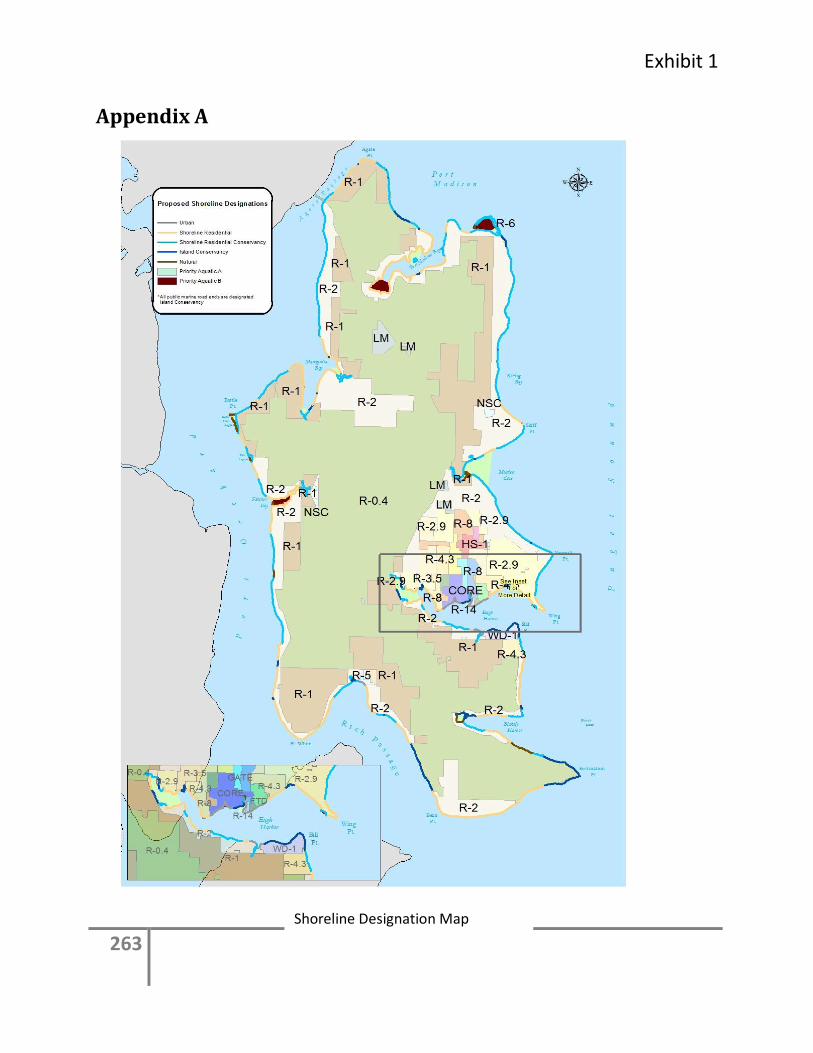
Exhibit 1
263
Appendix A
Shoreline Designation Map
264
Appendix B
Critical Areas B-1. Definitions For the purposes of this subsection, the following definitions shall apply:
1. “Aquifer recharge area” means the surface area of any geological formation sufficiently
pervious to provide fresh water to an aquifer through the process of infiltration and
percolation.
2. “Base flood” means a general and temporary condition of partial or complete inundat ion
of normally dry land areas having a one percent chance of being equaled or exceeded in
any given year. Base flood elevation data is commonly displayed as an elevation line on
flood insurance maps, showing the location of the expected whole-foot water-surface
elevation of the base (100-year) flood.
3. “Best management practices” (BMPs) means conservation practices or systems of
practices and management measures that:
a. Control soil loss and protect water quality from degradation caused by nutrients,
animal waste, toxins, and sediment; and
b. Minimize adverse impacts to surface water and groundwater flow, and to the
chemical, physical, and biological characteristics of critical areas.
BMPs are defined by the United States Department of Agriculture, the State of
Washington Department of Agriculture, the Washington State Department of Ecology,
Washington State Department of Health, Kitsap Conservation District, and other
professional organizations.
4. “Buffer” means an area adjoining to and a part of a critical area that is required for the
continued maintenance, functioning, and/or structural stability of that critical area, or an
area adjacent to a stream or wetland that (a) surrounds and protects the functions and
values of the stream or wetland from adverse impacts, (b) is an integral part of a stream
or wetland ecosystem, and (c) provides shading, input of organic debris and coarse
sediments, room for variation in stream or wetland edge, habitat for wildlife, and
protection from harmful intrusion, to protect the public from losses suffered when the
functions and values of the wetland or stream are degraded.
5. “Category I, II, III, IV wetlands”: see “Wetland category”.
6. “Critical areas” means aquifer recharge areas, fish and wildlife habitatconservation areas,
frequently flooded areas, geologically hazardous areas, and wetlands.
7. “Critical habitat” means a habitat identified by US Fish and Wildlife Service or the
National Marine Fisheries Service as habitat necessary for survival of endangered or
threatened species.
8. “Educational or scientific activities” means controlled and/or supervised scientific
activities or educational activities that are associated with an educational program that is
approved through a conditional use permit.
9. “Engineering geologist” means a practicing engineering geologist who has at least four
years of professional employment as an engineering geologist with experience in
landslide evaluation, and a Washington State specialty license in engineering geology as
specified in Chapter 18.220 RCW.
Exhibit 1
265
10. “Erosion hazard area” means a landform or soil type subject to being worn away by the
action of water, wind, freeze-thaw, or ice, and which are:
a. Rated in the Soil Survey of Kitsap County Area, Washington, USDA (1980), as
having severe hazard of water erosion, including:
i. Indianola-Kitsap Complex, 45 to 70 percent slope;
ii. Kitsap Silt Loam, 15 to 30 percent slope, 30 to 45 percent slope;
iii. Ragnar Fine Sandy Loam, 15 to 30 percent slope; and
iv. Schneider very gravelly loam, 45 to 70 percent slope;
b. Classified in the Department of Ecology Coast Zone Atlas as:
i. Class 3, class U (unstable) includes severe erosion hazards and rapid surface runoff
areas;
ii. Class 4, class UOS (unstable old slides) includes areas having severe limitations due
to slope; and
iii. Class 5, class URS (unstable recent slides); and
c. Identified by the USGS Surface Geology Map of Bainbridge Island (Haugerud, 2001)
as rilled slopes/scarps.
11. “Existing development” means a development that was lawfully constructed, approved
or established prior to the effective date of the ordinance codified in this chapter.
12. “Fish” means species of the vertebrate taxonomic groups Cephalospidomorphi and
Osteichthyes.
13. “Fish and wildlife habitat” means a seasonal range or habitat element with which a given
species has a primary association, and which, if altered, may reduce the likelihood that
the species will maintain and reproduce over the long-term. These include areas of
relative density or species richness, breeding habitat, winter range, and movement
corridors. These also include habitats of limited availability or high vulnerability to
alteration, such as cliffs, streams and wetlands.
14. “Fisheries biologist” means a person with experience and training in fisheries who is
able to submit substantially correct reports on fish population surveys, stream surveys
and other related data analyses of fisheries resources. “Substantially correct” means that
technical or scientific errors, if any, are minor and do not delay or affect the site plan
review process. Qualifications of a fisheries biologist include:
a. Either:
i. Certification by the American Fisheries Society, or;
ii. Bachelor of Science degree in fisheries or the biological sciences from an accredited
institution and five years of professional fisheries experience; and
b. The prior successful completion of at least three habitat management plans; and
c. The biologist is listed on a roster of qualified professionals prepared by the Director.
15. “Frequently flooded areas” means lands subject to a one percent or greater chance of
flooding in any given year, as determined by the Federal Emergency Management
Agency. These areas include, but are not limited to, floodplains adjacent to streams,
lakes, coastal areas, and wetlands. (Also see Chapter 15.16 BIMC, Flood Damage
Prevention.)
16. “Functions” means the beneficial roles served by critical areas including, but not limited
to, water quality protection and enhancement, fish and wildlife habitat, food chain
support, flood storage, conveyance and attenuation, groundwater recharge and discharge,
266
erosion control, wave attenuation, aesthetic value protection, and recreation. These roles
are not listed in order of priority.
17. “Geologically hazardous areas” means areas susceptible to significant erosion, sliding, or
other geological events. They pose a threat to the health and safety of citizens when used
as sites for incompatible commercial, residential or industrial development. Geologically
hazardous areas include erosion hazard areas, landslide hazard areas, and seismic hazard
areas.
18. “Geotechnical engineer” means a practicing geotechnical/civil engineer who has a valid
Washington engineering license and a valid certificate of registration in civil engineering,
at least four years of professional employment as a geotechnical engineer with experience
in landslide evaluation, and appropriate training and experience as specified in Chapter
18.43 RCW.
19. “Habitat Management Plan” (HMP) means a report prepared by a professional wildlife
biologist or fisheries biologist which discusses and evaluates critical fish and wildlife
habitat functions and identifies and evaluates measures necessary to enhance and improve
habitat conservation on a proposed development site.
20. “Habitat of local importance” means a seasonal range or habitat element with which a
given species has a primary association, and which, if altered, may reduce the likelihood
that the species will maintain their population and reproduce over the long-term. These
might include areas of high relative density or species richness, breeding habitat, winter
range, and movement corridors. These might also include habitats that are of limited
availability or areas of high vulnerability to alteration, such as cliffs and wetlands.
21. “Hazard tree” means a tree with structural defects likely to cause failure of all or part of
the tree, which could strike a “target.” A target can be a building or a place where people
gather such as a park bench, picnic table, street, or backyard. In the case of steep slopes,
a hazard tree can also be a tree that is a hazard to stability of the slope, as determined by a
geotechnical engineer.
22. “Hazardous substances” means any liquid, solid, gas, or sludge, including any material,
substance, product, commodity, or waste, regardless of quantity, that exhibits any of the
characteristics or criteria of hazardous waste as specified in RCW 70.105.010. (Also see
BIMC 18.06.450 through 18.06.510).
23. “Hydric soil” means soil which is saturated, flooded, or ponded long enough during the
growing season to develop anaerobic conditions in the upper part.
24. “Hydrogeologist” means a practicing hydrogeologist who has at least four years of
professional employment as a hydrogeologist with experience in the specific subject area
in which they are providing a report, and a Washington specialty license in hydrogeology
as specified in RCW Chapter 18.220.
25. “Hydrophyte or hydrophytic vegetation” means plant life growing in water or on a
substrate that is at least periodically deficient in oxygen as a result of excessive water
content. The presence of hydrophytic vegetation shall be determined following the
methods described in the “Within the Federal delineation manual and Regional
supplement or its successor.
26. “Impact of land use” means the relative measure of the intensity of land use used to
determine the appropriate buffer widths for wetlands and streams which is categorized as
follows:
Exhibit 1
267
a. High impact land use includes commercial development, industrial development,
institutional development, residential (more than one unit per acre) development, new
agriculture (high-intensity such as dairies, nurseries, greenhouses, raising and
harvesting crops requiring annual tilling, raising and maintaining animals), and high-
intensity recreation such as golf courses and ballfields.
b. Moderate impact land use includes residential development (1 unit/acre or less), new
agriculture (moderate-intensity such as orchard and hay fields), paved trails, and
building of logging roads.
c. Low impact land use includes low-intensity open space such as passive recreation,
natural resources preservation, and unpaved trails.
27. “Invasive/exotic species” means plants and animals that are not native to the Puget
Sound lowlands and are recognized by wetland professionals or biologists to be highly
competitive with native vegetation and animals. Invasive/exotic plant species include
those listed on the noxious weed list developed by the Washington State Noxious Weed
Board, nonnative blackberries and English ivy. Invasive/exotic animal species include
any species, such as rats, bullfrogs, zebra mussels and green crabs, considered by
resource professionals to be damaging to the native animal populations.
28. “Landslide hazard areas” means areas which are potentially subject to risk of mass
movement due to a combination of factors, including historic failures, geologic,
topographic, and hydrologic features. Some of these areas are identified in the
Department of Ecology Coastal Zone Atlas and USGS Surface Geology Map of
Bainbridge Island (Haugerud, 2001). The presence of these factors shall be determined
through assessment, by the least intrusive means, by the City Engineer or at the City
Engineer’s request by a third party geoengineer or geotechnical expert, prior to issuance
of any permit. Landslide hazard areas include the following:
a. Areas characterized by slopes greater than 15 percent having springs or groundwater
seepage and having impermeable soils (typically silt and clay) overlain or frequently
interbedded with permeable granular soils (predominantly sand and gravel);
b. Any area potentially unstable due to rapid stream incision or stream bank erosion;
c. Any area located on an alluvial fan, debris flow deposit, or in a debris flowpath,
presently or potentially subject to impacts or inundation by debris flows or deposition
of stream-transported sediments;
d. Any area with a slope of 40 percent or greater and with a vertical relief of 10 or more
feet except areas composed of competent consolidated rock;
e. Any area designated or mapped as class U, UOS, or URS by the Department of
Ecology Coastal Zone Atlas and/or mapped as a landslide or scarp on the USGS
Surface Geology Map of Bainbridge Island (Haugerud, 2001); or
29. “Liquefaction” means a process in which a water-saturated soil, upon shaking, suddenly
loses strength and behaves as a fluid.
30. “Mitigation categories” means
a. The following specific categories: (need for mitigation ratios)
i. Mitigation, Compensatory: replacing project-induced critical area losses or impacts,
including, but not limited to, establishment, re-establishment, rehabilitation or
enhancement.
268
ii. Mitigation, Establishment: Mitigation performed to intentionally establish a
critical area (e.g., wetland) at a site where it does not currently exist.
iii. Mitigation, Re-Establishment: The manipulation of the physical, chemical, or
biological characteristics of a site with the goal of returning natural or historic
functions to a former critical area.
iv. Mitigation, Rehabilitation: The manipulation of the physical, chemical, or
biological characteristics of a site with the goal of repairing natural or historic
functions and processes to a degraded critical area.
v. Mitigation, Enhancement: The manipulation of the physical, chemical, or
biological characteristics of a biological wetland to heighten, intensify or improve
specific function(s) or to change for specific purposes such as water quality
improvement, flood water retention, or wildlife habitat.
31. “Normal maintenance” means those usual acts to prevent a decline, lapse or cessation
from a lawfully established condition. Normal maintenance includes removing debris
from and cutting or manual removal of vegetation in crossing and bridge areas. Normal
maintenance does not include:
a. Use of fertilizer or pesticide application in wetlands, Fish and Wildlife Habitat
Conservation Areas, or their buffers;
b. Re-digging ditches in wetlands or their buffers to expand the depth and width beyond
the original ditch dimensions;
c. Re-digging existing drainage ditches in order to drain wetlands on lands not classified
as existing and ongoing agriculture under Section B-2(C) (Exemptions).
32. “Open space” means undeveloped areas of varied size. Open space often contains
distinctive geologic, botanic, zoologic, historic, scenic or other critical area, or natural
resource land features.
33. “Ravine” means a V-shaped landform generally having little to no floodplain and
normally containing steep slopes, which is deeper than 10 vertical feet as measured from
the centerline of the ravine to the top of the slope. Ravines are typically created by the
wearing action of streams. The top of the slope is determined where there is a significant
change in the slope to generally less that a 15 percent slope.
34. “Reasonable alternative” means an activity that could feasibly attain or approximate a
proposal's objectives, but at a lower environmental cost or decreased level of
environmental degradation.
35. “Repair” means activities that restore the character, size, or scope of a project only to the
previously authorized condition.
36. “Seismic hazard areas” means areas subject to severe risk of damage as a result of
seismic induced ground shaking, or surface faulting. While ground shaking is the
principal risk because the entire island will shake significantly, severe damage will occur
where slope failure, liquefaction, and settlement are induced by the shaking and surface
rupture is created by fault movement. The following areas are considered seismic hazard
areas:
a. Seismic Landslide Hazard Areas - Slopes which are stable in non-earthquake periods,
but fail and slide during ground shaking;
Exhibit 1
269
b. Liquefaction Hazard Areas - Areas of cohesionless, loose or soft, saturated soils of
low density in association with a shallow groundwater table that are subject to
settlement and/or liquefaction from ground shaking, or;
c. Fault Hazard Areas - Areas of known surface rupture or significant surface
deformation as a result of an active fault movement, including 50 feet on either side.
37. “Site” means the entire lot, series of lots, or parcels on which a development is located or
proposed to be located, including all contiguous undeveloped lots or parcels under
common ownership.
38. “Streams” means those areas in the City of Bainbridge Island where the surface water
flows are sufficient to produce a defined channel or bed. A defined channel or bed is an
area which demonstrates clear evidence of the passage of water and includes but is not
limited to bedrock channels, gravel beds, sand and silt beds, and defined-channel swales.
The channel or bed need not contain water year-round. This definition is not meant to
include irrigation ditches, canals, storm or surface water runoff devices, or other artificial
watercourses unless they are used by fish or used to convey streams naturally occurring
prior to construction of the water course.
39. “Stream Types” means a streams classification system based on fish usage and perennial
or seasonal water regime as found in WAC 222-16-030 and meeting the standards listed
below.
a. “Type F Stream” means a stream that has suitable fish habitat. If fish usage has not
been determined, water having the following characteristics are presumed to have fish
use: Streams segments having a defined channel of 2 feet or greater within the
bankfull width and having a gradient of 16 percent or less. Determination of fish
usage shall use the methodology found in Washington Department of Natural
Resource’s Forest Practice Board Manual, Section 13.
b. “Type Np” means all segments of natural waters within the bankfull width of defined
channels that are perennial nonfish habitat streams. Perennial streams are waters that
do not go dry any time of a year of normal rainfall. However, for the purpose of water
typing, Type Np Waters include the intermittent dry portions of the perennial channel
below the uppermost point of perennial flow.
c. “Type Ns” means all segments of natural waters within the bankfull width of the
defined channels that are not Type S, F, or Np Waters. These are seasonal, nonfish
habitat streams in which surface flow is not present for at least some portion of a year
of normal rainfall and are not located downstream from any stream reach that is a
Type Np Water. Ns Waters must be physically connected by an above-ground
channel system to marine waters, Type F, or Np Waters.
40. “Wetland or wetlands” means areas that are inundated or saturated by surface water or
groundwater at a frequency and duration sufficient to support, and under normal
circumstances do support, a prevalence of vegetation typically adapted for life in
saturated soil conditions. Wetlands generally include swamps, estuaries, marshes, bogs,
and similar areas. Wetlands do not include those artificial wetlands intentionally created
from nonwetland sites, including, but not limited to, irrigation and drainage ditches,
grass-lined swales, canals, detention facilities, wastewater treatment facilities, farm
ponds, and landscape amenities, or those wetlands created after July 1, 1990, that were
unintentionally created as result of the construction of a road, street, or highway.
270
Wetland may include those artificial wetland intentionally created from nonwetland areas
to mitigate the conversion of wetlands.
41. “Wetland boundary” means the boundary or edge of a wetland as delineated using the
methodology found in Regional Supplement to the Corps of Engineers Wetland
Delineation Manual: Western Mountains, Valleys, and Cost Region (Version 2.0). (Per
WAC173-22-035, or its sucessor.)
42. “Wetland category” means category as defined in “Washington State Wetland Rating
System for Western Washington, Revised,” Department of Ecology publication #04-06-
025, or as revised and adopted by the department.
43. “Wetland classes” means the classification system of the U.S. Fish and Wildlife Service
(Cowardin, et al. 1979).
44. Wetland Mitigation.
a. In-kind: To replace wetlands with substitute wetlands whose characteristics closely
approximate those destroyed or degraded by a regulated activity. It does not mean
replacement “in-category.”
b. Off-site: To replace wetlands away from the site on which a wetland has been
impacted by a regulated activity.
c. On-site: To replace wetlands at or adjacent to the site on which a wetland has been
impacted by a regulated activity.
d. Out-of-kind: To replace wetlands with substitute wetlands whose characteristics do
not closely approximate those destroyed or degraded by a regulated activity. It does
not refer to replacement “out-of-category.”
45. Wetlands, Regulated.
a. “Regulated wetlands” means:
i. All Category I and II wetlands;
ii. All Category III and Category IV wetlands
b. Category I, II, III and IV wetlands include:
i. Lands defined as wetlands shall be those areas that are inundated or saturated by
surface water or groundwater at a frequency and duration sufficient to support,
and that under normal circumstances do support, a prevalence of vegetation
typically adapted for life in saturated soil conditions.
ii. Wetlands created as mitigation and wetlands modified for approved land use
activities.
c. Regulated wetlands do not include artificial wetlands intentionally created from non-
wetland sites, including, but not limited to, irrigation and drainage ditches, grass-lined
swales, canals, detention facilities, wastewater treatment facilities, farm ponds, and
landscape amenities, or those wetlands created after July 1, 1990 that were
unintentionally created as a result of the construction of a road, street, or highway.
46. “Wetlands specialist” means a person with experience and training in wetland issues
who is able to submit substantially correct reports on wetland delineations,
classifications, functional assessments and mitigation plans. “Substantially correct”
means that errors, if any, are minor and do not delay or affect the site plan review
process. Qualifications of a wetlands specialist include:
a. Either:
Exhibit 1
271
i. Certification as a Professional Wetland Scientist (PWS) or Wetland Professional in
Training (WPIT) through the Society of Wetland Scientists, or;
ii. Bachelor of science degree in the biological sciences from an accredited institution
and five years of professional field experience; and
b. The prior successful completion of at least three wetland reports; and
c. The specialist is listed on a roster of qualified professionals prepared by the Director.
47. “Wildlife biologist” means a person with experience and training in the principles of
wildlife management and with practical knowledge in the habits, distribution and
environmental management of wildlife. Qualifications include:
a. Either:
i. Certification as a professional wildlife biologist through The Wildlife Society, or;
ii. Bachelor of science or bachelor of arts degree in wildlife management, wildlife
biology, ecology, zoology, or a related field, from an accredited institution and
five years of professional field experience; and
b. The prior successful completion of at least three habitat managements plans; and
c. The biologist is listed on a roster of qualified professionals prepared by the Director.
46. “Zone of Influence” means an area, usually upslope from a geologically hazardous area,
where changes in land use and hydrology can affect the stability of the geologically
hazardous area. The zone of influence is defined as 300 feet upslope from slopes greater
than 40 percent, and 200 feet upslope from slopes greater than 15 percent but less than 40
percent that are determined to be geologically hazardous areas.
B-2. Applicability, exemptions, and prior development activity. A. Applicability. This appendix establishes regulations for the protection of sites which
contain critical areas or are adjacent to sites which contain critical areas in the shoreline
jurisdiction. Development and land use activities proposed on critical area sites shall
comply with the provisions of this Appendix. No action shall be taken by any person,
company, agency, governmental body (including the City), or applicant, which results in
any alteration of a critical area except as consistent with the purposes, requirements,
objectives, and goals of this chapter.
B. Inventory of Critical Areas. This appendix shall apply to all critical areas located within
the shoreline jurisdiction of the city. The approximate location and extent of these areas
on Bainbridge Island is displayed on various inventory maps available at the city’s
Department of Planning and Community Development. Maps and inventory lists are
guides to the general location and extent of critical areas. Critical areas not shown are
presumed to exist on Bainbridge Island and are protected under all the provisions of this
chapter. In the event that any of the designations shown on the maps or inventory lists
conflict with the site-specific conditions, site-specific conditions shall control.
C. Exemptions. The following activities are exempt from the requirements of this chapter
1. Emergencies that threaten the public health, safety and welfare. An "emergency" is an
unanticipated and immediate threat to public health, safety, or the environment which
requires action within a time too short to allow compliance with this chapter, further
definition of “emergency” is in Section 8.0 of the Shoreline Master Program. Restoration
or mitigation of critical areas and buffers impacted by emergency action shall be required
in a timely matter.
272
2. Normal and routine maintenance of structures, landscaping and vegetation that will not
further impact or alter critical areas or buffers.
3. Normal and routine maintenance and operation of pre-existing retention/detention
facilities, biofilters and other stormwater management facilities, irrigation and drainage
ditches, and fish ponds; provided, that such activities shall not involve conversion of any
wetland not currently being used for such activity. Any maintenance of ponds located in
stream habitat areas shall require appropriate approval from the Washington Department
of Fish and Wildlife.
4. Structural alterations to buildings that do not increase the structural footprint or introduce
new adverse impacts to an adjacent critical area, except for structures located on
geologically hazardous areas which are not exempt.
5. Normal and routine maintenance or repair of existing utility structures within a right-of-
way or existing utility corridor or easements, including the cutting, removal and/or
mowing of vegetation.
6. Forest practices conducted pursuant to Chapter 76.09 RCW, except Class IV (general
conversions) and Conversion Option Harvest Plans (COHP).
7. Activities within a portion of a wetland buffer or fish and wildlife habitat area buffer
located landward of an existing, substantially developed area, such as a paved area, or
permanent structure, which eliminates or greatly reduces the impact of the proposed
activities on the wetland or fish and wildlife habitat area. The Director shall review the
proposal to determine the likelihood of associated impacts.
8. Hazard Tree Removal. Where a threat to human life, property, or slope stability is
demonstrated, the Director may allow removal of danger or hazard trees subject to the
following criteria:
a. Tree removal is the minimum necessary to balance protection of the critical area and its
buffer with protection of life and property; and
b. The critical area or its buffer shall be replanted as determined by the Director.
The Director may require the applicant to consult with a professional forester or a
certified arborist prior to tree removal. Hazard tree abatement can sometimes be achieved
by felling the tree or trimming the tree. Habitat needs may require leaving the fallen tree
in the riparian corridor or maintaining a high stump for wildlife habitat.
9. Aquifer recharge areas. A person, or property, shall be exempt from the provisions of this
chapter unless either of the following is true:
a. The property is located in a fish and wildlife habitat conservation area, frequently flooded
area, geologically hazardous area, and/or wetland; or
b. One of more of the uses identified in Section B-E are proposed.
D. Standards for existing development.
1. Existing structures and related improvements. Structures and related improvements that
were legally built or vested prior to the effective date of Ordinance No. 2012-4 that do
not meet the setback or buffer requirements of this appendix may continue to exist in
their present form, and may be altered, including remodeled, reconstructed, or expanded,
if such alteration complies with the provisions of this Section and will result in no net
loss of ecological function.
2. Existing structures, not located in a geologically hazardous area, that were legally built or
vested prior to the effective date of Ordinance No. 2012-4
Exhibit 1
273
may be altered if:
a. There is no change in the footprint of the building;
b. The remodel is entirely inside the existing building;
c. There is no further encroachment into the buffers required pursuant to this chapter unless
a Variance is first approved
3. Existing property improvements other than structures, including driveways, parking areas,
yards, play areas, storage areas, and similar improvements that were legally established
or vested prior to the effective date of Ordinance No. 2012-4 may be altered if:
a. There is no change in the location of the improvement;
b. Any alteration of the improvement is entirely inside of the existing boundaries of the
improvement;
c. There is no further encroachment into the buffers unless a Variance is first approved.
4. Alterations permitted by this Section shall not be exempt from applicable City review or
permit requirements or other applicable City codes.
B-3. Prescriptive buffers variations. A. Intent. The City recognizes that in some cases it may not be possible to provide a critical
area buffer that meets the dimensions prescribed by this ordinance, due to land area or
other constraints. The City further recognizes that in some cases the desired or better
critical area protection can be achieved through alternative approaches.
This section provides alternatives that can be pursued in lieu of the prescribed buffers
when warranted by site-specific conditions. In considering an application for any of
these alternatives, it shall always be the primary intent of the City to protect the functions
and values of the critical areas. It is further the intent of the City to ensure that the
application of the provisions of this chapter does not deprive an owner from reasonable
use of their property.
Any proposed use of the following alternatives shall be supported by analysis utilizing
appropriate science, to determine and minimize the impacts of the alternative:
B. Buffer Averaging. If characteristics of the property do not allow reasonable use with
prescribed buffers, the Director may allow wetland and/or fish and wildlife conservation
area buffer widths to be averaged. It is intended that the process for reviewing a buffer
averaging proposal be as simple as possible, while ensuring that the following criteria are
met:
1. The total area contained within the buffer after averaging shall be no less than that
contained within the standard buffer prior to averaging;
2. The applicant demonstrates that such averaging will clearly provide greater protection of
the functions and values of critical areas than would be provided by the prescribed habitat
buffers.
3. The averaging will not result in reduced buffers next to highly sensitive habitat areas; and
4. The applicant demonstrates one or more of the following:
a. That the wetland contains variations in sensitivity due to existing physical characteristics;
b. That only low intensity uses would be located within 200 feet of areas where the buffer
width is reduced, and that such low intensity uses restrictions are guaranteed in perpetuity
by covenant, deed restriction, easement, or other legally binding mechanism; or
c. That buffer averaging is necessary to avoid an extraordinary hardship to the applicant
caused by circumstances peculiar to the property.
274
C. Habitat Management Plan. A Habitat Management Plan may be prepared pursuant to
subsection B-4 when it can clearly be demonstrated that greater protection of the
functions and values of critical areas can be achieved through the HMP than could be
achieved through providing the prescribed habitat buffers. A Habitat Management Plan
may be used as a means to protect wetland and/or fish and wildlife habitat conservation
area buffers. Habitat Management Plans may not be used to reduce the water quality
buffers for wetlands and/or fish and wildlife habitat conservation areas.
D. Public notice. Appropriate notice of, and opportunity to comment on, the proposed use of
any of the foregoing alternatives shall be given to surrounding property owners and the
general public, in a manner to be established by the Director.
B-4. Habitat management plan. A. General. A Habitat Management Plan shall comply with the requirements of this Section,
and shall clearly demonstrate that greater protection of the functions and values of critical
areas can be achieved through the HMP than could be achieved through providing the
prescribed habitat buffers. The Director shall prepare performance standards and
monitoring guidelines for Habitat Management Plans, including a program for City
oversight of such plans. Once the standards and guidelines are in place, an applicant may
propose to implement an HMP as a means to protect habitat buffers associated with
wetlands and/or fish and wildlife conservation areas.
B. Intent. HMPs are primarily intended as a means to restore or improve buffers that have
been degraded by past activity, and should preserve, and not reduce, existing high quality
habitat buffers. While not primarily intended as a means to reduce buffers, the HMP may
propose a reduction of the habitat buffer width where it is shown that the HMP will
comply with the other requirements of this Section. An HMP shall not reduce the
prescribed water quality buffer width as listed in B-8 and B-10 under any circumstance.
C. Effect of buffers. An HMP shall provide habitat functions and values that are greater
than would be provided by the prescribed habitat buffers. When habitat buffers are a
component of an HMP, they shall be at least the minimum size necessary to accomplish
the objectives of the HMP. The HMP may propose, but the City shall not require, a
habitat buffer containing a greater area than is required by the prescribed habitat buffer.
D. Impact mitigation - general. The HMP shall encompass an area large enough to provide
mitigation for buffer reduction below the standard required buffers, and shall identify
how the development impacts resulting from the proposed project will be mitigated. The
developer of the plan shall use the best available science in all facets of the analyses. The
Washington Department of Fish and Wildlife Priority Habitat and Species Management
Recommendations, dated May 1991, and/or bald eagle protection rules outlined in WAC
232-12-292, as now or hereafter amended, may serve as guidance for this report. For
Habitat Management Plans addressing wetland buffers, Method for Assessing Wetland
Functions, Ecology Publication #99-116 shall be used for guidance in determining
function equivalency. All Habitat Management Plans shall be reviewed by a qualified
third party selected by the City. The applicant will be responsible for the cost of the
review.
F. Map. The Habitat Management Plan shall contain a map prepared at an easily readable
scale, showing:
1. The location of the proposed development site;
Exhibit 1
275
2. Property boundaries;
3. The relationship of the site to surrounding topographic, water features, and cultural
features;
4. Proposed building locations and arrangements;
5. A legend which includes a complete legal description, acreage of the parcel, scale, north
arrow, and date of map revision.
G. Report. The Habitat Management Plan shall also contain a report which contains:
1. A description of the nature and intensity of the proposed development;
2. An analysis of the effect of the proposed development, activity or land use change upon
the wildlife species and habitat identified for protection. If the Habitat Management Plan
is addressing wetland habitat, the analysis shall compare an assessment of wildlife habitat
suitability of the wetland applying standard buffers with an assessment of habitat
suitability as proposed using Method for Assessing Wetland Functions, Washington State
Department of Ecology (if available for the specific Hydrogeomorphic classification);
and
3. A plan which identifies how the applicant proposes to mitigate any adverse impacts to
wildlife habitats created by the proposed development. For wetland or other habitats
protected by this chapter, the application shall show, using the appropriate function
assessment methodology, that habitat functions and values are greater after the
development than would occur had the prescribed buffers been provided (see Mitigation
Plan requirements, Section 16.20.110).
4. All review comments received from outside reviewers. If the HMP recommends
mitigation involving federally listed threatened or endangered species, migratory
waterfowl or wetlands, the U.S. Fish and Wildlife Service shall receive a copy of the
draft HMP.
5. The HMP shall specifically address, as appropriate, the following:
a. Enhancement of existing degraded buffer area and replanting of the disturbed buffer area
with native or equivalent vegetation;
b. The use of alternative on-site wastewater systems in order to minimize site clearing;
c. Infiltration of stormwater where soils permit;
d. Retention of existing native or equivalent vegetation on other portions of the site in order
to offset habitat loss from buffer reduction; and
e. The need for fencing and signage along the buffer edge.
H. Mitigation measures. Possible mitigation measures to be included in the report, or
required by the Director, could include, but are not limited to:
1. Establishment of buffer zones;
2. Preservation of critically important plants and trees;
3. Limitation of access to habitat areas;
4. Seasonal restriction of construction activities;
5. Establishing phased development requirements; and
6. Monitoring plan for a period necessary to establish that performance standards have been
meet. Generally this will be for a period of seven to ten years.
I. HMP adequacy. The HMP shall demonstrate to the satisfaction of the Director that the
habitat functions and values are improved by implementation of the HMP. If there is a
disagreement between the Director and the applicant as to the adequacy of the HMP, the
276
issue of plan adequacy shall be resolved by consulting with the Washington Department
of Fish and Wildlife for HMPs relating to streams or the Washington Department of
Ecology for HMPs relating to wetlands. If the State agencies are not available in a timely
manner, the applicant may choose to have the City refer the HMPs to a third party
consultant at the expense of the applicant. After consultation with such State departments
or third party consultant, the Director shall make a final decision on the adequacy of the
HMP.
J. Timing. An HMP must be developed and approved either prior to preliminary plat
approval or issuance of the building permit, as applicable, and must be implemented
before the City grants either final plat approval or an occupancy permit, as applicable.
K. Performance Surety. The Director may require that the applicant provide a performance
surety to ensure conformance with mitigation requirements of the habitat management
plan pursuant to Section B-4.
B-5. Application requirements. A. Submittal Requirements. In addition to the general submittal requirements for all
applications in the Administration Handbook applications for land use or development
proposals within critical areas or their buffers shall be filed with the information
requested on the application forms available from the Department of Planning and
Community Development. The applicant shall not be granted any approval or permission
to conduct development or land use in a critical area and/or its buffer prior to fulfilling
the requirements of this chapter.
B. Support Information Requirements. When support information is required by the
Director it shall contain the following and be prepared by one or more of the experts
listed in Subsection B.4 of this section:
1. A description of the critical areas on or adjoining the site and how the proposed
development will or will not impact critical areas, their buffers, and adjoining properties,
including:
a. Drainage, surface and subsurface hydrology, and water quality;
b. Existing vegetation as it relates to wetlands, steep slopes, soil stability, and fish and
wildlife habitat value; and
c. Other critical area characteristics and functions.
2. Recommended methods for mitigating impacts and a description of how these methods
may impact adjacent properties;
3. Any additional information determined as relevant by the Director;
4. Such studies shall be prepared by experts in the area of concern, who shall be selected
from a list of approved consultants prepared by the Director, as follows:
a. Aquifer recharge study: Hydrogeologist;
b. Flood hazard area study: Professional civil engineer; hydro-geologist;
c. Geologically hazardous area study: Engineering geologist; geotechnical engineer,
provided that:
i. An engineering geologist may provide a study, including interpretation, evaluation,
analysis, and application of geological information and data and may predict potential or
likely changes in types and rates of surficial geologic processes due to proposed changes
to a location, provided it does not contain recommended methods for mitigating identified
impacts, other than avoidance, structural impacts to, or suitability of civil works; and
Exhibit 1
277
ii. Engineering geologists may not provide engineering recommendations or design
recommendations, but may contribute to a complete geotechnical report that is co-sealed
by a geotechnical engineer.
d. Stream, riparian area, drainage corridor study: Biologist with stream ecology expertise;
fish or wildlife biologist; a civil engineer may provide studies for drainage, surface and
subsurface hydrology, and water quality;
e. Wetland study: Wetlands specialist.
f. Habitat Management Plans: Wildlife biologist and/or fisheries biologist.
5. The Director may in some cases retain experts at the applicant’s expense to assist in the
review of studies; and
6. Such studies shall be prepared in accordance with procedures established by the Director
or City Engineer as specified.
B-6. Mitigation plan requirements. A. All critical area restoration, creation and/or enhancement projects required pursuant to
this appendix either as a permit condition or as a result of an enforcement action shall
follow a mitigation plan prepared by an expert approved by the Director. The applicant
or violator shall receive written approval of the mitigation plan by the Director prior to
commencement. Compensatory mitigation is not required for allowed activities which
utilize best management practices to protect the functions and values of regulated critical
areas.
B. Purpose of Mitigation Plan. The mitigation plan shall provide information on land
acquisition, construction, maintenance and monitoring of the replaced critical area. The
mitigation plan shall recreate as nearly as possible the original critical area in terms of its
acreage, function, geographic location and setting.
C. Mitigation Plan Submittal Requirements. A complete mitigation plan shall consist of plot
plans, a written report, and performance bonds, as required below. The plot plans and
written report shall be prepared by qualified professionals approved by the Director.
1. Plot Plan Requirements. The following information shall be submitted on one or more
plot plans (as determined by the Director):
a. A legal description and a survey (boundary and topography) prepared by a licensed
surveyor of the proposed development site, compensation site, and location of existing
critical area(s) on each. This shall include wetland delineation and existing wetland
acreage.
b. Scaled plot plan(s) indicating:
i. Proposed construction;
ii. Zoning setback and critical area buffer requirements;
iii. Construction phasing and sequence of construction;
iv. Site cross-sections, percent slope, existing and finished grade elevations;
v. Soil and substrate conditions;
vi. Grading and excavation plan, including erosion and sediment control plans needed for
construction and long-term survival; substrate stockpiling locations and techniques, and
source controls needed for critical area construction and maintenance;
vii. Landscape plans indicating species, types, quantities, locations, size, spacing or density
of planting; planting season or timing; planting instructions, watering schedule and
278
nutrient requirements; source of plant materials or seeds; and, where appropriate,
measures to protect plants from destruction or predation; and
viii. Water control structures and water-level maintenance practices needed to achieve the
necessary hydrocycle/hydroperiod characteristics, etc.
2. Written Report Requirements. A written report shall accompany the plot plan(s) and shall
provide the additional information required below. In addition, the report should be used
as needed to clarify or explain elements of the plot plan(s).
a. Baseline Information.
i. Wetland delineation and existing wetland acreage;
ii. Vegetative, faunal and hydrologic characteristics;
iii. Soil and substrate conditions;
iv. Relationship within watershed and to existing streams, wetlands, ponds, or saltwater;
v. Existing and proposed adjacent site conditions; and
vi. Existing and proposed ownership.
b. Environmental Goals and Objectives. The report shall contain a description of the
environmental goals and objectives to be met by the compensation plan. The goals and
objectives shall be related to the functions and values of the original critical area or, if
out-of-kind wetland mitigation, the type of wetland to be emulated. This analysis shall
include, but is not limited to the following:
i. Site selection criteria;
ii. Identification of compensation goals;
iii. Identification of functions and values;
iv. Dates for beginning and completion of the project and compensation plan;
v. A complete description of the relationship between and among structures and functions
sought;
vi. Review of available literature and/or known like-projects to date in restoring or creating
the type of critical area proposed;
vii. Likelihood of success of the proposed compensation project at duplicating the original
critical area. This shall be based on experiences of comparable projects identified in the
literature review or existing projects, if any; and
viii. Likelihood of the ability of the created or restored critical area to provide the functions
and values of the original critical area. This shall be based on such factors as surface
water and groundwater supply and flow patterns; dynamics of the ecosystem; sediment or
pollutant influx and/or erosion, periodic flooding and drought, etc.; presence of invasive
flora or fauna; potential human or animal disturbance; and previous comparable projects,
if any.
c. Performance Standards. Specific criteria shall be provided for evaluating whether or not
the goals and objectives of the project are met and for beginning remedial action or
contingency measures. Such criteria may include water quality standards, survival rates
of planted vegetation, species abundance, and diversity targets, habitat diversity indices,
or other ecological, geological or hydrological criteria.
d. Detailed Specifications. Written specifications and descriptions of compensation
techniques shall be provided. These shall include, but not be limited to, items in
Subsection C.2 of this Section.
Exhibit 1
279
e. Monitoring Program. A program outlining the approach for monitoring construction of
the compensation project and for assessing a completed project shall be provided.
Monitoring may include, but is not limited to:
i. Establishing vegetation plots to track changes in plant species composition and density
over time;
ii. Using photo stations to evaluate vegetation community response;
iii. Sampling surface and subsurface waters to determine pollutant loading, and changes
from the natural variability of background conditions (pH, nutrients, heavy metals);
iv. Measuring base flow rates and storm water runoff to model and evaluate water quality
predictions, if appropriate;
v. Measuring sedimentation rates, if applicable; and
vi. Sampling fish and wildlife populations to determine habitat utilization, species
abundance and diversity.
f. A protocol shall be included outlining how the monitoring data will be evaluated by
agencies that are tracking the progress of the compensation project. A monitoring report
shall be submitted annually, at a minimum, documenting milestones, successes,
problems, and contingency actions of the compensation project. The compensation
project shall be monitored for a period necessary to establish that performance standards
have been met, but not for a period less than seven years.
g. Contingency Plan. Identification of potential courses of action, and any corrective
measures to be taken when monitoring or evaluation indicates project performance
standards are not being met.
D. Performance and Maintenance Surety and Demonstration of Competence. A
demonstration of financial resources, administrative, supervisory, and technical
competence and scientific expertise to successfully execute the compensation project
shall be provided. A compensation project manager shall be named and the qualifications
of each team member involved in preparing the mitigation plan and implementing and
supervising the project shall be provided, including educational background and areas of
expertise, training and experience with comparable projects. In addition, a surety
ensuring fulfillment of the compensation project, monitoring program, and any
contingency measure shall be posted.
E. City Consultation. The City may consult with and solicit comments from any federal,
state, regional, or local agency, including tribes, having any special expertise with respect
to any environmental impact prior to approving a mitigation proposal which includes
critical areas compensation. The compensation project proponents should provide
sufficient information on plan design and implementation in order for such agencies to
comment on the overall adequacy of the mitigation proposal.
F. Permit Conditions. Any compensation project prepared pursuant to this section and
approved by the Director shall become part of the application for the permit.
B-7. Aquifer recharge areas. A. Classification. The entirety of Bainbridge Island is the recharge area for the island
aquifers. Certain uses must be carefully evaluated before being approved, and others
must be prohibited, in order to protect the city’s aquifers, due to the following:
280
1. Bainbridge Island is dependent upon its aquifers as the sole and essential source for
drinking water. Critical recharge areas have the potential to affect potable water where
an essential source of drinking water is vulnerable to contamination.
2. The island aquifers are vulnerable to pollution that has the potential to create a significant
public health hazard. High vulnerability is indicative of land uses which produce
contaminants that may degrade groundwater and low vulnerability is indicative of land
uses which will not.
3. Susceptibility to pollution is a function of depth of groundwater, permeability of soils, soil
types, presence of potential sources of contamination and any other relevant factors.
4. Soil types that transfer water to the aquifer are rated in terms of infiltration rate. Soil types
with the high infiltration rates are associated with areas of high aquifer recharge. The
rates and soil types are defined by the U.S. Department of Agriculture, Soil Conservation
Service, in the Soil Survey of Kitsap County.
5. The island aquifers are vulnerable to a reduction in recharge from activities that reduce
the infiltration rate on a site.
B. Hydrogeologic Assessment. The following proposed activities will require the
preparation of a hydrogeologic assessment:
1. The use of hazardous substances, other than household chemicals used according to the
directions specified on the packaging for domestic applications;
2. The use of injection wells, including on-site septic systems, except those domestic septic
systems releasing less than 14,500 gallons of effluent per day; or
3. Any other activity determined by the Director likely to have an adverse impact on ground
water quality or quantity or on the recharge of the aquifer.
C. Hydrogeologic Assessment Requirements. A hydrogeologic assessment shall include, at
a minimum, the following site and proposal-related information:
1. Available information regarding geologic and hydrogeologic characteristics of the site
including the surface location of all critical aquifer recharge areas located on site or
immediately adjacent to the site, and permeability of the unsaturated zone;
2. Ground water depth, flow direction, and gradient based on available information;
3. Currently available data on wells and springs within 1,300 feet of the project area;
4. Location of other critical areas, including surface waters, within 1,300 feet of the project
area;
5. Available historic water quality data for the area to be affected by the proposed activity;
6. Best management practices proposed to be utilized to protect groundwater quality; and
7. Low impact development practices designed to maintain infiltration rates to the
underlying aquifers.
D. Performance Standards – Specific Uses.
1. Storage Tanks. All storage tanks proposed in a critical aquifer recharge area must comply
with local building code requirements and must conform to the following requirements:
a. Underground Tanks. All new underground storage facilities proposed for the storage of
hazardous substances or hazardous wastes shall be designed and constructed so as to:
i. Prevent releases due to corrosion or structural failure for the operational life of the tank;
ii. Be protected against corrosion, constructed of noncorrosive material, steel clad with a
noncorrosive material, or designed to include a secondary containment system to prevent
the release or threatened release of any stored substances; and
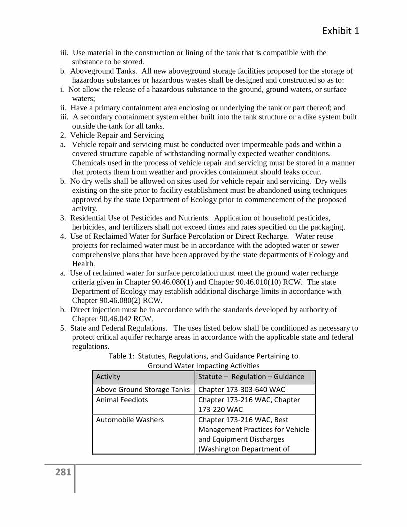
Exhibit 1
281
iii. Use material in the construction or lining of the tank that is compatible with the
substance to be stored.
b. Aboveground Tanks. All new aboveground storage facilities proposed for the storage of
hazardous substances or hazardous wastes shall be designed and constructed so as to:
i. Not allow the release of a hazardous substance to the ground, ground waters, or surface
waters;
ii. Have a primary containment area enclosing or underlying the tank or part thereof; and
iii. A secondary containment system either built into the tank structure or a dike system built
outside the tank for all tanks.
2. Vehicle Repair and Servicing
a. Vehicle repair and servicing must be conducted over impermeable pads and within a
covered structure capable of withstanding normally expected weather conditions.
Chemicals used in the process of vehicle repair and servicing must be stored in a manner
that protects them from weather and provides containment should leaks occur.
b. No dry wells shall be allowed on sites used for vehicle repair and servicing. Dry wells
existing on the site prior to facility establishment must be abandoned using techniques
approved by the state Department of Ecology prior to commencement of the proposed
activity.
3. Residential Use of Pesticides and Nutrients. Application of household pesticides,
herbicides, and fertilizers shall not exceed times and rates specified on the packaging.
4. Use of Reclaimed Water for Surface Percolation or Direct Recharge. Water reuse
projects for reclaimed water must be in accordance with the adopted water or sewer
comprehensive plans that have been approved by the state departments of Ecology and
Health.
a. Use of reclaimed water for surface percolation must meet the ground water recharge
criteria given in Chapter 90.46.080(1) and Chapter 90.46.010(10) RCW. The state
Department of Ecology may establish additional discharge limits in accordance with
Chapter 90.46.080(2) RCW.
b. Direct injection must be in accordance with the standards developed by authority of
Chapter 90.46.042 RCW.
5. State and Federal Regulations. The uses listed below shall be conditioned as necessary to
protect critical aquifer recharge areas in accordance with the applicable state and federal
regulations.
Table 1: Statutes, Regulations, and Guidance Pertaining to Ground Water Impacting Activities
Activity Statute – Regulation – Guidance
Above Ground Storage Tanks Chapter 173-303-640 WAC
Animal Feedlots Chapter 173-216 WAC, Chapter 173-220 WAC
Automobile Washers Chapter 173-216 WAC, Best Management Practices for Vehicle and Equipment Discharges (Washington Department of
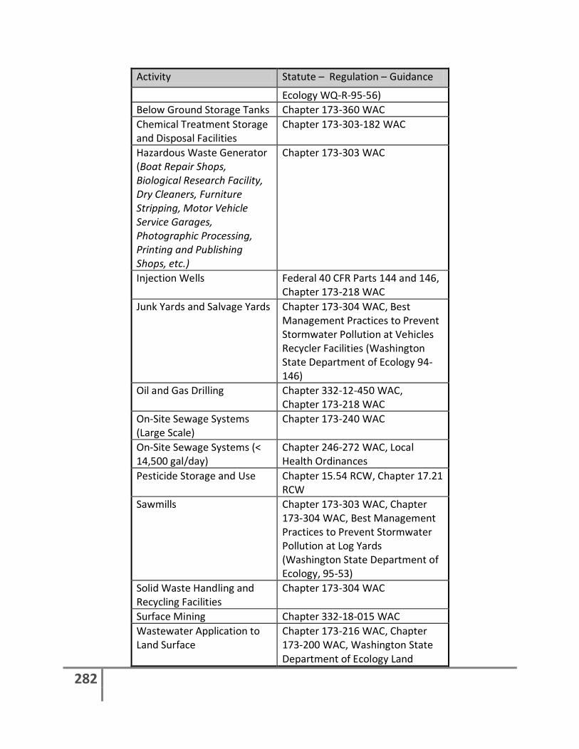
282
Activity Statute – Regulation – Guidance
Ecology WQ-R-95-56)
Below Ground Storage Tanks Chapter 173-360 WAC
Chemical Treatment Storage and Disposal Facilities
Chapter 173-303-182 WAC
Hazardous Waste Generator (Boat Repair Shops, Biological Research Facility, Dry Cleaners, Furniture Stripping, Motor Vehicle Service Garages, Photographic Processing, Printing and Publishing Shops, etc.)
Chapter 173-303 WAC
Injection Wells Federal 40 CFR Parts 144 and 146, Chapter 173-218 WAC
Junk Yards and Salvage Yards Chapter 173-304 WAC, Best Management Practices to Prevent Stormwater Pollution at Vehicles Recycler Facilities (Washington State Department of Ecology 94-146)
Oil and Gas Drilling Chapter 332-12-450 WAC, Chapter 173-218 WAC
On-Site Sewage Systems (Large Scale)
Chapter 173-240 WAC
On-Site Sewage Systems (< 14,500 gal/day)
Chapter 246-272 WAC, Local Health Ordinances
Pesticide Storage and Use Chapter 15.54 RCW, Chapter 17.21 RCW
Sawmills Chapter 173-303 WAC, Chapter 173-304 WAC, Best Management Practices to Prevent Stormwater Pollution at Log Yards (Washington State Department of Ecology, 95-53)
Solid Waste Handling and Recycling Facilities
Chapter 173-304 WAC
Surface Mining Chapter 332-18-015 WAC
Wastewater Application to Land Surface
Chapter 173-216 WAC, Chapter 173-200 WAC, Washington State Department of Ecology Land
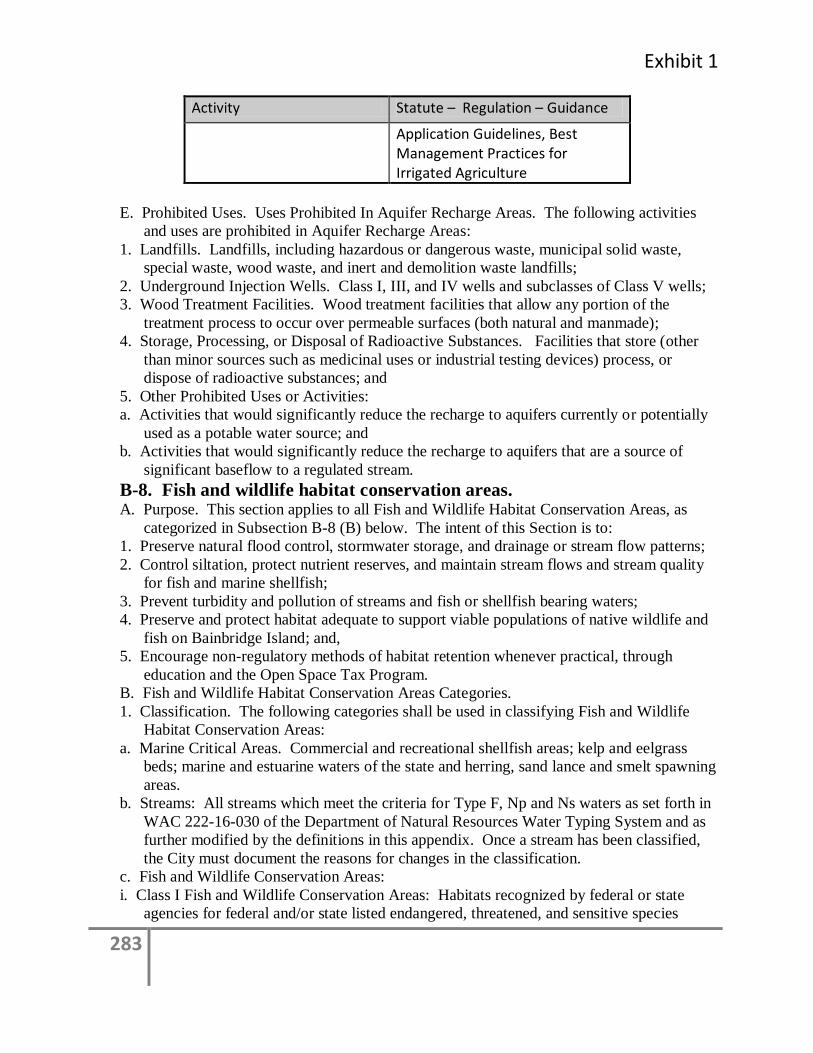
Exhibit 1
283
Activity Statute – Regulation – Guidance
Application Guidelines, Best Management Practices for Irrigated Agriculture
E. Prohibited Uses. Uses Prohibited In Aquifer Recharge Areas. The following activities
and uses are prohibited in Aquifer Recharge Areas:
1. Landfills. Landfills, including hazardous or dangerous waste, municipal solid waste,
special waste, wood waste, and inert and demolition waste landfills;
2. Underground Injection Wells. Class I, III, and IV wells and subclasses of Class V wells;
3. Wood Treatment Facilities. Wood treatment facilities that allow any portion of the
treatment process to occur over permeable surfaces (both natural and manmade);
4. Storage, Processing, or Disposal of Radioactive Substances. Facilities that store (other
than minor sources such as medicinal uses or industrial testing devices) process, or
dispose of radioactive substances; and
5. Other Prohibited Uses or Activities:
a. Activities that would significantly reduce the recharge to aquifers currently or potentially
used as a potable water source; and
b. Activities that would significantly reduce the recharge to aquifers that are a source of
significant baseflow to a regulated stream.
B-8. Fish and wildlife habitat conservation areas. A. Purpose. This section applies to all Fish and Wildlife Habitat Conservation Areas, as
categorized in Subsection B-8 (B) below. The intent of this Section is to:
1. Preserve natural flood control, stormwater storage, and drainage or stream flow patterns;
2. Control siltation, protect nutrient reserves, and maintain stream flows and stream quality
for fish and marine shellfish;
3. Prevent turbidity and pollution of streams and fish or shellfish bearing waters;
4. Preserve and protect habitat adequate to support viable populations of native wildlife and
fish on Bainbridge Island; and,
5. Encourage non-regulatory methods of habitat retention whenever practical, through
education and the Open Space Tax Program.
B. Fish and Wildlife Habitat Conservation Areas Categories.
1. Classification. The following categories shall be used in classifying Fish and Wildlife
Habitat Conservation Areas:
a. Marine Critical Areas. Commercial and recreational shellfish areas; kelp and eelgrass
beds; marine and estuarine waters of the state and herring, sand lance and smelt spawning
areas.
b. Streams: All streams which meet the criteria for Type F, Np and Ns waters as set forth in
WAC 222-16-030 of the Department of Natural Resources Water Typing System and as
further modified by the definitions in this appendix. Once a stream has been classified,
the City must document the reasons for changes in the classification.
c. Fish and Wildlife Conservation Areas:
i. Class I Fish and Wildlife Conservation Areas: Habitats recognized by federal or state
agencies for federal and/or state listed endangered, threatened, and sensitive species
284
documented in maps or data bases available to the City of Bainbridge Island and which, if
altered, may reduce the likelihood that the species will maintain and reproduce over the
long term.
ii. Class II Fish and Wildlife Conservation Areas. Habitats for State listed candidate,
monitor, or priority species documented in maps or data bases available to City of
Bainbridge Island and its citizens, and which, if altered, may reduce the likelihood that
the species will maintain and reproduce over the long term.
d. Habitats and Species of Local Importance. This section provides for the designation and
protection of habitats and species of local importance.
i. Designation of species of habitat of local importance can be based on any of the following
circumstances:
(a) Local populations of native species are in danger of extirpation based on existing trends.
(b) Local populations of native species are likely to become threatened or endangered under
state of federal law.
(c) Local populations of native species are vulnerable or declining.
(d) The species or habitat has recreation, commercial, game, tribal, or other special value.
(e) Long-term persistence of a species is dependent on the protection, maintenance, and/or
restoration of the nominated habitat.
(f) Protection by other county, state, or federal policies, laws, regulations, or non-regulatory
tools is not adequate to prevent degradation of the species or habitat in the city.
(g) Without protection, there is likelihood that the species or habitat will be diminished over
the long term.
ii. Nomination.
(a) Any person may nominate habitats and species for designation.
(b) The nomination should indicate whether specific habitat features are to be protected (for
example, nest sites, breeding areas, and nurseries), or whether the habitat or ecosystem is
being nominated in its entirety.
(c) Where the nomination is a specific habitat site, the nomination shall include the name
and address of all property owners of record of all assessor parcels within the area
potentially affected by the management recommendations. The list shall at a minimum
include all properties within 300 feet from the edge of all property identified for special
designation.
(d) The nomination shall include recommended management strategies for the species or
habitats. Management strategies must be supported by the best available science, and
where restoration of habitat is proposed, a specific plan for restoration must be provided
prior to nomination.
iii. Nomination processing and approval. The decision whether to designate a nominated
species or habitat as one of local importance shall be made by the City Council. If
approved, the City Council shall pass an ordinance establishing the designation.
iv. Establishment of specific rules for protection. Within 120 days of the effective date of an
ordinance designating a species or habitat of local importance, the Director shall develop
an administrative rule addressing protection in compliance with this section.
C. Development Standards. Regulated uses in designated Fish and Wildlife Habitat
Conservation Areas and/or buffers shall comply with the performance standards outlined
in this Section.
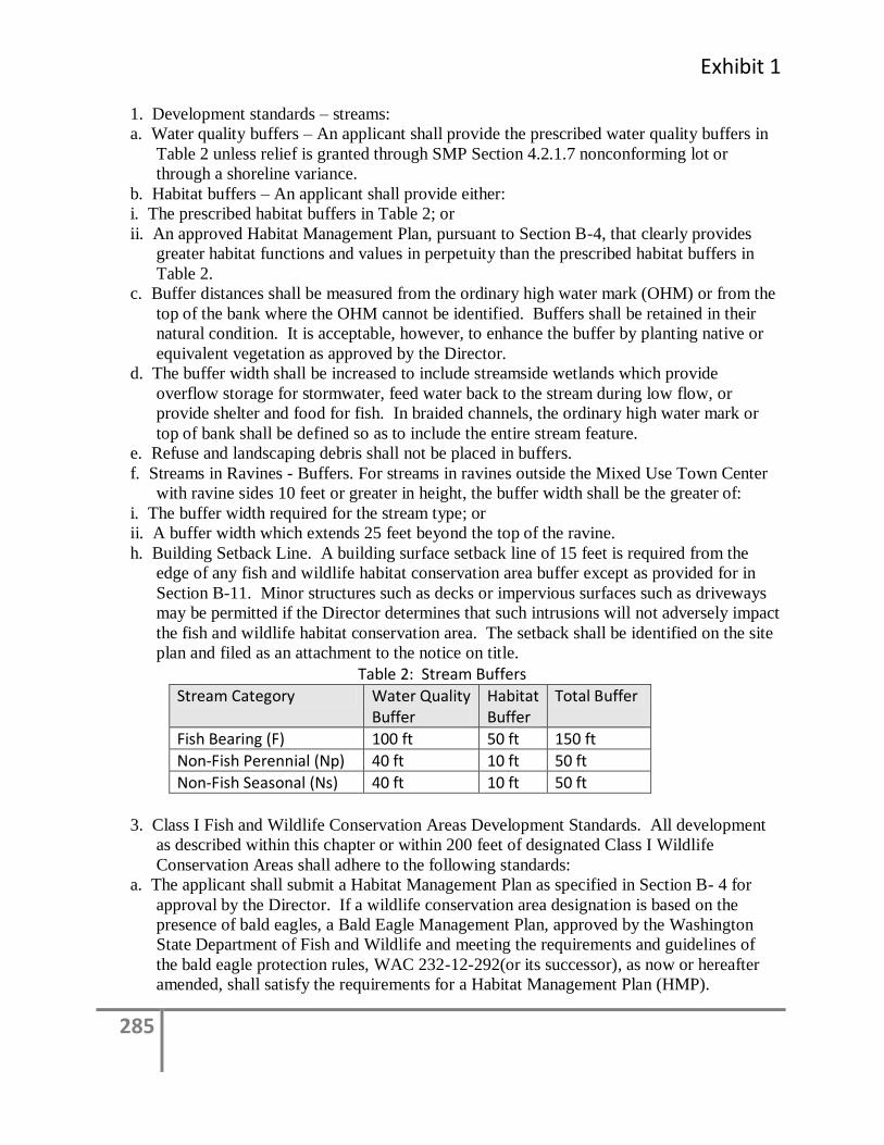
Exhibit 1
285
1. Development standards – streams:
a. Water quality buffers – An applicant shall provide the prescribed water quality buffers in
Table 2 unless relief is granted through SMP Section 4.2.1.7 nonconforming lot or
through a shoreline variance.
b. Habitat buffers – An applicant shall provide either:
i. The prescribed habitat buffers in Table 2; or
ii. An approved Habitat Management Plan, pursuant to Section B-4, that clearly provides
greater habitat functions and values in perpetuity than the prescribed habitat buffers in
Table 2.
c. Buffer distances shall be measured from the ordinary high water mark (OHM) or from the
top of the bank where the OHM cannot be identified. Buffers shall be retained in their
natural condition. It is acceptable, however, to enhance the buffer by planting native or
equivalent vegetation as approved by the Director.
d. The buffer width shall be increased to include streamside wetlands which provide
overflow storage for stormwater, feed water back to the stream during low flow, or
provide shelter and food for fish. In braided channels, the ordinary high water mark or
top of bank shall be defined so as to include the entire stream feature.
e. Refuse and landscaping debris shall not be placed in buffers.
f. Streams in Ravines - Buffers. For streams in ravines outside the Mixed Use Town Center
with ravine sides 10 feet or greater in height, the buffer width shall be the greater of:
i. The buffer width required for the stream type; or
ii. A buffer width which extends 25 feet beyond the top of the ravine.
h. Building Setback Line. A building surface setback line of 15 feet is required from the
edge of any fish and wildlife habitat conservation area buffer except as provided for in
Section B-11. Minor structures such as decks or impervious surfaces such as driveways
may be permitted if the Director determines that such intrusions will not adversely impact
the fish and wildlife habitat conservation area. The setback shall be identified on the site
plan and filed as an attachment to the notice on title.
Table 2: Stream Buffers
Stream Category Water Quality Buffer
Habitat Buffer
Total Buffer
Fish Bearing (F) 100 ft 50 ft 150 ft
Non-Fish Perennial (Np) 40 ft 10 ft 50 ft
Non-Fish Seasonal (Ns) 40 ft 10 ft 50 ft
3. Class I Fish and Wildlife Conservation Areas Development Standards. All development
as described within this chapter or within 200 feet of designated Class I Wildlife
Conservation Areas shall adhere to the following standards:
a. The applicant shall submit a Habitat Management Plan as specified in Section B- 4 for
approval by the Director. If a wildlife conservation area designation is based on the
presence of bald eagles, a Bald Eagle Management Plan, approved by the Washington
State Department of Fish and Wildlife and meeting the requirements and guidelines of
the bald eagle protection rules, WAC 232-12-292(or its successor), as now or hereafter
amended, shall satisfy the requirements for a Habitat Management Plan (HMP).
286
b. All new development within ranges and habitat elements with which Class I Fish and
Wildlife have a significant relationship may require the submittal of a Habitat
Management Plan (HMP) as specified in Section B- 4. The requirement for an HMP
shall be determined during the SEPA/Critical Areas review on the project.
c. An HMP required pursuant to this section shall consider measures to retain and protect the
wildlife habitat and shall consider effects of land use intensity, buffers, setbacks,
impervious surfaces, erosion control and retention of native or equivalent vegetation.
d. Increased Buffer Provisions. The Director may increase buffer widths, up to 50% greater
than the applicable buffer set in this chapter for critical areas with known locations of
endangered, threatened, or state monitor or priority species for which a habitat
management plan indicates a larger buffer is necessary to protect habitat values for such
species. Such determination shall be based on site-specific and project-related
conditions.
4. Class II Fish and Wildlife Conservation Area Development Standards. All development
within designated Class II Wildlife Conservation Areas shall adhere to the following
standards:
a. An HMP may be required for any proposed development within designated Class II Fish
and Wildlife Conservation Areas. The HMP shall consider measures to retain and protect
the wildlife habitat and shall consider effects of land use intensity, buffers, setbacks,
impervious surfaces, erosion control and retention of native or equivalent vegetation. The
requirement for an HMP shall be determined during the SEPA/Critical Areas review on
the project.
b. Increased Buffer Provisions. The Director may increase buffer widths, up to 50% greater
than the applicable buffer set in this chapter for critical areas with known locations of
endangered, threatened, or state monitor or priority species for which a habitat
management plan indicates a larger buffer is necessary to protect habitat values for such
species. Such determination shall be based on site-specific and project-related
conditions.
5. Stream Crossings. Any private or public road expansion or construction which is allowed
and must cross streams classified within this chapter, shall comply with the following
minimum development standards:
a. Bridges or bottomless culverts shall be required for all streams which have Salmonid
breeding habitat. Other alternatives may be allowed upon submittal of a Habitat
Management Plan which demonstrates that other alternatives would not result in
significant impacts to the Fish and Wildlife Conservation Area, as determined appropriate
through the Washington State Department of Fish and Wildlife, Hydraulics Project
Approval process. The plan must demonstrate that salmon habitat will be replaced on a
1:1 ratio.
b. Crossings shall not occur in Salmonid spawning areas unless no other feasible crossing
site exists. For new development proposals, if existing crossings are determined to
adversely impact salmon spawning or passage areas, new or upgraded crossings shall be
located as determined necessary through coordination with the Washington State
Department of Fish and Wildlife;
c. Bridge piers or abutments shall not be placed in either the floodway or between the
ordinary, high water marks unless no other feasible alternative placement exists;
Exhibit 1
287
d. Crossings shall not diminish flood carrying capacity;
e. Crossings shall serve multiple properties whenever possible;
f. Where there is no reasonable alternative to providing a conventional culvert, the culvert
shall be the minimum length necessary to accommodate the permitted activity.
6. Stream Relocations. Stream relocations for the purpose of flood protection and/or
fisheries restoration shall only be permitted when adhering to the following minimum
performance standards and when consistent with Washington State Department of Fish
and Wildlife Hydraulic Project Approval:
a. The channel, bank, and buffer areas should be replanted with native or equivalent
vegetation that replicates a natural, undisturbed riparian condition;
b. For those shorelands and waters designated as Frequently Flooded Areas pursuant to
Section B-1, a professional engineer licensed in the State of Washington shall provide
information demonstrating that the equivalent base flood storage volume and function
will be maintained; and
c. Relocated stream channels shall be designed to meet or exceed the functions and values of
the stream to be relocated.
7. Pesticides, Fertilizers and Herbicides. Use of pesticides, fertilizers, herbicides are
regulated by Section 4.1.7 of the Shoreline Master Program
8. Land Divisions and Land Use Permits. All land divisions and land uses proposed on a site
that includes Fish and Wildlife Habitat Conservation Areas shall comply with the
following procedures and development standards:
a. The open water area of lakes, streams, and tidal lands shall not be permitted for use in
calculating minimum lot area.
b. Land division approvals shall be conditioned so that all required buffers are designated as
an easement or covenant encumbering the buffer. Such easement or covenant shall be
recorded together with the land division and represented on the final plat, short plat or
binding site plan.
c. In order to avoid the creation of nonconforming lots, each new lot shall contain at least
one building site that meets the requirements of this chapter, including buffer
requirements for habitat conservation areas. Each lot must also have access and a sewage
disposal system location that are suitable for development which do not adversely impact
the Fish and Wildlife Conservation Area.
d. After preliminary approval and prior to final land division approval, the Director may
require that the common boundary between a required buffer and the adjacent lands be
identified using permanent signs. In lieu of signs, alternative methods of buffer
identification may be approved when such methods are determined by the Director to
provide adequate protection to the aquatic buffer.
10. Trails and Trail-Related Facilities. Construction of public and private trails and trail-
related facilities, such as benches, interpretive centers, and viewing platforms, may be
allowed in Fish and Wildlife Habitat Conservation Areas or their buffers pursuant to the
following standards:
a. Trails and related facilities shall, to the extent feasible, be placed on existing road grades,
utility corridors, or other such previously disturbed areas which do not provide ecological
functions.;

288
b. Trails and related facilities shall be planned to minimize removal of trees, shrubs, snags
and important wildlife habitat;
c. Viewing platforms, interpretive centers, benches and access to them, shall be designed and
located to minimize disturbance of wildlife habitat and/or critical characteristics of the
affected conservation area;
d. Trails, in general, shall be set back from streams so that there will be no or minimal
impact to the stream from trail use or maintenance. Elevated trails which protect or
enchance ecological functions shall be used to the maximum extent feasible. Trails shall
be constructed with pervious surfaces when feasible.
12. Stream Bank Stabilization.
a. A stream channel and bank may be stabilized when naturally occurring earth movement
threatens existing structures (defined as requiring a Building Permit pursuant to the
applicable building code), public improvements, unique natural resources, public health,
safety or welfare, or the only feasible access to property, and, in the case of streams,
when such stabilization results in maintenance of Fish and Wildlife Habitat, flood
control, and improved water quality.
b. Where bank stabilization is determined to be necessary, bioengineering or other non-
structural methods should be the first option for protection. Bulkheads and retaining
walls may only be utilized as an engineering solution where it can be demonstrated that
an existing residential structure cannot be safely maintained without such measures, and
that the resulting retaining wall is the minimum length necessary to provide a stable
building area for the structure. The Director may require that bank stabilization be
designed by a professional engineer licensed in the State of Washington with
demonstrated expertise in hydraulic actions of shorelines. Bank stabilization projects
may also require a City of Bainbridge Island clearing or grading permit and Hydraulic
Project Approval from the Washington Department of Fish and Wildlife.
c. Nonstructural streambank protective techniques are preferred to bulkheads or other types
of streambank armoring. Nonstructural techniques include but are not limited to
vegetation plantings and bioengineering.
13. Fencing and Signs. Prior to approval or issuance of permits for land divisions or other
new development, the Director may require that the common boundary between a
required buffer and the adjacent lands be identified using fencing or permanent signs. In
lieu of fencing or signs, alternative methods of buffer identification may be approved
when such methods are determined by the Director to provide adequate protection to the
buffer.
Exhibit 1
289
B-9. Geologically hazardous areas. A. General. Geologically hazardous areas include erosion hazard areas, landslide hazard
areas, and seismic hazard areas. Zone of influence areas are not considered geologically
hazardous areas.
B. Purpose. The intent of this section is to prevent the potential for personal injury or loss
of life or property due to flooding, erosion, landslides, seismic events, or soil subsidence.
Development must not increase slope instability, and must avoid on-site and off-site
impacts, as well as potential risk to structures. Preserving the existing vegetation may be
an important part of minimizing those risks.
C. Classification. Geologically hazardous areas shall be classified based upon landslide
history and the presence of unstable soils, steepness of slopes, erosion potential, and
seismic hazards. Areas in this category are a potential threat to public health, safety, and
welfare when construction is allowed. While some potential risk due to construction can
be reduced through structural engineering design, construction in these areas should be
avoided when the potential risk cannot be reduced to a level comparable to the risk if the
site were initially stable prior to construction. Classification and rating shall be based
upon the risk to the environment and to development in geologically hazardous areas.
D. Minimum Submittal Requirements.
1. All geologically hazardous areas and buffers.
a. Indemnification. An indemnification or hold harmless agreement shall be required for all
projects in geologically hazardous areas and buffers. The form of the agreement shall be
approved by the City and executed prior to the commencement of construction or site
alteration.
b. Notice A notice of intent to construct on a landslide hazard area or reduce the minimum
buffer in a landslide hazard area shall be given pursuant to BIMC 2.16. 20. The notice of
intent shall be issued within 14 days of a completed application pursuant to BIMC
2.16.020(5). The notice shall include a 21-day comment period and no permits or
approval of reduced buffers shall be issued before the end of the comment period.
c. All reports or analyses required or prepared pursuant to this Section shall be prepared
pursuant to Section B-5, B-9 and/or any other applicable provisions of this appendix, and
shall meet the satisfaction of, and be approved by, the City Engineer prior to the
commencement of any development activity.
d. To protect public health, safety and welfare, the City Engineer may call for a third party
review of any geotechnical report in cases where there may be potential for substantial
damage to life, property or the environment should the proposed engineering solution
fail. When a third party review is required, costs incurred for a qualified third party
geotechnical engineer to perform the review shall be borne by the applicant.
e. Geological Hazards Assessment. A Critical Area report is required for all projects in
geologically hazardous areas and buffers and shall contain an assessment of geological
hazards including the following site- and proposal-related information at a minimum:
i. Site and Construction Plans. The report shall include a copy of the site plans for the
proposal showing:
A. The type and extent of geologic hazard areas, any other Critical Areas, and buffers on,
adjacent to, or within a zone or distance of potential significant influence as determined
by a professional engineer/ geologist;
290
B. Proposed development, including the location of existing and proposed structures, fill,
storage of materials, and drainage facilities, with dimensions indicating distances to the
floodplain, if available;
C. The topography, as determined by a professional engineer or geologist, of the project area
and all hazard areas addressed in the report; and
D. Clearing limits.
ii. Assessment of Geological Characteristics. The report shall include an assessment of the
geologic characteristics of the soils, sediments, and/or rock of the project area and
potentially affected adjacent properties, and a review of the site history regarding
landslides, erosion, and prior grading. Soils analysis shall be accomplished in accordance
with accepted classification systems in use in the region. The assessment shall include,
but not be limited to:
A. A description of the surface and subsurface geology, hydrology, soils, and vegetation
found in the project area and in all hazard areas addressed in the report;
B. A detailed overview of the field investigations, published data, and references; data and
conclusions from past assessments of the site; and site specific measurements, test,
investigations, or studies that support the identification of geologically hazardous areas;
and
C. A description of the vulnerability of the site to seismic and other geologic events.
iii. Analysis of Proposal. The report shall contain a hazards analysis including a detailed
description of the project, its relationship to the geologic hazard(s), and its potential
impact upon the hazard area, the subject property, and affected adjacent properties.
iv. Minimum Buffer and Building Setback. The report shall make a recommendation for the
minimum no-disturbance buffer and minimum building setback from any geologic hazard
based upon the geotechnical analysis. Where the recommended buffers are less than the
standard buffers set forth in section Section B-9(E)(2)(a) the rationale and basis for the
reduced buffer shall be clearly articulated and demonstrate that the protection standard set
forth in that section has been met.
f. Incorporation of Previous Study. Where a valid Critical Areas report has been prepared for
a specific site, and where the proposed land use activity and surrounding site conditions
are unchanged, said report may be incorporated into the required Critical Area report, if
deemed still valid and appropriate by a professional engineer or geologist. The applicant
shall submit a hazards assessment detailing any changed environmental conditions
associated with the site based on best professional judgment of the engineer/ geologist.
g. Mitigation of Long-Term Impacts. When hazard mitigation is required, the mitigation plan
shall specifically address how the activity maintains or reduces the pre-existing level of
risk to the site and adjacent properties on a long-term basis (equal to or exceeding the
projected life span of the activity or occupation). Proposed mitigation techniques shall be
considered to provide long-term hazard reduction only if they do not require regular
maintenance or other actions to maintain their function. Mitigation may also be required
to avoid any increase in risk above the pre-existing conditions following abandonment of
the activity.
h. In addition to the general Critical Area report requirements of section B-9(D) Critical Area
reports for geologically hazardous areas must meet requirements of this section. Critical
Exhibit 1
291
Area reports for two or more types of Critical Areas must meet the report requirements
for each relevant type of Critical Area.
2 Landslide Hazard and Erosion Hazard Areas. In addition to the basic Critical Areas report,
a Critical Area report for an erosion hazard or landslide hazard area shall include the
following information at a minimum:
a. Erosion Control. An erosion control plan prepared by a civil engineer shall be submitted
to the City prior to the issuance of a clearing or grading permit, in accordance with BIMC
15.20.
b. The applicant shall provide a geotechnical analysis containing the following information:
i. Site Plan. The Critical Area report shall include a copy of the site plan for the proposal
showing:
A. The height of slope, slope gradient, and cross-section of the project area;
B. The location of springs, seeps, or other surface expressions of ground water on or a zone
or distance of potential significant influence as determined by a professional engineer/
geologist; and
C. The location and description of surface water run-off features.
ii. Hazards Analysis. The hazards analysis component of the Critical Areas report shall
specifically include:
A. A description of the extent and type of vegetative cover;
B. A description of subsurface conditions based on data from site-specific explorations;
C. Descriptions of surface and ground water conditions, public and private sewage disposal
systems, fills and excavations, and all structural improvements;
D. An estimate of slope stability and the effect construction and placement of structures will
have on the slope over the estimated life of the structure;
E.. An estimate of the bluff retreat rate that recognizes and reflects potential catastrophic
events such as seismic activity or a one hundred-year storm event;
F. Consideration of the run-out hazard of landslide debris and/or the impacts of landslide run-
out on down slope properties;
G. A study of slope stability including an analysis of proposed cuts, fills, and other site
grading;
H. Recommendations for building siting limitations; and
I. An analysis of proposed surface and subsurface drainage, and the vulnerability of the site
to erosion.
iii. Geotechnical Engineering Report. The technical information for a project within a
landslide hazard area shall include a geotechnical engineering report prepared by a
licensed engineer that presents engineering recommendations for the following:
A. Parameters for design of site improvements including appropriate foundations and
retaining structures. These should include allowable load and resistance capacities for
bearing and lateral loads, installation considerations, and estimates of settlement
performance;
B. Recommendations for drainage and subdrainage improvements;
C. Earthwork recommendations including clearing and site preparation criteria, fill placement
and compaction criteria, temporary and permanent slope inclinations and protection, and
temporary excavation support, if necessary; and
292
D. Mitigation of adverse site conditions including slope stabilization measures for
seismically unstable soils, surface water management, location and methods of erosion
control, a vegetation management and/or replanting plan, and/or other means for
maintaining long-term soil stability if appropriate.
3. Seismic Hazards Areas. In addition to the basic report requirements, a Critical Area
report for a seismic hazard area shall also meet the following requirements:
a. Fault Hazard. The applicant shall provide a geologic/geotechnical analysis containing
information specified by the City Engineer that documents the presence or absence of any
surface deformation on the site in areas mapped by the City. If deformation is located,
the applicant shall provide a geotechnical analysis containing information specified by
the City Engineer, which concludes that the development proposal as mitigated meets the
standards of this section.
b. Liquefaction Hazard. The applicant shall provide a geotechnical analysis containing
information specified by the City Engineer that meets the standards of this section (as
mitigated).
c. Seismic Landslide Hazard. The applicant shall provide the same analysis and plan as
required for landslide hazard areas, pursuant to Section B-9(D).
4. Tsunami Hazards. The City shall provide applicants for development in low lying
shoreline areas and other areas where flood elevation is controlled by tide level with
information on tsunami hazards.(may need revision)
5. Zone of Influence Areas beyond the established buffer. The applicant shall have the
surface and storm water management plan (See BIMC 15.20)for the project reviewed by
a geotechnical engineer to determine if there is any potentially adverse impacts to the
landslide hazardous area. If the geotechnical engineer or the City Engineer determines
that there are potential adverse impacts, the applicant shall provide a geotechnical
analysis containing information specified by the City Engineer which analyzes the
potential impacts to the geological hazard from the proposed development in the zone of
influence and meets the standards of this section. The report shall contain
recommendations to avoid adverse impacts to the geologically hazardous area.
Concentrated discharge of stormwater shall only be allowed where specially
recommended in the report and authorized by the City Engineer.”
E. Development Standards.
1. General Requirements. The City Engineer shall establish administrative procedures to
implement this section. The applicant shall meet the following standards for all new
activities permitted in geologically hazardous areas or associated buffers:
a. The proposed activity shall not create a net increase in geological instability, either on- or
off-site, which is defined as follows:
i. The subject parcel shall not be less stable after the planned development than before; and
ii. The adjacent parcels shall not have greater risk or be less stable after the planned
development than before.
b. The proposed activity shall not increase the risk of life safety due to geological hazards
above professionally acceptable levels.
c. The proposed activity shall not increase the risk due to geological hazards above
professionally acceptable levels for:
Exhibit 1
293
i. Property loss of any habitable structures or their necessary supporting infrastructure on-
site or;
ii. Risk to any off-site structures or property of any kind; and
d. Proposed buildings shall be constructed using appropriate engineering methods that
respond to the geologic characteristics specific to the site in order to achieve the highest
standard of safety feasible.
e. The proposed development shall not decrease the factor of safety for landslide occurrences
below the limits of 1.5 for static conditions and 1.0 for dynamic conditions. Analysis of
dynamic conditions shall be based on the minimum horizontal acceleration for the
probabilistic maximum considered earthquake as established by the currently adopted
version of the International Building Code.
f. The proposed activity shall not further degrade the values and functions of the associated
critical areas.
2. Redevelopment of existing structures
a. If an existing structure is damaged or is intentionally demolished the new structure must
meet all the provisions of a new structure.
b. Structural alteration to an existing legally constructed structure that does not increase the
structural footprint and are determined by the City Engineer as having a minimal
potential for increasing landslide hazard and meets the minimum buffer deminsions in B-
9(E)(3)(i);
3. Development Design and Location. The following requirements shall apply to any land
or vegetation modification or construction within a landslide hazard area and/or its buffer
as described herein:
a. Buffer Requirement: A buffer equal to the height of the slope or fifty (50) feet,
whichever is greater, shall be established from all edges of a landslide hazard area except
where no other reasonable alternative exists, reduction may be allowed as follows:
i. Buffer Reduction.
A. Buffer reductions may be allowed provided a critical areas report, pursuant to Section B-
9(D)(1)(2) and any other related section of Appendix B, demonstrates to the Director that
the buffer reduction will not reduce the level of protection to the proposed development,
adjacent properties, and other associated critical areas as required by Section B-9(E)(1).
B. For slopes forty (40) percent or greater the buffer may in no case be reduced to less than
ten (10) feet. A decision by the Director to reduce buffer shall be based on a critical
areas report pursuant Section B-9(D)(1)(2) that may includes a third-party independent
review by a qualified geotechnical engineer pursuant to BIMC Section B-9(D)(1)(d);
ii. Increased Buffer. The buffer may be increased beyond that specified in subsection (a)
above if the Director determines a larger buffer is necessary to prevent risk of damage to
proposed development, adjacent development, and uses and the associated critical areas;
iii. Building Setback. All building and structures shall have a minimum setback of (15) feet
from the outer edge of the buffer around landslide hazard areas to allow for construction
activity; and
iv. Vegetation Retention. Unless otherwise provided or as part of an approved alteration,
removal of vegetation from an erosion or landslide hazard area or related buffer shall be
prohibited.
294
b. All development proposals shall be designed to avoid impacts to the geologically
hazardous areas. The development shall be designed to minimize the footprint of
building in other disturbed areas, minimize removal of vegetation, minimize topographic
change, and retain open space to the maximum extent practicable;
c. Development design shall utilize clustering, under-structure parking, multi-level
construction, and tiered foundations to the extent feasible to minimize impervious lot
coverage, slope disturbance, and changes to the natural topography;
d. Access shall be in the least sensitive part of the site, and common access drives and utility
corridors are required to the extent feasible;
e. Roads, walkways and parking areas shall be designed to parallel the natural contours to
the extent feasible;
f. All proposed clearing and tree removal shall be marked in the field for inspection and
approval prior to alteration of the site;
g. Cut and fill slopes shall be prepared and maintained to control against erosion and
instability;
h. Drainage and stormwater designs in zones of influence shall incorporate elements of low
impact design, to the extent feasible, and shall be designed in such a manner that
stormwater outlet discharges do not create additional impacts. The proposed activities
shall not increase surface water discharge or sedimentation to adjacent properties beyond
the pre-development condition; and
F. Exemptions. The following activities are permitted in geologically hazardous areas or
associated buffers; provided, that the applicant can demonstrate that applicable standards
in Subsection B-9(E)(1) can be met, or where the applicant has demonstrated through a
Critical Areas report prepared by a geotechnical engineer in accordance with the
specifications of the City Engineer that no adverse impact will result from the proposal
and where approved surface water drainage will result in minimum slope and vegetation
disturbance:
1. Surface Water Management: Slopes or buffers may be used for approved surface water
conveyance if no other reasonable alternative route is available. Installation techniques
shall minimize disturbance to the slope and vegetation.
2. The construction of approved public or private trails; provided, they are constructed of
material, for example cable lift access, which will not contribute to surface water runoff;
3. The construction of public or private utility corridors or streets; provided, it has been
demonstrated that such alterations will not increase landslide or erosion risks through
required analysis pursuant to section B-9(D)(1) and the City determines that no other
feasible alternative exists;
4. Select Vegetation Removal Activities. The following vegetation removal activities are
allowed, provided that no vegetation shall be removed from a geologically hazardous
area or its buffer without approval from the Director;
a. Removal of noxious weeds using non-motorized equipment or light equipment if approved
by the Director. Provision for the use of herbicides are in Section 4.1.7 of the Shoreline
Master Program. Bare areas remaining after weed removal shall be re-vegetated with
native plant species pursuant to an enhancement plan approved by the City.
b. Removal and pruning of hazard trees as defined ISA (International Society of
Arboriculture) standards by provided that a ISA certified arborist documents the hazard
Exhibit 1
295
and provides a report to the Director for review and approval. Replacement shall be based
on the recommendations of the arborist and geotechnical engineer and approved by the
Director. The Director may require a second opinion from a certified ISA arborist in
cases of removal of hazard trees. Mitigation for tree removal shall follow Section 4.1.2
of the Shoreline Master Program and the following
i. Size of trees shall be approved by the Director. and
ii.The landowner shall ensure 100% survival of replacement trees.
5. The trimming and limbing of vegetation for the creation and maintenance of view
corridors in accordance with the pruning standards of the International Society of
Arboriculture; provided, that the soils are not disturbed and activity will not increase the
risk of landslide or erosion. All vegetation removal must be based on a bluff
management plan (SMP Section 4.1.5) developed by a certified arborist and reviewed by
a geotechnical engineer to determine if it will impact slope stability. A clearing permit
will be required prior to the any vegetation removal.
6. Limited Exemption - For landslide areas 40% or greater with a vertical elevation change
of up to twenty (20) feet may be exempted from section B-9(E)(2)(i) based on the City
review and acceptance of a Critical Areas report from a geologist or licensed
geotechnical engineer in accordance with section B-9(D) when no adverse impact will
result from the exemption.
B-10. Wetlands. A. Purpose. This section applies to all regulated uses within or adjacent to areas designated
as wetlands, as categorized in section B-10(B) below. The intent of this Section is listed
in no specific priority, as follows:
1. Preserve, protect, restore, and improve wetland functions and values. Achieve no net loss
and increase the quality of wetland acreage, functions, and values within the city.
Mitigation measures, as conditions of permits, must have a reasonable expectation of
success. Under the conditions of this Section, the Director may deny development
proposals that would irreparably impact regulated wetlands; and
2. Protect the public's health, safety, and welfare, while preventing public expenditures that
could arise from improper wetland uses and activities; and
3. Plan wetland uses and activities in a manner that protects and enhances the natural
systems and environmental quality of Bainbridge Island and allows property holders to
benefit from wetland property ownership wherever allowable under the conditions of this
chapter; and
4. Preserve ecological functions and values of wetlands which provide water quality
protection, natural flood control, stormwater storage, contributes to groundwater and
stream flow, shoreline stabilization, and wildlife and fish habitat; and
5. Prevent turbidity and pollution of wetlands and fish or shellfish bearing waters, and
maintain healthy wildlife habitat; and
6. Encourage land use development patterns that maintain, enhance, or restore natural
wetland systems and protect disturbance-sensitive and wetland-dependent wildlife, fish
resources, and open space; and
7. Protect and preserve wetlands values as natural areas providing aesthetic, recreational,
and educational opportunities that need to be preserved for future generations; and
8. Enhance the connectivity between wetland landscapes.
296
B. Wetland Delineation and Categories. Identification of wetlands and delineation of their
boundaries pursuant to this Chapter shall be done in accordance with the approved
federal wetland delineation manual and applicable regional supplements. All areas within
the City of Bainbridge Island meeting the wetland designation criteria in that procedure
are hereby designated critical areas and are subject to the provisions of this Chapter.
The City uses the Department of Ecology's (DOE’s) Washington State Wetland Rating
System for Western Washington, 2004, or as amended hereafter and adopted by the
Director to categorize wetlands for the purposes of establishing wetland buffer widths,
wetland uses and replacement ratios for wetlands. Once a wetland has been classified
using the current DOE rating system, the City shall not reclassify the wetland without
clearly documenting the reason for the change. If the wetland has a rating in the City
GIS system, this rating can be used for regulatory purposes. This system consists of four
wetland categories generally described as follows:
1. Category I wetlands are those that:
a. Represent unique or rare wetland type; or
b. Are more sensitive to disturbance than most wetlands; or
c. Are relatively undisturbed and contain ecological attributes that are impossible to replace
within a human lifetime; or
d. Provide a high level of function.
Category I wetlands include estuarine wetlands larger than one acre, bogs, mature and
old-growth wetlands over one acre, wetlands in coastal lagoons, and wetlands that
perform many functions very well as demonstrated by a score of over 70 points using the
DOE rating system.
2. Category II wetlands are difficult, though not impossible, to replace, and provide a high
level of function. Category II wetlands include estuarine wetlands smaller than one acre
or disturbed and larger than one acre and wetlands that perform functions well as
demonstrated by a score of 51-69 using the DOE rating system.
3. Category III wetlands are wetlands with a moderate level of function as demonstrated by
a score of 30-50 points using the DOE rating system.
4. Category IV wetlands have the lowest level of function as demonstrated by a score less
than 30 points using the DOE rating system and are often heavily disturbed.
C. Regulated and Non-Regulated Wetlands Classification.
1. Regulated Wetlands:
a. All natural wetlands that meet the criteria in the Regional Supplement to the Corps of
Engineers Wetland Delineation Manual: Western Mountains, Valleys, and Cost Region
(Version 2.0)
b. Unintentionally created wetlands that meet the criteria in the Regional Supplement to the
Corps of Engineers Wetland Delineation Manual: Western Mountains, Valleys, and Cost
Region (Version 2.0) except as listed in subsection (C)(2)(b) of this section.
c. Wetlands intentionally created from non-wetland areas to mitigate conversion of other
wetlands.
2. Non-Regulated Wetlands:
a. Created Wetlands. Wetlands created intentionally from a non-wetland site that was not
required to be constructed as mitigation for adverse wetland impacts. These may include,
but are not limited to, irrigation and drainage ditches, grass-lined swales, canals,
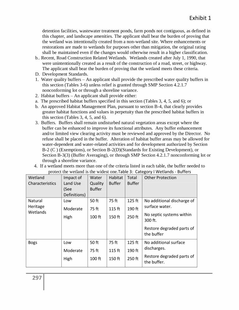
Exhibit 1
297
detention facilities, wastewater treatment ponds, farm ponds not contiguous, as defined in
this chapter, and landscape amenities. The applicant shall bear the burden of proving that
the wetland was intentionally created from a non-wetland site. Where enhancements or
restorations are made to wetlands for purposes other than mitigation, the original rating
shall be maintained even if the changes would otherwise result in a higher classification.
b.. Recent, Road Construction Related Wetlands. Wetlands created after July 1, 1990, that
were unintentionally created as a result of the construction of a road, street, or highway.
The applicant shall bear the burden of proving that the wetland meets these criteria.
D. Development Standards.
1. Water quality buffers – An applicant shall provide the prescribed water quality buffers in
this section (Tables 3-6) unless relief is granted through SMP Section 4.2.1.7
nonconforming lot or through a shoreline variance.
2. Habitat buffers – An applicant shall provide either:
a. The prescribed habitat buffers specified in this section (Tables 3, 4, 5, and 6); or
b. An approved Habitat Management Plan, pursuant to section B-4, that clearly provides
greater habitat functions and values in perpetuity than the prescribed habitat buffers in
this section (Tables 3, 4, 5, and 6).
3. Buffers. Buffers shall remain undisturbed natural vegetation areas except where the
buffer can be enhanced to improve its functional attributes. Any buffer enhancement
and/or limited view clearing activity must be reviewed and approved by the Director. No
refuse shall be placed in the buffer. Alteration of habitat buffer areas may be allowed for
water-dependent and water-related activities and for development authorized by Section
B-2 (C ) (Exemptions), or Section B-2(D)(Standards for Existing Development), or
Section B-3(3) (Buffer Averaging), or through SMP Section 4.2.1.7 nonconforming lot or
through a shoreline variance.
4. If a wetland meets more than one of the criteria listed in each table, the buffer needed to
protect the wetland is the widest one.Table 3: Category I Wetlands - Buffers
Wetland Characteristics
Impact of Land Use (See Definitions)
Water Quality Buffer
Habitat Buffer
Total Buffer
Other Protection
Natural Heritage Wetlands
Low
Moderate
High
50 ft
75 ft
100 ft
75 ft
115 ft
150 ft
125 ft
190 ft
250 ft
No additional discharge of surface water.
No septic systems within 300 ft.
Restore degraded parts of the buffer
Bogs Low
Moderate
High
50 ft
75 ft
100 ft
75 ft
115 ft
150 ft
125 ft
190 ft
250 ft
No additional surface discharges.
Restore degraded parts of the buffer.
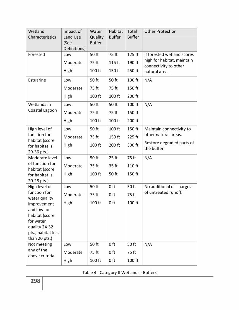
298
Wetland Characteristics
Impact of Land Use (See Definitions)
Water Quality Buffer
Habitat Buffer
Total Buffer
Other Protection
Forested Low
Moderate
High
50 ft
75 ft
100 ft
75 ft
115 ft
150 ft
125 ft
190 ft
250 ft
If forested wetland scores high for habitat, maintain connectivity to other natural areas.
Estuarine Low
Moderate
High
50 ft
75 ft
100 ft
50 ft
75 ft
100 ft
100 ft
150 ft
200 ft
N/A
Wetlands in Coastal Lagoon
Low
Moderate
High
50 ft
75 ft
100 ft
50 ft
75 ft
100 ft
100 ft
150 ft
200 ft
N/A
High level of function for habitat (score for habitat is 29-36 pts.)
Low
Moderate
High
50 ft
75 ft
100 ft
100 ft
150 ft
200 ft
150 ft
225 ft
300 ft
Maintain connectivity to other natural areas.
Restore degraded parts of the buffer.
Moderate level of function for habitat (score for habitat is 20-28 pts.)
Low
Moderate
High
50 ft
75 ft
100 ft
25 ft
35 ft
50 ft
75 ft
110 ft
150 ft
N/A
High level of function for water quality improvement and low for habitat (score for water quality 24-32 pts.; habitat less than 20 pts.)
Low
Moderate
High
50 ft
75 ft
100 ft
0 ft
0 ft
0 ft
50 ft
75 ft
100 ft
No additional discharges of untreated runoff.
Not meeting any of the above criteria.
Low
Moderate
High
50 ft
75 ft
100 ft
0 ft
0 ft
0 ft
50 ft
75 ft
100 ft
N/A
Table 4: Category II Wetlands - Buffers
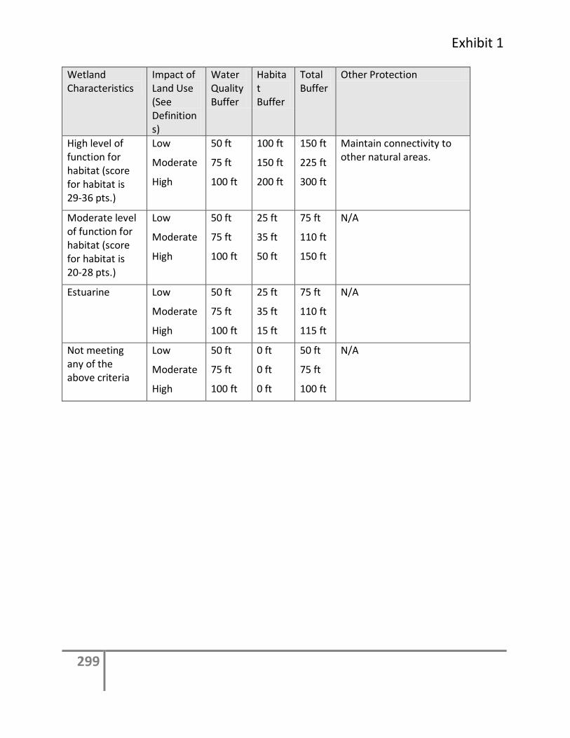
Exhibit 1
299
Wetland Characteristics
Impact of Land Use (See Definitions)
Water Quality Buffer
Habitat Buffer
Total Buffer
Other Protection
High level of function for habitat (score for habitat is 29-36 pts.)
Low
Moderate
High
50 ft
75 ft
100 ft
100 ft
150 ft
200 ft
150 ft
225 ft
300 ft
Maintain connectivity to other natural areas.
Moderate level of function for habitat (score for habitat is 20-28 pts.)
Low
Moderate
High
50 ft
75 ft
100 ft
25 ft
35 ft
50 ft
75 ft
110 ft
150 ft
N/A
Estuarine Low
Moderate
High
50 ft
75 ft
100 ft
25 ft
35 ft
15 ft
75 ft
110 ft
115 ft
N/A
Not meeting any of the above criteria
Low
Moderate
High
50 ft
75 ft
100 ft
0 ft
0 ft
0 ft
50 ft
75 ft
100 ft
N/A
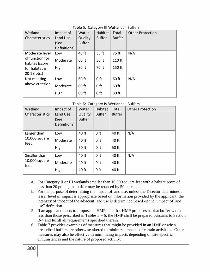
300
Table 5: Category III Wetlands - Buffers
Wetland Characteristics
Impact of Land Use (See Definitions)
Water Quality Buffer
Habitat Buffer
Total Buffer
Other Protection
Moderate level of function for habitat (score for habitat is 20-28 pts.)
Low
Moderate
High
40 ft
60 ft
80 ft
35 ft
50 ft
70 ft
75 ft
110 ft
150 ft
N/A
Not meeting above criterion
Low
Moderate
High
60 ft
60 ft
80 ft
0 ft
0 ft
0 ft
60 ft
60 ft
80 ft
N/A
Table 6: Category IV Wetlands - Buffers
Wetland Characteristics
Impact of Land Use (See Definitions)
Water Quality Buffer
Habitat Buffer
Total Buffer
Other Protection
Larger than 10,000 square feet
Low
Moderate
High
40 ft
40 ft
50 ft
0 ft
0 ft
0 ft
40 ft
40 ft
50 ft
N/A
Smaller than 10,000 square feet
Low
Moderate
High
40 ft
40 ft
40 ft
0 ft
0 ft
0 ft
40 ft
40 ft
40 ft
N/A
a. For Category II or III wetlands smaller than 10,000 square feet with a habitat score of
less than 20 points, the buffer may be reduced by 50 percent.
b. For the purpose of determining the impact of land use, unless the Director determines a
lesser level of impact is appropriate based on information provided by the applicant, the
intensity of impact of the adjacent land use is determined based on the “impact of land
use” definition.
5. If an applicant elects to propose an HMP, and that HMP proposes habitat buffer widths
less than those prescribed in Tables 3 – 6, the HMP shall be prepared pursuant to Section
B-4 and fulfill all requirements specified therein.
6. Table 7 provides examples of measures that might be provided in an HMP or when
prescribed buffers are otherwise altered to minimize impacts of certain activities. Other
measures may also be effective in minimizing impacts depending on site-specific
circumstances and the nature of proposed activity.
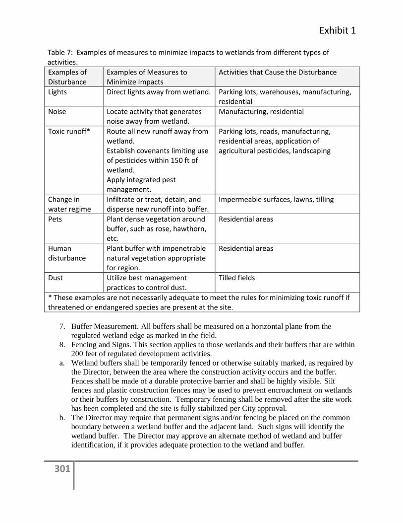
Exhibit 1
301
Table 7: Examples of measures to minimize impacts to wetlands from different types of activities.
Examples of Disturbance
Examples of Measures to Minimize Impacts
Activities that Cause the Disturbance
Lights Direct lights away from wetland. Parking lots, warehouses, manufacturing, residential
Noise Locate activity that generates noise away from wetland.
Manufacturing, residential
Toxic runoff* Route all new runoff away from wetland. Establish covenants limiting use of pesticides within 150 ft of wetland. Apply integrated pest management.
Parking lots, roads, manufacturing, residential areas, application of agricultural pesticides, landscaping
Change in water regime
Infiltrate or treat, detain, and disperse new runoff into buffer.
Impermeable surfaces, lawns, tilling
Pets Plant dense vegetation around buffer, such as rose, hawthorn, etc.
Residential areas
Human disturbance
Plant buffer with impenetrable natural vegetation appropriate for region.
Residential areas
Dust Utilize best management practices to control dust.
Tilled fields
* These examples are not necessarily adequate to meet the rules for minimizing toxic runoff if threatened or endangered species are present at the site.
7. Buffer Measurement. All buffers shall be measured on a horizontal plane from the
regulated wetland edge as marked in the field.
8. Fencing and Signs. This section applies to those wetlands and their buffers that are within
200 feet of regulated development activities.
a. Wetland buffers shall be temporarily fenced or otherwise suitably marked, as required by
the Director, between the area where the construction activity occurs and the buffer.
Fences shall be made of a durable protective barrier and shall be highly visible. Silt
fences and plastic construction fences may be used to prevent encroachment on wetlands
or their buffers by construction. Temporary fencing shall be removed after the site work
has been completed and the site is fully stabilized per City approval.
b. The Director may require that permanent signs and/or fencing be placed on the common
boundary between a wetland buffer and the adjacent land. Such signs will identify the
wetland buffer. The Director may approve an alternate method of wetland and buffer
identification, if it provides adequate protection to the wetland and buffer.
302
9. Building or Impervious Surface Setback Lines. A building or impervious surface setback
line of 15 feet is required from the edge of any wetland buffer. Minor structural or
impervious surface intrusions into the areas of the setback may be permitted if the
Director determines that such intrusions will not adversely impact the wetland. The
setback shall be identified on a site plan and filed as an attachment to a notice on title.
E. Regulated Uses And Activities. New development activities on properties containing
regulated wetlands and buffers are subject to the development standards in this section, as
permitted in the underlying zoning designation. Requirements for additional activities
are specified in Table 8. The City may grant exceptions to these uses and activities
according to the intent and specifications of this chapter. All authorized uses and
activities in a regulated wetland or its buffer shall be subject to conditions established by
the Director and may be subject to mitigation as required by this chapter.
Development shall be classified as “allowed,” “permitted,” “special use” or “prohibited”
according to this Section. Any regulated uses not specifically listed in Table 8 and Table
4 of the Shoreline Master Program shall be considered unclassified and may be allowed if
granted a special use review in accordance with this chapter and the Shoreline Master
Program. For the purpose of Table 8, “W” and “B” refer to the terms “wetland” and
“buffer.”
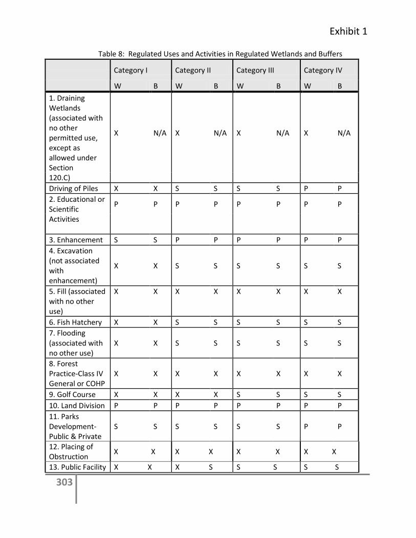
Exhibit 1
303
Table 8: Regulated Uses and Activities in Regulated Wetlands and Buffers
Category I Category II Category III Category IV
W B W B W B W B
1. Draining Wetlands (associated with no other permitted use, except as allowed under Section
X N/A X N/A X N/A X N/A
120.C)
Driving of Piles X X S S S S P P
2. Educational or Scientific
P P P P P P P P
Activities
3. Enhancement S S P P P P P P
4. Excavation (not associated with enhancement)
X X S S S S S S
5. Fill (associated with no other use)
X X X X X X X X
6. Fish Hatchery X X S S S S S S
7. Flooding (associated with no other use)
X X S S S S S S
8. Forest Practice-Class IV General or COHP
X X X X X X X X
9. Golf Course X X X X S S S S
10. Land Division P P P P P P P P
11. Parks Development-Public & Private
S S S S S S P P
12. Placing of Obstruction
X X X X X X X X
13. Public Facility X X X S S S S S
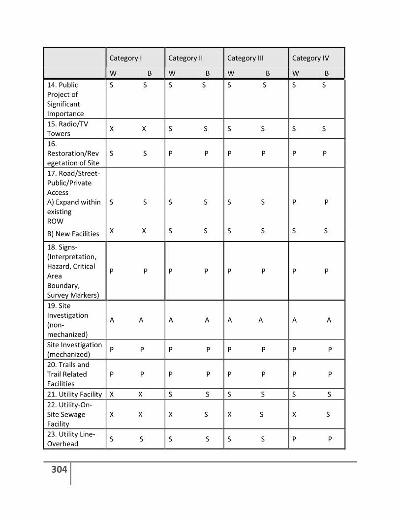
304
Category I Category II Category III Category IV
W B W B W B W B
14. Public Project of Significant Importance
S S S S S S S S
15. Radio/TV Towers
X X S S S S S S
16. Restoration/Revegetation of Site
S S P P P P P P
17. Road/Street- Public/Private
Access A) Expand within existing ROW
S S S S S S P P
B) New Facilities X X S S S S S S
18. Signs-(Interpretation, Hazard, Critical Area Boundary, Survey Markers)
P P P P P P P P
19. Site Investigation (non-mechanized)
A A A A A A A A
Site Investigation (mechanized)
P P P P P P P P
20. Trails and Trail Related Facilities
P P P P P P P P
21. Utility Facility X X S S S S S S
22. Utility-On-Site Sewage Facility
X X X S X S X S
23. Utility Line-Overhead
S S S S S S P P
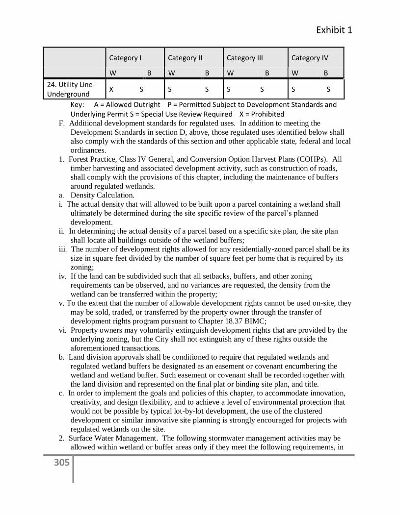
Exhibit 1
305
Category I Category II Category III Category IV
W B W B W B W B
24. Utility Line-Underground
X S S S S S S S
Key: A = Allowed Outright P = Permitted Subject to Development Standards and Underlying Permit S = Special Use Review Required X = Prohibited
F. Additional development standards for regulated uses. In addition to meeting the
Development Standards in section D, above, those regulated uses identified below shall
also comply with the standards of this section and other applicable state, federal and local
ordinances.
1. Forest Practice, Class IV General, and Conversion Option Harvest Plans (COHPs). All
timber harvesting and associated development activity, such as construction of roads,
shall comply with the provisions of this chapter, including the maintenance of buffers
around regulated wetlands.
a. Density Calculation.
i. The actual density that will allowed to be built upon a parcel containing a wetland shall
ultimately be determined during the site specific review of the parcel’s planned
development.
ii. In determining the actual density of a parcel based on a specific site plan, the site plan
shall locate all buildings outside of the wetland buffers;
iii. The number of development rights allowed for any residentially-zoned parcel shall be its
size in square feet divided by the number of square feet per home that is required by its
zoning;
iv. If the land can be subdivided such that all setbacks, buffers, and other zoning
requirements can be observed, and no variances are requested, the density from the
wetland can be transferred within the property;
v. To the extent that the number of allowable development rights cannot be used on-site, they
may be sold, traded, or transferred by the property owner through the transfer of
development rights program pursuant to Chapter 18.37 BIMC;
vi. Property owners may voluntarily extinguish development rights that are provided by the
underlying zoning, but the City shall not extinguish any of these rights outside the
aforementioned transactions.
b. Land division approvals shall be conditioned to require that regulated wetlands and
regulated wetland buffers be designated as an easement or covenant encumbering the
wetland and wetland buffer. Such easement or covenant shall be recorded together with
the land division and represented on the final plat or binding site plan, and title.
c. In order to implement the goals and policies of this chapter, to accommodate innovation,
creativity, and design flexibility, and to achieve a level of environmental protection that
would not be possible by typical lot-by-lot development, the use of the clustered
development or similar innovative site planning is strongly encouraged for projects with
regulated wetlands on the site.
2. Surface Water Management. The following stormwater management activities may be
allowed within wetland or buffer areas only if they meet the following requirements, in
306
addition to the development standards in this section and in conformance with the
Stormwater Management Ordinance, Chapter 15.20 BIMC:
a. Surface water discharges from stormwater facilities or structures; provided, that the new
surface water discharges to regulated wetlands from retention/detention facilities;
b. Pre-settlement ponds or other surface water management structures; provided, that the
discharge does not significantly increase or decrease the rate of flow and/or hydro-period,
nor decrease the water quality of the wetland. Water quality treatment best management
practices will be required prior to discharge. Pre-treatment of surface water discharge
through biofiltration or other means shall be required.
3. Trails and Trail-Related Facilities: Construction of public and private trails and trail-
related facilities, such as benches and viewing platforms, may be allowed in wetlands or
wetland buffers pursuant to the following guidelines:
a. Trails and related facilities shall, to the extent feasible, be placed on existing road grades,
utility corridors, or any other previously disturbed areas which do not provide ecological
functions.
b. Trails and related facilities shall be planned to minimize removal of trees, soil
disturbance, and existing hydrological characteristics, shrubs, snags, and important
wildlife habitat.
c. Viewing platforms and benches, and access to them, shall be designed and located to
minimize disturbance of wildlife habitat and/or critical characteristics of the affected
wetland.
d. Trails and related facilities shall generally be located outside required buffers. Where
trails are permitted within buffers they shall be located in the outer portion of the buffer
and a minimum of 25 feet from the wetland edge, except where wetland crossings or
viewing areas have been approved by the Director. Trail locations close to the wetland
may be allowed if the primary purpose of the trail is wetland viewing or enjoyment.
Elevated trails which protect or enchance ecological functions shall be used to the
maximum extent feasible.
e. Trails shall generally be limited to pedestrian use unless other more intensive uses, such as
bike or horse trails, have been specifically allowed and mitigation has been provided.
Trail width shall not exceed five feet unless there is a demonstrated need, subject to
review and approval by the Director. Trails shall be constructed with pervious materials
unless otherwise approved by the Director.
4. Parks. Development of public park and recreation facilities may be permitted; provided,
that no alteration of wetlands or wetland buffers is allowed except for uses allowed in
Table 8. For example, enhancement of wetlands and development of trails may be
allowed in wetlands and wetland buffers subject to special use requirements and approval
of a Wetland Mitigation Plan.
5. Educational or scientific activities. These activities shall only be permitted if they are
directly related to the affected wetland and related buffers, and may include the viewing
and sampling of natural systems. They may also include the installation of physical
structures, including pervious trails, benches, permanent wildlife watching blinds,
boardwalks, viewing platforms, or similar structures, or minor modifications to wetlands
and their buffers. Any physical structures or minor modifications are subject to City
Exhibit 1
307
approval to minimize the impacts of human intrusion on the functions and values of
critical areas and their buffers according to the following criteria:
a. Minimize the footprint of structures and the number of access points to any particular
critical area;
b. Minimize the amount of clearing and grading;
c. Elevate structures where possible;
d. Avoid impacting the flow of water;
e. Use appropriate building materials; and
f. Minimize the impacts of construction.
G. Special Use Review. Development identified as a Special Use Review in Table 8 of this
section may be approved, with conditions, or denied according to the procedures and
criteria outlined in this subsection. Special Use Review is an administrative process
unless the underlying permit requires a public hearing.
1. The Director is authorized to take action on permits as required by this chapter.
2. The Director may approve a permit after review of the application and a Wetland
Mitigation Plan submitted in accordance with this chapter. The Director shall determine
whether the use or activity cannot be avoided because no reasonable or practicable
alternative exists, the proposed use is consistent with the spirit and intent of this chapter
and it will not cause adverse impacts to the wetland or the wetland buffer which cannot
be mitigated. In taking action to approve a Special Use Review, the Director may attach
reasonable conditions as necessary to minimize impacts, rectify impacts or compensate
for impacts to the wetland or wetland buffer.
3. The Director shall deny a Special Use Review request if the proposed use or activity is
inconsistent with this chapter and/or will cause adverse impacts to the wetland or wetland
buffer, which cannot be adequately mitigated and/or avoided.
4. Special use review requests for agricultural conversions shall include a farm plan
developed by the Kitsap Conservation District. The plan shall identify the best
management practices for the proposed agricultural activity.
5. Special Use Review determinations are appealable to the hearings examiner pursuant to
BIMC 2.16.020(P).
H. Wetlands and Streams Restoration, Creation, Mitigation, or Enhancement.
1. Any person who alters regulated wetlands or streams or their standard buffers as required
by this chapter shall restore, create or enhance equivalent areas or greater areas than those
altered in order to compensate for losses. In the alternative, conservation easements or
mitigation banking may be considered as appropriate mitigation provided that areas
equivalent to those altered are achieved.
2. Where feasible, restored or created wetlands and streams shall be a higher category than
the altered wetland or stream.
3. Compensation areas shall be determined according to function, acreage, type, location,
time factors, ability to be self-sustaining and projected success. Multiple compensation
projects may be proposed for one project in order to best achieve the goal of no net loss.
4. Given the need for expertise and monitoring, voluntary restoration, creation or
enhancement projects or compensatory projects may be permitted only when the Director
finds that the proposed project is associated with an activity or development otherwise
permitted. Additionally, the applicant shall:
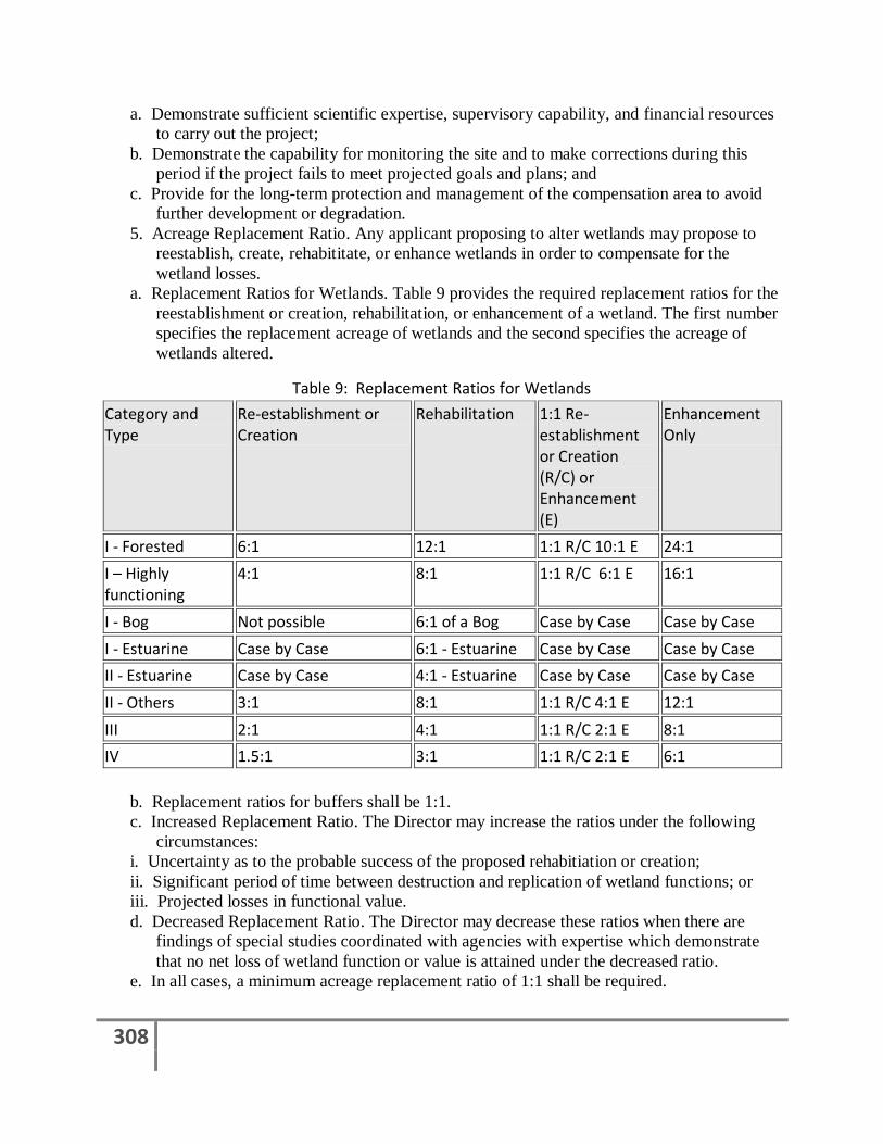
308
a. Demonstrate sufficient scientific expertise, supervisory capability, and financial resources
to carry out the project;
b. Demonstrate the capability for monitoring the site and to make corrections during this
period if the project fails to meet projected goals and plans; and
c. Provide for the long-term protection and management of the compensation area to avoid
further development or degradation.
5. Acreage Replacement Ratio. Any applicant proposing to alter wetlands may propose to
reestablish, create, rehabititate, or enhance wetlands in order to compensate for the
wetland losses.
a. Replacement Ratios for Wetlands. Table 9 provides the required replacement ratios for the
reestablishment or creation, rehabilitation, or enhancement of a wetland. The first number
specifies the replacement acreage of wetlands and the second specifies the acreage of
wetlands altered.
Table 9: Replacement Ratios for Wetlands
Category and Type
Re-establishment or Creation
Rehabilitation 1:1 Re-establishment or Creation (R/C) or Enhancement (E)
Enhancement Only
I - Forested 6:1 12:1 1:1 R/C 10:1 E 24:1
I – Highly functioning
4:1 8:1 1:1 R/C 6:1 E 16:1
I - Bog Not possible 6:1 of a Bog Case by Case Case by Case
I - Estuarine Case by Case 6:1 - Estuarine Case by Case Case by Case
II - Estuarine Case by Case 4:1 - Estuarine Case by Case Case by Case
II - Others 3:1 8:1 1:1 R/C 4:1 E 12:1
III 2:1 4:1 1:1 R/C 2:1 E 8:1
IV 1.5:1 3:1 1:1 R/C 2:1 E 6:1
b. Replacement ratios for buffers shall be 1:1.
c. Increased Replacement Ratio. The Director may increase the ratios under the following
circumstances:
i. Uncertainty as to the probable success of the proposed rehabitiation or creation;
ii. Significant period of time between destruction and replication of wetland functions; or
iii. Projected losses in functional value.
d. Decreased Replacement Ratio. The Director may decrease these ratios when there are
findings of special studies coordinated with agencies with expertise which demonstrate
that no net loss of wetland function or value is attained under the decreased ratio.
e. In all cases, a minimum acreage replacement ratio of 1:1 shall be required.
Exhibit 1
309
6. Wetland Type. In-kind compensation shall be provided except where the applicant can
demonstrate that:
a. The wetland system is already significantly degraded and out-of-kind replacement will
result in a wetland with greater functions and values;
b. Scientific problems such as invasive/exotic vegetation and changes in watershed
hydrology make implementation of in-kind compensation impossible;
c. Out-of-kind replacement will best meet identified regional goals (e.g., replacement of
historically diminished wetland types); and
d. Where out-of-kind replacement is accepted, greater acreage replacement ratios may be
required to compensate for lost functions and values.
7. Location. On-site compensation shall be provided except where the applicant can
demonstrate that:
a. The hydrology and ecosystem of the original wetland and those who benefit from the
hydrology and ecosystem will not be substantially damaged by the on-site loss;
b. On-site compensation is not scientifically feasible due to problems with hydrology, soils,
or other factors;
c. Compensation is not practical due to potentially adverse impacts from surrounding land
uses;
d. Existing functions and values at the site of the proposed restoration are significantly
greater than lost wetland functional values;
e. That established regional goals for flood storage, flood conveyance, habitat or other
wetland functions have been established and strongly justify location of compensatory
measures at another site;
f. There is no feasible location for on-site mitigation;
g. Off-site compensation shall occur within the same watershed, if feasible, as the wetland
loss occurred; provided, that Category IV wetlands may be replaced outside of the
watershed when there is no reasonable alternative; and
h. In selecting compensation sites, an applicant shall pursue siting in the following order of
preference:
i. Upland sites which were formerly wetlands;
ii. Idled upland sites generally having bare ground or vegetative cover consisting primarily
of invasive introduced species, weeds, or emergent vegetation; or
iii. Other disturbed upland.
8. Timing. Wherever feasible, compensatory projects shall be completed prior to activities
that will disturb wetlands, and immediately after activities that will temporarily disturb
wetlands. In all other cases, except for Category I wetlands, compensatory projects
should be completed prior to use or occupancy of the activity or development which was
conditioned upon such compensation. Construction of compensation projects shall be
timed to reduce impacts to existing wildlife and flora.
9. Cooperative Restoration, Creation or Enhancement Projects. The Director may encourage,
facilitate, and approve cooperative projects wherein a single applicant or other
organization with demonstrated capability may undertake a compensation project with
funding from other applicants under the following circumstances:
a. Restoration, creation or enhancement at a particular site may be scientifically difficult or
impossible; or

310
b. Creation of one or several larger wetlands may be preferable to many small wetlands;
c. Persons proposing cooperative compensation projects shall:
i. Submit a joint permit application;
ii. Demonstrate compliance with all standards;
iii. Demonstrate the organizational and fiscal capability to act cooperatively; and
iv. Demonstrate that long-term management can and will be provided.
10. Mitigation Banking.
a. The City may consider and approve replacement or enhancement of wetlands to address
unavoidable adverse impacts caused by development activities through an approved
wetland mitigation bank. Compensatory mitigation in advance of authorized impacts
must be provided through an approved mitigation bank if a bank is used.
b. When off-site mitigation is authorized, the Director shall give priority to locations within
the same drainage basin as the development proposal site that meet the following:
i. Mitigation banking sites and resource mitigation reserves as authorized by this chapter;
ii. Private mitigation sites that are established in compliance with the requirements of this
chapter and approved by the Director; and
iii. Public mitigation sites that have been ranked in a process that has been supported by
ecological assessments.
c. The Director may require documentation that the mitigation site has been permanently
preserved from future development or alteration that would be inconsistent with the
functions of the mitigation. The documentation may include, but need not be limited to, a
conservation easement, transfer of clearing credits or other agreement between the
applicant and owner of the mitigation site. The City may enter into agreements or
become a party to any easement or other agreement necessary to ensure that the site
continues to exist in its mitigated condition.
d. The Director shall maintain a list of sites available for use for off-site mitigation projects.
e. The Director may develop a program to allow the payment of a fee in lieu of providing
mitigation on a development site. The program should address:
i. When the payment of a fee is allowed, considering the availability of a site in geographic
proximity with comparable hydrologic and biological functions and potential for future
habitat fragmentation and degradation; and
ii. The use of the fees for mitigation on public or private sites that have been ranked
according to ecological criteria through one or more programs that have included a public
process.
B-11. Frequently Flooded Areas
A. Classification. Classification for frequently flooded areas shall be consistent with the 100-year
floodplain designation of the Federal Emergency Management Agency and the National Flood
Insurance Program. In addition, the following criteria shall be considered when designating and
classifying these areas:
1. Flooding impact to human health, safety, and welfare and to public facilities and services;
2. Available documentation including federal, state, and local laws, regulations and
programs, local maps, and federally subsidized flood insurance programs;
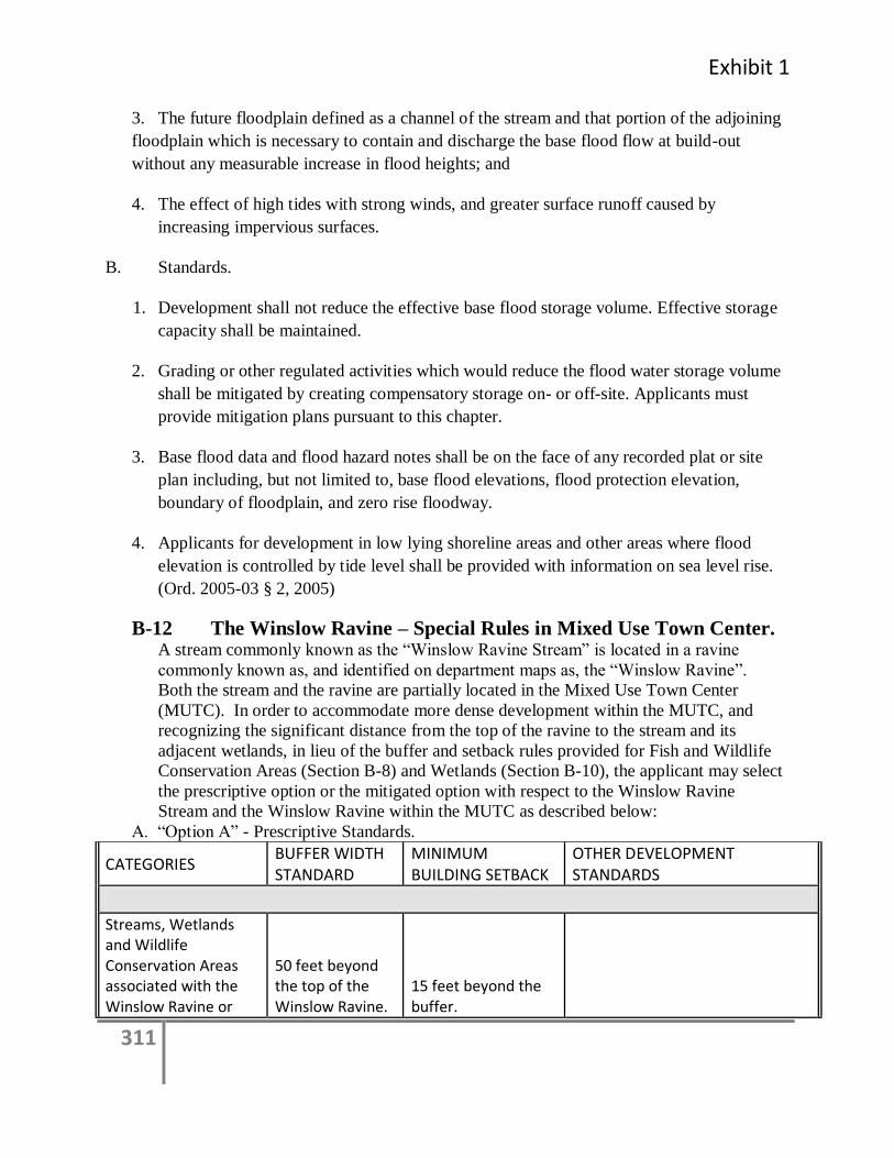
Exhibit 1
311
3. The future floodplain defined as a channel of the stream and that portion of the adjoining
floodplain which is necessary to contain and discharge the base flood flow at build-out
without any measurable increase in flood heights; and
4. The effect of high tides with strong winds, and greater surface runoff caused by
increasing impervious surfaces.
B. Standards.
1. Development shall not reduce the effective base flood storage volume. Effective storage
capacity shall be maintained.
2. Grading or other regulated activities which would reduce the flood water storage volume
shall be mitigated by creating compensatory storage on- or off-site. Applicants must
provide mitigation plans pursuant to this chapter.
3. Base flood data and flood hazard notes shall be on the face of any recorded plat or site
plan including, but not limited to, base flood elevations, flood protection elevation,
boundary of floodplain, and zero rise floodway.
4. Applicants for development in low lying shoreline areas and other areas where flood
elevation is controlled by tide level shall be provided with information on sea level rise.
(Ord. 2005-03 § 2, 2005)
B-12 The Winslow Ravine – Special Rules in Mixed Use Town Center. A stream commonly known as the “Winslow Ravine Stream” is located in a ravine
commonly known as, and identified on department maps as, the “Winslow Ravine”.
Both the stream and the ravine are partially located in the Mixed Use Town Center
(MUTC). In order to accommodate more dense development within the MUTC, and
recognizing the significant distance from the top of the ravine to the stream and its
adjacent wetlands, in lieu of the buffer and setback rules provided for Fish and Wildlife
Conservation Areas (Section B-8) and Wetlands (Section B-10), the applicant may select
the prescriptive option or the mitigated option with respect to the Winslow Ravine
Stream and the Winslow Ravine within the MUTC as described below:
A. “Option A” - Prescriptive Standards.
CATEGORIES BUFFER WIDTH STANDARD
MINIMUM BUILDING SETBACK
OTHER DEVELOPMENT STANDARDS
Streams, Wetlands and Wildlife Conservation Areas associated with the Winslow Ravine or
50 feet beyond the top of the Winslow Ravine.
15 feet beyond the buffer.
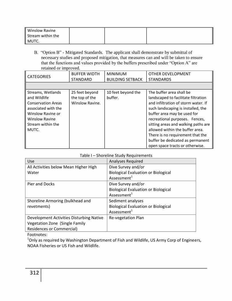
312
Winslow Ravine Stream within the MUTC.
B. “Option B” - Mitigated Standards. The applicant shall demonstrate by submittal of
necessary studies and proposed mitigation, that measures can and will be taken to ensure
that the functions and values provided by the buffers prescribed under “Option A” are
retained or improved.
CATEGORIES BUFFER WIDTH STANDARD
MINIMUM BUILDING SETBACK
OTHER DEVELOPMENT STANDARDS
Streams, Wetlands and Wildlife Conservation Areas associated with the Winslow Ravine or Winslow Ravine Stream within the MUTC.
25 feet beyond the top of the Winslow Ravine.
10 feet beyond the buffer.
The buffer area shall be landscaped to facilitate filtration and infiltration of storm water. If such landscaping is installed, the buffer area may be used for recreational purposes. Fences, sitting areas and walking paths are allowed within the buffer area. There is no requirement that the buffer be dedicated as permanent open space tracts or otherwise.
Table I – Shoreline Study Requirements
Use Analyses Required
All Activities below Mean Higher High Water
Dive Survey and/or Biological Evaluation or Biological Assessment1
Pier and Docks Dive Survey and/or Biological Evaluation or Biological Assessment1
Shoreline Armoring (bulkhead and revetments)
Sediment analyses Biological Evaluation or Biological Assessment1
Development Activities Disturbing Native Vegetation Zone (Single Family Residences or Commercial)
Re-vegetation Plan
Footnotes: 1Only as required by Washington Department of Fish and Wildlife, US Army Corp of Engineers, NOAA Fisheries or US Fish and Wildlife.
Exhibit 1
313
Additional Studies may be required by the Director as necessary to determine whether the
application meets the decision criteria for Shoreline Substantial Development Permit, Shoreline
Substantial Development Exemption, Shoreline Conditional Use Permit or Shoreline Variance.
314
Appendix C
Buffer Recommendation Memorandums
Exhibit 1
315
City of Bainbridge Island PLANNING & COMMUNITY DEVELOPMENT
MEMORANDUM TO: City Council FROM: Libby Hudson, Long Range Planning Manager Ryan Ericson, Associate Planner DATE: August 11, 2011 RE: Herrera Environmental Consultants Memorandum documenting
Marine Shoreline Buffer Recommendation Discussions City Council Special Meeting of August 16, 2011
The attached memorandum has been provided by the City’s scientific consultants, Herrera
Environmental Consultants, to assist the City in developing buffer recommendations as part of
the Shoreline Master Program Update process. The memo is intended to be utilized by the citizen
workgroups, Planning Commission and City Council in reviewing and updating the vegetation
conservation buffer and management standards.
This memo is informed by the science summarized in two documents that the City
commissioned, the Nearshore Assessment Summary of Best Available Science (Battelle, October
2003) and the Summary of Science Addendum (Herrera, 2011). The memo reflects the outcome
of buffer requirement discussions with Herrera and City staff, the requirements of the state
Shoreline Master Program (SMP) Guidelines (WAC 173-26), and the policy direction of the
citizen workgroups. In respect to vegetation conservation for the SMP Update, the state
Guidelines [WAC 173-26-201(3)(d)(viii) and 173-26- 221(5)(b)] direct that the City should:
Identify measures and regulations that address conservation of vegetation and ensure that
new development meets vegetation conservation objectives;
Assure no net loss of shoreline ecological functions and ecosystem-wide processes through a
variety of measures, including setback and buffer standards;
Identify ecological processes and functions of vegetation that are important to the local
aquatic and terrestrial ecology and provide measures that conserve sufficient vegetation to
maintain these functions;
316
Vegetation conservation areas are not necessarily intended to be closed to use and
development, but should provide for management of vegetation in a manner adequate to
assure no net loss of shoreline function.
The City’s existing SMP utilizes vegetation buffers known as Native Vegetation Zones (NVZ).
The policy direction from the SMP Vegetation Conservation Workgroup suggests that in
updating these buffers, the City should:
Protect and restore shoreline vegetation to maintain and enhance ecological functions, human
safety, personal property protection, and shoreline views and vistas. (Vegetation
Conservation and Management Zones Draft Goal); and
Establish shoreline vegetation conservation and management zones immediately upland of
ordinary high water mark (OHWM) for each shoreline use and shoreline characterization,
recognizing the pattern of development, shoreline ecological and ecosystem wide processes,
and using current science and technical information, as described in WAC 173-26-201(2)(a).
(Vegetation Conservation and Management Zones Draft Policy #6).
Developing Marine Shoreline Buffer Recommendations
The process used to develop the memorandum and the suggested range of buffers included
several stages and was completed during a series of discussions with the consultant team and
staff, including the following:
1. Reviewing the science related to buffers (summarized at the beginning of the memo, page 1).
This was completed by Herrera.
2. Developing a concept for a two-zoned management area (buffer) that is comprised of a more
protective (and more restricted use and activity) zone adjacent to the OHWM, and a more
flexible zone (allowing minimal use, activity and alteration to vegetation) situated within the
remaining portion of the management area. This concept is described on page 6 of the Herrera
memo, under Marine Shoreline Buffer and Riparian Protection Zone Recommendations. The
two-zoned management area concept was developed with Herrera and City staff, first agreeing
on principles that met the SMP Guidelines and the policy direction of the citizen workgroup.
These are outlined in the section Agreed Principles, page 9 of the Herrera memo.
3. Developing dimensional recommendations. The Buffer Considerations and Recommendations
section of the memo, page 11, was developed using the two-zone concept and developing
principles that are informed by the science and the characteristics of the Bainbridge Island
shoreline. Widths were then established for the management areas and applied to the proposed
shoreline designations, (Table 1, page 12). This was completed by Herrera and modified by City
staff to reflect the policy direction of the citizen workgroups and the proposed shoreline
designation map.
Terminology Vegetation conservation is important for managing and retaining shoreline vegetation in both the
state SMP Guidelines and in the City’s existing SMP (which included Native Vegetation Zones
established for all shoreline designations). These management areas are intended to protect
shoreline functions, primarily related to vegetation. In the scientific literature and within local
Exhibit 1
317
shoreline master programs, these areas might be called different names, including “buffers”,
“setbacks” or “management areas”. This can be confusing since the terms for different
management tools are frequently interchanged. Technical and scientific literature refer to buffers
as relatively undisturbed areas that protect ecologically sensitive areas, while planning and
regulatory terminology often allows some limited disturbance of the buffer area. This document
uses the planning and regulatory definition of buffers.
As a management tool, these protective areas have the following in common: the area is a
designated dimensional area situated along the shoreline, measured from the OHWM landward,
with adopted regulations that limit uses and activities within these areas. The width of this area
may be a fixed width or a flexible width (as is proposed here).
The Herrera memo uses terminology for this protective area, describing it as a marine shoreline
buffer or Standard Buffer, that includes an inner zone, the Riparian Protection Zone (RPZ),
which is measured adjacent to the OHWM.
These terms are slightly different in the draft Vegetation Conservation and Management Zones
regulations, in which the entire buffer is called the Standard Shoreline Buffer (SSB) and is
comprised of two zones, the Riparian Protection Zone (RPZ) and the Marine Shoreline Zone
(MSZ).
Revised Memorandum The Herrera Memorandum was revised on August 11, 2011 to provide additional clarification and to correct or clarify some citations used in the document.
318
Herrera Environmental Consultants, Inc.
Memorandum
To Ryan Ericson, Associate Planner, and Libby Hudson, Division Manager
City of Bainbridge Island
From Amanda Azous, José Carrasquero, and Jeff Parsons,
Herrera Environmental Consultants;
Lisa Grueter, BERK
Date August 2, 2011
Subject Documentation of Marine Shoreline Buffer Recommendation Discussions
The following discussion documents thoughts and considerations with respect to marine
shoreline buffers for different shoreline use designations. The discussion is based on a review
of the City of Bainbridge Island’s (City) existing marine shoreline buffer regulations, the City’s
shoreline character, nearshore assets, existing and future land uses, scientific recommendations
for marine buffers, as well as discussions with City staff. This memo begins with describing
what a marine shoreline buffer is and how it differs from a riparian area; followed by a summary
discussion of science-based buffer recommendations; and closes with buffer recommendations
for the City’s shoreline management plan update. For reference, marine shoreline buffer widths
currently required by the City’s shoreline regulation are provided in Attachment A, and are taken
from Chapter 16.12 BIMC.
Marine Shoreline Buffers and Riparian Areas Marine shoreline buffers are used in the City to regulate areas to protect the marine nearshore
from the effects of land use activities (such as construction of buildings, driveways, and other
infrastructure). Marine shoreline buffers may have variable widths, and use restrictions generally
apply uniformly to the entire buffer area. This discussion in part serves to distinguish the concept
of a marine shoreline buffer from that of a riparian area, which is an integral part of an aquatic
ecosystem and, therefore, requires a more protective level of regulation.
A riparian area differs from a marine shoreline buffer in that it describes the terrestrial ecosystem
directly adjacent to the marine nearshore that interacts with the aquatic environment. For
example, intact riparian areas have native plant communities comprised of varying species of
herbs and grasses, shrubs, deciduous trees, and coniferous stands of various ages and they are
integral to the proper functioning of the nearshore. Native plant species are those species that
occur or historically occurred on Bainbridge Island before European contact based upon the best
available scientific and historical documentation.
Key functions supplied by riparian areas include providing large woody debris (LWD), bank
stability, marine species food sources such as detritus and insects, and temperature moderation of
beach substrate. This includes providing an overhanging, complex network of branches, trunks,
stems and roots that act to moderate nearshore wave energy. In contrast, marine shoreline buffers
Exhibit 1
319
may include non-native landscaping, vegetable gardens, and lawns as well as possibly, native
vegetation communities.
Because the functions provided by a riparian area are fundamental to maintaining a healthy
functioning marine nearshore, it is recommended that the City designate a riparian protection
zone (RPZ) with more restricted uses and assign a separate marine shoreline buffer to protect the
RPZ. This would be done to protect such areas that are currently intact, and to establish an RPZ
where such areas do not currently exist such as when properties re-develop, remodel or otherwise
expand development. The RPZ would be treated as a conservation area to preserve the essential
relationship between nearshore and shoreline ecological functions.
Some activities allowed within the RPZ would be weed removal, hazardous tree or limb removal,
or shoreline oriented uses that are a high priority such as water dependent uses on private parcels
or nearshore access and water enjoyment uses in public park areas.2 This approach will help to
ensure the protection of what remains of the City’s intact riparian zones and will facilitate and
provide more flexibility for uses within marine shoreline buffers. Policies, incentives and
regulations that support restoration of riparian areas (such as through restoration of native plant
communities) would benefit increases in nearshore habitat and functions and assist with showing
no net loss.
Scientific Importance of Marine Shoreline Buffers and Riparian Areas Sustaining habitats and species requires protection of the ecological functions and processes that
support survival and population success, in addition to the direct protection of the habitats
themselves. Without adequate habitat protection, ecological functions and key natural processes
become degraded. In response to this risk, scientifically based recommended buffer widths and
site-specific methods for determining buffers have been established in several sources. These
sources were reviewed and reported in the City’s Addendum to the Summary of Science Report
(Herrera 2011) and are briefly summarized here.
Marine Shoreline Buffers
Factors relevant to the effectiveness of marine shoreline buffers, or of a given buffer width,
include the type and intensity of surrounding land development, influence of groundwater,
stability of slopes or bluffs, types of pollutants and their sources, vegetation dynamics (such as
type and density), and geomorphic functions of driftwood or other habitat features that might
affect the functions and values of the buffer (Brennan et al. 2009). For example, slopes that
are more susceptible to massive failure may require a larger buffer, particularly if existing
development is contributing to an increased rate of erosion such as from poor stormwater
management and a lack of stabilizing vegetation. Feeder bluffs contributing to spawning beaches
may require a larger buffer in order to protect future development while also decreasing the
future need for shoreline armoring. Parcels with marshes, lagoons, or spit / barrier / backshores
likewise may require wider buffers to protect these important ecological features. Steep slopes
comprised of bedrock (relatively rare in the City) or stable high bluffs (greater than 5 meters)
2 Allowances in the RPZ are more fully discussed in recommendations starting on page 6.
320
may allow for a narrower buffer as slope stability and sediment sources would not be impacted
by development.
Much of the existing riparian and buffer literature is related to freshwater systems therefore,
Washington Department of Fish and Wildlife (WDFW) established a panel of scientists in 2008
to assess the freshwater riparian scientific literature to determine its applicability to marine
shoreline systems. The result of the literature review, and the Marine Riparian Workshop
Proceedings conducted by the scientific panel in 2008 was a common consensus that freshwater
riparian buffer research was conceptually applicable to marine shorelines (Brennan et al. 2009).
The data provided by the WDFW panel (Brennan et al. 2009) suggest that necessary buffer
widths vary considerably depending on the site-specific characteristics and the functions to
be protected. For example, in order to achieve at least 80 percent effectiveness at removing
pollutants from stormwater runoff, recommended buffers varied from as little as 16 feet to as
large as 1,969 feet depending on the slope, depth and type of soil, surface roughness, density
of vegetation and the intensity of the land use. Buffer widths for organic matter contributions
(such as plant litter and terrestrial insects) ranging between 16 and 328 feet from the shoreline,
depending on site conditions, were reported by Bavins et al. (2000) for providing this function.
Buffers to protect the large woody debris function important to habitat structure and shoreline
stability were suggested to be between 33 and 328 feet. However, given that trees located
300 feet landward from the edge of a bluff or bank would not immediately be recruited on the
nearshore, consideration should be given to the site’s potential tree height and the current and
expected rate of bluff or bank retreat when establishing buffers for providing large woody debris.
The WDFW panel found that buffer widths to support a number of specific riparian functions
were identified by May (2003) and Knutson and Naef (1997). May recommended 98 feet for
fine sediment control, and shade and microclimate control and 164 feet for the LWD function.
Knutson and Naef recommended 138 feet for fine sediment control, 90 feet for temperature
moderation, and 147 feet for LWD and litter fall functions. The panel’s review indicated that
recommendations for wildlife habitat protection ranged from 50 feet (specific to highly rural
areas) to 328 feet.
Riparian Areas
An extensive body of research and literature has emerged over the last three decades which
documents the specific importance of riparian areas in providing ecological functions related to
waters of the state. These functions include the following (Romanuk and Levings 2010; Brennan
et al. 2009; Lemieux et al. 2004):
Water quality maintenance
Fine sediment control
Large woody debris delivery and retention
Microclimate moderation
Nutrient delivery and retention
Terrestrial carbon source to nearshore food webs
Fish and wildlife habitat creation and maintenance
Direct food support for juvenile salmonids
Hydrologic based slope stability
Exhibit 1
321
There is consensus in the scientific community that marine riparian areas are critical to
sustaining many ecological functions (Desbonnet et al. 1994; Brennan and Culverwell 2004;
Lemieux et al. 2004; Brennan et al. 2009). Marine riparian shoreline vegetation is an important
component of nearshore habitat throughout the Puget Sound region (Herrera 2007; Lemieux
et al. 2004; Levings and Jamieson 2001; Redman et al. 2005) and includes both upland forested
plant communities occurring on the shoreline as well as unique vegetation found only in the
marine nearshore (Lemieux et al 2004). Marine riparian areas contain elements of both aquatic
and terrestrial ecosystems that mutually influence each other (Knutson and Naef 1997; Fresh
et al. 2004; Lemieux et al. 2004). For example, juvenile salmon consume terrestrially derived
carbon which can extend into the low intertidal zone (Romanuk and Levings 2010), and salmon
are well known conduits for returning marine derived nutrients into freshwater systems
(Chaloner et al. 2002; Wipfli 2003). Beach wrack and detritus accumulated in driftwood and
tree fall in the nearshore zone, provide both terrestrial and marine derived food sources for
invertebrates, fish, birds, and other organisms (Lewis 2007; Brennan et al. 2009). Riparian
vegetation also provides contributions of organic matter, moisture, and nutrients that assist in
the establishment and maintenance of estuarine marsh plants (Eilers 1975; Williams and Thom
2001).
These interactions between riparian vegetation and the nearshore marine environment are
important to the survival and population success of numerous species that depend on marine
habitats. Conservation efforts which, preserve the natural processes of detritus and nutrient
conveyance, and organic debris accumulation, are therefore important in the marine environment.
The establishment of significant protection for marine riparian areas is an important management
strategy for protecting marine habitat conservation areas.
In literature reviews conducted to evaluate the potential impacts of removing riparian vegetation
on numerous sensitive species, several mechanisms of impact have been identified (Herrera
2007b, 2008b). The degree of impact to the aquatic environment depends upon the magnitude
of the vegetation removal or alteration (such as size and number of trees affected, and total area
cleared of vegetation). At more severe levels, riparian vegetation modification could result in the
following impacts, which would have subsequent implications for species survival and overall
habitat condition:
Altered shade and temperature regime: Caused by direct removal of
vegetation.
Reduced bank and shoreline stability: Caused by degradation of
riparian vegetation, loss of vegetative cover and root cohesion, and
reduced resistance to erosion. This may in turn affect aquatic habitat by
increasing suspended sediments and altering riparian habitat structure.
Altered organic material contributions: Caused by reduced source of
leaf litter, woody debris, terrestrial insects, and other biota.
322
Altered habitat complexity and increased habitat fragmentation:
Caused by removal of native vegetation and creating habitat favored by
invasive species.
There are geologic constraints on the type and density of vegetation that can establish on some
areas of marine shoreline. For example, many bedrock shorelines are limited in the development
of functional densities of vegetation. This is particularly relevant along the southern shoreline of
the City where bedrock and overconsolidated sediments are common.
It has been shown that detritus feeding organisms may not be adapted to the leaf fall patterns or
the chemical characteristics of leaves from non-native trees suggesting that riparian areas are
most effective when comprised of native vegetation (Karr and Schlosser 1977). In addition,
native plant species have adapted to local physical conditions such as soil, geology, and climate
and therefore require less maintenance, are resistant to most pests and diseases, and require little
or no irrigation or fertilizers, once established. Thus maintaining native plant species in marine
riparian areas can also have consequent benefits on maintaining water quality.
In a meta-analysis review of 73 peer-reviewed studies of vegetated buffer efficacy in protecting
water quality, Zhang et al. (2010) reported that forested buffers were generally found to remove
more nitrogen (a limiting nutrient in marine waters) as well as phosphorus than grassed buffers.
For areas with slopes up to 10 percent, predicted sediment removal efficiencies for a 33-foot
(10-meter) vegetated buffer ranged from 76 to 100 percent. Removal efficiencies for nitrogen
were 71 to 85 percent, and for phosphorus were 69 to 98 percent. Steeper slopes had declining
removal rates.
By maintaining bank stability and contributing large wood to the aquatic environment, riparian
vegetation forms and maintains habitat complexity. Riparian vegetation and large wood improve
beach stability and contribute to roughness and sediment trapping (Brennan and Culverwell
2004; Gonor et al. 1988; Herrera 2005). This includes improved capacity of beaches to retain
sand, a crucial substrate for forage fish spawning (Pentilla 2007).
Herrera (2005) suggested that driftwood and tree fall at the top of the beach may also stabilize
the upper beach area by slowing littoral drift and reducing wave-induced erosion). It has been
suggested that estuarine wood can affect water flow and the subsequent formation of bars and
mudbanks (Gonor et al. 1988). The contribution to habitat complexity along marine shorelines
may be maximized if trees that fall to beaches remain in place (Herrera 2005).
Marine Shoreline Buffer and Riparian Protection Zone Recommendations City of Bainbridge Island shorelines are predominantly developed (over 82 percent [Battelle
2003]) which limits the City’s ability to require wide buffers that are protected through
regulation as conservation areas. Therefore, our recommendations have focused on protecting
intact riparian habitat by limiting uses within this ecologically important zone, allowing for a
less restrictive marine shoreline buffer landward of the riparian area that would protect the
RPZ as well as provide some buffer functions; and by suggesting the City provide regulatory
thresholds and landowner incentives to restore native riparian habitat whenever possible. In
addition, the recommendations are informed by the City’s desire to limit the number of non-
conforming structures therefore, existing distances to residential structures from the shoreline are
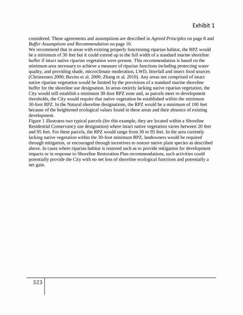
Exhibit 1
323
considered. These agreements and assumptions are described in Agreed Principles on page 8 and
Buffer Assumptions and Recommendation on page 10.
We recommend that in areas with existing properly functioning riparian habitat, the RPZ would
be a minimum of 30 feet but it could extend up to the full width of a standard marine shoreline
buffer if intact native riparian vegetation were present. This recommendation is based on the
minimum area necessary to achieve a measure of riparian functions including protecting water
quality, and providing shade, microclimate moderation, LWD, litterfall and insect food sources
(Christensen 2000; Bavins et al. 2000; Zhang et al. 2010). Any areas not comprised of intact
native riparian vegetation would be limited by the provisions of a standard marine shoreline
buffer for the shoreline use designation. In areas entirely lacking native riparian vegetation, the
City would still establish a minimum 30-foot RPZ zone and, as parcels meet re-development
thresholds, the City would require that native vegetation be established within the minimum
30-foot RPZ. In the Natural shoreline designations, the RPZ would be a minimum of 100 feet
because of the heightened ecological values found in these areas and their absence of existing
development.
Figure 1 illustrates two typical parcels (for this example, they are located within a Shoreline
Residential Conservancy use designation) where intact native vegetation varies between 20 feet
and 95 feet. For these parcels, the RPZ would range from 30 to 95 feet. In the area currently
lacking native vegetation within the 30-foot minimum RPZ, landowners would be required
through mitigation, or encouraged through incentives to restore native plant species as described
above. In cases where riparian habitat is restored such as to provide mitigation for development
impacts or in response to Shoreline Restoration Plan recommendations, such activities could
potentially provide the City with no net loss of shoreline ecological functions and potentially a
net gain.
324
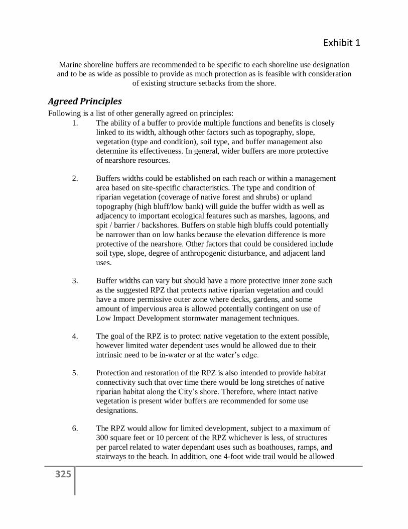
Exhibit 1
325
Marine shoreline buffers are recommended to be specific to each shoreline use designation
and to be as wide as possible to provide as much protection as is feasible with consideration
of existing structure setbacks from the shore.
Agreed Principles Following is a list of other generally agreed on principles:
1. The ability of a buffer to provide multiple functions and benefits is closely
linked to its width, although other factors such as topography, slope,
vegetation (type and condition), soil type, and buffer management also
determine its effectiveness. In general, wider buffers are more protective
of nearshore resources.
2. Buffers widths could be established on each reach or within a management
area based on site-specific characteristics. The type and condition of
riparian vegetation (coverage of native forest and shrubs) or upland
topography (high bluff/low bank) will guide the buffer width as well as
adjacency to important ecological features such as marshes, lagoons, and
spit / barrier / backshores. Buffers on stable high bluffs could potentially
be narrower than on low banks because the elevation difference is more
protective of the nearshore. Other factors that could be considered include
soil type, slope, degree of anthropogenic disturbance, and adjacent land
uses.
3. Buffer widths can vary but should have a more protective inner zone such
as the suggested RPZ that protects native riparian vegetation and could
have a more permissive outer zone where decks, gardens, and some
amount of impervious area is allowed potentially contingent on use of
Low Impact Development stormwater management techniques.
4. The goal of the RPZ is to protect native vegetation to the extent possible,
however limited water dependent uses would be allowed due to their
intrinsic need to be in-water or at the water’s edge.
5. Protection and restoration of the RPZ is also intended to provide habitat
connectivity such that over time there would be long stretches of native
riparian habitat along the City’s shore. Therefore, where intact native
vegetation is present wider buffers are recommended for some use
designations.
6. The RPZ would allow for limited development, subject to a maximum of
300 square feet or 10 percent of the RPZ whichever is less, of structures
per parcel related to water dependant uses such as boathouses, ramps, and
stairways to the beach. In addition, one 4-foot wide trail would be allowed

326
for beach access. Structures or trails exceeding those thresholds would
require a variance.
7. While there will be prescriptive standards, flexibility will be achieved by a
marine shoreline buffer range that considers different development
conditions and uses, and by allowing an option for a qualified professional
to prepare a “critical areas stewardship plan” similar to Jefferson County’s
SMP example.
8. Properties along the Aquatic Conservancy use designation would not be
allowed to have reduced buffers.
9. Properties within a Natural Area use designation would be prohibited from
any shoreline development in the RPZ except for one 4-foot wide trail for
beach access.
10. When a project will result in impacts and require mitigation measures, the
mitigation would include restoration of the native plant ecosystem. For
example mitigation activities could include re-establishing native dune
grasses, forests or other habitat communities, as natural conditions would
warrant for the site.
11. Lots may be provided an exception to buffer standards (e.g., lots less than
a certain depth where the combination of setbacks and typical building
footprint would not allow for use of the property).
12. Buffer averaging allowing variable widths would provide flexibility and
can be protective of nearshore functions and resources.
13. Existing developed properties with wider shoreline parcels would be
allowed to have variable buffer widths (narrower in front of existing
structures and wider when moving laterally from the building and
perpendicular from the shoreline).
14. We note that critical saltwater environments are based on presence of
primary species which means most if not all of the City shoreline areas
need some level of nearshore habitat protection (based on WAC173-26).3
3 From 173-26 WAC: Critical saltwater habitats include all kelp beds, eelgrass beds, spawning and holding areas for forage
fish, such as herring, smelt and sandlance; subsistence, commercial and recreational shellfish beds; mudflats, intertidal habitats with vascular plants, and areas with which priority species have a primary association. Critical saltwater habitats require a higher level of protection due to the important ecological functions they provide. Ecological functions of marine shorelands can affect the viability of critical saltwater habitats. Therefore, effective protection and restoration of critical saltwater habitats should integrate management of shorelands as well as submerged areas.

Exhibit 1
327
Buffer Assumptions and Recommendations To bracket the range of various buffer widths from the scientific literature, we considered the
following:
Existing development regulations
Future land use
The City’s existing environmental buffers
Existing shoreline character (physical & biological) and nearshore assets
Recently adopted marine shoreline management plans from Puget Sound
jurisdictions
A review of the distance of existing residential structures from the
OHWM (to consider the City’s desire to limit the number of new non-
conforming structures)
Table 1 shows the mean, median, and standard deviation of the distance between the ordinary
high water mark (OHWM) and existing primary residential structures for each shoreline use
designation as determined by a GIS analysis of 2009 aerial photographs of land cover on the
City’s shorelines (data provided by the City). These distances were used to identify typical
existing conditions for each proposed use designation.
Table 1 also indicates the suggested RPZ and marine shoreline buffer widths for each proposed
use designation that resulted from our review of scientific literature, the City’s existing shoreline
regulations, existing shoreline character, the distance of existing structures from the shoreline,
nearshore assets, existing and future land uses, and discussions with City staff. A minimum and a
maximum marine shoreline buffer is offered that would vary based on existing parcel conditions
where shallow lots (lots less than 200 feet from the OHWM) or high bluff shoreline parcels
would have narrower buffers and deeper lots (lots greater than 200 feet from the OHWM) or
those with 65 percent coverage of native trees and shrubs within the RPZ, low banks, marshes,
lagoons or spit / barrier / backshores would have wider buffer requirements. The table also
distinguishes buffer requirements for developed lots versus undeveloped lots in the Shoreline
Residential Conservancy use designation. Existing City regulations require a 115-foot buffer on
estuarine wetlands. That requirement is recommended for developed lots in the Shoreline
Residential Conservancy use designation in order to reduce the number of non-compliant
structures, and it is expanded to 150 feet for undeveloped lots in order to advance shoreline
protection when future development occurs.
Figure 2 illustrates an example configuration of the RPZ and marine shoreline buffer for a parcel
with low bank waterfront, 65 percent canopy cover, and a Shoreline Residential use designation.
The recommendations do not distinguish between water-oriented and non-water oriented uses.
Allowances for water-oriented uses would be part of the formal code development process.
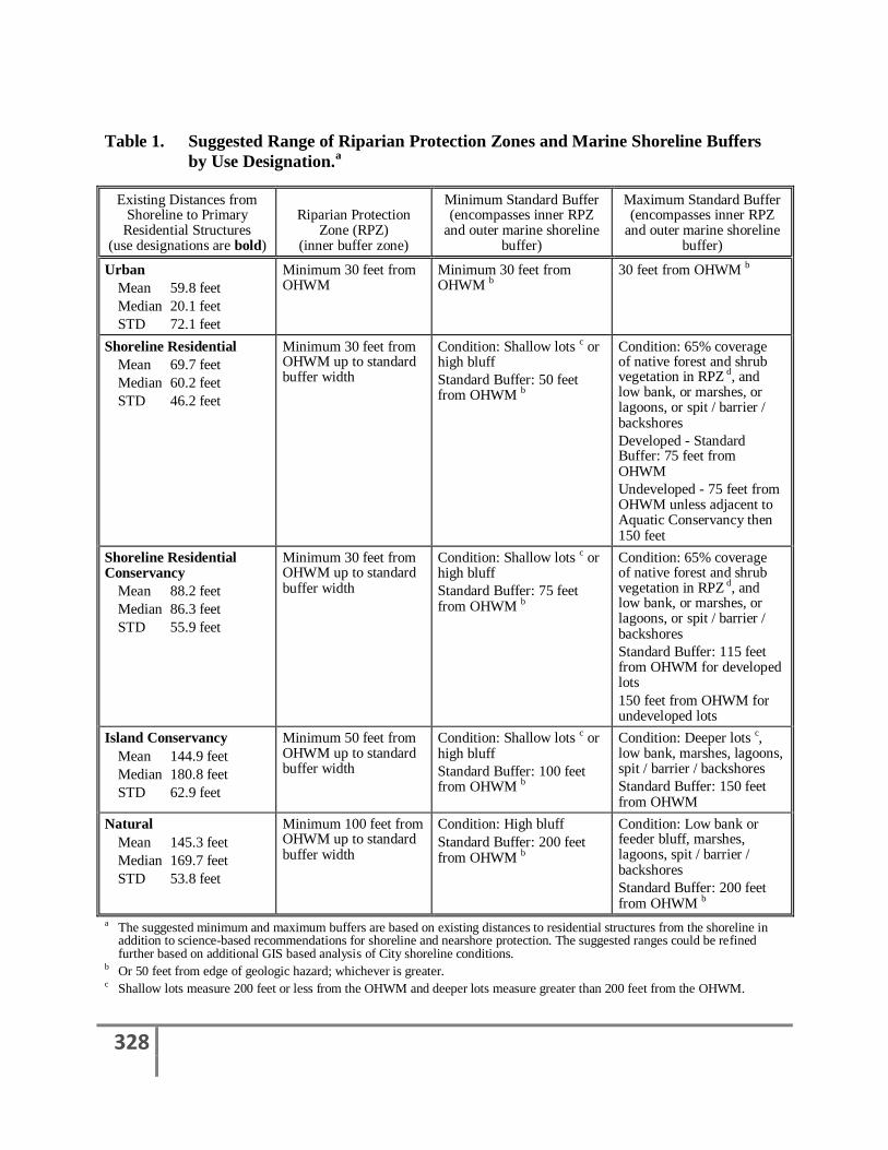
328
Table 1. Suggested Range of Riparian Protection Zones and Marine Shoreline Buffers
by Use Designation.a
Existing Distances from Shoreline to Primary
Residential Structures (use designations are bold)
Riparian Protection Zone (RPZ)
(inner buffer zone)
Minimum Standard Buffer (encompasses inner RPZ
and outer marine shoreline buffer)
Maximum Standard Buffer (encompasses inner RPZ
and outer marine shoreline buffer)
Urban
Mean 59.8 feet
Median 20.1 feet
STD 72.1 feet
Minimum 30 feet from OHWM
Minimum 30 feet from OHWM b
30 feet from OHWM b
Shoreline Residential
Mean 69.7 feet
Median 60.2 feet
STD 46.2 feet
Minimum 30 feet from OHWM up to standard buffer width
Condition: Shallow lots c or high bluff
Standard Buffer: 50 feet from OHWM b
Condition: 65% coverage of native forest and shrub vegetation in RPZ d, and low bank, or marshes, or lagoons, or spit / barrier / backshores
Developed - Standard Buffer: 75 feet from OHWM
Undeveloped - 75 feet from OHWM unless adjacent to Aquatic Conservancy then 150 feet
Shoreline Residential Conservancy
Mean 88.2 feet
Median 86.3 feet
STD 55.9 feet
Minimum 30 feet from OHWM up to standard buffer width
Condition: Shallow lots c or high bluff
Standard Buffer: 75 feet from OHWM b
Condition: 65% coverage of native forest and shrub vegetation in RPZ d, and low bank, or marshes, or lagoons, or spit / barrier / backshores
Standard Buffer: 115 feet from OHWM for developed lots
150 feet from OHWM for undeveloped lots
Island Conservancy
Mean 144.9 feet
Median 180.8 feet
STD 62.9 feet
Minimum 50 feet from OHWM up to standard buffer width
Condition: Shallow lots c or high bluff
Standard Buffer: 100 feet from OHWM b
Condition: Deeper lots c, low bank, marshes, lagoons, spit / barrier / backshores
Standard Buffer: 150 feet from OHWM
Natural
Mean 145.3 feet
Median 169.7 feet
STD 53.8 feet
Minimum 100 feet from OHWM up to standard buffer width
Condition: High bluff
Standard Buffer: 200 feet from OHWM b
Condition: Low bank or feeder bluff, marshes, lagoons, spit / barrier / backshores
Standard Buffer: 200 feet from OHWM b
a The suggested minimum and maximum buffers are based on existing distances to residential structures from the shoreline in addition to science-based recommendations for shoreline and nearshore protection. The suggested ranges could be refined further based on additional GIS based analysis of City shoreline conditions.
b Or 50 feet from edge of geologic hazard; whichever is greater. c Shallow lots measure 200 feet or less from the OHWM and deeper lots measure greater than 200 feet from the OHWM.
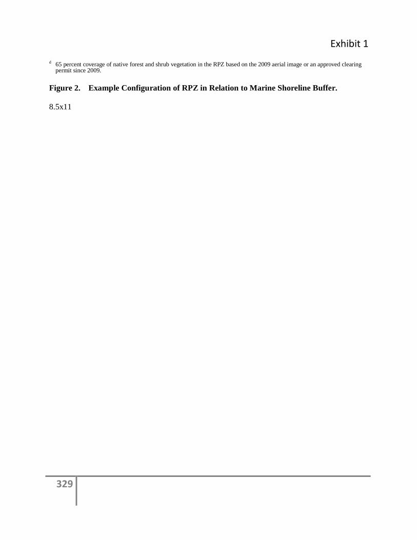
Exhibit 1
329
d 65 percent coverage of native forest and shrub vegetation in the RPZ based on the 2009 aerial image or an approved clearing permit since 2009.
Figure 2. Example Configuration of RPZ in Relation to Marine Shoreline Buffer.
8.5x11
330
References
Bavins, M., D. Couchman, and J. Beumer. 2000. Fisheries Guidelines for Fish Habitat Buffer
Zones. Department of Primary Industries, Queensland, Fish Habitat Guideline FHG 003.
Brennan, J., H. Culverwell, R. Gregg, P. Granger. 2009. Protection of Marine Riparian Functions in
Puget Sound, Washington. Washington Sea Grant. Seattle, Washington. Prepared for Washington
Department of Fish and Wildlife. June 15, 2009.
Brennan, J.S. and H. Culverwell. 2004. Marine Riparian: An Assessment of Riparian Functions in
Marine Ecosystems. Published by Washington Sea Grant Program. Copyright 2005, University of
Washington, Board of Regents, Seattle, Washington. 34 p.
Chaloner D.T., K. Martin, M.S. Wipfli, P.H. Ostrom, G.A. Lamberti. 2002. Marine carbon and
nitrogen in southeastern Alaska stream food webs: evidence from artificial and natural streams.
Can. J. Fish. Aquat. Sci. 59:1257–1265
Christensen, D. 2000. Protection of Riparian Ecosystems: A Review of Best Available Science.
Jefferson County Environmental Health Division, Washington.
Desbonnet, A., P. Pogue, V. Lee, and N. Wolff. 1994. Vegetated buffers in the coastal zone – A
summary review and bibliography. University of Rhode Island, Graduate School of Oceanography.
Eilers, H.P.I. 1975. Plants, plant communities, net production and tide levels: the ecological
biogeography of the Nehalem salt marshes, Tillamook County, Oregon. Oregon State University,
Corvallis, Oregon. 368 pp.
Fresh, K., C. Simenstad, J. Brennan, M. Dethier, G. Gelfenbaum, F. Goetz, M. Logsdon, D. Myers,
T. Mumford, J. Newton, H. Shipman, and C. Tanner. 2004. Guidance for protection and restoration
of the nearshore ecosystems of Puget Sound. Puget Sound Nearshore Partnership Report No.
2004-02. Published by Washington Sea Grant Program, University of Washington, Seattle,
Washington.
Gonor, J., J. Sedell, and P. Benner. 1988. What we know about large trees in estuaries, in the sea,
and on coastal beaches. In From the forest to the sea: a story of fallen trees, edited by C. Maser,
R. Tarrant, J. Trappe and J. Franklin. USDA, Forest Service, Pacific Northwest Research Station,
Portland, Oregon. pp. 83-112.
Herrera. 2005. Marine shoreline sediment survey and assessment, Thurston County, Washington.
Thurston Regional Planning Council, Olympia, Washington. Prepared by Herrera Environmental
Consultants, Inc., Seattle, Washington.
Herrera. 2007. Habitat Modifications White Paper. Washington Department of Fish and Wildlife,
Olympia, Washington. Prepared by Herrera Environmental Consultants, Inc., Seattle, Washington.
Exhibit 1
331
Herrera. 2011. City of Bainbridge Island Addendum to the Summary of Science. Herrera
Environmental Consultants, Inc., Seattle, Washington. January 2011.
Karr, J.R. and I.J. Schlosser. 1977. Impact of Nearstream Vegetation and Stream Morphology
on Water Quality and Stream Biota. Athens, GA: U.S. EPA Ecological Research Series
(EPA-600/3-77/097).
Knutson, K.L. and V.L. Naef. 1997. Management Recommendations for Washington's Priority
Habitats. Riparian. Olympia, Washington: Washington State Department of Fish and Wildlife.
Lemieux, J.P., J.S. Brennan, M. Farrell, C.D. Levings, and D. Myers. 2004. Proceedings of the
DFO/PSAT sponsored marine riparian experts workshop. Tsawwassen, British Columbia: Canadian
Manuscript Report of Fisheries and Aquatic Sciences.
Levings, C. and G. Jamieson. 2001. Marine and Estuarine Riparian Habitats and Their Role in
Coastal Ecosystems, Pacific Region. Fisheries & Oceans Canada, Science Branch, West Vancouver,
B.C. Research document 2001/109.
May, C.W. 2003. Stream-Riparian Ecosystems in the Puget Sound Lowland Eco-Region: A Review
of Best Available Science. Watershed Ecology LLC.
Penttila, D. 2007. Marine Forage Fishes in Puget Sound. Puget Sound Nearshore Partnership Report
No. 2007-03. Published by U.S. Army Corps of Engineers, Seattle District, Seattle, Washington.
Redman, S., D. Meyers, and D. Averill. 2005. Regional Nearshore and Marine Aspects of Salmon
Recovery in Puget Sound. Shared Strategy for Puget Sound. June 28, 2005.
Romanuk, T.N. and C.D. Levings. 2010. Reciprocal Subsidies and Food Web Pathways Leading to
Chum Salmon Fry in a Temperate Marine-Terrestrial Ecotone. PLoS ONE 5(4):e10073.
doi:10.1371/journal.pone.0010073.
Williams, G.D. and R.M. Thom. 2001. Marine and Estuarine Shoreline Modification Issues White
Paper. Olympia, Washington.
Wipfli, M.S., J.P. Hudson, J.P. Caouette, and D.T. Chaloner. 2003. Marine subsidies in freshwater
ecosystems: salmon carcasses increase the growth rates of stream-resident salmonids. Transactions
of the American Fisheries Society 132:371-381.
Zhang, X, X. Liu, M. Zhang, R. Dahlgren, and M. Eitzel. 2010. A Review of Vegetated Buffers and
a Meta-analysis of their Mitigation Efficacy in Reducing Nonpoint Source Pollution. J. Environ.
Qual. 39:76-84.
332
ATTACHMENT A
Current Marine Shoreline Buffer Requirements
and Allowed Buffer Uses in the City of Bainbridge Island
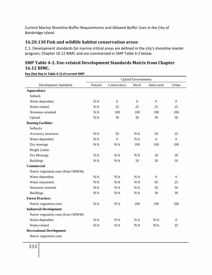
333
Current Marine Shoreline Buffer Requirements and Allowed Buffer Uses in the City of Bainbridge Island
16.20.130 Fish and wildlife habitat conservation areas:
C.1. Development standards for marine critical areas are defined in the city’s shoreline master program, Chapter 16.12 BIMC and are summarized in SMP Table 4-2 below.
SMP Table 4-2. Use-related Development Standards Matrix from Chapter 16.12 BIMC. Key (See Key in Table 4-1) of current SMP
Development Standards
Upland Environments
Natural Conservancy Rural Semi-rural Urban
Aquaculture
Setback
Water-dependent N/A 0 0 0 0
Water-related N/A 25 25 25 25
Nonwater-oriented N/A 100 100 100 100
Upland N/A 30 30 30 30
Boating Facilities
Setbacks
Accessory structures N/A 50 N/A 50 25
Water-dependent N/A 0 N/A 0 0
Dry moorage N/A N/A 100 100 100
Height Limits
Dry Moorage N/A N/A N/A 30 30
Buildings N/A N/A 20 20 20
Commercial
Native vegetation zone (from OHWM)
Water-dependent N/A N/A N/A 0 0
Water-enjoyment N/A N/A N/A 50 25
Nonwater-oriented N/A N/A N/A 50 50
Buildings N/A N/A N/A 30 30
Forest Practices
Native vegetation zone: N/A N/A 100 100 100
Industrial Development
Native vegetation zone (from OHWM)
Water-dependent N/A N/A N/A N/A 0
Water-related N/A N/A N/A N/A 25
Recreational Development
Native vegetation zone
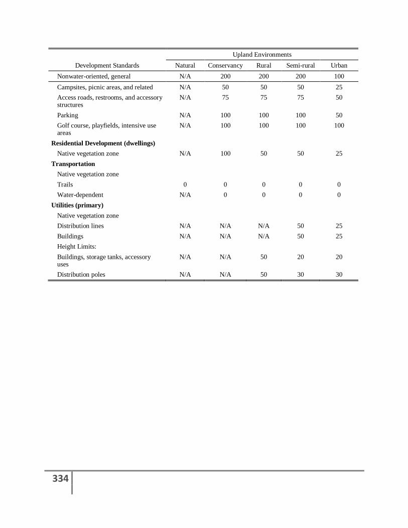
334
Development Standards
Upland Environments
Natural Conservancy Rural Semi-rural Urban
Nonwater-oriented, general N/A 200 200 200 100
Campsites, picnic areas, and related N/A 50 50 50 25
Access roads, restrooms, and accessory structures
N/A 75 75 75 50
Parking N/A 100 100 100 50
Golf course, playfields, intensive use areas
N/A 100 100 100 100
Residential Development (dwellings)
Native vegetation zone N/A 100 50 50 25
Transportation
Native vegetation zone
Trails 0 0 0 0 0
Water-dependent N/A 0 0 0 0
Utilities (primary)
Native vegetation zone
Distribution lines N/A N/A N/A 50 25
Buildings N/A N/A N/A 50 25
Height Limits:
Buildings, storage tanks, accessory uses
N/A N/A 50 20 20
Distribution poles N/A N/A 50 30 30
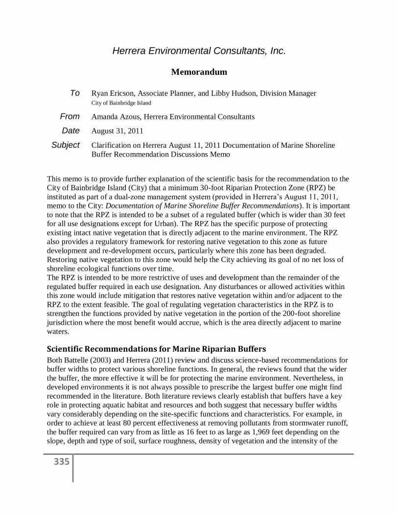
335
Herrera Environmental Consultants, Inc.
Memorandum
To Ryan Ericson, Associate Planner, and Libby Hudson, Division Manager
City of Bainbridge Island
From Amanda Azous, Herrera Environmental Consultants
Date August 31, 2011
Subject Clarification on Herrera August 11, 2011 Documentation of Marine Shoreline
Buffer Recommendation Discussions Memo
This memo is to provide further explanation of the scientific basis for the recommendation to the
City of Bainbridge Island (City) that a minimum 30-foot Riparian Protection Zone (RPZ) be
instituted as part of a dual-zone management system (provided in Herrera’s August 11, 2011,
memo to the City: Documentation of Marine Shoreline Buffer Recommendations). It is important
to note that the RPZ is intended to be a subset of a regulated buffer (which is wider than 30 feet
for all use designations except for Urban). The RPZ has the specific purpose of protecting
existing intact native vegetation that is directly adjacent to the marine environment. The RPZ
also provides a regulatory framework for restoring native vegetation to this zone as future
development and re-development occurs, particularly where this zone has been degraded.
Restoring native vegetation to this zone would help the City achieving its goal of no net loss of
shoreline ecological functions over time.
The RPZ is intended to be more restrictive of uses and development than the remainder of the
regulated buffer required in each use designation. Any disturbances or allowed activities within
this zone would include mitigation that restores native vegetation within and/or adjacent to the
RPZ to the extent feasible. The goal of regulating vegetation characteristics in the RPZ is to
strengthen the functions provided by native vegetation in the portion of the 200-foot shoreline
jurisdiction where the most benefit would accrue, which is the area directly adjacent to marine
waters.
Scientific Recommendations for Marine Riparian Buffers
Both Battelle (2003) and Herrera (2011) review and discuss science-based recommendations for
buffer widths to protect various shoreline functions. In general, the reviews found that the wider
the buffer, the more effective it will be for protecting the marine environment. Nevertheless, in
developed environments it is not always possible to prescribe the largest buffer one might find
recommended in the literature. Both literature reviews clearly establish that buffers have a key
role in protecting aquatic habitat and resources and both suggest that necessary buffer widths
vary considerably depending on the site-specific functions and characteristics. For example, in
order to achieve at least 80 percent effectiveness at removing pollutants from stormwater runoff,
the buffer required can vary from as little as 16 feet to as large as 1,969 feet depending on the
slope, depth and type of soil, surface roughness, density of vegetation and the intensity of the
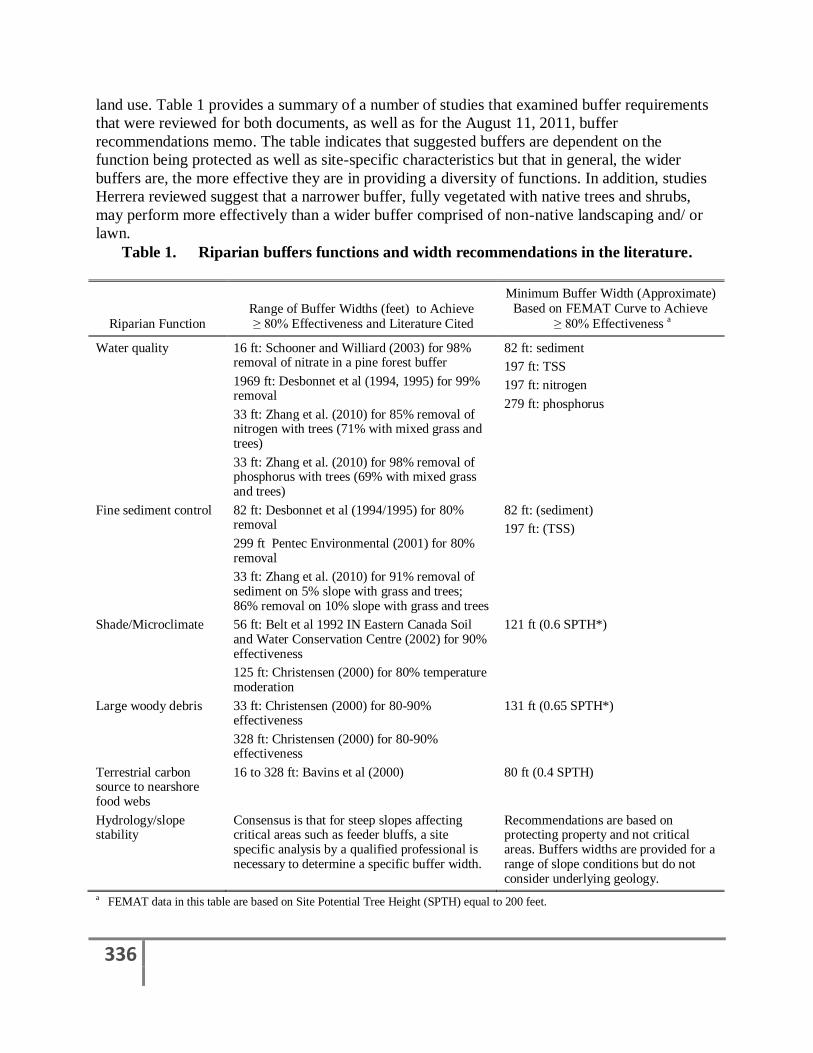
336
land use. Table 1 provides a summary of a number of studies that examined buffer requirements
that were reviewed for both documents, as well as for the August 11, 2011, buffer
recommendations memo. The table indicates that suggested buffers are dependent on the
function being protected as well as site-specific characteristics but that in general, the wider
buffers are, the more effective they are in providing a diversity of functions. In addition, studies
Herrera reviewed suggest that a narrower buffer, fully vegetated with native trees and shrubs,
may perform more effectively than a wider buffer comprised of non-native landscaping and/ or
lawn.
Table 1. Riparian buffers functions and width recommendations in the literature.
Riparian Function Range of Buffer Widths (feet) to Achieve ≥ 80% Effectiveness and Literature Cited
Minimum Buffer Width (Approximate) Based on FEMAT Curve to Achieve
≥ 80% Effectiveness a
Water quality 16 ft: Schooner and Williard (2003) for 98% removal of nitrate in a pine forest buffer
82 ft: sediment
197 ft: TSS
197 ft: nitrogen
279 ft: phosphorus
1969 ft: Desbonnet et al (1994, 1995) for 99% removal
33 ft: Zhang et al. (2010) for 85% removal of nitrogen with trees (71% with mixed grass and trees)
33 ft: Zhang et al. (2010) for 98% removal of phosphorus with trees (69% with mixed grass and trees)
Fine sediment control 82 ft: Desbonnet et al (1994/1995) for 80% removal
82 ft: (sediment)
197 ft: (TSS) 299 ft Pentec Environmental (2001) for 80% removal
33 ft: Zhang et al. (2010) for 91% removal of sediment on 5% slope with grass and trees; 86% removal on 10% slope with grass and trees
Shade/Microclimate 56 ft: Belt et al 1992 IN Eastern Canada Soil and Water Conservation Centre (2002) for 90% effectiveness
121 ft (0.6 SPTH*)
125 ft: Christensen (2000) for 80% temperature moderation
Large woody debris 33 ft: Christensen (2000) for 80-90% effectiveness
131 ft (0.65 SPTH*)
328 ft: Christensen (2000) for 80-90% effectiveness
Terrestrial carbon source to nearshore food webs
16 to 328 ft: Bavins et al (2000) 80 ft (0.4 SPTH)
Hydrology/slope stability
Consensus is that for steep slopes affecting critical areas such as feeder bluffs, a site specific analysis by a qualified professional is necessary to determine a specific buffer width.
Recommendations are based on protecting property and not critical areas. Buffers widths are provided for a range of slope conditions but do not consider underlying geology.
a FEMAT data in this table are based on Site Potential Tree Height (SPTH) equal to 200 feet.
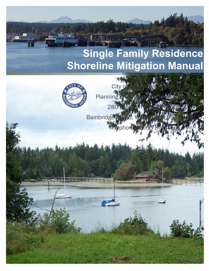
Single Family Residence Shoreline Mitigation Manual
July 2012
City of Bainbridge Island
Planning & Community Development
280 Madison Avenue North
Bainbridge Island, Washington 98110-1812
Telephone: 206.780.3750
Prepared by
Herrera Environmental Consultants, Inc
2200 Sixth Avenue, Suite 1100
Seattle, Washington 98121
Telephone: 206.441.9080
Contents
Introduction 1
Mitigation Requirements 6
Vegetation is Cleared 6
New Impervious Surface is Created 9
Aquatic Habitat is Disturbed 12
What is the Process for Obtaining Approval to Use this Guidance? 14
Checklists for Mitigation Approval 16
Permitted Fill Material is Placed Below OHWM 10
Mitigation Exemption for Repair or Replacement of Overwater Structures 13

Single Family Residence Shoreline Mitigation Manual 1
IntroductionThis manual provides guidance for City of Bainbridge Island (City) homeowners as well as City staff and consultants on requirements and mitigation opportunities for specific types of single-family residential (SFR) development within the shoreline jurisdiction of the City.
Under Washington State Shoreline Management Act Guidelines [WAC 173-26-186(8) & 201(2)(c)], all new development, activities and uses must meet the standard of no net loss of ecological functions and shoreline processes. To ensure the standard of no net loss is met, any adverse impacts from new, repaired, or replaced development must be mitigated in accordance with the Mitigation Sequence (see Page 2) described in WAC 173-26-201((2)(e). When there are permanent impacts not addressed in sequence number 2, 3, or 4 the applicant must provide mitigation for the remaining adverse impacts to meet the no net loss standard.
The City’s Shoreline Management Program (SMP) regulations require an applicant submit a site-specific analysis to demonstrate that the no net loss standard has been met. A site-specific analysis is a technical report that identifies existing conditions and ecological functions, impacts from the project, and proposed mitigation.
To give homeowners a low cost alternative for meeting the no net loss standard, this manual was developed and provides mitigation for common types of SFR development as an alternative to submitting a site-specific analysis.
This manual provides City requirements for single family residences when mitigating construction, repair or replacement of SFR primary and accessory structures. Subdivisions, including short plats and other development, and uses or activities not associated with SFR development, are required to provide a site-specific analysis in accordance with the SMP Section 4.1.2 Environmental Impacts.
A homeowner can use this shoreline mitigation manual if:• the SFR is not part of a new subdivision
application; and
• the proposed project is located within a qualifying site (see below); and
• the proposed project is listed among the development and structure types and maximum size constraints covered by this guidance (shown in Table 1).
Washington State Shoreline Management Act Guidelines:
http://www.ecy.wa.gov/programs/sea/sma/guidelines/downloads/Draft_2002_SMP_Rule.pdf
What sites qualify for this approach?Sites which qualify for this manual are SFR shoreline parcels that are not adjacent to a marsh or a lagoon. Marshes and lagoons are a critical habitat feature for many protected species and therefore development proposals affecting these sites require a higher level of examination. Proposed development on SFR sites with an adjacent marsh or lagoon must complete a site-specific analysis that complies with the requirements of SMP Section 4.1.2, Environmental Impacts, and/or Appendix B, Critical Areas.
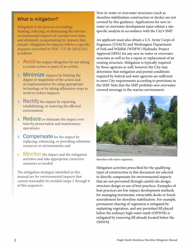
Single Family Residence Shoreline Mitigation Manual2
What is mitigation?Mitigation is the process of avoiding, limiting, reducing, or eliminating the adverse environmental impacts of a project over time, and ultimately compensating for impacts that remain. Mitigation for impacts follows a specific sequence described in WAC 173-26-201((2)(e) as follows:
1. Avoid the impact altogether by not taking a certain action or parts of an action;
2. Minimize impacts by limiting the degree or magnitude of the action and its implementation by using appropriate technology or by taking affirmative steps to avoid or reduce impacts;
3. Rectify the impact by repairing, rehabilitating, or restoring the affected environment;
4. Reduce or eliminate the impact over time by preservation and maintenance operations;
5. Compensate for the impact by replacing, enhancing, or providing substitute resources or environments; and
6. Monitor the impact and the mitigation activities and take appropriate corrective measures as needed.
The mitigation strategies identified in this manual are for environmental impacts that cannot reasonably be avoided (steps 2 through 6 of this sequence).
New in-water or overwater structures (such as shoreline stabilization construction or docks) are not covered by this guidance. Applications for new in-water or overwater development must submit a site-specific analysis in accordance with the City’s SMP.
An applicant must also obtain a U.S. Army Corps of Engineers (USACE) and Washington Department of Fish and Wildlife (WDFW) Hydraulic Project Approval (HPA) for any new in-water or overwater structure as well as for a repair or replacement of an existing structure. Mitigation is typically required by those agencies as well, however the City may determine that mitigation and permit conditions required by federal and state agencies are sufficient to meet City requirements according to provisions in the SMP. Note that the SMP prohibits new overwater covered moorage in the marine environment .
Mitigation activities prescribed for the qualifying types of construction in this document are selected to directly compensate for environmental impacts that are not prevented through careful site design, structure design or use of best practices. Examples of best practices are low impact development methods for managing stormwater, retractable docks or beach nourishment for shoreline stabilization. For example, permanent clearing of vegetation is mitigated by replanting vegetation, and any permitted fill placed below the ordinary high water mark (OHWM) is mitigated by removing fill already located below the OHWM.
Shoreline with native vegetation.
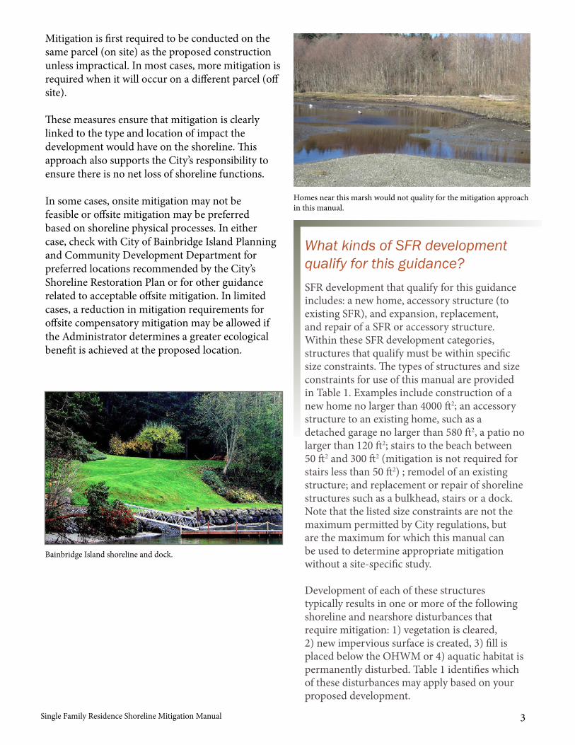
Single Family Residence Shoreline Mitigation Manual 3
Mitigation is first required to be conducted on the same parcel (on site) as the proposed construction unless impractical. In most cases, more mitigation is required when it will occur on a different parcel (off site).
These measures ensure that mitigation is clearly linked to the type and location of impact the development would have on the shoreline. This approach also supports the City’s responsibility to ensure there is no net loss of shoreline functions.
In some cases, onsite mitigation may not be feasible or offsite mitigation may be preferred based on shoreline physical processes. In either case, check with City of Bainbridge Island Planning and Community Development Department for preferred locations recommended by the City’s Shoreline Restoration Plan or for other guidance related to acceptable offsite mitigation. In limited cases, a reduction in mitigation requirements for offsite compensatory mitigation may be allowed if the Administrator determines a greater ecological benefit is achieved at the proposed location.
What kinds of SFR development qualify for this guidance?SFR development that qualify for this guidance includes: a new home, accessory structure (to existing SFR), and expansion, replacement, and repair of a SFR or accessory structure. Within these SFR development categories, structures that qualify must be within specific size constraints. The types of structures and size constraints for use of this manual are provided in Table 1. Examples include construction of a new home no larger than 4000 ft2; an accessory structure to an existing home, such as a detached garage no larger than 580 ft2, a patio no larger than 120 ft2; stairs to the beach between 50 ft2 and 300 ft2 (mitigation is not required for stairs less than 50 ft2) ; remodel of an existing structure; and replacement or repair of shoreline structures such as a bulkhead, stairs or a dock. Note that the listed size constraints are not the maximum permitted by City regulations, but are the maximum for which this manual can be used to determine appropriate mitigation without a site-specific study.
Development of each of these structures typically results in one or more of the following shoreline and nearshore disturbances that require mitigation: 1) vegetation is cleared, 2) new impervious surface is created, 3) fill isplaced below the OHWM or 4) aquatic habitat is permanently disturbed. Table 1 identifies which of these disturbances may apply based on your proposed development.
Homes near this marsh would not quality for the mitigation approach in this manual.
Bainbridge Island shoreline and dock.
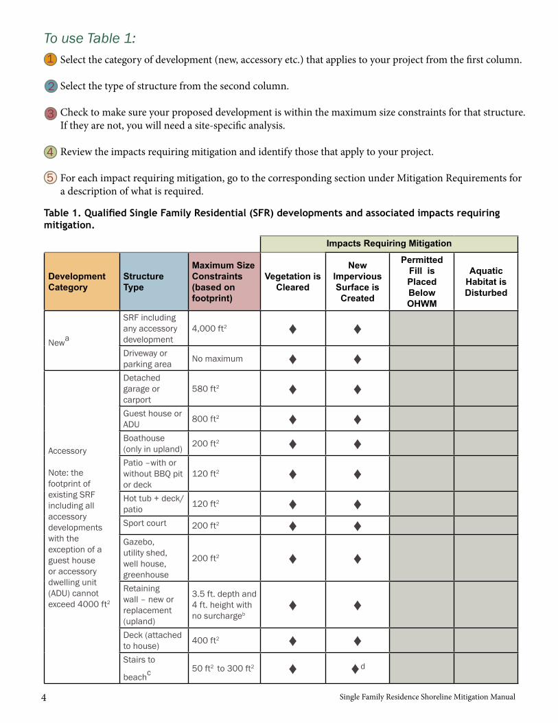
Single Family Residence Shoreline Mitigation Manual4
To use Table 1:Select the category of development (new, accessory etc.) that applies to your project from the first column.
Select the type of structure from the second column.
Check to make sure your proposed development is within the maximum size constraints for that structure. If they are not, you will need a site-specific analysis.
Review the impacts requiring mitigation and identify those that apply to your project.
For each impact requiring mitigation, go to the corresponding section under Mitigation Requirements for a description of what is required.
1
2
3
4
5
Impacts Requiring Mitigation
Development Category
Structure Type
Maximum Size Constraints (based on footprint)
Vegetation is Cleared
New Impervious Surface is Created
Permitted Fill is Placed Below OHWM
Aquatic Habitat is Disturbed
Newa
SRF including any accessory development
4,000 ft2 ♦ ♦Driveway or parking area No maximum ♦ ♦
Accessory
Note: the footprint of existing SRF including all accessory developments with the exception of a guest house or accessory dwelling unit (ADU) cannot exceed 4000 ft2
Detached garage or carport
580 ft2 ♦ ♦Guest house or ADU 800 ft2 ♦ ♦Boathouse (only in upland) 200 ft2 ♦ ♦Patio –with or without BBQ pit or deck
120 ft2 ♦ ♦Hot tub + deck/patio 120 ft2 ♦ ♦Sport court 200 ft2 ♦ ♦Gazebo, utility shed, well house, greenhouse
200 ft2 ♦ ♦
Retaining wall – new or replacement (upland)
3.5 ft. depth and 4 ft. height with no surchargeb
♦ ♦
Deck (attached to house) 400 ft2 ♦ ♦Stairs to
beachc 50 ft2 to 300 ft2 ♦ ♦d
Table 1. Qualified Single Family Residential (SFR) developments and associated impacts requiring mitigation.
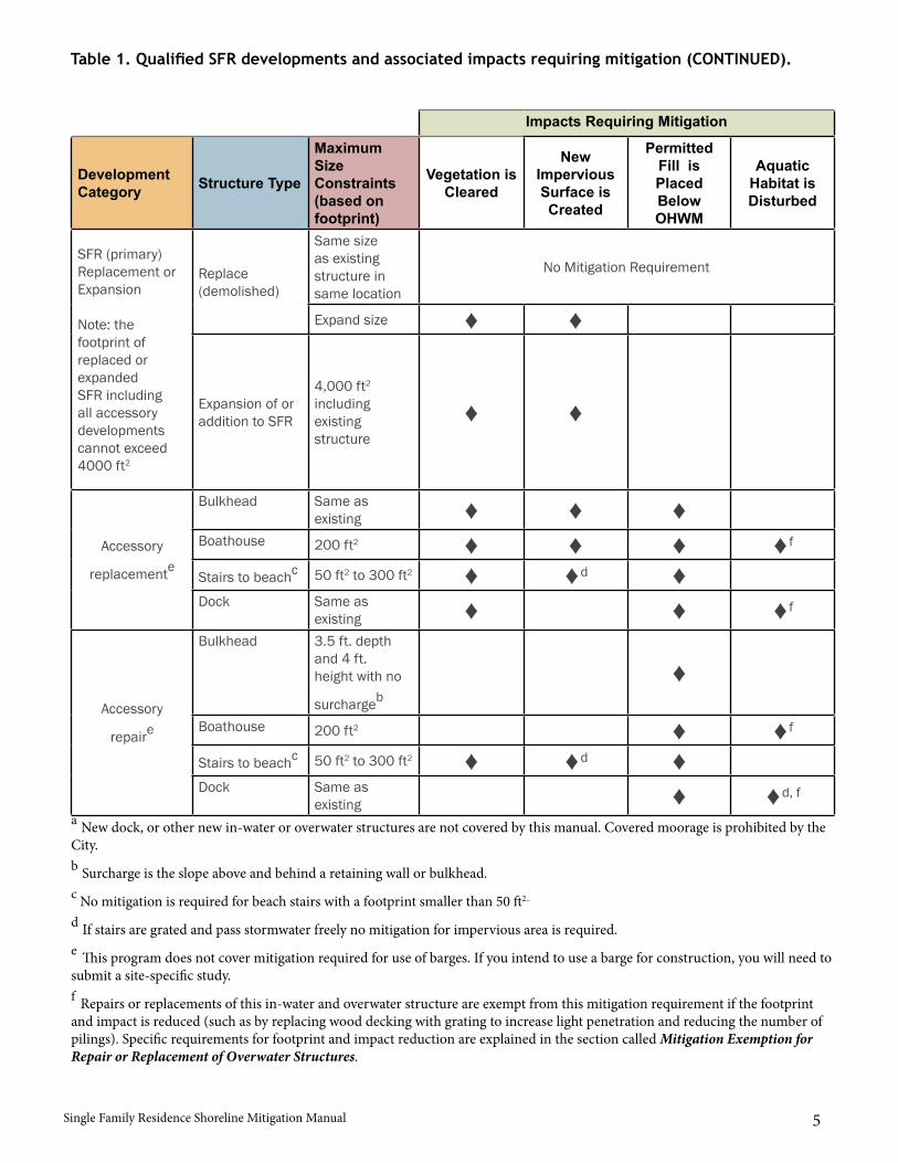
Single Family Residence Shoreline Mitigation Manual 5
Impacts Requiring Mitigation
Development Category Structure Type
Maximum Size Constraints (based on footprint)
Vegetation is Cleared
New Impervious Surface is Created
Permitted Fill is Placed Below OHWM
Aquatic Habitat is Disturbed
SFR (primary) Replacement or Expansion
Note: the footprint of replaced or expanded SFR including all accessory developments cannot exceed 4000 ft2
Replace (demolished)
Same size as existing structure in same location
No Mitigation Requirement
Expand size ♦ ♦
Expansion of or addition to SFR
4,000 ft2 including existing structure
♦ ♦
Accessory
replacemente
Bulkhead Same as existing ♦ ♦ ♦
Boathouse 200 ft2 ♦ ♦ ♦ ♦f
Stairs to beachc 50 ft2 to 300 ft2 ♦ ♦d ♦Dock Same as
existing ♦ ♦ ♦f
Accessory
repaire
Bulkhead 3.5 ft. depth and 4 ft. height with no
surchargeb♦
Boathouse 200 ft2 ♦ ♦f
Stairs to beachc 50 ft2 to 300 ft2 ♦ ♦d ♦Dock Same as
existing ♦ ♦d, f
Table 1. Qualified SFR developments and associated impacts requiring mitigation (CONTINUED).
a New dock, or other new in-water or overwater structures are not covered by this manual. Covered moorage is prohibited by theCity.b Surcharge is the slope above and behind a retaining wall or bulkhead.c No mitigation is required for beach stairs with a footprint smaller than 50 ft2..
d If stairs are grated and pass stormwater freely no mitigation for impervious area is required.e This program does not cover mitigation required for use of barges. If you intend to use a barge for construction, you will need tosubmit a site-specific study.f Repairs or replacements of this in-water and overwater structure are exempt from this mitigation requirement if the footprintand impact is reduced (such as by replacing wood decking with grating to increase light penetration and reducing the number of pilings). Specific requirements for footprint and impact reduction are explained in the section called Mitigation Exemption for Repair or Replacement of Overwater Structures.
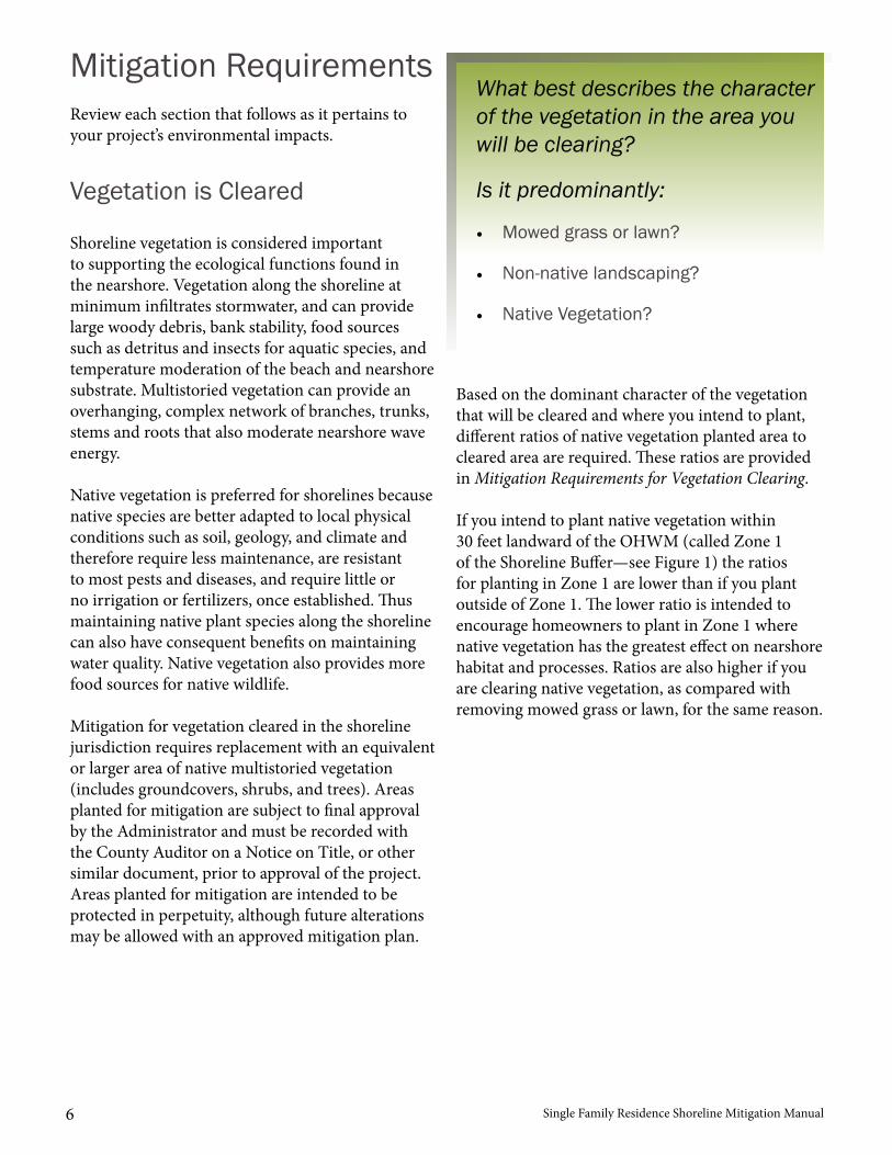
Single Family Residence Shoreline Mitigation Manual6
Mitigation Requirements
Vegetation is Cleared
Review each section that follows as it pertains to your project’s environmental impacts.
Shoreline vegetation is considered important to supporting the ecological functions found in the nearshore. Vegetation along the shoreline at minimum infiltrates stormwater, and can provide large woody debris, bank stability, food sources such as detritus and insects for aquatic species, and temperature moderation of the beach and nearshore substrate. Multistoried vegetation can provide an overhanging, complex network of branches, trunks, stems and roots that also moderate nearshore wave energy.
Native vegetation is preferred for shorelines because native species are better adapted to local physical conditions such as soil, geology, and climate and therefore require less maintenance, are resistant to most pests and diseases, and require little or no irrigation or fertilizers, once established. Thus maintaining native plant species along the shoreline can also have consequent benefits on maintaining water quality. Native vegetation also provides more food sources for native wildlife.
Mitigation for vegetation cleared in the shoreline jurisdiction requires replacement with an equivalent or larger area of native multistoried vegetation (includes groundcovers, shrubs, and trees). Areas planted for mitigation are subject to final approval by the Administrator and must be recorded with the County Auditor on a Notice on Title, or other similar document, prior to approval of the project. Areas planted for mitigation are intended to be protected in perpetuity, although future alterations may be allowed with an approved mitigation plan.
Based on the dominant character of the vegetation that will be cleared and where you intend to plant, different ratios of native vegetation planted area to cleared area are required. These ratios are provided in Mitigation Requirements for Vegetation Clearing.
If you intend to plant native vegetation within 30 feet landward of the OHWM (called Zone 1 of the Shoreline Buffer—see Figure 1) the ratios for planting in Zone 1 are lower than if you plant outside of Zone 1. The lower ratio is intended to encourage homeowners to plant in Zone 1 where native vegetation has the greatest effect on nearshore habitat and processes. Ratios are also higher if you are clearing native vegetation, as compared with removing mowed grass or lawn, for the same reason.
What best describes the character of the vegetation in the area you will be clearing?
Is it predominantly:
• Mowed grass or lawn?
• Non-native landscaping?
• Native Vegetation?
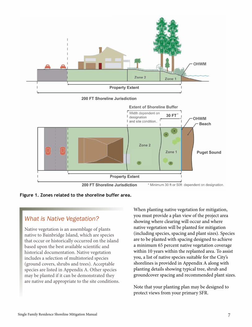
Single Family Residence Shoreline Mitigation Manual 7
When planting native vegetation for mitigation, you must provide a plan view of the project area showing where clearing will occur and where native vegetation will be planted for mitigation (including species, spacing and plant sizes). Species are to be planted with spacing designed to achieve a minimum 65 percent native vegetation coverage within 10 years within the replanted area. To assist you, a list of native species suitable for the City’s shorelines is provided in Appendix A along with planting details showing typical tree, shrub and groundcover spacing and recommended plant sizes.
Note that your planting plan may be designed to protect views from your primary SFR.
Figure 1. Zones related to the shoreline buffer area.
What is Native Vegetation?Native vegetation is an assemblage of plants native to Bainbridge Island, which are species that occur or historically occurred on the island based upon the best available scientific and historical documentation. Native vegetation includes a selection of multistoried species (ground covers, shrubs and trees). Acceptable species are listed in Appendix A. Other species may be planted if it can be demonstrated they are native and appropriate to the site conditions.
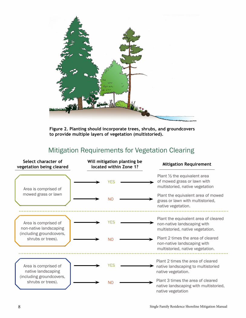
Single Family Residence Shoreline Mitigation Manual8
Mitigation Requirements for Vegetation ClearingSelect character of
vegetation being clearedWill mitigation planting be
located within Zone 1? Mitigation Requirement
Area is comprised of mowed grass or lawn
Plant ½ the equivalent area of mowed grass or lawn with multistoried, native vegetation
Plant the equivalent area of mowed grass or lawn with multistoried, native vegetation.
YES
NO
Plant the equivalent area of cleared non-native landscaping with multistoried, native vegetation.
Plant 2 times the area of cleared non-native landscaping with multistoried, native vegetation.
YES
NO
Area is comprised of non-native landscaping
(including groundcovers, shrubs or trees).
Plant 2 times the area of cleared native landscaping to multistoried native vegetation.
Plant 3 times the area of cleared native landscaping with multistoried, native vegetation
YES
NO
Area is comprised of native landscaping
(including groundcovers, shrubs or trees).
Figure 2. Planting should incorporate trees, shrubs, and groundcovers to provide multiple layers of vegetation (multistoried).
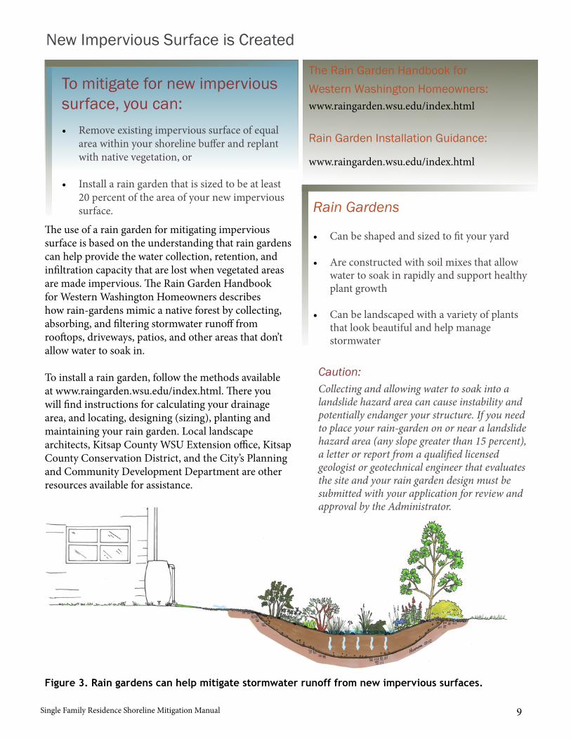
Single Family Residence Shoreline Mitigation Manual 9
The use of a rain garden for mitigating impervious surface is based on the understanding that rain gardens can help provide the water collection, retention, and infiltration capacity that are lost when vegetated areas are made impervious. The Rain Garden Handbook for Western Washington Homeowners describes how rain-gardens mimic a native forest by collecting, absorbing, and filtering stormwater runoff from rooftops, driveways, patios, and other areas that don’t allow water to soak in.
To install a rain garden, follow the methods available at www.raingarden.wsu.edu/index.html. There you will find instructions for calculating your drainage area, and locating, designing (sizing), planting and maintaining your rain garden. Local landscape architects, Kitsap County WSU Extension office, Kitsap County Conservation District, and the City’s Planning and Community Development Department are other resources available for assistance.
To mitigate for new impervious surface, you can:• Remove existing impervious surface of equal
area within your shoreline buffer and replantwith native vegetation, or
• Install a rain garden that is sized to be at least20 percent of the area of your new impervioussurface.
Rain Garden Installation Guidance:
The Rain Garden Handbook for Western Washington Homeowners:www.raingarden.wsu.edu/index.html
www.raingarden.wsu.edu/index.html
New Impervious Surface is Created
Rain Gardens
Caution:
• Can be shaped and sized to fit your yard
• Are constructed with soil mixes that allowwater to soak in rapidly and support healthyplant growth
• Can be landscaped with a variety of plantsthat look beautiful and help managestormwater
Collecting and allowing water to soak into a landslide hazard area can cause instability and potentially endanger your structure. If you need to place your rain-garden on or near a landslide hazard area (any slope greater than 15 percent), a letter or report from a qualified licensed geologist or geotechnical engineer that evaluates the site and your rain garden design must be submitted with your application for review and approval by the Administrator.
Figure 3. Rain gardens can help mitigate stormwater runoff from new impervious surfaces.
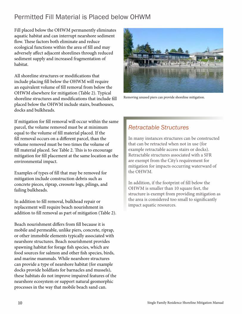
Single Family Residence Shoreline Mitigation Manual10
Permitted Fill Material is Placed below OHWM
Removing unused piers can provide shoreline mitigation.
Fill placed below the OHWM permanently eliminates aquatic habitat and can interrupt nearshore sediment flow. These factors both eliminate and reduce ecological functions within the area of fill and may adversely affect adjacent shorelines through reduced sediment supply and increased fragmentation of habitat.
All shoreline structures or modifications that include placing fill below the OHWM will require an equivalent volume of fill removal from below the OHWM elsewhere for mitigation (Table 2). Typical shoreline structures and modifications that include fill placed below the OHWM include stairs, boathouses, docks and bulkheads.
If mitigation for fill removal will occur within the same parcel, the volume removed must be at minimum equal to the volume of fill material placed. If the fill removal occurs on a different parcel, than the volume removed must be two times the volume of fill material placed. See Table 2. This is to encourage mitigation for fill placement at the same location as the environmental impact.
Examples of types of fill that may be removed for mitigation include construction debris such as concrete pieces, riprap, creosote logs, pilings, and failing bulkheads.
In addition to fill removal, bulkhead repair or replacement will require beach nourishment in addition to fill removal as part of mitigation (Table 2).
Beach nourishment differs from fill because it is mobile and permeable, unlike piers, concrete, riprap, or other immobile elements typically associated with nearshore structures. Beach nourishment provides spawning habitat for forage fish species, which are food sources for salmon and other fish species, birds, and marine mammals. While nearshore structures can provide a type of nearshore habitat (for example docks provide holdfasts for barnacles and mussels), these habitats do not improve impaired features of the nearshore ecosystem or support natural geomorphic processes in the way that mobile beach sand can.
Retractable Structures
In many instances structures can be constructed that can be retracted when not in use (for example retractable access stairs or docks). Retractable structures associated with a SFR are exempt from the City’s requirement for mitigation for impacts occurring waterward of the OHWM.
In addition, if the footprint of fill below the OHWM is smaller than 10 square feet, the structure is exempt from providing mitigation as the area is considered too small to significantly impact aquatic resources.
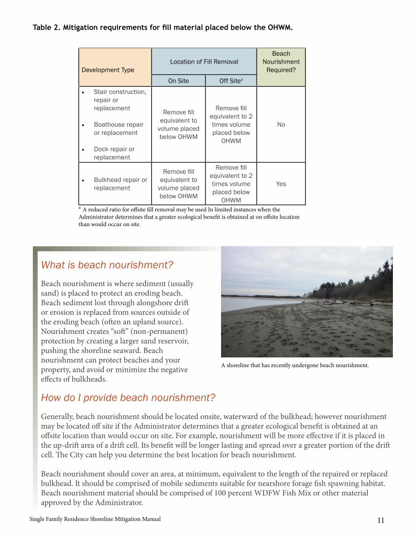
Single Family Residence Shoreline Mitigation Manual 11
A shoreline that has recently undergone beach nourishment.
What is beach nourishment?
How do I provide beach nourishment?
Beach nourishment is where sediment (usually sand) is placed to protect an eroding beach. Beach sediment lost through alongshore drift or erosion is replaced from sources outside of the eroding beach (often an upland source). Nourishment creates “soft” (non-permanent) protection by creating a larger sand reservoir, pushing the shoreline seaward. Beach nourishment can protect beaches and your property, and avoid or minimize the negative effects of bulkheads.
Generally, beach nourishment should be located onsite, waterward of the bulkhead; however nourishment may be located off site if the Administrator determines that a greater ecological benefit is obtained at an offsite location than would occur on site. For example, nourishment will be more effective if it is placed in the up-drift area of a drift cell. Its benefit will be longer lasting and spread over a greater portion of the drift cell. The City can help you determine the best location for beach nourishment.
Beach nourishment should cover an area, at minimum, equivalent to the length of the repaired or replaced bulkhead. It should be comprised of mobile sediments suitable for nearshore forage fish spawning habitat. Beach nourishment material should be comprised of 100 percent WDFW Fish Mix or other material approved by the Administrator.
Development TypeLocation of Fill Removal
Beach Nourishment
Required?On Site Off Sitea
• Stair construction,repair orreplacement
• Boathouse repairor replacement
• Dock repair orreplacement
Remove fill equivalent to
volume placed below OHWM
Remove fill equivalent to 2 times volume placed below
OHWM
No
• Bulkhead repair orreplacement
Remove fill equivalent to
volume placed below OHWM
Remove fill equivalent to 2 times volume placed below
OHWM
Yes
Table 2. Mitigation requirements for fill material placed below the OHWM.
a A reduced ratio for offsite fill removal may be used In limited instances when the Administrator determines that a greater ecological benefit is obtained at on offsite location than would occur on site.
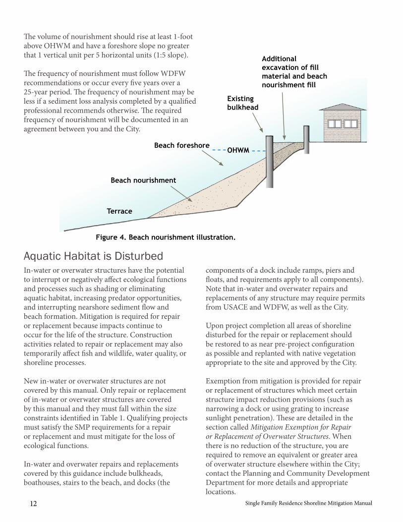
Single Family Residence Shoreline Mitigation Manual12
The volume of nourishment should rise at least 1-foot above OHWM and have a foreshore slope no greater that 1 vertical unit per 5 horizontal units (1:5 slope).
The frequency of nourishment must follow WDFW recommendations or occur every five years over a 25-year period. The frequency of nourishment may be less if a sediment loss analysis completed by a qualified professional recommends otherwise. The required frequency of nourishment will be documented in an agreement between you and the City.
In-water or overwater structures have the potential to interrupt or negatively affect ecological functions and processes such as shading or eliminating aquatic habitat, increasing predator opportunities, and interrupting nearshore sediment flow and beach formation. Mitigation is required for repair or replacement because impacts continue to occur for the life of the structure. Construction activities related to repair or replacement may also temporarily affect fish and wildlife, water quality, or shoreline processes.
New in-water or overwater structures are not covered by this manual. Only repair or replacement of in-water or overwater structures are covered by this manual and they must fall within the size constraints identified in Table 1. Qualifying projects must satisfy the SMP requirements for a repair or replacement and must mitigate for the loss of ecological functions.
In-water and overwater repairs and replacements covered by this guidance include bulkheads, boathouses, stairs to the beach, and docks (the
Figure 4. Beach nourishment illustration.
Aquatic Habitat is Disturbed components of a dock include ramps, piers and floats, and requirements apply to all components). Note that in-water and overwater repairs and replacements of any structure may require permits from USACE and WDFW, as well as the City.
Upon project completion all areas of shoreline disturbed for the repair or replacement should be restored to as near pre-project configuration as possible and replanted with native vegetation appropriate to the site and approved by the City.
Exemption from mitigation is provided for repair or replacement of structures which meet certain structure impact reduction provisions (such as narrowing a dock or using grating to increase sunlight penetration). These are detailed in the section called Mitigation Exemption for Repair or Replacement of Overwater Structures. When there is no reduction of the structure, you are required to remove an equivalent or greater area of overwater structure elsewhere within the City; contact the Planning and Community Development Department for more details and appropriate locations.
OHWMBeach foreshore
Beach nourishment
Existing bulkhead
Additional excavation of fill material and beach nourishment fill
Terrace
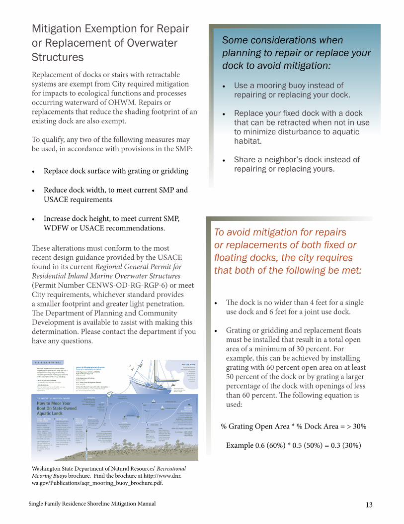
Single Family Residence Shoreline Mitigation Manual 13
Replacement of docks or stairs with retractable systems are exempt from City required mitigation for impacts to ecological functions and processes occurring waterward of OHWM. Repairs or replacements that reduce the shading footprint of an existing dock are also exempt.
To qualify, any two of the following measures may be used, in accordance with provisions in the SMP:
These alterations must conform to the most recent design guidance provided by the USACE found in its current Regional General Permit for Residential Inland Marine Overwater Structures (Permit Number CENWS-OD-RG-RGP-6) or meet City requirements, whichever standard provides a smaller footprint and greater light penetration. The Department of Planning and Community Development is available to assist with making this determination. Please contact the department if you have any questions.
Mitigation Exemption for Repair or Replacement of Overwater Structures
Some considerations when planning to repair or replace your dock to avoid mitigation:
• Use a mooring buoy instead ofrepairing or replacing your dock.
• Replace your fixed dock with a dockthat can be retracted when not in useto minimize disturbance to aquatichabitat.
• Share a neighbor’s dock instead ofrepairing or replacing yours.• Replace dock surface with grating or gridding
• Reduce dock width, to meet current SMP andUSACE requirements
• Increase dock height, to meet current SMP,WDFW or USACE recommendations.
EXTREME HIGH TIDE
EXTREME LOW TIDE
VESSEL SWING
DEHT
DELT
L
CAUTIONVessel may hit anything
located within thevessel swing.
ANCHOR
VESSEL SWING
Buoy-moored boatmust not be more than60 feet in length.
FOR RESIDENTIAL PROPERTY OWNERS
All-Rope System
High-strength nylonrope joins buoy toanchor. The rope’sbuoyancy keeps it fromdragging along thebottom and killingmarine vegetation.Regular maintenance isrequired to keepbarnacles and musselsfrom colonizing on therope and weighing itdown to scour thearea.
How to Moor YourBoat On State-OwnedAquatic Lands
Mid-LineFloat System(Preferred)
A mid-linefloat system(as shownhere) keepsthe anchor linefrom draggingon the bottom,which can killmarinevegetation.
P L E A S E N O T E
Private recreationalmooring buoys are not
authorizedfor residential(living on the
boat) orcommercial
purposes.
DETERMINEYOUR BUOY
MEASUREMENTS
The following mathematicalformula may help you
calculate the anchor linelength (L) and vessel swing.Call your DNR Aquatic District
office for help with the calculation(phone numbers on back).
Anchor line Length (L) = Scope x DEHTDEHTWater Depth atExtreme High Tide.
DELTWater Depth atExtreme Low Tide.
L (Length)Anchor line Length.
SCOPERatio of anchor linelength to water depth.Washington State Parksrecommends between4 and 7 feet of anchorline for every foot ofwater depth.
Poly Rope
Chainkeeps extrascope from
floating to thesurface during
slack water.
Mooring Buoy46 cm diameter, white
propyethylene plastic filledwith polyurethane.
Mark buoy with parcelnumber.
7.5 cm wide bluestripe around buoy.
Swivel
Vessel Swing = (L2) – (DELT)2
+ Mooring line+ Vessel length
6"– 8"Midline Floatattached to the polyrope a distance equalto 1/3 depth at hightide from anchor.
Helix AnchorSystem
U S E R E Q U I R E M E N T S
GRA
PHIC
DES
IGN
AN
D IL
LUST
RATI
ON
: LU
IS P
RAD
O /
DN
R
Mooring buoys havethe potential to impact aquatic
vegetation. DNR discouragesplacement of mooring buoys in
areas that impact aquatichabitat, including kelp beds
and eelgrass meadows.
Contact the following agencies to determineif a permit or authorization is required:
◗ WA Department of Fish and WildlifeHydraulic Project Approval(360) 902-2534
◗ WA Department of Ecology(360) 407-6400
◗ U.S. Army Corps of Engineers (Permit)(206) 764-3495
◗ Shoreline Master Program (Permit or Exemption)Requirements differ by county, addressed throughyour local county planning office.
◗ State Registration with DNRComplete the enclosed insert self-mailer.
◗ City RestrictionsIf you live within city limits, allowable uses vary.Contact your city’s planning office forrequirements.
Although residential landowners whoseproperty abuts state aquatic lands may use arecreational mooring buoy for free, theyare still responsible for meeting requirementsfor the installation of the buoy, including:
CHOOSE A MOORINGSYSTEM DESIGN
Some mooring systemdesigns have thepotential to damageunderwater lands andmarine vegetationaround the buoy. DNR’sLand Managers can helpyou select a system thatbest suites your area.
State Department ofFish and Wildlife hasfound two designs to beless destructive toecosystems, fish andwildlife:
Washington State Department of Natural Resources’ Recreational Mooring Buoys brochure. Find the brochure at http://www.dnr.wa.gov/Publications/aqr_mooring_buoy_brochure.pdf.
To avoid mitigation for repairs or replacements of both fixed or floating docks, the city requires that both of the following be met:
• The dock is no wider than 4 feet for a singleuse dock and 6 feet for a joint use dock.
• Grating or gridding and replacement floatsmust be installed that result in a total openarea of a minimum of 30 percent. Forexample, this can be achieved by installinggrating with 60 percent open area on at least50 percent of the dock or by grating a largerpercentage of the dock with openings of lessthan 60 percent. The following equation isused:
% Grating Open Area * % Dock Area = > 30%
Example 0.6 (60%) * 0.5 (50%) = 0.3 (30%)
Single Family Residence Shoreline Mitigation Manual14
A checklist is provided in this manual to assist you with submitting a complete proposal that fulfills the requirements of this manual. Please contact Planning and Community Development by phone at (206)
780-3750 or by email at [email protected] if you have any questions.
What is the Process for Obtaining Approval to Use this Guidance?
• Submit your project proposal, completed checklist, and site plan along with your list ofrequired mitigation activities and their proposed design to Planning and CommunityDevelopment for review and approval by the Administrator.
• Obtain all required shoreline permits as outlined in Table 4-1 of the SMP.
• Submit these applications along with your project proposal.
• A preapplication conference may be required.
Single Family Residence Shoreline Mitigation Manual 15
For each item below, please attach additional information to this checklist as needed to describe fully your project and proposed mitigation.
Checklists for Mitigation Approval
General Checklist for All Sites
ITEM NOTES
☐ Project description Include a brief description of your proposed structure, along with its footprint.
☐ List of impacts requiring mitigation
See Table 1.
☐ Proposed mitigation description
Will mitigation be onsite or offsite?For offsite mitigation, provide location and confirmation that the property owner has agreed to have mitigation on their property.
☐ Site plan Show locations of existing and proposed structure(s) as well as location(s) for mitigation.

Single Family Residence Shoreline Mitigation Manual16
Checklist for Various Impact Types
ITEM
☐ Vegetation Clearing
☐ Areas of Clearing and Replanting
☐ Species List
☐ Example Spacing for Planting Species
☐ Plant Sizes
☐ Creation of New Impervious Area
☐ Provide the location and area of impervious surface to bereomoved and replanted.
OR☐ If constructing a RAIN GARDEN
☐ Drainage area calculation
☐ Location and size of rain garden using methods from Rain Garden Handbook for Western Washington Homeowners found at www.raingarden.wsu.edu/index.html
☐ Permitted Fill Below OHWM
☐ Provide calculation of fill volume and proposed location forremoving required fill volume
☐ Beach Nourishment
☐ Provide location and volume to be deposited
☐ Provide frequency of nourishment
☐ USACE permit or WDFW HPA is obtained
☐ Brief description of mitigation requirements
☐ Provide copy of each permit and any associated conditions
Appendix ANative Plant List and Suggested Plant Spacing
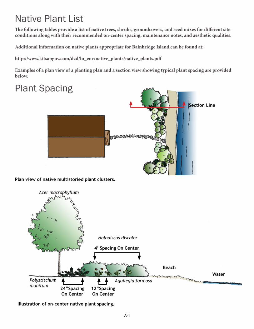
A-1
Section Line
The following tables provide a list of native trees, shrubs, groundcovers, and seed mixes for different site conditions along with their recommended on-center spacing, maintenance notes, and aesthetic qualities.
Additional information on native plants appropriate for Bainbridge Island can be found at:
http://www.kitsapgov.com/dcd/lu_env/native_plants/native_plants.pdf
Examples of a plan view of a planting plan and a section view showing typical plant spacing are provided below.
Native Plant List
Plant Spacing
Illustration of on-center native plant spacing.
4’ Spacing On Center
BeachWater
12”Spacing On Center
24”Spacing On Center
Acer macrophyllum
Holodiscus discolor
Aquilegia formosaPolystitchum munitum
Plan view of native multistoried plant clusters.
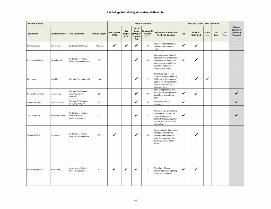
Bainbridge Island Mitigation Manual Plant List
Latin Name Common Name Site Conditions Mature Height Wet Slopes (WS)
Dry Slopes
(DS)
Top of Bank
(TOB) or Upland
(U)
Spacing On Center (O.C.)
Maintenance Notes and Aesthetic Qualities Dry Moist to
Saturated0 to 1 foot
1 to 2 feet
2 to 3 feet
Acer circinatum Vine maple Part shade. Moist soil. 10' to 15' 10'Provides vibrant fall color. Good for seasonally wet soils.
Acer macrophyllum Big‐leaf maplePart shade to full sun. Moist, well drained soils.
90' 30'
Vigorous grower. Good for seasonally wet or seasonally dry soils. Plant away from pond inlets and outlets to avoid leaf litter debris clogging structures.
Alnus rubra Red alder Full sun. Poor, moist soil. 100' 15'
Short lived tree. Plan on harvesting and/or replacing in 50 year cycle. Important species for nitrogen fixation. They establish well on disturbed sites.
Amelanchier alnifolia ServiceberryFull sun. Well drained soil. Very drought tolerant.
10' 10'
Early spring bloomer. Use this tree for Spring interest. Good for seasonally dry soils.
Arbutus menziesii Pacific madroneFull sun. Well drained, poor, dry rocky soil.
50' 20' Difficult species to transplant.
Corylus cornuta Western hazelnutPart shade to full sun. Well drained soil. Understory species.
20' 15'
This small tree is sometime classified as a shrub. The spring flowers appear before the leaves in yellow catkins. The fall leaves are pale yellow.
Fraxinus latifolia Oregon ashPart shade to full sun. Moist to saturated soils.
75' 20'
Fast growing for first third of life span and long lived. Good for seasonally wet soils. This species is often found growing in dense stands.
Prunus emarginata Bitter cherryPart shade to full sun. Dry to moist sites.
30' 15'Short lived. Plan on harvesting and/or replacing within 40 to 50 years.
Marine Shoreline (Saltwater Tolerant)
Deciduous Trees Plant Placement Seasonal Water Level Tolerance
A-2
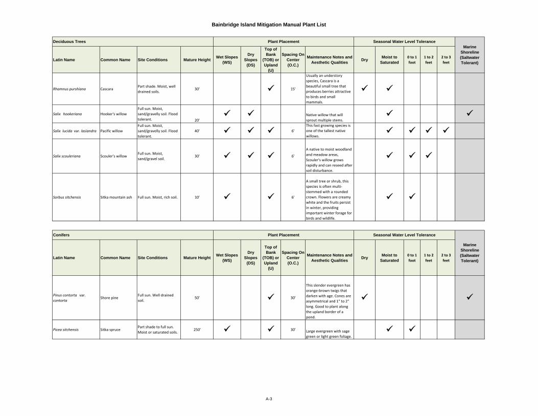
Bainbridge Island Mitigation Manual Plant List
Latin Name Common Name Site Conditions Mature Height Wet Slopes (WS)
Dry Slopes
(DS)
Top of Bank
(TOB) or Upland
(U)
Spacing On Center (O.C.)
Maintenance Notes and Aesthetic Qualities Dry Moist to
Saturated0 to 1 foot
1 to 2 feet
2 to 3 feet
Rhamnus purshiana CascaraPart shade. Moist, well drained soils.
30' 15'
Usually an understory species, Cascara is a beautiful small tree that produces berries attractive to birds and small mammals.
Salix hookeriana Hooker's willowFull sun. Moist, sand/gravelly soil. Flood tolerant. 20'
Native willow that will sprout multiple stems.
Salix lucida var. lasiandra Pacific willowFull sun. Moist, sand/gravelly soil. Flood tolerant.
40' 6'This fast growing species is one of the tallest native willows.
Salix scouleriana Scouler's willowFull sun. Moist, sand/gravel soil.
30' 6'
A native to moist woodland and meadow areas, Scouler's willow grows rapidly and can reseed after soil disturbance.
Sorbus sitchensis Sitka mountain ash Full sun. Moist, rich soil. 10' 6'
A small tree or shrub, this species is often multi‐stemmed with a rounded crown. Flowers are creamy white and the fruits persist in winter, providing important winter forage for birds and wildlife.
Latin Name Common Name Site Conditions Mature Height Wet Slopes (WS)
Dry Slopes
(DS)
Top of Bank
(TOB) or Upland
(U)
Spacing On Center (O.C.)
Maintenance Notes and Aesthetic Qualities Dry Moist to
Saturated0 to 1 foot
1 to 2 feet
2 to 3 feet
Pinus contorta var. contorta
Shore pineFull sun. Well drained soil.
50' 30'
This slender evergreen has orange‐brown twigs that darken with age. Cones are asymmetrical and 1" to 2" long. Good to plant along the upland border of a pond.
Picea sitchensis Sitka sprucePart shade to full sun. Moist or saturated soils.
250' 30' Large evergreen with sage green or light green foliage.
Marine Shoreline (Saltwater Tolerant)
Conifers Plant Placement Seasonal Water Level Tolerance
Deciduous Trees Plant Placement Seasonal Water Level ToleranceMarine
Shoreline (Saltwater Tolerant)
A-3
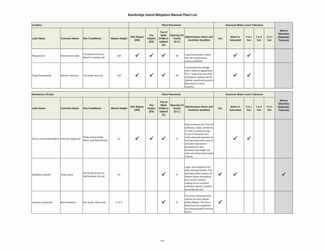
Bainbridge Island Mitigation Manual Plant List
Latin Name Common Name Site Conditions Mature Height Wet Slopes (WS)
Dry Slopes
(DS)
Top of Bank
(TOB) or Upland
(U)
Spacing On Center (O.C.)
Maintenance Notes and Aesthetic Qualities Dry Moist to
Saturated0 to 1 foot
1 to 2 feet
2 to 3 feet
Thuja plicata Western red cedarFull shade to full sun. Moist to swampy soil.
100' 30' Long‐lived western native that can survive moist, mucky conditions.
Tsuga heterophylla Western hemlock Full shade. Wet soil. 150' 30'
Young trees have foliage with a feathery appearance. The 1" long cones are small and papery. Species can be shallow rooted and prone to blow down in some locations.
Latin Name Common Name Site Conditions Mature Height Wet Slopes (WS)
Dry Slopes
(DS)
Top of Bank
(TOB) or Upland
(U)
Spacing On Center (O.C.)
Maintenance Notes and Aesthetic Qualities Dry Moist to
Saturated0 to 1 foot
1 to 2 feet
2 to 3 feet
Cornus sericea (stolonifera) Red‐osier dogwoodShady stream banks. Moist, well drained soils.
15' 4'
Plant minimum of 4' from all walkways, roads, and fences in order to avoid pruning. Prune 2‐3 branches of a multi‐stemmed specimen to the base every other year to stimulate new branch development. New branches have bright red color and will provide winter interest.
Holodiscus discolor Ocean sprayPart shade to full sun. Well drained, dry soil.
15' 4'
Large, vase‐shaped shrub with arching branches. The big foamy white clusters of flowers bloom throughout the summer months, making this an excellent pollinator species. Good for seasonally dry soil.
Lonicera involucrata Black twinberry Part shade. Moist soils. 2' to 7' 4'
This erect, thinly branches species has twin tubular yellow flowers. The shiny black fruits are cupped by two showy purplish‐maroon bracts.
Deciduous Shrubs Plant Placement Seasonal Water Level Tolerance
Marine Shoreline (Saltwater Tolerant)
Conifers Plant Placement Seasonal Water Level Tolerance
Marine Shoreline (Saltwater Tolerant)
A-4
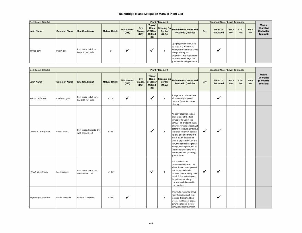
Bainbridge Island Mitigation Manual Plant List
Latin Name Common Name Site Conditions Mature Height Wet Slopes (WS)
Dry Slopes
(DS)
Top of Bank
(TOB) or Upland
(U)
Spacing On Center (O.C.)
Maintenance Notes and Aesthetic Qualities Dry Moist to
Saturated0 to 1 foot
1 to 2 feet
2 to 3 feet
Myrica gale Sweet galePart shade to full sun. Moist to wet soils.
5' 4'
Upright growth form. Can be used as a windbreak when planted in rows. Good nitrogen‐fixing soil properties. Has a spicy scent on hot summer days. Can grow in relatively poor soils.
Latin Name Common Name Site Conditions Mature Height Wet Slopes (WS)
Dry Slopes
(DS)
Top of Bank
(TOB) or Upland
(U)
Spacing On Center (O.C.)
Maintenance Notes and Aesthetic Qualities Dry Moist to
Saturated0 to 1 foot
1 to 2 feet
2 to 3 feet
Myrica californica California galePart shade to full sun. Moist to wet soils.
6'‐18' 4'A large shrub to small tree with an upright growth pattern. Great for border planting.
Oemleria cerasiformis Indian plumPart shade. Moist to dry, well‐drained soil.
5'‐ 16' 4'
An early bloomer, Indian plum is one of the first shrubs to flower in the spring. The drooping chains of white flowers appear just before the leaves. Birds love the small fruit that begin as yellow‐gold and transform into a bluish‐black color later in the summer. In the sun, this species can grow as a large, dense plant, but in the shade it will take on a more open and sprawling growth form.
Philadelphus lewisii Mock orangePart shade to full sun. Well drained soil.
5' ‐10' 4'
This species is an ornamental favorite. The white flowers that appear in late spring and early summer have a lovely sweet smell. This species is great for pollinators, along borders, and clustered in odd numbers.
Physocarpus capitatus Pacific ninebark Full sun. Moist soil. 6' ‐12' 3'
This multi‐stemmed shrub has interesting bark that looks as if it is shedding layers. The flowers appear as white clusters in later spring and early summer.
Marine Shoreline (Saltwater Tolerant)
Deciduous Shrubs Plant Placement Seasonal Water Level Tolerance
Deciduous Shrubs Plant Placement Seasonal Water Level Tolerance
Marine Shoreline (Saltwater Tolerant)
A-5
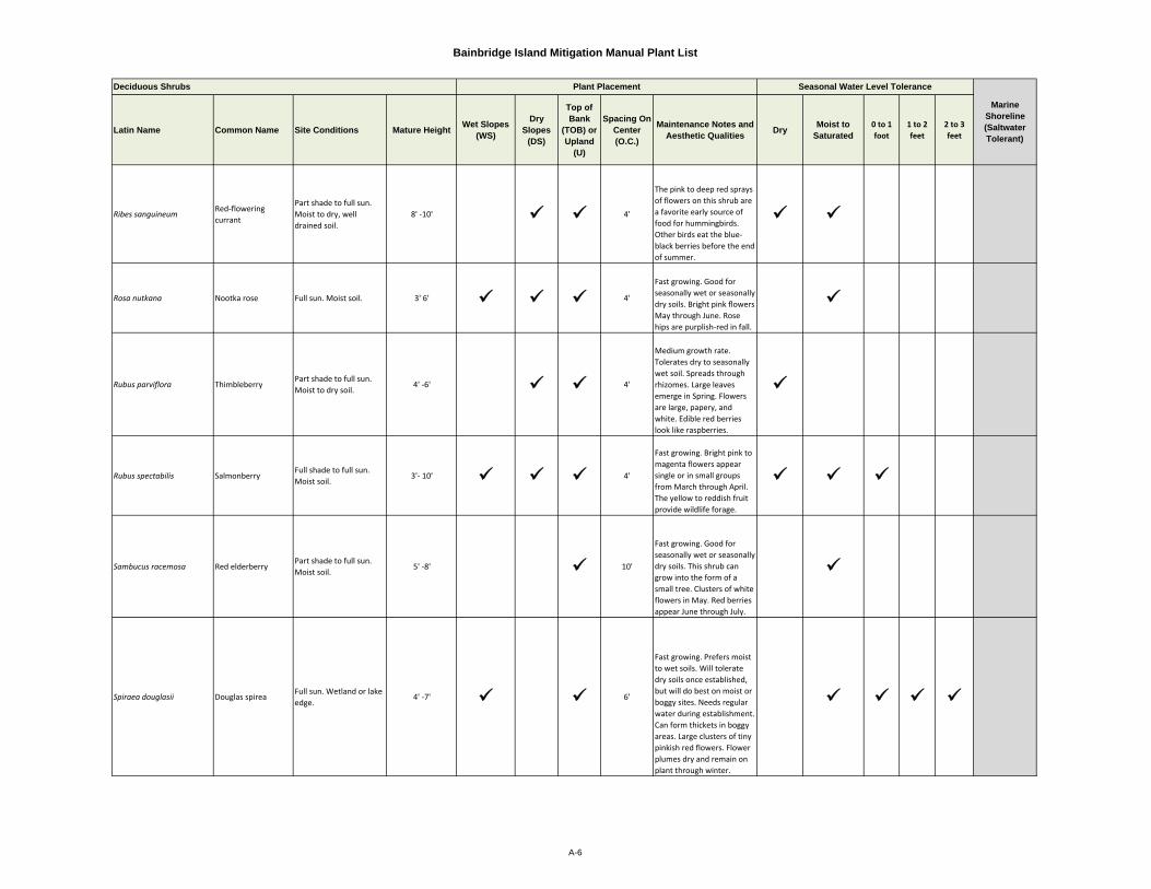
Bainbridge Island Mitigation Manual Plant List
Latin Name Common Name Site Conditions Mature Height Wet Slopes (WS)
Dry Slopes
(DS)
Top of Bank
(TOB) or Upland
(U)
Spacing On Center (O.C.)
Maintenance Notes and Aesthetic Qualities Dry Moist to
Saturated0 to 1 foot
1 to 2 feet
2 to 3 feet
Ribes sanguineumRed‐flowering currant
Part shade to full sun. Moist to dry, well drained soil.
8' ‐10' 4'
The pink to deep red sprays of flowers on this shrub are a favorite early source of food for hummingbirds. Other birds eat the blue‐black berries before the end of summer.
Rosa nutkana Nootka rose Full sun. Moist soil. 3' 6' 4'
Fast growing. Good for seasonally wet or seasonally dry soils. Bright pink flowers May through June. Rose hips are purplish‐red in fall.
Rubus parviflora ThimbleberryPart shade to full sun. Moist to dry soil.
4' ‐6' 4'
Medium growth rate. Tolerates dry to seasonally wet soil. Spreads through rhizomes. Large leaves emerge in Spring. Flowers are large, papery, and white. Edible red berries look like raspberries.
Rubus spectabilis SalmonberryFull shade to full sun. Moist soil.
3'‐ 10' 4'
Fast growing. Bright pink to magenta flowers appear single or in small groups from March through April. The yellow to reddish fruit provide wildlife forage.
Sambucus racemosa Red elderberryPart shade to full sun. Moist soil.
5' ‐8' 10'
Fast growing. Good for seasonally wet or seasonally dry soils. This shrub can grow into the form of a small tree. Clusters of white flowers in May. Red berries appear June through July.
Spiraea douglasii Douglas spireaFull sun. Wetland or lake edge.
4' ‐7' 6'
Fast growing. Prefers moist to wet soils. Will tolerate dry soils once established, but will do best on moist or boggy sites. Needs regular water during establishment. Can form thickets in boggy areas. Large clusters of tiny pinkish red flowers. Flower plumes dry and remain on plant through winter.
Deciduous Shrubs Plant Placement Seasonal Water Level Tolerance
Marine Shoreline (Saltwater Tolerant)
A-6
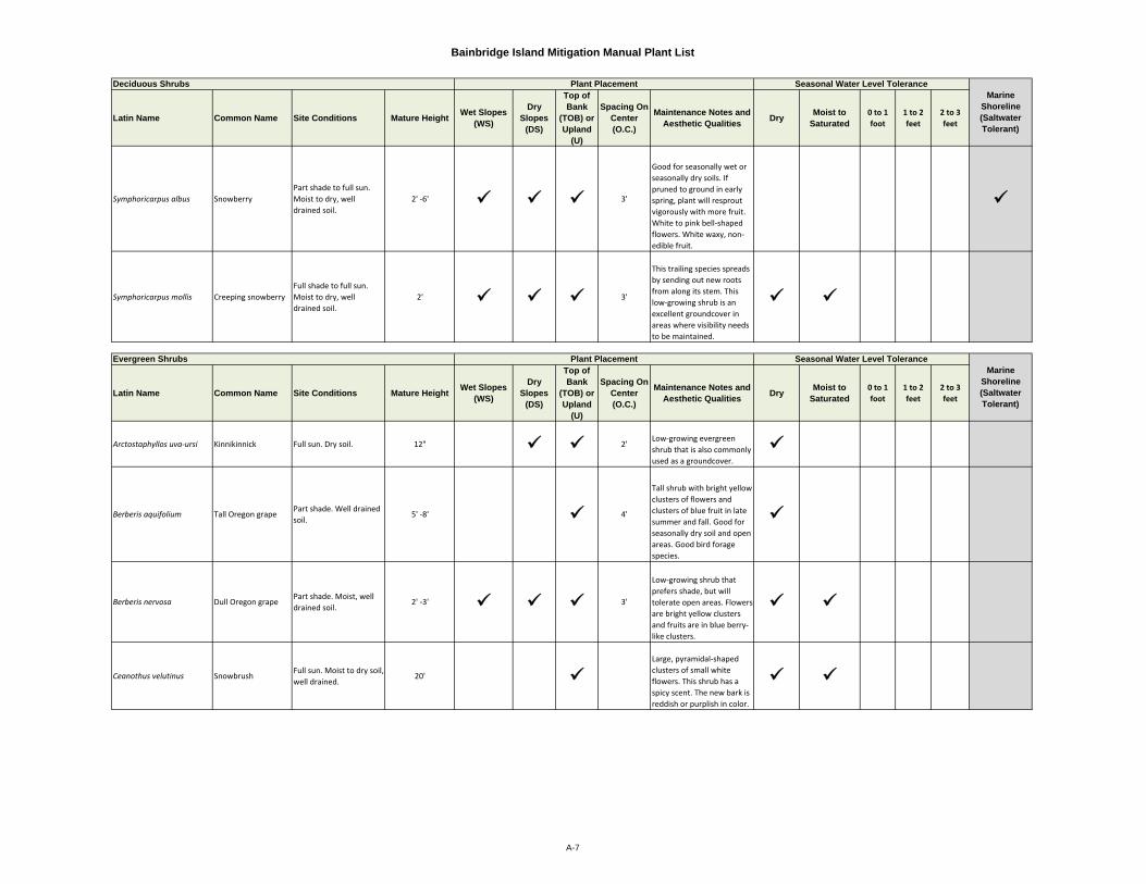
Bainbridge Island Mitigation Manual Plant List
Latin Name Common Name Site Conditions Mature Height Wet Slopes (WS)
Dry Slopes
(DS)
Top of Bank
(TOB) or Upland
(U)
Spacing On Center (O.C.)
Maintenance Notes and Aesthetic Qualities Dry Moist to
Saturated0 to 1 foot
1 to 2 feet
2 to 3 feet
Symphoricarpus albus SnowberryPart shade to full sun. Moist to dry, well drained soil.
2' ‐6' 3'
Good for seasonally wet or seasonally dry soils. If pruned to ground in early spring, plant will resprout vigorously with more fruit. White to pink bell‐shaped flowers. White waxy, non‐edible fruit.
Symphoricarpus mollis Creeping snowberryFull shade to full sun. Moist to dry, well drained soil.
2' 3'
This trailing species spreads by sending out new roots from along its stem. This low‐growing shrub is an excellent groundcover in areas where visibility needs to be maintained.
Latin Name Common Name Site Conditions Mature Height Wet Slopes (WS)
Dry Slopes
(DS)
Top of Bank
(TOB) or Upland
(U)
Spacing On Center (O.C.)
Maintenance Notes and Aesthetic Qualities Dry Moist to
Saturated0 to 1 foot
1 to 2 feet
2 to 3 feet
Arctostaphyllos uva‐ursi Kinnikinnick Full sun. Dry soil. 12" 2'Low‐growing evergreen shrub that is also commonly used as a groundcover.
Berberis aquifolium Tall Oregon grapePart shade. Well drained soil.
5' ‐8' 4'
Tall shrub with bright yellow clusters of flowers and clusters of blue fruit in late summer and fall. Good for seasonally dry soil and open areas. Good bird forage species.
Berberis nervosa Dull Oregon grapePart shade. Moist, well drained soil.
2' ‐3' 3'
Low‐growing shrub that prefers shade, but will tolerate open areas. Flowers are bright yellow clusters and fruits are in blue berry‐like clusters.
Ceanothus velutinus SnowbrushFull sun. Moist to dry soil, well drained.
20' Large, pyramidal‐shaped clusters of small white flowers. This shrub has a spicy scent. The new bark is reddish or purplish in color.
Deciduous Shrubs Plant Placement Seasonal Water Level ToleranceMarine
Shoreline (Saltwater Tolerant)
Marine Shoreline (Saltwater Tolerant)
Evergreen Shrubs Plant Placement Seasonal Water Level Tolerance
A-7
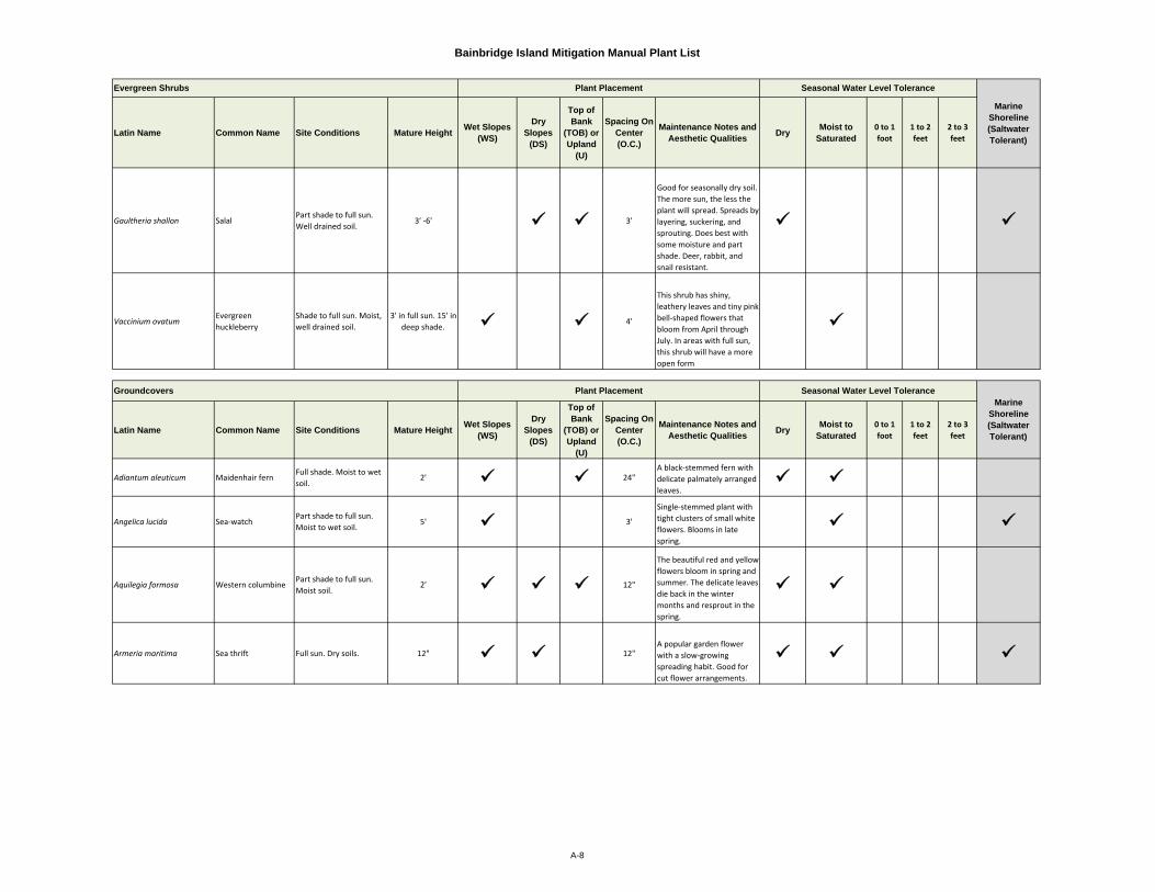
Bainbridge Island Mitigation Manual Plant List
Latin Name Common Name Site Conditions Mature Height Wet Slopes (WS)
Dry Slopes
(DS)
Top of Bank
(TOB) or Upland
(U)
Spacing On Center (O.C.)
Maintenance Notes and Aesthetic Qualities Dry Moist to
Saturated0 to 1 foot
1 to 2 feet
2 to 3 feet
Gaultheria shallon SalalPart shade to full sun. Well drained soil.
3' ‐6' 3'
Good for seasonally dry soil. The more sun, the less the plant will spread. Spreads by layering, suckering, and sprouting. Does best with some moisture and part shade. Deer, rabbit, and snail resistant.
Vaccinium ovatumEvergreen huckleberry
Shade to full sun. Moist, well drained soil.
3' in full sun. 15' in deep shade. 4'
This shrub has shiny, leathery leaves and tiny pink bell‐shaped flowers that bloom from April through July. In areas with full sun, this shrub will have a more open form
Latin Name Common Name Site Conditions Mature Height Wet Slopes (WS)
Dry Slopes
(DS)
Top of Bank
(TOB) or Upland
(U)
Spacing On Center (O.C.)
Maintenance Notes and Aesthetic Qualities Dry Moist to
Saturated0 to 1 foot
1 to 2 feet
2 to 3 feet
Adiantum aleuticum Maidenhair fernFull shade. Moist to wet soil.
2' 24"A black‐stemmed fern with delicate palmately arranged leaves.
Angelica lucida Sea‐watchPart shade to full sun. Moist to wet soil.
5' 3'
Single‐stemmed plant with tight clusters of small white flowers. Blooms in late spring.
Aquilegia formosa Western columbinePart shade to full sun. Moist soil.
2' 12"
The beautiful red and yellow flowers bloom in spring and summer. The delicate leaves die back in the winter months and resprout in the spring.
Armeria maritima Sea thrift Full sun. Dry soils. 12" 12"A popular garden flower with a slow‐growing spreading habit. Good for cut flower arrangements.
Plant Placement Seasonal Water Level Tolerance
Marine Shoreline (Saltwater Tolerant)
Evergreen Shrubs
Marine Shoreline (Saltwater Tolerant)
Seasonal Water Level TolerancePlant PlacementGroundcovers
A-8
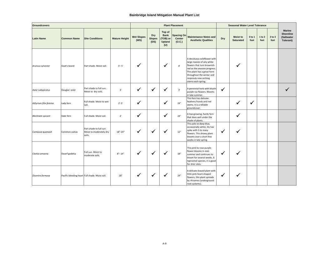
Bainbridge Island Mitigation Manual Plant List
Latin Name Common Name Site Conditions Mature Height Wet Slopes (WS)
Dry Slopes
(DS)
Top of Bank
(TOB) or Upland
(U)
Spacing On Center (O.C.)
Maintenance Notes and Aesthetic Qualities Dry Moist to
Saturated0 to 1 foot
1 to 2 feet
2 to 3 feet
Aruncus sylvester Goat's beard Part shade. Moist soil. 3'‐ 5' 4'
A deciduous wildflower with large masses of airy white flowers that turn brownish‐red as the seasons progress. This plant has a great form throughout the winter and resprouts new arching stems each spring.
Aster subspicatus Douglas' asterPart shade to full sun. Moist to dry soils.
3' 3' A perennial herb with bluish‐purple ray flowers. Blooms in late summer.
Athyrium filix‐femina Lady fernFull shade. Moist to wet soil.
2'‐5' 24"
This fern has delicate feathery fronds and red stems. It is a reliable groundcover.
Blechnam spicant Deer fern Full shade. Moist soil. 2' 24"A low‐growing, hardy fern that does well under the shade of plants.
Camassia quamash Common camasPart shade to full sun. Moist to moderately dry soils.
18"‐24" 12"
This pale to deep blue, occasionally white, lily has spike with 5 to many flowers. This showy plant blooms over a short few weeks in late spring.
Clarkia amoena Dwarf godetiaFull sun. Moist to moderate soils.
8"‐ 14" 18"
This pink to rose‐purple flower blooms in mid‐summer and continues to bloom for several weeks. A taprooted species, it is good for drier sites.
Dicentra formosa Pacific bleeding heart Full shade. Moist soil. 18" 24"
A delicate‐leaved plant with little pink heart‐shaped flowers, this plant spreads by rhizomes (underground root systems).
Groundcovers Plant Placement Seasonal Water Level Tolerance
Marine Shoreline (Saltwater Tolerant)
A-9
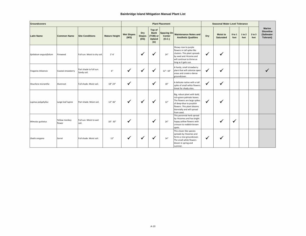
Bainbridge Island Mitigation Manual Plant List
Latin Name Common Name Site Conditions Mature Height Wet Slopes (WS)
Dry Slopes
(DS)
Top of Bank
(TOB) or Upland
(U)
Spacing On Center (O.C.)
Maintenance Notes and Aesthetic Qualities Dry Moist to
Saturated0 to 1 foot
1 to 2 feet
2 to 3 feet
Epilobium angustifolium Fireweed Full sun. Moist to dry soil. 2'‐6' 24"
Showy rose to purple flowers in tall spike‐like clusters. This plant spreads by seed and rhizome and will continue to thrive as long as it gets sun.
Fragaria chiloensis Coastal strawberryPart shade to full sun. Sandy soil.
6" 12"‐ 18"A hardy, small strawberry plant that will colonize open areas and create a dense groundcover.
Heuchera micrantha Alumroot Full shade. Moist soil. 18"‐24" 18"A delicate native with a tall spike of small white flowers. Great for shady sites.
Lupinus polyphyllus Large‐leaf lupine Part shade. Moist soil. 12"‐36" 12"
Big, robust plant with bold, rich‐green palmate leaves. The flowers are large spikes of deep‐blue to purplish flowers. This plant blooms biennially and will spread from seed.
Mimulus guttatusYellow monkey flower
Full sun. Moist to wet soil.
18"‐ 30" 24"
This perennial herb spread by rhizomes and has bright happy yellow flowers with crimson to reddish‐brown spots.
Oxalis oregana Sorrel Full shade. Moist soil. 12" 14"
This clover‐like species spreads by rhizomes and forms a nice groundcover. The small white flowers bloom in spring and summer.
Groundcovers Plant Placement Seasonal Water Level Tolerance
Marine Shoreline (Saltwater Tolerant)
A-10

Bainbridge Island Mitigation Manual Plant List
Latin Name Common Name Site Conditions Mature Height Wet Slopes (WS)
Dry Slopes
(DS)
Top of Bank
(TOB) or Upland
(U)
Spacing On Center (O.C.)
Maintenance Notes and Aesthetic Qualities Dry Moist to
Saturated0 to 1 foot
1 to 2 feet
2 to 3 feet
Plectritis congesta Sea blushFull sun. Moist to wet soil.
6"‐24" 12" This small herb has an upright stem that supports a head of showy pink flowers.
Polystitchum munitum Sword fern Moist to dry soil. 2'‐ 5' 24"One of the most adaptable, hardy ferns this species stays green year‐round.
Potentilla anserina var. pacifica
SilverweedPart shade to full sun. Moist to wet soil. 18"
24"
Small spreading plant with yellow flowers. Blooms late spring through mid-summer.
Sedum spathulifoliumBroad‐leaved stonecrop
Full sun. Dry soils. 6" 12"A native sedum with green and red succulent foliage. The yellow flowers bloom in June and July.
Sidalcea hendersoniiHenderson's checkermallow
Full sun. Moist to wet soil.
5' 3'
A tall native herbaceous perennail with a stalk of pink to mauve flowers that bloom early to mid‐ summer.
Sisyrinchium idahoense Blue eyed grassPart shade to full sun. Moist soils.
24" 12"This perennial herb has grass‐like leaves, but has a light blue to dark purple (sometimes white) flower.
Tellima grandiflora Fringecup Part shade. Moist soil. 14"‐ 30" 18"
A perennial herb with a spike of fragrant, greenish‐white flowers that turn pink or reddish as the flowers age.
Tolmiea menziesii Youth‐on‐age Full shade. Moist soil. 6" ‐12" 12"
Small plant that forms a delicate groundcover. The tiny flowers are brownish‐purple.
Groundcovers Plant Placement Seasonal Water Level Tolerance
Marine Shoreline (Saltwater Tolerant)
A-11
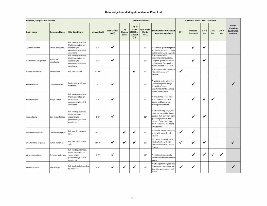
Bainbridge Island Mitigation Manual Plant List
Latin Name Common Name Site Conditions Mature HeightWet Slopes
(WS)
Dry Slopes
(DS)
Top of Bank
(TOB) or Upland
(U)
Spacing On Center (O.C.)
Maintenance Notes and Aesthetic Qualities Dry Moist to
Saturated0 to 1 foot
1 to 2 feet
2 to 3 feet
Agrostis exarata Spiked bentgrass
Full sun to part shade. Moist, saturated, or seasonally to permanently flooded conditions.
1'‐3' 12" A perennial grass that grows in tufted form and has erect spikes, as its name suggests.
Beckmannia syzigachneAmerican sloughgrass
Full sun to part shade. Moist, saturated, or seasonally to permanently flooded conditions.
1'‐3' 12"
A stout grass with somewhat spongy stems, this plant grows on its own or in groups. This species can be planted or seeded.
Bromus sitchensis Sitka brome Full sun. Dry soils. 6"‐ 18" 12"A stout perennial grass with flowers in open, airy panicles.
Carex lyngbyei Lyndgye's sedgePart shade to full sun. Wet soils.
3' 12"
A wetland sedge with lime to medium green foliage. Tops of leaf blades sometimes slightly arching. Brown flower stalks.
Carex obnupta Slough sedge
Full sun to part shade. Moist, saturated, or seasonally to permanently flooded conditions.
1'‐3' 12"A large tufted sedge with erect, then arching leaf blades and large brown arching flower heads.
Carex stipata Saw beaked sedge
Full sun to part shade. Moist, saturated, or seasonally to permanently flooded conditions.
1'‐3' 12"
A tufted arching sedge, this plant has pyramidal flower clusters that turn from light green to golden as they mature. Flower stems are erect and leaves are bright spring green.
Danthonia californica California oat grassFull sun. Dry to moist soil.
10"‐ 12" 12"A delicate, native, clumping grass with purplish‐red flowers.
Deschampsia cespitosa Tufted hairgrassFull sun. Moist to wet soil.
18"‐ 4' 12"
This large, clumping grass has big feathery flower heads with bronze arching flowers.
Eleocharis palustris Common spikerush
Full sun to part shade. Moist, saturated, or seasonally to permanently flooded conditions.
1'‐3' 12" A mat‐forming perennial spikerush with erect slender stems.
Elymus glaucus Blue wildryeFull shade to full sun. Dry to moist soil.
2'‐4' 12"
A tufted perennial grass that forms small clumps and has light blue‐green green leaf blades.
Grasses, Sedges, and Rushes
Marine Shoreline (Saltwater Tolerant)
Seasonal Water Level TolerancePlant Placement
A-12

Bainbridge Island Mitigation Manual Plant List
Latin Name Common Name Site Conditions Mature Height Wet Slopes (WS)
Dry Slopes
(DS)
Top of Bank
(TOB) or Upland
(U)
Spacing On Center (O.C.)
Maintenance Notes and Aesthetic Qualities Dry Moist to
Saturated0 to 1 foot
1 to 2 feet
2 to 3 feet
Elymus mollis Dune grassFull sun. Moist to wet soil.
3' 24"
An industrial strength dune grass that forms large clumps and spreads via underground stems. A hearty weed competitor.
Festuca rubra Red fescueFull sun to full shade. Dry to moist soil.
2' 12"
A versatile grass that spreads by rhizome. One of the few shade tolerant grasses.
Glyceria occidentalisNorthwestern mannagrass
Full sun to part shade. Moist, saturated, or seasonally to permanently flooded conditions.
1'‐5' 12"A tall perennial wetland grass.
Hordeum brachyantherum Meadow barleyFull sun. Dry to moist soil.
1'‐3' 12"
A hardy native tolerant of wet, dry, and saline sites. This species is used for erosion control and as a groundcover. Can sometimes compete with reed canary grass.
Juncus ensifolius Dagger‐leaf rush
Full sun to part shade. Moist, saturated, or seasonally to permanently flooded conditions.
6" to 2.5' 12" A small rush with an erect form, this wetland species spreads by rhizome.
Juncus tenuis Slender rush
Full sun to part shade. Moist, saturated, or seasonally to permanently flooded conditions.
6" to 2' 12"This rush is best planted, due to its low seed fertility rate. A clump forming perennial rush.
Schoenoplectus acutus Hardstem bulrush
Full sun to part shade. Moist, saturated, or seasonally to permanently flooded conditions.
3' to 6' 12"
A good wetland species to use for soil stabilization and water treatment. Birds eat the seeds, but this plant is not a preferred food of deer and elk.
Schoenoplectus microcarpus
Soft stem bulrush
Full sun to part shade. Moist, saturated, or seasonally to permanently flooded conditions.
2' to 3' 12"A good soil stabilization and water quality species, this plant spreads readily by rhizome.
Seasonal Water Level Tolerance
Marine Shoreline (Saltwater Tolerant)
Grasses, Sedges, and Rushes Plant Placement
A-13
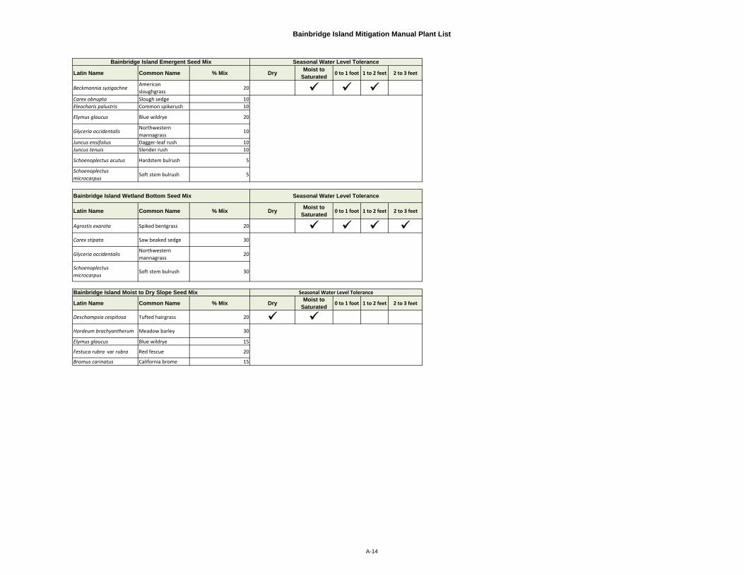
Bainbridge Island Mitigation Manual Plant List
Latin Name Common Name % Mix Dry Moist to Saturated 0 to 1 foot 1 to 2 feet 2 to 3 feet
Beckmannia syzigachneAmerican sloughgrass
20 Carex obnupta Slough sedge 10Eleocharis palustris Common spikerush 10
Elymus glaucus Blue wildrye 20
Glyceria occidentalisNorthwestern mannagrass
10
Juncus ensifolius Dagger‐leaf rush 10Juncus tenuis Slender rush 10
Schoenoplectus acutus Hardstem bulrush 5
Schoenoplectus microcarpus
Soft stem bulrush 5
Latin Name Common Name % Mix Dry Moist to Saturated 0 to 1 foot 1 to 2 feet 2 to 3 feet
Agrostis exarata Spiked bentgrass 20 Carex stipata Saw beaked sedge 30
Glyceria occidentalisNorthwestern mannagrass
20
Schoenoplectus microcarpus
Soft stem bulrush 30
Latin Name Common Name % Mix Dry Moist to Saturated 0 to 1 foot 1 to 2 feet 2 to 3 feet
Deschampsia cespitosa Tufted hairgrass 20 Hordeum brachyantherum Meadow barley 30
Elymus glaucus Blue wildrye 15
Festuca rubra var rubra Red fescue 20
Bromus carinatus California brome 15
Bainbridge Island Moist to Dry Slope Seed Mix
Bainbridge Island Wetland Bottom Seed Mix
Bainbridge Island Emergent Seed Mix
Seasonal Water Level Tolerance
Seasonal Water Level Tolerance
Seasonal Water Level Tolerance
A-14
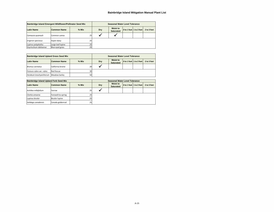
Bainbridge Island Mitigation Manual Plant List
Latin Name Common Name % Mix Dry Moist to Saturated 0 to 1 foot 1 to 2 feet 2 to 3 feet
Camassia quamash Common camas 25 Erigeron speciosus Aspen daisy 25
Lupinus polyphyllus Large‐leaf lupine 25Sisyrinchium idahoense Blue eyed grass 25
Latin Name Common Name % Mix Dry Moist to Saturated 0 to 1 foot 1 to 2 feet 2 to 3 feet
Bromus carinatus California brome 20 Festuca rubra var. rubra Red fescue 30
Hordeum brachyantherum Meadow barley 50
Latin Name Common Name % Mix Dry Moist to Saturated 0 to 1 foot 1 to 2 feet 2 to 3 feet
Achillea millefolium Yarrow 25 Clarkia amoena Farewell‐to‐spring 25
Lupinus bicolor Bicolor lupine 25
Solidago canadensis Canada goldenrod 25
Seasonal Water Level Tolerance
Bainbridge Island Emergent Wildflower/Pollinator Seed Mix
Bainbridge Island Upland Grass Seed Mix Seasonal Water Level Tolerance
Bainbridge Island Upland Forb Seed Mix
Seasonal Water Level Tolerance
A-15
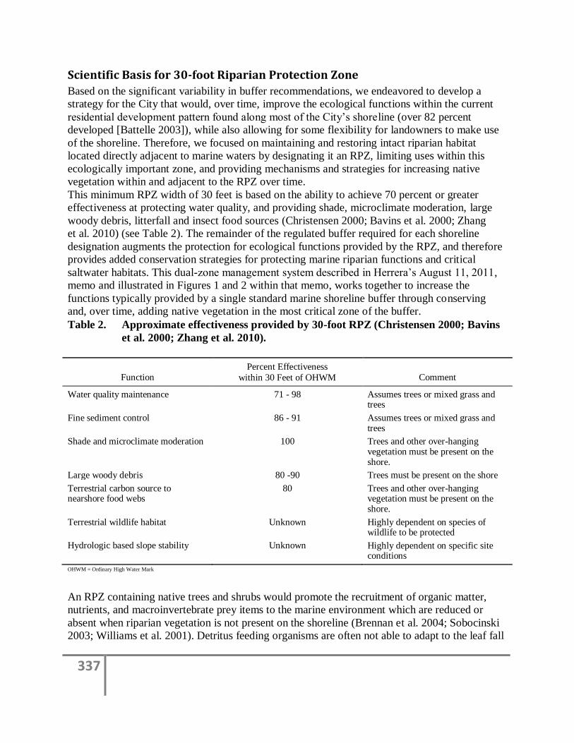
337
Scientific Basis for 30-foot Riparian Protection Zone
Based on the significant variability in buffer recommendations, we endeavored to develop a
strategy for the City that would, over time, improve the ecological functions within the current
residential development pattern found along most of the City’s shoreline (over 82 percent
developed [Battelle 2003]), while also allowing for some flexibility for landowners to make use
of the shoreline. Therefore, we focused on maintaining and restoring intact riparian habitat
located directly adjacent to marine waters by designating it an RPZ, limiting uses within this
ecologically important zone, and providing mechanisms and strategies for increasing native
vegetation within and adjacent to the RPZ over time.
This minimum RPZ width of 30 feet is based on the ability to achieve 70 percent or greater
effectiveness at protecting water quality, and providing shade, microclimate moderation, large
woody debris, litterfall and insect food sources (Christensen 2000; Bavins et al. 2000; Zhang
et al. 2010) (see Table 2). The remainder of the regulated buffer required for each shoreline
designation augments the protection for ecological functions provided by the RPZ, and therefore
provides added conservation strategies for protecting marine riparian functions and critical
saltwater habitats. This dual-zone management system described in Herrera’s August 11, 2011,
memo and illustrated in Figures 1 and 2 within that memo, works together to increase the
functions typically provided by a single standard marine shoreline buffer through conserving
and, over time, adding native vegetation in the most critical zone of the buffer.
Table 2. Approximate effectiveness provided by 30-foot RPZ (Christensen 2000; Bavins
et al. 2000; Zhang et al. 2010).
Function Percent Effectiveness
within 30 Feet of OHWM Comment
Water quality maintenance 71 - 98 Assumes trees or mixed grass and trees
Fine sediment control 86 - 91 Assumes trees or mixed grass and trees
Shade and microclimate moderation 100 Trees and other over-hanging vegetation must be present on the shore.
Large woody debris 80 -90 Trees must be present on the shore
Terrestrial carbon source to nearshore food webs
80 Trees and other over-hanging vegetation must be present on the shore.
Terrestrial wildlife habitat Unknown Highly dependent on species of wildlife to be protected
Hydrologic based slope stability Unknown Highly dependent on specific site conditions
OHWM = Ordinary High Water Mark
An RPZ containing native trees and shrubs would promote the recruitment of organic matter,
nutrients, and macroinvertebrate prey items to the marine environment which are reduced or
absent when riparian vegetation is not present on the shoreline (Brennan et al. 2004; Sobocinski
2003; Williams et al. 2001). Detritus feeding organisms are often not able to adapt to the leaf fall
338
patterns or the chemical characteristics of leaves from non-native plants, which is one reason
why shoreline vegetation should be native species for maximum effectiveness (Karr and
Schlosser 1977). Native plant species are adapted to local physical conditions such as soil,
geology, and climate and therefore require less maintenance, are resistant to most pests and
diseases, and require little or no irrigation or fertilizers, once established. Thus maintaining
native plant species adjacent to the shoreline helps maintain water quality. Also, trees located
close to the shore, form and maintain habitat complexity by stabilizing banks and contributing
large wood to the aquatic environment.
Another important protection feature is that the RPZ would extend up to the full width of a
standard marine shoreline buffer wherever intact native riparian vegetation were present but
would be a minimum of 30 feet.
In areas entirely lacking native riparian vegetation, the City would still establish a minimum
30-foot RPZ and, as parcels met re-development thresholds, the City would require that native
vegetation be established within the minimum 30-foot RPZ. In the Natural shoreline designation,
the RPZ would be a minimum of 100 feet because of the heightened ecological values found in
the areas within this shoreline designation and their absence of existing development.
In summary, the 30-foot RPZ is a subset of a dual-zone system, intended to preserve existing
native trees and shrubs, and restore them when possible, to increase their presence adjacent to the
shoreline and protect important shoreline functions. This strategy will provide opportunity to
significantly improve over time shoreline functions over existing City conditions, where
degradation exists or continues to occur. The implementation of the RPZ as a component of a
regulated buffer will allow the City to effectively stem the loss of shoreline resources due to loss
of native shoreline vegetation and, in conjunction with regulations addressing activities allowed
in the remainder of the regulated buffer, assist the City with meeting its goal of no net loss of
shoreline ecological functions.
References
Battelle. 2003. Bainbridge Island nearshore assessment: Summary of best available science.
Prepared for: City of Bainbridge Island. October 2003.
Bavins, M., D. Couchman, and J. Beumer. 2000. Fisheries Guidelines for Fish Habitat Buffer
Zones. Department of Primary Industries, Queensland, Fish Habitat Guideline FHG 003.
Belt, G.H., J. O'Laughlin, and T. Merril. 1992. Design of Forest Riparian Buffer Strips for the
Protection of Water Quality: Analysis of Scientific Literature. University of Idaho. Idaho Forest
Wildlife and Range Experiment Station.
Brennan, J., H. Culverwell, R. Gregg, P. Granger. 2009. Protection of Marine Riparian Functions in
Puget Sound, Washington. Prepared for Washington Department of Fish and Wildlife by
Washington Sea Grant, Seattle, Washington. June 15, 2009.
Brennan, J.S. and H. Culverwell. 2004. Marine Riparian: An Assessment of Riparian Functions in
Marine Ecosystems. Published by Washington Sea Grant Program. Copyright 2005, University of
Washington, Board of Regents, Seattle, Washington. 34 p.
339
Christensen, D. 2000. Protection of Riparian Ecosystems: A Review of Best Available Science.
Jefferson County Environmental Health Division, Washington.
Desbonnet, A., P. Pogue, V. Lee, and N. Wolff. 1994. Vegetated buffers in the coastal zone – A
summary review and bibliography. University of Rhode Island, Graduate School of Oceanography.
Desbonnet, A., V. Lee, P. Pogue, D. Reis, J. Boyd, J. Willis, and M. Imperial. 1995. Development
of coastal vegetated buffer programs. Coastal Management 23:91‐109.
Herrera. 2011. City of Bainbridge Island Addendum to the Summary of Science. Herrera
Environmental Consultants, Inc., Seattle, Washington. January 2011.
Karr, J.R. and I.J. Schlosser. 1977. Impact of Nearstream Vegetation and Stream Morphology
on Water Quality and Stream Biota. U.S. EPA, Athens, Georgia. Ecological Research Series
(EPA-600/3-77/097).
Pentec Environmental. 2001. Use of Best Available Science in City of Everett Buffer Regulations.
Report to the City of Everett Planning and Community Development Department. Edmonds,
Washington. March 15, 2001.
Schoonover, J.E., and K.W.J. Williard. 2003. Groundwater nitrate reduction in giant cane and forest
riparian zones. Journal of the American Water Resources Association 39(2):347‐354.
Williams, G.D. and R.M. Thom. 2001. Marine and Estuarine Shoreline Modification Issues White
Paper. Olympia, Washington.
Zhang, X, X. Liu, M. Zhang, R. Dahlgren, and M. Eitzel. 2010. A Review of Vegetated Buffers and
a Meta-analysis of their Mitigation Efficacy in Reducing Nonpoint Source Pollution. J. Environ.
Qual. 39:76-84.

341
Appendix D
Single Family Residence Mitigation Manual
378
Appendix E
Special Area Maps
379
380
381

ORDINANCE NO. 2014-04 EXHIBIT 3
Administrative Amendments to Title 2 of the Bainbridge Island Municipal Code Section 1. Section 2.14.010 of the Bainbridge Island Municipal Code is amended to read as follows: 2.14.010 CITY COUNCIL A. The city council of Bainbridge Island serves as the legislative body for the municipality and the decision-maker on some types of quasi-judicial land use decisions. More specifically, city council makes final decisions on:
1. Final long subdivisions; and 2. Site-specific rezones; and 3. Consolidated project reviews where any element requires city council approval.
B. In addition, city council exercises its legislative authority regarding land use by making final decisions on:
1. Adoption or amendment of development regulations in this BIMC; and 2. Adoption of comprehensive plan amendments; and 3. Adoption of special area plans; and 4. Area-wide rezones.; and 5. Adoption of, amendments to, or revisions of the Shoreline Master Program. To become effective any
amendments to the Shoreline Master Program must be reviewed and approved by the Department of Ecology, pursuant to RCW 90.58.190 or its successor and Chapter 173-26 WAC or its successor.
Section 2. Section 2.16.010, Land Use Procedures Summary Table, is amended to read as follows:
Table 2.16.010-1: Summary Table of Land Use Procedures
R = Review and Recommendation, (R) = Optional Review, D = Decision, A = Appeal, P = Public Hearing,
(P) = Optional Public Hearing
DRB Planning
Comm.
Director Hearing
Examiner
City
Council
Courts
Administrative Approvals
Clearing Permit D A
Conversion Option Harvest Plan Permit D A
Minor Conditional Use (R) (R) D A
Minor Variance (R) D A
Agricultural Conditional Use D A
Large Lot Subdivisions (Prelim) D A
(Final) D A
1
Ordinance 2014-04, Exhibit 3 Includes Ecology Required amendments and amendments to match WAC 173-27 Updated 6/27/2014
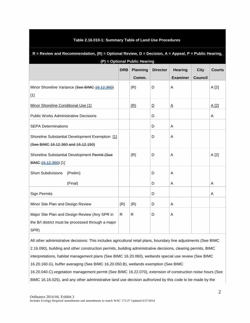
Table 2.16.010-1: Summary Table of Land Use Procedures
R = Review and Recommendation, (R) = Optional Review, D = Decision, A = Appeal, P = Public Hearing,
(P) = Optional Public Hearing
DRB Planning
Comm.
Director Hearing
Examiner
City
Council
Courts
Minor Shoreline Variance (See BIMC 16.12.360)
[1]
(R) D A A [2]
Minor Shoreline Conditional Use [1] (R) D A A [2]
Public Works Administrative Decisions D A
SEPA Determinations D A
Shoreline Substantial Development Exemption [1]
(See BIMC 16.12.360 and 16.12.150)
D A
Shoreline Substantial Development Permit (See
BIMC 16.12.360) [1]
(R) D A A [2]
Short Subdivisions (Prelim) D A
(Final) D A A
Sign Permits D A
Minor Site Plan and Design Review (R) (R) D A
Major Site Plan and Design Review (Any SPR in
the B/I district must be processed through a major
SPR)
R R D A
All other administrative decisions: This includes agricultural retail plans, boundary line adjustments (See BIMC
2.16.090), building and other construction permits, building administrative decisions, clearing permits, BIMC
interpretations, habitat management plans (See BIMC 16.20.060), wetlands special use review (See BIMC
16.20.160.G), buffer averaging (See BIMC 16.20.050.B), wetlands exemption (See BIMC
16.20.040.C),vegetation management permit (See BIMC 16.22.070), extension of construction noise hours (See
BIMC 16.16.025), and any other administrative land use decision authorized by this code to be made by the
2
Ordinance 2014-04, Exhibit 3 Includes Ecology Required amendments and amendments to match WAC 173-27 Updated 6/27/2014
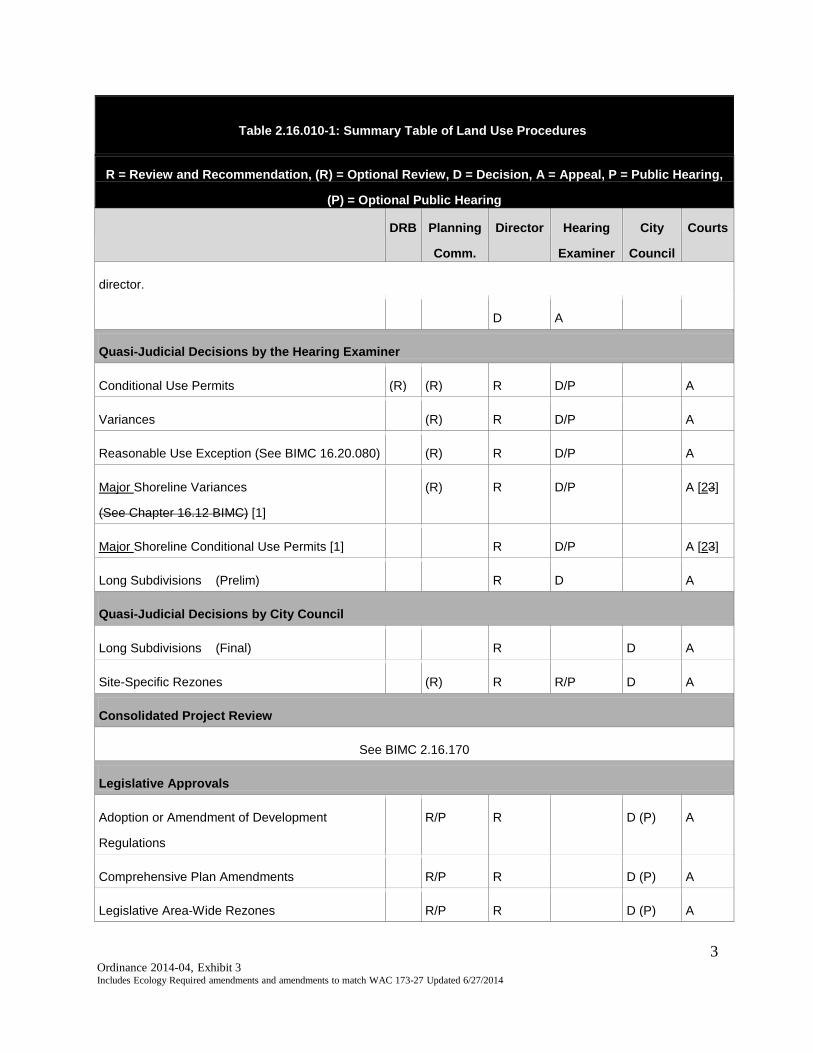
Table 2.16.010-1: Summary Table of Land Use Procedures
R = Review and Recommendation, (R) = Optional Review, D = Decision, A = Appeal, P = Public Hearing,
(P) = Optional Public Hearing
DRB Planning
Comm.
Director Hearing
Examiner
City
Council
Courts
director.
D A
Quasi-Judicial Decisions by the Hearing Examiner
Conditional Use Permits (R) (R) R D/P A
Variances (R) R D/P A
Reasonable Use Exception (See BIMC 16.20.080) (R) R D/P A
Major Shoreline Variances
(See Chapter 16.12 BIMC) [1]
(R) R D/P A [23]
Major Shoreline Conditional Use Permits [1] R D/P A [23]
Long Subdivisions (Prelim) R D A
Quasi-Judicial Decisions by City Council
Long Subdivisions (Final) R D A
Site-Specific Rezones (R) R R/P D A
Consolidated Project Review
See BIMC 2.16.170
Legislative Approvals
Adoption or Amendment of Development
Regulations
R/P R D (P) A
Comprehensive Plan Amendments R/P R D (P) A
Legislative Area-Wide Rezones R/P R D (P) A
3
Ordinance 2014-04, Exhibit 3 Includes Ecology Required amendments and amendments to match WAC 173-27 Updated 6/27/2014
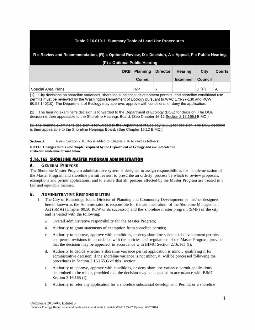
Table 2.16.010-1: Summary Table of Land Use Procedures
R = Review and Recommendation, (R) = Optional Review, D = Decision, A = Appeal, P = Public Hearing,
(P) = Optional Public Hearing
DRB Planning
Comm.
Director Hearing
Examiner
City
Council
Courts
Special Area Plans R/P R D (P) A [1] City decisions on shoreline variances, shoreline substantial development permits, and shoreline conditional use permits must be reviewed by the Washington Department of Ecology pursuant to WAC 173-27-130 and RCW 90.58.140(10). The Department of Ecology may approve, approve with conditions, or deny the application. [2] The hearing examiner’s decision is forwarded to the Department of Ecology (DOE) for decision. The DOE decision is then appealable to the Shoreline Hearings Board. (See Chapter 16.12 Section 2.16.165.I BIMC.) [3] The hearing examiner’s decision is forwarded to the Department of Ecology (DOE) for decision. The DOE decision is then appealable to the Shoreline Hearings Board. (See Chapter 16.12 BIMC.) Section 3. A new Section 2.16.165 is added to Chapter 2.16 to read as follows: NOTE: Changes to this new chapter required by the Department of Ecology and are indicated in strikeout/ underline format below. 2.16.165 SHORELINE MASTER PROGRAM ADMINISTRATION A. GENERAL PURPOSE The Shoreline Master Program administrative system is designed to assign responsibilities for implementation of the Master Program and shoreline permit review; to prescribe an orderly process by which to review proposals, exemptions and permit applications; and to ensure that all persons affected by the Master Program are treated in a fair and equitable manner. B. ADMINISTRATIVE RESPONSIBILITIES
1. The City of Bainbridge Island Director of Planning and Community Development or his/her designee, herein known as the Administrator, is responsible for the administration of the Shoreline Management Act (SMA) (Chapter 90.58 RCW or its successor) and the shoreline master program (SMP) of the city and is vested with the following:
a. Overall administrative responsibility for the Master Program; b. Authority to grant statements of exemption from shoreline permits; c. Authority to approve, approve with conditions, or deny shoreline substantial development permits
and permit revisions in accordance with the policies and regulations of the Master Program, provided that the decision may be appealed in accordance with BIMC Section 2.16.165 (I);
d. Authority to decide whether a shoreline variance permit application is minor, qualifying it for administrative decision; if the shoreline variance is not minor, it will be processed following the procedures in Section 2.16.165.G of this section;
e. Authority to approve, approve with conditions, or deny shoreline variance permit applications determined to be minor, provided that the decision may be appealed in accordance with BIMC Section 2.16.165 (I);
f. Authority to refer any application for a shoreline substantial development Permit, or a shoreline
4
Ordinance 2014-04, Exhibit 3 Includes Ecology Required amendments and amendments to match WAC 173-27 Updated 6/27/2014
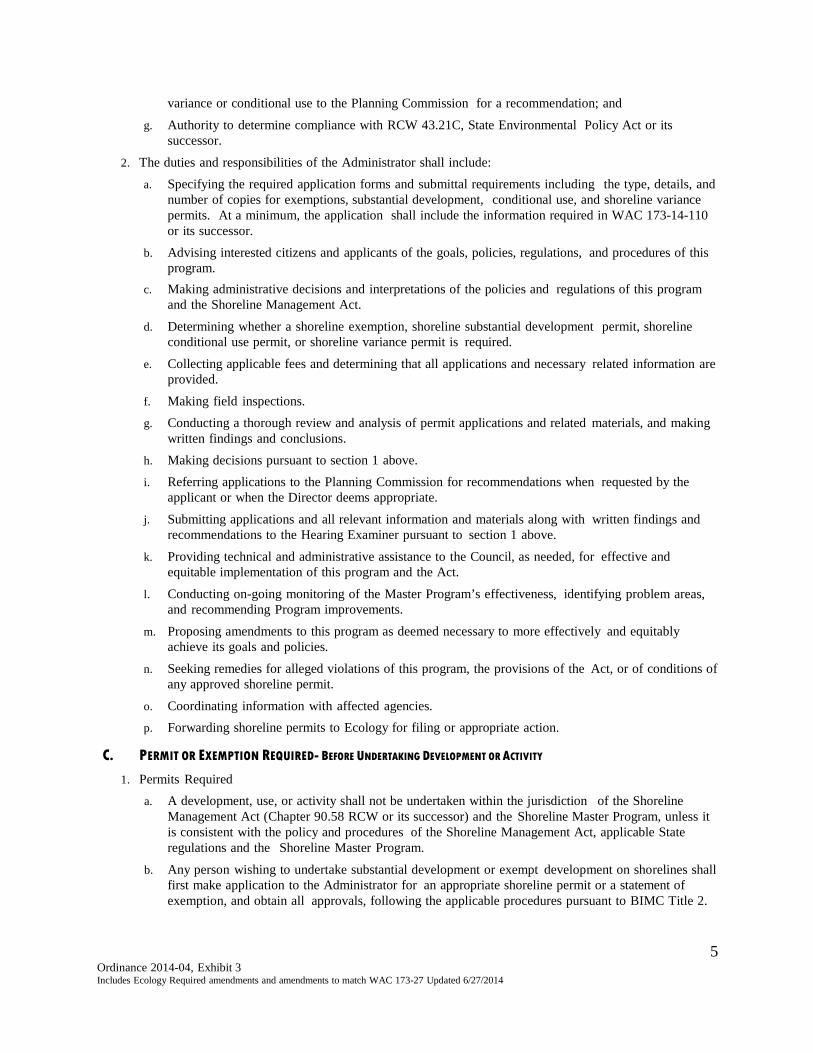
variance or conditional use to the Planning Commission for a recommendation; and
g. Authority to determine compliance with RCW 43.21C, State Environmental Policy Act or its successor.
2. The duties and responsibilities of the Administrator shall include: a. Specifying the required application forms and submittal requirements including the type, details, and
number of copies for exemptions, substantial development, conditional use, and shoreline variance permits. At a minimum, the application shall include the information required in WAC 173-14-110 or its successor.
b. Advising interested citizens and applicants of the goals, policies, regulations, and procedures of this program.
c. Making administrative decisions and interpretations of the policies and regulations of this program and the Shoreline Management Act.
d. Determining whether a shoreline exemption, shoreline substantial development permit, shoreline conditional use permit, or shoreline variance permit is required.
e. Collecting applicable fees and determining that all applications and necessary related information are provided.
f. Making field inspections. g. Conducting a thorough review and analysis of permit applications and related materials, and making
written findings and conclusions. h. Making decisions pursuant to section 1 above. i. Referring applications to the Planning Commission for recommendations when requested by the
applicant or when the Director deems appropriate.
j. Submitting applications and all relevant information and materials along with written findings and recommendations to the Hearing Examiner pursuant to section 1 above.
k. Providing technical and administrative assistance to the Council, as needed, for effective and equitable implementation of this program and the Act.
l. Conducting on-going monitoring of the Master Program’s effectiveness, identifying problem areas, and recommending Program improvements.
m. Proposing amendments to this program as deemed necessary to more effectively and equitably achieve its goals and policies.
n. Seeking remedies for alleged violations of this program, the provisions of the Act, or of conditions of any approved shoreline permit.
o. Coordinating information with affected agencies. p. Forwarding shoreline permits to Ecology for filing or appropriate action.
C. PERMIT OR EXEMPTION REQUIRED- BEFORE UNDERTAKING DEVELOPMENT OR ACTIVITY
1. Permits Required a. A development, use, or activity shall not be undertaken within the jurisdiction of the Shoreline
Management Act (Chapter 90.58 RCW or its successor) and the Shoreline Master Program, unless it is consistent with the policy and procedures of the Shoreline Management Act, applicable State regulations and the Shoreline Master Program.
b. Any person wishing to undertake substantial development or exempt development on shorelines shall first make application to the Administrator for an appropriate shoreline permit or a statement of exemption, and obtain all approvals, following the applicable procedures pursuant to BIMC Title 2.
5 Ordinance 2014-04, Exhibit 3 Includes Ecology Required amendments and amendments to match WAC 173-27 Updated 6/27/2014
c. A substantial development shall not be undertaken within the jurisdiction of the Shoreline Management Act (Chapter 90.58 RCW or its successor) and the Shoreline Master Program, unless an appropriate shoreline permit has been obtained, the appeal period has been completed, any appeals have been resolved, and/or the applicant has been given permission by the proper authority to proceed pursuant to the procedures of this chapter BIMC Title 2.
d. If a development, use or activity is listed as a conditional use by the Shoreline Master Program, such development, use, or activity shall not be undertaken within the jurisdiction of the Shoreline Management Act (Chapter 90.58 RCW or its successor) and the Master Program, unless a shoreline conditional use permit has been obtained, the appeal period has been completed, any appeals have been resolved, and/or the applicant given permission to proceed by the proper authority pursuant to the procedures of this chapter BIMC Title 2.
e. If a development, use, or activity cannot comply with the regulations of the Master Program, a shoreline variance must be obtained before commencement of development or construction, or beginning the use or activity pursuant to the procedures of BIMC Title 2.
f. If a project includes uses or activities that include permitted and conditional uses, or a major shoreline variance is required, all shoreline permits shall be heard and decided by the Hearing Examiner using the procedures, requirements, and criteria for a conditional use and/or shoreline variance pursuant to the procedures of BIMC Title 2.
g. See WAC 173-14-050 or its successor for a description of how the permit requirements apply to developments undertaken prior to the passage of the Shoreline Management Act of 1971.
h. See WAC 173-14-062 or its successor for a description of how the permit requirements apply to federal agency projects.
2. Statement of Exemption a. If it has been determined by the Administrator that a proposed development or activity is exempt
from shoreline permits pursuant to WAC 173-27-040, a statement of exemption shall be required following the procedures provided in BIMC Chapter 2.16. No exempt development, use or activity shall be undertaken within the jurisdiction of the Shoreline Management Act (Chapter 90.58 RCW or its successor) and the Master Program, unless a statement of exemption has been obtained from the Administrator and all conditions are met.
D. APPLICATIONS
The Administrator shall provide the necessary application forms for statements of exemption and for permits for shoreline substantial development, shoreline conditional use, and shoreline variance. The application shall provide, at a minimum, the information required by WAC 173-14-110, or its successor along with the information required on the permit application.
E. STATEMENT OF EXEMPTION FROM SHORELINE SUBSTANTIAL DEVELOPMENT PERMIT
1. Purpose and Applicability Certain development activities identified in WAC 173-27-040 are exempt from the requirement to secure a shoreline substantial development permit; however, a shoreline variance or shoreline conditional use permit may still be required. State law requires that exemptions be construed narrowly. Exemption from substantial development permit procedures does not constitute exemption from compliance with the policies and use regulations of the SMA (RCW 90.58), the provisions of the Master Program, or applicable City, state or federal permit requirements. Applicants shall have the burden to demonstrate that the proposal complies with the requirements for the exemptions sought as described under WAC 173-27-040, or its successor. If any part of a proposed development is not eligible for exemption, then a substantial development permit is required for the entire proposed development project, pursuant to WAC 173-27-040(d), or its successor.
6
Ordinance 2014-04, Exhibit 3 Includes Ecology Required amendments and amendments to match WAC 173-27 Updated 6/27/2014

2. Procedure a. In the case of an emergency, the Administrator may waive this requirement and authorize the use or
activity orally or in writing. If authorized orally, the applicant shall submit a required application as soon as possible.
b. The Administrator shall decide requests for a statement of exemption based on WAC 173-27-040 or its successor and the provisions of the Shoreline Management Act and the Master Program.
c. Before determining that a proposal is exempt, the Administrator may conduct a site inspection to ensure that the proposal meets the exemption criteria.
d. Exempt developments and activities shall comply with the Shoreline Management Act and the Master Program. The Administrator shall condition statements of exemption to ensure the exempt development or activity complies with the Shoreline Management Act and the Master Program.
e. In the case of development subject to the policies and regulations of the Master Program, but exempt from the substantial development permit process, shoreline management requirements may be made conditions of the building permits and/or other permits and approvals. For example, the approval of a building permit for a single- family residence can be conditioned with provisions from the Master Program.
f. Whenever a development falls within the exemptions stated in WAC 173-27-040 or its successor, but is still subject to those permits listed in WAC 173-27-040 (as amended), a letter exempting the development from the substantial development permit requirements of Chapter 90.58 RCW or its successor shall be given to the applicant and Department of Ecology.
3. Decision Criteria a. Exemptions shall be narrowly construed, when making the determination, the Administrator shall
grant a statement of exemption only when the development proposed is consistent with the following:
i. The applicable policies, guidelines, and regulations of the policies, guidelines and regulations of
the Shoreline Management Act of 1971, RCW 90.58, as amended, WAC 173-26 and WAC 173-27 or its successor;
ii. The goals, policies, objectives and regulations of the City of Bainbridge Island Shoreline Master Program;
iii. The City of Bainbridge Island Comprehensive Plan and Municipal Code; all other applicable law; and any related documents and approvals.
4. Action of Administrator The Administrator may grant, deny, or conditionally approve the shoreline exemption request. The
approval or conditional approval will become conditions of approval for any related development permit, and no development permit will be issued unless it is consistent with the statement of exemption. A copy of the City’s statement of exemption shall be filed with the Department of Ecology.
5. Application Timeframe The approval for a shoreline exemption shall be the same as the expiration date of the development
permit. All conditions of the approval for a shoreline exemption shall be included in the conditions of approval granted for the development permit.
6. Appeal Any person aggrieved by the Administrator’s determination on a shoreline exemption request may be
appealed, except as stated below, using the applicable appeal provision of BIMC Section 2.16.165 (I). If a proposed development activity also requires approval through other permit procedures, any appeal of a shoreline exemption requires will be heard as part of that other process.
7
Ordinance 2014-04, Exhibit 3 Includes Ecology Required amendments and amendments to match WAC 173-27 Updated 6/27/2014
F. SHORELINE SUBSTANTIAL DEVELOPMENT PERMIT 1. Purpose and Applicability Substantial development is any development of which the total cost or fair market value exceeds five
thousand seven hundred and eighteen six thousand four hundred and sixteen dollars ($5,718 6,416) or any development, which materially interferes with the normal public use of the waters or shorelines of the state, except those exempted developments set forth in the preceding section, consistent with WAC 173-27-040, or its successor.
2. Procedure Shoreline substantial development permits shall be approved through the general administrative review
procedures described in BIMC 2.16.030 except as described below. Application materials for shoreline substantial development permits can be found in the Administrative Manual.
a. Public Comment - The City shall not make a decision on the permit until after the end of the
comment period. i. A thirty (30) day public comment period shall be given for shoreline permits. ii. The public comment period shall be twenty (20) days for substantial development permits for a
limited utility extension or for erosion control measures to protect a single-family residence and its appurtenant structures. (See Shoreline Master Program definition of "limited utility extension, Chapter 16.12.")
iii. SEPA review shall be conducted as provided by BIMC Chapter 16.04 Environmental Policy or its successor. The required SEPA notices should be included with the shoreline notices when possible. The SEPA documents should be circulated with permit documents where possible.
3. Decision and Criteria After the thirty (30) day comment period has ended, the Administrator shall issue a decision on the
application. a. The Administrator may approve, approve with modifications, or deny any substantial development
permit.
b. Decision Criteria. i. In making the decision, the Administrator shall grant a substantial development permit only
when the development proposed is consistent with the following: A. The applicable policies, guidelines, and regulations of the policies, guidelines and
regulations of the Shoreline Management Act of 1971, RCW 90.58, as amended, WAC 173-26 and WAC 173-27 or its successor;
B. The goals, policies, objectives and regulations of the City of Bainbridge Island Shoreline Master Program;
C. The City of Bainbridge Island Comprehensive Plan and Municipal Code; all other applicable law; and any related documents and approvals.
ii. The Administrator shall also consider whether the cumulative impact of additional past and future requests that reasonably may be made in accordance with the Comprehensive Plan, or similar planning document, for like actions in the area will result in substantial adverse effects on the shoreline environment and shoreline resources.
c. The applicant(s) shall have the burden of proving that a proposed development is consistent with the approval criteria and Master Program policies and regulations. [WAC 90.58.140(7) or its successor].
d. The Administrator may require additional information if necessary. e. The Administrator shall issue a written decision which contains the following:
8
Ordinance 2014-04, Exhibit 3 Includes Ecology Required amendments and amendments to match WAC 173-27 Updated 6/27/2014
i. A statement indicating the application is approved, approved with modifications, or denied; ii. A statement of any conditions included as part of an approval or approval with modifications; iii. A statement of facts upon which the decision, including any conditions, is based, and the
conclusions derived from those facts; and iv. A statement of the right of any person to appeal the decision of the Administrator pursuant to
BIMC Section 2.16.165 (I) below.
f. The Administrator may refer the application to the Planning Commission for review and recommendations prior to deciding the application. The application shall also be referred to the Planning Commission for a recommendation at the request of the applicant. The Planning Commission makes its recommendation following its review of the proposal, the environmental checklist, and the tentative threshold determination.
g. The permit, whether approved or denied, shall be in the form required by WAC 173-27- 120 or its successor.
4. Distribution/notification of Administrative Decision. a. The Administrator shall mail the applicant the original of the completed permit form and the findings
and conclusions. b. All persons who submitted comments on the application during the comment period (see paragraph
above) and anyone else requesting notification in writing, shall be notified in a timely manner of the decision and shall be mailed a copy of the decision.
5. Application Timeframe a. Substantial Progress
i. Substantial progress towards completion of a permitted activity shall be undertaken within two (2) years after approval of the permit [WAC 173-27-090, or its successor]. See definition of "substantial progress."
ii. The Administrator may, with prior notice to parties of record and to Ecology, grant one extension of the two (2) year time period for substantial progress for up to one (1) year based on reasonable factors which would justify the extension, including the inability to expeditiously obtain other governmental permits which are required prior to the commencement of construction [WAC 173-27-090, or its successor]. The request for the extension must be filed with the Administrator before the end of the time limit.
b. Five Year Permit Authorization i. The authorization granted by an approved permit to construct any structure or conduct any use or
activity shall terminate five (5) years after the date the permit is approved by the City, except that the permit may be authorized for a lesser period of fixed duration.
ii. Where an approved permit authorizes construction, the use and maintenance of the structure or facility may continue after the five (5) year period, provided the structure was completed during the five (5) year time limit or any approved extension.
iii. Where an approved permit authorizes a use or activity which does not require a structure, such as mining or maintenance dredging, the use or activity shall cease at the end of the five (5) year limit or any extension as granted in paragraph (iv) below.
iv. The Administrator may, with prior notice to parties of record and to Ecology, grant one (1) time extension of up to one year based on reasonable factors which would justify the extension. The request for the extension must be filed with the Administrator before the end of the time limit.
c. The application time limits shall not include the time during which an activity was not actually
pursued due to the pendency of reasonably related administrative appeals or litigation. d. When a permit is conditioned, the conditions shall be satisfied prior to occupancy or use of a
structure, or prior to commencement of a nonstructural activity, provided an alternative compliance
9 Ordinance 2014-04, Exhibit 3 Includes Ecology Required amendments and amendments to match WAC 173-27 Updated 6/27/2014
limit may be specified in the permit.
e. Revisions to permits may be authorized after the original permit has expired under paragraph b of this section, provided this procedure shall not be used to extend the original permit time requirements. [WAC 173-27-060, or its successor].
6. Adjustments to Approved Shoreline Substantial Development Permits.
a. Minor adjustments to an approved shoreline substantial development permit may be made after review by the Administrator. The applicant must submit detailed plans and text describing the proposed changes. If the Administrator determines that the revisions proposed are within the scope and intent of the original permit, consistent with WAC 173-27-100 or its successor, the Administrator may approve the revision as a Minor Adjustment.
b. A Minor Adjustment entails a revision that is "within the scope and intent of the original permit," which means all of the following:
i. No additional over-water construction is involved, except that pier, dock, or float construction may be increased by five hundred (500) square feet or ten (10) percent, whichever is less;
ii. Ground area coverage and height of each building is not increased more than ten (10) percent; iii. Additional structures located landward and not within required buffer or setback areas do not
exceed a total of two hundred fifty (250) square feet; iv. The revision does not authorize development to exceed height, setback, lot coverage, or any
other requirement of the City of Bainbridge Island Shoreline Master Program; v. Additional landscaping is consistent with conditions, if any, attached to the original permit and
with the applicable Master Program provisions; vi. The use authorized pursuant to the original permit is not changed; and vii. No substantial, adverse, environmental impact will be caused by the project revision. WAC 173-
27-064 (2)(a-g) as amended.
c. If the sum of the proposed revision and any previously approved revisions do not meet the criteria above, the revision shall be reviewed through a Major Adjustment process. This shall be processed in the same manner as a new shoreline substantial development permit application. If the revision adjustment involves a conditional use or shoreline variance which was conditioned by the Department of Ecology, the revision adjustment also must be reviewed and approved by Ecology. [WAC 173-27-064 or its successor].
d. A City or Ecology decision on a minor or major adjustment to the permit may be appealed within
twenty-one (21) days of such decision, in accordance with RCW 90.58.180 or its successor, and WAC 173-27-064 or its successor.
e. Construction allowed by the revised permit that is not authorized under the original permit is undertaken at the applicant's risk until the expiration of the appeals deadline.
7. Appeal
The decision of the Administrator may be appealed to the Hearing Examiner following the procedures of BIMC Section 2.16.165 (I).
G. SHORELINE VARIANCE, MINOR OR MAJOR This subsection applies to all applications for shoreline variances
1. Purpose The purposes of a shoreline variance permit is strictly limited to granting relief to specific bulk,
10
Ordinance 2014-04, Exhibit 3 Includes Ecology Required amendments and amendments to match WAC 173-27 Updated 6/27/2014
dimensional, or performance standards set forth in the Master Program, where there are extraordinary or unique circumstances relating to the property such that the strict implementation of the Master Program would impose unnecessary hardships on the applicant or thwart the Shoreline Management Act policies as stated in RCW 90.58.020 or its successor.
2. Applicability a. The minor variance process may be used for minor deviations from zoning standards in BIMC Title
18 and BIMC 16.12 as determined by the director. Minor projects should be limited to: (a) projects that are exempt from review under the State Environmental Policy Act (SEPA), or (b) proposals for less than a 25 percent encroachment in required yards, or (c) proposals of less than a 25 percent increase in lot coverage. All other variances shall be considered a Major Variance and processed as described in 2(b) below.
b. This process may also be used for minor variation(s) from the engineering requirements of the adopted city of Bainbridge Island engineering and development standards if the requested variation will further the purposes of the BIMC and is approved by the department director, after recommendation by the city engineer and/or the fire marshal.
c. This procedure is not available to obtain variances from subdivision standards in BIMC Title 17 or to obtain variances from BIMC Title 18 zoning standards cross-referenced in BIMC Title 17 as part of a short subdivision, long subdivision, or large lot subdivision approval or amendment process, except for those engineering standards covered by subsection B.2 of this section.
d. This procedure is not available to allow the siting for an accessory dwelling unit where it would not otherwise be permitted.
e. A variance shall not be granted solely because of the presence of nonconformities in the vicinity of the subject site.
f. The project involves only one project. g. The project has not generated a significant public input.
3. Procedure
a. Minor Shoreline Variance The Administrator shall review a minor shoreline variance application following procedures in section F.2, above.
b. Major Shoreline Variance Applications for shoreline variances that are more intensive than the minor shoreline variance as
determined by the Administrator shall be decided by the Hearing Examiner following the procedures in BIMC 2.16.100, or its successor, supplemented by the following provisions:
i. The decision of the Hearing Examiner shall be the final City decision, and may be appealed in accordance with paragraphs BIMC Section 2.16.165 (I).
d. Notice of Application and Comment Period - In addition to the notice of application content established in BIMC 2.16.020(K), notice of application for shoreline variance permits must also contain the information required under WAC 173-27-110.
e. Notice of Hearing – When a public hearing is required, the procedures of BIMC 2.16.020 (K)(6) shall apply.
f. The Administrator shall mail the final City decision to the applicant, the State Department of Ecology, and the State Attorney General. The permit must be received by Ecology within eight (8) days of the date of the decision. Within eight (8) days of the date of the decision, the Administrator shall also mail the decision to any person who requested notice of the decision.
g. The State Department of Ecology shall approve, approve with conditions, or deny all shoreline
11
Ordinance 2014-04, Exhibit 3 Includes Ecology Required amendments and amendments to match WAC 173-27 Updated 6/27/2014
variances approved by the City. Ecology's decision must be made within thirty (30) days of the date the permit and other information required by WAC 173-14-090 or its successor are received by Ecology and the Washington State Attorney General. Ecology will send a letter to the applicant and the City informing them of the decision. Upon receipt of the Ecology decision, the Administrator shall notify those interested persons who requested notification.
4. Decision Criteria Pursuant to WAC 173-27-210 170 or its successor, the criteria below constitute the minimum criteria for review and approval of a shoreline variance permit.
a. Shoreline variance permits for development and/or uses that will be located landward of the ordinary high water mark (OHWM), and/or landward of any wetland, as defined in BIMC 16.12, may be authorized provided the applicant can demonstrate all of the following:
i. The strict application of the bulk, dimensional or performance standards set forth in the applicable master program precludes, or significantly interferes with, reasonable use of the property;
ii. The hardship described in (a) of this subsection is specifically related to the property, and is the result of unique conditions such as irregular lot shape, size, or natural features and the application of the master program, and not, for example, from deed restrictions or the applicant's own actions;.
iii. The design of the project is compatible with other authorized uses within the area and with uses planned for the area under the comprehensive plan and shoreline master program and will not cause adverse impacts to the shoreline environment
iv. The variance will not constitute a grant of special privilege not enjoyed by the other properties in the area
v. The variance requested is the minimum necessary to afford relief; and vi. The public interest will suffer no substantial detrimental effect.
b. Shoreline variance permits where the development will be located either waterward of the ordinary high water mark (OHWM) or within or within any wetland, defined in BIMC 16.12, may be approved or approved with conditions or modifications subject to approval by Ecology, if the decision maker finds the applicant has demonstrated compliance with all of the following criteria:
i. The strict application of the bulk, dimensional or performance standards set forth in the applicable master program precludes all reasonable use of the property;
ii. The proposal is consistent with the criteria established under subsection (3)(ii) through (vi) of this section; and
iii. The public rights of navigation and use of the shorelines will not be adversely affected. c. In the granting of all shoreline variance permits, consideration shall be given to the cumulative
impact of additional requests for like actions in the area. For example, if shoreline variances were granted to other developments in the area where similar circumstances exist, the total of the shoreline variances should also remain consistent with the policies of RCW 90.58 or its successor and should not produce substantial adverse effects to the shoreline environment.
5. Timeframe Construction and activities authorized by a shoreline variance are subject to the time limitations in F(5).
[WAC 173-27-090, or its successor].
6. Adjustments to Approved Shoreline Variance a. A permit revision is required whenever an applicant proposes substantive changes to the design,
terms or conditions of a project from that approved as a shoreline variance. The applicant shall submit detailed plans and text describing the proposed changes in the permit and demonstrating
12
Ordinance 2014-04, Exhibit 3 Includes Ecology Required amendments and amendments to match WAC 173-27 Updated 6/27/2014
compliance with the following minimum standards pursuant to WAC 173-27.
b. If the proposed changes are determined by the Administrator to be within the scope and intent of the original permit, and are consistent with the Act (RCW 90.58), the shoreline guidelines (WAC 173-26), and the shoreline master program, the revisions may be approved as a Minor Adjustment.
c. A Minor Adjustment entails a revision that is “within the scope and intent of the original permit,”
which means all of the following:
i. No additional over-water construction is involved except that a pier, dock or floating structure may be increased by ten percent (10%) or 500 square feet whichever is less over that approved under the original approval;
ii. Ground area coverage and/or height may be increased a maximum of ten percent (10%) over that approved under the original approval; provided that, the revised approval does not authorize development to exceed the height, impervious surface, setback or any other requirements of this Program except as authorized under a variance granted for the original development;
iii. Additional or revised landscaping is consistent with any conditions attached to the original approval and with this Program;
iv. The use authorized pursuant to the original approval is not changed; and v. The revision will not cause adverse environmental impacts beyond those originally authorized in
the approval.
d. Revisions to shoreline permits and statements of exemption may be authorized after the original authorization has expired. Revisions made after the expiration of the original approval shall be limited to changes that are consistent with this Program and that would not require a permit under this Program. If the proposed change is a substantial development as defined by this Program, then a new permit is required. The provisions of this paragraph shall not be used to extend the time requirements or to authorize substantial development beyond the time limits or scope of the original approval.
e. A new permit shall be required if the proposed revision and any previously approved revisions in combination would constitute development beyond the scope and intent of the original approval.
f. Upon approval of a revision, the decision maker shall file a copy of the revised site plan and a detailed description of the authorized changes to the original permit with the Department of Ecology together with a final ruling and findings supporting the decision based on the requirements of this section. In addition, the decision maker shall notify parties of record of the action.
g. If the proposed revision is to a development for which a shoreline variance was issued, the decision maker shall submit the revision to the Department of Ecology for approval with conditions or denial, and shall indicate that the revision is being submitted under the requirements of this paragraph. Under the requirements of WAC 173-27-110(6), the department shall render and transmit to the decision maker and the applicant/proponent its final decision within fifteen (15) days of the date of the Department’s receipt of the submittal from the decision maker. The decision maker shall notify parties on record of the Department’s final decision.
7. Appeal of Decision on Shoreline Variance The decision of the Hearing Examiner may be appealed to the following the procedures of BIMC Section 2.16.165 (I).
H. SHORELINE CONDITIONAL USE PERMITS Where a development includes several uses or activities and one or more uses or activities require a Shoreline conditional use permit, all uses and activities shall be processed and decided following the shoreline conditional use procedures.
13
Ordinance 2014-04, Exhibit 3 Includes Ecology Required amendments and amendments to match WAC 173-27 Updated 6/27/2014
1. Purpose The purpose of a shoreline conditional use permit is to allow greater flexibility in applying the use regulations of the Master Program in a manner consistent with the policies of RCW 90.58.020, or its successor provided that shoreline conditional use permits should also be granted in a circumstance where denial of the permit would result in a thwarting of State policy enumerated in RCW 90.58.020 or its successor. In authorizing a conditional use, special conditions may be attached to the permit by the City or the State Department of Ecology to prevent undesirable effects of the proposed use. Uses which are specifically prohibited by the Master Program may not be authorized with approval of a shoreline conditional use permit.
2. Applicability a. Minor Conditional use
As determined by the director, this procedure shall apply to (a) all minor conditional uses indentified in BIMC 16.12; (b) where the director determines that the anticipated impacts of those conditional uses will be minor or minimal; or (c) uses that are clearly consistent and compatible with other uses in the same zone or vicinity.
b. Major Conditional Use As determined by the administrator, a major conditional use permit shall be secured from the city prior to establishing or expanding a use according to situations that include, but are not limited to: (a) the proposed use or expansion covers 50 percent or greater of the total lot area; (b) the proposed use is accessed by a local or private road; (c) the proposed use or expansion generates more than 36 total trips per day; (d) the proposed use or expansion contains four or more units in a multifamily dwelling; or (e) requests for additional nonresidential building height pursuant to BIMC 16.12
3. Procedure a. Application - An application for a shoreline conditional use permit shall be submitted on a form
provided by the City. The application should be accompanied by maps, a completed environmental checklist, applicable fees, and any other information specified in the Master Program or requested by the Administrator.
b. Minor Shoreline Conditional Use i. The Administrator shall review a minor shoreline variance application following
procedures in F.2, above.
c. Minor Shoreline Conditional Use Applications for shoreline variances that are more intensive than the minor shoreline variance as
determined by the Administrator shall be decided by the Hearing Examiner following the procedures in BIMC 2.16.100, or its successor, supplemented by the following provisions: i. The decision of the Hearing Examiner shall be the final City decision, and may be appealed in
accordance with paragraphs BIMC Section 2.16.165 (I).
d. Notice of Application and Comment Period - In addition to the notice of application content established in 2.16.020(K), notice of application for shoreline conditional use permits must also contain the information required under WAC 173-27-110.
e Notice of Hearing – When a public hearing is required, the procedures of BIMC 2.16.020 (K)(6) shall apply.
f. The Administrator shall mail the final City decision to the applicant, the State Department of Ecology, and the State Attorney General. The permit must be received by Ecology within eight (8) days of the date of the decision. Within eight (8) days of the date of the decision, the Administrator shall also mail the decision to any person who requested notice of the decision.
g. The State Department of Ecology shall approve, approve with conditions, or deny all shoreline
14
Ordinance 2014-04, Exhibit 3 Includes Ecology Required amendments and amendments to match WAC 173-27 Updated 6/27/2014
conditional use permits approved by the City. Ecology's decision must be made within thirty (30) days of the date the permit and other information required by WAC 173-14-090 or its successor are received by Ecology and the Washington State Attorney General. Ecology will send a letter to the applicant and the City informing them of the decision. Upon receipt of the Ecology decision, the Administrator shall notify those interested persons who requested notification.
4. Decision Criteria – Conditional Use Permit a. Uses classified as conditional uses may be authorized provided that pursuant to WAC 173-27-140
and 160 or its successor, the applicant can demonstrate all of the following:
i. The proposed use will be consistent with the policies of RCW 90.58.020 or its successor and the policies of the Master Program;
ii. The proposed use will not interfere with the normal public use of the public shorelines; iii. That the proposed use of the site and design of the project is compatible with other authorized
uses within the area and with uses planned for the area under the comprehensive plan and shoreline master program;
iv. The proposed use will cause no unreasonably adverse effects to the shoreline environment designation in which it is located;
v. The public interest suffers no substantial detrimental effect. [WAC 173- 14-140(1) or its successor]; and
vi. The proposed use is consistent with the provisions of the Zoning Ordinance (BIMC Title 18).
b. Other uses which are not listed in the Master Program as permitted or conditional uses and are also not prohibited may be authorized as conditional uses provided the applicant can demonstrate, in addition to the criteria set forth in 3(a) above that 1) extraordinary circumstances preclude reasonable economic use of the property in a manner consistent with the policies of RCW 90.58.020, or its successor) that the proposed use would not produce significant adverse effects on the shoreline environment.
c. In the granting of all shoreline conditional use permits, consideration shall be given to the cumulative impact of additional requests for like actions in the area.
5. Timeframe Construction and activities authorized by a shoreline conditional use permit are subject to the time limitations in F(5) [WAC 173-27-090, or its successor].
6. Adjustments to Approved Shoreline Conditional Use Permit a. A permit revision is required whenever an applicant proposes substantive changes to the design,
terms or conditions of a project from that approved as a shoreline conditional use permit. When a revision of a shoreline conditional use permit is sought, the applicant shall submit detailed plans and text describing the proposed changes in the permit and demonstrating compliance with the following minimum standards pursuant to WAC 173- 27.
b. If the proposed changes are determined by the Administrator to be within the scope and intent of the
original permit, and are consistent with the SMA (RCW 90.58), the shoreline guidelines (WAC 173-26), and the shoreline master program, the revisions may be approved as a Minor Adjustment.
c. A Minor Adjustment entails a revision that is “within the scope and intent of the original permit,” which means all of the following:
i. No additional over-water construction is involved except that a pier, dock or floating structure may be increased by ten percent (10%) or 500 square feet whichever is less over that approved under the original approval;
ii. Ground area coverage and/or height may be increased a maximum of ten percent (10%) over that
15
Ordinance 2014-04, Exhibit 3 Includes Ecology Required amendments and amendments to match WAC 173-27 Updated 6/27/2014
approved under the original approval; provided that, the revised approval does not authorize development to exceed the height, impervious surface, setback or any other requirements of this Program except as authorized under a variance granted for the original development;
iii. Additional or revised landscaping is consistent with any conditions attached to the original approval and with this Program;
iv. The use authorized pursuant to the original approval is not changed; and
v. The revision will not cause adverse environmental impacts beyond those originally authorized in the approval.
d Revisions to shoreline permits and statements of exemption may be authorized after the original authorization has expired. Revisions made after the expiration of the original approval shall be limited to changes that are consistent with this Program and that would not require a permit under this Program. If the proposed change is a substantial development as defined by this Program, then a new permit is required. The provisions of this paragraph shall not be used to extend the time requirements or to authorize substantial development beyond the time limits or scope of the original approval.
e. A new permit shall be required if the proposed revision and any previously approved revisions in combination would constitute development beyond the scope and intent of the original approval.
f. Upon approval of a revision, the decision maker, shall file a copy of the revised site plan and a detailed description of the authorized changes to the original permit with the Department of Ecology together with a final ruling and findings supporting the decision based on the requirements of this section. In addition, the decision maker shall notify parties of record of the action.
g. If the proposed revision is to a development for which a shoreline conditional use or variance was issued, the decision maker shall submit the revision to the Department of Ecology for approval, approval with conditions, or denial, and shall indicate that the revision is being submitted under the requirements of this paragraph. Under the requirements of WAC 173-27-110(6), the department shall render and transmit to the decision maker and the applicant/proponent its final decision within fifteen (15) days of the date of the Department’s receipt of the submittal from the decision maker. The decision maker shall notify parties on record of the Department’s final decision.
7. Appeal of Decision on Conditional Use Permit The decision of the Hearing Examiner may be appealed to the following the procedures of BIMC Section
2.16.165 (I).
I. SHORELINE APPLICATION APPEALS 1. Appeal - Administrative
a. The decision of the Administrator on Shoreline Exemptions or Shoreline Substantial Development Permits may be appealed to the Hearing Examiner within twenty-one (21) calendar days following the issuance of a written decision by the Administrator.
b. Appeals shall be initiated by filing with the City Clerk a notice of appeal setting forth the action being appealed and the principal points upon which the appeal is based together with a filing fee as prescribed by resolution of the Council.
c. If an appeal is filed, the case shall be reviewed as an open record hearing by the Hearing Examiner, who shall follow the procedures established in BIMC 2.16.130 or its successor.
d. The Hearing Examiner shall consider the criteria in paragraph above and may refer the application to the Planning Commission for a recommendation. The decision of the Hearing Examiner shall be the final City action.
e. Within eight (8) days of final action by the City, including completion of appeals or expiration of appeal periods, the Administrator shall file copies of the action with the Department of Ecology and
16
Ordinance 2014-04, Exhibit 3 Includes Ecology Required amendments and amendments to match WAC 173-27 Updated 6/27/2014
the Attorney General pursuant to WAC 173-27-090 RCW 90.58.140(6) or its successor.
2. Appeal - Shoreline Variance and Shoreline Conditional Use Permits a. If a shoreline variance or shoreline conditional use permit is denied by the City, the twenty-one (21)
day appeal period begins on the day the denied permit or shoreline variance and other information required by WAC 173-14-090 RCW 90.58.140(6) or its successor are received by Ecology and the Attorney General
b. If a shoreline variance or shoreline conditional use permit is approved by the City, the twenty-one (21) day appeal period begins on the day the shoreline variance or conditional use permit is approved or denied by Ecology.
c. During the appeal period, the City and/or Ecology decision on the permit may be appealed to the Washington State Shorelines Hearings Board as provided by RCW 90.58.180 or its successor. The applicant or any other party authorized to conduct activities or uses by the decision shall not begin construction, development, or any authorized use or activity until after the twenty-one (21) day appeal period. Construction or use may occur during the time a court appeal is underway provided 1) the permit was approved by the local government and the State Shorelines Hearings Board, and 2) permission is granted for the construction, use or activity under RCW 90.58.140(5)(9) or its successor.
3. Washington State Department of Ecology Appeal Period a. On the day the permit and other information required by WAC 173-27-090 or its successor are
received by Ecology and the Attorney General, the twenty-one (21) day appeal period begins. (Ecology generally sends a letter to the Administrator and the applicant informing them of the date the application was received.)
b. During the twenty-one (21) day appeal period, the City decision on the permit may be appealed to the Washington State Shorelines Hearings Board as provided by RCW 90.58.180 or its successor and WAC 461-08 or its successor.
c. Development pursuant to a shoreline permit shall not begin and is not authorized until twenty-one
(21) days from the date of filing, as defined in RCW 90.58.140(5)(b & c) or its successor and WAC 173-27-090 or its successor or until all review proceedings initiated within twenty-one (21) days from the date of such filing have been terminated, except as provided in RCW 90.58.140(b) or its successor.
Section 4. A new Section 2.16.200 is added to Chapter 2.16 to read as follows:
2.16.200 Shoreline Master Program Amendments. A. Purpose
The purpose of this section is to provide the process for amending the Shoreline Master Program and/or designation map. Amendments may include additions, deletions, corrections, updates, modifications or revisions to maps, goals and policies or regulations of the City’s adopted Shoreline Management Program.
B. Shoreline Master Program Reviews The Shoreline Master Program shall be periodically reviewed by the Administrator and the City Council and adjustments made as necessary to reflect changing local circumstances, new information or improved data, and/or changes in state statutes and regulations. This review process shall be consistent with WAC 173-26-090 and -100, or its successor requirements and shall include a local citizen involvement effort and public hearing to obtain the views and comments of the public.
17
Ordinance 2014-04, Exhibit 3 Includes Ecology Required amendments and amendments to match WAC 173-27 Updated 6/27/2014
C. Amendments to the Shoreline Master Program The provisions of the Shoreline Master Program may be amended as provided for in RCW 90.58.120, 90.58.200 or its successor and WAC 173-26 or its successor.
1. Any person, including the City may submit an application for an amendment to the Administrator together with any required fee.
2. Any amendment to the Shoreline Master Program must satisfy the requirements of the State Environmental Policy Act (Chapter 43.21C RCW or its successor) and WAC 197- 11 or its successor.
3. The City Council shall approve, modify, or deny an application for an amendment after conducting at least one public hearing to consider the proposal.
4. Prior to conducting the hearing, the City shall publish notice of the hearing in one or more newspapers of general circulation a minimum ten (10) days prior to the date of the hearing. The notice shall include:
a. Reference to the authority under which the action is proposed; b. A statement or summary of the proposed changes to the Master Program; c. The date, time, and location of the hearing, and the manner in which interested persons may present
their views; and
d. Reference to the availability of the proposal for public inspection at the local government office, or upon request.
5. As provided by State law, amendments and revisions to the Master Program are not effective unless approved by the Washington State Department of Ecology.
6. Proponents for shoreline environment redesignations (i.e., amendments to the shoreline maps and descriptions) have the burden of demonstrating consistency with shoreline environment designation criteria of the Master Program and WAC 173-26-191 and -211 or its successor.
7. The Administrator shall transmit a copy of any locally approved amendment and the information required
by WAC 173-26-110, or its successor to Ecology within fourteen days of the date of the City's decision. 8. The Department of Ecology shall review the amendment pursuant to WAC 173-26-120, or its successor.
D. Pursuant to RCW 90.58.190 and RCW 36.70A.280, a decision by the City of Bainbridge Island City Council to amend the Shoreline Master Program shall not constitute a final appealable decision until the Department of Ecology has made a decision to approve, reject, or modify the proposed amendment. Following the decision of the Department of Ecology regarding the proposed amendment, the decision may be appealed to the Western Washington Growth Management Hearings Board as provided in RCW 90.58.190.
18
Ordinance 2014-04, Exhibit 3 Includes Ecology Required amendments and amendments to match WAC 173-27 Updated 6/27/2014
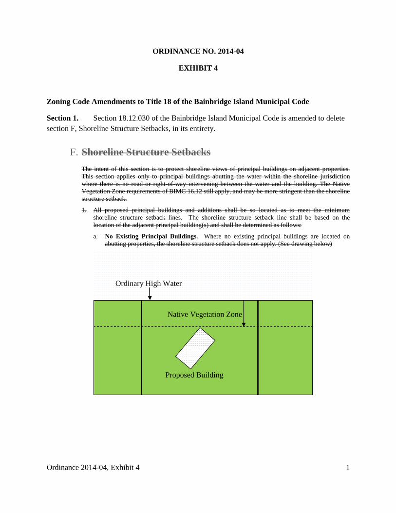
ORDINANCE NO. 2014-04
EXHIBIT 4
Zoning Code Amendments to Title 18 of the Bainbridge Island Municipal Code
Section 1. Section 18.12.030 of the Bainbridge Island Municipal Code is amended to delete section F, Shoreline Structure Setbacks, in its entirety.
F. Shoreline Structure Setbacks
The intent of this section is to protect shoreline views of principal buildings on adjacent properties. This section applies only to principal buildings abutting the water within the shoreline jurisdiction where there is no road or right-of-way intervening between the water and the building. The Native Vegetation Zone requirements of BIMC 16.12 still apply, and may be more stringent than the shoreline structure setback.
1. All proposed principal buildings and additions shall be so located as to meet the minimum shoreline structure setback lines. The shoreline structure setback line shall be based on the location of the adjacent principal building(s) and shall be determined as follows:
a. No Existing Principal Buildings. Where no existing principal buildings are located on abutting properties, the shoreline structure setback does not apply. (See drawing below)
Ordinary High Water
Native Vegetation Zone
Proposed Building
Ordinance 2014-04, Exhibit 4 1
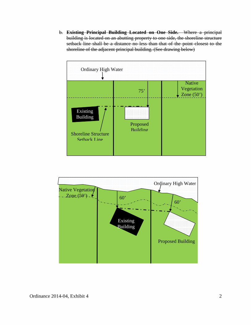
b. Existing Principal Building Located on One Side. Where a principal building is located on an abutting property to one side, the shoreline structure setback line shall be a distance no less than that of the point closest to the shoreline of the adjacent principal building. (See drawing below)
Proposed Building
Ordinary High Water
Shoreline Structure Setback Line
Native Vegetation Zone (50’)
75’
Existing Building
Proposed Building
Native Vegetation Zone (50’) 60’
60’
Ordinary High Water
Existing Building
Ordinance 2014-04, Exhibit 4 2
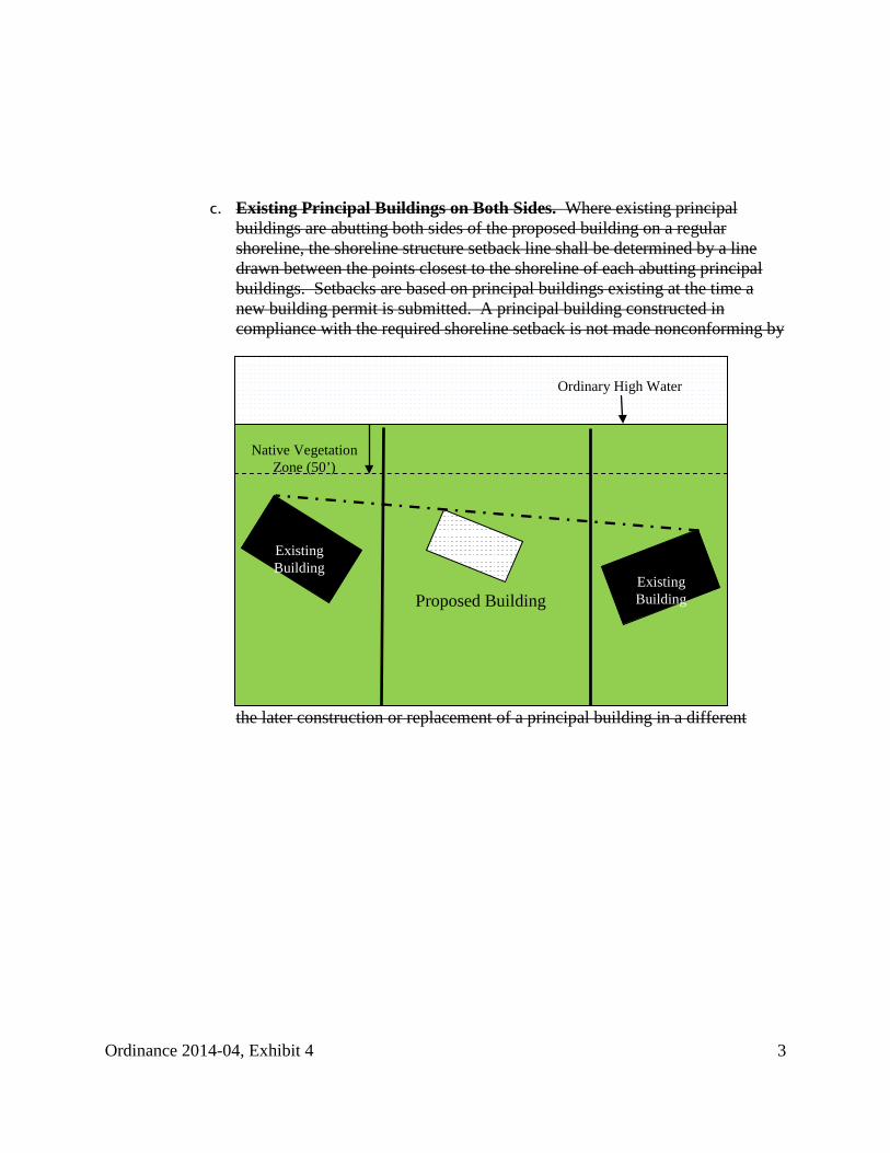
c. Existing Principal Buildings on Both Sides. Where existing principal buildings are abutting both sides of the proposed building on a regular shoreline, the shoreline structure setback line shall be determined by a line drawn between the points closest to the shoreline of each abutting principal buildings. Setbacks are based on principal buildings existing at the time a new building permit is submitted. A principal building constructed in compliance with the required shoreline setback is not made nonconforming by
the later construction or replacement of a principal building in a different
Proposed Building
Native Vegetation Zone (50’)
Existing Building
Ordinary High Water
Existing Building
Ordinance 2014-04, Exhibit 4 3
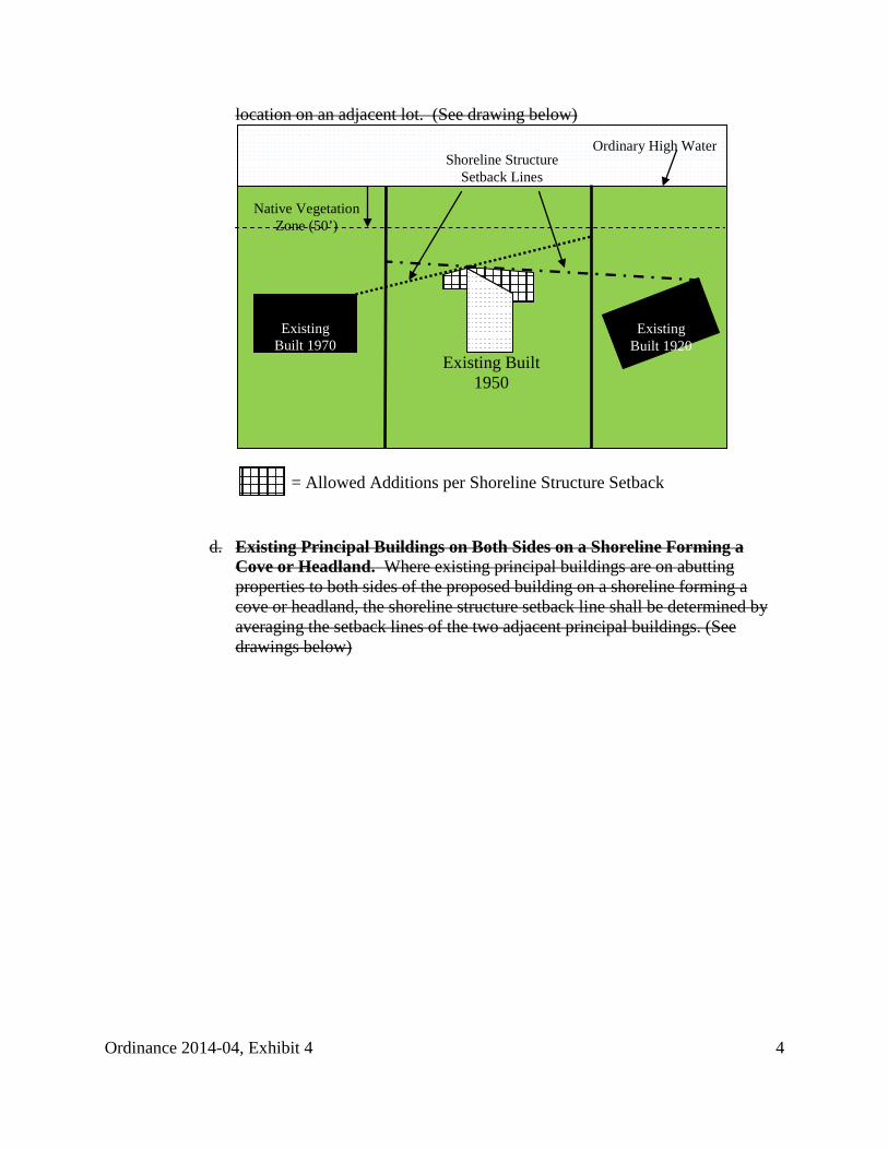
location on an adjacent lot. (See drawing below)
d. Existing Principal Buildings on Both Sides on a Shoreline Forming a Cove or Headland. Where existing principal buildings are on abutting properties to both sides of the proposed building on a shoreline forming a cove or headland, the shoreline structure setback line shall be determined by averaging the setback lines of the two adjacent principal buildings. (See drawings below)
Existing Built 1950
Ordinary High Water
Native Vegetation Zone (50’)
Existing Built 1920
Existing Built 1970
Shoreline Structure Setback Lines
= Allowed Additions per Shoreline Structure Setback
Ordinance 2014-04, Exhibit 4 4
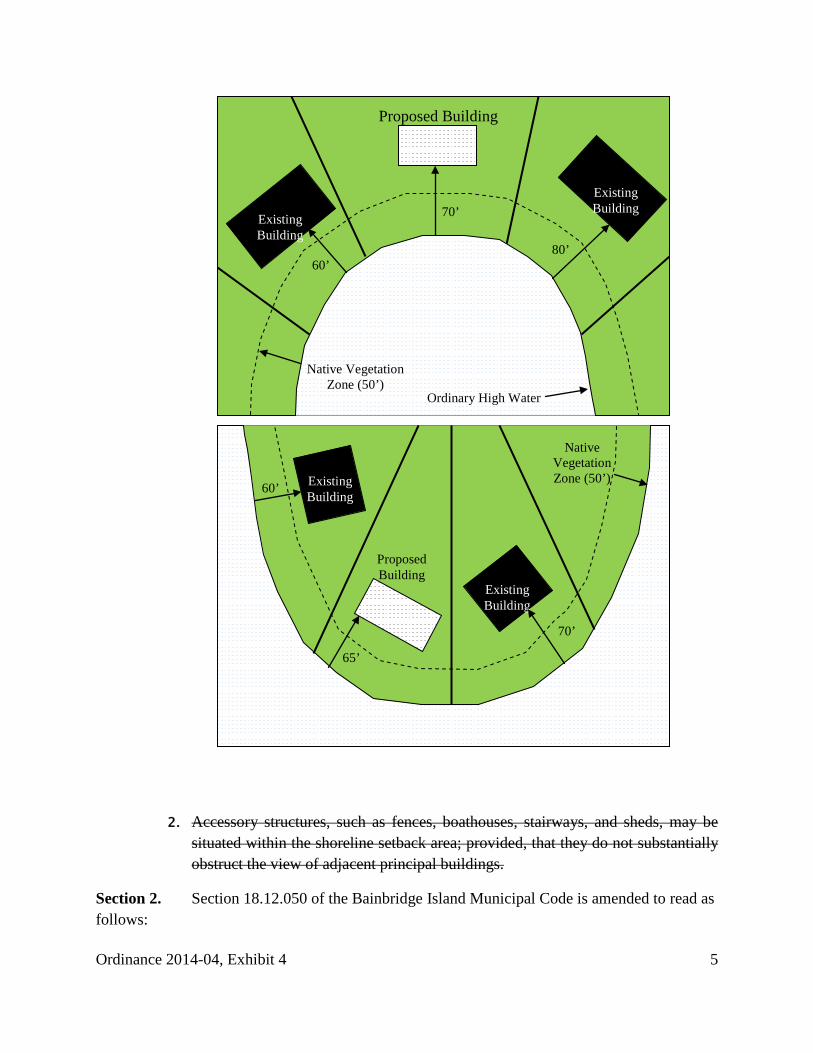
2. Accessory structures, such as fences, boathouses, stairways, and sheds, may be situated within the shoreline setback area; provided, that they do not substantially obstruct the view of adjacent principal buildings.
Section 2. Section 18.12.050 of the Bainbridge Island Municipal Code is amended to read as follows:
Existing Building
Proposed Building
70’
60’
65’
Native Vegetation Zone (50’) Existing
Building
Ordinary High Water
Native Vegetation Zone (50’)
Existing Building
Existing Building
60’ 80’
70’
Proposed Building
Ordinance 2014-04, Exhibit 4 5
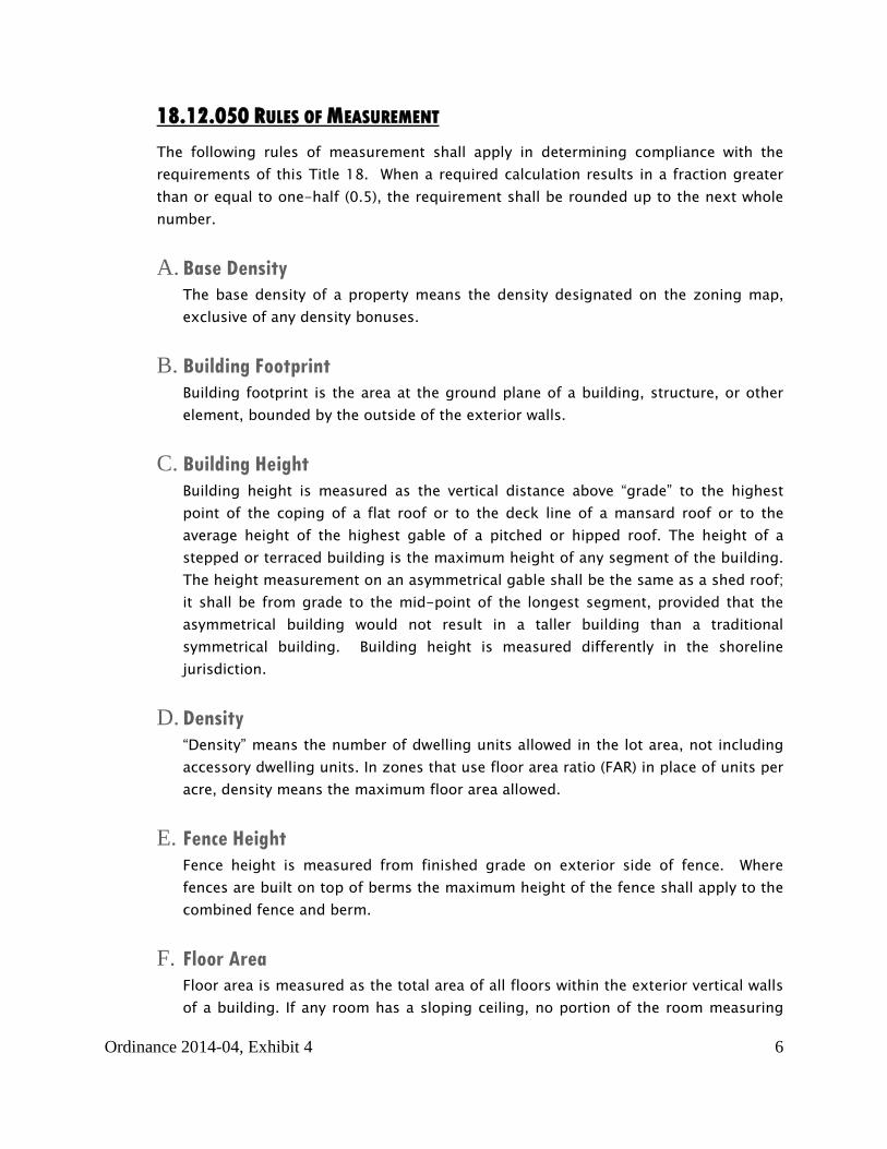
18.12.050 RULES OF MEASUREMENT The following rules of measurement shall apply in determining compliance with the requirements of this Title 18. When a required calculation results in a fraction greater than or equal to one-half (0.5), the requirement shall be rounded up to the next whole number.
A. Base Density The base density of a property means the density designated on the zoning map, exclusive of any density bonuses.
B. Building Footprint Building footprint is the area at the ground plane of a building, structure, or other element, bounded by the outside of the exterior walls.
C. Building Height Building height is measured as the vertical distance above “grade” to the highest point of the coping of a flat roof or to the deck line of a mansard roof or to the average height of the highest gable of a pitched or hipped roof. The height of a stepped or terraced building is the maximum height of any segment of the building. The height measurement on an asymmetrical gable shall be the same as a shed roof; it shall be from grade to the mid-point of the longest segment, provided that the asymmetrical building would not result in a taller building than a traditional symmetrical building. Building height is measured differently in the shoreline jurisdiction.
D. Density “Density” means the number of dwelling units allowed in the lot area, not including accessory dwelling units. In zones that use floor area ratio (FAR) in place of units per acre, density means the maximum floor area allowed.
E. Fence Height Fence height is measured from finished grade on exterior side of fence. Where fences are built on top of berms the maximum height of the fence shall apply to the combined fence and berm.
F. Floor Area Floor area is measured as the total area of all floors within the exterior vertical walls of a building. If any room has a sloping ceiling, no portion of the room measuring
Ordinance 2014-04, Exhibit 4 6
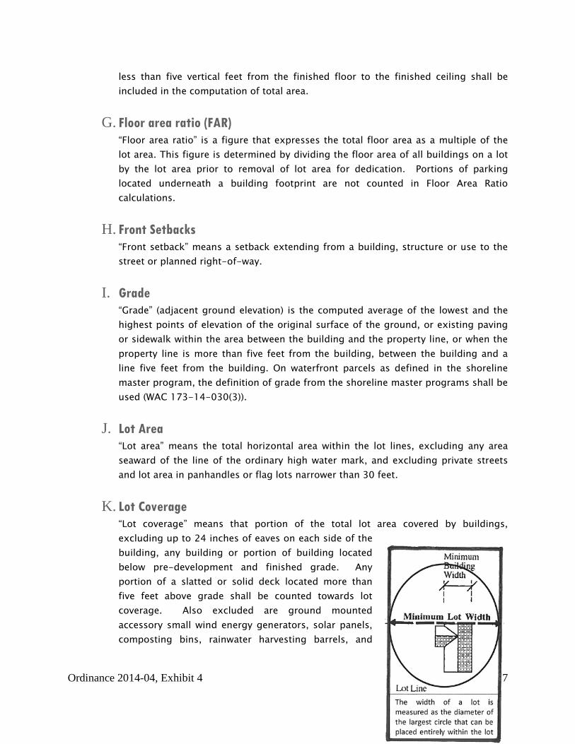
less than five vertical feet from the finished floor to the finished ceiling shall be included in the computation of total area.
G. Floor area ratio (FAR) “Floor area ratio” is a figure that expresses the total floor area as a multiple of the lot area. This figure is determined by dividing the floor area of all buildings on a lot by the lot area prior to removal of lot area for dedication. Portions of parking located underneath a building footprint are not counted in Floor Area Ratio calculations.
H. Front Setbacks “Front setback” means a setback extending from a building, structure or use to the street or planned right-of-way.
I. Grade “Grade” (adjacent ground elevation) is the computed average of the lowest and the highest points of elevation of the original surface of the ground, or existing paving or sidewalk within the area between the building and the property line, or when the property line is more than five feet from the building, between the building and a line five feet from the building. On waterfront parcels as defined in the shoreline master program, the definition of grade from the shoreline master programs shall be used (WAC 173-14-030(3)).
J. Lot Area “Lot area” means the total horizontal area within the lot lines, excluding any area seaward of the line of the ordinary high water mark, and excluding private streets and lot area in panhandles or flag lots narrower than 30 feet.
K. Lot Coverage “Lot coverage” means that portion of the total lot area covered by buildings, excluding up to 24 inches of eaves on each side of the building, any building or portion of building located below pre-development and finished grade. Any portion of a slatted or solid deck located more than five feet above grade shall be counted towards lot coverage. Also excluded are ground mounted accessory small wind energy generators, solar panels, composting bins, rainwater harvesting barrels, and
Ordinance 2014-04, Exhibit 4 7
covers designed to shade ground mounted heat pumps and air conditioners to increase their efficiency.
L. Lot Depth “Lot depth” means the horizontal distance from the midpoint of the front lot line to the midpoint of the rear lot line, or to the most distant point on any other lot line where there is no rear lot line.
M. Lot Width “Lot Width” means the diameter of the biggest circle that can fit entirely inside the lot boundary line.
N. Rear Setback “Rear setback” means a setback extending from a building, structure or use to the rear lot line. If a property has more than one front yard, then rear setback does not apply. In the shoreline jurisdiction, rear setback does not apply since native vegetation zone requirements exceed rear setback requirements.
O. Setback “Setback” means the required distance measured horizontally between every building, structure or use and the lot lines, planned rights-of-way, rights-of-way or streets.
P. Side Setback “Side setback” means a setback extending from a building, structure or use to the side lot line. When a parcel has two or more front setbacks, the remaining setbacks are to be considered side setbacks. If a property is bordered on three or more sides by streets, the minimum setback on the remaining side is the minimum setback required for that zone district. If the property is bordered on two sides by streets, the two remaining sides shall meet the minimum and total side setbacks. When a setback for an existing structure is smaller than the minimum required, the minimum for the second side setback does not need to make up the difference – the second side setback need only be as large as if the nonconforming side yard met its minimum requirement.
Q. Shoreline Structure Setback “Shoreline structure setback” is measured as the shortest distance measured on a horizontal plane between the ordinary high water mark and the principle building at
Ordinance 2014-04, Exhibit 4 8
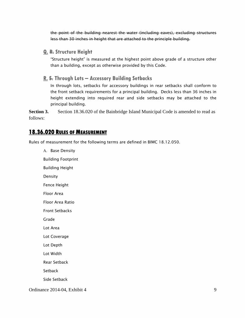
the point of the building nearest the water (including eaves), excluding structures less than 30 inches in height that are attached to the principle building.
Q. R. Structure Height “Structure height” is measured at the highest point above grade of a structure other than a building, except as otherwise provided by this Code.
R. S. Through Lots – Accessory Building Setbacks In through lots, setbacks for accessory buildings in rear setbacks shall conform to the front setback requirements for a principal building. Decks less than 36 inches in height extending into required rear and side setbacks may be attached to the principal building.
Section 3. Section 18.36.020 of the Bainbridge Island Municipal Code is amended to read as follows:
18.36.020 RULES OF MEASUREMENT Rules of measurement for the following terms are defined in BIMC 18.12.050.
A. Base Density
Building Footprint
Building Height
Density
Fence Height
Floor Area
Floor Area Ratio
Front Setbacks
Grade
Lot Area
Lot Coverage
Lot Depth
Lot Width
Rear Setback
Setback
Side Setback
Ordinance 2014-04, Exhibit 4 9
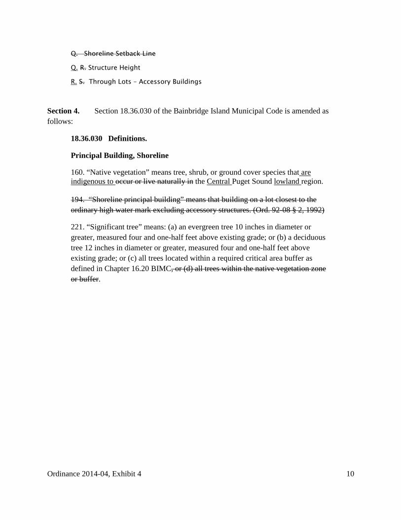
Q. Shoreline Setback Line
Q. R. Structure Height
R. S. Through Lots – Accessory Buildings
Section 4. Section 18.36.030 of the Bainbridge Island Municipal Code is amended as follows:
18.36.030 Definitions.
Principal Building, Shoreline
160. “Native vegetation” means tree, shrub, or ground cover species that are indigenous to occur or live naturally in the Central Puget Sound lowland region. 194. “Shoreline principal building” means that building on a lot closest to the ordinary high water mark excluding accessory structures. (Ord. 92-08 § 2, 1992)
221. “Significant tree” means: (a) an evergreen tree 10 inches in diameter or greater, measured four and one-half feet above existing grade; or (b) a deciduous tree 12 inches in diameter or greater, measured four and one-half feet above existing grade; or (c) all trees located within a required critical area buffer as defined in Chapter 16.20 BIMC, or (d) all trees within the native vegetation zone or buffer.
Ordinance 2014-04, Exhibit 4 10
Related Documents