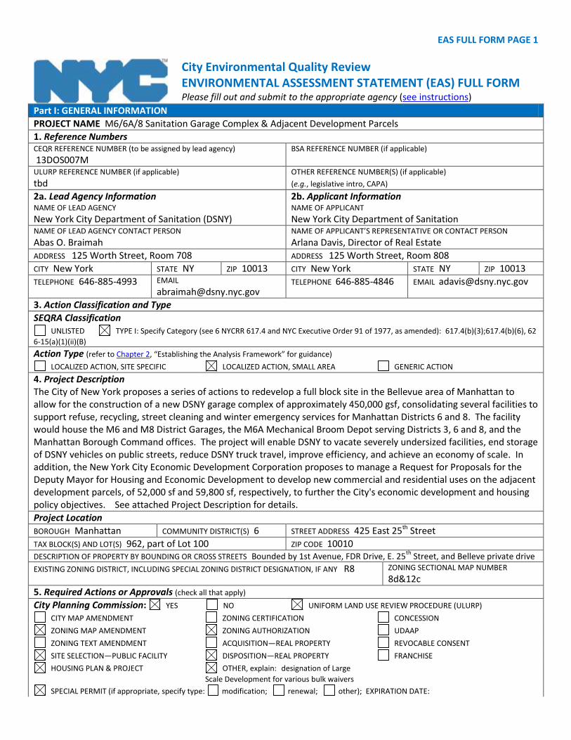
EAS FULL FORM PAGE 1 City Environmental Quality Review ENVIRONMENTAL ASSESSMENT STATEMENT (EAS) FULL FORM Please fill out and submit to the appropriate agency (see instructions) Part I: GENERAL INFORMATION PROJECT NAME M6/6A/8 Sanitation Garage Complex & Adjacent Development Parcels 1. Reference Numbers CEQR REFERENCE NUMBER (to be assigned by lead agency) 13DOS007M BSA REFERENCE NUMBER (if applicable) ULURP REFERENCE NUMBER (if applicable) tbd OTHER REFERENCE NUMBER(S) (if applicable) (e.g., legislative intro, CAPA) 2a. Lead Agency Information NAME OF LEAD AGENCY New York City Department of Sanitation (DSNY) 2b. Applicant Information NAME OF APPLICANT New York City Department of Sanitation NAME OF LEAD AGENCY CONTACT PERSON Abas O. Braimah NAME OF APPLICANT’S REPRESENTATIVE OR CONTACT PERSON Arlana Davis, Director of Real Estate ADDRESS 125 Worth Street, Room 708 ADDRESS 125 Worth Street, Room 808 CITY New York STATE NY ZIP 10013 CITY New York STATE NY ZIP 10013 TELEPHONE 646-885-4993 EMAIL [email protected] TELEPHONE 646-885-4846 EMAIL [email protected] 3. Action Classification and Type SEQRA Classification UNLISTED TYPE I: Specify Category (see 6 NYCRR 617.4 and NYC Executive Order 91 of 1977, as amended): 617.4(b)(3);617.4(b)(6), 62 6-15(a)(1)(ii)(B) Action Type (refer to Chapter 2, “Establishing the Analysis Framework” for guidance) LOCALIZED ACTION, SITE SPECIFIC LOCALIZED ACTION, SMALL AREA GENERIC ACTION 4. Project Description The City of New York proposes a series of actions to redevelop a full block site in the Bellevue area of Manhattan to allow for the construction of a new DSNY garage complex of approximately 450,000 gsf, consolidating several facilities to support refuse, recycling, street cleaning and winter emergency services for Manhattan Districts 6 and 8. The facility would house the M6 and M8 District Garages, the M6A Mechanical Broom Depot serving Districts 3, 6 and 8, and the Manhattan Borough Command offices. The project will enable DSNY to vacate severely undersized facilities, end storage of DSNY vehicles on public streets, reduce DSNY truck travel, improve efficiency, and achieve an economy of scale. In addition, the New York City Economic Development Corporation proposes to manage a Request for Proposals for the Deputy Mayor for Housing and Economic Development to develop new commercial and residential uses on the adjacent development parcels, of 52,000 sf and 59,800 sf, respectively, to further the City's economic development and housing policy objectives. See attached Project Description for details. Project Location BOROUGH Manhattan COMMUNITY DISTRICT(S) 6 STREET ADDRESS 425 East 25 th Street TAX BLOCK(S) AND LOT(S) 962, part of Lot 100 ZIP CODE 10010 DESCRIPTION OF PROPERTY BY BOUNDING OR CROSS STREETS Bounded by 1st Avenue, FDR Drive, E. 25 th Street, and Belleve private drive EXISTING ZONING DISTRICT, INCLUDING SPECIAL ZONING DISTRICT DESIGNATION, IF ANY R8 ZONING SECTIONAL MAP NUMBER 8d&12c 5. Required Actions or Approvals (check all that apply) City Planning Commission: YES NO UNIFORM LAND USE REVIEW PROCEDURE (ULURP) CITY MAP AMENDMENT ZONING CERTIFICATION CONCESSION ZONING MAP AMENDMENT ZONING AUTHORIZATION UDAAP ZONING TEXT AMENDMENT ACQUISITION—REAL PROPERTY REVOCABLE CONSENT SITE SELECTION—PUBLIC FACILITY DISPOSITION—REAL PROPERTY FRANCHISE HOUSING PLAN & PROJECT OTHER, explain: designation of Large Scale Development for various bulk waivers SPECIAL PERMIT (if appropriate, specify type: modification; renewal; other); EXPIRATION DATE:

Welcome message from author
This document is posted to help you gain knowledge. Please leave a comment to let me know what you think about it! Share it to your friends and learn new things together.
Transcript
EAS FULL FORM PAGE 1
City Environmental Quality Review ENVIRONMENTAL ASSESSMENT STATEMENT (EAS) FULL FORM Please fill out and submit to the appropriate agency (see instructions)
Part I: GENERAL INFORMATION
PROJECT NAME M6/6A/8 Sanitation Garage Complex & Adjacent Development Parcels
1. Reference Numbers CEQR REFERENCE NUMBER (to be assigned by lead agency)
13DOS007M BSA REFERENCE NUMBER (if applicable)
ULURP REFERENCE NUMBER (if applicable)
tbd
OTHER REFERENCE NUMBER(S) (if applicable)
(e.g., legislative intro, CAPA)
2a. Lead Agency Information NAME OF LEAD AGENCY
New York City Department of Sanitation (DSNY)
2b. Applicant Information NAME OF APPLICANT
New York City Department of Sanitation NAME OF LEAD AGENCY CONTACT PERSON
Abas O. Braimah NAME OF APPLICANT’S REPRESENTATIVE OR CONTACT PERSON
Arlana Davis, Director of Real Estate
ADDRESS 125 Worth Street, Room 708 ADDRESS 125 Worth Street, Room 808
CITY New York STATE NY ZIP 10013 CITY New York STATE NY ZIP 10013
TELEPHONE 646-885-4993 EMAIL [email protected]
TELEPHONE 646-885-4846 EMAIL [email protected]
3. Action Classification and Type
SEQRA Classification UNLISTED TYPE I: Specify Category (see 6 NYCRR 617.4 and NYC Executive Order 91 of 1977, as amended): 617.4(b)(3);617.4(b)(6), 62
6-15(a)(1)(ii)(B) Action Type (refer to Chapter 2, “Establishing the Analysis Framework” for guidance)
LOCALIZED ACTION, SITE SPECIFIC LOCALIZED ACTION, SMALL AREA GENERIC ACTION
4. Project Description
The City of New York proposes a series of actions to redevelop a full block site in the Bellevue area of Manhattan to allow for the construction of a new DSNY garage complex of approximately 450,000 gsf, consolidating several facilities to support refuse, recycling, street cleaning and winter emergency services for Manhattan Districts 6 and 8. The facility would house the M6 and M8 District Garages, the M6A Mechanical Broom Depot serving Districts 3, 6 and 8, and the Manhattan Borough Command offices. The project will enable DSNY to vacate severely undersized facilities, end storage of DSNY vehicles on public streets, reduce DSNY truck travel, improve efficiency, and achieve an economy of scale. In addition, the New York City Economic Development Corporation proposes to manage a Request for Proposals for the Deputy Mayor for Housing and Economic Development to develop new commercial and residential uses on the adjacent development parcels, of 52,000 sf and 59,800 sf, respectively, to further the City's economic development and housing policy objectives. See attached Project Description for details.
Project Location
BOROUGH Manhattan COMMUNITY DISTRICT(S) 6 STREET ADDRESS 425 East 25th Street
TAX BLOCK(S) AND LOT(S) 962, part of Lot 100 ZIP CODE 10010 DESCRIPTION OF PROPERTY BY BOUNDING OR CROSS STREETS Bounded by 1st Avenue, FDR Drive, E. 25
th Street, and Belleve private drive
EXISTING ZONING DISTRICT, INCLUDING SPECIAL ZONING DISTRICT DESIGNATION, IF ANY R8 ZONING SECTIONAL MAP NUMBER 8d&12c
5. Required Actions or Approvals (check all that apply)
City Planning Commission: YES NO UNIFORM LAND USE REVIEW PROCEDURE (ULURP) CITY MAP AMENDMENT ZONING CERTIFICATION CONCESSION ZONING MAP AMENDMENT ZONING AUTHORIZATION UDAAP ZONING TEXT AMENDMENT ACQUISITION—REAL PROPERTY REVOCABLE CONSENT SITE SELECTION—PUBLIC FACILITY DISPOSITION—REAL PROPERTY FRANCHISE HOUSING PLAN & PROJECT OTHER, explain: designation of Large
Scale Development for various bulk waivers
SPECIAL PERMIT (if appropriate, specify type: modification; renewal; other); EXPIRATION DATE:
EAS FULL FORM PAGE 2 SPECIFY AFFECTED SECTIONS OF THE ZONING RESOLUTION
Board of Standards and Appeals: YES NO
VARIANCE (use) VARIANCE (bulk)
SPECIAL PERMIT (if appropriate, specify type: modification; renewal; other); EXPIRATION DATE:
SPECIFY AFFECTED SECTIONS OF THE ZONING RESOLUTION
Department of Environmental Protection: YES NO If “yes,” specify:
Other City Approvals Subject to CEQR (check all that apply) LEGISLATION FUNDING OF CONSTRUCTION, specify: DSNY Capital RULEMAKING POLICY OR PLAN, specify: CONSTRUCTION OF PUBLIC FACILITIES FUNDING OF PROGRAMS, specify: 384(b)(4) APPROVAL PERMITS, specify: OTHER, explain: relocation of DSNY facilities
Other City Approvals Not Subject to CEQR (check all that apply)
PERMITS FROM DOT’S OFFICE OF CONSTRUCTION MITIGATION
AND COORDINATION (OCMC) LANDMARKS PRESERVATION COMMISSION APPROVAL
OTHER, explain: Public Design Commission approval
State or Federal Actions/Approvals/Funding: YES NO If “yes,” specify:
6. Site Description: The directly affected area consists of the project site and the area subject to any change in regulatory controls. Except
where otherwise indicated, provide the following information with regard to the directly affected area. Graphics: The following graphics must be attached and each box must be checked off before the EAS is complete. Each map must clearly depict
the boundaries of the directly affected area or areas and indicate a 400-foot radius drawn from the outer boundaries of the project site. Maps may not exceed 11 x 17 inches in size and, for paper filings, must be folded to 8.5 x 11 inches.
SITE LOCATION MAP ZONING MAP SANBORN OR OTHER LAND USE MAP TAX MAP FOR LARGE AREAS OR MULTIPLE SITES, A GIS SHAPE FILE THAT DEFINES THE PROJECT SITE(S)
PHOTOGRAPHS OF THE PROJECT SITE TAKEN WITHIN 6 MONTHS OF EAS SUBMISSION AND KEYED TO THE SITE LOCATION MAP
Physical Setting (both developed and undeveloped areas) Total directly affected area (sq. ft.): 163,800 Waterbody area (sq. ft.) and type: 0 Roads, buildings, and other paved surfaces (sq. ft.): approx 163,500 Other, describe (sq. ft.): approx 300 sf. landscaping
7. Physical Dimensions and Scale of Project (if the project affects multiple sites, provide the total development facilitated by the action)
SIZE OF PROJECT TO BE DEVELOPED (gross square feet): 1,936,680 NUMBER OF BUILDINGS: 3 GROSS FLOOR AREA OF EACH BUILDING (sq. ft.): approx 450,000 for
garage; 624,000 for parcel A; 717,600 for parcel B
HEIGHT OF EACH BUILDING (ft.): 128 -Garage; 348 -parcel A; 508 parcel B
NUMBER OF STORIES OF EACH BUILDING: Garage- 4 main floors plus mezzanines; Parcels A and B: tbd- up to 30 stories
Does the proposed project involve changes in zoning on one or more sites? YES NO If “yes,” specify: The total square feet owned or controlled by the applicant: 139,980 The total square feet not owned or controlled by the applicant: approx. 23,820 - part of private drive Does the proposed project involve in-ground excavation or subsurface disturbance, including, but not limited to foundation work, pilings, utility
lines, or grading? YES NO If “yes,” indicate the estimated area and volume dimensions of subsurface disturbance (if known):
AREA OF TEMPORARY DISTURBANCE: sq. ft. (width x length) VOLUME OF DISTURBANCE: approx 1 million cubic ft. (width x
length x depth)
AREA OF PERMANENT DISTURBANCE: approx 139,980 sq. ft. (width
x length)
8. Analysis Year CEQR Technical Manual Chapter 2
ANTICIPATED BUILD YEAR (date the project would be completed and operational): 2022
ANTICIPATED PERIOD OF CONSTRUCTION IN MONTHS: 36
WOULD THE PROJECT BE IMPLEMENTED IN A SINGLE PHASE? YES NO IF MULTIPLE PHASES, HOW MANY?
BRIEFLY DESCRIBE PHASES AND CONSTRUCTION SCHEDULE:
9. Predominant Land Use in the Vicinity of the Project (check all that apply)
RESIDENTIAL MANUFACTURING COMMERCIAL PARK/FOREST/OPEN SPACE OTHER, specify:
institutional and public facilities
EAS FULL FORM PAGE 3 DESCRIPTION OF EXISTING AND PROPOSED CONDITIONS
The information requested in this table applies to the directly affected area. The directly affected area consists of the project site and the area subject to any change in regulatory control. The increment is the difference between the No-Action and the With-Action conditions.
EXISTING CONDITION
NO-ACTION CONDITION
WITH-ACTION CONDITION
INCREMENT
LAND USE
Residential YES NO YES NO YES NO If “yes,” specify the following: Describe type of residential structures apts; base (2) tower (2)
No. of dwelling units 1176 1176
No. of low- to moderate-income units 353 353
Gross floor area (sq. ft.) 1,175,640 ("all residential" scenario)
up to 1,175,640
Commercial YES NO YES NO YES NO If “yes,” specify the following: Describe type (retail, office, other) scientific R&D labs;
Retail
Gross floor area (sq. ft.) 1,175,640 ("all commercial" scenario; 82,980 retail
up to 1,175,640; + 82,980 retail
Manufacturing/Industrial YES NO YES NO YES NO If “yes,” specify the following: Type of use DSNY vehicle storage,
maintenance, fueling
Gross floor area (sq. ft.) 450,000 450,000
Open storage area (sq. ft.)
If any unenclosed activities, specify: ramp, fueling island
Community Facility YES NO YES NO YES NO If “yes,” specify the following: Type college and domitory academic facility, non
specific tbd
Gross floor area (sq. ft.) 457,000 457,000 82,980 decrease
Vacant Land YES NO YES NO YES NO If “yes,” describe:
Publicly Accessible Open Space YES NO YES NO YES NO If “yes,” specify type (mapped City, State, or Federal parkland, wetland—mapped or otherwise known, other):
Other Land Uses YES NO YES NO YES NO If “yes,” describe:
PARKING
Garages YES NO YES NO YES NO If “yes,” specify the following: No. of public spaces 0 0 0 0
No. of accessory spaces 12 12 DSNY Garage-115; Parcels A and B: tbd
Operating hours
Attended or non-attended DSNY- attended
Lots YES NO YES NO YES NO If “yes,” specify the following: No. of public spaces 0
No. of accessory spaces 12 12 tbd
Operating hours
Other (includes street parking) YES NO YES NO YES NO

EAS FULL FORM PAGE 4
EXISTING CONDITION
NO-ACTION CONDITION
WITH-ACTION CONDITION
INCREMENT
If “yes,” describe: parking on E. 25th
St parking on E. 25th
St parking on E .25th
St.
POPULATION
Residents YES NO YES NO YES NO If “yes,” specify number: dormitory- tbd dormitory-tbd 1952 tbd
Briefly explain how the number of residents was calculated:
Parcels A and B will be developed for 1) residential plus retail & community facility, 2) residential and commercial, plus retail & community facility, or 3) all commercial, plus retail & community facility. Figure is for all residential scenario, including community facility and retail; 1.66 avg household size based on NYC DCP MN NTA Murray Hill-Kips Bay data table SF1-H2 (2010 data).
Businesses YES NO YES NO YES NO If “yes,” specify the following: No. and type
No. and type of workers by business scientific lab:5750 Retail 249
No. and type of non-residents who are not workers
Briefly explain how the number of businesses was calculated:
Retail workers based on 1 employee per 1000 sf; scientific research facility based on 4 employees per 1000 sf; residential use assumed to generate 1 worker per 22 units; community facility 1 worker per 450 sf. Assumptions based on Columbia Manhattanville FEIS and Cornell Tech FEIS.
Other (students, visitors, concert-goers,
etc.)
YES NO YES NO YES NO
If any, specify type and number: 1000 students, visitors, institutional staff
1000 students, visitors, institutional staff
community facility: 184 DSNY Garage- 200
-616
Briefly explain how the number was calculated:
1 employee per 450 sf for community facility.
ZONING Zoning classification R8 R8 M1-5 & C6-4
Maximum amount of floor area that can be developed
1,684,800 1,684,800 1,612,000 -72,800, without bonuses
Predominant land use and zoning classifications within land use study area(s) or a 400 ft. radius of proposed project
R8; C2-5 Medical institutions, schools, park,NYU
R8, C2-5 medical instititions, park, NYU
R8, M1-5, C6-4, C2-5
Attach any additional information that may be needed to describe the project. If your project involves changes that affect one or more sites not associated with a specific development, it is generally appropriate to include total development projections in the above table and attach separate tables outlining the reasonable development scenarios for each site.
EAS FULL FORM PAGE 5
Part II: TECHNICAL ANALYSIS
INSTRUCTIONS: For each of the analysis categories listed in this section, assess the proposed project’s impacts based on the thresholds and
criteria presented in the CEQR Technical Manual. Check each box that applies.
If the proposed project can be demonstrated not to meet or exceed the threshold, check the “no” box.
If the proposed project will meet or exceed the threshold, or if this cannot be determined, check the “yes” box.
For each “yes” response, provide additional analyses (and, if needed, attach supporting information) based on guidance in the CEQR
Technical Manual to determine whether the potential for significant impacts exists. Please note that a “yes” answer does not mean that
an EIS must be prepared—it means that more information may be required for the lead agency to make a determination of significance.
The lead agency, upon reviewing Part II, may require an applicant to provide additional information to support the Full EAS Form. For example, if a question is answered “no,” an agency may request a short explanation for this response.
YES NO
1. LAND USE, ZONING, AND PUBLIC POLICY: CEQR Technical Manual Chapter 4
(a) Would the proposed project result in a change in land use different from surrounding land uses?
(b) Would the proposed project result in a change in zoning different from surrounding zoning?
(c) Is there the potential to affect an applicable public policy?
(d) If “yes,” to (a), (b), and/or (c), complete a preliminary assessment and attach. see attached
(e) Is the project a large, publicly sponsored project? o If “yes,” complete a PlaNYC assessment and attach. tbd
(f) Is any part of the directly affected area within the City’s Waterfront Revitalization Program boundaries? o If “yes,” complete the Consistency Assessment Form.
2. SOCIOECONOMIC CONDITIONS: CEQR Technical Manual Chapter 5
(a) Would the proposed project:
o Generate a net increase of more than 200 residential units or 200,000 square feet of commercial space?
If “yes,” answer both questions 2(b)(ii) and 2(b)(iv) below.
o Directly displace 500 or more residents?
If “yes,” answer questions 2(b)(i), 2(b)(ii), and 2(b)(iv) below.
o Directly displace more than 100 employees?
If “yes,” answer questions under 2(b)(iii) and 2(b)(iv) below.
o Affect conditions in a specific industry?
If “yes,” answer question 2(b)(v) below.
(b) If “yes” to any of the above, attach supporting information to answer the relevant questions below. If “no” was checked for each category above, the remaining questions in this technical area do not need to be answered.
i. Direct Residential Displacement
o If more than 500 residents would be displaced, would these residents represent more than 5% of the primary study area population?
o If “yes,” is the average income of the directly displaced population markedly lower than the average income of the rest of the study area population?
ii. Indirect Residential Displacement
o Would expected average incomes of the new population exceed the average incomes of study area populations?
o If “yes:”
Would the population of the primary study area increase by more than 10 percent?
Would the population of the primary study area increase by more than 5 percent in an area where there is the
potential to accelerate trends toward increasing rents?
o If “yes” to either of the preceding questions, would more than 5 percent of all housing units be renter-occupied and unprotected?
iii. Direct Business Displacement
o Do any of the displaced businesses provide goods or services that otherwise would not be found within the trade area, either under existing conditions or in the future with the proposed project?
o Is any category of business to be displaced the subject of other regulations or publicly adopted plans to preserve,

EAS FULL FORM PAGE 6
YES NO enhance, or otherwise protect it?
iv. Indirect Business Displacement
o Would the project potentially introduce trends that make it difficult for businesses to remain in the area? o Would the project capture retail sales in a particular category of goods to the extent that the market for such goods
would become saturated, potentially resulting in vacancies and disinvestment on neighborhood commercial streets?
v. Effects on Industry
o Would the project significantly affect business conditions in any industry or any category of businesses within or outside the study area?
o Would the project indirectly substantially reduce employment or impair the economic viability in the industry or category of businesses?
3. COMMUNITY FACILITIES: CEQR Technical Manual Chapter 6
(a) Direct Effects
o Would the project directly eliminate, displace, or alter public or publicly funded community facilities such as educational facilities, libraries, health care facilities, day care centers, police stations, or fire stations?
(b) Indirect Effects
i. Child Care Centers o Would the project result in 20 or more eligible children under age 6, based on the number of low or low/moderate
income residential units? (See Table 6-1 in Chapter 6)
o If “yes,” would the project result in a collective utilization rate of the group child care/Head Start centers in the study area that is greater than 100 percent?
o If “yes,” would the project increase the collective utilization rate by 5 percent or more from the No-Action scenario?
ii. Libraries
o Would the project result in a 5 percent or more increase in the ratio of residential units to library branches? (See Table 6-1 in Chapter 6)
o If “yes,” would the project increase the study area population by 5 percent or more from the No-Action levels?
o If “yes,” would the additional population impair the delivery of library services in the study area?
iii. Public Schools
o Would the project result in 50 or more elementary or middle school students, or 150 or more high school students based on number of residential units? (See Table 6-1 in Chapter 6)
o If “yes,” would the project result in a collective utilization rate of the elementary and/or intermediate schools in the study area that is equal to or greater than 100 percent?
o If “yes,” would the project increase this collective utilization rate by 5 percent or more from the No-Action scenario?
iv. Health Care Facilities
o Would the project result in the introduction of a sizeable new neighborhood?
o If “yes,” would the project affect the operation of health care facilities in the area?
v. Fire and Police Protection
o Would the project result in the introduction of a sizeable new neighborhood?
o If “yes,” would the project affect the operation of fire or police protection in the area?
4. OPEN SPACE: CEQR Technical Manual Chapter 7
(a) Would the project change or eliminate existing open space?
(b) Is the project located within an under-served area in the Bronx, Brooklyn, Manhattan, Queens, or Staten Island?
(c) If “yes,” would the project generate more than 50 additional residents or 125 additional employees?
(d) Is the project located within a well-served area in the Bronx, Brooklyn, Manhattan, Queens, or Staten Island? (e) If “yes,” would the project generate more than 350 additional residents or 750 additional employees? (f) If the project is located in an area that is neither under-served nor well-served, would it generate more than 200 additional
residents or 500 additional employees?
(g) If “yes” to questions (c), (e), or (f) above, attach supporting information to answer the following:
o If in an under-served area, would the project result in a decrease in the open space ratio by more than 1 percent? o If in an area that is not under-served, would the project result in a decrease in the open space ratio by more than 5
EAS FULL FORM PAGE 7
YES NO percent?
o If “yes,” are there qualitative considerations, such as the quality of open space, that need to be considered? Please specify:
5. SHADOWS: CEQR Technical Manual Chapter 8 (a) Would the proposed project result in a net height increase of any structure of 50 feet or more? (b) Would the proposed project result in any increase in structure height and be located adjacent to or across the street from
a sunlight-sensitive resource?
(c) If “yes” to either of the above questions, attach supporting information explaining whether the project’s shadow would reach any sunlight-sensitive resource at any time of the year. see attached
6. HISTORIC AND CULTURAL RESOURCES: CEQR Technical Manual Chapter 9 (a) Does the proposed project site or an adjacent site contain any architectural and/or archaeological resource that is eligible
for or has been designated (or is calendared for consideration) as a New York City Landmark, Interior Landmark or Scenic Landmark; that is listed or eligible for listing on the New York State or National Register of Historic Places; or that is within a designated or eligible New York City, New York State or National Register Historic District? (See the GIS System for Archaeology and National Register to confirm)
(b) Would the proposed project involve construction resulting in in-ground disturbance to an area not previously excavated? (c) If “yes” to either of the above, list any identified architectural and/or archaeological resources and attach supporting information on
whether the proposed project would potentially affect any architectural or archeological resources. LPC letter attached. 7. URBAN DESIGN AND VISUAL RESOURCES: CEQR Technical Manual Chapter 10
(a) Would the proposed project introduce a new building, a new building height, or result in any substantial physical alteration to the streetscape or public space in the vicinity of the proposed project that is not currently allowed by existing zoning?
(b) Would the proposed project result in obstruction of publicly accessible views to visual resources not currently allowed by existing zoning?
(c) If “yes” to either of the above, please provide the information requested in Chapter 10. See attached. Rezoning sought; bulk waiver requested for DSNY height & setback; to be studied in EIS
8. NATURAL RESOURCES: CEQR Technical Manual Chapter 11 (a) Does the proposed project site or a site adjacent to the project contain natural resources as defined in Section 100 of
Chapter 11?
o If “yes,” list the resources and attach supporting information on whether the project would affect any of these resources.
(b) Is any part of the directly affected area within the Jamaica Bay Watershed?
o If “yes,” complete the Jamaica Bay Watershed Form and submit according to its instructions.
9. HAZARDOUS MATERIALS: CEQR Technical Manual Chapter 12 (a) Would the proposed project allow commercial or residential uses in an area that is currently, or was historically, a
manufacturing area that involved hazardous materials?
(b) Does the proposed project site have existing institutional controls (e.g., (E) designation or Restrictive Declaration) relating to hazardous materials that preclude the potential for significant adverse impacts?
(c) Would the project require soil disturbance in a manufacturing area or any development on or near a manufacturing area or existing/historic facilities listed in Appendix 1 (including nonconforming uses)?
(d) Would the project result in the development of a site where there is reason to suspect the presence of hazardous materials, contamination, illegal dumping or fill, or fill material of unknown origin?
(e) Would the project result in development on or near a site that has or had underground and/or aboveground storage tanks (e.g., gas stations, oil storage facilities, heating oil storage)?
(f) Would the project result in renovation of interior existing space on a site with the potential for compromised air quality; vapor intrusion from either on-site or off-site sources; or the presence of asbestos, PCBs, mercury or lead-based paint?
(g) Would the project result in development on or near a site with potential hazardous materials issues such as government-listed voluntary cleanup/brownfield site, current or former power generation/transmission facilities, coal gasification or gas storage sites, railroad tracks or rights-of-way, or municipal incinerators?
(h) Has a Phase I Environmental Site Assessment been performed for the site? ○ If “yes,” were Recognized Environmental Conditions (RECs) identified? Briefly identify: former gas station
(i) Based on the Phase I Assessment, is a Phase II Investigation needed? see attached discussion.
10. WATER AND SEWER INFRASTRUCTURE: CEQR Technical Manual Chapter 13 (a) Would the project result in water demand of more than one million gallons per day? (b) If the proposed project located in a combined sewer area, would it result in at least 1,000 residential units or 250,000
square feet or more of commercial space in Manhattan, or at least 400 residential units or 150,000 square feet or more of commercial space in the Bronx, Brooklyn, Staten Island, or Queens?
EAS FULL FORM PAGE 8
YES NO (c) If the proposed project located in a separately sewered area, would it result in the same or greater development than that
listed in Table 13-1 in Chapter 13?
(d) Would the project involve development on a site that is 5 acres or larger where the amount of impervious surface would increase?
(e) If the project is located within the Jamaica Bay Watershed or in certain specific drainage areas, including Bronx River, Coney Island Creek, Flushing Bay and Creek, Gowanus Canal, Hutchinson River, Newtown Creek, or Westchester Creek, would it involve development on a site that is 1 acre or larger where the amount of impervious surface would increase?
(f) Would the proposed project be located in an area that is partially sewered or currently unsewered? (g) Is the project proposing an industrial facility or activity that would contribute industrial discharges to a Wastewater
Treatment Plant and/or contribute contaminated stormwater to a separate storm sewer system?
(h) Would the project involve construction of a new stormwater outfall that requires federal and/or state permits? (i) If “yes” to any of the above, conduct the appropriate preliminary analyses and attach supporting documentation. see attached
11. SOLID WASTE AND SANITATION SERVICES: CEQR Technical Manual Chapter 14 (a) Using Table 14-1 in Chapter 14, the project’s projected operational solid waste generation is estimated to be (pounds per week): under
100,000
o Would the proposed project have the potential to generate 100,000 pounds (50 tons) or more of solid waste per week? (b) Would the proposed project involve a reduction in capacity at a solid waste management facility used for refuse or
recyclables generated within the City?
o If “yes,” would the proposed project comply with the City’s Solid Waste Management Plan?
12. ENERGY: CEQR Technical Manual Chapter 15 (a) Using energy modeling or Table 15-1 in Chapter 15, the project’s projected energy use is estimated to be (annual BTUs): tbd (b) Would the proposed project affect the transmission or generation of energy?
13. TRANSPORTATION: CEQR Technical Manual Chapter 16 (a) Would the proposed project exceed any threshold identified in Table 16-1 in Chapter 16?
(b) If “yes,” conduct the appropriate screening analyses, attach back up data as needed for each stage, and answer the following questions:
o Would the proposed project result in 50 or more Passenger Car Equivalents (PCEs) per project peak hour?
If “yes,” would the proposed project result in 50 or more vehicle trips per project peak hour at any given intersection? **It should be noted that the lead agency may require further analysis of intersections of concern even when a project generates fewer than 50 vehicles in the peak hour. See Subsection 313 of Chapter 16 for more information.
o Would the proposed project result in more than 200 subway/rail or bus trips per project peak hour?
If “yes,” would the proposed project result, per project peak hour, in 50 or more bus trips on a single line (in one direction) or 200 subway/rail trips per station or line?
o Would the proposed project result in more than 200 pedestrian trips per project peak hour?
If “yes,” would the proposed project result in more than 200 pedestrian trips per project peak hour to any given pedestrian or transit element, crosswalk, subway stair, or bus stop?
14. AIR QUALITY: CEQR Technical Manual Chapter 17
(a) Mobile Sources: Would the proposed project result in the conditions outlined in Section 210 in Chapter 17?
(b) Stationary Sources: Would the proposed project result in the conditions outlined in Section 220 in Chapter 17? o If “yes,” would the proposed project exceed the thresholds in Figure 17-3, Stationary Source Screen Graph in Chapter
17? (Attach graph as needed) tbd in DEIS
(c) Does the proposed project involve multiple buildings on the project site?
(d) Does the proposed project require federal approvals, support, licensing, or permits subject to conformity requirements? (e) Does the proposed project site have existing institutional controls (e.g., (E) designation or Restrictive Declaration) relating
to air quality that preclude the potential for significant adverse impacts?
(f) If “yes” to any of the above, conduct the appropriate analyses and attach any supporting documentation. See attached.
15. GREENHOUSE GAS EMISSIONS: CEQR Technical Manual Chapter 18 (a) Is the proposed project a city capital project or a power generation plant? (b) Would the proposed project fundamentally change the City’s solid waste management system? (c) Would the proposed project result in the development of 350,000 square feet or more? (d) If “yes” to any of the above, would the project require a GHG emissions assessment based on guidance in Chapter 18?
M6/6A/8 Sanitation Garage Complex and Adjacent Parcels
Supplement to the Environmental Assessment Statement Form
CEQR # 13DOS007M
Part I. General Information
Supplement to Question 4. Project Description
A. INTRODUCTION
The City of New York proposes a series of actions to redevelop a full block site in the Bellevue
area of Manhattan Community District 6 to allow for the construction of a new Department of Sanitation
(DSNY) garage complex and new commercial and/or residential development on the adjoining parcels
(“the Proposed Project”). The site forms a portion of a superblock (Block 962, part of Lot 100) and is
bounded by First Avenue, Franklin Delano Roosevelt (FDR) Drive, East 25th Street and a private drive
(former East 26th Street) (the “Project Site”). The Project Site currently houses the Brookdale Campus of
Hunter College of the City University of New York in Manhattan. This site will be vacated in 2017
pursuant to Hunter College’s plans to relocate to a new campus under construction on East 73rd
Street.
In order to carry out its waste collection/recycling and street cleaning functions and
environmental sustainability goals mandated by the City Charter and local laws, DSNY requires adequate
garage facilities to house equipment and personnel support functions. DSNY seeks to site its garages
equitably in a manner that provides efficient service to local community districts and minimizes impacts
on the facility’s neighbors. To support DSNY’s refuse and recycling collection, street cleaning and
winter weather emergency services for Manhattan Community Districts 6, 8, the City proposes to site a
DSNY garage complex to house the Manhattan District 6 Garage, the Manhattan District 8 Garage, the
mechanical broom depot that serves Manhattan Districts 3, 6 and 8 (the District 6A Garage), and the
Manhattan Borough Command office. The Garage would be located mid-block of the Project Site.
DSNY vehicles and equipment – refuse and recycling collection trucks, light duty vehicles, salt spreaders,
snow plows, etc. – would be parked, maintained and refueled at the proposed garage. The facility would
not include a salt shed.
The remainder of the Project Site would be divided into two separate parcels (“Parcel A” and
“Parcel B” or “Parcels A and B”). See Figure 1: Location of Proposed Action. The program for the
proposed development on Parcels A and B is expected to include a variety of residential and commercial
uses, such as mixed-income residential, retail, commercial space such as office or laboratory space, and
community facilities. Should the discretionary actions subject to the Uniform Land Use Review
Procedure (“ULURP”) be approved, the New York City Economic Development Corporation (NYCEDC)
anticipates releasing a Request for Proposals to guide the future development.
The Proposed Project would require a number of discretionary governmental actions. As
described in greater detail below, the following actions are necessary for the Proposed Project:
DSNY:
Capital funding to construct the Garage Complex
Closure of four respective DSNY facilities and relocation to the proposed Project Site

S-1
DSNY M6/6A/8 Garage Complex & Adjacent Development
Environmental Assessment Statement-13DOS007M May 2015
City Planning Commission
--Garage
Site selection for a capital project,
Rezoning the midblock portion of the Project Site from an R8 residential district to an M1-5
manufacturing district to permit construction of the garage,
Issuing a special permit pursuant to the designation of a portion of the Project Site as a Large
Scale General Development (LSGD) for certain bulk waivers for relief from side and rear yard,
street wall and setback regulations; and curb cut authorization.
--Parcels A and B
Rezoning the remaining portion of the block from an R8 residential district to a C6-4 commercial
district to facilitate the future development of Parcels A and B,
Issuing Special Permits pursuant to Section 74-78 to allow scientific research and development
facilities within a C6 district,
Disposition by sale or lease for Parcels A and B,
Easements to allow access to the former East 26th Street and to provide light and air to future
buildings that front that area, and
Any other action necessary to facilitate the Proposed Project.
The overall project goals include 1) Provide adequate facilities to house the Manhattan Districts 6
and 8 Garages, District 6A Broom Depot, and Manhattan Borough Command office; and 2) Facilitate the
development of Parcels A and B into a mixed-use development that is financially viable and supports
larger City goals, including affordable housing and support for the growing life sciences sector.
These actions are subject to ULURP and to City Environmental Quality Review procedures
(CEQR) and the State Environmental Quality Review Act (SEQRA) and its implementing regulations.
Accordingly, the lead agency for the environmental review is DSNY, while the City Planning
Commission (CPC) and the Office of the Deputy Mayor for Housing and Economic Development are
involved agencies. The City Council automatically reviews all zoning map changes and may elect to
review all other ULURP actions included in the application.
The Proposed Project represents an update to a prior proposal for the DSNY Garage project that
was the subject of an Environmental Assessment Statement (“EAS”) and a Draft Scope for a DEIS
released for public comment on May 24, 2013. A public meeting to receive comments on that Draft Scope
was held on June 25, 2013 at the Hunter College Health Sciences Center, 450 First Avenue, and public
comments on it were received until mid-August 2013. In response to comments received from the public
and elected officials, the original DSNY project has been broadened to include the entire Project Site and
related approvals for the redevelopment of the parcels adjacent to the proposed DSNY Garage complex.
Accordingly, this document is an amended EAS.
S-2
DSNY M6/6A/8 Garage Complex & Adjacent Development
Environmental Assessment Statement-13DOS007M May 2015
The project contact person for more information is: Abas O. Braimah, City Planner, DSNY
Bureau of Legal Affairs, 125 Worth Street, Room 708, New York, NY 10013. Fax 212-442-9090; tel
646-885-4993.
B. PROJECT BACKGROUND
DSNY EXISTING NEED
DSNY requires new garages for District 6, District 8, District 6A (DSNY’s mechanical broom
fleet serving Manhattan’s east side), and the Manhattan Borough Command office (the “Garage”). Off-
street equipment storage and modern facilities would be provided for DSNY uniformed and civilian
employees for these districts. The Proposed Project would replace inadequate and outdated facilities,
improve operational efficiencies, reduce DSNY truck travel, achieve an economy of scale, and end the
storage of DSNY equipment for these districts on public streets. See Figure 1-1 Location of Proposed
Action and DSNY Garages in Manhattan.
DSNY GARAGE COMPLEX
The proposed Garage, to be located in Manhattan Community District (CD) 6, would support
DSNY refuse collection, recycling and winter emergency services to Manhattan CDs 6 and 8, and street
cleaning service for MN CDs 3, 6 and 8.
The new facility would consolidate the following operations, as further described below:
Manhattan 6 (M6) now at 606 W. 30th Street in Manhattan CD 4 (with equipment parked on-
street along W. 29th Street and on 11
th Avenue);
Manhattan 8 (M8) now at 423 W. 215th in Manhattan CD 12 (with equipment parked on-street
along W. 215th Street);
Manhattan 8A (M8A) mechanical broom garage now at 680 E. 132nd
Street in Bronx CD 1; and
Manhattan Borough Command Office now at 427 E. 87th Street in Manhattan CD 8, with on-
street parking of DSNY sedans and sport utility vehicles.
CURRENT MANHATTAN 6 GARAGE
DSNY’s current M6 garage is in an undersized leased facility (15,000 square feet building and
8000 square feet personnel trailer) on Manhattan’s west side, with trucks parked mainly on public streets.
The garage accommodates only light duty vehicles, repair bays and offices. The personnel trailer
contains lockers and bathrooms. Until recently, the garage stored its collection and other large truck fleet
and operated a fueling and vehicle washing facility on Metropolitan Transit Authority property under the
High Line. However, the Hudson Yards redevelopment project has recently displaced these uses, forcing
DSNY to store its collection trucks on public streets, which is undesirable from a community impact,
traffic and equipment safety perspective. DSNY must also now conduct refueling and washing at other
garages, which is inefficient. The garage’s location across town from its East Side service area creates
further inefficiencies, with wasted time, delays in winter emergency road response (plowing and salt
S-3
DSNY M6/6A/8 Garage Complex & Adjacent Development
Environmental Assessment Statement-13DOS007M May 2015
spreading functions), and extra truck travel with its associated traffic, air, noise and carbon impacts and
equipment wear and tear. See Figures 2-a, b & c. Moreover, the leased facility is in contract to be sold to
a third party and redevelopment is being pursued for the site, adding urgency to the DSNY’s search for an
alternate, East Side location for the M6 garage.
CURRENT MANHATTAN 8 GARAGE
DSNY’s current M8 garage is located in Manhattan CD12 in a former incinerator at 215th Street
in Manhattan with most of its trucks stored on public streets due to lack of garage space. This 215th Street
complex includes Manhattan District 12 and Bronx 7 and 8 District Garages. The District 8 trucks must
travel seven miles to their service area, which is inefficient, hampers emergency winter response by plows
and salt spreaders, and contributes to traffic congestion and to excessive wear and tear on equipment.
The M8 garage had moved temporarily uptown to this location in 2007 pending the demolition
and planned reconstruction of the DSNY garage complex for Districts 6 and 8 in a former incinerator and
garage building at East 73rd
Street between First Avenue and York Avenue. However, capital funding for
DSNY’s planned East 73rd
Street Garage reconstruction was eliminated by budget cuts during the recent
fiscal crisis. The City subsequently sold that parcel as part of an economic development project that
includes private hospital construction and a new facility for Hunter College’s Health Sciences program to
replace the 1950s-era Brookdale campus. The sale included a $200 million payment to the City’s
General Fund. This funding has been allocated by the City to construct the new DSNY garage. Hunter
College will vacate the Brookdale campus by August 31, 2017.
CURRENT MANHATTAN 6A BROOM DEPOT
The mechanical brooms that serve the east side of Manhattan are garaged at 680 E. 132nd
Street in
the Bronx, within Bronx CD 1. The brooms must cross over the Willis Avenue Bridge and travel through
a portion of Manhattan’s East Side in order to access their service area of Manhattan CDs 3, 6 and 8.
CURRENT MANHATTAN BOROUGH COMMAND
The Manhattan Borough Command Office is now at 427 E. 87th Street in Manhattan CD 8, with
on-street parking of DSNY sedans and sport utility vehicles. Twenty personnel are assigned to this office.
The Office does not require a location in this area, and would be better sited in or close to a DSNY garage
complex. This approximately 5,400 square foot, two-story City-owned property is fully utilized by the
Borough Command Office. It has excess developable floor area under its R8 zoning but has no on-site
parking, forcing DSNY’s 12 vehicles assigned to the Borough Command to be stored on the street. The
aging institutional building is out of character with the mainly residential street. In order to optimize
DSNY operations and maximize value to the City by allowing the sale or redevelopment of the small but
valuable E. 87th Street site, the Borough Command Office will be relocated to a new DSNY garage
complex.
S-4
DSNY M6/6A/8 Garage Complex & Adjacent Development
Environmental Assessment Statement-13DOS007M May 2015
GARAGE CRITERIA
When siting a district garage and/or mechanical broom depot, DSNY seeks a site that can provide
efficient and cost effective refuse collection, street cleaning, recycling and winter emergency services to
the community, without negatively impacting its character, growth, development or sustainability. Other
factors evaluated are overall cost, the availability of sites, proximity of the site to service delivery areas,
access to truck routes, suitable zoning, the concentration of similar city facilities and any potential
adverse environmental conditions. The Project Site-- in Community District 6 on a truck route (First
Avenue) with the proposed rezoning--is believed to satisfy these criteria. The Project Site redevelopment
will also allow for additional improvements on Parcels A and B that can coexist in proximity to the
Garage while meeting other important City policy objectives. The criteria that DSNY use in siting the
components of the proposed Garage Complex are discussed further in a document for the Proposed
Action known as the “Fair Share Criteria” Analysis for the facility, which is part of the ULURP
application. The District 8 and District 6 Garages are each considered a “local facility” under the Fair
Share criteria, as they each serve one community district. The District 6A Mechanical Broom Depot is
considered a “regional facility” as it serves more than one community district (M3, M6, and M8). The
Manhattan Borough Command is also a “regional facility”, as it serves the entire Borough of Manhattan,
and could be sited anywhere within the Borough.
PARCELS A AND B PLANNING PRINCIPLES
In early 2015, NYCEDC and DSNY worked with Community Board 6 and local elected officials
to develop a working group (the “Working Group”) to solicit input on the community priorities for
Parcels A and B. The key priorities highlighted by the Working Group included a vibrant walking
experience on E. 25th Street, life sciences uses in the commercial space, locally-oriented retail and
services, open space access, mixed-income residential (including senior housing), and ongoing
involvement of the Working Group throughout the RFP process.
In terms of City priorities for this area, the City will be guided by the Working Group principles,
additional input from Community Board 6, and major City policy initiatives. The key policy initiatives
relevant to this location include the East Side Life Sciences Corridor and Housing New York, both of
which are consistent with the Working Group conversations.
The East Side Life Sciences Corridor anchors the network of academic medical centers, research
foundations, and private industry that plays a crucial and growing role in the New York City economy.
The City is committed to not only supporting existing life sciences companies but increasing the size of
industry by encouraging the growth of new companies through a variety of initiatives. In particular, the
City seeks to encourage mid-range or step-up companies that may spin off from academic or research
institutions and need smaller but adequate spaces to develop their research into commercial products.
City initiatives include the NYC Early-Stage Life Sciences Funding initiative, a $150 million investment
to support breakthrough ventures, and the Harlem Biospace, an incubator space for emerging life sciences
companies. NYCEDC anticipates leveraging the City-owned property on Parcels A and B to further
support emerging companies in this industry.
S-5
DSNY M6/6A/8 Garage Complex & Adjacent Development
Environmental Assessment Statement-13DOS007M May 2015
The other major policy initiative that the City anticipates addressing through Parcels A and B is
Housing New York, an ambitious housing plan to build and preserve 200,000 units of affordable housing
over the next ten years. The plan lays out ten principles that underpin the plan and its initiatives, one of
which directly relates to this project.1 Principle #4 states that “our municipal tools and public assets
should be deployed more effectively” and that the city “should…seize opportunities to thoughtfully
develop affordable housing at public sites.” Land use actions that would be necessary to facilitate
development on Parcels A and B and the framework used to analyze the environmental consequences of
such development that could achieve these city objectives are further discussed below.
C. PROJECT DESCRIPTION
SITE DESCRIPTION
The project site would occupy an approximately 185,820 square foot (sf) portion of a much larger
parcel (Block 962, Lot 100) that currently includes the Bellevue Hospital Center, Office of the Chief
Medical Examiner and the Brookdale Campus. The former East 26th Street, now a private drive serving
the superblock, forms the northern boundary of the site, while East 25th Street forms the southern
boundary. See Figure 2: Aerial View of Project Site, and photos of the Project Site and vicinity,
attached. The Project Site is also shown on the attached Tax Map (Figure 3). Access to the site is from
the FDR Drive off-ramp south and west bound onto East 25th Street, from First Avenue east bound on
East 25th Street, and from the Bellevue complex private drive (former East 26
th Street currently one-way
west bound) east from First Avenue and from the west.
The Project Site is currently used by Hunter College as its Brookdale Campus, with the College's
School of Health Professions: The Hunter-Bellevue School of Nursing; the School of Health Sciences; the
Brookdale Center on Aging; the Center for AIDS, Drugs and Community Health; a dormitory; and two
College tennis courts. As noted above, Hunter College has approved a plan to vacate the site by August
2017 for a new campus that is currently under construction on East 73rd
Street.
Land uses in the vicinity of the Project Site are a mix of institutional, residential, commercial and
recreational uses. See Land Use map (Figure 4). The Project Site is currently zoned as an R8 residential
district. In these districts, new buildings may be developed under height factor regulations or optional
Quality Housing regulations. The Floor Area Ratio for height factor development ranges from 0.94 to
6.02. Residential and community facility uses are permitted as-of-right within R8 districts. See Zoning
Map (Figures 5-1 and 5-2).
1 Please see http://www.nyc.gov/html/housing/pages/home/index.shtml for the complete Housing New York plan.

S-6
DSNY M6/6A/8 Garage Complex & Adjacent Development
Environmental Assessment Statement-13DOS007M May 2015
SITE PLAN
1. DSNY GARAGE
The proposed DSNY Garage Complex site plan would provide for the approximately 447,370
gross square feet (346,290 zoning sf) Garage to be located through-block on the middle of the Project
Site. The Garage site dimensions would be 380 ft by 260 ft (to northern edge of the private drive);
building dimensions would be 380 ft by 212 ft. See Site Plan (Figure 6). The pedestrian entrance would
be on East 25th Street. The primary garage entrance and exit for all trucks and light duty vehicle would be
via the private drive on the northern side of the building (the former East 26th Street). The building has
been designed so that all truck queuing will take place within the building and trucks will not idle on the
former East 26th Street while waiting to enter the garage facility. Access easements would be recorded for
the private drive. A secondary garage entrance and exit on East 25th Street would be used only if the main
entrance were inaccessible, such as in an emergency situation. The building would be used primarily for
vehicle storage and maintenance (Use Group 16C under the Zoning Resolution), with accessory offices
for support personnel, and the DSNY Manhattan Borough Command office. The DSNY equipment that
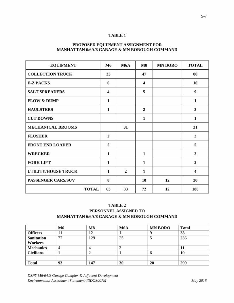
would be stored at the facility are listed in Table 1, while the personnel assigned to the respective
component districts are listed in Table 2, below. Taking into account scheduled vacations and days off,
approximately 200 DSNY staff would be assigned to work from the facility on an average peak day of the
week (a Thursday).
S-7
DSNY M6/6A/8 Garage Complex & Adjacent Development
Environmental Assessment Statement-13DOS007M May 2015
TABLE 1
PROPOSED EQUIPMENT ASSIGNMENT FOR
MANHATTAN 6/6A/8 GARAGE & MN BOROUGH COMMAND
EQUIPMENT M6 M6A M8 MN BORO TOTAL
COLLECTION TRUCK 33 47 80
E-Z PACKS 6 4 10
SALT SPREADERS 4 5 9
FLOW & DUMP 1 1
HAULSTERS 1 2 3
CUT DOWNS 1 1
MECHANICAL BROOMS 31 31
FLUSHER 2 2
FRONT END LOADER 5 5
WRECKER 1 1 2
FORK LIFT 1 1 2
UTILITY/HOUSE TRUCK 1 2 1 4
PASSENGER CARS/SUV 8 10 12 30
TOTAL 63 33 72 12 180
TABLE 2
PERSONNEL ASSIGNED TO
MANHATTAN 6/6A/8 GARAGE & MN BOROUGH COMMAND
M6 M8 M6A MN BORO Total
Officers 11 12 1 9 33
Sanitation
Workers
77 129 25 5 236
Mechanics 4 4 3 11
Civilians 1 2 1 6 10
Total 93 147 30 20 290

S-8
DSNY M6/6A/8 Garage Complex & Adjacent Development
Environmental Assessment Statement-13DOS007M May 2015
The DSNY Garage would stand approximately 114 to 129 feet tall (measured from street grade to
main roof deck) plus rooftop mechanical systems. It would contain approximately 180 parking spaces for
DSNY vehicles and equipment and 115 accessory parking spaces in the cellar of the site for personnel.
Figure 7 shows the proposed tax lots for the Garage and two adjacent development parcels.
Figure 8 shows sections of elevations of the Garage Complex. Figures 9-a through 9-d show renderings
of the Garage looking east along 25th Street and the Bellevue Drive opposite East 26
th Street, respectively,
and from above. Figure 10 shows the Garage site plan with the first floor plan.
The facility will include fuel dispensers and sub-floor petroleum storage tanks for B5 and B20
Biodiesel, gasoline, motor oil, hydraulic fluid, and waste oil, for a total of approximately 35,000 gallons
of storage. This would include one 10,000-gallon biodiesel fuel tank, three 4,000-gallon biodiesel fuel
tank, one 4,000-gallon unleaded gasoline tank, one 4,000-gallon hydraulic fluid tank, one 2,500-gallon
motor oil tank and one 2,500-gallon waste oil tank. The tanks will be of double-walled fiberglass with
interstitial leak detection systems, and will be installed in accordance with federal, New York State and
New York City Fire Department regulations. The building will be equipped with electric chargers for
plug-in electric vehicles. Pursuant to local law, most of DSNY’s light duty vehicles to be stored at the
facility are gas-electric hybrids or all-electric. The facility’s vehicle wash bays will direct wash water
through an oil/water separator before being discharged to the City’s sewer system for further treatment.
All the diesel equipment housed at the Garage in 2022 would utilize ultra-low sulfur B5 or B20
biodiesel fuel and be equipped with ‘Clean Diesel’ technology typically consisting of USEPA Certified
2007 Model Year-compliant technology or better, with after-treatment technology such as diesel
particulate filters that have been shown to reduce vehicle particulate emissions by 90%-- to levels
comparable to those from trucks fueled by compressed natural gas. Likewise, emissions of NOx from
DSNY diesel trucks will be controlled through advanced technology such as urea injection.
The building will incorporate other energy saving technology and environmentally sustainable
design elements, including a green vegetated roof and a system with a basement cistern to harvest
rainwater for use in the building. The building will be served by the Consolidated Edison steam network
for building heating and cooling. The building will meet a minimum of LEED (Leadership in Energy and
Environmental Design) Silver status, an accreditation attested to by the U.S. Green Buildings Council.
The location of the Garage in the midblock of the Project Site has been proposed in order to
minimize any conflicts between traffic associated with the garage and traffic associated with uses on the
Bellevue Campus, in particular EMS vehicles and other first responders. This location also greatly
reduces the likelihood that entering trucks would have to queue onto 1st Avenue. With truck queuing
occurring inside the building on the northern side and with the southern side of the building sealed with
windows and featuring personnel space, the building is designed to avoid impacts to the pedestrian
corridor of East 25th Street.
Given that the eastern portion of the Project Site is within the 100-year flood plain, the midblock
location also provides resiliency benefits. By taking advantage of the existing grade change along the
Project Site and the midblock location, the functional first floor will be established above the recently
S-9
DSNY M6/6A/8 Garage Complex & Adjacent Development
Environmental Assessment Statement-13DOS007M May 2015
proposed updated Federal Emergency Management Agency (FEMA) Advisory Base Flood Elevation
currently under review and adopted by the New York City Department of Buildings. Moreover, the
garage has been designed for resiliency to a 500-year flood event and the fuel storage areas and truck
ramps have been specifically designed to ensure that DSNY functions are not interrupted during a major
flood event.
DSNY operations are generally six days per week, with minimal activity on Sundays. The garage
will be staffed and security provided 24 hours per day, seven days per week. The three shifts are 12AM
to 8AM, 6AM to 2PM, and 4PM to 12AM. The principal collection routes are on the 6AM to 2PM shift,
with the trucks leaving before 6:30 AM and returning staggered over the 10:30 AM to 1:30 PM period,
depending on their routes and varying conditions. On a typical day, an average of 63 collection trucks and
mechanical brooms leave the facility for their service districts. On the peak day of the week, a Thursday, 71
collection trucks and brooms are in service. See Peak Day Trip Table, attached.
DSNY crews are expected to dump their loads on shift before returning to the Garage. Refuse
collected by the facility’s crews will be delivered to the DSNY Marine Transfer Station (MTS) located at
East 91st Street and the East River, where it will be placed into containers and shipped by barge to a container
terminal in Howland Hook and sent to waste-to-energy plants in Chester, PA and in Niagara Falls, NY.
Recyclable metal, glass and plastic (MGP) collected by M6 and M8 crews are driven to the Sims Municipal
Recycling transfer location in the Bronx, from which it is barged to the Sims Material Recovery Facility in
Sunset Park, Brooklyn for sorting, baling and shipment to processors for recycling into various feedstuffs.
Paper collected from M6 and M8 is driven to the DSNY West 59th Street MTS, where it is put into barges and
taken to a private paper recycling mill in Staten Island for processing into new paperboard products such as
pizza boxes. DSNY plans to construct a recycling MTS for paper and MGP on the Gansevoort Peninsula, in
accordance with the approved Solid Waste Management Plan. This would take paper and MGP from M6 and
M8, among other districts. This facility may be operational by the Build year of 2022; that is the subject of a
separate environmental review.
DSNY personnel serve a critical public function, must respond to winter weather emergencies by
coming to work even when mass transit is unavailable, and must at times work 12- hour shifts. Accordingly,
DSNY has programmed parking space in the building for employee vehicles.
With the proposed Garage Complex, DSNY will be closing several personnel section stations in
the field, which are locations where DSNY crews take breaks, have lunch and access restrooms. These
facilities are currently needed due to the distance from the M6, M8 and M6A service districts and their
respective district garages. The section stations to close are: 155 East 10th Street, 223 East 26
th Street, and
1120 Second Avenue, all in Manhattan. This will achieve a savings to the City and reduce DSNY truck
traffic in the vicinity of these locations.
As discussed above, the advancement of the proposed action represents a continuation of DSNY’s
plan to house all equipment and personnel in a manner that enhances delivery of service to local
community districts and minimizes impacts on those districts. Projects already completed in Manhattan
include the construction of a new garage for M12 at 301 W. 215th Street in Manhatttan CD 12, and a new
S-10
DSNY M6/6A/8 Garage Complex & Adjacent Development
Environmental Assessment Statement-13DOS007M May 2015
garage for M4, M4A and M7 at 786 12th Avenue in Manhattan CD 4. A new garage for M1, M2 and M5
is nearing completion at 353 Spring Street/500 Washington Street in Manhattan CD 2.
Garage construction is anticipated to take approximately three years, following demolition of the
Brookdale Campus buildings. Temporary closures of sidewalks and portions of streets during
construction would be coordinated with the New York City Department of Transportation (“NYCDOT”).
In accordance with the New York City Noise Code, a noise mitigation plan will be prepared and
implemented during construction, and dust control measures will be deployed.
2. PARCELS A & B
In addition to the development of the DSNY Garage, the Proposed Project includes the development
of Parcels A and B. Following completion of the City approvals process, the City anticipates issuing one
or more competitive public Request for Proposals (“RFP”) by the end of 2016 for development of Parcels
A and B by one or more developers. NYCEDC, on behalf of the Deputy Mayor for Housing and
Economic Development, would manage the RFP process. The RFP(s) will set overall parameters for
development of Parcels A and B, and will result in a disposition of these parcels by sale or lease. It is
anticipated that a developer would be selected in 2017 with construction commencing on one or both of
the sites starting 2019 and continuing to 2022. In order to facilitate the achievement of the City’s policy
goals on Parcels A and B, the City proposes rezoning the parcels to a C6-4 zoning district.
Parcel A
Parcel A is located at the western end of the block with frontages on First Avenue, East 25th
Street, and the demapped portion of the former East 26th Street. The zoning lot would be approximately
200 feet along East 25th Street by 260 feet along 1
st Avenue for a total zoning lot area of approximately
52,000 gross square feet. It is assumed that the proposed building on Parcel A would be developed as of
right under the future C6-4 zoning district, which would allow development up to a maximum Floor Area
Ratio (“FAR”) of 10 for commercial, community facility, and residential uses. If the Inclusionary
Housing or Plaza programs are pursued through future development, the maximum FAR of Parcel A
could be up to 12.
Parcel B
Parcel B would be located at the eastern end of the block with frontages on the FDR service road,
East 25th Street, and the demapped portion of the former East 26
th Street. The zoning lot’s frontage along
East 25th Street would be approximately 230 feet while frontage along the service road would be 260 feet
for a total zoning lot area of approximately 59,800 gross square feet. As with Parcel A, it is assumed that
the proposed building on Parcel B would be developed under a proposed C6-4 rezoning, which would
allow development up to a maximum FAR of 10 for commercial, community facility, and residential
uses, or a maximum FAR of 12 if the Inclusionary Housing or Plaza programs are successfully
incorporated into the project.
S-11
DSNY M6/6A/8 Garage Complex & Adjacent Development
Environmental Assessment Statement-13DOS007M May 2015
PROPOSED DISCRETIONARY ACTIONS
The discretionary governmental approvals subject to CEQR and SEQRA that have been identified
for the Proposed Project include:
DSNY
Capital funding for Garage Complex Construction.
Closure of four facilities and relocation of operations to the proposed Garage Complex.
City Planning Commission
Site Selection for a capital project for the Garage.
Rezoning of the mid-block portion of the Project Site from the current R8 residential district to
M1-5 manufacturing district.
Certain bulk waivers by means of special permits issued for a Large Scale General Development
(LSGD) pursuant to Zoning Resolution §74-74 et seq. for relief from side and rear yard, street
wall height and setback regulations; and authorization for curb cuts.
Rezoning of Parcels A and B from current R8 to C6-4.
Special Permits pursuant to Zoning Resolution §74-78 to permit a scientific research and
development facility within a C6 district.
Disposition by the City of New York’s Land Development Corporation for the development of
Parcels A and B, with approval of the Manhattan Borough Board pursuant to New York City
Charter Section 384(b)(4).
Determination of the Proposed Action’s consistency with the City’s Waterfront Revitalization
Program.
Any other approvals as may be required to facilitate the development of the Parcels A and B.
Office of the Mayor
Approval of disposition for development of Parcels A and B pursuant to City Charter 384(b)(4).
ULURP approvals are subject to review and approval by the City Council, at its option. Public Design
Commission approval of the garage exterior design would also be required.
BUILD YEAR
Construction of the Proposed Project is anticipated to start in 2019 following the necessary public
approvals, DSNY fully designing the garage and procuring a construction contractor, and a public RFP
process for Parcels A and B at the end of which a developer would be selected to develop the sites. It is
anticipated that construction on the garage and Parcels A and B would occur simultaneously with all of
the facilities fully operational by the year 2022.
S-12
DSNY M6/6A/8 Garage Complex & Adjacent Development
Environmental Assessment Statement-13DOS007M May 2015
REASONABLE WORST-CASE DEVELOPMENT SCENARIO (RWCDS)
In order to assess the possible effects of the Proposed Project, a reasonable worst-case
development scenario (RWCDS) for the project was established for both Future No-Action and Future
With-Action conditions. The incremental difference between the Future No-Action and Future With-
Action conditions serves as the basis of the impact category analyses in the environmental review.
For conservative analysis purposes, this analysis assumes that the entire Project Site is
redeveloped. The Garage is assumed to be developed in the midblock area of the Project Site under M1-5
zoning. Parcels A and B would be developed on the adjoining parcels and would be developed under C6-
4 zoning regulations. Given that the assumed zoning district for Parcels A and B permits a range of uses,
the RWCDS will assume two different development scenarios as this would be the most conservative
analysis.
First, each technical area assessed in the environmental review will include an analysis of a
scenario that assumes that Parcel A and B are each entirely redeveloped with commercial uses,
specifically a scientific and research facility as described in Section 74-78 of the Zoning Resolution,
community facility space, and ground-floor retail (the “All Commercial Scenario”). In addition to the All
Commercial Scenario, the technical analysis will be supplemented in some cases by an additional
scenario which assumes each parcel is redeveloped with residential uses, ground floor retail, and
community facility use (the “All Residential Scenario”). For this scenario, each technical area will
provide an appropriate level of analysis. Each scenario is described in detail below.
THE FUTURE WITHOUT THE PROPOSED ACTIONS (“FUTURE NO-ACTION”)
The future without the proposed actions (the “No Action” condition) is the future baseline
condition to which the changes that are expected to result from the Proposed Project are compared. The
No-Action condition assumes that none of the proposed actions necessary for the Proposed Project are
approved. Without the Proposed Project, it is assumed the Project Site would continue to be used as an
academic-type community facility at full occupancy, under the current R8 zoning.
THE FUTURE WITH THE PROPOSED ACTIONS (“FUTURE WITH-ACTION”)
By 2022 under With-Action conditions, as described in the Project Description and shown in
Tables 3 through 6, the Proposed Project would result in significant new development on the Project Site.
The Project Site would be divided into three separate zoning lots, each of which would encompass
portions of the current Brookdale Campus as well as portions of the former East 26th Street. The Future
with the Proposed Actions assumes that the entire project site is redeveloped with the Garage being
developed under M1-5 zoning and Parcels A and B being developed under C6-4 zoning regulations.
The new zoning lot for the proposed DSNY Garage would be located in the middle of the Project
Site. The new zoning lot would have a length of 380 feet along East 25th Street with a width of

S-13
DSNY M6/6A/8 Garage Complex & Adjacent Development
Environmental Assessment Statement-13DOS007M May 2015
approximately 260 feet spanning from East 25th Street to the northern side of the former East 26
th Street
for a total area of approximately 98,800 square feet with the proposed Garage facility occupying
approximately 80,560 square feet of that space. The proposed M1-5 zoning district allows development to
a maximum of 5.0 FAR. As such, the Garage could be constructed to a maximum of 494,000 square feet.
Although the Garage could be developed to that maximum, the actual facility would be developed to
approximately 346,290 square feet. Accordingly approximately 147,710 square feet of floor area may be
available for transfer to either Parcel A or Parcel B for use as commercial floor area.
Parcels A and B would be developed on new zoning lots directly adjacent to the Garage. Parcel A
would be located at the western end of the block with frontages on 1st Avenue and East 25
th Street. The
zoning lot for Parcel A would have a length of approximately 200 feet along East 25th Street and a width
of approximately 260 feet from East 25th Street to the northern side of the former East 26
th Street for a
total zoning lot area of approximately 52,000 square feet. Parcel B would be located at the eastern end of
the Project Site with frontages on the FDR service road and East 25th Street. The zoning lot for Parcel B
would have a length of approximately 230 feet along East 25th Street and a width of approximately 260
feet from East 25th Street to the northern side of the former East 26
th Street for a total zoning lot area of
approximately 59,800 square feet.
In order to capture all potential impacts from the development possibilities on Parcels A and B,
the RWCDS encompasses both an All Commercial Scenario and an All Residential Scenario. Analyzing
these two scenarios allows for one of four potential outcomes – commercial buildings on both sites,
mixed-use residential on both sites, or one commercial building and one mixed-use residential on either
Parcel A or Parcel B. The conservative analysis ensures that the highest environmental impact uses will
be included in the proper technical analysis area.
The All Commercial scenario assumes that Parcels A and B are redeveloped with commercial
space, specifically scientific and research facilities as described in Section 74-78 of the Zoning
Resolution, and ground-floor retail. Parcel A would be developed with a 624,000 square foot building and
Parcel B would be developed with a 717,600 square foot building. Parcel A would have approximately
39,380 square feet of retail space on the ground-floor along 1st Avenue and East 25
th Street, and
approximately 39,380 square feet of community facility space, and the remaining 545,240 square feet
would be used as a scientific research facility. Parcel B would have approximately 43,600 square feet of
ground-floor retail with frontage along East 25th Street and 43,600 square feet of community facility
space. The remaining 630,400 square feet would be used as a scientific research facility (see Table 3).

S-14
DSNY M6/6A/8 Garage Complex & Adjacent Development
Environmental Assessment Statement-13DOS007M May 2015
Table 3: All Commercial Scenario
Use
Site A
Site B
Scientific Research and
Development Facility
545,240
630,400
Retail 39,380 43,600
Community Facility 39,380 43,600
Total
624,000
717,600
To ensure a conservative analysis, it is assumed that each building would be built to the
maximum 12 FAR by utilizing a public plaza bonus to augment the base 10 FAR for commercial uses in a
C6-4 district. In addition to the plaza bonus, it is assumed that the remaining, unused commercial floor
area from the DSNY garage facility and adjoining private drive (147,710 square feet) would be
transferred to one of the two buildings. As such, the total commercial development across both parcels
could be up to approximately 1,489,310 square feet of development.
For the All Commercial scenario, each building would be built within the as-of-right bulk
envelope with an 85-foot high base with a tower rising above the base. The tower would be set back by at
least 15 feet along 1st Avenue and by 20 feet along East 25
th Street. The base would not occupy the entire
zoning lot and would not be built within the former East 26th Street. Instead, each building would be
located within the area generally defined by the existing sidewalks on East 25th Street and the former East
26th Street Bellevue private driveway. Each building would be constructed to maintain the proposed
access to the Garage’s entry drive, which will include widening the private Bellevue driveway along Site
A.
The All Residential scenario assumes that Parcels A and B are redeveloped with residential uses,
ground floor retail, and community facility space. With this assumption, Parcel A would be developed
with a mixed use building with up to approximately 39,380 square feet of ground-floor retail along 1st
Avenue or East 25th Street, up to approximately 39,380 square feet of community facility space, and up to
approximately 545,240 square feet of residential space. Parcel B would be a residential building with up
to approximately 630,400 square feet of residential space, 43,600 square feet of retail, and 43,600 square
feet of community facility space (see Table 4). Based on an assumption of 1,000 square feet per
residential unit, Parcel A would have up to approximately 541 residential units and Parcel B would have
635 residential units. Of the 1,176 total residential units, it is assumed that up to 30%, or 353 units, would
be affordable with the remaining 823 units as market-rate residential units. An assumed 20% of the units
(within the 30%) would be low-income as defined by the New York City Department of Housing
Preservation and Development.
S-15
DSNY M6/6A/8 Garage Complex & Adjacent Development
Environmental Assessment Statement-13DOS007M May 2015
Table 4: All Residential Scenario
Use Site A Site B
Residential
545,240
630,400
Retail 39,380 43,600
Community Facility 39,380 43,600
Total
624,000
717,600
To ensure a conservative analysis, it is assumed that each building would be built to the
maximum 12 FAR for residential uses in a C6-4 district by receiving a floor area bonus through
participation in the Inclusionary Housing Program. For this scenario, it is assumed that the remaining,
unused commercial floor area from the DSNY garage facility and adjoining private drive (147,710 square
feet) would be transferred to one of the two buildings. As such, the total development across both parcels
could be up to approximately 1,489,310 square feet of development.
Similar to the first scenario, for the All Residential scenario, each building would be built within
the as-of-right bulk envelope with an 85-foot high base with a tower rising above that base height. The
tower would be set back by at least 15 feet along 1st Avenue and by 20 feet along East 25
th Street. The
base would not occupy the entire zoning lot and would not be built within the former East 26th Street.
Instead, each building would be located within the area generally defined by the existing sidewalks on
East 25th Street and the former East 26
th Street, with appropriate zoning lot line setbacks from the DSNY
Garage and preserving access to the Garage entry drive, which will include widening the private driveway
along Site A.
As described above, the incremental difference between the Future No-Action and Future With-
Action conditions serves as the basis of the impact category analyses in the environmental review for the
proposed action. Table 5 illustrates the incremental difference between the All Commercial Scenario and
the No Action Condition. Table 6 illustrates the incremental difference between the All Residential
Scenario and the No Action Condition.
Table 5: Comparison of Total Development Potential between the
No-Action Condition and All Commercial Scenario
Use No-Action
Scenario (sf)
All-Commercial
Scenario (sf)
Increment
Scientific Research Facility 0 1,323,350 1,323,350
Ground Floor Retail 0 82,980 82,980
Community Facility 450,000 82,980 -367,020
Total 450,000 1,489,310 1,039,310
S-16
DSNY M6/6A/8 Garage Complex & Adjacent Development
Environmental Assessment Statement-13DOS007M May 2015
Table 6: Comparison of Total Development Potential between the
No-Action Condition and All Residential Scenario
Use No-Action
Scenario(sf)
All-Residential
Scenario (sf)
Increment
Ground Floor
Retail
0 82,980 82,980
Community
Facility
450,000 82,980 -367,020
Residential 0 1,175,640 1,175,640
Total 450,000 1,341,600 891,600
PROJECT POPULATION
In the Future No Action condition, the buildings of the Project Site would have an institutional
use with no additional construction assumed. Based on an assumed population generation of 1 employee
per 450 square feet of institutional space and no new construction by 2022, the Future No Action
condition would have a population of approximately 1,000 persons (students, visitors, clients, patients,
and/or employees).
With the Proposed Project, it is anticipated that approximately 290 staff would be based at and/or
work from the Garage, spread over several shifts. The total number of employees assigned on a peak
day/peak shift would be 199, excluding winter emergencies. Most of the DSNY staff would spend the
majority of their work day in the field.
For the All Commercial Scenario, development on Parcels A and B would generate a project
population of 5,999 employees, an incremental increase of 4,999 employees compared to the No Action
condition. For the All Residential Scenario, development on Parcels A and B would generate a project
population of 759 employees, a decrease of 241 persons compared to the No Action condition.2 In
addition, the All Residential Scenario would generate a residential population of 1,952 people, based on
an average household size of 1.66.3
-------------------------------------------------------------------------------------------------------------------------
2 Residential use assumed to generate 1 employee per 22 units, scientific research facility assumed to generate 4
employees per 1,000 sf, ground floor retail assumed to generate 3 employees per 1,000 sf, and community facility
use assumed to generate 1 employee per 450 sf. Assumptions based on Columbia Manhattanville FEIS and Cornell
Tech FEIS. 3 Average household size assumption based on NYC DCP MN NTA Murray Hill-Kips Bay, data table SF1-H2. Data
set available at: http://www.nyc.gov/html/dcp/html/census/demo_tables_2010.shtml
S-17
DSNY M6/6A/8 Garage Complex & Adjacent Development
Environmental Assessment Statement-13DOS007M May 2015
PART II: TECHNICAL ANALYSIS
Supplement to Question 1: Land Use, Zoning and Public Policy
As noted above, the proposed action would rezone portions of the site from R8 to M1-5 (for the
Garage Complex) and to C6-4 (for the proposed commercial use or residential use, plus retail and
community facility). With the proposed M1-5 zoning, the Garage Complex will require relief from the
street wall height of 85 feet and setback along East 25th Street, and from the side yard and rear yard
requirements. A 197-a plan has been adopted for the area, which must be considered. It does not
specifically call for housing or a manufacturing district on this location. The site encompasses the
equivalent of a City block. Within 400 feet are a mix of uses that include institutions (hospitals), the City
Office of the Chief Medical Examiner, a Fire Department Emergency Medical Services station,
residences, commercial ground floor retail, and parkland, with no manufacturing district in the vicinity.
Such a rezoning and change in use has the potential to conflict with current zoning and land uses in the
immediate vicinity, and so warrants further analysis in an Environmental Impact Statement.
Supplement to Question 2: Socioeconomic Conditions
Socioeconomic impacts can occur when a Proposed Project directly or indirectly changes
economic activities in an area. The purpose of the socioeconomic assessment is to disclose changes that
would be created by a proposed action and identify whether they rise to a significant level. The
assessment examines the effects of the proposed actions on socioeconomic conditions on the Project Site
and in the surrounding neighborhood.
The analysis follows the guidelines of the 2014 CEQR Technical Manual in assessing the
Proposed Project’s effects on socioeconomic conditions. The objective is to present sufficient information
regarding the effects of the project to make a preliminary assessment either to rule out the possibility of
significant impacts or to determine that more detailed analysis is required to make a determination as to
impacts. According to CEQR Technical Manual guidelines, the five principal issues of concern with
respect to socioeconomic conditions are whether a proposed action would result in significant impacts due
to: (1) direct residential displacement; (2) direct business and institutional displacement; (3) indirect
residential displacement; (4) indirect business/institutional displacement; and (5) adverse effects on a
specific industry. As detailed below, the Proposed Project warrants an assessment of socioeconomic
conditions with respect only to indirect business and residential displacement.
As the Project Site does not support any active business or residential uses, the Proposed Project
would not result in the direct displacement of any residents or businesses, and therefore, an assessment of
potential socioeconomic effects due to direct displacement is not warranted for the Proposed Project. In
addition, the CEQR Technical Manual indicates that an assessment is appropriate if a project is expected
to affect conditions within a specific industry. The project site does not include any commercial uses, and
therefore the Proposed Project would not directly displace any businesses or industrial employees.
Moreover, the proposed actions are site-specific, and do not include any citywide regulatory changes that

S-18
DSNY M6/6A/8 Garage Complex & Adjacent Development
Environmental Assessment Statement-13DOS007M May 2015
would adversely affect the economic and operational conditions of certain types of businesses or
processes. Therefore, the proposed actions would not result in significant adverse effects on specific
industries, and no further analysis of this issue is warranted.
In conformance with the CEQR Technical Manual guidelines, the assessment of indirect business
displacement and indirect residential displacement begins with a preliminary assessment to determine
whether a detailed analysis is necessary. The All Commercial scenario would result in an incremental
increase of more than 200,000 square feet of new commercial uses to the area, which is the CEQR
Technical Manual threshold for “substantial” new development. Therefore, a preliminary socioeconomic
analysis of indirect business displacement is warranted. The All Residential scenario for the Proposed
Project would exceed the CEQR Technical Manual threshold of 200 residential units, and therefore, a
preliminary socioeconomic analysis of indirect residential displacement is warranted. However, as
residential units on the site would include 20% reserved for persons or households of low income and
another 10% or persons or households of moderate income using standard City categories, it can be
concluded that no indirect residential displacement would result from the all-residential scenario.
The proposed all-commercial scenario would result in a scientific research facility use, similar to
what exists in the Bellevue vicinity, in accordance with existing community plans (197-a Plan). As noted
above, this is consistent with current trends in the area, and would not be expected to result in a
significant adverse impact from indirect displacement of commercial uses within 400 feet of the site.
As noted above, the project will not displace any use, as the Brookdale Campus is being vacated
by Hunter College pursuant to a separate plan. The introduction of a DSNY Garage complex to the site
with its 200 daily workers who work mainly offsite would not be expected to significantly change the
socioeconomic conditions in the vicinity by increasing demand for housing or decreasing demand for
commercial or institutional uses. The introduction of commercial uses to Parcels A and B in the form of
scientific research and development laboratories would not be expected to cause indirect displacement of
commercial uses in the immediate vicinity (400 foot radius), as these are ground level retail, plus some
generic office space. This would not create a trend making it difficult for businesses to stay in the area, as
there is already a trend for commercial medical and scientific research and development in this area. One
or both of the development parcels could be developed for residential use, and would include 30% low
and moderate income housing. Therefore the average income of such residents would not be expected to
exceed the average income of the residents in the study area such that indirect displacement would result.
Thus no indirect socioeconomic impacts would be expected.
Supplement to Question 3: Community Facilities
The demand for community facilities and services is directly related to the type and size of the
new population generated by development resulting from the Proposed Project. New workers tend to
create limited demands for community facilities and services, while new residents create more substantial
and permanent demands. The Hunter College Brookdale Campus will vacate the site, independent of this
action. The Proposed Project would not result in direct displacement of any community facility or
services. One or two community facilities may be provided as part of the development of Parcels A and

S-19
DSNY M6/6A/8 Garage Complex & Adjacent Development
Environmental Assessment Statement-13DOS007M May 2015
B. As such, no further analysis of direct effects on community facilities is warranted. As Parcels A and
B both could be developed for residential uses, generating a potential residential population of up to 1952
persons, further study is warranted concerning the indirect effects on community services due to the
Proposed Project, focusing on public schools, publicly funded day care facilities, and libraries.
Supplement to Question 4: Open Space
Open space is defined as publicly or privately owned land that is publicly accessible and operates,
functions, or is available for leisure, play, or sport, or is set aside for the protection and/or enhancement of
the natural environment. An analysis of open space determines whether or not a Proposed Project would
have direct effects resulting from the elimination or alteration of open space, and/or indirect effects
resulting from overtaxing available open space. The site has no publicly available open space. Open
spaces in the immediate vicinity of the project site include Asser Levy Recreational Center, Pool and
Playground south of the site; and two non-park landscaped spaces north of the site that the public may
access at certain times for passive use: the Bellevue Sobriety Garden and the Bellevue Hospital
landscaped entrance plaza.
According to the 2014 CEQR Technical Manual, an assessment of a project’s potential for direct
effects may be appropriate if the project would result in a physical loss of publicly accessible open space
(by encroaching on an open space or displacing an open space); change the use of an open space so that it
no longer serves the same user population (e.g., elimination of playground equipment); limit public access
to an open space; or cause increased noise or air pollutant emissions, odors, or shadows on public open
space that would affect its usefulness, whether on a permanent or temporary basis. The Project Site does
not include any publicly accessible open space and the Proposed Project would not have a direct physical
effect on any existing open space resource, other than possibly casting temporary shadows on portions on
the Bellevue Sobriety Garden and entrance plaza. Such limited shadow impacts would not significantly
impede the usefulness of these open spaces. Further analysis will be limited to the proposed action’s
indirect effects on open space.
An indirect effect may occur when the population generated by a project would be sufficiently
large to noticeably diminish the ability of an area’s open space to serve the future population. The
population thresholds for a CEQR assessment of indirect effects vary, depending upon the current
adequacy of open space in the project’s study area. The Project Site is not located within an underserved
or well‐served open space area of Manhattan4, and as such, the CEQR Technical Manual threshold for an
open space assessment is more than 200 residents and 500 employees. The incremental increase in
residents and employees associated with the Proposed Project would exceed these thresholds, with up to
5384 additional workers in the commercial scenario, and up to 1900 residents in the all residential
scenario, which would create added demands on local open space and recreational facilities. Therefore, a
preliminary open space analysis will be conducted. If the preliminary analysis determines that further
analysis is warranted, then a detailed analysis will be performed. As noted above, with the proposed C6-4
4 Open space information is available here:
http://www.nyc.gov/html/oec/html/ceqr/open_space_maps_manhattan.shtml

S-20
DSNY M6/6A/8 Garage Complex & Adjacent Development
Environmental Assessment Statement-13DOS007M May 2015
zoning for Parcels A and B, future development could incorporate public open space into one or both
sites, in the form of a public plaza that would allow development to a density of a 12 FAR, potentially
increasing the local supply of public open space within the 400 foot radius of the site.
Supplement to Question 5: Shadows
The Proposed Project’s potential for significant and adverse shadow impacts pursuant to 2014
CEQR Technical Manual guidelines was considered. Generally, the potential for shadow impacts exists if
an action would result in new structures or additions to existing buildings resulting in structures greater
than 50 feet in height or located adjacent to, or across the street from a sunlight-sensitive resource. Such
resources include publicly accessible open spaces, important sunlight-sensitive natural features, or
historic resources with sun-sensitive features.
The Proposed Project would result in new buildings on the Project Site, the tallest of which would
be on either Parcels A or B, which could be up to 30 stories (approximately 350-feet tall). Such a building
would cast a shadow up to 1,505 feet on December 21, the day with the longest shadows, according to the
CEQR Technical Manual. This is more than the maximum shadow cast by the 160 foot North Tower and
132 foot West Tower currently on the Project Site. The analysis assumes a shadow increment expected
with the proposed rezoning of Parcels A and B with bonus floor area awarded for affordable housing or a
public plaza, in accordance with the CEQR Technical Manual. The maximum theoretical shadow radius
from such a building on December 21 (not an actual shadow) would extend past Second Avenue to the
west, and past 30th Street to the north, and to the East River. By comparison, the proposed DSNY garage
would have a roof height from the curb up to approximately 129 feet plus a mechanical penthouse, casting
a theoretical maximum shadow of 541 feet on December 21.
The screening analysis indentified no important sunlight-sensitive natural features or historic
resources that would be cast in shadow by the project. Impacts to parks and other publicly accessible
open space were also considered. Asser Levy Playground and Recreational Center is south of the Project
Site, and therefore would not be affected significantly by shadows from the Proposed Action.
Incremental shadows would fall for part of the day on the Bellevue Sobriety Garden to the north of the
Project Site’s Parcel B. This private space does not have ready access to the public but may have some
public utilization. Likewise, the landscaped entrance plaza to Bellevue Hospital Center accessed from
First Avenue is private and fenced, but the public may use it for sitting. Shadow from development on
Parcel A would fall on this plaza for part of the day. It is already cast in shadow by the North and West
Towers and other buildings for much of the day, and thus the shadow increment from development on
Parcel A is expected to be minor. Further to the northwest, Bellevue South Park extends north from East
26th Street west of Mt. Carmel Place. This park, which opened in 1979, has mature trees, benches,
decorative plantings, fitness equipment, basketball courts and a playground. It would come within the
maximum theoretical shadow radius cast by development on Parcel A on December 21. Also, Vincent F.
Albano Jr. Playground, which is located northwest of the intersection of East 29th Street and Second
Avenue, would come within the theoretical maximum shadow radius on December 21. These parks and
publicly accessible private spaces will be evaluated in more detail in a Tier 3 assessment, in accordance
with the CEQR Technical Manual. The shadows assessment will determine the extent, duration, and
S-21
DSNY M6/6A/8 Garage Complex & Adjacent Development
Environmental Assessment Statement-13DOS007M May 2015
effects of any potential new shadows from the Proposed Action on these and any other sunlight-sensitive
resources identified in the vicinity of the Project Site. A significant impact to such resources is not
expected; this will be confirmed with the Tier 3 analysis.
Supplement to Question 6: Historic and Cultural Resources
Historic and cultural resources include archaeological (buried) resources and architectural
(historic standing structure) resources. The Project Site (Block 962, part of Lot 100) does not contain any
landmarked structures or structures eligible for inclusion in the National Register of Historic Places. It
was previously disturbed by construction. The Project Site would be subject to demolition, including
below-grade structures. Therefore, the potential for any remaining archaeological resources appears to be
slight. In accordance with the CEQR Technical Manual, the New York City Landmarks Preservation
Commission (LPC) was consulted regarding the Project Site’s potential archaeological sensitivity. LPC
advised that the Project Site has no architectural or archeological significance. Accordingly, no further
discussion is warranted with respect to archaeological and cultural resources to conclude the project will have
no significant adverse impacts to these resources.
Supplement to Question 7: Urban Design and Visual Resources
According to the CEQR Technical Manual, urban design is the summation of those elements that
may impact a pedestrian’s experience of an area. Such elements as streets, buildings, visual resources,
open space, natural features, and wind have the potential to alter the arrangement, appearance, and
functionality of the built environment, and therefore define the identity and uniqueness of a
neighborhood. A visual resource is the connection from the public realm to significant natural or built
features, including views of the waterfront, public parks, landmark structures or districts, otherwise
distinct buildings or groups of buildings, or natural resources. If a project requires actions that would
result in physical changes to a project site beyond those allowable by existing zoning and which could be
observed by a pedestrian from street level, a preliminary assessment of urban design and visual resources
should be prepared. As per the CEQR Technical Manual, examples of projects that may require a
detailed analysis are those that would allow a project to potentially obstruct view corridors, compete with
icons in the skyline, or make substantial alterations to the streetscape of a neighborhood by noticeably
changing the scale of buildings.
Since the Proposed Project would require land use approvals that would result in physical
differences beyond what would be allowed under existing zoning and those differences could be observed
by a pedestrian from street level, a preliminary assessment of urban design and visual resources is
warranted. The scope of this assessment includes the pedestrian experience along First Avenue and along
East 25th Street, within 400 feet of the project site. The private Bellevue Drive does not have a view
corridor to the east, as buildings block the views; also, the sidewalks along this drive are not standard
sidewalks as they are part of a private campus, and therefore views from them do not warrant the same
assessment as the experience from public sidewalks. The pedestrian experience along East 25th Street will
be altered in the No Action condition by the construction of a flood wall parallel to the street along its
southern side for the Veterans Administration Hospital. The proposed sidewalk experience along the 25th
S-22
DSNY M6/6A/8 Garage Complex & Adjacent Development
Environmental Assessment Statement-13DOS007M May 2015
Street façade of the proposed Garage Complex and from First Avenue is shown on the attached
renderings. See Figures 9a through d. The requested waiver from the setback requirement at 85 feet
above the street wall would result in the street wall rising to 112 feet before setting back. This relief is
needed to accommodate the width of the ramp to the upper floors of the building without seriously
compromising the available vehicle storage space on these floors. Normal setbacks at 85 feet above the
street would be provided for the rest of the block along Parcels A and B, and along First Avenue. The
garage is designed to present the appearance of an attractive office and/or institutional building to
pedestrians along East 25th Street, which is a significant pedestrian corridor as it provides access to the
pedestrian footbridge to the Waterside complex on the opposite side of the FDR Drive. The ramps are
fully enclosed and most of the time no trucks would be using them. A green vegetated roof, while not
visible to pedestrians, would add visual interest to those on higher floors in the vicinity, including the
hospitals, the Office of the Chief Medical Examiner, and the Waterside towers.
The bulk and massing of the proposed Garage Complex with the requested bulk waivers would
not constitute a significant adverse impact to the pedestrian experience with respect to the area’s urban
design. However, more study is warranted of the overall Proposed Action’s impacts to urban design,
taking into account the proposed development on Parcels A and B which could involve additional height
for affordable housing or other amenity, resulting in a building or buildings as high as 30 stories each,
likely with a tower on a base configuration as is common in Manhattan. The additional assessment will
include renderings of development proposed to be allowed on these two parcels. These renderings will
help to determine whether physical changes proposed by the Proposed Project would raise the potential to
significantly and adversely affect elements of urban design and pedestrian experience such as disturbance
to the vitality, the walkability, or the visual character of the area.
The analysis would describe the potential changes that could occur to urban design and visual
resources in the future with the Proposed Project, in comparison to the future without the proposed
actions, focusing on the changes to the built environment’s arrangement, appearance, or functionality that
could negatively affect a pedestrian’s experience of the area. If necessary, mitigation measures such as
design changes and/or physical changes that reduce or eliminate potential significant adverse impacts will
be identified.
Supplement to Question 9: Hazardous Materials
The potential presence of hazardous materials and/or contamination on the Project Site was
considered. Asbestos is known to be present on the Brookdale Campus, and would be abated in accordance
with applicable regulations prior to building demolition. A Phase I Environmental Site Assessment (ESA)
was conducted reviewing the site’s history, proximity to any known spills and any recognized environmental
conditions. No open spills were found for the site. The entire site has been used for a dormitory, nursing
school and health sciences complex since the early 1950’s. A gas station once operated in proximity to the
site. A portion of the site was used for a grease-related business early in the last century. The Department of
Environmental Protection (NYCDEP) has recommended additional testing (such as a limited Phase II ESA)
prior to or during construction. Any appropriate remediation measures specific to the proposed uses on the
Project Site, including those recommended by the NYCDEP, will be provided.
S-23
DSNY M6/6A/8 Garage Complex & Adjacent Development
Environmental Assessment Statement-13DOS007M May 2015
Certain hazardous materials (e.g., petroleum bulk storage, maintenance fluids, automotive
batteries, laboratory supplies, etc.) would be associated with operation of the DSNY Garage and
development on Parcels A and B. The petroleum would be stored in accordance with Fire Department
regulations and Department of Environmental Conservation rules to ensure safety and protection of the
environment. If any abandoned underground storage tanks for petroleum are encountered during
construction, they will be handled in accordance with all applicable regulations. The entire site will be
excavated for cellars and pilings and slab placement. As is common in Manhattan waterfront districts in
the floodplain, the site has urban fill, which may have elevated levels of certain compounds such as lead
and polycyclic aromatic hydrocarbons (PAH’s). Further information will be obtained by site specific
sampling, which will be done pursuant to a sampling plan reviewed and approved by NYCDEP. Excess
site soils to be removed will be sampled and handled as appropriate in accordance with applicable
regulations. A site-specific health and safety plan will be prepared in advance of excavation and
submitted to NYCDEP for its review. A dust control plan will be implemented during construction. With
these measures, the project does not have the potential to result in a significant adverse impact from
hazardous materials.
Supplement to Question 10: Water and Sewer Infrastructure
Water Supply
According to the CEQR Technical Manual, an analysis of an action’s impact on the water supply
system should be conducted only for actions that would have exceptionally large demand for water, such
as power plants, very large cooling systems, or large developments (e.g., those that use more than 1
million gallons per day). In addition, actions located at the extremities of the water distribution system
(such as the Rockaways) should be analyzed. The Proposed Project does not meet any of these criteria,
and therefore an analysis of water supply is not warranted.
Wastewater and Stormwater Conveyance and Treatment
The 2014 CEQR Technical Manual outlines thresholds for analysis of a project’s generation of
wastewater and stormwater. The need for an analysis of a project’s effects on wastewater and stormwater
conveyance depends on a project’s proposed density, its location, and its potential to increase impervious
surfaces. A preliminary assessment of the Proposed Project’s effects on wastewater infrastructure is
warranted as the All Commercial scenario would result in an increment of more than 250,000 square feet
of commercial space in Manhattan, compared to the No Action condition. Stormwater runoff from the
Site is expected to decrease over the No Action condition, as the Proposed Action’s garage component
would have a green vegetated roof and harvest stormwater for the building’s use for vehicle washing and
store it in a cellar cistern. The No Action condition has no green roof or stormwater harvesting or flow
detention technology. The All Residential scenario would result in an increment of less than 1,000
residential units, taking into account the current dormitory use on site, which is below the level that would
warrant an assessment. According to the CEQR Technical Manual Table 13.2, the All Commercial
scenario’s maximum water usage and sanitary flow from the All Commercial scenario, would be .1
gallons per day /sf, plus 0.24 gallons per day/sf for retail use, for about 137,564 gallons per day. As the
S-24
DSNY M6/6A/8 Garage Complex & Adjacent Development
Environmental Assessment Statement-13DOS007M May 2015
site is supplied by Con Edison steam for both heating and air conditioning, it is assumed water demands
for air conditioning are not applicable. The DSNY Garage Complex water use is expected to be under
25,000 gallons per day, based on the similar Manhattan 4/4A/7 Garage usage. This would not exceed the
use for the current 450,000 sf community facility on the site. Therefore, the proposed action would not
have the potential to result in a significant adverse impact to the City’s sewage treatment infrastructure.
Supplement to Question 13: Transportation
Based on the CEQR Technical Manual, detailed transportation analyses may be warranted if a
proposed action is anticipated to result in an incremental increase of 50 or more peak hour vehicles trips,
200 or more peak hour subway or bus trips, or 200 or more peak hour pedestrian trips. The Proposed
Project is expected to result in peak hour trip generation that would exceed these thresholds and therefore,
detailed analyses of traffic, transit, and pedestrian operations, as well as assessments of vehicular and
pedestrian safety and screening assessments of the parking supply and utilization, are warranted. A
Travel Demand Factors (TDF) memo will be prepared for review and comment by the New York City
Department of Transportation (NYCDOT) for concurrence on the travel demand assumptions and detailed
analysis study areas. Traffic counts will be taken to determine current roadway conditions for the
proposed action’s peak hours of traffic trip generation, in accordance with the CEQR Technical Manual.
In view of the peak hour trip numbers for the garage (see Peak Day Trip Table, attached), the project may
result in a significant adverse impact to traffic conditions, absent mitigation measures such as traffic
signal timing adjustments, and a detailed study must be conducted to determine the location, frequency
and duration of impacts, and to identify possible mitigation measures.
It is expected that the proposed Garage’s parking demand will be accommodated on-site.
Therefore, a detailed parking demand study is not warranted for the garage. Development on Parcels A
and B are expected to include some parking on site. Parking demand associated with the projected All
Commercial and All Residential development scenarios on Parcels A and B will be compared with the
Future No Action condition, in accordance with the CEQR Technical Manual.
Currently, trips made by public transportation to and from the Project Site are served by the
Lexington Avenue No. 6 train, the M9, M23 and M34A bus routes at East 23rd
Street, and the
First/Second Avenue M15 bus route. In addition, several express bus routes have stops along East 23rd
Street proximate to the Project Site. The trip estimates and distribution of transit trips to these area public
transportation services from the two proposed action development scenarios (All Residential scenario plus
garage; and All Commercial scenario plus garage) will be estimated and compared to the No Action
condition to see whether it warrants a detailed analysis of stairway and control area elements at the
nearest subway station and line-haul conditions of the subway and bus routes identified above. If
necessary, the detailed transit analysis will assess the AM and PM commuter peak periods. Where
impacts are identified, practical mitigation measures will be discussed.
Project-related transit and pedestrian trips are projected to traverse area sidewalks, corner
reservoirs and crosswalks. These modes are not inclusive of commuting automobiles traveling to/from
S-25
DSNY M6/6A/8 Garage Complex & Adjacent Development
Environmental Assessment Statement-13DOS007M May 2015
the Garage as they are anticipated to park internally on-site. Pedestrian trips from the development
increment from Parcels A and B (two scenarios noted above) over the Future No Build condition will be
determined. Where impacts are identified, practical mitigation measures such as street furniture removal,
crosswalk widening, corner extension, etc. will be explored to alleviate these impacts. The pedestrian
screening and/or analysis will employ a similar methodology to the traffic assessment discussed above.
Accident data for the study area intersections and other nearby sensitive locations from the most
recent three-year period will be obtained from the New York State Department of Transportation
(NYSDOT). These data will be analyzed to determine if any of the studied locations may be classified per
CEQR Technical Manual criteria as high vehicle crash or high pedestrian/bike accident locations and
whether trips and changes resulting from the Proposed Project would adversely affect vehicular and
pedestrian safety in the area. If any high accident locations are identified, feasible improvement measures
will be explored to address potential safety issues. The Project Site currently has a Citibike station. All
available and appropriate Citibike data will be considered in consultation with NYCDOT.
Construction Period Transportation Assessment
Construction of the Proposed Project is expected to exceed the short-term threshold of two years
as defined in the 2014 CEQR Technical Manual. As such, a construction period screening assessment will
be conducted to determine if a detailed analysis is warranted. The analysis will identify changes to traffic
circulation and potential increase in trips to/from the study area, as well as identify street closures
resulting from the construction of the Proposed Project. If construction generated trip thresholds (similar
to those identified in the TDF Memorandum) are exceeded, a detailed analysis will be conducted.
Supplement to Question 14: Air Quality
Air impacts from the proposed action were considered. The number of heavy duty diesel truck
trips associated with the proposed Garage Complex exceed screening numbers used by the CEQR
Technical Manual for fine particulate matter (PM) impact analysis. Therefore additional studies are
warranted and will be conducted. The air quality studies for the proposed actions will include both mobile
and stationary source analyses. The mobile source air quality impact analysis will assess the potential
impacts from particulate matter (PM) and carbon monoxide (CO) from traffic-generated emissions. The
stationary source air quality impact analysis will address the effects of vehicle emissions inside the garage
that are exhausted via roof vents. As the Project Site will be supplied by Consolidated Edison steam, no
building boiler emissions are expected.
Mobile Source Analysis
DSNY collection trucks all use advanced clean diesel technology with diesel particulate filters and
ultra-low sulfur diesel fuel. All of DSNY’s mechanical brooms also use clean diesel technology, in
accordance with federal USEPA standards that took effect with the 2007 model year. DSNY light duty
vehicles are subject to local law requirements that they be the cleanest in their class; most are hybrid-electric;
an increasing number are plug-in electric vehicles, with zero emissions. DSNY collection trucks are heavy
S-26
DSNY M6/6A/8 Garage Complex & Adjacent Development
Environmental Assessment Statement-13DOS007M May 2015
duty diesel Class 8 trucks. Diesel trucks are not a significant source of CO. The principal collection routes
are on the 6AM to 2PM shift, with the trucks leaving before 6:30 AM and returning prior to 2PM.
Stationary Source Analysis
HVAC Analysis
As noted above, the Project Site is served by Consolidated Edison steam lines for building
heating, ventilation and air conditioning (HVAC) purposes. Therefore, no building boiler emissions are
expected. The Garage building’s ventilation system will exhaust transitory vehicle emissions to the roof.
A screening analysis will be performed to determine whether incremental emissions from any onsite
HVAC equipment (Garage and development on Parcels A and B) over conditions in the Future No Action
would be significant. The screening analysis will use the procedures outlined in the CEQR Technical
Manual that consider the distance of the HVAC exhaust to the nearest building of equal or greater height,
the proposed building size, the height of the exhaust stack and the type(s) of fuel used.
If the screening analyses for the Proposed Project’s HVAC systems indicate that there would be a
potential for significant adverse air quality impacts, a more detailed stationary source analysis will be
performed using EPA’s AERMOD model. In the event that violations of National Ambient Air Quality
Standards or NYCDEP’s significant impact level guidance levels are predicted, design measures to reduce
pollutant levels to below such levels will be proposed.
Supplement to Question 15: Greenhouse Gases
The Proposed Project would result in incremental development that would exceed the 2014
CEQR Technical Manual threshold of 350,000 square feet of development, and therefore, a Greenhouse
Gas (GHG) emissions consistency assessment is warranted. Certain City GHG reduction goals include
energy-efficient buildings, use of clean power, transit-oriented development and sustainable
transportation, reduction of construction operations emissions, and use of building materials with low
carbon intensity.
The Proposed Action is expected to be consistent with the City’s efforts to reduce GHG
emissions. The Garage Complex will result in shorter routes for DSNY trucks and more efficient
operations, which will result in lower GHG emissions. The Garage Complex will be constructed with
energy saving features and water conservation technology and will use recycled materials. It will be
designed to maximize use of natural light to conserve electricity. It will have a vegetated green roof to
add insulation and counteract the urban heat island effect. The building will be supplied by Consolidated
Edison’s energy efficient steam district heating system. It will feature a rainwater harvesting cistern
technology. It will meet the Leadership in Environmental and Energy Design (LEED) Silver status at a
minimum; this is a level of sustainable building design attested to by the U.S. Green Buildings Council.
Debris from demolition of the structures on the site will be processed for potential recycling of masonry
and metals.
Developments on Parcels A and B are expected to feature use of the steam district heating
system, energy-efficient windows, building insulation and lighting fixtures, and recycled materials
S-27
DSNY M6/6A/8 Garage Complex & Adjacent Development
Environmental Assessment Statement-13DOS007M May 2015
A qualitative discussion of the proposed action’s stationary and mobile sources of GHG
emissions will be provided in conjunction with a discussion of goals for reducing GHG emissions. The
construction phase or the extraction or production of materials or fuels needed to construct the project is
not likely to be a significant part of total project emissions. Therefore, emissions resulting from
construction activity and construction materials do not warrant quantitative assessment. The project
would not fundamentally change the city’s solid waste management system. Therefore a quantified
assessment of emissions due to solid waste management is not warranted.
Supplement to Question 16: Noise
The CEQR Technical Manual requires that the noise study address whether the Proposed Project
would result in a significant increase in noise levels at sensitive land uses such as residences and
institutions, and if so, what level of building sound attenuation is necessary to provide acceptable interior
noise levels at affected buildings. For the purposes of noise analysis, the All Residential scenario is
conservatively used for Parcels A and B, and compared to institutional academic uses under the Future
No Action condition.
The proposed M1-5 zoning district for the proposed garage parcel has performance standards for
noise which must be met by the Garage Complex. The proposed principal garage activity is vehicle
storage, with accessory maintenance. These are For CEQR purposes, it is assumed that outdoor
mechanical equipment on the three respective buildings –Garage, Parcel A, and Parcel B--would be
designed to meet applicable regulations and therefore no detailed analysis of potential noise impacts due
to stationary outdoor mechanical equipment is warranted. The Proposed Project will generate vehicular
trips, particularly trips by DSNY trucks leaving and entering the building and traversing certain roadway
segments. Accordingly, such mobile source truck noise would be the principal source of concern for the
project with respect to noise impacts. According to the CEQR Technical Manual, one heavy duty diesel
DSNY collection truck is equivalent to 47 passenger cars (passenger car equivalents, or PCE’s).
A screening of potential sensitive receptors for noise was conducted. As residential use may be
introduced to Parcel A, and DSNY trucks will pass in close proximity to this site and to the open plaza
used by the public in front of Bellevue Hospital on First Avenue, the potential for a significant impact to
sensitive receptors exists, and therefore a detailed noise analysis is warranted and will be prepared in
accordance with the CEQR Technical Manual and in consultation with the City’s noise experts at the
Department of Environmental Protection. The analysis will determine the level of attenuation if any
needed to satisfy CEQR Technical Manual criteria to mitigate any significant impact. The level of
building sound attenuation necessary to satisfy such requirements is a function of exterior noise levels and
will be determined. Measured values will be compared to appropriate standards and guideline levels. As
necessary, recommendations regarding general noise attenuation measures needed for the Proposed
Project to achieve compliance with standards and guideline levels will be made. Any significant noise
impacts which cannot feasibly be mitigated will be disclosed.
S-28
DSNY M6/6A/8 Garage Complex & Adjacent Development
Environmental Assessment Statement-13DOS007M May 2015
Supplement to Question 17: Public Health
According to the CEQR Technical Manual, public health is the organized effort of society to protect
and improve the health and well-being of the population through monitoring; assessment and surveillance;
health promotion; prevention of disease, injury, disorder, disability and premature death; and reducing
inequalities in health status. The goal of CEQR with respect to public health is to determine whether adverse
impacts on public health may occur as a result of a Proposed Project, and if so, to identify measures to
mitigate such effects.
According to the guidelines of the CEQR Technical Manual, a public health analysis is not warranted
if a project does not result in a significant unmitigated adverse impact in other CEQR analysis areas, such as
air quality, water quality, hazardous materials, or noise. The project will result in ending on-street and
unenclosed vehicle storage of DSNY collection trucks and other equipment, and will store the vehicles
indoors instead. DSNY trucks use advanced clean diesel technology and ultra-low sulfur diesel fuel. DSNY
light duty vehicles are subject to local law requirements that they have the lowest emissions in their class;
most are hybrid-electric. Based on the environmental reviews of other DSNY garages projects, no significant
adverse impacts to public health from the relocation, construction and operation of a modern DSNY garage
facility are expected. Commercial or residential mixed use development on Parcels A and B would not be
uses that would raise significant public health concerns. If unmitigated significant adverse impacts are
identified in any one of the analyzed technical areas, and DSNY as lead agency determines that a public
health assessment is warranted, an analysis will be provided for that specific technical area.
Supplement to Question 18. Neighborhood Character
According to the CEQR Technical Manual, neighborhood character is a combination of various
elements that give neighborhoods their distinct “personality.” These elements may include a
neighborhood’s land use, urban design, visual resources, historic resources, socioeconomics,
transportation, and/or noise, and they are considered together to determine a project’s effects on
neighborhood character.
The Proposed Project involves a proposed Sanitation garage facility with indoor vehicle storage
on a site currently occupied by institutional uses in a neighborhood with institutional buildings of
comparable scale. In addition, commercial and/or residential development is proposed for Parcels A and
B, in buildings that would be up to 30 stories high. In assessing the impact of this project upon
neighborhood character, further study is warranted to consider how these elements of the environment
interact to create the context and feeling of a neighborhood and how the Proposed Project may affect that
context and feeling. A community facility type academic use is projected to continue on the site in the
No Action condition. The site is not currently developed to the allowed FAR for the current R8 zoning.
To be conservative, full as-of-right development of the site in the No Action condition is not assumed by
the project’s Build year.
The large institutional and residential buildings in the site’s immediate vicinity (VA Hospital,
Bellevue, Medical Examiner’s Building, NYU building on First Avenue, Waterside Complex, parking
garage) plus the adjacent parks and open spaces will be unchanged in 2022 and will continue to dominate

S-29
DSNY M6/6A/8 Garage Complex & Adjacent Development
Environmental Assessment Statement-13DOS007M May 2015
the area’s character. First Avenue will continue to be a truck route, and traffic noise from the adjacent
FDR Drive will continue to contribute to the area’s character.
The pedestrian experience along East 25th Street will change due to the establishment of a street
wall along the proposed Garage Complex portion of the block, and along Parcels A and B. If Parcels A
and B are developed with plazas and towers, the setback of buildings on one or both of these parcels
would somewhat resemble the current setback for the Brookdale Campus North Tower. The elimination
of the two private campus tennis courts, while a change, would not constitute a significant adverse impact
to neighborhood character. Based on available information the Proposed Action is unlikely to have the
potential to adversely affect a determining element of neighborhood character. The preliminary
assessment of other impact categories in this EAS found that the Proposed Project may result in a
significant adverse impact to land use, zoning and public policy; transportation; air quality; and noise;
and that these areas warrant further study to determine if such impacts are significant and can be
mitigated. Accordingly, the extent to which these elements constitute significant components of
neighborhood character must also be assessed further. Impacts concerning shadows, open spaces, and
socioeconomic conditions will also be considered, as appropriate, following the guidance in the 2014
CEQR Technical Manual.
Supplement to Question 19: Construction
Construction impacts, though temporary, can have an effect on the adjacent community, as well
as on people passing through the area. Construction impacts are usually important when construction
activity has the potential to affect transportation conditions, archaeological resources and the integrity of
historic resources, community noise patterns, mitigation of hazardous materials, and air quality
conditions. According to the CEQR Technical Manual, construction duration is often broken down into
short-term (less than two years) and long-term (two or more years). Where the duration of construction is
expected to be short-term, any impacts resulting from such short-term construction generally do not
warrant detailed assessment. Construction of the Proposed Project would be implemented in a single
phase and would be long-term, lasting up to approximately 36 months following site demolition. It would
involve the construction of a DSNY garage facility and the redevelopment of Parcels A and B with
commercial and/or residential uses. It is expected that all proposed buildings would be completed and
occupied concurrently by the project’s anticipated Build Year of 2022. The garage would be pile-
supported slab construction. It is expected that Parcel A and B construction would also require pile-
supported slab foundations.
A detailed assessment of impacts during construction is warranted and will be provided. The
construction schedule for the Proposed Project will be discussed and an estimate of activity on-site
provided. A construction noise mitigation plan is required by the City’s Noise Code. Diesel construction
equipment operating on site for City construction projects must be equipped with best available emissions
control retrofit technology under local law. Impacts to sidewalks and traffic lanes from temporary
closures will be coordinated with the NYCDOT. Dust control measures are required and will be
implemented. The project site is not in proximity to archeological resources or historic resources that
could be adversely affected by construction. With these measures, no potentially significant adverse
S-30
DSNY M6/6A/8 Garage Complex & Adjacent Development
Environmental Assessment Statement-13DOS007M May 2015
environmental impact from construction is predicted. Nevertheless, more detail on construction period
impacts will be provided in an environmental impact statement.
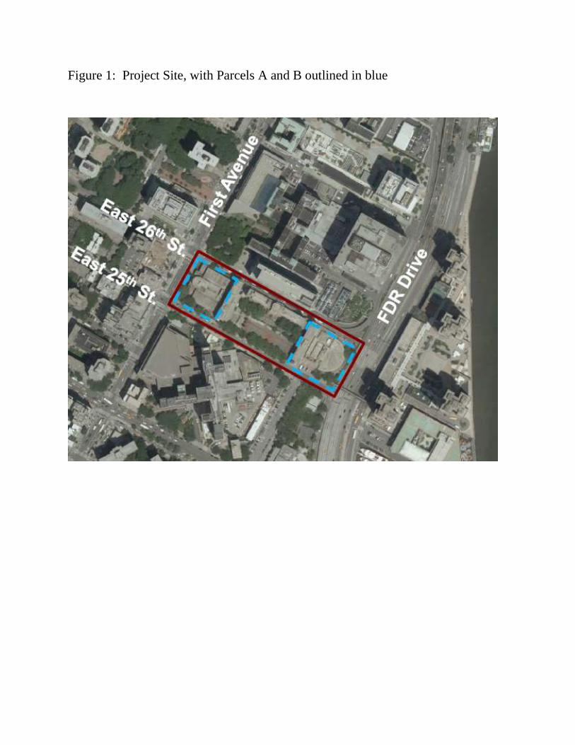
Figure 1: Project Site, with Parcels A and B outlined in blue

MN07
MN08
MN09 MN10
MN11
MN12
MN05
MN04
MN06
MN02
MN03
MN01 MN03B
MN11G
MN10G
MN9G
BX01
BX04
MN8ABX1G,3G,4G
FUTURE E91 ST MTSW59 ST PAPER RECYCLABLES MTS
MN4G,4A,7G
MN6G
FUTUREGANSEVOORT RECYCLABLES MTS
MN1G
FUTURE MN1G,2G,5G
MN3G
MN8GMN12GBX8GBX7G
PROJECT SITE(
MN BOROUGH REPAIR
MN BOROUGH COMMAND
MN2G
Figure 1-1: Location of Proposed Actionand DSNY Garages in Manhattan
DSNYEGPMO 5/15/15 G:\Dan\2015\May\M6M8_EIS\M6_Garage_EIS_proposedaction.mxd
¯ DSNY M6/ 6A/ 8 Garage Complex & Adjacent Development Parcels
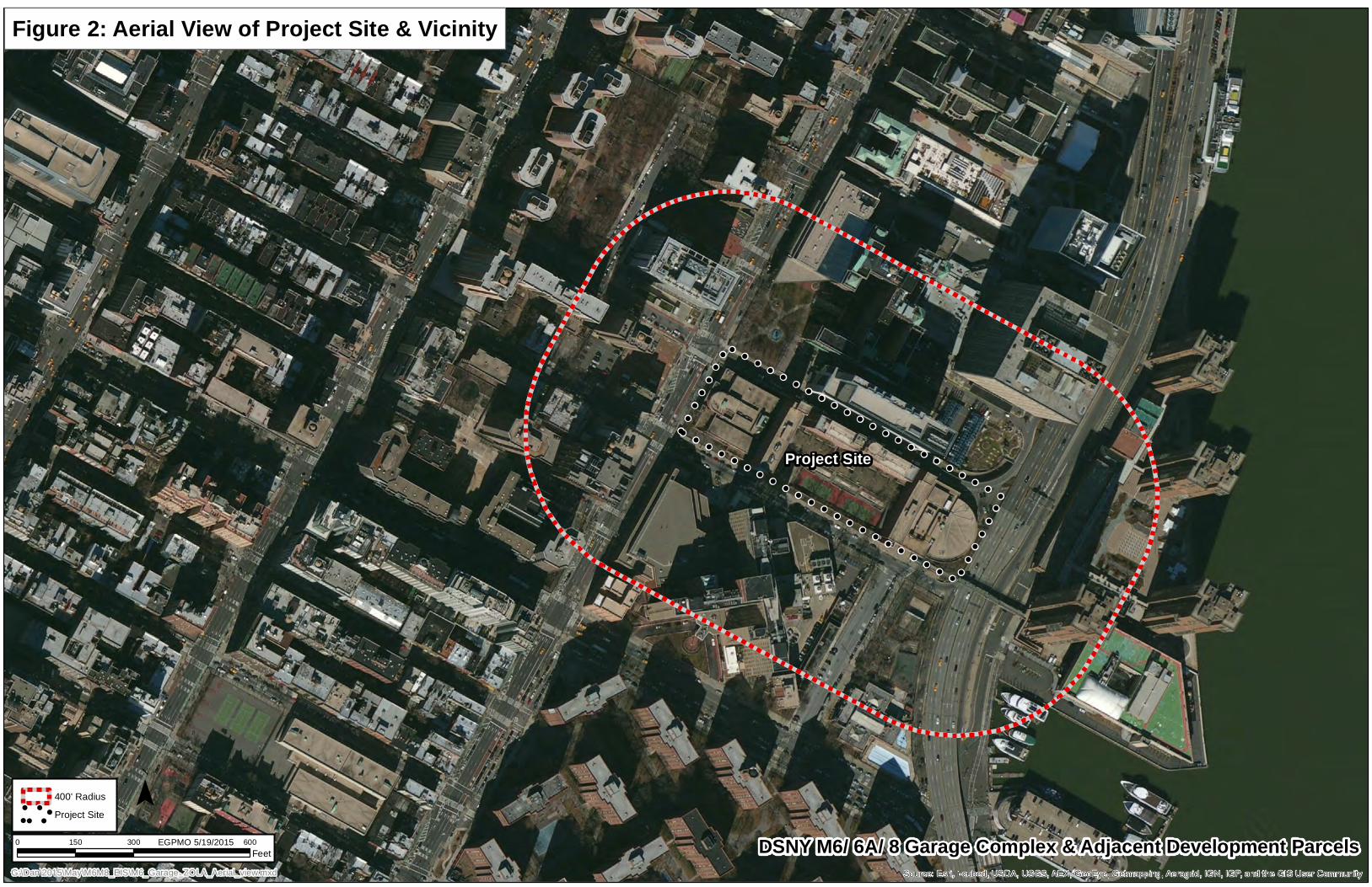
!!
!!
!!
!
!!
!!
!!
!!
!!
!!
!!
!!
!!
!!
!!
!!
!!
!!
!!
!!
!!
!!
!!
!!
!!
!!
!!
!!
!!
!!
!!
!!
!
!!
!!
!!
!!
!!
!!
!!
!!
!!
!!
!!
!!
!!
!!
!!
!!
!!
!!
!!
!!
!!
!!
!!
!!
!!
Source: Esri, i-cubed, USDA, USGS, AEX, GeoEye, Getmapping, Aerogrid, IGN, IGP, and the GIS User Community
Figure 2: Aerial View of Project Site & Vicinity
400' Radius
!
! ! !
!!
!
! ! !
!! Project Site¯
0 300 600150Feet
EGPMO 5/19/2015
G:\Dan\2015\May\M6M8_EIS\M6_Garage_ZOLA_Aerial_view.mxd
Project Site
DSNY M6/ 6A/ 8 Garage Complex & Adjacent Development Parcels
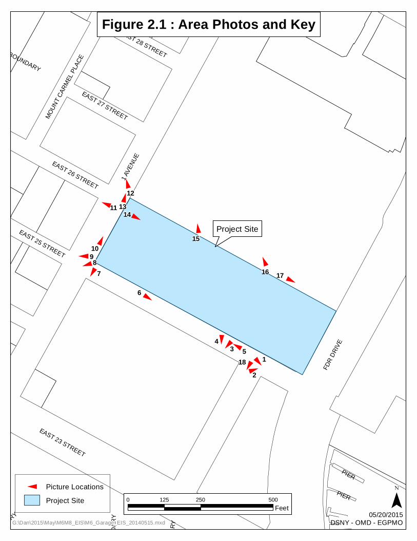
MOUN
T CAR
MEL PL
ACE
PIER
EAST 23 STREET
EAST 26 STREET
EAST 28 STREET
DISTRICT BOUNDARY
1 AVE
NUE
PIER
2010
CB B
OUND
ARY
EAST 27 STREET
EAST 25 STREET
DIST
RICT
BOUN
DARY
DISTRICT BOUNDARY
FDR D
RIVE
11
13
218
45
6
78910
1213
14
15
16 17
! !
!! !
!
!
!!
!
!
!
!!
!
!
!!
0 250 500125Feet ¯
Figure 2.1 : Area Photos and Key
Project Site
G:\Dan\2015\May\M6M8_EIS\M6_Garage_EIS_20140515.mxd05/20/2015
DSNY - OMD - EGPMO
! Picture LocationsProject Site
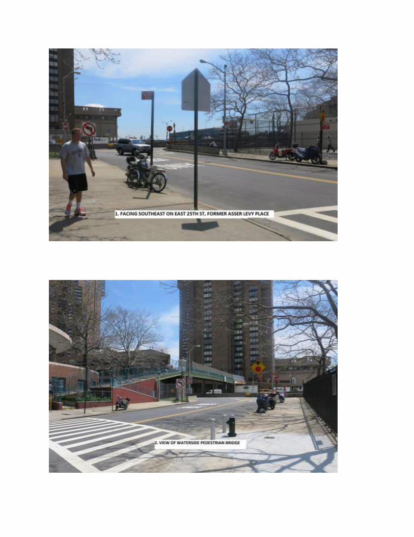
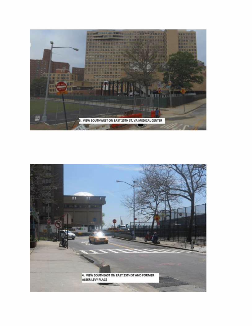
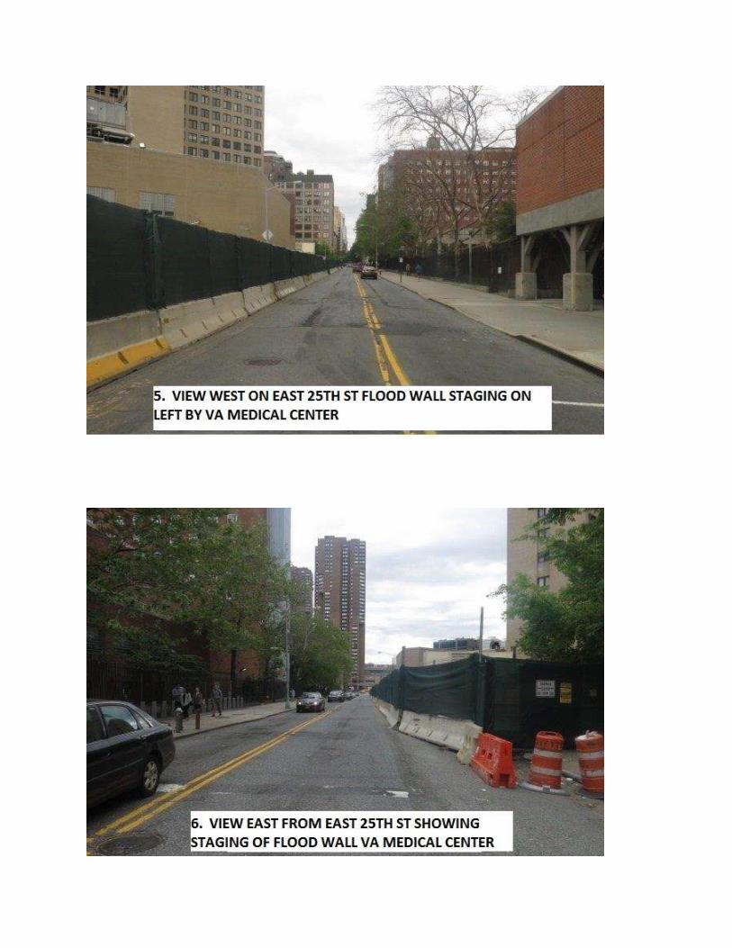

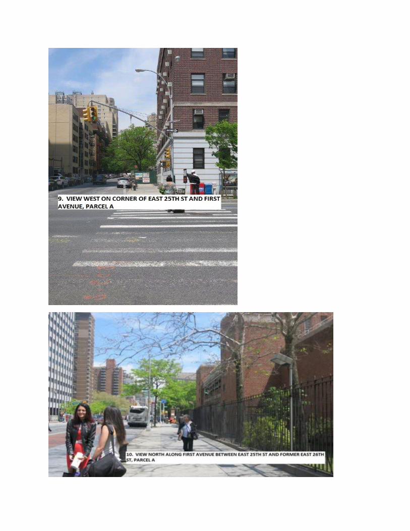
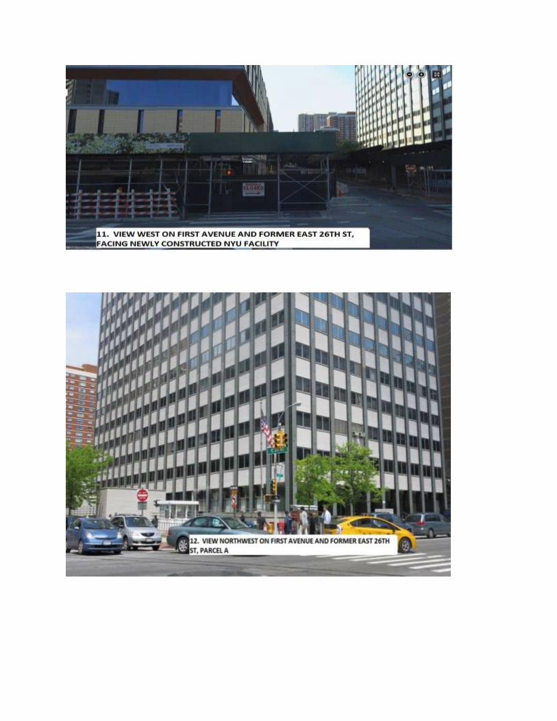
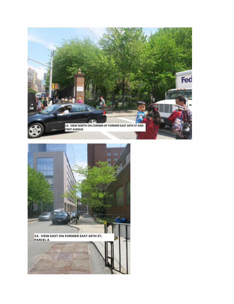
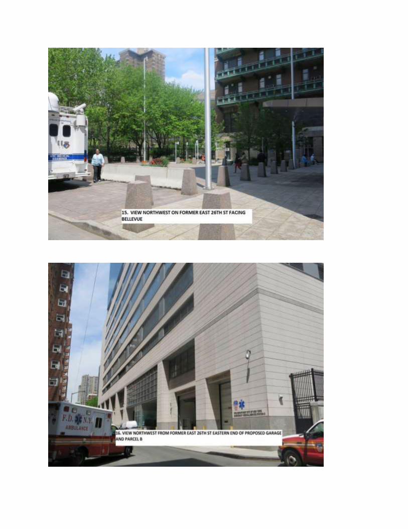

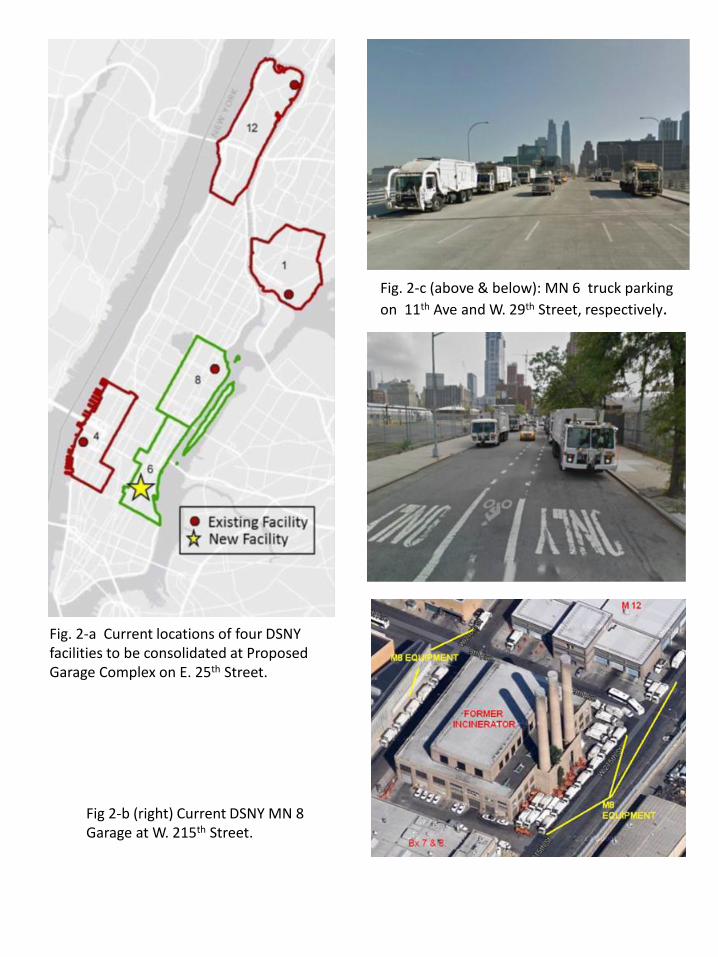
Fig. 2-a Current locations of four DSNY facilities to be consolidated at Proposed Garage Complex on E. 25th Street.
Fig. 2-c (above & below): MN 6 truck parking on 11th Ave and W. 29th Street, respectively.
Fig 2-b (right) Current DSNY MN 8 Garage at W. 215th Street.
!!
!!
!!
! !!
!!
!!
!!
!!
!!
!!
!!
!!
!!
!!
!!
!!
!!
!!
!!
!!
!!
!!
!!
!!
!!
!!
!
R8
R8B
C6-2
C2-7
R7B
M2-3C2-8
C1-9A
C1-9
R8B
R7B
C1-9 C1-9R8A
C1-8AC1-8
PARK
C1-9A
PARK
R8B PARK
C4-6
C2-8A
0 300 600150Feet
!!
! ! !!
!!! Project SiteExisting C2-5 DistrictExisting Zoning DistrictsTax Block PolygonTax Lot Polygon
¯
Figure 3: Tax Map for Manhattan Block 962 Lot 100
G:\Dan\2015\May\M6M8_EIS\M6_Garage_TaxMap_nodimens.mxd
Project Site
DSNY EGPMO 5/19/2015DSNY M6/ 6A/ 8 Garage Complex & Adjacent Development Parcels
MT. C
ARME
L PL.
GRAMERCY PARK NORTH
BROA
DWAY
ALLE
Y
EAST 25 STREET
EAST 28 STREET
1 AVE
NUE
PIER
EAST 23 STREET
EAST 24 STREET
ALLE
YEAST 27 STREET
AVENUE C
EAST 22 STREET
2 AVE
NUE EAST 26 STREET
FDR D
RIVE
ASSE
R LEV
Y PL
EAST 23 STREET
EAST RIVER
3 AVE
NUE
E 27 ST
E 28 ST
E 29 STE 30 ST
EAST 21 STREET!
!!
!!
!! !
!!
!!
!!
!!
!!
!!
!!
!!
!!
! !!
!!
!!
!!
!!
!!
!!
!!
!!
!!
!!
!!
!!
!
70'
35'
35'
60'
35'
35'
35'
60'
25'
17
15
18
5
37
4
0
2
28
0
1
15
27
2
5
6
7
5
9
14
0
5
6
14
26
1
28
7
0
7
20
17
6
15
3
8
31
6
66
1
18
11
7
267
20
7
1
20
6
7
25
16
0
5
0
10
8
0
5
19
20
8217
5
16
6
16
5
21
2
6
21
19
4
5
12
68
17
9
11
20
3
5
180
0
8
19
12
3
10
16
5
0
5
6
4
6
6
7
20
5
4
19
14
7
16
5
6
6
6
05
3
1
6
0
622
6
64
6
6
4
6
76
5
6
6
6 6
56
5
2
6
1
5
66
6
6
5
6
5
7
6
10
4
16
6
6
5
4
613
5
11
5
55
4
5
4
5
5
5
5
6
5
5
5
5
5
7
5
9
6
5
4
5
50
5
5
5
3
2
5
5
5
5
5
5
3
6
5
3
5
4
5
5
5
5
5
6
6
7
2
5
7
5
5
5
3
5
4
2
5
55
6
6
3
3.5
5
6
7
55 55
5
3
55
5
4
5
55
3
4
5
3
55
2
3
5
4
5
4
6
4
4
4
4
4
5
44
3
5
43
6
3
3
3
2
4
4
4
3 4
5
5
5
5
9
5
4 4
8
44
4
3
4
3
443
3
8
4
5
4
8
4
4
3
3
6
4
3
4
4
4
3
3
4
8
4
4
2222
4
3
5
4
4
5 4
3
4
4
4
4
3 3
22
33
4
4
11
5
4
33
5 17
7
43
76
R8
R7-2
R8B
C2-7
R8B
M1-1
C6-2
R9A
C2-8A
R8B
C1-9A
C2-8
C1-7
R7B
C1-9A
R7B
R8A
C1-9
R9A
PARK
C5-2
C6-4AC6-3
C1-8A
C1-6A
C1-8 M2-3
PARK
R7-2
C6-3AC6-2AC6-2A
C6-3A
962
978
955
991
934
929
926
981
880
931 932
933
930904
901
878
881
925
903
900
902
907
879
899
905
928
927
898
908 935
906
877
992
876
924
875
882
923 972897
Figure 4: Land Use Map
400' Radius
!
! ! !
!! Project SiteExisting Zoning DistrictsExisting C2-5 Commercial Overlay01 - One & Two-Family Buildings02 - Multi-Family Walkup Buildings03 - Multi-Family Elevator Buildings04 - Mixed Commercial/ Residential Buildings05 - Commercial/ Office Buildings06 - Industrial/ Manufacturing07 - Transportation/ Utility08 - Publ;ic Facilities & Institutions09 - Open Space10 - Parking Facilities11 - Vacant LandOther Values/ No Data
¯
0 325 650162.5FeetDSNY
EGPMO5/19/2015 G:\Dan\2015\May\M6M8_EIS\M6_Garage_EIS_Area_Land_Use_20150513.mxdLand use data: NYC Dept of City Planning MapPLUTO r14v1
DSNY M6/ 6A/ 8 Garage Complex & Adjacent Development Parcels
Project Site

!!!!
!!!!!!!!!!!!!
!!
!!!!!!!!!!!!
Project Site
DSNY M6/ 6A/ 8 Garage Complex & Adjacent Development Parcels
Figure 5-1: Zoning Map
400' Radius
!!!!
!!!!!!!!!!!! !
!!!
!!!!!!!!!!!!
Figure 5-2: Zoning Map
DSNY M6/ 6A/ 8 Garage Complex & Adjacent Development Parcels
Project Site400' Radius
G:\Dan\2015\May\M6M8_EIS\12crubbersheet.mxd

ENGINEERING BUREAU - SPECIAL PROJECTS DIVISION July 14, 2014
M6/ 6A/ 8 Sanitation Garage Complex and Adjacent Development ParcelsSITE PLAN
SCALE: 1” = 80’
DSNYPROPOSED
SANITATION GARAGE425 E 25th Street
V . A . N Y H A R B O R H E A L T H C A R EV . A . N Y H A R B O R H E A L T H C A R ES Y S T E M M A N H A T T A N C A M P U SS Y S T E M M A N H A T T A N C A M P U S
O C M E D N A F O R E N S I CL A B O R A T O R Y B U I L D I N G
F D N Y E M SK I P S B A YS T A T I O N
B A T T A L I O N8
B U I L D I N G D B U I L D I N G C
B U I L D I N G HLOBBY
B E L L E V U EH O S P I T A L
A S S E R L E V YP L A Y G R O U N D
L A N D S C A P E DP L A Z A
B E L L E V U ES O B R I E T YG A R D E N
V . A . N Y H A R B O R H E A L T H C A R ES Y S T E M M A N H A T T A N C A M P U S
O C M E D N A F O R E N S I CL A B O R A T O R Y B U I L D I N G
F D N Y E M SK I P S B A YS T A T I O N
B A T T A L I O N8
B U I L D I N G D B U I L D I N G C
B U I L D I N G HLOBBY
B E L L E V U EH O S P I T A L
A S S E R L E V YP L A Y G R O U N D
L A N D S C A P E DP L A Z A
B E L L E V U ES O B R I E T YG A R D E N
S
NNAA
OUT INAuxiliaryEntrance
Secondary Truck
Entrance
Staff / Visitor Entry
Queue Line
OUT
Pedestrian
IN
EmployeeVehicle
Entrance PrimaryTruck
Entrance
VS
VVVYYY M M AMM M AM M A
IINNIN
P d t i
Q
rkk
cTTV hiV hihVV
o ndmploVV
UTT N
eue Li
EE
E 2 5 t h S t
O
N
E
W
A
YT
R
A
F F
I
C
1 s
t
A
v
e
F D
R
D
R
I V
E
O
N
E
W
A
YT
R
A
F F
I
C
T W O W A YT R A F F I C
T W O W A YT R A F F I C
G A R A G E
S E R V I C E R D.F O R M E R2 6 t h S t
E 2 5 t h S t
E 2 6 t h S t
O
N
E
W
A
YT
R
A
F F
I
C
O
N
E
W
A
YT
R
A
F F
I
C
H O S P I T A LP A R K I N G
S T R U C T U R E
H O S P I T A LP A R K I N G
D E V E L O P M E N TP A R C E L A
D E V E L O P M E N TP A R C E L B
SCALE:
0 20’ 40’ 60’ 80’
229.65’
Figure 6: Site Plan

E 25TH ST
BELLEVUE DR
1ST
AVE
FDR
DR
GARAGESE RV ICE RD
OCME DNA ForensicLaboratory Building
FDNY EMSKips BayStation
Battalion 8
Bellevue HospitalCenter
VA Hospital
WatersidePlaz a
Bus
Lane
Bus
Lane
Bus
Lane
Sea
wal
l (un
der c
onst
ruct
ion
)
Asser Levy Park
Sobriety Garden
Parcel AZoning Lot
DSNY GarageZoning Lot
Parcel B Zoning Lot
~200 ft
~260
ft
~230 ft
~260 ft
~380 ft
Figure 6: Proposed zoning lots*Note: Not to scale
Parcel A DSNY Garage Parcel B
Figure 1: General Site Plan*Note: Not to scale
DSNY M6/6A/8 Garage Complex & Adjacent Development
Environmental Assessment Statement May 2015
Figure 8: Garage Complex Sections
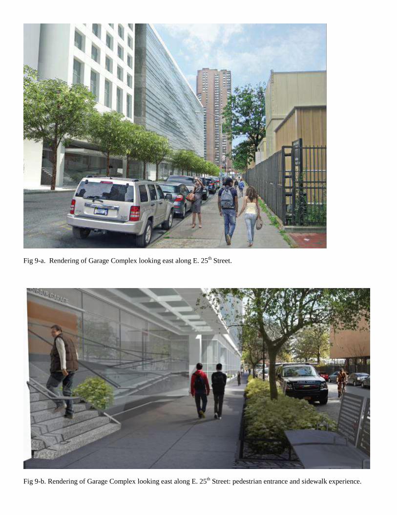
Fig 9-a. Rendering of Garage Complex looking east along E. 25th Street.
Fig 9-b. Rendering of Garage Complex looking east along E. 25th Street: pedestrian entrance and sidewalk experience.

Fig. 9-c. Rendering of Garage Complex, view east along Bellevue private drive at First Avenue and E.26th Street.
Fig. 9-d. Rendering of Garage Complex looking east along East 25th Street, showing one concept for Parcel A.
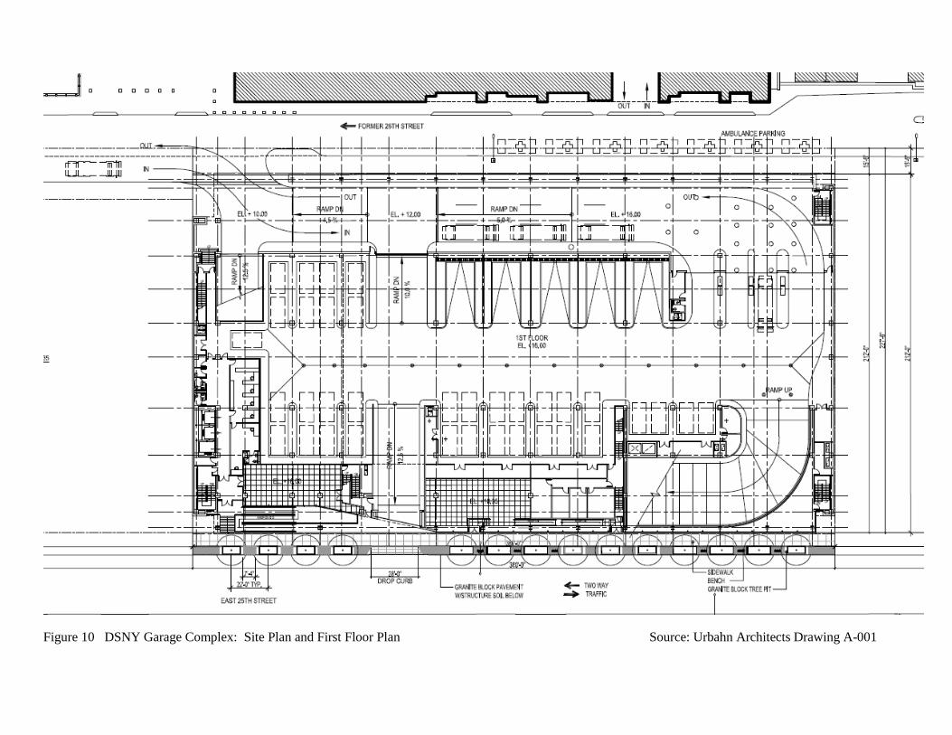
Figure 10 DSNY Garage Complex: Site Plan and First Floor Plan Source: Urbahn Architects Drawing A-001


Related Documents