CITIES INTERNATIONAL SEMINAR 2013 Arry Susilowardhani; Strategic Environmental Assessment The potential of Strategic Environmental Assessment to address the challenges of climate change to reduce the risks of disasters: a case study from Semarang, Indonesia Arry SUSILOWARDHANI;Environmental Agency of Semarang City, Indonesia ABSTRACT Indonesia as an archipelagic country is likely to suffer severely from the impacts of climate change since most of its major cities are located in coastal zones. Semarang, a heavily populated coastal city in Central Java Province, is vulnerable to the impacts of climate change as it already experiences disastrous flooding and tidal inundation annually, with devastating impacts on the community. Globally, changes in climate patterns are considered o be primarily responsible for sea level rise. Existing Indonesian national laws on disaster management will become inadequate in the future since prevention of risk is only regarding the reduction of factors triggering disaster risk such as the application of construction standards for earthquake-resistant building without considering disaster-reduction through spatial planning. Therefore, the threat posed by climate change suggests more robust policy adaptation. A higher level of policy such as Strategic Environmental Assessment (SEA) which addresses the impacts of climate change, including natural hazards would be more useful for Indonesia’s Disaster Risk Reduction program. The implementation of Strategic Environmental Assessment (SEA) in Indonesia, which is at an early stage, provides a framework for assessing and managing environmental risks. SEA may contribute to the integration of climate change considerations into policies, plans and programmes, which is useful to support Disaster Risk Reduction (DRR). However, there are some challenges in incorporating climate change into SEA which include capacity building, funding, data problems, integration of SEA into regional planning documents and communication. Some efforts, such as providing training for the local SEA team, expanding the membership of this team by including universities and/ or NGOs to enhance the SEA process and engaging the Bureau of Statistics and the Meteorological Agency to support data collecting are some proposed solutions to integrate climate change into SEA in Indonesia in order to improve disaster risk management. 1

Welcome message from author
This document is posted to help you gain knowledge. Please leave a comment to let me know what you think about it! Share it to your friends and learn new things together.
Transcript
CITIES INTERNATIONAL SEMINAR 2013Arry Susilowardhani; Strategic Environmental Assessment
The potential of Strategic Environmental Assessmentto address the challenges of climate change to reducethe risks of disasters: a case study from Semarang,
Indonesia
Arry SUSILOWARDHANI;Environmental Agency of Semarang City, Indonesia
ABSTRACTIndonesia as an archipelagic country is likely to suffer severelyfrom the impacts of climate change since most of its major citiesare located in coastal zones. Semarang, a heavily populated coastalcity in Central Java Province, is vulnerable to the impacts ofclimate change as it already experiences disastrous flooding andtidal inundation annually, with devastating impacts on thecommunity. Globally, changes in climate patterns are considered o beprimarily responsible for sea level rise. Existing Indonesiannational laws on disaster management will become inadequate in thefuture since prevention of risk is only regarding the reduction offactors triggering disaster risk such as the application ofconstruction standards for earthquake-resistant building withoutconsidering disaster-reduction through spatial planning. Therefore,the threat posed by climate change suggests more robust policyadaptation. A higher level of policy such as Strategic EnvironmentalAssessment (SEA) which addresses the impacts of climate change,including natural hazards would be more useful for Indonesia’sDisaster Risk Reduction program.The implementation of Strategic Environmental Assessment (SEA) inIndonesia, which is at an early stage, provides a framework forassessing and managing environmental risks. SEA may contribute tothe integration of climate change considerations into policies,plans and programmes, which is useful to support Disaster RiskReduction (DRR). However, there are some challenges in incorporatingclimate change into SEA which include capacity building, funding,data problems, integration of SEA into regional planning documentsand communication. Some efforts, such as providing training for thelocal SEA team, expanding the membership of this team by includinguniversities and/ or NGOs to enhance the SEA process and engagingthe Bureau of Statistics and the Meteorological Agency to supportdata collecting are some proposed solutions to integrate climatechange into SEA in Indonesia in order to improve disaster riskmanagement.
1

CITIES INTERNATIONAL SEMINAR 2013Arry Susilowardhani; Strategic Environmental Assessment
Keywords: SEA, climate change, disaster risk reduction
2
CITIES INTERNATIONAL SEMINAR 2013Arry Susilowardhani; Strategic Environmental Assessment
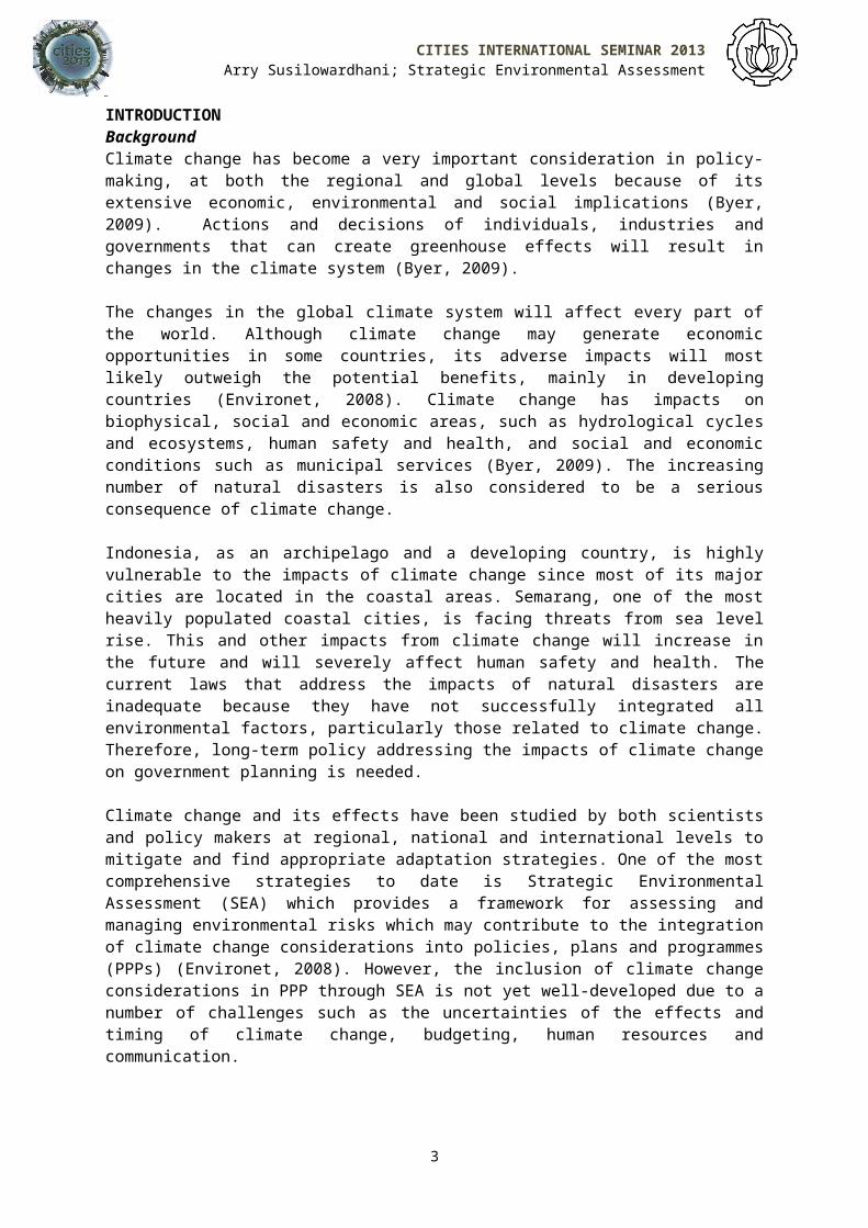
INTRODUCTIONBackgroundClimate change has become a very important consideration in policy-making, at both the regional and global levels because of itsextensive economic, environmental and social implications (Byer,2009). Actions and decisions of individuals, industries andgovernments that can create greenhouse effects will result inchanges in the climate system (Byer, 2009).
The changes in the global climate system will affect every part ofthe world. Although climate change may generate economicopportunities in some countries, its adverse impacts will mostlikely outweigh the potential benefits, mainly in developingcountries (Environet, 2008). Climate change has impacts onbiophysical, social and economic areas, such as hydrological cyclesand ecosystems, human safety and health, and social and economicconditions such as municipal services (Byer, 2009). The increasingnumber of natural disasters is also considered to be a seriousconsequence of climate change.
Indonesia, as an archipelago and a developing country, is highlyvulnerable to the impacts of climate change since most of its majorcities are located in the coastal areas. Semarang, one of the mostheavily populated coastal cities, is facing threats from sea levelrise. This and other impacts from climate change will increase inthe future and will severely affect human safety and health. Thecurrent laws that address the impacts of natural disasters areinadequate because they have not successfully integrated allenvironmental factors, particularly those related to climate change.Therefore, long-term policy addressing the impacts of climate changeon government planning is needed.
Climate change and its effects have been studied by both scientistsand policy makers at regional, national and international levels tomitigate and find appropriate adaptation strategies. One of the mostcomprehensive strategies to date is Strategic EnvironmentalAssessment (SEA) which provides a framework for assessing andmanaging environmental risks which may contribute to the integrationof climate change considerations into policies, plans and programmes(PPPs) (Environet, 2008). However, the inclusion of climate changeconsiderations in PPP through SEA is not yet well-developed due to anumber of challenges such as the uncertainties of the effects andtiming of climate change, budgeting, human resources andcommunication.
3
CITIES INTERNATIONAL SEMINAR 2013Arry Susilowardhani; Strategic Environmental Assessment
This paper aims to analyse the challenges of mainstreaming climatechange consideration using SEA in Indonesia, particularly forSemarang, in order to improve that region’s Disaster Risk Reduction(DRR) strategies. The research will mainly be conducted by reviewingsecondary data, including journal articles, research reports, booksand other academic sources on SEA, DRR and climate change mitigationand adaptation.
The paper begins with a description of the potential impacts ofclimate change on Indonesia. It is followed by a review of theexisting and relevant policies and processes for climate changeadaptation. The third section discusses the SEA potential inSemarang City. To support the argument that mainstreaming climatechange considerations into SEA will improve DRR, this paper proposessome solutions to the problems identified.
Potential Impact of Climate Change on IndonesiaThe IPCC (Inter Governmental Panel on Climate Change) has observedthat there is evidence of the warming of the climate system such asincreases in temperatures, snow and ice melting and sea level rise.It is predicted that for the next two decades there will be a riseof about 0.2oC in global temperature per decade (IPCC, 2007). Therising of global temperature will also cause changes inprecipitation, sea levels and the frequency and severity of extremeevents (IPCC, 2007). These changes in the climate system will affectall systems and sectors in the world, particularly ecosystems, foodproduction, industry and settlements, society, human health andsafety and water availability. In Asia in particular, the impactswill include a decrease in the availability of freshwater especiallyin large river basins, increased flooding from both rivers and thesea, an increase in problems of natural resource and environmentalmanagement and increasing morbidity and mortality numbers (IPCC,2007). Indonesia is an archipelagic country which consists of 17,504islands, mostly small islands with only five big islands (BPS,2010). Of its approximately 5.3 million km2 area, around 3.3 millionkm2 is sea (BPS, 2010). Most of its main cities and provincialcapitals are heavily populated, and are located on the coast.Therefore, sea level rise is likely to be the most significanteffect of climate change that will have impacts on these settlementsand the society, the industries, water resources and human healthand safety, due to increased flooding.
Approximately 40 per cent of Indonesian people still depend onagriculture, fishery or forestry for their livelihood (BPS, 2010),
4
CITIES INTERNATIONAL SEMINAR 2013Arry Susilowardhani; Strategic Environmental Assessment
thus their dependance on natural resources is high. Increases inglobal average temperatures will negatively affect the ecosystemsand availability of natural resources, including water and food.
The poverty rate in Indonesia, as shown in the BPS-StatisticsIndonesia’s (Badan Pusat Statistic) data (13.33 per cent in 2010) (BPS,2010), shows the low resilience of some parts of the community inadapting to the impacts of climate change, especially increasedfrequency of extreme weather events which will likely increasenatural hazard occurrence such as floods, droughts and landslides.These are among the most important impacts of climate change thathave to be faced by Indonesia and especially by the low resiliencecommunity. Therefore, to avoid the poor’s burden particularly due todisaster, Disaster Risk Reduction (DRR) must be considered indevelopment planning.
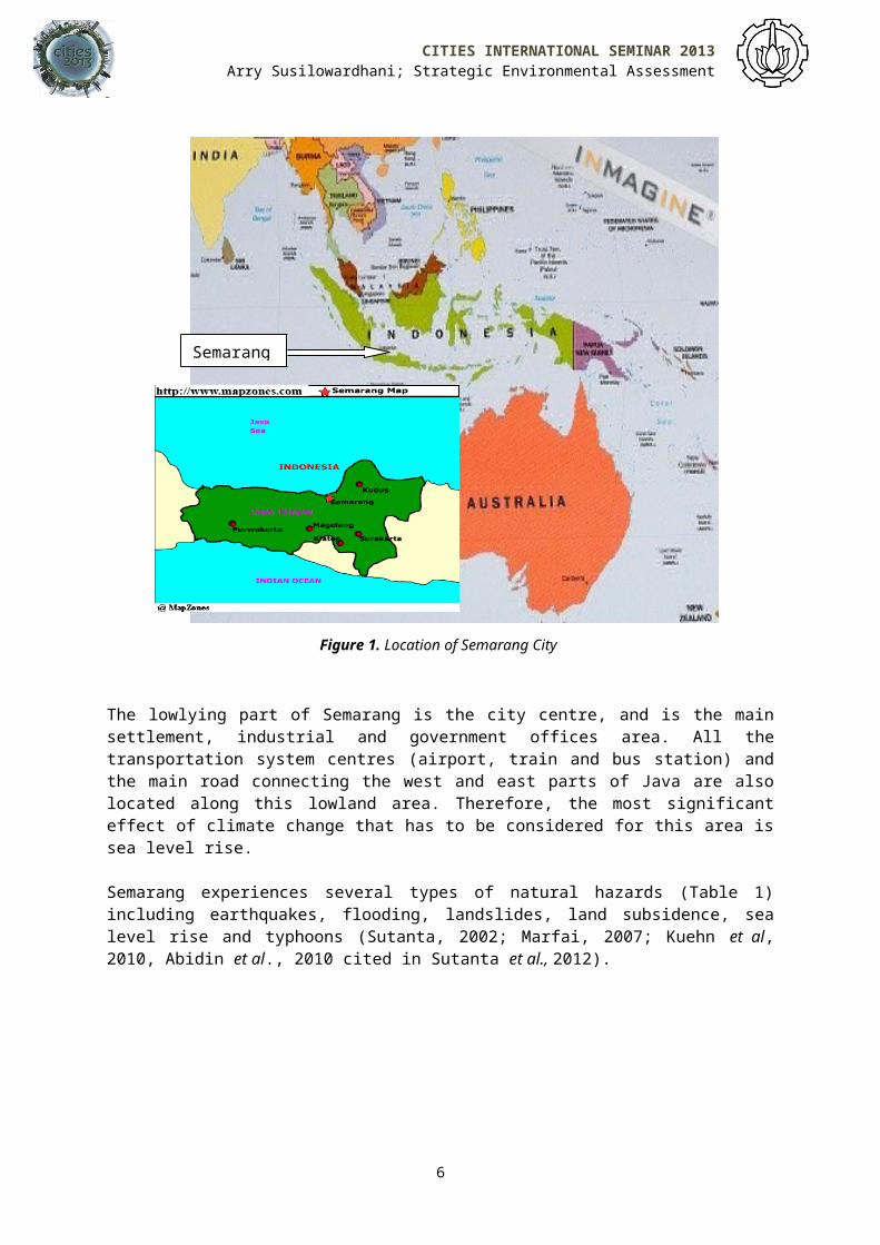
1. Potential Impacts on SemarangSemarang, the capital of Central Java Province, is a heavilypopulated city (density 4,032 people/ km2 in 2009) located on thecoast of the Java Sea (BPS Kota Semarang, 2009) (Figure 1). However,the topography of this city also comprises hilly areas besideslowland areas. The lowland part makes up approximately 34 per centof the city’s land area, with an elevation of 5 meters above sealevel (asl) or below, while the highest elevation of the hilly partis 348 meters asl (Sutanta et al., 2012).
5
CITIES INTERNATIONAL SEMINAR 2013Arry Susilowardhani; Strategic Environmental Assessment
Figure 1. Location of Semarang City
The lowlying part of Semarang is the city centre, and is the mainsettlement, industrial and government offices area. All thetransportation system centres (airport, train and bus station) andthe main road connecting the west and east parts of Java are alsolocated along this lowland area. Therefore, the most significanteffect of climate change that has to be considered for this area issea level rise.
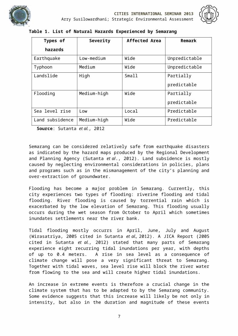
Semarang experiences several types of natural hazards (Table 1)including earthquakes, flooding, landslides, land subsidence, sealevel rise and typhoons (Sutanta, 2002; Marfai, 2007; Kuehn et al,2010, Abidin et al., 2010 cited in Sutanta et al., 2012).
6
Semarang
CITIES INTERNATIONAL SEMINAR 2013Arry Susilowardhani; Strategic Environmental Assessment
Table 1. List of Natural Hazards Experienced by Semarang
Types of
hazards
Severity Affected Area Remark
Earthquake Low-medium Wide UnpredictableTyphoon Medium Wide UnpredictableLandslide High Small Partially
predictableFlooding Medium-high Wide Partially
predictableSea level rise Low Local PredictableLand subsidence Medium-high Wide Predictable
Source: Sutanta et al., 2012
Semarang can be considered relatively safe from earthquake disastersas indicated by the hazard maps produced by the Regional Developmentand Planning Agency (Sutanta et al., 2012). Land subsidence is mostlycaused by neglecting environmental considerations in policies, plansand programs such as in the mismanagement of the city’s planning andover-extraction of groundwater.
Flooding has become a major problem in Semarang. Currently, thiscity experiences two types of flooding: riverine flooding and tidalflooding. River flooding is caused by torrential rain which isexacerbated by the low elevation of Semarang. This flooding usuallyoccurs during the wet season from October to April which sometimesinundates settlements near the river bank.
Tidal flooding mostly occurrs in April, June, July and August(Wirasatriya, 2005 cited in Sutanta et al., 2012). A JICA Report (2005cited in Sutanta et al., 2012) stated that many parts of Semarangexperience eight recurring tidal inundations per year, with depthsof up to 0.4 meters. A rise in sea level as a consequence ofclimate change will pose a very significant threat to Semarang.Together with tidal waves, sea level rise will block the river waterfrom flowing to the sea and will create higher tidal inundations.
An increase in extreme events is therefore a crucial change in theclimate system that has to be adapted to by the Semarang community.Some evidence suggests that this increase will likely be not only inintensity, but also in the duration and magnitude of these events
7

CITIES INTERNATIONAL SEMINAR 2013Arry Susilowardhani; Strategic Environmental Assessment
(O’Brien et al., 2008). This will accelerate the occurrence oflandslides, typhoons and drought in some vulnerable areas and createmore serious natural hazard problems in Semarang.
Therefore, changes in the world’s climate system, particularly sealevel rise and increases in extreme events, will increase the riskof natural hazards in Semarang, particularly flooding, landslides,typhoons and drought. Thus, an adaptation strategy for these climatechange impacts has to be considered and adopted by the Government ofSemarang City.
Policies and Processes for Disaster Risk Reduction and Climate Change Adaptation Indonesian societies, including Semarang, have experienced manynatural disasters such as floods and landslides. This is not a newphenomenon; in 2005, Indonesia was placed seventh in the countriesmost often hit by natural disasters (UNESCO, 2006 cited in Hadi,2008). Because of that, there are already existing policy frameworksrelated to disaster management in Indonesia.
1. Frameworks and Strategies for Disaster Risk Reduction (DRR) The international framework for disaster risk reduction has evolvedthrough various changes since the early 1970s (O’Brien et al., 2008).The conceptual aproach to disaster management shifted throughoutthese stages, from addressing only the hazards to understanding aswell as addressing the vulnerabilities and underlying factors thatlead to disasters: this process finally created the Hyogo Frameworkfor Action (HFA) as the international framework for disaster riskreduction. The HFA 2005-2015 was adopted by 168 countries includingIndonesia (O’Brien et al., 2008). In Indonesia, an awareness of disaster risk reduction has emergedsince the 1990s following the declaration of the InternationalDecade for Natural Disaster Reduction (Bappenas and BNPB, 2010).This continued with the legal reform process of the nationaldisaster policy in Indonesia, beginning in 2007, by referring to theHFA (Lassa et al., 2012). This regulatory reform, triggered by theoccurrence of various major disasters since Tsunami Aceh at the endof 2004 has resulted in the enactment of Law Number 24/2007 on DisasterManagement in April 2007 (BNPB and UNDP Indonesia, 2009). This lawacts as the basis for DRR at the national level (Bappenas and BNPB,2010). The framework for disaster management has shifted fromcentralistic and sectoral approaches to decentralistic withinvolvement of all stakeholders in a multi-sectoral approach (BNPBand UNDP Indonesia, 2009). This disaster management reform included
8
CITIES INTERNATIONAL SEMINAR 2013Arry Susilowardhani; Strategic Environmental Assessment
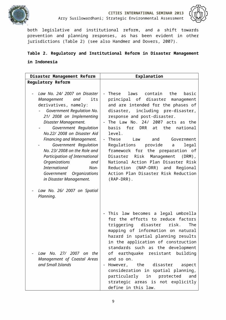
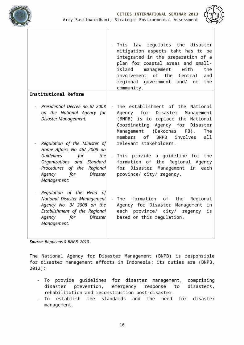
both legislative and institutional reform, and a shift towardsprevention and planning responses, as has been evident in otherjurisdictions (Table 2) (see also Handmer and Dovers, 2007).
Table 2. Regulatory and Institutional Reform in Disaster Management
in Indonesia
Disaster Management Reform ExplanationRegulatory Reform
- Law No. 24/ 2007 on DisasterManagement and itsderivatives, namely:- Government Regulation No.
21/ 2008 on ImplementingDisaster Management.
- Government RegulationNo.22/ 2008 on Disaster AidFinancing and Management.
- Government RegulationNo. 23/ 2008 on the Role andParticipation of InternationalOrganizations andInternational Non-Government Organizationsin Disaster Management.
- Law No. 26/ 2007 on SpatialPlanning.
- Law No. 27/ 2007 on theManagement of Coastal Areasand Small Islands
- These laws contain the basicprincipal of disaster managementand are intended for the phases ofdisaster, including pre-disaster,response and post-disaster.
- The Law No. 24/ 2007 acts as thebasis for DRR at the nationallevel.
- These Law and GovernmentRegulations provide a legalframework for the preparation ofDisaster Risk Management (DRM),National Action Plan Disaster RiskReduction (NAP-DRR) and RegionalAction Plan Disaster Risk Reduction(RAP-DRR).
- This law becomes a legal umbrellafor the efforts to reduce factorstriggering disaster risk. Themapping of information on naturalhazard in spatial planning resultsin the application of constructionstandards such as the developmentof earthquake resistant buildingand so on.
- However, the disaster aspectconsideration in spatial planning,particularly in protected andstrategic areas is not explicitlydefine in this law.
9
CITIES INTERNATIONAL SEMINAR 2013Arry Susilowardhani; Strategic Environmental Assessment
- This law regulates the disastermitigation aspects taht has to beintegrated in the preparation of aplan for coastal areas and small-island management with theinvolvement of the Central andregional government and/ or thecommunity.
Institutional Reform
- Presidential Decree no 8/ 2008on the National Agency forDisaster Management.
- Regulation of the Minister ofHome Affairs No 46/ 2008 onGuidelines for theOrganizations and StandardProcedures of the RegionalAgency for DisasterManagement;
- Regulation of the Head ofNational Disaster ManagementAgency No. 3/ 2008 on theEstablishment of the RegionalAgency for DisasterManagement.
- The establishment of the NationalAgency for Disaster Management(BNPB) is to replace the NationalCoordinating Agency for DisasterManagement (Bakornas PB). Themembers of BNPB involves allrelevant stakeholders.
- This provide a guideline for theformation of the Regional Agencyfor Disaster Management in eachprovince/ city/ regency.
- The formation of the RegionalAgency for Disaster Management ineach province/ city/ regency isbased on this regulation.
Source: Bappenas & BNPB, 2010.
The National Agency for Disaster Management (BNPB) is responsiblefor disaster management efforts in Indonesia; its duties are (BNPB,2012):
- To provide guidelines for disaster management, comprisingdisaster prevention, emergency response to disasters,rehabilitation and reconstruction post-disaster.
- To establish the standards and the need for disastermanagement.
10
CITIES INTERNATIONAL SEMINAR 2013Arry Susilowardhani; Strategic Environmental Assessment
- To inform information on disaster management activities to thecommunities.
- To report the disaster management efforts to the President ofthe Republic of Indonesia.
- To be responsible for the use of International and NationalDisaster Aid.
- To be responsible for the use of the national budget fordisaster management.
- To provide guidelines for the formation of a Regional Agencyfor Disaster Management.
BNPB together with The National Development Planning Agency(Bappenas) share the responsibility to prepare the National ActionPlan for Disaster Risk Reduction (NAP DRR).
Following the reformation in 2008, an institution for Disaster RiskReduction (DRR) in Indonesia, known as the National Platform forDisaster Risk Reduction (Planas-PRB) was established (Bappenas andBNPB, 2010). This institution comprises representatives from thegovernment, NGOs, international donor agencies, media, universitiesand the private sector. It provides advocacy at various levels,assisting coordination, providing policy recommendations in planningand implementing activities related to DRR (Bappenas and BNPB,2010). Planas PRB is also involved in the preparation of NAP-DRR2010-2012.
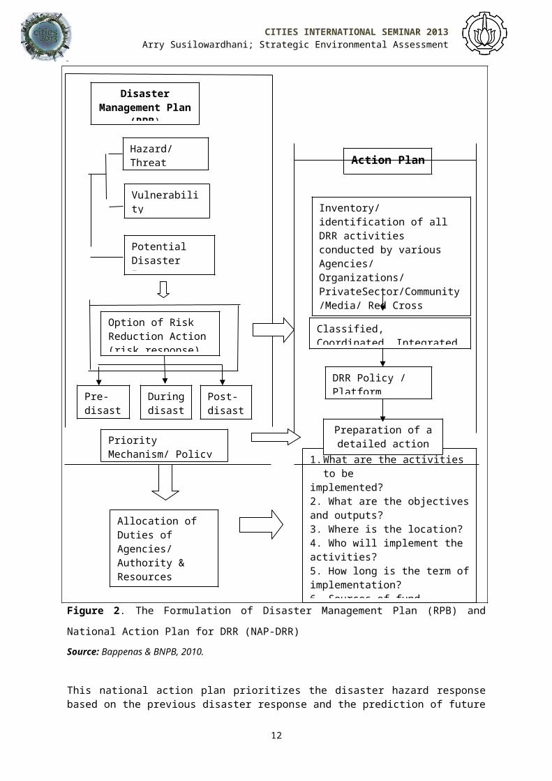
NAP-DRR is aimed at providing the reference and guidelines for allparties at the national level involved in the DRR policy during theperiod of three financial years (Bappenas and BNPB, 2010). Thisaction plan is formulated based on Law No. 24/ 2007 on Disaster Managementand Government Regulation No. 21/ 2008 on the Implementation of Disaster Managementand is an articulation of the National Disaster Management Plan(Renas-PB) (Figure 2). NAP-DRR serves as the basis for priorities inreducing risks of disaster hazard.
11
CITIES INTERNATIONAL SEMINAR 2013Arry Susilowardhani; Strategic Environmental Assessment
Figure 2. The Formulation of Disaster Management Plan (RPB) and
National Action Plan for DRR (NAP-DRR)Source: Bappenas & BNPB, 2010.
This national action plan prioritizes the disaster hazard responsebased on the previous disaster response and the prediction of future
12
DisasterManagement Plan
(RPB)
Hazard/ Threat
Vulnerability
Priority Mechanism/ Policy
Duringdisast
Pre-disast
Post-disast
Allocation of Duties of Agencies/ Authority & Resources
1.What are the activitiesto be
implemented?2. What are the objectivesand outputs?3. Where is the location?4. Who will implement the activities?5. How long is the term ofimplementation?6. Sources of fund
Option of Risk Reduction Action (risk response)
Potential Disaster Impact
Action Plan
Preparation of adetailed action
plan
DRR Policy / Platform
Classified, Coordinated, Integrated
Inventory/identification of all DRR activities conducted by various Agencies/ Organizations/ PrivateSector/Community/Media/ Red Cross

CITIES INTERNATIONAL SEMINAR 2013Arry Susilowardhani; Strategic Environmental Assessment
disasters based on the outcome of disaster risk analysis. Fivepriority actions in the National Action Plan for Disaster RiskReduction (NAP-DRR) 2010-2012 were set out after considering theHyogo Framework for Action (HFA) including (Bappenas and BNPB,2010):
- Disaster Risk Reduction as national and regional priorities aswell as capacity building;
- Identification, assessment and monitoring of disaster risks aswell as the application of early warning systems;
- Use of knowledge, innovation and education to build safer andmore resilient cultures and communities;
- Reduction of disaster risk causing factors;- Preparedness strengthening of disaster response at all levels
of community.
NAP-DRR 2010-2012 is prepared through coordination of the followingparties (Bappenas and BNPB, 2010):
1. Bappenas and BNPB for the group of ministries/ agencies;2. Convergence Group for the group of international donors; 3. National Platform (Planas PRB) for the group of non-
governmental organizations. Nevertheless, this NAP-DRR will become inadequate in the futuresince prevention of risk as regulated under Law No. 26/ 2007 onlyincludes the reduction of factors triggering disaster risk such as theapplication of construction standards for earthquake-resistantbuilding without considering disaster-reduction through spatialplanning. Therefore, the threat posed by climate change suggests amore robust policy adaptation framework is needed. A higher level ofpolicy such as Strategic Environmental Assessment (SEA) whichaddresses the impacts of climate change would be more useful for aDisaster Risk Reduction program.
13
CITIES INTERNATIONAL SEMINAR 2013Arry Susilowardhani; Strategic Environmental Assessment
2. Strategic Environmental Assessment (SEA) and Climate Change Adaptation (CCA)
Awareness of the possible impacts of climate change in Indonesia hasraised the need to carry out action plans for Climate ChangeAdaptation, such as Strategic Environmental Assessment (SEA). SEA inIndonesia, in particular, has just become mandatory in 2009 by theLaw No. 32/ 2009 on Environmental Protection and Management (Dusik, 2010). Inaddition to this legal basis of SEA implementation, there is alsoits derivative, the Ministerial Environmental Regulations No. 27/ 2009 (PT.Sucofindo, 2010 a). This law requires an SEA of spatial plans andlong-term and medium-term development plans at national, provincialand local levels to be carried out - as well as SEA for policies,plans and programs - with potentially significant environmentalimpacts (Dusik and Kappiantari, 2011). Based on this, SEA inIndonesia is carried out by Bappenas (at national level) or Bappeda(at local level) as the development planning agency, the Ministry ofEnvironment (KLH at national level) or the Environmental Agency (BLHat local level) and the Directorate General of Regional DevelopmentMinistry of Home Affairs (Bangda) that assist local authorities inreal SEA implementation (PT. Sucofindo, 2010 c).
SEA is a series of systematic analysis and participatory activitiesthat ensures that environmental aspects and sustainable developmentissues are considered during decision-making processes (PT.Sucofindo, 2010 a). SEA is being carried out due to theineffectiveness of Environmental Impact Assessment (EIA) in solvingenvironmental problems. This is because EIA is only done at theproject level while the problem lies at the policy plan and programlevel. Therefore, the objectives of SEA are to (PT. Sucofindo, 2010b):
1. Facilitate the formulation of several planning options, toarrive at a win-win solution.
2. Improve institutional cooperation and overcome sectoralpolicy conflicts.
3. Critically evaluate development planning alternatives.4. Encourage involvement by stakeholders (government and non-
government).
14
CITIES INTERNATIONAL SEMINAR 2013Arry Susilowardhani; Strategic Environmental Assessment
Based on the Ministerial Environmental Regulations No 27/ 2009 on the Implementationof SEA, potential impacts and/ or environmental risks that need to beconsidered in SEA are:
- Climate change;- Damage, deterioration and extinction of biological diversity;- Increase in floods, landslides, drought and forest fires and
land use intensity and coverage;- Decline in the quality and quantity of natural resources;- Improvement over forest area and/or land function;- Increase in the number of the poor or threatened
sustainability of community’s livelihoods, and/or- Increased risks to human health and safety.
The emphasis on addressing climate change is also stated in Article16, item (e) of the Law on Environmental Protection and Management No. 32/ 2009which requires SEA to assess the ‘level of proneness and capacityfor adaptation to climate change’ (Pemerintah RI, 2009). Thus, SEAin Indonesia has become the main formalized process for addressingthe vulnerability of various plans, programs and policies related toclimate change.
The Potential of Strategic Environmental Assessment (SEA) for integrating Disaster Risk Reduction (DRR) and Climate Change Adaptation (CCA)
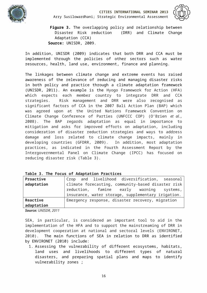
1. The linkages between SEA and DRRAlthough DRR and CCA focus on different concerns, they havesimilarities in terms of their focus and similar tools formonitoring, analyzing and addressing the adverse consequences ofclimate change (UNISDR, 2009). Flood management is one example ofissues that need to be addressed in both DRR and CCA because thisissue contributes to both DRR’s and CCA’s policy goals. Theoverlapping program of action and relationship between DRR and CCAis illustrated in Figure 3 (UNISDR, 2009).
15
CITIES INTERNATIONAL SEMINAR 2013Arry Susilowardhani; Strategic Environmental Assessment
Figure 3. The overlapping policy and relationship betweenDisaster Risk reduction (DRR) and Climate ChangeAdaptation (CCA)
Source: UNISDR, 2009.
In addition, UNISDR (2009) indicates that both DRR and CCA must beimplemented through the policies of other sectors such as waterresources, health, land use, environment, finance and planning.
The linkages between climate change and extreme events has raisedawareness of the relevance of reducing and managing disaster risksin both policy and practice through a climate adaptation framework(UNISDR, 2011). An example is the Hyogo Framework for Action (HFA)which expects each member country to integrate DRR and CCAstrategies. Risk management and DRR were also recognised assignificant factors of CCA in the 2007 Bali Action Plan (BAP) whichwas agreed upon at the United Nations Framework Convention onClimate Change Conference of Parties (UNFCCC COP) (O’Brien et al.,2008). The BAP regards adaptation as equal in importance tomitigation and asks for improved efforts on adaptation, includingconsideration of disaster reduction strategies and ways to addressdamage and loss related to climate change impacts, mainly indeveloping countries (GFDRR, 2009). In addition, most adaptationpractices, as indicated in the Fourth Assessment Report by theIntergovernmental Panel on Climate Change (IPCC) has focused onreducing disaster risk (Table 3).
Table 3. The Focus of Adaptation PracticesProactiveadaptation
Crop and livelihood diversification, seasonalclimate forecasting, community-based disaster riskreduction, famine early warning systems,insurance, water storage, supplementary irigation.
Reactiveadaptation
Emergency response, disaster recovery, migration
Source: UNISDR, 2011
SEA, in particular, is considered an important tool to aid in theimplementation of the HFA and to support the mainstreaming of DRR indevelopment cooperation at national and sectoral levels (ENVIRONET,2010). The main functions of SEA in relation to DRR as identifiedby ENVIRONET (2010) include: 1. Assessing the vulnerability of different ecosystems, habitats,
land uses and livelihoods to different types of naturaldisasters, and preparing spatial plans and maps to identifyvulnerability zones ;
16
CITIES INTERNATIONAL SEMINAR 2013Arry Susilowardhani; Strategic Environmental Assessment
2. Helping to quantify environmental changes that are occuring fromvarious causes and interpreting the effects of these changes ondisaster risk;
3. Assessing how development goals may be threatened or optimisedby certain types of disaster risk;
4. Mainstreaming specific disaster reduction measures in policies,plans and programs prepared at international, national andregional levels;
5. Identifying ways of strengthening mitigation measures andimproving disaster preparedness plans and Early Warning System.
a. Integration of Disaster Risk Reduction (DRR) and Climate Change Adaptation(CCA) in Strategic Environmental Assessment (SEA) Implementation in SemarangFor a developing country like Indonesia, the integration of DRR andCCA aims to reduce vulnerability and enhance resilience (Gero et al.,2010). The reforms carried out in national disaster management andthe mandatory SEA implementation have built awareness by thegovernment of Semarang City of the importance of integrating DRR andCCA in SEA for Semarang’s Spatial Planning.
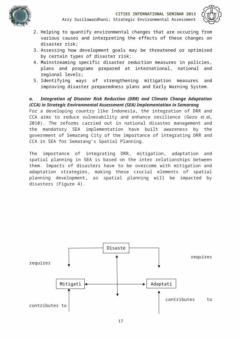
The importance of integrating DRR, mitigation, adaptation andspatial planning in SEA is based on the inter relationships betweenthem. Impacts of disasters have to be overcome with mitigation andadaptation strategies, making these crucial elements of spatialplanning development, as spatial planning will be impacted bydisasters (Figure 4).
requires
requires
contributes tocontributes to
17
Disaster
Mitigation
Adaptati

CITIES INTERNATIONAL SEMINAR 2013Arry Susilowardhani; Strategic Environmental Assessment
Figure 4. Relationship between Spatial Planning and DisasterMitigation and Adaptation
Source: Sutanta et al., 2012.
Since spatial planning determines decisions about the long termutilization of land, it has four possible roles in DRR (Fleischhaueret al.,2055 cited in Sutanta et al., 2010):
1. Prohibiting future development in highly disaster-prone areas,particularly those with a history of natural hazardoccurrences.
2. Classifying different types of land use management for disasterprone areas. For example designing an area with a steep slopewhich is highly susceptible to landslides for plantationsinstead of residential area.
3. Regulating land use with legally binding status. For example inan area which is vulnerable to earthquakes, regulation ofbuilding standards is crucial to reduce impacts of buildingcollapse.
4. Hazard modification such as promoting methods to reduce therisk of flooding by creating a retarding basin for flood waterand maintaining its function by keeping this area free ofdevelopment.
The effective integration of spatial planning and DRR is veryimportant at the local government level since the local governmentis the authority that has to make first response pre-disaster andhas to be responsible for preparing a comprehensive policy ondisaster mitigation (Sutanta et al., 2010). Thus, preparing the SEA forSpatial Planning for Semarang City aims to ensure this effectiveintegration.
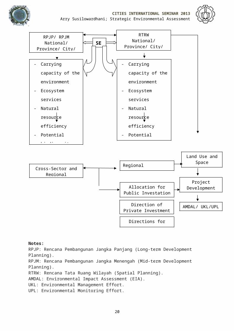
i. Position of Strategic Environmental Assessment (SEA) in Indonesia SEA is considered an appropriate tool for integrating Disaster RiskReduction (DRR) and Climate Change Adaptation (CCA) since itassesses and manages all environmental aspects including climatechange. Furthermore, SEA in Indonesia has a significant position inpolicies, plans and programs since it has become a requirement inlong-term and mid-term development planning (RPJP/ RPJM) as well asin spatial planning (RTRW) as illustrated in Figure 5. SEA ensuresthat all long-term and mid-term development planning as well as
18
SpatialPlanning
CITIES INTERNATIONAL SEMINAR 2013Arry Susilowardhani; Strategic Environmental Assessment
spatial planning integrate carrying capacity of the environment andall environmental consideration including climate change adaptationin every cross-sector and regional development in order to minimisedisaster risk.
19
CITIES INTERNATIONAL SEMINAR 2013Arry Susilowardhani; Strategic Environmental Assessment
Notes: RPJP: Rencana Pembangunan Jangka Panjang (Long-term Development Planning).RPJM: Rencana Pembangunan Jangka Menengah (Mid-term Development Planning).RTRW: Rencana Tata Ruang Wilayah (Spatial Planning).AMDAL: Environmental Impact Assessment (EIA).UKL: Environmental Management Effort.UPL: Environmental Monitoring Effort.
20
RPJP/ RPJMNational/
Province/ City/
RTRWNational/
Province/ City/
- Carrying
capacity of the
environment
- Ecosystem
services
- Natural
resource
efficiency
- Potential
biodiversity
- Carrying
capacity of the
environment
- Ecosystem
services
- Natural
resource
efficiency
- Potential
biodiversity
Cross-Sector andRegional
Regional Development
Land Use andSpace
Allocation
Allocation forPublic Investation
Direction ofPrivate Investment
Directions forOthers
ProjectDevelopment
AMDAL/ UKL/UPL
SE
CITIES INTERNATIONAL SEMINAR 2013Arry Susilowardhani; Strategic Environmental Assessment
Figure 5. Position of SEA in PPP Planning Source: PT. Sucofindo, 2010 b.
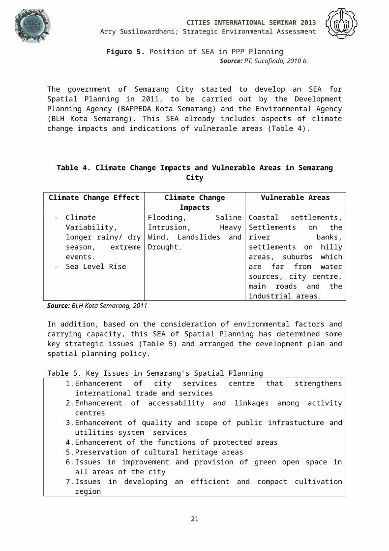
The government of Semarang City started to develop an SEA forSpatial Planning in 2011, to be carried out by the DevelopmentPlanning Agency (BAPPEDA Kota Semarang) and the Environmental Agency(BLH Kota Semarang). This SEA already includes aspects of climatechange impacts and indications of vulnerable areas (Table 4).
Table 4. Climate Change Impacts and Vulnerable Areas in SemarangCity
Climate Change Effect Climate ChangeImpacts
Vulnerable Areas
- ClimateVariability,longer rainy/ dryseason, extremeevents.
- Sea Level Rise
Flooding, SalineIntrusion, HeavyWind, Landslides andDrought.
Coastal settlements,Settlements on theriver banks,settlements on hillyareas, suburbs whichare far from watersources, city centre,main roads and theindustrial areas.
Source: BLH Kota Semarang, 2011
In addition, based on the consideration of environmental factors andcarrying capacity, this SEA of Spatial Planning has determined somekey strategic issues (Table 5) and arranged the development plan andspatial planning policy.
Table 5. Key Issues in Semarang’s Spatial Planning1.Enhancement of city services centre that strengthens
international trade and services2.Enhancement of accessability and linkages among activity
centres3.Enhancement of quality and scope of public infrastucture and
utilities system services 4.Enhancement of the functions of protected areas5.Preservation of cultural heritage areas6.Issues in improvement and provision of green open space in
all areas of the city7.Issues in developing an efficient and compact cultivation
region
21
CITIES INTERNATIONAL SEMINAR 2013Arry Susilowardhani; Strategic Environmental Assessment
8.Issues in the management and development of coastal areas9.Issues in the development of cultivated areas in accordance
with carrying capacity10. Issues in environmental preservation and improvement of
the function of environment11. Issues in increasing the function of the region in the
economic development area of Semarang city12. Issues of preservation and enhancement of social values
and cultureSource: BLH Kota Semarang, 2011
ii. Addressing the Challenges
Despite the success in integrating Disaster Risk Reduction (DRR) inStrategic Environmental Assessment (SEA) for spatial planning, thereare still some challenges that have to be taken into account. Somesignificant challenges identified are capacity building, funding,data problem, integration of SEA into Regional Planning Documentsand communication. I will explore each of these briefly, below.
a. Capacity BuildingThe SEA of Semarang’s spatial planning was conducted by a teamcomprising representatives of the Development Planning Agency ofSemarang City (BAPPEDA Kota Semarang) which has responsibility forthe development of plans and programs and the Environmental Agencyof Semarang City (BLH Kota Semarang) which deals with the relevantenvironmental issues in Semarang (BLH Kota Semarang, 2011). Thepractical work carried out by SEA teams requires skilled SEAfacilitators who can assist the entire assessment process andprovide advice on approach and methodology (Dusik, 2010). In thecase of Semarang, the preparation of its SEA was supported by alocal external consultant, CV. Tumbuh Jaya Desain (Y. Hastuti1,pers. comm.., 8 February 2012). Dusik (2010) stated that although anexternal consultant could be contracted to support SEAs in case of alack of capacity in the SEA team, this should only be adopted ininitial SEAs such as in the SEA of Semarang’s spatial planning.Moreover, this external support should be used to build up the SEAteam’s capacity for the future (Dusik, 2010).
In terms of mainstreaming climate change and DRR in SEA, this needscapacity enhancement to deal with the uncertainties of climatechange. In this context, ‘capacities’ also means capacities inplanning and implementing programs that could enhance the capacitiesof communities and reduce the vulnerabilities (Prabhakar et al.,,
1 Y. Hastuti is the head of the program sub division of the Environmental Agency of Semarang City (BLH Kota Semarang).
22

CITIES INTERNATIONAL SEMINAR 2013Arry Susilowardhani; Strategic Environmental Assessment
2009). In addition, Prabhakar et al. (2009) indicated a need tounderstand the terminology used in climate change and DRR whichrequires appropriate education and training.
b. FundingEnvironmental programs in Indonesia commonly have limited budgets.The World Bank stated that the allocation of funding forenvironment and spatial planning programs in Indonesia was stilllow, only 1.1 per cent (World Bank, 2007 cited in Wingqvist andDahlberg, 2008). This is below the level recommended by the WorldBank which suggests around 1.4 to 2.5 per cent of budget allocationof a developing country should be spent on environment (World Bank2007 cited in Wingqvist and Dahlberg, 2008).
c. Problems with Data Data availability is a significant issue in determining the qualityof an SEA. In the process of developing the SEA for Semarang’sspatial planning, data collecting became one of the main challenges(Y. Hastuti, pers. comm., 8 February 2012). Like in many cases inother regions in Indonesia, data accessibility, availability andreliability also become a problem (Dusik, 2010). Dusik (2010) statesthat the problems in collecting data in Indonesia arise mostlybecause time-series data sets are not readily available, variousagencies often produce contradictory data, data are often notcompatible and there are no free copies available of relevantreports or printed data. Those problems may arise because of thelimited number of skilled people and/ or technology which in turn isrelated to capacity building and funding.
d. Integration of SEA into Regional Planning Documents The planning and decision making process in Indonesia is determinedby technical, bureaucratic and political elements which are closelyinterlinked and complex in their interactions (Dusik andKappiantari, 2011). These interactions are also influenced byeconomic interest groups and very important persons who havedevelopment interests related to Policy, Plan and Program (PPP)(Dusik and Kappiantari, 2011).
The success of integrating SEA results into formal decisions inRegional Planning Documents (Regional Spatial Plan and RegionalDevelopment Plan) in Semarang is determined by the SEA team, theHead of Planning Division and the Chairman of BAPPEDA Kota Semarang,the Mayor of Semarang City and The Legislative Body (DPRD KotaSemarang). The process, from the SEA team up to the review by DPRDKota Semarang, involves constant negotiations among multiple actors,which is influenced by the bargaining power of the technical,
23

CITIES INTERNATIONAL SEMINAR 2013Arry Susilowardhani; Strategic Environmental Assessment
bureaucratic and political actors as well as economic groups and thepeople with development interests. These influences determine theestablishment of policy, plan and program for development whichsometimes do not address all the key issues in SEA.
e. Communication and CoordinationSince this is the first SEA carried out by the Government ofSemarang City, problems of communication and coordination may arisewithin government organisations as well as problems of communicationto decision makers and among different stakeholders. Another factorthat may cause problems in communication is the cultural values ofJavanese people. Cooperation with other people in society is verysignificant in Javanese cultural values; it is associated with areluctance to openly face existing problems in society. This canlead to a tendency to produce official documents and technicalreports in words or terms with ambiguous or unclear meaning (Mulder,2001 cited in Dusik and Kappiantari, 2011).
To address these problems, the Government of Semarang City needs to: Provide training for the local SEA team and related
important stakeholders to enhance their capacity. This willalso lessen the problem of miscommunication.
Expand the membership of the SEA team by including nongovernment elements such as from NGOs and universities toprovide enrichment inputs, collection and analysis of dataand assessment of the implications of PPP.
Request facilitation in SEA application from theDirectorate General of Regional Development Ministry of HomeAffairs.
Allocate appropriate funding for environment and spatialplanning.
Involve or engage the Statistics Bureau at a relevant levelfor data collecting.
Engage the Meteorological Agency for the collecting andinterpreting climate information.
Engage universities and local communities to obtain primaryor additional data in order to minimise the lack of dataavailability.
Engage relevant government organisations and stakeholderssuch as through dissemination to the Local Agency forDisaster Management of Semarang City.
Inform different actors about SEA results in the decisionmaking process in clear and understandable words.
24
CITIES INTERNATIONAL SEMINAR 2013Arry Susilowardhani; Strategic Environmental Assessment
CONCLUSIONSThe effects of climate change, particularly sea level rise and theincreased frequency and intensity of extreme events, which increasesthe risk of natural hazard have become serious threats forIndonesian societies. Semarang, a coastal city in Indonesia, islikely to experience serious threats from natural hazards likeflooding, landslides, typhoon and drought. This needs an adaptationstrategy for climate change impacts that has to be carried out bythe Government of Semarang City.
The occurrence of various major disasters in Indonesia triggeredregulatory refom in the existing Disaster Risk Reduction policy,with the enactment of Law Number 24/ 2007 on Disaster Management. Thisdisaster management reform is not only a legislative reform but alsoan institutional reform with the establishment of the NationalAgency for Disaster Management (BNPB) to replace the NationalCoordinating Agency for Disaster Management (Bakornas PB). Thisagency, together with the National Development Planning Agency, hasthe responsibility of preparing the National Action Plan on DsasterRisk Reduction (NAP-DRR) which has to be reviewed every three years(BNPB, 2012).
Awareness of the increasing impacts of climate change in Indonesiahas also raised the need to carry out action plans for climatechange adaptation, such as Strategic Environmental Assessment( SEA). Law No. 32/ 2009 on Environmental Protection and Management and itsderivative, the Ministerial Environmental Regulations No. 27/ 2009 require SEAof spatial plans and long-term and medium-term development plans atnational, provincial and local levels to be carried out as well asSEA for PPPs with potentially significant environmental impacts.
Furthermore, the linkages between climate change and extreme eventshave raised awareness of the relevance of reducing and managingdisaster risks to climate adaptation in both policy and practice.The reforms carried out in national disaster management and themandatory SEA implementation has raised awareness of the importanceof integrating Disaster Risk Reduction and Climate Change Adaptationin SEA for Semarang’s spatial planning. SEA is considered anappropriate tool for integrating Disaster Risk Reduction (DRR) andClimate Change Adaptation (CCA) since it assesses and manages allenvironmental aspects including climate change. Furthermore, SEA inIndonesia has an important position since it has become arequirement for long-term and mid-term development planning (RPJP/RPJM) as well as spatial planning (RTRW).
25
CITIES INTERNATIONAL SEMINAR 2013Arry Susilowardhani; Strategic Environmental Assessment
Despite the succees of the Government of Semarang City inintegrating DRR in SEA for spatial planning, there are still somechallenges that have to be taken into account. Some significantchallenges identified are capacity building, funding, data problems,integration of SEA into regional planning documents andcommunication. Some efforts, such as providing training for thelocal SEA team, expanding the membership of this team by includinguniversities and/ or NGOs to enhance the SEA process, engaging theBureau of Statistics and the Meteorological Agency to support datacollecting are some proposed solutions to address those problems.
REFERENCESBadan Lingkungan Hidup (BLH) Kota Semarang, 2011. Penyusunan Kajian Lingkungan
Hidup Strategis (KLHS) Rencana Tata Ruang Kota Semarang (Strategic Environmental
Assessment for Semarang’s Spatial Planning), Pemerintah Kota Semarang,
translated by Susilowardhani,A.
Badan Nasional Penanggulangan Bencana, 2012. Tugas Pokok dan Fungsi Badan Nasional
Penanggulangan Bencana (Main Duties and Functions of the National Agency for Disaster
Management), Pemerintah Republik Indonesia, translated by
Susilowardhani, A. Available from:
http://www.bnpb.go.id/website/asp/content.asp?id=27 (Accessed
19 March 2012).
Badan Nasional Penanggulangan Bencana (BNPB) and United Nations Development
Programme (UNDP) Indonesia, 2009. Lessons Learned: Disaster Management Legal
Reform The Indonesian Experience, BNPB and UNDP Indonesia. Available from:
http://www.icimod.org/?opg=949&q=drr_document&document=526 (Accessed
17 March 2012).
Badan Pusat Statistik (BPS) Indonesia, 2010. Trends of the Selected Socio-Economic
Indiicators of Indonesia, BPS Indonesia. Available from:
http://www.bps.go.id/booklet/Boklet_Agustus_2010.pdf (Accessed 15 March 2012).
Badan Pusat Statistik (BPS) Kota Semarang, 2009. Profil Kependudukan
(Demographic Profile), Pemerintah Kota Semarang, translated by
26
CITIES INTERNATIONAL SEMINAR 2013Arry Susilowardhani; Strategic Environmental Assessment
Susilowardhani, A. Available from:
http://henamarga.net63.net/penduduk.html (Accessed 15 March 2012).
Byer, P.H., Lalani, M.J., and Yeomans, J.S., 2009. Addressing and
Communicating Climate Change and Its Uncertainties in Project
Environmental Impact Assessment, Journal of Environmental Assessment Policy and
Management, 11 (1): 29-50.
DAC Network on Environment and Development Co-operation (ENVIRONET), 2008.
Strategic Environmental Assessment and Adaptation to Climate Change, ENVIRONET 8th
Meeting,
DAC Network on Environment and Development Co-operation (ENVIRONET), 2010.
Strategic Environmental Assessment and Disaster Risk Reduction, OECD.
Dusik, J., 2010. SEA as a dialogue and planning support tool: Lessons from pilot projects in
Indonesia, Indonesia-Denmark Environmental Support Programme, Phase 2,
Component 1, Jakarta.
Dusik, J. And Kappiantari, M., 2011. Customizing strategic environmental assessment
for Indonesian decision-making context: Initial lessons learnt, Indonesia-Denmark
Support Programme, Jakarta.
Gero, A., Mĕheux, K. and Dominey-Howes, D., 2010. Disaster risk reduction and
climate change adaptation in the Pacific: The challenge of integration, ATRC-NHRL
Miscellanous Report 4.
Global Facility for Disaster Reduction and Recovery (GFDRR), 2009. GFDRR
Programs: Disaster Risk Reduction Building Resilience in Changing Climate, GFDRR,
Washington.
Hadi, S., 2008. Government of Indonesia Policy in Mainstreaming Disaster Risk Reduction and
Disaster Management into the Planning and Budgeting System, presentation at
27
CITIES INTERNATIONAL SEMINAR 2013Arry Susilowardhani; Strategic Environmental Assessment
Pacific Regional Disaster Risk Management Meeting, 21-22 July, Nadi,
Fiji.
Handmer, J. and Dovers, S., 2007. Handbook of Disaster and Emergency Policies and
Institutions, Earthscan, London.
Intergovernmental Panel on Climate Change (IPCC) Fourth Assessment Report
(AR4), 2007. Climate Change 2007: Synthesis Report, Pachauri, R.K. and
Reisinger, A. (Eds), Geneva, Switzerland.
Lassa, J.A, Leman, I, Amri, A, Ferdiwijaya, D, Pakpahan, D, Arshinta,
Sarumaha, A, Saragih, S, Purwanti, H and Sagala, S, 2012. Achieving
resilience through communicating research, policy and practice in DRR
and CCA in Indonesia, Community Adaptation and Risk Reduction Governance Series
(CARR Governance) (4).
O’Brien, K., Sygna, L., Leichenko, R., Adger, W.N., Barnett, J., Mitchell,
T., Schipper, L., Tanner, T., Vogel, C., Mortreux, C., 2008. Disaster
Risk Reduction, Climate Change Adaptation and Human Security, Report prepared for
the Royal Norwegian Ministry of Foreign Affairs by the Global
Environmental Change and Human Security (GECHS) Project, GECHS Report
2008:3.
Pemerintah RI, 2009. Undang-Undang No.32 Tahun 2009 tentang Perlindungan dan
Pengelolaan Lingkungan Hidup ( Law No. 32 of 2009 on Environmental Protection and
Management), Pemerintah Republik Indonesia, translated by
Susilowardhani, A. Available from:
http://www.menlh.go.id/home/index.php?
option=com_content&view=category&id=47&Itemid=188&lang=en (Accessed
10 March 2012).
Prabhakar, S.V.R.K., Srinivasan, A. and Shaw, R., 2009. Climate change and
local level disaster risk reduction planning: need, opportunities and
challenges, Mitigation and Adaptation Strategies for Global Change, 14: 7 – 33.
28
CITIES INTERNATIONAL SEMINAR 2013Arry Susilowardhani; Strategic Environmental Assessment
PT. Sucofindo, 2010 a. Sectoral SEA Guidance, ESP-Environmental Support
Programme Danida, Jakarta.
PT. Sucofindo, 2010 b. Final SEA for National Mid-Term Development Plan for one sector,
ESP-Environmental Support Programme Danida, Jakarta.
PT. Sucofindo, 2010 c. Kick off Meeting: SEA Implementation on National Development
Planning, ESP-Environmental Support Programme Danida, Jakarta.
State Ministry for National Development Planning/ National Development
Planning Agency (Bappenas) and National Agency for Disaster
Management (BNPB), 2010. National Action Plan for Disaster Risk Reduction 2010-
2012, Government of the Republic of Indonesia.
Sutanta, H., Rajabifard, A. and Bishop, I.D., 2010. Integrating spatial planning
and disaster risk reduction at the local level in the context of spatially enabled government,
in GSDI 12 World Conference, Realising Spatially Enabled Societies,
Singapore, 19-22 October.
Sutanta, H., Rajabifard, A., Bishop, I., 2012. Disaster Risk Reduction using
Acceptable Risk Measures for Spatial Planning, presentation for Studi Kerentanan
Penurunan Muka Tanah Kota Semarang (Study on Land Subsidence
Vulnerability of Semarang City), Semarang, 13 February, BAPPEDA Kota
Semarang.
United Nations International Strategy for Disaster Reduction (UNISDR),
2009. Adaptation to Climate Change by Reducing Disaster Risks: Country Practices and
Lessons, Briefing Note 02, UNISDR, Geneva.
United Nations International Strategy for Disaster Reduction (UNISDR),
2011. Strengthening climate change adaptation through effective disaster risk reduction,
Briefing Note 03, UNISDR, Geneva.
29

CITIES INTERNATIONAL SEMINAR 2013Arry Susilowardhani; Strategic Environmental Assessment
Wingqvist, G.Ő. and Dahlberg, E., 2008. Indonesia Environmental and Climate Change
Policy Brief, University of Gothenburg, Sweden.
30
Related Documents