A Cultural Impact Assessment for the Proposed Kapa`a High- lands Phase II, Kapa`a Ahupua`a, Kawaihau District, Kaua`i TMK (4) 4-3-03:01 by Nancy McMahon, M.A. Prepared for Three Stooges LLC By Exploration Associates, Ltd. May 2012 EAL 3-2600 Kaumualii Hwy 1300-306 T 808 639 6695 [email protected] Exploration Associates Ltd.

Welcome message from author
This document is posted to help you gain knowledge. Please leave a comment to let me know what you think about it! Share it to your friends and learn new things together.
Transcript
A Cultural Impact Assessment for the Proposed Kapa`a High-lands Phase I I, Kapa`a Ahupua`a, Kawaihau District, Kaua`i
TMK (4) 4-3-03:01
by
Nancy McMahon, M.A.
Prepared for
Three Stooges LLC
By
Exploration Associates, Ltd.
May 2012
EAL 3-2600 Kaumualii Hwy 1300-306 T 808 639 6695 [email protected]
Exploration Associates Ltd.
TABLE OF CONTENTS
INTRODUCTION 2
Scope of Work 2
Methods 2
KAPA’A 6
Natural Setting 9
Mo‘olelo of Kapa‘a 10
Place Names and Wahi Pana of Kapa‘a 18
Summary of the Mythological and Traditional Accounts of Kapa‘a 22
Early Post-Contact Period The Mahele Period 26
The Late 1800s 20th Century History of Kapa‘a 29
Previous Archaeological and Cultural Studies of Kapa‘a 33
RESULTS OF COMMUNITY CONSULTATION 39
TRADITIONAL RESOURCES/CULTURAL PRACTICES 42
SUMMARY AND CONCLUSION 46
BIBLIOGRAPHY 48
APPENDIX 58
Exploration Associates Ltd.
CIA KAPAA HIGHLANDS 1

LIST OF FIGURES
Figure 1. Tax Map Showing the Kapa‘a Highlands Phase II 7
Figure 2. Aerial View of the Project Area Looking North 8
Figure 3. Portion of 1872 Survey Map by James Gay, Showing Swamp Land in Puna 23
Figure 4. Aerial View of Kapa‘a, Kaua‘i, looking west, circa 1933 (Bishop Museum Archives) 31
Figure 5. Hawai‘i Territory Survey Map (Iao 1914) of Kapa‘a Section Showing Roads, Railroads and Camps 32
Figure 6. Historic Properties in Kapa‘a Ahupua‘a 37
Figure 7. Cattle Grazing 40
Figure 8. Goats (in the Distance) Grazing 40
Figure 9. Solar Farm and Equipment Buildings 41
Figure 10. Road Remnant with Cattle in Background 45
LIST OF TABLES
Table 1. Place Names of Kapa’a 10
Table 2. Mahele Land Claims and Land Use of Kapa‘a 25
Table 3. Heiau of Kapa‘a 33
Table 4. Historic Properties in Kapa‘a Ahupua‘a 34
Exploration Associates Ltd.
CIA KAPAA HIGHLANDS 2

INTRODUCTION
Scope of Work
The following scope of work was agreed upon to fulfill the requirements of a cultural impact assessment, as outlined by the Office of Environmental Quality Control guidelines:
1) Further background research with the goal of identifying traditional Hawaiian ac-tivities including gathering of plant, animal and other resources or agricultural pur-suits as may be indicated in the historic record.
2) Examination of historical documents, Land Commission Awards, and historic maps, with the specific purpose of identifying traditional Hawaiian activities including gathering of plant, animal and other resources or agricultural pursuits as may be indicated in the his-toric record to develop a Cultural landscape background study,
3) A review of the existing archaeological information pertaining to the sites in the study area as they may allow us to reconstruct traditional land use activities and identify and describe the cultural resources, practices and beliefs associated with the parcel and identify present uses, if appropriate.
4) Conduct oral interviews with persons and agencies knowledgeable about the historic and traditional practices in the project area and region. This includes eight formal inter-views and more informal interviews plus coordination with relevant community groups.
5) Preparation of a report on items 1-3 summarizing the information gathered related to tra-ditional practices and land use. The report will assess the impact of the proposed action on the cultural practices and features identified.
Methods
1. Historic ResearchResearch was conducted to find historic maps at the Hawai‘i State Survey Office, the State
Historic Preservation Division library and the Kaua‘i Historical Society. Historical re-search was conducted at the State Historic Preservation Division Library, the Hawai‘i State Archives and the Bishop Museum where information on historic land use and past cultural traditions was sought. The Bishop Museum also provided historic photographs for
Exploration Associates Ltd.
CIA KAPAA HIGHLANDS 3
the report. In an attempt to obtain more regional or local sources, historic documents were sought at the Kaua‘i Historical Society, Kaua‘i Museum and the Kapa‘a Public Library.
2. Archaeological ReviewThe library at the Department of Land and Natural Resources, State Historic Preserva-
tion Division were used to obtain information regarding previous archaeological and cultural studies in the Kapa’a area. Previously identified archaeological sites are presented for each section separately and are discussed in the context of associated cultural tradi-tions. A complete review of archaeological sites, including descriptions, ahupua‘a, settlement patterns and archaeological constraints is available in a separate archaeological assessment document (McMahon 2012).
3. Identification of Knowledgeable Informants! Hawaiian organizations, community members and cultural and lineal descendants with lineal ties to the greater Kapa‘a area were contacted to: (1) identify potential knowl-edgeable individuals with cultural expertise and knowledge of the project area and sur-rounding vicinity, and (2) identify cultural concerns and potential impacts relative to the project. An effort was made to locate informants who either grew up in the project area or who, in the past, used the area for cultural purposes. These included lifetime residents of Kapa‘a Town, families with ties to the historic rice industries of Kapa‘a and former employees of Lihue Plantation who may have lived in one of the residential camps near the study area. Other potential user groups were residents in the Kapa‘a who have their roots in Kapa‘a, and continue to utilize the makai areas for cultural reasons. In addition, informal talk-story with community members familiar with the study area is ongoing. The organizations consulted were the State Historic Preservation Division (SHPD), The Of-fice of Hawaiian Affairs (OHA), the Kaua‘i/Ni‘ihau Islands Burial Council, the Royal Or-der of Kamehameha, Kaumuali‘i Chapter, Kaua‘i County Council, Kaua‘i County Mayor, Kaua‘i Health Heritage Coastal Corridor Committee, Kaua‘i Historical Society, Kaua‘i His-toric Preservation Commission.
4. InterviewsInterviews were conducted for this assessment. Once the participant was identified,
she/he was contacted and interviewed. Excerpts from the interview are used throughout this report, wherever applicable.
5. Report! This study documents relevant information on traditions and practices from the historic record as well as from contemporary oral sources. The report includes cultural and historic documentation of Kapa‘a, a summary of archaeological studies, the results of
Exploration Associates Ltd.
CIA KAPAA HIGHLANDS 4

community consultation, and an assessment of traditional resources/traditional practices. The report is organized in such a way that reflects the effort of data and information gather-ing. This is the information used in the final assessment of Traditional Resources/Cultural Practices reported in the Conclusions Section IV and V.
Exploration Associates Ltd.
CIA KAPAA HIGHLANDS 5
KAPA‘A
The Kapa‘a Highlands Phase II is located in Kapa‘a, above the Kapa‘a Bypass Road and adjacent to Kapa‘a Middle School. The property is further identified by Kaua‘i Tax Map Key No. (4) 4-3-03:01. The total acreage of the area is 163.125. (Figure 1 and 2).
The project area lies in the traditional ahupua‘a of Kapa‘a belongs’ to the ancient dis-trict of Puna (now the district is more commonly called "Kawaihau"), one of five an-cient districts on Kaua‘i (King 1935: 228). Puna was the second largest district on Kaua‘i, behind Kona, and extended from Kipu south of Lihu‘e to Kamalomalo‘o, just north of Kealia. For taxation, educational and judicial reasons, new districts were cre-ated in the 1840's. The Puna District, with the same boundaries became the Lihu‘e Dis-trict, named for an important town in that district. In 1878, by the act of King Kalakaua in securing a future name for the new Hui Kawaihau, created the new district of Ka-waihau. This new district encompassed the ahupua‘a ranging from Olohena on the south to Kilauea on the north. Subsequent alterations to district boundaries in the 1920's left Kawaihau with Olohena as its southernmost boundary and Moloa‘a as its northernmost boundary (King 1935:222).
Exploration Associates Ltd.
CIA KAPAA HIGHLANDS 6
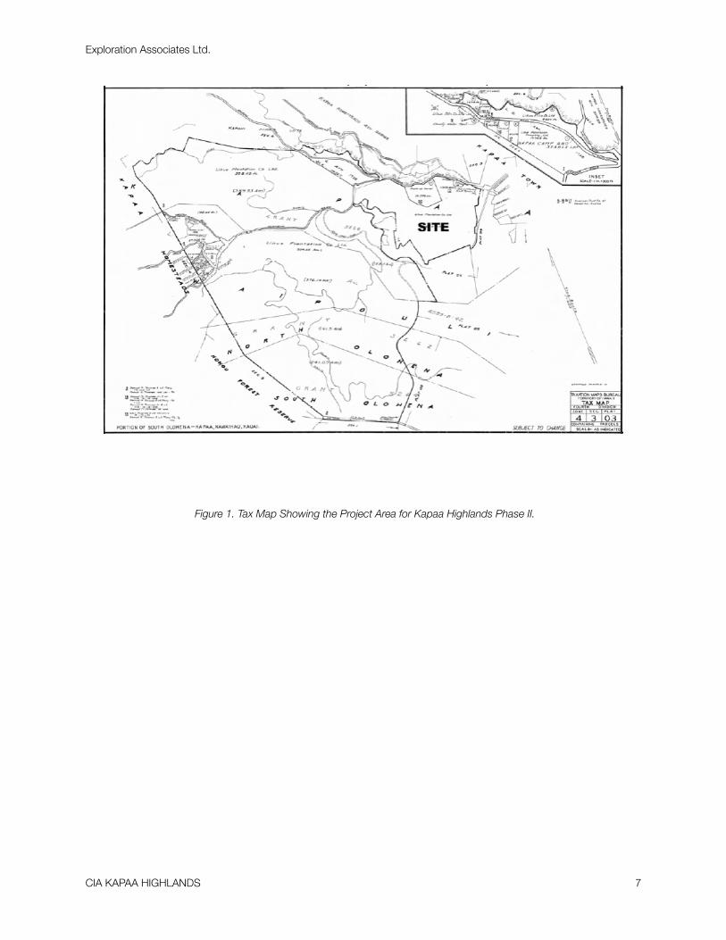
Figure 1. Tax Map Showing the Project Area for Kapaa Highlands Phase II.
Exploration Associates Ltd.
CIA KAPAA HIGHLANDS 7
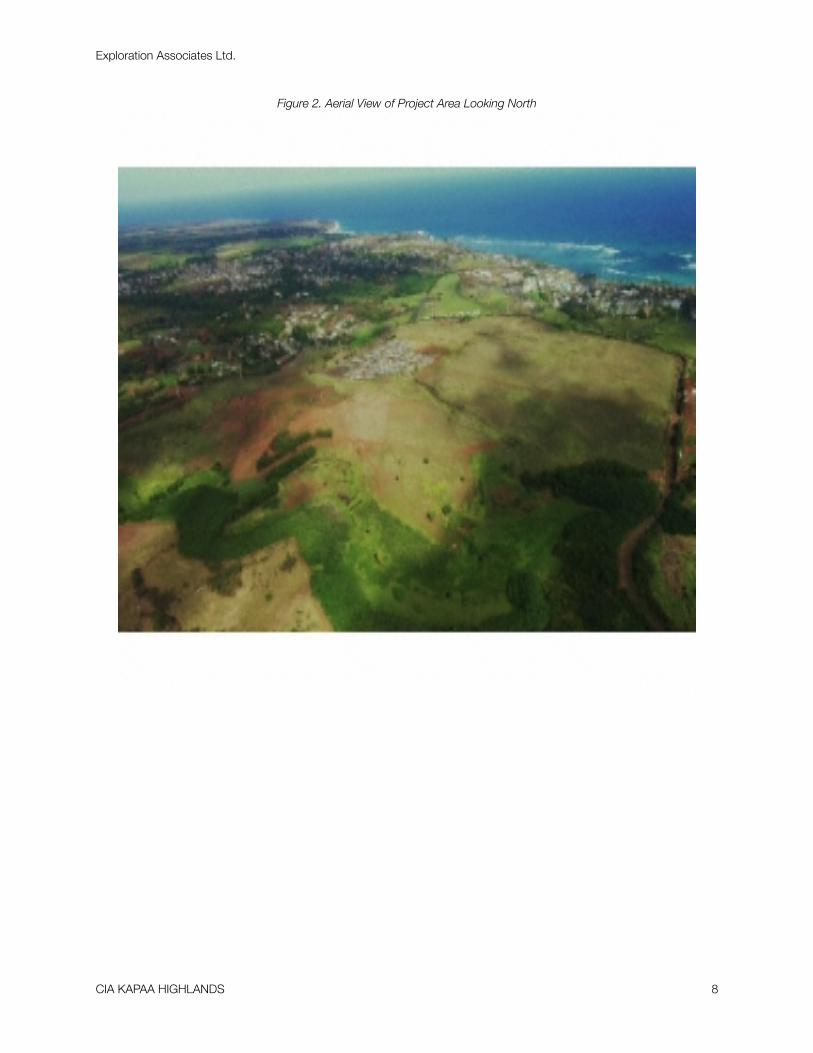
Figure 2. Aerial View of Project Area Looking North
Exploration Associates Ltd.
CIA KAPAA HIGHLANDS 8
Natural Setting
The ahupua‘a of Kapa‘a, is located on the eastern side of the island of Kaua‘i, in the old district or moku of Puna. Adjacent and to the north is the ahupua‘a of Keālia, and to the south, Waipouli. Like other ahupua‘a in Puna, Kapa‘a is exposed to the northeast tradewinds and receives 40 to 50 inches of rain a year at the shore and considerably more precipitation in-land. The area of the ahupua‘a of Kapa‘a, is approximately 6,394 acres (Gay 1872 R.M. 159, Commission of Boundaries Record, Kaua‘i, vol.1, 1873:23; Commission of Boundaries Re-cord, Kauai, vol. 1, 1872:109). Wichman (1998:84) notes the paradox that Kapa‘a "is one of the largest ahupua‘a of the Puna District [of Kaua‘i] and the most bereft of legends."
Alluvium, colluvium and terrigenous sediments resulting from the erosion of the primary island building events in Kaua‘i history, the Waimea Canyon Volcanic Series and the Koloa Volcanic Series, are the major sources of sediment for the formation of Kaua‘i’s non-mountainous region, including Kapa‘a (MacDonald and Abbott 1970:382-384). Kapa‘a is located within the physiographic division known as the Līhu‘e Plain (Armstrong 1973:30). During higher sea levels, terrigenous sediment accumulated further inland as streams released their sediment loads further inland from where the shoreline had en-croached. Also, reefs grew with the rising sea level, and, as the sea receded, marine sedi-ments were created and deposited on shore by the erosion of these reefs. Both of these processes were part of the formation of the Līhu‘e Plain.
The soils of the project area reflect the original geologic sediments deposited and the ero-sional processes induced by climatic agents. Backshore of the sand berm in Kapa‘a, are found sandy loams associated with the Mokuleia soil series (Foote et al. 1972:95). These soils consist of mostly recent alluvium deposited over coral sand and are typical of the eastern and northern coastal plains of Kaua‘i. Behind Kapa‘a Town and north of Moikeha Canal is found mixed fill. South of Moikeha Canal are Mokuleia clay loams, similar to the sandy loams fronting them. The soils found in the sand berm in Waipouli and Olohena are of the Lihue Series, which are characterized as well-drained soils derived from igneous material originating in Kapa‘a’s uplands (Foote et al. 1972:82).
Historically, these ahupua‘a contained two prominent landscape features, a coastal plain with sand dunes and a large marsh. An 1872 map (Figure 2) by James Gay de-lineating the boundaries of Kapa‘a and adjacent lands shows that much of the makai re-gion was a “swamp” that extended from Waipouli into Kapa‘a. This “swamp” appears to be the most prominent natural feature of the seaward end of Waipouli and Kapa‘a. The makai areas of the ahupua‘a can be characterized as fairly flat. Kapa‘a has an irregularly-
Exploration Associates Ltd.
CIA KAPAA HIGHLANDS 9

shaped gulches and small valleys in the uplands, through which small tributary streams run, including the Kapahi, Makaleha, Moalepe and Konohiki Streams. While some of these streams combine with other tributaries in neighboring Keālia to form Kapa‘a Stream, which empties into the ocean at the northern border of the ahupua‘a, others flow di-rectly into the marsh areas of Kapa‘a and Waipouli (Handy and Handy 1972:394,423; Territo-rial Planning Board 1940:9).
Kapa‘a Town areas is built on a sand berm with ocean on the makai side and marsh on the mauka side. The sand berm was probably slightly wider here than in other localities, but dry land was probably always at a premium.
Mo‘olelo of Kapa‘a
A brief overview of some of the better documented mythological and traditional accounts of Kapa‘a is presented below and is followed by a brief summation of their import.
The Puna district of Kaua‘i is well known for two legendary chiefs, Kawelo and Mō‘īkeha. Kawelo is more closely associated with Wailua and Hanamā‘ulu and Mō‘īkeha is linked to Kapa‘a. Mō‘īkeha is understood to be the grandchild of Maweke, one of the principal genealogical lines from which Hawaiians today trace their ancestry (Beckwith 1970:352). Sometime between the eleventh and twelfth centuries marks the ar-rival of Maweke to the Hawaiian Islands. Mō‘īkeha succeeds his older brother Ku-muhonua as ruling chief during the time of Mailikūkahi. Kapa‘a is mentioned in tradi-tions concerning Kawelo (Kaweloleimākua), the mo‘o Kalamainu‘u and the origins of the hina‘i hinãlea fish, and the story of Lonoikamakahiki (Fornander 1917:IV:318, 704-705; Rice 1923: 106-108; Thrum 1923: 123-135; Kamakau 1976:80).
1. Mō‘īkehaKapa‘a was the final home of the legendary chief Mō‘īkeha. Born at Waipi‘o on the is-
land of Hawai‘i, Mō‘īkeha sailed to Kahiki (Tahiti), the home of his grandfather, Maweke, after a disastrous flood. On his return to Hawai‘i, he settled at Kapa‘a, Kaua‘i. Kila, Mō‘īkeha’s favorite of three sons by the Kaua‘i chiefess Ho‘oipoikamalani, was born at Kapa‘a and was considered the most handsome man on the island. It was Kila who was sent by his father back to Kahiki to slay his old enemies and retrieve a foster son, the high chief La‘amaikahiki (Handy and Handy 1972:424; Beckwith 1970:352-358; Kalākaua 1888:130-135; Fornander 1917:IV:160). Mō‘īkeha’s love for Kapa‘a is recalled in the ‘olelo no‘eau: Ka lulu o Mo‘ikeha i ka laulã o Kapa‘a “The calm of Mō‘īkeha in the breadth of Kapa‘a ” (Pukui 1983: 157).
Exploration Associates Ltd.
CIA KAPAA HIGHLANDS 10
The place “Lulu-o-Mō‘īkeha” is described as being situated “near the landing and the school of Waimahanalua” (Akina 1913: 5). The landing in Kapa‘a was known as the Makee Landing and was probably constructed in the late 1870s, along with the Makee sugar mill. Today, in place of the old Makee Landing is part of a breakwater located on the north side of Moikeha Canal, near the present day Coral Reef Hotel (Bushnell et al. 2002:7).
In the Hawaiian newspaper Ku‘oko‘a published at the turn of the century, Akina (1913: 6) also tells the story of how Mō‘īkeha’s son, Kila stocks the Hawaiian Islands with the akule, kawakawa and ‘opelu fish. When Kila travels to Kahiki, he seeks out his grandfather Maweke and explains that he is the child of Mō‘īkeha. When Maweke asks Kila if Mō‘īkeha is enjoying himself, Kila answers with the following chant of Puna, Kaua‘i:
My father enjoys the billowing clouds I walea no ku‘u makuakãne i ke ao over Pöhaku-pili, ho‘okanunu, iluna o PöhakupiliThe sticky and delicious poi,! I ka poi uouo ono ae no a,
With the fish brought from Puna,! Me ka i‘a i na mai o ka Puna,
The broad-backed shrimp of Kapalua,! Ka opae hoainahanaha o Kapalua;The dark-backed shrimp of Pohakuhapai,! Na opae kua hauli o Pohakuhapai,
The potent awa root of Maiakii,! Na puawa ona mai no o Maiakii,
The breadfruit laid in the embers at Me ka ulu moelehu mai no o Makialo, MakialoThe large heavy taros of Keahapana! Me na kalo pehi hua o Keahapana,
The crooked surf of Makaiwa too! A i kekee nalu ae no hoi o Makaiwa,The bending hither and thither A i ke kahuli aku kahuli mai o ka pua uku of the reed and rush blossoms, me ka pua neki,The swaying of the kalukalu A i ka nu‘a ae no o ke kalukalu o Puna, grasses of Puna,
The large, plump, private A i na mea nui nepunepu no a ku‘u mau parts of my mothers, makuahine
Of Ho‘oipoikamalanai and Hinau-u,! O Ho‘oipoikamalanai me Hinau-u,
The sun that rises and sets,! A i ka la hiki ae no a napoo aku,
He enjoys himself on Kaua‘i,! Walea ai no ka nohona ia Kaua‘i,All of Kaua‘i is Mö‘ikeha’s! Ua puni a puni Kaua‘i ia Mö‘ikeha
Exploration Associates Ltd.
CIA KAPAA HIGHLANDS 11
Maweke was delighted and when the boy is questioned as to his purpose, Kila tells his great grandfather he is seeking fish for his family. Maweke tells Kila to lead the fish back to his homeland. This is how Kila led the akule, kawakawa and ‘öpelu to Hawai’i (For-nander 1917:IV:162-163).
In another legend of Kila, Mö‘ikeha sends his son to Tahiti to slay his enemies. Upon reaching Tahiti, Kila meets his father’s aunt, Kanepohihi, in the form of a blind, su-pernatural rat. He introduces himself, sending his father Mö‘ikeha’s greetings. Kanepohihi asks of Mö‘ikeha, and Kila responds:
He is indulging in ease in Kaua‘i! I walea ia Kaua‘i
Where the sun rises and sets again,! I ka lã hiki ae a pö ihoWhere the surf of Makaiwa curves and! I ke kee a ka nalu o Makaiwa bends,
Where the sun comes up over! I ka hiki mai a ka la malunaThe kalukalu of Kewa;! O ke kalukalu o KewaThe stretched out waters of Wailua,! O ka wai halau o WailuaAnd the entrancing favors of my mother! O ka lealea o ka mai o kuu makuahine
Ho‘oipoikamalanai! O Ho‘oipoikamalanai
He will live and die in Kaua‘i! O kahi noho no o Kaua‘i a make(Fornander 1916:IV:162-163)
2. Ka‘ililauokekoa the Chiefess of Kapa'a and the Lute KanikawiWaipouli and Kapa‘a are mentioned in the legend of Ka‘ililauokekoa, a chiefess of Ka-
pa‘a and granddaughter or daughter of Mö‘ikeha. Thomas Thrum (1907: 83-84) relates that:
[Kaililauokekoa's] greatest desire was to play konane, a game somewhat re-sembling checkers, and to ride the curving surf of Makaiwa (ke‘eke‘e nalu o Makaiwa), a surf which breaks directly outside of Waipouli, Kapa‘a. She passed the larger part of her time in this matter every day, and because of the con-tinual kissing of her cheeks by the fine spray of the sea of Makaiwa, the bloom of her youth became attractive ‘as a torch on high,' so unsur-passed was her personal charm.
In the Thrum (1923:123-135) version, Ka‘ililauokekoa is seduced by the nose flute of Kauakahiali‘i who is at the time residing in Wailua uka at a place called Pihanakalani. She travels up to Pihanakalani with her companion where she joins Kauakahiali‘i as his wife. They are found by Mö‘ikeha’s people and taken down to Kapa‘a where Kauakahi-ali´i is imprisoned. A boy named Kalukaluokewa takes pity on Kauakahiali´i and sneaks
Exploration Associates Ltd.
CIA KAPAA HIGHLANDS 12
through the kalukalu grass and the ahuawa rushes to bring the prisoner food and water. Meanwhile, Ka´ililauokekoa tells her parents of her calling by Kanikawi to the home of Ka-halelehua at Pihanakalani and her encounter with Kauakahiali‘i.
3. Kalukalu grass of Kapa‘a“Kūmoena kalukalu Kapa‘a” or “Kapa‘a is like the kalukalu mats” is a line from a chant
recited by Lonoikamakahiki. Kalukalu is a sedge grass, apparently used for weaving mats (Fornander 1917:IV:318-319). Pukui (1983:187) associates the kalukalu with lovers in “ke kalukalu moe ipo o Kapa‘a”; “the kalukalu of Kapa‘a that sleeps with the lover.” According to Wichman (1998:84), “a kalukalu mat was laid on the ground under a tree, covered with a thick pile of grass, and a second mat was thrown over that for a comfortable bed,” thus the association with lovers. Kaua‘i was famous for this peculiar grass, and it probably grew around the marshlands of Kapa‘a. It is thought to be extinct now, but an old-time resident of the area recalled that it had edible roots, “somewhat like peanuts.” Perhaps it was a famine food source (Kapa‘a Elementary School 1933: VI).
4. Pãka‘a and the wind gourd of La‘amaomao (Keahiahi)Kapa‘a also figures prominently in the famous story of Pãka‘a and the wind gourd of
La‘amaomao. Pãka‘a was the son of Kuanu‘uanu, a high-ranking retainer of the Big Is-land ruling chief Keawenuia‘umi (the son and heir to the legendary chief ‘Umi), and La‘a-maomao, the most beautiful woman of Kapa‘a and member of a family of high status kahuna. Kuanu‘uanu left the island of Hawai‘i, traveled throughout the other islands and finally set-tled on Kaua‘i, at Kapa‘a. It was there that he met and married La‘amaomao, although he never revealed his background or high rank to her until the day a messenger arrived, call-ing Kuanu‘uanu back to the court of Keawenuia‘umi. By that time, La‘amaomao was with child but Kuanu‘uanu could not take her with him. He instructed her to name the child, if it turned out to be a boy, Pãka‘a. Pãka‘a was raised on the beach at Kapa‘a by La‘amaomao and her brother Ma‘ilou, a bird snarer. He grew to be an intelligent young man and it is said he was the first to adapt the use of a sail to small fishing canoes. Al-though Pãka‘a was told by his mother from a very young age that his father was Ma‘ilou, he suspected otherwise. After constant questioning by Paka‘a, La‘amaomao told her son the truth about Kuanu‘uanu.
Intent on seeking out his real father, Pãka‘a prepared for the journey to Hawai‘i Is-land. His mother presented him with a tightly covered gourd containing the bones of her grandmother, also named La‘amaomao, the goddess of the winds. With the gourd and chants taught to him by his mother, Pãka‘a could command the forces of all the winds in Hawai‘i. While this story continues on at length about Pãka‘a and his exploits on Hawai‘i and later
Exploration Associates Ltd.
CIA KAPAA HIGHLANDS 13
on Moloka‘i, it will not be dwelt upon further here. It is important to note that several ver-sions of this story do include the chants which give the traditional names of all the winds at all the districts on all the islands, preserving them for this and future generations (Nakuina 1990; Rice 1923:69-89; Beckwith 1970:86-87; Thrum 1923:53-67; Fornander 1918:V: 78-128).
Frederick Wichman (1998:84) writes that Pãka‘a grew up on a headland named Kea-hiahi just south of Kapa‘a River. Here, Pãka`a learned to catch mālolo, his favorite fish. Af-ter studying the ocean and devising his plan to fabricate a sail, Pãka‘a wove a sail in the shape of a crab claw and tried it out on his uncle’s canoe. One day, after going out to catch mālolo, he challenged the other fishermen to race to shore. He convinced them to fill his ca-noe with fish suggesting it was the only way he could truly claim the prize if he won:
The fishermen began paddling toward shore. They watched as Pãka‘a paddled farther out to sea and began to fumble with a pole that had a mat tied to it. It looked so funny that they began to laugh, and soon they lost the rhythm of their own paddling. Suddenly Pãka‘a’s mast was up and the sail filled with wind. Pãka‘a turned toward shore and shot past the astonished fishermen, landing on the beach far ahead of them. That night, Pãka‘a, his mother, and his uncle had all the mãlolo they could eat [Wichman 1998:85].
5. KaweloleimakuaKapa‘a is also mentioned in traditions concerning Kawelo (Kawelolei-
makua), Keililauokekoa (Moikeha's daughter, or granddaughter, dependent on dif-fering versions of the tale), the mo‘o or reptile Kalamainu‘u and the origins of the hi-na‘i hinalea or the fish trap used to catch the hinalea fish, and the story of Lonoika-makahiki (Fornander 1917, vol.4 pt.2:318, vol.4 pt.3:704-705; Rice 1923:106-108; Thrum 1923:123-135; Kamakau 1976:80).
6. Kanaka-Nunui-Moe-The Sleeping Giant
Frederick B. Wichman relates an account of Kaua‘i’s Sleep-ing Giant:
A long time ago, there was a giant living in Kawaihau among the low hills behind Kapa‘a town. He was so tall he could see above the coco-nut trees. If he sat very still, it was easy to mistake him for one of the hills. Anyone who did not know him was afraid of his great size, fearing
Exploration Associates Ltd.
CIA KAPAA HIGHLANDS 14

the damage he might cause. However the people of Kawaihau loved him, for he was very friendly and went out of his way to be useful.
This giant was always careful where he stepped so that he would not injure anyone and he never destroyed taro patches or houses with a careless foot. When he wished to rest, he sat on one of the small hills above Kapa‘a. The villagers were glad when this happened for his weight flattened the hilltop, making another plot of ground fit for culti-vation."He is very helpful," the Kapa‘a people said to astonished stranger who came to their land. "He does many things for us quickly that oth-erwise we could not do in many months."Wherever this giant stepped he left keep footprints and in these deep holes the people planted ba-nana trees. The villagers threw leaves, taro peelings, and other vegetable rubbish into these holes. When compost had been formed, they planted banana sprouts. In this way, the people of Kapa‘a always had ripe ba-nanas to give to the giant, for banana was his favorite food.
The giant yawned very often, for he was always sleepy. The gust of wind from his mouth often knocked down houses and blew the grass thatch into the sea. The giant was always very apologetic whenever this hap-pened and he quickly brought logs from the uplands to rebuild the fallen houses and gathered pili for the thatching.
He found it difficult to stay awake more than a hundred years at a time. When he could no longer fight against the drowsiness overpowering him, he would sleep using a small hill for a pillow. Because of this, the people called him Kanakanunui-moe, the sleeping giant.
When he slept, Nunui slept for hundreds of years while the winds blew dirt over him and seeds were dropped there by the birds. The gently showers sent by Kahale-lehua, goddess of the gentle rains, fed these seeds and forest grew up over the giant. When Nunui awoke and stretched, the people of Kapa‘a fled in great fear, for what they had thought to be a hill had come alive.
One time, while Nunui was still awake, the high chief of Kawaihau wanted to build a large heiau to honor one of his gods. This was to be no ordinary temple. The chief wanted water-polished rocks for the walls and hard koa wood from Kokee for the framework of the god's house.So the chief told the Kawaihau people what he wanted them to do. They must gather rocks from the golden brown waters of the Koke`e streams and
Exploration Associates Ltd.
CIA KAPAA HIGHLANDS 15

cut koa trees on the edges of Waimea canyon, and gather pili grass that grew at Mana. "All this must be done in the turn of one moon," he ordered.The unhappy people left their chief and silently returned to their village. The giant Nunui, stepping carefully among them, saw the long faces of the peo-ple.
"What is wrong?" he asked.
The Kapa‘a villagers told him what they must do within the impossibly short time. "This cannot be done," the people said in low, sad voices. "How can we go to Kokee and bring back stones enough to build the walls in that time? And cut down the koa trees and bring the logs here and build the sacred house? And even if we do these things, who will cultivate our fields?"
Nunui smiled gently. "Tend to your fields," he said. "This work is nothing for me, and I'll gladly help you. Besides, it will give me something to do."
The giant went to Kokee and scooped up smooth, round boulders from the golden brown waters and brought them to Kapa‘a. "Chief," he called to the astonished ruler, "show me where you wish to build this heiau."The amazed chief pointed out the place set aside for the temple. Nunui placed the rocks to form a wall, fitting them so closely together that not even a mouse could squeeze between the cracks. Within a week, he had built a strong, thick, handsome wall around the sacred place.Nunui returned to the edge of Waimea Canyon and cut down koa trees and trimmed them into the shaped he needed. He carried these back and made the framework of the house. He gathered pili grass form Wild and wrapped the stems into bundles, tied these bundles to the framework, and within half the time the chief had set, the heiau was finished.Everyone was happy. The farmers had been able to keep up with their chores, the chief had his heiau, and Nunui had something to do. There was even time enough a celebration. The chief ordered all his people to gather bananas and to pound sweet potatoes and taro into poi. Some people hurried to slaughter pigs and dogs to be cooked in the imu, while other paddled out to sea to fill their canoes with fish and sent their wives to gather seaweed and opihi from the reef. At last, enough food for everyone was ready, and the chief, the villagers, and Nunui sat down before the overflowing bowls and platters."Eat," said the chief to Nunui. "After the work you have done, you must be hungry."
Exploration Associates Ltd.
CIA KAPAA HIGHLANDS 16
The giant ate all the food that had been put before him. When he was through, his stomach bulged and he was very sleepy. He chose a comfortable hill just a short distance above Kapa'a town. Nunui stretched a last time, lay down along the top of the hill, and soon was sound asleep.As he slept through the years, the winds blew dirt over him and the birds brought seeds. Ka-hale-lehua, goddess of the gentle rains, sent showers to water the plants that now covered the giant.So Kanaka-nunui-moe sleeps and sleeps and has come to resemble a long hill with a lump at one end where his nose is and lumps at the other ends where his feet are. He no long looks like a living being, but one day, perhaps soon, his eyes will open, he'll yawn and stretch his arms, and sit up. [Wich-man 1985:13-16]
7. LepeamoaIn the Legend of "Lepeamoa (The Chicken Girl of Palama)"(Thrum 1923:177) is a refer-
ence to a fantastic battle at Kapa'a between Lepeamoa's brother, the hero Kauilani and a su-pernatural kupua called Akuapehuale ("god of swollen billows"):
Kauilani struck him a heavy blow and the spear leaped again and again upon him, till he rolled into a mountain stream at a place called Kapa‘a, out of which he crawled, almost drowned. Then he was driven along even to the image houses, where a fierce battle took place, in which the wooden im-ages took part, many of them being torn to pieces by the teeth of Akuapehu-ale.
8. Palila and Ka`eaHigh in the mauka region of Kapa‘a in the Makaleha mountains at a place called Ka`ea, is
reported to be the supernatural banana grove of the Kaua`i kupua or demigod Palila, grand-son of Hina (Handy and Handy 1972:424). Joseph Akina for Kieoko 'a Newspaper in 1913 describes Palila's banana grove:
The stalk could hardly be surrounded by two men, and was about 35 feet high from the soil to the lowest petiole. The length of the cluster from stem to low-est end of the bunch of bananas was about 1 3/4 fathoms long (one anana and one muku). There were only two bananas on each about 4 '/2 inches around the middle. There were just two bananas, one on the east side and one on the west, each about a foot or more in length. The one on the east side was tartish, like a waiawi (Spanish guava) in taste and the one on the west was practically tasteless. The diameter of the end of the fruit stem of this banana seemed to be about 11/2 feet. This kind of banana plant and its fruit seemed al-most supernatural... (Akina, 1913:5).
Exploration Associates Ltd.
CIA KAPAA HIGHLANDS 17
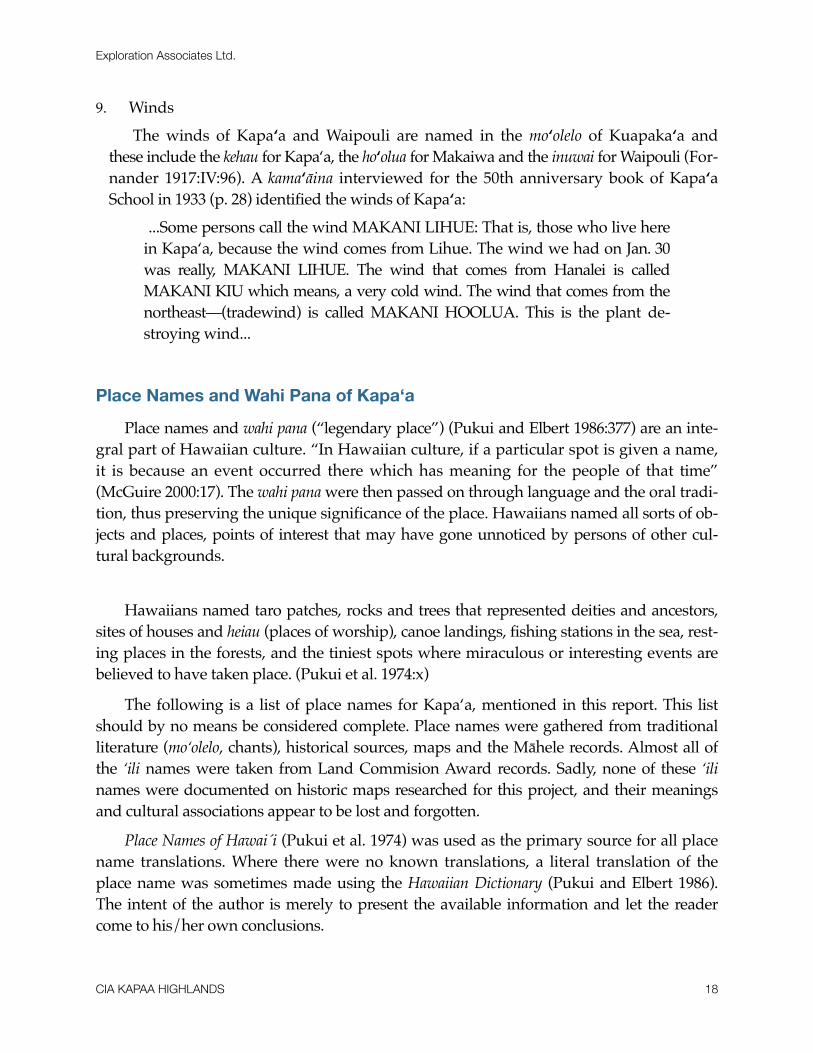
9. WindsThe winds of Kapa‘a and Waipouli are named in the mo‘olelo of Kuapaka‘a and
these include the kehau for Kapa‘a, the ho‘olua for Makaiwa and the inuwai for Waipouli (For-nander 1917:IV:96). A kama‘āina interviewed for the 50th anniversary book of Kapa‘a School in 1933 (p. 28) identified the winds of Kapa‘a:
...Some persons call the wind MAKANI LIHUE: That is, those who live here in Kapa‘a, because the wind comes from Lihue. The wind we had on Jan. 30 was really, MAKANI LIHUE. The wind that comes from Hanalei is called MAKANI KIU which means, a very cold wind. The wind that comes from the northeast—(tradewind) is called MAKANI HOOLUA. This is the plant de-stroying wind...
Place Names and Wahi Pana of Kapa‘a
Place names and wahi pana (“legendary place”) (Pukui and Elbert 1986:377) are an inte-gral part of Hawaiian culture. “In Hawaiian culture, if a particular spot is given a name, it is because an event occurred there which has meaning for the people of that time” (McGuire 2000:17). The wahi pana were then passed on through language and the oral tradi-tion, thus preserving the unique significance of the place. Hawaiians named all sorts of ob-jects and places, points of interest that may have gone unnoticed by persons of other cul-tural backgrounds.
Hawaiians named taro patches, rocks and trees that represented deities and ancestors, sites of houses and heiau (places of worship), canoe landings, fishing stations in the sea, rest-ing places in the forests, and the tiniest spots where miraculous or interesting events are believed to have taken place. (Pukui et al. 1974:x)
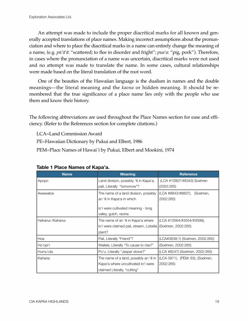
The following is a list of place names for Kapa‘a, mentioned in this report. This list should by no means be considered complete. Place names were gathered from traditional literature (mo‘olelo, chants), historical sources, maps and the Māhele records. Almost all of the ‘ili names were taken from Land Commision Award records. Sadly, none of these ‘ili names were documented on historic maps researched for this project, and their meanings and cultural associations appear to be lost and forgotten.
Place Names of Hawai´i (Pukui et al. 1974) was used as the primary source for all place name translations. Where there were no known translations, a literal translation of the place name was sometimes made using the Hawaiian Dictionary (Pukui and Elbert 1986). The intent of the author is merely to present the available information and let the reader come to his/her own conclusions.
Exploration Associates Ltd.
CIA KAPAA HIGHLANDS 18
An attempt was made to include the proper diacritical marks for all known and gen-erally accepted translations of place names. Making incorrect assumptions about the pronun-ciation and where to place the diacritical marks in a name can entirely change the meaning of a name, (e.g. pū‘ā‘ā: “scattered; to flee in disorder and fright”; pua‘a: “pig, pork”). Therefore, in cases where the pronunciation of a name was uncertain, diacritical marks were not used and no attempt was made to translate the name. In some cases, cultural relationships were made based on the literal translation of the root word.
One of the beauties of the Hawaiian language is the dualism in names and the double meanings—the literal meaning and the kaona or hidden meaning. It should be re-membered that the true significance of a place name lies only with the people who use them and know their history.
The following abbreviations are used throughout the Place Names section for ease and effi-ciency. (Refer to the References section for complete citations.)
LCA=Land Commission AwardPE=Hawaiian Dictionary by Pukui and Elbert, 1986PEM=Place Names of Hawai´i by Pukui, Elbert and Mookini, 1974
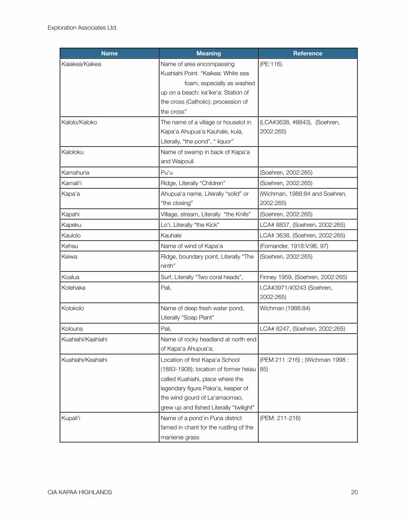
Table 1 Place Names of Kapa’a.Name Meaning Reference
Apopo Land division, possibly ‘ili in Kapa‘a,
pali, Literally “tomorrow”?
(LCA #10907/#8343) Soehren
(2002:265)
Awawaloa The name of a land division, possibly
an ‘ili in Kapa‘a in which
lo‘i were cultivated meaning - long
valley, gulch, ravine.
(LCA #8843/#8837), (Soehren,
2002:265)
Hahanui /Kahanui The name of an ‘ili in Kapa‘a where
lo‘i were claimed pali, stream, Lobelia
plant?
(LCA #10564/#3554/#3599),
(Soehren, 2002:265)
Hoa Pali, Literally “Friend”? (LCA#3638:1) (Soehren, 2002:265)
Ho‘opi‘i Wailele, Literally “To cause to rise?” (Soehren, 2002:265)
Humu‘ula Pu‘u, Literally “Jasper stone?” (LCA #8247) (Soehren, 2002:265)
Kahana The name of a land, possibly an ‘ili in
Kapa‘a where uncultivated lo‘i were
claimed Literally, “cutting”
(LCA 3971). (PEM: 63), (Soehren,
2002:265)
Exploration Associates Ltd.
CIA KAPAA HIGHLANDS 19
Name Meaning Reference
Kaiakea/Kaikea Name of area encompassing
Kuahiahi Point. “Kaikea: White sea
foam, especially as washed
up on a beach: ka‘ike‘a: Station of
the cross (Catholic); procession of
the cross”
(PE:116).
Kalolo/Kaloko The name of a village or houselot in
Kapa‘a Ahupua‘a Kauhale, kula,
Literally, “the pond”, “ liquor”
(LCA#3638, #8843), (Soehren,
2002:265)
Kaloloku Name of swamp in back of Kapa‘a
and Waipouli
Kamahuna Pu‘u (Soehren, 2002:265)
Kamali‘i Ridge, Literally “Children” (Soehren, 2002:265)
Kapa‘a Ahupua‘a name, Literally “solid” or
“the closing”
(Wichman, 1988:84 and Soehren,
2002:265)
Kapahi Village, stream, Literally “the Knife” (Soehren, 2002:265)
Kapeku Lo‘i, Literally “the Kick” LCA# 8837, (Soehren, 2002:265)
Kaulolo Kauhale LCA# 3638, (Soehren, 2002:265)
Kehau Name of wind of Kapa‘a (Fornander, 1918:V:96, 97)
Keiwa Ridge, boundary point, Literally “The
ninth”
(Soehren, 2002:265)
Koalua Surf, Literally “Two coral heads”, Finney 1959, (Soehren, 2002:265)
Kolehaka Pali, LCA#3971/#3243 (Soehren,
2002:265)
Kolokolo Name of deep fresh water pond,
Literally “Soap Plant”
Wichman (1988:84)
Kolouna Pali, LCA# 8247, (Soehren, 2002:265)
Kuahiahi/Kaahiahi Name of rocky headland at north end
of Kapa‘a Ahupua‘a;
Kuahiahi/Keahiahi Location of first Kapa‘a School
(1883-1908); location of former heiau
called Kuahiahi, place where the
legendary figure Paka‘a, keeper of
the wind gourd of La‘amaomao,
grew up and fished Literally “twilight”
(PEM 211 :216) ; (Wichman 1998 :
85)
Kupali‘i Name of a pond in Puna district
famed in chant for the rustling of the
manienie grass
(PEM: 211-216)
Exploration Associates Ltd.
CIA KAPAA HIGHLANDS 20

Name Meaning Reference
Kupanihi The name of a pond in the Puna
district associated with Kaeo,
Kaumuali‘i’s older brother, ili, kauhale,
Name of fishpond and land in Kapa‘a
claimed
(PEM:216); in LCA #3971/#3243,
(Soehren, 2002:265)
Maeleele The name of a land division, possibly
an ‘ili in Kapa´a in which lo‘i Literally
“Numb” were cultivated,
(LCA #3638), (Soehren, 2002:265)
Makaleha Pu‘u, boundary point, Eyes looking
about as in wonder and admiration,
Boundary Commission, (Soehren,
2002:265)
Makanalimu Place, heiau, Literally “Gift of
seaweed”
PEM:141
Makea ‘Auwai, Literally “fallow land” LCA# 3599/#3554 (Soehren,
2002:265)
Moalepe/Moalepi Hill in the mauka region of Keālia
(HAS, Interior Dept., Land, June 23,
1862); land division, stream possibly
an ‘ili in mauka region of Kapa‘a
LCA #8247 (Soehren, 2002:265)
Moikeha Canal Canal which is traversed by two
plantation era railroads near the
present day Kapa‘a Public Library
and the Coral Reef Hotel
Naele Pali, Literally “swamp, big” LCA #8837, (Soehren, 2002:265)
Paikahawai ‘ili, (Soehren, 2002:265)
Pohakiikii Pu‘u, Tilted stone, (Soehren, 2002:265)
Pohakupili Pu‘u, boundary point, Literally “
joined stone”,
(Soehren, 2002:265)
Poo Surf, Literally “Head” Finney 1959, (Soehren, 2002:265)
Pueo Pali, Literally “owl”, LCA# 8843, (Soehren, 2002:265)
Puhi The name of a village or household in
Kapa‘a Ahupua‘a, Kauhale, pond,
Literally “eel”,
LCA #3554/#3599, (Soehren,
2002:265)
Puohomaka Pali, LCA# 8837, (Soehren, 2002:265)
Pupukai Pali, LCA# 3638, (Soehren, 2002:265)
Puu Ekeeke Pali, LCA# 8837, (Soehren, 2002:265)
Puu Lauii Pu‘u, boundary point, Laui‘i fern hill, Boundary Commission,(Soehren,
2002:265)
Ulakiu Ku, LCA# 8837, (Soehren, 2002:265)
Ulukiu Name of a houselot or village in
Kapa‘a
(LCA #8837
Exploration Associates Ltd.
CIA KAPAA HIGHLANDS 21

Name Meaning Reference
Waika‘ea Canal and boat ramp in Kapa‘a
adjacent to the present day Pono Kai
Resort, ditch,
(Clark 2002:374), (Soehren,
2002:265)
Waikaeee A place described as being located
in the uplands near Nounou
(PEM Placenames, Ku‘oko‘a, May 2,
1913)
Waileia Rock, boundary point, Literally
“Abundant Water”
Boundary Commission, (Soehren,
2002:265)
Waimahanalua Name of a stream and school
located near the old Makee The
name mahanalua suggests the
stream was forked and fed by
multiple streams which could well be
the case since the backlands of
Kapa‘a were swamplands fed by
many streams. near the present day
Moikeha Canal.
(PEM Placenames, Ku‘oko‘a May 9,
1913).
Waitala “local” name used to refer to Waika
´ea Canal
(T. Sokei, July 28, 2003 in Bushnell
et.al. 2004)
Summary of the Mythological and Traditional accounts of Kapa‘a
! A survey of traditional mythological literature shows Kapa‘a prominently asso-ciated with some of the most famous legendary and historical figures including Maui, Kawelo, Mo‘ikeha, Maweke, Palila, Paka‘a and Kanaka Nunui Moe. What few specific references there are suggest that high status habitation was focused near the coast with less intensive utilization of the uplands which were regarded as wild places. The most notable feature of the traditional accounts are the references to grasses and sedges (Kalukalu grass and Ahuawa rushes) which undoubtedly reflects in part the natural marsh lands near the coast but may also reflect transformation of the landscape through a denudation of trees by the activities of a relatively dense population harvesting slow growing trees for firewood and construction materials over many centuries.
Exploration Associates Ltd.
CIA KAPAA HIGHLANDS 22
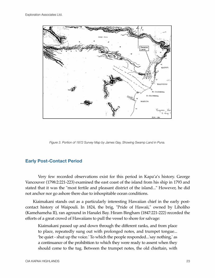
Figure 3. Portion of 1872 Survey Map by James Gay, Showing Swamp Land in Puna.
Early Post-Contact Period
! Very few recorded observations exist for this period in Kapa‘a’s history. George Vancouver (1798:2:221-223) examined the east coast of the island from his ship in 1793 and stated that it was the "most fertile and pleasant district of the island..." However, he did not anchor nor go ashore there due to inhospitable ocean conditions.
Kiaimakani stands out as a particularly interesting Hawaiian chief in the early post-contact history of Waipouli. In 1824, the brig, "Pride of Hawaii," owned by Liholiho (Kamehameha II), ran aground in Hanalei Bay. Hiram Bingham (1847:221-222) recorded the efforts of a great crowd of Hawaiians to pull the vessel to shore for salvage:
Kiaimakani passed up and down through the different ranks, and from place to place, repeatedly sung out with prolonged notes, and trumpet tongue... ‘be quiet - shut up the voice.' To which the people responded...'say nothing,' as a continuance of the prohibition to which they were ready to assent when they should come to the tug. Between the trumpet notes, the old chieftain, with
Exploration Associates Ltd.
CIA KAPAA HIGHLANDS 23
the natural tones and inflections, instructed them to grasp the ropes firmly, rise together at the signal, and leaning inland, to look and draw straight forward, without looking backwards toward the vessel. They being thus mar-shalled and instructed, remained quiet for some minutes, upon their hams.
The salvage efforts ultimately failed and the brig was lost. Bingham's account vividly sug-gests the force of personality of the chief and further betokens an authority and stature that may have been founded upon the traditional prestige of his domain, Waipouli.
Kiaimakani appears in Samuel Kamakau's account (1961:267) of the 1824 rebellion of the chiefs of Kaua‘i upon the death of Kaumuali‘i. Kalanimoku, representative of Kame-hameha II, had called a council of the Kaua‘i chiefs at Waimea during which he announced
“The lands shall continue as they now stand. Our son, Kahala-i‘a, shall be ruler over you.” A blind chief of Waipouli in Puna, named Ki‘ai-makani, said, “That is not right; the land should be put together and re-divided be-cause we have a new rule,” but Ka-lani-moku would not consent to this.
After some Kaua‘i chiefs, including Kiaimakani, rebelled against the imposed de-crees:
On August 8 [1824] the battle of Wahiawa was fought close to Hanapepe. The Hawaii men were at Hanapepe, the Kauai forces at Wahiawa, where a fort had been hastily erected and a single cannon (named Hume-hume) mounted as a feeble attempt to hold back the enemy...Large num-bers of Kauai soldiers had gathered on the battleground, but they were unarmed save with wooden spears, digging sticks, and javelins...No one was killed on the field, but as they took to flight they were pursued and slain. So Kia‘imakani, Na-ke‘u, and their followers met death [Kamakau 1961: 268].
Kamakau´s singling out of Kiaimakani for special mention reinforces the impression that the chief and his ahupua‘a may have shared a traditional prestige.
In 1840, Peale and Rich, with Charles Wilkes’ United States Exploring Expedition, traversed the coastline there on horseback heading north from Wailua:
The country on the way is of the same character as that already seen. They passed the small villages of Kuapau, Keālia, Anehola, Mowaa, and Kauharaki, situated at the mouths of the mountain streams, which were closed with similar sand-bars to those already described. These bars afforded places to cross at, though requiring great precaution when on horseback. The streams above the bars were in most cases deep, wide, and navigable a few miles for canoes. Besides the sugarcane, taro, &c., some good fields of rice were seen. The country may be called open; it is covered
Exploration Associates Ltd.
CIA KAPAA HIGHLANDS 24

with grass forming excellent pasture-grounds, and abounds in plover and turnstones, scattered in small flocks [Wilkes 1845:69].
James Jarves (1844:157), who tracked much of the same route as Peale and Rich, noted "nothing of particular interest is met with on the road, until arriving at Anahola."
The Mahele Period
! The Organic Acts of 1845 and 1846 initiated the process of the Mahele, which in-troduced private property into Hawaiian society. It is through information garnered from records for Land Commission Awards (LCAs) generated during the Mahele that spe-cific documentation of traditional life in Kapa‘a come to light.
Table 2. Mahele Land Claims and Land Use of Kapa‘a.
LCA Number Ahupua‘a Claimant ´Ili of the
Ahupua‘a
Land Use Number of
‘Āpana
3243 (See 3971) Kapa‘a Honolii, Ioane
Kahana, Kupanihi Village
6 lo‘i (uncult), house lot
2 (2 acres, 1 rood, 1 ord)
3554 Kapa‘a Keo Kahanui Puhi Vil-lage
15 lo‘i, house lot
2 (7 acres, 1 rood, 17 rods)
3638 Kapa‘a Huluili Maeleele Ka-loko Village
12-15 lo‘i, house lot
2 (5 acres, 1 rood, 19 rods)
8247 Kapa‘a Ehu Moalepe / Noalepe 20 lo‘i, 1 (3 roods)
8837 Kapa‘a Kamapaa Ulukiu lalo Awawaloa Ulu-kiu
3 lo‘i, 2 lo‘i, house lot
1 (2 acres, 2 roods, 27rods)
8843 Kapa‘a Kiau Apopo Ka-lolo Village
6 (5) lo‘i and kula, house lot
2 (2.75 acres,3 rods)
10564 Kapa‘a Oleloa, Daniel
Hikinui farm fishpond, 10 lo‘i
Exploration Associates Ltd.
CIA KAPAA HIGHLANDS 25
Kapa’a Land Commission Awards
Documents relating to Land Commission Awards (kuleana) during this period show, surprisingly, that only six individuals were awarded kuleana parcels in the relatively large ahupua‘a of Kapa‘a. Five of the six received multiple parcels and show characteristic similarities. They are Keo (LCA #3554, 3599), Kiau (#8843), Kamapaa (#8837), Ioane Honolii (#3971), and Huluili (#3638) (See Table 1). All five had lo‘i on the mauka side of the lowland swamp area, sometimes extending a short distance up into small, shallow gulches and valleys. Each also had a separate house lot located on the makai side of the swamp, adjacent to the beach.
Interestingly, the residential "village" of Kapa‘a did not exist as a single entity, but was a series of small settlements or compounds that stretched along the shore-line of the ahupua‘a and included (south to north) Kupanihi (Makahaikupanihi), Ka-lolo (Kaulolo), Puhi, and Ulukiu. The sixth individual, Ehu (#8247), was the only per-son to be awarded a single parcel in the upland area of Kapa‘a at Moalepe valley, ap-proximately five miles from the shore. In 1848, when Ehu made his claim, he was the only one living there. A few years later, according to Honoli‘i’s testimony to support Ehu’s claim, "There are no houses and no people now living on the land. Ehu found himself lonely there, all his neighbors having either died or left the land. Ehu now lives in Wailua." Ehu may have been the last person to live at and cultivate in the traditional way the far mauka region of Kapa‘a.
A check of the Foreign Testimony (F.T) for Kuleana Claims to Quiet Land Titles in the Hawaiian Islands (1848-50) reveals the names of three ‘auwai in Kapa‘a. Cross-referencing this information with various maps gives a general indication of their lo-cation: Makahaikupanihi, along the southern border near the shore and the settlement in Waipouli; Makea, near the current Kapa‘a Public Library on the mauka side of Kūhiō Highway; and Kapa‘a, probably along the current Kanaele Road.
There were no kuleana claims found within the project area.
The Late 1800s
! In 1849, a son of Wai‘oli missionaries, William P. Alexander, recorded a trip he took around Kaua‘i. Although, he focuses on the larger mission settlements like Koloa and Hanalei, he does mention Kapa‘a:
A few miles from Wailua, near Kapa‘a, we passed the wreck of a schooner on the beach, which once belonged to Capt. Bernard. It was driven in a gale over
Exploration Associates Ltd.
CIA KAPAA HIGHLANDS 26

the reef, and up on the beach, where it now lies. A few miles further we ar-rived at Kealia. We had some difficulty crossing the river at this place, owing to the restiveness of our horses. The country here near the shore was rather un-inviting, except the valley which always contained streams of water (Alexander, 1991: 123).
In later years, the notorious Kapa‘a reef was to become the location of many shipwrecks particularly once a landing was built there in the 1880s.
Although most of the historic record documents for Kaua‘i in this period revolve around missionary activities and the missions themselves, there was indication that the Kapa‘a area was being considered for new sugar cane experiments, similar to those occurring in Koloa. In a historic move, Ladd and Company received a 50 year lease on land in Koloa from Kamehameha III and Kaua‘i Governor Kaikio‘ewa of Kaua‘i. The terms of the lease allowed the new sugar company "the right of someone other than a chief to control land" and had profound effects on "traditional notions of land tenure dominated by the chiefly hierarchy" (Donohugh, 2001: 88). In 1837, a very similar lease with similar terms was granted to Wilama Ferani, a merchant and U.S. citizen based in Honolulu (Hawai`i State Archives, Interior Dept., Letters, Aug. 1837). The lease was granted by Kauikeaouli or Kamehameha III for the lands of Kapa‘a, Kealia and Waipouli for twenty years for the following purpose:
...for the cultivation of sugar cane and anything else that may grow on said land, with all of the right for some place to graze animals, and the forest land above to the top of the mountains and the people who are living on said lands, it is to them whether they stay or not, and if they stay, it shall be as follows: They may cultivate the land according to the instructions of Wilama Ferani and his heirs and those he may designate under him... (Hawai`i State Archives, Interior Dept., Letters, Aug. 1837).
Unlike Ladd & Company which eventually became the Koloa Sugar
Company, there is no further reference to Wilama Ferani and his lease for lands in Kapa‘a, Kealia and Waipouli. In a brief search for information on Honolulu merchant, Wilama Ferani, nothing was found. It is thought that perhaps Wilama Ferani may be another name for William French, a well known Honolulu merchant who is docu-mented as having experimented with grinding sugar cane in Waimea, Kaua‘i at about the same time the 1837 lease for lands in Kapa‘a, Kealia and Waipouli was signed (Joesting, 1984: 152).
The sugar industry came to the Kapa‘a region in 1877 with the establishment of the Makee Sugar Company and subsequent construction of a mill near the north end of the present town. Cane was cultivated mainly in the upland areas on former kula lands. The first crop was planted by the Hui Kawaihau, a group composed of associates of King
Exploration Associates Ltd.
CIA KAPAA HIGHLANDS 27

David Kalākaua. The king threw much of his political and economic power behind the project to ensure its success (Dole 1929:8-15). The Hui Kawaihau was originally a choral society begun in Honolulu whose membership consisted of many prominent names, both Hawaiian and haole. It was Kalakaua's thought that the Hui members could join forces with Makee, who had previous sugar plantation experience on Maui, to establish a successful sugar corporation on the east side of Kaua‘i. Captain Makee was given land in Kapa‘a to build a mill and he agreed to grind cane grown by Hui members. Kalakaua de-clared the land between Wailua and Moloa‘a, the Kawaihau District, a fifth district and for four years the Hui attempted to grow sugar cane at Kapahi, on the plateau lands above Ka-pa‘a. After a fire destroyed almost one half of the Hui's second crop of cane and the un-timely death of one of their principal advocates, Captain James Makee, the Hui began to disperse and property and leasehold rights passed on to Makee's son-in-law and new Makee Plantation owner, Colonel Z. S. Spalding (Dole, 1916: 14). As part of the infrastructure of the new plantation, a sugar mill was erected and the Makee Landing was built in Kapa‘a during the early years of the Makee Sugar Plantation. Following Captain Makee's death, Colonel Spalding took control of the Plantation and in 1885 moved the mill to Kealia (Cook, 1999: 51). The deteriorating stone smokestack and landing were still there well into the 1900s (Damon, 1931:359).
A train line went inland from Kapa‘a Town from the coast along the present Lehua Street alignment heading south behind Kapa‘a Town. This railroad line skirts the rice lands behind Kapa‘a Town. Another branch ran between Hauaala and Hundley Roads and the branch from behind Kapa‘a Town joined the Hauaala/Hundley railroad alignment where the proposed corridors for this project join the present Kūhiō Highway. The train line continued north to the Keālia (Kapa‘a) River. Chinese rice farmers had begun to cultivate the lowlands of Kapa‘a with increasing success about this same time. Several Hawaiian kuleana owners leased or sold outright their parcels mauka of the swampland to rice cultivators. Concurrently, the economic activity as a result of the rice and sugar cultivation sparked interest in the house lot kuleana on the makai side of the marsh for increasing commercial and residential development (Lai 1985:148-161). This land was drained and used for cane in the early 20th century before more recent urbanization of the area.
Narrow wagon roads gave way to macadamized roads in the early part of the 20th century. This new road was called the Kaua‘i Belt Road and parts of it are thought to have followed the "Old Government Road" (Cook, 1999). In Kapa‘a, the present day Kuhio Highway probably follows the same route as the original Government Road and subsequent Kaua‘i Belt Road. The location of the kuleana awards in Kapa‘a indicates that the majority of the house lots were situated along the Government Road. LCA 3243 names a "road" as one of its boundaries.
Exploration Associates Ltd.
CIA KAPAA HIGHLANDS 28

20th Century History of Kapa‘a
! In the early 1900s, government lands were auctioned off as town lots in Kapa‘a Town to help with the burgeoning plantation population. Many of these lots were pur-chased by Portuguese and Japanese laborers who had fulfilled their contract duties with Makee Plantation. One kama‘āina interviewed for a previous project in Kapa‘a mentioned that in the 1930s and 1940s, the area north of Mo‘ikeha Canal in Kapa‘a was mostly settled by Portuguese families (W. Kaneakua in Bushnell et al. 2002:28). The Japanese were also very prominent in the 1920s and 1930s, largely replacing the Chinese merchants of the turn of the century in the Kapa‘a business sector.
Though most of the large plantation camps were located in neighboring Keālia, there were a few in Kapa‘a. Many people consulted had clear memories of the plantation camps in Kapa‘a: a fairly large camp located just behind Kapa‘a Town and three smaller camps located in the hills above Kapa‘a. The large camp, Pueo Camp (Figure 6), was lo-cated adjacent to the intersection where the current Kapa‘a Bypass Road turns off of Olo-hena Road (Interview w/ A. Paik, 5/14/03 in Bushnell et. al. 2004). One Kapa‘a resi-dent who grew up in Pueo Camp remembers the camp being quite large with between 75 and 100 people, mostly single Filipino and Chinese men with some Japanese families and a few Hawaiian and Portuguese families Pueo Camp is thought to be a fairly early Makee Plantation Sugar Camp built strategically adjacent to the railroad tracks which accessed the sugar fields in the upland areas of Kapa‘a. Though no one consulted knew the date Pueo Camp was established, the oldest of our informants, Mrs. Alice Paik, born in 1912, knew the camp was there before she was born (Interview w/ A. Paik, 5/14/03 in Bushnell et. al. 2004). Pueo camp was destroyed sometime in the 1950s. The other three camps located in the hills adjacent to or just off of Olohena Road were considerably smaller than Pueo Camp. These consisted of Stable Camp, 35 Camp and 18 Camp (See Figure 6). Two other camps in the Kapa‘a/Waipouli area were also mentioned. Aguiar camp was a residential camp for employees of the pineapple industry, and Mundon Camp was thought to be a residential camp for Lihue Plantation workers (Interview w/ G. Hiyane, 5/14/03 in Bushnell et. al. 2004).
Pineapple became the next largest commercial enterprise in the region. In 1913, Hawaiian Canneries opened in Kapa‘a at the site now occupied by Pono Kai Resort (Cook 1999:56; Figure 6). The Kapa‘a Cannery provided employment for many Kapa‘a residents and many of the informants for this project mentioned having worked in the cannery during some time of their lives. By 1960, 3400 acres were in pineapple and there were 250 full time employees and 1000 seasonal employees for the Kapa‘a Cannery. However, in 1962, Hawaiian Canneries went out of business due to competition from third world countries.
Exploration Associates Ltd.
CIA KAPAA HIGHLANDS 29
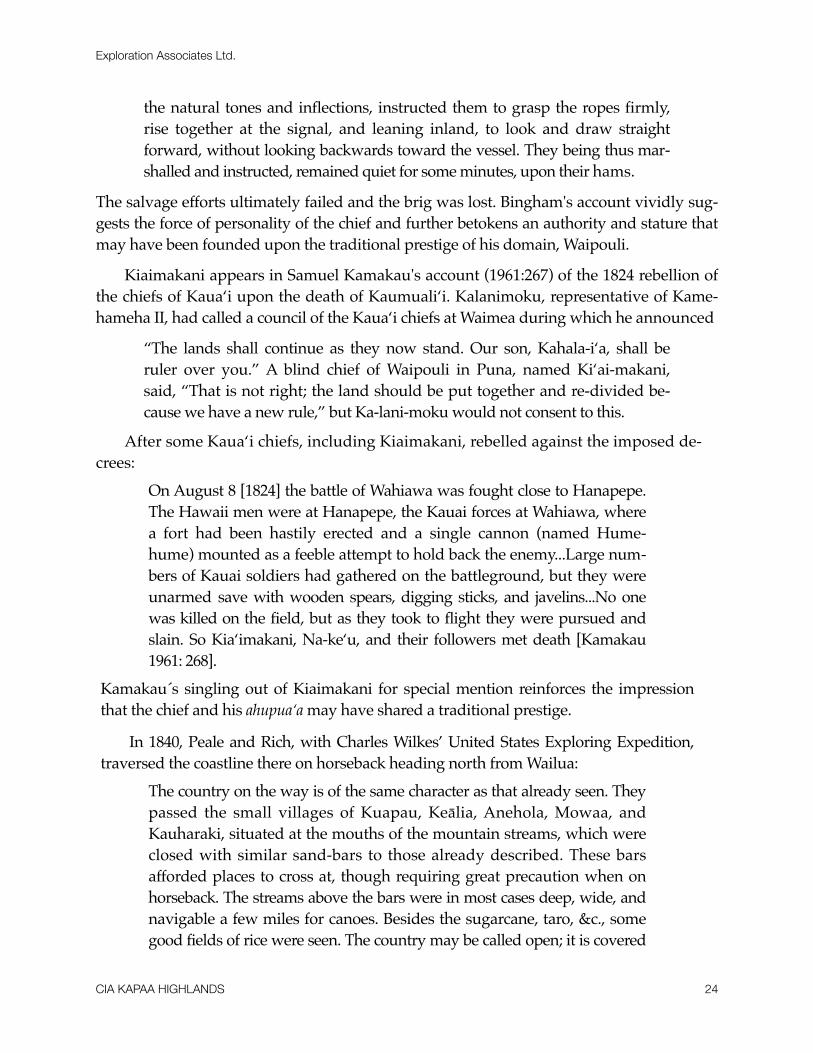
The Ahukini Terminal & Railway Company was formed in 1920 to establish a rail-road to connect Anahola, Keālia and Kapa‘a to Ahukini Landing at Hanamā‘ulu and to “provide relatively cheap freight rates for the carriage of plantation sugar to a terminal out-let” (Condé and Best 1973:185). This company was responsible for extending the Makee Sugar Company railroad line from the Makee Landing [formerly located near the present day Coral Reef Hotel] to the Ahukini Landing at Hanamā‘ulu Bay. This railroad line trav-ersed near much of the study area (Figures 4 & 5) and was in use from 1921, through the take-over by Lihue Plantation Company in 1934 and until Lihue Plantation converted from railroad transport to trucking in the late 1950s.
Lihue Plantation was the last plantation in Hawai‘i to convert from railroad transport to trucking (Condé and Best 1973: 167). In 1955, reports came out on the dredging for coral proposed for the reef fronting Kapa‘a Beach Park (Garden Island Newspaper, Sep-tember 21, 1955). This coral was to be used for building plantation roads. The dredg-ing was later blamed for accelerated erosion along Kapa‘a Beach (Garden Island Newspaper, October 30, 1963). Today, there are several sea walls along the Kapa‘a Beach Park to check erosion. Old time residents claim the sandy beach at Kapa‘a was once much more extensive than it is now. “By 1957 the company was salvaging a part of their plantation road, which was being supplanted by roads laid out for the most part on or close to the old rail bed” (Condé and Best 1973: 167). By 1959, the plantation had completely con-verted over to trucking.
Severe floods in Kapa‘a in 1940 led to the dredging and construction of the Waikaea and Moikeha Canals sometime in the 1940s (Territorial Planning Board 1940:7). Al-though the Waikaea Canal, bordering the Kapa‘a Pineapple Cannery, had been pro-posed as early as 1923, nothing was constructed until after the floods (Bureau of Land Con-veyances, Grant 8248). A Master Plan for Kapa‘a, published in 1940, asks the Territo-rial Legislature for funds to be set aside for the completion of a drainage canal and for filling makai and mauka of the canal (Territorial Planning Board 1940:7). In 1955, reports came out on the dredging for coral proposed for the reef fronting Kapa'a Beach Park (Gar-den Island Newspaper, September 21, 1955). The coral was to be used for building plantation roads. This dredging was later blamed for accelerated erosion along Kapa'a Beach (Garden Island Newspaper, October 30, 1963).
Today, there are several sea walls along the Kapa'a Beach Park to check erosion. Old time residents claim the sandy beach in Kapa'a was once much more extensive than it is now (Bushnell et al. 2002).
Many of the plantation workers bought property of their own and moved out of planta-tion camps. The plantation camps which bordered Kahio Highway were disbanded in the 1980s. The Lihue Plantation began to phase out in the last part of the 20th century. Kapa'a Town suffered after the closing of the Kapa'a Cannery, however the growing tourist indus-try helped to ease the economic affects of the Cannery's closing.
Exploration Associates Ltd.
CIA KAPAA HIGHLANDS 30
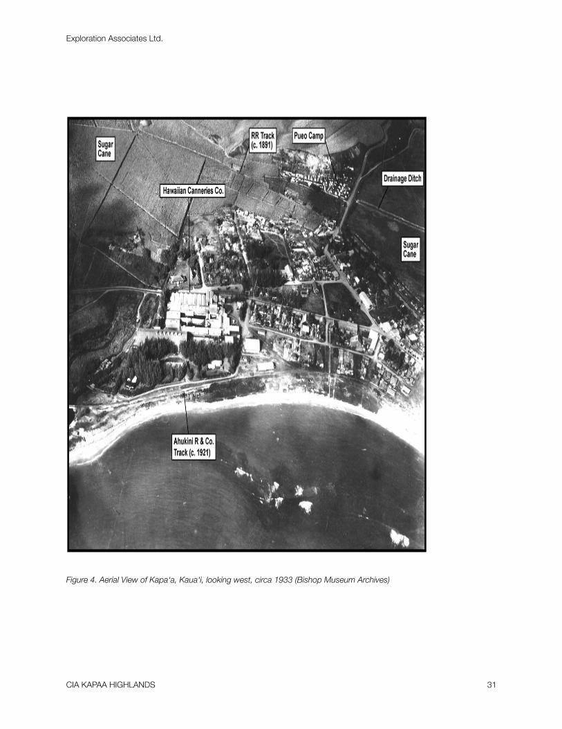
Figure 4. Aerial View of Kapa‘a, Kaua‘i, looking west, circa 1933 (Bishop Museum Archives)
Exploration Associates Ltd.
CIA KAPAA HIGHLANDS 31

Figure 5. Hawai‘i Territory Survey Map (Iao 1914) of Kapa‘a Section Showing Roads, Railroads and Camps
Exploration Associates Ltd.
CIA KAPAA HIGHLANDS 32
Previous Archaeological and Cultural Studies of Kapa‘a
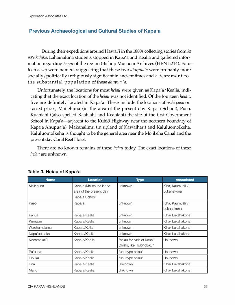
! During their expeditions around Hawai‘i in the 1880s collecting stories from ka pō‘e kahiko, Lahainaluna students stopped in Kapa‘a and Kealia and gathered infor-mation regarding heiau of the region (Bishop Musuem Archives (HEN I:214). Four-teen heiau were named, suggesting that these two ahupua‘a were probably more socially/politically/religiously significant in ancient times and a testament to the substantial population of these ahupua ‘a.
Unfortunately, the locations for most heiau were given as Kapa‘a/Kealia, indi-cating that the exact location of the heiau was not identified. Of the fourteen heiau, five are definitely located in Kapa‘a. These include the locations of wahi pana or sacred places, Mailehuna (in the area of the present day Kapa‘a School), Pueo, Kuahiahi ((also spelled Kaahiahi and Keahiahi) the site of the first Government School in Kapa‘a—adjacent to the Kuhiö Highway near the northern boundary of Kapa‘a Ahupua‘a), Makanalimu (in upland of Kawaihau) and Kaluluomoikeha. Kaluluomolkeha is thought to be the general area near the Mo`ikeha Canal and the present day Coral Reef Hotel.
There are no known remains of these heiau today. The exact locations of these heiau are unknown.
Table 3. Heiau of Kapa‘a
Name Location Type Associated
Mailehuna Kapa‘a (Mailehuna is the
area of the present day
Kapa'a School)
unknown Kiha, Kaumuali‘i/
Lukahakona
Pueo Kapa‘a unknown Kiha, Kaumuali‘i/
Lukahakona
Pahua Kapa‘a/Kealia unknown Kiha/ Lukahakona
Kumalae Kapa‘a/Kealia unknown Kiha/ Lukahakona
Waiehumalama Kapa‘a/Keilia unknown Kiha/ Lukahakona
Napu‘upa‘akai Kapa‘a/Kealia unknown Kiha/ Lukahakona
Noeamakali`i Kapa‘a/Kedlia "heiau for birth of Kaua‘i
Chiefs, like Holoholoku"
Unknown
Pu'ukoa Kapa‘a/Kealia "unu type heiau" Unknown
Piouka Kapa‘a/Kealia "unu type heiau" Unknown
Una Kapa‘a/Kealia Unknown Kiha/ Lukahakona
Mano Kapa‘a/Kealia Unknown Kiha/ Lukahakona
Exploration Associates Ltd.
CIA KAPAA HIGHLANDS 33

Name Location Type Associated
Kuahiahi Kapa‘a (govn't
school stands on site now)
Unknown Kaumuali‘i/
Lukahakona
Makanalimu Upland of Kawaihau Unknown Kaumuali‘i
Kaluluomoikeha Kapa‘a Unknown Mo‘ikeha
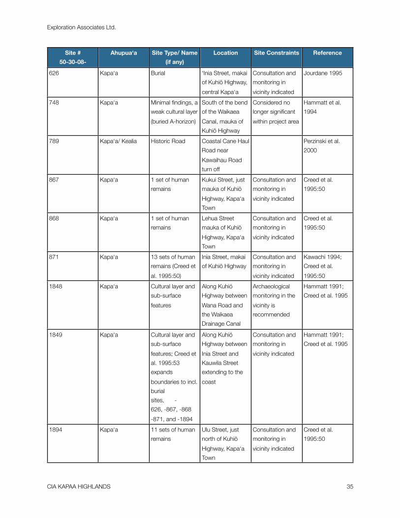
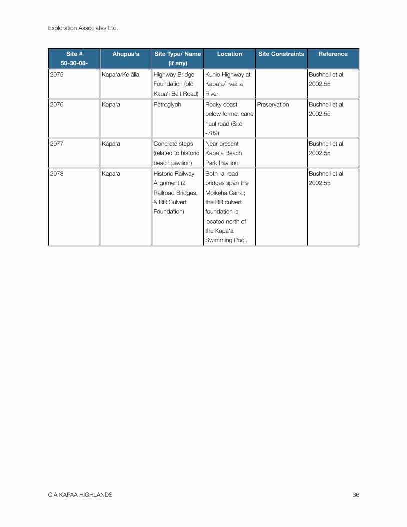
4. Historic Properties in Kapa‘a Ahupua‘a (see Figure 6)
Site #
50-30-08-
Ahupua‘a Site Type/ Name
(if any)
Location Site Constraints Reference
B001 Kapa‘a Historic Cemetery South of bend of
Kapa‘a Stream, a
kilometer mauka
from Kuhiö Hwy
Appears to be a
discrete historic
cemetery
Kikuchi and
Remoaldo 1992
B002 Kapa‘a Historic Cemetery Just mauka from
Kuhiö Highway,
south of Kapa‘a
Stream
Appears to be a
discrete historic
cemetery
Kikuchi and
Remoaldo 1992
B003 Kapa‘a Kapa‘a Public
Cemetery
South of Kanaele
Road, one
kilometer inland of
Kuhiö Highway
Appears to be a
discrete historic
cemetery
Kikuchi and
Remoaldo 1992
B004 Kapa‘a Historic Cemetery North of Apopo
Road, one
kilometer inland of
Kuhiö Highway
Appears to be a
discrete historic
cemetery
Kikuchi and
Remoaldo 1992
B013 Kapa‘a Historic Cemetery Just mauka from
Kuhiö Highway,
north of the
Waikaea Canal
Appears to be a
discrete historic
cemetery
Kikuchi and
Remoaldo 1992
B014 Kapa‘a All Saints
Episcopal Church
Cemetery
Just mauka from
Kuhiö Highway,
south of the
Waikaea Canal
Appears to be a
discrete historic
cemetery
Kikuchi and
Remoaldo
1992:62-65
547 Kapa‘a sub-surface
features including
a firepit and a
possible house
foundation
South of bend of
Waikaea Canal,
mauka of Kuhiö
Highway
Archaeological
monitoring in the
vicinity is
recommended
Spear 1992:3
Exploration Associates Ltd.
CIA KAPAA HIGHLANDS 34
Site #
50-30-08-
Ahupua‘a Site Type/ Name
(if any)
Location Site Constraints Reference
626 Kapa‘a Burial ‘Inia Street, makai
of Kuhiö Highway,
central Kapa‘a
Consultation and
monitoring in
vicinity indicated
Jourdane 1995
748 Kapa‘a Minimal findings, a
weak cultural layer
(buried A-horizon)
South of the bend
of the Waikaea
Canal, mauka of
Kuhiö Highway
Considered no
longer significant
within project area
Hammatt et al.
1994
789 Kapa‘a/ Kealia Historic Road Coastal Cane Haul
Road near
Kawaihau Road
turn off
Perzinski et al.
2000
867 Kapa‘a 1 set of human
remains
Kukui Street, just
mauka of Kuhiö
Highway, Kapa‘a
Town
Consultation and
monitoring in
vicinity indicated
Creed et al.
1995:50
868 Kapa‘a 1 set of human
remains
Lehua Street
mauka of Kuhiö
Highway, Kapa‘a
Town
Consultation and
monitoring in
vicinity indicated
Creed et al.
1995:50
871 Kapa‘a 13 sets of human
remains (Creed et
al. 1995:50)
Inia Street, makai
of Kuhiö Highway
Consultation and
monitoring in
vicinity indicated
Kawachi 1994;
Creed et al.
1995:50
1848 Kapa‘a Cultural layer and
sub-surface
features
Along Kuhiö
Highway between
Wana Road and
the Waikaea
Drainage Canal
Archaeological
monitoring in the
vicinity is
recommended
Hammatt 1991;
Creed et al. 1995
1849 Kapa‘a Cultural layer and
sub-surface
features; Creed et
al. 1995:53
expands
boundaries to incl.
burial
sites, -
626, -867, -868
-871, and -1894
Along Kuhiö
Highway between
Inia Street and
Kauwila Street
extending to the
coast
Consultation and
monitoring in
vicinity indicated
Hammatt 1991;
Creed et al. 1995
1894 Kapa‘a 11 sets of human
remains
Ulu Street, just
north of Kuhiö
Highway, Kapa‘a
Town
Consultation and
monitoring in
vicinity indicated
Creed et al.
1995:50
Exploration Associates Ltd.
CIA KAPAA HIGHLANDS 35
Site #
50-30-08-
Ahupua‘a Site Type/ Name
(if any)
Location Site Constraints Reference
2075 Kapa‘a/Ke ãlia Highway Bridge
Foundation (old
Kaua‘i Belt Road)
Kuhiö Highway at
Kapa‘a/ Keãlia
River
Bushnell et al.
2002:55
2076 Kapa‘a Petroglyph Rocky coast
below former cane
haul road (Site
-789)
Preservation Bushnell et al.
2002:55
2077 Kapa‘a Concrete steps
(related to historic
beach pavilion)
Near present
Kapa‘a Beach
Park Pavilion
Bushnell et al.
2002:55
2078 Kapa‘a Historic Railway
Alignment (2
Railroad Bridges,
& RR Culvert
Foundation)
Both railroad
bridges span the
Moikeha Canal;
the RR culvert
foundation is
located north of
the Kapa‘a
Swimming Pool.
Bushnell et al.
2002:55
Exploration Associates Ltd.
CIA KAPAA HIGHLANDS 36

Figure 6. Historic Properties in Kapa‘a, Waipouli and Olohena Ahupua‘a.
Exploration Associates Ltd.
CIA KAPAA HIGHLANDS 37

! In summary, the archaeological research of the Kapa‘a, area has been somewhat skewed to development which has mostly occurred along the coast. Early 20th century archaeological studies attested to the existence of upland terraces, however subsequent studies in the 1980s found no record of upland sites. Although there is little in the way of surface archaeology of Kapa‘a that has been able to withstand the test of time (with the exception of Kukui Heiau), archaeological studies have illustrated the vast poten-tial for intact subsurface cultural layers. These cultural deposits extend throughout modern day Kapa‘a Town, on the shorelines between the Waipouli Town Center and the Coconut Plantation Resort and along the coast in Olohena makai of the old Coconut Plantation Cinema. These cultural deposits suggest a long occupation of the area over many centuries beginning by the late 15th or early 16th centuries.
Exploration Associates Ltd.
CIA KAPAA HIGHLANDS 38

RESULTS OF COMMUNITY CONSULTATION
! As partial fulfillment of the Scope of Work, consultation with organizations and the community was conducted to identify knowledgeable kūpuna and participants to be interviewed, as well as others who could inform on the history of the subject area and previous land use. The organizations consulted were the State Historic Preservation Division, the Department of Land and Natural Resources (DLNR), the Office of Hawaiian Affairs, the Kaua‘i/Ni‘ihau Islands Burial Council, the Kaua‘i Historical Society, and the Kaua‘i Historic Preservation Review Committee (KHPRC).
A substantial effort was made to locate knowledgeable informants for the area of Kapa‘a. An attempt was made to contact as many individuals as possible. These led us to the 5 knowledgeable parties that were interviewed for this project. A cultural impact as-sessment conducted for the Kapa‘a-Kealia Bike and Pedestrian Path included a narrow corridor from the Waikaea Drainage Canal to Hömaikawa‘a, a small inlet beyond Kealia (Bushnell et al. 2002). In addition cultural impact assessment was also conducted for the Kapa‘a Relief Route (Bushnell et. al. 2004). Only one cultural impact assessment has been conducted for the uplands of Kapa‘a for the proposed Water Reservoir Mauka Locale in Kapa‘a, Kaua‘i Island (Mitchell et. al. 2004). These CIA and historic research of the project area, community consultation and informant interviews were combined to provide an assessment of cultural traditions, both past and present.
Traditions were also collected in connection to the streams, canals and marsh areas where ‘ōpae and ‘o‘opu were once found in abundance. Fishing for ‘oama in Kapa‘a’s canals continues to be a lively family tradition during the summers.
Consultation Process
! Through the consultation process, five individuals were identified as potential informants. Three had written letters of their knowledge of the area (Stanley Vasques,
Exploration Associates Ltd.
CIA KAPAA HIGHLANDS 39
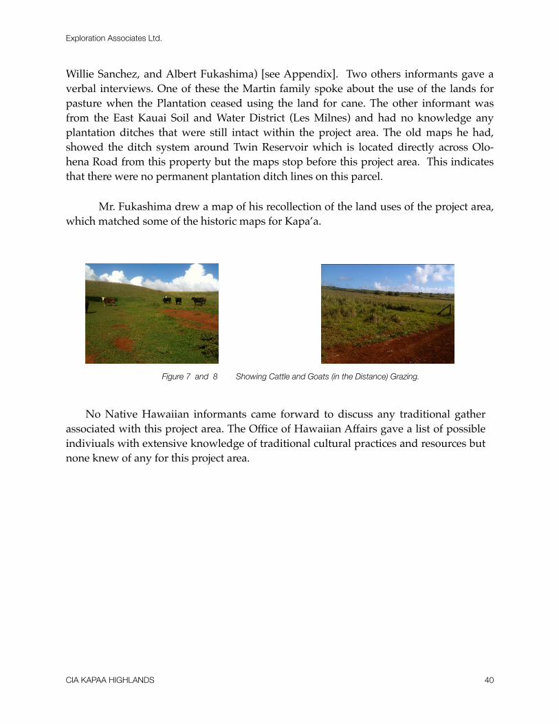
Willie Sanchez, and Albert Fukashima) [see Appendix]. Two others informants gave a verbal interviews. One of these the Martin family spoke about the use of the lands for pasture when the Plantation ceased using the land for cane. The other informant was from the East Kauai Soil and Water District (Les Milnes) and had no knowledge any plantation ditches that were still intact within the project area. The old maps he had, showed the ditch system around Twin Reservoir which is located directly across Olo-hena Road from this property but the maps stop before this project area. This indicates that there were no permanent plantation ditch lines on this parcel.
! Mr. Fukashima drew a map of his recollection of the land uses of the project area, which matched some of the historic maps for Kapa’a.
Figure 7 and 8 Showing Cattle and Goats (in the Distance) Grazing.
No Native Hawaiian informants came forward to discuss any traditional gather associated with this project area. The Office of Hawaiian Affairs gave a list of possible indiviuals with extensive knowledge of traditional cultural practices and resources but none knew of any for this project area.
Exploration Associates Ltd.
CIA KAPAA HIGHLANDS 40

Figure 9. KIUC’s Solar Farm and Equipment Buildings.
Exploration Associates Ltd.
CIA KAPAA HIGHLANDS 41
TRADITIONAL CULTURAL PRACTICES OF KAPA‘ A
Burials
! The coastline in Kapa‘a once contained extensive sand dunes that were documented in travels throughout the nineteenth century (Knudsen 1991; Alexander 1991). Most of the sand dunes were modified or destroyed at the onset of the twentieth century. This was due to the extensive use of the coastal areas for ranching, settlement, and new transportation routes like trains and roads. Archaeological studies in the Kapa‘a area demonstrate the widespread prehistoric use of sand as a medium for burials. Burials have been idenfied along the coast and extending well mauka of the coastline into present day Kapa‘a Town. Cultural deposits found associated with burials in the Kapa‘a area shed light on the Hawai-ian tradition of burying members of the ´ohana in the kulaiwi, or birth land.
For Hawaiians, “man’s immortality was manifest in his bones...Even the bones of the living became symbols of the link between man’s progenitors and his own eventual immortal-ity” (Pukui et al. 1972:106). Thus, the discovery of iwi (bones) is a very sensitive issue for the Hawaiian community requiring much mediation and protocol.
No burials are believed to be present within the project area and none are known in the vicinity.
Marshlands of Kapa‘a
! The areas inland of Kapa‘a and Waipouli Towns were formerly the marshlands of Kapa‘a. During the 20th century, portions of the marshlands of Kapa‘a and Waipouli were filled, drained and designated as marginal agricultural lands. Traditionally, how-ever, these marshlands were once much more significant. Westerners may call them “swamps,” but Hawaiians who grew up in the Kapa‘a and Waipouli area knew they were fishponds (Bushnell et. al. 2004). Many kama‘aina recall fishing for freshwater shrimp and
Exploration Associates Ltd.
CIA KAPAA HIGHLANDS 42
gobies, the ‘opae and ‘o‘opu. For the Kaneakua brothers, their childhood memories of ‘opae are tied to the old Chinese vendors who once traversed the neighborhood selling the shrimps.
I can remember Chinese, they used to catch shrimp, fresh water shrimp in big five gallon can. They put it in there, both side and they have their stick across, walking through the little village that we were over there and used to come out and say, “‘Opae, ‘Opae” and families who want buy the ‘opae and they used to dig it out in a big a scoop, bowl, and was so much you know. Yeah, those were the days. Our streams used to be loaded with shrimp (In-terview with J. & W. Kaneakua 8/1/02 in Bushnell et al. 2002).
One informant said that his experience catching ‘opae centered on the irrigation ditches that drained the marshlands behind Kapa‘a. “My first lessons in swimming were in the drain ditches the sugar people created to dry out their cane lands. Also in the ditches were the ‘opae or river shrimp. I caught ‘opae and cooked them with soy sauce in recycled oil sardine cans.” (Interview with G. Hiyane, 5/14/03 in Bushnell et. al. 2004). One individual who grew up in Pueo Camp adjacent to the marsh recalls frequenting the irrigation ditches in Waipouli for ‘ōpae, ‘o‘opu, and pantat (catfish) that were then sold to the old Chi-nese men in the camp for 10¢ (Personal communication with G. Mukai, 8/5/03 in Bushnell et. al. 2004).
Mr. Sokei who grew up in a rice growing family in the back of what is known as All Saints Church in Kapa‘a shared some memories of his home in the 1930s that may reflect the land-scape a hundred years prior. Mr. Sokei remembers the family home located on high ground above the marsh. “Back then, the land was natural, full of mounds. Rice was culti-vated in fields all the way to the hills. The water level in the marsh would go up and down with the tide and when there was lots of water, one could find ‘o‘opu, ‘ōpae, catfish, frogs and mud turtles for eating” (Personal communication with T. Sokei, 7/28/03 in Bush-nell et. al. 2004). Likewise, the kuleana awards of the 1840s and 1850s present a picture of homes scattered on the edges of the marsh and on islands of high ground within the marsh. Numerous ‘auwai were constructed to irrigate lo‘i kalo. Hau bush was shaped into fences to separate kuleana or physical features and fishponds were built to stock fish. For Hawaiians living the marsh was an extremely productive area constituting the basis of their existence.
The notion that the marshlands were quite significant traditionally is also evident in the Hawaiian place names, particularly the wahi pana (storied places) associated with the Kapa‘a/Waipouli marsh. Mãkaha-o-Kupãnihi was a pond, a “deep pool set aside for ali‘i to bathe in” located at the border of Kapa‘a and Waipouli Ahupua‘a presumably within the marsh (Lahainaluna Students Compositions, No. 15). It was here that Kaumuali‘i’s half-brother Keawe was shot to death forever defiling the waters of Kupãnihi. Another wahi pana in this district was Këwã. The proverb ‘ke kalukalu o Kēwā’ refers to a certain type
Exploration Associates Ltd.
CIA KAPAA HIGHLANDS 43
of grass, kalukalu (used in making a very soft gauze or kapa) found growing in the marsh-lands of Kapa‘a and Waipouli (Fornander 1916:IV:162).
Gathering for Plant Resources
! Hawaiians utilized upland resources for a multitude of purposes. Forest re-sources were gathered, for not only the basic needs of food and clothing, but for tools, weapons, canoe building, house construction, dyes, adornments, hula, medici-nal and religious purposes. The present project area is dominated by alien vegetation (albezia, ginger, California grass) although some traditional cultigens (banana, bamboo, kid and historically introduced food plants (papaya) are present as well. Within the pro-ject area itself no specific documentation was found regarding gathering of plants dur-ing traditional Hawaiian times. During this assessment there were no ongoing prac-tices related to traditional gathering of plant resources identified in the present pro-ject area. None of the individuals contacted for this assessment identified any native plant gathering practices within the project area.
Historic Properties
! No historic properties were identified within the project area or in the vicinity. The density of identified historic properties is far greater near the coast of Kapa‘a Ahupua'a. For a listing of the historic properties of Kapa‘a, Kaua‘i, see Table 4.
Trails
! Based on nineteenth and twentieth century maps the primary transporta-tion routes mauka/makai correlated closely to the existing major roadways. During this assessment there were no trail systems identified in the proposed project area.
Planation Ditch System or ‘Auwai
! Based on the archaeological assessment (McMahon, 2012), field checks, docu-mentation from land records, plantations records and maps, and informants informa-tion, no remnants of these historic properties exist. Several pieces presumed to be rem-
Exploration Associates Ltd.
CIA KAPAA HIGHLANDS 44
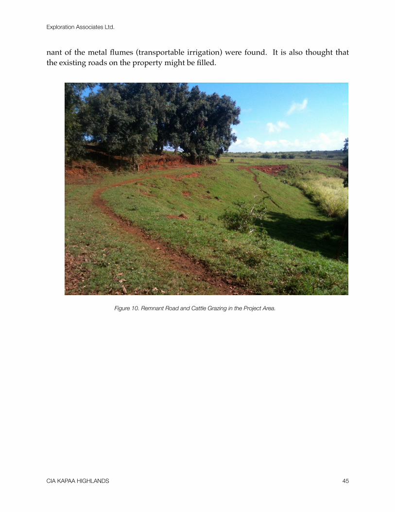
nant of the metal flumes (transportable irrigation) were found. It is also thought that the existing roads on the property might be filled.
Figure 10. Remnant Road and Cattle Grazing in the Project Area.
Exploration Associates Ltd.
CIA KAPAA HIGHLANDS 45
SUMMARY AND CONCLUSIONS
A cultural impact assessment was conducted for the proposed Kapa‘a Highlands Phase II. Historic research of the project area was carried out to identify any cultural re-sources or traditional cultural practices associated with the area encompassing the pro-posed Kapa‘a Highlands Phase II. In addition, community consultation was conducted. An attempt was made to contact parties regarding cultural knowledge, land use history, cul-tural sites and traditional Hawaiian or other cultural practices in the vicinity of the pro-ject area. Five individuals came forward as knowledgeable informants. In addition to the informants, other community members shared valuable information regarding tradi-tional land use, attitudes and practices associated with the project area.
The marshlands of Kapa‘a were once a significant resource prior to Western contact. The fringes of the marsh were utilized for lo‘i kalo, and other resources including the gather-ing of kalukalu, a type of grass utilized for kapa. Places in the marshes also served as fish-ponds. Vestiges of the cultural significance of the marshlands are retained in the mo‘olelo and ‘olelo no‘eau particular to this area. With the establishment of the sugar plantations in the late nineteenth century, the marshlands were significantly altered. Marsh areas were drained and filled to create more dryland for commercial agriculture and pasture land. Several individuals consulted and interviewed grew up fishing for ‘ōpae and ‘o‘opu in the irrigation ditches which once drained the swamps. They expressed sadness at the changing of the landscape and the passing of their childhood traditions with the final draining and filling of the swamps. No further concerns regarding the marshlands were expressed other than the presumed low potential of possibly encountering habitation deposits and burials related to former LCA parcels.
This report documents the use of the ‘auwai or plantation ditches for irrigation and wa-ter use by the residents up until the 1960s. The ‘auwai were also utilized for a variety of ac-tivities beyond their primary irrigation purpose. The bulk of the ‘auwai have been lost through modern pasturage, disuse and adjacent road improvements.
In general the community emphasized the importance of communicating with the ‘ohana of Kapa‘a regarding changes to the land. This includes asking permission of the ‘ohana, including ‘uhane (immortal spirits) for opening up the land to proposed new
Exploration Associates Ltd.
CIA KAPAA HIGHLANDS 46
uses. It was stressed that this and other protocols are necessary to “open the path” for change, thus avoiding accidents and potential obstacles of a cultural nature.
In summary, there are no known traditional resources or cultural practices associated with the Kapaa Highlands Project Area.
Exploration Associates Ltd.
CIA KAPAA HIGHLANDS 47
BIBLIOGRAPHY
Akina, Joseph1913! “I Ke hou I Ka Lulu-o-Moikeha I ka laula o kapaa”, Ku‘oko‘a. May 2-9,
1913. Bishop Museum Archives HEN Place Names, Kauai.
Alexander, William Patterson1991 "A Tour of Kauai in 1849: Private Journal of William DeWitt Alexan-
der," The Kauai Papers, Kauai Historical Society, A Kauai Historical So-ciety Publication, Lihue, Kauai, HI.
Armitage, George T.and H.P. Judd1944! Ghost Dog and Other Hawaiian Legends; Advertiser Publishing Co., Ltd.,
Honolulu.Armstrong, Warwick, Ed.
1973! Atlas of Hawai‘i, University of Hawaii Press, Honolulu.Barrère, Dorothy, compiler
1994! The King's Māhele: The Awardees and Their Lands, Honolulu, HI.Beckwith, Martha W.
1970! Hawaiian Mythology, University of Hawaii Press, Honolulu, HI.
Bennett, Wendell C.1931! The Archaeology of Kaua`i, Bishop Museum Bulletin 80, Honolulu.
Bingham, Hiram1847! A Residence of Twenty-One Years in the Sandwich Islands, Huntington,
Hartford.Conn., Convers, New YorkBishop Museum Archives
HEN I: 214 "Heiaus of Kealia and Kapa`a" and "Well Known Things [or Places]".
HEN I: 215 "Famous Things mentioned by Two Men".HEN I: 216 "Heiaus from Kapa'a to Kealia" and "Things for which Ka-pa'a was Known".
Borthwick, Douglas F. and Hallett H. Hammatt
Exploration Associates Ltd.
CIA KAPAA HIGHLANDS 48
1999! Archaeological Monitoring and Burial Treatment Plans for the ProposedImprovements to the Kapa‘a Seventh-day Adventist Church, Kapa`a Ah-upua`a, Puna District, Kaua`i Island (TMK 4-5-03: 19), Cultural Surveys Hawai‘i, Kailua, HI.
Boundary Commission see Commission of Boundaries
Buck, Peter H. (see also Te Rangi Hiroa)1964! Arts and Crafts of Hawaii, Bishop Museum Special Publication 45, Vol. I,
Honolulu.Bureau of Land Conveyances
Grant 8248
Bushnell, K.W., D.W. Shideler, and H. H. Hammatt2002! Cultural Impact Assessment for the Proposed Kapa‘a -Kealia Bike and
Pedestrian Path, Kapa‘a and Kealia, Kawaihau District, Kaua‘i Island, Ha-wai’i (TMK: 4-5, 4-6-14, 4-7-03 & 04), Vols. I & II; Cultural Surveys Hawai’i, Inc., Kailua, HI
2004 Cultural Impact Assessment for Kapa‘aRelief Route:Kapa‘a Waipouli, Olena and Hanamaulu, Kaua‘i Island, Hawai’i Cultural Surveys Hawai’i, Kailua, HI
Bushnell, Kristina and Hallett H. Hammatt2000! An Archaeological Monitoring Report for Improvements to the Kapa‘a
Seventh-Day Adventist Church, 1132 Kuhio Highway, Kapa‘a Ahupua‘a, Dis-trict of Puna, Island of Kauai (TMK 4-5-03:19), Cultural Surveys Hawaii, Kailua, HI.
Bushnell, K.W., Melanie Mann, Douglas Borthwick, Tony Bush, Todd Tulchin, David Shideler and Hallett H. Hammatt
2003 Archaeological Inventory Survey for the Proposed Kapa'a/Kealia Bike and Pedestrian Path, Kapa 'a and Kealia, Kawaihau District, Kaua `i Island, Hawai (TMK 4-5, 4-6-14, 4-7-03 & 04). Cultural Surveys Hawaii, Inc. Kailua, HI.
Calis, Irene2000 End of Field Work Report: Human Burial Removal and Archaeological Monitoring, Kapa‘a Beach Park Public Bathroom Installation, Kapa‘a, Kaua‘i Scientific Consultant Services.
Chafee, David B., Berdena Burgett and Robert L. Spear1994a An Inventory Survey of a Mamane Street Houselot, Kapa‘a !
!Ahupua’a, Kawaihau District, Puna, Island of Kaua‘i (TMK: 4-5-09:51), SCS Inc., Kane‘ohe, HI.
Exploration Associates Ltd.
CIA KAPAA HIGHLANDS 49
1994b An Inventory Survey of a Kukui Street Houselot, Kapa‘a Ahupua‘a,Kawaihau District, Puna, Island of Kaua‘i (TMK: 4-5-09:10), SCS Inc., Kane‘ohe, HI.
Chaffee, David B. and Robert L. Spear1995! A Reconnaissance Survey Letter Report, Earl & Maggie Arruda Property,
Kapa‘a, Kaua‘i, Hawai’i, TMK 4-4-02:100 Scientific Consultant Services, Inc. Kane’ohe, HI.
Ching, Francis K. W.1976 Letter Report: Archaeological Reconnaissance - Report, Kapa 'a "Wastewater
Treatment and Disposal System, ARCH 14-96, Letter to R. M Towill Corpora-tion, ARCH, Lawa`i, Kaua`i, HI.
Clark, John R.K.2002! Hawai‘i Place Names, Shores, Beaches and Surf Sites, University of
Hawaii Press, Honolulu, HI.
Commission of Boundaries1864-1905! Record of Commission of Boundaries for the Island of Kaua‘i, vol.
1, Honolulu, HI.Condé, Jesse C. and Gerald M. Best
1973! Sugar Trains, Narrow Gauge Rails of Hawaii, Glenwood Publishers,Felton, CA.
Cook, Chris1999! “Kaua‘i, the Garden Island: A Pictorial History of the Commerce and
Work of the People”, Donning Co., Virginia Beach, VA.Cooper, George and Gavan Daws
1990! Land and Power in Hawaii, The Democratic Years; University of HawaiiPress, Honolulu.
Coulter, John Wesley1931! Population and Utilization of Land and Sea in Hawaii, 1853 Bernice P.
Bishop Museum Bulletin 88, Honolulu, Hawaii.
Coulter, John Wesley and Chee Kwon Chun1937! Chinese Rice Farmers in Hawaii, University of Hawai‘i, Honolulu.
Creed, Victoria, Hallett H. Hammatt, Gerald K. Ida, Ian Masterson and John Winieski1995! A Summary of the Archaeological Monitoring for the Kapa‘a SewerlineProject Waipouli and Kapa‘a Ahupua‘a, Puna District, Kaua‘i (TMK: 4-3-09 and 4-5-03 to 11), Cultural Surveys Hawaii, Kailua, HI.
Exploration Associates Ltd.
CIA KAPAA HIGHLANDS 50

Damon, Ethel M.1931! Koamalu, Privately printed at the Honolulu Star-Bulletin Press, Honolulu,
(2 Volumes). Dega, Michael F. and James Powell
2003! Archaeological Monitoring During Phase I of the Kaua‘i Rural Fiber OpticDuct Lines Project, Kaua‘i Island, Hawai‘i. Scientific Consultant Services
Dole, Charles S.1929! The Hui Kawaihau" in Papers of the Hawaiian Historical Society, Number
16, Honolulu.
Donohugh, Donald2001 The Story of Koloa, A Kaua `i Plantation Town, Mutual Publishing, Honolulu, HI.
Elmore, Michelle and Joseph Kennedy2003 An Archaeological Monitoring Report for the Proposed Kiihio Drainage
Improvements Kapa'a and Anahola (Project # 56AC-01-01) Located in Kawaihau District, Island of Kaua ACPI.
Foote, Donald E., Elmer L. Hill, Sakuichi Nakamura, and Floyd Stephens1972! Soil Survey of the Islands of Kauai, Oahu, Maui, Molokai, and Lanai,
State of Hawaii. Soil Conservation Service, U.S. Department of Agri-culture.
Fornander, Abraham1878-85 An Account of the Polynesian Race, Its Origin and Migrations and the An-
cient History of the Hawaiian People to the Time of Kamehameha I, 3 vols., Trubner & Co., London.
Fornander, Abraham1917-1918 Collection of Hawaiian Antiquities and Folklore, T.G. Thrum edit.,
Memoirs of the Bernice Pauahi Bishop Museum (Vol. IV & V), Bishop Mu-seum Press, Honolulu.
Fornander, Abraham1996! Ancient History of the Hawaiian People to the Times of Kamehameha I,
with an Introduction by Glen Grant, Mutual Publishing, Honolulu, HI.Garden Island Newspaper
1955! “Geologists Says Kapaa Coral Removal No Threat to Town”. September 21, 1955.
Exploration Associates Ltd.
CIA KAPAA HIGHLANDS 51
1963! “Kapaa Blames Feceral Role As Erosion Continues. Says Barrier on Reefis Required”. October 30, 1963.
1983 ! "Centennial Year, Kapa'a School Wants Pix of its 100 Years". April 1, 1983.
Giambelluca, Thomas W., Michael A. Nullet and Thomas A. Schroeder1986 ! Rainfall Atlas of Hawaii, Department of Land and Natural Resources,
Honolulu, HI.Glick, Clarence E.
1980! Sojourners and Settlers: Chinese Migrants in Hawaii. Hawaii ChineseHistory Center and The University Press of Hawaii, Honolulu.
Hammatt, Hallett H.1981! Archaeological Reconnaissance of 52.56 Acres for a Proposed
Subdivision, TMK:4-8(?)-13-1, Kapa‘a, Puna, Kaua‘i Island, ARCH Report 140298, Prepared for Waialeale Partners.
1986 ! Archaeological Reconnaissance of the Makaleha Springs Water SourceDevelopment, Kapa‘a, Kaua‘i TMK: 4-6-01:1, Cultural Surveys Hawaii, Kailua, HI.
1987! Letter Reports on Kapa‘a Sewerline Project
1991a ! Archaeological Subsurface Testing for the Proposed Kapa 'a Sewer line, Wailua, Olohena, Waipouli and Kapa 'a, Kaua `i, Cultural Surveys Hawai`i, Kailua, HI.
1991b! Archaeological Subsurface Testing for the Proposed Kapa‛a Sewerline,Wailua, Olohena, Waipouli and Kapa‘a, Kaua‘i, Cultural Surveys Ha-wai‘i, Kailua, O‘ahu.
Hammatt, Hallett H., Rodney Chiogioji, Gerald K. Ida, and Victoria S. Creed1997 ! An Archaeological Inventory Survey for the Kuhio Highway Widening
and Bypass Options within the Ahupua‘a of Wailua, South Olohena, North Olohena, Waipouli & Kapa‘a, Island of Kaua‘i , with Appendix on Paly-nology by Jerome Ward, Ph.D., Cultural Surveys Hawaii, Kailua, HI.
Hammatt, Hallett H., Gerald K. Ida, and Rodney Chiogioji1994 ! Archaeological Document Review and Assessment of Three Alternative
Widening and Bypass Options for the Kuhio Highway Within the Ah-upua‘a of Hanamaulu, Wailua, South Olohena, North Olohena, Waipouli & Kapa‘a, Lihu‘e and Kawaihau Districts, Island of Kaua‘i, Revised 1994, Cultural Surveys Hawaii, Kailua, HI.
Exploration Associates Ltd.
CIA KAPAA HIGHLANDS 52
Hammatt, Hallett H., Gerald K. Ida and William H. Folk1994! Archaeological Inventory of a 1.87-Acre Parcel, Kapa‘a, Kaua‘i (TMK 4-
5-05:6), Rev. August 1994, Cultural Surveys Hawaii, Kailua, HI.
Hammatt, Hallett H. and David W. Shideler2004 ! Archaeological Assessment of Alternative Routes Proposed for the
Lydgate to Kapa‘a Bike and Pedestrian Pathway Project Within the Ahu-pua‘a of Wailua, South Olohena, North Olohena, Waipouli and Kapa‘a, Cultural Surveys Hawai`i, Kailua, HI.
Hammatt, Hallett H., David W. Shideler and William H. Folk2002 Archaeological Study in Support of Proposed Kuhio Highway Im-
provements (Kapa‘a By-Pass) Hanama‘ulu to Kapa‘a Ahupua‘a, Kaua‘i, Cultural Surveys Hawai‘i, Kailua, HI.
Handy, E.S. Craighill1940! The Hawaiian Planter, Volume 1, Bishop Museum, Bulletin No. 161.,
Honolulu, HI.
Handy, E.S. Craighill, and Elizabeth G. Handy1972! Native Planters in Old Hawaii, Bishop Museum Press, Honolulu, HI.
Hawaii State Archives1837 Interior Department, Land, Incoming Letter. August 1837.
1882 Interior Department, Letter book, Vol. 20, p. 426, Letter from ! Spalding to the Honorable Jacob Hardy, Circuit Judge—Fourth ! !
! ! Circuit KauaiHawaii Territorial Planning Board
1940 ! Master Plan of the Town of Kapa‘a, In collaboration with the Kaua‘i County Board of Supervisors, Publication No. 8. Advertiser Publishing Co., Honolulu, HI.
Honolulu Advertiser1997 ! "Amfac to put more land up for sale: Tracts on Kaua‘i, Big Island" by Mike
Gordon. July 7, 1997. Section Bl.1960 "Kaua‘i Tries to See into Future. March 20, 1960.
Jarves, James Jackson1844! Scenes and Scenery in the Sandwich Islands and a Trip through Central
America 1837-42, J. Munroe and Co., Boston.
Exploration Associates Ltd.
CIA KAPAA HIGHLANDS 53
Joesting, Edward1984 ! Kaua‘i, The Separate Kingdom, University of Hawaii Press and Kaua‘i Mu-
seum Association, Ltd., Honolulu
Jourdane, Elaine1995! Inadvertent Discovery of Human Remains at 1382-A Inia Street, Kapa‘a ,
Kaua‘i (Kapa‘a Sewerline Project Laterals) Site 626, SHPD, Honolulu, HI..Kalākaua, David
1888! The Legends and Myths of Hawaii, Charles L. Webster, (Reprint of threevolumes published in 1877-85), New York.
Kamakau, Samuel Manaiakalani1961! Ruling Chiefs of Hawaii, The Kamehameha Schools Press, Honolulu, HI.
Kamakau, Samuel Manaiakalani1976! The Works of the People of Old, Bishop Museum Special Publication, No.
61, Honolulu.Kapa ̀a Elementary School
1933! Kapaa Elementary School, Kula O Kapa‘a, 1883-1933, Published by theschool on its fiftieth anniversary, Kapa‘a , Kaua‘i .
1983 ! Kapa 'a School 1883-1983: A "Century of Knowledge". Kapa'a Elementary, !! Kapa`a, Kaua` i.
Kawachi, Carol T.1994 ! Inadvertent Burial at 1316 Inia Street (Jasper) TMK 4-5-08:33, Kapa 'a, !! Kawaihau, Kauai 50-30-08-871, State Historic Preservation Division, ! Honolulu, HI.
Keaweamahi, D.1876! “Huakai makaikai ia Kauai.” Ka Lahui Hawai‘i, 10 & 17 August 1876.
“Tour of Kauai.” English Translation by M.K. Pukui. BMA: HEN Thrum #227.
Kikuchi, William K. and Susan Remoaldo1992! Cemeteries of Kaua‘i, Vol. 1, Kaua‘i Community College and University
of Hawai‘i, Puhi, Kaua‘i .
King, Robert D.1935! "Districts in the Hawaiian Islands" In Coulter, John Wesley (compiler) A
Gazetteer of the Territory of Hawaii, University of Hawaii Research Publi-cations, No. 11, University of Hawaii, Honolulu, Hi.
King, Robert D., compiler1942! Real Property, Appraisers Manual, Honolulu, HI.
Exploration Associates Ltd.
CIA KAPAA HIGHLANDS 54
Klass, Tim1970! World War II on Kauai: Historical Research, Prepared for the Kauai
Historical Society by The Westland Foundation, Portland, Oregon.
KRD (Kaua‘i Renovation and Development - Kaipo Akana)1994! Archaeological Monitoring of the Rock Wall Revetment for Burial Site -
746Lai, Violet L. assisted by Kum Pui Lai
1985! He Was a Ram, Wong Aloiau of Hawaii, Published for the HawaiiChinese History Center and the Wong Aloiau Association by University Press of Hawai‘i, Honolulu.
Lydgate, J.M.1917! Kaumuali‘i, The Last King of Kaua‘i, Hawaiian Historical Society,
Annual Report No. 24, Honolulu.
Lydgate, John M.1916! "The Pictured Rocks", The Garden Island, 22 February: 5.
MacDonald, G.A. and Abbott, A.T.1970!Volcanoes in the Sea. University of Hawaii Press, Honolulu.
McMahon, Nancy A.1996! Archaeological Inventory Survey for 5 Unit Apartment, TMK: 4-5-05:8,
Kapa‘a, Kawaihau, Kaua‘i, Exploration Associates, Ltd., Koloa, Kauai, HI.
1994 ! Inadvertent Burial Find, Kapa 'a, Kawaihau, Kaua `i, SHPD, Honolulu, HI1993a! Inadvertent Burial Discovery and Disinterment, Site 50-30-09-6011, State
Preservation Division, DLNR, Honolulu, HI.1992a! Field Inspection Report for Site 50-30-04-1880, on file at State Historic
Preservation Division. 1992b! Field Inspection Report for Site 50-30-04-1881, on file at State Historic
Preservation Division. 2012! An Archaeological Assessment for the Kapaa Highlands Phase II, TMK: (4)
4-3-03:01, Exploration Associates Ltd, Lihue, Kauai
Mitchell, Auli’i and Hallett Hammatt2004! A Cultural Impact Assessment For A Proposed Water Reservoir, Kapa’a
Ahupua’a, Kawaihau District, Kaua’i, TMKS 4-6-11:, 4-6-8:24, 4-6-03: 30, Cultural Surveys Hawaii, Kailua HI
Malo, David1951! Hawaiian Antiquities, Bishop Museum Press: Honolulu.
Exploration Associates Ltd.
CIA KAPAA HIGHLANDS 55

Nakuina, Moses K.1990! The Wind Gourd of La‘amaomao, Translated by Esther T. Mookini and
Sarah Nakoa, Kalamaku Press, Honolulu.
Office of the Commissioner of Public Lands1929! Indices of Awards, Made by the Board of Commissioners to Quiet Land
Title in the Hawaiian Islands.
Pacific Planning & Engineering, Inc.1992! Environmental Assessment and Environmental Impact Statement
Preparation Notice Kuhio Highway, Hanamaulu to Kapaa Project Number 56A-07-90, Kapa‘a, Kaua‘i, Hawai‘i, For U.S. Department of Trans-portation Federal Highways Administration and State of Hawai‘i, Depart-ment of Transportation Highways Division.
Perzinski, Mary and Hallett H. Hammatt2001! A Summary of Archaeological Monitoring for the Kuhio Highway,
Waikaea Bridge Widening Project Kapa‘a Ahupua‘a, Kawaihau District,
Kaua‘i Island (TMK: 4-3-06 to 4-3-08), Cultural Surveys Hawaii, Kailua, HI.
Porteus, Stanley B.1962! A Century of Social Thinking in Hawaii, Pacific Books Publication, Palo
Alto, CA.
Pukui, Mary Kawena1983! Olelo No‘eau: Hawaiian Proverbs and Poetical Sayings, Bishop Museum
Special Publication No.71, Bishop Museum Press, Honolulu.1986 Hawaiian Dictionary, 2ndEdition, University of Hawaii Press, Honolulu, HI.
Pukui, Mary K., Samuel H. Elbert and Esther Mookini1974! Place Names of Hawai‘i, University of Hawai‘i Press, Honolulu.
Rice, William Hyde1923! Hawaiian Legends, Bernice P. Bishop Museum Bulletin 3, Honolulu..
Spear, Robert L.1992c! Letter Report Concerning Monitoring for the Cost-U-Less Project Kapa‘a,
Kaua‘i , Hawai‘i (TMK: 4-5-5:4&9), Scientific Consultant Services Inc.
Territorial Planning Board, Territory of Hawaii in collaboration with the County Board of Su-pervisors, County of Kaua‘i
1940! Master Plan of the Town of Kapaa, County of Kauai, Hawaii, PublicationNo. 8, Advertiser Publishing Co., Ltd., Honolulu.
Exploration Associates Ltd.
CIA KAPAA HIGHLANDS 56
Thrum, Thomas G.1906! "Heiaus and Heiau Sites Throughout the Hawaiian Islands, Kauai, in:
Hawaiian Almanac and Annual 1907, pp. 36-48, Honolulu, HI.1923! More Hawaiian Folk Tales, A.C. McClurg & Co., Chicago.
1998! Hawaiian Folk Tales: A Collection of Native Legends, MutualPublishing, Honolulu.
Vancouver, George1798! A Voyage of Discovery to the North Pacific Ocean and Round the World
Performed in the Years 1790-95, 6 vols., John Stockdale, London.Van Ryzin, Karl and Hallett H. Hammatt
2004 ! An Archaeological Assessment For The Proposed Water Reservoir, Kapa 'aAhupua 'a, Kaua `i TMK 4-6-03:10 Cultural Surveys Hawai`i, Kailua, HI.
Wichman, Frederick B.1998! Kaua‘i Ancient Place Names and Their Stories. University of! Hawaii Press: Honolulu.
1985 ! Kauai Tales, Bamboo Ridge Press, Honolulu, HI
Wilkes, Charles1845?! Narrative of the United States Exploring Expedition, During the Years
1838, 1839, 1840, 1841, 1842, 5 Vols. Lea and Blanchard, Philadelphia, Pa.
Exploration Associates Ltd.
CIA KAPAA HIGHLANDS 57
APPENDIX
Letters from Informants
Exploration Associates Ltd.
CIA KAPAA HIGHLANDS 58
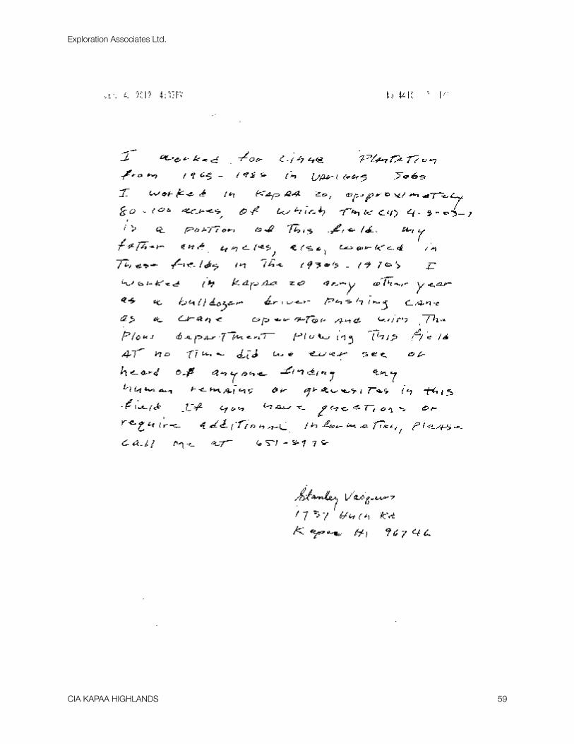
Exploration Associates Ltd.
CIA KAPAA HIGHLANDS 59
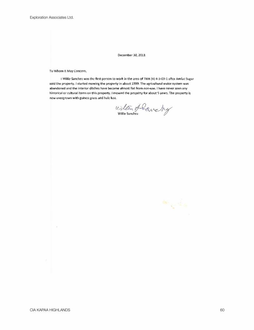
Exploration Associates Ltd.
CIA KAPAA HIGHLANDS 60

Exploration Associates Ltd.
CIA KAPAA HIGHLANDS 61
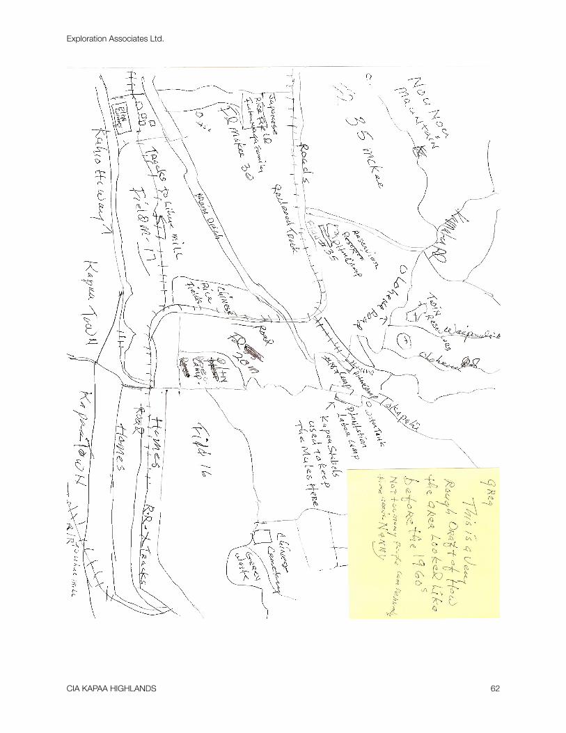
Exploration Associates Ltd.
CIA KAPAA HIGHLANDS 62
Related Documents