This is a peer-reviewed, post-print (final draft post-refereeing) version of the following published document, This is the peer reviewed version of the following article: Chiswell, Hannah Marie (2014) The value of the 1941–1943 National Farm Survey as a method for engagement with farmers in contemporary research. Area, 46 (4). pp. 426-434., which has been published in final form at http://onlinelibrary.wiley.com/doi/10.1111/area.12136/abstract. This article may be used for non-commercial purposes in accordance with Wiley Terms and Conditions for Self-Archiving. and is licensed under All Rights Reserved license: Chiswell, Hannah Marie (2014) The value of the 1941–1943 National Farm Survey as a method for engagement with farmers in contemporary research. Area, 46 (4). pp. 426-434. ISSN 0004-0894 Official URL: http://onlinelibrary.wiley.com/doi/10.1111/area.12136/abstract DOI: http://dx.doi.org/10.1111/area.12136 EPrint URI: http://eprints.glos.ac.uk/id/eprint/4872 Disclaimer The University of Gloucestershire has obtained warranties from all depositors as to their title in the material deposited and as to their right to deposit such material. The University of Gloucestershire makes no representation or warranties of commercial utility, title, or fitness for a particular purpose or any other warranty, express or implied in respect of any material deposited. The University of Gloucestershire makes no representation that the use of the materials will not infringe any patent, copyright, trademark or other property or proprietary rights. The University of Gloucestershire accepts no liability for any infringement of intellectual property rights in any material deposited but will remove such material from public view pending investigation in the event of an allegation of any such infringement. PLEASE SCROLL DOWN FOR TEXT.

Welcome message from author
This document is posted to help you gain knowledge. Please leave a comment to let me know what you think about it! Share it to your friends and learn new things together.
Transcript

This is a peer-reviewed, post-print (final draft post-refereeing) version of the following published document,
This is the peer reviewed version of the following article: Chiswell, Hannah Marie (2014) The value of the
1941–1943 National Farm Survey as a method for engagement with farmers in contemporary research. Area,
46 (4). pp. 426-434., which has been published in final form at
http://onlinelibrary.wiley.com/doi/10.1111/area.12136/abstract. This article may be used for non-commercial
purposes in accordance with Wiley Terms and Conditions for Self-Archiving. and is licensed under All Rights
Reserved license:
Chiswell, Hannah Marie (2014) The value of the 1941–1943 National Farm
Survey as a method for engagement with farmers in contemporary
research. Area, 46 (4). pp. 426-434. ISSN 0004-0894
Official URL: http://onlinelibrary.wiley.com/doi/10.1111/area.12136/abstract
DOI: http://dx.doi.org/10.1111/area.12136
EPrint URI: http://eprints.glos.ac.uk/id/eprint/4872
Disclaimer
The University of Gloucestershire has obtained warranties from all depositors as to their title in the material
deposited and as to their right to deposit such material.
The University of Gloucestershire makes no representation or warranties of commercial utility, title, or fitness
for a particular purpose or any other warranty, express or implied in respect of any material deposited.
The University of Gloucestershire makes no representation that the use of the materials will not infringe any
patent, copyright, trademark or other property or proprietary rights.
The University of Gloucestershire accepts no liability for any infringement of intellectual property rights in any
material deposited but will remove such material from public view pending investigation in the event of an
allegation of any such infringement.
PLEASE SCROLL DOWN FOR TEXT.
Dr Hannah Chiswell
1
The value of the 1941-1943 National Farm Survey as a method for engagement with
farmers in contemporary research
This article proposes the use of the National Farm Survey (NFS) data and maps as a resource
to support interviews with farmers and their families, across a wide range of geographical
topics. The paper explores the origins of the NFS and evaluates its use as a reconstructive
tool. Drawing directly on its use in recent empirical research into family farm succession as
an example, the paper details the associated method, including development of a
Geographic Information System and the integration of the NFS data and maps into interview
questions, as prompts and starting points. Using empirical data the paper evinces the
benefits of deploying the NFS as a resource in this way, including improving response rate,
establishment of rapport, capturing of participant interest, facilitation of detailed responses
and the stimulation of new trajectories and topics. Critically, use of the NFS in the proposed
way means, in contrast to its previous applications, it is unencumbered by its inherent
problems and inconsistencies, and interestingly, these problems can even become a source
of strength for the researcher.
Key words: National Farm Survey, interviews, maps, historical GIS, method
Introduction
Commissioned to assess Britain’s ability to feed itself during the Second World War, the
National Farm Survey (NFS) gathered information on all farms in England and Wales, over 5
acres, between 1941 and 1943. Having been available to researchers for over 20 years,
studies have realised its significance in relation to issues of farm mechanization, social
history and farm size and structure. For example, recent efforts have explored the NFS’s
value as a means of tracing changes in farm occupation (Walford 2007), as well as more
broadly, landscape management (Riley and Watkins 2007), making the NFS an incredibly
powerful and diverse resource for the geographer. Although these attempts have
commendably utilised what is arguably an underutilised resource, and yielded some
valuable insights, they have, by their own admission, achieved mixed results. Although
unrivalled in cover, detail and richness, it is vital to note “the limitations of the NFS as an
historical source are quite substantial” (Short et al 2000, 142).

Dr Hannah Chiswell
2
Drawing on its use in recent empirical research into family farm succession as an example,
this paper details an efficacious alternative use of the NFS as a tool to support and facilitate
qualitative interviews. The suggested method integrates key NFS data and maps into
intended interview questions, where it serves as an entry point into a wealth of topics and
aids the articulation of narratives. Although presented with reference to a specific research
project, this article ultimately advocates the utility of the approach in any research involving
interviewing farmers, farm families and landowners, across a range of historical and
contemporary geographical investigations.
The National Farm Survey
A product of the urgent need to increase home food production after the start of the
Second World War in September 1939, ‘County War Agricultural Executive Committees’
(CWAECs) were established by the Minister of Agriculture and Fisheries (MAF), to which the
authority to increase food production was delegated. Committees had the power to
“organize land, reclamation, inspect farm businesses, instruct farmers on agricultural
practice, allocate certain farm requisites, mobilize and direct gangs of workers, commission
farm repairs, and where necessary, dispossess farmers in instances of especially poor land
management” (Jackson 2005, 6). Despite some debate surrounding the respective merits of
increasing levels of domestic production as opposed to stockpiling, CWAECs directed what
became known as the plough-up campaign, which meant “land devoted to producing
feedstuffs for animals would have to be diverted into production for direct human
consumption” (Short et al 2000, 32)
To assist with the plough-up campaign, the MAF initiated the first Farm Survey in the June of
1940, expecting the investigatory work to be completed by the end of July. However, by

Dr Hannah Chiswell
3
October 1940, the first Farm Survey had not yet been completed, and where visits had been
carried out, there were concerns over the quality of completion and consistency between
different counties.
In December 1940, the Ministry issued a Circular, thanking the CWAECs for their work in
carrying out the survey (Short et al 2000). However, they continued by stating the survey
would be developed in a more standardised way, as a means of assisting in the immediate
food security crisis.
On the 26th
of April 1941 the CWAECs received instruction from the MAF, setting out the
scope and purpose of a more extensive survey, known as the National Farm Survey.
Beginning in the Spring of 1941 and completed by the end of 1943, the NFS provided a
wealth of data which primarily “assisted with emergency planning so that, where
inefficiencies and mismanagement were seen to exist, agricultural resources could be
husbanded to make a more effective contribution to the war effort” (Short et al 2000, 5).
The survey, completed for every farm and holding of five acres or more, consisted of three
main elements. Firstly, the annual 4 June Agricultural Census was completed by farmers as
normal during the war, but in 1941 two supplementary forms were included. The first aimed
“to ascertain more detail concerning small fruit and horticultural produce” (Short et al 2000,
5), known as the Horticultural Return. The second, entitled the Supplementary Return
detailed “the motive power on the holding, rents and length of occupation” (Short et al
2000, 5). Secondly, the Primary Return, which “provided detailed information on tenure, the
conditions of the farm, water and electricity supplies, and farm management” (Short et al
2000, 5), was collected during visits by CWAEC District Committee members (surveyors). The
relevant 1941 4 June Census Returns were made available to the CWAEC District Committee

Dr Hannah Chiswell
4
members prior to farm visits. The Primary Return also required the surveyor to grade the
farm from A-C (with A being the best and C being the worst), and where a B or C
classification was given, they were asked to select a reason why this was the case, from
either old age, lack of capital and personal failings.
The final component of the NFS was the series of large-scale farm maps. As part of the
complete individual farm record, the CWAECs were ordered to mark the boundaries of each
farm on an OS map. The maps are regarded as “one of the finest and most valuable legacies
of the NFS” (Short et al 2000, 74).
Previous uses of the NFS: a review
Although understood by many as the ‘Second Domesday Book’, Short et al’s (2000)
extensive analysis revealed a range of concerns, including the proportion of farms without a
Primary Return, inconsistencies in the completion of the forms, the proportion of records
missing, ambiguous, illegible or incorrect and perhaps most damningly, several and
significant inconsistencies within the data (Short et al 2000). The limitations arising from the
NFS’s inadequacies, errors and inconsistencies have been highlighted in a range of
investigations, reviewed below.
Riley and Watkins (2007) recognise the contemporary research and policy focus on the
environmental effects of farming, and resultant efforts to reverse the damage caused by
agriculture since the Second World War. It is with this in mind they suggest how the NFS
data may be used to gain a clearer understanding of the character and management of the
“traditional landscape”, describing how “the NFS may make an important contribution in
giving baseline data for the extent of such features in the mid-twentieth century” (Riley and

Dr Hannah Chiswell
5
Watkins 2007 207). They asked, firstly, can NFS data and maps be used to reconstruct land
use at the field level, and secondly, does the combination of NFS data with near-
contemporary aerial photographs enhance this insight? Their success is explored using the
example of Castle Farm (West Sussex). Given that Castle Farm was mainly a dairy farm
consisting of grassland, Riley and Watkins (2007 212) anticipated this should have made
“identification of the land use of individual fields rather simple”, however, they discovered
“in practice this farm is very difficult to interpret”, which they attribute to significant
inconsistency between the farm area stated in the Census Return (100 acres) and the area
stated in the Primary Return (121 acres). They conclude, the different areas “make it very
difficult to use the data to reconstruct land use field-by-field” (Riley and Watkins 2007: 214).
They suggest that the ‘missing’ land, could be an area liable to flooding, however, they
describe this as merely ‘guesswork’. Use of near-contemporary aerial photographs does
help and it proved possible to identify from the photos, how the areas nearer the river had
not been cut for hay, a finding that “perhaps backs the argument […] that this is an area of
rough grazing that might have been excluded from the area of the farm in the NFS” (Riley
and Watkins 2007 214). Although the aerial photograph did aid the interpretation for Castle
Farm, Riley and Watkins ultimately suggest the interpretation is inconclusive.
Similarly, Taylor et al. (2012) focus on an entire parish, namely Hamsey, East Sussex. Unlike
Riley and Watkins’ aerial photographs, which were from a range of different years, Taylor et
al. used aerial photographs taken by the Luftwaffe on 12 August 1940, only two years
before much of the mapping and data collection. It was therefore “anticipated that the
deployment here of a more nearly contemporary aerial-photograph might allow land use to
be reconstructed with more certainty, but this proved not to be the case” (Taylor et al.

Dr Hannah Chiswell
6
2012, 95). Aside from problems associated with the aerial photographs pre-dating much of
the plough-up campaign, Taylor et al. (2012, 95) describe “significant issues with the
consistency of the NFS and 4 June Census information”. With specific reference to Riley and
Watkins’ work, Taylor et al. (2012, 95) claim their study “encountered similar difficulties”.
Walford (2007) used the NFS, combined with electoral registers, to reconstruct changes in
farm occupancy over time. Although Walford (2007 212) is able to draw some interesting
conclusions about the survival rates of family farms over time, which he attributes to NFS
classification, suggesting that “farmers might have been more prone to become ‘non-
survivors’ if they were classified as B or C”, he also warn of “some uncertainty over the
explanation” inherent in using a combination of historical documentary sources.
In contrast to the above, Jackson (2005) used the NFS simply as ‘a window’ into farming in
the parish of Powderham, Devon, in his descriptive micro-study. Although using the NFS to
simply “shed light on the character of agrarian economy and society at a particular point in
time”, Jackson (2005, 19) still expressed some concern over the ‘inconsistency’ and ‘bias’ of
the NFS and suggests that ‘some reservation’ is needed when interpreting NFS data.
More recently, drawing on data from his earlier, larger research project (Walford 2007),
Walford (2013) used NFS data and maps to explore the extent of the plough-up campaign
on landscape change in the South Downs. Although he recognised ‘certain deficiencies’ with
the NFS data, including the difference in coverage (attributable to the varying diligence of
the different CWAEC surveyors), Walford (2013) was able to confidently calculate, and
spatially demonstrate using GIS, the impact of the plough-up campaign on the total area of
cereals on farms in the West Sussex and East Sussex parishes, as well as the percentage of
Dr Hannah Chiswell
7
farmland ploughed-up at the individual farm level. Walford’s (2013: 42) evaluation of the
potential of the NFS as a source for reconstruction of the past summarises the varying
successes of its previous applications:
“Provided that a certain level of caution is exercised, the NFS can be regarded as
providing a reasonably comprehensive and consistent survey […] where
individual farms and farmers can be identified so that connections to
subsequent sample surveys and to earlier, contemporary and later publicly
available documents can be carried out. Nevertheless it remains impossible to
compensate for missing or inaccurate information.”
Although strong, the warnings emerging from the above mentioned research are normal
words of caution associated with using any vast historical resource for such purposes.
Therefore, it is not the intention of this paper to discredit its previous uses, nor deny the
wealth of data and the unparalleled level of detail offered by the NFS. Instead, it is alongside
its “enormous potential […] to provide a rich and informative social and environmental
geography and history of mid-twentieth century agriculture” (Riley and Watkins 2007: 215)
its use as an interview tool for contemporary research is proposed. Before evidencing the
potential of the NFS, the ensuing section sets out in a detailed and technical manner, the
associated method.
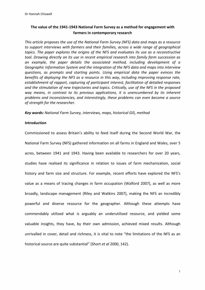
Obtaining NFS data
NFS documents (MAF 32), including the Primary Return, Census Return and Supplementary
Form, and 6-inch maps (MAF 73) for the parishes of Hatherleigh, Iddesleigh,
Monkokehampton, Broadwoodkelly and Winkleigh, in mid-Devon (Figure 1), were
photographed using a high resolution digital camera, during a visit to the National Archive,

Dr Hannah Chiswell
8
Kew. Difficulties with gathering data in this way were generally associated ensuring the
camera was in focus to ensure writing was legible.
FIGURE 1. Location of the parishes in Devon
An integral part of the method involved the creation of a Geographic Information System
(GIS) to allow historical farms to be ‘created’ as individual shapefiles. A modern-day OS map
of the same area at the 1:25,000 scale was imported into ArcGIS. The 96 individual
photographed NFS maps were georeferenced, or ‘matched up’ to real world points or
Ground Control Points (GCPs), such as road intersections or building corners, identified on
the modern-day OS maps. A total of 15 GCPs were identified for each of the 96 (pictures of
the) NFS maps. How well the image appeared to fit with the referent OS map was the only
assessment criteria. Georeferenced (pictures of) NFS maps were merged into one distinct
layer. This method differs to that of Walford’s (2013) who used near-contemporary OS maps
as a base layer from which to digitise the 1940s1 farms. Here, instead, the use of a modern-
day base layer from which to georeference the 1940s maps was chosen to ensure the
digitised historical boundary could be presented to the farmer in relation to/projected on
top of, modern day reference points and thus be easily identifiable to the farmer being
interviewed. There were some minor difficulties matching the images of the digitally
photographed NFS maps to the modern OS map, although Walford (2013) also recalled
experiencing similar difficulties using near-contemporary OS maps. Overall, the method
proved sufficiently accurate for the desired representative purposes and allowed farmers to
identify the historical boundary of their farm in relation to modern-day buildings, road
intersections and so on.
1 In the issue of brevity ‘1940s’ represents the time of the 1941-1943 National Farm Survey
Dr Hannah Chiswell
9
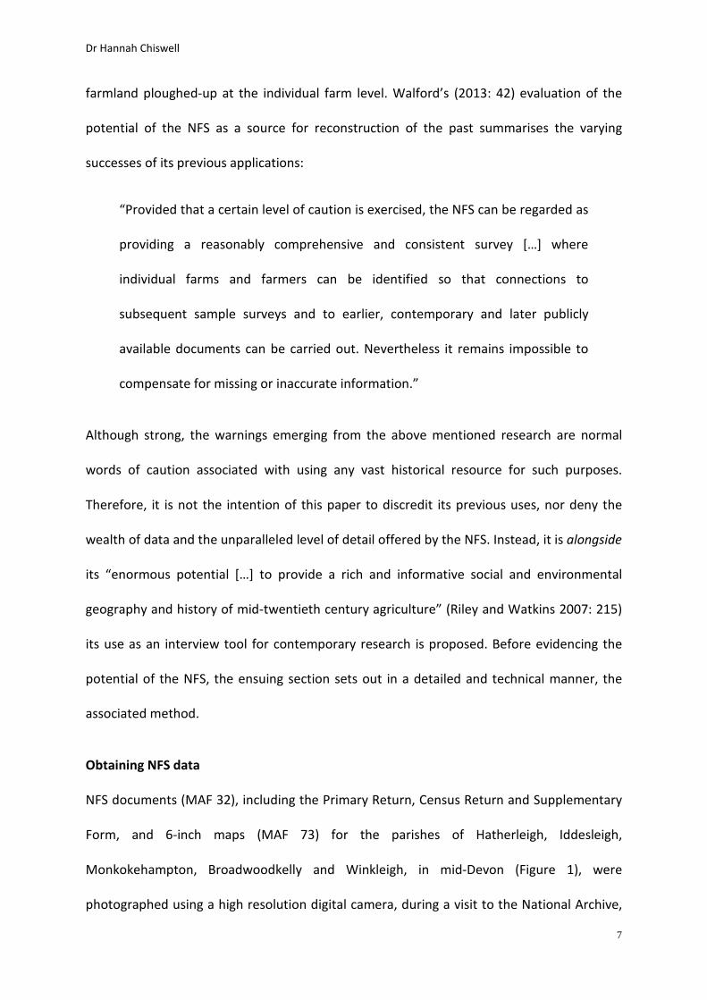
As recognised by Short et al. (2000, 155) “many maps display some form of annotation or
marking in the margins of the sheets” as well as other “printed marginalia such as dates or
scales”. As well as this, the maps in the sample were never perfectly rectangular. To allow
for the images to be joined as a contiguous map in the GIS, the border and associated
marginalia had to be cropped out of the photograph to produce a perfectly rectangular
image. This was done simply in Microsoft Office, using the cropping tool. Images were
added to the geodatabase. This sometimes resulted in the loss of small parts of the map and
meant the maps did not join perfectly. However, the resulting gaps (Figure 2) merely
present an aesthetic problem.
FIGURE 2. Joining the georeferenced NFS maps
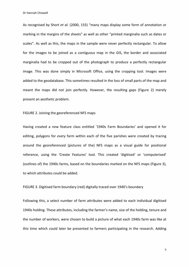
Having created a new feature class entitled ‘1940s Farm Boundaries’ and opened it for
editing, polygons for every farm within each of the five parishes were created by tracing
around the georeferenced (pictures of the) NFS maps as a visual guide for positional
reference, using the ‘Create Features’ tool. This created ‘digitised’ or ‘computerised’
(outlines of) the 1940s farms, based on the boundaries marked on the NFS maps (Figure 3),
to which attributes could be added.
FIGURE 3. Digitised farm boundary (red) digitally traced over 1940’s boundary
Following this, a select number of farm attributes were added to each individual digitised
1940s holding. These attributes, including the farmer’s name, size of the holding, tenure and
the number of workers, were chosen to build a picture of what each 1940s farm was like at
this time which could later be presented to farmers participating in the research. Adding
Dr Hannah Chiswell
10
these attributes in this way proved a useful way of storing, organising and searching the
farm data, and enabled an instantaneous construction of a historical snapshot of the farm.
The NFS as a interview tool: an example
Having collected and checked the selected farm attributes, they were used explicitly to
design and personalise semi-structured interview questions for individual farms
participating in the above-mentioned research project. Generic questions, such as ‘how long
have your family been farming here?’, were supplemented with data from the NFS to be
more specific, referring to the owner of the farm at the time of the NFS. Similarly, the
‘snapshots’ of participating holdings were used to create ‘farm portfolios’, containing the
farm map and key attributes of the farm at the time of the NFS (listed above). Farm
portfolios were presented at the start of, and available for reference throughout the
interviews.
The following discussion elucidates the use of the NFS as an interview tool. The discussion
draws significantly on interview narratives from the research project, with the sole purpose
of evidencing the merit of using the NFS in the proposed way. It is hoped by drawing on
interview dialogue so extensively, it will authentically demonstrate the value of utilising the
NFS in this way.
The NFS data was used to ‘open’ each of the interviews. Introduction of the NFS
immediately aroused the interest of the participants and in many cases, respondents
expressed their excitement at the prospect of access to the data. Introduction of the NFS
served as a means by which to ‘break the ice’ and thus, created a positive atmosphere and
immediately established rapport between the interviewer and the respondent. Reflecting
Dr Hannah Chiswell
11
on their own interviews with business owners and managers, including those in farming,
Healey and Rawlinson (1993) suggest that starting an interview on the right note is
paramount, with implications for participant openness throughout the interview. All farmers
initially commented on their interest in the NFS data and maps, and critically, this interest
was evident in their subsequent engagement.
Interviewer: I spent some time last summer at the National Archive in Kew
Farmer 1: Oh yeah
Interviewer: I was collecting the 1940s National Farm Survey data for all the
farms across the 5 parishes, so I’ve got the data here, the basics, such as who
owned the farm, who worked here, the size of the farm and so on
Farmer 1: Okay, that sounds really good
Interviewer: I went up to the National Archive in Kew, and looked at some
historical data for the farms down here from the 1940s National Farm Survey
and I’ve got some facts and figures about the farm as it was, which I’ll go
through
Farmer 2: Oh great, when was this?
Interviewer: In the 1940s
Farmer 2: Oh wow, we’d like a copy of this
Interviewer: Of course, I’ve already done a copy for you
Farmer 2: This should be interesting, wow, thanks, that’s great
The idea that the interview would be mutually beneficial ameliorated the power balance
and undoubtedly heightened interest in the interview process. Interestingly, in one case, a

Dr Hannah Chiswell
12
respondent recalled how another participant had recommended partaking in the study to
him because of his likely interest in the NFS data.
Interviewer: I’ve got some old records here, the National Farm Survey
Farmer 4: Oh yeah Bill mentioned some old documents. He said I’d find them
interesting
Interviewer: Great
Farmer 4: Is that the old farm accounts or …?
Interviewer: It’s the National Farm Survey. It was done in the early 1940s, so it
contains some really interesting stuff about the farm
Farmer 4: Oh that does sound good, we’d be really interested in having a copy
of this
Interviewer: I’ve already done you a copy for you to hang on to if you want
Farmer 4: That’s great
The NFS documents were integrated into the opening question. The name of the previous
owner, as recorded in the NFS, was used to ask how farmers had come to be at their farm.
Parenthetically, rather than being just ‘another participant’ answering a set of standardised
questions, personalisation of the questions using the NFS prioritises and empowers the
farmer, something Mishler (1991, 181) suggests ‘unsurprisingly’ results in more detailed,
narrative accounts. Questions based on their farm (and in many cases, their family) naturally
elicited farmer interest, with demonstrable implications for participant engagement evident
in the detailed nature of the narratives. This phenomenon was observed elsewhere by
Harper (2002 23) who used historical and aerial farm photographs during interviews with
dairy farmers in upstate New York; he aptly states such artefacts “mine deeper shafts into a

Dr Hannah Chiswell
13
different part of human consciousness than do words-alone interviews” which “leads to
deep and interesting talk”. Furthermore, just as Harper (2002 23) noted how the
introduction of aerial and historical farm photographs to interviews, in a similar vein to the
championed use of the NFS, meant “suddenly previously taciturn farmers had a great deal
to say”, farmers in this case, were similarly engaged.
In most cases introduction of the previous owner, as recorded in the NFS, acted as a
‘scaffold’ for further questions.
Interviewer: The National Farm Survey suggests it was a Mr Smith farming
here in 1942. Was Mr Smith related to you?
Farmer 5: No, no, not at all
Interviewer: That’s fine, so how did you come to be farming here, how did that
transpire?
Farmer 5: We lived at Eastwood Farm, which is quarter mile up the road
really, and most of the land adjoins, um and that’s the family farm and I
suspect the 1970s, maybe 1977 or 1978 that we had the opportunity to buy
Townsend Farm
Interviewer: Okay, that’s great ... was the farm bought to kind of incorporate
into one big farm, or …?
Farmer 5: Well, it was more because there was me and my brother, James,
and it gave us both the opportunity to farm and stay around here, so I think it
was more with that in mind really

Dr Hannah Chiswell
14
However, in the case of Farmer 7, the interviewer didn’t even need to pose a further
question; introduction of the information alone prompted a sufficient response.
Interviewer: I had a look at some old records, the National Farm Survey to be
exact and from what I can tell in the early 1940s, the farm here was owned
and being farmed by a Mr J Card
Farmer 7: Well, it’s gone through four generations, my great-Granddad, he
was John Card, I’m not sure what year he come here, but I think he bought it
in 1911, from the estate, for a few hundred pounds I think, then my
Granddad, he was John Card, and then my Dad, he was R J Card, he took it on,
and then me
Interviewer: Okay
Farmer 7: We’ve got 175 acres here now, but it was just a much smaller farm
then and we’ve just build it up ever since
As demonstrated here, use of the NFS as a starting point acts to ‘open up’ the interview
process, facilitating detailed dialogue with very little interviewer input. In the following
dialogue, the interviewer simply seeks to confirm the previous owner of the farm. However,
in response to this simple fact, several other trajectories to the discussion evolved, including
how and when the farm had passed through successive generations, and tellingly hinted at
the difficulty Farmer 8 experienced in obtaining managerial control of the farm whilst his
father was alive.
Interviewer: From what I can tell, the farm was owned by a Mr J Richards in
the 1940s, would that be right?

Dr Hannah Chiswell
15
Farmer 8: Yeah, that would have been my Granddad, […] and then he passed
it onto my Father, and then I inherited it from me Father, in 97. He died in
2007, he still remained the head of it, headed it up, like, or you know, ‘the
farmer, but then he died in 2007 so I’ve been on my own since then. He
passed the farm over to me, you know on paper, but he was very much still
‘the farmer’
This mode of questioning prompted the respondent and gave them significant freedom to
respond. It also reduced the need for interviewer input, reducing the risk of leading
questions.
Perhaps the most appealing feature of using the NFS in this way is the irrelevance of NFS
inconsistency. As evident in the ensuing example, the apparent error2 in the 1940s acreage
of the farm merely formed a natural deviation in the conversation. In having to correct the
error, the respondent felt it necessary to justify why this would not have been the case, and
in doing so, offered further information, that may not have been volunteered without the
error. Just as Riley and Harvey (2007, 398) observed how “artefacts may take the narrative
into less immediately obvious directions”, in this case, the participant introduces a new
dimension, by referring to his Grandson’s involvement in the business. In contrast to its
previous applications, the NFS’s inherent problems can arguably become a source of
strength.
2 Although errors with the acreage recorded were amongst the most common types of errors with the NFS (Short et al, 2000) this apparent mismatch between the acreage proposed by the NFS data and the farmer’s understanding, could be a case of the additional 57.5 acres of land being in another parish, or, the farmer could simply be wrong or confused. Either way, the accuracy of the acreage is almost irrelevant here – the point to convey is how, where they do exist (which they commonly do), discrepancies with the NFS can become a source of further thought and discussion.

Dr Hannah Chiswell
16
Interviewer: Okay and just some questions about the farm. So in the 1940s, it
appears to be around 82.5 acres, would that have been about right?
Farmer 10: No, I don’t think so. This was probably around the 140 mark,
maybe a bit more then
Interviewer: And how big is it now?
Farmer 10: It’s 138 now … we got rid of a little bit of it, since we bought it, just
a few acres on the end, sold it to some neighbours who wanted to enlarge
their garden, wasn’t the best bit of land and gave us some cash to buy a few
things when Mark, my Grandson came into the business
Interviewer 10: So since um, your Grandson has expressed an interest in
farming, is there anything you’ve done on the farm to kind of accommodate
him working here or ...?
Farmer 10: Well yeah, we have built up the cows a bit more. We’ve tried to go
from 60 up to 90, to accommodate a little bit more towards what he wanted
to do, what he’s interested in and yeah some odd bits of machinery to make
life easier for us all, that Mark’s suggested. He went to a local college and part
of his course, he worked at different farms so yeah he’s been able to
recommend stuff that they’ve been doing
Having been introduced, the portfolios were left ‘between’ the interviewer and the
participant (often the kitchen table) to be referred to at will. Although with specific
reference to photos, Carlsson (2001, 127) notes how their inclusion in the interview process
means “the focus of attention is kept on something concrete and visible […] as something to
‘hold on to’ and share experiences around”. In several incidences, farmers used the maps, to

Dr Hannah Chiswell
17
demonstrate or emphasise their point. These incidences, were noted down during the
course of the interview, and proved to be a very useful additional source during the analysis
of the interview data.
The NFS as an interview tool: some conclusions
Although used here in an investigation into family farm succession, the preceding discussion
has demonstrated the NFS’s value as a resource in interviews to encourage participant
engagement and facilitate discussion.
In the case of this research, farmer responses to the introduction of the NFS during semi-
structured interviews were overwhelmingly positive. Introduction of the NFS aided
recruitment of participants, establishment of rapport and captured the interest of
participants. Perhaps most significantly given the difficulties faced by previous applications,
the use of the NFS in this way was not encumbered by its inconsistencies and as
demonstrated, such problems even become a source of strength.
The method proposed here offers an invaluable tool for geographers, applicable for those
seeking to engage farmers, farm families, landowners and so on, regardless of topic. Its use
has potential to further encourage and enable researchers to move beyond ‘interrogation’
methods, towards a more conversational approach, facilitating a dialogue in which the
thoughts and experiences of respondents can be expressed in their own words.
Fundamentally, the simple and yet efficacious method offers opportunity to enrich and
deepen the quality of resulting testimonies, which is likely to further enhance our
understanding of a vast number of topics being investigated.

Dr Hannah Chiswell
18
Figure 1 Location of the parishes in Devon

Dr Hannah Chiswell
19
Figure 2 Joining the georeferenced NFS maps (Source: NFS maps from The National Archive MAF 73/10/52 -
reproduced by permission)

Dr Hannah Chiswell
20
Figure 3 Digitised farm boundary digitally traced over 1940’s boundary (Source: NFS map from The National
Archive MAF 73/10/52 - reproduced by permission)
Dr Hannah Chiswell
21
References
Carlsson B 2001 Depicting Experiences Scandinavian Journal of Educational Research 45
125-143
Harper D 2002 Talking about Pictures: A Case for Photo Elicitation Visual Studies 17 13-26
Harvey D and Riley M 2007 Oral histories, farm practice and uncovering meaning in the
countryside Social & Cultural Geography 8 391-415
Healey M and Rawlinson M (1993) Interviewing business owners and managers: a review of
methods and techniques Geoforum 24 339-355
Jackson A 2005 A landed estate in mid-twentieth century Devon: insights from the 1941-3
National Farm Survey Family and Community History 8 5-20
Mishler E 1991 Research Interviewing: Context and narrative Cambridge
Riley M and Watkins C 2007 The value of the National Farm Survey and contemporary aerial
photographs for environmental history in Short B M, Watkins C and Martin J (eds.) The
Front Line of Freedom: British Farming in the Second World War. Exeter: British Agricultural
History Society 2007 204-216
Short B, Watkins C, Foot W and Kinsman P 2000 The National Farm Survey 1941-1943:
State Surveillance and the Countryside in England and Wales in the Second World War Oxon,
CABI
Dr Hannah Chiswell
22
Taylor K J, Walford N, Short, B. and Armitage R 2012 Cautionary notes on linking the
National Farm Survey with other records for investigating the agrarian history of Second
World War Britain Agricultural History Review 60 77-96
Walford N 2007 The National Farm Survey and the tracing of post-war farmers’ movements
on the South Downs in Short B, Watkins C and Martin, J (eds.) The Front Line of Freedom:
British Farming in the Second World War Exeter: British Agricultural History Society 2007
217-229
Walford N 2013 The extent and impact of the 1940 and 1941 “plough-up” campaigns on
farming across the South Downs, England Journal of Rural Studies 32 38-49
Related Documents