AIR WAR COLLEGE AIR UNIVERSITY CHINESE SPACE SUPERIORITY? CHINA’S MILITARY SPACE CAPABILITIES AND THE IMPACT OF THEIR USE IN A TAIWAN CONFLICT By Steven A. Smith, Lt Col, USAF A Research Report Submitted to the Faculty In Partial Fulfillment of the Graduation Requirements 17 February 2006

Welcome message from author
This document is posted to help you gain knowledge. Please leave a comment to let me know what you think about it! Share it to your friends and learn new things together.
Transcript
AIR WAR COLLEGE
AIR UNIVERSITY
CHINESE SPACE SUPERIORITY?
CHINA’S MILITARY SPACE CAPABILITIES AND THE IMPACT OF THEIR USE IN A TAIWAN CONFLICT
By
Steven A. Smith, Lt Col, USAF
A Research Report Submitted to the Faculty
In Partial Fulfillment of the Graduation Requirements
17 February 2006
DISCLAIMER
The views expressed in this academic research paper are those of the author and do not reflect
the official policy or position of the US government or the Department of Defense. In
accordance with Air Force Instruction 51-303, it is not copyrighted, but is the property of the
United States government.
ii
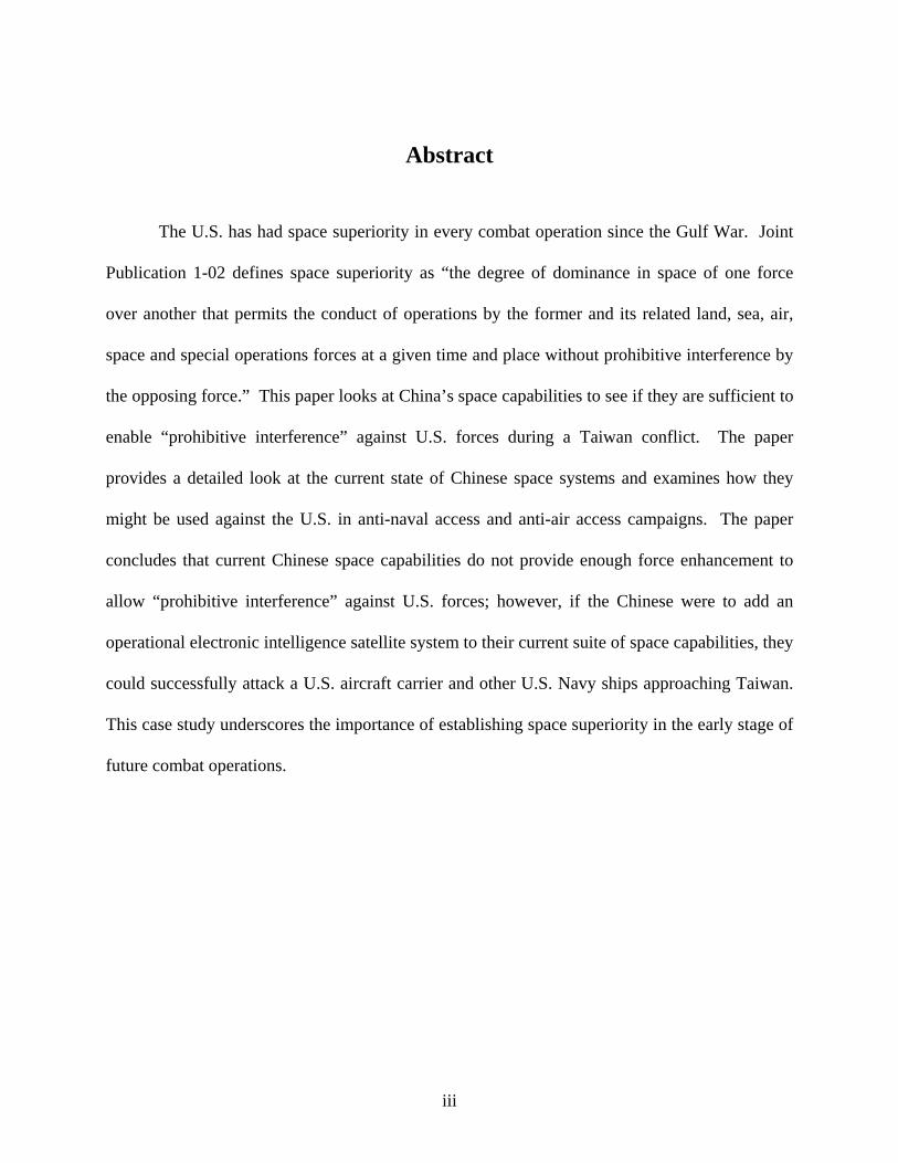
Abstract
The U.S. has had space superiority in every combat operation since the Gulf War. Joint
Publication 1-02 defines space superiority as “the degree of dominance in space of one force
over another that permits the conduct of operations by the former and its related land, sea, air,
space and special operations forces at a given time and place without prohibitive interference by
the opposing force.” This paper looks at China’s space capabilities to see if they are sufficient to
enable “prohibitive interference” against U.S. forces during a Taiwan conflict. The paper
provides a detailed look at the current state of Chinese space systems and examines how they
might be used against the U.S. in anti-naval access and anti-air access campaigns. The paper
concludes that current Chinese space capabilities do not provide enough force enhancement to
allow “prohibitive interference” against U.S. forces; however, if the Chinese were to add an
operational electronic intelligence satellite system to their current suite of space capabilities, they
could successfully attack a U.S. aircraft carrier and other U.S. Navy ships approaching Taiwan.
This case study underscores the importance of establishing space superiority in the early stage of
future combat operations.
iii
Contents
Page
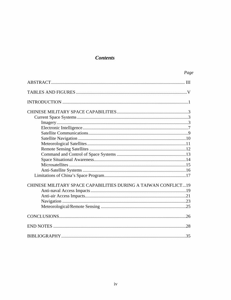
ABSTRACT...................................................................................................................... III
TABLES AND FIGURES ..................................................................................................V
INTRODUCTION ...............................................................................................................1
CHINESE MILITARY SPACE CAPABILITIES...............................................................3 Current Space Systems ..................................................................................................3
Imagery....................................................................................................................3 Electronic Intelligence.............................................................................................7 Satellite Communications........................................................................................9 Satellite Navigation ...............................................................................................10 Meteorological Satellites .......................................................................................11 Remote Sensing Satellites .....................................................................................12 Command and Control of Space Systems .............................................................13 Space Situational Awareness.................................................................................14 Microsatellites .......................................................................................................15 Anti-Satellite Systems ...........................................................................................16
Limitations of China’s Space Program........................................................................17
CHINESE MILITARY SPACE CAPABILITIES DURING A TAIWAN CONFLICT...19 Anti-naval Access Impacts ....................................................................................19 Anti-air Access Impacts.........................................................................................21 Navigation .............................................................................................................23 Meteorological/Remote Sensing ...........................................................................25
CONCLUSIONS................................................................................................................26
END NOTES .....................................................................................................................28
BIBLIOGRAPHY..............................................................................................................35
iv

Tables and Figures
Page Table 1. China’s Current Space Systems.…………………………………………………………4
Figure 1. China’s Satellite TT&C Stations…………………………………………………….. 14
Figure 2. Chinese Short, Medium and Intermediate Range Missile
Ranges………………….…21
v

Chapter 1
Introduction
“The space of operations becomes all-dimensional and military action will be conducted simultaneously in many fields, on land, in the air, in outer space and in the electronic field.” General Fu Quanyou
Chief of General Staff, People’s Liberation Army, 20 Feb 19991
Space is an integral part of U.S. combat operations. In the 1991 Gulf War, space played
a significant role in combat operations, and in major U.S. operations since then space has played
an ever increasing role. However, in all those conflicts, we have faced an adversary who had
little or no space capability. Thus, we have had space superiority from the outset of operations.
Joint Publication 1-02 defines space superiority as “the degree of dominance in space of one
force over another that permits the conduct of operations by the former and its related land, sea,
air, space and special operations forces at a given time and place without prohibitive interference
by the opposing force.”2[Emphasis added] What if we engaged in combat operations and didn’t
have space superiority? What if we engaged an adversary who had enough dominance in space
which allowed prohibitive interference by the opposing force? How would that dominance
manifest itself? How would this impact U.S. combat operations? This paper will provide insight
into these questions through a case study involving a U.S.-China dispute over Taiwan.
A Taiwan U.S.-China conflict is a practical case study for two reasons. First, the
possibility is feasible.3 While China and the U.S. both seek a peaceful resolution of the Taiwan
1
issue, a conflict is a potential scenario. China’s 2004 Defense White Paper described their
relations with Taiwan as “grim” and made stopping Taiwanese independence a “sacred
responsibility” for China’s armed forces.4 In addition, in March 2005, China’s National
People’s Congress passed an “anti-secession” law providing legal justification for the use of
force if Taiwan attempts to become independent.5 Furthermore, the U.S.-Taiwan Relations Act
says it is the U.S.’s policy that any non-peaceful actions to determine the future of Taiwan are
considered a “grave concern,” and the law requires the U.S. to maintain the capability to resist
any force or other coercion which would threaten the people of Taiwan.6 Together these two
laws are the dilemma of Taiwan and make a conflict feasible, especially if there is a
miscalculation by China, the U.S. or Taiwan as all parties seek peaceful resolution.
Second, a U.S.-China conflict is practical for case study since China has an impressive
amount of space capability, some of which has been in use for decades, and they are continuing
to grow their space capabilities every year. Although they are not a near-peer to the U.S. in
space, they have significant space capabilities that potentially could challenge U.S. space
superiority. 7 Thus, a Taiwan conflict would be the U.S.’s first combat operation in which an
adversary with capability, know-how and experience used space systems actively against us.
This paper will lay out the current Chinese space capabilities and investigate if these types of
systems could potentially enable “prohibitive interference” by China against U.S. military
operations in support of Taiwan. Thus, we might face the possibility of not having space
superiority during combat operations. What are the space capabilities China possesses? What
might be their impact on U.S. military capabilities during a Taiwan conflict? The next two
chapters will look to answer those two questions in detail.
2

Chapter 2
Chinese Military Space Capabilities
China has an extensive array of space capabilities which range from satellite design and
manufacture to launch services and on-orbit operations.8 China’s People’s Liberation Army
(PLA) has given three tasks to its space units: observation/intelligence, navigation/positioning
and communications.9 The following is a description of the major Chinese space systems that
perform these tasks. The focus is on those space capabilities in which the Chinese have invested
and have the possibility to improve the overall effectiveness of their armed forces. The
information used to compile the following information is from open, unclassified sources.10
Chinese space systems are summarized in Table 1.
Current Space Systems
Imagery
General Fu Quanyou, while he was the PLA’s Chief of General Staff, wrote that
commanders need to have a full picture of the battlefield, and China must “make energetic
efforts to develop advanced means of intelligence-gathering and reconnaissance … and improve
the ability to obtain and process information” to “thoroughly understand the enemy’s
situation.”11 Satellite imagery looks to meet these demands. China’s program for satellite
imagery, known as their Jian Bing (“Pathfinder”) program, has been active since 1975. China is
on the third and
3
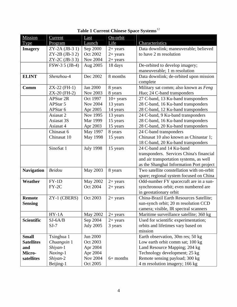
Table 1 Current Chinese Space Systems12
Mission Type
Current Program
Last Launch
On-orbit Life
Characteristics
Imagery ZY-2A (JB-3 1) ZY-2B (JB-3 2) ZY-2C (JB-3 3)
Sep 2000 Oct 2002 Nov 2004
2+ years 2+ years 2+ years
Data downlink; maneuverable; believed to have 2 m resolution
FSW-3 5 (JB-4) Aug 2005 18 days De-orbited to develop imagery; maneuverable; 1 m resolution
ELINT Shenzhou-4 Dec 2002 8 months Data downlink; de-orbited upon mission complete
Comm ZX-22 (FH-1) ZX-20 (FH-2)
Jan 2000 Nov 2003
8 years 8 years
Military sat comm; also known as Feng Huo; 24 C-band transponders
APStar 2R APStar 5 APStar 6
Oct 1997 Nov 2004 Apr 2005
10+ years 13 years 14 years
27 C-band, 13 Ku-band transponders 28 C-band, 16 Ku-band transponders 28 C-band, 12 Ku-band transponders
Asiasat 2 Asiasat 3S Asiasat 4
Nov 1995 Mar 1999 Apr 2003
13 years 15 years 15 years
24 C-band, 9 Ku-band transponders 28 C-band, 16 Ku-band transponders 28 C-band, 20 Ku-band transponders
Chinasat 6 Chinasat 10
May 1997 8 years 15 years
24 C-band transponders Chinasat 10 also known as Chinastar 1; 18 C-band, 20 Ku-band transponders
May 1998
SinoSat 1 July 1998 15 years 24 C-band and 14 Ku-band transponders. Services China's financial and air transportation systems, as well as the Shanghai Information Port project
Navigation Beidou May 2003 8 years Two satellite constellation with on-orbit spare; regional system focused on China
Weather FY-1D FY-2C
May 2002 Oct 2004
2+ years 2+ years
Odd-number FY spacecraft are in a sun-synchronous orbit; even numbered are in geostationary orbit
Remote Sensing
ZY-1 (CBERS)
Oct 2003
2+ years
China-Brazil Earth Resources Satellite; sun-synch orbit; 20 m resolution CCD camera; visible, IR spectral scanners
HY-1A May 2002 2+ years Maritime surveillance satellite; 360 kg Scientific SJ-6A/B
SJ-7 Sep 2004 2+ years
3 years July 2005 Used for scientific experimentation; orbits and lifetimes vary based on mission
Small Satellites and Micro-satellites
Tsinghua 1 Chuangxin 1 Shiyan-1 Naxing-1 Shiyan-2 Beijing-1
Jun 2000 Oct 2003 Apr 2004 Apr 2004 Nov 2004 Oct 2005
6+ months
Earth observation, 30m res; 50 kg Low earth orbit comm sat; 100 kg Land Resource Mapping; 204 kg Technology development; 25 kg Remote sensing payload; 300 kg 4 m resolution imagery; 166 kg
4

fourth generation of this program, and the two current systems differ most distinctly by how the
satellite data is obtained by the analyst.13
The Jian Bing-3 (JB-3) imagery satellite sends its images electronically, allowing the
analyst to get the data in near real-time. The system is also known as Zi Yuan-2 (“Resource”,
ZY-2), and it was first launched without prior announcement in Sep 2000.14 The ZY-2 came
from the ZY-1, the Chinese-Brazilian Earth Resources Satellite, a remote sensing satellite
discussed later.15 The Chinese announced the ZY-2 satellite was for civil purposes such as crop
yield assessment; however, it is believed to be primarily used for military purposes.16 The JB-3
is believed to have two-meter resolution capability using digital imaging technology.17 The third
satellite in the series was launched in November 2004, and when the Xinhua News Agency
announced the November launch, it also mentioned the previous two satellites, launched in
September 2000 and October 2002, were also operational.18 The Chinese are also working to
improve their capability. The Shenzhou 5 manned capsule the Chinese launched in Oct 2003 had
a digital imaging experiment on board capable of 1.6 meter resolution.19
Jian Bing-4 (JB-4) is a film-based system which deorbits to allow the film to be
developed and analyzed. The Chinese officially call the JB-4 the Fanhui Shi Weixing-3
(“Recoverable Satellite”, abbreviated FSW), and it comes from a long line of satellites that have
been launched and improved since 1975.20 The previous version of the FSW-3 held over 2000
meters of film, and open source information reports the FSW-3 has one meter resolution.21 On-
orbit duration is either roughly 18 days or 26 days, depending on the altitude of the satellite with
the lower orbit providing shorter on-orbit duration but better resolution imagery.22 To
supplement this indigenous imagery capability, China has reached agreements to receive
5

imagery from numerous commercial imagery firms, including the U.S. LANDSAT, France’s
SPOT, Russia satellite imagery and Israel’s EROS-A one meter resolution satellite.23
Currently, China has no indigenous synthetic aperture radar (SAR) imaging system;
however, Chinese scientists have been working to develop a Chinese SAR system for at least a
decade, and they plan to have four SAR systems on-orbit along with four optical reconnaissance
satellites by 2010.24 Despite the lack of a Chinese system, China has extensive experience using
commercially available SAR systems. The Chinese have agreements to directly receive
Canada’s RADARSAT imagery as well as to receive data from two European Space Agency’s
(ESA) SAR payloads. China has had a RADARSAT ground receiving station in Beijing since
1998, and it is able to receive the data within 1-4 hours after the spacecraft acquires an image.
The RADARSAT ground system is capable of not only producing images with a resolution of 7-
10 meters and a revisit rate of 3 days, but it has special algorithms for ship detection by detecting
the ships themselves as well as their wakes.25 Likewise, the Chinese receive the ESA’s
ENVISAT’s Advanced SAR data in Beijing and Hong Kong, and this system can also
automatically perform ship and wake detection.26 The ENVISAT is capable of imagery with a
resolution of up to 6 meters with a revisit rate of every 6 days at Taiwan’s latitude.27 China
also has access to the ESA’s Earth Resources Satellite (ERS) SAR data via a direct downlink
station in Beijing, and ERS can also perform ship and wake detection.28
An effective satellite imagery system relies on more than just having space-based imagery
capability. It also depends on being able to process and analyze the data.29 The Remote Sensing
Ground Station near Beijing is the main center for China’s imagery processing, and this station
directly receives the data from the ZY-2 and other satellites.30 China has been processing and
analyzing their own and other nations’ imagery for decades, starting with their FSW-1 program
6

in 1975 up to today’s improved FSW-3 and the real-time imagery from the ZY-2 program.31
China has the facilities and the experience for imagery analysis, and they have integrated these
capabilities into their joint military exercises.
Space capabilities cannot be effectively employed in military operations unless they are
exercised with the combat forces ahead of time to develop effective tactics, techniques and
procedures for use during combat. The Chinese realize this and have exercised their
reconnaissance capabilities in their annual joint force exercise at Dongshan Island in the Taiwan
Strait. In this joint exercise, 18,000 PLA forces practiced beach landings, establishing “air
dominance”, and attacking aircraft carriers using their Su-27s, Su-30s, SOVREMENNY-class
destroyers, SS-N-22 supersonic anti-ship missiles, and various tactical and cruise missiles. One
of the objectives specifically called out was “satellite reconnaissance and tracking.”32 In
addition, China has developed means to counter satellite detection of their forces sufficient to
mask detection from space assets.33 China has been improving their counter-reconnaissance
capabilities, and they continue to exercise it.34 Specifically, exercising counter-reconnaissance
techniques was one of the objectives for the 2004 Dongshan Island exercise.35
Electronic Intelligence
Like their imagery program, the Chinese have decades of experience with satellite-derived
electronic intelligence (ELINT). China started their space-based ELINT program in 1975, and
the last confirmed space-based ELINT satellite was on-orbit in 2002.36 China has a strong
ELINT program in terms of ground, air and ship-based ELINT collectors; however, its space-
based ELINT capabilities have been limited and sporadic.37 The Shenzhou program is primarily
focused on China’s manned space efforts, but prior to the manned missions the Shenzhou
spacecraft also acted as a space-based ELINT collector. Shenzhou 1 though 4 all flew with an
7
ELINT payload with Shenzhou 2 through 4 carrying three antennas attached to booms at the
front of the orbital module and seven feed horns on the bottom of the module.38 These orbital
modules remained on orbit for 18 months, and a Chinese official reported the purpose of the
Shenzhou 4 ELINT payload was to intercept radar and telecommunication traffic signals.39 The
Shenzhou sent the data from the ELINT payload to the Remote Sensing Ground Station in
Beijing.40 However, little Chinese space-based ELINT activity has occurred since the Shenzhou
4.
Reviews of open literature on Chinese space programs reveal no ELINT collector currently
on orbit; however, one on-line source believes the Shijian (“Practice”) scientific satellite
launched in Sep 2004 possibly has an ELINT mission, and previous Shijian missions have
performed ELINT collection.41 Regardless, China is interested in ELINT satellite programs and
the ability to transmit data directly to mobile data reception equipment with deployed military
units.42
The sporadic on-orbit ELINT capability, coupled with their strong terrestrial ELINT
program, might be indicative of the regional nature of the Chinese ELINT program.
Specifically, a periodic satellite ELINT capability enables occasional surveillance of worldwide
radar and communication systems allowing the Chinese to detect new signals and update the
databases of their regionally-focused terrestrial systems.43 These updates as well as other
ELINT products would come from the PLA General Staff Headquarters’ Third Department
which is the primary focal point for ELINT.44
While the current state of affairs shows no persistent space-based ELINT system, there
could be one in the future. Articles from Chinese engineering journals show active interest in
8
the area, including developing small ELINT satellites or constellations of small satellites capable
of providing precise location data.45
Satellite Communications
China is a solid competitor in the commercial satellite communications market, and this
capability, coupled with their dedicated military satellite communications capability, gives them
a robust satellite communication network. Chinese industry has at least four commercial satellite
communication networks (APStar, Asiasat, Chinasat, Sinosat -- see Table 1). Many of their
communication satellites use the Chinese Dong Fang Hong (“East is Red” - DFH) satellite bus,
but U.S. and European manufacturers developed the remaining spacecraft.46 However, in 1998,
China had allotted only limited channels to the PLA.47 To correct this shortcoming and not take
away revenue from the profitable commercial business, China started a new military satellite
communication program, the Feng Huo program (“Fire and Smoke”).48 The Chinese launched
the first Feng Huo satellite (FH-1) in January 2000 and followed it up with the FH-2 launched
November 2003. FH-1 and FH-2 are also known as Zhongxing-22 and Zhongxing-20,
respectively, since these two satellites were placed in geosynchronous orbital slots numbered 20
and 22 for the Zhongxing (“Star of China”) commercial satellite communication spacecraft.49
The FH-1 and FH-2 are part of the Qu Dian Command, Control, Communication, Computer,
Intelligence (C4I) system that looks to provide theater forces with the capability to communicate
and share information in near-real time.50 Additionally, the Chinese are also looking into small
mobile satellite communication reception stations that could be deployed into theaters of
conflict.51 The capability to receive data via satellite communication will be essential for theater
commanders to exploit improved situational awareness provided by other space-based and
intelligence platforms and to synchronize combat operations.
9

Satellite Navigation
China is deeply involved in projects to improve their satellite navigation capability. They
have developed their own navigation satellite program; use GPS extensively throughout the
country for a vast number of applications; are a partner with the European Union on Galileo, the
European navigation satellite program; and Chinese firms are part of the contractor team
developing Galileo.52
China does not want to be dependent on foreign systems; therefore, they are creating their
own navigation satellite constellation.53 The Chinese Beidou (“Big Dipper”) system consists of
two satellites and a spare in geosynchronous orbit and is intended only to provide regional
coverage around China.54 The first two on-orbit spacecraft were the first generation of their
satellite navigation system, and the Beidou-3 satellite launched in May 2003 was the next step
toward a second generation system.55 According to the Beidou’s chief designer, the current
system is intended “mainly to serve transportation, shipping, distribution of materials and other
services” – namely, users on the ground.56 In particular, a user must be on the surface of the
Earth and must be in two-way communication with a central station. The user sends the central
station its latitude/longitude and the central station provides the user its altitude by comparing
the user’s transmitted latitude/longitude with a detailed model showing local terrain altitudes.57
However, using three satellites and advanced processing algorithms, it is possible for the current
system to improve the accuracy of warheads in flight for 10 minutes or more (i.e. free flight time
of 4200 kilometers or more) as long the warhead can maneuver or is on a bus which can
maneuver.58
In addition to its own satellite navigation program, China uses and is heavily involved in
developing other nation’s satellite navigation programs. China is a partner with the EU, India
10
and Israel on the Galileo satellite navigation program. While they will not have access to the
Public Regulated Service encrypted signal, Beijing does expect working with Europe will boost
Chinese satellite development and other aerospace technologies.59 In addition, Chinese industry
teams were on each of the two teams competing for the system contract.60
Finally, China is a heavy user of GPS in civil applications such as fishing, public bus and
taxi monitoring, seismic monitoring, and telecommunication network timing.61 Militarily,
potential Chinese use of differential GPS in ballistic and cruise missiles offers significant
accuracy improvements and increases their effectiveness as stand-off coercive weapons.62
Overall, China is looking to improve the robustness of their satellite navigation capabilities –
indigenously and using foreign systems.
Meteorological Satellites
China began its efforts to develop its own weather satellite in the late 1960s and launched its
first meteorological satellite in 1988.63 Today, the Chinese have two meteorological satellite
systems. The Fengyun-1 (“Wind and Cloud” – FY-1) is a low earth orbiting system, and the
Fengyun-2 (FY-2) is a geosynchronous system.64 The FY-1’s capabilities are similar to the U.S.
LANDSAT, and it will be replaced by the FY-3 series with expected first launch in 2006.65
China launched the newest FY-2 in 2004 highlighting that its developer designed and
manufactured it independently of any foreign assistance. The satellite features additional
meteorological sensors that the Chinese press reports put it on par with “international standards
of new generation weather satellites.”66 Improved meteorological data leads to improved civil
applications, but it also provides improved operational data that is vital when planning an
amphibious attack or air strikes.67
11
Remote Sensing Satellites
Remote sensing programs are crucial for achieving the information superiority the Chinese
military desires.68 China has two indigenous remote sensing satellite programs: the Haiyang
(“Ocean”) system and a cooperative program with Brazil called the China-Brazil Earth
Resources Satellite (CBERS).69
China launched the 365-kg Haiyang-1 (HY-1) satellite in 2002 in a tandem launch with the
FY-1D satellite. The HY-1’s mission is to provide China with a maritime surveillance capability
without having to rely on foreign systems.70 The spacecraft has an ocean water-color scanner
with a resolution of 1.1 km and a visible light imaging system with a resolution of 250 m.71 The
maritime surveillance mission of the HY-1 involves observing sea conditions such as surface
temperature, currents, silt, pollutants and sea ice.72 China’s National Ocean Satellite
Applications Center has ground stations in Beijing and at Sanya on the southern tip of the island
of Hainan; however, commands from these ground stations are sent to the Xian Satellite Monitor
and Control Station (see below) for uplink to the satellite.73 China plans to launch the next HY
satellite in 2006.74
The China-Brazil Earth Resources Satellites (CBERS, also known as ZY-1) launched in
1999 and 2003 showed increasing sophistication with its multi-payload and digital transmission
capability.75 The payload included an infrared multi-spectral scanner and a visible light imager
capable of 20 m resolution images, and the satellite can be controlled at ground stations in Brazil
or China.76 In September 2000, China and Brazil signed an agreement for two more CBERS
satellites with 5 meter resolution and improved redundancy. In addition, they agreed to
investigate building a joint geosynchronous weather satellite and a communication satellite.77
The data from CBERS is processed in China at the Remote Sensing Ground Station along with
12
data from Landsat (U.S.), ERS (European Space Agency), the Japanese Earth Resources
Satellite, SPOT (France), Radarsat-1/2 (Canada), and the Indian Remote Sensing satellite.78
Command and Control of Space Systems
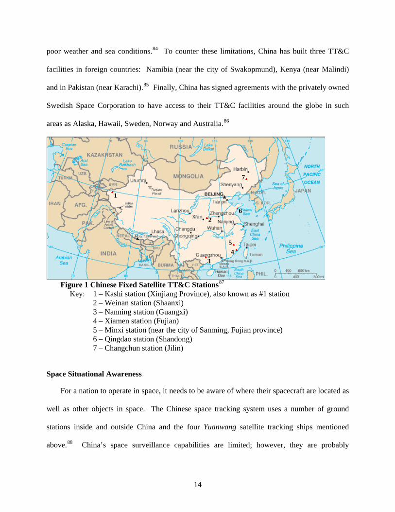
Effective command and control of space assets is critical to maintaining healthy satellite
systems. To perform these functions, three things are required: operations centers to generate
commands and monitor the spacecraft; stations to track the spacecraft, receive health and status
data from the satellites, and send commands (also called tracking, telemetry and control, TT&C);
and trained personnel to perform the command and control function. Within China, the main
operations centers for spacecraft commanding and monitoring are the Xian Satellite Monitor and
Control Center, located in the city of Weinan 60 km NW of Xian, and the Beijing Aerospace
Command and Control center.79 The Xian center performs the lion share of the command and
control work for the Chinese space systems; however, the Beijing center is the focal point for the
manned space missions.80 The Xian center can perform command and control on several dozen
spacecraft simultaneously.81 Integral to the operations of these centers are seven fixed ground
stations within China for sending and receiving TT&C data (see Figure 1).82 In addition, China
also has three mobile TT&C stations which it deploys throughout the country, one of which is
dedicated to tracking the reentry of their spacecraft.83
The fixed and mobile ground tracking stations in China can only communicate with
spacecraft visible from the Chinese landmass. China achieves worldwide command and control
capabilities using three methods: ships, Chinese facilities built in foreign countries and access to
foreign tracking networks. China operates a fleet of four tracking ships, the Yuanwang 1, 2, 3
and 4 (“long view”). These ocean-going ships provide full TT&C capabilities, including the
ability to detect and correct spacecraft problems; however, they are expensive and affected by
13
poor weather and sea conditions.84 To counter these limitations, China has built three TT&C
facilities in foreign countries: Namibia (near the city of Swakopmund), Kenya (near Malindi)
and in Pakistan (near Karachi).85 Finally, China has signed agreements with the privately owned
Swedish Space Corporation to have access to their TT&C facilities around the globe in such
areas as Alaska, Hawaii, Sweden, Norway and Australia.86
3
1
2
45
6
7
Figure 1 Chinese Fixed Satellite TT&C Stations87
Key: 1 – Kashi station (Xinjiang Province), also known as #1 station 2 – Weinan station (Shaanxi) 3 – Nanning station (Guangxi) 4 – Xiamen station (Fujian) 5 – Minxi station (near the city of Sanming, Fujian province) 6 – Qingdao station (Shandong) 7 – Changchun station (Jilin)
Space Situational Awareness
For a nation to operate in space, it needs to be aware of where their spacecraft are located as
well as other objects in space. The Chinese space tracking system uses a number of ground
stations inside and outside China and the four Yuanwang satellite tracking ships mentioned
above.88 China’s space surveillance capabilities are limited; however, they are probably
14
sufficient to track most U.S. satellites.89 Reports in the Chinese technical press indicate their
network can determine orbits to the “meter precision level.”90 Meanwhile, the ESA and China
are cooperating to design a network which will provide satellite observation data, and China will
continue to improve its satellite tracking network.91 All this indicates the Chinese understand
the need for a space object tracking system and they can keep track of their own spacecraft,
debris which can threaten their manned and unmanned spacecraft and U.S. or other foreign
systems which can observe actions within China.
Microsatellites
The Chinese have a very advanced indigenous microsatellite program, and they clearly see
the future of microsatellites. Microsatellites are generally defined as satellites which weigh
between 10 and 100 kg, and small satellites weigh between 100 and 500 kg.92 As of early 2006,
China has successfully gotten on orbit four small satellites, including the Haiyang maritime
surveillance satellite discussed above, and three microsatellites (see Table 1). Missions for these
microsatellites and small satellites include imagery, remote sensing, technology development
and communication.93 This accomplishment indicates a high degree of sophistication for their
space program. This evolution in China’s space program began when Tsinghua University
joined with the U.K.’s Surrey Satellite Technology, Ltd to build the Tsinghua 1 satellite that was
launched in 2000. This 50 kg microsatellite provided 30 meter resolution imagery, and this joint
venture gave Tsinghua University the know-how to build microsatellites.94 Tsinghua University
followed up this success by independently building their own microsatellite, the 25 kg Naxing
(Naxing is a shortened version of Nami Weixing, “Nanosatellite”; however, it weighed more than
the nanosatellite defined upper weight of 10 kg). China launched the Naxing in April 2004 in
tandem with another Chinese-built small satellite, the Shiyan-1 (“experiment’) built by the
15

Harbin Institute of Technology.95 The Naxing is especially noteworthy for some breakthrough
microsatellite advances, such as being the smallest satellite capable of three-axis stabilization.96
The Chinese continue to advance their small satellites and microsatellites. In Oct 2005, they
launched Beijing-1, a satellite built by Surrey Satellite Technology. The spacecraft weighed 166
kg and is capable of 4m resolution imagery.97 The reduced weight, and thus reduced launch
cost, is what makes small and microsatellites an attractive means for gaining space capabilities.
The drawback often is reduced capability, but a 4 m resolution imagery capability indicates
China and the rest of the world’s microsatellites are achieving increased sophistication and
utility.
Anti-Satellite Systems
There is a significant amount of discussion in the open press about Chinese plans and
development efforts for an on-orbit anti-satellite capability as well as anti-satellite ground-based
lasers.98 This paper will not consider these anti-satellite possibilities or other possible offensive
counterspace capabilities for two reasons. First, the primary objective of this paper is to answer
the question: are Chinese space capabilities sufficient enough to give them space superiority.
Specifically, could their space systems be used in concert with their terrestrial-based forces to
enable prohibitive interference to U.S. operations? Denying U.S. space capabilities through
Chinese counterspace capabilities and then investigating the effects is a different type of
analysis. Second, looking at the impacts of any Chinese anti-satellite operations could not be
done in an unclassified manner. Eliminating or degrading U.S. space capability with offensive
counterspace systems then looking at the impact of the lack of these capabilities on the U.S.
military would lead to a classified analysis identifying any strengths or weaknesses of our
16
current weapon systems or tactics. For these two reasons, Chinese anti-satellite systems fall
outside the scope of this paper.
Limitations of China’s Space Program
The space capabilities China possesses today can be used successfully for military
operations. However, there are limitations to their current capabilities. First, they possess no
space-based missile warning program. Both the U.S. and Russia view this as an essential
capability with the both nations continuing to keep their constellation functional with some level
of capability.99 Yet, the Chinese do not have a space-based early warning system. Chinese
writings have said China should pursue a space-based missile warning capability; however, they
have not launched one as of early 2006.100 This can indicate they do not see the need at all for
space-based early warning, given the regional focus of their military or they are getting the data
from another source similar to the manner the U.S. shares its early warning information with
other nations.101 Secondly, they lack a persistent ELINT capability. China’s current lack of
sustained space-based ELINT could indicate they do not value this capability highly or they have
gotten very good at masking ELINT payloads as other systems or on other satellites.102
Given all the capability detailed above, China is a space power but not a near-peer to the
U.S.103 While China is looking to modernize, in early 2006 they have not yet realized their goal
of “local wars under high-technology conditions.”104 Their goals in space currently do not seem
to extend beyond the short term goal of modernizing their military.105 One senior analyst at the
Brookings Institute predicts it “is doubtful that trends in space capabilities or any other aspect of
defense modernization will readily alter the basic military balance in the next decade or so.”106
If this prediction is correct, the question remains: what if the goal was not to acquire enough
space capability to upset the balance but to acquire enough capability to enable the PLA, the
17

PLA Air Force and the PLA Navy to provide some level of prohibitive interference to the U.S.
military? How much space capability would be required for that? Is today’s space capability
sufficient for these purposes? How much prohibitive interference could today’s capabilities
provide? What would their impact be on U.S. military operations? The next chapter will
explore these questions in the context of a conflict over Taiwan.
18
Chapter 3
Chinese Military Space Capabilities During a Taiwan Conflict
Given the Chinese space systems in the previous chapter, how might the Chinese use their
space capabilities in a scenario involving a conflict with the U.S. over Taiwan? Would the
contributions from these systems be sufficient enough to give China space superiority and if so,
what would be the impact of that space superiority on the U.S. military?
A crucial element of U.S. strategy during a Taiwan conflict will be projecting power into the
region with the intent of opposing Chinese military actions. Unless we can apply military power
at the point of engagement, Taiwan and the surrounding theater, our military forces will have
little ability to impact the situation. Thus, when looking at the impact of the Chinese space
capabilities, the paper will pay particular attention to the impact on U.S. power projection
capabilities with particular attention to naval and air power. Michael O’Hanlon, a Brookings
Institute senior analyst, stated, “Given trends in military reconnaissance, information processing
and precision strike technologies, large assets such as aircraft carriers and land bases, on which
the United States depends, are likely to be increasingly vulnerable to attack in the years
ahead.”107 These attacks could be enabled by Chinese space capabilities.
Anti-naval Access Impacts
The U.S. intelligence community believes China will use a sea-denial strategy aimed at
U.S. aircraft carriers and other naval forces approaching Taiwan.108 Thus, a key component of a
Chinese campaign against Taiwan would be to keep the U.S. aircraft carriers out of striking
19
range of Taiwan with a critical task of finding and sinking carriers. ELINT systems, like those
demonstrated on the Shenzhou, could track U.S. carriers operating in the western Pacific or
Indian Oceans.109 In addition, some of their anti-naval weapons could use space-based
information. Specifically, one of China’s primary weapons to strike U.S. naval assets will be the
supersonic, sea-skimming SS-N-26 missile. In recent years, China has purchased the Russian
SS-N-26 anti-ship cruise missiles; however, without space-based ELINT data which can locate
and track naval assets, the Chinese ability to effectively use the SS-N-26 is undermined.110
Michael O’Hanlon, a Brookings Institute senior analyst, states, “To attack a U.S. carrier, one
needs not only periodic localization of the carrier, but real-time tracking and dissemination of
that information to a missile that is capable of reaching the carrier and defeating its defenses.”111
Space systems are only one of the means to locate and track U.S. carriers, and it is unclear if
China’s current reconnaissance satellites have the capability to locate and target U.S. aircraft
carriers.112 However, as shown in the previous chapter, China has launched and operated ELINT
systems in the past. If they did acquire a space-based ELINT system, how would they use it and
the rest of their suite of space capability against U.S. naval forces?
Chinese discussions envision using space systems to track American naval forces, and
ELINT systems enable this.113 Space-based ELINT systems can be used to acquire maritime
target location for Chinese naval forces.114 China’s improvements in satellite communication
and space-based reconnaissance allow them to identify, target and track U.S. military activities
deep into the Western Pacific providing maritime target locations directly to their forces.115 In
addition, ELINT systems can be used to provide general location of U.S. naval assets which the
Chinese could then use to cue searches for U.S. naval forces using the Canadian RADARSAT
and ESA’s ERS-2 and ENVISAT synthetic aperture radar systems with their wake detection
20

capability.116 Using these systems, the Chinese could more precisely locate and determine
heading and velocity of carrier battle groups. Once found, China could keep the carrier’s
location current using its full imagery suite: ZY-2, RADARSAT, ENVISAT, ERS, JERS, Israeli
and Russian commercial sources and any microsatellite experiments on orbit (e.g. the Beijing-1).
Of course, the indigenous imagery sources would not have the time delay which can occur with
commercial systems.117 However, the Chinese have ENVISAT, RADARSAT and ERS
receiving stations in country for near real-time receipt of imagery thus minimizing the time delay
between when the satellites obtain the imagery and when an analyst can process the data.118
Thus, this suite of space-based capability – ELINT systems used in conjunction with imagery
systems with satellite communications disseminating the data – could provide excellent target
information for Chinese anti-naval weapon systems. Ultimately, some analysts believe the U.S.
could lose a carrier or two during a Taiwan conflict.119 If this were to happen, Chinese space
systems would have played a role, and this would be a clear example of the “prohibitive
interference” required by the definition of space superiority. Thus, this scenario provides one
example of the impact of one instance of Chinese space superiority.
Anti-air Access Impacts
Space systems can also help with a Chinese anti-air access campaign, especially in the area
of delaying or disrupting air assets in theater. Potential launch points for in-theater aircraft are
bases on Japan, the Philippines, Singapore or Guam.120 While access to these bases would
depend on allied governments granting use, for analysis purposes, this paper will look at those
fields as potential launch points. Focusing on airfields in these countries, China could develop
detailed target sets from space-based imagery prior to a conflict and if hostilities seemed closer
at hand, use its satellite imagery to monitor defense developments in Taiwan and other
21

supporting countries.121 With this satellite imagery, Chinese planners can determine very
accurate locations of airfields, taxiways, and fuel and weapons storage facilities which would be
very lucrative targets for long range attack.122 As Figure 2 shows, the CSS-2 and CSS-5 have
the range to reach many potential airfields. The Chinese have recently equipped the CSS-5 with
a conventional warhead, and its reentry velocity makes it very difficult to intercept for current
ground-based missile defense systems.123 Thus, it would be well suited for attacks on airfields
U.S. forces might use.
Figure 2. Chinese Short, Medium and Intermediate Range Missile Ranges124
Chinese ballistic and cruise missile attacks on airfields would not look to destroy the U.S.
facilities, but suppress their ability to provide air and missile defense. Rear Admiral Eric A.
McVadon (USN, Ret.), former Defense Attaché at the American Embassy in Beijing and expert
on China’s military, stated that once the Chinese suppressed U.S. air and missile defenses, it
would conceptually “permit follow-on attacks, in relative safety, by the several new types of
22
Chinese aircraft using very modern cruise missiles.”125 This scenario is a great concern for the
Asia-Pacific region. As one wing commander at Guam said, “[Chinese planes and missiles]
would keep coming … I fear them numbers-wise,” and one analyst predicts, “We can’t expect
that we can completely protect a carrier battle group when it got into theater.”126 Not only
would these forces be looking to target carriers, they would look to target items which enable
U.S. air power, and this targeting would be assisted by imagery derived from space systems. A
former high-ranking Chinese official once said to be victorious in future combat, “We will have
to gain air and sea superiority, but win information superiority first.”127 Gaining this
information superiority, on the way to winning air and sea superiority, would be enabled by
Chinese space systems.
This analysis shows that the contributions from Chinese space systems in the anti-air access
battle would not be as clearly significant as the anti-naval access battle. The contribution in the
anti-air arena primarily would be assisting in developing targeting sets, and this certainly would
not constitute “prohibitive interference.” Thus, Chinese space systems are insufficient to allow
space superiority in an anti-air access scenario. How else could Chinese space systems aid their
armed forces? Are their space systems capable of providing “prohibitive interference” in other
manners?
Navigation
Current Chinese navigation capability will have mixed impacts to their warfighting
capability. As discussed in Chapter 2, for the Beidou system to improve the accuracy of their
missiles while in flight, they would need to travel at least 4200 km. As Figure 2 shows, the
Chinese short, medium and intermediate range ballistic missile systems are not capable of the
threshold 4200 km range. Thus, the current satellite navigation system is not capable of helping
23
improve the accuracy of these warheads in flight. However, the Chinese indigenous satellite
navigation system is capable of helping their military in two regards. First, for a mobile missile
launcher or any missile launcher to accurately develop a solution to strike a target, you need to
know the exact latitude, longitude and altitude of the launcher. Even today’s Beidou system is
capable of providing this; however, the system requires the users to transmit to a local receiving
station, and military forces prefer to not transmit during hostilities to avoid being located by
enemy ELINT systems. Therefore, the current system would not provide much utility to the
mobile missile force or any user wishing to remain undetected during combat. However, the
Chinese could use this system or GPS prior to a conflict to pre-survey launch locations for their
mobile launchers. This would help provide the required accuracy for launch point location.
Secondly, the current Beidou system could also help during a conflict by acting as a
timing source. Modern satellite communication networks use GPS to establish system time for
the users of the network. China might question the reliability of the GPS signals they receive
during a conflict; however, the Chinese could rely on their Beidou system to provide accurate
timing for their networks.
In the future, the Chinese have ambitions to create their own navigation satellite system
to free them from dependence on other nations. The Chinese have seen the need for a satellite
navigation system as urgent and have studied constellations of five to seven navigation
satellites.128 Therefore, a second generation Chinese satellite navigation system could be used to
correct warhead trajectories in flight and make their long-range, standoff systems even more
accurate. Depending on the degree of accuracy improvement, this improvement in space
capability could constitute “prohibitive interference” in the future; however, the current state of
the Chinese satellite navigation system is not a challenge to space superiority.
24
Meteorological/Remote Sensing
Satellite remote sensing systems allow the Chinese to see the conditions of any candidate
beachheads to determine if conditions at a particular location would allow an effective landing.
Meteorological satellites can be used to assess and predict weather conditions during combat
operations as well as to determine cloud cover over target areas for their optical imagery
satellites. Also, the ground stations, data relay networks and analysis facilities for remote
sensing satellite systems as well as the routine analysis of the data, provides capability and image
processing expertise which can translate into an effective imagery exploitation system.129 Thus,
these weather and remote sensing systems would act in a force enhancement role; however by
themselves, they would not constitute a space capability providing “prohibitive interference.”
In summary, this chapter has shown the current Chinese space systems do not provide
enough capability to threaten U.S. space superiority. However, the addition of an operational
ELINT system could provide China with space superiority, the consequence of which could be
the sinking of a U.S. aircraft carrier or other U.S. Navy ships.
In general, what does this mean for U.S. planners and commanders? This case study has
emphasized the importance of quickly establishing space superiority for U.S. and allied forces in
any theater of combat operations. If you establish space superiority, you reduce the lethality of
an adversary’s forces. If you allow an adversary space superiority, you will face an enemy at
full capability, the impact of which would be the increased loss life for U.S. and allied forces.
Thus, denying an adversary access to space information should be one of the initial tasks in the
early phase of operations.
25
Chapter 4
Conclusions
China has demonstrated an impressive array of space capabilities in the fields of imagery,
electronics intelligence, communication, navigation, meteorology, and remote sensing. They
possess a robust satellite command and control architecture, and their space situational
awareness allows them to keep their systems healthy and to remain aware of foreign space
systems. In addition, their advances in small satellites and microsatellites clearly demonstrate
their technological advancement as well as their intent to continue to improve their space
systems. However, is all this space capability sufficient to provide them space superiority,
especially as it relates to a conflict with the U.S. over Taiwan?
Using the JP 1-02 definition of space superiority, specifically that space capabilities
allow the forces of one side to exert “prohibitive interference” over another side, China’s current
space systems would not provide space superiority for its armed forces in a conflict with the U.S.
over Taiwan. This analysis has shown today’s Chinese space systems are insufficient to provide
a meaningful edge in executing an anti-sea or anti-air access campaign. In addition, the current
state of the Chinese satellite navigation system does not permit a sufficient level of force
enhancement to constitute space superiority for China. Finally, the contributions from their
remote sensing and meteorological satellite programs do not markedly increase the ability of
their armed forces to provide “prohibitive interference” to U.S. forces. However, if China were
to field an operational ELINT satellite system, the space superiority equation could change
26
dramatically. The combination of ELINT detection and location, the ability of synthetic aperture
radar to find ships at sea, Chinese satellite imaging systems’ capability to precisely locate U.S.
Navy ships and the ability of their satellite communications systems to provide the data to
shooters at sea would potentially provide a deadly targeting solution for China’s long-range anti-
ship missile systems. Together, these space systems could provide China with space superiority
sufficient to allow the PLA, PLAAF and PLAN to successfully engage and potentially sink U.S.
Navy vessels, even a U.S. aircraft carrier.
Thus, at the outset of a future Taiwan conflict, the U.S. could face a situation with which
it has never before had to contend – the lack of space superiority. The consequences of this
situation could be severe. Therefore, an objective in the early phase of any future combat
operations must be to gain space superiority by denying an adversary access to space
information. As space capabilities become increasingly important to the U.S. military and armed
forces around the world, the requirement for establishing space superiority likewise increases
and the impact of the lack of space superiority becomes correspondingly more somber.
27
End Notes
1 Fu Quanyou, "PLA's Fu Quanyou on High-Tech Local War," Beijing Zhongguo Junshi Kexue,
20 Feb 1999, FBIS FTS19990701001913, 6. General Fu Quanyou was a member of the Chinese Communist Party’s Central Military Commission and chief of the general staff for the PLA. Beijing Zhonggou Junshi Kexue is the quarterly journal of the PLA Academy of Military Science and the China Military Science Association.
2 Joint Publication 1-02, Department of Defense Dictionary of Military and Associated Terms (12 April 2001 as amended through 31 August 2005), 494.
3 Laurent Murawiec, “Chinese Grand Strategy and the Chinese Way of War,” Testimony to the U.S.-China Economic & Security Review Commission, 15 Sep 2005, 1 http://www.uscc.gov/hearings/2005hearings/written_testimonies/05_09_15wrts/murawiec.pdf .
4 Information Office of the State Council of the People’s Republic of China, China’s National Defense in 2004, (Beijing: State Council of the People’s Republic of China, 27 December 2004), 2, 3 http://www.china.org.cn/e-white/20041227/index.htm.
5 Department of Defense, The Military Power of the People’s Republic of China, (Washington DC: Department of Defense, 19 July 2005), 3.http://www.defenselink.mil/news/Jul2005/d20050719china.pdf.
6 Taiwan Relations Act, Public Law 96-8, 96th Congress, (10 April 1979), sec. 2b (4-6), http://usinfo.state.gov/eap/Archive_Index/Taiwan_Relations_Act.html.
7 Shu-Hsien Liao, “Will China Become a Military Space Superpower?” Space Policy, 21, No. 3 (Aug 2005), 205-206, www.elsevier.com/locate/spacepol.
8 James A. Lewis, “China as a Military Space Competitor,” Center for Strategic and International Studies, January 2004, 3, http://www.gwu.edu/~spi/spaceforum/China.pdf.
9 Pin Fan and Li Qi, “The Application of and Countermeasures to the Space Force in High-Tech Limited Wars,” Zhongguo Junshi Kexue, no. 2, 1997, 130-131 in You Ji, The Armed Forces of China, (London: I.B. Tauris & Co, 1999), 84.
10 I used no classified sources preparing this paper. The use of a source does not mean I think they are right or wrong. I used these sources to create a suite of space capabilities for the case study laid out in the rest of the paper.
11 Fu Quanyou, "PLA's Fu Quanyou on High-Tech Local War,” 10. 12 Information for this table provided from the following sources: David Baker, ed., Jane’s
Space Directory 2004-2005, (Coulsdon, Surrey, UK: Jane’s Information Group, 2004); China Defence Today, http://www.sinodefence.com/space/satellite/default.asp; The Satellite Encyclopedia, http://www.tbs-satellite.com/tse/online/; Mark Wade, Encyclopedia Astronautica, http://www.astronautix.com/; NASA’s National Space Science Data Center, http://nssdc.gsfc.nasa.gov/; NASA’s Office of Space Operations, http://www.hq.nasa.gov/osf/relatedlinks.htm; Jonathan’s Space Report, http://www.planet4589.org/jsr.html; Gunter’s Space Page, http://www.skyrocket.de/space/sat.htm; Chen Lan, “Chinese Launch Log,” http://www.geocities.com/CapeCanaveral/Launchpad/1921/launch.htm; Surrey Satellite Technology Ltd., “Beijing-1,” http://www.sstl.co.uk/index.php?loc=121;
28
Chinese Academy of Space Technology, ”Demonstration of Shiyan-2 Fulfilled,” http://www.cast.ac.cn/en/ShowArticle.asp?ArticleID=578Asiasat, “Satellite Footprints,” http://www.asiasat.com.hk/eng/02_satellites/footprints.html; Chinanex, “Chinasat,” http://www.chinanex.com/company/chinasat.htm.
13 Baker, ed., Jane’s Space Directory 2004-2005, 647. 14 James A. Lewis, “China as a Military Space Competitor,” 5. 15 Ajey Lele, “China: A Growing Military Space Power,” Astropolitics 3, no. 1 (Spring 2005),
71. 16 “China Launches 3rd ‘ZY-2’ Resource Satellite,” Xinhua News Agency, 6 November 2004,
http://news.xinhuanet.com/english/2004-11/06/content_2184195.htm, 1. Note: Xinhua is China official news service; Joan Johnson-Freese, “China’s Military Modernization and Cross-Strait Balance,” Testimony to the U.S.-China Economic and Security Review Commission, 15 September 2005, 5, http://www.uscc.gov/hearings/2005hearings/written_testimonies/05_09_15wrts/johnson_joan.pdf.
17 Mark Wade, “ZY,” Encyclopedia Astronautica, 2, http://www.astronautix.com/craft/zy.htm. 18 “China Launches 3rd ‘ZY-2’ Resource Satellite,” Xinhua News Agency, 1. 19 “PRC Astronaut Safety Detailed, Spaceship Has Advanced Reconnaissance Camera,” Hong
Kong Ta Kung Pao (Internet Version), 18 Jun 2003, 1, FBIS CPP20030618000034. Note: Hong Kong Ta Kung Pao is a PRC-owned daily newspaper.
20 Baker, Jane’s Space Directory 2004-2005, 647. 21 Mark Stokes, China’s Strategic Modernization: Implications for the United States, (Carlisle,
PA: Strategic Studies Institute, September 1999), 35-36. 22 Jonathan McDowell, “Jonathan’s Space Report,” No. 553, 4 September 2005, 2,
http://host.planet4589.org/space/jsr/back/news.553. 23 Stokes, China’s Strategic Modernization, 36-37. 24 James A. Lewis, “China as a Military Space Competitor,” 4-5. 25 MacDonald, Dettwiler and Associates, Ltd., “About RADARSAT-1 Network Stations,”
http://www.rsi.ca/partners/net_stat/net_stat_map.asp (accessed 29 November 05); Brian Harvey, China’s Space Program (Chichester, UK: Praxis Publishing, 2004), 38.
26 Kongsberg Spacetec, “Hong Kong ENVISAT ASAR and MERIS Receive Station Complete,” 1, http://www.spacetec.no/news_store/HongKong%20ASAR (accessed 10 Oct 2005).
27 European Space Agency, “ENVISAT Instruments, Product Quality,” http://envisat.esa.int/instruments/asar/data-app/prodquality.html (accessed 30 November 05); European Space Agency, “ENVISAT Data Products, Geophysical Coverage,” http://envisat.esa.int/dataproducts/asar/CNTR1-1-4.htm (accessed 30 November 05).
28 Harvey, China’s Space Program, 185; European Space Agency, “The Applications of SAR Data – An Overview,” http://earth.esa.int/applications/data_util/SARDOCS/index.htm .
29 James A. Lewis, “China as a Military Space Competitor,” 5. 30 James A. Lewis, “China as a Military Space Competitor,” 5. Stokes, China’s Strategic
Modernization, 36. 31 Baker, Jane’s Space Directory, 647; Mark Wade, “FSW,” Encyclopedia Astronautica,
http://www.astronautix.com/craft/fsw.htm. 32 “Three Purposes of Military Maneuver at Dongshan Island,” People’s Daily Online, 19 July
2004, http://english.people.com.cn/200407/19/eng10040719_150106.html .
29

33 Matthew Mowthorpe, The Militarization and Weaponization of Space (Lanham, NJ:
Lexington Books, 2004), 93. 34 Department of Defense, The Military Power of the People’s Republic of China, 33. 35 “Three Purposes of Military Maneuver at Dongshan Island,” People’s Daily Online. 36 Desmond Ball, China’s Signals Intelligence Satellite Programs, Working Paper No. 382
(Canberra, Australia: Australian National University, December 2003), 6, 14. 37 James A. Lewis, “China as a Military Space Competitor,” 7. 38 Mark Wade, “Shenzhou – Divine Military Vessel,” Space Daily, 2 Oct 2003,
http://www.spacedaily.com/news/china-03zd.html ; Ball, China’s Signals Intelligence Satellite Programs, 13.
39 Sibing He, “Space Official in Beijing Reveals Dual Purpose of Shenzhou,” Space Daily, 7 March 2003, http://www.spacedaily.com/news/china-03l.html; Ball, China’s Signals Intelligence Satellite Programs, 13.
40 Ball, China’s Signals Intelligence Satellite Programs, 15. 41 GlobalSecurity.org, “Chinese Launch Log,”
http://www.globalsecurity.org/space/world/china/log.htm (accessed 30 November 2005). References the Shijian-6A (“Practice”) satellite as “Military ELINT (6A)?” Ball, China’s Signals Intelligence Satellite Programs, 6. The NASA Space Science Data Center lists the Shijian 2B launched in 1981 as having characteristics similar to spacecraft with ELINT missions. “Shijian 2B,” NASA Space Science Data Center, http://nssdc.gsfc.nasa.gov/database/MasterCatalog?sc=1981-093A (accessed 30 November 2005).
42 Department of Defense, The Military Power of the People’s Republic of China, 35. 43 Ball, China’s Signals Intelligence Satellite Programs, 1; Liao, “Will China Become a Military
Space Superpower?” 208 . 44 James A. Lewis, “China as a Military Space Competitor,” 6. 45 Ball, China’s Signals Intelligence Satellite Programs, 19-20. 46 Mark Wade, “DFH-3,” Encyclopedia Astronautica, 1
http://www.astronautix.com/craft/dfh3.htm. 47 Mowthorpe, The Militarization and Weaponization of Space, 94; Ji, The Armed Forces of
China, 77. 48 Mark Wade, “FH-1,” Encyclopedia Astronautica, 1 http://www.astronautix.com/craft/fh1.htm;
Ji, The Armed Forces of China, 77; Harvey, China’s Space Program, 113; Mowthorpe, The Militarization and Weaponization of Space, 94. NOTE: Feng Huo was the messaging system used by the ancient Chinese army on the Great Wall to warn of attack.
49 Harvey, China’s Space Program, 111-113. 50 Liao, “Will China Become a Military Space Superpower?” 208 . 51 Ji, The Armed Forces of China, 77; “China: PLA Mobile Satellite Communication System –
Photo,” Beijing Zhongguo Hangtian Bao, 8 November 2002, FBIS CPP20021122000139. Beijing Zhongguo Hangtian is a monthly semitechnical magazine on aerospace published by the China Aerospace Corporation (CASC) Science and Technology Information Office.
52 Lele, “China: A Growing Military Space Power,” 73; Tong Kai, “PRC S&T: Progress in China’s Navigation and Positioning Satellite System,” Beijing Zhongguo Hangtian, 1 Aug 02, FBISCPP20020912000137, 1, 5-7; Michael A. Taverna, “U.S., China Eye Galileo,” Aviation Week & Space Technology 162, no. 5 (31 Jan 3005): 26.
30
53 Liao, “Will China Become a Military Space Superpower?” 209 . 54 Tong Kai, “PRC S&T: Progress in China’s Navigation and Positioning Satellite System,” 7. 55 Wu Kai, “For China’s Navigation Satellite– Interview with Chief Designer Fan Benyao and
General Commander Li Zhuhong of Beidou 1 Navigation Satellite,” Beijing Zhongguo Hangtian Bao, 28 May 2003, FBIS CPP20030605000282, 2.
56 Wu Kai, “For China’s Navigation Satellite– Interview with Chief Designer Fan Benyao and General Commander Li Zhuhong of Beidou 1 Navigation Satellite,” 1.
57 Tong Kai, “PRC S&T: Progress in China’s Navigation and Positioning Satellite System,” 7-8. 58 Geoffrey Forden, “Strategic Uses for China’s Bei Dou Satellite System,” Jane’s Intelligence
Review, 1 Oct 2003, 10-11. Dr. Forden’s algorithm idea uses differences in Doppler shift to determine velocity, and he assumes a maximum of 600 seconds of data is required. Using an ICBM’s burnout velocity of 7000 m/s as a worse case speed scenario, minimum range required to determine an accurate solution is 4200 km of free flight time. Additional time (and thus range) is needed to determine a solution and implement the fix prior to impact.
59 Lele, “China: A Growing Military Space Power,” 72-73. 60 Taverna, “U.S., China Eye Galileo,” 26. 61 Tong Kai, “PRC S&T: Progress in China’s Navigation and Positioning Satellite System,” 5-6. 62 Johnson-Freese, “China’s Military Modernization and Cross-Strait Balance,” 7. 63 Wei Long, “Chinese Metsat Program Long March to Success,” Space Daily, 5 September
2001, 1-2, http://www.spacedaily.com/news/china-01zh.html. 64 Liao, “Will China Become a Military Space Superpower?” 208 . 65 Wei Long, “China Plans Six MetSats By 2008,” Space Daily, 5 September 2001, 1,
http://www.spacedaily.com/news/china-01zv.html; Chen Lan, “Launch Schedule,” (accessed 29 Nov 2005), http://www.geocities.com/CapeCanaveral/Launchpad/1921/schedule.htm?200520.
66 “China launches first professional weather satellite,” People’s Daily Online, 19 Oct 2004, http://english.people.com.cn/200410/19/eng20041019_160738.html.
67 Johnson-Freese, “China’s Military Modernization and Cross-Strait Balance,” 7. 68 James A. Lewis, “China as a Military Space Competitor,” 4. 69 Department of Defense, The Military Power of the People’s Republic of China, 35. 70 James A. Lewis, “China as a Military Space Competitor,” 4; Mark Wade, “HY-1,”
Encyclopedia Astronautica, 1, http://www.astronautix.com/craft/hy1.htm. 71 Liu Jianqiang, “PRC S&T: Haiyang 1A Satellite Capability and Performance,” Beijing
Zhongguo Hangtian, 1 September 2003, 4-5, FBIS CPP 20031021000217. 72 Harvey, China’s Space Program, 140. 73 Liu Jianqiang, “PRC S&T: Haiyang 1A Satellite Capability and Performance,” 1, 7. 74 Harvey, China’s Space Program, 141. 75 Liao, “Will China Become a Military Space Superpower?” 209 . 76 Mark Wade, “ZY,” Encyclopedia Astronautica, 1, http://www.astronautix.com/craft/hy1.htm. 77 Wei Long, “China, Brazil Continue Remote-sensing,” Space Daily, 28 September 2001, 1,
http://www.spacedaily.com/news/china-00zzf.html. 78 China Remote Sensing Ground Station, “China RSGS, Home of Earth-Resources Data,”
http://www.rsgs.ac.cn/english.html (accessed 2 Dec 2005). 79 Ball, China’s Signals Intelligence Satellite Programs, 4. 80 Ball, China’s Signals Intelligence Satellite Programs, 4.
31
81 Zong Xin, “PRC S&T: Space Object Tracking Reaches Meter Precision Level,” Beijing
Zhongguo Hangtian Bao, 25 Jun 2004, 1, FBIS CPP20040708000247. 82 Christian Larder, “Chinese Space Industry’s Ambitions,” Paris Air &COSMOS International,
25 Oct 1996, 36-37, FBIS FTS19961025000948, 3; Chinese Defence Today, “Space Tracking, Telemetry and Command Network,” http://www.sinodefence.com/space/facility/ttc.asp.
83 Baker, Jane’s Space Directory 2004-2005, 213. 84 Wen Yu, “The Magnificent Legacy Being Forged by the Yuanwang Class Ships,” Beijing
Zhongguo Hangtian (Aerospace China), 1 Jul 2000, FBIS CPP 20000823000131, 3; Harvey, China’s Space Program, 185-186.
85 Harvey, China’s Space Program, 187; “13 Monitoring Stations to Ensure Successful Manned Spaceflight,” Xinhua News Service, 15 October 2003, http://news.xinhuanet.com/english/2003-10/15/content_1124282.htm (accessed 7 December 2005).
86 Mikael Stern, “Chinese and Swedish Satellite Operators Sign Long Term Agreement,” Swedish Space Corporation news release, 23 Jan 2001, http://www.ssc.se/default.asp?division=satops&groupid=2004518135454569&newsid=2004628151226347; agreement provides access to Prioranet network facilities whose locations can be found at Universal Space Networks, “Prioranet Worldwide Locations,” http://www.uspacenetwork.com/sites.html.
87 Map from “China,” CIA World Fact Book, 1 November 2005; http://www.cia.gov/cia/publications/factbook/geos/ch.html; tracking sites from Stokes, China’s Strategic Modernization, 40 and Liu Bing, Liu Cheng, “A Long Special Report: Highlights about China’s Space Monitoring and Control Networks,” PLA Daily, 3 April 2002, 1-7, translated by Dr. Xiaoming Zhang, Air War College faculty. Note: Harvey, China’s Space Program, 183 references ground stations at Guiyang (in Guizhou province) and Yilan (in Heilongjiang), but no other contemporary source mentions these two ground stations.
88 James A. Lewis, “China as a Military Space Competitor,” 10. 89 Johnson-Freese, “China’s Military Modernization and Cross-Strait Balance,” 8. 90 Zong Xin, “PRC S&T: Space Object Tracking Reaches Meter Precision Level,” Beijing
Zhongguo Hangtian Bao, 25 Jun 2004, 1, FBIS CPP20040708000247. 91 Larry M. Wortzel, “The Rules of Engagement: The Russia Model,” Ad Astra, Spring 2005,
24-25; Department of Defense, The Military Power of the People’s Republic of China, 36. 92 Wikipedia.org, “Miniaturized Satellite,” http://en.wikipedia.org/wiki/Miniaturized_satellites
(accessed 5 Dec 2005); Wikipedia’s definitions correlate with other sources (for example Surrey Satellite Technology, Ltd’s webpage at http://www.sstl.co.uk/index.php?loc=30 ). Small satellites or minisatellites generally are defined as those satellites weighing between 100-500 kg. Nanosatellites generally are defined as satellites which weigh less than 10 kg. Finally, picosatellites are those satellites which weigh less than 1 kg.
93 Department of Defense, The Military Power of the People’s Republic of China, 35. 94 James A. Lewis, “China as a Military Space Competitor,” 9. 95 Jonathan McDowell, “Jonathan’s Space Report,” No. 524, 23 Apr 2004,
http://host.planet4589.org/space/jsr/back/news.524. 96 Johnson-Freese, “China’s Military Modernization and Cross-Strait Balance,” 8. According to
Dr. Johnson-Freese, the Naxing-1 is the smallest satellite capable of three-axis stabilization. This indicates the Chinese have achieved a high level of technical sophistication with their microsatellite program.
32
97 Surrey Satellite Technology Ltd., “Beijing-1,” http://www.sstl.co.uk/index.php?loc=121; also
“Satellite observing Beijing sent into orbit,” Xinhuanet, 28 Oct 2005, http://www.cast.cn/en/ShowArticle.asp?ArticleID=958.
98 Department of Defense, The Military Power of the People’s Republic of China, 36; Lele, “China: A Growing Military Space Power,” 71; Phillip C. Saunders, “China’s Space Ambitions: Implications for U.S. Security,” Ad Astra, Spring 2005, 21, 23; National Defense University, “Dragons in Orbit? Analyzing the Chinese Approach to Space,” (Washington DC: August 2001), 3 http://www.ndu.edu/inss/China_Center/CMA_Conf_Oct 00/paper10.htm; Rear Admiral (U.S. Navy, Retired) Eric A. McVadon, “Recent Trends in China’s Military Modernization,” Testimony to The U.S.-China Economic and Security Review Commission, 15 Sep 2005, 3, http://www.uscc.gov/hearings/2005hearings/written_testimonies/05_09_15wrts/mcvadon.pdf .
99 NASA Office of Space Flight, “2004 Worldwide Space Launches,” http://www.hq.nasa.gov/osf/2004/launch04.html; the Russians and the U.S. separately launched their latest early warning satellites in Feb 2004.
100 Senior Colonel Ma Gaihe and Lieutenant Colonel Feng Haiming, “PRC: Military Journal on ‘Comprehensive Integration’ and RMA with Chinese Characteristics,” Beijing Zhongguo Junshi Kexue, 20 Apr 2004, 5, FBIS CPP20030907000273. Note: Senior Colonel Ma is the director of the Armament Work Research Office under the General Armament Department’s Comprehensive Planning Department.
101 This program is called the Shared Early Warning System. With this system the U.S. provides tailored missile warning from its Defense Support Program satellites to partners and allies.
102 James A. Lewis, “China as a Military Space Competitor,” 7. 103 Liao, “Will China Become a Military Space Superpower?” 205-206 . 104 Michael E. O’Hanlon, Neither Star Wars Nor Sanctuary (Washington DC: Brookings
Institute Press, 2004), 95. 105Johnson-Freese, “China’s Military Modernization and Cross-Strait Balance,” 9. 106 O’Hanlon, Neither Star Wars Nor Sanctuary, 95. 107 O’Hanlon, Neither Star Wars Nor Sanctuary, 97. 108 Department of Defense, The Military Power of the People’s Republic of China, 41. 109 Ball, China’s Signals Intelligence Satellite Programs, 15. 110 Liao, “Will China Become a Military Space Superpower?” 209. 111 O’Hanlon, Neither Star Wars Nor Sanctuary, 101. 112 Johnson-Freese, “China’s Military Modernization and Cross-Strait Balance,” 8. 113 National Defense University, “Dragons in Orbit?” 6. 114 James A. Lewis, “China as a Military Space Competitor,” 7. 115 Department of Defense, The Military Power of the People’s Republic of China, 12-13. 116 MacDonald, Dettwiler and Associates, Ltd., “About RADARSAT-1 Network Stations,”
http://www.rsi.ca/partners/net_stat/net_stat_map.asp (accessed 29 November 05); Kongsberg Spacetec Company, “Hong Kong ENVISAT ASAR and MERIS Receiving Station Completed,” http://www.spacetec.no/news_store/HongKong%20ASAR (accessed 29 November 05).
117 Johnson-Freese, “China’s Military Modernization and Cross-Strait Balance,” 7. 118 Harvey, China’s Space Program, 185; James A. Lewis, “China as a Military Space
Competitor,” 6; European Space Agency, “The Applications of SAR Data – An Overview,”
33
http://earth.esa.int/applications/data_util/SARDOCS/index.htm; MacDonald, Dettwiler and Associates, Ltd., “About RADARSAT-1 Network Stations”; Kongsberg Spacetec, “Hong Kong ENVISAT ASAR and MERIS Receive Station Complete”.
119 O’Hanlon, Neither Star Wars Nor Sanctuary, 97. 120 Colonel Lawrence M. Martin Jr., “Countering a Strategic Gambit,” Air and Space Power
Journal, No. 3, 19. 121 Mowthorpe, The Militarization and Weaponization of Space, 93. 122 Roger Cliff, “China’s Military Modernization and the Cross-Strait Balance,” Testimony to the
U.S.-China Economic and Security Review Commission, 15 Sep 2005, 4, http://www.rand.org/pubs/testimonies/2005/RAND_CT247.pdf .
123 McVadon, “Recent Trends in China’s Military Modernization,” 2. 124 Department of Defense, The Military Power of the People’s Republic of China, 13. 125 McVadon, “Recent Trends in China’s Military Modernization,” 3. 126 Robert Marquand, “Chinese Build a High-Tech Army within an Army,” Christian Science
Monitor, November 17, 2005 http://www.csmonitor.com/2005/1117/p01s03-woap.html, 1. The quote comes from Col Michael Boera, a wing commander in Guam. The analyst quoted is Mr. Dennis Roy of the Asia-Pacific Center for Security Studies.
127 Clarence A. Robinson, Jr., “China’s Military Potency Relies on Arms Information Content,” SIGNAL, November 1999, 4, http://www.afcea.org/signal/archives/content/nov99/china-nov.html. The quote comes from Chang Mengxiong, the former senior engineer for China’s Commission on Science, Technology, Industry and National Defense’s Beijing Institute of System Engineering. He was part of a group of advisors that provided assessments on which weapon systems the Chinese should focus on or cancel.
128 Mowthorpe, The Militarization and Weaponization of Space, 94. 129 Liao, “Will China Become a Military Space Superpower?” 209.
34
Bibliography
Baker, David ed. Jane’s Space Directory 2004-2005. Coulsdon, Surrey, UK: Jane’s Information Group, 2004.
Ball, Desmond. China’s Signals Intelligence Satellite Programs. Working Paper No. 382. Canberra, Australia: Australian National University, December 2003.
Bing, Liu and Liu Cheng. “A Long Special Report: Highlights about China’s Space Monitoring and Control Networks.” PLA Daily, 3 April 2002: 1-7. Translated by Dr. Xiaoming Zhang, Air War College faculty, Nov 2005.
Cliff, Roger. “China’s Military Modernization and the Cross-Strait Balance.” Testimony to the U.S.-China Economic and Security Review Commission, 15 Sep 2005. http://www.rand.org/pubs/testimonies/2005/RAND_CT247.pdf.
Fan, Pin and Li Qi. “The Application of and Countermeasures to the Space Force in High-Tech Limited Wars.” Zhongguo Junshi Kexue, no. 2, 1997. In You Ji. The Armed Forces of China. London: I.B. Tauris & Co., 1999.
Forden, Geoffrey. “Strategic Uses for China’s Bei Dou Satellite System.” Jane’s Intelligence Review, 1 Oct 2003. From janes.com subscription service.
Gaihe, Senior Colonel (PLA) Ma and Lieutenant Colonel (PLA) Feng Haiming. “PRC: Military Journal on ‘Comprehensive Integration’ and RMA with Chinese Characteristics.” Beijing Zhongguo Junshi Kexue, 20 Apr 2004. In FBIS CPP20030907000273.
He, Sibing. “Space Official in Beijing Reveals Dual Purpose of Shenzhou.” Space Daily, 7 March 2003. http://www.spacedaily.com/news/china-03l.html.
Jianqiang, Liu. “PRC S&T: Haiyang 1A Satellite Capability and Performance.” Beijing Zhongguo Hangtian, 1 September 2003. In FBIS CPP 20031021000217.
Johnson-Freese, Joan. “China’s Military Modernization and Cross-Strait Balance.” Testimony to the U.S.-China Economic and Security Review Commission, 15 September 2005. http://www.uscc.gov/hearings/2005hearings/written_testimonies/05_09_15wrts/johnson_joan.pdf.
Kai, Tong. “PRC S&T: Progress in China’s Navigation and Positioning Satellite System.” Beijing Zhongguo Hangtian, 1 Aug 02. In FBIS CPP20020912000137.
Kai, Wu. “For China’s Navigation Satellite– Interview with Chief Designer Fan Benyao and General Commander Li Zhuhong of Beidou 1 Navigation Satellite.” Beijing Zhongguo Hangtian Bao, 28 May 2003. In FBIS CPP20030605000282.
Lan, Chen. “Chinese Launch Log.” http://www.geocities.com/CapeCanaveral/Launchpad/1921/launch.htm.
Lan, Chen. “Launch Schedule.” (accessed 29 Nov 2005). http://www.geocities.com/CapeCanaveral/Launchpad/1921/schedule.htm?200520.
Larder, Christian. “Chinese Space Industry’s Ambitions.” Paris Air &COSMOS International, 25 Oct 1996. In FBIS FTS19961025000948.
Lele, Ajey. “China: A Growing Military Space Power.” Astropolitics 3, no. 1 (Spring 2005): 67-75.
35
Lewis, James A. “China as a Military Space Competitor.” Center for Strategic and International Studies, January 2004. http://www.gwu.edu/~spi/spaceforum/China.pdf.
Liao, Shu-Hsien. “Will China Become a Military Space Superpower?” Space Policy, 21, no. 3 (Aug 2005): 205-212. www.elsevier.com/locate/spacepol.
Long, Wei “China, Brazil Continue Remote-sensing,” Space Daily, 28 September 2001. http://www.spacedaily.com/news/china-00zzf.html.
Long, Wei. “China Plans Six MetSats by 2008.” Space Daily, 5 September 2001. http://www.spacedaily.com/news/china-01zv.html.
Long, Wei. “Chinese Metsat Program Long March To Success.” Space Daily, 5 September 2001. http://www.spacedaily.com/news/china-01zh.html.
Marquand, Robert. “Chinese Build A High-Tech Army Within An Army.” Christian Science Monitor, November 17, 2005. http://www.csmonitor.com/2005/1117/p01s03-woap.html.
Martin. Colonel Lawrence M. Jr. “Countering a Strategic Gambit.” Air and Space Power Journal, No. 3: 64-74.
McDowell, Jonathan. “Jonathan’s Space Report.” No. 524, 23 April 2004. http://host.planet4589.org/space/jsr/back/news.524.
McDowell, Jonathan. “Jonathan’s Space Report.” No. 553, 4 September 2005. http://host.planet4589.org/space/jsr/back/news.553.
McVadon, Rear Admiral (U.S. Navy, Retired) Eric A. “Recent Trends in China’s Military Modernization.” Testimony to the U.S.-China Economic and Security Review Commission, 15 September 2005. http://www.uscc.gov/hearings/2005hearings/written_testimonies/05_09_15wrts/mcvadon.pdf
Mowthorpe, Matthew. The Militarization and Weaponization of Space. Lanham, NJ: Lexington Books, 2004.
Murawiec, Laurent. “Chinese Grand Strategy and the Chinese Way of War.” Testimony to the U.S.-China Economic & Security Review Commission, 15 September 2005. http://www.uscc.gov/hearings/2005hearings/written_testimonies/05_09_15wrts/murawiec.pdf.
Quanyou, Fu. "PLA's Fu Quanyou on High-Tech Local War." Beijing Zhongguo Junshi Kexue. 20 Feb 1999. In Foreign Broadcast Information Service (FBIS) FTS19990701001913.
Robinson, Clarence A. Jr. “China’s Military Potency Relies on Arms Information Content.” SIGNAL, November 1999. http://www.afcea.org/signal/archives/content/nov99/china-nov.html.
Saunders, Phillip C. “China’s Space Ambitions: Implications for U.S. Security.” Ad Astra, Spring 2005: 21-23.
Stern, Mikael. “Chinese and Swedish Satellite Operators Sign Long Term Agreement.” Swedish Space Corporation news release, 23 Jan 2001. http://www.ssc.se/default.asp?division=satops&groupid=2004518135454569&newsid=2004628151226347.
Stokes, Mark. China’s Strategic Modernization: Implications for the United States. Carlisle, PA: Strategic Studies Institute, September 1999.
Taverna, Michael A. “U.S., China Eye Galileo.” Aviation Week & Space Technology 162, no. 5 (31 Jan 3005): 26.
Wade, Mark. “DFH-3.” Encyclopedia Astronautica. http://www.astronautix.com/craft/dfh3.htm. Wade, Mark. “FH-1.” Encyclopedia Astronautica. http://www.astronautix.com/craft/fh1.htm. Wade, Mark. “FSW,” Encyclopedia Astronautica. http://www.astronautix.com/craft/fsw.htm
36

Wade, Mark. “HY-1,” Encyclopedia Astronautica. http://www.astronautix.com/craft/hy1.htmWade, Mark. “Shenzhou – Divine Military Vessel.” Space Daily, 2 Oct 2003.
http://www.spacedaily.com/news/china-03zd.html . Wade, Mark. “ZY.” Encyclopedia Astronautica. http://www.astronautix.com/craft/zy.htm. Wortzel, Larry M. “The Rules of Engagement: The Russia Model.” Ad Astra, Spring 2005: 24-
25. Xin, Zong. “PRC S&T: Space Object Tracking Reaches Meter Precision Level.” Beijing
Zhongguo Hangtian Bao, 25 Jun 2004. In FBIS CPP20040708000247.Yu, Wen. “The Magnificent Legacy Being Forged by the Yuanwang Class Ships.” Beijing
Zhongguo Hangtian (Aerospace China), 1 Jul 2000. In FBIS CPP 20000823000131. “13 Monitoring Stations to Ensure Successful Manned Spaceflight.” Xinhua News Service, 15
October 2003. http://news.xinhuanet.com/english/2003-10/15/content_1124282.htm. “China Launches First Professional Weather Satellite.” People’s Daily Online, 19 Oct 2004.
http://english.people.com.cn/200410/19/eng20041019_160738.html.“China Launches 3rd ‘ZY-2’ Resource Satellite.” Xinhua News Agency, 6 November 2004.
http://news.xinhuanet.com/english/2004-11/06/content_2184195.htm. “China: PLA Mobile Satellite Communication System – Photo.” Beijing Zhongguo Hangtian
Bao, 8 November 2002. In FBIS CPP20021122000139. “PRC Astronaut Safety Detailed, Spaceship Has Advanced Reconnaissance Camera.” Hong
Kong Ta Kung Pao (Internet Version), 18 Jun 2003. In FBIS CPP20030618000034. “Satellite Observing Beijing Bent Into Orbit.” Xinhuanet, 28 Oct 2005.
http://www.cast.cn/en/ShowArticle.asp?ArticleID=958. “Three Purposes of Military Maneuver at Dongshan Island.” People’s Daily Online, 19 July
2004. http://english.people.com.cn/200407/19/eng10040719_150106.html Asiasat. “Satellite Footprints.” http://www.asiasat.com.hk/eng/02_satellites/footprints.html. Chinanex. “Chinasat.” http://www.chinanex.com/company/chinasat.htm. China Remote Sensing Ground Station. “China RSGS, Home of Earth-Resources Data.”
http://www.rsgs.ac.cn/english.html. Chinese Academy of Space Technology. ”Demonstration of Shiyan-2 Fulfilled.”
http://www.cast.ac.cn/en/ShowArticle.asp?ArticleID=578. Chinese Defence Today. “Space Tracking, Telemetry and Command Network.”
http://www.sinodefence.com/space/facility/ttc.aspEuropean Space Agency. “ENVISAT Data Products, Geophysical Coverage.”
http://envisat.esa.int/dataproducts/asar/CNTR1-1-4.htm.European Space Agency. “ENVISAT Instruments, Product Quality.”
http://envisat.esa.int/instruments/asar/data-app/prodquality.html. European Space Agency. “The Applications of SAR Data – An Overview.”
http://earth.esa.int/applications/data_util/SARDOCS/index.htm.GlobalSecurity.org. “Chinese Launch Log.”
http://www.globalsecurity.org/space/world/china/log.htm (accessed 30 November 2005). Information Office of the State Council of the People’s Republic of China. China’s National
Defense in 2004. Beijing: State Council of the People’s Republic of China, 27 December 2004. http://www.china.org.cn/e-white/20041227/index.htm.
37
Kongsberg Spacetec Co. “Hong Kong ENVISAT ASAR and MERIS Receive Station Complete.” http://www.spacetec.no/news_store/HongKong%20ASAR.
MacDonald, Dettwiler and Associates, Ltd. “About RADARSAT-1 Network Stations,” http://www.rsi.ca/partners/net_stat/net_stat_map.asp. (accessed 29 November 05).
NASA Office of Space Flight. “2004 Worldwide Space Launches.” http://www.hq.nasa.gov/osf/2004/launch04.html.
NASA Space Science Data Center. “Shijian 2B.” http://nssdc.gsfc.nasa.gov/database/MasterCatalog?sc=1981-093A.
National Defense University, “Dragons in Orbit? Analyzing the Chinese Approach to Space,” (Washington DC: August 2001), 3 http://www.ndu.edu/inss/China_Center/CMA_Conf_Oct 00/paper10.htm;
Surrey Satellite Technology Ltd. “Beijing-1.” http://www.sstl.co.uk/index.php?loc=121. Surrey Satellite Technology, Ltd. “A Spectrum of Small Satellite Solutions.”
http://www.sstl.co.uk/index.php?loc=30 . Wikipedia.org. “Miniaturized Satellite.” http://en.wikipedia.org/wiki/Miniaturized_satellites
(accessed 5 Dec 2005). U.S. Department of Defense. The Military Power of the People’s Republic of China. Washington
DC: Department of Defense, 19 July 2005. http://www.defenselink.mil/news/Jul2005/d20050719china.pdf.
Universal Space Networks. “Prioranet Worldwide Locations.” http://www.uspacenetwork.com/sites.html.
Joint Publication 1-02. Department of Defense Dictionary of Military and Associated Terms, 12
April 2001 as amended through 31 August 2005. Map. “China.” CIA World Fact Book, 1 November 2005;
http://www.cia.gov/cia/publications/factbook/geos/ch.htmlthTaiwan Relations Act. Public Law 96-8. 96 Congress, 10 April 1979, sec. 2b (4-6).
http://usinfo.state.gov/eap/Archive_Index/Taiwan_Relations_Act.html.
38
Related Documents