China Regional Pankaj Kumar Singh

Welcome message from author
This document is posted to help you gain knowledge. Please leave a comment to let me know what you think about it! Share it to your friends and learn new things together.
Transcript
China Regional
Pankaj Kumar Singh

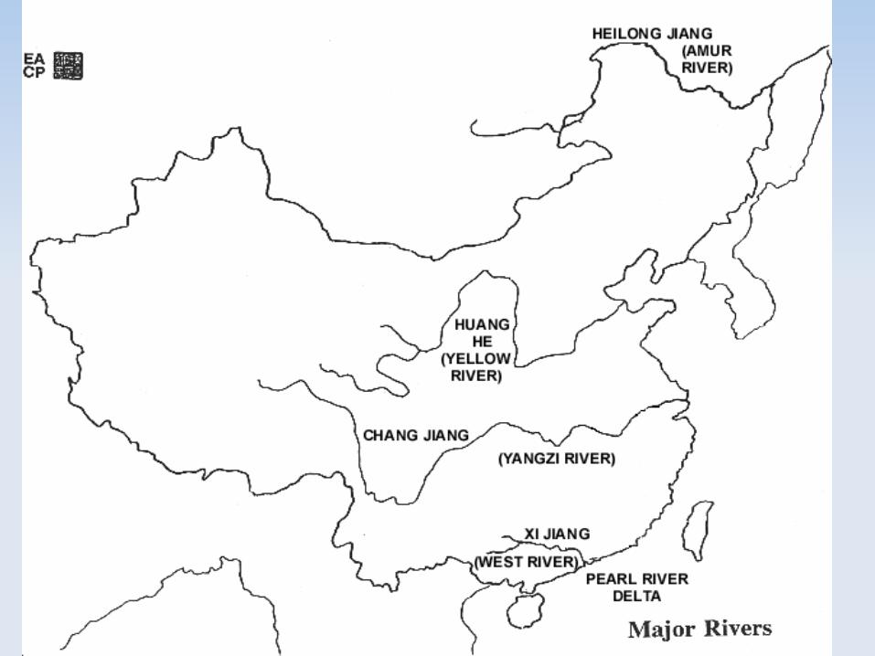
River
Hwang Ho or Hwang He - Before reaching the plains the, Hwang Ho passes through the Loess Plateau, at the foot of the Qilian Shan range in Gansu and Shanxi provinces. Here the river has dug deep ravines and carried downstream appreciable quantities of silt. Its irregular now, however, gives rise to unexpected and disastrous silting, often causing the course of its bed to be altered.
Yangtze Kiang or Chang Xiang River - The largest river of China flows in the middle part of eastern China and drains into the east China Sea. Shanghai is locate on the bank of this river.
Si Kiang or Xi Xiang - Rises in the eastern part of Yunan plateau flows through the southern most part of China. It drains into south China Sea and its mouth is located near canton.

Fishing
The fisheries of China may divided into three categories - Deep sea, inshore and inland.
Deep sea fishing - recently the deep-sea fisheries have begun to be increasingly exploited as powered vessels have been put into service.
Coastal or inshore fishing - Hundreds of thousand of Chinese are engaged in the inshore fishing industry and factors for its development - coastal topography and pressure of population.
Inland fishing - The third type of fishing is associated with inland waters, the lakes, rivers, canals and ponds.


Agriculture
About 62 per cent of the population is engaged in agriculture. This includes the herders of Mongolia who care for their livestock.
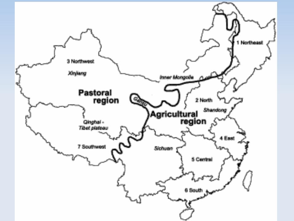
The bulk of China's agriculture is concentrated in the wetter, eastern third of the country. There are four distinct production regions:
1. The Hwang Ho Plain
2. Loess hills of Northern China
3. The Chang Jiang drainage basin
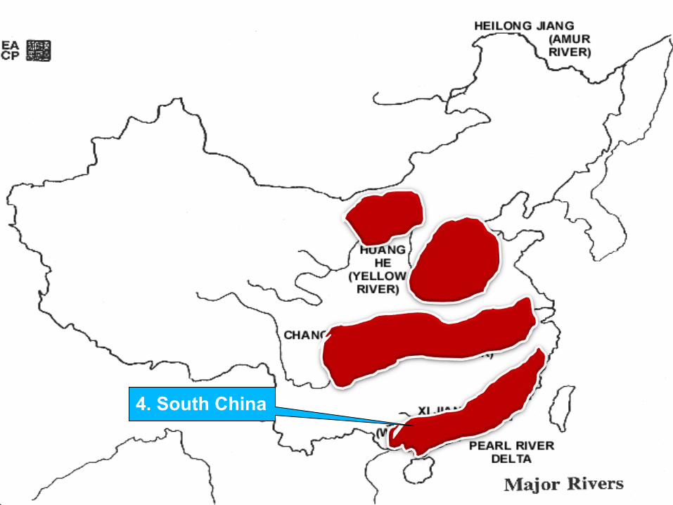
4. South China

Agriculture
About 62 per cent of the population is engaged in agriculture. This includes the herders of Mongolia who care for their livestock.
The bulk of China's agriculture is concentrated in the wetter, eastern third of the country. There are four distinct production regions:
1. The Hwang Ho Plain
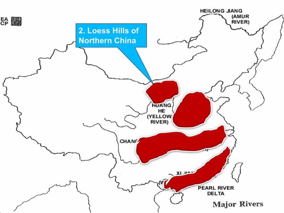
2. Loess hills of Northern China
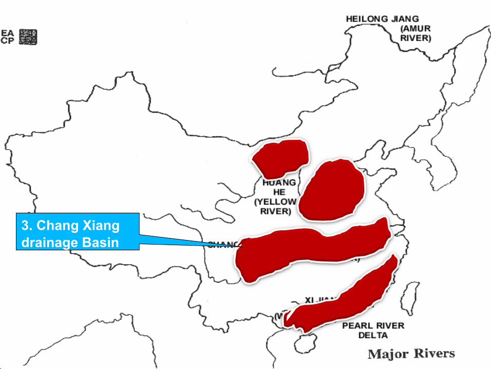
3. The Chang Jiang drainage basin
4. South China

3. Chang Xiang drainage Basin
4. South China
2. Loess Hills of Northern China
1. Hwang Ho Plain

Agriculture Region
The Hwang Ho Plain - Large alluvial plain created by the Hwang Ho River. It is the heartland of Chinese civilization. The major crops produced are wheat, barley, corn, millet, Much of the agriculture is subsistence-level. The Communist government's attempts to create large collective farms in the region have been unsuccessful. Until recently, they did not use commercial fertilizers, and the ancient custom of using human waste for fertilizer continues.
Loess hills of Northern China - To the west of the Hwang Ho Plain lie the loess hills of Northern China. This region of wind-blown soil has been dissected by thousands of gullies, but the flat areas between the miniature canyons are farmed intensively.

1. Hwang Ho Plain
2. Loess Hills of Northern China

Agriculture
The Chang Jiang drainage basin - The third major farming region of China, is the rice-producing area. Rice is the major crop along the river from the Sichuan Basin to Shanghai. Other crops include sweet potatoes, barley, millet, sugar cane. The region has also been noted for the production of silk and tea. Mulberry trees for feeding silkworms are still common, although the silk industry has declined.
South China - It is the poorest of the four major agricultural regions. The plain surrounding Canton is not large, and the rolling hills give way quickly to non-arable mountains. A number of these small plains exist, however, all along the coast from Hong Kong to Shanghai. The semi-tropical climate sometimes makes it possible to grow two crops each year, but the soils are thin and not as fertile as the river basins to the north. The typical Chinese crops grown in this region are tea, rice,
3. Chang Xiang drainage Basin
4. South China

Crops Producing Regions
Winter Wheat Loess Plateau, North China, Yangtze
Spring Wheat North west China
Rice Sichuan, Southern Region, South Eastern Region
Tea Southern Region

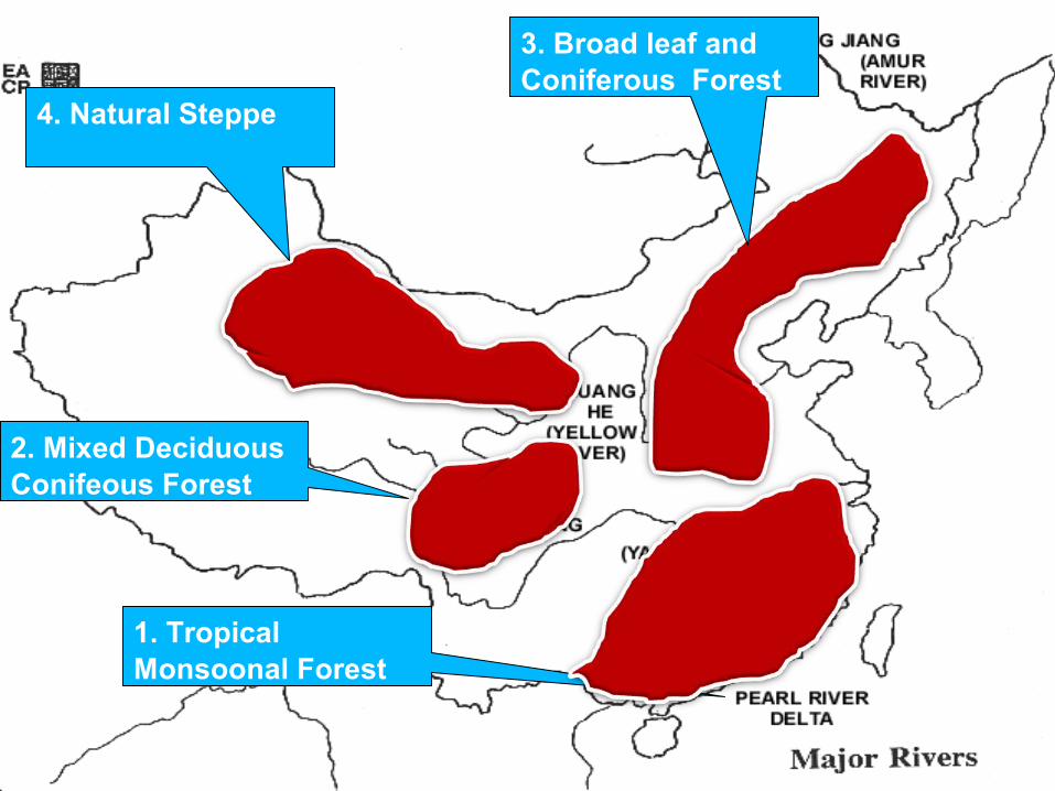
1. Tropical Monsoonal Forest
4. Natural Steppe
2. Mixed Deciduous Conifeous Forest
3. Broad leaf and Coniferous Forest
Forest
1. Forest occupies a mere 8.5% of the total area, use of timber of constructional purposes and fuel, the original natural forest cover has been almost completely removed in South China. Therefore, there are limited areas of tropical monsoon forest in South China, most of this is secondary growth with much bamboo.
2. Interior southern China and central China has Mountains, an area of mixed deciduous and coniferous forest, but in actual fact scarcely anything remains of the original forest cover.
3. The Great Plain of northern China was probably originally under mixed broadleaf and coniferous forest but hardly anything of this is left.
4. Plateaus of north-western China form a natural steppe area; this belt of grassland continues north-eastward. Much of it suffered deterioration through overgrazing and soil erosion.
5
4
32
1
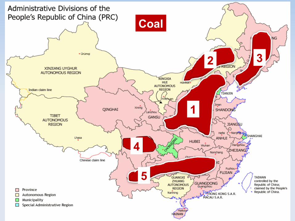
Coal

Coal
All types of coal are found, including anthracite, bituminous and lignite.
1. Shanxi and Shaanxi - The greatest concentration of China's coal is in the north: in Shanxi and Shaanxi account for 47 per cent of China"s huge reserves. Gansu, Henan , Hebei and Shandong. not easily accessible since found in folds and faults
2. Inner Mongolia accounts for another 25 per cent.
3. Manchuria – Heilongjiang, Jilin and Liaoning which support heavy industries, easily accessible and contain high-grade coking coal, chief mining areas are at Fushun,
4. Sichuan Basin - Further south there are many scattered deposits, The coal deposits here are extensive but rarely occur near the surface.
5. Lesser deposits occur in the province of Yunnan, Guizhou, Jiangxi and Hunan, serving local demand only.

2. Shandong
1. Anshan
1. Baotou
4. Guangzhou
5. Hainan
Iron Ore

Iron ore
Manchuria - China has large iron ore deposits, of which the Manchurian deposits at Anshan are the most actively mined.
Other important regions are :
Lower Chang Jiang (Yangtze), the Chongqing area, Scattered deposits occur in the Shandong (Shantung) Peninsula, north of Baotou (Paotow) in inner Mongolia, the Lower Xi Jiang (Si Kiang) near Guangzhou (Canton), and on the island of Hainan in the south.
The iron and steel industry is established in almost all the major cities, including Anshan, Shanghai, Wuhan, Chongqing and Guangzhou (Canton).
2. Shandong
1. Manchuria
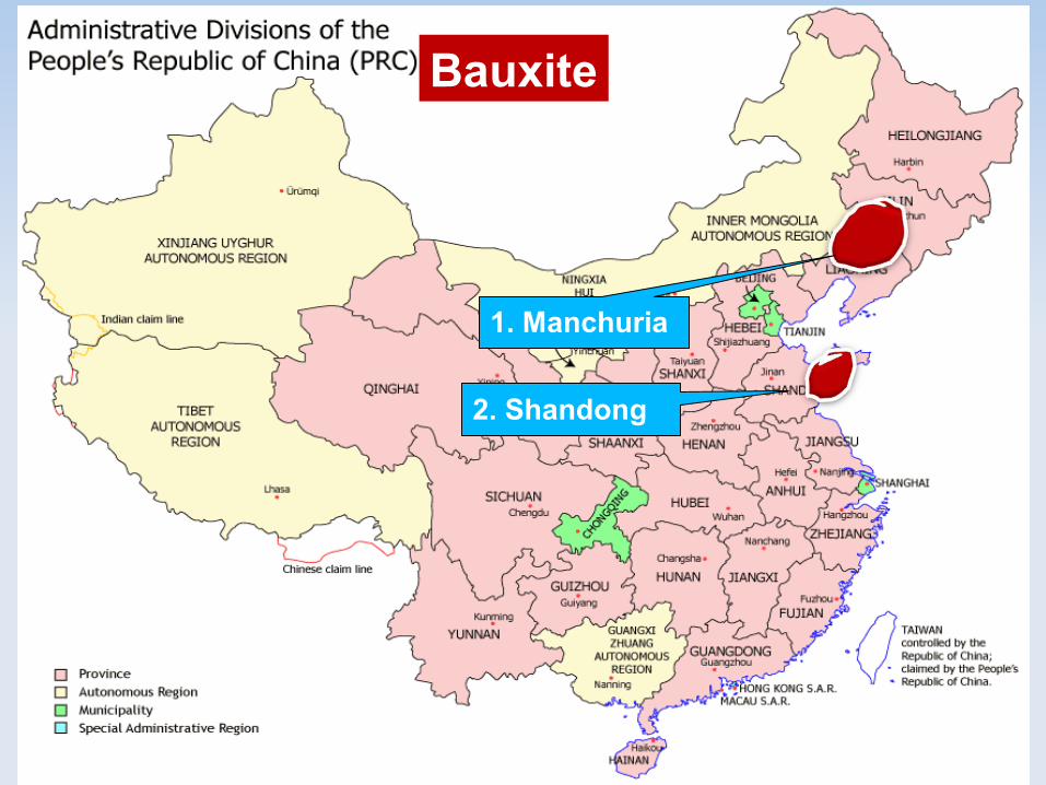
Bauxite
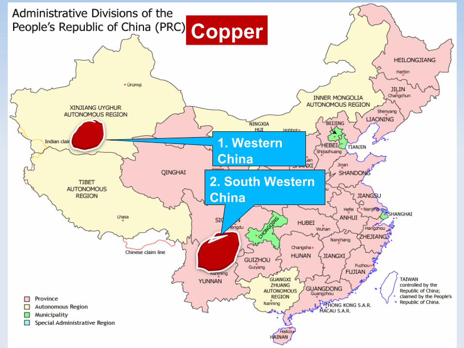
2. South Western China
1. Western China
Copper
Copper & Bauxite
Copper - is plentiful although western and south-western China.
Bauxite deposits occur in Shandong and Manchuria and newly-found reserves are reported to exist in the provinces of Gansu, Yunnan.

2. Shengli nearShandong
1. Daqing , Daqang near Beijing
Petroleum
2. Large Field in Xi Jiang Valley

Petroleum
Much of China's oil comes from the north-east of the country.
1. Daqing is the largest field and has large reserves.
2. Dakang field near Beijing is potentially even larger and continues offshore.
3. Other northern fields are at Shengli in Shandong.
4. There are large fields in Xi jiang (Si kiang)

Factors for Industrial Development in China
China has a vast natural resource forming the base of the industrial development—
1. 18 billion tons of iron ore reserves making the country fourth in the world ranking;
2. world's largest deposits of tungsten and adequate amount of deposits of manganese, molybdenum and antimony:
3. China's coal deposits account for 20 % of the world total;
4. Self sufficient in petroleum - about 5 % of the world oil.The country has collaborated with other countries in exploiting oil of the offshore deposits of Yellow Sea and South China Sea;
5. Hydro-electric potential in the country is about 15 % of the world total, although rivers have a high seasonal flow.
Countries like Japan, the United States are the main trading partners of China and they also provide investment and technology.
Over and above all, China has vast labour force enabling it to implement all the planning of industrial development.
China has always been an agricultural country and its agricultural products provide raw materials for its agro-based industries.

Petroleum
Boutou
Shanxi
Beijing
Tianjin
Shenyang
Fushun
Anshan

Industrial Region
3. Shanxi - Boutou
2. Beijing - Tianjin
1. Anshan – Fushun - Shenyang
Industrial Region
1. Manchuria - Leading heavy industrial region and Heavy industries are centred on the Anshan-Fushun-Shenyang triangle. Imp. Factor Both coal and iron ore are found in the region lying in convenient proximity.The important industries are iron and steel, engineering, cars, tractors, factory equipments and chemicals.
2. Tianjin-Beijing Area - The most important factor, presence of coal in Shanxi and Hebei. Important industries of Tianjin are metallurgical, engineering, shipbuilding, textiles and chemicals
3. Shanxi-Baotou Area - Largest coalfield of China is located in the province of Shaanxi and Shanxi (Shensi and Shansi). Iron ore with 50 per cent metallic content is also found here.

Industrial Region
5. Wuhan
4. Lower Chang Xiang - Shanghai
6. Xi Xiang Delta- Guangzhou ( Canton )
7. Sichuan – Congqing, Chengdu

Industrial Region
4. Lower Chang Jiang (Yangtze Kiang) – Due to its coastal location, the region has greater accessibility. With Western technological influence a number of industries have developed. Shanghai is the most important port, handling the bulk of international trade.
5. Wuhan Area - Coal is found at Pingxiang (Pingsiang) and iron ore is found at Tayeh. The easy communication links are provided by river Chang Jiang (Yangtze Kiang).
6. Xi Jiang (Si Kiang) Delta Region - Guangzhou (Canton) is the chief port. The industrial development of the region has been stimulated because of its proximity to Hong Kong.
7. Sichuan - Rich in natural resources like coal, iron ore, and agricultural raw materials.Chongking and Chengdu are important centres.

Related Documents