Spring 2014 Children & Family Health 12th Edition

Welcome message from author
This document is posted to help you gain knowledge. Please leave a comment to let me know what you think about it! Share it to your friends and learn new things together.
Transcript

Sprin
g 201
4
Children &Family Health
12th Edition

Vital Signs is made possible by the generous support of:
BNIA-JFI would also like to thank the following:
The University of Baltimore
The Jacob France Institute
The Merrick School of Business
The Goldseker Foundation
The Baltimore Community Foundation
and
BNIA-JFI Steering Committee Members who generously provided Data Stories
BNIA-JFI Staff who contributed to Vital Signs 12:
Seema Iyer, PhD Associate Director Jacob France Institute David Epstein, Research Associate
Cheryl Knott, GIS Analyst Nancy Jones, Data Manager
Jahangir Akbar, Research Assistant Sachini Bandara, Student Assistant Kathryn Montgomery, Designer
David Carpenter, Web Developer

Vital Signs 12 Health 1
Healthy children and families are the cornerstone of good quality of life in neighborhoods, and research has provided growing evidence of the place-based determinants of health1. Baltimore City released Healthy Baltimore 20152 in May 2011, identifying ten priority public health areas and specific goals for reducing negative health outcomes. The plan benchmarks several measures at the citywide level; however, as shown in the Department’s Neighborhood Health Profiles 20113, each indicator can vary dramatically by neighborhood. In addition to Healthy Baltimore, the City launched the Baltimore Food Policy Initiative in 2010 to focus on healthy food availability to all neighborhoods. Baltimore City has also had a long-term strategy to improve birth outcomes4 coordinated by the B’More for Healthy Babies initiative.
Vital Signs 12 coordinates many of the specific indicators identified in these plans as key to tracking health-related quality of life measures for Baltimore’s neighborhoods. In order to ensure consistent communication of health-related data to Baltimore communities, analysis of indicators in this chapter has been more closely coordinated with the Baltimore City Department Health and the Johns Hopkins Center for a Livable Future.
Data
Children & Family Health data for Vital Signs 12 indicators come from several sources. State sources include the Maryland Department of Vital Statistics, Maryland Department of the Environment, and Maryland Department of Human Resources. City sources include Baltimore City Health Department, Baltimore City Liquor Board, and research partners at the Johns Hopkins Center for a Livable Future. Indicators are created by normalizing data by the number of residents in a given area. This will reflect the concentration of an indicator within an area, and allow for comparison across neighborhoods and over time.
Vital Signs 12 includes eighteen indicators for Community Statistical Areas5 (CSAs) designed to track the health of adults, children, and infants in Baltimore City and its neighborhoods. These indicators are grouped into the following categories: birth outcomes; life expectancy and mortality; lead poisoning; built environment and food security; and social assistance programs.
1 The Joint Center for Political and Economic Studies. Place Matters for Health in Baltimore: Ensuring Opportunities for Good Health for All; November 2012 2 Spencer M, Petteway R, Bacetti L, Barbot O. Healthy Baltimore 2015: A city where all residents realize their full health potential. Baltimore City Health Department; May 2011 3 Community Health Profiles http://www.baltimorehealth.org/neighborhood.html 4 Strategy to Improve Birth Outcomes in Baltimore City (2009) http://www.healthybabiesbaltimore.com/uploads/file/pdfs/SIBO%20Strategy%202009.pdf 5 CSAs are groups of census tracks that correspond to neighborhoods which vary in size. See Vital Signs 12 Introduction.

Vital Signs 12 Health 2
Birth Outcomes6
Vital Signs 12 tracks four birth outcome indicators for Baltimore’s Community Statistical Areas (CSAs): teen birth rate; percent of births delivered at term; percent of babies born with satisfactory birth weight; and percent of births where the mother received early prenatal care. From 2011 to 2012, the trends for each of these indicators are mixed for Baltimore City as a whole.
• Baltimore City’s teen birth rate (the number of girls aged 15-19 who have given birth per 1,000 females aged 15-19) has continued to decrease over the past several years and declined further from 46.6 in 2011 to 41.5 in 2012. From 2011 to 2012, the teen birth rate declined in 36 CSAs, remained the same in three CSAs, and increased in 16 CSAs.
• In 2012, the CSAs with the highest teen birth rates were Patterson Park North & East (104.5), Fells Point (100.0), Highlandtown (94.8), Penn North/Reservoir Hill (79.4), and Clifton-Berea (77.1). Four CSAs with zero teen birth are Greater Roland Park/Poplar Hill, Canton, Mt. Washington/Coldspring, and North Baltimore/ Guilford/Homeland.
• The percentage of births that were delivered at term (at least 37 weeks gestation) in Baltimore City declined slightly from 87.4% in 2011 to 86.6% in 2012. From 2011 to 2012, the percentage of births at term declined in 32 CSAs, with the greatest decreases occurring in Poppleton/The Terracs/Hollins Market (-10.7%), Washington Village (-9.4), and Greater Roland Park/Poplar Hill (-8.2%). From 2011 to 2012, the percentage of births at term increased in 23 CSAs, with the greatest increases occurring in Modtown (8.21%), Highlandtown (6.35%), and Upton/Druid Heights (5.08%). In 2012, the CSAs with the highest percentage of births at term were Mt. Washington/Coldspring (95.3%) and Fells Point (93.7%).
6 Birth outcome data comes from the Maryland Department of Vital Statistics

Vital Signs 12 Health 3
• The percentage of births where the child was of satisfactory weight (at least 5.5lbs) in Baltimore City declined slightly from 88.4% in 2011 to 88.2% in 2012. From 2011 to 2012, the percentage of births with a satisfactory birth weight increased in 28 CSAs, with the greatest increases occurring in Cherry Hill (13.6%), Madison/East End (7.6%, and Upton/Druid Heights (6.9%). From 2011 to 2012, the percentage of births with a satisfactory birth weight declined in 27 CSAs, with the greatest decreases occurring in Howard Park/West Arlington (-13.4), Greater Rosemont (-10.2%), and Oldtown/Middle East (-9.3%).
• In 2012, the CSAs with the highest percentage of births with satisfactory birth weight were Fells Point (97.2%) and Mt. Washington/Coldspring (96.9%); the CSA with the lowest percentage of births with satisfactory birth weight was Forest Park/Walbrook (79.0%).
• The percentage of births where the mother received early prenatal care (early being care that began in the first trimester) in Baltimore City increased from 59.0% in 2011 to 62.7% in 2012. From 2011 to 2012, the percentage of births where the mother received early prenatal care increased in 38 CSAs, with the greatest increases occurring in Forest Park/Walbrook (48.5%), Poppleton/The Terraces/Hollins Market (38.7%), and Orangeville/East Highlandtown (29.1%). From 2011 to 2012, the percentage of births where the mother received early prenatal care declined in 17 CSAs, with the greatest decreases occurring in Chinquapin Park/Belvedere (-15.4), Morrell Park/Violetville (-10.9%), and Downtown/Seton Hill (-8.8%).
• In 2012, the CSAs with the highest percentage of births where the mother received early prenatal care were Greater Roland Park/Poplar Hill (86.9%) and South Baltimore (80.9%). The CSAs with the lowest percentages of mothers received early prenatal care included Southern Park Heights (48.1%), Chinquapin Park/Belvedere (49.2%), and Brooklyn/Curtis Bay/Hawkins Point (49.6%).

Vital Signs 12 Health 4
Life Expectancy and Mortality7
Life expectancy (how long one might expect to live) and mortality rates (chances of dying) are fundamental health outcomes that are increasingly correlated with a person’s neighborhood. Vital Signs 12 reports life expectancy at birth and mortality rates for five age categories. These two indicators are inversely related; CSAs with low life expectancy have high rates of mortality in the younger age categories.
• In 2012, the life expectancy at birth in Baltimore City was 73.9 years. The CSAs with the highest life expectancy were Greater Roland Park/Poplar Hill (84.4 years), Cross-Country/Cheswolde (84.2 years), North Baltimore/Guilford/Homeland (83.2 years), Mt. Washington/Coldspring (81.7 years), and Glen-Fallstaff (78.5 years). The CSAs with the lowest life expectancy were Downtown/Seton Hill (65.0 years), Clifton-Berea (66.4 years), Poppleton/The Terraces/Hollins Market (67.1 years), Upton/Druid Heights (67.3 years), and Greenmount East (67.4 years).
7 Data and methodology provided by the Baltimore City Department of Health
Data Story: Infant Mortality Rate
The Infant Mortality Rate (IMR) is the number of infant (<1yr) deaths per 1000 live births. IMR is often used as a key indicator to determine the overall health and well-being of a community because the major factors driving the infant mortality rate are the same factors that affect the health of an entire population. Baltimore City’s infant mortality rate is calculated on an annual basis using the vital statistics that are reported on city resident birth and death certificates. This indicator helps researchers, program planners, and policy makers target areas in need of programs like community-based improvement projects and public health interventions.
Historically, Baltimore City has had one of the highest IMRs in the nation, sometimes being twice as high as that of the US. In 2009, the Baltimore City Health Department’s Bureau of Maternal and Child Health implemented a city-wide initiative known as B’more for Healthy Babies (BHB) to directly combat the City’s high infant mortality rate. BHB is an ongoing program that brings together key stakeholders, such as city agencies, health care providers, community groups, and community members, to help improve maternal and infant health in the Baltimore City. With this collaborative partnership, BHB is able to work at different levels, from policy to the community. Since the initiation of BHB in 2009, Baltimore City’s overall infant mortality rate has been reduced by 28%. Despite this significant reduction, many preventable infant deaths are still occurring each year and BHB remains an important effort in improving the lives of infants and their families in Baltimore City.
For more information on B’more for Healthy Babies, visit http://www.healthybabiesbaltimore.com/
By Baltimore City Department of Health

Vital Signs 12 Health 5
• The infant mortality rate measures the average number of deaths over a 5-year period in persons under the age of one per 1,000 live births (See Data Story) From 2008-2012, the infant mortality rate was 9.7 in Baltimore City. The CSA with the highest infant mortality rate was Pimlico/Arlington/Hilltop (21.0). Three CSAs experienced an infant mortality rate below 3.08: Claremont/Armistead, Fells Point, and Greater Roland Park/Poplar Hill.
• From 2008-2012, Baltimore City’s age-specific mortality rate for persons aged 1-14 was 2.5 per 1,000 persons. There were 15 CSAs with zero deaths of persons in this age group. The CSAs with the highest rates were Downtown/Seton Hill (20.7) and Midway/Coldstream (8.4).
• From 2008-2012, Baltimore City’s age-specific mortality rate for persons aged 15-24 was 11.9 per 1,000 persons. The CSAs with the highest rates were Clifton-Berea (31.9) and Midway/Coldstream (29.9).
• From 2008-2012, Baltimore City’s age-specific mortality rate for persons aged 25-44 was 24.0 per 1,000 persons, with Greater Roland Park/Poplar Hill (2.1) and Canton (3.3) reporting the lowest rates. The CSAs with the highest rates were Clifton-Berea (59.5) and Penn North/Reservoir Hill (50.0).
• From 2007-2011, Baltimore City’s age-specific mortality rate for persons aged 45-64 was 114.1 per 1,000 persons. The CSAs with the highest rates were Downtown/Seton Hill (203.5), Poppleton/The Terraces/Hollins Market (197.4), and Clifton-Berea (185.6). The CSAs with the lowest rates were Greater Roland Park/Poplar Hill (33.2), Mt. Washington/Coldspring (46.3), and North Baltimore/Guilford/Homeland (53.2).
• From 2008-2012, Baltimore City’s age-specific mortality rate for persons aged 65-84 was 397.8. The CSAs with the highest rates were Downtown/Seton Hill (785.4) and Washington Village (577.1). The CSAs with the lowest rates were Greater Roland Park/Poplar Hill (209.7) and North Baltimore/Guilford/Homeland (209.9).
• From 2008-2012, Baltimore City’s age-specific mortality rate for persons 85 and over was 1,231.5 per 1,000. The CSAs with the highest rates were Downtown/Seton Hill (2,000.0) andMidway/Coldstream (1,866.7). The CSAs with the lowest rates were Morrelle Par/Violetville (912.6), Cross-Country/Cheswolde (918.7), and Midtown (983.2).
8 Rate estimated due to small numbers of infant deaths

Vital Signs 12 Health 6
Lead Poisoning9 Although lead-based paint has been banned in the United States since 1978, many Baltimore homes were constructed prior to the ban and continue to contain paint and other sources of lead toxic to human health. When human blood lead levels are high, it can affect many organs and tissues including heart, kidneys, bones, and the nervous system. In children, elevated levels of lead in the blood can lead to permanent learning and behavior disorders.
• From 2011 to 2012, the total number of children between the ages of 0 and 6 tested for elevated levels of lead in their blood decreased by 1.6%, from 19,036 to 18,723. In 2012, the greatest number of children tested for elevated blood lead were in Cross-Country/Cheswolde (391 children), Cherry Hill (382 children), Brooklyn/Curtis Bay/Hawkins Point (374 children), Belair-Edison (356 children), and Harford/Echodale (348 children).
9 The number of children 0 to 6 years old that are tested for elevated levels of blood lead are reported by the Maryland Department of the Environment Lead Poisoning Prevention Program http://www.mde.state.md.us/programs/land/Pages/index.aspx
Range of Age-specific Mortality Rates among Community Statistical Areas
The broad range in age-specific mortality rates is an indicator of health disparities that exist across neighborhoods in Baltimore.
Indicator Lowest Rate
Baltimore City Rate
Highest Rate
Infant Mortality <3.0* 9.7 21.0 Mortality by Age (1-14 years old) 0.0 2.5 20.7 Mortality by Age (15-24 years old) 0.0 11.9 31.9 Mortality by Age (25-44 years old) 2.1 24.0 59.5 Mortality by Age (45-64 years old) 33.2 114.1 203.5 Mortality by Age (65-84 years old) 209.7 397.8 785.4 Mortality by Age (85 and over) 912.6 1,231.5 2,000.0

Vital Signs 12 Health 7
• In 2012, the percent of children age 0-6 with elevated blood lead levels decreased from 1.4% in 2011 to 1.2% in 2012. Of the 47 CSAs that had any children tested for elevated levels of blood lead in 2012, only 8 CSAs had children found to have elevated blood lead levels. The CSAs where the greatest percentage of children who were tested and were found to have elevated blood lead levels included Sandtown-Winchester/Harlem Park (7.4%), Midway/Coldstream (6.1%), and Edmondson Village (5.3%).
Built Environment and Food Security
A neighborhood’s built environment (buildings, streets, parks, etc) provide the context for human activity and can directly or indirectly impact the ability of residents to live healthy lives. Vital Signs 12 tracks two indicators of the density of off-premise liquor outlets10 and, in coordination with the Johns Hopkins Center for Livable Future, fast food/prepared-food and average healthy food availability index (see Indicator In-Depth).
• In 2012, the density of off-premise liquor outlets in Baltimore City was 1.2 per 1,000 residents. The density of these stores ranged from 8.5 per 1,000 persons in the Downtown/Seton Hill CSA to 0.0 in Cross-Country/Cheswolde.
• In 2012, the total number of off-premise liquor outlets in Baltimore was 766. The number of liquor outlets decreased by 1.9% from 78111 in 2011 to 766 in 2012. The largest numbers of establishments were located in Downtown/Seton Hill (55), Southwest Baltimore (47), Canton (40), and Highlandtown (38). The fewest numbers of establishments were located in Cross-Country/Cheswolde (0), Beechfield/Ten Hills/West Hills (1), Edmondson Village (1) and Cherry Hill (1).
• In 2011, the density of fast or prepared food12 in Baltimore was 1.4 stores per 1,000 residents. The CSAs with the highest density of fast food outlets per 1,000 residents were Downtown/Seton Hill (22.3), Madison/East End (4.6), and Inner Harbor/Federal Hill (4.2). Many CSAs (28) had less than 1.0 fast food outlets per 1,000 residents. The CSAs with the lowest density of fast food outlets per 1,000 residents included Cross-Country/Cheswolde (0.0), Edmonson Village (0.1), Mt. Washington/Coldspring (0.2), and Dickeyville/Franklintown (0.2).
10 Rachel L. Johnson Thornton, et al (2011). Zoning for a Healthy Baltimore: A Health Impact Assessment to of the Transform Baltimore Comprehensive Zoning Code Rewrite. 11 Correction: The 2011 total number of off-premise liquor stores was revised downward from 866 to781 in order to exclude one day permits. 12 See Vital Signs 11 for more information on this indicator. Source: The Johns Hopkins Center for a Livable Future at the Bloomberg School of Public Health.

Vital Signs 12 Health 8
• In 2012, the average healthy food availability index ranking of Baltimore City was 10.3. The CSAs with the highest average healthy food availability index ranking were Mt. Washington/Coldspring (24.8), South Baltimore (18.1), and Canton (16.9). The CSAs with the lowest average healthy food availability index ranking included Cross-Country/Cheswolde (0.0) Dickeyville/Franklintown (0.0), and Edmondson Village (6.4) (see Indicator In-Depth).
Indicator In-Depth: Healthy Food Availability Index
The Baltimore City Healthy Food Availability Index (HFAI) score is a quantitative depiction of the availability of healthy and whole food in supermarkets, small groceries & corner stores (known as superettes in the industry), convenience stores and other stores that sell food. This score can be used to evaluate individual stores as well as provide a means through which healthy food availability can be compared between stores. The Johns Hopkins Center for a Livable Future (CLF) calculated HFAI scores for all food stores in Baltimore, in summer 2012, using an adapted version of the NEMS-S (Nutrition Environment Measures Survey in Stores) tool. The NEMS-S tool was developed by researchers at the Rollins School of Public Health at Emory University to measure the nutritional environment of food retail stores and was designed to assess healthy food availability in grocery and convenience stores. The survey looks for the presence of basic food groups and healthy options within those groups, such as milk, and low fat milk as the healthy option. CLF did an additional assessment of supermarkets in Baltimore in spring 2013 using another adapted version of the NEM-S tool, in order to account for the quality and variety of healthy food options, and the quality of the supermarket themselves. CLF took the total HFAI score from both surveys and calculated an average HFAI score for each Community Statistical Area (CSA) in Baltimore. This analysis showed that HFAI scores were generally higher in the city center as well as along the edges of the city, which tend to also be higher income areas. HFAI scores were generally lower in the lowest-income areas, especially southwest and northeast of the city center. (Cont’ on next page)

Vital Signs 12 Health 9
Social Assistance Programs13 Baltimore residents have access to several federal programs aimed at assisting people during times of financial distress. The uptake of these programs ebbs and flows with economic cycles but also varies by neighborhoods in the City. Vital Signs 12 tracks Temporary Assistance to Needy Families (TANF) a program administered through the Maryland Department of Human Resources.
13 Source of data is the Maryland Department of Human Resources through a data sharing agreement with the Jacob France Institute. Research has shown that administrative records yield significantly higher counts of participation in government safety-net programs compared with survey (Census) estimates. Lynch et al (2008) “Differences in Estimates of Public Assistance Recipiency Between Surveys and Administrative Records” www.ubalt.edu/jfi/jfi/reports/TANFJan2008.pdf
Indicator In-Depth: Healthy Food Availability Index (Con’t)
Data Collection Methods CLF obtained a food permit list from the Baltimore City Health Department in August 2011, which includes all sites that sell food, such as stores, restaurants and temporary locations such as farmers’ market stands and street carts. CLF processed the list, further dividing the records between food stores and restaurants, and used the internet to help verify store and restaurant type and operational status. Food stores were grouped into six categories, including supermarkets, superettes (“mom and pop” small grocery stores, including corner stores), convenience stores, discount stores, and pharmacies. The updated food store list was geocoded in ArcGIS and then plotted in a map book. The map book was used by two data collectors in summer 2012 as a planning tool for conducting HFAI assessments in food stores in Baltimore City. They also used the map book to keep track of stores that had been closed or renamed and add new stores that were not on the food permit list. The data collectors used their assessments to calculate HFAI scores for each food store. HFAI scores ranged from 0 to 28.5, with higher scores indicating more availability of healthy and whole food in a food store. A second HFAI assessment specifically for supermarkets was completed in spring 2013. The new supermarket scores were added to the original scores, increasing the scoring range to 0 to 50. These final HFAI scores were added to the food store data layer in ArcGIS. The food store data layer was then spatially joined with the 2010 CSA data layer in ArcGIS and the HFAI scores were averaged across each CSA.
Sources The food store data layer was originally derived from the August 2011 Baltimore City food permit list. It was later field verified and updated by CLF. The HFAI scores were generated by CLF. The CSA data layer was obtained from the Baltimore Neighborhood Indicators Alliance.
Updates This is the first time CLF has calculated the average HFAI score for each CSA in Baltimore. Updates to the data will be made every other year, in conjunction with updates to the CLF Food Desert Map.
By The Johns Hopkins Center for a Livable Future at the Bloomberg School of Public Health

Vital Signs 12 Health 10
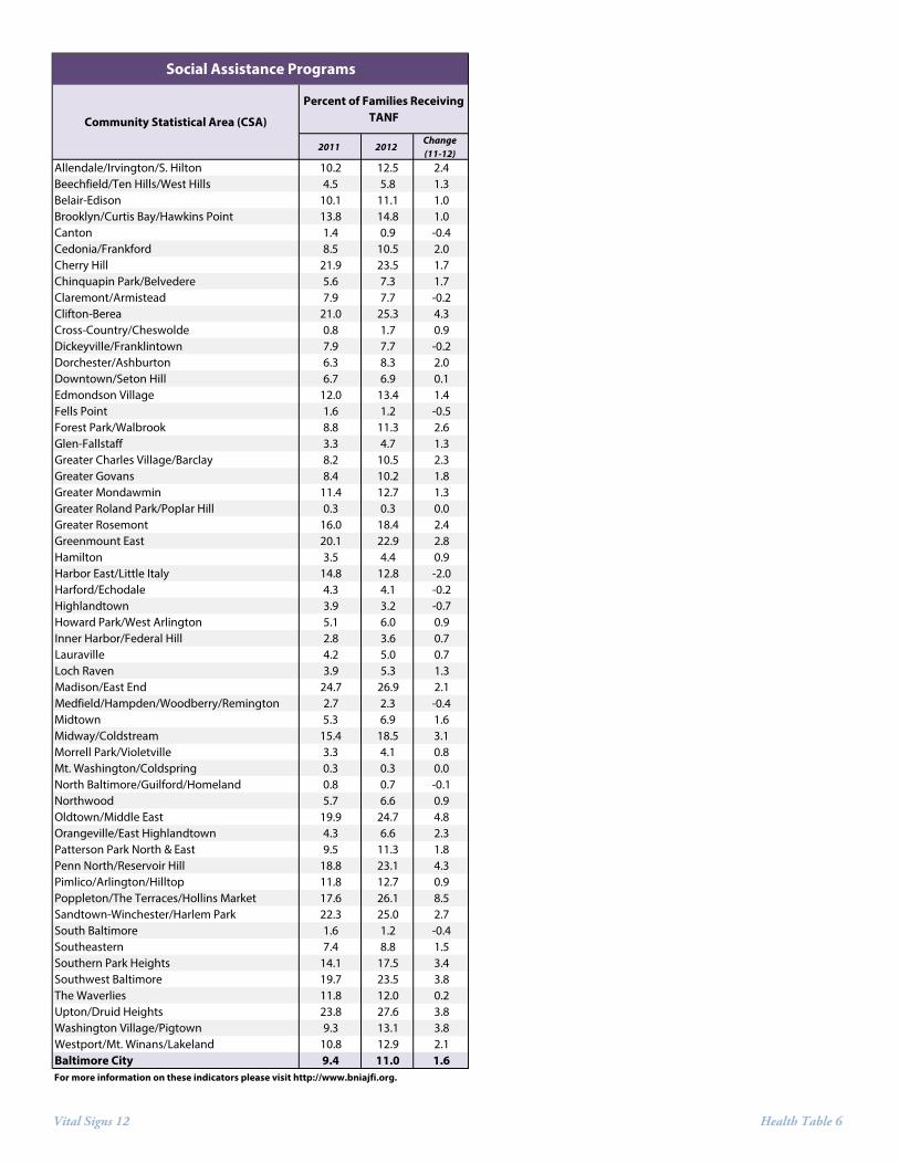
• In 2012, 11.0% of the families in Baltimore City received TANF support at some point during the year, which is a 1.6% increase from 2011 (9.4%). The CSAs with the highest percentage of families receiving TANF were Upton/Druid Heights (27.6%), Madison/East End (26.9%), Poppleton/The Terraces/Hollins Market (26.1%), and Clifton-Berea (25.3%). The CSAs with the lowest percentage included Mt. Washington/Coldspring (0.3%), Greater Roland Park/Poplar Hill (0.3%), North Baltimore/Guilford/Homeland (.7%), and Canton (.9%).
New Indicators in Vital Signs 12 Vital Signs 12, Children & Family Health includes one new indicator: average healthy food availability index. The new data included in Vital Signs 12 will serve as the baseline for future comparisons, and is not comparable to previous data.
Baseline Rates in 2012 for Baltimore City: New Health Indicator
Healthy food availability index 10.3

Vital Signs 12 Health Indicators 1
For each indicator reported in Vital Signs 12, we provide the data source, the years for which it is reported, and the five CSAs with the highest and lowest values for the indicator; these may not correspond to positive or negative trends.
Birth Outcome Indicators
Teen Pregnancy Rate Measure of birth among young persons. Definition: The rate of female teens aged 15-19 that gave birth per 1,000 females aged 15-19. Source: Maryland Department of Vital Statistics, 2010, 2011, 2012; U.S. Census, 2010 Five Highest:
1. Patterson Park North & East 2. Fells Point 3. Highlandtown 4. Penn North/Reservoir Hill 5. Clifton-Berea
Five Lowest: Four CSAs did not have any teenage births in 2012: 1-4. Greater Roland Park/Poplar Hill
North Baltimore/Guilford/Homeland Mt. Washington/Coldspring Canton
5. Midtown
Percent of Births Delivered at Term Measures the portion of births that are considered to be full-term and likely to result in a healthier baby. Definition: The percentage of births delivered at term measures the percentage of births in a calendar year where the baby is delivered between 37 and 42 weeks of gestation. Source: Maryland Department of Vital Statistics 2010, 2011, 2012 Five Highest:
1. Mt. Washington/Coldspring 2. Fells Point 3. Highlandtown 4. Midtown 5. South Baltimore
North Baltimore/Guilford/Homeland Five Lowest:
1. Downtown/Seton Hill 2. Forest Park/Walbrook 3. Washington Village 4. Midway/Coldstream 5. Sandtown-Winchester/Harlem Park

Vital Signs 12 Health Indicators 2
Percent of Babies Born with a Satisfactory Birth Weight Measure of babies born at a healthy weight. Definition: The percentage of children born with a birth weight of at least 5 ½ pounds out of all births in the area. Source: Maryland Department of Vital Statistics 2010, 2011, 2012 Five Highest:
1. Fells Point 2. Mt. Washington/Coldspring 3. South Baltimore 4. North Baltimore/Guilford/Homeland 5. Cross-Country/Cheswolde
Five Lowest: 1. Forest Park/Walbrook 2. Oldtown/Middle East 3. Downtown/Seton Hill 4. Pimlico/Arlington/Hilltop 5. Greater Rosemont
Percent of Births where the Mother Received Early Prenatal Care Measure of healthy pregnancies and healthy babies. Definition: The percentage of births where the mother received prenatal care during the first trimester of the pregnancy in a calendar year out of all births within an area. This information is calculated by the Vital Statistics registration information collected from each live birth. Source: Maryland Department of Vital Statistics 2010, 2011, 2012 Five Highest:
1. Greater Roland Park/Poplar Hill 2. South Baltimore 3. Canton 4. Inner Harbor/Federal Hill 5. Fells Point
Five Lowest: 1. Southern Park Heights 2. Chinquapin Park/Belvedere 3. Brooklyn/Curtis Bay/Hawkins Point 4. Southwest Baltimore 5. Midway/Coldstream

Vital Signs 12 Health Indicators 3
Life Expectancy and Mortality Indicators Life Expectancy at Birth Summarizes health over the entire lifespan. Definition: The average number of years a newborn can expect to live, assuming he or she experiences the currently prevailing rates of death through their lifespan. Source: Baltimore City Health Department, 2011, 2012 Five Highest:
1. Greater Roland Park/Poplar Hill 2. Cross-Country/Cheswolde 3. North Baltimore/Guilford/Homeland 4. Mt. Washington/Coldspring 5. Glen-Fallstaff
Five Lowest: 1. Downtown/Seton Hill 2. Clifton-Berea 3. Poppleton/The Terraces/Hollins Market 4. Upton/Druid Heights 5. Greenmount East
Infant Mortality Measure of death rate in persons under one year of age. Definition: The number of infant deaths (babies under one year of age) per 1,000 live births within the area in a five year period. This is the most stable and commonly measured indicator of mortality in this age group. Source: Baltimore City Health Department, 2008-2012 Five Highest:
1. Pimlico/Arlington/Hilltop 2. Harbor East/Little Italy 3. Dickeyville/Franklintown 4. Greenmount East 5. Greater Mondawmin
Five Lowest: 1. North Baltimore/Guilford/Homeland 2. Canton 3. Cross-Country/Cheswolde 4. Mt. Washington/Coldspring 5. Claremont/Armistead
Mortality by Age (1-14 years old) Measure of death rate for persons between one and 14 years old. Definition: The number of deaths of persons between the ages of one and 14 per 10,000 persons within the area in a five year period. Source: Baltimore City Health Department, 2008-2012 Five Highest:
1. Downtown/Seton Hill 2. Midway/Coldstream 3. Greenmount East 4. Southwest Baltimore 5. Oldtown/Middle East
Five Lowest: Fifteen CSAs reported zero deaths.
Mortality by Age (15-24 years old) Measure of death rate for persons between 15 and 24 years old. Definition: The number of deaths of persons between the ages of 15 and 24 per 10,000 persons within the area in a five year period. Source: Baltimore City Health Department, 2008-2012 Five Highest:
1. Clifton-Berea 2. Midway/Coldstream 3. The Waverlies 4. Belair-Edison 5. Penn North/Reservoir Hill
Five Lowest: 1. Mt. Washington/Coldspring 2. North Baltimore/Guilford/Homeland 3. Greater Charles Village/Barclay 4. South Baltimore 5. Greater Roland Park/Poplar Hill

Vital Signs 12 Health Indicators 4
Mortality by Age (25-44 years old) Measure of death rate for persons between 25 and 44years old. Definition: The number of deaths of persons between the ages of 25 and 44 per 10,000 persons within the area in a five year period. Source: Baltimore City Health Department, 2008-2012 Five Highest:
1. Clifton-Berea 2. Penn North/Reservoir Hill 3. Upton/Druid Heights 4. Greenmount East 5. Cherry Hill
Five Lowest: 1. Greater Roland Park/Poplar Hill 2. Canton 3. Inner Harbor/Federal Hill 4. Cross-Country/Cheswolde 5. Mt. Washington/Coldspring
Mortality by Age (45-64 years old) Measure of death rate for persons between 45 and 64 years old. Definition: The number of deaths of persons between the ages of 45 and 64 per 10,000 persons within the area in a five year period. Source: Baltimore City Health Department, 2008-2012 Five Highest:
1. Downtown/Seton Hill 2. Poppleton/The Terraces/Hollins Market 3. Clifton-Berea 4. Madison/East End 5. Greenmount East
Five Lowest: 1. Greater Roland Park/Poplar Hill 2. Mt. Washington/Coldspring 3. North Baltimore/Guilford/Homeland 4. Cross-Country/Cheswolde 5. Canton
Mortality by Age (65-84 years old) Measure of death rate for persons between 65 and 84 years old. Definition: The number of deaths of persons between the ages of 65 and 84 per 10,000 persons within the area in a five year period. Source: Baltimore City Health Department, 2008-2012 Five Highest:
1. Downtown/Seton Hill 2. Washington Village 3. Claremont/Armistead 4. Poppleton/The Terraces/Hollins Market 5. Madison/East End
Five Lowest: 1. Greater Roland Park/Poplar Hill 2. North Baltimore/Guilford/Homeland 3. Cross-Country/Cheswolde 4. Mt. Washington/Coldspring 5. Glen-Fallstaff
Mortality by Age (85 and Over) Measure of death rate for persons between 85 years old and above. Definition: The number of deaths of persons 85 years and older per 10,000 persons within the area in a five year period. Source: Baltimore City Health Department, 2008-2012 Five Highest:
1. Downtown/Seton Hill 2. Midway/Coldstream 3. South Baltimore 4. Belair-Edison 5. Highlandtown
Five Lowest: 1. Morrell Park/Violetville 2. Cross-Country/Cheswolde 3. Midtown 4. Greater Charles Village/Barclay 5. Medfield/Hampden/Woodberry

Vital Signs 12 Health Indicators 5
Lead Poisoning Indicators
Number of Children Tested for Elevated Blood Lead Levels Measure of child testing for the potential of elevated blood lead levels. Definition: This indicator reflects the total number of children aged 0-6 who are tested for the presence of blood lead in a calendar year. Source: Maryland Department of the Environment, Lead Poisoning Prevention Program, 2010, 2011, 2012 Five Highest:
1. Cross-Country/Cheswolde 2. Cherry Hill 3. Brooklyn/Curtis Bay/Hawkins Point 4. Belair-Edison 5. Harford/Echodale
Five Lowest: Eight CSAs did not have any children tested in 2012.
Percent of Children with Elevated Blood Lead Levels Measure of high exposure to lead for young children. Definition: The number of children aged 0-6 that are found to either have elevated blood lead levels (≥10Mg/dL) or lead poisoning (≥20 Mg/dL) out of the number of children tested within an area in a calendar year. Source: Maryland Department of the Environment, Lead Poisoning Prevention Program, 2010, 2011, 2012 Five Highest:
1. Sandtown-Winchester/Harlem Park 2. Midway/Coldstream 3. Edmondson Village 4. Greater Rosemont 5. Madison/East End
Five Lowest: Forty-seven CSAs had no children found to have elevated blood lead levels in 2012.

Vital Signs 12 Health Indicators 6
Built Environment and Food Security Liquor Outlet Density Measures the concentration of access to off-premise liquor. Definition: This indicator reflects the number of business establishments that possess a Class A (Off Sale package goods no on-premises consumption - 6 days, 6:00 a.m.- Midnight. No Sunday sales except Sundays between Thanksgiving Day and New Year's Day upon issuance of a special license for each Sunday) or BD7 (tavern) business license that allows them to sell beer, wine, or liquor. Other liquor licenses to restaurants or on-premise consumption were not included in this analysis. This number is provided by 1,000 residents to allow for comparison across neighborhoods. Source: Baltimore City Liquor Board 20111, 2012, U.S. Census 2010 Five Highest:
1. Downtown/Seton Hill 2. Highlandtown 3. Canton 4. Fells Point 5. South Baltimore
Five Lowest: 1. Cross-Country/Cheswolde 2. Beechfield/Ten Hills/West Hills 3. Northwood 4. Cherry Hill 5. Edmondson Village
Average Healthy Food Availability Index The Baltimore City Healthy Food Availability Index (HFAI) is a quantitative depiction of the availability of healthy and whole food in supermarkets, small groceries & corner stores, convenience stores, and other stores that sell food. Definition: The Johns Hopkins Center for a Livable Future (CLF) calculated HFAI scores for all food stores in Baltimore, in summer 2012, using an adapted version of the NEMS-S (Nutrition Environment Measures Survey in Stores) tool. The NEMS-S tool was developed by researchers at the Rollins School of Public Health at Emory University to measure the nutritional environment of food retail stores and was designed to assess healthy food availability in grocery and convenience stores. CLF obtained a food permit list from the Baltimore City Health Department in August 2011, which includes all sites that sell food, such as stores, restaurants, and temporary locations such as farmers’ market stands and street carts. HFAI scores range from zero to 28.5, with higher scores indicating more availability of healthy and whole food in a food store. Source: Baltimore City Health Department, 2011 Analysis by: Johns Hopkins Center for a Livable Future (CLF) 2012 Five Highest:
1. Mt. Washington/Coldspring 2. South Baltimore 3. Canton 4. Beechfield/Ten Hills/West Hills 5. Greater Charles Village/Barclay
Five Lowest: Two CSAs had an HFAI score of 0 in 2012: 1-2. Cross-Country/Cheswolde
Dickeyville/Franklintown 3. Edmondson Village 4. Downtown/Seton Hill 5. Greater Rosemont
1 The 2011 values reported in Vital Signs 11 for this indicator have been revised to exclude one day permits. See Vital Signs 12 Corrections and Revisions.
Vital Signs 12 Health Indicators 7
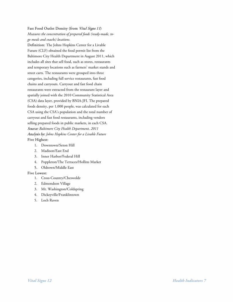
Fast Food Outlet Density (from Vital Signs 11) Measures the concentration of prepared foods (ready-made, to-go meals and snacks) locations. Definition: The Johns Hopkins Center for a Livable Future (CLF) obtained the food permit list from the Baltimore City Health Department in August 2011, which includes all sites that sell food, such as stores, restaurants and temporary locations such as farmers’ market stands and street carts. The restaurants were grouped into three categories, including full service restaurants, fast food chains and carryouts. Carryout and fast food chain restaurants were extracted from the restaurant layer and spatially joined with the 2010 Community Statistical Area (CSA) data layer, provided by BNIA-JFI. The prepared foods density, per 1,000 people, was calculated for each CSA using the CSA’s population and the total number of carryout and fast food restaurants, including vendors selling prepared foods in public markets, in each CSA. Source: Baltimore City Health Department, 2011 Analysis by: Johns Hopkins Center for a Livable Future Five Highest:
1. Downtown/Seton Hill 2. Madison/East End 3. Inner Harbor/Federal Hill 4. Poppleton/The Terraces/Hollins Market 5. Oldtown/Middle East
Five Lowest: 1. Cross-Country/Cheswolde 2. Edmondson Village 3. Mt. Washington/Coldspring 4. Dickeyville/Franklintown 5. Loch Raven

Vital Signs 12 Health Indicators 8
Social Assistance Indicators
Percentage of Families Receiving TANF Measure of uptake of federal cash assistance. Definition: Temporary Assistance for Needy Families (TANF) is a federal assistance program. The Act provides temporary financial assistance while aiming to get people off of that assistance, primarily through employment. Source: Maryland Department of Human Resources, 2011, 2012, U.S. Census, 2010 Five Highest:
1. Upton/Druid Heights 2. Madison/East End 3. Poppleton/The Terraces/Hollins Market 4. Clifton-Berea 5. Sandtown-Winchester/Harlem Park
Five Lowest: 1. Mt. Washington/Coldspring 2. Greater Roland Park/Poplar Hill 3. North Baltimore/Guilford/Homeland 4. Canton 5. Fells Point

Vital Signs 12 Health Table 1
2010 2011 2012Change (11-12)
2010 2011 2012Change (11-12)
2010 2011 2012Change (11-12)
2010 2011 2012Change (11-12)
Allendale/Irvington/S. Hilton 55.0 58.1 45.9 -12.2 85.3 86.0 84.3 -1.7 87.4 83.8 83.8 0.1 51.9 55.3 57.0 1.8Beechfield/Ten Hills/West Hills 42.8 21.4 42.8 21.4 87.5 90.6 89.5 -1.1 91.7 90.6 90.1 -0.5 64.3 67.1 63.0 -4.1Belair-Edison 67.6 56.8 58.1 1.4 84.0 82.5 82.0 -0.5 87.7 84.5 83.8 -0.6 63.9 63.3 63.2 -0.2Brooklyn/Curtis Bay/Hawkins Point 111.1 94.6 63.8 -30.7 83.1 82.3 85.0 2.7 89.9 86.7 91.4 4.6 50.9 47.2 49.6 2.4Canton 46.5 23.3 0.0 -23.3 94.6 93.7 90.6 -3.1 94.6 97.6 92.9 -4.7 73.9 79.4 79.5 0.2Cedonia/Frankford 48.9 42.1 38.7 -3.4 83.8 86.3 84.8 -1.4 84.4 85.7 86.5 0.8 56.6 61.6 63.8 2.1Cherry Hill 57.6 60.5 63.4 2.9 80.9 79.6 83.1 3.5 88.8 79.0 89.8 10.7 57.2 52.5 57.2 4.8Chinquapin Park/Belvedere 50.6 84.4 63.3 -21.1 87.0 89.3 89.4 0.0 92.6 87.7 90.2 2.4 63.9 58.2 49.2 -9.0Claremont/Armistead 48.9 48.9 45.1 -3.8 83.0 89.2 89.5 0.3 83.0 90.0 91.1 1.1 47.2 50.8 63.7 12.9Clifton-Berea 72.0 61.7 77.1 15.4 82.8 85.6 85.7 0.1 83.6 88.1 90.3 2.2 52.2 56.9 64.0 7.1Cross-Country/Cheswolde 0.0 15.5 6.7 -8.9 93.2 95.9 92.5 -3.4 95.1 96.8 93.8 -3.0 60.2 68.3 62.5 -5.7Dickeyville/Franklintown 21.1 28.2 35.2 7.0 85.5 94.2 92.3 -1.9 85.5 94.2 88.5 -5.8 63.6 57.7 55.8 -1.9Dorchester/Ashburton 49.3 49.3 35.2 -14.1 87.2 85.3 83.7 -1.5 85.7 84.5 87.0 2.5 56.4 58.9 61.0 2.1Downtown/Seton Hill 65.2 43.5 21.7 -21.7 87.5 80.7 80.0 -0.7 80.4 82.5 80.0 -2.5 69.6 70.2 64.0 -6.2Edmondson Village 89.5 64.8 49.4 -15.4 85.0 88.8 88.3 -0.5 85.0 86.9 86.5 -0.4 62.6 55.1 60.4 5.2Fells Point 88.9 44.4 100.0 55.6 94.2 96.2 93.7 -2.5 94.2 94.0 97.2 3.2 59.1 69.2 76.2 7.1Forest Park/Walbrook 71.8 58.5 50.5 -8.0 85.9 85.0 80.4 -4.5 87.3 83.5 79.0 -4.4 52.8 42.9 63.6 20.8Glen-Fallstaff 49.5 30.5 26.7 -3.8 90.4 89.4 88.8 -0.7 94.5 90.4 92.5 2.1 56.4 60.6 62.6 2.0Greater Charles Village/Barclay 9.7 11.6 10.7 -1.0 86.1 90.7 85.5 -5.2 88.3 90.7 89.1 -1.6 56.2 63.6 70.3 6.7Greater Govans 53.7 68.3 34.1 -34.1 87.2 87.1 87.7 0.7 87.9 87.1 87.7 0.7 61.0 57.1 59.4 2.3Greater Mondawmin 42.9 32.2 41.1 8.9 78.4 85.9 86.1 0.1 85.6 87.5 87.8 0.3 49.6 57.8 65.2 7.4Greater Roland Park/Poplar Hill 0.0 0.0 0.0 0.0 94.3 91.1 83.6 -7.5 94.3 89.3 88.5 -0.8 74.3 73.2 86.9 13.7Greater Rosemont 80.8 64.7 58.5 -6.2 87.1 88.6 82.1 -6.5 87.8 90.5 81.3 -9.2 52.3 49.6 58.2 8.6Greenmount East 99.2 79.9 55.1 -24.8 85.4 85.3 84.4 -0.9 82.6 82.4 84.4 2.0 48.6 64.0 62.6 -1.4Hamilton 25.3 10.5 27.4 16.8 83.1 86.2 88.0 1.7 86.4 89.9 91.1 1.3 68.6 71.7 65.8 -5.9Harbor East/Little Italy 70.4 70.4 49.3 -21.1 84.0 88.0 85.6 -2.4 85.1 89.2 87.8 -1.4 61.7 57.8 64.4 6.6Harford/Echodale 15.8 45.5 29.7 -15.8 85.8 87.2 86.2 -1.0 88.1 89.7 89.2 -0.4 58.0 64.9 66.4 1.5Highlandtown 77.6 77.6 94.8 17.2 92.4 87.9 93.5 5.6 91.6 89.2 92.0 2.9 62.6 58.6 74.6 16.0Howard Park/West Arlington 61.6 44.8 33.6 -11.2 85.0 89.5 82.5 -7.0 86.0 94.2 81.6 -12.6 48.6 69.8 68.0 -1.8Inner Harbor/Federal Hill 30.0 30.0 10.0 -20.0 92.7 90.8 89.8 -0.9 92.1 93.5 92.1 -1.4 74.4 77.7 76.3 -1.4Lauraville 38.8 34.2 27.4 -6.8 85.8 84.8 86.0 1.2 86.6 87.4 87.3 -0.1 66.1 59.6 62.7 3.1Loch Raven 57.8 31.7 18.7 -13.1 83.9 84.3 88.1 3.8 88.6 86.0 88.1 2.0 54.4 62.8 58.5 -4.3Madison/East End 81.0 86.1 75.9 -10.1 83.6 85.6 81.8 -3.9 85.4 83.1 89.4 6.3 50.3 53.8 65.3 11.5Medfield/Hampden/Woodberry/Remington 58.8 44.1 44.1 0.0 90.0 92.1 90.9 -1.2 91.0 93.4 91.8 -1.7 66.5 69.0 67.9 -1.1Midtown 8.0 4.8 4.8 0.0 89.3 86.3 93.4 7.1 90.2 90.4 91.7 1.3 67.9 58.9 66.1 7.2Midway/Coldstream 53.7 79.4 65.4 -14.0 85.7 81.8 80.9 -0.9 79.4 85.5 84.2 -1.3 45.2 53.3 51.4 -2.0Morrell Park/Violetville 78.8 14.8 39.4 24.6 87.5 86.1 88.0 1.9 92.5 92.2 93.2 1.0 61.7 65.2 58.1 -7.1Mt. Washington/Coldspring 10.9 10.9 0.0 -10.9 89.6 90.9 95.3 4.4 92.5 92.7 96.9 4.1 64.2 70.9 70.3 -0.6North Baltimore/Guilford/Homeland 3.1 1.6 0.0 -1.6 91.5 92.2 92.6 0.4 90.7 89.4 94.1 4.8 63.6 69.5 75.7 6.2Northwood 15.6 13.4 18.6 5.2 85.9 85.7 88.1 2.4 84.0 86.3 91.4 5.1 58.3 55.9 57.6 1.7Oldtown/Middle East 74.2 47.5 38.6 -8.9 87.8 90.7 84.6 -6.1 87.2 87.9 79.7 -8.1 53.8 63.6 67.8 4.3Orangeville/East Highlandtown 106.1 111.1 45.5 -65.7 87.6 92.9 88.4 -4.5 91.0 93.4 91.0 -2.4 40.4 45.1 58.3 13.2Patterson Park North & East 87.1 82.1 104.5 22.4 89.6 87.8 88.9 1.1 91.9 88.8 88.9 0.1 50.8 56.6 70.6 13.9Penn North/Reservoir Hill 47.1 61.8 79.4 17.6 79.3 82.9 86.0 3.2 84.3 87.1 84.9 -2.3 54.3 62.1 61.6 -0.5Pimlico/Arlington/Hilltop 63.7 46.6 53.9 7.4 83.4 83.1 84.8 1.7 84.7 84.4 81.2 -3.3 51.0 57.8 52.9 -4.9Poppleton/The Terraces/Hollins Market 65.5 89.3 53.6 -35.7 89.0 92.3 82.4 -9.9 84.9 91.0 83.8 -7.2 53.4 48.7 67.6 18.8Sandtown-Winchester/Harlem Park 69.8 61.9 73.0 11.1 80.4 82.1 81.3 -0.8 86.8 85.4 82.8 -2.6 58.3 59.2 62.2 3.0South Baltimore 0.0 30.8 15.4 -15.4 97.1 90.2 92.6 2.5 95.1 91.7 94.9 3.2 71.8 70.5 80.9 10.4Southeastern 68.0 68.0 43.7 -24.3 83.0 89.1 88.1 -1.0 83.0 89.1 89.8 0.7 50.9 55.4 57.6 2.2Southern Park Heights 78.2 72.6 54.0 -18.6 85.4 91.6 84.3 -7.3 87.7 91.1 83.3 -7.8 52.4 47.5 48.1 0.6Southwest Baltimore 82.4 75.8 66.7 -9.2 85.8 85.5 86.4 0.9 87.0 86.1 88.5 2.4 50.0 45.7 51.2 5.5The Waverlies 53.6 35.7 62.5 26.8 82.1 89.2 88.6 -0.6 83.8 92.8 87.6 -5.2 55.6 63.1 68.6 5.5Upton/Druid Heights 97.4 92.1 76.3 -15.8 88.3 82.4 86.6 4.2 88.3 82.4 88.1 5.7 60.8 49.7 57.2 7.5Washington Village/Pigtown 69.8 64.0 46.5 -17.4 84.8 89.0 80.7 -8.3 92.9 90.2 88.6 -1.6 65.7 59.8 67.0 7.3Westport/Mt. Winans/Lakeland 64.9 99.2 30.5 -68.7 86.8 82.5 85.7 3.2 92.6 83.2 86.6 3.4 47.1 51.8 57.1 5.3Baltimore City 51.1 46.6 41.5 -5.1 86.5 87.4 86.6 -0.8 88.3 88.4 88.2 -0.2 57.0 59.0 62.7 3.6For more information on these indicators please visit http://www.bniajfi.org.
Community Statistical Area (CSA)Teen Birth Rate
Birth Outcomes
Percent of Births Delivered at Term
Percent of Babies Born with a Satisfactory Birth Weight
Percent of Births Where Mother Received Prenatal Care

Vital Signs 12 Health Table 2
2010 2011 2012Change (11-12)
2010 2011 2012Change (11-12)
Allendale/Irvington/S. Hilton 0.0 0.0 0.0 0.0 386 166 187 12.7%Beechfield/Ten Hills/West Hills 0.0 0.0 0.0 0.0 0 199 0 -100.0%Belair-Edison 7.5 2.0 1.4 -0.5 200 256 356 39.1%Brooklyn/Curtis Bay/Hawkins Point 0.0 0.0 0.0 0.0 0 360 374 3.9%Canton 0.0 0.0 0.0 0.0 96 124 130 4.8%Cedonia/Frankford 0.0 0.0 0.0 0.0 240 199 320 60.8%Cherry Hill 0.0 0.0 0.0 0.0 198 322 382 18.6%Chinquapin Park/Belvedere 0.0 0.0 0.0 0.0 146 233 138 -40.8%Claremont/Armistead 0.0 0.0 0.0 0.0 240 222 244 9.9%Clifton-Berea 0.0 0.0 0.0 0.0 0 0 0Cross-Country/Cheswolde 0.0 0.0 0.0 0.0 408 351 391 11.4%Dickeyville/Franklintown 0.0 0.0 0.0 0.0 110 0 0Dorchester/Ashburton 0.0 0.0 0.0 0.0 0 0 0Downtown/Seton Hill 0.0 0.0 0.0 0.0 49 47 76 61.7%Edmondson Village 0.0 0.0 5.3 5.3 123 207 132 -36.2%Fells Point 0.0 0.0 0.0 0.0 137 215 114 -47.0%Forest Park/Walbrook 4.6 3.0 0.0 -3.0 109 169 191 13.0%Glen-Fallstaff 0.0 1.7 0.0 -1.7 164 302 158 -47.7%Greater Charles Village/Barclay 0.0 0.0 0.0 0.0 84 0 107Greater Govans 0.0 0.0 0.0 0.0 54 123 64 -48.0%Greater Mondawmin 0.0 0.0 0.0 0.0 203 59 34 -42.4%Greater Roland Park/Poplar Hill 0.0 0.0 0.0 0.0 132 57 43 -24.6%Greater Rosemont 1.0 1.6 5.3 3.7 479 496 95 -80.8%Greenmount East 3.8 3.6 3.8 0.2 183 167 185 10.8%Hamilton 0.0 0.0 0.0 0.0 64 177 161 -9.0%Harbor East/Little Italy 0.0 0.0 0.0 0.0 199 154 39 -74.7%Harford/Echodale 0.0 0.0 0.0 0.0 156 297 348 17.2%Highlandtown 0.0 0.0 0.0 0.0 113 107 105 -1.9%Howard Park/West Arlington 0.0 0.0 0.0 0.0 0 237 0 -100.0%Inner Harbor/Federal Hill 0.0 0.0 0.0 0.0 232 172 239 39.0%Lauraville 0.0 0.0 0.0 0.0 145 33 120 263.6%Loch Raven 0.0 0.0 0.0 0.0 0 222 190 -14.4%Madison/East End 6.1 5.9 4.4 -1.5 377 353 318 -9.9%Medfield/Hampden/Woodberry/Remington 0.0 0.0 0.0 0.0 156 275 283 2.9%Midtown 0.0 0.0 0.0 0.0 0 65 116 78.5%Midway/Coldstream 6.1 5.5 6.1 0.7 114 328 114 -65.2%Morrell Park/Violetville 0.0 0.0 0.0 0.0 65 119 108 -9.2%Mt. Washington/Coldspring 0.0 0.0 0.0 0.0 90 122 112 -8.2%North Baltimore/Guilford/Homeland 0.0 0.0 0.0 0.0 239 107 46 -57.0%Northwood 0.0 0.0 0.0 0.0 170 254 327 28.7%Oldtown/Middle East 0.0 0.0 0.0 0.0 171 188 274 45.7%Orangeville/East Highlandtown 0.0 0.0 0.0 0.0 0 96 0 -100.0%Patterson Park North & East 3.4 2.3 0.0 -2.3 410 217 171 -21.2%Penn North/Reservoir Hill 0.0 0.0 0.0 0.0 88 70 0 -100.0%Pimlico/Arlington/Hilltop 0.0 3.1 0.0 -3.1 0 161 236 46.6%Poppleton/The Terraces/Hollins Market 0.0 0.0 0.0 0.0 88 117 131 12.0%Sandtown-Winchester/Harlem Park 6.9 0.0 7.4 7.4 203 99 95 -4.0%South Baltimore 0.0 0.0 0.0 0.0 121 97 72 -25.8%Southeastern 0.0 0.0 0.0 0.0 202 65 64 -1.5%Southern Park Heights 0.0 0.0 0.0 0.0 0 297 0 -100.0%Southwest Baltimore 5.3 6.9 3.7 -3.2 506 72 296 311.1%The Waverlies 0.0 0.0 0.0 0.0 100 72 166 130.6%Upton/Druid Heights 0.0 0.0 0.0 0.0 85 0 68Washington Village/Pigtown 0.0 0.0 0.0 0.0 0 0 50Westport/Mt. Winans/Lakeland 0.0 0.0 0.0 0.0 208 232 232 0.0%Baltimore City 1.6 1.4 1.2 -0.2 19,702 19,036 18,723 -1.6%For more information on these indicators please visit http://www.bniajfi.org.
Community Statistical Area (CSA)
Percent of Children (aged 0-6) with Elevated Blood Lead Levels
Number of Children (aged 0-6) Tested for Elevated Blood Lead Levels
Lead Poisoning

Vital Signs 12 Health Table 3
2011 2012Change (11-12)
2011 2012Change (11-12)
2011 2012Change (11-12)
2011 2012Change (11-12)
Allendale/Irvington/S. Hilton 70.0 70.4 0.3 14.8 16.9 2.1 3.2 1.9 -1.3 18.2 19.0 0.8Beechfield/Ten Hills/West Hills 74.1 74.7 0.6 12.8 11.8 -1.0 1.8 1.8 0.0 18.7 15.2 -3.5Belair-Edison 71.5 72.5 1.0 21.3 15.0 -6.3 2.2 2.2 0.0 26.4 23.6 -2.9Brooklyn/Curtis Bay/Hawkins Point 69.7 69.5 -0.2 7.7 7.9 0.2 3.1 4.4 1.3 17.2 13.4 -3.8Canton 77.0 77.4 0.4 5.7 1.8 -3.9 0.0 0.0 0.0 6.6 8.8 2.2Cedonia/Frankford 72.8 72.8 -0.1 13.7 15.2 1.5 2.3 2.3 0.0 12.3 12.8 0.5Cherry Hill 68.7 68.8 0.1 15.2 14.8 -0.4 3.4 3.4 0.0 21.9 21.9 0.0Chinquapin Park/Belvedere 75.4 74.9 -0.5 11.1 11.3 0.1 1.6 1.6 0.0 9.0 12.5 3.6Claremont/Armistead 73.1 72.7 -0.4 <3.0* 3.1 1.1 0.0 -1.1 11.7 10.1 -1.7Clifton-Berea 65.1 66.4 1.2 21.5 17.6 -3.8 3.1 3.1 0.0 41.3 31.9 -9.3Cross-Country/Cheswolde 88.0 84.2 -3.8 9.2 2.1 -7.2 0.7 2.2 1.4 2.2 5.5 3.3Dickeyville/Franklintown 72.2 73.4 1.1 25.0 18.6 -6.4 2.4 2.4 0.0 24.8 12.4 -12.4Dorchester/Ashburton 73.4 74.0 0.6 8.5 10.3 1.8 2.1 3.2 1.1 13.5 17.2 3.7Downtown/Seton Hill 64.0 65.0 1.0 12.9 9.0 -3.9 15.5 20.7 5.2 2.9 7.1 4.3Edmondson Village 73.2 73.5 0.3 12.3 12.7 0.3 1.4 0.0 -1.4 4.8 6.4 1.6Fells Point 76.8 76.8 0.0 <3.0* 4.2 0.0 0.0 0.0 7.1 5.3 -1.8Forest Park/Walbrook 73.9 73.4 -0.4 6.1 10.8 4.7 4.8 4.8 0.0 12.2 10.8 -1.4Glen-Fallstaff 95.6 78.5 -17.1 6.8 7.4 0.6 0.0 2.4 2.4 2.0 5.0 3.0Greater Charles Village/Barclay 76.2 75.1 -1.2 14.3 15.2 0.9 0.0 3.9 3.9 2.4 2.4 0.0Greater Govans 74.0 74.3 0.3 15.1 12.4 -2.7 0.0 0.0 0.0 14.2 14.2 0.0Greater Mondawmin 71.1 71.7 0.6 15.9 17.7 1.7 6.9 2.7 -4.1 21.6 15.1 -6.5Greater Roland Park/Poplar Hill 84.1 84.4 0.3 <3.0* 3.3 1.8 0.0 -1.8 5.7 2.8 -2.8Greater Rosemont 69.2 70.1 0.9 11.1 13.6 2.5 3.1 3.1 0.0 16.3 12.4 -3.9Greenmount East 67.0 67.4 0.4 20.5 18.2 -2.3 9.2 6.5 -2.6 12.2 9.1 -3.0Hamilton 75.3 75.4 0.1 13.2 15.0 1.8 4.4 4.4 0.0 8.1 8.1 0.0Harbor East/Little Italy 73.5 72.5 -0.9 15.5 19.5 4.0 3.9 1.9 -1.9 20.2 20.2 0.0Harford/Echodale 75.9 76.2 0.2 6.3 6.4 0.1 3.3 3.3 0.0 10.6 8.8 -1.8Highlandtown 74.0 74.4 0.4 4.4 7.3 2.9 0.0 0.0 0.0 9.0 9.0 0.0Howard Park/West Arlington 74.2 75.0 0.8 8.8 7.5 -1.2 2.4 2.4 0.0 10.9 9.6 -1.4Inner Harbor/Federal Hill 77.3 77.8 0.5 7.1 6.9 -0.2 0.0 0.0 0.0 5.4 5.4 0.0Lauraville 74.2 75.0 0.9 18.0 14.7 -3.4 1.9 1.9 0.0 9.8 11.0 1.2Loch Raven 75.2 75.9 0.7 13.6 13.7 0.1 1.5 0.8 -0.8 15.4 12.0 -3.4Madison/East End 66.8 67.4 0.7 14.0 14.4 0.4 1.0 2.1 1.0 23.1 20.4 -2.7Medfield/Hampden/Woodberry/Remington 75.5 75.9 0.3 6.3 7.1 0.8 2.2 2.2 0.0 9.5 8.4 -1.1Midtown 74.8 76.0 1.2 11.5 7.6 -3.9 2.9 2.9 0.0 4.0 2.9 -1.1Midway/Coldstream 66.1 67.9 1.8 10.6 15.4 4.7 12.6 8.4 -4.2 36.4 29.9 -6.5Morrell Park/Violetville 72.2 72.7 0.4 11.3 11.6 0.4 2.8 0.0 -2.8 21.4 21.4 0.0Mt. Washington/Coldspring 81.1 81.7 0.7 3.2 3.1 -0.1 0.0 0.0 0.0 0.0 0.0 0.0North Baltimore/Guilford/Homeland 82.2 83.2 1.0 4.1 0.0 -4.1 0.0 0.0 0.0 1.5 1.5 0.0Northwood 75.9 76.2 0.3 12.6 13.1 0.6 0.0 0.0 0.0 5.5 5.1 -0.4Oldtown/Middle East 75.0 74.0 -1.0 10.0 10.0 0.0 5.1 5.1 0.0 4.9 6.1 1.2Orangeville/East Highlandtown 72.3 72.9 0.6 3.1 4.1 1.0 0.0 0.0 0.0 9.9 8.2 -1.6Patterson Park North & East 71.4 71.7 0.3 7.9 7.7 -0.3 4.0 2.4 -1.6 19.6 16.8 -2.8Penn North/Reservoir Hill 69.2 69.9 0.7 12.8 12.6 -0.2 0.0 0.0 0.0 25.0 23.5 -1.5Pimlico/Arlington/Hilltop 68.6 69.1 0.5 18.9 21.0 2.1 1.9 1.0 -1.0 23.2 19.6 -3.7Poppleton/The Terraces/Hollins Market 64.7 67.1 2.4 14.1 10.1 -4.0 4.0 2.0 -2.0 23.9 21.2 -2.7Sandtown-Winchester/Harlem Park 67.5 68.8 1.2 16.8 13.2 -3.6 3.4 2.8 -0.7 23.1 19.0 -4.1South Baltimore 74.9 75.0 0.1 5.7 5.2 -0.5 4.0 4.0 0.0 2.7 2.7 0.0Southeastern 73.5 74.0 0.5 9.1 9.0 -0.1 0.0 1.8 1.8 13.6 6.8 -6.8Southern Park Heights 68.3 69.2 0.9 14.4 14.3 -0.2 6.1 4.6 -1.5 20.8 17.9 -2.8Southwest Baltimore 67.3 67.8 0.5 14.2 15.0 0.8 5.4 5.4 0.0 22.0 22.0 0.0The Waverlies 72.2 72.0 -0.1 13.5 14.0 0.4 1.5 1.5 0.0 23.7 23.7 0.0Upton/Druid Heights 66.1 67.3 1.2 14.1 10.3 -3.8 1.7 3.3 1.7 27.2 22.5 -4.7Washington Village/Pigtown 70.3 69.8 -0.5 13.9 13.3 -0.6 0.0 2.3 2.3 14.7 17.1 2.4Westport/Mt. Winans/Lakeland 74.5 72.8 -1.7 17.0 12.7 -4.4 0.0 0.0 0.0 19.8 18.0 -1.8Baltimore City 73.5 73.9 0.4 11.7 9.7 -2.0 2.8 2.5 -0.4 13.5 11.9 -1.6For more information on these indicators please visit http://www.bniajfi.org.
Life Expectancy and Mortality
Community Statistical Area (CSA)Life Expectancy Infant Mortality Rate
Mortality by Age (1-14 years old)
Mortality by Age (15-24 years old)

Vital Signs 12 Health Table 4
2011 2012Change (11-12)
2011 2012Change (11-12)
2011 2012Change (11-12)
2011 2012Change (11-12)
Allendale/Irvington/S. Hilton 41.9 39.8 -2.0 134.3 129.4 -4.9 453.8 430.3 -23.5 1326.5 1381.4 55.0Beechfield/Ten Hills/West Hills 24.0 19.8 -4.2 89.2 96.1 6.9 339.4 329.0 -10.4 1539.7 1349.2 -190.5Belair-Edison 30.1 26.2 -3.9 100.6 105.6 5.0 345.3 335.7 -9.5 1984.3 1842.5 -141.7Brooklyn/Curtis Bay/Hawkins Point 36.5 34.7 -1.9 145.8 155.4 9.6 466.6 468.9 2.3 1776.0 1568.0 -208.0Canton 2.8 3.3 0.5 78.8 74.8 -4.0 373.3 384.2 10.9 1539.5 1407.9 -131.6Cedonia/Frankford 27.8 28.7 0.9 95.7 95.4 -0.3 434.6 434.6 0.0 1560.0 1480.0 -80.0Cherry Hill 47.2 47.2 0.0 140.2 142.7 2.4 473.4 442.5 -30.9 1423.1 1461.5 38.5Chinquapin Park/Belvedere 18.3 18.3 0.0 97.9 107.1 9.2 316.3 311.3 -5.0 1576.5 1694.1 117.6Claremont/Armistead 19.4 19.4 0.0 127.1 132.1 5.0 500.0 522.9 22.9 1195.1 1268.3 73.2Clifton-Berea 66.8 59.5 -7.2 195.0 185.6 -9.3 415.4 416.9 1.5 1449.3 1468.6 19.3Cross-Country/Cheswolde 2.6 5.8 3.2 31.8 58.3 26.4 78.3 214.4 136.0 292.2 918.7 626.5Dickeyville/Franklintown 19.9 19.9 0.0 106.9 108.9 2.1 403.8 410.3 6.4 1488.4 1348.8 -139.5Dorchester/Ashburton 33.3 28.9 -4.4 113.2 112.6 -0.6 393.7 359.7 -34.0 1294.1 1245.7 -48.4Downtown/Seton Hill 22.0 15.3 -6.7 214.5 203.5 -11.0 831.1 785.4 -45.7 2384.6 2000.0 -384.6Edmondson Village 39.7 35.0 -4.7 120.2 120.2 0.0 359.6 351.3 -8.3 1264.7 1338.2 73.5Fells Point 7.7 8.6 0.9 77.1 82.8 5.7 398.7 378.9 -19.8 1644.4 1488.9 -155.6Forest Park/Walbrook 27.9 24.4 -3.5 113.2 114.6 1.4 394.0 392.3 -1.7 1169.8 1301.9 132.1Glen-Fallstaff 13.9 23.1 9.2 43.7 76.3 32.5 137.3 278.3 141.0 396.6 1185.5 788.9Greater Charles Village/Barclay 10.7 11.5 0.8 109.5 118.7 9.2 385.9 378.1 -7.8 886.2 1029.9 143.7Greater Govans 29.9 29.2 -0.7 102.8 102.8 0.0 357.3 360.5 3.3 1270.1 1313.9 43.8Greater Mondawmin 41.0 38.1 -2.9 129.9 134.0 4.1 425.2 418.3 -6.9 1074.1 1118.5 44.4Greater Roland Park/Poplar Hill 3.2 2.1 -1.1 33.2 33.2 0.0 213.1 209.7 -3.4 1317.1 1280.5 -36.6Greater Rosemont 52.6 46.1 -6.5 145.8 143.2 -2.6 461.2 436.0 -25.2 1323.7 1289.9 -33.8Greenmount East 54.1 48.4 -5.6 167.0 175.2 8.2 433.9 445.2 11.3 1546.2 1630.3 84.0Hamilton 19.4 16.7 -2.7 71.6 76.4 4.8 424.3 413.9 -10.4 1417.6 1272.0 -145.6Harbor East/Little Italy 17.9 19.9 2.0 116.9 118.5 1.6 365.3 383.9 18.6 1117.6 1235.3 117.6Harford/Echodale 18.6 17.0 -1.6 80.5 81.8 1.3 357.1 350.4 -6.7 1589.7 1572.6 -17.1Highlandtown 11.1 10.6 -0.6 118.2 109.5 -8.8 434.8 398.6 -36.2 1728.8 1711.9 -16.9Howard Park/West Arlington 40.0 30.7 -9.4 108.6 108.6 0.0 348.0 348.0 0.0 1144.0 1198.4 54.5Inner Harbor/Federal Hill 6.9 5.6 -1.3 83.6 86.9 3.2 343.3 336.7 -6.6 1298.0 1245.0 -53.0Lauraville 20.1 18.3 -1.8 83.5 78.7 -4.8 422.9 401.1 -21.8 1547.7 1527.6 -20.1Loch Raven 24.2 23.7 -0.5 86.9 84.1 -2.8 336.8 342.1 5.2 1263.5 1184.1 -79.4Madison/East End 53.7 42.4 -11.4 166.0 176.2 10.2 504.2 491.6 -12.6 1578.9 1368.4 -210.5Medfield/Hampden/Woodberry/Remington 17.4 14.8 -2.7 98.7 97.2 -1.5 414.6 405.0 -9.6 1041.3 1052.3 11.0Midtown 17.0 14.9 -2.0 113.2 109.7 -3.4 362.6 355.4 -7.2 1058.8 983.2 -75.6Midway/Coldstream 59.8 41.6 -18.2 155.1 145.7 -9.4 448.8 422.9 -25.9 1657.1 1866.7 209.5Morrell Park/Violetville 25.6 20.2 -5.4 135.8 130.7 -5.1 458.3 488.6 30.3 907.8 912.6 4.9Mt. Washington/Coldspring 5.3 6.6 1.3 52.8 46.3 -6.4 283.7 257.9 -25.8 1562.0 1532.8 -29.2North Baltimore/Guilford/Homeland 9.4 7.2 -2.2 54.7 53.2 -1.5 219.2 209.9 -9.2 1272.1 1236.7 -35.3Northwood 30.0 25.9 -4.1 90.9 89.9 -1.0 283.2 284.3 1.0 1297.6 1365.9 68.3Oldtown/Middle East 32.5 28.1 -4.4 107.1 121.3 14.2 296.4 335.5 39.1 1155.2 1206.9 51.7Orangeville/East Highlandtown 24.2 19.7 -4.5 145.9 150.8 5.0 409.1 383.1 -26.0 1642.1 1578.9 -63.2Patterson Park North & East 22.0 19.7 -2.3 126.5 137.6 11.0 444.7 421.9 -22.9 1655.7 1590.2 -65.6Penn North/Reservoir Hill 50.0 50.0 0.0 137.7 130.7 -7.0 477.5 444.2 -33.4 1280.7 1368.4 87.7Pimlico/Arlington/Hilltop 44.4 41.3 -3.1 155.3 157.7 2.4 423.3 413.4 -9.9 1446.4 1482.1 35.7Poppleton/The Terraces/Hollins Market 49.3 37.0 -12.3 217.2 197.4 -19.7 574.0 514.8 -59.2 1611.1 1666.7 55.6Sandtown-Winchester/Harlem Park 56.1 44.3 -11.8 158.5 165.5 7.0 483.8 466.5 -17.2 1243.0 1282.9 39.8South Baltimore 8.5 10.3 1.8 95.7 86.1 -9.6 470.3 465.9 -4.4 1761.2 1850.7 89.6Southeastern 29.1 27.9 -1.1 122.1 122.1 0.0 380.8 389.8 9.0 1323.3 1172.9 -150.4Southern Park Heights 43.9 42.0 -1.9 145.8 144.1 -1.7 454.8 429.8 -25.0 1536.2 1536.2 0.0Southwest Baltimore 48.1 44.1 -4.0 177.6 169.6 -8.0 481.6 473.9 -7.7 1333.3 1315.8 -17.5The Waverlies 30.4 30.4 0.0 114.1 121.7 7.6 378.7 383.2 4.5 1346.9 1265.3 -81.6Upton/Druid Heights 51.7 49.3 -2.4 184.5 172.6 -11.9 515.0 489.3 -25.6 1607.1 1607.1 0.0Washington Village/Pigtown 30.0 28.1 -1.9 122.4 124.1 1.7 547.3 577.1 29.9 1377.8 1333.3 -44.4Westport/Mt. Winans/Lakeland 23.8 27.8 4.0 88.1 96.6 8.6 351.0 453.4 102.4 1254.9 1294.1 39.2Baltimore City 27.3 24.0 -3.3 117.9 114.1 -3.8 393.7 373.8 -19.9 1315.0 1231.5 -83.5For more information on these indicators please visit http://www.bniajfi.org.
Community Statistical Area (CSA)
Life Expectancy and Mortality
Mortality by Age (25-44 years old)
Mortality by Age (45-64 years old)
Mortality by Age (65-84 years old)
Mortality by Age (85 and over)

Vital Signs 12 Health Table 5
2011 2012Change (11-12)
2011 2012
Allendale/Irvington/S. Hilton 0.9 0.9 0.0 0.6 7.8Beechfield/Ten Hills/West Hills 0.2 0.1 -0.1 0.7 15.6Belair-Edison 1.1 0.7 -0.4 1.0 10.3Brooklyn/Curtis Bay/Hawkins Point 2.4 1.4 -1.0 0.8 8.6Canton 7.5 4.9 -2.6 1.1 16.9Cedonia/Frankford 1.0 0.8 -0.2 0.8 12.3Cherry Hill 0.2 0.1 -0.1 0.7 8.8Chinquapin Park/Belvedere 2.6 0.8 -1.8 0.4 15.3Claremont/Armistead 1.3 0.9 -0.5 0.9 7.4Clifton-Berea 2.6 1.7 -0.9 0.9 8.8Cross-Country/Cheswolde 0.0 0.0 0.0 0.0 0.0Dickeyville/Franklintown 0.2 0.2 0.0 0.2 0.0Dorchester/Ashburton 0.3 0.3 -0.1 0.8 10.0Downtown/Seton Hill 25.8 8.5 -17.3 22.3 6.7Edmondson Village 0.8 0.1 -0.6 0.1 6.4Fells Point 10.5 4.1 -6.4 1.9 10.2Forest Park/Walbrook 0.7 0.5 -0.2 0.3 7.8Glen-Fallstaff 0.7 0.4 -0.3 1.9 10.3Greater Charles Village/Barclay 2.2 1.2 -1.0 2.1 15.3Greater Govans 0.4 0.4 0.0 0.4 8.9Greater Mondawmin 1.0 0.6 -0.3 1.8 14.0Greater Roland Park/Poplar Hill 1.6 0.3 -1.4 0.7 11.8Greater Rosemont 1.4 1.0 -0.4 1.4 6.9Greenmount East 2.4 2.0 -0.5 1.4 9.6Hamilton 1.8 0.5 -1.3 0.8 8.8Harbor East/Little Italy 12.0 3.3 -8.7 3.0 11.8Harford/Echodale 0.7 0.7 0.1 0.6 9.9Highlandtown 8.1 5.2 -2.9 2.3 13.9Howard Park/West Arlington 0.6 0.3 -0.3 0.9 10.2Inner Harbor/Federal Hill 11.5 2.6 -9.0 4.2 12.4Lauraville 1.4 0.6 -0.8 0.6 11.5Loch Raven 0.5 0.1 -0.4 0.3 15.3Madison/East End 2.6 1.5 -1.0 4.6 10.1Medfield/Hampden/Woodberry/Remington 2.8 1.2 -1.6 1.0 10.4Midtown 5.5 1.9 -3.6 2.1 13.0Midway/Coldstream 1.8 1.6 -0.2 2.1 8.0Morrell Park/Violetville 1.7 1.2 -0.4 1.1 10.4Mt. Washington/Coldspring 1.7 0.4 -1.4 0.2 24.8North Baltimore/Guilford/Homeland 0.6 0.3 -0.3 1.0 7.5Northwood 0.2 0.1 -0.1 0.4 8.9Oldtown/Middle East 1.3 0.4 -0.9 3.1 8.4Orangeville/East Highlandtown 5.3 2.8 -2.4 1.9 8.6Patterson Park North & East 1.9 1.4 -0.4 0.8 12.7Penn North/Reservoir Hill 1.6 0.7 -0.8 0.3 7.0Pimlico/Arlington/Hilltop 1.4 1.0 -0.3 1.6 9.8Poppleton/The Terraces/Hollins Market 3.3 1.8 -1.6 3.9 8.5Sandtown-Winchester/Harlem Park 1.9 1.5 -0.5 1.0 9.4South Baltimore 2.5 3.6 1.1 0.7 18.1Southeastern 3.7 2.4 -1.3 0.8 7.2Southern Park Heights 1.1 0.8 -0.2 0.8 11.7Southwest Baltimore 3.2 2.6 -0.6 2.2 10.3The Waverlies 1.7 0.6 -1.0 0.6 15.1Upton/Druid Heights 1.3 1.0 -0.4 1.8 9.8Washington Village/Pigtown 4.7 3.1 -1.6 2.2 9.8Westport/Mt. Winans/Lakeland 1.7 0.8 -0.8 2.2 14.4Baltimore City 2.3 1.2 -1.0 1.4 10.3For more information on these indicators please visit http://www.bniajfi.org.
Community Statistical Area (CSA)
Liquor Outlet density (per 1,000 Residents)
Built Environment and Food Security
Fast Food Outlet Density (per 1,000 Residents)
Healthy Food Availability Index
Vital Signs 12 Health Table 6
2011 2012Change (11-12)
Allendale/Irvington/S. Hilton 10.2 12.5 2.4Beechfield/Ten Hills/West Hills 4.5 5.8 1.3Belair-Edison 10.1 11.1 1.0Brooklyn/Curtis Bay/Hawkins Point 13.8 14.8 1.0Canton 1.4 0.9 -0.4Cedonia/Frankford 8.5 10.5 2.0Cherry Hill 21.9 23.5 1.7Chinquapin Park/Belvedere 5.6 7.3 1.7Claremont/Armistead 7.9 7.7 -0.2Clifton-Berea 21.0 25.3 4.3Cross-Country/Cheswolde 0.8 1.7 0.9Dickeyville/Franklintown 7.9 7.7 -0.2Dorchester/Ashburton 6.3 8.3 2.0Downtown/Seton Hill 6.7 6.9 0.1Edmondson Village 12.0 13.4 1.4Fells Point 1.6 1.2 -0.5Forest Park/Walbrook 8.8 11.3 2.6Glen-Fallstaff 3.3 4.7 1.3Greater Charles Village/Barclay 8.2 10.5 2.3Greater Govans 8.4 10.2 1.8Greater Mondawmin 11.4 12.7 1.3Greater Roland Park/Poplar Hill 0.3 0.3 0.0Greater Rosemont 16.0 18.4 2.4Greenmount East 20.1 22.9 2.8Hamilton 3.5 4.4 0.9Harbor East/Little Italy 14.8 12.8 -2.0Harford/Echodale 4.3 4.1 -0.2Highlandtown 3.9 3.2 -0.7Howard Park/West Arlington 5.1 6.0 0.9Inner Harbor/Federal Hill 2.8 3.6 0.7Lauraville 4.2 5.0 0.7Loch Raven 3.9 5.3 1.3Madison/East End 24.7 26.9 2.1Medfield/Hampden/Woodberry/Remington 2.7 2.3 -0.4Midtown 5.3 6.9 1.6Midway/Coldstream 15.4 18.5 3.1Morrell Park/Violetville 3.3 4.1 0.8Mt. Washington/Coldspring 0.3 0.3 0.0North Baltimore/Guilford/Homeland 0.8 0.7 -0.1Northwood 5.7 6.6 0.9Oldtown/Middle East 19.9 24.7 4.8Orangeville/East Highlandtown 4.3 6.6 2.3Patterson Park North & East 9.5 11.3 1.8Penn North/Reservoir Hill 18.8 23.1 4.3Pimlico/Arlington/Hilltop 11.8 12.7 0.9Poppleton/The Terraces/Hollins Market 17.6 26.1 8.5Sandtown-Winchester/Harlem Park 22.3 25.0 2.7South Baltimore 1.6 1.2 -0.4Southeastern 7.4 8.8 1.5Southern Park Heights 14.1 17.5 3.4Southwest Baltimore 19.7 23.5 3.8The Waverlies 11.8 12.0 0.2Upton/Druid Heights 23.8 27.6 3.8Washington Village/Pigtown 9.3 13.1 3.8Westport/Mt. Winans/Lakeland 10.8 12.9 2.1Baltimore City 9.4 11.0 1.6For more information on these indicators please visit http://www.bniajfi.org.
Community Statistical Area (CSA)
Percent of Families Receiving TANF
Social Assistance Programs

Baltimore Neighborhood Indicator Alliance – Jacob France Institute
University of Baltimore
1420 North Charles Street
Baltimore, Maryland 21201
Website: www.bniajfi.org
Email: [email protected]
Facebook: www.facebook.com/bniajfi
Twitter: @bniajfi
Related Documents