Chestnut Grove Academy Geography Year 8 Spring Test Revision Use this revision guide to help you revise for the upcoming test. You should revise the following: The location of at least 15 countries in Asia – aim for more. The location of 3 deserts and 3 mountain ranges in Asia The location of 4 rivers in Asia Describing the population distribution in Asia – 3 sparsely populated areas and 3 densely populated areas Explaining the population distribution in Asia – 3 sparsely populated areas and 3 densely populated areas (recap on the factors too) A description of the economic growth in Asia Rural urban inequality in Asia The one child policy in China The pros and cons of the Three Gorges Dam Key features of a glacier and how a glacier forms and moves Glacial erosion – including landforms of erosion Impacts of glacial retreat You can also use BBC Bitesize and your exercise book to help you revise. Test date: First lesson back after the Easter holidays!

Welcome message from author
This document is posted to help you gain knowledge. Please leave a comment to let me know what you think about it! Share it to your friends and learn new things together.
Transcript
Chestnut Grove Academy Geography Year 8 Spring Test Revision
Use this revision guide to help you revise for the upcoming test. You should revise the following: The location of at least 15 countries in Asia – aim for more. The location of 3 deserts and 3 mountain ranges in Asia The location of 4 rivers in Asia Describing the population distribution in Asia – 3 sparsely populated areas and 3 densely populated areas Explaining the population distribution in Asia – 3 sparsely populated areas and 3 densely populated areas (recap on the factors too) A description of the economic growth in Asia Rural urban inequality in Asia The one child policy in China The pros and cons of the Three Gorges Dam Key features of a glacier and how a glacier forms and moves Glacial erosion – including landforms of erosion Impacts of glacial retreat You can also use BBC Bitesize and your exercise book to help you revise. Test date: First lesson back after the Easter holidays!

REVISE: Can you locate at least 20 the countries in Asia? Use Lizard Point online quizzes and the map on the next page to help you learn them all!
Afghanistan Georgia South Korea Pakistan East Timor
Armenia India Kuwait Palestine Turkey
Azerbaijan Indonesia Kyrgyzstan Phillippines Turkmenistan
Bahrain Iran Laos Qatar United Arab Emirates
Bangladesh Iraq Lebanon Russia Uzbekistan
Bhutan Israel Malaysia Saudi Arabia Vietnam
Brunei Japan Mongolia Singapore Yemen
Cambodia Jordan Myanmar Syria Taiwan
China Kazakhstan Nepal Takikistan
Cyprus North Korea Oman Thailand
http://lizardpoint.com/geography/asia-quiz.php

Political Map of Asia

Mountain Ranges of Asia 1. The Altay Mountains are a mountain range in
East-Central Asia, where Russia, China, Mongolia and Kazakhstan come together.
2. Ghats The Western Ghats are a mountain range along the western side of India with an average height of around 1,200 m. The Eastern Ghats are a range of mountains along India's eastern coast.
3. The Himalayas, a huge mountain range in the north of India, is the world's highest mountain range, and home to the world's highest mountains, including Mount Everest at 8,848 m and K2 at 8,611 m above sea level.
4. The Kunlun Mountains are one of the longest mountain chains in Asia, extending across western China and the Tibetan Plateau. The highest mountain is the Kunlun Goddess at 7,167m
5. The Tian Shan is a large mountain system located in Central Asia. It's located to the north and west of the Taklamakan Desert near the border region of Kazakhstan, Kyrgyzstan and western China.
6. The Urals are 1,640 miles (2,640 km) in length and extend from the northern-edge of the Russian Federation down through Kazakhstan. They form a natural border between Asia and Europe Russia.
7. The Zagros are the largest mountain range in Iran and Iraq.
REVISE: Do you know the location of at least three mountain ranges in Asia?

Deserts of Asia 1. Ar Rub' Al Khali Desert: Known as the Empty
Quarter, it's the largest (only sand) desert in the world and famed for huge sand dunes that can extend for over 25 miles
2. Arabian Desert: One of the largest deserts on the planet, is a large desert stretching from Yemen to the Persian Gulf and from Oman to Jordan and Iraq.
3. The Gobi Desert: It is the largest desert in Asia, covering 500,000 square miles. It extends from northern China into Mongolia and receives an average of 7 inches of rainfall each year because the Himalaya mountains block rain clouds from reaching the region.
4. The Kara Kum Desert covers 135,000 square miles, nearly 70 percent of Turkmenistan's land.
5. Kyzyl Kum Desert Crossing over Kazakhstan into Uzbekistan, this 115,000 square mile desert features a wide variety of flora and fauna.
6. Takla Makan Desert China's largest desert extends over 123,550 square miles. Takla Makan is one of the largest sandy deserts in the world.
7. Thar Desert Covering 77,000 square miles in India and Pakistan, the Thar Desert is Asia's only subtropical desert. Thar receives up to 20 inches of rain per year, mostly during the monsoon period from July to September, and most crops are grown during this rainy season.
REVISE: Do you know the location of at least three deserts in Asia?

Rivers from the Tibetan Plateau
REVISE: Can you locate: •The Yangtze River •The Yellow River •Brahmaputra River •The Mekong River

Can you match these place names with the spots on your map? Use the next page to explain why each is sparsely or densely populated? •Saudi Arabia •Bangladesh and NE India •Eastern China •Mongolia and Northern China •Western China, Nepal and Tibet
Knowledge – Can name major cities across Asia and describe the pattern of population distribution (including evidence). Understanding – Can explain the factors that help to explain the population distribution in Asia. Can spot anomalies to identified patterns.

Mongolia and Northern China – Sparsely Populated
The Gobi Desert is the largest desert in Asia, covering 500,000 square miles. Extending from northern China into Mongolia, the Gobi Desert receives an average of 7 inches of rainfall each year because the Himalaya mountains block rain clouds from reaching the region.
Western China, Nepal and Tibet - Sparsely Populated The Himalayas, a huge mountain range immediately at the north of the Indian subcontinent, is the world's highest mountain range, and home to the world's highest peaks, including Mount Everest at 8,848 m and K2 at 8,611 m above sea level. The Himalayan system includes over 100 mountains exceeding 7,200 m.

Saudi Arabia - Sparsely Populated Ar Rub' Al Khali Desert: Known as the Empty Quarter, it's the largest (only sand) desert in the world and famed for huge sand dunes that can extend for over 25 miles. It covers most of southern Saudi Arabia, and is almost moistureless.

Eastern China – Densely Populated – Flat land below 100m above sea level. Yangtze River. Next to the South China Sea. Lots of employment in factories. The city has over 20 million inhabitants.
Bangladesh and NE India – Densely Populated
The River Ganges and Brahmaputra carry water down from the Himalayas. When these flood the land, fertile silt provides good agricultural land.

Factors that lead to a dense population (you need to know at least three of these).
Vegetation - Areas of open woodland and grassland are easy to settle in. e.g. The Pampas in Argentina.
Accessibility - Coastal areas with easy access to transport and trade
Economic - Good infrastructure such as roads, railways etc as well as a skilled and varied labour force
Climates - Moderate climates with enough rain and warm temperatures to allow crops to grow and ripen e.g. W. Europe & Japan.
Soil - Thick fertile soil that increase agricultural production such as S.E. England.
Resources - Plenty of water, timber, minerals such as coal, oil and copper enable countries to develop. e.g. Western Europe & Eastern America
Relief - Lowland areas which are flat are easier to farm and build settlements and transport links
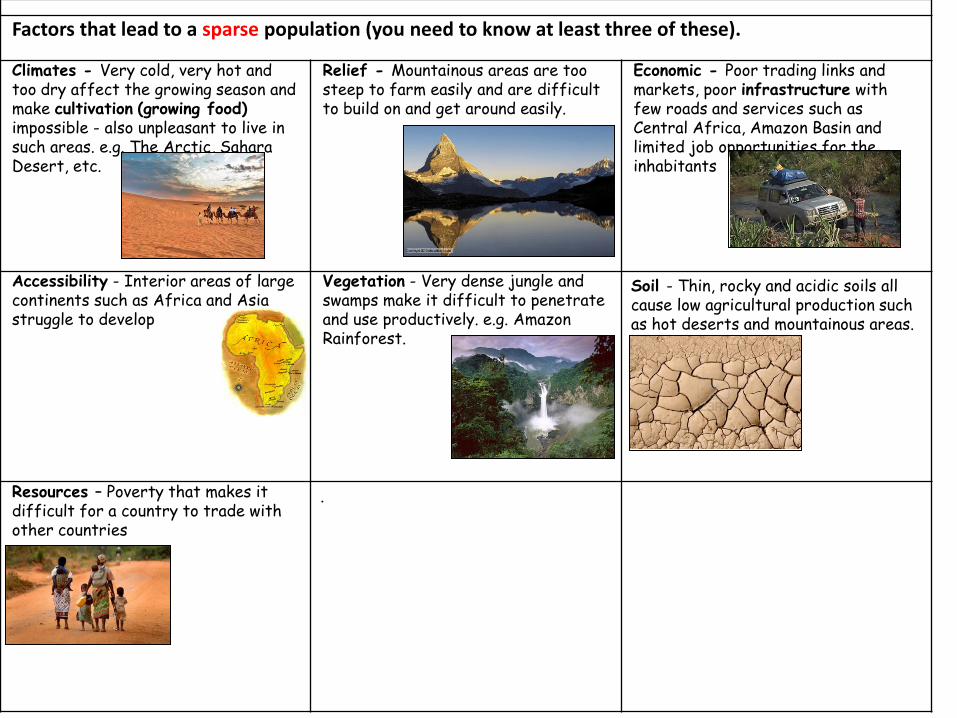
Factors that lead to a sparse population (you need to know at least three of these). Climates - Very cold, very hot and too dry affect the growing season and make cultivation (growing food) impossible - also unpleasant to live in such areas. e.g. The Arctic, Sahara Desert, etc.
Relief - Mountainous areas are too steep to farm easily and are difficult to build on and get around easily.
Economic - Poor trading links and markets, poor infrastructure with few roads and services such as Central Africa, Amazon Basin and limited job opportunities for the inhabitants
Accessibility - Interior areas of large continents such as Africa and Asia struggle to develop
Vegetation - Very dense jungle and swamps make it difficult to penetrate and use productively. e.g. Amazon Rainforest.
Soil - Thin, rocky and acidic soils all cause low agricultural production such as hot deserts and mountainous areas.
Resources – Poverty that makes it difficult for a country to trade with other countries
.

Test yourself: Can you describe how China and India are experiencing rapid economic growth?
2011: India 7% of world GDP + China 17% of world GDP = 24% of world GDP
2030: India 11% of world GDP + China 28% of world GDP = 39% of world GDP
2060: India 18% of world GDP + China 28% of world GDP = 46% of world GDP

RURAL POVERTY IN INDIA: Almost 30 per cent of India’s rural population live in serious poverty. Almost all of them are dependent on farming for their living. On the map of poverty in India, the poorest areas are in parts of Rajasthan, Madhya Pradesh, Uttar Pradesh, Bihar, Jharkhand, Orissa, Chhattisgarh and West Bengal. Large numbers of India's poorest people live in the semi-arid (dry) tropical region. Here, shortages of water and lots of droughts make farmers’ lives very difficult. There were three major droughts between 2002 and 2012. Poverty is high in eastern Uttar Pradesh and northern Bihar because these areas are often hit by flooding. In coastal fishing communities such as Orissa people's living conditions are getting worse because of environmental damage, damage to fish stocks and natural disasters such as tsunamis and cyclones.
Rural-Urban Inequality in Asia: India and China focus REASONS FOR RURAL TO URBAN MIGRATION
PUSH FACTOR (Rural Areas)
PULL FACTOR (Urban Areas)
Unemployment Plenty of jobs, chance of an education and future.
A lack of services (eg. poor quality schools or doctors)
Better services, access to schools etc
Crop failure or drought (the crops haven’t grown)
Good food supply (or jobs with money to allow you to buy food)
Flooding Less risk of natural disasters
Poverty Wealth and affluence
Almost 55% of China’s population live in rural areas, where two-thirds of the population work in the primary sector (farming, fishing or forestry). These jobs are normally very low paid. Often the men have migrated to the city, leaving the women behind. Rural families are still very poor in China and lack basic services and amenities hat many more urban households take for granted. (There is still lots of poverty in urban areas too though). Natural disasters such as floods and droughts are becoming more frequent. In July 2013, much of southwest China suffered from serious flooding. Sichuan Province was the hardest hit. At least 73 people were killed as a result of the flooding, with 180 people missing. An estimated 6 million people were affected by the floods.
Test yourself: •What are some problems that people in rural India and China face? •How might these be considered push factors?

THE PULL FACTORS - MUMBAI: 7. Read through this article. Can you find any pull factors that draw people to Mumbai?
Rural-Urban Inequality in Asia: India and China focus
Test yourself: •What are some of the pull factors in Mumbai?

Why was the policy introduced?
China’s One Child Policy
Between 1958 and 1961, 20-30 million Chinese people starved to death in a devastating famine. After that, the dictator Mao Zedong introduced birth control (that’s contraception) to try to reduce the number of people that needed feeding. This included encouraging women to have abortions. In 1978 the Chinese leader Deng Xiaoping brought in the one child policy that limited families to only one child. He believed it was vital to protect the food supply and help the economy to grow. If they had more than one child families got fined or were given other punishments.
Test yourself: •Can you explain why the one child policy was introduced? •Can you give 3 punishments of the one child policy?
Some of the punishments for having more than one child include: • Fines of 4 times your annual income (imagine that in the
UK, if your annual income was £20,000 you’d have to pay £80,000 to have a second child) (what would you do?)
• Putting members of your family (eg. your father, grandmother or brother) in prison.
• Forcing women to be sterilised (in one region of China, a team of 600 officials tracked down 10,000 women and forced them to be sterilised against their will).
• Being unable to register the birth of the second child, meaning it doesn’t get access to schooling or healthcare.
• Forced abortions. • Smothering new born babies (in very extreme cases).

“IT’S A SUCCESS!” By reducing the population China has been able to concentrate it’s efforts on becoming a global and powerful country. If it had too many people it would not have been able to develop so quickly.
China's family planning laws,
introduced in 1979, are thought to have prevented the birth of
up to 400million babies
China’s One Child Policy – Good things about the policy
Zhang Hui, mother of one little girl, believes that one child is enough and she would want one no matter the government regulations and fines. “I’m too busy at work to have any more,” stated Beijing native Zhao Hui. She also went on to say she is not alone in thinking this way. Many of her friends feel the same. A 2008 Pew Research poll three-in-four Chinese people (76%) approve of the policy. Professor Wang Feng, of the University of California, Irvine, confessed that because of the one child policy the Chinese citizen’s attitudes have evolved since the policy was instated in 1978. “A lot of people simply don’t want that many children. People have accepted the policy,” said Wang. Over the years, the Chinese people have adapted to the childbearing regulations.
In cities like Beijing and Shanghai, Chinese women are too busy at work to have more than one child. In fact, 3 out of 4 Chinese people approve of the one-child policy.
Test yourself: •Can you explain at least two advantages of the One Child Policy?

“IT’S A
FAILURE!” The One Child Policy is having negative effects on China’s population too. There will soon be, and already is a sign of an ageing population which will mean the government will have to put more money onto healthcare and pensions with fewer youngsters around to carry out the work. By the year 2025, the percentage of over 65s in China could reach 30% and instead of the traditional method of children caring for their elders, China’s elderly will have to be put into social retirement care as there won’t be enough youngsters to support them.
Children are becoming far too spoilt! Parents are treating their only children like royalty, and obese, demanding boys are being seen far too often now and they will have big problems when they reach their teens. I thought this policy was meant to improve living conditions!
FORGET BABY BOOM…WHAT ABOUT THIS BACHELOR BOOM This ridiculous attempt of a policy is seriously affecting China’s sex ratio. Since the 1980s, our ratio has become completely disfigured and the male to female ratio is now 116:100. So much for killing of baby girls and an increase in abortion rates. China could have completely devastated it’s future as there will soon be a shortage in the number of young fertile women and then there will be even fewer births. China is forcing young men to remain single, there to be an increase in prostitution and the status of women may well go down in an already overpowering male society. What a disaster!
China’s One Child Policy – Bad things about the policy
Sex discrimination is one consequence of the one child policy. Most people prefer sons to daughters (because their sons are more likely to support them when they are older). Some couples go to drastic lengths to have their one and only child be a boy. Abortion, neglect, abandonment, and even infanticide (killing a baby) have become consequence of the one child policy. Everyday in China, 20,000 babies are born, but for every 100 girls there are 120 boys.
Test yourself: •Can you explain at least two disadvantages of the One Child Policy? •Can you evaluate the policy – do you think it was a good or a bad thing? •Can you suggest how they could improve the policy?

Advantages of the Three Gorges Dam Disadvantages of the Three Gorges Dam
New lake will enable ships of up to 10,000
tonnes to navigate upstream as far as
Chongqing. This is good for trading.
Four cities and hundreds of villages will be
submerged by the new lake. Over a million
people will have to be relocated.
New settlements built high above the
valley will have better houses and services
than the towns they replace. This means
people will have better housing and
services.
The project will cost £75 billion and it will
take 18 years to complete. This is
expensive!
Flood protection for 100 million people
living downstream. In 1998 3,000 people
died and 30 million were made homeless by
floods. The Dam will protect people from
future flooding.
The water pressure behind the dam could
trigger an earthquake and cause the dam
to burst.
Clean, renewable energy from hydro-
electric power would reduce coal
consumption. This is good as it will not
contribute towards climate change.
The lake may fill with vast amounts of
sediment that used to fertilise the land
near the river. This means that the land is
less fertile so people living close by who
were previously dependent on agriculture
may not be able to grow their crops.
China’s use of energy and the Three Gorges Dam
Local residents Environmental campaigners from the UK Environmental campaigners from the local area in China The Chinese Government Chinese people living in cities far from the dam
Can you suggest what these different groups of people might think about the dam?
Test yourself: •Can you explain advantages of the Three Gorges Dam? •Can you explain disadvantages of the Three Gorges Dam? •Can you suggest how different groups of people may feel about the dam?
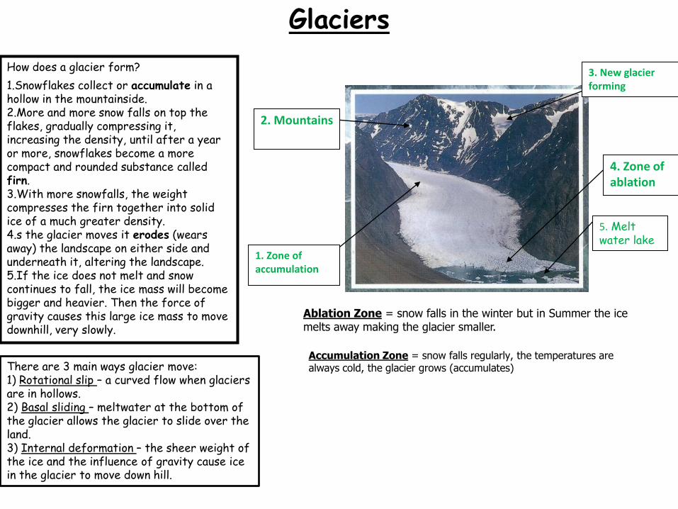
5. Melt water lake
1. Zone of accumulation
3. New glacier forming
2. Mountains
4. Zone of ablation
How does a glacier form?
1.Snowflakes collect or accumulate in a hollow in the mountainside. 2.More and more snow falls on top the flakes, gradually compressing it, increasing the density, until after a year or more, snowflakes become a more compact and rounded substance called firn. 3.With more snowfalls, the weight compresses the firn together into solid ice of a much greater density. 4.s the glacier moves it erodes (wears away) the landscape on either side and underneath it, altering the landscape. 5.If the ice does not melt and snow continues to fall, the ice mass will become bigger and heavier. Then the force of gravity causes this large ice mass to move downhill, very slowly.
Ablation Zone = snow falls in the winter but in Summer the ice melts away making the glacier smaller.
Accumulation Zone = snow falls regularly, the temperatures are always cold, the glacier grows (accumulates) There are 3 main ways glacier move:
1) Rotational slip – a curved flow when glaciers are in hollows. 2) Basal sliding – meltwater at the bottom of the glacier allows the glacier to slide over the land. 3) Internal deformation – the sheer weight of the ice and the influence of gravity cause ice in the glacier to move down hill.
Glaciers

Plucking: As a glacier moves over the landscape, water melts below the glacier and seeps into cracks within the underlying rock. This water freezes and melts, weakening the rock. These pieces of rock can now be picked up or plucked from their rocky base and carried along with the moving glacier.
Glacial erosion
Abrasion: Abrasion is the erosion that occurs when particles scrape against each other. The enormous weight of the glacier, along with rocks and sediment plucked up and clinging to its belly scratch and carve the rock surface below. It's almost as if the moving glacier is sanding the rocks with abrasive sandpaper.
Description Photograph
U-shaped valley – a valley with steep sides and a flat floor formed where a glacier used to flow. Before glaciation they would likely have been a v-shaped valley with a small river. Often U-shaped valleys have a ‘ribbon’ lake in them or small stream. Glaciers bulldoze everything in their path, leading to the creation of U-shaped valleys. These sort of valleys are found throughout Scotland, The Lake District and Snowdonia.
Arete A very narrow, knife like ridge of rock. It is formed when two glaciers erode two U-shaped valleys running next to each other. A famous UK example is ‘Striding Edge’ in the Lake District.
Fjord Formed where a glacier cuts a U-shaped valley in a coastal area. When the ice melts sea water floods the valley creating beautiful steep sided valleys. Norway is famous for them.
Corrie/cirque and tarn A large hollow formed below a mountain peak where glaciers erode downwards. A tarn is the small lake often left at the bottom of a corrie.
Hanging valley A shallow valley formed by a smaller glacier that sits above a larger one. Often there is a waterfall into the main U-shaped valley.
Pyramidal peak/horn Distinctive 3-sided mountain tops formed where 3 corries are formed around one peak. A famous example is The Matterhorn in Switzerland.
1= Horn/pyramid peak 2 = Arete 3 = Corrie/cirque 4 = Tarn 5 = Alluvial fan 6 = Ribbon lake 7 = Truncated spur 8 = Misfit stream 9 = Hanging valley 10 = U shaped valley

Test yourself: Can you label each number with the correct erosional landform? Can you explain how at least 2 of these landforms are formed?

Glacier retreat = the overall loss of ice from a glacier over a period of time due to warmer temperatures or a reduction in snowfall. It occurs as climate warms and melts the glaciers, glacier retreat in the last half century is proof of climate change occurring.
Glacial retreat
What will the impacts of glacial retreat be on people?
The Indus, Ganges, Brahmaputra, Irrawady, Mekong and Yangtze River all have sources in the Himalayas and are fed by glaciers. These rivers flow through two of the worlds most populated countries and most densely populated cities. A reduction in discharge due to the melting and disappearance of glaciers here would be devastating on drinking, industrial and agricultural water supplies. This also happens in South America.
A number of South American countries are highly dependent upon glaciers and glacial runoff for energy production. In the Andes region, hydropower supplies 81% of Peru's electricity, 73% of Colombia's, 72% of Ecuador's, and 50% of Bolivia's, in each country glaciers contribute a significant portion of this runoff. In the Cordillera Blanca, Peru glacial cover has been shrinking since the 70's, decreasing by 15% over a 25 year span.
Sea level rise is the most obvious and catastrophic effect of glacier melt. At present thermal expansion is believed to be the main contributor to sea level rise, however glacier melt water is going to take that over by 2025. Antarctica and Greenland contain 75% of the world’s ice. Should these ice caps melt it would be apocalyptic for earth. Greenland alone would result in a 7m sea level rise. It is estimated sea levels could rise over 1m by 2100. Islands such as the Maldives are already under threat.
Related Documents