Cheryl Huffman Harvard Graduate School of Design Master of Landscape Architecture and Urban Design Candidate 2014

Cheryl Huffman _ Portfolio 2012-13
Mar 21, 2016
Master of Landscape Architecture and Urban Design (MLAUD) Candidate ’14
Welcome message from author
This document is posted to help you gain knowledge. Please leave a comment to let me know what you think about it! Share it to your friends and learn new things together.
Transcript
Cheryl Huffman
Harvard Graduate School of Design
Master of Landscape Architecture and Urban DesignCandidate 2014


CLEVELAND
COLUMBUS CINCINNATICLEVELAND
1:100,000
CINCINNATI
NTS
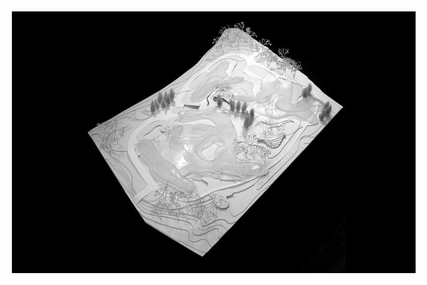
PlasseinSpring 2008The Ohio State University
An examination in plasticity, this project challenges conventional methods in form and function. Emerged from densities found in aerial photographs of the site (next page) this design embraces organic forms derived from context. Unique conditions are created and require varied planting and materials strategies. Site strategies are flexible and defined by flow (water and people). For example, plants within the enclosures tolerate low light, plants around the extrusions capture run-off, plants inside the pockets are
N
suitable for bio-remediation, and plants upon the overlaps thrive in roof gardens.The program features a “3-C” intermodal rail hub (120,000 sf) with administrative offices, a business incubator building (120,00 sf), a rail platform, a flexible exercise area, a fitness trail, a subsurface parking garage, surface parking for visitors, emergency vehicle pathways, a central plaza, two drop-off courts, two courtyards, designated areas for ponding, one altered stream, rain gardens, and a marsh area.

N
Sorting visual site densities (parti)
Enclosures
Circulation
Extrusions
Stormwater management
Pockets
Proposed site plan
Overlaps


1:60

1:80
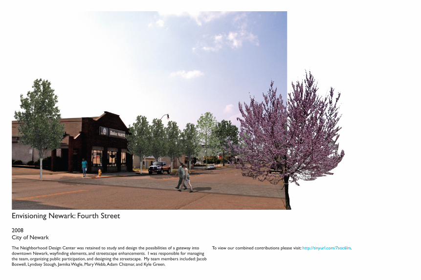
Envisioning Newark: Fourth Street
2008City of Newark
The Neighborhood Design Center was retained to study and design the possibilities of a gateway into downtown Newark, wayfinding elements, and streetscape enhancements. I was responsible for managing the team, organizing public participation, and designing the streetscape. My team members included: Jacob Boswell, Lyndsey Stough, Javnika Wagle, Mary Webb, Adam Chizmar, and Kyle Green.
To view our combined contributions please visit: http://tinyurl.com/7soc6lm.
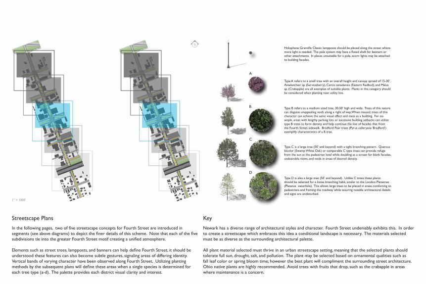
Holophane Granville Classic lampposts should be placed along the street where more light is needed. The pole system may have a fluted shaft for banners or other attachments. In places unsuitable for a pole, acorn lights may be attached to building facades.
Key
Newark has a diverse range of architectural styles and character. Fourth Street undeniably exhibits this. In order to create a streetscape which embraces this idea a conditional landscape is necessary. The materials selected must be as diverse as the surrounding architectural palette.
All plant material selected must thrive in an urban streetscape setting, meaning that the selected plants should tolerate full sun, drought, salt, and pollution. The plant may be selected based on ornamental qualities such as fall leaf color or spring bloom time; however the best plant will compliment the surrounding street architecture. Ohio native plants are highly recommended. Avoid trees with fruits that drop, such as the crabapple in areas where maintenance is a concern.
D
C
A
B
Type D is also a large tree (50’ and beyond). Unlike C trees these plants should be selected for a loose branching habit, similar to the London Planetree (Platanus xacerfolia). This allows large trees to be placed in areas comforting to pedestrians and framing the roadway while assuring notable architectural details and signs are undisturbed.
Type C is a large tree (50’ and beyond) with a tight branching pattern. Quercus bicolor (Swamp White Oak) or comparable C type trees can provide refuge from the sun at the pedestrian level while doubling as a screen for blank facades, undesirable views, and voids in areas of desired density.
Type A refers to a small tree with an overall height and canopy spread of 15-30’. Amelanchier sp. (Serviceberry), Cercis canadensis (Eastern Redbud), and Malus sp. (Crabapple) are all examples of suitable plants. Plants in this category should be considered when planting near utility line.
Type B refers to a medium sized tree, 30-50’ high and wide. Trees of this nature can disguise unappealing voids along a right of way. When massed, trees of this character can achieve the same visual effect and mass as a building. For ex-ample, areas with lengthy parking lots or excessive building setbacks can utilize type B trees to form density and help continue the line of facades that front the Fourth Street sidewalk. Bradford Pear trees (Pyrus calleryana ‘Bradford’) exemplify characteristics of a B tree.
N
Streetscape Plans
In the following pages, two of five streetscape concepts for Fourth Street are introduced in segments (see above diagrams) to depict the finer details of this scheme. Note that each of the five subdivisions tie into the greater Fourth Street motif creating a unified atmosphere.
Elements such as street trees, lampposts, and banners can help define Fourth Street, it should be understood these features can also become subtle gestures, signaling areas of differing identity. Vertical bands of varying character have been observed along Fourth Street. Utilizing planting methods by the subsequent plans will define these areas when a single species is determined for each tree type (a-d). The palette provides each district visual clarity and interest.
1” = 1000’

Streetscape Plan 3
This plan marks the most important intersection (at Fourth and Main) in the historic downtown. This intersection must guide visitors toward the courthouse square. To indicate this importance, a change in road pavement could call out its significance. To further this idea, the addition of planting strips could grab the attention of people experiencing Newark.
Streetscape Plan 4
We have fittingly named this district the “Canal District” for the historic section of the Erie Canal that once defined it. The Canal district requires a good amount of attention in order to deal with the many vacancies and voids within the area. Because the Canal District is already home to numerous residential and family oriented services such as The Works, the police station, fire station, and the Little Bear Grocery, it is our opinion that the Canal District should see future development as a largely residential community. It is suggested that the City of Newark and property owners dress the voids in this area with dense trees until buildings can be infilled. This, in effect, temporarily disguises voids until more permanent progress can be made.
N1” = 200’N1” = 200’

N A DBB A C C C B B B B A A A C D A D
I. II. III.
B A A C B B A B B BB A C D A B B C D
East Elevations
I. Infill structure accents existing building materials generating visual interest.
II. Infill structure resembles an appropriate mass and character for the historic area.
III. Infill structure creates opportunities for first floor retail units and second/ third story residences consistent with the future goals of the canal character area.
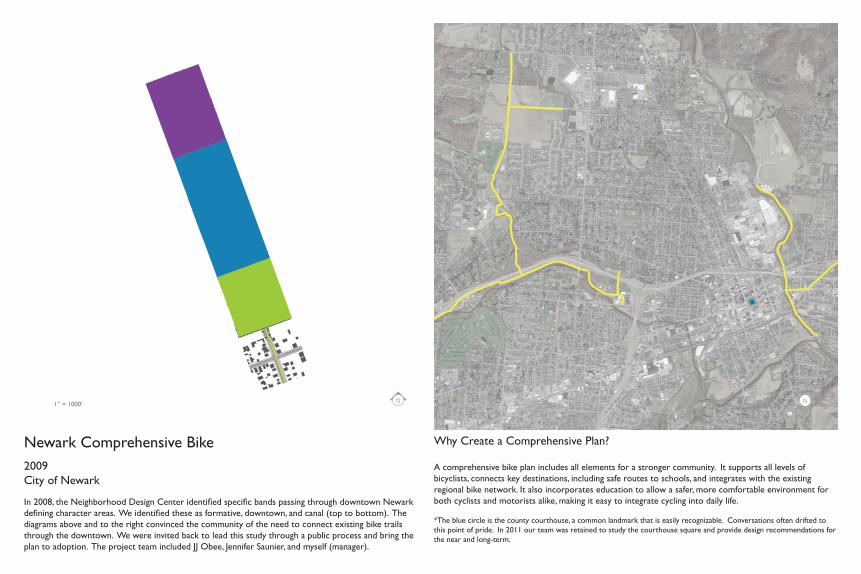
Newark Comprehensive Bike2009City of Newark
In 2008, the Neighborhood Design Center identified specific bands passing through downtown Newark defining character areas. We identified these as formative, downtown, and canal (top to bottom). The diagrams above and to the right convinced the community of the need to connect existing bike trails through the downtown. We were invited back to lead this study through a public process and bring the plan to adoption. The project team included JJ Obee, Jennifer Saunier, and myself (manager).
Why Create a Comprehensive Plan? A comprehensive bike plan includes all elements for a stronger community. It supports all levels of bicyclists, connects key destinations, including safe routes to schools, and integrates with the existing regional bike network. It also incorporates education to allow a safer, more comfortable environment for both cyclists and motorists alike, making it easy to integrate cycling into daily life.
*The blue circle is the county courthouse, a common landmark that is easily recognizable. Conversations often drifted to this point of pride. In 2011 our team was retained to study the courthouse square and provide design recommendations for the near and long-term.
N N1” = 1000’

Sharrow
A shared right of way.
Approximately $1,200 per mile to mark.
1
WHAT
DO
ES THAT
MEA
N?
Ora
nge L
ine: G
oose
pond
-Deo
Rou
te
ROUTE O
PTIO
NS:
Current Trail ConnectivityConnects toDowntown
Bike Laneon-streetBike Laneon shoulder
Bike Trailoff-street
Signal Suggested
Connects toRecreation
Sharrowon-street
Safe Intersections
Positive Driver’s AttitudesBike-Safe Surface
Expense
User Preference
$$ $$$ $$$ $$ $$ $
Expert
Casual
Amateur
2aGreen
Line
: Racco
on C
reek
Trail
A
2b 3aRed Li
ne: G
ranv
ille R
oute
A
Dashed
Gre
en Li
ne: Rac
coon
Cre
ek Tr
ail B
3bDashed
Red
Line
: Gra
nville
Rou
te B
4 Blue L
ine: W
. Chu
rch St
. Rou
te
expert
cyclist
expert
cyclist
expert
cyclist
casual
cyclist
expert
cyclist
casual
cyclist
expert
cyclist
casual
cyclist
expert
cyclist
casual
cyclist
amateur
cyclist
amateur
cyclist N
Multi-purpose Trail
Off road, paved trailways to be shared by pedestrians, bladers, and bicyclists.
No motorized vehicles.
Approximately $192,000 per mile to mark.
Initial Proposal
Based on a matrix of factors (left), the team determined several feasible routes to connect the bike system through the downtown. Various typologies were considered to include the best value for riders. Also, we determined possible locations for a trailhead depicted above in gray. These options, as well as, specific route details (next page) were shared with the public for review. We solicited feedback through open group discussions, survey responses, independent comments, and on-line responses.
Bike Lane
Designated lane on the roadway for bicycles.
Approximately $5,400 per mile to mark.
10’ multi-use trail
Raccoon Creek
Retaining wall
10’ Multi-use
expert
cyclist
amateur
cyclist
casual
cyclist
Levee separating residential from trail 16’ Multi-use trail
with signage
Steep bank with vegetation for support
South Fork River
N
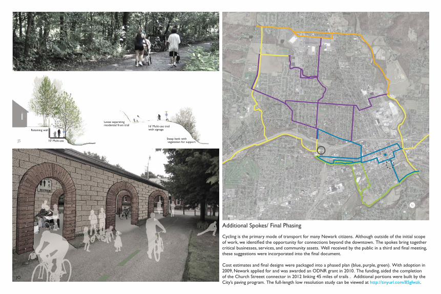
Additional Spokes/ Final Phasing
Cycling is the primary mode of transport for many Newark citizens. Although outside of the initial scope of work, we identified the opportunity for connections beyond the downtown. The spokes bring together critical businesses, services, and community assets. Well received by the public in a third and final meeting, these suggestions were incorporated into the final document.
Cost estimates and final designs were packaged into a phased plan (blue, purple, green). With adoption in 2009, Newark applied for and was awarded an ODNR grant in 2010. The funding, aided the completion of the Church Streeet connector in 2012 linking 45 miles of trails . Additional portions were built by the City’s paving program. The full-length low resolution study can be viewed at http://tinyurl.com/85glwzk.
JS
JO
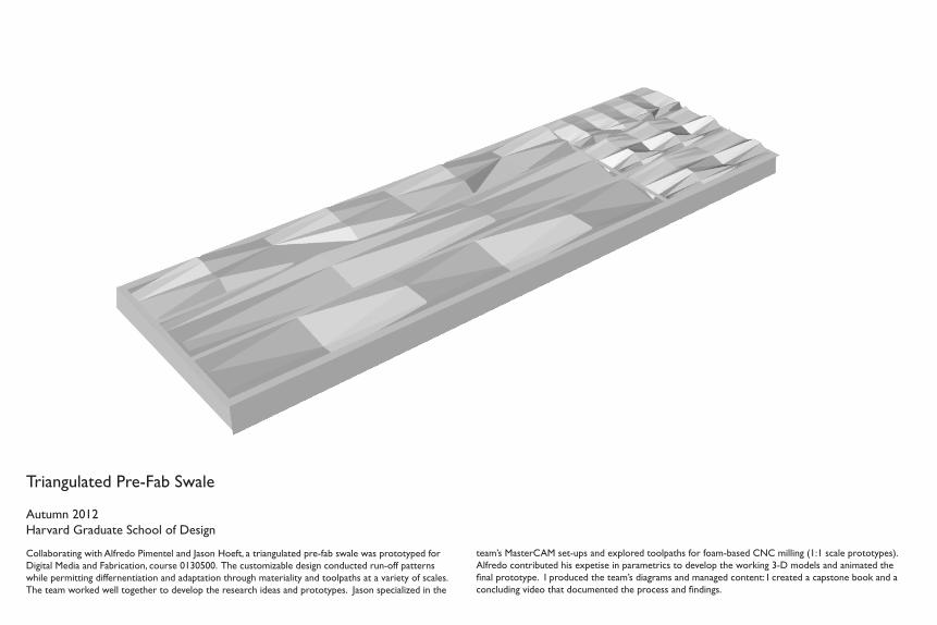
Triangulated Pre-Fab Swale
Autumn 2012Harvard Graduate School of Design
Collaborating with Alfredo Pimentel and Jason Hoeft, a triangulated pre-fab swale was prototyped for Digital Media and Fabrication, course 0130500. The customizable design conducted run-off patterns while permitting differnentiation and adaptation through materiality and toolpaths at a variety of scales. The team worked well together to develop the research ideas and prototypes. Jason specialized in the
team’s MasterCAM set-ups and explored toolpaths for foam-based CNC milling (1:1 scale prototypes). Alfredo contributed his expetise in parametrics to develop the working 3-D models and animated the final prototype. I produced the team’s diagrams and managed content: I created a capstone book and a concluding video that documented the process and findings.
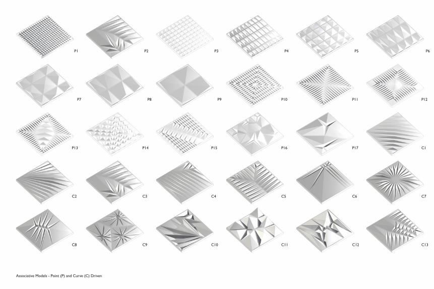
P1 P2 P3 P4 P5 P6
P7 P8 P9 P10 P11 P12
P13 P14 P15 P16 P17 C1
C2 C3 C4 C5 C6 C7
C8 C9 C10 C11 C12 C13
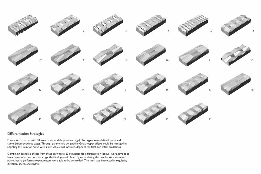
Associative Models - Point (P) and Curve (C) Driven
1 2 3 4 5 6
7 8 9 10 11 12
13 14 15 16 17 18
19 20 21 22 23
Differentiation Strategies
Formal tests started with 30 associative models (previous page). Two types were defined: point and curve driven (previous page). Through parameters designed in Grasshopper, effects could be managed by adjusting the point or curve with slider values that included, depth, shear, fillet, and offset limitations.
Combining desirable effects from these early tests, 23 strategies for differentiation (above) were developed from three lofted sections on a hypothethical ground plane. By manipulating the profiles with attractor points, hydro-performance parameters were able to be controlled. The team was interested in regulating direction, speed, and rhythm.

Final Prototype
Selecting several of the most compelling profiles based on their performative aspects, the team joined these profiles to form a customizable yet pre-fabricated site specific swale. The illustration above is a projection of the product’s future applicability. Using stone, the diagrams to the right demonstrate material behavior in a storm water event, from peak flow to lull.
AP
AP
AP
AP

Urban Grafting: New Dwelling Landscapes for the Extended City
2013 (In Progress)Harvard Graduate School of Design
“Urban design can be seen as an act of “grafting” a new organism onto an existing one, introducing a new physiology into an existing pattern. More than reinventing housing typology itself, this studio is focusing on the design of “interfaces” between the private dimension and the public one with new forms of collective spaces in the contemporary city”. - Cino Zucchi, Principal and Architect, CZA/ Studio Instructor
Two examples of housing typologies follow. They are part of a catalougue with geometrical descriptions of Milano’s urban fabrics, in order to investigate its textural qualities, public spaces, and overarching characteristics. Collectively, the studio has mapped 24 samples of housing and mixed-use settlements. Sites are dispersed among Milan’s center and periphery to inform recursive urban design strategies.

QT8 QuarterGoogle Map Cut-out
San Siro QuarterGoogle Map Cut-out
QT8 QuarterNolli Plan
San Siro QuarterNolli Plan
QT8 Quarter Three Dimensional East View
San Siro QuarterThree Dimensional East View
San Siro QuarterThree Dimensional North View
QT8 Quarter Three Dimensional East ViewInverted
San Siro Quarter Three Dimensional East ViewInverted
San Siro Quarter Three Dimensional NorthViewInverted
QT8 Quarter Three Dimensional North ViewInverted
QT8 Quarter Three Dimensional North View
N
N
N
N
N
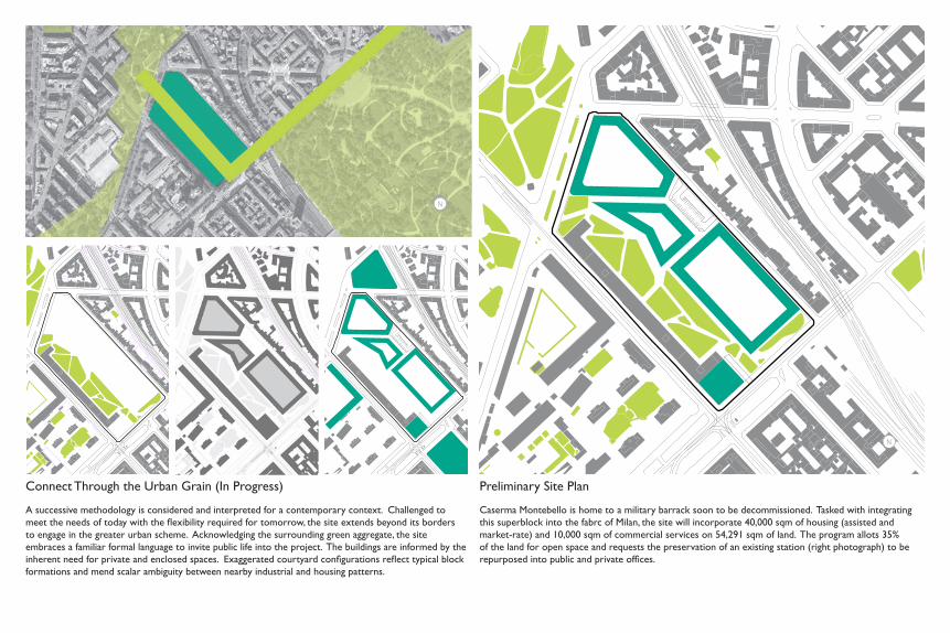
Connect Through the Urban Grain (In Progress)
A successive methodology is considered and interpreted for a contemporary context. Challenged to meet the needs of today with the flexibility required for tomorrow, the site extends beyond its borders to engage in the greater urban scheme. Acknowledging the surrounding green aggregate, the site embraces a familiar formal language to invite public life into the project. The buildings are informed by the inherent need for private and enclosed spaces. Exaggerated courtyard configurations reflect typical block formations and mend scalar ambiguity between nearby industrial and housing patterns.
N
Preliminary Site Plan
Caserma Montebello is home to a military barrack soon to be decommissioned. Tasked with integrating this superblock into the fabrc of Milan, the site will incorporate 40,000 sqm of housing (assisted and market-rate) and 10,000 sqm of commercial services on 54,291 sqm of land. The program allots 35% of the land for open space and requests the preservation of an existing station (right photograph) to be repurposed into public and private offices.
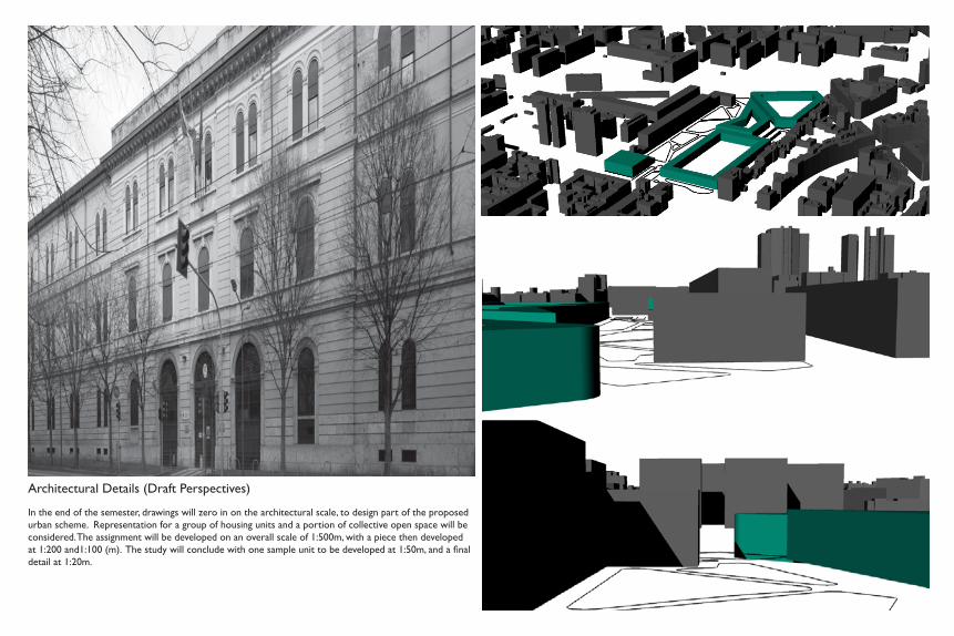
Architectural Details (Draft Perspectives)
In the end of the semester, drawings will zero in on the architectural scale, to design part of the proposed urban scheme. Representation for a group of housing units and a portion of collective open space will be considered. The assignment will be developed on an overall scale of 1:500m, with a piece then developed at 1:200 and1:100 (m). The study will conclude with one sample unit to be developed at 1:50m, and a final detail at 1:20m.
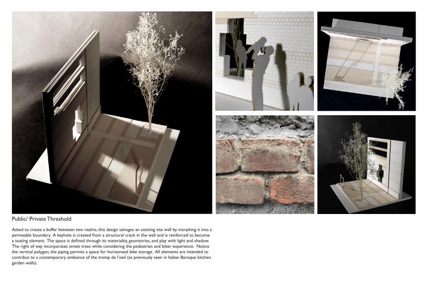
Public/ Private Threshold
Asked to create a buffer between two realms, this design salvages an existing site wall by morphing it into a permeable boundary. A keyhole is created from a structural crack in the wall and is reinforced to become a seating element. The space is defined through its materiality, geometries, and play with light and shadow. The right of way incorporates street trees while considering the pedestrian and biker experience. Notice the vertical polygon, the piping permits a space for horizonatal bike storage. All elements are intended to contribut to a contemporary ambiance of the tromp de l’oeil (as previously seen in Italian Baroque kitchen garden walls).

Cheryl Huffman
Harvard Graduate School of Design
Master of Landscape Architecture and Urban DesignCandidate 2014
Related Documents