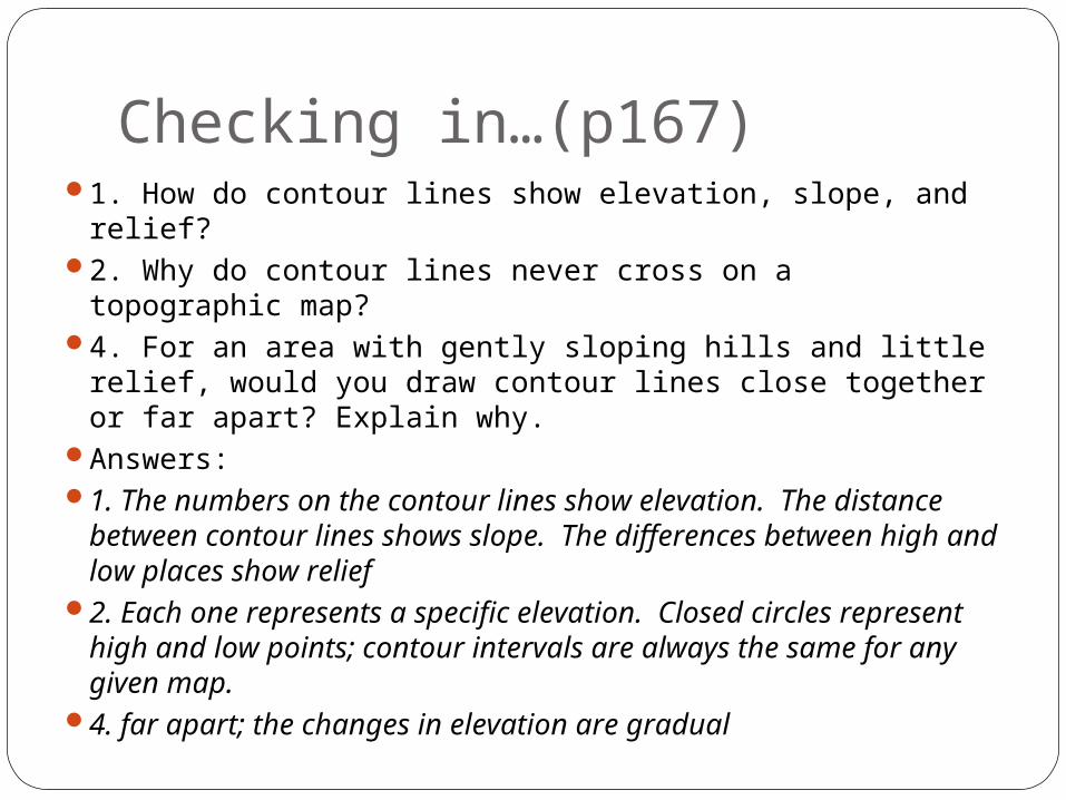
Checking in…(p167) 1. How do contour lines show elevation, slope, and relief? 2. Why do contour lines never cross on a topographic map? 4. For an area with gently sloping hills and little relief, would you draw contour lines close together or far apart? Explain why. Answers: 1. The numbers on the contour lines show elevation. The distance between contour lines shows slope. The differences between high and low places show relief 2. Each one represents a specific elevation. Closed circles represent high and low points; contour intervals are always the same for any given map. 4. far apart; the changes in elevation are gradual

Checking in…(p167) 1. How do contour lines show elevation, slope, and relief? 2. Why do contour lines never cross on a topographic map? 4. For an area.
Dec 18, 2015
Welcome message from author
This document is posted to help you gain knowledge. Please leave a comment to let me know what you think about it! Share it to your friends and learn new things together.
Transcript
Checking in…(p167)1. How do contour lines show elevation, slope, and relief?2. Why do contour lines never cross on a topographic
map?4. For an area with gently sloping hills and little relief,
would you draw contour lines close together or far apart? Explain why.
Answers:1. The numbers on the contour lines show elevation. The
distance between contour lines shows slope. The differences between high and low places show relief
2. Each one represents a specific elevation. Closed circles represent high and low points; contour intervals are always the same for any given map.
4. far apart; the changes in elevation are gradual

Chapter 5: Views of Earth TodayChapter 6: Minerals and Rocks
Chapter 7: Erosion and Depositio
Unit 2: Earth’s Surface
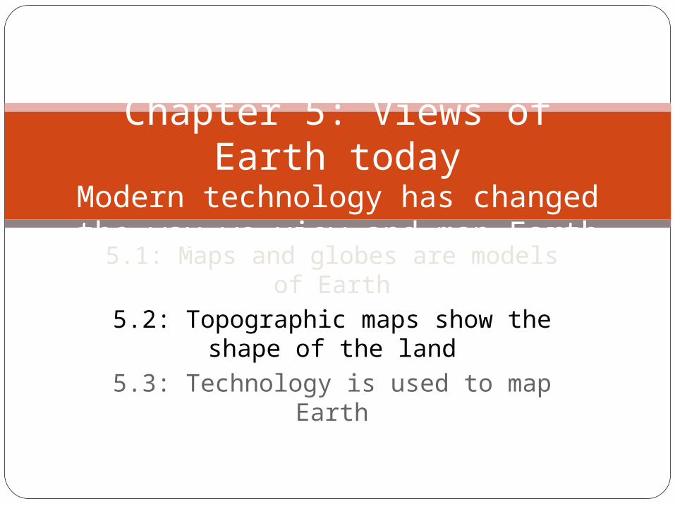
5.1: Maps and globes are models of Earth
5.2: Topographic maps show the shape of the land
5.3: Technology is used to map Earth
Chapter 5: Views of Earth today
Modern technology has changed the way we view and map Earth

5.2: Topographic maps show the shape of the landBefore, you learned:
Different maps provide information about natural and human-made features
Latitude and longitude are used to find places on Earth
All flat maps distort Earth’s surfaceNow, you will learn:
How contour lines show elevation, slope, and relief
What rules contour lines followWhat common symbols are used on
topographic maps

Topographic maps use contour line to show featuresSimple trail maps do not show you anything
about what the land looks like – rivers, hills, valleys?
Topography – the shape, or features, of the landCan be natural: mountains, plateaus, plainsCan be human-made: dams, roads
Topographic map: a flat map that uses lines to show Earth’s surface featurescontour lines show…
Distance, elevation, slope, relief

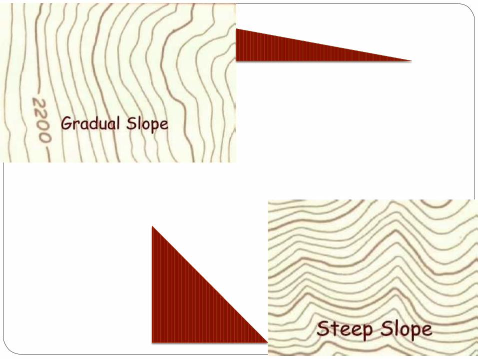
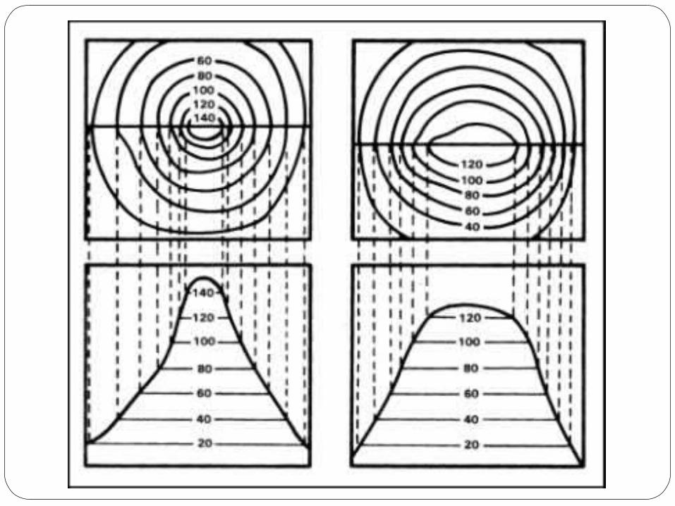
Topographic maps use contour line to show features1. Elevation: how high above sea level a place is
Can be a few meters to several thousand meters above sea level
Contour line numbers show elevation
2. Slope: how steep a landform or area isthe more gradual the slope, the farther apart the
contour linesThe steeper the slope, the closer together they are
3. Relief: difference between the area’s highest and lowest points
Subtract the lowest elevation on a map from the highest


Contour lines follow certain rules
Lines never cross – because each line shows an exact elevation
Circles show highest and lowest points lines form closed circles around mountain tops and
hilltops, and also depressions (sunken areas in the group)
Sometimes the elevation of the mountain or hill will be written in the middle of the circle
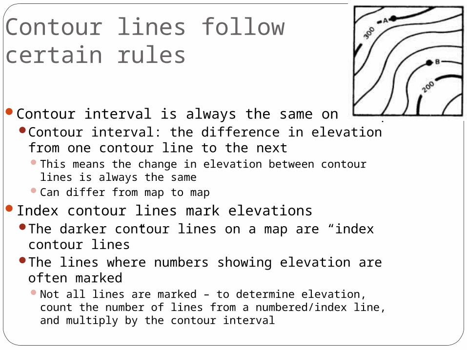
Contour lines follow certain rules
Contour interval is always the same on a mapContour interval: the difference in elevation from
one contour line to the nextThis means the change in elevation between contour lines
is always the sameCan differ from map to map
Index contour lines mark elevationsThe darker contour lines on a map are “index
contour lines”The lines where numbers showing elevation are
often markedNot all lines are marked – to determine elevation, count
the number of lines from a numbered/index line, and multiply by the contour interval

Topographic Maps…Also contain symbols for natural and
human-made featuresCover urban, rural, and wilderness areasAre useful for hikers, campers, engineers,
archaeologists, forest rangers, biologists, and others…

What could this be?


Contour Map Match the contour line drawing in the
PHOTO column with the corresponding contour line image in the TOPO column.
Hint #1: The Arrow in the TOPO images point downhill.
Hint #2: Don't get frustrated with the answers. A couple are very similar.

Related Documents