region | neighborhood, district, and corridor | block, street, and building congress for the new urbanism charter of the new urbanism

Welcome message from author
This document is posted to help you gain knowledge. Please leave a comment to let me know what you think about it! Share it to your friends and learn new things together.
Transcript

re g i on | ne i g h bor h ood, d i st r i c t, and corr i dor | b loc k, st r e et, and bu i l d i ng
cong re s s f or th e ne w ur b an i s m
charter of th e n ew ur b a n i sm

th e c harte r o f th e new ur ban i sm as signed by 266 attendees of the
fourth Congress for the New Urbanism (CNU IV), Charleston, South Carolina, 1996.
c h arte r of th e new ur ban i sm
cong re s s f or th e new ur ban i sm

This publication was made possible, in part, by a grant from the Fannie Mae Foundation.
Copyright © 1999 Congress for the New Urbanism. All rights reserved. No part of this publication may be reproduced without permission.
Library of Congress Catalog Number 99-0000 International Standard Book Number 99-0000
Published by McGraw-Hill, Inc.
d e s i g n : Wolfe Design, Pittsburgh, Pennsylvania
p r i n t i n g : need more information.

c h arte r of th e new ur ban i sm
Commentary by
h a r v e y g a n t t
t o n y h i s s
r i c h a r d e . k i l l i n g s w o r t h
g i a n n i l o n g o
t o m s c h m i d
Afterword by
p e t e r c a l t h o r p e
Postscript by
r o b e r t d a v i s
Edited by
m i c h a e l l e c c e s e a n d k a t h l e e n m c c o r m i c k
Foreword by
s h e l l e y r . p o t i c h a
Essays by
r a n d a l l a r e n d t
g . b . a r r i n g t o n
j o n a t h a n b a r n e t t
s t e p h a n i e b o t h w e l l
p e t e r c a l t h o r p e
t h o m a s j . c o m i t t a
v i c t o r d o v e r
a n d r e s d u a n y
d o u g l a s f a r r
r a y g i n d r o z
k e n g r e e n b e r g
j a c k y g r i m s h a w
d o u g l a s k e l b a u g h
w a l t e r k u l a s h
b i l l l e n n e r t z
w i l l i a m l i e b e r m a n
w e n d y m o r r i s
e l i z a b e t h m o u l e
j o h n o . n o r q u i s t
m y r o n o r f i e l d
e l i z a b e t h p l a t e r - z y b e r k
s t e f a n o s p o l y z o i d e s
h e n r y r . r i c h m o n d
m a r k m . s c h i m m e n t i
d a n i e l s o l o m o n
m a r c a . w e i s s
r o b e r t d . y a r o
cong re s s f or th e new ur ban i sm


c o n g r e s s f o r t h e n e w u r b a n i s m
th e cong re s s f or th e new ur ban i sm views disinvestment in central cities, the spread of placeless sprawl, increasing separation by race and income, environmental deterioration, loss of agricultural lands and wilderness, and the erosion of society’s built heritage as one interrelated community-building challenge. We stand for the restoration of existing urban centers and towns within coherent metropolitan regions, the reconfi guration of sprawling suburbs into communities of real neighborhoods and diverse districts, the conservation of natural environments, and the preservation of our built legacy. We recognize that physical solutions by themselves will not solve social and economic problems, but neither can economic vitality, community stability, and environmental health be sustained without a coherent and supportive physical framework. We advocate the restructuring of public policy and development
charte r of the new urban i sm
Preamble
v
c h a r t e r o f t h e n e w u r b a n i s m
practices to support the following principles: neighborhoods should be diverse in use and population; communities should be designed for the pedestrian and transit as well as the car; cities and towns should be shaped by physically defi ned and universally accessible public spaces and community institutions; urban places should be framed by archi-tecture and landscape design that celebrate local history, climate, ecology, and building practice. We represent a broad-based citizenry, composed of public and private sector leaders, community activists, and multidisciplinary professionals. We are committed to reestablishing the relationship between the art of building and the making of community, through citizen-based participatory planning and design. We dedicate ourselves to reclaiming our homes, blocks, streets, parks, neighborhoods, districts, towns, cities, regions, and environment.
vi
c o n g r e s s f o r t h e n e w u r b a n i s m
p r e a m b l e t o t h e c h a r t e r v
Foreword 1
s h e l l e y r . p o t i c h a
What’s New About the New Urbanism? 5
j o n a t h a n b a r n e t t
p r i n c i p l e s o f t h e c h a r t e r
t h e r e g i o n : m e t r o p o l i s, c i t y , a n d t o w n 13
One
The metropolitan region is a fundamental economic unit of the contemporary 15
world. Governmental cooperation, public policy, physical planning, and economic
strategies must refl ect this new reality.
e s s a y b y p e t e r c a l t h o r p e
Two
Metropolitan regions are fi nite places with geographic boundaries derived from 23
topography, watersheds, coastlines, farmlands, regional parks, and river basins.
The metropolis is made of multiple centers that are cities, towns, and villages, each
with its own identifi able center and edges.
e s s a y b y r o b e r t d . y a r o
Three
The metropolis has a necessary and fragile relationship to its agrarian hinterland 29
and natural landscapes. The relationship is environmental, economic, and cultural.
Farmland and nature are as important to the metropolis as the garden is to the house.
e s s a y b y r a n d a l l a r e n d t
Four
Development patterns should not blur or eradicate the edges of the metropolis. 35
Infi ll development within existing areas conserves environmental resources,
economic investment, and social fabric, while reclaiming marginal and abandoned
areas. Metropolitan regions should develop strategies to encourage such infi ll
development over peripheral expansion.
e s s a y b y j a c k y g r i m s h a w
w i t h c o m m e n t a r y b y h a r v e y g a n t t 40
Contents

c o n t e n t s
Five
Where appropriate, new development contiguous to urban boundaries should 43
be organized as neighborhoods and districts, and be integrated with the existing
urban pattern. Noncontiguous development should be organized as towns and
villages with their own urban edges, and planned for a jobs/housing balance,
not as bedroom suburbs.
e s s a y b y w e n d y m o r r i s
Six
The development and redevelopment of towns and cities should respect historical 49
patterns, precedents, and boundaries.
e s s a y b y s t e p h a n i e b o t h w e l l
Seven
Cities and towns should bring into proximity a broad spectrum of public and 53
private uses to support a regional economy that benefi ts people of all incomes.
Affordable housing should be distributed throughout the region to match job
opportunities and to avoid concentrations of poverty.
e s s a y b y h e n r y r . r i c h m o n d
Eight
The physical organization of the region should be supported by a framework of 59
transportation alternatives. Transit, pedestrian, and bicycle systems should maximize
access and mobility throughout the region while reducing dependence on
the automobile.
e s s a y b y g . b . a r r i n g t o n
w i t h c o m m e n t a r y b y r i c h a r d e . k i l l i n g s w o r t h a n d t o m s c h m i d 64
Nine
Revenues and resources can be shared more cooperatively among the municipalities 65
and centers within regions to avoid destructive competition for tax base and to
promote rational coordination of transportation, recreation, public services, housing,
and community institutions.
e s s a y b y m y r o n o r f i e l d
c o n g r e s s f o r t h e n e w u r b a n i s m
n e i g h b o r h o o d, d i s t r i c t, a n d c o r r i d o r 71
Ten
The neighborhood, the district, and the corridor are the essential elements of 73
development and redevelopment in the metropolis. They form identifi able areas that
encourage citizens to take responsibility for their maintenance and evolution.
e s s a y b y j o n a t h a n b a r n e t t
Eleven
Neighborhoods should be compact, pedestrian-friendly, and mixed-use. Districts 79
generally emphasize a special single use, and should follow the principles of neigh-
borhood design when possible. Corridors are regional connectors of neighborhoods
and districts; they range from boulevards and rail lines to rivers and parkways.
e s s a y b y e l i z a b e t h p l a t e r - z y b e r k
Twelve
Many activities of daily living should occur within walking distance, allowing 83
independence to those who do not drive, especially the elderly and the young.
Interconnected networks of streets should be designed to encourage walking,
reduce the number and length of automobile trips, and conserve energy.
e s s a y b y w a l t e r k u l a s h
Thirteen
Within neighborhoods, a broad range of housing types and price levels can bring 89
people of diverse ages, races, and incomes into daily interaction, strengthening the
personal and civic bonds essential to an authentic community.
e s s a y b y m a r c a . w e i s s
Fourteen
Transit corridors, when properly planned and coordinated, can help organize 97
metropolitan structure and revitalize urban centers. In contrast, highway corridors
should not displace investment from existing centers.
e s s a y b y j o h n o . n o r q u i s t
Fifteen
Appropriate building densities and land uses should be within walking distance of 101

c o n t e n t s
transit stops, permitting public transit to become a viable alternative to the automobile.
e s s a y b y w i l l i a m l i e b e r m a n
Sixteen
Concentrations of civic, institutional, and commercial activity should be embedded 105
in neighborhoods and districts, not isolated in remote, single-use complexes.
Schools should be sized and located to enable children to walk or bicycle to them.
e s s a y b y e l i z a b e t h m o u l e
Seventeen
The economic health and harmonious evolution of neighborhoods, districts, 109
and corridors can be improved through graphic urban design codes that serve
as predictable guides for change.
e s s a y b y b i l l l e n n e r t z
Eighteen
A range of parks, from tot lots and village greens to ballfi elds and community 113
gardens, should be distributed within neighborhoods. Conservation areas and open
lands should be used to defi ne and connect different neighborhoods and districts.
e s s a y b y t h o m a s j . c o m i t t a
b l o c k, s t r e e t, a n d b u i l d i n g 121
Nineteen
A primary task of all urban architecture and landscape design is the physical 123
defi nition of streets and public spaces as places of shared use.
e s s a y b y d a n i e l s o l o m o n
Twenty
Individual architectural projects should be seamlessly linked to their surroundings. 127
This issue transcends style.
e s s a y b y s t e f a n o s p o l y z o i d e s
Twenty one
The revitalization of urban places depends on safety and security. The design of 133
streets and buildings should reinforce safe environments, but not at the expense
of accessibility and openness.
e s s a y b y r a y g i n d r o z
w i t h c o m m e n t a r y b y t o n y h i s s 138
Twenty two
In the contemporary metropolis, development must adequately accommodate 141
automobiles. It should do so in ways that respect the pedestrian and the form

c o n g r e s s f o r t h e n e w u r b a n i s m
of public space.
e s s a y b y d o u g l a s f a r r
Twenty three
Streets and squares should be safe, comfortable, and interesting to the pedestrian. 147
Properly confi gured, they encourage walking and enable neighbors to know each
other and protect their communities.
e s s a y b y v i c t o r d o v e r
w i t h c o m m e n t a r y b y g i a n n i l o n g o 152
Twenty four
Architecture and landscape design should grow from local climate, topography, 155
history, and building practice.
e s s a y b y d o u g l a s k e l b a u g h
Twenty fi ve
Civic buildings and public gathering places require important sites to reinforce 161
community identity and the culture of democracy. They deserve distinctive
form, because their role is different from that of other buildings and places that
constitute the fabric of the city.
e s s a y b y a n d r e s d u a n y
Twenty six
All buildings should provide their inhabitants with a clear sense of location, weather, 169
and time. Natural methods of heating and cooling can be more resource-effi cient
than mechanical systems.
e s s a y b y m a r k m . s c h i m m e n t i
Twenty seven
Preservation and renewal of historic buildings, districts, and landscapes affi rm the 173
continuity and evolution of urban society.
e s s a y b y k e n g r e e n b e r g
Afterword 177
p e t e r c a l t h o r p e
Postscript 181
r o b e r t d a v i s
Editors’ Notes 185
Credits 186
Bibliography 191


1
What we now recognize as “New Urbanism” began with a remarkable set of
conversations aimed at systematically changing the ground rules for development in
North America. In October 1993, the fi rst Congress convened in Alexandria, Virginia,
to share works in progress and debate issues. Among the 170 people who attended
were some of the nation’s leading designers, as well as a number of maverick prac-
titioners. What resulted was energizing and created the seed of a larger movement
that has now borne fruit.
The original Congress participants were concerned about the placelessness of
modern suburbs, the decline of central cities, the growing separation in communities
by race and income, the challenges of raising children in an economy that requires two
incomes for every family, and the environmental damage brought on by development
that requires us to depend on the automobile for all daily activities.
They discussed root causes—changing household demographics, land consumption
without regard to natural features or physical limits, federal and state policies that
encourage low-density sprawl, street standards that are insensitive to human needs,
and zoning codes that virtually require an ugly sameness to permeate all communities
regardless of regional climates and traditions. They analyzed the regional forces that
create dilapidated urban neighborhoods surrounded by fl ourishing suburbs. And,
unlike many critics who came before them, they focused on the relationships among
these problems.
Foreword

f o r e w o r d2
Fortunately, they didn’t stop by enumerating
the problems. They sought examples (and created
new models) that showed another path. By the
end of 1993, it was apparent that these issues also
were interesting to many others. Six architects at
the forefront of this emerging movement—
Peter Calthorpe, Andres Duany, Elizabeth Moule,
Elizabeth Plater-Zyberk, Stefanos Polyzoides, and
Daniel Solomon—took steps to incorporate as a
nonprofi t organization that would advocate for the
principles of New Urbanism and for a wholesale
shift in the way communities are built.
The Congress for the New Urbanism (CNU)
seeks to support an American movement to restore
urban centers, reconfi gure sprawling suburbs, con-
serve environmental assets, and preserve our built
legacy. We aim to achieve this by educating other
design professionals, policy makers, and the public;
by changing policies and practices that perpetuate
destructive development practices; and by forming
a network of like-minded groups that can effect
change at all levels. CNU is one of only a few
voices addressing the confl uence of community,
economics, and environment in our cities. And it is
the only national organization dedicated to address-
ing these issues through urban design and planning.
Many local, regional, and national groups look
to CNU for expertise in land development strate-
gies. But what I fi nd so remarkable about CNU is
that it is the only group of planners and designers,
and now, also, developers, public offi cials, and activ-
ists, clearly committed to addressing the social and
economic implications of design decisions. Granted,
the New Urbanists are not the fi rst to posit these
ideas—others made many of these points years
before the term New Urbanism was even coined.
Nor do New Urbanists claim to have invented
urbanism. Rather, the New Urbanists
have formed an organization dedicated to addressing
the problems and publicizing the alternatives.
At this writing, CNU is rapidly growing stron-
ger and more diversifi ed. What began as an
odd collection of designers, visionaries, and agitators
now includes some of the nation’s most esteemed
academics, economists, planners, transportation
engineers, sociologists, and environmentalists. As
a progressive core of practitioners in their respec-
tive fi elds, these CNU members work tirelessly
to infl u ence their professions. CNU also hosts
a growing number of developers who see New
Urbanism
as a way to right some wrongs in their profession
without neglecting their profi ts. And, perhaps
most encouraging, CNU includes among its ranks
a growing cadre of elected offi cials and citizen
activists who view New Urbanism as a means of
reclaiming their communities.
In its short existence, CNU has made consider-
able progress in advancing its ambitious agenda. The
most dramatic indicators are the
growing numbers of New Urbanist development
and redevelopment projects under way around
the nation. In addition, there are many indications

c o n g r e s s f o r t h e n e w u r b a n i s m 3
that public discourse about cities and development
has recently made a radical shift, as evidenced by
New Jersey Governor Christine Todd Whitman’s
1998 inaugural address:
“Every part of New Jersey suffers when we plan
haphazardly. . . . Sprawl eats up our open space. It
creates traffi c jams that boggle the mind and pollute
the air. Sprawl can make one feel downright claus-
trophobic
about our future.”
Meanwhile, Vice President Al Gore has made
sprawl a national issue:
“While the blight of poor development and its
social consequences have many names, the solutions,
pioneered
by local citizens, are starting to coalesce into a
movement. In the future, livable communities will
be the basis of
our competitiveness and economic strength.”
For the fi rst time, there is broad—though far
from universal—recognition that the problems of
our cities and suburbs need to be addressed and that
the planning and design of our cities have rami-
fi cations in every aspect of public and private life.
This book focuses on the Charter of the
New Urbanism. Adopted by our members in 1996,
the Charter sets forth a positive vision for our
communities. Its preamble demonstrates the New
Urbanists’ commitment to tackling problems in
an inter disciplinary way, and involving those most
affected by design decisions: citizens. As you will
see in the essays that follow, its principles are
detailed but fl exible prescriptions for city design.
I don’t expect the Charter to be a stagnant
document. The ideas and strategies of New Urbanism
need to mature and evolve. We need to learn new
and better ways of building and rebuilding. How-
ever, the Charter is unique because it promotes a
vision and tells how we can accomplish it.
Over time, I hope that the work of the New
Urbanists will support what I see as an impending
cultural shift. In the twilight of the 20th century,
people are increasingly concerned about both their
quality of life and maintaining a basic standard of
living. They are concerned about civic issues and
building a civil community. I see New Urbanism
as one piece of a movement whose time has come.
s h e l l e y r . p o t i c h a
Executive Director
Congress for the New Urbanism

44

5
j o n a t h a n b a r n e t t
What’s New About the New Urbanism?
Most of us live amid space, comfort, and convenience that once only the very rich
could imagine. Computers, automobiles, and air travel have opened up vast new
opportunities for jobs and leisure. But the old methods for managing urban growth
and change don’t work as well as they used to; often they don’t work at all.
In fast-growing suburban areas, communities are trying to control immense new
developments with zoning and subdivision codes that were probably enacted in the
1950s to shape much smaller projects, and are struggling to fi nance new schools,
roads, and services. Meanwhile, the landscapes and the way of life that attract the new
development become more endangered every day.
Older cities are fi nding that downtown renewal is not enough to offset lost jobs
from vanishing industries, the growing need for social services, problems in the school
system, and dysfunctional housing projects.
Older suburbs, which were getting along well until a few years ago, are suddenly
confronted by the same kinds of social problems found in the nearby city, without
the benefi t of the city’s tax base and institutional resources.
The Charter of the Congress for the New Urbanism begins:
The Congress for the New Urbanism views disinvestment in central cities, the spread
of placeless sprawl, increasing separation by race and income, environmental deteriora-
tion, loss of agricultural lands and wilderness, and the erosion of society’s built heritage
as one interrelated community-building challenge.
c o n g r e s s f o r t h e n e w u r b a n i s m

nation can afford a strategy of writing off its older
urban areas and replacing them with developments
on the edge of metropolitan regions. To state such a
policy explicitly is enough to show how absurd
it is. However, in the United States, many individual
decisions are being made as if older cities and
towns are write-offs; and the sum of these individual
decisions risks becoming a national policy.
The places where people and businesses are
moving often do not live up to expectations.
They lack the coherence of older cities and towns.
They lack the rural charm people thought they
were moving to enjoy. Disappointment with new
urbanized areas causes people and businesses to
move outward once again, and the whole wasteful
cycle is repeated.
Of course it is not possible to rewind develop-
ment back to, say, 1970, and replay it based on what
we know now. Decentralized metropolitan regions
are the new reality, and we have to learn how to
make them work.
However, it is possible to reshape endless com-
mercial strip development into towns and special
districts, and to turn shapeless subdivisions into
neighborhoods; but the task is unprecedented and
will require the invention of new planning policies
and design techniques. It is possible to bring new
development into the bypassed and deteriorated
areas of cities, but what is offered has to be as good
or better than what is available elsewhere. It is
possible to make sure that the mistakes of recent
urban development are not repeated. It is also
i n t r o d u c t i o n
Each of these issues has long been identifi ed
as a problem. What is new about the New Urbanism
is the assumption that solutions to these problems
require that they be worked out together.
It is harder to create new jobs in the old city
when communities on the urban fringe are offering
industrial development subsidies as well as cheap
land and new infrastructure. Communities in fast-
growing suburbs can’t afford the new schools they
need, while older suburbs are turning unneeded
schools into senior-citizen centers. Whole neigh-
borhoods of houses in cities such as Detroit and
St. Louis have deteriorated and been demolished,
leaving block after block vacant, but complete with
all the necessary utilities. Meanwhile farms and
woodlands are being bulldozed for new houses in
nearby rural counties, which are going deeply into
debt to pay for roads and sewage-treatment plants.
Some cities have grown by annexation to
include most of the suburban development in
their metropolitan region. Studies show that such
metropolitan cities, or city–county governments,
have better resources for solving their problems
than cities and suburbs that remain separate places.
The metropolitan region has become the basic
unit of urban development: Airports and highways
serve a whole region and not just individual cit-
ies and towns. So do retail and offi ce centers, sport
franchises, and cultural institutions.
Despite the temptations for individual families
and businesses to move away from problems in older
cities and suburbs to new homes in the country, no
6

c o n g r e s s f o r t h e n e w u r b a n i s m 7
possible to link all the diverse parts of the met-
ropolitan region together again with transporta-
tion systems that do not rely only on automobiles.
Success in these areas would take development pres-
sures off the natural environment and bring new
life to valuable old buildings and districts.
So here is another aspect of what is new about
the New Urbanism: It calls for new design concepts
to meet new situations. These include innovative
ways to retrieve the mistakes of recent development;
new regulations and policies to keep the old mis-
takes from recurring; visionary proposals for making
older areas competitive again; plans for limiting
the extent of the metropolitan region and pulling
it together by new forms of transportation.
The Charter continues:
We stand for the restoration of existing urban cen-
ters
and towns within coherent metropolitan regions,
the reconfi guration of sprawling suburbs into com-
munities of real neighborhoods and diverse districts,
the conservation
of natural environments, and the preservation of our
built legacy.
All very well, but how practical are new design
concepts, given today’s harsh economic and social
realities? What about crime; what about schools;
what about jobs?
The rapid transformation of cities and suburbs
into metropolitan urban regions has been part of a
larger process of economic growth and change that
has destabilized and transformed many aspects of
life today, and goes far beyond issues of city design
and planning.
However, some recent innovations in crime
control have interesting analogies to the kinds
of proposals that are part of the New Urbanism:
community-based police patrols, low tolerance for
“environmental” offenses like aggressive panhan-
dling or graffi ti, plus new computer-aided programs
for the strategic deployment of police resources.
The success of these innovative crime-control
measures contains important messages.
First of all, it turns out that rising crime
statistics are not inevitable. Crime can be controlled.
It is not necessary to try to move away from it.
Second, measures based on community responsibility
and environmental improvement are not just good
city design. They are also good social policy.
The failure of school systems to educate all
children to their full abilities is another massive
problem, aggravated by the concentration of families
with the most severe economic and behavioral
diffi culties in older urban areas. Enough evidence
has accumulated from experimental programs to
demonstrate that, while a few children may have
severe learning disabilities, the problem is most often
the system and not the children.
The United States is in the midst of a national
debate about how to improve schools while main-
taining universal education, including proposals
and experimental programs for national standards,
charter schools, and school vouchers. Some of
the most promising innovations include means to

i n t r o d u c t i o n8
involve parents in the life of the schools, school-
based programs to help parents in areas with large
concentrations of multi-problem families, and
community-based support networks of tutors and
extracurricular activities. Another important fac-
tor is the maintenance of an orderly and secure
envi ronment within the school itself.
Again these proposals create interesting analogies
to principles of the New Urbanism because they
emphasize both a supportive community and the
importance of the physical environment.
New international patterns of trade, the
changing geography of industrial development, and
the rising importance of service and information-
based jobs have transformed the workplace. Older
cities are no longer the automatic source of low-
skilled, entry-level jobs, although many people most
in need of these jobs still live in older urban areas.
These issues involve the whole economy and
go far beyond the subject matter of city design and
planning. The United States and other countries are
in the process of adjusting social-welfare policies to
place more emphasis on returning welfare recipients
to the workforce. This requires greater public- policy
emphasis on job creation and correcting the mis-
match between the location of jobs and the homes
of people who need them. These efforts and many
other government economic-development programs
involve issues of importance to the New Urbanism.
Many bypassed or underused sites in older areas
lie idle because of real or suspected industrial con-
tamination. Brownfi eld programs that make it easier
to clean up and recycle these properties can bring
life back to older areas. Enterprise Zones provide
tax subsidies to encourage businesses to locate near
where people need jobs. Fair housing and other
programs encourage decentralization of subsidies
to locate affordable housing more evenly across the
metropolitan area. New metro politan transportation
systems recognize and serve the decentralized work
locations created in recent decades.
The New Urbanism has come a long way
from the belief that an earlier generation’s design
and planning policies, such as Slum Clearance,
Urban Renewal, or New Towns, could by them-
selves cure major societal affl ictions.
As the Charter continues:
We recognize that physical solutions by themselves
will not solve social and economic problems, but
neither can economic vitality, community stability,
and environmental health be sustained without a
coherent and supportive physical framework.
Frequently new commercial buildings or
housing developments, even if very expensive, are
seen to detract from their surrounding area rather
than to improve it. This is true both in “greenfi eld”
situations and in older urban districts. As a result,
local citizens often bitterly oppose new development
proposals, a major factor in diverting development
farther out to the edges of metropolitan areas.
Much of the confl ict between local citizens
and developers is unnecessary. It results from out-
moded development regulations and the ways that
development practice has adapted to them.
For example, most ordinances governing the
way properties are divided up into lots set a maxi-

c o n g r e s s f o r t h e n e w u r b a n i s m 9
mum grade for streets, often 5 percent. The easiest
way for a developer to deal with this requirement
is to regrade the whole property so that no slope
is greater than 5 percent by bulldozing all existing
vegetation, shaving off topsoil, pushing soil and rock
into runoff watercourses, and, in general, violating
basic principles of ecological design. The answer to
this problem involves revising local regulations to
reduce permitted development in steeply sloping
areas while accepting a more fl exible layout of lots
and streets. At the same time, homebuilders need
to revise their standard practice, and not follow plans
that require extensive regrading. After all, grading
costs money. Mature vegetation has monetary value
to the home buyer. And a layout that preserves the
contours of the landscape can provide just as many
house sites as one that does not.
Another example: Communities often create
zones of thousands of acres that permit only one
size of single-family house. Developers then con-
struct tracts of hundreds, sometimes even thousands,
of the same-size house and lot, producing little
diversity of income, no local shopping, few des ti-
nations within walking distance, and households
located too far apart to support public transportation.
Communities instead need to create neighborhood
zones that permit a diversity of housing types
while incorporating convenience shopping districts.
They must permit compact development around
neighborhood centers so people can walk to some
destinations, and take public transit to others. The
effect of this change in policy, where it has been
tried, has been to create places of character and
diversity, not just a group of subdivisions and the
occasional shopping mall.
A third example: zoning that encourages
commercial development only in narrow strips
along a highway. The idea of the commercial strip
goes back to streetcar suburbs and small towns
with a single Main Street. It makes little sense as
a development pattern extended for miles along
highways. However, development practice has
adapted to it. People forget that, far from being an
inevitable consequence of the real-estate market,
commercial strips are created by an outmoded
zoning practice that designates far too much
com mercial land to be used intensively, while not
zoning enough commercial land at any one location
to permit more effi cient development. An alterna-
tive pattern concentrating development at specifi c
locations along a highway would create better
community design, make long-distance traffi c
move much faster, use land more effi ciently, and
generally make more economic sense.
Commercial strip and large-lot zoning
deployed over vast acreage are the recipe for urban
sprawl. To change the design of new development,
it is necessary to change these legal templates.
Here then is another innovation of the
New Urbanism: the recognition that design and
planning concepts cannot be separated from their
imple mentation mechanism. Today’s defects in
city design can be traced to defective public policies
and poorly thought-out investment practices. Hence
the improved city-design concepts advocated by

i n t r o d u c t i o n10
the New Urbanism also require improved public
policies and new real-estate investment practices.
As the Charter of the New Urbanism states:
We advocate the restructuring of public policy and
development practices to support the following
principles: neighborhoods should be diverse in use
and population; communities should be designed
for the pedestrian and transit as well as the car;
cities and towns should be shaped by physically
defi ned and universally accessible public spaces and
community institutions; urban places should be
framed by architecture and landscape design
that celebrate local history, climate, ecology, and
building practice.
Historically, concepts about the design of
buildings, landscapes, or cities have been put for-
ward by designers who expect society to recognize
the “rightness” of the design and then fi nd ways to
implement it. The Congress for the New Urbanism
recognizes that innovations in city design require
parallel innovations in public policy and private
fi nance. The Congress seeks to be much more than
a society of design professionals. It includes all those
whose voices need to be heard if there are to be
constructive changes in the ways cities and towns
are developed — and in society’s overall relation to
the natural and built environment.
Another aspect of what is new about the
New Urbanism and the Congress: It is not just
another professional organization, but a coalition
of designers, other professionals, public and
private decision-makers, and concerned citizens.
To quote the Charter once again:
We represent a broad-based citizenry composed
of public and private sector leaders, community
activists, and multidisciplinary professionals. We
are committed to reestablishing the relationship
between the art of building and the making of
community, through citizen-based participatory
planning and design.
Of course no group has all the answers.
Innovation in city design and in urban and land-
scape conservation requires experiments, and a
continuous process of evaluation and improvement.
However, there are some basic principles that can
be expected to hold true for a long time. Most of
these principles are not new at all; unfortunately
they have often been forgotten in the rush to keep
up with recent growth and change.
This book sets out 27 basic principles of
urbanism that should guide public policy, develop-
ment practice, urban planning, and design. They
begin at the scale of the metropolitan region, and of
whole cities and towns. These are followed
by design principles for neighborhoods, districts,
and corridors as the basic elements of cities and
towns, and then city-design principles for blocks,
streets, and individual buildings. Each principle is
explained and illustrated in detail.
Individually most of these principles will not
seem radical. Some may appear to be axiomatic. Yet
it is an innovation to consider them as a compre hen-
sive sequence dealing with the built environment at
every scale. Together these principles form the basic
agenda of the New Urbanism.
As the Charter concludes:
11c o n g r e s s f o r t h e n e w u r b a n i s m

13c o n g r e s s f o r t h e n e w u r b a n i s m
t h e r eg i on:
The largest scale of the Charter is the Region: Metropolis, City, and Town. Many national issues now addressed at the federal, state, and local levels are truly regional in scope. Yet we lack the tools to respond to these challenges at the scale at which they can be resolved. Our aggregations of cities, towns, and suburbs must coalesce into a regional metropolis that is a single economic, cultural, environmental, and civic entity. Given this reality, regional strategies and coordination must guide policies for economic development, pollution control, open-space pres-ervation, housing, and transportation. The Charter outlines emerging strategies of regionalism and their critical design and policy principles. In opening essays, Peter Calthorpe and Robert Yaro defi ne oppor-tunities for cooperation within metropolitan areas rather than pitting city against suburb. Randall Arendt describes why farmland is still worth fi ghting for within metropolitan regions. Jacky Grimshaw relates
1414 t h e r e g i o n : m e t r o p o l i s , c i t y , a n d t o w n
that non-governmental, regional coalitions can advance metropolitan goals. In parallel commentary, Harvey Gantt defi nes why cities are still vital within New Urbanism. Wendy Morris lays out a program for physical planning that can be achieved on neighborhood and regional scales at the same time. Stephanie Bothwell argues that neighborhoods of the past can provide a prologue for the way we live in the future. Henry Richmond creates an economic case for distributing affordable, transit-oriented housing throughout a region. G. B. Arrington tells us about the Portland region, which has given equal rights and opportuni-ties to pedestrians, cyclists, and transit-riders, and how these concepts have translated into changes in physical design. Finally, Myron Orfi eld discusses the successes and challenges of a tax revenue–sharing program he helped invent in the Minneapolis–St. Paul region.

15
p e t e r c a l t h o r p e
The metropolitan region is a fundamental economic unit of the
contemporary world. Governmental cooperation, public policy,
physical planning, and economic strategies must refl ect this new
reality.
O n e
The last half-century has seen the rise of a social and commercial geography that
fuses town, city, and suburb into a new but unresolved order — the metropolitan region.
It’s becoming clear that the economic building blocks of the global economy are
regions — not nations, states, or cities. It’s equally clear that many of our environmental
challenges are regional in scope. Air quality, water quality, habitat restoration, and farm-
land preservation reach beyond the scale of city and town while remaining unique to
each region. Our basic infrastructure investments also are regional in scale and scope.
Issues of economic equity, social integration, and race all now play themselves out in
a regional geography increasingly segregated by identity, opportunities, and population.
And as our cities and suburbs grow together economically, we fi nd ourselves in a new
metropolitan culture built out of regional institutions, history, ecologies, and oppor-
tunities. Our sense of place is increasingly grounded in the region rather than nation,
town, or city.
Yet we have no framework for this new reality, no handle to guide it, nor any
established means to harvest its opportunities. Some of our most vexing prob-
lems — urban decay and joblessness, sprawl, congestion, lost open space, and economic
com pet itiveness — need solutions that recognize the new economic and social unity of
our regions, rather than the piecemeal policies of local governments or bureaucratized
16 t h e r e g i o n : m e t r o p o l i s , c i t y , a n d t o w n
“This sets the chief mission
for the city of the future:
that of creating a visible
regional and civic structure,
designed to make man at
home with his deeper self
and his larger world. . . .”
l ew i s mum f ord
The City in History
state and federal programs. Too often we are caught
between national solutions that are too generic,
bureau cratic, and large, and local solutions that are
too isolated, anemic, and reactionary.
Lacking regional tools of governance that
employ the opportunities of the new metro-
politan reality, policy makers persist in treating the
symptoms of our problems rather than addressing
their root causes. We address inner-city disinvest-
ment more with localized strategies such as the
Community Reinvestment Act legislation, small
community banks, tax breaks, and subsidies, rather
than by reinforcing such local programs with
regional policies that limit sprawl, and with local
tax-base sharing to target economic investment
where it is needed most. We control air pollution
with standards for tailpipe emissions, fuel consump-
tion with more effi cient engines, and congestion
with more freeways, rather than regionally coor-
dinating transit investments and land-use policy
to reduce auto use. We limit lost open space with
piecemeal acquisitions, habitat degradation with
disconnected reserves, and farmland conversion
with convertible tax credits, rather than defi ning
compact and environmentally sound regional forms.
Too often, we address affordable housing by build-
ing isolated blocks of subsidized housing within
low-income neighborhoods, rather than zoning
for mixed-income neighborhoods everywhere and
implementing regional fair-housing practices.
Effective regional governance can coordi-
nate our patterns of development and renewal in
a fashion that goes to the root of these problems,
addressing their causes as well as manifestations.
It’s hard to envision a successful region that does
not integrate land-use patterns and transportation
investments to create alternatives to increasingly
expensive and unsustainable “auto-only” envi-
ronments. It’s hard to envision a healthy regional
economy without adequate and well-placed afford-
able housing for its workforce. It’s hard to imagine
a high quality of life without access to open space
and habitat, and the breathing room provided by
preserved farms at the edge of the metropolis. And
it’s hard to imagine arresting urban decay without
some form of regional tax-base equity along with
strategies to deconcentrate poverty and improve
inner-city schools.
The following fi ve regional strategies involving
governmental cooperation, public policy, physical
planning, and economic strategies can help reshape
the quality of our communities, the health of our
environment, and the vitality of our economy. They
can help form the framework for more integrated
regions and the foundation for many of the princi-
ples of New Urbanism at the town, neighborhood,
and building scale.
“A great city is nothing
more than a portrait
of itself, and yet when
all is said and done, its
arsenal of scenes and
images are part of a
deeply moving plan.”
mar k h e l p r i n
Winter’s Tale

c o n g r e s s f o r t h e n e w u r b a n i s m 17
i n 19 9 8 , th e sa lt lake c i ty r e g i on launched the “Envision Utah” plan.
Sponsored by the nonprofi t Coalition for Utah’s Future, this study examined four
growth scenarios, from almost completely automobile dependent (left) to nearly
90 percent of growth focused in compact, walkable, transit-oriented communities (right).
Citizens learned that auto-oriented growth alone would increase urbanized land by
409 square miles in 20 years. Compact growth would add only 85 square miles. Based
on a survey of citizen preferences (600,000 questionnaires were mailed), Envision
Utah hopes to limit newly urbanized land to 125 square miles.

t h e r e g i o n : m e t r o p o l i s , c i t y , a n d t o w n18
th e 19 9 2 r e g i onal p lan cal l e d L U T R AQ —Making the Land Use,
Transportation, Air Quality Connection—was sponsored by 1000 Friends of Oregon
to pose alternatives to building a $200 million beltway around the west side of
Portland, Oregon. LUTRAQ argued convincingly that expanding transit and plan-
ning for transit-oriented development (TOD) would create traffi c solutions without
building new highways.

c o n g r e s s f o r t h e n e w u r b a n i s m 19
1 . th e r e g i onal land u s e and
t ran s p ortat i on conne c t i on
Highways make suburban sprawl possible and sprawl
constantly requires more highways. The pattern
feeds itself but never reaches resolution. To counter
the negative spatial effects of sprawl, we must focus
new development, redevelopment, and services
within walkable, transit-served neighborhoods that
are connected to larger concentrations of work-
places. Clustered services, adequate transit, walkable
streets, and accessible local destinations serve not
only youth, elderly, and low-income groups, but
also working middle-class households in search
of more convenient and affordable lifestyles.
Metropolitan coordination and framework plans
are necessary to integrate local land use with
regional transportation investments.
2 . fa i r h ou s i ng and
‘ d e conc e nt rat i ng ’ p ove rty
We won’t solve the problems of the urban poor in
the ghetto alone. For a region to function effectively,
each jurisdiction within the metropolis must provide
its fair share of affordable housing. This is true in
terms of equity or plain economic effi ciency. Policies
supporting regional fair-housing distribution not
only provide opportunities for the urban poor to
move closer to the new job centers, but are also
necessary to create the transportation effi ciencies
that result from the improved balance between jobs
and housing. Certainly local strategies to improve
inner-city neighborhoods are important, but they
shouldn’t displace regional strategies — the two
should reinforce each other. Deconcentrating
dysfunctional pockets of poverty, providing access for
the urban poor to suburban jobs, and beginning to
mend the geographic isolation of economic classes in
our society are essentially regional problems.
3 . g r e e nl i ne s and ur ban g rowth
boundar i e s
Environ mental concerns for habitat, wetlands,
open space, and farmlands, as well as the need for
recreational open space, should be addressed in a
regional framework rather than by piecemeal land
acquisition and preservation. Preserving open space
in a coherent manner can reinforce a development
tendency toward more compact communities as
well as the reuse and revitalization of many declin-
ing districts. Without clear, defensible limits to
growth, investments in infrastructure and jobs will
continue to sprawl. Environmental preservation
and economic reinvestment can be wrapped in
one regional policy.
4 . r e g i onal tax - bas e shar i ng
and s oc i al e qu i ty
As long as basic local services are dependent on
local property wealth, property tax-base sharing
is a critical component of metropolitan stability.
Property tax-base sharing creates equity in the
provision of public services, breaks the intensify-
ing sub-regional mismatch between social needs
and tax resources, undermines the fi scal incentives
that often drive sprawl, and ends intra-metropolitan
“[In Seattle], a new regional
strategy resulted in the
rejection of plans for a
new 4,500-home suburb
20 miles from
Seattle — exactly the kind
of sprawl-and-fl ight phe-
nomenon that national
policies have so successfully
encouraged. Seattle has
begun to
understand that its long-
term viability can only
be secured by acting like
a city-region or a city-
state, and therefore it has
begun to knit together the
destinies of city, suburbs,
and the surrounding
countryside.”
dan i e l ke m m i s
The Good City and the
Good Life

20 t h e r e g i o n : m e t r o p o l i s , c i t y , a n d t o w n
i n hayward, cal i f orn i a (top), sprawling growth usurps hillsides and other
natural lands. The traditional grid of Brigham City, Utah (bottom), contains growth
while sparing the mountainsides and the fertile valley.
c o n g r e s s f o r t h e n e w u r b a n i s m 21
competition for tax base. Without regional
tax-sharing provisions, inner-city economic decay
will continue to spread. Local land-use decisions
will continue to be balkanized and regionally
dysfunctional.
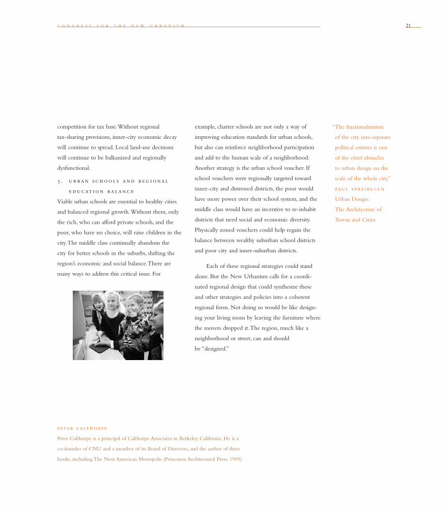
5 . ur ban sc h ool s and r e g i onal
e ducat i on balanc e
Viable urban schools are essential to healthy cities
and balanced regional growth. Without them, only
the rich, who can afford private schools, and the
poor, who have no choice, will raise children in the
city. The middle class continually abandons the
city for better schools in the suburbs, shifting the
region’s economic and social balance. There are
many ways to address this critical issue. For
p et e r calth orpe
Peter Calthorpe is a principal of Calthorpe Associates in Berkeley, California. He is a
co-founder of CNU and a member of its Board of Directors, and the author of three
books, including The Next American Metropolis (Princeton Architectural Press, 1993).
example, charter schools are not only a way of
improving education standards for urban schools,
but also can reinforce neighborhood participation
and add to the human scale of a neighborhood.
Another strategy is the urban school voucher. If
school vouchers were regionally targeted toward
inner-city and distressed districts, the poor would
have more power over their school system, and the
middle class would have an incentive to re-inhabit
districts that need social and economic diversity.
Physically zoned vouchers could help regain the
balance between wealthy suburban school districts
and poor city and inner-suburban districts.
Each of these regional strategies could stand
alone. But the New Urbanism calls for a coordi-
nated regional design that could synthesize these
and other strategies and policies into a coherent
regional form. Not doing so would be like design-
ing your living room by leaving the furniture where
the movers dropped it. The region, much like a
neighborhood or street, can and should
be “designed.”
“The fractionalization
of the city into separate
political entities is one
of the chief obstacles
to urban design on the
scale of the whole city.”
paul s p r e i r e g e n
Urban Design:
The Architecture of
Towns and Cities
2222 t h e r e g i o n : m e t r o p o l i s , c i t y , a n d t o w n
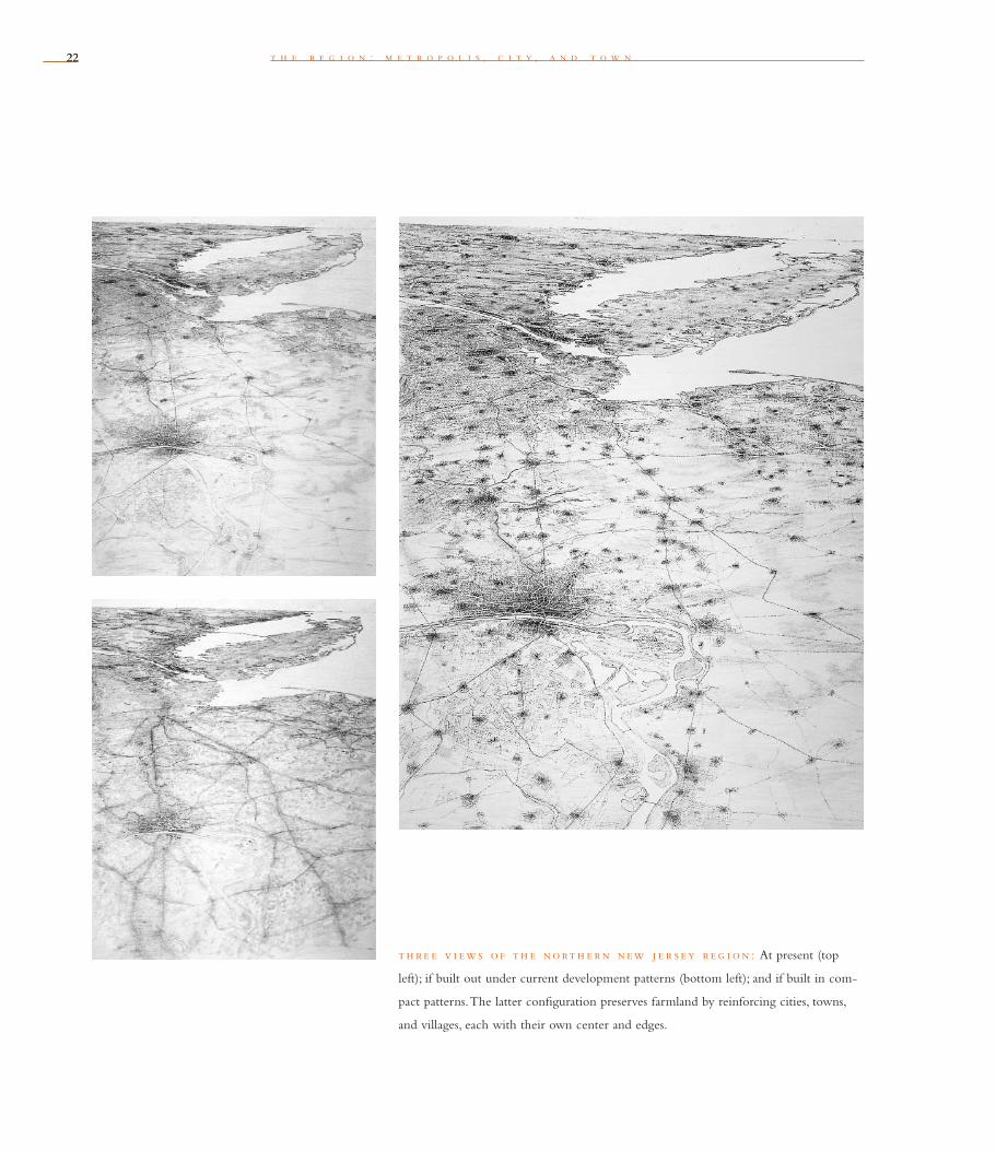
th re e v i ews o f th e north e rn new j e r s ey r e g i on : At present (top
left); if built out under current development patterns (bottom left); and if built in com-
pact patterns. The latter confi guration preserves farmland by reinforcing cities, towns,
and villages, each with their own center and edges.

23
r o b e r t d . y a r o
Metropolitan regions are fi nite places with geographic
boundaries derived from topography, watersheds, coastlines,
farmlands, regional parks, and river basins. The metropolis is
made of multiple centers that are cities, towns, and villages, each
with its own identifi able center and edges.
Tw o
Regionalism — the idea that metropolitan regions are stronger when they harmonize
with their natural environments — is making more sense than ever. By preserving green
space, protecting watersheds, investing in transit, and directing growth toward established
areas, well-planned metropolitan regions are protecting their environmental health.
But they also are bolstering their economic health by providing amenities that
attract entrepre neurial and creative people, particularly in technology and information-
based industries. These people are increasingly “footloose” and will move their homes
and businesses to regions that provide the best quality of life.
Most other U.S. metropolitan regions have rejected — or more correctly, neglect-
ed — the concept that regional attributes are critical to their well-being. But a grow-
ing number of places are rejecting sprawl and instead embracing this type of profi table
regionalism.
One way regions can begin fostering this link between economic and ecological
health is by marshaling a comprehensive plan; one that relates transit needs to vibrant
downtowns, and that employs open space both as a recreational resource and a growth
boundary. As Alexander Garvin observes in The American City: What Works, What
Doesn’t, the comprehensive regional plan “can be a powerful instrument for municipal
improvement.” In recent years, regional planning has become a higher priority still

24 t h e r e g i o n : m e t r o p o l i s , c i t y , a n d t o w n
“To waste, to destroy, our
natural resources, to skin
and exhaust the land
instead of using it so as to
increase its usefulness, will
result in undermining in
the days of our children
the very prosperity which
we ought by right to hand
down to them amplifi ed
and developed.”
th e odore roo s eve lt
message to Congress, 1907
because regions need to meet federal standards for
clean air and transportation. In the early 1990s,
Sacramento, Seattle, and San Diego began preparing
new metropolitan plans and organizing new growth
in compact centers built around planned rail systems.
These initiatives stem in part from the 1990 Clean
Air Act Amendments and the 1991 Intermodal
Surface Transportation Effi ciency Act (ISTEA). Both
pieces of legislation encourage land-use measures
designed to attain clean-air standards.
To begin the pursuit of a regional plan,
regions should fi rst clearly defi ne their own sense
of identity. This is a process that begins as regions
explore and celebrate their own natural, cultural,
and architectural heritage.
We can see how this has evolved in Seattle.
As the Seattle region has matured, it has identifi ed
styles for its architecture and public spaces that
are specifi c to its setting. Many buildings combine
locally harvested materials with Native American,
maritime, industrial, and vernacular designs. The
city has dedicated a major city park, Discovery Park,
as a preserve of the native Puget Sound landscape.
The proposed Mountains-to-Sound Greenway
would connect the spine of the Cascade Mountains
to the east with Puget Sound to the west, protect-
ing historic and natural features along the route.
The regional economy has become identifi ed with
exported products; not just timber, but airplanes,
software, and a gourmet coffee company that has
become ubiquitous. Despite the usual problems
associated with sprawl, an increasing number of
built places in this corner of the Northwest look as
though they belong. Now that the state has provided
the framework of urban growth boundaries (UGBs),
the region is proceeding to the next step. It is
developing planning responses and funding trans-
portation infrastructure that will ultimately preserve
wetlands, prevent fl ooding, and spare distant forests
and mountains the encroachment of urbanization.
h ow to i n i t i ate and p ur sue
a r e g i onal p lan
To succeed in efforts to develop metropolitan plans,
the citizens of a region must begin by registering
broad public concern about threats to natural or
cultural heritage, or to economic prospects. They
must develop a consensus based upon a compelling
and widely shared vision for a better future.
Regional governments are not essential to
implement metropolitan strategies. Yet some form
of regional governance is necessary. This can be
provided by a civic group with powerful business or
community leadership, such as New York’s Regional
Plan Association (RPA), Chicago’s Metropolitan
Planning Council, or Pittsburgh’s Allegheny
Conference. In San Diego, the San Diego County
Association of Governments (SANDAG) has helped
lead an effort to preserve 172,000 acres of critical
wildlife habitat.
Regional service districts, such as New York’s
Palisades Interstate Park Commission, or Boston’s
Massachusetts Water Resources Authority, can
promote sensible planning in the name of protect-
ing a vital resource. In upstate New York, efforts to
protect New York City’s water supply have led to
“Whenever we make
changes in our surround-
ings, we can all too easily
shortchange ourselves. The
way to avoid the danger is
to start doing three things
at once: Make sure that
when we change a place,
the change agreed upon
nurtures our growth as
capable and responsible
people, while also protect-
ing the natural environ-
ment, and developing jobs
and homes enough for all.”
tony h i s s
The Experience of Place

c o n g r e s s f o r t h e n e w u r b a n i s m 25
an agreement between the city and upstate com-
munities to manage growth and protect land in
the watershed. As a result of taking the initiative
to safeguard its water quality, the city is saving
$6 billion — the cost of a new fi ltration plant. In
San Francisco, the Public Utilities Commission
spent more than $2 million and fi ve years on a plan
to manage the 63,000-acre Peninsula and Alameda
watersheds to preserve water quality, but also to
conserve signifi cant buffers to urbanization in
the Bay Area.
Regional planning and governance can
be provided by a regional council, such as the
Minneapolis–St. Paul’s Metropolitan Council, or
by a regional government, such as Portland’s Metro,
created in 1979 as the nation’s fi rst elected metro-
politan government. Regional planning authori-
ties such as the Cape Cod Commission and the
Tahoe Regional Planning Agency (whose authority
straddles the California–Nevada border to include
the entire Lake Tahoe basin) have also taken steps to
integrate the design of urban areas with the preser-
vation of open places.
Successful regions must direct most new
employment and population to compact centers
accessible to regional rail systems. This requires
improving transit networks while proposals for new
or expanded highways are put on hold. Rail systems
should focus on a vibrant 24-hour regional central
business district (CBD), which must also contain
major cultural, educational, governmental, retail,
entertainment, and employment activities; have lively
residential neighborhoods representing all income
levels within or near the CBD; preserve the historic
fabric of these neighborhoods and the CBD; and
provide high-quality public spaces and street life.
Since 1980, cities such as Baltimore, Cleveland,
Denver, Milwaukee, Portland, Seattle, and
Sacramento have formed a nucleus of successful
regions featuring these attributes. That is half the
equation. The other half, only now beginning in
cities like Philadelphia and San Diego, is to defi ne
and protect the open-space systems needed to
create green limits to growth.
rob e rt d . yaro
Robert D. Yaro is executive director of the Regional Plan Association in New York City and
a co-author of Rural By Design: Maintaining Small Town Character (APA Planners Press,
1994)
and A Region at Risk (Island Press, 1996).
“It is thrifty to prepare today
for the wants of tomorrow.”
a e s op
The Ant and the
Grasshopper
a r e g i on at r i sk
Equity
Increasing gap between rich and poor
Improving prosperity for all
A healthy regionalecosystem
Wasteful consumptionof resources
Greensward
Mobility
Centers
Workforce
Governance
Quality of life
Increasedquality of life
Sluggish “boom & bust” growth Vibrant sustainable growth
Environment Equity Environment
EconomyEconomy
a com pet i t i v e r e g i on
26 t h e r e g i o n : m e t r o p o l i s , c i t y , a n d t o w n
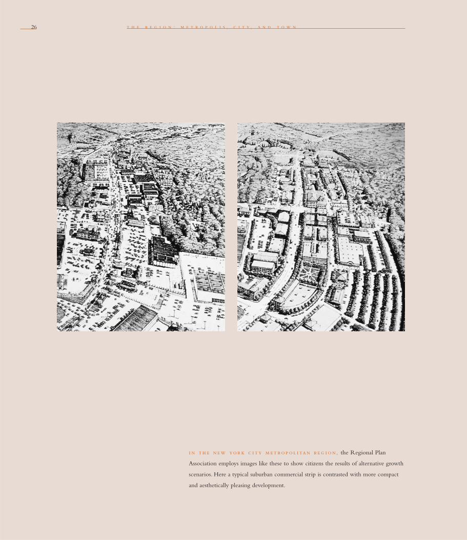
i n th e new yor k c i ty m et rop ol i tan r e g i on, the Regional Plan
Association employs images like these to show citizens the results of alternative growth
scenarios. Here a typical suburban commercial strip is contrasted with more compact
and aesthetically pleasing development.

c o n g r e s s f o r t h e n e w u r b a n i s m 27
Regional Planning: The New York Experience
For more than 75 years, the nonprofi t Regional
Plan Association (RPA) has worked effectively in
the New York–New Jersey–Connecticut metro-
politan region, the nation’s largest. In 1929, RPA’s
landmark Plan for New York (the world’s fi rst
comprehensive metropolitan plan) proposed the
creation of a vast regional park and parkway system.
By 1950 this was largely in place, but postwar
sprawl soon outpaced many of its measures
and benefi ts.
To keep up with the demands posed by Baby
Boom–fueled growth, RPA’s second regional plan
of 1968 proposed major expansion of the region’s
open-space system. It also suggested creating a
network of satellite centers, linked by a revitalized
regional rail system, to accommodate the region’s
rapidly decentralizing population and economy.
As a result of these strategies, paired with
$25 billion to rebuild the rail system, New York
City and the region’s 12 “regional downtowns”
are linked today by modernized transit that carries
more than fi ve million passengers daily, nearly one-
half of total U.S. ridership. These “re-magnetized”
urban centers contain more than half the region’s
jobs, a far higher share than in any other large
U.S. metropolitan area.
Despite these considerable efforts, the rate of
New York–area sprawl is still rising. Since 1965, the
population of metropolitan New York has increased
only 13 percent, but urbanized land swelled by
61 percent. For this reason, A Region at Risk,
RPA’s Third Regional Plan of 1996, aims to regain
a
grip on this region, which comprises three states,
31 counties, and about 2,000 different governments.
The plan calls for a 4-million-acre Metropolitan
Greensward. A network of 11 protected “regional
reserves” would encompass mountains, estuar-
ies, farms, and forests, as well as hundreds of
rural vil lages. A regional greenway system could
link these to “re-greened” urban centers. When
completed, this preserved network of public and
private lands will provide a permanent “green
edge” to growth — a de facto urban growth
boundary — ranging from New York Harbor to the
Appalachian Highlands.
— r o b e r t y a r o

2828 t h e r e g i o n : m e t r o p o l i s , c i t y , a n d t o w n
29
r a n d a l l a r e n d t
The metropolis has a necessary and fragile relationship to its
agrarian hinterland and natural landscapes. The relationship is
environmental, economic, and cultural. Farmland and nature
are as important to the metropolis as the garden is to the house.
T h r e e
In this era of modern agriculture, do efforts to save farmland amount to little more
than a sentimental gesture? The answer is that saving farmland and other agricultural
land remains crucial to the health of metropolitan communities. Despite the onslaught
of sprawl, farms remain a major economic, natural, and social factor near and even
within urban America. Efforts to preserve such agricultural lands are vital to both
the economic and natural balance within many metropolitan regions. Many acres
of productive land can still be saved in a way that has a positive effect on the shape
of development.
One third of all American farms — that’s 640,000 farms — are located in the
nation’s 320 Metropolitan Statistical Areas (MSAs), or areas with at least 50,000 residents.
Covering 159 million acres, these farms account for 20 percent of the country’s har-
vested cropland. In the Northeast, half the farms are in MSAs. In the Pacifi c region, the
proportion is two-thirds. According to American Farmland magazine, farms in metro
areas produce 79 percent of our fruits, 69 percent of our vegetables, and 52 percent
of our milk.
In addition to safeguarding the productivity of these farms, we must conserve the
special relationship between urban areas and their hinterlands. The rural hinterlands
are loosely defi ned as those areas where less than 15 percent of the land has been
developed for “non-resource” purposes, such as suburban development. The hinterlands
provide much more than breathing room for metropolitan areas. More basically, they
“Our farms are in danger
of becoming subdivisions
or shopping malls. We can’t
sit back and take our farms,
and the food they supply,
for granted.”
dan g l i c k man
U.S. Secretary of
Agriculture

t h e r e g i o n : m e t r o p o l i s , c i t y , a n d t o w n30
supply and protect high-quality drinking water.
Cities such as Boston, New York, and San Francisco
realized this early and purchased or set aside vast
acreage of land in their hinterlands for reservoirs
and associated watersheds. The hinterlands also
improve the region’s quality of life and its economic
base by providing opportunities for out-
door recreation and tourism.
Finally, the hinterlands can be the home of
small-scale organic farms, which are compatible
with residential living. These supply fl owers, meat,
and produce to corner groceries, farmers’ markets,
and area restaurants, enlivening these public spaces
with a sense of regional identity and pride.
Between the metropolitan center and the
hinterlands, there exists an intermediate suburban
zone where 15 to 85 percent of the land has been
developed. The band occupied by this intermedi-
ate zone often extends 20 to 40 miles from the
outer edge of the older suburbs to the inner edge
of the rural hinterlands. Even these suburban areas
are sometimes highly productive and should be
pro tected against sprawling development. They
typically contain a signifi cant acreage of farmland
and woodlands, as well as miles of riparian habitat.
Without effective regional growth-management
strategies, both the hinterlands and the intermediate
zone remain vulnerable to future waves of sprawl.
th re e a e r i a l v i ews
of the same landscape.
Today’s view (above left).
After conventional develop-
ment (above right). After
cluster development
(facing page).
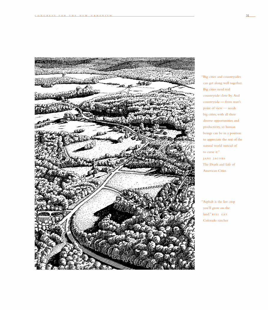
c o n g r e s s f o r t h e n e w u r b a n i s m 31
“Asphalt is the last crop
you’ll grow on the
land.” b i l l gay
Colorado rancher
“Big cities and countrysides
can get along well together.
Big cities need real
country side close by. And
countryside — from man’s
point of view — needs
big cities, with all their
diverse opportunities and
pro ductivity, so human
beings can be in a position
to appreciate the rest of the
natural world instead of
to curse it.”
jane jacob s
The Death and Life of
American Cities

32
randal l are nd t
Randall Arendt is the vice president for conservation planning at the Natural Lands Trust
in Media, Pennsylvania, and the author of Rural By Design (APA Planners Press, 1994),
Growing Greener: Putting Conservation into Local Codes (Island Press, 1999), and The Design
Characteristics of Hamlets, Villages and Traditional Small Town Neighborhoods (APA Planning
In recent years, many techniques have been devel-
oped to preserve open lands. Most are designed
to compensate landowners who might otherwise
sell their land for development. These techniques
include urban growth boundaries (UGBs), transfer
of development rights (TDRs), purchase of devel-
opment rights (PDRs), right-to-farm laws, and
the establishment of land trusts or of organizations
that accept donations of conservation easements.
In any given community, these special com pen-
satory mechanisms might protect a few parcels of
open space. Yet society’s ability to conserve
more land is crippled by existing suburban zoning
densities. These typically range from one-half acre
to fi ve acres per dwelling. No land- conservation
efforts will be effective unless the basic ground-
work — the zoning regulations — are changed.
Rezoning to preserve rural resources and
uses involves two strategies. They work best when
paired. The fi rst strategy is to adjust zoning to cre-
ate minimum tract sizes large enough to support
farming and ranching. The minimum amount of
land needed to farm or ranch varies dramatically. In
the Pacifi c Northwest, with wet climate and rich
soils, fi ve acres can support a farm. In the temper-
ate Northeast, one can profi t from a celery farm of
about 20 acres. The ranches of the arid West require
much larger parcels running into thousands of acres.
t h e r e g i o n : m e t r o p o l i s , c i t y , a n d t o w n
“Town and country must
be married, and out of
this joyous union will
spring a new hope, a new
life, a new civilization.” e b -
e ne z e r h oward
The other strategy involves creating urban-
design regulations and incentives that cluster devel-
opment onto a much smaller portion of a parcel
than would otherwise be occupied. This technique
is sometimes called conservation subdivision design.
Such clustering will not prevent development from
becoming dispersed. However, in concert with
planning to identify important lands to conserve,
this strategy can reserve as much as 70 percent of
developable land as open space. With advanced
planning, these pieces of land can be knit together
into a greenbelt or open-space network.
Under conventional development scenarios,
the fi rst 5 percent of development often ruins
50 percent of the countryside. If you take a small
amount of development, even just three buildings,
and put them in the middle of a farm fi eld,
you effectively destroy the fi eld. If you put these
buildings at the edge of the fi eld, or behind some
trees, you can preserve the character and the
function of that landscape.
We should embrace these imaginative ways to
accommodate inevitable growth. The alternative is
too dismal to contemplate: letting development take
the course of least resistance, through a framework
of conventional codes that will produce endless
acres of low-density sprawl, each proposed and
approved independently, and eventually spreading
over mile after square mile of countryside.

c o n g r e s s f o r t h e n e w u r b a n i s m 33
an ag r i c ultural com mun i ty i n newton, utah (top), built on a tight
grid, preserves farmland. Under conventional development scenarios (bottom), the
fi rst 5 percent of development can ruin 50 percent of the landscape. Even just three
buildings placed in the middle of a farm fi eld effectively destroys the fi eld.
34
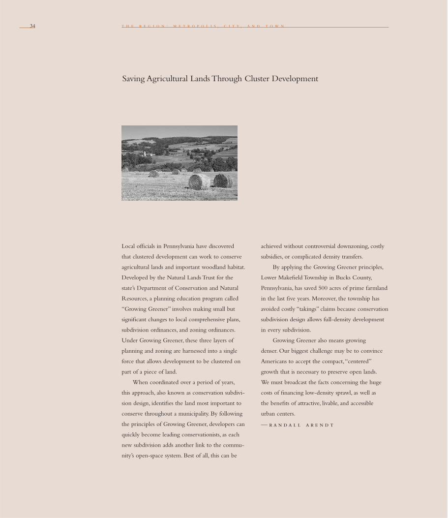
Saving Agricultural Lands Through Cluster Development
t h e r e g i o n : m e t r o p o l i s , c i t y , a n d t o w n
Local offi cials in Pennsylvania have discovered
that clustered development can work to conserve
agricultural lands and important woodland habitat.
Developed by the Natural Lands Trust for the
state’s Department of Conservation and Natural
Resources, a planning education program called
“Growing Greener” involves making small but
signifi cant changes to local comprehensive plans,
subdivision ordinances, and zoning ordinances.
Under Growing Greener, these three layers of
planning and zoning are harnessed into a single
force that allows development to be clustered on
part of a piece of land.
When coordinated over a period of years,
this approach, also known as conservation subdivi-
sion design, identifi es the land most important to
conserve throughout a municipality. By following
the principles of Growing Greener, developers can
quickly become leading conservationists, as each
new subdivision adds another link to the commu-
nity’s open-space system. Best of all, this can be
achieved without controversial downzoning, costly
subsidies, or complicated density transfers.
By applying the Growing Greener principles,
Lower Makefi eld Township in Bucks County,
Pennsylvania, has saved 500 acres of prime farmland
in the last fi ve years. Moreover, the township has
avoided costly “takings” claims because conservation
subdivision design allows full-density development
in every subdivision.
Growing Greener also means growing
denser. Our biggest challenge may be to convince
Americans to accept the compact, “centered”
growth that is necessary to preserve open lands.
We must broadcast the facts concerning the huge
costs of fi nancing low-density sprawl, as well as
the benefi ts of attractive, livable, and accessible
urban centers.
— r a n d a l l a r e n d t

35
j a c k y g r i m s h a w
Development patterns should not blur or eradicate the edges
of the metropolis. Infi ll development within existing areas
conserves environmental resources, economic investment, and
social fabric, while reclaiming marginal and abandoned areas.
Metropolitan regions should develop strategies to encourage
such infi ll development over peripheral expansion.
F o u r
Only a few metropolitan regions have been able to grapple with growth and suburban
sprawl by forming effective regional governments. But numerous other regions are
fi nding that grass-roots efforts — led by citizens, civic organizations, environmental
groups, and churches, frequently in coalitions — can work toward regional planning
goals that focus on reviving city centers as a strategy to curtail sprawl.
The New Urbanism is a key element of this approach. I learned of the
New Urbanism in 1992 when my organization, the Chicago-based Center for
Neighborhood Technology (CNT), was assisting residents of the West Garfi eld Park
community along the city’s Lake Street elevated train. Our goal was to convince
the Chicago Transit Authority to rehab rather than demolish the deteriorating line.
Running from Oak Park in the western suburbs, through the Loop, the Lake Street
“El” was privately built in 1890. Publicly owned since 1947, it had faced declining rid-
ership and station closings since then. It appeared to be redundant because another line
ran parallel a few miles away. Sometimes you could walk downtown faster because its
track was plagued by “slow zones” that also posed safety problems. Although fewer than
half of the households in West Garfi eld had access to a car, only 6 percent of residents
commuted to work on the Lake Street El. The Transit Authority was naturally reluctant
to spend the $400 million required for repairs. At the same time, the West Garfi eld Park
community was up in arms about the prospect of losing the line and its

36 t h e r e g i o n : m e t r o p o l i s , c i t y , a n d t o w n
Pulaski station, but realized that some brilliant
solution was needed to save it.
Then we discovered the New Urbanist con-
cept of transit-oriented development (TOD).
This involves zoning the areas around transit
stations — too often wasted on surface parking
lots — for
compact development that provides services for the
neighborhood and for commuters. This was a new
idea at the time. The only other central-city appli-
cation of these transit-oriented design principles
was at the Fruitvale station of Bay Area Rapid
Transit (BART) in Oakland, California. In Chicago,
we quickly recognized the opportunity to revitalize
transit and a neighborhood simultaneously.
The challenge was to make this sort of public
and private investment appealing within a low-
income neighborhood. Between 1950 and 1990,
the population of West Garfi eld Park dropped from
60,000 to 24,000. This was once a thriving indus-
trial area. But many of the industries, including
Schwinn Bicycle, had moved away. The residential
blocks on side streets were pocked with vacant lots.
Forty percent of the land around the Pulaski
station was vacant. The neighborhood did host
a regional shopping area, but it lacked such basic
services as a grocery store and a family restaurant.
Nevertheless, 118,000 people — the population of
a small city — still lived within a half-mile of the
Pulaski station.
To address these issues, CNT and Douglas Farr,
a CNU-member architect, led a community plan-
ning charrette. Through a partnership among the
city, the Transit Authority, and a coalition of com-
munity activists, funds became available through the
federal Intermodal Surface Transportation Effi ciency
Act (ISTEA) for other planning. Under what came
to be called the Community Green Line Initiative,
the Transit Authority agreed not only to rebuild
the line, but to build a new station with room for a
day-care center and other privately run neighbor-
hood services. The City declared a redevelopment
area aimed to attract neighborhood services within
a quarter-mile around the Pulaski transit stop.
In 1994, the line was closed for reconstruc-
tion. Consolidated with another line and renamed
the Green Line, it reopened in 1996 and is just
beginning to surpass its former level of ridership.
new deve lop m e nt
p rop o s e d around
c h i cag o ’s ‘‘g r e e n
l i ne ’’ (below) will bring
services into a decaying
neighborhood while revi-
talizing transit. The transit
connection helps people
decrease their spending on
cars and thus frees income
for housing. Special mort-
gage packages are helping
homebuyers who have
access to transit qualify
for larger loans.
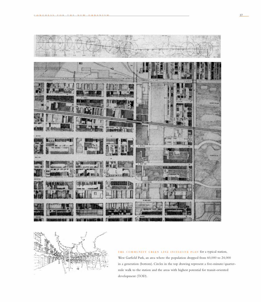
c o n g r e s s f o r t h e n e w u r b a n i s m 37
th e com mun i ty g re e n l i ne i n i t i at iv e p lan for a typical station,
West Garfi eld Park, an area where the population dropped from 60,000 to 24,000
in a generation (bottom). Circles in the top drawing represent a fi ve-minute/quarter-
mile walk to the station and the areas with highest potential for transit-oriented
development (TOD).
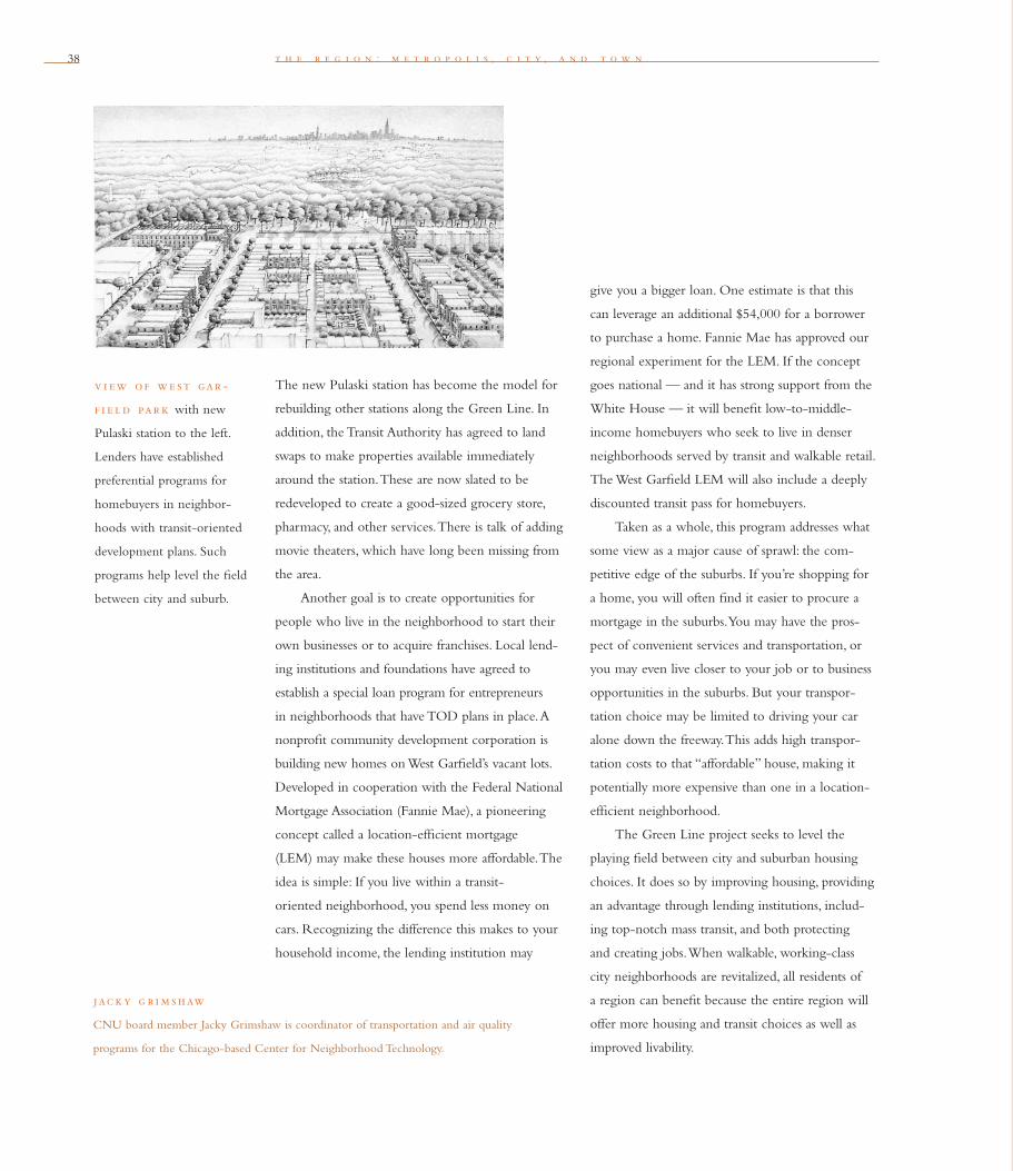
38 t h e r e g i o n : m e t r o p o l i s , c i t y , a n d t o w n
The new Pulaski station has become the model for
rebuilding other stations along the Green Line. In
addition, the Transit Authority has agreed to land
swaps to make properties available immediately
around the station. These are now slated to be
redeveloped to create a good-sized grocery store,
pharmacy, and other services. There is talk of adding
movie theaters, which have long been missing from
the area.
Another goal is to create opportunities for
people who live in the neighborhood to start their
own businesses or to acquire franchises. Local lend-
ing institutions and foundations have agreed to
establish a special loan program for entrepreneurs
in neighborhoods that have TOD plans in place. A
nonprofi t community development corporation is
building new homes on West Garfi eld’s vacant lots.
Developed in cooperation with the Federal National
Mortgage Association (Fannie Mae), a pioneering
concept called a location-effi cient mortgage
(LEM) may make these houses more affordable. The
idea is simple: If you live within a transit-
oriented neighborhood, you spend less money on
cars. Recognizing the difference this makes to your
household income, the lending institution may
give you a bigger loan. One estimate is that this
can leverage an additional $54,000 for a borrower
to purchase a home. Fannie Mae has approved our
regional experiment for the LEM. If the concept
goes national — and it has strong support from the
White House — it will benefi t low-to-middle-
income homebuyers who seek to live in denser
neighborhoods served by transit and walkable retail.
The West Garfi eld LEM will also include a deeply
discounted transit pass for homebuyers.
Taken as a whole, this program addresses what
some view as a major cause of sprawl: the com-
petitive edge of the suburbs. If you’re shopping for
a home, you will often fi nd it easier to procure a
mortgage in the suburbs. You may have the pros-
pect of convenient services and transportation, or
you may even live closer to your job or to business
opportunities in the suburbs. But your transpor-
tation choice may be limited to driving your car
alone down the freeway. This adds high transpor-
tation costs to that “affordable” house, making it
potentially more expensive than one in a location-
effi cient neighborhood.
The Green Line project seeks to level the
playing fi eld between city and suburban housing
choices. It does so by improving housing, providing
an advantage through lending institutions, includ-
ing top-notch mass transit, and both protecting
and creating jobs. When walkable, working-class
city neighborhoods are revitalized, all residents of
a region can benefi t because the entire region will
offer more housing and transit choices as well as
improved livability.
jac k y g r i m shaw
CNU board member Jacky Grimshaw is coordinator of transportation and air quality
programs for the Chicago-based Center for Neighborhood Technology.
v i ew of we st gar -
f i e l d par k with new
Pulaski station to the left.
Lenders have established
preferential programs for
homebuyers in neighbor-
hoods with transit-oriented
development plans. Such
programs help level the fi eld
between city and suburb.

c o n g r e s s f o r t h e n e w u r b a n i s m 39
Odd Bedfellows Make Strong Coalitions in Chicago
In the Chicago region, citizen groups are
transcending municipal lines to develop the type
of regional strategies that fractured governments
can’t achieve. Among them:
One coalition seeks to stop major toll-road
expansions because these new roads are catalysts
for urban disinvestment and sprawl. This group is
composed of the Environmental Law and Policy
Center of the Midwest, Business and Professional
People for the Public Interest, the American Lung
Association, the Chicagoland Bicycle Federation,
the Illinois Chapter of the Sierra Club, and the
Center for Neighborhood Technology.
The disparities caused by sprawl are not only
being challenged by nonprofi ts and citizen groups.
The Commercial Club of Chicago is sponsoring
the Metropolis Project — a new Burnham plan for
the 21st century. This plan, Preparing Metropolitan
Chicago for the 21st Century, embodies New
Urbanist principles as it seeks to address issues of
poverty, housing, transportation, pollution, race, and
jobs.
In addition, the faith-based Metropolitan
Alliance of Congregations is educating citizen
leaders and congregations in Cook and Will coun-
ties about the social, economic, and environmental
conditions in the region, and telling them how to
infl uence decision makers regarding land use and
transportation planning.
In the area of housing development and
poli cies, groups as diverse as the Metropolitan
Planning Council, the Commercial Club, the
Leadership Council for Metropolitan Open
Communities, Regional Action Project 2000+,
the Chicago Rehab Network, and dozens of com-
munity development corporations understand the
problems caused by the mismatch between housing
and jobs. They are doing everything from promot-
ing federal public-housing reform to focusing on
dispersing the isolated,
high-density pockets of poverty by creating mixed-
income communities.
A citizen group called the Chicagoland
Transportation and Air Quality Commission created
the Citizen Transportation Plan for Northeastern
Illinois — The $650 Billion Decision. This long-
range transportation plan lays out a policy and plan-
ning
framework for transportation decisions for the
next 25 years. The plan also advocates infi ll projects
and redevelopment in existing communities, strong
farmland protection policies, transit-oriented
development, and the redevelopment of industrial
brownfi elds.
The group of citizens who helped craft the
transportation vision understood that the continued
disinvestment in the city and inner suburbs creates
pressures to develop farmland in other parts of the
region. The Citizen Plan has now been endorsed
by 139 organizations and municipalities. If imple-
mented, it would begin to moderate sprawl.
— j a c k y g r i m s h a w

40
Why Cities Matter to New Urbanism
I was drawn to the principles of New Urbanism
upon hearing about them in 1993. The use of the
word “new” affi xed to “urbanism” suggested fresh-
ness, vitality, and energy. The concepts of livability,
sustainability, small-scale neighborhood develop-
ment, walkability, and more intense utilization of
public transportation were appealing to someone
like me, who had spent decades fi ghting sprawl.
But I am also a lover of “old urbanism,” a child
of the city. I have spent my entire adult life working
in the core city, where development patterns already
exist. I grew up in a working-class neighborhood
with sidewalks, front porches, and stickball in the
street. Today I live within two blocks of
my offi ce, and walk to restaurants and go to pop
concerts a few blocks away.
My fascination with New Urbanism has as
much to do with my reaction to the so-called
decline of cities, which has been reinforced in the
media’s negative perceptions of the urban core
in the last 30 to 40 years. To many people, urban
means poor folk, too many minorities, crime, drugs,
and unstable families. It means overcrowding, traffi c
jams, limited open space, and substandard schools
and facilities. It means political confusion, aban-
doned shopping centers, and even abandoned
neighborhoods.
Yet cities have tremendous assets that are often
overlooked. They are the home of great medical
centers, colleges and universities, cultural facilities,
government buildings, employment centers, and
the basic infrastructure of streets, utilities, and pub-
lic transportation—not to mention the wonderful
diversity of people that refl ects what America is
all about.
These resources are struggling against the
forces that draw people and investment away from
the core. The result has been a tremendous fl ight of
middle Americans chasing the “American Dream,”
coupled with meaningless municipal boundaries
that have not only accelerated physical abandon-
ment, but also isolated core cities, socially and
politically. There are some notable successes, such as
Portland, Seattle, Denver, Milwaukee, Charlotte,
and Charleston. Even in these cities there are still
at-risk neighborhoods with complex social and
physical conditions.
t h e r e g i o n : m e t r o p o l i s , c i t y , a n d t o w n
can phys i cal de s i g n
ove rcom e p rob -
l e m s o f th e c i ty ?
Computer-generated photo-
montage shows proposed
streetscape improvements
around the historic Fox
movie palace in downtown
Oakland, California. Cyber-
improvements include new
street trees, lighting, bus
lanes, and infi ll buildings.
c o n g r e s s f o r t h e n e w u r b a n i s m 41
There is a real challenge here for New
Urbanism. If the goal of the New Urbanism is
to rekindle the American Dream (admittedly an
ephemeral and spiritual goal) by building settle-
ments that encourage community, livability, con-
venience, decent housing, and preservation of
the environment, then a signifi cant thrust of this
movement must focus on the existing core city.
This especially means infi ll development of at-risk
neighborhoods, whether in urban or fi rst-ring
suburban areas.
The Congress for the New Urbanism has the
brainpower, resources, values, and design principles
necessary to meet the challenge of infi ll, core city
development. But there are challenges we need to
address fi rst:
The initial problems are not always a matter of
physical design. They involve investment patterns,
job security, school quality, racial discrimination,
and the political complexities that produce tangled
bureaucracies and ineffective zoning. We must rec-
ognize that working in the inner city does not lend
itself to quick-fi x solutions. It may require years of
work to change something like bad zoning laws. I
have seen at-risk neighborhoods in Charlotte begin
to turn around with nothing more than better
police patrol, better newspaper coverage, a neighbor-
hood watch program, or a new elementary school
principal.
We must think incrementally — street by
street, block by block, neighborhood by neighbor-
hood. Sometimes it may be a simple improvement
like a mini-park, a reformed slum landlord making
improvements to his property, or an adaptive reuse
of an abandoned shopping center. We must have the
patience to see these incremental actions as a posi-
tive catalyst. The question is whether we commit to
the long-term involvement required.
We should not assume we will be trusted in
the inner city. We must ask whether we are prepared
as architects, urban designers, and planners to work
at gaining credibility with neighborhood activists,
politicians, and the community. Often, we are seen
as the enemy —we helped build the freeways that
facilitated the exodus, we built the regional malls,
we built suburbia.
Are we prepared to measure success in a dif-
ferent way? As important as physical renewal and
revitalization is, the real success of revitalizing the
old involves human dynamics. Do people feel like
they are part of a place or a community? Has crime
decreased measurably? Are children becoming bet-
ter educated? Does the promise of the American
Dream seem real to more people?
The New Urbanism has already made a sub-
stantial contribution to the movement to control
urban sprawl. But if we take on the challenges of
infi ll development and help to make revitalized cit-
ies commonplace, we will move this Congress
to a new level.
— h a r v e y g a n t t
harvey gant t
A former mayor of Charlotte, North Carolina, Harvey Gantt is a board member of the
Congress for the New Urbanism. He is an architect and partner in the fi rm of Gantt
Huberman in Charlotte.

4242 t h e r e g i o n : m e t r o p o l i s , c i t y , a n d t o w n
i n th e north we st corr i dor b eyond p e rth , au st ral i a ,
the proposed Jindalee Town would structure new growth into neighbor-
hoods and towns around a rail line.
43
w e n d y m o r r i s
Where appropriate, new development contiguous to urban
boundaries should be organized as neighborhoods and districts,
and be integrated with the existing urban pattern. Noncon tiguous
development should be organized as towns and villages with
their own urban edges, and planned for a jobs/housing balance,
not as bedroom suburbs.
F i v e
As a basis for managing growth within a region, the New Urbanism provides an
excellent framework for weaving new neighborhoods into the urban pattern and for
creating self-contained, mixed-use towns and villages outside the city. In both cases,
it’s critical that we view and plan for the region as a whole.
d i r e c t i ng g rowth i nto c lu ste r i ng ne i g h bor h ood s
Planning new, urban extensions, known in Australia as regional or urban structuring,
involves analyzing the existing urban structure around a site and highlighting town
and neighborhood centers, key regional attractions and destinations, and school and
community facilities. This analysis, combined with an analysis of the proposed growth
area and beyond, allows us to identify existing points of connection, existing and
planned infrastructure, site features, barriers, and long-term urban edges. It addresses
how people go about their daily activities. Where are the neighborhood and town
centers? Where is the public transit system, and how well is it accessed? Are the towns
and neighborhoods well-connected, or are they separated? How does the project site
connect to adjacent and nearby neighborhoods? Are neighborhood centers appropri-
ately distributed, or are they limiting each other’s potential? What factors about local
economies, histories, politics, and jurisdictions could impede a project’s success?

44 t h e r e g i o n : m e t r o p o l i s , c i t y , a n d t o w n
From this analysis, we can design a regional
structure, showing the site and its role in the con-
text of existing and future development. We can
also identify the strengths and weaknesses of the
existing urban structure with the aim of using
new development to help solve problems such
as ineffi cient transit connections.
re g i onal st ruc tur i ng
The key planning goal is to concentrate compatible
residential and work populations within clusters
of walkable neighborhoods to form towns, while
locating less compatible activities, such as heavy
industry or extensive open spaces, in between or
beyond these clusters. The relatively dense and
commercial town centers should be located around
a major public transit interchange or at intersections
of major traffi c routes.
Neighborhood edges should meld seamlessly,
except where natural barriers, large green spaces,
freeways, or other boundaries provide a prominent
edge. It’s important to design with the features of
the land to defi ne urban boundaries and establish
a sense of identity. A ring of green around every
neighborhood isn’t necessary.
If we design beyond the site to an urban
edge — at least to the edge of the outer neighbor-
hoods of a town cluster — we begin to see the
benefi t
of regional planning for infrastructure, especially
for roads and public transit. A similar approach to
regional, town, and neighborhood structuring
can be used for proposed urban areas that have
no connection to existing urban areas.
e m p loym e nt t r e nd s and
job s / h ou s i ng balanc e
New Urbanist communities work well in generating
employment opportunities in our post-industrial
economy of small businesses, home-based businesses,
digitally connected branches of large businesses,
and part-time and multiple employment. To provide
adequate opportunities for business and employ-
ment growth, I believe that as much as 30 percent
of a mixed-use town or neighborhood core should
accommodate different kinds of workplaces. The
core also needs cafes and other services that support
workers, as well as diverse building types with room
for expansion and evolution.
de s i g n i ng ur ban e x pan s i on s
Many New Urbanist projects must be grafted onto
fringes of conventional suburban development, in
areas that have little in the way of services, retail
shops, integrated workplaces, or sense of place. The
new neighborhood creates a center for the existing
residential community, and that community in
turn provides critical early support for the center’s
“A lack of boundary simply
creates a kind of chaotic
environment which none
of us feel very proprietary
towards — neither the
residents nor the rest of
the community nor cer-
tainly outsiders. . . . Making
boundaries is akin to
stabilizing the city so that
its virtues remain across
generations rather than
seeming to be temporary,
not like those houses that
gather feet and go away.
So create edges and bound-
aries. Make them very
strong. They are akin to
making a defi ned under-
standing of the particular
place, activities, techniques
of building and systems
of service. We must not
start with the geometry
but with the user.”
donly n ly ndon
Places
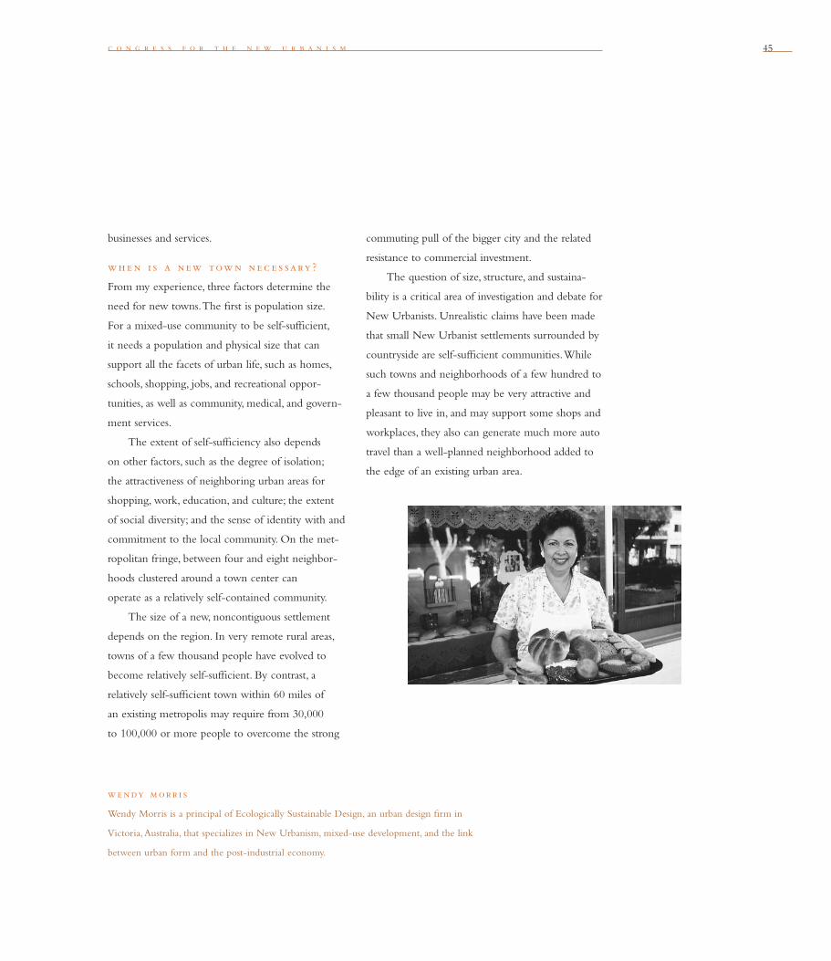
c o n g r e s s f o r t h e n e w u r b a n i s m 45
businesses and services.
wh e n i s a new tow n ne c e s sary ?
From my experience, three factors determine the
need for new towns. The fi rst is population size.
For a mixed-use community to be self-suffi cient,
it needs a population and physical size that can
support all the facets of urban life, such as homes,
schools, shopping, jobs, and recreational oppor-
tunities, as well as community, medical, and govern-
ment services.
The extent of self-suffi ciency also depends
on other factors, such as the degree of isolation;
the attractiveness of neighboring urban areas for
shopping, work, education, and culture; the extent
of social diversity; and the sense of identity with and
commitment to the local community. On the met-
ropolitan fringe, between four and eight neighbor-
hoods clustered around a town center can
operate as a relatively self-contained community.
The size of a new, noncontiguous settlement
depends on the region. In very remote rural areas,
towns of a few thousand people have evolved to
become relatively self-suffi cient. By contrast, a
relatively self-suffi cient town within 60 miles of
an existing metropolis may require from 30,000
to 100,000 or more people to overcome the strong
we ndy morr i s
Wendy Morris is a principal of Ecologically Sustainable Design, an urban design fi rm in
Victoria, Australia, that specializes in New Urbanism, mixed-use development, and the link
between urban form and the post-industrial economy.
commuting pull of the bigger city and the related
resistance to commercial investment.
The question of size, structure, and sustaina-
bility is a critical area of investigation and debate for
New Urbanists. Unrealistic claims have been made
that small New Urbanist settlements surrounded by
countryside are self-suffi cient communities. While
such towns and neighborhoods of a few hundred to
a few thousand people may be very attractive and
pleasant to live in, and may support some shops and
workplaces, they also can generate much more auto
travel than a well-planned neighborhood added to
the edge of an existing urban area.

t h e r e g i o n : m e t r o p o l i s , c i t y , a n d t o w n46
c urre nt 5 year s
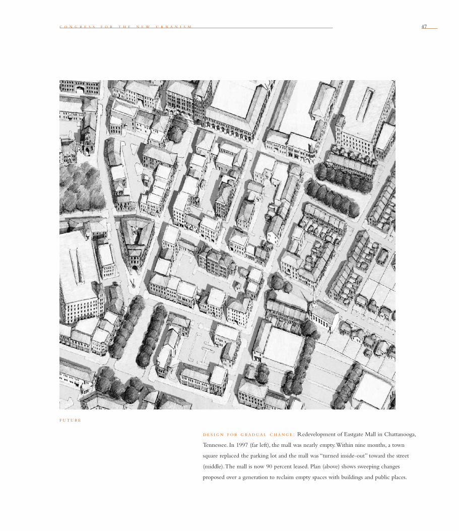
c o n g r e s s f o r t h e n e w u r b a n i s m 47
de s i g n f or g radual c hang e : Redevelopment of Eastgate Mall in Chattanooga,
Tennessee. In 1997 (far left), the mall was nearly empty. Within nine months, a town
square replaced the parking lot and the mall was “turned inside-out” toward the street
(middle). The mall is now 90 percent leased. Plan (above) shows sweeping changes
proposed over a generation to reclaim empty spaces with buildings and public places.
f uture
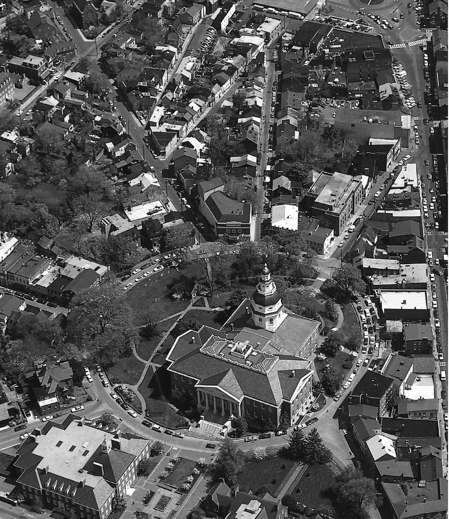

49
s t e p h a n i e b o t h w e l l
The development and redevelopment of towns and cities
should respect historical patterns, precedents, and boundaries.
S i x
In Colonial New England, towns were laid out collectively by the community, and the
boundaries extended only as far as the town meeting bell could be heard. The building
of homes and businesses once was focused around the “heart” of the community —
the town green was its cultural, economic, and spiritual center. From the local hilltop,
people could see their community laid out and could understand it.
Viewed from above, America’s landscape now shows the enormous changes that
human habitation has wrought over hundreds of years. In some places, we can still
recognize the piece that each town and surrounding farmsteads played in shaping the
pattern of that region’s landscape. We can see the natural and manmade boundaries that
meet at the bases of mountains and edges of rivers, and the precedents that give
us bearings within patterns such as street grids and downtown cores.
What is overwhelmingly apparent from this perspective are the breaks with the tra-
ditional historic patterns and precedents of development. They include tears in
the urban fabric — abandoned lots, public housing projects, and “megadevelopments”
created by urban renewal and highways. They also include rends in the wilderness,
where nature has been torn at the edges and patched with development. The suburban
patterns of alternating strip malls and circuitous street systems may be visually seduc-
tive, but they suggest an underlying lack of order, an endlessly repetitive, piecemeal
approach to development.
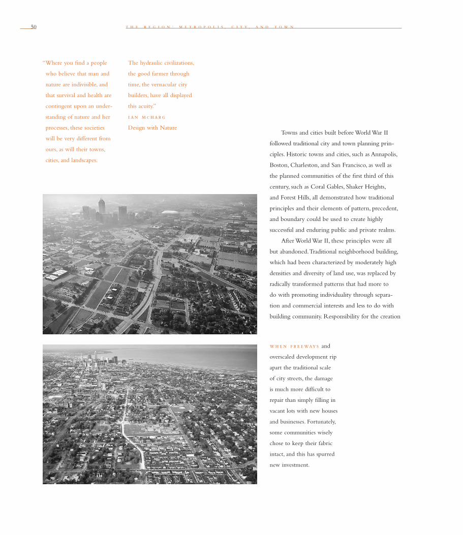
50
“Where you fi nd a people
who believe that man and
nature are indivisible, and
that survival and health are
contingent upon an under-
standing of nature and her
processes, these societies
will be very different from
ours, as will their towns,
cities, and landscapes.
t h e r e g i o n : m e t r o p o l i s , c i t y , a n d t o w n
Towns and cities built before World War II
followed traditional city and town planning prin-
ciples. Historic towns and cities, such as Annapolis,
Boston, Charleston, and San Francisco, as well as
the planned communities of the fi rst third of this
century, such as Coral Gables, Shaker Heights,
and Forest Hills, all demonstrated how traditional
principles and their elements of pattern, precedent,
and boundary could be used to create highly
successful and enduring public and private realms.
After World War II, these principles were all
but abandoned. Traditional neighborhood building,
which had been characterized by moderately high
densities and diversity of land use, was replaced by
radically transformed patterns that had more to
do with promoting individuality through separa-
tion and commercial interests and less to do with
building community. Responsibility for the creation
The hydraulic civilizations,
the good farmer through
time, the vernacular city
builders, have all displayed
this acuity.”
i an m c harg
Design with Nature
wh e n f r e eways and
overscaled development rip
apart the traditional scale
of city streets, the damage
is much more diffi cult to
repair than simply fi lling in
vacant lots with new houses
and businesses. Fortunately,
some communities wisely
chose to keep their fabric
intact, and this has spurred
new investment.
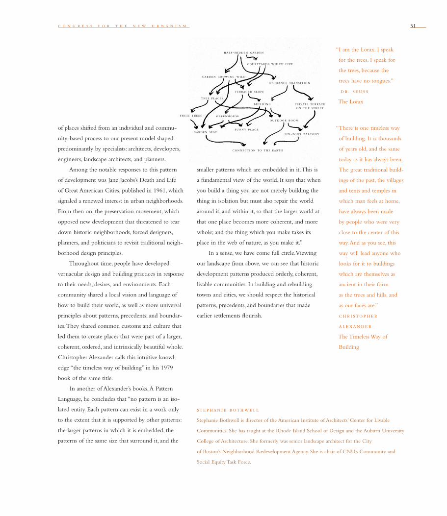
c o n g r e s s f o r t h e n e w u r b a n i s m 51
“There is one timeless way
of building. It is thousands
of years old, and the same
today as it has always been.
The great traditional build-
ings of the past, the villages
and tents and temples in
which man feels at home,
have always been made
by people who were very
close to the center of this
way. And as you see, this
way will lead anyone who
looks for it to buildings
which are themselves as
ancient in their form
as the trees and hills, and
as our faces are.”
c h r i stoph e r
a l e xande r
The Timeless Way of
Building
“I am the Lorax. I speak
for the trees. I speak for
the trees, because the
trees have no tongues.”
dr. s e u s s
The Lorax
st e phan i e both we l l
Stephanie Bothwell is director of the American Institute of Architects’ Center for Livable
Communities. She has taught at the Rhode Island School of Design and the Auburn University
College of Architecture. She formerly was senior landscape architect for the City
of Boston’s Neighborhood Redevelopment Agency. She is chair of CNU’s Community and
Social Equity Task Force.
of places shifted from an individual and commu-
nity-based process to our present model shaped
pre dominantly by specialists: architects, developers,
engineers, landscape architects, and planners.
Among the notable responses to this pattern
of development was Jane Jacobs’s Death and Life
of Great American Cities, published in 1961, which
signaled a renewed interest in urban neighborhoods.
From then on, the preservation movement, which
opposed new development that threatened to tear
down historic neighborhoods, forced designers,
planners, and politicians to revisit traditional neigh-
borhood design principles.
Throughout time, people have developed
vernacular design and building practices in response
to their needs, desires, and environments. Each
community shared a local vision and language of
how to build their world, as well as more universal
principles about patterns, precedents, and boundar-
ies. They shared common customs and culture that
led them to create places that were part of a larger,
coherent, ordered, and intrinsically beautiful whole.
Christopher Alexander calls this intuitive knowl-
edge “the timeless way of building” in his 1979
book of the same title.
In another of Alexander’s books, A Pattern
Language, he concludes that “no pattern is an iso-
lated entity. Each pattern can exist in a work only
to the extent that it is supported by other patterns:
the larger patterns in which it is embedded, the
patterns of the same size that surround it, and the
smaller patterns which are embedded in it. This is
a fundamental view of the world. It says that when
you build a thing you are not merely building the
thing in isolation but must also repair the world
around it, and within it, so that the larger world at
that one place becomes more coherent, and more
whole; and the thing which you make takes its
place in the web of nature, as you make it.”
In a sense, we have come full circle. Viewing
our landscape from above, we can see that historic
development patterns produced orderly, coherent,
livable communities. In building and rebuilding
towns and cities, we should respect the historical
patterns, precedents, and boundaries that made
earlier settlements fl ourish.
half-hidden garden
courtyards which live
entrance transition
private terrace on the street
six-foot balcony
outdoor room
terraced slope
garden growing wild
tree places
fruit tree s
sunny place
greenhouse
garden seat
building
connection to the earth

5252 t h e r e g i o n : m e t r o p o l i s , c i t y , a n d t o w n
i n s outh c e nt ral lo s ang e l e s , Vermont Village Plaza is a new mixed-use
development that includes 36 affordable townhouses. Located amid a blighted three-
mile strip, the project builds upon the stability of a well-kept neighborhood just a few
blocks away.
53
h e n r y r . r i c h m o n d
Cities and towns should bring into proximity a broad spectrum
of public and private uses to support a regional economy that
benefi ts people of all incomes. Affordable housing should be
distributed throughout the region to match job opportunities
and to avoid concentrations of poverty.
S e v e n
America faces two critical housing affordability issues: housing for urban minorities
and housing for the working poor. Both are closely related to this principle’s goal
to break the link between inner-city disinvestment and sprawl. As I will explain,
meeting this goal also can encourage the proliferation of compact, transit-oriented
development.
The fi rst critical issue to address is the provision of housing to end the social
isolation of poor urban minorities. It took 100 years to end slavery in 1865. It took
another 100 years to end segregation sanctioned by law. We are three decades into
America’s third great challenge of racial justice: to create housing policies that will
enable urban minorities to live in areas of metropolitan regions where jobs are grown,
schools are succeeding, and streets are safe. Affording such residential opportunities
is a more effective, durable, and just approach than busing kids across town to school,
operating van pools to get people from the inner city to suburban jobs, or building
more jails and prisons to handle crime in American ghettos.
While middle-class blacks have made enormous housing gains in the past three
decades, progress has been slow for the urban poor. Census data shows that in 1990
there were more black Americans living in urban neighborhoods with poverty rates of
at least 40 percent than there were slaves in 1860. As Congress cuts support for welfare
and housing, and as “minority” populations gradually replace Caucasians over the next
54 t h e r e g i o n : m e t r o p o l i s , c i t y , a n d t o w n
four decades to form the new American majority,
America must create housing opportunities that pro-
vide access to jobs, schools, and safe neighborhoods.
The reasons for doing so, however, go beyond
the need to accord equal opportunity to all
Americans. Breaking down the isolation and con-
centration of poor people of color will advance
economic and environmental goals in which all
Americans have a stake.
The critical second issue is creating housing
for the working poor of any race. More than 5 mil-
lion working households now pay more than half
their household income for housing. This is the
highest level since the Depression. While prosper-
ing seniors have lifted overall home ownership rates
to 65 percent, a three-decade high, home owner-
ship for young people is at a two-decade low. This
is despite low unemployment, low mortgage rates,
easing credit policies, and relaxed downpayment
requirements. One part of this disparity in housing
markets results from municipal zoning that prevents
affordable housing by needlessly adding costs to
housing. Another part stems from government’s fail-
ure to make housing available to working families
through incentives or supports to reduce rent or
mortgage payments.
Not surprisingly, this problem is greatest in
households where incomes have been plummeting
for 25 years: those with incomes at the bottom
20 percent. The next 20 percent have also been
going down, if less sharply. The next 20 percent have
barely held their own. People in the bottom two
quintiles are having real problems buying homes.
Three jurisdictions — one state and two coun-
ties — have succeeded in dealing with these two
housing affordability problems. In each case, efforts
to increase housing affordability in metropolitan
regions have produced major community-wide
benefi ts unrelated to housing. These benefi ts
include reducing development pressure on farm-
land, increasing the feasibility of transit investment,
and improving the climate for investment in the
center of metropolitan regions.
l east co st h ou s i ng
Since the late 1970s, Oregon’s statewide land-use
program has helped the entire Portland region
adopt zoning that creates more affordable hous-
ing. These reform policies were not seeking radical
reform; just movement back toward traditional lot
sizes and mixes of single-family to multi-family and
attached houses. In 1978, the average size of a built
single-family lot in Portland was 5,600 square feet.
However, the average size of a vacant single-family
lot in the region had gradually ballooned to 13,000
square feet. This was partly due to municipalities
seeking to attract larger, more valuable housing as a
tactic to increase their tax base. With land typically
making up 25 percent of the cost of a house, lot
size is important for affordability.
Oregon’s statewide land-use policy for afford-
able housing requires cities to revise their zoning
to refl ect two trends: two decades of fl at or falling
household income for half the population, and
fewer people per household. Between 1978 and
1983, in the 24 cities within the Portland region’s
Urban Growth Boundary (UGB), the average sin-
“One of the most pernicious
results of sprawl has been
the impact on African-
Americans, Latinos, and on
the nation’s race relations.
Urban disinvestment,
white fl ight, and the con-
centration of poverty
and minorities within city
borders may seem like
‘natural’ facts of economic
life — tragic but unavoid-
able. But in fact, the
‘residential apartheid’
that prevails in so many
metropolitan regions
derives from deliberate
policy choices.”
dav i d bol l i e r
How Smart Growth Can
Stop Sprawl
“Any city, however small,
is in fact divided into
two, one the city of
the poor, the other of
the rich; they are at
war with one another.”
p lato
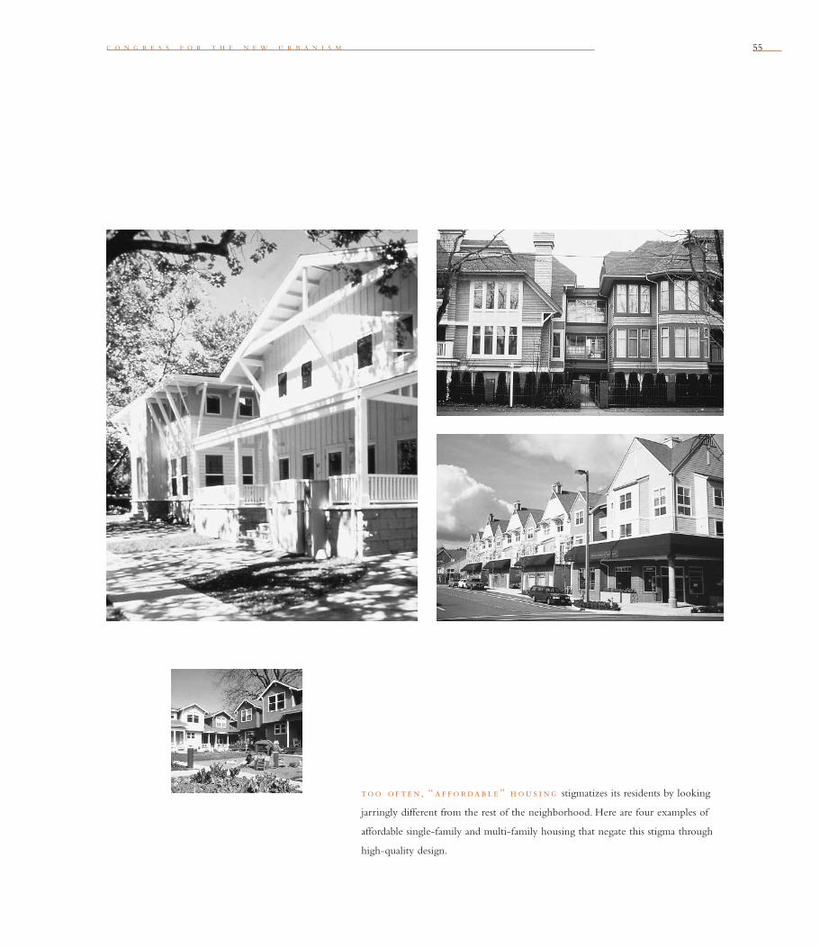
c o n g r e s s f o r t h e n e w u r b a n i s m 55
too o f t e n, “ a f f ordable ” h ou s i ng stigmatizes its residents by looking
jarringly different from the rest of the neighborhood. Here are four examples of
affordable single-family and multi-family housing that negate this stigma through
high-quality design.

56 t h e r e g i o n : m e t r o p o l i s , c i t y , a n d t o w n
gle-family lot size was brought back down to about
8,500 square feet. In addition, the amount of land
zoned for multi-family housing quadrupled from 7
percent of vacant land to 28 percent. On the same
base of vacant, residentially zoned land, 305,000
housing units could be built in 1983, compared to
129,000 in 1978. Adopted in 1998, Portland Metro’s
2040 plan for regional growth brought the average
single-family lot even closer to “normal,”
to about 6,500 square feet. Thus, the Portland
region has become a very effi cient producer of
lots inside the UGB.
These numbers show why the urban growth
boundary that has enclosed this “upzoning” process
since 1979 is a pro-development concept. It has
made possible a nationally unprecedented, metro-
politan-wide deregulation of the housing market.
The higher-density zoning that resulted has benefi t-
ted many interests. The new market-sensitive zoning
increased both affordability for consumers and prof-
itability for developers. It also reduced development
pressure on the urban fringe. More fundamentally,
the urban growth boundary says to Oregon builders
and home buyers, “We’re going to reduce the cost-
boosting interference in residential markets caused
by local zoning.” No leader of any interest group in
the region wants to go back to
the “good old days.”
h ou s i ng a f f ordab i l i ty ac h i eve d
by l i nk s to t ran s i t
When launched in 1979, the Silicon Valley
Manufacturing Group (SVMG) did not seem to
have a land-use agenda. Yet no local organization
in America has brought about more innovative
and important land-use reforms. Its successes dem-
onstrate how local groups can contain and repair
sprawl while emphasizing affordable housing.
SVMG launched this effort by documenting
how government policy — in this case, munici-
pal zoning and taxation — was generating sprawl.
SVMG asked the 15 municipalities in Santa Clara
County for their inventories of vacant land — how
much land was zoned for what class of use, at what
densities, and where. SVMG was surprised that only
a few cities possessed such data — let alone had
mapped it. So SVMG recruited volunteers from its
members and did the work itself. They found short-
ages and surpluses caused by policies. For example,
the most optimistic industry projections foresaw
182,000 new jobs by 2010. However, municipalities
desperate for tax base had zoned enough “indus-
trial” land for 391,000 jobs. Conversely, with hous-
ing costs already affordable
for only a tiny percentage of SVMG’s 225,000
employees in the county, and with 108,000 new
households expected to form by 2010, cities had
zoned enough land to create only 69,000 homes.
SVMG then made a strategic decision to
ground its alternative-to-sprawl vision in mar-
ket reality. SVMG hired a survey fi rm to learn its
employees’ preferences for housing and transporta-
“A February 1999 report
by the U.S. Conference
of Mayors found that 49
percent of all households
in the nation’s cities owned
their homes, compared to
71.5 percent in the suburbs.
The U.S. mayors said that
mortgage lending discrimi-
nation forces many urban
home seekers to move
to the suburbs to pursue
the dream of home
ownership.”
dav i d bol l i e r
How Smart Growth Can
Stop Sprawl

c o n g r e s s f o r t h e n e w u r b a n i s m 57
tion. They found 49 percent were “very or some-
what” interested in smaller or attached houses and
that 65 percent would take rail transit to commute.
But only 14 percent lived within a mile of the
county’s 21 miles of rail line. Current zoning made
these choices impossible.
Given the nature of the problem and the
market preferences, SVMG recommended both
deregulation and new investments. These measures
attracted broad support because they advanced
corporate, employee, and environmental goals.
For example, SVMG proposed rezoning industrial
land to allow medium-density (not high-density),
mixed-use, and transit-oriented new development;
and argued for construction of new rail lines next
to new sites for affordable housing.
With the support of conservation and com-
munity groups, critical decisions made from 1995
to 1997 helped achieve SVMG’s goals. The city of
San Jose adopted an urban growth boundary. Other
cities are rezoning industrial land for affordable,
transit-oriented housing. And voters approved a
county-wide, half-cent sales tax to raise $1.8 billion
to fi nance 77 miles of new light rail.
More than any other factor, these reforms
were due to SVMG’s leadership and in par-
ticular its superb 1995 report, Creating Quality
Neighborhoods: Housing Solutions for Silicon
Valley, which makes it clear that California’s tech-
nology businesses depend upon sound land-use
planning.
sub s i d i z e d h ou s i ng
Least-cost zoning, transit-oriented zoning, and
transit investments can produce signifi cant housing
affordability. However, many people who wish to
work near job-rich communities still cannot afford
housing. This is where subsidies must play a role in
the creation of scatter-site housing, or the dispersal
of affordable housing throughout a community.
Some say racial tensions are too great for
scatter-site housing programs to be politically real-
istic. Wealthy whites, the argument goes, will object
to proposals to build housing designed to allow
poorer people from other races to become their
neighbors. Yet the nation’s most successful subsidized
housing program is in Maryland’s Montgomery
County, a well-to-do, predominantly white,
Washington, D.C. suburb of 750,000. Montgomery
County’s housing program has proved successful
over two decades, even though the county’s minor-
ity population increased, and even though the
county’s program targeted minorities.
Since 1970, housing projects in Montgomery
County with more than 50 units have been
required to provide 15 percent of their units as low-
income and moderately affordable. As of 1998, more
than 10,000 units were built throughout the county.
Of those, two-thirds were sold and one-third were
rented. From 1980 to 1991, the average sale price
for an affordable unit was $69,900, compared to
the county average of about $208,000. More than
60 percent of the buyers of affordable units were
minority members whose household incomes
5858
were $26,400, compared to the county average of
$62,000.
The program succeeds because it includes
bonuses as well as mandates. Instead of assigning
quotas, the county set up a builder-driven, market-
friendly process. The builder says, “The county will
give me a density bonus that will allow me to add
about 22 percent more units to my project, because
I’ve included 15 percent affordable and low-income
units in my project. Where can I do that? Where
is this going to fl y?” The developer pencils it out.
Except for the support from the county, the scatter-
ing of affordable, subsidized housing in Montgomery
County is essentially market-driven.
Montgomery County’s scatter-site housing pro-
gram benefi ts everyone in the county, not just the
people in the new houses. First, avoiding concentra-
tions of poverty helps attain educational goals for the
poor by providing new opportunities. For example,
the drop-out rate in Montgomery County’s schools
is only 2 percent a year—one-third the national
average, and one-sixth the center-city average.
In addition, deconcentrating poverty —that
is, enabling the tiny percentage of poorer, minor-
ity households county-wide to live among the vast
extent of middle-class neighborhoods —helps save
the county’s farmland. Why? Because concentrations
of poverty repel private investment from the inner
city and inner suburbs. Such concentrations are
thus one of the most powerful forces pushing
new development out from the centers of regions.
Reducing this anti-investment force —by creating
opportunities for housing in all parts of the region
— reduces pressure for sprawl at the edge and
helps restore investment feasibility at the center.
What if all of America had used Montgomery
County’s technique for the last 20 years? Private
developers in the U.S. build about 1.5 million hous-
ing units a year. Add to that 1.5 million the 50,000
units built by nonprofi ts, community development
corporations, and the public housing authorities.
If Montgomery County’s policies had been used,
America would have created about 5 million afford-
able housing units in 20 years, an amount equal to
the 5 million households now paying
more than half their income for housing.
These successes in Oregon, Silicon Valley, and
Montgomery County demonstrate that the prin-
ciples of New Urbanism can effectively address the
nation’s most daunting social problems. Focusing
on a regional perspective, relaxing outmoded zon-
ing restrictions, and investing in transit and UGBs
ensures that choice-giving development patterns
have a chance. The CNU Charter provides a
valuable guide to all American citizens concerned
with metropolitan land-use reform.
t h e r e g i o n : m e t r o p o l i s , c i t y , a n d t o w n
“The world we have
created today as a result
of our thinking thus far
has problems which can-
not be solved by thinking
the way we thought
when we created them.”
a l b e rt e i n st e i n
h e nry r . r i c h mond
A former board member of the CNU, Henry R. Richmond founded 1000 Friends of Oregon
in the 1970s and was its executive director through 1993. In 1989 he founded the National
Growth Management Leadership Project, a coalition of organizations from 24 states. He is
now the executive director of the American Land Institute in Portland, Oregon.
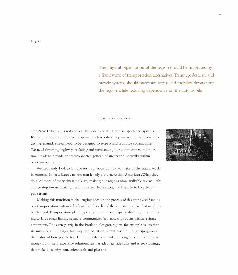
59
g . b . a r r i n g t o n
The physical organization of the region should be supported by
a framework of transportation alternatives. Transit, pedestrian, and
bicycle systems should maximize access and mobility through out
the region while reducing dependence on the automobile.
E i g h t
The New Urbanism is not anti-car. It’s about civilizing our transportation systems.
It’s about rewarding the typical trip — which is a short trip — by offering choices for
getting around. Streets need to be designed to respect and reinforce communities.
We need fewer big highways isolating and surrounding our communities, and more
small roads to provide an interconnected pattern of streets and sidewalks within
our communities.
We frequently look to Europe for inspiration on how to make public transit work
in America. In fact, Europeans use transit only a bit more than Americans. What they
do a lot more of every day is walk. By making our regions more walkable, we will take
a huge step toward making them more livable, drivable, and friendly to bicycles and
pedestrians.
Making this transition is challenging because the process of designing and funding
our transportation system is backwards. It’s a relic of the interstate system that needs to
be changed. Transportation planning today rewards long trips by directing most fund-
ing to large roads linking separate communities. Yet most trips occur within a single
community. The average trip in the Portland, Oregon, region, for example, is less than
six miles long. Building a highway transportation system based on long trips ignores
the reality of how people travel and exacerbates sprawl and congestion. It also diverts
money from the inexpensive solutions, such as adequate sidewalks and street crossings,
that make local trips convenient, safe, and pleasant.
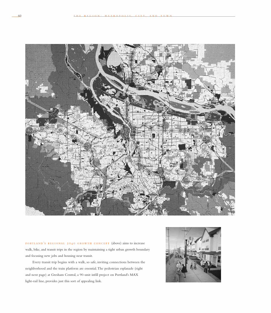
t h e r e g i o n : m e t r o p o l i s , c i t y , a n d t o w n60
p ort land ’s r e g i onal 2 0 4 0 g rowth conc e p t (above) aims to increase
walk, bike, and transit trips in the region by maintaining a tight urban growth boundary
and focusing new jobs and housing near transit.
Every transit trip begins with a walk, so safe, inviting connections between the
neighborhood and the train platform are essential. The pedestrian esplanade (right
and next page) at Gresham Central, a 90-unit infi ll project on Portland’s MAX
light-rail line, provides just this sort of appealing link.
c o n g r e s s f o r t h e n e w u r b a n i s m 61
Reaching solutions requires basic changes in
how we plan for and fi nance transpor tation. We
dedicate more transportation funding to big roads
because they seem to carry the most traffi c. In fact,
our network of small roads, if you add up all the
traffi c, carries more cars than the big interstates.
Short trips make up most total travel each day. If we
paid attention to where people want to go instead
of what is easy to count, we would shift
our attention and our transportation resources
to the short trip.
For centuries the short trip dictated how cities
were organized and developed. We have only moved
away from this model in the past 50 years. Short
trips remain the mother’s milk of healthy commu-
nities. Places where kids bike to school, neighbors
walk to the local store, and everyone carpools to
soccer practice are places that work.
The roads we build have a huge effect on how
much we travel. People who live in areas that con-
tain a tight grid of streets and a mixture of land uses
walk more, use transit more, and take half as many
automobile trips compared to those who
live in typical outer-edge suburbs. Interestingly, the
more urban group drives less, but they take more
total trips, including lots of short walks.
There is no transportation rule that says you
have to sacrifi ce the community to serve it. In the
past quarter-century, Portland has overhauled its
transportation network to offer abundant choices
for getting around — walking, biking, transit, and
yes, driving. Owing to its small-block street grid,
the city of Portland actually has more streets per
square mile than its suburban neighbors. Places like
Portland emphasize small-scale solutions — improv-
ing sidewalks to encourage the pedestrian, calming
traffi c to return control to neighborhoods and busi-
ness districts, revising transit priorities to give buses
an advantage over the car, and connecting streets so
more of them lead to places rather than dead ends.
In other words, we should design the road system
to serve a variety of needs: to move people; to
encourage compact, transit-oriented development
on adjacent land; and to serve pedestrians, bikes,
transit, and cars.
The suburban landscape is hostile to mobility
by any mode, including the automobile. The rea-
son is that our streets provide so few connections,
and large roads divide places that should be an
easy stroll apart. That’s why we have mind-numb-
ing congestion in the suburbs. Maximizing choice
and mobility in our communities starts with the
pedestrian, because every transit trip begins and
ends with walking. Environments that serve pedes-
trians also work for transit. The most successful
transit stops are surrounded not by parking lots but
by housing and businesses within walking distance.
However, planning for a viable transit system is not
a prerequisite for changing the layout of our com-
munities to make them more walkable. People in
every community walk. We can begin transforming
our communities in increments. One place to start
would be around schools, where improvements
to sidewalks and crossings would allow many more
children to walk. This would make the school
environment safer by reducing traffi c and also
Since adopting a regional
urban growth boundary in
1979, Portland’s population
has grown by 17 percent,
but the urbanized land area
of the region has expanded
by less than 7 percent.
From 1995 to 1997, one
of every four homes built
in the Portland region was
built through redevelopment
and infi ll. During the same
period, the city of Portland
led the region’s cities in
housing starts.
Public transit is not the
transportation of last choice
in Portland. More than
70 percent of the region’s
transit riders have a car
available for the trip.
Unlike any other metro-
politan area in America,
Portland’s transit ridership
is growing faster than the
rate of expansion in service,
population growth, or
vehicle miles traveled.

62 t h e r e g i o n : m e t r o p o l i s , c i t y , a n d t o w n
th e p roc e s s o f t ran s f orm i ng t ran s p ortat i on requires tackling land
use and transportation in new ways. The Round is a $100 million, mixed-use project
being built on the site of a former wastewater treatment plant. Portland’s MAX line
runs right through the center of the site.

c o n g r e s s f o r t h e n e w u r b a n i s m 63
begin to alleviate the parental burden of driving
children everywhere.
While communities should focus more trans-
portation dollars on small-scale solutions, transit
agencies must completely transform their image.
America is not getting on the bus. Transit is losing
its share while offering a product that has changed
very little in 40 years. It is not enough for transit
proponents to point fi ngers at suburban sprawl.
We can’t ask transit to be the metaphorical bridge
to the 21st century while riding a system locked in
the past. Transit needs to appeal both to its existing
market and to new markets. That means re-orienting
the focus of our transit systems to serve travel within
the suburbs as well as to the central city.
For transit to appeal to people in the vast
majority of places in America where growth is
occurring, it should include bus service that people
fi nd just as enticing as rail. Buses need to be faster,
more frequent, more reliable, safer, and more com-
fortable using existing technology. For example,
technology already can provide traffi c signals to
speed the bus trip by turning the signal green by
remote control. Bus transit centers should be as
g. b . arr i ng ton
G. B. Arrington is director of strategic planning for Tri-Met, Portland’s transit operator, and the
chair of CNU’s Transportation Task Force. For more than 20 years, he has played a key role in
the Portland region’s experiment to reinvent the livable community by uniting transportation
and land use.
comfortable as the best rail stations. Printed sched-
ules must be widely and conveniently available.
Low-fl oor buses with high windows offer a better
ride. Small neighborhood buses create transit solu-
tions appropriate to the scale of the neighborhood.
A new technology provides real-time information
at bus stops that informs riders when the next bus
will arrive.
We can begin transforming transportation
by funding more small streets, more connections,
and different, not simply more, transit. But the
transportation formula for livable, vibrant commu-
nities begins by rewarding the short trip and
the pedestrian.
“Ask for the ancient paths
where the good way is;
and walk in it and fi nd
rest for your souls.”
j e r e m i ah 6:16
many p e de st r i an s
are i n a h o st i l e
e nv i ronm e nt (left).
We need fewer big highways
isolating and surrounding
our communities, and more
small roads to provide an
interconnected pattern of
streets and sidewalks within
our communities.

64
Connecting Walkable Communities to Good Health
t h e r e g i o n : m e t r o p o l i s , c i t y , a n d t o w n
We may now be paying for building decades of
auto-centered communities that discourage active
lifestyles and encourage sedentary lifestyles. That
price is a dramatic increase in overweight adults
and children, as well as a huge number of health
problems that stem from inactivity.
At an early age, we teach children that you
need a car to get around. Is the car the issue or
is it the way that we design our communities?
We design them to move vehicles effi ciently, not
people — whether pedestrian or bicycle. People
are viewed as hindrances.
Research suggests that, if provided with
improved sidewalks and bikeways, and better con-
nections for walking and cycling, people will indeed
walk or bike more often. This shift would also
reduce traffi c congestion and improve air quality,
and it could reduce pedestrian injuries and fatalities.
A three-pronged attack on sedentary lifestyles, air
quality, and pedestrian injuries could signifi cantly
improve public health.
Physical activity is the most natural behavior
of humans. Until recent decades, it was a neces-
sary part of survival. But with the advancement of
industry and technology, humans have engineered
the most basic form of behavior out of their lives.
Recent evidence shows that the risks of a sedentary
lifestyle are alarming. Sedentary lifestyles in the U.S.
may be a primary factor in 200,000 deaths caused
by heart disease, cancer, and diabetes each year.
Developments that emphasize mixed land use,
high density, street connectivity, and pedestrian
environments have a positive effect on walking and
bicycling as travel choices. People would register
signifi cant benefi ts if they took two 15-minute
walking or bicycle trips on most days of the week.
In this respect, the built environment and how we
travel play an important role in promoting health.
— r i c h a r d e . k i l l i n g s w o r t h
a n d t o m s c h m i d
Centers for Disease Control and Prevention

65
m y r o n o r f i e l d
Revenues and resources can be shared more cooperatively
among the municipalities and centers within regions to avoid
destructive competition for tax base and to promote rational
coordination of transportation, recreation, public services,
housing, and community institutions.
N i n e
In many regions throughout the United States, the link between local property wealth
and the public services it can support leads to socioeconomic polarization among com-
munities and sprawling, ineffi cient land use. Property tax-base sharing severs this detri-
mental link by equalizing funding for public services. It resolves the mismatch between
growing social needs and shrinking property tax-based resources. Sharing property
taxes undermines local fi scal incentives that support exclusive zoning and sprawl, and
decreases incentives for competition for tax base among communities within a metro-
politan region. It also makes regional land-use policies possible.
New Urbanists believe that public funding to support basic public services — in-
cluding police and fi refi ghters, local roads and sewers, parks, and especially local
schools — should be equal throughout a metropolitan area. People of modest means
shouldn’t have inferior public services because they can’t afford to live in property-
rich communities.
School spending in particular illustrates the need for equity. About half the states
have attempted to achieve equity in school funding. In Minnesota’s school equity sys-
tem, for example, the state provides an equal base amount of funding for each student,
which may be supplemented by local districts. But even with this system, the northern,
tax-base poor suburbs of the Twin Cities are still prone to high dropout rates and low col-
lege attendance. This probably results from the combination of less local voluntary
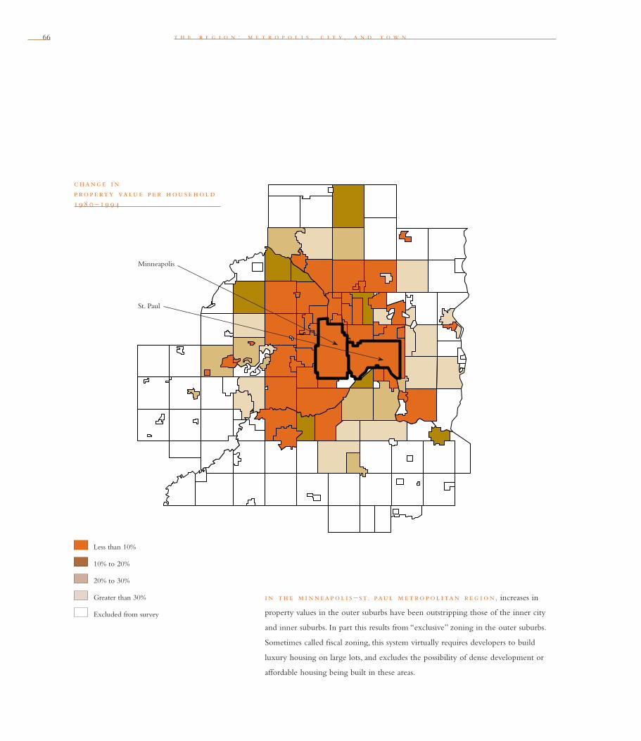
66 t h e r e g i o n : m e t r o p o l i s , c i t y , a n d t o w n
c hang e i n p rope rty value p e r h ou se h ol d 19 8 0 – 19 9 4
Less than 10%
10% to 20%
20% to 30%
Greater than 30%
Excluded from survey
Minneapolis
St. Paul
i n th e m i nneap ol i s – st. paul m et rop ol i tan r e g i on, increases in
property values in the outer suburbs have been outstripping those of the inner city
and inner suburbs. In part this results from “exclusive” zoning in the outer suburbs.
Sometimes called fi scal zoning, this system virtually requires developers to build
luxury housing on large lots, and excludes the possibility of dense development or
affordable housing being built in these areas.

c o n g r e s s f o r t h e n e w u r b a n i s m 67
funding and the increasing challenges of single par-
entage and poverty. The need for equity is especially
critical in the central cities, where local tax bases are
evaporating, and state and federal support for urban
programs is declining.
In almost every part of the United States,
wherever social needs are growing, the tax base is
uncertain or declining; wherever the tax base is
solid, social needs are stable or declining. In the
early 1990s, for example, St. Paul had to raise taxes
dramatically, but as a result of rapidly increasing
social responsibilities, it also had to cut services. At
the same time, dramatic tax-base increases allowed
exclusive suburbs like Minnetonka and Plymouth,
with their small and even declining social needs,
to reduce taxes and maintain high service levels.
Regionalizing the tax base would make public
funds based on property wealth available for grow-
ing social needs throughout the Twin Cities region.
Currently, however, any community that can
increase its tax base and limit its local social respon-
sibilities and costs by exclusive zoning will do so.
On a metropolitan level, the great disparities in tax
base per household explain local fi scal incentives
for exclusionary zoning. Developing communi-
ties, for example, may decide to build only houses
priced above $150,000 that “pay their way.” Because
requiring large lots is one of the only ways to
ensure that expensive houses will be built, low-
density development becomes an intrinsic part of
this “fi scal zoning.” Regional sharing of taxes on
expensive homes, however, would weaken incen-
tives to create exclusive housing markets, and thus
would limit the tendency toward large-lot sprawl.
Besides promoting low-density development
patterns, a fragmented metropolitan tax base fosters
unnecessary movement outward from the city.
This occurs when more new housing is built on
the metropolitan fringe than new households are
formed in the region, and housing vacancies accu-
mulate at the core. Both the push of decline and
fi scal crisis in the urban core community, and the
pull of rapidly growing communities that need
tax base to pay for infrastructure, fuel this type
of sprawl, as new households choose to locate in
relatively problem-free communities.
In the Twin Cities, the exodus from Brooklyn
Center, a declining inner suburb, to Maple Grove,
a growing, exclusively residential suburb, typifi es
these trends. People and businesses pushed out of
fi scally strapped Brooklyn Center are pulled into
Maple Grove on a fi scally fueled housing boom.
As Brooklyn Center declines, the number of poor
children in its schools increases, crime grows, and
residential property values become increasingly
uncertain.
As the push of these factors gains momentum,
residents move into Maple Grove and other north-
western developing suburbs. The Brookdale shop-
ping center, an important part of Brooklyn Center’s
commercial-industrial base, is also in fi nancial trou-
ble. With deteriorating demographics, the shopping
center is losing tenants and customers to a new mall
in Maple Grove. At the same time, the Brookdale
shopping center is becoming a popular hangout
for poor youth. Brooklyn Center thus must
face multiplying social needs with a crippled tax
base and a highly public symbol of decline. The
New middle-income
households in the outer
suburbs are imposing net
public costs of between
$900 and $1,500 annually,
while similar households in
the central city make a net
contribution of between
$600 and $800 a year.
“Thus, locating a household
in the suburbs as opposed
to the central city conse-
quently costs society on net
between $1,500 and $2,300
per year.”
dav i d bol l i e r
How Smart Growth Can
Stop Sprawl
“It’s no longer the ‘enviro
crazies’ who are questioning
sprawl. It’s God-fearing,
red-meat–eating, conser-
vative Republican county
executives and town
supervisors who are saying,
‘Wait a minute. We can’t
afford this anymore.’”
rob e rt yaro
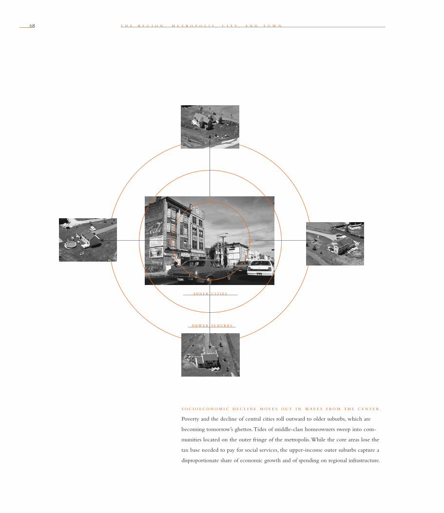
68 t h e r e g i o n : m e t r o p o l i s , c i t y , a n d t o w n
i nne r c i t i e s
newe r subur b s
s oc i oe conom i c de c l i ne move s out i n wave s f rom th e c e nte r.
Poverty and the decline of central cities roll outward to older suburbs, which are
becoming tomorrow’s ghettos. Tides of middle-class homeowners sweep into com-
munities located on the outer fringe of the metropolis. While the core areas lose the
tax base needed to pay for social services, the upper-income outer suburbs capture a
disproportionate share of economic growth and of spending on regional infrastructure.
c o n g r e s s f o r t h e n e w u r b a n i s m 69
community will have to raise taxes or cut services
at the very time good services are most needed to
shore up the city.
As new communities develop, they take on
large debts for the concentrated development of
streets, sewers, parks, and schools. Tremendous pres-
sure builds on these local governments when debt
falls due, and property tax increases seem inevitable,
so they tend to spread their costs by continuing to
grow. This is how tax-base fragmentation encourages
low-density sprawl.
Low-density sprawl also is encouraged by
building communities at densities that can’t be
served by public transit and with infrastructure costs
that the existing tax base can’t sustain. The same
local fi scal pressures that encourage low-density
development to enrich the tax base contribute to
unnecessary low-density sprawl.
Intra-metropolitan competition for tax base
harms the entire region. When cities engage in
bidding wars for businesses that have already chosen
to locate in a region, public moneys are used to
improve one community’s fi scal position and ser-
vices at the expense of another’s. Businesses can
take advantage of this competition to shed social
responsibilities. By threatening to leave, they can
force troubled communities to pay them to stay.
The widespread use of tax-increment fi nancing
(TIF) — which allows cities to compete (some
would say gamble) for tax base, not only with their
own resources but with those of the local school
district, county, and state without the input of
these jurisdictions — has reinforced this trend.
According to many economists, such intra-
metropolitan competition damages the economic
health of the whole region. As trade barriers
recede, and the force of national economies fades,
metropolitan areas become the basic units of global
competition. Suddenly, fragmented groups of
cities, fi ghting among themselves for government
resources and economic development, are thrown
into vigorous world competition against the
powerful metropolitan systems of Western Europe
and Asia (where expenditures for transportation,
telecommunications, and education are coordinated
to all jurisdictions’ economic advantage).
Tax-base sharing eases the fi scal crisis in
declining communities, allowing them to shore up
decline. It also relieves pressure on growing com-
munities to spread local debt costs through growth
and erodes fi scal incentives encouraging low-density
sprawl. As the local property tax base becomes less
dependent on growth, communities can exercise a
regional perspective on land use. They are able to
consider measures that will benefi t the region as a
whole, such as urban growth boundaries, mixed-use
development, greater density, and more effi cient use
of regional infrastructure.
my ron or f i e l d
Myron Orfi eld is the Representative for District 60B in the Minnesota State Legislature. He
is an attorney and the executive director of the Metropolitan Area Research Corporation,
a Minneapolis-based organization that works with 27 metropolitan regions. Orfi eld is the
author of Metropolitics: A Regional Agenda for Community and Stability (Brookings
Institute / Lincoln Institute of Land Policy, 1997).
“The effect of our current
system of taxing buildings
is one of the prime causes
of our affordable housing
crisis. Because it rewards
decay and punishes new,
high-quality construc-
tion close to the center,
almost no new middle-class
housing has been built
since early in the 20th
century. Also, under the
current system, high taxes
on buildings tend to be
shifted to renters. This is
precisely what caused the
perverse conditions at the
end of World War II in
which the rent for Ralph
Kramden’s apartment was
higher than the monthly
mortgage payment of a
house in Levittown, leading
ultimately to the complete
abandonment of the city
by the middle class.”
jam e s h oward
k un st l e r
Home From Nowhere


71c o n g r e s s f o r t h e n e w u r b a n i s m
n e i g h bor h ood, d i st r i c t, and corr i d or
The middle scale of the Charter is the Neighborhood, the District, and the Corridor. New Urbanism at the neighborhood scale updates timeless principles in response to new challenges. These include intro-ducing urbanism to the suburbs, both in building and rebuilding, while respecting the fabric of communities built before World War II. Another challenge is to resolve the confl ict between the fi ne detail of tradi-tional urban environments and the large-scale realities of contemporary institutions and technologies. This is the heart of New Urbanism: the reassertion of fundamental urban design principles at the neighborhood scale and their unique accommodation to the contemporary world. This section also describes an ideal structure for towns and cities.As opposed to the destructive single-use zoning of most contemporary city plans, the New Urbanism proposes a structure of three fundamental elements — neighborhoods, districts, and corridors. Viewing a community as the integration of mixed-use places rather than isolated land uses is a profound change. It provides a planning superstructure that respects

t h e b l o c k , t h e s t r e e t , a n d t h e b u i l d i n g72 n e i g h b o r h o o d , d i s t r i c t , a n d c o r r i d o r72
human scale and community while creating places for larger institutions and infrastructure. New Urbanism does not sidestep the large scale of modern business and retailing; it simply calls for their placement within special districts when they might overwhelm neighborhoods. In complementary essays, Jonathan Barnett and Elizabeth Plater-Zyberk defi ne the need to design regions as aggregations of neighbor-hoods, districts, and corridors. Walter Kulash describes remedies to organize transportation systems in a world of sprawling arterial roads. Marc Weiss introduces HOPE VI, the federal housing program (devised with substantial infl uence from CNU members) that has begun to replace dysfunctional housing projects with mixed-use, mixed-income neighborhoods. The highway-fi ghting mayor of Milwaukee, John Norquist, argues that traditional boulevards and neighborhood streets add value to cities while freeways subtract from them. William Lieberman elaborates on the connection between public transit and dense, pedestrian-oriented neighborhoods, while Elizabeth Moule takes a stand against auto-oriented sprawl in part because of its negative effects on society’s most disenfranchised— the poor, seniors, women, and children. Bill Lennertz charts the connection between thoughtful graphic design codes and mixed-use neighborhoods that achieve and maintain their economic value. Finally, Thomas Comitta recalls how his urban childhood in Pennsylvania was enriched by parks, natural areas, and playing fi elds — and posits how this balance can be restored between neighborhoods and their open spaces.

73
j o n a t h a n b a r n e t t
The neighborhood, the district, and the corridor are the
essential elements of development and redevelopment in the
metropolis. They form identifi able areas that encourage citizens
to take responsibility for their maintenance and evolution.
Te n
th e ne i g h bor h ood
From the study window of my house in Washington, D.C., I can see the elementary
school and schoolyard diagonally across the street. Around me are houses of all shapes
and sizes: some modest bungalows, a street of rowhouses opposite the school, a mix
of bigger two-story dwellings, and — up the hill — some large and expensive new
houses.
Two blocks away on the boulevard, there is a little shopping district with a pizza
place, a video-rental store, several dry-cleaners and beauty shops, a branch post offi ce,
and a newly opened Starbucks. There are two relatively recent four-story offi ce buildings
on the boulevard with shops on their ground fl oors, two small apartment houses, plus
a mix of one- and two-story retail buildings, some with apartments or offi ces upstairs.
Down the hill past the boulevard there are more houses and a community park and
recreation center.
Older cities and suburbs are full of neighborhoods like this. Although they continue
to be good places to live, these types of neighborhoods have almost disappeared from
areas planned after World War II. Instead, most recent urban and suburban developments
are separate tracts of similar houses on similarly sized lots, or groups of apartment tow-
ers or garden apartments. Cars are needed for all transportation, as there are few shops,
jobs, schools, or civic buildings within walking distance of homes, and densities are too
74 n e i g h b o r h o o d , d i s t r i c t , a n d c o r r i d o r
low to support public transportation.
In other words, these newer areas have been
planned only as single-use zoning districts: with
hundreds, and sometimes thousands, of acres all
zoned for the same-sized house, with occasional
pockets of apartments, physically separated from
single-use corridors of commercial development
that is permitted only in narrow strips along
major highways.
In 1929, planner Clarence Perry proposed an
infl uential theory of neighborhood design as part
of the New York City Regional Plan. Perry based
the size of an ideal neighborhood on the number
of families needed to support an elementary school.
He also drew a circle, representing the area covered
within a fi ve-minute walking distance of a central
point, over his diagrammatic plan of the neighbor-
hood — a statement that being able to walk where
you want to go remains important even when
modern transportation is available.
The New Urbanism reaffi rms the neighbor-
hood as the basic building block of all residential
districts. Within the 10-minute walking circle, a
neighborhood includes a mix of different house and
apartment types. Streets make legible con nections
that are easy to walk as well as drive, and there are
neighborhood shops, schools, and civic buildings, all
within walking distance.
th e d i st r i c t
While cities have always had identifi able functional
districts, the practice of using laws to divide cities
into districts for separate uses dates from the intro-
duction of zoning in Germany and the Netherlands
around the turn of the 20th century. Zoning is
now accepted as an essential element of land-use
regulation almost everywhere. There continues to
be agreement that most industries require a separate
district. At the other end of the land-use spectrum,
large parks need to be adjacent to other activities
but separated from them. However, most business
and residential districts require more of a mix of
uses and building types than zoning usually permits.
The New Urbanism proposes a return to the dis-
tricts that include a variety of uses in addition to
their primary activities. For example, all residential
districts should be made up of neighborhoods.
All business districts should include a mix of
shopping, offi ces, and residences. Mizner Park is an
excellent example: a mixed-use residential, offi ce,
and business district (designed by Cooper Carry,
Inc.) created on the site of a failed shopping mall
“Trend is not destiny.”
l ew i s mum f ord
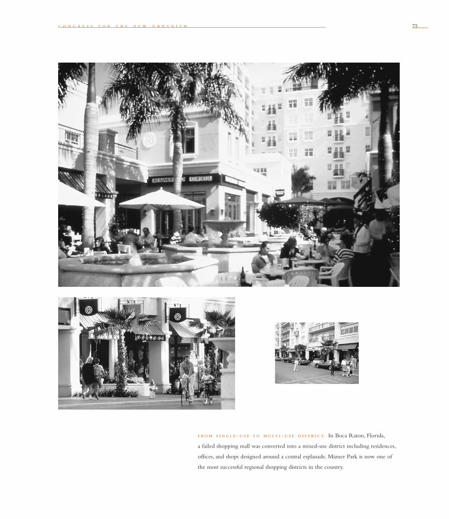
c o n g r e s s f o r t h e n e w u r b a n i s m 75
f rom s i ng le - u s e to mult i - u s e d i st r i c t. In Boca Raton, Florida,
a failed shopping mall was converted into a mixed-use district including residences,
offi ces, and shops designed around a central esplanade. Mizner Park is now one of
the most successful regional shopping districts in the country.
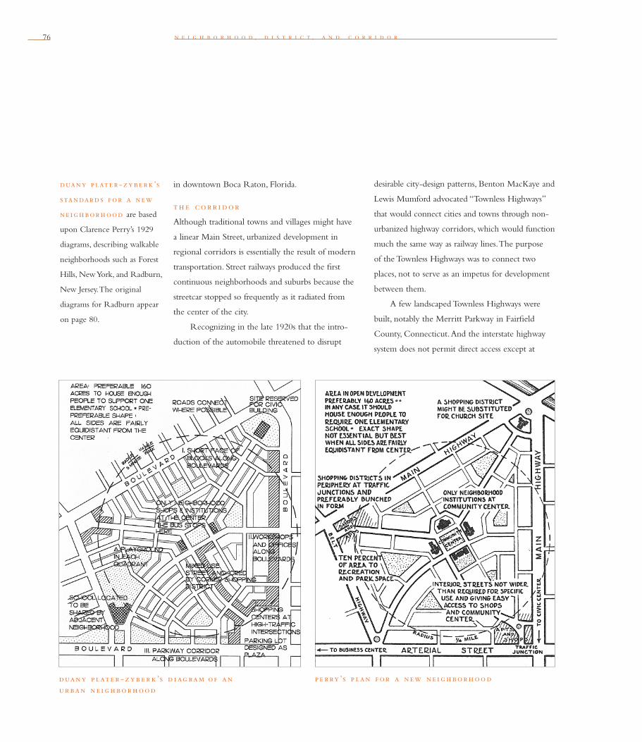
76 n e i g h b o r h o o d , d i s t r i c t , a n d c o r r i d o r
in downtown Boca Raton, Florida.
th e corr i dor
Although traditional towns and villages might have
a linear Main Street, urbanized development in
regional corridors is essentially the result of modern
transportation. Street railways produced the fi rst
continuous neighborhoods and suburbs because the
streetcar stopped so frequently as it radiated from
the center of the city.
Recognizing in the late 1920s that the intro-
duction of the automobile threatened to disrupt
desirable city-design patterns, Benton MacKaye and
Lewis Mumford advocated “Townless Highways”
that would connect cities and towns through non-
urbanized highway corridors, which would function
much the same way as railway lines. The purpose
of the Townless Highways was to connect two
places, not to serve as an impetus for development
between them.
A few landscaped Townless Highways were
built, notably the Merritt Parkway in Fairfi eld
County, Connecticut. And the interstate highway
system does not permit direct access except at
duany p late r-zybe rk ’s
standards for a new
ne ighborhood are based
upon Clarence Perry’s 1929
diagrams, describing walkable
neighborhoods such as Forest
Hills, New York, and Radburn,
New Jersey. The original
diagrams for Radburn appear
on page 80.
p e rry ’s p lan f or a new ne i g h bor h oodduany p late r - z y b e r k ’s d i ag ram of an ur ban ne i g h bor h ood

c o n g r e s s f o r t h e n e w u r b a n i s m 77
jonathan barnet t
CNU board member Jonathan Barnett is the principal of Jonathan Barnett, FAIA, AICP, in
Washington, D.C. He is also a professor of City and Regional Planning at the University
of Pennsylvania. His numerous books on urban design include Urban Design as Public Policy,
Introduction to Urban Design, The Elusive City, and The Fractured Metropolis.
interchanges. But, in general, the timely warning of
MacKaye and Mumford was not heeded. Instead,
continuous commercial strips — zoning districts
originally devised for frontages along streetcar
streets — were zoned along arterials and highways
in suburbs and rural areas.
This practice proved a planning disaster. The
commercial strip provides far too much land zoned
for business to create any incentive to use it effi -
ciently, while there is not enough appropriately
zoned land at any one location to create anything
like a town or city center.
Land in urbanized corridors along highways
can be developed in districts dense enough to be
served by public transit as well as automobiles.
Residential and industrial districts can be related
to each other, and residential, industrial, and
business districts can be separated by rural and
low-density suburban areas. Existing commercial
“The Townless Highway
begets the Highwayless
Town in which the needs
of close and continuous
human association on all
levels will be uppermost. . . .
For the highwayless town
is based upon the notion
of effective zoning of func-
tions through initial public
design, rather than by blind
legal ordinances.” l ew i s
mum f ord
“What Is a City”
Architectural Record, 1937
strips can be made into more intensive districts
at appropriate locations.
Modern transportation also makes it both
necessary and possible to designate regional parks
as corridors. Benton MacKaye fi rst proposed a
protected Appalachian Highlands corridor stretching
from Maine to Georgia in 1921. The 2,100-mile-
long Appalachian Trail is a large portion of MacKaye’s
concept that has since been implemented. The
protection of natural systems that form regional
corridors is an important element of the
one alte rnat ive to
sprawling strip development
involves creating nodes of
transit-oriented develop-
ment at one-mile intervals
along a corridor.

78 n e i g h b o r h o o d , d i s t r i c t , a n d c o r r i d o r78
l e on k r i e r ’s e x p re s s i v e d i ag ram s illustrate the difference between
a zoned “anti-city” and a “poly-centric city of urban communities” based upon
effi cient walking distances.
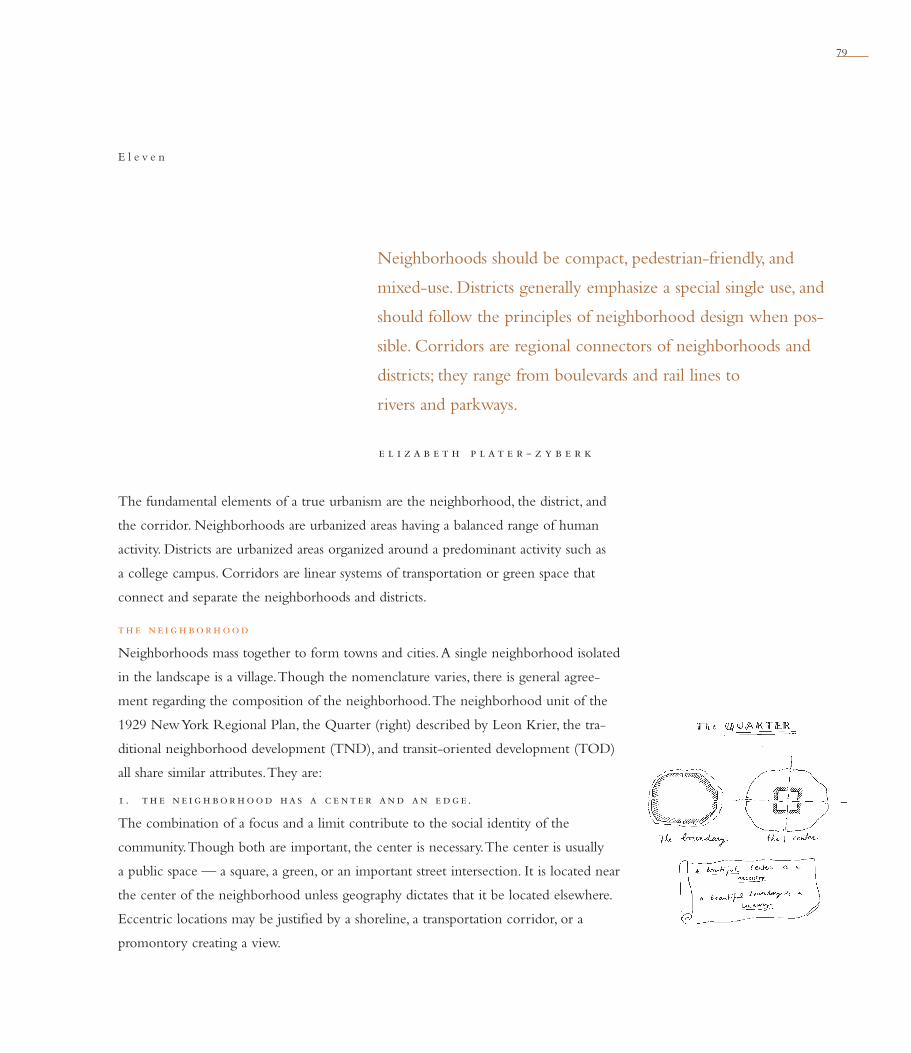
79
e l i z a b e t h p l a t e r - z y b e r k
Neighborhoods should be compact, pedestrian-friendly, and
mixed-use. Districts generally emphasize a special single use, and
should follow the principles of neighborhood design when pos-
sible. Corridors are regional connectors of neighborhoods and
districts; they range from boulevards and rail lines to
rivers and parkways.
E l e v e n
The fundamental elements of a true urbanism are the neighborhood, the district, and
the corridor. Neighborhoods are urbanized areas having a balanced range of human
activity. Districts are urbanized areas organized around a predominant activity such as
a college campus. Corridors are linear systems of transportation or green space that
connect and separate the neighborhoods and districts.
th e ne i g h bor h ood
Neighborhoods mass together to form towns and cities. A single neighborhood isolated
in the landscape is a village. Though the nomenclature varies, there is general agree-
ment regarding the composition of the neighborhood. The neighborhood unit of the
1929 New York Regional Plan, the Quarter (right) described by Leon Krier, the tra-
ditional neighborhood development (TND), and transit-oriented development (TOD)
all share similar attributes. They are:
1 . th e ne i g h bor h ood has a c e nte r and an e dg e .
The combination of a focus and a limit contribute to the social identity of the
community. Though both are important, the center is necessary. The center is usually
a public space — a square, a green, or an important street intersection. It is located near
the center of the neighborhood unless geography dictates that it be located elsewhere.
Eccentric locations may be justifi ed by a shoreline, a transportation corridor, or a
promontory creating a view.

80 n e i g h b o r h o o d , d i s t r i c t , a n d c o r r i d o r
The center is the location for civic build-
ings, such as libraries, meeting halls, and churches.
Commercial buildings including shops and work-
places are also associated with the center of a
village. But in the aggregations of neighborhoods
that create towns and cities, commercial buildings
are often at the edge where, combined with the
commercial edges of other neighborhoods, they
form a town center.
The edge of a neighborhood varies in charac-
ter. In villages, the edge borders the lowest density
of housing and is usually defi ned by land reserved
for cultivation or conservation in a natural state. In
urban areas, the neighborhood edge is often defi ned
by boulevards or parkways, which may be lined by
higher-density buildings.
2 . th e ne i g h bor h ood has a
ba lanc e d m i x o f ac t iv i t i e s :
sh op p i ng, wor k , sc h ool i ng,
r e c reat i on, and al l ty p e s
o f h ou s i ng.
This arrangement is particularly useful for
those — young, old, handicapped, or poor — who
can’t depend on the automobile for mobility.
The neighborhood provides housing for a
range of incomes. Affordable housing types include
backyard cottages, apartments above shops, and row-
houses. Houses and apartments for the wealthy may
occupy the choice sites.
“In recent decades Americans
have been focusing too
much on the house itself
and too little on the neigh-
borhood, too much on the
interior luxury and too
little on public amenity.
By reconsidering the design
of our houses, we might
begin again to create
walkable, stimulating, more
affordable neighborhoods
where sociable pleasures
are always within reach.
The country can learn
much from the neighborly
kinds of housing we used
to build. They made —
and continue to
make — good places for
living.”
ph i l i p lang don
by 19 2 8 , th e re we re
a l r eady 21 . 3 m i l l i on
car s on America’s roads.
Clarence Stein and Henry
Wright’s 1928 general plan
for Radburn, New Jersey,
put the pedestrian fi rst
by placing most of life’s
needs within a short stroll
in neighborhoods for
10,000 people. Shopping
centers placed at the
edges are accessible both
by foot and by car.
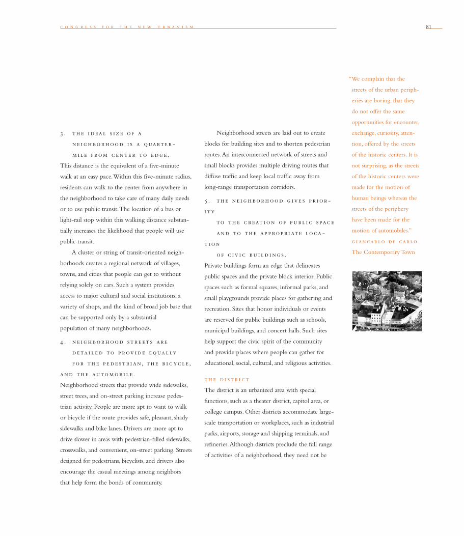
c o n g r e s s f o r t h e n e w u r b a n i s m 81
3 . th e i d eal s i z e o f a
n e i g h bor h ood i s a quarte r -
m i l e f rom c e nte r to e dg e .
This distance is the equivalent of a fi ve-minute
walk at an easy pace. Within this fi ve-minute radius,
residents can walk to the center from anywhere in
the neighborhood to take care of many daily needs
or to use public transit. The location of a bus or
light-rail stop within this walking distance substan-
tially increases the likelihood that people will use
public transit.
A cluster or string of transit-oriented neigh-
borhoods creates a regional network of villages,
towns, and cities that people can get to without
relying solely on cars. Such a system provides
access to major cultural and social institutions, a
variety of shops, and the kind of broad job base that
can be supported only by a substantial
population of many neighborhoods.
4 . n e i g h bor h ood st r e et s ar e
d eta i l e d to p rov i de e qual ly
f or th e p e de st r i an, th e b i c yc le ,
and th e automob i l e .
Neighborhood streets that provide wide sidewalks,
street trees, and on-street parking increase pedes-
trian activity. People are more apt to want to walk
or bicycle if the route provides safe, pleasant, shady
sidewalks and bike lanes. Drivers are more apt to
drive slower in areas with pedestrian-fi lled sidewalks,
crosswalks, and convenient, on-street parking. Streets
designed for pedestrians, bicyclists, and drivers also
encourage the casual meetings among neighbors
that help form the bonds of community.
Neighborhood streets are laid out to create
blocks for building sites and to shorten pedestrian
routes. An interconnected network of streets and
small blocks provides multiple driving routes that
diffuse traffi c and keep local traffi c away from
long-range transportation corridors.
5 . th e ne i g h bor h ood g iv e s p r i or -
i ty
to th e c reat i on o f p ub l i c s pac e
and to th e ap p rop r i ate loca -
t i on
o f c iv i c bu i l d i ng s .
Private buildings form an edge that delineates
public spaces and the private block interior. Public
spaces such as formal squares, informal parks, and
small playgrounds provide places for gathering and
recreation. Sites that honor individuals or events
are reserved for public buildings such as schools,
municipal buildings, and concert halls. Such sites
help support the civic spirit of the community
and provide places where people can gather for
educational, social, cultural, and religious activities.
th e d i st r i c t
The district is an urbanized area with special
functions, such as a theater district, capitol area, or
college campus. Other districts accommodate large-
scale transportation or workplaces, such as industrial
parks, airports, storage and shipping terminals, and
refi neries. Although districts preclude the full range
of activities of a neighborhood, they need not be
“We complain that the
streets of the urban periph-
eries are boring, that they
do not offer the same
opportunities for encounter,
exchange, curiosity, atten-
tion, offered by the streets
of the historic centers. It is
not surprising, as the streets
of the historic centers were
made for the motion of
human beings whereas the
streets of the periphery
have been made for the
motion of automobiles.”
g i ancar lo de car lo
The Contemporary Town

8282
“Above all else, a city is
a means of providing a
maximum number of social
contacts and satis factions.
When the open spaces
gape too widely, and the
dispersal is too constant,
the people lack a stage
for their activities and the
drama of their daily life
lacks sharp focus.”
l ew i s mum f ord
The Highway and the City
n e i g h b o r h o o d , d i s t r i c t , a n d c o r r i d o r
elizabeth plater-zyberk
Elizabeth Plater-Zyberk is Dean of the University of Miami School of Architecture and a
founding principal of Duany Plater-Zyberk & Company, an architecture and town planning
fi rm in Miami that has designed numerous New Urbanist communities. She is a founding
board member of CNU.
the single-activity zones of suburbia; complementary
activities can support the district’s primary identity.
The structure of the district parallels the neigh-
borhood. It has an identifi able focus that provides
orientation and identity, and clear boundaries that
allow for special taxing or management organiza-
tions. Like the neighborhood, the district features
public spaces — plazas, sidewalks, important inter-
sections — that reinforce a sense of community
among users, encourage pedestrians, and ensure
security. Transit systems benefi t districts greatly and
should be connected to neighborhoods within a
regional network.
th e corr i dor
The corridor is the connector or separator of
neighborhoods and districts. Corridors are com-
posed of natural and technical components ranging
from wildlife trails to rail lines. The corridor is
not the haphazardly residual “open space” buffer-
ing the enclaves of suburbia, but a deliberate civic
element characterized by its continuity. It is defi ned
by the boundaries of neighborhoods and districts
and provides entry to them.
The path of a transportation corridor is deter-
mined by the intensity of its use. Highways and
heavy-rail corridors remain tangential to towns and
cities and enter only the industrial districts. Light
rail and bus corridors may be incorporated into the
boulevards at the edges of neighborhoods, where
transit stops are designed for pedestrian use and
can accommodate building sites. Bus corridors
may pass into neighborhood centers on small
conven tional streets.
Transportation corridors may be laid out within
continuous parkways, providing long-distance
walking and bicycle trails and a continuous natural
habitat. Green corridors or greenways can also be
formed by natural systems such as streams, drainage
ditches engineered for irrigation, or as a result of
drainage systems for water runoff. These greenways
may include recreational open spaces, such as parks,
playing fi elds, schoolyards, and golf courses. Such
continuous natural spaces should gradually fl ow to
the rural edges, connecting the regional ecosystem.
th e c i ty o f we st
sac ram e nto. A neighbor-
hood center connected to a
town center at a transit stop.

83
w a l t e r k u l a s h
Many activities of daily living should occur within walking
distance, allowing independence to those who do not drive,
especially the elderly and the young. Interconnected networks
of streets should be designed to encourage walking, reduce the
number and length of automobile trips, and conserve energy.
Tw e l v e
Transportation is one of the most controversial elements in community development.
In New Urbanist communities, transportation planning focuses on reducing depen-
dence on the automobile, increasing public transit use, and developing a more fl exible
road system. These actions help reduce local traffi c problems, conserve energy, improve
air quality, and encourage people to walk, bike, or take the bus to get around within
their neighborhood or district.
The street layout of a community in large part dictates the effectiveness of its
transportation system. The connected street network, essential to the New Urbanism,
appears in a wide variety of street patterns. The successful network can be highly
regular and recti linear, such as the grid found in many neotraditional new towns, or
it can be informal and highly irregular, as in New England towns and European city
cores. The connected network benefi ts traffi c by providing a direct route between
where people live and their daily destinations. This network also offers a vast number
of different routes for traffi c, as well as many intersections, which increase left-turn
options and reduce the bottleneck congestion found in most road systems. Traffi c is
thus diffused over miles of streets.
Until the 1930s, highly connected street networks were built into every form of
settlement in the United States. The connected street network was so fundamental to
town builders’ thinking that it did not need to be codifi ed. In the 1930s, the notion
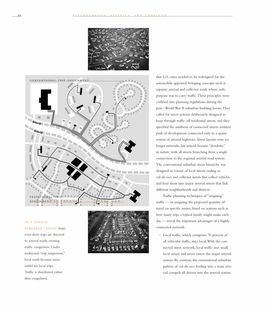
84 n e i g h b o r h o o d , d i s t r i c t , a n d c o r r i d o r
that U.S. cities needed to be redesigned for the
automobile appeared, bringing concepts such as
separate arterial and collector roads whose only
purpose was to carry traffi c. These principles were
codifi ed into planning regulations during the
post– World War II suburban building boom. They
called for street systems deliberately designed to
keep through traffi c off residential streets, and they
specifi ed the antithesis of connected streets: isolated
pods of development connected only to a sparse
system of arterial highways. Street layouts were no
longer networks, but instead became “dendritic”
in nature, with all streets branching from a single
connection to the regional arterial road system.
The conventional suburban street hierarchy was
designed to consist of local streets ending in
cul-de-sacs and collector streets that collect vehicles
and feed them into major arterial streets that link
different neighborhoods and districts.
Traffi c planning techniques of “assigning”
traffi c — or assigning the projected quantity of
travel on specifi c routes, based on notions such as
how many trips a typical family might make each
day — reveal the important advantages of a highly
connected network:
• Local traffi c, which comprises 70 percent of
all vehicular traffi c, stays local. With the con-
nected street network, local traffi c uses small
local streets and never enters the major arterial
system. By contrast, the conventional suburban
pattern of cul-de-sacs feeding into a main arte-
rial compels all drivers into the arterial system.
i n a ty p i cal
subur ban layout (top),
even short trips are directed
to arterial roads, creating
traffi c con gestion. Under
traditional “trip assignment,”
local roads become more
useful for local trips.
Traffi c is distributed rather
than coagulated.
conve nt i onal t r i p a s s i g nm e nt
t rad i t i onal t r i p a s s i g nm e nt

c o n g r e s s f o r t h e n e w u r b a n i s m 85
This focusing of all traffi c onto arterial high-
ways produces intersection congestion even
in low-density developments and creates the
defi ning characteristics of suburban
sprawl-pattern traffi c.
• Travel is more direct. In a network, the large
number of highly connected streets ensures
the shortest possible travel distance for any
given trip. This short travel distance also refl ects
the ability to reach most destinations from all
directions, thereby eliminating the need to
make a circuitous trip on arterial highways.
• The highly connected network allows the
arterial streets to more effi ciently accommo-
date trips most important to the region, such
as longer-distance drives to work and trips for
specialty shopping and medical care. This is
the mission of these roads, according to state
departments of transportation, typically the
arterial roads’ “owner.” Attempting to accom-
modate short, local, daily trips is an abuse of
the intended function of arterial streets and
fuels much of the demand for more and
wider highways.
• Creating town centers. The highly connected
network fosters the development of a true
town center. Traffi c is able to reach the town
center from all directions, using numerous
possible routes. The highly connected network
also promotes centralized activities, whereas
the conventional suburban pattern rewards the
sprawl of activities located in thin strips along
major highways. (Public efforts to limit or
eliminate strip development through such
regulatory efforts as master plans, zoning, and
site plan regulations are easily circumvented
by landowners and conventional suburban
developers.)
• Non-vehicular travel. The highly connected
grid is an ideal environment for walking,
biking, and public transit because it provides
direct connections between where people
live and where they need to go. Walking and
biking are pleasant because of the wide variety
of street environments on different routes and
the low levels of traffi c on the streets. The con-
ventional suburban layout, on the other hand,
is the worst possible environment for pedes-
trian travel. Access between peoples’ homes
and their destinations is seldom direct, and it
usually requires travel through hostile environ-
ments such as major arterial streets
and parking lots. In conventional suburban
development, few if any frequent or typical
trips are within walking distance — up to
1,300 feet, or up to only 500 feet through
unpleasant circumstances such as parking lots.
And walking or biking often is dangerous
and unpleasant because there are no sidewalks,
or they may exist only on the multi-lane
arterial road where traffi c is heavier and faster,
with much greater noise and fumes.
c o n g r e s s f o r t h e n e w u r b a n i s m
“It is sad to see how many
cities have this emptiness
at their core. . . . What they
need is pedestrian con-
gestion. But what they
are doing is taking what
people are on the streets
and putting them some-
where else. In a kind of
holy war against the street,
they are putting them
up in overhead skyways,
down in underground
concourses, and into sealed
atriums and galleries. They
are putting them every-
where except at street level.
. . . But one can hope.
I think the center is going
to hold. I think it is going
to hold because of the
way people demonstrate by
their actions how vital is
centrality. The street rituals
and encounters that seem
so casual, the prolonged
goodbyes, the 100 percent
conversations — these are
not at all trivial. They
are manifestations of one
of the most powerful of
impulses: the impulse to
the center.
And of the primacy
of the street. It is the river
of life of the city, the place
where we come together,
the pathway to the center.”
w i l l i am h . whyte
City: Rediscovering the
Center
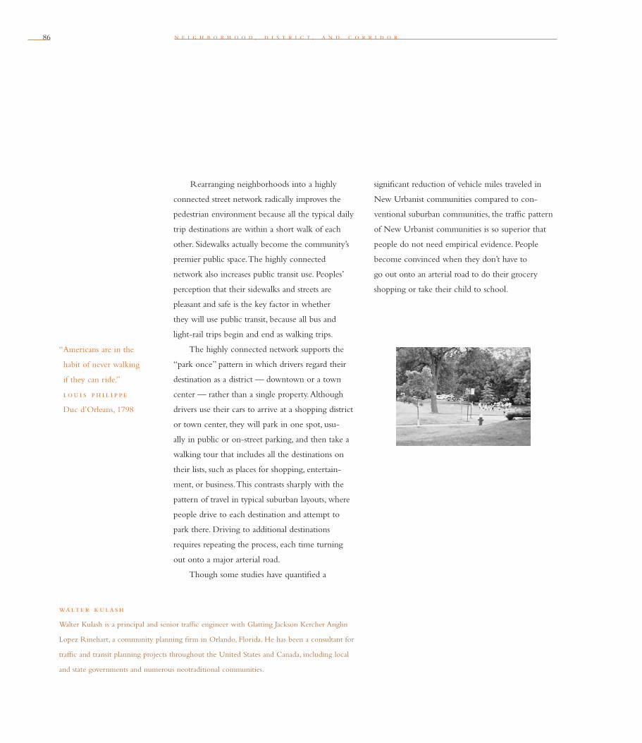
86 n e i g h b o r h o o d , d i s t r i c t , a n d c o r r i d o r
Rearranging neighborhoods into a highly
connected street network radically improves the
pedestrian environment because all the typical daily
trip destinations are within a short walk of each
other. Sidewalks actually become the community’s
premier public space. The highly connected
network also increases public transit use. Peoples’
perception that their sidewalks and streets are
pleasant and safe is the key factor in whether
they will use public transit, because all bus and
light-rail trips begin and end as walking trips.
The highly connected network supports the
“park once” pattern in which drivers regard their
destination as a district — downtown or a town
center — rather than a single property. Although
drivers use their cars to arrive at a shopping district
or town center, they will park in one spot, usu-
ally in public or on-street parking, and then take a
walking tour that includes all the destinations on
their lists, such as places for shopping, entertain-
ment, or business. This contrasts sharply with the
pattern of travel in typical suburban layouts, where
people drive to each destination and attempt to
park there. Driving to additional destinations
requires repeating the process, each time turning
out onto a major arterial road.
Though some studies have quantifi ed a
walte r k ulash
Walter Kulash is a principal and senior traffi c engineer with Glatting Jackson Kercher Anglin
Lopez Rinehart, a community planning fi rm in Orlando, Florida. He has been a consultant for
traffi c and transit planning projects throughout the United States and Canada, including local
and state governments and numerous neotraditional communities.
signifi cant reduction of vehicle miles traveled in
New Urbanist communities compared to con-
ventional suburban communities, the traffi c pattern
of New Urbanist communities is so superior that
people do not need empirical evidence. People
become convinced when they don’t have to
go out onto an arterial road to do their grocery
shopping or take their child to school.
“Americans are in the
habit of never walking
if they can ride.”
lou i s ph i l i p p e
Duc d’Orleans, 1798

c o n g r e s s f o r t h e n e w u r b a n i s m 87
p rop o s e d r e de s i g n o f pal m canyon dr iv e in Cathedral City, California.
An unsightly strip with 30,000 cars a day zooming by deteriorating buildings, Palm
Canyon will be remade with extensive landscaping and sidewalks. Some 100 acres of
new buildings frame public spaces. Urban design standards require inviting building
entries, canopies, and lighting that encourage pedestrians.

88 n e i g h b o r h o o d , d i s t r i c t , a n d c o r r i d o r88
19 2 0 s 195 0 s 19 9 8
f i v e b loc k s east o f balt i more c i ty hal l , Pleasant View Gardens is the
fi rst project completed under the federal program called HOPE VI—otherwise known
as Homeownership Opportunities for People Everywhere. Pleasant View Gardens
replaced grim 1950s-style high-rise public housing with rowhouses, senior housing,
and mixed uses. Narrow streets and small blocks typical of Baltimore’s historic
neighborhoods were reinstated in place of “superblocks.”
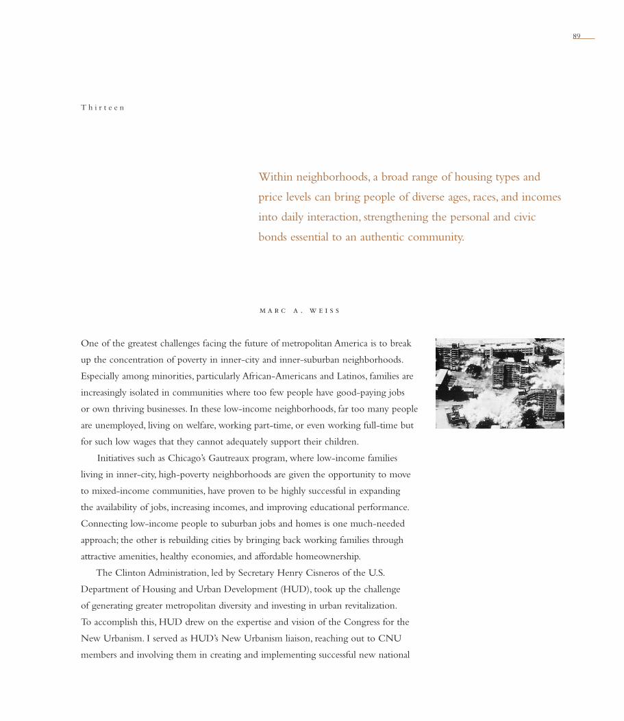
89
m a r c a . w e i s s
Within neighborhoods, a broad range of housing types and
price levels can bring people of diverse ages, races, and incomes
into daily interaction, strengthening the personal and civic
bonds essential to an authentic community.
T h i r t e e n
One of the greatest challenges facing the future of metropolitan America is to break
up the concentration of poverty in inner-city and inner-suburban neighborhoods.
Especially among minorities, particularly African-Americans and Latinos, families are
increasingly isolated in communities where too few people have good-paying jobs
or own thriving businesses. In these low-income neighborhoods, far too many people
are unemployed, living on welfare, working part-time, or even working full-time but
for such low wages that they cannot adequately support their children.
Initiatives such as Chicago’s Gautreaux program, where low-income families
living in inner-city, high-poverty neighborhoods are given the opportunity to move
to mixed-income communities, have proven to be highly successful in expanding
the availability of jobs, increasing incomes, and improving educational performance.
Connecting low-income people to suburban jobs and homes is one much-needed
approach; the other is rebuilding cities by bringing back working families through
attractive amenities, healthy economies, and affordable homeownership.
The Clinton Administration, led by Secretary Henry Cisneros of the U.S.
Department of Housing and Urban Development (HUD), took up the challenge
of generating greater metropolitan diversity and investing in urban revitalization.
To accomplish this, HUD drew on the expertise and vision of the Congress for the
New Urbanism. I served as HUD’s New Urbanism liaison, reaching out to CNU
members and involving them in creating and implementing successful new national

90 n e i g h b o r h o o d , d i s t r i c t , a n d c o r r i d o r
18 9 9 19 4 0 19 7 0 19 9 9
th e tow nh om e s on cap i tol h i l l, a HOPE VI project, replaces 5.3 acres of
abandoned public housing in Washington, D.C., with 154 new homes, a community
building, and new public streets. Affordable and market-rate homes are designed to the
same standard. Variety is assured through 35 different facade designs, 30 window con-
fi gurations, and 22 types of bricks, all based upon historical precedent on Capitol Hill.
Figure-ground diagrams show how streets deteriorated from 1899 to 1970 as vacant
lots and wide roads proliferated, and how this has been repaired.
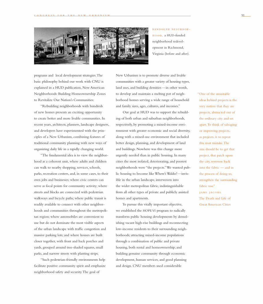
c o n g r e s s f o r t h e n e w u r b a n i s m 91
programs and local development strategies. The
basic philosophy behind our work with CNU is
explained in a HUD publication, New American
Neighborhoods: Building Homeownership Zones
to Revitalize Our Nation’s Communities:
“Rebuilding neighborhoods with hundreds
of new homes presents an exciting opportunity
to create better and more livable communities. In
recent years, architects, planners, landscape designers,
and developers have experimented with the prin-
ciples of a New Urbanism, combining features of
traditional community planning with new ways of
organizing daily life in a rapidly changing world.
“The fundamental idea is to view the neighbor-
hood as a coherent unit, where adults and children
can walk to nearby shopping, services, schools,
parks, recreation centers, and, in some cases, to their
own jobs and businesses; where civic centers can
serve as focal points for community activity; where
streets and blocks are connected with pedestrian
walkways and bicycle paths; where public transit is
readily available to connect with other neighbor-
hoods and communities throughout the metropoli-
tan region; where automobiles are convenient to
use but do not dominate the most visible aspects
of the urban landscape with traffi c congestion and
massive parking lots; and where houses are built
closer together, with front and back porches and
yards, grouped around tree-shaded squares, small
parks, and narrow streets with planting strips.
“Such pedestrian-friendly environments help
facilitate positive community spirit and emphasize
neighborhood safety and security. The goal of
New Urbanism is to promote diverse and livable
communities with a greater variety of housing types,
land uses, and building densities —in other words,
to develop and maintain a melting pot of neigh-
borhood homes serving a wide range of household
and family sizes, ages, cultures, and incomes.”
Our goal at HUD was to support the rebuild-
ing of both urban and suburban neighborhoods,
respectively, by promoting a mixed-income envi-
ronment with greater economic and social diversity,
along with a mixed-use environment that included
better design, planning, and development of land
and buildings. Nowhere was this change more
urgently needed than in public housing. In many
cities the most isolated, deteriorating, and poorest
neighborhoods were “the projects.” We wanted pub-
lic housing to become like Where’s Waldo? —invis-
ible in the urban landscape, interwoven into
the wider metropolitan fabric, indistinguishable
from all other types of private and publicly assisted
homes and apartments.
To pursue this vitally important objective,
we established the HOPE VI program to radically
transform public housing developments by demol-
ishing vacant high-rise buildings and reconnecting
low-income residents to their surrounding neigh-
borhoods; attracting mixed-income populations
through a combination of public and private
housing, both rental and homeownership; and
building genuine community through economic
development, human services, and good planning
and design. CNU members used considerable
“One of the unsuitable
ideas behind projects is the
very notion that they are
projects, abstracted out of
the ordinary city and set
apart. To think of salvaging
or improving projects,
as proj ects, is to repeat
this root mistake. The
aim should be to get that
project, that patch upon
the city, rewoven back
into the fabric — and in
the process of doing so,
strengthen the surrounding
fabric too.”
jane jacob s
The Death and Life of
Great American Cities
randol ph ne i g h bor -
h ood, a HUD-funded
neigh bor hood redevel-
opment in Richmond,
Virginia (before and after).

n e i g h b o r h o o d , d i s t r i c t , a n d c o r r i d o r92
i n p i t t sburg h , c raw f ord s quare in the Lower Hill neighborhood was
vacant for 25 years. The redevelopment included 331 residences —rental and owner-
occupied —built around parks and reconstituted streets. The revived neighborhood
is racially mixed and equally divided between market-rate and affordable homes.

c o n g r e s s f o r t h e n e w u r b a n i s m 93
expertise in redesigning public housing develop-
ments including Diggs Town in Norfolk. They are
assisting HUD and local public housing authorities
in spending billions of dollars wisely on redevel-
oping public housing communities in Baltimore,
Charlotte, Chicago, Detroit, Washington, D.C.,
Boston, Cleveland, Philadelphia, Pittsburgh, Atlanta,
Louisville, and dozens of additional cities.
Similarly, when the Clinton Administration
embarked on its ambitious Empowerment Zones
and Enterprise Communities initiative and its new
Homeownership Zones program, we turned to the
New Urbanists for help in developing innovative
concepts and methods of community planning and
urban design. Secretary Cisneros asked the CNU to
form an Inner City Task Force to work with HUD
and local communities in applying the principles
of New Urbanism to rebuild inner-city and inner-
suburban neighborhoods. The CNU leadership
then asked Secretary Cisneros to sign the Charter,
and he did so when he gave the keynote address at
the Charleston congress in 1996. Since that time,
CNU’s Inner City Task Force has played a major
role in both the HOPE VI and Homeownership
Zones efforts, serving as faculty in HUD-sponsored
courses to educate and train local offi cials in the
use of New Urbanist ideas to improve development
practices and build better communities.
Leaders of the Congress for the New Urbanism
produced for HUD a landmark document, Principles
for Planning and Designing Homeownership Zones,
based on the key ideas in CNU’s Charter. This
document was used by all of the 110 local govern-
ment applicants for the $100 million nationwide
Homeownership Zones grants competition in 1996.
HUD awarded extra points to applicants for devel-
opment proposals that incorporated “innovative and
creative community planning and design” strategies
using New Urbanism principles.
The bottom line is this: To achieve a prosperous
and just society with a high quality of life for all our
citizens and families, economic, social, and physical
diversity are essential elements for the long-term
success of every neighborhood and community. One
of the best ways to promote such a healthy diversity
of homes and people is by utilizing the principles of
the Charter of the New Urbanism.
marc a . we i s s
Marc A. Weiss, Ph.D., a former professor of urban development and planning at Columbia
University, served as special assistant to the Secretary of the U.S. Department of Housing
and Urban Development (HUD) from 1993 to 1997 and was a senior policy adviser to the
Clinton–Gore campaign and transition in 1991 and 1992. Weiss is a senior fellow at the
Center for National Policy in Washington, D.C., and is the author of many books and articles,
including The Rise of the Community Builders and Real Estate Development Principles and
Process. He is currently co-authoring a book with Henry Cisneros on the future of American
cities and regions.
“Nobody not under the
control of some bureaucrat
or commissar would ever
wish to live in a ‘housing
project’. . . nobody not
under some such control
ever has.”
p et e r b lake
Form Follows Fiasco
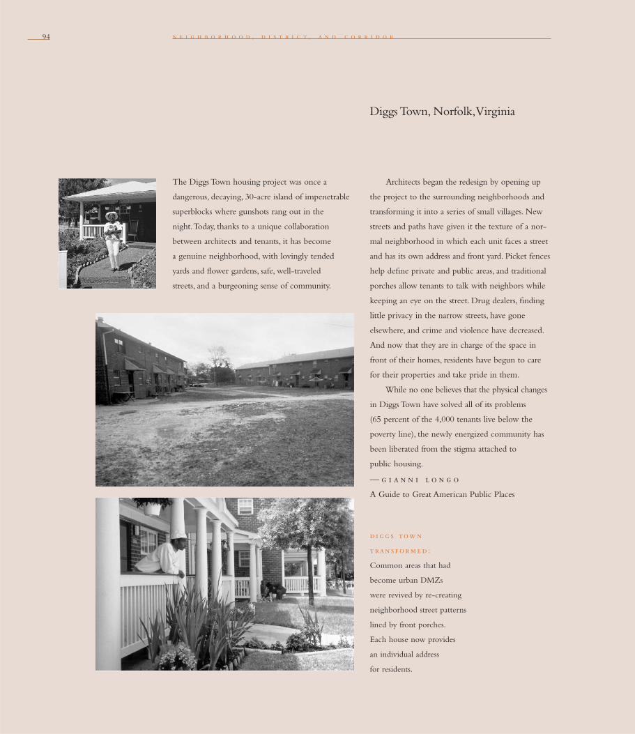
94
The Diggs Town housing project was once a
dangerous, decaying, 30-acre island of impenetrable
superblocks where gunshots rang out in the
night. Today, thanks to a unique collaboration
between architects and tenants, it has become
a genuine neigh borhood, with lovingly tended
yards and fl ower gardens, safe, well-traveled
streets, and a burgeoning sense of community.
n e i g h b o r h o o d , d i s t r i c t , a n d c o r r i d o r
Architects began the redesign by opening up
the project to the surrounding neighborhoods and
transforming it into a series of small villages. New
streets and paths have given it the texture of a nor-
mal neighborhood in which each unit faces a street
and has its own address and front yard. Picket fences
help defi ne private and public areas, and traditional
porches allow tenants to talk with neighbors while
keeping an eye on the street. Drug dealers, fi nding
little privacy in the narrow streets, have gone
elsewhere, and crime and violence have decreased.
And now that they are in charge of the space in
front of their homes, residents have begun to care
for their properties and take pride in them.
While no one believes that the physical changes
in Diggs Town have solved all of its problems
(65 percent of the 4,000 tenants live below the
poverty line), the newly energized community has
been liberated from the stigma attached to
public housing.
— g i a n n i l o n g o
A Guide to Great American Public Places
d i g g s tow n
t ran s f orm e d :
Common areas that had
become urban DMZs
were revived by re-creating
neighborhood street patterns
lined by front porches.
Each house now provides
an individual address
for residents.
Diggs Town, Norfolk, Virginia
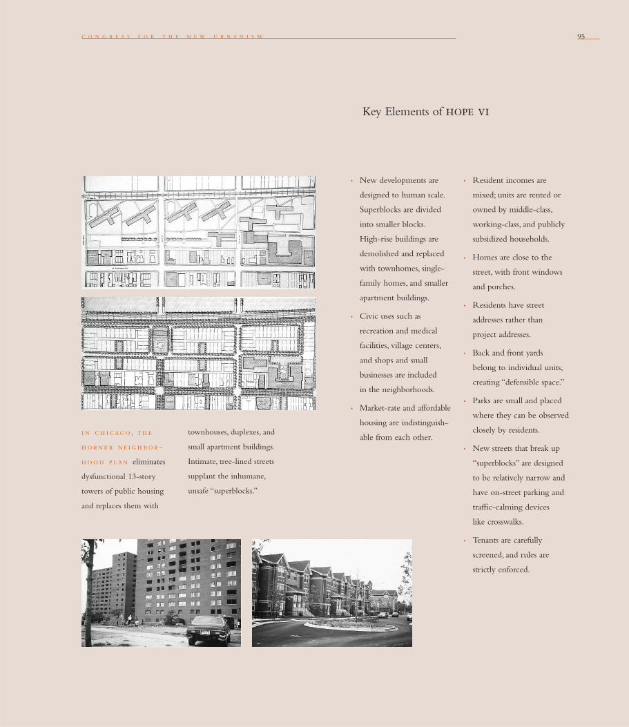
c o n g r e s s f o r t h e n e w u r b a n i s m 95
Key Elements of hope vi
• New developments are
designed to human scale.
Superblocks are divided
into smaller blocks.
High-rise buildings are
demolished and replaced
with townhomes, single-
family homes, and smaller
apartment buildings.
• Civic uses such as
recreation and medical
facilities, village centers,
and shops and small
businesses are included
in the neighborhoods.
• Market-rate and affordable
housing are indistinguish-
able from each other.
• Resident incomes are
mixed; units are rented or
owned by middle-class,
working-class, and publicly
subsidized households.
• Homes are close to the
street, with front windows
and porches.
• Residents have street
addresses rather than
project addresses.
• Back and front yards
belong to individual units,
creating “defensible space.”
• Parks are small and placed
where they can be observed
closely by residents.
• New streets that break up
“superblocks” are designed
to be relatively narrow and
have on-street parking and
traffi c-calming devices
like crosswalks.
• Tenants are carefully
screened, and rules are
strictly enforced.
i n c h i cag o, th e
h orne r ne i g h bor -
h ood p lan eliminates
dysfunctional 13-story
towers of public housing
and replaces them with
townhouses, duplexes, and
small apartment buildings.
Intimate, tree-lined streets
supplant the inhumane,
unsafe “superblocks.”
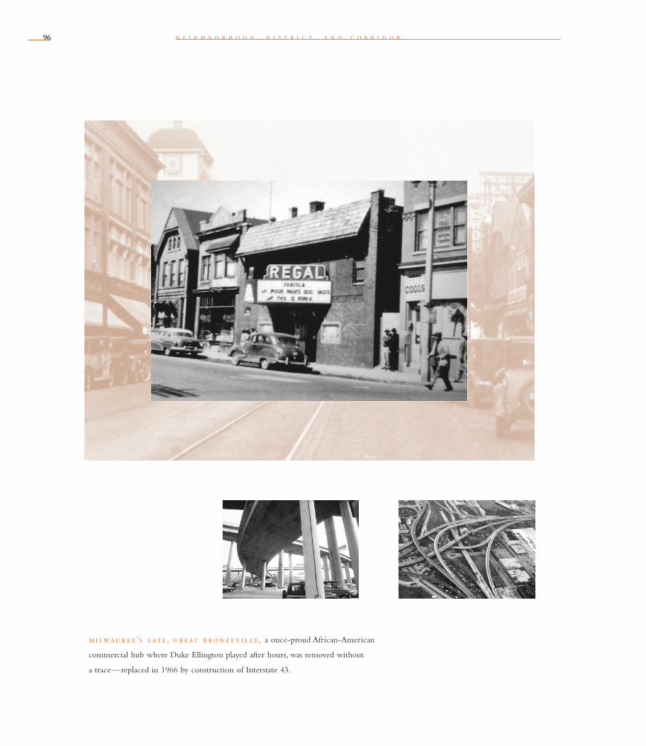
9696 n e i g h b o r h o o d , d i s t r i c t , a n d c o r r i d o r
m i lwauke e ’s late , g r eat b ron z ev i l l e , a once-proud African-American
commercial hub where Duke Ellington played after hours, was removed without
a trace—replaced in 1966 by construction of Interstate 43.

97
j o h n o . n o r q u i s t
Transit corridors, when properly planned and coordinated,
can help organize metropolitan structure and revitalize urban
centers. In contrast, highway corridors should not displace
investment from existing centers.
F o u r t e e n
In 1941, Norman Bel Geddes, the father of the interstate highway system, warned that
the revolutionary highway system he envisioned could harm cities. “A great motorway
has no business cutting a wide swath right through a town or city and destroying
the values there,” he wrote in his book, Magic Motorways. “Its place is in the country.”
Unfortunately, such warnings went unheeded. Instead, the federal government
today funds 90 percent of the cost of freeways that cities would never build on
their own. With that money, pork-barrel politicians, state bureaucrats, and highway
contractors chop up cities with miles of high-priced concrete.
Even today, many of Milwaukee’s residents, business owners, and municipal leaders
must fi ght the retrograde highway lobby, which seeks to spend $1.3 billion to rebuild a
multi-level interstate interchange and add lanes to Interstate 94. This expansion would
stretch 13 miles from the heart of the city, siphoning life from city neighborhoods and
businesses into suburban Waukesha County.
Milwaukee has been down this traumatic road before. In 1966, construction of
Interstate 43 plowed right through Eighth and Walnut, the city’s African-American
commercial and cultural hub. Few thought twice about it. State Representative Lloyd
Barbee picketed the fi rst bulldozer in protest of what he called the “dirty ditch.” But
his action was futile. Once-proud Bronzeville, Milwaukee’s little version of Harlem’s
125th and Lenox, was removed without a trace, except for an annual remembrance in a
nearby park. The Flame nightclub where Duke Ellington once played after hours, the
“If the purpose of the
motorway as now con-
ceived is that of being a
high-speed, non-stop
thoroughfare, the motor-
way would only bungle
the job if it got caught up
with the city. . . . A great
motorway has no business
cutting a wide swath
right through a town or
city and destroying the
values there; its place is
in the country.”
norman b e l g e dde s
Magic Motorways
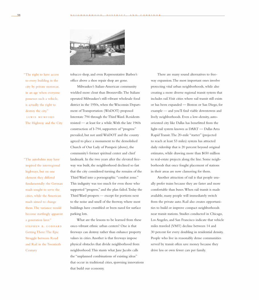
98 n e i g h b o r h o o d , d i s t r i c t , a n d c o r r i d o r
tobacco shop, and even Representative Barbee’s
offi ce above a shoe repair shop are gone.
Milwaukee’s Italian-American community
wielded more clout than Bronzeville. The Italians
operated Milwaukee’s still-vibrant wholesale food
district in the 1950s, when the Wisconsin Depart-
ment of Transportation (WisDOT) proposed
Interstate 794 through the Third Ward. Residents
resisted — at least for a while. With the late 1960s
construction of I-794, supporters of “progress”
prevailed, but not until WisDOT and the county
agreed to place a monument to the demolished
Church of Our Lady of Pompeii (above), the
community’s former spiritual center and chief
landmark. In the two years after the elevated free-
way was built, the neighborhood declined so fast
that the city considered turning the remains of the
Third Ward into a pornographic “combat zone.”
This indignity was too much for even those who
supported “progress,” and the plan failed. Today the
Third Ward prospers — except for portions next
to the noise and smell of the freeway, where most
buildings have crumbled or been razed for surface
parking lots.
What are the lessons to be learned from these
once-vibrant ethnic urban centers? One is that
freeways can destroy rather than enhance property
values in cities. Another is that freeways impose
physical obstacles that divide neighborhood from
neighborhood. This stunts what Jane Jacobs calls
the “unplanned combinations of existing ideas”
that occur in traditional cities, spawning innovations
that build our economy.
There are many sound alternatives to free-
way expansion. The most important ones involve
protecting vital urban neighborhoods, while also
creating a more diverse regional transit system that
includes rail. Visit cities where rail transit still exists
or has been expanded — Boston or San Diego, for
example — and you’ll fi nd viable downtowns and
lively neighborhoods. Even a low-density, auto-
oriented city like Dallas has benefi tted from the
light-rail system known as DART — Dallas Area
Rapid Transit. The 20-mile “starter” (projected
to reach at least 53 miles) system has attracted
daily ridership that is 20 percent beyond original
estimates, while drawing more than $650 million
to real-estate projects along the line. Some neigh-
borhoods that once fought placement of stations
in their areas are now clamoring for them.
Another attraction of rail is that people usu-
ally prefer trains because they are faster and more
comfortable than buses. When rail transit is made
available, many people will immediately switch
from the private auto. Rail also creates opportuni-
ties to build or improve compact neighborhoods
near transit stations. Studies conducted in Chicago,
Los Angeles, and San Francisco indicate that vehicle
miles traveled (VMT) decline between 14 and
30 percent for every doubling in residential density.
People who live in reasonably dense communities
served by transit often save money because they
drive less or own fewer cars per family.
“The autobahns may have
inspired the interregional
highways, but on one
element they differed
fundamentally: the German
roads sought to serve the
cities, while the American
roads aimed to change
them. The variance would
become startlingly apparent
a generation later.”
st e ph e n b . g oddard
Getting There: The Epic
Struggle between Road
and Rail in the Twentieth
Century
“The right to have access
to every building in the
city by private motorcar,
in an age when everyone
possesses such a vehicle,
is actually the right to
destroy the city.”
l ew i s mum f ord
The Highway and the City
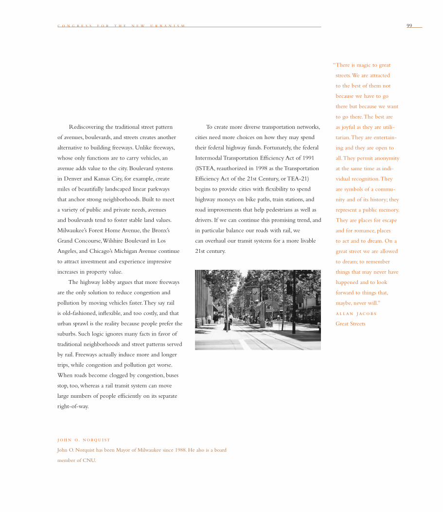
c o n g r e s s f o r t h e n e w u r b a n i s m 99
Rediscovering the traditional street pattern
of avenues, boulevards, and streets creates another
alternative to building freeways. Unlike freeways,
whose only functions are to carry vehicles, an
avenue adds value to the city. Boulevard systems
in Denver and Kansas City, for example, create
miles of beautifully landscaped linear parkways
that anchor strong neighborhoods. Built to meet
a variety of public and private needs, avenues
and boulevards tend to foster stable land values.
Milwaukee’s Forest Home Avenue, the Bronx’s
Grand Concourse, Wilshire Boulevard in Los
Angeles, and Chicago’s Michigan Avenue continue
to attract investment and experience impressive
increases in property value.
The highway lobby argues that more freeways
are the only solution to reduce congestion and
pollution by moving vehicles faster. They say rail
is old-fashioned, infl exible, and too costly, and that
urban sprawl is the reality because people prefer the
suburbs. Such logic ignores many facts in favor of
traditional neighborhoods and street patterns served
by rail. Freeways actually induce more and longer
trips, while congestion and pollution get worse.
When roads become clogged by congestion, buses
stop, too, whereas a rail transit system can move
large numbers of people effi ciently on its separate
right-of-way.
joh n o. norqu i st
John O. Norquist has been Mayor of Milwaukee since 1988. He also is a board
member of CNU.
To create more diverse transportation networks,
cities need more choices on how they may spend
their federal highway funds. Fortunately, the federal
Intermodal Transportation Effi ciency Act of 1991
(ISTEA, reauthorized in 1998 as the Transportation
Effi ciency Act of the 21st Century, or TEA-21)
begins to provide cities with fl exibility to spend
highway moneys on bike paths, train stations, and
road improvements that help pedestrians as well as
drivers. If we can continue this promising trend, and
in particular balance our roads with rail, we
can overhaul our transit systems for a more livable
21st century.
“There is magic to great
streets. We are attracted
to the best of them not
because we have to go
there but because we want
to go there. The best are
as joyful as they are utili-
tarian. They are entertain-
ing and they are open to
all. They permit anonymity
at the same time as indi-
vidual recognition. They
are symbols of a commu-
nity and of its history; they
represent a public memory.
They are places for escape
and for romance, places
to act and to dream. On a
great street we are allowed
to dream; to remember
things that may never have
happened and to look
forward to things that,
maybe, never will.”
al lan jacob s
Great Streets


101
w i l l i a m l i e b e r m a n
Appropriate building densities and land uses should be
within walking distance of transit stops, permitting public
transit to become a viable alternative to the automobile.
F i f t e e n
In many urban areas today, transit is used primarily by people without cars. Public
transpor tation must do its best to serve environments created for the automobile,
with characteristics that are antagonistic to the needs of people walking to and from
transit stops.
Until the end of the fi rst World War, travel within America’s urban areas was
primarily on foot or by public transportation. Proximity to public transit was a highly
regarded attribute for real estate, as it minimized walking distance. More intense land
uses, such as shops, schools, and workplaces, tended to be located around transit stops.
Residential densities generally were highest along the streets served by streetcars and
buses, tapering to lower densities as the distance from stops increased.
With the advent of the automobile, the relationships between transit and land
use weakened. As more people switched to auto travel, fewer were affected by the
length of the walk to public transportation. Newer suburbs were laid out primarily
with the needs of motorists in mind, and very different patterns of density and
location prevailed.
In fact, many of the residential developments laid out in the past 30 years have
their lowest densities on the very streets served by buses and light rail. Often this is
because the only suitable through streets are large arterials. The levels of noise and
pollution generated along these thoroughfares make them poor places for residential
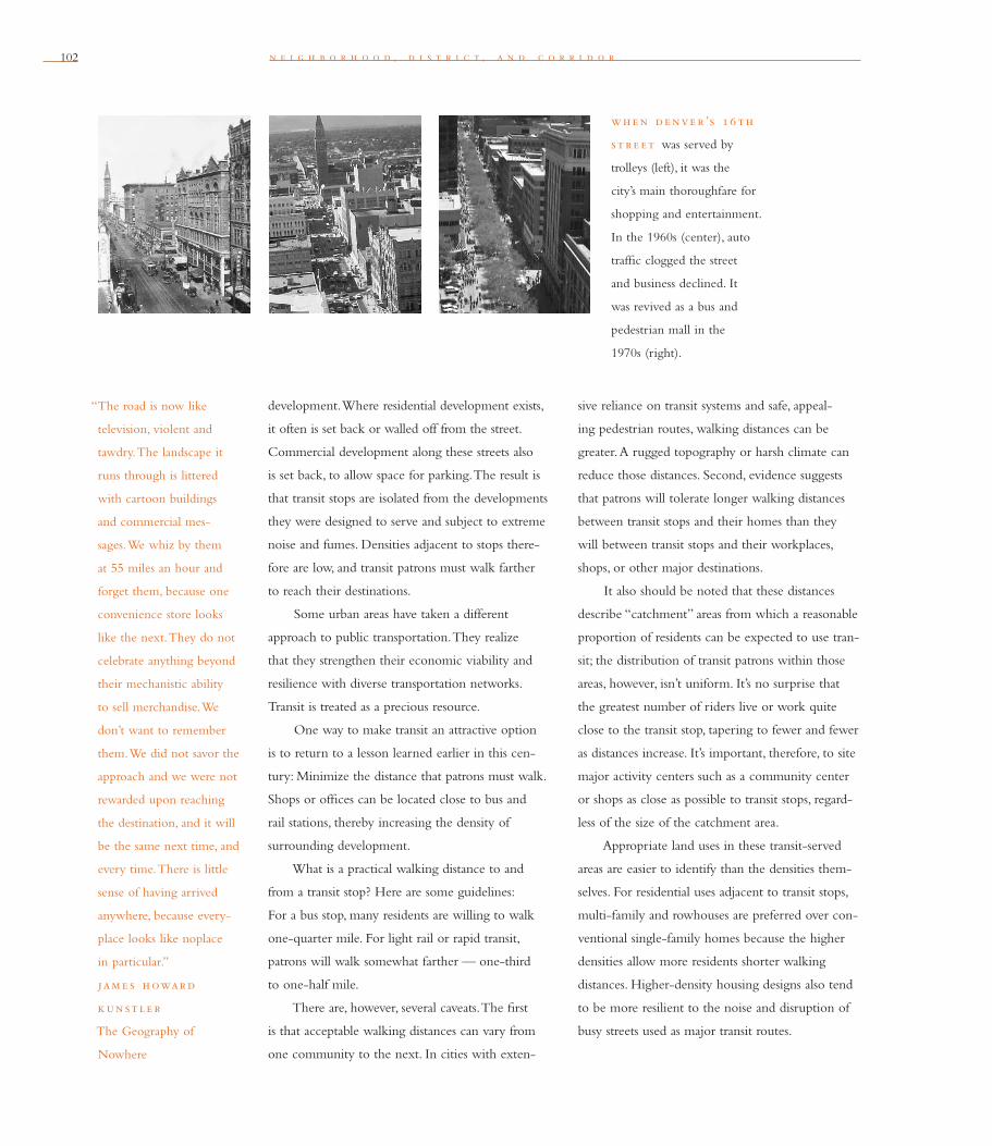
102
“The road is now like
television, violent and
tawdry. The landscape it
runs through is littered
with cartoon buildings
and commercial mes-
sages. We whiz by them
at 55 miles an hour and
forget them, because one
convenience store looks
like the next. They do not
celebrate anything beyond
their mechanistic ability
to sell merchandise. We
don’t want to remember
them. We did not savor the
approach and we were not
rewarded upon reaching
the destination, and it will
be the same next time, and
every time. There is little
sense of having arrived
anywhere, because every-
place looks like noplace
in particular.”
jam e s h oward
k un st l e r
The Geography of
Nowhere
n e i g h b o r h o o d , d i s t r i c t , a n d c o r r i d o r
development. Where residential development exists,
it often is set back or walled off from the street.
Commercial development along these streets also
is set back, to allow space for parking. The result is
that transit stops are isolated from the developments
they were designed to serve and subject to extreme
noise and fumes. Densities adjacent to stops there-
fore are low, and transit patrons must walk farther
to reach their destinations.
Some urban areas have taken a different
approach to public transportation. They realize
that they strengthen their economic viability and
resilience with diverse transportation networks.
Transit is treated as a precious resource.
One way to make transit an attractive option
is to return to a lesson learned earlier in this cen-
tury: Minimize the distance that patrons must walk.
Shops or offi ces can be located close to bus and
rail stations, thereby increasing the density of
surrounding development.
What is a practical walking distance to and
from a transit stop? Here are some guidelines:
For a bus stop, many residents are willing to walk
one-quarter mile. For light rail or rapid transit,
patrons will walk somewhat farther — one-third
to one-half mile.
There are, however, several caveats. The fi rst
is that acceptable walking distances can vary from
one community to the next. In cities with exten-
sive reliance on transit systems and safe, appeal-
ing pedestrian routes, walking distances can be
greater. A rugged topography or harsh climate can
reduce those distances. Second, evidence suggests
that patrons will tolerate longer walking distances
between transit stops and their homes than they
will between transit stops and their workplaces,
shops, or other major destinations.
It also should be noted that these distances
describe “catchment” areas from which a reasonable
proportion of residents can be expected to use tran-
sit; the distribution of transit patrons within those
areas, however, isn’t uniform. It’s no surprise that
the greatest number of riders live or work quite
close to the transit stop, tapering to fewer and fewer
as distances increase. It’s important, therefore, to site
major activity centers such as a community center
or shops as close as possible to transit stops, regard-
less of the size of the catchment area.
Appropriate land uses in these transit-served
areas are easier to identify than the densities them-
selves. For residential uses adjacent to transit stops,
multi-family and rowhouses are preferred over con-
ventional single-family homes because the higher
densities allow more residents shorter walking
distances. Higher-density housing designs also tend
to be more resilient to the noise and disruption of
busy streets used as major transit routes.
wh e n de nve r ’s 16 th
st r e et was served by
trolleys (left), it was the
city’s main thoroughfare for
shopping and entertainment.
In the 1960s (center), auto
traffi c clogged the street
and business declined. It
was revived as a bus and
pedestrian mall in the
1970s (right).

c o n g r e s s f o r t h e n e w u r b a n i s m 103
In most communities, at least 18 homes per
acre is ideal within a half-mile walk of rail or bus
stations, while 12 units per acre is a reasonable
minimum density within one-quarter mile of a bus
stop. For more suburban, single-family neighbor-
hoods, fi ve to seven units per acre is the lowest via-
ble density for a bus route. These density guidelines
can be increased substantially in urban centers and
in large cities with extensive transit systems.
Offi ces should be located directly adjacent
to transit stops so employees can use transit conve-
niently. Minimum fl oor-area ratios (FAR) of 0.35
to 0.50 are desirable near bus stops, increasing to
1.00 or more near rail stations. (A fl oor-area ratio
is the relationship between the permitted fl oor area
of a building and the area of the lot on which it
is located; the higher the FAR, the more intense
the use of the parcel.)
For commercial retail, the type of use is more
important than the density. Neighborhood retail,
such as dry cleaners and cafes, and services like
day-care centers, can support transit facilities by
providing conveniences close to where riders get
on or off. Large retail facilities such as shopping
centers can become transit focal points when they
are close to transit facilities. The key is for transit
stops to be located near the entrances of the build-
ings, not at the fringes of the parking area. Schools
w i l l i am l i e b e rman
William Lieberman is director of planning and operations for San Diego’s Metropolitan Transit
Development Board, a legislatively created transit authority that owns and runs systems for light
rail and bus. He is the former chair of CNU’s Transportation Task Force.
of any size are ideal near public transportation. For
industrial uses, only those that are labor-intensive,
rather than space-intensive, should be placed close
to transit stops.
Land-use plans and zoning codes that specify
these types of uses and densities around existing
transit lines — or streets where transit is likely to
be built in the future — will go a long way toward
transforming urban areas into places where tran-
sit contributes to a lively environment. If public
transportation can handle a larger portion of travel,
urban areas can reduce auto emissions and fuel
consumption, and avoid the higher costs associ-
ated with building and supporting the infrastruc-
ture needed in sprawled land-use patterns. Just as
important, the quality of life improves for residents
of metropolitan areas when they can choose from
among a variety of travel modes and reduce their
travel expenses.
p e op l e w i l l wal k a
quarte r - m i l e to catch
a bus, but when rail transit
is available and the route is
pleasant, they’ll walk up to
half a mile. Too many transit
stops are engulfed by park-
ing lots and freeways rather
than compatible develop-
ment that supports ridership.

104104 n e i g h b o r h o o d , d i s t r i c t , a n d c o r r i d o r
i n tuc s on, ar i zona , th e new c ivano ne i g h bor h ood places civic
buildings and services within a short walk of every home. The City of Tucson
permitted development on the condition that Civano consume only two-thirds
the water and energy of a conventional subdivision.
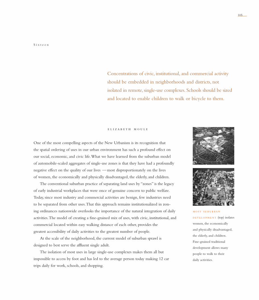
105
e l i z a b e t h m o u l e
Concentrations of civic, institutional, and commercial activity
should be embedded in neighborhoods and districts, not
isolated in remote, single-use complexes. Schools should be sized
and located to enable children to walk or bicycle to them.
S i x t e e n
One of the most compelling aspects of the New Urbanism is its recognition that
the spatial ordering of uses in our urban environment has such a profound effect on
our social, economic, and civic life. What we have learned from the suburban model
of automobile-scaled aggregates of single-use zones is that they have had a profoundly
negative effect on the quality of our lives — most disproportionately on the lives
of women, the economically and physically disadvantaged, the elderly, and children.
The conventional suburban practice of separating land uses by “zones” is the legacy
of early industrial workplaces that were once of genuine concern to public welfare.
Today, since most industry and commercial activities are benign, few industries need
to be separated from other uses. That this approach remains institutionalized in zon-
ing ordinances nationwide overlooks the importance of the natural integration of daily
activities. The model of creating a fi ne-grained mix of uses, with civic, institutional, and
commercial located within easy walking distance of each other, provides the
greatest accessibility of daily activities to the greatest number of people.
At the scale of the neighborhood, the current model of suburban sprawl is
designed to best serve the affl uent single adult.
The isolation of most uses in large single-use complexes makes them all but
impossible to access by foot and has led to the average person today making 12 car
trips daily for work, schools, and shopping.
mo st subur ban
deve lop m e nt (top) isolates
women, the economically
and physically disadvantaged,
the elderly, and children.
Fine-grained traditional
development allows many
people to walk to their
daily activities.
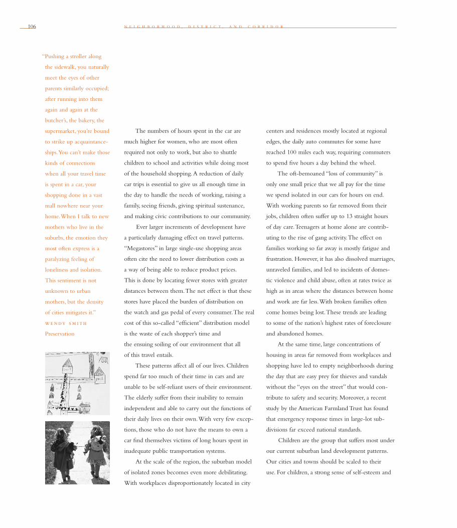
106
“Pushing a stroller along
the sidewalk, you naturally
meet the eyes of other
parents similarly occupied;
after running into them
again and again at the
butcher’s, the bakery, the
supermarket, you’re bound
to strike up acquaintance-
ships. You can’t make those
kinds of connections
when all your travel time
is spent in a car, your
shopping done in a vast
mall nowhere near your
home. When I talk to new
mothers who live in the
suburbs, the emotion they
most often express is a
paralyzing feeling of
loneliness and isolation.
This sentiment is not
unknown to urban
mothers, but the density
of cities mitigates it.”
we ndy sm i th
Preservation
n e i g h b o r h o o d , d i s t r i c t , a n d c o r r i d o r
The numbers of hours spent in the car are
much higher for women, who are most often
required not only to work, but also to shuttle
children to school and activities while doing most
of the household shopping. A reduction of daily
car trips is essential to give us all enough time in
the day to handle the needs of working, raising a
family, seeing friends, giving spiritual sustenance,
and making civic contributions to our community.
Ever larger increments of development have
a particularly damaging effect on travel patterns.
“Megastores” in large single-use shopping areas
often cite the need to lower distribution costs as
a way of being able to reduce product prices.
This is done by locating fewer stores with greater
distances between them. The net effect is that these
stores have placed the burden of distribution on
the watch and gas pedal of every consumer. The real
cost of this so-called “effi cient” distribution model
is the waste of each shopper’s time and
the ensuing soiling of our environment that all
of this travel entails.
These patterns affect all of our lives. Children
spend far too much of their time in cars and are
unable to be self-reliant users of their environment.
The elderly suffer from their inability to remain
independent and able to carry out the functions of
their daily lives on their own. With very few excep-
tions, those who do not have the means to own a
car fi nd themselves victims of long hours spent in
inadequate public transportation systems.
At the scale of the region, the suburban model
of isolated zones becomes even more debilitating.
With workplaces disproportionately located in city
centers and residences mostly located at regional
edges, the daily auto commutes for some have
reached 100 miles each way, requiring commuters
to spend fi ve hours a day behind the wheel.
The oft-bemoaned “loss of community” is
only one small price that we all pay for the time
we spend isolated in our cars for hours on end.
With working parents so far removed from their
jobs, children often suffer up to 13 straight hours
of day care. Teenagers at home alone are contrib-
uting to the rise of gang activity. The effect on
families working so far away is mostly fatigue and
frustration. However, it has also dissolved marriages,
unraveled families, and led to incidents of domes-
tic violence and child abuse, often at rates twice as
high as in areas where the distances between home
and work are far less. With broken families often
come homes being lost. These trends are leading
to some of the nation’s highest rates of foreclosure
and abandoned homes.
At the same time, large concentrations of
housing in areas far removed from workplaces and
shopping have led to empty neighborhoods during
the day that are easy prey for thieves and vandals
without the “eyes on the street” that would con-
tribute to safety and security. Moreover, a recent
study by the American Farmland Trust has found
that emergency response times in large-lot sub-
divisions far exceed national standards.
Children are the group that suffers most under
our current suburban land development patterns.
Our cities and towns should be scaled to their
use. For children, a strong sense of self-esteem and
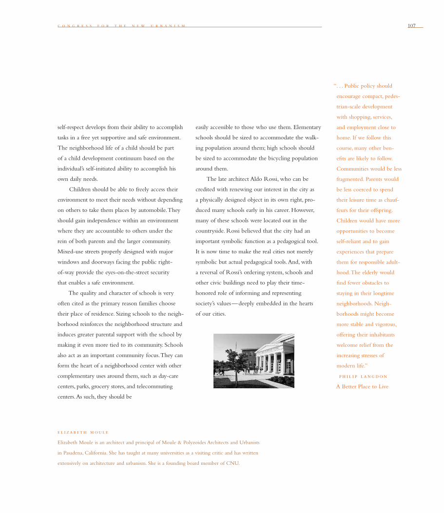
c o n g r e s s f o r t h e n e w u r b a n i s m 107
“. . . Public policy should
encourage compact, pedes-
trian-scale development
with shopping, services,
and employment close to
home. If we follow this
course, many other ben-
efi ts are likely to follow.
Communities would be less
fragmented. Parents would
be less coerced to spend
their leisure time as chauf-
feurs for their offspring.
Children would have more
opportunities to become
self-reliant and to gain
experiences that prepare
them for responsible adult-
hood. The elderly would
fi nd fewer obstacles to
staying in their longtime
neighborhoods. Neigh-
borhoods might become
more stable and vigorous,
offering their inhabitants
welcome relief from the
increasing stresses of
modern life.”
ph i l i p lang don
A Better Place to Live
self-respect develops from their ability to accomplish
tasks in a free yet supportive and safe environment.
The neighborhood life of a child should be part
of a child development continuum based on the
individual’s self-initiated ability to accomplish his
own daily needs.
Children should be able to freely access their
environment to meet their needs without depending
on others to take them places by automobile. They
should gain independence within an environment
where they are accountable to others under the
rein of both parents and the larger community.
Mixed-use streets properly designed with major
windows and doorways facing the public right-
of-way provide the eyes-on-the-street security
that enables a safe environment.
The quality and character of schools is very
often cited as the primary reason families choose
their place of residence. Sizing schools to the neigh-
borhood reinforces the neighborhood structure and
induces greater parental support with the school by
making it even more tied to its community. Schools
also act as an important community focus. They can
form the heart of a neighborhood center with other
complementary uses around them, such as day-care
centers, parks, grocery stores, and telecommuting
centers. As such, they should be
e l i zab eth moule
Elizabeth Moule is an architect and principal of Moule & Polyzoides Architects and Urbanists
in Pasadena, California. She has taught at many universities as a visiting critic and has written
extensively on architecture and urbanism. She is a founding board member of CNU.
easily accessible to those who use them. Elementary
schools should be sized to accommodate the walk-
ing population around them; high schools should
be sized to accommodate the bicycling population
around them.
The late architect Aldo Rossi, who can be
credited with renewing our interest in the city as
a physically designed object in its own right, pro-
duced many schools early in his career. However,
many of these schools were located out in the
countryside. Rossi believed that the city had an
important symbolic function as a peda gogical tool.
It is now time to make the real cities not merely
symbolic but actual pedagogical tools. And, with
a reversal of Rossi’s ordering system, schools and
other civic buildings need to play their time-
honored role of informing and representing
society’s values—deeply embedded in the hearts
of our cities.
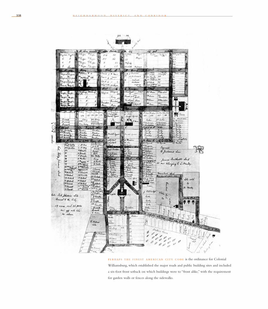
108108 n e i g h b o r h o o d , d i s t r i c t , a n d c o r r i d o r
p e r hap s th e f i n e st am e r i can c i ty code is the ordinance for Colonial
Williamsburg, which established the major roads and public building sites and included
a six-foot front setback on which buildings were to “front alike,” with the requirement
for garden walls or fences along the sidewalks.
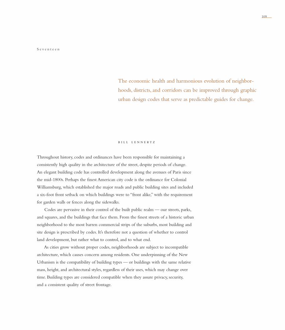
109
b i l l l e n n e r t z
The economic health and harmonious evolution of neighbor-
hoods, districts, and corridors can be improved through graphic
urban design codes that serve as predictable guides for change.
S e v e n t e e n
Throughout history, codes and ordinances have been responsible for maintaining a
consistently high quality in the architecture of the street, despite periods of change.
An elegant building code has controlled development along the avenues of Paris since
the mid-1800s. Perhaps the fi nest American city code is the ordinance for Colonial
Williamsburg, which established the major roads and public building sites and included
a six-foot front setback on which buildings were to “front alike,” with the requirement
for garden walls or fences along the sidewalks.
Codes are pervasive in their control of the built public realm — our streets, parks,
and squares, and the buildings that face them. From the fi nest streets of a historic urban
neighborhood to the most barren commercial strips of the suburbs, most building and
site design is prescribed by codes. It’s therefore not a question of whether to control
land development, but rather what to control, and to what end.
As cities grow without proper codes, neighborhoods are subject to incompatible
architecture, which causes concern among residents. One underpinning of the New
Urbanism is the compatibility of building types — or buildings with the same relative
mass, height, and architectural styles, regardless of their uses, which may change over
time. Building types are considered compatible when they assure privacy, security,
and a consistent quality of street frontage.
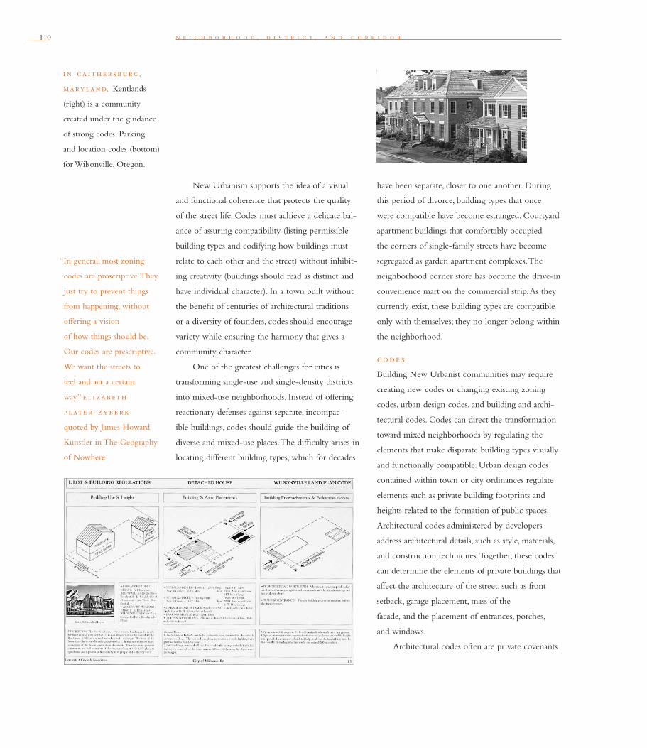
110 n e i g h b o r h o o d , d i s t r i c t , a n d c o r r i d o r
New Urbanism supports the idea of a visual
and functional coherence that protects the quality
of the street life. Codes must achieve a delicate bal-
ance of assuring compatibility (listing permissible
building types and codifying how buildings must
relate to each other and the street) without inhibit-
ing creativity (buildings should read as distinct and
have individual character). In a town built without
the benefi t of centuries of architectural traditions
or a diversity of founders, codes should encourage
variety while ensuring the harmony that gives a
community character.
One of the greatest challenges for cities is
transforming single-use and single-density districts
into mixed-use neighborhoods. Instead of offering
reactionary defenses against separate, incompat-
ible buildings, codes should guide the building of
diverse and mixed-use places. The diffi culty arises in
locating different building types, which for decades
have been separate, closer to one another. During
this period of divorce, building types that once
were compatible have become estranged. Courtyard
apartment buildings that comfortably occupied
the corners of single-family streets have become
segregated as garden apartment complexes. The
neighborhood corner store has become the drive-in
convenience mart on the commercial strip. As they
currently exist, these building types are compatible
only with themselves; they no longer belong within
the neighborhood.
code s
Building New Urbanist communities may require
creating new codes or changing existing zoning
codes, urban design codes, and building and archi-
tectural codes. Codes can direct the transformation
toward mixed neighborhoods by regulating the
elements that make disparate building types visually
and functionally compatible. Urban design codes
contained within town or city ordinances regulate
elements such as private building footprints and
heights related to the formation of public spaces.
Architectural codes administered by developers
address architectural details, such as style, materials,
and construction techniques. Together, these codes
can determine the elements of private buildings that
affect the architecture of the street, such as front
setback, garage placement, mass of the
facade, and the placement of entrances, porches,
and windows.
Architectural codes often are private covenants
“In general, most zoning
codes are proscriptive. They
just try to prevent things
from happening, without
offering a vision
of how things should be.
Our codes are prescriptive.
We want the streets to
feel and act a certain
way.” e l i zab eth
p late r - z y b e r k
quoted by James Howard
Kunstler in The Geography
of Nowhere
i n ga i th e r sburg,
mary land, Kentlands
(right) is a community
created under the guidance
of strong codes. Parking
and location codes (bottom)
for Wilsonville, Oregon.

c o n g r e s s f o r t h e n e w u r b a n i s m 111
initiated by land developers for particular projects
(one exception is historic districts, which may have
their own architectural codes determined by a city,
town, or district). Ideally, architectural codes are
crafted by consensus among the developer, town
planners, and the local jurisdiction, and are put in
place as part of the deed restrictions. These codes,
combined with covenants and restrictions (known
collectively as CC&Rs), are administered by such
entities as master developers and homeowner
associations. CC&Rs are private agreements and
may be quite prescriptive in detail.
The New Urbanism recommends that the
following items be included in site-specifi c codes:
• the regulating plan, showing the platting of
the various zones (the countryside, corridors,
neighborhoods, and districts), the public
rights-of-way, (thoroughfares, civic build-
ing lots, open spaces), and private lots. In an
already developed area, the layout of lots
and street rights-of-way, for example, can
be incorporated into a city code.
• use standards that locate the allowed uses
of buildings in various zones.
• urban regulations that control those aspects of
private buildings that affect public space, such
as building height and placement, location
of primary entrances, location of parking,
and encouragements for stoops and porches.
• architectural regulations that assure visual
compatibility among disparate building
types by controlling building materials and
confi gurations.
• thoroughfare standards that control the
dimensions of vehicular and pedestrian ways
that are specialized in both capacity and
character. For existing streets, standards should
show options for retrofi ts.
• landscape standards, with planting prescrip-
tions for public and private land, to maintain a
visually coherent urban fabric.
ord i nanc e s
Ordinances are local laws for land development
adopted by a public governing agency. Since
ordinances are usually required to be “clear and
prescriptive,” they normally are less controlling
of architectural and design elements than private
codes. Ordinances include a city’s land-use or
zoning code, which regulates the physical aspects
of land development according to use, building
placement and bulk, parking provisions, and land-
scape. The intention of ordinances is to create com-
patible neighborhoods and to protect public safety,
health, and welfare.
i m p l e m e ntat i on st rate g i e s
“The most important
features of city planning
are not the public build-
ings, not the railroad
approaches, not even the
parks and playgrounds.
They are the location of
streets, the establishment of
block lines, the subdivisions
of property into lots, the
regulations of building, and
the housing of people. . . .
The fi xing and extension
of these features is too
often left practically with-
out effective regulation
to the decision of private
individuals. That these
individuals are often lack-
ing in knowledge, in taste,
in high or even fair civic
motives; that they are often
controlled by ignorance,
caprice, and selfi shness,
the present character
of American city sub-
urbs bears abundant
testimony.” joh n nole n
city planner, on his
1911 plan for Madison,
Wisconsin
th e r e g ulat i ng
p lan for the Canyon
Rim Neighborhood
in Redmond, Oregon.

112112 n e i g h b o r h o o d , d i s t r i c t , a n d c o r r i d o r
Through a process of citizen participation, cit-
ies and towns should examine the ability of their
ordinances to create mixed-use neighborhoods,
districts, and corridors. If those ordinances don’t
allow for mixed-use places, planners and citizens
should develop a strategy for revising them in
one of the following ways:
• Start over. Completely rewrite the city’s
comprehensive plan and zoning ordinances
with the help of neighborhood associations,
local developers, business leaders, and city staff.
Create a new vision for the city and a strategy
for how to achieve and maintain that vision.
• Adopt a set of parallel ordinances. Keep the
current ordinances but also offer an alternate
track that will produce a mixed-use neigh-
borhood. In some communities, for example,
an overlay allows developers the choice of
creating a New Urbanist development (typical
design overlays address issues such as reduc-
ing the domination of the garage door on the
street and the location of building entrances
on a public way). Encourage the alternative
track by providing faster plan approval or other
incentives. This approach often is more
b i l l l e nne rtz
Bill Lennertz is a founder and principal of Lennertz Coyle & Associates, architects and
town planners in Portland, Oregon. He was co-editor for Andres Duany and Elizabeth
Plater-Zyberk: Towns and Town-Making Principles (Harvard University Graduate School of
Design, 1991). Lennertz is a founding member of CNU.
easily accepted politically, and therefore can
be adopted relatively quickly.
• Rewrite selected portions of the ordinances.
Identify the major code obstacles and rewrite
only those problem sections. This approach
may be necessary to change quickly regulations
that are responsible for a rapid erosion of the
quality of a community (when a shopping-mall
strip is proposed, for example). These rewritten
ordinances should be included in a town or
city’s comprehensive plan, which establishes the
guiding planning principles and policies that
describe the city’s composition of neighbor-
hoods, districts and corridors, and countryside.
In New Urbanist communities, ordinances
can shape a public space, and the architectural codes
make the buildings around it compatible and add
another layer of richness and character. Another way
of thinking about this is that ordinances will make
a town, and architectural codes will make a beauti-
ful town. Given the power of codes in determining
the harmonious evolution and economic stability
of places, creating urban-design codes that ensure
diverse, mixed-use neighborhoods and towns will
help guide these communities through change.
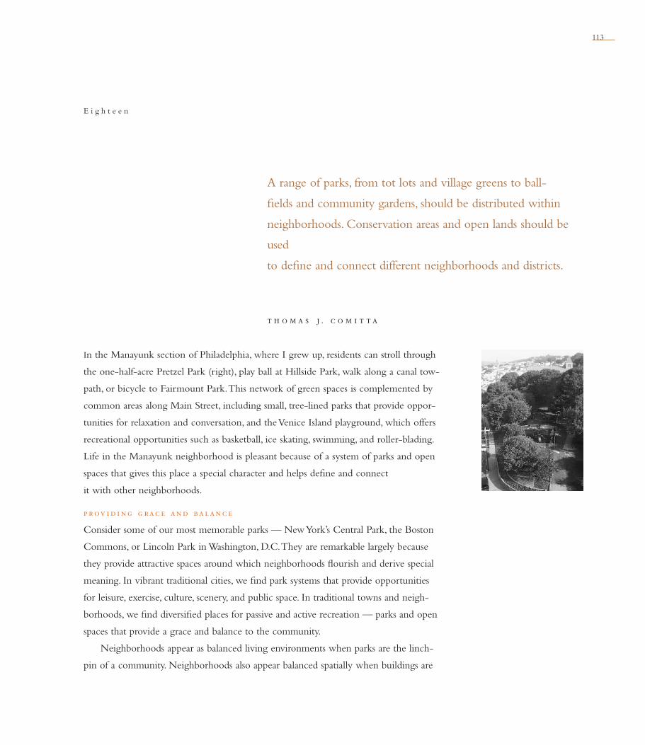
113
t h o m a s j . c o m i t t a
A range of parks, from tot lots and village greens to ball-
fi elds and community gardens, should be distributed within
neigh borhoods. Conservation areas and open lands should be
used
to defi ne and connect different neighborhoods and districts.
E i g h t e e n
In the Manayunk section of Philadelphia, where I grew up, residents can stroll through
the one-half-acre Pretzel Park (right), play ball at Hillside Park, walk along a canal tow-
path, or bicycle to Fairmount Park. This network of green spaces is complemented by
common areas along Main Street, including small, tree-lined parks that provide oppor-
tunities for relaxation and conversation, and the Venice Island playground, which offers
recreational opportunities such as basketball, ice skating, swimming, and roller-blading.
Life in the Manayunk neighborhood is pleasant because of a system of parks and open
spaces that gives this place a special character and helps defi ne and connect
it with other neighborhoods.
p rov i d i ng g rac e and balanc e
Consider some of our most memorable parks — New York’s Central Park, the Boston
Commons, or Lincoln Park in Washington, D.C. They are remarkable largely because
they provide attractive spaces around which neighborhoods fl ourish and derive special
meaning. In vibrant traditional cities, we fi nd park systems that provide opportunities
for leisure, exercise, culture, scenery, and public space. In traditional towns and neigh-
borhoods, we fi nd diversifi ed places for passive and active recreation — parks and open
spaces that provide a grace and balance to the community.
Neighborhoods appear as balanced living environments when parks are the linch-
pin of a community. Neighborhoods also appear balanced spatially when buildings are

114 n e i g h b o r h o o d , d i s t r i c t , a n d c o r r i d o r
onc e th e m i lwauke e r i v e r was a p ol lute d d i tc h running through
the heart of the city. After the water quality was improved through advanced sewage
treatment, the city launched a $10 million effort to create a series of riverfront parks,
landings, plazas, and promenades. The Milwaukee RiverWalk has proven highly suc-
cessful. Buildings that turned their back on the river have been renovated with new
The Milwaukee RiverWalk: Revitalizing the Central City
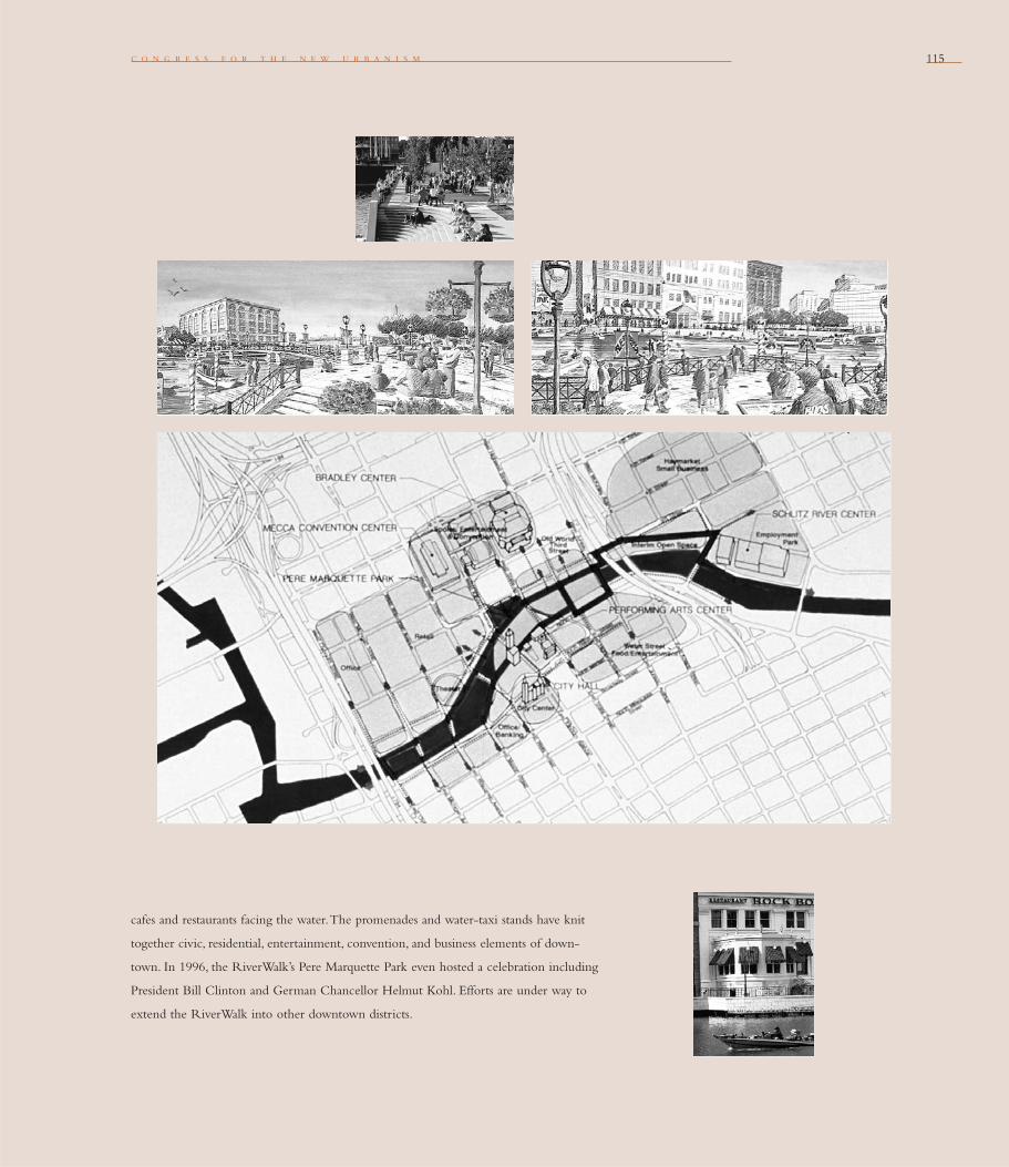
c o n g r e s s f o r t h e n e w u r b a n i s m 115
cafes and restaurants facing the water. The promenades and water-taxi stands have knit
together civic, residential, entertainment, convention, and business elements of down-
town. In 1996, the RiverWalk’s Pere Marquette Park even hosted a celebration including
President Bill Clinton and German Chancellor Helmut Kohl. Efforts are under way to
extend the RiverWalk into other downtown districts.

n e i g h b o r h o o d , d i s t r i c t , a n d c o r r i d o r116
complemented by plazas, squares, and other open
spaces. The contrast between built and unbuilt
is attractive on several levels: between the fi rm
textures of buildings and streets and the soft colors
and textures of the natural world; between a
more formal architectural character and nature’s
informality; and between the massing of struc tures
and the openness of common space. With parks
and other open spaces to provide visually
stimulating contrasts, both the architectural and
natural environments in a neighborhood read
as more distinguished.
g iv i ng f orm to th e ne i g h bor h ood
Within a traditional neighborhood, the form of
open spaces should relate directly to the network of
streets and lanes. As larger green spaces, the market
plaza, the civic plaza, the green, the park, and the
edge should all relate to the design of the whole
neighborhood. As smaller green spaces, the play-
ground, the close, and the square should all relate
to the design of the block. The ideal traditional
neighborhood typically involves contact with a
park, plaza, square, or village green within a fi ve-
to-ten-minute walk of its center (these elements
often are located within the center). Within a
quarter-mile radius from the center of a traditional
neighborhood, there typically are other green or
civic places such as a tot lot, playgrounds, playfi elds,
or com munity gardens.
Raymond Unwin’s 1909 book, Town Planning
in Practice, describes the role of “places” with civic
and green space as the form-giving element of the
traditional town. Unwin recommended planning
a neighborhood that wasn’t exclusively buildings,
but also provided common open spaces. What
motivated Unwin’s ideas from the late 1800s were
overcrowding and squalid conditions in the city of
London. His call for city neighborhoods to incor-
porate fresh air, light, and visual relief was echoed
by other planners and social reformers, in large
part for public health reasons, but also for aesthetic
and civic reasons. His notion of giving discipline to
the space used for civic and recreation purpos-
es — carefully planning the arrangement of parks
and other green spaces to create an attractive con-
trast and balance — contributes to the town plan-
ning tradition that now allows us the pleasure of
discovering a vest-pocket park or small plaza.
Through the Garden City concept advanced
by Ebenezer Howard in his 1898 book, Garden
Cities of To-morrow, the core of a settlement is
considered organized and memorable when the
space in the center is devoted to and maintained as
a park-like setting. When the edge of a settlement
is open and green, it promotes a distinct contrast
with the built environment. This is shown in the
diagram of Howard’s “Ward and Centre Garden-
City”(on page 44).
sup p ort i ng and c e l e b rat i ng
ne i g h bor h ood l i f e
Parks and open areas are the places that support
neighborhood life and its celebrations. The Fourth
of July picnic, Halloween “dark in the park,” and
the summer concert series all happen in the park.
What gives each park special character are features
“Since most production in
the city takes place under a
roof, indoors, it is obvious
that urban recreation must
emphasize the out-of-doors,
plant life, air, and light.
In our poorly mechanized,
over-centralized, and
congested cities the crying
need is for organized space:
fl exible, adaptable outdoor
space in which to stretch,
breath, expand, grow.”
garret t e c k bo,
dan i e l u. k i l ey,
and jam e s c . ro s e
Landscape Design in the
Urban Environment
“Most [cities] are sitting on
a huge reservoir of space
yet untapped by imagina-
tion. In their ineffi ciently
used rights-of-way, their
vast acreage of parking lots,
there is more than enough
space for broad walk-
ways and small parks and
pedestrian places — and
at premium locations.”
w i l l i am h . whyte
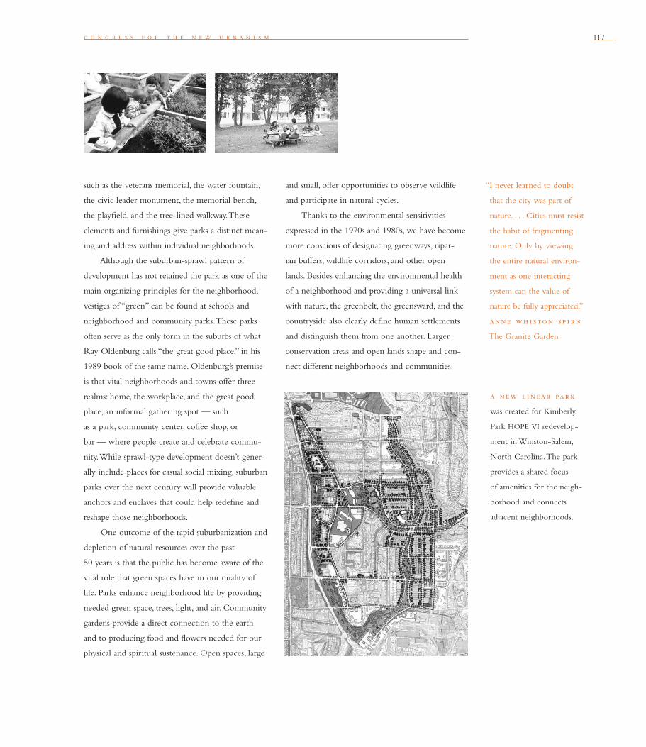
c o n g r e s s f o r t h e n e w u r b a n i s m 117
such as the veterans memorial, the water fountain,
the civic leader monument, the memorial bench,
the playfi eld, and the tree-lined walkway. These
elements and furnishings give parks a distinct mean-
ing and address within individual neighborhoods.
Although the suburban-sprawl pattern of
development has not retained the park as one of the
main organizing principles for the neighborhood,
vestiges of “green” can be found at schools and
neighborhood and community parks. These parks
often serve as the only form in the suburbs of what
Ray Oldenburg calls “the great good place,” in his
1989 book of the same name. Oldenburg’s premise
is that vital neighborhoods and towns offer three
realms: home, the workplace, and the great good
place, an informal gathering spot — such
as a park, community center, coffee shop, or
bar — where people create and celebrate commu-
nity. While sprawl-type development doesn’t gener-
ally include places for casual social mixing, suburban
parks over the next century will provide valuable
anchors and enclaves that could help redefi ne and
reshape those neighborhoods.
One outcome of the rapid suburbanization and
depletion of natural resources over the past
50 years is that the public has become aware of the
vital role that green spaces have in our quality of
life. Parks enhance neighborhood life by providing
needed green space, trees, light, and air. Community
gardens provide a direct connection to the earth
and to producing food and fl owers needed for our
physical and spiritual sustenance. Open spaces, large
and small, offer opportunities to observe wildlife
and participate in natural cycles.
Thanks to the environmental sensitivities
expressed in the 1970s and 1980s, we have become
more conscious of designating greenways, ripar-
ian buffers, wildlife corridors, and other open
lands. Besides enhancing the environmental health
of a neighborhood and providing a universal link
with nature, the greenbelt, the greensward, and the
countryside also clearly defi ne human settlements
and distinguish them from one another. Larger
conservation areas and open lands shape and con-
nect different neighborhoods and communities.
“I never learned to doubt
that the city was part of
nature. . . . Cities must resist
the habit of fragmenting
nature. Only by viewing
the entire natural environ-
ment as one interacting
system can the value of
nature be fully appreciated.”
anne wh i ston s p i rn
The Granite Garden
a new l i near par k
was created for Kimberly
Park HOPE VI redevelop-
ment in Winston-Salem,
North Carolina. The park
provides a shared focus
of amenities for the neigh-
borhood and connects
adjacent neigh borhoods.
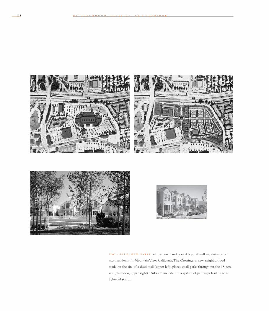
118 n e i g h b o r h o o d , d i s t r i c t , a n d c o r r i d o r
too o f t e n, new par k s are oversized and placed beyond walking distance of
most residents. In Mountain View, California, The Crossings, a new neighborhood
made on the site of a dead mall (upper left), places small parks throughout the 18-acre
site (plan view, upper right). Parks are included in a system of pathways leading to a
light-rail station.

c o n g r e s s f o r t h e n e w u r b a n i s m 119
p lann i ng f or par k s and ope n s pac e s
Development policies and codes increasingly are
being fi ne-tuned to present the right formula for
the built and the unbuilt environments. Within
many traditional neighborhoods, a range of between
8 percent and 15 percent of the landscape is typi-
cally reserved for “green spaces” for recreational
and leisure pursuits. Within a town or community,
a range from 25 percent to 40 percent of the
landscape is typically reserved for environmental
conservation and recreation.
Parks and open spaces should be distributed
within neighborhoods, and should be created and
maintained to help defi ne and connect neighbor-
hoods. Parks and open spaces can be designed
and organized according to their spatial attributes
and their functions.
As part of a network of green and open spaces,
the function of the park system should include:
the “green” formed by surrounding streets, with
buildings oriented around it; the tot lot or mini-park;
the playground with play equipment and courts;
th omas j. com i t ta
Thomas J. Comitta, AICP, RLA, ASLA, is president of Thomas Comitta Associates, Inc., a
town planning and landscape architecture fi rm in West Chester, Pennsylvania. He is also
co-chair of CNU’s Standards & Precedents Task Force and has prepared livable community
design standards for many municipalities.
the playfi eld and athletic fi eld; the community
park shared by a group of neighborhoods with a
pavilion, amphitheater, or gazebo; the community
gardens; the greenway or open space corridor on
the edge of neighborhoods; and the countryside
between towns consisting in large part of agri-
cultural land and other open space.
As the principles of the New Urbanism
become more widely practiced, good neighbor-
hoods and towns will be defi ned by an integrated
network of parks and open spaces. When strung
together with places for living, working, shopping,
and civic activities, parks can provide, borrowing
the idea popularized by the great landscape archi-
tect Frederick Law Olmsted, an “emerald necklace”
for the neighborhood.
“Sandboxes and playgrounds
don’t work just for kids.
Some of my best friends
are those I met when I
watched over my sons’ play
in sandboxes of Riverside
Drive in New York City.
The streets adjacent to
Riverside Drive, which
had no strips of park to
accommodate such play
areas, had much less
social life.”
am i ta i e tz i on i
The Spirit of Community

121c o n g r e s s f o r t h e n e w u r b a n i s m
b lock, st re et, and bu i ld ing
The Charter’s smallest scale is the Block, the Street, and the Building. At this scale, we need to accommodate automobiles as well as pedestri-ans. New Urbanism does not naively call for the elimination of the car. Rather, it challenges us to create environments that support walking, biking, transit, and the car. This section outlines urban design strategies that reinforce human scale while incorporating contemporary realities. Jobs no longer need to be isolated in offi ce parks, but their integration into mixed-use neighborhoods calls for sensitive urban design. Different types of housing no longer need buffers to separate and isolate them, but they do need architecture that signifi es continuity within the neigh-borhood. Retail and civic uses do not need special zones, but they do need block, street, and building patterns that connect them to their community.
c o n g r e s s f o r t h e n e w u r b a n i s m

122122 b l o c k , s t r e e t , a n d b u i l d i n g
Daniel Solomon launches this exploration by delimiting the fault line between Modernism and the traditional urbanism that continues to fl ourish. Stefanos Polyzoides explains why style may be irrelevant, although responding to historical and other contextual settings is crucial. Ray Gindroz and Tony Hiss illuminate the connection between physical design and public safety—and why it involves much more than bright lighting and strong policing. Arguing that pedestrian-only environments can be economic and social failures, Douglas Farr explains how autos can be threaded into safe and lively streets and public spaces. Victor Dover identifi es the patterns that make streets and public plazas successful. In additional commentary, Gianni Longo explains how we can advance efforts to restore public spaces. Douglas Kelbaugh proposes new means to root new buildings to their natural, cultural, and histori-cal settings. Regarding civic buildings, Andres Duany says that planning and foresight are more important than architecture—but that exuber-ant design can provide vital symbolism. Mark Schimmenti discusses the continuing importance of the natural elements in a climate-controlled world, while Ken Greenberg says we must not lose sight of the need to identify, protect, and revitalize historic areas.
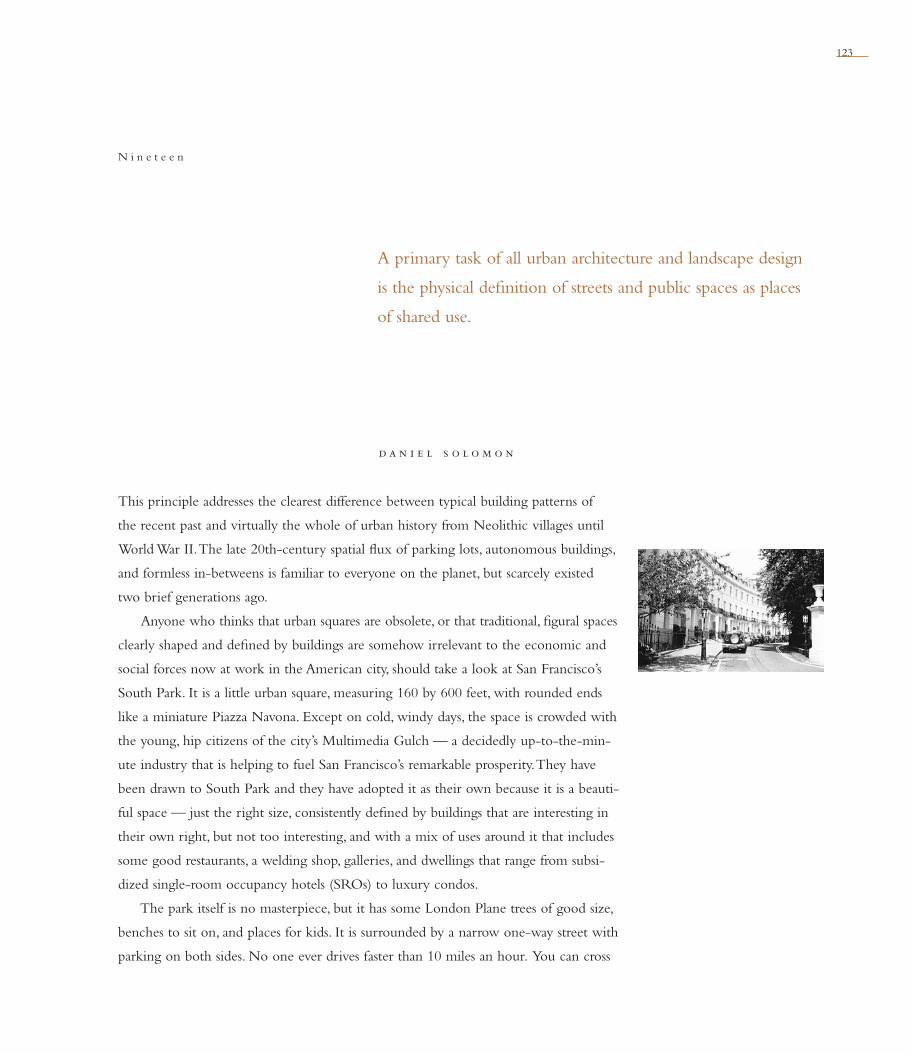
123
d a n i e l s o l o m o n
A primary task of all urban architecture and landscape design
is the physical defi nition of streets and public spaces as places
of shared use.
N i n e t e e n
This principle addresses the clearest difference between typical building patterns of
the recent past and virtually the whole of urban history from Neolithic villages until
World War II. The late 20th-century spatial fl ux of parking lots, autonomous buildings,
and formless in-betweens is familiar to everyone on the planet, but scarcely existed
two brief generations ago.
Anyone who thinks that urban squares are obsolete, or that traditional, fi gural spaces
clearly shaped and defi ned by buildings are somehow irrelevant to the economic and
social forces now at work in the American city, should take a look at San Francisco’s
South Park. It is a little urban square, measuring 160 by 600 feet, with rounded ends
like a miniature Piazza Navona. Except on cold, windy days, the space is crowded with
the young, hip citizens of the city’s Multimedia Gulch — a decidedly up-to-the-min-
ute industry that is helping to fuel San Francisco’s remarkable prosperity. They have
been drawn to South Park and they have adopted it as their own because it is a beauti-
ful space — just the right size, consistently defi ned by buildings that are interesting in
their own right, but not too interesting, and with a mix of uses around it that includes
some good restaurants, a welding shop, galleries, and dwellings that range from subsi-
dized single-room occupancy hotels (SROs) to luxury condos.
The park itself is no masterpiece, but it has some London Plane trees of good size,
benches to sit on, and places for kids. It is surrounded by a narrow one-way street with
parking on both sides. No one ever drives faster than 10 miles an hour. You can cross
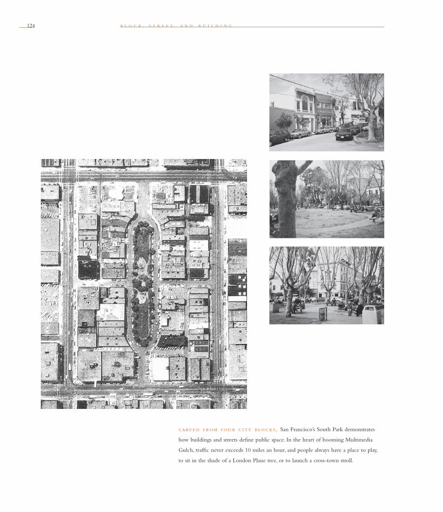
124 b l o c k , s t r e e t , a n d b u i l d i n g
carve d f rom f our c i ty b loc k s, San Francisco’s South Park demonstrates
how buildings and streets defi ne public space. In the heart of booming Multimedia
Gulch, traffi c never exceeds 10 miles an hour, and people always have a place to play,
to sit in the shade of a London Plane tree, or to launch a cross-town stroll.

c o n g r e s s f o r t h e n e w u r b a n i s m 125
the narrow street anywhere. South Park is carved
from the middle of four standard city blocks, the
simple act of a 19th-century entrepreneur who saw
it as a way to create a place out of no place and
thereby make some money for himself. Sometimes
New Urbanism is just a matter of not forgetting old
knowledge.
The liberation of architecture and landscape
from their traditional civic duties as the walls,
portals, and passages of the public realm is a recent
phenomenon that tends to displace what has stood
as shared wisdom for millennia. It has been brought
about by pressures common throughout the world.
The automobile has the largest role in this story,
but there are also other factors at work. The roots of
modern architecture in object- making, buildings as
“machines for living” whose sole allegiances
are to their own programs and technics, have made
their own huge contributions to the crisis of place
so visible at the frayed edges of cities everywhere.
New Urbanists regard this condition of formlessness
as neither benefi cial nor irreversible.
The continued vitality, popularity, and
economic health of traditional urban streets and
squares defi ned by their buildings is signifi cant in
this regard. Late 20th-century planners, architects,
developers, and bureaucrats may have lost track
of how collectively to construct a proper public
realm, but late 20th-century people have clearly
not forgotten how to use it, to depend upon it
and to take great pleasure in its qualities. There
are many beautiful and physically intact traditional
urban places that accommodate automobiles and
the same economic life as the most formless, edge-
city sprawl. New Urbanism is predicated upon the
principle that there is no inherent and necessary
connection between the rise of an electronic infor-
mation culture and the disintegration of urban form.
The precursors of New Urbanism began in
the 1970s to evolve methods of analysis and design,
suitable to our contemporary circumstance, that
restore the traditional reciprocity between the form
of buildings and the form of public space. The
methods of depicting urban space developed by
Belgian architect Rob Krier, the 1978 publication
of the classic book Collage City by Colin Rowe
and Fred Koetter, the publication of Court and
Garden
by Michael Dennis in 1986, and the evolution of
the fi gure-ground method of drawing urban form
at Cornell and many other schools are milestones
in this evolution. It is unlikely that a generation
of planners, architects, and landscape architects
accustomed to the convention of fi gure-ground
representation of urban contexts will ever grant
the same autonomy to buildings that was typical
in the heyday of the Modern movement. This
way of drawing makes the urban damage (right)
infl icted by autonomous and self-referential build-
ings too obvious to ignore.
Beginning with theoretical groundwork laid
out so vividly in the texts quoted on these pages,
many architects and planners have found practical
means to ensure that buildings reassert their tradi-
tional role as the defi ners of public space. One
simple but crucial shift in planning practice has
“[B]y 1930, the disintegra-
tion of the street and of
all highly organized pub-
lic space seemed to have
become inevitable; and for
two major reasons: the new
and rationalized form of
housing and the new dic-
tates of vehicular activity.
For, if the confi guration
of housing now evolved
from the inside out, from
the logical needs of the
individual residential unit,
then it could no longer
be subservient to external
pressures; and, if external
public space had become
so functionally chaotic as
to be without effective
signifi cance, then — in any
case — there were no valid
pressures which it could
any longer exert.”
col i n rowe and
f r e d koet te r
Collage City
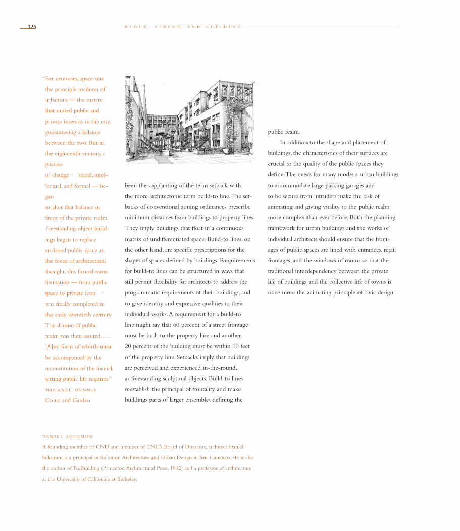
126126 b l o c k , s t r e e t , a n d b u i l d i n g
been the supplanting of the term setback with
the more architectonic term build-to line. The set-
backs of conventional zoning ordinances prescribe
minimum distances from buildings to property lines.
They imply buildings that fl oat in a continuous
matrix of undifferentiated space. Build-to lines, on
the other hand, are specifi c prescriptions for the
shapes of spaces defi ned by buildings. Requirements
for build-to lines can be structured in ways that
still permit fl exibility for architects to address the
programmatic requirements of their buildings, and
to give identity and expressive qualities to their
individual works. A requirement for a build-to
line might say that 60 percent of a street frontage
must be built to the property line and another
20 percent of the building must be within 10 feet
of the property line. Setbacks imply that buildings
are perceived and experienced in-the-round,
as freestanding sculptural objects. Build-to lines
reestablish the principal of frontality and make
buildings parts of larger ensembles defi ning the
dan i e l s olomon
A founding member of CNU and member of CNU’s Board of Directors, architect Daniel
Solomon is a principal in Solomon Architecture and Urban Design in San Francisco. He is also
the author of ReBuilding (Princeton Archi tectural Press, 1992) and a professor of architecture
at the University of California at Berkeley.
public realm.
In addition to the shape and placement of
buildings, the characteristics of their surfaces are
crucial to the quality of the public spaces they
defi ne. The needs for many modern urban buildings
to accommodate large parking garages and
to be secure from intruders make the task of
animating and giving vitality to the public realm
more complex than ever before. Both the planning
frame work for urban buildings and the works of
individual architects should ensure that the front-
ages of public spaces are lined with entrances, retail
frontages, and the windows of rooms so that the
traditional interdependency between the private
life of buildings and the collective life of towns is
once more the animating principle of civic design.
“ For centuries, space was
the principle medium of
urbanism — the matrix
that united public and
private interests in the city,
guaranteeing a balance
between the two. But in
the eighteenth century, a
process
of change — social, intel-
lectual, and formal — be-
gan
to alter that balance in
favor of the private realm.
Freestanding object build-
ings began to replace
enclosed public space as
the focus of architectural
thought, this formal trans-
formation — from public
space to private icon —
was fi nally completed in
the early twentieth century.
The demise of public
realm was then assured. . . .
[A]ny form of rebirth must
be accompanied by the
reconstitution of the formal
setting public life requires.”
m i c ha e l de nn i s
Court and Garden

127
Individual architectural projects should be seamlessly linked
to their surroundings. This issue transcends style.
Tw e n t y
The architecture of our time is dominated by obsessively self-referential, isolated
projects. Such projects aggrandize the individual interests of their clients. They high-
light the formal language and signature of their authors. They endeavor to express
in stylistic terms the mood of the cultural instant when they were designed and built.
The typical project today, however big or small, is a commodity that demands a
unique, differentiated, and, therefore, superfi cial image. We are left with a cultural and
physical landscape of unprecedented confusion, monotony, and fragility. The battle of
the styles fueled by the interests and ambitions of countless clients and their architects
is in no small measure responsible.
A temporal architecture, or an architecture of a specifi c time, that communicates
through a stream of hastily designed, undecipherable private projects is by defi nition
ephemeral. When introduced into a long-lived urban or natural setting, this Architecture
of Time induces chaos by slowly undermining and eventually destroying by design a
cultural commitment to coherence in the city and nature.
In contrast to an Architecture of Time, a New Urbanist architecture is an Architec-
ture of Place. It does not rely upon the idle repetition of historical styles. Instead, New
Urbanist architecture strives to evolve by exercising critical design choices across time.
Its language and permanence endeavor to express a diverse set of deep values held by
those who live in and around it. It is only a fragment of a larger order. Whatever its
s t e f a n o s p o l y z o i d e s
“We want no new style of
architecture. Who wants
a new style of painting
or of sculpture? But we
want some style.”
joh n ru sk i n
“All styles are good except
the boring kind.”
volta i r e
The Prodigal Child
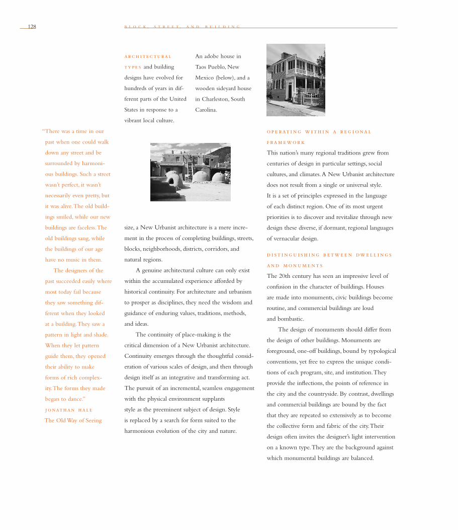
128 b l o c k , s t r e e t , a n d b u i l d i n g
size, a New Urbanist architecture is a mere incre-
ment in the process of completing buildings, streets,
blocks, neighborhoods, districts, corridors, and
natural regions.
A genuine architectural culture can only exist
within the accumulated experience afforded by
historical continuity. For architecture and urbanism
to prosper as disciplines, they need the wisdom and
guidance of enduring values, traditions, methods,
and ideas.
The continuity of place-making is the
critical dimension of a New Urbanist architecture.
Continuity emerges through the thoughtful con sid-
eration of various scales of design, and then through
design itself as an integrative and transforming act.
The pursuit of an incremental, seamless engagement
with the physical environment supplants
style as the preeminent subject of design. Style
is replaced by a search for form suited to the
harmonious evolution of the city and nature.
ope rat i ng w i th i n a r e g i onal
f ram ewor k
This nation’s many regional traditions grew from
centuries of design in particular settings, social
cultures, and climates. A New Urbanist architecture
does not result from a single or universal style.
It is a set of principles expressed in the language
of each distinct region. One of its most urgent
priorities is to discover and revitalize through new
design these diverse, if dormant, regional languages
of vernacular design.
d i st i ng u i sh i ng b etwe e n dwe l l i ng s
and monum e nt s
The 20th century has seen an impressive level of
confusion in the character of buildings. Houses
are made into monuments, civic buildings become
routine, and commercial buildings are loud
and bombastic.
The design of monuments should differ from
the design of other buildings. Monuments are
foreground, one-off buildings, bound by typological
conventions, yet free to express the unique condi-
tions of each program, site, and institution. They
provide the infl ections, the points of reference in
the city and the countryside. By contrast, dwellings
and commercial buildings are bound by the fact
that they are repeated so extensively as to become
the collective form and fabric of the city. Their
design often invites the designer’s light intervention
on a known type. They are the background against
which monumental buildings are balanced.
“There was a time in our
past when one could walk
down any street and be
surrounded by harmoni-
ous buildings. Such a street
wasn’t perfect, it wasn’t
necessarily even pretty, but
it was alive. The old build-
ings smiled, while our new
buildings are faceless. The
old buildings sang, while
the buildings of our age
have no music in them.
The designers of the
past succeeded easily where
most today fail because
they saw something dif-
ferent when they looked
at a building. They saw a
pattern in light and shade.
When they let pattern
guide them, they opened
their ability to make
forms of rich complex-
ity. The forms they made
began to dance.”
jonathan hale
The Old Way of Seeing
arc h i t e c tural
ty p e s and building
designs have evolved for
hundreds of years in dif-
ferent parts of the United
States in response to a
vibrant local culture.
An adobe house in
Taos Pueblo, New
Mexico (below), and a
wooden sideyard house
in Charleston, South
Carolina.

c o n g r e s s f o r t h e n e w u r b a n i s m 129
at th e un ive r s i ty o f ar i zona in Tucson, the Colonia de la Paz Residence
Halls are in a 300-foot-by-300-foot building organized around 11 courtyards as an
extension of Hispanic building and town planning traditions. Specifi c sources were
documented in the architect’s sketchbooks during the design. A variety of techniques
was then incorporated that adapted the building to desert living conditions, including
a cooling tower in its principal courtyard.
130 b l o c k , s t r e e t , a n d b u i l d i n g
de c i ph e r i ng a conte xt
Authentic design choices emerge by relating to
the urban and natural order of existing places. To
generate a true Architecture of Place, it is neces-
sary to draw the boundaries of the context of each
project, identify the elements of past designs, reveal
their physical characteristics, and assess their value
and relevance.
de s i g n i ng by r e f e r e nc e
to p r e c e de nt s
The architecture of the New Urbanism is more ref-
erential than abstract. It depends on historical prec-
edent as guide and inspiration. In each setting for
new projects, designers must discover and respect
the patterns of buildings, open space, landscape,
infrastructure, and transportation networks. These
typological precedents are the historical patterns
society has employed to resolve formal challenges in
recurring programs and sites. They
are the living proof of an architectural culture.
A typological order, different for each region, is a
principal subject that must be mastered before a new
project becomes an instrument of positive change.
i nt e g rat i ng f ormal e l e m e nt s
The language of the New Urbanism is not limited
to buildings. Every project also contains within
its boundaries fragments that defi ne the overall
network of roads and parking, infrastructure,
open space, and landscape. Each project built then
becomes an agent for the harmonious completion
of the form of the city and nature.
Buildings added to existing buildings generate
a fabric. Open spaces added to existing open spaces
defi ne an active public realm. Landscape added
to existing landscape introduces the vibrant pres-
ence of nature into the city. The character of places
depends on the judicious combination of all these
elements through design.
re s p ond i ng to nature
The architecture of the New Urbanism accom-
modates itself with the forces of nature. A seamless
connection to the existing built world is unlikely
to be made unless spaces for human habitation,
indoors or outdoors, become specifi c to their place
and climate. Designing in response to nature can
entail a number of initiatives: minimizing energy
use and pollution, maximizing water conservation
and management, constructing more permanent
buildings with recyclable materials, and promoting
renovation, rehabilitation, and reuse.
“Since my early youth I
have been acutely aware
of the chaotic ugliness
of our modern man-
made environment when
compared to the unity
and beauty of old,
pre-industrial towns.”
walte r g rop i u s

c o n g r e s s f o r t h e n e w u r b a n i s m 131
i n th e evolv i ng de s i g n for the town of Windsor, Florida, an architecture of
place is harmoniously accomplished. Many architects designed a neighborhood under
a code that prescribed key architectural and urban common elements while allowing
freedom of expression.

132132 b l o c k , s t r e e t , a n d b u i l d i n g
u s i ng t e c h nolog y i n th e s e rv i c e
o f arc h i t e c ture
Projects are by defi nition place-specifi c when they
utilize a process of construction that fi ts the chal-
lenges of diverse local settings. We should reject
uniformly, around the world, the pursuit of a
capital-intensive, advanced, and expensive mate-
rials-based architecture. On the other hand, an
Architecture of Place will always use technology in
a fl exible way to build differently in different set-
tings and times. The availability of relatively cheap
labor in some places can produce architecture that
emphasizes hand-crafting. In capital-rich settings,
an architecture assembled out of machine-fabri-
cated parts can fl ourish. And in places in between,
technology can serve architecture based on many,
diverse, and appropriate processes of construction.
conc lu s i on
Style is not an a priori dimension of design. Style
should emerge from two choices made within a
cultural and environmental framework for each
region. First, there is the question of adopting,
transforming, or denying an existing order of
building, open space, landscape, infrastructure, and
transportation networks. Second, a decision must
be made on the use of an appropriate language
of design and building. The available options are
traditional, abstract, or hybrid. The fi rst is a matter
of public responsibility, the second is a matter of
subjective judgment. The consequence of practicing
these two choices can be an Architecture of Place
based on an aesthetic of formal coherence.
Such an architecture of choosing (eklegein in
Greek) is in the best sense of the word eclectic.
It demands architectural expression in response
to different settings. It is based on an evolving
common understanding of the structure of places,
subject to reinterpretation by each architect. It is
incremental rather than revolutionary, respectful
rather than avant-garde. By directing designers
and builders to the value of what exists, and by
encouraging them to operate sensitively and
thoughtfully, a New Urbanist architecture itself
can ultimately become generative and timeless:
as precedent, as invitation to interpretation, and
as a point of departure for subsequent design that
is both an end and a beginning.
st e fano s p oly zo i de s
Stefanos Polyzoides is a partner in Moule & Polyzoides Architects and Urbanists in Pasadena,
California, and an associate professor of architecture at the University of Southern California.
He is a founding board member of CNU.
ke l bau g h r e s i de nc e
in Princeton, New Jersey,
is a historic moment in
American sustainable
architecture: It was the
fi rst Trombe wall house
in America and one of
the fi rst to use passive
solar energy.

133
r a y g i n d r o z
The revitalization of urban places depends on safety and
security. The design of streets and buildings should reinforce safe
environments, but not at the expense of accessibility
and openness.
Tw e n t y o n e
Urban safety is perhaps the most fundamental problem all cities face. No one wants to
live, work, start a business, or shop in a city unless it’s safe.
Both the perception and reality of a safe and secure environment are essential to
attract people to our inner-city neighborhoods. Crime statistics may plummet, but if
people feel lost or trapped within a public space, unable to see or fi nd a quick way out,
they will avoid it. Public spaces devoid of other people or lined with blank walls or
boarded-up windows seem dangerous (and are) because they are not managed or cared
for, and are therefore out of control. Gated communities isolate those inside and often
make the space around them more dangerous.
Safe places, on the other hand, are orderly, well lit, and clean. Public spaces where
we either see or feel others around us make us feel secure. Safe public spaces have well-
maintained buildings with windows, and open vistas that show a way out and help
us fi nd our way through the city. These spaces seem safe (and are) because they are
orderly, cared for, and therefore under control.
Design, once considered only a minor factor in security concerns, is now known
to be an essential component of urban safety. New Urbanists recognize that public
spaces need to be loved to be safe, and that good design helps support secure urban
environments. Design alone, however, is powerless: Community safety and security
requires a partnership among designers, community leaders, residents, and
community-based police.
134 b l o c k , s t r e e t , a n d b u i l d i n g
th e h uman p r e s e nc e , provided by elements such as front porches, is crucial
for safe streets. This is true within a privately built community like Celebration, Florida
(top), or in mixed public and private housing like the Randolph Neighborhood
(above), or Diggs Town (right), two projects in Virginia.

c o n g r e s s f o r t h e n e w u r b a n i s m 135
The issue is not so much how to create spaces
that can be defended, but rather how to create
spaces that bring people together and keep them
safe. In urban areas, the public spaces where street
lighting, streetscapes, and paving meet private
property must be maintained collaboratively by
public and private property owners. This collabo-
ration is accomplished by consensus, which can
be fostered by designing spaces that people can
identify with, develop a strong sense of ownership
for, and be proud of.
s eve n qual i t i e s o f sa f e s pac e s
The qualities that support this collaboration for
safety include:
1 . h uman p r e s e nc e
People in a public space must feel the presence of
other people in the space and in the buildings sur-
rounding the space. The sense that we are not alone
and are being observed helps us behave properly
and feel safe. Windows are symbols of that presence,
whether people are behind them or not. Mixed-use
buildings help promote 24-hour presence.
2 . cong e n i al i ty
The dimensions and scale of the space should
encourage comfortable inter actions among people.
3 . h umane p rote c t i on
Mechanical devices such as cameras and gates
should be invisible. Where possible, police presence
should be personal, on foot or bicycle, so police
offi cers can interact with others.
4 . v i s i b i l i ty, l i g h t, and ope nne s s
Open views that enable us to see other people and
to be seen — by people driving by, as well as by
others in the space — provide natural supervision.
Lighting should ensure nighttime visibility.
5 . orde r
Coherent landscapes, streetscapes, and signs in both
the public rights-of-way and bordering properties
make a clear statement that a space is well-managed
and safe.
6 . conne c t i on s
Spaces must be perceived as part of an intercon-
nected network of streets and public open space,
so we feel we have access to others who make
the space safe.
7. l e g i b i l i ty
The clarity with which each space connects to
the rest of the city helps us understand the form
of the city, keeps us from feeling lost, and assures
us that we are in control of our relationship with
the city spaces and the people in them.
ap p ly i ng th e p r i nc i p l e s
to p ub l i c s pac e s
Applying these principles and qualities varies with
each type of public space, such as the following:
ne i g h bor h ood st r e et s
A neighborhood street lined with carefully tended
front yards, fl ower-fi lled porches, and house facades
with large windows feels safe and comfortable.
A stranger knows that he will be seen and made to
feel either welcome or not. The message is clear this
“Streets and their sidewalks,
the main public places
of a city, are its most vital
organs. Think of a city
and what comes to mind?
Its streets. If a city’s streets
look interesting, the city
looks interesting; if they
look dull, the city looks
dull. More than that . . .
if a city’s streets are safe
from barbarism and fear,
the city is thereby tolerably
safe from barbarism and
fear. When people say that
a city, or part of it, is
dangerous or is a jungle
what they mean primarily
is that they do not feel
safe on the sidewalks. . . .
To keep the city safe is a
fundamental task of a city’s
streets and its sidewalks.”
jane jacob s
The Death and Life of
Great American Cities
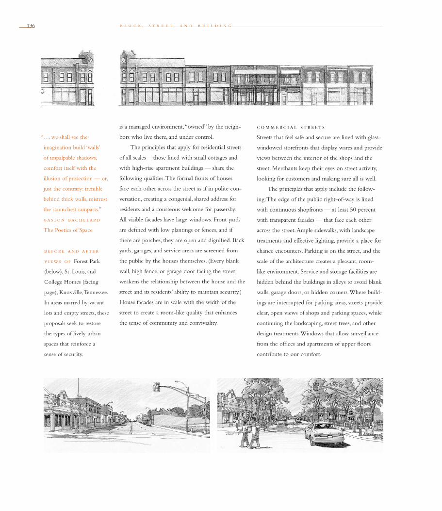
136
is a managed environment, “owned” by the neigh-
bors who live there, and under control.
The principles that apply for residential streets
of all scales—those lined with small cottages and
with high-rise apartment buildings — share the
following qualities. The formal fronts of houses
face each other across the street as if in polite con-
versation, creating a congenial, shared address for
residents and a courteous welcome for passersby.
All visible facades have large windows. Front yards
are defi ned with low plantings or fences, and if
there are porches, they are open and dignifi ed. Back
yards, garages, and service areas are screened from
the public by the houses themselves. (Every blank
wall, high fence, or garage door facing the street
weakens the relationship between the house and the
street and its residents’ ability to maintain security.)
House facades are in scale with the width of the
street to create a room-like quality that enhances
the sense of community and conviviality.
com m e rc i al st r e et s
Streets that feel safe and secure are lined with glass-
windowed storefronts that display wares and provide
views between the interior of the shops and the
street. Merchants keep their eyes on street activity,
looking for customers and making sure all is well.
The principles that apply include the follow-
ing: The edge of the public right-of-way is lined
with continuous shopfronts — at least 50 percent
with transparent facades — that face each other
across the street. Ample sidewalks, with landscape
treatments and effective lighting, provide a place for
chance encounters. Parking is on the street, and the
scale of the architecture creates a pleasant, room-
like environment. Service and storage facilities are
hidden behind the buildings in alleys to avoid blank
walls, garage doors, or hidden corners. Where build-
ings are interrupted for parking areas, streets provide
clear, open views of shops and parking spaces, while
continuing the landscaping, street trees, and other
design treatments. Windows that allow surveillance
from the offi ces and apartments of upper fl oors
contribute to our comfort.
b l o c k , s t r e e t , a n d b u i l d i n g
“. . . we shall see the
imagination build ‘walls’
of impalpable shadows,
comfort itself with the
illusion of protection — or,
just the contrary: tremble
behind thick walls, mistrust
the staunchest ramparts.”
gaston bac h e lard
The Poetics of Space
b e f ore and a f t e r
v i ews o f Forest Park
(below), St. Louis, and
College Homes (facing
page), Knoxville, Tennessee.
In areas marred by vacant
lots and empty streets, these
proposals seek to restore
the types of lively urban
spaces that reinforce a
sense of security.
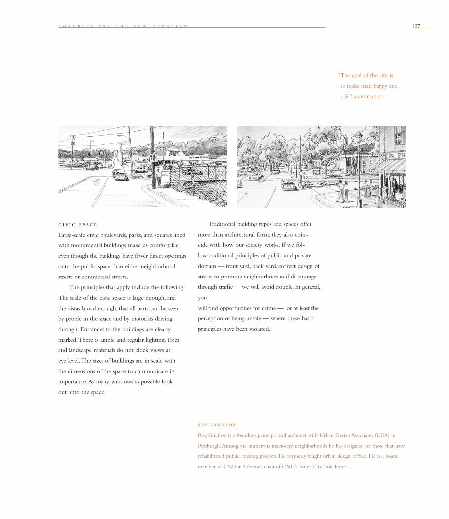
c o n g r e s s f o r t h e n e w u r b a n i s m 137
c iv i c s pac e
Large-scale civic boulevards, parks, and squares lined
with monumental buildings make us comfortable
even though the buildings have fewer direct openings
onto the public space than either neighborhood
streets or com mercial streets.
The principles that apply include the following:
The scale of the civic space is large enough, and
the vistas broad enough, that all parts can be seen
by people in the space and by motorists driving
through. Entrances to the buildings are clearly
marked. There is ample and regular lighting. Trees
and landscape materials do not block views at
eye level. The sizes of buildings are in scale with
the dimensions of the space to communicate its
importance. As many windows as possible look
out onto the space.
ray g i ndro z
Ray Gindroz is a founding principal and architect with Urban Design Associates (UDA) in
Pittsburgh. Among the numerous inner-city neighborhoods he has designed are those that have
rehabilitated public housing projects. He formerly taught urban design at Yale. He is a board
member of CNU and former chair of CNU’s Inner City Task Force.
Traditional building types and spaces offer
more than architectural form; they also coin-
cide with how our society works. If we fol-
low traditional principles of public and private
domain — front yard, back yard, correct design of
streets to promote neighborliness and discourage
through traffi c — we will avoid trouble. In general,
you
will fi nd opportunities for crime — or at least the
perception of being unsafe — where these basic
principles have been violated.
“The goal of the city is
to make man happy and
safe.” ar i stot l e

138 b l o c k , s t r e e t , a n d b u i l d i n g
The Rebirth of Bryant Park
New York City’s Bryant Park is a spectacularly safe
and sought-after urban park. But 20 years ago, six-
acre Bryant Park — the only open space at the
heart of midtown Manhattan’s 26 million square
feet of offi ces and shops stuffed into the world’s
greatest collection of skyscrapers — was a heart
of darkness. During the previous decade it had
become “needle park” — dominated by drug deal-
ers, dreaded by the public, the scene of two murders
and at least one other felony every three days.
Decline and degradation were not the end of
the Bryant Park story, but the beginning of a night-
into-day transformation. A partnership composed of
the city, a foundation, building owners around the
park, and a nonprofi t park restoration group spent
$9 million on a comprehensive two-year overhaul.
Seven years later, Bryant Park is probably the most
sought-after public space in New York — at once
midtown’s front lawn and its living room carpet.
The park regularly draws lunchtime crowds of
10,000. Mothers and toddlers smell the fl owers.
Orange-robed Tibetan Buddhist monks munch
sandwiches and gaze at the top of the Empire State
Building. Shirt-sleeved businessmen and women sit
in circles on the great lawn to continue meetings
that began indoors. On summer nights, as many as
11,000 people gather to view classic movies on a
giant screen.
Drug dealers disappeared the day the park
reopened in 1992 and have never returned. Crime
is practically nonexistent: Two of the fi rst 4 million
visitors to the restored park have had their pockets
picked. What went right? Restorers rejected the
idea that the park could solve its safety problems
by restricting access. Instead, a study by the late
William H. Whyte, the great modern student of
public spaces, disclosed that long before drug dealers
made it dangerous, the park had been chronically
under-used for almost half a century, because of
fatal fl aws in its 1934 design as a secluded, formal
French garden.
As a result, Bryant Park had always been
psychologically unsafe — a place where fearful-
ness had a stronger hold than delight. The park had
been surrounded by a series of high hedges, so that
people on the street had no way of knowing what
was inside, pleasant or unpleasant. People who did
venture in felt trapped in a maze. There were not
nearly enough entrances and exits, and the few
that existed had steep, narrow steps.
The new park, hedge-free and awash with
entrances, entices people with restaurants and hand-
somely labeled food kiosks, 2,000 movable, green
folding chairs, opulent fl ower beds, nonstop security
patrols, restrooms with fresh fl owers and baby-
changing stations, and a full-time cleaning staff that
daily removes more than a ton of trash. Bryant Park
is almost self-supporting: Concessions and neighbor-
ing landlords cover 90 percent of its $2.5 million
annual operating budget, and the park simultaneously
subsidizes the owners of nearby buildings. Rents in
the area have gone up by as much as 100 percent.
— t o n y h i s s
tony h i s s
Tony Hiss is the author of numerous books, including The Experience of Place.

c o n g r e s s f o r t h e n e w u r b a n i s m 139
twe nty year s ag o, b ryant par k in midtown Manhattan was a heart
of darkness. By correcting decades-old design fl aws that invited nefarious activities,
the park renovation of 1992 created a safe and inviting urban space.

140140 b l o c k , s t r e e t , a n d b u i l d i n g

141
d o u g l a s f a r r
In the contemporary metropolis, development must adequately
accommodate automobiles. It should do so in ways that respect
the pedestrian and the form of public space.
Tw e n t y t w o
Automobiles are a fact of modern life, and they are not going away. Walking, on the
other hand, faces extinction in most places built since World War II — places designed
for the convenient use of cars. This is nothing new, since the forms of cities and towns
have always adapted to people’s dominant method of getting around. What is differ-
ent is that places designed around cars are hostile to pedestrians. Try to walk across an
eight-lane suburban arterial, and you understand this immediately.
For thousands of years, urban streets and spaces accommodated the fl ow of
pedestrians and domesticated animals. When humans hitched wagons to animals, urban
development adapted to the size of the rigs and the room they needed to maneuver.
American cities of the 19th century were laid out for horse-drawn vehicles. At fi rst, the
auto seemed to fi t in nicely. The fi rst autos were more maneuverable, smaller, and fewer
in number than the horse-drawn carriage rigs, and they had little effect on
city planning.
Enter the Automobile Age, and all hell breaks loose. Automobile ownership grows
exponentially, setting several forces in motion. A design manifesto called the Athens
Charter, written by Le Corbusier and other leading Modern architects in 1943, advo-
cates designing places around cars. Zoning and building codes are promulgated making
it illegal to do anything but to design for cars. Some architects forget how to design
pedestrian-friendly public places. People cease to value public spaces.
ac ro s s th e count ry,
both pedestrian malls and
interior malls are dying. This
illustrates the paradox of
modern retail development.
Too many cars scare away
pedestrians, while too few
starve the retailers. Mizner
Park, in Boca Raton, Florida
(left), strikes a balance by
replacing a dead mall with
a mixed-use community
facing a revived street.

142 b l o c k , s t r e e t , a n d b u i l d i n g
What remains is a tragic paradox: a metro-
politan region where cars can travel anywhere
while pedestrians cannot. The importance of this
Charter principle emerges when one understands
that when places are designed exclusively for cars,
fewer people will walk.
We Americans love our freedoms, and the
automobile gave us the freedom not to walk much.
Judging by the record numbers of obese Americans,
we are enthusiastically exercising our freedom not
to walk. We also love convenience. People will drive
rather than walk even incredibly short distances
if parking is convenient at both ends of the trip.
Once in a car, people fi nd it convenient to make
all trips in a car, whether cross-town or down the
block. This results in ever-increasing numbers of
trips by car and total miles driven — a 30 percent
increase in vehicle miles traveled (VMT) since
1989 alone. We need a national “12-step” program
to get and keep people out of their cars.
At the same time, we need to be realistic. Most
people will continue to drive their cars, so streets
must oblige traffi c. But we need better streets and
public spaces than most new ones being built. They
must be reasonably pleasant and convenient for
motoring, but delightful for walking and cycling.
The addition of bike lanes, sidewalks, and trees
to facilitate people-powered transit also has the
benefi t of making the street narrower, so drivers
tend to slow down.
A fi rst step would be to give architects and
urban designers a remedial education on how to
make good multi-purpose public streets. The design
elements that contribute to success vary, but several
universal design principles emerge.
p rote c t th e p e de st r i an
Start with providing sidewalks. Not surprisingly,
people walk more when there are sidewalks and
less if they are forced to walk in a street or a ditch.
Second, reduce traffi c speeds to increase pedestrian
safety. Traffi c engineers will tell you that driving
speeds are largely determined by street width and
the number of lanes; posted speed limits are mean-
ingless. Drivers will ignore a 25-mile-an-hour sign
on an eight-lane arterial. Conversely, it feels risky
to drive faster than 30 on a narrow street with
cars parked on both sides.
Traffi c circles and other “traffi c-calming” tools
can reduce vehicle speeds and foster a safe pedes-
trian environment (above left). Drivers sometimes
protest when such measures are installed, but it
turns out they can improve traffi c fl ow on a street.
Traffi c circles can be particularly effective because
they allow traffi c to fl ow without stopping, whereas
stop-lights and four-way stops can generate more
air and noise pollution. What enhances safety for
pedestrians makes driving safer, too. In 1998,
the city of Seattle reported that the installation of
119 traffi c-calming projects reduced accidents by
94 percent at those locations.
“[S]treets require and use
vast amounts of land.
In the United States, 25
to 35 percent of a city’s
developed land is likely
to be in public right-of-
way, mostly in streets. . . .
If we can develop and
design streets so they are
wonderful, fulfi lling places
to be . . . then we will
have successfully designed
about one-third of the
city directly and will have
an immense impact on
the rest.”
al lan b . jacob s
Great Streets
“In Houston, a person
walking is somebody
on the way to their
car.” anth ony dow n s
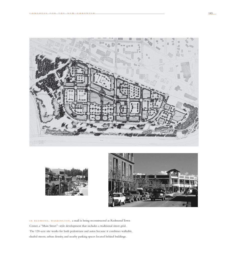
c o n g r e s s f o r t h e n e w u r b a n i s m 143
i n r e dmond, wash i ng ton, a mall is being reconstructed as Redmond Town
Center, a “Main Street”–style development that includes a traditional street grid.
The 120-acre site works for both pedestrians and autos because it combines walkable,
shaded streets, urban density, and nearby parking spaces located behind buildings.
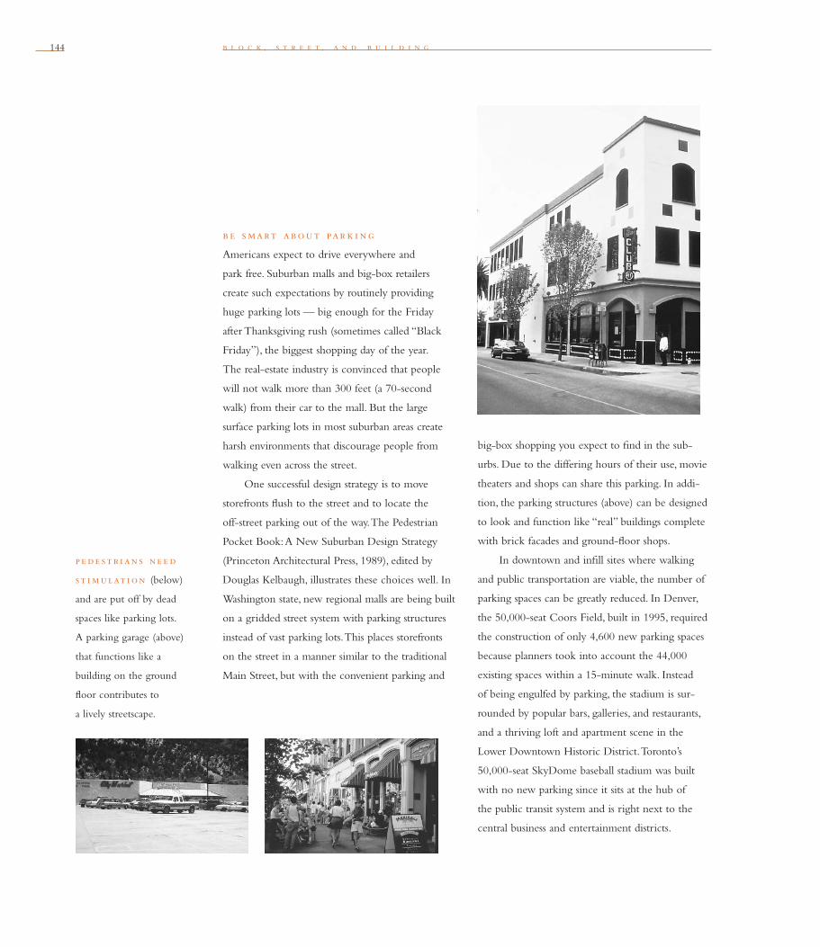
144 b l o c k , s t r e e t , a n d b u i l d i n g
b e smart about par k i ng
Americans expect to drive everywhere and
park free. Suburban malls and big-box retailers
create such expectations by routinely providing
huge parking lots — big enough for the Friday
after Thanksgiving rush (sometimes called “Black
Friday”), the biggest shopping day of the year.
The real-estate industry is convinced that people
will not walk more than 300 feet (a 70-second
walk) from their car to the mall. But the large
surface parking lots in most suburban areas create
harsh environments that discourage people from
walking even across the street.
One successful design strategy is to move
storefronts fl ush to the street and to locate the
off-street parking out of the way. The Pedestrian
Pocket Book: A New Suburban Design Strategy
(Princeton Architectural Press, 1989), edited by
Douglas Kelbaugh, illustrates these choices well. In
Washington state, new regional malls are being built
on a gridded street system with parking structures
instead of vast parking lots. This places storefronts
on the street in a manner similar to the traditional
Main Street, but with the convenient parking and
big-box shopping you expect to fi nd in the sub-
urbs. Due to the differing hours of their use, movie
theaters and shops can share this parking. In addi-
tion, the parking structures (above) can be designed
to look and function like “real” buildings complete
with brick facades and ground-fl oor shops.
In downtown and infi ll sites where walking
and public transportation are viable, the number of
parking spaces can be greatly reduced. In Denver,
the 50,000-seat Coors Field, built in 1995, required
the construction of only 4,600 new parking spaces
because planners took into account the 44,000
existing spaces within a 15-minute walk. Instead
of being engulfed by parking, the stadium is sur-
rounded by popular bars, galleries, and restaurants,
and a thriving loft and apartment scene in the
Lower Downtown Historic District. Toronto’s
50,000-seat SkyDome baseball stadium was built
with no new parking since it sits at the hub of
the public transit system and is right next to the
central business and entertainment districts.
p e de st r i an s ne e d
st i mulat i on (below)
and are put off by dead
spaces like parking lots.
A parking garage (above)
that functions like a
building on the ground
fl oor contributes to
a lively streetscape.
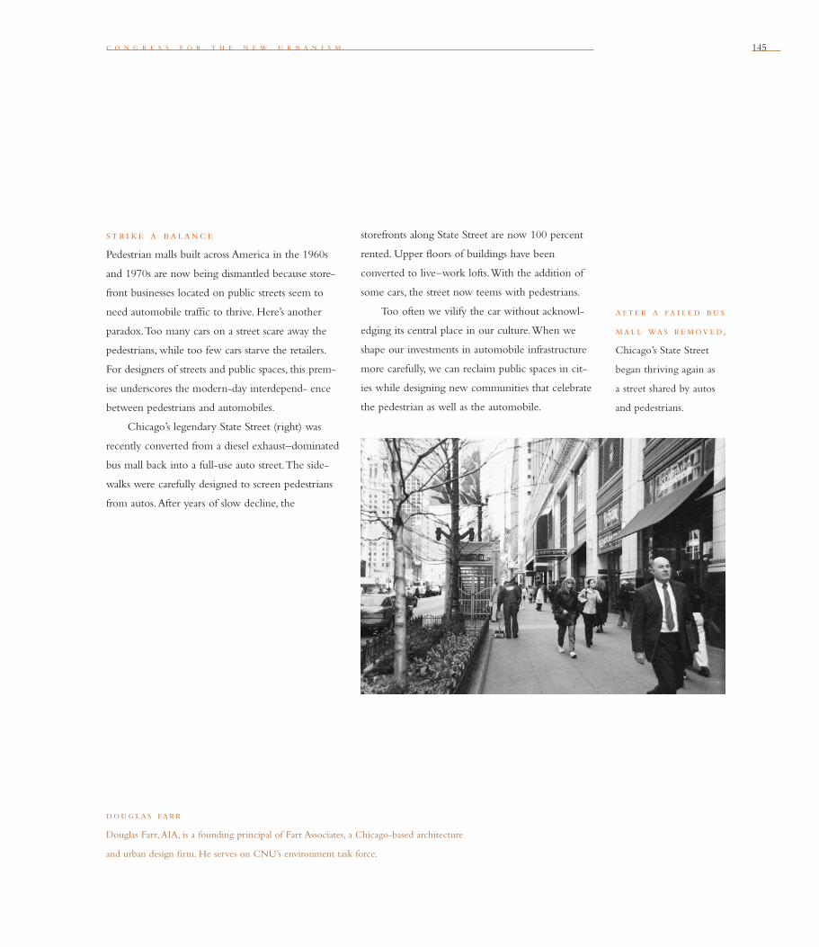
c o n g r e s s f o r t h e n e w u r b a n i s m 145
dou g las farr
Douglas Farr, AIA, is a founding principal of Farr Associates, a Chicago-based architecture
and urban design fi rm. He serves on CNU’s environment task force.
st r i ke a balanc e
Pedestrian malls built across America in the 1960s
and 1970s are now being dismantled because store-
front businesses located on public streets seem to
need automobile traffi c to thrive. Here’s another
paradox. Too many cars on a street scare away the
pedestrians, while too few cars starve the retailers.
For designers of streets and public spaces, this prem-
ise underscores the modern-day interdepend- ence
between pedestrians and automobiles.
Chicago’s legendary State Street (right) was
recently converted from a diesel exhaust–dominated
bus mall back into a full-use auto street. The side-
walks were carefully designed to screen pedestrians
from autos. After years of slow decline, the
storefronts along State Street are now 100 percent
rented. Upper fl oors of buildings have been
converted to live–work lofts. With the addition of
some cars, the street now teems with pedestrians.
Too often we vilify the car without acknowl-
edging its central place in our culture. When we
shape our investments in automobile infrastructure
more carefully, we can reclaim public spaces in cit-
ies while designing new communities that celebrate
the pedestrian as well as the automobile.
a f te r a fa i l e d bu s
mal l was r e move d,
Chicago’s State Street
began thriving again as
a street shared by autos
and pedestrians.
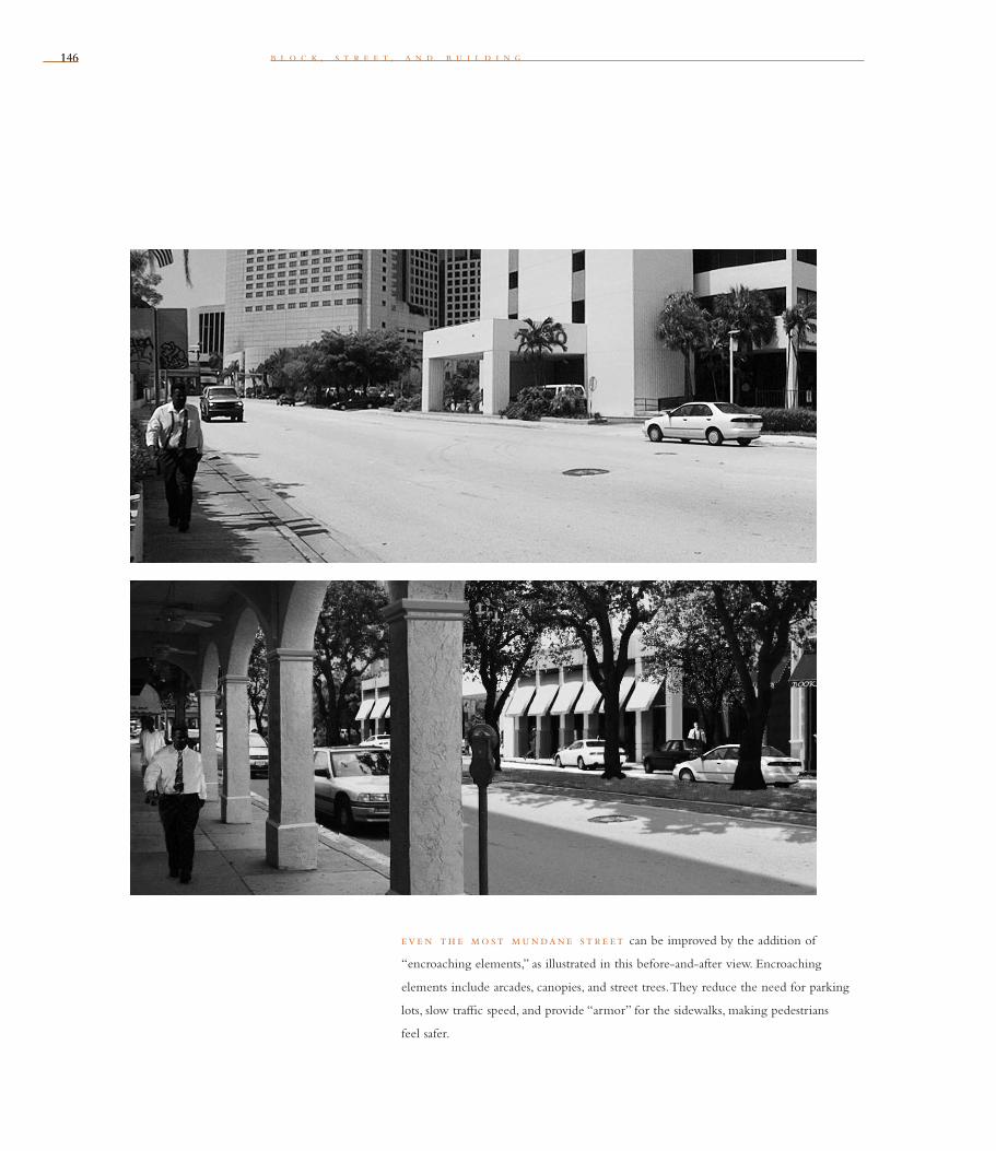
146146 b l o c k , s t r e e t , a n d b u i l d i n g
eve n th e mo st mundane st r e et can be improved by the addition of
“encroaching elements,” as illustrated in this before-and-after view. Encroaching
elements include arcades, canopies, and street trees. They reduce the need for parking
lots, slow traffi c speed, and provide “armor” for the sidewalks, making pedestrians
feel safer.
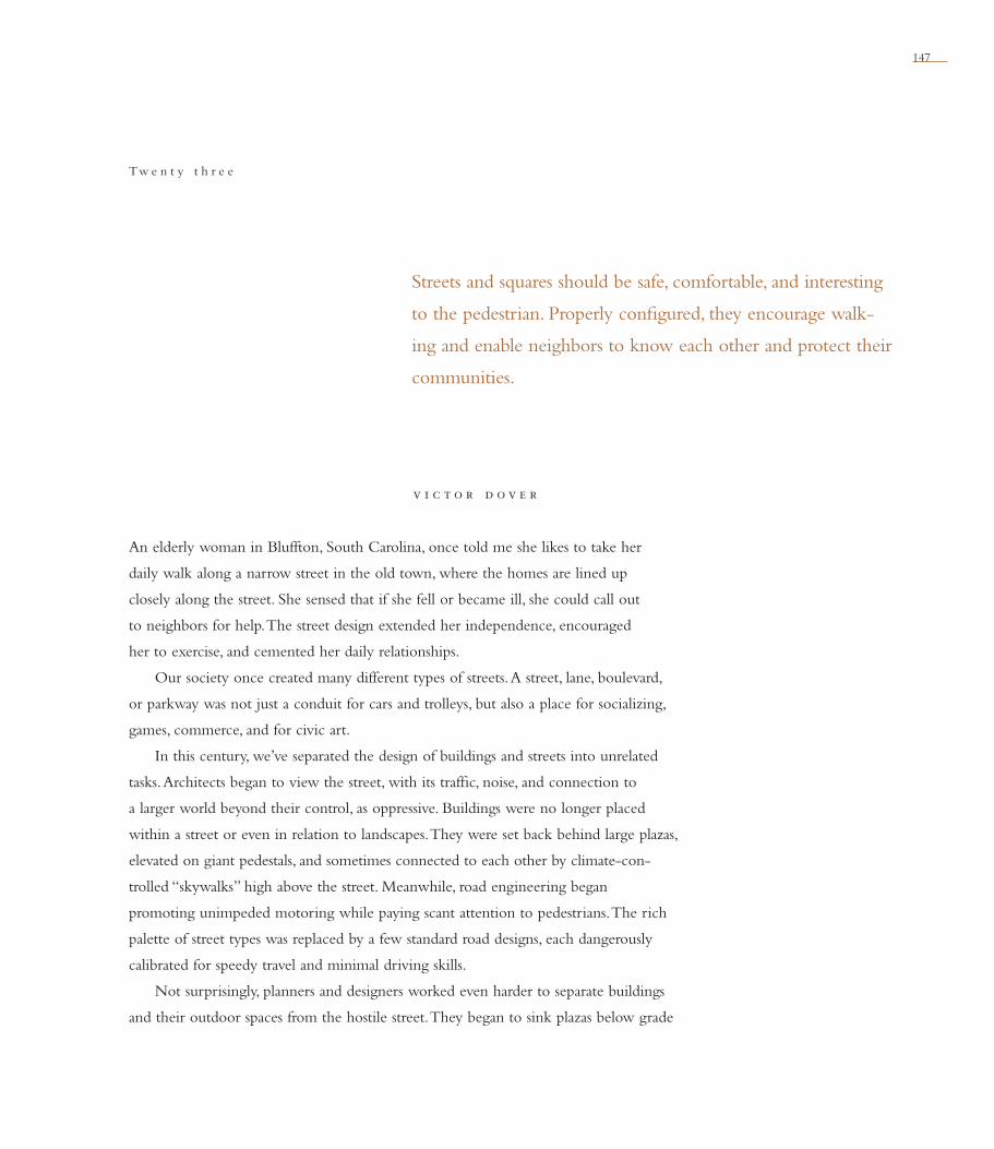
147
v i c t o r d o v e r
Streets and squares should be safe, comfortable, and interesting
to the pedestrian. Properly confi gured, they encourage walk-
ing and enable neighbors to know each other and protect their
communities.
Tw e n t y t h r e e
An elderly woman in Bluffton, South Carolina, once told me she likes to take her
daily walk along a narrow street in the old town, where the homes are lined up
closely along the street. She sensed that if she fell or became ill, she could call out
to neighbors for help. The street design extended her independence, encouraged
her to exercise, and cemented her daily relationships.
Our society once created many different types of streets. A street, lane, boulevard,
or parkway was not just a conduit for cars and trolleys, but also a place for socializing,
games, commerce, and for civic art.
In this century, we’ve separated the design of buildings and streets into unrelated
tasks. Architects began to view the street, with its traffi c, noise, and connection to
a larger world beyond their control, as oppressive. Buildings were no longer placed
within a street or even in relation to landscapes. They were set back behind large plazas,
elevated on giant pedestals, and sometimes connected to each other by climate-con-
trolled “skywalks” high above the street. Meanwhile, road engineering began
promoting unimpeded motoring while paying scant attention to pedestrians. The rich
palette of street types was replaced by a few standard road designs, each dangerously
calibrated for speedy travel and minimal driving skills.
Not surprisingly, planners and designers worked even harder to separate buildings
and their outdoor spaces from the hostile street. They began to sink plazas below grade
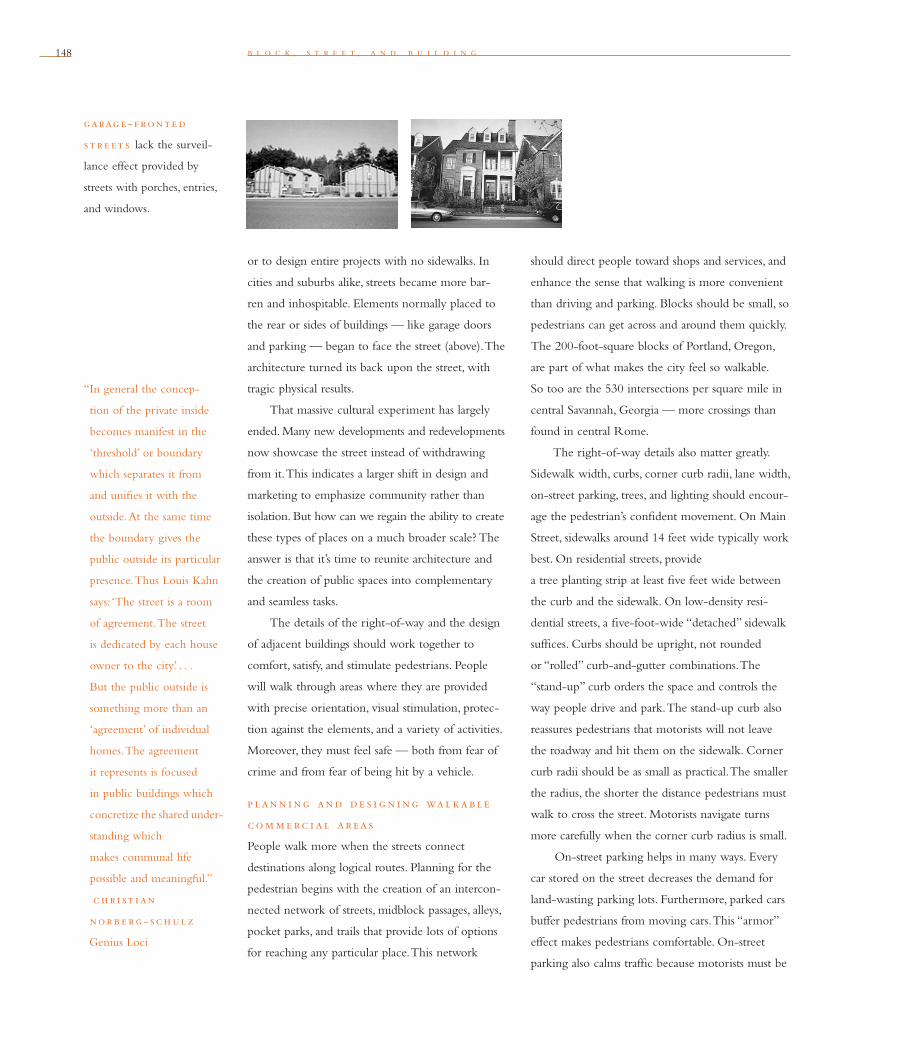
148 b l o c k , s t r e e t , a n d b u i l d i n g
or to design entire projects with no sidewalks. In
cities and suburbs alike, streets became more bar-
ren and inhospitable. Elements normally placed to
the rear or sides of buildings — like garage doors
and parking — began to face the street (above). The
architecture turned its back upon the street, with
tragic physical results.
That massive cultural experiment has largely
ended. Many new developments and redevelopments
now showcase the street instead of withdrawing
from it. This indicates a larger shift in design and
marketing to emphasize community rather than
isolation. But how can we regain the ability to create
these types of places on a much broader scale? The
answer is that it’s time to reunite architecture and
the creation of public spaces into complementary
and seamless tasks.
The details of the right-of-way and the design
of adjacent buildings should work together to
comfort, satisfy, and stimulate pedestrians. People
will walk through areas where they are provided
with precise orientation, visual stimulation, protec-
tion against the elements, and a variety of activities.
Moreover, they must feel safe — both from fear of
crime and from fear of being hit by a vehicle.
p lann i ng and de s i g n i ng wal kable
com m e rc i al areas
People walk more when the streets connect
destinations along logical routes. Planning for the
pedestrian begins with the creation of an intercon-
nected network of streets, midblock passages, alleys,
pocket parks, and trails that provide lots of options
for reaching any particular place. This network
should direct people toward shops and services, and
enhance the sense that walking is more convenient
than driving and parking. Blocks should be small, so
pedestrians can get across and around them quickly.
The 200-foot-square blocks of Portland, Oregon,
are part of what makes the city feel so walkable.
So too are the 530 intersections per square mile in
central Savannah, Georgia — more crossings than
found in central Rome.
The right-of-way details also matter greatly.
Sidewalk width, curbs, corner curb radii, lane width,
on-street parking, trees, and lighting should encour-
age the pedestrian’s confi dent movement. On Main
Street, sidewalks around 14 feet wide typically work
best. On residential streets, provide
a tree planting strip at least fi ve feet wide between
the curb and the sidewalk. On low-density resi-
dential streets, a fi ve-foot-wide “detached” sidewalk
suffi ces. Curbs should be upright, not rounded
or “rolled” curb-and-gutter combinations. The
“stand-up” curb orders the space and controls the
way people drive and park. The stand-up curb also
reassures pedestrians that motorists will not leave
the roadway and hit them on the sidewalk. Corner
curb radii should be as small as practical. The smaller
the radius, the shorter the distance pedestrians must
walk to cross the street. Motorists navigate turns
more carefully when the corner curb radius is small.
On-street parking helps in many ways. Every
car stored on the street decreases the demand for
land-wasting parking lots. Furthermore, parked cars
buffer pedestrians from moving cars. This “armor”
effect makes pedestrians comfortable. On-street
parking also calms traffi c because motorists must be
“In general the concep-
tion of the private inside
becomes manifest in the
‘threshold’ or boundary
which separates it from
and unifi es it with the
outside. At the same time
the boundary gives the
public outside its particular
presence. Thus Louis Kahn
says: ‘The street is a room
of agreement. The street
is dedicated by each house
owner to the city’. . . .
But the public outside is
something more than an
‘agreement’ of individual
homes. The agreement
it represents is focused
in public buildings which
concretize the shared under-
standing which
makes communal life
possible and meaningful.”
c h r i st i an
nor b e rg - sc h ul z
Genius Loci
garag e - f ronte d
st r e et s lack the surveil-
lance effect provided by
streets with porches, entries,
and windows.
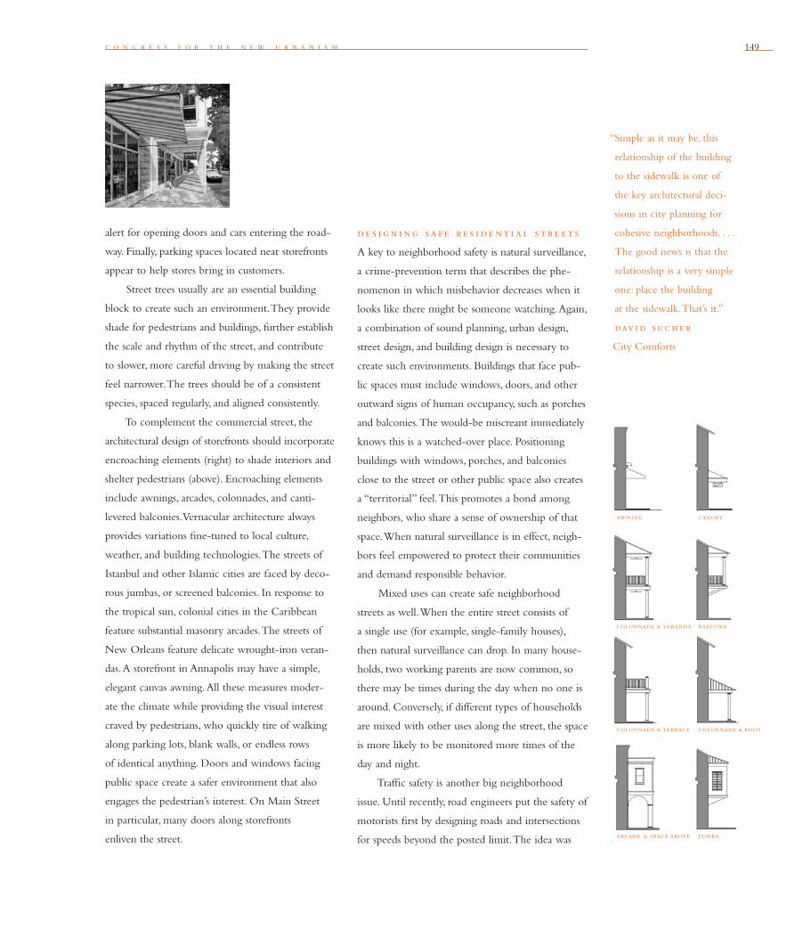
c o n g r e s s f o r t h e n e w u r b a n i s m 149
alert for opening doors and cars entering the road-
way. Finally, parking spaces located near storefronts
appear to help stores bring in customers.
Street trees usually are an essential building
block to create such an environment. They provide
shade for pedestrians and buildings, further establish
the scale and rhythm of the street, and contribute
to slower, more careful driving by making the street
feel narrower. The trees should be of a consistent
species, spaced regularly, and aligned consistently.
To complement the commercial street, the
architectural design of storefronts should incor porate
encroaching elements (right) to shade interiors and
shelter pedestrians (above). Encroaching elements
include awnings, arcades, colonnades, and canti-
levered balconies. Vernacular architecture always
provides variations fi ne-tuned to local culture,
weather, and building technologies. The streets of
Istanbul and other Islamic cities are faced by deco-
rous jumbas, or screened balconies. In response to
the tropical sun, colonial cities in the Caribbean
feature substantial masonry arcades. The streets of
New Orleans feature delicate wrought-iron veran-
das. A storefront in Annapolis may have a simple,
elegant canvas awning. All these measures moder-
ate the climate while providing the visual interest
craved by pedestrians, who quickly tire of walking
along parking lots, blank walls, or endless rows
of identical anything. Doors and windows facing
public space create a safer environment that also
engages the pedestrian’s interest. On Main Street
in particular, many doors along storefronts
enliven the street.
de s i g n i ng sa f e r e s i de nt i a l st r e et s
A key to neighborhood safety is natural surveillance,
a crime-prevention term that describes the phe-
nomenon in which misbehavior decreases when it
looks like there might be someone watching. Again,
a combination of sound planning, urban design,
street design, and building design is necessary to
create such environments. Buildings that face pub-
lic spaces must include windows, doors, and other
outward signs of human occupancy, such as porches
and balconies. The would-be miscreant immediately
knows this is a watched-over place. Positioning
buildings with windows, porches, and balconies
close to the street or other public space also creates
a “territorial” feel. This promotes a bond among
neighbors, who share a sense of ownership of that
space. When natural surveillance is in effect, neigh-
bors feel empowered to protect their communities
and demand responsible behavior.
Mixed uses can create safe neighborhood
streets as well. When the entire street consists of
a single use (for example, single-family houses),
then natural surveillance can drop. In many house-
holds, two working parents are now common, so
there may be times during the day when no one is
around. Conversely, if different types of households
are mixed with other uses along the street, the space
is more likely to be monitored more times of the
day and night.
Traffi c safety is another big neighborhood
issue. Until recently, road engineers put the safety of
motorists fi rst by designing roads and intersections
for speeds beyond the posted limit. The idea was
“Simple as it may be, this
relationship of the building
to the sidewalk is one of
the key architectural deci-
sions in city planning for
cohesive neighborhoods. . . .
The good news is that the
relationship is a very simple
one: place the building
at the sidewalk. That’s it.”
dav i d suc h e r
City Comforts
awning canopy
colonnade & veranda balcony
colonnade & terrace colonnade & roof
arcade & space above jumba

150 b l o c k , s t r e e t , a n d b u i l d i n g
to protect those motorists who drive carelessly or
too fast. But when the road is designed for speed-
ing, people take advantage of that invitation, and
more mayhem results. Traffi c calming reverses this
approach by providing physical cues — including
street trees, narrower streets, traffi c circles, and
intersections designed for pedestrians — to slow
down rather than speed up.
s quare s and p lazas
Our modern urban plazas suffer from many of the
same problems as modern streets. Especially at the
base of high-rise offi ce buildings, they frequently
showcase the building rather than encourage or
shelter the pedestrian. They are indifferent to their
climate and environs, and thus are unpleasant to
walk through or to inhabit. Fortunately, many of
these places can be rescued. In almost every city,
dull urban plazas have already been improved to
provide new seating, shade, and places to eat, shop,
or enjoy performances.
The size and placement of squares should
relate to their purpose and context. Their design
image should be driven by climate, culture, and the
activities likely to occur there. Plazas and squares
v i c tor dove r
Victor Dover, AICP, is a planner and principal in Dover, Kohl & Partners, Town Planning,
in South Miami, Florida. He is a founding member of CNU.
should be located where they will be used — near
cafes and storefronts, or in front of a courthouse,
for example — and where they enhance real-estate
value. Regional traditions should inform the choice
between a soft, green space such as the village
common found in small towns in the Northeast
and Midwest, or the paved plaza found in Latin
America, the Caribbean, or the Mediterranean.
For too many years, cities and towns turned
inwards by replacing their shopping streets with
interior malls, supplanting ground-level sidewalks
with enclosed bridges, and placing parking in spots
once inhabited by street-level shops and activi-
ties. Much was lost, but we’re discovering we can
integrate the design of architecture and streets
to regain the vigor of public spaces.
“The measure of any great
civilization is its cities and
a measure of a city’s great-
ness is to be found in the
quality of its public spaces,
its parks and squares.”
joh n ru sk i n
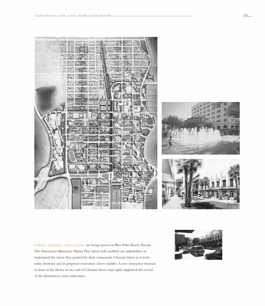
c o n g r e s s f o r t h e n e w u r b a n i s m 151
p ub l i c s quare s and p lazas are being revived in West Palm Beach, Florida.
The Downtown Illustrative Master Plan (above left) enabled city stakeholders to
understand the vision they posited for their community. Clematis Street as it looks
today (bottom) and its proposed renovation (above middle). A new interactive fountain
in front of the library at one end of Clematis Street (top right) supported the revival
of the downtown’s main retail street.
152
“In a city the street must
be supreme. It is the fi rst
institution of the city. The
street is a room by agree-
ment, a community room,
the walls of which belong
to the donors, dedicated
to the city for com-
mon use. Its ceiling is the
sky.” lou i s i . kah n
Between Silence and Light
The Recovery of the Public Realm
The state of this country’s public spaces is both
exciting and sobering. On the one hand, the past
20 years have produced a magnifi cent revival
of public places. Major sites in central loca-
tions — urban riverfronts, downtown plazas and
parks, fashionable shopping streets, and historic
districts — have been renovated and are better kept
than ever before. These places have received lavish
public and private investment and been the focus
of innovative management efforts that sustain their
vitality. As a consequence, they are extremely well
used and are brimming with people who go about
their business with a freedom and easiness that one
rarely encountered in such places just a few years
ago.
On the other hand, smaller and less central
places — neighborhood streets and parks, play-
grounds, gardens, neighborhood squares, and older
suburban commercial centers — continue to
decline. In fact, many smaller public places have
become
the victims of redevelopment, privatization, and
neglect, and are disappearing altogether. If not
addressed, this imbalance will ultimately dimin-
ish the rich diversity of the public environment
of cities, forever the symbol of our communities’
aesthetic and social values. It will also deplete the
rich design vocabulary upon which that diversity
was built.
A full recovery of both grand and humble
public places in cities and older suburbs is in order.
Such full recovery, however, requires a rigorous and
all-inclusive approach that includes:
• Addressing head-on the forces that contrib-
ute to the deterioration of public places. This
means managing growth; subordinating private
cars to public and other modes of transporta-
tion; bringing back the many and integrated
civic activities that have fallen out of our lives
in the past 50 years; and reversing functional,
social, and economic segregation;
• Challenging rules and regulations that inhibit
the creation of great public places;
• Thinking creatively of ways to fi nance and
maintain them;
• Looking at each public place as part of a much
larger system, in which preserves of wild and
rural land are rigorously linked (via greenways
and transportation corridors) to the humblest
neighborhood places to form a coherent public
network of open spaces and pathways;
• Cataloging and understanding the consensual
and rich design vocabulary that has given
us the elegant and masterly public realm of
the past;
• Applying that vocabulary to new places and
to the rehabilitation of existing ones, including
public and low-income housing;
• Developing and supporting legislation to
facilitate the transformation of empty and
abandoned lots (including surface parking
b l o c k , s t r e e t , a n d b u i l d i n g
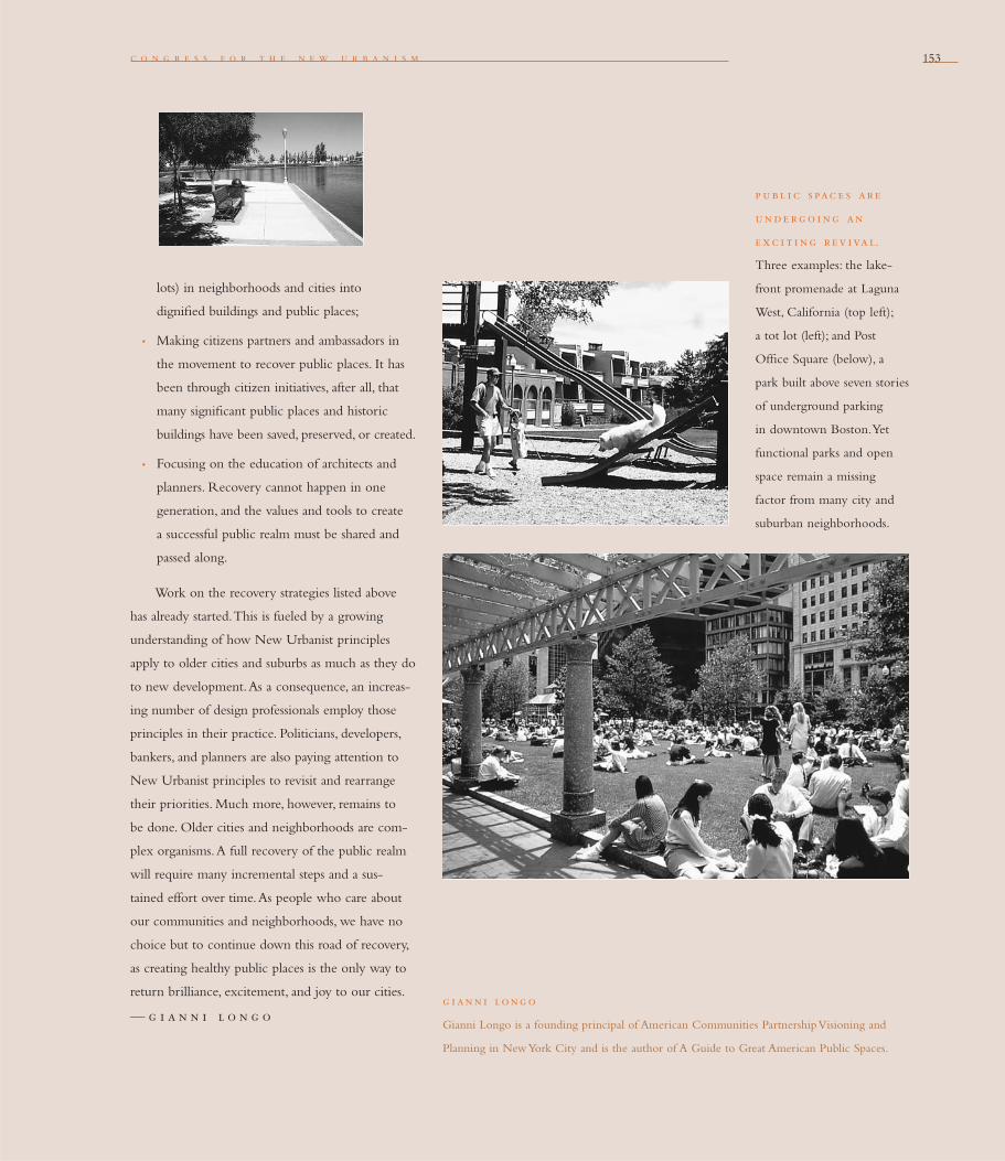
c o n g r e s s f o r t h e n e w u r b a n i s m 153
g i ann i long o
Gianni Longo is a founding principal of American Communities Partnership Visioning and
Planning in New York City and is the author of A Guide to Great American Public Spaces.
lots) in neighborhoods and cities into
dignifi ed buildings and public places;
• Making citizens partners and ambassadors in
the movement to recover public places. It has
been through citizen initiatives, after all, that
many signifi cant public places and historic
buildings have been saved, preserved, or created.
• Focusing on the education of architects and
planners. Recovery cannot happen in one
generation, and the values and tools to create
a successful public realm must be shared and
passed along.
Work on the recovery strategies listed above
has already started. This is fueled by a growing
understanding of how New Urbanist principles
apply to older cities and suburbs as much as they do
to new development. As a consequence, an increas-
ing number of design professionals employ those
principles in their practice. Politicians, developers,
bankers, and planners are also paying attention to
New Urbanist principles to revisit and rearrange
their priorities. Much more, however, remains to
be done. Older cities and neighborhoods are com-
plex organisms. A full recovery of the public realm
will require many incremental steps and a sus-
tained effort over time. As people who care about
our communities and neighborhoods, we have no
choice but to continue down this road of recovery,
as creating healthy public places is the only way to
return brilliance, excitement, and joy to our cities.
— g i a n n i l o n g o
p ubl i c s pac e s ar e
unde rg o i ng an
e xc i t i ng r ev ival.
Three examples: the lake-
front promenade at Laguna
West, California (top left);
a tot lot (left); and Post
Offi ce Square (below), a
park built above seven stories
of underground parking
in downtown Boston. Yet
functional parks and open
space remain a missing
factor from many city and
suburban neighborhoods.

154154
pas s i v e s olar arc h i t e c ture relies on the orientation of buildings rather than
technology. Solar architecture (above) combines south-facing windows, greenhouse
walls, and masonry Trombe walls that absorb solar heat and release it into the interior.
“Solar chimneys” draw away heat for summer cooling. These and other types of
natural heating and ventilation techniques grow from local climate.
b l o c k , s t r e e t , a n d b u i l d i n g
north e l evat i on
s outh e l evat i on
155
d o u g l a s k e l b a u g h
Architecture and landscape design should grow from
local climate, topography, history, and building practice.
Tw e n t y f o u r
To an urban planner, many New Urbanist principles mean thinking bigger — planning
at the scale of a metropolitan region rather than at the scale of the subdivision. To
an architect or landscape architect, however, this principle means thinking smaller —
resisting the forces that make generic buildings, streets, and blocks, and championing
forces that encourage local design. Also called Regionalism or Critical Regionalism,
this attitude celebrates and delights in what is different about a place.
This principle roots architecture and landscape design in local culture and the
genius loci. It is a reaction against the standardization and homogenization of
Modernism, which typically substituted technological fi xes (air conditioning, for exam-
ple) for
architectural responses to climate, topography, and building practice.
Within this principle’s emphasis on climate and topography, the Charter also asserts
the importance of the vertical cycles, loops, and chains of nature. Understanding and
preserving these natural systems is essential to ecological health, as is respect for the land
and its geology, hydrology, biota, and the cyclical processes that nourish and cleanse
the environment.
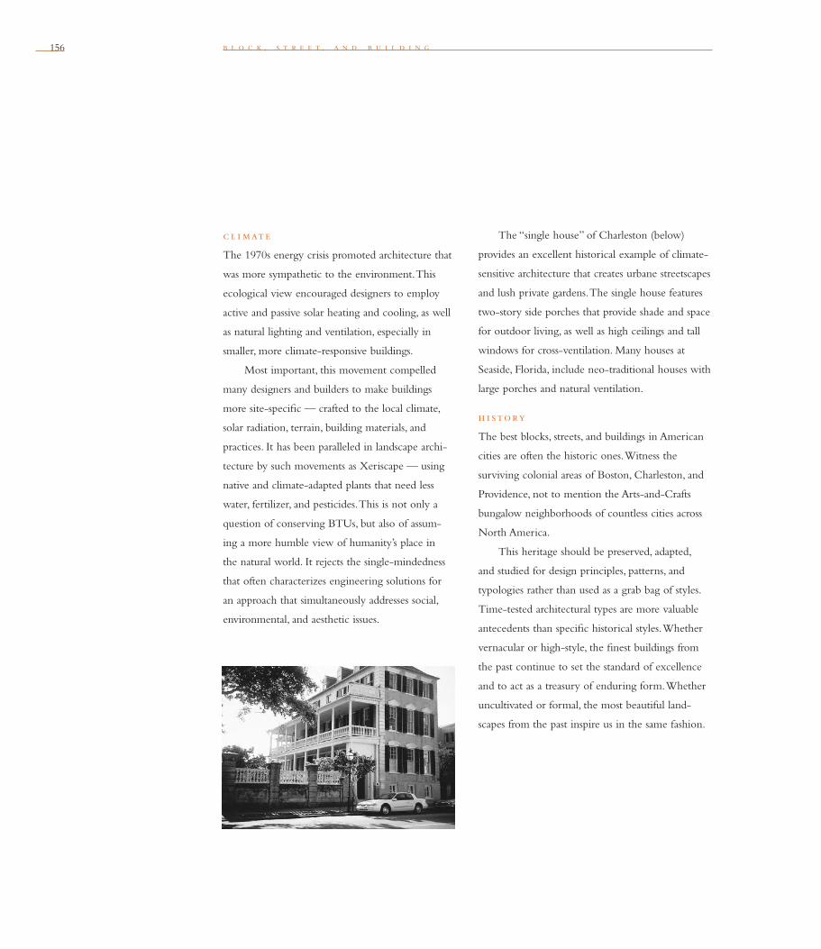
156 b l o c k , s t r e e t , a n d b u i l d i n g
c l i mate
The 1970s energy crisis promoted architecture that
was more sympathetic to the environment. This
ecological view encouraged designers to employ
active and passive solar heating and cooling, as well
as natural lighting and ventilation, especially in
smaller, more climate-responsive buildings.
Most important, this movement compelled
many designers and builders to make buildings
more site-specifi c — crafted to the local climate,
solar radiation, terrain, building materials, and
practices. It has been paralleled in landscape archi-
tecture by such movements as Xeriscape — using
native and climate-adapted plants that need less
water, fertilizer, and pesticides. This is not only a
question of conserving BTUs, but also of assum-
ing a more humble view of humanity’s place in
the natural world. It rejects the single-mindedness
that often characterizes engineering solutions for
an approach that simultaneously addresses social,
environmental, and aesthetic issues.
The “single house” of Charleston (below)
provides an excellent historical example of climate-
sensitive architecture that creates urbane streetscapes
and lush private gardens. The single house features
two-story side porches that provide shade and space
for outdoor living, as well as high ceilings and tall
windows for cross-ventilation. Many houses at
Seaside, Florida, include neo-traditional houses with
large porches and natural ventilation.
h i story
The best blocks, streets, and buildings in American
cities are often the historic ones. Witness the
surviving colonial areas of Boston, Charleston, and
Providence, not to mention the Arts-and-Crafts
bungalow neighborhoods of countless cities across
North America.
This heritage should be preserved, adapted,
and studied for design principles, patterns, and
typologies rather than used as a grab bag of styles.
Time-tested architectural types are more valuable
antecedents than specifi c historical styles. Whether
vernacular or high-style, the fi nest buildings from
the past continue to set the standard of excellence
and to act as a treasury of enduring form. Whether
uncultivated or formal, the most beautiful land-
scapes from the past inspire us in the same fashion.

c o n g r e s s f o r t h e n e w u r b a n i s m 157
Designers need not continually invent new
form. Originality for its own sake is neither better
nor less slavish than the superfi cial copying of
other times and places. New Urbanists must respect
authentic, living traditions without resorting to
empty historical mimicry, just as surely as they
reject avant-garde trendiness and naive futurism.
When designing blocks, streets, and buildings, New
Urbanists should view local precedents and conven-
tions as a point of departure. Conventional design
vocabulary and syntax then can be incrementally
transformed to express and accommodate new
technical innovations and programmatic changes.
Local architectural language can evolve, much
as spoken language does in multilingual dialects,
and much as new words are coined to name new
scientifi c and technological developments. If it
evolves either too slowly or too suddenly, it loses
its meaning and power. Change succeeds when
it is fresh but not too radical or disorienting, so
that it rhymes across time and space.
top og raphy
The earth’s surface has been denatured by centuries
of massive earthmoving that has created wholesale
reconfi guration of land. Often the result has been
run-off, erosion, and fl ooding of biblical proportions.
From topsoil to treetops, the landscape has been
disfi gured and violated by the wholesale bulldozing
of America (right).
To slow our rapacious consumption of the
hinterland, New Urbanism underscores the impor-
tance of inscribing a horizontal circle of compact,
pedestrian-friendly, mixed-use development on the
land, as exemplifi ed by the concept known as a
“pedestrian pocket” (also known as transit-oriented
development). To increase vehicular and pedestrian
connectivity, New Urbanist projects have revived
the grid as a pattern of development and circula-
tion. When overlaid on hilly topography, the grid-
iron can result in the types of dramatic streetscapes
and views for which San Francisco and Seattle are
famous. Even when interrupted by topographic
features, the grid provides greater connection
within urban circulation patterns than the curvi-
linear streets of conventional sprawl, which is
often naturalistic in superfi cial and artifi cial ways.
bu i l d i ng mate r i a l s and t e c h n i que s
The Modernist search for standardized solutions
has devolved into the Post-Modernist search
for variety. Contemporary modes of production
and distribution make this possible. Standardized
building components are reverting to customized
components, helped along by both the fl exibility
of computerized manufacturing and the speedy
international distribution of goods and services.
In short, designers can now specify any
product in any color or style from anywhere in
the world. This freedom has not usually resulted in
better design. Indeed, one can argue that contem-
porary buildings, blocks, and neighborhoods have
developed too much visual or stylistic variety. They
often contain a riot of different building materials,
colors, shapes, and motifs that lack coherence or
grounding in local building practices. New products
“Now that we have built
the sprawling system of far-
fl ung houses, offi ces, and
discount marts connected
by freeways, we can’t afford
to live in it. We also failed
to anticipate the costs of
the social problems we cre-
ated in letting our towns
and cities go to hell. Two
generations have grown up
and matured in America
without experiencing
what it is like to live in
a human habitat of qual-
ity. We have lost so much
culture in the sense of how
to build things well. Bodies
of knowledge and sets of
skills that took centuries to
develop were tossed into
the garbage,
and we will not get them
back easily. The culture
of architecture was lost to
Modernism and its dogmas.
The culture of town
planning was handed over
to lawyers and bureaucrats,
with pockets of resistance
mopped up by the auto-
mobile, highway, and
real estate interests.”
james howard kunstler
The Geography of Nowhere

158
are vended at a rate that makes it diffi cult if not
impossible for users to evaluate them, or for
knowledge to accumulate in meaningful ways.
The size of contemporary residential and com-
mercial projects has increased enormously, resulting
in two different but equally problematic design
strategies. One introduces a false diversity
of materials, textures, color, and style. The other
rigidly controls these variables. In the former case,
tectonic integrity is usually lost. Only rarely can a
single design team or building contractor master
multiple architectural languages and styles, each of
which uses different materials in different ways.
In the latter case, a limited palette of materials
and colors results in tedious repetition and lifeless
uniformity. Neither strategy seems to produce the
design integrity or richness of local, incremental
development, where the hand and human touch of
individual builders and designers is more evident.
Variations and reinterpretations of local architectural
types, especially when constructed with local build-
ing materials, produces more genuine diversity than
either polyglot diversity or uniform design controls.
The loss of local building knowledge and
traditions has been accompanied by a precipitous
decline in the quality of contemporary building
construction. The sheetrocking of America occurred
b l o c k , s t r e e t , a n d b u i l d i n g
th e p e de st r i an
p oc ket (below), also
known as transit-oriented
development, combines
strategies for mixed-use
development, transit, and
walkability. When this
rational diagram is applied
to a real piece of land, it
must be adjusted to infl ect
local history, topography,
and circumstance.

c o n g r e s s f o r t h e n e w u r b a n i s m 159
dou g las ke l bau g h
Douglas Kelbaugh, FAIA, is dean of the College of Architecture and Urban Planning at
the University of Michigan. A pioneer of passive solar design, he has received many awards
for his architecture and urban design projects. He is the editor of The Pedestrian Pocket Book:
A New Suburban Design Strategy (Princeton Architectural Press, 1989) and author of Common
Place: Toward Neighborhood and Regional Design (University of Washington Press, 1997).
in a single lifetime. Buildings became more like
stage sets, unable to take a kick or even a punch
from a vandal. Ersatz and fake materials that imitate
nobler materials have existed throughout the his-
tory of building and architecture. Colonial build-
ings disguised wood as stone, and the Victorians
fooled the eye with pressed tin and prefab cast-iron
facades. But tectonic impersonation and sceno-
graphic con struction have worsened with commer-
cial image-making, as well as with the shorter and
shorter life spans of contemporary buildings.
As a result of this impoverishment of the built
environment, more people seek more permanent
materials and better craftsmanship. Environmentally
aware consumers also demand local and recy-
cled materials as well as other “green” products,
which save on transportation costs, clean-up, and
embodied energy.
In the increasingly global cultures of trade,
tourism, and telecommunications, it has become
essential to recognize and defend local differences in
climate, topography, history, and building
practice. Authenticity commands a higher, not a
lower, premium in a more highly mediated world.
In the end, architecture and landscape design are
not words or paper but buildings and their sur-
rounds. Situated in microclimates, on the ground,
connecting past to the future, palpably there, alive
with fl ora and fauna, they are the stage for life itself.
“There are global eco-
nomic and cultural forces
that turn all architec-
ture — modern, traditional,
and Post-Modern — into
a commodity that merely
adorns an increasingly
degraded environment.”
alan p lat tu s
Associate Dean,
School of Architecture,
Yale University

160160 b l o c k , s t r e e t , a n d b u i l d i n g
i n t rad i t i onal tow n s, public buildings stand out from ordinary residences and
shops in design and scale. Today this relationship is frequently reversed. Indeed, citizens
would be surprised if their local post offi ce were as well built as a new restaurant, if
the town hall were as fi ne as a department store.

161
Civic buildings and public gathering places require impor-
tant sites to reinforce community identity and the culture of
democracy. They deserve distinctive form, because their role is
different from that of other buildings and places that constitute
the fabric of the city.
Tw e n t y f i v e
It is surely one of the minor mysteries of modern times that civic buildings in America
have become cheap to the point of squalor when they were once quite magnifi cent
as a matter of course. Our post offi ces, public schools and colleges, fi re stations, town
halls, and all the rest are no longer honored with an architecture of fi ne materials,
tall spaces, and grandeur of form. The new civic buildings are useful enough, but they
are incapable of providing identity or pride for their communities.
Today’s civic buildings tend to be less accomplished even than run-of-the-mill
commercial structures. Indeed, citizens would be surprised if their local post offi ce
were as well built as a new restaurant, if the town hall were as fi ne as a department
store, or the community college as grand as a regional shopping mall.
This inversion in the civic and private hierarchy has no precedent in American
society and is alien to the sensibility of most cultures. Why should this sad situation
be uniquely ours? Surely this nation is wealthier than it has ever been. As late as the
1950s, civic structures were still the best buildings in town.
At the heart of the change is the defi nition of infrastructure. Infrastructure is
the supporting armature of urbanism. Today’s defi nition is constrained by utilitarian
thinking. It includes only thoroughfares and utilities. Indeed the term infrastructure
is a neologism including the technical while excluding the civic.
a n d r e s d u a n y

162
“Participation in the res
publica today is most often
a matter of going along,
and the forums for this
public life, like the city,
are in a state of decay.”
r i c hard s e nnet t
The Fall of Public Man
b l o c k , s t r e e t , a n d b u i l d i n g
Civic buildings were once included with
thoroughfares and utilities in the term public works.
Voters could decide with equanimity between, say,
a school or a road. Given the choice they would
often fund the civic building. After all, civic build-
ings are the social infrastructure, no less important
than the movement infrastructure of vehicles, fl uids,
and power.
The postwar process by which urban planning
became a collection of specialties destroyed the uni-
fi ed conception of public works and, as with
so much else in planning, a bias for the techni-
cal prevailed. Investment in roads now receives the
dedicated gasoline tax, but civic buildings must be
“subsidized” from other sources. And in the case
of cultural buildings like museums, these sources
are reduced to random private benefactors.
The United States, where roads are repaired
sooner than schools, thus boasts of the world’s best
infrastructure and the civic buildings of an under-
developed country. Only if horizontal and vertical
infrastructure are joined again as public works
can there be an intelligent, indeed democratic,
allocation of available resources.
Public buildings are those sponsored exclusively
by government: the city halls, town halls, armories,
transportation and postal facilities, public schools
and colleges, as well as the few cultural facilities
of national importance, such as the Smithsonian.
However, many equally important communal
organizations such as the Metropolitan Museum
and the Boston Symphony are funded privately.
These belong to the civic category.
Civic buildings may receive government
sponsorship, but they are administered by nonprofi t
groups. The distinction between the civic and the
public is not particularly important in America,
where government prefers to confi ne its investment
to public infrastructure and private nonprofi ts
must compensate.
Private clubs that do not receive government
subsidy, but nevertheless perform a communal
function, should too be considered civic. And, not
entirely outside of this category, are the many places
that play a communal role while belonging neither
to the civic nor the public categories.
These are the common, informal daily gathering
places between the poles of workplace and resi-
dence. They are typically diners, corner stores,
cafes, rathskellers, pubs, barber shops, hotel lobbies,
and the like categorized as “third places” by
Ray Oldenburg in The Great Good Place.
Within a new community, public and civic
buildings will come into being as the urbanism
evolves, but only if some provision is made for them
early in the planning process. To overcome the
innate resistance to public expenditure, the master
plan can reserve lots for generic civic buildings.
The type of building is left to be determined by the
society eventually. In the early phases of build-out,
civic investment may seem utopian, but citizens of
a successful place will eventually want to endow
themselves with culture, and to embellish their
beloved community with civic buildings. Evidence
of these sentiments can be seen in every great
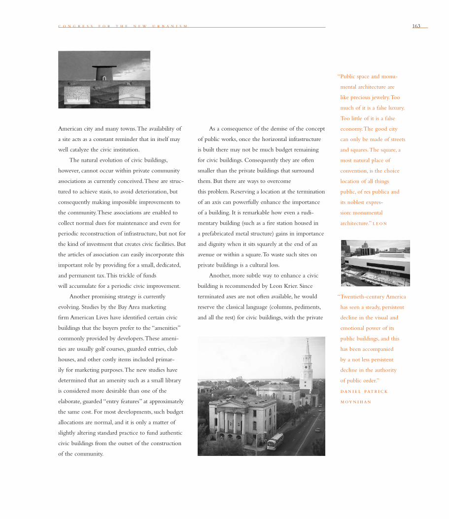
c o n g r e s s f o r t h e n e w u r b a n i s m 163
American city and many towns. The avail ability of
a site acts as a constant reminder that in itself may
well catalyze the civic institution.
The natural evolution of civic buildings,
however, cannot occur within private community
associations as currently conceived. These are struc-
tured to achieve stasis, to avoid deterioration, but
con sequently making impossible improvements to
the community. These associations are enabled to
collect normal dues for maintenance and even for
periodic reconstruction of infrastructure, but not for
the kind of investment that creates civic facilities. But
the articles of association can easily incorporate this
important role by providing for a small, dedicated,
and permanent tax. This trickle of funds
will accumulate for a periodic civic improvement.
Another promising strategy is currently
evolving. Studies by the Bay Area marketing
fi rm American Lives have identifi ed certain civic
buildings that the buyers prefer to the “amenities”
commonly provided by developers. These ameni-
ties are usually golf courses, guarded entries, club
houses, and other costly items included primar-
ily for marketing purposes. The new studies have
determined that an amenity such as a small library
is considered more desirable than one of the
elaborate, guarded “entry features” at approximately
the same cost. For most developments, such budget
allocations are normal, and it is only a matter of
slightly altering standard practice to fund authentic
civic buildings from the outset of the construction
of the community.
As a consequence of the demise of the concept
of public works, once the horizontal infra structure
is built there may not be much budget remaining
for civic buildings. Consequently they are often
smaller than the private buildings that surround
them. But there are ways to overcome
this problem. Reserving a location at the termination
of an axis can powerfully enhance the importance
of a building. It is remarkable how even a rudi-
mentary building (such as a fi re station housed in
a prefabricated metal structure) gains in importance
and dignity when it sits squarely at the end of an
avenue or within a square. To waste such sites on
private buildings is a cultural loss.
Another, more subtle way to enhance a civic
building is recommended by Leon Krier. Since
terminated axes are not often available, he would
reserve the classical language (columns, pediments,
and all the rest) for civic buildings, with the private
“Public space and monu-
mental architecture are
like precious jewelry. Too
much of it is a false luxury.
Too little of it is a false
economy. The good city
can only be made of streets
and squares. The square, a
most natural place of
convention, is the choice
location of all things
public, of res publica and
its noblest expres-
sion: monumental
architecture.” l e on
“Twentieth-century America
has seen a steady, persistent
decline in the visual and
emotional power of its
public buildings, and this
has been accompanied
by a not less persistent
decline in the authority
of public order.”
dan i e l pat r i c k
moy n i han
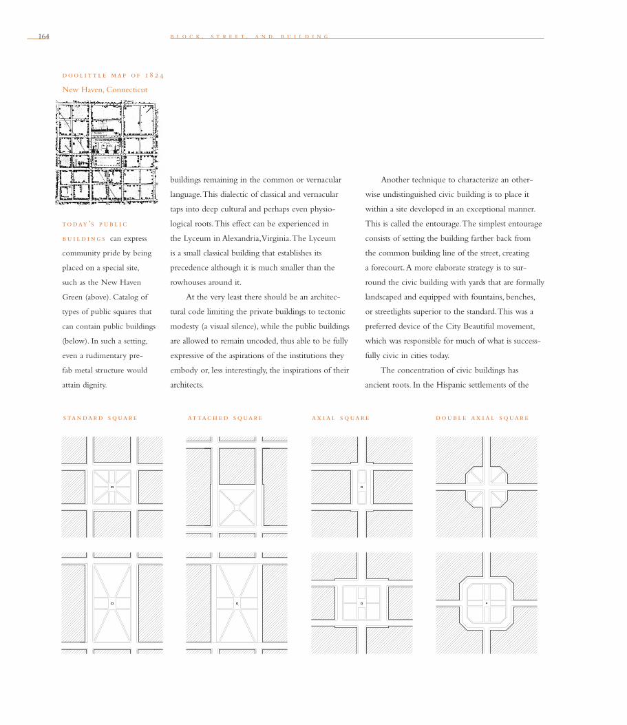
164 b l o c k , s t r e e t , a n d b u i l d i n g
buildings remaining in the common or vernacular
language. This dialectic of classical and vernacular
taps into deep cultural and perhaps even physio-
logical roots. This effect can be experienced in
the Lyceum in Alexandria, Virginia. The Lyceum
is a small classical building that establishes its
precedence although it is much smaller than the
rowhouses around it.
At the very least there should be an architec-
tural code limiting the private buildings to tectonic
modesty (a visual silence), while the public buildings
are allowed to remain uncoded, thus able to be fully
expressive of the aspirations of the institutions they
embody or, less interestingly, the inspirations of their
architects.
Another technique to characterize an other-
wise undistinguished civic building is to place it
within a site developed in an exceptional manner.
This is called the entourage. The simplest entourage
consists of setting the building farther back from
the common building line of the street, creating
a forecourt. A more elaborate strategy is to sur-
round the civic building with yards that are formally
landscaped and equipped with fountains, benches,
or streetlights superior to the standard. This was a
preferred device of the City Beautiful movement,
which was responsible for much of what is success-
fully civic in cities today.
The concentration of civic buildings has
ancient roots. In the Hispanic settlements of the
today ’s p ub l i c
bu i l d i ng s can express
community pride by being
placed on a special site,
such as the New Haven
Green (above). Catalog of
types of public squares that
can contain public buildings
(below). In such a setting,
even a rudimentary pre-
fab metal structure would
attain dignity.
standard s quare at tac h e d s quare ax i al s quare double ax i al s quare
dool i t t l e map o f 18 2 4
New Haven, Connecticut
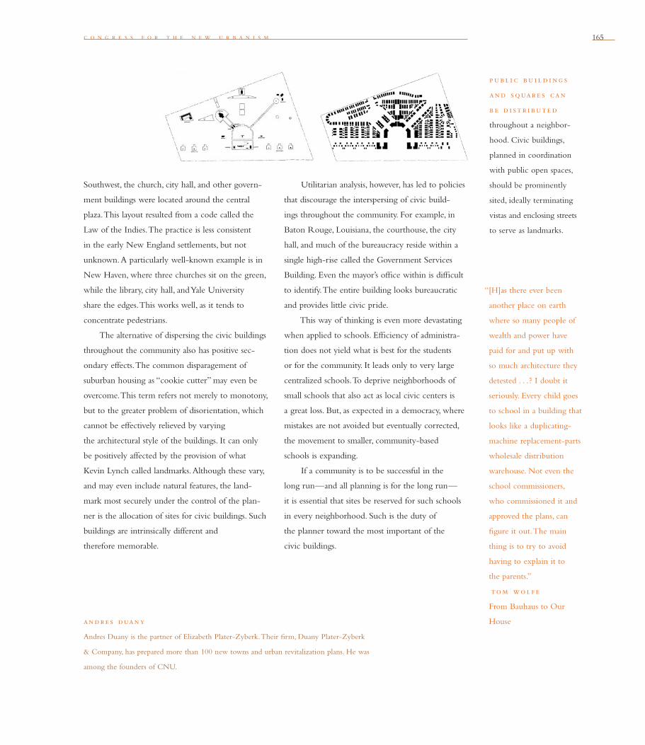
c o n g r e s s f o r t h e n e w u r b a n i s m 165
“[H]as there ever been
another place on earth
where so many people of
wealth and power have
paid for and put up with
so much architecture they
detested . . .? I doubt it
seriously. Every child goes
to school in a building that
looks like a duplicating-
machine replacement-parts
wholesale distribution
warehouse. Not even the
school commissioners,
who commissioned it and
approved the plans, can
fi gure it out. The main
thing is to try to avoid
having to explain it to
the parents.”
tom wol f e
From Bauhaus to Our
House
Southwest, the church, city hall, and other govern-
ment buildings were located around the central
plaza. This layout resulted from a code called the
Law of the Indies. The practice is less consistent
in the early New England settlements, but not
unknown. A particularly well-known example is in
New Haven, where three churches sit on the green,
while the library, city hall, and Yale University
share the edges. This works well, as it tends to
concentrate pedestrians.
The alternative of dispersing the civic buildings
throughout the community also has positive sec-
ondary effects. The common disparagement of
suburban housing as “cookie cutter” may even be
overcome. This term refers not merely to monotony,
but to the greater problem of disorientation, which
cannot be effectively relieved by varying
the architectural style of the buildings. It can only
be positively affected by the provision of what
Kevin Lynch called landmarks. Although these vary,
and may even include natural features, the land-
mark most securely under the control of the plan-
ner is the allocation of sites for civic buildings. Such
buildings are intrinsically different and
therefore memorable.
Utilitarian analysis, however, has led to policies
that discourage the interspersing of civic build-
ings throughout the community. For example, in
Baton Rouge, Louisiana, the courthouse, the city
hall, and much of the bureaucracy reside within a
single high-rise called the Government Services
Building. Even the mayor’s offi ce within is diffi cult
to identify. The entire building looks bureaucratic
and provides little civic pride.
This way of thinking is even more devastating
when applied to schools. Effi ciency of administra-
tion does not yield what is best for the students
or for the community. It leads only to very large
centralized schools. To deprive neighborhoods of
small schools that also act as local civic centers is
a great loss. But, as expected in a democracy, where
mistakes are not avoided but eventually corrected,
the movement to smaller, community-based
schools is expanding.
If a community is to be successful in the
long run—and all planning is for the long run—
it is essential that sites be reserved for such schools
in every neighborhood. Such is the duty of
the planner toward the most important of the
civic buildings.
andre s duany
Andres Duany is the partner of Elizabeth Plater-Zyberk. Their fi rm, Duany Plater-Zyberk
& Company, has prepared more than 100 new towns and urban revitalization plans. He was
among the founders of CNU.
p ub l i c bu i l d i ng s
and s quare s can
b e d i st r i bute d
throughout a neighbor-
hood. Civic buildings,
planned in coordination
with public open spaces,
should be prominently
sited, ideally terminating
vistas and enclosing streets
to serve as landmarks.
166
Civic Buildings as Vertical Infrastructure
Civic buildings and spaces should be considered
vertical infrastructure. They are long-term invest-
ments, as important to the functioning and the
welfare of a community as the horizontal infra-
structure of thoroughfares and utilities. Together,
vertical and horizontal infrastructure should be
considered public works.
de f i n i ng c iv i c and p ub l i c
Public denotes those buildings and places that
the entire community holds in common ownership.
They usually pertain to government, public edu-
cation, recreation, and transportation. Civic is a
more comprehensive category, adding to the public
facilities those administered by private organizations
which provide communal benefi t. These are usually
religious, cultural, and educational institutions,
as well as certain sporting venues.
e nabl i ng th e con st ruc t i on o f
c iv i c bu i l d i ng s
Civic places will come into being only if provision
is made for them in the urban planning process.
It is fundamental that sites be reserved early and
made available to suitable organizations. By being
conceived as public works, the construction of
the buildings may even be fi nanced by the bud-
get residual from the more economical horizontal
infrastructure resulting from compact development.
Such civic buildings may play the role of amenities
that developers deem necessary for marketing pur-
poses. They can substitute for the typical “entry
feature” or the golf course.
Another method to fund civic improvements
is to tap into the taxation stream of the increasingly
common community associations. These can be
structured to enable civic improvements in addition
to the usual provisions for maintenance.
on th e phy s i cal i d e nt i ty o f
c iv i c bu i l d i ng s
A civic building can be an effective repository of
a community’s pride and a manifestation of its
identity. To do so, the civic building must be readily
identifi able as such. It is, however, no longer possi-
ble to depend on an identity based on scale, as civic
buildings today are often smaller than private ones.
A more realistic strategy is to enhance the building
by granting it a signifi cant location. Signifi cant sites
are generally those that terminate the axial vista of
a thoroughfare, or those that enfront or occupy a
public open space, such as a plaza or a square. Also,
a special landscape associated with the building (the
entourage) can create the signifi cant difference.
A supplementary method is to differentiate
a civic building by the tectonic elaboration of its
construction. This establishes a dialectic between
private and civic architecture. This may include
the incorporation of an exceptional element such
as a tower or a colonnade. Another more subtle
method is to reserve certain colors for public
buildings, as civic buildings in New England
villages are often white clapboard while com-
mon buildings are of grey shingle. There is also the
recourse to the duality of the timeless classical
and vernacular languages.
b l o c k , s t r e e t , a n d b u i l d i n g

c o n g r e s s f o r t h e n e w u r b a n i s m 167
on th e conc e nt rat i on or
d i s p e r s i on o f c iv i c bu i l d i ng s
Civic buildings may be concentrated in one place
or dispersed throughout the community. There is
no question that urbanistically, if not administra-
tively, several smaller public buildings in a campus
setting are superior to the single, composite mega-
structure currently in favor. By separating the
program into multiple buildings, the institution’s
roles are easier to decipher. This is also more likely
to decant activity into the public space, rather
than internalizing it within a corridor system.
Advice on the wide dispersal of such buildings
throughout the community or their concentration
at the core is less conclusive. To group all the public
buildings does enliven public life at that one place
more intensely. On the other hand, the dispersal of
these special buildings more equitably leavens the
overall fabric of the community and contributes to
localized identity. Both have valid precedent in the
American urban tradition.
— a n d r e s d u a n y
c o n g r e s s f o r t h e n e w u r b a n i s m

168 b l o c k , s t r e e t , a n d b u i l d i n g
al b e rt kah n ’s General Motors Headquarters (above), built in 1921, placed each
worker within 20 feet of an operable window. Kahn’s factory buildings, like the
Packard Motor Car Company Forge Shop (right), 1911, used extensive glazing and
ingenious clerestory systems to bathe factory workers in daylight and to ventilate
with little mechanical assistance. The section of the plant shows paths of light and
air circulation.
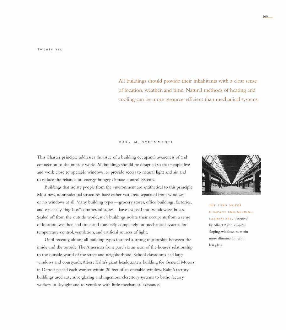
169
m a r k m . s c h i m m e n t i
All buildings should provide their inhabitants with a clear sense
of location, weather, and time. Natural methods of heating and
cooling can be more resource-effi cient than mechanical systems.
Tw e n t y s i x
This Charter principle addresses the issue of a building occupant’s awareness of and
connection to the outside world. All buildings should be designed so that people live
and work close to operable windows, to provide access to natural light and air, and
to reduce the reliance on energy-hungry climate control systems.
Buildings that isolate people from the environment are antithetical to this principle.
Most new, nonresidential structures have either vast areas separated from windows
or no windows at all. Many building types—grocery stores, offi ce buildings, factories,
and especially “big-box” commercial stores—have evolved into windowless boxes.
Sealed off from the outside world, such buildings isolate their occupants from a sense
of location, weather, and time, and must rely completely on mechanical systems for
temperature control, ventilation, and artifi cial sources of light.
Until recently, almost all building types fostered a strong relationship between the
inside and the outside. The American front porch is an icon of the house’s relationship
to the outside world of the street and neighborhood. School classrooms had large
windows and courtyards. Albert Kahn’s giant headquarters building for General Motors
in Detroit placed each worker within 20 feet of an operable window. Kahn’s factory
buildings used extensive glazing and ingenious clerestory systems to bathe factory
workers in daylight and to ventilate with little mechanical assistance.
th e f ord motor
com pany e ng i ne e r i ng
laboratory, designed
by Albert Kahn, employs
sloping windows to attain
more illumination with
less glass.

170 b l o c k , s t r e e t , a n d b u i l d i n g
courtyard h ou s i ng at i t s b e st — the Andalusia apartments (1926) in West
Hollywood, California, designed by Arthur and Nina Zwebel, who had no formal
training in architecture. Buildings with narrow footprints or that wrap around court-
yards provide more light and air and use less energy for lighting and illumination.
Big, boxy, air-conditioned buildings can be cheaper to build, but we won’t be able
to afford such power hogs forever.
p lan o f th e andalu s i a West Hollywood, 1926
c o n g r e s s f o r t h e n e w u r b a n i s m 171
“More than any other art
form, building and archi-
tecture have an interactive
relationship with nature.
Nature is not only topog-
raphy and site, but also
climate and light. . . .
Built form is necessarily sus-
ceptible to an intense inter-
action with these elements
and with time,
in its cyclical aspects . . .
yet we tend to forget how
universal technology in the
form of modern mechan-
ical services (air condi-
tioning, artifi cial light, etc.)
tends towards the elimi-
nation of precisely those
features that would
otherwise relate the outer
membrane of a given fabric
to a particular place and
a specifi c culture . . . [and
to] natural light in relation
to diurnal and seasonal
change.”
ke nneth f ram p ton
Center: A Journal for
Architecture in America
mar k m . sc h i m m e nt i
Mark M. Schimmenti is an architect and urban designer and an associate professor of
architecture at the University of Tennessee in Knoxville. In his professional practice,
he specializes in creating master plans and comprehensive design guidelines for cities,
neighborhoods, and new developments.
It’s illuminating to compare the footprints
of buildings designed before climate control and
fl uorescent lighting with those built today. Before
World War II, large buildings were composed of
relatively thin bays and pavilions linked together.
With the exception of theaters and auditoriums,
every habitable room had a window. More recent
buildings have vast areas with no relationship to
an outside wall. People occupying these areas are
completely isolated from the outside world.
Buildings with narrow footprints — thin
buildings whose interior spaces are close to outside
walls and windows — consume less energy. Obviously,
the closer people are to windows, the less they need
electrical illumination. And if those windows can be
opened, the building needs less air-conditioning or
heat on temperate days.
Buildings with large footprints are power hogs.
Vast interior spaces provide little access to windows
and rely more on electrical illumination, which
generates a lot of heat. So much heat is generated
that many of these buildings need year-round air-
conditioning. In fact, the era of big boxy buildings
came about, not only because they can be cheaper
to build, but also because air-conditioning allowed
a way to cool them down. These large boxes that
require air-conditioning consume even more energy
than does a heating system.
In response to this, government agencies now
regulate access to windows in buildings; some
countries even have regulations requiring sunlight
for some rooms. Ironically, some well-intended
energy regulations have had the opposite effect,
such as those requiring smaller windows that are
sealed shut.
This Charter principle proposes solutions for
buildings that are more people- and earth-friendly.
We can look to examples of this principle at
work in pre-war buildings and urban design, and
in architectural traditions that vary by culture and
climate. In a warm, dry climate, a Mediterranean-
style building can be organized around a courtyard
humidifi ed by a fountain; the same style building
in the hot and humid climate of Florida should
be thinner to improve cross-ventilation.
It’s important to understand how traditional
building types were confi gured, including how
they were placed on the land, how buildings and
their rooms were oriented, and the relationship
between individual buildings and adjacent ones.
Through such an understanding, we can begin to
design communities that respect natural systems
and people’s need for access to them.


173
k e n g r e e n b e r g
Preservation and renewal of historic buildings, districts, and
landscapes affi rm the continuity and evolution of urban society.
Tw e n t y s e v e n
Cities are perpetually unfi nished serial creations. In each generation, new uses, social
patterns, and economic activities emerge, while others become obsolete and are dis-
placed, renewed, or transformed. The form of the city develops through a continuous
reworking over the traces of what came before. This nonstop evolution of use and
form is both inevitable and desirable.
For this urban evolution to occur successfully, there must be an implied “contract”
about the nature of city building in which the contributions of previous generations
are understood and creatively reinterpreted, even where change is substantial. In the
mid–20th century, however, this contract was broken. The modern movement in city
planning and architecture rejected the traditional city as a foundation upon which
to build and sought to replace it wholesale. Polemical plans such as Le Corbusier’s
Plan Voisin for Paris (right) proposed the removal of all but a handful of the city’s most
signifi cant monuments. This approach was widely imitated in urban renewal schemes in
North America, most often with disastrous consequences.
This Charter principle affi rms New Urbanism’s respect for continuity and evolution
in the built environment and in landscapes. New Urbanism reinforces the importance
of being aware of and honoring the historic fabric of urban places and of designing
new urban places that will accommodate change over time. In the United States and
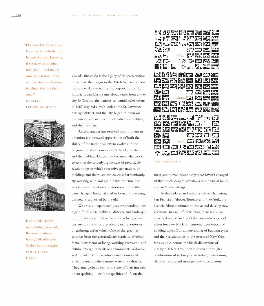
174 b l o c k , s t r e e t , a n d b u i l d i n g
Canada, this credo is the legacy of the preservation
movement that began in the 1960s. When and how
this renewed awareness of the importance of the
historic urban fabric came about varies from city to
city. In Toronto, the nation’s centennial celebrations
in 1967 inspired a fresh look at the St. Lawrence
heritage district, and the city began to focus on
the history and architecture of individual buildings
and their settings.
Accompanying our renewed commitment to
urbanism is a renewed appreciation of both the
ability of the traditional city to evolve and the
organizational framework of the block, the street,
and the building. Defi ned by the street, the block
establishes the underlying context of predictable
relationships in which successive generations of
buildings and their uses can co-exist harmoniously.
By working with, not against, this structure, the
whole is not called into question each time the
parts change. Though altered in form and meaning,
the new is supported by the old.
We are also experiencing a corresponding new
regard for historic buildings, districts, and landscapes
not just as exceptional artifacts but as living enti-
ties, useful sources of precedents, and repositories
of enduring urban values. One of the great les-
sons has been the extraordinary elasticity of urban
form. New forms of living, working, recreation, and
culture emerge in heritage environments as diverse
as Amsterdam’s 17th-century canal houses and
St. Paul’s turn-of-the-century warehouse district.
They emerge because, not in spite, of their intrinsic
urban qualities — or those qualities of life on the
street and human relationships that haven’t changed
all that much, despite alterations in individual build-
ings and their settings.
In these places and others, such as Charleston,
San Francisco (above), Toronto, and New York, the
historic fabric continues to evolve and develop new
vocations. In each of these cities, there is also an
increased understanding of the particular legacy of
urban form — block dimensions, street types, and
building types. Our understanding of building types
and their relationships to the streets of New York,
for example, honors the block dimensions of
200 by 800 feet. Evolution is fostered through a
com bination of techniques, including preservation,
adaptive re-use, and strategic new construction.
“I believe that when a man
loses contact with the past
he loses his soul. Likewise,
if we deny the architec-
tural past — and the les-
sons to be learned from
our ancestors — then our
buildings also lose their
souls.”
c har le s ,
p r i nc e o f wale s
“Rest rubble, sprawl-
ing suburbs, jerry-built,
Kerwan’s mushroom
house, built of breeze.
Shelter from the night.”
jam e s joyc e
Ulysses
18 9 9
19 31
19 7 6
san f ranc i sco

c o n g r e s s f o r t h e n e w u r b a n i s m 175
“The architect should
be regarded as a kind
of physical historian,
because he constructs
relationships across
time: civilization in fact.”
v i nc e nt sc ul ly
American Architecture
and Urbanism
ke n g re e nb e rg
Ken Greenberg is an urban designer, architect, and principal of Urban Strategies, a Toronto fi rm
known for its holistic, interdisciplinary approach to city planning and building. Before starting
Urban Strategies in 1987, he spent 10 years with the City of Toronto, where he founded and
directed the Division of Architecture and Urban Design.
As the success of these places demonstrates,
city form is generally more enduring than par-
ticular land uses or functions. The prospects for
longevity — continuous preservation and adaptive
re-use — are improved where the block, the street,
and the building possess a basic generality, simplicity,
and adaptability that allow for reasonable degrees
of change and modifi cation in response to social,
economic, and technological change.
While cities such as Paris and Amsterdam
possess a unique and enviable built heritage, the les-
sons they provide can be generalized. There is
“In every city there are
individual personali-
ties; every city possesses a
personal soul formed of old
traditions and living feel-
ings as well as unresolved
aspirations. Yet still the city
cannot be independent of
the general laws of urban
dynamics. Behind the
particular causes there are
general conditions, and the
result
is that no urban growth
is spontaneous. Rather,
it is through the natural
tendencies of the many
groups dispersed through-
out the different parts
of the city that we must
explain the modifi cations
of the city’s structure.”
a l do ro s s i
The Architecture of the
City
no tabula rasa. In virtually any setting — existing
city or greenfi eld — there is a signifi cant natural or
cultural legacy with landforms, vegetation, water-
courses, street patterns, agricultural or industrial
heritage, and built forms. The recognition of these
elements at any stage of urbanization, as legitimate
shapers and infl uencers of what is to come next,
must be an essential part of the methodology of
urbanism. Sustained vitality depends upon both
stewardship and a skillful layering that builds cre-
atively on the legacies of landscape and urban form.


177
In many ways, the Congress for the New Urbanism represents the extension of parallel
efforts evolving since Jane Jacobs and William Whyte began their critiques of Modern
architecture and the auto-focused metropolis in the 1950s and 1960s. Since that time
much work has been undertaken to correct Modernism’s negation of the city. It is now
generally accepted that a city’s vitality is tied to its diversity, human scale, and quality of
public space. The notion that the auto-oriented suburb is sustainable or even desirable
is no longer conventional wisdom. Environmental groups have developed to defend
the ecosystems and farmlands threatened by sprawl. Inner-city activists have mobilized
to revitalize urban neighborhoods. Historic preservation groups have expanded their
agenda from individual buildings to whole districts and urban economies. The Congress
for the New Urbanism builds on all of these movements and attempts to unite them
with a common set of principles at three telescoping scales: the region, the neighbor-
hood, and the block.
Like these other contemporary efforts in design and planning, the philosophy of
New Urbanism offers an alternative to suburban sprawl, urban decay and disinvestment,
single-use zoning, and auto-only environments. Yet it is perhaps unique in develop-
ing an interlocking approach at multiple scales. Not since the City Beautiful and
Arts-and-Crafts movements at the turn of the century, or the Congres International
d’Architecture Moderne (CIAM) in the 1920s, has there been an attempt to create a
Afterword

178 a f t e r w o r d
design vision that unifi es the differing scales
and disciplines shaping the built environment.
Individualized efforts at the scale of the region,
the neighborhood, or the street are necessary and
important, but not suffi cient to bring basic change
to our development patterns. The Charter asserts
that the three scales are interactive and must be
coordinated to have a penetrating effect. This
notion that each are interdependent and mutually
reinforcing is the result of a new perspective; that
the signifi cant increments of our social, economic,
and ecological life have shifted from nation, state,
and city to globe, region, and neighborhood. We
live in a world at once bigger and more immediate
than ever before.
The dominance of the global economy, the
emergence of metropolitan regions, the matura-
tion of the suburbs, the revitalization of inner-city
neighborhoods, and a renewed focus on human-
scaled environments are linked contemporary
phenomena. Although too often treated indepen-
dently, each is critically dependent on the other.
The global economy’s building blocks are regions,
not cities or states. Regional policies dramatically
affect the evolution of suburbs and the revitalization
of the city. Growth and investment in individual
neighborhoods indeed depends on regional forces
that can reinforce rather than frustrate local initia-
tive. For example, regional initiatives in afford-
able housing, tax-base sharing, and transportation
investments now critically link inner-city neigh-
borhoods to suburban development. Conversely,
the physical design of neighborhoods, if allowed to
follow the old patterns of sprawl, can easily negate
initiatives to preserve open space, reduce traffi c
congestion, and promote economic equity. And
healthy neighborhoods everywhere are dependent
on coherent block, street, and building standards
as well as supportive regional policies. As the whole
is re-conceived, each part changes. This is a precept
of the three sections of the Charter.
Too often, New Urbanism is not understood
as a complex system of policies and design principles
that operate at multiple scales. It is misinterpreted
simply as a conservative movement to recapture
the past while ignoring the issues of our time. It is
thought to be driven by nostalgia and ordered by
outdated traditions. To some, New Urbanism simply
means tree-lined streets, houses with front porches,
and Main Street retail—a reworking of a Norman
Rockwell fantasy of small-town America, primarily
for the rich.
If such an oversimplifi cation of New Urbanism
were true, this criticism would be compelling. But
if nostalgic urbanism is such a good idea, why are
so many older, traditional neighborhoods in decline?
And given the car, the scale of modern business,
and the complex nature of families today, is such
a nostalgic vision possible or even desirable?
c o n g r e s s f o r t h e n e w u r b a n i s m 179
Clearly it is not. But nostalgia is not what
New Urbanism is proposing. Its goals and breadth
are much grander, more complete and challenging.
Many misconceptions are caused by focusing on
New Urbanism’s neighborhood-scale prescriptions
without seeing them embedded in regional struc-
tures. Or understanding that those neighborhoods
are supported by design principles at the street
and building scale that attend more to environmen-
tal imperatives and pedestrian comfort than to
historical precedent.
Replacing cul-de-sacs and malls with tradi-
tional urban design, although desirable, is not suf-
fi cient to solve the problems of modern growth,
either practically or ideologically. If it were, beauti-
ful historic Main Streets would not be dying across
the country, and many urban neighborhoods and
fi rst-ring suburbs would not be in decline. If good
urban design were enough, then where develop-
ment happens and who is wealthy enough to afford
it would be irrelevant. They are not.
Two tenets of New Urbanism address these
critical issues of affordability and location. One
is economic diversity. The other is regionalism.
Economic diversity calls for a broad range of hous-
ing opportunities as well as uses within each neigh-
borhood—affordable and expensive, small and large,
rental and ownership, singles and family housing.
This is a radical proposition. It implies that more
low-income and affordable housing will be built
in the wealthy suburbs, while it advocates placing
middle-class homes in urban neighborhoods. It
advocates mixing income groups and races in a way
that frightens many communities. In the city this is
labeled “gentrifi cation.” In the suburbs,
it is called crime (the code word for any housing
other than large-lot single family). This principle
is rarely realized in practice and, given the current
political climate, almost always compromised.
But it is a central tenet of New Urbanism and
sets a direction quite different from most new
development in the suburbs and many urban-
renewal programs.
The principle of diversity has a major regional
implication: fairly distributed affordable housing
for all communities of the region. It implies that we
should no longer isolate the poor in the inner city
and segregate the middle class in the suburbs.
It implies limiting additional public housing in
low-income neighborhoods, and instead scattering
public housing throughout the region and fostering
inclusionary zoning in the suburbs.
Diversity is perhaps the most challenging
aspect of New Urbanism, but it is essential to its
philosophy. Some have suggested that the consis-
tent and sometimes historical architecture of New
Urbanist communities effectively camoufl ages their
underlying economic and social diversity. Certainly
the integration of differing housing types and costs

180180 a f t e r w o r d
calls for an urban design and architecture that uni-
fi es a neighborhood rather than isolates, and in
some cases stigmatizes, its pieces. New Urbanism
may not always succeed in radically reintegrating
the segregated geography of our cities and suburbs,
but it does lay out design and policy principles that
provide the means to do so. The political will to
make such a change consistently involves a larger
cultural challenge.
The aspect of New Urbanism that addresses
the issues of where growth is most appropriate is
its call for regional design. Beyond regional policies
for tax equity or fair-share housing, New Urbanism
proposes to create a defi nitive physical map of the
metropolis; its boundaries, open spaces, connections,
and centers. This idea of “designing” the region,
much like one could design a neighborhood or
district, has been passé since the time of Daniel
Burnham, the great Chicago planner of the early
20th century. But it is central to addressing the issues
of where development should happen and how
it fi ts into the whole. Without regional form-giv-
ers like habitat and agricultural preserves, urban
growth boundaries, transit systems, and designated
urban centers, even well-designed neighborhoods
can contribute to sprawl. Infi ll and redevelopment,
although a high priority for New Urbanism, can-
not accommodate all the growth in many regions.
A regional plan is the necessary armature for the
placement of new growth as towns, neighborhoods,
or villages.
Without housing diversity in neighborhoods
and a powerful regional design ordering new
investments, the question of where new develop-
ment should happen and who can afford it remains
unanswered. Although the challenge of creating
truly diverse neighborhoods and sustainable regional
forms may remain an elusive goal for some time, the
CNU Charter lays out the principles and
techniques to achieve them.
p e t e r c a l t h o r p e
181
For fi ve millennia, we built towns and cities with strong centers and clear edges,
beyond which lay farms, forests, lakes, and streams. Only in the last fi ve decades have
these clear edges become ragged, as the centrifugal forces of sprawl have fl ung a strange
collection of objects across the landscape. The strangest of these objects are
big boxes with specialized functions. They are connected to each other by swaths of
asphalt. Each is surrounded by a small sea of the same material. Their placement relative
to each other and to the smaller boxes we live in is designed and planned for the maxi-
mum consumption of time and energy in various forms, including human.
For fi ve millennia, our human settlements were built to human scale, to the fi ve-
or ten-minute walk that defi ned neighborhoods, within which all of life’s necessities
and many of its frivolities could be found. Even great cities can be seen as a collection
of neighborhoods. Greater London is, in fact, a set of towns and villages merged into
a metropolis. Even now, Belgravia, Mayfair, Knightsbridge, and Chelsea have distinct
centers and edges and distinctive character. Within these neighborhoods, buildings are
four or fi ve stories high because that is the maximum number of stairs we could
comfortably ascend.
Postscript

182 p o s t s c r i p t
Now we have elevators and cars allowing our
cities to expand upward and evermore outward. We
have tested the limits of these new toys; emerging
economies are pushing these limits even further. It
is time for us, however, to recognize that enough is
enough. Tall buildings can be exciting in Manhattan
and Hong Kong. In cities such as Houston and
Atlanta, they merely stunt balanced development
by absorbing all the growth potential of a decade
onto a handful of sites, leaving parking lots and
abandoned buildings a block away. Suburban sprawl,
in turn, sucks the economic potential from our cit-
ies and saps their ability to renew and regenerate
themselves. The result is a blighted environment
where once there were working or natural landscapes.
Within cities as well as within natural and
working landscapes, complexity and diversity indi-
cate the long-term health, or the sustainability, of
these natural and fabricated systems. The earliest
ecosystem collapses in our recorded history occurred
in the Fertile Crescent, where monoculture farming
depleted the fertility on which this early civiliza-
tion depended. Today’s world offers some parallels.
Monoculture agriculture seems productive, but it
requires alarming quantities of petrochemicals in
the form of fertilizers and pesticides, and it depletes
soil and pollutes lakes and streams.
In the same way as agriculture, monoculture
development patterns had their origin in a good
idea: to separate foul steel mills and slaughter-
houses from dwellings. Now we rigidly separate all
uses—our homes, our workplaces, our children’s
schools, the places where we assemble. This ensures
the maximum consumption of time and energy to
move from one place to another. It also separates
us from each other. The number of people with
whom we have daily contact becomes limited to
those we see in our homes and at work. Perhaps
we see our neighbors occasionally, but our neigh-
borhoods are not designed to allow us to walk or
send our kids to a corner store. They are, frequently,
isolated enclaves, behind walls and gates, separating
us from anyone whose income or attitudes might
differ from ours.
Sustainability means diversity, complexity, and
inclusivity. We cannot build sustainable communities
based upon monocultural exclusivity. Sustainability
also means planning, building, and acting as if
tomorrow will in fact come, as if we cared about
our grandchildren enough to care about the world
we leave them.
The strange objects we have fl ung about our
landscape are built only for today. Most are cheap
and shoddy. Grouped into strips (or the American
Automobile Slum, as James Howard Kunstler
describes such strips), they constitute a hostile and
aesthetically offensive environment. And their
economic half-life is shrinking. Shopping centers
built only in the 1960s are already being aban-
doned. Their abandonment brings down the values
of nearby neighborhoods. WalMarts built fi ve years
ago are already being abandoned for superstores.
We have built a world of junk, a degraded environ-
c o n g r e s s f o r t h e n e w u r b a n i s m 183
ment. It may be profi table for a short term, but its
long-term economic prognosis is bleak.
This all began with a compelling vision put
forth by General Motors at the 1939 World’s Fair.
In their Futurama exhibit, the fair’s most popular
exhibit, GM showed a vision of a utopia, which
according to David Gelernter in 1939: The Lost
World of the Fair, was not one of civil society per-
fected,
but a more modest one of middle-class comfort.
The key components of Futurama’s diorama were
a house with a lawn and a ride along uncrowded
highways in the privacy and comfort of a private
motorcar. These images soon became embedded
in our culture’s collective consciousness as the
new images of the American Dream. After the war,
GM’s chairman, Charles Wilson, became President
Eisenhower’s Secretary of Defense. His most
memorable public utterance was, “What is good
for General Motors is good for the country.” The
National System of Interstate and Defense Highways
program was started during this administration.
Success can seduce us down garden paths that
lead to dead ends. The techniques and organiza-
tional systems pioneered by Henry Ford helped
win World War II. It is not surprising that they
were marshaled after the war not just to build cars
but also to build houses. The demand for both was
fueled by returning soldiers who could spend their
savings on cars because their new homes could be
fi nanced on easy government terms.
This extraordinary demand for new homes
was easier to satisfy by applying mass-production
techniques to convert potato fi elds into Levittowns
than by building or renovating houses in older
neighborhoods. And mass production meant
specialization. So homebuilders churned out these
houses, and only houses, in great numbers. Places
to shop would be provided in time, but on other
sites, by a new group of specialists, who came to
be known as shopping-center developers.
After the War, Rosie the Riveter married
GI Joe, and she settled down to a life of domestic-
ity. But her new house in Levittown was so isolated
from shops, schools, and even neighbors that a
second car became a necessity. In time, her house
had to grow, to accommodate the stuff that pros-
perity and consumerism demanded. Her daughters,
whose expectations of material comfort were
yet higher, later found it necessary to commute to
work, to escape the isolation and emptiness of sub-
urban life, as well as to support a consumer culture
developed to fi ll the emptiness of suburban life.
City life no longer provided an alternative
since the fl ight to the suburbs had stripped cities,
which found it increasingly diffi cult to provide
such basic services as safe streets and good schools.
Attractive and convenient public transportation
was even more diffi cult to provide. By the time the
Interstate system was under way, GM (and others)
had bought up and dismantled many of our cit-
ies’ trolley systems. Without this alternative way of
getting around, and with most of us scattered too

184184 p o s t s c r i p t
far apart for any form of public transit to work, we
became two- and three-car families, a vision even
Futurama had not dared to predict.
The utopia of comfort turned out to be
fl awed. By now the dream has become a nightmare
for many. The average Sunbelt family makes at least
14 car trips per day and spends more than $14,000
a year on two cars (as well as spending, cumulatively,
about six weeks each year encapsulated in them,
often stuck in traffi c). We kill nearly as many people
per year in traffi c accidents (about 44,000) as were
killed in Vietnam. We spend $50 billion annually
to maintain a military presence in the Persian Gulf
to protect our dependence on foreign oil.
It doesn’t have to be this way. Through the
1920s, well into the automobile age, we built
mixed-use, pedestrian-scale communities with strong
centers and clear edges. In most cities, these 1920s
neighborhoods (among them Kansas City’s Country
Club District, Lake Forest near Chicago, Atlanta’s
Inman Park, and Mountain Brook in Birmingham,
Alabama) are still the most desirable places to
live. They cope gracefully with cars because they
are designed for people at a human scale. They
represent the culmination of centuries of post-
Renaissance thinking about the Ideal City, which
centers around the scale of the Vitruvian man
whose outstretched arms and legs describe a circle,
that most perfect of geometric forms. This in turn
symbolized the clear edge of the Ideal City, within
which, sheltered by community, we can live in
harmony with the natural world, but with respect
for the awesome and sometimes awful power of
Mother Nature.
The New Urbanism is no more than an attempt
to pick up the threads, so recently abandoned, of this
5,000-year-old craft of building towns and cities. For
most of the past 500 years, since Alberti and Serlio
rediscovered Vitruvius and the wisdom
of the ancients, this craft has been refi ned by suc-
ceeding generations. We have only recently turned
away from our obligation to carry on the traditions
of this craft and to add to this body of knowledge.
Instead we engaged in a radical experiment to
create a “Brave New World,” a Futurama.
The 50-year-old experiment has failed
miserably. Once a magical machine for mobility,
the automobile has been turned into an indispens-
able appliance and a prison that separates us from
contact with our fellow citizens. Our countryside is
devastated and our cities partly abandoned. But
we can rebuild our cities and towns. We can stop
the despoiling of our countryside. We can work
together as environmentalists and advocates for
social justice, as architects and planners, as develop-
ers of humane settlements, and as long-term inves-
tors in our land.
rob e rt dav i s
Robert Davis is the Chair of the Congress for the New Urbanism and the founder of Seaside,
Florida. He is a principal in Arcadia Land Company, a San Francisco fi rm specializing in town
building and land stewardship.
185
We live in the kind of traditional neighborhood our parents took for granted (and later happily
rejected for the suburbs). Many of our mornings begin walking our two kids to their neighborhood
schools. A block away, we can catch a bus downtown, and if we have business in Denver, a transfer
to an inter-city bus brings us there quickly. We walk or bike to the library and to do errands at our
neighborhood shopping center. On summer nights, we stroll to a neighborhood park where people
enjoy a large playground, volleyball, picnics, and sunsets.
Ours is the type of convenient, sane, and compact neighborhood that is now becoming rare and
exclusive. What was once taken for granted—handy services, mixed uses, good schools, safe streets,
effi cient transit—has become exotic, or is regarded as “amenity” that causes homebuyers to enter
bidding wars over 1950 brick boxes.
We became involved in the New Urbanism (and, before that, historic preservation) because we
believe in preserving and enhancing the best elements in neighborhoods like ours. We would also
like to see other compact communities fl ourish as a benefi t to our nation’s economic, environmental,
and, yes, mental health.
The authors who contributed to this effort are all too aware of the superannuated zoning,
banking, policy, and real-estate practices that discourage good planning and development. In many
cases they are the leaders who sounded the national alarm about the consequences of poorly shaped
growth. But they are also visionaries with solutions based on a hopeful message. Desperate city
neighborhoods can be renewed; atomized suburbs can be patched together; and traditional commu-
nities, natural areas, and farmlands can still be saved.
We are grateful for the guidance of the CNU Board; especially for the contributions of an
advisory committee that included Jonathan Barnett, Peter Calthorpe, and Daniel Solomon. They
championed the book and spent hours consulting on its graphic look and content. We are thankful
for the cooperation of all 32 authors, who volunteered to write the essays and withstood our hound-
ing during revisions. We genufl ect to Shelley Poticha, an exemplar of level-headedness and clear-eyed
criticism. Her confi dence and enthusiasm never wavered. Terri Wolfe provided expert
editorial as well as graphic guidance. Will Fleissig introduced us to CNU and provided advice and
support. CNU staffers, especially Andy Shafer, offered invaluable assistance and research. We also
thank our families for their support, especially David and Joanne McCormick, Angela McCormick,
Gaetana Leccese, Alice Leccese Powers, and Maria Leccese Kotch. Our children Nora and Vito—
budding New Urbanists—entertained each other while this project washed over several rooms
of our home. Pedestrian extraordinaire, Dan DiSanto of Brooklyn, New York, taught one of the
editors at an early age how to explore the city by foot and train.
We hope this book makes a difference.
m i c ha e l l e cc e s e and kath le e n m ccorm i c k
Michael Leccese and Kathleen McCormick are co-principals of Fountainhead Communications, Inc.,
in Boulder, Colorado. They have written and edited numerous books and write for publications including
Architecture, Landscape Architecture, Metropolis, The New York Times, Preservation, Planning, and Urban
c o n g r e s s f o r t h e n e w u r b a n i s m
Editors’ Notes
c r e d i t s186
cove r
Left: New Jersey regional
map illustration from
A Region at Risk, courtesy
of the Regional Plan
Association’s “Visual
Simulations for the Region’s
Future.” This program was
developed as part of the
Regional Design Program
led by Robert D. Yaro
with Jonathan Barnett,
Harry L. Dodson and
Dodson Associates, and
Robert L. Geddes.
Center: Communications
Hill, San Jose, California.
Designed by Solomon
Architecture and Urban
Design. Illustration cour-
tesy of Daniel Solomon.
Right: Haymount, Caroline
County, Virginia. Designed
by Duany Plater-Zyberk
& Company. Illustration
courtesy of Andres Duany
and Elizabeth Plater-Zyberk,
Duany Plater-Zyberk &
Company.
pag e 4
Downtown Boston.
Photograph provided
by Local Government
Commission.
pag e 11
Downtown Athens, Georgia.
Photograph provided by
Shelley Poticha, Congress
for the New Urbanism.
pag e 12
New Jersey regional map
illustration, from A Region
at Risk. Courtesy of the
Regional Plan Association.
pag e 17
Envision Utah Alternative
Growth Strategies, Salt
Lake City, Utah. Designed
by Calthorpe Associates.
Illustration courtesy of
Peter Calthorpe.
pag e 18
The Land Use, Trans-
portation, and Air Quality
Connection (LUTRAQ)
plan for Washington
County, Oregon. Designed
by Calthorpe Associates.
Illustration courtesy of
Calthorpe Associates and
1000 Friends of Oregon.
pag e 2 0
Photographs by
Alex MacLean, Landslides.
pag e 21
Photograph by
Lynn Johnson.
pag e 2 2
Top and bottom left:
New Jersey regional map
illustrations from A Region
at Risk. Courtesy of the
Regional Plan Association.
Right: Diagram provided
by Robert D. Yaro.
pag e 25
Diagrams courtesy of
Robert D. Yaro.
pag e 2 6
Illustrations courtesy
of Robert D. Yaro and
Dodson Associates.
pag e 2 8
Photograph by
Alex MacLean, Landslides.
pag e s 30 & 31
Illustration from Rural by
Design. Courtesy of
Randall Arendt, Natural
Lands Trust.
pag e 33
Photographs by
Alex MacLean, Landslides.
pag e 34
Photograph courtesy of
Randall Arendt.
pag e s 36, 37 & 38
Community Initiative plan
for West Garfi eld Park,
Chicago. Designed by Farr
Associates. Illustrations
courtesy of Douglas Farr.
pag e 39
Photograph courtesy of
Shelley Poticha.
pag e 4 0
Oakland Arts District.
Simulation by Steve Price,
Urban Advantage.
pag e 4 2
Jindalee Town, Perth,
Australia, designed by
Ecologically Sustainable
Design. Illustration
courtesy of Wendy Morris,
Ecologically Sustainable
Design.
pag e 4 4
Garden-City diagram from
Garden Cities of To-mor-
row by Ebenezer Howard.
pag e 45
Photograph courtesy
of Doug Shoemaker,
Mission Housing.
pag e s 4 6 & 47
Eastgate Mall, Chattanooga,
Tennessee. Designed by
Dover, Kohl & Partners.
Illustrations courtesy of
Joseph Kohl, Dover, Kohl
& Partners.
pag e 4 8
Photograph of Annapolis,
Maryland, by Alex MacLean,
Landslides.
pag e 5 0
Top: Indianapolis, Indiana.
Bottom: Cleveland, Ohio.
Photographs by
Alex MacLean, Landslides.
pag e 51
Illustration by Christopher
Alexander from The
Timeless Way of Building.
pag e 5 2
Vermont Village Plaza,
South Central Los Angeles,
designed by Solomon
Architecture and Urban
Design. Photographs
and illustration courtesy of
Solomon Architecture
and Urban Design. Photo-
graphs by Grant Mudford.
Credits
c o n g r e s s f o r t h e n e w u r b a n i s m 187
pag e 55
Top left: Vest Pocket
Community, Fairfax,
California, designed by
Solomon Architecture
and Urban Design.
Photograph courtesy of
Solomon Architecture
and Urban Design. Photo-
graph by Bambi LaPlante.
Top right: Photograph
courtesy of Douglas
Kelbaugh. Lower right and
bottom: Photographs cour-
tesy of Local Government
Commission.
pag e 5 9
Photograph courtesy of
G. B. Arrington, Tri-Met,
Portland, Oregon.
pag e 6 0
Top: Region 2040 plan.
Courtesy of Metro, Portland,
Oregon.
Bottom: Gresham Central
0n Portland, Oregon’s MAX
light-rail line. Photograph
by Steven Bealf.
pag e 61
Civic Stadium Joint
Development proj-
ect, Portland, Oregon.
Photograph by
Steven Bealf.
pag e 6 2
The Round, Beaverton,
Oregon, designed by
StastnyBrun Architects.
Illustration and photograph
courtesy of G. B. Arrington.
Photograph by
Steven Bealf.
pag e 6 3
Top: Photograph provided
by G. B. Arrington.
Bottom: Photograph
courtesy of Local
Government Commission.
pag e 64
Photograph by
Tony Stone Images.
pag e 6 6
Minneapolis region
property value map
courtesy of Myron Orfi eld,
State Representative of
Minnesota.
pag e 6 8
Diagram center photogra-
phy by Local Government
Commission. Diagram
outer photography by
Alex MacLean, Landslides.
pag e 7 0
Communications Hill,
San Jose, California,
designed by Solomon
Architecture and Urban
Design. Illustration courtesy
of Solomon Architecture
and Urban Design.
pag e 75
Mizner Park, Boca Raton,
Florida, designed by
Cooper Carry, Inc.
Photographs courtesy of
Cooper Carry, Inc.
pag e 7 6
Left: Urban neighborhood
diagram provided by Duany
Plater-Zyberk & Company.
Right: Rural neighbor-
hood diagram by Clarence
Perry, courtesy of Jonathan
Barnett, University of
Pennsylvania.
pag e 7 7
Transit-oriented develop-
ment diagram courtesy of
Calthorpe Associates.
pag e s 7 8 & 7 9
Illustrations by Leon Krier.
pag e 8 0
Illustration by Clarence
Stein and Henry Wright.
Courtesy of Duany Plater-
Zyberk & Company.
pag e 81
Photograph provided by
Duany Plater-Zyberk &
Company.
pag e 8 2
West Sacramento neighbor-
hood center, Sacramento,
California. Designed by
Duany Plater-Zyberk &
Company. Illustration
courtesy of Duany Plater-
Zyberk & Company.
pag e 8 4
Top and bottom: Photo-
graphs by Alex MacLean,
Landslides. Center:
Conventional trip assign-
ment vs. traditional trip
assignment diagram.
Courtesy of Walter Kulash,
Glatting Jackson Kercher
Anglin Lopez Rinehart.
pag e 8 6
Photograph by Peter Katz,
Urban Advantage.
pag e 8 7
Cathedral City, California.
Designed by Freedman,
Tung & Bottomley.
Illustration courtesy
of Freedman, Tung &
Bottomley.
pag e s 88 & 8 9
Pleasant View Gardens,
Baltimore, a HOPE VI
project. Designed by Torti
Gallas and Partners/CHK,
Inc. Photographs and
illustrations courtesy of
John Torti, Torti Gallas
and Partners/CHK, Inc.
pag e 9 0
The Townhomes on Capitol
Hill, Washington, D.C., a
HOPE VI project.
Designed by Weinstein
Associates.
Top left and right:
Photographs by Shelley
Poticha. Center and
bottom: Photographs
and illustrations courtesy
of Amy Weinstein,
Weinstein Associates.
pag e 91
Randolph neighborhood
revitalization, Richmond,
Virginia. Designed by
Urban Design Associates.
Photographs courtesy
of Ray Gindroz, Urban
Design Associates.
pag e 9 2
Crawford Square, Pittsburgh,
Pennsylvania. Designed by
Urban Design Associates.
Photographs courtesy of
Urban Design Associates.
pag e 9 4
Diggs Town, Norfolk,
Virginia. Designed by
Urban Design Associates.
Photographs courtesy
of Urban Design Associates.
pag e 95
c r e d i t s188
Horner Homes, Chicago,
Illinois, a HOPE VI project.
Designed by Calthorpe
Associates. Illustrations
and photographs courtesy
of Calthorpe Associates.
pag e s 9 6 & 9 8
Photographs courtesy of
John Norquist, Mayor
of Milwaukee.
pag e 9 9
Transit Mall, San Jose,
California. Photograph
by Michael Corbett.
pag e 10 0
Photograph of downtown
Portland, Oregon, courtesy
of G. B. Arrington.
pag e 101
Photograph courtesy of
William Lieberman, San
Diego Metropolitan Transit
District.
pag e 10 2
Photographs courtesy of
Calthorpe Associates.
pag e 10 3
Diagram courtesy of
New Jersey Transit, from
Planning for Transit-
Friendly Land Use: A
Handbook for New Jersey
Communities.
pag e 10 4
Civano Neighborhood,
Tucson, Arizona. Designed
by Moule & Polyzoides
Architects and Urbanists.
Illustrations courtesy of
Elizabeth Moule, Moule &
Polyzoides Architects and
Urbanists.
pag e 105
Top: Photograph courtesy
of Moule & Polyzoides
Architects and Urbanists.
Bottom: Photograph by
Alex MacLean, Landslides.
pag e 10 6
Photograph and illustration
courtesy of Dan Burden,
Walkable Communities, Inc.
pag e 10 7
Rachel Carson Elementary
School at Kentlands,
Gaithersburg, Maryland.
Designed by Duany Plater-
Zyberk & Company.
Photograph provided
by Peter Katz, Urban
Advantage.
pag e 10 8
Colonial Williamsburg code.
Illustration courtesy of
Bill Lennertz, Lennertz
Coyle & Associates.
pag e 110
Kentlands photograph
courtesy of Duany Plater-
Zyberk & Company.
Wilsonville, Oregon code,
designed by Lennertz Coyle
& Associates. Illustration
courtesy of Bill Lennertz,
Lennertz Coyle &
Associates.
pag e 111
Redmond, Oregon,
neighborhood plan.
Designed by Lennertz Coyle
& Associates.
Illustration courtesy of
Bill Lennertz.
pag e 113
Photograph courtesy of Tom
Comitta, Thomas Comitta
Associates, Inc.
pag e s 114 & 115
Milwaukee RiverWalk,
Milwaukee, Wisconsin.
Designed by Ken Kay
Associates. Illustrations
and photographs provided
by Ken Kay.
pag e 116
Left: Photograph courtesy
of Calthorpe Associates.
Center: Photograph
courtesy of Tom Comitta.
Right: Mizner Park,
Boca Raton, Florida.
Photograph courtesy of
Cooper Carry, Inc.
pag e 117
Top left: Photograph cour-
tesy of Doug Shoemaker.
Top right: Photograph
courtesy of Peter Katz.
Bottom: Kimberly Park,
Winston-Salem, North
Carolina, a HOPE VI
project. Designed by
Urban Design Associates.
Illustration courtesy of
Urban Design Associates.
pag e 118
The Crossings, Mountain
View, California, designed
by Calthorpe Associates.
Illustrations and photographs
courtesy of Calthorpe
Associates.
pag e 12 0
Haymount, Caroline
County, Virginia. Designed
by Duany Plater-Zyberk &
Company. Illustration
courtesy of Duany Plater-
Zyberk & Company.
pag e 12 3
Photograph courtesy of
Daniel Solomon.
pag e 12 4
Left: South Park, San
Francisco, California. Aerial
photograph courtesy of
the City of San Francisco.
South Park photographs
courtesy of Christopher J.
Hudson, Congress for the
New Urbanism.
pag e 125
Illustration courtesy of
Colin Rowe and Fred
Koetter.
pag e 12 6
101 San Fernando, San Jose,
California. Designed by
Solomon Architecture
and Urban Design.
Illustration courtesy of
Solomon Architecture
and Urban Design.
pag e 12 8
Photographs courtesy of
Moule & Polyzoides
Architects and Urbanists.
pag e 12 9
University of Arizona,
Tucson. Designed by Moule
& Polyzoides Architects and
Urbanists. Photographs and
drawings courtesy of Moule
& Polyzoides Architects and
Urbanists.
pag e 131

c o n g r e s s f o r t h e n e w u r b a n i s m 189
Windsor, Florida.
Urban design by Duany
Plater-Zyberk & Company.
Top: Windsor Tennis Club.
Architecture by Jorge
Hernandez, Dennis Hector,
and Joanna Lombard.
Photograph by Thomas
Delbeck. Center: Photo-
graph by Thomas Delbeck.
Bottom left: Architecture
by Gibson and Slickworth.
Photograph by Thomas
Delbeck. Bottom middle:
Architecture by Scott
Merrill. Photograph by
Xavier Iglesias. Bottom
right: Architecture by Hugh
Newell Jacobsen. Photo-
graph by Thomas Delbeck.
Photographs courtesy of
Duany Plater-Zyberk &
Company.
pag e 132
Kelbaugh residence,
Princeton, New Jersey.
Designed by Douglas
Kelbaugh. Photograph and
illustration courtesy of
Douglas Kelbaugh.
pag e 133
Randolph Neighborhood,
Richmond, Virginia.
Designed by Urban Design
Associates. Photograph
courtesy of Urban Design
Associates.
pag e 134
Top: Celebration, Florida.
Urban design by Cooper,
Robertson & Partners.
Pattern Book by Urban
Design Associates.
Bottom left: Randolph
Neighborhood, Richmond,
Virginia. Designed by
Urban Design Associates.
Bottom right: Diggs Town,
Norfolk, Virginia. Phot0-
graph by Paul Rocheleau.
All photographs courtesy of
Urban Design Associates.
pag e 135
Top: Photograph courtesy
of Urban Design Associates.
Bottom: Photograph
courtesy of Calthorpe
Associates.
pag e 136
Top: College Homes,
a HOPE VI project in
Knoxville, Tennessee.
Designed by Urban Design
Associates. Illustration
courtesy of Urban Design
Associates. Bottom: Forest
Park Southeast Revitalization
Plan, St. Louis. Before and
after illustrations courtesy of
Urban Design Associates.
pag e 137
College Homes, a HOPE VI
project in Knoxville,
Tennessee. Before and after
illustrations courtesy of
Urban Design Associates.
pag e 138
Bryant Park, New York
City. Photograph and plan
courtesy of Grand Central
Partnership/Bryant Park
Restoration Corporation.
Photograph by F. Charles.
pag e 139
Bryant Park, New York
City. Photograph courtesy
of Gianni Longo, American
Communities Partnership.
Inset image of graffi ti
provided by Tony Stone
Images.
pag e 14 0
Mizner Park, Boca Raton,
Florida. Photograph
courtesy of Cooper
Carry, Inc.
pag e 14 2
Top left: Mountain View,
California. Designed
by Freedman Tung &
Bottomley. Photograph
courtesy of Freedman
Tung & Bottomley.
Top right: Photograph
courtesy of Local
Government Commission.
Bottom: Photograph by Dan
Burden.
pag e 14 3
Redmond Town Center,
Redmond, Washington.
Designed by LMN
Architects. Illustration and
photographs courtesy
of LMN Architects.
pag e 14 4
Top: Photograph courtesy
of Shelley Poticha. Bottom
left: Photograph courtesy
of Moule & Polyzoides
Architects and Urbanists.
Bottom right: Photograph
by Judy Corbett, Local
Government Commission.
pag e 145
State Street, Chicago.
Photograph by Shelley
Poticha.
pag e 14 6
Street design simulation
by Steve Price, Urban
Advantage.
pag e 14 8
Left: Photograph courtesy of
Victor Dover, Dover, Kohl
& Partners.
Right: Photograph
courtesy of Peter Katz.
pag e 14 9
Illustrations courtesy of
Victor Dover, Dover,
Kohl & Partners.
pag e 15 0
Top left: Photograph
courtesy of Peter Katz.
Top right and bottom:
Photograph and illustration
courtesy of Dover, Kohl
& Partners.
pag e 151
West Palm Beach, Florida.
Master plan designed by
Duany Plater-Zyberk &
Company. Illustrations and
photographs courtesy of
Duany Plater-Zyberk &
Company. Photograph top
right by L. Fontalvo-Abello.

c r e d i t s190
pag e 153
Top: Laguna West,
Sacramento County,
California. Designed by
Calthorpe Associates.
Photograph courtesy
of Calthorpe Associates.
Center: Photograph cour-
tesy of Local Government
Commission.
Bottom: Post Offi ce Square,
Boston, Massachusetts.
Photograph courtesy of
Gianni Longo.
pag e 15 4
Roosevelt Solar Village,
Roosevelt, New Jersey.
Designed by Kelbaugh+
Lee. Photographs and
illustrations courtesy
of Douglas Kelbaugh.
pag e 156
Photograph courtesy
of Shelley Poticha.
pag e 157
Top: Photograph by
Douglas Kelbaugh.
Bottom: Photograph by
Alex MacLean, Landslides.
pag e 158
The Pedestrian Pocket
model designed by
Calthorpe Associates.
Illustration courtesy of
Calthorpe Associates.
pag e 16 0
Photograph courtesy
of Duany Plater-Zyberk
& Company.
pag e 161
Illustrations by Leon Krier.
pag e 16 2
Photograph courtesy of
Duany Plater-Zyberk &
Company.
pag e 16 3
Top: Temple for Seaside,
Seaside, Florida, designed
by Roberto M. Behar.
Illustration courtesy of
Duany Plater-Zyberk
& Company. Far right:
Photograph courtesy of
John Norquist. Bottom:
Photograph courtesy of
Shelley Poticha.
pag e 164
Top: Doolittle Map of
New Haven, 1824. Bottom:
Diagram of town squares
from The Lexicon of the
New Urbanism. Courtesy
of Duany Plater-Zyberk &
Company.
pag e 165
Seaside, Florida. Diagrams
courtesy of Duany Plater-
Zyberk & Company.
pag e 16 7
Illustration by Leon Krier.
pag e s 16 8 & 16 9
Photographs and illustrations
courtesy of The Albert Kahn
Collaborative, Inc.
pag e 17 0
Photographs by Julius
Shulman. Photographs
and illustrations courtesy
of Moule & Polyzoides
Architects and Urbanists.
pag e 17 2
Photograph by
Alex MacLean, Landslides.
pag e 17 3
Le Corbusier’s Plan Voisin
for Paris. Courtesy of
Michael Dennis.
pag e 174
Left: Denver Dry Goods
renovation, Denver,
Colorado. Photographs
courtesy of Jonathan
Rose, Affordable Housing
Development Corporation.
Right: Alamo Square,
San Francisco. Illustration
courtesy of Anne Vernez
Moudon.
pag e 175
Photograph courtesy
of Duany Plater-Zyberk
& Company.
c o n g r e s s f o r t h e n e w u r b a n i s m 191
ale xande r , c h r i stoph e r . A Pattern Language:
Towns, Buildings, Construction. New York University
Press, 1977.
ale xande r , c h r i stoph e r . The Timeless Way of
Building. New York University Press, 1977.
are nd t, randal l et al. Rural by Design: Maintaining
Small Town Character. APA Planners Press, 1994.
bac h e lard , gaston. The Poetics of Space.
Beacon Press, 1994.
bacon, e dmund n. Design of Cities. Penguin
Books, 1974.
bal das sare , mar k. Trouble in Paradise: The
Suburban Transformation in America. Columbia University
Press, 1988.
barnet t, jonathan. The Elusive City: Five
Centuries of Design, Ambition and Miscalculation. Harper
& Row, 1986.
barnet t, jonathan. The Fractured Metropolis:
Improving the New City, Restoring the Old City,
Reshaping
the Region. HarperCollins, 1995.
b e l g e dde s , norman. Magic Motorways. Random
House, 1940.
b e rry, j e f f r ey et al. The Rebirth of Urban
Democracy. Brookings Institution, 1993.
b eve r i dg e , c har le s e . et al. Frederick Law
Olmsted: Designing the American Landscape. Rizzoli,
1995.
blake , p e t e r. Form Follows Fiasco. Little, Brown,
1974.
bol l i e r , dav i d. How Smart Growth Can Stop
Sprawl:
A Fledgling Citizen Movement Expands. Essential Books,
Bibliography1998.
b rand, st ewart. How Buildings Learn: What
Happens After They’re Built. Viking, 1994.
b re e n, ann and d i c k r i g by. Waterfronts: Cities
Reclaim Their Edge. McGraw-Hill, 1994.
b rooke , st eve n. Seaside. Pelican, 1995.
bude r , stanley. Visionaries and Planners: The Garden
City Movement and the Modern Community. Oxford
University Press, 1990.
burnham , dan i e l. Plan of Chicago. Princeton
Architectural Press, 1994.
calth orpe , p e t e r. The Next American Metropolis:
Ecology, Community, and the American Dream. Princeton
Architectural Press, 1993.
c har le s, p r i nc e o f wale s. A Vision of Britain:
A Personal View of Architecture. Doubleday, 1989.
c i sne ro s, h e nry (ed.). Interwoven Destinies: Cities
and the Nation. W.W. Norton, 1993.
de nn i s , m i c ha e l. Court and Garden: from the
French hotel to the city of modern architecture. MIT
Press, 1986.
dow n s, anth ony. New Visions for Metropolitan
America. Brookings Institution/Lincoln Institute of
Land Policy, 1994.
dow n s, anth ony. Stuck In Traffi c: Coping With
Peak-Hour Traffi c Congestion. Brookings Institution, 1992.
duany, andre s. The Lexicon of the New Urbanism.
Duany Plater-Zyberk & Company, 1999.
duany, andre s and e l izabeth plater-zyberk.
Towns and Townmaking Principles. Rizzoli, 1991.
east e r l i ng, ke l l e r. American Town Plans: A
Comparative Time Line. Princeton Architectural Press,
1993.
e c k bo, garret t. Urban Landscape Design.
McGraw-Hill, 1964.

b i b l i o g r a p h y192
etz i on i, am i ta i. The Spirit of Community: The
Reinvention of American Society. Simon & Schuster, 1994.
f i sh man, rob e rt. Bourgeois Utopias: The Rise and
Fall of Suburbia. Basic Books, 1989.
f i tc h , jam e s mar ston. Historic Preservation:
Curatorial Management of the Built World. University of
Virginia Press, 1990.
f ram p ton, ke nneth. “Ten Points for an Architecture
of Regionalism: A Provisional Polemic.” Center: A Journal
of Architecture in America, Vol. 3, 1987.
gal lag h e r, w i n i f r e d. The Power of Place: How
Our Surroundings Shape Our Thoughts, Emotions, and
Actions. Poseidon Press, 1993.
garreau, jo e l. Edge City: Life on the New Frontier.
Doubleday, 1991.
garv i n, a l e xande r. The American City: What
Works,
What Doesn’t. McGraw-Hill, 1996.
g e h l, jan. Life Between Buildings —Using Public
Space.
Van Nostrand Reinhold, 1987.
g oddard, st e ph e n b. Getting There: The Epic
Struggle between Road and Rail in the Twentieth
Century. University of Chicago Press, 1994.
g ratz , rob e rta b rande s and norman
m intz . Cities Back From the Edge: New Life For
Downtown.
John Wiley and Sons, 1998.
hale , jonathan. The Old Way of Seeing: How
Architecture Lost Its Magic (And How to Get It Back).
Houghton Miffl in, 1994.
h e g e mann, we rne r and e l b e rt p e et s.
American Vitruvius: An Architect’s Handbook of Civic Art.
Princeton Architectural Press, 1988.
h i l de b rand, g rant. Designing for Industry: The
Architecture of Albert Kahn. MIT Press, 1974.
h i s s , tony. The Experience of Place. Vintage Books,
1991.
h oward, e b e ne z e r. Garden Cities of To-morrow.
Faber and Faber, 1945.
hy lton, th omas. Save Our Land, Save Our Towns:
A Plan for Pennsylvania. RB Books, 1995.
jac k s on, f rank. Sir Raymond Unwin: Architect,
Planner,
and Visionary. Zwemmer Books, 1987.
jac k s on, ke nneth t. Crabgrass Frontier: The
Suburbanization of the United States. Oxford University
Press, 1987.
jacob s, a l lan b. Great Streets. MIT Press, 1993.
jacob s, a l lan b. Looking at Cities. Harvard
University Press, 1985.
jacob s, jane. Cities and the Wealth of Nations:
Principles of Economic Life. Random House, 1985.
jacob s, jane. The Death and Life of Great American
Cities. Vintage Books, 1992.
kah n, lou i s i. Between Silence and Light. Random
House, 1979.
katz, p e t e r. The New Urbanism: Toward an
Architecture
of Community. McGraw-Hill, 1994.
kay, jane h oltz . Asphalt Nation: How the
Automobile Took Over America, and How We Can Take
It Back. Crown Publishers, 1997.
ke l bau g h, dou glas. Common Place: Toward
Neighborhood and Regional Design. University of
Washington Press, 1997.
ke l bau g h, dou g las (ed.). The Pedestrian Pocket
Book: A New Suburban Design Strategy. Princeton
Architectural Press, 1989.
ke m m i s, dan i e l. Community and the Politics of
Place. University of Oklahoma Press, 1990.
ke m m i s, dan i e l. The Good City and The Good Life:
Renewing the Sense of Community. Houghton Miffl in,

c o n g r e s s f o r t h e n e w u r b a n i s m 193
1995.
ko stof, s p i ro. The City Assembled: The Elements of
Urban Form through History. Bulfi nch Press, 1992.
ko stof, s p i ro. The City Shaped: Urban Patterns and
Meanings through History. Bulfi nch Press, 1994.
k r i e r, l e on. Architecture and Urban Design, 1967–
1992.
St. Martin’s Press, 1992.
k r i e r, rob. Urban Space. Rizzoli, 1979.
k un st l e r, jam e s h oward. Home from Nowhere:
Remaking our Everyday World for the 21st Century.
Simon & Schuster, 1996.
k un st l e r, jam e s h oward. The Geography of
Nowhere: The Rise and Decline of America’s Man-Made
Landscape. Simon & Schuster, 1994.
lang don, ph i l i p. A Better Place To Live: Reshaping
the American Suburb. Harper Perennial, 1995.
l e gate s, r i c hard t. and f r e de r i c stout
(eds.). The City Reader. Routeledge, 1996.
l e j e une, j ean - f ranco i s (ed.). The New City.
Vol. 1–3. University of Miami School of Architecture/
Princeton Architectural Press, 1994.
long o, g i ann i. A Guide to Great American Public
Places. Urban Initiatives, 1996.
ly nc h, kev i n. The Image of the City. MIT Press, 1960.
m ac kaye , b e nton. The New Exploration: A
Philosophy of Regional Planning. University of Illinois
Press, 1994.
madde x, d i ane (ed.). All About Old Buildings: The
Whole Preservation Catalog. The Preservation Press, 1985.
m c camant, kath ry n and c har le s durret t.
CoHousing, A Contemporary Approach to Housing
Ourselves. Ten Speed Press, 1994.
m c harg, i an. Design With Nature. Wiley, 1995.
moe , r i c hard and carte r w i l k i e.
Changing Places: Rebuilding Community in the Age of
Sprawl. Henry Holt, 1997.
moh ney, dav i d. Seaside: Making a Town in America.
Princeton Architectural Press, 1991.
morr i sh, w i l l i am. Planning to Stay. Milkweed
Press, 1994.
moudon, anne v e rne z . Built for Change:
Neighborhood Architecture in San Francisco. MIT Press,
1986.
mum f ord, l ew i s. The City in History: Its Origins,
Its Transformations, and Its Prospects. Harcourt, Brace &
World, 1961.
mum f ord, l ew i s. The Highway and the City.
Harcourt, Brace & World, 1964.
ne le s s on, anton. Visions for a New American
Dream:
Process, Principles, and an Ordinance to Plan and Design
Small Communities. APA Planners Press, 1993.
nor b e rg - sc h ul z , c h r i st i an. Genius Loci:
Towards a Phenomenology of Architecture. Rizzoli, 1980.
norqu i st, joh n. The Wealth of Cities: Revitalizing
the Centers of American Life. Addison Wesley, 1998.
ol de nburg, ray. The Great Good Place. Paragon
House, 1991.
or f i e l d, my ron. Metropolitics: A Regional Agenda
for Community and Stability. Brookings Institution/
Lincoln Institute of Land Policy, 1997.
p i c k, mar i tza. The Sierra Club Guide to Community
Organizing: How to Save Your Neighborhood, City, or
Town. Sierra Club Books, 1993.
p oly zo i de s, st e fano s et al. Courtyard Housing in
Los Angeles: A Typological Analysis. Princeton
Architectural Press, 1992.
p orte r, dou g las r. Managing Growth in America’s
Communities. Island Press, 1997.
re i c h, rob e rt b. The Work of Nations: Preparing
b i b l i o g r a p h y194
Ourselves for 21st Century Capitalism. Random House,
1992.
re p s, joh n. The Making of Urban America: A History
of City Planning in the U.S. Princeton University Press,
1965, 1994.
ro s s i , a l do. The Architecture of the City. MIT Press,
1982.
rowe , col i n and f r e d koet te r. Collage City.
MIT Press, 1978.
rudof sk y, b e rnard. Streets for People. Van Nostrand
Reinhold, 1969.
ru sk, dav i d. Cities Without Suburbs. Woodrow Wilson
Center Press, 1995.
ry b c z y n sk i , w i tol d. City Life. Scribner, 1995.
sc ul ly, v i nc e nt. American Architecture and
Urbanism.
Henry Holt, 1969.
sc ul ly, v i nc e nt. Architecture: The Natural and the
Manmade. St. Martins Press, 1993.
s e nnet t, r i c hard. The Conscience of the Eye:
The Design and Social Life of Cities. W. W. Norton, 1992.
s e nnet t, r i c hard. The Fall of Public Man.
W. W. Norton, 1992.
s ewe l l, joh n. The Shape of the City: Toronto
Struggles
With Modern Planning. University of Toronto Press, 1993.
sm i th, we ndy. “The Ideal City: Raising children
successfully in a city is not only possible, it can be good
for them —not to mention their parents.” Preservation,
November/December 1998.
s olomon, dan i e l. Rebuilding. Princeton
Architectural Press, 1992.
s or k i n, m i c ha e l (ed.). Variations on a Theme Park:
The New American City and the End of Public Space.
The Noonday Press, 1992.
s p i rn, anne wh i ston. The Granite Garden: Urban
Nature and Human Design. Basic Books, 1984.
suc h e r, dav i d. City Comforts. City Comforts
Press, 1995.
th om p s on, j . w i l l i am. “LA Forum: Is There
a Prescription for Sprawl?” Landscape Architecture,
September 1998.
unw i n, raymond. Town Planning in Practice: An
Introduction to the Art of Designing Cities and Suburbs.
1909; Princeton Architectural Press, 1994.
Related Documents