Characterizing change in baseflow interactions with urbanization through event-based hydrograph separation and analysis Peter John Thompson Earthfx Inc. Dr. William K. Annable Department of Civil and Environmental Engineering University of Waterloo IAH 2012 Congress September 21, 2012

Characterizing Change in Baseflow Interactions with Urbanization Through Event-Based Hydrograph Separation and Analysis
Apr 07, 2017
Welcome message from author
This document is posted to help you gain knowledge. Please leave a comment to let me know what you think about it! Share it to your friends and learn new things together.
Transcript

Characterizing change in baseflow interactions with urbanization through
event-based hydrograph separation and analysis
Peter John Thompson Earthfx Inc.
Dr. William K. Annable
Department of Civil and Environmental Engineering University of Waterloo
IAH 2012 Congress
September 21, 2012

Effects of Urbanization
• Increase in impervious area
• Shorter events
• Larger peak discharge
• Infiltration
• Changes to frequency
• Channelization
• Change in vegetative cover
• Habitat degradation
• Erosion
• Poor water quality
• Failure of engineered structures
2

AAfafdas
Hydrograph Change with Urbanization
Time (T) Time (T)
Rain
fall
(L
)
Dis
ch
arg
e (
L/T
3)
After
Urbanization
Original
Lag time after
urbanization
Hydrograph
of streamflow
Lag time
Center of mass
of runoff
and of rainfall
Dis
ch
arg
e (
L/T
3)
Rainfall
•Changes to event hydrograph with urbanization...?
after Leopold (1968)

Study Catchments
4
Environment Canada (Water Survey Division) Gauged Catchments

0 2 4 6 8 101Kilometers
Effective Catchment Area
Road Network - 1954
Forested Cover - 1955
Urbanized Area - 1954
Little Don River at Don Mills (02HC029)
1954
Don River at York Mills
(02HC005)

0 2 4 6 8 101Kilometers
Effective Catchment Area
Road Network - 1960
Urbanized Area - 1960
1960
Don River at York Mills
(02HC005)
Little Don River at Don Mills (02HC029)

0 2 4 6 8 101Kilometers
Effective Catchment Area
Road Network - 1970
Urbanized Area - 1970
1970
Don River at York Mills
(02HC005)
Little Don River at Don Mills (02HC029)

0 2 4 6 8 101Kilometers
Effective Catchment Area
Road Network - 1978
Urbanized Area - 1978
1978
Don River at York Mills
(02HC005)
Little Don River at Don Mills (02HC029)

0 2 4 6 8 101Kilometers
Effective Catchment Area
Road Network - 1995
Urbanized Area - 1995
1995
Don River at York Mills
(02HC005)
Little Don River at Don Mills (02HC029)

0 2 4 6 8 101Kilometers
Effective Catchment Area
Road Network - 2005
Urbanized Area - 2005
2005
Don River at York Mills
(02HC005)
Little Don River at Don Mills (02HC029)

Land Use Change (“De-farming”/Urbanization)
0
2
4
6
8
10
12
0
10
20
30
40
50
60
70
80
90
100
1950 1960 1970 1980 1990 2000 2010
Ro
ad D
en
sity
(km
/km
2)
Pe
rce
nt
Are
a
Year
Urbanized Area
Agricultural Area
Catchment Road Density
02HC005 – Don River at York Mills Effective Catchment Area – 95.5 km2

Urban Stream Flow Data
• Need high resolution, high frequency data
• Joint project with Water Survey of Canada
• Extracted archived stream flow data to create a complete hydrometric record from 1969 to present
12

Daily vs. Instantaneous Data

Daily vs. Instantaneous Data

15
Event Separation Algorithm
• Suite of hydrograph visualization and analysis tools written in VB .net

16
Event Separation Algorithm

Typical Event Hydrograph
Qpeak
Qend
Qstart Qreg
Time
Dis
cha
rge
Qpivot
tstart tpeak tend treg
Trise Tevent Trec
Vevent
Q75
Q50
T75
T50 Rising Limb
Falling Limb
Recession Limb
17

Mann-Kendall Test
• Non-parametric test for monotonic trends
• Independent events assumed to be uncorrelated
• Trends tested to a 95% significance level ( p ≤ 0.025 )
0 if1
0 if0
0 if1
sgn
1
1 1
sgnn
k
n
kj
kj xxS
18

Peak Event Discharge
MK Trend: Increasing

Peak Event Discharge
Station Name Trend
Duffins Creek above Pickering
East Humber River near Pine Grove
East Oakville Creek near Omagh
Laurel Creek at Waterloo ↑
Redhill Creek at Hamilton
Black Creek near Weston ↑
Etobicoke Creek at Brampton ↑
Etobicoke Creek below QEW ↑
Mimico Creek at Islington ↑
Don River at York Mills ↑
Little Don River at Don Mills ↑
Don River at Todmorden ↑
Rouge River near Markham ↑
Highland Creek near West Hill ↑
Harmony Creek at Oshawa ↑

Number of Events per Year
Station Name Trend
Duffins Creek above Pickering
East Humber River near Pine Grove
East Oakville Creek near Omagh
Laurel Creek at Waterloo
Redhill Creek at Hamilton
Black Creek near Weston
Etobicoke Creek at Brampton ↑
Etobicoke Creek below QEW
Mimico Creek at Islington
Don River at York Mills ↑
Little Don River at Don Mills ↑
Don River at Todmorden
Rouge River near Markham ↑
Highland Creek near West Hill ↑
Harmony Creek at Oshawa ↑
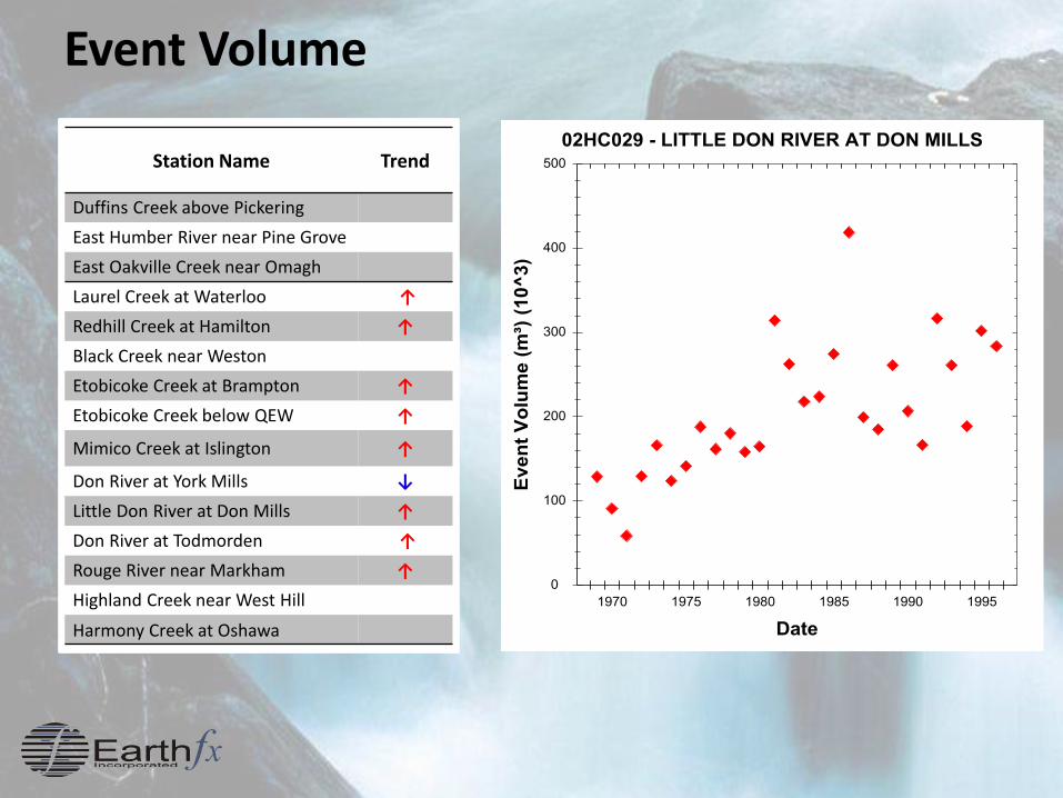
Event Volume
Station Name Trend
Duffins Creek above Pickering
East Humber River near Pine Grove
East Oakville Creek near Omagh
Laurel Creek at Waterloo ↑
Redhill Creek at Hamilton ↑
Black Creek near Weston
Etobicoke Creek at Brampton ↑
Etobicoke Creek below QEW ↑
Mimico Creek at Islington ↑
Don River at York Mills ↓
Little Don River at Don Mills ↑
Don River at Todmorden ↑
Rouge River near Markham ↑
Highland Creek near West Hill
Harmony Creek at Oshawa

Total Event Duration
Station Name Trend
Duffins Creek above Pickering
East Humber River near Pine Grove
East Oakville Creek near Omagh ↓
Laurel Creek at Waterloo
Redhill Creek at Hamilton
Black Creek near Weston ↓
Etobicoke Creek at Brampton ↓
Etobicoke Creek below QEW ↑
Mimico Creek at Islington ↑
Don River at York Mills ↓
Little Don River at Don Mills ↑
Don River at Todmorden ↓
Rouge River near Markham ↑
Highland Creek near West Hill ↓
Harmony Creek at Oshawa ↓

Hydrograph Separation
Qpeak
Qstart
Qreg
Time
Dis
cha
rge
Qpivot
tstarttpeak
treg
Quick (Direct)Flow
Inter Flow
Base Flow
Constant Slope Method Inflection Point Solver
• Find inflection point on falling limb via non-linear curve fitting
• Separate linear storage volumes

Hydrograph Separation
25

Event Quick Flow (Direct Runoff) Volume
Station Name Trend
Duffins Creek above Pickering
East Humber River near Pine Grove
East Oakville Creek near Omagh
Oakville Creek at Milton ↓
Credit River near Orangeville
Black Creek near Weston
Etobicoke Creek at Brampton ↑
Etobicoke Creek below QEW ↑
Mimico Creek at Islington ↑
Don River at York Mills
Little Don River at Don Mills ↑
Don River at Todmorden
Rouge River near Markham ↑
Highland Creek near West Hill ↑
Harmony Creek at Oshawa
MK Trend: Increasing

Event Interflow Volume
Station Name Trend
Duffins Creek above Pickering ↑
East Humber River near Pine Grove
East Oakville Creek near Omagh
Oakville Creek at Milton
Credit River near Orangeville
Black Creek near Weston ↑
Etobicoke Creek at Brampton
Etobicoke Creek below QEW ↑
Mimico Creek at Islington ↑
Don River at York Mills
Little Don River at Don Mills ↑
Don River at Todmorden ↑
Rouge River near Markham ↑
Highland Creek near West Hill ↑
Harmony Creek at Oshawa ↑
MK Trend: Increasing

Zombie Science?
28
“Results from these comparisons show that depending on the method used, automated baseflow separation underestimates the simulated baseflow by as much as 28%, or overestimates it by up to 74%, during rainfall events.” (Partington et al., 2012)

Conclusions
• While direct runoff increases in urbanizing catchments, event contribution to shallow system may increase or decrease
• Hydrograph separation methods have relevance in modern hydrology, more work required
• Must work towards integrated SW/GW definitions
• Canada has an large database of high resolution, instantaneous hydrometric data spanning from 1969 onwards
29

Acknowledgements
Dr. Herman Goertz Jeanette Fooks
Paula Hunter Carrie-Lynn Green
Eco-Hydraulics Co-op
Tyler Gale
Victoria Lounder
Ben Plumb
Christina Bright
Water Survey Division, Environment Canada
Tom Arsenault
Aerial Photography Analysis
Robert Leonard
Nikita Tirskikh
Chris McKie

31
Questions or Comments?

WSC
Station ID Station Name
Area
(km2)
Percent
Urban
(1969)
Percent
Urban
(≈2010)
Percent
Change
02HC019 Duffins Creek above Pickering 93.5 > 5% --
02HC009 East Humber River near Pine Grove 197 > 10% --
02HB004 East Oakville Creek near Omagh 199 > 10% --
02GA024 Laurel Creek at Waterloo 57.5 15 38 23
02HA014 Red Hill Creek at Hamilton 56.3 27 60 33
02HC027 Black Creek near Weston 58 55 78 22
02HC017 Etobicoke Creek at Brampton 63.2 1 18 17
02HC030 Etobicoke Creek below QEW 204 20 55 34
02HC033 Mimico Creek at Islington 70.6 43 82 39
02HC005 Don River at York Mills 88.1 30 69 39
02HC029 Little Don River at Don Mills 130 30 68 38
02HC024 Don River at Todmorden 316 43 73 30
02HC022 Rouge River near Markham 186 7 40 33
02HC013 Highland Creek near West Hill 88.1 47 86 39
02HD013 Harmony Creek at Oshawa 41.6 20 45 25
32
Study Catchments

Summary (Warm Weather Trends)
Station Name Peak
Discharge
Time to
Peak
Event
Duration
Total
Hydrograph
Duration
Event
Volume
Total
Hydrograph
Volume
Flashiness
Duffins Creek above Pickering
East Humber River near Pine Grove
East Oakville Creek near Omagh ↓
Oakville Creek at Milton ↑ ↓ ↓ ↓ ↓ ↓ ↑
Credit River near Orangeville ↑
Laurel Creek at Waterloo ↑ ↑ ↑ ↑ ↑
Redhill Creek at Hamilton ↑
Black Creek near Weston ↑ ↓ ↑
Etobicoke Creek at Brampton ↑ ↓ ↓ ↓ ↑ ↑ ↑
Etobicoke Creek below QEW ↑ ↑ ↑ ↑ ↑ ↑
Mimico Creek at Islington ↑ ↑ ↑ ↑ ↑ ↑
Don River at York Mills ↑ ↓ ↓ ↓ ↓ ↑
Little Don River at Don Mills ↑ ↑ ↑ ↑ ↑ ↑ ↑
Don River at Todmorden ↑ ↓ ↓ ↑ ↑ ↑
Rouge River near Markham ↑ ↑ ↑ ↑ ↑ ↑
Highland Creek near West Hill ↑ ↓ ↓ ↓ ↑ ↑
Harmony Creek at Oshawa ↑ ↓ ↓ ↑

Partial Flow Duration Curve
1970 1985 2010
Related Documents