Characterization of Aerosols using Airborne Lidar, MODIS, and GOCART Data during the TRACE-P (2001) Mission ich Ferrare 1 , Ed Browell 1 , Syed Ismail 1 , Yoram Kaufm Mian Chin 2 , Vince Brackett 3 , Carolyn Butler 3 , Marian Clayton 3 , Marta Fenn 3 , Jean Francois Léon 4 ASA Langley Research Center, Hampton, VA, USA ASA Goddard Space Flight Center, Greenbelt, MD, USA AIC/NASA Langley Research Center, Hampton, VA, USA aboratoire d’Optique Atmospherique, Lille, France MODIS Science Team Meeting, March 2005

Characterization of Aerosols using Airborne Lidar, MODIS, and GOCART Data during the TRACE-P (2001) Mission Rich Ferrare 1, Ed Browell 1, Syed Ismail 1,
Dec 14, 2015
Welcome message from author
This document is posted to help you gain knowledge. Please leave a comment to let me know what you think about it! Share it to your friends and learn new things together.
Transcript
Characterization of Aerosols using Airborne Lidar, MODIS, and GOCART Data during the TRACE-P
(2001) MissionRich Ferrare1, Ed Browell1, Syed Ismail1, Yoram Kaufman2,
Mian Chin2, Vince Brackett3, Carolyn Butler3, Marian Clayton3, Marta Fenn3, Jean Francois Léon4
1NASA Langley Research Center, Hampton, VA, USA2NASA Goddard Space Flight Center, Greenbelt, MD, USA3SAIC/NASA Langley Research Center, Hampton, VA, USA4Laboratoire d’Optique Atmospherique, Lille, France
MODIS Science Team Meeting, March 2005
Outline
• Motivation
• Objectives
• Airborne Lidar Measurements
• Lidar + MODIS retrievals
• GOCART model evaluation
• Summary and Future
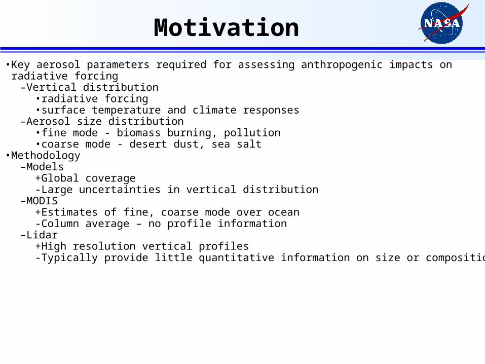
Motivation• Key aerosol parameters required for assessing anthropogenic impacts on radiative forcing
–Vertical distribution• radiative forcing• surface temperature and climate responses
–Aerosol size distribution• fine mode - biomass burning, pollution• coarse mode - desert dust, sea salt
• Methodology–Models
+Global coverage- Large uncertainties in vertical distribution
–MODIS+Estimates of fine, coarse mode over ocean- Column average – no profile information
–Lidar+High resolution vertical profiles- Typically provide little quantitative information on size or composition
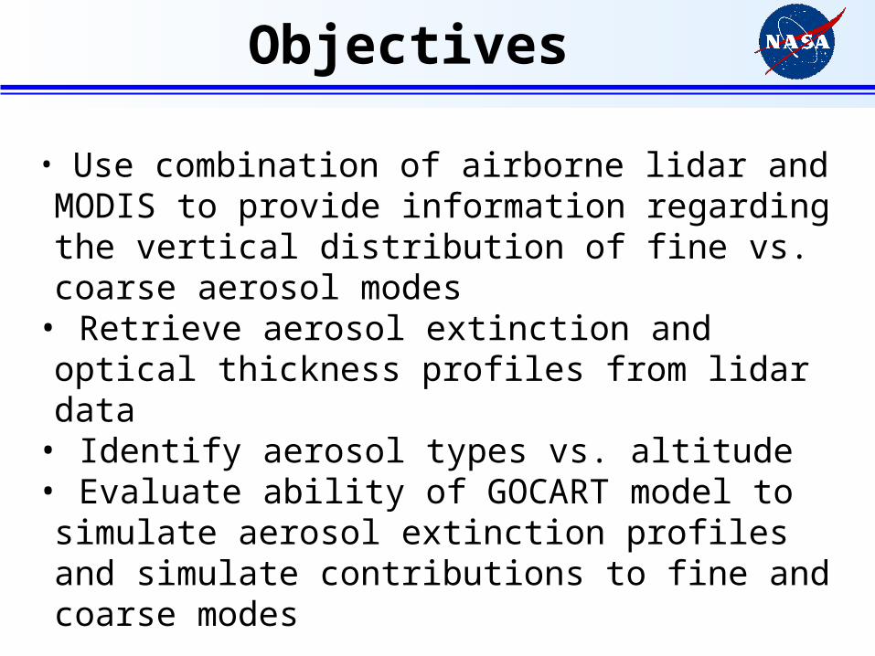
Objectives
• Use combination of airborne lidar and MODIS to provide information regarding the vertical distribution of fine vs. coarse aerosol modes
• Retrieve aerosol extinction and optical thickness profiles from lidar data
• Identify aerosol types vs. altitude• Evaluate ability of GOCART model to simulate aerosol extinction profiles and simulate contributions to fine and coarse modes
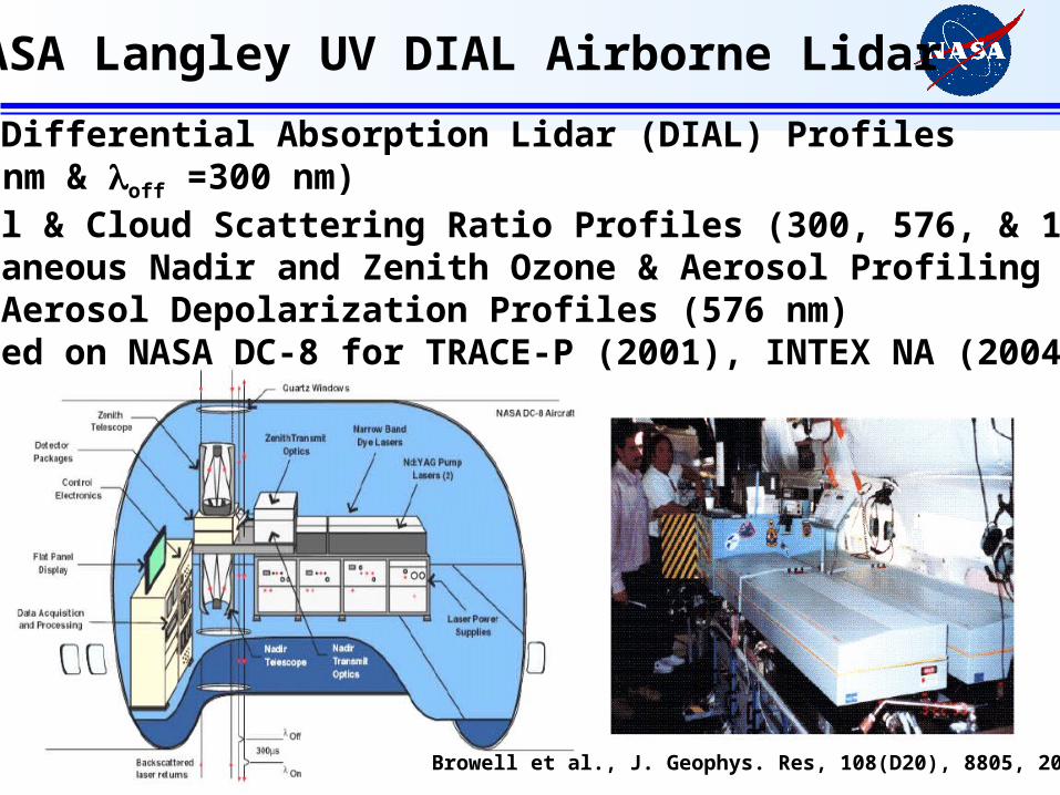
NASA Langley UV DIAL Airborne Lidar
• Ozone Differential Absorption Lidar (DIAL) Profiles(on=289 nm & off =300 nm)• Aerosol & Cloud Scattering Ratio Profiles (300, 576, & 1064 nm)• Simultaneous Nadir and Zenith Ozone & Aerosol Profiling• Nadir Aerosol Depolarization Profiles (576 nm)• Deployed on NASA DC-8 for TRACE-P (2001), INTEX NA (2004)
Browell et al., J. Geophys. Res, 108(D20), 8805, 2003.
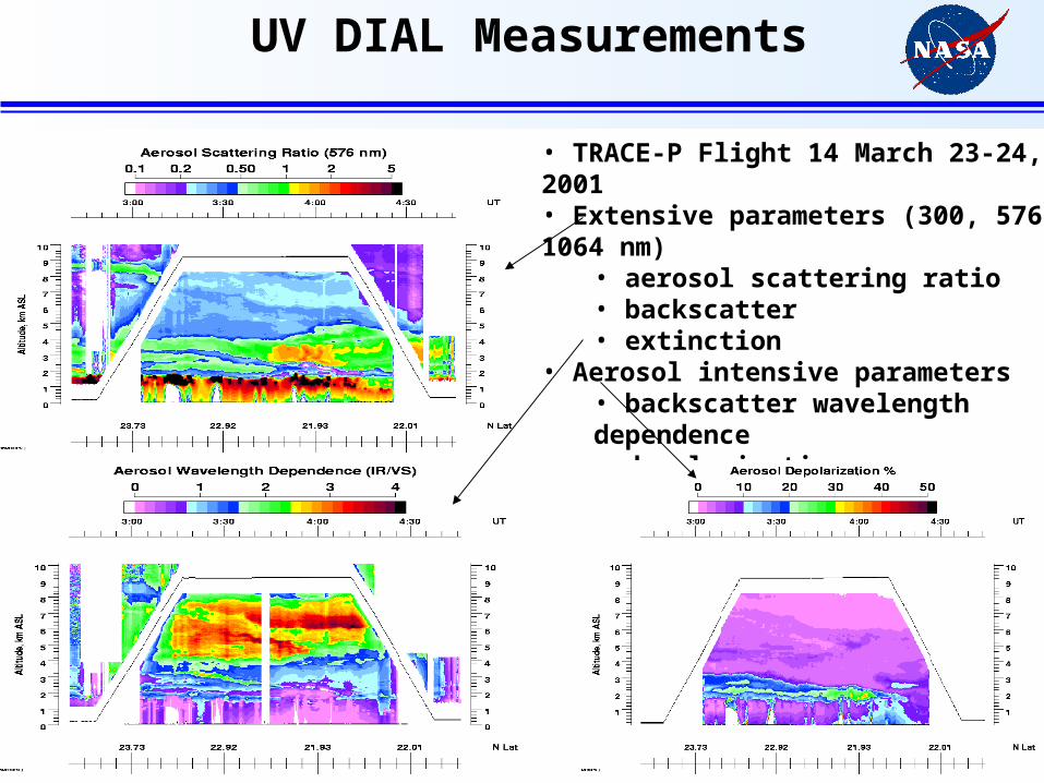
UV DIAL Measurements
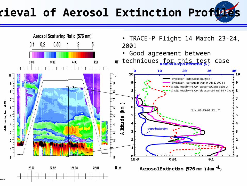
• TRACE-P Flight 14 March 23-24, 2001• Extensive parameters (300, 576, 1064 nm)
• aerosol scattering ratio• backscatter• extinction
• Aerosol intensive parameters• backscatter wavelength dependence• depolarization
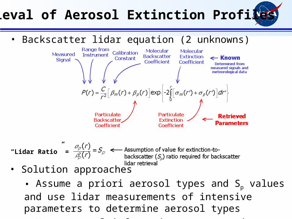
Retrieval of Aerosol Extinction Profiles
• Backscatter lidar equation (2 unknowns)
• Solution approaches
• Assume a priori aerosol types and Sp values and use lidar measurements of intensive parameters to determine aerosol types
• Use external information to constrain solution (e.g. MODIS AOT)
“Lidar Ratio” =
Retrieval of Aerosol Extinction Profiles
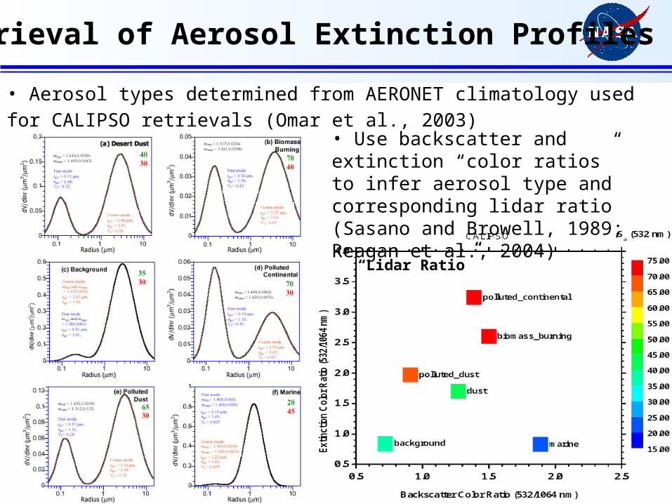
• Aerosol types determined from AERONET climatology used for CALIPSO retrievals
(Omar et al., 2003) • Use backscatter and extinction “color ratios” to infer aerosol type and corresponding lidar ratio (Sasano and Browell, 1989; Reagan et al., 2004)
“Lidar Ratio”
0
1
2
3
4
5
6
7
8
9
10
1E-3 0.01 0.10
1
2
3
4
5
6
7
8
9
100 10 20 30 40
Aerosol Extinction (576 nm) (km-1)
Altitude
(km
)
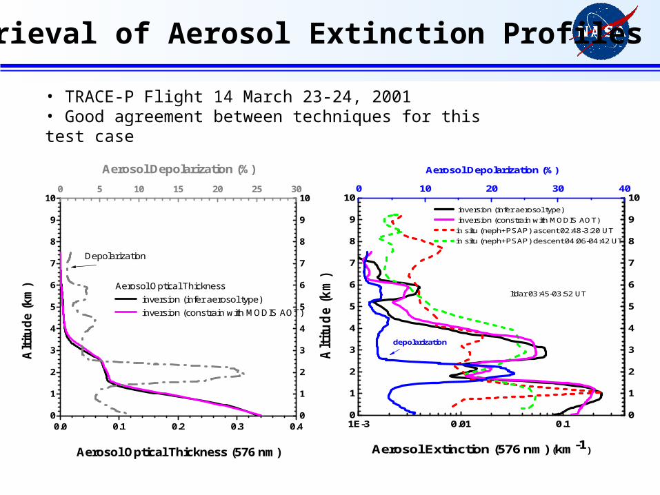
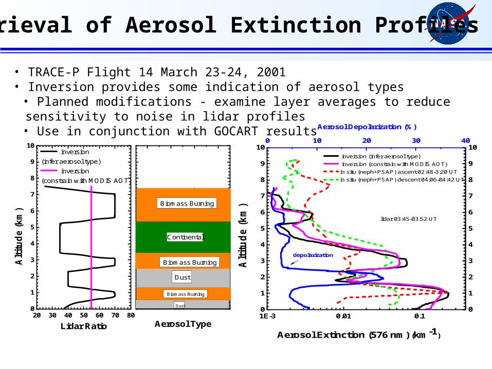
inversion (infer aerosol type) inversion (constrain with MODIS AOT) in situ (neph+PSAP) ascent 02:48-3:20 UT in situ (neph+PSAP) descent 04:06-04:42 UT
lidar 03:45-03:52 UT
Aerosol Depolarization (%)
depolarization
Retrieval of Aerosol Extinction Profiles
• TRACE-P Flight 14 March 23-24, 2001• Good agreement between techniques for this test case
0
1
2
3
4
5
6
7
8
9
10
0.0 0.1 0.2 0.3 0.40
1
2
3
4
5
6
7
8
9
100 5 10 15 20 25 30
Aerosol Optical Thickness inversion (infer aerosol type) inversion (constrain with MODIS AOT)
Aerosol Optical Thickness (576 nm)
Alti
tude
(km
)
Depolarization
Aerosol Depolarization (%)
0
1
2
3
4
5
6
7
8
9
10
1E-3 0.01 0.10
1
2
3
4
5
6
7
8
9
100 10 20 30 40
Aerosol Extinction (576 nm) (km-1)
Altitude
(km
)
inversion (infer aerosol type) inversion (constrain with MODIS AOT) in situ (neph+PSAP) ascent 02:48-3:20 UT in situ (neph+PSAP) descent 04:06-04:42 UT
lidar 03:45-03:52 UT
Aerosol Depolarization (%)
depolarization
Retrieval of Aerosol Extinction Profiles
• TRACE-P Flight 14 March 23-24, 2001• Good agreement between techniques for this test case
0
1
2
3
4
5
6
7
8
9
10
20 30 40 50 60 70 80
inversion(infer aerosol type)
inversion(constrain with MODIS AOT)
Lidar Ratio
Alti
tude
(km
)
Aerosol Type
Biomass Burning
Biomass Burning
Continental
Dust
Biomass Burning
Dust 0
1
2
3
4
5
6
7
8
9
10
1E-3 0.01 0.10
1
2
3
4
5
6
7
8
9
100 10 20 30 40
Aerosol Extinction (576 nm) (km-1)
Altitude
(km
)
inversion (infer aerosol type) inversion (constrain with MODIS AOT) in situ (neph+PSAP) ascent 02:48-3:20 UT in situ (neph+PSAP) descent 04:06-04:42 UT
lidar 03:45-03:52 UT
Aerosol Depolarization (%)
depolarization
Retrieval of Aerosol Extinction Profiles
• TRACE-P Flight 14 March 23-24, 2001• Inversion provides some indication of aerosol types
• Planned modifications - examine layer averages to reduce sensitivity to noise in lidar profiles• Use in conjunction with GOCART results
MODIS+lidar Aerosol Retrieval
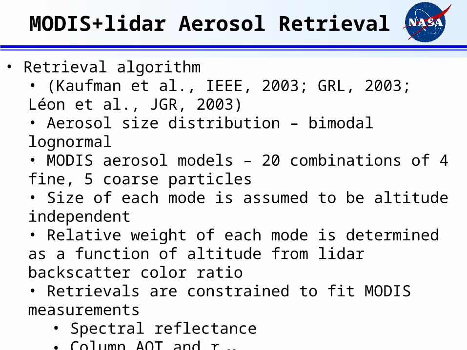
• Retrieval algorithm• (Kaufman et al., IEEE, 2003; GRL, 2003; Léon et al., JGR, 2003)• Aerosol size distribution – bimodal lognormal• MODIS aerosol models – 20 combinations of 4 fine, 5 coarse particles• Size of each mode is assumed to be altitude independent• Relative weight of each mode is determined as a function of altitude from lidar backscatter color ratio• Retrievals are constrained to fit MODIS measurements
• Spectral reflectance• Column AOT and reff
• Modifications• UV wavelength (300 nm) – more information on fine particle size• Depolarization – adjust the backscatter phase function for nonsphericity
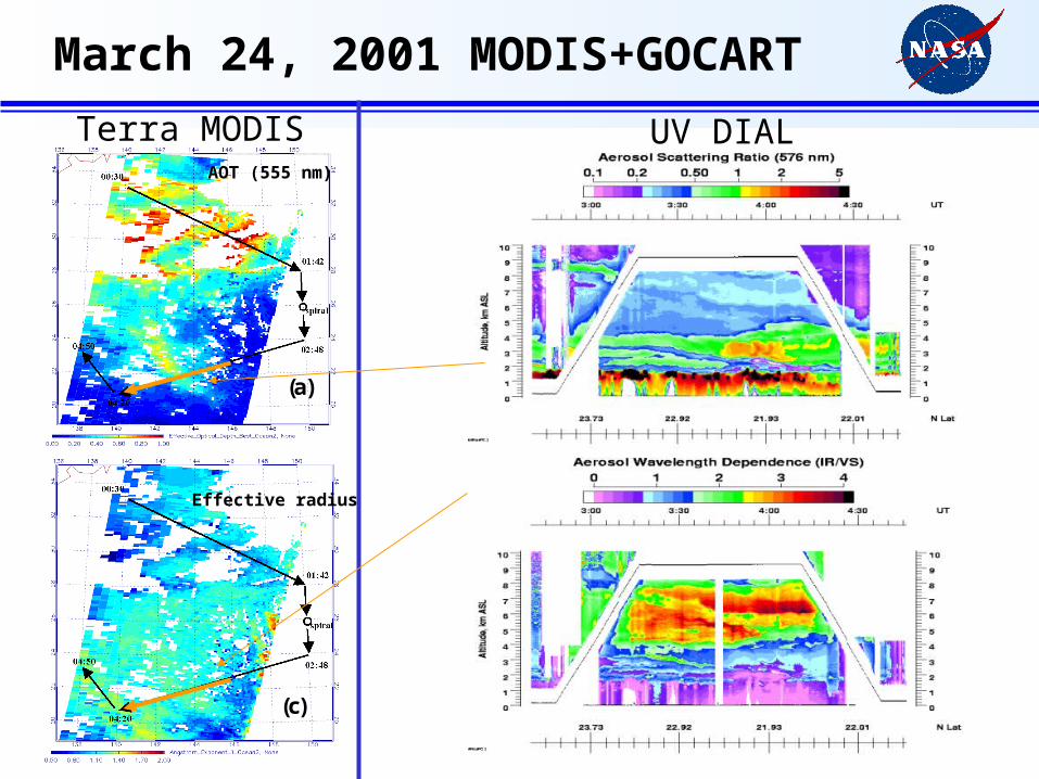
(a) (b)
(c)
Terra MODISAOT (555 nm)
Effective radius
March 24, 2001 MODIS+GOCART
UV DIAL
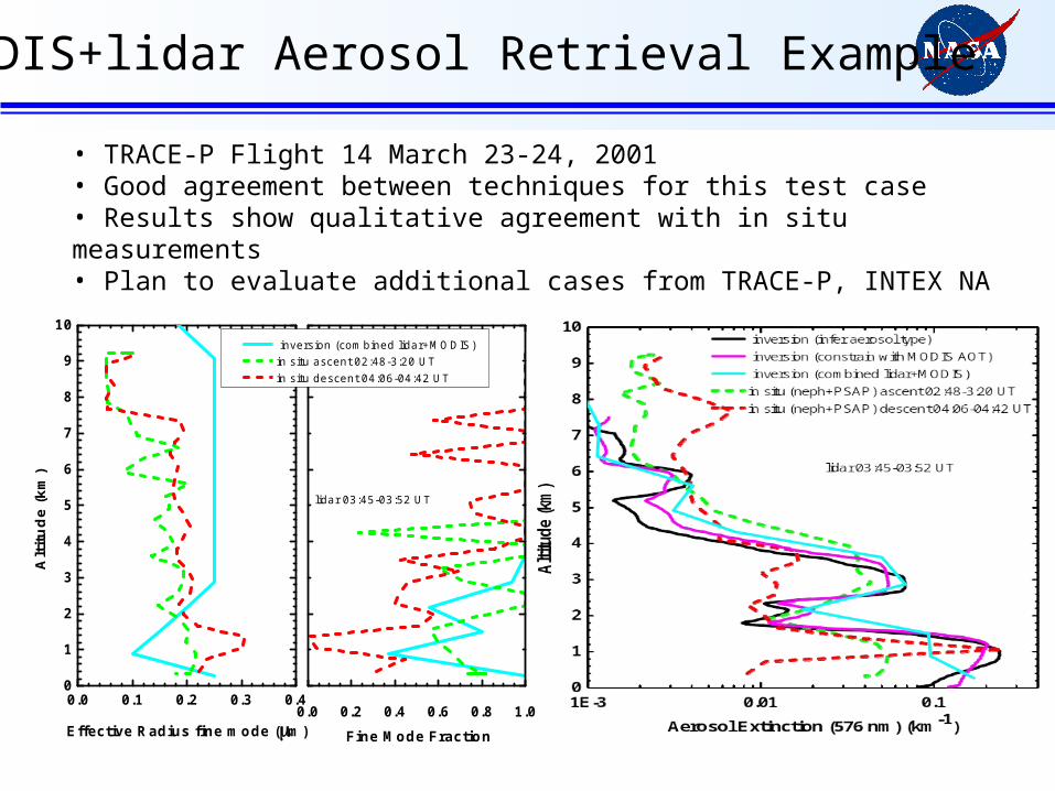
MODIS+lidar Aerosol Retrieval Example
• TRACE-P Flight 14 March 23-24, 2001• Good agreement between techniques for this test case• Results show qualitative agreement with in situ measurements• Plan to evaluate additional cases from TRACE-P, INTEX NA
0
1
2
3
4
5
6
7
8
9
10
0.0 0.1 0.2 0.3 0.4
Effective Radius fine mode (m)
Alt
itu
de
(km
)
lidar 03:45-03:52 UT
0.0 0.2 0.4 0.6 0.8 1.0
inversion (combined lidar+MODIS) in situ ascent 02:48-3:20 UT in situ descent 04:06-04:42 UT
Fine Mode Fraction

(a) (b)
(c)
Terra MODISAOT (555 nm)
Effective radius
GOCART
Total AOT (500 nm) Sulfate AOT (500 nm)
Dust AOT (500 nm) Organic Carbon AOT (500 nm)
March 24, 2001 MODIS+GOCART
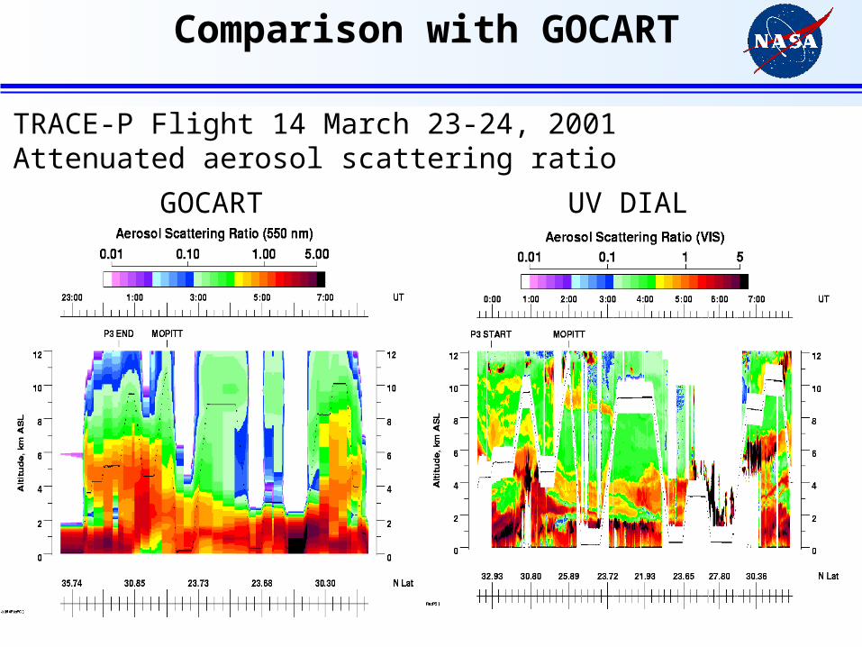
Comparison with GOCART
• TRACE-P Flight 14 March 23-24, 2001• Attenuated aerosol scattering ratio
GOCART UV DIAL

GOCART March 24, 2001
Total Sulfate
Dust OrganicCarbon
0
1
2
3
4
5
6
7
8
9
10
1E-4 1E-3 0.01 0.1
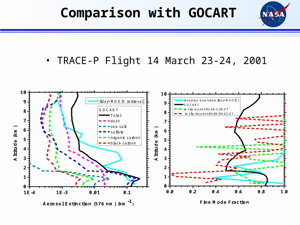
GOCART Total dust sea salt sulfate organic carbon black carbon
Aerosol Extinction (576 nm) (km-1)
Alt
itu
de
(km
)
lidar+MODIS retrieval
0
1
2
3
4
5
6
7
8
9
10
0.0 0.2 0.4 0.6 0.8 1.0
Fine Mode Fraction
Alt
itu
de
(km
)
inversion (combined lidar+MODIS) GOCART in situ ascent 02:48-3:20 UT in situ descent 04:06-04:42 UT
• TRACE-P Flight 14 March 23-24, 2001
Comparison with GOCART
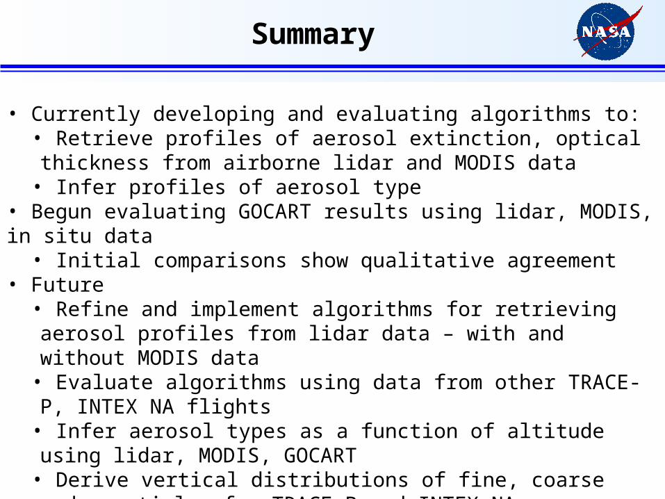
Summary
• Currently developing and evaluating algorithms to:• Retrieve profiles of aerosol extinction, optical thickness from airborne lidar and MODIS data
• Infer profiles of aerosol type• Begun evaluating GOCART results using lidar, MODIS, in situ data
• Initial comparisons show qualitative agreement• Future
• Refine and implement algorithms for retrieving aerosol profiles from lidar data – with and without MODIS data
• Evaluate algorithms using data from other TRACE-P, INTEX NA flights• Infer aerosol types as a function of altitude using lidar, MODIS, GOCART• Derive vertical distributions of fine, coarse mode particles for TRACE-P and INTEX NA
Related Documents