PROCEEDINGS, 43rd Workshop on Geothermal Reservoir Engineering Stanford University, Stanford, California, February 12-14, 2018 SGP-TR-213 1 Characterization of a Deep Fault Zone in Upper Jurassic Carbonates of the Northern Alpine Foreland Basin for Geothermal Production (South Germany) Michael Dussel 1 , Inga Moeck 1,2 , Markus Wolfgramm 3 , Robert Straubinger 4 1 Leibniz Institute for Applied Geophysics (LIAG), Section Geothermics and Information Systems, Hannover, Germany 2 Georg-August-Universität Göttingen, Department of Applied Geology, Göttingen, Germany 3 Geothermie Neubrandenburg GmbH (GTN), Neubrandenburg, Germany 4 Enex Power Germany GmbH (Enex), Kirchseeon, Germany [email protected] Keywords: fault intersection, permeability structure, 3D seismic interpretation, Y-shaped grabens, fractured carbonate cores, geothermal play type ABSTRACT The fractured and karstified Upper Jurassic carbonates of the South German Molasse Basin, the northern foreland basin of the European Alps, constitute the most important reservoir for deep geothermal energy use in Germany. Over the last 15 years more than 20 deep geothermal heating facilities and power plants were successfully installed. Currently, new wells are drilled deeper and nearer closer to the frontal fault of the Alpine fold belt. The new targets are associated with challenging drilling and detailed target determination like damage zones and intersection of faults of Y-shaped graben structures. One of the wells into the deep basin is the well GEN-1ST, drilled into 4.7 km deep dolomitic carbonates. An intensive research program was carried out to determine the permeability structure across the drilled fault zone including vertical seismic profiling, core drilling and logging. 1. INTRODUCTION The Bavarian Molasse Basin in South Germany is the most important region for the use of deep geothermal energy in Germany. 21 geothermal projects, most of them located in the Munich region, operated in 2017 with an installed capacity of 270.4 MW thermal and 32.2 MW electric (Weber et al., 2016). Two of them are power plants, 15 heatings and four heating-power plants. Six projects are in the construction or planning phase. The geothermal reservoir consists of Upper Jurassic carbonates. As generally stated by Moeck (2014) for the orogenic belt/ foreland play type especially lithology, facies, diagenesis and tectonics control the permeability structure of the reservoir. Since the beginning of the geothermal production with the conversion of the petroleum borehole Erding 1 (1998) to thermal water use for spa purposes, extensive efforts were launched to investigate the potential geological targets in the 600 to 650 m thick Upper Jurassic carbonates in 2000 to 4000 m depth (Schulz et al., 2004, Böhm et al., 2013, Lüschen et al., 2014). After nearly two decades of successful geothermal exploration in the region of Munich the high geothermal potential of the southern South Molasse Basin in Germany shall be economically utilized by newly developed exploitation concepts. Similar to the Deep Basin in Alberta/Canada, the target horizon is in a depth greater than 4500 m and exhibits a challenge in exploration and drilling. While the Upper Jurassic in the Munich region is drilled and characterized through several geothermal wells, the deep basin carbonates are still understudied. Due to the large depth, the reservoir porosity might by low due to compaction and diagenetic processes. Effectively, deep reservoirs are expected to be fault- and fracture- controlled. The geothermal well Geretsried GEN-1 (see Figure 1a) was the first commercial well drilled 2013 into the deep basin Upper Jurassic. The geothermal site Geretsried covers a large 3D seismic survey and is located 40 km south of Munich, east of the lake Starnberg and close to the Alpine orogenic belt at the transition of the unfolded Molasse Basin to the folded Molasse Basin (Fig. 1b). The exploration concept focused on rock facies, the so-called massive reef detritus facies and ended in a non-productive well with a flow rate of less than 5 l/s. At that time it was with its 6036 m length (MD) the longest geothermal borehole in Europe. The dry well GEN-1 was plugged in August 2013 and the negative results from this prominent project provoked a considerable draw-down in the whole geothermal market in Germany. The results of this well indicated a tight carbonate rock with dolomitic intervals. Therefore, a new exploration concept was developed for Geretsried targeting a normal fault and its adjacent damage zone. Already in 2013 first ideas grew to turn Geretsried into a research project to analyse and understand the permeability structure of the underexplored deep part of the Upper Jurassic Malm aquifer. Since carbonate rocks are generally known as fractured, diagenetically and facies controlled reservoirs, the focus of the research ambitions was on the permeability structure of fault zones, facies classification and fault zone diagenesis. In 2015 the research proposal Dolomitkluft was submitted to the German Federal Ministry for Economic Affairs and Energy for a joint project with partners from industry and scientific institutions. The Dolomitkluft proposal was accepted and the joint project started in May 2016 with funds from the German Federal Ministry of Economic Affairs and Energy. Main tasks of this research project is re-evaluation of 3D seismic data after vertical seismic profiling in the well GEN-1, drilling a side-track from the main well into the nearby fault zone, drill coring, logging and hydraulic testing in several steps. The research project Dolomitkluft (i.e. dolomite fracture) addresses the geothermal development, testing and analysis of the first fracture dominated dolomitic aquifer in the deep Malm of the Bavarian Molasse Basin. Several research topics are dealt out among the partners of the joint project, Enex, LIAG, GEOS, GTN and TUM. Enex is the license owner of the test side and coordinator of the joint research project. The scientific lead has the LIAG.

Welcome message from author
This document is posted to help you gain knowledge. Please leave a comment to let me know what you think about it! Share it to your friends and learn new things together.
Transcript

PROCEEDINGS, 43rd Workshop on Geothermal Reservoir Engineering
Stanford University, Stanford, California, February 12-14, 2018
SGP-TR-213
1
Characterization of a Deep Fault Zone in Upper Jurassic Carbonates of the Northern Alpine
Foreland Basin for Geothermal Production (South Germany)
Michael Dussel1, Inga Moeck1,2, Markus Wolfgramm3, Robert Straubinger4
1Leibniz Institute for Applied Geophysics (LIAG), Section Geothermics and Information Systems, Hannover, Germany
2Georg-August-Universität Göttingen, Department of Applied Geology, Göttingen, Germany
3Geothermie Neubrandenburg GmbH (GTN), Neubrandenburg, Germany
4Enex Power Germany GmbH (Enex), Kirchseeon, Germany
Keywords: fault intersection, permeability structure, 3D seismic interpretation, Y-shaped grabens, fractured carbonate cores, geothermal
play type
ABSTRACT
The fractured and karstified Upper Jurassic carbonates of the South German Molasse Basin, the northern foreland basin of the European
Alps, constitute the most important reservoir for deep geothermal energy use in Germany. Over the last 15 years more than 20 deep
geothermal heating facilities and power plants were successfully installed. Currently, new wells are drilled deeper and nearer closer to the
frontal fault of the Alpine fold belt. The new targets are associated with challenging drilling and detailed target determination like damage
zones and intersection of faults of Y-shaped graben structures. One of the wells into the deep basin is the well GEN-1ST, drilled into 4.7
km deep dolomitic carbonates. An intensive research program was carried out to determine the permeability structure across the drilled
fault zone including vertical seismic profiling, core drilling and logging.
1. INTRODUCTION
The Bavarian Molasse Basin in South Germany is the most important region for the use of deep geothermal energy in Germany. 21
geothermal projects, most of them located in the Munich region, operated in 2017 with an installed capacity of 270.4 MW thermal and
32.2 MW electric (Weber et al., 2016). Two of them are power plants, 15 heatings and four heating-power plants. Six projects are in the
construction or planning phase. The geothermal reservoir consists of Upper Jurassic carbonates. As generally stated by Moeck (2014) for
the orogenic belt/ foreland play type especially lithology, facies, diagenesis and tectonics control the permeability structure of the reservoir.
Since the beginning of the geothermal production with the conversion of the petroleum borehole Erding 1 (1998) to thermal water use for
spa purposes, extensive efforts were launched to investigate the potential geological targets in the 600 to 650 m thick Upper Jurassic
carbonates in 2000 to 4000 m depth (Schulz et al., 2004, Böhm et al., 2013, Lüschen et al., 2014). After nearly two decades of successful
geothermal exploration in the region of Munich the high geothermal potential of the southern South Molasse Basin in Germany shall be
economically utilized by newly developed exploitation concepts. Similar to the Deep Basin in Alberta/Canada, the target horizon is in a
depth greater than 4500 m and exhibits a challenge in exploration and drilling. While the Upper Jurassic in the Munich region is drilled
and characterized through several geothermal wells, the deep basin carbonates are still understudied. Due to the large depth, the reservoir
porosity might by low due to compaction and diagenetic processes. Effectively, deep reservoirs are expected to be fault- and fracture-
controlled. The geothermal well Geretsried GEN-1 (see Figure 1a) was the first commercial well drilled 2013 into the deep basin Upper
Jurassic. The geothermal site Geretsried covers a large 3D seismic survey and is located 40 km south of Munich, east of the lake Starnberg
and close to the Alpine orogenic belt at the transition of the unfolded Molasse Basin to the folded Molasse Basin (Fig. 1b). The exploration
concept focused on rock facies, the so-called massive reef detritus facies and ended in a non-productive well with a flow rate of less than
5 l/s. At that time it was with its 6036 m length (MD) the longest geothermal borehole in Europe. The dry well GEN-1 was plugged in
August 2013 and the negative results from this prominent project provoked a considerable draw-down in the whole geothermal market in
Germany. The results of this well indicated a tight carbonate rock with dolomitic intervals. Therefore, a new exploration concept was
developed for Geretsried targeting a normal fault and its adjacent damage zone. Already in 2013 first ideas grew to turn Geretsried into a
research project to analyse and understand the permeability structure of the underexplored deep part of the Upper Jurassic Malm aquifer.
Since carbonate rocks are generally known as fractured, diagenetically and facies controlled reservoirs, the focus of the research ambitions
was on the permeability structure of fault zones, facies classification and fault zone diagenesis.
In 2015 the research proposal Dolomitkluft was submitted to the German Federal Ministry for Economic Affairs and Energy for a joint
project with partners from industry and scientific institutions. The Dolomitkluft proposal was accepted and the joint project started in May
2016 with funds from the German Federal Ministry of Economic Affairs and Energy. Main tasks of this research project is re-evaluation
of 3D seismic data after vertical seismic profiling in the well GEN-1, drilling a side-track from the main well into the nearby fault zone,
drill coring, logging and hydraulic testing in several steps. The research project Dolomitkluft (i.e. dolomite fracture) addresses the
geothermal development, testing and analysis of the first fracture dominated dolomitic aquifer in the deep Malm of the Bavarian Molasse
Basin. Several research topics are dealt out among the partners of the joint project, Enex, LIAG, GEOS, GTN and TUM. Enex is the
license owner of the test side and coordinator of the joint research project. The scientific lead has the LIAG.
Dussel et al.
2
Figure 1a: Location of borehole Geretsried GEN 1ST-A1 (base: map of a 3D thermo-hydraulic model in the Munich region (blue
dyed) in the realm of German regions with hydrothermal resources (proven and assumed), and associated temperature
ranges (modified after Suchi et al., 2014), (www.geotis.de), in: Dussel et al., 2016).
Figure 1b: Distribution of the subsurface Upper Jurassic (Franconian and Swabian facies) in the Molasse Basin with isolines of
hydraulic conductivity in m/s. Arrow indicates the reduction of hydraulic conductivity from NE to SW. Dashed area:
transition to Helvetian facies with expected very low hydraulic conductivity (modified from Birner et al., 2012).
Deep fault zones are hitherto scientifically understudied: the dimensions of damage zone, fault core and the permeability variability in
these fault zones compared to intact rock are not well quantified. The interaction between fault kinematics, diagenetic processes and facies
types affecting the reservoir quality criteria porosity and permeability in depth are not well known. Therefore, a drill core section was
planned along the sidetrack covering intact reservoir rock, damage zone and fault core of the 5000 m deep fault. Structural geological,
geomechanical, geohydraulic and seismic analysis will help to characterize the fault zone. The results will be crucial for future geothermal
development in the Malm and fault controlled geothermal play types in general.
Dussel et al.
3
2. THE PROJECT DOLOMITKLUFT
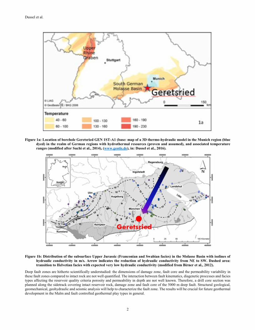
The exploration concept of the project Dolomitkluft considers faults and its damage zone as main conduits for fluids. In the Molasse
Basin, mainly normal faults serve as production zone for geothermal wells (Moeck et al., 2015) (Fig. 2a), contrasting the concept of
critically stressed faults as major fluid pathways (e.g. Barton et al., 1995). Normal faults in foreland basins play a special role in the
tectonic setting since the strike of foreland basin normal faults is parallel to the frontal fault of the adjacent mountain belt (Moeck et al.,
2015) and is obviously inconsistent with the stress regime in foreland basins (Cacace et al., 2013; Moeck et al., 2015). In the Molasse
Basin, the trend of normal faults is E-W (Moeck et al., 2015) while the direction of the maximum horizontal stress is N-S (Reinecker et
al., 2010), resulting in presuming high normal stresses and contraction on E-W normal faults. One reason for the extension along these
faults might be lithospheric bending which is alongstrike the mountain belt. Elevated permeability along these normal faults could be
explained by the intersection of syn- and antithetic normal faults, crossing normal faults (Ferrill et al., 2009; Budach et al., 2017) and
growth of damage zone in intersectional fault areas. The project Dolomitkluft aims to drill through intersectional fault areas of a major
normal fault, dipping to North, and antithetic normal faults, dipping to south (Figure 2b). Drill core sampling through intact rock, expected
damage zone and fault core shall clarify the increase or change in permeability towards fault zones, helping hydraulic reservoir models in
parametrization of fault zones.
Figure 2: Syn- and antithetic normal faults. Left 2a: major normal fault (red) with secondary faults (orange) in carbonate rock
(Cathedral formation, Alberta, Canada). Strongly damaged zone with high number of fracture intersections between
secondary faults. Right 2b: well path of sidetrack GEN-1ST through expected damage zone and intersectional fault area.
In order to achieve the economic and scientific goals of the overall project, the following tasks as a part of the entire work were already
performed from 2016 to 2017:
- Re-opening of the main well GEN-1 for vertical seismic profiling from 4200 m depth to ground level.
- Building a new seismic velocity model, time-depth-conversion and re-interpretation of 3D seismic data focusing on a graben structure
close to the main well
- Drilling of the sidetrack GEN-1ST, including the scientific program of FIT tests, coring, intensive cutting sampling for later thin sections.
- Appointment of an independent mudlogging, an independent drilling engineer, and an independent reservoir engineer for comprehensive
expert supervision with respect to the funding goals
- Supply of all necessary permits (mining law, laws pertaining to water, public right, and private right)
- Supervision of the entire project during preparation and execution. Personal presence at drilling site / project management tasks /
documentation of the drilling data / providing necessary information from borehole GEN-1 / Public Relations
Main tasks of the Leibniz Institute for Applied Geophysics (LIAG) are to deliver (I) a seismic velocity model representative for the
Southern Molasse Basin for an optimal fault interpretation; (II) dimensioning of fault zones for a numeric TH reservoir model; (III) for
the first time in a geothermal drilling in the Molasse Basin sampling of core material from the reservoir for scientific investigations which
will be performed also by Technical University Munich (TUM); (IV) frac-simulation as proof for the EGS utilization potential of
dolomites; (V) stress field analysis, kinematic fault analysis, quantification of fault reactivation potential; (VI)
planning/assignment/petrographic analysis of drill cores from the reservoir drilled through a fault zone and thin section analysis of cutting
and core material in cooperation with TUM; (VII) input of comprehensive data sets into LIAG’s geothermal information system GeotIS;
(VIII) public relation through professional outreach (e.g. brochures), workshops for knowledge transfer.
3. UNDERGROUND MODEL
Fault zones, carbonate lithoclastic-oolithic-packstone-facies with reef mounds (so called reef-facies or Franconian facies), dolomitization
as well as karstification are considered as the primary controlling factors of the Upper Jurassic reservoir of the South German Molasse
Basin (Dussel et al. 2016). The main borehole Geretsried GEN-1 was drilled into an undisturbed facies zone which was interpreted from
Dussel et al.
4
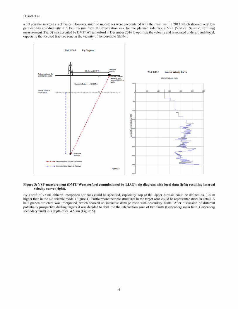
a 3D seismic survey as reef facies. However, micritic mudstones were encountered with the main well in 2013 which showed very low
permeability (productivity < 5 l/s). To minimize the exploration risk for the planned sidetrack a VSP (Vertical Seismic Profiling)
measurement (Fig. 3) was executed by DMT/ Wheatherford in December 2016 to optimize the velocity and associated underground model,
especially the focused fracture zone in the vicinity of the borehole GEN-1.
Figure 3: VSP-measurement (DMT/ Weatherford commissioned by LIAG): rig diagram with local data (left); resulting interval
velocity curve (right).
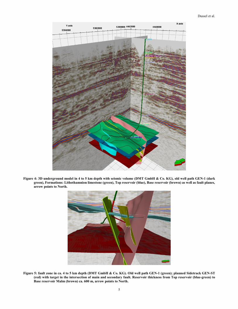
By a shift of 72 ms hitherto interpreted horizons could be specified, especially Top of the Upper Jurassic could be defined ca. 100 m
higher than in the old seismic model (Figure 4). Furthermore tectonic structures in the target zone could be represented more in detail. A
half graben structure was interpreted, which showed an intensive damage zone with secondary faults. After discussion of different
potentially prospective drilling targets it was decided to drill into the intersection zone of two faults (Gartenberg main fault, Gartenberg
secondary fault) in a depth of ca. 4.5 km (Figure 5).
Dussel et al.
5
Figure 4: 3D underground model in 4 to 5 km depth with seismic volume (DMT GmbH & Co. KG), old well path GEN-1 (dark
green), Formations: Lithothamnion limestone (green), Top reservoir (blue), Base reservoir (brown) as well as fault planes,
arrow points to North.
Figure 5: fault zone in ca. 4 to 5 km depth (DMT GmbH & Co. KG). Old well path GEN-1 (green); planned Sidetrack GEN-ST
(red) with target in the intersection of main and secondary fault. Reservoir thickness from Top reservoir (blue-green) to
Base reservoir Malm (brown) ca. 600 m, arrow points to North.
Dussel et al.
6
4. DRILLING AND CORING
In April 2017 operations for the drilling of the sidetrack in the borehole Geretsried GEN-1 started. After different considerations (e.g.
high gas pressure zone in Tertiary Rupelian clays) the sidetrack was drilled from a position deep as possible in the already existing
borehole. 230 m steel casing had to be milled from the deepest (4.) section. In June 2017 drilling of the sidetrack began after setting a
packer and a whipstock in ca. 4260 m depth in Tertiary layers. The last drilling section was displaced in the marly mostly dolomitic
carbonates of the Purbeckian (lowest Lower Cretaceous), which represents by its hydraulic connection to the Upper Jurassic the Top of
the potential reservoir. In the Upper Jurassic the borehole was deviated to ESE and SE with an inclination of ca. 70° in order to reach the
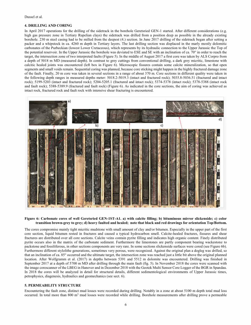
target, the intersection zone of two interpreted faults (Figure 5). In the middle of August 2017 a first core was taken by ALS Corpro from
a depth of 5018 m MD (measured depth). In contrast to grey cuttings from conventional drilling, a dark grey micritic, limestone with
calcitic healed joints was encountered (left box in Figure 6). Microscopic fissures contain some calcite mineralization, so that open
segments and small voids remain. Sequential coring was planned, because core sticking might happen in the highly fractured damage zone
of the fault. Finally, 20 m core was taken in several sections in a range of about 370 m. Core sections in different quality were taken in
the following depth ranges in measured depths meter: 5018.2-5019.3 (intact and fractured rock); 5035.8-5036.51 (fractured and intact
rock); 5199-5203 (intact and fractured rock); 5204-5205.1 (fractured and intact rock); 5374-5378 (intact rock); 5378-5388 (intact rock
and fault rock); 5388-5389.9 (fractured and fault rock) (Figure 6). As indicated in the core sections, the aim of coring was achieved as
intact rock, fractured rock and fault rock with intensive shear fracturing is encountered.
Figure 6: Carbonate cores of well Geretsried GEN-1ST-A1. a) with calcite filling; b) bituminous mirror slickenside; c) color
transition brown-grey to grey; d) heavy faulted and healed; note that black and red drawings for orientation Top/Bottom.
The cores compromise mainly tight micritic mudstone with small amount of clay and/or bitumen. Especially in the upper part of the first
core section, liquid bitumen rested in fractures and caused a typical hydrocarbon smell. Calcite-healed fractures, fissures and shear
fractures are distributed over all core sections. Calcite veins contain pyrite filling and indicates high organic content. Finely distributed
pyrite occurs also in the matrix of the carbonate sediment. Furthermore the limestones are partly component bearing wackestone to
packstone and fossiliferous, in other sections components are very rare. In some sections slickenside surfaces were cored (see Figure 6b).
Furthermore different stylolithe generations, sometimes very porous, were recognized. Against the original plan a dogleg was drilled, so
that an inclination of ca. 85° occurred and the ultimate target, the intersection zone was reached just a little bit above the original planned
location. After Wolfgramm et al. (2017) in depths between 5391 and 5512 m dolomite was encountered. Drilling was finished in
September 2017 at a depth of 5700 m MD after drilling through the main fault (fig. 5). In November 2018 the cores were scanned with
the image corescanner of the LBEG in Hanover and in Dezember 2018 with the Geotek Multi Sensor Core Logger of the BGR in Spandau.
In 2018 the cores will be analyzed in detail for structural details, different sedimentological environments of Upper Jurassic times,
petrophysics, diagenesis, hydraulics and geomechanics (see sect. 6).
5. PERMEABILITY STRUCTURE
Encountering the fault zone, distinct mud losses were recorded during drilling. Notably in a zone at about 5100 m depth total mud loss
occurred. In total more than 800 m3 mud losses were recorded while drilling. Borehole measurements after drilling prove a permeable

Dussel et al.
7
inflow zone at about 5100 m MD (Figure 7). Particularly a temperature decrease (Figure 7, green line) indicates the cooling of the rock
caused by intruded drilling mud.
Figure 7: Borehole measurements in GEN-1ST-A1: Natural gamma ray (red); sonic (blue); temperature (green); part of an image
log which had to be interrupted (brown); vp/vs ratio from sonic (black line)
After three acidizing jobs with HCl and the newly developed biodegradable acid SBB007 from the company Fangmann a six day
production test was conducted with Coiled-Tubing Nitrogen Liftting (Wolfgramm et al., 2017). The hydraulic test results in a
transmissivity of 6.5 * 10-7 m2/s and a productivity index of about 0,04 l/(s*bar), which ranges wide beyond an economic use. The
injectivity is by a factor five significantly higher as the productivity.
6. DISCUSSION
The sidetrack Geretsried GEN-1ST-A1 crossed about 1000 m Upper Jurassic carbonates from intact rock to damage zone to fault core.
The temperature log and the mud losses indicate fractured permeable rock in 5100 and 5300 m depth. Static mud losses indicate further
injectivity. The low productivity indicates fractures as fluid pathways, confirming the fractured controlled reservoir rock. However, the
fractures are obviously not connected to a good reservoir rock with high porosity, resulting in a very low productivity index. The drawdown
in the well during production was significant with about 1000 m. Acidizing could not enhance the productivity indicating a low porosity
reservoir. Rapid acid losses during acidizing is another indicator for a fractured controlled reservoir. The production test indicates that a
large drawdown causes a closure of fractures in the near-wellbore area, causing a reduction in well connectivity to the reservoir. Proppants
might be inappropriate since the marly limestone is too elastic for proppant support.
The facies and diagenetic processes in this tight carbonate might explain the low productivity. First results indicate that dolomite growth
occurred however there is no high temperature dolomite. Idiomorphic dolomite rhomboeders grow in the matrix reducing the primary
pore space. The majority of dolomitization occurred along fractures and stylolithe seams, suggesting former fluid flow along fractures
and stylolithes with transport of Mg-rich obviously meteoric water (Mraz et al., submitted). The results are however worthwhile for any
reservoir modelling as the thickness of a deep normal fault could be evidenced with the main fault and a maximum thickness of roughly
80 m containing calcite-healed secondary fracture porosity in its damage zone. Porosity and permeability tests on core material will reveal
the increase of permeability from intact rock to fault rock, although in this case permeability is not sufficient for a productive well.
7. OUTLOOK AND CONCLUSION
For further characterization of carbonates and fault zone the following core analysis will be performed:
- Density, porosity
- Permeability, poro-elastic properties
- XRF, REM, EDX, thin sections, fluid inclusions (microthermometry), cathodoluminescence

Dussel et al.
8
- Ultrasonic measurements
- Thermal conductivity
Slip tendency analysis will be conducted for the fault system and core scan measurements will be correlated with borehole measurements
and facies analysis. The EGS potential will be investigated in this project although induced seismicity occurred already in geothermal
wells near Munich, lowering the acceptance for EGS, hydraulic fracturing and fault zone injection in the Molasse Basin. Besides the EGS-
option alternative concepts for geothermal energy use will be analyzed like a deep borehole heat exchanger as well as other potential
geothermal horizons. All available data (VSP, hydraulic tests, petrophysics, geomechanics, facies maps) will be implemented into the
public internet portals of the LIAG, the Geophysics Information System (FIS GP) and the Geothermal Information System for Germany
(GeotIS). The remaining cores are available for further scientific research in particular deep fault zone studies.
The drilling results indicate tight carbonate reservoir rock in the southern deep Molasse Basin. Existing fractures do not support sufficient
flow rates for economic use. Effectively, drilling in the deep Molasse Basin exhibits a high exploration risk. New innovative exploration
concepts and methods might be considered to minimize the exploration risk in this region. The preliminary results demonstrate that
research on hydrothermal systems is still required although or even because there are already existing production sites. Future geothermal
field development and the extension of geothermal use implies detailed investigation of exploration methods targeting high porosity
domains, recharge and discharge zones in geothermal reservoirs, and test drilling to ultimately provide guidelines for successful
geothermal production from deep reservoirs in Germany and worldwide.
ACKNOWLEDGEMENTS
The joint research project Dolomitkluft (= dolomite fracture) is funded by the German Ministry for Economic Affairs and Energy (grant
number 0324004).
REFERENCES
Barton, C. A., Zoback, M.D., and Moos, D.: Fluid flow along potentially active faults in crystalline rock, Geology, 23(8), (1995), 683-
686.
Birner, J., Fritzer, T., Jodocy, M., Savatis, A., Schneider, M., Stober, I.: Hydraulische Eigenschaften des Malmaquifers im Süddeutschen
Molassebecken und ihre Bedeutung für die geothermische Erschließung, Z geol Wiss, 40, 2/3, (2012), 133 – 156.
Böhm, F., Savvatis, A., Steiner, U., Schneider, M., Koch, R.: Lithofazielle Reservoircharakterisierung zur geothermischen Nutzung des
Malm im Großraum München, Grundwasser, 18 (1), (2013), 3-13.
Budach, I., Wolfgramm, M., Moeck, I., Lüschen, E.: Temporal evolution of fault systems in the Upper Jurassic of the Central German
Molasse Basin: case study Unterhaching, Int J Earth Sci, (2017), DOI 10.1007/s00531-017-1518-1.
Cacace, M., Bloecher, G., Watanabe, N., Moeck, I., Boersing, N., Scheck-Wenderoth, M., Kolditz, O., Huenges, E.: Modelling of fractured
carbonate reservoirs: outline of a novel technique via a case study from the Molasse Basin, southern Bavaria, Germany. Environ
Earth Sci, 70(8), (2013), 3585-3602.
Dussel, M., Lüschen, E., Thomas, R., Agemar, T., Fritzer, T., Sieblitz, S., Huber, B., Birner, J., Schulz, R.: Forecast for thermal water use
from Upper Jurassic carbonates in the Munich region (South German Molasse Basin), Geothermics, 60, (2016) 13-30.
Ferrill, D.A., Morris, A.P., Mc Ginnis, R.N.: Crossing conjugate normal faults in field exposures and seismic data, AAPG Bull., 93(11),
(2009), 1471-1488.
Moeck, I., Mraz, E.: Multiphase fossil normal faults in geothermal systems: Insights from the Bavarian Molasse Basin, Geotectonic
Research, 97, Special Issue DRT 2015, Abstracts, (2015), DIO:10.1127/1864-5658/2015-27.
Moeck, I.: Catalog of geothermal play types based on geologic controls, Renewable and sustainable energy reviews, 37, (2014), 867-882.
Mraz, E., Moeck, I., Wolfgramm, M. (submitted): Porosity decline of Upper Jurassic carbonate rock caused by a change in depositional
environment. Submitted to Facies.
Reinecker, J., Tingay, M., Müller, B., Heidbach, O.: Present-day stress orientation in the Molasse Basin, Tectonophysics, 482, (2010),
129-138.
Schulz, R., Thomas, R., Jung, R., Schellschmidt, R.: Geoscientific prospect evaluation for the Unterhaching geothermal power plant. Z
Angew Geol, 2, (2004), 28-36.
Suchi, E., Dittmann, J., Knopf, S., Müller, C., Schulz, R.: Geothermal atlas to visualize potential conflicts of interest between CO2 storage
(CCS) and deep geothermal energy in Germany. Z Dt Ges Geowiss, 165, (2014), 439-453.
Weber, J., Ganz, B., Sanner, B., Moeck, I.: Geothermal Energy Use, Country Update for Germany. European Geothermal Congress 2016,
Strasbourg, France, 19-24 Sept 2016, 1-16.
Wolfgramm, M., Buse, C., Budach, I.: Geretsried 1 Sidetrack (Gen-1ST und Gen-1ST-A1) - Geologischer Bericht -, GTN, (2017), 48 S.,
unpublished.
Related Documents