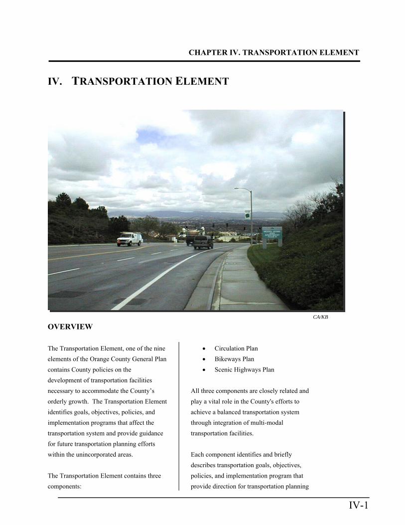
CHAPTER IV. TRANSPORTATION ELEMENT IV-1 IV. TRANSPORTATION ELEMENT CA/KB OVERVIEW The Transportation Element, one of the nine elements of the Orange County General Plan contains County policies on the development of transportation facilities necessary to accommodate the County’s orderly growth. The Transportation Element identifies goals, objectives, policies, and implementation programs that affect the transportation system and provide guidance for future transportation planning efforts within the unincorporated areas. The Transportation Element contains three components: Circulation Plan Bikeways Plan Scenic Highways Plan All three components are closely related and play a vital role in the County's efforts to achieve a balanced transportation system through integration of multi-modal transportation facilities. Each component identifies and briefly describes transportation goals, objectives, policies, and implementation program that provide direction for transportation planning

Welcome message from author
This document is posted to help you gain knowledge. Please leave a comment to let me know what you think about it! Share it to your friends and learn new things together.
Transcript
CHAPTER IV. TRANSPORTATION ELEMENT
IV-1
IV. TRANSPORTATION ELEMENT
CA/KB
OVERVIEW
The Transportation Element, one of the nine
elements of the Orange County General Plan
contains County policies on the
development of transportation facilities
necessary to accommodate the County’s
orderly growth. The Transportation Element
identifies goals, objectives, policies, and
implementation programs that affect the
transportation system and provide guidance
for future transportation planning efforts
within the unincorporated areas.
The Transportation Element contains three
components:
Circulation Plan
Bikeways Plan
Scenic Highways Plan
All three components are closely related and
play a vital role in the County's efforts to
achieve a balanced transportation system
through integration of multi-modal
transportation facilities.
Each component identifies and briefly
describes transportation goals, objectives,
policies, and implementation program that
provide direction for transportation planning
CHAPTER IV.TRANSPORTATION ELEMENT
IV-2
within the unincorporated territory of the
County.
PURPOSE OF THE ELEMENT
The Transportation Element sets forth a
comprehensive strategy for planning,
developing, and maintaining a surface
transportation system to serve existing and
planned land uses in the unincorporated
areas of Orange County. The primary goal,
consistent with the State mandate, was
originally adopted by the Orange County
Board of Supervisors on May 10, 1972. On
June 9, 1982, this goal was reaffirmed as
follows:
To develop an integrated transportation
system consisting of a blend of
transportation modes capable of
meeting the need to move people and
goods by private and public means with
maximum efficiency, convenience,
economy, safety, and comfort and a
system that is consistent with other
goals and values of the County and the
region.
RELATIONSHIP TO OTHER ELEMENTS
The Transportation Element has the same
horizon year and growth assumptions as
other elements so as to ensure internal
consistency.
The Transportation Element is one part of a
compendium of nine General Plan elements
that address projections for the next 20 to 30
year time frame. The Transportation
Element provides a basis for transportation-
related decisions, and complements the other
General Plan elements. Specifically, it
clarifies and addresses transportation issues
raised in the other General Plan elements
and offers guidance toward solutions.
The Transportation Element, as an
expression of County transportation policy,
achieves consistency with other General
Plan elements through the use of common
demographic assumptions. These
demographic projections have been adopted
by the Board of Supervisors in the Orange
County Projections (OCP) 2000, a single
data reference used for County policy-
making and planning. All long-range
planning and budgeting activities by the
County of Orange and the Orange County
Transportation Authority (OCTA) are based
on these projections.
This Element is also responsive to the
Growth Management Plan Element policies,
Air Quality Management District (AQMD)
objectives, and regional planning objectives
of the Southern California Association of
Governments (SCAG) and the OCTA.
COMPONENT ONE: CIRCULATION PLAN
Overview
CHAPTER IV. TRANSPORTATION ELEMENT
IV-3
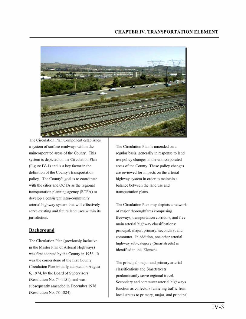
The Circulation Plan Component establishes
a system of surface roadways within the
unincorporated areas of the County. This
system is depicted on the Circulation Plan
(Figure IV-1) and is a key factor in the
definition of the County's transportation
policy. The County's goal is to coordinate
with the cities and OCTA as the regional
transportation planning agency (RTPA) to
develop a consistent intra-community
arterial highway system that will effectively
serve existing and future land uses within its
jurisdiction.
Background
The Circulation Plan (previously inclusive
in the Master Plan of Arterial Highways)
was first adopted by the County in 1956. It
was the cornerstone of the first County
Circulation Plan initially adopted on August
6, 1974, by the Board of Supervisors
(Resolution No. 74-1151), and was
subsequently amended in December 1978
(Resolution No. 78-1824).
The Circulation Plan is amended on a
regular basis, generally in response to land
use policy changes in the unincorporated
areas of the County. These policy changes
are reviewed for impacts on the arterial
highway system in order to maintain a
balance between the land use and
transportation plans.
The Circulation Plan map depicts a network
of major thoroughfares comprising
freeways, transportation corridors, and five
main arterial highway classifications:
principal, major, primary, secondary, and
commuter. In addition, one other arterial
highway sub-category (Smartstreets) is
identified in this Element.
The principal, major and primary arterial
classifications and Smartstreets
predominantly serve regional travel.
Secondary and commuter arterial highways
function as collectors funneling traffic from
local streets to primary, major, and principal
CHAPTER IV.TRANSPORTATION ELEMENT
IV-4
arterials. The overall network of
thoroughfares is designed to accommodate
existing and projected traffic.
The Circulation Plan classifications are a
statement of policy intended to reserve
adequate right-of-way for future highway
improvements within the unincorporated
areas of the County. Design guidelines and
criteria are briefly described for each arterial
classification.
Purpose
The Circulation Plan serves as the legally
required Circulation Element for the
unincorporated areas under California
Government Code Section 65302(b), and is
one of the three components of the
Transportation Element of Orange County's
General Plan.
The main purpose of the Circulation Plan is
to describe an arterial highway system that
effectively supports General Plan policies
and serves existing and adopted future land
uses in the unincorporated areas of Orange
County. Extensive coordination with the
land use planning and implementation
processes carried on by the County of
Orange and adjacent jurisdictions is
essential for the Circulation Plan to provide
its intended service to County motorists.
CLASSIFICATION
Arterial highways are shown on the
Circulation Plan map in the following two
forms:
1) Established alignments depicted by
solid lines on the map, including
existing highways where the centerline
is the precise centerline, and future
highways where the Board of
Supervisors, a City Council, or the
subdivision process has established a
precise alignment; and
2) Conceptually proposed alignments,
defined by intermittent lines indicating
future facilities whose precise
alignment and category have not yet
been determined.
Arterial highways have been divided into
classifications to address travel demand
needs in terms of capacity and number of
through lanes to aid in setting consistent
design standards for unincorporated
territory. These and other classifications are
contained in the County's Highway Design
Manual. These standards are used to ensure
that arterial highway facilities are designed
with public safety and adequate carrying
capacity in mind. In addition, special
intersection approaches for principal, major,
primary, and secondary arterials have been
identified to help address congestion
problems.
A concept of the "Maximum Feasible
Intersection" (MFI) has been introduced to
establish a guideline for intersection
enhancement that is compatible with travel

CHAPTER IV. TRANSPORTATION ELEMENT
IV-5
Insert Figure IV-1 (Circulation Plan Map)
CHAPTER IV.TRANSPORTATION ELEMENT
IV-6
Left Blank for Fig. IV-1 (11x17)
CHAPTER IV. TRANSPORTATION ELEMENT
IV-7
demand requirements and operation
capabilities of the highway system. Traffic
studies, for example, can also be used as a
mechanism to identify intersections that may
require enhancement above the standard
plan specified for that facility. Therefore,
notwithstanding typical intersection
geometrics as identified in the County
Highway Design Manual, additional right-
of-way may be required to implement the
MFI. The MFI for each classification is
defined in the classification description.
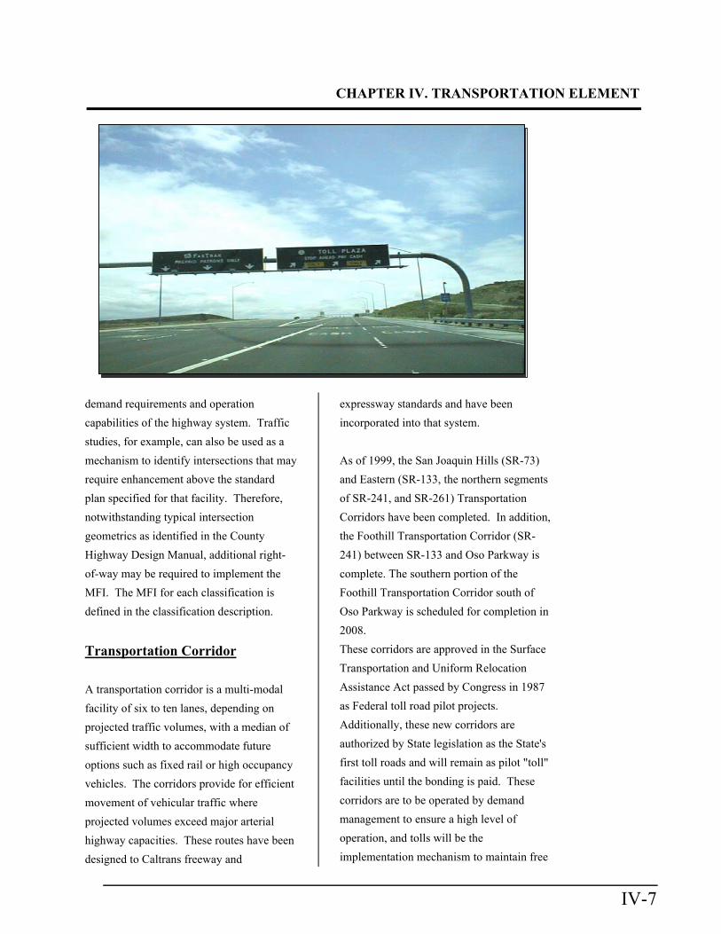
Transportation Corridor
A transportation corridor is a multi-modal
facility of six to ten lanes, depending on
projected traffic volumes, with a median of
sufficient width to accommodate future
options such as fixed rail or high occupancy
vehicles. The corridors provide for efficient
movement of vehicular traffic where
projected volumes exceed major arterial
highway capacities. These routes have been
designed to Caltrans freeway and
expressway standards and have been
incorporated into that system.
As of 1999, the San Joaquin Hills (SR-73)
and Eastern (SR-133, the northern segments
of SR-241, and SR-261) Transportation
Corridors have been completed. In addition,
the Foothill Transportation Corridor (SR-
241) between SR-133 and Oso Parkway is
complete. The southern portion of the
Foothill Transportation Corridor south of
Oso Parkway is scheduled for completion in
2008.
These corridors are approved in the Surface
Transportation and Uniform Relocation
Assistance Act passed by Congress in 1987
as Federal toll road pilot projects.
Additionally, these new corridors are
authorized by State legislation as the State's
first toll roads and will remain as pilot "toll"
facilities until the bonding is paid. These
corridors are to be operated by demand
management to ensure a high level of
operation, and tolls will be the
implementation mechanism to maintain free
CHAPTER IV.TRANSPORTATION ELEMENT
IV-8
flow.
Final alignment and environmental studies
will define the ultimate route of the
proposed southern portion of the Foothill
Corridor. These studies will identify the
necessary rights-of-way based on projected
traffic volumes and the various
transportation modes to be accommodated.
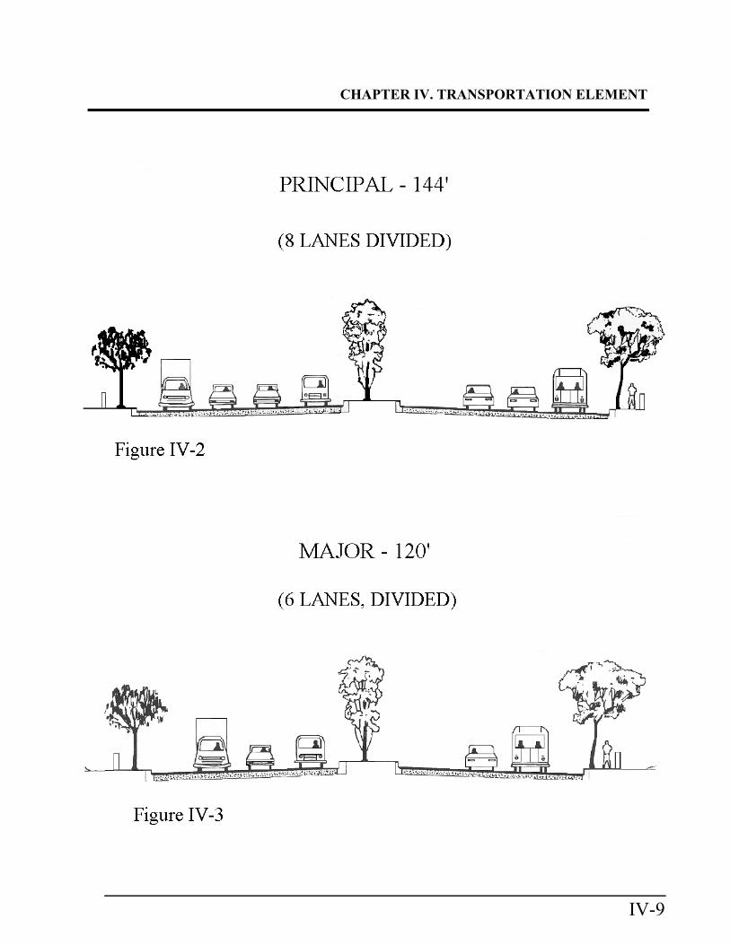
Principal Arterial
A principal arterial is an eight-lane divided
roadway, with a typical right-of-way width
of 144 feet and a roadway width of 126 feet,
curb to curb, including a 14-foot median
(Figure IV-2). A principal arterial is
designed to accommodate approximately
40,000 to 60,000 vehicle trips per day at
Level of Service 'C'.
Maximum Feasible Intersection (MFI)
The standard MFI for a principal
arterial shall consist of four through
lanes, two left-turn lanes and a free
right-turn lane. An optional right-turn
lane, in lieu of a free right, may be
allowed if warranted by traffic demand.
Alternative geometrics, such as a grade
separation or other special treatment,
may be considered if they are cost
effective and operationally feasible. In
review and approval of subdivisions,
the objective shall be to reserve
adequate right-of-way to permit future
implementation of the MFI as
warranted.
Major Arterial
A major arterial highway is a six-lane
divided roadway, with a typical right-of-way
width of 120 feet and a roadway width from
curb to curb, including a 14 foot median, of
102 feet (Figure IV-3). A major is designed
to accommodate approximately 30,000 to
45,000 vehicle trips per day at Level of
Service 'C'. Major arterials carry a large
volume of regional through traffic not
handled by the freeway system.
MFI
The standard MFI for a major arterial
shall consist of three through lanes, two
left turn lanes and a free right turn lane.
An optional right-turn lane, in lieu of a
free right, may be allowed if warranted
by traffic demand. Alternative
geometrics such as a grade separation or
other special treatment may be
considered if they are cost effective and
operationally feasible. In review and
approval of subdivisions, the objective
shall be to reserve adequate right-of-
way to permit future implementation of
the MFI as warranted.
Primary Arterial
A primary arterial highway is a four lane
divided roadway, with a typical right-of-way
width of 100 feet and a roadway width from
curb to curb, including a 14 foot median, of
CHAPTER IV. TRANSPORTATION ELEMENT
IV-9
CHAPTER IV.TRANSPORTATION ELEMENT
IV-10
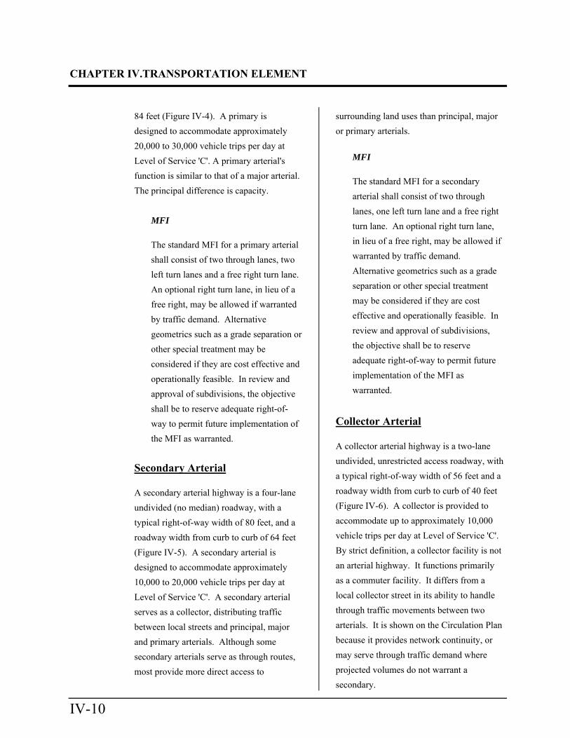
84 feet (Figure IV-4). A primary is
designed to accommodate approximately
20,000 to 30,000 vehicle trips per day at
Level of Service 'C'. A primary arterial's
function is similar to that of a major arterial.
The principal difference is capacity.
MFI
The standard MFI for a primary arterial
shall consist of two through lanes, two
left turn lanes and a free right turn lane.
An optional right turn lane, in lieu of a
free right, may be allowed if warranted
by traffic demand. Alternative
geometrics such as a grade separation or
other special treatment may be
considered if they are cost effective and
operationally feasible. In review and
approval of subdivisions, the objective
shall be to reserve adequate right-of-
way to permit future implementation of
the MFI as warranted.
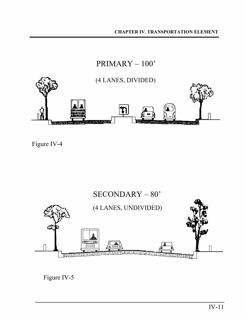
Secondary Arterial
A secondary arterial highway is a four-lane
undivided (no median) roadway, with a
typical right-of-way width of 80 feet, and a
roadway width from curb to curb of 64 feet
(Figure IV-5). A secondary arterial is
designed to accommodate approximately
10,000 to 20,000 vehicle trips per day at
Level of Service 'C'. A secondary arterial
serves as a collector, distributing traffic
between local streets and principal, major
and primary arterials. Although some
secondary arterials serve as through routes,
most provide more direct access to
surrounding land uses than principal, major
or primary arterials.
MFI
The standard MFI for a secondary
arterial shall consist of two through
lanes, one left turn lane and a free right
turn lane. An optional right turn lane,
in lieu of a free right, may be allowed if
warranted by traffic demand.
Alternative geometrics such as a grade
separation or other special treatment
may be considered if they are cost
effective and operationally feasible. In
review and approval of subdivisions,
the objective shall be to reserve
adequate right-of-way to permit future
implementation of the MFI as
warranted.
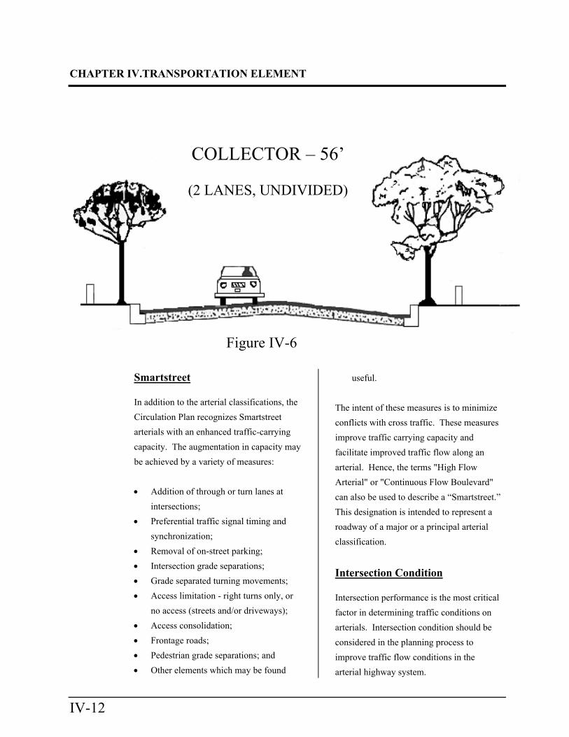
Collector Arterial
A collector arterial highway is a two-lane
undivided, unrestricted access roadway, with
a typical right-of-way width of 56 feet and a
roadway width from curb to curb of 40 feet
(Figure IV-6). A collector is provided to
accommodate up to approximately 10,000
vehicle trips per day at Level of Service 'C'.
By strict definition, a collector facility is not
an arterial highway. It functions primarily
as a commuter facility. It differs from a
local collector street in its ability to handle
through traffic movements between two
arterials. It is shown on the Circulation Plan
because it provides network continuity, or
may serve through traffic demand where
projected volumes do not warrant a
secondary.
CHAPTER IV. TRANSPORTATION ELEMENT
IV-11
PRIMARY – 100’
(4 LANES, DIVIDED)
SECONDARY – 80’
(4 LANES, UNDIVIDED)
Figure IV-4
Figure IV-5
CHAPTER IV.TRANSPORTATION ELEMENT
IV-12
Smartstreet
In addition to the arterial classifications, the
Circulation Plan recognizes Smartstreet
arterials with an enhanced traffic-carrying
capacity. The augmentation in capacity may
be achieved by a variety of measures:
Addition of through or turn lanes at
intersections;
Preferential traffic signal timing and
synchronization;
Removal of on-street parking;
Intersection grade separations;
Grade separated turning movements;
Access limitation - right turns only, or
no access (streets and/or driveways);
Access consolidation;
Frontage roads;
Pedestrian grade separations; and
Other elements which may be found
useful.
The intent of these measures is to minimize
conflicts with cross traffic. These measures
improve traffic carrying capacity and
facilitate improved traffic flow along an
arterial. Hence, the terms "High Flow
Arterial" or "Continuous Flow Boulevard"
can also be used to describe a “Smartstreet.”
This designation is intended to represent a
roadway of a major or a principal arterial
classification.
Intersection Condition
Intersection performance is the most critical
factor in determining traffic conditions on
arterials. Intersection condition should be
considered in the planning process to
improve traffic flow conditions in the
arterial highway system.
Figure IV-6
COLLECTOR – 56’
(2 LANES, UNDIVIDED)
CHAPTER IV. TRANSPORTATION ELEMENT
IV-13
Reclassification
A reduction in classification of a roadway
from one side of an intersection to the other
is made by transitioning the higher
classification to the lower classification over
a specified section beyond the intersection.
Specifications for the required transition
length are contained in the CALTRANS
Traffic Manual (current edition).
Other Considerations
The typical sections depicted in the
Circulation Plan legend, and in Figures IV-2
through IV-6, are simplified diagrams based
upon adopted Orange County Standard
Plans. Notwithstanding these arterial
highway specifications, additional right-of-
way may be required for any classification
when an arterial highway coincides with an
adopted route for an additional public
facility (e.g., transit facilities, bikeways, or
riding and hiking trails) or a scenic highway.
The "right-of-way reserve" designation on
the Circulation Plan indicates that origin-
destination needs have been projected in the
area, but ultimate carrying capacity
requirements have not been determined.
This status is applied to facilities where the
classification is uncertain due to potentially
significant land use changes or network
continuity needs.
A route designated "right-of-way reserve"
requires design and right-of-way sufficient
to construct a major arterial highway. Any
refinements to the underlying classification
would occur in conjunction with the land
use planning process. The "right-of-way
reserve" designation allows right-of-way
flexibility to meet potential changes in the
Land Use Element.
GOALS, OBJECTIVES AND POLICIES: Circulation Plan
Goals, objectives and policies are intended
to provide direction for transportation
implementation in the County's
unincorporated areas.
A goal is a general expression of values and
is abstract in nature. Goals look to an
ultimate future of approximately twenty
years. An objective is an intermediate step
toward attaining a goal and is relatively
more specific. A policy is a specific
statement that guides decision-making.
Goal 1
Provide a circulation plan that supports land
use policies of the County. Objectives
1.1 Establish a circulation plan that
accommodates the General Plan
Land Use Element of the County.
1.2 Establish a circulation plan
designed to serve as part of a
balanced transportation system
(auto, rail, transit, bus, truck,
bicycle, pedestrian, etc.).
CHAPTER IV.TRANSPORTATION ELEMENT
IV-14
1.3 Develop a program to monitor
arterial highway conditions at
intersections within the
unincorporated areas to ensure
that an acceptable Level of
Service (LOS) is maintained.
1.4 Prepare circulation monitoring
reports to evaluate the
cumulative impacts of major land
use developments within
unincorporated County areas.
1.5 Develop a circulation phasing
plan to ensure that adequate
roadway capacity is available on
the circulation network to
accommodate increments of new
development.
1.6 Develop a "7 Year Capital
Improvement Program" of
circulation improvements
pursuant to Measure M and the
Congestion Management
Program (CMP). Policies
1.1 Implement the circulation plan in
a manner that supports the
implementation of adopted
overall land use policies and
which is consistent with
financing capabilities.
1.2 Apply conditions to land use
development projects to ensure
that the direct and cumulative
impacts of these projects are
mitigated consistent with
established level of service
policies.
Goal 2 Provide a circulation (arterial highway) plan
that is integrated with that of adjacent
jurisdictions.
Objectives
2.1 Plan, develop and implement a
circulation system in the
unincorporated areas, which is
consistent with the Master Plan
of Arterial Highways and
circulation plans of adjacent
jurisdictions.
Policies
2.1 Coordinate with the following
transportation planning agencies:
Caltrans (State), Orange County
Transportation Authority
(OCTA), the Transportation
Corridor Agencies (County
corridor planning and
construction) and Orange County
cities on various studies relating
to freeway, tollway and
transportation corridor planning,
construction, and improvement in
order to facilitate the planning
and implementation of an
integrated circulation system.
CHAPTER IV. TRANSPORTATION ELEMENT
IV-15
2.2 Coordinate Circulation Plan
planning with OCTA for the
purpose of promoting existing
and future transit system
programs.
2.3 Apply conditions to development
projects to ensure compliance
with OCTA’s transit goals and
policies.
2.4 Apply conditions to development
projects to ensure
implementation of the
Circulation Plan as applicable.
Goal 3
Provide a circulation plan that facilitates the
safe, convenient and efficient movement of
people and goods throughout unincorporated
areas of the County.
Objectives
3.1 Establish minimum roadway
specifications necessary to
ensure safe and efficient
movement of vehicles and other
modes of transportation.
3.2 Provide for safe and efficient
movement of traffic on
smartstreets, 8-lane, 6-lane, 4-
lane and 2-lane arterials so as to
provide access to the regional
circulation network.
Policies
3.1 Maintain acceptable levels of
service on arterial highways
pursuant to the Growth
Management Element of the
General Plan.
3.2 Ensure that all intersections
within the unincorporated portion
of Orange County maintain a
peak hour level of service "D",
according to the County Growth
Management Plan Transportation
Implementation Manual.
3.3 Evaluate all proposed land use
phasing plans for major
development projects to ensure
maintenance of acceptable
Levels of Service on arterial
highway links and intersections.
Goal 4 Ensure that the circulation plan conforms to
applicable environmental quality standards.
Objectives
4.1 Ensure that development of the
circulation plan is sensitive to the
environmental character of
communities and neighborhoods
throughout the unincorporated
areas of the County.
4.2 Plan and develop, through design
and alignment studies, roads in a
manner which minimizes impacts
associated with crossing of flood
plains or drainage courses;
known earthquake fault zones,
CHAPTER IV.TRANSPORTATION ELEMENT
IV-16
wildlife, unique geological, and
resource conservation and open
space areas and currently
designated agricultural areas.
4.3 Maintain a circulation system
that is compatible with the
physical environment, to the
extent practical, and allows for
the preservation of the natural
resources of the County.
Policies
4.1 Implement the Circulation Plan
in a manner consistent with
Federal, State and local
environmental quality standards
and regulations.
Goal 5
Manage peak hour traffic congestion to
achieve an acceptable level of service (LOS)
on existing and future circulation plan
facilities in the unincorporated areas of the
County.
Objectives
5.1 Implement the circulation system
in a manner which achieves the
established Traffic Level of
Service Policy pursuant to the
applicable Growth Management
Plan (GMP) Element. The 2020
Updated Transportation
Implementation Manual contains
traffic LOS policies applicable to
County unincorporated areas.
5.2 Develop traffic forecasts for
County unincorporated areas that
are consistent with those of
OCTA.
5.3 Reduce Vehicle Miles Traveled
in an effort to reduce greenhouse
gas (GHG), pursuant to SB 743.
See “Guidelines for Evaluating
Vehicle Miles Traveled Under
CEQA” and “2020 Updated
Transportation Implementation
CHAPTER IV. TRANSPORTATION ELEMENT
IV-17
Manual”.
Policies
5.1 Establish "traffic impact fees" for
application to county
development projects with
measurable traffic impacts, as
defined in the Growth
Management Plan Element of the
General Plan. These fees may
serve as local matching funds for
Orange County Measure 'M',
state and federal highway
funding programs.
5.2 Use uniform analytical methods,
in conformance with the Growth
Management Plan, Measure M,
and the Congestion Management
Program (CMP), to aid in
transportation planning and
impact evaluation and support
the development and utilization
of sub-area models to address
detailed transportation issues.
5.3 Use adopted Orange County
forecasts for all projections of
future year population, housing,
employment, and other
socioeconomic data to assure
consistency among other General
Plan Elements.
5.4 Develop traffic forecasts for
County unincorporated areas
utilizing the approved Orange
County forecast.
5.5 Require as conditions of approval
that the necessary improvements
to arterial highway facilities, to
which a project contributes
measurable traffic, be
constructed and completed
within a specified time period or
ADT/peak hour milestone to
attain a Level of Service "D" at
the intersections under the sole
control of the County. LOS 'C'
shall be maintained on Santiago
Canyon Road links until such
time as uninterrupted segments
of the roadway (i.e., no major
intersections) are reduced to less
than three miles. For a detailed
discussion of LOS policies, refer
to the 2020 Updated
Transportation Implementation
Manual.
5.6 Establish comprehensive traffic
improvement programs to ensure
that circulation improvements are
built, as a condition of approval,
to accommodate each phase of
development. For a more detailed
discussion regarding traffic
improvement programs, refer to
the Growth Management Plan
Element of the General Plan.
5.7 Require, as a condition of
approval, that a development
mitigation program, development
agreement or developer fee
program be adopted to ensure
that development is paying its
CHAPTER IV.TRANSPORTATION ELEMENT
IV-18
fair share of the costs associated
with that development pursuant
to Policy 5.1.
5.8 Participate in Growth
Management Program (GMP)
forums to develop and secure
funding to implement circulation
improvements necessary to
achieve established LOS
standards.
Goal 6
Implement transportation demand
management (TDM) and transportation
systems management (TSM) strategies
which reduce peak hour vehicle travel
demand and minimize single-occupant
vehicles and trip length on the
unincorporated County roadway system.
Objectives
6.1 Develop and promote a
transportation system and
strategies that are consistent with
Rule 2202 of the South Coast Air
Quality Management District
(SCAQMD) and the County
Transportation Demand
Management (TDM) Ordinance
(Ordinance No. 3820).
6.2 Encourage development of Park
and Ride facilities in County
unincorporated areas to integrate
multi-modal transportation
facilities and promote
ridesharing. These activities
should be done in coordination
with OCTA and the development
community.
6.3 Maximize the efficient
movement of traffic through
congested areas by using
approved Orange County signal
coordination methods.
6.4 Implement arterial highway
intersections to their Maximum
Feasible Intersection (MFI)
capabilities when LOS
deficiencies are noted.
6.5 Enhance the efficient movement
of vehicles through the
circulation system by providing
bike lanes and restricting parking
on arterials whenever feasible.
6.6 Enhance the continuous
movement of vehicles along bus
routes by providing bus turnouts.
6.7 Require developers of more than
100 dwelling units, or 25,000
square feet of non-residential
uses to: a) demonstrate
consistency between the local
transportation facilities, services,
and programs, and the regional
transportation plan1; and b)
submit, as part of their
development proposal (non-
residential), a Transportation
System Management/
Transportation Demand
1 Current regional transportation plan is that that is developed by SCAG.
CHAPTER IV. TRANSPORTATION ELEMENT
IV-19
Management (TSM/TDM) plan
which includes strategies,
implementation programs and an
annual monitoring mechanism to
ensure a reduction of single-
occupant automobile travel
associated with development.
Policies
6.1 Apply conditions to development
projects to ensure compliance
with applicable TDM/TSM
regulations and the County's
TDM Ordinance.
6.2 Encourage new developments to
support means of enhanced
pedestrian and bikeway use by
providing linkages between land
uses such as residential areas,
parks, schools, businesses and
commercial areas which typically
generate a large number of peak
hour trips.
6.3 Work with adjacent jurisdictions
to cooperatively implement
needed measures that would
provide high occupancy vehicle
lanes, emergency lanes or
additional travel lanes, necessary
channelization, and/or bicycle
lanes whenever warranted and
feasible.
6.4 Assist businesses in County
unincorporated areas in the
implementation of the policies of
the County Transportation
Demand Management (TDM)
Ordinance.
6.5 Require employment centers
(e.g. shopping malls, business
parks, etc) with total employment
of more than 100 to form
Transportation Management
Associations (TMA), or to be
affiliated with an established
TMA, to coordinate ridesharing
for the purpose of reducing
single-occupant vehicle trips to
their site.
6.6 Encourage commercial
developments to provide park
and ride lots if practical and
feasible.
IMPLEMENTATION PROGRAMS: Circulation Plan
Implementation programs provide a means
of achieving General Plan Transportation
Element goals, objectives and policies. The
implementation programs have been adopted
to assist in implementing the County
Circulation Plan.
1. SUBDIVISION CONDITIONS OF
APPROVAL
Subdivision map applicants are
required to comply with certain
conditions prior to approval of their
maps. Generally, standard conditions
of approval, from the OC Public
Works manual of "Standard
Conditions of Approval", are applied
CHAPTER IV.TRANSPORTATION ELEMENT
IV-20
to projects to ensure that developments
meet county standards and that project
impacts are mitigated. The intent of
these conditions is to standardize and
facilitate the application of
requirements to development projects.
Additional non-standard conditions
should be applied to developments
when appropriate.
2. ASSESSMENT DISTRICT
Assessment Districts are a means of
financing the design and construction,
through bond sales, of infrastructure
needed to support new development.
Periodic assessments, paid by property
owners within the infrastructure area
of benefit, are used to repay the bonds.
Assessment Districts are administered
by the County.
3. MAJOR THOROUGHFARE AND
BRIDGE FEE PROGRAMS
There are ten major thoroughfare and
bridge fee programs which include the
following:
a) Foothill Circulation Phasing Plan
(FCPP)
The FCPP was adopted by the
Board of Supervisors on October
14, 1987 and is administered by
OC Public Works (OCPW). As of
July 1, 1995 approximately 98
percent of the roadways planned
for FCPP funding were completed
and 2 percent were in the final
design and right of way acquisition
phase based on lane-miles of
roadway.
b) Coastal Area Road Improvements
and Traffic Signals (CARITS)
The CARITS is a financing plan for
the construction and improvement
of roadways and intersections in
the south county coastal area. It
includes construction of 13
roadway sections (31 lane-miles),
improvements to 6 intersections
and installation of traffic signals at
29 locations. CARITS was adopted
by the Board of Supervisors on
December 14, 1988 and is
administered by OCPW.
c) El Toro Road Fee Program
The El Toro Road Fee Program
was adopted in October 1983 and is
administered by OCPW. This
financing program is for upgrading
El Toro Road between Trabuco
Road and Live Oak Canyon Road
to its 1982 Master Plan of Arterial
Highways designation as a primary
arterial.
d) Moulton Parkway/Laguna Niguel
Fee Program
The Moulton Parkway/Laguna
Niguel Fee Program was adopted
by the Board of Supervisors on
January 7, 1987 and is administered
by OCPW. The program has
constructed arterial highway
improvements in the Laguna Hills,
and Laguna Niguel and
CHAPTER IV. TRANSPORTATION ELEMENT
IV-21
unincorporated areas.
e) Plano Trabuco Area Road Fee
Program
The Plano Trabuco Area Road Fee
Program was adopted in October
1983 by the Board of Supervisors
and is administered by OCPW.
The fee program was established to
provide funding for the extension
of Alicia Parkway and Santa
Margarita Parkway across Trabuco
Creek to Plano Trabuco Road, and
an expansion of the Santa
Margarita Parkway bridge over
Trabuco Creek.
f) Santiago Canyon Road Fee
Program
The Santiago Canyon Road Fee
Program was adopted by the Board
of Supervisors on August 10, 1990
and is administered by OCPW.
The fee program was established to
provide funds for widening
Santiago Canyon Road to a primary
arterial highway from Chapman
Avenue to Live Oak Canyon Road.
g) Avenida La Pata Supplementary
Road Fee Program
The Avenida La Pata
Supplementary Road Fee Program
was adopted by the Board of
Supervisors on November 12, 1991
and is administered by OCPW.
The purpose of the fee program is
to construct Avenida La Pata from
Ortega Highway to the City of San
Clemente city limits.
h) San Clemente Regional
Circulation Financing and
Phasing Program (RCFPP)
The RCFPP was adopted by the
City of San Clemente and
subsequently by the Board of
Supervisors on November 12,
1991. Administration of the
program is by the city (for
incorporated areas covered by the
RCFPP) in coordination with
OCPW (for unincorporated RCFPP
areas). The program is a condition
of approval for the Rolling Hills
and Talega Valley Planned
Communities and provides a
mechanism for a phased program,
tied to traffic level of service (LOS)
and development, to construct
arterial highway and I-5
interchange improvements.
4. ORANGE COUNTY COMBINED
TRANSPORTATION FUNDING
PROGRAMS (OCCTFP)
OCCTFP consists of a number of
funding programs for transportation
projects. OCCTFP programs are
administered by OCTA. The
Combined Transportation Funding
Programs Manual provides guidelines
and procedures necessary for Orange
County agencies to apply for local
funding sources. Programs contained
in the manual are:
a) Arterial Highways Rehabilitation
CHAPTER IV.TRANSPORTATION ELEMENT
IV-22
Program
The Arterial Highways
Rehabilitation Program (AHRP)
has been developed to deal with the
pavement condition in Orange
County. Specifically, the AHRP is
designed to fund pavement
rehabilitation projects on the
Master Plan of Arterial Highways
(MPAH) facilities throughout
Orange County.
The Arterial Highways
Rehabilitation Program is
administered by OCTA and
replaces the former Arterial
Highways Financing Program.
All jurisdictions in Orange County
whose Circulation Plan is
consistent with the MPAH are
eligible to participate in the
program. Agencies should contact
OCTA for details.
b) Measure M Streets and Roads
Programs
The Measure 'M' Growth
Management Program requires a
locally collected and administered
traffic mitigation fee to guarantee
that new development pays its fair
share toward dealing with traffic
generated by the new development.
This requirement is addressed in
Policies 1.2 and 5.1 of this
Component and Policy 4 of the
Growth Management Element of
County General Plan.
These policies provide assurances
that the impacts of a development
are adequately mitigated by the
developer pursuant to the Growth
Management provisions of
Measure M requirement for a
"minimally acceptable base fee
level for areas under the County
jurisdiction".
5. COMPUTER MODELING
The countywide travel demand
forecast model is known as the Orange
County Transportation Analysis Model
(OCTAM) and is used to forecast
future travel demand on the County
Master Plan of Arterial Highways
(MPAH) network. The forecasts are
used to plan and design roadways and
transportation facilities needed to
support land use development in the
County.
6. ROAD IMPROVEMENT
MONITORING
a) Monitoring Report
This is a detailed analysis of traffic
conditions at intersections impacted
by development in unincorporated
areas of the County. The analysis
is done for horizons of three and
five years. The report also contains
specific mitigations that are
necessary to ensure LOS consistent
with standards specified in the
Growth Management Plan Element.
In addition to other applicable

CHAPTER IV. TRANSPORTATION ELEMENT
IV-23
requirements of the General Plan,
the County shall prepare, or cause
to be prepared, an annual
monitoring report regarding the
average number of daily vehicle
trips generated by the land uses at
Orange County’s Central Park
shown on Map III-1. The County
shall approve land uses within
Orange County’s Central Park
consistent with the General Plan in
a manner to insure that the average
number of daily vehicle trips
generated by the authorized land
uses within Orange County’s
Central Park at build out shown on
Map III-1 do not exceed ninety-six
thousand (96,000) vehicle trips per
day on average.
b) Development Agreement
Implementation Program
The County has entered into a
number of Development
Agreements with major county
developers in the unincorporated
areas of the County. Each contains
specific infrastructure
improvements, including roadways,
to be completed by the developer
by certain development milestones.
The intent of these agreements is to
provide a mechanism for phasing
new development in conjunction
with the construction of
infrastructure needed to serve that
development. A Development
Agreement Implementation
Program has been established to
define and clarify the benefits
obtained through these agreements.
This program is administered by
OCPW.
c) Facility Implementation Program
The Facility Implementation
Program (FIP) is based on the 11
"Measure M" GMAs and contains
FIPs for only those GMAs with a
large amount of unincorporated
areas. The FIPs outline
infrastructure improvements and
phasing of those improvements
necessary to support projected
development in the unincorporated
areas.
7. TRANSPORTATION DEMAND
MANAGEMENT (TDM)
PROGRAMS
a) County TDM Ordinance
The County adopted a
Transportation Demand
Management Ordinance on April
30, 1991 to address the County’s
strategy to promote transportation
demand management.
b) Transportation Management
Associations (TMAs)
A TMA is a proactive, non-profit,
public benefit organization, may be
required through conditions of
approval, for the purpose of helping
employers, developers, building
CHAPTER IV.TRANSPORTATION ELEMENT
IV-24
owners, government agencies and
others to collectively establish
policies, programs and services to
address local transportation
problems. TMAs provide a means
for the County to achieve trip
reduction goals such as those
contained in the County's TDM
Ordinance (Ordinance No. 3820)
and in the SCAQMD's Rule 1501.
Implementation Schedule: Ongoing
Responsible Agency: OCPW
Source of Funds:
Local Park Trust Fund
Local Park Maintenance Agency
Funds
Grants
General Fund
Special Taxes (subject to two-thirds
approval of local voters)
8. CONGESTION MANAGEMENT
PROGRAM
Proposition 111 was approved by the
State of California voters on June 5,
1990. AB 1791, an element of Prop
111 legislation, requires that each
county with an urban area population
of 50,000 or more develop and
implement a Congestion Management
Plan (CMP). In response to AB 1791
Orange County adopted its first CMP
in June of 1991. The intent of the
CMP is to foster coordination among
land use, transportation planning and
air quality management. The CMP is
administered by OCTA.
9. INTERMODAL SURFACE
TRANSPORTATION
EFFICIENCY ACT (ISTEA) OF
1991 & TRANSPORTATION
EQUITY ACT (TEA-21)
The Intermodal Surface Transportation
Efficiency Act (ISTEA) of 1991 and
TEA-21 in 1998 established Federal
funding for transportation.
TEA-21 preserves the ISTEA
philosophy but TEA provides the
financial wherewithal lacking in
ISTEA. TEA-21 provides 217 billion
dollars in spending authorization over
the next six years - a 40 percent
increase over ISTEA. The Act includes
a measure which requires that funds
included in the Federal Highway Trust
Fund be spent primarily on
maintenance and construction of the
nation’s transportation infrastructure.
OCTA is primarily involved in the
programming and selection of projects
for TEA-21 Programs.
10. CIRCULATION PLAN
AMENDMENT
The County Circulation Plan, as well
as the circulation plans for the various
cities, is required to be consistent with
the Master Plan of Arterial Highways
(MPAH), which is administered by
CHAPTER IV. TRANSPORTATION ELEMENT
IV-25
OCTA. Amendments to the County
Circulation Plan may require
amending the MPAH. The procedure
for amending the MPAH is set forth in
the OCTA publication entitled
"Guidance for Administration of the
Orange County Master Plan of Arterial
Highways" dated November 1993.
COMPONENT TWO: BIKEWAYS PLAN
Overview
The current Bikeways Plan is excerpted
from the initial Master Plan of Countywide
Bikeways that was adopted in 1971. It
defines a network of local bikeways that
interfaces with and complements adjacent
local and regional bike routes. The
Bikeways Plan supports General Plan
policies and covers the unincorporated areas
of Orange County.
Bicycle routes provide an alternative
transportation mode for all trips, including
commuting, shopping, school, and
recreation. The Bikeways Plan defines
goals, policies, and objectives for planning,
design and construction of an integrated
system of on-road and paved off-road
bicycle facilities in the unincorporated areas
of the County. The emphasis is placed on
bicycle route that complement other
transportation modes (e.g., transit, car-pool,
etc.) serving activity centers (e.g.,
employment, educational, civic, etc.).
The Bikeways Plan also addresses the
recreational objectives of bicycling. This is
done in concert with other Countywide
recreational programs such as regional parks
and riding and hiking trails.
The Bikeways Plan Component of the
Transportation Element provides the policies
and practices that help to define the role of
bicycle travel within Orange County’s
unincorporated areas. Coordination of the
Bikeways Plan's development and
implementation with OCTA and the various
cities of Orange County is an important part
of the process.
CLASSIFICATION
The Bikeways Plan exhibit (Figure IV-7)
indicates the general location and
classification of all officially adopted
bikeways in the County unincorporated
areas, whether existing or proposed. The
Caltrans Highway Design Manual can be
referenced for clarification and specific
detail on design speeds, grades, signing,
striping and other design issues. This
document has been modified for adoption by
OCPW in the Orange County Highway
Design Manual.
"The thing
about a
bicycle is
that it's
difficult to
feel unhappy
on one and
impossible
to feel old."
Sunset Magazine,
September 1999
CHAPTER IV.TRANSPORTATION ELEMENT
IV-26
The basis for the design of bikeways in the
County’s unincorporated areas shall be, in
order of precedence, Chapter 1000 of the
Orange County Highway Design Manual,
followed by Chapter 1000 of the Caltrans
Highway Design Manual. Additional
information can be found in the County's
adopted Standard Plans and the OCTA
Commuter Bikeway Strategic Plan (CBSP).
Laws pertaining to the use of bicycles and
trail facilities can be found in the Vehicle
Code of the State of California (CVC). The
rights and rules applied to the operation of a
bicycle on arterial highways, as shown on
the County Circulation Plan (CP), are set
forth in the CVC, Division 11, Section
21200 as follows:
Every person riding a bicycle upon a
highway has all of the rights and is
subject to all of the provisions
applicable to the driver of a vehicle by
this division, ...
Following is a description of the
characteristics of Class I, II and III
bikeways.
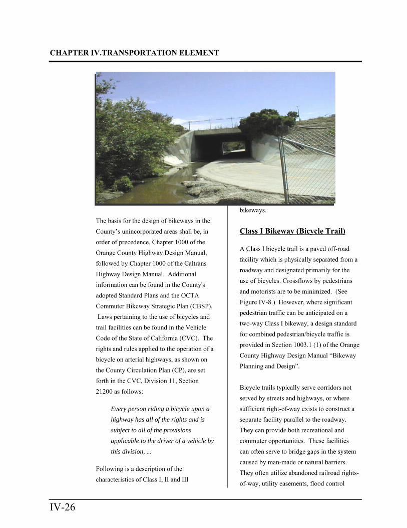
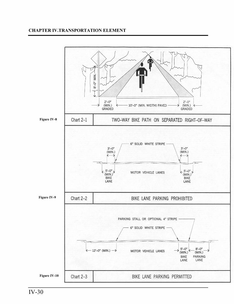
Class I Bikeway (Bicycle Trail) A Class I bicycle trail is a paved off-road
facility which is physically separated from a
roadway and designated primarily for the
use of bicycles. Crossflows by pedestrians
and motorists are to be minimized. (See
Figure IV-8.) However, where significant
pedestrian traffic can be anticipated on a
two-way Class I bikeway, a design standard
for combined pedestrian/bicycle traffic is
provided in Section 1003.1 (1) of the Orange
County Highway Design Manual “Bikeway
Planning and Design”.
Bicycle trails typically serve corridors not
served by streets and highways, or where
sufficient right-of-way exists to construct a
separate facility parallel to the roadway.
They can provide both recreational and
commuter opportunities. These facilities
can often serve to bridge gaps in the system
caused by man-made or natural barriers.
They often utilize abandoned railroad rights-
of-way, utility easements, flood control
CHAPTER IV. TRANSPORTATION ELEMENT
IV-27
channels, parks and similar linear open
space corridors.
Class II Bikeway (Bicycle Lane)
A Class II bicycle lane is a facility featuring
a striped lane on the paved area of a road for
preferential use by bicycles. It is located
along the edge of the paved area outside the
motor vehicle travel lanes and shall be
restricted to parking. (See Figure IV-9.)
Where sufficient pavement width exists, it
may be located between a parking lane and
the outside motor vehicle travel lane. (See
Figure IV-10.)
Section 1003.2 (1) of the Orange County
hway Design Manual "Bikeway Planning
and Design" provides for a typical width of
8 feet, measured from curb face, for a Class
II bikeway on a curbed street, and specifies
that additional width be provided where
parking is anticipated. However, a
minimum width of 5 feet is acceptable if
more width is needed in the travel way of
existing roadways to facilitate re-striping for
additional turn lanes.
On arterial highways in the County's
unincorporated areas where a Class II trail is
designated on the Bikeways Plan, parking
shall be prohibited where insufficient width
exists to accommodate both parking and
bicycle lanes, in addition to the required
number of vehicular travel lanes.
CHAPTER IV.TRANSPORTATION ELEMENT
IV-28
Left Blank for Fig. IV-7 (11x17)
CHAPTER IV. TRANSPORTATION ELEMENT
IV-29
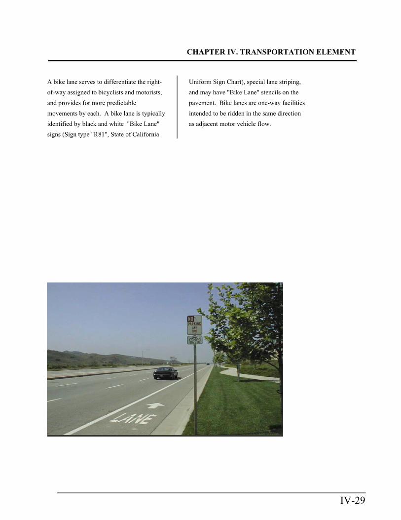
A bike lane serves to differentiate the right-
of-way assigned to bicyclists and motorists,
and provides for more predictable
movements by each. A bike lane is typically
identified by black and white "Bike Lane"
signs (Sign type "R81", State of California
Uniform Sign Chart), special lane striping,
and may have "Bike Lane" stencils on the
pavement. Bike lanes are one-way facilities
intended to be ridden in the same direction
as adjacent motor vehicle flow.
CHAPTER IV.TRANSPORTATION ELEMENT
IV-30
Figure IV-8
Figure IV-9
Figure IV-10
CHAPTER IV. TRANSPORTATION ELEMENT
IV-31
Class III (Bicycle Route)
A Class III bicycle route is a facility
typically identified by green and white
(Type "D11-1") "Bike Route" guide signing
only. There usually are no special lane
designations, and parking may be permitted.
Bicycle traffic may share either the roadway
with motor vehicles, or a sidewalk with
pedestrians and, in either case, bicycle usage
is considered secondary. Bike routes are
established as a means to connect otherwise
discontinuous segments of Class I or Class
II bikeways.
Undetermined
A bikeway route designated on the
Bikeways Plan map as "Undetermined"
indicates that the ultimate trail category or
classification, and/or its alignment has not
yet been determined or officially adopted
due to topographical or right of-way
constraints, or other considerations.
GOALS, OBJECTIVES AND POLICIES: Bikeway Plan
This section provides guidance regarding the
Bikeways Plan Component of the
Transportation Element.
Goal 1
Develop and implement a bikeway plan that
maximizes the opportunities for non-
motorized vehicle transportation, and meets
the recreation and local transportation needs
of the residents of Orange County's
unincorporated areas.
Objectives
1.1 Develop a bikeways network for
the unincorporated areas that
provides non-motorized
alternatives for commuter travel
as well as recreational
opportunities.
1.2 Plan and develop the County's
Bikeways Plan in coordination
with the cities, OCTA, and
CalTrans. This system will be
designed to complement and
interface with the overall
transportation network existing
and planned for Orange County,
including the individual cities'
bikeways and circulation plans.
1.3 Develop a bikeway network that
maximizes the safety and
convenience of users of all levels
of experience within that system.
1.4 Promote coordination among the
County, the Cities, OCTA, and
other agencies in providing an
integrated bikeways system.
1.5 Review and update the Bikeways
Plan as needed, in order to assure
compatibility with the other
elements of the County General
Plan, and with the bikeways
plans of OCTA, the Cities, and
adjacent counties.
CHAPTER IV.TRANSPORTATION ELEMENT
IV-32
1.6 Actively seek all available means
of financing bikeways including
State and Federal grants.
Policies
1.1 Role of the Bikeways Plan:
Coordinate and facilitate the
implementation of the
unincorporated County's bikeway
system, utilizing input from the
bicycling community, the cities,
and other agencies.
1.2 Seven-Year Plan:
Establish and annually update a
Seven-Year Plan to provide
direction for bikeway
implementation and to serve as a
guide for grant applications. The
plan will include both commuter
and recreational bikeways.
1.3 Arterial Highways:
Provide for bicycle access to
arterial highways as depicted on
the Circulation Plan. Bicycle
travel will also be accommodated
on arterial highways during
roadway construction, widening
or other improvements, whenever
feasible and practical.
1.4 Commuting:
Design bicycle routes to connect
residential areas with major
activity centers (employment,
educational, civic, etc.) by
requiring, through the
subdivision process, the
dedication of right-of-way and
construction of designated
bikeways as conditions of
development within the
unincorporated areas.
1.5 Recreation:
Plan bicycle routes to facilitate
access to recreational areas such
as regional parks, beach areas,
and major tourist
commercial/recreational
facilities.
1.6 System Connectivity:
Plan a bikeway network to
interface with other modes of
transportation (train or transit
stations and Park-N-Ride lots,
etc.) to plan for, and provide
space for carrying recreational
and commuting bicyclists on
public transportation systems
where feasible.
1.7 Modal Interaction:
Encourage other modes of
transportation (buses, trains, etc.)
to plan for, and provide space for
carrying recreational and
commuting bicyclists on public
transportation systems where
feasible.
1.8 Scenic Value:
Locate bikeways along
designated scenic highways
wherever environmentally,
CHAPTER IV. TRANSPORTATION ELEMENT
IV-33
physically, or economically
feasible, and encourage the
development of scenic vista
points and rest areas where
feasible and appropriate.
1.9 Rights-of-Way:
Construct bikeways in existing
and abandoned public rights-of-
way along flood control
channels, parks, roads, and utility
and railroad rights-of-way where
feasible, and where a need can be
demonstrated.
1.10 Public Information:
Provide bicycle trail and safety
information to the public by
publishing bike trail maps and
representing the County at trade
shows, rideshare fairs, etc.
1.11 Design Standards:
Design and construct bikeways in
accordance with County and
Caltrans standards in order to
maximize safety and minimize
potential conflicts with
pedestrians and motor vehicles.
1.12 Bicycle Safety:
Separate bicycle and automobile
traffic wherever possible, taking
into consideration safety, users of
the facility, economic factors,
and physical feasibility, and by
designing only one-way bike
lanes, thereby minimizing
conflicts at intersections and
reducing the hazards of bicyclists
traveling against traffic.
1.13 User Convenience:
Encourage the provision of
bicycle racks, showers, lockers,
and other storage facilities,
where practical and economically
feasible, when reviewing
discretionary permits for major
activity centers.
1.14 Regional Continuity:
Encourage other jurisdictions to
adopt a system of bikeways that
complements the County system
and the Commuter Bikeways
Strategic Plan (CBSP)
administered by OCTA.
1.15 Regional Consistency:
Periodically revise the Bikeways
Plan component of the
Transportation Element, when
warranted, to reflect changing
conditions, and evaluate
proposed development projects
for compatibility with the County
regional bikeways system
through the subdivision and
discretionary permit review
process.
1.16 Funding:
Solicit and utilize all sources of
local, regional, State, and Federal
funds to plan, acquire right-of-
way for, and construct bikeways,
including such sources as SB 821
CHAPTER IV.TRANSPORTATION ELEMENT
IV-34
and SB 244 (CalTrans Bike Lane
Account) funds; County Road
funds and Harbors, Beaches and
Parks funds; and private grants.
1.17 Development Commitment:
Encourage developers to provide
local bicycle trails, as well as
require construction of applicable
Bikeways Plan bikeways within
their projects as conditions of
development approval.
IMPLEMENTATION PROGRAMS: Bikeway Plan
1. SUBDIVISION PROCESS
Programs involve a review of
subdivision maps for consistency with
the Bikeways plan, and a requirement
that new developments dedicate
necessary right-of-way, and develop
bikeway facilities according to
Bikeways Plan classification and
design specifications.
2. FUNDING
Bikeway funding programs (Bicycle
and Pedestrian Facilities (BPF)
Funding Program, SB 244, etc.) accord
priority to those projects which
improve bicycle access to employment
centers, educational facilities, and
commercial developments, as well as
to recreational areas. The BPF,
formerly referred to as SB 821,
funding program is administered by
OCTA.
COMPONENT THREE: SCENIC HIGHWAYS PLAN
Overview
The Scenic Highways Component of the
General Plan was first adopted by the Board
of Supervisors on June 12, 1973 (Resolution
No. 73-659). The component identifies the
County's scenic highway routes. The
primary purpose of the Scenic Highways
Component is to define the policy guidelines
pertaining to the implementation of the
Scenic Highways Plan (Figure IV-11).
The Scenic Highways Plan attempts to
incorporate safety, utility, economy, and
aesthetics into the planning, design and
construction of scenic highways.
CLASSIFICATION
The County's designated scenic highways
have been divided into two categories:
Viewscape Corridors and Landscape
Corridors (Appendix IV-4).
Viewscape Corridor (Type 1)
A viewscape corridor is a route which
traverses a corridor within which unique or
unusual scenic resources and aesthetic
values are found. This designation is
intended to minimize the impact of the
highway and land development upon the
significant scenic resources along the route.
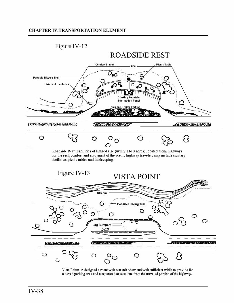
Safety roadside rests and vista points should
be developed, when feasible and where
appropriate, to enhance any exceptional

CHAPTER IV. TRANSPORTATION ELEMENT
IV-35
scenic values (Figures IV-12 and IV-13).
CHAPTER IV.TRANSPORTATION ELEMENT
IV-36
Insert Fig. IV-11 (Scenic Highway Plan
Map)

CHAPTER IV. TRANSPORTATION ELEMENT
IV-37
Left blank for Fig. IV-11 (11x17)
CHAPTER IV.TRANSPORTATION ELEMENT
IV-38
ROADSIDE REST Figure IV-12
VISTA POINT Figure IV-13
CHAPTER IV. TRANSPORTATION ELEMENT
IV-39
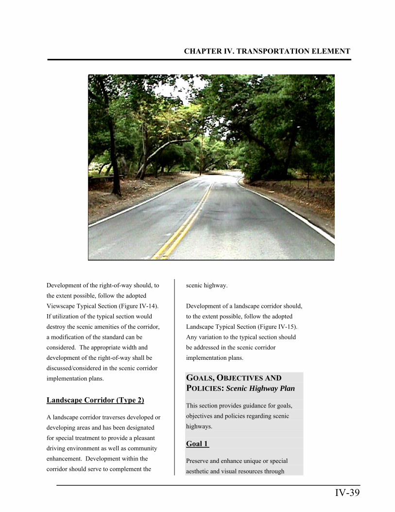
Development of the right-of-way should, to
the extent possible, follow the adopted
Viewscape Typical Section (Figure IV-14).
If utilization of the typical section would
destroy the scenic amenities of the corridor,
a modification of the standard can be
considered. The appropriate width and
development of the right-of-way shall be
discussed/considered in the scenic corridor
implementation plans.
Landscape Corridor (Type 2)
A landscape corridor traverses developed or
developing areas and has been designated
for special treatment to provide a pleasant
driving environment as well as community
enhancement. Development within the
corridor should serve to complement the
scenic highway.
Development of a landscape corridor should,
to the extent possible, follow the adopted
Landscape Typical Section (Figure IV-15).
Any variation to the typical section should
be addressed in the scenic corridor
implementation plans.
GOALS, OBJECTIVES AND
POLICIES: Scenic Highway Plan
This section provides guidance for goals,
objectives and policies regarding scenic
highways.
Goal 1
Preserve and enhance unique or special
aesthetic and visual resources through

CHAPTER IV.TRANSPORTATION ELEMENT
IV-40
CHAPTER IV. TRANSPORTATION ELEMENT
IV-41
sensitive highway design and the regulation
of development within the scenic corridor.
Objectives
1.1 Protect and enhance the County's
beauty, amenities and quality of
life within the unincorporated
areas.
1.2 Add to the pleasure of its
residents and visitors by
enhancing scenic routes.
1.3 Coordinate the development of
new scenic corridors with
CalTrans, OCTA, the cities, and
the development community, in
order to preserve the aesthetic
qualities of the environment.
1.4 Preserve established Scenic
Highways in order to protect the
existing scenic qualities of these
corridors.
1.5 Develop the roadway portion of
the scenic corridors in a manner
that recognizes the natural scenic
resources of the corridor and is
sensitive to them to the
maximum extent feasible.
1.6 Require sufficient setback from
the scenic corridor, where
feasible, for the purpose of
preserving the corridor's scenic
qualities.
Policies
1.1 Project Consistency:
Require preparation and approval
of highway plans demonstrating
project consistency with the
intent of the Scenic Highway
Component, prior to tract map
recordation. This can be
accomplished through the
subdivision, discretionary permit,
Feature or Area Plan review
process.
1.2 Offer of Dedication:
Where necessary to preserve
unique or special visual features,
impose conditions on
development within a scenic
highway corridor to require
dedication of scenic easements
consistent with the adopted
corridor plan.
1.3 Addition to the Scenic Highway
Plan:
Preserve scenic routes which
have exceptional or unique visual
features, but are not necessarily
designated as arterial highways
on the County Circulation Plan,
by placing them on the Scenic
Highways Plan. Development of
scenic highways shall be in
conformance with a Specific Plan
prepared in accordance with the
Scenic Highway Implementation
Planning Guidelines (Appendix
IV-5).
CHAPTER IV.TRANSPORTATION ELEMENT
IV-42
1.4 Cooperative Planning:
Connect County-designated
scenic highways with city-
designated scenic highways;
adjacent-County-designated
scenic highways, and/or those in
the State Scenic Highway system
so as to form a linked system.
1.5 View Design:
Where feasible, through the
design process and alignment
studies, develop the scenic
highway in a manner which takes
into account the cone of vision of
the motorist. Consider both the
short and long-range views
available along the way while
enhancing them with foreground
framing.
1.6 Highway Design:
Design the roadway to have a
visual quality and riding comfort
resulting from its horizontal and
vertical design. Introduce curves
where feasible to take advantage
of natural or man-made scenic
features.
1.7 Inclusion of Trails:
Incorporate pedestrian,
equestrian, and bicycle trails into
the right-of-way of scenic
highways as designated by the
County's Bikeways Plan and the
Master Plan of Regional Riding
and Hiking Trails.
1.8 Road Slope Improvement:
Where feasible, utilize contour
grading and slope rounding to
gradually transition graded road
slopes into the natural
configuration consistent with the
topography of the area.
IMPLEMENTATION PROGRAMS: Scenic Highway Plan
1. SUBDIVISION PROCESS
During the review of subdivisions and
discretionary permits, assure that the
number of access points (e.g.,
driveways, local roads, etc.) on scenic
highways are minimized.
Related Documents