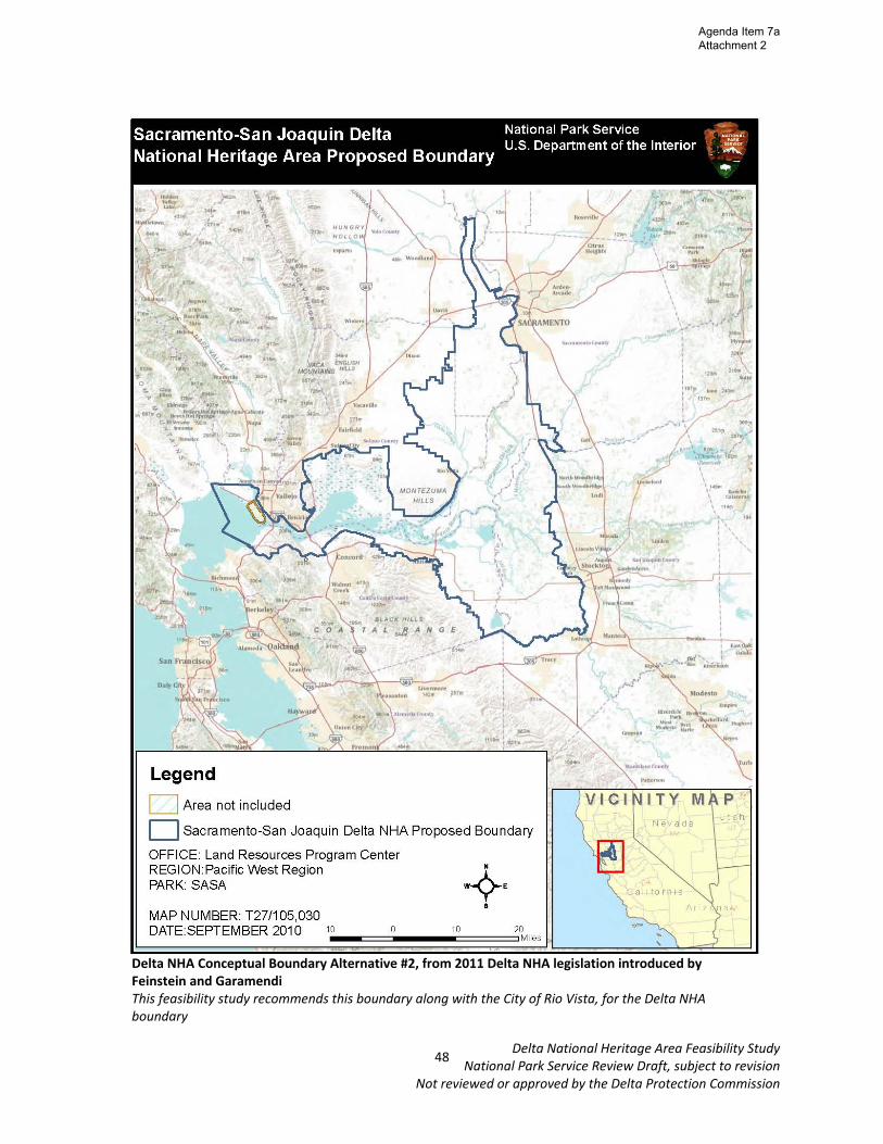
Delta National Heritage Area Feasibility Study National Park Service Review Draft, subject to revision Not reviewed or approved by the Delta Protection Commission Chapter 7 – Conceptual Boundaries Conceptual boundary delineations, as recommended by NPS guidelines, are an important part of the NHA feasibility study. NHA boundaries should include the natural/cultural/historic resources which support the proposed NHA themes. The boundaries of the potential NHA remain conceptual through the feasibility study process, and are not finalized until after a NHA is designated by Congress and a management plan is developed. Two boundaries alternatives were proposed as part of this process. The first boundary alternative was developed by the DPC staff based upon the geographical range of heritage resources in the Delta which are supportive of NHA themes. This boundary alternative included the Primary Zone of the Delta, as well as a few add‐ons. The second boundary alternative is the boundary that was included in the 2011 Delta NHA legislation introduced by Feinstein and Garamendi. This alternative includes much of the Legal Delta, as well as the Suisun Marsh and Carquinez Strait. Based on the input received from a series of public meetings held throughout the Delta in October 2011, the December 2011 DPC meeting, and correspondence from Delta counties, DPC staff has made the recommendation to go with the second boundary alternative, with the addition of the city of Rio Vista. Description of the Recommended Boundary Alternative This boundary alternative was developed for the Delta NHA legislation introduced by Feinstein and Garamendi. The majority of the land area in this alternative is within the Legal Delta, but extends into the Suisun Marsh and Carquinez Strait. As NPS criteria outlines, NHAs must contain an assemblage of natural, historic, or cultural resources that together represent distinctive aspects of American heritage. Therefore, consideration of this boundary must include discussion on ways in which the resources of the Carquinez Strait and Suisun Marsh are also supportive of the themes identified in this process. Both the Carquinez Strait Preservation Trust and the Suisun Marsh Resources Conservation District have written to the DPC expressing their interests in being included in the NHA and explained relevant elements of their histories and existing resources (see appendix 6). The Suisun Marsh lies directly adjacent to the Delta and is the largest estuarine marsh in the western United States and is extremely ecologically diverse. The Marsh was also reclaimed for agriculture during the same period that the Delta was, though state and federal water projects and upstream diversions led to a decline of agriculture in the Marsh and most of the Marsh was then purchased to support waterfowl habitat and hunting. A number of resources in the Marsh are used for education, interpretation, and recreation, which can be supportive of the Delta NHA, particularly the public lands in the marsh which are open for wildlife viewing, hiking, birdwatching, photography, hunting, and fishing. 46 Agenda Item 7a Attachment 2

Welcome message from author
This document is posted to help you gain knowledge. Please leave a comment to let me know what you think about it! Share it to your friends and learn new things together.
Transcript

Delta National Heritage Area Feasibility Study National Park Service Review Draft, subject to revision
Not reviewed or approved by the Delta Protection Commission
Chapter 7 – Conceptual Boundaries Conceptual boundary delineations, as recommended by NPS guidelines, are an important part of the NHA feasibility study. NHA boundaries should include the natural/cultural/historic resources which support the proposed NHA themes. The boundaries of the potential NHA remain conceptual through the feasibility study process, and are not finalized until after a NHA is designated by Congress and a management plan is developed. Two boundaries alternatives were proposed as part of this process. The first boundary alternative was developed by the DPC staff based upon the geographical range of heritage resources in the Delta which are supportive of NHA themes. This boundary alternative included the Primary Zone of the Delta, as well as a few add‐ons. The second boundary alternative is the boundary that was included in the 2011 Delta NHA legislation introduced by Feinstein and Garamendi. This alternative includes much of the Legal Delta, as well as the Suisun Marsh and Carquinez Strait. Based on the input received from a series of public meetings held throughout the Delta in October 2011, the December 2011 DPC meeting, and correspondence from Delta counties, DPC staff has made the recommendation to go with the second boundary alternative, with the addition of the city of Rio Vista. Description of the Recommended Boundary Alternative This boundary alternative was developed for the Delta NHA legislation introduced by Feinstein and Garamendi. The majority of the land area in this alternative is within the Legal Delta, but extends into the Suisun Marsh and Carquinez Strait. As NPS criteria outlines, NHAs must contain an assemblage of natural, historic, or cultural resources that together represent distinctive aspects of American heritage. Therefore, consideration of this boundary must include discussion on ways in which the resources of the Carquinez Strait and Suisun Marsh are also supportive of the themes identified in this process. Both the Carquinez Strait Preservation Trust and the Suisun Marsh Resources Conservation District have written to the DPC expressing their interests in being included in the NHA and explained relevant elements of their histories and existing resources (see appendix 6). The Suisun Marsh lies directly adjacent to the Delta and is the largest estuarine marsh in the western United States and is extremely ecologically diverse. The Marsh was also reclaimed for agriculture during the same period that the Delta was, though state and federal water projects and upstream diversions led to a decline of agriculture in the Marsh and most of the Marsh was then purchased to support waterfowl habitat and hunting. A number of resources in the Marsh are used for education, interpretation, and recreation, which can be supportive of the Delta NHA, particularly the public lands in the marsh which are open for wildlife viewing, hiking, birdwatching, photography, hunting, and fishing.
46
Agenda Item 7a Attachment 2

Delta National Heritage Area Feasibility Study National Park Service Review Draft, subject to revision
Not reviewed or approved by the Delta Protection Commission
The Carquinez Strait is a geographical link between the San Francisco Bay and the Delta, therefore making it a key component of the largest estuary on the West Coast. The geologic creation of the Delta stemmed from sediments trapped inland of the rocky neck of the Strait. It is part of the passage for anadromous fish, as well as a Pacific flyway stopover location. Historically, it was part of the Gold Rush corridor and home to a fishing industry like the Delta was. Agricultural goods produced in the Delta were processed and stored in grain warehouses, flour mills, and canning facilities that were once prevalent along the Strait. One of the activities which the Carquinez Strait Preservation Trust has undertaken is the publishing of a book, Gateway to the Inland Coast – The Story of the Carquinez Strait, 1996, which goes into further detail about heritage resources in the Strait. Regional Trails connect these systems together, and areas of the Strait and the Marsh could serve as potential gateways for a Delta NHA. Financial advantages may also exist to including urban areas, such as the communities along the Carquinez Strait, into the NHA boundaries.
47
Agenda Item 7a Attachment 2
Delta National Heritage Area Feasibility Study National Park Service Review Draft, subject to revision
Not reviewed or approved by the Delta Protection Commission
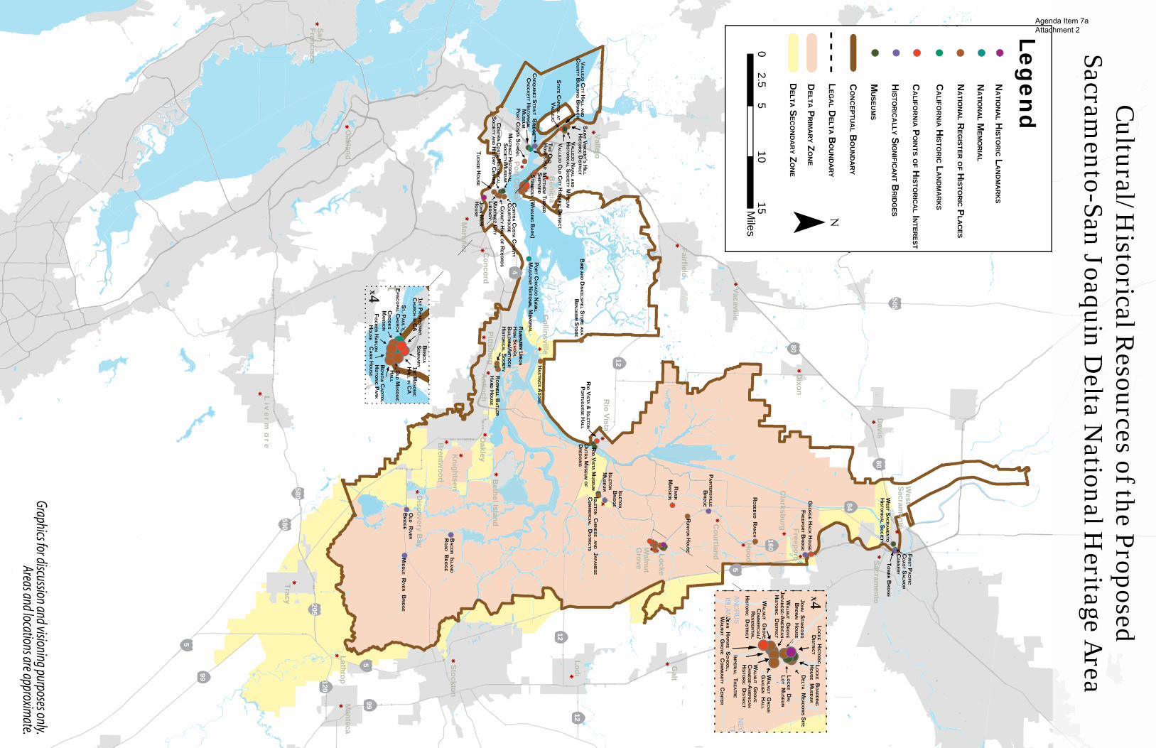
Delta NHA Conceptual Boundary Alternative #2, from 2011 Delta NHA legislation introduced by Feinstein and Garamendi This feasibility study recommends this boundary along with the City of Rio Vista, for the Delta NHA boundary
48
Agenda Item 7a Attachment 2

Delta National Heritage Area Feasibility Study National Park Service Review Draft, subject to revision
Not reviewed or approved by the Delta Protection Commission
Chapter 8 – Supporting Resources Criteria for NHA designation includes language that an area must have natural, historic, and cultural resources which represent nationally‐significant aspects of American history, as well as recreational and educational opportunities. This chapter will discuss some of the key resources of the NHA under consideration. Key historic/cultural resources are listed, mapped, and described, including: National Historic Landmarks, National Memorials, National Register of Historic Places, California Historical Landmarks, California Points of Historical Interest, Historically Significant Bridges, and Museums. Local historic/cultural festivals are also described. Public lands with public access are listed, mapped, and described, as these lands serve as valuable natural, recreational, and in some cases historical/cultural resources. Finally, recreational resources are described and mapped, including California Recreational Corridors which pass through the region.
49
Agenda Item 7a Attachment 2

Delta National Heritage Area Feasibility Study National Park Service Review Draft, subject to revision
Not reviewed or approved by the Delta Protection Commission
Inventory of Historical/Cultural Resources County Resource Name Address City/TownNational Historic Landmarks Contra Costa John Muir House 4202 Alhambra Ave. Martinez Sacramento Locke Historic District Locke Locke National Memorial Contra Costa Port Chicago Naval Magazine Concord Naval Weapons Station Concord National Register of Historic Places Contra Costa Contra Costa County Courthouse 625 Court Street Martinez Contra Costa County Hall of Records 725 Court Street Martinez Contra Costa John Marsh Home Contra Costa Martinez City Library 740 Court Street Martinez Contra Costa Port Costa School Plaza El Hambre Port Costa Contra Costa Riverview Union High School Building 1500 West 4th Street Antioch Contra Costa Roswell Butler Hard House 815 West First Street Antioch Contra Costa Tucker House 110 Escobar Martinez Sacramento Rosebud Ranch N of Hood Hood Sacramento Runyon House 12865 River Rd. Courtland Sacramento Delta Meadows Site Address Restricted Locke
Sacramento Locke Historic District Bounded on the W by the Sacramento River, on the N by Locke Rd., on the E by Alley St., and on the S by Levee St.
Locke
Sacramento Brown, John Stanford, House 13950 CA 160 Walnut Grove Sacramento Imperial Theatre Market St. Walnut Grove
Sacramento Walnut Grove Chinese‐American Historic District Bounded by C, Tyler, and Bridge Sts., and River Rd. Walnut Grove
Sacramento Walnut Grove Commercial/Residential Historic District Browns Alley and River Rd. Walnut Grove
Sacramento Walnut Grove Gakuen Hall Pine and C Sts. Walnut Grove
Sacramento Walnut Grove Japanese‐American Historic District Bounded by Winnie St., Tyler St., C St., and River Rd. Walnut Grove
Sacramento Isleton Chinese and Japanese Commercial Districts Bounded by River Rd. and Union, E and H Sts. Isleton
Solano Benicia Capitol State Historic Park NW Corner of 1st and G Sts Benicia
Solano Bird and Dinkelspiel Store aka Benjamin Store 2145 Collinsivlle Road., Bird’s Landing Collinsville
Solano Carr House 165 East D Street Benicia Solano Crooks Mansion 285 W. G St. Benicia Solano Fischer Hanlon House 135 W. G St. Benicia Solano Hastings Adobe NE of Collinsville off CA 68 Collinsville Solano Old Masonic Hall 106 W. J St. Benicia
Solano Saint Vincent’s Hill Historic District (Partial) Mare Island Way almost to Sonoma Blvd. and from Quincy Alley to Kissel Alley Vallejo
Solano Stamboul (Whaling Bark) Foot of W. 12th St. Benicia Solano Vallejo City Hall & County Building Branch 734 Marin St. Vallejo Solano Vallejo Old City Historic District (Partial) Sonoma Blvd., and Monterey, Carolina, and York Sts Vallejo California Historical Landmark Solano 1st Masonic Hall in CA 110 W. J St. Benicia Solano The Old Homestead 993 Loring Ave. at Ralph Ave. Crockett Solano St. Paul’s Episcopal Church 120 E. J St. at 1st St. Benicia Yolo First Pacific Coast Salmon Cannery West Sacramento W. Sacramento California Points of Historical Interest Sacramento George Hack House River Road Freeport
Sacramento Jean Harvie School, Walnut Grove Community Center 14273 River Road Walnut Grove
Sacramento Grand Island Mansion 13415 Grand Island Road Walnut Grove Solano Benicia Seminary City Park Military West between 1st and 2nd Benicia Solano 1st Protestant Church in CA Benicia City Park, K St between 1st and 2nd Benicia Solano Matthew Turner Shipyard Foot of W. 12th St. off of W. K St. Benicia Solano Rio Vista & Isleton Portuguese Hall 295 S. 7th Street Rio Vista Solano State Capitol at Vallejo NW Corner of City Parking Lot, 200 York Vallejo
50
Agenda Item 7a Attachment 2

Delta National Heritage Area Feasibility Study National Park Service Review Draft, subject to revision
Not reviewed or approved by the Delta Protection Commission
Inventory of Historical/Cultural Resources (cont.)
Historically Significant Bridges (determined eligible for listing in the National Register of Historic Places) Contra Costa/Solano Carquinez Strait Bridge Interstate 80 over Carquinez Strait Crockett/Vallejo
Sacramento Freeport Bridge Near Freeport on Freeport blvd over Sacramento River Freeport
Sacramento Isleton Bridge Near Isleton on State Route 160 over Sacramento River Isleton
Sacramento Paintersville Bridge Near Courtland on State Route 160 over Sacramento River Courtland
San Joaquin Bacon Island Road Bridge In the vicinity of Stockton on Bacon Island Road over Middle Road Stockton
San Joaquin Middle River Bridge Near Stockton on State Route 4 over Middle River Stockton San Joaquin Old River Bridge Near Stockton on State Route 4 over Old River Stockton
Yolo/ Sacramento Tower Bridge
State Route 279 (Capitol Mall in Sacramento) across the Sacramento River, between West Sacramento in Yolo County and the City of Sacramento
W. Sacramento /Sacramento
Museums Contra Costa Antioch Historical Society 1500 W. Fourth Street Antioch
Contra Costa Contra Costa Historical Society and History Center 610 Main Street Martinez
Contra Costa Crockett Historical Museum 900 Loring Ave. Crockett Contra Costa Martinez Historical Society/Museum 1005 Escobar Martinez Sacramento Isleton Museum 33 Main Street Isleton Sacramento Locke Board House Museum 13916 Main Street Locke Sacramento Locke Dai Loy Museum Main Street Locke Solano Dutra Museum of Dredging 345 St. Gertrude Avenue Rio Vista Solano Rio Vista Museum 16 N. Front Street Rio Vista
Solano Vallejo Naval and Historical Society Museum 734 Marin St. Vallejo
Yolo West Sacramento Historical Society 849 Jefferson W. Sacramento
51
Agenda Item 7a Attachment 2
!!
!
! !
!
!
!!
!
!
!
!!
!
!!
!
!
!
!
!
!!
!
!
!
!!!
!
!!
!
!
!
!
!
!!
!
!
!!
k
k
k
k
k
k
kk
k
k
k
k
kk
k
k
k
k
kk
k
k
k
k
k
k
k
k
k
k
k
k
k
Galt
Lodi
Hood
Dixon
DavisO
akleyC
oncord
Manteca
Lathrop
Antioch
Freeport
Liv
ermo
re
Fairfield
Vacaville
Brentw
ood
Knightsen
Courtland
Clarksburg
Sacramento
Collinsville
Walnut
Grove
Discovery B
ay
Tracy
kSan Francisco
k Oakland
RIVER
VIEW UN
ION
HIG
H SC
HO
OL
BU
ILDIN
G/AN
TIOC
H H
ISTOR
ICA
L SO
CIETY
RO
SWELL B
UTLER
HA
RD H
OU
SE
HA
STING
S AD
OB
E
BIR
D AN
D DIN
KELSPIEL S
TOR
E AK
A B
ENJA
MIN S
TOR
E
RIO V
ISTA & ISLETO
N P
OR
TUG
UESE H
ALL
DU
TRA M
USEU
M OF
DR
EDG
ING
RIO V
ISTA MU
SEUM
Bethel Island
WEST S
AC
RA
MEN
TO H
ISTOR
ICA
L SO
CIETY
FIR
ST PA
CIFIC
CO
AST S
ALM
ON
CA
NN
ERY
TO
WER B
RID
GE
West
Sacramento
JO
HN M
UIR
HO
USE
CO
UN
TY HA
LL OF R
ECO
RD
S
TU
CK
ER HO
USE
MA
RTIN
EZ CITY
LIB
RA
RY
MA
RTIN
EZ HISTO
RIC
AL
SO
CIETY/M
USEU
M
CO
NTR
A CO
STA CO
UN
TY C
OU
RTH
OU
SE
CO
NTR
A CO
STA HISTO
RIC
AL
SO
CIETY A
ND H
ISTORY C
ENTER
SA
INT V
INC
ENT’S H
ILL H
ISTOR
IC DISTR
ICT
VA
LLEJO NAVA
L AN
D H
ISTOR
ICA
L SO
CIETY M
USEU
M
VA
LLEJO OLD C
ITY HISTO
RIC D
ISTRIC
TS
TATE CA
PITOL AT
VA
LLEJO
VA
LLEJO CITY H
ALL A
ND
CO
UN
TY BU
ILDIN
G BR
AN
CH
MATTH
EW TU
RN
ER S
HIPYA
RD
STA
MB
OU
L (WH
ALIN
G BA
RK)
PO
RT C
HIC
AG
O NAVA
L M
AG
AZIN
E NATIO
NA
L MEM
OR
IAL
!!
Locke
!
!!
Rio Vista
k
!!!
! !! !!
!t
CR
OO
KS
MA
NSIO
N
FISC
HER H
AN
LON
HO
USE
CA
RR H
OU
SE
OLD M
ASO
NIC
HA
LL
BEN
ICIA C
APITO
L H
ISTOR
IC PA
RK
BEN
ICIA
SEM
INA
RY1
ST PR
OTESTA
NT
CH
UR
CH IN C
A
ST. P
AU
L’S E
PISCO
PAL C
HU
RC
H
1ST M
ASO
NIC
HA
LL IN CA
Cultural/H
istorical Resources of the Proposed
Sacramento-San Joaquin D
elta National H
eritage Area
580
580
205120
5
5
99
99
12
12
5
160
84
80
80
505
12
4
¯0
510
152.5
Miles
Legen
d!!!!!!
LEG
AL D
ELTA BO
UN
DA
RY
CO
NC
EPTUA
L BO
UN
DA
RY
DELTA P
RIM
AR
Y ZO
NE
DELTA S
ECO
ND
AR
Y ZO
NE
NA
TION
AL H
ISTOR
IC LA
ND
MA
RK
S
NA
TION
AL R
EGISTER O
F HISTO
RIC P
LAC
ES
CA
LIFOR
NIA H
ISTOR
IC LA
ND
MA
RK
S
CA
LIFOR
NIA P
OIN
TS OF H
ISTOR
ICA
L INTER
EST
HISTO
RIC
ALLY S
IGN
IFICA
NT B
RID
GES
MU
SEUM
S
!N
ATIO
NA
L MEM
OR
IAL
!
!
! !! !!
!
!!! !
LO
CK
E HISTO
RIC
DISTR
ICT
LO
CK
E BO
AR
DIN
G H
OU
SE MU
SEUM
LO
CK
E DA
I L
OY M
USEU
M
JO
HN S
TAN
FOR
D B
RO
WN H
OU
SE
WA
LNU
T GR
OVE
GA
KU
EN HA
LL
WA
LNU
T GR
OVE
JA
PAN
ESE-AM
ERIC
AN
HISTO
RIC D
ISTRIC
T
WA
LNU
T GR
OVE
CH
INESE-A
MER
ICA
N H
ISTOR
IC DISTR
ICT
WA
LNU
T GR
OVE
CO
MM
ERC
IAL/
RESID
ENTIA
LH
ISTOR
IC DISTR
ICT
DELTA M
EAD
OW
S SITE
IMPER
IAL T
HEA
TRE
JEA
N HA
RVIE S
CH
OO
L, W
ALN
UT G
RO
VE CO
MM
UN
ITY CEN
TER
4 x
4 x
ISLETON
MU
SEUM
ISLETON C
HIN
ESE A
ND J
APA
NESE
CO
MM
ERC
IAL D
ISTRIC
TS
ISLETON
BR
IDG
E
BA
CO
N ISLAN
D R
OA
D BR
IDG
E
MID
DLE R
IVER BR
IDG
E
OLD R
IVER B
RID
GE
RIVER
MA
NSIO
N
RU
NYON
HO
USE
RO
SEBU
D RA
NC
H
FR
EEPOR
T BR
IDG
E
PA
INTER
SVILLEB
RID
GE
CA
RQ
UIN
EZ STR
AIT B
RID
GE
TH
E OLD
HO
MESTEA
D
CR
OC
KETT H
ISTOR
ICA
LM
USEU
MP
OR
T CO
STA SC
HO
OL
GEO
RG
E HA
CK H
OU
SE
!! !!
!!
!!! !
!
Vallejo
Port Costa
Martinez
Stockton
Pittsburg
Benicia
!!!
! !! !!!
Graphics for discussion and visioning purposes only.Areas and locations are approxim
ate.
Agenda Item 7a Attachment 2

Delta National Heritage Area Feasibility Study National Park Service Review Draft, subject to revision
Not reviewed or approved by the Delta Protection Commission
Descriptions of Historical/Cultural Resources Photos by DPC, unless noted otherwise National Historic Landmarks John Muir House Martinez, Contra Costa County The John Muir National Historic Site is a 14‐room Italianate Victorian mansion where the naturalist and writer John Muir lived, as well as a nearby 325 acres tract of native oak woodlands and grasslands historically owned by the Muir family. The mansion was built in 1883 by Dr. John Strentzel, Muir's father‐in‐law, with whom Muir went into partnership, managing his 2,600‐acre fruit ranch. Muir and his wife, Louisa, moved into the house in 1890, and he lived there until his death in 1914. Locke Historical District Locke, Sacramento County Built in 1915, the town of Locke, is the last vestige of a single Chinese community in the nation. The town was built and inhabited exclusively for and by the Chinese. Many community
members helped build the first transcontinental railroad and the extensive levee system throughout the Delta. Locke is composed of four blocks of one‐ and two‐story commercial and residential structures entirely designed in the false‐fronted, woodcutter, gothic style which was predominate in the small turn‐of‐the‐century river towns. Many of the original descendants live in the community today.
National Memorial Port Chicago Naval Magazine Concord, Contra Costa County The Port Chicago Naval Magazine is a memorial for the largest homeland disaster during World War II. On the evening of July 17, 1944, residents in the San Francisco East Bay were jolted awake by a massive explosion that cracked windows and lit up the night sky. At Port Chicago Naval Magazine, 320 men were instantly killed when the munitions ships they were loading with ammunition for the Pacific theatre troops blew up. The majority of the deaths were African American sailors working for the racially segregated military. The explosion and its aftermath led to the largest Naval mutiny in US history, and it and the subsequent trial became major catalysts for the United States Navy to desegregate following the war.
Photo source: Locke Foundation
Photo source: Wikipedia
53
Agenda Item 7a Attachment 2
Delta National Heritage Area Feasibility Study National Park Service Review Draft, subject to revision
Not reviewed or approved by the Delta Protection Commission
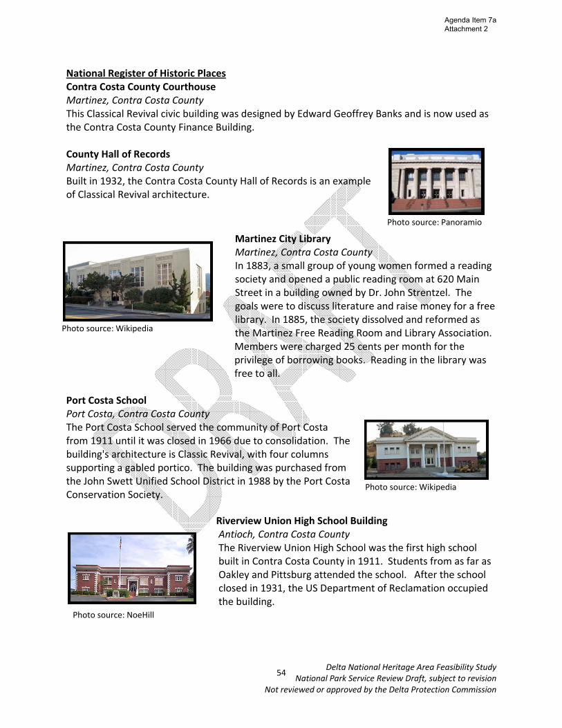
National Register of Historic Places Contra Costa County Courthouse Martinez, Contra Costa County This Classical Revival civic building was designed by Edward Geoffrey Banks and is now used as the Contra Costa County Finance Building. County Hall of Records Martinez, Contra Costa County Built in 1932, the Contra Costa County Hall of Records is an example of Classical Revival architecture.
Martinez City Library Martinez, Contra Costa County In 1883, a small group of young women formed a reading society and opened a public reading room at 620 Main Street in a building owned by Dr. John Strentzel. The goals were to discuss literature and raise money for a free library. In 1885, the society dissolved and reformed as the Martinez Free Reading Room and Library Association. Members were charged 25 cents per month for the privilege of borrowing books. Reading in the library was free to all.
Port Costa School Port Costa, Contra Costa County The Port Costa School served the community of Port Costa from 1911 until it was closed in 1966 due to consolidation. The building's architecture is Classic Revival, with four columns supporting a gabled portico. The building was purchased from the John Swett Unified School District in 1988 by the Port Costa Conservation Society.
Riverview Union High School Building Antioch, Contra Costa County The Riverview Union High School was the first high school built in Contra Costa County in 1911. Students from as far as Oakley and Pittsburg attended the school. After the school closed in 1931, the US Department of Reclamation occupied the building.
Photo source: NoeHill
Photo source: Panoramio
Photo source: Wikipedia
Photo source: Wikipedia
54
Agenda Item 7a Attachment 2
Delta National Heritage Area Feasibility Study National Park Service Review Draft, subject to revision
Not reviewed or approved by the Delta Protection Commission
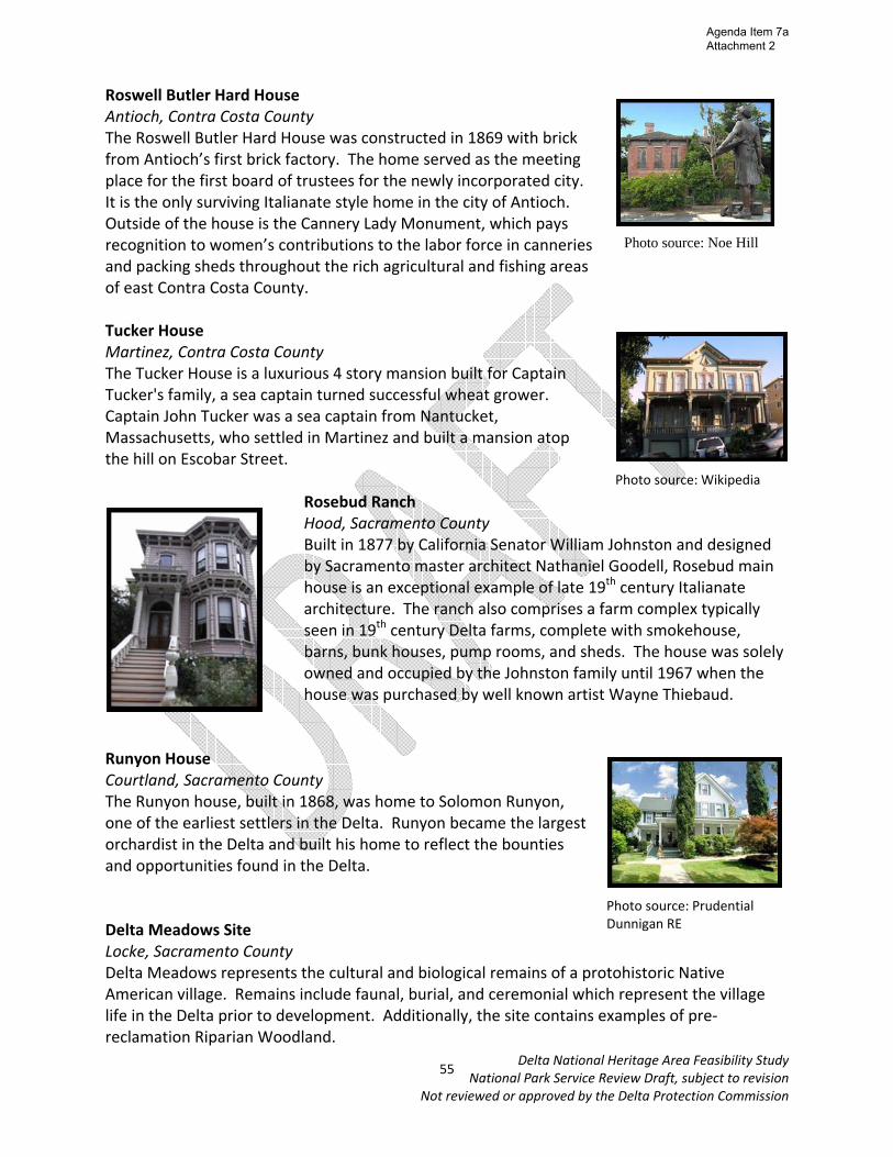
Roswell Butler Hard House Antioch, Contra Costa County The Roswell Butler Hard House was constructed in 1869 with brick from Antioch’s first brick factory. The home served as the meeting place for the first board of trustees for the newly incorporated city. It is the only surviving Italianate style home in the city of Antioch. Outside of the house is the Cannery Lady Monument, which pays recognition to women’s contributions to the labor force in canneries and packing sheds throughout the rich agricultural and fishing areas of east Contra Costa County. Tucker House Martinez, Contra Costa County The Tucker House is a luxurious 4 story mansion built for Captain Tucker's family, a sea captain turned successful wheat grower. Captain John Tucker was a sea captain from Nantucket, Massachusetts, who settled in Martinez and built a mansion atop the hill on Escobar Street.
Rosebud Ranch Hood, Sacramento County Built in 1877 by California Senator William Johnston and designed by Sacramento master architect Nathaniel Goodell, Rosebud main house is an exceptional example of late 19th century Italianate architecture. The ranch also comprises a farm complex typically seen in 19th century Delta farms, complete with smokehouse, barns, bunk houses, pump rooms, and sheds. The house was solely owned and occupied by the Johnston family until 1967 when the house was purchased by well known artist Wayne Thiebaud.
Runyon House Courtland, Sacramento County The Runyon house, built in 1868, was home to Solomon Runyon, one of the earliest settlers in the Delta. Runyon became the largest orchardist in the Delta and built his home to reflect the bounties and opportunities found in the Delta. Delta Meadows Site Locke, Sacramento County Delta Meadows represents the cultural and biological remains of a protohistoric Native American village. Remains include faunal, burial, and ceremonial which represent the village life in the Delta prior to development. Additionally, the site contains examples of pre‐reclamation Riparian Woodland.
Photo source: Prudential Dunnigan RE
Photo source: Noe Hill
Photo source: Wikipedia
55
Agenda Item 7a Attachment 2

Delta National Heritage Area Feasibility Study National Park Service Review Draft, subject to revision
Not reviewed or approved by the Delta Protection Commission
Imperial Theater Walnut Grove, Sacramento County The Imperial Theater, built in 1919, was a source of entertainment for residents in the Delta. The theater was built by Yonekichi Takeda and owned by Mrs. Alex Brown, as exclusionary laws excluded Asian‐Americans from owning property at that time. In the late 1930s the theater was purchased by Ray Gilgert. In 1954 a representative of the government of Nationalist China was met by virtually the whole
Delta Chinese community in an effort to raise money and denounce communism at the Imperial Theater. John Stanford Brown House Walnut Grove, Sacramento County The Brown house, built in 1925, is a leading example of Tudor Revival architecture which was prevalent in the US throughout the 1910s‐30s. The home was designed by noted Sacramento architect Frank “Squeaky” Williams. John Stanford Brown was born and raised in Walnut Grove and was the founding president of the Bank of Alex Brown. Walnut Grove Chinese‐American Historic District Walnut Grove, Sacramento County The Walnut Grove Chinese‐American Historic District, built circa 1937, served as the commercial and social center for both the Asian residents and for Chinese‐American laborers working on the nearby farms and ranches. The district was the final cohesively constructed enclave of the Chinese Americans in the region and the last established Chinatown in the Delta. Walnut Grove Commercial/Residential Historic District Walnut Grove, Sacramento County This district served as the center of the non‐Asian commercial district between 1879 and 1923. Its buildings were all built and used by Walnut Grove resident Alex Brown. Some of the oldest commercial and residential buildings in Walnut Grove are located in this district.
56
Agenda Item 7a Attachment 2
Delta National Heritage Area Feasibility Study National Park Service Review Draft, subject to revision
Not reviewed or approved by the Delta Protection Commission
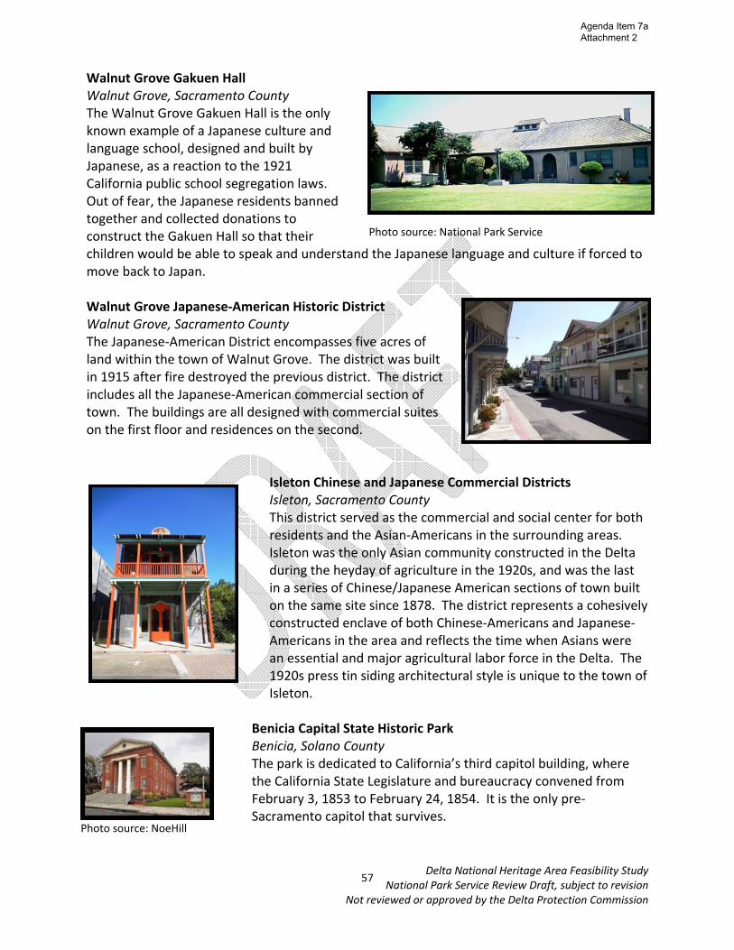
Walnut Grove Gakuen Hall Walnut Grove, Sacramento County The Walnut Grove Gakuen Hall is the only known example of a Japanese culture and language school, designed and built by Japanese, as a reaction to the 1921 California public school segregation laws. Out of fear, the Japanese residents banned together and collected donations to construct the Gakuen Hall so that their children would be able to speak and understand the Japanese language and culture if forced to move back to Japan. Walnut Grove Japanese‐American Historic District Walnut Grove, Sacramento County The Japanese‐American District encompasses five acres of land within the town of Walnut Grove. The district was built in 1915 after fire destroyed the previous district. The district includes all the Japanese‐American commercial section of town. The buildings are all designed with commercial suites on the first floor and residences on the second.
Isleton Chinese and Japanese Commercial Districts Isleton, Sacramento County This district served as the commercial and social center for both residents and the Asian‐Americans in the surrounding areas. Isleton was the only Asian community constructed in the Delta during the heyday of agriculture in the 1920s, and was the last in a series of Chinese/Japanese American sections of town built on the same site since 1878. The district represents a cohesively constructed enclave of both Chinese‐Americans and Japanese‐Americans in the area and reflects the time when Asians were an essential and major agricultural labor force in the Delta. The 1920s press tin siding architectural style is unique to the town of Isleton.
Benicia Capital State Historic Park Benicia, Solano County The park is dedicated to California’s third capitol building, where the California State Legislature and bureaucracy convened from February 3, 1853 to February 24, 1854. It is the only pre‐Sacramento capitol that survives.
Photo source: National Park Service
Photo source: NoeHill
57
Agenda Item 7a Attachment 2

Delta National Heritage Area Feasibility Study National Park Service Review Draft, subject to revision
Not reviewed or approved by the Delta Protection Commission
Bird and Dinkelspiel Store aka Benjamin Store Collinsville, Solano County In 1869 John Bird constructed a wharf and warehouse on Montezuma Slough. Soon, one mile east of the wharf, a community began to evolve. A blacksmith shop came first, and then the store was built in 1875. In this year the town was officially named Birds Landing. Carr House Benicia, Solano County The Carr house is one of the few masonry buildings in Benicia. The house was constructed in 1870. The brick shell is a sober vernacular structure. Crooks Mansion Benicia, Solano County The Crooks house at 285 West G St. was built in the late 1880s by J.E. Crooks and his brother William, president of the People’s Bank in Benicia and mayor from 1924‐1940. The architectural style reflects the taste of that era, Stick‐style. Fischer Hanlon House Benicia, Solano County In 1849, Joseph Fischer, a Swiss immigrant, came to Benicia. After joining a butcher partnership, Fischer purchased his lot on July 1, 1858. The house, reputed to be an old hotel was relocated here. The converted building is an outstanding example of East Coast Federalist styling, which illustrates architectural diffusion during the Gold Rush. Hastings Adobe Collinsville, Solano County The Hastings Adobe, completed in 1846, is the second oldest structure in Solano County. Pioneer Lansford Hastings, author of the Emigrants Guide to Oregon and California, claimed the property in hopes to plan a Mormon community named Montezuma City. Hastings lived in the adobe until he abandoned it in 1849. Lindsay Marshall took possession of the property in 1853 and reclaimed over 1,000 acres for faming and ranching. The adobe is currently owned by PG&E. Old Masonic Hall Benicia, Solano County The Old Masonic Hall in Benicia, California was built in 1850. It served as a clubhouse.
Photo source: Historical Marker Data Base
Photo source: Wikipedia
Photo source: Panoramio
58
Agenda Item 7a Attachment 2

Delta National Heritage Area Feasibility Study National Park Service Review Draft, subject to revision
Not reviewed or approved by the Delta Protection Commission
Saint Vincent’s Hill Historic District Vallejo, Solano County The St. Vincent’s Hill Historic District is a 33‐square block area surrounding St. Vincent’s Catholic Church and bounded on the south by Florida and Carolina Streets, on the east by Sonoma Boulevard, on the north by Tennessee Street, and on the west by Mare Island Way. The historic significance of this district lies in its growth as a workingman’s neighborhood for shipbuilders at the nearby Mare Island Naval Shipyard. It is expressed in a wide variety of architectural styles beginning with the Greek Revival cottages of the 1850’s and 1860’s. Stamboul (Whaling Bark) Benicia, Solano County The whaling bark Stamboul was built in Medford, Massachusetts in 1843, and during the 1880's, her home port was San Francisco. She had a length of 106 feet, a beam of 25 feet, and a draft of 14 feet with a tonnage of 260. A bark is a sailing ship with three masts, square‐rigged on the fore and main masts and fore‐and‐aft rigged on the mizzenmast. In the mid‐19th century, this rigging became popular for whaling vessels because it required fewer men to handle the sails when the boats were down for whales. The name Stamboul is a variant form of Istanbul widely used by English speakers in the 19th Century.
Vallejo City Hall and County Building Branch Vallejo, Solano County The Vallejo City Hall and County Building Branch was built in 1927 and is an example of Spanish Renaissance Revival architecture. The building was designed by Charles Perry.
Vallejo Old City Historic District Vallejo, Solano County The Vallejo Heritage District was one of the first nationally registered districts west of the Mississippi. The district contains houses and structures which showcase Vallejo’s rich and varied architectural history. Most of the homes in the district were built between 1860 and 1890 and show the elegant style of what has become known as the "Working Man’s Victorian”. California Historical Landmark
1st Masonic Hall in California Benicia, Solano County The first Masonic hall built in California was formally dedicated 1850. This building served as the Masonic Temple for Benicia Lodge No. 5 until 1888, when the new temple was occupied. It was used by a boys' club prior to World War I and by the American Legion shortly after the war.
Photo source: Noe Hill
Photo source: Wikipedia
Photo source: NoeHill 59
Agenda Item 7a Attachment 2
Delta National Heritage Area Feasibility Study National Park Service Review Draft, subject to revision
Not reviewed or approved by the Delta Protection Commission
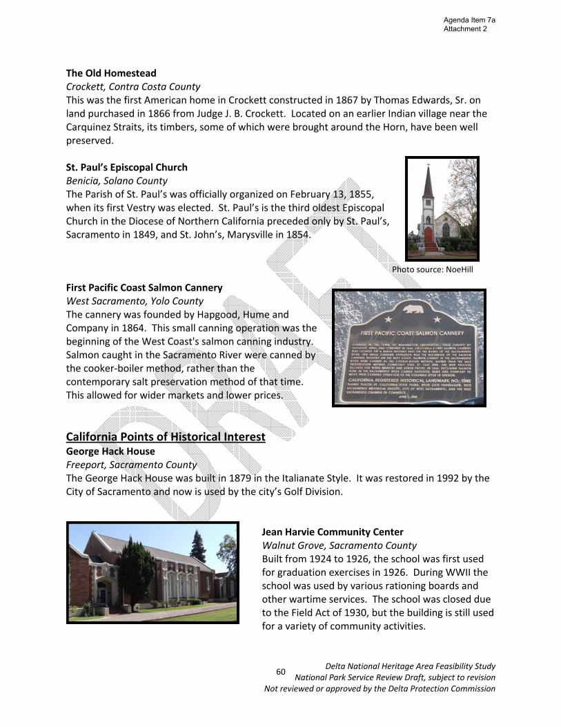
The Old Homestead Crockett, Contra Costa County This was the first American home in Crockett constructed in 1867 by Thomas Edwards, Sr. on land purchased in 1866 from Judge J. B. Crockett. Located on an earlier Indian village near the Carquinez Straits, its timbers, some of which were brought around the Horn, have been well preserved. St. Paul’s Episcopal Church Benicia, Solano County The Parish of St. Paul’s was officially organized on February 13, 1855, when its first Vestry was elected. St. Paul’s is the third oldest Episcopal Church in the Diocese of Northern California preceded only by St. Paul’s, Sacramento in 1849, and St. John’s, Marysville in 1854. First Pacific Coast Salmon Cannery West Sacramento, Yolo County The cannery was founded by Hapgood, Hume and Company in 1864. This small canning operation was the beginning of the West Coast's salmon canning industry. Salmon caught in the Sacramento River were canned by the cooker‐boiler method, rather than the contemporary salt preservation method of that time. This allowed for wider markets and lower prices. California Points of Historical Interest George Hack House Freeport, Sacramento County The George Hack House was built in 1879 in the Italianate Style. It was restored in 1992 by the City of Sacramento and now is used by the city’s Golf Division.
Jean Harvie Community Center Walnut Grove, Sacramento County Built from 1924 to 1926, the school was first used for graduation exercises in 1926. During WWII the school was used by various rationing boards and other wartime services. The school was closed due to the Field Act of 1930, but the building is still used for a variety of community activities.
Photo source: NoeHill
60
Agenda Item 7a Attachment 2

Delta National Heritage Area Feasibility Study National Park Service Review Draft, subject to revision
Not reviewed or approved by the Delta Protection Commission
Grand Island Mansion Walnut Grove, Sacramento County The 24,000 square foot mansion boasts 58 rooms, tile roof, and concrete and stucco Mediterranean style. The house was built in 1918 by Mrs. Louis William Myers, daughter of Lubin of the Weinstock Lubin department store. The home has been featured in magazines such as Architectural Digest, Sunset, and National Geographic and is a popular wedding and reception location. Benicia Seminary Benicia, Solano County The Benicia Seminary is the birthplace of Mills College founded in 1852 as the Young Ladies' Seminary of Benicia. The seminary was acquired from Mary Atkins by Cyrus and Susan Mills in 1865. It was moved to its present site in Oakland in 1871 and chartered as a college by the State of California in 1885. 1st Protestant Church in California Benicia, Solano County This church was organized by the Reverend Sylvester Woodbridge, Jr. in 1849. This was the first Protestant church established in California with an ordained resident pastor. The church was disbanded in 1875. Matthew Turner Shipyard Benicia, Solano County Matthew Turner was an American sea captain, shipbuilder and designer. He constructed 228 vessels, of which 154 were built in the Matthew Turner shipyard in Benicia. He built more sailing vessels than any other single shipbuilder in America, and can be considered "the 'granddaddy' of big time wooden shipbuilding on the Pacific Coast”. Rio Vista & Isleton Portuguese Hall Rio Vista, Solano County Since 1928, this hall has been in continuous use for social events, including the site of the annual “Holy Ghost Festa.” A number of other community and family gatherings are also held regularly at this venue which makes it an important center for Delta residents, particularly in Rio Vista and Isleton.
Photo source: Grand Island Mansion
Photo source: State Office of Historic Preservation
Photo source: Noe Hill
61
Agenda Item 7a Attachment 2

Delta National Heritage Area Feasibility Study National Park Service Review Draft, subject to revision
Not reviewed or approved by the Delta Protection Commission
State Capitol at Vallejo Vallejo, Solano County In 1851, Vallejo was the official state capitol, with the government prepared to meet for the first time the following year. In 1852, the legislature convened for the first time. Unfortunately, Vallejo did not follow through with building a capitol for them to meet in. After being forced to meet in a leaky building, sitting on barrels, they motioned to move sessions to Sacramento, and served there for the remainder of the session after only 11 days. Historically Significant Bridges (determined eligible for listing on the National Register of Historic Places) Carquinez Strait Bridge Contra Costa and Solano Counties
Built in 1927, this bridge was the fourth largest cantilever bridge in the world and the second largest in the U.S. when it was built. Development of the bridge was of great importance as it provided the final link in the Pan‐American Highway, connecting Canada with Mexico.
Freeport Bridge Sacramento and Yolo Counties Built in 1929, the Freeport Bridge is one of only five modified examples in California of the Strauss Heel Trunnion Bascule Bridge. The main span is 226 feet long and the secondary spans are Warren pony trusses.
Isleton Bridge Sacramento County This bridge, built in 1923, is also one of the five modified examples of the Strauss Heel Trunnion Bascule Bridge in California. The main bascule span is 226 feet long and the secondary spans are reinforced concrete bowstring arches.
Photo source: California Cycling
Photo source: California Department of Transportation
62
Agenda Item 7a Attachment 2

Delta National Heritage Area Feasibility Study National Park Service Review Draft, subject to revision
Not reviewed or approved by the Delta Protection Commission
Paintersville Bridge Sacramento County Built in 1923, the Paintersville bridge is additionally one of the five modified examples in California of the Strauss Heel Trunnion Bascule Bridge. The main span carries the bascule and is 226 feet long. The two secondary spans are through Pratt trusses, each 120 feet in length.
Bacon Island Road Bridge San Joaquin County Built in 1906, this 314 foot long swing bridge is the oldest movable highway span in California. Although relocated in 1950, the structure remains today in a similar setting and retains a high degree of integrity.
Middle River Bridge & Old River Bridge San Joaquin County The Middle River Bridge and its twin, the Old River Bridge, are the oldest unmodified highway swing bridges in the state. They typify the many swing bridges constructed in the Delta in the early decades of the twentieth century.
Tower Bridge Sacramento/Yolo Counties Sacramento’s Tower Bridge is the only pre WWII vertical lift bridge in California. Built in 1934‐6, the bridge eight spans total 738 feet in length, 54 feet in width, and carry four lanes of traffic between steel channel railings across the Sacramento River. The bridge is steel through Warren truss vertical lift span, with a steel through truss and reinforced concrete and steel plate deck girder approach span.
Photo source: US Library of Congress
Photo source: California Department of Transportation
63
Agenda Item 7a Attachment 2
Delta National Heritage Area Feasibility Study National Park Service Review Draft, subject to revision
Not reviewed or approved by the Delta Protection Commission
Museums Antioch Historical Society Museum Antioch, Contra Costa County Located in Riverview Union High School Building, the Antioch Historical Society Museum contains displays and artifacts to interpret the history of Antioch and East Contra Costa County. Several displays are relevant to the broader Delta region, on topics including wildlife, Native Americans, agriculture/canneries, and maritime. Contra Costa County Historical Society and History Center Martinez, Contra Costa County The History Center is designed to be primarily a living archive. The History Center is a treasure trove of the records, letters, pictures, maps and books that tell the story of Contra Costa’s past. It is intended as a focus for scholarly activity, offering valuable resources available for students and writers of history and a place where teachers can find prime source material on the County's past to share with their students.
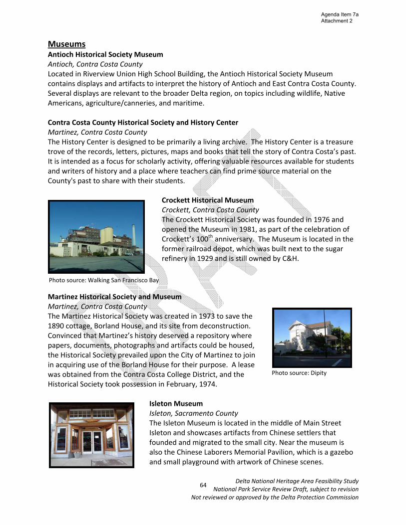
Crockett Historical Museum Crockett, Contra Costa County The Crockett Historical Society was founded in 1976 and opened the Museum in 1981, as part of the celebration of Crockett’s 100th anniversary. The Museum is located in the former railroad depot, which was built next to the sugar refinery in 1929 and is still owned by C&H.
Martinez Historical Society and Museum Martinez, Contra Costa County The Martinez Historical Society was created in 1973 to save the 1890 cottage, Borland House, and its site from deconstruction. Convinced that Martinez’s history deserved a repository where papers, documents, photographs and artifacts could be housed, the Historical Society prevailed upon the City of Martinez to join in acquiring use of the Borland House for their purpose. A lease was obtained from the Contra Costa College District, and the Historical Society took possession in February, 1974.
Isleton Museum Isleton, Sacramento County The Isleton Museum is located in the middle of Main Street Isleton and showcases artifacts from Chinese settlers that founded and migrated to the small city. Near the museum is also the Chinese Laborers Memorial Pavilion, which is a gazebo and small playground with artwork of Chinese scenes.
Photo source: Walking San Francisco Bay
Photo source: Dipity
64
Agenda Item 7a Attachment 2

Delta National Heritage Area Feasibility Study National Park Service Review Draft, subject to revision
Not reviewed or approved by the Delta Protection Commission
Locke Boarding House Museum Locke, Sacramento County The Locke Boarding House was built in 1915 to rent out to migrant workers in the area. It now serves as an exhibit and research facility operated by California State Parks and the Locke Foundation, with historic photos and artifacts of Locke and Delta Chinese.
Locke Dai Loy Museum Locke, Sacramento County A former gambling house in Locke, Dai Loy was closed down in the early fifties by the state government, but now has re‐opened as a museum.
Dutra Museum of Dredging Rio Vista, Solano County This museum will take one through the Northern California history of the dredging industry and the integral role that the Dutra family played in reclaiming the Delta. Scale models, photographs, and artifacts are key features of the museum. Rio Vista Museum Rio Vista, Solano County
The Rio Vista Museum came about as a result of the country’s 1976 Bicentennial. People of the surrounding area contributed historical artifacts to the museum to tell the unique history of Rio Vista.
Photo source: Rio Vista Museum
Photo source: Dutra Museum of Dredging
65
Agenda Item 7a Attachment 2
Delta National Heritage Area Feasibility Study National Park Service Review Draft, subject to revision
Not reviewed or approved by the Delta Protection Commission
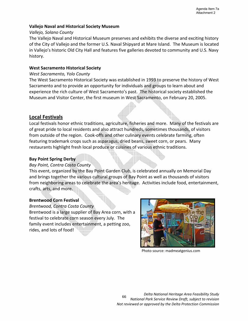
Vallejo Naval and Historical Society Museum Vallejo, Solano County The Vallejo Naval and Historical Museum preserves and exhibits the diverse and exciting history of the City of Vallejo and the former U.S. Naval Shipyard at Mare Island. The Museum is located in Vallejo’s historic Old City Hall and features five galleries devoted to community and U.S. Navy history. West Sacramento Historical Society West Sacramento, Yolo County The West Sacramento Historical Society was established in 1993 to preserve the history of West Sacramento and to provide an opportunity for individuals and groups to learn about and experience the rich culture of West Sacramento’s past. The historical society established the Museum and Visitor Center, the first museum in West Sacramento, on February 20, 2005. Local Festivals Local festivals honor ethnic traditions, agriculture, fisheries and more. Many of the festivals are of great pride to local residents and also attract hundreds, sometimes thousands, of visitors from outside of the region. Cook‐offs and other culinary events celebrate farming, often featuring trademark crops such as asparagus, dried beans, sweet corn, or pears. Many restaurants highlight fresh local produce or cuisines of various ethnic traditions. Bay Point Spring Derby Bay Point, Contra Costa County This event, organized by the Bay Point Garden Club, is celebrated annually on Memorial Day and brings together the various cultural groups of Bay Point as well as thousands of visitors from neighboring areas to celebrate the area’s heritage. Activities include food, entertainment, crafts, arts, and more. Brentwood Corn Festival Brentwood, Contra Costa County Brentwood is a large supplier of Bay Area corn, with a festival to celebrate corn season every July. The family event includes entertainment, a petting zoo, rides, and lots of food!
Photo source: madmeatgenius.com
66
Agenda Item 7a Attachment 2

Delta National Heritage Area Feasibility Study National Park Service Review Draft, subject to revision
Not reviewed or approved by the Delta Protection Commission
Courtland Pear Fair Courtland, Sacramento County
The Pear Fair is a celebration of the annual Bartlett Pear Harvest in the Delta. Organized by local community volunteers, the Fair has become a long standing summer tradition in the Delta that reflects the character and lifestyle of rural life, family fun and a wonderful day of entertainment, full of various dishes and drinks made of pears. This festival is always the last Sunday in July.
Isleton Asian Celebration Isleton, Sacramento County Formerly celebrated as the Chinese New Year, the event was modified in recent years to be more inclusive of Isleton's diverse Asian heritage, and is now held on the first Saturday of March every year. Isleton Cajun Festival Isleton, Sacramento County The Isleton Cajun festival was developed to continue the traditions which the Isleton Crawdad festival had celebrated in the town for more than 20 years, once attracting 200,000 people. The Isleton Cajun Festival began in 2011, and includes food and craft vendors, Zydeco and Cajun music, a carnival for kids, and of course, crawdads. Benicia in Bloom Benicia, Solano County Celebrate the magic of spring in Downtown Benicia during the annual ‘Benicia in Bloom’ on the last weekend of March. The celebration features earth‐friendly displays and demonstrations from Bay Area nonprofits and eco‐partners.
Northern California Pirate Festival Vallejo, Solano County The Northern California Pirate Festival has one goal: to create an entertaining event where everyone who loves pirates will have a great time and feel welcome! The festival encourages coming out in costume...whether you dress as an historical era pirate from the Golden Age of Sail or a bejeweled Mardi‐Gras Krewmate from New
Orleans, whether your taste runs towards Hollywood Swashbucklers or Foreign Buccaneers from international waters! Dress up and share in the experience. This is the largest pirate festival in the country and takes place Father’s Day weekend.
Photo source: Sacramento Bee
Photo source: City of Isleton
Photo source: Benicia Main Street
Photo source: Latitude 38
67
Agenda Item 7a Attachment 2
Delta National Heritage Area Feasibility Study National Park Service Review Draft, subject to revision
Not reviewed or approved by the Delta Protection Commission
Rio Vista Bass Derby and Festival Rio Vista, Solano County This is the oldest Bass derby on the West Coast. It includes a Bass derby, carnival, food, entertainment, water races and activities, raffles, parade, and fireworks. The derby and festival is in the first weekends of October. Rio Vista Holy Ghost Festa Rio Vista, Solano County This long time Portuguese tradition is a celebration honoring Queen Isabel of Portugal. The Festa is a testament to the generosity and love Queen Isabel showed the poor and hungry. There is a parade filled with Queens from the Delta communities and flags and banners that represent the Rio Vista and Isleton Portuguese Club. The festival started in 1899 and continues today, usually on the last weekend of July. Suisun Marsh Field Day Suisun Marsh, Solano County Since 1982, the Suisun Marsh Field Day features renowned waterfowl and wildlife artists, free trap shooting and instruction for children, a BB Gun range, Junior Duck calling contest, free junior hunting license, and more. Field Day is the first Saturday of June. Vallejo to San Francisco Yacht Race Vallejo, Solano County The first mention of an organized race came in 1925, when PICYA organized a cruise to Vallejo on a Saturday, to be followed by a race back on Sunday. This is the official origin of the Great Vallejo Race, now reputed to be the largest inland regatta in the United States, drawing from 300 to 500 boats annually. Now under the aegis of the Yacht Racing Association of San Francisco Bay, it is a two‐day race that marks the official opening of the Bay’s racing season.
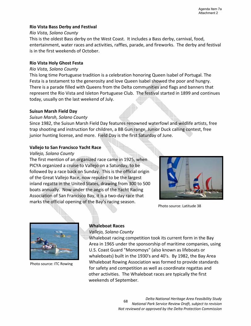
Whaleboat Races Vallejo, Solano County Whaleboat racing competition took its current form in the Bay Area in 1965 under the sponsorship of maritime companies, using U.S. Coast Guard "Monomoys" (also known as lifeboats or whaleboats) built in the 1930's and 40's. By 1982, the Bay Area Whaleboat Rowing Association was formed to provide standards for safety and competition as well as coordinate regattas and other activities. The Whaleboat races are typically the first weekends of September.
Photo source: Latitude 38
Photo source: ITC Rowing
68
Agenda Item 7a Attachment 2

Delta National Heritage Area Feasibility Study National Park Service Review Draft, subject to revision
Not reviewed or approved by the Delta Protection Commission
Yolo Bypass California Duck Days Yolo Bypass, Yolo County Duck Days is an annual celebration of California wetlands and wildlife on President’s Day weekend. Activities include bird watching and identifying, workshops, bird calling, rice farming demonstrations, decoy carving, and more.
Photo source: The Davis Enterprise
69
Agenda Item 7a Attachment 2

Delta National Heritage Area Feasibility Study National Park Service Review Draft, subject to revision
Not reviewed or approved by the Delta Protection Commission
Public Lands with Public Access About 74, 000 acres of the Delta and Suisun Marsh are public lands, not including 61,000 acres of open water and 57,000 acres of navigable waterways spread over 700 miles of sloughs and winding channels. Additionally, there are about 7,000 acres of public lands along the Carquinez Strait. These public lands include state parks and recreation areas; ecological reserves and wildlife refuges; fishing areas; and more. Many of these areas support a wide variety of recreation activities, providing opportunities for fishing, hunting, motorized and non‐motorized boating, swimming, windsurfing, wildlife viewing, picnicking, hiking, biking, and camping. Some offer trails and options for driving tours, visitor/interpretive centers, and historical sites. Special district, state, and federal ownership Numbers coincide with map on next page County Site Name Agency 1 Contra Costa Antioch/Oakley Regional Shoreline East Bay Regional Parks District
2 Contra Costa Big Break Regional Shoreline East Bay Regional Parks District
3 Contra Costa Carquinez Strait Shoreline East Bay Regional Parks District
4 Contra Costa Franks Tract State Recreation Area California Department of Fish and Game
5 Contra Costa John Muir National Historic Site National Park Service
6 Contra Costa Lone Tree Point East Bay Regional Parks District
7 Contra Costa Marsh Creek Trail East Bay Regional Parks District
8 Contra Costa Martinez Regional Shoreline East Bay Regional Parks District
9 Contra Costa Rhode Island Wildlife Area California Department of Fish and Game
10 Contra Costa San Pablo Bay Regional Shoreline East Bay Regional Parks District
11 Contra Costa Waterbird Regional Preserve East Bay Regional Parks District
12 Contra Costa West Pittsburg Park Ambrose Recreation and Park District
13 Sacramento Brannan Island Fishing Access California Department of Fish and Game
14 Sacramento Brannan Island State Recreation Area California Department of Parks and Recreation
15 Sacramento Cliff House Fishing Access California Department of Fish and Game
16 Sacramento Cosumnes River Ecological Reserve (partial)* California Department of Fish and Game
17 Sacramento Delta Meadows California Department of Parks and Recreation
18 Sacramento Lower Sherman Island Wildlife Area California Department of Fish and Game
19 Sacramento Sherman Island Other State
20 Sacramento Stone Lakes National Wildlife Refuge U.S. Fish and Wildlife Service/California Department of Parks and Recreation
21 San Joaquin White Slough Wildlife Area (partial) California Department of Fish and Game
22 San Joaquin Woodbridge Ecological Reserve California Department of Fish and Game
23 Solano Belden’s Landing Fishing Access California Department of Fish and Game
24 Solano Benicia Capitol State Historic Park California Department of Parks and Recreation
25 Solano Benicia State Recreation Area California Department Parks and Recreation
26 Solano Calhoun Cut Ecological Reserve California Department of Fish and Game
27 Solano Decker Island Wildlife Area California Department of Fish and Game
28 Solano Grizzly Island Wildlife Area California Department of Fish and Game
29 Solano Hill Slough Wildlife Area California Department of Fish and Game
30 Solano Miner Slough Wildlife Area California Department of Fish and Game
31 Solano Napa‐Sonoma Marshes Wildlife Area California Department of Fish and Game
32 Solano Peytonia Slough Ecological Reserve California Department of Fish and Game
33 Solano Rio Vista Fishing Access California Department of Fish and Game
34 Solano Rush Ranch Open Space Solano Land Trust
35 Solano San Pablo Bay National Wildlife Refuge U.S. Fish and Wildlife Service
36 Solano Vallejo Fishing Pier California Department of Fish and Game
70
Agenda Item 7a Attachment 2
Delta National Heritage Area Feasibility Study National Park Service Review Draft, subject to revision
Not reviewed or approved by the Delta Protection Commission
37 Yolo Clarksburg Fishing Access California Department of Fish and Game
38 Yolo Sacramento Bypass Wildlife Area California Department of Fish and Game
39 Yolo Yolo Bypass Wildlife Area California Department of Fish and Game
*part of Cosumnes River Preserve, which a portion lies within the proposed boundary. This preserve is jointly managed by The Nature Conservancy, Bureau of Land Management, Ducks Unlimited, Department of Fish and Game, Department of Water Resources, Sacramento County Department of Parks and Recreation, and the state Wildlife Conservation Board.
71
Agenda Item 7a Attachment 2

GaltLodi
Hood
Dixon
Davis
Oakely
Concord
Manteca
Lathrop
Antioch
Freeport
Fairfield
Vacaville
Brentw
ood
Knightsen
Courtland
Clarksburg
Sacramento
Collinsville
Walnut
Grove
Discovery B
ay
k
k
k
k
k
k
kk
k
k
k
k
k
kk
k
k
k
kk
k
k
k
k
k
k
k
k
k
k
k
kk
k
k
k
Tracy
San Francisco
Oakland
Rio Vista
Locke
West
Sacramento
Isleton
Bethel Island
Stockton
Vallejo
Crockett
Port Costa
Martinez
Pittsburg
k Benicia
Public Lands with Public A
ccess of the Proposed Sacram
ento-San Joaquin Delta N
ational Heritage A
rea
580
580
205120
5
5
99
99
12
12
5160
84
80
80
505
12
4
¯
05
1015
2.5M
iles
Legen
dP
UB
LIC LA
ND
S
CO
NC
EPTUA
L NH
A BO
UN
DA
RY
DELTA P
RIM
AR
Y ZO
NE
DELTA S
ECO
ND
AR
Y ZO
NE
12
34
5
6
7
8
9
1011
12
1314
15
1617
1819
2122
23
2425
26
27
28
2930
31
32
33
34
3536
37
38
39
20
County
Site Nam
e Agency
1
Contra Costa An
och/Oakley Regional Shoreline
East Bay Regional Parks District
2 Contra Costa
Big Break Regional Shoreline East Bay Regional Parks District
3
Contra Costa Carquinez Strait Shoreline
East Bay Regional Parks District
4 Contra Costa
Franks Tract State Recreaon Area
California Department of Fish and G
ame
5
Contra Costa John M
uir Na
onal Historic Site
Na
onal Park Service
6 Contra Costa
Lone Tree Point East Bay Regional Parks District
7
Contra Costa M
arsh Creek Trail East Bay Regional Parks District
8
Contra Costa
Mar
nez Regional Shoreline
East Bay Regional Parks District
9
Contra Costa
Rhode Island Wildlife Area
California Department of Fish and G
ame
10
Contra Costa
San Pablo Bay Regional Shoreline
East Bay Regional Parks District
11
Contra Costa
Waterbird Regional Preserve
East Bay Regional Parks District
12
Contra Costa
West Pi
sburg Park
Ambrose Recrea
on and Park District
13
Sacramento
Brannan Island Fishing Access
California Department of Fish and G
ame
14
Sacramento
Brannan Island State Recreaon Area
California Department of Parks and Recrea
on
15
Sacramento
Cliff House Fishing Access
California Department of Fish and G
ame
16
Sacramento
Cosumnes River Ecological Reserve
(paral)*
California Department of Fish and G
ame
17
Sacramento
Delta Meadow
s
California Department of Parks and Recrea
on
18
Sacramento
Lower Sherm
an Island Wildlife Area
California Department of Fish and G
ame
19 Sacram
ento
Sherman Island
Other State
20
Sacramento
Stone LakesNa
onalWildlife
Refuge
U.S. Fish and W
ildlife Service/California Departm
ent of Parks and Recreaon
21 San Joaquin
White Slough W
ildlife Area (paral)
California Department of Fish and G
ame
22 San Joaquin
Woodbridge Ecological Reserve
California Department of Fish and G
ame
23 Solano
Belden’s Landing Fishing Access California Departm
ent of Fish and Gam
e
24 Solano
Benicia Capitol State Historic Park
California Department of Parks and Recrea
on 25
Solano Benicia State Recrea
on Area California Departm
ent of Fish and Gam
e 26
Solano Calhoun Cut Ecological Reserve
California Department of Fish and G
ame
27 Solano
Decker Island Wildlife Area
California Department of Fish and G
ame
28 Solano
Grizzly Island W
ildlife Area California Departm
ent of Fish and Gam
e 29
Solano H
ill Slough Wildlife Area
California Department of Fish and G
ame
30
Solano
Miner Slough W
ildlife Area
California Department of Fish and G
ame
31
Solano
Napa-Sonom
a Marshes W
ildlife Area
California Department of Fish and G
ame
32
Solano
Peytonia Slough Ecological Reserve
California Department of Fish and G
ame
33
Solano
Rio Vista Fishing Access
California Department of Fish and G
ame
34
Solano
Rush Ranch Open Space
Solano Land Trust 35
Solano
San Pablo Bay Na
onal Wildlife Refuge
U.S. Fish and W
ildlife Service 36
Solano
Vallejo Fishing Pier
California Department of Fish and G
ame
37
Yolo Clarksburg Fishing Access
California Department of Fish and G
ame
38
Yolo
Sacramento Bypass W
ildlife Area
California Department of Fish and G
ame
39
Yolo
Yolo Bypass Wildlife Area
California Department of Fish and G
ame
CountySite N
ame
AgencySite K
ey
Graphics for discussion and visioning purposes only. Areas and locations are approximate.
Agenda Item 7a Attachment 2

Delta National Heritage Area Feasibility Study National Park Service Review Draft, subject to revision
Not reviewed or approved by the Delta Protection Commission
Descriptions of Public Lands with Public Access Antioch/Oakley Regional Shoreline Contra Costa County A 550‐foot pier provides access to great fishing in the San Joaquin River at Antioch/Oakley Regional Shoreline, located just upstream from Highway 160's Nejedly Bridge in Antioch. Fishing, picnicking and kite flying are all favorite activities at this park.
Big Break Regional Shoreline Contra Costa County The Big Break Regional Shoreline is a small bay at the edge of the San Joaquin River and home to a wide variety of species, particularly birds and fish. The Delta Science Center is a project being developed at Big Break, which will be utilized for educational purposes and include sampling and testing areas for students, an amphitheater, a picnic area, and a walkway with an artistic replica of the Delta.
Carquinez Strait Shoreline Contra Costa County Carquinez Strait Regional Shoreline comprises 1,415 acres of bluffs and shoreline along Carquinez Scenic Drive between the town of Crockett and the hillsides overlooking Martinez. This parkland provides a gateway to the Delta along the northern edge of Contra Costa County. The coastal hills rise steeply up to 750 feet above Carquinez Strait. From the highest elevations the view includes the marshland of Benicia State Recreation Area to the north across Carquinez Strait. From atop Franklin Ridge along the Franklin Ridge Loop Trail and the California Riding and Hiking Trail, the horizon is pierced by the peaks of Mt. Tamalpais to the west and Mt. Diablo to the east. :
Photo source: Sierra Club
Photo source: East Bay Regional Park District
Photo source: East Bay Regional Park District
73
Agenda Item 7a Attachment 2
Delta National Heritage Area Feasibility Study National Park Service Review Draft, subject to revision
Not reviewed or approved by the Delta Protection Commission
Franks Tract State Recreation Area Contra Costa County Franks Tract State Recreation Area is only accessible by water and is located southeast of Brannan Island between False River and Bethel Island. Franks Tract flooded in 1936 and again in 1938. Very few land forms remain exposed, with the exception of remnant levees. During the fall and winter, a large variety of waterfowl can be found in Franks Tract due to the Delta’s key position in the Pacific flyway. Year round residents include gulls, great blue herons, terns, swallows, crows, blackbirds, cormorants, and kingfishers. Lone Tree Point Contra Costa County This small park on the Rodeo shoreline provides expansive views of San Pablo Bay with picnic opportunities. Marsh Creek Trail Contra Costa County
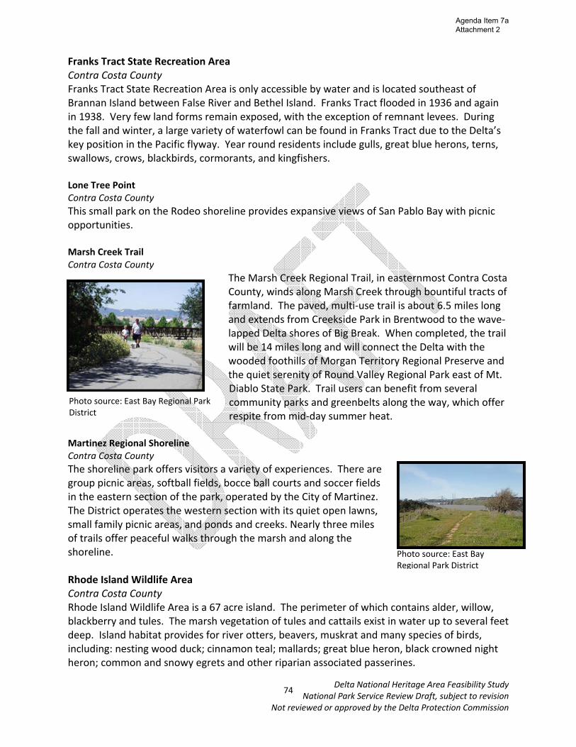
The Marsh Creek Regional Trail, in easternmost Contra Costa County, winds along Marsh Creek through bountiful tracts of farmland. The paved, multi‐use trail is about 6.5 miles long and extends from Creekside Park in Brentwood to the wave‐lapped Delta shores of Big Break. When completed, the trail will be 14 miles long and will connect the Delta with the wooded foothills of Morgan Territory Regional Preserve and the quiet serenity of Round Valley Regional Park east of Mt. Diablo State Park. Trail users can benefit from several community parks and greenbelts along the way, which offer respite from mid‐day summer heat.
Martinez Regional Shoreline Contra Costa County The shoreline park offers visitors a variety of experiences. There are group picnic areas, softball fields, bocce ball courts and soccer fields in the eastern section of the park, operated by the City of Martinez. The District operates the western section with its quiet open lawns, small family picnic areas, and ponds and creeks. Nearly three miles of trails offer peaceful walks through the marsh and along the shoreline. Rhode Island Wildlife Area Contra Costa County Rhode Island Wildlife Area is a 67 acre island. The perimeter of which contains alder, willow, blackberry and tules. The marsh vegetation of tules and cattails exist in water up to several feet deep. Island habitat provides for river otters, beavers, muskrat and many species of birds, including: nesting wood duck; cinnamon teal; mallards; great blue heron, black crowned night heron; common and snowy egrets and other riparian associated passerines.
Photo source: East Bay Regional Park District
Photo source: East Bay Regional Park District
74
Agenda Item 7a Attachment 2

Delta National Heritage Area Feasibility Study National Park Service Review Draft, subject to revision
Not reviewed or approved by the Delta Protection Commission
San Pablo Bay Regional Shoreline Contra Costa County Point Pinole Regional Shoreline is a 2,315‐acre parkland right next to densely populated Pinole, Richmond, and San Pablo. Trails lead through breezy meadows with wildflowers in season, through aromatic eucalyptus woods, or along bluffs and beaches on San Pablo Bay. Waterbird Regional Preserve Contra Costa County Waterbird Regional Preserve is a 198‐acre area comprised of a wetland and the associated uplands to the east. The focal point of the Preserve is the rich and diverse Al McNabney Marsh, of which the East Bay Regional Park District owns 46 acres in the southern end and Mountain View Sanitary District owns 69 acres in the northern and deeper end. Brannan Island State Recreation Area Sacramento County Brannan Island State Recreation Area has countless islands and marshes with diverse wildlife habitats and many opportunities for recreation, including boating, windsurfing, and swimming. It also has great fishing opportunities for striped bass, sturgeon, catfish, bluegill, perch, bullhead, and more. Cosumnes River Ecological Preserve Sacramento County This 46,000 acre nature preserve is found at the lower reach of California’s Central Valley and protects native habitat such as oak tree savanna, riparian oak forest, and wetlands, which are no longer as prevalent in the region due to agricultural development. The preserve was designated as a National Natural Landmark by NPS in 1976. Activities at the preserve include field trips, educational workshops, wildlife viewing, paddling, hiking and fishing. Delta Meadows Sacramento County The area is a prime example of riparian woodlands which were prevalent in the Delta prior to reclamation. Habitat supports different types of wildlife including the river otter, the Delta smelt and the Sacramento chub.
Photo source: marinas.com
Photo source: East Bay Regional Park District
75
Agenda Item 7a Attachment 2

Delta National Heritage Area Feasibility Study National Park Service Review Draft, subject to revision
Not reviewed or approved by the Delta Protection Commission
Lower Sherman Island Wildlife Area Sacramento County The Lower Sherman Island Wildlife Area is approximately 3,100 acres, primarily marsh and open water. The area is home to hundreds of different bird species as well as mammals such as river otters, beavers, and minks. Stone Lakes National Wildlife Refuge Sacramento County Stone Lakes Refuge acquired its first land in 1994 and was officially designated the 505th unit in the National Wildlife Refuge System. It joined the ranks of other local land management projects, including the Cosumnes River Preserve to the south and the Vic Fazio Yolo Bypass Wildlife Area to the west, to protect and enhance imperiled Central Valley fish and wildlife habitats. Public access recently was enhanced in the refuge with the development of a nature area with an amphitheater, interpretive displays and a small network of trails to nearby wetlands. White Slough Wildlife Area San Joaquin County The wildlife area consists of 880 acres of man‐made ditches, canals (burrow ponds), freshwater marshes, grassland/upland, and riparian habitat. Ponds were created during the construction of Interstate‐5. Hunting, fishing, hiking, wildlife viewing is available.
Woodbridge Ecological Preserve San Joaquin County One of the key features of this ecological preserve is its greater Sandhill crane communities. This species was listed as threatened in 1983. This reserve comprises part of the Stockton Delta wetlands sytstem which provide the largest area of freshwater marsh wintering habitat in the state, not only for Sandhill cranes but for other waterfowl as well.
Belden’s Landing Fishing Access Solano County In the 1980s the Department of Fish & Game purchased this site which has a rich history of Native Americans, commerce, agricultural activities, and more. A public waterway access facility is located where the old ferry crossing carried hunters and fishermen to Grizzly Island and the site of Jim and Mary Belden’s landing, who had purchased the harbor in 1945.
Photo source: Department of Fish and Game
Photo source: Solano County
76
Agenda Item 7a Attachment 2
Delta National Heritage Area Feasibility Study National Park Service Review Draft, subject to revision
Not reviewed or approved by the Delta Protection Commission
Benicia State Capitol Historic Park Solano County Benicia Capitol State Historic Park is the site of California’s third seat of government (1853‐54). It is the only pre‐Sacramento capitol that survives. The original building has been restored with reconstructed period furnishings and exhibits. The interior includes a board‐for‐board reconstruction of the building’s original floor with ponderosa pine. The desks, three of which are originals from the Benicia period or earlier, are furnished with a candlestick, a 19th century newspaper, a quill pen, and a top hat. Benicia State Recreation Area Solano County Benicia State Recreation Area covers marsh, grassy hillsides and rocky beaches along the narrowest portion of the Carquinez Strait. Cyclists, runners, walkers, equestrians, and roller skaters enjoy the park’s 2 1/2 miles of road and bike paths. Picnicking, bird watching and fishing are also attractions. Decker Island Wildlife Area Solano County Decker Island, a 648‐acre island, is just south of Rio Vista and surrounded by the Sacramento River and Horseshoe Bend. The island was created in the early 1900s when the Sacramento River was dredged and the spoils were placed on top of existing wetlands.
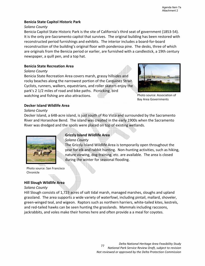
Grizzly Island Wildlife Area Solano County The Grizzly Island Wildlife Area is temporarily open throughout the year for elk and rabbit hunting. Non‐hunting activities, such as hiking, nature viewing, dog‐training, etc. are available. The area is closed during the winter for seasonal flooding.
Hill Slough Wildlife Area Solano County Hill Slough consists of 1,723 acres of salt tidal marsh, managed marshes, sloughs and upland grassland. The area supports a wide variety of waterfowl, including pintail, mallard, shoveler, green‐winged teal, and wigeon. Raptors such as northern harriers, white‐tailed kites, kestrels, and red‐tailed hawks can be seen hunting the grasslands. Mammals including raccoons, jackrabbits, and voles make their homes here and often provide a a meal for coyotes.
Photo source: Association of Bay Area Governments
Photo source: San Francisco Chronicle
77
Agenda Item 7a Attachment 2

Delta National Heritage Area Feasibility Study National Park Service Review Draft, subject to revision
Not reviewed or approved by the Delta Protection Commission
Miner Slough Wildlife Area Solano County The area is 37 acres in size with approximately 10 acres remaining above the water at high tide, making up one small island and a narrow peninsula extending from Prospect Island. Riparian vegetation includes willows, cottonwoods, tules, and blackberries; which support wildlife species, such as beaver, black‐crowned night heron, and a variety of waterfowl. Napa‐Sonoma Wildlife Areas Solano County This wildlife area consists of over 13,000 acres of saltwater ponds, tidal marshes, and wetlands , just north of San Pablo Bay. Many waterfowl species and shorebirds including the California clapper rail can be found here. Most of the area is accessible only by boat. Peytonia Slough Ecological Preserve Solano County The Peytonia Slough Ecological Preserve is a 520 acre open access preserve. Boating, fishing, nature viewing, and hiking are permitted.
Rush Ranch Open Space Solano County Rush Ranch is a 2,070‐acre open space area located in southern Solano County, bordered on one side by the Suisun Marsh. Rush Ranch has vast open spaces of tranquil rolling grasslands and an abundance of bird and wildlife viewing opportunities.
San Pablo Bay National Wildlife Refuge Solano County The San Pablo Bay National Wildlife Refuge lies along the north shore of San Pablo Bay in Sonoma, Solano, and Napa Counties in northern California. The refuge includes open bay/tidal marsh, mud flats, and seasonal and managed wetland habitats. Yolo Bypass Wildlife Area Yolo County The Yolo Bypass contains the Vic Fazio Yolo Wildlife Area and was the largest public/private restoration project in the United States west of the Florida Everglades. It forms a valuable wetland for much of the year and is used for agriculture in the summer. It is part of the Yolo Bypass flood control channel, and is compatible with the flood control processes.
Photo source: Yolo Basin Foundation
Photo source: Department of Fish and Game
Photo source: Rush Ranch
78
Agenda Item 7a Attachment 2
Delta National Heritage Area Feasibility Study National Park Service Review Draft, subject to revision
Not reviewed or approved by the Delta Protection Commission
Recreational Resources in the Proposed NHA Over 1,000 miles of navigable waterways exist throughout the Delta making it a recreational haven for locals and visitors alike. Specific recreational activities include boating, fishing, windsurfing, hunting, birdwatching, and more. The U.S. Coast Guard is responsible for law enforcement and public safety throughout the Delta’s waterways. Private recreation facilities and other businesses serving visitors also support recreation in the region. There are almost 100 marinas found throughout the Delta, some of which offer camping, cabin rentals, picnic facilities, boat launches, houseboat rentals, and fishing access. Private yacht clubs also exist throughout the Delta, as well as a handful of private duck clubs, and a few private golf courses. Private excursion vessels departing from Antioch, Pittsburg, Stockton, Sacramento, Suisun City, and Walnut Grove offer additional ways for visitors to explore the region. Much of the land in Suisun Marsh is owned by private duck clubs though public waterfowl hunting areas are found there as well. Other recreational activities at the Marsh include wildlife viewing, hiking, and canoeing. The Carquinez Strait is also an ideal place for water‐based recreation including fishing, boating, and windsurfing. Restaurants, hotels, wineries, galleries, gift shops, and farm stands exist throughout the Delta which can help support the visitor’s experience. The Clarksburg appellation in the Northern Delta contains many of the region’s wineries, including the Old Sugar Mill with six wineries in one location. The Delta Discovery Center is also a key attraction located outside of Rio Vista, and includes the Delta Farmer’s Market. The Delta Loop is a 10 mile scenic drive along the Mokelumne and San Joaquin Rivers with over 40 attractions. It is an ideal spot for exploring the Delta by car or boat and includes marinas, resorts, RV parks, restaurants, bars, gift shops, and more. Regional Trail Systems A number of regional trail systems exist throughout the Delta, Suisun Marsh and Carquinez Strait. These trail systems help link the region’s recreational, cultural, historical and natural resources sites to one another, and also help connect the region to outside communities. American Discovery Trail The ADT is a multi‐use patchwork of existing trails and paved roads. The trail stretches across more than 6,800 miles, and is the only coast‐to‐coast, non motorized recreational trail. From Discovery Park in Sacramento, the ADT crosses the American River and follows a levee trail along the Sacramento River to Old Sacramento. Leaving Old Sacramento and following city streets, the ADT passes by the magnificent historic state capital building and the Sacramento City Cemetery. After leaving Sacramento, the ADT passes for over 50 miles of the Delta using levee roads, and going through the small towns of Freeport, Clarksburg, Locke, Walnut Grove, and Isleton.
79
Agenda Item 7a Attachment 2

Delta National Heritage Area Feasibility Study National Park Service Review Draft, subject to revision
Not reviewed or approved by the Delta Protection Commission
Bay Area Ridge Trail The Bay Area Ridge Trail is a planned 550+‐mile multi‐use trail (currently over 330 miles are complete) along the hill and mountain ridgelines ringing the San Francisco Bay Area. When complete, the trail will connect over 75 parks and open spaces. The trail is being designed to provide access for hikers, runners, mountain bicyclists, and equestrians. It will be accessible through trailheads near major population centers, and extend into more remote areas. Portions of it are along the Carquinez Strait in Contra Costa and Solano Counties. Juan Bautista de Anza Historical Trail In 1776, as Americans fought for independence in the East, Juan Bautista de Anza led more than 240 people over 1200 miles to settle Alta California. It was the first overland route established to connect New Spain with San Francisco. The historic trail retraces their footsteps from Nogales, Arizona to San Francisco; and passes along the Carquinez Strait and through the Contra Costa County portion of the Delta. Mokelumne Coast to Crest Trail This trail crosses the San Francisco Bay to Pacific Crest Trail in the Sierras and passes through East Bay Regional Parkland, Mt. Diablo State Park, and the Stanislaus National Forest. In the Delta it goes through the cities of Antioch, Rio Vista and Isleton. Currently the Delta segment of the trail is in the pre‐planning phase and will likely be a water trail along the Mokelumne River. San Francisco Bay Trail The San Francisco Bay Trail offers access to commercial, industrial and residential neighborhoods; points of historic, natural and cultural interest; recreational areas like beaches, marinas, fishing piers, boat launches, and over 130 parks and wildlife preserves totaling 57,000 acres of open space. It passes through highly urbanized areas like downtown San Francisco as well as remote natural areas like the San Francisco Bay National Wildlife Refuge. Depending on the location of its segments, the Bay Trail consists of paved multi‐use paths, dirt trails, bike lanes, sidewalks or city streets signed as bike routes. The Bay Trail passes through portions on Contra Costa and Solano Counties along the Carquinez Strait, connects to the Bay Area Ridge Trail, and will likely connect to the future Great California Delta Trail.
80
Agenda Item 7a Attachment 2
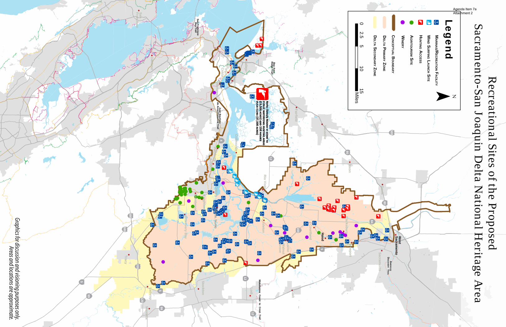
&
& &
&
&&& &
&
&&&
&
&&&&
&
&
&
&
&
&
& &
&&
&
&
&
&
&
& &
&
&
&
&
&
&
&
&
&
&
&&
!x!x
!x!x!x
!x!x
!x
!x!x!x!x
!x!x
!x!x
!x!x
!x!x!x
!x!x!x!x!x!x!x
!x!x
!x
!x!x
!x!x
!x!x
!x!x!x!x!x
!x!x!x!x!x!x!x!x
!x!x
!x
!x!x!x
!x!x!x
!x!x!x!x
!x!x!x!x
!x!x!x
!x!x
!x!x
!x!x
!x!x!x!x
!x!x
!x!x!x!x
!x!x
!x!x
!x!x
!x!x
!x!x
!x!x
!x!x!x
!x!x
!x!x
!x!x
!x!x
!x!x!x!x!x!x!x
!x!x!x
!x!x
!x!x
!x!x!x
!x!x!x!x
!x!x!x!x!x
!x!x!x
!x!x!x!x!x!x
!x!x!x!x!x!x!x
!x!x
!x!x
!x!x
!x!x
!x
!x!x
!x!x
!x
!x
!x!x !x
!
!x
!x
!x
!x!x!x
!x
!x
!x
!x
!x
!x
!x
!x
!x!x!x
!x
!x!x
!x
!x
!x
!x
!x
!x!x!x
!x
!x
!x
!x
!x!x
!x!x
!x!x
!x
!x!x
!x! x
!x
!x
!x
!x
!x
! x
!¥!¥
!¥!¥
!¥!¥!¥
!¥!¥
!©!©!©!©!©
!©!©!©!©!©!©!©!©!©!©
!©
!©
!©
!©!©
!©
!©
!
!! !! !!
!
!!
!
xx xx x
xx
x
xx
xx !x
!x !x!x ! x
! x! x! x
!x!x
! x!x
! x! x
! © ! ©!©
k
k
k
k
k
k
kk
k
k
k
k
k
kk
k
k
k
kk
k
k
k
k
k
k
k
k
k
k
k
kk
k
Galt
Lodi
Dixon
Davis
Oakley
Concord
Manteca
Lathrop
Antioch
Freeport
Fairfield
Vacaville
Brentw
ood
Knightsen
Courtland
Clarksburg
Sacramento
Collinsville
Walnut
Grove
Discovery B
ay
Tracy
kSan Francisco
kOakland
Stockton
&
&
&
!©N
: S M
N: S
M
(13,500
) 158
(13,500
) 158
(37,500 )
(37,500
)
West
Sacramento
Hood
BETH
ELETH
EL I ISLAN
DSLA
ND
Recreational Sites of the Proposed
Sacramento-San Joaquin D
elta National H
eritage Area
580
580
205120
5
5
99
99
12
12
5
160
84
80
80
505
12
4
&
¯
05
1015
2.5M
iles
Legen
d
DELTA P
RIM
AR
Y ZO
NE
DELTA S
ECO
ND
AR
Y ZO
NE
MA
RIN
AS/R
ECR
EATIO
N FA
CILITY
WIN
D SU
RFIN
G LA
UN
CH S
ITE
HU
NTIN
G AC
CESS
AG
RITO
UR
ISM SITE
WIN
ERY
¥ x©& &
CO
NC
EPTUA
L BO
UN
DA
RY
Vallejo
CrockettPort
Costa
Martinez
Pittsburg
Benicia
Rio Vista
Isleton
Locke
Mokelum
ne Coast to C
rest Trail
AM
ERIC
AN
DISC
OVER
Y TR
AIL
Juan Bautista
de Anza H
istorical Trail
San Francisco B
ay Trail
Bay A
rea R
idge Trail
Graphics for discussion and visioning purposes only.Areas and locations are approxim
ate.
Agenda Item 7a Attachment 2
Related Documents