Chapter 6 – Recommendations Page 1 of 20 Chapter 6: Recommendations 6.0 Introduction The aviation industry has never proven to be dull or lackluster. Rather, it continues to excite, challenge, and inspire us. While flying has become commonplace in many ways, the mechanics behind the safe and efficient takeoff and landing of any aircraft is still an incredible feat. Indiana’s system of airports serves as the foundation for this remarkable movement of people and things by providing that vital piece of ground where aircraft safely transition from land to air and vice versa. There is, however, increasing competition for the use of both land and air, and as the demand for this fixed commodity grows, the pressure to compromise airport utility will increase. Along with this challenge comes the infinite need to preserve and enhance the ISASP’s 100 miles of runway and related airport infrastructure to ensure a safe, efficient, and effective airport system to support Hoosier mobility and prosperity. For Indiana’s system of airports to move toward the goals and recommendations presented in the ISASP, both state and local action will be required. The decision to implement individual airport recommendations made in this update of the ISASP ultimately lies with each airport sponsor, but as sponsors plan the future of their facilities, these recommendations should serve as a guide for future development. This Chapter of the ISASP provides individual airport and system-wide recommendations to assist in INDOT’s mission to “plan, build, maintain and operate a superior transportation system enhancing safety, mobility, and economic growth” 1 . The recommendations that are presented in this Chapter have been developed using the results of the system inventory and analysis using the core principles and goals of the system as a guiding element. Developing recommendations provides a guide for decision makers and airport sponsors who allocate available resources to develop each airport in the ISASP to support the system as a whole. It should again be recognized that the recommendations contained within this chapter are only recommendations and not requirements. While the responsibility for the implementation of these 1 Indiana Department of Transportation, INDOT Mission, Goals, Values, www.in.gov/indot/2341.htm, accessed 4-10- 13.

Welcome message from author
This document is posted to help you gain knowledge. Please leave a comment to let me know what you think about it! Share it to your friends and learn new things together.
Transcript

Chapter 6 – Recommendations Page 1 of 20
Chapter 6: Recommendations 6.0 Introduction
The aviation industry has never proven to be dull or lackluster. Rather, it continues to excite, challenge,
and inspire us. While flying has become commonplace in many ways, the mechanics behind the safe and efficient takeoff and landing of any aircraft is still an incredible feat. Indiana’s system of airports serves as
the foundation for this remarkable movement of people and things by providing that vital piece of ground where aircraft safely transition from land to air and vice versa. There is, however, increasing competition for the use of both land and air, and as the demand for this fixed commodity grows, the
pressure to compromise airport utility will increase. Along with this challenge comes the infinite need to preserve and enhance the ISASP’s 100 miles of runway and related airport infrastructure to ensure a safe,
efficient, and effective airport system to support Hoosier mobility and prosperity.
For Indiana’s system of airports to move toward the goals and recommendations presented in the ISASP, both state and local action will be required. The decision to implement individual airport
recommendations made in this update of the ISASP ultimately lies with each airport sponsor, but as sponsors plan the future of their facilities, these recommendations should serve as a guide for future
development.
This Chapter of the ISASP provides individual airport and system-wide recommendations to assist in INDOT’s mission to “plan, build, maintain and operate a superior transportation system enhancing safety,
mobility, and economic growth”1. The recommendations that are presented in this Chapter have been developed using the results of the system inventory and analysis using the core principles and goals of
the system as a guiding element. Developing recommendations provides a guide for decision makers and airport sponsors who allocate available resources to develop each airport in the ISASP to support the
system as a whole.
It should again be recognized that the recommendations contained within this chapter are only recommendations and not requirements. While the responsibility for the implementation of these
1 Indiana Department of Transportation, INDOT Mission, Goals, Values, www.in.gov/indot/2341.htm, accessed 4-10-13.
Chapter 6 – Recommendations Page 2 of 20
recommendations most often falls to the local airport sponsors, in some instances, INDOT has been identified as also having a role in their implementation.
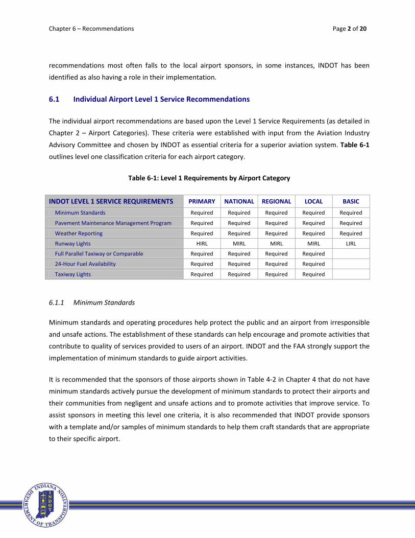
6.1 Individual Airport Level 1 Service Recommendations
The individual airport recommendations are based upon the Level 1 Service Requirements (as detailed in Chapter 2 – Airport Categories). These criteria were established with input from the Aviation Industry
Advisory Committee and chosen by INDOT as essential criteria for a superior aviation system. Table 6-1 outlines level one classification criteria for each airport category.
Table 6-1: Level 1 Requirements by Airport Category
INDOT LEVEL 1 SERVICE REQUIREMENTS PRIMARY NATIONAL REGIONAL LOCAL BASIC
Minimum Standards Required Required Required Required Required
Pavement Maintenance Management Program Required Required Required Required Required
Weather Reporting Required Required Required Required Required
Runway Lights HIRL MIRL MIRL MIRL LIRL
Full Parallel Taxiway or Comparable Required Required Required Required
24-Hour Fuel Availability Required Required Required Required
Taxiway Lights Required Required Required Required
6.1.1 Minimum Standards
Minimum standards and operating procedures help protect the public and an airport from irresponsible
and unsafe actions. The establishment of these standards can help encourage and promote activities that contribute to quality of services provided to users of an airport. INDOT and the FAA strongly support the
implementation of minimum standards to guide airport activities.
It is recommended that the sponsors of those airports shown in Table 4-2 in Chapter 4 that do not have minimum standards actively pursue the development of minimum standards to protect their airports and
their communities from negligent and unsafe actions and to promote activities that improve service. To assist sponsors in meeting this level one criteria, it is also recommended that INDOT provide sponsors
with a template and/or samples of minimum standards to help them craft standards that are appropriate to their specific airport.

Chapter 6 – Recommendations Page 3 of 20
6.1.2 Pavement Maintenance Management Program
As detailed in Chapter 2, all airports should have a pavement maintenance management program in
order to preserve their existing pavements and plan for future maintenance that will be needed. By better maintaining pavements, the pavement service life can be extended, which reduces the funding needed each year for rehabilitation or reconstruction. It is recommended that the airports shown in
Table 4-3 in Chapter 4 that do not have these programs work with INDOT to develop a pavement management plan that can be used to manage their existing and future pavements. These programs can
identify optimal maintenance schedules which are critical, since pavement maintenance can be costly.
6.1.3 Weather Reporting
Indiana has an effective network of weather reporting sites, including 48 AWOS and ASOS systems
combined, that improve airport utility and safety by helping pilots obtain accurate information when arriving, departing, or traveling en route to an airport. However, the 21 airports shown in bold in Table 4-
4 in Chapter 4 do not have weather reporting systems and therefore are not meeting this level one criteria. It is recommended that these 21 airports include the installation of an AWOS or ASOS on their Capital Improvement Plan (CIP), if not already shown. A priority should be placed on the provision of
weather reporting equipment at every system airport as resources are available. This may require a cost/benefit analysis when FAA AIP funds are sought, so INDOT should seek out alternative funding
sources for airports that do not pass the FAA’s cost/benefit analysis.
6.1.4 Runway Lights
Runway lighting, which improves safety and increases the utility of airports, is used to define the edges of
a runway during nighttime and low visibility conditions. The Level One runway lighting criteria for each airport classification is different: for Primary it is HIRL; for National, Regional and Local it is MIRL; and for
Basic is LIRL.
Fortunately, the majority of system airports already have the required type of runway lighting for their airport category. The three airports shown on Table 4-5 in Chapter 4 that are not meeting this Level One
criteria should include the purchase and installation of runway lights (appropriate to their airport classification) on their CIP. Unfortunately, two of these three airports shown are not currently eligible for
FAA AIP funds. Therefore, INDOT should seek alternative funding sources for these airports.
Chapter 6 – Recommendations Page 4 of 20
6.1.5 Full Parallel Taxiway or Comparable
Parallel taxiways increase safety and capacity at an airport by minimizing the time an aircraft occupies
the runway when maneuvering before takeoff or after landing, and eliminating the need for back taxi on an active runway. While some airports did not have a standard parallel taxiway at the time of the inventory, they did have alternate taxiways that allowed aircraft to taxi from one end of the runway to
the other, without having to use the runway to taxi. Airports with this sort of configuration were considered to have a comparable taxiway. (Note: Parallel taxiways are not a Level One requirement for
Basic Airports.)
It is recommended that resources be allocated to the 11 local airports shown in Table 4-6 in Chapter 4 that do not have parallel taxiways, as available, to design and construct full parallel taxiways (or
comparable) at each. Those airports that have approximately 20,000 annual operations or more should be targeted for implementation first due to their higher level of operations. After that, those airports that
are trying to obtain lower minimums should target the construction of these parallel taxiways. Although these projects can be costly, the increase in efficiency and safety that results can often offset at least a
portion of the project cost.
6.1.6 24-Hour Fuel Availability
An essential service for aircraft operations is the availability of aircraft fuel. It is important that fuel is
available for pilots 24/7 as many flights occur outside of what may be considered standard operating hours. If a pilot who needs fuel lands at night and fuel is not available, the aircraft is essentially grounded. Airports that have credit card readers at the fuel pumps were noted as having 24/7 fueling availability.
For those airports that do not have credit card readers, but could have staff at the airfield to pump fuel within 60 minutes of being called, were also considered to have 24/7 fuel availability.
All airports classified as Primary, National, Regional, or Local in the system have 24-hour fuel availability and therefore are meeting this Level One criteria. It should be noted that 24-hour fuel availability is not a
requirement for Basic Airports.
While all of the Primary, National, Regional and Local airports are meeting this criterion at this time, it is important to encourage the continued provision of fuel at these airports. Since having access to fuel is
often a function of staffing, the importance of fuel availability needs to be made clear to these airports to ensure this criteria continues to be maintained.
Chapter 6 – Recommendations Page 5 of 20
6.1.7 Taxiway Lights
Taxiway lighting is used to illuminate the edge of taxiways in nighttime and low-visibility conditions.
Taxiway lighting improves the usability and safety of an airport in times of inclement weather or dark skies. The 26 airports listed in Table 4-8 in Chapter 4 do not have taxiway lights and therefore are not meeting this Level One criteria. (Note: Taxiway lights are not a requirement for Basic Airports.)
There are 26 Regional and Local Airports that are not meeting this Level One criteria. Therefore, it is recommended that the sponsors of these 26 airports include the purchase and installation of taxiway
lighting on their CIPs. The usability and safety of these airports will increase with the installation of taxiway lights. Those airports in the Regional category should be targeted for implementation first due to their higher level of operations.
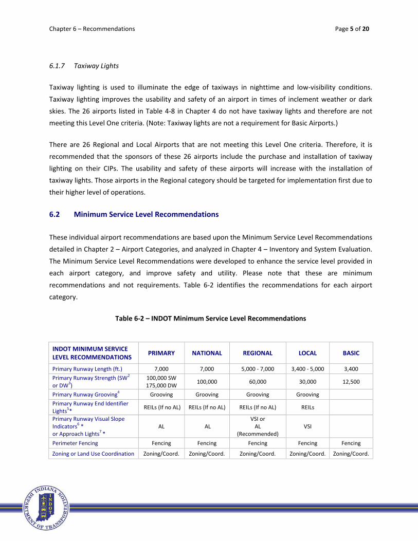
6.2 Minimum Service Level Recommendations
These individual airport recommendations are based upon the Minimum Service Level Recommendations detailed in Chapter 2 – Airport Categories, and analyzed in Chapter 4 – Inventory and System Evaluation.
The Minimum Service Level Recommendations were developed to enhance the service level provided in each airport category, and improve safety and utility. Please note that these are minimum
recommendations and not requirements. Table 6-2 identifies the recommendations for each airport category.
Table 6-2 – INDOT Minimum Service Level Recommendations
INDOT MINIMUM SERVICE LEVEL RECOMMENDATIONS PRIMARY NATIONAL REGIONAL LOCAL BASIC
Primary Runway Length (ft.) 7,000 7,000 5,000 - 7,000 3,400 - 5,000 3,400 Primary Runway Strength (SW2 or DW3)
100,000 SW 175,000 DW 100,000 60,000 30,000 12,500
Primary Runway Grooving4 Grooving Grooving Grooving Grooving Primary Runway End Identifier Lights5* REILs (If no AL) REILs (If no AL) REILs (If no AL) REILs
Primary Runway Visual Slope Indicators6 * or Approach Lights7 *
AL AL VSI or
AL (Recommended)
VSI
Perimeter Fencing Fencing Fencing Fencing Fencing Fencing
Zoning or Land Use Coordination Zoning/Coord. Zoning/Coord. Zoning/Coord. Zoning/Coord. Zoning/Coord.
Chapter 6 – Recommendations Page 6 of 20
6.2.1 Primary Runway Length
A recommended primary runway length was developed for each airport category. It is important to note
that actual runway length needed is based upon the performance characteristics of the most demanding aircraft type intending to use an airport. Table 4-8 Chapter 4 includes several airports that do not meet the recommended general runway length target for their airport category and several that are at the
lower end of their range. Should any of these airports have a need to increase their runway length based on local conditions and their most demanding aircraft, INDOT should support these extensions based on
documented justification provided by the airport sponsor.
6.2.2 Primary Runway Strength
Runway should be constructed to a strength that provides adequate support for the loads imposed by
the full range of aircraft using the airport. Table 4-11 in Chapter 4 includes several airports that do not meet the runway strength recommendation for their respective airport category. As the sponsors of
these airports seek funds to overlay or reconstruct their primary runways, INDOT should determine the benefit of increasing the strength of those runways based on current aircraft types using the airport in addition to aircraft types expected in the future. Proper pavement strength design represents the most
economical solution for long-term aviation needs.
6.2.3 Primary Runway Grooving
Runway pavement should provide a surface that is not slippery and will provide good traction during any
weather conditions. Table 4-12 in Chapter 4 identifies several Regional and Local airports that do not have grooving on their primary runway. The sponsors of these airports should seek to include runway
grooving in their CIP request where it may logically fit based on the project (e.g., runway overlay). Those airports with commercial service and based turbojet aircraft should be target first for funding by INDOT.
6.2.4 Primary Runway Approach Lights, Visual Slope Indicators, and Runway End Identifier Lights
Tables 4-13 and 4-14 in Chapter 4 identify airports with primary runways that do and do not have
Approach Lights, Visual Slope Indicators, and Runway End Identifier Lights. All Primary, National, Regional and Local airports should have one or more of these systems on their primary runway depending on their
airport category. Airport sponsors not meeting the recommendations for their respective airport category should include the appropriate navigational aid in their CIP. Those airports with the highest
instrument operations should be targeted first by INDOT for funding.

Chapter 6 – Recommendations Page 7 of 20
6.2.5 Perimeter Fencing and Zoning
Tables 4-15 and 4-16 in Chapter 4 include several airports that do not have the perimeters of their
airports fenced. Perimeter fencing is recommended for all ISASP airports. Accordingly, airport sponsors that do not have fencing should include fencing in their CIP requests to INDOT. Those airports with documented wildlife concerns or incursions into the airport operations area by unauthorized vehicles
should be targeted for funding first.
Zoning is also recommended for all airports. While overlay zoning that protects the airport’s approach
and departure airspace from tall structures and the airport in general from incompatible land uses is preferential, this is sometimes out of the airport sponsor’s control to implement. In these cases, airport sponsors should seek some type of coordination with local officials to address incompatible land uses.
This could be in the form of a memorandum of understanding (MOU). INDOT should include on its website samples of recommended zoning ordinances and MOU templates for airport sponsors without
zoning to follow. INDOT should also annually advise by letter all zoning and planning commissions in the state of the existence and local requirements outlined in Indiana’s Regulation of Tall Structures, IC 8-10-
10.
6.3 Minimum Vertically Guided Instrument Approach Procedure (IAP) Recommendations
Minimum Vertically Guided IAP Recommendations were made for each airport category as detailed in
Chapter 2 – Airport Categories, and analyzed in Chapter 4 – Inventory and System Evaluation. Table 6-3 outlines these recommendations.
Chapter 6 – Recommendations Page 8 of 20
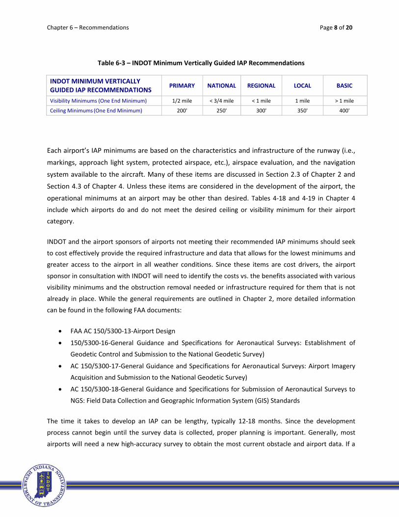
Table 6-3 – INDOT Minimum Vertically Guided IAP Recommendations
INDOT MINIMUM VERTICALLY GUIDED IAP RECOMMENDATIONS PRIMARY NATIONAL REGIONAL LOCAL BASIC
Visibility Minimums (One End Minimum) 1/2 mile < 3/4 mile < 1 mile 1 mile > 1 mile
Ceiling Minimums (One End Minimum) 200' 250' 300' 350' 400'
Each airport’s IAP minimums are based on the characteristics and infrastructure of the runway (i.e.,
markings, approach light system, protected airspace, etc.), airspace evaluation, and the navigation
system available to the aircraft. Many of these items are discussed in Section 2.3 of Chapter 2 and
Section 4.3 of Chapter 4. Unless these items are considered in the development of the airport, the
operational minimums at an airport may be other than desired. Tables 4-18 and 4-19 in Chapter 4
include which airports do and do not meet the desired ceiling or visibility minimum for their airport category.
INDOT and the airport sponsors of airports not meeting their recommended IAP minimums should seek
to cost effectively provide the required infrastructure and data that allows for the lowest minimums and greater access to the airport in all weather conditions. Since these items are cost drivers, the airport
sponsor in consultation with INDOT will need to identify the costs vs. the benefits associated with various visibility minimums and the obstruction removal needed or infrastructure required for them that is not
already in place. While the general requirements are outlined in Chapter 2, more detailed information can be found in the following FAA documents:
• FAA AC 150/5300-13-Airport Design
• 150/5300-16-General Guidance and Specifications for Aeronautical Surveys: Establishment of Geodetic Control and Submission to the National Geodetic Survey)
• AC 150/5300-17-General Guidance and Specifications for Aeronautical Surveys: Airport Imagery Acquisition and Submission to the National Geodetic Survey)
• AC 150/5300-18-General Guidance and Specifications for Submission of Aeronautical Surveys to
NGS: Field Data Collection and Geographic Information System (GIS) Standards
The time it takes to develop an IAP can be lengthy, typically 12-18 months. Since the development process cannot begin until the survey data is collected, proper planning is important. Generally, most
airports will need a new high-accuracy survey to obtain the most current obstacle and airport data. If a

Chapter 6 – Recommendations Page 9 of 20
runway is to be extended at a particular airport, care should be taken to ensure the appropriate surveys are obtained for maintaining or upgrading any airport’s IAP. The options for funding these types of
surveys should be identified in the airport’s CIP to INDOT.
6.4 General Recommendations - Maintaining and Increasing Indiana’s Competitive Edge: Meeting the Challenge
In addition to individual airport recommendations, this ISASP update includes general recommendations
for INDOT. To meet Indiana’s air transportation needs, the state must be served by a strategically developed, located, and diversified airport system, and this requires capital investment, innovative and
forward thinking, in addition to a commitment to the advancement of Indiana’s aviation system on the federal, state, and local levels. INDOT can lead the way for this system by supporting its future in several
critical ways.
6.4.1 NEXTGEN and Automatic Dependent Surveillance-Broadcast (ADS-B) Services
NextGen is the FAA’s term for its movement to the next generation of air traffic control and navigation by shifting from a ground-based to a satellite-based system using digital technologies. ADS-B is part of this
technology that will transform air traffic control from the current radar-based system to the satellite-based one.
ADS-B uses Global Positioning System (GPS) signals and aircraft avionics
to transmit an aircraft’s location to ground receivers. ADS-B broadcasts a composite of radar and ADS-B information from equipped aircraft back
through ground stations to the aircraft cockpit, so the pilot sees what the controller sees. Aircraft with ADS-B equipped avionics can see all aircraft
in radar contact with controllers within 15 miles. ADS-B also shares graphical weather including thunderstorms and information on
significant and hazardous weather, winds and temperatures aloft, pilot reports, special use airspace, and temporary flight restrictions. This type
of situational awareness has never been available to pilots before, and can markedly improve safety and utility in all segments of aviation. Nationwide coverage by ADS-B is scheduled to be in place by 2013.
NextGen also has provided the technology for Localizer Performance with Vertical Guidance (LPV) instrument approach procedures that can be flown by equipped aircraft down to a decision altitude as
ADS-B Antenna at TYQ
Chapter 6 – Recommendations Page 10 of 20
low as 200 feet above the runway. These approaches are flown much like the traditional Instrument Landing System (ILS) approach, but airports do not have to install and maintain expensive ground-based
equipment.
As NextGen brings opportunities like ADS-B in the cockpit, improved instrument approach at airports, reduced airport congestion, and more efficient aircraft flight partners, INDOT should strive to ensure
ISASP airports are in a position to receive the most benefit when the FAA implements new technology. However, INDOT should also stay abreast of the impact of the FAA’s decision to substantially reduce the
number of ground-based navigational aids.
The FAA is planning a gradual discontinuance (removal from service) of VOR facilities in CONUS (the conterminous U.S.) to a minimum operational network (MON). The MON
would enable aircraft anywhere in the CONUS to proceed safely to a destination with a GPS-independent approach within 100 nm. MON coverage is planned to be provided at
altitudes above 5,000 feet above ground level (AGL).2
While the decommissioning of VOR facilities will save the FAA a significant amount of money, it does come with an impact to Indiana airports. It cancels redundancy in case of GPS signal outage at low
altitudes if only available above 5,000 feet AGL. Accordingly, INDOT should investigate and fully understand the potential impacts to ISASP airports and their navigational coverage if/when a GPS signal
outage occurs.
6.4.2 Unmanned Aerial Vehicles (UAVs)
UAVs come in many shapes and sizes. They can be as large as a Boeing 737 or smaller than a radio-
controlled model airplane. Although they share many similarities to manned aircraft, they are inherently different. In the FAA Modernization and Reform Act of 2012, Congress directed the FAA to establish a
program to integrate UAVs into the national airspace system at six test ranges. Indiana’s National Center for Complex Operations (NCCO), which acts as a center to connect federal, state, and private parties with
interests in the defense industry, announced in 2012 Indiana’s partnership with Ohio to pursue a designation as one of the six FAA test sites for testing UAVs. UAVs will benefit municipalities and private
2Federal Register Volume 76, Number 241, www.federalregister.gov/articles/2011/12/15/2011-31451/proposed-provision-of-navigation-services-for-the-next-generation-air-transportation-system-nextgen, accessed 4-17-13.
Chapter 6 – Recommendations Page 11 of 20
industry, which is already incorporating them into such areas as law enforcement, agriculture operations, and surveying.
While UAVs come with their share of controversy regarding privacy issues, these systems will likely share airspace with Indiana’s traditional aircraft in the near future. They are relatively affordable, easy to transport, and simple to launch. UAVs have been tested by the Washington State Department of
Transportation (DOT) for use as an avalanche control tool on mountain slopes and by the Florida DOT for use in monitoring remote areas of that state. The Virginia DOT has tested their feasibility for use in real-
time traffic surveillance, monitoring traffic incidents and signals, and environmental condition assessment of roadsides. Additionally, the Utah DOT has used them to take pictures of highways to
inventory their features and conditions for use in geographic information systems (GIS) databases.
Recently, the Ohio legislature passed a bill that gives the DOT authority to conduct testing of UAVs, partner with other in-state agencies and share information, and to partner with agencies in Indiana.
Accordingly, INDOT should monitor UAV technology to determine where this equipment can be used to enhance the Aviation Section’s products and services while also assisting where needed with safe
integration into Indiana’s airspace.
Additionally, with INDOT’s mission to “plan, build, maintain and operate a superior transportation system enhancing safety, mobility, and economic growth”3 there is an opportunity for the agency to help foster
the responsible growth of UAVs into Indiana airspace because of their potential economic impact to the state. The Association for Unmanned Vehicle System International (AUVSI) reported in early 2013 that
Indiana is projected to create over 1,000 jobs in this area in the next three years and that the economic impact could be $208 million in the same timeframe.4
6.4.3 Airspace Awareness
Airspace awareness is vital to the utility of our airports and to preservation of navigable airspace. As discussed above with UAVs, there are more and more competing needs for Hoosier airspace. While
Indiana and the U.S. have regulations for the preservation of this airspace (IC 8-21-10, Regulation of Tall Structures, and FAR Part 77, Objects that Affect Navigable Airspace, respectively), pressures on airspace
3 Indiana Department of Transportation, INDOT Mission, Goals, Values, www.in.gov/indot/2341.htm, accessed 4-10-13. 4 The Association for Unmanned Vehicle System International (AUVSI), The Economic Impact of Unmanned Aircraft Systems Integration in The United States, www.auvsi.org/econreport, accessed 4-10-13.
Chapter 6 – Recommendations Page 12 of 20
use still exist. Finding a site to locate a communications tower, a wind turbine, or a high-rise building can be challenging and costly. INDOT should seek to find ways to increase airspace awareness and provide
technical assistance in site location so structures do not impede or decrease the utility of the airport system. Sister states (e.g., Kansas DOT) have developed web-based tools using platforms like Google
Earth to offer visual representation of restricted airspace around airports and airways. Efforts like these assist in early site assessment, allowing developers to focus on airspace compatible locations for
development.
6.4.4 Asset Maintenance/Preservation
The biggest asset of Indiana’s transportation network is first and foremost pavement. It is the foundation upon which most of our modes of transportation travel at one point or another. Be it pavement on a
highway, runway, taxiway, or bike lane, pavement helps keep Hoosiers mobile. In a state with the freeze and thaws that come with harsh winter conditions, maintaining this pavement can be a big job.
Another challenge for the Hoosier transportation system is geology. Southern Indiana is home to two well-developed areas of karst landscape (Mitchell Plateau and Muscatatuck Plateau) which is characterized by sinkholes.5 These geological features can cause problems for airports. Additionally, old
coal mines in Indiana located in the west/southwest portion of the state can cause the same type of problems. Sinkholes near the Monroe County Airport in Bloomington revealed voids under the runway
from Karst geology. Abandoned coal mines in Terre Haute resulted in the collapse of an aircraft apron in 2004.
While fixes for both of these airports are planned or underway, similar problems have the potential to
impact other airports in the ISASP. Our airports could benefit from INDOT’s commitment to research and development in the way our highways have benefited. The mission of INDOT’s Research and
Development is “to conduct, oversee and partner in cost-effective transportation research and development that benefits” their customers.”6 Part of this program includes “Specialized Testing,” which
provides services related to pavements and structures for data-driven decision-making and to minimize risks. INDOT’s types of specialized tests that can benefit ISASP airports are ground-penetrating radar
5 Indiana Geological Society, Karst in Indiana, igs.indiana.edu, accessed 4-8-13.
6 INDOT Research And Development, http://www.in.gov/indot/2700.htm, accessed 5-8-13
Chapter 6 – Recommendations Page 13 of 20
(GPR) and other nondestructive testing like falling weight deflectometers (FWD). These types of technologies can detect where underground voids and water/moisture may be a problem and examine
subsurface conditions of pavement to assist in determining resurfacing priorities and providing safe runways for the traveling public. They also reduce the amount of destructive testing required and runway
closure times.
6.4.5 Infrastructure Investment
In 2012, the FAA Modernization and Reform Act
increased the required match from 5% to 10% for most Federal grants from the Airport Improvement Program. While for the vast amount of INDOT’s
history it had historically split this match with the local airport sponsor, more recent matching amounts
from INDOT have been as low as 1.25%.
According to the 2010 Report Card for Indiana’s Infrastructure by the American Society of Civil
Engineers, “Airports in Indiana are facing enormous infrastructure decay. With reduced funding sources
and more competition for discretionary funding sources, Indiana’s airport leaders will need to turn to
new funding techniques if they are to continue to provide an efficient and effective means of air travel
that will meet the needs in the future.”7 These needs were echoed in the funding chapter of this report.
Many states face the same airport infrastructure needs and funding shortfalls as Indiana. As a result,
some states have become innovative in their approach to funding airport projects. To ensure
Indiana can continue to compete for economic
7 American Society of Civil Engineers, 2010 Report Card for Indiana’s Infrastructure, www.inasce.org/images/ Report%20Card%20Final.pdf, accessed 4-17-13
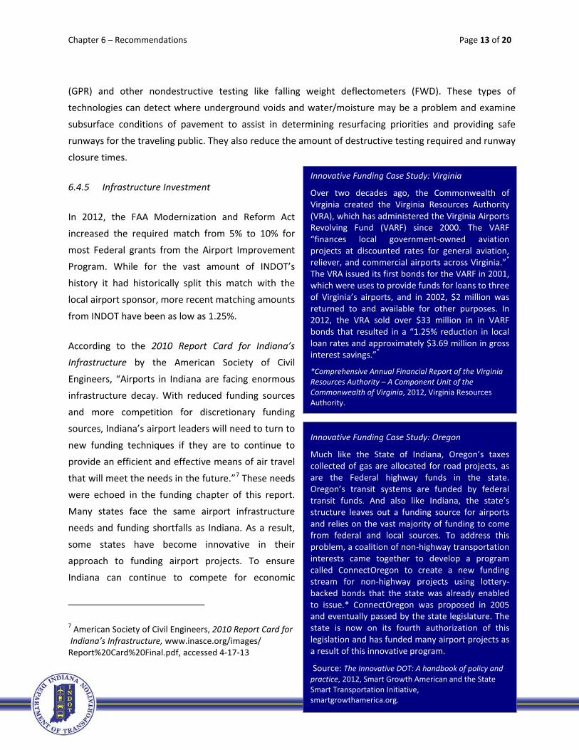
Innovative Funding Case Study: Virginia
Over two decades ago, the Commonwealth of Virginia created the Virginia Resources Authority (VRA), which has administered the Virginia Airports Revolving Fund (VARF) since 2000. The VARF “finances local government-owned aviation projects at discounted rates for general aviation, reliever, and commercial airports across Virginia.”* The VRA issued its first bonds for the VARF in 2001, which were uses to provide funds for loans to three of Virginia’s airports, and in 2002, $2 million was returned to and available for other purposes. In 2012, the VRA sold over $33 million in in VARF bonds that resulted in a “1.25% reduction in local loan rates and approximately $3.69 million in gross interest savings.”*
*Comprehensive Annual Financial Report of the Virginia Resources Authority – A Component Unit of the Commonwealth of Virginia, 2012, Virginia Resources Authority.
Innovative Funding Case Study: Oregon
Much like the State of Indiana, Oregon’s taxes collected of gas are allocated for road projects, as are the Federal highway funds in the state. Oregon’s transit systems are funded by federal transit funds. And also like Indiana, the state’s structure leaves out a funding source for airports and relies on the vast majority of funding to come from federal and local sources. To address this problem, a coalition of non-highway transportation interests came together to develop a program called ConnectOregon to create a new funding stream for non-highway projects using lottery-backed bonds that the state was already enabled to issue.* ConnectOregon was proposed in 2005 and eventually passed by the state legislature. The state is now on its fourth authorization of this legislation and has funded many airport projects as a result of this innovative program.
Source: The Innovative DOT: A handbook of policy and practice, 2012, Smart Growth American and the State Smart Transportation Initiative, smartgrowthamerica.org.
Chapter 6 – Recommendations Page 14 of 20
growth, INDOT should search for innovative ways to restore a 50/50 match to federal AIP projects, reinstate the Indiana State Local Airport Development Program, and fund their Airport Revolving Loan
Program.
6.4.6 Air Traffic Control
Most of the airports in the ISASP are not served by an air traffic control (ATC) tower. In fact, the vast
majority of airports in the United States function this way, and thousands of safe operations are conducted each day at these airports. ATC towers do, however, add a layer of safety to operations at
busier airports even if they do not provide regularly scheduled air carrier services from the airlines.
ISASP facilities like Terre Haute International or Columbus Regional have ATC towers without airline service. Sometimes these facilities are in place because the airport serves a significant amount of flight
training, military operations, or turbine aircraft during inclement weather. Regardless of the reason, these towers are expensive to operate, and the automatic spending cuts that can happen as a result of
the Budget Control Act (referred as sequester or sequestration) may result in closure of several of these facilities. For this reason and because existing non-towered airports have a desire to increase their margin of safety by adding ATC services, INDOT should support inventive ways to fund and support ATC
service at non-towered airports. While remote air traffic services have not yet been approved for use in the U.S. by the FAA, it has been developed and tested and is moving into operational use in Sweden and
Australia.8 Additionally, the FAA’s Wide-Area Multilateration (WAM) project is now allowing air traffic controllers to track aircraft in the mountainous areas of Alaska where radar is not possible. Additionally,
in 2006 the Colorado DOT partnered with the FAA for a project to plan, install, test, and commission a surveillance system for the Colorado mountain airports.9 Note: WAM is being used in the near-term while
the FAA implements ADS-B nationwide. WAM will then be used as a backup to ADS-B in case of a GPS outage, and also provide an additional surveillance source for ADS-B traffic broadcasts sent to
appropriately equipped aircraft.10
INDOT should attempt to take advantage of Indiana’s “emphasis on the automotive, life sciences, energy, and national security industry sectors,” and support of “companies involved in advanced manufacturing,
8 SAAB Group, Remote Tower: Control Several Airports from a Single Location. www.saabgroup.com, accessed 4-8-13. 9 Wide Area Mulitlateration (WAM) Project, FAA, www.faa.gov/nextgen/implementation/programs/adsb/wsa/wam/ accessed 4-8-2013. 10 Ibid.

Chapter 6 – Recommendations Page 15 of 20
logistics, information technology and research and development” by supporting development and partnerships with public and private entities interested in advancing these areas where they stand to
benefit Indiana’s airport system.11
Also important to Indiana’s airports and the entire country’s aviation industry is the Indianapolis Air Traffic Control Center (ARTCC). One of 21 en-route centers across the U.S., the Indianapolis ARTCC
provides radar and nonradar control and advisory services to aircraft operating on both visual and
instrument flight rules (VFR and IFR) plans over an area of approximately 73,000 square miles, including spacing services to Chicago O’Hare airport and all traffic crossing through America’s heartland.12
There are currently over 500 employees in the Center, with a variety of backgrounds and
skills. They include air traffic control, electronics, computer science, telecommunications, meteorology, management, personnel, secretarial services, training, logistics,
evaluations, electrical, heating, plumbing, refrigeration, security, food services, janitorial, and others. All these skills are required to ensure a smooth operation of the air
traffic system. There are over 350 operational controllers, which include both certified professional controllers and developmental level controllers.13
Considering the economic, employment, and aviation impact of this facility, INDOT should seek to
educate the general public on its importance and assist wherever needed in promoting its continued location in the Hoosier state.
6.4.7 Real-time Weather
While on-airport weather reporting in the form of FAA-approved AWOS or ASOS equipment is included in
the individual airport recommendations, INDOT could look to supplement this tool like they have on road surfaces. Its “Road Weather Sensors Map” provides up-to-date weather information for multiple roads
throughout Indiana that are equipped with INDOT’s Road Weather Information System (RWIS) technology.14 The RWIS includes surface and sub-surface temperature. While the AWOS is capable of
providing this type information, most are not equipped to do so unless they are at large airports served by the commercial airlines. Indiana airport users may be able to benefit from information for RWIS
11 Indiana Economic Development Corporation, Programs and Initiatives, www.iedc.in.gov, accessed 4-8-2-13. 12 Facility Orientation Guide, Indianapolis ARTCC, Indianapolis, Indiana, Federal Aviation Administration. 13 ibid. 14 INDOT Road Weather Sensors, http://netservices.indot.in.gov/rwis/default.asp, accessed 4-17-13.
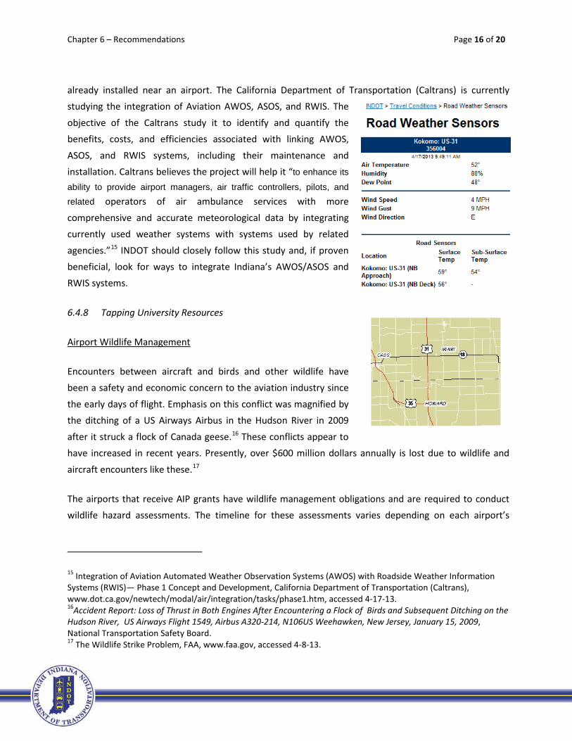
Chapter 6 – Recommendations Page 16 of 20
already installed near an airport. The California Department of Transportation (Caltrans) is currently studying the integration of Aviation AWOS, ASOS, and RWIS. The
objective of the Caltrans study it to identify and quantify the benefits, costs, and efficiencies associated with linking AWOS,
ASOS, and RWIS systems, including their maintenance and installation. Caltrans believes the project will help it “to enhance its
ability to provide airport managers, air traffic controllers, pilots, and related operators of air ambulance services with more
comprehensive and accurate meteorological data by integrating currently used weather systems with systems used by related
agencies.”15 INDOT should closely follow this study and, if proven beneficial, look for ways to integrate Indiana’s AWOS/ASOS and RWIS systems.
6.4.8 Tapping University Resources
Airport Wildlife Management
Encounters between aircraft and birds and other wildlife have been a safety and economic concern to the aviation industry since
the early days of flight. Emphasis on this conflict was magnified by the ditching of a US Airways Airbus in the Hudson River in 2009
after it struck a flock of Canada geese.16 These conflicts appear to have increased in recent years. Presently, over $600 million dollars annually is lost due to wildlife and
aircraft encounters like these.17
The airports that receive AIP grants have wildlife management obligations and are required to conduct wildlife hazard assessments. The timeline for these assessments varies depending on each airport’s
15 Integration of Aviation Automated Weather Observation Systems (AWOS) with Roadside Weather Information Systems (RWIS)— Phase 1 Concept and Development, California Department of Transportation (Caltrans), www.dot.ca.gov/newtech/modal/air/integration/tasks/phase1.htm, accessed 4-17-13. 16Accident Report: Loss of Thrust in Both Engines After Encountering a Flock of Birds and Subsequent Ditching on the Hudson River, US Airways Flight 1549, Airbus A320-214, N106US Weehawken, New Jersey, January 15, 2009, National Transportation Safety Board. 17 The Wildlife Strike Problem, FAA, www.faa.gov, accessed 4-8-13.

Chapter 6 – Recommendations Page 17 of 20
certification and/or based aircraft and operations18. These wildlife assessments are expensive and time-consuming, often resulting in more expensive recommendations for airport improvements.
INDOT has a Program Development Division that is responsible for the “collection, analysis and reporting of traffic statistical data and traffic projection, crash data, bridge inspection data, road physical features inventory” and “oversees the development and implementation of statewide management systems of
pavement, bridge, congestion, safety and traffic monitoring”19. To date, these activities have neglected airports and their safety issues. In addition to crash data collection and analysis, in 2006 INDOT partnered
with Purdue University and the Federal Highway Administration on the evaluation of wildlife reflectors in reducing vehicle-deer collisions on Indiana Interstate 80/90.
Indiana universities like Purdue and Indiana State University have a wealth of expertise on aviation and
wildlife20 that could be coupled with INDOT support to greatly increase flying safety. Partnerships like the above with Purdue or other Indiana universities and the FAA could help in finding ways and means to
reduce accidents, injuries, fatalities, and financial losses resulting from wildlife encounters around airports. Additionally, including airports in INDOT’s other crash data analysis could also increase our
knowledge on airport safety and potential trends and solutions.
Alternative Fuels
As with most other modes of transportation, aviation is experiencing pressures to find alternative fuel
sources. Airports, airlines, the military, and federal and local governments all understand the motives for alternative fuels including economic, operational, and environmental reasons. There are many ways that INDOT can participate in and offer support to the development and distribution of alternative fuels at
Hoosier airports. One way is to support industry and university initiatives in finding alternative fuel sources for aircraft and developing storage and dispensing systems at airports.
18 Clarification of Wildlife Hazard Management Requirements for Non-Certificated Federally Obligated Airports in the National Plan of Integrated Airport Systems (NPIAS), Federal Register Notice Of Proposed Clarification Of Airport Improvement Program Grant Assurances And Opportunity To Comment, FR Doc. 2012-29591 Filed 12-7-12; 8:45 am. 19Indiana Department of Transportation, About INDOT>Central>Division>Program Development, www.in.gov/indot, accessed 4-8-13. 20 Blackwell, B. F., DeVault, Seamans, Lima, Baumhardt, and Fernández-Juricic, Exploiting avian vision with aircraft lighting to reduce bird strikes. Journal of Applied Ecology, Volume 49, August 2012.
Chapter 6 – Recommendations Page 18 of 20
The National Test Facility for Fuels and Propulsion, located in the Niswonger Aviation Technology Building at the Purdue University Airport, includes a “state-of-the-art fuel and material test and evaluation center
capable of conducting advanced fuels research in the fields of emissions, material compatibility, and endurance.”21 With testing experience and fuel knowledge, INDOT could support the use of labs like this
in researching and analyzing the infrastructure needed to store and distribute alternative fuels at Indiana airports. Additionally, the Purdue Research Park offers another potential resource in bringing alternative
fuels to Hoosier airports and aircraft. Swift Enterprises, located at this park, can perform extensive laboratory exploration because of its partnership with Purdue and is currently pursuing the development
of unleaded aviation gasoline and renewable jet fuel.
Additionally, the Indiana Biomass Energy Working Group is working to bring alternative fuel to aviation. The Working Group is “a consortium of stakeholders from the industry, state and federal government,
trade organizations, universities and citizenry working together to create a climate in the state of Indiana that would foster the growth of a viable renewable energy industry, protect our environment, provide
energy security and green jobs in our communities.”22 In early 2013, the Working Group hosted the conference Spotlight on Biofuels Development for the Aviation Sector and New Biomass Energy
Development in Indiana with the goal of bringing awareness to Indiana about the possibilities of biofuels in aviation.
The potential environmental benefits and economic impact of alternative fuels in the aviation industry
are impressive and attractive. INDOT’s encouragement for further exploration of alternative aviation fuels and support of the airport infrastructure needed for such fuels will improve ISASP airports and
overall state economic growth.
Aviation Technical Education and Training
According to an employer survey conducted in 2013 by the Indiana Chamber of Commerce, 71% of employees lack applied skills, 36% fall short on academic skills (math, reading, writing, English, etc.), 35%
are missing computer skills, 25% need on-the-job training, and 21% require certification.23 These skills are
21 Purdue University College of Technology, Aviation Technology, About NAFET, www.tech.purdue.edu/at/NATEF/Facilities/index.cfm, accessed 4-10-13. 22 Indiana Biomass Energy Working Group, Mission Statement, http://extension.purdue.edu/renewable-energy/indiana-biomass-working-group.shtml, accessed 4-10-13. 23Indiana Chamber of Commerce, Employer Survey: Skills Gap Remains Major Concern, www.indianachamber.com/index.php/employer-survey-skills-gap-remains-major-concern, accessed 4-10-13.
Chapter 6 – Recommendations Page 19 of 20
also missing on the national level. The U.S. Department of Labor awarded a $14 million grant to the National Aviation Consortium (NAC) to provide accelerated training to more than 2,500 students to fill
current jobs in five states, including Indiana.24
According to the Aviation Week 2010 Workforce Study, the average age for production/nonexempt employees in the aerospace industry is 47 (for companies with between 1,000 and 9,999 employees). By
2014, over 25 percent of these employees will be eligible for retirement. 25 According to AAR Corp., a global aerospace industry leader, current and future skills gaps result in slower growth, high on-the-job
training costs, and decreased productivity. “AAR will pay upwards of $225,000 to train 75 airframe sheet metal technicians at its Indianapolis aircraft maintenance center.”26 The company needs to double its
workforce in the next year to support its Indianapolis services, but the talent pool is missing.
Four universities in Indiana that provide aviation related education and training: Purdue University, Indiana State University, Vincennes University, and Ivy Tech Community College. Ivy Tech is one of the
partners assisting with the training provided by the grant given to the NAC. With the Governor’s emphasis on vocational and technical education programs and the need for specialized aviation industry
skills, these institutions could serve as key players in filling skills gaps in the state.
Sister state DOTs have realized the importance of aviation education and taken on educational initiatives. The Wisconsin DOT assists with a summer employment and learning opportunity program for high school
students. This program, which is a result of a partnership between industry, schools and government, offers high-school students real world experiences in aviation-related jobs.27 Previous employers have
included Aircraft Service International Group, Southwest Airlines, Signature Flight Support, and the Transportation Security Administration. INDOT could spearhead or support outreach initiatives like this
with Indiana aviation companies and airports to assist in attracting Indiana students to our state’s aviation industry.
24The Manufacturing Institute, Press Release, Over $14 million in Funding Announced for Aviation Education Programs, www.themanufacturinginstitute.org/~/media/A669DCE4A4964E0E99BFA79AF04B85E2/ DOL_TAACCCT_Awards_Aviation_Release.pdf, accessed 4-10-13 25 Aviation Week 2010 Workforce Study, aerospaceblog.files.wordpress.com/2010/08/2010_corp_wf _study_final.pdf, accessed 4-10-13 26 AAR Corp., The Mid-Skills Gap in Middle America, www.aarcorp.com/mid-skills/files/aar_midskills_report_102011.pdf, accessed 4-10-13. 27 Wisconsin DOT, Aviation Careers Education (ACE), www.dot.wisconsin.gov/travel/air/ace.htm, accessed 4-10-13.
Chapter 6 – Recommendations Page 20 of 20
Safety Management Systems
The use of Safety Management Systems (SMS) at airports can help “detect and correct safety problems
before they result in aircraft accidents or incidents”.28 Under the FAA’s SMS program, formalized safety risk management will be incorporated into FAA AIP-funded airport projects. Accordingly, SMS will become a standard process in all ISASP airport planning and development.
In relation to safety, in late 2012, the FAA selected a team of universities to lead a new Air Transportation Center of Excellence (COE) for general aviation called the FAA Center of Excellence Partnership to
Enhance General Aviation Safety, Accessibility and Sustainability (PEGASAS). Purdue University was one of the three universities selected to lead the Center, and it teamed with several industry and organizational partners, some of which were from Indiana including the firm Woolpert, the South Bend
and Fort Wayne airports, and INDOT.
With safety as part of the core mission of PEGASAS and INDOT as its partner, there is tremendous
opportunity for Indiana to be a leader in general aviation safety. INDOT should look for ways to benefit from the PEGASAS project and Purdue’s Department of Aviation Technology experience and knowledge of SMS to enhance the safety of Indiana’s transportation system.
6.8 Summary
Airport sponsor and INDOT emphasis should first be placed on projects that assist and airport in meeting Level 1 criteria. Projects that meet Minimum Service Level and IAP recommendations should also be
considered as important and be a secondary focus for airports to attain. Additionally, INDOT should look for ways to capitalize on the successes it has achieved with highways by implementing the same or
similar technology and processes on airports. While these types of initiatives are pursued, INDOT should also look for innovative ways and leadership roles to help Hoosier airports seek and attract and retain
business that provides for economic growth for Hoosier communities.
28 Safety Management Systems (SMS) for Airports, FAA, www.faa.gov/airports/airport_safety/safety_management_systems/, accessed 4-17-13.
Related Documents