Project for Assessing and Integrating Climate Change Impacts into the Water Resources Management Plans for Brantas and Musi River Basins (Climate Change Impact Assessment and Hydrological Simulation) Final Report The University of Tokyo Nippon Koei Co., Ltd. CHAPTER 5 CONCLUSION AND RECOMMENDATION

Welcome message from author
This document is posted to help you gain knowledge. Please leave a comment to let me know what you think about it! Share it to your friends and learn new things together.
Transcript
Project for Assessing and Integrating Climate Change Impacts into the Water Resources Management Plans
for Brantas and Musi River Basins (Climate Change Impact Assessment and Hydrological Simulation)
Final Report
The University of Tokyo
Nippon Koei Co., Ltd.
CHAPTER 5
CONCLUSION AND RECOMMENDATION

Project for Assessing and Integrating Climate Change Impacts into the Water Resources Management Plans for Brantas and Musi River Basins (Climate Change Impact Assessment and Hydrological Simulation)
Final Report CHAPTER 5 CONCLUSION AND RECOMMENDATIONHERS
The University of Tokyo Nippon Koei Co., Ltd.
5-1
CHAPTER 5 CONCLUSION AND RECOMMENDATION 5.1 Climate Change Impact Assessment on Water Cycle
5.1.1 General Remarks There are uncertainties in projected future conditions. Therefore, there should be careful
consideration of such uncertainties when using these findings, and it is important to test the sensitivity of adaptation decisions to a plausible range of climate change projections. In addition, even using current state-of the-art techniques, the uncertainty bounds were found to be large.
The climate in Indonesia is dominated by the ITCZ and conditions of the Pacific and Indian Oceans. Rainfall will be affected by changes in the ENSO or IOD and their effects on monsoon variability. Therefore, it is important to know how ENSO and IOD cycles will change in the future. Their effects are complex and not well understood, but scientists continue to study and characterize them. According to the Intergovernmental Panel on Climate Change (IPCC) Working Group I Contributions to the Fifth Assessment Report, the ENSO cycle will remain the dominant pattern of global interannual climate variability in the future. There is no strong indication that the form of ENSO events will change in the future, but rainfall variability associated with ENSO is likely to increase in the future. 5.1.2 Summary in Brantas River Basin (1) Impact on Water Resources
i. There is a relatively high degree of agreement among GCMs about the future direction of drought conditions over the entire basin. The ensemble mean change of low flows is around -15% by the 2050s, indicating severe drought conditions in the future climate.
ii. There is a relatively high degree of agreement among GCMs about the future direction of flood conditions over the entire basin. The ensemble mean change of top 2% of duration curve is around 10% by the 2050s, indicating severe flooding conditions in the future climate.
(2) Impact on Flood Regime
i. The change in flood peak discharge is more significant than that of rainfall when the magnitude of the flood discharge is large, because water generally flows faster as its volume increases. The results indicate severe flooding conditions in the future climate.
ii. Projected land-use changes proved to have a negligible impact on the basin, because the change area is too small (less than 10%) to have an effect on flood discharge.
5.1.3 Summary in Musi River Basin (1) Impact on Water Resources:
i. Annual rainfall will decrease very likely. ii. Monthly averaged discharge will decrease in the first-half rainy season and the second-half
dry season, whereas will increase in the second-half rainy season and the first-half dry season.
Project for Assessing and Integrating Climate Change Impacts into the Water Resources Management Plans for Brantas and Musi River Basins (Climate Change Impact Assessment and Hydrological Simulation)
Final Report CHAPTER 5 CONCLUSION AND RECOMMENDATIONHERS
The University of Tokyo Nippon Koei Co., Ltd.
5-2
iii. Low flow discharge will likely decrease, whereas high flow discharge will likely increase. iv. It is very likely that the drought period will become longer in future v. The changes in ET and soil moisture, which are closely related with rice production, are very
small. (2) Impact on Flood Regime
i. The range of projected flood changes is very wide. A scenario approach is effective for adaptation planning.
5.2 Climate Change Impact Assessment on Food Production in Musi River Basin i. The yields under future climates decreased slightly in irrigated, fresh water swamp, and tidal
swamp ecotypes due to higher temperature. ii. The effect of climate change was obvious in rainfed ecotypes, in which yield was affected by
precipitation through soil moisture. iii. Larger yearly variations were predicted in the specific season production in rainfed ecotypes
under the specific GCM scenarios. In these cases, adjustments in planting dates and growth durations are necessary.
5.3 Recommendation
i. Long-term and quality data, even at a small number of stations, is indispensable for climate change impact assessments.
ii. Assessment tools and models should be selected according to data availability and quality. iii. Detailed statistical data is recommended for more precise predictions for climate change
impacts on agriculture. iv. Training is necessary in order for field surveys to obtain data used for model calibration. v. Precise field utilization maps and future projections would be recommended.
Project for Assessing and Integrating Climate Change Impacts into the Water Resources Management Plans
for Brantas and Musi River Basins (Climate Change Impact Assessment and Hydrological Simulation)
Final Report
The University of Tokyo
Nippon Koei Co., Ltd.
CHAPTER 6
OTHERS
Project for Assessing and Integrating Climate Change Impacts into the Water Resources Management Plans
for Brantas and Musi River Basins (Climate Change Impact Assessment and Hydrological Simulation)
Final Report
CHAPTER 6 OTHERS
The University of Tokyo
Nippon Koei Co., Ltd.
6-1
CHAPTER 6 OTHERS 6.1 Undertakings of the Government of Indonesia
To implement the investigation, liability on the Indonesian side is described as follows, signed in the Record of Discussions (R/D) as of November 6, 2012.
The Directorate General of Water Resources (DGWR) will take necessary measures to provide at its own expense:
(a) Services for DGWR’s counterpart and administrative personnel, as referred to in the R/D (b) Suitable office space with necessary equipment (c) Supply or replacement of machinery, equipment, instruments, vehicles, tools, spare parts,
and any other materials necessary for project implementation, other than equipment provided by the Japan International Cooperation Agency (JICA)
(d) Information and support for obtaining medical services (e) Credentials or identification cards (f) Available data (including maps and photographs) and information related to the project (g) Running expenses for project implementation (h) Expenses required for the operation and maintenance of equipment provided by JICA (i) Facilities required by members of JICA missions, for remittance and use of funds introduced
into Indonesia from Japan, in connection with project implementation 6.2 References
Literature referred to in this report is shown below.
1)Nyunt, C.T., H. Yamamoto, A. Yamamoto, T. Koike: Application of bias-correction and downscaling method to Kalu Ganga Basin in Sri Lanka, Annual Journal of Hydraulic Engineering, JSCE, Vol. 56, 2012.
2)Wang, L., T. Koike, K. Yang, T. J. Jackson, R. Bindlish, and D. Yang, Development of a distributed biosphere hydrological model and its evaluation with the Southern Great Plains Experiments (SGP97 and SGP99), J. Geophys. Res., 114, D08107, doi: 10.1029/2008JD010800, 2009.
3)Yang, K., T. Watanabe, T. Koike et al,: Autocalibration System Developed to Assimilate AMSR-E Data into a Land Surface Model for Estimating Soil Moisture and the Surface Energy Budget, Journal of the Meteorological Society of Japan, Vol. 85A, pp 229-242, 2007.
4)Tsujimoto K., Homma K., Koike T., and Ohta T.: Development of a coupled model of a distributed hydrological model and a rice growth model for grasping necessary information for rain-fed agriculture, Japan Society of Civil Engineering (JSCE), 69-4, I_511-I_516, 2013.
Project for Assessing and Integrating Climate Change Impacts into the Water Resources Management Plans
for Brantas and Musi River Basins (Climate Change Impact Assessment and Hydrological Simulation)
Final Report
CHAPTER 6 OTHERS
The University of Tokyo
Nippon Koei Co., Ltd.
6-2
5) Kumiko Tsujimoto, Koki Homma, Toshio Koike, Tetsu Ohta; Development of a coupled model of a distributed hydrological model and a rice growth model for optimizing irrigation schedule, EGU, 2013.
6)Japan International Cooperation Agency (JICA): The study on comprehensive management plan for the water resources for the Brantas River basin in the Republic of Indonesia. Volume III. Nippon Koei Co., LTD. and Nikken Consultants, Inc, 1998
7)Aldrian, E. Djamil, Y. S.: Long term rainfall trend of the Brantas catchment area, East Java, Indonesian Journal of Geography, 2006.
8)Ines, A. V. M. and Hansen, J. W.: Bias correction of daily GCM rainfall for crop simulation studies, Agricultural and Forest Meteorology, 138, pp. 44-53, 2006.
9)Feddersen, H. and Andersen, U.: A method for statistical downscaling of seasonal ensemble predictions, Tellus A, Volume 57, Issue 3, pages 398-408, 2005.
10)Sharma D, Das Gupta A, Babel MS: Spatial disaggregation of bias-corrected GCM precipitation for improved hydrologic simulation: Ping river basin, Thailand. Hydrol Earth Sys Sci 11 (4):1373–1390, 2007.
11)Hosking, J. R. M. and J. R. Wallis: Parameter and quantile estimation for the generalized Pareto distribution, Technometrics 29 (3), 339-349, 1987.
12)Madsen, H., Pearson, C. P. and Rosbjerg, D.: Comparison of annual maximum series and partial duration series methods for modeling extreme hydrologic events 2. Regional modeling, Water Resources Research 33: doi: 10.1029/96WR03849. Issn: 0043-1397, 1997.
13)Cesaraccio, C., Spano, D., Duce, P., Snyder, R. L.: An improved model for determining degree-day values from daily temperature data. Int. J. Biometeorol. 45, 161-169, 2001.
14)Yang, K., Koike, T., and Ye, B.: Improving estimation of hourly, daily, and monthly solar radiation by importing global data sets, Agricultural and Forest Meteorology, 137: 43-55, 2006.
15)Yang, K., Huang, G.-W., & Tamai, N.: A hybrid model for estimating global solar radiation, Solar Energy, 70, 13-22, 2001.
16)Todd M. Crawford and Claude E. Duchon: An improved Parameterization for estimating effective atmospheric emissivity for use in calculating daytime downwelling longwave radiation, Journal of applied meteorology, Volume 38: 474-480, 1998
Project for Assessing and Integrating Climate Change Impacts into the Water Resources Management Plans
for Brantas and Musi River Basins (Climate Change Impact Assessment and Hydrological Simulation)
Final Report Appendix
The University of Tokyo
Nippon Koei Co., Ltd.
Appendix
Appendix A Meetings and Seminars
Appendix B Field Surveys
Appendix C Training in Japan
(Climate Change Impact Assessment)
Project for Assessing and Integrating Climate Change Impacts into the Water Resources Management Plans
for Brantas and Musi River Basins (Climate Change Impact Assessment and Hydrological Simulation)
Final Report Appendix A
The University of Tokyo
Nippon Koei Co., Ltd.
Appendix A
Meetings and Seminars
A-1 Kick-off meeting and the First Seminar A-2 The Second Seminar in Jakarta and the First Seminar in
Surabaya A-3 Workshop on Assessing and Integrating Climate Change
Impacts into the Water Resources Management Plans for the Brantas and Musi River Basins (Interim Explanation-1)
A-4 Interim Explanation of Musi River Basin Outputs and Overall
Schedule of the Project (Interim Explanation-2) A-5 The Third Seminar in Jakarta and the First Seminar in
Palembang
Project for Assessing and Integrating Climate Change Impacts into the Water Resources Management Plans
for Brantas and Musi River Basins (Climate Change Impact Assessment and Hydrological Simulation)
Final Report
Appendix A-1
The University of Tokyo
Nippon Koei Co., Ltd.
A-1-1
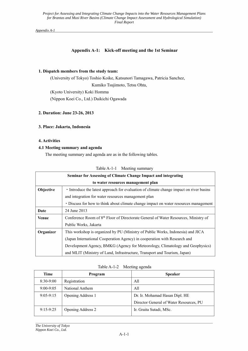
Appendix A-1: Kick-off meeting and the 1st Seminar
1. Dispatch members from the study team:
(University of Tokyo) Toshio Koike, Katsunori Tamagawa, Patricia Sanchez, Kumiko Tsujimoto, Tetsu Ohta,
(Kyoto University) Koki Homma (Nippon Koei Co., Ltd.) Daikichi Ogawada
2. Duration: June 23-26, 2013 3. Place: Jakarta, Indonesia 4. Activities 4.1 Meeting summary and agenda The meeting summary and agenda are as in the following tables.
Table A-1-1 Meeting summary Seminar for Assessing of Climate Change Impact and integrating
to water resources management plan
Objective ・Introduce the latest approach for evaluation of climate change impact on river basins
and integration for water resources management plan
・Discuss for how to think about climate change impact on water resources management
Date 24 June 2013
Venue Conference Room of 8th Floor of Directorate General of Water Resources, Ministry of
Public Works, Jakarta
Organizer This workshop is organized by PU (Ministry of Public Works, Indonesia) and JICA
(Japan International Cooperation Agency) in cooperation with Research and
Development Agency, BMKG (Agency for Meteorology, Climatology and Geophysics)
and MLIT (Ministry of Land, Infrastructure, Transport and Tourism, Japan)
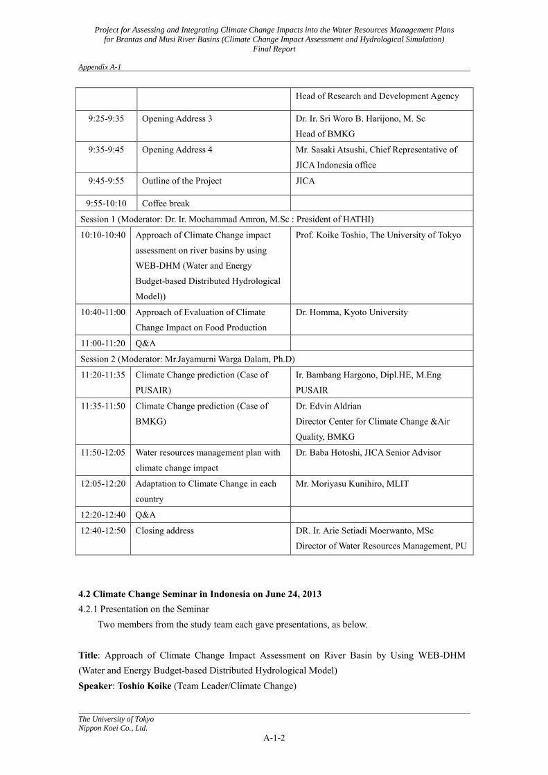
Table A-1-2 Meeting agenda Time Program Speaker
8:30-9:00 Registration All
9:00-9:05 National Anthem All
9:05-9:15 Opening Address 1 Dr. Ir. Mohamad Hasan Dipl. HE
Director General of Water Resources, PU
9:15-9:25 Opening Address 2 Ir. Graita Sutadi, MSc.
Project for Assessing and Integrating Climate Change Impacts into the Water Resources Management Plans
for Brantas and Musi River Basins (Climate Change Impact Assessment and Hydrological Simulation)
Final Report
Appendix A-1
The University of Tokyo
Nippon Koei Co., Ltd.
A-1-2
Head of Research and Development Agency
9:25-9:35 Opening Address 3 Dr. Ir. Sri Woro B. Harijono, M. Sc
Head of BMKG
9:35-9:45 Opening Address 4 Mr. Sasaki Atsushi, Chief Representative of
JICA Indonesia office
9:45-9:55 Outline of the Project JICA
9:55-10:10 Coffee break
Session 1 (Moderator: Dr. Ir. Mochammad Amron, M.Sc : President of HATHI)
10:10-10:40 Approach of Climate Change impact
assessment on river basins by using
WEB-DHM (Water and Energy
Budget-based Distributed Hydrological
Model))
Prof. Koike Toshio, The University of Tokyo
10:40-11:00 Approach of Evaluation of Climate
Change Impact on Food Production
Dr. Homma, Kyoto University
11:00-11:20 Q&A
Session 2 (Moderator: Mr.Jayamurni Warga Dalam, Ph.D)
11:20-11:35 Climate Change prediction (Case of
PUSAIR)
Ir. Bambang Hargono, Dipl.HE, M.Eng
PUSAIR
11:35-11:50 Climate Change prediction (Case of
BMKG)
Dr. Edvin Aldrian
Director Center for Climate Change &Air
Quality, BMKG
11:50-12:05 Water resources management plan with
climate change impact
Dr. Baba Hotoshi, JICA Senior Advisor
12:05-12:20 Adaptation to Climate Change in each
country
Mr. Moriyasu Kunihiro, MLIT
12:20-12:40 Q&A
12:40-12:50 Closing address DR. Ir. Arie Setiadi Moerwanto, MSc
Director of Water Resources Management, PU
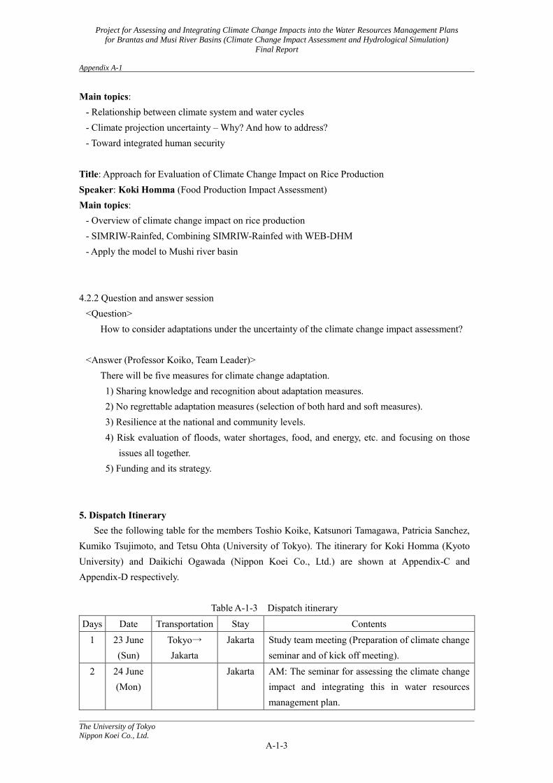
4.2 Climate Change Seminar in Indonesia on June 24, 2013 4.2.1 Presentation on the Seminar
Two members from the study team each gave presentations, as below.
Title: Approach of Climate Change Impact Assessment on River Basin by Using WEB-DHM (Water and Energy Budget-based Distributed Hydrological Model) Speaker: Toshio Koike (Team Leader/Climate Change)
Project for Assessing and Integrating Climate Change Impacts into the Water Resources Management Plans
for Brantas and Musi River Basins (Climate Change Impact Assessment and Hydrological Simulation)
Final Report
Appendix A-1
The University of Tokyo
Nippon Koei Co., Ltd.
A-1-3
Main topics: - Relationship between climate system and water cycles - Climate projection uncertainty – Why? And how to address? - Toward integrated human security
Title: Approach for Evaluation of Climate Change Impact on Rice Production Speaker: Koki Homma (Food Production Impact Assessment) Main topics:
- Overview of climate change impact on rice production - SIMRIW-Rainfed, Combining SIMRIW-Rainfed with WEB-DHM - Apply the model to Mushi river basin
4.2.2 Question and answer session <Question>
How to consider adaptations under the uncertainty of the climate change impact assessment?
<Answer (Professor Koiko, Team Leader)> There will be five measures for climate change adaptation. 1) Sharing knowledge and recognition about adaptation measures. 2) No regrettable adaptation measures (selection of both hard and soft measures). 3) Resilience at the national and community levels. 4) Risk evaluation of floods, water shortages, food, and energy, etc. and focusing on those
issues all together. 5) Funding and its strategy.
5. Dispatch Itinerary See the following table for the members Toshio Koike, Katsunori Tamagawa, Patricia Sanchez, Kumiko Tsujimoto, and Tetsu Ohta (University of Tokyo). The itinerary for Koki Homma (Kyoto University) and Daikichi Ogawada (Nippon Koei Co., Ltd.) are shown at Appendix-C and Appendix-D respectively.
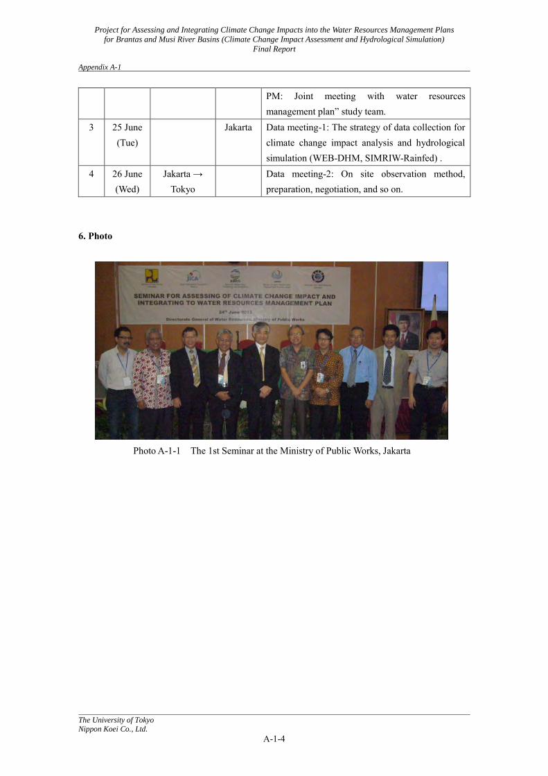
Table A-1-3 Dispatch itinerary Days Date Transportation Stay Contents
1 23 June (Sun)
Tokyo→ Jakarta
Jakarta Study team meeting (Preparation of climate change seminar and of kick off meeting).
2 24 June (Mon)
Jakarta AM: The seminar for assessing the climate change impact and integrating this in water resources management plan.
Project for Assessing and Integrating Climate Change Impacts into the Water Resources Management Plans
for Brantas and Musi River Basins (Climate Change Impact Assessment and Hydrological Simulation)
Final Report
Appendix A-1
The University of Tokyo
Nippon Koei Co., Ltd.
A-1-4
PM: Joint meeting with water resources management plan” study team.
3 25 June (Tue)
Jakarta Data meeting-1: The strategy of data collection for climate change impact analysis and hydrological simulation (WEB-DHM, SIMRIW-Rainfed) .
4 26 June (Wed)
Jakarta → Tokyo
Data meeting-2: On site observation method, preparation, negotiation, and so on.
6. Photo
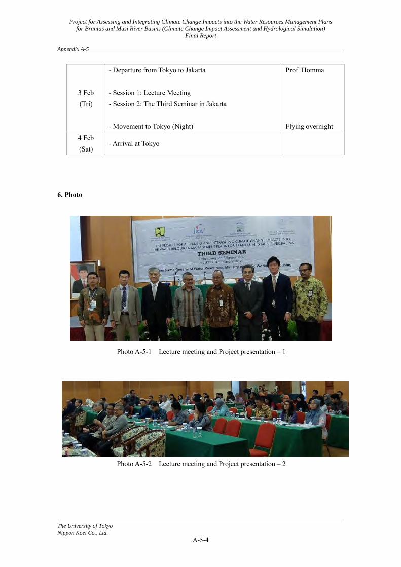
Photo A-1-1 The 1st Seminar at the Ministry of Public Works, Jakarta

Project for Assessing and Integrating Climate Change Impacts into the Water Resources Management Plans
for Brantas and Musi River Basins (Climate Change Impact Assessment and Hydrological Simulation)
Final Report Appendix A-2
The University of Tokyo
Nippon Koei Co., Ltd.
A-2-1
Appendix A-2: The Second Seminar in Jakarta and the First Seminar in Surabaya
1. Dispatch members from the study team:
(University of Tokyo) Toshio Koike, Patricia Sanchez, Kumiko Tsujimoto, Tetsu Ohta, (Kyoto University) Koki Homma, (Nippon Koei Co., Ltd.) Daikichi Ogawada
2. Duration: May 18-22, 2014 3. Place: Jakarta and Surabaya, Indonesia 4. Activities 4.1 Climate Change Seminar in Jakarta on 19 June 2014 4.1.1 Meeting agenda
The meeting agenda is as in the following table.
Table A-2-1 Meeting agenda in Jakarta Date : May 19, 2014 (Monday)
Time : 13:15 - 17:15
Venue : Function Room, 8th Floor, SDA Building, Ministry of Public Works, Jakarta
Moderator : Dr. Eka Nugraha Abdi, ST MPPM, PDS
Head of Subdit of Hydrology and Water Quality, PU
Time Program Speaker 12:45-13:15 Registration
Opening Session
13:15-13:20 National Anthem 13:20-13:30 Opening Address 1 Dr. Ir. M. Basoeki Hadimoeljono MSc
Director General of Spatial Planning, PU 13:30-13:40 Opening Address 2 Dr. Ir. Andi Eka Sakya
Head of BMKG 13:40-13:50 Opening Address 3
Mr. Yuki Aratsu Senior Representative of JICA Indonesia Office
13:50-14:05 New Paradigm to Formulate WRM Strategy in Uncertainty
Dr. Baba Hitoshi JICA Senior Advisor
14:05-14:20 ~~~ Coffee break ~~~
Presentation
Project for Assessing and Integrating Climate Change Impacts into the Water Resources Management Plans
for Brantas and Musi River Basins (Climate Change Impact Assessment and Hydrological Simulation)
Final Report Appendix A-2
The University of Tokyo
Nippon Koei Co., Ltd.
A-2-2
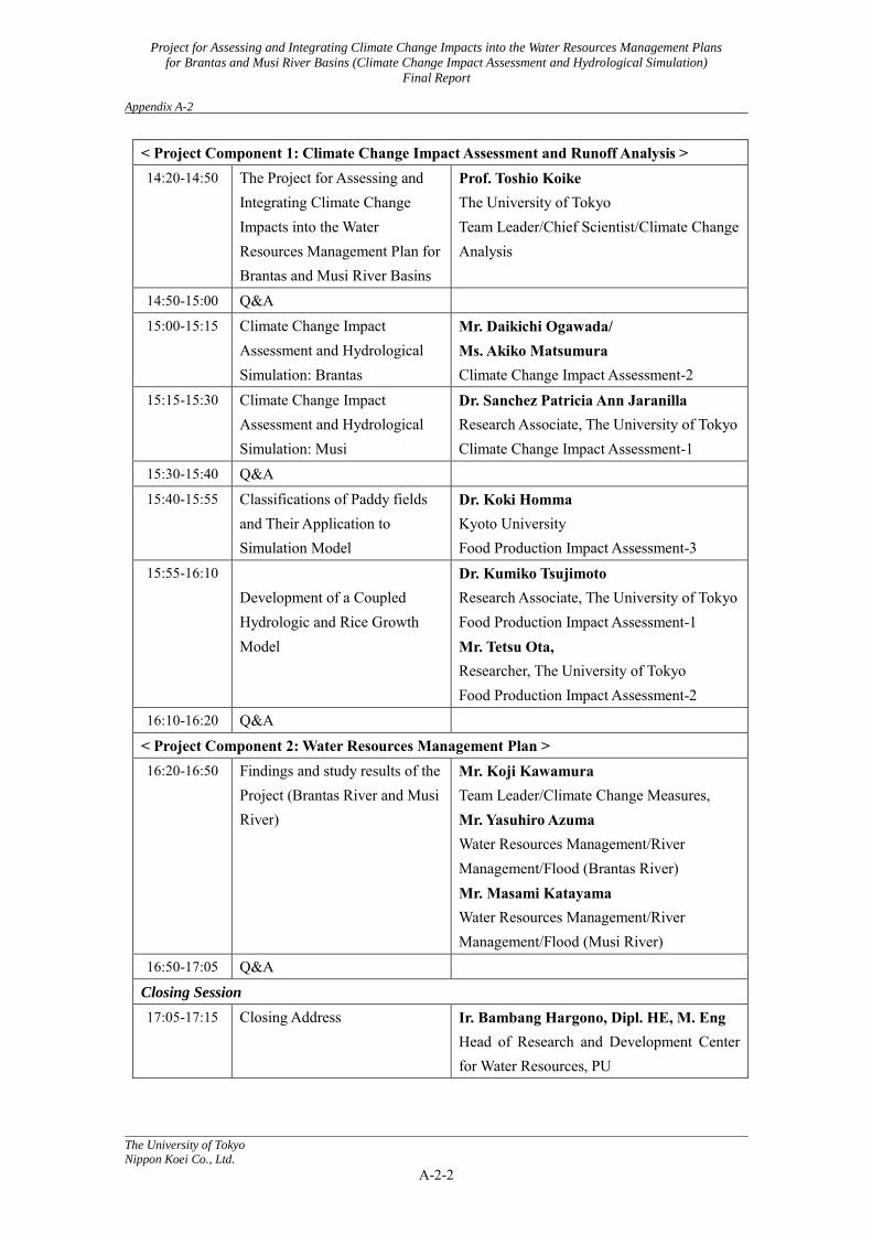
< Project Component 1: Climate Change Impact Assessment and Runoff Analysis > 14:20-14:50 The Project for Assessing and
Integrating Climate Change Impacts into the Water Resources Management Plan for Brantas and Musi River Basins
Prof. Toshio Koike The University of Tokyo Team Leader/Chief Scientist/Climate Change Analysis
14:50-15:00 Q&A 15:00-15:15 Climate Change Impact
Assessment and Hydrological Simulation: Brantas
Mr. Daikichi Ogawada/ Ms. Akiko Matsumura Climate Change Impact Assessment-2
15:15-15:30 Climate Change Impact Assessment and Hydrological Simulation: Musi
Dr. Sanchez Patricia Ann Jaranilla Research Associate, The University of Tokyo Climate Change Impact Assessment-1
15:30-15:40 Q&A 15:40-15:55 Classifications of Paddy fields
and Their Application to Simulation Model
Dr. Koki Homma Kyoto University Food Production Impact Assessment-3
15:55-16:10 Development of a Coupled Hydrologic and Rice Growth Model
Dr. Kumiko Tsujimoto Research Associate, The University of Tokyo Food Production Impact Assessment-1 Mr. Tetsu Ota, Researcher, The University of Tokyo Food Production Impact Assessment-2
16:10-16:20 Q&A < Project Component 2: Water Resources Management Plan > 16:20-16:50 Findings and study results of the
Project (Brantas River and Musi River)
Mr. Koji Kawamura Team Leader/Climate Change Measures, Mr. Yasuhiro Azuma Water Resources Management/River Management/Flood (Brantas River) Mr. Masami Katayama Water Resources Management/River Management/Flood (Musi River)
16:50-17:05 Q&A Closing Session 17:05-17:15 Closing Address Ir. Bambang Hargono, Dipl. HE, M. Eng
Head of Research and Development Center for Water Resources, PU
Project for Assessing and Integrating Climate Change Impacts into the Water Resources Management Plans
for Brantas and Musi River Basins (Climate Change Impact Assessment and Hydrological Simulation)
Final Report Appendix A-2
The University of Tokyo
Nippon Koei Co., Ltd.
A-2-3
4.1.2 Question and answer session <Question>
How to consider adaptations under the uncertainty of the climate change impact assessment?
<Answer (Professor Koiko, Team Leader)> There will be five measures for climate change adaptation. 1) Sharing knowledge and recognition about adaptation measures. 2) No regrettable adaptation measures (selection of both hard and soft measures). 3) Resilience at the national and community levels. 4) Risk evaluation of floods, water shortages, food, and energy, etc. and focusing on those issues
all together. 5) Funding and its strategy.
4.2 Climate Change Seminar in Surabaya on 20 June 2014 4.2.1 Meeting agenda
The meeting agenda is as in the following table.
Table A-2-2 Meeting agenda in Surabaya Date : 20 May 2014 (Tuesday)
Time : 13:30 - 17:00
Venue : Singgasana Hotel, Surabaya. Jl. Gunungsari, Surabaya 60224, Tel:031-568-2703
Moderator: Ir. Anggia Satrini, M. Eng., Head of Division for Program and Planning, BBWS
Brantas
Main topics:
1) Result of climate change impact assessment and runoff analysis for the Brantas River Basin
2) Findings and study results of the Project for the Brantas River Basin
Time Program Speaker
13:00-13:30 Registration
Opening Session
13:30-13:40 Introduction of the Project Ir. Ruby Hartanto Dipl HE Head of Administration Division, BBWS Brantas
13:40-13:50 New Paradigm to Formulate WRM Strategy in Uncertainty
Dr. Baba Hitoshi JICA Senior Advisor
13:50-14:05 ~~~ Coffee break ~~~
Presentation
< Project Component 1: Climate Change Impact Assessment and Runoff Analysis >
Project for Assessing and Integrating Climate Change Impacts into the Water Resources Management Plans
for Brantas and Musi River Basins (Climate Change Impact Assessment and Hydrological Simulation)
Final Report Appendix A-2
The University of Tokyo
Nippon Koei Co., Ltd.
A-2-4
14:05-14:35 Introduction to Climate Change Impacts and Adaptations and Project Overview
Prof. Toshio Koike The University of Tokyo Team Leader/Chief Scientist/Climate Change Analysis
14:35-14:45 Q&A
14:45-15:15 Climate Change Impact Assessment of the Water Cycle in Brantas River
Mr. Daikichi Ogawada/ Ms. Akiko Matsumura Climate Change Impact Assessment-2
15:15-15:20 Q&A
15:20-15:40 Rice Production Modeling and Data Preparation
Dr. Koki Homma Kyoto University Food Production Impact Assessment-3
15:40-15:55 Water-Rice Coupled Model Development Including Irrigation in Musi River
Dr. Kumiko Tsujimoto The University of Tokyo Food Production Impact Assessment-1 Mr. Tetsu Ota Researcher, The University of Tokyo Food Production Impact Assessment-2
15:55-16:05 Q&A
< Project Component 2: Water Resources Management Plan >
16:05-16:35 Findings and study results of the Project (Brantas River)
Mr. Koji Kawamura Team Leader/Climate Change Measures, Mr. Yasuhiro Azuma Water Resources Management/River Management/Flood (Brantas River)
16:35-16:50 Q&A
Closing Session
16:50-17:00 Closing Address Ir. Raymond Valiant Ruritan Technical Director, PJT-1
4.2.2 Summary
It is believed that due to the warmer climate, the magnitude and frequency of floods will decrease in some regions. Low flow will decrease in the future. Uncertainty should be considered.
Ir Raymond Valiant Ruritan , Technical Director, PJT-1 closed the session by thanking everyone and explaining the status of climate change in Brantas to the local participants in Bahasa, Indonesian. Half of the participants were from local government agencies and the other half of the participants were from NGOs (non-government organizations--farmers).

Project for Assessing and Integrating Climate Change Impacts into the Water Resources Management Plans
for Brantas and Musi River Basins (Climate Change Impact Assessment and Hydrological Simulation)
Final Report Appendix A-2
The University of Tokyo
Nippon Koei Co., Ltd.
A-2-5
4.2.3 Question and answer session (1) Project Component 1: Climate Change Impact Assessment and Runoff Analysis
Q-1-1) Tatar Surabaya (ITS University) If cloud formation is increasing as air temperatures increase, will rainfall increase too? What is the effect of this at the basin scale?
A-1-1) It is difficult to form clouds as temperatures increase, as water vapor increases, and clouds increase in one area and decrease in another. At the watershed scale (smaller area), heavier rainfall happens more often on a very local scale because of convective rainfall.
Q-1-2) Sutamsi (meteorological station officer, BMKG Karang PlosoMalang)
The water supply in Brantas is decreased because of increases in temperature: do you have a study on this?
A-1-2) To be discussed in Project Component 2.
Q-1-3)
The rainfall in Brantas river basin totals 1000-2000 mm/year; will the rainfall decrease in the future?
A-1-3) Downscaling of the rainfall pattern at the grid scale.
Q-1-4) Wayu Gesuti (Ministry of Forestry in Brantas)
How to incorporate uncertainty into planning? Probability of increases, decreases, etc.? A-1-4)
A strategy needs to be prepared even for low uncertainty depending on whether or not an area may be vulnerable to the negative impacts of climate change (e.g. flood increases may affect people living near riverbanks). Soft (programs) or hard (levees) adaptation measures may be incorporated into the planning scheme.
(2) Project Component 2: Water Resources Management Plan
Q-2-1) Tatar Surabaya (ITS University) What is the significance of the outputs if we do not account for land use changes when we simulate floods in the future?
A-2-1) Consult with local governments for their projected land use changes. If a 30% decrease in irrigated rice is projected in the future, this decrease will be incorporated in future model
Project for Assessing and Integrating Climate Change Impacts into the Water Resources Management Plans
for Brantas and Musi River Basins (Climate Change Impact Assessment and Hydrological Simulation)
Final Report Appendix A-2
The University of Tokyo
Nippon Koei Co., Ltd.
A-2-6
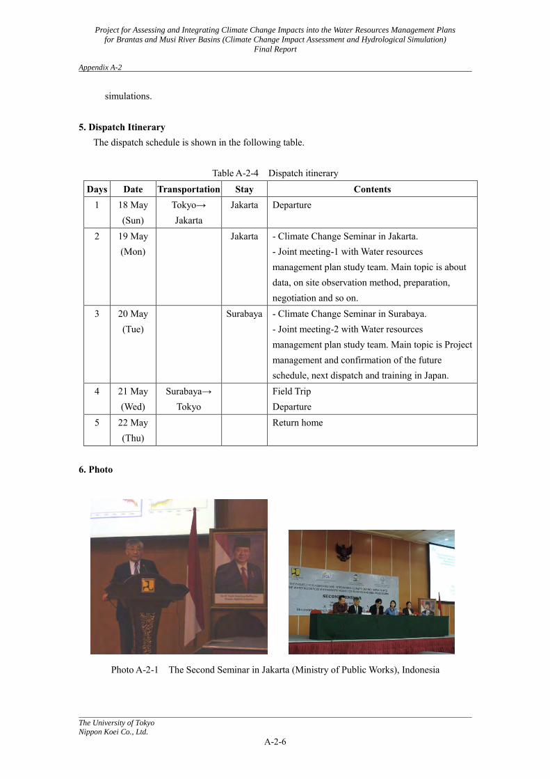
simulations. 5. Dispatch Itinerary The dispatch schedule is shown in the following table.
Table A-2-4 Dispatch itinerary
Days Date Transportation Stay Contents 1 18 May
(Sun) Tokyo→ Jakarta
Jakarta Departure
2 19 May (Mon)
Jakarta - Climate Change Seminar in Jakarta. - Joint meeting-1 with Water resources management plan study team. Main topic is about data, on site observation method, preparation, negotiation and so on.
3 20 May (Tue)
Surabaya - Climate Change Seminar in Surabaya. - Joint meeting-2 with Water resources management plan study team. Main topic is Project management and confirmation of the future schedule, next dispatch and training in Japan.
4 21 May (Wed)
Surabaya→ Tokyo
Field Trip Departure
5 22 May (Thu)
Return home
6. Photo
Photo A-2-1 The Second Seminar in Jakarta (Ministry of Public Works), Indonesia
Project for Assessing and Integrating Climate Change Impacts into the Water Resources Management Plans
for Brantas and Musi River Basins (Climate Change Impact Assessment and Hydrological Simulation)
Final Report Appendix A-2
The University of Tokyo
Nippon Koei Co., Ltd.
A-2-7
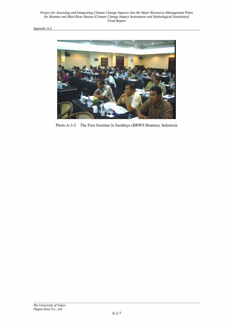
Photo A-2-2 The First Seminar in Surabaya (BBWS Brantas), Indonesia
Project for Assessing and Integrating Climate Change Impacts into the Water Resources Management Plans
for Brantas and Musi River Basins (Climate Change Impact Assessment and Hydrological Simulation)
Final Report Appendix A-3
The University of Tokyo
Nippon Koei Co., Ltd.
A-3-1
Appendix A-3: Workshop on Assessing and Integrating Climate Change Impacts into
the Water Resources Management Plans for the Brantas and Musi River Basins (Interim Explanation-1)
1. Dispatch members from the study team (Project Component 1):
Daikichi Ogawada (Climate Change Impact Assessment, Nippon Koei Co., Ltd.) Kumiko Tsujimoto (Food Production Impact Assessment, University of Tokyo)
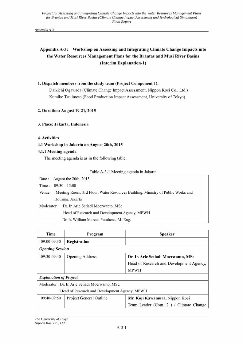
2. Duration: August 19-21, 2015 3. Place: Jakarta, Indonesia 4. Activities 4.1 Workshop in Jakarta on August 20th, 2015 4.1.1 Meeting agenda
The meeting agenda is as in the following table.
Table A-3-1 Meeting agenda in Jakarta Date : August the 20th, 2015
Time : 09:30 - 15:00
Venue : Meeting Room, 3rd Floor, Water Resources Building, Ministry of Public Works and
Housing, Jakarta
Moderator : Dr. Ir. Arie Setiadi Moerwanto, MSc
Head of Research and Development Agency, MPWH
Dr. Ir. William Marcus Putuhena, M. Eng.
Time Program Speaker
09:00-09:30 Registration
Opening Session
09:30-09:40 Opening Address Dr. Ir. Arie Setiadi Moerwanto, MSc Head of Research and Development Agency, MPWH
Explanation of Project
Moderator : Dr. Ir. Arie Setiadi Moerwanto, MSc,
Head of Research and Development Agency, MPWH
09:40-09:50 Project General Outline Mr. Koji Kawamura, Nippon Koei Team Leader (Com. 2 ) / Climate Change

Project for Assessing and Integrating Climate Change Impacts into the Water Resources Management Plans
for Brantas and Musi River Basins (Climate Change Impact Assessment and Hydrological Simulation)
Final Report Appendix A-3
The University of Tokyo
Nippon Koei Co., Ltd.
A-3-2
members Project Component 1: Climate Change Impact Assessment and Runoff Analysis
09:50-10:30
10:30-10:40
Project Overview, Present Progress (Brantas River and Musi River) and Work Schedule Q & A
Dr. Kumiko Tsujimoto, The University of Tokyo Food production Impact Assessment Mr. Daikichi Ogawada, Nippon Koei Climate Change Impact Assessment
Project Component 2: Water Resources Management Plan
10:40-11:20
11:20-11:30
Project Overview, Present Progress (Brantas River and Musi River) and Work Schedule Q & A
Mr. Koji Kawamura, Nippon Koei Team Leader/Climate Change Measures, Mr. Tadahiro Fukuda, Nippon Koei River Facilities Management Mr. Masami Katayama, CTI Engineering International, Water Resources Management/River Management / Flood (Musi River)
Exchange of Opinions
11:30-12:00 - Position of Guideline, which is one of the project outcomes - Methodology of Capacity Development in the Project
All participants
12:00-13:00 Lunch Break Report on the Outcomes from the Second Training* in Japan
Moderator: Dr. Ir. William Marcus Putuhena, M. Eng. 13:00-13:10 Summary of the Training in
Japan Mr. Koji Kawamura, Nippon Koei Team Leader/Climate Change Measures,
13:10-13:25
Report on the Outcomes by Trainee
Mr. Mohammad Ridwan Nur Prasetyo, ST., M. Kom, BMKG.
13:25-13:40 Mr. Heruyoko, ST, MT, PUSAIR, MPWH
13:40-13:55 Ms. Wulan Seizarwati, S,Si., PUSAIR, MPWH
13:55-14:05 Discussion, Q & A All participants Closing Session 14:05-14:15 Closing Address Ir. Agus Suprapto Kusmulyono, M. Eng,
PhD, Director of Directorate of Water Resources Management
Note: * Training Title = “Simulation and Evaluation of Climate Change Impacts by Downscaling
Project for Assessing and Integrating Climate Change Impacts into the Water Resources Management Plans
for Brantas and Musi River Basins (Climate Change Impact Assessment and Hydrological Simulation)
Final Report Appendix A-3
The University of Tokyo
Nippon Koei Co., Ltd.
A-3-3
and Hydrological Modeling” 4.1.2 Comments and questions
1) Dr. Arie(At opening address) - The Indonesian side expresses regret at local observation data being insufficient during the project. - We recognize that climatic change is important. - The results of the project are going to be applied to other 160 river basins all over the country.
2) Dr. Agus(At project overview)
- We desire to complete the project as soon as possible. - The temperature rise of 2 degrees in Brantas river basin has surprised us a great deal.
What kinds of mitigation measures do we have? The influence of urbanization and land use changes are necessary along with the effects of climate change. (Mr. Ogawada) The influence of urbanization and land use changes were examined.
The results showed the influence on streamflow was small.
3) Trainees (Request) - We would like to have additional training on “Simulation and Evaluation of Climate Change
Impacts by Downscaling and Hydrological Modeling”, especially on the crop model and the coupled model.
(Mr. Goto, JICA) This is difficult to add, because of the project period and budget limitations. Can this be dealt with remotely from Japan?
(Dr. Tsujimoto) It is absolutely difficult to do this. There are two constraining points: - Access permission to the servers in Japan is mandatory.
- Appropriate computation environment is necessary for the agencies and the institutions in Indonesia.
4) Dr. Arie(At closing address)
The results presented today are still not convincing to me.
For example: differences between the Brantas and Musi river basins, differences in GCMs, the reasons, how to understand, available measures to overcome, and so on.
We would like the final report for this project as soon as possible.
Project for Assessing and Integrating Climate Change Impacts into the Water Resources Management Plans
for Brantas and Musi River Basins (Climate Change Impact Assessment and Hydrological Simulation)
Final Report Appendix A-3
The University of Tokyo
Nippon Koei Co., Ltd.
A-3-4
5. Dispatch Itinerary The dispatch schedule is shown in the following table.
Table A-3-2 Dispatch itinerary
Days Date Transportation Stay Contents 1 19Aug.
(Wed)
1) Tokyo → Jakarta 2) Phnom Penh → Jakarta
Jakarta Traveling
2 20 Aug. (Thu)
Jakarta
1) Jakarta → Tokyo
Jakarta - Workshop on Assessing and Integrating Climate Change Impacts into the Water Resources Management Plans for Brantas and Musi River Basins
- Joint meeting with JICA and Water resources management plan study team
Departure
3 21 Aug. (Fri)
2) Jakarta → Phnom Penh
1) Return home 2) Arrival
1) Ogawada, 2) Tsujimoto 6. Photo
Photo A-3-1 Workshop at the Ministry of Public Works and Housing in Jakarta
Project for Assessing and Integrating Climate Change Impacts into the Water Resources Management Plans
for Brantas and Musi River Basins (Climate Change Impact Assessment and Hydrological Simulation)
Final Report Appendix A-4
The University of Tokyo
Nippon Koei Co., Ltd.
A-4-1
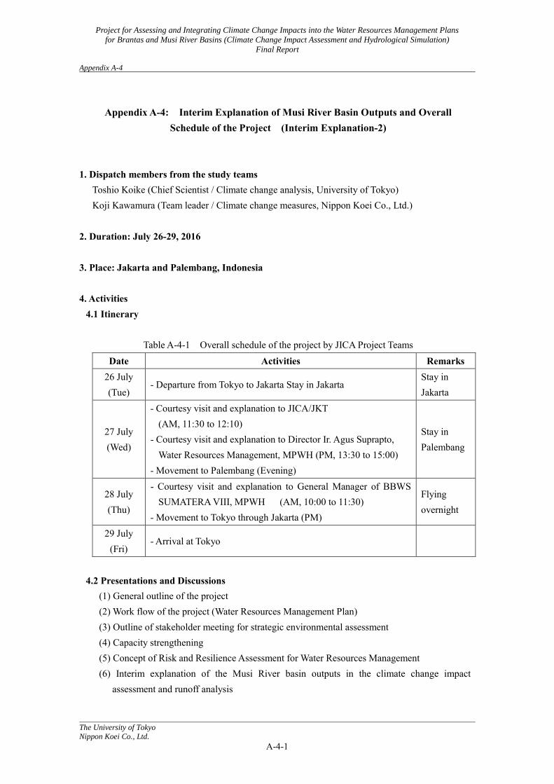
Appendix A-4: Interim Explanation of Musi River Basin Outputs and Overall
Schedule of the Project (Interim Explanation-2)
1. Dispatch members from the study teams
Toshio Koike (Chief Scientist / Climate change analysis, University of Tokyo) Koji Kawamura (Team leader / Climate change measures, Nippon Koei Co., Ltd.)
2. Duration: July 26-29, 2016 3. Place: Jakarta and Palembang, Indonesia 4. Activities
4.1 Itinerary
Table A-4-1 Overall schedule of the project by JICA Project Teams Date Activities Remarks
26 July (Tue)
- Departure from Tokyo to Jakarta Stay in Jakarta Stay in Jakarta
27 July (Wed)
- Courtesy visit and explanation to JICA/JKT (AM, 11:30 to 12:10)
- Courtesy visit and explanation to Director Ir. Agus Suprapto, Water Resources Management, MPWH (PM, 13:30 to 15:00)
- Movement to Palembang (Evening)
Stay in Palembang
28 July (Thu)
- Courtesy visit and explanation to General Manager of BBWS SUMATERA VIII, MPWH (AM, 10:00 to 11:30)
- Movement to Tokyo through Jakarta (PM)
Flying overnight
29 July (Fri)
- Arrival at Tokyo
4.2 Presentations and Discussions
(1) General outline of the project (2) Work flow of the project (Water Resources Management Plan) (3) Outline of stakeholder meeting for strategic environmental assessment (4) Capacity strengthening (5) Concept of Risk and Resilience Assessment for Water Resources Management (6) Interim explanation of the Musi River basin outputs in the climate change impact
assessment and runoff analysis
Project for Assessing and Integrating Climate Change Impacts into the Water Resources Management Plans
for Brantas and Musi River Basins (Climate Change Impact Assessment and Hydrological Simulation)
Final Report Appendix A-4
The University of Tokyo
Nippon Koei Co., Ltd.
A-4-2
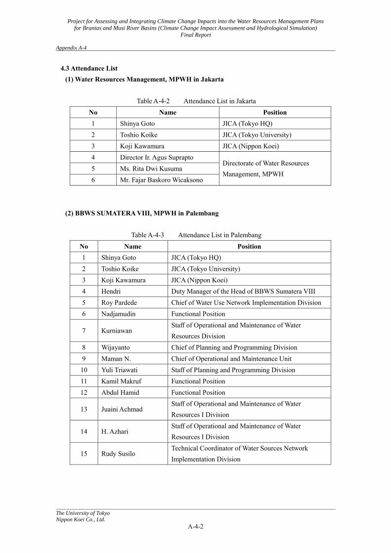
4.3 Attendance List (1) Water Resources Management, MPWH in Jakarta
Table A-4-2 Attendance List in Jakarta
No Name Position 1 Shinya Goto JICA (Tokyo HQ) 2 Toshio Koike JICA (Tokyo University) 3 Koji Kawamura JICA (Nippon Koei) 4 Director Ir. Agus Suprapto
Directorate of Water Resources Management, MPWH
5 Ms. Rita Dwi Kusuma 6 Mr. Fajar Baskoro Wicaksono
(2) BBWS SUMATERA VIII, MPWH in Palembang
Table A-4-3 Attendance List in Palembang No Name Position 1 Shinya Goto JICA (Tokyo HQ) 2 Toshio Koike JICA (Tokyo University) 3 Koji Kawamura JICA (Nippon Koei) 4 Hendri Duty Manager of the Head of BBWS Sumatera VIII 5 Roy Pardede Chief of Water Use Network Implementation Division 6 Nadjamudin Functional Position
7 Kurniawan Staff of Operational and Maintenance of Water Resources Division
8 Wijayanto Chief of Planning and Programming Division 9 Maman N. Chief of Operational and Maintenance Unit 10 Yuli Triawati Staff of Planning and Programming Division 11 Kamil Makruf Functional Position 12 Abdul Hamid Functional Position
13 Juaini Achmad Staff of Operational and Maintenance of Water Resources I Division
14 H. Azhari Staff of Operational and Maintenance of Water Resources I Division
15 Rudy Susilo Technical Coordinator of Water Sources Network Implementation Division

Project for Assessing and Integrating Climate Change Impacts into the Water Resources Management Plans
for Brantas and Musi River Basins (Climate Change Impact Assessment and Hydrological Simulation)
Final Report Appendix A-4
The University of Tokyo
Nippon Koei Co., Ltd.
A-4-3
4.4 Photo
Photo A-4-1 Meeting in Jakarta-1 Photo A-4-2 Meeting in Palembang-2
Photo A-4-3 Explanation Meeting in Palembang-1
Photo A-4-4 Explanation Meeting in
Palembang-2
Project for Assessing and Integrating Climate Change Impacts into the Water Resources Management Plans
for Brantas and Musi River Basins (Climate Change Impact Assessment and Hydrological Simulation)
Final Report Appendix A-5
The University of Tokyo
Nippon Koei Co., Ltd.
A-5-1
Appendix A-5: The Third Seminar in Jakarta and the First Seminar in Palembang
1. Dispatch member from the study teams Toshio Koike (Chief Scientist / Climate change analysis, University of Tokyo) Koki Homma (Food Production Impact Assessment, Tohoku University)
2. Duration: February 2 - 4, 2017 3. Place: Jakarta and Palembang, Indonesia 4. Activities
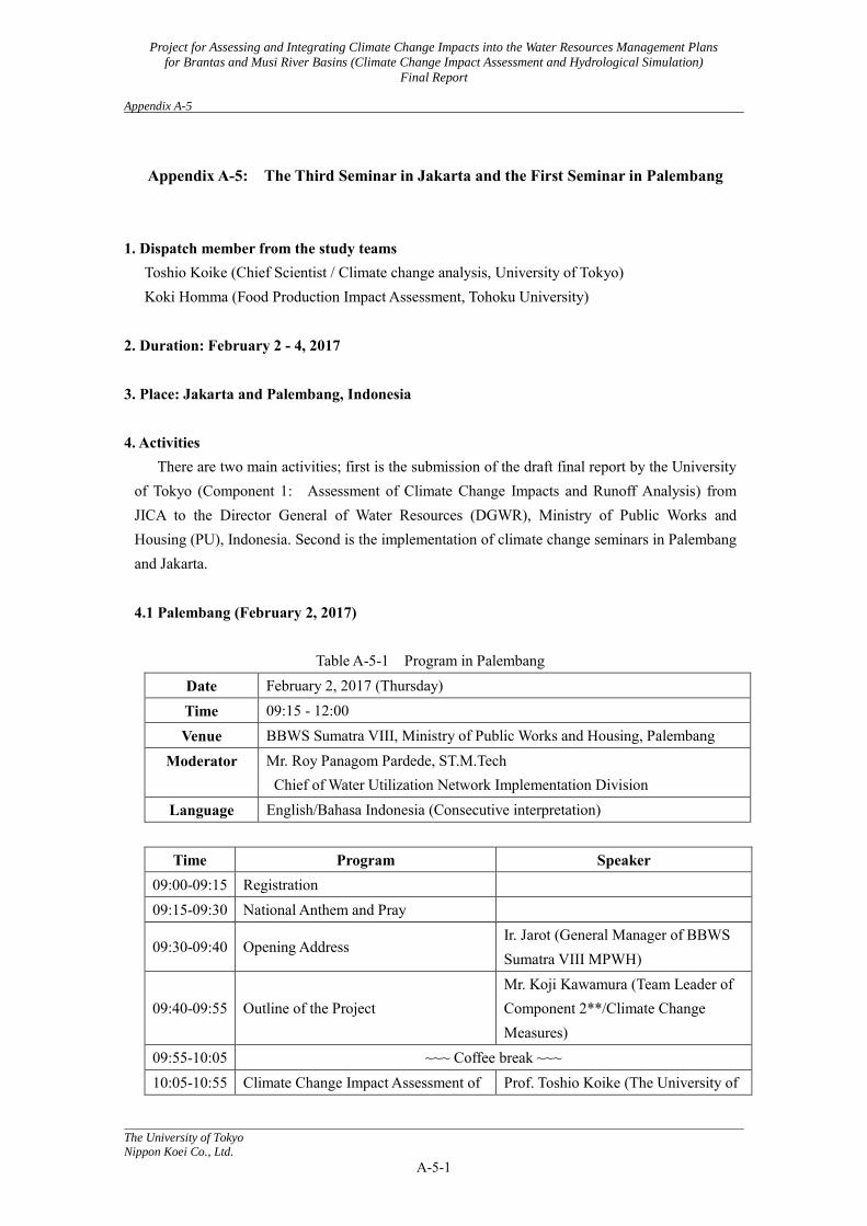
There are two main activities; first is the submission of the draft final report by the University of Tokyo (Component 1: Assessment of Climate Change Impacts and Runoff Analysis) from JICA to the Director General of Water Resources (DGWR), Ministry of Public Works and Housing (PU), Indonesia. Second is the implementation of climate change seminars in Palembang and Jakarta. 4.1 Palembang (February 2, 2017)
Table A-5-1 Program in Palembang
Date February 2, 2017 (Thursday) Time 09:15 - 12:00 Venue BBWS Sumatra VIII, Ministry of Public Works and Housing, Palembang
Moderator Mr. Roy Panagom Pardede, ST.M.Tech Chief of Water Utilization Network Implementation Division
Language English/Bahasa Indonesia (Consecutive interpretation)
Time Program Speaker 09:00-09:15 Registration 09:15-09:30 National Anthem and Pray
09:30-09:40 Opening Address Ir. Jarot (General Manager of BBWS Sumatra VIII MPWH)
09:40-09:55 Outline of the Project Mr. Koji Kawamura (Team Leader of Component 2**/Climate Change Measures)
09:55-10:05 ~~~ Coffee break ~~~ 10:05-10:55 Climate Change Impact Assessment of Prof. Toshio Koike (The University of
Project for Assessing and Integrating Climate Change Impacts into the Water Resources Management Plans
for Brantas and Musi River Basins (Climate Change Impact Assessment and Hydrological Simulation)
Final Report Appendix A-5
The University of Tokyo
Nippon Koei Co., Ltd.
A-5-2
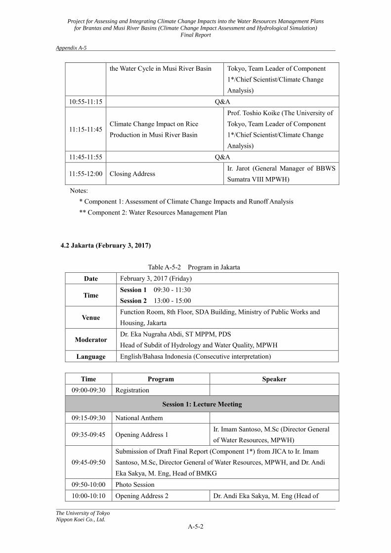
the Water Cycle in Musi River Basin Tokyo, Team Leader of Component 1*/Chief Scientist/Climate Change Analysis)
10:55-11:15 Q&A
11:15-11:45 Climate Change Impact on Rice Production in Musi River Basin
Prof. Toshio Koike (The University of Tokyo, Team Leader of Component 1*/Chief Scientist/Climate Change Analysis)
11:45-11:55 Q&A
11:55-12:00 Closing Address Ir. Jarot (General Manager of BBWS Sumatra VIII MPWH)
Notes: * Component 1: Assessment of Climate Change Impacts and Runoff Analysis ** Component 2: Water Resources Management Plan
4.2 Jakarta (February 3, 2017)
Table A-5-2 Program in Jakarta
Date February 3, 2017 (Friday)
Time Session 1 09:30 - 11:30 Session 2 13:00 - 15:00
Venue Function Room, 8th Floor, SDA Building, Ministry of Public Works and Housing, Jakarta
Moderator Dr. Eka Nugraha Abdi, ST MPPM, PDS Head of Subdit of Hydrology and Water Quality, MPWH
Language English/Bahasa Indonesia (Consecutive interpretation)
Time Program Speaker 09:00-09:30 Registration
Session 1: Lecture Meeting
09:15-09:30 National Anthem
09:35-09:45 Opening Address 1 Ir. Imam Santoso, M.Sc (Director General of Water Resources, MPWH)
09:45-09:50 Submission of Draft Final Report (Component 1*) from JICA to Ir. Imam Santoso, M.Sc, Director General of Water Resources, MPWH, and Dr. Andi Eka Sakya, M. Eng, Head of BMKG
09:50-10:00 Photo Session 10:00-10:10 Opening Address 2 Dr. Andi Eka Sakya, M. Eng (Head of
Project for Assessing and Integrating Climate Change Impacts into the Water Resources Management Plans
for Brantas and Musi River Basins (Climate Change Impact Assessment and Hydrological Simulation)
Final Report Appendix A-5
The University of Tokyo
Nippon Koei Co., Ltd.
A-5-3
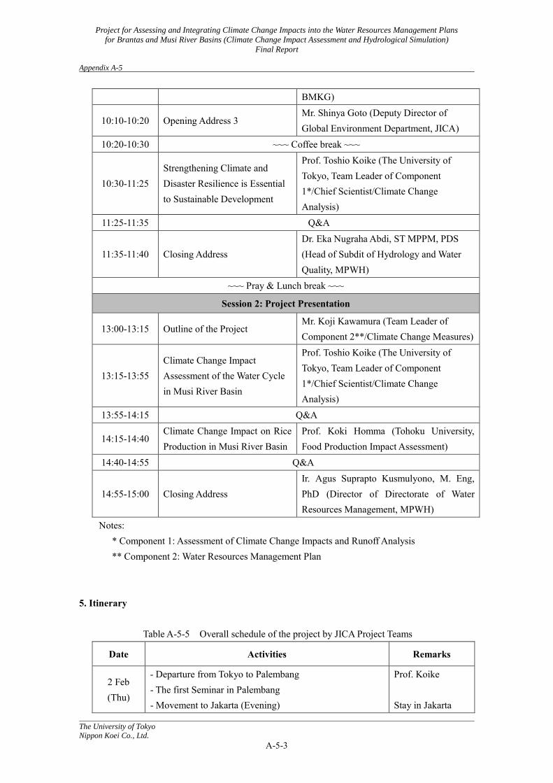
BMKG)
10:10-10:20 Opening Address 3 Mr. Shinya Goto (Deputy Director of Global Environment Department, JICA)
10:20-10:30 ~~~ Coffee break ~~~
10:30-11:25 Strengthening Climate and Disaster Resilience is Essential to Sustainable Development
Prof. Toshio Koike (The University of Tokyo, Team Leader of Component 1*/Chief Scientist/Climate Change Analysis)
11:25-11:35 Q&A
11:35-11:40 Closing Address Dr. Eka Nugraha Abdi, ST MPPM, PDS (Head of Subdit of Hydrology and Water Quality, MPWH)
~~~ Pray & Lunch break ~~~
Session 2: Project Presentation
13:00-13:15 Outline of the Project Mr. Koji Kawamura (Team Leader of Component 2**/Climate Change Measures)
13:15-13:55 Climate Change Impact Assessment of the Water Cycle in Musi River Basin
Prof. Toshio Koike (The University of Tokyo, Team Leader of Component 1*/Chief Scientist/Climate Change Analysis)
13:55-14:15 Q&A
14:15-14:40 Climate Change Impact on Rice Production in Musi River Basin
Prof. Koki Homma (Tohoku University, Food Production Impact Assessment)
14:40-14:55 Q&A
14:55-15:00 Closing Address Ir. Agus Suprapto Kusmulyono, M. Eng, PhD (Director of Directorate of Water Resources Management, MPWH)
Notes: * Component 1: Assessment of Climate Change Impacts and Runoff Analysis ** Component 2: Water Resources Management Plan
5. Itinerary
Table A-5-5 Overall schedule of the project by JICA Project Teams
Date Activities Remarks
2 Feb (Thu)
- Departure from Tokyo to Palembang - The first Seminar in Palembang - Movement to Jakarta (Evening)
Prof. Koike Stay in Jakarta
Project for Assessing and Integrating Climate Change Impacts into the Water Resources Management Plans
for Brantas and Musi River Basins (Climate Change Impact Assessment and Hydrological Simulation)
Final Report Appendix A-5
The University of Tokyo
Nippon Koei Co., Ltd.
A-5-4
3 Feb (Tri)
- Departure from Tokyo to Jakarta - Session 1: Lecture Meeting - Session 2: The Third Seminar in Jakarta - Movement to Tokyo (Night)
Prof. Homma Flying overnight
4 Feb (Sat)
- Arrival at Tokyo
6. Photo
Photo A-5-1 Lecture meeting and Project presentation – 1
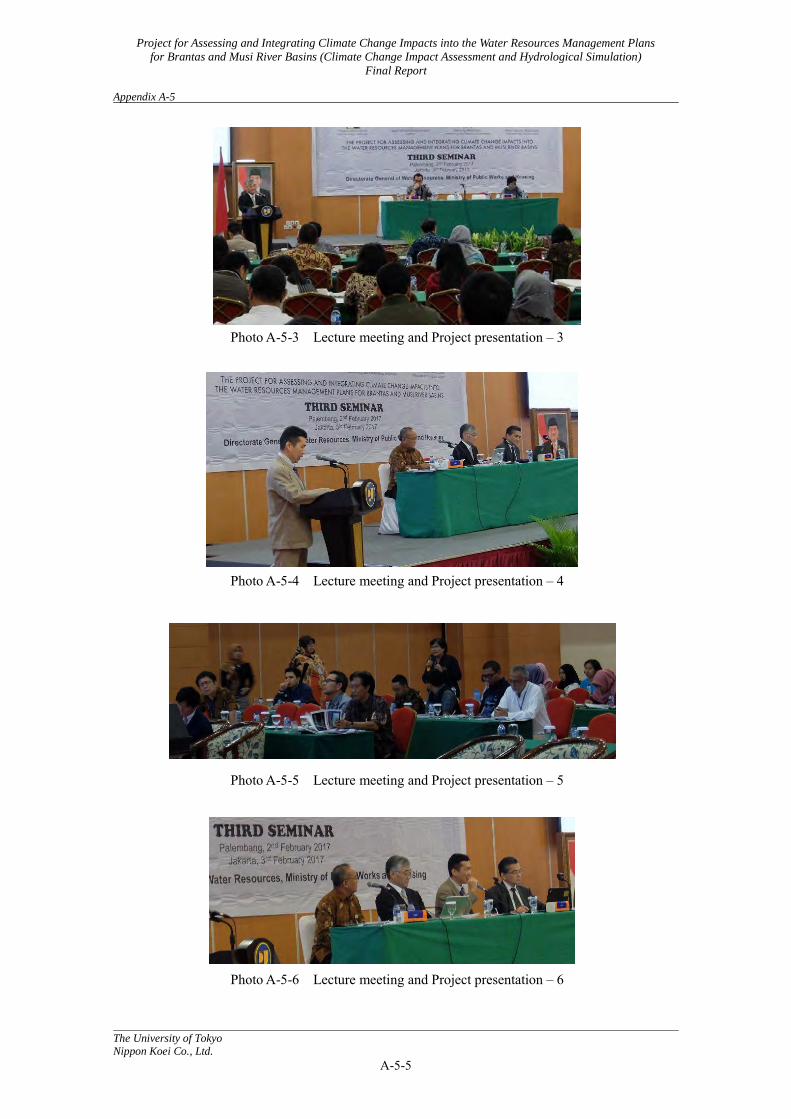
Photo A-5-2 Lecture meeting and Project presentation – 2
Project for Assessing and Integrating Climate Change Impacts into the Water Resources Management Plans
for Brantas and Musi River Basins (Climate Change Impact Assessment and Hydrological Simulation)
Final Report Appendix A-5
The University of Tokyo
Nippon Koei Co., Ltd.
A-5-5
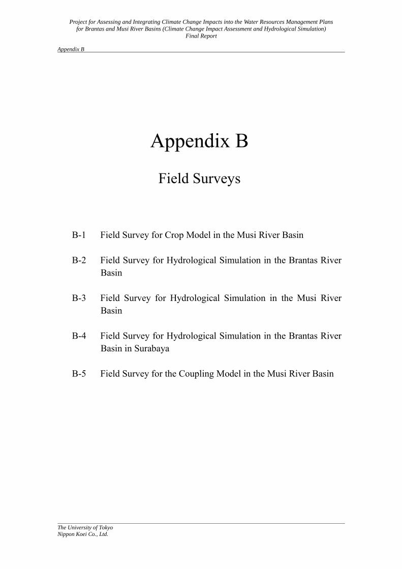
Photo A-5-3 Lecture meeting and Project presentation – 3
Photo A-5-4 Lecture meeting and Project presentation – 4
Photo A-5-5 Lecture meeting and Project presentation – 5
Photo A-5-6 Lecture meeting and Project presentation – 6
Project for Assessing and Integrating Climate Change Impacts into the Water Resources Management Plans
for Brantas and Musi River Basins (Climate Change Impact Assessment and Hydrological Simulation)
Final Report Appendix B
The University of Tokyo
Nippon Koei Co., Ltd.
Appendix B
Field Surveys
B-1 Field Survey for Crop Model in the Musi River Basin B-2 Field Survey for Hydrological Simulation in the Brantas River
Basin B-3 Field Survey for Hydrological Simulation in the Musi River
Basin B-4 Field Survey for Hydrological Simulation in the Brantas River
Basin in Surabaya B-5 Field Survey for the Coupling Model in the Musi River Basin
Project for Assessing and Integrating Climate Change Impacts into the Water Resources Management Plans
for Brantas and Musi River Basins (Climate Change Impact Assessment and Hydrological Simulation)
Final Report Appendix B-1
The University of Tokyo
Nippon Koei Co., Ltd.
B-1-1
Appendix B-1: Field Survey for Crop Model in the Musi River Basin 1. Dispatch members from the study team: Koki Homma (Kyoto University) 2. Duration: June 18th (Tue) – July 6th (Sat), 2013 3. Place: Jakarta, Palembang and Martapura 4. Activities: 4.1 Establishment and conducting of a field survey for the development of a crop model
It is necessary to collect data on agricultural management such as rice varieties, growing seasons, and the amount of fertilization as input data for simulation models on growth and production of rice, a primary agricultural product of the targeted area. On the other hand, yields are also necessary for verifying the models. In addition, field surveys for actual water use are needed for development of an irrigation module. As for the data collection, we assisted the consultant, who was responsible for the “Water resources management plan” to establish a methodology (manuals) for the field survey.
At first, we aimed to collect the government data in the targeted area. For the purpose, we checked the data, which can be collected, and discussed the methodology to collect it. Candidates for the outsourcing contractor, which conduct investigations for farmers’ fields, were checked, and the contents of investigation were discussed with the consultant, who was responsible for the “Water resources management plan”.
4.2 Lecture at the seminar I joined “The seminar for assessing the impacts of climate change and integrating the
water resources management plan” hosted by the Ministry of Public Works Indonesia, JICA, and so on, and made a lecture entitled “Approaches for evaluations on climate change impacts on rice production”.
5. Dispatch Itinerary The dispatch schedule is shown in the following table.
Table B-1-1 Dispatch Itinerary
Days Date Transportation Stay Contents 1 18th June
(Tue) Kyoto→ Jakarta
Jakarta Departure
2 19th June (Wed)
Jakarta Meeting with the consultants who was responsible to a “Water resources management plan” (with Mr. Hirota and 2 persons of Nippon Koei)
3 20th June (Thu)
Jakarta Information collection for the governmental data
4 21st June Jakarta ditto
Project for Assessing and Integrating Climate Change Impacts into the Water Resources Management Plans
for Brantas and Musi River Basins (Climate Change Impact Assessment and Hydrological Simulation)
Final Report Appendix B-1
The University of Tokyo
Nippon Koei Co., Ltd.
B-1-2
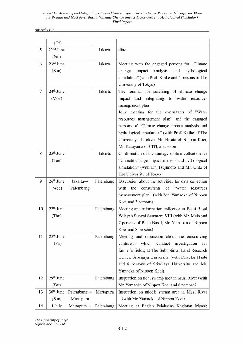
(Fri) 5 22nd June
(Sat) Jakarta ditto
6 23rd June (Sun)
Jakarta Meeting with the engaged persons for “Climate change impact analysis and hydrological simulation” (with Prof. Koike and 4 persons of The University of Tokyo)
7 24th June (Mon)
Jakarta The seminar for assessing of climate change impact and integrating to water resources management plan Joint meeting for the consultants of ”Water resources management plan” and the engaged persons of “Climate change impact analysis and hydrological simulation” (with Prof. Koike of The University of Tokyo, Mr. Hirota of Nippon Koei, Mr. Katayama of CITI, and so on
8 25th June (Tue)
Jakarta Confirmation of the strategy of data collection for “Climate change impact analysis and hydrological simulation” (with Dr. Tsujimoto and Mr. Ohta of The University of Tokyo)
9 26th June (Wed)
Jakarta→ Palembang
Palembang Discussion about the activities for data collection with the consultants of ”Water resources management plan” (with Mr. Yamaoka of Nippon Koei and 3 persons)
10 27th June (Thu)
Palembang Meeting and information collection at Balai Busal Wilayah Sungai Sumatera VIII (with Mr. Muis and 7 persons of Balai Busal, Mr. Yamaoka of Nippon Koei and 8 persons)
11 28th June (Fri)
Palembang Meeting and discussion about the outsourcing contractor which conduct investigation for farmer’s fields; at The Suboptimal Land Research Center, Sriwijaya University (with Director Hasbi and 8 persons of Sriwijaya University and Mr. Yamaoka of Nippon Koei)
12 29th June (Sat)
Palembang Inspection on tidal swamp area in Musi River(with Mr. Yamaoka of Nippon Koei and 6 persons)
13 30th June (Sun)
Palembang→ Martapura
Martapura Inspection on middle stream area in Musi River(with Mr. Yamaoka of Nippon Koei)
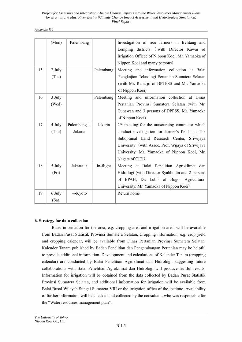
14 1 July Martapura→ Palembang Meeting at Bagian Pelaksana Kegiatan Irigasi;
Project for Assessing and Integrating Climate Change Impacts into the Water Resources Management Plans
for Brantas and Musi River Basins (Climate Change Impact Assessment and Hydrological Simulation)
Final Report Appendix B-1
The University of Tokyo
Nippon Koei Co., Ltd.
B-1-3
(Mon) Palembang Investigation of rice farmers in Belitang and Lemping districts ( with Director Kawai of Irrigation Officce of Nippon Koei, Mr. Yamaoka of Nippon Koei and many persons)
15 2 July (Tue)
Palembang Meeting and information collection at Balai Pengkajian Teknologi Pertanian Sumatera Selatan (with Mr. Raharjo of BPTPSS and Mr. Yamaoka of Nippon Koei)
16 3 July (Wed)
Palembang Meeting and information collection at Dinas Pertanian Provinsi Sumatera Selatan (with Mr. Cunawan and 3 persons of DPPSS, Mr. Yamaoka of Nippon Koei)
17 4 July (Thu)
Palembang→ Jakarta
Jakarta 2nd meeting for the outsourcing contractor which conduct investigation for farmer’s fields; at The Suboptimal Land Research Center, Sriwijaya University(with Assoc. Prof. Wijaya of Sriwijaya University, Mr. Yamaoka of Nippon Koei, Mr. Nagata of CITI)
18 5 July (Fri)
Jakarta→ In-flight Meeting at Balai Penelitian Agroklimat dan Hidrologi (with Director Syahbudin and 2 persons of BPAH, Dr. Lubis of Bogor Agricultural University, Mr. Yamaoka of Nippon Koei)
19 6 July (Sat)
→Kyoto Return home
6. Strategy for data collection Basic information for the area, e.g. cropping area and irrigation area, will be available
from Badan Pusat Statistik Provinsi Sumatera Selatan. Cropping information, e.g. crop yield and cropping calendar, will be available from Dinas Pertanian Provinsi Sumatera Selatan. Kalender Tanam published by Badan Penelitian dan Pengembangan Pertanian may be helpful to provide additional information. Development and calculations of Kalender Tanam (cropping calendar) are conducted by Balai Penelitian Agroklimat dan Hidrologi, suggesting future collaborations with Balai Penelitian Agroklimat dan Hidrologi will produce fruitful results. Information for irrigation will be obtained from the data collected by Badan Pusat Statistik Provinsi Sumatera Selatan, and additional information for irrigation will be available from Balai Busal Wilayah Sungai Sumatera VIII or the irrigation office of the institute. Availability of further information will be checked and collected by the consultant, who was responsible for the “Water resources management plan”.

Project for Assessing and Integrating Climate Change Impacts into the Water Resources Management Plans
for Brantas and Musi River Basins (Climate Change Impact Assessment and Hydrological Simulation)
Final Report Appendix B-1
The University of Tokyo
Nippon Koei Co., Ltd.
B-1-4
7. Progress on determining the outsourcing contractor to conduct investigations for farmers’ fields
We (Mr. Yamaoka and Homma) obtained from Dr. Iskandar Lubis the information for the outsourcing contractor, who will conduct investigations for farmers’ fields. Dr. Lubis is a lecturer of Bogor Agricultural University, and he has experience of similar investigations in collaboration with myself. According to his information, we discussed with Director Hasbi and his staff in the Suboptimal Land Research Center, Sriwijaya University. The Center is an inter-research institute for the University, Balai Pengkajian Teknologi Pertanian Sumatera Selatan and Dinas Pertanian Provinsi Sumatera Selatan. Mr. Yamaoka and I checked and confirmed the ability of the Center as an outsourcing contractor. Because there is no candidate other than the Center, I recommend it as the outsourcing contractor to the consultant, who was responsible for the “Water resources management plan” (The consultant concluded the contract with the Center after this activity).
8. Photo
Photo B-1-1: “The seminar for assessing the impacts of climate change and integrating the water resources management plan” Prof. Koike (Left), the engaged person (Homma; middle), Prof. Triweko of Parahyangan University (Right)
Photo B-1-2: Downstream of Musi River
Project for Assessing and Integrating Climate Change Impacts into the Water Resources Management Plans
for Brantas and Musi River Basins (Climate Change Impact Assessment and Hydrological Simulation)
Final Report Appendix B-1
The University of Tokyo
Nippon Koei Co., Ltd.
B-1-5
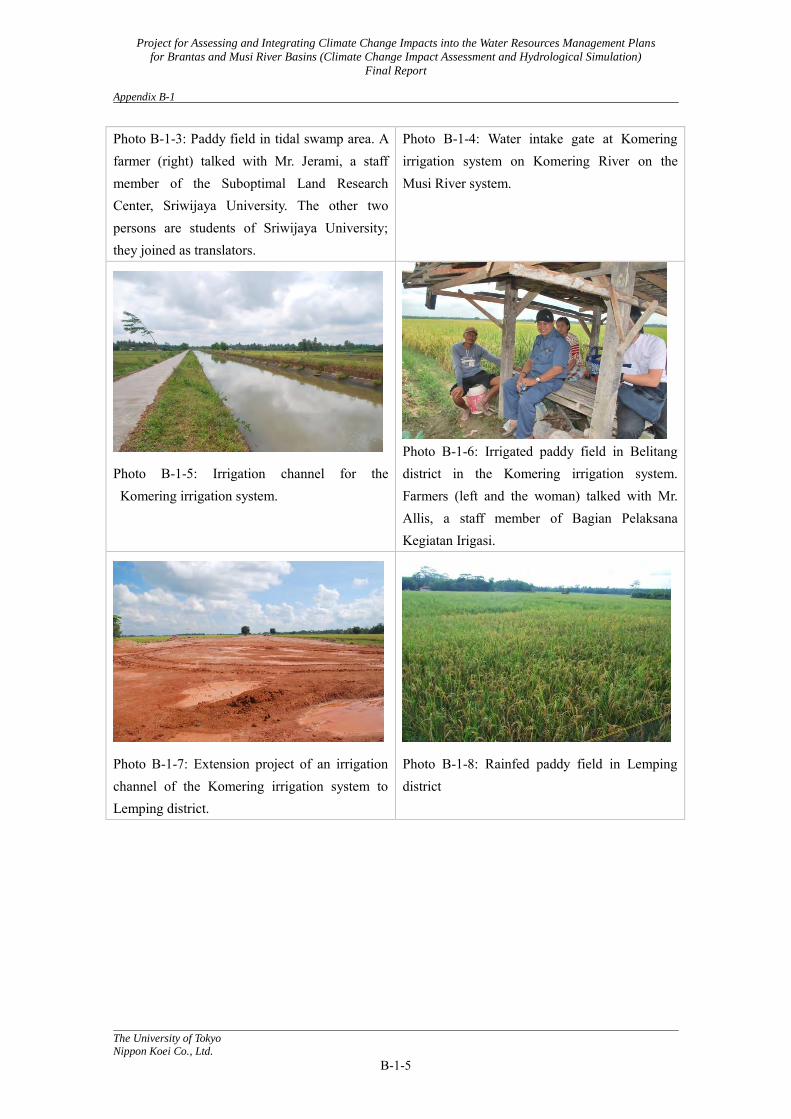
Photo B-1-3: Paddy field in tidal swamp area. A farmer (right) talked with Mr. Jerami, a staff member of the Suboptimal Land Research Center, Sriwijaya University. The other two persons are students of Sriwijaya University; they joined as translators.
Photo B-1-4: Water intake gate at Komering irrigation system on Komering River on the Musi River system.
Photo B-1-5: Irrigation channel for the Komering irrigation system.
Photo B-1-6: Irrigated paddy field in Belitang district in the Komering irrigation system. Farmers (left and the woman) talked with Mr. Allis, a staff member of Bagian Pelaksana Kegiatan Irigasi.
Photo B-1-7: Extension project of an irrigation channel of the Komering irrigation system to Lemping district.
Photo B-1-8: Rainfed paddy field in Lemping district
Project for Assessing and Integrating Climate Change Impacts into the Water Resources Management Plans
for Brantas and Musi River Basins (Climate Change Impact Assessment and Hydrological Simulation)
Final Report Appendix B-2
The University of Tokyo
Nippon Koei Co., Ltd.
B-2-1
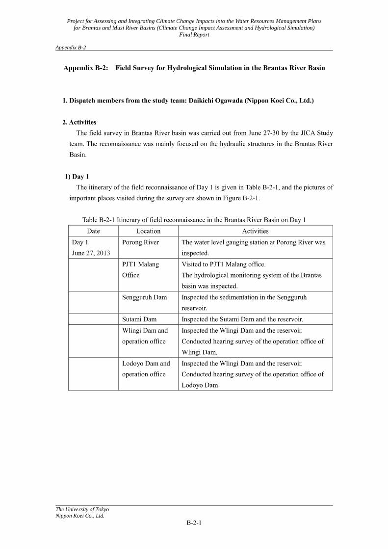
Appendix B-2: Field Survey for Hydrological Simulation in the Brantas River Basin 1. Dispatch members from the study team: Daikichi Ogawada (Nippon Koei Co., Ltd.) 2. Activities
The field survey in Brantas River basin was carried out from June 27-30 by the JICA Study team. The reconnaissance was mainly focused on the hydraulic structures in the Brantas River Basin.
1) Day 1
The itinerary of the field reconnaissance of Day 1 is given in Table B-2-1, and the pictures of important places visited during the survey are shown in Figure B-2-1.
Table B-2-1 Itinerary of field reconnaissance in the Brantas River Basin on Day 1
Date Location Activities Day 1 June 27, 2013
Porong River The water level gauging station at Porong River was inspected.
PJT1 Malang Office
Visited to PJT1 Malang office. The hydrological monitoring system of the Brantas basin was inspected.
Sengguruh Dam Inspected the sedimentation in the Sengguruh reservoir.
Sutami Dam Inspected the Sutami Dam and the reservoir. Wlingi Dam and
operation office Inspected the Wlingi Dam and the reservoir. Conducted hearing survey of the operation office of Wlingi Dam.
Lodoyo Dam and operation office
Inspected the Wlingi Dam and the reservoir. Conducted hearing survey of the operation office of Lodoyo Dam
Project for Assessing and Integrating Climate Change Impacts into the Water Resources Management Plans
for Brantas and Musi River Basins (Climate Change Impact Assessment and Hydrological Simulation)
Final Report Appendix B-2
The University of Tokyo
Nippon Koei Co., Ltd.
B-2-2
Porong water level gauging station
PJT1, Malang Office
Sengguruh Dam
Sutami Dam
Wilingi Dam
Lodoyo Dam
Figure B-2-1 Pictures of the sites investigated on Day 1
Project for Assessing and Integrating Climate Change Impacts into the Water Resources Management Plans
for Brantas and Musi River Basins (Climate Change Impact Assessment and Hydrological Simulation)
Final Report Appendix B-2
The University of Tokyo
Nippon Koei Co., Ltd.
B-2-3
2) Day 2 The itinerary of the field survey of Day 2 is shown in Table E-2, and the pictures of the sites
visited during the survey are shown in Figure E-2.
Table B-2-2 Itinerary of field reconnaissance in the Brantas River Basin on Day 2 Day 2 June 28, 2013
Wonorejo Dam Inspected the Wonorejo Dam and the reservoir. The diversion channel from Kelantur River to the reservoir was inspected.
Tulungagung Gate and operation office
Inspected the Tulungagung gate and pumps. Conducted hearing survey of the operation office. The POLA and operation rules were checked.
Mrican Barrage and opration office
Inspected the Barrage condition and intake facilities.
Ploso water level gauging station
Inspected the water level gauging facilities.
Jatimlerek Barrage Inspected the condition of the rehabilitated barrage. Lower reaches of
Widas River Inspected the flood prone area along lower reach of Widas river.
Menturus Barrage Inspected the barrage and intake facilities. New Lengkong
Barrage Inspected the barrage and the corrupted river bank protection on the left bank downstream of the barrage.
Wonorejo Dam
Diversion channel from Kelantur River to
Wonorejo
Project for Assessing and Integrating Climate Change Impacts into the Water Resources Management Plans
for Brantas and Musi River Basins (Climate Change Impact Assessment and Hydrological Simulation)
Final Report Appendix B-2
The University of Tokyo
Nippon Koei Co., Ltd.
B-2-4
Tulungagung Gate
Tulungagung Gate
Mrican Barrage
Ploso water level gauging station
Jatimlerek Barrage
Lower reach of the Widas River
Menturus Barrage
New Lengkong Barrage
Project for Assessing and Integrating Climate Change Impacts into the Water Resources Management Plans
for Brantas and Musi River Basins (Climate Change Impact Assessment and Hydrological Simulation)
Final Report Appendix B-2
The University of Tokyo
Nippon Koei Co., Ltd.
B-2-5
Figure B-2-2 Pictures of site investigated on Day 2
3) Day 3
The itinerary of the field survey of Day 3 is shown in Table E-3, and the pictures of important locations inspected during the survey are shown in Figure E-3.
Table B-2-3 Itinerary of field reconnaissance in the Brantas River Basin on Day 3
Day 3 June 30, 2013
Solorejo Dam Inspected the Solorejo Dam and the reservoir. Conducted hearing survey about the management of the reservoir, especially the dredging of volcanic sediments came from Mt. Kelud.
Sidoarujo mud flow Inspected the current condition of the Sidoarjo mud flow.
Reservoir at Selorejo Dam
Spillway at Selorejo Dam
Screen for intake at Selorejo Dam
Sidoarjo mud flow
Figure B-2-3 Pictures of sites investigated on Day 3
Project for Assessing and Integrating Climate Change Impacts into the Water Resources Management Plans
for Brantas and Musi River Basins (Climate Change Impact Assessment and Hydrological Simulation)
Final Report Appendix B-3
The University of Tokyo
Nippon Koei Co., Ltd.
B-3-1
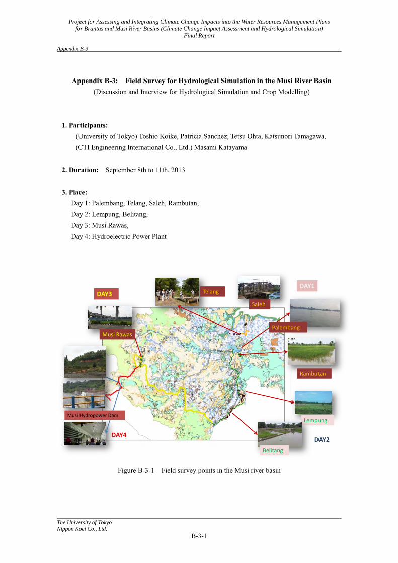
Appendix B-3: Field Survey for Hydrological Simulation in the Musi River Basin
(Discussion and Interview for Hydrological Simulation and Crop Modelling) 1. Participants:
(University of Tokyo) Toshio Koike, Patricia Sanchez, Tetsu Ohta, Katsunori Tamagawa, (CTI Engineering International Co., Ltd.) Masami Katayama
2. Duration: September 8th to 11th, 2013 3. Place:
Day 1: Palembang, Telang, Saleh, Rambutan, Day 2: Lempung, Belitang, Day 3: Musi Rawas, Day 4: Hydroelectric Power Plant
Figure B-3-1 Field survey points in the Musi river basin
Palembang
Rambutan
Telang
Saleh
DAY1
DAY2
Lempung
Belitang
Musi Rawas
DAY3
Musi Hydropower Dam
DAY4

Project for Assessing and Integrating Climate Change Impacts into the Water Resources Management Plans
for Brantas and Musi River Basins (Climate Change Impact Assessment and Hydrological Simulation)
Final Report Appendix B-3
The University of Tokyo
Nippon Koei Co., Ltd.
B-3-2
4. Activities
4.1 Day 1 (September 8th, 2013): Palembang - Talang - Saleh - Rambutan For the first day, the trip consisted of about an hour speed boat ride from Aston Hotel Palembang
to Talang (Tidal Swamp A and B Type), followed by another hour’s trip (by boat) to visit Saleh (Tidal Swamp C or D). Lastly, we went back to a freshwater swamp inland of Palembang called Rambutan. 4.1.1 Talang (Tidal Swamp)
Figure B-3-2: PALSAR image and visiting route around Talang Photo B-3-1: Talang
The type of TIDAL SWAMP PADDY is TYPE A or B. •70% of farmers do rattooning
- Only one cropping of direct seeding - Paddy re-growth
•30% of farmers - 1st cropping by direct seeding - 2nd cropping by direct seeding - However, this second cropping is more prone to flooding and drought
•Types of disasters: - Floods and droughts - Sea water intrusion (NOT AN ISSUE) - Pests and diseases
•Rice varieties: - Chiheran - the taste is very good but is prone to virus and fungi - Impari - tolerant of viruses, fungi; flood resistant
•Price of crop is controlled by the government at Rp.7,000/kilo
Project for Assessing and Integrating Climate Change Impacts into the Water Resources Management Plans
for Brantas and Musi River Basins (Climate Change Impact Assessment and Hydrological Simulation)
Final Report Appendix B-3
The University of Tokyo
Nippon Koei Co., Ltd.
B-3-3
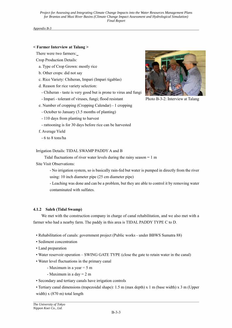
< Farmer Interview at Talang >
There were two farmers: Crop Production Details:
a. Type of Crop Grown: mostly rice b. Other crops: did not say c. Rice Variety: Chiheran, Impari (Impari tigablas) d. Reason for rice variety selection:
- Chiheran - taste is very good but is prone to virus and fungi - Impari - tolerant of viruses, fungi; flood resistant Photo B-3-2: Interview at Talang
e. Number of cropping (Cropping Calendar) - 1 cropping - October to January (3.5 months of planting) - 110 days from planting to harvest - rattooning is for 30 days before rice can be harvested
f. Average Yield - 6 to 8 tons/ha
Irrigation Details: TIDAL SWAMP PADDY A and B
Tidal fluctuations of river water levels during the rainy season = 1 m Site Visit Observations:
- No irrigation system, so is basically rain-fed but water is pumped in directly from the river using: 10 inch diameter pipe (25 cm diameter pipe) - Leaching was done and can be a problem, but they are able to control it by removing water contaminated with sulfates.
4.1.2 Saleh (Tidal Swamp)
We met with the construction company in charge of canal rehabilitation, and we also met with a farmer who had a nearby farm. The paddy in this area is TIDAL PADDY TYPE C to D.
• Rehabilitation of canals: government project (Public works - under BBWS Sumatra 88) • Sediment concentration • Land preparation • Water reservoir operation – SWING GATE TYPE (close the gate to retain water in the canal) • Water level fluctuations in the primary canal
- Maximum in a year = 5 m - Maximum in a day = 2 m
• Secondary and tertiary canals have irrigation controls • Tertiary canal dimensions (trapezoidal shape): 1.5 m (max depth) x 1 m (base width) x 3 m (Upper width) x (870 m) total length
Project for Assessing and Integrating Climate Change Impacts into the Water Resources Management Plans
for Brantas and Musi River Basins (Climate Change Impact Assessment and Hydrological Simulation)
Final Report Appendix B-3
The University of Tokyo
Nippon Koei Co., Ltd.
B-3-4
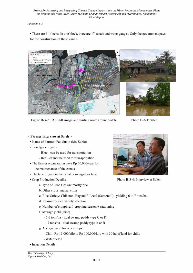
• There are 41 blocks. In one block, there are 17 canals and water gauges. Only the government pays for the construction of these canals.
Figure B-3-2: PALSAR image and visiting route around Saleh Photo B-3-3: Saleh
< Farmer Interview at Saleh >
• Name of Farmer: Pak Subio (Mr. Subio) • Two types of gates:
- Blue - can be used for transportation - Red - cannot be used for transportation
• The farmer organization pays Rp 50,000/year for the maintenance of the canals
• The type of gate in the canal is swing-door type. • Crop Production Details: Photo B-3-4: Interview at Saleh
a. Type of Crop Grown: mostly rice b. Other crops: maize, chilis c. Rice Variety: Chiheran, Bagandif, Local (Somontol) –yielding 6 to 7 tons/ha d. Reason for rice variety selection: e. Number of cropping: 1 cropping season + rattooning f. Average yield (Rice)
- 5-6 tons/ha - tidal swamp paddy type C or D - ~7 tons/ha - tidal swamp paddy type A or B
g. Average yield for other crops: - Chili: Rp 15,000/kilo to Rp 100,000/kilo with 30 ha of land for chilis - Watermelon
• Irrigation Details:

Project for Assessing and Integrating Climate Change Impacts into the Water Resources Management Plans
for Brantas and Musi River Basins (Climate Change Impact Assessment and Hydrological Simulation)
Final Report Appendix B-3
The University of Tokyo
Nippon Koei Co., Ltd.
B-3-5
- TIDAL SWAMP TYPE C or D with water gate to keep the water in using tidal variation (e.g. when water is low, gate swings close but when water level is high, gate swings open to let the water flow into the canals). - 1,240 ha of land is occupied by the blocks. - During the rainy season, the gate is closed to keep the water in; irrigation source: rain - During the dry season, the gate is open; farmers cultivate maize, etc. - Near the main canal or river, TIDAL SWAMP PADDY TYPE A OR B can be found
• Main cause of crop loss: - It depends on climate, prediction of optimal time for planting - Increase in the incidence of pests and diseases: when relative humidity is high, there is higher incidence of pests and diseases on rice - Leaching problem: three years ago (2010), seeds did not germinate after sowing because of very acidic soil. When there is not enough rainfall to leach the soil of the ferrites and sulfates, soil is more acid. If 50 cm layer of the soil dries up, acid sulfate soil appears.
• Depth of water in the canals is maintained at 0.5 m (at least) during the growing/germination phase. But, it varies because it is dependent on rain.
4.1.3 Rambutan (Fresh Water Swamp)
Photo B-3-5: Rambutan
Figure B-3-4: PALSAR image and visiting route around Rambutan
< Farmer Interview at Rambutan >
Farmer Name: Pak Nurdin (Mr. Nurdin) • In the Rainy Season, they do not plant because water levels are too high. Instead, the harvest time is scheduled for the rainy season.
Project for Assessing and Integrating Climate Change Impacts into the Water Resources Management Plans
for Brantas and Musi River Basins (Climate Change Impact Assessment and Hydrological Simulation)
Final Report Appendix B-3
The University of Tokyo
Nippon Koei Co., Ltd.
B-3-6
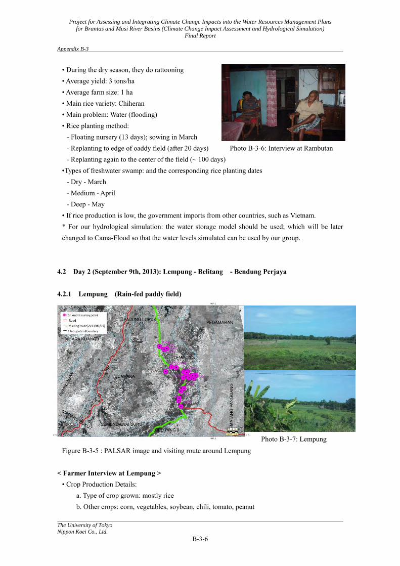
• During the dry season, they do rattooning • Average yield: 3 tons/ha • Average farm size: 1 ha • Main rice variety: Chiheran • Main problem: Water (flooding) • Rice planting method:
- Floating nursery (13 days); sowing in March - Replanting to edge of oaddy field (after 20 days) Photo B-3-6: Interview at Rambutan - Replanting again to the center of the field (~ 100 days)
•Types of freshwater swamp: and the corresponding rice planting dates - Dry - March - Medium - April - Deep - May
• If rice production is low, the government imports from other countries, such as Vietnam. * For our hydrological simulation: the water storage model should be used; which will be later changed to Cama-Flood so that the water levels simulated can be used by our group.
4.2 Day 2 (September 9th, 2013): Lempung - Belitang - Bendung Perjaya
4.2.1 Lempung (Rain-fed paddy field)
Photo B-3-7: Lempung Figure B-3-5 : PALSAR image and visiting route around Lempung
< Farmer Interview at Lempung > • Crop Production Details:
a. Type of crop grown: mostly rice b. Other crops: corn, vegetables, soybean, chili, tomato, peanut
Project for Assessing and Integrating Climate Change Impacts into the Water Resources Management Plans
for Brantas and Musi River Basins (Climate Change Impact Assessment and Hydrological Simulation)
Final Report Appendix B-3
The University of Tokyo
Nippon Koei Co., Ltd.
B-3-7
c. Rice variety: Ciliwung, Chiheran d. Reason for rice variety selection:
: Chiheran - High quality (market price is high), - Tolerant to viruses, - Good harvest
e. Cropping pattern - First cropping: October to November: Rice - Second cropping: Other crops
f. Cropping calendar of Chiheran Photo B-3-8: Interview at Lempung -90 days from planting to harvest (Seeding to replant: 20 days, heading: 50 - 60 days, harvest: 90 days.)
g. Average yield - 3 to 4 tons/ha
h. Paddy area per farmer - 0.5 to 4 ha
i. Types of disasters: -Floods and droughts , and pests
j. Others - One or two week rain prediction is useful for seeding preparation.
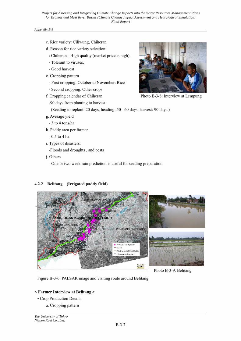
4.2.2 Belitang (Irrigated paddy field)
Photo B-3-9: Belitang
Figure B-3-6: PALSAR image and visiting route around Belitang
< Farmer Interview at Belitang > • Crop Production Details:
a. Cropping pattern
Project for Assessing and Integrating Climate Change Impacts into the Water Resources Management Plans
for Brantas and Musi River Basins (Climate Change Impact Assessment and Hydrological Simulation)
Final Report Appendix B-3
The University of Tokyo
Nippon Koei Co., Ltd.
B-3-8
- First cropping: September: Rice - Second cropping: March: Rice - Third cropping: Vegetables
b. Rice variety: Ciliwung, Chiheran, Baditin c. Reason for rice variety selection:
- Ciliwung - Best quality but not strong against pests - Chiheran - Strong against pests
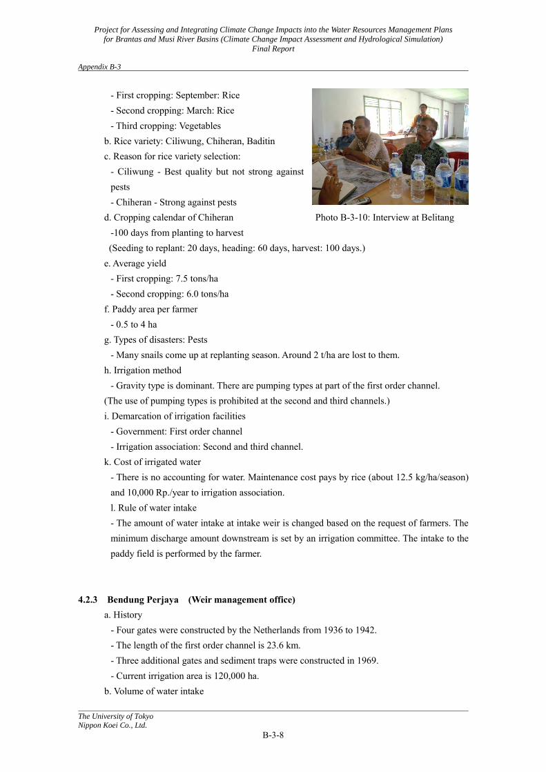
d. Cropping calendar of Chiheran Photo B-3-10: Interview at Belitang -100 days from planting to harvest
(Seeding to replant: 20 days, heading: 60 days, harvest: 100 days.) e. Average yield
- First cropping: 7.5 tons/ha - Second cropping: 6.0 tons/ha
f. Paddy area per farmer - 0.5 to 4 ha
g. Types of disasters: Pests - Many snails come up at replanting season. Around 2 t/ha are lost to them.
h. Irrigation method - Gravity type is dominant. There are pumping types at part of the first order channel.
(The use of pumping types is prohibited at the second and third channels.) i. Demarcation of irrigation facilities
- Government: First order channel - Irrigation association: Second and third channel.
k. Cost of irrigated water - There is no accounting for water. Maintenance cost pays by rice (about 12.5 kg/ha/season) and 10,000 Rp./year to irrigation association. l. Rule of water intake - The amount of water intake at intake weir is changed based on the request of farmers. The minimum discharge amount downstream is set by an irrigation committee. The intake to the paddy field is performed by the farmer.
4.2.3 Bendung Perjaya (Weir management office) a. History
- Four gates were constructed by the Netherlands from 1936 to 1942. - The length of the first order channel is 23.6 km. - Three additional gates and sediment traps were constructed in 1969. - Current irrigation area is 120,000 ha.
b. Volume of water intake
Project for Assessing and Integrating Climate Change Impacts into the Water Resources Management Plans
for Brantas and Musi River Basins (Climate Change Impact Assessment and Hydrological Simulation)
Final Report Appendix B-3
The University of Tokyo
Nippon Koei Co., Ltd.
B-3-9
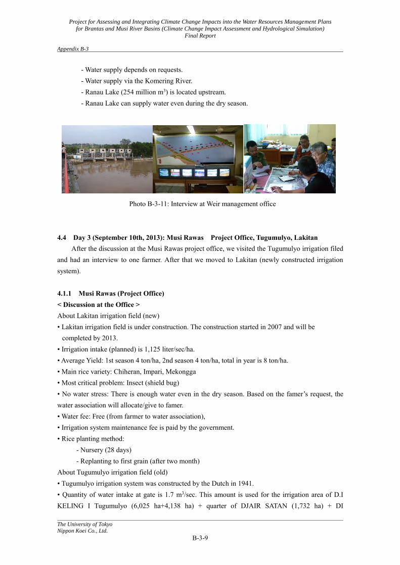
- Water supply depends on requests. - Water supply via the Komering River. - Ranau Lake (254 million m3) is located upstream. - Ranau Lake can supply water even during the dry season.
Photo B-3-11: Interview at Weir management office 4.4 Day 3 (September 10th, 2013): Musi Rawas Project Office, Tugumulyo, Lakitan
After the discussion at the Musi Rawas project office, we visited the Tugumulyo irrigation filed and had an interview to one farmer. After that we moved to Lakitan (newly constructed irrigation system). 4.1.1 Musi Rawas (Project Office) < Discussion at the Office > About Lakitan irrigation field (new) • Lakitan irrigation field is under construction. The construction started in 2007 and will be
completed by 2013. • Irrigation intake (planned) is 1,125 liter/sec/ha. • Average Yield: 1st season 4 ton/ha, 2nd season 4 ton/ha, total in year is 8 ton/ha. • Main rice variety: Chiheran, Impari, Mekongga • Most critical problem: Insect (shield bug) • No water stress: There is enough water even in the dry season. Based on the famer’s request, the water association will allocate/give to famer. • Water fee: Free (from farmer to water association), • Irrigation system maintenance fee is paid by the government. • Rice planting method:
- Nursery (28 days) - Replanting to first grain (after two month)
About Tugumulyo irrigation field (old) • Tugumulyo irrigation system was constructed by the Dutch in 1941. • Quantity of water intake at gate is 1.7 m3/sec. This amount is used for the irrigation area of D.I KELING I Tugumulyo (6,025 ha+4,138 ha) + quarter of DJAIR SATAN (1,732 ha) + DI
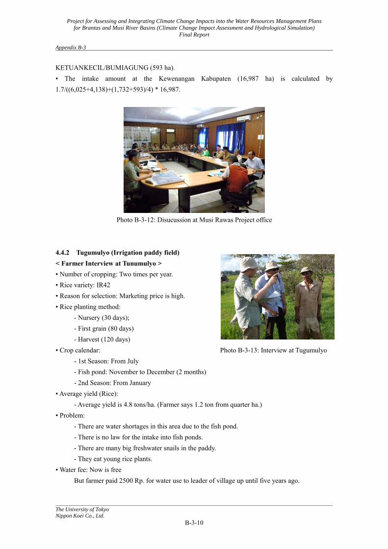
Project for Assessing and Integrating Climate Change Impacts into the Water Resources Management Plans
for Brantas and Musi River Basins (Climate Change Impact Assessment and Hydrological Simulation)
Final Report Appendix B-3
The University of Tokyo
Nippon Koei Co., Ltd.
B-3-10
KETUANKECIL/BUMIAGUNG (593 ha). • The intake amount at the Kewenangan Kabupaten (16,987 ha) is calculated by 1.7/((6,025+4,138)+(1,732+593)/4) * 16,987.
Photo B-3-12: Disucussion at Musi Rawas Project office
4.4.2 Tugumulyo (Irrigation paddy field) < Farmer Interview at Tunumulyo > • Number of cropping: Two times per year. • Rice variety: IR42 • Reason for selection: Marketing price is high. • Rice planting method:
- Nursery (30 days); - First grain (80 days) - Harvest (120 days)
• Crop calendar: Photo B-3-13: Interview at Tugumulyo - 1st Season: From July - Fish pond: November to December (2 months) - 2nd Season: From January
• Average yield (Rice): - Average yield is 4.8 tons/ha. (Farmer says 1.2 ton from quarter ha.)
• Problem: - There are water shortages in this area due to the fish pond. - There is no law for the intake into fish ponds. - There are many big freshwater snails in the paddy. - They eat young rice plants.
• Water fee: Now is free But farmer paid 2500 Rp. for water use to leader of village up until five years ago.
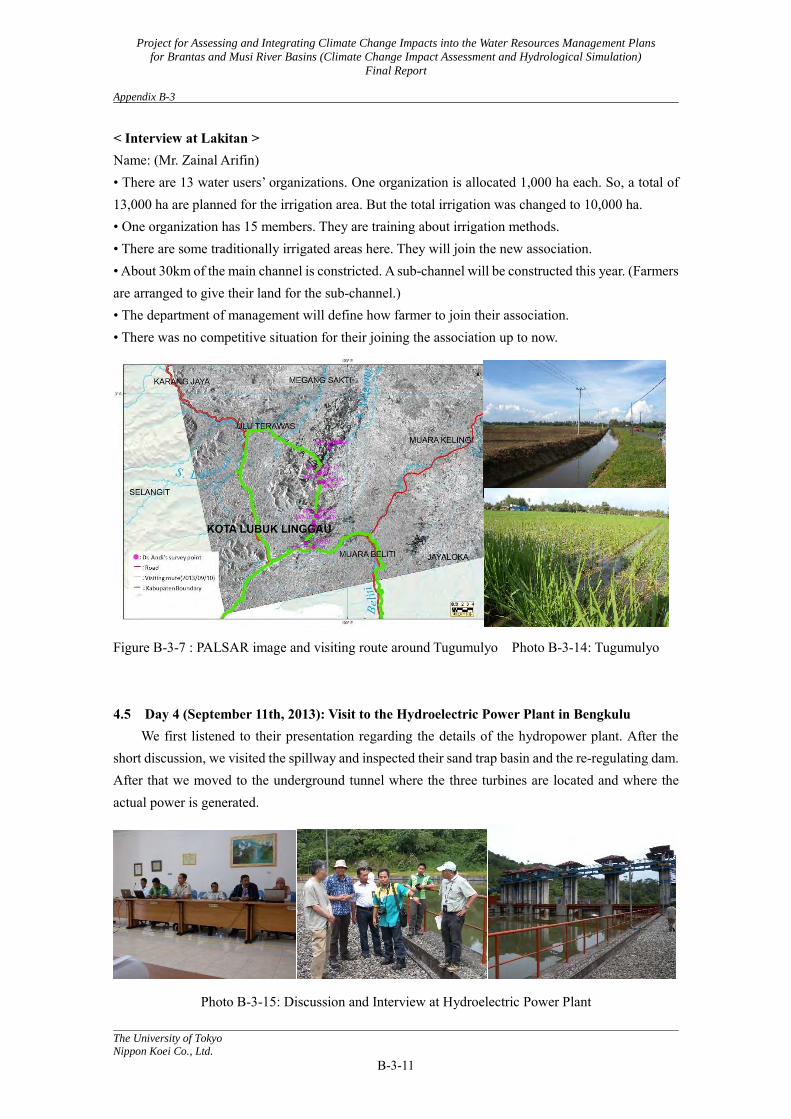
Project for Assessing and Integrating Climate Change Impacts into the Water Resources Management Plans
for Brantas and Musi River Basins (Climate Change Impact Assessment and Hydrological Simulation)
Final Report Appendix B-3
The University of Tokyo
Nippon Koei Co., Ltd.
B-3-11
< Interview at Lakitan > Name: (Mr. Zainal Arifin) • There are 13 water users’ organizations. One organization is allocated 1,000 ha each. So, a total of 13,000 ha are planned for the irrigation area. But the total irrigation was changed to 10,000 ha. • One organization has 15 members. They are training about irrigation methods. • There are some traditionally irrigated areas here. They will join the new association. • About 30km of the main channel is constricted. A sub-channel will be constructed this year. (Farmers are arranged to give their land for the sub-channel.) • The department of management will define how farmer to join their association. • There was no competitive situation for their joining the association up to now.
Figure B-3-7 : PALSAR image and visiting route around Tugumulyo Photo B-3-14: Tugumulyo 4.5 Day 4 (September 11th, 2013): Visit to the Hydroelectric Power Plant in Bengkulu
We first listened to their presentation regarding the details of the hydropower plant. After the short discussion, we visited the spillway and inspected their sand trap basin and the re-regulating dam. After that we moved to the underground tunnel where the three turbines are located and where the actual power is generated.
Photo B-3-15: Discussion and Interview at Hydroelectric Power Plant
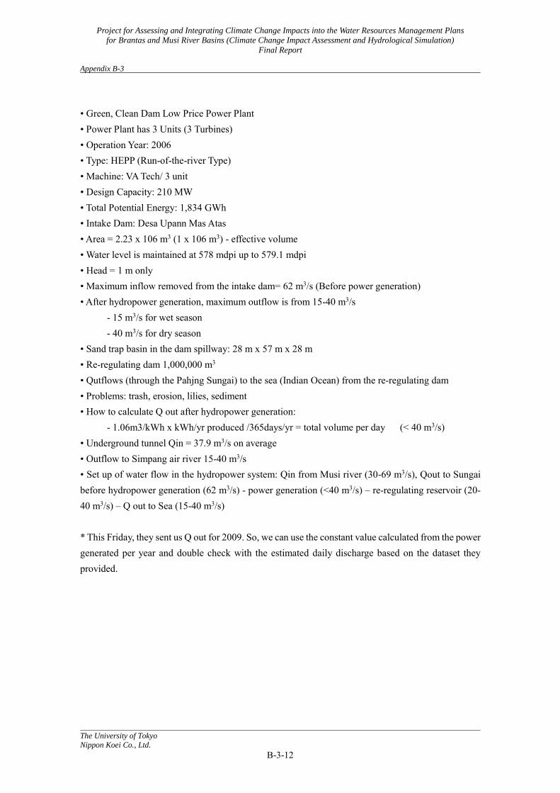
Project for Assessing and Integrating Climate Change Impacts into the Water Resources Management Plans
for Brantas and Musi River Basins (Climate Change Impact Assessment and Hydrological Simulation)
Final Report Appendix B-3
The University of Tokyo
Nippon Koei Co., Ltd.
B-3-12
• Green, Clean Dam Low Price Power Plant • Power Plant has 3 Units (3 Turbines) • Operation Year: 2006 • Type: HEPP (Run-of-the-river Type) • Machine: VA Tech/ 3 unit • Design Capacity: 210 MW • Total Potential Energy: 1,834 GWh • Intake Dam: Desa Upann Mas Atas • Area = 2.23 x 10⁶ m3 (1 x 10⁶ m3) - effective volume • Water level is maintained at 578 mdpi up to 579.1 mdpi • Head = 1 m only • Maximum inflow removed from the intake dam= 62 m3/s (Before power generation) • After hydropower generation, maximum outflow is from 15-40 m3/s
- 15 m3/s for wet season - 40 m3/s for dry season
• Sand trap basin in the dam spillway: 28 m x 57 m x 28 m • Re-regulating dam 1,000,000 m3 • Qutflows (through the Pahjng Sungai) to the sea (Indian Ocean) from the re-regulating dam • Problems: trash, erosion, lilies, sediment • How to calculate Q out after hydropower generation:
- 1.06m3/kWh x kWh/yr produced /365days/yr = total volume per day (< 40 m3/s) • Underground tunnel Qin = 37.9 m3/s on average • Outflow to Simpang air river 15-40 m3/s • Set up of water flow in the hydropower system: Qin from Musi river (30-69 m3/s), Qout to Sungai before hydropower generation (62 m3/s) - power generation (<40 m3/s) – re-regulating reservoir (20-40 m3/s) – Q out to Sea (15-40 m3/s) * This Friday, they sent us Q out for 2009. So, we can use the constant value calculated from the power generated per year and double check with the estimated daily discharge based on the dataset they provided.

Project for Assessing and Integrating Climate Change Impacts into the Water Resources Management Plans
for Brantas and Musi River Basins (Climate Change Impact Assessment and Hydrological Simulation)
Final Report Appendix B-4
The University of Tokyo
Nippon Koei Co., Ltd.
B-4-1
Appendix B-4: Field Survey for Hydrological Simulation in the Brantas River Basin in
Surabaya
1. Dispatch members from the study team (Project Component 1) (University of Tokyo) Toshio Koike, Patricia Sanchez, Kumiko Tsujimoto, Tetsu Ohta, (Kyoto University) Koki Homma, (Nippon Koei Co., Ltd.) Daikichi Ogawada
2. Date: May 21, 2014 3. Activities
The field survey in the Brantas River basin was carried out on May 21st by the JICA study team as a part of the climate change seminar. It was mainly focused on the upstream area due to time restrictions. Investigation sites and the time schedule of the field survey are shown in figure B-4-1 and Table B-4-1 respectively.
Figure B-4-1 Investigated sites
Table B-4-1 Time schedule of the field survey Time Program on May 21st Remarks 7:00 Departure from the hotel 9:30 JPT-1, Malang Courtesy visit and discussion 10:40 Sengguruh dam 11:40 Sutami dam

Project for Assessing and Integrating Climate Change Impacts into the Water Resources Management Plans
for Brantas and Musi River Basins (Climate Change Impact Assessment and Hydrological Simulation)
Final Report Appendix B-4
The University of Tokyo
Nippon Koei Co., Ltd.
B-4-2
13:00 Lunch at Malang Porong river Sidoarjo mud flow
On the way to Surabaya
16:30 Surabaya
Mr. Didik Ardianto gave a presentation at JPT-1, and some dam operation specifications were explained at the Sutami dam, as below. (1) PJT-1 (Presentation by Mr. Didik Ardianto)
Operation and maintenance conducted by their office: routine, preventive, emergency, conservation, and hydrological management (WL, Q etc. check and maintain the instruments).
A decrease from 100% to 57% storage efficiency was observed in the dam from 1972 to 2000. The main issue is sedimentation. Another problem is scouring of the riverbed during dredging (Jan to April water level is lower than the HWL).
The adaptation strategy for this is to create a control water level (CWL) lower than the high water level (HWL) during the rainy season.
<< Comment (by Professor Koike, Team Leader) >>
Possible addition (not promised): Hydrological model + sediment transport model. (2) Sutami Dam (Explanation by dam staff)
Basically, a gravity dam control is made in the Lodoyo dam where 50m3/s is the minimum constant base flow and Q is reported to the manager (Mr. Adie Santoso) every six hours but recorded automatically every hour. Sample values for that day are (Qin = 88.4 m3/s and Qout = 84.2 m3/s). The hourly data of eight dams is available in the Malang office.
4. Dispatch Itinerary This dispatch schedule is shown in the following table.
Table B-4-2 Dispatch itinerary
Days Date Transportation Stay Contents 1 18 May
(Sun) Tokyo→ Jakarta
Jakarta Departure
2 19 May (Mon)
Jakarta - Climate Change Seminar in Jakarta. - Joint meeting-1 with Water resources management plan study team.
3 20 May (Tue)
Surabaya - Climate Change Seminar in Surabaya. - Joint meeting-2 with Water resources management plan study team.

Project for Assessing and Integrating Climate Change Impacts into the Water Resources Management Plans
for Brantas and Musi River Basins (Climate Change Impact Assessment and Hydrological Simulation)
Final Report Appendix B-4
The University of Tokyo
Nippon Koei Co., Ltd.
B-4-3
4 21 May (Wed)
Surabaya→ Tokyo
Field Trip Departure
5 22 May (Thu)
Return home
Project for Assessing and Integrating Climate Change Impacts into the Water Resources Management Plans
for Brantas and Musi River Basins (Climate Change Impact Assessment and Hydrological Simulation)
Final Report Appendix B-5
The University of Tokyo
Nippon Koei Co., Ltd.
B-5-1
Appendix B-5: Field Survey for the Coupling Model in the Musi River Basin
1. Dispatch members from the study team: (Kyoto University) Koki Homma, (University of Tokyo) Kumiko Tsujimoto
2. Duration: May 15-17, 2014 (Dr. Homma only), May 23-25, 2014 3. Place: Jakarta, Bogor (May 15-17, 2014)
Musi River basin (May 22-24, 2014) 4. Activities
- Research meeting at Bogor Agricultural University - Implementation of field survey required for preparing crop model and establishment of
the method 4.1 Research meeting at Bogor Agricultural University (May 15-17, 2014) One of the members of the study team, Dr. Koki Homma, visited Dr. Haris Syaybuddin, who is the Head of the Indonesian Agroclimate and Hydrology Research Institute (IAHRI), Indonesian Agency for Agricultural Research and Development, Ministry of Agriculture, in Bogor. They discussed about the web information system “Kalendar Tanam (Cropping Calendar)”, which has been managed by IAHRI and helps farmers decide their cropping management. The system is quite interesting, and it is hoped it will be connected to this project in the future. The study team also visited Dr. Iskandar Lubis, Lecturer of Bogor Agricultural University, and obtained information about experimental situations in rice cultivation areas in Indonesia. He provided some documents that can be utilized to parameterize phonological development of rice cultivars. 4.2 Implementation of field survey required for preparing crop model and establishment of the method (22 to 24 May, 2014) We have combined the hydrological model (WEB-DHM) and the crop growth model (SIMRIW-Rainfed) to evaluate the effects of climatic change on water flow and rice production in the Musi River basin. However, the preliminary test indicated that we need to improve models for irrigation management in irrigated paddies and tidal swamp paddies and for changes in water depth in fresh water swamp paddies and rainfed paddies. For these improvements, the study team conducted investigations in farmers’ fields and their management in the Musi River Basin, and confirmed the details of irrigation management and changes in water depth. The investigations were firstly conducted in tidal swamp areas around the lower part of Musi
Project for Assessing and Integrating Climate Change Impacts into the Water Resources Management Plans
for Brantas and Musi River Basins (Climate Change Impact Assessment and Hydrological Simulation)
Final Report Appendix B-5
The University of Tokyo
Nippon Koei Co., Ltd.
B-5-2
River. The study team interviewed farmers about their management methods, especially about irrigation and drainage procedures in the paddies. They also observed field conditions, because a satellite image for the investigated area indicated that there are two types of tidal swamp paddies. The observation suggests that one type of tidal swamp paddies is managed similarly to how the irrigated paddies are, and the other type is managed similarly to how the rainfed paddies are. Utilizing digital maps developed by the Ministry of Agriculture together with digital elevation maps may enable us to distinguish the two types of tidal swamp paddies for our simulation work. Subsequently, the study team visited fresh water swamp paddies and interviewed farmers. The activity suggests that modelling water depth and recession is quite important to evaluate rice productivity in the paddies. The study team observed supplemental irrigation in rainfed paddies, and investigate the times and amounts. However, besides the evaluation of amounts being too difficult, the times and amounts seem much lower than those in irrigated paddies. Accordingly, the research team decided that modelling supplemental irrigation in rainfed paddies is not necessary in this project. The investigation in irrigated paddies was conducted on the number of croppings per year and irrigation management. The number of cropping is regulated by the District Department of Agriculture in terms of pest management. The irrigation is conducted through the gravity method. The observations confirmed that the sub-model for irrigation management in the project is consistent with the actual management.
Strategy of irrigation channel development was obtained at the office of Komering Water Weir. The head of office also explained the management of water in the area. Irrigation and discharge rates, the planning of irrigation channels, and so one were explained by Mr. Kawai of Nippon Koei Co. Ltd. He also gave copies of documents about the Komering Irrigation Project.
After the investigation activities, the study team observed landscapes in the Musi River basin and discussed the land-use map employed in the project. The discussion concluded that the map needs to be updated, but a temporal solution was found at a project meeting held just after this field survey.
5. Progress in the improvement of the combined simulation model of WEB-DHM and SIMRIW-Rainfed Adequate information and documents were collected to parameterize phonological developments of
rice cultivars for the crop model section. One of the problems when simulating rice production in the Musi River basin was the land-use map. A temporal solution was found at a project meeting, but continuous efforts have been recommended for the update of the land-use map in order to accurately evaluate rice production. Irrigation models for tidal swamp paddies were considered not to have any problems. Problems in rice cultivation in tidal swamp paddies were salinity and acidity by sulfuric acid caused by the severe drying of soil. However, these problems are local and there is not enough data to be incorporated, making us decide that this project will not
Project for Assessing and Integrating Climate Change Impacts into the Water Resources Management Plans
for Brantas and Musi River Basins (Climate Change Impact Assessment and Hydrological Simulation)
Final Report Appendix B-5
The University of Tokyo
Nippon Koei Co., Ltd.
B-5-3
include these problems. The accuracy of water depth and recession rate in fresh water swamp paddies is quite important and
affects simulation results. This survey also indicated the importance of accuracy. The accuracy must be reviewed after preliminary calculations are made with the simulation model. The review may reveal points to be improved in the simulation model. The review is also necessary to check the requirement of the sub-model for supplemental irrigation in rainfed paddies. The sub-model for irrigation management in irrigated paddies does not have any problem at present. However, the irrigation rate and so on have to be checked for in the Komering irrigation area by using the information obtained in the survey.
6. Dispatch Itinerary This dispatch schedule is shown in the following table.
Table B-5-1 Dispatch Itinerary
Day Date Transference Stay Activities
1 15 May (Thu)
Kyoto→Jakarta→Bogor Bogor Departure
2 16 May
(Fri) Bogor
Research meeting at Agriculture Climate Research Center
3 17 May
(Sat) Bogor
Research meeting at Bogor Agricultural University.
(1) 18 May (Sun)
Bogor→Jakarta Jakarta Traveling
(2) 19 May (Mon)
Jakarta
- Climate Change Seminar in Jakarta. - Joint meeting-1 with Water resources management plan study team.
(3) 20 May (Tue)
Jakarta→Surabaya Surabaya - Climate Change Seminar in Surabaya. - Joint meeting-2
(4) 21 May (Wed)
Surabaya→Jakarta Jakarta Field Trip Departure → Jakarta
(5) 22 May (Thu)
Jakarta→Palembang Palembang Investigation at tidal swamp and fresh water swamp paddies.
4 23 May
(Fri) Palembang →Martapura Martapura
Investigation at rainfed and irrigated paddies. Observation at Komering intake weir. Visiting
Project for Assessing and Integrating Climate Change Impacts into the Water Resources Management Plans
for Brantas and Musi River Basins (Climate Change Impact Assessment and Hydrological Simulation)
Final Report Appendix B-5
The University of Tokyo
Nippon Koei Co., Ltd.
B-5-4
Mr. Kawai of Nippon Koei Co. Ltd.
5 24 May
(Sat) Martapura →Palembang→Jakarta
Jakarta Observation along with Musi River.
6 25 May (Sun)
Jakarta→Kyoto Return home
7. Photo
Photo B-5-1: A pool of water in the Telang tidal swamp paddy area. The pool of water was so acidic due to sulfuric acid that animals such as insects and fishes cannot survive.
Photo B-5-2: Farmers explained their management of irrigation and drainage in paddy fields in the Yelang tidal swamp paddy area.
Photo B-5-3: The boat traveling on the primary channel in the Upang tidal swamp paddy area.
Photo B-5-4: Fresh water swamp paddies in Rambutan. As water depth decreased, farmers started to transplant rice seedlings.
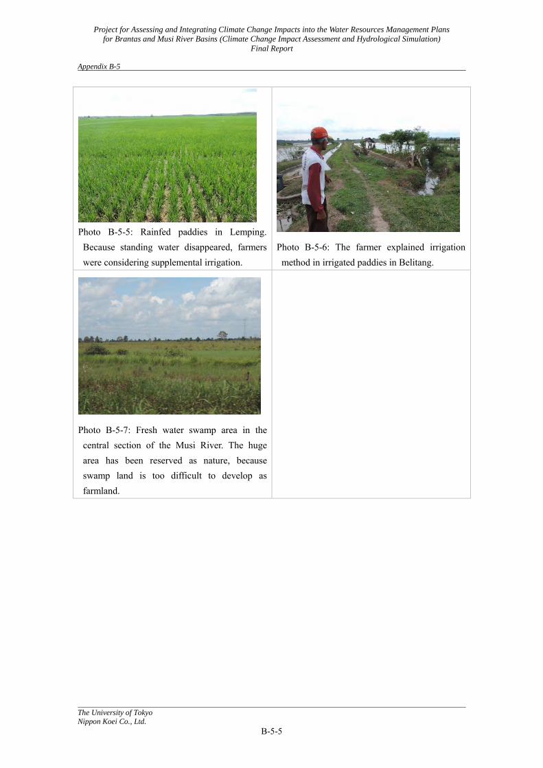
Project for Assessing and Integrating Climate Change Impacts into the Water Resources Management Plans
for Brantas and Musi River Basins (Climate Change Impact Assessment and Hydrological Simulation)
Final Report Appendix B-5
The University of Tokyo
Nippon Koei Co., Ltd.
B-5-5
Photo B-5-5: Rainfed paddies in Lemping. Because standing water disappeared, farmers were considering supplemental irrigation.
Photo B-5-6: The farmer explained irrigation method in irrigated paddies in Belitang.
Photo B-5-7: Fresh water swamp area in the central section of the Musi River. The huge area has been reserved as nature, because swamp land is too difficult to develop as farmland.
Project for Assessing and Integrating Climate Change Impacts into the Water Resources Management Plans
for Brantas and Musi River Basins (Climate Change Impact Assessment and Hydrological Simulation)
Final Report Appendix C
The University of Tokyo
Nippon Koei Co., Ltd.
Appendix C
Training in Japan
(Climate Change Impact Assessment)
C-1 The First Training Course (1st Training-1) C-2 The First Training Course (1st Training-2) C-3 The Second Training Course (Deep understanding)
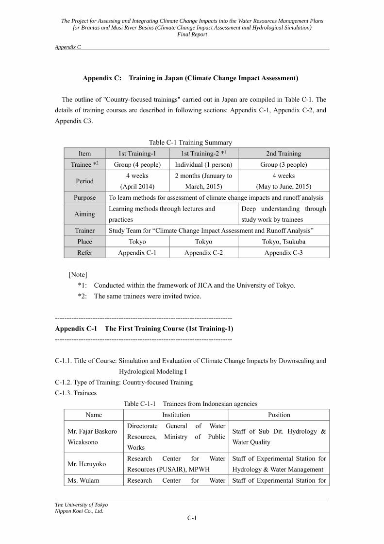
The Project for Assessing and Integrating Climate Change Impacts into the Water Resources Management Plans
for Brantas and Musi River Basins (Climate Change Impact Assessment and Hydrological Simulation)
Final Report Appendix C
The University of Tokyo
Nippon Koei Co., Ltd.
C-1
Appendix C: Training in Japan (Climate Change Impact Assessment)
The outline of "Country-focused trainings" carried out in Japan are compiled in Table C-1. The
details of training courses are described in following sections: Appendix C-1, Appendix C-2, and Appendix C3.
Table C-1 Training Summary Item 1st Training-1 1st Training-2 *1 2nd Training
Trainee *2 Group (4 people) Individual (1 person) Group (3 people)
Period 4 weeks
(April 2014) 2 months (January to
March, 2015) 4 weeks
(May to June, 2015) Purpose To learn methods for assessment of climate change impacts and runoff analysis
Aiming Learning methods through lectures and practices
Deep understanding through study work by trainees
Trainer Study Team for “Climate Change Impact Assessment and Runoff Analysis” Place Tokyo Tokyo Tokyo, Tsukuba Refer Appendix C-1 Appendix C-2 Appendix C-3
[Note]
*1: Conducted within the framework of JICA and the University of Tokyo. *2: The same trainees were invited twice.
--------------------------------------------------------------------------- Appendix C-1 The First Training Course (1st Training-1) --------------------------------------------------------------------------- C-1.1. Title of Course: Simulation and Evaluation of Climate Change Impacts by Downscaling and
Hydrological Modeling I C-1.2. Type of Training: Country-focused Training C-1.3. Trainees
Table C-1-1 Trainees from Indonesian agencies Name Institution Position
Mr. Fajar Baskoro Wicaksono
Directorate General of Water Resources, Ministry of Public Works
Staff of Sub Dit. Hydrology & Water Quality
Mr. Heruyoko Research Center for Water Resources (PUSAIR), MPWH
Staff of Experimental Station for Hydrology & Water Management
Ms. Wulam Research Center for Water Staff of Experimental Station for
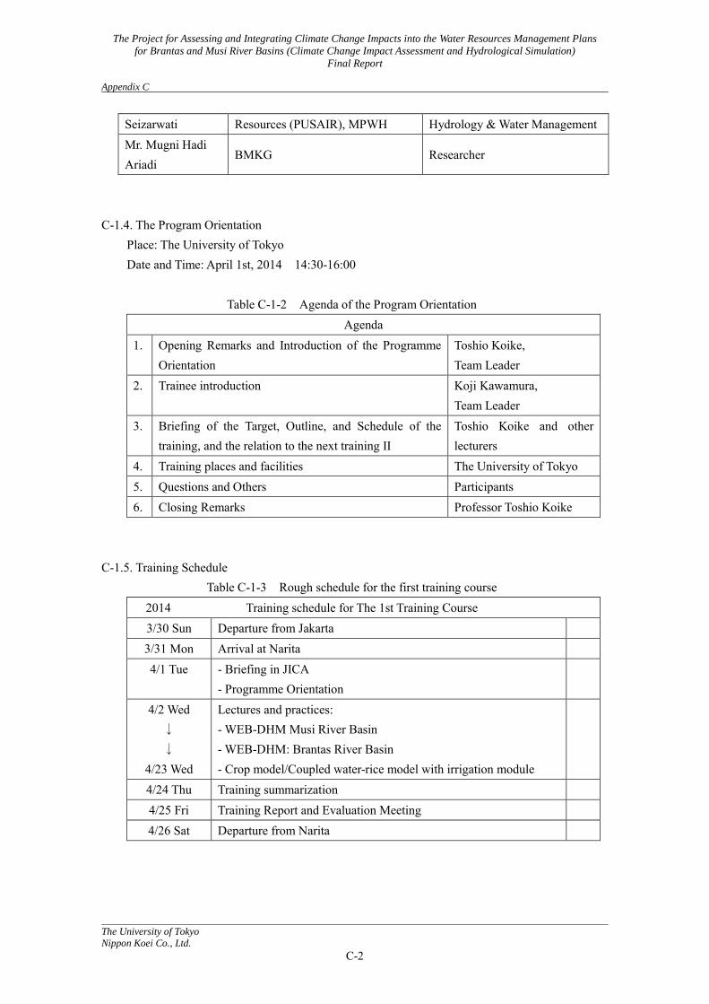
The Project for Assessing and Integrating Climate Change Impacts into the Water Resources Management Plans
for Brantas and Musi River Basins (Climate Change Impact Assessment and Hydrological Simulation)
Final Report Appendix C
The University of Tokyo
Nippon Koei Co., Ltd.
C-2
Seizarwati Resources (PUSAIR), MPWH Hydrology & Water Management Mr. Mugni Hadi Ariadi
BMKG Researcher
C-1.4. The Program Orientation
Place: The University of Tokyo Date and Time: April 1st, 2014 14:30-16:00
Table C-1-2 Agenda of the Program Orientation
Agenda 1. Opening Remarks and Introduction of the Programme
Orientation Toshio Koike, Team Leader
2. Trainee introduction Koji Kawamura, Team Leader
3. Briefing of the Target, Outline, and Schedule of the training, and the relation to the next training II
Toshio Koike and other lecturers
4. Training places and facilities The University of Tokyo 5. Questions and Others Participants 6. Closing Remarks Professor Toshio Koike
C-1.5. Training Schedule
Table C-1-3 Rough schedule for the first training course 2014 Training schedule for The 1st Training Course 3/30 Sun Departure from Jakarta
3/31 Mon Arrival at Narita
4/1 Tue - Briefing in JICA - Programme Orientation
4/2 Wed ↓ ↓
4/23 Wed
Lectures and practices: - WEB-DHM Musi River Basin - WEB-DHM: Brantas River Basin - Crop model/Coupled water-rice model with irrigation module
4/24 Thu Training summarization
4/25 Fri Training Report and Evaluation Meeting
4/26 Sat Departure from Narita
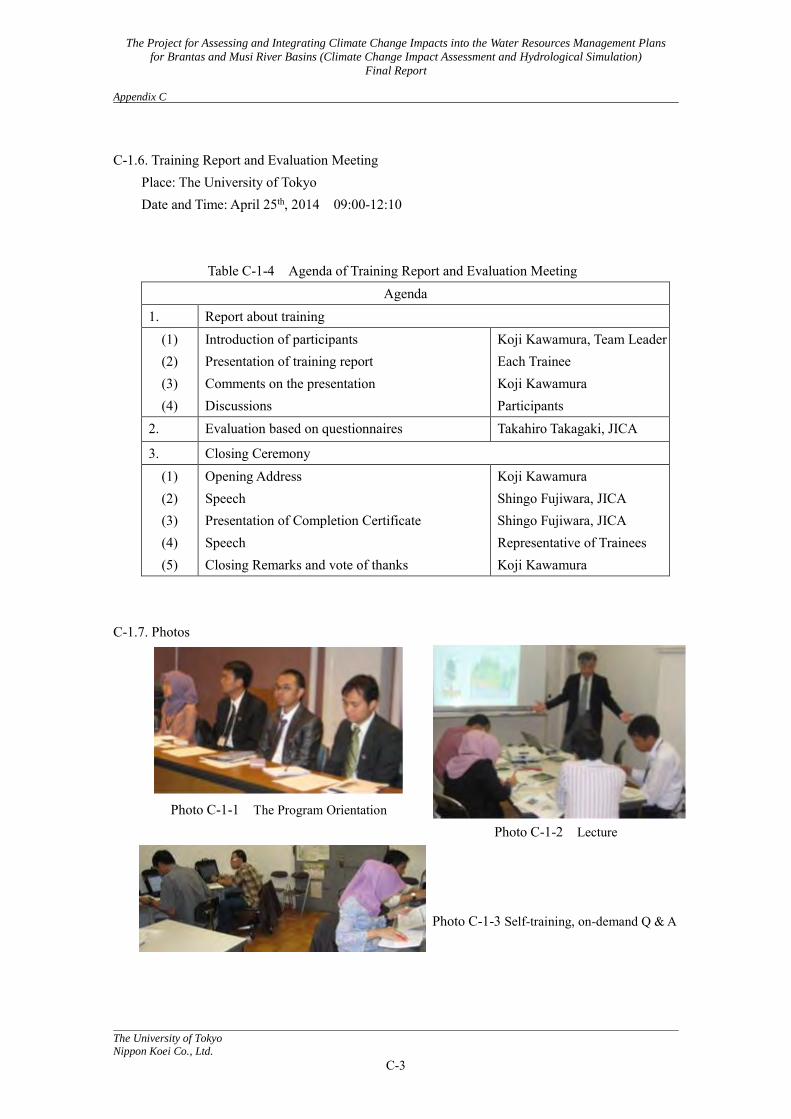
The Project for Assessing and Integrating Climate Change Impacts into the Water Resources Management Plans
for Brantas and Musi River Basins (Climate Change Impact Assessment and Hydrological Simulation)
Final Report Appendix C
The University of Tokyo
Nippon Koei Co., Ltd.
C-3
C-1.6. Training Report and Evaluation Meeting
Place: The University of Tokyo Date and Time: April 25th, 2014 09:00-12:10
Table C-1-4 Agenda of Training Report and Evaluation Meeting Agenda
1. Report about training (1) (2) (3) (4)
Introduction of participants Presentation of training report Comments on the presentation Discussions
Koji Kawamura, Team Leader Each Trainee Koji Kawamura Participants
2. Evaluation based on questionnaires Takahiro Takagaki, JICA
3. Closing Ceremony (1) (2) (3) (4) (5)
Opening Address Speech Presentation of Completion Certificate Speech Closing Remarks and vote of thanks
Koji Kawamura Shingo Fujiwara, JICA Shingo Fujiwara, JICA Representative of Trainees Koji Kawamura
C-1.7. Photos
Photo C-1-1 The Program Orientation
Photo C-1-2 Lecture
Photo C-1-3 Self-training, on-demand Q & A
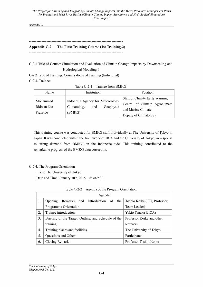
The Project for Assessing and Integrating Climate Change Impacts into the Water Resources Management Plans
for Brantas and Musi River Basins (Climate Change Impact Assessment and Hydrological Simulation)
Final Report Appendix C
The University of Tokyo
Nippon Koei Co., Ltd.
C-4
--------------------------------------------------------------------------- Appendix C-2 The First Training Course (1st Training-2) --------------------------------------------------------------------------- C-2.1 Title of Course: Simulation and Evaluation of Climate Change Impacts by Downscaling and
Hydrological Modeling I C-2.2 Type of Training: Country-focused Training (Individual) C-2.3. Trainee:
Table C-2-1 Trainee from BMKG Name Institution Position
Mohammad Ridwan Nur Prasetyo
Indonesia Agency for Meteorology Climatology and Geophysic (BMKG)
Staff of Climate Early Warning Central of Climate Agroclimate and Marine Climate Deputy of Climatology
This training course was conducted for BMKG staff individually at The University of Tokyo in Japan. It was conducted within the framework of JICA and the University of Tokyo, in response to strong demand from BMKG on the Indonesia side. This training contributed to the remarkable progress of the BMKG data correction.
C-2.4. The Program Orientation
Place: The University of Tokyo Date and Time: January 30th, 2015 8:30-9:30
Table C-2-2 Agenda of the Program Orientation
Agenda 1. Opening Remarks and Introduction of the
Programme Orientation Toshio Koike ( UT, Professor, Team Leader)
2. Trainee introduction Yukio Tanaka (JICA) 3. Briefing of the Target, Outline, and Schedule of the
training. Professor Koike and other lecturers
4. Training places and facilities The University of Tokyo 5. Questions and Others Participants 6. Closing Remarks Professor Toshio Koike
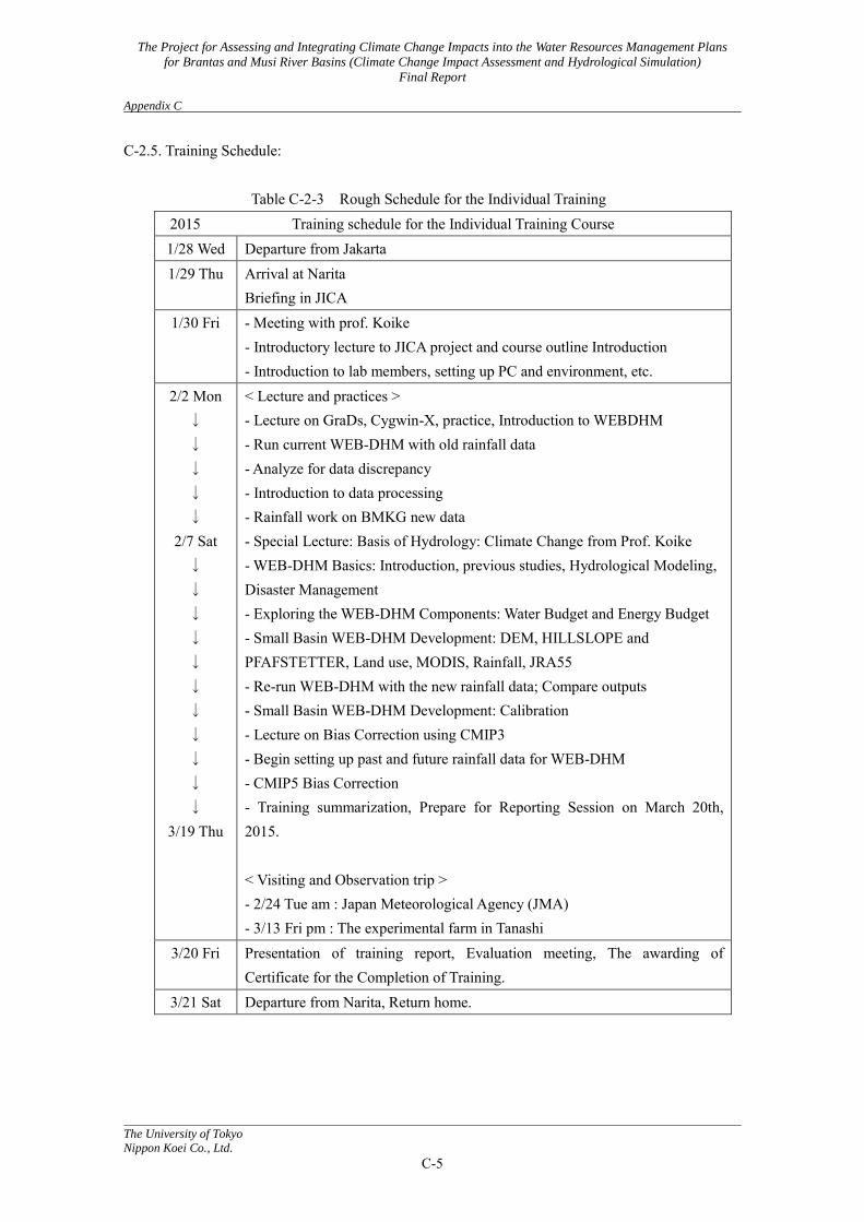
The Project for Assessing and Integrating Climate Change Impacts into the Water Resources Management Plans
for Brantas and Musi River Basins (Climate Change Impact Assessment and Hydrological Simulation)
Final Report Appendix C
The University of Tokyo
Nippon Koei Co., Ltd.
C-5
C-2.5. Training Schedule:
Table C-2-3 Rough Schedule for the Individual Training 2015 Training schedule for the Individual Training Course 1/28 Wed Departure from Jakarta 1/29 Thu Arrival at Narita
Briefing in JICA 1/30 Fri - Meeting with prof. Koike
- Introductory lecture to JICA project and course outline Introduction - Introduction to lab members, setting up PC and environment, etc.
2/2 Mon ↓ ↓ ↓ ↓ ↓
2/7 Sat ↓ ↓ ↓ ↓ ↓ ↓ ↓ ↓ ↓ ↓ ↓
3/19 Thu
< Lecture and practices > - Lecture on GraDs, Cygwin-X, practice, Introduction to WEBDHM - Run current WEB-DHM with old rainfall data - Analyze for data discrepancy - Introduction to data processing - Rainfall work on BMKG new data - Special Lecture: Basis of Hydrology: Climate Change from Prof. Koike - WEB-DHM Basics: Introduction, previous studies, Hydrological Modeling, Disaster Management - Exploring the WEB-DHM Components: Water Budget and Energy Budget - Small Basin WEB-DHM Development: DEM, HILLSLOPE and PFAFSTETTER, Land use, MODIS, Rainfall, JRA55 - Re-run WEB-DHM with the new rainfall data; Compare outputs - Small Basin WEB-DHM Development: Calibration - Lecture on Bias Correction using CMIP3 - Begin setting up past and future rainfall data for WEB-DHM - CMIP5 Bias Correction - Training summarization, Prepare for Reporting Session on March 20th, 2015. < Visiting and Observation trip > - 2/24 Tue am : Japan Meteorological Agency (JMA) - 3/13 Fri pm : The experimental farm in Tanashi
3/20 Fri Presentation of training report, Evaluation meeting, The awarding of Certificate for the Completion of Training.
3/21 Sat Departure from Narita, Return home.

The Project for Assessing and Integrating Climate Change Impacts into the Water Resources Management Plans
for Brantas and Musi River Basins (Climate Change Impact Assessment and Hydrological Simulation)
Final Report Appendix C
The University of Tokyo
Nippon Koei Co., Ltd.
C-6
C-2.6. Training Report and Evaluation Meeting Place: The University of Tokyo Date and Time: March 21st, 2015 08:30-9:30
Table C-2-4 Agenda of Training Report and Evaluation Meeting
Agenda 1. Report about training
(1) (2)
(3) (4)
Opening Address (5 min) Presentation of training report (15 min) Comments on the presentation (5 min) Discussions (10 min)
Toshio Koike Mohammad Ridwan Nur Prasetyo Yukio Tanaka Participants
2. Closing Ceremony (1) (2) (3)
(4)
Speech (2 min ) Presentation of Completion Certificate ( 3 min ) Speech ( 3 min ) Closing Remarks (2 min )
Yukio Tanaka, JICA Yukio Tanaka, JICA Mohammad Ridwan Nur Prasetyo Toshio Koike
C-2.7. Photos
Photo C-2-1 Closing Ceremony on March 20th, 2015

The Project for Assessing and Integrating Climate Change Impacts into the Water Resources Management Plans
for Brantas and Musi River Basins (Climate Change Impact Assessment and Hydrological Simulation)
Final Report Appendix C
The University of Tokyo
Nippon Koei Co., Ltd.
C-7
-------------------------------------------------------------------------------------- Appendix C-3 The Second Training Course (Deep understanding) -------------------------------------------------------------------------------------- C-3.1 Title of Course: Simulation and Evaluation of Climate Change Impacts by Downscaling and
Hydrological Modeling II C-3.2 Type of Training: Country-focused Training C-3.3. Trainees:
Table C-3-1 Trainees from Indonesian Agencies Name Institution Position
Mr. Heruyoko Research Center for Water Resources (PUSAIR), MoPW
Staff of Experimental Station for Hydrology & Water Management
Ms. Wulam Seizarwati
Research Center for Water Resources (PUSAIR), MoPW
Staff of Experimental Station for Hydrology & Water Management
Mohammad Ridwan Nur Prasetyo
Indonesia Agency for Meteorology Climatology and Geophysic (BMKG)
Staff of Climate Early Warning Central of Climate Agroclimate and Marine Climate Deputy of Climatology
C-3.4. The Orientation at JICA
Place: JICA Tokyo Date and Time: May 28 (Thu) 10:00-12:00 Participant: JICA, Nippon Koei
C-3.5. Training Schedule
Table C-3-2 Rough Schedule for the Third Training
2015 Training schedule for The 3rd Training Course 5/26 Tue Departure from Jakarta 5/27 Wed Arrival at Narita
5/28 Thu am Briefing in JICA 5/28 Thu pm
5/29 Fri ↓ ↓ ↓ ↓ ↓
< Lectures, study works and practices > - Summary of the progress in this project. - Summary of the progress of Water Cycle in Musi river basin. - Summary of the progress in Brantas river basin. - Summary of the progress related to agriculture field in Musi river basin. - Understanding of WEB-DHM - Work on the development of WEB-DHM
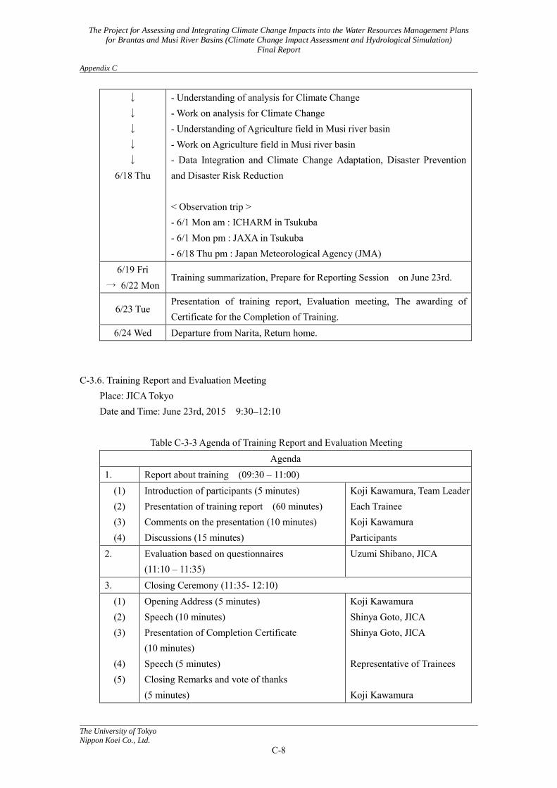
The Project for Assessing and Integrating Climate Change Impacts into the Water Resources Management Plans
for Brantas and Musi River Basins (Climate Change Impact Assessment and Hydrological Simulation)
Final Report Appendix C
The University of Tokyo
Nippon Koei Co., Ltd.
C-8
↓ ↓ ↓ ↓ ↓
6/18 Thu
- Understanding of analysis for Climate Change - Work on analysis for Climate Change - Understanding of Agriculture field in Musi river basin - Work on Agriculture field in Musi river basin - Data Integration and Climate Change Adaptation, Disaster Prevention and Disaster Risk Reduction < Observation trip > - 6/1 Mon am : ICHARM in Tsukuba - 6/1 Mon pm : JAXA in Tsukuba - 6/18 Thu pm : Japan Meteorological Agency (JMA)
6/19 Fri → 6/22 Mon
Training summarization, Prepare for Reporting Session on June 23rd.
6/23 Tue Presentation of training report, Evaluation meeting, The awarding of Certificate for the Completion of Training.
6/24 Wed Departure from Narita, Return home. C-3.6. Training Report and Evaluation Meeting
Place: JICA Tokyo Date and Time: June 23rd, 2015 9:30–12:10
Table C-3-3 Agenda of Training Report and Evaluation Meeting
Agenda 1. Report about training (09:30 – 11:00)
(1) (2) (3) (4)
Introduction of participants (5 minutes) Presentation of training report (60 minutes) Comments on the presentation (10 minutes) Discussions (15 minutes)
Koji Kawamura, Team Leader Each Trainee Koji Kawamura Participants
2. Evaluation based on questionnaires (11:10 – 11:35)
Uzumi Shibano, JICA
3. Closing Ceremony (11:35- 12:10) (1) (2) (3)
(4) (5)
Opening Address (5 minutes) Speech (10 minutes) Presentation of Completion Certificate (10 minutes) Speech (5 minutes) Closing Remarks and vote of thanks (5 minutes)
Koji Kawamura Shinya Goto, JICA Shinya Goto, JICA Representative of Trainees Koji Kawamura
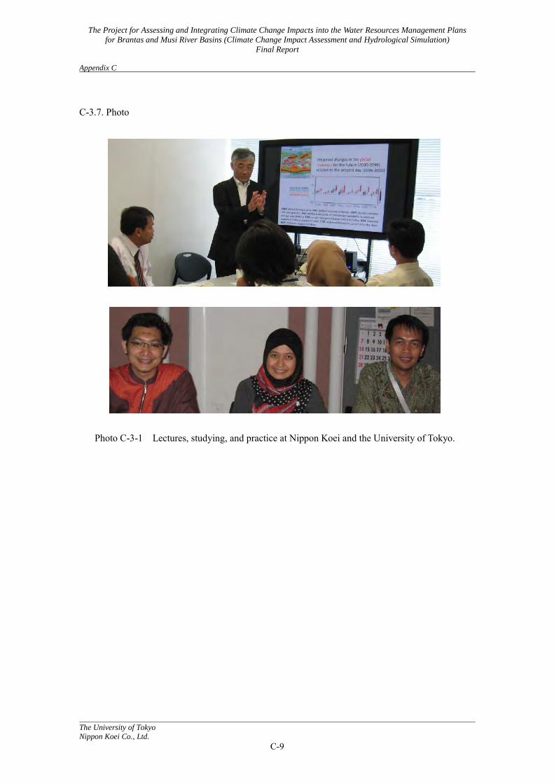
The Project for Assessing and Integrating Climate Change Impacts into the Water Resources Management Plans
for Brantas and Musi River Basins (Climate Change Impact Assessment and Hydrological Simulation)
Final Report Appendix C
The University of Tokyo
Nippon Koei Co., Ltd.
C-9
C-3.7. Photo
Photo C-3-1 Lectures, studying, and practice at Nippon Koei and the University of Tokyo.
Related Documents