Chapter 4 Facts and Finding 4.1 Tourism Macroscopic Background Environment 4.1.1 Geographical Location and Scope Guilin (15) 1 is located in northern Guangxi, bordering Liuzhou to the west, Laibin to the southwest, Wuzhou to the south, Hezhou to the southeast, and within neighboring Hunan, Huaihua to the northwest, Shaoyang to the north, and Yongzhou to the east. It has a total area of 27,809 square kilometers (10,737 sq. mi). The topography of the area is marked by karst formations. The Li River flows through the city. Fig (1-14) Figure (1-14) the Guilin city full area map Area • Total 27,809 km 2 (10,737 sq. mi) Elevation 153 m (502 ft.) Population 1 (15) [18] https://en.wikipedia.org/wiki/Guilin

Welcome message from author
This document is posted to help you gain knowledge. Please leave a comment to let me know what you think about it! Share it to your friends and learn new things together.
Transcript

Chapter 4
Facts and Finding
4.1 Tourism Macroscopic Background Environment
4.1.1 Geographical Location and Scope
Guilin (15) 1 is located in
northern Guangxi, bordering
Liuzhou to the west, Laibin to
the southwest, Wuzhou to the
south, Hezhou to the
southeast, and within
neighboring Hunan, Huaihua
to the northwest, Shaoyang to
the north, and Yongzhou to
the east. It has a total area of
27,809 square kilometers
(10,737 sq. mi). The
topography of the area is
marked by karst formations.
The Li River flows through
the city. Fig (1-14)
Figure (1-14) the Guilin city full area map
Area
• Total 27,809 km2 (10,737 sq. mi)
Elevation 153 m (502 ft.)
Population
1 (15) [18] https://en.wikipedia.org/wiki/Guilin

• Total 4,747,963
• Density 170/km2 (440/sq. mi)
Hills and Mountains: Diecai Hill (叠彩⼭山), Elephant Trunk Hill, Wave-Subduing
Hill (伏波⼭山), Lipu Mountains, Kitten Mountain, the highest peak of Guangxi, and
Yao Hill (尧⼭山)
Cave: Reed Flute Cave, Seven-Star Cave
4.1.2EconomicSituation
Region'sGDPtotaled182.71billionYuanin2014,anincreaseof8%.(16)2
Thefirstindustrialaddedvalue32.31billionYuan,increaseof4.9%,thesecond
industry added value 86.51 billion Yuan, increase of 9.9%, the third industry
addedvalue63.89billionYuan,increaseof6.6%.
Organization fiscal revenue was 19.52 billion Yuan, an increase of 8.2%. In
socialinvestmentinfixedassets164.53billionYuan,upby18.3%;Totalretail
sales of social consumer goods 68.29 billion Yuan, up by 13.1%; Urban per
capita disposable income of 26811 Yuan, an increase of 9.2%, farmers per
capitanet incomeof9431Yuan,upby12.8%;Consumerpricesrose2%;The
urbanization rateof45.6%;Ten thousandYuanGDPenergy consumption fell
3.5%,emissionreductiontaskcompleteautonomousregion.
Guilinhadreceived44.6995milliontouristsfromhomeandabroadthroughout
the year, an increase of 15.5%. Among them, the mainland tourists 42.5361
millionperson-time,upby16.0%;Inboundtourists2.1634million,anincrease
of 6.4%. Realize the tourism income of 51.733 billion Yuan, an increase of
23.1%.Amongthem,themainlandtourismincomeof45.351billionYuan,upby
25.7%;overseastourismincomeof6.382billionYuan, increasedby7.2%,the
percapitaoverseastouristsstayingfor2.18days.
2 (16) [19] https://en.wikipedia.org/wiki/Guilin

4.1.3 Tourism Service Facilities
Guilin tourism is very developed. Guilin has two to five star hotels; there are no star
standard level hotels at the county. Guilin is littered with 1157 different star-level
hotels. (17)3
Figure (1-15) Guilin tourism statistics: Guilin star hotels (2008) (18)
Name of Hotel Star Guest Rooms Beds
Sheraton Hotel 430 760
DI YUAN Hotel 333 642
LIJIANG Waterfall
Hotel 646 1164
GUI SHAN Hotel 607 1136
GUILIN Hotel 268 536
GUI HU Hotel 263 494
PLAZA Hotel 271 530
King LONG Aviation
Hotel 205 367
RONG HU Hotel 415 785
King Long Hotel 118 212
DAN GUI Hotel 361 722
3(17)[20]:http://baike.baidu.com/link?url=eKcj4W1j7Xj9ENLvxyU7xNTr4HL68kmgperkAz8EdqyFEu
dtxLoR8u3xQfUM5MDbfYnLoaqpELFKXEQHtbMStIpuRSGmJ3oyrpXPzhSUwBe
(18)[21]:http://wenku.baidu.com/link?url=Jwys4Dl5xUeG73Rp8Bhb0lq85WzLAJMWiZCj8lqLTc9-aX
Mg-vGLaJP6zyxmiwYLbiZk1fZyrfFdtzBzw6KRaaU7LM-ghpVMfEqymURz6CO
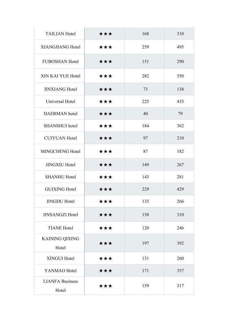
TAILIAN Hotel 168 310
XIANGJIANG Hotel 259 495
FUBOSHAN Hotel 151 290
XIN KAI YUE Hotel 282 550
JINXIANG Hotel 73 138
Universal Hotel 225 435
DAERMAN hotel 40 79
SHANSHUI hotel 184 362
CUIYUAN Hotel 97 210
MINGCHENG Hotel 87 182
JINGXIU Hotel 149 267
SHANHU Hotel 143 281
GUIXING Hotel 229 429
JINGDU Hotel 135 266
JINSANGZI Hotel 158 310
TIANE Hotel 120 246
KAINING QIXING
Hotel 197 392
XINGUI Hotel 131 260
YANMAO Hotel 171 357
LIANFA Business
Hotel 159 317
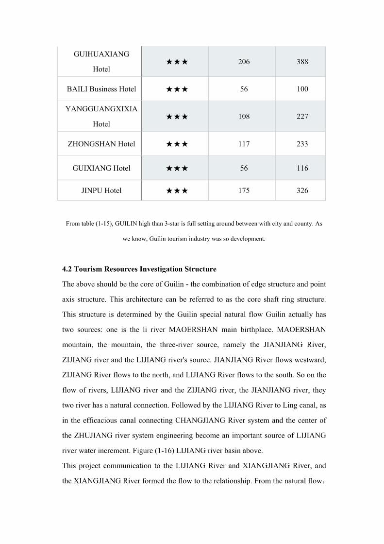
GUIHUAXIANG
Hotel 206 388
BAILI Business Hotel 56 100
YANGGUANGXIXIA
Hotel 108 227
ZHONGSHAN Hotel 117 233
GUIXIANG Hotel 56 116
JINPU Hotel 175 326
From table (1-15), GUILIN high than 3-star is full setting around between with city and county. As
we know, Guilin tourism industry was so development.
4.2 Tourism Resources Investigation Structure
The above should be the core of Guilin - the combination of edge structure and point
axis structure. This architecture can be referred to as the core shaft ring structure.
This structure is determined by the Guilin special natural flow Guilin actually has
two sources: one is the li river MAOERSHAN main birthplace. MAOERSHAN
mountain, the mountain, the three-river source, namely the JIANJIANG River,
ZIJIANG river and the LIJIANG river's source. JIANJIANG River flows westward,
ZIJIANG River flows to the north, and LIJIANG River flows to the south. So on the
flow of rivers, LIJIANG river and the ZIJIANG river, the JIANJIANG river, they
two river has a natural connection. Followed by the LIJIANG River to Ling canal, as
in the efficacious canal connecting CHANGJIANG River system and the center of
the ZHUJIANG river system engineering become an important source of LIJIANG
river water increment. Figure (1-16) LIJIANG river basin above.
This project communication to the LIJIANG River and XIANGJIANG River, and
the XIANGJIANG River formed the flow to the relationship. From the natural flow,

and than another special case, LIJIANG river into the sea on the way to the east
and two changes. One is the LIJIANG river to PING 'LE merges with LI,
CHAJIANG river, GUIJIANG river. Make the LIJIANG river and GUINAN
County, and GUIDONG County has a natural link; the second is to WUZHOU
LIJIANG River and XIJIANG
Fig (1-16) LIJIANG river basin above
North
South
West East
Hunan Direction
Ziyuan
Quanzhou
Guanyang
Gongcheng
Yangshuo
Ping’leLipu
Lingui
Yongfu
Longsheng
Lingchuan
Xing’an
Shaoyang
Guizhou direction
Sanjiang Zhaoping
Hezhou
Liuzhou
Nanning
Guangdong Direction
Guilin downtown
First lap
Second circle
Third ring
City ring tourism landscape zone
City ring tourism landscape zone
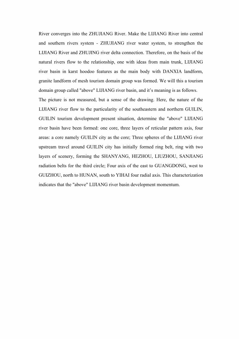
River converges into the ZHUJIANG River. Make the LIJIANG River into central
and southern rivers system - ZHUJIANG river water system, to strengthen the
LIJIANG River and ZHUJING river delta connection. Therefore, on the basis of the
natural rivers flow to the relationship, one with ideas from main trunk, LIJIANG
river basin in karst hoodoo features as the main body with DANXIA landform,
granite landform of mesh tourism domain group was formed. We will this a tourism
domain group called "above" LIJIANG river basin, and it’s meaning is as follows.
The picture is not measured, but a sense of the drawing. Here, the nature of the
LIJIANG river flow to the particularity of the southeastern and northern GUILIN,
GUILIN tourism development present situation, determine the "above" LIJIANG
river basin have been formed: one core, three layers of reticular pattern axis, four
areas: a core namely GUILIN city as the core; Three spheres of the LIJIANG river
upstream travel around GUILIN city has initially formed ring belt, ring with two
layers of scenery, forming the SHANYANG, HEZHOU, LIUZHOU, SANJIANG
radiation belts for the third circle; Four axis of the east to GUANGDONG, west to
GUIZHOU, north to HUNAN, south to YIHAI four radial axis. This characterization
indicates that the "above" LIJIANG river basin development momentum.

4.2.1 Tourism Resources Analysis and Evaluation
Around the SWOT four factors, this study selected the investigation group of 20
peoples. About the Guilin tourism strategy, analysis SWOT factors of comparative
judgment matrix factor coefficient.
Because special reasons, there are not proceed experiment. But the SWOT - AHP
analysis method can still do some data analysis. If the teacher or the researchers are
interested in, you can own the related experiment analysis.
4.3 SWOT Analysis of Tourism Development
In the 1950 s. International strategic planning on the school developed a new
analysis method, SWOT analysis. SWOT refers to S (strengths), W (weaknesses), O
(opportunities) and T (threats). It is first applied to enterprises. Combine
environmental analysis and the analysis of enterprise. It is basis of enterprise
developing marketing strategy. It forms the enterprise marketing strategic status of
the comprehensive judgment. For the enterprise marketing strategy formulation
Overall Level System Level Variable Level
Guilin Tourism Strategic Analysis
Strengths (S)
Weaknesses (W)
Opportunities (O)
Threats (T)
Variable Layer Resources (S1)Location Advantage (S2)Brand Advantage (S3) Infrastructure Gradually Improve (S4)Government Policy Support (S5)Resource Development Depth (W1)Government's Guidance of Rural Tourism and Loss of Guide (W2)Management Talent Shortage (W3)Brand Consciousness (W3)Development of the North Gulf Economic Diversification (O1)Way to Travel (O2)National Holiday Adjustment (O3)
acro Economic Environment to Promote (O4)Surrounding the Tourism Market Competition’ Fierce (T1)Project Repetitive Construction Seriously (T2)Environmental Protection Pressure Increasing (T3)Malignant Price Competition with Industry (T4)

provides the basis of an objective and comprehensive. In 1990 of the 20th century,
the SWOT analysis method was transplanted applied to tourism planning. Tourism
planning SWOT is in the process of tourism development planning study, for your
strengths and weaknesses, environmental opportunities and threats for analysis of
the system. Used to carry forward the strengths and avoid weaknesses, and to
provide for the establishment of tourism development strategic objective and
comprehensive basis.
Advantages and disadvantages is a set of the concept of relative to the competition
strength. Planning area own resources or ability compared with competitors, if
stronger than called their strengths and not as good as opponent as weakness.
Opportunities and threats from outside, is to point to be or upcoming new trend, new
changes or new events. Is beneficial to the development of regional tourism, the
opportunity is a threat.(19)
Currently in tourism planning application SWOT analysis are mainly three forms:
the first is to develop properties analysis, mainly is the text, usually in accordance
with the strengths, weaknesses, opportunities and threats of order list analysis
respectively. Then add set properties analysis; the second is the strengths,
weaknesses, opportunities and threats in column matrix or form, compare the choice;
the third is the block diagram as standard, visual in image, clear logical relations, the
result is very clear. Figure (1-16) is in the form of the form has carried on the SWOT
analysis of tourism development strategic principles.
Strategy development began in the background of the situation analysis. Considering
the strengths and weaknesses in the development of regional tourism industry. In
order, to more effective management into the environment opportunities and threats,
and long-term strategic planning. Four strategic plan is generated by the SWOT
matrix, SO strategy by way of thinking use strengths to take a chance; ST strategy
consider ways of using strengths to threats; ST strategic thinking ways of using
strengths to threats; Send strategy tries to overcome weaknesses using opportunities;
Basic is defensive, WT strategy is mainly to minimize weakness to escape the threat.

(20)4
The four strategic plans are the general starting point is the opportunities and
weaknesses into strengths. A regional tourism, of course, the situation is not so
simple four combinations, in theory, there should be four combinations. (20) So the
ultimate strategic combination is also complicated. But for the sake of convenient
operation, often can ignore the background of the secondary, highlight developed
strategy combinations, easy to implement. The main core of SWOT analysis, it’s
including regional natural resources. Tourist Attractions and Experience, Promotion
and Distribution, Infrastructure, Tourist Service, Human Resources, Management
and Consultation Method of content are 44. The content is the key to influence the
future tourism development. Only accurate analysis of these factors can make a
scientific tourism development strategy.
4(19) [22] LIN ZHENHUA.“SWOT analysis of tourism planning”. “Forestry survey plan”.2004.29.
(1) : 64-69.
(20) [23] J.David Hunger, Thmas L.Wheelen.《The essence of strategic management》. “Electronic
industry press”.2002. P83.

Figure (1-17) the Based on the present situation of tourism development strategy on the basis of
SWOT analysis principle.
4.3.1 Strengths and Weakness of Tourism Industry Development
4.3.1.1 Strengths
l Rich Rural Tourism Resources
Rapid development of modern ecological agriculture, the rural town of natural of
primitive simplicity, distinctive ethnic customs, subtropical scenery of four seasons
constitutes the rich rural tourism resources in the region.
SWOT Analysis Judgment Development Principles Tourism development strategy
SO (strength + opportunity) Actively expand principle
In the face of so many opportunities, both have
obvious advantages, should actively develop new
products, expand business areas, greater tourism market
space.
ST (strength + threat) Efforts to fight the principle
Although faced with many opportunities, but tourism
regions exist obvious weaknesses, should think of
some way to make up the shortfall, carries forward the
strengths, keep out weaknesses.
Send (weaknesses + opportunity) Suitable for the principle
In the face of a powerful threat, but also has obvious
advantages, should take advantage of their strengths,
the source of the threat analysis, passive into the
initiative.
WT (weaknesses - threats) Negative conservative principles
In the face of powerful threat, and there is an obvious
disadvantage, can only take the business adjustment, improve their conditions, avoiding threats, find new
market opportunities.

l Superior Traffic Location
Guilin - Guangzhou high-speed, Guilin - Changsha high-speed, Guilin - BEIHAI
high-speed passing through; Guilin LIANGJIANG international airport is a 4D large
airport; Guiyang - Guangzhou high-speed railway after the completion of the
"twelfth five-year plan" period, Guilin will be Hunan, GUIZHOU, Sichuan, Yunnan
to transport hub in the pearl river delta.
l Excellent Tourism Brand
Based on landscape “JIATIANXIA”. Guilin international tourism city, the city
depends on the type of the rural tourism development specific the huge market
potential and broad prospects for development.
l Relatively Perfect Infrastructure
In recent years, Guilin area combined with new socialist rural construction, speed up
rural infrastructure construction such as traffic, communication, and environmental
health; in order to speed up the development of rural tourism has laid a good
foundation.
l Rare Policy Advantage
Guilin tourism comprehensive reform pilot area and national services
comprehensive reform pilot city construction, the corresponding social and
economic development policies and measures, are conducive to the rapid
development of the rural travel LIJIANG river basin.
4.3.1.2 Weakness
l Guilin tourism resource development depth is not enough. Market management
simple lack of overall planning of tourism development, tourism development level
is low, generally stay at the ordinary level; Leisure, culture in-depth experience of
tourism projects.
l Government makes guidelines for the travel improve is not enough to do. Guilin
county and township (town) government departments whose paid more attention to
develop traditional travel were. But because of the lack of tourism knowledge, to the
local tourism development guidance, failed to effectively organize the masses to

develop special tourism projects.
l Guilin tourism services and management level is not high. Because of the lack of
professional education and training, service and management level of Guilin tourism
practitioners need to improve. The too lack of high-level talent management become
Guilin tourism development.
l Tourism brand consciousness. Now formed a wide range of Guilin tourism
development trend of increase, but the lack of brand has a certain competitive
advantage. In the long run, will seriously affect the region's tourism development
benefits, thus affecting its sustainable development.
4.3.2 Opportunity and Threats of Tourism Industry Development
4.3.2.1 Opportunity
l The opportunities brought by the national economic and tourism development
policy.
The No. 1 document in recent years, China's state council about agricultural
development, the state council on further promoting economic and social
development in Guangxi several opinions, Guilin national tourism comprehensive
reform pilot area construction, etc., all bring new opportunities for the development
of Guilin’s tourism.
l Travel demand basis
In recent years, with the "mature" tourists, travel demand increasing, travel form
diversification, no longer meet the traditional scenic area (spot) tourism, with strong
participation and experience of rural tourism is more and more respected, bring new
opportunities for development of LIJIANG river tourism of river system.
l Opportunities Brought About by the Holidays
Canceled after adjustment of holiday system in China "First of May" of the five-day
vacation. And some of small vacation was increased. This for China, the
development of Guilin’s tourism scenic spot depends on brought huge market
demand.
l Macro Tourism Environment. Over the past 20 years, Europe and the United States
will standardize and develop the rural tourism in, show strong vitality and huge
development potential. The China national tourism administration of the Chinese
characteristics of landscape tourist town (village) demonstration "and" China's rural
tourism development compendium (2009-2015), was promulgated, will promote the
healthy development of tourism in our country, provides a good opportunity for
development of LIJIANG river tourism.
4.3.2.2 Threats
l Peripheral Provinces Tourism Market Competition is Intense
Yunnan has the large-scale tourist reception point 4887, formed the tourism industry
system. GUIZHOU also with the natural ecology, characteristic agriculture and
village, ethnic cultural heritage resources for rely on, in a variety of types of tourism
development of tourism. The Pearl River delta region has gradually achieve a new
round of "the pearl river delta" tourism industrial upgrading development, tourism
development bring great threat to the li river valley.
l Rural Tourism Project Redundant Construction
As tourism development heats up, many parts of the LIJIANG river basin are eager
to preempt the rural tourism market, in the absence of scientific planning
demonstration development tourism projects, as a result, tourism projects repetitive
construction seriously, cause industry disorderly competition, constitute a great
impact on the development of tourism.
l Environmental Protection Pressure Increasing
The LIJIANG river basin has a lot of karst landform areas, but due to the fragile
ecological system in karst landform areas, with the expanding of tourism
development, the growing Numbers of tourists, environmental pollution is serious,
the increase in the number of garbage and sewage emissions has negative effects on
the LIJIANG river tourism environment.
l Malignant Price Competition Around Industries
Industry management can't keep up with development of tourism, the tour guide
tourism low pay commission added between the tourism industry a vicious price

competition, also bring a serious threat to the rural tourism development of small
profits.
From the research analysis Guilin tourism strategy of SWOT qualitative on table
(1-18):
Fig1-18Guilin tourism strategy SWOT qualitative analysis table
Internal Reasons
External Causes
Strategic Combination
Strengths
Resources of high quality
Good position conditions
Good connection conditions
Solid development foundation
Opportunity
Countries to expand tourism consumption policy support
Time in the period of construction of GUANGXI tourism strategy of strong province
Time in YANGSHUO a world-class resort area
Karst cave main strategy
High-quality goods strategy of trend
Strategic leadership take the lead
Integration strategy
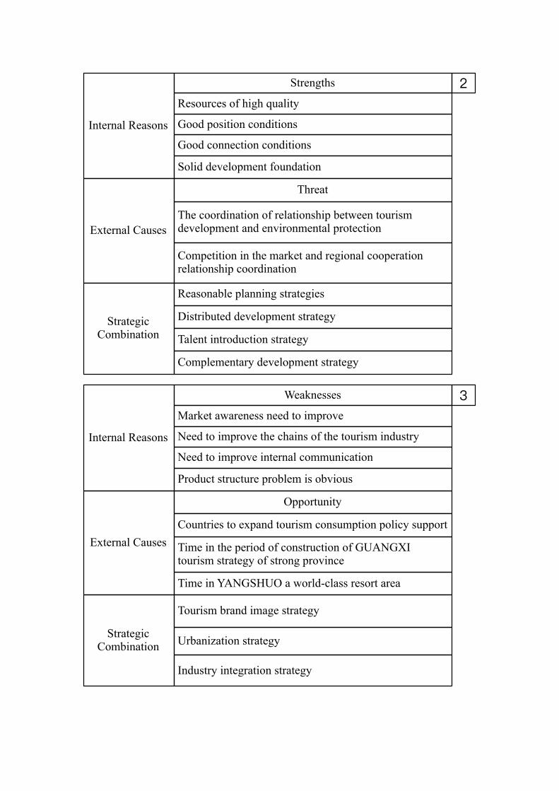
Internal Reasons
External Causes
Strategic Combination
Strengths
Resources of high quality
Good position conditions
Good connection conditions
Solid development foundation
Threat
The coordination of relationship between tourism development and environmental protection
Competition in the market and regional cooperation relationship coordination
Reasonable planning strategies
Distributed development strategy
Talent introduction strategy
Complementary development strategy
Internal Reasons
External Causes
Strategic Combination
Weaknesses
Market awareness need to improve
Need to improve the chains of the tourism industry
Need to improve internal communication
Product structure problem is obvious
Opportunity
Tourism brand image strategy
Urbanization strategy
Industry integration strategy
Countries to expand tourism consumption policy support
Time in the period of construction of GUANGXI tourism strategy of strong province
Time in YANGSHUO a world-class resort area

4.3.3 SWOT Analysis Conclusion
At present, Guilin belong to famous internationally is not high enough. You also
need to joint efforts by different level government and society. Fully feeling that
good tourism development strategy of development and construction of all kinds of
conditions. Travel around the lava caves formed karst tourism brand image. In
development, fully rely on GUILIN brand influence; accept the growth of
YANGSHUO County. From the resources, market, industry and so on various
aspects to realize connection and YANGSHUO tourism. On the basis, increase
speed to make up the tourism urbanization and industrialization, the formation of
tourism development, the pattern of industry. Also put in a lot of weakness, of
course, the current development of Guilin’s tourism and challenges. But tend to
macro level of industry. This requires the government from a strategic height to
grasp.
Internal Reasons
External Causes
Strategic Combination
Strengths
Threat
The coordination of relationship between tourism development and environmental protection
Competition in the market and regional cooperation relationship coordination
Government leading strategy
Strategy for the development of policy
Countries to expand tourism consumption policy support
Time in the period of construction of GUANGXI tourism strategy of strong province
Time in YANGSHUO a world-class resort area
Related Documents