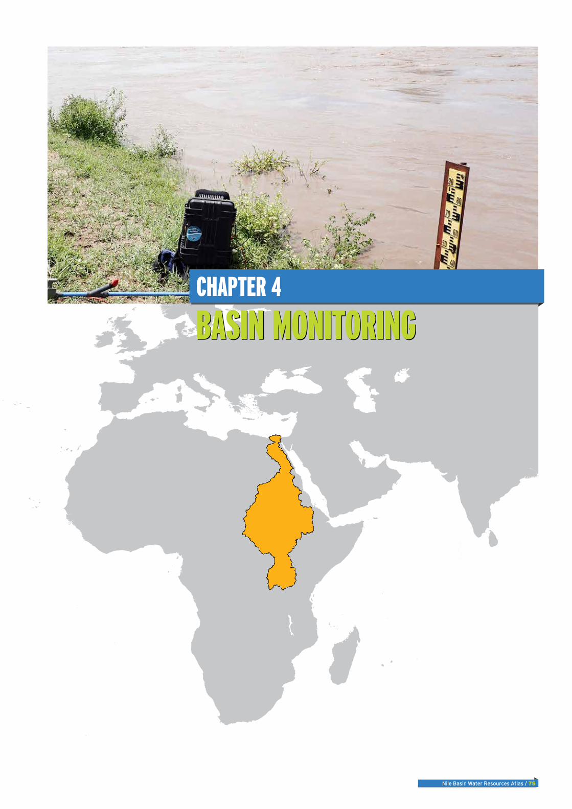
Nile Basin Water Resources Atlas / 75 BASIN MONITORING BASIN MONITORING CHAPTER 4

Welcome message from author
This document is posted to help you gain knowledge. Please leave a comment to let me know what you think about it! Share it to your friends and learn new things together.
Transcript
Nile Basin Water Resources Atlas / 75
Basin MonitoringBasin MonitoringChapter 4

76 / Nile Basin Water Resources Atlas
There are approximately 928 meteorologi-cal and 423 hydrometric stations in the Nile Basin. Over 70 percent of the meteorological stations measure either just daily rainfall to-tals or rainfall and temperature. Most hydro-metric stations measure river or lake water levels. Monitoring of water quality, sediment transport in rivers, and groundwater are at their early stages in most countries. Data transmission from the stations to central data repository in most countries is manual.
The current total number of national moni-toring stations in the Nile Basin countries is well below its historical maximum. Staff and financial resources to operate and maintain the complete national network of stations are limited in all countries. Automated data transmission using modern technology is being newly introduced in many countries. In all countries the potential use of data for real-time water resources management is not realized because of a lack of telemetry and data processing and management systems.
There have been national as well as regional initiatives to improve river basin monitoring in the Nile Basin. The Nile Basin Initiative has recently completed the design of a Nile Basin regional Hydromet system. This system will comprise a set of 323 meteorological and 79 hydrometric stations, groundwater and water quality laboratory strengthening and moni-toring use of remote sensing for monitoring river basin processes. The system relies on existing monitoring stations to be upgraded to meet the requirements as a regional mon-itoring network with few new stations added where no current monitoring stations exist. The IGAD-HYCOS is another regional initia-tive that has supported member countries of the IGAD to upgrade their hydrological moni-toring network; some of these stations are in the Nile Basin.
Key Messages

Nile Basin Water Resources Atlas / 77
introduCtion
OverviewThis chapter presents the current state of water resources monitoring in the Nile Basin. The focus of the chapter is primarily on hydro-meteorological monitoring with additional information provided on monitoring of water quality and groundwater. The information in this chapter is based on data compiled by NBI from the riparian countries. No information was available for part of the Nile Basin that lies in Egypt and Eritrea. The monitoring network presented in this chapter includes only those networks that are operated by national agencies for hydrological and meteorological moni-toring services. It doesn’t include those monitoring stations that are established and operated by specialized agencies for specific purposes.
Meteorological monitoringThere were 928 meteorological stations in the Nile Basin in the countries surveyed in 2014. Most (674) of these stations measure rainfall only or rainfall and tempera-ture while the rest measure fuller set of
meteorological parameters. In addition to the stations that are established and maintained by National Meteorological Services agencies, there are other net-works that have been put in place for spe-cific purposes. An example of such special purpose networks is the 19 hydro-meteo-rological stations that are operated by the Kenyan Flood Diagnostics and Fore-casting Centre (FDFC) in the Nzoia and Tana River basins. Such networks are not included in the Atlas.
Overall, basic meteorological variables of precipitation, temperature, relative humidity and evaporation are measured in all countries. Automated weather stations have been introduced in all countries though the distribution and area coverage greatly vary between countries.
Data transmission from the stations in most countries is manual. As can be seen from the table, telemetry is introduced in only five countries, namely, DRC, Ethiopia and Kenya. The telemetry system in DR Congo is part of the SADC- HYCOS.
NBI countries, met stations summary
Country Full Met StationsRainfall or rainfall and
temperature measuring stations
Burundi 10 21
DR Congo 3 0
Ethiopia 99 397
Kenya 27 104
Rwanda 24 11
South Sudan 5 0
Sudan 38 48
Tanzania 17 25
Uganda 31 68
254 674
Total 928
National institutions responsible for meteorological monitoringCountry Institution Institution full name
Burundi IGEBU Institut Géographic of Burundi
DR Congo METTELSAT Agence Nationale de Meteorologie et de Teledetection par Satellite
Ethiopia MOWR Ministry of Water, Irrigation and Electricity, National Meteorological Services Authority
Kenya MEWNR Ministry of Environment, Water and Natural Resources
Rwanda MINIRENA Ministry of Natural Resources
South Sudan MEDIWR Ministry of Electricity, Dams, Irrigation and Water Resources
Sudan MWRE Ministry of Water Resources and Electricity
Tanzania TMA Tanzania Meteorological Agency
Uganda UNMA Uganda National Meteorological Authority
Existing meteorological monitoring capabilitiesCountry Burundi DR Congo Ethiopia Kenya Rwanda South Sudan Sudan Tanzania Uganda
Meteorological
Automated stations Y N Y* Y Y Y Y Y Y
Telemetry N Y Y Y N N N Y N
Precipitation Y Y Y Y Y Y Y Y Y
Temperature Y Y Y Y Y Y Y Y Y
Relative humidity Y Y Y Y Y Y Y Y Y
Evaporation Y Y Y Y Y Y Y Y Y
"* Capability recently introducedNote: the Survey didn’t include Egypt”
Sudan
Egypt
Kenya
EthiopiaSouth Sudan
Uganda
Democratic Republic of Congo
Eritrea
United Republic of TanzaniaBurundi
Rwanda
0 250 500125
Kilometers
River
Lakes
Meteorological stations
Country boundary
Sub-basin
The NBI is not an authorityon international boundaries
Meteorological station at Entebbe, Uganda
phot
o: V
ivia
n Na
byon
ga

78 / Nile Basin Water Resources Atlas
Historical evolution of meteorological stationsIn most countries, meteorological mon-itoring started in 1900’s. The Hydromet Project (1967 – 1992) boosted river basin monitoring in the participating coun-tries, namely, Egypt, DR Congo, Sudan, Uganda, Burundi, and Rwanda. Over the years, however, the number of monitoring stations declined in some of the countries. Charts are provided for Burundi and Uganda to indicate the historical growth and decline in number of meteorological stations for which data was available.
Evaporation pan Wind vane
Meteoroligical station at Entebbe, Uganda
Phot
o: N
ile-S
EC

Nile Basin Water Resources Atlas / 79
Hydrometric monitoring
Hydrometric monitoring networks are defined as observations networks that primarily measure stream flow related pa-rameters (primarily river/lake water levels and river discharge).
In 2014, there were 427 hydrometric sta-tions in the countries included in the sur-vey. These registered stations primarily measure river/lake water levels and river discharge. In very few stations, suspended sediment load at rivers are measured.
Most of the gauging stations employ staff gauges as the only instrument for water level measurement. The available capa-bilities of the countries with respect to hydrometric monitoring are shown in the adjacent table.
Telemetry for automated data transmis-sion has been introduced in Ethiopia, Uganda and Tanzania recently.
Water quality and sediment monitoring is practiced in very few countries, which is clearly a major gap in current monitor-ing networks in the Nile Basin. In most countries there is not sufficient capability (laboratories, mobile calibration labs, field sampling kits).
In most countries, groundwater monitor-ing is virtually non-existent. Comparative-ly, Uganda has the largest groundwater observation network that includes 30 groundwater monitoring stations.
NBI countries, hydrometric stations summaryCountry Hydrometric stations Country Hydrometric stations
Burundi 15 Sudan 18
Kagera 15 Blue Nile - Lower 7
DR Congo 0 Main Nile 8
Lake Albert 0 Tekeze-Atbara 3
Ethiopia 176 White Nile 0
Baro-Akobo-Sobat 27 Tanzania 19
Blue-Nile 126 Lake Victoria - Kagera 7
Tekeze-Atbara 23 Lake Victoria - Tanzania 12
Kenya 93 Uganda 66
Lake Victoria 87 Bahr el Jebel 1
Victoria Nile 6 Lake Albert 19
Rwanda 36 Lake Victoria -Kagera 2
Lake Victoria - Kagera 36 Lake Victoria -Uganda 14
South Sudan 5 Victoria Nile 30
Bahr el Ghazal 1
Bahr el Jebel 2
Baro-Akobo-Sobat 1
White Nile 1 Total 428
Existing hydrometric capabilities Hydrometric Burundi DR Congo Ethiopia Kenya Rwanda South Sudan Sudan Tanzania Uganda
Automated stations Y N Y Y Y N Y Y Y
Telemetry N N Y* N N N N Y* Y
Water level Y Y Y Y Y Y Y Y Y
Discharge Y N Y Y Y Y Y Y Y
Reservoir/Lake level Y Y Y Y Y Y Y Y Y
"* Capability recently indtroducedNote: the Survey didn’t include Egypt”
Existing water quality monitoring capabilities Water quality/sediment Burundi DR Congo Ethiopia Kenya Rwanda South Sudan Sudan Tanzania Uganda
Basic water quality Y N Y* Y Y N Y Y Y
Special water quality N N N Y N N Y N N
Sediment sampling Y N Y N N N Y Y Y
"* Capability recently indtroducedNote: the Survey didn’t include Egypt”
Existing groundwater monitoring capabilities Groundwater Burundi DR Congo Ethiopia Kenya Rwanda South Sudan Sudan Tanzania Uganda
Water level Y N Y* Y N N N N Y
Water quality Y N Y* N Y N N N N
"* Capability recently indtroducedNote: the Survey didn’t include Egypt”
Sudan
Egypt
Kenya
Ethiopia
South Sudan
Uganda
Democratic Republic of Congo
Eritrea
United Republic of TanzaniaBurundi
Rwanda
0 250 500125
Kilometers
River
Lakes
Hydro meteorological stations
Country boundary
Sub-basin
The NBI is not an authorityon international boundaries
River Nyamugasani at Lake Victoria inlet
phot
o: K
iwal
bye
80 / Nile Basin Water Resources Atlas
Existing data management and communication capabilities Data Management / Communication
Burundi DR Congo Ethiopia Kenya Rwanda South Sudan Sudan Tanzania Uganda
Coop-data systems N N N Y N N N N N
Auto-access N N N N N N N N N
Note: the Survey didn’t include Egypt”
The situation with respect to data man-agement and data communication capa-bilities is shown in adjacent table. None of the countries with the exception of Kenya, Uganda and Tanzania employ systematic data storage and management tools for managing the hydro-meteorological data. Only in few countries, for example in Ethi-opia, Uganda, Tanzania telemetry system has been introduced to support near-real time data transmission.
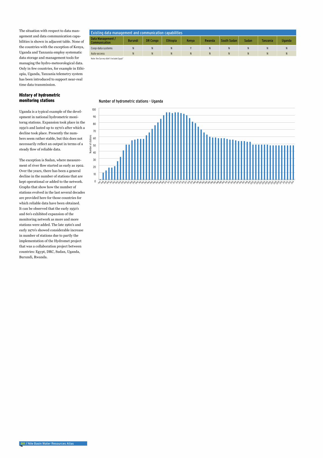
History of hydrometric monitoring stations
Uganda is a typical example of the devel-opment in national hydrometric moni-torng stations. Expansion took place in the 1950’s and lasted up to 1970’s after which a decline took place. Presently the num-bers seem rather stable, but this does not necessarily reflect an output in terms of a steady flow of reliable data.
The exception is Sudan, where measure-ment of river flow started as early as 1902. Over the years, there has been a general decline in the number of stations that are kept operational or added to the network. Graphs that show how the number of stations evolved in the last several decades are provided here for those countries for which reliable data have been obtained. It can be observed that the early 1950’s and 60’s exhibited expansion of the monitoring network as more and more stations were added. The late 1960’s and early 1970’s showed considerable increase in number of stations due to partly the implementation of the Hydromet project that was a collaboration project between countries: Egypt, DRC, Sudan, Uganda, Burundi, Rwanda.
Nile Basin Water Resources Atlas / 81
Current Monitoring networK
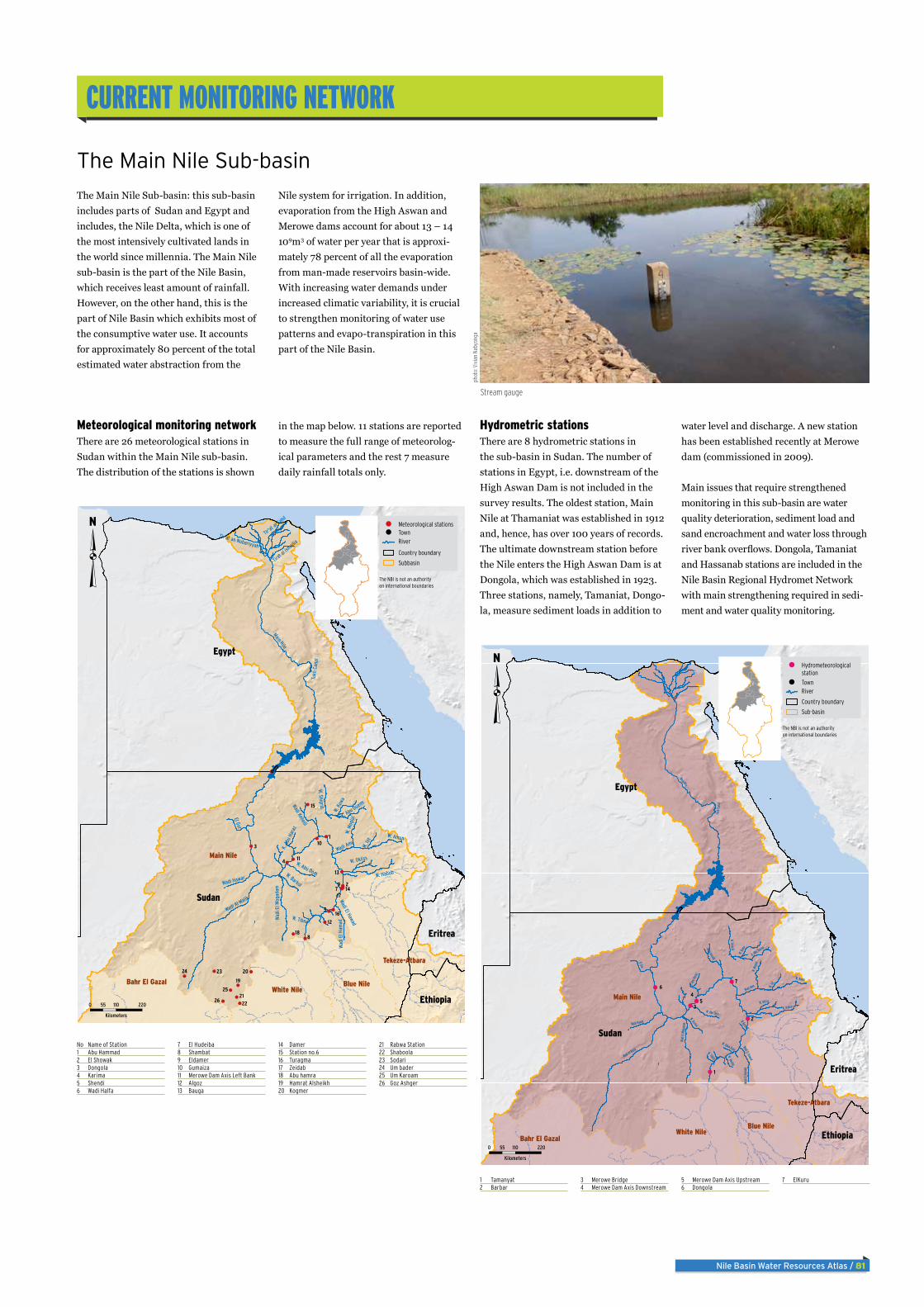
The Main Nile Sub-basin: this sub-basin includes parts of Sudan and Egypt and includes, the Nile Delta, which is one of the most intensively cultivated lands in the world since millennia. The Main Nile sub-basin is the part of the Nile Basin, which receives least amount of rainfall. However, on the other hand, this is the part of Nile Basin which exhibits most of the consumptive water use. It accounts for approximately 80 percent of the total estimated water abstraction from the
Nile system for irrigation. In addition, evaporation from the High Aswan and Merowe dams account for about 13 – 14 109m3 of water per year that is approxi-mately 78 percent of all the evaporation from man-made reservoirs basin-wide. With increasing water demands under increased climatic variability, it is crucial to strengthen monitoring of water use patterns and evapo-transpiration in this part of the Nile Basin.
The Main Nile Sub-basin
Meteorological monitoring networkThere are 26 meteorological stations in Sudan within the Main Nile sub-basin. The distribution of the stations is shown
in the map below. 11 stations are reported to measure the full range of meteorolog-ical parameters and the rest 7 measure daily rainfall totals only.
Hydrometric stationsThere are 8 hydrometric stations in the sub-basin in Sudan. The number of stations in Egypt, i.e. downstream of the High Aswan Dam is not included in the survey results. The oldest station, Main Nile at Thamaniat was established in 1912 and, hence, has over 100 years of records. The ultimate downstream station before the Nile enters the High Aswan Dam is at Dongola, which was established in 1923. Three stations, namely, Tamaniat, Dongo-la, measure sediment loads in addition to
water level and discharge. A new station has been established recently at Merowe dam (commissioned in 2009).
Main issues that require strengthened monitoring in this sub-basin are water quality deterioration, sediment load and sand encroachment and water loss through river bank overflows. Dongola, Tamaniat and Hassanab stations are included in the Nile Basin Regional Hydromet Network with main strengthening required in sedi-ment and water quality monitoring.
No Name of Station1 Abu Hammad2 El Showak3 Dongola4 Karima5 Shendi6 Wadi Halfa
7 El Hudeiba8 Shambat9 Eldamer10 Gumaiza11 Merowe Dam Axis Left Bank12 Algoz13 Bauga
14 Damer15 Station no.616 Turagma17 Zeidab18 Abu hamra19 Hamrat Alsheikh20 Kogmer
21 Rabwa Station22 Shaboola23 Sodari24 Um bader25 Um Karoam26 Goz Ashger
1 Tamanyat2 Barbar
3 Merowe Bridge4 Merowe Dam Axis Downstream
5 Merowe Dam Axis Upstream6 Dongola
7 ElKuru
9
8
7
6
5
4
3
2
1
26
25
24 23
22
21
20
19
18
17
16
15
14
13
12
11
10
Sudan
Egypt
Eritrea
Ethiopia
Main Nile
Tekeze-Atbara
White NileBlue NileBahr El Gazal
Main Nile
Wadi Al Malik
W. Habob
El Gur
Wadi Hawar
W. M
ogla
l
W. K
uwa
W. Abu Dom
W. Amun
W. Okliss
Wadi Amu
Wadi Keheili
W. Io
t
K. A
bu H
araz
Wadi El Hawad
W. Shigrib
Wad
i El M
ogad
am
Tir'at a
l-Sahil
K. Abu Dueim
Tir'at an Nubariyyah
Tirat
al ism
ailia
W. Tibna
W. Barkol
Tukh
Can
al
Wad
i El H
amad
0 110 22055
Kilometers
RiverTownMeteorological stations
Country boundary
Subbasin
The NBI is not an authorityon international boundaries
76
54
3
2
1
Sudan
Egypt
Eritrea
Ethiopia
Main Nile
Tekeze-Atbara
White NileBlue Nile
Bahr El Gazal
Main Nile
Wadi Al Malik
W. Habob
El Gur
Wadi Hawar
W. M
oglal
W. Ku
wa
W. Abu Dom
W. Amun
W. Okliss
Wadi Amu
Wadi Keheili
W. IotK.
Abu H
araz
Wadi El Hawad
W. Shigrib
Wadi
El Mo
gada
m
K. Abu Dueim
W. Tibna
W. Barkol
W.Kurmat
Tukh
Cana
l
Wadi
El Ha
mad
W. Awatib
W. Umm Bahr
River
0 110 22055
Kilometers
Town
Hydrometeorologicalstation
Country boundary
Sub-basin
The NBI is not an authorityon international boundaries
Stream gauge
phot
o: V
ivia
n Na
byon
ga
82 / Nile Basin Water Resources Atlas
9876
54
3 2
1
25
24232221
2019
18
1716
15 14
13
121110
26
Tekeze
Atbara River
Mereb
W. Arab
Tirare
Kaza
Angereb
Meri
Werei
Gereb
Qash River
K. Amab
Uri
KAdarot
Goha
K. Garatit
Mekeza
K. Ar
ab
Melgu
Giba
K. Tikrid
Jarma
Ruwasa
K. Serobit
K. Deri
K. Derudeb
K. Asot
Bera
Sitona
Durkuta
n
W. Mahaleit
K. Tohamiyam
W. Hilgi k. dern
adeb
Khor Gura
K. Umm Safa
Aykelem
K. Eig
aikwat
May Tsaida
K. Orgein
K. Mindia
Yimra
Tekeze Atbara
Blue Nile
Main Nile
White Nile
Rahad
Tekeze Atbara
Blue Nile
Dinder
Aroma
Shuwak
Berber
Atbara
Gonder
Kassala
Teseney
Ed Damir
Adi Keyh
New Halfa
Al Hawata
Dekemhare
Al Qadarif
Lake Tana
Sudan
Ethiopia
Eritrea
0 100 20050
Kilometers
RiverTown
HydrometeorologicalStation
Country Boundary
Sub-basin
The NBI is not an authorityon international boundaries
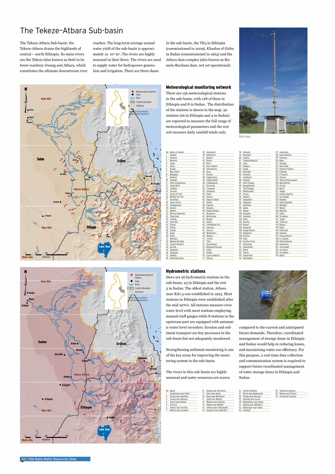
The Tekeze-Atbara Sub-basin: the Tekeze-Atbara drains the highlands of central – north Ethiopia. Its main rivers are the Tekeze (also known as Setit in its lower reaches), Gwang and Atbara, which constitutes the ultimate downstream river
reaches. The long-term average annual water yield of the sub-basin is approxi-mately 12 109 m3. The rivers are highly seasonal in their flows. The rivers are used to supply water for hydropower genera-tion and irrigation. There are three dams
in the sub-basin, the TK5 in Ethiopia (commissioned in 2009), Khashm el Girba in Sudan (commissioned in 1964) and the Atbara dam complex (also known as Ru-mela-Burdana dam, not yet operational).
The Tekeze–Atbara Sub-basin
Meteorological monitoring networkThere are 136 meteorological stations in the sub-basin, with 128 of them in Ethiopia and 8 in Sudan. The distribution of the stations is shown in the map. 30 stations (26 in Ethiopia and 4 in Sudan) are reported to measure the full range of meteorological parameters and the rest 106 measure daily rainfall totals only.
Hydrometric stationsthere are 26 hydrometric stations in the sub-basin; 23 in Ethiopia and the rest 3 in Sudan. The oldest station, Atbara near Kilo 3 was established in 1923. Most stations in Ethiopia were established after the mid 1970’s. All stations measure river water level with most stations employing manual staff gauges while 8 stations in the upstream part are equipped with automat-ic water level recorders. Erosion and sed-iment transport are key processes in the sub-basin but not adequately monitored.
Strengthening sediment monitoring is one of the key areas for improving the moni-toring system in the sub-basin.
The rivers in this sub-basin are highly seasonal and water resources are scarce
compared to the current and anticipated future demands. Therefore, coordinated management of storage dams in Ethiopia and Sudan would help in reducing losses, and maximizing water use efficiency. For this purpose, a real-time data collection and communication system is required to support future coordinated management of water storage dams in Ethiopia and Sudan.
No Name of Station1 Debark2 Humera3 Metema4 Sanja5 Adwa6 Atsebi7 May Tsebri8 Maygaba9 Nebelet10 Senkata11 Shire Endasilasse12 Amde Work13 Lalibela14 Tsitsika15 Axum Air Port16 Mekele Air Port17 Adi Arkay18 Agere Genet19 Ambagiorgis20 Ashere21 Baeker22 Belesa (Hamusit)23 Chanchok24 Chenek25 Chew Ber26 Ebinat27 Endris28 Guhala29 Ibnat30 Kafta31 Mykadra32 Mekane Birhane33 Tegdie (Kirakir)34 Abi Adi35 Adiawala36 Adigoshu37 Adikilte38 Adimehemeday
39 Adiremets40 Aditsetser41 Badme42 Biezet43 Bora44 Daro Hafash45 Debrekerbe46 Dera47 Dimma48 Edaga Selus49 Edaga Hibret50 Endabaguna51 Feresmay52 Finarawa53 Gelebeda54 Gijjet55 Guroro56 Hagere Selam57 Halelo58 Hawzen59 Hewane60 Ketema Negus61 Mayhanes62 Merhsenay63 Muglat64 Rahya65 Selehelehe (IV)66 Semema67 Shiraro68 Wedisemro69 Wukuro70 Yichila71 Yiha72 Ayna Bugna73 Belebala Giyorgis74 Chilla75 Dibiko76 Esrel (Libanos)77 Gibana
78 Hamusit79 Kewzeba80 Sekota81 Telajen/Hamusit82 Zata83 Adidaro84 Dabat85 Dib Bahir86 Felwuha87 Gedebeye88 Gobgob89 Kimir Dingay90 Negadebaher91 Tikil Dengay92 Welela bahir93 Zerma94 Adidaro95 Adigudom96 Adigebru97 Adishehu98 Agibe99 Agulai100 Asegede101 Aynalem102 Chila103 Dansha104 Debud105 Dengolet106 Edaga Hamus107 Edagaribi108 Enticho109 Fatsi110 Gerehu Srnay111 Hashenge112 Haykmshal113 Rama114 Samre115 Tsegereda116 Workamba
117 Asketema118 Dabo Ketema119 Kulmesk120 Muja121 Kassala122 New Halfa123 Khashm Elgirba124 Elshwak125 Fireweini126 Shiraro127 Tekeze Hydro power128 Wad alheleo129 Aroma130 Banrt131 Degen132 Gashm algerba133 Goz Ragab134 Hadalia135 Halfa Elgadida136 Matateb137 Mekali138 Mokram139 Sidon140 Tendalayi141 Togan142 Tomorgu143 Barbar144 Doka145 ElGuraish146 Showak147 Elazaza North148 Es salama149 Hillat Hakuma150 shasheina151 Um brakeit152 Um Grgor153 Um Rahau154 Aykel
No Name1 Gendawoha near Kokit2 Atsela near Adishihu3 Goang near Metema4 Asera near Debark5 Al Asira6 Tekeze near Yechila7 Metere near Ainalem
8 Gheba near Adi Kumsi9 Dolo near Quiha10 Buya near Maitsemri11 Illala near Mekele12 Mekezo near Dansha13 Gheba near Mekele14 Tekeze near Embamadre15 Angareb near Abdi Rafi
16 Genfel at Wukro17 Worie near Maikenetal18 Sulluh near Hawsien19 Ayehida near Axum20 Maimidimar near Adwa21 Sebtta near Adidahiro22 Maidungur near Adwa23 Hamdait
24 Tekeze at Humera25 Molge near Shiraro26 Zarema at Zarema
98
7
6
5
4
3
2
1
9998
97
96
95
94
93
92
91
90
8988
87
86
85
84
83
8281 80
79
78
77
76
75
74
7372
71
70
69
68
67
6665 64
63
62
61
60
59
58
57
56
55
54
53
52
51
504948
47
4645 44
43
42
41
40
39
38
37
36
35
34
33
32
31
30
29
28
27
26
2524
23
22
21
20
19
18
17 16
15
14
13
12
1110
153
152
151
150 149
148
147
146
145
144
143
142
141140
139
138
137
136
135
134
133
132
131
130
129
128
127
126
125
124
123
122 121
120
119118
117
116115
114
113
112
111
110
109108
107
106
105
104
103
102
101
100
154
Teke
ze
Atbara River
Mereb
W. Arab
Tirare
Kaza
Angereb
Meri
Werei
Gereb
Qash River
K. Amab
Uri
KAdarot
Goha
K. Garatit
Mekeza
K. A
rab
Melgu
Giba
K. Tikrid
Jarma
Ruwasa
K. Serobit
K. Deri
K. Derudeb
K. Asot
Bera
Sitona
Durkutan
W. Mahaleit
K. Tohamiyam
k. dernadebKhor Gura
K. Umm Safa
Aykelem
K. Eig
aikwat
May Tsaida
K. Orgein
K. Mindia
Yimra
Tekeze-Atbara
Blue Nile
Main Nile
White Nile
Rahad
Tekeze Atbara
Blue Nile
Dinder
Aroma
Shuwak
Berber
Atbara
Gonder
Teseney
Ed Damir
Adi Keyh
New Halfa
Al Hawata
Dekemhare
Al Qadarif
Lake Tana
Sudan
Ethiopia
Eritrea
0 100 20050
Kilometers
The NBI is not an authorityon international boundaries
RiverTownMeteorological stations
Country boundary
Subbasin
Wind vane
phot
o: N
ile-S
EC

Nile Basin Water Resources Atlas / 83
The Blue Nile river (known as Abbay in Ethiopia) drains the highlands of Ethiopia and contributes about 60 per cent of the annual flow of the Nile measured at Aswan in Egypt. The long-term average annual water yield of the sub-basin is approxi-
mately 50 BCM. The Blue Nile is highly seasonal with approximately 70 percent of its annual flow occurring in just 4 months. The Blue Nile is source of water for major irrigation schemes in the Sudan. The Blue Nile causes severe flood damages in Sudan
from time to time. The Grand Ethiopi-an Renaissance Dam (GERD) is under construction on the Blue Nile designed to store some 74 109m3. With the GERD in place, the Blue Nile will be fully regulat-ed and its downstream flow depends on
releases from the dam. This is expected to reduce flood damages significantly. There are opportunities for cross border collabo-ration on the coordinated management of the Blue Nile in which joint monitoring of river flows is an important component.
The Blue Nile Sub-basin
Meteorological monitoring networkThere are 304 meteorological stations in the sub-basin, with 286 of them in Ethio-pia and 18 in Sudan. The distribution of the stations is shown in the map below. 64
stations (53 in Ethiopia and 11 in Sudan) are reported to measure the full range of meteorological parameters and the rest 106 measure daily rainfall totals only.
Hydrometric stationsThere are 133 hydrometric stations in the sub-basin; 126 in Ethiopia and the remaining seven in Sudan. The station just downstream of Ethiopia – Sudan border, the Diem station, has a record of over 100 years and, therefore, one of the most important. However, is due to the recent heightening of the Roseries Dam in Sudan, the station at times get inundated by the back-water of the dam. Most stations in Ethiopia were established in the early 1960’s. Erosion and sediment transport are also key processes in the sub-basin but not adequately monitored.
The Blue Nile sub-basin offers one of the greatest opportunities for hydropower de-velopment in the Nile Basin. In addition,
providing over 60 percent of the average annual flow of the Nile, the Blue Nile is the major source of water for the Nile. Key focus in strengthening of hydrometric
monitoring system shall be on real-time data collection and transmission system, sediment monitoring and monitoring of river morphological changes downstream as a result of anticipated flow regimes in the sub-basin.
No Station1 Quara2 Shahura3 Adet4 Ayehu5 Birr Sheleko6 Bullen7 Chagni8 Dangila9 Debre Work10 Finoteselam11 Lay Birr12 Mankush13 Motta14 Pawe15 Bedele16 Gatira17 Alem Ketema18 Ambo Agriculture19 Debre Berhan20 Eneware21 Fiche22 Gunde Meskel23 Kachise24 Mehal Meda25 Angerguten26 Anger27 Arjo28 Dedessa29 Gidayana30 Kamashe31 Nedjo32 Shambu33 Amba Mariam34 Mekane Selam35 Wegel Tena36 Wereilu37 Gondar A.p.38 Bahir Dar New39 Debre Markos40 Nekemte41 Addis Zemen42 Amed Ber43 Chandiba44 Enfranz45 Gassay46 Kolladiba47 Maksegnit48 Mekaneyesus49 Shinfa50 Wanzaye51 Wereta (Add)52 Addis Kidame53 Almahal54 Amanueal55 Asteriyo56 Bambudi57 Bichena
58 Bure59 Dembecha60 Dengay Ber61 Dengel Ber62 Digua Tsion
(Bibugn)63 Dimma64 Durbet65 Elias66 Fasiledes67 Finoteselam68 Gilgelbeles69 Gundil70 Jawi71 Kidamaja72 Kunzila73 Liben74 Mandura75 Merawi76 Shandi77 Shebelberenta
(Yeduha)78 Simada79 Wegedade80 Wetet Abay81 Yetemen82 Zege83 Zela (Yarienja)84 Boreka85 Dembi86 Sigmo87 Agaro88 Chancho89 Debele90 Derba91 Filiklik92 Gebere Guracha93 Gohatsion94 Gudoberet95 Jeldu96 Lemi97 Meragna98 Rema99 Sarmider100 Sheno101 Siadebr102 Sululta103 Tikur Enchine104 Abadi105 Abasina Joger106 Alibo107 Bambase108 Combolcha109 Dalaty110 Embabo111 Fincha112 Gutten113 Hareto
114 Mendi115 Neshi116 Odda Bildigulu117 Sherekole118 Sibusire119 Uke120 Wayu121 Debre Zebit122 Debre Zeit123 Degollo124 Densa125 Gashena126 Gimba127 Gishe Rabel128 Gishen129 Guguftu130 Kabie131 Kone132 Koreb133 Ligwama134 Masha135 Saynt Adjibar136 Shoga137 Wegidi138 Kon Abo139 Ambesame140 Arb Gebeya
(Dera)141 Arb Gebeya
(Gaint)142 Aymba143 Chewahit144 Delgi145 Dera Hamusite146 Koma Fasiledos147 Korata148 Lewaye149 Licha150 Shembekit151 Yifag152 Abay Sheleko153 Addis Alem154 Andassa155 Aneded (Amber)156 Askuna157 Azana158 Baruda159 Chara160 Chimba161 Debre Zeit162 Dejen163 Dibate164 Enjabara165 Felege Berhan166 Feres Bet167 Genetabo168 Geregera169 Gesengessa
170 Gimijabet Mariam171 Gulback172 Gundo Woin173 Kembaba174 Keranio175 Kessa176 Kuy177 Lumamme178 Mambuk179 Mankusa180 Menta Wuha181 Merto Lemariam182 Meshenti183 Quarit184 Rob Gebeya185 Sebader186 Sekela187 Tilili188 Tis Abay189 Urana190 Wadeyesus191 Yechereka192 Yejube193 Yesemala194 Yetnora195 Zenzelema196 Abdela197 Bido198 Debena199 Gechi200 Kone201 Setema202 Yambero203 Yanfa204 Babu205 Boto206 Choche207 Dame208 Gembe209 Semodo210 Setema211 Somodo212 Toba213 Arb Bila214 Chacha215 Debre Tsige216 Degem217 Deneba218 Enchini219 Fetra220 Fital221 Gimbi Bila222 Gubre223 Harodoyo224 Jara225 Jihur226 Kotu227 Muger
228 Muke Turi229 Seladingai230 Serkulla231 Shekute232 Toke Erenso233 Wegere234 Zemro235 Agallo Mitti236 Amba 10237 Amba 16238 Arbgebeya239 Dedessa River240 Ehud Gebeya241 Gebete242 Getema243 Gizen244 Haro245 Homi246 Jarso247 Jermet248 Kiltukara249 Kiramu250 Kokeffe251 Kone252 Menge253 Mukelemi254 Muletadiga255 Sasiga256 Werejiru257 Ajibar (Add)258 Akesta259 Ancharo260 Dawunt (Chet)261 Dessie Zuria Met262 Estayish263 Genete Sch264 Gerado265 Geregera266 Gobiye267 Gosh-Meda268 Kelem Meda269 Kellela270 Kundi271 Kutaber272 Tebasit273 Tenta Tateke Sch274 Wein-Amba275 Hena276 Teleyayen277 Abu Naama278 Sennar279 Umm Benin280 Wad Medani281 Ed Damazine282 Khartoum283 El Gadaref284 Elgezira285 Roseires
286 Singa287 Cheffa288 Simada289 Yetenora290 Sher. Gizen (W)291 Dendar292 Dender293 Karkoj294 Kassab295 Sennar Town296 Singa297 Tozi298 Ubhugar299 Wad Alneal300 Abu Kshma301 Abu Sharaba302 Almatna303 Kagai304 Leiya305 Hugerat306 Rabak307 Ummsigan308 Wad En Na’em309 Wd Alkali310 Basunda311 Elfaw312 Elhawata313 G.enahal314 Gadamblyia315 Mafaza316 W.eshaair317 Elhory318 Elmetna319 Gadamblyia
South320 Samsam321 Um Blail322 Um Leiyon323 Debre Tabor
No Station1 Urgessa near Gembe2 Temsa near Agaro3 Didessa near Dembi4 Dabana near
Bunobedele5 Didessa near Arjo6 Wama near Nekemte7 Melke near Guder8 Sifa near Nekemte9 Bello near Guder10 Fatto near Guder11 Indris at Guder12 Guder at Guder13 Huluka near Ambo14 Debis nearGuder15 Dabana near Abasina16 Tato near Gutie17 Indris near Sire18 Adiya near Nekemte19 Gerbi near Sululta20 Roba near Chancho21 Deneba near Chancho22 Mugher near Chancho23 Uke near Nekemte24 Aleltu near Chancho25 Gorfo near Gorfo26 Angar near Nekemte27 Dilla near Nedjo28 Tinshu Duber near
Duber29 Tilku Duber near Duber
30 Aleltu at Nedjo31 Little Ang at Angar
Gutin32 Chacha at Chacha33 Komis near Gori34 Koriche near Kiltu Kara35 Hujur near Nedjo36 Robi Jida near Muka
Ture37 Aleltu near Muka Ture38 Beressa near Debre
Berhan39 Sechi nearMendi40 Mutsa near Bambasi41 Neshi near Shambo42 Robigumero near Lemi43 Dabus near Asosa44 Jemma near Lemi45 Haffa near Assosa46 Gambella near Asossa47 Jemma at Abay
Confluence48 Abay at Kessi Bridge49 Wenchit near Alem
Ketema50 Hoha near Asossa51 Muga near Dejen52 Wizer near Mehal Meda53 Yeda near Amber54 Bogena at Lumame55 Shy near Mehal Meda56 Chemoga near
Debremarkos57 Abahim at
Debremarcos58 Jedeb near Ama Nuel59 Teme near Mota60 Suha near Bichena61 Gebregura. near
Degolo62 Shelkole near
Komosha63 L. Fettam at Galibed64 Temcha near
Dembecha65 Gudla at Dembecha66 Jogola at Wereilu67 Abbay near Bure68 Chereka at Yechereka69 Birr near Jiga70 Leza near Jiga71 Abay at Shergole
Cableway RGS72 Lah near Finote Selam73 Mechela near Kabe74 Boreda near
Mekaneselam75 Selgi near Kabe76 Lege Cora near
Mekaneselam77 Talia near Jiga78 Fettam at Tilile79 Tigdar nearGunde
Woin
80 Dondor near Metekel81 Missini at Kossober82 Ardy near Metekel83 Ayo near Kossober84 Azuari near Mota85 Abay at Mekane
Selam-Gundewein Br.86 Abay at Yarenga
Bridge87 Dura near Metekel88 Buchiksi near
Kidamaja89 Sedie near Mota90 Abbay near Kessie91 Gerado near Dessie92 Abay at El Delm93 Gilgel Be. near
Mandura94 Tul near Adet95 Quashini near Addis
Kidame96 Abbay at Sudan Border97 Eldeim98 Main Beles at Bridge99 Shina near Adiet100 Amen at Dangila101 Main Bele at Bridge DS
of Bagusta102 Gelgel Abbay near
Marawi103 Koga at Merawi104 Bered at Merewi
105 Ezana near Bahirdar106 Mendel near Tis Abbay107 Andassa near Bahir
Dar108 Lake Tana at Bahir Dar109 Abbay at Bahir Dar110 Abbay near Pedagogi111 Chena near Istay112 Wenka near Istay113 Fegoda near Arb
Gebeya114 Gelda near Ambessame115 Roseries116 Ribb near Gasai117 Gumara near Bahir Dar118 Zufil near Debre Tabor119 Lake Tana at Kunzila120 Ribb near Addis Zemen121 Upper Ribb On
DebreTabor Road122 Lake Tana at Gorgora123 Garno near Infranz124 Gemero near
Maksegnit125 Megech near Azezo126 Angareb near Gonder127 Wad Eleis128 Gewesi129 Hawata130 Madani131 Khartoum132 Yebu at Yebu
98 7
65
4
3
2 1
999897 96 9594
9392 91
9089888786 85848382
8180 7978
7776
75
7473
727170
69
6867
666564
6362 616059
58 57
5655
5453
52
5150
49
48
4746 45 44
4342
4140 393837
3635
34 3332
3130 29
2827 26 2524
23 22
2120
1918
171615 14
13
1211 10
131
130
129128
127
126
125124
123122121120
119118
117116
115
114113 112
111
110
109108
107106
105104103
102101100
132
Lake Tana
Blue Nile
Tekeze Atbara
White Nile
Baro-Akobo-Sobat
Main Nile
Ethiopia
Sudan
Eritrea
South Sudan
Blue Nile
Beles
Didesa
Dabu
s
Jema
ElRahad River
Dinder
Muger
Dindir River
Hanger
Beshilo
Gude
r
Jita
Wench
it
Dila
Shinfa
Finc
ha
K. Kenana
Debena
Weleka
Rahad
Gelege
Chacha
Zita
K. Abu Sana
K. El Aqahin
Cheye
Jira
Mitisi
W. Abu Qanafid
K. El Garia
Gerado
Et Ta
mad
a
K. et
Taro
ba
K. Mugdu
Dula
Anonu
K. Abu Tabub
Baro
Rahad
Blue Nile
Dinder
Akobo
White Nile
Sobat
Tekeze Atbara
Pibor
0 70 14035
Kilometers
RiverTown
Hydrometeorologicalstation
Country boundary
Sub-basin
The NBI is not an authorityon international boundaries
9
8
7
654
3
2
1
9998
97
96
95
94
9392
91
90
89
88
8786
85
84
83
82
81
80
79
78
77
76
7574
73
72
71
70
69
68
67
66
65
64
63
62
61
60
59
58
57
56 55
54
53
52
51
50
49
48
4746
45
4443
42
41
40
39
38
37
36
35
34
33
32
31
30
29
28
27
2625
24
23
22
2120
19
18
17
16
15
14
13
12
11
10
322
321
320
319
318
317
316
315
314313
312
311
310
309
308
307
306
305
304
303
302
301
300
299
298
297
296
295294
293
292
291
290
289
288
287
286
285
284
283
282
281
279
278
277
276
275
274
273
272
271270
269
268
267
266
265
264
263
262
261
260
259
258
257
256
255
254
253
252
251
250
249
248247
246
245
244243
242
241
240
239
238
237
236 235
234233
232
231
230
229
228227226
225
224
223
222221
220
219
218
217
216
215 214
213
212
211
210
209
208
207
206
205204
203202
201
200
199198
197196
195
194
193
192
191
190
189
188
187 186
185 184
183
182
181180179
178
177176
175174
173
172
171
170
169
168
167 166165
164
163
162161
160
159
158
157
156
155
154
153
152
151
150
149148
147
146
145
144
143
142
141140
139 138
137
136
135
134
133
132
131
130129
128
127
126
125
124
123
122
121
120
119
118
117
116
115114
113
112
111
110
109
108
107
106
105
104
103
102
101
100
323Lake Tana
Blue Nile
Tekeze Atbara
White Nile
Baro Akobbo Sobat
Main Nile
Ethiopia
Sudan
Eritrea
South Sudan
Blue Nile
Beles
Didesa
Dabu
s
Jema
ElRahad River
Dinder
Muger
Dindir River
Hanger
Besh
ilo
Guder
Jita
Wenchit
Dila
Shinfa
Fincha
K. Kenana
Debena
Weleka
Rahad
Gelege
Chacha
K. Abu Sana
K. El Aqahin
Cheye
Jira
Mitisi
W. Abu Qanafid
K. El Garia
Et Ta
mad
a
K. et
Taro
ba
K. Mugdu
Albe
da
Kola (Dinder)
K. Abu Tabub
BaroRahad
Blue Nile
Dinder
Akobo
White Nile
Sobat
Tekeze
Pibor
0 70 14035
Kilometers
RiverTownMeteorological stations
Country boundary
Subbasin
The NBI is not an authorityon international boundaries
Ground water level monitoring station
phot
o: N
ile-S
EC
84 / Nile Basin Water Resources Atlas
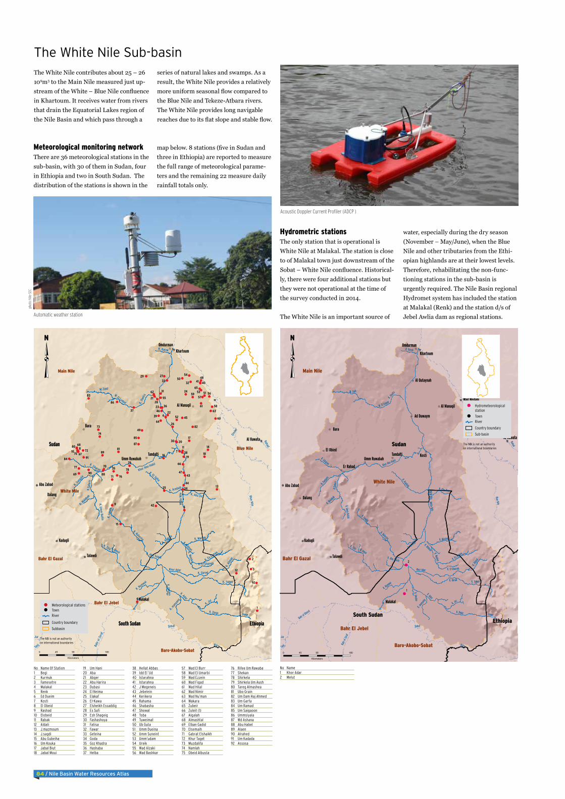
Hydrometric stationsThe only station that is operational is White Nile at Malakal. The station is close to of Malakal town just downstream of the Sobat – White Nile confluence. Historical-ly, there were four additional stations but they were not operational at the time of the survey conducted in 2014.
The White Nile is an important source of
water, especially during the dry season (November – May/June), when the Blue Nile and other tributaries from the Ethi-opian highlands are at their lowest levels. Therefore, rehabilitating the non-func-tioning stations in the sub-basin is urgently required. The Nile Basin regional Hydromet system has included the station at Malakal (Renk) and the station d/s of Jebel Awlia dam as regional stations.
The White Nile contributes about 25 – 26 109m3 to the Main Nile measured just up-stream of the White – Blue Nile confluence in Khartoum. It receives water from rivers that drain the Equatorial Lakes region of the Nile Basin and which pass through a
series of natural lakes and swamps. As a result, the White Nile provides a relatively more uniform seasonal flow compared to the Blue Nile and Tekeze-Atbara rivers. The White Nile provides long navigable reaches due to its flat slope and stable flow.
The White Nile Sub-basin
Meteorological monitoring networkThere are 36 meteorological stations in the sub-basin, with 30 of them in Sudan, four in Ethiopia and two in South Sudan. The distribution of the stations is shown in the
map below. 8 stations (five in Sudan and three in Ethiopia) are reported to measure the full range of meteorological parame-ters and the remaining 22 measure daily rainfall totals only.
No Name Of Station1 Begi2 Kurmuk3 Famesetre4 Malakal5 Renk6 Ed Dueim7 Kosti8 El Obeid9 Rashad10 Elobeid11 Rabak12 Aldali13 J.mazmoum14 J.sagdi15 Abu Gubeiha16 Um Kouka17 Jabal Biut18 Jabal Moui
19 Um Hani20 Aba21 Abger22 Abu Harira23 Dubasi24 El Neima25 Elakaf26 El-Kawa27 Elsheikh Essaddig28 Es Sufi29 Esh Shageig30 Fashashoya31 Fatisa32 Fawar33 Geteina34 Goda35 Goz Khadra36 Hashaba37 Helba
38 Hellat Abbas39 Idd El`Ud40 Istarahna41 Istarahna42 J Megeneis43 Jebelein44 Kerikera45 Rahama46 Shabasha47 Showal48 Toba49 Tuweimat50 Ub Guta51 Umm Dueina52 Umm Suneint53 Umm’udam54 Ureik55 Wad Alzaki56 Wad Bashkar
57 Wad El Burr58 Wad El Umarbi59 Wad Ezzein60 Wad Figad61 Wad Hilal62 Wad Nimir63 Wad Nu’man64 Wakara65 Zubeir66 Zuleit (1)67 Algalah68 Almashtal69 Elban Gadid70 Elsemaih71 Gabrat Elshaikh72 Khur Taget73 Muzdalifa74 Namlah75 Obeid Albusta
76 Rifee Um Rawaba77 Shekan78 Shirkela79 Shirkela Um Aush80 Tareg Almashea81 Ubo Grain82 Um Dam Haj Ahmed83 Um Garfa84 Um Ramad85 Um Saigaoon86 Ummsiyala87 Wd Ashana88 Abu Habel89 Alaen90 Alrahed91 Um Kadada92 Assosa
No Name1 Khor Adar2 Melut
9
87
6
5
4
3
2
1
91
90
89
88
87
86
85
84
83
82
8180
79
7877
76
75
74
73
72
71
70
69
68
67
66
65
64
63
62
61
60
59
58
5756
55
54
53
52
51
50
49
48
47
46
45
44
43
42
41 40
39
38
3736
35
34
3332
31
30
29
28
27
26
25
24
23
22
21
20
1918
17
16
15
14
13
12
1110
92
K. Daga
K. A
hmar
K. Qarad
K. Es Samaa
K. Omol
K. Jur
K. Yabus
K. Sikaran
K. ta
ndik
K. Adar
W. El Luqud
Khor Abo Habil
K. Aradaib
K. Tira
K. Abu Tuleih
W. Zaid
Khor Adar
K. man
yang
K. Mariok
K. Su
ngala
Deke
K. Barok
K. Nymwai
K. Bibban
K. Abu Dirs
K. Kuterira
K. Wehfet
K. El Ghareib
K. Al A
rda
K.Sa
farir
K. If
aetis
K. Mala
bak
K. Umako
K. Et Talha
K. Umm
Balila
Sudan
South Sudan Ethiopia
White Nile
Blue Nile
Main Nile
Bahr El Gazal
Bahr El Jebel
Baro-Akobo-Sobat
Sobat
Baro
Whi
te N
ile Blue Nile
Dind
er
Bahr
el Z
eraf
Rahad
Tanj
Jur
Bahr el G
hazal
Bara
Dalang
Talawdi
Malakal
Kadugli
Omdurman
Tandalti
Khartoum
Al Hawata
Abu Zabad
Al Manaqil
Umm Ruwabah
0 90 18045
Kilometers
RiverTownMeteorological stations
Country boundary
Subbasin
The NBI is not an authorityon international boundaries
Automatic weather station
phot
o: N
ile-S
EC
Acoustic Doppler Current Profiler (ADCP )
2
1
White Nile
K. Daga
K. Ah
mar
K. Qarad
K. Es Samaa
K. Omol
K. Jur
K. Yabus
K. Sikaran
K. tandik
K. Adar
W. El Luqud
Khor Abo Habil
K. Aradaib
K. Tira
K. Abu Tuleih
W. Zaid
Khor Adar
K. many
ang
K. Mariok
K. Sun
gala
Deke
K. Barok
K. Nymwai
K. Bibban
K. Abu Dirs
K. Kuterira
K. Wehfet
K. El Ghareib
K. Al Arda
K.Safa
rir
K. Ifa
etis
K. Mala
bak
K. Umako
K. Umm Balila
Sudan
South SudanEthiopia
White Nile
Main Nile
Bahr El Gazal
Bahr El Jebel
Baro-Akobo-Sobat
Sobat
Baro
White Nile
Blue Nile
Dinde
r
Bahr
el Ze
raf
Rahad
Tanj
Jur
Bahr el G
hazal
Bara
Kosti
Dalang
Talawdi
Malakal
Kadugli
Omdurman
Tandalti
Er Rahad
El Obied
Khartoum
Al Hawata
Ad Duwaym
Abu Zabad
Wad Medani
Al Manaqil
Umm Ruwabah
Al Qutaynah
0 90 18045
Kilometers
RiverTown
Hydrometeorologicalstation
Country boundary
Sub-basin
The NBI is not an authorityon international boundaries
Nile Basin Water Resources Atlas / 85
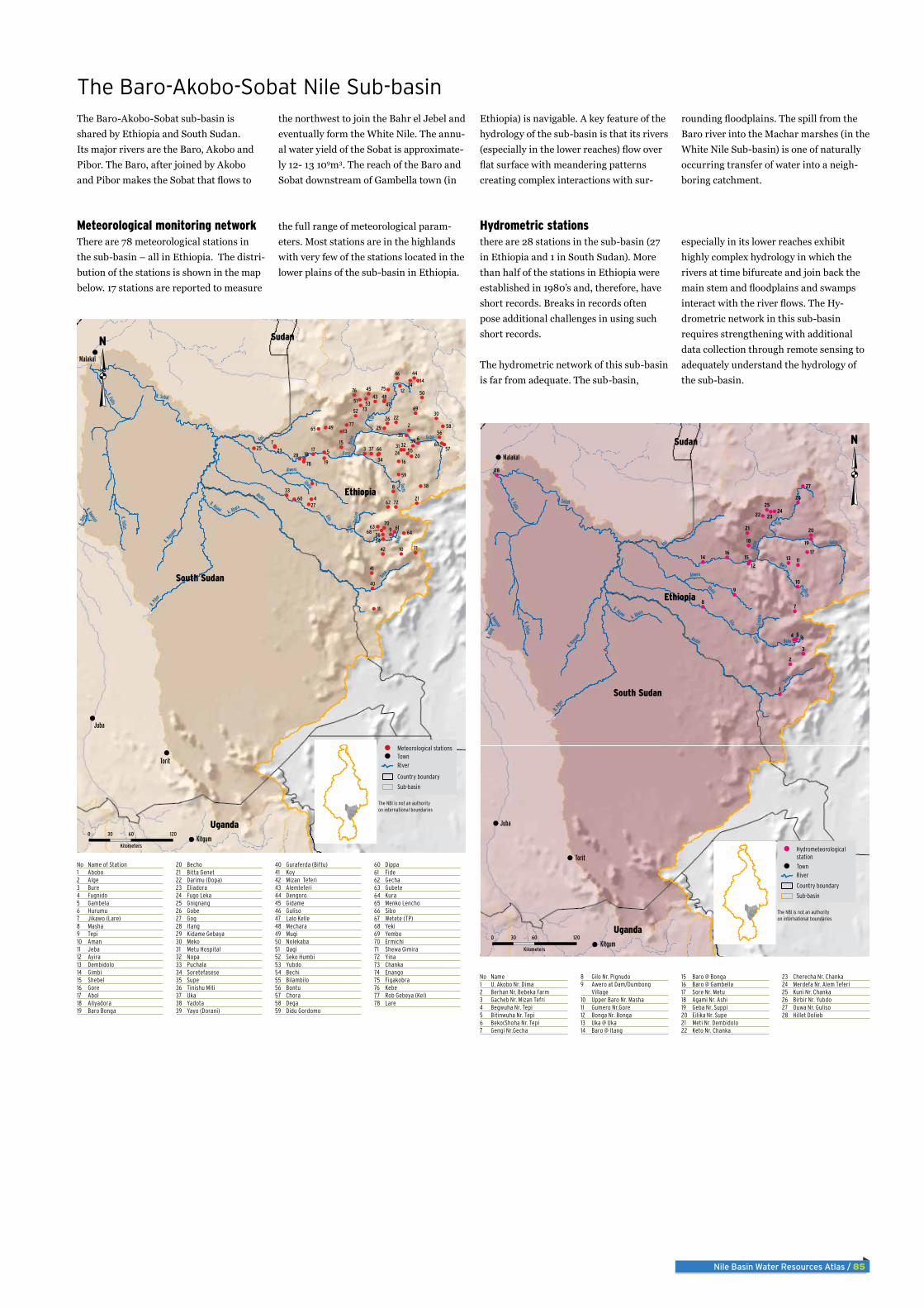
The Baro-Akobo-Sobat sub-basin is shared by Ethiopia and South Sudan. Its major rivers are the Baro, Akobo and Pibor. The Baro, after joined by Akobo and Pibor makes the Sobat that flows to
the northwest to join the Bahr el Jebel and eventually form the White Nile. The annu-al water yield of the Sobat is approximate-ly 12- 13 109m3. The reach of the Baro and Sobat downstream of Gambella town (in
Ethiopia) is navigable. A key feature of the hydrology of the sub-basin is that its rivers (especially in the lower reaches) flow over flat surface with meandering patterns creating complex interactions with sur-
rounding floodplains. The spill from the Baro river into the Machar marshes (in the White Nile Sub-basin) is one of naturally occurring transfer of water into a neigh-boring catchment.
The Baro-Akobo-Sobat Nile Sub-basin
Meteorological monitoring networkThere are 78 meteorological stations in the sub-basin – all in Ethiopia. The distri-bution of the stations is shown in the map below. 17 stations are reported to measure
the full range of meteorological param-eters. Most stations are in the highlands with very few of the stations located in the lower plains of the sub-basin in Ethiopia.
Hydrometric stationsthere are 28 stations in the sub-basin (27 in Ethiopia and 1 in South Sudan). More than half of the stations in Ethiopia were established in 1980’s and, therefore, have short records. Breaks in records often pose additional challenges in using such short records.
The hydrometric network of this sub-basin is far from adequate. The sub-basin,
especially in its lower reaches exhibit highly complex hydrology in which the rivers at time bifurcate and join back the main stem and floodplains and swamps interact with the river flows. The Hy-drometric network in this sub-basin requires strengthening with additional data collection through remote sensing to adequately understand the hydrology of the sub-basin.
No Name of Station1 Abobo2 Alge3 Bure4 Fugnido5 Gambela6 Hurumu7 Jikawo (Lare)8 Masha9 Tepi10 Aman11 Jeba12 Ayira13 Dembidolo14 Gimbi15 Shebel16 Gore17 Abol18 Aliyadora19 Baro Bonga
20 Becho21 Bitta Genet22 Darimu (Dopa)23 Eliadora24 Fugo Leka25 Gnignang26 Gobe27 Gog28 Itang29 Kidame Gebaya30 Meko31 Metu Hospital32 Nopa33 Puchala34 Soretefasese35 Supe36 Tinishu Miti37 Uka38 Yadota39 Yayo (Dorani)
40 Guraferda (Biftu)41 Koy42 Mizan Teferi43 Alemteferi44 Dengoro45 Gidame46 Guliso47 Lalo Kelle48 Mechara49 Mugi50 Nolekaba51 Qaqi52 Seko Humbi53 Yubdo54 Bechi55 Bilambilo56 Bontu57 Chora58 Dega59 Didu Gordomo
60 Dippa61 Fide62 Gecha63 Gubete64 Kura65 Menko Lencho66 Sibo67 Wetete (TP)68 Yeki69 Yembo70 Ermichi71 Shewa Gimira72 Yina73 Chanka74 Enango75 Figakobra76 Kebe77 Rob Gebeya (Kel)78 Lare
No Name1 U. Akobo Nr. Dima2 Berhan Nr. Bebeka Farm3 Gacheb Nr. Mizan Tefri4 Begwuha Nr. Tepi5 Bitinwuha Nr. Tepi6 Beko(Shoha Nr. Tepi7 Gengi Nr.Gecha
8 Gilo Nr. Pignudo9 Awero at Dam/Dumbong
Village10 Upper Baro Nr. Masha11 Gumero Nr.Gore12 Bonga Nr. Bonga13 Uka @ Uka14 Baro @ Itang
15 Baro @ Bonga16 Baro @ Gambella17 Sore Nr. Metu18 Agami Nr. Ashi19 Geba Nr. Suppi20 Eilika Nr. Supe21 Meti Nr. Dembidolo22 Keto Nr. Chanka
23 Cherecha Nr. Chanka24 Merdefa Nr. Alem Teferi25 Kuni Nr. Chanka26 Birbir Nr. Yubdo27 Ouwa Nr. Guliso28 Hillet Dolieb
South Sudan
Ethiopia
Kenya
Uganda
Sudan
9
8
76
5
4
3
2
1
78
77
76 7574
73
72
71
70
69
68
6766
65
6463
62
61
60
59
58
57
56
55
54
53
52
51
50
49
48
47
46
45
44
43
42
41
40
39
38
37
36
35
34
33
3231
30
29
28
27
26
252423
22
21
2019
1817
16
15
14
13
12
11
10
Gilo
Baro
R. Pib
or
Alwero
Koji
Akobo
R. Sobat
Geba
Birbir
Dima
K. Na
naam
K. Fullis
Ubela
K. Fullus
k. Abara
Beko
Goda
re
R. Agawi
K. Din
g
Duchi
Golo
K. Kwanjor
Usen
Juba
Torit
Kitgum
Malakal
0 60 12030
Kilometers
RiverTownMeteorological stations
Country boundary
Sub-basin
The NBI is not an authorityon international boundaries
9
87
654
3
2
1
28
27
2625
242322
21 20
1918
17161514 13
1211
10
South Sudan
Ethiopia
Kenya
Uganda
Sudan
Gilo
Baro
R. Pib
or
Alwero
Koji
Akobo
R. Sobat
Geba
Birbir
Dima
K. Na
naam
K. Fullis
Ubela
K. Fullus
k. Abara
Beko
Goda
re
R. Agawi
K. Din
g
Duchi
Golo
K. Kwanjor
Usen
Juba
Torit
Kitgum
Malakal
0 60 12030
Kilometers
RiverTown
Hydrometeorologicalstation
Country boundary
Sub-basin
The NBI is not an authorityon international boundaries
86 / Nile Basin Water Resources Atlas
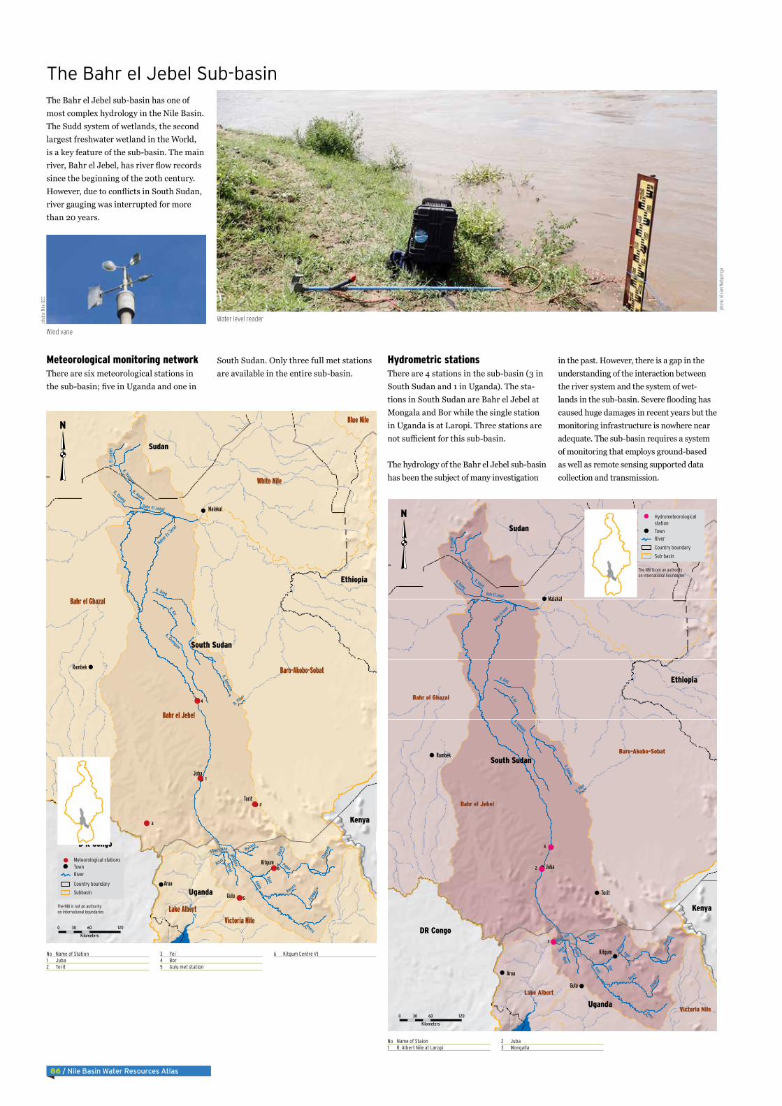
The Bahr el Jebel sub-basin has one of most complex hydrology in the Nile Basin. The Sudd system of wetlands, the second largest freshwater wetland in the World, is a key feature of the sub-basin. The main river, Bahr el Jebel, has river flow records since the beginning of the 20th century. However, due to conflicts in South Sudan, river gauging was interrupted for more than 20 years.
The Bahr el Jebel Sub-basin
Meteorological monitoring networkThere are six meteorological stations in the sub-basin; five in Uganda and one in
South Sudan. Only three full met stations are available in the entire sub-basin.
Hydrometric stationsThere are 4 stations in the sub-basin (3 in South Sudan and 1 in Uganda). The sta-tions in South Sudan are Bahr el Jebel at Mongala and Bor while the single station in Uganda is at Laropi. Three stations are not sufficient for this sub-basin.
The hydrology of the Bahr el Jebel sub-basin has been the subject of many investigation
in the past. However, there is a gap in the understanding of the interaction between the river system and the system of wet-lands in the sub-basin. Severe flooding has caused huge damages in recent years but the monitoring infrastructure is nowhere near adequate. The sub-basin requires a system of monitoring that employs ground-based as well as remote sensing supported data collection and transmission.
No Name of Station1 Juba2 Torit
3 Yei4 Bor5 Gulu met station
6 Kitgum Centre Vt
No Name of Staion1 R. Albert Nile at Laropi
2 Juba3 Mongalla
3
2
1
South Sudan
Uganda
Sudan
Ethiopia
Kenya
DR Congo
Bahr el Jebel
White Nile
Baro-Akobo-Sobat
Bahr el Ghazal
Victoria Nile
Lake Albert
Aswa
Bahr El Jebel
Pager
Agag
o
K. Gumgum
K. Ding
Bahar E
l Zeref
K. Kir
UnyamaAyugiK. Amwoin
K. Hagaral
R. Agaid
Nyimur
Chap
edi
Ajan
K. El
Lodie
i
K. Dyang
Aring
a
Albert Nile
Awuch
R. Pibor
Awero
Adidi
Arua
Gulu
Juba
Torit
Kitgum
Rumbek
Malakal
0 60 12030
Kilometers
RiverTown
Hydrometeorologicalstation
Country boundary
Sub-basin
The NBI is not an authorityon international boundaries
6
5
4
3
2
1
South Sudan
Uganda
Sudan
Ethiopia
Kenya
D R Congo
Bahr el Jebel
White Nile
Baro-Akobo-Sobat
Bahr el Ghazal
Victoria NileLake Albert
Blue Nile
Aswa
Bahr El Jebel
Pager
Agag
o
K. Gumgum
K. Ding
Bahar
Ez Za
raf
K. Kir
UnyamaAyugi
K. Amwoin
K. Hagaral
R. Agaid
Nyimur
Chap
edi
Ajan
K. E
l Lod
iei
K. Dyang
Okur
a
Albert Nile
Awuch
R. Pibor
Awero
Adidi
Arua
Gulu
Juba
Torit
Kitgum
Rumbek
Malakal
0 60 12030
Kilometers
RiverTownMeteorological stations
Country boundary
Subbasin
The NBI is not an authorityon international boundaries
Wind vane
Water level readerphot
o: N
ile-S
EC
phot
o: V
ivia
n Na
byon
ga

Nile Basin Water Resources Atlas / 87
The Bahr el Ghazal Sub-basin drains is shared by South Sudan and Sudan. It has an area comparable to the Blue Nile but with very small outflow. The main river, Bahr el Ghazal, flows and joins the Bahr el Jebel downstream of Lake No.
The Bahr el Ghazal Sub-basin
Meteorological monitoring networkThere are 14 meteorological stations in the sub-basin; two in South Sudan and 12 in Sudan. Nine stations are full met stations.
Hydrometric stationsThere is only one station in the sub-ba-sin – on a tributary of the river at Wau in South Sudan. The map below shows the location of the station. The table adjacent to the map provides the list of hydrometric stations that were available but not oper-ational and those newly proposed as part of strengthening the monitoring system in South Sudan.
The Bahr el Ghazal is the least monitored sub-basin in the Nile Basin. As a result, the hydrology of the sub-basin is not well understood although indications are that the sub-basin has considerable water resources potential. A combination of ground – and remote sensing based obser-vations of hydro-meteorological parame-ters are needed for the long-term sustain-able management of the water resources of the sub-basin.
No Name of Station1 YAMBIO2 RUMBEK3 Wau4 KUAJOK5 Raga6 AWEIL7 BENTIU8 Alradoom9 RADOM10 BURAM
11 ABU MATARIG12 UMM SIKEINAT13 Kadugli14 tulus15 ABUGABRA16 Babanusa17 ABU HEMEID18 EL-DEAIN19 Gazala gawazat20 EID EL-GANAM21 MUHAGRIA
22 ET TOMAI23 Neyala24 Nyala25 DANKOG26 Elodaiah27 EL-TEWAISHA28 KAS29 Giraih Elsarha30 En Nahud31 KALOKITING32 KUNGAR
33 WAFA’A34 TORA TONGA35 MALEMM36 Wd Bunda37 SUNI38 Elmazroob39 Alkhowi40 Eial Bakhit41 El Fasher42 El Fasher
Note: All Hydrometric stations in Bahr el Ghazal are not operational1 Rumbek
2 Gel
2
1
Bahr el Ghazal
Main Nile
Bahr el Jebel
White Nile
Sudan
South Sudan
D R Congo
R. Ge
l
Bahr El Arab
R. Lol
R. Boro
R. So
po
R. Busseri
R. Ib
ba
R. Sue
R. Biri
R. Wa
u
River
Sue
Wadi
Al Gh
alla
R. Raga
R. llu
River Tan
j
K. Ku
ru
R. lbba
K. Teih
River
Jur
K. Gulnum
K. Gama
R. Tuj
u
W. El Khadaior Buneikat
R. N
aam
K. Bib
i
K. Yabo
K. Gu
lnam
R. N
umat
inna
R. Pongo
K. Meze
R. Ku
ru or
Chel
W. El Ku
R. B
iki
W. Ibra
K. W
ohke
R. Ji
or Po
ngo
Ba River
K. Lesi
K. Iya
K. Ibb
a
K.Moa
R. Mb
ungu
K. Yubo
Simbi
K. Igi
K. Yak
umi
Mekki
K. Ngoia
K.Ngomi
K. Rubu
R. Lin
gusi
W. Ab
u ger
naan
K. Fadyit
K. M,Bo
loko
Bahr
El Gh
azal
River
Sue o
r Jur
R. Makedik
K. Maridi
K. Zumbi
K. Vo
rulum
u
Kar Mayen
Aweil
Nyala
Kutum
Yambio
Sodari
Rumbek
Mellit
Muglad
Tambura
Talawdi
El Obied
Al Fashir
Abu Zabad
0 120 24060
Kilometers
RiverTown
Hydrometeorologicalstation
Country boundary
Sub-basin
The NBI is not an authorityon international boundaries
98
7
65
4
3
2
1
4241
40
393837 36
3534 33
3231
30
2928
27
2625
24
2322 21
20 1918 17 16
1514 1312 11
10
Bahr el Ghazal
Main Nile
Bahr el Jebel
White NileSudan
South Sudan
DR Congo
R. G
el
Bahr El Arab
R. Lol
R. Boro
R. S
opo
R. Busseri
R. Ib
ba
R. Sue
R. Biri
R. W
au
Rive
r Sue
Wadi
Al G
halla
R. Rag
a
R. ll
u
River Tanj
K. K
uru
R. lbba
K. Teih
Rive
r Jur
W. El ku
K. Gulnum
K. Gama
R. Tu
ju
W. El Khadaior Buneikat
R. N
aam
K. B
ibi
K. Yabo
K. G
ulna
mR. N
umat
inna
R. Pongo
K. Meze
R. K
uru
or C
hel
W. El Ku
R. B
iki
W. Ibra
K. W
ohke
R. J
i or P
ongo
Ba River
K. Lesi
K. Iy
a
K. Ib
ba
K.Mo
a
R. M
bung
u
R. Ji
K. Yubo
Simbi
K. Igi
K. Ya
kum
i
Mekki
K. Ngoia
K.Ngomi
K. Rubu
R. Li
ngus
i
W. A
bu g
erna
an
K. Fadyit
K. M,B
oloko
Bahr
El G
haza
l
Rive
r Sue
or J
ur
R. Makedik
K. Maridi
K. Zumbi
K. V
orul
umu
Aweil
Nyala
Kutum
Yambio
Sodari
Rumbek
Mellit
Muglad
Tambura
Talawdi
El Obied
Al Fashir
Abu Zabad
0 120 24060
Kilometers
RiverTownMeteorological stations
Country boundary
Sub-basin
The NBI is not an authorityon international boundaries
Dry river bed in South Sudan
phot
o: A
rsen
ie C
osea
c/Fl
ickr
88 / Nile Basin Water Resources Atlas
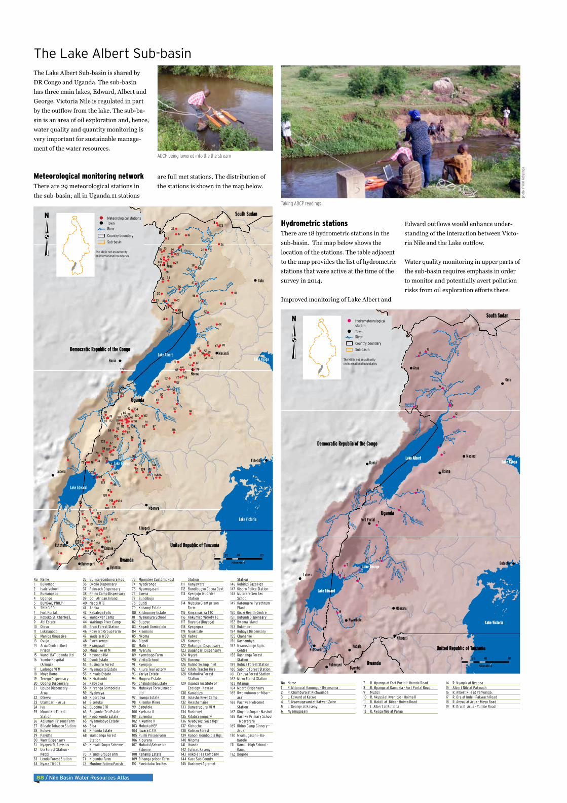
Hydrometric stationsThere are 18 hydrometric stations in the sub-basin. The map below shows the location of the stations. The table adjacent to the map provides the list of hydrometric stations that were active at the time of the survey in 2014.
Improved monitoring of Lake Albert and
Edward outflows would enhance under-standing of the interaction between Victo-ria Nile and the Lake outflow.
Water quality monitoring in upper parts of the sub-basin requires emphasis in order to monitor and potentially avert pollution risks from oil exploration efforts there.
The Lake Albert Sub-basin is shared by DR Congo and Uganda. The sub-basin has three main lakes, Edward, Albert and George. Victoria Nile is regulated in part by the outflow from the lake. The sub-ba-sin is an area of oil exploration and, hence, water quality and quantity monitoring is very important for sustainable manage-ment of the water resources.
The Lake Albert Sub-basin
Meteorological monitoring networkThere are 29 meteorological stations in the sub-basin; all in Uganda.11 stations
are full met stations. The distribution of the stations is shown in the map below.
No Name1 Bukombo2 Isale Vuhovi3 Rumangabo4 Ugongo5 BUNGWE-PNILP6 SHINGIRO7 Fort Portal8 Koboko St. Charles L9 Abi Estate10 Olovu11 Lokiragodo12 Manibe Omuazire13 Ovujo14 Arua Central Govt
Prison15 Wandi BAT Uganda Ltd16 Yumbe Hospital
(Aringa)17 Ladonga VFM18 Moyo Boma19 Terego Dispensary20 Obongi Dispensary21 Upupe Dispensary -
Arua22 Otrevu23 Utumbari - Arua24 Ivu25 Mount Kei Forest
Station26 Adjumani Prisons Farm27 Bileafe Tobacco Station28 Kuluva29 Payidha30 Warr Dispensary31 Nyapea St.Aloysius32 Usi Forest Station -
Nebbi33 Lendu Forest Station34 Nyara TWGCS
35 Buliisa Gomborora Hqs36 Okollo Dispensary37 Pakwach Dispensary38 Rhino Camp Dispensary39 Goli African.Inland.40 Nebbi UTC41 Anaka42 Kabalega Falls43 Wangkwar Camp44 Wairingo River Camp45 Erusi Forest Station46 Pokwero Group Farm47 Wadelai WDD48 Rwebisengo49 Kyangwali50 Mugalike WFM51 Kasonga HM52 Dwoli Estate53 Busingiro Forest54 Nyamageta Estate55 Kinyala Estate56 Kizirafumbi57 Kabwoya58 Kiryanga Gombolola59 Nyabyeya60 Kigorobya61 Biseruka62 Bugoma CFR63 Bugambe Tea Estate64 Rwabikondo Estate65 Nyamolobyo Estate66 Siba67 Kihonda Estate68 Wampanga Forest
Station69 Kinyala Sugar Scheme
B70 Kisindi Group Farm71 Kigumba Farm72 Muntme Fatima Parish
73 Mpondwe Customs Post74 Nyabirongo75 Nyamugasani76 Bwera77 Bundibujo78 Butiti79 Kahangi Estate80 Kilchooney Estate81 Nyakasura School82 Bugoye83 Kagadi Gombololo84 Kisomoro85 Nkoma86 Bigodi87 Matiri88 Nyaruru89 Kyembogo Farm90 Virika School91 Kyenjojo92 Kijura Tea Factory93 Yeriya Estate94 Mugusu Estate95 Chakatimba Estate96 Muhokya Toro Limeco
Ltd97 Isunga Estate98 Kilembe Mines99 Sebutole100 Kyehara II101 Bulemba102 Kikumiro V103 Mobuku HEP104 Itwara C.F.R.105 Ruimi Prison Farm106 Kiburara107 Mubuku\Sebwe Irr
Scheme108 Kahangi Estate109 Bihanga prison Farm110 Rwebitaba Tea Res
Station111 Kanyawara112 Bundibugyo Cocoa Devt113 Kyenjojo 1st Order
Station114 Mubuku Giant prison
Farm115 Kinyamasika TTC116 Kakumiro Variety TC117 Buyanja (Buyaga)118 Kyegegwa119 Nyakibale120 Katwe121 Kanungu122 Rukungiri Dispensary123 Bugangari Dispensary124 Myeya125 Burema126 Rulind Swamp Inlet127 Kihihi Tractor Hire128 Kitahulira Forest
Station129 Uganda Institute of
Ecology - Kasese130 Kaniabizo131 Ishasha River Camp132 Rwashamaire133 Bunyaruguru WFM134 Bushenyi135 Kitabi Seminary136 Nyabusozi Saza Hqs137 Kicheche138 Kalinzu Forest139 Kanoni Gombolola Hqs140 Mitoma141 Ibanda142 Tufmac Kasenyi143 Ankole Tea Company144 Kazo Sub County145 Bushenyi Agromet
Station146 Rubirizi Saza Hqs147 Kisoro Police Station148 Mutolere Sen Sec
School149 Karengere Pyrethrum
Plant150 Kisizi Health Centre151 Bufundi Dispensary152 Bwama Island153 Bukimbiri154 Rubaya Dispensary155 Chananke156 Kashambya157 Nyarushanje Agric
Centre158 Rushanga Forest
Station159 Ruhiza Forest Station160 Sabinio Forest Station161 Echuya Forest Station162 Muko Forest Station163 Kitanga164 Mparo Dispensary165 Rwomuhororo - Mbar-
ara166 Pachwa Hydromet
Station167 Kinyara Sugar - Masindi168 Kashwa Primary School
- Mbararara169 Rhino Camp Ginnery -
Arua170 Nyamugasani - Ka-
barole171 Kamuli High School -
Kamuli172 Bogoro
No Name1 R. Mitano at Kanungu - Rwensama2 R. Chambura at Kichwamba3 L. Edward at Katwe4 R. Nyamugasani at Katwe - Zaire5 L. George at Kasenyi6 Nyamugasani
7 R. Mpanga at Fort Portal - Ibanda Road8 R. Mpanga at Kampala - Fort Portal Road9 Muzizi10 R. Nkussi at Kyenjojo - Hoima R11 R. Waki II at Biiso - Hoima Road12 L. Albert at Butiaba13 R. Kyoga Nile at Paraa
14 R. Nyagak at Nyapea15 Albert Nile at Pakwach16 R. Albert Nile at Panyango.17 R. Ora at Inde - Pakwach Road18 R. Anyau at Arua - Moyo Road19 R. Oru at Arua - Yumbe Road
9
8
7
6
54
32
1
19
1817
16
151413
12
11
10
Uganda
Democratic Republic of the Congo
Rwanda
United Republic of Tanzania
South Sudan
Semulik
i
Ora
Muzizi
Nkus
i
Aswa
Anyau
Albe
rt N
ile
Ruha
i
Kochi
Ntungu
Mpanga
Ome
Dura
Waiga
Levih
Nyagak
Ruchuru
Kako
b
Rucharu
Mah
oma
Dyna
Aca
Linya
Nyabisheki
Sunim
Dira
Kaija
Rutungu
Nyanjakufa
Wasa
ZokaNyawa
Waisoke
Ramugura
Muceru
GetiDaymu
Oruy
ubu
Ruhe
zam
inda
Kahombu
Kazinga Channel
Nyarw
odo
Dawuma
Rwem
amba
Arua
Gulu
Hoima
Bunia
Kabale
Byumba
Lubero
Entebbe
Masindi
Mbarara
Kikagati
Rutshuru
Nyakibale
Ruhengeri
Fort Portal
Lake Victoria
Lake Albert
Lake Edward
Lake Kyoga
Lake George
0 40 8020
Kilometers
RiverTown
Hydrometeorologicalstation
Country boundary
Sub-basin
The NBI is not an authorityon international boundaries
9
8
7
6 5
4
3
2
1
99
98
97
96
95
94
93
92
91
908988
87
8685
84
83
82
81
80
797877
76
75
7473
72
7170
69
68
67
66
6564
63
62
61
60 59
58
57
56
55
54
53
52
51
50
49
48
47
46
45
44
43
42
41
4039
38
37
36
35
34
33
32
31
30
29
28
27
26
25
24 2322
21
20
19
18
17 16
15
14
13
1211
10
171
170
169
168
167
166
165
164163
162
161
160
159
158
157
156
155
154
153
152
151
150
149
148147
146
145
144
143
142
141
140
139
138
137
136
135
134
133
132
131130
129
128
127
125
124
123122
121
120
119
118
117116
115
114
113
112
111
110
109
108
107
106
105
104
103
102
101
100
172
180
179
178
177
176
175
173
Uganda
Democratic Republic of the Congo
Rwanda
United Republic of Tanzania
South Sudan
Semulik
i
Ora
Muzizi
Nkusi
Aswa
Anyau
Albe
rt N
ile
Ruha
i
Kochi
Ntun
gu
Mpanga
Ome
Dura
Waiga
Levi
h
Nyagak
Ruchuru
Kako
b
Rucharu
Mah
oma
Dyna
Aca
Linya
Nyabisheki
SunimDira
Kaija
Rutungu
Wasa
Zoka
Chambura
Nyawa
Waisoke
Ramugura
Muceru
GetiDaymu
Oruy
ubu
Kahombu
Nyarw
odo
Dawuma
Tangi
Arua
Gulu
Hoima
Bunia
Kabale
Byumba
Lubero
Entebbe
Masindi
Mbarara
Kikagati
Rutshuru
Ruhengeri
Lake Victoria
Lake Albert
Lake Edward
Lake Kyoga
Lake George
0 40 8020
Kilometers
RiverTownMeteorological stations
Country boundary
Sub-basin
The NBI is not an authorityon international boundaries
ADCP being lowered into the the stream
Taking ADCP readings
phot
o: V
ivia
n Na
byon
ga

Nile Basin Water Resources Atlas / 89
The largest part of the Victoria Nile sub-basin lies in Uganda with a small part in Kenya and is the drained by the Victoria Nile once it leaves the Lake Victoria. The sub-basin has substantial hydropower potential. The average annual flow of Victoria Nile at Jinja station in Ugan-da is approximately 32 109m3. This is a sub-basin with relatively good monitoring infrastructure in the Nile Basin.
The Victoria Nile Sub-basin
Meteorological monitoring networkThere are 48 meteorological stations in the sub-basin; distributed in Kenya (6)
and Uganda (42).11 stations are full met stations. The distribution of the stations is shown in the map below.
Hydrometric stationsthere are 53 hydrometric stations in the sub-basin; 6 in Kenya and 47 in Uganda. The map below shows the location of the station. The table adjacent to the map provides the list of hydrometric stations that were active at the time of the survey in 2014.
Enhancing reservoir operation of a cas-cade of hydropower dams (existing and planned ones) is one of the priority areas in the sub-basin. This requires enhanced real-time data collection and transmission system linked with appropriately built reservoir management system.
No Name1 Kimama Primary2 Sirisia Chief’s Camp3 Lukolis Dispensary,Kakamega4 Kolonya Boy’s Sec. School5 Angorai Chief’s Centre6 Machakusi Nursery7 Amagoro D.o’s Office8 Alupe Cotton Research Station9 Mbale
10 Lira11 Nakasongola12 Namayingo Health Centre13 Busitema University14 Tororo Met15 Kwapa Sub County H/Q16 Butaleja District H/Q17 Budumba Health Centre18 Manafwa Water Works19 Kafu (Masindi)
20 Enget (Lira)21 Namulonge Res Station22 Jinja Met. Station23 Tororo Met.station24 Soroti Met Station25 Lira Ngetta Agromet Station.26 Nabiswera27 Alupe Kari
1 L. Victoria at Jinja Pier2 Alupe3 Alupe4 R. Malaba at Jinja - Tororo Road5 Malakisi6 Malakisi7 Malaba8 R. Mayanja at Kapeeka - Kakunga9 R. Kigwe at Semuto - Wobulenzi10 Yala11 R. Mpologoma at Budumba12 R. Victoria Nile at Mbulamuti13 Malakisi
14 Wamboli at Nabiswera - Gulu Rd15 R. Manafwa at Mbale - Tororo Ro16 R. Mpologoma at Tirinyi-Mbale road17 R. Namatala at Mbale - Soroti R18 R. Sironko at Mbale - Moroto Road19 R. Simu at Mbale - Moroto Road20 R. Sipi at Mbale - Moroto Road21 R. Abuket at Kumi - Serere Road22 R. Agu at Kumi - Serere Road23 R. Kafu at Kampala - Gulu Road24 R. Kelim (Greek) at Mbale - Moroto Road25 L. Kyoga at Bugondo Pier26 R. Kapiri at Kumi - Soroti Road
27 R. Kyoga Nile at Masindi Port28 R. Namalu at Mbale - Moroto Rd29 R. Omunyal Upper at Tiririri -30 R. Akokorio at Soroti - Katakwi31 L. Kwania at Kachung32 R. Enget at Bata - Dokolo Road33 R. Tochi II at Gulu - Atura Roa34 R. Kyoga Nile at Kamdini35 Tochi136 R. Sezibwa at Falls
98
7 654
32
1
35
3433
32
313029
28
27 2625 24
23
222120
1918
17
16 15141312
11 10
36
Victoria Nile
Bahr el Jebel
Lake Victoria
Uganda
Kenya
Kenya
Kafu
Sezi
bwa
Lugogo
Mayanja
Dope
th
Ukul
at
Okole
Victoria Nile
Mpongo
Kirik
Malaba
Kelim
Mpologoma
Lum
buye
Long
iro
Towa
Aroca
Kiiz
i
Siroko
Lwaja
li
Toch
i
Angoleto
Naba
lach
ar
Kiko
Okere
Naig
ombw
aOmanimani
Komirya
Titi
Mayanja Kato
Namatala
Kaputh
Lochoman
Ayago
Lumboka
Loch
idim
ukat
Kotipe
Nabigaga
Oditaileng
Nator
Orio
Kisingu
Lokorimoru
Muk
ote
Katansule
Luyam
Gulu
Lira
Hoima
Jinja
Mbale
Kitgum
Soroti
Tororo
Masindi
Bungoma
Kakamega
Lake Kyoga
Lake Albert
Lake Victoria
0 50 10025
Kilometers
RiverTown
Hydrometeorologicalstation
Country boundary
Sub-basin
The NBI is not an authorityon international boundaries
9
8
76
54
3
2
1
26
25
24
23
2221
20
19
18
17 1615
14
13
12
11
10
27
Victoria Nile
Bahr el Jebel
Lake Victoria
Baro-Akobo-Sobat
Uganda
Kenya
Kenya
Kafu
Sezi
bwa
Lugogo
Mayanja
Dope
th
Ukul
at
Okole
Victoria Nile
Mpongo
Kirik
Malaba
Kelim
Mpologoma
Lum
buye
Long
iro
Towa
Aroca
Kiiz
i
Siroko
Lwaja
li
Toch
i
Angoleto
Naba
lach
ar
Kiko
Oker
e
Naig
ombw
a
Omanimani
Komirya
Titi
Mayanja Kato
Kaputh
Lochoman
Ayago
Manafwa
Minakulu
Lumboka
Loch
idim
ukat
Kotipe
Oditaileng
Nator
Orio
Kisingu
Lokorimoru
Muk
ote
Katansule
Luyam
Gulu
Lira
Hoima
Jinja
Mbale
Kitgum
SorotiMasindi
Kakamega
Lake Kyoga
Lake Albert
Lake Victoria0 50 10025
Kilometers
RiverTownMeteorological stations
Country boundary
Sub-basin
The NBI is not an authorityon international boundaries
Lake Kyoga at Bugondo during dry season
Lake Kyoga at Bugondo during wet season
Station at River Kafu
phot
o: V
ivia
n Na
byon
ga
phot
o: V
ivia
n Na
byon
ga
phot
o: V
ivia
n Na
byon
ga

90 / Nile Basin Water Resources Atlas
The Lake Victoria sub-basin makes the headwater of the White Nile. The Lake, with an area of about 68,000 km2 offers a major regulation to the flow of Victoria Nile. Major tributaries of the Lake include the Kagera (draining parts of Burundi,
Rwanda and Tanzania), Mara (originating in Kenya), Nzoiya (Kenya) and Yala (Ken-ya). The lake, which is a source of water for users in three countries is also used widely for navigation.
The Lake Victoria Sub-basin
Meteorological monitoring networkThere are 254 meteorological stations in the sub-basin; distributed in Burundi (31), Kenya (124), Rwanda (34), Tanzania (42) and Uganda (23). The distribution of the stations is shown in the map below.
Hydrometric stationsThere are 158 hydrometric stations in the sub-basin; 14 in Burundi (in Kagera catch-ment), 87 in Kenya, 36 in Rwanda (Kagera catchment), seven in Tanzania and four in Uganda. The map below shows the location of the stations. The table adjacent to the map provides the list of hydrometric
stations that were active at the time of the survey in 2014.
Monitoring of water quality and lake water levels are two priority areas for strength-ening the hydrometric monitoring system in the Lake Victoria Sub-basin. In the Kagera, sediment monitoring is a priority.
No Name1 Muyinga2 Karuzi3 Gitega (Aero)4 Ruyigi 5 Gisozi6 Muriza7 Ruvyironza8 Rwegura9 Nyamuswaga10 Bugarama (B.aero-
naut)11 Giheta12 Mugera (Paroisse)13 Musongati14 Gitega (Zege)15 Teza (Nyabigondo)16 Bukwavu17 Burenza18 Butora19 Buziracanda20 Fota21 Gikwiye22 Kiganda (Paroisse)23 Mugege24 Mugera (Cankuzo)25 Mungwa26 Muramba27 Mwaro28 Mweya29 Ngozi (Kagoma)30 Rutegama31 Rutonganik32 Butezi33 Ijenda (Mission)34 Ijenda (The Villag)35 Kibumbu36 Mugera (Lycee)37 Mulehe38 Munanira39 Murehe (Mission)40 Murongwe41 Ngozi (Ocibu)42 Nyakararo43 Rusaka44 Rutovu45 Mashitsi46 Burasira (Seminaire)47 Busiga48 Rugari (E.F.I.)49 Bitezi (Gasibe)50 Bugarama (Commune)51 Bugenyuzi (Paroisse)52 Buhiga53 Buhinyuza54 Bukeye (E.F.I.)55 Bwagiriza56 Gisanze57 Gishubi58 Gitega (Agri)59 Gitega (Ndebe)60 Gitongo61 Kabuyenge62 Kanyinya (E.F.I.)63 Kayongozi64 Kaziba65 Kibimba66 Kiganda (E.F.I.)67 Kinazi68 Matongo(Com)69 Muramvya
70 Musema71 Musenyi (E.F.I.)72 Mutumba (Nyabikere)73 Ngozi (Caprin)74 Ngozi (College)75 Remera76 Rugari (Paroisse)77 Rusengo (E.F.I.)78 Ruyigi (Agri)79 Ruyigi (Mission)80 Musenyi (Paroisse)81 Rweza (Nyangwa)82 Siaya Atc83 Masinde Muliro
University84 Chwele85 Migori86 Bomet87 Kitale Met88 Eldoret Airport89 Eldoret Kapsoya Met90 Suba Met, Rusinga
Island Kaswanga Hdr. Stn
91 Kakamega Met92 Nganyi Community
Ranet93 Kakamega Met New
Site94 Kakamega Airport95 Mumias Sugar Factory96 Kaimosi Farmers
Training Centre97 Lugari Forest Station98 Kapsara Tea Factory99 Uholo Chief’s Office100 Chorlim Adc101 Kapenguria Wrma
Office102 Cheptongei Chief’s
Office103 Kipkabus Forest
Station104 Nabkoi Forest Station105 Bunyala Ranet Fm106 Mukuyuni Dc’s Office107 Bungoma Water Yard108 Kadenge Yala Swamp109 Nangina Girls H. School110 Nambale Agric. Office111 Kwangamor Primary
School112 Bunyala Irrigation
Scheme.113 Wakhungu Nurs-
ery-Samia114 Kaliwa Primary115 Matayos Youth
Polytechnic116 Madende Secondary117 Erusui Secondary118 Lugari Water Yard119 Kapsokwony Water
Yard120 Timboroa Forest121 Chebara Dam122 Eldoret Water Yard123 Kitale Water Yard124 Kakamega Forest
Station125 Ebusiratsi Health
Centre.126 Kaptagat Forest
Station127 Eldoret,Institute Of
Agriculture128 Kimilili Agric. Depart-
ment.129 Chief’s Centre Kongoni130 Yala Tn131 Bondo Water Supply132 Chorlim A.d.c.133 A.d.c. Namandala Farm134 Nakami Farm No.1135 Leissa Farm,Kitale136 Kitale Gloucester Vale
Estate137 Khwisero Met Station138 Mwihila Secondary
School,Yala139 Kigama Primary
School140 Sega Primary School141 Oholo Chief’s Camp.142 Malava Agiric. Station.143 Kaimosi Tea Estate Ltd.144 Shikusa Borstal
Institution.145 Kakamega Agromet
Station146 Bukembe147 Eregi, St. Augustine’s
T.t.c.148 Esalwa Secondary
School149 Mundoli150 Malava Forest Guard
Post.151 Sabatia Chief’s Office152 Kabujoi Forest Station153 Namuichula Nursery154 Lugulu Primary School155 Barding Harambee
Secondary Sch.156 Bukura Institute Of
Agriculture157 Nzoia Sugar Factory
Bungoma158 Shiakungu Sec. School159 Nandi Hills, Savani
Estate160 Eldoret Kenya Coop.
Creameries161 Siret Tea Co. Ltd.,Nandi162 Nandi Hills,Kibweri Tea
Estate163 Kapsaret Forest
Station ,Eldoret164 Kimwani A.d.c. Farm165 Kapkeben Chemoni
Estate166 Miwani Sugar Section
III167 Oyugis Agricultural
Station168 Bondo Water Supply169 Kibos Cotton Experi-
mental Sta.170 Homabay Farmers
Training Centre171 Lambwe Forest Station172 Wanjare Chief’s Camp
173 Ndiru Chief’s Camp174 Kebabe Primary
School175 Madiany Chief’s Office176 Masaka Apundo’s Farm177 Nyabola Girl’s Second-
ary School178 South Nyanza Sugar
Factory179 Kaminjeiwet Second-
ary School180 Koru Homa Lime Co’
Ltd181 Londian, Keresoi
Forest Station182 Kericho Tea Research
Foundation183 Maragat Forest Station184 Tenderet Tea Estate185 Bomet Water Supply186 Hail Research Station
Kericho187 Chemase Cane Grow188 Mombwo Sugar Belt
Co.189 Awasi School190 Aroket Tea Estate
Sotik191 Ndoinet Forest Station192 Saino Forest Station193 Tendeno Forest
Station194 Nyangores Forest
Station195 Narotia Forest Station196 Achego Primary
School197 God Abuoro Primary
School198 Ogen Primary School199 Naluwa Farm Endebess200 Nangina Catholic
Mission201 Burnt Forest Agric.
Station202 Akala Dispensary203 Koru, Coffee Board
Sub-Station204 Cheptenye Secondary
School205 Makindu Pri. School,
Muhoroni206 Kilgoris Divissional
Agr.office207 Kigali Aero208 Ntaruka209 Bakokwe210 Butare Aero211 Gihinga212 Gikomero213 Kaduha214 Kanombe215 Mayange216 Ndego217 Ngarama218 Nyabimata219 Rulindo220 Rutongo221 Busogo-Isae222 Cyanika223 Gikongoro Met
224 Karama Kilimbi225 Muramba Paroisse226 Nyagahanga Efa227 Nyamata228 Nyamiyaga229 Nyarubuye230 Runyombyi231 Kigali Aero232 Bunda/ Bitaraguru
Met. Station233 Kidinda Met. Station234 Magu Met. Station235 Maswa Met. Station236 Randa Met. Station237 Ukerewe Met. Station238 Buhemba Met. Station239 Kuruya Met. Station240 Mugumu Met. Station241 Nyabusara Met.
Station242 Rulenge Met. Station243 Ngudu Met. Station244 Bukoba245 Musoma246 Mwanza247 Biharamulo248 Kayanga Met. Station249 Kishanda Met. Station250 Kyakakera Met. Station251 Ngara252 Bitaraguru P/School253 Bukoba Maji (Yard)254 Busulwangili P/School255 Busweta P/School256 Bwai P/School257 Chanongu P/School258 Izigo259 Kayenze P/School260 Kikubiji P/School261 Kikuku262 Kisesa P/School263 Kuruya P/School264 Lukuba Island265 Mugumu P/School266 Mwabagole P/School267 Mwadubi P/School268 Mwanangwa P/School269 Mwanza Maji (Yard)270 Nshambya271 Nyakanyasi272 Sumve High School273 Tallaga P/School274 Tallo Secondary
School275 Utegi P/School276 Walla P/School277 Kharumwa P/School278 Nyehunge P/School279 Sagata P/School280 Zunzuli P/School281 Lolui282 Kome283 Molo Sub County H/Q284 Mbarara Met Station285 Mpanga Forest Statio286 Entebbe Intl Airport287 Kabake Met Station288 Lwemiyaga289 Kakuto290 Cankuzo (Projet)
No Name1 Nyakijanda (Buhoro K10)2 Ruvyironza (Muyange)3 Nyabaha (Mubuga)4 Ruvubu (Gitega)5 Ruvyironza (Kibaya)6 Kayongozi (Nyankanda)7 Ndurumu (Shombo)8 Mubarazi (Murongwe)9 Ruvubu (Muyinga)10 Nyamuswaga (Gisha)11 Kayave (Mparamirundi12 Rte Butare/Ngozi (Akanyaru)13 Kibeho (Akanyaru)14 Simiyu River at Lumeji15 Ruvuvu/Mumwendo Ferry16 Simiyu River at M/Bridge17 Duma River at Sayaka18 Mwanza South Port19 Cohoha (Kigozi)20 Kazingiri (Nyagatare)21 Rweru (Nyagisozi)22 Mudasomwa (Rukarara)23 Rusumo (Akagera)24 Nyabisindu (Mwogo)25 Gakindo (Lac Rweru)26 Shell (Lac Cyohoha S)27 Gihinga (Akanyaru)28 Mbuye (Akagera)29 Nduruma (Cyunuzi)30 Rubago (Lac Sake)31 Gashora (Lac Mirayi)32 Mfune (Nyabarongo)33 Gashora (Lac Rumira)34 Rukoma (Lac Sake)35 Mbalageti36 Shyembe (Lac Bilira)37 Ururumanza (Ururumanza)38 Gihuma (Gihuma)39 Rwinzoka (Akagera)40 Kavumu (Rugeramigozi)41 Grumet River at M/Bridge42 Mwaka (Nyabarongo)43 Kanzenze (Nyabarongo)44 Ruliba (Nyabarongo)45 Nemba (Nyabugogo)46 Yanze (Yanze)47 Suguti48 Ihema (Ihema Lake)49 Gaseke (Nyamabuye)50 Rusumo (Mwange)51 Kinoni (Base)52 Mara River at Nyansurura53 Ngono/Muhutwe54 Kogatende Ranger Post55 Nyakinama (Mukungwa)56 Mara River at Mara Mine57 Mara River at Kirumi Ferry58 Nyagahanga (Warufu)59 Musoma Port
60 Ngono/Kalebe Bridge61 Ntaruka (Lac Bulera)62 Ngoma (Ngoma)63 Kamiranzovu (Kamiranzovu)64 Rusumo (Rugezi)65 West Ngono at Kyakakera66 Bukoba Port67 R. Nyakizumba at Maziba68 Mori River at Utegi69 Kagera/Kyaka Ferry70 Ngono/Kyaka Rd Bridge71 Mara72 Kagera/Nyakanyasi73 Migori74 Kagitumba (Muvumba)75 Gucha Migori76 R. Kagera at Masangano77 R. Bukora at Katera78 Sare79 Amala80 Nyangweta81 R. Bukora at Mutukula - Kyotera82 Gucha83 Nyangores84 Kipsonoi85 Nyakobisara86 R. Kisoma at Mutukula - Kyotera87 Kenyamware88 R. Lwanda at Kyotera - Rakai Ro89 R. Kisoma Upper Stream at Kyote90 R. Kisoma Upper at Kyotera - Ra91 Mogusii92 R. Ruizi at New Waterworks93 R. Ruizi at Mbarara Water Works94 Kipsonoi Kapsimbiri95 Isanda96 Kiptiget97 Kipsonoi98 Eaka Kioge99 Awach Ober100 New Itare101 Yurith102 Awach Tende103 Awach104 Awach Kabondo105 Mapamujugu106 Songon107 Awach Kabuon108 Lower Songon109 Ainapkoi110 Sondu111 Katonga at Kampala Katonga Road112 Miriu Sondu113 Tugenon114 Nyando115 Namuting116 Nyando117 Masaita118 Nyando (Ahero Bridge)119 Masaita Dam
120 Nyando121 Awach Seme122 Lake Victoria at Kisumu123 Kibos124 Kibos125 Mbogo126 Awach127 R. Katonga at Kampala - Masaka128 Ainamatua129 Ainopsiwa130 Great Oruba131 Tributary of Kibos132 Kibos133 Yala Kadenge134 Yala135 Zaaba136 L. Victoria at Entebbe Pier137 Edzawa138 Garagoli139 R. Kakinga Index Catchment140 Nzoia Ruambwa141 Uludhi142 Wuroya143 Wuroya144 Nzoia145 Gaula146 R. Kibimba at Kinoni - Mubende147 Firatsi148 Placemark149 R. Sio at Luhalali Near Bunadet150 Isiukhu151 Ikhamala152 L. Wamala at Lubajja153 Áisasala154 Lairi155 Sio River156 Endoroto157 Ellegirini158 Chevaywa159 Khalaba160 Luandeti161 Kipkarren162 Chwele163 Murgusi164 Bokoli165 Kuywa166 Sosiani167 Segoit168 Large Nzoia169 Rongai170 Kamakoiwa171 Kamukoywa172 Kimilili Springs173 Kimilili174 Moiben175 Kuywa176 Little Nzoia177 Tongaren178 Nzoia179 Ruvyironza (Nyabiraba)
9
8 76
5 43
2 1
99 98 9796
95 949392
9190
89
88 8786
8584
838281
80
79787776 75
74 73
72 7170696867 6665
64
63 6261 60 5958
57 5655 5453 52
5150
4948 47
4645
44 4342 4140 393837 36 353433
32
31 30 29282726 2524
2322 21 20
19 181716
1514
1312
1110
178177
176175
174173
172
171170
169168
167
166165
164
163162
161160
159
158 157
156155 154
153152
151
150
149 148 147146 145
144
143142
141
140139 138137136 135
134133 132
131
130 129
128
127 126 125
124123
121
120119
118117116115
114113112
111 110 109
108
107106105
104
103102
101
100
179
Uganda
Kenya
Tanzania
Rwanda
Burundi
DR Congo
Mara
Nzoia
Yala
Simiyu
Mwisa
Duma
Kagera
Pololeti
Ruvu
buRu
izi
Grumeti
Isanga
Rubana
Mbalageti
Migori
Sio
Sand
Kibaale Kuja
Ngon
o
Sare
Katonga
Kany
aru
Talek
Amala
Mamwe
Ruba
re
Nabakazi
Nhuyugu
Longaianiet
Kakinga
Omukagasha
Kipkaren
Kaso
ngen
ye
Kigaba
Bariadi
Tirina
Kayon
gozi
Ruvyi
ronza
Koitobos
Rufuha
Kaku
NyabogatiNgara Nanyuki
Enga
re
Wingi
Kishanda
Nabajuzi
Thigit
he
OlemuguruMbirurume
Mazin
ga
Kimon
di
Cyizin
ga
Sisei
Rwak
akur
u
Sandai
Lake Victoria
Lake Edward
Lake Albert
Lake George
Lake Kyoga
Molo
Jinja
Mbale
Kabale
Tororo
Muleba
Mwanza
Musoma
Kahama
Butare
Byumba
Lubero
Entebbe
Mbarara
Eldoret
Kabatoro
Kikagati
Rutshuru
Nyakibale
Biharamulo
Fort Portal
0 60 12030
Kilometers
RiverTown
Hydrometeorologicalstation
Country boundary
Sub-basin
The NBI is not an authority on international boundaries
98
7
6
5
43
2
1
99
98
97
969594
93
92
91
90
89
88
87
86
85
84
83
82
81
80
7978
77
76
75 7473
72
7170
69
68
67
6665
64
63
6261
60
5958
57
56
55
54 5352
5150
49
48
47
46
45
44
4342
41
40
39
38
37
3635
34
33
32
31
30
29
28
27
26
25
24
23
22
21
2019
18
17
16
15
14
13
121110
289
288
287
286
285
284
283
282281
280
279
278
277
276
275
274
273
272
271
270
269
268267
266
265
264
263
262
261
260
259
258
257
256
255
254
253
252
251
250
249
248
247
246
245244
243
242
241
240
239
238
237
236
235
234
233
232231
230
229
228
227
226225
224
223222
221
220219
218
217
216
215
214
213
212
211
210
209
208
207
206
205
204
203202
201
200
199
198
197196
195
194
193
192191
190
189188
187
186
185
184 183
182181
180
179
178
177
176175
174173
172171
170
169168
167
166
165
164
163
162 161
160
159
158
157
156
155
154
153
152
151
150
149
148
147
146
145
144
143
142
141140
139
138137
136
135
134
133132
131130
129128
127
126125
124
123
122
121
120
119
118
117
116
115
114113
112
111110
109
108
107
106
105 104
103
102
101
100
290
Uganda
Kenya
Tanzania
Rwanda
Burundi
DR Congo
Mara
Simiyu
Mwisa
Duma
Kagera
Pololeti
Ruvubu
Ruizi
Grumeti
Isanga
RubanaMbalageti
Migori
Sio
Sand
Kibaale
Kuja
Ngon
o
Sare
Katonga
Kanyaru
Talek
Amala
Mamwe
Rubare
KibimbaNabakazi
Itare
Nhuyugu
Longaianiet
Kakinga
Omukagasha
Kaso
ngen
ye
Kigaba
Baria
di
Tirina
Rufuha
Kaku
Kipsonoi
Nyabogati
Nyabarongo
Ngara Nanyuki
Enga
re
Wingi
Kishanda
Nabajuzi
Thigit
he
OlemuguruMbirurume
Mazin
ga
Migin
a
Cyizin
ga
Rwak
akur
u
Sandai
Lake Victoria
Lake Edward
Lake Albert
Lake George
Jinja
Mbale
Kisii
Kabale
Tororo
Muleba
Mwanza
BukobaMusoma
Kahama
Lubero
Entebbe
Mbarara
Kabatoro
Kikagati
Gitarama
Rutshuru
Nyakibale
SengeremaBiharamulo
Fort Portal
0 60 12030
Kilometers
RiverTownMeteorological stations
Country boundary
Sub-basin
The NBI is not an authority on international boundaries
Entebbe station
Station on River Kagera at Masangano
phot
o: V
ivia
n Na
byon
ga
phot
o: N
ile-S
EC
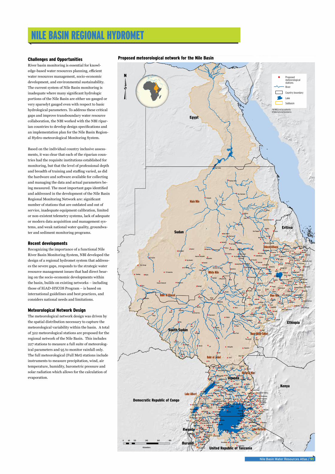
Nile Basin Water Resources Atlas / 91
nile Basin regional hydroMet
Challenges and OpportunitiesRiver basin monitoring is essential for knowl-edge-based water resources planning, efficient water resources management, socio-economic development, and environmental sustainability. The current system of Nile Basin monitoring is inadequate where many significant hydrologic portions of the Nile Basin are either un-gauged or very sparselyt gauged even with respect to basic hydrological parameters. To address these critical gaps and improve transboundary water resource collaboration, the NBI worked with the NBI ripar-ian countries to develop design specifications and an implementation plan for the Nile Basin Region-al Hydro-meteorological Monitoring System.
Based on the individual country inclusive assess-ments, it was clear that each of the riparian coun-tries had the requisite institutions established for monitoring, but that the level of professional depth and breadth of training and staffing varied, as did the hardware and software available for collecting and managing the data and actual parameters be-ing measured. The most important gaps identified and addressed in the development of the Nile Basin Regional Monitoring Network are: significant number of stations that are outdated and out of service, inadequate equipment calibration, limited or non-existent telemetry systems, lack of adequate or modern data acquisition and management sys-tems, and weak national water quality, groundwa-ter and sediment monitoring programs.
Recent developments Recognizing the importance of a functional Nile River Basin Monitoring System, NBI developed the design of a regional hydromet system that address-es the severe gaps, responds to the strategic water resource management issues that had direct bear-ing on the socio-economic developments within the basin, builds on existing networks – including those of IGAD-HYCOS Program – is based on international guidelines and best practices, and considers national needs and limitations.
Meteorological Network DesignThe meteorological network design was driven by the spatial distribution necessary to capture the meteorological variability within the basin. A total of 322 meteorological stations are proposed for the regional network of the Nile Basin. This includes 227 stations to measure a full suite of meteorolog-ical parameters and 95 to monitor rainfall only. The full meteorological (Full Met) stations include instruments to measure precipitation, wind, air temperature, humidity, barometric pressure and solar radiation which allows for the calculation of evaporation.
Lui
Bor
Yei
Wau
Doka
Tonj
Madu
Arua
Kafu
Kome
Moyo
Lira
Raga
Renk
Juba
Kone
Zata
Gore
Begi
Arjo
Jeba
Aman
Alge
Pawe Adet
Goma
Elfaw
Tulus
Radom
Togan
Sidon
Tonga
Pibor
Nasir
Kodok
Ngoma
Lendu
Hoima
Enget
Lolui
Gulu
Mbale
Bwai Ngara
Magu
Bunda
Nyala
Kosti
Aweil
Torit
Ndego
Bomet
Koreb
Mendi
Badme
Nedjo
Gimbi Anger
Fiche
Masha
Abobo
Motta
Ayehu
Sanja
Quara
Aykel
Bunia
Pachua
Faddoi
Samsam
Sodari KogmerFatisa
Dankog
Barbar
Aldali
Maridi
Shambe
Tekeze
Simada
Kakuto
Ikulwe
KibogaKagada
NariamJaber
Loyoro
Yumbe Kitgum
Kabake
Soroti
Kasese
Moroto
Bukasa
Masaka
Kasese
Mwanza
MusomaBukoba
Ngudu
Randa
Maswa
Rashad
Shendi
Karima
Atbara
Sennar
Yambio
Rumbek
Bentiu
Narok,
Sotik,
Koru,
Chwele
Gidame
Halelo
Guroro
Shinfa
Guhala
Chenek
Baeker
Kurmuk
Assosa
Atsebi
Gatira
Bedele
Chagni
Bullen
Metema
Humera
Debark
MurizaGisozi
Karuzi
Basunda
Ub Guta
Hadalia
Tumbura
Na'andi
Kapoeta
Shiraro
Maichew
Adigrat
Ishasha
Labori
Kakoge
Nyakwai
Adilang
Buliisa
Karenga
Bugondo
Mpanga
Mbarara
Mbarara
Mugumu
Mugumu Kuruya
Buhemba
Elshwak
Elobeid
Kassala
Kadugli
Dongola
Malakal
Mayange
Ntaruka
Byimana
Kebabe
Oyugis
Nabkoi
Mumias
Sululta
Siadebr
Kunzila
Nekemte
Wereilu
Kamashe
Nebelet
Kachise
Eneware
Jikawo
Mankush
Dangila
Shahura
Butembo
Rwegura
Gitega
Muyinga
El Hawata
Um Bader
Tendelti
Jebelein
El Neima
Mongalla
Gogreial
LwamagwaBushenyi
Kampala
Nalweyo
Wangkwar
Masindi
Mubende
Busweta
Kayanga
Rulenge
Kahunda
Ukerewe
Kidinda
En Nahud
Babanusa
Khartoum
Ed Dueim
Naikara
Kilgoris
Ndoinet Homabay
Angorai
Kaimosi
Finarawa
Adigoshu
Tsitsika
Lalibela
Gidayana
Placemark
Ummsiyala
Muzdalifa
Wd Alkali
Wad Figad
Abu Hamra
Goz Ragab
Placemark
Nagi Shot
Combolcha
Rushanga
Rwenshama
Namwenda
Lwemiyaga
Bushenyi
Kharumwa Kikubiji
Kishanda
Shinyanga
New Halfa
El Fasher
Umm Benin
Abu Naama
Nyabimata
Nyagatare
Kawangire
God Bura
Kipkabus
Siaya Atc
Adiremets
Adi Arkay
Amde Work
Dembidolo
Pibor Post
Gadamblyia
J Megeneis
Jabal MouiTora Tonga
Wad Alneal
Limu Genet
Butiaba Hm
Namulonge
Namayingo
Kyakakera
Biharamulo
Nyabusara
El Gadaref
Wadi Halfa
Abu Hammad
Wad Medani
Byumba Met
Elburgon,
Suba Met,
Alupe Kari
Wegel Tena
May Tsebri
Debre Work
Ruvyironza
Elban Gadid
Eial Bakhit
El-tewaisha
Meshraerreq
Greek River
Wadelai Wdd
Bundibugyo
Nakasongola
Ed Damazine
Butare Aero
Kigali Aero
Cheptongei
Chorlim Adc
Gondar A.P.
Amba Mariam
Finoteselam
Debre Tabor
Station No.6
Hamsh Koreab
Sher. Gizen
Shola Gebeya
Rwomuhororo
Gerehu Srnay
Debre Markos
Mekane Selam
Gunde Meskel
Debre Berhan
Nefasemewecha
South Nyanza
Axum Air Port
Bahir Dar New
Gazala Gawazat
Nkozi Exp Farm
Khashm Elgirba
Kisumu Airport
Hamrat Alsheikh
Eldoret Airport
Mekele Air Port
Um Dam Haj Ahmed
Shirkela Um Aush
Bunyala Ranet Fm
Eldoret Kapsoya
Ambo Agriculture
Obongi Dispensary
Shire Endasilasse
Kapsara Tea Factory
Entebbe Intl Airport
Kampala Sewerage Works
Sudan
Egypt
Kenya
Ethiopia
South Sudan
Democratic Republic of Congo
Eritrea
United Republic of Tanzania
Uganda
Burundi
Rwanda
Main Nile
Bahr el Ghazal Blue Nile
White Nile
Tekeze-Atbara
Bahr el Jebel
Lake Victoria
Baro-Akob-Sobat
Victoria Nile
Lake Albert
0 120 240 360 48060
Kilometers
Proposed meteorological network for the Nile Basin
River
Proposedmeteorological stations
Country boundary
Lake
Subbasin
The NBI is not an authorityon international boundaries

92 / Nile Basin Water Resources Atlas
Hydrological Network DesignThe primary purpose of the existing hydrometric stations for the regional design would be for measuring stream-flow at rivers and water level at lakes. In addition, the hydrometric design also includes locations by water quality and sediment monitoring, which typically aligns with streamflow gauging locations. The regional design proposes monitoring of both basic and advanced water quality parameters. The Nile Basin hydrometric design focuses on achieving the monitoring of transboundary water management issues. A total of 79 hydrometric stations are proposed for the regional network of the Nile Basin.
Proposed hydrometric network map
Meteorological stations per sub-basinSub-basin Area (KM2) Regional design
Lake Victoria - Kagera 197,181 30
Lake Victoria - Kenya/Mara 49,737 31
Lake Victoria - Tanzania/Mara 71,305 22
Lake Victoria - Uganda 27,660 13
Victoria Nile 85,521 28
Lake Albert 74,819 28
Bahr el Jebel 185,364 14
Bahr el Ghazal 604,746 23
Baro-Akobo-Sobat 204,288 17
White Nile 258,803 17
Blue Nile - Upper 175,374 41
Blue Nile - Lower 132,344 13
Tekeze-Atbara 232,374 35
Main Nile 592,637 10
Total 322
Summary of proposed meteorological network by country
Country Active Inactive* New Total# of Stations w/
Full Met Rain Only
Burundi 9 1 1 11 10 1
DR Congo 3 2 4 9 7 2
Ethiopia 82 1 0 83 74 9
Kenya 28 5 0 33 21 12
Rwanda 10 1 0 11 11 0
South Sudan 5 22 5 32 18 14
Sudan 33 18 0 51 29 22
Tanzania 21 6 0 27 22 5
Uganda 48 17 0 65 35 30
Total 239 73 10 322 227 95
% of Total 74% 23% 3% 100% 70% 30%
*Inactive Stations also include unknown or “blank” status entries originally received
Summary of Proposed Regional Hydrometric Network by Country
Country Active Inactive* New Total# of Stations w/
WQ Sediment
Burundi 2 0 0 2 1 2
DR Congo 0 0 1 1 1 0
Ethiopia 15 0 0 15 4 14
Kenya 6 0 0 6 6 1
Rwanda 6 0 1 7 6 5
South Sudan 4 6 2 12 5 2
Sudan 12 1 0 13 9 12
Tanzania 8 0 0 8 8 6
Uganda 14 1 0 15 12 1
Total 67 8 4 79 52 43
% of Total 85% 10% 5% 100% 66% 55%
*Inactive Stations also include unknown or “blank” status entries originally received
Wau
Tonj
Renk
Mara
Katwe
Paraa
Nasir
Sondu
Itang
Laropi
Masaka
LumejiSayaka
HawataGewesi
Madani
Eldeim
Akobo
Gitega
Butiaba
Kyotera
Bunadet
Hamdait
Dongola
Malakal
Rusumo
Ishango
Al Asira
Hassanab
Tamanyat
Khartoum
Roseries
Nyamlell
Mongalla
Akanyaru
Pedagogi
Panyango.
BweramuleMbulamuti
Masangano
mbalageti
Mara Mine
Abdi Rafi Embamadre
Bahir Dar
Kogatende
Jinja Pier
Akobo Town
Nyabarongo
new station
Maya Doleib
Kyaka Ferry
River Assua
Doleib Hill
Kessi Bridge
Masindi Port
Bugondo Pier
Gucha Migori
Ahero BridgeYala Kadenge
Grumet river
Atbara Kilo 3
Nzoia Ruambwa
Mumwendo Ferry
Sudan
Egypt
Kenya
Ethiopia
South Sudan
UgandaD. R. Congo
Eritrea
TanzaniaBurundi
Rwanda
Main Nile
Bahr el Ghazal
Blue Nile
White Nile
Lake Victoria
Tekeze-Atbara
Bahr el Jebel
Baro-Akobo-Sobat
Victoria NileLake Albert
0 250 500125
Kilometers
River
Proposedhydro met stations
Country boundary
Lake
Sub-basin
The NBI is not an authorityon international boundaries
Meandering river in South Sudan
Meandering river in South Sudan
phot
o: A
my
the
Nurs
e/fli
ckr.c
omph
oto:
Am
y th
e Nu
rse/
flick
r.com

Nile Basin Water Resources Atlas / 93
ConClusion
The critical gap in data in the Nile Basin has been recognized early during the preparation of the first set of coopera-tive projects under NBI. As a result, NBI developed the Nile River Basin Monitoring Strategy to guide its activities for enhanc-ing the monitoring system in the Nile Basin. The strategy was endorsed by the NBI governance and remains the guiding document for the design of the regional monitoring network.
Gaps in spatial coverage and time series in key catchments result in an incom-plete understanding and knowledge of bio-physical conditions, setbacks in strategic assessment and water resources planning, suboptimal water management decisions, and delays in planning and execution of investment projects.
Some 14 issues were first identified by NBI Member States; these included: improved
water resource planning and manage-ment; flood management; rain-fed agricul-tural management, irrigated agricultural management; drought management; soil erosion and sediment transport; surface water quality; groundwater management; hydropower; navigation; fisheries; water-shed management; wetlands management; and climate change. These regional issues played a key role in the methodology of station selection for the regional network.
Information collected by the system will be accessible to all NBI Member States through the NBI Regional Data Manage-ment system; guided by the effective data sharing protocol among the NBI countries. NBI will compile all the data collected within the riparian countries and provide synthesized information, trends, patterns, and facts that will inform both national and regional water resources planning and management.
Phot
o: is
tock

94 / Nile Basin Water Resources Atlas
Related Documents