525 Earth Science Powerful events cause changes on Earth’s surface such that it looks different than it did 4.6 billion years ago. In this chapter, you will learn that Earth is a layered ball covered with thin pieces that move, interact, and shape Earth’s surface. The theory of plate tectonics, which you will learn about in the second section, explains the dramatic movements of these pieces called tectonic plates. Friction and pressure intensify at the boundaries of the plates. When pressure is released, an earthquake occurs. While the movement of tectonic plates causes slow changes on Earth, amazing and fast changes occur when an earthquake strikes. Earthquakes are the subject of the third section. Studying the Earth is like detective work—you use clues to uncover the fascinating history waiting to be told. In this Investigation, you will have the opportunity to reconstruct the underlying stories in different situations and rock formations. The theory of plate tectonics explains how and in what direction tectonic plates move on Earth’s surface. In this Investigation, you will simulate the movement of the plates and predict how Earth will look in 50 million years. In this Investigation, you will simulate the causes and effects of an earthquake. In the process, you will discover some of the factors that affect the timing and magnitude of an earthquake and use the results to develop a simple explanation of the cause of earthquakes. 28.1 Understanding Earth What story is hidden here? 28.2 Plate Tectonics What will Earth look like in 50 million years? 28.3 Earthquakes What mechanical factors affect earthquakes? 10 Chapter 28 The Changing Earth

Welcome message from author
This document is posted to help you gain knowledge. Please leave a comment to let me know what you think about it! Share it to your friends and learn new things together.
Transcript
525
Earth Science
Powerful events cause changes on Earth’s surface such that it looks different than itdid 4.6 billion years ago. In this chapter, you will learn that Earth is a layered ballcovered with thin pieces that move, interact, and shape Earth’s surface. The theoryof plate tectonics, which you will learn about in the second section, explains thedramatic movements of these pieces called tectonic plates. Friction and pressureintensify at the boundaries of the plates. When pressure is released, an earthquakeoccurs. While the movement of tectonic plates causes slow changes on Earth,amazing and fast changes occur when an earthquake strikes. Earthquakes are thesubject of the third section.
Studying the Earth is like detective work—you use clues to uncover the fascinatinghistory waiting to be told. In this Investigation, you will have the opportunity toreconstruct the underlying stories in different situations and rock formations.
The theory of plate tectonics explains how and in what direction tectonic platesmove on Earth’s surface. In this Investigation, you will simulate the movement ofthe plates and predict how Earth will look in 50 million years.
In this Investigation, you will simulate the causes and effects of an earthquake. Inthe process, you will discover some of the factors that affect the timing andmagnitude of an earthquake and use the results to develop a simple explanation ofthe cause of earthquakes.
28.1 Understanding Earth What story is hidden here?
28.2 Plate Tectonics What will Earth look like in 50 million years?
28.3 Earthquakes What mechanical factors affect earthquakes?
10Chapter 28
The ChangingEarth
Chapter 28: The Changing Earth
526
Learning Goals
In this chapter, you will:
! Use relative dating to sequence events recorded in a rock formation.
! Learn about Earth’s interior and the role it plays in shaping Earth’s surface.
! Apply basic science concepts like density, viscosity, convection, and energy transformation to Earth science.
! Learn about the theory of plate tectonics and be about to explain evidence that supports this theory.
! Learn about the three main kinds of plate boundaries: convergent, divergent, and transform.
! Learn about the causes and effects of earthquakes and where they occur.
! Learn about the role of seismic waves in understanding Earth’s interior.
! Learn about the scales that are used to rate the magnitude of an earthquake.
! Calculate the location of an epicenter of an earthquake using seismic data.
! Learn how to keep safe during an earthquake.
Vocabulary
asthenosphere focus original horizontally sea-floor spreadingcontinental drift geology paleontology seismic wavecross-cutting relationships inclusions Pangaea subductionepicenter lateral continuity plate tectonics superpositionfault lithosphere P-wave S-wavefaunal succession mid-ocean ridge relative dating tsunami
527
Chapter 28
28.1 Understanding Earth
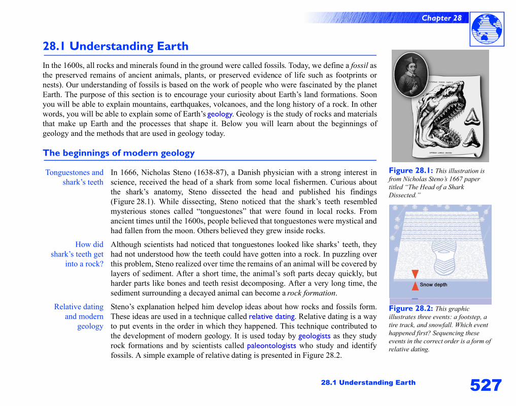
Figure 28.1: This illustration is from Nicholas Steno’s 1667 paper titled “The Head of a Shark Dissected.”
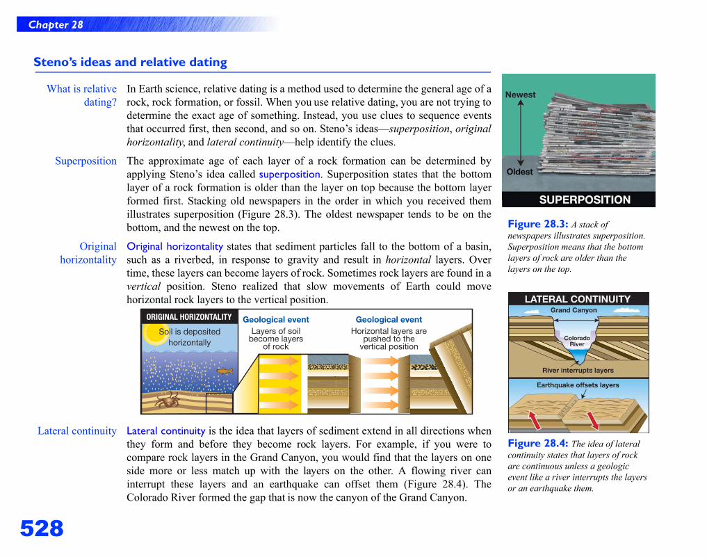
Figure 28.2: This graphic illustrates three events: a footstep, a tire track, and snowfall. Which event happened first? Sequencing these events in the correct order is a form of relative dating.
28.1 Understanding EarthIn the 1600s, all rocks and minerals found in the ground were called fossils. Today, we define a fossil asthe preserved remains of ancient animals, plants, or preserved evidence of life such as footprints ornests). Our understanding of fossils is based on the work of people who were fascinated by the planetEarth. The purpose of this section is to encourage your curiosity about Earth’s land formations. Soonyou will be able to explain mountains, earthquakes, volcanoes, and the long history of a rock. In otherwords, you will be able to explain some of Earth’s geology. Geology is the study of rocks and materialsthat make up Earth and the processes that shape it. Below you will learn about the beginnings ofgeology and the methods that are used in geology today.
The beginnings of modern geology
Tonguestones andshark’s teeth
In 1666, Nicholas Steno (1638-87), a Danish physician with a strong interest inscience, received the head of a shark from some local fishermen. Curious aboutthe shark’s anatomy, Steno dissected the head and published his findings(Figure 28.1). While dissecting, Steno noticed that the shark’s teeth resembledmysterious stones called “tonguestones” that were found in local rocks. Fromancient times until the 1600s, people believed that tonguestones were mystical andhad fallen from the moon. Others believed they grew inside rocks.
How didshark’s teeth get
into a rock?
Although scientists had noticed that tonguestones looked like sharks’ teeth, theyhad not understood how the teeth could have gotten into a rock. In puzzling overthis problem, Steno realized over time the remains of an animal will be covered bylayers of sediment. After a short time, the animal’s soft parts decay quickly, butharder parts like bones and teeth resist decomposing. After a very long time, thesediment surrounding a decayed animal can become a rock formation.
Relative datingand modern
geology
Steno’s explanation helped him develop ideas about how rocks and fossils form.These ideas are used in a technique called relative dating. Relative dating is a wayto put events in the order in which they happened. This technique contributed tothe development of modern geology. It is used today by geologists as they studyrock formations and by scientists called paleontologists who study and identifyfossils. A simple example of relative dating is presented in Figure 28.2.
528
Chapter 28
Steno’s ideas and relative dating
What is relativedating?
In Earth science, relative dating is a method used to determine the general age of arock, rock formation, or fossil. When you use relative dating, you are not trying todetermine the exact age of something. Instead, you use clues to sequence eventsthat occurred first, then second, and so on. Steno’s ideas—superposition, originalhorizontality, and lateral continuity—help identify the clues.
Superposition The approximate age of each layer of a rock formation can be determined byapplying Steno’s idea called superposition. Superposition states that the bottomlayer of a rock formation is older than the layer on top because the bottom layerformed first. Stacking old newspapers in the order in which you received themillustrates superposition (Figure 28.3). The oldest newspaper tends to be on thebottom, and the newest on the top.
Originalhorizontality
Original horizontality states that sediment particles fall to the bottom of a basin,such as a riverbed, in response to gravity and result in horizontal layers. Overtime, these layers can become layers of rock. Sometimes rock layers are found in avertical position. Steno realized that slow movements of Earth could movehorizontal rock layers to the vertical position.
Lateral continuity Lateral continuity is the idea that layers of sediment extend in all directions whenthey form and before they become rock layers. For example, if you were tocompare rock layers in the Grand Canyon, you would find that the layers on oneside more or less match up with the layers on the other. A flowing river caninterrupt these layers and an earthquake can offset them (Figure 28.4). TheColorado River formed the gap that is now the canyon of the Grand Canyon.
Figure 28.3: A stack of newspapers illustrates superposition. Superposition means that the bottom layers of rock are older than the layers on the top.
Figure 28.4: The idea of lateral continuity states that layers of rock are continuous unless a geologic event like a river interrupts the layers or an earthquake them.
529
Chapter 28
28.1 Understanding Earth
Interpreting rocks formations
The presentexplains the past
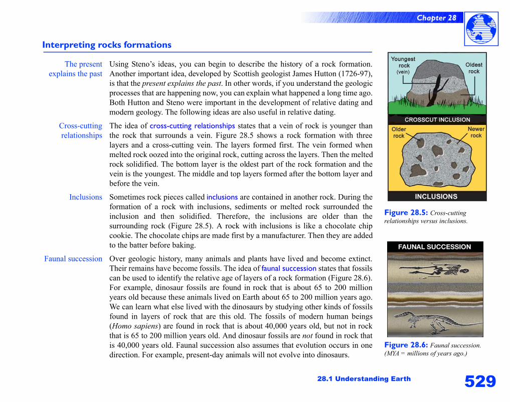
Using Steno’s ideas, you can begin to describe the history of a rock formation.Another important idea, developed by Scottish geologist James Hutton (1726-97),is that the present explains the past. In other words, if you understand the geologicprocesses that are happening now, you can explain what happened a long time ago.Both Hutton and Steno were important in the development of relative dating andmodern geology. The following ideas are also useful in relative dating.
Cross-cuttingrelationships
The idea of cross-cutting relationships states that a vein of rock is younger thanthe rock that surrounds a vein. Figure 28.5 shows a rock formation with threelayers and a cross-cutting vein. The layers formed first. The vein formed whenmelted rock oozed into the original rock, cutting across the layers. Then the meltedrock solidified. The bottom layer is the oldest part of the rock formation and thevein is the youngest. The middle and top layers formed after the bottom layer andbefore the vein.
Inclusions Sometimes rock pieces called inclusions are contained in another rock. During theformation of a rock with inclusions, sediments or melted rock surrounded theinclusion and then solidified. Therefore, the inclusions are older than thesurrounding rock (Figure 28.5). A rock with inclusions is like a chocolate chipcookie. The chocolate chips are made first by a manufacturer. Then they are addedto the batter before baking.
Faunal succession Over geologic history, many animals and plants have lived and become extinct.Their remains have become fossils. The idea of faunal succession states that fossilscan be used to identify the relative age of layers of a rock formation (Figure 28.6).For example, dinosaur fossils are found in rock that is about 65 to 200 millionyears old because these animals lived on Earth about 65 to 200 million years ago.We can learn what else lived with the dinosaurs by studying other kinds of fossilsfound in layers of rock that are this old. The fossils of modern human beings(Homo sapiens) are found in rock that is about 40,000 years old, but not in rockthat is 65 to 200 million years old. And dinosaur fossils are not found in rock thatis 40,000 years old. Faunal succession also assumes that evolution occurs in onedirection. For example, present-day animals will not evolve into dinosaurs.
Figure 28.5: Cross-cutting relationships versus inclusions.
Figure 28.6: Faunal succession. (MYA = millions of years ago.)
530
Chapter 28
Calculating Earth’s age
CalculatingEarth’s age
William Thompson Kelvin (1824-1907), known for proposing the absolutetemperature scale that came to be named after him, meticulously calculatedEarth’s age to be between 10 million and 100 million years. His calculations werebased on his prediction of how long it would take for a hot Earth to cool.
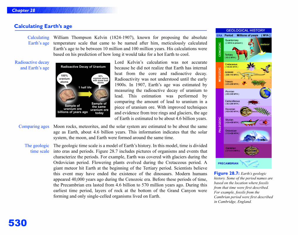
Radioactive decayand Earth’s age
Lord Kelvin’s calculation was not accuratebecause he did not realize that Earth has internalheat from the core and radioactive decay.Radioactivity was not understood until the early1900s. In 1907, Earth’s age was estimated bymeasuring the radioactive decay of uranium tolead. This estimation was performed bycomparing the amount of lead to uranium in apiece of uranium ore. With improved techniquesand evidence from tree rings and glaciers, the ageof Earth is estimated to be about 4.6 billion years.
Comparing ages Moon rocks, meteorites, and the solar system are estimated to be about the sameage as Earth, about 4.6 billion years. This information indicates that the solarsystem, the moon, and Earth were formed around the same time.
The geologictime scale
The geologic time scale is a model of Earth’s history. In this model, time is dividedinto eras and periods. Figure 28.7 includes pictures of organisms and events thatcharacterize the periods. For example, Earth was covered with glaciers during theOrdovician period. Flowering plants evolved during the Cretaceous period. Agiant meteor hit Earth at the beginning of the Tertiary period. Scientists believethis event may have ended the existence of the dinosaurs. Modern humansappeared 40,000 years ago during the Cenozoic era. Before these periods of time,the Precambrian era lasted from 4.6 billion to 570 million years ago. During thisearliest time period, layers of rock at the bottom of the Grand Canyon wereforming and only single-celled organisms lived on Earth.
Figure 28.7: Earth’s geologic history. Some of the period names are based on the location where fossils from that time were first described. For example, fossils from the Cambrian period were first described in Cambridge, England.
531
Chapter 28
28.1 Understanding Earth
Inside Earth
Earth’s beginningsand the formation
of layers
Scientists believe that Earth formed when cosmic particles collected into a spheredue to the gravitational attraction between the particles. As these particlesgathered, pressure inside the sphere increased. Iron particles melted andpercolated to the core. The “fall” of iron to the core was accompanied by theconversion of potential energy to kinetic energy. This energy transformationgenerated intense heat that melted other particles in the sphere. At this point inEarth’s formation, the densest materials like irb on and nickel sank to Earth’scenter and formed its core. Layers of less dense material formed the mantle. Theleast dense elements rose to the outer surface and formed our planet’s crust.
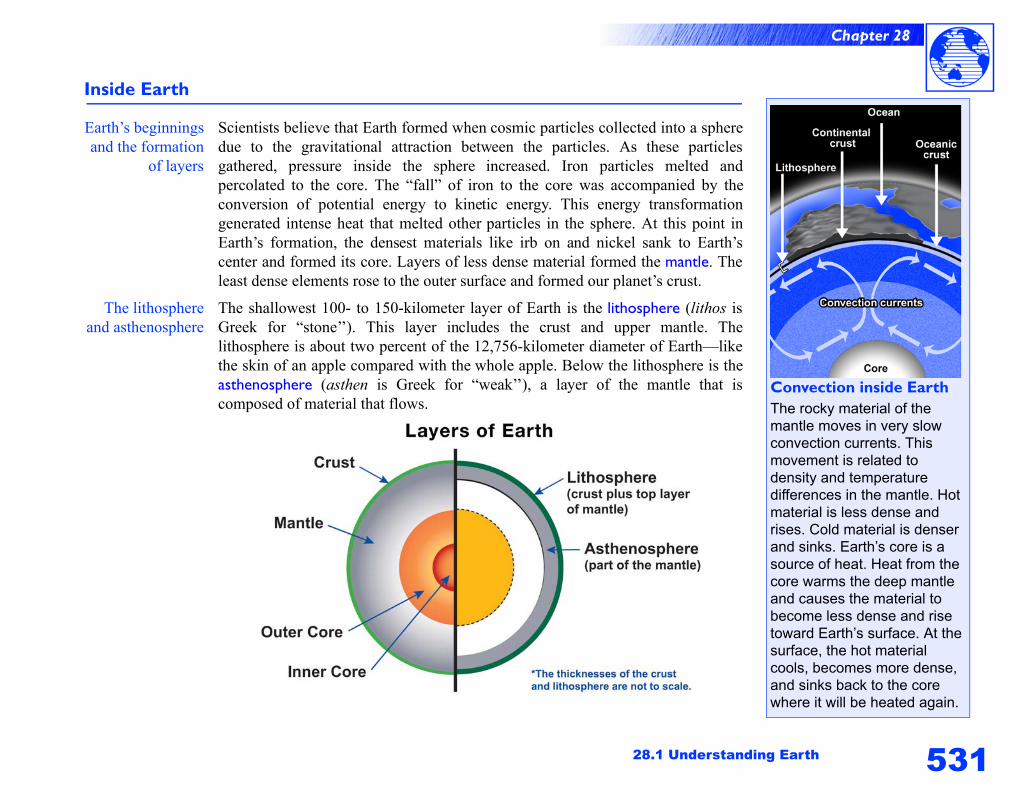
The lithosphereand asthenosphere
The shallowest 100- to 150-kilometer layer of Earth is the lithosphere (lithos isGreek for “stone’’). This layer includes the crust and upper mantle. Thelithosphere is about two percent of the 12,756-kilometer diameter of Earth—likethe skin of an apple compared with the whole apple. Below the lithosphere is theasthenosphere (asthen is Greek for “weak’’), a layer of the mantle that iscomposed of material that flows.
Convection inside EarthThe rocky material of the mantle moves in very slow convection currents. This movement is related to density and temperature differences in the mantle. Hot material is less dense and rises. Cold material is denser and sinks. Earth’s core is a source of heat. Heat from the core warms the deep mantle and causes the material to become less dense and rise toward Earth’s surface. At the surface, the hot material cools, becomes more dense, and sinks back to the core where it will be heated again.
532
Chapter 28
The layers of Earth
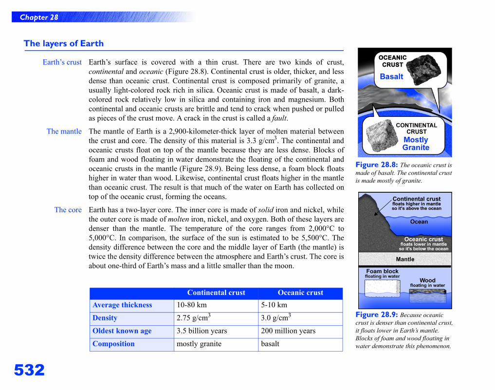
Earth’s crust Earth’s surface is covered with a thin crust. There are two kinds of crust,continental and oceanic (Figure 28.8). Continental crust is older, thicker, and lessdense than oceanic crust. Continental crust is composed primarily of granite, ausually light-colored rock rich in silica. Oceanic crust is made of basalt, a dark-colored rock relatively low in silica and containing iron and magnesium. Bothcontinental and oceanic crusts are brittle and tend to crack when pushed or pulledas pieces of the crust move. A crack in the crust is called a fault.
The mantle The mantle of Earth is a 2,900-kilometer-thick layer of molten material betweenthe crust and core. The density of this material is 3.3 g/cm3. The continental andoceanic crusts float on top of the mantle because they are less dense. Blocks offoam and wood floating in water demonstrate the floating of the continental andoceanic crusts in the mantle (Figure 28.9). Being less dense, a foam block floatshigher in water than wood. Likewise, continental crust floats higher in the mantlethan oceanic crust. The result is that much of the water on Earth has collected ontop of the oceanic crust, forming the oceans.
The core Earth has a two-layer core. The inner core is made of solid iron and nickel, whilethe outer core is made of molten iron, nickel, and oxygen. Both of these layers aredenser than the mantle. The temperature of the core ranges from 2,000°C to5,000°C. In comparison, the surface of the sun is estimated to be 5,500°C. Thedensity difference between the core and the middle layer of Earth (the mantle) istwice the density difference between the atmosphere and Earth’s crust. The core isabout one-third of Earth’s mass and a little smaller than the moon.
Continental crust Oceanic crustAverage thickness 10-80 km 5-10 km
Density 2.75 g/cm3 3.0 g/cm3
Oldest known age 3.5 billion years 200 million years
Composition mostly granite basalt
Figure 28.8: The oceanic crust is made of basalt. The continental crust is made mostly of granite.
Figure 28.9: Because oceanic crust is denser than continental crust, it floats lower in Earth’s mantle. Blocks of foam and wood floating in water demonstrate this phenomenon.
533
Chapter 28
28.1 Understanding Earth
Important concepts that will help you understand Earth science
Conceptsyou already know
This section begins your study of the processes that shape Earth. The concepts youhave learned in this section will help you understand mountains, earthquakes,volcanoes, and the formation of rocks. As you continue to read, you will see thefollowing familiar concepts.
Concept How the concept applies to understanding Earth
Density The layers of Earth are separated according to density.For example, the core of Earth is much denser than thecontinental and oceanic crusts.
Viscosity The molten material of the mantle is viscous. Forexample, molasses is much more viscous than waterwhich flows very quickly. The viscosity of lava explainsthe kinds of volcanic eruptions that occur.
Convection currents The convection currents in the mantle are similar to theconvection currents in the atmosphere.
Potential and kinetic energy As Earth formed, the fall of iron to the core wasaccompanied by the conversion of potential energy tokinetic energy. Heat was produce inside Earth as aresult of this energy conversion. Also, earthquakes arecaused by a conversion of potential energy to kineticenergy.
Cycles Cycle is a term used to describe various processes thatmove matter from place to place on Earth. Water istransported on Earth via the water cycle. The energysource driving this cycle is the sun. The rock cycle is aset of processes that lead to the formation and recyclingof the various kinds of rocks. Energy sources driving thiscycle are climate changes (driven by the sun) andconvection currents that distribute heat in Earth’smantle.
Plate tectonics
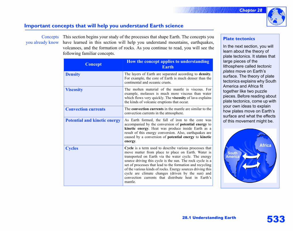
In the next section, you will learn about the theory of plate tectonics. It states that large pieces of the lithosphere called tectonic plates move on Earth’s surface. The theory of plate tectonics explains why South America and Africa fit together like two puzzle pieces. Before reading about plate tectonics, come up with your own ideas to explain how plates move on Earth’s surface and what the effects of this movement might be.
534
Chapter 28
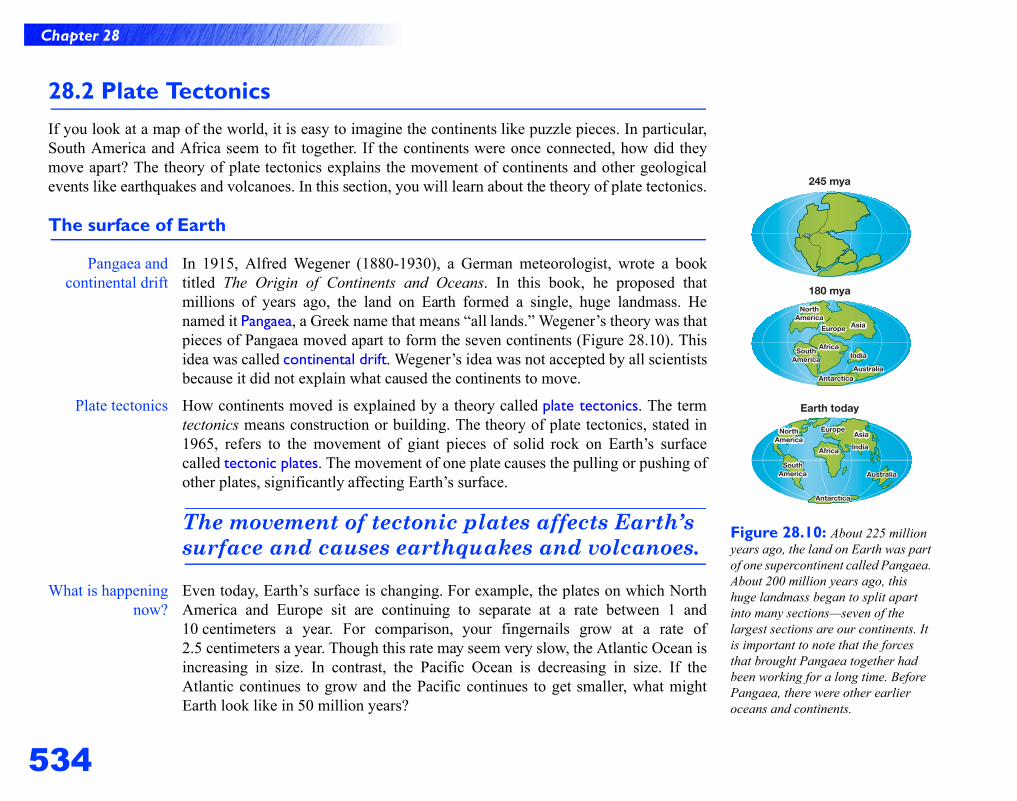
Figure 28.10: About 225 million years ago, the land on Earth was part of one supercontinent called Pangaea. About 200 million years ago, this huge landmass began to split apart into many sections—seven of the largest sections are our continents. It is important to note that the forces that brought Pangaea together had been working for a long time. Before Pangaea, there were other earlier oceans and continents.
28.2 Plate TectonicsIf you look at a map of the world, it is easy to imagine the continents like puzzle pieces. In particular,South America and Africa seem to fit together. If the continents were once connected, how did theymove apart? The theory of plate tectonics explains the movement of continents and other geologicalevents like earthquakes and volcanoes. In this section, you will learn about the theory of plate tectonics.
The surface of Earth
Pangaea andcontinental drift
In 1915, Alfred Wegener (1880-1930), a German meteorologist, wrote a booktitled The Origin of Continents and Oceans. In this book, he proposed thatmillions of years ago, the land on Earth formed a single, huge landmass. Henamed it Pangaea, a Greek name that means “all lands.” Wegener’s theory was thatpieces of Pangaea moved apart to form the seven continents (Figure 28.10). Thisidea was called continental drift. Wegener’s idea was not accepted by all scientistsbecause it did not explain what caused the continents to move.
Plate tectonics How continents moved is explained by a theory called plate tectonics. The termtectonics means construction or building. The theory of plate tectonics, stated in1965, refers to the movement of giant pieces of solid rock on Earth’s surfacecalled tectonic plates. The movement of one plate causes the pulling or pushing ofother plates, significantly affecting Earth’s surface.
The movement of tectonic plates affects Earth’s surface and causes earthquakes and volcanoes.
What is happeningnow?
Even today, Earth’s surface is changing. For example, the plates on which NorthAmerica and Europe sit are continuing to separate at a rate between 1 and10 centimeters a year. For comparison, your fingernails grow at a rate of2.5 centimeters a year. Though this rate may seem very slow, the Atlantic Ocean isincreasing in size. In contrast, the Pacific Ocean is decreasing in size. If theAtlantic continues to grow and the Pacific continues to get smaller, what mightEarth look like in 50 million years?
535
Chapter 28
28.2 Plate Tectonics
Continental drift
Wegener’sevidence for
continental drift
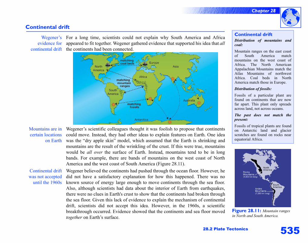
For a long time, scientists could not explain why South America and Africaappeared to fit together. Wegener gathered evidence that supported his idea that allthe continents had been connected.
Mountains are incertain locations
on Earth
Wegener’s scientific colleagues thought it was foolish to propose that continentscould move. Instead, they had other ideas to explain features on Earth. One ideawas the “dry apple skin” model, which assumed that the Earth is shrinking andmountains are the result of the wrinkling of the crust. If this were true, mountainswould be all over the surface of Earth. Instead, mountains tend to be in longbands. For example, there are bands of mountains on the west coast of NorthAmerica and the west coast of South America (Figure 28.11).
Continental driftwas not accepted
until the 1960s
Wegener believed the continents had pushed through the ocean floor. However, hedid not have a satisfactory explanation for how this happened. There was noknown source of energy large enough to move continents through the sea floor.Also, although scientists had data about the interior of Earth from earthquakes,there were no clues in Earth's crust to show that the continents had broken throughthe sea floor. Given this lack of evidence to explain the mechanism of continentaldrift, scientists did not accept this idea. However, in the 1960s, a scientificbreakthrough occurred. Evidence showed that the continents and sea floor movedtogether on Earth’s surface.
Figure 28.11: Mountain ranges in North and South America.
Continental driftDistribution of mountains andcoal: Mountain ranges on the east coastof South America matchmountains on the west coast ofAfrica. The North AmericanAppalachian Mountains match theAtlas Mountains of northwestAfrica. Coal beds in NorthAmerica match those in Europe.Distribution of fossils: Fossils of a particular plant arefound on continents that are nowfar apart. This plant only spreadsacross land, not across oceans.The past does not match thepresent: Fossils of tropical plants are foundon Antarctic land and glacierscratches are found on rocks nearequatorial Africa.
536
Chapter 28
Sea-floor spreading
Mountain rangeson the sea floor
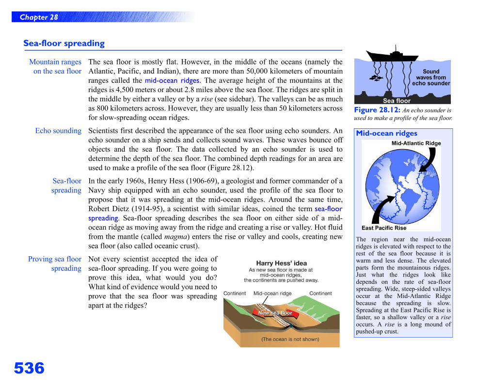
The sea floor is mostly flat. However, in the middle of the oceans (namely theAtlantic, Pacific, and Indian), there are more than 50,000 kilometers of mountainranges called the mid-ocean ridges. The average height of the mountains at theridges is 4,500 meters or about 2.8 miles above the sea floor. The ridges are split inthe middle by either a valley or by a rise (see sidebar). The valleys can be as muchas 800 kilometers across. However, they are usually less than 50 kilometers acrossfor slow-spreading ocean ridges.
Echo sounding Scientists first described the appearance of the sea floor using echo sounders. Anecho sounder on a ship sends and collects sound waves. These waves bounce offobjects and the sea floor. The data collected by an echo sounder is used todetermine the depth of the sea floor. The combined depth readings for an area areused to make a profile of the sea floor (Figure 28.12).
Sea-floorspreading
In the early 1960s, Henry Hess (1906-69), a geologist and former commander of aNavy ship equipped with an echo sounder, used the profile of the sea floor topropose that it was spreading at the mid-ocean ridges. Around the same time,Robert Dietz (1914-95), a scientist with similar ideas, coined the term sea-floorspreading. Sea-floor spreading describes the sea floor on either side of a mid-ocean ridge as moving away from the ridge and creating a rise or valley. Hot fluidfrom the mantle (called magma) enters the rise or valley and cools, creating newsea floor (also called oceanic crust).
Proving sea floorspreading
Not every scientist accepted the idea ofsea-floor spreading. If you were going toprove this idea, what would you do?What kind of evidence would you need toprove that the sea floor was spreadingapart at the ridges?
Figure 28.12: An echo sounder is used to make a profile of the sea floor.
Mid-ocean ridges
The region near the mid-oceanridges is elevated with respect to therest of the sea floor because it iswarm and less dense. The elevatedparts form the mountainous ridges.Just what the ridges look likedepends on the rate of sea-floorspreading. Wide, steep-sided valleysoccur at the Mid-Atlantic Ridgebecause the spreading is slow.Spreading at the East Pacific Rise isfaster, so a shallow valley or a riseoccurs. A rise is a long mound ofpushed-up crust.
537
Chapter 28
28.2 Plate Tectonics
Magnetic patterns on the sea floor
Earth isa giant magnet
Like a giant magnet, Earth has a magnetic north and south pole. Scientists believeEarth’s magnetism is due to convection currents in the liquid outer core. Thesecurrents generate a magnetic field around Earth. Not only does this magnetic fieldprovide us with a means of navigation, but it also blocks some of the sun’s harmfulelectromagnetic radiation from reaching Earth’s surface.
Earth’s polarityhas switched
over time
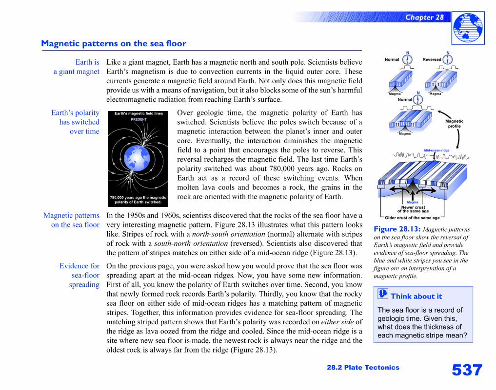
Over geologic time, the magnetic polarity of Earth hasswitched. Scientists believe the poles switch because of amagnetic interaction between the planet’s inner and outercore. Eventually, the interaction diminishes the magneticfield to a point that encourages the poles to reverse. Thisreversal recharges the magnetic field. The last time Earth’spolarity switched was about 780,000 years ago. Rocks onEarth act as a record of these switching events. Whenmolten lava cools and becomes a rock, the grains in therock are oriented with the magnetic polarity of Earth.
Magnetic patternson the sea floor
In the 1950s and 1960s, scientists discovered that the rocks of the sea floor have avery interesting magnetic pattern. Figure 28.13 illustrates what this pattern lookslike. Stripes of rock with a north-south orientation (normal) alternate with stripesof rock with a south-north orientation (reversed). Scientists also discovered thatthe pattern of stripes matches on either side of a mid-ocean ridge (Figure 28.13).
Evidence forsea-floor
spreading
On the previous page, you were asked how you would prove that the sea floor wasspreading apart at the mid-ocean ridges. Now, you have some new information.First of all, you know the polarity of Earth switches over time. Second, you knowthat newly formed rock records Earth’s polarity. Thirdly, you know that the rockysea floor on either side of mid-ocean ridges has a matching pattern of magneticstripes. Together, this information provides evidence for sea-floor spreading. Thematching striped pattern shows that Earth’s polarity was recorded on either side ofthe ridge as lava oozed from the ridge and cooled. Since the mid-ocean ridge is asite where new sea floor is made, the newest rock is always near the ridge and theoldest rock is always far from the ridge (Figure 28.13).
Figure 28.13: Magnetic patterns on the sea floor show the reversal of Earth’s magnetic field and provide evidence of sea-floor spreading. The blue and white stripes you see in the figure are an interpretation of a magnetic profile.
! Think about it
The sea floor is a record of geologic time. Given this, what does the thickness of each magnetic stripe mean?
538
Chapter 28
The theory of plate tectonics
The theory ofplate tectonics
The theory of plate tectonics is consistent with the observed magnetic patterns onthe sea floor, sea-floor spreading, continental drift, and the idea that thelithosphere is divided into tectonic plates. This theory also provides possibleexplanations for many things about Earth’s geology such as mountain-building,earthquakes, and volcanoes.
Plates are piecesof the lithosphere
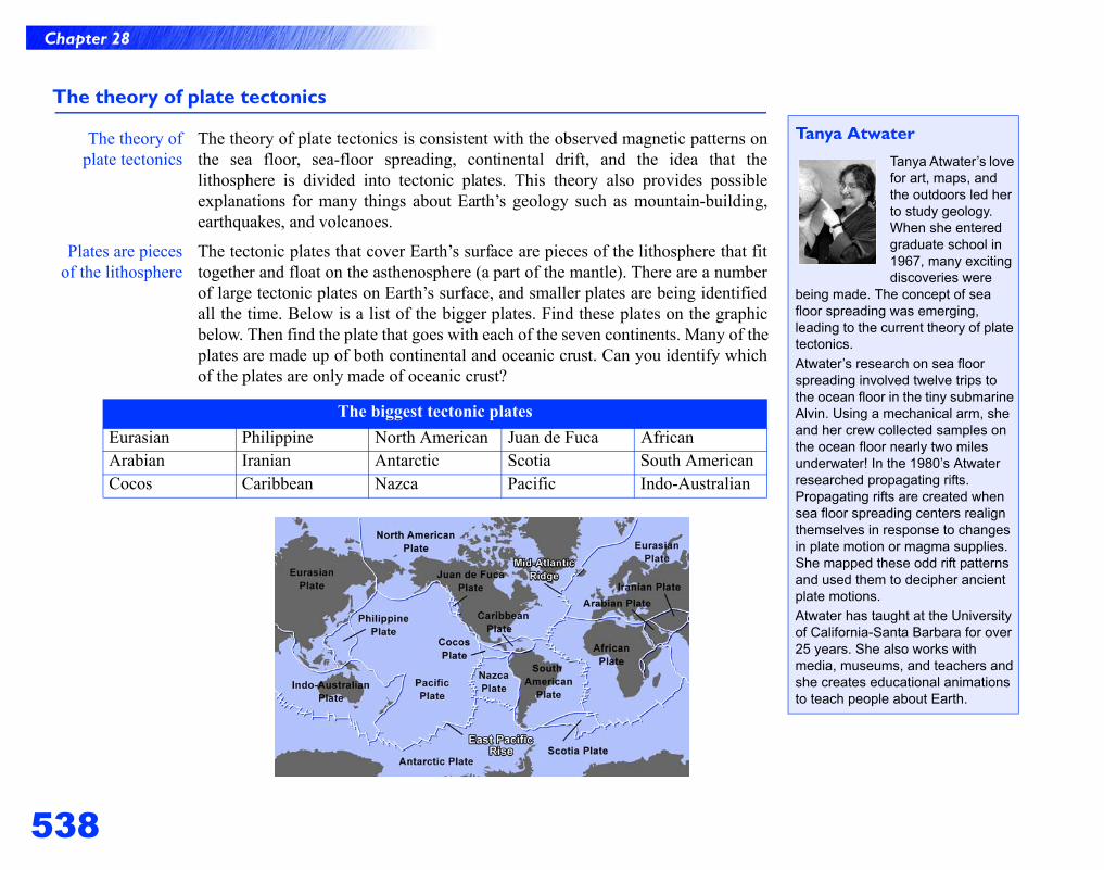
The tectonic plates that cover Earth’s surface are pieces of the lithosphere that fittogether and float on the asthenosphere (a part of the mantle). There are a numberof large tectonic plates on Earth’s surface, and smaller plates are being identifiedall the time. Below is a list of the bigger plates. Find these plates on the graphicbelow. Then find the plate that goes with each of the seven continents. Many of theplates are made up of both continental and oceanic crust. Can you identify whichof the plates are only made of oceanic crust?
The biggest tectonic platesEurasian Philippine North American Juan de Fuca AfricanArabian Iranian Antarctic Scotia South AmericanCocos Caribbean Nazca Pacific Indo-Australian
Tanya AtwaterTanya Atwater’s love for art, maps, and the outdoors led her to study geology. When she entered graduate school in 1967, many exciting discoveries were
being made. The concept of sea floor spreading was emerging, leading to the current theory of plate tectonics.
Atwater’s research on sea floor spreading involved twelve trips to the ocean floor in the tiny submarine Alvin. Using a mechanical arm, she and her crew collected samples on the ocean floor nearly two miles underwater! In the 1980’s Atwater researched propagating rifts. Propagating rifts are created when sea floor spreading centers realign themselves in response to changes in plate motion or magma supplies. She mapped these odd rift patterns and used them to decipher ancient plate motions.
Atwater has taught at the University of California-Santa Barbara for over 25 years. She also works with media, museums, and teachers and she creates educational animations to teach people about Earth.
539
Chapter 28
28.2 Plate Tectonics
Describing plate boundaries
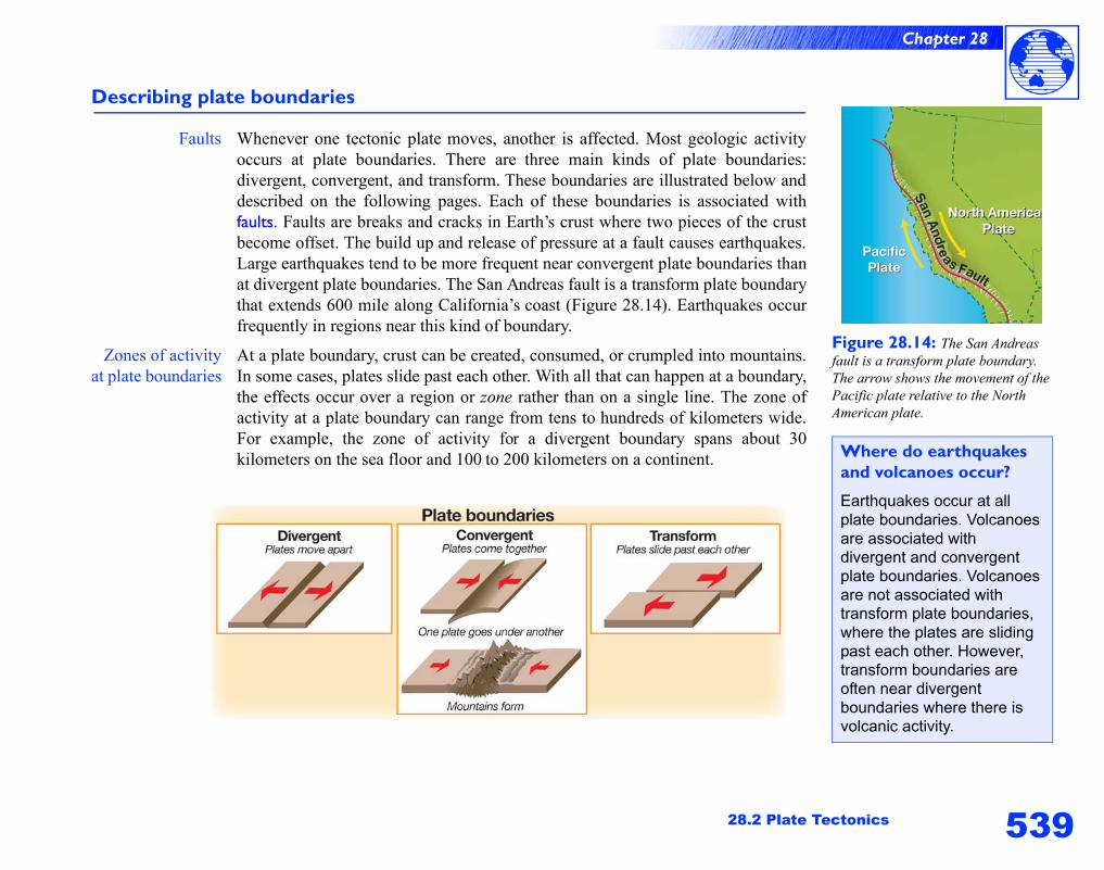
Faults Whenever one tectonic plate moves, another is affected. Most geologic activityoccurs at plate boundaries. There are three main kinds of plate boundaries:divergent, convergent, and transform. These boundaries are illustrated below anddescribed on the following pages. Each of these boundaries is associated withfaults. Faults are breaks and cracks in Earth’s crust where two pieces of the crustbecome offset. The build up and release of pressure at a fault causes earthquakes.Large earthquakes tend to be more frequent near convergent plate boundaries thanat divergent plate boundaries. The San Andreas fault is a transform plate boundarythat extends 600 mile along California’s coast (Figure 28.14). Earthquakes occurfrequently in regions near this kind of boundary.
Zones of activityat plate boundaries
At a plate boundary, crust can be created, consumed, or crumpled into mountains.In some cases, plates slide past each other. With all that can happen at a boundary,the effects occur over a region or zone rather than on a single line. The zone ofactivity at a plate boundary can range from tens to hundreds of kilometers wide.For example, the zone of activity for a divergent boundary spans about 30kilometers on the sea floor and 100 to 200 kilometers on a continent.
Figure 28.14: The San Andreas fault is a transform plate boundary. The arrow shows the movement of the Pacific plate relative to the North American plate.
Where do earthquakes and volcanoes occur?
Earthquakes occur at all plate boundaries. Volcanoes are associated with divergent and convergent plate boundaries. Volcanoes are not associated with transform plate boundaries, where the plates are sliding past each other. However, transform boundaries are often near divergent boundaries where there is volcanic activity.
540
Chapter 28
Divergent plate boundaries
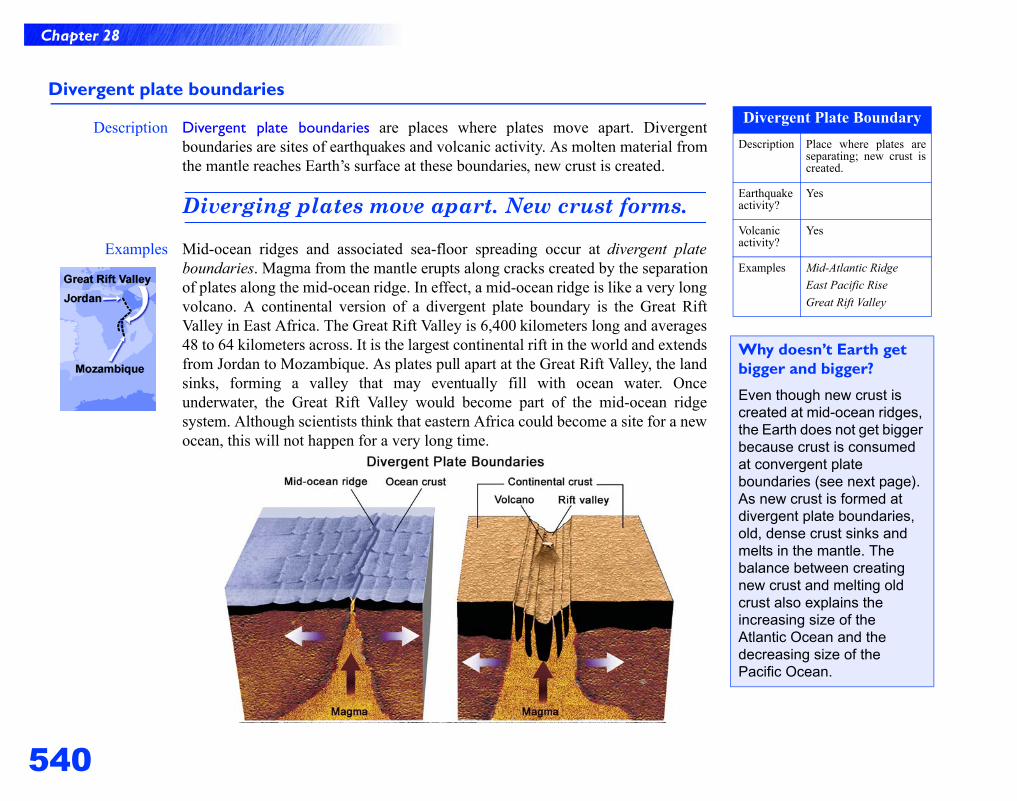
Description Divergent plate boundaries are places where plates move apart. Divergentboundaries are sites of earthquakes and volcanic activity. As molten material fromthe mantle reaches Earth’s surface at these boundaries, new crust is created.
Diverging plates move apart. New crust forms.
Examples Mid-ocean ridges and associated sea-floor spreading occur at divergent plateboundaries. Magma from the mantle erupts along cracks created by the separationof plates along the mid-ocean ridge. In effect, a mid-ocean ridge is like a very longvolcano. A continental version of a divergent plate boundary is the Great RiftValley in East Africa. The Great Rift Valley is 6,400 kilometers long and averages48 to 64 kilometers across. It is the largest continental rift in the world and extendsfrom Jordan to Mozambique. As plates pull apart at the Great Rift Valley, the landsinks, forming a valley that may eventually fill with ocean water. Onceunderwater, the Great Rift Valley would become part of the mid-ocean ridgesystem. Although scientists think that eastern Africa could become a site for a newocean, this will not happen for a very long time.
Divergent Plate BoundaryDescription Place where plates are
separating; new crust iscreated.
Earthquakeactivity?
Yes
Volcanicactivity?
Yes
Examples Mid-Atlantic RidgeEast Pacific RiseGreat Rift Valley
Why doesn’t Earth get bigger and bigger?
Even though new crust is created at mid-ocean ridges, the Earth does not get bigger because crust is consumed at convergent plate boundaries (see next page). As new crust is formed at divergent plate boundaries, old, dense crust sinks and melts in the mantle. The balance between creating new crust and melting old crust also explains the increasing size of the Atlantic Ocean and the decreasing size of the Pacific Ocean.
541
Chapter 28
28.2 Plate Tectonics
Convergent plate boundaries
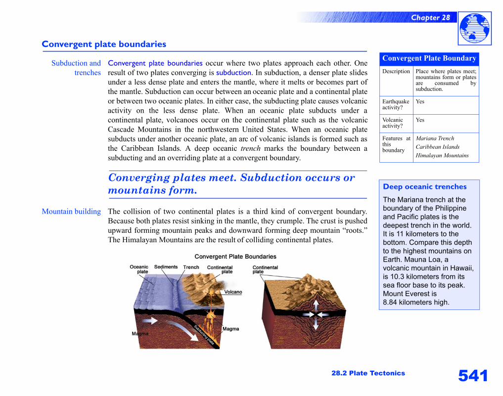
Subduction andtrenches
Convergent plate boundaries occur where two plates approach each other. Oneresult of two plates converging is subduction. In subduction, a denser plate slidesunder a less dense plate and enters the mantle, where it melts or becomes part ofthe mantle. Subduction can occur between an oceanic plate and a continental plateor between two oceanic plates. In either case, the subducting plate causes volcanicactivity on the less dense plate. When an oceanic plate subducts under acontinental plate, volcanoes occur on the continental plate such as the volcanicCascade Mountains in the northwestern United States. When an oceanic platesubducts under another oceanic plate, an arc of volcanic islands is formed such asthe Caribbean Islands. A deep oceanic trench marks the boundary between asubducting and an overriding plate at a convergent boundary.
Converging plates meet. Subduction occurs or mountains form.
Mountain building The collision of two continental plates is a third kind of convergent boundary.Because both plates resist sinking in the mantle, they crumple. The crust is pushedupward forming mountain peaks and downward forming deep mountain “roots.”The Himalayan Mountains are the result of colliding continental plates.
Convergent Plate BoundaryDescription Place where plates meet;
mountains form or platesare consumed bysubduction.
Earthquakeactivity?
Yes
Volcanicactivity?
Yes
Features atthisboundary
Mariana TrenchCaribbean IslandsHimalayan Mountains
Deep oceanic trenches
The Mariana trench at the boundary of the Philippine and Pacific plates is the deepest trench in the world. It is 11 kilometers to the bottom. Compare this depth to the highest mountains on Earth. Mauna Loa, a volcanic mountain in Hawaii, is 10.3 kilometers from its sea floor base to its peak. Mount Everest is 8.84 kilometers high.
542
Chapter 28
Transform plate boundaries
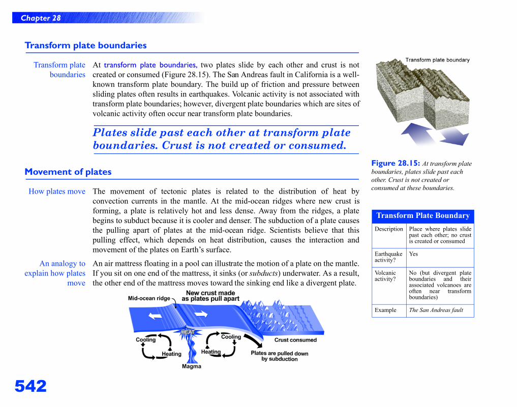
Transform plateboundaries
At transform plate boundaries, two plates slide by each other and crust is notcreated or consumed (Figure 28.15). The San Andreas fault in California is a well-known transform plate boundary. The build up of friction and pressure betweensliding plates often results in earthquakes. Volcanic activity is not associated withtransform plate boundaries; however, divergent plate boundaries which are sites ofvolcanic activity often occur near transform plate boundaries.
Plates slide past each other at transform plate boundaries. Crust is not created or consumed.
Movement of plates
How plates move The movement of tectonic plates is related to the distribution of heat byconvection currents in the mantle. At the mid-ocean ridges where new crust isforming, a plate is relatively hot and less dense. Away from the ridges, a platebegins to subduct because it is cooler and denser. The subduction of a plate causesthe pulling apart of plates at the mid-ocean ridge. Scientists believe that thispulling effect, which depends on heat distribution, causes the interaction andmovement of the plates on Earth’s surface.
An analogy toexplain how plates
move
An air mattress floating in a pool can illustrate the motion of a plate on the mantle.If you sit on one end of the mattress, it sinks (or subducts) underwater. As a result,the other end of the mattress moves toward the sinking end like a divergent plate.
Figure 28.15: At transform plate boundaries, plates slide past each other. Crust is not created or consumed at these boundaries.
Transform Plate BoundaryDescription Place where plates slide
past each other; no crustis created or consumed
Earthquakeactivity?
Yes
Volcanicactivity?
No (but divergent plateboundaries and theirassociated volcanoes areoften near transformboundaries)
Example The San Andreas fault
543
Chapter 28
28.3 Earthquakes
Figure 28.16: These recent moderate earthquakes in Japan are associated with subduction occurring at plate boundaries.
Figure 28.17: The focus, epicenter, and seismic waves of an earthquake occurring at an active fault.
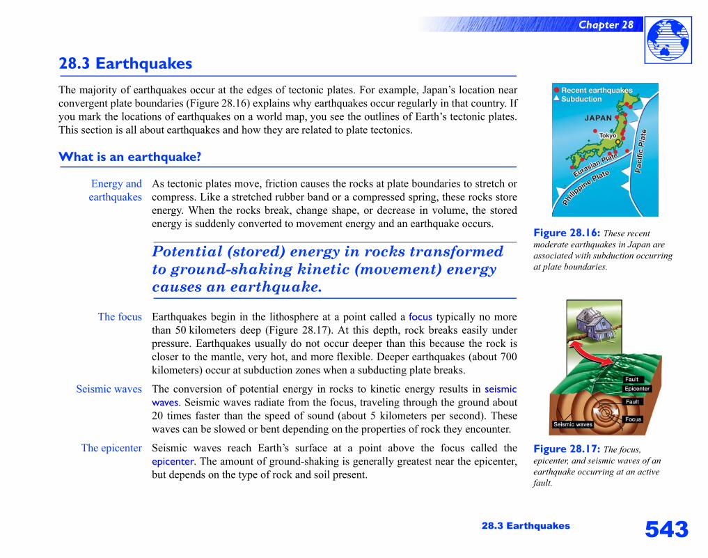
28.3 EarthquakesThe majority of earthquakes occur at the edges of tectonic plates. For example, Japan’s location nearconvergent plate boundaries (Figure 28.16) explains why earthquakes occur regularly in that country. Ifyou mark the locations of earthquakes on a world map, you see the outlines of Earth’s tectonic plates.This section is all about earthquakes and how they are related to plate tectonics.
What is an earthquake?
Energy andearthquakes
As tectonic plates move, friction causes the rocks at plate boundaries to stretch orcompress. Like a stretched rubber band or a compressed spring, these rocks storeenergy. When the rocks break, change shape, or decrease in volume, the storedenergy is suddenly converted to movement energy and an earthquake occurs.
Potential (stored) energy in rocks transformed to ground-shaking kinetic (movement) energy causes an earthquake.
The focus Earthquakes begin in the lithosphere at a point called a focus typically no morethan 50 kilometers deep (Figure 28.17). At this depth, rock breaks easily underpressure. Earthquakes usually do not occur deeper than this because the rock iscloser to the mantle, very hot, and more flexible. Deeper earthquakes (about 700kilometers) occur at subduction zones when a subducting plate breaks.
Seismic waves The conversion of potential energy in rocks to kinetic energy results in seismicwaves. Seismic waves radiate from the focus, traveling through the ground about20 times faster than the speed of sound (about 5 kilometers per second). Thesewaves can be slowed or bent depending on the properties of rock they encounter.
The epicenter Seismic waves reach Earth’s surface at a point above the focus called theepicenter. The amount of ground-shaking is generally greatest near the epicenter,but depends on the type of rock and soil present.
544
Chapter 28
Seismic waves
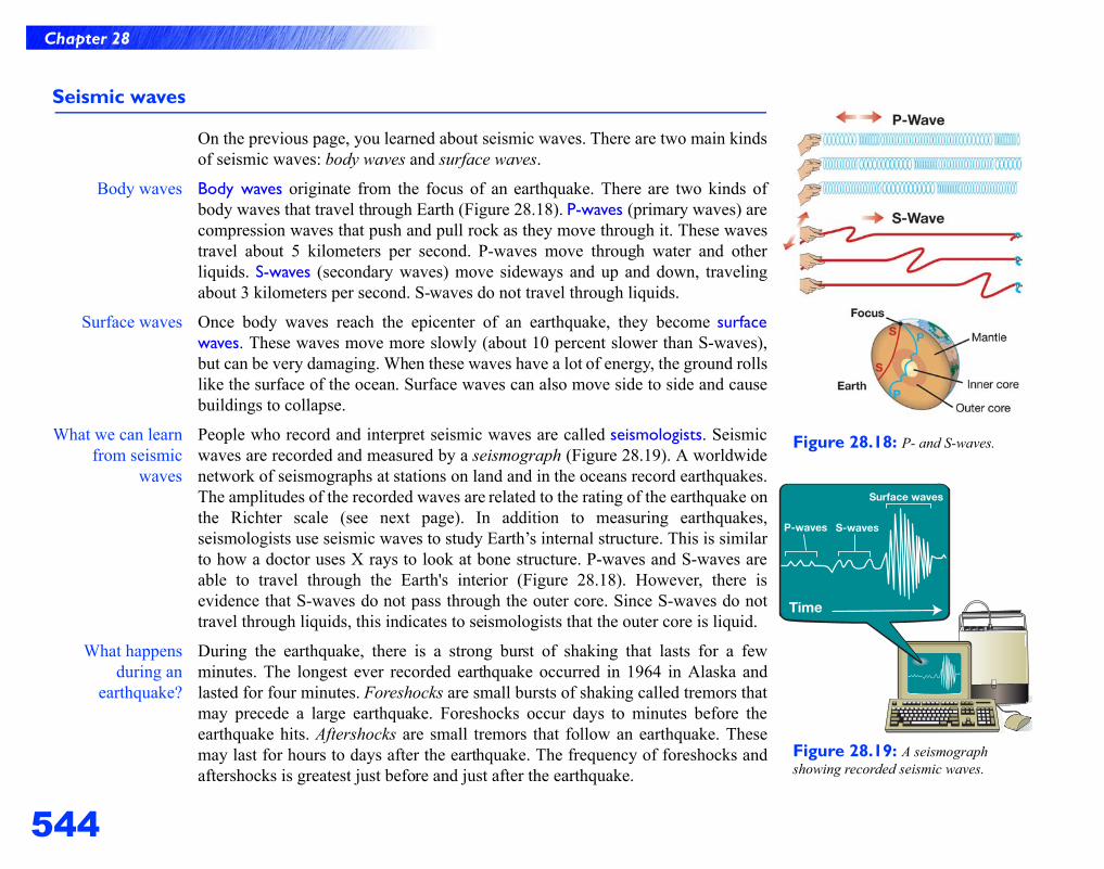
On the previous page, you learned about seismic waves. There are two main kindsof seismic waves: body waves and surface waves.
Body waves Body waves originate from the focus of an earthquake. There are two kinds ofbody waves that travel through Earth (Figure 28.18). P-waves (primary waves) arecompression waves that push and pull rock as they move through it. These wavestravel about 5 kilometers per second. P-waves move through water and otherliquids. S-waves (secondary waves) move sideways and up and down, travelingabout 3 kilometers per second. S-waves do not travel through liquids.
Surface waves Once body waves reach the epicenter of an earthquake, they become surfacewaves. These waves move more slowly (about 10 percent slower than S-waves),but can be very damaging. When these waves have a lot of energy, the ground rollslike the surface of the ocean. Surface waves can also move side to side and causebuildings to collapse.
What we can learnfrom seismic
waves
People who record and interpret seismic waves are called seismologists. Seismicwaves are recorded and measured by a seismograph (Figure 28.19). A worldwidenetwork of seismographs at stations on land and in the oceans record earthquakes.The amplitudes of the recorded waves are related to the rating of the earthquake onthe Richter scale (see next page). In addition to measuring earthquakes,seismologists use seismic waves to study Earth’s internal structure. This is similarto how a doctor uses X rays to look at bone structure. P-waves and S-waves areable to travel through the Earth's interior (Figure 28.18). However, there isevidence that S-waves do not pass through the outer core. Since S-waves do nottravel through liquids, this indicates to seismologists that the outer core is liquid.
What happensduring an
earthquake?
During the earthquake, there is a strong burst of shaking that lasts for a fewminutes. The longest ever recorded earthquake occurred in 1964 in Alaska andlasted for four minutes. Foreshocks are small bursts of shaking called tremors thatmay precede a large earthquake. Foreshocks occur days to minutes before theearthquake hits. Aftershocks are small tremors that follow an earthquake. Thesemay last for hours to days after the earthquake. The frequency of foreshocks andaftershocks is greatest just before and just after the earthquake.
Figure 28.18: P- and S-waves.
Figure 28.19: A seismograph showing recorded seismic waves.
545
Chapter 28
28.3 Earthquakes
Measuring the magnitude of an earthquake
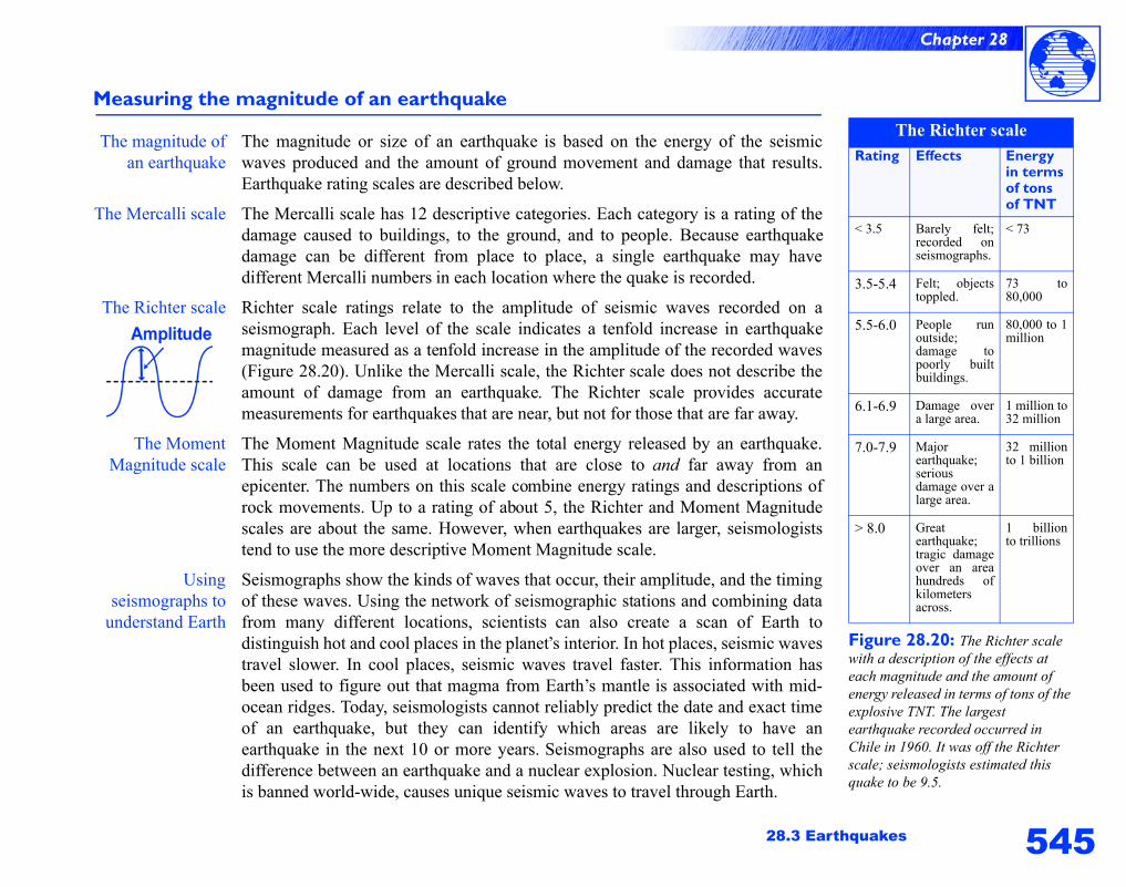
The magnitude ofan earthquake
The magnitude or size of an earthquake is based on the energy of the seismicwaves produced and the amount of ground movement and damage that results.Earthquake rating scales are described below.
The Mercalli scale The Mercalli scale has 12 descriptive categories. Each category is a rating of thedamage caused to buildings, to the ground, and to people. Because earthquakedamage can be different from place to place, a single earthquake may havedifferent Mercalli numbers in each location where the quake is recorded.
The Richter scale Richter scale ratings relate to the amplitude of seismic waves recorded on aseismograph. Each level of the scale indicates a tenfold increase in earthquakemagnitude measured as a tenfold increase in the amplitude of the recorded waves(Figure 28.20). Unlike the Mercalli scale, the Richter scale does not describe theamount of damage from an earthquake. The Richter scale provides accuratemeasurements for earthquakes that are near, but not for those that are far away.
The MomentMagnitude scale
The Moment Magnitude scale rates the total energy released by an earthquake.This scale can be used at locations that are close to and far away from anepicenter. The numbers on this scale combine energy ratings and descriptions ofrock movements. Up to a rating of about 5, the Richter and Moment Magnitudescales are about the same. However, when earthquakes are larger, seismologiststend to use the more descriptive Moment Magnitude scale.
Usingseismographs to
understand Earth
Seismographs show the kinds of waves that occur, their amplitude, and the timingof these waves. Using the network of seismographic stations and combining datafrom many different locations, scientists can also create a scan of Earth todistinguish hot and cool places in the planet’s interior. In hot places, seismic wavestravel slower. In cool places, seismic waves travel faster. This information hasbeen used to figure out that magma from Earth’s mantle is associated with mid-ocean ridges. Today, seismologists cannot reliably predict the date and exact timeof an earthquake, but they can identify which areas are likely to have anearthquake in the next 10 or more years. Seismographs are also used to tell thedifference between an earthquake and a nuclear explosion. Nuclear testing, whichis banned world-wide, causes unique seismic waves to travel through Earth.
Figure 28.20: The Richter scale with a description of the effects at each magnitude and the amount of energy released in terms of tons of the explosive TNT. The largest earthquake recorded occurred in Chile in 1960. It was off the Richter scale; seismologists estimated this quake to be 9.5.
The Richter scaleRating Effects Energy
in terms of tons of TNT
< 3.5 Barely felt;recorded onseismographs.
< 73
3.5-5.4 Felt; objectstoppled.
73 to80,000
5.5-6.0 People runoutside;damage topoorly builtbuildings.
80,000 to 1million
6.1-6.9 Damage overa large area.
1 million to32 million
7.0-7.9 Majorearthquake;seriousdamage over alarge area.
32 millionto 1 billion
> 8.0 Greatearthquake;tragic damageover an areahundreds ofkilometersacross.
1 billionto trillions
546
Chapter 28
Where do earthquakes occur?
Where areearthquakes?
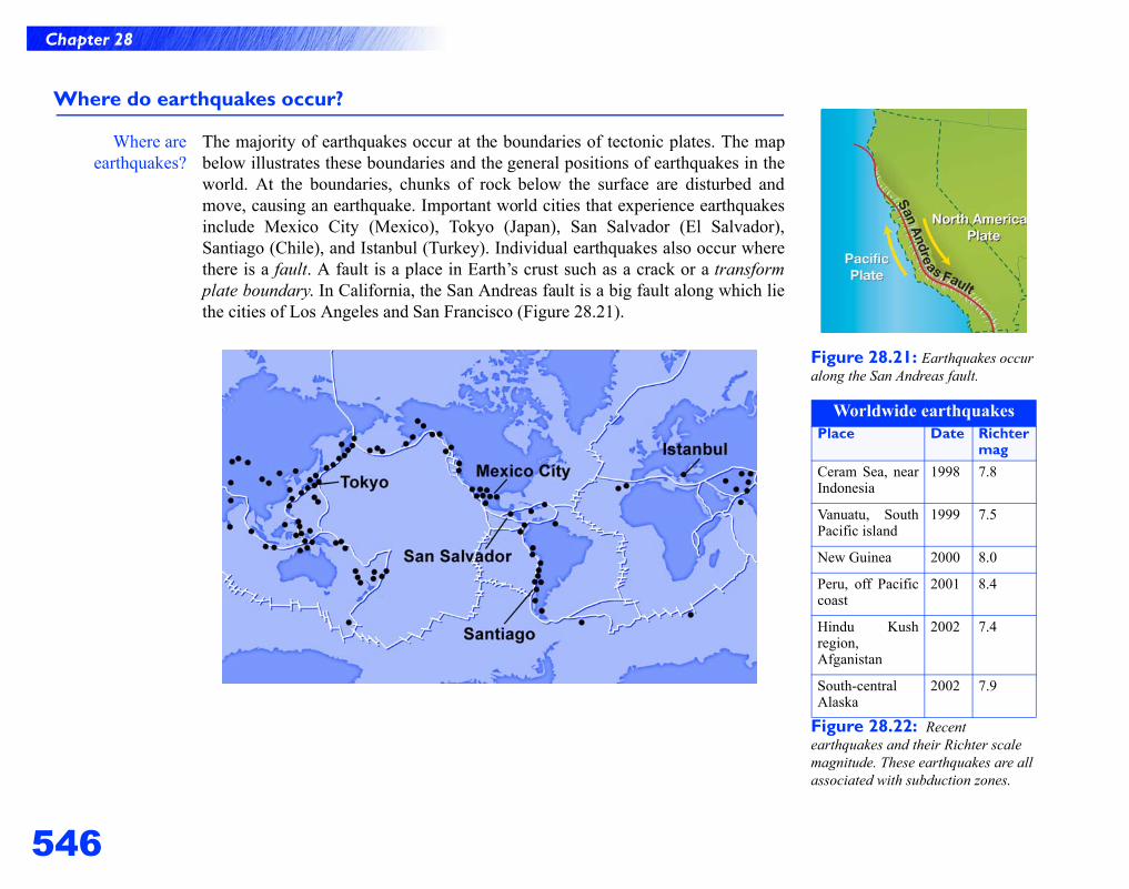
The majority of earthquakes occur at the boundaries of tectonic plates. The mapbelow illustrates these boundaries and the general positions of earthquakes in theworld. At the boundaries, chunks of rock below the surface are disturbed andmove, causing an earthquake. Important world cities that experience earthquakesinclude Mexico City (Mexico), Tokyo (Japan), San Salvador (El Salvador),Santiago (Chile), and Istanbul (Turkey). Individual earthquakes also occur wherethere is a fault. A fault is a place in Earth’s crust such as a crack or a transformplate boundary. In California, the San Andreas fault is a big fault along which liethe cities of Los Angeles and San Francisco (Figure 28.21).
Figure 28.21: Earthquakes occur along the San Andreas fault.
Figure 28.22: Recent earthquakes and their Richter scale magnitude. These earthquakes are all associated with subduction zones.
Worldwide earthquakesPlace Date Richter
magCeram Sea, nearIndonesia
1998 7.8
Vanuatu, SouthPacific island
1999 7.5
New Guinea 2000 8.0
Peru, off Pacificcoast
2001 8.4
Hindu Kushregion,Afganistan
2002 7.4
South-centralAlaska
2002 7.9
547
Chapter 28
28.3 Earthquakes
Earthquakes in the United States
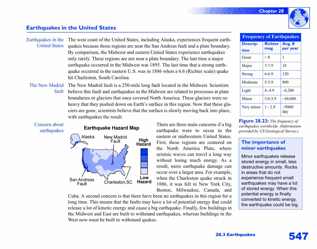
Earthquakes in theUnited States
The west coast of the United States, including Alaska, experiences frequent earth-quakes because those regions are near the San Andreas fault and a plate boundary. By comparison, the Midwest and eastern United States experience earthquakes only rarely. These regions are not near a plate boundary. The last time a major earthquake occurred in the Midwest was 1895. The last time that a strong earth-quake occurred in the eastern U.S. was in 1886 when a 6.6 (Richter scale) quake hit Charleston, South Carolina.
The New Madridfault
The New Madrid fault is a 250-mile long fault located in the Midwest. Scientists believe this fault and earthquakes in the Midwest are related to processes at plate boundaries or glaciers that once covered North America. These glaciers were so heavy that they pushed down on Earth’s surface in this region. Now that these gla-ciers are gone, scientists believe that the surface is slowly moving back into place, with earthquakes the result.
Concern aboutearthquakes
There are three main concerns if a bigearthquake were to occur in theeastern or midwestern United States.First, these regions are centered onthe North America Plate, whereseismic waves can travel a long waywithout losing much energy. As aresult, more earthquake damage canoccur over a larger area. For example,when the Charleston quake struck in1886, it was felt in New York City,Boston, Milwaukee, Canada, and
Cuba. A second concern is that there have been no earthquakes in this region for along time. This means that the faults may have a lot of potential energy that couldrelease a lot of kinetic energy and cause a big earthquake. Finally, few buildings inthe Midwest and East are built to withstand earthquakes, whereas buildings in theWest now must be built to withstand quakes.
Figure 28.23: The frequency of earthquakes worldwide. (Information provided by US Geological Survey.)
Frequency of EarthquakesDescrip-
tion
Richtermag
Avg. # per year
Great > 8 1
Major 7-7.9 18
Strong 6-6.9 120
Moderate 5-5.9 800
Light 4.-4.9 ~6,200
Minor 3.0-3.9 ~49,000
Very minor 1 - 2.9 ~9000/day
The importance of minor earthquakes
Minor earthquakes release stored energy in small, less destructive amounts. Rocks in areas that do not experience frequent small earthquakes may have a lot of stored energy. When this potential energy is finally converted to kinetic energy, the earthquake could be big.
548
Chapter 28
What do seismologists do?
Locating anepicenter
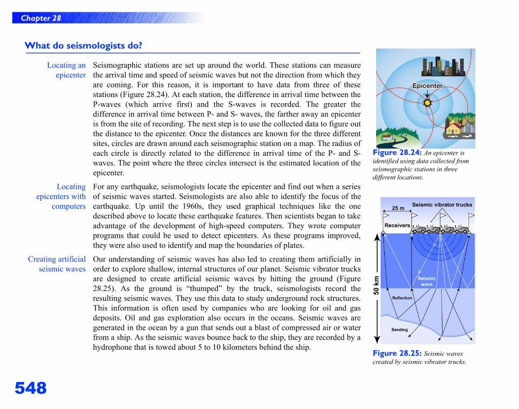
Seismographic stations are set up around the world. These stations can measurethe arrival time and speed of seismic waves but not the direction from which theyare coming. For this reason, it is important to have data from three of thesestations (Figure 28.24). At each station, the difference in arrival time between theP-waves (which arrive first) and the S-waves is recorded. The greater thedifference in arrival time between P- and S- waves, the farther away an epicenteris from the site of recording. The next step is to use the collected data to figure outthe distance to the epicenter. Once the distances are known for the three differentsites, circles are drawn around each seismographic station on a map. The radius ofeach circle is directly related to the difference in arrival time of the P- and S-waves. The point where the three circles intersect is the estimated location of theepicenter.
Locatingepicenters with
computers
For any earthquake, seismologists locate the epicenter and find out when a seriesof seismic waves started. Seismologists are also able to identify the focus of theearthquake. Up until the 1960s, they used graphical techniques like the onedescribed above to locate these earthquake features. Then scientists began to takeadvantage of the development of high-speed computers. They wrote computerprograms that could be used to detect epicenters. As these programs improved,they were also used to identify and map the boundaries of plates.
Creating artificialseismic waves
Our understanding of seismic waves has also led to creating them artificially inorder to explore shallow, internal structures of our planet. Seismic vibrator trucksare designed to create artificial seismic waves by hitting the ground (Figure28.25). As the ground is “thumped” by the truck, seismologists record theresulting seismic waves. They use this data to study underground rock structures.This information is often used by companies who are looking for oil and gasdeposits. Oil and gas exploration also occurs in the oceans. Seismic waves aregenerated in the ocean by a gun that sends out a blast of compressed air or waterfrom a ship. As the seismic waves bounce back to the ship, they are recorded by ahydrophone that is towed about 5 to 10 kilometers behind the ship.
Figure 28.24: An epicenter is identified using data collected from seismographic stations in three different locations.
Figure 28.25: Seismic waves created by seismic vibrator trucks.
549
Chapter 28
28.3 Earthquakes
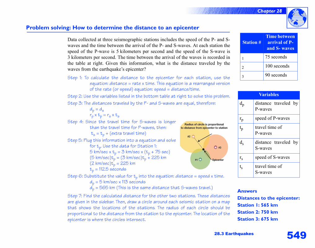
Problem solving: How to determine the distance to an epicenter
Data collected at three seismographic stations includes the speed of the P- and S-waves and the time between the arrival of the P- and S-waves. At each station thespeed of the P-wave is 5 kilometers per second and the speed of the S-wave is3 kilometers per second. The time between the arrival of the waves is recorded inthe table at right. Given this information, what is the distance traveled by thewaves from the earthquake’s epicenter?
Step 1: To calculate the distance to the epicenter for each station, use theequation: distance = rate x time. This equation is a rearranged versionof the rate (or speed) equation: speed = distance/time.
Step 2: Use the variables listed in the bottom table at right to solve this problem.Step 3: The distances traveled by the P- and S-waves are equal, therefore:
dp = ds rp x tp = rs x ts
Step 4: Since the travel time for S-waves is longerthan the travel time for P-waves, then: ts = tp + (extra travel time)
Step 5: Plug this information into a equation and solvefor tp. Use the data for Station 1:5 km/sec x tp = 3 km/sec x (tp + 75 sec)(5 km/sec)tp = (3 km/sec)tp + 225 km(2 km/sec)tp = 225 kmtp = 112.5 seconds
Step 6: Substitute the value for tp into the equation: distance = speed x time.dp = 5 km/sec x 113 secondsdp = 565 km (This is the same distance that S-waves travel.)
Step 7: Find the calculated distance for the other two stations. These distancesare given in the sidebar. Then, draw a circle around each seismic station on a mapthat shows the locations of the stations. The radius of each circle should beproportional to the distance from the station to the epicenter. The location of theepicenter is where the circles intersect.
AnswersDistances to the epicenter:Station 1: 565 kmStation 2: 750 kmStation 3: 675 km
Station #Time between arrival of P- and S- waves
1 75 seconds
2 100 seconds
3 90 seconds
Variables
dp distance traveled byP-waves
rp speed of P-waves
tp travel time ofP-waves
ds distance traveled byS-waves
rs speed of S-waves
ts travel time ofS-waves
550
Chapter 28
Preventing earthquake damage
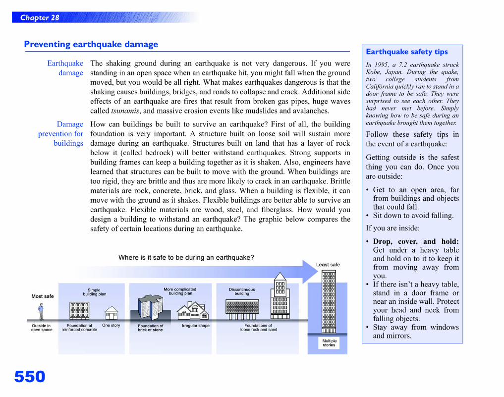
Earthquakedamage
The shaking ground during an earthquake is not very dangerous. If you werestanding in an open space when an earthquake hit, you might fall when the groundmoved, but you would be all right. What makes earthquakes dangerous is that theshaking causes buildings, bridges, and roads to collapse and crack. Additional sideeffects of an earthquake are fires that result from broken gas pipes, huge wavescalled tsunamis, and massive erosion events like mudslides and avalanches.
Damageprevention for
buildings
How can buildings be built to survive an earthquake? First of all, the buildingfoundation is very important. A structure built on loose soil will sustain moredamage during an earthquake. Structures built on land that has a layer of rockbelow it (called bedrock) will better withstand earthquakes. Strong supports inbuilding frames can keep a building together as it is shaken. Also, engineers havelearned that structures can be built to move with the ground. When buildings aretoo rigid, they are brittle and thus are more likely to crack in an earthquake. Brittlematerials are rock, concrete, brick, and glass. When a building is flexible, it canmove with the ground as it shakes. Flexible buildings are better able to survive anearthquake. Flexible materials are wood, steel, and fiberglass. How would youdesign a building to withstand an earthquake? The graphic below compares thesafety of certain locations during an earthquake.
Earthquake safety tips
In 1995, a 7.2 earthquake struckKobe, Japan. During the quake,two college students fromCalifornia quickly ran to stand in adoor frame to be safe. They weresurprised to see each other. Theyhad never met before. Simplyknowing how to be safe during anearthquake brought them together.
Follow these safety tips inthe event of a earthquake:
Getting outside is the safestthing you can do. Once youare outside:
• Get to an open area, farfrom buildings and objectsthat could fall.
• Sit down to avoid falling.If you are inside:
• Drop, cover, and hold:Get under a heavy tableand hold on to it to keep itfrom moving away fromyou.
• If there isn’t a heavy table,stand in a door frame ornear an inside wall. Protectyour head and neck fromfalling objects.
• Stay away from windowsand mirrors.
551
Chapter 28
28.3 Earthquakes
Preparing for earthquakes: tsunamis and seismic networks
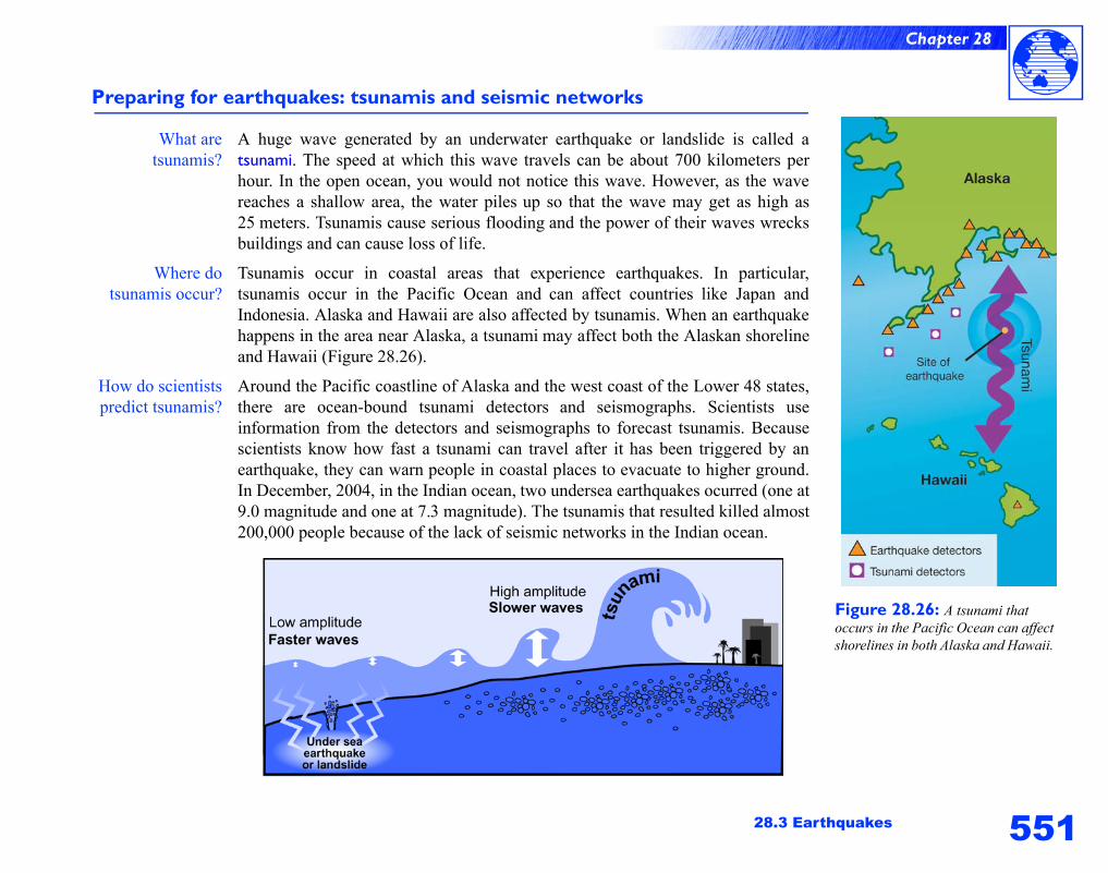
What aretsunamis?
A huge wave generated by an underwater earthquake or landslide is called atsunami. The speed at which this wave travels can be about 700 kilometers perhour. In the open ocean, you would not notice this wave. However, as the wavereaches a shallow area, the water piles up so that the wave may get as high as25 meters. Tsunamis cause serious flooding and the power of their waves wrecksbuildings and can cause loss of life.
Where dotsunamis occur?
Tsunamis occur in coastal areas that experience earthquakes. In particular,tsunamis occur in the Pacific Ocean and can affect countries like Japan andIndonesia. Alaska and Hawaii are also affected by tsunamis. When an earthquakehappens in the area near Alaska, a tsunami may affect both the Alaskan shorelineand Hawaii (Figure 28.26).
How do scientistspredict tsunamis?
Around the Pacific coastline of Alaska and the west coast of the Lower 48 states,there are ocean-bound tsunami detectors and seismographs. Scientists useinformation from the detectors and seismographs to forecast tsunamis. Becausescientists know how fast a tsunami can travel after it has been triggered by anearthquake, they can warn people in coastal places to evacuate to higher ground.In December, 2004, in the Indian ocean, two undersea earthquakes ocurred (one at9.0 magnitude and one at 7.3 magnitude). The tsunamis that resulted killed almost200,000 people because of the lack of seismic networks in the Indian ocean.
Figure 28.26: A tsunami that occurs in the Pacific Ocean can affect shorelines in both Alaska and Hawaii.
Chapter 28 Review
552
Chapter 28 Review
Vocabulary review
Match the following terms with the correct definition. There is one extra definition in the list that will not match any of the terms.
Concept review
1. Define superposition and lateral continuity. Why are theseideas useful in interpreting how the Grand Canyon formed?
2. Compare the convection currents within the mantle to those inthe atmosphere. What energy source drives each current?
3. Compare and contrast the asthenosphere and the lithosphere.4. Which of the largest tectonic plates are mainly made of oceanic
crust and do not include major continents? Use the diagram ofthe tectonic plates in the section entitled Plate Tectonics to helpyou answer this question.
5. Describe an example of a divergent plate boundary and atransform plate boundary. Describe two examples of aconvergent plate boundary—one example should illustratewhere subduction occurs, and the other example shouldillustrate where mountains occur.
6. What is the difference between the focus and the epicenter ofan earthquake?
7. Draw a diagram that shows the difference between a P-waveand an S-wave. Describe the differences between these twokinds of earthquake waves.
Set One Set Two1. paleontologist a. The idea that the continents were once a super-
continent called Pangaea.1. lithosphere a. A process that occurs at diverging tectonic plates.
2. cross-cutting relationships
b. For a layered rock, the youngest layer is on top and the oldest layer is on the bottom.
2. asthenosphere b. An ocean mountain range that occurs where tectonic plates diverge.
3. superposition c. A scientist who studies fossils. 3. sea-floor spreading c. The layer of the mantle below the lithosphere.
4. relative dating d. A method used to determine the order in which geologic events happened.
4. mid-ocean ridge d. Earth’s crust plus the rigid, upper layer of the mantle.
5. continental drift e. The vein of rock is younger than the rock surrounding the vein.
5. original horizontality
e. Sediment forms horizontal layers under the influence of gravity.
f. A rock embedded in another rock is older. f. A feature at converging tectonic plates.
553
Chapter 28 Review
Problems
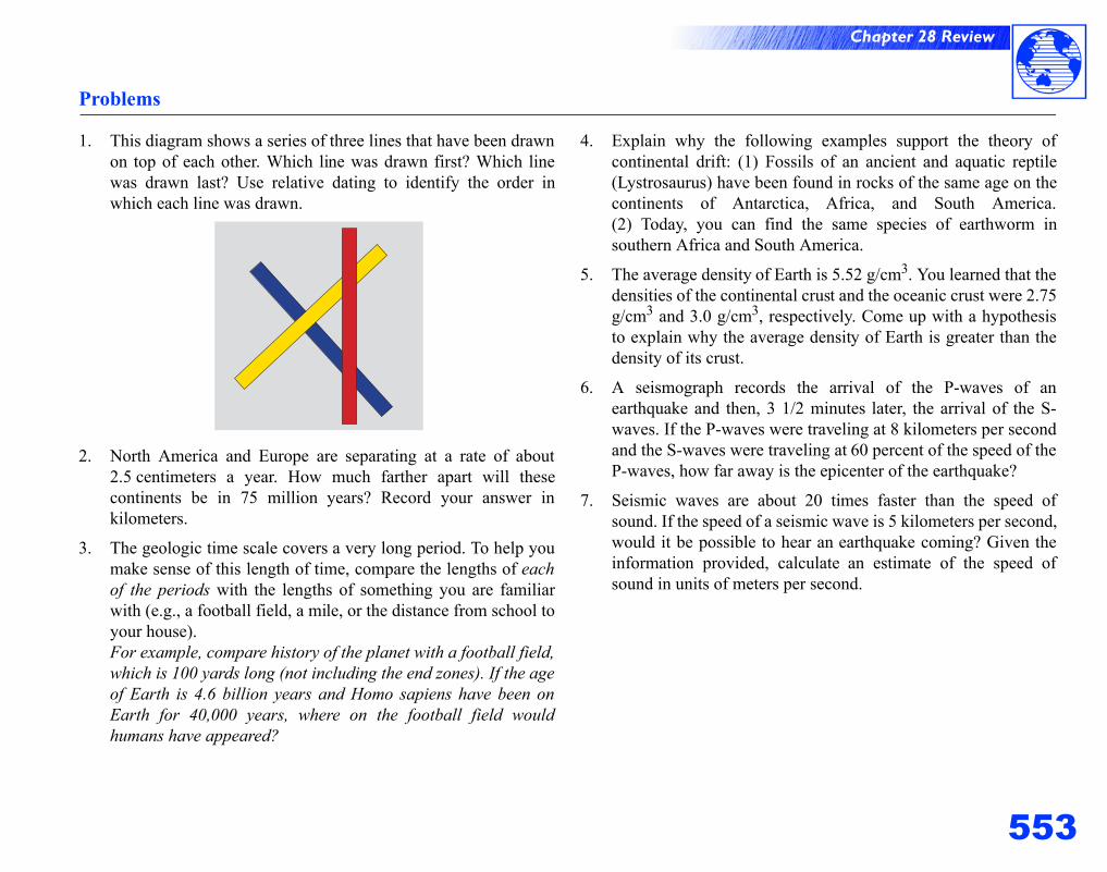
1. This diagram shows a series of three lines that have been drawnon top of each other. Which line was drawn first? Which linewas drawn last? Use relative dating to identify the order inwhich each line was drawn.
2. North America and Europe are separating at a rate of about2.5 centimeters a year. How much farther apart will thesecontinents be in 75 million years? Record your answer inkilometers.
3. The geologic time scale covers a very long period. To help youmake sense of this length of time, compare the lengths of eachof the periods with the lengths of something you are familiarwith (e.g., a football field, a mile, or the distance from school toyour house).For example, compare history of the planet with a football field,which is 100 yards long (not including the end zones). If the ageof Earth is 4.6 billion years and Homo sapiens have been onEarth for 40,000 years, where on the football field wouldhumans have appeared?
4. Explain why the following examples support the theory ofcontinental drift: (1) Fossils of an ancient and aquatic reptile(Lystrosaurus) have been found in rocks of the same age on thecontinents of Antarctica, Africa, and South America.(2) Today, you can find the same species of earthworm insouthern Africa and South America.
5. The average density of Earth is 5.52 g/cm3. You learned that thedensities of the continental crust and the oceanic crust were 2.75g/cm3 and 3.0 g/cm3, respectively. Come up with a hypothesisto explain why the average density of Earth is greater than thedensity of its crust.
6. A seismograph records the arrival of the P-waves of anearthquake and then, 3 1/2 minutes later, the arrival of the S-waves. If the P-waves were traveling at 8 kilometers per secondand the S-waves were traveling at 60 percent of the speed of theP-waves, how far away is the epicenter of the earthquake?
7. Seismic waves are about 20 times faster than the speed ofsound. If the speed of a seismic wave is 5 kilometers per second,would it be possible to hear an earthquake coming? Given theinformation provided, calculate an estimate of the speed ofsound in units of meters per second.
Chapter 28 Review
554
!Applying your knowledge
1. The terms density, potential energy, and kinetic energy wereused in this unit. Each of these terms was presented in previousunits. Define each term in your own words and explain whythey are important for understanding earth science.
2. Review some recent popular science magazines to find outabout the present day activities of geologists andpaleontologists. Write a short paragraph that describes acurrent topic of research in the area of either geology orpaleontology.
3. Another important figure in developing the field of geology isCharles Lyell (1797-1875), a Scottish geologist. Like JamesHutton, Lyell was important in establishing the idea that theevents in the present explain events of the past. Lyell’s term forthis concept was uniformitarianism. Further research thescientific contributions of both scientists on the Internet or inyour local library. Explain their contributions in the form of anone-minute advertisement for television. Write the script foryour advertisement and present it to your class. You may useprops and other actors in your advertisement.
4. The geologic time scale shown in the section titledUnderstanding Earth illustrates some of the events that haveoccurred over geologic time. By doing research on the Internetor in your local library, identify when the following eventsoccurred during Earth’s geologic history: (1) the appearance ofthe first trees, (2) the formation of Mount Everest, and (3) theformation of the Mediterranean Sea.
5. Compare Wegener’s theory of continental drift with the theoryof plate tectonics. Explain why one theory became acceptedwhile the other theory did not.
6. At the site of the Great Rift Valley in Africa, three plates arepulling apart. An eventual consequence of this is that an oceanwill form between these plates. When this happens, what willthis divergent plate boundary become? Hint: The AtlanticOcean has this feature.
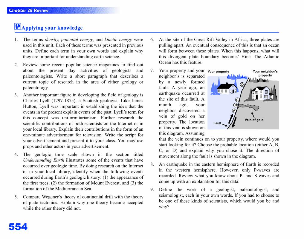
7. Your property and yourneighbor’s is separatedby a newly formedfault. A year ago, anearthquake occurred atthe site of this fault. Amonth ago, yourneighbor discovered avein of gold on herproperty. The locationof this vein is shown onthis diagram. Assumingthat the vein continues on to your property, where would youstart looking for it? Choose the probable location (either A, B,C, or D) and explain why you chose it. The direction ofmovement along the fault is shown in the diagram.
8. An earthquake in the eastern hemisphere of Earth is recordedin the western hemisphere. However, only P-waves arerecorded. Review what you know about P- and S-waves andcome up with an explanation for this data.
9. Define the work of a geologist, paleontologist, andseismologist, each in your own words. If you had to choose tobe one of these kinds of scientists, which would you be andwhy?
555
Earth Science
Slow, powerful processes are involved in recycling and moving rocky material fromplace to place on the planet. Deep within Earth, magma rises up and erupts on to thesurface. When cooled, this molten rock may become a hand-sized piece of rock, partof a volcanic mountain, or part of the sea floor. Erosion of the land by water, wind,and glaciers is another way that matter moves from place to place. Erosion removesparticles off rocks and minerals and moves them to another place where they maybecome another rock formation. The movement of tectonic plates on Earth’s surfacecan cause rock to be pulled back into the mantle or fold into mountains. The rockcycle summarizes the history of rocks and rock formations.
This Investigation expands your understanding of volcanoes. You will be giveninformation about active volcanoes and their magma composition. You will use thisinformation to predict the geographic location of an active volcano.
The surface of Earth has endured a lot of erosion over it’s 4.6-billion year history.By comparison, the moon’s surface has remained relatively unchanged over thistime. In this Investigation, you will count the number of meteor impacts for a regionof the moon and extrapolate those effects for Earth.
In this Investigation, you will simulate the processes that lead to the formation ofthe three main kinds of rocks—igneous, sedimentary, and metamorphic. You willalso practice interpreting rock formations.
29.1 Volcanoes Why do some volcanoes erupt explosively?
29.2 The Surface of Earth How have meteors affected Earth’s surface?
29.3 Rocks and Minerals How can we interpret the stories within rocks?
Chapter 29Formation of
Rocks
10
Chapter 29: Formation of Rocks
556
Learning Goals
In this chapter, you will:
! Learn about the role of plate tectonics in causing volcanoes and learn what causes eruptions to be gentle or highly explosive.
! Identify the main types of volcanoes: shield volcanoes, stratovolcanoes, and cinder cones.
! Learn about other forms of volcanic activity such as geysers, hot springs, hydrothermal vents, and geothermal energy.
! Learn about the constructive and destructive processes on Earth’s surface like mountain-building, and erosion by wind, water, and ice.
! Learn how to interpret and use geologic hazard maps.
! Understand human impacts such as urban sprawl on Earth’s surface.
! Learn how to identify the three main kinds of rocks: igneous, sedimentary, and metamorphic.
! Learn how to identify common minerals using Mohs hardness scale.
! Apply your understanding of the rock cycle to explain the properties of rocks and to interpret rock formations.
Vocabulary
caldera geothermal energy metamorphic rock soil profilecinder cone volcano glacier mineral stratovolcanocleavage plane hydrothermal vent Mohs hardness scale urban sprawlcrater igneous rock Ring of Fire venterosion lava rock cycle weatheringfault-block mountain magma sedimentary rockfold mountain magma chamber shield volcano
557
Chapter 29
29.1 Volcanoes
Figure 29.1: Mount St. Helens before and after its eruption. Images courtesy of USGS/Cascades Volcano Observatory.
Travel to Earth’s core
In 1864, Jules Verne wrote“Journey to the Center ofEarth.” In this fictional tale,the characters begin and endtheir travels by entering andexiting a volcano. As youmight imagine, a journey tothe center of Earth, if it werepossible, would involveenduring extremes oftemperature and pressure.Earth’s core is about as hot asthe sun. The pressure wouldbe very great because of thehuge weight of rock layers.
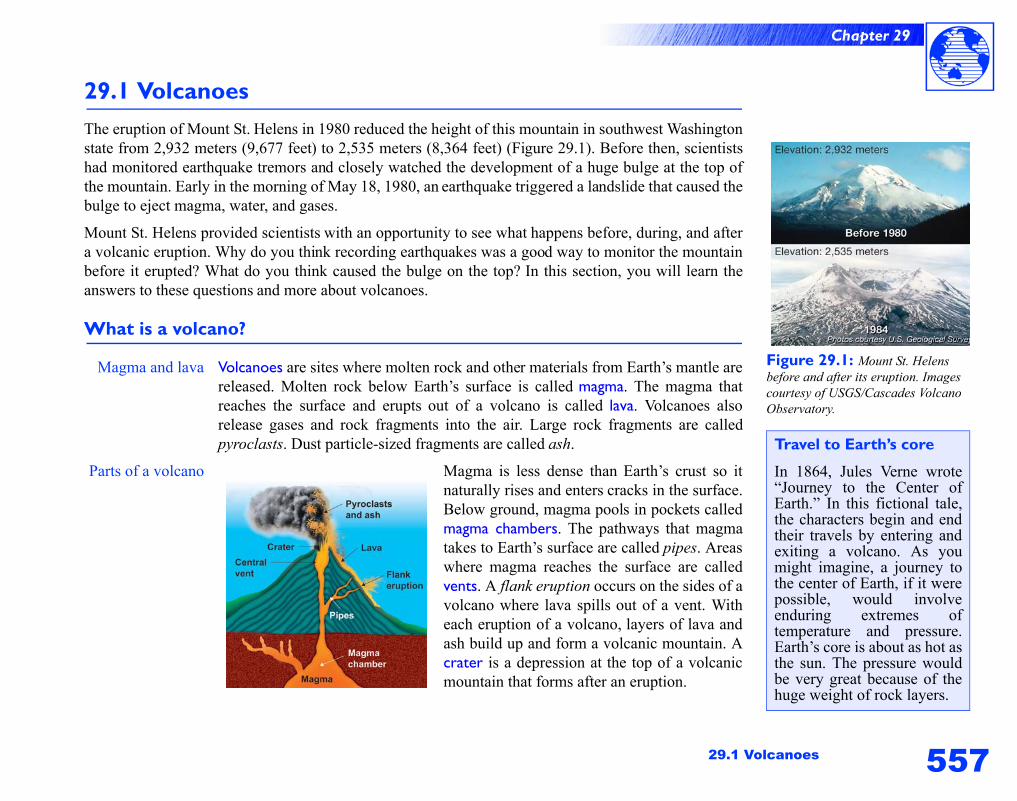
29.1 VolcanoesThe eruption of Mount St. Helens in 1980 reduced the height of this mountain in southwest Washingtonstate from 2,932 meters (9,677 feet) to 2,535 meters (8,364 feet) (Figure 29.1). Before then, scientistshad monitored earthquake tremors and closely watched the development of a huge bulge at the top ofthe mountain. Early in the morning of May 18, 1980, an earthquake triggered a landslide that caused thebulge to eject magma, water, and gases.
Mount St. Helens provided scientists with an opportunity to see what happens before, during, and aftera volcanic eruption. Why do you think recording earthquakes was a good way to monitor the mountainbefore it erupted? What do you think caused the bulge on the top? In this section, you will learn theanswers to these questions and more about volcanoes.
What is a volcano?
Magma and lava Volcanoes are sites where molten rock and other materials from Earth’s mantle arereleased. Molten rock below Earth’s surface is called magma. The magma thatreaches the surface and erupts out of a volcano is called lava. Volcanoes alsorelease gases and rock fragments into the air. Large rock fragments are calledpyroclasts. Dust particle-sized fragments are called ash.
Parts of a volcano Magma is less dense than Earth’s crust so itnaturally rises and enters cracks in the surface.Below ground, magma pools in pockets calledmagma chambers. The pathways that magmatakes to Earth’s surface are called pipes. Areaswhere magma reaches the surface are calledvents. A flank eruption occurs on the sides of avolcano where lava spills out of a vent. Witheach eruption of a volcano, layers of lava andash build up and form a volcanic mountain. Acrater is a depression at the top of a volcanicmountain that forms after an eruption.
558
Chapter 29
How magma forms
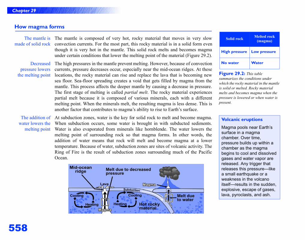
The mantle ismade of solid rock
The mantle is composed of very hot, rocky material that moves in very slowconvection currents. For the most part, this rocky material is in a solid form eventhough it is very hot in the mantle. This solid rock melts and becomes magmaunder certain conditions that lower the melting point of the material (Figure 29.2).
Decreasedpressure lowers
the melting point
The high pressures in the mantle prevent melting. However, because of convectioncurrents, pressure decreases occur, especially near the mid-ocean ridges. At theselocations, the rocky material can rise and replace the lava that is becoming newsea floor. Sea-floor spreading creates a void that gets filled by magma from themantle. This process affects the deeper mantle by causing a decrease in pressure.The first stage of melting is called partial melt. The rocky material experiencespartial melt because it is composed of various minerals, each with a differentmelting point. When the minerals melt, the resulting magma is less dense. This isanother factor that contributes to magma’s ability to rise to Earth’s surface.
The addition ofwater lowers the
melting point
At subduction zones, water is the key for solid rock to melt and become magma.When subduction occurs, some water is brought in with subducted sediments.Water is also evaporated from minerals like hornblende. The water lowers themelting point of surrounding rock so that magma forms. In other words, theaddition of water means that rock will melt and become magma at a lowertemperature. Because of water, subduction zones are sites of volcanic activity. TheRing of Fire is the result of subduction zones surrounding much of the PacificOcean.
Figure 29.2: This table summarizes the conditions under which the rocky material in the mantle is solid or melted. Rocky material melts and becomes magma when the pressure is lowered or when water is present.
Solid rock Melted rock (magma)
High pressure Low pressure
No water Water
Volcanic eruptions
Magma pools near Earth’s surface in a magma chamber. Over time, pressure builds up within a chamber as the magma begins to cool and dissolved gases and water vapor are released. Any trigger that releases this pressure—like a small earthquake or a weakness in the volcano itself—results in the sudden, explosive, escape of gases, lava, pyroclasts, and ash.
559
Chapter 29
29.1 Volcanoes
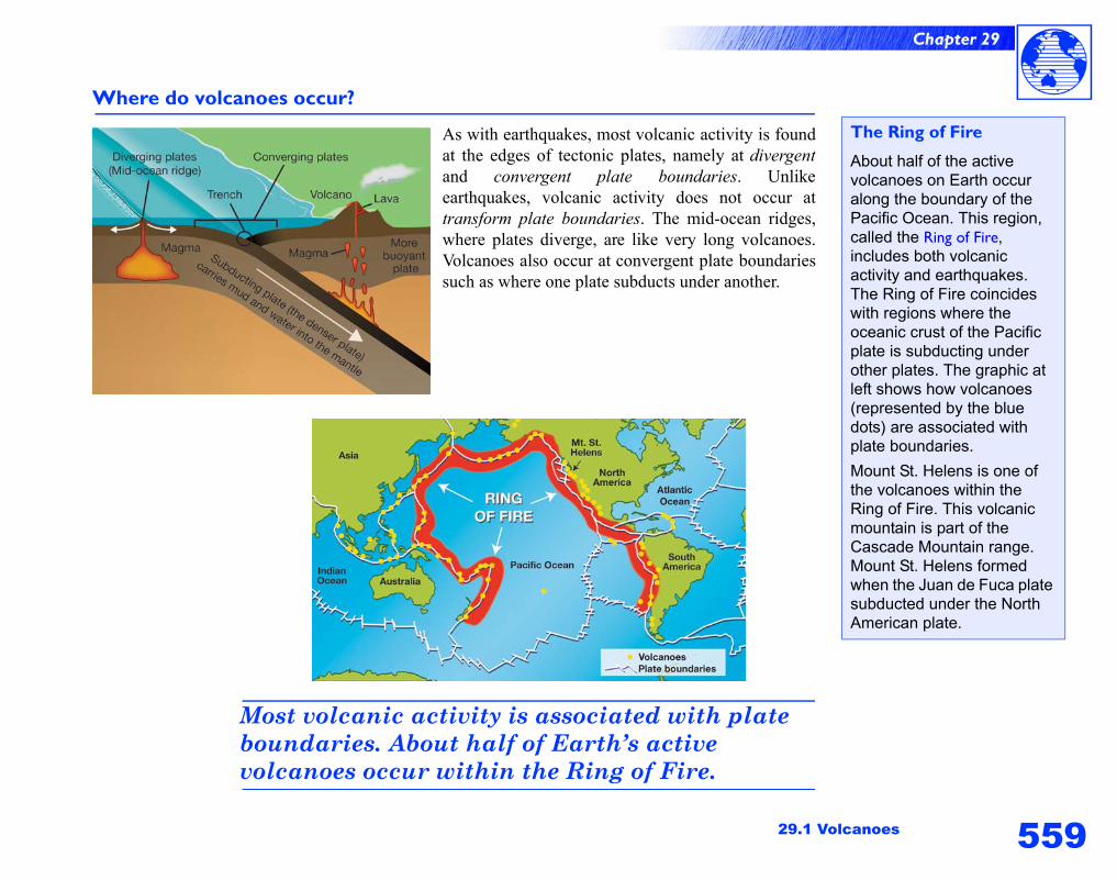
Where do volcanoes occur?
As with earthquakes, most volcanic activity is foundat the edges of tectonic plates, namely at divergentand convergent plate boundaries. Unlikeearthquakes, volcanic activity does not occur attransform plate boundaries. The mid-ocean ridges,where plates diverge, are like very long volcanoes.Volcanoes also occur at convergent plate boundariessuch as where one plate subducts under another.
Most volcanic activity is associated with plate boundaries. About half of Earth’s active volcanoes occur within the Ring of Fire.
The Ring of Fire
About half of the active volcanoes on Earth occur along the boundary of the Pacific Ocean. This region, called the Ring of Fire, includes both volcanic activity and earthquakes. The Ring of Fire coincides with regions where the oceanic crust of the Pacific plate is subducting under other plates. The graphic at left shows how volcanoes (represented by the blue dots) are associated with plate boundaries.
Mount St. Helens is one of the volcanoes within the Ring of Fire. This volcanic mountain is part of the Cascade Mountain range. Mount St. Helens formed when the Juan de Fuca plate subducted under the North American plate.
560
Chapter 29
Features of volcanoes
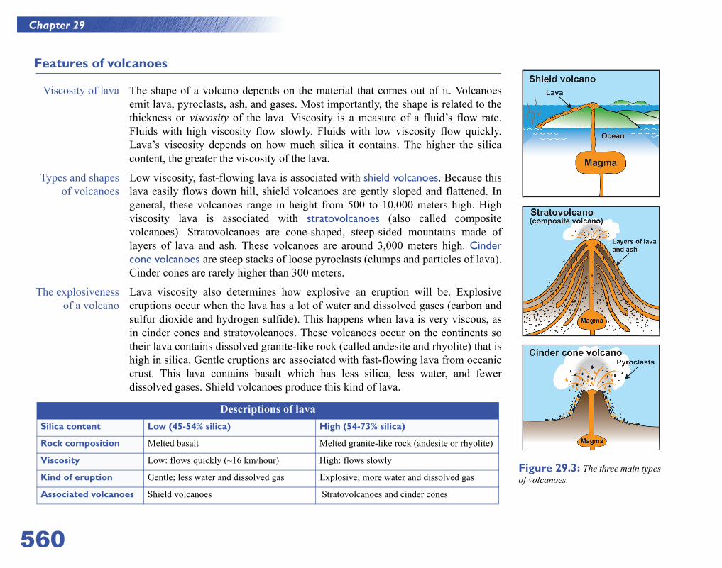
Viscosity of lava The shape of a volcano depends on the material that comes out of it. Volcanoesemit lava, pyroclasts, ash, and gases. Most importantly, the shape is related to thethickness or viscosity of the lava. Viscosity is a measure of a fluid’s flow rate.Fluids with high viscosity flow slowly. Fluids with low viscosity flow quickly.Lava’s viscosity depends on how much silica it contains. The higher the silicacontent, the greater the viscosity of the lava.
Types and shapesof volcanoes
Low viscosity, fast-flowing lava is associated with shield volcanoes. Because thislava easily flows down hill, shield volcanoes are gently sloped and flattened. Ingeneral, these volcanoes range in height from 500 to 10,000 meters high. Highviscosity lava is associated with stratovolcanoes (also called compositevolcanoes). Stratovolcanoes are cone-shaped, steep-sided mountains made oflayers of lava and ash. These volcanoes are around 3,000 meters high. Cindercone volcanoes are steep stacks of loose pyroclasts (clumps and particles of lava).Cinder cones are rarely higher than 300 meters.
The explosivenessof a volcano
Lava viscosity also determines how explosive an eruption will be. Explosiveeruptions occur when the lava has a lot of water and dissolved gases (carbon andsulfur dioxide and hydrogen sulfide). This happens when lava is very viscous, asin cinder cones and stratovolcanoes. These volcanoes occur on the continents sotheir lava contains dissolved granite-like rock (called andesite and rhyolite) that ishigh in silica. Gentle eruptions are associated with fast-flowing lava from oceaniccrust. This lava contains basalt which has less silica, less water, and fewerdissolved gases. Shield volcanoes produce this kind of lava.
Descriptions of lavaSilica content Low (45-54% silica) High (54-73% silica)
Rock composition Melted basalt Melted granite-like rock (andesite or rhyolite)
Viscosity Low: flows quickly (~16 km/hour) High: flows slowly
Kind of eruption Gentle; less water and dissolved gas Explosive; more water and dissolved gas
Associated volcanoes Shield volcanoes Stratovolcanoes and cinder cones
Figure 29.3: The three main types of volcanoes.
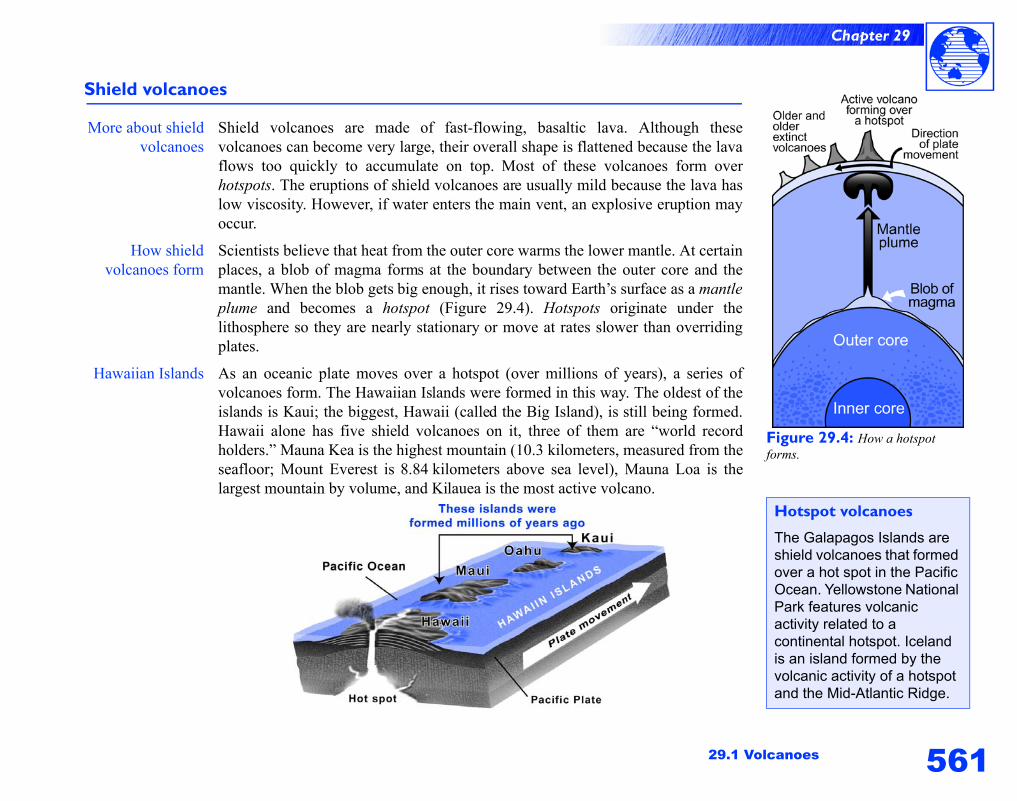
561
Chapter 29
29.1 Volcanoes
Shield volcanoes
More about shieldvolcanoes
Shield volcanoes are made of fast-flowing, basaltic lava. Although thesevolcanoes can become very large, their overall shape is flattened because the lavaflows too quickly to accumulate on top. Most of these volcanoes form overhotspots. The eruptions of shield volcanoes are usually mild because the lava haslow viscosity. However, if water enters the main vent, an explosive eruption mayoccur.
How shieldvolcanoes form
Scientists believe that heat from the outer core warms the lower mantle. At certainplaces, a blob of magma forms at the boundary between the outer core and themantle. When the blob gets big enough, it rises toward Earth’s surface as a mantleplume and becomes a hotspot (Figure 29.4). Hotspots originate under thelithosphere so they are nearly stationary or move at rates slower than overridingplates.
Hawaiian Islands As an oceanic plate moves over a hotspot (over millions of years), a series ofvolcanoes form. The Hawaiian Islands were formed in this way. The oldest of theislands is Kaui; the biggest, Hawaii (called the Big Island), is still being formed.Hawaii alone has five shield volcanoes on it, three of them are “world recordholders.” Mauna Kea is the highest mountain (10.3 kilometers, measured from theseafloor; Mount Everest is 8.84 kilometers above sea level), Mauna Loa is thelargest mountain by volume, and Kilauea is the most active volcano.
Figure 29.4: How a hotspot forms.
Hotspot volcanoes
The Galapagos Islands are shield volcanoes that formed over a hot spot in the Pacific Ocean. Yellowstone National Park features volcanic activity related to a continental hotspot. Iceland is an island formed by the volcanic activity of a hotspot and the Mid-Atlantic Ridge.
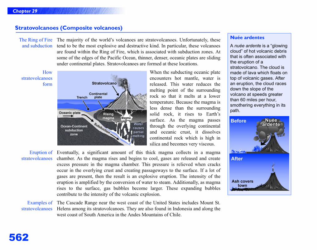
562
Chapter 29
Stratovolcanoes (Composite volcanoes)
The Ring of Fireand subduction
The majority of the world’s volcanoes are stratovolcanoes. Unfortunately, thesetend to be the most explosive and destructive kind. In particular, these volcanoesare found within the Ring of Fire, which is associated with subduction zones. Atsome of the edges of the Pacific Ocean, thinner, denser, oceanic plates are slidingunder continental plates. Stratovolcanoes are formed at these locations.
Howstratovolcanoes
form
When the subducting oceanic plateencounters hot mantle, water isreleased. This water reduces themelting point of the surroundingrock so that it melts at a lowertemperature. Because the magma isless dense than the surroundingsolid rock, it rises to Earth’ssurface. As the magma passesthrough the overlying continentaland oceanic crust, it dissolvescontinental rock which is high insilica and becomes very viscous.
Eruption ofstratovolcanoes
Eventually, a significant amount of this thick magma collects in a magmachamber. As the magma rises and begins to cool, gases are released and createexcess pressure in the magma chamber. This pressure is relieved when cracksoccur in the overlying crust and creating passageways to the surface. If a lot ofgases are present, then the result is an explosive eruption. The intensity of theeruption is amplified by the conversion of water to steam. Additionally, as magmarises to the surface, gas bubbles become larger. These expanding bubblescontribute to the intensity of the volcanic explosion.
Examples ofstratovolcanoes
The Cascade Range near the west coast of the United States includes Mount St.Helens among its stratovolcanoes. They are also found in Indonesia and along thewest coast of South America in the Andes Mountains of Chile.
Nuée ardentes
A nuée ardente is a “glowing cloud” of hot volcanic debris that is often associated with the eruption of a stratovolcano. The cloud is made of lava which floats on top of volcanic gases. After an eruption, the cloud races down the slope of the volcano at speeds greater than 60 miles per hour, smothering everything in its path.
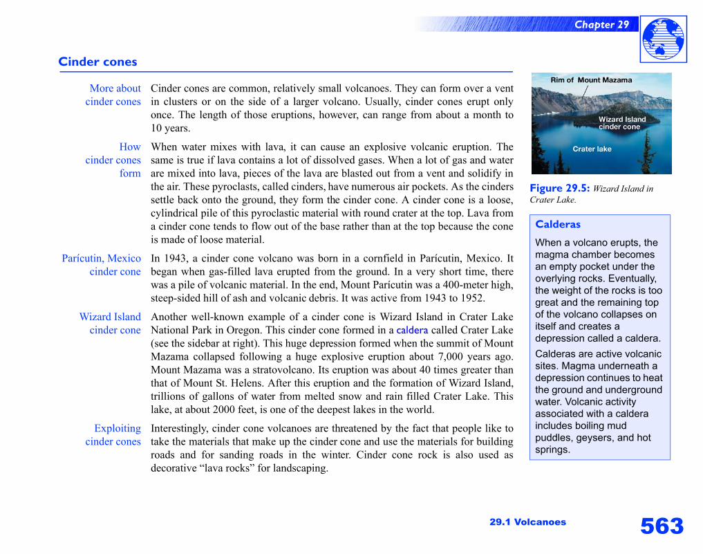
563
Chapter 29
29.1 Volcanoes
Cinder cones
More aboutcinder cones
Cinder cones are common, relatively small volcanoes. They can form over a ventin clusters or on the side of a larger volcano. Usually, cinder cones erupt onlyonce. The length of those eruptions, however, can range from about a month to10 years.
Howcinder cones
form
When water mixes with lava, it can cause an explosive volcanic eruption. Thesame is true if lava contains a lot of dissolved gases. When a lot of gas and waterare mixed into lava, pieces of the lava are blasted out from a vent and solidify inthe air. These pyroclasts, called cinders, have numerous air pockets. As the cinderssettle back onto the ground, they form the cinder cone. A cinder cone is a loose,cylindrical pile of this pyroclastic material with round crater at the top. Lava froma cinder cone tends to flow out of the base rather than at the top because the coneis made of loose material.
Parícutin, Mexicocinder cone
In 1943, a cinder cone volcano was born in a cornfield in Parícutin, Mexico. Itbegan when gas-filled lava erupted from the ground. In a very short time, therewas a pile of volcanic material. In the end, Mount Parícutin was a 400-meter high,steep-sided hill of ash and volcanic debris. It was active from 1943 to 1952.
Wizard Islandcinder cone
Another well-known example of a cinder cone is Wizard Island in Crater LakeNational Park in Oregon. This cinder cone formed in a caldera called Crater Lake(see the sidebar at right). This huge depression formed when the summit of MountMazama collapsed following a huge explosive eruption about 7,000 years ago.Mount Mazama was a stratovolcano. Its eruption was about 40 times greater thanthat of Mount St. Helens. After this eruption and the formation of Wizard Island,trillions of gallons of water from melted snow and rain filled Crater Lake. Thislake, at about 2000 feet, is one of the deepest lakes in the world.
Exploitingcinder cones
Interestingly, cinder cone volcanoes are threatened by the fact that people like totake the materials that make up the cinder cone and use the materials for buildingroads and for sanding roads in the winter. Cinder cone rock is also used asdecorative “lava rocks” for landscaping.
Figure 29.5: Wizard Island in Crater Lake.
Calderas
When a volcano erupts, the magma chamber becomes an empty pocket under the overlying rocks. Eventually, the weight of the rocks is too great and the remaining top of the volcano collapses on itself and creates a depression called a caldera.
Calderas are active volcanic sites. Magma underneath a depression continues to heat the ground and underground water. Volcanic activity associated with a caldera includes boiling mud puddles, geysers, and hot springs.
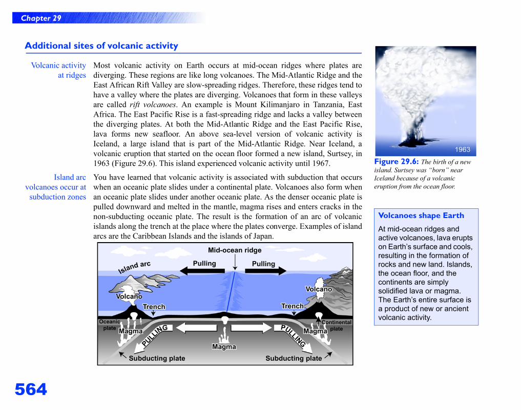
564
Chapter 29
Additional sites of volcanic activity
Volcanic activityat ridges
Most volcanic activity on Earth occurs at mid-ocean ridges where plates arediverging. These regions are like long volcanoes. The Mid-Atlantic Ridge and theEast African Rift Valley are slow-spreading ridges. Therefore, these ridges tend tohave a valley where the plates are diverging. Volcanoes that form in these valleysare called rift volcanoes. An example is Mount Kilimanjaro in Tanzania, EastAfrica. The East Pacific Rise is a fast-spreading ridge and lacks a valley betweenthe diverging plates. At both the Mid-Atlantic Ridge and the East Pacific Rise,lava forms new seafloor. An above sea-level version of volcanic activity isIceland, a large island that is part of the Mid-Atlantic Ridge. Near Iceland, avolcanic eruption that started on the ocean floor formed a new island, Surtsey, in1963 (Figure 29.6). This island experienced volcanic activity until 1967.
Island arcvolcanoes occur at
subduction zones
You have learned that volcanic activity is associated with subduction that occurswhen an oceanic plate slides under a continental plate. Volcanoes also form whenan oceanic plate slides under another oceanic plate. As the denser oceanic plate ispulled downward and melted in the mantle, magma rises and enters cracks in thenon-subducting oceanic plate. The result is the formation of an arc of volcanicislands along the trench at the place where the plates converge. Examples of islandarcs are the Caribbean Islands and the islands of Japan.
Figure 29.6: The birth of a new island. Surtsey was “born” near Iceland because of a volcanic eruption from the ocean floor.
Volcanoes shape Earth
At mid-ocean ridges and active volcanoes, lava erupts on Earth’s surface and cools, resulting in the formation of rocks and new land. Islands, the ocean floor, and the continents are simply solidified lava or magma. The Earth’s entire surface is a product of new or ancient volcanic activity.
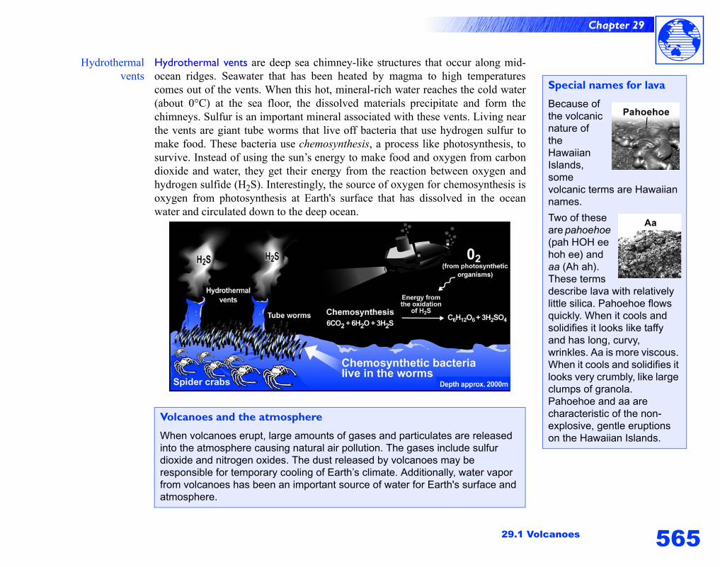
565
Chapter 29
29.1 Volcanoes
Hydrothermalvents
Hydrothermal vents are deep sea chimney-like structures that occur along mid-ocean ridges. Seawater that has been heated by magma to high temperaturescomes out of the vents. When this hot, mineral-rich water reaches the cold water(about 0°C) at the sea floor, the dissolved materials precipitate and form thechimneys. Sulfur is an important mineral associated with these vents. Living nearthe vents are giant tube worms that live off bacteria that use hydrogen sulfur tomake food. These bacteria use chemosynthesis, a process like photosynthesis, tosurvive. Instead of using the sun’s energy to make food and oxygen from carbondioxide and water, they get their energy from the reaction between oxygen andhydrogen sulfide (H2S). Interestingly, the source of oxygen for chemosynthesis isoxygen from photosynthesis at Earth's surface that has dissolved in the oceanwater and circulated down to the deep ocean.
Volcanoes and the atmosphere
When volcanoes erupt, large amounts of gases and particulates are released into the atmosphere causing natural air pollution. The gases include sulfur dioxide and nitrogen oxides. The dust released by volcanoes may be responsible for temporary cooling of Earth’s climate. Additionally, water vapor from volcanoes has been an important source of water for Earth's surface and atmosphere.
Special names for lava
Because of the volcanic nature of the Hawaiian Islands, some volcanic terms are Hawaiian names.
Two of these are pahoehoe (pah HOH ee hoh ee) and aa (Ah ah). These terms describe lava with relatively little silica. Pahoehoe flows quickly. When it cools and solidifies it looks like taffy and has long, curvy, wrinkles. Aa is more viscous. When it cools and solidifies it looks very crumbly, like large clumps of granola. Pahoehoe and aa are characteristic of the non-explosive, gentle eruptions on the Hawaiian Islands.
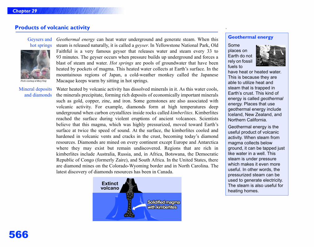
566
Chapter 29
Products of volcanic activity
Geysers andhot springs
Geothermal energy can heat water underground and generate steam. When thissteam is released naturally, it is called a geyser. In Yellowstone National Park, OldFaithful is a very famous geyser that releases water and steam every 33 to93 minutes. The geyser occurs when pressure builds up underground and forces ablast of steam and water. Hot springs are pools of groundwater that have beenheated by pockets of magma. This heated water collects at Earth’s surface. In themountainous regions of Japan, a cold-weather monkey called the JapaneseMacaque keeps warm by sitting in hot springs.
Mineral depositsand diamonds
Water heated by volcanic activity has dissolved minerals in it. As this water cools,the minerals precipitate, forming rich deposits of economically important mineralssuch as gold, copper, zinc, and iron. Some gemstones are also associated withvolcanic activity. For example, diamonds form at high temperatures deepunderground when carbon crystallizes inside rocks called kimberlites. Kimberlitesreached the surface during violent eruptions of ancient volcanoes. Scientistsbelieve that this magma, which was highly pressurized, moved toward Earth’ssurface at twice the speed of sound. At the surface, the kimberlites cooled andhardened in volcanic vents and cracks in the crust, becoming today’s diamondresources. Diamonds are mined on every continent except Europe and Antarcticawhere they may exist but remain undiscovered. Regions that are rich inkimberlites include Australia, Russia, and, in Africa, Botswana, the DemocraticRepublic of Congo (formerly Zaire), and South Africa. In the United States, thereare diamond mines on the Colorado-Wyoming border and in North Carolina. Thelatest discovery of diamonds resources has been in Canada.
.
Geothermal energy
Some places on Earth do not rely on fossil fuels to have heat or heated water. This is because they are able to utilize heat and steam that is trapped in Earth’s crust. This kind of energy is called geothermal energy. Places that use geothermal energy include Iceland, New Zealand, and Northern California.
Geothermal energy is the useful product of volcanic activity. When steam from magma collects below ground, it can be tapped just like water in a well. This steam is under pressure which makes it even more useful. In other words, the pressurized steam can be used to generate electricity. The steam is also useful for heating homes.
567
Chapter 29
29.1 Volcanoes
Describing volcanoes
Assessingthe status of
a volcano
The scientists who study volcanoes are called volcanologists. In addition to tryingto predict the timing of a volcanic eruption, they determine how hazardous aneruption might be. Volcanologists spend their time observing and describingvolcanic regions. An active volcano may soon erupt or has just erupted. Presently,there are about 500 active volcanoes on Earth, causing an average of 60 eruptionsper year. A dormant volcano does not show signs of erupting, but it may erupt inthe future. The time until the next eruption may not be for hundreds or thousandsof years. Dormant volcanoes include Campi Flegrei caldera in Italy, Mount Bakerand Mount Hood on the West Coast of the United States, and Nisyros, astratovolcanic island that is part of Greece. An extinct volcano is one that hasceased activity. Examples of extinct volcanoes are Mount Kilimanjaro inTanzania, East Africa; Mount Warning in Australia; 90 volcanoes in the volcanicregion of France called Chaine des Puys; and Mount Elbrus in Russia, Europe’stallest mountain at over 5.4 kilometers.
Describingvolcanic rock
Volcanic activity results in theformation of two kinds of rocks—extrusive and intrusive igneous rocks.Rocks formed from lava, which hasbeen erupted on the surface, arereferred to as extrusive. These rockscool quickly and have fine crystals asa result. Extrusive rocks areassociated with volcanic eruptions.When magma cools and solidifiesbelow Earth’s surface, intrusiveigneous rocks are formed. Becausethese rocks cool more slowly, theyhave larger crystals. A batholith is alarge underground rock that formedwhen a mass of magma cooledunderground.
Can volcanoes be predicted?
It is easier to predict a volcanic eruption than an earthquake because there are many more signs that a volcano might erupt. Predictors of eruptions include:
• Earthquake tremors that result from magma collecting in the ground.
• Heating of water near the volcano.
• The release of gases from the volcano.
• Changes of the volcano’s surface
Which of these predictors indicated that Mount St. Helens was going to erupt in 1980?
Scientists can predict that a volcano is active and will erupt in the near future. They cannot predict the exact time it will erupt or how explosive it will be.
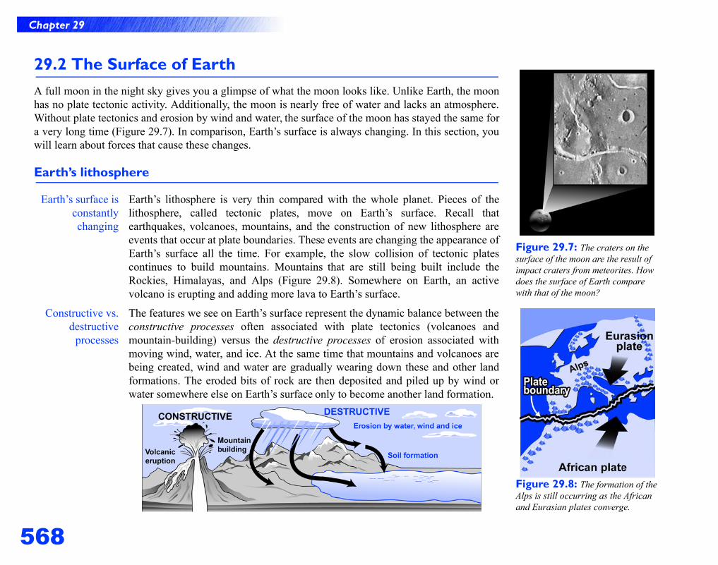
568
Chapter 29
Figure 29.7: The craters on the surface of the moon are the result of impact craters from meteorites. How does the surface of Earth compare with that of the moon?
Figure 29.8: The formation of the Alps is still occurring as the African and Eurasian plates converge.
29.2 The Surface of EarthA full moon in the night sky gives you a glimpse of what the moon looks like. Unlike Earth, the moonhas no plate tectonic activity. Additionally, the moon is nearly free of water and lacks an atmosphere.Without plate tectonics and erosion by wind and water, the surface of the moon has stayed the same fora very long time (Figure 29.7). In comparison, Earth’s surface is always changing. In this section, youwill learn about forces that cause these changes.
Earth’s lithosphere
Earth’s surface isconstantlychanging
Earth’s lithosphere is very thin compared with the whole planet. Pieces of thelithosphere, called tectonic plates, move on Earth’s surface. Recall thatearthquakes, volcanoes, mountains, and the construction of new lithosphere areevents that occur at plate boundaries. These events are changing the appearance ofEarth’s surface all the time. For example, the slow collision of tectonic platescontinues to build mountains. Mountains that are still being built include theRockies, Himalayas, and Alps (Figure 29.8). Somewhere on Earth, an activevolcano is erupting and adding more lava to Earth’s surface.
Constructive vs.destructive
processes
The features we see on Earth’s surface represent the dynamic balance between theconstructive processes often associated with plate tectonics (volcanoes andmountain-building) versus the destructive processes of erosion associated withmoving wind, water, and ice. At the same time that mountains and volcanoes arebeing created, wind and water are gradually wearing down these and other landformations. The eroded bits of rock are then deposited and piled up by wind orwater somewhere else on Earth’s surface only to become another land formation.
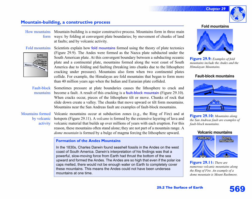
569
Chapter 29
29.2 The Surface of Earth
Mountain-building, a constructive process
How mountainsform
Mountain-building is a major constructive process. Mountains form in three mainways: by folding at convergent plate boundaries; by movement of chunks of landat faults; and by volcanic activity.
Fold mountains Scientists explain how fold mountains formed using the theory of plate tectonics(Figure 29.9). The Andes were formed as the Nazca plate subducted under theSouth American plate. At this convergent boundary between a subducting oceanicplate and a continental plate, mountains formed along the west coast of SouthAmerica due to folding and faulting (breaking into chunks due to the lithospherecracking under pressure). Mountains also form when two continental platescollide. For example, the Himalayas are fold mountains that began to form morethan 40 million years ago when the Indian and Eurasian plate collided.
Fault-blockmountains
Sometimes pressure at plate boundaries causes the lithosphere to crack andbecome a fault. A result of this cracking is a fault-block mountain (Figure 29.10).When cracks occur, pieces of the lithosphere tilt or move. Chunks of rock thatslide down create a valley. The chunks that move upward or tilt form mountains.Mountains near the San Andreas fault are examples of fault-block mountains.
Mountains formedby volcanic
activity
Volcanic mountains occur at subduction zones (e.g., the Ring of Fire) and athotspots (Figure 29.11). A volcano is formed by the extensive layering of lava andvolcanic material that builds up over millions of years with each eruption. For thisreason, these mountains often stand alone; they are not part of a mountain range. Adome mountain is formed by a bulge of magma forcing the lithosphere upward.
Formation of the Andes Mountains
In the 1830s, Charles Darwin found seashell fossils in the Andes on the west coast of South America. Darwin’s interpretation of his findings was that a powerful, slow-moving force from Earth had thrust the bottom of the sea upward and formed the Andes. The Andes are so high that even if the polar ice caps melted, there would not be enough water on Earth to completely cover these mountains. This means the Andes could not have been undersea mountains at one time.
Figure 29.9: Examples of fold mountains include the Andes and the Himalayan Mountains.
Figure 29.10: Mountains along the San Andreas fault are examples of fault-block mountains.
Figure 29.11: There are numerous volcanic mountains along the Ring of Fire. An example of a dome mountain is Mount Rushmore.
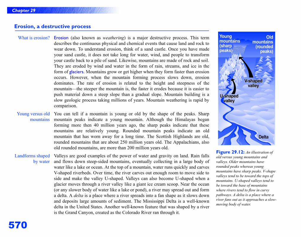
570
Chapter 29
Erosion, a destructive process
What is erosion? Erosion (also known as weathering) is a major destructive process. This termdescribes the continuous physical and chemical events that cause land and rock towear down. To understand erosion, think of a sand castle. Once you have madeyour sand castle, it does not take long for water, wind, and people to transformyour castle back to a pile of sand. Likewise, mountains are made of rock and soil.They are eroded by wind and water in the form of rain, streams, and ice in theform of glaciers. Mountains grow or get higher when they form faster than erosionoccurs. However, when the mountain forming process slows down, erosiondominates. The rate of erosion is related to the height and steepness of themountain—the steeper the mountain is, the faster it erodes because it is easier topush material down a steep slope than a gradual slope. Mountain building is aslow geologic process taking millions of years. Mountain weathering is rapid bycomparison.
Young versus oldmountains
You can tell if a mountain is young or old by the shape of the peaks. Sharpmountain peaks indicate a young mountain. Although the Himalayas beganforming more then 40 million years ago, the sharp peaks indicate that thesemountains are relatively young. Rounded mountain peaks indicate an oldmountain that has worn away for a long time. The Scottish Highlands are old,rounded mountains that are about 250 million years old. The Appalachians, alsoold rounded mountains, are more than 200 million years old.
Landforms shapedby water
Valleys are good examples of the power of water and gravity on land. Rain fallsand flows down steep-sided mountains, eventually collecting in a large body ofwater like a lake or ocean. At the top of a mountain, water runs quickly and carvesV-shaped riverbeds. Over time, the river carves out enough room to move side toside and make the valley U-shaped. Valleys can also become U-shaped when aglacier moves through a river valley like a giant ice cream scoop. Near the ocean(or any slower body of water like a lake or pond), a river may spread out and forma delta. A delta is a place where a river spreads into a fan shape as it slows downand deposits large amounts of sediment. The Mississippi Delta is a well-knowndelta in the United States. Another well-known feature that was shaped by a riveris the Grand Canyon, created as the Colorado River ran through it.
Figure 29.12: An illustration of old versus young mountains and valleys. Older mountains have rounded peaks whereas young mountains have sharp peaks. V-shape valleys tend to be toward the tops of mountains. U-shaped valleys tend to be toward the base of mountains where rivers tend to flow in curvy pathways. A delta is a place where a river fans out as it approaches a slow-moving body of water.
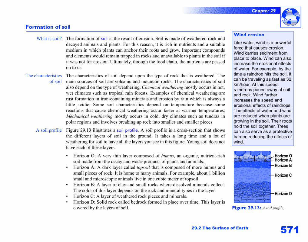
571
Chapter 29
29.2 The Surface of Earth
Formation of soil
What is soil? The formation of soil is the result of erosion. Soil is made of weathered rock anddecayed animals and plants. For this reason, it is rich in nutrients and a suitablemedium in which plants can anchor their roots and grow. Important compoundsand elements would remain trapped in rocks and unavailable to plants in the soil ifit was not for erosion. Ultimately, through the food chain, the nutrients are passedon to us.
The characteristicsof soil
The characteristics of soil depend upon the type of rock that is weathered. Themain sources of soil are volcanic and mountain rocks. The characteristics of soilalso depend on the type of weathering. Chemical weathering mostly occurs in hot,wet climates such as tropical rain forests. Examples of chemical weathering arerust formation in iron-containing minerals and erosion by rain which is always alittle acidic. Some soil characteristics depend on temperature because somereactions that cause chemical weathering occur faster at warmer temperatures.Mechanical weathering mostly occurs in cold, dry climates such as tundras inpolar regions and involves breaking up rock into smaller and smaller pieces.
A soil profile Figure 29.13 illustrates a soil profile. A soil profile is a cross-section that showsthe different layers of soil in the ground. It takes a long time and a lot ofweathering for soil to have all the layers you see in this figure. Young soil does nothave each of these layers.
• Horizon O: A very thin layer composed of humus, an organic, nutrient-richsoil made from the decay and waste products of plants and animals.
• Horizon A: A dark layer called topsoil that is composed of more humus andsmall pieces of rock. It is home to many animals. For example, about 1 billionsmall and microscopic animals live in one cubic meter of topsoil.
• Horizon B: A layer of clay and small rocks where dissolved minerals collect.The color of this layer depends on the rock and mineral types in the layer.
• Horizon C: A layer of weathered rock pieces and minerals. • Horizon D: Solid rock called bedrock formed in place over time. This layer is
covered by the layers of soil. Figure 29.13: A soil profile.
Wind erosion
Like water, wind is a powerful force that causes erosion. Wind carries sediment from place to place. Wind can also increase the erosional effects of water. For example, by the time a raindrop hits the soil, it can be traveling as fast as 32 km/hour. At this speed, raindrops pound away at soil and rock. Wind further increases the speed and erosional effects of raindrops. The effects of water and wind are reduced when plants are growing in the soil. Their roots hold the soil together. Trees can also serve as a protective barrier, reducing the effects of wind.
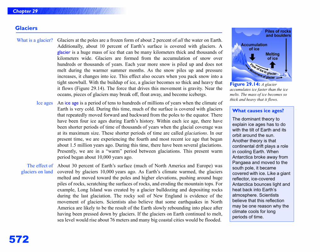
572
Chapter 29
Glaciers
What is a glacier? Glaciers at the poles are a frozen form of about 2 percent of all the water on Earth.Additionally, about 10 percent of Earth’s surface is covered with glaciers. Aglacier is a huge mass of ice that can be many kilometers thick and thousands ofkilometers wide. Glaciers are formed from the accumulation of snow overhundreds or thousands of years. Each year more snow is piled up and does notmelt during the warmer summer months. As the snow piles up and pressureincreases, it changes into ice. This effect also occurs when you pack snow into atight snowball. With the buildup of ice, a glacier becomes so thick and heavy thatit flows (Figure 29.14). The force that drives this movement is gravity. Near theoceans, pieces of glaciers may break off, float away, and become icebergs.
Ice ages An ice age is a period of tens to hundreds of millions of years when the climate ofEarth is very cold. During this time, much of the surface is covered with glaciersthat repeatedly moved forward and backward from the poles to the equator. Therehave been four ice ages during Earth’s history. Within each ice age, there havebeen shorter periods of time of thousands of years when the glacial coverage wasat its maximum size. These shorter periods of time are called glaciations. In ourpresent time, we are experiencing the fourth and most recent ice age that beganabout 1.5 million years ago. During this time, there have been several glaciations.Presently, we are in a “warm” period between glaciations. This present warmperiod began about 10,000 years ago.
The effect ofglaciers on land
About 30 percent of Earth’s surface (much of North America and Europe) wascovered by glaciers 10,000 years ago. As Earth’s climate warmed, the glaciersmelted and moved toward the poles and higher elevations, pushing around hugepiles of rocks, scratching the surfaces of rocks, and eroding the mountain tops. Forexample, Long Island was created by a glacier bulldozing and depositing rocksduring the last glaciation. The rocky soil of New England is evidence of themovement of glaciers. Scientists also believe that some earthquakes in NorthAmerica are likely to be the result of the Earth slowly rebounding into place afterhaving been pressed down by glaciers. If the glaciers on Earth continued to melt,sea level would rise about 76 meters and many big coastal cities would be flooded.
Figure 29.14: A glacier accumulates ice faster than the ice melts. The mass of ice becomes so thick and heavy that it flows.
What causes ice ages?
The dominant theory to explain ice ages has to do with the tilt of Earth and its orbit around the sun. Another theory is that continental drift plays a role in cooling Earth. When Antarctica broke away from Pangaea and moved to the south pole, it became covered with ice. Like a giant reflector, ice-covered Antarctica bounces light and heat back into Earth’s atmosphere. Scientists believe that this reflection may be one reason why the climate cools for long periods of time.
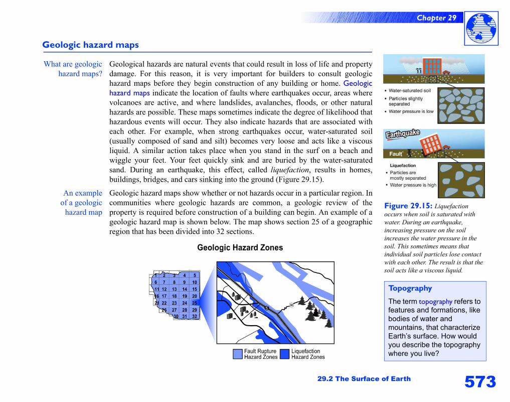
573
Chapter 29
29.2 The Surface of Earth
Geologic hazard maps
What are geologichazard maps?
Geological hazards are natural events that could result in loss of life and propertydamage. For this reason, it is very important for builders to consult geologichazard maps before they begin construction of any building or home. Geologichazard maps indicate the location of faults where earthquakes occur, areas wherevolcanoes are active, and where landslides, avalanches, floods, or other naturalhazards are possible. These maps sometimes indicate the degree of likelihood thathazardous events will occur. They also indicate hazards that are associated witheach other. For example, when strong earthquakes occur, water-saturated soil(usually composed of sand and silt) becomes very loose and acts like a viscousliquid. A similar action takes place when you stand in the surf on a beach andwiggle your feet. Your feet quickly sink and are buried by the water-saturatedsand. During an earthquake, this effect, called liquefaction, results in homes,buildings, bridges, and cars sinking into the ground (Figure 29.15).
An exampleof a geologic
hazard map
Geologic hazard maps show whether or not hazards occur in a particular region. Incommunities where geologic hazards are common, a geologic review of theproperty is required before construction of a building can begin. An example of ageologic hazard map is shown below. The map shows section 25 of a geographicregion that has been divided into 32 sections.
Figure 29.15: Liquefaction occurs when soil is saturated with water. During an earthquake, increasing pressure on the soil increases the water pressure in the soil. This sometimes means that individual soil particles lose contact with each other. The result is that the soil acts like a viscous liquid.
Topography
The term topography refers to features and formations, like bodies of water and mountains, that characterize Earth’s surface. How would you describe the topography where you live?
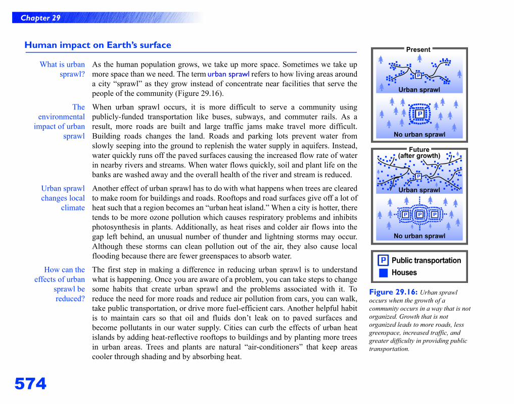
574
Chapter 29
Human impact on Earth’s surface
What is urbansprawl?
As the human population grows, we take up more space. Sometimes we take upmore space than we need. The term urban sprawl refers to how living areas arounda city “sprawl” as they grow instead of concentrate near facilities that serve thepeople of the community (Figure 29.16).
Theenvironmental
impact of urbansprawl
When urban sprawl occurs, it is more difficult to serve a community usingpublicly-funded transportation like buses, subways, and commuter rails. As aresult, more roads are built and large traffic jams make travel more difficult.Building roads changes the land. Roads and parking lots prevent water fromslowly seeping into the ground to replenish the water supply in aquifers. Instead,water quickly runs off the paved surfaces causing the increased flow rate of waterin nearby rivers and streams. When water flows quickly, soil and plant life on thebanks are washed away and the overall health of the river and stream is reduced.
Urban sprawlchanges local
climate
Another effect of urban sprawl has to do with what happens when trees are clearedto make room for buildings and roads. Rooftops and road surfaces give off a lot ofheat such that a region becomes an “urban heat island.” When a city is hotter, theretends to be more ozone pollution which causes respiratory problems and inhibitsphotosynthesis in plants. Additionally, as heat rises and colder air flows into thegap left behind, an unusual number of thunder and lightning storms may occur.Although these storms can clean pollution out of the air, they also cause localflooding because there are fewer greenspaces to absorb water.
How can theeffects of urban
sprawl bereduced?
The first step in making a difference in reducing urban sprawl is to understandwhat is happening. Once you are aware of a problem, you can take steps to changesome habits that create urban sprawl and the problems associated with it. Toreduce the need for more roads and reduce air pollution from cars, you can walk,take public transportation, or drive more fuel-efficient cars. Another helpful habitis to maintain cars so that oil and fluids don’t leak on to paved surfaces andbecome pollutants in our water supply. Cities can curb the effects of urban heatislands by adding heat-reflective rooftops to buildings and by planting more treesin urban areas. Trees and plants are natural “air-conditioners” that keep areascooler through shading and by absorbing heat.
Figure 29.16: Urban sprawl occurs when the growth of a community occurs in a way that is not organized. Growth that is not organized leads to more roads, less greenspace, increased traffic, and greater difficulty in providing public transportation.
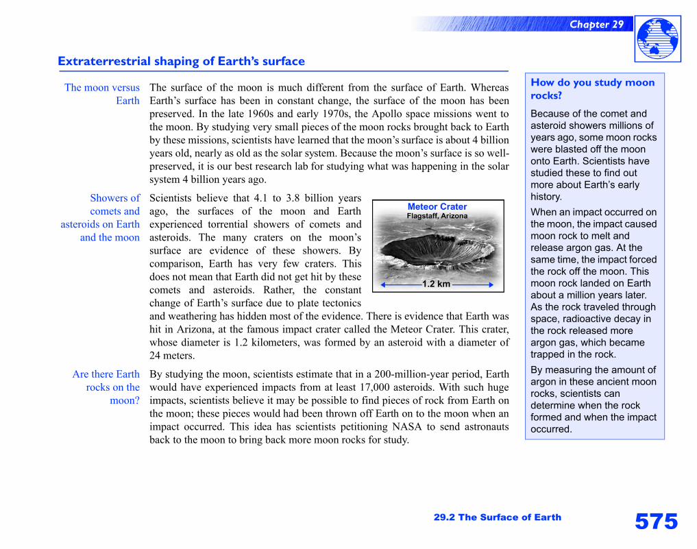
575
Chapter 29
29.2 The Surface of Earth
Extraterrestrial shaping of Earth’s surface
The moon versusEarth
The surface of the moon is much different from the surface of Earth. WhereasEarth’s surface has been in constant change, the surface of the moon has beenpreserved. In the late 1960s and early 1970s, the Apollo space missions went tothe moon. By studying very small pieces of the moon rocks brought back to Earthby these missions, scientists have learned that the moon’s surface is about 4 billionyears old, nearly as old as the solar system. Because the moon’s surface is so well-preserved, it is our best research lab for studying what was happening in the solarsystem 4 billion years ago.
Showers ofcomets and
asteroids on Earthand the moon
Scientists believe that 4.1 to 3.8 billion yearsago, the surfaces of the moon and Earthexperienced torrential showers of comets andasteroids. The many craters on the moon’ssurface are evidence of these showers. Bycomparison, Earth has very few craters. Thisdoes not mean that Earth did not get hit by thesecomets and asteroids. Rather, the constantchange of Earth’s surface due to plate tectonicsand weathering has hidden most of the evidence. There is evidence that Earth washit in Arizona, at the famous impact crater called the Meteor Crater. This crater,whose diameter is 1.2 kilometers, was formed by an asteroid with a diameter of24 meters.
Are there Earthrocks on the
moon?
By studying the moon, scientists estimate that in a 200-million-year period, Earthwould have experienced impacts from at least 17,000 asteroids. With such hugeimpacts, scientists believe it may be possible to find pieces of rock from Earth onthe moon; these pieces would had been thrown off Earth on to the moon when animpact occurred. This idea has scientists petitioning NASA to send astronautsback to the moon to bring back more moon rocks for study.
How do you study moon rocks?
Because of the comet and asteroid showers millions of years ago, some moon rocks were blasted off the moon onto Earth. Scientists have studied these to find out more about Earth’s early history.
When an impact occurred on the moon, the impact caused moon rock to melt and release argon gas. At the same time, the impact forced the rock off the moon. This moon rock landed on Earth about a million years later. As the rock traveled through space, radioactive decay in the rock released more argon gas, which became trapped in the rock.
By measuring the amount of argon in these ancient moon rocks, scientists can determine when the rock formed and when the impact occurred.
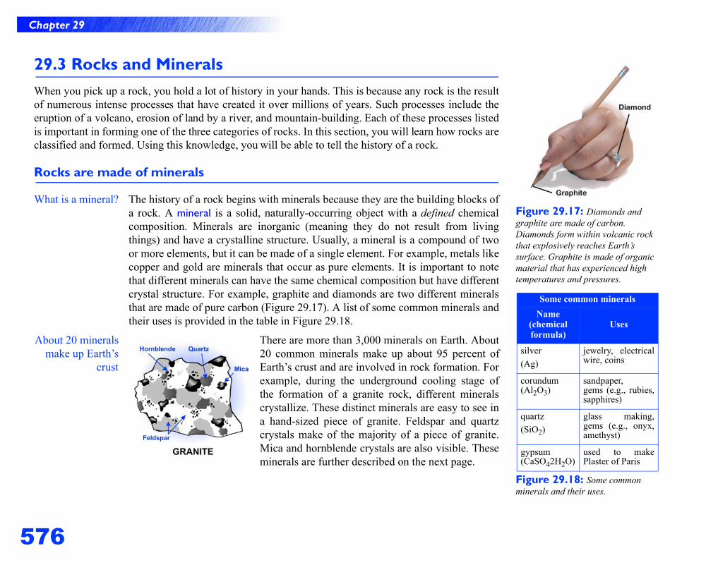
576
Chapter 29
Figure 29.17: Diamonds and graphite are made of carbon. Diamonds form within volcanic rock that explosively reaches Earth’s surface. Graphite is made of organic material that has experienced high temperatures and pressures.
Figure 29.18: Some common minerals and their uses.
Some common mineralsName
(chemical formula)
Uses
silver(Ag)
jewelry, electricalwire, coins
corundum(Al2O3)
sandpaper, gems (e.g., rubies,sapphires)
quartz(SiO2)
glass making,gems (e.g., onyx,amethyst)
gypsum(CaSO42H2O)
used to makePlaster of Paris
29.3 Rocks and MineralsWhen you pick up a rock, you hold a lot of history in your hands. This is because any rock is the resultof numerous intense processes that have created it over millions of years. Such processes include theeruption of a volcano, erosion of land by a river, and mountain-building. Each of these processes listedis important in forming one of the three categories of rocks. In this section, you will learn how rocks areclassified and formed. Using this knowledge, you will be able to tell the history of a rock.
Rocks are made of minerals
What is a mineral? The history of a rock begins with minerals because they are the building blocks ofa rock. A mineral is a solid, naturally-occurring object with a defined chemicalcomposition. Minerals are inorganic (meaning they do not result from livingthings) and have a crystalline structure. Usually, a mineral is a compound of twoor more elements, but it can be made of a single element. For example, metals likecopper and gold are minerals that occur as pure elements. It is important to notethat different minerals can have the same chemical composition but have differentcrystal structure. For example, graphite and diamonds are two different mineralsthat are made of pure carbon (Figure 29.17). A list of some common minerals andtheir uses is provided in the table in Figure 29.18.
About 20 mineralsmake up Earth’s
crust
There are more than 3,000 minerals on Earth. About20 common minerals make up about 95 percent ofEarth’s crust and are involved in rock formation. Forexample, during the underground cooling stage ofthe formation of a granite rock, different mineralscrystallize. These distinct minerals are easy to see ina hand-sized piece of granite. Feldspar and quartzcrystals make of the majority of a piece of granite.Mica and hornblende crystals are also visible. Theseminerals are further described on the next page.
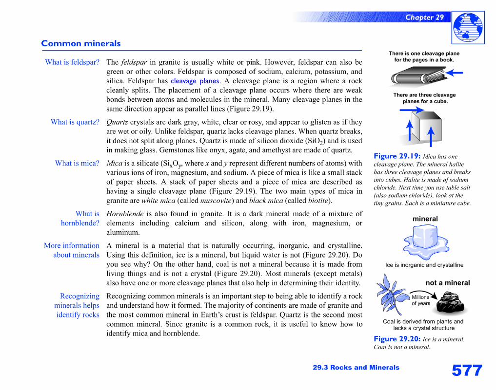
577
Chapter 29
29.3 Rocks and Minerals
Common minerals
What is feldspar? The feldspar in granite is usually white or pink. However, feldspar can also begreen or other colors. Feldspar is composed of sodium, calcium, potassium, andsilica. Feldspar has cleavage planes. A cleavage plane is a region where a rockcleanly splits. The placement of a cleavage plane occurs where there are weakbonds between atoms and molecules in the mineral. Many cleavage planes in thesame direction appear as parallel lines (Figure 29.19).
What is quartz? Quartz crystals are dark gray, white, clear or rosy, and appear to glisten as if theyare wet or oily. Unlike feldspar, quartz lacks cleavage planes. When quartz breaks,it does not split along planes. Quartz is made of silicon dioxide (SiO2) and is usedin making glass. Gemstones like onyx, agate, and amethyst are made of quartz.
What is mica? Mica is a silicate (SixOy, where x and y represent different numbers of atoms) withvarious ions of iron, magnesium, and sodium. A piece of mica is like a small stackof paper sheets. A stack of paper sheets and a piece of mica are described ashaving a single cleavage plane (Figure 29.19). The two main types of mica ingranite are white mica (called muscovite) and black mica (called biotite).
What ishornblende?
Hornblende is also found in granite. It is a dark mineral made of a mixture ofelements including calcium and silicon, along with iron, magnesium, oraluminum.
More informationabout minerals
A mineral is a material that is naturally occurring, inorganic, and crystalline.Using this definition, ice is a mineral, but liquid water is not (Figure 29.20). Doyou see why? On the other hand, coal is not a mineral because it is made fromliving things and is not a crystal (Figure 29.20). Most minerals (except metals)also have one or more cleavage planes that also help in determining their identity.
Recognizingminerals helpsidentify rocks
Recognizing common minerals is an important step to being able to identify a rockand understand how it formed. The majority of continents are made of granite andthe most common mineral in Earth’s crust is feldspar. Quartz is the second mostcommon mineral. Since granite is a common rock, it is useful to know how toidentify mica and hornblende.
Figure 29.19: Mica has one cleavage plane. The mineral halite has three cleavage planes and breaks into cubes. Halite is made of sodium chloride. Next time you use table salt (also sodium chloride), look at the tiny grains. Each is a miniature cube.
Figure 29.20: Ice is a mineral. Coal is not a mineral.

578
Chapter 29
Figure 29.21: The Mohs hardness scale is used to help identify minerals.
Mohs hardness scaleMineral Hardness
talc 1
gypsum 2
calcite 3
fluorite 4
apatite 5
orthoclase 6
quartz 7
topaz 8
corundum 9
diamond 10
Where to go to find out more about rocks
A rock key can help identify a rock by asking a series of questions. Keys also have diagrams or photographs to help you identify rocks. You can find a rock key at your local library. You can also learn about local rocks by contacting your state’s geological survey.
Identifying minerals
Mohs hardnessscale
Mohs hardness scale was developed in 1812 by Friedrick Mohs (an Austrianmineral expert) as a method to identify minerals (Figure 28.2). This scale uses 10common minerals to represent variations in hardness. You can identify a mineral’splace on the hardness scale by whether it can scratch another mineral. Forexample, gypsum (hardness = 2) scratches talc (hardness = 1). The hardestmineral, a diamond, can scratch all other minerals. Minerals of the same hardness(and without impurities) scratch each other.
Common itemstest the hardness
of a mineral
In addition to the minerals listed in Figure 29.21, you can use common items. Forexample, your fingernail, a penny, and glass can be used to test the hardness of amineral. The following scenarios illustrate how to use Mohs hardness scale.
• A fingernail scratches gypsum, but gypsum does not scratch the fingernail.The fingernail is scratched by calcite. What is the hardness of a fingernail?Answer: 2.5
• A penny is scratched by fluorite, but the penny cannot scratch fluorite. Thepenny scratches calcite and calcite scratches the penny. What is a penny’shardness? Answer: 3
• A piece of glass scratches and is scratched by orthoclase (a type of feldspar).The glass scratches apatite. What is the hardness of glass? Answer: 6
Identifying rocks
What is a rock? A rock is a naturally formed solid usually made of one or more minerals.Therefore, being able to recognize common minerals is very useful for identifyinga rock. It is important to note that it can be difficult to identify a rock. Scientistssometimes have to rely on special microscopes to be sure about a rock’s identity.
Use your powersof observation to
identify a rock
Your powers of observation are your best tools for identifying a rock. Askyourself: What does the rock look like? Where was it found? Your answers tothese questions may help you determine if the rock is igneous, sedimentary, ormetamorphic. The terms igneous, sedimentary, and metamorphic refer to how arock was formed. You will learn about these terms on the next page.
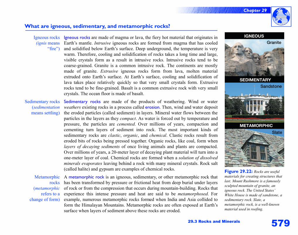
579
Chapter 29
29.3 Rocks and Minerals
What are igneous, sedimentary, and metamorphic rocks?
Igneous rocks(ignis means
“fire”)
Igneous rocks are made of magma or lava, the fiery hot material that originates inEarth’s mantle. Intrusive igneous rocks are formed from magma that has cooledand solidified below Earth’s surface. Deep underground, the temperature is verywarm. Therefore, cooling and solidification of rocks takes a long time and large,visible crystals form as a result in intrusive rocks. Intrusive rocks tend to becoarse-grained. Granite is a common intrusive rock. The continents are mostlymade of granite. Extrusive igneous rocks form from lava, molten materialextruded onto Earth’s surface. At Earth’s surface, cooling and solidification oflava takes place relatively quickly so that very small crystals form. Extrusiverocks tend to be fine-grained. Basalt is a common extrusive rock with very smallcrystals. The ocean floor is made of basalt.
Sedimentary rocks(sedimentationmeans settling)
Sedimentary rocks are made of the products of weathering. Wind or waterweathers existing rocks in a process called erosion. Then, wind and water depositthe eroded particles (called sediment) in layers. Mineral water flows between theparticles in the layers as they compact. As water is forced out by temperature andpressure, the particles are cemented. Over millions of years, compaction andcementing turn layers of sediment into rock. The most important kinds ofsedimentary rocks are clastic, organic, and chemical. Clastic rocks result fromeroded bits of rocks being pressed together. Organic rocks, like coal, form whenlayers of decaying sediments of once living animals and plants are compacted.Over millions of years, a 20-meter layer of decaying plant material will turn into aone-meter layer of coal. Chemical rocks are formed when a solution of dissolvedminerals evaporates leaving behind a rock with many mineral crystals. Rock salt(called halite) and gypsum are examples of chemical rocks.
Metamorphicrocks
(metamorphicrefers to a
change of form)
A metamorphic rock is an igneous, sedimentary, or other metamorphic rock thathas been transformed by pressure or frictional heat from deep burial under layersof rock or from the compression that occurs during mountain-building. Rocks thatexperience this intense pressure and heat are said to be metamorphosed. Forexample, numerous metamorphic rocks formed when India and Asia collided toform the Himalayan Mountains. Metamorphic rocks are often exposed at Earth’ssurface when layers of sediment above these rocks are eroded.
Figure 29.22: Rocks are useful materials for creating structures that last. Mount Rushmore is a famously sculpted mountain of granite, an igneous rock. The United States’ White House is made of sandstone, a sedimentary rock. Slate, a metamorphic rock, is a well-known material used in roofing.
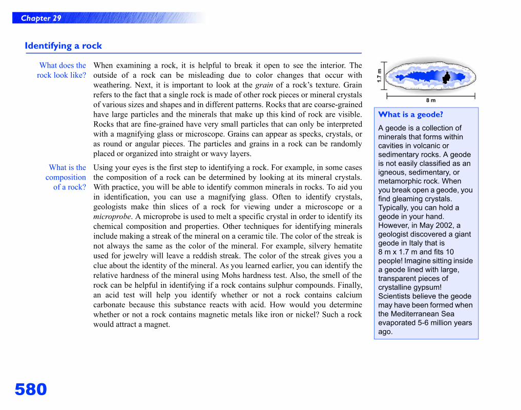
580
Chapter 29
Identifying a rock
What does therock look like?
When examining a rock, it is helpful to break it open to see the interior. Theoutside of a rock can be misleading due to color changes that occur withweathering. Next, it is important to look at the grain of a rock’s texture. Grainrefers to the fact that a single rock is made of other rock pieces or mineral crystalsof various sizes and shapes and in different patterns. Rocks that are coarse-grainedhave large particles and the minerals that make up this kind of rock are visible.Rocks that are fine-grained have very small particles that can only be interpretedwith a magnifying glass or microscope. Grains can appear as specks, crystals, oras round or angular pieces. The particles and grains in a rock can be randomlyplaced or organized into straight or wavy layers.
What is thecomposition
of a rock?
Using your eyes is the first step to identifying a rock. For example, in some casesthe composition of a rock can be determined by looking at its mineral crystals.With practice, you will be able to identify common minerals in rocks. To aid youin identification, you can use a magnifying glass. Often to identify crystals,geologists make thin slices of a rock for viewing under a microscope or amicroprobe. A microprobe is used to melt a specific crystal in order to identify itschemical composition and properties. Other techniques for identifying mineralsinclude making a streak of the mineral on a ceramic tile. The color of the streak isnot always the same as the color of the mineral. For example, silvery hematiteused for jewelry will leave a reddish streak. The color of the streak gives you aclue about the identity of the mineral. As you learned earlier, you can identify therelative hardness of the mineral using Mohs hardness test. Also, the smell of therock can be helpful in identifying if a rock contains sulphur compounds. Finally,an acid test will help you identify whether or not a rock contains calciumcarbonate because this substance reacts with acid. How would you determinewhether or not a rock contains magnetic metals like iron or nickel? Such a rockwould attract a magnet.
What is a geode?
A geode is a collection of minerals that forms within cavities in volcanic or sedimentary rocks. A geode is not easily classified as an igneous, sedimentary, or metamorphic rock. When you break open a geode, you find gleaming crystals. Typically, you can hold a geode in your hand. However, in May 2002, a geologist discovered a giant geode in Italy that is 8 m x 1.7 m and fits 10 people! Imagine sitting inside a geode lined with large, transparent pieces of crystalline gypsum! Scientists believe the geode may have been formed when the Mediterranean Sea evaporated 5-6 million years ago.
581
Chapter 29
29.3 Rocks and Minerals
Identifying igneous, sedimentary, or metamorphic rocks
How do you tellif a rock is
igneous?
Igneous rocks can often be identified by their texture. For example, igneous rockshave crystals that intersect at angles. However, the grain in these rocks usuallydoes not have a pattern or a uniform orientation of crystals. The size of the grainsdepends on how fast the rock cooled during its formation. Some igneous rocks areglassy (very fine-grained) because they cooled quickly. Basalt is a fine-grainedrock. An example of a slow-cooling igneous rock with large, easy-to-see grains, isgranite. Granitic rocks are easy to find in mountainous regions where they havebeen exposed due to weathering. In flatter regions, this intrusive igneous rock isoften buried by sediments. Mount Rushmore in South Dakota is made of granite.
How do you tellif a rock is
sedimentary?
Sedimentary rocks often appear to have layers of rock pieces. Because the piecestend to sort by size, a sedimentary rock tends to have same sized pieces or thesame sized particles are organized into layers. The boundaries between pieces in asedimentary rock are not well-defined. Sedimentary rocks are often found in areaswhere sediment gets deposited. Sedimentary rocks with large pieces tend to formin high-energy environments, like the bed of a fast-moving river (conglomeraterock). Sedimentary rocks with small pieces form in low energy environments likea pond, lake, or the ocean floor (shale). Sedimentary rocks are common and easilyseen in the mid- and southwestern United States. For example, the Grand Canyonis a giant land formation made of layers of sedimentary rock that have beenexposed by weathering.
How do you tellif a rock is
metamorphic?
The grains in metamorphic rocks tend to orient themselves based on how the rockwas metamorphosed. Rocks that are modified by pressure have grains oriented inlines. An example of this kind of metamorphic rock is slate formed from shale (asedimentary rock). Rocks that are modified by pressure and heat have grainsoriented in foliations (wavy patterns). These rocks appear layered or foliated.Examples of foliated rocks are gneiss formed from granite. Examples ofnonfoliated rock include some types of marble formed from limestone.Metamorphic rocks tend to be the hardest and most weather-resistant rock of thethree kinds. These rocks are often associated with mountains because thepressures that arise from mountain-building cause the formation of these rocks.
The history of a rock
Marble is a weather-resistant,crystalline rock often used bysculptors. How is marble formed?
Marble is a metamorphic rock that originates as limestone. It is thousands or millions of years old. Limestone, a sedimentary rock, was formed on the bottom of the ocean. As tiny marine creatures died, their calcium carbonate shells rained down on the ocean floor and became sediments called ooze. In ancient times, compaction and cementing hardened the ooze to limestone and preserved these tiny fossils. The limestone was raised as mountains formed. The heat and pressure created by this movement caused some rock to metamorphose into marble. The green or grey streaks in marble are the result of compounds in the limestone being forced out during metamorphosis.
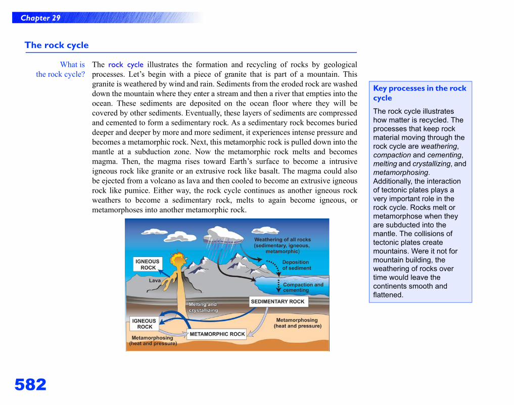
582
Chapter 29
The rock cycle
What isthe rock cycle?
The rock cycle illustrates the formation and recycling of rocks by geologicalprocesses. Let’s begin with a piece of granite that is part of a mountain. Thisgranite is weathered by wind and rain. Sediments from the eroded rock are washeddown the mountain where they enter a stream and then a river that empties into theocean. These sediments are deposited on the ocean floor where they will becovered by other sediments. Eventually, these layers of sediments are compressedand cemented to form a sedimentary rock. As a sedimentary rock becomes burieddeeper and deeper by more and more sediment, it experiences intense pressure andbecomes a metamorphic rock. Next, this metamorphic rock is pulled down into themantle at a subduction zone. Now the metamorphic rock melts and becomesmagma. Then, the magma rises toward Earth’s surface to become a intrusiveigneous rock like granite or an extrusive rock like basalt. The magma could alsobe ejected from a volcano as lava and then cooled to become an extrusive igneousrock like pumice. Either way, the rock cycle continues as another igneous rockweathers to become a sedimentary rock, melts to again become igneous, ormetamorphoses into another metamorphic rock.
Key processes in the rock cycle
The rock cycle illustrates how matter is recycled. The processes that keep rock material moving through the rock cycle are weathering, compaction and cementing, melting and crystallizing, and metamorphosing. Additionally, the interaction of tectonic plates plays a very important role in the rock cycle. Rocks melt or metamorphose when they are subducted into the mantle. The collisions of tectonic plates create mountains. Were it not for mountain building, the weathering of rocks over time would leave the continents smooth and flattened.
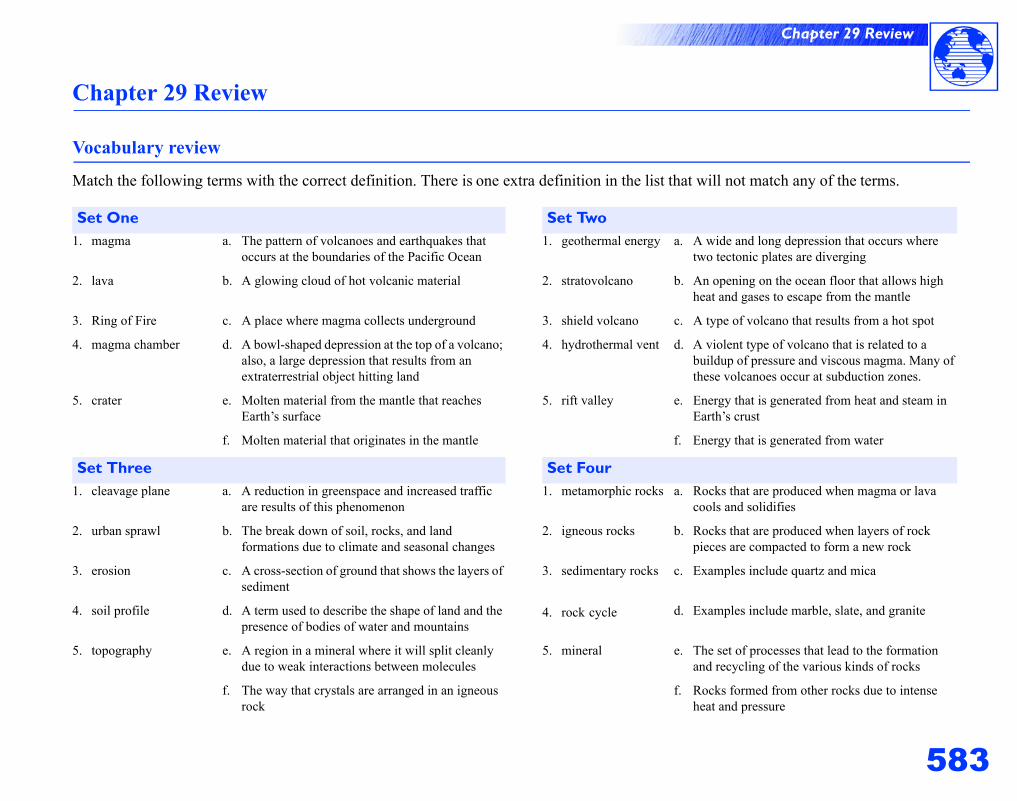
583
Chapter 29 Review
Chapter 29 Review
Vocabulary review
Match the following terms with the correct definition. There is one extra definition in the list that will not match any of the terms.
Set One Set Two1. magma a. The pattern of volcanoes and earthquakes that
occurs at the boundaries of the Pacific Ocean1. geothermal energy a. A wide and long depression that occurs where
two tectonic plates are diverging
2. lava b. A glowing cloud of hot volcanic material 2. stratovolcano b. An opening on the ocean floor that allows high heat and gases to escape from the mantle
3. Ring of Fire c. A place where magma collects underground 3. shield volcano c. A type of volcano that results from a hot spot
4. magma chamber d. A bowl-shaped depression at the top of a volcano; also, a large depression that results from an extraterrestrial object hitting land
4. hydrothermal vent d. A violent type of volcano that is related to a buildup of pressure and viscous magma. Many of these volcanoes occur at subduction zones.
5. crater e. Molten material from the mantle that reaches Earth’s surface
5. rift valley e. Energy that is generated from heat and steam in Earth’s crust
f. Molten material that originates in the mantle f. Energy that is generated from water
Set Three Set Four1. cleavage plane a. A reduction in greenspace and increased traffic
are results of this phenomenon1. metamorphic rocks a. Rocks that are produced when magma or lava
cools and solidifies
2. urban sprawl b. The break down of soil, rocks, and land formations due to climate and seasonal changes
2. igneous rocks b. Rocks that are produced when layers of rock pieces are compacted to form a new rock
3. erosion c. A cross-section of ground that shows the layers of sediment
3. sedimentary rocks c. Examples include quartz and mica
4. soil profile d. A term used to describe the shape of land and the presence of bodies of water and mountains
4. rock cycle d. Examples include marble, slate, and granite
5. topography e. A region in a mineral where it will split cleanly due to weak interactions between molecules
5. mineral e. The set of processes that lead to the formation and recycling of the various kinds of rocks
f. The way that crystals are arranged in an igneous rock
f. Rocks formed from other rocks due to intense heat and pressure
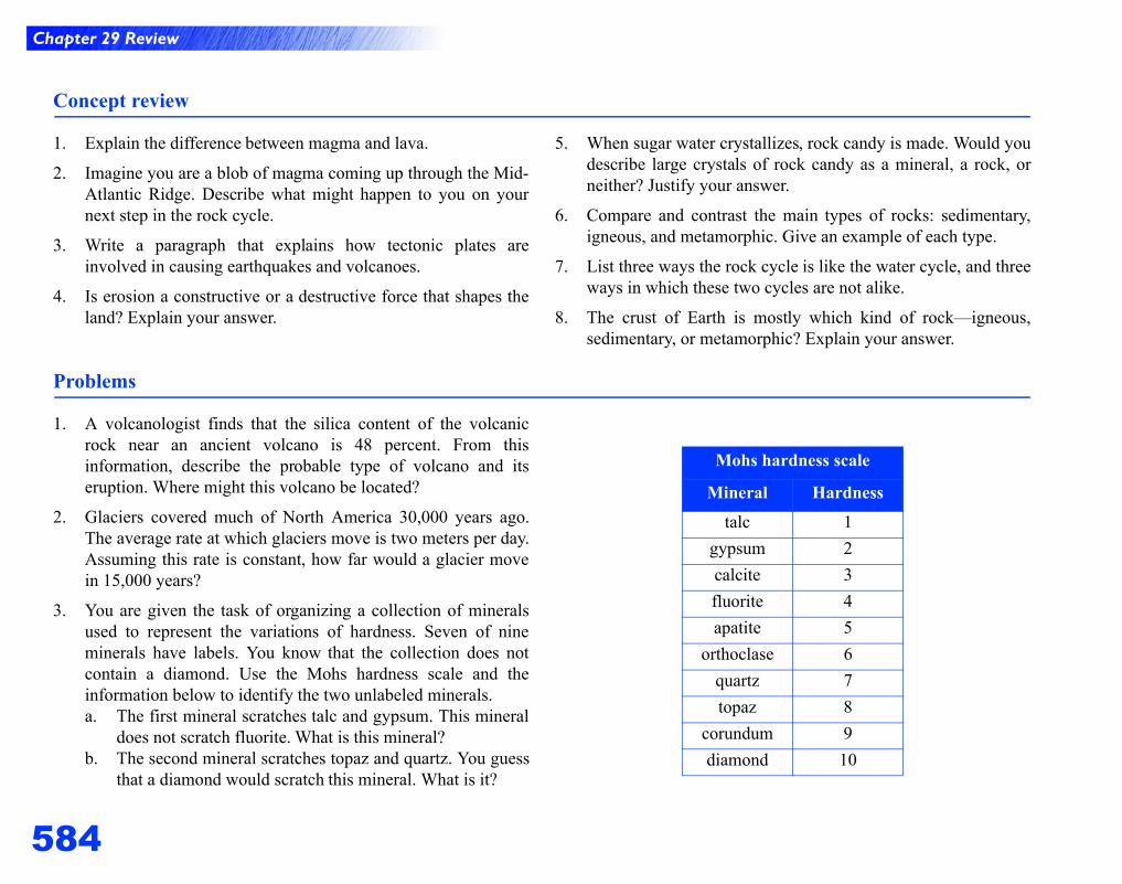
Chapter 29 Review
584
Concept review
1. Explain the difference between magma and lava.
2. Imagine you are a blob of magma coming up through the Mid-Atlantic Ridge. Describe what might happen to you on yournext step in the rock cycle.
3. Write a paragraph that explains how tectonic plates areinvolved in causing earthquakes and volcanoes.
4. Is erosion a constructive or a destructive force that shapes theland? Explain your answer.
5. When sugar water crystallizes, rock candy is made. Would youdescribe large crystals of rock candy as a mineral, a rock, orneither? Justify your answer.
6. Compare and contrast the main types of rocks: sedimentary,igneous, and metamorphic. Give an example of each type.
7. List three ways the rock cycle is like the water cycle, and threeways in which these two cycles are not alike.
8. The crust of Earth is mostly which kind of rock—igneous,sedimentary, or metamorphic? Explain your answer.
Problems
1. A volcanologist finds that the silica content of the volcanicrock near an ancient volcano is 48 percent. From thisinformation, describe the probable type of volcano and itseruption. Where might this volcano be located?
2. Glaciers covered much of North America 30,000 years ago.The average rate at which glaciers move is two meters per day.Assuming this rate is constant, how far would a glacier movein 15,000 years?
3. You are given the task of organizing a collection of mineralsused to represent the variations of hardness. Seven of nineminerals have labels. You know that the collection does notcontain a diamond. Use the Mohs hardness scale and theinformation below to identify the two unlabeled minerals.a. The first mineral scratches talc and gypsum. This mineral
does not scratch fluorite. What is this mineral?b. The second mineral scratches topaz and quartz. You guess
that a diamond would scratch this mineral. What is it?
Mohs hardness scale
Mineral Hardnesstalc 1
gypsum 2calcite 3fluorite 4apatite 5
orthoclase 6quartz 7topaz 8
corundum 9diamond 10
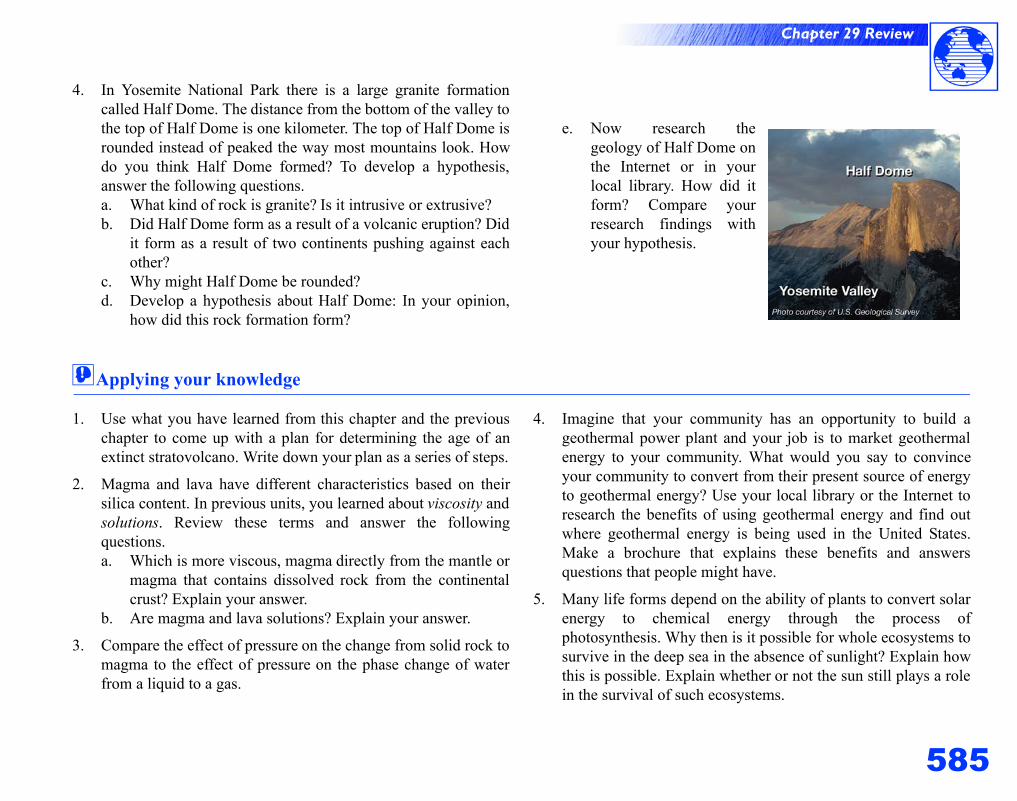
585
Chapter 29 Review
4. In Yosemite National Park there is a large granite formationcalled Half Dome. The distance from the bottom of the valley tothe top of Half Dome is one kilometer. The top of Half Dome isrounded instead of peaked the way most mountains look. Howdo you think Half Dome formed? To develop a hypothesis,answer the following questions.a. What kind of rock is granite? Is it intrusive or extrusive?b. Did Half Dome form as a result of a volcanic eruption? Did
it form as a result of two continents pushing against eachother?
c. Why might Half Dome be rounded?d. Develop a hypothesis about Half Dome: In your opinion,
how did this rock formation form?
e. Now research thegeology of Half Dome onthe Internet or in yourlocal library. How did itform? Compare yourresearch findings withyour hypothesis.
!Applying your knowledge
1. Use what you have learned from this chapter and the previouschapter to come up with a plan for determining the age of anextinct stratovolcano. Write down your plan as a series of steps.
2. Magma and lava have different characteristics based on theirsilica content. In previous units, you learned about viscosity andsolutions. Review these terms and answer the followingquestions.a. Which is more viscous, magma directly from the mantle or
magma that contains dissolved rock from the continentalcrust? Explain your answer.
b. Are magma and lava solutions? Explain your answer.
3. Compare the effect of pressure on the change from solid rock tomagma to the effect of pressure on the phase change of waterfrom a liquid to a gas.
4. Imagine that your community has an opportunity to build ageothermal power plant and your job is to market geothermalenergy to your community. What would you say to convinceyour community to convert from their present source of energyto geothermal energy? Use your local library or the Internet toresearch the benefits of using geothermal energy and find outwhere geothermal energy is being used in the United States.Make a brochure that explains these benefits and answersquestions that people might have.
5. Many life forms depend on the ability of plants to convert solarenergy to chemical energy through the process ofphotosynthesis. Why then is it possible for whole ecosystems tosurvive in the deep sea in the absence of sunlight? Explain howthis is possible. Explain whether or not the sun still plays a rolein the survival of such ecosystems.
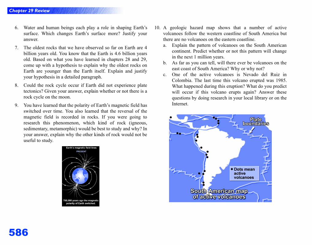
Chapter 29 Review
586
6. Water and human beings each play a role in shaping Earth’ssurface. Which changes Earth’s surface more? Justify youranswer.
7. The oldest rocks that we have observed so far on Earth are 4billion years old. You know that the Earth is 4.6 billion yearsold. Based on what you have learned in chapters 28 and 29,come up with a hypothesis to explain why the oldest rocks onEarth are younger than the Earth itself. Explain and justifyyour hypothesis in a detailed paragraph.
8. Could the rock cycle occur if Earth did not experience platetectonics? Given your answer, explain whether or not there is arock cycle on the moon.
9. You have learned that the polarity of Earth’s magnetic field hasswitched over time. You also learned that the reversal of themagnetic field is recorded in rocks. If you were going toresearch this phenomenon, which kind of rock (igneous,sedimentary, metamorphic) would be best to study and why? Inyour answer, explain why the other kinds of rock would not beuseful to study.
10. A geologic hazard map shows that a number of activevolcanoes follow the western coastline of South America butthere are no volcanoes on the eastern coastline.a. Explain the pattern of volcanoes on the South American
continent. Predict whether or not this pattern will changein the next 1 million years.
b. As far as you can tell, will there ever be volcanoes on theeast coast of South America? Why or why not?
c. One of the active volcanoes is Nevado del Ruiz inColombia. The last time this volcano erupted was 1985.What happened during this eruption? What do you predictwill occur if this volcano erupts again? Answer thesequestions by doing research in your local library or on theInternet.
Related Documents