CHAPTER 13 Sverdrup Basin Ashton Embry and Benoit Beauchamp Contents 1. Introduction 452 2. Geological Setting 453 3. Depositional and Tectonic History 455 3.1. Phase 1: From mountains to depressions (Early Carboniferous–Early Late Carboniferous) 455 3.2. Phase 2: Repeated quiescence and inversion (Late Carboniferous–Early Permian) 457 3.3. Phase 3: Passive and cold (Middle–Late Permian) 460 3.4. Phase 4: Filling the deep basin (Triassic) 460 3.5. Phase 5: Shallow seas (latest Triassic–earliest Cretaceous) 461 3.6. Phase 6: Rejuvenation (Early Cretaceous–earliest Late Cretaceous) 465 3.7. Phase 7: Quiescence (Late Cretaceous) 466 3.8. Phase 8: Fragmentation and uplift (Paleocene–Eocene) 466 4. Tectonic Episodes 467 5. Economic Geology 467 5.1. Petroleum 467 5.2. Coal 468 6. Summary 469 References 470 Abstract The Sverdrup Basin is located in the Canadian Arctic Islands. It is 1,000 km by 350 km and is filled with up to 13 km of Carboniferous to Paleogene strata. The basin initially developed in Early Carboniferous as a rift basin upon highly deformed Early Paleozoic strata of the Ellesmerian Orogenic Belt. The development of the basin can be broken into eight phases, each being characterized by a distinctive combination of tectonic, depositional and climatic regimes and separated by episodes of widespread uplift and basin reorganization. The Upper Paleozoic strata are up to 5 km thick and are characterized by a distinct shelf to deep basin topography. Carbonate strata dominated the shelf until Middle Permian and were supplanted by siliciclastics and chert in Middle and Late Permian when the climate cooled. Triassic siliciclastics are up to 4 km thick and they filled the deep, central basin by Late Triassic. From latest Triassic to earliest Cretaceous the basin was occupied by shallow siliciclastics shelves and up to 2 km of strata accumulated. Renewed rifting in Early Cretaceous resulted in a thick succession (2 km) of Early Cretaceous non- marine to shallow marine strata with units of basalts in the northeast. Widespread diabase sill and dyke intrusion, likely related to the Alpha Ridge Plume and the opening of the Amerasia Ocean Basin, occurred at this time. Following an interval of low subsidence and low sediment supply in the Late Cretaceous, the basin began to be deformed in earliest Paleocene by the Eurekan Orogeny driven by the counterclockwise rotation of Greenland. Local foreland basins developed and contain up to 3 km of Paleocene–Eocene strata. In Late Eocene the basin was uplifted and deformed by faulting and folding with deformation decreasing southwestwards. Eighteen oil and gas fields have been discovered in Eurekan anticlines and potential prospects include traps associated with Eurekan structures, salt domes, reefs and prominent unconformities. Widespread petroleum source rocks are documented in Middle and Upper Triassic strata and likely occur with other stratigraphic intervals from Carboniferous to Lower Cretaceous. Sedimentary Basins of the World, Volume 5 r 2008 Elsevier B.V. ISSN 1874-5997, DOI 10.1016/S1874-5997(08)00013-0 All rights reserved. 451

Welcome message from author
This document is posted to help you gain knowledge. Please leave a comment to let me know what you think about it! Share it to your friends and learn new things together.
Transcript
C H A P T E R 1 3
Sverdrup Basin
Ashton Embry and Benoit Beauchamp
Contents
1. Introduction 452
2. Geological Setting 453
3. Depositional and Tectonic History 455
3.1. Phase 1: From mountains to depressions (Early Carboniferous–Early Late Carboniferous) 455
3.2. Phase 2: Repeated quiescence and inversion (Late Carboniferous–Early Permian) 457
3.3. Phase 3: Passive and cold (Middle–Late Permian) 460
3.4. Phase 4: Filling the deep basin (Triassic) 460
3.5. Phase 5: Shallow seas (latest Triassic–earliest Cretaceous) 461
3.6. Phase 6: Rejuvenation (Early Cretaceous–earliest Late Cretaceous) 465
3.7. Phase 7: Quiescence (Late Cretaceous) 466
3.8. Phase 8: Fragmentation and uplift (Paleocene–Eocene) 466
4. Tectonic Episodes 467
5. Economic Geology 467
5.1. Petroleum 467
5.2. Coal 468
6. Summary 469
References 470
Abstract
The Sverdrup Basin is located in the Canadian Arctic Islands. It is 1,000 km by 350 km and is filled with up to 13 km of
Carboniferous to Paleogene strata. The basin initially developed in Early Carboniferous as a rift basin upon highly
deformed Early Paleozoic strata of the Ellesmerian Orogenic Belt. The development of the basin can be broken into eight
phases, each being characterized by a distinctive combination of tectonic, depositional and climatic regimes and
separated by episodes of widespread uplift and basin reorganization.
The Upper Paleozoic strata are up to 5 km thick and are characterized by a distinct shelf to deep basin topography.
Carbonate strata dominated the shelf until Middle Permian and were supplanted by siliciclastics and chert in Middle and
Late Permian when the climate cooled. Triassic siliciclastics are up to 4 km thick and they filled the deep, central basin by
Late Triassic.
From latest Triassic to earliest Cretaceous the basin was occupied by shallow siliciclastics shelves and up to 2 km of
strata accumulated. Renewed rifting in Early Cretaceous resulted in a thick succession (2 km) of Early Cretaceous non-
marine to shallow marine strata with units of basalts in the northeast. Widespread diabase sill and dyke intrusion, likely
related to the Alpha Ridge Plume and the opening of the Amerasia Ocean Basin, occurred at this time. Following an
interval of low subsidence and low sediment supply in the Late Cretaceous, the basin began to be deformed in earliest
Paleocene by the Eurekan Orogeny driven by the counterclockwise rotation of Greenland. Local foreland basins developed
and contain up to 3 km of Paleocene–Eocene strata. In Late Eocene the basin was uplifted and deformed by faulting and
folding with deformation decreasing southwestwards.
Eighteen oil and gas fields have been discovered in Eurekan anticlines and potential prospects include traps associated
with Eurekan structures, salt domes, reefs and prominent unconformities. Widespread petroleum source rocks are
documented in Middle and Upper Triassic strata and likely occur with other stratigraphic intervals from Carboniferous to
Lower Cretaceous.
Sedimentary Basins of the World, Volume 5 r 2008 Elsevier B.V.
ISSN 1874-5997, DOI 10.1016/S1874-5997(08)00013-0 All rights reserved.
451
1. Introduction
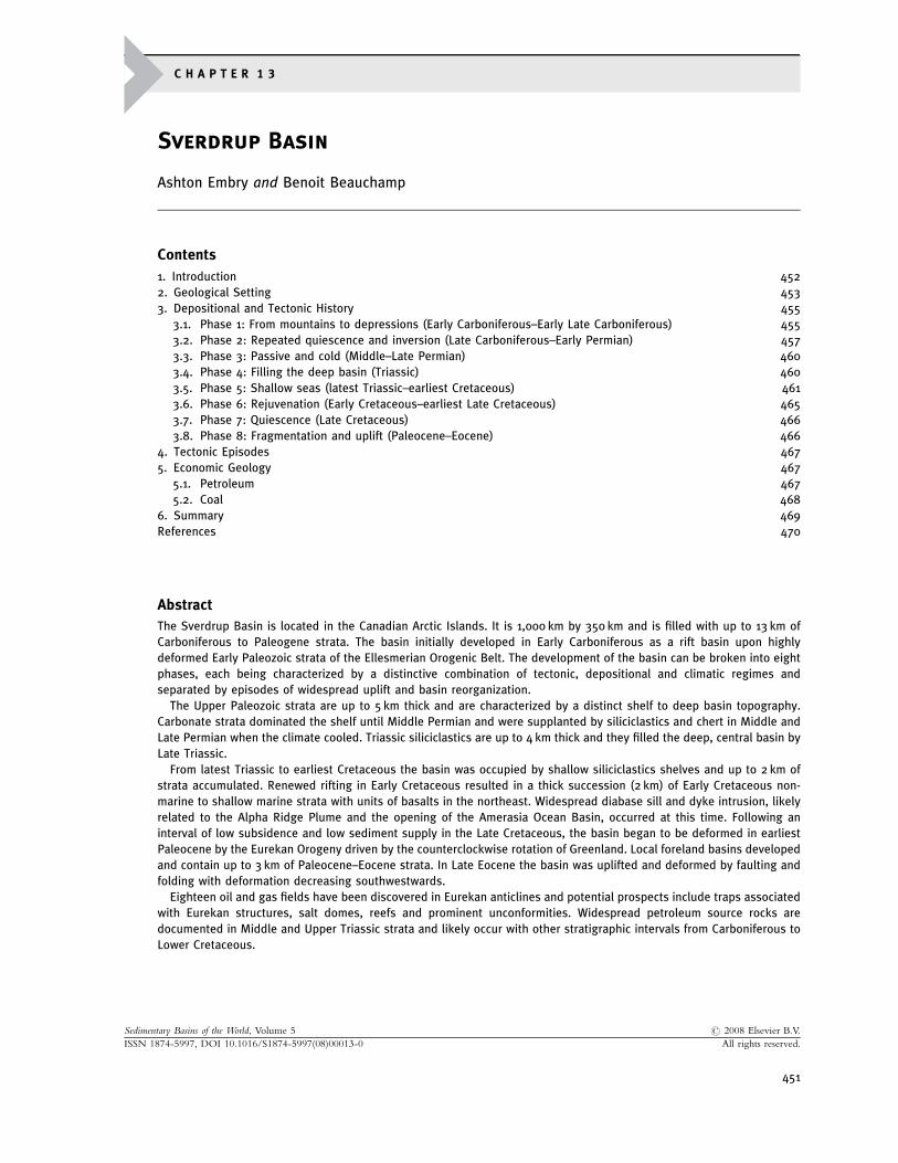
The Sverdrup Basin, a major Carboniferous to Paleogene depocentre in the Canadian Arctic Islands, wasrecognized during Operation Franklin (1955), when the geology of the Arctic Islands was first systematicallystudied by the Geological Survey of Canada (Fortier et al., 1963). The basin occupies much of the QueenElizabeth Islands and stretches for about 1,300 km between northern Ellesmere Island on the northeast and PrincePatrick Island on the southwest. It is up to 350 km across (Figure 1). About half of the 300,000 km2 area of thebasin is land with the remainder being inter-island channels.
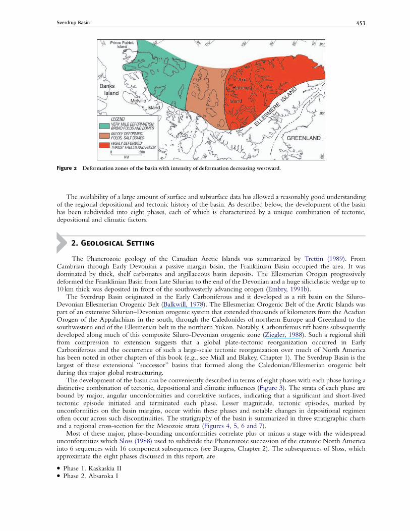
The basin fill consists of Carboniferous to Eocene strata that are estimated to be up to 13 km thick (Balkwill,1978). The eastern portion of the basin was uplifted and deformed in the Late Paleogene and is now amountainous area. To the west, deformation was much less and the topography is subdued (Figure 2). The foldingand thrusting of the eastern portion have deformed the original shape of the basin and palinspastic restorationshave not been attempted.
Officers of the Geological Survey have described the outcropping strata in a series of publications; the pre-1988 results are summarized in the Arctic Islands DNAG volume (Trettin, 1991). Publications such as Harrison(1995), Beauchamp (1995) and Beauchamp et al. (2001) provide recent information on the Late Paleozoicsuccession, building from the pioneering work of Thorsteinsson (1974), Mayr (1992) and Davies and Nassichuk(1991a). Embry (1991a) summarized the stratigraphy and depositional history of the Mesozoic succession.Ricketts (1994) and Ricketts and Stephenson (1994) are the most comprehensive summaries of Tertiarystratigraphy and paleogeographic evolution.
Oil exploration in the basin began in 1968, and between 1969 and 1986 120 wells were drilled into SverdrupBasin strata. Tens of thousands of kilometers of seismic lines were shot in the basin although most of these lineshave not been studied in detail. The exploratory activity resulted in 18 discoveries with natural gas being theprimary hydrocarbon found.
Figure 1 Outline of Sverdrup Basin with basin axis.The black dots represent the120 wells drilled in the basin.The main sourceareas lay to the south and east as indicated by arrows. A low-lying land area to the north (Crockerland) was a relatively minorsource area.TH,Tanquary High.
Ashton Embry and Benoit Beauchamp452
The availability of a large amount of surface and subsurface data has allowed a reasonably good understandingof the regional depositional and tectonic history of the basin. As described below, the development of the basinhas been subdivided into eight phases, each of which is characterized by a unique combination of tectonic,depositional and climatic factors.
2. Geological Setting
The Phanerozoic geology of the Canadian Arctic Islands was summarized by Trettin (1989). FromCambrian through Early Devonian a passive margin basin, the Franklinian Basin occupied the area. It wasdominated by thick, shelf carbonates and argillaceous basin deposits. The Ellesmerian Orogen progressivelydeformed the Franklinian Basin from Late Silurian to the end of the Devonian and a huge siliciclastic wedge up to10 km thick was deposited in front of the southwesterly advancing orogen (Embry, 1991b).
The Sverdrup Basin originated in the Early Carboniferous and it developed as a rift basin on the Siluro-Devonian Ellesmerian Orogenic Belt (Balkwill, 1978). The Ellesmerian Orogenic Belt of the Arctic Islands waspart of an extensive Silurian–Devonian orogenic system that extended thousands of kilometers from the AcadianOrogen of the Appalachians in the south, through the Caledonides of northern Europe and Greenland to thesouthwestern end of the Ellesmerian belt in the northern Yukon. Notably, Carboniferous rift basins subsequentlydeveloped along much of this composite Siluro-Devonian orogenic zone (Ziegler, 1988). Such a regional shiftfrom compression to extension suggests that a global plate-tectonic reorganization occurred in EarlyCarboniferous and the occurrence of such a large-scale tectonic reorganization over much of North Americahas been noted in other chapters of this book (e.g., see Miall and Blakey, Chapter 1). The Sverdrup Basin is thelargest of these extensional ‘‘successor’’ basins that formed along the Caledonian/Ellesmerian orogenic beltduring this major global restructuring.
The development of the basin can be conveniently described in terms of eight phases with each phase having adistinctive combination of tectonic, depositional and climatic influences (Figure 3). The strata of each phase arebound by major, angular unconformities and correlative surfaces, indicating that a significant and short-livedtectonic episode initiated and terminated each phase. Lesser magnitude, tectonic episodes, marked byunconformities on the basin margins, occur within these phases and notable changes in depositional regimenoften occur across such discontinuities. The stratigraphy of the basin is summarized in three stratigraphic chartsand a regional cross-section for the Mesozoic strata (Figures 4, 5, 6 and 7).
Most of these major, phase-bounding unconformities correlate plus or minus a stage with the widespreadunconformities which Sloss (1988) used to subdivide the Phanerozoic succession of the cratonic North Americainto 6 sequences with 16 component subsequences (see Burgess, Chapter 2). The subsequences of Sloss, whichapproximate the eight phases discussed in this report, are
� Phase 1. Kaskaskia II� Phase 2. Absaroka I
Figure 2 Deformation zones of the basin with intensity of deformation decreasing westward.
Sverdrup Basin 453
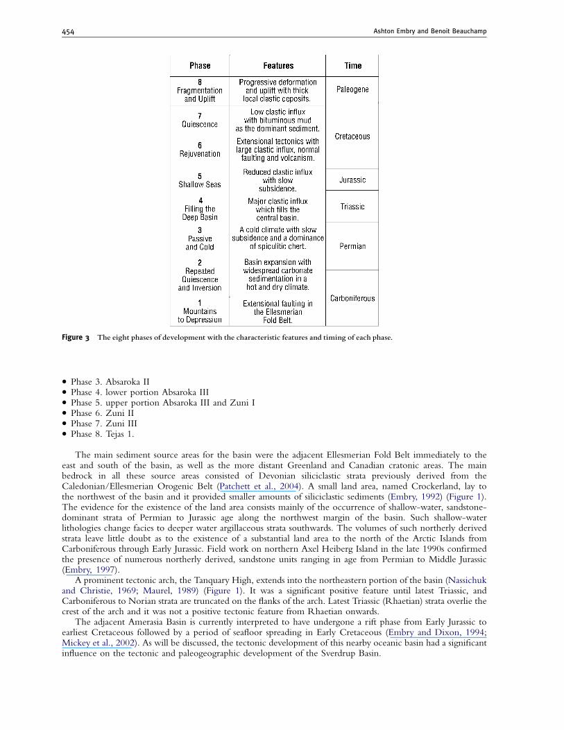
� Phase 3. Absaroka II� Phase 4. lower portion Absaroka III� Phase 5. upper portion Absaroka III and Zuni I� Phase 6. Zuni II� Phase 7. Zuni III� Phase 8. Tejas 1.
The main sediment source areas for the basin were the adjacent Ellesmerian Fold Belt immediately to theeast and south of the basin, as well as the more distant Greenland and Canadian cratonic areas. The mainbedrock in all these source areas consisted of Devonian siliciclastic strata previously derived from theCaledonian/Ellesmerian Orogenic Belt (Patchett et al., 2004). A small land area, named Crockerland, lay tothe northwest of the basin and it provided smaller amounts of siliciclastic sediments (Embry, 1992) (Figure 1).The evidence for the existence of the land area consists mainly of the occurrence of shallow-water, sandstone-dominant strata of Permian to Jurassic age along the northwest margin of the basin. Such shallow-waterlithologies change facies to deeper water argillaceous strata southwards. The volumes of such northerly derivedstrata leave little doubt as to the existence of a substantial land area to the north of the Arctic Islands fromCarboniferous through Early Jurassic. Field work on northern Axel Heiberg Island in the late 1990s confirmedthe presence of numerous northerly derived, sandstone units ranging in age from Permian to Middle Jurassic(Embry, 1997).
A prominent tectonic arch, the Tanquary High, extends into the northeastern portion of the basin (Nassichukand Christie, 1969; Maurel, 1989) (Figure 1). It was a significant positive feature until latest Triassic, andCarboniferous to Norian strata are truncated on the flanks of the arch. Latest Triassic (Rhaetian) strata overlie thecrest of the arch and it was not a positive tectonic feature from Rhaetian onwards.
The adjacent Amerasia Basin is currently interpreted to have undergone a rift phase from Early Jurassic toearliest Cretaceous followed by a period of seafloor spreading in Early Cretaceous (Embry and Dixon, 1994;Mickey et al., 2002). As will be discussed, the tectonic development of this nearby oceanic basin had a significantinfluence on the tectonic and paleogeographic development of the Sverdrup Basin.
Figure 3 The eight phases of development with the characteristic features and timing of each phase.
Ashton Embry and Benoit Beauchamp454
3. Depositional and Tectonic History
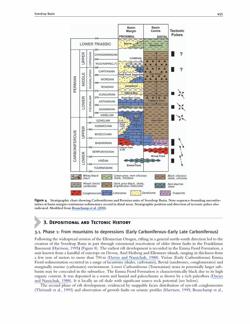
3.1. Phase 1: From mountains to depressions (Early Carboniferous–Early Late Carboniferous)
Following the widespread erosion of the Ellesmerian Orogen, rifting in a general north-south direction led to thecreation of the Sverdrup Basin in part through extensional reactivation of older thrust faults in the FranklinianBasement (Harrison, 1995) (Figure 8). The earliest rift development is recorded in the Emma Fiord Formation, aunit known from a handful of outcrops on Devon, Axel Heiberg and Ellesmere islands, ranging in thickness froma few tens of meters to more than 700m (Davies and Nassichuk, 1988). Visean (Early Carboniferous) EmmaFiord sedimentation occurred in a range of lacustrine (shales, carbonates), fluvial (sandstones, conglomerates) andmarginally marine (carbonates) environment. Lower Carboniferous (Tournaisian) strata in potentially larger sub-basins may be concealed in the subsurface. The Emma Fiord Formation is characteristically black due to its highorganic content. It was deposited in a warm and humid and paleoclimate as shown by a rich palyoflora (Daviesand Nassichuk, 1988). It is locally an oil shale with significant source rock potential (see below).
The second phase of rift development, evidenced by mappable facies distribution of syn-rift conglomerates(Theriault et al., 1993) and observation of growth faults on seismic profiles (Harrison, 1995; Beauchamp et al.,
Figure 4 Stratigraphic chart showing Carboniferous and Permian units of Sverdrup Basin. Note sequence-bounding unconfor-mities at basin margin continuous sedimentary record in distal areas. Stratigraphic position and direction of tectonic pulses alsoindicated. Modi¢ed from Beauchamp et al. (2001).
Sverdrup Basin 455
2001) (Figure 8), led to a significant enlargement of the rift system. This is recorded in the red-colored BorupFiord Formation (Thorsteinsson, 1974), which lies unconformably on Emma Fiord strata, or directly on theFranklinian basement with a profound angular unconformity (Figure 4). A variety of rift-related fluvialenvironments and their deposits are recognized including alluvial fans and braid-plain mass-flow and stream-channel conglomerates with large Franklinian clasts derived from subbasin-bounding highs, to sheetfloodsandstones and mudstones deposited along the axis of tectonic depressions (Theriault et al., 1993). Minorevaporites locally occur, which, in addition to the red coloration and the widespread development of caliches,indicate a shift to a semi-arid climate. Volcanics (Audhild volcanics) locally occur within or immediately abovethe Borup Fiord Formation. The Borup Fiord succession passes upward into a marine limestone of Serpukhovianage (late Early Carboniferous). Shortly thereafter a significant base-level drop, coinciding with the Mississippian–Pennsylvanian boundary (Early–Late Carboniferous boundary), led to widespread erosion of Borup Fiord strataand to the progradation of a wedge of marine sandstone in the distal basin axial areas where it lies in the lowestpart of the Otto Fiord Formation (Mayr, 1992).
The third phase of rifting, also evidenced by growth faults on seismic profiles (Figure 8) (Harrison, 1995;Beauchamp et al., 2001) and the distribution of syn-rift conglomerates and evaporites, occurred during theBashkirian–Early Moscovian interval (Theriault, 1991) and led to both a significant deepening and to a majorenlargement of the Sverdrup Basin tens of kilometers outboard of the initial rift configuration. Fault-controlledsubsidence in the axial area led to the widespread invasion of marine waters resulting in a cyclic succession of
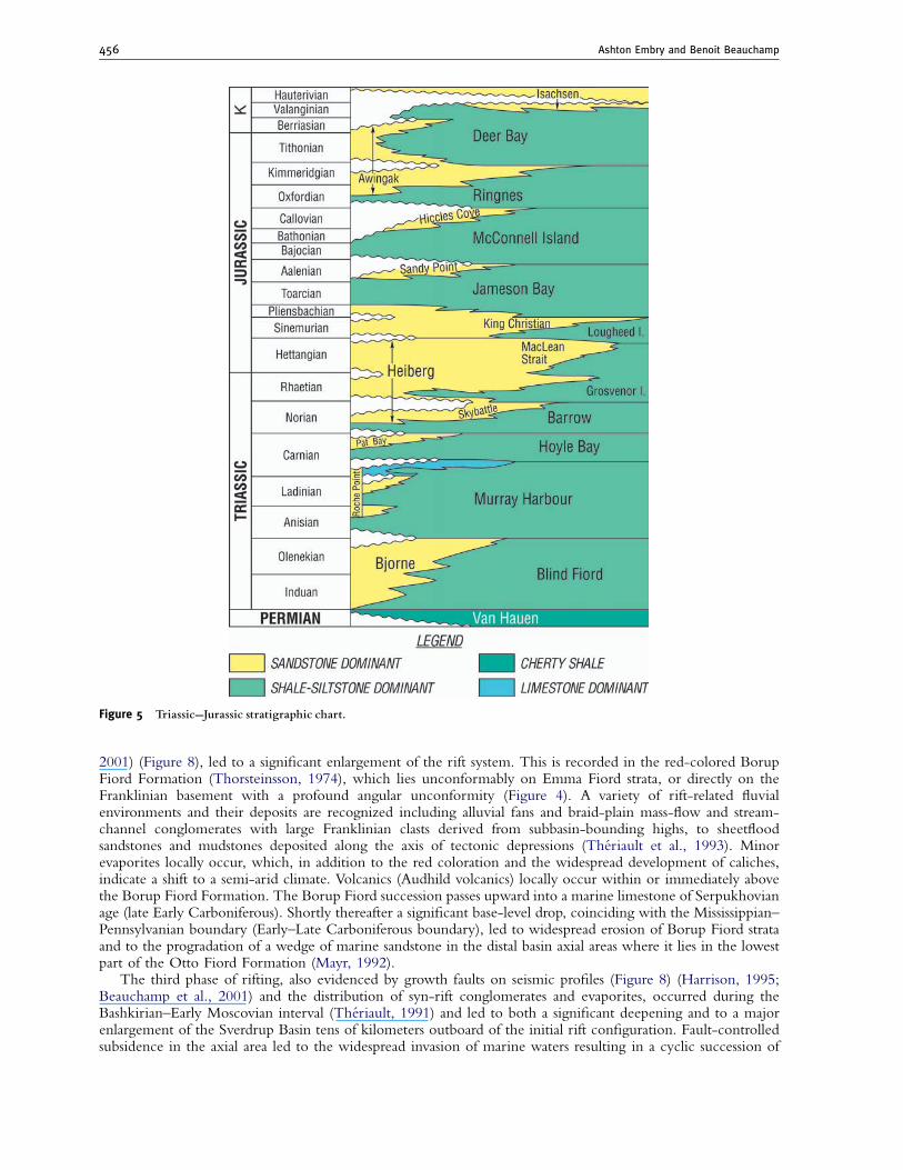
Figure 5 Triassic--Jurassic stratigraphic chart.
Ashton Embry and Benoit Beauchamp456
open to restricted marine carbonates and subaqueous evaporites (gypsum, anhydrite, halite) (Figure 4). Theserocks belong to the Otto Fiord Formation, which is up to 400m thick in the outcrop belt, but a greater thicknesswas probably deposited along the basin axis, as suggested by the occurrence of hundreds of diapiric structurespiercing the overlying succession to the west (Nassichuk and Davies, 1980). Contemporaneous sedimentation atthe basin margin was similar to that of the earlier Borup Fiord Formation: red-colored conglomerates andsandstones of alluvial fan to braided-river origin deposited in a series of fault-bounded tectonic depressions andpassing upward into marginal marine carbonates and rare evaporites. Together, the Otto Fiord Formation and thecorrelative lower Canyon Fiord Formation constitute the transgressive systems track of a broad unconformity-bounded sequence, the maximum flooding surface of which marks the end of orthogonal rifting in the SverdrupBasin (i.e., extension perpendicular to major basement structures) (Beauchamp et al., 2001).
3.2. Phase 2: Repeated quiescence and inversion (Late Carboniferous–Early Permian)
The second phase of basin development was marked by four episodes of tectonic quiescence characterized bypassive and uniform subsidence separated by shorter intervals of regional uplift and fault-controlled differentialsubsidence, during which some of the previously developed half-grabens continued to grow, while others ceasedto be active, and new depressions, fault-bounded highs and broad flexures were developed. This suggests areorganization of tectonic stresses, both in terms of magnitude and orientation, as orthogonal north-south riftingof the previous phase gave way to a more complex history of transtension and transpression along a northwest-southeast principal compressional stress direction, and a secondary northeast-southwest extensional direction(Figure 4), thus oblique to most of the previous rift structures (Beauchamp et al., 2001).
The onset of this second phase was marked by a rapid base-level rise. This event is recorded by the drowningof the entire Sverdrup Basin area, a complete reconnection with the open ocean, a major invasion of the sea tensof kilometers inland (middle limestone member, Canyon Fiord Formation), and the offshore growth of hugekeep-up carbonate reef-mounds (Tellevak member of Hvitland Peninsula Formation), some of which attained
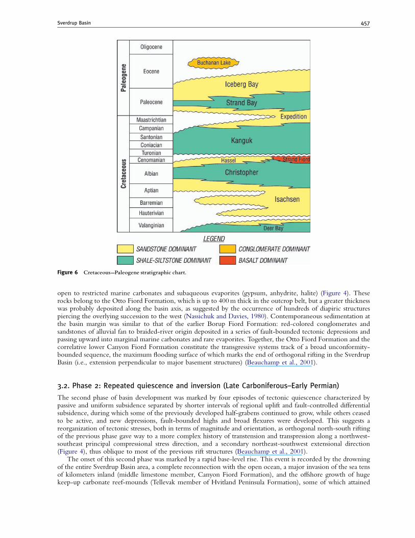
Figure 6 Cretaceous--Paleogene stratigraphic chart.
Sverdrup Basin 457
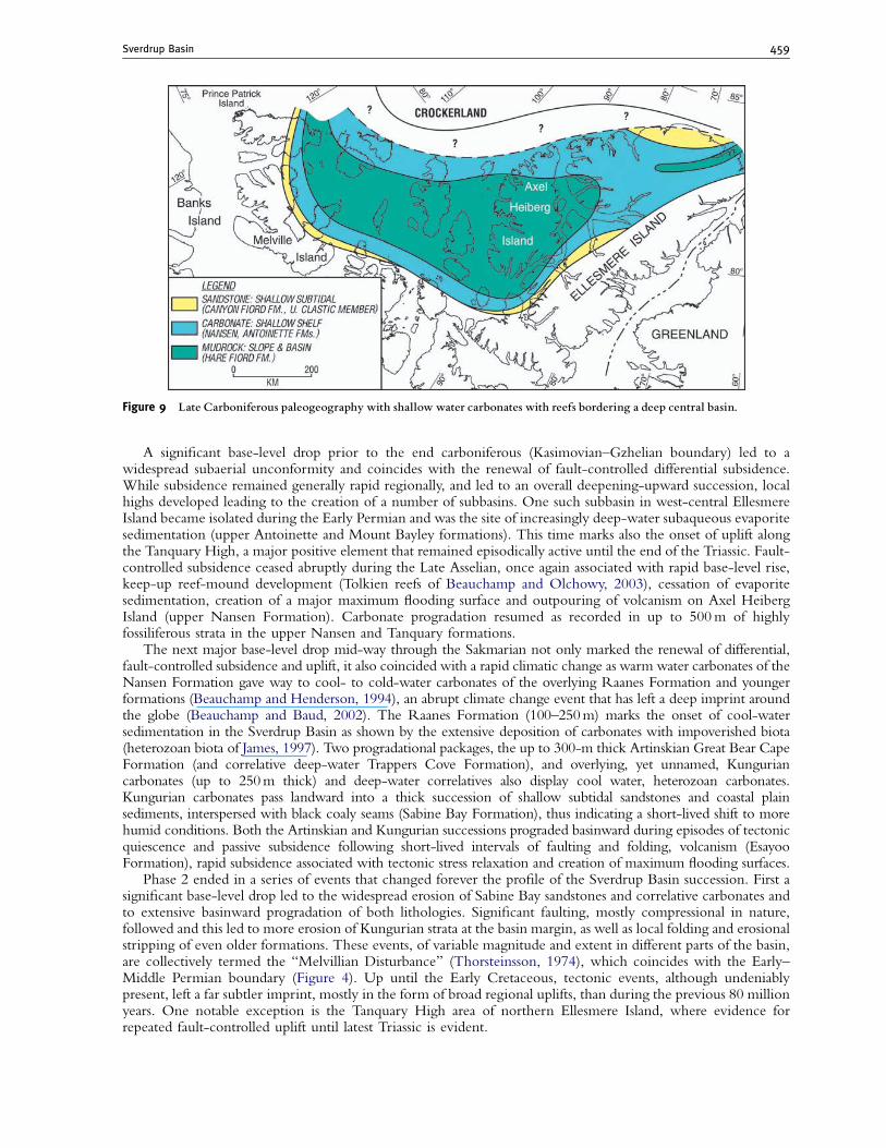
thicknesses of up to 600m before being drowned themselves (Davies and Nassichuk, 1991b). This gain inaccommodation likely resulted from crustal collapse associated with the cessation of rifting and fault-controlledsubsidence. The next 12 million years (Late Moscovian to Kasimovian) were marked by slower, regional, uniformand passive subsidence which allowed a carbonate platform (Nansen Formation) to prograde basinward forsignificant distances. Nansen shelf carbonates are typically arranged in a series of high-frequency sequences, orcyclothems, which may have been controlled by glacio-eustatic fluctuations due to the advance and retreat ofcontemporaneous Gondawana glaciers, as suggested by the occurrence of similar cycles around the world(Heckel, 1986). Nansen carbonates pass landward into basin-fringing sandstones deposited in shallow subtidal tocoastal plain environments (upper clastic member, Canyon Fiord Formation) and basinward into large shelf-edgereefs that are up to 1.5 km thick. Correlative, yet substantially thinner, slope to basinal turbidites and mudrocksare contained in the Hare Fiord Formation (Figure 9). These observations, plus the occurrences of a wide varietyof tropical-like biotic and abiotic carbonate components attest for a warm marine environment (Beauchamp andDesrochers, 1997).
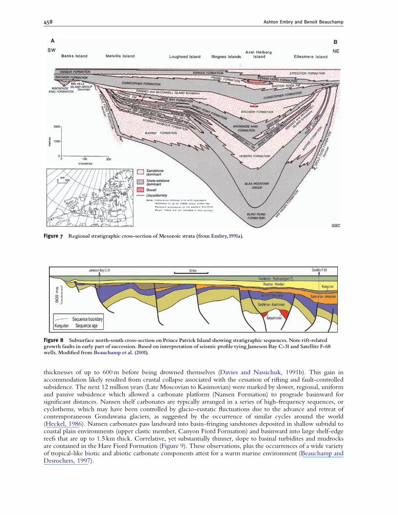
Figure 7 Regional stratigraphic cross-section of Mesozoic strata (from Embry,1991a).
Figure 8 Subsurface north-south cross-section on Prince Patrick Island showing stratigraphic sequences. Note rift-relatedgrowth faults in early part of succession. Based on interpretation of seismic pro¢le tying Jameson Bay C-31 and Satellite F-68wells. Modi¢ed from Beauchamp et al. (2001).
Ashton Embry and Benoit Beauchamp458
A significant base-level drop prior to the end carboniferous (Kasimovian–Gzhelian boundary) led to awidespread subaerial unconformity and coincides with the renewal of fault-controlled differential subsidence.While subsidence remained generally rapid regionally, and led to an overall deepening-upward succession, localhighs developed leading to the creation of a number of subbasins. One such subbasin in west-central EllesmereIsland became isolated during the Early Permian and was the site of increasingly deep-water subaqueous evaporitesedimentation (upper Antoinette and Mount Bayley formations). This time marks also the onset of uplift alongthe Tanquary High, a major positive element that remained episodically active until the end of the Triassic. Fault-controlled subsidence ceased abruptly during the Late Asselian, once again associated with rapid base-level rise,keep-up reef-mound development (Tolkien reefs of Beauchamp and Olchowy, 2003), cessation of evaporitesedimentation, creation of a major maximum flooding surface and outpouring of volcanism on Axel HeibergIsland (upper Nansen Formation). Carbonate progradation resumed as recorded in up to 500m of highlyfossiliferous strata in the upper Nansen and Tanquary formations.
The next major base-level drop mid-way through the Sakmarian not only marked the renewal of differential,fault-controlled subsidence and uplift, it also coincided with a rapid climatic change as warm water carbonates of theNansen Formation gave way to cool- to cold-water carbonates of the overlying Raanes Formation and youngerformations (Beauchamp and Henderson, 1994), an abrupt climate change event that has left a deep imprint aroundthe globe (Beauchamp and Baud, 2002). The Raanes Formation (100–250m) marks the onset of cool-watersedimentation in the Sverdrup Basin as shown by the extensive deposition of carbonates with impoverished biota(heterozoan biota of James, 1997). Two progradational packages, the up to 300-m thick Artinskian Great Bear CapeFormation (and correlative deep-water Trappers Cove Formation), and overlying, yet unnamed, Kunguriancarbonates (up to 250m thick) and deep-water correlatives also display cool water, heterozoan carbonates.Kungurian carbonates pass landward into a thick succession of shallow subtidal sandstones and coastal plainsediments, interspersed with black coaly seams (Sabine Bay Formation), thus indicating a short-lived shift to morehumid conditions. Both the Artinskian and Kungurian successions prograded basinward during episodes of tectonicquiescence and passive subsidence following short-lived intervals of faulting and folding, volcanism (EsayooFormation), rapid subsidence associated with tectonic stress relaxation and creation of maximum flooding surfaces.
Phase 2 ended in a series of events that changed forever the profile of the Sverdrup Basin succession. First asignificant base-level drop led to the widespread erosion of Sabine Bay sandstones and correlative carbonates andto extensive basinward progradation of both lithologies. Significant faulting, mostly compressional in nature,followed and this led to more erosion of Kungurian strata at the basin margin, as well as local folding and erosionalstripping of even older formations. These events, of variable magnitude and extent in different parts of the basin,are collectively termed the ‘‘Melvillian Disturbance’’ (Thorsteinsson, 1974), which coincides with the Early–Middle Permian boundary (Figure 4). Up until the Early Cretaceous, tectonic events, although undeniablypresent, left a far subtler imprint, mostly in the form of broad regional uplifts, than during the previous 80 millionyears. One notable exception is the Tanquary High area of northern Ellesmere Island, where evidence forrepeated fault-controlled uplift until latest Triassic is evident.
Figure 9 Late Carboniferous paleogeography with shallow water carbonates with reefs bordering a deep central basin.
Sverdrup Basin 459
3.3. Phase 3: Passive and cold (Middle–Late Permian)
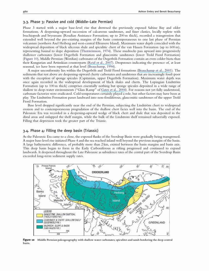
Phase 3 started with a major base-level rise that drowned the previously exposed Sabine Bay and olderformations. A deepening-upward succession of calcareous sandstones, and finer clastics, locally replete withbrachiopods and bryozoans (Roadian Assistance Formation; up to 200m thick), recorded a transgression thatextended well beyond the pre-existing margins of the basin contemporaneous to one last phase of Permianvolcanism (northern Axel Heiberg and west-central Ellesmere Island). Maximum water depth coincided with thewidespread deposition of black siliceous shale and spiculitic chert of the van Hauen Formation (up to 600m),representing basinal to slope deposition (Thorsteinsson, 1974). These mudrocks pass upward into progressivelyshallower carbonates (lower Degerbols Formation and glauconitic sandstones (lower Trold Fiord Formation)(Figure 10), Middle Permian (Wordian) carbonates of the Degerbols Formation contain an even colder biota thantheir Kungurian and Artinskian counterparts (Reid et al., 2007). Dropstones indicating the presence of, at leastseasonal, ice have been reported at that level (Beauchamp, 1994).
A major unconformity lies within the Degerbols and Trold Fiord formations (Beauchamp et al., 2001). Thesediments that rest above are deepening-upward cherty carbonates and sandstones that are increasingly fossil-poorwith the exception of sponge spicules (Capitanian, upper Degerbols Formation). Maximum water depth wasonce again recorded in the widespread development of black shales and cherts. The Lopingian LindstromFormation (up to 100m thick) comprises essentially nothing but sponge spicules deposited in a wide range ofshallow to deep-water environments (‘‘Glass Ramp’’ of Gates et al., 2004). For reasons not yet fully understood,carbonate factories were eradicated. Cold temperatures certainly played a role, but other factors may have been atplay. The Lindstrom Formation passes landward into non-fossiliferous, glauconitic sandstones of the upper TroldFiord Formation.
Base level dropped significantly near the end of the Permian, subjecting the Lindstrom chert to widespreaderosion and to contemporaneous progradation of the shallow chert facies well into the basin. The end of thePaleozoic Era was recorded in a deepening-upward wedge of black chert and shale that was deposited in thedistal areas and onlapped the shelf margin, while the bulk of the Lindstrom shelf remained subaerially exposed.Filling that depression took the greater part of the Triassic.
3.4. Phase 4: Filling the deep basin (Triassic)
As the Paleozoic Era came to a close, the exposed flanks of the Sverdrup Basin were gradually being transgressed.A major base-level rise initiated Phase 4 and the sea reached inland well beyond the previous margins of the basin.A large bathymetric difference, of probably more than 2 km, existed between the basin margins and basin axis.This deep basin began to form in the Early Carboniferous as rifting progressed and continued to expandlandwards. It deepened throughout the Late Paleozoic as subsidence rates of the central part of the Sverdrup Basinexceeded long-term sediment supply rates.
Figure 10 Middle Permian paleogeography with shallow water carbonates, spiculites and sands bordering the deep centralbasin.
Ashton Embry and Benoit Beauchamp460
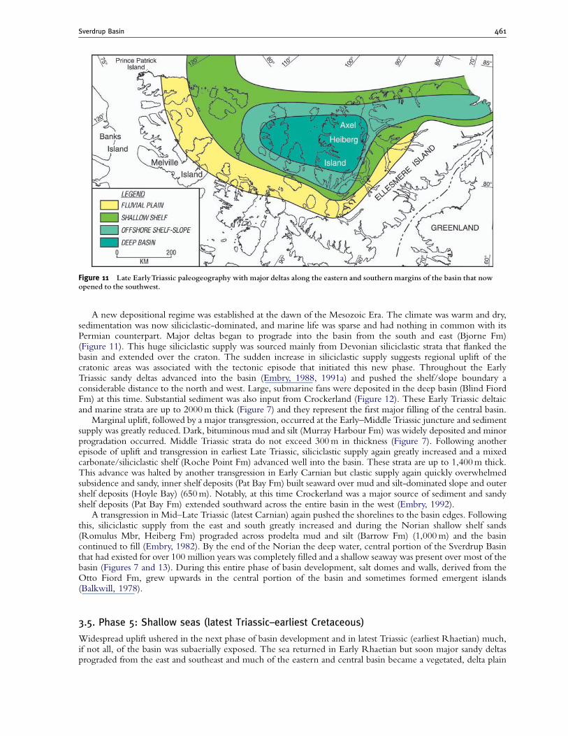
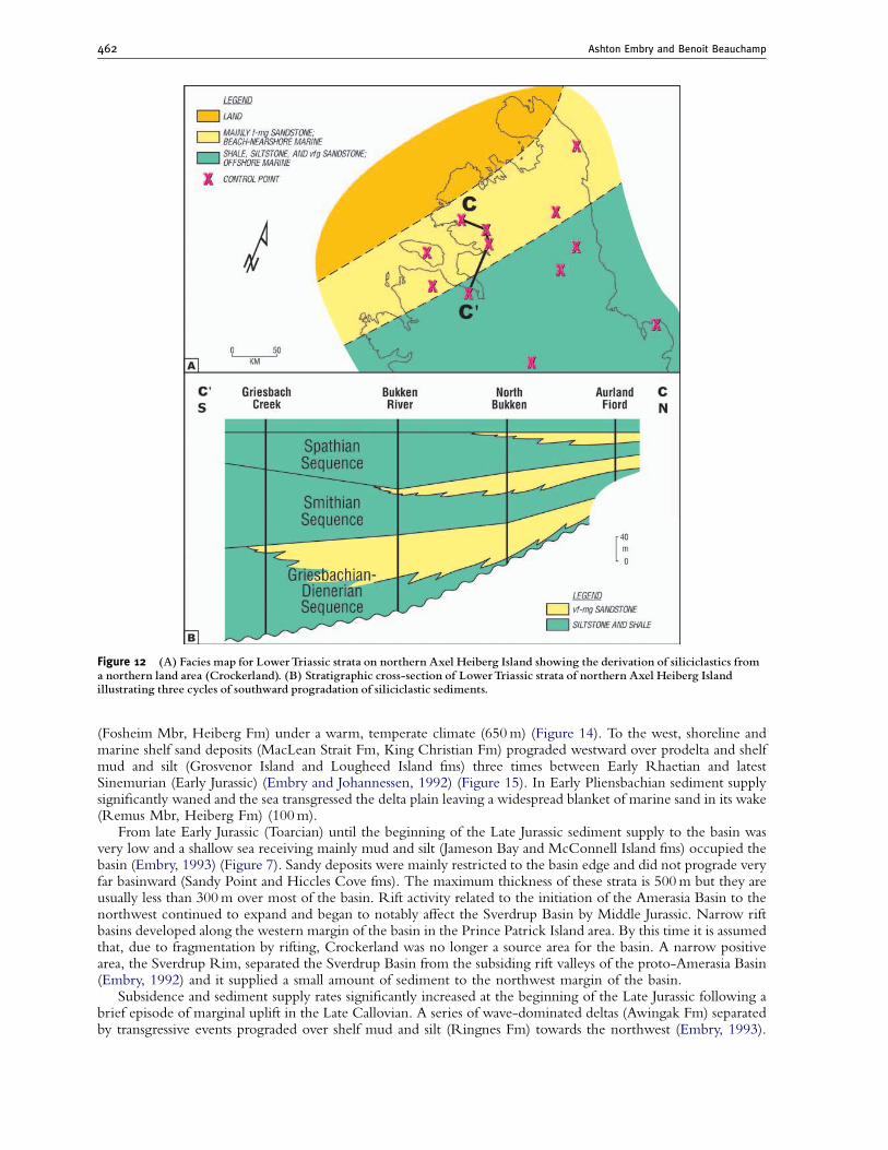
A new depositional regime was established at the dawn of the Mesozoic Era. The climate was warm and dry,sedimentation was now siliciclastic-dominated, and marine life was sparse and had nothing in common with itsPermian counterpart. Major deltas began to prograde into the basin from the south and east (Bjorne Fm)(Figure 11). This huge siliciclastic supply was sourced mainly from Devonian siliciclastic strata that flanked thebasin and extended over the craton. The sudden increase in siliciclastic supply suggests regional uplift of thecratonic areas was associated with the tectonic episode that initiated this new phase. Throughout the EarlyTriassic sandy deltas advanced into the basin (Embry, 1988, 1991a) and pushed the shelf/slope boundary aconsiderable distance to the north and west. Large, submarine fans were deposited in the deep basin (Blind FiordFm) at this time. Substantial sediment was also input from Crockerland (Figure 12). These Early Triassic deltaicand marine strata are up to 2000m thick (Figure 7) and they represent the first major filling of the central basin.
Marginal uplift, followed by a major transgression, occurred at the Early–Middle Triassic juncture and sedimentsupply was greatly reduced. Dark, bituminous mud and silt (Murray Harbour Fm) was widely deposited and minorprogradation occurred. Middle Triassic strata do not exceed 300m in thickness (Figure 7). Following anotherepisode of uplift and transgression in earliest Late Triassic, siliciclastic supply again greatly increased and a mixedcarbonate/siliciclastic shelf (Roche Point Fm) advanced well into the basin. These strata are up to 1,400m thick.This advance was halted by another transgression in Early Carnian but clastic supply again quickly overwhelmedsubsidence and sandy, inner shelf deposits (Pat Bay Fm) built seaward over mud and silt-dominated slope and outershelf deposits (Hoyle Bay) (650m). Notably, at this time Crockerland was a major source of sediment and sandyshelf deposits (Pat Bay Fm) extended southward across the entire basin in the west (Embry, 1992).
A transgression in Mid–Late Triassic (latest Carnian) again pushed the shorelines to the basin edges. Followingthis, siliciclastic supply from the east and south greatly increased and during the Norian shallow shelf sands(Romulus Mbr, Heiberg Fm) prograded across prodelta mud and silt (Barrow Fm) (1,000m) and the basincontinued to fill (Embry, 1982). By the end of the Norian the deep water, central portion of the Sverdrup Basinthat had existed for over 100 million years was completely filled and a shallow seaway was present over most of thebasin (Figures 7 and 13). During this entire phase of basin development, salt domes and walls, derived from theOtto Fiord Fm, grew upwards in the central portion of the basin and sometimes formed emergent islands(Balkwill, 1978).
3.5. Phase 5: Shallow seas (latest Triassic–earliest Cretaceous)
Widespread uplift ushered in the next phase of basin development and in latest Triassic (earliest Rhaetian) much,if not all, of the basin was subaerially exposed. The sea returned in Early Rhaetian but soon major sandy deltasprograded from the east and southeast and much of the eastern and central basin became a vegetated, delta plain
Figure 11 Late EarlyTriassic paleogeography with major deltas along the eastern and southern margins of the basin that nowopened to the southwest.
Sverdrup Basin 461
(Fosheim Mbr, Heiberg Fm) under a warm, temperate climate (650m) (Figure 14). To the west, shoreline andmarine shelf sand deposits (MacLean Strait Fm, King Christian Fm) prograded westward over prodelta and shelfmud and silt (Grosvenor Island and Lougheed Island fms) three times between Early Rhaetian and latestSinemurian (Early Jurassic) (Embry and Johannessen, 1992) (Figure 15). In Early Pliensbachian sediment supplysignificantly waned and the sea transgressed the delta plain leaving a widespread blanket of marine sand in its wake(Remus Mbr, Heiberg Fm) (100m).
From late Early Jurassic (Toarcian) until the beginning of the Late Jurassic sediment supply to the basin wasvery low and a shallow sea receiving mainly mud and silt (Jameson Bay and McConnell Island fms) occupied thebasin (Embry, 1993) (Figure 7). Sandy deposits were mainly restricted to the basin edge and did not prograde veryfar basinward (Sandy Point and Hiccles Cove fms). The maximum thickness of these strata is 500m but they areusually less than 300m over most of the basin. Rift activity related to the initiation of the Amerasia Basin to thenorthwest continued to expand and began to notably affect the Sverdrup Basin by Middle Jurassic. Narrow riftbasins developed along the western margin of the basin in the Prince Patrick Island area. By this time it is assumedthat, due to fragmentation by rifting, Crockerland was no longer a source area for the basin. A narrow positivearea, the Sverdrup Rim, separated the Sverdrup Basin from the subsiding rift valleys of the proto-Amerasia Basin(Embry, 1992) and it supplied a small amount of sediment to the northwest margin of the basin.
Subsidence and sediment supply rates significantly increased at the beginning of the Late Jurassic following abrief episode of marginal uplift in the Late Callovian. A series of wave-dominated deltas (Awingak Fm) separatedby transgressive events prograded over shelf mud and silt (Ringnes Fm) towards the northwest (Embry, 1993).
Figure 12 (A) Facies map for LowerTriassic strata on northern Axel Heiberg Island showing the derivation of siliciclastics froma northern land area (Crockerland). (B) Stratigraphic cross-section of LowerTriassic strata of northern Axel Heiberg Islandillustrating three cycles of southward progradation of siliciclastic sediments.
Ashton Embry and Benoit Beauchamp462
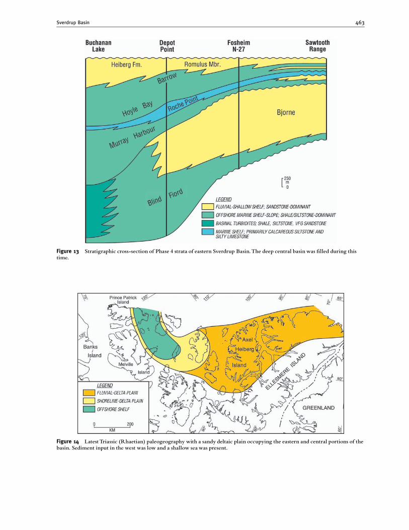
Figure 13 Stratigraphic cross-section of Phase 4 strata of eastern Sverdrup Basin.The deep central basin was ¢lled during thistime.
Figure 14 LatestTriassic (Rhaetian) paleogeography with a sandy deltaic plain occupying the eastern and central portions of thebasin. Sediment input in the west was low and a shallow seawas present.
Sverdrup Basin 463
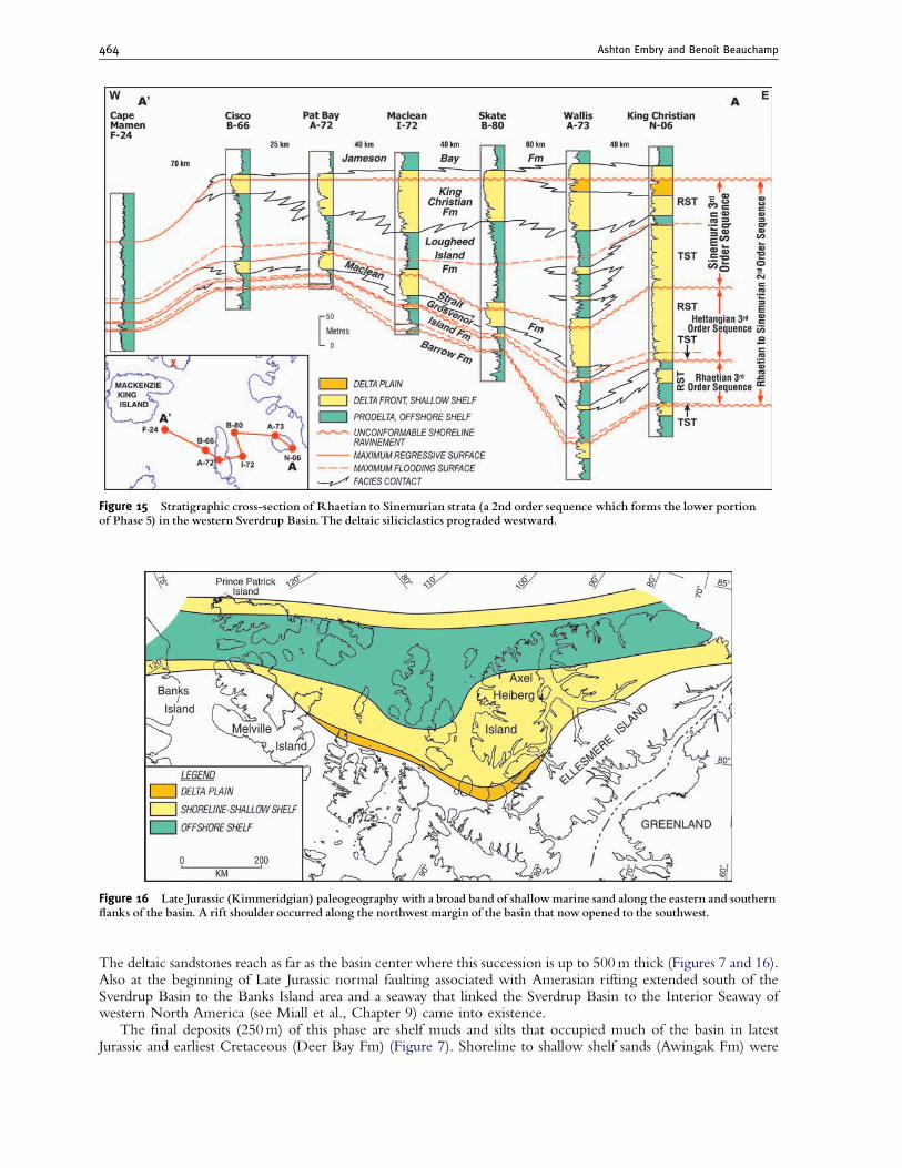
The deltaic sandstones reach as far as the basin center where this succession is up to 500m thick (Figures 7 and 16).Also at the beginning of Late Jurassic normal faulting associated with Amerasian rifting extended south of theSverdrup Basin to the Banks Island area and a seaway that linked the Sverdrup Basin to the Interior Seaway ofwestern North America (see Miall et al., Chapter 9) came into existence.
The final deposits (250m) of this phase are shelf muds and silts that occupied much of the basin in latestJurassic and earliest Cretaceous (Deer Bay Fm) (Figure 7). Shoreline to shallow shelf sands (Awingak Fm) were
Figure 15 Stratigraphic cross-section of Rhaetian to Sinemurian strata (a 2nd order sequence which forms the lower portionof Phase 5) in the western Sverdrup Basin.The deltaic siliciclastics prograded westward.
Figure 16 Late Jurassic (Kimmeridgian) paleogeography with a broad band of shallowmarine sand along the eastern and southern£anks of the basin. A rift shoulder occurred along the northwest margin of the basin that now opened to the southwest.
Ashton Embry and Benoit Beauchamp464
deposited on the basin edge during much of this time with highly progradational, delta front sandstones (basalIsachsen Fm) occurring at the top of the succession.
The salt structures that had been established in the Late Paleozoic continued to ascend and deform the strata.Large, local variations in thicknesses occur in the vicinity of these structures and a significant surge of upwardmovement occurred at the end of this phase (Jackson and Harrison, 2006).
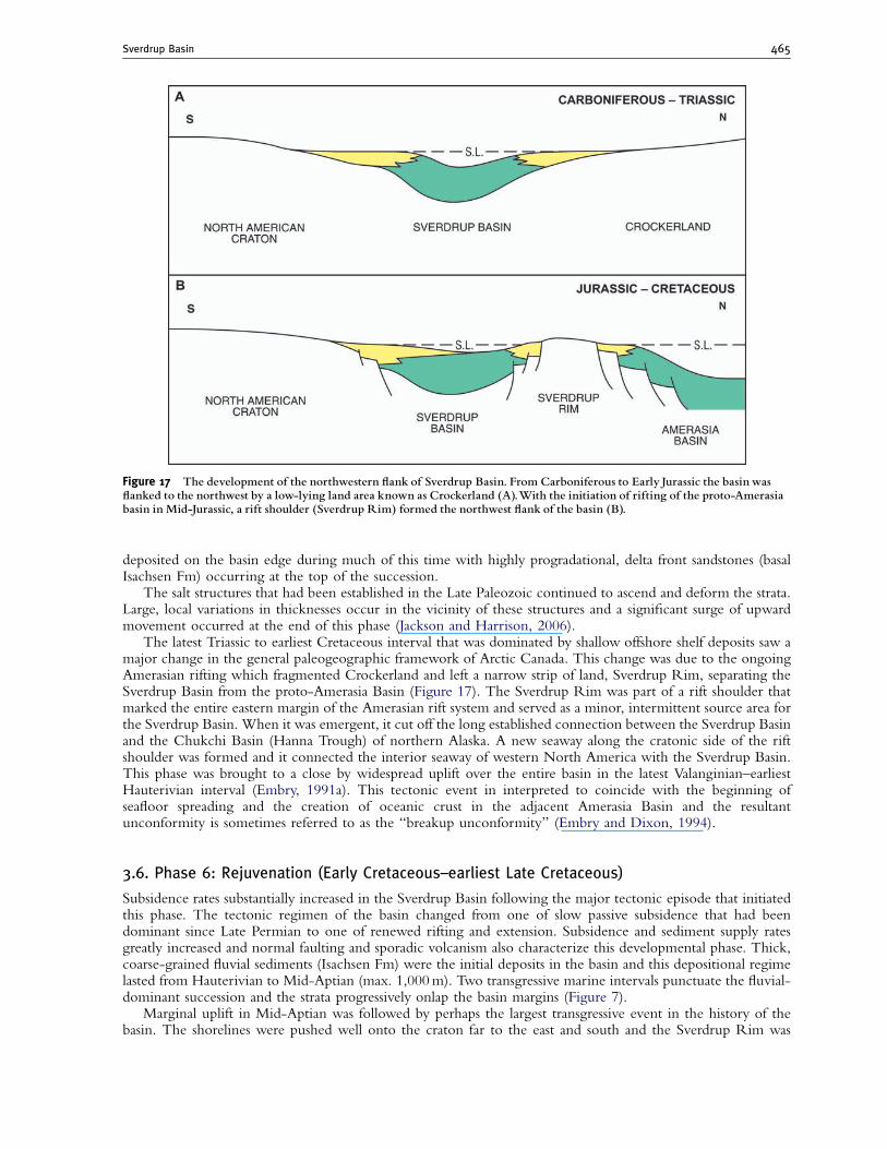
The latest Triassic to earliest Cretaceous interval that was dominated by shallow offshore shelf deposits saw amajor change in the general paleogeographic framework of Arctic Canada. This change was due to the ongoingAmerasian rifting which fragmented Crockerland and left a narrow strip of land, Sverdrup Rim, separating theSverdrup Basin from the proto-Amerasia Basin (Figure 17). The Sverdrup Rim was part of a rift shoulder thatmarked the entire eastern margin of the Amerasian rift system and served as a minor, intermittent source area forthe Sverdrup Basin. When it was emergent, it cut off the long established connection between the Sverdrup Basinand the Chukchi Basin (Hanna Trough) of northern Alaska. A new seaway along the cratonic side of the riftshoulder was formed and it connected the interior seaway of western North America with the Sverdrup Basin.This phase was brought to a close by widespread uplift over the entire basin in the latest Valanginian–earliestHauterivian interval (Embry, 1991a). This tectonic event in interpreted to coincide with the beginning ofseafloor spreading and the creation of oceanic crust in the adjacent Amerasia Basin and the resultantunconformity is sometimes referred to as the ‘‘breakup unconformity’’ (Embry and Dixon, 1994).
3.6. Phase 6: Rejuvenation (Early Cretaceous–earliest Late Cretaceous)
Subsidence rates substantially increased in the Sverdrup Basin following the major tectonic episode that initiatedthis phase. The tectonic regimen of the basin changed from one of slow passive subsidence that had beendominant since Late Permian to one of renewed rifting and extension. Subsidence and sediment supply ratesgreatly increased and normal faulting and sporadic volcanism also characterize this developmental phase. Thick,coarse-grained fluvial sediments (Isachsen Fm) were the initial deposits in the basin and this depositional regimelasted from Hauterivian to Mid-Aptian (max. 1,000m). Two transgressive marine intervals punctuate the fluvial-dominant succession and the strata progressively onlap the basin margins (Figure 7).
Marginal uplift in Mid-Aptian was followed by perhaps the largest transgressive event in the history of thebasin. The shorelines were pushed well onto the craton far to the east and south and the Sverdrup Rim was
Figure 17 The development of the northwestern £ank of Sverdrup Basin. From Carboniferous to Early Jurassic the basin was£anked to the northwest by a low-lying land area known as Crockerland (A).With the initiation of rifting of the proto-Amerasiabasin in Mid-Jurassic, a rift shoulder (Sverdrup Rim) formed the northwest £ank of the basin (B).
Sverdrup Basin 465
drowned. The basin received thick deposits of offshore mud and silt (Christopher Fm) which progradednorthward (1,100m). At the end of the Early Cretaceous shoreline and shallow shelf sands (Hassel Fm) progradedinto the basin (200m) (Figure 7) and heralded widespread uplift in latest Early Cretaceous and earliest LateCretaceous.
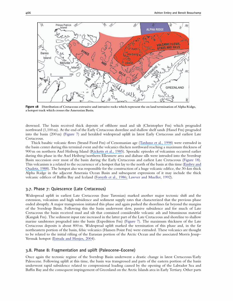
Thick basaltic volcanic flows (Strand Fiord Fm) of Cenomanian age (Tarduno et al., 1998) were extruded inthe basin center during this terminal event and the volcanics thicken northward reaching a maximum thickness of900m on northern Axel Heiberg Island (Ricketts et al., 1985). Sporadic episodes of volcanism occurred earlierduring this phase in the Axel Heiberg/northern Ellesmere area and diabase sills were intruded into the SverdrupBasin succession over most of the basin during the Early Cretaceous and earliest Late Cretaceous (Figure 18).This volcanism is a related to the occurrence of a hotspot that lay to the north of the basin at this time (Embry andOsadetz, 1988). The hotspot also was responsible for the construction of a huge volcanic edifice, the 30-km thickAlpha Ridge in the adjacent Amerasia Ocean Basin and subsequent expressions of it may include the thickvolcanic edifices of Baffin Bay and Iceland (Forsyth et al., 1986; Lawver and Mueller, 1992).
3.7. Phase 7: Quiescence (Late Cretaceous)
Widespread uplift in earliest Late Cretaceous (base Turonian) marked another major tectonic shift and theextension, volcanism and high subsidence and sediment supply rates that characterized that the previous phaseended abruptly. A major transgression initiated this phase and again pushed the shorelines far beyond the marginsof the Sverdrup Basin. Following this the basin underwent slow, passive subsidence and for much of LateCretaceous the basin received mud and silt that contained considerable volcanic ash and bituminous material(Kanguk Fm). The sediment input rate increased in the latter part of the Late Cretaceous and shoreline to shallowmarine sandstones prograded into the basin (Expedition Fm) (Figure 7). The maximum thickness of the LateCretaceous deposits is about 800m. Widespread uplift marked the termination of this phase and, in the farnortheastern portion of the basin, felsic volcanics (Hansen Point Fm) were extruded. These volcanics are thoughtto be related to the initial rifting of the Eurasian portion of the Arctic Ocean and the associated Morris Jesup–Yermak hotspot (Estrada and Henjes, 2004).
3.8. Phase 8: Fragmentation and uplift (Paleocene–Eocene)
Once again the tectonic regime of the Sverdrup Basin underwent a drastic change in latest Cretaceous/EarlyPaleocene. Following uplift at this time, the basin was transgressed and parts of the eastern portion of the basinunderwent rapid subsidence related to compressional loading caused by the opening of the Labrador Sea andBaffin Bay and the consequent impingement of Greenland on the Arctic Islands area in Early Tertiary. Other parts
Figure 18 Distribution of Cretaceous extrusive and intrusive rocks which represent the on land termination of Alpha Ridge,a hotspot track which crosses the Amerasian Basin.
Ashton Embry and Benoit Beauchamp466
of the basin such as the Princess Margaret Arch and Cornwall Arch likely underwent uplift and the adjacentsubsiding areas received a high supply of siliciclastic sediment (Ricketts and Stephenson, 1994). The Paleocene–Mid-Eocene succession in these foreland basins consists of a basal transgressive sandstone unit (upper ExpeditionFm) followed by regressive marine shale and siltstone (Strand Bay Fm) and a very thick succession of sand-dominated, coastal to fluvial deposits with abundant coal (Iceberg Bay Fm) (3,000m). Deformation progressedthrough the Paleocene and Eocene and syn-tectonic conglomerates (Buchanan Lake Fm) up to 1,000m thickwere deposited in front of the advancing thrust sheets. The deformation climaxed in Late Eocene (EurekanOrogeny) and the entire basin was uplifted, bringing to a close a 300 million year history of deposition. TheSverdrup Basin area has remained under compression since that time and has acted as a major source area for theadjacent Amerasia Basin throughout much of the Tertiary.
The eastern part of the basin was substantially deformed by thrusting and folding and deformation graduallydecreased in a southwestward direction. The western portion of the basin is slightly deformed by broad folds andthroughout the basin the salt structures exhibited large vertical growth during this compressive interval.
4. Tectonic Episodes
The Sverdrup Basin originated due to an episode of extensional tectonics that affected much of theCaledonian/Ellesmerian Orogenic Belt in Early Carboniferous. The basin was uplifted and deformed in LateEocene due to compression associated with the opening of the Labrador Sea. During its long history theSverdrup Basin was affected by numerous tectonic episodes that resulted in widespread unconformities. These inturn allow the succession to be subdivided into large magnitude sequences (Beauchamp et al., 2001; Embry,1988, 1991a, 1993). The 1st order sequences contain smaller magnitude (2nd and 3rd order) sequenceboundaries. The characteristics of these 1st, 2nd and 3rd order unconformities leave no doubt as to their tectonicorigin (Embry, 1990, 1997; Beauchamp et al., 2001).
The largest magnitude unconformities (first order) closely match those recognized in various areas of theNorth American craton and the origin of these is interpreted to be due to various plate-tectonic processes whichaffected the continent (Sloss, 1988; Burgess, Chapter 2). It seems reasonable to assume that the smaller magnitudeunconformities were also generated by crustal movements driven by plate-tectonic interactions as suggested byEmbry (1997). Overall it seems the Sverdrup Basin was affected by a relatively short-lived, tectonic episode onceevery 5–10 million years and that the magnitude of such an episode varied from quite large (widespread uplift andlarge changes in tectonic and depositional regimes) to moderate (subdued, marginal uplift and subtle changes indepositional regime).
5. Economic Geology
5.1. Petroleum
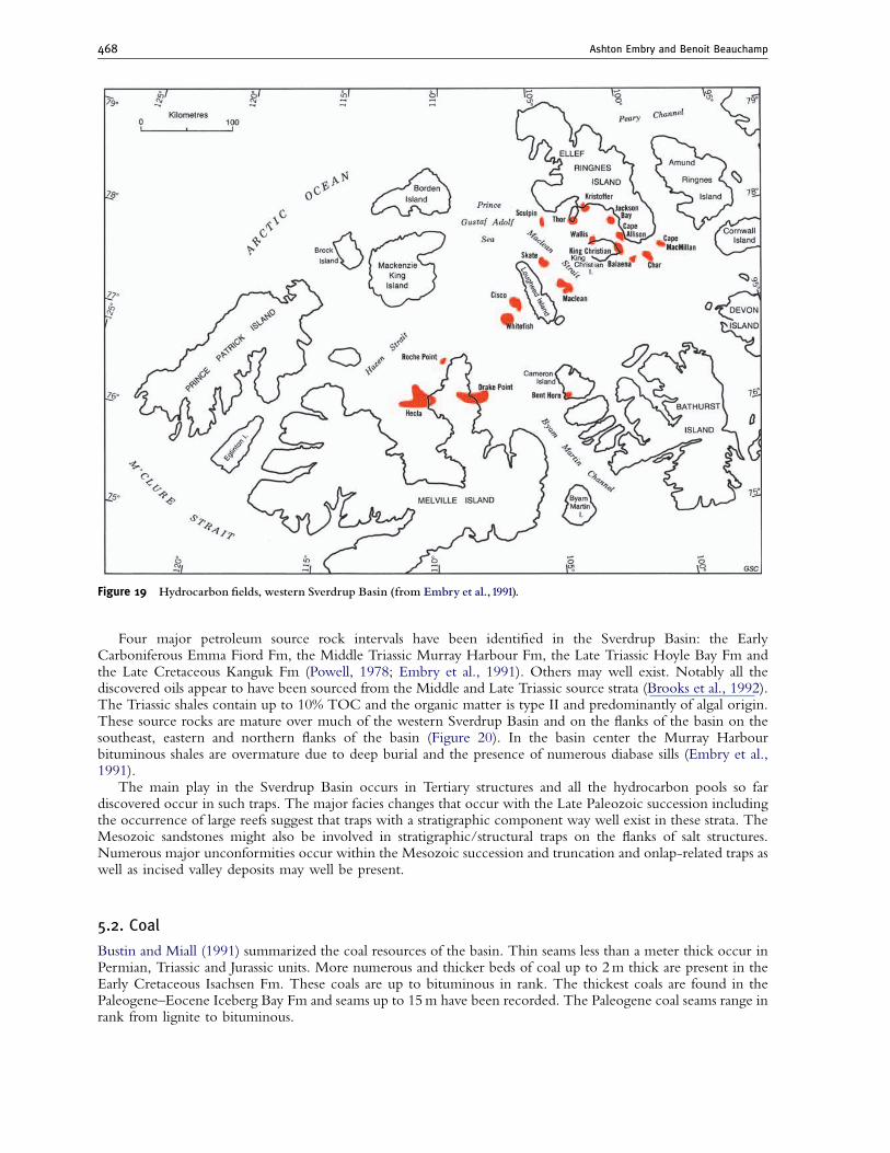
Exploration for petroleum in the Sverdrup Basin began in 1968 soon after the formation of Panarctic OilsLimited, a consortium of numerous oil companies and the federal government. A string of major gas fields werediscovered between northeastern Melville Island and western Ellef Ringnes Island from 1969 to 1980 (Figure 19).In 1981 a major oil field, Cisco, was discovered west of Lougheed Island but following discoveries weredisappointing in their small quantities of contained oil. The last well was drilled in 1986 and exploration in theSverdrup Basin ceased with the collapse of the oil price that year.
Strata that are sufficiently porous and permeable to act as reservoir rocks are very common in the SverdrupBasin. In the Late Paleozoic succession potential reservoir units include the Nansen, Canyon Fiord and SabineBay fms. The main potential Mesozoic reservoir units are found in the Bjorne, Roche Point, Pat Bay, Heiberg,MacLean Strait, King Christian, Hiccles Cove, Awingak, Isachsen and Hassel formations. The Bjorne sandstonesare host to the oil sands of Melville Island and numerous oil and gas shows have been encountered in thesesandstones. Most of the gas discovered so far occurs in the MacLean Strait and King Christian formations. Thesesandstones are of shallow marine origin and have very good to excellent porosity and permeability, especiallyalong the southwestern basin margin (Waylett, 1989). Sandstones of the Remus Member of the Heiberg Fm arealso very good reservoirs and contain gas at a few localities. In the basin center area the sandstones of the HeibergFm have greatly reduced porosity due to cementation. Large quantities of oil and gas are also in shallow marinesandstones of the Awingak Fm. These reservoir units can have porosities up to 15%. The fluvial sandstones of theIsachsen contain small amounts of hydrocarbons. The sandstones of the Isachsen Fm are very porous andpermeable over most of the basin but subsurface occurrences are often in communication with nearby outcrops.
Sverdrup Basin 467
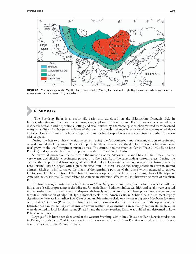
Four major petroleum source rock intervals have been identified in the Sverdrup Basin: the EarlyCarboniferous Emma Fiord Fm, the Middle Triassic Murray Harbour Fm, the Late Triassic Hoyle Bay Fm andthe Late Cretaceous Kanguk Fm (Powell, 1978; Embry et al., 1991). Others may well exist. Notably all thediscovered oils appear to have been sourced from the Middle and Late Triassic source strata (Brooks et al., 1992).The Triassic shales contain up to 10% TOC and the organic matter is type II and predominantly of algal origin.These source rocks are mature over much of the western Sverdrup Basin and on the flanks of the basin on thesoutheast, eastern and northern flanks of the basin (Figure 20). In the basin center the Murray Harbourbituminous shales are overmature due to deep burial and the presence of numerous diabase sills (Embry et al.,1991).
The main play in the Sverdrup Basin occurs in Tertiary structures and all the hydrocarbon pools so fardiscovered occur in such traps. The major facies changes that occur with the Late Paleozoic succession includingthe occurrence of large reefs suggest that traps with a stratigraphic component way well exist in these strata. TheMesozoic sandstones might also be involved in stratigraphic/structural traps on the flanks of salt structures.Numerous major unconformities occur within the Mesozoic succession and truncation and onlap-related traps aswell as incised valley deposits may well be present.
5.2. Coal
Bustin and Miall (1991) summarized the coal resources of the basin. Thin seams less than a meter thick occur inPermian, Triassic and Jurassic units. More numerous and thicker beds of coal up to 2m thick are present in theEarly Cretaceous Isachsen Fm. These coals are up to bituminous in rank. The thickest coals are found in thePaleogene–Eocene Iceberg Bay Fm and seams up to 15m have been recorded. The Paleogene coal seams range inrank from lignite to bituminous.
Figure 19 Hydrocarbon ¢elds, western Sverdrup Basin (from Embry et al.,1991).
Ashton Embry and Benoit Beauchamp468
6. Summary
The Sverdrup Basin is a major rift basin that developed on the Ellesmerian Orogenic Belt inEarly Carboniferous. The basin went through eight phases of development. Each phase is characterized by adistinctive tectonic and depositional setting and was initiated by a tectonic episode characterized by widespreadmarginal uplift and subsequent collapse of the basin. A notable change in climate often accompanied thesetectonic changes that may have been a response to somewhat abrupt changes in plate-tectonic spreading directionand/or speed.
During the first two phases, which occurred during the Carboniferous and Permian, carbonate sedimentswere deposited in a hot climate. Thick salt deposits filled the basin early in the development of the basin and hugereefs grew on the shelf margins at various times. The climate became much cooler in Phase 3 (Middle to LatePermian) and spiculitic cherts were deposited on the shelf and in the basin.
A new world dawned on the basin with the initiation of the Mesozoic Era and Phase 4. The climate becamevery warm and siliciclastic sediments poured into the basin from the surrounding cratonic areas. During theTriassic the deep, central basin was gradually filled and shallow-water sediments reached the basin center byLate Triassic. Phase 5 began with high siliciclastic influx in latest Triassic and Early Jurassic in a warm, humidclimate. Siliciclastic influx waned for much of the remaining portion of this phase which extended to earliestCretaceous. This latter potion of this phase of basin development coincides with the rifting phase of the adjacentAmerasia Basin. Normal faulting related to Amerasian extension affected the southwestern portion of SverdrupBasin.
The basin was rejuvenated in Early Cretaceous (Phase 6) by an extensional episode which coincided with theinitiation of seafloor spreading in the adjacent Amerasia Basin. Sediment influx was high and basalts were eruptedin the northeast with accompanying widespread diabase dyke and sill intrusion. These igneous rocks represent theterrestrial termination of Alpha Ridge, a hotspot track in the Amerasia Basin. Subsidence and sediment supplysignificantly decreased in earliest Late Cretaceous and bituminous shale was the main deposit of the basin for mostof the Late Cretaceous (Phase 7). The basin began to be compressed in the Paleogene due to the opening of theLabrador Sea and the consequent counterclockwise rotation of Greenland. Thick, mainly continental siliciclasticswere deposited in local foreland basins (Phase 8) and the entire Sverdrup Basin was uplifted and deformed in LatePaleocene to Eocene.
Large gas fields have been discovered in the western Sverdrup within latest Triassic to Early Jurassic sandstonesin Paleogene anticlines. Coal is common in various non-marine units from Permian onward with the thickestseams occurring in the Paleogene strata.
Figure 20 Maturity map for the Middle--LateTriassic shales (Murray Harbour and Hoyle Bay formations) which are the mainsource strata for the discovered hydrocarbons.
Sverdrup Basin 469
REFERENCES
Balkwill, H. R., 1978, Evolution of Sverdrup Basin. AAPG Bulletin, v. 62, pp. 1004–1028.Beauchamp, B., 1994, Permian climatic cooling in the Canadian Arctic, in Klein, G. D. ed., Pangea: paleoclimate, tectonics and
sedimentation during accretion, zenith and break-up of a super-continent, Geological Society of America (Special Paper 288),pp. 229–246.
Beauchamp, B., 1995, Permian history of Arctic North America, in Scholle, P. A. and Peryt, T. M. eds., The Permian of northern Pangea,Volume 2: Sedimentary basins and economic resources, Springer-Verlag, Heidelberg, pp. 3–22.
Beauchamp, B., and Baud, A., 2002, Growth and demise of Permian biogenic chert along northwest Pangea: evidence for end-Permiancollapse of thermohaline circulation. Palaeogeography, Palaeoclimatology, Palaeoecology, v. 184, pp. 37–63.
Beauchamp, B., and Desrochers, A., 1997, Permian warm- to very cold carbonates and cherts in northwest Pangea, in James, N. P. andClarke, J. eds., Cool water carbonates, SEPM (Special Publication 56), Tulsa, USA, pp. 327–347.
Beauchamp, B., and Henderson, C. M., 1994, The Lower Permian Raanes, Great Bear Cape and Trappers Cove formations, SverdrupBasin, Canadian Arctic: stratigraphy and conodont zonation. Bulletin of Canadian Petroleum Geology, v. 42, pp. 562–597.
Beauchamp, B., and Olchowy, B., 2003, Early Permian buildups (Tolkien reefs) associated with subaqueous evaporites, Sverdrup Basin,Canadian Arctic: a record of syn- tectonic to post-tectonic reciprocal uplift and subsidence, in Ahr, W. ed., Permo-carboniferouscarbonate platforms and reefs, SEPM (Special Publication 78 and AAPG Memoir 83), Tulsa, USA, pp. 133–153.
Beauchamp, B., Harrison, J. C., Utting, J., Brent, T. A., and Pinard, S., 2001, Carboniferous and Permian subsurface stratigraphy, PrincePatrick Island, Northwest Territories, Canadian Arctic, Geological Survey of Canada, Bulletin 565, Ottawa, Canada, 93 pp.
Brooks, P., Embry, A., Goodarzi, F., and Stewart, R., 1992, Organic geochemistry and biological marker geochemistry of Schei Pointgroup (Triassic) and recovered oils from the Sverdrup Basin (Arctic Islands, Canada). Bulletin of Canadian Petroleum Geology,v. 40, pp. 173–187.
Bustin, R. M., and Miall, A. D., 1991, Coal resources, Arctic Islands, in Trettin, H. ed., Innuitian orogen and Arctic platform: Canada andGreenland, Geological Survey of Canada, Geology of Canada, no. 3, Ottawa, Canada, pp. 529–532.
Davies, G. R., and Nassichuk, W. W., 1988, An Early Carboniferous (Visean) lacustrine oil shale in Canadian Arctic Archipelago.American Association of Petroleum Geologists Bulletin, v. 72, pp. 8–20.
Davies, G. R., and Nassichuk, W. W., 1991a, Carboniferous and Permian history of the Sverdrup Basin, Arctic Islands, in Trettin, H. P.ed., Geology of the innuitian orogen and Arctic Platform of Canada and Greenland, Geological Survey of Canada, Geology ofCanada, no. 3, Ottawa, Canada, pp. 345–367.
Davies, G. R., and Nassichuk, W. W., 1991b, Submarine cements and fabrics in Carboniferous to Lower Permian, reefal, shelf-margin andslope carbonates, Northwestern Ellesmere Island, Canadian Arctic Archipelago, Geological Survey of Canada, Bulletin 399,Ottawa, Canada, 77 pp.
Embry, A. F., 1982, The Upper Triassic–Lower Jurassic Heiberg Deltaic complex of the Sverdrup Basin, in Embry, A. and Balkwill, H.eds., Arctic geology and geophysics, CSPG Memoir 8, pp. 189–218.
Embry, A. F., 1988, Triassic sea-level changes: evidence from the Canadian Arctic Archipelago, in Wilgus, C., Hastings, B., Kendall, C.,Posamentier, H., Ross, C., and Van Wagoner, J. eds., Sea-level changes an integrated approach, SEPM (Special Publication 42),Tulsa, USA, pp. 249–259.
Embry, A. F., 1990, A tectonic origin for third-order depositional sequences in extensional basins implications for basin modelling, inCross, T. ed., Quantitative dynamic stratigraphy, Prentice Hall, Engelwood Cliffs, USA, pp. 491–502.
Embry, A. F., 1991a, Mesozoic history of the Arctic Islands, in Trettin, H. ed., Innuitian orogen and Arctic Platform: Canada andGreenland, Geological Survey of Canada, Geology of Canada, no. 3, Ottawa, Canada, pp. 369–433.
Embry, A. F., 1991b, Middle-Upper Devonian clastic wedge of the Arctic Islands; Chapter 10, in Trettin, H. P. ed., Geology ofthe Innuitian orogen and Arctic Platform of Canada and Greenland, Geological Survey of Canada, Geology of Canada, no. 3,Ottawa, Canada, pp. 263–279.
Embry, A., 1992, Crockerland – the northern source area for the Sverdrup Basin, Canadian Arctic Archipelago, in Vorren, T., Blackadar,R., Glenister, B., Greiner, H., McLaren, D., McMillan, N., Norris, A., Roots, E., Souther, J., Thorsteinsson, R., and Tozer, T.eds., Arctic geology and petroleum potential, Norwegian Petroleum Society (Special Publication 2), Amsterdam, The Netherlands,pp. 205–216.
Embry, A. F., 1993, Transgressive-regressive (T-R) sequence analysis of the Jurassic succession of the Sverdrup Basin, Canadian ArcticArchipelago. Canadian Journal of Earth Sciences, v. 30, pp. 301–320.
Embry, A., 1997, The Blind Fiord formation and Blaa Mountain Group (Triassic) of northwestern Axel Heiberg Island, Canadian ArcticArchipelago, in Current research, 1997-B, Geological Survey of Canada, pp. 193–198.
Embry, A. F., and Dixon, J., 1994, The age of the Amerasia basin, in Thurston, D. and Fujita, K. eds., 1992 Proceedings InternationalConference on Arctic margins, MMS94 – 0040, U.S. Department of the Interior, Anchorage, Alaska, pp. 289–294.
Embry, A., and Johannessen, E., 1992, T-R sequence stratigraphy, facies analysis and reservoir distribution in the uppermost Triassic andLower Jurassic succession, western Sverdrup Basin, Arctic Canada, in Vorren, T., Bergsager, E., Dahl-Stamnes, O., Holter, E.,Johansen, B., Lie, E., and Lund, T. eds., Arctic geology and petroleum potential, Norwegian Petroleum Society (SpecialPublication 2), Amsterdam, The Netherlands, pp. 121–146.
Embry, A., and Osadetz, K., 1988, Stratigraphy and tectonic significance of Cretaceous volcanism, Queen Elizabeth Islands, ArcticArchipelago. Canadian Journal of Earth Sciences, v. 25, pp. 1209–1219.
Embry, A., Powell, T., and Mayr, U., 1991, Petroleum resources, Arctic Islands, in Trettin, H., ed., Innuitian Orogen and Arctic Platform:Canada and Greenland, Geological Survey of Canada, Geology of Canada, no. 3, pp. 515–525.
Estrada, S., and Henjes, K., 2004, Volcanism in the Canadian High Arctic related to the opening of the Arctic Ocean. Zeitshrift derDeutschen Geologischen Gesellschaft, v. 54, pp. 579–603.
Forsyth, D. A., Morel-a-l’Huissier, P., Asudeh, I., and Green, A. G., 1986, Alpha ridge and Iceland: products of the same plume? Journalof Geodynamics, v. 6, pp. 197–214.
Fortier, Y., Blackadar, R., Glenister, B., Greiner, H., McLaren, D., McMillan, N., Norris, A., Roots, E., Souther, J., Thorsteinsson, R.,and Tozer, T., 1963, Geology of the north-central part of the Arctic Archipelago, Northwest territories (Operation Franklin),Ottawa Canada, Geological Survey of Canada, Memoir 320, 671 pp.
Ashton Embry and Benoit Beauchamp470
Gates, L., James, N. P., and Beauchamp, B., 2004, A glass ramp: Shallow-water Permian spiculitic chert sedimentation, Sverdrup Basin,Arctic Canada. Sedimentary Geology, v. 168, pp. 125–147.
Harrison, J. C., 1995, Melville Island’s salt based fold belt (Arctic Canada), Geological Survey of Canada, Bulletin 472, Ottawa, Canada,331 pp.
Heckel, P. H., 1986, Sea level curve for Pennsylvanian eustatic marine transgressive–regressive depositional cycles along mid-continentoutcrop belt, North America. Geology, v. 14, pp. 330–334.
Jackson, M. P. A., and Harrison, J. C., 2006, An allochthonous salt canopy on Axel Heiberg Island, Sverdrup Basin, Arctic Canada.Geology, v. 34, pp. 1045–1048.
James, N. P., 1997, The cool-water carbonate depositional realm, in James, N. P. and Clarke, J. A. D. eds., Cool-water carbonates, SEPM(Special Publication 56), pp. 1–22.
Lawver, L. A., and Mueller, R., 1992, A hotspot origin for the Canada Basin and the path of the Iceland Hotspot. Eos, Transactions,American Geophysical Union, v. 73(14), 287 pp.
Maurel, L. E., 1989, Geometry and evolution of the Tanquary structural high and its effects on the paleogeography of the Sverdrup basin,northern Ellesmere Island, Canadian Arctic, in Current research part G, Geological Survey of Canada, Paper 89-1G, Ottawa,Canada, pp. 177–189.
Mayr, U., 1992, Reconnaissance and preliminary interpretation of Upper Devonian to Permian stratigraphy of northeastern EllesmereIsland, Canadian Arctic Archipelago, Geological Survey of Canada, Paper 91-08, Ottawa, Canada, 117 pp.
Mickey, M., Byrnes, A., and Haga, H., 2002, Biostratigraphic evidence for the prerift position of the North slope, Alaska and ArcticIslands, Canada, and Sinemurian incipient rifting of Canada basin, in Miller, E., Grantz, A., and Klemperer, S. eds., Tectonicevolution of the Bering Shelf-Chukchi Sea-Arctic margin and adjacent landmasses, GSA (Special Paper 360), Anchorage, USA,pp. 67–75.
Nassichuk, W. W., and Christie, R. L., 1969, Upper Paleozoic and Mesozoic stratigraphy in Yelverton pass region, Ellesmere Island,District of Franklin, Geological Survey of Canada, Paper 68-31, Ottawa, Canada, 24 pp.
Nassichuk, W. W., and Davies, G. R., 1980, Stratigraphy and sedimentation of the Otto Fiord Formation. Geological Survey of Canada,Bulletin 286, Ottawa, Canada, 87 pp.
Patchett, P., Embry, A., Ross, G., Beauchamp, B., Harrison, C., Mayr, U., Isachsen, C., Rosenberg, E., and Spence, G., 2004,Sedimentary Cover of the Canadian Shield through Mesozoic time reflected by Nd Isotopic and geochemical results for theSverdrup Basin, Arctic Canada. Journal of Geology, v. 112, pp. 39–57.
Powell, T., 1978, An assessment of the hydrocarbon source potential of the Canadian Arctic Islands, Geological Survey of Canada, Paper78-12, Ottawa, Canada, 82 pp.
Reid, C., James, N. P., Beauchamp, B., and Kyser, T. K., 2007, Faunal turnover and changing oceanography: Late Paleozoic warm-to-coolwater carbonates, Sverdrup Basin, Canadian Arctic Archipelago. Sedimentology, v. 249, pp. 128–159.
Ricketts, B., 1994, Basin analysis, Eureka Sound Group, Axel Heiberg and Ellesmere Islands, Canadian Arctic Archipelago, GeologicalSurvey of Canada, Memoir 439, Ottawa, Canada, 119 pp.
Ricketts, B., and Stephenson, R., 1994, The demise of the Sverdrup Basin: Late Cretaceous–Paleogene sequence stratigraphy and forwardmodeling. Journal of Sedimentary Research, v. B64, pp. 516–530.
Ricketts, B., Osadetz, K., and Embry, A., 1985, Volcanic style in the Strand Fiord Formation (Upper Cretaceous), Axel Heiberg Island,Canadian Arctic Islands. Polar Research, v. 3, pp. 107–122.
Sloss, L. L., 1988, Tectonic evolution of the craton in Phanerozoic time, in Sloss, L. L. ed., Sedimentary cover – North American Craton;US., Geological Society of America, The Geology of North America, v. D-2, Boulder, USA, pp. 25–51.
Tarduno, J. A., Brinkman, D. B., Renne, P. R., Cottrell, R. D., Scher, H., and Castillo, P., 1998, Evidence for extreme climatic warmthfrom Late Cretaceous Arctic vertebrates. Science, v. 282, pp. 2241–2244.
Theriault, P., 1991, Synrift sedimentation in the Upper Carboniferous Canyon Fiord Formation, SW Ellesmere Island, Canadian Arctic,M.Sc. Thesis, University of Ottawa, Ottawa, Canada, 210 pp.
Theriault, P., Beauchamp, B., and Steel, R., 1993, Syntectonic deposition of the Carboniferous Borup Fiord Formation, NorthwesternEllesmere Island, Geological Survey of Canada, Paper 93-1E, pp. 105–112.
Thorsteinsson, R., 1974, Carboniferous and Permian stratigraphy of Axel Heiberg Island and western Ellesmere Island, Canadian ArcticArchipelago, Geological Survey of Canada, Bulletin 224, Ottawa, Canada, 115 pp.
Trettin, H. P., 1989, The Arctic Islands, in Bally, A. W. and Palmer, A. R. eds., The Geology of North America: the Geology of NorthAmerica. An overview, The Decade of North American Geology, Boulder, USA, v. A, pp. 349–370.
Trettin, H. ed., 1991, Geology of the Innuitian orogen and Arctic Platform of Canada and Greenland, Ottawa, Geological Survey ofCanada, Geology of Canada, v. 3, 569 pp.
Waylett, D., 1989, Drake Point gas field – Canada Arctic Islands, Sverdrup basin, in Beaumont, E. and Foster, N. eds., Treatise ofpetroleum geology, Atlas of oil and gas fields, AAPG, Tulsa, USA, pp. 1–27.
Ziegler, P., 1988, Evolution of the Arctic-North Atlantic and the Western Tethys. AAPG, Memoir 43, Tulsa, USA, 198 pp.
Sverdrup Basin 471
Related Documents