A9 Dualling Programme: Tay Crossing to Ballinluig DMRB Stage 3 Environmental Statement Chapter 11: Road Drainage and the Water Environment Page 1 of Chapter 11 11 Road Drainage and the Water Environment This chapter assesses the impacts of the proposed scheme on the surface water environment, specifically considering the attributes of hydrology and flood risk, fluvial geomorphology and water quality. The proposed scheme is located within the River Tay catchment. Within the 500m study area, 32 surface water features were identified which may be affected by the proposed scheme. The majority of these are steep, entrenched, cascading low stream order watercourses characterised by step/pool sequences with cobble, pebble and/or gravel substrates, and which currently feature culverted crossings associated with the existing A9. The largest watercourse within the study area is the River Tay (catchment area: 2,966km 2 ), which is a partially embanked mobile gravel-bed river. Several watercourses within the study area form part of the River Tay Special Area of Conservation (SAC); these include the River Tay, River Tummel, Kindallachan Burn (downstream of the Highland Main Line railway) and Dowally Burn (extending some 1km upstream from its confluence with the River Tay). The proposed scheme is largely located within the functional floodplain of the River Tay, and in sections within close proximity to the River Tay. This has been a key constraining factor in the design of the proposed scheme. There are no crossings of the River Tay associated with the proposed scheme. The River Tay catchment is currently affected by abstractions for two major hydroelectric schemes; the Tummel Valley scheme on the River Tummel and the Breadalbane scheme on the River Tay. The River Tay receives runoff from the existing A9 drainage, which is predominantly un-attenuated and untreated. Land uses within the River Tay catchment are primarily sheep grazing and managed moorland in the upper reaches, forestry in the middle reaches, and arable farming and built development in the lower reaches (SEPA, 2010a); therefore, potential pollution sources are generally limited to agricultural runoff, road runoff and forestry operations. The impact assessment was informed by consultation, desk-based assessments, site walkovers and surveys. Hydraulic modelling of the five largest watercourses within the study area (River Tay, River Tummel, Kindallachan Burn, Dowally Burn and Sloggan Burn) and several other minor watercourses was undertaken to assess potential impacts on flood risk. Significant potential impacts from the proposed scheme in the absence of mitigation include increases in fluvial flood risk, alterations to flows and sediment processes within watercourses, and deterioration in water quality within receiving watercourses from construction and operational runoff. Mitigation during construction would be delivered through a Construction Environmental Management Plan (CEMP), which would include measures for flood risk, fluvial geomorphology and water quality. A sediment management plan, storage of machinery and material outside the functional floodplain, adherence to guidance such as the SEPA Guidance for Pollution Prevention (GPPs), and specific management plans to manage drainage and minimise the generation of suspended sediment, are included as measures to mitigate construction impacts. With the implementation of mitigation measures during construction, residual impacts on all receptors would be reduced to either Neutral or Slight significance. During the operational phase, mitigation measures include the use of Sustainable Drainage Systems (SuDS), compensatory flood storage, scour protection and erosion monitoring to protect affected watercourses. With the proposed mitigation, the majority of residual impacts during operation would be of Neutral significance with a small number of residual impacts of Slight significance. A residual impact of Moderate significance to the River Tay is predicted, due to areas within the Tay floodplain where an increased flood depth is predicted. As these areas are within the existing floodplain, it is considered appropriate that the increased flood depth be accepted given that there would be no discernible change in flood risk and mitigation measures to prevent the increase in depth would be disproportionate. 11.1 Introduction This chapter presents the DMRB Stage 3 assessment of the proposed scheme (see Chapter 5: The Proposed Scheme) in terms of the following aspects of the surface water environment: hydrology and flood risk, fluvial geomorphology and water quality. The chapter is supported by the following appendices, which are cross-referenced where relevant: Appendix A11.1 (Baseline Conditions);

Welcome message from author
This document is posted to help you gain knowledge. Please leave a comment to let me know what you think about it! Share it to your friends and learn new things together.
Transcript
A9 Dualling Programme: Tay Crossing to Ballinluig
DMRB Stage 3 Environmental Statement
Chapter 11: Road Drainage and the Water Environment
Page 1 of Chapter 11
11 Road Drainage and the Water Environment
This chapter assesses the impacts of the proposed scheme on the surface water environment, specifically considering the attributes of hydrology and flood risk, fluvial geomorphology and water quality.
The proposed scheme is located within the River Tay catchment. Within the 500m study area, 32 surface water features were identified which may be affected by the proposed scheme. The majority of these are steep, entrenched, cascading low stream order watercourses characterised by step/pool sequences with cobble, pebble and/or gravel substrates, and which currently feature culverted crossings associated with the existing A9.
The largest watercourse within the study area is the River Tay (catchment area: 2,966km2), which is a partially embanked mobile gravel-bed river. Several watercourses within the study area form part of the River Tay Special Area of Conservation (SAC); these include the River Tay, River Tummel, Kindallachan Burn (downstream of the Highland Main Line railway) and Dowally Burn (extending some 1km upstream from its confluence with the River Tay). The proposed scheme is largely located within the functional floodplain of the River Tay, and in sections within close proximity to the River Tay. This has been a key constraining factor in the design of the proposed scheme. There are no crossings of the River Tay associated with the proposed scheme.
The River Tay catchment is currently affected by abstractions for two major hydroelectric schemes; the Tummel Valley scheme on the River Tummel and the Breadalbane scheme on the River Tay. The River Tay receives runoff from the existing A9 drainage, which is predominantly un-attenuated and untreated. Land uses within the River Tay catchment are primarily sheep grazing and managed moorland in the upper reaches, forestry in the middle reaches, and arable farming and built development in the lower reaches (SEPA, 2010a); therefore, potential pollution sources are generally limited to agricultural runoff, road runoff and forestry operations.
The impact assessment was informed by consultation, desk-based assessments, site walkovers and surveys. Hydraulic modelling of the five largest watercourses within the study area (River Tay, River Tummel, Kindallachan Burn, Dowally Burn and Sloggan Burn) and several other minor watercourses was undertaken to assess potential impacts on flood risk.
Significant potential impacts from the proposed scheme in the absence of mitigation include increases in fluvial flood risk, alterations to flows and sediment processes within watercourses, and deterioration in water quality within receiving watercourses from construction and operational runoff.
Mitigation during construction would be delivered through a Construction Environmental Management Plan (CEMP), which would include measures for flood risk, fluvial geomorphology and water quality. A sediment management plan, storage of machinery and material outside the functional floodplain, adherence to guidance such as the SEPA Guidance for Pollution Prevention (GPPs), and specific management plans to manage drainage and minimise the generation of suspended sediment, are included as measures to mitigate construction impacts.
With the implementation of mitigation measures during construction, residual impacts on all receptors would be reduced to either Neutral or Slight significance.
During the operational phase, mitigation measures include the use of Sustainable Drainage Systems (SuDS), compensatory flood storage, scour protection and erosion monitoring to protect affected watercourses.
With the proposed mitigation, the majority of residual impacts during operation would be of Neutral significance with a small number of residual impacts of Slight significance. A residual impact of Moderate significance to the River Tay is predicted, due to areas within the Tay floodplain where an increased flood depth is predicted. As these areas are within the existing floodplain, it is considered appropriate that the increased flood depth be accepted given that there would be no discernible change in flood risk and mitigation measures to prevent the increase in depth would be disproportionate.
11.1 Introduction
This chapter presents the DMRB Stage 3 assessment of the proposed scheme (see Chapter 5: The Proposed Scheme) in terms of the following aspects of the surface water environment: hydrology and flood risk, fluvial geomorphology and water quality. The chapter is supported by the following appendices, which are cross-referenced where relevant:
Appendix A11.1 (Baseline Conditions);
A9 Dualling Programme: Tay Crossing to Ballinluig
DMRB Stage 3 Environmental Statement
Chapter 11: Road Drainage and the Water Environment
Page 2 of Chapter 11
Appendix A11.2 (Surface Water Hydrology);
Appendix A11.3 (Flood Risk Assessment);
Appendix A11.4 (Hydraulic Modelling Report);
Appendix A11.5 (Fluvial Geomorphology);
Appendix A11.6 (SuDS and Water Quality);
Appendix A11.7 (Impact Assessment); and
Appendix A11.8 (Watercourse Crossings Report).
The chapter is further supported by the following figures, which are cross-referenced where relevant:
Figure 11.1(a-d): Surface Water Features;
Figure 11.2(a-d): Baseline Flood Risk;
Figure 11.3(a-d): Change in Flood Level (With Mitigation);
Figure 11.4(a-d): Drainage Catchments;
Appendix A11.3, Figures A11.3.1- A11.3.6 (Flood Risk Figures); and
Appendix A11.8, Figures A11.8.1- A11.8.29 (Watercourse Crossing Drawings).
11.2 Approach and Methods
Structure of Assessment
The assessment of potential impacts on the attributes of the surface water environment in this chapter includes:
Hydrology and Flood Risk: potential impacts on the flow of water above ground and the risk of flooding from all sources;
Fluvial Geomorphology: the sensitivity of, and potential impacts upon, fluvial landforms associated with river systems, and the flow and sediment transport processes which create and sustain them; and
Water Quality: the quality of the water in terms of potential impacts upon biodiversity, dilution and removal of waste products and water supply.
The surface water environment is intrinsically linked to groundwater and ecological receptors, considered in Chapter 10 (Geology, Soils, Contaminated Land and Groundwater) and Chapter 12 (Ecology and Nature Conservation) respectively. Commercial and recreational use of the water environment is considered in Chapter 8 (People and Communities: Community and Private Assets). The specialist teams undertaking each of these assessments worked closely together to cover interactions between these topics, and cross-referencing is provided throughout these chapters where relevant.
The approach and methods were informed by the recommendations made in the A9 Dualling Programme Strategic Environmental Assessment (SEA) (Transport Scotland, 2013). More detailed information on the SEA recommendations is presented in Appendix A6.1 (SEA Monitoring Framework).
Legislative and Policy Context
The assessment has taken into account relevant guidance, legislation, policy and regulations, including those listed in Table 11.1.
A9 Dualling Programme: Tay Crossing to Ballinluig
DMRB Stage 3 Environmental Statement
Chapter 11: Road Drainage and the Water Environment
Page 3 of Chapter 11
Table 11.1: Legislation, regulations and guidance
Topic Name
Key Legislation Water Environment Water Services (WEWS) Act 2003 (Scottish Government, 2003);
Flood Risk Management (Scotland) Act 2009 (Scottish Government, 2009a);
EU Floods Directive (2007/60/EC); and
The Water Environment (Controlled activities) (Scotland) Regulations 2011 (as amended) (CAR) (Scottish Government, 2013).
Other Legislation The Climate Change (Scotland) Act 2009 (Scottish Government, 2009b);
European Union (EU) Drinking Water Directive (98/83/EC);
The Environment Act 1995;
Surface Waters (Fishlife) (Classification) (Scotland) (Amendment) Regulations, 2003;
Control of Pollution Act 1974 (CoPA);
Environmental Protection Act 1990;
Environmental Liability (Scotland) Regulations 2009;
The Water Supply (Water Quality) (Scotland) Regulations, 2001;
The Public Water Supplies (Scotland) Regulations 2014;
The Private Water Supplies (Scotland) Regulations 2006;
The Water Environment (Oil Storage) (Scotland) Regulations 2006; and
Pollution Prevention and Control (Scotland) Regulations 2012 (PPC 2012).
Policy Water Framework Directive (WFD) policy guidance ‘The Future for Scotland’s Waters, Guiding Principles on the Technical Requirements of the Water Framework Directive’ (SEPA, 2002); and
Scottish Planning Policy (SPP), (Flooding and Drainage Chapter) Scottish Government (2014).
General Guidance British Standards BS 6031:2009 Code of Practice for Earthworks (British Standards, 2009);
British Water (Undated). Code of Practice – Assessment of Manufactured Treatment Devices Designed to Treat Surface Water Runoff;
DMRB Volume 11, Section 3, Part 10 (HD 45/09): Road Drainage and the Water Environment (The Highways Agency et al., 2009a), hereby referred to as DMRB HD45/09;
DMRB Volume 4, Section 2, Part 1 (HA 106/04): Drainage of Runoff from Natural Catchments (The Highways Agency et al., 2004a);
DMRB Volume 4, Section 2, Part 7 (HA 107/04): Design of Outfall and Culvert Details (The Highways Agency et al., 2004b);
Interim Advice Note (IAN) 125/09: Supplementary Guidance for Users of DMRB Volume 11 Environmental Assessment (The Highways Agency et al.,2009b);
CIRIA C689: Culvert Design and Operation Guide (CIRIA, 2010);
CIRIA C741: Environmental Good Practice on Site (fourth edition) (CIRIA, 2015a);
River Crossings and Migratory Fish: Design Guidance (Scottish Executive, 2001);
SEPA (WAT-SG-23) Engineering in the Water Environment: Good Practice Guidance: Bank Protection Rivers and Lochs (SEPA, 2008a);
SEPA (WAT-SG-25) Engineering in the Water Environment: Good Practice Guidance: River crossings (SEPA, 2010b);
SEPA (WAT-SG-28) Engineering in the Water Environment: Good Practice Guidance: Intakes and Outfalls (SEPA, 2008b);
SEPA (WAT-SG-29) Good Practice Guide: Temporary Construction Methods (SEPA, 2009);
SEPA (WAT-PS-06) Position Statement to Support the Implementation of the Water Environment (Controlled Activities) (Scotland) Regulations 2011 (SEPA, 2015a);
SEPA The Water Environment (Controlled Activities) (Scotland) Regulations 2011 (as amended) A Practical Guide (SEPA, 2018a);
SEPA Regulatory Method (WAT-RM-08), Sustainable Urban Drainage Systems (SEPA, 2017); and
SEPA (2018b). Supporting Guidance (WAT-SG-75). Sector Specific Guidance: Construction Sites.
Flood Risk Guidance Technical Flood Risk Guidance for Stakeholders (SS-NFR-P-002) (SEPA, 2015b);
Scottish Government’s Online Planning Advice on Flood Risk (22 June 2015) (Scottish Government, 2015a); and
Flood Risk and Flood Risk Assessments (Perth and Kinross Council, June 2014).
Fluvial Geomorphology Guidance
Waterway Bank Protection: a guide to erosion assessment and management (Environment Agency, 1999);
The Fluvial Design Guide (Environment Agency, 2010);
Guidebook of Applied Fluvial Geomorphology (Sear et al., 2010);
SEPA (WAT-SG-21) Environmental Standards for River Morphology (SEPA, 2012); and
SEPA (WAT-SG-23) Engineering in the Water Environment Good Practice Guide: Bank Protection – Rivers and Lochs (SEPA, 2008a).
Water Quality Guidance
CIRIA C532: Control of water pollution from construction sites (CIRIA, 2001);
CIRIA C609: Sustainable drainage systems: Hydraulic, structural and water quality advice (CIRIA, 2004);

A9 Dualling Programme: Tay Crossing to Ballinluig
DMRB Stage 3 Environmental Statement
Chapter 11: Road Drainage and the Water Environment
Page 4 of Chapter 11
Topic Name
CIRIA C648: Control of water pollution from linear construction projects: Technical Guidance (CIRIA, 2006a);
CIRIA C649: Control of water pollution from linear construction projects: Site Guide (CIRIA, 2006b);
CIRIA C698: Site handbook for the construction of SUDS (CIRIA, 2007);
CIRIA C753: The SuDS Manual (CIRIA, 2015b);
CIRIA R142: Control of pollution from highway drainage discharge (CIRIA, 1994);
SEPA Code of Practice for installers, owners and operators of underground storage tanks and pipelines (SEPA, 2006); and
SEPA Guidance for Pollution Prevention (GPPs) and Pollution Prevention Guidelines (SEPA, 2006-2017).
The following paragraphs discuss the key legislation of relevance to this chapter.
Water Environment and Water Services (Scotland) Act 2003 (WEWS Act)
The Water Framework Directive (WFD) (2000/60/EC) was transposed into Scottish law under the Water Environment and Water Services (Scotland) Act 2003 (WEWS Act). Under the WFD, new activities should not cause deterioration (of the ecological and chemical status of surface and groundwater bodies), or prevent the achievement of overall Good Ecological Status (GES) or Potential (GEP, for artificial or heavily modified water bodies). However, such activities may be permitted, where:
the benefits to human health, human safety or sustainable development outweigh their costs to the environment and to society;
there are no significantly better alternative means of providing the benefits; and
all practicable mitigation measures are taken to minimise their adverse effects on the water environment.
The aims of the WEWS Act are to:
provide a sufficient supply of good quality surface water and groundwater as needed for sustainable, balanced and equitable water use;
significantly reduce groundwater pollution;
protect territorial and other marine waters; and
achieve the objectives of international agreements.
This chapter is primarily concerned with surface water and has considered the requirements of the WEWS Act during the baseline characterisation of water features, the assessment of impacts and selection of mitigation measures. The assessment of groundwater is covered in Chapter 10 (Geology, Soils, Contaminated Land and Groundwater) and has been referred to where relevant.
The Water Environment (Controlled Activities) (Scotland) Regulations 2011 (as amended)
The WEWS Act (Scottish Government, 2003) gives Scottish Ministers power to regulate activities in the water environment (both surface waters and groundwater). This is achieved under CAR (Scottish Government, 2013) and The Water Environment (Miscellaneous) (Scotland) Regulations 2017 (Scottish Government, 2017). This legislation controls engineering works within inland surface waters, as well as point source discharges, abstractions and impoundments.
There are three different levels of authorisation under CAR: General Binding Rules (GBR), Registration, and Licence (either Simple or Complex). The level of authorisation required for an activity relates to the risk associated with the activity, and is determined from the criteria set out within the CAR: A Practical Guide (SEPA, 2018a). The level of authorisation under CAR for the proposed scheme is likely to range from GBRs covering discharges from short road drainage catchments, to Simple Licences for culvert replacements and Complex licences for channel realignments. Discharges during construction will also require a Complex Licence as a result of recent amendments to CAR (SEPA, 2018a).
A9 Dualling Programme: Tay Crossing to Ballinluig
DMRB Stage 3 Environmental Statement
Chapter 11: Road Drainage and the Water Environment
Page 5 of Chapter 11
The development of a specimen design, preparation of a CAR scoping report and drafting of CAR license applications will be undertaken in consultation with SEPA following the completion of the DMRB Stage 3 Assessment.
Flood Risk Management (Scotland) Act 2009
The EU Floods Directive (2007/60/EC) is transposed into Scottish law through the Flood Risk Management (Scotland) Act 2009. The FRM Act sets in place a statutory framework for delivering a sustainable and risk-based approach to the management of flooding, including the preparation of assessments of the likelihood and impacts of flooding, and associated catchment focussed plans.
The FRM Act places a duty on responsible authorities (Scottish Ministers, SEPA, Scottish Water and local authorities) to manage and reduce flood risk and promote sustainable flood risk management. The main elements of the FRM Act, which are relevant to the planning system, are the assessment of flood risks and undertaking structural and non-structural flood management measures.
Scottish Planning Policy (SPP)
Through the FRM Act, SPP (Scottish Government, 2014) requires planning authorities to consider all sources of flooding (coastal, fluvial, pluvial, groundwater, sewers and blocked culverts) and their associated risks when preparing development plans and reviewing planning applications.
The aims of SPP in relation to flooding are:
to prevent developments which would be at significant risk of being affected by flooding;
to prevent developments which would increase the probability of flooding elsewhere; and
to provide a risk framework from which to identify a site’s flood risk category and the related appropriate planning response.
This approach places planning in the wider context of Scottish Government aims and policies. SPP does not restate policy and guidance used elsewhere but should take into account the wider policy framework including the National Planning Framework in decision making.
Study Area
The baseline study area for this assessment extends 500m from the footprint of the proposed mainline, as shown on Figure 11.1 and includes identified water features (‘WFs’: including major to minor watercourses, drainage ditches and palaeochannels), existing watercourse crossing points and flood inundation extents. It should be noted that where the potential for flood risk impact due to the scheme has been observed to extend beyond the 500m study area in areas of the River Tay floodplain these have been included within the assessment. For ecological designations, refer to Figure 5.1 and Figure 12.1.
As described in Chapter 1 (Introduction), the southern section of the A9 Dualling Programme comprises five projects (from the Pass of Birnam to Glen Garry). The majority of the identified water features within this southern section were referenced sequentially from south to north (with occasional late additions appearing out of sequence). The proposed scheme is within the lower middle section of the southern section and, as such, the assessed water feature referencing starts at WF06 (River Tay).
For fluvial geomorphology, the study area was extended to 1km upstream and downstream of the proposed scheme to consider potential impacts on WFD status for designated water bodies, assess erosion risk, ascertain baseline sensitivity and inform the design of the proposed scheme and appropriate mitigation.
For flood risk, the study area is determined by the natural processes of the water feature, the floodplain and the location of flood receptors. The hydrological inputs to this study area are affected by processes across the whole of the River Tay catchment.

A9 Dualling Programme: Tay Crossing to Ballinluig
DMRB Stage 3 Environmental Statement
Chapter 11: Road Drainage and the Water Environment
Page 6 of Chapter 11
Baseline Conditions
Baseline conditions were identified through a combination of consultation with relevant stakeholders, desk-based assessment and site walkovers.
Desk-based Assessment
The desk-based assessment took into account relevant guidance (including DMRB HD45/09), legislation and regulations, as provided in Table 11.1. In addition, the data sources detailed in Table 11.2 have informed the assessments.
Table 11.2: Data sources
Topic Sources of Information
Mapping and spatial data
Aerial photography (BLOM, 2013);
Ordnance Survey (OS) 1: 25,000 mapping and 1: 1,250 to 1: 10,000 MasterMap data;
LiDAR topographical survey data;
Post flood event wrack mark survey data;
Historical maps (National Library of Scotland, 2015); and
British Geological Survey (BGS) Digital Mapping (BGS, 2016).
Hydrological data
Flood Estimation Handbook (FEH) CD-ROM v3, Centre for Ecology and Hydrology (CEH, 2009);
SEPA Flood Maps (SEPA, 2015c);
Flows Enterprise (LFE) flow duration curve percentiles supplied by Wallingford Hydro Solutions;
SEPA Flood Frequency Curves and Time Series Data (SEPA, 2016a);
National River Flow Archive (CEH, 2015);
SEPA river gauging data records from 1952 to 2015 for station 15012 (River Tummel at Pitlochry) and associated hydrometric data (SEPA, 2016b);
SEPA RBMP data and classification results available on the SEPA Water Environment Hub (SEPA, 2016c); and
The River Basin Management Plan for the Scotland River Basin District: 2015 – 2027 (Scottish Government, 2015b).
Previous assessments
A9 Dualling Programme Strategic Environmental Assessment (SEA) – Environmental Report (Transport Scotland, 2013);
A9 Dualling Programme Strategic Environmental Assessment (SEA) – Environmental Report Addendum (Transport Scotland, 2014a);
A9 Dualling Programme Strategic Environmental Assessment (SEA) – Post Adoption SEA Statement (Transport Scotland, 2014b);
DMRB Stage 1 Assessment A9 Dualling: Preliminary Engineering Support (PES) Services (Jacobs, 2014); and
A9 Dualling Tay Crossing to Ballinluig: DMRB Stage 2 Scheme Assessment Report, Volume 1: Main Report and Appendices, Part 3: Environmental Assessment (Jacobs, 2016).
Site Walkover and Surveys
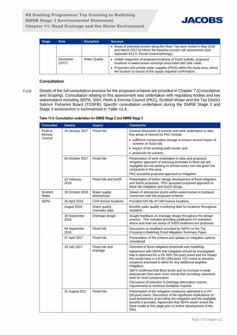
The site walkovers and surveys undertaken to support the assessments are detailed in Table 11.3.
Table 11.3: Site walkover and surveys
Stage Date Discipline Surveys
DMRB Stage 2
February, March, April and June (2015)
All Visual inspection of surface water features and the adjacent area to provide an understanding of the local topography, the hydrological regime and to enable catchment boundaries to be defined where they could not be identified with certainty from the desk-based assessment.
DMRB Stage 3
July, August, November, December (2016), January and March (2017)
Flood Risk Surveys of water feature geometry e.g. channel cross-sections and hydraulic structures, using conventional topographical survey techniques.
Inspections of minor culvert crossings on the existing A9.
Strategic walkover surveys were at selected locations with a focus on developing Flood Risk Assessment (FRA) methodologies related to minor water features and how they should be analysed.
May (2016)
and March (2017)
Fluvial Geomorphology
Geomorphological processes and features around several existing structures over a number of water features including: WF36 (Dowally Burn) and WF40 (Kindallachan Burn).
A9 Dualling Programme: Tay Crossing to Ballinluig
DMRB Stage 3 Environmental Statement
Chapter 11: Road Drainage and the Water Environment
Page 7 of Chapter 11
Stage Date Discipline Surveys
Areas of potential erosion along the River Tay were visited in May 2016 and March 2017 to inform the baseline erosion risk assessment (see Appendix A11.5: Fluvial Geomorphology).
December (2017)
Water Quality Visible inspection of proposed locations of SuDS outfalls, proposed locations of watercourse crossings associated with side roads.
Properties with private water supplies (PWS) within the study area, where the location or source of the supply required confirmation.
Consultation
Details of the full consultation process for the proposed scheme are provided in Chapter 7 (Consultation and Scoping). Consultation relating to this assessment was undertaken with regulatory bodies and key stakeholders including SEPA, SNH, Perth & Kinross Council (PKC), Scottish Water and the Tay District Salmon Fisheries Board (TDSFB). Specific consultation undertaken during the DMRB Stage 2 and Stage 3 assessment is summarised in Table 11.4.
Table 11.4: Consultation undertaken for DMRB Stage 2 and DMRB Stage 3
Consultee Date(s) Aspect Comments
Perth & Kinross Council
18 January 2017 Flood risk General discussion of scheme and work undertaken to date. Key areas of interest for PKC include:
sufficient compensation storage to ensure neutral impact of scheme on flood risk;
impact of the existing earth bunds; and
proposals for culverts.
04 October 2017 Flood risk Presentation of work undertaken to date and proposed mitigation approach of ensuring increases in flood risk are negligible but not seeking to remove every mm rise given the constraints in this area.
PKC accepted proposed approach to mitigation.
22 February 2018
Flood risk and SuDS Presentation of further design development of flood mitigation and SuDS proposals. PKC accepted proposed approach to flood risk mitigation and SuDS design.
Scottish Water
18 October 2016 Water supply abstractions
Details of abstraction points within watercourses in hydraulic connection with the proposed scheme.
SEPA 26 April 2016 CAR licence locations Provided GIS file of CAR licence locations.
August 2016 Water quality chemistry data
Monthly water quality monitoring data for locations throughout Scotland.
28 September 2016
Drainage design Sought feedback on drainage design throughout the design process. This included providing justification for scenarios where less than two levels of SuDS treatment are proposed.
09 September 2016
Flood risk Discussion on feedback provided by SEPA on the Tay Crossing to Ballinluig Flood Mitigation Summary Paper.
27 April 2017 Flood risk Presentation of the scheme and update on mitigation options considered.
13 July 2017 Flood risk and drainage
Overview of flood mitigation proposals and modelling.
Agreement with SEPA that mitigation should be investigated that is optimised for a 2% AEP (50-year) event and the impact this would have in a 0.5% (200-year) +CC event at sensitive receptors assessed to allow for any additional targeted mitigation.
SEPA confirmed that flood levels and no increase in peak downstream flow were more critical than providing volumetric level for level compensation.
Discussion of reduction in drainage attenuation volume requirements to minimise floodplain impacts.
31 August 2017 Flood risk Presentation of the mitigation measures optimised to a 2% (50-year) event. Discussion of the significant implications on local landowners of providing the mitigation and the negligible benefits it provides. Agreement that SEPA would review the flood model at this stage prior to further development of the FRA.

A9 Dualling Programme: Tay Crossing to Ballinluig
DMRB Stage 3 Environmental Statement
Chapter 11: Road Drainage and the Water Environment
Page 8 of Chapter 11
Consultee Date(s) Aspect Comments
02 February 2018
Flood Risk Update on design proposals and mitigation strategy and discussion of SEPA comments on Project 5 FRA where relevant to Project 03.
Spey Fishery Board (SFB)
05 November 2014
Salt application on roads
SFB raised concerns over salt discharge into designated waters through SuDS and highlighted that existing drainage may ‘percolate’ through ‘habitats’. See comment below and refer to Appendix A11.6 (SuDS and Water Quality) for the approach undertaken in relation to salt.
SNH 07 July 2015 Salt application on roads
SNH highlighted the issue of salt and importance in gaining an understanding of current discharge. SEPA does not hold any evidence to suggest salt from the A9 is a current threat; only concern that the A9 has few discharge points. Transport Scotland should consider salt issues in relation to the A9 Dualling Programme. Refer to Appendix A11.6 (SuDS and Water Quality) for the approach undertaken in relation to salt.
Flooding issues were raised at public exhibitions, correspondence and consultation meetings with
landowners and members of the public, which provided opportunities to capture local evidence and concerns. Information obtained from this consultation was used to inform the baseline assessment, in particular to help calibrate model findings, and mitigation, where appropriate.
Impact Assessment Methodology
Introduction
The impact assessment reported in this chapter was undertaken in accordance with the guidance provided in DMRB HD45/09 (Highways Agency et al., 2009a), whereby the level of significance of a potential impact, on the existing baseline condition of the surface water environment, is determined by the sensitivity of the surface water feature combined with the magnitude of impact. This assessment takes account of general and specific impacts from construction and/or operational activities, both before and after the application of mitigation measures i.e. potential and residual impacts respectively.
The sensitivity and magnitude criteria presented in Tables 11.5 and 11.6 represent a development of those provided within DMRB HD45/09 Annex IV, to reflect the local sensitivities and other regulatory guidance.
Hydrology and Flood Risk
The assessment of potential impacts on hydrology and flood risk considered changes to the flow of water above the ground surface and within associated water features. In particular, the likelihood of flooding was assessed against the design 0.5% Annual Exceedance Probability (AEP) (1 in 200-year) plus a 20% allowance for climate change (CC) flood event in line with SEPA’s Technical Flood Risk Guidance for Stakeholders (SEPA, 2015b); hereafter referred to as the 0.5% AEP (200-year) plus CC event.
AEP refers to the chance that a flood of a particular size is experienced or exceeded during any year. This chapter refers to a probability value expressed as a percentage to quantify this. For example, a 50% AEP equates to a 1 in 2 chance of the flood being experienced or exceeded in any given year, and a 0.5% AEP equates to a 1 in 200 probability of the flood being experienced or exceeded in any given year. The potential effects of CC were allowed for in flood flow estimations by adding 20% to the 0.5% AEP (200-year) flood flows, in accordance with guidance (SEPA, 2015b). For simplicity, the terms 0.5% AEP (200-year) plus CC event and the ‘design flood event’ are used interchangeably to describe the flood event used in the assessment of flood risk.
Fluvial Geomorphology
Assessment of potential impacts on fluvial geomorphology considered both upstream and downstream changes in the bed substrate, and fluvial and geomorphological processes (including erosion, transport and deposition of sediment) both within the channel and adjacent floodplain habitats.

A9 Dualling Programme: Tay Crossing to Ballinluig
DMRB Stage 3 Environmental Statement
Chapter 11: Road Drainage and the Water Environment
Page 9 of Chapter 11
The assessment of fluvial geomorphology impacts was undertaken using standard good practice and guidance notes from SEPA, noted in Table 11.1, in the absence of specific methodologies for the assessment of fluvial geomorphology with respect to road developments. The assessment was supported and further developed using professional judgement.
Water Quality
The assessment of potential impacts on water quality includes the sub-attributes of water supply/quality, dilution and removal of waste products and biodiversity, as specified within DMRB HD45/09.
Sensitivity
The sensitivity of water features assigned within Appendix A11.1 (Baseline Conditions) was categorised on a scale of ‘low’ to ‘very high’ using various sources of information described below, as well as professional judgement, in accordance with the criteria provided in Table 11.5. In some cases, water features were categorised as a higher or lower sensitivity where sufficient justification exists. Where applicable, supporting information is provided within the relevant technical appendix and Appendix A11.1 (Baseline Conditions).
For hydrology and flood risk, the sensitivity was based on the number and type of potential flood receptors including the existing A9 (assessed as critical social infrastructure in line with Scottish Government, 2014). Very high, high, medium and low sensitivities were assigned to watercourses taking into account the likelihood of flooding to identified receptors during the 0.5% AEP (200-year) plus CC event (SEPA, 2015b).
The sensitivity assessment of water quality was informed by the WFD water body condition status published by SEPA (to meet WEWS Act requirements) on its Water Environment Hub website (SEPA, 2016c). Where no data exist for smaller/minor water features, assumptions were made based on the status of the nearest classified water feature of a similar character (Mustow et al. 2005). In addition, any field observations which would likely affect the status of the water feature, if it were to be classified, were also taken into consideration.
Table 11.5: Sensitivity criteria – water features
Sensitivity Criteria
Very High Attribute has a high quality and/or rarity on international scale
Hydrology and Flood Risk
Water feature with direct flood risk to the adjacent populated areas, with greater than 100 residential properties and/or critical social infrastructure units such as the existing A9, the Highland Main Line railway, hospitals, schools or safe shelters at risk during the 0.5% AEP (200-year) plus CC event.
Water feature with hydrological importance to: (i) sensitive and protected ecosystems of international status; and/or (ii) critical economic and social uses (e.g. water supply, navigation, recreation, and amenity).
Fluvial Geomorphology
Sediment Regime
Water feature sediment regime provides a diverse mosaic of habitat types suitable for species sensitive to changes in sediment concentration and turbidity, such as migratory salmon and/or freshwater pearl mussel (FWPM). Water feature appears in complete equilibrium with natural erosion and deposition occurring. The water feature has sediment processes reflecting the nature of the catchment and fluvial system.
Channel Morphology
Water feature includes varied morphological features (e.g. pools, riffles, bars, natural bank profiles) with no sign of channel modification.
Natural Fluvial Processes
Water feature displays natural fluvial processes and natural flow regime, which would be highly vulnerable to change as a result of modification.
Water Quality
Water Supply/Quality
‘High’ physical-chemical status, and/or
Water feature constitutes a valuable water supply resource due to extensive exploitation for public, private domestic and/or agricultural and/or industrial use, feeding ten or more properties; and/or
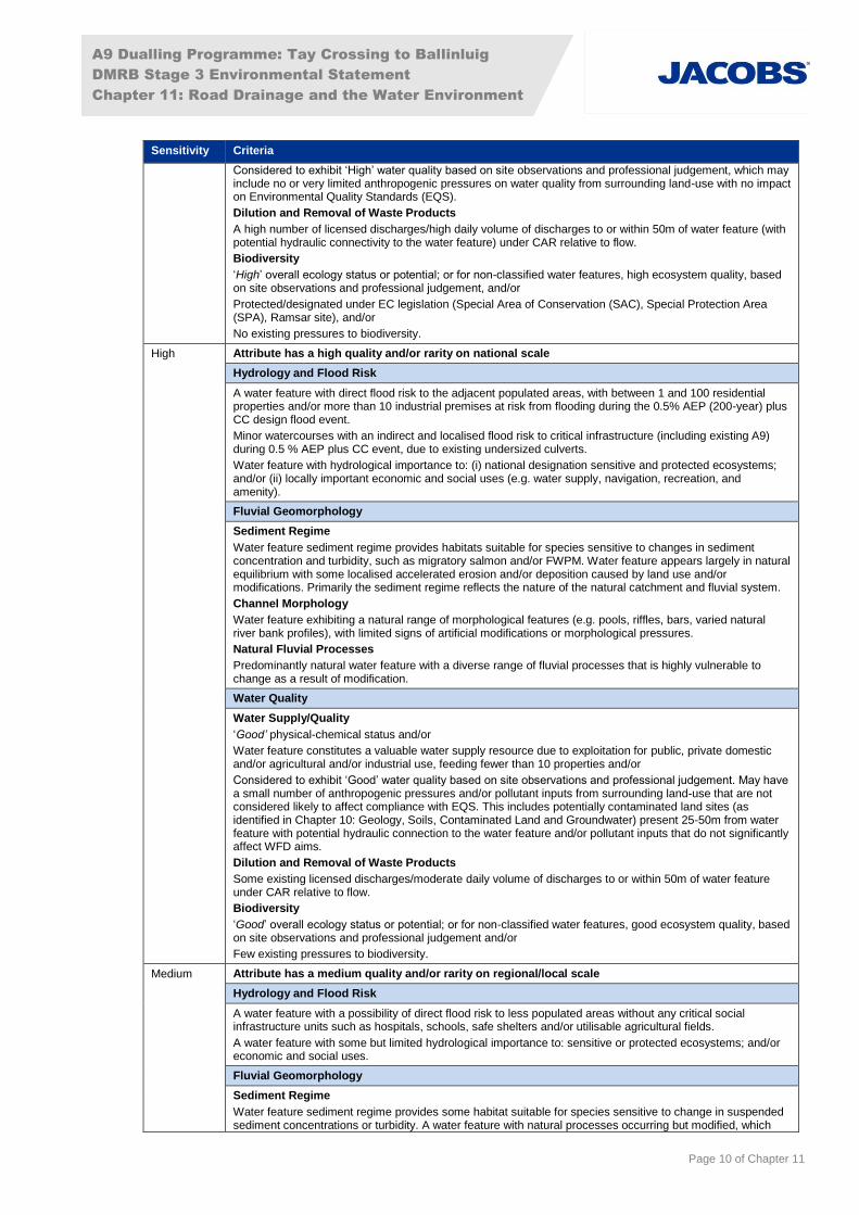
A9 Dualling Programme: Tay Crossing to Ballinluig
DMRB Stage 3 Environmental Statement
Chapter 11: Road Drainage and the Water Environment
Page 10 of Chapter 11
Sensitivity Criteria
Considered to exhibit ‘High’ water quality based on site observations and professional judgement, which may include no or very limited anthropogenic pressures on water quality from surrounding land-use with no impact on Environmental Quality Standards (EQS).
Dilution and Removal of Waste Products
A high number of licensed discharges/high daily volume of discharges to or within 50m of water feature (with potential hydraulic connectivity to the water feature) under CAR relative to flow.
Biodiversity
‘High’ overall ecology status or potential; or for non-classified water features, high ecosystem quality, based on site observations and professional judgement, and/or
Protected/designated under EC legislation (Special Area of Conservation (SAC), Special Protection Area (SPA), Ramsar site), and/or
No existing pressures to biodiversity.
High Attribute has a high quality and/or rarity on national scale
Hydrology and Flood Risk
A water feature with direct flood risk to the adjacent populated areas, with between 1 and 100 residential properties and/or more than 10 industrial premises at risk from flooding during the 0.5% AEP (200-year) plus CC design flood event.
Minor watercourses with an indirect and localised flood risk to critical infrastructure (including existing A9) during 0.5 % AEP plus CC event, due to existing undersized culverts.
Water feature with hydrological importance to: (i) national designation sensitive and protected ecosystems; and/or (ii) locally important economic and social uses (e.g. water supply, navigation, recreation, and amenity).
Fluvial Geomorphology
Sediment Regime
Water feature sediment regime provides habitats suitable for species sensitive to changes in sediment concentration and turbidity, such as migratory salmon and/or FWPM. Water feature appears largely in natural equilibrium with some localised accelerated erosion and/or deposition caused by land use and/or modifications. Primarily the sediment regime reflects the nature of the natural catchment and fluvial system.
Channel Morphology
Water feature exhibiting a natural range of morphological features (e.g. pools, riffles, bars, varied natural river bank profiles), with limited signs of artificial modifications or morphological pressures.
Natural Fluvial Processes
Predominantly natural water feature with a diverse range of fluvial processes that is highly vulnerable to change as a result of modification.
Water Quality
Water Supply/Quality
‘Good’ physical-chemical status and/or
Water feature constitutes a valuable water supply resource due to exploitation for public, private domestic and/or agricultural and/or industrial use, feeding fewer than 10 properties and/or
Considered to exhibit ‘Good’ water quality based on site observations and professional judgement. May have a small number of anthropogenic pressures and/or pollutant inputs from surrounding land-use that are not considered likely to affect compliance with EQS. This includes potentially contaminated land sites (as identified in Chapter 10: Geology, Soils, Contaminated Land and Groundwater) present 25-50m from water feature with potential hydraulic connection to the water feature and/or pollutant inputs that do not significantly affect WFD aims.
Dilution and Removal of Waste Products
Some existing licensed discharges/moderate daily volume of discharges to or within 50m of water feature under CAR relative to flow.
Biodiversity
‘Good’ overall ecology status or potential; or for non-classified water features, good ecosystem quality, based on site observations and professional judgement and/or
Few existing pressures to biodiversity.
Medium Attribute has a medium quality and/or rarity on regional/local scale
Hydrology and Flood Risk
A water feature with a possibility of direct flood risk to less populated areas without any critical social infrastructure units such as hospitals, schools, safe shelters and/or utilisable agricultural fields.
A water feature with some but limited hydrological importance to: sensitive or protected ecosystems; and/or economic and social uses.
Fluvial Geomorphology
Sediment Regime
Water feature sediment regime provides some habitat suitable for species sensitive to change in suspended sediment concentrations or turbidity. A water feature with natural processes occurring but modified, which

A9 Dualling Programme: Tay Crossing to Ballinluig
DMRB Stage 3 Environmental Statement
Chapter 11: Road Drainage and the Water Environment
Page 11 of Chapter 11
Sensitivity Criteria
causes notable alteration to the natural sediment transport pathways, sediment sources and areas of deposition.
Channel Morphology
Water feature exhibiting some natural morphological features (e.g. pools, riffles and depositional bars). The channel cross-section is partially modified in places, with obvious signs of modification to the channel morphology. Natural recovery of channel form may be present (e.g. eroding cliffs, depositional bars).
Natural Fluvial Processes
Water feature with some natural fluvial processes, including varied flow types. Modifications and anthropogenic influences having an obvious impact on natural flow regime, flow pathways and fluvial processes.
Water Quality
Water Supply/Quality
‘Moderate’ physical-chemical status, and/or
Considered to exhibit ‘Moderate’ water quality based on site observations and professional judgement. May have a number of anthropogenic pressures and/or pollutant inputs from surrounding land-use that are considered likely to be affecting compliance with EQS for one or more parameters. This includes potentially contaminated land sites (as identified in Chapter 10: Geology, Soils, Contaminated Land and Groundwater) present 10-25m from water feature with potential hydraulic connection to the water feature.
Dilution and removal of waste products
Few existing licensed discharges/low daily volume of discharges to or within 50m of water feature under CAR relative to flow.
Biodiversity
‘Moderate’ overall ecology status or potential; or for non-classified water features, moderate ecosystem quality, based on site observations and professional judgement, and/or
Existing pressures which are likely to be adversely affecting biodiversity.
Low Attribute has a low quality and/or rarity on local scale
Hydrology and Flood Risk
A water feature passing through uncultivated agricultural land. A water feature which is assessed as not being a flood risk to the existing A9 for the 0.5% AEP (200-year) plus CC design flood event.
A water feature with minimal hydrological importance to: (i) sensitive or protected ecosystems; and/or (ii) economic and social uses.
Fluvial Geomorphology
Sediment Regime
Water feature sediment regime which provides very limited physical habitat for species sensitive to changes in suspended solids concentration or turbidity. Highly modified sediment regime with limited/no capacity for natural recovery.
Channel Morphology
Water feature that has been extensively modified (e.g. by culverting, addition of bank protection or impoundments) and exhibits limited-to-no morphological diversity. The water feature is likely to have uniform flow, uniform banks and absence of bars. Insufficient energy for morphological change.
Natural Fluvial Processes
Water feature which shows no or limited evidence of active fluvial processes with unnatural flow regime or/and uniform flow types and minimal secondary currents.
Water Quality
Water Supply/Quality
‘Poor’ or ‘Bad’ physical-chemical status or potential, and/or
Considered to exhibit ‘Poor’ or ‘Bad’ water quality based on site observations and professional judgement. May have a large number of anthropogenic pressures and/or pollutant inputs from surrounding land-use that are considered likely to be affecting the compliance of EQS for the majority of parameters. This includes potentially contaminated land sites (as identified in Chapter 10: Geology, Soils, Contaminated Land and Groundwater) present within 10m of water feature with potential hydraulic connection to the water feature.
Dilution and removal of waste products
No existing licensed discharges to or within 50m of the water feature under CAR.
Biodiversity
‘Poor’ or ‘Bad’ overall ecology status or for non-classified water features, poor or bad ecosystem quality, based on site observations and professional judgement, and/or
Many existing pressures which are considered to be adversely affecting biodiversity.
Impact Magnitude
The magnitude of potential impacts was assessed on a scale of ‘major’ to ‘negligible’ for both adverse and beneficial impacts based on the likely effect of proposed activities, guided by the criteria and
A9 Dualling Programme: Tay Crossing to Ballinluig
DMRB Stage 3 Environmental Statement
Chapter 11: Road Drainage and the Water Environment
Page 12 of Chapter 11
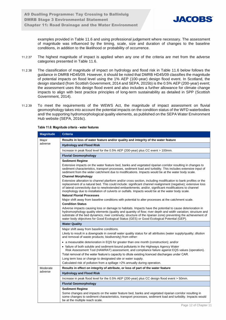
examples provided in Table 11.6 and using professional judgement where necessary. The assessment of magnitude was influenced by the timing, scale, size and duration of changes to the baseline conditions, in addition to the likelihood or probability of occurrence.
The highest magnitude of impact is applied when any one of the criteria are met from the adverse categories presented in Table 11.6.
The classification of magnitude of impact on hydrology and flood risk in Table 11.6 below follows the guidance in DMRB HD45/09. However, it should be noted that DMRB HD45/09 classifies the magnitude of potential impacts on flood level using the 1% AEP (100-year) design flood event. In Scotland, the design standard (from Scottish Government, 2014 and SEPA, 2015b) is the 0.5% AEP (200-year) event; the assessment uses this design flood event and also includes a further allowance for climate change impacts to align with best practice principles of long-term sustainability as detailed in SPP (Scottish Government, 2014).
To meet the requirements of the WEWS Act, the magnitude of impact assessment on fluvial geomorphology takes into account the potential impacts on the condition status of the WFD waterbodies and/ the supporting hydromorphological quality elements, as published on the SEPA Water Environment Hub website (SEPA, 2016c).
Table 11.6: Magnitude criteria - water features
Magnitude Criteria
Major adverse
Results in loss of water feature and/or quality and integrity of the water feature
Hydrology and Flood Risk
Increase in peak flood level for the 0.5% AEP (200-year) plus CC event > 100mm.
Fluvial Geomorphology
Sediment Regime
Extensive impacts on the water feature bed, banks and vegetated riparian corridor resulting in changes to sediment characteristics, transport processes, sediment load and turbidity. This includes extensive input of sediment from the wider catchment due to modifications. Impacts would be at the water body scale.
Channel Morphology
Extensive alteration to channel planform and/or cross section, including modification to bank profiles or the replacement of a natural bed. This could include: significant channel realignment (negative); extensive loss of lateral connectivity due to new/extended embankments; and/or, significant modifications to channel morphology due to installation of culverts or outfalls. Impacts would be at the water body scale.
Natural Fluvial Processes
Major shift away from baseline conditions with potential to alter processes at the catchment scale.
Condition Status
Adverse impacts causing loss or damage to habitats. Impacts have the potential to cause deterioration in hydromorphology quality elements (quality and quantity of flow; river depth and width variation; structure and substrate of the bed dynamics; river continuity; structure of the riparian zone) preventing the achievement of water body objectives for Good Ecological Status (GES) or Good Ecological Potential (GEP).
Water Quality
Major shift away from baseline conditions.
Likely to result in a downgrade in overall water quality status for all attributes (water supply/quality; dilution and removal of waste products; biodiversity) from either:
a measurable deterioration in EQS for greater than one month (construction); and/or
failure of both soluble and sediment-bound pollutants in the Highways Agency Water Risk Assessment Tool (HAWRAT) assessment, and compliance failure against EQS values (operation).
Total removal of the water feature’s capacity to dilute existing licenced discharges under CAR.
Long term loss or change to designated site or water supply.
Calculated risk of pollution from a spillage >2% annually during operation.
Moderate adverse
Results in effect on integrity of attribute, or loss of part of the water feature
Hydrology and Flood Risk
Increase in peak flood level for the 0.5% AEP (200-year) plus CC design flood event > 50mm.
Fluvial Geomorphology
Sediment Regime
Some changes and impacts on the water feature bed, banks and vegetated riparian corridor resulting in some changes to sediment characteristics, transport processes, sediment load and turbidity. Impacts would be at the multiple reach scale.

A9 Dualling Programme: Tay Crossing to Ballinluig
DMRB Stage 3 Environmental Statement
Chapter 11: Road Drainage and the Water Environment
Page 13 of Chapter 11
Magnitude Criteria
Channel Morphology
Some alteration to channel planform and/or cross section, including modification to bank profiles or the replacement of a natural bed. Activities could include: channel realignment, new/extended embankments, modified bed and/bank profiles, replacement of bed and/or banks with artificial material and/or installation of culverts. Impacts would be at the multiple reach scale.
Natural Fluvial Processes
A shift away from baseline conditions with potential to alter processes at the reach or multiple reach scale.
Condition Status
Moderate adverse impacts at the reach or multiple reach scale, which causes some loss or damage to habitats. Impacts have the potential to cause failure or deterioration in one or more of the hydromorphological quality elements (quality and quantity of flow; river depth and width variation; structure and substrate of the bed dynamics; river continuity; structure of the riparian zone). May prevent the achievement of water body objectives for GES or GEP.
Water Quality
A moderate shift away from baseline conditions that may be long-term or temporary.
Likely to result in a decline in water quality but not a downgrade in overall water quality status from either:
a measurable deterioration in EQS for less than one month (construction); and/or
failure of both soluble and sediment-bound pollutants in HAWRAT but compliance with EQS values (operation).
Reduction in the water feature’s capacity to dilute existing discharges under CAR.
May result in temporary impacts on designated species/habitats or water supply.
Calculated risk of pollution from a spillage >1% and <2% annually during operation.
Minor adverse
Results in some measurable change in quality or vulnerability of attribute of the water feature
Hydrology and Flood Risk
Increase in peak flood level for the 0.5% AEP (200-year) plus CC design flood event of > 10mm.
Fluvial Geomorphology
Sediment Regime
Limited impacts on the water feature bed, banks and vegetated riparian corridor resulting in limited (but notable) changes to sediment characteristics, transport processes, sediment load and turbidity at the reach scale.
Channel Morphology
A small change or modification in the channel planform and/or cross section. Includes upgrade to and/or extension of existing water feature crossing and/or structure with associated minor channel realignment with localised impacts.
Natural Fluvial Processes
Minimal shift away from baseline conditions with typically localised impacts up to the reach scale.
Condition Status
Minor adverse impacts at the reach scale, which may cause partial loss or damage to habitats. Impacts have the potential to cause failure or deterioration in one of the hydromorphological quality elements (quality and quantity of flow; river depth and width variation; structure and substrate of the bed dynamics; river continuity; structure of the riparian zone).
Water Quality
Minor shift away from baseline conditions.
Likely to result in a slight decline in water quality with no associated impacts on designated species/habitats or water supply, which is characterised by:
a temporary decline in water quality during construction; and/or
failure of either soluble or sediment-bound pollutants in HAWRAT during operation.
Slight reduction in the water feature’s capacity to dilute existing discharges under CAR.
Calculated risk of pollution from a spillage >0.5% and <1% annually during operation.
Negligible Results in effect on attribute of the water feature, but of insufficient magnitude to affect the use or integrity
Hydrology and Flood Risk
Negligible change in peak flood level for the 0.5% AEP (200-year) plus CC design flood event of +/- 10mm.
Fluvial Geomorphology
Minimal or no measurable change from baseline conditions in terms of sediment transport, channel morphology and natural fluvial processes. Any impacts are likely to be highly localised and not have an effect at the reach scale.
Water Quality
No perceptible changes to baseline conditions.
No measurable change in water quality at any time during construction.

A9 Dualling Programme: Tay Crossing to Ballinluig
DMRB Stage 3 Environmental Statement
Chapter 11: Road Drainage and the Water Environment
Page 14 of Chapter 11
Magnitude Criteria
No change in the water feature’s capacity to dilute existing discharges under CAR.
No risk identified by HAWRAT (Pass for both soluble and sediment-bound pollutants) during operation.
Risk of pollution from a spillage <0.5% during operation.
Minor beneficial
Results in some beneficial effect on attribute of the water feature or a reduced risk of negative effect occurring to the water feature
Hydrology and Flood Risk
Reduction in peak flood level for the 0.5% AEP (200-year) plus CC design flood event > 10mm
Fluvial Geomorphology
Sediment Regime
Partial improvement to sediment processes at the reach scale, including reduction in siltation and localised recovery of sediment transport processes.
Channel Morphology
Partial improvements include enhancements to in-channel habitat, riparian zone and morphological diversity of the bed and/or banks.
Natural Fluvial Processes
Slight improvement on baseline conditions with potential to improve flow processes at the reach scale.
Condition Status
Slight beneficial impacts at the reach scale, which may cause partial habitat enhancement. Impacts have the potential to improve one of the hydromorphological quality elements (quality and quantity of flow; river depth and width variation; structure and substrate of the bed dynamics; river continuity; structure of the riparian zone).
Water Quality
Minor improvement over baseline conditions.
HAWRAT assessment of either soluble or sediment-bound pollutants becomes ‘Pass’ from an existing site where the baseline was a ‘Fail’ condition. Calculated reduction in existing spillage risk by 50% or more (when existing spillage risk is <1% annually).
Moderate beneficial
Results in moderate improvement of the quality of the attribute of the water feature
Hydrology and Flood Risk
Reduction in peak flood level for the 0.5% AEP (200-year) plus CC design flood event > 50mm
Fluvial Geomorphology
Sediment Regime
Reduction in siltation and recovery of sediment transport processes at the reach or multiple reach scale.
Channel Morphology
Partial creation of both in-channel and vegetated riparian habitat. Improvement in morphological diversity of the bed and/or banks at the reach or multiple reach scale. Includes partial or complete removal of structures and/or artificial materials.
Natural Fluvial Processes
Notable improvements on baseline conditions and recovery of fluvial processes at the reach or multiple reach scale.
Condition Status
Notable beneficial impacts at the reach to multiple reach scale. Impacts have the potential to improve one or more of the hydromorphological quality elements (quality and quantity of flow; river depth and width variation; structure and substrate of the bed dynamics; river continuity; structure of the riparian zone) and/or assist in achieving the water body objectives for GES or GEP.
Water Quality
A moderate improvement over baseline conditions.
HAWRAT assessment of both soluble and sediment-bound pollutants becomes ‘Pass’ from an existing site where the baseline was a ‘Fail’ condition. Calculated reduction in existing spillage risk by 50% or more (when existing spillage risk is >1% annually).
Major beneficial
Results in major improvement of attribute quality
Hydrology and Flood Risk
Reduction in peak flood level for the 0.5% AEP (200-year) plus CC design flood event > 100mm.
Fluvial Geomorphology
Sediment Regime
Improvement to sediment processes at the catchment scale, including recovery of sediment supply and transport processes.
Channel Morphology
Extensive creation of both in-channel habitat and riparian zone. Morphological diversity of the bed and/or banks is restored, such as natural planform, varied natural cross-sectional profiles, recovery of fluvial
A9 Dualling Programme: Tay Crossing to Ballinluig
DMRB Stage 3 Environmental Statement
Chapter 11: Road Drainage and the Water Environment
Page 15 of Chapter 11
Magnitude Criteria
features (e.g. cascades, pools, riffles, and bars) expected for river type. Removal of modifications, structures, and artificial materials.
Natural Fluvial Processes
Substantial improvement on baseline conditions at catchment scale. Recovery of flow and sediment regime.
Condition Status
Substantial beneficial impacts at the catchment scale, which result in recovery/restoration of natural habitats suitable for supporting sensitive species. Potential improvement of overall status condition, which could lead to achievement of water body objectives for GES or GEP.
Water Quality
Major improvement over baseline conditions. The removal or likelihood of removal of existing pressures, resulting in a water body achieving its objectives for GES or GEP.
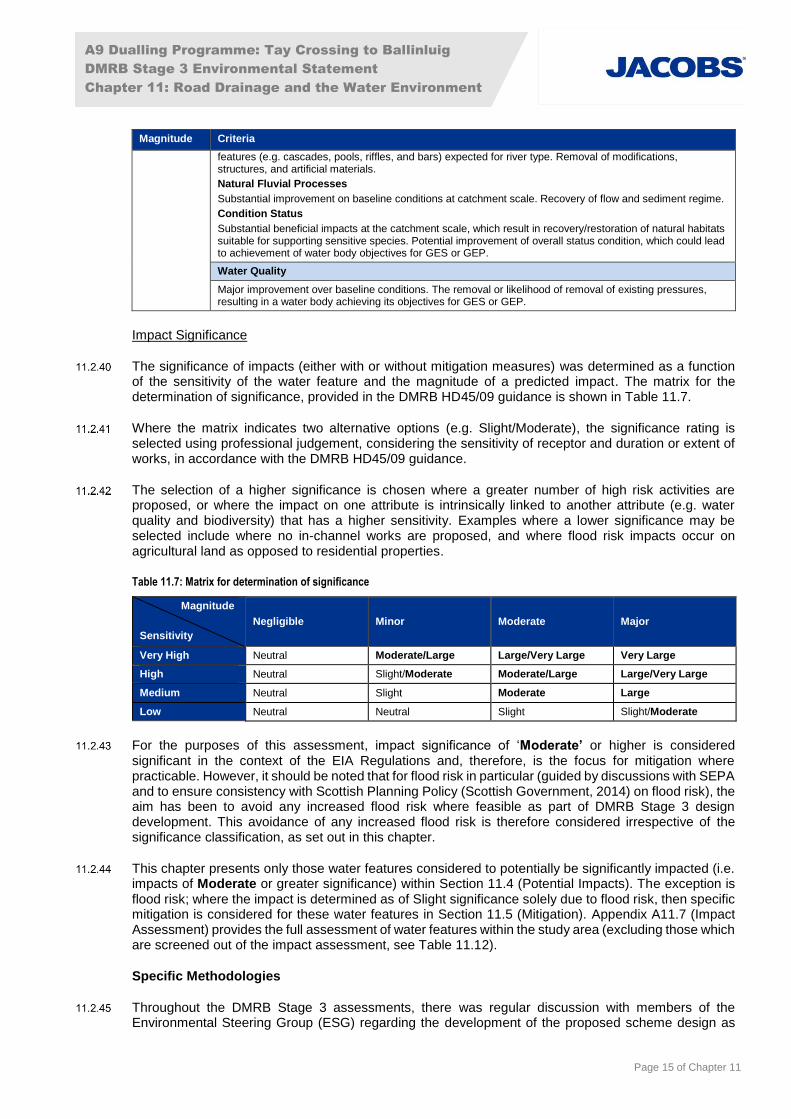
Impact Significance
The significance of impacts (either with or without mitigation measures) was determined as a function of the sensitivity of the water feature and the magnitude of a predicted impact. The matrix for the determination of significance, provided in the DMRB HD45/09 guidance is shown in Table 11.7.
Where the matrix indicates two alternative options (e.g. Slight/Moderate), the significance rating is selected using professional judgement, considering the sensitivity of receptor and duration or extent of works, in accordance with the DMRB HD45/09 guidance.
The selection of a higher significance is chosen where a greater number of high risk activities are proposed, or where the impact on one attribute is intrinsically linked to another attribute (e.g. water quality and biodiversity) that has a higher sensitivity. Examples where a lower significance may be selected include where no in-channel works are proposed, and where flood risk impacts occur on agricultural land as opposed to residential properties.
Table 11.7: Matrix for determination of significance
Magnitude
Sensitivity
Negligible Minor Moderate Major
Very High Neutral Moderate/Large Large/Very Large Very Large
High Neutral Slight/Moderate Moderate/Large Large/Very Large
Medium Neutral Slight Moderate Large
Low Neutral Neutral Slight Slight/Moderate
For the purposes of this assessment, impact significance of ‘Moderate’ or higher is considered significant in the context of the EIA Regulations and, therefore, is the focus for mitigation where practicable. However, it should be noted that for flood risk in particular (guided by discussions with SEPA and to ensure consistency with Scottish Planning Policy (Scottish Government, 2014) on flood risk), the aim has been to avoid any increased flood risk where feasible as part of DMRB Stage 3 design development. This avoidance of any increased flood risk is therefore considered irrespective of the significance classification, as set out in this chapter.
This chapter presents only those water features considered to potentially be significantly impacted (i.e. impacts of Moderate or greater significance) within Section 11.4 (Potential Impacts). The exception is flood risk; where the impact is determined as of Slight significance solely due to flood risk, then specific mitigation is considered for these water features in Section 11.5 (Mitigation). Appendix A11.7 (Impact Assessment) provides the full assessment of water features within the study area (excluding those which are screened out of the impact assessment, see Table 11.12).
Specific Methodologies
Throughout the DMRB Stage 3 assessments, there was regular discussion with members of the Environmental Steering Group (ESG) regarding the development of the proposed scheme design as

A9 Dualling Programme: Tay Crossing to Ballinluig
DMRB Stage 3 Environmental Statement
Chapter 11: Road Drainage and the Water Environment
Page 16 of Chapter 11
well as the environmental assessment methods, with reference to the SEA (Transport Scotland, 2013) for the wider A9 Dualling Programme.
Hydrology and Flood Risk
A flood risk assessment was undertaken following SEPA’s Technical Flood Risk Guidance for Stakeholders (SEPA, 2015b), and giving consideration to the guidance within DMRB HD45/09, one-dimensional (1D)/two-dimensional (2D) hydraulic modelling was undertaken for five of the principal water features within the study area: River Tay; River Tummel; Kindallachan Burn; Dowally Burn; and Sloggan Burn. Hydraulic modelling using 1D-2D linked techniques was also undertaken for 14 minor watercourses (WF18, WF23, WF25, WF,25, WF28, WF29, WF30, WF31, WF37, WF38, WF42, WF50, WF52 and WF53) to characterise flood mechanisms. Hydraulic spreadsheet based calculations were undertaken to assess flood risk from the remaining watercourses. Further details of the assessment undertaken are included in Appendix A11.8 (Watercourse Crossings Report).
Full detailed methodologies are provided in Appendix A11.2 (Surface Water Hydrology), Appendix A11.3 (Flood Risk Assessment) and Appendix A11.4 (Hydraulic Modelling Report).
Fluvial Geomorphology
As part of the assessment for the proposed scheme, an assessment of potential impacts on the fluvial geomorphology of the water features affected by the proposed scheme was carried out in line with the Supporting Guidance (WAT-SG-21): Environmental Standards for River Morphology (SEPA, 2012a).
A baseline assessment of existing areas at risk of erosion along the River Tay and River Tummel was also undertaken to inform sensitivity ratings. These included locations where the existing A9 infrastructure is currently at risk, or the proposed scheme could be at risk from fluvial erosion in the future. Results of the erosion risk assessment are included in Appendix A11.1 (Baseline Conditions) with further details provided in Appendix A11.5 (Fluvial Geomorphology).
An additional geomorphological assessment was undertaken for the Habitat Regulations Assessment (HRA), focussing on potential impacts on the existing condition of SAC habitats and species. Further details on the methodology and results of the assessment are provided in Appendix A11.5 (Fluvial Geomorphology).
Water Quality
Specific water quality assessments were carried out to assess the impacts on the water environment from the operation of the proposed scheme.
Highways Agency Water Risk Assessment Tool (HAWRAT)
The assessment of operational impacts relating to routine runoff and spillage risk was carried out in line with the methods contained in DMRB HD45/09 (Method A and Method D, respectively). The assessment of the magnitude and significance of operational impacts has taken into account the nature of the water features proposed to receive road drainage and the dilution or dispersal potential of the water features.
A summary of Methods A and D of DMRB HD45/09 is provided within Appendix A11.6 (SuDS and Water Quality).
An assessment of the impacts from de-icing activities (and specifically from chloride) and an assessment of the SuDS requirements for side road drainage using the Simple Index Approach (CIRIA, 2015b) has also been undertaken. These assessments do not inform the impact assessment presented within this chapter due to the limitations associated with the methods, but the conclusions are discussed qualitatively within Appendix A11.6 (SuDS and Water Quality).
Limitations to Stage 3 Assessment
Baseline conditions described in Appendix A11.1 (Baseline Conditions) were informed by site walkover observations with surveys of water features made at specific times and water levels. However, it is
A9 Dualling Programme: Tay Crossing to Ballinluig
DMRB Stage 3 Environmental Statement
Chapter 11: Road Drainage and the Water Environment
Page 17 of Chapter 11
recognised that seasonal variables (such as flow levels, vegetation growth and land use) can affect the visibility of in-channel features; as well as the overall morphology and fluvial processes observed at the time of survey, representing a limitation in recorded data sets, common to all aquatic field studies.
In addition, data received during consultation, some of which was received 2 years ago, may have been updated since the time of writing of this chapter.
Hydrology and Flood Risk
The majority of water features within the study area have small ungauged catchments. No flow gauge is located within the study area. Therefore, the hydraulic model used to assess the impact of the proposed scheme has not been calibrated against three flow events as stated in DMRB Stage 3 guidance. The hydraulic model has however, undergone extensive sensitivity testing and calibration with wrack marks, photographs and anecdotal evidence of historical flood events. Flows have also been calibrated against those within the A9 Dualling: Pass of Birnam project (Project 02) hydraulic model immediately downstream of the proposed scheme hydraulic model. The Project 02 model has been calibrated to gauge data.
Flood risk related to groundwater sources is not specifically addressed within this chapter; however, consideration of potential impacts on flood risk in relation to artesian conditions is reported in Chapter 10 (Geology, Soils, Contaminated Land and Groundwater) and Appendix A11.3 (Flood Risk Assessment). In addition, flood risk related to the failure of water-retaining infrastructure is reported in Appendix A11.3 (Flood Risk Assessment).
Limitations relating to the flow estimation methods, hydraulic modelling and flood risk assessment are provided in Appendix A11.2 (Surface Water Hydrology), Appendix A11.3 (Flood Risk Assessment) and Appendix A11.4 (Hydraulic Modelling Report) respectively.
Fluvial Geomorphology
Many watercourses were observed in the field at one point in time, therefore the predominant sediment regime and processes operating within the channel were inferred using best available site data and desk-based information. Measurements taken during initial geomorphological surveys were visual estimates only. Where geomorphological issues were identified, further investigations to inform the design process made use of detailed topographic survey data.
Further limitations relating to the surveys and assessments undertaken for fluvial geomorphology are provided in Appendix A11.5 (Fluvial Geomorphology).
Water Quality
The identification of private water supplies (PWS) was based on the information obtained through desk studies, consultation with local authorities and SEPA, as well as site visits (refer to Chapter 10: Geology, Soils, Contaminated Land and Groundwater). Reasonable skill, care and diligence were exercised in identifying PWS; however, notwithstanding this, there may be PWS which have not been identified, or PWS which may not be correctly characterised due to erroneous or out of date information provided during consultation.
Limitations relating to the water quality assessments undertaken are also provided in Appendix A11.6 (SuDS and Water Quality).
11.3 Baseline Conditions
Water Features
A detailed description of all water features affected by the proposed scheme is provided within Appendix A11.1 (Baseline Conditions). This includes the baseline conditions for all water environment attributes covered within this chapter, namely: Hydrology and Flood Risk, Fluvial Geomorphology and Water Quality (Water Quality, Water Supply, Dilution and Removal of Waste Products and Biodiversity). As part of the baseline assessment for all water features, a sensitivity rating has been determined for each

A9 Dualling Programme: Tay Crossing to Ballinluig
DMRB Stage 3 Environmental Statement
Chapter 11: Road Drainage and the Water Environment
Page 18 of Chapter 11
water environment attribute and is included within the appendix. Where more information is required, for example in relation to increased sensitivity levels, this is located within the relevant technical appendix and a cross-reference provided.
Within the 500m study area, 34 water features were initially identified, including artificial drainage channels, minor watercourses and large river systems.
As described in Chapter 1 (Introduction), the southern section of the A9 Dualling Programme comprises four projects currently progressing through the DMRB design and assessment process (from the Pass of Birnam to Glen Garry). The majority of identified water features within this southern section were referenced sequentially from south to north. The water features within the Tay Crossing to Ballinluig (Project 03) section are therefore numbered from WF06 to WF70, with WF06 being the River Tay.
The locations of all water features, with corresponding identification references, proposed scheme crossing locations and flood inundation extents are shown on Figures 11.1 and 11.2. For ecological designations, refer to Figures 5.1 and 12.2.
During the baseline review, a number of water features observed on Ordnance Survey mapping within the 500m study area were excluded from the baseline, as site surveys identified that they either did not exist or were existing road drainage features which do not require assessment under DMRB HD45/09. In addition, two minor watercourses (WF45/WF46) were scoped out of the assessment as they were identified to be up-gradient from the proposed construction and operational activities, and hence would not be affected.
The baseline conditions of all water features are described in the following paragraphs, and their subsequent sensitivity per attribute is confirmed at the end of this section (refer to Table 11.12).
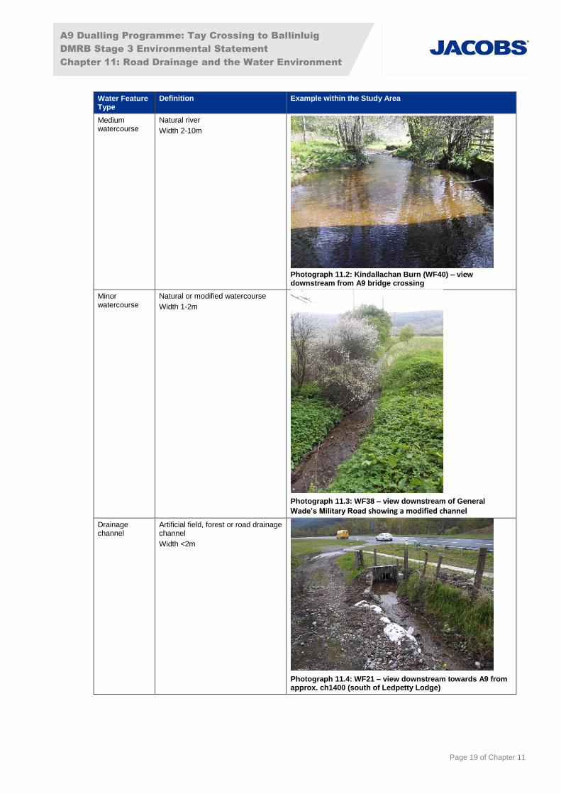
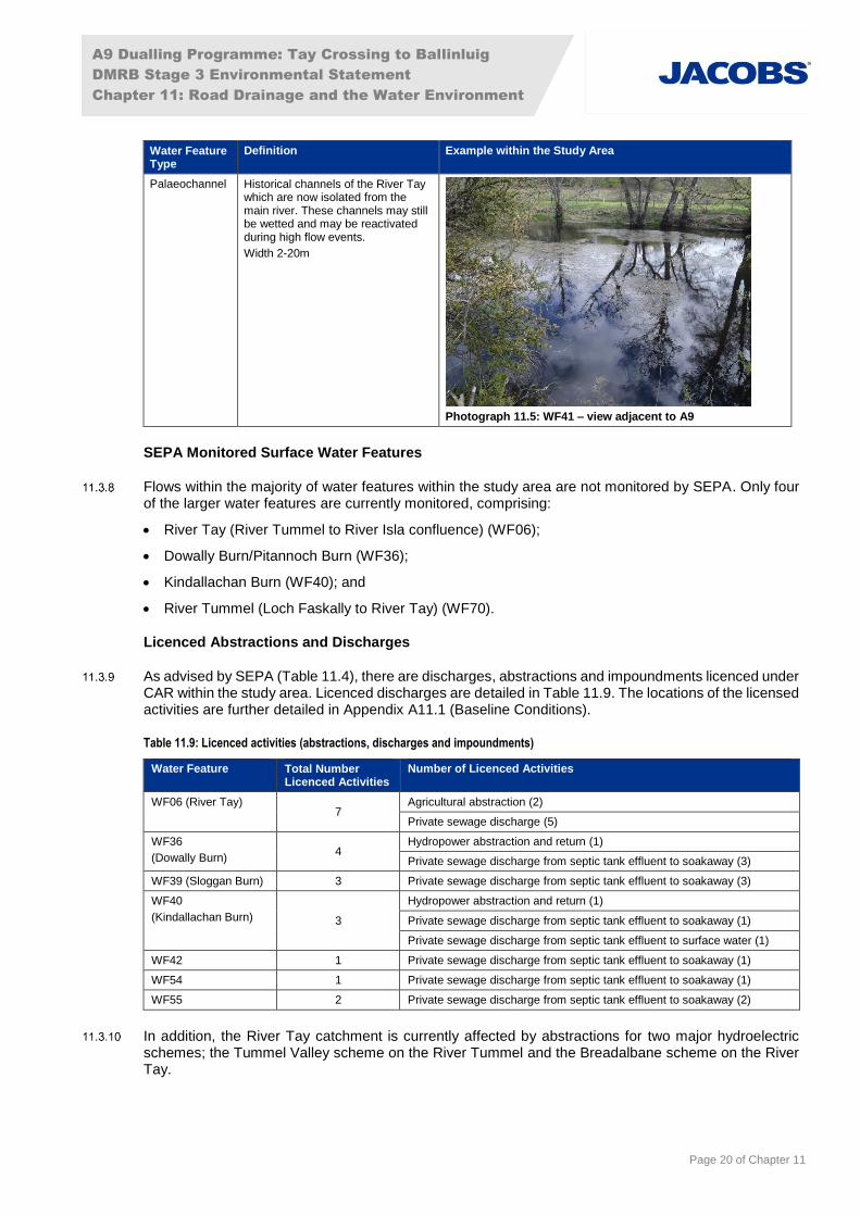
The baseline assessment includes consideration of river typology in line with the Environmental Standards for River Morphology (SEPA, 2012). The different types and definitions of water features identified within the study area are described below in Table 11.8.
Table 11.8: Types and definitions of water features within the study area
Water Feature Type
Definition Example within the Study Area
Major watercourse
Natural river channel
Width >10m
Photograph 11.1: River Tay (WF06) – view downstream from ch1600 (south of Ledpetty Lodge)
A9 Dualling Programme: Tay Crossing to Ballinluig
DMRB Stage 3 Environmental Statement
Chapter 11: Road Drainage and the Water Environment
Page 19 of Chapter 11
Water Feature Type
Definition Example within the Study Area
Medium watercourse
Natural river
Width 2-10m
Photograph 11.2: Kindallachan Burn (WF40) – view downstream from A9 bridge crossing
Minor watercourse
Natural or modified watercourse
Width 1-2m
Photograph 11.3: WF38 – view downstream of General
Wade’s Military Road showing a modified channel
Drainage channel
Artificial field, forest or road drainage channel
Width <2m
Photograph 11.4: WF21 – view downstream towards A9 from approx. ch1400 (south of Ledpetty Lodge)
A9 Dualling Programme: Tay Crossing to Ballinluig
DMRB Stage 3 Environmental Statement
Chapter 11: Road Drainage and the Water Environment
Page 20 of Chapter 11
Water Feature Type
Definition Example within the Study Area
Palaeochannel Historical channels of the River Tay which are now isolated from the main river. These channels may still be wetted and may be reactivated during high flow events.
Width 2-20m
Photograph 11.5: WF41 – view adjacent to A9
SEPA Monitored Surface Water Features
Flows within the majority of water features within the study area are not monitored by SEPA. Only four of the larger water features are currently monitored, comprising:
River Tay (River Tummel to River Isla confluence) (WF06);
Dowally Burn/Pitannoch Burn (WF36);
Kindallachan Burn (WF40); and
River Tummel (Loch Faskally to River Tay) (WF70).
Licenced Abstractions and Discharges
As advised by SEPA (Table 11.4), there are discharges, abstractions and impoundments licenced under CAR within the study area. Licenced discharges are detailed in Table 11.9. The locations of the licensed activities are further detailed in Appendix A11.1 (Baseline Conditions).
Table 11.9: Licenced activities (abstractions, discharges and impoundments)
Water Feature Total Number Licenced Activities
Number of Licenced Activities
WF06 (River Tay) 7
Agricultural abstraction (2)
Private sewage discharge (5)
WF36
(Dowally Burn) 4
Hydropower abstraction and return (1)
Private sewage discharge from septic tank effluent to soakaway (3)
WF39 (Sloggan Burn) 3 Private sewage discharge from septic tank effluent to soakaway (3)
WF40
(Kindallachan Burn) 3
Hydropower abstraction and return (1)
Private sewage discharge from septic tank effluent to soakaway (1)
Private sewage discharge from septic tank effluent to surface water (1)
WF42 1 Private sewage discharge from septic tank effluent to soakaway (1)
WF54 1 Private sewage discharge from septic tank effluent to soakaway (1)
WF55 2 Private sewage discharge from septic tank effluent to soakaway (2)
In addition, the River Tay catchment is currently affected by abstractions for two major hydroelectric schemes; the Tummel Valley scheme on the River Tummel and the Breadalbane scheme on the River Tay.

A9 Dualling Programme: Tay Crossing to Ballinluig
DMRB Stage 3 Environmental Statement
Chapter 11: Road Drainage and the Water Environment
Page 21 of Chapter 11
Water Supply
Two private water supply (PWS) abstractions from surface waters were identified within the 500m study area, as detailed in Table 11.10 and as shown on Figure 11.1.
Chapter 10 (Geology, Soils, Contaminated Land and Groundwater) provides a full list of PWS, including those from springs and groundwater sources, within 850m of the proposed scheme.
Table 11.10: PWS Abstractions from surface waters within the study area
Water Feature PWS Reference
Source of Information
Property Status Comments
Littleton Burn TB-PWS4 Questionnaire 1 and 3 Inchfield and Cottage No 1, 2 and 3 Inchmagrannachan Cottages
Active Only dried up two or three times in 50 years. No mains connection.
WF06 (River Tay) TB-PWS6 SEPA consultation (licensed abstraction)
Agricultural land at Inchmagrannachan Farm, Dunkeld, Perth
Active Agricultural abstraction from mobile irrigation plant (NO 00449 44434).
The River Tay is a designated Drinking Water Protected Area (DWPA) under The Water Environment (Drinking Water Protected Areas) (Scotland) Order 2007 (Scottish Government, 2007). It is noted that there is a Scottish Water abstraction from the River Tay at Perth; this is at a considerable distance downstream of the proposed scheme (approximately 40km) and is not considered further in this assessment.
Existing Road Drainage Network
Road drainage treatment on the existing A9 between the Tay Crossing and Ballinluig is generally limited, consisting of kerbs and gullies which discharge untreated and un-attenuated road runoff via outfalls into the nearest watercourses. There are some limited sections of filter drains within the roadside verges, which will provide an initial level of treatment for road runoff.
Existing Flood Risk
The characterisation of baseline flood risk is described in detail in Appendix A11.3 (Flood Risk Assessment). This includes an assessment of existing flood risk from rivers (fluvial), surface water (pluvial), groundwater, sewers and failure of water-retaining infrastructure.
Current fluvial flood risk is described for each watercourse in Appendix A11.1 (Baseline Conditions) and a summary of existing fluvial and pluvial flood risk from Appendix A11.3 (Flood Risk Assessment) is provided below.
Fluvial Flood Risk
Existing fluvial flood risk was separated into flood risk from principal watercourses (medium/major watercourses) and flood risk from minor watercourses (including drainage channels) and reported in the subsequent sections. Within the proposed scheme (from the Tay Crossing to Ballinluig) there are five identified principal watercourses (River Tay, River Tummel, Kindallachan Burn, Sloggan Burn and Dowally Burn) and 27 minor watercourses identified as potentially being affected by the proposed scheme, thereby a total of 32 watercourses were included in the scope of this assessment.
Principal Watercourses
The SEPA Flood Maps indicate that a considerable proportion of the study area is located within, or in close proximity to the 0.5% AEP (200-year) flood extent (the functional floodplain).
North of the River Tay crossing and extending up to the settlement of Dowally, the existing A9 is shown to be located outwith the SEPA functional floodplain extent, although over large extents the functional floodplain reaches the western edge of the road and in two locations encroaches slightly onto the
A9 Dualling Programme: Tay Crossing to Ballinluig
DMRB Stage 3 Environmental Statement
Chapter 11: Road Drainage and the Water Environment
Page 22 of Chapter 11
carriageway. Further north, between the settlements of Dowally and Kindallachan, there are several locations where the existing A9 encroaches into the SEPA functional floodplain of the River Tay and/or the functional floodplain associated with the Kindallachan Burn, Sloggan Burn or Dowally Burn. Specifically, the existing A9 is shown to lie within the functional floodplain north of Dowally (ch4250–4730), at the settlement of Guay in the vicinity of the River Tay/Sloggan Burn confluence (ch5220–5250), and between the settlements of Guay and Kindallachan (ch5400–6000).
North of Kindallachan, the existing A9 is again shown to be located outwith the 0.5% AEP (200-year) flood extent, with the exception of a short length of the A9 immediately north of Kindallachan (ch6300-6500).
Further locations where the existing A9 lies in close proximity to the SEPA functional floodplain extent of the River Tay, include the section of carriageway between Ledpetty Lodge and Warren Lodge (ch1430-1820), approximately 400m south of Dowally (ch3670) and approximately 150m south of Haugh of Kilmorich (ch6575–6820).
Significant flooding from the principal watercourses within the project area was recorded as recently as December 2015. Further flood events occurred in 2010, 2008, 2006 and 2005. Flooding has also affected local properties and infrastructure. Further details of historical flooding can be found in Appendix A11.3 (Flood Risk Assessment).
Within the study area five principal water features were identified as requiring assessment. These watercourses (River Tay, River Tummel, Kindallachan Burn, Sloggan Burn and Dowally Burn) have been subject to detailed numerical hydraulic modelling which adopts a linked 1D-2D technique.
The five watercourses were considered within a single hydraulic model (Hydraulic Model III) in order to assess flood risk. The baseline flood risk associated with these five water features is discussed in further detail below.
Hydraulic Model of the River Tay (including River Tummel, Kindallachan Burn, Sloggan Burn and
Dowally Burn)
The hydraulic modelling indicates that during the design flood event, there is a flood risk to the existing A9 north of Warren Lodge (between ch1850 and ch2200), at Guay (ch5150–ch5700), at Kindallachan (ch6000–ch6150), north of Kindallachan (ch6300-ch6600) and north of Haugh of Kilmorich (ch7200-ch7300). There are also areas north of the proposed scheme extents, near Ballinluig, where the A9 is at risk of flooding.
Extensive flooding is observed in the floodplain between the Tay Crossing and Ballinluig. Around the settlement of Dowally, much of the flooding predicted by the hydraulic modelling is observed to pond over agricultural land located on the left-bank floodplain of the River Tay, between the existing A9 (northbound) and the Highland Main Line railway. Flooding is also predicted to General Wade’s Military Road near Guay and on the access road to Dowally near Balnabeggan.
A summary of the risk of flooding to properties (and which event they are predicted to start flooding) is included as Table 11.11.
Table 11.11: Property Flooding Threshold Event (Baseline Scenario)
Event at which flood extents first reach property
Properties
50% AEP (2-year) n/a
3.33% AEP (30-year) Mill of Logierait, Ballicock Hall, Cottar House, The Old Post Office and Woodinch
2% AEP (50-year) n/a
1.33% AEP (75-year) Haugh of Kilmorich
0.5% AEP (200-year) Dalguise House and Guay Farmhouse
0.5% AEP (200-year) plus CC Dowally Farm, Station Cottages, Inch of Tulliemet, Bellfield Cottage, The Orchard and Old Station House

A9 Dualling Programme: Tay Crossing to Ballinluig
DMRB Stage 3 Environmental Statement
Chapter 11: Road Drainage and the Water Environment
Page 23 of Chapter 11
A more detailed discussion of flood risk to properties within the project area is included in Appendix A11.3 (Flood Risk Assessment).
Minor Watercourses
There are 27 water features within the study area assessed as being minor water features. These are typically smaller unnamed streams with relatively small catchment areas (<0.5km2). Of these, 24 are minor watercourses which are culverted under the existing A9. During the design flood event, the peak flow estimates for these watercourses range from 0.17m3/s to 2.31m3/s, compared to a peak flow on the River Tay of 2563m3/s.
The risk of flooding from these watercourses is generally low as they typically flow through rural areas with no flood sensitive receptors. The greatest risks are usually associated with the watercourse crossings, especially in those cases where the existing capacity of the culvert is insufficient to convey flood flows and where there is limited upstream flood storage, potentially placing sensitive receptors (including the existing A9) at greater risk of flooding.
Hydraulic assessment has been undertaken on these watercourses to identify those which may pose a direct flood risk to the existing A9 during the design flood event. The baseline culvert assessment indicates that eight culverts are predicted to surcharge during the design event and that there are two water features considered to pose a direct flood risk to the existing A9; the predicted upstream water level is less than 0.6m below the existing road level. A freeboard of 0.6m (distance between top flood level and road level) has been considered necessary, as specified in SEPA guidance (SEPA 2015b).
Surface Water (Pluvial) Flood Risk
The SEPA Flood Map indicates that for the 0.5% AEP (200-year) rainfall event, there are a number of small areas of land in close proximity to the existing A9 and within the study area which may be susceptible to surface water (pluvial) flooding. The general areas identified as being at potential risk of pluvial flooding are:
west of Dowally, between the Highland Main Line railway and the existing A9;
north of Guay, along the southbound carriageway;
several areas between the A9 and the Highland Main Line railway between Kindallachan and Ballinluig; and
at a number of smaller, localised areas between Haugh of Kilmorich and Ballinluig.
Sewer Flood Risk
Scottish Water sewer records indicate that a short length of combined sewer within Guay is the only sewer within the project area. The risk of flooding to the existing A9 from this sewer is considered low, as in the event of surcharge or failure, flows would be expected to flow towards the Sloggan Burn. A more extensive sewer network in Ballinluig is approximately 850m from the proposed scheme’s northern extent and any flows from the sewer would be expected to pond in local low areas between the sewer and the proposed scheme.
Infrastructure Failure Flood Risk
The project area is downstream of a number of reservoirs, failure of which could result in flood risk to the existing A9 and other receptors within the project area. Reservoirs where SEPA breach modelling (SEPA, 2015d) indicates flood risk to the project area include Loch Tummel, Loch Rannoch, Errochty Reservoir, Loch Garry, Loch Faskally, Glen Lyon, Loch Ericht and Loch an Daimh. These reservoirs are located upstream along the River Tummel or River Tay and failure of any of these reservoirs could result in flooding to the A9 within the project area.
Loch Ordie is located to the east of the proposed scheme, upstream of the Dowally Burn and Sloggan Burn sections within the project area. Failure of this reservoir could also result in flooding to the A9 and other receptors within the project area.
A9 Dualling Programme: Tay Crossing to Ballinluig
DMRB Stage 3 Environmental Statement
Chapter 11: Road Drainage and the Water Environment
Page 24 of Chapter 11
It should be noted that the reservoirs listed are regulated under the Reservoirs (Scotland) Act 2011 and therefore the risk of failure is considered low.
Failure or blockage of the existing road drainage network could result in flooding to receptors downstream, including the existing A9 and local properties below road level. Flood depths as a result of such blockages are likely to be low and the risk is reduced through maintenance. Further discussion of the potential impact of blockages can be found in Appendix A11.3 (Flood Risk Assessment).
Erosion Risk
As part of the geomorphological baseline investigations, locations of erosion risk were identified along the River Tay (WF06). These locations were either close to the existing A9 or parts of the proposed scheme that may be at risk of fluvial erosion.
To inform design development for the proposed scheme, a detailed erosion risk assessment was undertaken to identify the potential level of risk at each location. This level of risk was identified based on the likelihood of erosion occurring (based on factors such as channel type, historical channel change and bed/bank material) combined with the likely magnitude of an impact.
During the DMRB Stage 2 assessment, SEPA confirmed that the potential erosion risk at ch1700 and ch3700 was considered as an issue for the proposed scheme. Consequently, further investigation has been undertaken covering the two areas of concern. These are discussed below, along with the proposed solutions identified.
Between ch1300-1900, there is a zone of potential high erosion risk. Here the bank has an engineered profile of made-ground created during the construction of the existing A9. During construction of the existing A9, the channel was diverted upstream of this reach to flow within the main channel that was occupied 100 years previously. Rock armour bank protection was placed along the bank toe of the engineered bank profile to form both the river bank and the existing A9 embankment, with a resectioned bank face up to bank top. Over the past 40 years, there has been approximately 5m of bank retreat through this reach where the rock armour protection has started to fail and is potentially reaching the end of its design life. The loss of bank protection has potentially accelerated bank erosion processes including: mass failure (slope processes); fluvial entrainment; and subaerial weakening and weathering. A combination of these three erosion processes has resulted in bank slumping and erosion of the toe, which has resulted in vertical undercut bank toe profiles along sections of this reach. Above the eroded toe section, the river bank face retains its resectioned profile and slopes steeply (with slope angles of approximately 25-30°) over several metres to the bank top. Erosion processes operating on this engineered bank could compromise the integrity of both the existing A9 and the proposed scheme. Given the river bank in this location is engineered, a geotechnical solution is required to ensure the integrity of the bank and the A9 infrastructure. Embedded mitigation is included as part of the design of the proposed scheme as explained within Chapter 4 (Iterative Design Development). The proposed design solution is a set-back contiguous bored piled wall solution.
Between ch3600-3800, tree fall, likely from wind throw, has caused scarring of the bank face. The bank is otherwise vegetated with grasses, shrubs and trees. Fluvial erosion does not appear to be the cause of the tree fall. An outfall is proposed at this location and should be micro-sited to minimise removal of vegetation. Fallen trees should be maintained at the bank toe, where practicable, as they provide natural bank protection. Re-grading around the outfall structure is recommended along with re-planting of grasses, shrubs and trees. Green bank engineering techniques are recommended around the outfall structure, such as seeded coir matting, willow spilling, root wads and brash. In addition, planting of mixed native woodland is recommended on the bank top to aid both bank stabilisation and to provide a wind break, once established, for trees lining the bank top and on the bank face. The tree planting should avoid casting shade on the banks of the proposed SuDS pond as it will be a basking area for species. Further information on the embedded mitigation is included as part of the design of the proposed scheme as explained within Chapter 4 (Iterative Design Development).
The proposed scheme at ch4500 has been assessed to result in slightly higher peak velocity of water flowing over the floodplain during flood events at the new western junction embankment. However, due to the very low velocities (0.28m/s baseline compared to 0.32m/s with the scheme in the 0.5% AEP

A9 Dualling Programme: Tay Crossing to Ballinluig
DMRB Stage 3 Environmental Statement
Chapter 11: Road Drainage and the Water Environment
Page 25 of Chapter 11
(200-year) plus climate change event), this increase has been assessed as being insignificant and would not put the proposed A9 embankment at risk of any fluvial erosion.
Baseline Sensitivity Summary
Table 11.12 provides a summary of the baseline sensitivity classifications for hydrology and flood risk, fluvial geomorphology and water quality attributes for all water features within the study area. Table 11.12 also indicates where water features were screened out for the impact assessment. Water features are generally screened out on the basis that no pathway was identified by which the proposed scheme could impact them.
Water Quality is considered in terms of four sub-attributes: ‘Quality’, ‘Supply’, ‘Dilution and Removal of Waste Products’, and ‘Biodiversity’. Water supply is only relevant for where PWS or public water supply abstractions are present.
A full description of the baseline conditions for all water features is provided in Appendix A11.1 (Baseline Conditions).

A9 Dualling Programme: Tay Crossing to Ballinluig
DMRB Stage 3 Environmental Statement
Chapter 11: Road Drainage and the Water Environment
Page 26 of Chapter 11
Table 11.12: Summary of water feature sensitivity
Water Feature ID Water Feature Type Attribute Initial Screening
Hydrology and Flood Risk
Fluvial Geomorphology
Water Quality
Water Quality Water Supply Dilution and Removal of Waste Products
Biodiversity
WF06 (River Tay) Major watercourse very high high very high high low very high Screened in for assessment
WF16 Minor watercourse low low low na low low Screened in for assessment
WF18 Minor watercourse low low low na low low Screened in for assessment
WF19 Minor watercourse very high low low na low low Screened in for assessment
WF20 Minor watercourse very high low low na low low Screened in for assessment
WF21 Minor watercourse low low low na low low Screened in for assessment
WF22 Minor watercourse low low low na low low Screened in for assessment
WF23 Minor watercourse low medium medium na low medium Screened in for assessment
WF24 Minor watercourse low medium medium na low medium Screened in for assessment
WF25 Minor watercourse low medium medium na low medium Screened in for assessment
WF28 Minor watercourse low low low na low low Screened in for assessment
WF29 Minor watercourse low low low na low low Screened in for assessment
WF30 Minor watercourse low low low na low low Screened in for assessment
WF31 Minor watercourse low low medium na low low Screened in for assessment
WF32 Minor watercourse low medium medium na low low Screened in for assessment
WF33 Minor watercourse low low low na low low Screened in for assessment
WF34 Minor watercourse low low low na low low Screened in for assessment
WF35 Minor watercourse low low low na low low Screened in for assessment
WF36 (Dowally Burn) Medium watercourse high medium high na medium very high Screened in for assessment
WF37 Minor watercourse medium low low na low low Screened in for assessment
WF38 Minor watercourse medium medium low na low low Screened in for assessment
WF39 (Sloggan Burn) Medium watercourse very high medium medium high low medium Screened in for assessment
WF40 (Kindallachan Burn) Medium watercourse very high high high na medium very high Screened in for assessment
WF41 Palaeochannel medium low low na low low Screened in for assessment
WF42 Palaeochannel medium low low na low low Screened in for assessment
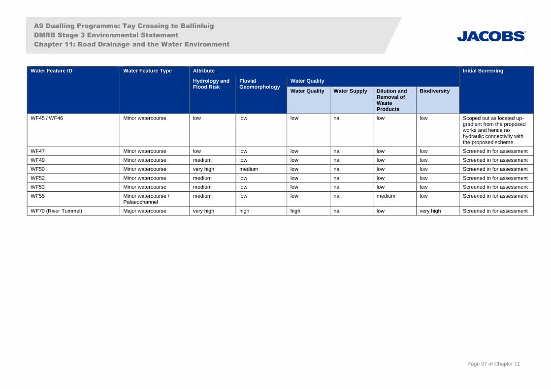
A9 Dualling Programme: Tay Crossing to Ballinluig
DMRB Stage 3 Environmental Statement
Chapter 11: Road Drainage and the Water Environment
Page 27 of Chapter 11
Water Feature ID Water Feature Type Attribute Initial Screening
Hydrology and Flood Risk
Fluvial Geomorphology
Water Quality
Water Quality Water Supply Dilution and Removal of Waste Products
Biodiversity
WF45 / WF46 Minor watercourse low low low na low low Scoped out as located up-gradient from the proposed works and hence no hydraulic connectivity with the proposed scheme
WF47 Minor watercourse low low low na low low Screened in for assessment
WF49 Minor watercourse medium low low na low low Screened in for assessment
WF50 Minor watercourse very high medium low na low low Screened in for assessment
WF52 Minor watercourse medium low low na low low Screened in for assessment
WF53 Minor watercourse medium low low na low low Screened in for assessment
WF55 Minor watercourse / Palaeochannel
medium low low na medium low Screened in for assessment
WF70 (River Tummel) Major watercourse very high high high na low very high Screened in for assessment
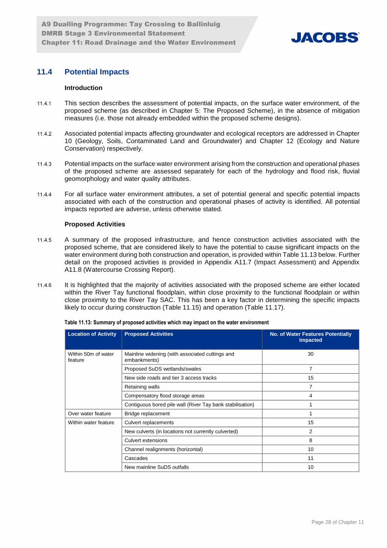
A9 Dualling Programme: Tay Crossing to Ballinluig
DMRB Stage 3 Environmental Statement
Chapter 11: Road Drainage and the Water Environment
Page 28 of Chapter 11
11.4 Potential Impacts
Introduction
This section describes the assessment of potential impacts, on the surface water environment, of the proposed scheme (as described in Chapter 5: The Proposed Scheme), in the absence of mitigation measures (i.e. those not already embedded within the proposed scheme designs).
Associated potential impacts affecting groundwater and ecological receptors are addressed in Chapter 10 (Geology, Soils, Contaminated Land and Groundwater) and Chapter 12 (Ecology and Nature Conservation) respectively.
Potential impacts on the surface water environment arising from the construction and operational phases of the proposed scheme are assessed separately for each of the hydrology and flood risk, fluvial geomorphology and water quality attributes.
For all surface water environment attributes, a set of potential general and specific potential impacts associated with each of the construction and operational phases of activity is identified. All potential impacts reported are adverse, unless otherwise stated.
Proposed Activities
A summary of the proposed infrastructure, and hence construction activities associated with the proposed scheme, that are considered likely to have the potential to cause significant impacts on the water environment during both construction and operation, is provided within Table 11.13 below. Further detail on the proposed activities is provided in Appendix A11.7 (Impact Assessment) and Appendix A11.8 (Watercourse Crossing Report).
It is highlighted that the majority of activities associated with the proposed scheme are either located within the River Tay functional floodplain, within close proximity to the functional floodplain or within close proximity to the River Tay SAC. This has been a key factor in determining the specific impacts likely to occur during construction (Table 11.15) and operation (Table 11.17).
Table 11.13: Summary of proposed activities which may impact on the water environment
Location of Activity Proposed Activities No. of Water Features Potentially Impacted
Within 50m of water feature
Mainline widening (with associated cuttings and embankments)
30
Proposed SuDS wetlands/swales 7
New side roads and tier 3 access tracks 15
Retaining walls 7
Compensatory flood storage areas 4
Contiguous bored pile wall (River Tay bank stabilisation) 1
Over water feature Bridge replacement 1
Within water feature Culvert replacements 15
New culverts (in locations not currently culverted) 2
Culvert extensions 8
Channel realignments (horizontal) 10
Cascades 11
New mainline SuDS outfalls 10

A9 Dualling Programme: Tay Crossing to Ballinluig
DMRB Stage 3 Environmental Statement
Chapter 11: Road Drainage and the Water Environment
Page 29 of Chapter 11
Construction
Construction – General Impacts
This section presents an overview of the potential general impacts likely to occur during construction in the absence of mitigation.
Potential impacts arising from construction activities are typically considered to be short-term, although in some cases they can have longer term effects. For instance, short-term, acute impacts on water quality could have longer term chronic effects on aquatic ecology.
Table 11.14 outlines potential general impacts on the surface water environment during the construction of the proposed scheme.
Table 11.14: Potential general construction impacts
Type of Impact Potential General Impacts from Construction Activities
Hydrology and Flood Risk
Changes to runoff rates and flow characteristics
Increased runoff and/or reduced infiltration rates from soil compaction due to construction traffic and the presence of temporary haul routes in the area of the proposed scheme.
Changes to flow characteristics due to disturbance or unintentional changes to channel dimensions and/or sedimentation etc. associated with works which may impact on the hydraulic flow characteristics of a water feature.
Disruption or blockage of existing natural flow paths due to temporary channel diversions and other associated temporary works, coffer dams etc. to facilitate culvert or bridge construction.
Increased peak flow rates going into water feature(s) due to temporary construction works for SuDS within catchments.
Local lowering of groundwater and/or barriers to groundwater flow due to dewatering of excavations or temporary works for excavations requiring groundwater cut-offs.
Flash flooding of works during rapid runoff (pluvial) events potentially leading to major hazards, in particular if there are haul routes upstream of steep slopes where the proposed scheme is in cutting.
Increase in flood risk Increased flood risk due to temporary channel diversions to facilitate culvert or bridge construction; in-channel works; any associated temporary works and/or re-direction of flow through constructed realignments or into pre-earthwork ditches with a lower conveyance.
Reduced flood storage capacity due to temporary loss of floodplain area or compartmentalisation of the floodplain.
Reduced natural floodplain conveyance due to construction materials and plant within the floodplain; haul route construction or other temporary works related to carriageway widening and other activities in the floodplain.
Reduced watercourse conveyance capacity due to under-sized culverts or sediment/blockage e.g.at temporary haul route crossings and under the existing A9.
Increased risk of flooding from exposed sewers and water mains that may also result in a pollution incident due to the increased potential for service strikes.
Increased risk of flooding of working areas, potentially damaging plant and materials and/or leading to pollution incidents.
Fluvial Geomorphology
Changes to sediment regime
Release of suspended solids from: exposed bare earth surfaces; due to in-channel working for culvert and outfall installation and channel realignment construction; construction of clear-span bridges; vegetation clearance (likely to be greater in winter months).
Increased sediment supply from accidental damage to river banks or bed resulting from vegetation clearance, plant movement or other construction activities.
Increased sediment delivery and transport due to temporary earthworks being washed away.
Changes to channel morphology
A reduction in diversity of the channel bed due to increased fine sediment supply from bare earth surfaces, in-channel construction of structures and vegetation clearance.
Loss of active features such as exposed gravel deposits due to smothering by fine sediment.
Loss or disturbance of channel bed in the vicinity of culvert installation and outfall construction or where channels are realigned.
Reduced morphological diversity due to vegetation clearance, loss of tree roots and/or woody material. (Woody material within the channel may encourage the formation of different geomorphological features such as riffles, deposits and pools.)
In-channel adjustments, through erosion and deposition, due to alterations to cross-section and planform.
Increase in channel erosion as water is released down realigned channels, particularly if the channel is straightened and gradient increased.
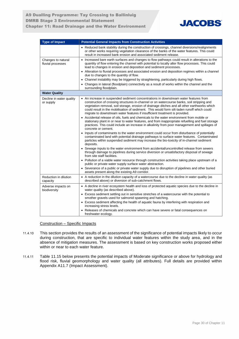
A9 Dualling Programme: Tay Crossing to Ballinluig
DMRB Stage 3 Environmental Statement
Chapter 11: Road Drainage and the Water Environment
Page 30 of Chapter 11
Type of Impact Potential General Impacts from Construction Activities
Reduced bank stability during the construction of crossings, channel diversions/realignments or other works requiring vegetation clearance of the banks of the water features. This could result in increased bank erosion and associated sediment release.
Changes to natural fluvial processes
Increased bare earth surfaces and changes to flow pathways could result in alterations to the quantity of flow entering the channel with potential to locally alter flow processes. This could lead to changes in erosion and deposition and sediment processes.
Alteration to fluvial processes and associated erosion and deposition regimes within a channel due to changes to the quantity of flow.
Channel instability may be triggered by straightening, particularly during high flows.
Changes in lateral (floodplain) connectivity as a result of works within the channel and the surrounding floodplain.
Water Quality
Decline in water quality or supply
An increase in suspended sediment concentrations in downstream water features from construction of crossing structures in-channel or on watercourse banks, soil stripping and vegetation removal, soil storage, erosion of drainage ditches and all other earthworks which could result in the mobilisation of sediment. This would form silt-laden runoff which could migrate to downstream water features if insufficient treatment is provided.
Accidental release of oils, fuels and chemicals to the water environment from mobile or stationary plant in or near to water features, and from inappropriate refuelling and fuel storage practices. This could include an increase in alkalinity from poor management and spillages of concrete or cement.
Inputs of contaminants to the water environment could occur from disturbance of potentially contaminated land with potential drainage pathways to surface water features. Contaminated particles within suspended sediment may increase the bio-toxicity of in-channel sediment deposits.
Sewage inputs to the water environment from accidental/uncontrolled release from sewers through damage to pipelines during service diversion or unsatisfactory disposal of sewage from site staff facilities.
Pollution of a viable water resource through construction activities taking place upstream of a public or private water supply surface water abstraction.
Severance of a public or private water supply due to disruption of pipelines and other buried assets present along the existing A9 corridor.
Reduction in dilution capacity
A reduction in the dilution capacity of a watercourse due to the decline in water quality (as described above) or diversion of sub-catchment flows.
Adverse impacts on biodiversity
A decline in river ecosystem health and loss of protected aquatic species due to the decline in water quality (as described above).
Excess sediment settling out in sensitive stretches of a watercourse with the potential to smother gravels used for salmonid spawning and hatching.
Excess sediment affecting the health of aquatic fauna by interfering with respiration and increasing stress levels.
Releases of chemicals and concrete which can have severe or fatal consequences on freshwater ecology.
Construction – Specific Impacts
This section provides the results of an assessment of the significance of potential impacts likely to occur during construction, that are specific to individual water features within the study area, and in the absence of mitigation measures. The assessment is based on key construction works proposed either within or near to each water feature.
Table 11.15 below presents the potential impacts of Moderate significance or above for hydrology and flood risk, fluvial geomorphology and water quality (all attributes). Full details are provided within Appendix A11.7 (Impact Assessment).

A9 Dualling Programme: Tay Crossing to Ballinluig
DMRB Stage 3 Environmental Statement
Chapter 11: Road Drainage and the Water Environment
Page 31 of Chapter 11
Table 11.15: Potential impacts (pre-mitigation) on specific water features – Construction
Water Feature Attribute Description of Specific Construction Impacts on Water Feature Sensitivity Magnitude Significance
WF06 (River Tay)
Hydrology and Flood Risk
Temporary increase in impermeable areas within the catchment and construction of new road drainage outfalls have the potential to increase peak flow rates. Loss of floodplain storage due to construction works within the floodplain in multiple locations results in increased flood levels throughout the floodplain according to hydraulic modelling results. Impact varies by location, but there is increased flood risk to several properties including Haugh of Kilmorich, Guay Farmhouse, Dowally Farm and properties on the west bank of the Tay floodplain, although these increases are negligible in some cases. Potential for increased flood risk to A9 and Highland Mainline Railway.
very high moderate Very Large
Fluvial Geo-morphology
Potential fine sediment input to water feature from direct construction activities within the channel and indirectly from works within the tributaries, surrounding earthworks and construction activities (including construction of drainage, embankments and side roads in the floodplain). This could lead to changes of the morphological features present, including smothering of bed substrate and depositional features. Works within the vicinity and along the banks of the River Tay altering channel banks and reducing floodplain area. This could alter the lateral connectivity of the water feature. Permanent removal of a length of natural bank and bed at each outfall, with localised changes to flow dynamics and the potential for alterations in sediment processes. Lateral connectivity with the floodplain altered as a result of new headwalls, with permanent removal of riparian vegetation. Potential for localised erosion of bed and banks around headwall structures. Works along the banktop and/or bankface to install a contiguous bore piled wall (River Tay bank stabilisation) between ch1600-1900 has the potential for the release of fine sediment into the River Tay. This could lead to changes to the existing baseline conditions, including smothering of bed substrate and depositional features, and potential for alteration to flow patterns.
high moderate Moderate
Water Quality A temporary measurable decrease in water quality (including EQS) for greater than one month with temporary impacts on designated species/habitats and agricultural abstractions (water supplies) from the generation of turbid runoff and/or accidental spillage of fuels, oils, cementitious material or other polluting substances.
In relation to the bank stabilisation works between ch1600-1900, there is potential for signficant release of sediment into the River Tay SAC without appropriate mitigation, due to works being undertaken on unstable ground in very close proximity to the River Tay.
very high major Very Large
Biodiversity very high major Very Large
Water Supply high moderate Large
WF16 Water Quality A temporary measurable decrease in water quality (including EQS) for greater than one month with temporary impacts on designated species/habitats from the generation of turbid runoff and/or accidental spillage of fuels, oils, cementitious material or other polluting substances.
low major Moderate
Biodiversity low major Moderate
WF18 Water Quality A temporary measurable decrease in water quality (including EQS) for greater than one month with temporary impacts on designated species/habitats from the generation of turbid runoff and/or accidental spillage of fuels, oils, cementitious material or other polluting substances.
low major Moderate
Biodiversity low major Moderate
WF19 Hydrology and Flood Risk
Potential for temporary increase in runoff rates from site areas. Culvert and in channel works may cause restriction in flood flows. Loss of floodplain area. These could increase flood risk to the A9.
very high minor Large
Water Quality A temporary measurable decrease in water quality (including EQS) for greater than one month with temporary impacts on designated species/habitats from the generation of turbid runoff and/or accidental spillage of fuels, oils, cementitious material or other polluting substances.
low major Moderate
Biodiversity low major Moderate
WF20 Hydrology and Flood Risk
Potential for temporary increase in runoff rates from site areas. Culvert and in channel works may cause restriction in flood flows. Loss of floodplain area. These could increase flood risk to the A9
very high minor Large
Water Quality low major Moderate

A9 Dualling Programme: Tay Crossing to Ballinluig
DMRB Stage 3 Environmental Statement
Chapter 11: Road Drainage and the Water Environment
Page 32 of Chapter 11
Water Feature Attribute Description of Specific Construction Impacts on Water Feature Sensitivity Magnitude Significance
Biodiversity A temporary measurable decrease in water quality (including EQS) for greater than one month with temporary impacts on designated species/habitats from the generation of turbid runoff and/or accidental spillage of fuels, oils, cementitious material or other polluting substances.
low major Moderate
WF21 Water Quality A temporary measurable decrease in water quality (including EQS) for greater than one month with temporary impacts on designated species/habitats from the generation of turbid runoff and/or accidental spillage of fuels, oils, cementitious material or other polluting substances.
low major Moderate
Biodiversity low major Moderate
WF23 Water Quality A temporary measurable decrease in water quality (including EQS) for greater than one month with temporary impacts on designated species/habitats from the generation of turbid runoff and/or accidental spillage of fuels, oils, cementitious material or other polluting substances.
medium major Large
Biodiversity medium major Large
WF24 Water Quality A temporary measurable decrease in water quality (including EQS) for greater than one month with temporary impacts on designated species/habitats from the generation of turbid runoff and/or accidental spillage of fuels, oils, cementitious material or other polluting substances.
medium major Large
Biodiversity medium major Large
WF25 Water Quality A temporary measurable decrease in water quality (including EQS) for greater than one month with temporary impacts on designated species/habitats from the generation of turbid runoff and/or accidental spillage of fuels, oils, cementitious material or other polluting substances.
medium major Large
Biodiversity medium major Large
WF28 Water Quality A temporary measurable decrease in water quality (including EQS) for greater than one month with temporary impacts on designated species/habitats from the generation of turbid runoff and/or accidental spillage of fuels, oils, cementitious material or other polluting substances.
low major Moderate
Biodiversity low major Moderate
WF29 Water Quality A temporary measurable decrease in water quality (including EQS) for greater than one month with temporary impacts on designated species/habitats from the generation of turbid runoff and/or accidental spillage of fuels, oils, cementitious material or other polluting substances.
low major Moderate
Biodiversity low major Moderate
WF30 Water Quality A temporary measurable decrease in water quality (including EQS) for greater than one month with temporary impacts on designated species/habitats from the generation of turbid runoff and/or accidental spillage of fuels, oils, cementitious material or other polluting substances.
low major Moderate
Biodiversity low major Moderate
WF31 Water Quality A temporary measurable decrease in water quality (including EQS) for greater than one month with temporary impacts on designated species/habitats from the generation of turbid runoff and/or accidental spillage of fuels, oils, cementitious material or other polluting substances.
medium major Large
Biodiversity low major Moderate
WF32 Water Quality A temporary measurable decrease in water quality (including EQS) for greater than one month with temporary impacts on designated species/habitats from the generation of turbid runoff and/or accidental spillage of fuels, oils, cementitious material or other polluting substances.
medium major Large
Biodiversity low major Moderate
WF33 Water Quality A temporary measurable decrease in water quality (including EQS) for greater than one month with temporary impacts on designated species/habitats from the generation of turbid runoff and/or accidental spillage of fuels, oils, cementitious material or other polluting substances.
low major Moderate
Biodiversity low major Moderate
WF34 Water Quality A temporary measurable decrease in water quality (including EQS) for greater than one month with temporary impacts on designated species/habitats from the generation of turbid runoff and/or accidental spillage of fuels, oils, cementitious material or other polluting substances.
low major Moderate
Biodiversity low major Moderate
WF35 Water Quality A temporary measurable decrease in water quality (including EQS) for greater than one month with temporary impacts on designated species/habitats from the generation of turbid runoff and/or accidental spillage of fuels, oils, cementitious material or other polluting substances.
low major Moderate
Biodiversity low major Moderate

A9 Dualling Programme: Tay Crossing to Ballinluig
DMRB Stage 3 Environmental Statement
Chapter 11: Road Drainage and the Water Environment
Page 33 of Chapter 11
Water Feature Attribute Description of Specific Construction Impacts on Water Feature Sensitivity Magnitude Significance
WF36 (Dowally Burn)
Hydrology and Flood Risk
Potential for temporary increase in runoff rates from site areas. Culvert and in channel works may cause restriction in flood flows. Loss of floodplain area. Increase in flood risk to farmland and access roads could result.
high major Large
Fluvial Geo-morphology
Temporary increase in fine sediment delivery from road widening and road construction, PED, culvert extension for the A9 and two side roads and construction of three outfalls. Disturbance of banks, bed substrate (cobble and pebble), natural morphological features (such as the riffle-pool sequence) due to culvert extension under existing A9 culvert and installation of a new box culvert for the Network Rail access track. Changes to channel morphology due to increase of artificial bank material. Permanent removal of a length of natural bank and bed at each outfall, with localised changes to flow dynamics and the potential for alterations in sediment processes. Lateral connectivity with the floodplain altered as a result of new headwalls and the permanent removal of riparian vegetation. Potential for localised erosion of bed and banks around headwall structure.
medium moderate Moderate
Water Quality A temporary measurable decrease in water quality (including EQS) for greater than one month with temporary impacts on designated species/habitats from the generation of turbid runoff and/or accidental spillage of fuels, oils, cementitious material or other polluting substances.
high major Large
Biodiversity very high major Very Large
WF37 Hydrology and Flood Risk
Potential for temporary increase in runoff rates from site areas. Culvert and in channel works may cause restriction in flood flows. Loss of floodplain area. Increase in flood risk to farmland could result.
medium major Large
Water Quality A temporary measurable decrease in water quality (including EQS) for greater than one month with temporary impacts on designated species/habitats from the generation of turbid runoff and/or accidental spillage of fuels, oils, cementitious material or other polluting substances.
low major Moderate
Biodiversity low major Moderate
WF38 Hydrology and Flood Risk
Potential for temporary increase in runoff rates from site areas. Culvert and in channel works may cause restriction in flood flows. Loss of floodplain area. Increase in flood risk to farmland could result.
medium major Large
Fluvial Geo-morphology
Temporary increase in fine sediment delivery from extensive construction activities in this locality, including: two culvert replacement and extensions; one new culvert; channel realignment and channel regrading; PED; two new outfalls; road widening and road construction. Diversion/damming of flow during in-channel works to construct culvert extensions. Changes to channel morphology due to increase of artificial bed and bank material and partial channel realignment. Construction of compensatory flood storage area would cause significant delivery of fine sediment to downstream section of water feature caused by large area of exposed soil following excavation. Permanent removal of a length of natural bank and bed at the outfalls, with localised changes to flow dynamics and the potential for alterations in sediment processes. Lateral connectivity with the floodplain altered as a result of new headwalls, as well as permanent removal of riparian vegetation. Potential for localised erosion of bed and banks around headwalls structure.
medium moderate Moderate
Water Quality A temporary measurable decrease in water quality (including EQS) for greater than one month with temporary impacts on designated species/habitats from the generation of turbid runoff and/or accidental spillage of fuels, oils, cementitious material or other polluting substances.
low major Moderate
Biodiversity low major Moderate
WF39 (Sloggan Burn)
Hydrology and Flood Risk
Potential for temporary increase in runoff rates from site areas. Culvert and in channel works may cause restriction in flood flows. Loss of floodplain area. Increase in flood risk to farmland could result.
very high major Very Large
Fluvial Geo-morphology
Temporary increase in fine sediment delivery from road widening and road construction, one new outfall, PED and culvert extension for the A9 and new culvert for the side road. Changes to channel morphology due to increase of artificial bank material.
medium moderate Moderate
Water Quality medium major Large
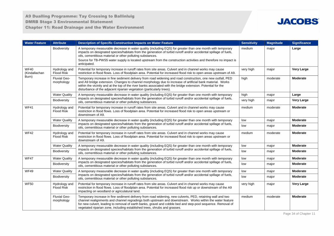
A9 Dualling Programme: Tay Crossing to Ballinluig
DMRB Stage 3 Environmental Statement
Chapter 11: Road Drainage and the Water Environment
Page 34 of Chapter 11
Water Feature Attribute Description of Specific Construction Impacts on Water Feature Sensitivity Magnitude Significance
Biodiversity A temporary measurable decrease in water quality (including EQS) for greater than one month with temporary impacts on designated species/habitats from the generation of turbid runoff and/or accidental spillage of fuels, oils, cementitious material or other polluting substances.
Source for TB-PWS5 water supply is located upstream from the construction activities and therefore no impact is anticipated.
medium major Large
WF40 (Kindallachan Burn)
Hydrology and Flood Risk
Potential for temporary increase in runoff rates from site areas. Culvert and in channel works may cause restriction in flood flows. Loss of floodplain area. Potential for increased flood risk to open areas upstream of A9.
very high major Very Large
Fluvial Geo-morphology
Temporary increase in fine sediment delivery from road widening and road construction, one new outfall, PED and A9 bridge extension. Changes to channel morphology due to increase of artificial bank material. Works within the vicinity and at the top of the river banks associated with the bridge extension. Potential for the disturbance of the adjacent riparian vegetation (particularly trees).
high moderate Moderate
Water Quality A temporary measurable decrease in water quality (including EQS) for greater than one month with temporary impacts on designated species/habitats from the generation of turbid runoff and/or accidental spillage of fuels, oils, cementitious material or other polluting substances.
high major Large
Biodiversity very high major Very Large
WF41 Hydrology and Flood Risk
Potential for temporary increase in runoff rates from site areas. Culvert and in channel works may cause restriction in flood flows. Loss of floodplain area. Potential for increased flood risk to open areas upstream or downstream of A9.
medium moderate Moderate
Water Quality A temporary measurable decrease in water quality (including EQS) for greater than one month with temporary impacts on designated species/habitats from the generation of turbid runoff and/or accidental spillage of fuels, oils, cementitious material or other polluting substances.
low major Moderate
Biodiversity low major Moderate
WF42 Hydrology and Flood Risk
Potential for temporary increase in runoff rates from site areas. Culvert and in channel works may cause restriction in flood flows. Loss of floodplain area. Potential for increased flood risk to open areas upstream or downstream of A9.
medium moderate Moderate
Water Quality A temporary measurable decrease in water quality (including EQS) for greater than one month with temporary impacts on designated species/habitats from the generation of turbid runoff and/or accidental spillage of fuels, oils, cementitious material or other polluting substances.
low major Moderate
Biodiversity low major Moderate
WF47 Water Quality A temporary measurable decrease in water quality (including EQS) for greater than one month with temporary impacts on designated species/habitats from the generation of turbid runoff and/or accidental spillage of fuels, oils, cementitious material or other polluting substances.
low major Moderate
Biodiversity low major Moderate
WF49 Water Quality A temporary measurable decrease in water quality (including EQS) for greater than one month with temporary impacts on designated species/habitats from the generation of turbid runoff and/or accidental spillage of fuels, oils, cementitious material or other polluting substances.
low major Moderate
Biodiversity low major Moderate
WF50 Hydrology and Flood Risk
Potential for temporary increase in runoff rates from site areas. Culvert and in channel works may cause restriction in flood flows. Loss of floodplain area. Potential for increased flood risk up or downstream of the A9 impacting on woodland or agriculatural land.
very high major Very Large
Fluvial Geo-morphology
Temporary increase in fine sediment delivery from road widening, new culverts, PED, retaining wall and two channel realignments and channel regradings both upstream and downstream. Works within the water feature for new culvert, leading to removal of earth banks, gravel and cobble bed and step-pool sequence. Removal of vegetated riparian zone, including established trees, shrubs and grasses.
medium moderate Moderate

A9 Dualling Programme: Tay Crossing to Ballinluig
DMRB Stage 3 Environmental Statement
Chapter 11: Road Drainage and the Water Environment
Page 35 of Chapter 11
Water Feature Attribute Description of Specific Construction Impacts on Water Feature Sensitivity Magnitude Significance
Disturbance to and removal of the existing morphological features during construction of the realignment and potential infilling of existing channel to link with the proposed new culvert. Permanent removal of a length of natural bank and bed at the outfall, with localised changes to flow dynamics and the potential for alterations in sediment processes. Lateral connectivity with the floodplain altered as a result of a new headwall, as well as permanent removal of riparian vegetation. Potential for localised erosion of bed and banks around the headwall structure.
Water Quality A temporary measurable decrease in water quality (including EQS) for greater than one month with temporary impacts on designated species/habitats from the generation of turbid runoff and/or accidental spillage of fuels, oils, cementitious material or other polluting substances.
low major Moderate
Biodiversity low major Moderate
WF52 Water Quality
A temporary measurable decrease in water quality (including EQS) for greater than one month with temporary impacts on designated species/habitats from the generation of turbid runoff and/or accidental spillage of fuels, oils, cementitious material or other polluting substances.
low major Moderate
Biodiversity low major Moderate
WF53 Hydrology and Flood Risk
Potential for temporary increase in runoff rates from site areas. Culvert and in channel works may cause restriction in flood flows. Loss of floodplain area. Potential for increase in flood risk within field upstream of A9.
medium major Large
Water Quality A temporary measurable decrease in water quality (including EQS) for greater than one month with temporary impacts on designated species/habitats from the generation of turbid runoff and/or accidental spillage of fuels, oils, cementitious material or other polluting substances.
low major Moderate
Biodiversity low major Moderate
WF70 Hydrology and Flood Risk
Negligible impacts expected due to downstream works in River Tay floodplain changing water levels. very high minor Moderate
Water Quality Potential for temporary works to be located within catchment with a temporary measurable decrease in water quality for less than one month from the generation of turbid runoff and/or accidental spillage of fuels, oils, cementitious material or other polluting substances.
high minor Moderate
Biodiversity very high minor Large
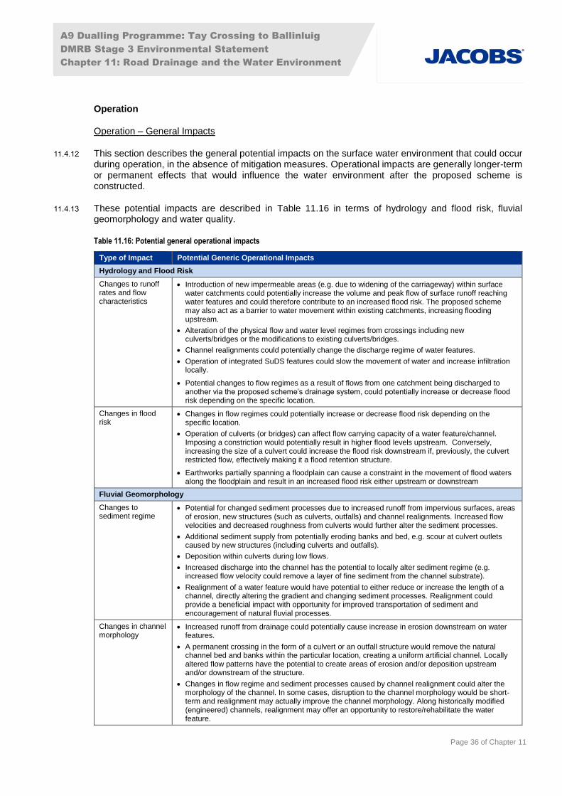
A9 Dualling Programme: Tay Crossing to Ballinluig
DMRB Stage 3 Environmental Statement
Chapter 11: Road Drainage and the Water Environment
Page 36 of Chapter 11
Operation
Operation – General Impacts
This section describes the general potential impacts on the surface water environment that could occur during operation, in the absence of mitigation measures. Operational impacts are generally longer-term or permanent effects that would influence the water environment after the proposed scheme is constructed.
These potential impacts are described in Table 11.16 in terms of hydrology and flood risk, fluvial geomorphology and water quality.
Table 11.16: Potential general operational impacts
Type of Impact Potential Generic Operational Impacts
Hydrology and Flood Risk
Changes to runoff rates and flow characteristics
Introduction of new impermeable areas (e.g. due to widening of the carriageway) within surface water catchments could potentially increase the volume and peak flow of surface runoff reaching water features and could therefore contribute to an increased flood risk. The proposed scheme may also act as a barrier to water movement within existing catchments, increasing flooding upstream.
Alteration of the physical flow and water level regimes from crossings including new culverts/bridges or the modifications to existing culverts/bridges.
Channel realignments could potentially change the discharge regime of water features.
Operation of integrated SuDS features could slow the movement of water and increase infiltration locally.
Potential changes to flow regimes as a result of flows from one catchment being discharged to another via the proposed scheme’s drainage system, could potentially increase or decrease flood risk depending on the specific location.
Changes in flood risk
Changes in flow regimes could potentially increase or decrease flood risk depending on the specific location.
Operation of culverts (or bridges) can affect flow carrying capacity of a water feature/channel. Imposing a constriction would potentially result in higher flood levels upstream. Conversely, increasing the size of a culvert could increase the flood risk downstream if, previously, the culvert restricted flow, effectively making it a flood retention structure.
Earthworks partially spanning a floodplain can cause a constraint in the movement of flood waters along the floodplain and result in an increased flood risk either upstream or downstream
Fluvial Geomorphology
Changes to sediment regime
Potential for changed sediment processes due to increased runoff from impervious surfaces, areas of erosion, new structures (such as culverts, outfalls) and channel realignments. Increased flow velocities and decreased roughness from culverts would further alter the sediment processes.
Additional sediment supply from potentially eroding banks and bed, e.g. scour at culvert outlets caused by new structures (including culverts and outfalls).
Deposition within culverts during low flows.
Increased discharge into the channel has the potential to locally alter sediment regime (e.g. increased flow velocity could remove a layer of fine sediment from the channel substrate).
Realignment of a water feature would have potential to either reduce or increase the length of a channel, directly altering the gradient and changing sediment processes. Realignment could provide a beneficial impact with opportunity for improved transportation of sediment and encouragement of natural fluvial processes.
Changes in channel morphology
Increased runoff from drainage could potentially cause increase in erosion downstream on water features.
A permanent crossing in the form of a culvert or an outfall structure would remove the natural channel bed and banks within the particular location, creating a uniform artificial channel. Locally altered flow patterns have the potential to create areas of erosion and/or deposition upstream and/or downstream of the structure.
Changes in flow regime and sediment processes caused by channel realignment could alter the morphology of the channel. In some cases, disruption to the channel morphology would be short-term and realignment may actually improve the channel morphology. Along historically modified (engineered) channels, realignment may offer an opportunity to restore/rehabilitate the water feature.
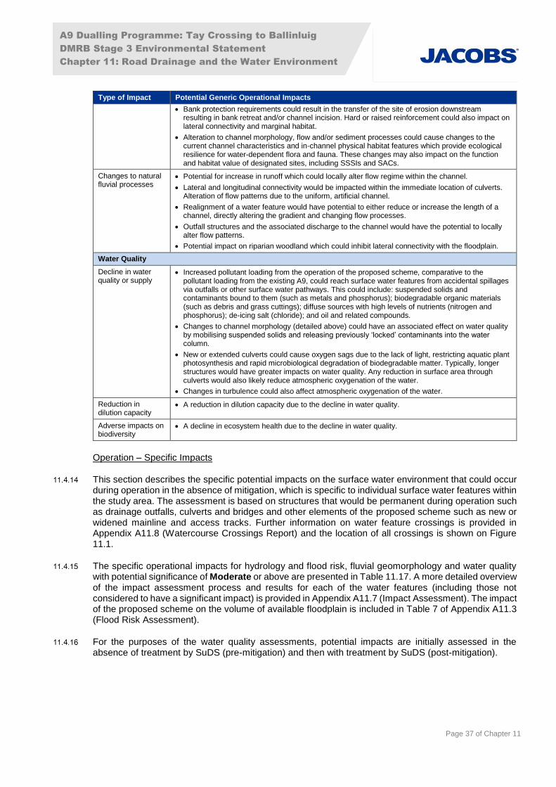
A9 Dualling Programme: Tay Crossing to Ballinluig
DMRB Stage 3 Environmental Statement
Chapter 11: Road Drainage and the Water Environment
Page 37 of Chapter 11
Type of Impact Potential Generic Operational Impacts
Bank protection requirements could result in the transfer of the site of erosion downstream resulting in bank retreat and/or channel incision. Hard or raised reinforcement could also impact on lateral connectivity and marginal habitat.
Alteration to channel morphology, flow and/or sediment processes could cause changes to the current channel characteristics and in-channel physical habitat features which provide ecological resilience for water-dependent flora and fauna. These changes may also impact on the function and habitat value of designated sites, including SSSIs and SACs.
Changes to natural fluvial processes
Potential for increase in runoff which could locally alter flow regime within the channel.
Lateral and longitudinal connectivity would be impacted within the immediate location of culverts. Alteration of flow patterns due to the uniform, artificial channel.
Realignment of a water feature would have potential to either reduce or increase the length of a channel, directly altering the gradient and changing flow processes.
Outfall structures and the associated discharge to the channel would have the potential to locally alter flow patterns.
Potential impact on riparian woodland which could inhibit lateral connectivity with the floodplain.
Water Quality
Decline in water quality or supply
Increased pollutant loading from the operation of the proposed scheme, comparative to the pollutant loading from the existing A9, could reach surface water features from accidental spillages via outfalls or other surface water pathways. This could include: suspended solids and contaminants bound to them (such as metals and phosphorus); biodegradable organic materials (such as debris and grass cuttings); diffuse sources with high levels of nutrients (nitrogen and phosphorus); de-icing salt (chloride); and oil and related compounds.
Changes to channel morphology (detailed above) could have an associated effect on water quality by mobilising suspended solids and releasing previously ‘locked’ contaminants into the water column.
New or extended culverts could cause oxygen sags due to the lack of light, restricting aquatic plant photosynthesis and rapid microbiological degradation of biodegradable matter. Typically, longer structures would have greater impacts on water quality. Any reduction in surface area through culverts would also likely reduce atmospheric oxygenation of the water.
Changes in turbulence could also affect atmospheric oxygenation of the water.
Reduction in dilution capacity
A reduction in dilution capacity due to the decline in water quality.
Adverse impacts on biodiversity
A decline in ecosystem health due to the decline in water quality.
Operation – Specific Impacts
This section describes the specific potential impacts on the surface water environment that could occur during operation in the absence of mitigation, which is specific to individual surface water features within the study area. The assessment is based on structures that would be permanent during operation such as drainage outfalls, culverts and bridges and other elements of the proposed scheme such as new or widened mainline and access tracks. Further information on water feature crossings is provided in Appendix A11.8 (Watercourse Crossings Report) and the location of all crossings is shown on Figure 11.1.
The specific operational impacts for hydrology and flood risk, fluvial geomorphology and water quality with potential significance of Moderate or above are presented in Table 11.17. A more detailed overview of the impact assessment process and results for each of the water features (including those not considered to have a significant impact) is provided in Appendix A11.7 (Impact Assessment). The impact of the proposed scheme on the volume of available floodplain is included in Table 7 of Appendix A11.3 (Flood Risk Assessment).
For the purposes of the water quality assessments, potential impacts are initially assessed in the absence of treatment by SuDS (pre-mitigation) and then with treatment by SuDS (post-mitigation).
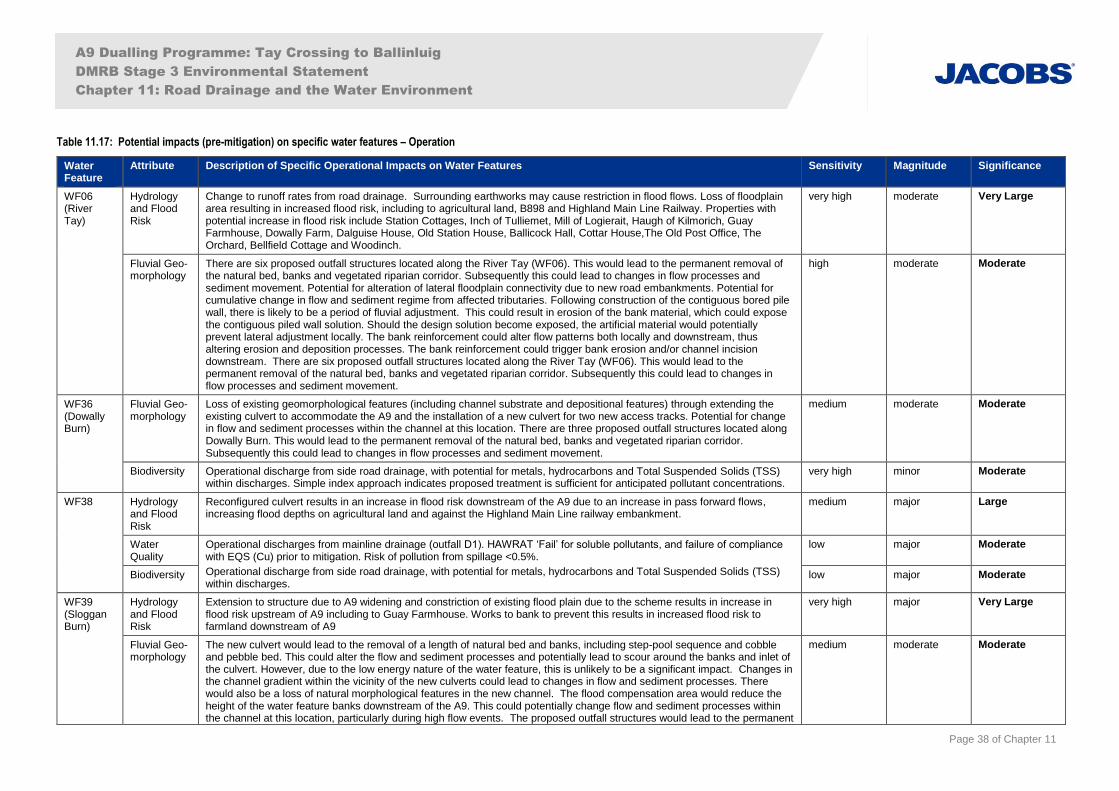
A9 Dualling Programme: Tay Crossing to Ballinluig
DMRB Stage 3 Environmental Statement
Chapter 11: Road Drainage and the Water Environment
Page 38 of Chapter 11
Table 11.17: Potential impacts (pre-mitigation) on specific water features – Operation
Water Feature
Attribute Description of Specific Operational Impacts on Water Features Sensitivity Magnitude Significance
WF06 (River Tay)
Hydrology and Flood Risk
Change to runoff rates from road drainage. Surrounding earthworks may cause restriction in flood flows. Loss of floodplain area resulting in increased flood risk, including to agricultural land, B898 and Highland Main Line Railway. Properties with potential increase in flood risk include Station Cottages, Inch of Tulliemet, Mill of Logierait, Haugh of Kilmorich, Guay Farmhouse, Dowally Farm, Dalguise House, Old Station House, Ballicock Hall, Cottar House,The Old Post Office, The Orchard, Bellfield Cottage and Woodinch.
very high moderate Very Large
Fluvial Geo-morphology
There are six proposed outfall structures located along the River Tay (WF06). This would lead to the permanent removal of the natural bed, banks and vegetated riparian corridor. Subsequently this could lead to changes in flow processes and sediment movement. Potential for alteration of lateral floodplain connectivity due to new road embankments. Potential for cumulative change in flow and sediment regime from affected tributaries. Following construction of the contiguous bored pile wall, there is likely to be a period of fluvial adjustment. This could result in erosion of the bank material, which could expose the contiguous piled wall solution. Should the design solution become exposed, the artificial material would potentially prevent lateral adjustment locally. The bank reinforcement could alter flow patterns both locally and downstream, thus altering erosion and deposition processes. The bank reinforcement could trigger bank erosion and/or channel incision downstream. There are six proposed outfall structures located along the River Tay (WF06). This would lead to the permanent removal of the natural bed, banks and vegetated riparian corridor. Subsequently this could lead to changes in flow processes and sediment movement.
high moderate Moderate
WF36 (Dowally Burn)
Fluvial Geo-morphology
Loss of existing geomorphological features (including channel substrate and depositional features) through extending the existing culvert to accommodate the A9 and the installation of a new culvert for two new access tracks. Potential for change in flow and sediment processes within the channel at this location. There are three proposed outfall structures located along Dowally Burn. This would lead to the permanent removal of the natural bed, banks and vegetated riparian corridor. Subsequently this could lead to changes in flow processes and sediment movement.
medium moderate Moderate
Biodiversity Operational discharge from side road drainage, with potential for metals, hydrocarbons and Total Suspended Solids (TSS) within discharges. Simple index approach indicates proposed treatment is sufficient for anticipated pollutant concentrations.
very high minor Moderate
WF38 Hydrology and Flood Risk
Reconfigured culvert results in an increase in flood risk downstream of the A9 due to an increase in pass forward flows, increasing flood depths on agricultural land and against the Highland Main Line railway embankment.
medium major Large
Water Quality
Operational discharges from mainline drainage (outfall D1). HAWRAT ‘Fail’ for soluble pollutants, and failure of compliance with EQS (Cu) prior to mitigation. Risk of pollution from spillage <0.5%.
Operational discharge from side road drainage, with potential for metals, hydrocarbons and Total Suspended Solids (TSS) within discharges.
low major Moderate
Biodiversity low major Moderate
WF39 (Sloggan Burn)
Hydrology and Flood Risk
Extension to structure due to A9 widening and constriction of existing flood plain due to the scheme results in increase in flood risk upstream of A9 including to Guay Farmhouse. Works to bank to prevent this results in increased flood risk to farmland downstream of A9
very high major Very Large
Fluvial Geo-morphology
The new culvert would lead to the removal of a length of natural bed and banks, including step-pool sequence and cobble and pebble bed. This could alter the flow and sediment processes and potentially lead to scour around the banks and inlet of the culvert. However, due to the low energy nature of the water feature, this is unlikely to be a significant impact. Changes in the channel gradient within the vicinity of the new culverts could lead to changes in flow and sediment processes. There would also be a loss of natural morphological features in the new channel. The flood compensation area would reduce the height of the water feature banks downstream of the A9. This could potentially change flow and sediment processes within the channel at this location, particularly during high flow events. The proposed outfall structures would lead to the permanent
medium moderate Moderate
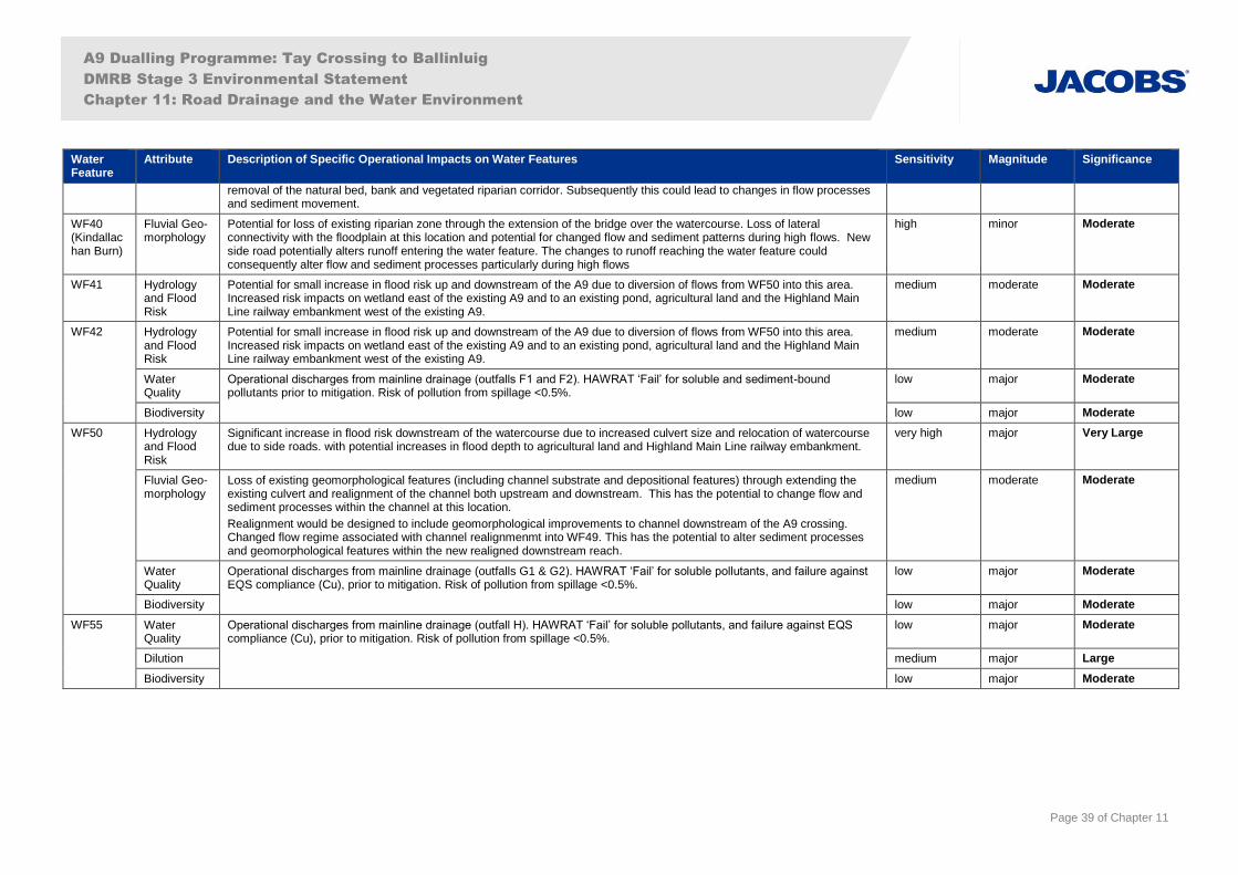
A9 Dualling Programme: Tay Crossing to Ballinluig
DMRB Stage 3 Environmental Statement
Chapter 11: Road Drainage and the Water Environment
Page 39 of Chapter 11
Water Feature
Attribute Description of Specific Operational Impacts on Water Features Sensitivity Magnitude Significance
removal of the natural bed, bank and vegetated riparian corridor. Subsequently this could lead to changes in flow processes and sediment movement.
WF40 (Kindallachan Burn)
Fluvial Geo-morphology
Potential for loss of existing riparian zone through the extension of the bridge over the watercourse. Loss of lateral connectivity with the floodplain at this location and potential for changed flow and sediment patterns during high flows. New side road potentially alters runoff entering the water feature. The changes to runoff reaching the water feature could consequently alter flow and sediment processes particularly during high flows
high minor Moderate
WF41 Hydrology and Flood Risk
Potential for small increase in flood risk up and downstream of the A9 due to diversion of flows from WF50 into this area. Increased risk impacts on wetland east of the existing A9 and to an existing pond, agricultural land and the Highland Main Line railway embankment west of the existing A9.
medium moderate Moderate
WF42 Hydrology and Flood Risk
Potential for small increase in flood risk up and downstream of the A9 due to diversion of flows from WF50 into this area. Increased risk impacts on wetland east of the existing A9 and to an existing pond, agricultural land and the Highland Main Line railway embankment west of the existing A9.
medium moderate Moderate
Water Quality
Operational discharges from mainline drainage (outfalls F1 and F2). HAWRAT ‘Fail’ for soluble and sediment-bound pollutants prior to mitigation. Risk of pollution from spillage <0.5%.
low major Moderate
Biodiversity low major Moderate
WF50 Hydrology and Flood Risk
Significant increase in flood risk downstream of the watercourse due to increased culvert size and relocation of watercourse due to side roads. with potential increases in flood depth to agricultural land and Highland Main Line railway embankment.
very high major Very Large
Fluvial Geo-morphology
Loss of existing geomorphological features (including channel substrate and depositional features) through extending the existing culvert and realignment of the channel both upstream and downstream. This has the potential to change flow and sediment processes within the channel at this location.
Realignment would be designed to include geomorphological improvements to channel downstream of the A9 crossing. Changed flow regime associated with channel realignmenmt into WF49. This has the potential to alter sediment processes and geomorphological features within the new realigned downstream reach.
medium moderate Moderate
Water Quality
Operational discharges from mainline drainage (outfalls G1 & G2). HAWRAT ‘Fail’ for soluble pollutants, and failure against EQS compliance (Cu), prior to mitigation. Risk of pollution from spillage <0.5%.
low major Moderate
Biodiversity low major Moderate
WF55 Water Quality
Operational discharges from mainline drainage (outfall H). HAWRAT ‘Fail’ for soluble pollutants, and failure against EQS compliance (Cu), prior to mitigation. Risk of pollution from spillage <0.5%.
low major Moderate
Dilution medium major Large
Biodiversity low major Moderate

A9 Dualling Programme: Tay Crossing to Ballinluig
DMRB Stage 3 Environmental Statement
Chapter 11: Road Drainage and the Water Environment
Page 40 of Chapter 11
11.5 Mitigation
Introduction
This chapter makes reference to overarching standard measures applicable across the A9 dualling projects (‘SMC’ mitigation item references), and also to project-specific measures (‘P03’ mitigation item references). Those that specifically relate to Road Drainage and the Water Environment are assigned a ‘W’ reference.
The objective of this section is the identification of mitigation measures to avoid/prevent, reduce or offset potential significant impacts, described in Section 11.4 (Potential Impacts), taking into account best practice, legislation and guidance, during both construction and operation.
As stated in Section 11.12 (Approach and Methods), consultation with SEPA and SNH was undertaken throughout the DMRB Stage 3 process to seek guidance on surface water drainage, pollution prevention measures and engineering activities on waterbodies. Further information on the consultation process is provided in Chapter 7 (Consultation and Scoping).
Embedded Mitigation
Substantial environmental input has contributed to the design process to help inform the most sustainable alignment options, watercourse crossing design and drainage solutions (referred to as primary or embedded mitigation). This iterative approach has included discussion of proposed engineering options and their associated potential environmental impacts, as well as the recommendation of measures that limit the impacts on the surface water environment. For further details, refer to Chapter 4 (Iterative Design Development).
An engineering solution was developed at each watercourse crossing which is considered to be consentable under CAR based on the DMRB Stage 3 design; refer to Appendix A11.8 (Watercourse Crossing Report). A Specimen Design will be developed, in consultation with SEPA, to support the CAR authorisation process following the completion of the DMRB Stage 3 Assessment. This will allow for the development of the design to include provision of fish passage, scour protection and other measures required to obtain authorisation.
Land Made Available for Construction Drainage
A preliminary review of construction drainage requirements was undertaken to inform the land required to provide adequate surface water management during construction.
This review has assessed the land required to accommodate the 10% AEP (10-year) return period rainfall event, as would reasonably be expected to occur during the period of construction, for each construction drainage catchment and within each construction phase. An additional volume to account for the estimated soil loss from each corresponding construction drainage catchment has also been considered in the assessment, using methods as detailed in CIRIA (2006a). The inclusion of the soil loss volume provides an increased treatment volume on catchments that will be more susceptible to soil erosion.
The results of the review were used to inform the extent of the Compulsory Purchase Orders (CPO) boundary and will form a baseline for the Contractor to develop a construction drainage strategy.
Mainline, Junctions, Access Roads and Tracks
The proposed scheme has been designed to be above the 0.5% AEP (200-year) plus CC flood level with an additional 600mm of freeboard where reasonably practicable. Unsurfaced access tracks within design flood event extents may remain unchanged from existing ground elevations and as a result may have lower flood protection than the proposed scheme. It is not always possible to provide a higher standard of protection to these access routes, as they serve locations (e.g. SuDS ponds) already within the 0.5% AEP (200-year) plus CC flood extent.

A9 Dualling Programme: Tay Crossing to Ballinluig
DMRB Stage 3 Environmental Statement
Chapter 11: Road Drainage and the Water Environment
Page 41 of Chapter 11
SuDS
SuDS are a legal requirement in Scotland under WEWS and CAR and were included within the DMRB Stage 3 design. The proposed scheme includes 12 mainline SuDS outfalls discharging to five water features. SuDS are designed to treat pollutants and attenuate runoff to acceptable levels before discharging to the water environment. Engineering and environmental factors were considered to confirm the drainage design and the types and locations of SuDS features.
The following SuDS design principles were initially adopted for the proposed scheme:
SuDS features were located, where practical, outside the 0.5% AEP (200-year) functional floodplain, and were designed to be protected from inundation by the 3.33% AEP (30-year) flood event;
SuDS features were designed to attenuate the 0.5% AEP (200-year) rainfall event plus CC with appropriate freeboard and discharge at the 50% AEP (2-year) ‘greenfield’ runoff rate; and
two levels of conventional SuDS treatment were identified as a minimum requirement for the proposed scheme mainline.
However, due to the highly constrained nature of the study site in relation to flood levels, flood extents and topography, the following project specific departures from the above SuDS design standards have been adopted on certain drainage catchments (through consultation with Perth and Kinross Council and SEPA):
SuDS features designed to attenuate the 3.33% AEP (30-year) plus CC rainfall event and discharge at the 50% AEP (2-year) ‘existing’ runoff rate (applicable to drainage catchments B, D1, D2, E, F1, F2, G1, G2 and H);
adopting SuDS without inundation protection (i.e. constructed below existing ground levels) within the functional floodplain (applicable to drainage catchments D1, D2 and H); and
adopting proprietary SuDS components (hydrodynamic vortex separator or HVS in conjunction with geocellular storage) as a level of ‘proprietary SuDS treatment’, as opposed to conventional SuDS treatment (applicable to drainage catchments B, F1, F2, G1 and G2).
Three of the SuDS outfalls (F1, F2 and H) will discharge into inundated palaeochannels. These outfall locations have been assessed as being suitable to receive discharge as:
they are non-designated and non-groundwater dependent habitats (refer to Appendix A10.2 and Chapter 12);
there is a degree of surface and subsurface flow within these features enabling dilution, treatment, and removal of any residual pollutants (as evident through watercourse inflows, GI data and topography);
these features currently receive discharge from the existing A9 drainage; and
the adoption of these outfall locations removes the requirement for direct discharges into the River Tay SAC, with associated water quality and ecological benefits.
Specific mitigation has been provided (P03-W46) regarding the design of these outfalls. Further detail on the proposed SuDS departures, and their justification, is also provided within Appendix A11.6 (SuDS and Water Quality).
Figure 11.4 and Table 11.20 detail the location and proposed SuDS management trains associated with the mainline drainage catchments.
Culverts
The culvert design for the watercourse crossings of the A9 mainline takes account of three different design conditions in the hydraulic analysis as follows:
All new replacement watercourse crossings (i.e. where it is proposed that an existing culvert is fully removed and replaced with a new culvert) were sized in accordance with the Design Manual for
A9 Dualling Programme: Tay Crossing to Ballinluig
DMRB Stage 3 Environmental Statement
Chapter 11: Road Drainage and the Water Environment
Page 42 of Chapter 11
Roads and Bridges (DMRB) HA107/04. This includes the minimum requirement to freely pass the 1% AEP (100-year) design fluvial event with appropriate freeboard within the culvert barrel.
The culverts for the replacement crossings, as well as those that are extended based on their existing geometry, have also been tested in the 0.5% AEP (200-year) event to confirm that they remain free flowing (i.e. they are not surcharged) in this event, and that there is appropriate culvert freeboard, taking account of other factors influencing culvert design.
All culverts have also been assessed against the design flood event i.e. 0.5% AEP (200-year) plus an allowance for climate change to confirm that there is a minimum 600mm freeboard to road level as reported in Appendix A11.3 (Flood Risk Assessment).
All new (or replaced) side road and unsurfaced access track culverts are designed to freely pass the 0.5% AEP (200-year) plus climate change design event (with appropriate freeboard within the culvert barrel).
Pre-earthworks Drainage
Pre-earthworks drainage (PED) is likely to take the form of ditches, and will be constructed at the top of cuttings and the base of embankments where surface water and sub-surface pathways from adjoining land will flow towards the proposed scheme or other receptors, thus intercepting the flow. The purpose of the pre-earthworks drainage is to collect runoff from the natural catchments surrounding the proposed scheme and convey overland flow to the nearest watercourse, maintaining the existing hydrological regime of the natural catchment, where possible.
In accordance with DMRB, PED has been designed to convey the 1.3% AEP (75-year) rainfall runoff event, however where practicable and necessary based on specific conditions at each cutting where PED is required, the sizing of PED at the top of the cuttings could be increased to accommodate the design flood event to minimise the risk of overtopping and flood risk to the road. Potential catchment areas flowing into the PED are generally small and therefore any exceedance flows are likely to be small. Any areas where flows could present a risk to the A9 will be considered further at detailed design.
Once operational, this system does not require any formal treatment or attenuation prior to discharge, beyond the treatment and attenuation that is provided by the drain itself, as it is draining the natural catchment and kept separate from any polluted carriageway runoff. However, mitigation during construction is required, which is detailed in Table 11.18.
Standard Mitigation
Standard mitigation commitments during construction (SMC-S1 to SMC-S4) are set out in Chapter 21 (Schedule of Environmental Commitments) and consist predominantly of best practice measures. The standard construction and operation mitigation commitments for the Road Drainage and Water Environment are detailed in Table 11.18 below.
Table 11.18: Standard mitigation measures
Mitigation Item
Description
Standard Construction Mitigation
SMC-W1 In relation to authorisations under CAR, the Contractor will be required to provide a detailed Construction Method Statement which will include proposed mitigation measures for specific activities including any requirements identified through the pre-CAR application consultation process.
SMC-W2 In relation to flood risk the Contractor will implement the following mitigation measures during construction:
The Flood Response Plan (as part of the CEMP, refer to Mitigation Item SMC-S1 in Table 21.1 of Chapter 21 (Schedule of Environmental Commitments)) will set out the following mitigation measures to be implemented when working within the functional floodplain (defined here as the 0.5% AEP (200-year) flood extent):
Routinely check the MET office Weather Warnings and the SEPA Floodline alert service for potential storm events (or snow melt), flood alerts and warnings relevant to the area of the construction works.
During periods of heavy rainfall or extended periods of wet weather (in the immediate locality or wider river catchment) river levels will be monitored using, for example, SEPA Water Level Data when available/visual inspection of water features. The Contractor will assess any change from base flow condition and be familiar with the normal dry weather flow conditions for the water feature, and be familiar
A9 Dualling Programme: Tay Crossing to Ballinluig
DMRB Stage 3 Environmental Statement
Chapter 11: Road Drainage and the Water Environment
Page 43 of Chapter 11
Mitigation Item
Description
with the likely hydrological response of the water feature to heavy rainfall (in terms of time to peak, likely flood extents) and windows of opportunity to respond should river levels rise.
Should flooding be predicted, works close or within the water features will be immediately withdrawn (if practicable) from high risk areas (defined as: within the channel or within the bankfull channel zone - usually the 50% (2-year) AEP flood extent). Works will retreat to above the 10% AEP (10-year) flood extent) with monitoring and alerts for further mobilisation outside the functional floodplain should river levels continue to rise.
Plant and materials will be stored in areas outside the functional floodplain where practicable, with the aim for temporary construction works to be resistant or resilient to flooding impacts, to minimise/prevent movement or damage during potential flooding events. Where this is not possible, agreement will be required from the Environmental Clerk of Works (EnvCoW).
Stockpiling of material within the functional floodplain, if unavoidable, will be carefully controlled with limits to the extent of stockpiling within an area, to prevent compartmentalisation of the floodplain, and stockpiles will be located >10m from watercourse banks.
Temporary drainage systems will be implemented to alleviate localised surface water flood risk and prevent obstruction of existing surface runoff pathways. Where practicable, temporary haul routes will be located outside of the functional floodplain.
SMC-W3 The Contractor will implement appropriate controls for construction site runoff and sedimentation, including but not limited to:
avoiding unnecessary stockpiling of materials and exposure of bare surfaces, limiting topsoil stripping and phasing stripping to areas where bulk earthworks are immediately programmed;
installation of temporary drainage systems/SuDS (or equivalent) including pre-earthworks drainage;
pre-earthworks drainage/SuDS with appropriate outfalls to be in place prior to any earthworks activities;
treatment facilities to be scheduled prior to any works which may generate site run-off and sedimentation, to allow settlement and treatment of any pollutants contained in site runoff and to control the rate of flow before water is discharged into a receiving watercourse;
the adoption of silt fences, check dams, settlement lagoons, soakaways and other sediment trap structures as appropriate;
the maintenance and regrading of haulage route surfaces where issues are encountered with the breakdown of the existing surface and generation of fine sediment;
provision of wheel washes at appropriate locations (in terms of proposed construction activities) and >10m from water features;
protecting soil stockpiles using bunds, silt fencing and peripheral cut-off ditches, and location of stockpiles at distances of >10m; and
restoration of bare surfaces (seeding and planting) throughout the construction period as soon as possible after the work has been completed.
SMC-W4 In relation to in-channel working, the Contractor will adhere to GPP/PPGs (SEPA, 2006-2017) and other good practice guidance (Table 11.1), and implement appropriate measures, including but not limited to:
undertaking in-channel works during low flow periods (i.e. when flows are at or below the mean average) as far as reasonably practicable to reduce the potential for sediment release and scour;
no in-channel working during the salmonid spawning seasons unless permitted within any CAR license;
minimise the length of channel disturbed and size of working corridor, with the use of silt fences or bunds where appropriate to prevent sediment being washed into the water feature;
limit the removal of vegetation from the riparian corridor, and retaining vegetated buffer zone wherever reasonably practicable; and
limit the amount of tracking adjacent to watercourses and avoid creation of new flow paths between exposed areas and new or existing channels.
SMC-W5 Where channel realignment is necessary the Contractor will adhere to good practice guidance (Table 11.1) and implement appropriate measures, including but not limited to:
once a new channel is constructed, the flow should, where practicable, be diverted from the existing channel to the new course under normal/low flow conditions;
diverting flow to a new channel should be timed to avoid forecast heavy rainfall events at the location and higher up in the catchment (the optimum time will be the spring and early summer months to allow vegetation establishment to help stabilise the new channel banks);
with offline realignments, the flow will be diverted with a steady release of water into the newly constructed realignment to avoid entrainment of fine sediment or erosion of the new channel; and
any proposed channel realignment works will be supervised by a suitably qualified geomorphologist.
SMC-W6 In relation to refuelling and storage of fuels the Contractor will adhere to GPP/PPGs (SEPA, 2006-2017) and other good practice guidance (Table 11.1), and implement appropriate measures, including but not limited to:
only designated trained and competent operatives will be authorised to refuel plant;
refuelling will be undertaken at designated refuelling areas (e.g. on hardstanding, with spill kits available, and >10m from water features) where practicable;
appropriate measures will be adopted to avoid spillages (refer to Mitigation Item W7); and

A9 Dualling Programme: Tay Crossing to Ballinluig
DMRB Stage 3 Environmental Statement
Chapter 11: Road Drainage and the Water Environment
Page 44 of Chapter 11
Mitigation Item
Description
compliance with the Pollution Incident Control Plan (refer to Mitigation Item S1).
SMC-W7 In relation to oil/fuel leaks and spillages the Contractor will adhere to GPP/PPGs (SEPA, 2006-2017) and other good practice guidance (Table 11.1), and implement appropriate measures, including but not limited to:
stationary plant will be fitted with drip trays and emptied regularly;
plant machinery will be regularly inspected for leaks with maintenance as required;
spillage kits will be stored at key locations on-site and detailed within the Construction Environmental Management Plan (CEMP) (refer to Mitigation Item S1); and
construction activities will comply with the Pollution Incident Control Plan (refer to Mitigation Item S1).
SMC-W8 In relation to chemical storage, handling and reuse the Contractor will adhere to GPP/PPGs (SEPA, 2006-2017) and other good practice guidance (Table 11.1), and implement appropriate measures which will include, but may not be limited to:
chemical, fuel and oil storage will be undertaken within a site compound, which will be located on stable ground at a low risk of flooding and >10m from any watercourse;
chemical, fuel and oil stores will be locked and sited on an impervious base within a secured bund with 110% of the storage capacity; and
pesticides, including herbicides, will only be used if there are no alternative practicable measures, and will be used in accordance with CAR requirements, the manufacturer’s instructions and application rates.
SMC-W9 In relation to concrete, cement and grout the Contractor will adhere to GPP/PPGs (SEPA, 2006-2017) and other good practice guidance (Table 11.1), and implement appropriate measures, including but not limited to:
concrete mixing and washing areas will be:
be located more than 10m from any water bodies;
have settlement and re-circulation systems for water reuse; and
have a contained area for washing out and cleaning of concrete batching plant or ready-mix lorries.
wash-water will not be discharged to the water environment and will be disposed of appropriately either to the foul sewer (with permission from Scottish Water), or through containment and disposal to an authorised site;
where concrete pouring is required within a channel, a dry working area will be created;
where concrete pouring is required within 10m of a water feature or over a water feature, appropriate protection will be put in place to prevent spills entering the channel (e.g. isolation of working area, protective sheeting); and
quick settling products (cement, concrete and grout) will be used for structures that are in or near to watercourses.
SMC-W10 Sewage from site facilities will be disposed of appropriately either to foul sewer (with the permission of Scottish Water) or appropriate treatment and discharge agreed with SEPA in advance of construction in accordance with ‘PPG04 Treatment and Disposal of Sewage’ (SEPA, 2006 – 2017).
SMC-W11 In relation to service diversions and to avoid damage to existing services from excavations and ground penetration, including temporary severance of public and private water supplies through damage to infrastructure, the Contractor will:
locate and map all private or public water supply assets and other service infrastructure prior to construction;
take measures to prevent damage to services and to avoid pollution during service diversions, excavations and ground works; and
provide a temporary alternative water supply (e.g. bottled or tankered) if services are to be disrupted or diverted by the works.
SMC-W12 For works within areas identified as potentially containing contaminated land and sediment the Contractor will reduce the risk of surface water pollution to an acceptably low level through:
further site investigation to determine the level of contamination prior to construction beginning;
the installation of temporary treatment facilities to enable removal of pollutants from surface waters; and
adoption of mitigation measures relating to contaminated land as outlined in Chapter 10 (Geology, Soils, Contaminated Land and Groundwater).
Standard Operation Mitigation
SMC-W13 In relation to bank reinforcement, design principles and mitigation measures will adhere to good practice (SEPA, 2008a), including but not limited to:
non-engineering solutions and green engineering (e.g. vegetation, geotextile matting) to be the preference during options appraisal;
requirements for grey engineering to control/prevent scour (e.g. rock armour, rip-rap, gabion baskets) to be minimised; and
post project appraisal to identify if there are issues that can be investigated and addressed at an early stage.
SMC-W14 In relation to outfalls, specimen and detailed design will ensure compliance to good practice (e.g. CIRIA, 2015b; Highways Agency et al., 2004; SEPA, 2008b), including but not limited to:
directing each outfall downstream to minimise impacts to flow patterns;
A9 Dualling Programme: Tay Crossing to Ballinluig
DMRB Stage 3 Environmental Statement
Chapter 11: Road Drainage and the Water Environment
Page 45 of Chapter 11
Mitigation Item
Description
avoiding projecting the outfall into the watercourse channel;
avoid installation of outfalls at locations of known historical channel migration;
avoid positioning in flow convergence zones or where there is evidence of active bank erosion/instability;
directing an outfall away from the banks of a river to minimise any potential risk of erosion (particularly on the opposite bank);
minimising the size/extent of the outfall headwall where possible to reduce the potential impact on the banks; and
post project appraisal to identify if there are issues that can be investigated and addressed at an early stage.
SMC-W15 In relation to watercourse crossings, specimen and detailed design will ensure compliance with good practice (SEPA, 2010b), including but not limited to:
Detailed design will mitigate flood risk impacts through appropriate hydraulic design of culvert structures. Flood risk will be assessed against the 0.5%AEP (200-year) plus an allowance for climate change design flood event. Detailed design will mitigate any loss of flood plain storage volume, where required, by appropriate provision of compensatory storage. Where culvert extension is not practicable or presents adverse impact on the water environment, appropriately designed replacement culverts may be installed.
Detailed design will mitigate impacts on the water environment through appropriate design of culvert structures and watercourse modifications (e.g. realignments) with respect to fluvial geomorphology, and both riparian and aquatic ecology.
Detailed design of culverts and associated watercourse modifications shall incorporate wherever practical:
adherence to design standards and good practice guidance (Table 11.1);
allowance for the appropriate conveyance of water and sediment for a range of flows (including at low flow conditions);
maintenance of the existing channel gradient to avoid erosion at the head (upstream) or tail (downstream) end of a culvert;
avoidance of reduction of watercourse length through shortening of watercourse planform;
minimisation of culvert length;
close alignment of the culvert with the existing water feature;
depressing the invert of culverts to allow for formation of a more natural bed (embedment of the culvert invert to a depth of at least 0.15m to 0.3m);
roughening of culvert inverts and interiors to help reduce water velocities; and
post project appraisal to identify if there are issues that can be investigated and addressed at an early stage.
SMC-W16 In relation to channel realignments, specimen and detailed design will ensure compliance with good practice (Table 11.1), including but not limited to:
minimising the length of the realignment, with the existing gradient maintained where possible;
design of the realignment in accordance with channel type and gradient;
if required, low flow channels or other design features to reduce the potential for siltation and provide an opportunity to improve the geomorphology of the water feature;
realignments designs be led by a suitably qualified geomorphologist;
where realignments result in an increase or decrease of channel gradient, the following principles will be applied:
an increased gradient within the channel (resulting in higher stream energies) will require mitigation in the form of energy dissipation, which could include the creation of a step-pool sequence; boulder bed-checks; plunge pools at culvert outlets; and/or; increased sinuosity; and
a decrease in gradient within the channel will require mitigation in the form of the construction of a low flow channel to minimise the impacts on locally varying low flow conditions and reduce the risk of siltation of the channel.
post project appraisal to identify if there are issues that can be investigated and addressed at an early stage.
SMC-W17 In relation to SuDS, the following mitigation measures will be implemented:
where required, authorisations for the road drainage discharge under CAR would be obtained from SEPA;
detailed design to adhere to design standards and good practice guidance (Table 11.1), including The SuDS Manual (CIRIA, 2015b) and SuDS for Roads (SCOTS, 2010);
for each drainage run, wherever practicable, a minimum of two levels of SuDS treatment within a ‘treatment train’ (see Table 11.19 for further details) to limit the volume of discharge and risk to water quality;
management of vegetation within ponds and drains through grass cutting, pruning of any marginal or aquatic vegetation (as appropriate to the SuDS component) and removal of any nuisance plants, especially trees;
SuDS retention ponds will be designed with an impermeable liner to maintain a body of standing water and provide treatment volume;
inspect inlets, outlets, banksides, structures and pipework for any blockage and/or structural damage and remediate where appropriate; and
regular inspection and removal of accumulated sediment, litter and debris from inlets, outlets, drains and ponds to avoid sub-optimal operation of SuDS; and
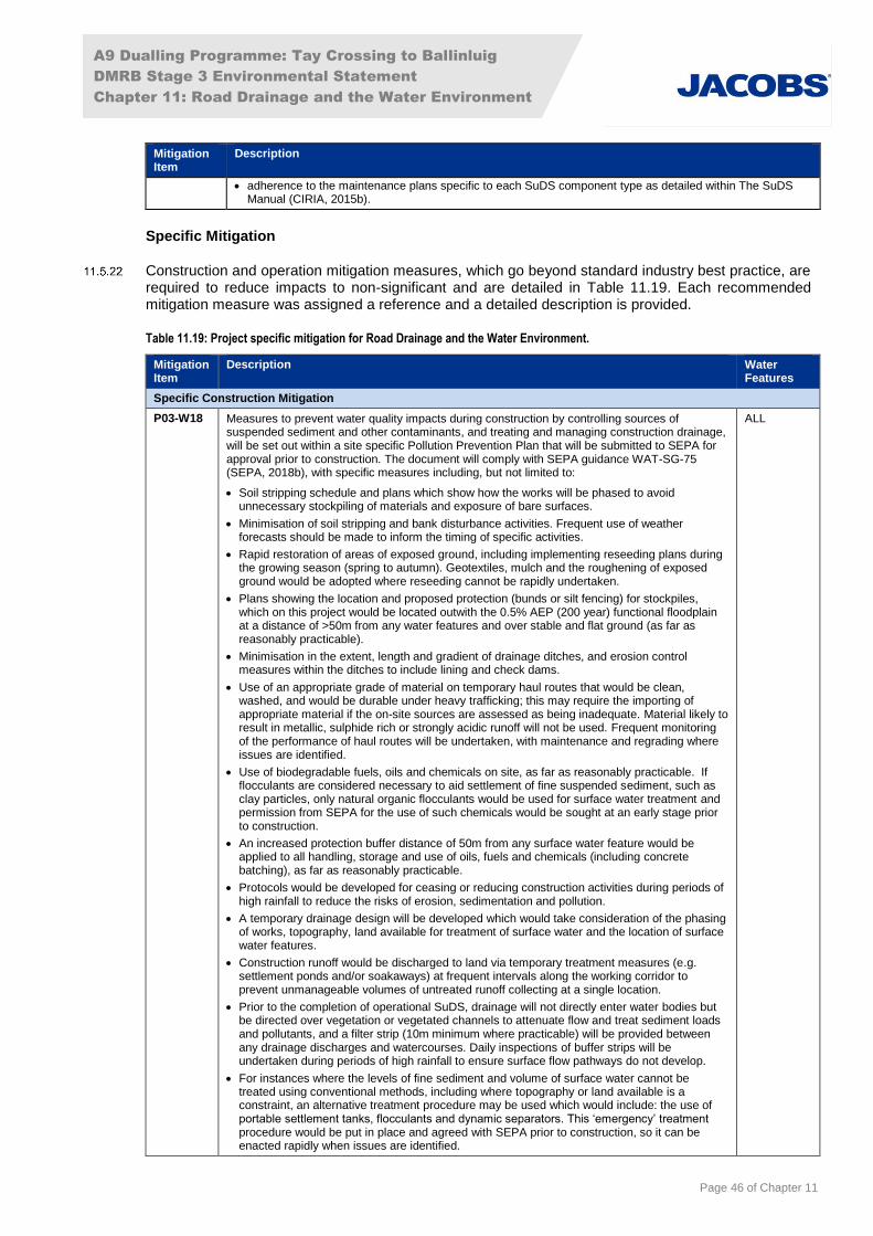
A9 Dualling Programme: Tay Crossing to Ballinluig
DMRB Stage 3 Environmental Statement
Chapter 11: Road Drainage and the Water Environment
Page 46 of Chapter 11
Mitigation Item
Description
adherence to the maintenance plans specific to each SuDS component type as detailed within The SuDS Manual (CIRIA, 2015b).
Specific Mitigation
Construction and operation mitigation measures, which go beyond standard industry best practice, are required to reduce impacts to non-significant and are detailed in Table 11.19. Each recommended mitigation measure was assigned a reference and a detailed description is provided.
Table 11.19: Project specific mitigation for Road Drainage and the Water Environment.
Mitigation Item
Description Water Features
Specific Construction Mitigation
P03-W18 Measures to prevent water quality impacts during construction by controlling sources of suspended sediment and other contaminants, and treating and managing construction drainage, will be set out within a site specific Pollution Prevention Plan that will be submitted to SEPA for approval prior to construction. The document will comply with SEPA guidance WAT-SG-75 (SEPA, 2018b), with specific measures including, but not limited to:
Soil stripping schedule and plans which show how the works will be phased to avoid unnecessary stockpiling of materials and exposure of bare surfaces.
Minimisation of soil stripping and bank disturbance activities. Frequent use of weather forecasts should be made to inform the timing of specific activities.
Rapid restoration of areas of exposed ground, including implementing reseeding plans during the growing season (spring to autumn). Geotextiles, mulch and the roughening of exposed ground would be adopted where reseeding cannot be rapidly undertaken.
Plans showing the location and proposed protection (bunds or silt fencing) for stockpiles, which on this project would be located outwith the 0.5% AEP (200 year) functional floodplain at a distance of >50m from any water features and over stable and flat ground (as far as reasonably practicable).
Minimisation in the extent, length and gradient of drainage ditches, and erosion control measures within the ditches to include lining and check dams.
Use of an appropriate grade of material on temporary haul routes that would be clean, washed, and would be durable under heavy trafficking; this may require the importing of appropriate material if the on-site sources are assessed as being inadequate. Material likely to result in metallic, sulphide rich or strongly acidic runoff will not be used. Frequent monitoring of the performance of haul routes will be undertaken, with maintenance and regrading where issues are identified.
Use of biodegradable fuels, oils and chemicals on site, as far as reasonably practicable. If flocculants are considered necessary to aid settlement of fine suspended sediment, such as clay particles, only natural organic flocculants would be used for surface water treatment and permission from SEPA for the use of such chemicals would be sought at an early stage prior to construction.
An increased protection buffer distance of 50m from any surface water feature would be applied to all handling, storage and use of oils, fuels and chemicals (including concrete batching), as far as reasonably practicable.
Protocols would be developed for ceasing or reducing construction activities during periods of high rainfall to reduce the risks of erosion, sedimentation and pollution.
A temporary drainage design will be developed which would take consideration of the phasing of works, topography, land available for treatment of surface water and the location of surface water features.
Construction runoff would be discharged to land via temporary treatment measures (e.g. settlement ponds and/or soakaways) at frequent intervals along the working corridor to prevent unmanageable volumes of untreated runoff collecting at a single location.
Prior to the completion of operational SuDS, drainage will not directly enter water bodies but be directed over vegetation or vegetated channels to attenuate flow and treat sediment loads and pollutants, and a filter strip (10m minimum where practicable) will be provided between any drainage discharges and watercourses. Daily inspections of buffer strips will be undertaken during periods of high rainfall to ensure surface flow pathways do not develop.
For instances where the levels of fine sediment and volume of surface water cannot be treated using conventional methods, including where topography or land available is a constraint, an alternative treatment procedure may be used which would include: the use of portable settlement tanks, flocculants and dynamic separators. This ‘emergency’ treatment procedure would be put in place and agreed with SEPA prior to construction, so it can be enacted rapidly when issues are identified.
ALL

A9 Dualling Programme: Tay Crossing to Ballinluig
DMRB Stage 3 Environmental Statement
Chapter 11: Road Drainage and the Water Environment
Page 47 of Chapter 11
Mitigation Item
Description Water Features
Settlement features would be sized appropriately to accommodate the maximum volume of runoff that would be reasonably expected to occur on any occasion during the period of construction (as to be agreed with SEPA).
All features associated with the temporary drainage system, including settlement ponds, settlement tanks, ditches and silt traps, will be maintained in a good state of repair by the Contractor.
P03-W19 A Construction Method Statement with specific pollution prevention measures will be developed and agreed with SEPA and SNH to prevent water quality impacts from the River Tay bank stabilisation works at ch1600 –1900. The outline methods and measures, which will be subject to further development and refinement by the contractor, will include but not be limited to:
Constructing the working platform for the bored piles with a slight fall back into the slope to prevent surface runoff from entering the River Tay.
Construction of a low height bund between the pile bores and the River Tay, and a temporary slope between the A9 and the platform, with a small filter drain along the toe to collect runoff from the working platform.
Diversion of collected runoff to a series of settlement tanks or settlement ponds located within the area of the northbound carriageway and additional land available in the vicinity of operational SuDS outfall B.
Containment and removal from site, for disposal at a licensed waste facility, of any drilling muds, if required during piling works.
Geotextile matting or other erosion protection measures on bare slopes, downstream silt fencing and silt curtains to protect sensitive aquatic ecological interests in the event of sediment release.
WF06
P03-W20 To measure the effectiveness of implemented mitigation measures in protecting downstream water quality and aquatic ecological interests, monitoring protocols during the construction phase will be developed within a site specific Water Quality Monitoring Plan, which will be submitted to SEPA for approval prior to construction. This would include, but not be limited to:
Appointment of a suitably qualified (minimum of 3 years’ experience supervising construction sites, monitoring water quality and drainage design) Hydrological Clerk of Works (HCoW), who will review the scheduling of earthworks, storage of materials, implementation of drainage and surface water treatment measures, and undertake monitoring of water quality. The HCoW will be provided with the authority to stop works and implement remedial action with immediate effect.
Water quality monitoring one year prior to construction, during construction and one year’s post construction. The monitoring regime to include monthly laboratory analysis, visual inspections and real time monitoring.
Water quality criteria and standards to be achieved for all site discharges during construction, and sampling locations, to be agreed in consultation with SEPA and SNH. The contractor will ensure compliance with these standards through the adoption of standard mitigation (Table 11.18) and Mitigation Items P03-W18 and P03-W19.
Real-time monitoring of electrical conductivity and turbidity to detect suspended solid concentrations in exceedance of baseline levels. An automated alert system would alert the HCoW and site staff of any pollution incidents, informing where further sampling is required to confirm compliance with the limits agreed with SEPA, and allow remedial actions to be implemented at specific locations.
ALL
P03-W21 Construction drainage systems/SuDS would be implemented prior to any significant earthworks to control/attenuate runoff during construction. Regular maintenance of construction SuDS and associated outfalls will be undertaken to ensure the basins are not susceptible to flood damage, and that flood risk is not increased locally during construction. In advance of extreme flood events (e.g. 0.5% AEP (200-year) + CC event), in stream working areas would be evacuated and allowed to flood to prevent any increases in flood levels from constriction of flows.
ALL
P03-W22 Where feasible, new culverts/artificial channels will be constructed prior to the decommissioning of the existing culvert/channel and commencement of construction activities. Flows will be steadily released into the newly constructed realignment, and erosion protection measures will be put in place, to avoid sedimentation and erosion of the new channel.
WF38
P03-W23 The River Tay (WF06) is known to have a risk of natural channel migration with active processes of bank erosion and sediment deposition, caution would be required and construction works (as far as possible) would need to remain a sufficient distance from the river bank as a means of not exacerbating these processes. The distance from the river bank would be determined at each site based on the specific locations at risk
WF06
Specific Operation Mitigation
P03-W24 Re-planting of vegetation around outfall structures, tying in with natural vegetation. The planting of trees, if removed, is of particular importance.
WF06
P03-W25 Geomorphological led design, construction supervision and post project appraisal of cascades and channel realignments/re-gradings. Incorporation of appropriate geomorphological features
WF16 WF18-WF25 WF30-WF42

A9 Dualling Programme: Tay Crossing to Ballinluig
DMRB Stage 3 Environmental Statement
Chapter 11: Road Drainage and the Water Environment
Page 48 of Chapter 11
Mitigation Item
Description Water Features
and suitable design of cross-section and planform to ensure movement of water downstream is not compromised.
WF47 WF49 WF50 WF52 WF53
P03-W26 Geomorphological input into detailed design, construction supervision and post-project appraisal of culverts. Measures to include use of depressed invert culverts, enabling the formation of a natural bed and minimising impact on existing channel bed and bank.
WF16-WF39
WF41-WF53
P03-W27 Reinstate riparian vegetation where possible. WF40
P03-W28 Set-back bridge abutments for new extended bridge as far back as practicable from back top. WF40
P03-W29 Install a depressed invert culvert and existing gravel substrate to be reinstated within culvert or similar, appropriately sized substrate to be used where existing substrate is unsuitable/impractical. Tie-in of the new channel cross-section to the upstream and downstream existing water feature to minimise potential erosion, such as an energy dissipation pool at the culvert outlet.
WF36
WF39
P03-W30 Operational Mainline SuDS: Management Train 1 (MT1) comprising filter drains and a wetland. This management train will be adopted for drainage catchments A1, A2, E and H.
WF06
WF55
P03-W31 Operational Mainline SuDS: MT2 comprising filter drains and swales. This management train will be adopted for drainage catchments D1 and D2.
WF06
WF38
P03-W32 Operational Mainline SuDS: MT3 comprising filter drains and a hydrodynamic vortex separator. This management train will be adopted for drainage runs B, F1, F2, G1 and G2.
WF06
WF42
WF50
P03-W33 Operational Mainline SuDS: MT4 comprising filter drains and a detention basin. This management train will be adopted for drainage catchments C.
WF06
P03-W34 Location of outfalls along River Tay to minimise potential risk of altering fluvial processes, such as erosion and depositional, in the vicinity of and downstream of the structure processes:
At ch700, microsite outfall to avoid depositional feature as far as practicable.
At ch1600-1900, geomorphological input into the design of River Tay bank stabilisation works.
At ch3870 the outfall should be orientated in line with the direction of flow. Maintain fallen trees in situ where possible as they provide natural bank protection. Plant bank face around the outfall structure.
At ch5500 the outfall should be set-back from the banks of the River Tay and connected via a small drainage channel. The drainage channel should be orientated in line with the direction of flow.
WF06
P03-W35 To prevent an increase in flood risk to the Haugh of Kilmorich and other areas between the railway and the A9, compensatory flood storage will be provided in an area of higher ground in a field to the north of Haugh of Kilmorich. This will provide additional floodplain storage capacity and ensure change in flood risk to the property will be negligible.
To accommodate the compensatory flood storage at this location, watercourse WF50 (which currently infiltrates to groundwater in an area of forestry) will be realigned to discharge into the realigned WF49 (which subsequently discharges into WF42/WF41).
WF06
WF49
WF50
P03-W36 The field between the A9 and General Wade’s Military Road immediately north of Guay will be connected to the existing floodplain with a culvert through the A9 and the railway embankment, with additional culverts just through the A9 and excavations undertaken to lower ground levels and provide additional floodplain storage. This will provide additional floodplain storage and mitigate the predicted increased flood risk to the Highland Mainline Railway as well as properties and farmland further downstream in the unmitigated case.
WF06
P03-W37 A flood wall will be provided on the right (north) bank of the Sloggan Burn to provide protection to Guay farmhouse and mitigate the increase in flood risk.
WF39
P03-W38 Geomorphological input into the detailed design of River Tay bank stabilisation works between ch1600-1900.
WF06
P03-W39 An additional culvert will be provided on the Sloggan Burn downstream of the Highland Mainline Railway to mitigate increases in flood risk to agricultural land.
WF39
P03-W40 Compensatory flood storage will be provided between the Highland Mainline Railway and the A9 south of Guay to mitigate increased flood risk to the railway and downstream receptors.
WF06
WF38
P03-W41 An Ecological/Compensatory Flood Storage Pond will be provided between the A9 and Highland Mainline Railway north of Kindallachan to mitigate increased flood risk to agricultural land and the railway in this area.
WF41
WF42
WF50
P03-W42 Floodplain compensation will be provided on the north bank of the watercourse downstream of the A9 to mitigate increases in flood risk to agricultural land and the railway embankment.
WF52
P03-W43 A monitoring programme will be implemented at the location of the bank stabilisation works at ch1600 – 1900 prior to construction consisting of collection of detailed baseline bank conditions, annual inspections of the river bank by a geomorphologist and a geotechnical engineer,
WF06
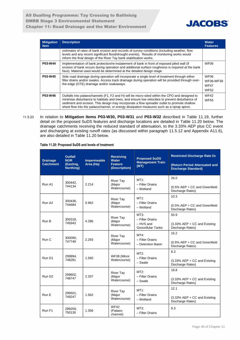
A9 Dualling Programme: Tay Crossing to Ballinluig
DMRB Stage 3 Environmental Statement
Chapter 11: Road Drainage and the Water Environment
Page 49 of Chapter 11
Mitigation Item
Description Water Features
estimates of rates of bank erosion and records of survey conditions (including weather, flow levels and any recent significant flood/drought events). Results of monitoring works would inform the final design of the River Tay bank stabilisation works.
P03-W44 Implementation of bank protection/re-instatement of bank in front of exposed piled wall (if erosion of bank occurs during operation and additional surface roughness is required at the bank face). Material used would be determined at the detailed design stage.
WF06
P03-W45 Side road drainage during operation will incorporate a single level of treatment through either filter drains and/or swales. Access track drainage during operation will be provided through over-the-edge (OTE) drainage and/or soakaways.
WF06
WF36-WF39
WF47
WF52
P03-W46 Outfalls into palaeochannels (F1, F2 and H) will be micro-sited within the CPO and designed to minimise disturbance to habitats and trees, and ensure low velocities to prevent disturbance of sediment and erosion. This design may incorporate a flow spreader outlet to promote shallow sheet flow into the palaeochannel, or energy dissipation measures such as a riprap apron.
WF42
WF55
In relation to Mitigation Items P03-W30, P03-W31 and P03-W32 described in Table 11.19, further detail on the proposed SuDS features and discharge locations are detailed in Table 11.20 below. The drainage catchments receiving the reduced standard of attenuation, to the 3.33% AEP plus CC event and discharging at existing runoff rates (as discussed within paragraph 11.5.12 and Appendix A11.6), are also detailed in Table 11.20 below.
Table 11.20: Proposed SuDS and levels of treatment
Drainage Catchment
Outfall NGR (Easting, Northing)
Impermeable Area (Ha)
Receiving Water Feature (Description)
Proposed SuDS Management Train (MT)
Restricted Discharge Rate l/s
(Return Period Attenuated and Discharge Standard)
Run A1 300442, 744134
2.214 River Tay (Major Watercourse)
MT1:
– Filter Drains
– Wetland
26.0
(0.5% AEP + CC and Greenfield Discharge Rates)
Run A2 300436, 744684
0.962 River Tay (Major Watercourse)
MT1:
– Filter Drains
– Wetland
10.3
(0.5% AEP + CC and Greenfield Discharge Rates)
Run B 300318, 745943
4.286 River Tay (Major Watercourse)
MT3:
– Filter Drains
– HVS and Geocellular Tanks
50.9
(3.33% AEP + CC and Existing Discharge Rates)
Run C 300090, 747749
2.293 River Tay (Major Watercourse)
MT4:
– Filter Drains
– Detention Basin
16.2
(0.5% AEP + CC and Greenfield Discharge Rates)
Run D1 299894, 748281
1.560 WF38 (Minor Watercourse)
MT2:
– Filter Drains
– Swale
8.3
(3.33% AEP + CC and Existing Discharge Rates)
Run D2 299602, 748747
2.207 River Tay (Major Watercourse)
MT2:
– Filter Drains
– Swale
18.8
(3.33% AEP + CC and Existing Discharge Rates)
Run E 299501, 749247
1.562 River Tay (Major Watercourse)
MT1:
– Filter Drains
– Wetland
12.1
(3.33% AEP + CC and Existing Discharge Rates)
Run F1 299259, 750130
1.356 WF42 (Palaeo-channel)
MT3:
– Filter Drains
9.3

A9 Dualling Programme: Tay Crossing to Ballinluig
DMRB Stage 3 Environmental Statement
Chapter 11: Road Drainage and the Water Environment
Page 50 of Chapter 11
Drainage Catchment
Outfall NGR (Easting, Northing)
Impermeable Area (Ha)
Receiving Water Feature (Description)
Proposed SuDS Management Train (MT)
Restricted Discharge Rate l/s
(Return Period Attenuated and Discharge Standard)
– HVS and Geocellular Tanks
(3.33% AEP + CC and Existing Discharge Rates)
Run F2 299287, 750305
0.744 WF42 (Palaeo-channel)
MT3:
– Filter Drains
– HVS and Geocellular Tanks
3.8
(3.33% AEP + CC and Existing Discharge Rates)
Run G1 298903, 750920
1.064 WF50 (Minor Watercourse)
MT3:
– Filter Drains
– HVS and Geocellular Tanks
12.0
(3.33% AEP + CC and Existing Discharge Rates)
Run G2 298924, 750951
1.119 WF50 (Minor Watercourse)
MT3:
– Filter Drains
– HVS and Geocellular Tanks
6.0
(3.33% AEP + CC and Existing Discharge Rates)
Run H 298095, 751551
1.155 WF55 (Palaeo-channel)
MT1:
– Filter Drains
– Wetland
6.6
(3.33% AEP + CC and Existing Discharge Rates)
11.6 Residual Impacts
Following implementation of the mitigation measures outlined in Section 11.5 (Mitigation), potentially significant impacts on the water environment would be avoided/prevented, reduced or offset.
The significant residual impacts likely to occur during either the construction and/or operational phases following the application of mitigation measures are set out in the following paragraphs and are adverse unless otherwise stated. Non-significant residual impacts identified for each surface water feature in terms of hydrology and flood risk, fluvial geomorphology and water quality are set out in Appendix A11.7 (Impact Assessment).
A summary of the residual impacts detailed within Appendix A11.7 (Impact Assessment) is provided below.
Construction
Hydrology and Flood Risk
No significant adverse residual impacts have been identified from construction of the proposed scheme. Construction of the scheme would have a minor increase in flood risk, particularly on WF06 (River Tay) due to the presence of construction works within the functional floodplain. These works risk reducing floodplain storage due to temporary works within the floodplain. However, the increase in flood depth would be anticipated to be negligible.
Fluvial Geomorphology
No residual impacts of Moderate significance or above are expected from the construction phase provided all proposed mitigation measures are adhered to.
Water Quality
No residual impacts of moderate significance or above are expected during the construction phase provided all proposed mitigation measures are adhered to.

A9 Dualling Programme: Tay Crossing to Ballinluig
DMRB Stage 3 Environmental Statement
Chapter 11: Road Drainage and the Water Environment
Page 51 of Chapter 11
Operation
Hydrology and Flood Risk
The majority of potential impacts arising from the operation of the proposed scheme would have a Neutral or Slight significance.
However adverse residual impacts with Moderate significance are attributed to WF06 (River Tay) due to increases in fluvial flood depth from the 0.5% AEP (200-year) plus CC event at the following locations:
Field at ch6400 (north of Kindallachan) on the east side of the A9. Increased flood depth of 10mm on existing flood depths of up to 3.6m. This field is an existing wetland and is therefore not considered sensitive to the increased flood depths. The land would be returned to the landowner with appropriate burdens restricting development, protecting the area for flood storage.
Area of land on right (west) bank of WF06 (River Tay) at approximately ch3000, which is also at risk of flooding from WF39. Proposed mitigation works on WF39 (Sloggan Burn) result in an increase in peak water level of up to 13mm for the 0.5% (200-year) plus CC design event on a baseline flood depth of up to 0.8m. An event on WF06 would have a negligible impact on the baseline flood depth of 4.6m. The two watercourses (worst-case) design events are of different durations and would therefore not be expected to coincide.
In each case, the measures to mitigate the impacts described would have additional adverse impacts on landowners or other sensitive receptors. Further detail on the mitigation options considered and justification for these subsequent adverse impacts not being considered appropriate can be found in Appendix A11.3 (Flood Risk Assessment).
It is noted that there are apparent instances of Major adverse impact as a result of the proposed scheme identified on Figure 11.3 at SuDS ponds A1, A2 and C, and at the field north of Guay and east of the A9. However, these are due to the excavations associated with these embedded mitigation measures (SuDS ponds and reprofiling for flood storage), and do not represent an actual increase in peak water level.
Fluvial Geomorphology
No residual significant fluvial geomorphology impacts are expected from operation of the proposed scheme. However, if appropriate mitigation and design is not undertaken there is likely to be a morphological response by watercourses across the scheme which could result in deterioration of the watercourse or ongoing management issues.
Water Quality
After mitigation by the proposed SuDS, no residual significant water quality impacts are expected from the operation of the proposed scheme.
Although ‘Fails’ of certain aspects of the HAWRAT assessment are noted for five outfalls post-mitigation in Appendix A11.6 (SuDS and Water Quality), it is highlighted that these failures are associated with minor watercourses and ephemeral water features with very low Q95 flows. It is acknowledged within DMRB HD45/09 that the HAWRAT tool has limitations when assessing impacts on ephemeral watercourses, as increasing the mitigation will still not enable a ‘Pass’ result if the Q95 flows are too low to provide dilution of pollutants. When the same drainage runs are assessed at the point of discharge into the River Tay SAC, all aspects of the HAWRAT assessment result in a ‘Pass’, due to the subsequent dilution taking place at this discharge location. Additionally, once the sensitivity of the receiving minor watercourses has been taken into account, no residual significant impacts are identified from the operational SuDS discharges.
The River Tay SAC catchment will benefit from the adoption of SuDS treatment with the A9 Dualling Programme, as there is generally no such treatment associated with the existing A9. Further detail and justification of the water quality assessment results is provided within Appendix A11.6 (SuDS and Water Quality).
A9 Dualling Programme: Tay Crossing to Ballinluig
DMRB Stage 3 Environmental Statement
Chapter 11: Road Drainage and the Water Environment
Page 52 of Chapter 11
11.7 Statement of Significance
Hydrology and Flood Risk
No significant impacts on hydrology and flood risk are anticipated during the construction phase, provided mitigation is adhered to.
During operation of the proposed scheme, adverse impacts of Moderate significance on WF06 (River Tay) were assessed.
Fluvial Geomorphology
No residual significant impacts on fluvial geomorphology are anticipated, provided all mitigation is adhered to.
Water Quality
No residual significant impacts on water quality (including sub-attributes ‘water quality’, ‘water supply’, ‘dilution and removal of waste products’ and ‘biodiversity’) are anticipated, provided all mitigation is adhered to.
11.8 References
BLOM (2013). Aerial Imagery. Available at: http://www.blomasa.com/home.html
British Geological Survey (2016). Geology of Britain viewer. Available online at: http://www.bgs.ac.uk/data/mapViewers/home.html
British Standards (2009). BS 6031:2009 Code of Practice for Earthworks.
British Water (Undated). Code of Practice – Assessment of Manufactured Treatment Devices Designed to Treat Surface Water Runoff.
(CEH) Centre for Ecology and Hydrology (2009). Flood Estimation Handbook CD-ROM Version 3. CEH
CEH (2015). National River Flow Archive. Available online at: http://www.ceh.ac.uk/news-and-media/news/uk-river-flow-data-now-web-accessible
Construction Industry Research and Information Association (1994). Control of pollution from highway drainage discharge, CIRIA R142.
Construction Industry Research and Information Association (2001). Control of water pollution from construction sites. Guidance for consultants and contractors, CIRIA C532.
Construction Industry Research and Information Association (2004). Sustainable drainage systems: Hydraulic, structural and water quality advice, CIRIA C609.
Construction Industry Research and Information Association (2006a). Control of water pollution from linear construction projects: Technical Guidance, CIRIA C648.
Construction Industry Research and Information Association (2006b). Control of water pollution from linear construction projects: Site guide, CIRIA C649.
Construction Industry Research and Information Association (2007). Site handbook for the construction of SUDS, CIRIA C698.
Construction Industry Research and Information Association (2010). Culvert Design and Operation Guide, CIRIA C689.

A9 Dualling Programme: Tay Crossing to Ballinluig
DMRB Stage 3 Environmental Statement
Chapter 11: Road Drainage and the Water Environment
Page 53 of Chapter 11
Construction Industry Research and Information Association (2015a). Environmental good practice on site guide (fourth edition), CIRIA C741
Construction Industry Research and Information Association (2015b). The SuDS Manual, CIRIA C753.
Environment Agency (1999). Waterway Bank Protection: a guide to erosion assessment and management (Environment Agency)
Environment Agency (2010). The Fluvial Design Guide. Available online at: http://evidence.environment-agency.gov.uk/FCERM/en/FluvialDesignGuide.aspx
Highways Agency, Scottish Executive, Welsh Assembly Government and The Department for Regional Development Northern Ireland (2004a). Design Manual for Roads and Bridges, Volume 4, Section 2, Part 1 (HA 106/04): Drainage of Runoff from Natural Catchments. Available at: http://www.standardsforhighways.co.uk/ha/standards/dmrb/vol4/section2/ha10604.pdf
Highways Agency, Scottish Executive, Welsh Assembly Government and The Department for Regional Development Northern Ireland (2004b). Design Manual for Roads and Bridges, Volume 4, Section 2, Part 7 (HA 107/04): Design of Outfall and Culvert Details. Available at: http://www.standardsforhighways.co.uk/ha/standards/dmrb/vol4/section2/ha10704.pdf
Highways Agency, Scottish Government, Welsh Assembly Government and The Department for Regional Development Northern Ireland (2009a). Design Manual for Roads and Bridges, Volume 11 Section 3, Part 10 (HD 45/09): Road Drainage and the Water environment. Available online at: http://www.standardsforhighways.co.uk/ha/standards/dmrb/vol11/section3.htm.
Highways Agency et al. (2009b). Interim Advice Note (IAN) 125/09: Supplementary Guidance for Users of DMRB Volume 11 Environmental Assessment
Jacobs (2014). DMRB Stage 1 Assessment A9 Dualling: Preliminary Engineering Support (PES) Services
Jacobs (2016). A9 Dualling Tay Crossing to Ballinluig: DMRB Stage 2 Scheme Assessment Report, Volume 1: Main Report and Appendices, Part 3: Environmental Assessment
National Library of Scotland (2015). Map images. Available online at: http://maps.nls.uk/
Mustow, S. E., Burgess, P. F. and Walker, N. (2005). Practical Methodology for Determining the Significance of Impacts on the Water Environment. Water and Environment Journal, 19: 100–108. doi:10.1111/j.1747-6593.2005.tb00557.x
Perth and Kinross Council (2014). Flood Risk and Flood Risk Assessments (Developers Guidance Note on Flooding & Drainage). Available online at: https://beta.gov.scot/publications/perth-and-kinross-council-planning-authority-core-documents/Flood%20Risk%20and%20FRA.pdf
SCOTS (2010). SuDS for Roads. Society of Chief Officers of Transportation in Scotland. Available online at: http://www.scotsnet.org.uk/documents/SudsforRoads.PublishedAug2009_001.pdf
Scottish Executive (2001). River Crossings and Migratory Fish: Design Guidance. Available online at: http://www.gov.scot/Topics/marine/science/Publications/publicationslatest/rivercrossings
Scottish Government (2003). Water Environment Water Services (WEWS) Act 2003. Available online at: http://www.legislation.gov.uk/asp/2003/3/contents
Scottish Government (2007). The Water Environment (Drinking Water Protected Areas) (Scotland) Order 2007. Available at: http://www.gov.scot/Publications/2008/03/Maps
Scottish Government (2009a). Flood Risk Management (Scotland) Act 2009. Available online at: http://www.legislation.gov.uk/asp/2009/6/pdfs/asp_20090006_en.pdf

A9 Dualling Programme: Tay Crossing to Ballinluig
DMRB Stage 3 Environmental Statement
Chapter 11: Road Drainage and the Water Environment
Page 54 of Chapter 11
Scottish Government (2009b). Climate Change (Scotland) Act 2009. Available online at: http://www.legislation.gov.uk/asp/2009/12/pdfs/asp_20090012_en.pdf
Scottish Government (2011). Water Environment (Controlled Activities) (Scotland) Regulations (2011) (CAR). Available online at: http://www.legislation.gov.uk/ssi/2011/209/made
Scottish Government (2013). Water Environment (Controlled Activities) (Scotland) Regulations (2013) (as amended) (CAR). Available online at: http://www.legislation.gov.uk/ssi/2013/176/contents/made
Scottish Government (2014). Scottish Planning Policy. Available online at: http://www.gov.scot/Resource/0045/00453827.pdf
Scottish Government (2015a). Scottish Government (2015b). Online Planning Advice on Flood Risk. Available online at http://www.gov.scot/Resource/0047/00479774.pdf [Accessed 08/02/17].
Scottish Government (2015b). The River Basin Management Plan for the Scotland River Basin District: 2015–2027. Available online at: http://www.sepa.org.uk/media/163445/the-river-basin-management-plan-for-the-scotland-river-basin-district-2015-2027.pdf [Accessed 21 June 2016].
Scottish Government (2017). Water Environment (Miscellaneous) (Scotland) Regulations 2017. Available online at: http://www.legislation.gov.uk/ssi/2017/389/contents/made
Sear, D.A.; Newson, M. D.; Thorne, C. R.; Soar, P. J. and Skinner, K. S. (2010). Guidebook of Applied Fluvial Geomorphology. ICE Publishing
SEPA (2002). The Future for Scotland's Waters: Guiding Principles on the Technical Requirements of the Water Framework Directive. Available online at: http://www.fwr.org/WQreg/Appendices/future_for_scotlands_waters(1).pdf [Accessed 21 June 2016]
SEPA (2006-2017). Guidance for Pollution Prevention (GPPs) / Pollution Prevention Guidelines (PPGs). Available online at: http://www.netregs.org.uk/environmental-topics/pollution-prevention-guidelines-ppgs-and-replacement-series/guidance-for-pollution-prevention-PPGs-full-list/
SEPA (2006). Code of Practice for installers, owners and operators of underground storage tanks and pipelines. Available at: https://www.sepa.org.uk/media/145052/code_of_practice_for_installers_owners_and_operators_of_underground_storage_tanks_pipelines_water.pdf
SEPA (2008a). Engineering in the Water Environment Good Practice Guide: Bank Protection Rivers and Lochs (WAT-SG-23). Available online at: http://www.sepa.org.uk/media/150971/wat_sg_23.pdf [Accessed 23 April 2015].
SEPA (2008b). Engineering in the Water Environment Good Practice Guide: Intakes and Outfalls (WAT-SG-28). Available online at: http://www.sepa.org.uk/media/150984/wat_sg_28.pdf [Accessed 23 April 2015].
SEPA (2009). Good Practice Guide: Temporary Construction Methods. Available online at: https://www.sepa.org.uk/media/150997/wat_sg_29.pdf
SEPA (2010a). Improving the quality of Scotland’s water environment Tay area management plan 2009–2015 Supplementary to the river basin management plan for the Scotland [Accessed 06 March 2017] www.sepa.org.uk/media/38103/tay_area-management-plan.pdf
SEPA (2010b). Engineering in the Water Environment: Good Practice Guide: River Crossings (WAT-SG-25). Available online at: http://www.sepa.org.uk/media/151036/wat-sg-25.pdf [Accessed 23 April 2015].
SEPA (2012). Supporting Guidance (WAT-SG-21) Environmental Standards for River Morphology. Available at: https://www.sepa.org.uk/media/152194/wat_sg_21.pdf

A9 Dualling Programme: Tay Crossing to Ballinluig
DMRB Stage 3 Environmental Statement
Chapter 11: Road Drainage and the Water Environment
Page 55 of Chapter 11
SEPA (2015a). SEPA Position Statement to Support the Implementation of the Water Environment (Controlled Activities) (Scotland) Regulations 2011. Available at: https://www.sepa.org.uk/media/150919/wat_ps_06_02.pdf
SEPA (2015b). Technical Flood Risk Guidance for Stakeholders (SS-NFR-P-002). Available online at: https://www.sepa.org.uk/media/162602/ss-nfr-p-002-technical-flood-risk-guidance-for-stakeholders.pdf
SEPA (2015c). Flood maps. Available at: https://www.sepa.org.uk/environment/water/flooding/flood-maps/
SEPA (2015d). Reservoirs Map. Available at: http://map.sepa.org.uk/reservoirsfloodmap/Map.htm
SEPA (2016a). Flood Frequency Curves and Time Series Data. SEPA
SEPA (2016b). River gauging data records from 1990 to 2015 for stations 15007 (River Tay at Pitnacree), 15003 (River Tay at Caputh), 15034 (River Garry at Killiecrankie), 15012 (River Tummel at Pitlochry) and associated hydrometric data. SEPA
SEPA (2016c). SEPA Water Environment Hub. Available at: http://www.sepa.org.uk/data-visualisation/water-environment-hub/ [Accessed 25 September 2016]
SEPA (2017). SEPA Regulatory Method (WAT-RM-08), Sustainable Urban Drainage Systems. Available at: http://www.sepa.org.uk/media/219048/wat-rm-08-regulation-of-sustainable-urban-drainage-systems-suds.pdf
SEPA (2018a). The Water Environment (Controlled Activities) (Scotland) Regulations 2011 (as amended): A Practical Guide version 8.1. Available at: https://www.sepa.org.uk/media/34761/car_a_practical_guide.pdf
SEPA (2018b). Supporting Guidance (WAT-SG-75). Sector Specific Guidance: Construction Sites. Available at: https://www.sepa.org.uk/media/340359/wat-sg-75.pdf
Transport Scotland (2013). A9 Dualling Programme Strategic Environmental Assessment (SEA) – Environmental Report. Available online at: https://www.transport.gov.scot/media/13023/a9_-_sea_-er_-_non-tech_summary_for_publication.pdf.
Transport Scotland (2014a). A9 Dualling Programme Strategic Environmental Assessment (SEA) – Environmental Report Addendum.
Transport Scotland (2014b). A9 Dualling Programme Strategic Environmental Assessment (SEA) – Post Adoption SEA Statement. https://www.transport.gov.scot/media/35684/tssea9-dualling-sea-pas-final-sept2014.pdf.
Related Documents