Chapter 1 Introduction to the Petroleum Geology of Myanmar MICHAEL F. RIDD 1 * & ANDREW RACEY 2 1 43 Prospect Quay, Point Pleasant, Wandsworth, London, SW18 1PR, UK 2 Andy Racey Geoscience, 5 Norris Close, Whitehill, Hampshire, GU35 9EG, UK *Corresponding author (e-mail: [email protected]) Before the birth of the modern, mechanized, petroleum industry, Myanmar (formerly Burma) was an exporter of oil products from its hand-dug wells in the centre of the country. It is now an impor- tant exporter again, but of gas from its offshore fields, and the inter- national petroleum companies are keen to obtain acreage both onshore and offshore; in the lead-up to the 2013 offshore round no fewer than 60 companies pre-qualified with the Ministry of Energy of the Myanmar government. Past petroleum studies It was not until the incorporation of Burma into British India in 1885 that extensive geological research was initiated in the country, with many of these articles (up to independence in 1948) being published in reports of the Geological Survey of India. Historically important publications by their geologists in- cluded a study of the all-important Tertiary rocks by Noetling (1895) followed by his account of the country’s petroleum occur- rences (Noetling 1897). A more detailed study followed, covering the core petroleum-bearing area (what we now call the Salin Basin in the Central Burma Depression, Fig. 1.1) by Grimes (1898). As a modern petroleum industry became established following the for- mation of the Burmah Oil Company in 1886, the Geological Survey of India (Pascoe 1912) published a major update of what the author described had become ‘... .one of the most important industries of the Indian Empire.’ Accounts of the oil fields by industry geologists included those by Stamp (1927), Evans (1941) and Tainsh (1950); meanwhile, a major study of the wider geology of Burma was published by Chhibber (1934a) and of its mineral resources by the same author (Chhibber 1934b). In many respects those works by Chhibber remain standard refer- ences on Burmese geology, as does the later study by Pascoe (1950 – 1964). Most geological fieldwork since independence has focused on mineral exploration, with systematic mapping of selected areas only starting in the late 1960s. Some of that information is in reports which have limited availability, such as the study of the Shan scarps region by the United Nations Development Pro- gramme (1978); that which is more widely published tends to be on metallogenesis, tectonics and local gravity surveys. A series of papers was published between 1968 and 1971 on petroleum geology in the Union of Burma Journal of Science and Technol- ogy. Further publications have come from bilateral development projects with Australian, British, French and German government bodies. The latter gave rise to what is still the current authority on the geology of Burma as a whole (Bender 1983), which contains an exhaustive bibliography. Mention should also be made of Mitchell who, although not a petroleum geologist, has done more than most to stimulate discus- sion of the tectonic history of Myanmar. Mitchell (1986) coined the term Victoria Land for the Gondwana-derived platelet which forms the eastern belt of the Indo-Burman Ranges, and other notable contributions include Mitchell (1981, 1992) and Mitchell et al. (2007, 2012). Pascoe (1950 – 1964) and Bender (1983) include brief sections on petroleum geology in their wide-ranging geological accounts of the country, but understandably they were unable to include the offshore geology. Since then papers have been published on particular aspects of onshore and offshore petroleum geology but, to our knowledge, none on Myanmar’s overall petroleum geology. The present account therefore seeks to provide such an overview, using as data sources published papers, information gathered from companies’ websites and Powerpoint presentations, in particular those by Myanma Oil and Gas Enterprise (MOGE), the instrument of the Myanmar government for petroleum explora- tion, development and production. Current oil and gas production Oil and gas are produced in Myanmar from Cenozoic sedimen- tary rocks that occur in the 1200 km-long Central Burma Depression as well as in the three areas into which the Ministry of Energy has divided its offshore territory (Fig. 1.2). The onshore Rakhine coastal strip (R in Fig. 1.2) saw minor oil pro- duction from hand-dug wells in the past and is included in this study for completeness. However, MOGE’s presentation material states that basins on the Shan Plateau (Namyau, Hsipaw-Lashio and Kalaw basins) and at the northern end of the Tanintharyi peninsula (Mawlamyine and Mepale basins) (Fig. 1.2) also have petroleum potential, but they have seen little or no explora- tion and available geological data are limited. These frontier basins are discussed in Chapter 5. While oil continues to be produced onshore from a number of small- to medium-sized fields, it is the discovery and pro- duction of offshore gas and associated gas-liquids which have transformed the country’s petroleum prospects and economy, as shown in Figure 1.3. In June 2013 the Ministry of Energy an- nounced that onshore oil production was averaging 7500 b/d and gas 65 MMcf/d (the Ministry’s daily gas production figure in 2013 compares with MOGE’s figure of 56 490 MMcf/d in 2014; Kyaw Kyaw Aung 2014); offshore production was around 10 000 b/d of gas-liquids and oil and 1.4 Bcf/d of gas. MOGE’s estimate of proven (?remaining) reserves in 2006 was 115.116 MMbbls oil and 0.309 Tcf gas (onshore) and 100.892 MMbbls condensate and 15.845 Tcf gas (offshore). Independent estimates of the country’s proven gas reserves by BP have varied year by year as more data have become available. For example, at end-2009 BP’s estimate of proven reserves was 20.1 Tcf; by end-2010 reserves had dropped to 11.8 Tcf; and by end-2011 it had fallen again to 7.8 Tcf. This figure was adopted again for end-2012, before rising to 10 Tcf at end-2013 (BP Statistical Review of World Energy 2009, 2010, 2011, 2012, 2013, 2014). For comparison, the United Kingdom’s proven gas reserves at end-2013 are stated by BP to be 8.6 Tcf. BP does From:Racey, A. & Ridd, M. F. 2015. Petroleum Geology of Myanmar. Geological Society, London, Memoirs, 45, 1–6. http://doi.org/10.1144/M45.01 # 2015 The Authors. Published by The Geological Society of London. All rights reserved. For permissions: http://www.geolsoc.org.uk/permissions. Publishing disclaimer: www.geolsoc.org.uk/pub_ethics by guest on March 14, 2020 http://mem.lyellcollection.org/ Downloaded from

Welcome message from author
This document is posted to help you gain knowledge. Please leave a comment to let me know what you think about it! Share it to your friends and learn new things together.
Transcript
Chapter 1
Introduction to the Petroleum Geology of Myanmar
MICHAEL F. RIDD1* & ANDREW RACEY2
143 Prospect Quay, Point Pleasant, Wandsworth, London, SW18 1PR, UK2Andy Racey Geoscience, 5 Norris Close, Whitehill, Hampshire, GU35 9EG, UK
*Corresponding author (e-mail: [email protected])
Before the birth of the modern, mechanized, petroleum industry,Myanmar (formerly Burma) was an exporter of oil products fromits hand-dug wells in the centre of the country. It is now an impor-tant exporter again, but of gas from its offshore fields, and the inter-national petroleum companies are keen to obtain acreage bothonshore and offshore; in the lead-up to the 2013 offshore roundno fewer than 60 companies pre-qualified with the Ministry ofEnergy of the Myanmar government.
Past petroleum studies
It was not until the incorporation of Burma into British India in1885 that extensive geological research was initiated in thecountry, with many of these articles (up to independence in1948) being published in reports of the Geological Survey ofIndia. Historically important publications by their geologists in-cluded a study of the all-important Tertiary rocks by Noetling(1895) followed by his account of the country’s petroleum occur-rences (Noetling 1897). A more detailed study followed, coveringthe core petroleum-bearing area (what we now call the Salin Basinin the Central Burma Depression, Fig. 1.1) by Grimes (1898). As amodern petroleum industry became established following the for-mation of the Burmah Oil Company in 1886, the GeologicalSurvey of India (Pascoe 1912) published a major update of whatthe author described had become ‘. . . .one of the most importantindustries of the Indian Empire.’ Accounts of the oil fieldsby industry geologists included those by Stamp (1927), Evans(1941) and Tainsh (1950); meanwhile, a major study of thewider geology of Burma was published by Chhibber (1934a) andof its mineral resources by the same author (Chhibber 1934b). Inmany respects those works by Chhibber remain standard refer-ences on Burmese geology, as does the later study by Pascoe(1950–1964).
Most geological fieldwork since independence has focused onmineral exploration, with systematic mapping of selected areasonly starting in the late 1960s. Some of that information is inreports which have limited availability, such as the study of theShan scarps region by the United Nations Development Pro-gramme (1978); that which is more widely published tends to beon metallogenesis, tectonics and local gravity surveys. A seriesof papers was published between 1968 and 1971 on petroleumgeology in the Union of Burma Journal of Science and Technol-ogy. Further publications have come from bilateral developmentprojects with Australian, British, French and German governmentbodies. The latter gave rise to what is still the current authority onthe geology of Burma as a whole (Bender 1983), which contains anexhaustive bibliography.
Mention should also be made of Mitchell who, although not apetroleum geologist, has done more than most to stimulate discus-sion of the tectonic history of Myanmar. Mitchell (1986) coinedthe term Victoria Land for the Gondwana-derived platelet whichforms the eastern belt of the Indo-Burman Ranges, and other
notable contributions include Mitchell (1981, 1992) and Mitchellet al. (2007, 2012).
Pascoe (1950–1964) and Bender (1983) include brief sectionson petroleum geology in their wide-ranging geological accountsof the country, but understandably they were unable to includethe offshore geology. Since then papers have been published onparticular aspects of onshore and offshore petroleum geologybut, to our knowledge, none on Myanmar’s overall petroleumgeology. The present account therefore seeks to provide such anoverview, using as data sources published papers, informationgathered from companies’ websites and Powerpoint presentations,in particular those by Myanma Oil and Gas Enterprise (MOGE),the instrument of the Myanmar government for petroleum explora-tion, development and production.
Current oil and gas production
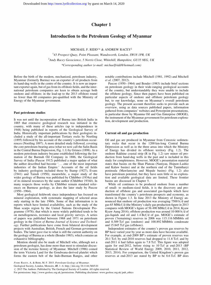
Oil and gas are produced in Myanmar from Cenozoic sedimen-tary rocks that occur in the 1200 km-long Central BurmaDepression as well as in the three areas into which the Ministryof Energy has divided its offshore territory (Fig. 1.2). Theonshore Rakhine coastal strip (R in Fig. 1.2) saw minor oil pro-duction from hand-dug wells in the past and is included in thisstudy for completeness. However, MOGE’s presentation materialstates that basins on the Shan Plateau (Namyau, Hsipaw-Lashioand Kalaw basins) and at the northern end of the Tanintharyipeninsula (Mawlamyine and Mepale basins) (Fig. 1.2) alsohave petroleum potential, but they have seen little or no explora-tion and available geological data are limited. These frontierbasins are discussed in Chapter 5.
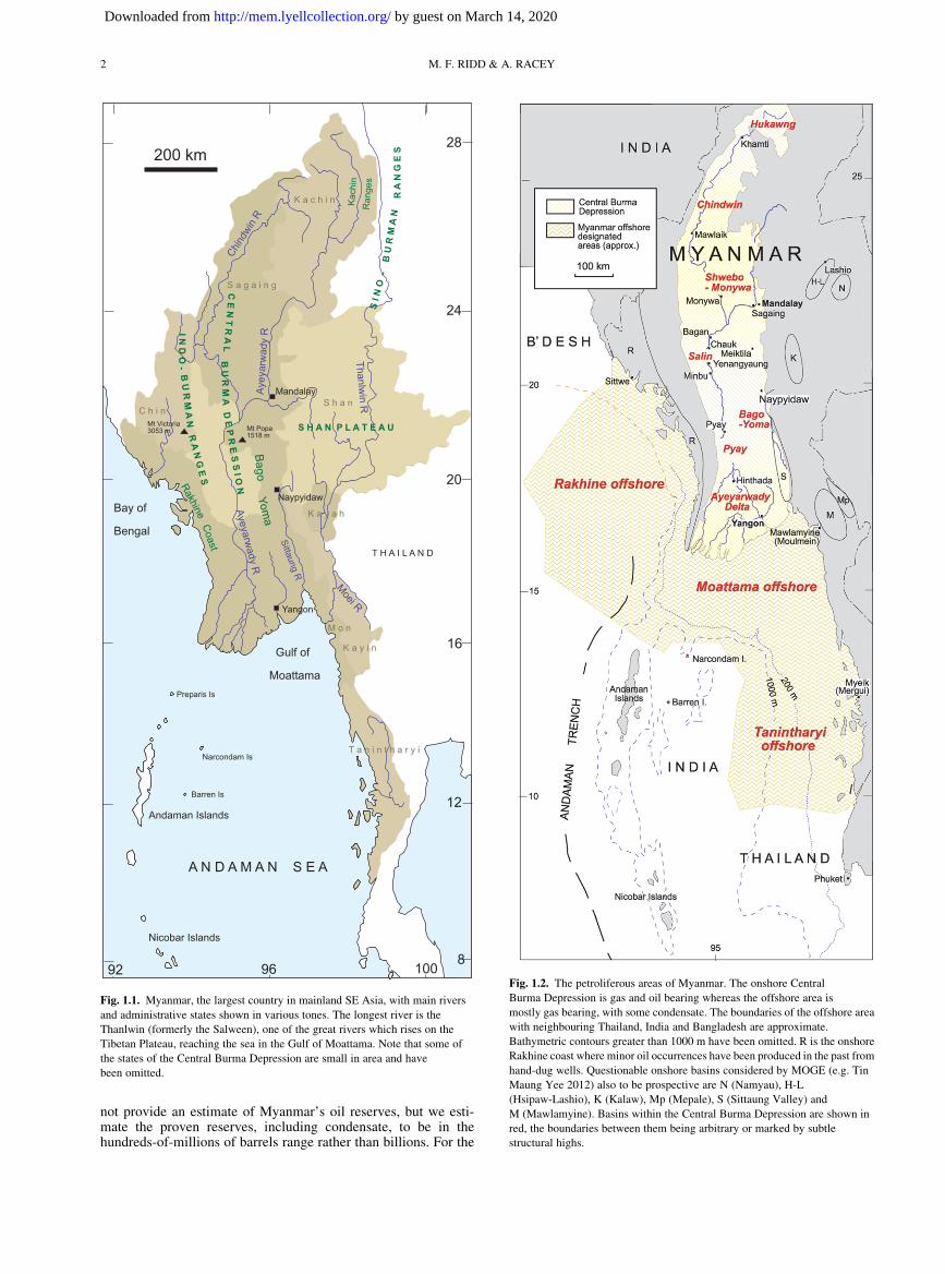
While oil continues to be produced onshore from a numberof small- to medium-sized fields, it is the discovery and pro-duction of offshore gas and associated gas-liquids which havetransformed the country’s petroleum prospects and economy, asshown in Figure 1.3. In June 2013 the Ministry of Energy an-nounced that onshore oil production was averaging 7500 b/d andgas 65 MMcf/d (the Ministry’s daily gas production figure in 2013compares with MOGE’s figure of 56 490 MMcf/d in 2014; KyawKyaw Aung 2014); offshore production was around 10 000 b/d ofgas-liquids and oil and 1.4 Bcf/d of gas. MOGE’s estimate ofproven (?remaining) reserves in 2006 was 115.116 MMbbls oiland 0.309 Tcf gas (onshore) and 100.892 MMbbls condensateand 15.845 Tcf gas (offshore).
Independent estimates of the country’s proven gas reserves byBP have varied year by year as more data have become available.For example, at end-2009 BP’s estimate of proven reserves was20.1 Tcf; by end-2010 reserves had dropped to 11.8 Tcf; and byend-2011 it had fallen again to 7.8 Tcf. This figure was adoptedagain for end-2012, before rising to 10 Tcf at end-2013 (BPStatistical Review of World Energy 2009, 2010, 2011, 2012,2013, 2014). For comparison, the United Kingdom’s proven gasreserves at end-2013 are stated by BP to be 8.6 Tcf. BP does
From: Racey, A. & Ridd, M. F. 2015. Petroleum Geology of Myanmar.
Geological Society, London, Memoirs, 45, 1–6. http://doi.org/10.1144/M45.01
# 2015 The Authors. Published by The Geological Society of London. All rights reserved.
For permissions: http://www.geolsoc.org.uk/permissions. Publishing disclaimer: www.geolsoc.org.uk/pub_ethics
by guest on March 14, 2020http://mem.lyellcollection.org/Downloaded from
not provide an estimate of Myanmar’s oil reserves, but we esti-mate the proven reserves, including condensate, to be in thehundreds-of-millions of barrels range rather than billions. For the
Fig. 1.1. Myanmar, the largest country in mainland SE Asia, with main rivers
and administrative states shown in various tones. The longest river is the
Thanlwin (formerly the Salween), one of the great rivers which rises on the
Tibetan Plateau, reaching the sea in the Gulf of Moattama. Note that some of
the states of the Central Burma Depression are small in area and have
been omitted.
Fig. 1.2. The petroliferous areas of Myanmar. The onshore Central
Burma Depression is gas and oil bearing whereas the offshore area is
mostly gas bearing, with some condensate. The boundaries of the offshore area
with neighbouring Thailand, India and Bangladesh are approximate.
Bathymetric contours greater than 1000 m have been omitted. R is the onshore
Rakhine coast where minor oil occurrences have been produced in the past from
hand-dug wells. Questionable onshore basins considered by MOGE (e.g. Tin
Maung Yee 2012) also to be prospective are N (Namyau), H-L
(Hsipaw-Lashio), K (Kalaw), Mp (Mepale), S (Sittaung Valley) and
M (Mawlamyine). Basins within the Central Burma Depression are shown in
red, the boundaries between them being arbitrary or marked by subtle
structural highs.
M. F. RIDD & A. RACEY2
by guest on March 14, 2020http://mem.lyellcollection.org/Downloaded from
US Geological Survey, Wandrey (2006) estimated undiscoveredresources (50% probability) onshore and offshore at 624 MMbblsoil, 17.976 Tcf gas and 669 MMbbls of natural gas-liquids.
Physiography and drainage
Myanmar is the largest country in mainland SE Asia, with a landarea of some 676 577 km2 and a continental shelf area of229 754 km2 down to the 200 m isobath (510 335 km2 to the200 km territorial limit from the shoreline). The shoreline has atotal length of 2052 km (Figs 1.1 & 1.4).
The country comprises five main topographic regions: (1) theKachin Ranges (part of the greater Sino-Burman Ranges) in thenorth; (2) the Indo-Burman Ranges in the west, the coastalMyanmar portion of which is referred to as the Rakhine Yoma(formerly Arakan Yoma); (3) the Shan Plateau in the east; (4)the Central Burma Depression in the middle which is the habitatof most of the onshore petroleum; and (5) to the WSW the
Rakhine Coastal Lowlands where oil and gas are present andhave been produced on a small scale hitherto.
The Indo-Burman Ranges extend some 1300 km to the southerntip of the Rakhine (Arakan) Peninsula, and their geological ana-logue reappears 1700 km further south as the Andaman Islands.The ranges form the border between India and Myanmar in thenorth while in the south they separate the Rakhine Coastal Low-lands from the Central Burma Depression. The southern, pen-insular, portion of Myanmar adjoining Thailand is TanintharyiProvince (previously Tenasserim), comprising mountains andnarrow coastal plains.
The Central Burman Depression comprises a complex of basinsstraddling a partly concealed volcanic arc which appears most pro-minently at Mt Popa (1518 m) and Taungthonlon (1708 m, 340 kmnorth of Mandalay) (Fig. 1.5). The southern part of the depressionis divided unequally into the Ayeyarwady (formerly Irrawaddy)valley in the west and the smaller Sittaung Valley in the east adja-cent to the Shan Plateau, and are themselves separated by the BagoYoma range of hills (formerly the Pegu Yoma). The deltaic lower
4000
2000
6000
800010 000
12 000
14 000
16 000
18 000
20 000
22 000
24 000
26 000
28 000
30 000
32 000
Bar
rels
per
day
onshore
offshore
1975
1980
1985
1990
1995
2000
2005
2010
200
100
300
400
500
onshore
offshore
1975
1980
1985
1990
1995
2000
2005
2010
600
700
800
900
1000
1100
1200
1300
1400
Aver
age
mill
ion
scf/d
ay
oil and gas liquids
gas
(a)
(b)
Fig. 1.3. (a) History of Myanmar oil and
gas-liquids production to 2013. (b) History
of gas production in Myanmar to 2012. The
offshore Yadana gas field was discovered in
1983 and came into production in 2000.
Yetagun was discovered in 1992 and also
came into production in 2000; other
offshore fields followed, including the Shwe
fields in 2004 and Zawtika in 2005. From
MOGE (Zaw Aung 2012; Kyaw Kyaw
Aung 2014).
INTRODUCTION 3
by guest on March 14, 2020http://mem.lyellcollection.org/Downloaded from

portions of the Ayeyarwady and Sittaung valleys cover a level andlow-lying delta-plain of some 31 000 km2 which is prone to flood-ing; wide areas were devastated by the tsunami resulting from the26 December 2004 Great Sumatra earthquake.
Two large tropical Neogene deltas drain into offshore Myanmar.The Ganges/Brahmaputra at the head of the Bay of Bengal isresponsible for the Bengal Fan which has an offshore area inMyanmar of 171 361 km2 and a Miocene–Pleistocene sedimentthickness of up to 20 km. The Ayeyarwady Delta is prominentonshore, but offshore its sediments were deflected eastwards intothe Martaban Basin where they cannot easily be distinguishedfrom input from the Sittaung and Thanlwin rivers.
The principal drainage system onshore Myanmar comprises thenorth–south-flowing Ayeyarwady River and its associated tributar-ies, which drain around 66% of onshore Myanmar with the mainpart of the Ayeyarwady system emptying into the Andaman Sea.The Chindwin River drains the northwestern part of the countrybefore joining the Ayeyarwady downstream of Mandalay. Themuch smaller Pathein River drains the southeastern RakhineYoma and the Rangoon River drains the southern Bago Yoma,both joining the network of waterways which is the AyeyarwadyDelta. The Shan Plateau in the east is drained by the Thanlwin
(Salween) River which enters the Gulf of Martaban south of theSittaung River and is one of the great rivers which rise on theTibetan Plateau. These rivers contributed most of the clasticsediment-fill observed offshore in the Gulf of Moattama Basin,much of which is of Pliocene age. Along the Rakhine Coastal Low-lands short rivers flowing westwards into the Bay of Bengal pro-vided a significant portion of the Plio-Pleistocene sediment-fill inthe offshore Rakhine Basin, while the Brahmaputra river system(as part of the Bengal Fan) provided sediment input into theRakhine Basin from the north throughout the Neogene. The hillcountry of peninsular Myanmar (Tanintharyi) is drained by shortrivers flowing westwards into the Gulf of Moattama and theTanintharyi Shelf area.
A notable feature of Myanmar’s rivers is the extent to whichthey follow the structural grain of the underlying rocks. In placesthis involves a large change in the direction of flow, for instancethe Moei River that partly forms the border with Thailanddoubles back from NW-flowing to SSE-flowing where it joinsthe Thanlwin River at about latitude 178N. River capture mayhave played a part in the development of the country’s drainagepattern through the Cenozoic, as suggested by Robinson et al.(2014).
(a) (b)
Fig. 1.4. (a) Digital elevation model (DEM) of Myanmar and surrounding region (courtesy of NASA and the US Geological Survey). (b) Simplified key to principal
geographical features of the DEM; approximate outlines of upland areas are shown in pale brown.
M. F. RIDD & A. RACEY4
by guest on March 14, 2020http://mem.lyellcollection.org/Downloaded from
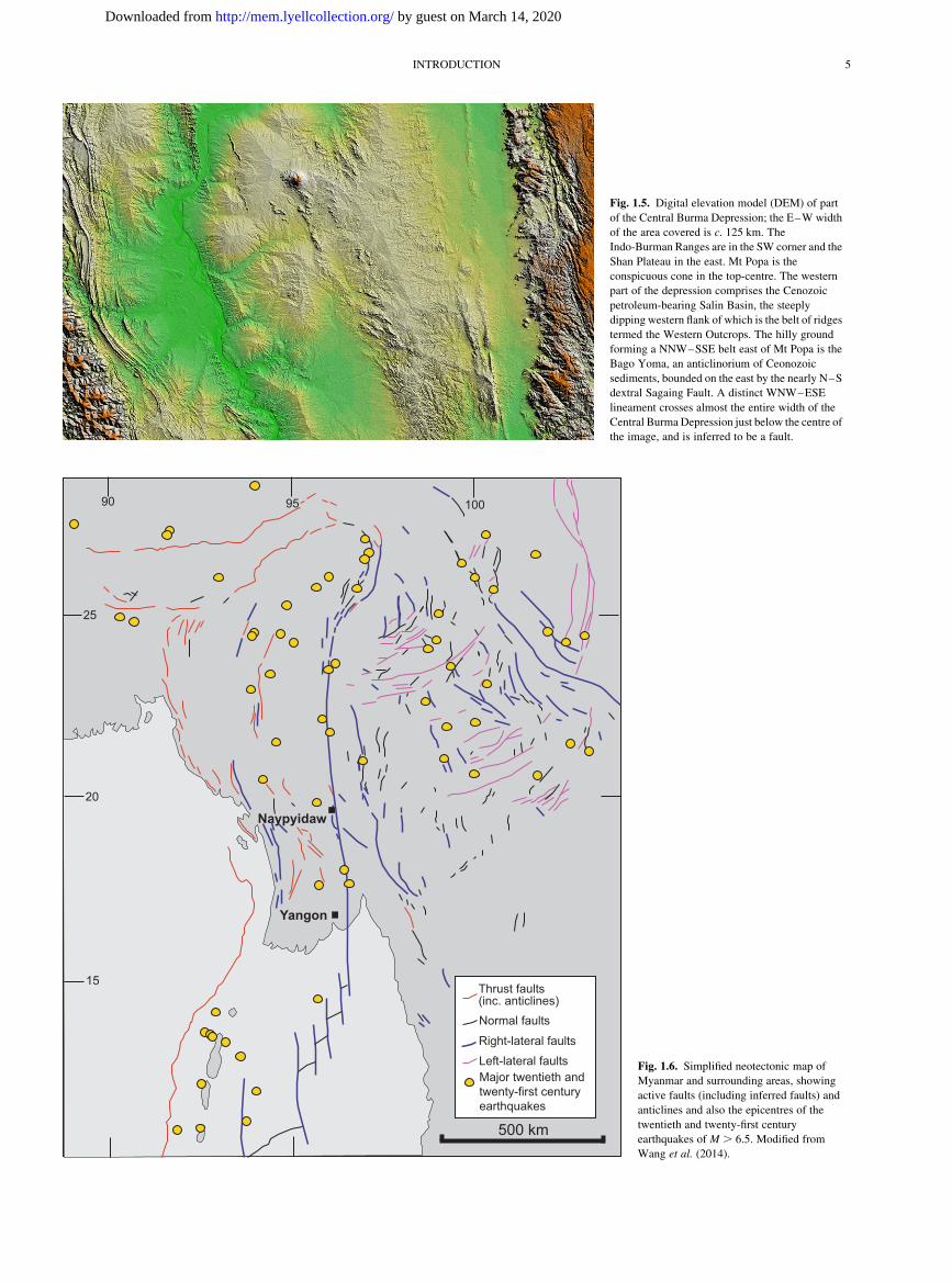
Fig. 1.5. Digital elevation model (DEM) of part
of the Central Burma Depression; the E–W width
of the area covered is c. 125 km. The
Indo-Burman Ranges are in the SW corner and the
Shan Plateau in the east. Mt Popa is the
conspicuous cone in the top-centre. The western
part of the depression comprises the Cenozoic
petroleum-bearing Salin Basin, the steeply
dipping western flank of which is the belt of ridges
termed the Western Outcrops. The hilly ground
forming a NNW–SSE belt east of Mt Popa is the
Bago Yoma, an anticlinorium of Ceonozoic
sediments, bounded on the east by the nearly N–S
dextral Sagaing Fault. A distinct WNW–ESE
lineament crosses almost the entire width of the
Central Burma Depression just below the centre of
the image, and is inferred to be a fault.
500 km
25
20
15
90 95 100
Thrust faults(inc. anticlines)Normal faults
Right-lateral faultsLeft-lateral faultsMajor twentieth andtwenty-first centuryearthquakes
Yangon
Naypyidaw
Fig. 1.6. Simplified neotectonic map of
Myanmar and surrounding areas, showing
active faults (including inferred faults) and
anticlines and also the epicentres of the
twentieth and twenty-first century
earthquakes of M . 6.5. Modified from
Wang et al. (2014).
INTRODUCTION 5
by guest on March 14, 2020http://mem.lyellcollection.org/Downloaded from

An excellent and easily obtained topographic map of Myanmarat 1:1 200 000 scale is published by Freytag and Berndt of Vienna(ISBN 3-7079-0652-3; www.freytagberndt.com).
Seismicity
Myanmar is one of the most seismically active countries in theworld. The country’s seismicity reflects the continued northwardscollision of the Indian Plate with Eurasia, the Burma Platelet beingthe buffer zone between the two (see Chapter 2). The crustal reac-tion to that oblique convergence has been widespread earthquakeswhich are related to: (1) the subduction of the India Plate beneaththe Burma Platelet (although Rangin et al. (2013) argue that thewestern boundary of the Burma Platelet north of the AndamanIslands has not been subducted since the Mesozoic, the seismicityin that northern zone therefore resulting from ongoing detachmentand sinking of an old slab); (2) right-lateral movement on mostlyN–S or NW–SE wrench faults with accompanying thrusting;and (3) left-lateral movement on wrench faults with WSW–ENEtrends, caused by the clockwise flow of the lithosphere as it is dis-placed under gravity from beneath the eastern Himalaya syntaxis.A study of the neotectonics of Myanmar has been carried out byWang et al. (2014) from satellite imagery and fieldwork, andtheir simplified map is provided in Figure 1.6.
It is not clear the extent to which recent movements, for exampleon faults, have affected the petroleum trap potential of structures.There is a risk that pre-existing traps might have been breached andallowed oil or gas to escape, and any prospect which is dependenton sealing by a still-active fault might have an extra degree of riskbecause of it. However, Curiale et al. (1994) argue that (onshore atleast) generation and migration are still continuing, tending to keeptraps topped up as they may become modified by young structuraldeformation. Another consequence of the seismicity of Myanmarand surrounding regions is the risk that it poses to operations,including the risk of structural damage to buildings, roads, rail-ways, dams and pipelines. An equally serious risk is that of flood-ing of lowland coastal areas by tsunamis generated offshore; asmentioned above, much of coastal Myanmar was devastated bythe tsunami caused by the Boxing Day 2004 Sumatran earthquake.Landslides can also be triggered by earthquakes, both onshore andoffshore, and it is thought that major submarine slides which fanout into deep water off the Rakhine coast were triggered by suchseismic shocks.
References
Bender, F. 1983. Geology of Burma. Gebruder Borntraeger, Berlin,Stuttgart.
BP PLC 2009. Statistical Review of World Energy 2009. BP plc., London.BP PLC 2010. Statistical Review of World Energy 2010. BP plc., London.BP PLC 2011. Statistical Review of World Energy 2011. BP plc., London.BP PLC 2012. Statistical Review of World Energy 2012. BP plc., London.BP PLC 2013. Statistical Review of World Energy 2013. BP plc., London.BP PLC 2014. Statistical Review of World Energy 2014. BP plc., London.Chhibber, H. I. 1934a. The Geology of Burma. Macmillan, London.Chhibber, H. I. 1934b. The Mineral Resources of Burma. Macmillan,
London.Curiale, J. A., Pe Kyi, Collins, I. D., Aung Din, Kyaw Nyein, Maung
Nyunt & Stuart, C. J. 1994. The central Myanmar (Burma) oilfamily – composition and implications for source. Organic Geo-chemistry, 22, 237–255.
Evans, P. 1941. The geology of British oilfields, 3 The oilfields of Burma.Geological Magazine, 78, 321–350.
Grimes, G. E. 1898. Geology of parts of the Myingyan, Magwe andPakokku Districts, Burma. Memoir of the Geological Survey ofIndia, 28, 30–71.
Kyaw Kyaw Aung 2014. Where Shall We Go to Find Oil and Gas Dis-covery Especially in Myanmar Onshore Blocks. Myanma Oil andGas Enterprise, Myanmar Oil and Gas Week, Yangon, Myanmar,25–26 February 2014.
Mitchell, A. H. G. 1981. Phanerozoic plate boundaries in mainland SEAsia, the Himalayas and Tibet. Journal of the Geological Society ofLondon, 138, 109–122.
Mitchell, A. H. G. 1986. Mesozoic and Cenozoic regional tectonics andmetallogenesis in mainland SE Asia. In: Teh, G. H. & Para-
manthan, S. (eds) Proceedings of GEOSEA V, Kuala Lumpur1984. Geological Society of Malaysia, Bulletin 19, 221–239.
Mitchell, A. H. G. 1992. Late Permian–Mesozoic events and the MerguiGroup Nappe in Myanmar and Thailand. Journal of Southeast AsianEarth Sciences, 7, 165–178.
Mitchell, A. H. G., Myint Thein Htay, Kyaw Min Htun, Myint
Naing Win, Thura Oo & Tin Hlaing. 2007. Rock relationshipsin the Mogok metamorphic belt, Tatkon to Mandalay, centralMyanmar. Journal of Asian Earth Sciences, 29, 891–910.
Mitchell, A. H. G., Chung, S.-L., Oo, T., Lin, T.-H. & Hung, C.-H.2012. Zircon U-Pb ages in Myanmar: magmatic-metamorphicevents and the closure of a neo-Tethys ocean? Journal of AsianEarth Sciences, 56, 1–23.
Noetling, F. 1895. The development and subdivision of the Tertiary inBurma. Records of the Geological Survey of India, 28, 59–86.
Noetling, F. 1897. The occurrence of petroleum in Burma and its techni-cal exploitation. Memoir of the Geological Survey of India, 27,47–272.
Pascoe, E. H. 1912. The oil-fields of Burma. Memoir of the GeologicalSurvey of India, 40, 329.
Pascoe, E. H. 1950–1964. Manual of the Geology of India and Burma,Third Edition. Volumes 1 (1950), 2 (1959), 3 (1964). Governmentof India Press, Calcutta.
Rangin, C., Maurin, T. & Masson, F. 2013. Combined effects ofEurasia/Sunda oblique convergence and East-Tibetan crustal flowon the active tectonics of Burma. Journal of Asian Earth Sciences,76, 185–194.
Robinson, R. A. J., Brezina, C. A. et al. 2014. Large rivers andorogens: the evolution of the Yarlung Tsangpo–Irrawaddy systemand the eastern Himalayan syntaxis. Gondwana Research, 26,112–121.
Stamp, L. D. 1927. The geology of the oil fields of Burma. Bulletin of theAmerican Association of Petroleum Geologists, 11, 557–579.
Tainsh, H. R. 1950. Tertiary geology and principal oilfields of Burma.Bulletin of the American Association of Petroleum Geologists, 34,823–855.
Tin Maung Yee 2012. Petroleum Geology Outlook of Myanmar andOpportunities For Exploration and Production. MOGP Summit,Yangon.
United Nations Development Programme 1978. Geology andExploration Geochemistry of the Shan Scarps Area, East ofKyaukse, Thazi and Katkon, Central Burma (Draft). Report preparedfor the Government of the Socialist Republic of the Union of Burma,Technical Report No.3
Wandrey, C. J. 2006. Eocene to Miocene Composite Total PetroleumSystem, Irrawaddy-Andaman and North Burma Geologic Provinces,Myanmar. US Geological Survey Bulletin, 2208-E, 26.
Wang, Yu., Sieh, K., Soe Thura, TUN, Lai, K.-Y. & Than, MYINT
2014. Active tectonics and earthquake potential of the Myanmarregion. Journal of Geophysical Research: Solid Earth, 119,3767–3822.
Zaw Aung 2012. Natural gas exploration and demand scenario inMyanmar. Myanmar OGP Conference, Yangon, Myanmar, 28–29March 2012.
M. F. RIDD & A. RACEY6
by guest on March 14, 2020http://mem.lyellcollection.org/Downloaded from
Related Documents


![[p.T] Petroleum Development Geology](https://static.cupdf.com/doc/110x72/577d34871a28ab3a6b8e3c29/pt-petroleum-development-geology.jpg)