Chap. 12 Lake-effect snow storms

Chap. 12 Lake-effect snow storms. Lake effect snow bands over the Great Lakes on 9 Jan 2011.
Jan 14, 2016
Welcome message from author
This document is posted to help you gain knowledge. Please leave a comment to let me know what you think about it! Share it to your friends and learn new things together.
Transcript

Chap. 12Lake-effect snow storms

Lake effect snow bands over the Great Lakes on 9 Jan 2011

Learning objectives1. Explain the physical and dynamical processes
responsible for lake-effect snow.
2. Describe the large-scale weather pattern that is most conducive to lake-effect snow in the Great Lakes region.
3. Provide explanations for the regional and seasonal climatology of lake-effect snow.
4. Distinguish the different types of organization of lake-effect snow.
5. Explain how lake-enhanced snowfall can occure in an extratropical cyclone.
6. Summarize the key challenges faced by weather forecasters to lake-effect snow distribution.
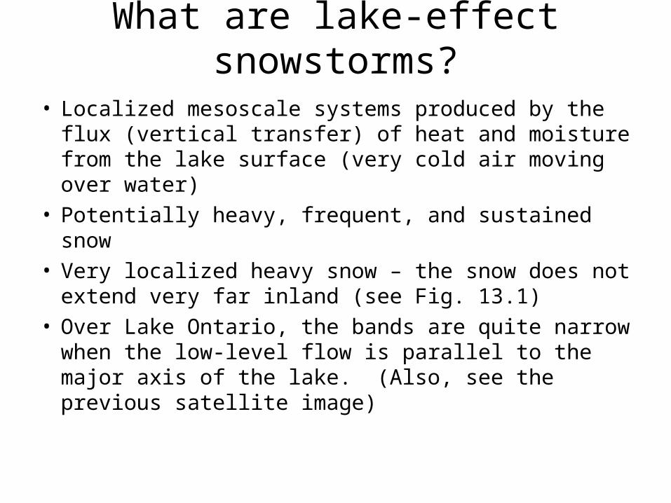
What are lake-effect snowstorms?
• Localized mesoscale systems produced by the flux (vertical transfer) of heat and moisture from the lake surface (very cold air moving over water)
• Potentially heavy, frequent, and sustained snow• Very localized heavy snow – the snow does not
extend very far inland (see Fig. 13.1)• Over Lake Ontario, the bands are quite narrow
when the low-level flow is parallel to the major axis of the lake. (Also, see the previous satellite image)

Fig. 13.1 Additional wintertime precipitation estimated for lake-effect snow
Where do lake-effect snow events occur?
Lake with most widespread impact?Lakes with highly localized impactsLake-effect snow areas that impact society

Large-scale weather patterns associated that promote lake-effect snow events
•Flow of cold air (polar continental or arctic in origin) from the northwest
•Post cold frontal air mass (cP or A) as shown in Fig. 12.2
•Northwesterly flow between a receding cyclone and approaching anticyclone
Fig. 13.2. Typical weather pattern for the lake-effect snow storm
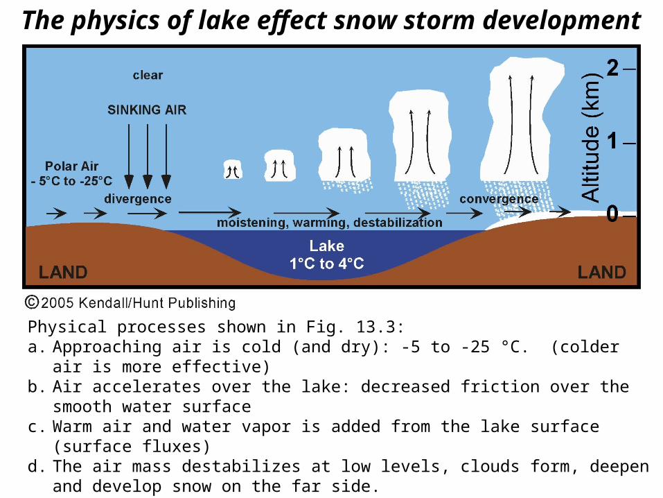
The physics of lake effect snow storm development
Physical processes shown in Fig. 13.3:a. Approaching air is cold (and dry): -5 to -25 °C. (colder air is more effective)b. Air accelerates over the lake: decreased friction over the smooth water surfacec. Warm air and water vapor is added from the lake surface (surface fluxes)d. The air mass destabilizes at low levels, clouds form, deepen and develop snow on
the far side.e. Enhanced convergence on the downwind shore decelerates the air, produces
convergence (and upward motion), and further enhances the snow fall.
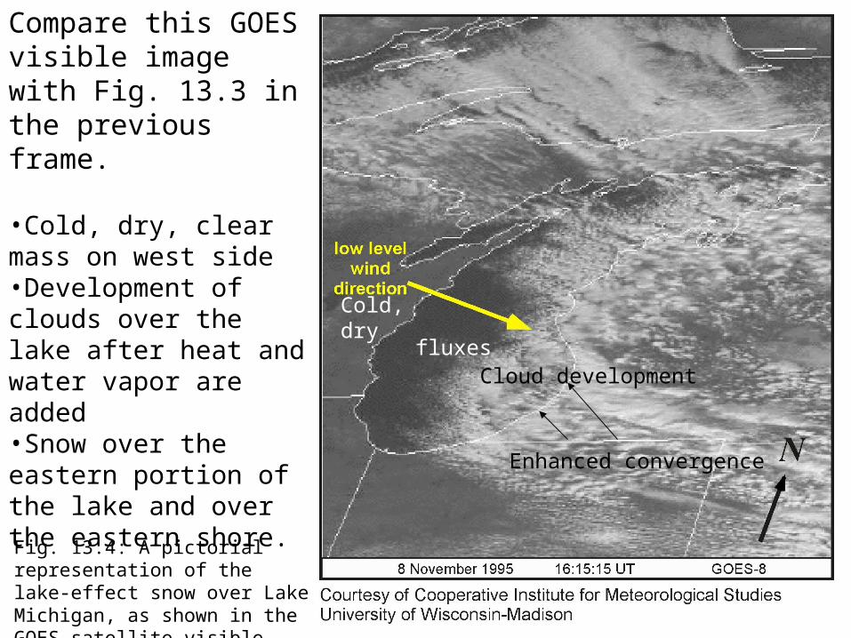
Fig. 13.4: A pictorial representation of the lake-effect snow over Lake Michigan, as shown in the GOES satellite visible image.
Cold,dry
fluxesCloud development
Enhanced convergence
Compare this GOES visible image with Fig. 13.3 in the previous frame.
•Cold, dry, clear mass on west side•Development of clouds over the lake after heat and water vapor are added•Snow over the eastern portion of the lake and over the eastern shore.

Climatology of lake-effect snow storms
Fig. 13.5. Mean monthly temperature difference between Milwaukee, WI on the west shore of Lake Michigan and the lake temperature on the east shore near Muskegon, MI. The period of lake-effect snow storms is highlighted in orange.
Lake effect snows begin in late November and reaches a peak in January.
(upwind)
(downwind shore)
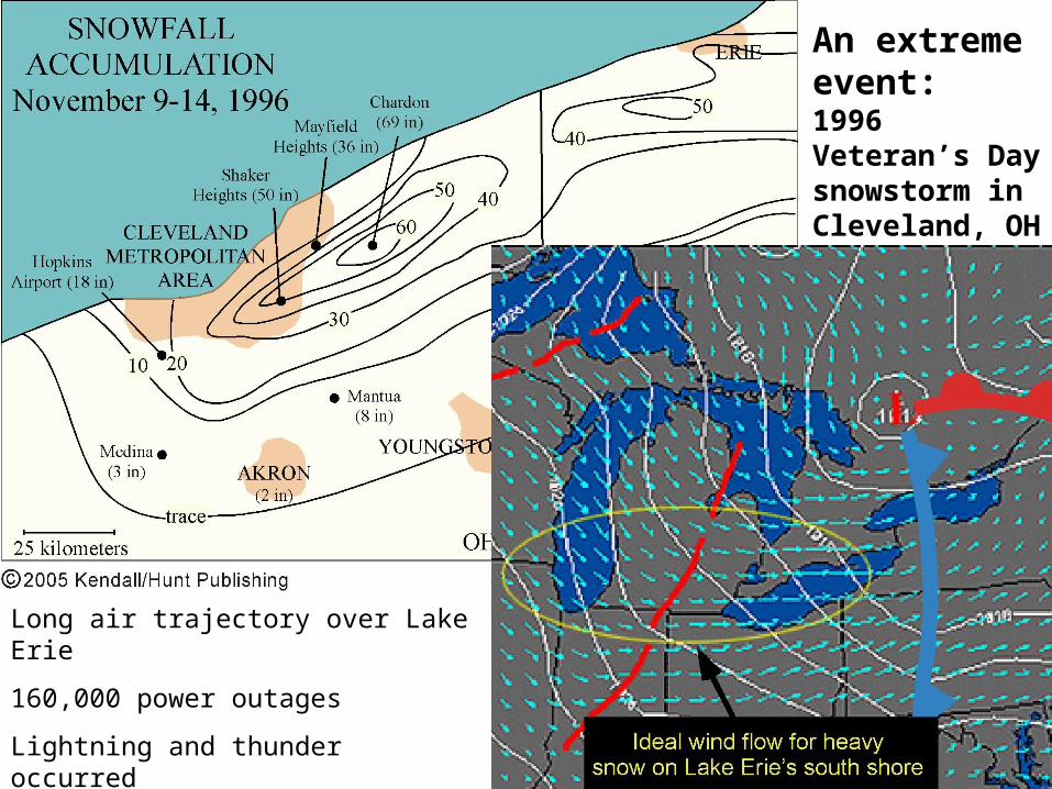
An extreme event:1996 Veteran’s Day snowstorm in Cleveland, OH
Long air trajectory over Lake Erie
160,000 power outages
Lightning and thunder occurred
Early season: warm water, cold air
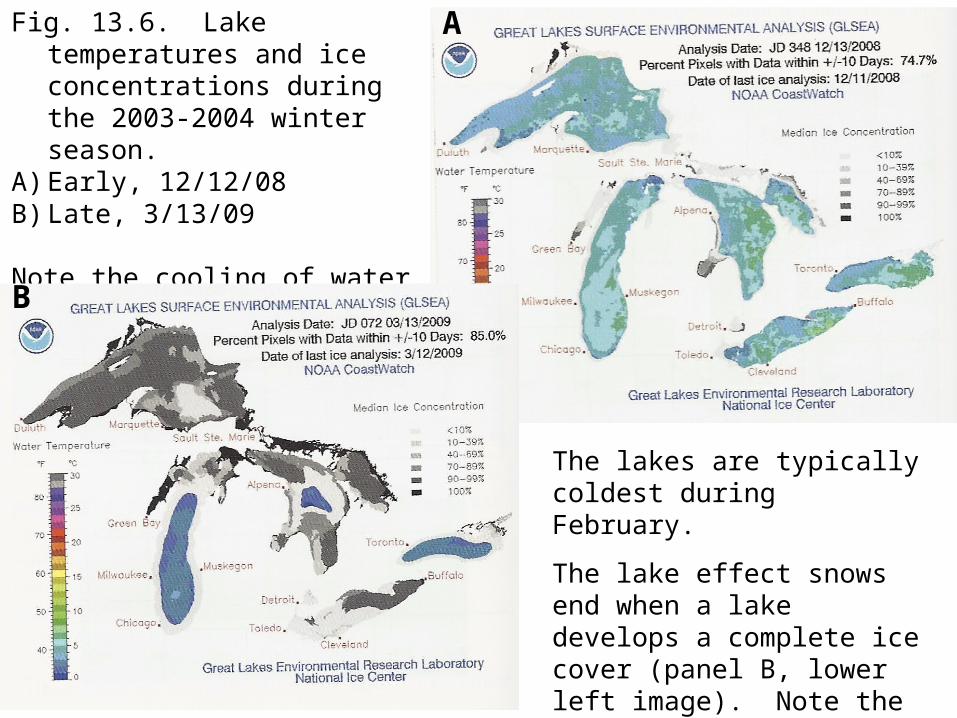
Fig. 13.6. Lake temperatures and ice concentrations during the 2003-2004 winter season.
A) Early, 12/12/08B) Late, 3/13/09
Note the cooling of water temperature and ice formation.
The lakes are typically coldest during February.
The lake effect snows end when a lake develops a complete ice cover (panel B, lower left image). Note the sparse ice cover Lakes Michigan and Ontario. Explain.
A
B

Fig. 13.7. Mean snowfall in December and February. Why is there a difference?
Lake Michigan
Lake Superior
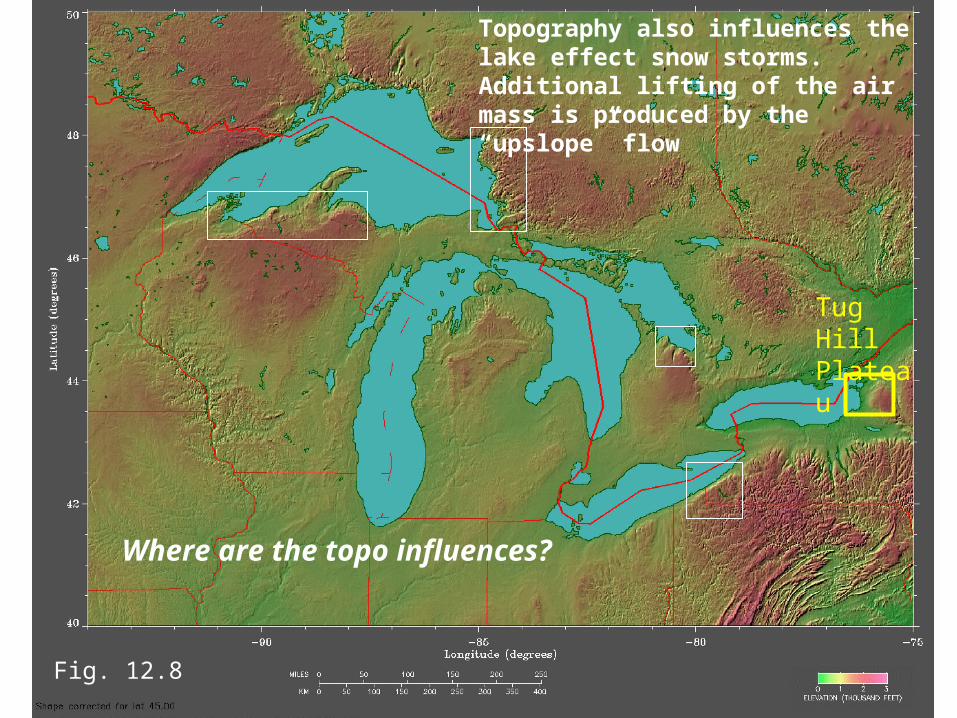
Topography also influences the lake effect snow storms. Additional lifting of the air mass is produced by the “upslope” flow
Fig. 12.8
Where are the topo influences?
Tug Hill Plateau

Fig. 13.9. Effect of air residence time. Longer trajectories over a lake surface allow for a greater addition of heat and moisture to the cold air mass, and hence more snow in general.
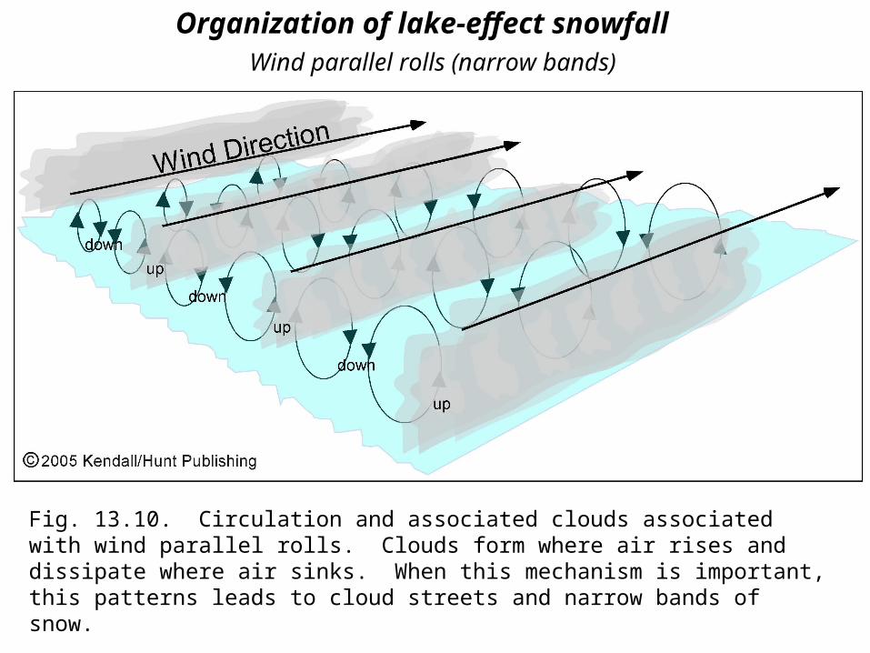
Organization of lake-effect snowfall
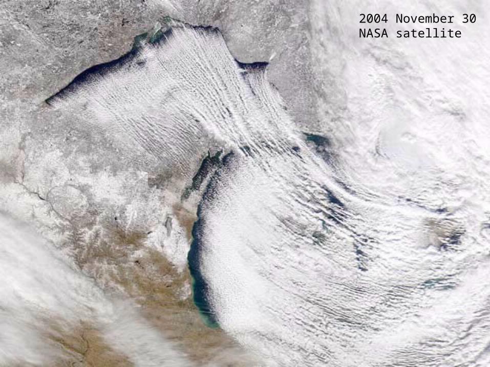
Fig. 13.10. Circulation and associated clouds associated with wind parallel rolls. Clouds form where air rises and dissipate where air sinks. When this mechanism is important, this patterns leads to cloud streets and narrow bands of snow.
Wind parallel rolls (narrow bands)
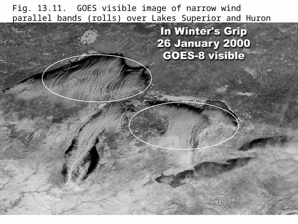
Fig. 13.11. GOES visible image of narrow wind parallel bands (rolls) over Lakes Superior and Huron
2004 November 30NASA satellite

Fig. 13.12.Radar image of wind parallel snow bands over the eastern side of Lake Michigan
Related Documents