Changing sources of magma generation beneath intra-oceanic island arcs: An insight from the juvenile Kohistan island arc, Pakistan Himalaya Stella M. Bignold ⁎ , Peter J. Treloar, Nick Petford Centre for Earth and Environmental Science Research, School of Earth Sciences & Geography, Kingston University, Penrhyn Road, Kingston-upon-Thames, Surrey KT1 2EE, UK Received 1 December 2004; received in revised form 13 January 2006; accepted 14 February 2006 Abstract The Kohistan arc, situated in the Pakistan Himalaya, is a Cretaceous intraoceanic island arc which was initiated during the northward movement of the Indian Plate. The arc was sutured to Asia at ca. 100 Ma. It was subsequently tilted northward when underplated by Indian continental crust during the early stages of India–Asia collision. Deep erosion of this tilted section provides a spectacular section through the whole arc sequence and offers a profound insight into the mechanisms of early stages of arc formation. Geochemical analysis and rare earth element modelling of basaltic sequences which date from the intraoceanic stages of arc development allow identification of three main magma source types in the mantle beneath the juvenile arc. The ‘E-type’ Kamila Amphibolites, with a MORB-type chemistry, form the intraoceanic basement to the arc. The ‘D-type’ Kamila Amphibolites are the earliest of the arc volcanic rocks. These were extracted from a primitive spinel-bearing mantle source, above a north-dipping subduction zone. The stratigraphically younger basalts of the Jaglot Group and Ghizar Formation of the Chalt Volcanic Group were derived from partial melting of a garnet-bearing source at greater depth. The Hunza Formation of the Chalt Volcanic Group contains the youngest mafic volcanic rocks of the intraoceanic arc. Although coeval with the Ghizar Formation of the Chalt Volcanic Group, they were generated by melting of a depleted, spinel-bearing mantle source rock and were erupted into a spatially and temporally restricted back-arc basin developed behind the volcanic front. The Chalt Volcanic Group was therefore formed from two different, adjacent, mantle source regions active at the same time. Results of REE modelling are consistent with models for intraoceanic arc formation in which the earliest volcanic rocks are derived from shallow level spinel-bearing peridotite, and later ones from a deeper garnet-bearing source. This is consistent with the melt region becoming deeper with time as subduction continues. A two-stage model is proposed for the back-arc basalts of the Hunza Formation in which a mantle source, depleted from a previous melting event, is underplated beneath the arc and later remelted during decompression as a consequence of extension and rifting of the arc. © 2006 Elsevier B.V. All rights reserved. Keywords: Kohistan; Geochemistry; Rare earth element modelling; Stratigraphy; Subduction Chemical Geology 233 (2006) 46 – 74 www.elsevier.com/locate/chemgeo ⁎ Corresponding author. Fax: +44 20 8547 8850. E-mail address: [email protected] (S.M. Bignold). 0009-2541/$ - see front matter © 2006 Elsevier B.V. All rights reserved. doi:10.1016/j.chemgeo.2006.02.008

Welcome message from author
This document is posted to help you gain knowledge. Please leave a comment to let me know what you think about it! Share it to your friends and learn new things together.
Transcript

3 (2006) 46–74www.elsevier.com/locate/chemgeo
Chemical Geology 23
Changing sources of magma generation beneath intra-oceanicisland arcs: An insight from the juvenile Kohistan
island arc, Pakistan Himalaya
Stella M. Bignold ⁎, Peter J. Treloar, Nick Petford
Centre for Earth and Environmental Science Research, School of Earth Sciences & Geography, Kingston University, Penrhyn Road,Kingston-upon-Thames, Surrey KT1 2EE, UK
Received 1 December 2004; received in revised form 13 January 2006; accepted 14 February 2006
Abstract
The Kohistan arc, situated in the Pakistan Himalaya, is a Cretaceous intraoceanic island arc which was initiated during thenorthward movement of the Indian Plate. The arc was sutured to Asia at ca. 100 Ma. It was subsequently tilted northward whenunderplated by Indian continental crust during the early stages of India–Asia collision. Deep erosion of this tilted section provides aspectacular section through the whole arc sequence and offers a profound insight into the mechanisms of early stages of arcformation. Geochemical analysis and rare earth element modelling of basaltic sequences which date from the intraoceanic stages ofarc development allow identification of three main magma source types in the mantle beneath the juvenile arc. The ‘E-type’ KamilaAmphibolites, with a MORB-type chemistry, form the intraoceanic basement to the arc. The ‘D-type’ Kamila Amphibolites are theearliest of the arc volcanic rocks. These were extracted from a primitive spinel-bearing mantle source, above a north-dippingsubduction zone. The stratigraphically younger basalts of the Jaglot Group and Ghizar Formation of the Chalt Volcanic Group werederived from partial melting of a garnet-bearing source at greater depth. The Hunza Formation of the Chalt Volcanic Groupcontains the youngest mafic volcanic rocks of the intraoceanic arc. Although coeval with the Ghizar Formation of the ChaltVolcanic Group, they were generated by melting of a depleted, spinel-bearing mantle source rock and were erupted into a spatiallyand temporally restricted back-arc basin developed behind the volcanic front. The Chalt Volcanic Group was therefore formed fromtwo different, adjacent, mantle source regions active at the same time. Results of REE modelling are consistent with models forintraoceanic arc formation in which the earliest volcanic rocks are derived from shallow level spinel-bearing peridotite, and laterones from a deeper garnet-bearing source. This is consistent with the melt region becoming deeper with time as subductioncontinues. A two-stage model is proposed for the back-arc basalts of the Hunza Formation in which a mantle source, depleted froma previous melting event, is underplated beneath the arc and later remelted during decompression as a consequence of extensionand rifting of the arc.© 2006 Elsevier B.V. All rights reserved.
Keywords: Kohistan; Geochemistry; Rare earth element modelling; Stratigraphy; Subduction
⁎ Corresponding author. Fax: +44 20 8547 8850.E-mail address: [email protected] (S.M. Bignold).
0009-2541/$ - see front matter © 2006 Elsevier B.V. All rights reserved.doi:10.1016/j.chemgeo.2006.02.008

47S.M. Bignold et al. / Chemical Geology 233 (2006) 46–74
1. Introduction
The Kohistan arc, located in NWPakistan, was initiatedin the Neotethys Ocean during the Cretaceous as anintraoceanic island arc developed above a N-dippingsubduction zone (Tahirkheli et al., 1979; Coward et al.,1987; Khan et al., 1993; Treloar et al., 1996; Burg et al.,1998; Bignold and Treloar, 2003). The arc was subse-quently sutured to Asia between 104 Ma (Petterson andWindley, 1985) and 85 Ma (Treloar et al., 1996), when itbecame an Andean-type volcanic margin. The arc wasstructurally telescoped along N-dipping thrusts duringsuturing and subsequent underthrusting by the leading edgeof continental India. As a result, a full stratigraphicsuccession from the base of the arc to its stratigraphic topcan now be traversed along accessible valleys. Theopportunity therefore arises to trace temporal and spatialchanges in volcanic style, chemistry and magma sourceregions through the complete life of the arc from itsinitiation as a juvenile intraoceanic island arc through itsevolution and eventual suturing with Asia to become acontinental margin arc.
Fig. 1. Geological sketch map of Kohist
Much geochemical data have been published fromrock suites throughout the accessible regions ofKohistan (Jan and Howie, 1981; Petterson and Windley,1985; Jan, 1988; Khan et al., 1989; Treloar et al., 1989;Jan and Windley, 1990; Petterson et al., 1990; Pettersonand Windley, 1991, 1992; Sullivan, 1992; George et al.,1993; Khan et al., 1993; Petterson et al., 1993; Sullivanet al., 1993; Khan et al., 1996, 1997; Bignold andTreloar, 2003). This paper presents new stratigraphicand geochemical data for volcanic successions in boththe eastern and western parts of the arc. The newgeochemical data supplement previously published dataand include complete rare earth element datasets.
Rare earth element modelling is used to identifypotential magma sources and suggest the degree ofpartial melting in the mantle wedge beneath the arc, withthe aim of determining changes in magma sourceregions as the juvenile arc evolved. The results ofmodelling each volcanic succession across the arc arecombined with stratigraphic and geochemical analysisto formulate a model for magma generation beneath thearc from its initiation until suturing with Eurasia.
an. Boxes denote sampling areas.
48 S.M. Bignold et al. / Chemical Geology 233 (2006) 46–74
2. Outline geology of the Kohistan arc
The rocks of the Kohistan island arc trend generallyeast–west (Fig. 1), and dip northward. The arc is boundedto the north by the Shyok Suture, along which it is sutured
Fig. 2. Geological sketch map of the Swat valley, Kohistan, show
to Asia, and to the south by the Main Mantle Thrust(MMT), the western continuation of the Indus–TzangpoSuture Zone along which it was thrust southward overcontinental India in the early Tertiary (Coward et al., 1982;Corfield et al., 2001.). It is bounded to the east by the
ing sample locations (modified from Treloar et al., 1996).

Fig. 3. Geological sketch map of the Panjkora and Dir valleys, Dir District, Kohistan, showing sample locations (modified from Treloar et al., 1996).
49S.M. Bignold et al. / Chemical Geology 233 (2006) 46–74
50 S.M. Bignold et al. / Chemical Geology 233 (2006) 46–74
Raikot–Sassi fault zone (Coward et al., 1986), whichseparates the arc from the Indian Plate gneisses of NangaParbat, tectonically exhumed from beneath the arc rocksduring the Pliocene.
Several distinct lithologies have been identifiedwithin the arc. A series of layered mafic and ultramaficintrusive cumulate bodies, the Jijal, Sapat and TorraTigga complexes, occur along the southern margin of thearc, in the immediate hanging wall of the MMT (Ahmedand Chaudhry, 1976; Jan and Howie, 1981; Jan et al.,1983; Jan and Windley, 1990; Jan and Tahirkheli, 1990;Miller et al., 1991; Jan et al., 1992, 1993; Khan et al.,1998) (Fig. 1). Amongst these bodies, the Jijal Complexhas a magmatic age of 118±12 Ma with a subsequentgranulite facies metamorphic overprint at about 100 Ma(Anczkiewicz and Vance, 2000; Yamamoto and Naka-mura, 2000).
Three distinct volcano–sedimentary sequences areexposed within the arc. From south to north these are theKamila Amphibolites, the Jaglot Group and the ChaltVolcanic Group. The Kamila Amphibolites (Fig. 1)extend E–Wacross the southern part of the arc, and havebeen studied in detail in the Indus and Swat valleys ofcentral Kohistan (Jan, 1970, 1979, 1988; Treloar et al.,1990, 1996) and in south-east Kohistan in the Thakvalley (Khan et al., 1998). They are dominantlycomposed of mafic rocks, both extrusive and intrusive,but with ultramafic, dioritic, tonalitic, granitic andtrondhjemitic plutons, and rare sediments. The rockshave been metamorphosed to amphibolite facies, and, in
Fig. 4. Geological sketch map of northern Kohistan, showing sam
the Indus valley, are strongly sheared and deformed. Theoutcrop of the Kamila Amphibolite Belt widenswestward so that in the Dir valley it has a cross-strikewidth of about 35 km (Figs. 1–3).
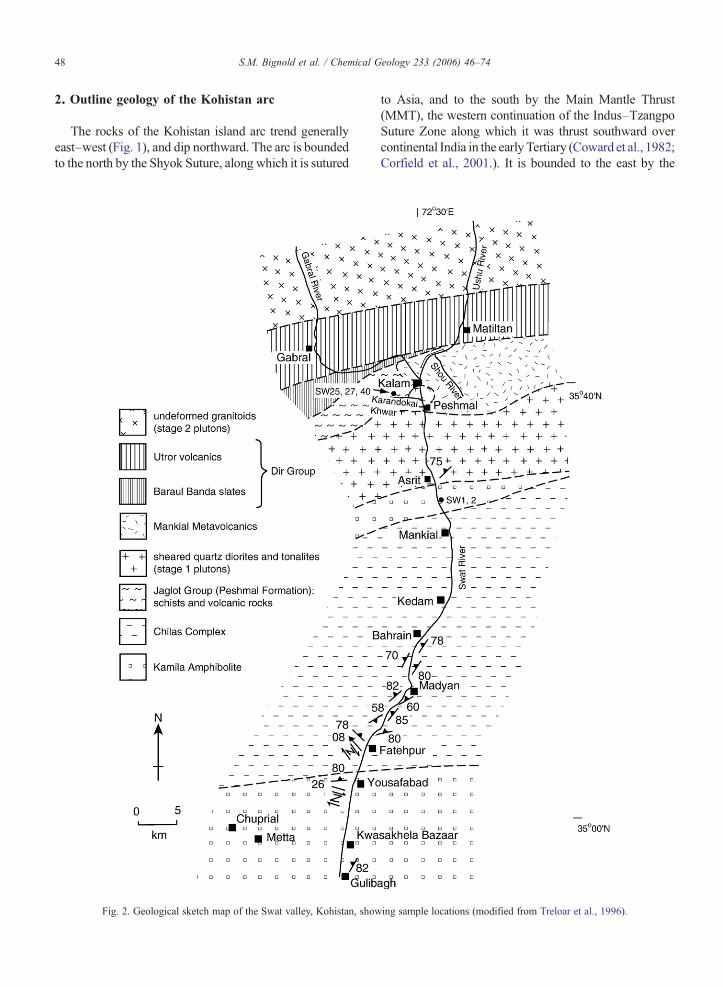
The Jaglot Group lies to the north of the KamilaAmphibolite Belt (Figs. 1–3) and was recognised as amajor stratigraphic unit by Khan et al. (1994) andTreloar et al. (1996). It comprises a belt of volcaniclasticschists interbedded with metavolcanic rocks and extendsE–W across the arc. It includes the Gilgit Formation,Gashu Confluence Volcanic Formation and ThelichiVolcanic Formation (Khan et al., 1994) which areexposed in the Indus valley to the southwest of Gilgit,the Majne Volcanic Formation to the S of Gilgit (Ahmedet al., 1977; Khan et al., 1994, 1996, 1997), and thePeshmal Schists (Jan, 1970; Jan and Mian, 1971; Khaliland Afridi, 1979; Sullivan, 1992) exposed in the Dir andSwat valleys in the west of the arc (Treloar et al., 1996).The northern margin of the Jaglot Group is intruded bythe Kohistan Batholith across the length of the arc.
The Chalt Volcanic Group and the Yasin Group(Figs. 1, 4) crop out in an arcuate belt along the northernmargin of the arc to the south of the Shyok Suture(Petterson et al., 1990; Petterson and Windley, 1991;Petterson and Treloar, 2004). The Chalt Volcanic Grouplies stratigraphically above the Jaglot Group, althoughboth are intruded by granitoids of the KohistanBatholith. The Chalt Volcanic Group has been dividedinto the Ghizar and Hunza Formations by Petterson andTreloar (2004). The Hunza Formation has been
ple locations (modified from Petterson and Treloar 2004).

51S.M. Bignold et al. / Chemical Geology 233 (2006) 46–74
interpreted as a back-arc basin (Treloar et al., 1996;Rolland et al., 2000; Robertson and Collins, 2002;Bignold and Treloar, 2003). Rocks correlated with theChalt Volcanic Group exposed to the east of the NangaParbat syntaxis carry a post-Valanginian fauna (Robert-son and Collins, 2002).
The Chilas complex is a mafic to ultramafic, calc-alkaline intrusive body, which extends for 300 km E–Walong the length of the arc, with a maximum width of40 km (Khan et al., 1989) (Fig. 1). In the west of the arc,in the Dir valley, it is intrusive into the KamilaAmphibolites (Sullivan et al., 1993; Treloar et al.,1996). By contrast, in the east of the arc it is intrusiveinto the contact between the Jaglot Group to the northand the Kamila Amphibolites to the south (Fig. 1). Itconsists of massive gabbro-norites, with minor discor-dant dykes and intrusive bodies of a mixed dunite–peridotite–pyroxenite–anorthosite association (Jan,1979; Jan and Howie, 1981). In the Indus Valley itsnorthern margin contains abundant xenoliths of stronglydeformed schists of the Jaglot Group (Treloar et al.,1996) which dates its emplacement as post-datingsuturing of the arc to Asia. The southern margin,which lies on the hanging wall of the Kamila ShearZone, is metamorphosed to amphibolite facies. TheChilas complex gabbro-norites in Upper Swat have aU–Pb zircon age of ∼85 Ma (Zeitler et al., 1981;Zeilinger et al., 2001). A Sm–Nd age of 69.5±9.3 Mahas been obtained from a “granulite facies” body of theComplex (Yamamoto and Nakamura, 1996).
The Kohistan Batholith (Fig. 1) forms part of theTrans-Himalaya Batholith and is intrusive into both theChalt Volcanic Group and the Jaglot Group. On the basisof Rb–Sr whole-rock isochron ages, Petterson andWindley (1985, 1991) identified three distinct stages ofemplacement of the Kohistan Batholith. Stage 1 plutons,which include the deformed Matum Das tonalite, wereemplaced between 110 and 90Ma, prior to suturing of thearc to Asia. Stage 2 plutons, with undeformed low-to-high-K calc-alkaline gabbros and diorites (with horn-blendite cumulates), and granodiorites were emplacedbetween 85 and 40Ma. Stage 3 plutons were emplaced asgranite sheets comprising biotite±muscovite±garnetleucogranites at about 30 Ma (George et al., 1993). BothStages 2 and 3 were emplaced after suturing with Asia.
3. Field relations and geochemistry
In this study, samples of basaltic and andesiticvolcanic rocks from all of the volcano–sedimentarygroups have been analysed for major, trace and rareearth elements. Some samples from the Chalt Volcanic
Group, previously analysed by Petterson and Windley(1991) and from the Kamila Amphibolites previouslyanalysed by Khan et al. (1997), were re-analysed inorder to generate complete rare earth element datasets.Sample locations are plotted in Figs. 2–4.
Samples were ground to fine powder in an agate ballmill, taking care not to include any veined or weatheredmaterial, and all powders, including internationalreference standards, were oven-dried overnight at105 °C. Lithium metaborate (LiBO2) fusions wereprepared, including blanks. Powders were weighed andthoroughly mixed with LiBO2, which had low Lacontamination. Each mixture was transferred to a carboncrucible and fused in a muffle furnace at 1050 °C. Themelts were poured into polythene screw-top bottlescontaining 0.8 M HNO3, and the solutions were stirreduntil dissolved. The solutions were filtered intovolumetric flasks and made up to an 0.5 M HNO3
solution with deionised water. They were immediatelytransferred to new polypropylene bottles for storage.Analysis took place within 1 week of preparation toavoid hydrolysis and possible precipitation duringstorage. Major elements were analysed using the HoribaJobin Yvon Ultima 2C ICP-AES, and trace and rareearth elements at the NERC ICP-MS Facility atKingston University using the VG Elemental Plasma-Quad 2+ STE. Analytical precision and accuracy duringanalysis by ICP-AES were monitored using an interna-tional reference standard after every five samples.Analysis by ICP-MS requires that the solutions arediluted a further 25-fold prior to analysis. Theinstrument was calibrated using synthetic mixed-element standard solutions. Analytical precision andaccuracy during ICP-MS analysis were monitored usinginternational standard reference materials run at thesame time as the samples. An internal standard solutionwas analysed after every five samples to monitor anydrift, and all analyses were corrected for drift. The lowerlimits of detection (Table 1) were calculated to a 95%confidence level of 3 standard deviations (3σ) of thedata. Data below this level were discarded.
Radiogenic isotope data for Sr, Nd and Pb wereobtained at NIGL, Keyworth (Bignold and Treloar,2003). Samples were carefully selected on two criteria.Thin section analysis enabled us to exclude any samplesshowing significant degrees of post-metamorphic hy-dration. Secondly, geochemical analytical data wereused to ensure that adequate levels of Sr, Nd and Pbwere present for isotopic analysis. Analytical proceduresfollowed were those published for Sr and Nd by Royseet al. (1998) and for Pb by Kempton (1995). Sr and Pbwere run as the metal species on single Ta and single Re

Table 1Table of geochemical analyses for the Kamila Amphibolites
D-typeV E-typeV LLD
SW3 SW2 DR16 DR21 DR8 DR17b DR20 DR17a DR9 DR18 A125a A119a A121a A086a A093a A083a 002– 001–
SiO2 48.14 51.26 47.05 49.12 50.41 50.76 51.23 51.24 51.65 51.72 48.72 49.54 50.26 47.98 48.76 51.19 51.45 52.61TiO2 1.36 0.85 0.69 1.11 0.89 0.96 0.72 0.91 0.57 0.93 0.75 0.69 0.47 2.13 1.86 2.24 2.20 2.19Al2O3 16.09 12.12 13.30 18.88 15.97 19.23 16.59 14.57 16.38 18.11 19.11 15.90 16.36 14.44 14.71 14.31 14.36 13.94FeOt 11.26 8.27 8.14 11.47 8.40 7.64 7.55 8.88 7.07 8.23 8.23 8.17 8.04 12.67 11.75 13.20 13.21 12.21MnO 0.22 0.14 0.13 0.14 0.16 0.15 0.14 0.14 0.15 0.12 n/d n/d n/d n/d n/d n/d 0.14 0.22MgO 7.43 13.07 12.48 5.58 8.12 5.46 8.63 8.85 7.72 5.78 6.50 11.17 8.18 6.11 6.90 5.11 3.30 3.24CaO 9.71 11.11 12.13 9.41 10.36 9.63 9.74 11.32 9.83 9.19 12.01 9.83 12.28 11.64 11.82 9.63 10.68 10.29Na2O 2.58 1.18 1.30 3.16 3.09 3.47 2.40 3.10 3.16 3.87 2.52 3.22 2.81 3.09 2.66 2.40 2.49 2.37K2O 0.09 0.55 0.83 0.88 0.95 1.25 0.17 0.49 1.02 0.99 1.06 0.38 0.57 0.32 0.08 0.26 0.23 0.29P2O5 0.13 0.20 0.16 0.04 0.16 0.17 0.12 0.10 0.08 0.19 0.17 0.19 0.12 0.21 0.17 0.19 0.29 0.28V 287 236 145 259 164 188 178 201 138 195 169 149 147 287 214 298 n/d n/d 0.7Cr 81.3 1002 841 7.62 225 179 313 399 315 277 173 46.8 153 186 174 25.9 13.7 24.3 2.2Ni 40.9 315.7 194 17.4 118 57.9 156 145 102 76.7 74.5 178.3 59.7 82.2 70 35.1 5.7 5 2.7Cu 9.5 59.8 59 69.8 33 90.3 19.9 59.9 60.3 28 bdl bdl 6.1 bdl bdl 9.1 22.4 52.3 2Zn 122 69.7 47.1 91.6 58.9 48.9 61.4 53.6 70.7 64.2 53.2 40.7 39.8 99.3 65.3 71.6 42.1 57.4 3.4Rb 6.1 11.8 13.2 20.4 10.8 29.5 3.7 5.1 16.5 15.6 21.1 7.8 7.1 2 1 2.4 0.6 1.8 0.6Sr 367 162 93 304 125 218 152 132 174 156 227 206 229 110 136 134 334 226 0.3Y 25.9 14.1 13.7 24.3 15.8 20.5 15.7 18.2 12.4 21.5 3.8 2.3 bdl 28.1 19.6 31.3 59.3 66.3 0.2Zr 45.1 33.8 26 30.7 37.8 51.3 38.2 45.2 32.8 56.7 37.3 30.8 17.1 105.3 84 109.7 185.3 235 0.4Nb 2.68 1.49 0.35 1.31 1.95 4.31 0.97 3.2 1.76 1.47 4.73 3.54 1.53 5.35 4.07 4.8 8.08 8.78 0.21Ba 49 104 52 65.6 98.4 163 17.2 46.1 108 48.2 163 38.7 50.4 35.7 15.5 41.1 0.8 5.6 1.2Hf 1.87 1.23 0.98 1.28 1.45 1.78 1.22 1.59 1.21 1.54 1.73 1.19 0.76 4.12 2.90 3.40 5.04 6.47 0.07Ta 0.13 0.18 0.26 0.11 0.22 0.19 0.14 0.31 0.15 0.14 1.23 1.54 1.47 0.68 0.56 0.53 1.93 3.15 0.05Pb 1.21 0.58 bdl 0.79 bdl bdl bdl bdl bdl bdl 2a 2a 2a 2a 2a 2a n/d n/d 0.27Th bdl 1.00 0.45 bdl 1.03 0.34 0.69 0.45 0.96 0.28 2.25 0.77 0.59 0.82 0.41 0.87 0.76 0.98 0.04
52S.M
.Bignold
etal.
/Chem
icalGeology
233(2006)
46–74

U bdl 0.38 0.33 bdl bdl bdl 0.21 bdl bdl bdl 0.46 0.1 0.1 0.21 bdl 0.45 0.33 0.47 0.07La 4.14 3.98 2.87 3.11 6.02 4.29 3.86 3.32 4.33 3.64 10.00 25.70 2.98 7.30 4.86 5.28 5.04 6.74 0.09Ce 14.20 11.70 6.19 9.08 12.97 9.68 9.56 7.90 10.17 10.14 21.33 12.17 6.97 19.43 14.33 15.67 27.83 30.30 0.12Pr 2.65 1.75 1.16 1.47 1.67 1.57 1.27 1.18 1.33 1.40 2.47 1.74 0.98 3.12 2.07 2.26 4.38 4.59 0.05Nd 13.13 8.19 5.35 8.06 7.85 7.52 6.47 6.52 7.60 8.72 10.13 8.78 4.65 16.23 11.83 15.17 22.67 25.27 0.04Sm 4.04 2.38 1.73 3.15 2.36 1.63 2.06 1.62 2.11 2.60 2.87 2.50 1.56 5.18 3.78 4.84 6.48 7.73 0.03Eu 1.29 0.80 0.84 0.91 0.73 1.07 0.72 0.76 0.72 0.91 0.84 0.87 0.56 1.73 1.50 1.60 2.47 2.74 0.01Gd 4.62 2.49 1.77 4.23 3.04 2.72 2.78 1.27 2.11 3.28 1.74 1.61 0.82 4.94 4.50 5.80 9.14 10.80 0.13Tb 0.82 0.35 0.52 0.62 0.46 0.63 0.42 0.55 0.33 0.55 0.09 bdl bdl 0.79 0.65 1.59 1.55 2.03 0.02Dy 5.49 3.08 2.76 4.93 3.49 3.97 2.94 2.70 1.96 3.89 2.92 2.45 2.00 7.16 6.19 7.53 10.77 11.27 0.08Ho 1.04 0.54 0.85 0.98 0.73 0.61 0.65 0.73 0.48 0.85 0.64 bdl 0.42 1.65 1.41 1.58 2.26 2.31 0.04Er 3.01 1.83 1.94 2.63 1.88 2.60 1.66 1.81 1.44 2.30 1.68 1.62 1.37 4.60 4.30 4.58 6.23 7.17 0.09Tm 0.36 0.21 0.38 0.43 0.28 0.22 0.27 0.35 0.22 0.39 0.23 0.17 0.17 0.72 0.55 0.74 1.08 1.11 0.01Yb 2.79 1.43 1.71 2.42 1.99 1.86 1.48 2.44 1.34 2.58 1.94 1.74 1.25 4.52 3.57 5.19 5.71 7.04 0.08Lu 0.41 0.35 0.37 0.40 0.29 0.31 0.29 0.31 0.23 0.51 0.28 0.25 0.15 0.63 0.44 0.59 0.94 1.07 0.0187Sr/86Sr 0.70446 0.70467 0.70417 0.70467 0.70384 0.70366 0.70388143Nd/144Nd 0.51274 0.51274 0.51284 0.51283 0.51299 0.51301 0.51302εNd120 2.19 2.90 4.70 4.20 7.00 7.40 7.40206Pb/204Pb 18.469 18.462 18.073 18.033 18.128 18.087 17.973207Pb/204Pb 15.611 15.586 15.527 15.535 15.497 15.456 15.561208Pb/204Pb 38.628 38.644 38.170 38.039 38.080 37.979 37.951Mg# 0.54 0.74 0.73 0.46 0.63 0.56 0.67 0.64 0.66 0.56 0.58 0.71 0.64 0.46 0.51 0.41 0.50 0.51(Ce/Yb)N 1.32 2.12 0.94 0.97 1.68 1.35 1.67 0.84 1.96 1.02 2.84 1.81 1.44 1.11 1.04 0.78 1.26 1.11Eu/Eu* 0.91 1.00 1.47 0.76 0.84 1.55 0.91 1.62 1.04 0.96 1.15 1.33 1.51 1.05 1.11 0.92 0.98 0.92
Samples prefixed with ‘A’ are from Khan et al. (1997) 74°00′N, 35°20.4′E. Sample locations are shown in Figs. 2 and 3. LLD=lower limits of detection; Eu /Eu*=EuN/√[(Sm)N· (Gd)N]; Mg#=100[Mg2+ / (Mg2++Fe2+)].a Analyses from Khan et al. (1997).
53S.M
.Bignold
etal.
/Chem
icalGeology
233(2006)
46–74

Table 2Table of geochemical analyses for the Jaglot Group
Gashu Confluence Volcanic Formation Peshmal Formation
N433 TL5 N426 N432 N431 N434 N425 TL3 TL1 TL6 DR64 DR34 SW27 SW25 SW40 DR55 DR25
SiO2 48.32 51.16 55.46 56.66 56.9 57.46 60.21 60.51 61.05 61.57 45.71 47.40 47.41 48.06 48.34 51.64 51.86TiO2 1.51 1.07 1.21 0.75 0.7 0.75 0.18 0.56 0.18 0.14 0.67 0.90 0.82 0.74 0.91 0.70 0.83Al2O3 17.09 16.33 14.37 15.9 16.29 13.79 13.36 18.14 13.19 16.52 15.10 16.92 13.07 13.30 13.25 16.19 17.50FeOt 9.71 9.77 2.53 1.93 1.95 1.86 1.49 1.48 1.46 1.05 41.82 11.39 9.63 9.53 10.13 10.29 9.34MnO 0.17 0.19 0.23 0.14 0.17 0.18 0.09 0.19 0.08 0.09 0.25 0.33 0.19 0.22 0.20 0.24 0.38MgO 7.71 7.36 4.59 5.66 6.17 7.01 5.91 2.38 5.05 4.75 11.77 1.83 13.43 12.92 12.90 6.77 5.79CaO 9.85 9.39 6.87 9.84 6.35 6.92 7.94 6.86 11.12 10.51 10.83 12.54 11.66 12.17 11.49 12.19 9.86Na2O 3.38 2.79 3.29 3.32 6.2 4.31 1.41 3.43 0.55 0.86 1.29 1.99 0.99 0.67 0.69 0.71 3.81K2O 0.41 0.44 0.86 0.34 0.26 1.34 0.9 0.64 0.03 bdl 1.07 3.52 1.16 1.10 0.93 1.55 1.21P2O5 0.24 0.28 0.15 0.14 0.12 0.13 0.08 0.18 0.06 0.02 0.22 0.10 0.17 0.13 0.13 0.30 0.11V 151 168 359 208 262 218 195 58.6 158 137 237 221 174 146 193 231 170Cr 85.3 280 57.2 80.9 66 107 132 bdl 126 172 615 74.5 703 701 622 150 70.8Ni 78.4 83 37.1 42.9 61.1 56.3 56.5 bdl 65.4 50.8 168 36.8 188 196 181 47.5 20.2Cu 25.9 111 28.4 50.7 48.1 82.1 80.6 9.1 24.9 65.2 61.6 20.2 bdl bdl 2.1 5.3 7.6Zn 48.5 70.7 89 50.1 60.1 72.1 40.2 74.4 50.5 42.3 103.6 77.9 52.6 62.3 74 140.7 90.4Rb 6.11 6.27 25.7 3.87 0.49 30.8 2.42 21.8 3.03 bdl 29.9 112.3 33.1 39.1 32.67 71.53 28Sr 321 311 202 162 31.8 86.7 58.2 393 41 66.4 142 140 60 69.9 105.7 343 276.7Y 23.7 20 28.8 17.3 16.8 18.6 3.1 19.2 3.6 6.0 14.8 14.1 11.8 9.0 12.3 19.4 10.2Zr 118 48 68.4 41.1 39.3 41.1 27.1 64.4 25.7 30.6 41.9 43.2 35.3 28 32.2 42 24.3Nb 3.61 1.84 1.53 0.94 0.92 1.29 1.21 2.56 1.36 0.93 2.09 1.76 1.68 1.63 1.93 1.78 0.78Ba 39.7 106 72.4 44.8 10.9 291 28.9 314 25.4 21.5 85.4 390 28.1 93.1 36.5 108.3 44.3Hf 2.58 1.62 1.95 1.40 1.21 1.51 0.71 1.84 0.71 1.11 1.29 1.29 1.39 1.18 0.88 1.49 1.10Ta 0.28 0.18 0.13 0.06 0.06 0.11 0.19 0.09 0.15 0.16 0.13 0.06 0.13 0.07 0.13 0.14 0.12Pb 1.33 1.15 bdl bdl bdl 0.69 bdl 0.86 1.57 1.63 0.76 1.39 1.03 1.56 0.90 2.54 1.20Th 0.41 0.95 0.54 0.37 0.67 0.38 1.71 1.59 1.42 2.19 1.81 0.64 1.68 1.11 1.01 1.63 0.35U bdl 0.39 bdl bdl bdl bdl bdl 0.66 0.53 0.81 0.46 0.26 0.44 0.27 0.36 0.53 0.21La 6.70 7.01 3.49 2.31 3.18 1.67 2.40 8.25 3.26 5.10 9.61 4.38 6.73 4.61 5.01 9.48 2.58Ce 18.30 17.10 9.93 6.62 6.74 6.25 5.95 19.40 7.20 10.30 20.03 8.91 14.73 10.16 10.80 19.33 6.61Pr 2.79 2.49 1.73 1.14 1.02 1.15 0.68 2.64 0.75 1.11 3.06 1.31 1.97 1.34 1.38 2.68 0.99Nd 14.20 10.60 9.22 6.41 5.70 6.82 2.76 12.30 2.50 3.98 13.07 5.58 9.15 5.34 7.12 12.00 4.96Sm 3.69 3.64 2.86 2.41 1.96 2.36 bdl 3.07 0.91 1.38 2.48 1.72 2.68 1.84 2.75 4.14 1.64Eu 1.47 1.22 1.02 0.74 0.73 0.84 0.22 1.14 0.36 0.12 1.07 0.58 0.48 0.41 0.60 0.70 0.79Gd 4.37 2.85 3.91 2.68 2.71 3.12 0.61 3.35 0.97 1.28 2.94 2.58 2.51 2.09 2.68 3.33 1.96Tb 0.73 0.61 0.72 0.48 0.50 0.54 0.09 0.47 0.12 0.20 0.51 0.40 0.39 0.32 0.44 0.48 0.40Dy 4.93 3.85 5.15 3.52 2.45 4.01 0.66 3.79 0.91 1.09 2.60 2.74 2.99 2.02 2.29 3.77 1.91Ho 0.92 0.82 1.09 0.73 0.72 0.84 0.13 0.67 0.11 0.18 0.62 0.52 0.47 0.48 0.56 0.64 0.56Er 2.90 2.15 3.31 2.19 2.09 2.42 0.49 2.30 0.55 0.81 1.65 1.60 1.36 1.01 1.43 2.69 1.24Tm 0.44 0.33 0.49 0.31 0.32 0.36 bdl 0.38 0.06 0.12 0.19 0.27 0.23 0.21 0.22 0.36 0.28Yb 2.76 2.05 3.05 1.99 2.10 2.32 0.63 2.16 0.67 1.16 1.85 2.04 1.41 0.99 1.51 2.61 1.30Lu 0.37 0.24 0.41 0.37 0.33 0.37 bdl 0.39 0.08 0.13 0.30 0.25 0.30 0.21 0.19 0.31 0.2387Sr/86Sr
0.7 0.7 0.71 0.71
143Nd/144Nd
0.51 0.51 0.51 0.51
εNd120 6.44 4.17 6.17 −6.93206Pb/204Pb
18.19 18.45 18.33 18.5
207Pb/204Pb
15.53 15.62 15.58 15.64
208Pb/204Pb
38.18 38.63 38.4 38.65
Mg# 0.59 0.57 0.42 0.54 0.56 0.60 0.61 0.39 0.58 0.64 0.66 0.22 0.72 0.71 0.69 0.54 0.52(Ce/Yb)N
1.72 2.16 0.84 0.86 0.83 0.70 2.44 2.32 2.78 2.30 2.80 1.13 2.70 2.66 1.85 1.92 1.31
Eu/Eu* 1.12 1.16 0.93 0.89 0.97 0.95 1.09 1.17 0.28 1.21 0.84 0.57 0.64 0.68 0.58 1.35
bdl=below detection limits. Sample locations are shown in Figs. 2 and 3. Eu /Eu*=EuN /√[(Sm)N · (Gd)N]; Mg#=100[Mg2+ / (Mg2++Fe2+)].
54 S.M. Bignold et al. / Chemical Geology 233 (2006) 46–74

Table 3Table of geochemical analyses for the Hunza Formation of the Chalt Volcanic Group
N116 low-Mg
N146a
high-MgN157high-Mg
N133low-Mg
N153high-Mg
N156high-Mg
N134low-Mg
99-3 low-Mg
N161high-Mg
N158a high-Mgboninite
N172 N163 N169 N138a high-Mgboninite
N121
SiO2 46.49 48.7 48.99 49.07 49.62 50.23 50.74 50.84 51.98 53.00 55.39 53.2 59.14 59.8 61.13TiO2 0.56 0.42 0.23 0.28 0.32 0.23 0.33 0.31 0.21 0.21 0.37 0.26 0.36 0.23 0.56Al2O3 19.38 11.6 10.89 14.84 14.13 10.14 17.04 14.94 9.42 9.40 15.84 12.00 14.26 11.80 13.17FeOt 12.31 10.80 9.13 8.69 9.07 8.98 9.35 8.19 8.85 8.28 9.12 6.39 6.98 7.11 9.34MnO 0.21 0.19 0.17 0.21 0.12 0.17 0.17 0.15 0.18 0.16 0.15 0.12 0.13 0.18 0.18MgO 7.98 13.40 14.92 6.47 12.06 15.90 8.40 7.97 15.02 14.40 7.17 6.90 7.63 8.70 4.44CaO 9.18 11.80 12.25 18.28 9.44 10.83 10.10 11.13 12.51 10.90 10.26 8.20 6.74 10.10 8.43Na2O 2.46 1.60 1.37 0.24 2.37 0.96 2.80 2.53 1.29 1.90 2.38 1.30 4.72 0.70 2.11K2O 0.67 0.25 0.20 0.04 1.09 1.17 1.15 1.19 0.29 0.11 0.05 1.16 0.42 0.20 0.20P2O5 0.06 0.03 0.04 0.09 0.06 0.03 0.02 0.03 0.04 0.03 0.08 0.03 0.05 0.04 0.09V 288 182 191 343 186 151 226 n/d 138 135 181 136 159 164 358Cr 89 1176 1340 422 633 1144 126 407 1495 1148 193 418 375 72 18Ni 35 290 283 86.2 121 254 70.5 85.2 448 64.7 41.5 105 92 114.3 28Cu 50.2 182 16.5 12.1 3.5 29.5 481 30.7 bdl 52.6 58.1 30.5 38.6 11.9 180Zn 77.1 105.8 61.4 45.7 80.3 52.1 56.5 41.4 40.6 38.7 33.7 25.6 30.5 58.2 87.2Rb 17.30 3.18 2.00 2.77 27.10 26.53 4.13 2.19 2.35 0.60 0.70 13.20 3.80 2.48 2.37Sr 111 18.1 116.6 103 71.7 51.3 97.1 71.9 54.8 50.5 149 203 453 52.2 50.9Y 16.1 6.7 10.9 8.2 7.0 5.4 5.7 6.7 5.5 4.8 8.0 7.5 8.4 6.2 10.4Zr 14.8 33.7 12.4 12.8 18.9 12 15.1 17.3 13.3 13.3 27.8 14.6 24.1 19.1 22Nb 0.46 1.05 0.46 0.66 0.36 1.00 1.04 0.65 bdl 0.30 0.59 0.33 0.55 0.74 0.95Ba 35.2 4.65 7.91 1.68 49.1 89.8 14.9 17.7 8.68 10.9 10.6 46.1 32.6 10.4 6.5Hf 0.51 0.95 0.35 0.31 0.45 0.45 0.46 0.45 0.56 0.51 0.76 0.52 0.81 0.63 0.55Ta 0.09 0.13 0.11 0.13 0.12 0.23 0.12 1.29 0.09 0.05 bdl bdl bdl 0.14 0.22Pb 5.00a 4.00a 4.00a 0.32 bdl 4.00a 6a n/d 6.00a 5.00a bdl 2.00a 7.00a 5.00a 8.00a
Th 0.20 bdl bdl bdl bdl 0.23 bdl 0.12 0.16 0.3 0.28 0.13 0.2 bdl 0.22U bdl 0.16 0.08 0.17 0.07 0.1 0.25 0.15 bdl 0.77 bdl bdl bdl bdl 0.08
(continued on next page)
55S.M
.Bignold
etal.
/Chem
icalGeology
233(2006)
46–74

Table 3 (continued)
N116 low-Mg
N146a
high-MgN157high-Mg
N133low-Mg
N153high-Mg
N156high-Mg
N134low-Mg
99-3 low-Mg
N161high-Mg
N158a high-Mgboninite
N172 N163 N169 N138a high-Mgboninite
N121
La 2.45 1.03 0.76 1.20 0.47 0.37 0.28 bdl 0.49 0.57 1.16 0.70 0.93 0.62 1.06Ce 3.53 1.57 1.11 0.99 1.06 0.77 1.00 2.24 0.79 1.00 2.38 0.52 1.89 1.67 1.67Pr 0.94 0.27 0.23 0.19 0.17 0.17 0.17 0.20 0.27 0.22 0.45 0.23 0.45 0.23 0.45Nd 4.52 1.72 1.49 1.23 1.76 1.27 1.12 1.84 0.93 1.38 2.60 1.71 2.49 1.63 1.63Sm 1.48 0.36 0.37 0.42 0.20 0.14 0.13 0.97 0.71 1.13 0.89 0.73 0.92 0.46 0.47Eu 0.54 0.20 0.26 0.23 0.21 0.14 0.25 0.25 0.25 0.27 0.43 0.29 0.40 0.17 0.35Gd 2.08 0.68 0.65 0.80 0.91 0.63 0.48 0.74 0.80 0.61 1.28 1.03 1.20 0.74 0.98Tb 0.47 0.19 0.23 0.17 0.16 0.19 0.13 0.14 0.21 0.19 0.22 0.21 0.24 0.14 0.31Dy 3.12 1.32 1.67 1.04 1.03 1.01 1.14 1.24 1.20 0.93 1.61 1.42 1.64 0.95 1.91Ho 0.64 0.36 0.32 0.29 0.24 0.24 0.25 0.33 0.30 0.22 0.34 0.32 0.37 0.19 0.37Er 2.05 0.97 1.06 0.80 0.78 0.66 0.70 1.02 0.75 0.66 1.08 1.07 1.07 0.70 1.10Tm 0.25 0.20 0.17 0.13 0.12 0.14 0.10 0.18 0.17 0.15 0.16 0.18 0.16 0.10 0.17Yb 1.96 1.49 1.09 0.93 0.96 0.85 0.60 0.61 0.81 0.76 1.15 1.28 1.44 0.79 1.18Lu 0.25 0.22 0.17 0.15 0.11 0.15 0.12 0.13 0.20 0.16 0.23 0.21 0.21 0.12 0.1987Sr/
86Sr0.705200 0.705251 0.705135 0.705715 0.705544 0.705593 0.705525
143Nd/144Nd
0.512950 0.512960 0.513014 0.513035 0.513029 0.513026 0.512970
εNd120 6.30 7.32 8.01 6.44 6.51 6.59 6.30206Pb/
204Pb18.243 18.277 18.318 18.207 18.147 18.091 18.283
207Pb/204Pb
15.540 15.549 15.565 15.533 15.532 15.521 15.569
208Pb/204Pb
38.224 38.236 38.169 38.135 38.108 38.048 38.315
Mg# 0.51 0.64 0.72 0.54 0.66 0.74 0.59 0.63 0.75 0.76 0.59 0.66 0.64 0.69 0.43(Ce/
Yb)N
0.47 0.27 0.26 0.28 0.29 0.23 0.43 0.95 0.34 0.54 0.11 0.34 0.55 0.37
Eu/Eu* 0.94 1.24 1.62 1.21 1.51 0.91 1.01 1.23 1.02 1.16 0.89 1.58
Major element analyses for those marked with * are from Petterson and Windley (1991). n/d=not determined; bdl=below detection limits. Sample locations are shown in Fig. 4. Eu /Eu*=EuN /√[(Sm)N · (Gd)N]; Mg#=100[Mg2+ / (Mg2++Fe2+)].a Major element analyses from Petterson and Windley (1991).
56S.M
.Bignold
etal.
/Chem
icalGeology
233(2006)
46–74

Table 4Table of geochemical analyses for the Ghizar Formation of the Chalt Volcanic Group
99-19 99-18 99-37 99-38 99-36 99-29 99-28 99-39 99-42 99-41 BHVO-1 AGV-1
Ishkoman Ishkoman Yasin Yasin Yasin Yasin Yasin Dehimal Dehimal Dehimal
SiO2 48.64 49.52 50.52 54.99 54.52 56.12 59.52 59.66 60.70 61.46 50.85 58.35TiO2 0.58 0.52 0.48 0.51 0.56 0.59 0.58 0.70 0.68 0.70 2.80 1.02Al2O3 13.57 14.30 14.67 14.91 14.26 17.65 17.38 15.95 16.35 16.46 13.61 16.86FeOt 9.53 8.87 8.48 8.17 9.14 8.35 7.32 6.09 4.81 4.74 12.12 6.59MnO 0.14 0.21 0.26 0.27 0.18 0.20 0.18 0.12 0.08 0.07 0.17 0.09MgO 7.61 6.53 9.88 7.97 4.73 4.11 4.07 3.38 3.70 3.69 7.08 1.49CaO 11.65 9.73 9.59 8.24 11.50 6.46 2.99 7.06 6.62 6.33 11.15 4.91Na2O 3.54 2.52 2.84 2.49 2.09 2.82 3.12 2.86 3.48 3.35 2.36 4.28K2O 2.60 4.62 0.29 0.46 0.73 1.54 2.92 2.04 1.33 0.84 0.51 2.78P2O5 0.27 0.28 0.07 0.09 0.12 0.16 0.11 0.14 0.13 0.19 0.28 0.48V n/d n/d n/d n/d n/d n/d n/d n/d n/d n/d 255 106Cr 469 47.1 n/d n/d n/d n/d n/d 13.8 102.4 63.9 281 9Ni 51.5 21.5 106.9 46.5 20.7 10.8 7.4 bdl 42.7 bdl 111 16Cu 95 104.1 138.5 144.9 32 83.9 75.6 74.3 61.1 6.9 130 59Zn 56.1 40.3 146.8 165.5 84.4 97.4 51.4 55.1 53.8 33.7 98.5 91Rb 30.4 91.4 3.5 8.9 1.5 28.9 51.9 47.8 27.1 13.5 10.3 67.8Sr 385 789 180 211 335 389 305 315 517 485 376 634Y 14.8 13.2 8.1 10.8 13.2 19.7 15.8 16.9 9.2 8.6 22.7 19.4Zr 42.3 58.3 19.9 30.2 32 104.2 116 88.8 95.6 88.9 148.3 222Nb 1.75 2.4 0.98 1.51 1.2 2.63 2.69 3.52 3.71 3.54 16.3 13.7Ba 158 332 259 152 16.3 149 470 209 200 167 127 1226Hf 1.33 1.84 0.75 1.02 1.06 3.33 4.05 2.35 2.54 3.02 4.07 5.3Ta 0.88 0.65 0.78 0.4 0.59 0.45 0.39 0.75 1.34 1.74 1.28 0.9Th 3.01 3.77 0.37 0.58 0.70 2.53 2.61 5.03 2.91 2.37 1.07 6.6U 1.06 1.10 0.22 0.21 0.31 0.84 0.69 1.13 0.88 0.64 0.41 1.97La 8.80 7.95 8.72 4.17 5.68 18.18 10.96 11.40 6.68 5.14 15.40 36.63Ce 25.63 24.47 5.68 8.98 13.04 27.08 23.11 29.43 25.27 22.93 35.60 68.80Pr 3.27 2.90 0.78 1.22 1.75 3.48 3.23 4.06 3.11 2.66 5.08 7.87Nd 15.73 12.77 4.25 6.26 9.38 15.80 13.17 12.60 11.00 10.82 22.7 31.97Sm 3.53 3.05 1.02 1.74 2.39 3.41 3.12 3.08 2.34 2.39 5.80 5.71Eu 1.13 0.92 0.50 0.47 0.71 1.15 1.43 1.15 0.83 0.65 2.10 1.59Gd 3.99 3.06 1.27 1.58 2.21 3.22 4.52 3.27 2.70 1.93 6.25 5.43Tb 0.37 0.40 0.22 0.26 0.44 0.54 0.54 0.40 0.21 0.20 0.87 0.74Dy 2.89 2.66 1.84 2.14 2.67 3.61 3.12 3.29 2.10 1.48 5.34 3.60Ho 0.55 0.54 0.43 0.48 0.61 0.83 0.82 0.69 0.39 0.33 0.98 0.70Er 1.69 1.79 1.12 1.36 1.58 2.35 1.90 1.53 0.78 0.94 2.60 1.87Tm 0.20 0.22 0.22 0.18 0.28 0.36 0.23 0.27 0.16 0.13 0.35 0.30Yb 1.65 1.69 1.08 1.49 1.63 2.91 2.27 1.81 1.04 0.67 1.98 1.68Lu 0.21 0.25 0.19 0.23 0.24 0.39 0.34 0.22 0.15 0.09 0.27 0.27Mg# 0.76 0.74 0.82 0.79 0.67 0.66 0.69 0.50 0.58 0.58Ce/YbN 4.01 3.75 1.36 1.56 2.07 2.41 2.63 4.20 6.31 8.82Eu/Eu* 0.92 0.92 1.34 0.87 0.94 1.06 1.16 1.11 1.01 0.93
Sample locations are shown in Fig. 4. Eu /Eu*=EuN /√[(Sm)N · (Gd)N]; Mg#=100[Mg2+ / (Mg2++Fe2+)].
57S.M. Bignold et al. / Chemical Geology 233 (2006) 46–74
filaments, respectively, using a Finnegan MAT 262multicollector mass spectrometer. Nd was run as themetal species on triple Ta–Re–Ta filament assembliesusing a VG354 multicollector mass spectrometer.Blanks for Sr, Nd and Pb were less than 400 pg,250 pg and 150 pg respectively. Reference standardsthroughout the course of analysis averaged values of87Sr/86Sr=0.710243±7 (1σ), n=10, for the NBS 987standard, and 143Nd/144Nd=0.511887±21 (2σ), n=7,for the La Jolla standard. 87Sr/86Sr was normalised
during run time to the accepted value of the internationalstandard NBS987=0.71024; 143Nd/144Nd was normal-ised to the accepted international La Jolla stan-dard=0.51186. Measured values for the NBS981standard were 206Pb/204Pb = 16.906 ± 6, 207Pb/204Pb=15.447±6 and 208 Pb /204Pb=36.553±18,n=20, and data were corrected to this standard.
Loss on ignition (LOI) was not part of the fusionprocess, so assessment was also made of the effects ofalteration on samples by thin section analysis. Tables 1–4

Fig. 5. (a) Deformed, pillowed lavas of the Kamila Amphibolite at Chuprial, Swat; (b) screen of deformed, pillowed, lavas of the Kamila Amphiboliteenclosed in rocks of the Kohistan Batholith, Asrit, Swat; (c) deformed, pillowed lavas of the Kamila Amphibolite, Dir; (d) deformed pillowed lavas ofthe Gashu Confluence Formation, Jaglot Group, Thelichi.
58 S.M. Bignold et al. / Chemical Geology 233 (2006) 46–74
list analyses of representative samples and internationalreference standards. Data for the reference materials fallwithin acceptable limits of less than 5% of publishedvalues for major elements, and less than 15% for traceelements. Each dataset was analysed statistically by
Fig. 6. Plot of FeO*/MgO against SiO2 wt.% showing the tholeiitic and calMiyashiro, 1974).
variance to test the null hypothesis that the means of thecompared data were equal. Any samples which failed thistest were rejected. All of the volcanic rocks that predatedsuturing to Asia have been metamorphosed to greenschistto amphibolite facies, but show little post-metamorphic
c-alkaline associations of the rocks of the juvenile Kohistan arc (after

59S.M. Bignold et al. / Chemical Geology 233 (2006) 46–74
hydration. However, because the LIL elements are highlymobile, emphasis in this study is placed on water-immobile HFSE, and the rare earth elements in particular,which have similar chemical and physical properties toeach other.
3.1. Kamila Amphibolites
The Kamila Amphibolites crop out in the Swatvalley, to the south of the Chilas Complex in the Swatand Indus Valleys and to both north and south of the
Fig. 7. Multi-element and rare earth element diagrams, comparing mean valu(‘E-type’, n=5; ‘D-type’, n=11, Jaglot Group (Gashu Confluence VolcanicGroup (Ghizar Formation, n=4; Hunza Formation, low-Mg, n=4, high-Mg,
Chilas Complex in the Dir Valley (Figs. 1–3). Within,and to the east of, the Indus Valley the state ofdeformation is such that no primary features arepreserved (Treloar et al., 1990). Pillow lavas arepreserved to the west of the Indus Valley, in the Swatand Dir Valleys. The pillows have fine-grained rims,which represent metamorphosed chilled margins, andare 20–30 cm in length, decreasing in size toward thesouth of the outcrop (Fig. 5a). Deformed tonalites of theStage 1 Kohistan Batholith at Asrit (Fig. 2) enclosescreens of pillowed metavolcanic rocks of the Kamila
es of the metavolcanic basic rocks of: (a, b) the Kamila AmphibolitesFormation, n=2, Peshmal Formation, n=7); and (c, d) Chalt Volcanicn=7, intermediate, n=4).

60 S.M. Bignold et al. / Chemical Geology 233 (2006) 46–74
Amphibolite sequence (Fig. 5b). These xenoliths aredeformed, fine-grained, layered epiclastic tuffs whichare rich in hornblende. In the southern part of the Dirsection near Timagora (Fig. 3), the Kamila Amphibo-lites are intruded by gabbro-norites of the ChilasComplex and by granodiorite sheets of the KohistanBatholith. As in Swat, the volcanic rocks are extensivelypillowed (Fig. 5c), but here they are flattened andelongated due to deformation.
Khan et al. (1993) divided the Kamila Amphibolitesinto two suites based on their geochemistry. One group(the high-Ti or ‘E-type’ series) is enriched in TiO2
(1.69–2.24%), high field strength elements (HFSE), andheavy rare earth elements (HREE). The other group (thelow-Ti or ‘D-type’ series) is relatively depleted in TiO2
(0.57–1.36%), HFSE, and HREE. Treloar et al. (1996)noted that the ‘E-type’ series has geochemical similar-ities with the Ontong–Java plateau, in particular the flatREE and HFSE patterns and the lack of Ta–Nb negativeanomalies. They thus interpreted it as the intraoceaniccrust on which the arc was built. The ‘D-type’ series hasa distinct negative Nb anomaly and the geochemicalcharacteristics of a subduction-related arc, and thuscontains the earliest arc-related rocks of Kohistan. Inaccordance with Khan et al. (1993), the enriched groupis referred to here as the ‘E-type’ group, and the depletedgroup as ‘D-type’.
Analytical data for the Kamila Amphibolites arelisted in Table 1. For those samples prefixed with ‘A’,the major element, Pb and isotope data are taken fromKhan et al. (1997). The high-Ti, ‘E’-type, samples are alltholeiitic. The ‘D’-type samples span the tholeiitic/calc-
Fig. 8. Plots of (a) Mg# and (b) CaO vs. SiO2 for sample
alkaline divide on a plot of SiO2 vs. FeO*/MgO (Fig. 6).
Two samples have high Mg# (DR16=0.73; SW2=0.4).Two fine-grained, foliated and homogeneous samplescollected from the Niat valley in E. Kohistan (002 and001) are analysed here. The rocks have TiO2 contents of2.19% and 2.20% and compare well with the high-Ti ‘E-type’ group of Khan et al. (1993). The ‘E-type’ rocks(Fig. 7a) display variable light ion lithophile element(LILE) concentrations, although the normalised (Nb/Yb)N HFSE ratios are close to 1. There are no negativeNb anomalies. The REE pattern for the ‘E-type’ samples(Fig. 7b) is flat. Mean (Ce/Yb)N ratios are 1.1. Elementconcentrations are 20–30 times chondritic values. Themulti-element pattern for the ‘D-type’ rocks (Fig. 7a)shows a distinct negative Nb anomaly, and a greaterenrichment in the LILE than is shown by the ‘E-type’rocks. The rare earth element diagram (Fig. 7b) showselement concentrations of about 10 times chondritevalues. There is some slight enrichment in the LREE,with (Ce/Yb)N ratios averaging 1.8 and Eu anomaliesaveraging 1.0. 87Sr/86Sr (0.70446) and 143Nd/144Nd(0.51274; εNd120=2.19) ratios are in the range reportedby Khan et al. (1997) and Bignold and Treloar (2003).
The trace element patterns for the ‘D-type’ and ‘E-type’ Kamila Amphibolites are significantly different(Fig. 7a). The ‘E-type’ pattern is only slightly enrichedrelative to MORB and has no negative Nb anomaly.Conversely, the ‘D-type’ pattern is enriched in theLILE relative to MORB and has a clear negativeNb anomaly. These differences are reflected in theREE patterns (Fig. 7b) where the ‘E-type’ KamilaAmphibolites have a flat pattern and an enrichment of
s from the Chalt Volcanic Group Hunza Formation.

61S.M. Bignold et al. / Chemical Geology 233 (2006) 46–74
about 20 times chondrite values, although with slightdepletions in the LREE and in Lu relative to the otherREE. The ‘D-type’ Kamila Amphibolites are enrichedby about 10 times chondrite values with a slightenrichment in the LREE relative to the HREE. Lu isalso slightly enriched relative to Yb.
3.2. Jaglot Group
The Jaglot Group comprises sequences of basalts andandesites, interbedded with sedimentary rocks, withvariable volcaniclastic contents. All have been meta-morphosed to greenschist or lower amphibolite facies.
Fig. 9. Plots of (a) εNd120, (b)87Sr/86Sr vs. Ce/Yb and (c) 143Nd/144Nd vs. 87Sr
Ocean sediments, IOM=Indian Ocean mantle, DMM=depleted MORB manOutlying samples are interpreted as containing an enhanced contribution fro
3.2.1. Gashu Confluence Volcanic FormationThe Jaglot Group in the Indus Valley is subdivided
into three formations Khan et al. (1994). The GilgitFormation comprises mainly paragneisses and schists ofsedimentary origin, and has a transitional contact withthe overlying Gashu Confluence Volcanic Formation(Khan et al., 1994, 1996). The Gashu ConfluenceVolcanic Formation is a suite of north-dipping, flattenedand sheared, pillowed, lavas, mafic sills and tuffs, whichcrop out to the north of Thelichi (Fig. 1). The pillows areset in a fine-grained, finely laminated matrix and aremore abundant toward the southern end of the outcrop(Fig. 5d). They are variably coloured, ranging from dark
/86Sr for selected igneous rocks of the Kohistan island arc. IOS=Indiantle Calculations of εNd120 are in accordance with Khan et al. (1997).m a sedimentary source (Bignold and Treloar, 2003).

62 S.M. Bignold et al. / Chemical Geology 233 (2006) 46–74
green to cream. Their thickness varies between 4 and40 cm. The sills have experienced intense stretching andthinning, and are boudinaged giving the appearance ofbeing pillowed, but the glassy chilled rims typical ofpillows are not present. The tuffs contain deformed airfall lapilli. Hornblende garbenschieffer crystals over-print the fabric and may postdate deformation.
Near Thelichi the Jaglot Formation rocks are foldedby the large amplitude Jaglot synform (Coward et al.,1987). Within the synform, the Gashu ConfluenceVolcanic Formation passes upward into a sequence ofslates and sandstones overlain by marbles interbeddedwith mafic tuffs and sills, in turn overlain by slates andsandstones. These rocks, which occupy the core of theJaglot syncline, are part of the Thelichi Formation, theuppermost unit of the Jaglot Group.
Basalts and andesites of the Gashu ConfluenceVolcanic Formation have Mg# ranging between 0.39and 0.64, and N6.0 wt.% MgO (Fig. 6a). The basaltshave N1.0 wt.% TiO2, and low Cr and Ni contents(Table 2). On a multi-element diagram, the GashuConfluence Volcanic Formation rocks have a clearsubduction-related chemical signature, the HFSE beingslightly depleted relative to MORB, but with similarvalues to the Kamila Amphibolites (Fig. 7a). The rareearth element pattern has a similar slope to that of the‘D-type’ Kamila Amphibolites with a mean (Ce/Yb)Nratio of 1.9, and is slightly more enriched in the LREErelative to the chondrite standard (Fig. 7b). 87Sr/86Srratios range between 0.70323 and 0.70791, and 143Nd/144Nd ratios between 0.51230 and 0.51297 (εNd120: −6.93 to 6.44) (Bignold and Treloar, 2003).
3.2.2. Peshmal FormationIn the Dir District, the N-dipping rocks of the Kamila
Amphibolite Belt pass upward into the Peshmal Forma-tion. A traverse along the Karandokai Khwar, a tributaryflowing eastward into the Swat River south ofKalam (Fig.2), provides the type section through the PeshmalFormation. The rocks, which dip gently to the northwest,are mostly layered biotite psammites and pelites, somegarnet-bearing, and resemble the layered Gilgit Para-gneisseswhich crop out in the east of the arc. They containvariable amounts of hornblende. Finely bedded layers areoften crenulated, sheared and intensely folded. Thin calc-silicate bands and lenses are also present. Interbeddedvolcanic horizons are generally mafic. They are thin,mostly b4 cm, often boudinaged, and contain abundantgarnet and hornblende. There is a higher proportion ofmetasedimentary rocks to metavolcanic rocks than in theIndus Valley. The basalts of the Peshmal Formation aretholeiitic and calc-alkaline in type (Fig. 6a). On a multi-
element diagram, the HFSE are slightly depleted withrespect to MORB and enriched in the LILE. The slightlyirregular pattern shown by the LILE may reflect elementmobility during either or both, of metamorphism andsubsequent hydration. The rocks have low TiO2 contents(Table 2) and pronounced negative Nb anomalies (Fig.7a). The rare earth element patterns (Fig. 7b) show a slightenrichment in LREE relative to HREE, with mean (Ce/Yb)N ratios of 2.3 in Swat and 2.0 in Dir. There are smallnegative Eu anomalies in the rocks, those from Swataveraging 0.7 and those fromDir, 0.9. Both the HFSE andREE patterns are similar to those of the ‘D-type’ KamilaAmphibolites, but are slightlymore depleted than those ofthe Gashu Confluence Volcanic Formation.
Although the mean data show similar trends onmulti-element and REE plots, basaltic samples from theGCV of the Jaglot Group are chemically distinct fromthose of the Peshmal Formation with which they arecorrelated, with only sample (TL5) being similar. ThePeshmal Formation, which crops out between 200 and300 km to the west of the GCV, has been metamor-phosed to greenschist rather than amphibolite facies, andshows more post-metamorphic alteration, and this mightexplain the differences in the LILE. The LREE/HREEratios (Ce/Yb)N are greater in the Peshmal Formationthan the Gashu Confluence Volcanic Formation. Thelatter also shows depletion in normalised Lu, not seen inthe Peshmal Formation. The LREE of the PeshmalFormation is enriched, and the HREE depleted, relativeto the ‘D-type Kamila Amphibolites.
3.3. Chalt Volcanic Group
The Chalt Volcanic Group (CVG) overlies the JaglotGroup to the south and is overlain by the Yasin Group tothe north. Where the Yasin Group is absent, the CVGlies in direct contact with the Shyok Suture Zone. TheCVG is divided into two Formations on the basis ofchemical and lithological variations (Petterson et al.,1990; Petterson and Windley, 1991; Petterson andTreloar, 2004). The Hunza Formation crops out in theeast and the Ghizar Formation in the west.
3.3.1. Hunza FormationThe type section of the Hunza Formation is
exposed along the Karakoram Highway in the HunzaValley, where it passes upward into the Yasin Group(Figs. 1, 4). This section has been described in detailby Robertson and Collins (2002) and Petterson andTreloar (2004). The volcanic rocks comprise massiveflows, some pillowed, epiclastic tuffs and ignimbriticflows. Although most of the rocks have a steep

63S.M. Bignold et al. / Chemical Geology 233 (2006) 46–74
southward dip, there is evidence, from inverted slumpstructures and grain sizes fining downward intuffaceous material, that the sequence is overturned,and that the rocks young northward. Rare felsic rockscontain randomly orientated hornblende needles. TheHunza Formation is intruded, along its southernmargin, by rocks of the Kohistan Batholith.
Rocks of the Hunza Formation are mainly calc-alkaline in nature (Petterson and Windley, 1991; Table3; Fig. 6). They show a range in Mg contents from high-Mg (9–15 wt.%) basalts and andesites to low-Mgbasalts, andesites and minor rhyolites. The majorelement chemistry of these rocks has been describedby Petterson and Windley (1991), and only the traceelement chemistry is described here. Petterson andWindley (1991) grouped the basic and intermediaterocks into a low-silica type, which also has low Mgcontent (b9% MgO, Mg# 0.51–0.59, here called thelow-Mg type), and a high-Mg type. High-Mg interme-diate rocks with SiO2 contents of 52–61% also haveN11% MgO, Mg# 0.69–0.76 (Fig. 8a). The multi-element patterns (Fig. 7c) show that both groups havenegative Nb anomalies and have HFSE values stronglydepleted with respect to MORB. These anomalies aremasked by the low Ce concentrations typical of theserocks. The rare earth element patterns for all the basicand intermediate samples (Fig. 7d) show an unusualpositive slope, which is most pronounced in the mostbasic rocks. The depletion in the LREE relative to theHREE indicates depletion in clinopyroxene and ortho-pyroxene in the source region. Mean (Ce/Yb)N ratios forthe high-Mg suite are 0.3, and Eu anomalies arenegligible. The REE patterns for the low-Mg group(Fig. 7d) vary from positive slopes to flat, with mean(Ce/Yb)N ratios of 0.7.
The intermediate rocks which are not included in thehigh-Mg group show patterns similar to, but slightlymore enriched than, those of the high-Mg group in themulti-element diagram (Fig. 7c). The rare earth elementpattern is similar to that of the low-Mg group, both beingslightly enriched in the LREE in comparison with thehigh-Mg group. The mean (Ce/Yb)N ratio is 0.4, andmean Eu anomaly is 1.3.
87Sr/86Sr ratios range between 0.70514 and 0.70559,and 143Nd/144Nd ratios range between 0.51296 and0.51301 (Bignold and Treloar, 2003). All are in therange reported by Khan et al. (1997).
Some of the rocks of the Hunza Formation high-Mggroup were identified by Petterson et al. (1990) andPetterson and Windley (1991) as having the generalgeochemical characteristics of boninites as defined byCameron et al. (1979) and Gill (1981). SiO2 content of
the rocks is 51–56 wt.%, MgON6 wt.% (Mg# 0.51–0.76), CrN500 ppm, NiN100 ppm, low TiO2 (b0.4–0.5 wt.%), with low concentrations of P, Zr and REE. Ofthe seventeen rocks analysed by Petterson and Windley(1991), eight satisfied these criteria. On the basis that thesamples contain 10–12.5% CaO (Fig. 8), Khan et al.(1997) further described them as high-Ca boninites,generally considered to occur in fore-arc regions (e.g.,Crawford et al., 1989; Bloomer et al., 1995). However, adescription as high-Mg rocks with boninitic affinities ispreferred here since, although these rocks clearly havesome of the chemical pre-requisites for boninites, not allthe requirements are fulfilled.
3.3.2. Ghizar FormationThe field relationships of the rocks of the Ghizar
Formation are fully described by Petterson and Treloar(2004). Basalts and andesites are tholeiitic to calc-alkaline, the majority being calc-alkaline (Fig. 6a). Mgnumbers range between 0.49 and 0.7 (Table 4). Themulti-element pattern (Fig. 7c) shows a negative Nbanomaly, consistent with island arc volcanic rock andthe HFSE show a restricted range of concentrationsbetween typical tholeiitic and primitive MORB (Pearce,1983). This pattern is similar to those of the ‘D-type’Kamila Amphibolites and the Jaglot Group (Fig. 7a).The rare earth element pattern for the Ghizar Formation(Fig. 7d) is more enriched in the LREE than those of the‘D-type’ Kamila Amphibolites and the Jaglot Group,with a mean (Ce/Yb)N ratio of 2.92.
The geochemistry of the Hunza Formation clearlydefines it as a different group from the Ghizar Formationand confirms the division of the Chalt Volcanic Groupinto two. The multi-element and REE patterns from theGhizar Formation are within the range of the ‘D-type’Kamila Amphibolites and the Jaglot Group (Fig. 7a, c),which have typical arc-related signatures. The HFSE ofthe Hunza Formation plot below the level of primitiveMORB (Pearce, 1983) (Fig. 7c), the REE patterns showdepletion in the LREE compared with enrichment in theGhizar Formation (Fig. 7d), and are depleted in theHREE relative to the ‘D-type’ Kamila Amphibolites, theJaglot Group and the Ghizar Formation.
3.4. Summary of the geochemical variations in thevolcanic rocks of the Kohistan island arc
Geochemical and isotopic data from Tables 1–4, Figs.7 and 9 clearly define three different magmatic succes-sions within the juvenile arc. The chemically distinctive‘E-type’ Kamila Amphibolites form one succession.These are enriched in the HFSE and REE represent pre-

64 S.M. Bignold et al. / Chemical Geology 233 (2006) 46–74
subduction ocean floor basalts. The ‘D-type’ KamilaAmphibolites, the Jaglot Group and the Ghizar Formationof the Chalt Volcanic Group form the second succession.These are all chemically similar in their HFSE and REEpatterns, and show a clear arc volcanic signature (c.f.,Pearce, 1983). The Hunza Formation of the ChaltVolcanic Group, with its high-Mg basalts and andesites,clearly represents a different magmatic source from themain arc volcanic rocks. High-Mg basalts and andesitesare commonly found in fore-arc settings and areincreasingly being reported from back-arc regions(Falloon et al., 1992; Meffre et al., 1996). The HunzaFormation is the youngest succession of the Kohistan arc,and lies at the same stratigraphic level as the GhizarFormation. With its depletion in the HFSE and the LREE,its weak arc signature and high-Mg rocks which require asource with high heat flow, this succession represents theformation of a back-arc spreading centre (Bignold andTreloar, 2003).
4. Rare earth element modelling of rocks of thejuvenile arc
The rare earth elements have similar chemical andphysical properties but, because of small differences inionic radius, they may become fractionated relative toeach other. As a result, they are particularly useful formodelling mantle melting in order to try to identifyappropriate mantle sources for the rock suites and thetypes and amounts of partial melting that may have beeninvolved.
Rare earth element modelling in this study wascarried out using computer software ‘DW’, developedby David Woodhead of Liverpool University, and wasbased on equations for batch and fractional partial
Table 5Partition coefficients used in rare earth element modelling (Hanson, 1980) B
Hornblende(B/A)
Clinopyroxene(mantle)
Orthopyroxene(mantle)
Olivine(mantle)
La 0.06 0.054 0.002 0.0004Ce 0.09 0.098 0.003 0.0005Pr 0.15 0.005 0.0008Nd 0.16 0.21 0.0068 0.001Sm 0.24 0.26 0.01 0.0013Eu 0.26 0.31 0.013 0.0016Gd 1.10 0.30 0.016 0.0015Tb 1.10 0.31 0.019 0.0015Dy 1.00 0.33 0.022 0.0017Ho 0.31 0.026 0.0016Er 1.00 0.30 0.03 0.0015Tm 0.29 0.04 0.0015Yb 1.00 0.28 0.049 0.0015Lu 0.82 0.10 0.06 0.002
melting (Wood and Fraser, 1986). Modelling takes theREE composition of a source region and calculates theREE composition of rocks resulting from varyingpercentages of partial melting. This process takes intoaccount the mineralogy of the source, the percentageof each of the minerals that enter the melt and theirpartition coefficients. This may be taken a step furtherby comparing results with known compositions ofrock suites. In this way a source region for these rocksmay be identified when calculated REE concentrationsof a melt, at a given percentage of partial melting,replicate or fall close to these known values. Thepartition coefficients used in this study are listed inTable 5.
The Kohistan rocks have been metamorphosed togreenschist and amphibolite facies, and their initialigneous mineralogy is therefore unknown. The samplesfrom the Dir region in particular have been hydratedafter metamorphism and only the least altered havebeen used in this study. The only known factor is theend product— voluminous basalts that we infer, on thebasis of the isotope data, have little crustal contamina-tion and no evidence for significant fractionation in asub-surface magma chamber. Therefore, the modellingignores the potential effects of fractionation andconsiders solely batch/equilibrium melting of a mantlesource. The similarity of the trace element patterns andREE curves (Fig. 7) shows element mobility in the LILelements but not in the high field strength elements orthe REE. Therefore, although the initial mineralogy ofthe rocks is unknown, during metamorphism the REEchemistry of rocks remains essentially the same.
Certain assumptions have had to be made in order tomodel mantle sources for the Kohistan rocks. REEanalyses have been taken from the literature in order to
/A=basaltic andesite
Garnet(mantle)
Spinel(mantle)
Plagioclase(B/A)
Plagioclase(mantle)
0.01 0.01 0.02 0.270.021 0.01 0.02 0.200.054 0.170.087 0.01 0.02 0.140.217 0.01 0.02 0.110.32 0.01 2.10 0.730.498 0.01 0.02 0.0660.75 0.01 0.02 0.061.06 0.01 0.01 0.0551.53 0.0482.00 0.01 0.01 0.0413.00 0.01 0.0364.03 0.01 0.006 0.0315.50 0.01 0.006 0.025

65S.M. Bignold et al. / Chemical Geology 233 (2006) 46–74
model potential mantle sources. Selection of anappropriate mantle source, mineralogy and chemistry isnot easy. The modelling process is extremely sensitive,so that unrealistic estimates of chemistry and mineralogyof the source and of melt proportions will produce resultsthat do not match the chemistry of the known endproduct. Hence, given the end products, it is possible toexclude a number of sources as, regardless of sourcemineralogy and melt proportion, they never produce amelt chemistry similar to that of the real rock. There is alimited number of REE analyses of mantle rocks, andthere is no evidence that the present-day Indian Oceanmantle is the same as Neotethyan mantle (Mahoney etal., 1998). Potential mantle sources tested includedprimitive mantle (McDonough et al., 1992; McDonoughand Sun, 1995), C1 chondrite, N-MORB, and E-MORB(Sun and McDonough, 1989), and estimates were madeof the mineralogy of these source regions and the extentof batch or fractional partial melting of the minerals inthem. Of these, only the values of McDonough et al.(1992) produced melts with chemistries similar to thoseof the Kohistan rocks.
Because this is a modelling exercise, and some rocksuites contain only a small number of samples, theresults presented here can be used only as an indicator ofthe source region and of the petrogenetic processes thatmight have taken place in the mantle during extractionof the arc magmas. Where similar results were obtainedfor both batch and fractional partial melting, the modelswere analysed statistically for comparison with therelevant rock suite, and only the closest fit for eachmodel is presented. In the event, only models of batchpartial melting yielded the best results. All results arepresented in REE diagrams normalised against chon-drite (Boynton, 1984).
4.1. Kamila Amphibolites
The REE chemistry of the ‘E-type’ and ‘D-type’mafic rocks of the Kamila Amphibolites can both besuccessfully modelled using the primitive mantle con-centrations of McDonough et al. (1992) as a mantle-typesource. The ‘E-type’ suite can be modelled by 6% batchpartial melting (Fig. 10a) and, depletion of the source inhornblende and the pyroxenes is indicated, although itwas not possible to obtain a perfect match in themodelled pattern, especially in the LREE. Theoretically,the presence of garnet in the source should producedepletion in Lu. However, modelling the melting of agarnet-bearing protolith did not provide a melt of asuitable composition. A near-perfect match of the REEpattern of the ‘D-type’ suite can be modelled through
15.5% batch partial melting of a primitive mantle sourcethat includes spinel (Fig. 10b).
4.2. Jaglot Group
Modelling of the REE chemistry of the Jaglot Groupstrongly suggests that the primitive mantle compositionof McDonough et al. (1992) was the source, althoughwith garnet present. Although the two rock suites of theJaglot Group are separated by 700 km, the modelledmineralogy of the source region is constant in olivineand garnet content and differs only minimally inhornblende and pyroxene content. Batch partial melting(7.5%) of this mantle source could produce a melt withREE chemistry similar to that of the mafic rocks of theGashu Confluence Volcanic Formation (Fig. 10c), and13% batch partial melting a melt with an REE patternsimilar to that of the mafic rocks of the PeshmalFormation (Fig. 10d).
4.3. Chalt Volcanic Group
4.3.1. Ghizar FormationThe Ghizar Formation crops out along the length of
northern Kohistan to the west of the Hunza Formation.Modelling shows that the mafic rocks from the GhizarFormation could have been generated by 4.5% batchpartial melting of the primitive mantle-type of McDo-nough et al. (1992) (Fig. 10e).
4.3.2. Hunza FormationIn contrast to all the main arc volcanic rocks of
Kohistan, the mafic rocks of the Hunza Formation aresignificantly depleted in the LREE, with a mean (Ce/Yb)N ratio of 0.3. These rocks require an LREE-depleted source. No REE analyses are available for theultramafic rocks of southern Kohistan, and the easternside of Ladakh is thought to be founded on continentalbasement (Rolland et al., 2000). Therefore, analysesfrom the literature of other LREE-depleted rocks wereused for modelling the Hunza Formation. Theseincluded dunite from Ladakh (Rolland et al., 2000),Alpine spinel lherzolite (Loubet et al., 1975), N-MORB (Sun and McDonough, 1989) and Rondaspinel lherzolite (Frey et al., 1985). From these,successful modelling was only possible using thedepleted spinel lherzolite REE data of Loubet et al.(1975). Fig. 11a–c shows that these Mg-rich, LREE-depleted basalts must have been have been extractedthrough batch partial melting of a mantle source withchemistry close to that of this starting material. REEconcentrations from this source are only slightly more

Fig. 10. Mantle melting models for rocks of the Kohistan island arc generated from batch partial melting of a mantle source type similar to calculatedprimitive mantle (McDonough et al., 1992). (a) ‘E-type’ Kamila Amphibolites: REE concentrations of the residue are similar to those of depletedspinel lherzolite xenoliths from the European Alps (Loubet et al., 1975); (b) ‘D-type’ Kamila Amphibolites; (c) Jaglot Group, Gashu ConfluenceVolcanic Formation; (d) Jaglot Group, Peshmal Formation; (e) Chalt Volcanic Group, Ghizar Formation. F=melt fraction, mantle.
66 S.M. Bignold et al. / Chemical Geology 233 (2006) 46–74
enriched than those of the mantle residue calculatedafter the extraction of the Kamila Amphibolite ‘E-type’ suite (Fig. 10a). Further modelling was thereforeattempted using both sets of REE concentrations aspotential mantle-type sources (Fig. 11d–f). Cumulaterocks occur at the southern edge of the Kohistan arcas the Jijal, Sapat and Tora Tigga complexes (Fig. 1).These may be a small remnant of a much larger massof intrusive cumulates, most of which were removedby delamination as a result of density instabilities andviscously removed during the duration of arc magma-tism (Kelemen et al., 2003). There are no REEanalyses of these rocks, and it is assumed that theywould not have been a potential source.
REE modelling using depleted spinel lherzolite(Loubet et al., 1975) shows that it is possible to producea melt through, 15.5% batch partial melting, which has a
close match to the low-Mg rocks (Fig. 11a). The matchwith the high-Mg and intermediate rocks is lesssatisfactory. Here, generation of the high-Mg rocksrequires 18.5% batch partial melting (Fig. 11b) and 6%more clinopyroxene in the melt than does production ofthe low-Mg rocks. 15.2% batch partial melting from thesame mantle source type to generate a melt similar to theintermediate rocks (Fig. 11c) requires a lower horn-blende and pyroxene content, but produces similarproportions of minerals in the melt as for the low-Mgand high-Mg suites.
Batch partial melting (10%) of the residue similar tothat remaining after the extraction of ‘E-type’ KamilaAmphibolites from a primitive mantle source type(Fig. 10a) generated basalts which matched closelythose of the low-Mg suite (Fig. 11d). Similarly, 12%batch partial melting produced a match close to the

Fig. 11. Mantle melting models for rocks of the Chalt Volcanic Group, Hunza Formation, generated from (a, b, c) batch partial melting of a mantlesource type with similar mineralogy and REE concentrations to depleted spinel lherzolite xenoliths from the European Alps (Loubet et al., 1975) and;(d, e, f) from the residue remaining after the extraction of the ‘E-type’ Kamila Amphibolites (Fig. 10a).
67S.M. Bignold et al. / Chemical Geology 233 (2006) 46–74
REE concentrations of the intermediate rocks (Fig.11f). Modelling of 15% batch partial melting resultedin a less satisfactory match with the high-Mg suite(Fig. 10e), but better in the HREE than in Fig. 10b.The mineralogy used in all the models was consistentwith this source being more pyroxene-enriched thandepleted spinel lherzolite (Loubet et al., 1975). Thehigh-Mg suite is formed of basalts and andesites.Andesites form as the result of remelting of under-plated basalts which are contaminated by upper crustalmaterial during their passage to the surface (Hickeyand Frey, 1982; Kempton et al., 1995; Michel et al.,1999; Riley et al., 2001). Boninites are considered tobe unusual forms of andesite, as their commonoccurrence in fore-arc settings with high heat flowindicates that they must have been generated frommantle sources. That the rocks of the Hunza Formationcan be modelled from remelting of the depletedresidue of a primitive mantle source would be
consistent with the possibility that high-Mg basaltsand andesites can be erupted in both fore-arc and back-arc settings.
It is clear from the geochemistry and REE modellingthat the mafic and intermediate rocks of the ChaltVolcanic Group were derived from two quite differentmantle source types. The Ghizar Formation rocks can bebest modelled from a fertile, primitive, mantle sourcetype. Conversely, the Hunza Formation, with itscharacteristic depletion in the LREE, can be modelledonly from a depleted mantle source. The best matchcomes from partial melting of a source similar to theresidue of previously extracted ‘E-type’, MORB-like,Kamila Amphibolites.
5. Discussion
REE modelling presented here strongly suggests that,with the exception of the Hunza Formation, each of the

Fig. 12. Simplified geological map of Kohistan summarising the results of rare earth element modelling of the volcanic rocks of the juvenile arc.Mantle source type and degrees of partial melting (%) are indicated in brackets.
68 S.M. Bignold et al. / Chemical Geology 233 (2006) 46–74
discrete volcanic sequences within the Kohistan IslandArc was derived from melting of a primitive mantlesource beneath Kohistan. Modelling of the chemicaldata suggests significant variations in both amount anddepth of melting. The latter is essentially characterisedby the presence of garnet or spinel in the source. Fig. 12shows the geographical distribution of the melt productsand highlights both the mineralogy of the source and theextent of melting of that source. If the Hunza Formationis excluded, then it is clear from this figure that theamount of partial melting decreases northward and thatthe mineralogy of the source changes northward.
The changes through time in the modelled sourceregion result from small, but significant, changes in basaltcomposition during early stages of evolution of thejuvenile arc. The change from a spinel- to a garnet-bearingsource documents the progressive descent of the north-ward subducting slab. It also suggests that the melt regionwas located just above the subducting slab. The isotopicdata suggest that the signature is a function of fluidsderived from subduction and dehydration of sea-floorsediments (Bignold and Treloar, 2003). The reducedamount of melting indicated by the modelling may alsoindicate that volatile release was not constant during sub-duction. Volatile release presumably decreases with depthas the hydrous phases in the subducting slab break down
at relatively low pressures. The result is that there is agreater volatile flux into the spinel-bearing mantle wedgethan into the deeper garnet-bearing segment of the wedge.
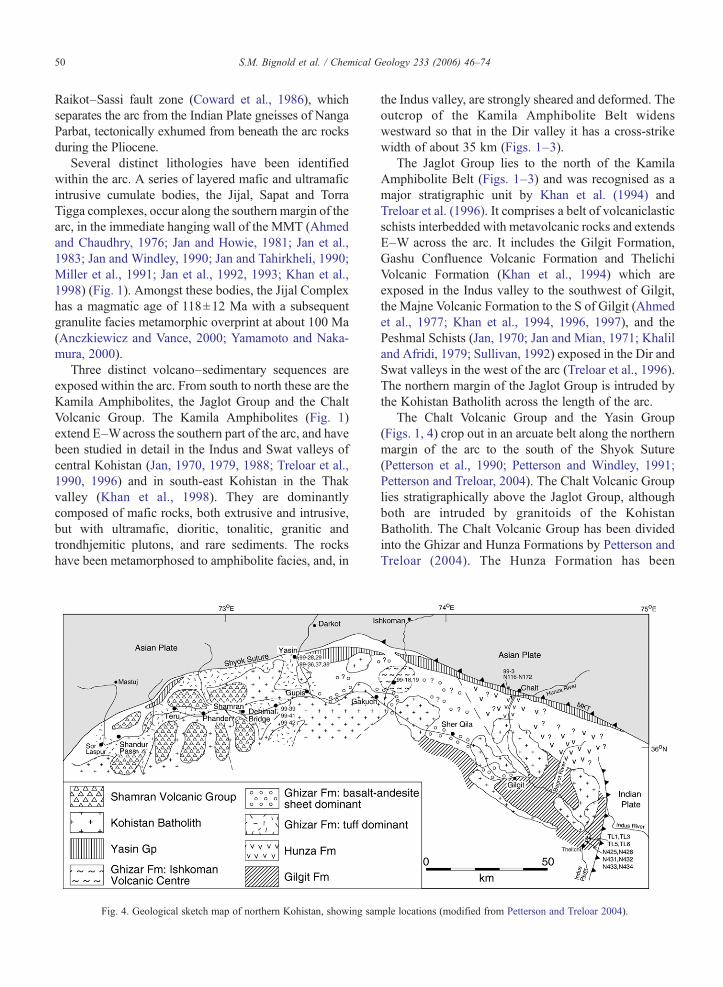
Fig. 13 shows a model for the evolution of thevolcanic rocks of the juvenile stages of the island arc.The model is underpinned by the assumption thatsubduction of Tethyan oceanic crust beneath the arc wasto the north, as is accepted by most workers in the region(see discussion in Bignold and Treloar, 2003). It isprimarily based on the recognition that three differentchemical signatures are present within volcanic rocksextruded prior to suturing with Asia. Firstly, basalticvolcanic rocks of the ‘D-type’Kamila Amphibolites, theJaglot Group and the Ghizar Formation all have typicalarc-type signatures, although with subtly differentchemistries that result from their derivation fromdifferent source regions. Secondly, the ‘E-type’ KamilaAmphibolites have an enriched MORB-type signature.Thirdly, basaltic and andesitic volcanic rocks of theHunza Formation have a very distinctive chemistry withstrong depletion in the LREE.
The ‘E-type’ Kamila Amphibolites have REE con-centrations similar to E-MORB with no arc signature. Ithas been demonstrated here that these rocks may havebeen generated in an intraoceanic setting (Fig. 13a) by6% partial melting of a primitive mantle-type source
Fig. 13. Schematic diagram showing: (a) emplacement of ‘D-type’ Kamila Amphibolite onto ‘E-type’ Kamila Amphibolite (MORB) basementfollowing decompression melting at the initiation of subduction; (b) eruption of Jaglot Group and Chalt Volcanic Group, Ghizar Formation, inducedby dehydration fluids from the subducting sediments during steady-state subduction; and (c) eruption of the Chalt Volcanic Group, Hunza Formationin the back-arc through decompression and remelting of the residue from the generation of the ‘E-type’ Kamila Amphibolites following intra-arcrifting and extension (adapted from McCulloch and Gamble, 1991). Convection lines show possible paths of hydrous fluids and melts in the mantlewedge. VF=volcanic front. Not to scale.
69S.M. Bignold et al. / Chemical Geology 233 (2006) 46–74
(Fig. 10a). The remaining residue of this primitivemantle source has REE concentrations similar to LREE-depleted spinel lherzolite xenoliths found in theEuropean Alps (Loubet et al., 1975). It is possible, ifunlikely, that MORB could be generated from an LREE-depleted lherzolite mantle source. REE modelling ofsuch a source shows that rocks with REE compositions
similar to N-MORB can be produced with only 2%batch partial melting (Fig. 14a). However, melting ofthis source could not have generated the ‘E-type’Kamila Amphibolites (Fig. 14b).
The data presented here are consistent with thehypothesis that the main arc volcanic rocks of theKohistan arc were erupted above a north-dipping

70 S.M. Bignold et al. / Chemical Geology 233 (2006) 46–74
subduction zone. On the assumption that spinellherzolite was present in the mantle wedge betweenabout 30 and 80 km depth (10–25 kbar), with garnetlherzolite mantle present at depths N80 km (N25 kbar),the implication is that the main arc volcanic rocks ofKohistan were generated by partial melting of a fertilemantle source (Fig. 13b). The ‘D-type’mafic rocks of theKamila Amphibolites, the earliest arc volcanic rocks,were produced at relatively shallow depths, and themafic rocks of the Jaglot Group and the Ghizar Forma-tion of the Chalt Volcanic Group were generated atdepths greater than 80 km as a north-dipping subductingslab penetrated further into the mantle (Fig. 13b).
Petterson and Treloar (2004) argued, on stratigraphiccriteria, that the Ghizar and Hunza Formations arecoeval units and that it is likely that they were eruptedcontemporaneously. However, their chemistries aresignificantly different, and REE modelling indicatesvery different source materials for them. The basalts andandesites of the Hunza Formation do not fit on the trenddisplayed by the basaltic rocks of the evolving juvenilearc, including the Ghizar Formation (Fig. 12). If this isso, the Chalt Volcanic Group was formed by twodifferent, adjacent, mantle source regions which musthave been active at the same time.
The Hunza Formation of the Chalt Volcanic Grouphas a MORB-type composition, but also carries a weakarc signature. Models of mantle melting (Fig. 11a, b, c)show that the mafic rocks of the Hunza Formation musthave been produced through melting of an LREE-
Fig. 14. Mantle melting models for (a) N-MORB and (b) ‘E-type’ Kamila Amsimilar REE concentrations to depleted lherzolite xenoliths from the Europe
depleted spinel lherzolite. A possible source would bean Alpine-type LREE-depleted lherzolite (Loubet et al.,1975) which has undergone a previous melting event. Inthe specific setting of the Kohistan arc rocks, the sourcecould more likely be the residue that remained of theprimitive mantle-type source from which the ‘E-type’Kamila Amphibolites were generated through 6%partial melting (Fig. 11d, e, f).
A two-stage model is indicated. The ‘E-type’ KamilaAmphibolites were generated through partial melting ofa primitive mantle source (Fig. 10a) in an intraoceanicsetting (Fig. 14a) and form the basement to the wholearc. We suggest that the residue which, after melting,would have REE concentrations similar to those ofAlpine peridotites (Loubet et al., 1975) was subsequent-ly underplated beneath the arc and was later remelted asthe source for the basalts of the Hunza Formation. Thisis consistent with field data which suggest that theKamila Amphibolites form the basement to the arc andthat the Hunza Formation with its MORB-like chemistryand weak arc signature is the youngest sequence in theKohistan arc (Petterson and Treloar, 2004).
Because high-Mg andesites and boninites are mostcommonly recognised as occurring in the fore-arc, thepresence of primitive, high-Mg rocks in the HunzaFormation led Khan et al. (1997) to propose, while nottaking account of the high stratigraphic position of theserocks, that they represent the fore-arc, and that they wereemplaced above a south-dipping subduction zone.While boninites and high-Mg volcanic rocks are
phibolites generated from batch partial melting of a mantle source withan Alps (Loubet et al., 1975).
71S.M. Bignold et al. / Chemical Geology 233 (2006) 46–74
known to be erupted in fore-arc settings (e.g., Crawfordet al., 1989; Bloomer et al., 1995), there is a growingbody of evidence that shows that they can also beerupted in back-arc settings (e.g., Falloon et al., 1992;Meffre et al., 1996). The high stratigraphic position ofthe boninites of the Hunza Formation, and theirrestricted spatial range in the north of the Kohistanarc, is consistent with them being erupted into an intra-or back-arc basin (Clift, 1995; Bédard et al., 1998), andwith the arc being erected above a north-dippingsubduction zone.
Here, we argue that the rocks of the Hunza Formationwere erupted into a back-arc basin. Rifting and opening ofthe back-arc basin occurred shortly before the arc suturedto Asia. Initial rifting probably occurred behind thevolcanic front as a consequence of extension. The firstmagmas to be erupted were low-Si, low-Mg, magmaswith weak arc signatures. These magmas were derivedfrom melting the residue of the primitive mantle sourcefrom which the ‘E-type’ Kamila Amphibolites had beenextracted. As rifting progressed, further magmatismoccurred. These magmas were the high-Mg basalts,high-Mg andesites and boninites of the Hunza Formationsequence, which also carry only weak arc signatures. Wenote that boninites constitute only a minor part of thiscompositionally variable suite of basalts and andesites.The presence of high-Mg basalts and andesites andboninitic units in this region indicates that there was alocalised high mantle heat flow. The source of thisenhanced heat flow could have been the northward sub-duction of an active spreading centre (Bignold andTreloar, 2003). However, it is more likely to have been theresult of upwelling, hot residual mantle as a result oflithospheric extension associated with rifting and openingof the back-arc basin. Generation of the high-Mg volcanicrocks would thus have been a result of decompressionmelting of this upwelling mantle material. Following the,probably, short-lived volcanic activity, an active spread-ing centre began to develop within the rifted basin andnormal MORB-type volcanism commenced (Fig. 13c),the arc signature diminishing with time and distance fromthe trench. That the Hunza Formation carries a weak arcsignature indicates connectionwith, but distance from, thesubduction zone.
On the basis of preliminary geochemical analysesRolland et al. (2002) suggested that basalts from thenorthern margin of the Ladakh arc, to the immediate eastof the Nanga Parbat syntaxis, have a back-arc signature.These basalts are the lateral equivalents of the HunzaFormation, and it is thus likely that they help define aremnant back-arc basin that extends from Ladakh in theeast to the present-day Naltar Valley in the west (Figs. 1,
4). This basin was probably restricted along strike lengthand was short-lived, as its evolution was terminated byclosure of the basin during suturing of the Kohistan arcto Asia. The geochemical data presented both here andby Rolland et al. (2002) are consistent with evidence,from the sedimentary record, for extension and riftingthat shortly predated collision of Kohistan with Asia(Robertson and Collins, 2002).
6. Conclusions
The Kohistan arc offers almost unique access to acomplete stratigraphic succession of an intraoceanicisland arc. Geochemistry, isotopic data and REEmodelling in this study, despite the fact that the rockshave been metamorphosed, offer the opportunity toidentify sources of magma generation beneath the arcwhich may be used as a model for other intraoceanicisland arc volcanoes. Despite the assumptions that had tobe made, the results are consistent with models ofoceanic island arc formation where magma is drawninitially from spinel-bearing mantle and, that as an arcmatures and the subducting slab penetrates deeper intothe mantle, magma is generated from a garnet-bearingsource. A two-stage model is also proposed, where amantle source, depleted from a previous melting event,may be underplated and later remelted as a consequenceof arc rifting, and erupted as back-arc magma.
Acknowledgements
SMB wishes to thank Professor Brian Windley at theUniversity of Leicester for the loan of rock samples andProfessor M. Asif Khan at the National Centre ofExcellence, Peshawar University, Pakistan, for provid-ing assistance in the field and for supplying powders forgeochemical analysis. Staff at the NERC ICP-MSFacility are thanked for their assistance. with thegeochemical analyses under grant No. ICP/89/1295, asare staff at NIGL, Keyworth, UK, for the use of theirfacilities for isotope analysis under grant No. IP/596/0499. This manuscript has been improved by helpfulcomments from Roberta Rudnick, Yann Rolland and ananonymous reviewer. [RR]
References
Ahmed, Z., Chaudhry,M.N., 1976. Petrology of the Babusar area,Diamirdistrict, Gilgit, Pakistan. Geol. Bull. Punjab Univ. 12, 67–78.
Ahmed, Z., Hussain, S., Awan, A., 1977. Petrology of the Thelichiarea, Gilgit Agency. Geol. Bull. Punjab Univ. 14, 27–38.
Anczkiewicz, R., Vance, D., 2000. Isotopic constraints on theevolution of metamorphic conditions in the Jijal–Patan complex

72 S.M. Bignold et al. / Chemical Geology 233 (2006) 46–74
and the Kamila Belt of the Kohistan arc, Pakistan Himalaya.In: Khan, M.A., Treloar, P.J., Searle, M.P., Jan, M.Q. (Eds.),Tectonics of the Nanga Parbat Syntaxis and the Western Himalaya.Geol. Soc. London Spec. Publ., vol. 170, pp. 321–331.
Bédard, J.H., Lauzière, K., Tremblay, A., Sangster, A., 1998. Evidencefor forearc seafloor-spreading from the Betts Cove ophiolite,Newfoundland: oceanic crust of boninitic affinity. Tectonophysics284, 23–245.
Bignold, S.M., Treloar, P.J., 2003. Northward subduction of theIndian Plate beneath the Kohistan island arc, Pakistan Himalaya:new evidence from isotopic data. J. Geol. Soc. (Lond.) 160,377–384.
Bloomer, S.H., Taylor, B., MacLeod, C.J., Stern, R.J., Fryer, P.,Hawkins, J.W., Johnson, L., 1995. Early arc volcanism and theophiolite problem: a perspective from drilling in the westernPacific. In: Taylor, B., Natland, J. (Eds.), Active Margins andMarginal Basins of the Western Pacific. Am. Geophys. Union,Geophys. Monogr., vol. 88, pp. 1–30.
Boynton, W.V., 1984. Geochemistry of the rare earth elements:meteorite studies. In: Henderson, P. (Ed.), Rare Earth ElementChemistry. Elsevier, Amsterdam, pp. 63–114.
Burg, J.P., Bodinier, J.L., Chaudhry, S., Hussain, S., Dawood, H.,1998. Infra-arc mantle-crust transition and intra-arc mantlediapirs in the Kohistan Complex (Pakistani Himalaya): petro-structural evidence. Terra Nova 10, 74–80.
Cameron, W.E., Nisbet, E.G., Dietrich, V.J., 1979. Boninites,komatiites and ophiolitic basalts. Nature 280, 550–553.
Clift, P.D., 1995. Volcaniclastic sedimentation and volcanism duringthe rifting of western Pacific backarc basins. In: Taylor, B.,Natland, J. (Eds.), Active Margins and Marginal Basins of theWestern Pacific. AGU, Geophys. Monogr., vol. 88, pp. 67–96.
Corfield, R.I., Searle, M.P., Pedersen, R.B., 2001. Tectonic setting,origin, and subduction history of the Spontang ophiolite, LadakhHimalaya, NW India. J. Geol. 109, 715–736.
Coward, M.P., Jan, M.Q., Rex, D., Tarney, J., Thirlwall, M., Windley,B.F., 1982. Geo-tectonic framework of the Himalaya of N.Pakistan. J. Geol. Soc. (Lond.) 139, 299–308.
Coward, M.P., Windley, B.F., Broughton, R.D., Luff, I.W., Petterson, M.G.,Pudsey, C.J., Rex, D.C., Khan, M.A., 1986. Collision tectonics in theNW Himalayas. In: Coward, M.P., Ries, A.C. (Eds.), CollisionTectonics. Geol. Soc. London Spec. Publ., vol. 19, pp. 203–219.
Coward, M.P., Butler, R.W.H., Khan, M.A., Knipe, R.J., 1987. Thetectonic history of Kohistan and its implications for Himalayanstructure. J. Geol. Soc. (Lond.) 144, 377–391.
Crawford, A.J., Falloon, T.J., Green, D.H., 1989. Classification,petrogenesis and tectonic setting of boninites. In: Crawford, A.J.(Ed.), Boninites and Related Rocks. Unwin Hyman, pp. 1–49.
Falloon, T.J., Malahoff, A., Zonenshain, L.P., Bogdanov, Y., 1992.Petrology and geochemistry of back-arc basin basalts from LauBasin spreading ridges at 15°, 18° and 19°S. Min. Pet. 47, 1–35.
Frey, F.A., Suen, J.C., Stockman, H.W., 1985. The Ronda hightemperature peridotite: geochemistry and petrogenesis. Geochim.Cosmochim. Acta 49, 2469–2491.
George, M.T., Harris, N.B.W., Butler, R.W.H., 1993. The tectonicimplications of contrasting granite-magmatism between theKohistanisland arc and the Nanga Parbat–Haramosh Massif, PakistanHimalaya. In: Treloar, P.J., Searle, M.P. (Eds.), Himalayan Tectonics.Geol. Soc. London Spec. Publ., vol. 74, pp. 173–191.
Gill, J.B., 1981. Orogenic Andesites and Plate Tectonics. Springer-Verlag, Berlin.
Hanson, G.N., 1980. Rare earth elements in petrogenetic studies ofigneous systems. Annu. Rev. Earth Planet. Sci. 8, 371–406.
Hickey, R.L., Frey, F.A., 1982. Geochemical characteristics of boniniteseries volcanics: implications for their source. Geochim. Cosmo-chim. Acta 46, 2099–2115.
Jan, M.Q., 1970. Petrography of the upper part of Kohistan andsouthwestern Gilgit agency along the Indus and Kandia rivers.Geol. Bull. Univ. Peshawar 5, 27–48.
Jan, M.Q., 1979. Petrography of pyroxene granulites fromnorthern Swat and Kohistan. Geol. Bull. Univ. Peshawar 11,65–87.
Jan, M.Q., 1988. Geochemistry of amphibolites from the southern partof the Kohistan arc, N. Pakistan. Min. Mag. 52, 147–159.
Jan, M.Q., Howie, R.A., 1981. The mineralogy and geochemistry ofthe metamorphosed basic and ultrabasic rocks of the Jijal complex,Kohistan, NW Pakistan. J. Petrol. 22, 85–126.
Jan, M.Q., Mian, I., 1971. Preliminary geology and Petrography ofSwat Kohistan. Geol. Bull. Univ. Peshawar 6, 1–32.
Jan, M.Q., Tahirkheli, A.Z., 1990. The Tora Tigga Complex,southern Dir, NW Pakistan: an example of mafic–ultramaficrocks in the bottom of an island arc. Geol. Bull. Univ.Peshawar 23, 231–251.
Jan, M.Q., Windley, B.F., 1990. Chromian spinel-silicate chemistry inultramafic rocks of the Jijal complex, northwest Pakistan. J. Petrol.31, 667–715.
Jan, M.Q., Banaras, M., Ghani, A., Asif, M., 1983. The Tora Tiggaultramafic complex, southernDir district. Geol. Bull. Univ. Peshawar16, 11–29.
Jan, M.Q., Khan, M.A., Windley, B.F., 1992. Exsolution in Al-Cr-Fe3+-rich spinel from the Chilas mafic–ultramafic complex, Pakistan. Am.Min. 77, 1074–1079.
Jan, M.Q., Khan, M.A., Qazi, M.S., 1993. The Sapat mafic–ultramaficcomplex, Kohistan arc, North Pakistan. In: Treloar, P.J., Searle, M.P.(Eds.), Himalayan Tectonics. Geol. Soc. London Spec. Publ., vol. 74,pp. 113–121.
Kelemen, P.B., Hanghøj, K., Greene, A.R., 2003. One viewof the geochemistry of subduction-related magmatic arcs,with an emphasis on primitive andesite and lower crust.In: Rudnick, R.L. (Ed.), Treatise on Geochemistry, vol. 3,pp. 593–659.
Kempton, P.D., 1995. Common Pb chemical procedures forsilicate rocks and minerals, methods of data correction and anassessment of data quality at the NERC Isotope GeosciencesLaboratory. NERC Isotope Geosciences Laboratory ReportSeries, vol. 78.
Kempton, P.D., Downes, H., Sharkov, E.V., Vetrin, V.R., Ionov, D.A.,Carswell, D.A., Beard, A., 1995. Petrology and geochemistry ofxenoliths from the Baltic Shield: evidence for partial melting andmetasomatism in the lower crust beneath an Archean Terrane.Lithos 36, 157–184.
Khalil, M.A., Afridi, A.G.K., 1979. The geology and petrography ofDeshi–Diwangar area, Ushu Gol Valley, Swat Kohistan. Geol.Bull. Univ. Peshawar 11, 99–111.
Khan, M.A., Jan, M.Q., Windley, B.F., Tarney, J., Thirlwall, M.F.,1989. The Chilas mafic–ultramafic igneous complex; theroot of the Kohistan island arc in the Himalaya ofNorthern Pakistan. In: Malinconico, L.L., Lillie, J. (Eds.),Tectonics of the Western Himalayas. Geol. Soc. Am. Spec. Paper,vol. 232, pp. 75–94.
Khan, M.A., Jan, Q.M., Weaver, B.L., 1993. Evolution of the lower arccrust in Kohistan, N. Pakistan: temporal arc magmatism throughearly, mature and intra-arc rift stages. In: Treloar, P.J., Searle, M.P.(Eds.), Himalayan Tectonics. Geol. Soc. London Spec. Publ.,vol. 74, pp. 123–128.

73S.M. Bignold et al. / Chemical Geology 233 (2006) 46–74
Khan, T., Khan, M.A., Jan, M.Q., 1994. Geology of a part of theKohistan terrane between Gilgit and Chilas, northern areas,Pakistan. Geol. Bull. Univ. Peshawar 27, 99–112.
Khan, T., Khan, M.A., Jan, M.Q., Naseem, M., 1996. Back-arc basinassemblages in Kohistan, Northern Pakistan. Geodin. Acta (Paris)9, 30–40.
Khan, M.A., Stern, R.J., Gribble, R.F., Windley, B.F., 1997.Geochemical and isotopic constraints on subduction polarity,magma sources and palaeogeography of the Kohistan intra-oceanic arc, Northern Pakistan Himalaya. J. Geol. Soc. (Lond.)154, 935–946.
Khan, M.A., Treloar, P.J., Khan, M.A., Khan, T., Qazi, M.S., Jan, M.Q.,1998. Geology of the Chalt–Babusar transect, Kohistan terrane, N.Pakistan: implications for the constitution and thickening of islandarc crust. J. Asian Earth Sci. 16, 253–268.
Loubet, M., Shimizu, N., Allègre, C.J., 1975. Rare earth elements inAlpine peridotites. Contrib. Mineral. Petrol. 53, 1–12.
Mahoney, J.J., Frei, R., Tejada, M.L.G., Mo, X.X., Leat, P.T., Nägler,T.F., 1998. Tracing the Indian Ocean mantle domain through time:isotopic results from Old West Indian, East Tethyan, and SouthPacific seafloor. J. Petrol. 39, 1285–1306.
McCulloch, M.T., Gamble, J.A., 1991. Geochemical and geodynami-cal constraints on subduction zone magmatism. Earth Planet. Sci.Lett. 102, 358–374.
McDonough, W.F., Sun, S.-S., 1995. The composition of the Earth.Chem. Geol. 120, 223–253.
McDonough,W.F., Sun, S.-S., Ringwood, A.E., Jagoutz, E., Hofmann,A.W., 1992. Potassium, rubidium, and cesium in the Earth andMoon and the evolution of the mantle of the Earth. Geochim.Cosmochim. Acta 56, 1001–1012.
Meffre, S., Aitchison, J.C., Crawford, A.J., 1996. Geochemicalevolution and tectonic significance of boninites and tholeiitesfrom the Koh ophiolite, New Caledonia. Tectonics 15, 67–83.
Michel, M., Robin, C., Samaniego, P., Hall, M.L., Cotton, J.,Mothes, P., Arnaud, N., 1999. Sangay volcano, Ecuador:structural development, present activity and petrology. J.Volcanol. Geotherm. Res. 90, 49–79.
Miller, D.J., Loucks, R.R., Ashraf, M., 1991. Platinum-group elementmineralisation in the Jijal layered ultramafic–mafic complex,Pakistan Himalayas. Econ. Geol. 86, 1093–1102.
Miyashiro, A., 1974. Volcanic rock series in island arc series and activecontinental margins. Am. J. Sci. 274, 321–355.
Pearce, J.A., 1983. Role of the sub-continental lithosphere in magmagenesis at active continental margins. In: Hawkesworth, C.J.,Norry, M.J. (Eds.), Continental Basalts and Mantle Xenoliths.Shiva, Nantwich, pp. 230–249.
Petterson, M.G., Treloar, P.J., 2004. Volcanostratigraphy of arcvolcanic sequences in the Kohistan arc, North Pakistan: volcanismwithin island arc, back-arc basin, and intra-continental tectonicsettings. J. Volcanol. Geotherm. Res. 130, 147–178.
Petterson, M.G., Windley, B.F., 1985. Rb–Sr dating of the Kohistanarc batholith in the trans-Himalaya of North Pakistan, and tectonicimplications. Earth Planet. Sci. Lett. 74, 45–57.
Petterson, M.G., Windley, B.F., 1991. Changing source regions ofmagmas and crustal growth in the trans-Himalayas: evidence fromthe Chalt volcanics and Kohistan Batholith, Kohistan, NorthernPakistan. Earth Planet. Sci. Lett. 102, 326–341.
Petterson, M.G., Windley, B.F., 1992. Field relations, geochemistryand petrogenesis of the Cretaceous basaltic Jutal dykes, Kohistan,Northern Pakistan. J. Geol. Soc. (Lond.) 149, 107–114.
Petterson, M.G., Windley, B.F., Luff, I.W., 1990. The Chalt volcanics,Kohistan, N Pakistan: High-Mg tholeiitic and low-Mg calc-alkaline
volcanism in a Cretaceous island arc. In: Sharma, K.K. (Ed.), Phys.Chem. Earth 17, no. II, Geology and Geodynamic Evolution of theHimalayan Collision Zone, Part 1, 19–30.
Petterson, M.G., Crawford, M.B., Windley, B.F., 1993. Petroge-netic implications of neodymium isotope data from theKohistan Batholith, North Pakistan. J. Geol. Soc. (Lond.)150, 125–129.
Riley, T.R., Leat, P.T., Pankhurst, R.J., Harris, C., 2001. Origins oflarge volume rhyolitic volcanism in the Antarctic Peninsula andPatagonia by crustal melting. J. Petrol. 42, 1043–1065.
Robertson, A.H.F., Collins, A.S., 2002. Shyok Suture Zone, NPakistan: late Mesozoic–Tertiary evolution of a critical sutureseparating the oceanic Ladakh Arc from the Asian continentalmargin. J. Asian Earth Sci. 20, 309–351.
Rolland, Y., Pecher, A., Picard, C., 2000. Middle Cretaceous back-arcformation and arc evolution along the Asian margin: the ShyokSuture Zone in northern Ladakh (NW Himalaya). Tectonophysics325, 145–173.
Rolland, Y., Picard, C., Pecher, A., Lapierre, H., Bosdch, D., Keller, F.,2002. The Cretaceous Ladakh arc of NW Himalaya: slab meltingand melt-mantle interaction during fast northward drift of IndianPlate. Chem. Geol. 182, 139–178.
Royse, K.R., Kempton, P.D., Darbyshire, D.P.F., 1998. Procedure forthe analysis for rubidium–strontium and samarium–neodymiumisotopes at the NERC Isotope Geosciences Laboratory. NERCIsotope Geosciences Laboratory Report Series, vol. 121.
Sullivan, M.A., 1992. The geology of the roof zone of the KohistanBatholith, Northwestern Pakistan. Unpublished PhD thesis,University of Leicester.
Sullivan, M.A., Windley, B.F., Saunders, A.D., Haynes, J.R., Rex, D.C., 1993. A palaeogeographic reconstruction of the Dir Group:evidence for magmatic arc migration within Kohistan, N. Pakistan.In: Treloar, P.J., Searle, M.P. (Eds.), Himalayan Tectonics. Geol.Soc. London Spec.l Publ., vol. 74, pp. 139–160.
Sun, S-S., McDonough, W.F., 1989. Chemical and isotopic system-atics of oceanic basalts: implications for mantle composition andprocesses. In: Saunders, A.D., Norry, M.J. (Eds.), Magmatism inthe Ocean Basins. Geol. Soc. London Spec. Publ., vol. 42, pp.313–345.
Tahirkheli, R.A.K., Mattauer, M., Proust, F., Tapponnier, P., 1979. TheIndia–Eurasia suture zone in northern Pakistan: synthesis andinterpretation of recent data at plate scale. In: Farah, A., Dejong, K.A. (Eds.), Geodynamics of Pakistan. Geol. Surv., Pakistan, Quetta,pp. 125–130.
Treloar, P.J., Rex, D.C., Guise, P.G., Coward, M.P., Searle, M.P.,Windley, B.F., Petterson, M.G., Jan, M.Q., Luff, I.W., 1989. K–Arand Ar–Ar geochronology of the Himalayan collision in NWPakistan: constraints on the timing of suturing, deformation,metamorphism and uplift. Tectonics 8, 881–909.
Treloar, P.J., Brodie, K.H., Coward, M.P., Jan, M.Q., Khan, M.A., Knipe, R.J., Rex, D.C., Williams, M.P., 1990. Theevolution of the Kamila shear zone, Kohistan, Pakistan. In:Salisbury, M.H., Fountain, D.M. (Eds.), Exposed Cross-sections of the Continental Crust. Kluwer Academic Press,Amsterdam, pp. 175–214.
Treloar, P.J., Petterson, M.G., Jan, M.Q., Sullivan, M.A., 1996. A re-evaluation of the stratigraphy and evolution of the Kohistan arcsequence, Pakistan Himalaya: implications for magmatic andtectonic arc building processes. J. Geol. Soc. (Lond.) 153,681–693.
Wood, B.J., Fraser, D.G., 1986. Elementary Thermodynamics forGeologists. Oxford University Press.

74 S.M. Bignold et al. / Chemical Geology 233 (2006) 46–74
Yamamoto, H., Nakamura, E., 1996. Sm–Nd dating of garnet granulitesfrom the Kohistan complex, northern Pakistan. J. Geol. Soc. (Lond.)153, 965–969.
Yamamoto, H., Nakamura, E., 2000. Timing of magmatic andmetamorphic events in the Jijal complex of the Kohistan arcdeduced from Sm–Nd dating of mafic granulites. In: Khan, M.A.,Treloar, P.J., Searle, M.P., Jan, M.Q. (Eds.), Tectonics of the NangaParbat Syntaxis and the Western Himalaya. Geol. Soc. LondonSpec. Publ., vol. 170, pp. 313–319.
Zeilinger, G., Burg, J.-P., Schaltegger, U., Seward, D., 2001. New U/Pb and fission track ages and their implication for the tectonichistory of the lower Kohistan arc complex, northern Pakistan. J.Asian Earth Sci. 19, 79–80.
Zeitler, P.K., Tahirkheli, R.A.K., Naesser, C., Johnson, N., Lyons, J.,1981. Preliminary fission track ages from the Swat valley, northernPakistan. Geol. Bull. Univ. Peshawar 13, 63–65.
Related Documents