Top Banner
Ch.4 Notes Plate Tectonics
34

Ch.4 Notes Plate Tectonics. Continental Drift 400 years ago Magellan and Columbus mapping info Similar shoreline 1912 Alfred Wegener hypothesized Pangaea.

Jan 01, 2016

Download

Documents

Oliver Fields
Welcome message from author
This document is posted to help you gain knowledge. Please leave a comment to let me know what you think about it! Share it to your friends and learn new things together.
Transcript
Page 1: Ch.4 Notes Plate Tectonics. Continental Drift 400 years ago Magellan and Columbus mapping info Similar shoreline 1912 Alfred Wegener hypothesized Pangaea.

Ch.4Notes

Plate Tectonics

Page 2: Ch.4 Notes Plate Tectonics. Continental Drift 400 years ago Magellan and Columbus mapping info Similar shoreline 1912 Alfred Wegener hypothesized Pangaea.

Continental Drift

• 400 years ago

• Magellan and Columbus mapping info

• Similar shoreline

• 1912 Alfred Wegener hypothesized

• Pangaea – 1 land mass

• Panthalassa – all seas

Page 3: Ch.4 Notes Plate Tectonics. Continental Drift 400 years ago Magellan and Columbus mapping info Similar shoreline 1912 Alfred Wegener hypothesized Pangaea.

World Map

Page 4: Ch.4 Notes Plate Tectonics. Continental Drift 400 years ago Magellan and Columbus mapping info Similar shoreline 1912 Alfred Wegener hypothesized Pangaea.

Evidence of Continental Drift

• Coastlines• Fossils• Mesosaurus – lived 270 million years ago• They cannot swim well• Age and type of rocks Brazil = Africa• Mountain ranges• Coal deposits• Continents joined over South Pole• No force making this happen? • Still not accepted 1930’s

Page 5: Ch.4 Notes Plate Tectonics. Continental Drift 400 years ago Magellan and Columbus mapping info Similar shoreline 1912 Alfred Wegener hypothesized Pangaea.

Continental Drift

Page 6: Ch.4 Notes Plate Tectonics. Continental Drift 400 years ago Magellan and Columbus mapping info Similar shoreline 1912 Alfred Wegener hypothesized Pangaea.

Sea floor spreading

• 1947

• Out of a ridge in the ocean floor magma flows creating new crust.

• Pushing old crust outward.

• Harry Hess – Princeton, MidAtlantic Ridge

• Arthur Holmes hypothesis in 1930 to put Wegener hypothesis back on map

Page 7: Ch.4 Notes Plate Tectonics. Continental Drift 400 years ago Magellan and Columbus mapping info Similar shoreline 1912 Alfred Wegener hypothesized Pangaea.

Sea floor spreading

Page 8: Ch.4 Notes Plate Tectonics. Continental Drift 400 years ago Magellan and Columbus mapping info Similar shoreline 1912 Alfred Wegener hypothesized Pangaea.

Sea Floor Spreading

Page 9: Ch.4 Notes Plate Tectonics. Continental Drift 400 years ago Magellan and Columbus mapping info Similar shoreline 1912 Alfred Wegener hypothesized Pangaea.

Mid-Ocean Ridges

• Go around the earth

• 80,000 km long

• Undersea mountain range with a valley in the middle.

Page 10: Ch.4 Notes Plate Tectonics. Continental Drift 400 years ago Magellan and Columbus mapping info Similar shoreline 1912 Alfred Wegener hypothesized Pangaea.

Mid Atlantic Ridge

Page 11: Ch.4 Notes Plate Tectonics. Continental Drift 400 years ago Magellan and Columbus mapping info Similar shoreline 1912 Alfred Wegener hypothesized Pangaea.

Iceland

Page 12: Ch.4 Notes Plate Tectonics. Continental Drift 400 years ago Magellan and Columbus mapping info Similar shoreline 1912 Alfred Wegener hypothesized Pangaea.

Earth layers

Page 13: Ch.4 Notes Plate Tectonics. Continental Drift 400 years ago Magellan and Columbus mapping info Similar shoreline 1912 Alfred Wegener hypothesized Pangaea.

layers

Page 14: Ch.4 Notes Plate Tectonics. Continental Drift 400 years ago Magellan and Columbus mapping info Similar shoreline 1912 Alfred Wegener hypothesized Pangaea.

Paleomagnetism of the ocean floor

• Magma has iron in it.

• Iron aligns with the poles like a magnet

• Reverse polarity in layers 1965

Page 15: Ch.4 Notes Plate Tectonics. Continental Drift 400 years ago Magellan and Columbus mapping info Similar shoreline 1912 Alfred Wegener hypothesized Pangaea.

Paleomagnetism of the ocean floor

Page 16: Ch.4 Notes Plate Tectonics. Continental Drift 400 years ago Magellan and Columbus mapping info Similar shoreline 1912 Alfred Wegener hypothesized Pangaea.

1960

• Hypothesis of continental drift and seafloor spreading turned into a theory.

Page 17: Ch.4 Notes Plate Tectonics. Continental Drift 400 years ago Magellan and Columbus mapping info Similar shoreline 1912 Alfred Wegener hypothesized Pangaea.

The theory of Plate Tectonics

• Explanation of how and why the continents broke apart.

• Construction = tectonics• Crust • 1. oceanic crust• 2 continental crust• Lithosphere – upper mantle• Asthenosphere – solid rock that is under

pressure• 30 different plates
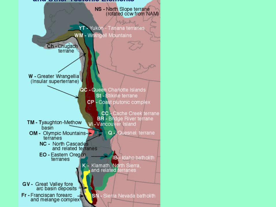
Page 18: Ch.4 Notes Plate Tectonics. Continental Drift 400 years ago Magellan and Columbus mapping info Similar shoreline 1912 Alfred Wegener hypothesized Pangaea.

Microplate Terranes

Page 19: Ch.4 Notes Plate Tectonics. Continental Drift 400 years ago Magellan and Columbus mapping info Similar shoreline 1912 Alfred Wegener hypothesized Pangaea.

Lithospheric Plate Boundaries

• Boundaries can be anywhere

• Divergent – moving away

• Convergent – moving toward

• Transform Boundaries – moving across

Page 20: Ch.4 Notes Plate Tectonics. Continental Drift 400 years ago Magellan and Columbus mapping info Similar shoreline 1912 Alfred Wegener hypothesized Pangaea.

Divergent – moving away

• Plates moving away from each other

• Asthenosphere flows upward to fill in

• Mid-ocean ridge

• Rift valley – center of plate boundary

• Red sea is one

Page 21: Ch.4 Notes Plate Tectonics. Continental Drift 400 years ago Magellan and Columbus mapping info Similar shoreline 1912 Alfred Wegener hypothesized Pangaea.

Sea floor spreading

Page 22: Ch.4 Notes Plate Tectonics. Continental Drift 400 years ago Magellan and Columbus mapping info Similar shoreline 1912 Alfred Wegener hypothesized Pangaea.

Convergent – moving toward

• Opposite side of divergent• 1. Oceanic crust vs continental crust oceanic is

denser so subduction – goes under, continental crust goes up

• Forms deep ocean trenches• Often forms volcanoes on land• 2. If continental crust plates are even both

crumple and go up (Himalayas)• 3. oceanic and oceanic crusts one is subducted• Deep trench and island arc of volcanoes

Page 23: Ch.4 Notes Plate Tectonics. Continental Drift 400 years ago Magellan and Columbus mapping info Similar shoreline 1912 Alfred Wegener hypothesized Pangaea.

Crust layers

Page 24: Ch.4 Notes Plate Tectonics. Continental Drift 400 years ago Magellan and Columbus mapping info Similar shoreline 1912 Alfred Wegener hypothesized Pangaea.
Page 25: Ch.4 Notes Plate Tectonics. Continental Drift 400 years ago Magellan and Columbus mapping info Similar shoreline 1912 Alfred Wegener hypothesized Pangaea.

Transform Boundaries – moving across

• 2 plates grinding past each other

• Not smooth so many spurts

• San Andreas Fault in California

Page 26: Ch.4 Notes Plate Tectonics. Continental Drift 400 years ago Magellan and Columbus mapping info Similar shoreline 1912 Alfred Wegener hypothesized Pangaea.

Causes of Plate Motion

• Movement of lithospheric plates by convection (transfer of heat)

• Convectional current – boiling rice• Ex. Lake turning over• Arthur Holmes

• Radioactivity• thermalconvection

Page 27: Ch.4 Notes Plate Tectonics. Continental Drift 400 years ago Magellan and Columbus mapping info Similar shoreline 1912 Alfred Wegener hypothesized Pangaea.

Plate Tectonics

Page 28: Ch.4 Notes Plate Tectonics. Continental Drift 400 years ago Magellan and Columbus mapping info Similar shoreline 1912 Alfred Wegener hypothesized Pangaea.

Microplate Terranes

• Theory of plate tectonics refines continental drift theory• Theory of microplate terranes• Scraping of ocean floor materials to land crust

• Separate from other plates (neighbors)• 1. Contains rock and fossils unique• 2. major faults are the boundaries• 3. magnetic properties differ

• Palo Alto – fossils of coral reef• Ocean floor sediments in California mountains• Petosky stones

Page 29: Ch.4 Notes Plate Tectonics. Continental Drift 400 years ago Magellan and Columbus mapping info Similar shoreline 1912 Alfred Wegener hypothesized Pangaea.

• FORMATION

Silicification of Paleozoic Era corals such as the Devonian age (416 to 359 million years ago) “Petosky Stone” of the Lake Michigan region (FIGURE 3) or on Prince of Wales Island, Alaska, are attributed to the large amount of siliceous sponges which flourished in the ancient warmer shallow waters. The sponges represent a likely source of mobile silica in the sedimentary pile. As the sponges decomposed, the silica was freed to replace the carbonate rich coral skeletons. Specimens are dominantly gray colored and exhibit a hexagonal pattern typical of primitive coral species
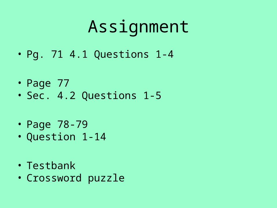
Page 30: Ch.4 Notes Plate Tectonics. Continental Drift 400 years ago Magellan and Columbus mapping info Similar shoreline 1912 Alfred Wegener hypothesized Pangaea.
Page 31: Ch.4 Notes Plate Tectonics. Continental Drift 400 years ago Magellan and Columbus mapping info Similar shoreline 1912 Alfred Wegener hypothesized Pangaea.
Page 32: Ch.4 Notes Plate Tectonics. Continental Drift 400 years ago Magellan and Columbus mapping info Similar shoreline 1912 Alfred Wegener hypothesized Pangaea.
Page 33: Ch.4 Notes Plate Tectonics. Continental Drift 400 years ago Magellan and Columbus mapping info Similar shoreline 1912 Alfred Wegener hypothesized Pangaea.

Assignment

• Pg. 71 4.1 Questions 1-4

• Page 77• Sec. 4.2 Questions 1-5

• Page 78-79• Question 1-14

• Testbank• Crossword puzzle

Page 34: Ch.4 Notes Plate Tectonics. Continental Drift 400 years ago Magellan and Columbus mapping info Similar shoreline 1912 Alfred Wegener hypothesized Pangaea.

• Assigned • Due • Explain how Sea Floor spreading occurs.• You must include:• - rift valley• - magma• - asthenosphere• iron• magnetism• north and south poles• use a diagram to help explain• where the old rock and new rock is located• why is this important to Alfred Wegeners idea of continental drift• It should take at least 2 paragraphs to explain it in detail.