Appendix A U.S. Army Corps of Engineers Preliminary Jurisdictional Determination and Delineation of Wetlands and Other Waters of the U.S. for the Halona Street Bridge Replacement Project (March &’())

Welcome message from author
This document is posted to help you gain knowledge. Please leave a comment to let me know what you think about it! Share it to your friends and learn new things together.
Transcript
Appendix A U.S. Army Corps of Engineers Preliminary
Jurisdictional Determination and Delineation of Wetlands and Other Waters of the U.S. for the
Halona Street Bridge Replacement Project (March &'())

DEPARTMENT OF THE ARMY
HONOLULU DISTRICT, U.S. ARMY CORPS OF ENGINEERS FORT SHAFTER, HAWAII 96858-5440
December 2, 2015
SUBJECT: Preliminary Jurisdictional Determination for Central Federal Lands Highways Division (CFLHD) Halona Street Bridge Project, Honolulu (Kalihi), Oahu Island, Hawaii. DA File No. POH-2015-00225. Mr. Mike Will U.S. Department of Transportation Federal Highway Administration Central Federal Lands Highways Division 12300 West Dakota Avenue, Suite 380A Lakewood, CO 80228-2583 Dear Mr. Will: The U.S. Army Corps of Engineers, Honolulu District (Corps) has received your letter, dated October 28, 2015, requesting a preliminary jurisdictional determination for the above-subject project. Department of the Army (DA) file number POH-2015-00225 has been assigned this project. Please reference this number in all future correspondence with our office concerning this project.
We have completed review of your submittal pursuant to our authorities at Section 404 of the Clean Water Act (33 U.S.C. 1344)(Section 404) and Section 10 of the Rivers and Harbors Act of 1899 (33 U.S.C. 403)(Section 10). Section 404 requires authorization prior to the discharge and/or placement of dredged or fill material into waters of the U.S., including adjacent wetlands. Section 10 requires authorization prior to installing structures or conducting work in, over, under, and affecting navigable waters.
Based on our review of the information submitted and available resources, we have
preliminarily determined that the Kapalama Drainage Canal at the Halona Bridge crossing may be a navigable water of the U.S. subject to the Corps’ regulatory jurisdiction (Enclosure 1). Accordingly, a Section 404 DA permit will be required for any activity resulting in the discharge and/or placement of dredged of fill material into the canal below the surveyed high tide line (HTL) in tidal waters, and the surveyed ordinary high water mark (OHWM) in non-tidal waters. A Section 10 DA permit will be required for any for any structures or activities occurring in, over, under, and affecting navigable waters of the U.S. that are NOT related to improvements to the bridge (e.g., maintenance repair of canal walls).
Please be advised, work activities related to the structural components of the
Halona Street Bridge that would occur in, over, under, and affecting navigable (i.e.,

- 2 -
tidal) waters should be coordinated with the U.S. Coast Guard pursuant to Section 9 of the Rivers and Harbors Act of 1899 (33 U.S.C. 401)(Section 9).
This preliminary jurisdictional determination identifies the presence of aquatic resources that may be waters of the U.S. subject to the Corps’ regulatory jurisdiction, but it does not finalize the Corps’ jurisdictional limits for the Kapalama Drainage Canal. The surveyed HTL and/or OHWM must be included on your project plans and may be subject to field verification by the Corps. The surveyed HTL and/or OHWM shall be used to determine whether a DA permit is required and the type of DA permit will be processed for your project.
We recommend that you identify and survey the Kapalama Drainage Canal’s HTL
and/or OHWM, as applicable, for portions of the stream that may be impacted by the proposed bridge project, including any area within the canal that may be cleared for maintenance purposes as part of the project scope. The HTL and/or OHWM shall be defined based on physical indicators present in the field (Enclosure 2). If there are circumstances that prevent the physical survey of the HTL and/or mean high water (MHW) mark in the field for tidally-influenced waters, then the HTL and MHW elevations must be established by survey with reference to available tidal datum (i.e., NOAA tidal station 1612340, Honolulu Harbor, 1983-2001 epoch) (Enclosure 3, or web link at: http://tidesandcurrents.noaa.gov/datums.html?id=1612340). The mean higher high water (MHHW) datum may be substituted for the HTL datum, but the HTL/MHHW and MHW elevations must be adjusted and in reference to mean sea level (MSL) (or MSL = 0) for this project location. The enclosed preliminary jurisdictional determination (JD) is a written indication that wetlands and waterways within your project area may be waters of the U.S. (Enclosure 4). For purposes of computation of impacts, compensatory mitigation requirements, and other resource protection measures, a permit decision made on the basis of a preliminary JD will treat all waters and wetlands that would be affected by the permitted activity as if they are jurisdictional waters of the U.S. If you concur with the findings of this preliminary JD, please sign it and return it to the following address within two weeks. If you believe the preliminary JD is inaccurate, you may request an approved JD, which is an official determination regarding the presence or absence of waters of the U.S.
Honolulu District U.S. Army Corps of Engineers Regulatory Office, Building 230 Fort Shafter, Hawaii 96858-5440
Thank you for your cooperation with the Honolulu District Regulatory Program.
Should you have any questions related to this preliminary determination, please contact Ms. Joy Anamizu at (808) 835-4308 or via e-mail at [email protected] .

- 3 -
You are encouraged to provide comments on your experience with the Honolulu District Regulatory Office by accessing our web-based customer survey form at http://corpsmapu.usace.army.mil/cm_apex/f?p=136:4:0.
Sincerely,
Michelle R. Lynch Chief, Regulatory Office
Enclosures: Cc via email w/encls: T. Parker, CFLHD T. Bovino Agostini, SWCA
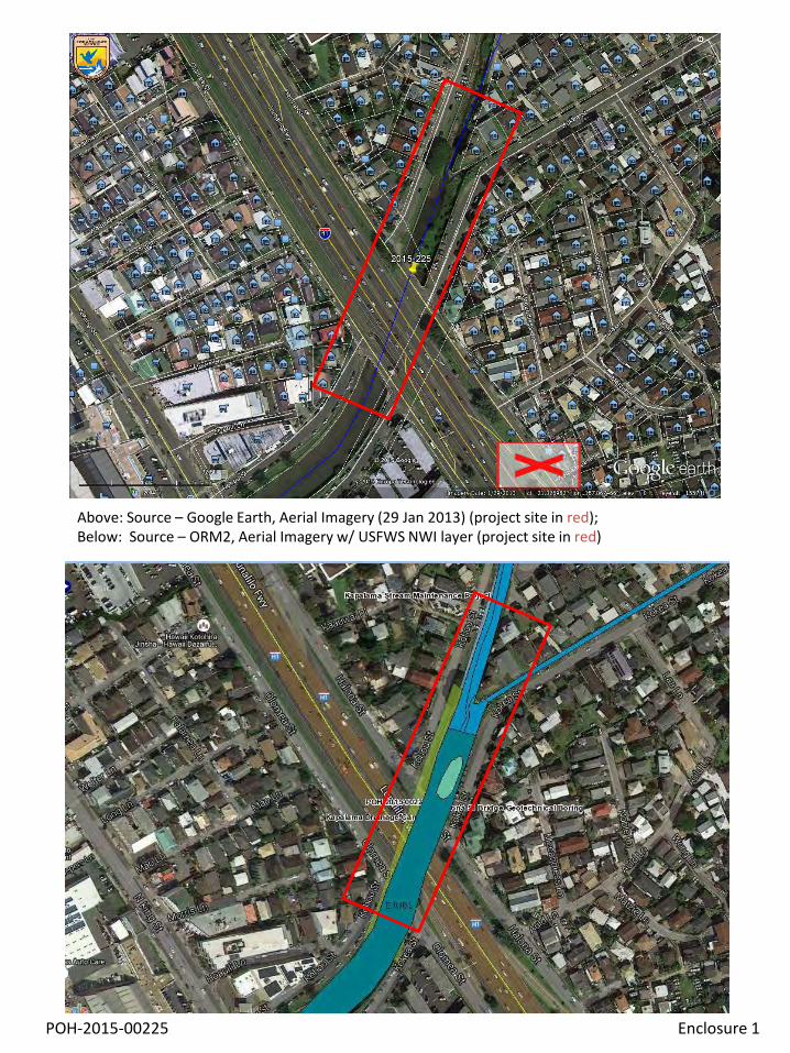
POH-2015-00225 Enclosure 1
Above: Source – Google Earth, Aerial Imagery (29 Jan 2013) (project site in red); Below: Source – ORM2, Aerial Imagery w/ USFWS NWI layer (project site in red)
Oahu

(b) General Tributary Characteristics (check all that apply): Tributary is: Natural Artificial (man-made). Explain: . Manipulated (man-altered). Explain: .
Tributary properties with respect to top of bank (estimate):
Average width: feet Average depth: feet Average side slopes: Pick List. Primary tributary substrate composition (check all that apply):
Silts Sands Concrete Cobbles Gravel Muck Bedrock Vegetation. Type/% cover: Other. Explain: . Tributary condition/stability [e.g., highly eroding, sloughing banks]. Explain: . Presence of run/riffle/pool complexes. Explain: . Tributary geometry: Pick List Tributary gradient (approximate average slope): % (c) Flow: Tributary provides for: Pick List Estimate average number of flow events in review area/year: Pick List Describe flow regime: . Other information on duration and volume: . Surface flow is: Pick List. Characteristics: . Subsurface flow: Pick List. Explain findings: . Dye (or other) test performed: . Tributary has (check all that apply): Bed and banks OHWM6 (check all indicators that apply):
clear, natural line impressed on the bank the presence of litter and debris changes in the character of soil destruction of terrestrial vegetation shelving the presence of wrack line vegetation matted down, bent, or absent sediment sorting leaf litter disturbed or washed away scour sediment deposition multiple observed or predicted flow events water staining abrupt change in plant community other (list):
Discontinuous OHWM.7 Explain: .
If factors other than the OHWM were used to determine lateral extent of CWA jurisdiction (check all that apply): High Tide Line indicated by: Mean High Water Mark indicated by:
oil or scum line along shore objects survey to available datum; fine shell or debris deposits (foreshore) physical markings; physical markings/characteristics vegetation lines/changes in vegetation types. tidal gauges other (list):
(iii) Chemical Characteristics:
Characterize tributary (e.g., water color is clear, discolored, oily film; water quality; general watershed characteristics, etc.). Explain: .
Identify specific pollutants, if known: .
6A natural or man-made discontinuity in the OHWM does not necessarily sever jurisdiction (e.g., where the stream temporarily flows underground, or where the OHWM has been removed by development or agricultural practices). Where there is a break in the OHWM that is unrelated to the waterbody’s flow regime (e.g., flow over a rock outcrop or through a culvert), the agencies will look for indicators of flow above and below the break. 7Ibid.
POH-2015-00225 1 Enclosure 2
J3RO9JNA
Highlight
J3RO9JNA
Highlight
J3RO9JNA
Highlight
J3RO9JNA
Highlight
J3RO9JNA
Highlight

PRODUCTS(/products.html) Data, Analyses, and Publications
PROGRAMS(/programs.html) Serving the Nation
EDUCATION(/education.html) Tides, Currents, and Predictions
HELP & ABOUT(/about.html) Info and how to reach us
There is a scheduled power outage which will affect CO-OPS' Tides and Currents web site (http://tidesandcurrents.noaa.gov/) beginning on Friday, December 4th, at 2:00 P.M, EST. During this time, the Tides and Currents website will have limited capability. Click here for more information (/coop_notice.html).
Meteorological Obs. (/met.html?id=1612340) Phys. Oceanography (/physocean.html?id=1612340)
Station: 1612340, Honolulu, HIStatus: Accepted (Apr 17 2003)Units: Feet
T.M.: 150Epoch: (/datum_options.html#NTDE)1983-2001Datum: STND
Elevations on Station Datum
Datum Value Description
MHHW(/datum_options.html#MHHW)
5.71 Mean Higher-High Water
MHW(/datum_options.html#MHW)
5.25 Mean High Water
MTL (/datum_options.html#MTL) 4.61 Mean Tide Level
MSL (/datum_options.html#MSL) 4.63 Mean Sea Level
DTL (/datum_options.html#DTL) 4.76 Mean Diurnal Tide Level
MLW (/datum_options.html#MLW) 3.97 Mean Low Water
MLLW(/datum_options.html#MLLW)
3.81 Mean Lower-Low Water
Ortho (/datum_options.html)
STND(/datum_options.html#STND)
0.00 Station Datum
GT (/datum_options.html#GT) 1.90 Great Diurnal Range
MN (/datum_options.html#MN) 1.28 Mean Range of Tide
DHQ (/datum_options.html#DHQ) 0.46 Mean Diurnal High Water Inequality
DLQ (/datum_options.html#DLQ) 0.16 Mean Diurnal Low Water Inequality
HWI (/datum_options.html#HWI) 2.09 Greenwich High Water Interval (in hours)
LWI (/datum_options.html#LWI) 8.34 Greenwich Low Water Interval (in hours)
Maximum 7.20 Highest Observed Water Level
Max Date & Time 02/14/1967 06:54
Highest Observed Water Level Date and Time
Minimum 2.40 Lowest Observed Water Level
Min Date & Time 04/30/1911 10:00
Lowest Observed Water Level Date and Time
HAT (/datum_options.html#HAT) 6.59 Highest Astronomical Tide
HAT Date & Time 12/02/1990 14:06
HAT Date and Time
LAT (/datum_options.html#LAT) 3.30 Lowest Astronomical Tide
Showing datums for
Data Units
Epoch
Feet
Meters
Present (1983-2001)
Superseded (1960-1978)
Submit
Datums for 1612340, Honolulu HI
Home (/) / Products (products.html) / Datums (stations.html?type=Datums) / 1612340 Honolulu, HI
Station Info Tides/Water Levels
1.9
MHHW: 5.71
MHW: 5.25
DTL: 4.76
MTL: 4.61MSL: 4.63
MLW: 3.97MLLW: 3.81
Datums
3.5
4
4.5
5
5.5
6
NOAA/NOS/CO-OPS
Datums for 1612340, Honolulu, HIAll figures in feet relative to station datum
Page 1 of 2
POH-2015-00225 1 Enclosure 3

Datum Value Description
LAT Date & Time 05/24/1990 18:54
LAT Date and Time
Tidal Datum Analysis Periods
01/01/1983 - 12/31/2001
To refer water level heights to NAVD88 (North American Vertical Datum of 1988), apply the values located at National Geodetic Survey(http://www.ngs.noaa.gov/Tidal_Elevation/diagram.jsp?PID=TU0286&EPOCH=1983-2001).
TIDES/WATER LEVELS
Water Levels (/waterlevels.html?id=1612340)
NOAA Tide Predictions(/noaatidepredictions/NOAATidesFacade.jsp?Stationid=1612340)
Harmonic Constituents (/harcon.html?id=1612340)
Sea Level Trends (/sltrends/sltrends_station.shtml?stnid=1612340)
Datums (/datums.html?id=1612340)
Bench Mark Sheets (/benchmarks.html?id=1612340)
Extreme Water Levels ( /est/est_station.shtml?stnid=1612340)
Reports (/reports.html?id=1612340)
METEOROLOGICAL/OTHER
Meteorological Observations (/met.html?id=1612340)
Water Temp/Conductivity
PORTS
This station is not a member of PORTS
OPERATIONAL FORECAST SYSTEMS
This station is not a member of OFS
INFORMATION
Station Home Page (/stationhome.html?id=1612340)
Data Inventory (/inventory.html?id=1612340)
Measurement Specifications (/measure.html)
Products available at 1612340 Honolulu, HI
InformationAbout CO-OPS(/about.html)Disclaimers(/disclaimers.html)Contact Us (/contact.html)Privacy Policy(/privacy.html)
ProductsPORTS (/ports.html)OFS (/models.html)Tide Predictions(/tide_predictions.html)Currents(/cdata/StationList?type=Current+Data&filter=active)More about products...(/products.html)
ProgramsMapping and Charting Support (/mapping.html)Maritime Services(/maritime.html)COASTAL (/coastal.html)More about programs...(/programs.html)
PartnersHydrographic Survey Support (/hydro.html)Marsh Restoration(/marsh.html)GoMOOS (/gomoos.html)TCOON (/tcoon.html)
Revised: 10/15/2013NOAA (http://www.noaa.gov) / National Ocean Service(http://oceanservice.noaa.gov)Web site owner: Center for Operational Oceanographic Products and Services
®
®
Page 2 of 2
POH-2015-00225 2 Enclosure 3
US Army Corps of Engineers, Honolulu District
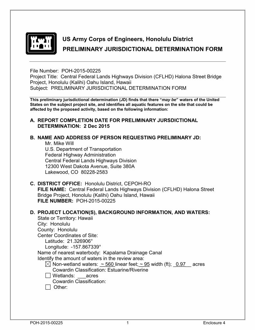
PRELIMINARY JURISDICTIONAL DETERMINATION FORM File Number: POH-2015-00225 Project Title: Central Federal Lands Highways Division (CFLHD) Halona Street Bridge Project, Honolulu (Kalihi) Oahu Island, Hawaii Subject: PRELIMINARY JURISDICTIONAL DETERMINATION FORM This preliminary jurisdictional determination (JD) finds that there “may be” waters of the United States on the subject project site, and identifies all aquatic features on the site that could be affected by the proposed activity, based on the following information: A. REPORT COMPLETION DATE FOR PRELIMINARY JURSDICTIONAL
DETERMINATION: 2 Dec 2015
B. NAME AND ADDRESS OF PERSON REQUESTING PRELIMINARY JD: Mr. Mike Will U.S. Department of Transportation Federal Highway Administration Central Federal Lands Highways Division 12300 West Dakota Avenue, Suite 380A Lakewood, CO 80228-2583
C. DISTRICT OFFICE: Honolulu District, CEPOH-RO
FILE NAME: Central Federal Lands Highways Division (CFLHD) Halona Street Bridge Project, Honolulu (Kalihi) Oahu Island, Hawaii
FILE NUMBER: POH-2015-00225 D. PROJECT LOCATION(S), BACKGROUND INFORMATION, AND WATERS:
State or Territory: Hawaii City: Honolulu County: Honolulu Center Coordinates of Site:
Latitude: 21.326906° Longitude: -157.867339°
Name of nearest waterbody: Kapalama Drainage Canal Identify the amount of waters in the review area:
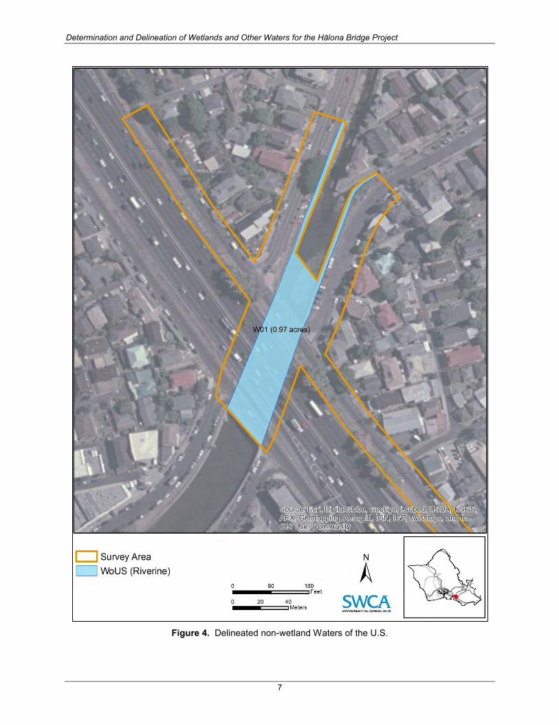
Non-wetland waters: ~ 560 linear feet; ~ 95 width (ft); _0.97__ acres Cowardin Classification: Estuarine/Riverine
Wetlands: ___acres Cowardin Classification:
Other:
POH-2015-00225
1
Enclosure 4

Name of any water bodies on the site that have been identified as Section 10 waters: Tidal: Kapalama Drainage Canal Non-Tidal: Kapalama Drainage Canal
E. REVIEW PERFORMED FOR SITE EVALUATION:
Office (Desk) Determination. Date: 1 Dec 2015 Field Determination. Date(s):
F. EXPLANATION OF PRELIMINARY AND APPROVED JURISDICTIONAL
DETERMINATIONS: 1. The Corps of Engineers believes that there may be jurisdictional waters of the
United States on the subject site, and the permit applicant or other affected party who requested this preliminary JD is hereby advised of his or her option to request and obtain an approved jurisdictional determination (JD) for that site. Nevertheless, the permit applicant or other person who requested this preliminary JD has declined to exercise the option to obtain an approved JD in this instance and at this time.
2. In any circumstance where a permit applicant obtains an individual permit, or a Nationwide General Permit (NWP) or other general permit verification requiring “pre-construction notification” (PCN), or requests verification for a non-reporting NWP or other general permit, and the permit applicant has not requested an approved JD for the activity, the permit applicant is hereby made aware of the following: (1) the permit applicant has elected to seek a permit authorization based on a preliminary JD, which does not make an official determination of jurisdictional waters; (2) that the applicant has the option to request an approved JD before accepting the terms and conditions of the permit authorization, and that basing a permit authorization on an approved JD could possibly result in less compensatory mitigation being required or different special conditions; (3) that the applicant has the right to request an individual permit rather than accepting the terms and conditions of the NWP or other general permit authorization; (4) that the applicant can accept a permit authorization and thereby agree to comply with all the terms and conditions of that permit, including whatever mitigation requirements the Corps has determined to be necessary; (5) that undertaking any activity in reliance upon the subject permit authorization without requesting an approved JD constitutes the applicant’s acceptance of the use of the preliminary JD, but that either form of JD will be processed as soon as is practicable; (6) accepting a permit authorization (e.g., signing a proffered individual permit) or undertaking any activity in reliance on any form of Corps permit authorization based on a preliminary JD constitutes agreement that all wetlands and other water bodies on the site affected in any way by that activity are jurisdictional waters of the United States, and precludes any challenge to such jurisdiction in any administrative or judicial compliance or enforcement action, or in any administrative appeal or in any Federal court; and (7) whether the applicant elects to use either an approved JD or a preliminary JD, that JD
POH-2015-00225
2
Enclosure 4

will be processed as soon as is practicable. Further, an approved JD, a proffered individual permit (and all terms and conditions contained therein), or individual permit denial can be administratively appealed pursuant to 33 C.F.R. Part 331, and that in any administrative appeal, jurisdictional issues can be raised (see 33 C.F.R. 331.5(a)(2)). If, during that administrative appeal, it becomes necessary to make an official determination whether CWA jurisdiction exists over a site, or to provide an official delineation of jurisdictional waters on the site, the Corps will provide an approved JD to accomplish that result, as soon as is practicable.
G. SUPPORTING DATA:
Data reviewed for preliminary JD (check all that apply - checked items should be included in case file and, where checked and requested, appropriately reference sources below):
Maps, plans, plots or plat submitted by or on behalf of the applicant/consultant: CFLHD project letter, dated 28 Oct 2015, and SWCA WOUS report, dated Mar 2015.
Data sheets prepared/submitted by or on behalf of the applicant/consultant. Office concurs with data sheets/delineation report. Office does not concur with data sheets/delineation report.
Data sheets prepared by the Corps: . Corps navigable waters’ study: . U.S. Geological Survey Hydrologic Atlas:
USGS NHD data. USGS 8 and 12 digit HUC maps.
U.S. Geological Survey map(s). Cite quad name: Honolulu Quad, 7.5 min series USDA Natural Resources Conservation Service Soil Survey. Citation: National wetlands inventory map(s). Cite name: USFWS NWI e-mapper State/Local wetland inventory map(s): . FEMA/FIRM maps: 100-year Floodplain Elevation is: (National Geodectic Vertical Datum of 1929) Photographs: Aerial (Name & Date): Aerial imagery, 29 Jan 2013
or Other (Name & Date): 11 Sep 2014 photos in SWCA WOUS report, dated Mar 2015
Previous determination(s). File no. and date of response letter: . Other information (please specify): Waolani Stream HUC 200600000304 /
12606.462772 sq ac
IMPORTANT NOTE: The information recorded on this form has not necessarily been verified by the Corps and should not be relied upon for later jurisdictional determinations. __//s// Joy Anamizu, 2 Dec 2015 __________________________ Signature and date of Signature and date of Regulatory Project Manager person requesting preliminary JD (REQUIRED) (REQUIRED, unless obtaining the signature is impracticable)
POH-2015-00225
3
Enclosure 4
Determination and Delineation of Wetlands and Other Waters of the U.S. for the Hālona Bridge Project Kalihi, Oʻahu Island, Hawai‘i
Prepared for
CH2M HILL
Prepared by
SWCA Environmental Consultants
March 2015
DETERMINATION AND DELINEATION OF WETLANDS AND OTHER WATERS OF THE U.S. FOR THE HĀLONA BRIDGE
PROJECT
KALIHI, OʻAHU ISLAND, HAWAI‘I
Prepared for
CH2M HILL 1132 Bishop Street, Suite 1100
Honolulu, Hawai‘i 96813 (808) 943-1133
Prepared by
SWCA Environmental Consultants
Bishop Square ASB Tower 1001 Bishop Street, Suite 2800
Honolulu, Hawai‘i (808) 548-7899 www.swca.com
SWCA Project No. 27166
Submitted November 11, 2014 Revised March 20, 2015
Determination and Delineation of Wetlands and Other Waters for the Hālona Bridge Project
i
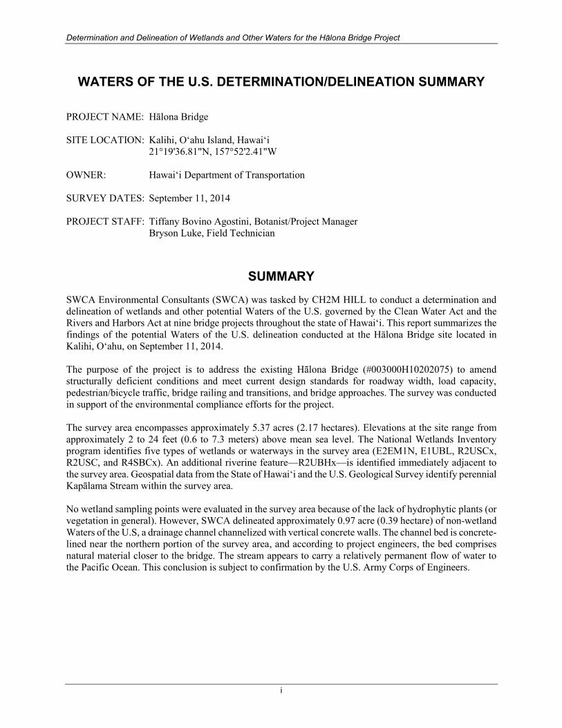
WATERS OF THE U.S. DETERMINATION/DELINEATION SUMMARY
PROJECT NAME: Hālona Bridge SITE LOCATION: Kalihi, Oʻahu Island, Hawai‘i 21°19'36.81"N, 157°52'2.41"W OWNER: Hawaiʻi Department of Transportation
SURVEY DATES: September 11, 2014 PROJECT STAFF: Tiffany Bovino Agostini, Botanist/Project Manager Bryson Luke, Field Technician
SUMMARY
SWCA Environmental Consultants (SWCA) was tasked by CH2M HILL to conduct a determination and delineation of wetlands and other potential Waters of the U.S. governed by the Clean Water Act and the Rivers and Harbors Act at nine bridge projects throughout the state of Hawaiʻi. This report summarizes the findings of the potential Waters of the U.S. delineation conducted at the Hālona Bridge site located in Kalihi, Oʻahu, on September 11, 2014. The purpose of the project is to address the existing Hālona Bridge (#003000H10202075) to amend structurally deficient conditions and meet current design standards for roadway width, load capacity, pedestrian/bicycle traffic, bridge railing and transitions, and bridge approaches. The survey was conducted in support of the environmental compliance efforts for the project. The survey area encompasses approximately 5.37 acres (2.17 hectares). Elevations at the site range from approximately 2 to 24 feet (0.6 to 7.3 meters) above mean sea level. The National Wetlands Inventory program identifies five types of wetlands or waterways in the survey area (E2EM1N, E1UBL, R2USCx, R2USC, and R4SBCx). An additional riverine feature—R2UBHx—is identified immediately adjacent to the survey area. Geospatial data from the State of Hawai‘i and the U.S. Geological Survey identify perennial Kapālama Stream within the survey area. No wetland sampling points were evaluated in the survey area because of the lack of hydrophytic plants (or vegetation in general). However, SWCA delineated approximately 0.97 acre (0.39 hectare) of non-wetland Waters of the U.S, a drainage channel channelized with vertical concrete walls. The channel bed is concrete-lined near the northern portion of the survey area, and according to project engineers, the bed comprises natural material closer to the bridge. The stream appears to carry a relatively permanent flow of water to the Pacific Ocean. This conclusion is subject to confirmation by the U.S. Army Corps of Engineers.

Determination and Delineation of Wetlands and Other Waters for the Hālona Bridge Project
ii
This page intentionally blank

Determination and Delineation of Wetlands and Other Waters for the Hālona Bridge Project
iii
CONTENTS
1.0 INTRODUCTION ................................................................................................................................. 1
2.0 DESCRIPTION OF THE SURVEY AREA ....................................................................................... 1
2.1 Location and Vicinity .......................................................................................................................... 1
2.2 Topography and Soils ......................................................................................................................... 3
2.3 Hydrology ........................................................................................................................................... 3
2.4 Flora and Fauna ................................................................................................................................... 3
3.0 METHODOLOGY ............................................................................................................................... 6
4.0 FINDINGS ............................................................................................................................................. 6
4.1 Non-Wetland Waters ........................................................................................................................... 6
4.2 Wetlands ............................................................................................................................................. 9
5.0 CONCLUSIONS ................................................................................................................................... 9
6.0 LITERATURE CITED ...................................................................................................................... 10
FIGURES
Figure 1. Location of the survey area. ......................................................................................................... 2 Figure 2. Soil types within the survey area ................................................................................................. 4 Figure 3. National Wetland Inventory classifications near the survey area. ............................................... 5 Figure 4. Delineated non-wetland Waters of the U.S. ................................................................................ 7 Figure 5. Kapālama Stream looking upstream from the bridge. ................................................................. 8 Figure 6. Kapālama Stream looking downstream toward the bridge. ......................................................... 8
Determination and Delineation of Wetlands and Other Waters for the Hālona Bridge Project
iv
ABBREVIATIONS
CFR Code of Federal Regulations CWA Clean Water Act ha hectare(s) m meter(s) MHW Mean High Water MHHW Mean Higher High Water
mm millimeter(s) NRCS Natural Resources Conservation Service NWI National Wetlands Inventory RHA Rivers and Harbors Act SWCA SWCA Environmental Consultants USACE U.S. Army Corps of Engineers WoUS Waters of the U.S.

Determination and Delineation of Wetlands and Other Waters for the Hālona Bridge Project
1
1.0 INTRODUCTION
The U.S. Army Corps of Engineers (USACE) derives its regulatory authority over wetlands and other Waters of the U.S. (WoUS) from two federal laws: 1) Section 10 of the Rivers and Harbors Act (RHA) of 1899 and 2) Section 404 of the Clean Water Act (CWA) of 1972. The RHA of 1899 prevents unauthorized obstruction or alteration of navigable WoUS. Navigable waters are defined as “subject to the ebb and flow of the tide and/or presently used, or have been used in the past, or may be susceptible for use to transport interstate or foreign commerce” (33 Code of Federal Regulations [CFR] 325.5(c)(2)). A Section 10 permit is required for non-fill discharging activities proposed within, over, or under WoUS. The limits of jurisdiction for tidally influenced navigable waters extend to the Mean High Water (MHW) line or High Tide Line. A more conservative approach than the MHW, the Mean Higher High Water (MHHW) line, is often used. Under Section 404 of the CWA, dredged and fill material may not be discharged into jurisdictional WoUS (including wetlands) without a permit. According to 40 CFR 230.3, WoUS subject to agency jurisdiction under Section 404 include navigable waters and their tributaries, interstate waters and their tributaries, wetlands adjacent to these waters, and impoundments of these waters. In addition, waters are protected by the CWA if determined to have a “significant nexus” with a traditional navigable water or interstate water (Environmental Protection Agency and USACE 2011). The U.S. Supreme Court’s decision in the consolidated cases Rapanos v. United States and Carabell v. United States (126 S. Ct. 2208) provides further information regarding whether a wetland or tributary is a WoUS. A Section 404 permit is required for all fill or discharge activities below (seaward or makai) of the MHW/MHHW line or High Tide Line in tidal waters or ordinary high water mark (OHWM) for non-tidal, non-wetland waters. The USACE (33 CFR 230.3) and U.S. Environmental Protection Agency (40 CFR 230.3) define wetlands as “those areas that are inundated or saturated by surface or groundwater at a frequency and duration sufficient to support, and that under normal circumstances do support, a prevalence of vegetation typically adapted for life in saturated soil conditions” (40 CFR 232.3). The 1987 Corps of Engineers Wetlands Delineation Manual (USACE 1987 Manual; USACE 1987), as amended, outlines the technical guidelines and methods for identifying and delineating wetlands potentially subject to Section 404. This manual is supplemented by the 2012 Regional Supplement to the Corps of Engineers Wetland Delineation Manual: Hawai‘i and Pacific Islands Region (Hawai‘i and Pacific Island Regional Supplement; USACE 2012). CH2M HILL is reviewing the proposed Hālona Bridge project (hereafter project) pursuant to Section 10 of the RHA and Section 404 of the CWA. The purpose of the project is to address the existing Hālona Bridge (#003000H10202075) to amend structurally deficient conditions and meet current design standards for roadway width, load capacity, pedestrian/bicycle traffic, bridge railing and transitions, and bridge approaches. The survey was conducted in support of the environmental compliance efforts for the project.
2.0 DESCRIPTION OF THE SURVEY AREA
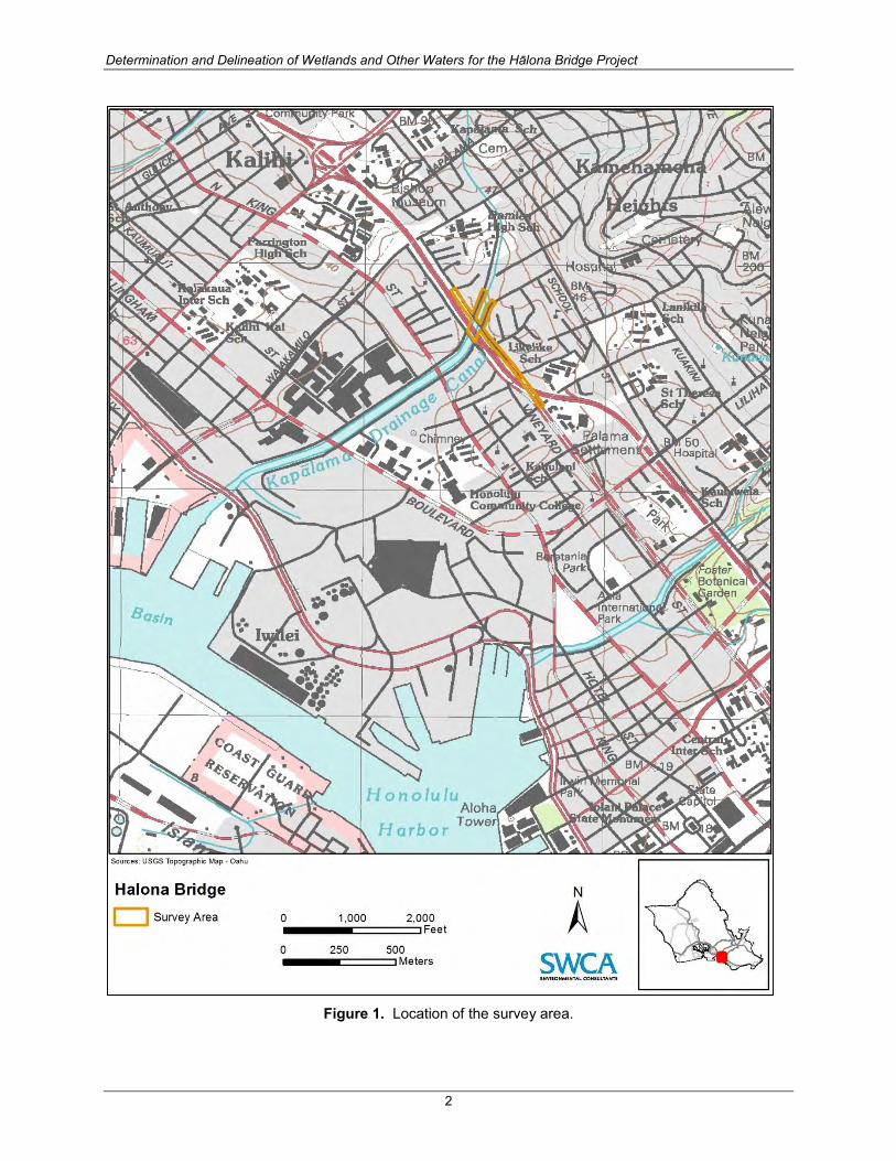
2.1 Location and Vicinity The Hālona Bridge site is in the Kalihi area on the Island of O‘ahu. The survey area encompasses Hālona Street from Kaauwai Place to Palama Street, a segment of the Interstate Route H-1 (Lunalilo Freeway), and portions of Kokea Street and Kohou Street (Figure 1). It covers approximately 5.37 acres (2.17 hectares [ha]). The surrounding area is predominantly residential.
Determination and Delineation of Wetlands and Other Waters for the Hālona Bridge Project
2
Figure 1. Location of the survey area.

Determination and Delineation of Wetlands and Other Waters for the Hālona Bridge Project
3
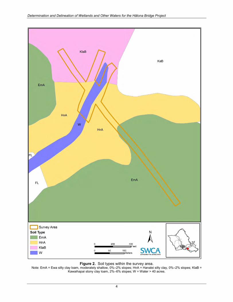
2.2 Topography and Soils Most of the survey area is relatively flat. Elevations at the site range from roughly 2 to 24 feet (0.6 to 7.3 meters [m]) above sea level. The Natural Resources Conservation Service (NRCS) identifies the following four soil types within the survey area: Kawaihapai stony clay loam, 2%–6% slopes (KlaB); Hanalei silty clay, 0%–2% slopes (HnA); Ewa silty clay loam, moderately shallow, 0%–2% slopes (EmA); and Water > 40 acres (W) (Foote et al. 1972; NRCS 2013) (Figure 2). The Hanalei silty clay, 0%–2% slopes soil type is listed as a hydric soil (NRCS 2012). Most of the survey area is covered in asphalt concrete-paved roadways.
2.3 Hydrology
Mean annual rainfall for this area is approximately 37 inches (940 millimeters [mm]). Rainfall is typically highest in November–December and lowest in June–August (Giambelluca et al. 2013). The closest rainfall gage to the site has experienced slightly above-average rainfall for 2014 through the end of September (National Oceanic and Atmospheric Administration/National Weather Service, Weather Forecast Office Honolulu 2014). The National Wetlands Inventory (NWI) program identifies five wetlands or waterways in the survey area (Figure 3). These comprise E2EM1N (Estuarine, Intertidal, Emergent, Persistent, Regularly Flooded), E1UBL (Estuarine, Subtidal, Unconsolidated bottom), R2USCx (Riverine, Lower Perennial, Unconsolidated Shore, Seasonally Flooded, Excavated), R2USC (Riverine, Lower Perennial, Unconsolidated Shore, Seasonally Flooded), and R4SBCx (Riverine, Intermittent, Streambed, Seasonally Flooded, Excavated). An additional Riverine feature—R2UBHx (Riverine, Lower Perennial, Unconsolidated Bottom, Permanently Flooded, Excavated)—is identified by the NWI program immediately adjacent to the survey area (Figure 3). The State of Hawai‘i and the U.S. Geological Survey identify Kapālama Stream (or Kapālama Drainage Canal) transversing the survey area (see Figure 1). The total length of this perennial stream is approximately 5.6 miles (9 kilometers) according to the Atlas of Hawaiian Watersheds & Their Aquatic Resources (Parham et al. 2008). Kapālama Stream is listed as a 303(d) Impaired Waterbody. The following are listed as the causes of impairment: total nitrogen, total phosphorus, nitrate/nitrite, trash, and turbidity (Hawaiʻi State Department of Health 2014).
2.4 Flora and Fauna Flora and fauna surveys of the survey area were conducted by SWCA on the same date as the WoUS survey. Vegetation types identified during that survey include weedy vegetation and ornamental landscaping. The site is dominated by non-native plants, and no listed plant species were seen (SWCA 2014). One state-listed animal species, the threatened white tern (Gygis alba), was observed transiting above the survey area. White terns are listed under Hawai‘i Revised Statutes (HRS) 195D as threatened on O‘ahu Island only. The endangered Hawaiian hoary bat or ‘ōpe‘ape‘a (Lasiurus cinereus semotus) may pass through the site or may use adjacent trees as roosting sites, but impacts to this species are not expected to occur so long as trees are not removed as a result of the project (SWCA 2014).
Determination and Delineation of Wetlands and Other Waters for the Hālona Bridge Project
4
Figure 2. Soil types within the survey area.
Note: EmA = Ewa silty clay loam, moderately shallow, 0%–2% slopes; HnA = Hanalei silty clay, 0%–2% slopes; KlaB = Kawaihapai stony clay loam, 2%–6% slopes; W = Water > 40 acres.

Determination and Delineation of Wetlands and Other Waters for the Hālona Bridge Project
5
Figure 3. National Wetland Inventory classifications near the survey area.
Determination and Delineation of Wetlands and Other Waters for the Hālona Bridge Project
6
3.0 METHODOLOGY
Before visiting the survey area, aerial photographs and topographic maps were examined to identify potential wetlands or WoUS in or near the survey area. Information was also gleaned from the NWI program, NRCS hydric soil data, as well as previous water resource reports and environmental assessments/environmental impact statements. SWCA biologists conducted WoUS determination and delineation fieldwork on September 11, 2014. As stated above, the jurisdiction of tidal, non-wetland WoUS extends to the High Tide Line or MHW line. The High Tide Line is defined as the intersection of the land with the water's surface at the maximum height reached by a rising tide (33 CFR Part 328). MHW is defined as the average of the higher high water height of each tidal day observed over the National Tidal Datum Epoch. The MHW line is 0.62 feet (0.19 m) above mean sea level, and the MHHW is 1.08 feet (0.33 m) above mean sea level. However, because the stream contains vertical concrete walls and the wall height exceeds the MHW and MHHW, SWCA determined the jurisdictional boundary of the potential WoUS by mapping the top of the vertical concrete wall. The boundaries of the stream under the freeway were estimated by connecting the known boundaries of the stream at the existing bridge with the boundaries of the stream just north of Olomea Street. The geographic coordinates were collected in the field with Trimble GeoExplorer 2008 Series global positioning system (GPS) unit and data were post-processed in ArcGIS using GPS Correct to sub-meter accuracy. The linear length and acreage of the feature were calculated by projecting these point and line data files in a geographic information system.
4.0 FINDINGS
4.1 Non-Wetland Waters A single perennial stream (known as Kapālama Stream or Canal) was identified in the survey area (Figure 4). Approximately 0.97 acre (0.39 ha) of non-wetland WoUS were delineated within the survey area. The stream is channelized and entirely surrounded by urban development; thus, the original drainage course has been extensively modified. In the northern portion of the survey area, approximately 300 feet (91 m) upstream of the existing bridge, the channelized stream forks. The channel bed is concrete-lined in the immediate vicinity of the fork; however, according to project engineers, the channel bed comprises natural material closer to the bridge. Standing water was observed in the stream during the survey (Figures 5 and 6). Most of Kapālama Stream within the survey area was determined to be tidally influenced due to the presence of marine/estuarine fish (striped mullet [Mugil cephalus] and great barracuda [Sphyraena barracuda]) near the bridge and observed changes in water levels throughout the day. It is unknown how often water within the channelized forks is tidally influenced. According to NWI data, the unnamed right fork terminates before the intersection with North School Street (outside of the survey area). The left fork (named Kapālama Stream) continues mauka toward the Koʻolau Mountain Range. Downstream of the survey area, Kapālama Stream flows southwest between Kokea and Kohou Street and eventually empties into Honolulu Harbor roughly 0.8 mile (1.3 kilometers) from the survey area.
Determination and Delineation of Wetlands and Other Waters for the Hālona Bridge Project
7
Figure 4. Delineated non-wetland Waters of the U.S.

Determination and Delineation of Wetlands and Other Waters for the Hālona Bridge Project
8
Figure 5. Kapālama Stream looking upstream from the bridge.
Figure 6. Kapālama Stream looking downstream toward the bridge.

Determination and Delineation of Wetlands and Other Waters for the Hālona Bridge Project
9
4.2 Wetlands
No wetlands were identified within the survey area. Most of the survey area is composed of pavement and concrete. Vegetated areas are mowed grasses and ornamental trees, interspersed with various weeds. The only hydrophytic plants seen occur within the concrete-lined portion of the channel where sediment has accumulated along the edges of the concrete walls.
5.0 CONCLUSIONS SWCA surveyed and delineated a single perennial non-wetland WoUS (known as Kapālama Stream or Canal) within the survey area. The stream was noted to be tidal in the immediate vicinity of the bridge during the survey, connecting to the Honolulu Harbor. Because the bridge project involves non-fill discharging activities over a WoUS, a Section 10 permit will likely be required. If the proposed project intends to place dredged or fill material within the delineated feature (such as a bridge pillar), it could be subject to either a Section 10 or Section 404 Nationwide Permit (NWP). These conclusions are subject to confirmation by the USACE Honolulu District. The general rule regarding the State Section 401 water quality certification is, if the USACE identifies that a permit (NWP/LOP/SIP) under Section 404 is required, the applicant will likely need a Section 401 water quality certification from the State Department of Health Clean Water Branch (CWB). Often a 401 water quality certification is not required for Section 10 permits. If the CWB responds and requires a 401 water quality certification, it can take several months to a year to process. In addition, a Stream Channel Alteration Permit (SCAP) may be required from the Commission on Water Resource Management (CWRM), depending on the activities proposed. SWCA recommends submitting a Request for Determination (RFD) from CWRM. If a SCAP is required, the permit timeframe is 90 days.
Determination and Delineation of Wetlands and Other Waters for the Hālona Bridge Project
10
6.0 LITERATURE CITED Environmental Protection Agency and U.S. Army Corps of Engineers (USACE). 2011. Draft Guidance
on Identifying Waters Protected by the Clean Water Act. Available at: http://water.epa.gov/lawsregs/guidance/wetlands/upload/wous_guidance_4-2011.pdf. Accessed July 3, 2013.
Foote, D.E., E.L. Hill, S. Nakamura, and F. Stephens. 1972. Soil Survey of the Islands of Kaua‘i, O‘ahu,
Maui, Moloka‘i, and Lana‘i, State of Hawai‘i. U.S. Department of Agriculture, Soil Conservation Service.
Giambelluca, T.W., Q. Chen, A.G. Frazier, J.P. Price, Y.L. Chen, P.S. Chu, J.K. Eischeid, and D.M.
Delparte. 2013. Online Rainfall Atlas of Hawai‘i. Bull. Amer. Meteor. Soc. 94, 313–316, doi: 10.1175/BAMS-D-11-00228.1. Available at: http://rainfall.geography.hawaii.edu. Accessed on September 12, 2014.
Hawaiʻi State Department of Health. 2014. 2014 State of Hawaii Water Quality Monitoring and
Assessment Report. Integrated Report to the U.S. Environmental Protection Agency and the U.S. Congress Pursuant to Sections 303(D) and 305(B), Clean Water Act (Public Law 97-117).
Lichvar, R.W. 2012. The National Wetland Plant List. ERDC/CRREL TR-12-11. Hanover, New
Hampshire: U.S. Army Corps of Engineers, Cold Regions Research and Engineering Laboratory. Available at: http://acwc.sdp.sirsi.net/client/search/asset:asset?t:ac=$N/1012381. Accessed December 10, 2012.
———. 2013. The National Wetland Plant List: 2013 wetland ratings. Phytoneuron 2013(49):1–241. Lichvar, R., N. Melvin, M. Butterwick, and W. Kirchner. 2012. National Wetland Plant List indicator
rating definitions. ERDC/CRREL TN-12-1. Hanover, New Hampshire: U.S. Army Engineer Research and Development Center, Cold Regions Research and Engineering Laboratory. Available at: http://www.fws.gov/wetlands/documents/National-Wetland-Plant-List-Indicator-Rating-Definitions.pdf. Accessed December 10, 2012.
National Oceanic and Atmospheric Administration/National Weather Service, Weather Forecast Office
Honolulu. 2014. Hydrology in Hawai‘i. Available at: http://www.prh.noaa.gov/hnl/hydro/pages/sep14sum.php . Accessed on October 15, 2014.
Natural Resources Conservation Service (NRCS). 2012. Hydric Soils State Lists, Hydric Soils of Hawai‘i.
Available at: ftp://ftp-fc.sc.egov.usda.gov/NSSC/Hydric_Soils/Lists/hydric_soils.xlsx. Accessed December 7, 2012.
———. 2013. Web Soil Survey. Available at: http://websoilsurvey.nrcs.usda.gov/. Accessed October 16,
2014. Parham, J.E., G.R. Higashi, E.K. Lapp, D.G. K. Kuamoo, R.T. Nishimoto, S. Hau, J.M. Fitzsimons,
D.A. Polhemus, and W.S. Devick. 2008. Atlas of Hawaiian Watersheds & Their Aquatic Resources. Copyrighted website published by the Hawaii Division of Aquatic Resources, Department of Land and Natural Resources. Available at: www.hawaiiwatershedatlas.com. Accessed April 9, 2013.

Determination and Delineation of Wetlands and Other Waters for the Hālona Bridge Project
11
SWCA. 2014. Biological Resource Assessment for the Hālona Bridge Project. Draft Submitted to CH2M HILL October 20, 2014.
U.S. Army Corps of Engineers (USACE). 1987. Corps of Engineers Wetlands Delineation Manual.
Wetlands Research Program Technical Report Y-87-1 (online edition). Vicksburg, Mississippi: U.S. Army Engineer Waterways Experiment Station. Available at: http://el.erdc.usace.army.mil/wetlands/pdfs/wlman87.pdf. Accessed December 10, 2012.
———. 2012. Regional Supplement to the Corps of Engineers Wetland Delineation Manual: Hawai‘i
and Pacific Islands Region Version 2.0, edited by J.F. Berkowitz, J.S. Wakeley, R.W. Lichvar, and C.V. Noble. ERDC/EL TR-12-5. Vicksburg, Mississippi: U.S. Army Engineer Research and Development Center.

Determination and Delineation of Wetlands and Other Waters for the Hālona Bridge Project
12
This page intentionally blank

Appendix B Summary of EDR Radius Map Report™ with
GeoCheck®, May (1, &'()

FORM-NULL-PVC
tropeR paM suidaR yrammuS RDE
6 Armstrong Road, 4th floorShelton, CT 06484Toll Free: 800.352.0050www.edrnet.com
Halona BridgeLunalilo Freeway/Kohou StreetHonolulu, HI 96817
Inquiry Number: 4293163.2sMay 13, 2015

SECTION PAGE
Executive Summary ES1
Overview Map 2
Detail Map 3
Map Findings Summary 4
Map Findings 7
Orphan Summary 215
Government Records Searched/Data Currency Tracking GR-1
GEOCHECK ADDENDUM
Physical Setting Source Addendum A-1
Physical Setting Source Summary A-2
Physical Setting SSURGO Soil Map A-5
Physical Setting Source Map A-15
Physical Setting Source Map Findings A-17
Physical Setting Source Records Searched PSGR-1
TC4293163.2s Page 1
Thank you for your business.Please contact EDR at 1-800-352-0050
with any questions or comments.
Disclaimer - Copyright and Trademark Notice
This Report contains certain information obtained from a variety of public and other sources reasonably available to Environmental DataResources, Inc. It cannot be concluded from this Report that coverage information for the target and surrounding properties does not exist fromother sources. NO WARRANTY EXPRESSED OR IMPLIED, IS MADE WHATSOEVER IN CONNECTION WITH THIS REPORT. ENVIRONMENTALDATA RESOURCES, INC. SPECIFICALLY DISCLAIMS THE MAKING OF ANY SUCH WARRANTIES, INCLUDING WITHOUT LIMITATION,MERCHANTABILITY OR FITNESS FOR A PARTICULAR USE OR PURPOSE. ALL RISK IS ASSUMED BY THE USER. IN NO EVENT SHALLENVIRONMENTAL DATA RESOURCES, INC. BE LIABLE TO ANYONE, WHETHER ARISING OUT OF ERRORS OR OMISSIONS, NEGLIGENCE,ACCIDENT OR ANY OTHER CAUSE, FOR ANY LOSS OF DAMAGE, INCLUDING, WITHOUT LIMITATION, SPECIAL, INCIDENTAL,CONSEQUENTIAL, OR EXEMPLARY DAMAGES. ANY LIABILITY ON THE PART OF ENVIRONMENTAL DATA RESOURCES, INC. IS STRICTLYLIMITED TO A REFUND OF THE AMOUNT PAID FOR THIS REPORT. Purchaser accepts this Report "AS IS". Any analyses, estimates, ratings,environmental risk levels or risk codes provided in this Report are provided for illustrative purposes only, and are not intended to provide, norshould they be interpreted as providing any facts regarding, or prediction or forecast of, any environmental risk for any property. Only a Phase IEnvironmental Site Assessment performed by an environmental professional can provide information regarding the environmental risk for anyproperty. Additionally, the information provided in this Report is not to be construed as legal advice.
Copyright 2015 by Environmental Data Resources, Inc. All rights reserved. Reproduction in any media or format, in wholeor in part, of any report or map of Environmental Data Resources, Inc., or its affiliates, is prohibited without prior written permission.
EDR and its logos (including Sanborn and Sanborn Map) are trademarks of Environmental Data Resources, Inc. or its affiliates. All othertrademarks used herein are the property of their respective owners.
TABLE OF CONTENTS

EXECUTIVE SUMMARY
TC4293163.2s EXECUTIVE SUMMARY 1
A search of available environmental records was conducted by Environmental Data Resources, Inc (EDR).The report was designed to assist parties seeking to meet the search requirements of EPA’s Standardsand Practices for All Appropriate Inquiries (40 CFR Part 312), the ASTM Standard Practice forEnvironmental Site Assessments (E 1527-13) or custom requirements developed for the evaluation ofenvironmental risk associated with a parcel of real estate.
TARGET PROPERTY INFORMATION
ADDRESS
LUNALILO FREEWAY/KOHOU STREETHONOLULU, HI 96817
COORDINATES
21.3266000 - 21˚ 19’ 35.76’’Latitude (North): 157.8675000 - 157˚ 52’ 3.00’’Longitude (West): Zone 4Universal Tranverse Mercator: 617448.9UTM X (Meters): 2358577.2UTM Y (Meters): 3 ft. above sea levelElevation:
USGS TOPOGRAPHIC MAP ASSOCIATED WITH TARGET PROPERTY
TP Target Property:USGS 7.5 min quad indexSource:
W Target Property:USGS 7.5 min quad indexSource:
4293163.2s Page 2
J37 FUTURE HONOLULU FORD CORNER OF HOUGHTAILI HI LUST, HI UST Higher 1424, 0.270, WNW
I36 TAKAMIYA PROPERTY 850 MOOWAA ST. CERCLIS Higher 1371, 0.260, West
I35 I. STEVEN SUNADA 850 MOOWAA ST HI LUST, HI UST Higher 1371, 0.260, West
I34 TAKAMIYA PROPERTY 850 MOOWAA ST HI SHWS, HI SPILLS Higher 1371, 0.260, West
H33 JBL HAWAII, LTD 905 KOKEA ST HI SHWS, HI ENG CONTROLS, HI INST CONTROL Higher 1291, 0.245, SW
H32 JBL HAWAII LTD 905 KOKEA ST HI LUST, HI UST Higher 1291, 0.245, SW
H31 HAWAII HOCHI LTD 917 KOKEA ST RCRA-CESQG, FINDS, CA HAZNET Higher 1231, 0.233, SW
G30 1311 MOOKAULA ST EDR US Hist Auto Stat Higher 1210, 0.229, West
G29 1310 MOOKAULA ST EDR US Hist Auto Stat Higher 1207, 0.229, West
G28 GERMAN CAR SERVICE 1310 MOOKAULA ST RCRA-CESQG, FINDS Higher 1207, 0.229, West
27 OAHU AIR CONDITIONIN 904 KOHOU ST RCRA NonGen / NLR, FINDS Higher 1179, 0.223, SW
E26 OAHU PLUMBING & SHEE 926 KOHOU ST HI LUST, HI UST, HI Financial Assurance Higher 1093, 0.207, SW
C25 1255 MOOKAULA ST EDR US Hist Auto Stat Higher 1058, 0.200, WSW
C24 1249 MOOKAULA ST EDR US Hist Auto Stat Higher 1053, 0.199, WSW
F23 YAMASAKI SERVICE INC 1010 KING ST RCRA-CESQG Higher 1040, 0.197, SSW
F22 MAHALO NORTH KING AU 1010 N KING ST HI LUST, HI UST, HI Financial Assurance Higher 1040, 0.197, SSW
F21 1010 N KING ST EDR US Hist Auto Stat Higher 1040, 0.197, SSW
C20 1240 MOOKAULA ST EDR US Hist Auto Stat Higher 1037, 0.196, WSW
C19 JOHIRO BROTHERS, INC 1240 MOOKAULA ST HI LUST, HI UST Higher 1037, 0.196, WSW
C18 ACCENT WALL DESIGN I 1240 MOOKAULA ST RCRA-CESQG, FINDS, CA HAZNET Higher 1037, 0.196, WSW
D17 1270 N KING ST EDR US Hist Cleaners Higher 1015, 0.192, WNW
E16 OAHU AIR CONDITIONIN 938 KOHOU ST RCRA-CESQG, FINDS, CA HAZNET Higher 1005, 0.190, SW
D15 U.S. POSTAL SERVICE 1271 N KING ST HI LUST, HI UST, HI Financial Assurance Higher 991, 0.188, West
C14 1240 MOOKAULA BAY 5 EDR US Hist Auto Stat Higher 963, 0.182, WSW
13 KANO TRUCKING SERVIC 1412 IAO LANE RCRA NonGen / NLR, FINDS, HI UST Higher 893, 0.169, SE
B12 1229 N KING ST EDR US Hist Auto Stat Higher 866, 0.164, West
B11 PACIFIC AUTO SERVICE 1229 N KING ST HI UST Higher 866, 0.164, West
B10 1222 N KING ST EDR US Hist Cleaners Higher 862, 0.163, West
B9 OAHU PLUMBING & SHEE 1217 N KING ST HI LUST, HI UST Higher 839, 0.159, West
8 KING’S SERVICE 1070 N KING ST HI LUST, HI UST Higher 835, 0.158, SSW
7 1160 N KING ST EDR US Hist Auto Stat Higher 727, 0.138, WSW
A6 GTE-HAWAIIAN TEL EMP 1138 N KING ST HI SHWS, HI ENG CONTROLS, HI INST CONTROL Higher 704, 0.133, WSW
A5 BOBS AUTO REPAIR 1138-A N KING ST RCRA NonGen / NLR Higher 704, 0.133, WSW
4 QUEEN LILIOKALANI HO 1300 HALONA ST RCRA-CESQG, FINDS Higher 646, 0.122, NNW
A3 UNOCAL 76 SS L 0471 1136 N KING ST RCRA-CESQG Higher 622, 0.118, SW
A2 7-11 KAPALAMA 1136 N KING ST. HI LUST, HI UST, HI Financial Assurance Higher 622, 0.118, SW
1 1435 AULD LN EDR US Hist Auto Stat Higher 578, 0.109, East
Reg FORT SHAFTER DOD Same 4935, 0.935, NW
Reg SAND ISLAND MILITARY DOD Same 3993, 0.756, SSW
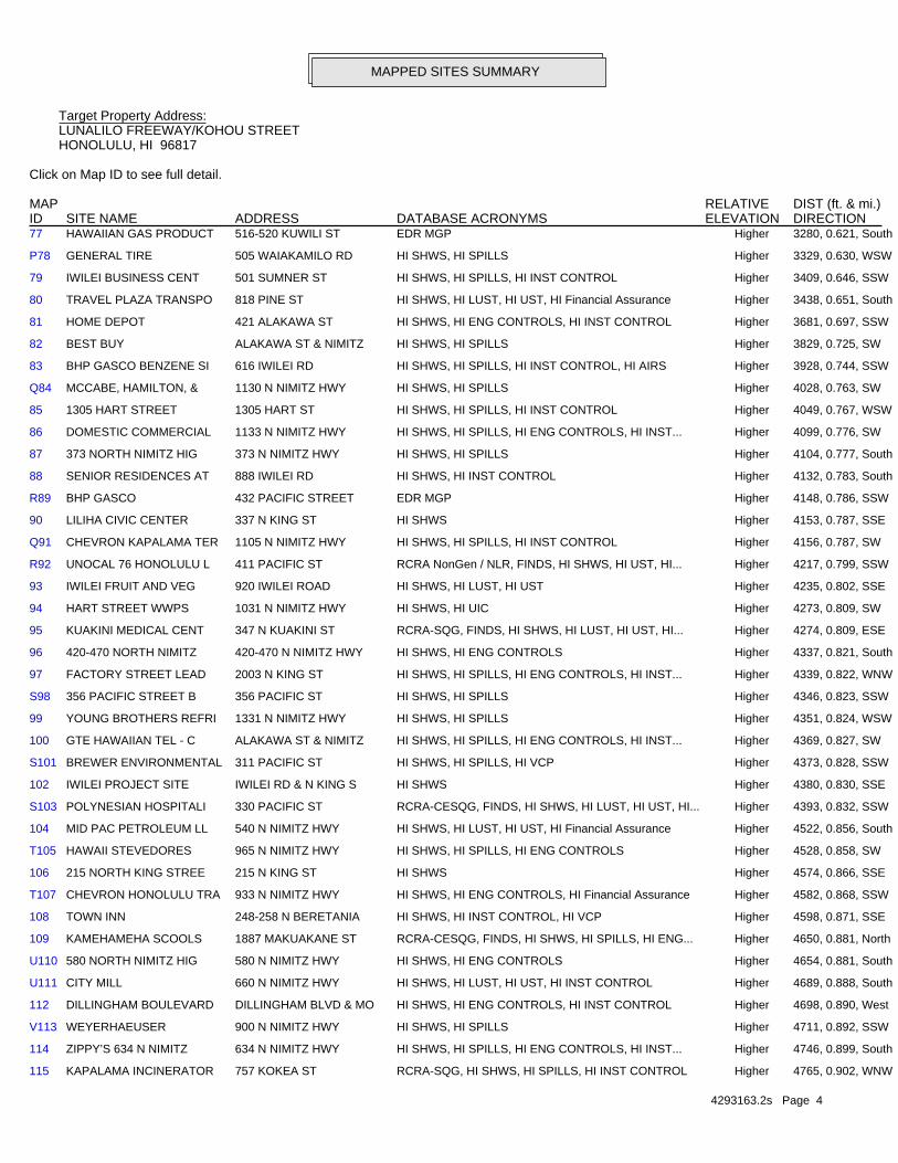
MAPPED SITES SUMMARY
Target Property Address:LUNALILO FREEWAY/KOHOU STREETHONOLULU, HI 96817
Click on Map ID to see full detail.
MAP RELATIVE DIST (ft. & mi.)ID DATABASE ACRONYMS ELEVATION DIRECTIONSITE NAME ADDRESS
4293163.2s Page 3
O76 NUUANU AUTO COMPANY 545 KAAAHI ST HI SHWS Higher 3252, 0.616, South
P75 1385 COLBURN STREET 1385 COLBURN ST HI SHWS, HI SPILLS Higher 3250, 0.616, WSW
O74 VON HAMM TEXTILES 546 KAAAHI ST HI SHWS, HI SPILLS, HI ENG CONTROLS, HI INST... Higher 3243, 0.614, South
N73 COSTCO GAS STATION 520 ALAKAWA ST HI SHWS, HI ENG CONTROLS, HI INST CONTROL, HI VCP Higher 3234, 0.613, SSW
N72 COSTCO WAREHOUSE 525 ALAKAWA ST HI SHWS, HI ENG CONTROLS, HI INST CONTROL, HI VCP Higher 3215, 0.609, SSW
71 LANCE GOYA CHEVRON 504 N SCHOOL ST HI SHWS, HI LUST, HI UST, HI ENG CONTROLS, HI INST... Higher 3105, 0.588, SE
70 HALL MARK DRY CLEANE 1470 LILIHA ST HI SHWS Higher 3042, 0.576, SE
69 KAMEHAMEHA SCHOOLS - 1336 DILLINGHAM BLVD HI SHWS, HI SPILLS Higher 2785, 0.527, WSW
68 DOLE IWILEI 801 DILLINGHAM BLVD HI SHWS, HI SPILLS, HI INST CONTROL Higher 2646, 0.501, South
67 FARRINGTON HIGH SCHO 1564 N KING ST FTTS, HIST FTTS, HI SHWS, HI SPILLS Higher 2644, 0.501, WNW
66 HAWAIIAN CANDIES & N 707 WAIAKAMILO RD HI LUST, HI UST Higher 2566, 0.486, WSW
65 CLASSIC BOWL 1190 DILLINGHAM BLVD HI SHWS Higher 2547, 0.482, SW
64 KING SHELL FOODMART 666 N KING ST HI LUST, HI UST, HI Financial Assurance Higher 2474, 0.469, SSE
63 MALUHIA HOSPITAL 1027 HALA DR HI LUST, HI UST, HI SPILLS Higher 2461, 0.466, ENE
M62 THEO DAVIES CATERPIL 935 DILLINGHAM BLVD HI SHWS, HI ENG CONTROLS, HI INST CONTROL Higher 2457, 0.465, SSW
M61 SPRINT LOT 925 DILLINGHAM BLVD HI LUST, HI UST Higher 2454, 0.465, SSW
M60 OWNED BY CCI, LEASED 925 DILLINGHAM BLVD FINDS, HI SHWS, HI ENG CONTROLS, HI INST CONTROL,... Higher 2454, 0.465, SSW
M59 HONOLULU COMMUNITY C 874 DILLINGHAM BLVD HI SHWS Higher 2436, 0.461, SSW
58 RICHARD TOM 963 ROBELLO LN HI LUST, HI UST, HI Financial Assurance Higher 2308, 0.437, South
57 SNAPPY SERVICE 719 N SCHOOL ST HI LUST, HI UST, HI SPILLS Higher 2186, 0.414, ESE
56 ALPAC CORPORATION 815 WAIAKAMILO RD HI LUST, HI UST Higher 2111, 0.400, West
55 MID PAC PETROLEUM 25 1342 N SCHOOL ST HI LUST, HI Financial Assurance Higher 2105, 0.399, NNE
54 KAPALAMA INCINERATOR 757 KOKEA STREET CERCLIS Higher 2071, 0.392, SW
L53 KAPALAMA CHEVRON 1402 N SCHOOL ST HI LUST, HI UST, HI Financial Assurance Higher 2069, 0.392, North
L52 AIM SCHOOL ST. 1403 N SCHOOL ST HI LUST, HI UST, HI Financial Assurance Higher 2062, 0.391, North
51 HONOLULU COMMUNITY C DILLINGHAM BLVD HI LUST, HI UST Higher 2061, 0.390, SSW
50 MALUHIA ELDERLY HOUS 1111 HALA DR HI LUST, HI UST Higher 1987, 0.376, ENE
49 SHIMAYA SHOTEN, LTD. 710 KOHOU ST HI LUST, HI UST Higher 1931, 0.366, SW
48 FORMER T J AUTO REPA 1314 N. SCHOOL STREE HI LUST, HI UST Higher 1785, 0.338, NNE
47 CLASSIC RUSTPROOFING 1437 N KING ST HI LUST, HI UST Higher 1777, 0.337, WNW
46 PALAMA ELDERLY HOUSI 851 N SCHOOL ST HI LUST, HI UST Higher 1658, 0.314, East
K45 OKADA TRUCKING CO., 818 MOOWAA ST HI LUST, HI UST, HI Financial Assurance Higher 1564, 0.296, WSW
K44 SEN PLEX CORPORATION 819 MOOWAA ST HI LUST, HI UST Higher 1561, 0.296, WSW
K43 ROSS TRUSTS 819 MOOWAA ST HI SHWS, HI VCP Higher 1561, 0.296, WSW
42 ISLAND PAINTING 1353 MOOKAULA ST HI LUST, HI UST, HI Financial Assurance Higher 1492, 0.283, West
J41 MARSHALL’S SHELL SS 1029 HOUGHTAILING ST HI LUST, HI UST, HI Financial Assurance Higher 1483, 0.281, WNW
40 TESORO 2GO #61022 1311 PALAMA ST HI LUST, HI UST, HI Financial Assurance Higher 1476, 0.280, SSE
39 SAWAI BROTHERS PAINT 1135 N SCHOOL ST HI LUST, HI UST Higher 1440, 0.273, NE
38 HAWAII HOUSING AUTHO 1002 N SCHOOL ST HI LUST, HI UST Higher 1429, 0.271, ENE
MAPPED SITES SUMMARY
Target Property Address:LUNALILO FREEWAY/KOHOU STREETHONOLULU, HI 96817
Click on Map ID to see full detail.
MAP RELATIVE DIST (ft. & mi.)ID DATABASE ACRONYMS ELEVATION DIRECTIONSITE NAME ADDRESS
4293163.2s Page 4
115 KAPALAMA INCINERATOR 757 KOKEA ST RCRA-SQG, HI SHWS, HI SPILLS, HI INST CONTROL Higher 4765, 0.902, WNW
114 ZIPPY’S 634 N NIMITZ 634 N NIMITZ HWY HI SHWS, HI SPILLS, HI ENG CONTROLS, HI INST... Higher 4746, 0.899, South
V113 WEYERHAEUSER 900 N NIMITZ HWY HI SHWS, HI SPILLS Higher 4711, 0.892, SSW
112 DILLINGHAM BOULEVARD DILLINGHAM BLVD & MO HI SHWS, HI ENG CONTROLS, HI INST CONTROL Higher 4698, 0.890, West
U111 CITY MILL 660 N NIMITZ HWY HI SHWS, HI LUST, HI UST, HI INST CONTROL Higher 4689, 0.888, South
U110 580 NORTH NIMITZ HIG 580 N NIMITZ HWY HI SHWS, HI ENG CONTROLS Higher 4654, 0.881, South
109 KAMEHAMEHA SCOOLS 1887 MAKUAKANE ST RCRA-CESQG, FINDS, HI SHWS, HI SPILLS, HI ENG... Higher 4650, 0.881, North
108 TOWN INN 248-258 N BERETANIA HI SHWS, HI INST CONTROL, HI VCP Higher 4598, 0.871, SSE
T107 CHEVRON HONOLULU TRA 933 N NIMITZ HWY HI SHWS, HI ENG CONTROLS, HI Financial Assurance Higher 4582, 0.868, SSW
106 215 NORTH KING STREE 215 N KING ST HI SHWS Higher 4574, 0.866, SSE
T105 HAWAII STEVEDORES 965 N NIMITZ HWY HI SHWS, HI SPILLS, HI ENG CONTROLS Higher 4528, 0.858, SW
104 MID PAC PETROLEUM LL 540 N NIMITZ HWY HI SHWS, HI LUST, HI UST, HI Financial Assurance Higher 4522, 0.856, South
S103 POLYNESIAN HOSPITALI 330 PACIFIC ST RCRA-CESQG, FINDS, HI SHWS, HI LUST, HI UST, HI... Higher 4393, 0.832, SSW
102 IWILEI PROJECT SITE IWILEI RD & N KING S HI SHWS Higher 4380, 0.830, SSE
S101 BREWER ENVIRONMENTAL 311 PACIFIC ST HI SHWS, HI SPILLS, HI VCP Higher 4373, 0.828, SSW
100 GTE HAWAIIAN TEL - C ALAKAWA ST & NIMITZ HI SHWS, HI SPILLS, HI ENG CONTROLS, HI INST... Higher 4369, 0.827, SW
99 YOUNG BROTHERS REFRI 1331 N NIMITZ HWY HI SHWS, HI SPILLS Higher 4351, 0.824, WSW
S98 356 PACIFIC STREET B 356 PACIFIC ST HI SHWS, HI SPILLS Higher 4346, 0.823, SSW
97 FACTORY STREET LEAD 2003 N KING ST HI SHWS, HI SPILLS, HI ENG CONTROLS, HI INST... Higher 4339, 0.822, WNW
96 420-470 NORTH NIMITZ 420-470 N NIMITZ HWY HI SHWS, HI ENG CONTROLS Higher 4337, 0.821, South
95 KUAKINI MEDICAL CENT 347 N KUAKINI ST RCRA-SQG, FINDS, HI SHWS, HI LUST, HI UST, HI... Higher 4274, 0.809, ESE
94 HART STREET WWPS 1031 N NIMITZ HWY HI SHWS, HI UIC Higher 4273, 0.809, SW
93 IWILEI FRUIT AND VEG 920 IWILEI ROAD HI SHWS, HI LUST, HI UST Higher 4235, 0.802, SSE
R92 UNOCAL 76 HONOLULU L 411 PACIFIC ST RCRA NonGen / NLR, FINDS, HI SHWS, HI UST, HI... Higher 4217, 0.799, SSW
Q91 CHEVRON KAPALAMA TER 1105 N NIMITZ HWY HI SHWS, HI SPILLS, HI INST CONTROL Higher 4156, 0.787, SW
90 LILIHA CIVIC CENTER 337 N KING ST HI SHWS Higher 4153, 0.787, SSE
R89 BHP GASCO 432 PACIFIC STREET EDR MGP Higher 4148, 0.786, SSW
88 SENIOR RESIDENCES AT 888 IWILEI RD HI SHWS, HI INST CONTROL Higher 4132, 0.783, South
87 373 NORTH NIMITZ HIG 373 N NIMITZ HWY HI SHWS, HI SPILLS Higher 4104, 0.777, South
86 DOMESTIC COMMERCIAL 1133 N NIMITZ HWY HI SHWS, HI SPILLS, HI ENG CONTROLS, HI INST... Higher 4099, 0.776, SW
85 1305 HART STREET 1305 HART ST HI SHWS, HI SPILLS, HI INST CONTROL Higher 4049, 0.767, WSW
Q84 MCCABE, HAMILTON, & 1130 N NIMITZ HWY HI SHWS, HI SPILLS Higher 4028, 0.763, SW
83 BHP GASCO BENZENE SI 616 IWILEI RD HI SHWS, HI SPILLS, HI INST CONTROL, HI AIRS Higher 3928, 0.744, SSW
82 BEST BUY ALAKAWA ST & NIMITZ HI SHWS, HI SPILLS Higher 3829, 0.725, SW
81 HOME DEPOT 421 ALAKAWA ST HI SHWS, HI ENG CONTROLS, HI INST CONTROL Higher 3681, 0.697, SSW
80 TRAVEL PLAZA TRANSPO 818 PINE ST HI SHWS, HI LUST, HI UST, HI Financial Assurance Higher 3438, 0.651, South
79 IWILEI BUSINESS CENT 501 SUMNER ST HI SHWS, HI SPILLS, HI INST CONTROL Higher 3409, 0.646, SSW
P78 GENERAL TIRE 505 WAIAKAMILO RD HI SHWS, HI SPILLS Higher 3329, 0.630, WSW
77 HAWAIIAN GAS PRODUCT 516-520 KUWILI ST EDR MGP Higher 3280, 0.621, South
MAPPED SITES SUMMARY
Target Property Address:LUNALILO FREEWAY/KOHOU STREETHONOLULU, HI 96817
Click on Map ID to see full detail.
MAP RELATIVE DIST (ft. & mi.)ID DATABASE ACRONYMS ELEVATION DIRECTIONSITE NAME ADDRESS

4293163.2s Page 5
132 SAUSE BROTHERS ALAKEA ST HI SHWS, HI SPILLS Higher 5249, 0.994, South
131 KUHIO PARK TERRACE T LINAPUNI ST HI SHWS, HI ENG CONTROLS, HI INST CONTROL, HI... Higher 5239, 0.992, NW
130 PACIFIC POULTRY 1804 KANAKANUI ST HI SHWS, HI SPILLS Higher 5228, 0.990, West
Y129 755 N NIMITZ HWY 755 N NIMITZ HWY HI SHWS, HI SPILLS, HI ENG CONTROLS, HI INST... Higher 5122, 0.970, SSW
128 775 NORTH NIMITZ HIG 775 N NIMITZ HWY HI SHWS, HI ENG CONTROLS, HI INST CONTROL Higher 5120, 0.970, SSW
127 KEKAULIKE DIAMOND HE 163 N HOTEL ST HI SHWS, HI SPILLS Higher 5116, 0.969, SSE
Y126 BHP PIER 29 739 N NIMITZ HWY HI SHWS Higher 5112, 0.968, SSW
125 CHANG-CHOW PROPERTY, 2161 N SCHOOL ST HI SHWS Higher 5099, 0.966, NNW
X124 EQUILON ENTERPRISES 789 N NIMITZ HWY HI SHWS Higher 5098, 0.966, SSW
W123 MOANA PAA KAI 705 N NIMITZ HWY RCRA-CESQG, HI SHWS, HI SPILLS Higher 5087, 0.963, SSW
W122 HAWAIIAN FLOUR MILL 703 N NIMITZ HWY HI SHWS Higher 5085, 0.963, SSW
X121 PAULEY PETROLEUM 795 N NIMITZ HWY HI SHWS, HI SPILLS, HI ENG CONTROLS, HI INST... Higher 5082, 0.962, SSW
W120 HAWAIIAN GRAIN CORPO 701 N NIMITZ HWY HI SHWS, HI LUST, HI UST Higher 5057, 0.958, SSW
119 700 N NIMITZ IDPP RE 700 N NIMITZ HWY HI SHWS, HI SPILLS, HI ENG CONTROLS, HI INST... Higher 4879, 0.924, SSW
V118 HAWAIIAN ELECTRIC CO 855 N NIMITZ HWY HI SHWS, HI SPILLS, HI ENG CONTROLS, HI INST... Higher 4847, 0.918, SSW
V117 861-869 NORTH NIMITZ 861-869 N NIMITZ HWY HI SHWS, HI ENG CONTROLS, HI INST CONTROL Higher 4819, 0.913, SSW
116 AWA WASTEWATER PUMP 190 N NIMITZ HWY HI SHWS, HI SPILLS Lower 4775, 0.904, South
MAPPED SITES SUMMARY
Target Property Address:LUNALILO FREEWAY/KOHOU STREETHONOLULU, HI 96817
Click on Map ID to see full detail.
MAP RELATIVE DIST (ft. & mi.)ID DATABASE ACRONYMS ELEVATION DIRECTIONSITE NAME ADDRESS

EXECUTIVE SUMMARY
TC4293163.2s EXECUTIVE SUMMARY 6
TARGET PROPERTY SEARCH RESULTS
The target property was not listed in any of the databases searched by EDR.
SURROUNDING SITES: SEARCH RESULTS
Surrounding sites were identified in the following databases.
Elevations have been determined from the USGS Digital Elevation Model and should be evaluated ona relative (not an absolute) basis. Relative elevation information between sites of close proximityshould be field verified. Sites with an elevation equal to or higher than the target property have beendifferentiated below from sites with an elevation lower than the target property.Page numbers and map identification numbers refer to the EDR Radius Map report where detaileddata on individual sites can be reviewed.
Sites listed in bold italics are in multiple databases.
Unmappable (orphan) sites are not considered in the foregoing analysis.
STANDARD ENVIRONMENTAL RECORDS
Federal CERCLIS list
CERCLIS: A review of the CERCLIS list, as provided by EDR, and dated 10/25/2013 has revealed thatthere are 2 CERCLIS sites within approximately 0.5 miles of the target property.
PageMap IDDirection / Distance Address Equal/Higher Elevation ____________________ ________ ___________________ _____ _____
TAKAMIYA PROPERTY 850 MOOWAA ST. W 1/4 - 1/2 (0.260 mi.) I36 16 KAPALAMA INCINERATOR 757 KOKEA STREET SW 1/4 - 1/2 (0.392 mi.) 54 23
Federal RCRA generators list
RCRA-CESQG: A review of the RCRA-CESQG list, as provided by EDR, and dated 12/09/2014 has revealedthat there are 7 RCRA-CESQG sites within approximately 0.25 miles of the target property.
PageMap IDDirection / Distance Address Equal/Higher Elevation ____________________ ________ ___________________ _____ _____
UNOCAL 76 SS L 0471 1136 N KING ST SW 0 - 1/8 (0.118 mi.) A3 8 QUEEN LILIOKALANI HO 1300 HALONA ST NNW 0 - 1/8 (0.122 mi.) 4 8 OAHU AIR CONDITIONIN 938 KOHOU ST SW 1/8 - 1/4 (0.190 mi.) E16 11 ACCENT WALL DESIGN I 1240 MOOKAULA ST WSW 1/8 - 1/4 (0.196 mi.) C18 11 YAMASAKI SERVICE INC 1010 KING ST SSW 1/8 - 1/4 (0.197 mi.) F23 13 GERMAN CAR SERVICE 1310 MOOKAULA ST W 1/8 - 1/4 (0.229 mi.) G28 14 HAWAII HOCHI LTD 917 KOKEA ST SW 1/8 - 1/4 (0.233 mi.) H31 15
EXECUTIVE SUMMARY
TC4293163.2s EXECUTIVE SUMMARY 7
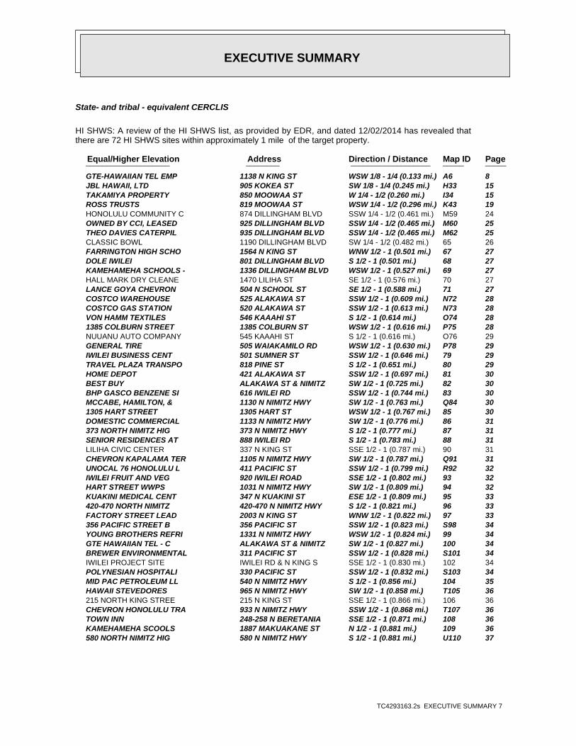
State- and tribal - equivalent CERCLIS
HI SHWS: A review of the HI SHWS list, as provided by EDR, and dated 12/02/2014 has revealed thatthere are 72 HI SHWS sites within approximately 1 mile of the target property.
PageMap IDDirection / Distance Address Equal/Higher Elevation ____________________ ________ ___________________ _____ _____
GTE-HAWAIIAN TEL EMP 1138 N KING ST WSW 1/8 - 1/4 (0.133 mi.) A6 8 JBL HAWAII, LTD 905 KOKEA ST SW 1/8 - 1/4 (0.245 mi.) H33 15 TAKAMIYA PROPERTY 850 MOOWAA ST W 1/4 - 1/2 (0.260 mi.) I34 15 ROSS TRUSTS 819 MOOWAA ST WSW 1/4 - 1/2 (0.296 mi.) K43 19 HONOLULU COMMUNITY C 874 DILLINGHAM BLVD SSW 1/4 - 1/2 (0.461 mi.) M59 24 OWNED BY CCI, LEASED 925 DILLINGHAM BLVD SSW 1/4 - 1/2 (0.465 mi.) M60 25 THEO DAVIES CATERPIL 935 DILLINGHAM BLVD SSW 1/4 - 1/2 (0.465 mi.) M62 25 CLASSIC BOWL 1190 DILLINGHAM BLVD SW 1/4 - 1/2 (0.482 mi.) 65 26 FARRINGTON HIGH SCHO 1564 N KING ST WNW 1/2 - 1 (0.501 mi.) 67 27 DOLE IWILEI 801 DILLINGHAM BLVD S 1/2 - 1 (0.501 mi.) 68 27 KAMEHAMEHA SCHOOLS - 1336 DILLINGHAM BLVD WSW 1/2 - 1 (0.527 mi.) 69 27 HALL MARK DRY CLEANE 1470 LILIHA ST SE 1/2 - 1 (0.576 mi.) 70 27 LANCE GOYA CHEVRON 504 N SCHOOL ST SE 1/2 - 1 (0.588 mi.) 71 27 COSTCO WAREHOUSE 525 ALAKAWA ST SSW 1/2 - 1 (0.609 mi.) N72 28 COSTCO GAS STATION 520 ALAKAWA ST SSW 1/2 - 1 (0.613 mi.) N73 28 VON HAMM TEXTILES 546 KAAAHI ST S 1/2 - 1 (0.614 mi.) O74 28 1385 COLBURN STREET 1385 COLBURN ST WSW 1/2 - 1 (0.616 mi.) P75 28 NUUANU AUTO COMPANY 545 KAAAHI ST S 1/2 - 1 (0.616 mi.) O76 29 GENERAL TIRE 505 WAIAKAMILO RD WSW 1/2 - 1 (0.630 mi.) P78 29 IWILEI BUSINESS CENT 501 SUMNER ST SSW 1/2 - 1 (0.646 mi.) 79 29 TRAVEL PLAZA TRANSPO 818 PINE ST S 1/2 - 1 (0.651 mi.) 80 29 HOME DEPOT 421 ALAKAWA ST SSW 1/2 - 1 (0.697 mi.) 81 30 BEST BUY ALAKAWA ST & NIMITZ SW 1/2 - 1 (0.725 mi.) 82 30 BHP GASCO BENZENE SI 616 IWILEI RD SSW 1/2 - 1 (0.744 mi.) 83 30 MCCABE, HAMILTON, & 1130 N NIMITZ HWY SW 1/2 - 1 (0.763 mi.) Q84 30 1305 HART STREET 1305 HART ST WSW 1/2 - 1 (0.767 mi.) 85 30 DOMESTIC COMMERCIAL 1133 N NIMITZ HWY SW 1/2 - 1 (0.776 mi.) 86 31 373 NORTH NIMITZ HIG 373 N NIMITZ HWY S 1/2 - 1 (0.777 mi.) 87 31 SENIOR RESIDENCES AT 888 IWILEI RD S 1/2 - 1 (0.783 mi.) 88 31 LILIHA CIVIC CENTER 337 N KING ST SSE 1/2 - 1 (0.787 mi.) 90 31 CHEVRON KAPALAMA TER 1105 N NIMITZ HWY SW 1/2 - 1 (0.787 mi.) Q91 31 UNOCAL 76 HONOLULU L 411 PACIFIC ST SSW 1/2 - 1 (0.799 mi.) R92 32 IWILEI FRUIT AND VEG 920 IWILEI ROAD SSE 1/2 - 1 (0.802 mi.) 93 32 HART STREET WWPS 1031 N NIMITZ HWY SW 1/2 - 1 (0.809 mi.) 94 32 KUAKINI MEDICAL CENT 347 N KUAKINI ST ESE 1/2 - 1 (0.809 mi.) 95 33 420-470 NORTH NIMITZ 420-470 N NIMITZ HWY S 1/2 - 1 (0.821 mi.) 96 33 FACTORY STREET LEAD 2003 N KING ST WNW 1/2 - 1 (0.822 mi.) 97 33 356 PACIFIC STREET B 356 PACIFIC ST SSW 1/2 - 1 (0.823 mi.) S98 34 YOUNG BROTHERS REFRI 1331 N NIMITZ HWY WSW 1/2 - 1 (0.824 mi.) 99 34 GTE HAWAIIAN TEL - C ALAKAWA ST & NIMITZ SW 1/2 - 1 (0.827 mi.) 100 34 BREWER ENVIRONMENTAL 311 PACIFIC ST SSW 1/2 - 1 (0.828 mi.) S101 34 IWILEI PROJECT SITE IWILEI RD & N KING S SSE 1/2 - 1 (0.830 mi.) 102 34 POLYNESIAN HOSPITALI 330 PACIFIC ST SSW 1/2 - 1 (0.832 mi.) S103 34 MID PAC PETROLEUM LL 540 N NIMITZ HWY S 1/2 - 1 (0.856 mi.) 104 35 HAWAII STEVEDORES 965 N NIMITZ HWY SW 1/2 - 1 (0.858 mi.) T105 36 215 NORTH KING STREE 215 N KING ST SSE 1/2 - 1 (0.866 mi.) 106 36 CHEVRON HONOLULU TRA 933 N NIMITZ HWY SSW 1/2 - 1 (0.868 mi.) T107 36 TOWN INN 248-258 N BERETANIA SSE 1/2 - 1 (0.871 mi.) 108 36 KAMEHAMEHA SCOOLS 1887 MAKUAKANE ST N 1/2 - 1 (0.881 mi.) 109 36 580 NORTH NIMITZ HIG 580 N NIMITZ HWY S 1/2 - 1 (0.881 mi.) U110 37

EXECUTIVE SUMMARY
TC4293163.2s EXECUTIVE SUMMARY 8
PageMap IDDirection / Distance Address Equal/Higher Elevation ____________________ ________ ___________________ _____ _____
CITY MILL 660 N NIMITZ HWY S 1/2 - 1 (0.888 mi.) U111 37 DILLINGHAM BOULEVARD DILLINGHAM BLVD & MO W 1/2 - 1 (0.890 mi.) 112 37 WEYERHAEUSER 900 N NIMITZ HWY SSW 1/2 - 1 (0.892 mi.) V113 37 ZIPPY’S 634 N NIMITZ 634 N NIMITZ HWY S 1/2 - 1 (0.899 mi.) 114 38 KAPALAMA INCINERATOR 757 KOKEA ST WNW 1/2 - 1 (0.902 mi.) 115 38 861-869 NORTH NIMITZ 861-869 N NIMITZ HWY SSW 1/2 - 1 (0.913 mi.) V117 38 HAWAIIAN ELECTRIC CO 855 N NIMITZ HWY SSW 1/2 - 1 (0.918 mi.) V118 38 700 N NIMITZ IDPP RE 700 N NIMITZ HWY SSW 1/2 - 1 (0.924 mi.) 119 38 HAWAIIAN GRAIN CORPO 701 N NIMITZ HWY SSW 1/2 - 1 (0.958 mi.) W120 39 PAULEY PETROLEUM 795 N NIMITZ HWY SSW 1/2 - 1 (0.962 mi.) X121 39 HAWAIIAN FLOUR MILL 703 N NIMITZ HWY SSW 1/2 - 1 (0.963 mi.) W122 39 MOANA PAA KAI 705 N NIMITZ HWY SSW 1/2 - 1 (0.963 mi.) W123 39 EQUILON ENTERPRISES 789 N NIMITZ HWY SSW 1/2 - 1 (0.966 mi.) X124 39 CHANG-CHOW PROPERTY, 2161 N SCHOOL ST NNW 1/2 - 1 (0.966 mi.) 125 40 BHP PIER 29 739 N NIMITZ HWY SSW 1/2 - 1 (0.968 mi.) Y126 40 KEKAULIKE DIAMOND HE 163 N HOTEL ST SSE 1/2 - 1 (0.969 mi.) 127 40 775 NORTH NIMITZ HIG 775 N NIMITZ HWY SSW 1/2 - 1 (0.970 mi.) 128 40 755 N NIMITZ HWY 755 N NIMITZ HWY SSW 1/2 - 1 (0.970 mi.) Y129 40 PACIFIC POULTRY 1804 KANAKANUI ST W 1/2 - 1 (0.990 mi.) 130 40 KUHIO PARK TERRACE T LINAPUNI ST NW 1/2 - 1 (0.992 mi.) 131 41 SAUSE BROTHERS ALAKEA ST S 1/2 - 1 (0.994 mi.) 132 41
PageMap IDDirection / Distance Address Lower Elevation ____________________ ________ ___________________ _____ _____
AWA WASTEWATER PUMP 190 N NIMITZ HWY S 1/2 - 1 (0.904 mi.) 116 38
State and tribal leaking storage tank lists
HI LUST: A review of the HI LUST list, as provided by EDR, and dated 03/02/2015 has revealed thatthere are 33 HI LUST sites within approximately 0.5 miles of the target property.
PageMap IDDirection / Distance Address Equal/Higher Elevation ____________________ ________ ___________________ _____ _____
7-11 KAPALAMA 1136 N KING ST. SW 0 - 1/8 (0.118 mi.) A2 7Facility Id: 9-100028Release ID: 930033Facility Status: Site Cleanup Completed (NFA)
KING’S SERVICE 1070 N KING ST SSW 1/8 - 1/4 (0.158 mi.) 8 9Facility Id: 9-101111Release ID: 870007Facility Status: Site Cleanup Completed (NFA)
OAHU PLUMBING & SHEE 1217 N KING ST W 1/8 - 1/4 (0.159 mi.) B9 9Facility Id: 9-103346Release ID: 980032Facility Status: Site Cleanup Completed (NFA)
U.S. POSTAL SERVICE 1271 N KING ST W 1/8 - 1/4 (0.188 mi.) D15 10Facility Id: 9-101773Release ID: 900116Facility Status: Site Cleanup Completed (NFA)
JOHIRO BROTHERS, INC 1240 MOOKAULA ST WSW 1/8 - 1/4 (0.196 mi.) C19 12Facility Id: 9-100258Release ID: 930050Facility Status: Site Cleanup Completed (NFA)

EXECUTIVE SUMMARY
TC4293163.2s EXECUTIVE SUMMARY 9
PageMap IDDirection / Distance Address Equal/Higher Elevation ____________________ ________ ___________________ _____ _____
MAHALO NORTH KING AU 1010 N KING ST SSW 1/8 - 1/4 (0.197 mi.) F22 12Facility Id: 9-100339Release ID: 080009Release ID: 980145Facility Status: Site Cleanup Completed with EHMPFacility Status: Site Cleanup Completed (NFA)
OAHU PLUMBING & SHEE 926 KOHOU ST SW 1/8 - 1/4 (0.207 mi.) E26 13Facility Id: 9-101367Release ID: 990119Facility Status: Site Cleanup Completed (NFA)
JBL HAWAII LTD 905 KOKEA ST SW 1/8 - 1/4 (0.245 mi.) H32 15Facility Id: 9-102462Release ID: 920012Facility Status: Site Cleanup Completed (NFA)
I. STEVEN SUNADA 850 MOOWAA ST W 1/4 - 1/2 (0.260 mi.) I35 16Facility Id: 9-100251Release ID: 910015Facility Status: Site Cleanup Completed (NFA)
FUTURE HONOLULU FORD CORNER OF HOUGHTAILI WNW 1/4 - 1/2 (0.270 mi.) J37 16Facility Id: 9-103785Release ID: 040065Facility Status: Site Cleanup Completed (NFA)
HAWAII HOUSING AUTHO 1002 N SCHOOL ST ENE 1/4 - 1/2 (0.271 mi.) 38 16Facility Id: 9-101036Release ID: 940197Facility Status: Site Cleanup Completed (NFA)
SAWAI BROTHERS PAINT 1135 N SCHOOL ST NE 1/4 - 1/2 (0.273 mi.) 39 17Facility Id: 9-101808Release ID: 980024Facility Status: Site Cleanup Completed (NFA)
TESORO 2GO #61022 1311 PALAMA ST SSE 1/4 - 1/2 (0.280 mi.) 40 17Facility Id: 9-100348Release ID: 980039Facility Status: Site Cleanup Completed (NFA)
MARSHALL’S SHELL SS 1029 HOUGHTAILING ST WNW 1/4 - 1/2 (0.281 mi.) J41 18Facility Id: 9-100783Release ID: 920145Release ID: 060022Release ID: 080032Release ID: 150008Facility Status: Site Cleanup Completed (NFA)Facility Status: Confirmed Release
ISLAND PAINTING 1353 MOOKAULA ST W 1/4 - 1/2 (0.283 mi.) 42 18Facility Id: 9-102161Release ID: 910079Facility Status: Site Cleanup Completed (NFA)
SEN PLEX CORPORATION 819 MOOWAA ST WSW 1/4 - 1/2 (0.296 mi.) K44 19Facility Id: 9-103359Release ID: 980053Facility Status: Site Cleanup Completed (NFA)
OKADA TRUCKING CO., 818 MOOWAA ST WSW 1/4 - 1/2 (0.296 mi.) K45 19Facility Id: 9-100285Release ID: 900028Facility Status: Site Cleanup Completed (NFA)
EXECUTIVE SUMMARY
TC4293163.2s EXECUTIVE SUMMARY 10
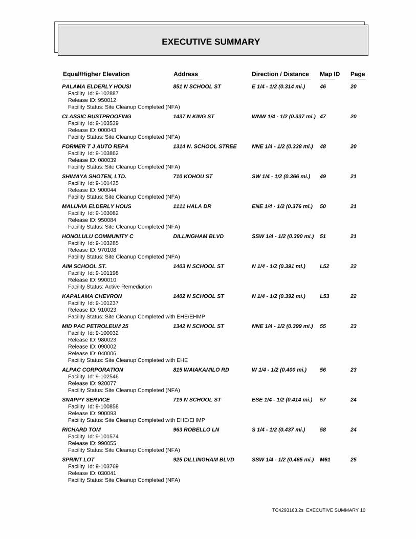
PageMap IDDirection / Distance Address Equal/Higher Elevation ____________________ ________ ___________________ _____ _____
PALAMA ELDERLY HOUSI 851 N SCHOOL ST E 1/4 - 1/2 (0.314 mi.) 46 20Facility Id: 9-102887Release ID: 950012Facility Status: Site Cleanup Completed (NFA)
CLASSIC RUSTPROOFING 1437 N KING ST WNW 1/4 - 1/2 (0.337 mi.) 47 20Facility Id: 9-103539Release ID: 000043Facility Status: Site Cleanup Completed (NFA)
FORMER T J AUTO REPA 1314 N. SCHOOL STREE NNE 1/4 - 1/2 (0.338 mi.) 48 20Facility Id: 9-103862Release ID: 080039Facility Status: Site Cleanup Completed (NFA)
SHIMAYA SHOTEN, LTD. 710 KOHOU ST SW 1/4 - 1/2 (0.366 mi.) 49 21Facility Id: 9-101425Release ID: 900044Facility Status: Site Cleanup Completed (NFA)
MALUHIA ELDERLY HOUS 1111 HALA DR ENE 1/4 - 1/2 (0.376 mi.) 50 21Facility Id: 9-103082Release ID: 950084Facility Status: Site Cleanup Completed (NFA)
HONOLULU COMMUNITY C DILLINGHAM BLVD SSW 1/4 - 1/2 (0.390 mi.) 51 21Facility Id: 9-103285Release ID: 970108Facility Status: Site Cleanup Completed (NFA)
AIM SCHOOL ST. 1403 N SCHOOL ST N 1/4 - 1/2 (0.391 mi.) L52 22Facility Id: 9-101198Release ID: 990010Facility Status: Active Remediation
KAPALAMA CHEVRON 1402 N SCHOOL ST N 1/4 - 1/2 (0.392 mi.) L53 22Facility Id: 9-101237Release ID: 910023Facility Status: Site Cleanup Completed with EHE/EHMP
MID PAC PETROLEUM 25 1342 N SCHOOL ST NNE 1/4 - 1/2 (0.399 mi.) 55 23Facility Id: 9-100032Release ID: 980023Release ID: 090002Release ID: 040006Facility Status: Site Cleanup Completed with EHE
ALPAC CORPORATION 815 WAIAKAMILO RD W 1/4 - 1/2 (0.400 mi.) 56 23Facility Id: 9-102546Release ID: 920077Facility Status: Site Cleanup Completed (NFA)
SNAPPY SERVICE 719 N SCHOOL ST ESE 1/4 - 1/2 (0.414 mi.) 57 24Facility Id: 9-100858Release ID: 900093Facility Status: Site Cleanup Completed with EHE/EHMP
RICHARD TOM 963 ROBELLO LN S 1/4 - 1/2 (0.437 mi.) 58 24Facility Id: 9-101574Release ID: 990055Facility Status: Site Cleanup Completed (NFA)
SPRINT LOT 925 DILLINGHAM BLVD SSW 1/4 - 1/2 (0.465 mi.) M61 25Facility Id: 9-103769Release ID: 030041Facility Status: Site Cleanup Completed (NFA)
EXECUTIVE SUMMARY
TC4293163.2s EXECUTIVE SUMMARY 11
PageMap IDDirection / Distance Address Equal/Higher Elevation ____________________ ________ ___________________ _____ _____
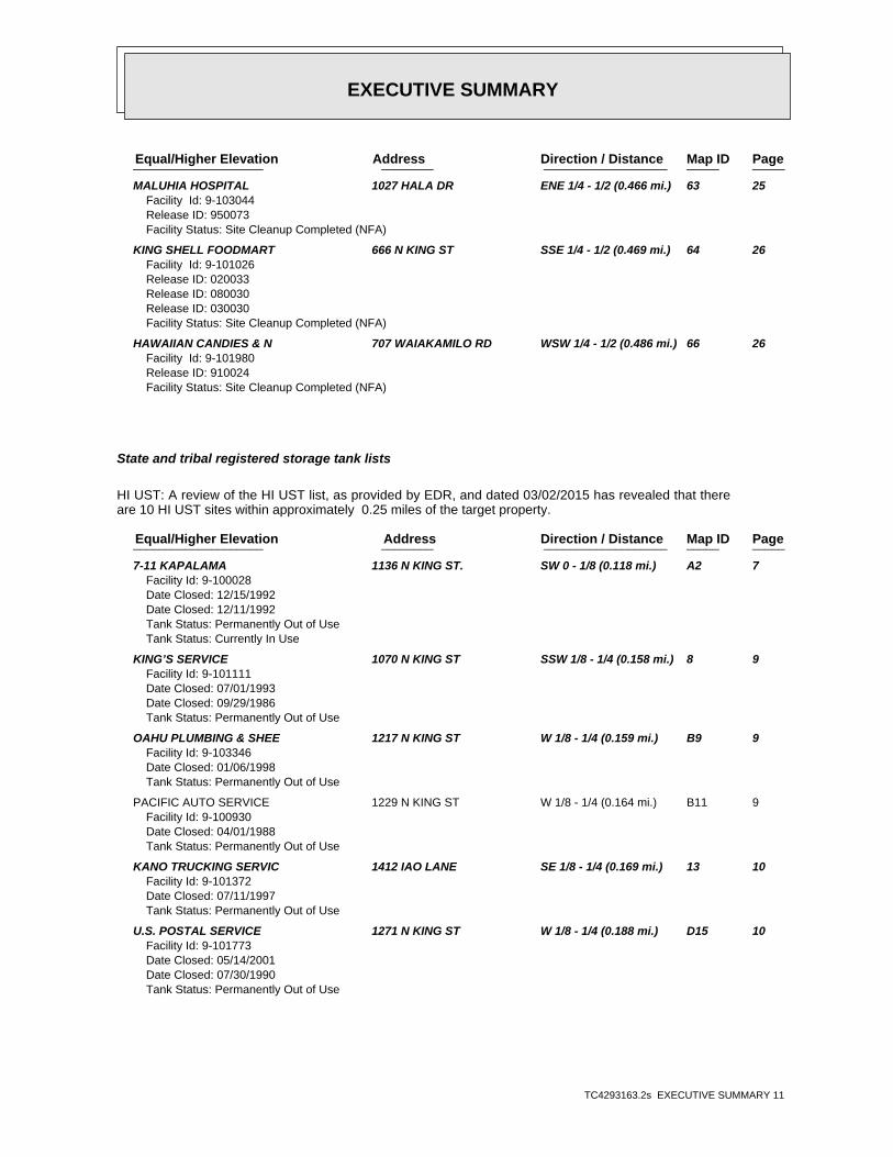
MALUHIA HOSPITAL 1027 HALA DR ENE 1/4 - 1/2 (0.466 mi.) 63 25Facility Id: 9-103044Release ID: 950073Facility Status: Site Cleanup Completed (NFA)
KING SHELL FOODMART 666 N KING ST SSE 1/4 - 1/2 (0.469 mi.) 64 26Facility Id: 9-101026Release ID: 020033Release ID: 080030Release ID: 030030Facility Status: Site Cleanup Completed (NFA)
HAWAIIAN CANDIES & N 707 WAIAKAMILO RD WSW 1/4 - 1/2 (0.486 mi.) 66 26Facility Id: 9-101980Release ID: 910024Facility Status: Site Cleanup Completed (NFA)
State and tribal registered storage tank lists
HI UST: A review of the HI UST list, as provided by EDR, and dated 03/02/2015 has revealed that thereare 10 HI UST sites within approximately 0.25 miles of the target property.
PageMap IDDirection / Distance Address Equal/Higher Elevation ____________________ ________ ___________________ _____ _____
7-11 KAPALAMA 1136 N KING ST. SW 0 - 1/8 (0.118 mi.) A2 7Facility Id: 9-100028Date Closed: 12/15/1992Date Closed: 12/11/1992Tank Status: Permanently Out of UseTank Status: Currently In Use
KING’S SERVICE 1070 N KING ST SSW 1/8 - 1/4 (0.158 mi.) 8 9Facility Id: 9-101111Date Closed: 07/01/1993Date Closed: 09/29/1986Tank Status: Permanently Out of Use
OAHU PLUMBING & SHEE 1217 N KING ST W 1/8 - 1/4 (0.159 mi.) B9 9Facility Id: 9-103346Date Closed: 01/06/1998Tank Status: Permanently Out of Use
PACIFIC AUTO SERVICE 1229 N KING ST W 1/8 - 1/4 (0.164 mi.) B11 9Facility Id: 9-100930Date Closed: 04/01/1988Tank Status: Permanently Out of Use
KANO TRUCKING SERVIC 1412 IAO LANE SE 1/8 - 1/4 (0.169 mi.) 13 10Facility Id: 9-101372Date Closed: 07/11/1997Tank Status: Permanently Out of Use
U.S. POSTAL SERVICE 1271 N KING ST W 1/8 - 1/4 (0.188 mi.) D15 10Facility Id: 9-101773Date Closed: 05/14/2001Date Closed: 07/30/1990Tank Status: Permanently Out of Use

EXECUTIVE SUMMARY
TC4293163.2s EXECUTIVE SUMMARY 12
PageMap IDDirection / Distance Address Equal/Higher Elevation ____________________ ________ ___________________ _____ _____
JOHIRO BROTHERS, INC 1240 MOOKAULA ST WSW 1/8 - 1/4 (0.196 mi.) C19 12Facility Id: 9-100258Date Closed: 01/26/1993Tank Status: Permanently Out of Use
MAHALO NORTH KING AU 1010 N KING ST SSW 1/8 - 1/4 (0.197 mi.) F22 12Facility Id: 9-100339Date Closed: 11/30/1987Date Closed: 12/03/2007Date Closed: 11/07/2005Tank Status: Permanently Out of UseTank Status: Permanently out of Use
OAHU PLUMBING & SHEE 926 KOHOU ST SW 1/8 - 1/4 (0.207 mi.) E26 13Facility Id: 9-101367Date Closed: 01/07/1999Tank Status: Permanently Out of Use
JBL HAWAII LTD 905 KOKEA ST SW 1/8 - 1/4 (0.245 mi.) H32 15Facility Id: 9-102462Date Closed: 10/19/1991Tank Status: Permanently Out of Use
State and tribal institutional control / engineering control registries
HI ENG CONTROLS: A review of the HI ENG CONTROLS list, as provided by EDR, and dated 12/02/2014 hasrevealed that there are 4 HI ENG CONTROLS sites within approximately 0.5 miles of the targetproperty.
PageMap IDDirection / Distance Address Equal/Higher Elevation ____________________ ________ ___________________ _____ _____
GTE-HAWAIIAN TEL EMP 1138 N KING ST WSW 1/8 - 1/4 (0.133 mi.) A6 8 JBL HAWAII, LTD 905 KOKEA ST SW 1/8 - 1/4 (0.245 mi.) H33 15 OWNED BY CCI, LEASED 925 DILLINGHAM BLVD SSW 1/4 - 1/2 (0.465 mi.) M60 25 THEO DAVIES CATERPIL 935 DILLINGHAM BLVD SSW 1/4 - 1/2 (0.465 mi.) M62 25
HI INST CONTROL: A review of the HI INST CONTROL list, as provided by EDR, and dated 12/02/2014 hasrevealed that there are 4 HI INST CONTROL sites within approximately 0.5 miles of the targetproperty.
PageMap IDDirection / Distance Address Equal/Higher Elevation ____________________ ________ ___________________ _____ _____
GTE-HAWAIIAN TEL EMP 1138 N KING ST WSW 1/8 - 1/4 (0.133 mi.) A6 8 JBL HAWAII, LTD 905 KOKEA ST SW 1/8 - 1/4 (0.245 mi.) H33 15 OWNED BY CCI, LEASED 925 DILLINGHAM BLVD SSW 1/4 - 1/2 (0.465 mi.) M60 25 THEO DAVIES CATERPIL 935 DILLINGHAM BLVD SSW 1/4 - 1/2 (0.465 mi.) M62 25
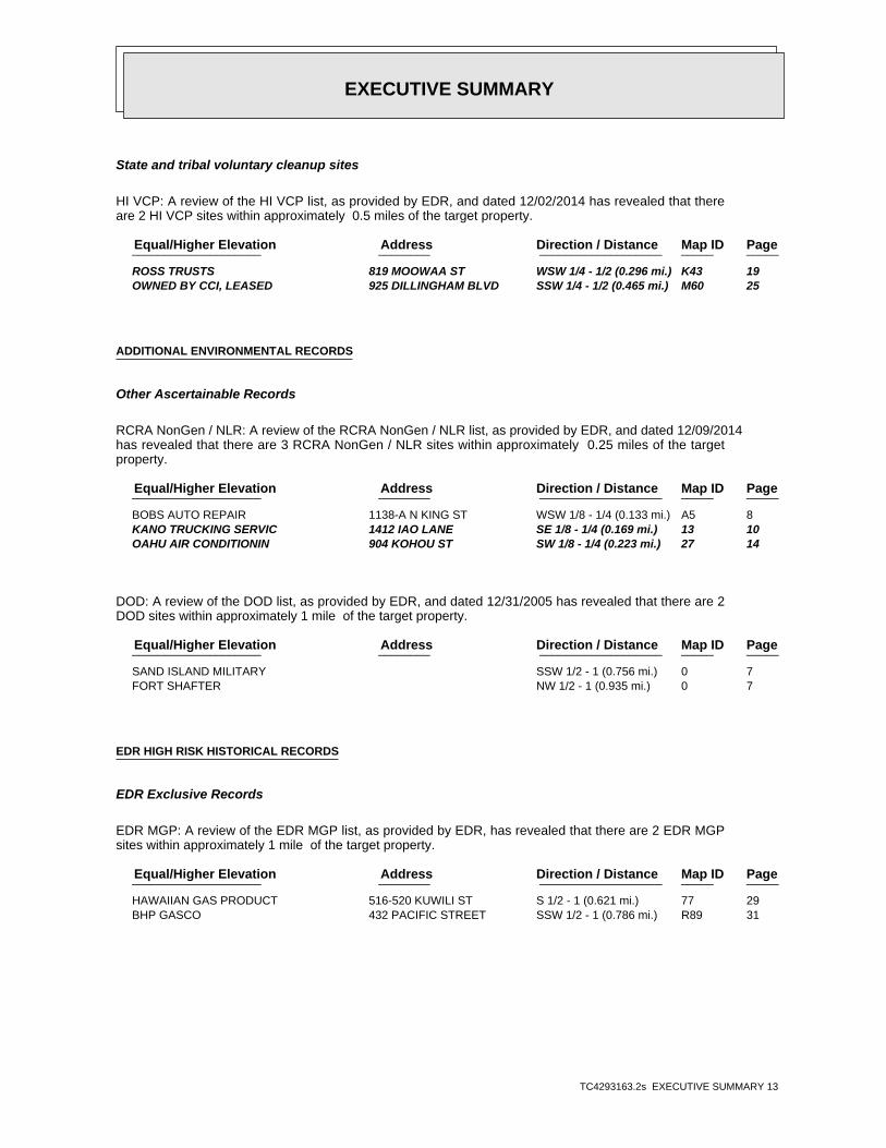
EXECUTIVE SUMMARY
TC4293163.2s EXECUTIVE SUMMARY 13
State and tribal voluntary cleanup sites
HI VCP: A review of the HI VCP list, as provided by EDR, and dated 12/02/2014 has revealed that thereare 2 HI VCP sites within approximately 0.5 miles of the target property.
PageMap IDDirection / Distance Address Equal/Higher Elevation ____________________ ________ ___________________ _____ _____
ROSS TRUSTS 819 MOOWAA ST WSW 1/4 - 1/2 (0.296 mi.) K43 19 OWNED BY CCI, LEASED 925 DILLINGHAM BLVD SSW 1/4 - 1/2 (0.465 mi.) M60 25
ADDITIONAL ENVIRONMENTAL RECORDS
Other Ascertainable Records
RCRA NonGen / NLR: A review of the RCRA NonGen / NLR list, as provided by EDR, and dated 12/09/2014has revealed that there are 3 RCRA NonGen / NLR sites within approximately 0.25 miles of the targetproperty.
PageMap IDDirection / Distance Address Equal/Higher Elevation ____________________ ________ ___________________ _____ _____
BOBS AUTO REPAIR 1138-A N KING ST WSW 1/8 - 1/4 (0.133 mi.) A5 8 KANO TRUCKING SERVIC 1412 IAO LANE SE 1/8 - 1/4 (0.169 mi.) 13 10 OAHU AIR CONDITIONIN 904 KOHOU ST SW 1/8 - 1/4 (0.223 mi.) 27 14
DOD: A review of the DOD list, as provided by EDR, and dated 12/31/2005 has revealed that there are 2DOD sites within approximately 1 mile of the target property.
PageMap IDDirection / Distance Address Equal/Higher Elevation ____________________ ________ ___________________ _____ _____
SAND ISLAND MILITARY SSW 1/2 - 1 (0.756 mi.) 0 7 FORT SHAFTER NW 1/2 - 1 (0.935 mi.) 0 7
EDR HIGH RISK HISTORICAL RECORDS
EDR Exclusive Records
EDR MGP: A review of the EDR MGP list, as provided by EDR, has revealed that there are 2 EDR MGPsites within approximately 1 mile of the target property.
PageMap IDDirection / Distance Address Equal/Higher Elevation ____________________ ________ ___________________ _____ _____
HAWAIIAN GAS PRODUCT 516-520 KUWILI ST S 1/2 - 1 (0.621 mi.) 77 29 BHP GASCO 432 PACIFIC STREET SSW 1/2 - 1 (0.786 mi.) R89 31

EXECUTIVE SUMMARY
TC4293163.2s EXECUTIVE SUMMARY 14
EDR US Hist Auto Stat: A review of the EDR US Hist Auto Stat list, as provided by EDR, has revealedthat there are 10 EDR US Hist Auto Stat sites within approximately 0.25 miles of the targetproperty.
PageMap IDDirection / Distance Address Equal/Higher Elevation ____________________ ________ ___________________ _____ _____
Not reported 1435 AULD LN E 0 - 1/8 (0.109 mi.) 1 7 Not reported 1160 N KING ST WSW 1/8 - 1/4 (0.138 mi.) 7 8 Not reported 1229 N KING ST W 1/8 - 1/4 (0.164 mi.) B12 10 Not reported 1240 MOOKAULA BAY 5 WSW 1/8 - 1/4 (0.182 mi.) C14 10 Not reported 1240 MOOKAULA ST WSW 1/8 - 1/4 (0.196 mi.) C20 12 Not reported 1010 N KING ST SSW 1/8 - 1/4 (0.197 mi.) F21 12 Not reported 1249 MOOKAULA ST WSW 1/8 - 1/4 (0.199 mi.) C24 13 Not reported 1255 MOOKAULA ST WSW 1/8 - 1/4 (0.200 mi.) C25 13 Not reported 1310 MOOKAULA ST W 1/8 - 1/4 (0.229 mi.) G29 14 Not reported 1311 MOOKAULA ST W 1/8 - 1/4 (0.229 mi.) G30 14
EDR US Hist Cleaners: A review of the EDR US Hist Cleaners list, as provided by EDR, has revealedthat there are 2 EDR US Hist Cleaners sites within approximately 0.25 miles of the targetproperty.
PageMap IDDirection / Distance Address Equal/Higher Elevation ____________________ ________ ___________________ _____ _____
Not reported 1222 N KING ST W 1/8 - 1/4 (0.163 mi.) B10 9 Not reported 1270 N KING ST WNW 1/8 - 1/4 (0.192 mi.) D17 11

ED
R Inc.
ED
R Inc.
ED
R Inc.
ED
R Inc.
ED
R Inc.
ED
R Inc.
ED
R Inc.
ED
R Inc.
ED
R Inc.
ED
R Inc.
ED
R Inc.
ED
R Inc.
ED
R Inc.
ED
R Inc.
ED
R Inc.
ED
R Inc.
ED
R Inc.
ED
R Inc.
ED
R Inc.
ED
R Inc.
ED
R Inc.
ED
R Inc.
ED
R Inc.
ED
R Inc.
ED
R Inc.
ED
R Inc.
ED
R Inc.
ED
R Inc.
ED
R Inc.
ED
R Inc.
ED
R Inc.
ED
R Inc.
ED
R Inc.
ED
R Inc.
ED
R Inc.
ED
R Inc.
ED
R Inc.
ED
R Inc.
ED
R Inc.
ED
R Inc.
ORPHAN SUMMARY
City EDR ID Site Name Site Address Zip Database(s)
Count: 8 records.
HONOLULU S117391417 1339 SCHOOL STREET 1339, 1341, 1343 N SCHOOL ST HI SHWS, HI ENG CONTROLS, HIINST CONTROL
HONOLULU S108008549 KALANI, HART, MOKUAEA STREET, HONO HART ST & KALANI ST & MOKUAEA HI SHWSHONOLULU S115488703 KALIHI AND KALAEPAA INTERSECTION KALAEPAA DR AND KALIHI ST HI SHWS, HI SPILLSHONOLULU 1006820337 ABC DISPOSAL COMPANY 2760 KAMEHAMEHA HWY 96819 HI SHWSHONOLULU S111704706 FORMER KAPALAMA MILITARY RESERVATI N NIMITZ HWY HI SHWSHONOLULU S108008765 CITIZENS ENERGY SERVICES PIER 38 NIMITZ HWY HI SHWS, HI SPILLS, HI ENG
CONTROLS, HI INST CONTROLHONOLULU S106819311 NIMITZ HIGHWAY WATER IMPROVEMENT P N NIMITZ HWY 96817 HI SHWSHONOLULU S108859926 KOKUA KALIHI VALLEY ACTIVE LIVING UPPER KALIHI ST HI SHWS, HI BROWNFIELDS
TC4293163.2s Page 215

EDR Inc.EDR Inc.EDR Inc.EDR Inc.EDR Inc.EDR Inc.EDR Inc.EDR Inc.EDR Inc.EDR Inc.EDR Inc.EDR Inc.EDR Inc.EDR Inc.EDR Inc.EDR Inc.EDR Inc.EDR Inc.EDR Inc.EDR Inc.EDR Inc.EDR Inc.EDR Inc.EDR Inc.EDR Inc.EDR Inc.EDR Inc.EDR Inc.EDR Inc.EDR Inc.EDR Inc.EDR Inc.EDR Inc.EDR Inc.EDR Inc.EDR Inc.EDR Inc.EDR Inc.EDR Inc.EDR Inc.
200
100
100

EDR Inc.EDR Inc.EDR Inc.EDR Inc.EDR Inc.EDR Inc.EDR Inc.EDR Inc.EDR Inc.EDR Inc.EDR Inc.EDR Inc.EDR Inc.EDR Inc.EDR Inc.EDR Inc.EDR Inc.EDR Inc.EDR Inc.EDR Inc.EDR Inc.EDR Inc.EDR Inc.EDR Inc.EDR Inc.EDR Inc.EDR Inc.EDR Inc.EDR Inc.EDR Inc.EDR Inc.EDR Inc.EDR Inc.EDR Inc.EDR Inc.EDR Inc.EDR Inc.EDR Inc.EDR Inc.EDR Inc.

EDR Inc.EDR Inc.EDR Inc.EDR Inc.EDR Inc.EDR Inc.EDR Inc.EDR Inc.EDR Inc.EDR Inc.EDR Inc.EDR Inc.EDR Inc.EDR Inc.EDR Inc.EDR Inc.EDR Inc.EDR Inc.EDR Inc.EDR Inc.EDR Inc.EDR Inc.EDR Inc.EDR Inc.EDR Inc.EDR Inc.EDR Inc.EDR Inc.EDR Inc.EDR Inc.EDR Inc.EDR Inc.EDR Inc.EDR Inc.EDR Inc.EDR Inc.EDR Inc.EDR Inc.EDR Inc.EDR Inc.
MAP FINDINGS SUMMARY
SearchTargetDistance Total
Database Property(Miles) < 1/8 1/8 - 1/4 1/4 - 1/2 1/2 - 1 > 1 Plotted
STANDARD ENVIRONMENTAL RECORDS
Federal NPL site list
0 NR 0 0 0 0 1.000NPL 0 NR 0 0 0 0 1.000Proposed NPL 0 NR NR NR NR NR TPNPL LIENS
Federal Delisted NPL site list
0 NR 0 0 0 0 1.000Delisted NPL
Federal CERCLIS list
2 NR NR 2 0 0 0.500CERCLIS 0 NR NR 0 0 0 0.500FEDERAL FACILITY
Federal CERCLIS NFRAP site List
0 NR NR 0 0 0 0.500CERC-NFRAP
Federal RCRA CORRACTS facilities list
0 NR 0 0 0 0 1.000CORRACTS
Federal RCRA non-CORRACTS TSD facilities list
0 NR NR 0 0 0 0.500RCRA-TSDF
Federal RCRA generators list
0 NR NR NR 0 0 0.250RCRA-LQG 0 NR NR NR 0 0 0.250RCRA-SQG 7 NR NR NR 5 2 0.250RCRA-CESQG
Federal institutional controls /engineering controls registries
0 NR NR 0 0 0 0.500US ENG CONTROLS 0 NR NR 0 0 0 0.500US INST CONTROL 0 NR NR 0 0 0 0.500LUCIS
Federal ERNS list
0 NR NR NR NR NR TPERNS
State- and tribal - equivalent CERCLIS
72 NR 64 6 2 0 1.000HI SHWS
State and tribal landfill and/orsolid waste disposal site lists
0 NR NR 0 0 0 0.500HI SWF/LF
State and tribal leaking storage tank lists
33 NR NR 25 7 1 0.500HI LUST 0 NR NR 0 0 0 0.500INDIAN LUST
State and tribal registered storage tank lists
10 NR NR NR 9 1 0.250HI UST
TC4293163.2s Page 4
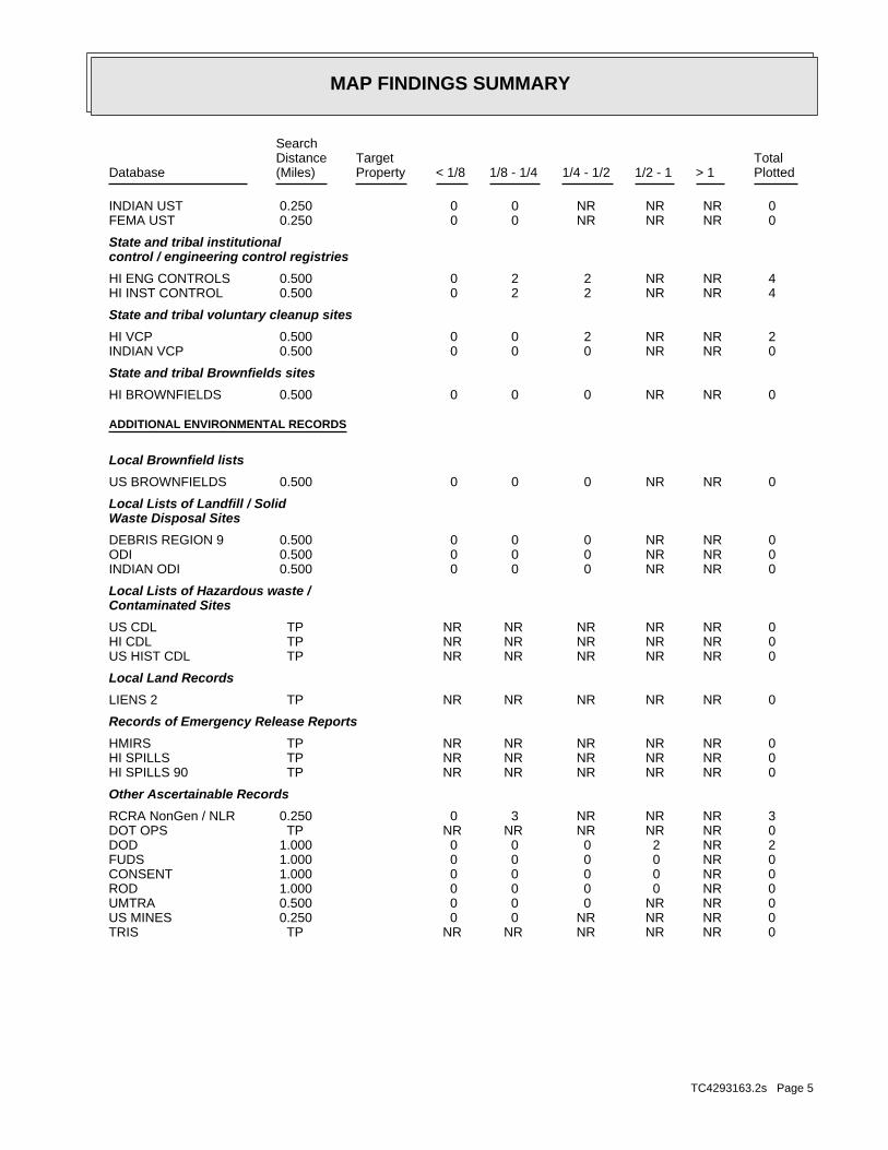
MAP FINDINGS SUMMARY
SearchTargetDistance Total
Database Property(Miles) < 1/8 1/8 - 1/4 1/4 - 1/2 1/2 - 1 > 1 Plotted
0 NR NR NR 0 0 0.250INDIAN UST 0 NR NR NR 0 0 0.250FEMA UST
State and tribal institutionalcontrol / engineering control registries
4 NR NR 2 2 0 0.500HI ENG CONTROLS 4 NR NR 2 2 0 0.500HI INST CONTROL
State and tribal voluntary cleanup sites
2 NR NR 2 0 0 0.500HI VCP 0 NR NR 0 0 0 0.500INDIAN VCP
State and tribal Brownfields sites
0 NR NR 0 0 0 0.500HI BROWNFIELDS
ADDITIONAL ENVIRONMENTAL RECORDS
Local Brownfield lists
0 NR NR 0 0 0 0.500US BROWNFIELDS
Local Lists of Landfill / SolidWaste Disposal Sites
0 NR NR 0 0 0 0.500DEBRIS REGION 9 0 NR NR 0 0 0 0.500ODI 0 NR NR 0 0 0 0.500INDIAN ODI
Local Lists of Hazardous waste /Contaminated Sites
0 NR NR NR NR NR TPUS CDL 0 NR NR NR NR NR TPHI CDL 0 NR NR NR NR NR TPUS HIST CDL
Local Land Records
0 NR NR NR NR NR TPLIENS 2
Records of Emergency Release Reports
0 NR NR NR NR NR TPHMIRS 0 NR NR NR NR NR TPHI SPILLS 0 NR NR NR NR NR TPHI SPILLS 90
Other Ascertainable Records
3 NR NR NR 3 0 0.250RCRA NonGen / NLR 0 NR NR NR NR NR TPDOT OPS 2 NR 2 0 0 0 1.000DOD 0 NR 0 0 0 0 1.000FUDS 0 NR 0 0 0 0 1.000CONSENT 0 NR 0 0 0 0 1.000ROD 0 NR NR 0 0 0 0.500UMTRA 0 NR NR NR 0 0 0.250US MINES 0 NR NR NR NR NR TPTRIS
TC4293163.2s Page 5

MAP FINDINGS SUMMARY
SearchTargetDistance Total
Database Property(Miles) < 1/8 1/8 - 1/4 1/4 - 1/2 1/2 - 1 > 1 Plotted
0 NR NR NR NR NR TPTSCA 0 NR NR NR NR NR TPFTTS 0 NR NR NR NR NR TPHIST FTTS 0 NR NR NR NR NR TPSSTS 0 NR NR NR NR NR TPICIS 0 NR NR NR NR NR TPPADS 0 NR NR NR NR NR TPMLTS 0 NR NR NR NR NR TPRADINFO 0 NR NR NR NR NR TPFINDS 0 NR NR NR NR NR TPRAATS 0 NR NR NR NR NR TPRMP 0 NR NR NR NR NR TPHI UIC 0 NR NR NR 0 0 0.250HI DRYCLEANERS 0 NR NR NR NR NR TPCA HAZNET 0 NR NR NR NR NR TPHI AIRS 0 NR 0 0 0 0 1.000INDIAN RESERV 0 NR NR 0 0 0 0.500SCRD DRYCLEANERS 0 NR NR NR NR NR TPHI Financial Assurance 0 NR NR NR NR NR TPLEAD SMELTERS 0 NR NR NR NR NR TPPRP 0 NR NR NR 0 0 0.2502020 COR ACTION 0 NR NR NR NR NR TPCOAL ASH DOE 0 NR NR NR NR NR TPUS AIRS 0 NR NR 0 0 0 0.500COAL ASH EPA 0 NR NR NR NR NR TPPCB TRANSFORMER 0 NR NR NR NR NR TPUS FIN ASSUR 0 NR NR NR NR NR TPEPA WATCH LIST
EDR HIGH RISK HISTORICAL RECORDS
EDR Exclusive Records
2 NR 2 0 0 0 1.000EDR MGP 10 NR NR NR 9 1 0.250EDR US Hist Auto Stat 2 NR NR NR 2 0 0.250EDR US Hist Cleaners
EDR RECOVERED GOVERNMENT ARCHIVES
Exclusive Recovered Govt. Archives
0 NR NR NR NR NR TPHI RGA LF 0 NR NR NR NR NR TPHI RGA LUST 0 NR NR NR NR NR TPHI RGA HWS
153 0 68 39 41 5 0- Totals --
NOTES:
TP = Target Property
NR = Not Requested at this Search Distance
Sites may be listed in more than one database
TC4293163.2s Page 6

TC4293163.2s Page 7
A2 HI LUST7-11 KAPALAMA U003154444SW HI UST1136 N KING ST. N/A< 1/8 HI Financial AssuranceHONOLULU, HI 96817
Relative:Higher
Click here for full text details
0.118 mi.622 ft.
HI LUST Facility Status: Site Cleanup Completed (NFA) Release ID: 930033 Facility Id: 9-100028
HI UST Tank Status: Permanently Out of Use Tank Status: Currently In Use Date Closed: 12/15/1992 Date Closed: 12/11/1992 Facility Id: 9-100028
HI Financial Assurance Alt Facility ID: 9-100028 Tank Status: Permanently Out of Use Tank Status: Currently In Use
1 EDR US Hist Auto Stat 1015227916East 1435 AULD LN N/A< 1/8 HONOLULU, HI 96817
Relative:Higher
Click here for full text details
0.109 mi.578 ft.
DOD DODFORT SHAFTER CUSA147753Region N/ANW FORT SHAFTER (County), HI
Click here for full text details
1/2-14935 ft.
DOD DODSAND ISLAND MILITARY RESERVATION CUSA147757Region N/ASSW SAND ISLAND MILITARY RESE (County), HI
Click here for full text details
1/2-13993 ft.
MAP FINDINGSMap IDDirection
EDR ID NumberDistanceEPA ID NumberDatabase(s)SiteElevation

TC4293163.2s Page 8
7 EDR US Hist Auto Stat 1015170839WSW 1160 N KING ST N/A1/8-1/4 HONOLULU, HI 96817
Relative:Higher
Click here for full text details
0.138 mi.727 ft.
A6 HI SHWSGTE-HAWAIIAN TEL EMPLOYEES FEDERAL CREDIT UNION (HTEFCU) 1006820922WSW HI ENG CONTROLS1138 N KING ST N/A1/8-1/4 HI INST CONTROLHONOLULU, HI 96817
Relative:Higher
Click here for full text details
0.133 mi.704 ft.
A5 RCRA NonGen / NLRBOBS AUTO REPAIR 1000373883WSW 1138-A N KING ST HID9816609051/8-1/4 HONOLULU, HI 96817
Relative:Higher
Click here for full text details
0.133 mi.704 ft.
RCRA NonGen / NLR EPA Id: HID981660905
4 RCRA-CESQGQUEEN LILIOKALANI HOSPITAL 1004688933NNW FINDS1300 HALONA ST HIR000000018< 1/8 HONOLULU, HI 96817
Relative:Higher
Click here for full text details
0.122 mi.646 ft.
RCRA-CESQG EPA Id: HIR000000018
FINDS Registry ID:: 110005729104
A3 RCRA-CESQGUNOCAL 76 SS L 0471 1004688898SW 1136 N KING ST HID984468702< 1/8 HONOLULU, HI 96817
Relative:Higher
Click here for full text details
0.118 mi.622 ft.
RCRA-CESQG EPA Id: HID984468702
MAP FINDINGSMap IDDirection
EDR ID NumberDistanceEPA ID NumberDatabase(s)SiteElevation

TC4293163.2s Page 9
B11 HI USTPACIFIC AUTO SERVICE U003541719West 1229 N KING ST N/A1/8-1/4 HONOLULU, HI 96817
Relative:Higher
Click here for full text details
0.164 mi.866 ft.
HI UST Tank Status: Permanently Out of Use Date Closed: 04/01/1988 Facility Id: 9-100930
B10 EDR US Hist Cleaners 1014983189West 1222 N KING ST N/A1/8-1/4 HONOLULU, HI 96817
Relative:Higher
Click here for full text details
0.163 mi.862 ft.
B9 HI LUSTOAHU PLUMBING & SHEETMETAL U003221928West HI UST1217 N KING ST N/A1/8-1/4 HONOLULU, HI 96819
Relative:Higher
Click here for full text details
0.159 mi.839 ft.
HI LUST Facility Status: Site Cleanup Completed (NFA) Release ID: 980032 Facility Id: 9-103346
HI UST Tank Status: Permanently Out of Use Date Closed: 01/06/1998 Facility Id: 9-103346
8 HI LUSTKING’S SERVICE U003541723SSW HI UST1070 N KING ST N/A1/8-1/4 HONOLULU, HI 96817
Relative:Higher
Click here for full text details
0.158 mi.835 ft.
HI LUST Facility Status: Site Cleanup Completed (NFA) Release ID: 870007 Facility Id: 9-101111
HI UST Tank Status: Permanently Out of Use Date Closed: 07/01/1993 Date Closed: 09/29/1986 Facility Id: 9-101111
MAP FINDINGSMap IDDirection
EDR ID NumberDistanceEPA ID NumberDatabase(s)SiteElevation
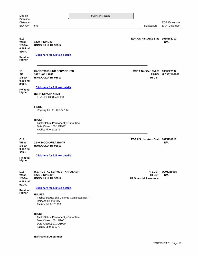
TC4293163.2s Page 10
D15 HI LUSTU.S. POSTAL SERVICE - KAPALAMA U001235585West HI UST1271 N KING ST N/A1/8-1/4 HI Financial AssuranceHONOLULU, HI 96817
Relative:Higher
Click here for full text details
0.188 mi.991 ft.
HI LUST Facility Status: Site Cleanup Completed (NFA) Release ID: 900116 Facility Id: 9-101773
HI UST Tank Status: Permanently Out of Use Date Closed: 05/14/2001 Date Closed: 07/30/1990 Facility Id: 9-101773
HI Financial Assurance
C14 EDR US Hist Auto Stat 1015191011WSW 1240 MOOKAULA BAY 5 N/A1/8-1/4 HONOLULU, HI 96813
Relative:Higher
Click here for full text details
0.182 mi.963 ft.
13 RCRA NonGen / NLRKANO TRUCKING SERVICE LTD 1000327197SE FINDS1412 IAO LANE HID9824979681/8-1/4 HI USTHONOLULU, HI 96817
Relative:Higher
Click here for full text details
0.169 mi.893 ft.
RCRA NonGen / NLR EPA Id: HID982497968
FINDS Registry ID:: 110005727062
HI UST Tank Status: Permanently Out of Use Date Closed: 07/11/1997 Facility Id: 9-101372
B12 EDR US Hist Auto Stat 1015188110West 1229 N KING ST N/A1/8-1/4 HONOLULU, HI 96817
Relative:Higher
Click here for full text details
0.164 mi.866 ft.
MAP FINDINGSMap IDDirection
EDR ID NumberDistanceEPA ID NumberDatabase(s)SiteElevation

TC4293163.2s Page 11
C18 RCRA-CESQGACCENT WALL DESIGN INC 1004688987WSW FINDS1240 MOOKAULA ST HIR0000542961/8-1/4 CA HAZNETHONOLULU, HI 96819
Relative:Higher
Click here for full text details
0.196 mi.1037 ft.
RCRA-CESQG EPA Id: HIR000054296
FINDS Registry ID:: 110005730478
CA HAZNET GEPAID: HIR000054296
D17 EDR US Hist Cleaners 1014985672WNW 1270 N KING ST N/A1/8-1/4 HONOLULU, HI 96817
Relative:Higher
Click here for full text details
0.192 mi.1015 ft.
E16 RCRA-CESQGOAHU AIR CONDITIONING SERVICE INC 1000423869SW FINDS938 KOHOU ST HID9825253471/8-1/4 CA HAZNETHONOLULU, HI 96817
Relative:Higher
Click here for full text details
0.190 mi.1005 ft.
RCRA-CESQG EPA Id: HID982525347
FINDS Registry ID:: 110005727197
CA HAZNET GEPAID: HID982525347
U.S. POSTAL SERVICE - KAPALAMA (Continued) U001235585
Alt Facility ID: 9-101773 Tank Status: Permanently Out of Use
MAP FINDINGSMap IDDirection
EDR ID NumberDistanceEPA ID NumberDatabase(s)SiteElevation
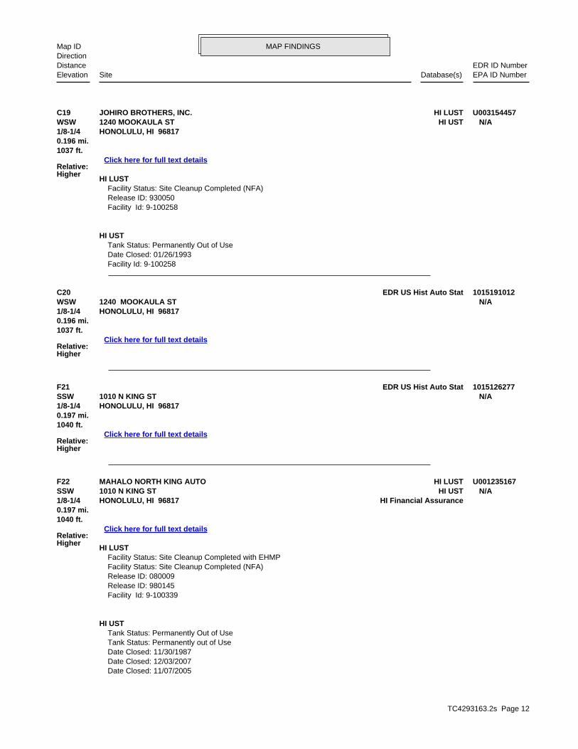
TC4293163.2s Page 12
F22 HI LUSTMAHALO NORTH KING AUTO U001235167SSW HI UST1010 N KING ST N/A1/8-1/4 HI Financial AssuranceHONOLULU, HI 96817
Relative:Higher
Click here for full text details
0.197 mi.1040 ft.
HI LUST Facility Status: Site Cleanup Completed with EHMP Facility Status: Site Cleanup Completed (NFA) Release ID: 080009 Release ID: 980145 Facility Id: 9-100339
HI UST Tank Status: Permanently Out of Use Tank Status: Permanently out of Use Date Closed: 11/30/1987 Date Closed: 12/03/2007 Date Closed: 11/07/2005
F21 EDR US Hist Auto Stat 1015126277SSW 1010 N KING ST N/A1/8-1/4 HONOLULU, HI 96817
Relative:Higher
Click here for full text details
0.197 mi.1040 ft.
C20 EDR US Hist Auto Stat 1015191012WSW 1240 MOOKAULA ST N/A1/8-1/4 HONOLULU, HI 96817
Relative:Higher
Click here for full text details
0.196 mi.1037 ft.
C19 HI LUSTJOHIRO BROTHERS, INC. U003154457WSW HI UST1240 MOOKAULA ST N/A1/8-1/4 HONOLULU, HI 96817
Relative:Higher
Click here for full text details
0.196 mi.1037 ft.
HI LUST Facility Status: Site Cleanup Completed (NFA) Release ID: 930050 Facility Id: 9-100258
HI UST Tank Status: Permanently Out of Use Date Closed: 01/26/1993 Facility Id: 9-100258
MAP FINDINGSMap IDDirection
EDR ID NumberDistanceEPA ID NumberDatabase(s)SiteElevation
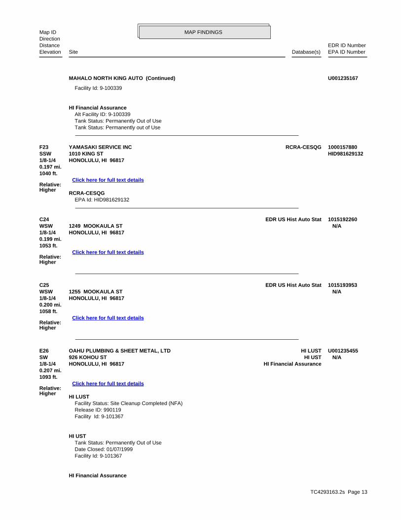
TC4293163.2s Page 13
E26 HI LUSTOAHU PLUMBING & SHEET METAL, LTD U001235455SW HI UST926 KOHOU ST N/A1/8-1/4 HI Financial AssuranceHONOLULU, HI 96817
Relative:Higher
Click here for full text details
0.207 mi.1093 ft.
HI LUST Facility Status: Site Cleanup Completed (NFA) Release ID: 990119 Facility Id: 9-101367
HI UST Tank Status: Permanently Out of Use Date Closed: 01/07/1999 Facility Id: 9-101367
HI Financial Assurance
C25 EDR US Hist Auto Stat 1015193953WSW 1255 MOOKAULA ST N/A1/8-1/4 HONOLULU, HI 96817
Relative:Higher
Click here for full text details
0.200 mi.1058 ft.
C24 EDR US Hist Auto Stat 1015192260WSW 1249 MOOKAULA ST N/A1/8-1/4 HONOLULU, HI 96817
Relative:Higher
Click here for full text details
0.199 mi.1053 ft.
F23 RCRA-CESQGYAMASAKI SERVICE INC 1000157880SSW 1010 KING ST HID9816291321/8-1/4 HONOLULU, HI 96817
Relative:Higher
Click here for full text details
0.197 mi.1040 ft.
RCRA-CESQG EPA Id: HID981629132
MAHALO NORTH KING AUTO (Continued) U001235167
Facility Id: 9-100339
HI Financial Assurance Alt Facility ID: 9-100339 Tank Status: Permanently Out of Use Tank Status: Permanently out of Use
MAP FINDINGSMap IDDirection
EDR ID NumberDistanceEPA ID NumberDatabase(s)SiteElevation

TC4293163.2s Page 14
G30 EDR US Hist Auto Stat 1015205064West 1311 MOOKAULA ST N/A1/8-1/4 HONOLULU, HI 96817
Relative:Higher
Click here for full text details
0.229 mi.1210 ft.
G29 EDR US Hist Auto Stat 1015204739West 1310 MOOKAULA ST N/A1/8-1/4 HONOLULU, HI 96817
Relative:Higher
Click here for full text details
0.229 mi.1207 ft.
G28 RCRA-CESQGGERMAN CAR SERVICE 1004688801West FINDS1310 MOOKAULA ST HID9816552281/8-1/4 HONOLULU, HI 96817
Relative:Higher
Click here for full text details
0.229 mi.1207 ft.
RCRA-CESQG EPA Id: HID981655228
FINDS Registry ID:: 110005724877
27 RCRA NonGen / NLROAHU AIR CONDITIONING SVC INC 1001218487SW FINDS904 KOHOU ST HIR0000006791/8-1/4 HONOLULU, HI 96817
Relative:Higher
Click here for full text details
0.223 mi.1179 ft.
RCRA NonGen / NLR EPA Id: HIR000000679
FINDS Registry ID:: 110005729541
OAHU PLUMBING & SHEET METAL, LTD (Continued) U001235455
Alt Facility ID: 9-101367 Tank Status: Permanently Out of Use
MAP FINDINGSMap IDDirection
EDR ID NumberDistanceEPA ID NumberDatabase(s)SiteElevation
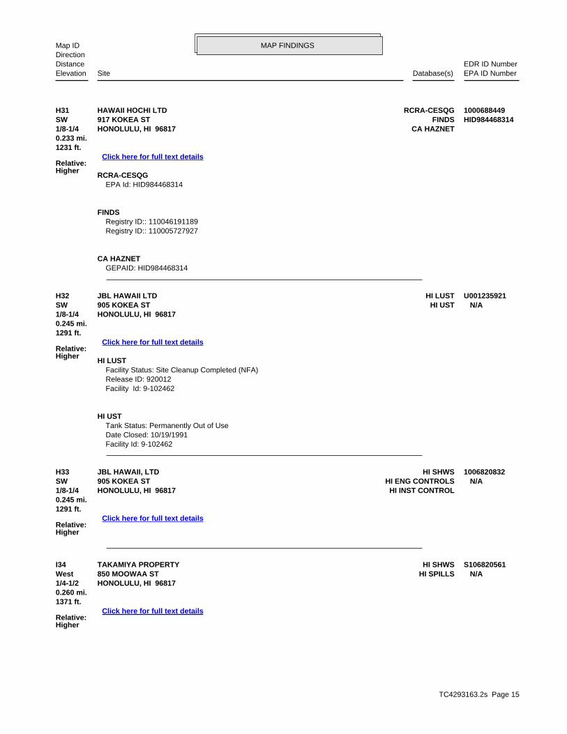
TC4293163.2s Page 15
I34 HI SHWSTAKAMIYA PROPERTY S106820561West HI SPILLS850 MOOWAA ST N/A1/4-1/2 HONOLULU, HI 96817
Relative:Higher
Click here for full text details
0.260 mi.1371 ft.
H33 HI SHWSJBL HAWAII, LTD 1006820832SW HI ENG CONTROLS905 KOKEA ST N/A1/8-1/4 HI INST CONTROLHONOLULU, HI 96817
Relative:Higher
Click here for full text details
0.245 mi.1291 ft.
H32 HI LUSTJBL HAWAII LTD U001235921SW HI UST905 KOKEA ST N/A1/8-1/4 HONOLULU, HI 96817
Relative:Higher
Click here for full text details
0.245 mi.1291 ft.
HI LUST Facility Status: Site Cleanup Completed (NFA) Release ID: 920012 Facility Id: 9-102462
HI UST Tank Status: Permanently Out of Use Date Closed: 10/19/1991 Facility Id: 9-102462
H31 RCRA-CESQGHAWAII HOCHI LTD 1000688449SW FINDS917 KOKEA ST HID9844683141/8-1/4 CA HAZNETHONOLULU, HI 96817
Relative:Higher
Click here for full text details
0.233 mi.1231 ft.
RCRA-CESQG EPA Id: HID984468314
FINDS Registry ID:: 110046191189 Registry ID:: 110005727927
CA HAZNET GEPAID: HID984468314
MAP FINDINGSMap IDDirection
EDR ID NumberDistanceEPA ID NumberDatabase(s)SiteElevation

TC4293163.2s Page 16
38 HI LUSTHAWAII HOUSING AUTHORITY U001235353ENE HI UST1002 N SCHOOL ST N/A1/4-1/2 HONOLULU, HI 96817
Relative:Higher
Click here for full text details
0.271 mi.1429 ft.
HI LUST Facility Status: Site Cleanup Completed (NFA) Release ID: 940197
J37 HI LUSTFUTURE HONOLULU FORD PROPERTY U003986422WNW HI USTCORNER OF HOUGHTAILING AND KING ST N/A1/4-1/2 HONOLULU, HI 96819
Relative:Higher
Click here for full text details
0.270 mi.1424 ft.
HI LUST Facility Status: Site Cleanup Completed (NFA) Release ID: 040065 Facility Id: 9-103785
HI UST Tank Status: Permanently Out of Use Date Closed: 08/10/2004 Facility Id: 9-103785
I36 CERCLISTAKAMIYA PROPERTY 1000707614West 850 MOOWAA ST. HID9844683711/4-1/2 HONOLULU, HI 96817
Relative:Higher
Click here for full text details
0.260 mi.1371 ft.
CERCLIS Site ID: 0904486 EPA Id: HID984468371
I35 HI LUSTI. STEVEN SUNADA U001235118West HI UST850 MOOWAA ST N/A1/4-1/2 HONOLULU, HI 96817
Relative:Higher
Click here for full text details
0.260 mi.1371 ft.
HI LUST Facility Status: Site Cleanup Completed (NFA) Release ID: 910015 Facility Id: 9-100251
HI UST Tank Status: Permanently Out of Use Date Closed: 04/01/1986 Facility Id: 9-100251
MAP FINDINGSMap IDDirection
EDR ID NumberDistanceEPA ID NumberDatabase(s)SiteElevation

TC4293163.2s Page 17
40 HI LUSTTESORO 2GO #61022 U003221598SSE HI UST1311 PALAMA ST N/A1/4-1/2 HI Financial AssuranceHONOLULU, HI 96817
Relative:Higher
Click here for full text details
0.280 mi.1476 ft.
HI LUST Facility Status: Site Cleanup Completed (NFA) Release ID: 980039 Facility Id: 9-100348
HI UST Tank Status: Permanently Out of Use Tank Status: Currently In Use Date Closed: 12/03/1997 Date Closed: 02/21/1990 Facility Id: 9-100348
HI Financial Assurance Alt Facility ID: 9-100348 Tank Status: Permanently Out of Use Tank Status: Currently In Use
39 HI LUSTSAWAI BROTHERS PAINTING CO. LTD. U001235597NE HI UST1135 N SCHOOL ST N/A1/4-1/2 HONOLULU, HI 96817
Relative:Higher
Click here for full text details
0.273 mi.1440 ft.
HI LUST Facility Status: Site Cleanup Completed (NFA) Release ID: 980024 Facility Id: 9-101808
HI UST Tank Status: Permanently Out of Use Date Closed: 12/16/1997 Facility Id: 9-101808
HAWAII HOUSING AUTHORITY (Continued) U001235353
Facility Id: 9-101036
HI UST Tank Status: Permanently Out of Use Date Closed: 06/13/1994 Facility Id: 9-101036
MAP FINDINGSMap IDDirection
EDR ID NumberDistanceEPA ID NumberDatabase(s)SiteElevation

TC4293163.2s Page 18
42 HI LUSTISLAND PAINTING U001235756West HI UST1353 MOOKAULA ST N/A1/4-1/2 HI Financial AssuranceHONOLULU, HI 96817
Relative:Higher
Click here for full text details
0.283 mi.1492 ft.
HI LUST Facility Status: Site Cleanup Completed (NFA) Release ID: 910079 Facility Id: 9-102161
HI UST Tank Status: Permanently Out of Use Facility Id: 9-102161
HI Financial Assurance Alt Facility ID: 9-102161 Tank Status: Permanently Out of Use
J41 HI LUSTMARSHALL’S SHELL SS U003402806WNW HI UST1029 HOUGHTAILING ST N/A1/4-1/2 HI Financial AssuranceHONOLULU, HI 96817
Relative:Higher
Click here for full text details
0.281 mi.1483 ft.
HI LUST Facility Status: Site Cleanup Completed (NFA) Facility Status: Confirmed Release Release ID: 920145 Release ID: 060022 Release ID: 080032 Release ID: 150008 Facility Id: 9-100783
HI UST Tank Status: Permanently Out of Use Tank Status: Permanently out of Use Date Closed: 09/30/1991 Date Closed: 12/03/2014 Date Closed: 12/03/2004 Facility Id: 9-100783
HI Financial Assurance Alt Facility ID: 9-100783 Tank Status: Permanently Out of Use Tank Status: Permanently out of Use
MAP FINDINGSMap IDDirection
EDR ID NumberDistanceEPA ID NumberDatabase(s)SiteElevation
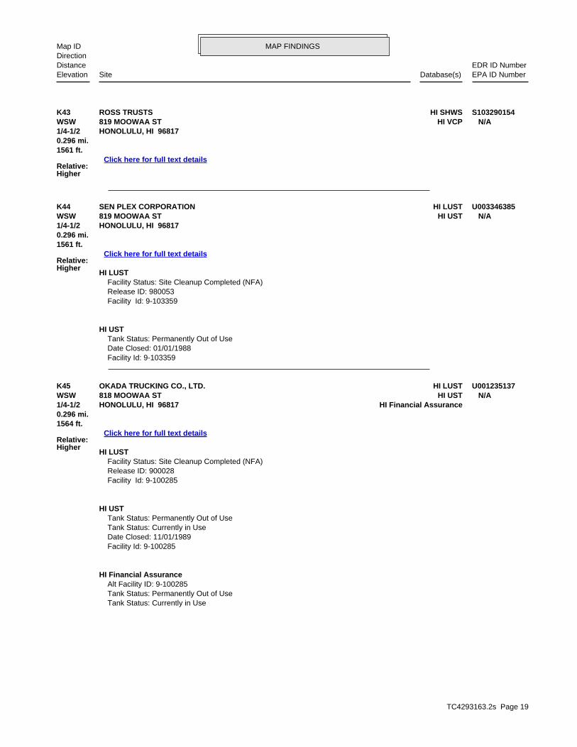
TC4293163.2s Page 19
K45 HI LUSTOKADA TRUCKING CO., LTD. U001235137WSW HI UST818 MOOWAA ST N/A1/4-1/2 HI Financial AssuranceHONOLULU, HI 96817
Relative:Higher
Click here for full text details
0.296 mi.1564 ft.
HI LUST Facility Status: Site Cleanup Completed (NFA) Release ID: 900028 Facility Id: 9-100285
HI UST Tank Status: Permanently Out of Use Tank Status: Currently in Use Date Closed: 11/01/1989 Facility Id: 9-100285
HI Financial Assurance Alt Facility ID: 9-100285 Tank Status: Permanently Out of Use Tank Status: Currently in Use
K44 HI LUSTSEN PLEX CORPORATION U003346385WSW HI UST819 MOOWAA ST N/A1/4-1/2 HONOLULU, HI 96817
Relative:Higher
Click here for full text details
0.296 mi.1561 ft.
HI LUST Facility Status: Site Cleanup Completed (NFA) Release ID: 980053 Facility Id: 9-103359
HI UST Tank Status: Permanently Out of Use Date Closed: 01/01/1988 Facility Id: 9-103359
K43 HI SHWSROSS TRUSTS S103290154WSW HI VCP819 MOOWAA ST N/A1/4-1/2 HONOLULU, HI 96817
Relative:Higher
Click here for full text details
0.296 mi.1561 ft.
MAP FINDINGSMap IDDirection
EDR ID NumberDistanceEPA ID NumberDatabase(s)SiteElevation
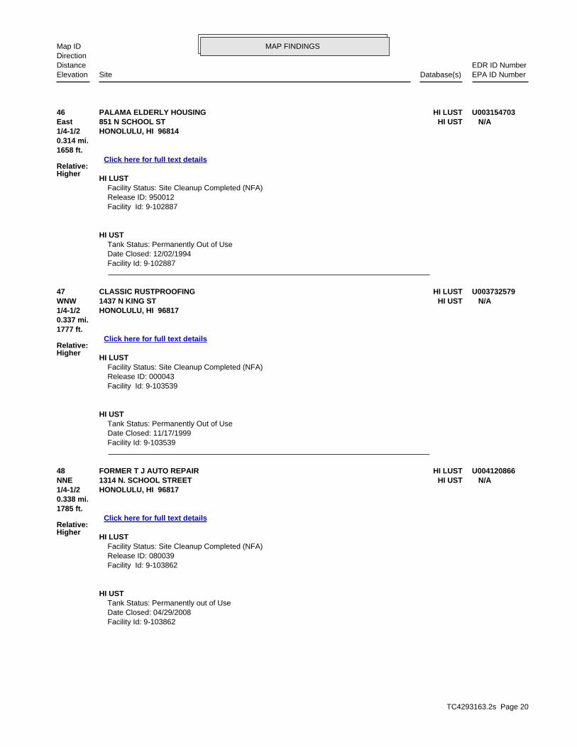
TC4293163.2s Page 20
48 HI LUSTFORMER T J AUTO REPAIR U004120866NNE HI UST1314 N. SCHOOL STREET N/A1/4-1/2 HONOLULU, HI 96817
Relative:Higher
Click here for full text details
0.338 mi.1785 ft.
HI LUST Facility Status: Site Cleanup Completed (NFA) Release ID: 080039 Facility Id: 9-103862
HI UST Tank Status: Permanently out of Use Date Closed: 04/29/2008 Facility Id: 9-103862
47 HI LUSTCLASSIC RUSTPROOFING U003732579WNW HI UST1437 N KING ST N/A1/4-1/2 HONOLULU, HI 96817
Relative:Higher
Click here for full text details
0.337 mi.1777 ft.
HI LUST Facility Status: Site Cleanup Completed (NFA) Release ID: 000043 Facility Id: 9-103539
HI UST Tank Status: Permanently Out of Use Date Closed: 11/17/1999 Facility Id: 9-103539
46 HI LUSTPALAMA ELDERLY HOUSING U003154703East HI UST851 N SCHOOL ST N/A1/4-1/2 HONOLULU, HI 96814
Relative:Higher
Click here for full text details
0.314 mi.1658 ft.
HI LUST Facility Status: Site Cleanup Completed (NFA) Release ID: 950012 Facility Id: 9-102887
HI UST Tank Status: Permanently Out of Use Date Closed: 12/02/1994 Facility Id: 9-102887
MAP FINDINGSMap IDDirection
EDR ID NumberDistanceEPA ID NumberDatabase(s)SiteElevation

TC4293163.2s Page 21
51 HI LUSTHONOLULU COMMUNITY COLLEGE U004109517SSW HI USTDILLINGHAM BLVD N/A1/4-1/2 HONOLULU, HI 96817
Relative:Higher
Click here for full text details
0.390 mi.2061 ft.
HI LUST Facility Status: Site Cleanup Completed (NFA) Release ID: 970108 Facility Id: 9-103285
HI UST Tank Status: Permanently Out of Use Date Closed: 12/01/1982 Facility Id: 9-103285
50 HI LUSTMALUHIA ELDERLY HOUSING U003221877ENE HI UST1111 HALA DR N/A1/4-1/2 HONOLULU, HI 96813
Relative:Higher
Click here for full text details
0.376 mi.1987 ft.
HI LUST Facility Status: Site Cleanup Completed (NFA) Release ID: 950084 Facility Id: 9-103082
HI UST Tank Status: Permanently Out of Use Date Closed: 05/05/1995 Date Closed: 04/28/1995 Facility Id: 9-103082
49 HI LUSTSHIMAYA SHOTEN, LTD. U001235478SW HI UST710 KOHOU ST N/A1/4-1/2 HONOLULU, HI 96817
Relative:Higher
Click here for full text details
0.366 mi.1931 ft.
HI LUST Facility Status: Site Cleanup Completed (NFA) Release ID: 900044 Facility Id: 9-101425
HI UST Tank Status: Permanently Out of Use Date Closed: 01/30/1990 Facility Id: 9-101425
MAP FINDINGSMap IDDirection
EDR ID NumberDistanceEPA ID NumberDatabase(s)SiteElevation

TC4293163.2s Page 22
L53 HI LUSTKAPALAMA CHEVRON U004221609North HI UST1402 N SCHOOL ST N/A1/4-1/2 HI Financial AssuranceHONOLULU, HI 96817
Relative:Higher
Click here for full text details
0.392 mi.2069 ft.
HI LUST Facility Status: Site Cleanup Completed with EHE/EHMP Release ID: 910023 Facility Id: 9-101237
HI UST Tank Status: Currently In Use Tank Status: Permanently Out of Use Date Closed: 09/18/1989 Facility Id: 9-101237
HI Financial Assurance Alt Facility ID: 9-101237 Tank Status: Permanently Out of Use Tank Status: Currently In Use
L52 HI LUSTAIM SCHOOL ST. U003154504North HI UST1403 N SCHOOL ST N/A1/4-1/2 HI Financial AssuranceHONOLULU, HI 96817
Relative:Higher
Click here for full text details
0.391 mi.2062 ft.
HI LUST Facility Status: Active Remediation Release ID: 990010 Facility Id: 9-101198
HI UST Tank Status: Currently In Use Tank Status: Permanently Out of Use Date Closed: 10/21/1998 Facility Id: 9-101198
HI Financial Assurance Alt Facility ID: 9-101198 Tank Status: Permanently Out of Use Tank Status: Currently In Use
MAP FINDINGSMap IDDirection
EDR ID NumberDistanceEPA ID NumberDatabase(s)SiteElevation

TC4293163.2s Page 23
56 HI LUSTALPAC CORPORATION U003221749West HI UST815 WAIAKAMILO RD N/A1/4-1/2 HONOLULU, HI 96800
Relative:Higher
Click here for full text details
0.400 mi.2111 ft.
HI LUST Facility Status: Site Cleanup Completed (NFA) Release ID: 920077 Facility Id: 9-102546
HI UST Tank Status: Permanently Out of Use Date Closed: 02/25/1992 Facility Id: 9-102546
55 HI LUSTMID PAC PETROLEUM 254539 (PREV: BURT’S UNOCAL SERVICE) U001235009NNE HI Financial Assurance1342 N SCHOOL ST N/A1/4-1/2 HONOLULU, HI 96817
Relative:Higher
Click here for full text details
0.399 mi.2105 ft.
HI LUST Facility Status: Site Cleanup Completed with EHE Release ID: 980023 Release ID: 090002 Release ID: 040006 Facility Id: 9-100032
HI Financial Assurance Alt Facility ID: 9-100032 Tank Status: Permanently Out of Use Tank Status: Permanently out of Use Tank Status: Currently in Use
54 CERCLISKAPALAMA INCINERATOR 1001475694SW 757 KOKEA STREET HISFN09054361/4-1/2 HONOLULU, HI 96817
Relative:Higher
Click here for full text details
0.392 mi.2071 ft.
CERCLIS Site ID: 0905436 EPA Id: HISFN0905436
MAP FINDINGSMap IDDirection
EDR ID NumberDistanceEPA ID NumberDatabase(s)SiteElevation

TC4293163.2s Page 24
M59 HI SHWSHONOLULU COMMUNITY COLLEGE GAS STATION 1006820629SSW 874 DILLINGHAM BLVD N/A1/4-1/2 HONOLULU, HI 96817
Relative:Higher
Click here for full text details
0.461 mi.2436 ft.
58 HI LUSTRICHARD TOM U003221678South HI UST963 ROBELLO LN N/A1/4-1/2 HI Financial AssuranceHONOLULU, HI 96817
Relative:Higher
Click here for full text details
0.437 mi.2308 ft.
HI LUST Facility Status: Site Cleanup Completed (NFA) Release ID: 990055 Facility Id: 9-101574
HI UST Tank Status: Permanently Out of Use Date Closed: 06/01/1998 Date Closed: 05/21/1998 Facility Id: 9-101574
HI Financial Assurance Alt Facility ID: 9-101574 Tank Status: Permanently Out of Use
57 HI LUSTSNAPPY SERVICE U001235264ESE HI UST719 N SCHOOL ST N/A1/4-1/2 HI SPILLSHONOLULU, HI 96817
Relative:Higher
Click here for full text details
0.414 mi.2186 ft.
HI LUST Facility Status: Site Cleanup Completed with EHE/EHMP Release ID: 900093 Facility Id: 9-100858
HI UST Tank Status: Permanently Out of Use Date Closed: 10/25/1993 Date Closed: 01/25/1993 Date Closed: 07/29/1991 Facility Id: 9-100858
MAP FINDINGSMap IDDirection
EDR ID NumberDistanceEPA ID NumberDatabase(s)SiteElevation
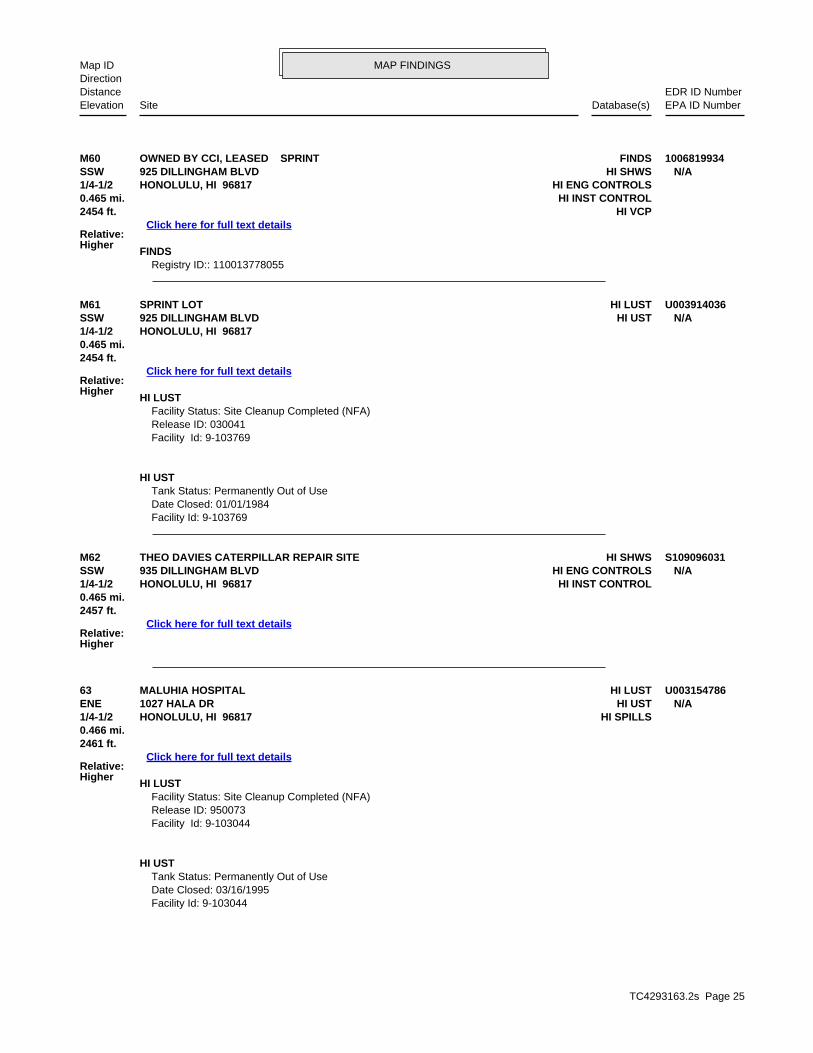
TC4293163.2s Page 25
63 HI LUSTMALUHIA HOSPITAL U003154786ENE HI UST1027 HALA DR N/A1/4-1/2 HI SPILLSHONOLULU, HI 96817
Relative:Higher
Click here for full text details
0.466 mi.2461 ft.
HI LUST Facility Status: Site Cleanup Completed (NFA) Release ID: 950073 Facility Id: 9-103044
HI UST Tank Status: Permanently Out of Use Date Closed: 03/16/1995 Facility Id: 9-103044
M62 HI SHWSTHEO DAVIES CATERPILLAR REPAIR SITE S109096031SSW HI ENG CONTROLS935 DILLINGHAM BLVD N/A1/4-1/2 HI INST CONTROLHONOLULU, HI 96817
Relative:Higher
Click here for full text details
0.465 mi.2457 ft.
M61 HI LUSTSPRINT LOT U003914036SSW HI UST925 DILLINGHAM BLVD N/A1/4-1/2 HONOLULU, HI 96817
Relative:Higher
Click here for full text details
0.465 mi.2454 ft.
HI LUST Facility Status: Site Cleanup Completed (NFA) Release ID: 030041 Facility Id: 9-103769
HI UST Tank Status: Permanently Out of Use Date Closed: 01/01/1984 Facility Id: 9-103769
M60 FINDSOWNED BY CCI, LEASED SPRINT 1006819934SSW HI SHWS925 DILLINGHAM BLVD N/A1/4-1/2 HI ENG CONTROLSHONOLULU, HI 96817
Relative:Higher
Click here for full text details
0.465 mi. HI INST CONTROL2454 ft. HI VCP
FINDS Registry ID:: 110013778055
MAP FINDINGSMap IDDirection
EDR ID NumberDistanceEPA ID NumberDatabase(s)SiteElevation
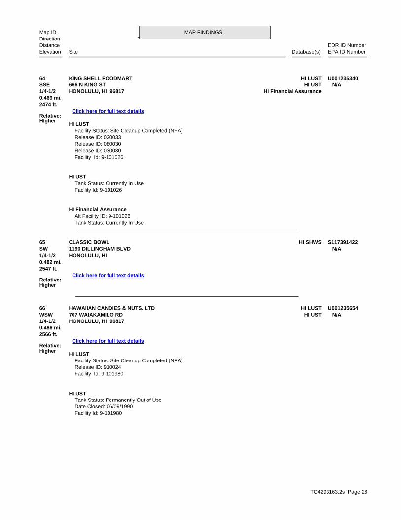
TC4293163.2s Page 26
66 HI LUSTHAWAIIAN CANDIES & NUTS. LTD U001235654WSW HI UST707 WAIAKAMILO RD N/A1/4-1/2 HONOLULU, HI 96817
Relative:Higher
Click here for full text details
0.486 mi.2566 ft.
HI LUST Facility Status: Site Cleanup Completed (NFA) Release ID: 910024 Facility Id: 9-101980
HI UST Tank Status: Permanently Out of Use Date Closed: 06/09/1990 Facility Id: 9-101980
65 HI SHWSCLASSIC BOWL S117391422SW 1190 DILLINGHAM BLVD N/A1/4-1/2 HONOLULU, HI
Relative:Higher
Click here for full text details
0.482 mi.2547 ft.
64 HI LUSTKING SHELL FOODMART U001235340SSE HI UST666 N KING ST N/A1/4-1/2 HI Financial AssuranceHONOLULU, HI 96817
Relative:Higher
Click here for full text details
0.469 mi.2474 ft.
HI LUST Facility Status: Site Cleanup Completed (NFA) Release ID: 020033 Release ID: 080030 Release ID: 030030 Facility Id: 9-101026
HI UST Tank Status: Currently In Use Facility Id: 9-101026
HI Financial Assurance Alt Facility ID: 9-101026 Tank Status: Currently In Use
MAP FINDINGSMap IDDirection
EDR ID NumberDistanceEPA ID NumberDatabase(s)SiteElevation

TC4293163.2s Page 27
71 HI SHWSLANCE GOYA CHEVRON U003402822SE HI LUST504 N SCHOOL ST N/A1/2-1 HI USTHONOLULU, HI 96817
Relative:Higher
Click here for full text details
0.588 mi. HI ENG CONTROLS3105 ft. HI INST CONTROL
HI Financial Assurance
HI LUST Facility Status: Site Cleanup Completed (NFA) Facility Status: Site Cleanup Completed with EHMP Release ID: 980240 Release ID: 030004 Release ID: 030003 Facility Id: 9-101259
HI UST Tank Status: Permanently Out of Use Date Closed: 10/06/2002
70 HI SHWSHALL MARK DRY CLEANERS S104534167SE 1470 LILIHA ST N/A1/2-1 HONOLULU, HI 96814
Relative:Higher
Click here for full text details
0.576 mi.3042 ft.
69 HI SHWSKAMEHAMEHA SCHOOLS - 1336 DILLINGHAM BOULEVARD S110061575WSW HI SPILLS1336 DILLINGHAM BLVD N/A1/2-1 HONOLULU, HI 96813
Relative:Higher
Click here for full text details
0.527 mi.2785 ft.
68 HI SHWSDOLE IWILEI S106816902South HI SPILLS801 DILLINGHAM BLVD N/A1/2-1 HI INST CONTROLHONOLULU, HI 96817
Relative:Higher
Click here for full text details
0.501 mi.2646 ft.
67 FTTSFARRINGTON HIGH SCHOOL 1007277849WNW HIST FTTS1564 N KING ST N/A1/2-1 HI SHWSHONOLULU, HI 96817
Relative:Higher
Click here for full text details
0.501 mi. HI SPILLS2644 ft.
MAP FINDINGSMap IDDirection
EDR ID NumberDistanceEPA ID NumberDatabase(s)SiteElevation
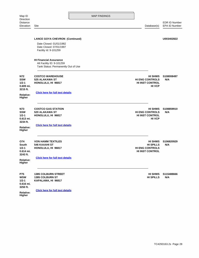
TC4293163.2s Page 28
P75 HI SHWS1385 COLBURN STREET S115488666WSW HI SPILLS1385 COLBURN ST N/A1/2-1 KAPALAMA, HI 96817
Relative:Higher
Click here for full text details
0.616 mi.3250 ft.
O74 HI SHWSVON HAMM TEXTILES S106820929South HI SPILLS546 KAAAHI ST N/A1/2-1 HI ENG CONTROLSHONOLULU, HI 96817
Relative:Higher
Click here for full text details
0.614 mi. HI INST CONTROL3243 ft.
N73 HI SHWSCOSTCO GAS STATION S108859910SSW HI ENG CONTROLS520 ALAKAWA ST N/A1/2-1 HI INST CONTROLHONOLULU, HI 96817
Relative:Higher
Click here for full text details
0.613 mi. HI VCP3234 ft.
N72 HI SHWSCOSTCO WAREHOUSE S108008497SSW HI ENG CONTROLS525 ALAKAWA ST N/A1/2-1 HI INST CONTROLHONOLULU, HI 96817
Relative:Higher
Click here for full text details
0.609 mi. HI VCP3215 ft.
LANCE GOYA CHEVRON (Continued) U003402822
Date Closed: 01/01/1982 Date Closed: 07/01/1997 Facility Id: 9-101259
HI Financial Assurance Alt Facility ID: 9-101259 Tank Status: Permanently Out of Use
MAP FINDINGSMap IDDirection
EDR ID NumberDistanceEPA ID NumberDatabase(s)SiteElevation
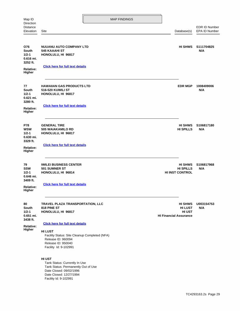
TC4293163.2s Page 29
80 HI SHWSTRAVEL PLAZA TRANSPORTATION, LLC U003154753South HI LUST818 PINE ST N/A1/2-1 HI USTHONOLULU, HI 96817
Relative:Higher
Click here for full text details
0.651 mi. HI Financial Assurance3438 ft.
HI LUST Facility Status: Site Cleanup Completed (NFA) Release ID: 960094 Release ID: 950040 Facility Id: 9-102991
HI UST Tank Status: Currently In Use Tank Status: Permanently Out of Use Date Closed: 09/02/1996 Date Closed: 12/27/1994 Facility Id: 9-102991
79 HI SHWSIWILEI BUSINESS CENTER S106817968SSW HI SPILLS501 SUMNER ST N/A1/2-1 HI INST CONTROLHONOLULU, HI 96814
Relative:Higher
Click here for full text details
0.646 mi.3409 ft.
P78 HI SHWSGENERAL TIRE S106817180WSW HI SPILLS505 WAIAKAMILO RD N/A1/2-1 HONOLULU, HI 96817
Relative:Higher
Click here for full text details
0.630 mi.3329 ft.
77 EDR MGPHAWAIIAN GAS PRODUCTS LTD 1008409006South 516-520 KUWILI ST N/A1/2-1 HONOLULU, HI 96817
Relative:Higher
Click here for full text details
0.621 mi.3280 ft.
O76 HI SHWSNUUANU AUTO COMPANY LTD S111704825South 545 KAAAHI ST N/A1/2-1 HONOLULU, HI 96817
Relative:Higher
Click here for full text details
0.616 mi.3252 ft.
MAP FINDINGSMap IDDirection
EDR ID NumberDistanceEPA ID NumberDatabase(s)SiteElevation

TC4293163.2s Page 30
85 HI SHWS1305 HART STREET S106815169WSW HI SPILLS1305 HART ST N/A1/2-1 HI INST CONTROLHONOLULU, HI 96814
Relative:Higher
Click here for full text details
0.767 mi.4049 ft.
Q84 HI SHWSMCCABE, HAMILTON, & RENNY COMPANY, LTD 1006818946SW HI SPILLS1130 N NIMITZ HWY N/A1/2-1 HONOLULU, HI 96817
Relative:Higher
Click here for full text details
0.763 mi.4028 ft.
83 HI SHWSBHP GASCO BENZENE SITE S110277531SSW HI SPILLS616 IWILEI RD N/A1/2-1 HI INST CONTROLHONOLULU, HI 96817
Relative:Higher
Click here for full text details
0.744 mi. HI AIRS3928 ft.
HI AIRS Facility Id: 0551-01-N
82 HI SHWSBEST BUY S108008729SW HI SPILLSALAKAWA ST & NIMITZ HWY N/A1/2-1 HONOLULU, HI 96817
Relative:Higher
Click here for full text details
0.725 mi.3829 ft.
81 HI SHWSHOME DEPOT S105887731SSW HI ENG CONTROLS421 ALAKAWA ST N/A1/2-1 HI INST CONTROLHONOLULU, HI 96817
Relative:Higher
Click here for full text details
0.697 mi.3681 ft.
TRAVEL PLAZA TRANSPORTATION, LLC (Continued) U003154753
HI Financial Assurance Alt Facility ID: 9-102991 Tank Status: Currently In Use Tank Status: Permanently Out of Use
MAP FINDINGSMap IDDirection
EDR ID NumberDistanceEPA ID NumberDatabase(s)SiteElevation
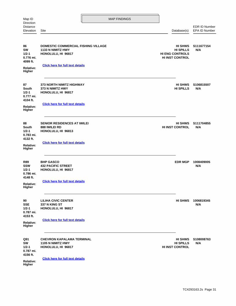
TC4293163.2s Page 31
Q91 HI SHWSCHEVRON KAPALAMA TERMINAL S108008763SW HI SPILLS1105 N NIMITZ HWY N/A1/2-1 HI INST CONTROLHONOLULU, HI 96817
Relative:Higher
Click here for full text details
0.787 mi.4156 ft.
90 HI SHWSLILIHA CIVIC CENTER 1006819345SSE 337 N KING ST N/A1/2-1 HONOLULU, HI 96817
Relative:Higher
Click here for full text details
0.787 mi.4153 ft.
R89 EDR MGPBHP GASCO 1008409005SSW 432 PACIFIC STREET N/A1/2-1 HONOLULU, HI 96817
Relative:Higher
Click here for full text details
0.786 mi.4148 ft.
88 HI SHWSSENIOR RESIDENCES AT IWILEI S111704855South HI INST CONTROL888 IWILEI RD N/A1/2-1 HONOLULU, HI 96813
Relative:Higher
Click here for full text details
0.783 mi.4132 ft.
87 HI SHWS373 NORTH NIMITZ HIGHWAY S106815507South HI SPILLS373 N NIMITZ HWY N/A1/2-1 HONOLULU, HI 96817
Relative:Higher
Click here for full text details
0.777 mi.4104 ft.
86 HI SHWSDOMESTIC COMMERCIAL FISHING VILLAGE S111677154SW HI SPILLS1133 N NIMITZ HWY N/A1/2-1 HI ENG CONTROLSHONOLULU, HI 96817
Relative:Higher
Click here for full text details
0.776 mi. HI INST CONTROL4099 ft.
MAP FINDINGSMap IDDirection
EDR ID NumberDistanceEPA ID NumberDatabase(s)SiteElevation

TC4293163.2s Page 32
94 HI SHWSHART STREET WWPS U003154453SW HI UIC1031 N NIMITZ HWY N/A1/2-1 HONOLULU, HI 96817
Relative:Higher
Click here for full text details
0.809 mi.4273 ft.
HI UIC UIC Permit Number: UO-2174 Facility Id/Lat Long Min Coord: 3-1952.05.1-2
93 HI SHWSIWILEI FRUIT AND VEGETABLE WAREHOUSE U003858603SSE HI LUST920 IWILEI ROAD N/A1/2-1 HI USTHONOLULU, HI 96813
Relative:Higher
Click here for full text details
0.802 mi.4235 ft.
HI LUST Facility Status: Site Cleanup Completed (NFA) Release ID: 020031 Facility Id: 9-103747
HI UST Tank Status: Permanently Out of Use Date Closed: 05/20/2002 Facility Id: 9-103747
R92 RCRA NonGen / NLRUNOCAL 76 HONOLULU LRNG CTR 1000167494SSW FINDS411 PACIFIC ST HID9816526961/2-1 HI SHWSHONOLULU, HI 96817
Relative:Higher
Click here for full text details
0.799 mi. HI UST4217 ft. HI SPILLS
HI VCPHI Financial Assurance
RCRA NonGen / NLR EPA Id: HID981652696
FINDS Registry ID:: 110009359826 Registry ID:: 110000495848
HI UST Tank Status: Permanently Out of Use Date Closed: 03/07/1997 Facility Id: 9-100108
HI Financial Assurance Alt Facility ID: 9-100108 Tank Status: Permanently Out of Use
MAP FINDINGSMap IDDirection
EDR ID NumberDistanceEPA ID NumberDatabase(s)SiteElevation
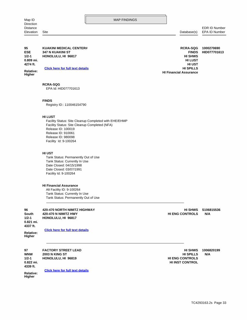
TC4293163.2s Page 33
97 HI SHWSFACTORY STREET LEAD 1006820199WNW HI SPILLS2003 N KING ST N/A1/2-1 HI ENG CONTROLSHONOLULU, HI 96819
Relative:Higher
Click here for full text details
0.822 mi. HI INST CONTROL4339 ft.
96 HI SHWS420-470 NORTH NIMITZ HIGHWAY S106815536South HI ENG CONTROLS420-470 N NIMITZ HWY N/A1/2-1 HONOLULU, HI 96817
Relative:Higher
Click here for full text details
0.821 mi.4337 ft.
95 RCRA-SQGKUAKINI MEDICAL CENTER# 1000270690ESE FINDS347 N KUAKINI ST HID0777016131/2-1 HI SHWSHONOLULU, HI 96817
Relative:Higher
Click here for full text details
0.809 mi. HI LUST4274 ft. HI UST
HI SPILLSHI Financial Assurance
RCRA-SQG EPA Id: HID077701613
FINDS Registry ID:: 110046154790
HI LUST Facility Status: Site Cleanup Completed with EHE/EHMP Facility Status: Site Cleanup Completed (NFA) Release ID: 100019 Release ID: 910061 Release ID: 980098 Facility Id: 9-100264
HI UST Tank Status: Permanently Out of Use Tank Status: Currently In Use Date Closed: 04/15/1998 Date Closed: 03/07/1991 Facility Id: 9-100264
HI Financial Assurance Alt Facility ID: 9-100264 Tank Status: Currently In Use Tank Status: Permanently Out of Use
MAP FINDINGSMap IDDirection
EDR ID NumberDistanceEPA ID NumberDatabase(s)SiteElevation

TC4293163.2s Page 34
S103 RCRA-CESQGPOLYNESIAN HOSPITALITY 1000906758SSW FINDS330 PACIFIC ST HI00005898121/2-1 HI SHWSHONOLULU, HI 96817
Relative:Higher
Click here for full text details
0.832 mi. HI LUST4393 ft. HI UST
HI SPILLSHI Financial Assurance
RCRA-CESQG
102 HI SHWSIWILEI PROJECT SITE (IWILEI BROWNFIELDS) S107022564SSE IWILEI RD & N KING ST N/A1/2-1 HONOLULU, HI 96817
Relative:Higher
Click here for full text details
0.830 mi.4380 ft.
S101 HI SHWSBREWER ENVIRONMENTAL INDUSTRIES-PACIFIC STREET 1000436248SSW HI SPILLS311 PACIFIC ST N/A1/2-1 HI VCPHONOLULU, HI 96817
Relative:Higher
Click here for full text details
0.828 mi.4373 ft.
100 HI SHWSGTE HAWAIIAN TEL - CONTAMINATED SOIL S106817210SW HI SPILLSALAKAWA ST & NIMITZ HWY N/A1/2-1 HI ENG CONTROLSHONOLULU, HI 96817
Relative:Higher
Click here for full text details
0.827 mi. HI INST CONTROL4369 ft.
99 HI SHWSYOUNG BROTHERS REFRIGERATE RELEASE S108009312WSW HI SPILLS1331 N NIMITZ HWY N/A1/2-1 HONOLULU, HI 96817
Relative:Higher
Click here for full text details
0.824 mi.4351 ft.
S98 HI SHWS356 PACIFIC STREET BWS TRENCHING SHEEN S110169069SSW HI SPILLS356 PACIFIC ST N/A1/2-1 HONOLULU, HI
Relative:Higher
Click here for full text details
0.823 mi.4346 ft.
MAP FINDINGSMap IDDirection
EDR ID NumberDistanceEPA ID NumberDatabase(s)SiteElevation

TC4293163.2s Page 35
104 HI SHWSMID PAC PETROLEUM LLC 2705958 U001235004South HI LUST540 N NIMITZ HWY N/A1/2-1 HI USTHONOLULU, HI 96817
Relative:Higher
Click here for full text details
0.856 mi. HI Financial Assurance4522 ft.
HI LUST Facility Status: Site Cleanup Completed (NFA) Release ID: 970015 Release ID: 920166 Release ID: 080018 Release ID: 070010 Facility Id: 9-100017
HI UST Tank Status: Permanently out of Use Tank Status: Permanently Out of Use Date Closed: 01/29/2007 Date Closed: 04/07/2008 Date Closed: 04/08/2008 Date Closed: 06/18/2001 Date Closed: 10/01/1996 Date Closed: 06/01/1990 Facility Id: 9-100017
HI Financial Assurance Alt Facility ID: 9-100017
POLYNESIAN HOSPITALITY (Continued) 1000906758
EPA Id: HI0000589812
FINDS Registry ID:: 110005722316
HI LUST Facility Status: Monitored Natural Attenuation Release ID: 910046 Facility Id: 9-101379
HI UST Tank Status: Currently in Use Tank Status: Permanently Out of Use Date Closed: 08/03/1994 Date Closed: 03/19/1991 Facility Id: 9-101379
HI Financial Assurance Alt Facility ID: 9-101379 Tank Status: Permanently Out of Use Tank Status: Currently in Use Tank Status: Temporarily out of Use
MAP FINDINGSMap IDDirection
EDR ID NumberDistanceEPA ID NumberDatabase(s)SiteElevation

TC4293163.2s Page 36
109 RCRA-CESQGKAMEHAMEHA SCOOLS 1000202706North FINDS1887 MAKUAKANE ST HID9816164691/2-1 HI SHWSHONOLULU, HI 96817
Relative:Higher
Click here for full text details
0.881 mi. HI SPILLS4650 ft. HI ENG CONTROLS
HI INST CONTROL
RCRA-CESQG EPA Id: HID981616469
FINDS
108 HI SHWSTOWN INN 1006819555SSE HI INST CONTROL248-258 N BERETANIA ST N/A1/2-1 HI VCPHONOLULU, HI 96817
Relative:Higher
Click here for full text details
0.871 mi.4598 ft.
T107 HI SHWSCHEVRON HONOLULU TRANSPORTATION TERMINAL U003154454SSW HI ENG CONTROLS933 N NIMITZ HWY N/A1/2-1 HI Financial AssuranceHONOLULU, HI 96817
Relative:Higher
Click here for full text details
0.868 mi.4582 ft.
HI Financial Assurance Alt Facility ID: 9-100242 Tank Status: Permanently Out of Use
106 HI SHWS215 NORTH KING STREET CONSTRUCTION SITE, TANKS 1 & 2 S106815334SSE 215 N KING ST N/A1/2-1 HONOLULU, HI 96814
Relative:Higher
Click here for full text details
0.866 mi.4574 ft.
T105 HI SHWSHAWAII STEVEDORES S106817380SW HI SPILLS965 N NIMITZ HWY N/A1/2-1 HI ENG CONTROLSHONOLULU, HI 96817
Relative:Higher
Click here for full text details
0.858 mi.4528 ft.
MID PAC PETROLEUM LLC 2705958 (Continued) U001235004
Tank Status: Permanently out of Use Tank Status: Permanently Out of Use
MAP FINDINGSMap IDDirection
EDR ID NumberDistanceEPA ID NumberDatabase(s)SiteElevation

TC4293163.2s Page 37
V113 HI SHWSWEYERHAEUSER S106821137SSW HI SPILLS900 N NIMITZ HWY N/A1/2-1 HONOLULU, HI 96817
Relative:Higher
Click here for full text details
0.892 mi.4711 ft.
112 HI SHWSDILLINGHAM BOULEVARD & MOKAUEA STREET S106816881West HI ENG CONTROLSDILLINGHAM BLVD & MOKAUEA ST N/A1/2-1 HI INST CONTROLHONOLULU, HI 96819
Relative:Higher
Click here for full text details
0.890 mi.4698 ft.
U111 HI SHWSCITY MILL U001235472South HI LUST660 N NIMITZ HWY N/A1/2-1 HI USTHONOLULU, HI 96817
Relative:Higher
Click here for full text details
0.888 mi. HI INST CONTROL4689 ft.
HI LUST Facility Status: Site Cleanup Completed (NFA) Release ID: 930073 Facility Id: 9-101398
HI UST Tank Status: Permanently Out of Use Date Closed: 03/08/1993 Facility Id: 9-101398
U110 HI SHWS580 NORTH NIMITZ HIGHWAY S109096040South HI ENG CONTROLS580 N NIMITZ HWY N/A1/2-1 HONOLULU, HI 96817
Relative:Higher
Click here for full text details
0.881 mi.4654 ft.
KAMEHAMEHA SCOOLS (Continued) 1000202706
Registry ID:: 110055125877 Registry ID:: 110055117715 Registry ID:: 110000789406
MAP FINDINGSMap IDDirection
EDR ID NumberDistanceEPA ID NumberDatabase(s)SiteElevation

TC4293163.2s Page 38
119 HI SHWS700 N NIMITZ IDPP RELEASE S110061245SSW HI SPILLS700 N NIMITZ HWY N/A1/2-1 HI ENG CONTROLSHONOLULU, HI
Relative:Higher
Click here for full text details
0.924 mi. HI INST CONTROL4879 ft.
V118 HI SHWSHAWAIIAN ELECTRIC COMPANY (HECO) - IWILEI TANK YARD U001235311SSW HI SPILLS855 N NIMITZ HWY N/A1/2-1 HI ENG CONTROLSHONOLULU, HI 96818
Relative:Higher
Click here for full text details
0.918 mi. HI INST CONTROL4847 ft.
V117 HI SHWS861-869 NORTH NIMITZ HIGHWAY S108859941SSW HI ENG CONTROLS861-869 N NIMITZ HWY N/A1/2-1 HI INST CONTROLHONOLULU, HI 96817
Relative:Higher
Click here for full text details
0.913 mi.4819 ft.
116 HI SHWSAWA WASTEWATER PUMP STATION S105262868South HI SPILLS190 N NIMITZ HWY N/A1/2-1 HONOLULU, HI 96817
Relative:Lower
Click here for full text details
0.904 mi.4775 ft.
115 RCRA-SQGKAPALAMA INCINERATOR 1001116173WNW HI SHWS757 KOKEA ST HIR0000010081/2-1 HI SPILLSHONOLULU, HI 96817
Relative:Higher
Click here for full text details
0.902 mi. HI INST CONTROL4765 ft.
RCRA-SQG EPA Id: HIR000001008
114 HI SHWSZIPPY’S 634 N NIMITZ HIGHWAY S110061866South HI SPILLS634 N NIMITZ HWY N/A1/2-1 HI ENG CONTROLSHONOLULU, HI 96781
Relative:Higher
Click here for full text details
0.899 mi. HI INST CONTROL4746 ft.
MAP FINDINGSMap IDDirection
EDR ID NumberDistanceEPA ID NumberDatabase(s)SiteElevation

TC4293163.2s Page 39
X124 HI SHWSEQUILON ENTERPRISES LLC HONOLULU TERMINAL S115488694SSW 789 N NIMITZ HWY N/A1/2-1 HONOLULU, HI 96817
Relative:Higher
Click here for full text details
0.966 mi.5098 ft.
W123 RCRA-CESQGMOANA PAA KAI 1000146699SSW HI SHWS705 N NIMITZ HWY HID9824113571/2-1 HI SPILLSHONOLULU, HI 96817
Relative:Higher
Click here for full text details
0.963 mi.5087 ft.
RCRA-CESQG EPA Id: HID982411357
W122 HI SHWSHAWAIIAN FLOUR MILL S106817404SSW 703 N NIMITZ HWY N/A1/2-1 HONOLULU, HI 96808
Relative:Higher
Click here for full text details
0.963 mi.5085 ft.
X121 HI SHWSPAULEY PETROLEUM S108009116SSW HI SPILLS795 N NIMITZ HWY N/A1/2-1 HI ENG CONTROLSHONOLULU, HI 96817
Relative:Higher
Click here for full text details
0.962 mi. HI INST CONTROL5082 ft.
W120 HI SHWSHAWAIIAN GRAIN CORPORATION U003402808SSW HI LUST701 N NIMITZ HWY N/A1/2-1 HI USTHONOLULU, HI 96817
Relative:Higher
Click here for full text details
0.958 mi.5057 ft.
HI LUST Facility Status: Case Transferred to HEER (regulated) Release ID: 920157 Facility Id: 9-100852
HI UST Tank Status: Permanently Out of Use Date Closed: 10/06/1993 Facility Id: 9-100852
MAP FINDINGSMap IDDirection
EDR ID NumberDistanceEPA ID NumberDatabase(s)SiteElevation

TC4293163.2s Page 40
130 HI SHWSPACIFIC POULTRY 1006819073West HI SPILLS1804 KANAKANUI ST N/A1/2-1 HONOLULU, HI 96819
Relative:Higher
Click here for full text details
0.990 mi.5228 ft.
Y129 HI SHWS755 N NIMITZ HWY S110061246SSW HI SPILLS755 N NIMITZ HWY N/A1/2-1 HI ENG CONTROLSHONOLULU, HI
Relative:Higher
Click here for full text details
0.970 mi. HI INST CONTROL5122 ft.
128 HI SHWS775 NORTH NIMITZ HIGHWAY S110061247SSW HI ENG CONTROLS775 N NIMITZ HWY N/A1/2-1 HI INST CONTROLHONOLULU, HI
Relative:Higher
Click here for full text details
0.970 mi.5120 ft.
127 HI SHWSKEKAULIKE DIAMOND HEAD BLOCK REVITALIZATION 1006819184SSE HI SPILLS163 N HOTEL ST N/A1/2-1 HONOLULU, HI 96817
Relative:Higher
Click here for full text details
0.969 mi.5116 ft.
Y126 HI SHWSBHP PIER 29 S106816192SSW 739 N NIMITZ HWY N/A1/2-1 HONOLULU, HI 96817
Relative:Higher
Click here for full text details
0.968 mi.5112 ft.
125 HI SHWSCHANG-CHOW PROPERTY, NORTH SCHOOL STREET 1006820024NNW 2161 N SCHOOL ST N/A1/2-1 HONOLULU, HI 96817
Relative:Higher
Click here for full text details
0.966 mi.5099 ft.
MAP FINDINGSMap IDDirection
EDR ID NumberDistanceEPA ID NumberDatabase(s)SiteElevation

TC4293163.2s Page 41
132 HI SHWSSAUSE BROTHERS S107024013South HI SPILLSALAKEA ST N/A1/2-1 HONOLULU, HI 96817
Relative:Higher
Click here for full text details
0.994 mi.5249 ft.
131 HI SHWSKUHIO PARK TERRACE TOWERS S108008570NW HI ENG CONTROLSLINAPUNI ST N/A1/2-1 HI INST CONTROLHONOLULU, HI 96819
Relative:Higher
Click here for full text details
0.992 mi. HI BROWNFIELDS5239 ft.
MAP FINDINGSMap IDDirection
EDR ID NumberDistanceEPA ID NumberDatabase(s)SiteElevation
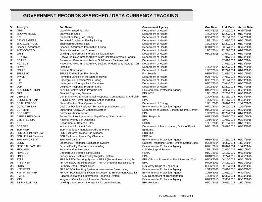
ED
R Inc.
ED
R Inc.
ED
R Inc.
ED
R Inc.
ED
R Inc.
ED
R Inc.
ED
R Inc.
ED
R Inc.
ED
R Inc.
ED
R Inc.
ED
R Inc.
ED
R Inc.
ED
R Inc.
ED
R Inc.
ED
R Inc.
ED
R Inc.
ED
R Inc.
ED
R Inc.
ED
R Inc.
ED
R Inc.
ED
R Inc.
ED
R Inc.
ED
R Inc.
ED
R Inc.
ED
R Inc.
ED
R Inc.
ED
R Inc.
ED
R Inc.
ED
R Inc.
ED
R Inc.
ED
R Inc.
ED
R Inc.
ED
R Inc.
ED
R Inc.
ED
R Inc.
ED
R Inc.
ED
R Inc.
ED
R Inc.
ED
R Inc.
ED
R Inc.
ED
R Inc.
ED
R Inc.
ED
R Inc.
ED
R Inc.
ED
R Inc.
ED
R Inc.
ED
R Inc.
ED
R Inc.
ED
R Inc.
ED
R Inc.
ED
R Inc.
ED
R Inc.
ED
R Inc.
ED
R Inc.
ED
R Inc.
ED
R Inc.
ED
R Inc.
ED
R Inc.
ED
R Inc.
ED
R Inc.
ED
R Inc.
ED
R Inc.
ED
R Inc.
ED
R Inc.
ED
R Inc.
ED
R Inc.
ED
R Inc.
ED
R Inc.
ED
R Inc.
ED
R Inc.
ED
R Inc.
ED
R Inc.
ED
R Inc.
ED
R Inc.
ED
R Inc.
ED
R Inc.
ED
R Inc.
ED
R Inc.
ED
R Inc.
ED
R Inc.
HI AIRS List of Permitted Facilities Department of Health 04/08/2015 04/10/2015 04/30/2015HI BROWNFIELDS Brownfields Sites Department of Health 12/02/2014 12/22/2014 01/27/2015HI CDL Clandestine Drug Lab Listing Department of Health 08/04/2010 09/10/2010 10/22/2010HI DRYCLEANERS Permitted Drycleaner Facility Listing Department of Health 12/31/2014 01/09/2015 02/11/2015HI ENG CONTROLS Engineering Control Sites Department of Health 12/02/2014 12/22/2014 01/27/2015HI Financial Assurance Financial Assurance Information Listing Department of Health 03/13/2015 03/17/2015 03/25/2015HI INST CONTROL Sites with Institutional Controls Department of Health 12/02/2014 12/22/2014 01/27/2015HI LUST Leaking Underground Storage Tank Database Department of Health 03/02/2015 03/04/2015 03/17/2015HI RGA HWS Recovered Government Archive State Hazardous Waste Facilitie Department of Health 07/01/2013 01/08/2014HI RGA LF Recovered Government Archive Solid Waste Facilities List Department of Health 07/01/2013 01/17/2014HI RGA LUST Recovered Government Archive Leaking Underground Storage Tan Department of Health 07/01/2013 01/03/2014HI SHWS Sites List Department of Health 12/02/2014 12/22/2014 01/27/2015HI SPILLS Release Notifications Department of Health 12/02/2014 12/22/2014 01/28/2015HI SPILLS 90 SPILLS90 data from FirstSearch FirstSearch 03/10/2012 01/03/2013 02/11/2013HI SWF/LF Permitted Landfills in the State of Hawaii Department of Health 09/17/2012 04/03/2013 05/10/2013HI UIC Underground Injection Wells Listing Department of Health 02/07/2013 02/12/2013 04/09/2013HI UST Underground Storage Tank Database Department of Health 03/02/2015 03/04/2015 03/17/2015HI VCP Voluntary Response Program Sites Department of Health 12/02/2014 12/22/2014 01/27/2015US 2020 COR ACTION 2020 Corrective Action Program List Environmental Protection Agency 04/22/2013 03/03/2015 03/09/2015US BRS Biennial Reporting System EPA/NTIS 12/31/2011 02/26/2013 04/19/2013US CERCLIS Comprehensive Environmental Response, Compensation, and Liab EPA 10/25/2013 11/11/2013 02/13/2014US CERCLIS-NFRAP CERCLIS No Further Remedial Action Planned EPA 10/25/2013 11/11/2013 02/13/2014US COAL ASH DOE Steam-Electric Plant Operation Data Department of Energy 12/31/2005 08/07/2009 10/22/2009US COAL ASH EPA Coal Combustion Residues Surface Impoundments List Environmental Protection Agency 07/01/2014 09/10/2014 10/20/2014US CONSENT Superfund (CERCLA) Consent Decrees Department of Justice, Consent Decree Library 01/23/2015 02/13/2015 03/09/2015US CORRACTS Corrective Action Report EPA 12/09/2014 12/29/2014 01/29/2015US DEBRIS REGION 9 Torres Martinez Reservation Illegal Dump Site Locations EPA, Region 9 01/12/2009 05/07/2009 09/21/2009US DELISTED NPL National Priority List Deletions EPA 12/16/2014 01/08/2015 02/09/2015US DOD Department of Defense Sites USGS 12/31/2005 11/10/2006 01/11/2007US DOT OPS Incident and Accident Data Department of Transporation, Office of Pipeli 07/31/2012 08/07/2012 09/18/2012US EDR MGP EDR Proprietary Manufactured Gas Plants EDR, Inc.US EDR US Hist Auto Stat EDR Exclusive Historic Gas Stations EDR, Inc.US EDR US Hist Cleaners EDR Exclusive Historic Dry Cleaners EDR, Inc.US EPA WATCH LIST EPA WATCH LIST Environmental Protection Agency 08/30/2013 03/21/2014 06/17/2014US ERNS Emergency Response Notification System National Response Center, United States Coast 09/29/2014 09/30/2014 11/06/2014US FEDERAL FACILITY Federal Facility Site Information listing Environmental Protection Agency 07/21/2014 10/07/2014 10/20/2014US FEDLAND Federal and Indian Lands U.S. Geological Survey 12/31/2005 02/06/2006 01/11/2007US FEMA UST Underground Storage Tank Listing FEMA 01/01/2010 02/16/2010 04/12/2010US FINDS Facility Index System/Facility Registry System EPA 01/18/2015 02/27/2015 03/25/2015US FTTS FIFRA/ TSCA Tracking System - FIFRA (Federal Insecticide, Fu EPA/Office of Prevention, Pesticides and Toxi 04/09/2009 04/16/2009 05/11/2009US FTTS INSP FIFRA/ TSCA Tracking System - FIFRA (Federal Insecticide, Fu EPA 04/09/2009 04/16/2009 05/11/2009US FUDS Formerly Used Defense Sites U.S. Army Corps of Engineers 06/06/2014 09/10/2014 09/18/2014US HIST FTTS FIFRA/TSCA Tracking System Administrative Case Listing Environmental Protection Agency 10/19/2006 03/01/2007 04/10/2007US HIST FTTS INSP FIFRA/TSCA Tracking System Inspection & Enforcement Case Lis Environmental Protection Agency 10/19/2006 03/01/2007 04/10/2007US HMIRS Hazardous Materials Information Reporting System U.S. Department of Transportation 12/29/2014 12/30/2014 03/09/2015US ICIS Integrated Compliance Information System Environmental Protection Agency 01/23/2015 02/06/2015 03/09/2015US INDIAN LUST R1 Leaking Underground Storage Tanks on Indian Land EPA Region 1 02/01/2013 05/01/2013 11/01/2013
TC4293163.2s Page GR-1
GOVERNMENT RECORDS SEARCHED / DATA CURRENCY TRACKING
St Acronym Full Name Government Agency Gov Date Arvl. Date Active Date

US INDIAN LUST R10 Leaking Underground Storage Tanks on Indian Land EPA Region 10 02/03/2015 02/12/2015 03/13/2015US INDIAN LUST R4 Leaking Underground Storage Tanks on Indian Land EPA Region 4 09/30/2014 03/03/2015 03/13/2015US INDIAN LUST R5 Leaking Underground Storage Tanks on Indian Land EPA, Region 5 01/30/2015 02/05/2015 03/09/2015US INDIAN LUST R6 Leaking Underground Storage Tanks on Indian Land EPA Region 6 01/23/2015 02/10/2015 03/13/2015US INDIAN LUST R7 Leaking Underground Storage Tanks on Indian Land EPA Region 7 09/23/2014 11/25/2014 01/29/2015US INDIAN LUST R8 Leaking Underground Storage Tanks on Indian Land EPA Region 8 01/28/2015 01/30/2015 03/13/2015US INDIAN LUST R9 Leaking Underground Storage Tanks on Indian Land Environmental Protection Agency 01/08/2015 01/08/2015 02/09/2015US INDIAN ODI Report on the Status of Open Dumps on Indian Lands Environmental Protection Agency 12/31/1998 12/03/2007 01/24/2008US INDIAN RESERV Indian Reservations USGS 12/31/2005 12/08/2006 01/11/2007US INDIAN UST R1 Underground Storage Tanks on Indian Land EPA, Region 1 02/01/2013 05/01/2013 01/27/2014US INDIAN UST R10 Underground Storage Tanks on Indian Land EPA Region 10 02/03/2015 02/12/2015 03/13/2015US INDIAN UST R4 Underground Storage Tanks on Indian Land EPA Region 4 09/30/2014 03/03/2015 03/13/2015US INDIAN UST R5 Underground Storage Tanks on Indian Land EPA Region 5 01/30/2015 02/05/2015 03/13/2015US INDIAN UST R6 Underground Storage Tanks on Indian Land EPA Region 6 01/23/2015 02/13/2015 03/13/2015US INDIAN UST R7 Underground Storage Tanks on Indian Land EPA Region 7 09/23/2014 11/25/2014 01/29/2015US INDIAN UST R8 Underground Storage Tanks on Indian Land EPA Region 8 01/29/2015 01/30/2015 03/13/2015US INDIAN UST R9 Underground Storage Tanks on Indian Land EPA Region 9 12/14/2014 02/13/2015 03/13/2015US INDIAN VCP R1 Voluntary Cleanup Priority Listing EPA, Region 1 09/29/2014 10/01/2014 11/06/2014US INDIAN VCP R7 Voluntary Cleanup Priority Lisitng EPA, Region 7 03/20/2008 04/22/2008 05/19/2008US LEAD SMELTER 1 Lead Smelter Sites Environmental Protection Agency 11/25/2014 11/26/2014 01/29/2015US LEAD SMELTER 2 Lead Smelter Sites American Journal of Public Health 04/05/2001 10/27/2010 12/02/2010US LIENS 2 CERCLA Lien Information Environmental Protection Agency 02/18/2014 03/18/2014 04/24/2014US LUCIS Land Use Control Information System Department of the Navy 12/03/2014 12/12/2014 01/29/2015US MLTS Material Licensing Tracking System Nuclear Regulatory Commission 12/29/2014 01/08/2015 01/29/2015US NPL National Priority List EPA 12/16/2014 01/08/2015 02/09/2015US NPL LIENS Federal Superfund Liens EPA 10/15/1991 02/02/1994 03/30/1994US ODI Open Dump Inventory Environmental Protection Agency 06/30/1985 08/09/2004 09/17/2004US PADS PCB Activity Database System EPA 07/01/2014 10/15/2014 11/17/2014US PCB TRANSFORMER PCB Transformer Registration Database Environmental Protection Agency 02/01/2011 10/19/2011 01/10/2012US PRP Potentially Responsible Parties EPA 10/25/2013 10/17/2014 10/20/2014US Proposed NPL Proposed National Priority List Sites EPA 12/16/2014 01/08/2015 02/09/2015US RAATS RCRA Administrative Action Tracking System EPA 04/17/1995 07/03/1995 08/07/1995US RADINFO Radiation Information Database Environmental Protection Agency 02/27/2015 02/27/2015 03/25/2015US RCRA NonGen / NLR RCRA - Non Generators / No Longer Regulated Environmental Protection Agency 12/09/2014 12/29/2014 01/29/2015US RCRA-CESQG RCRA - Conditionally Exempt Small Quantity Generators Environmental Protection Agency 12/09/2014 12/29/2014 01/29/2015US RCRA-LQG RCRA - Large Quantity Generators Environmental Protection Agency 12/09/2014 12/29/2014 01/29/2015US RCRA-SQG RCRA - Small Quantity Generators Environmental Protection Agency 12/09/2014 12/29/2014 01/29/2015US RCRA-TSDF RCRA - Treatment, Storage and Disposal Environmental Protection Agency 12/09/2014 12/29/2014 01/29/2015US RMP Risk Management Plans Environmental Protection Agency 02/01/2015 02/13/2015 03/25/2015US ROD Records Of Decision EPA 11/25/2013 12/12/2013 02/24/2014US SCRD DRYCLEANERS State Coalition for Remediation of Drycleaners Listing Environmental Protection Agency 03/07/2011 03/09/2011 05/02/2011US SSTS Section 7 Tracking Systems EPA 12/31/2009 12/10/2010 02/25/2011US TRIS Toxic Chemical Release Inventory System EPA 12/31/2011 07/31/2013 09/13/2013US TSCA Toxic Substances Control Act EPA 12/31/2012 01/15/2015 01/29/2015US UMTRA Uranium Mill Tailings Sites Department of Energy 09/14/2010 10/07/2011 03/01/2012US US AIRS (AFS) Aerometric Information Retrieval System Facility Subsystem ( EPA 10/16/2014 10/31/2014 11/17/2014US US AIRS MINOR Air Facility System Data EPA 10/16/2014 10/31/2014 11/17/2014
TC4293163.2s Page GR-2
GOVERNMENT RECORDS SEARCHED / DATA CURRENCY TRACKING
St Acronym Full Name Government Agency Gov Date Arvl. Date Active Date
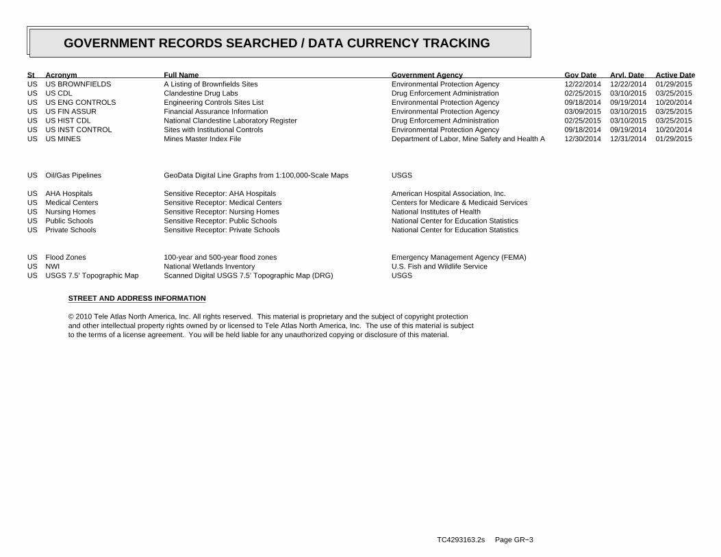
US US BROWNFIELDS A Listing of Brownfields Sites Environmental Protection Agency 12/22/2014 12/22/2014 01/29/2015US US CDL Clandestine Drug Labs Drug Enforcement Administration 02/25/2015 03/10/2015 03/25/2015US US ENG CONTROLS Engineering Controls Sites List Environmental Protection Agency 09/18/2014 09/19/2014 10/20/2014US US FIN ASSUR Financial Assurance Information Environmental Protection Agency 03/09/2015 03/10/2015 03/25/2015US US HIST CDL National Clandestine Laboratory Register Drug Enforcement Administration 02/25/2015 03/10/2015 03/25/2015US US INST CONTROL Sites with Institutional Controls Environmental Protection Agency 09/18/2014 09/19/2014 10/20/2014US US MINES Mines Master Index File Department of Labor, Mine Safety and Health A 12/30/2014 12/31/2014 01/29/2015
US Oil/Gas Pipelines GeoData Digital Line Graphs from 1:100,000-Scale Maps USGS
US AHA Hospitals Sensitive Receptor: AHA Hospitals American Hospital Association, Inc.US Medical Centers Sensitive Receptor: Medical Centers Centers for Medicare & Medicaid ServicesUS Nursing Homes Sensitive Receptor: Nursing Homes National Institutes of HealthUS Public Schools Sensitive Receptor: Public Schools National Center for Education StatisticsUS Private Schools Sensitive Receptor: Private Schools National Center for Education Statistics
US Flood Zones 100-year and 500-year flood zones Emergency Management Agency (FEMA)US NWI National Wetlands Inventory U.S. Fish and Wildlife ServiceUS USGS 7.5’ Topographic Map Scanned Digital USGS 7.5’ Topographic Map (DRG) USGS
STREET AND ADDRESS INFORMATION
© 2010 Tele Atlas North America, Inc. All rights reserved. This material is proprietary and the subject of copyright protectionand other intellectual property rights owned by or licensed to Tele Atlas North America, Inc. The use of this material is subjectto the terms of a license agreement. You will be held liable for any unauthorized copying or disclosure of this material.
TC4293163.2s Page GR−3
GOVERNMENT RECORDS SEARCHED / DATA CURRENCY TRACKING
St Acronym Full Name Government Agency Gov Date Arvl. Date Active Date

TC4293163.2s Page A-1
geologic strata.of the soil, and nearby wells. Groundwater flow velocity is generally impacted by the nature of theGroundwater flow direction may be impacted by surface topography, hydrology, hydrogeology, characteristics
2. Groundwater flow velocity. 1. Groundwater flow direction, and
Assessment of the impact of contaminant migration generally has two principal investigative components:
forming an opinion about the impact of potential contaminant migration.EDR’s GeoCheck Physical Setting Source Addendum is provided to assist the environmental professional in
Not reportedMost Recent Revision:21157-C8 PEARL HARBOR, HIWest Map:
Not reportedMost Recent Revision:21157-C7 HONOLULU, HITarget Property Map:
USGS TOPOGRAPHIC MAP
3 ft. above sea levelElevation:2358577.2UTM Y (Meters): 617448.9UTM X (Meters): Zone 4Universal Tranverse Mercator: 157.8675 - 157˚ 52’ 3.00’’Longitude (West): 21.3266 - 21˚ 19’ 35.76’’Latitude (North):
TARGET PROPERTY COORDINATES
HONOLULU, HI 96817LUNALILO FREEWAY/KOHOU STREETHALONA BRIDGE
TARGET PROPERTY ADDRESS
®GEOCHECK - PHYSICAL SETTING SOURCE ADDENDUM®

TC4293163.2s Page A-2
should be field verified.on a relative (not an absolute) basis. Relative elevation information between sites of close proximitySource: Topography has been determined from the USGS 7.5’ Digital Elevation Model and should be evaluated
SURROUNDING TOPOGRAPHY: ELEVATION PROFILES
Ele
vatio
n (f
t)E
leva
tion
(ft)
TP
TP0 1/2 1 Miles
✩Target Property Elevation: 3 ft.
North South
West East
03337
10
2016103
13
33
49
75
104
136
151
15712010
16
20 20 20 10 10 10
16 3
10
28
56
79
98
125
148
151
190
General WSWGeneral Topographic Gradient:TARGET PROPERTY TOPOGRAPHY
should contamination exist on the target property, what downgradient sites might be impacted.assist the environmental professional in forming an opinion about the impact of nearby contaminated properties or,Surface topography may be indicative of the direction of surficial groundwater flow. This information can be used toTOPOGRAPHIC INFORMATION
collected on nearby properties, and regional groundwater flow information (from deep aquifers).sources of information, such as surface topographic information, hydrologic information, hydrogeologic datausing site-specific well data. If such data is not reasonably ascertainable, it may be necessary to rely on otherGroundwater flow direction for a particular site is best determined by a qualified environmental professionalGROUNDWATER FLOW DIRECTION INFORMATION
®GEOCHECK - PHYSICAL SETTING SOURCE SUMMARY®
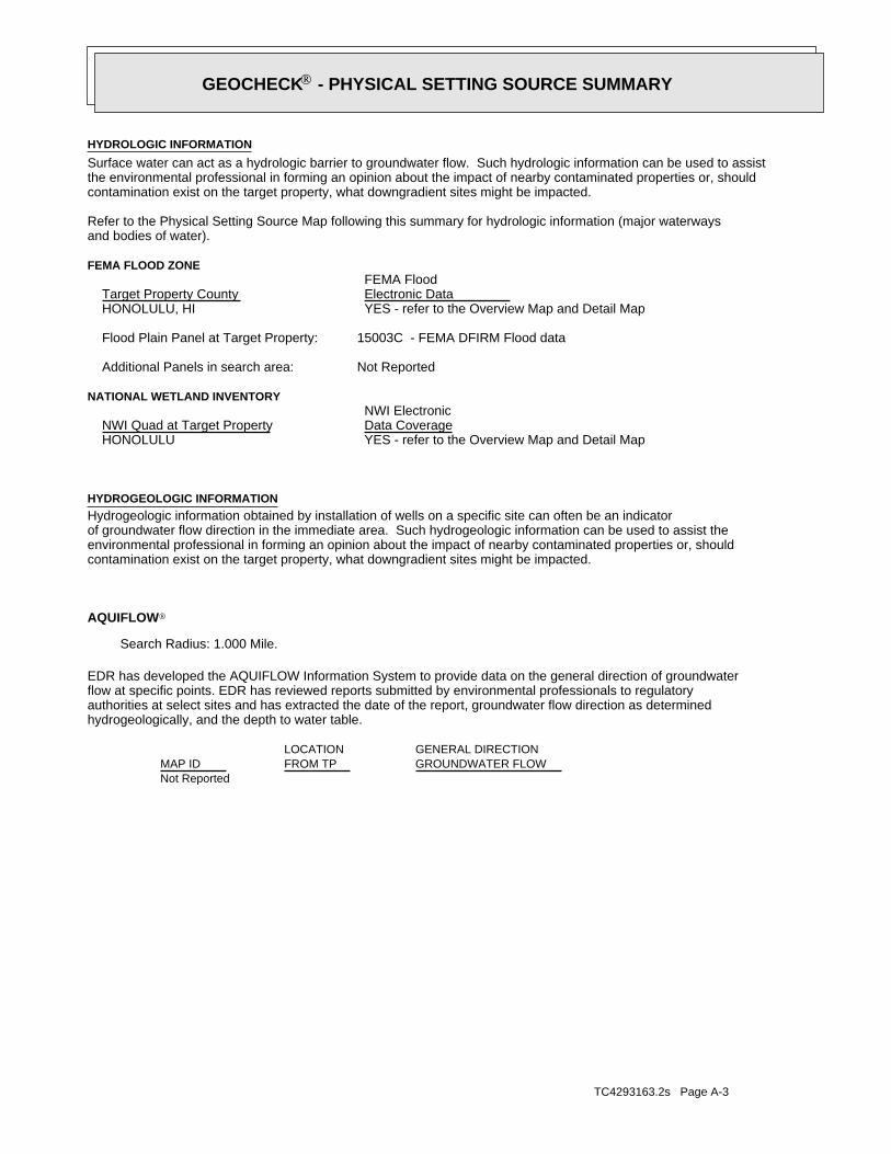
TC4293163.2s Page A-3
Not Reported
GENERAL DIRECTIONLOCATIONGROUNDWATER FLOWFROM TPMAP ID
hydrogeologically, and the depth to water table.authorities at select sites and has extracted the date of the report, groundwater flow direction as determinedflow at specific points. EDR has reviewed reports submitted by environmental professionals to regulatoryEDR has developed the AQUIFLOW Information System to provide data on the general direction of groundwater
AQUIFLOW®
Search Radius: 1.000 Mile.
contamination exist on the target property, what downgradient sites might be impacted.environmental professional in forming an opinion about the impact of nearby contaminated properties or, shouldof groundwater flow direction in the immediate area. Such hydrogeologic information can be used to assist theHydrogeologic information obtained by installation of wells on a specific site can often be an indicatorHYDROGEOLOGIC INFORMATION
YES - refer to the Overview Map and Detail MapHONOLULU
NATIONAL WETLAND INVENTORYNWI ElectronicData CoverageNWI Quad at Target Property
Not ReportedAdditional Panels in search area:
15003C - FEMA DFIRM Flood dataFlood Plain Panel at Target Property:
YES - refer to the Overview Map and Detail MapHONOLULU, HI
FEMA FLOOD ZONEFEMA FloodElectronic DataTarget Property County
and bodies of water).Refer to the Physical Setting Source Map following this summary for hydrologic information (major waterways
contamination exist on the target property, what downgradient sites might be impacted.the environmental professional in forming an opinion about the impact of nearby contaminated properties or, shouldSurface water can act as a hydrologic barrier to groundwater flow. Such hydrologic information can be used to assistHYDROLOGIC INFORMATION
®GEOCHECK - PHYSICAL SETTING SOURCE SUMMARY®
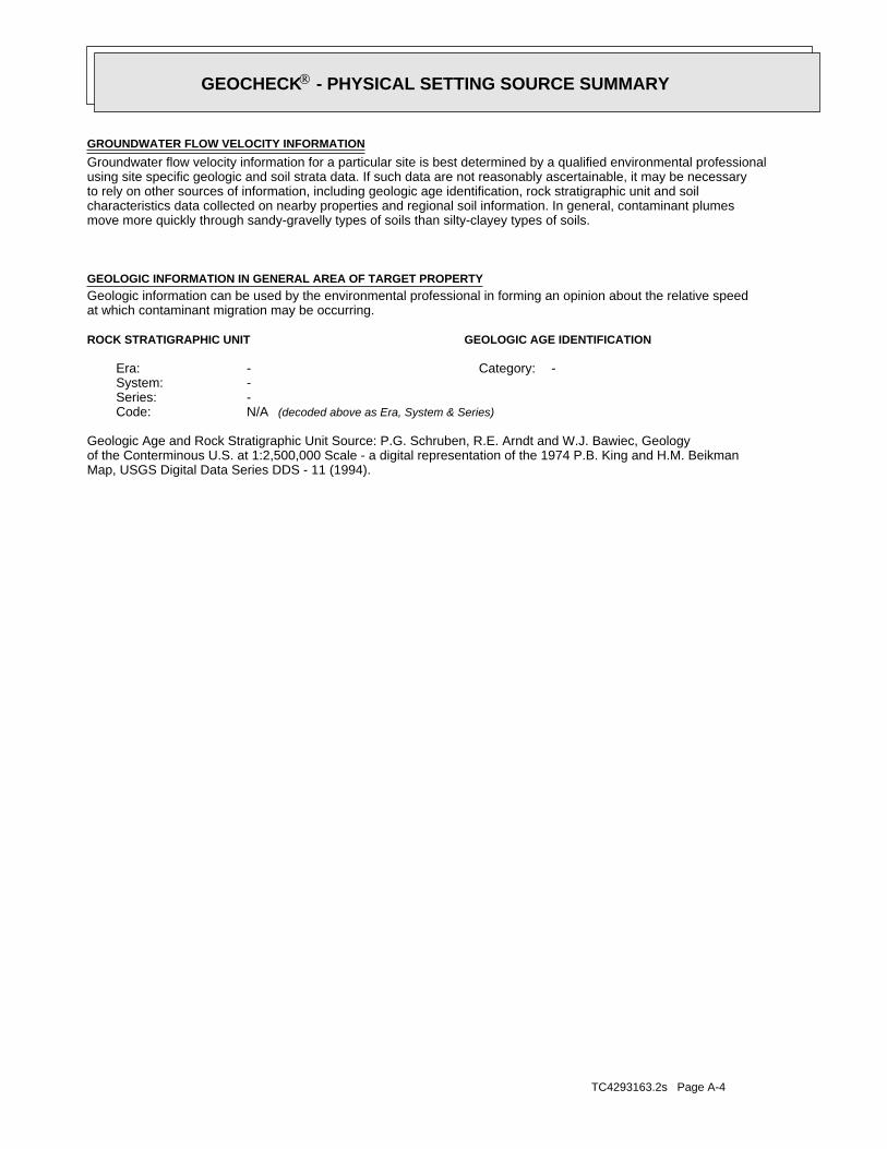
TC4293163.2s Page A-4
Map, USGS Digital Data Series DDS - 11 (1994).of the Conterminous U.S. at 1:2,500,000 Scale - a digital representation of the 1974 P.B. King and H.M. BeikmanGeologic Age and Rock Stratigraphic Unit Source: P.G. Schruben, R.E. Arndt and W.J. Bawiec, Geology
ROCK STRATIGRAPHIC UNIT GEOLOGIC AGE IDENTIFICATION
-Category:-Era:-System:-Series:N/ACode: (decoded above as Era, System & Series)
at which contaminant migration may be occurring.Geologic information can be used by the environmental professional in forming an opinion about the relative speedGEOLOGIC INFORMATION IN GENERAL AREA OF TARGET PROPERTY
move more quickly through sandy-gravelly types of soils than silty-clayey types of soils.characteristics data collected on nearby properties and regional soil information. In general, contaminant plumesto rely on other sources of information, including geologic age identification, rock stratigraphic unit and soilusing site specific geologic and soil strata data. If such data are not reasonably ascertainable, it may be necessaryGroundwater flow velocity information for a particular site is best determined by a qualified environmental professionalGROUNDWATER FLOW VELOCITY INFORMATION
®GEOCHECK - PHYSICAL SETTING SOURCE SUMMARY®
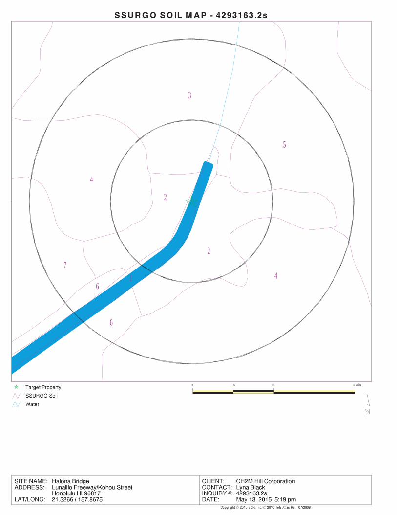
EDR Inc.EDR Inc.EDR Inc.EDR Inc.EDR Inc.EDR Inc.EDR Inc.EDR Inc.EDR Inc.EDR Inc.EDR Inc.EDR Inc.EDR Inc.EDR Inc.EDR Inc.EDR Inc.EDR Inc.EDR Inc.EDR Inc.EDR Inc.EDR Inc.EDR Inc.EDR Inc.EDR Inc.EDR Inc.EDR Inc.EDR Inc.EDR Inc.EDR Inc.EDR Inc.EDR Inc.EDR Inc.EDR Inc.EDR Inc.EDR Inc.EDR Inc.EDR Inc.EDR Inc.EDR Inc.EDR Inc.
3
5
4
1
2
2
74
6
6
0 1/16 1/8 1/4 Miles

TC4293163.2s Page A-6
> 30 inchesDepth to Watertable Min:
> 0 inchesDepth to Bedrock Min:
HighCorrosion Potential - Uncoated Steel:
Hydric Status: Partially hydric
Poorly drainedSoil Drainage Class:
movement of water, or soils with moderately fine or fine textures.Class C - Slow infiltration rates. Soils with layers impeding downwardHydrologic Group:
silty claySoil Surface Texture:
HanaleiSoil Component Name:
Soil Map ID: 2
No Layer Information available.
> 0 inchesDepth to Watertable Min:
> 0 inchesDepth to Bedrock Min:
Not ReportedCorrosion Potential - Uncoated Steel:
Hydric Status: UnknownSoil Drainage Class:
Not reportedHydrologic Group:Soil Surface Texture:
Water > 40 acresSoil Component Name:
Soil Map ID: 1
in a landscape. The following information is based on Soil Conservation Service SSURGO data.for privately owned lands in the United States. A soil map in a soil survey is a representation of soil patternsSurvey (NCSS) and is responsible for collecting, storing, maintaining and distributing soil survey informationThe U.S. Department of Agriculture’s (USDA) Soil Conservation Service (SCS) leads the National Cooperative Soil
DOMINANT SOIL COMPOSITION IN GENERAL AREA OF TARGET PROPERTY
®GEOCHECK - PHYSICAL SETTING SOURCE SUMMARY®
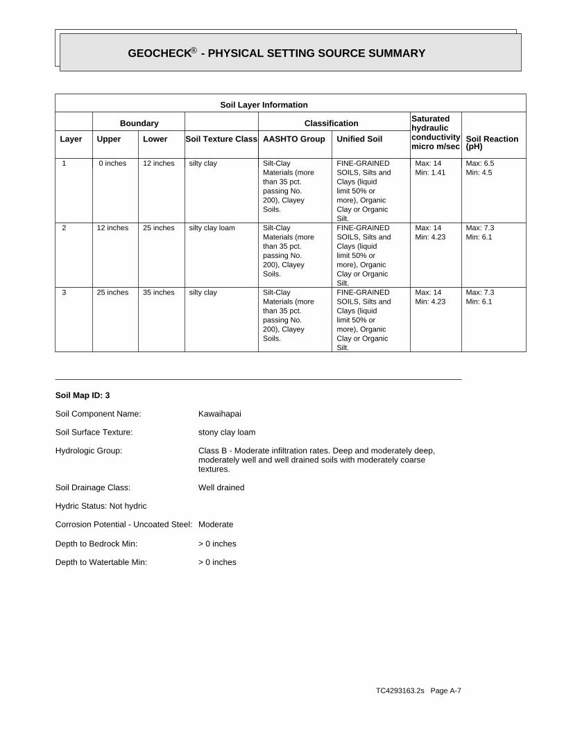
TC4293163.2s Page A-7
> 0 inchesDepth to Watertable Min:
> 0 inchesDepth to Bedrock Min:
ModerateCorrosion Potential - Uncoated Steel:
Hydric Status: Not hydric
Well drainedSoil Drainage Class:
textures.moderately well and well drained soils with moderately coarseClass B - Moderate infiltration rates. Deep and moderately deep,Hydrologic Group:
stony clay loamSoil Surface Texture:
KawaihapaiSoil Component Name:
Soil Map ID: 3
Min: 6.1Max: 7.3
Min: 4.23Max: 14
Silt.Clay or Organicmore), Organiclimit 50% orClays (liquidSOILS, Silts andFINE-GRAINED
Soils.200), Clayeypassing No.than 35 pct.Materials (moreSilt-Claysilty clay35 inches25 inches 3
Min: 6.1Max: 7.3
Min: 4.23Max: 14
Silt.Clay or Organicmore), Organiclimit 50% orClays (liquidSOILS, Silts andFINE-GRAINED
Soils.200), Clayeypassing No.than 35 pct.Materials (moreSilt-Claysilty clay loam25 inches12 inches 2
Min: 4.5Max: 6.5
Min: 1.41Max: 14
Silt.Clay or Organicmore), Organiclimit 50% orClays (liquidSOILS, Silts andFINE-GRAINED
Soils.200), Clayeypassing No.than 35 pct.Materials (moreSilt-Claysilty clay12 inches 0 inches 1
Soil Layer Information
Boundary Classification Saturatedhydraulicconductivitymicro m/sec
Layer Upper Lower Soil Texture Class AASHTO Group Unified Soil Soil Reaction(pH)
®GEOCHECK - PHYSICAL SETTING SOURCE SUMMARY®

TC4293163.2s Page A-8
> 0 inchesDepth to Watertable Min:
> 0 inchesDepth to Bedrock Min:
ModerateCorrosion Potential - Uncoated Steel:
Hydric Status: Not hydric
Well drainedSoil Drainage Class:
textures.moderately well and well drained soils with moderately coarseClass B - Moderate infiltration rates. Deep and moderately deep,Hydrologic Group:
silty clay loamSoil Surface Texture:
EwaSoil Component Name:
Soil Map ID: 4
Min: 6.6Max: 7.3
Min: 14.11Max: 141.14
Silty Sand.Sands with fines,SOILS, Sands,COARSE-GRAINED
and Sand.Clayey Gravel200), Silty, orpassing No.pct. or lessmaterials (35Granularsandy loam53 inches31 inches 3
Min: 6.6Max: 7.3
Min: 14.11Max: 141.14
Silty Sand.Sands with fines,SOILS, Sands,COARSE-GRAINED
and Sand.Clayey Gravel200), Silty, orpassing No.pct. or lessmaterials (35Granularsandy loam31 inches22 inches 2
Min: 6.6Max: 7.3
Min: 4.23Max: 42.34
50%), Lean Claylimit less thanClays (liquidSOILS, Silts andFINE-GRAINED
Soils.200), Clayeypassing No.than 35 pct.Materials (moreSilt-Claystony clay loam22 inches 0 inches 1
Soil Layer Information
Boundary Classification Saturatedhydraulicconductivitymicro m/sec
Layer Upper Lower Soil Texture Class AASHTO Group Unified Soil Soil Reaction(pH)
®GEOCHECK - PHYSICAL SETTING SOURCE SUMMARY®

TC4293163.2s Page A-9
Min: 6.6Max: 7.3
Min: 0.42Max: 4.23
more), Fat Clay.limit 50% orClays (liquidSOILS, Silts andFINE-GRAINED
Soils.200), Clayeypassing No.than 35 pct.Materials (moreSilt-Clayclay 9 inches 0 inches 1
Soil Layer Information
Boundary Classification Saturatedhydraulicconductivitymicro m/sec
Layer Upper Lower Soil Texture Class AASHTO Group Unified Soil Soil Reaction(pH)
> 107 inchesDepth to Watertable Min:
> 0 inchesDepth to Bedrock Min:
ModerateCorrosion Potential - Uncoated Steel:
Hydric Status: Not hydric
Poorly drainedSoil Drainage Class:
water table, or are shallow to an impervious layer.Class D - Very slow infiltration rates. Soils are clayey, have a highHydrologic Group:
claySoil Surface Texture:
KaenaSoil Component Name:
Soil Map ID: 5
Max: Min: Min: 1Max: 42 Not reportedNot reportedbedrock38 inches29 inches 3
Min: 6.6Max: 7.3
Min: 4.23Max: 14
Silty Sand.Sands with fines,SOILS, Sands,COARSE-GRAINED
Soils.200), Clayeypassing No.than 35 pct.Materials (moreSilt-Claysilty clay loam29 inches 7 inches 2
Min: 6.6Max: 7.3
Min: 4.23Max: 14
Silty Sand.Sands with fines,SOILS, Sands,COARSE-GRAINED
Soils.200), Clayeypassing No.than 35 pct.Materials (moreSilt-Claysilty clay loam 7 inches 0 inches 1
Soil Layer Information
Boundary Classification Saturatedhydraulicconductivitymicro m/sec
Layer Upper Lower Soil Texture Class AASHTO Group Unified Soil Soil Reaction(pH)
®GEOCHECK - PHYSICAL SETTING SOURCE SUMMARY®

TC4293163.2s Page A-10
Min: 6.1Max: 7.3
Min: 1.41Max: 14
Silty Sand.Sands with fines,SOILS, Sands,COARSE-GRAINED
Soils.200), Clayeypassing No.than 35 pct.Materials (moreSilt-Clay
loamgravelly sandy 5 inches 0 inches 1
Soil Layer Information
Boundary Classification Saturatedhydraulicconductivitymicro m/sec
Layer Upper Lower Soil Texture Class AASHTO Group Unified Soil Soil Reaction(pH)
> 0 inchesDepth to Watertable Min:
> 152 inchesDepth to Bedrock Min:
HighCorrosion Potential - Uncoated Steel:
Hydric Status: Not hydric
Well drainedSoil Drainage Class:
movement of water, or soils with moderately fine or fine textures.Class C - Slow infiltration rates. Soils with layers impeding downwardHydrologic Group:
gravelly sandy loamSoil Surface Texture:
Fill land, mixedSoil Component Name:
Soil Map ID: 6
Min: 6.6Max: 7.3
Min: 0.01Max: 1.41
more), Fat Clay.limit 50% orClays (liquidSOILS, Silts andFINE-GRAINED
Soils.200), Clayeypassing No.than 35 pct.Materials (moreSilt-Claystony clay53 inches37 inches 3
Min: 6.6Max: 7.3
Min: 0.01Max: 1.41
more), Fat Clay.limit 50% orClays (liquidSOILS, Silts andFINE-GRAINED
Soils.200), Clayeypassing No.than 35 pct.Materials (moreSilt-Claystony clay37 inches 9 inches 2
Soil Layer Information
Boundary Classification Saturatedhydraulicconductivitymicro m/sec
Layer Upper Lower Soil Texture Class AASHTO Group Unified Soil Soil Reaction(pH)
®GEOCHECK - PHYSICAL SETTING SOURCE SUMMARY®

TC4293163.2s Page A-11
Min: 6.6Max: 8.4
Min: 0.01Max: 1.41
more), Fat Clay.limit 50% orClays (liquidSOILS, Silts andFINE-GRAINED
Soils.200), Clayeypassing No.than 35 pct.Materials (moreSilt-Clayclay31 inches11 inches 2
Min: 6.6Max: 7.3
Min: 0.42Max: 4.23
more), Fat Clay.limit 50% orClays (liquidSOILS, Silts andFINE-GRAINED
Soils.200), Clayeypassing No.than 35 pct.Materials (moreSilt-Clayclay11 inches 0 inches 1
Soil Layer Information
Boundary Classification Saturatedhydraulicconductivitymicro m/sec
Layer Upper Lower Soil Texture Class AASHTO Group Unified Soil Soil Reaction(pH)
> 30 inchesDepth to Watertable Min:
> 0 inchesDepth to Bedrock Min:
HighCorrosion Potential - Uncoated Steel:
Hydric Status: Partially hydric
Poorly drainedSoil Drainage Class:
water table, or are shallow to an impervious layer.Class D - Very slow infiltration rates. Soils are clayey, have a highHydrologic Group:
claySoil Surface Texture:
Pearl HarborSoil Component Name:
Soil Map ID: 7
Max: Min: Min: 0.02Max: 0.42 Not reportedNot reportedbedrock70 inches59 inches 3
Min: 6.1Max: 7.3
Min: 1.41Max: 14
Silty Sand.Sands with fines,SOILS, Sands,COARSE-GRAINED
Soils.200), Clayeypassing No.than 35 pct.Materials (moreSilt-Clayfine sandy loam59 inches 5 inches 2
Soil Layer Information
Boundary Classification Saturatedhydraulicconductivitymicro m/sec
Layer Upper Lower Soil Texture Class AASHTO Group Unified Soil Soil Reaction(pH)
®GEOCHECK - PHYSICAL SETTING SOURCE SUMMARY®

TC4293163.2s Page A-12
1/4 - 1/2 Mile SSEUSGS40000269810 G471/4 - 1/2 Mile NNEUSGS40000269899 C461/4 - 1/2 Mile SSWUSGS40000269815 F451/4 - 1/2 Mile SSWUSGS40000269817 F441/4 - 1/2 Mile SSWUSGS40000269816 F431/4 - 1/2 Mile SEUSGS40000269822 E321/4 - 1/2 Mile NNWUSGS40000269893 D291/4 - 1/2 Mile WNWUSGS40000269869 B181/4 - 1/2 Mile WNWUSGS40000269870 B171/4 - 1/2 Mile WNWUSGS40000269871 B161/4 - 1/2 Mile WNWUSGS40000269868 B151/4 - 1/2 Mile WNWUSGS40000269865 B141/4 - 1/2 Mile WNWUSGS40000269866 B131/4 - 1/2 Mile WNWUSGS40000269867 B121/4 - 1/2 Mile WNWUSGS40000269864 B111/4 - 1/2 Mile NNEUSGS40000269888 C101/4 - 1/2 Mile WNWUSGS40000269855 B91/8 - 1/4 Mile ENEUSGS40000269863 A71/8 - 1/4 Mile ENEUSGS40000269850 A41/8 - 1/4 Mile ENEUSGS40000269853 A31/8 - 1/4 Mile ENEUSGS40000269854 A1
FEDERAL USGS WELL INFORMATION
LOCATIONFROM TPWELL IDMAP ID
1.000State DatabaseNearest PWS within 1 mileFederal FRDS PWS1.000Federal USGS
WELL SEARCH DISTANCE INFORMATION
SEARCH DISTANCE (miles)DATABASE
opinion about the impact of contaminant migration on nearby drinking water wells.professional in assessing sources that may impact ground water flow direction, and in forming anEDR Local/Regional Water Agency records provide water well information to assist the environmental
LOCAL / REGIONAL WATER AGENCY RECORDS
Min: 7.4Max: 7.8
Min: 0.01Max: 0.42
soils, Peat.Highly organicA-8muck48 inches31 inches 3
Soil Layer Information
Boundary Classification Saturatedhydraulicconductivitymicro m/sec
Layer Upper Lower Soil Texture Class AASHTO Group Unified Soil Soil Reaction(pH)
®GEOCHECK - PHYSICAL SETTING SOURCE SUMMARY®
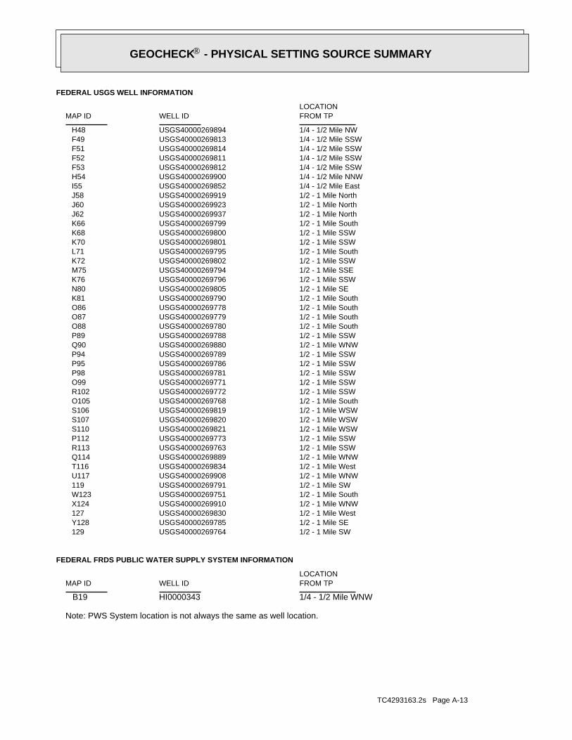
TC4293163.2s Page A-13
Note: PWS System location is not always the same as well location.
1/4 - 1/2 Mile WNWHI0000343 B19
FEDERAL FRDS PUBLIC WATER SUPPLY SYSTEM INFORMATION
LOCATIONFROM TPWELL IDMAP ID
1/2 - 1 Mile SWUSGS40000269764 1291/2 - 1 Mile SEUSGS40000269785 Y1281/2 - 1 Mile WestUSGS40000269830 1271/2 - 1 Mile WNWUSGS40000269910 X1241/2 - 1 Mile SouthUSGS40000269751 W1231/2 - 1 Mile SWUSGS40000269791 1191/2 - 1 Mile WNWUSGS40000269908 U1171/2 - 1 Mile WestUSGS40000269834 T1161/2 - 1 Mile WNWUSGS40000269889 Q1141/2 - 1 Mile SSWUSGS40000269763 R1131/2 - 1 Mile SSWUSGS40000269773 P1121/2 - 1 Mile WSWUSGS40000269821 S1101/2 - 1 Mile WSWUSGS40000269820 S1071/2 - 1 Mile WSWUSGS40000269819 S1061/2 - 1 Mile SouthUSGS40000269768 O1051/2 - 1 Mile SSWUSGS40000269772 R1021/2 - 1 Mile SSWUSGS40000269771 O991/2 - 1 Mile SSWUSGS40000269781 P981/2 - 1 Mile SSWUSGS40000269786 P951/2 - 1 Mile SSWUSGS40000269789 P941/2 - 1 Mile WNWUSGS40000269880 Q901/2 - 1 Mile SSWUSGS40000269788 P891/2 - 1 Mile SouthUSGS40000269780 O881/2 - 1 Mile SouthUSGS40000269779 O871/2 - 1 Mile SouthUSGS40000269778 O861/2 - 1 Mile SouthUSGS40000269790 K811/2 - 1 Mile SEUSGS40000269805 N801/2 - 1 Mile SSWUSGS40000269796 K761/2 - 1 Mile SSEUSGS40000269794 M751/2 - 1 Mile SSWUSGS40000269802 K721/2 - 1 Mile SouthUSGS40000269795 L711/2 - 1 Mile SSWUSGS40000269801 K701/2 - 1 Mile SSWUSGS40000269800 K681/2 - 1 Mile SouthUSGS40000269799 K661/2 - 1 Mile NorthUSGS40000269937 J621/2 - 1 Mile NorthUSGS40000269923 J601/2 - 1 Mile NorthUSGS40000269919 J581/4 - 1/2 Mile EastUSGS40000269852 I551/4 - 1/2 Mile NNWUSGS40000269900 H541/4 - 1/2 Mile SSWUSGS40000269812 F531/4 - 1/2 Mile SSWUSGS40000269811 F521/4 - 1/2 Mile SSWUSGS40000269814 F511/4 - 1/2 Mile SSWUSGS40000269813 F491/4 - 1/2 Mile NWUSGS40000269894 H48
FEDERAL USGS WELL INFORMATION
LOCATIONFROM TPWELL IDMAP ID
®GEOCHECK - PHYSICAL SETTING SOURCE SUMMARY®

TC4293163.2s Page A-14
1/2 - 1 Mile WSWHI9000000000953 S1031/2 - 1 Mile SouthHI9000000000949 O1011/2 - 1 Mile SSWHI9000000000947 R1001/2 - 1 Mile SSWHI9000000000942 P971/2 - 1 Mile SouthHI9000000000951 O961/2 - 1 Mile SSWHI9000000000943 P931/2 - 1 Mile SSWHI9000000000932 P921/2 - 1 Mile WNWHI9000000000920 Q911/2 - 1 Mile SSWHI9000000000948 P851/2 - 1 Mile SouthHI9000000000945 O841/2 - 1 Mile SouthHI9000000000946 O831/2 - 1 Mile SouthHI9000000000944 O821/2 - 1 Mile SouthHI9000000000930 K791/2 - 1 Mile SEHI9000000000916 N781/2 - 1 Mile EastHI9000000000918 771/2 - 1 Mile SSWHI9000000000929 K741/2 - 1 Mile SSEHI9000000000921 M731/2 - 1 Mile SSWHI9000000000931 K691/2 - 1 Mile SouthHI9000000000941 L671/2 - 1 Mile SSWHI9000000000939 K651/2 - 1 Mile NorthHI9000000001099 J641/2 - 1 Mile SouthHI9000000000938 K631/2 - 1 Mile NorthHI9000000001095 J611/2 - 1 Mile NorthHI9000000001098 J591/4 - 1/2 Mile ENEHI9000000000915 I571/4 - 1/2 Mile NNWHI9000000001094 H561/4 - 1/2 Mile NWHI9000000001092 H501/4 - 1/2 Mile SSEHI9000000000919 G421/4 - 1/2 Mile SSWHI9000000000962 F411/4 - 1/2 Mile SSWHI9000000000961 F401/4 - 1/2 Mile SSWHI9000000000964 F391/4 - 1/2 Mile SSWHI9000000000963 F381/4 - 1/2 Mile SSWHI9000000000958 F371/4 - 1/2 Mile SSWHI9000000000957 F361/4 - 1/2 Mile SSWHI9000000000960 F351/4 - 1/2 Mile SSWHI9000000000959 F341/4 - 1/2 Mile NNEHI9000000001100 C331/4 - 1/2 Mile SEHI9000000000933 E311/4 - 1/2 Mile NNWHI9000000001091 D301/4 - 1/2 Mile WNWHI9000000000937 B281/4 - 1/2 Mile WNWHI9000000000936 B271/4 - 1/2 Mile WNWHI9000000000966 B261/4 - 1/2 Mile WNWHI9000000000940 B251/4 - 1/2 Mile WNWHI9000000000935 B241/4 - 1/2 Mile WNWHI9000000000925 B231/4 - 1/2 Mile WNWHI9000000000924 B221/4 - 1/2 Mile WNWHI9000000000934 B211/4 - 1/2 Mile WNWHI9000000000926 B201/8 - 1/4 Mile ENEHI9000000000927 A81/8 - 1/4 Mile ENEHI9000000000922 A61/8 - 1/4 Mile ENEHI9000000000923 A51/8 - 1/4 Mile ENEHI9000000000928 A2
STATE DATABASE WELL INFORMATION
LOCATIONFROM TPWELL IDMAP ID
®GEOCHECK - PHYSICAL SETTING SOURCE SUMMARY®

TC4293163.2s Page A-15
1/2 - 1 Mile SEHI9000000000914 Y1261/2 - 1 Mile WNWHI9000000001090 X1251/2 - 1 Mile NNEHI9000000001101 V1221/2 - 1 Mile SouthHI9000000000955 W1211/2 - 1 Mile NNEHI9000000001102 V1201/2 - 1 Mile WNWHI9000000001093 U1181/2 - 1 Mile WNWHI9000000001089 Q1151/2 - 1 Mile SSWHI9000000000950 O1111/2 - 1 Mile WestHI9000000000956 T1091/2 - 1 Mile WSWHI9000000000952 S1081/2 - 1 Mile WSWHI9000000000954 S104
STATE DATABASE WELL INFORMATION
LOCATIONFROM TPWELL IDMAP ID
®GEOCHECK - PHYSICAL SETTING SOURCE SUMMARY®
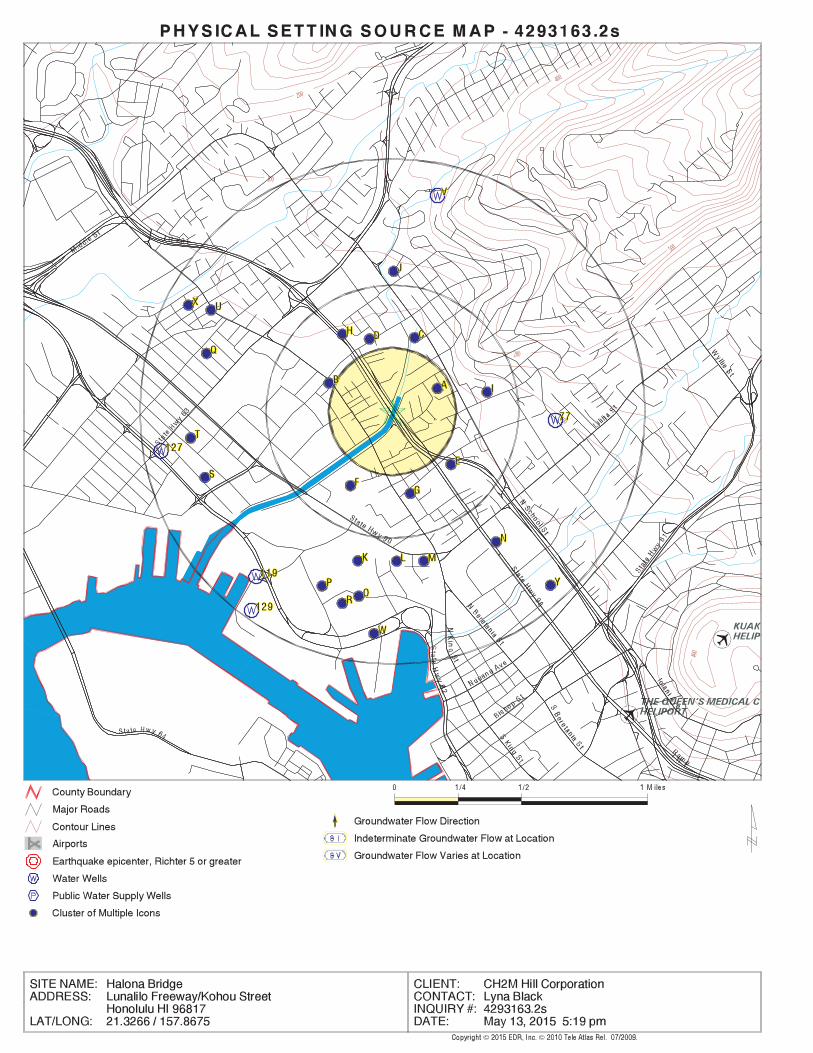
EDR Inc.EDR Inc.EDR Inc.EDR Inc.EDR Inc.EDR Inc.EDR Inc.EDR Inc.EDR Inc.EDR Inc.EDR Inc.EDR Inc.EDR Inc.EDR Inc.EDR Inc.EDR Inc.EDR Inc.EDR Inc.EDR Inc.EDR Inc.EDR Inc.EDR Inc.EDR Inc.EDR Inc.EDR Inc.EDR Inc.EDR Inc.EDR Inc.EDR Inc.EDR Inc.EDR Inc.EDR Inc.EDR Inc.EDR Inc.EDR Inc.EDR Inc.EDR Inc.EDR Inc.EDR Inc.EDR Inc.
400
400
200
200
500
100
100

EDR Inc.EDR Inc.EDR Inc.EDR Inc.EDR Inc.EDR Inc.EDR Inc.EDR Inc.EDR Inc.EDR Inc.EDR Inc.EDR Inc.EDR Inc.EDR Inc.EDR Inc.EDR Inc.EDR Inc.EDR Inc.EDR Inc.EDR Inc.EDR Inc.EDR Inc.EDR Inc.EDR Inc.EDR Inc.EDR Inc.EDR Inc.EDR Inc.EDR Inc.EDR Inc.EDR Inc.EDR Inc.EDR Inc.EDR Inc.EDR Inc.EDR Inc.EDR Inc.EDR Inc.EDR Inc.EDR Inc.
GEOCHECK - PHYSICAL SETTING SOURCE MAP FINDINGS®
Map IDDirectionDistanceElevation EDR ID NumberDatabase
A1ENE1/8 - 1/4 MileHigher
USGS40000269854FED USGSClick here for full text details
A2ENE1/8 - 1/4 MileHigher
HI9000000000928HI WELLSClick here for full text details
A3ENE1/8 - 1/4 MileHigher
USGS40000269853FED USGSClick here for full text details
A4ENE1/8 - 1/4 MileHigher
USGS40000269850FED USGSClick here for full text details
A5ENE1/8 - 1/4 MileHigher
HI9000000000923HI WELLSClick here for full text details
A6ENE1/8 - 1/4 MileHigher
HI9000000000922HI WELLSClick here for full text details
A7ENE1/8 - 1/4 MileHigher
USGS40000269863FED USGSClick here for full text details
A8ENE1/8 - 1/4 MileHigher
HI9000000000927HI WELLSClick here for full text details
B9WNW1/4 - 1/2 MileHigher
USGS40000269855FED USGSClick here for full text details
Page: 1

®GEOCHECK - PHYSICAL SETTING SOURCE MAP FINDINGS®
Map IDDirectionDistanceElevation EDR ID NumberDatabase
C10NNE1/4 - 1/2 MileHigher
USGS40000269888FED USGSClick here for full text details
B11WNW1/4 - 1/2 MileHigher
USGS40000269864FED USGSClick here for full text details
B12WNW1/4 - 1/2 MileHigher
USGS40000269867FED USGSClick here for full text details
B13WNW1/4 - 1/2 MileHigher
USGS40000269866FED USGSClick here for full text details
B14WNW1/4 - 1/2 MileHigher
USGS40000269865FED USGSClick here for full text details
B15WNW1/4 - 1/2 MileHigher
USGS40000269868FED USGSClick here for full text details
B16WNW1/4 - 1/2 MileHigher
USGS40000269871FED USGSClick here for full text details
B17WNW1/4 - 1/2 MileHigher
USGS40000269870FED USGSClick here for full text details
B18WNW1/4 - 1/2 MileHigher
USGS40000269869FED USGSClick here for full text details
Page: 2

®GEOCHECK - PHYSICAL SETTING SOURCE MAP FINDINGS®
Map IDDirectionDistanceElevation EDR ID NumberDatabase
B19WNW1/4 - 1/2 MileHigher
HI0000343FRDS PWSClick here for full text details
B20WNW1/4 - 1/2 MileHigher
HI9000000000926HI WELLSClick here for full text details
B21WNW1/4 - 1/2 MileHigher
HI9000000000934HI WELLSClick here for full text details
B22WNW1/4 - 1/2 MileHigher
HI9000000000924HI WELLSClick here for full text details
B23WNW1/4 - 1/2 MileHigher
HI9000000000925HI WELLSClick here for full text details
B24WNW1/4 - 1/2 MileHigher
HI9000000000935HI WELLSClick here for full text details
B25WNW1/4 - 1/2 MileHigher
HI9000000000940HI WELLSClick here for full text details
B26WNW1/4 - 1/2 MileHigher
HI9000000000966HI WELLSClick here for full text details
B27WNW1/4 - 1/2 MileHigher
HI9000000000936HI WELLSClick here for full text details
Page: 3

®GEOCHECK - PHYSICAL SETTING SOURCE MAP FINDINGS®
Map IDDirectionDistanceElevation EDR ID NumberDatabase
B28WNW1/4 - 1/2 MileHigher
HI9000000000937HI WELLSClick here for full text details
D29NNW1/4 - 1/2 MileHigher
USGS40000269893FED USGSClick here for full text details
D30NNW1/4 - 1/2 MileHigher
HI9000000001091HI WELLSClick here for full text details
E31SE1/4 - 1/2 MileHigher
HI9000000000933HI WELLSClick here for full text details
E32SE1/4 - 1/2 MileHigher
USGS40000269822FED USGSClick here for full text details
C33NNE1/4 - 1/2 MileHigher
HI9000000001100HI WELLSClick here for full text details
F34SSW1/4 - 1/2 MileHigher
HI9000000000959HI WELLSClick here for full text details
F35SSW1/4 - 1/2 MileHigher
HI9000000000960HI WELLSClick here for full text details
F36SSW1/4 - 1/2 MileHigher
HI9000000000957HI WELLSClick here for full text details
Page: 4

®GEOCHECK - PHYSICAL SETTING SOURCE MAP FINDINGS®
Map IDDirectionDistanceElevation EDR ID NumberDatabase
F37SSW1/4 - 1/2 MileHigher
HI9000000000958HI WELLSClick here for full text details
F38SSW1/4 - 1/2 MileHigher
HI9000000000963HI WELLSClick here for full text details
F39SSW1/4 - 1/2 MileHigher
HI9000000000964HI WELLSClick here for full text details
F40SSW1/4 - 1/2 MileHigher
HI9000000000961HI WELLSClick here for full text details
F41SSW1/4 - 1/2 MileHigher
HI9000000000962HI WELLSClick here for full text details
G42SSE1/4 - 1/2 MileHigher
HI9000000000919HI WELLSClick here for full text details
F43SSW1/4 - 1/2 MileHigher
USGS40000269816FED USGSClick here for full text details
F44SSW1/4 - 1/2 MileHigher
USGS40000269817FED USGSClick here for full text details
F45SSW1/4 - 1/2 MileHigher
USGS40000269815FED USGSClick here for full text details
Page: 5

®GEOCHECK - PHYSICAL SETTING SOURCE MAP FINDINGS®
Map IDDirectionDistanceElevation EDR ID NumberDatabase
C46NNE1/4 - 1/2 MileHigher
USGS40000269899FED USGSClick here for full text details
G47SSE1/4 - 1/2 MileHigher
USGS40000269810FED USGSClick here for full text details
H48NW1/4 - 1/2 MileHigher
USGS40000269894FED USGSClick here for full text details
F49SSW1/4 - 1/2 MileHigher
USGS40000269813FED USGSClick here for full text details
H50NW1/4 - 1/2 MileHigher
HI9000000001092HI WELLSClick here for full text details
F51SSW1/4 - 1/2 MileHigher
USGS40000269814FED USGSClick here for full text details
F52SSW1/4 - 1/2 MileHigher
USGS40000269811FED USGSClick here for full text details
F53SSW1/4 - 1/2 MileHigher
USGS40000269812FED USGSClick here for full text details
H54NNW1/4 - 1/2 MileHigher
USGS40000269900FED USGSClick here for full text details
Page: 6

®GEOCHECK - PHYSICAL SETTING SOURCE MAP FINDINGS®
Map IDDirectionDistanceElevation EDR ID NumberDatabase
I55East1/4 - 1/2 MileHigher
USGS40000269852FED USGSClick here for full text details
H56NNW1/4 - 1/2 MileHigher
HI9000000001094HI WELLSClick here for full text details
I57ENE1/4 - 1/2 MileHigher
HI9000000000915HI WELLSClick here for full text details
J58North1/2 - 1 MileHigher
USGS40000269919FED USGSClick here for full text details
J59North1/2 - 1 MileHigher
HI9000000001098HI WELLSClick here for full text details
J60North1/2 - 1 MileHigher
USGS40000269923FED USGSClick here for full text details
J61North1/2 - 1 MileHigher
HI9000000001095HI WELLSClick here for full text details
J62North1/2 - 1 MileHigher
USGS40000269937FED USGSClick here for full text details
K63South1/2 - 1 MileHigher
HI9000000000938HI WELLSClick here for full text details
Page: 7

®GEOCHECK - PHYSICAL SETTING SOURCE MAP FINDINGS®
Map IDDirectionDistanceElevation EDR ID NumberDatabase
J64North1/2 - 1 MileHigher
HI9000000001099HI WELLSClick here for full text details
K65SSW1/2 - 1 MileHigher
HI9000000000939HI WELLSClick here for full text details
K66South1/2 - 1 MileHigher
USGS40000269799FED USGSClick here for full text details
L67South1/2 - 1 MileHigher
HI9000000000941HI WELLSClick here for full text details
K68SSW1/2 - 1 MileHigher
USGS40000269800FED USGSClick here for full text details
K69SSW1/2 - 1 MileHigher
HI9000000000931HI WELLSClick here for full text details
K70SSW1/2 - 1 MileHigher
USGS40000269801FED USGSClick here for full text details
L71South1/2 - 1 MileHigher
USGS40000269795FED USGSClick here for full text details
K72SSW1/2 - 1 MileHigher
USGS40000269802FED USGSClick here for full text details
Page: 8
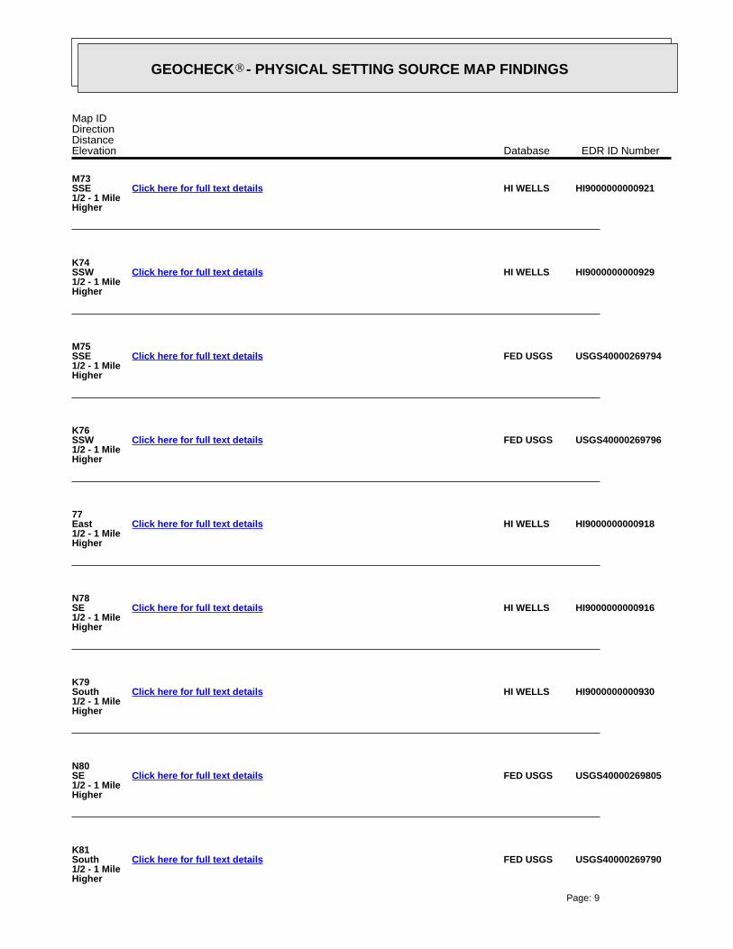
®GEOCHECK - PHYSICAL SETTING SOURCE MAP FINDINGS®
Map IDDirectionDistanceElevation EDR ID NumberDatabase
M73SSE1/2 - 1 MileHigher
HI9000000000921HI WELLSClick here for full text details
K74SSW1/2 - 1 MileHigher
HI9000000000929HI WELLSClick here for full text details
M75SSE1/2 - 1 MileHigher
USGS40000269794FED USGSClick here for full text details
K76SSW1/2 - 1 MileHigher
USGS40000269796FED USGSClick here for full text details
77East1/2 - 1 MileHigher
HI9000000000918HI WELLSClick here for full text details
N78SE1/2 - 1 MileHigher
HI9000000000916HI WELLSClick here for full text details
K79South1/2 - 1 MileHigher
HI9000000000930HI WELLSClick here for full text details
N80SE1/2 - 1 MileHigher
USGS40000269805FED USGSClick here for full text details
K81South1/2 - 1 MileHigher
USGS40000269790FED USGSClick here for full text details
Page: 9

®GEOCHECK - PHYSICAL SETTING SOURCE MAP FINDINGS®
Map IDDirectionDistanceElevation EDR ID NumberDatabase
O82South1/2 - 1 MileHigher
HI9000000000944HI WELLSClick here for full text details
O83South1/2 - 1 MileHigher
HI9000000000946HI WELLSClick here for full text details
O84South1/2 - 1 MileHigher
HI9000000000945HI WELLSClick here for full text details
P85SSW1/2 - 1 MileHigher
HI9000000000948HI WELLSClick here for full text details
O86South1/2 - 1 MileHigher
USGS40000269778FED USGSClick here for full text details
O87South1/2 - 1 MileHigher
USGS40000269779FED USGSClick here for full text details
O88South1/2 - 1 MileHigher
USGS40000269780FED USGSClick here for full text details
P89SSW1/2 - 1 MileHigher
USGS40000269788FED USGSClick here for full text details
Q90WNW1/2 - 1 MileHigher
USGS40000269880FED USGSClick here for full text details
Page: 10

®GEOCHECK - PHYSICAL SETTING SOURCE MAP FINDINGS®
Map IDDirectionDistanceElevation EDR ID NumberDatabase
Q91WNW1/2 - 1 MileHigher
HI9000000000920HI WELLSClick here for full text details
P92SSW1/2 - 1 MileHigher
HI9000000000932HI WELLSClick here for full text details
P93SSW1/2 - 1 MileHigher
HI9000000000943HI WELLSClick here for full text details
P94SSW1/2 - 1 MileHigher
USGS40000269789FED USGSClick here for full text details
P95SSW1/2 - 1 MileHigher
USGS40000269786FED USGSClick here for full text details
O96South1/2 - 1 MileHigher
HI9000000000951HI WELLSClick here for full text details
P97SSW1/2 - 1 MileHigher
HI9000000000942HI WELLSClick here for full text details
P98SSW1/2 - 1 MileHigher
USGS40000269781FED USGSClick here for full text details
O99SSW1/2 - 1 MileHigher
USGS40000269771FED USGSClick here for full text details
Page: 11

®GEOCHECK - PHYSICAL SETTING SOURCE MAP FINDINGS®
Map IDDirectionDistanceElevation EDR ID NumberDatabase
R100SSW1/2 - 1 MileHigher
HI9000000000947HI WELLSClick here for full text details
O101South1/2 - 1 MileHigher
HI9000000000949HI WELLSClick here for full text details
R102SSW1/2 - 1 MileHigher
USGS40000269772FED USGSClick here for full text details
S103WSW1/2 - 1 MileHigher
HI9000000000953HI WELLSClick here for full text details
S104WSW1/2 - 1 MileHigher
HI9000000000954HI WELLSClick here for full text details
O105South1/2 - 1 MileHigher
USGS40000269768FED USGSClick here for full text details
S106WSW1/2 - 1 MileHigher
USGS40000269819FED USGSClick here for full text details
S107WSW1/2 - 1 MileHigher
USGS40000269820FED USGSClick here for full text details
S108WSW1/2 - 1 MileHigher
HI9000000000952HI WELLSClick here for full text details
Page: 12

®GEOCHECK - PHYSICAL SETTING SOURCE MAP FINDINGS®
Map IDDirectionDistanceElevation EDR ID NumberDatabase
T109West1/2 - 1 MileHigher
HI9000000000956HI WELLSClick here for full text details
S110WSW1/2 - 1 MileHigher
USGS40000269821FED USGSClick here for full text details
O111SSW1/2 - 1 MileHigher
HI9000000000950HI WELLSClick here for full text details
P112SSW1/2 - 1 MileHigher
USGS40000269773FED USGSClick here for full text details
R113SSW1/2 - 1 MileHigher
USGS40000269763FED USGSClick here for full text details
Q114WNW1/2 - 1 MileHigher
USGS40000269889FED USGSClick here for full text details
Q115WNW1/2 - 1 MileHigher
HI9000000001089HI WELLSClick here for full text details
T116West1/2 - 1 MileHigher
USGS40000269834FED USGSClick here for full text details
U117WNW1/2 - 1 MileHigher
USGS40000269908FED USGSClick here for full text details
Page: 13
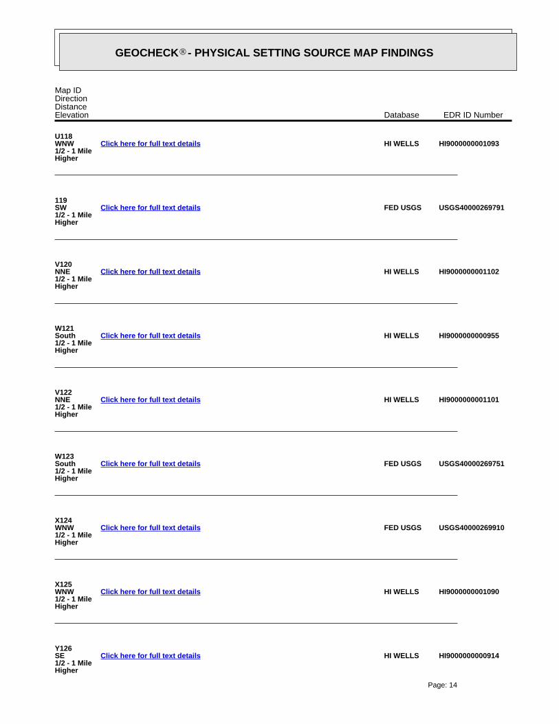
®GEOCHECK - PHYSICAL SETTING SOURCE MAP FINDINGS®
Map IDDirectionDistanceElevation EDR ID NumberDatabase
U118WNW1/2 - 1 MileHigher
HI9000000001093HI WELLSClick here for full text details
119SW1/2 - 1 MileHigher
USGS40000269791FED USGSClick here for full text details
V120NNE1/2 - 1 MileHigher
HI9000000001102HI WELLSClick here for full text details
W121South1/2 - 1 MileHigher
HI9000000000955HI WELLSClick here for full text details
V122NNE1/2 - 1 MileHigher
HI9000000001101HI WELLSClick here for full text details
W123South1/2 - 1 MileHigher
USGS40000269751FED USGSClick here for full text details
X124WNW1/2 - 1 MileHigher
USGS40000269910FED USGSClick here for full text details
X125WNW1/2 - 1 MileHigher
HI9000000001090HI WELLSClick here for full text details
Y126SE1/2 - 1 MileHigher
HI9000000000914HI WELLSClick here for full text details
Page: 14

®GEOCHECK - PHYSICAL SETTING SOURCE MAP FINDINGS®
Map IDDirectionDistanceElevation EDR ID NumberDatabase
127West1/2 - 1 MileHigher
USGS40000269830FED USGSClick here for full text details
Y128SE1/2 - 1 MileHigher
USGS40000269785FED USGSClick here for full text details
129SW1/2 - 1 MileHigher
USGS40000269764FED USGSClick here for full text details
Page: 15

0%0%100%0.200 pCi/LBasementNot ReportedNot ReportedNot ReportedNot ReportedLiving Area - 2nd Floor0%0%100%0.110 pCi/LLiving Area - 1st Floor
% >20 pCi/L% 4-20 pCi/L% <4 pCi/LAverage ActivityArea
Number of sites tested: 10
Federal Area Radon Information for Zip Code: 96817
: Zone 3 indoor average level < 2 pCi/L. : Zone 2 indoor average level >= 2 pCi/L and <= 4 pCi/L. Note: Zone 1 indoor average level > 4 pCi/L.
Federal EPA Radon Zone for HONOLULU County: 3
AREA RADON INFORMATION
®GEOCHECK - PHYSICAL SETTING SOURCE MAP FINDINGSRADON
®
TC4293163.2s Page 16

EDR Inc.EDR Inc.EDR Inc.EDR Inc.EDR Inc.EDR Inc.EDR Inc.EDR Inc.EDR Inc.EDR Inc.EDR Inc.EDR Inc.EDR Inc.EDR Inc.EDR Inc.EDR Inc.EDR Inc.EDR Inc.EDR Inc.EDR Inc.EDR Inc.EDR Inc.EDR Inc.EDR Inc.EDR Inc.EDR Inc.EDR Inc.EDR Inc.EDR Inc.EDR Inc.EDR Inc.EDR Inc.EDR Inc.EDR Inc.EDR Inc.EDR Inc.EDR Inc.EDR Inc.EDR Inc.EDR Inc.
TOPOGRAPHIC INFORMATION
USGS 7.5’ Digital Elevation Model (DEM)Source: United States Geologic SurveyEDR acquired the USGS 7.5’ Digital Elevation Model in 2002 and updated it in 2006. The 7.5 minute DEM correspondsto the USGS 1:24,000- and 1:25,000-scale topographic quadrangle maps. The DEM provides elevation datawith consistent elevation units and projection.
Scanned Digital USGS 7.5’ Topographic Map (DRG)Source: United States Geologic SurveyA digital raster graphic (DRG) is a scanned image of a U.S. Geological Survey topographic map. The map imagesare made by scanning published paper maps on high-resolution scanners. The raster imageis georeferenced and fit to the Universal Transverse Mercator (UTM) projection.
HYDROLOGIC INFORMATION
Flood Zone Data: This data, available in select counties across the country, was obtained by EDR in 2003 & 2011 from the FederalEmergency Management Agency (FEMA). Data depicts 100-year and 500-year flood zones as defined by FEMA.
NWI: National Wetlands Inventory. This data, available in select counties across the country, was obtained by EDRin 2002, 2005 and 2010 from the U.S. Fish and Wildlife Service.
HYDROGEOLOGIC INFORMATION
AQUIFLOW Information SystemR
Source: EDR proprietary database of groundwater flow informationEDR has developed the AQUIFLOW Information System (AIS) to provide data on the general direction of groundwater
flow at specific points. EDR has reviewed reports submitted to regulatory authorities at select sites and hasextracted the date of the report, hydrogeologically determined groundwater flow direction and depth to water tableinformation.
GEOLOGIC INFORMATION
Geologic Age and Rock Stratigraphic UnitSource: P.G. Schruben, R.E. Arndt and W.J. Bawiec, Geology of the Conterminous U.S. at 1:2,500,000 Scale - A digitalrepresentation of the 1974 P.B. King and H.M. Beikman Map, USGS Digital Data Series DDS - 11 (1994).
STATSGO: State Soil Geographic DatabaseSource: Department of Agriculture, Natural Resources Conservation ServicesThe U.S. Department of Agriculture’s (USDA) Natural Resources Conservation Service (NRCS) leads the nationalConservation Soil Survey (NCSS) and is responsible for collecting, storing, maintaining and distributing soilsurvey information for privately owned lands in the United States. A soil map in a soil survey is a representationof soil patterns in a landscape. Soil maps for STATSGO are compiled by generalizing more detailed (SSURGO)soil survey maps.
SSURGO: Soil Survey Geographic DatabaseSource: Department of Agriculture, Natural Resources Conservation Services (NRCS)Telephone: 800-672-5559SSURGO is the most detailed level of mapping done by the Natural Resources Conservation Services, mappingscales generally range from 1:12,000 to 1:63,360. Field mapping methods using national standards are used toconstruct the soil maps in the Soil Survey Geographic (SSURGO) database. SSURGO digitizing duplicates theoriginal soil survey maps. This level of mapping is designed for use by landowners, townships and countynatural resource planning and management.
TC4293163.2s Page PSGR-1
PHYSICAL SETTING SOURCE RECORDS SEARCHED
LOCAL / REGIONAL WATER AGENCY RECORDS
FEDERAL WATER WELLS
PWS: Public Water SystemsSource: EPA/Office of Drinking WaterTelephone: 202-564-3750Public Water System data from the Federal Reporting Data System. A PWS is any water system which provides water to at
least 25 people for at least 60 days annually. PWSs provide water from wells, rivers and other sources.
PWS ENF: Public Water Systems Violation and Enforcement DataSource: EPA/Office of Drinking WaterTelephone: 202-564-3750Violation and Enforcement data for Public Water Systems from the Safe Drinking Water Information System (SDWIS) after
August 1995. Prior to August 1995, the data came from the Federal Reporting Data System (FRDS).
USGS Water Wells: USGS National Water Inventory System (NWIS)This database contains descriptive information on sites where the USGS collects or has collected data on surfacewater and/or groundwater. The groundwater data includes information on wells, springs, and other sources of groundwater.
OTHER STATE DATABASE INFORMATION
RADON
Area Radon InformationSource: USGSTelephone: 703-356-4020The National Radon Database has been developed by the U.S. Environmental Protection Agency(USEPA) and is a compilation of the EPA/State Residential Radon Survey and the National Residential Radon Survey.The study covers the years 1986 - 1992. Where necessary data has been supplemented by information collected atprivate sources such as universities and research institutions.
EPA Radon ZonesSource: EPATelephone: 703-356-4020Sections 307 & 309 of IRAA directed EPA to list and identify areas of U.S. with the potential for elevated indoorradon levels.
OTHER
Airport Landing Facilities: Private and public use landing facilitiesSource: Federal Aviation Administration, 800-457-6656
Epicenters: World earthquake epicenters, Richter 5 or greaterSource: Department of Commerce, National Oceanic and Atmospheric Administration
Earthquake Fault Lines: The fault lines displayed on EDR’s Topographic map are digitized quaternary faultlines, preparedin 1975 by the United State Geological Survey
STREET AND ADDRESS INFORMATION
© 2010 Tele Atlas North America, Inc. All rights reserved. This material is proprietary and the subject of copyright protectionand other intellectual property rights owned by or licensed to Tele Atlas North America, Inc. The use of this material is subjectto the terms of a license agreement. You will be held liable for any unauthorized copying or disclosure of this material.
TC4293163.2s Page PSGR-2
PHYSICAL SETTING SOURCE RECORDS SEARCHED
Appendix C Endangered Species Act Section 2
Consultation Documentation
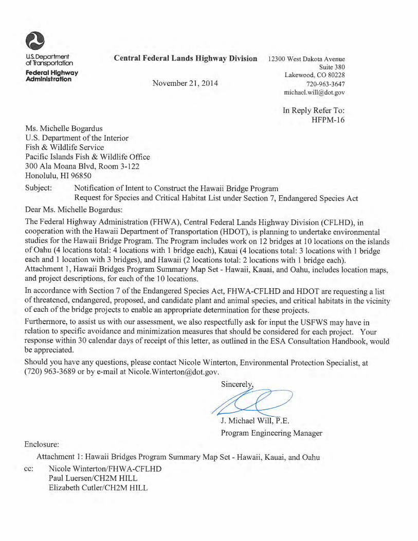

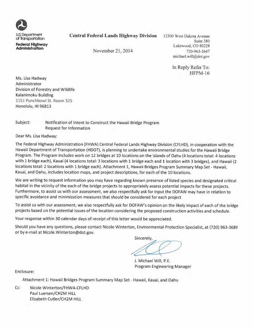


Hawaii Bridges Program ‐ Hawaii, Kauai, and Oahu
10
O – Halona
The proposed project is located on Halona Street, MP 20.21, adjacent to the Interstate Route H‐1 on‐
ramp from Vineyard Boulevard. The purpose of the project is to replace the existing bridge to meet
current design standards for roadway width, load capacity, pedestrian traffic, bridge railing and
transitions, and bridge approaches. HDOT has also requested the project include provisions to
discourage people from making temporary shelters under the bridges along Kapalama Canal.
United States Department of the Interior
ln Reply Refer To: 20 I 5-SL-0081
J . Michael Will
FISH AND WILDLIFE SERVICE Pacific Islands Fish and Wildlife Office 300 Ala Moana Boulevard, Room 3-122
Honolulu, Hawaii 96850
U.S. Department of Transportation Federal Highway Administration Central Federal Lands Highway Division 12300 West Dakota Avenue, Suite 380 Lakewood, CO 80228
DEC222~
Subject: Species List for Hawaii Bridges Program, Hawaii, Kauai, and Oahu
Dear Mr. J . Michael Will:
The U.S. Fish and Wildlife Service (Service) received your letter, dated November 21, 2014, requesting a list of federally threatened and endangered species, candidate species, plants and animals of special concern, and critical habitats in the vicinity of the proposed bridge projects. The Federal Highways Administration (FHW A), Central Federal Lands Highway Division (CFLHD), in cooperation with the State of Hawaii Department of Transportation (HDOT), is planning to conduct environmental studies for the proposed rehabilitation or replacement of 12 bridges at 10 locations on the islands of Hawaii, Kauai, and Oahu to improve the safety and reliability of the bridges.
On the island of Hawaii, the Ninole Bridge located along Mamalahoa Highway (Route 11) at mile post 56.7 would be rehabilitated or replaced, addressing bridge width, load capacity, railing, transitions, and approaches. The Hilea Bridge located on Mamalahoa Highway (Route 11) at mile post 57.7 would be rehabilitated or replaced, addressing bridge width, load capacity, railing, and transitions.
On the island of Kauai, Bridge 7E located along Kaumualii Highway (Route 50), approximately 800 feet west of Maluhia Road intersection, would be rehabilitated or replaced, addressing bridge width, load capacity, railing, and transitions. Hanapepe Bridge located on Kaumualii Highway (Route 50) in Hanapepe town would be rehabilitated or replaced, addressing bridge width, load capacity, railing, transitions, approaches, and effects of scour. Kapaa Stream Bridge located on Kuhio Highway (Route 56) near mile post 10 would be rehabilitated or replaced, addressing bridge width, load capacity, railing, transitions, and approaches. This project would also involve improvements to the highway intersection at Mailihuna Road, including roadway
TAKE PRIDE®lf: -' INAMERICA~

Mr. Will 2
widening, lighting, signing, pavement markings, drainage, and other improvements such as installation of traffic signals. The three Wainiha Stream bridges located on Kuhio Highway (Route 560) at mile post 6.4 and 6.7 would be replaced. Additionally, three load-restricted bridges which cross Waioli, Waipa, and Waikoko streams, located at mile posts 3.4, 3.9, and 4.2, will be studied to determine loads and alternatives such as temporary bridges or supports necessary to provide construction access to the Wainiha Stream bridges.
On the island of Oahu, the Halona Bridge located on Halona Street, which crosses Kapalama Canal, would be rehabilitated or replaced, addressing bridge width, load capacity, railing, transitions, approaches, and pedestrian traffic. The Kawela Bridge located on Kamehameha Highway (Route 83) at mile post 11.4 would be replaced, addressing bridge width, load capacity, railing, transitions, and approaches. The Nanahu Bridge located on Kamehameha Highway (Route 83) at mile post 13.4 would be rehabilitated or replaced, addressing bridge width, load capacity, railing, transitions, and approaches. The Roosevelt Bridge located on Kamehameha Highway (Route 99) at mile post 14.4 would be rehabilitated, addressing bridge load capacity, railing, and transitions.
The Service offers the following comments to assist you in your planning process so that impacts to trust resources can be avoided through site preparation, construction, and operation. Our comments are provided under the authorities of the Endangered Species Act of 1973 (ESA), as amended (16 U.S.C 153 l et seq.).
Our databases, including data compiled by the Hawaii Biodiversity and Mapping Program (HBMP), indicate the following species are known to occur or transit through the vicinity of the proposed project areas at Ninole Bridge and Hilea Bridge on the island of Hawaii: the federally endangered Blackburn's sphinx moth (Manduca blackbumi, BSM), Hawaiian goose (Branta sandvicensis), Hawaiian hawk (Buteo solitarius), Hawaiian hoary bat (Lasiurus cinereus semotus), and Hawaiian petrel (Pterodroma sandwichensis); and the threatened Newell's shearwater (Puffinus auricularis newelli). There is no designated critical habitat in the vicinity of the proposed project areas on the island of Hawaii.
Our databases, including data compiled by the HBMP, indicate the following species are known to occur or transit through the proposed project areas at Bridge 7E, Hanapepe Bridge, Kapaa Stream Bridge, and the Wainiha Stream bridges on the island of Kauai: the endangered Hawaiian black-necked stilt (Himantopus mexicanus knudseni), Hawaiian moorhen (Gallinula chloropus sandvicensis), Hawaiian coot (Fulica alai), Hawaiian duck (Anas wyvilliana), Hawaiian goose, Hawaiian hoary bat, and Hawaiian petrel; the threatened Newell's shearwater; and a candidate for listing band-rumped storm-petrel (Oceanodroma castro). Additionally, our databases indicate the threatened green sea turtle (Chelonia mydas) is known to occur in the vicinity of the proposed project areas at the Kapaa Stream Bridge and the Wainiha Stream bridges. There is no designated critical habitat in the vicinity of the proposed project areas on the island of Kauai.
The endangered Hawaiian monk seal (Monachus schauinslandi) may use beach habitat in the vicinity of the proposed project at the Kapaa Stream Bridge and the Wainiha Stream bridges. The National Marine Fisheries Service (NMFS) is the Federal agency .that consults on potential impacts to monk seals, both in their on-shore and ocean habitats. Therefore, we did not review
Mr. Will
the proposed project for potential project impact<; to monk seals. We recommend that you contact NMFS regarding the presence of monk seals in the area and potential impacts to the species from the project.
3
Our databases, including data compiled by the HBMP, indicate the following species are known to occur or transit through the proposed project areas at Kawela Bridge, Nanahu Bridge, and Roosevelt Bridge on the island of Oahu: the endangered Hawaiian black-necked stilt, Hawaiian moorhen, Hawaiian coot, Hawaiian duck, Hawaiian goose, Hawaiian hoary bat, and Hawaiian petrel; and the threatened Newell's shearwater. Hawaiian geese recently arrived on Oahu. A pair was first observed in early January 2014 at the First Wind Kawailoa wind farm facility. They have successfully nested, fledging two goslings at the James Campbell National Wildlife Refuge (NWR) near the town of Kahuku. The pair, originally from Kauai, was translocated to Hilo, Hawaii in February 2012, by the State of Hawaii Division of Forestry and Wildlife, and were apparently attempting to return to Kauai when they arrived on Oahu. As of December 2014 the four birds have been seen at the Mililani Agricultural Park, Mililani golf course, and James Campbell NWR.
Additionally, our databases indicate the endangered Hawaiian hoary bat is known to occur or transit through the proposed project area at Halona Bridge on the island of Oahu. There is no designated critical habitat in the vicinity of the proposed project areas on the island of Oahu.
The Service recommends the following measures to avoid and minimize project impacts to the above listed species.
Island of Hawaii
Blackbum·.\· sphinx moth Adult Blackburn's sphinx moths feed on nectar from native plants including beach morning glory (/pomoea pescaprae). iliee (Plumbago zeylanica). and maiapilo (Capparis sandwichiana). BSM larvae feed upon native tree tobacco (Nicotiww glauca), which occupies disturbed areas such as open fields and roadway margins. and the native aiea (Nothocestrum sp.), which is found in dry to moist forests at elevations ranging from 1,500 to 5.000 feet. We recommend that a qualified biologist survey the project area for the presence of larval host plants. If larval host plant are detected and will be affected during project construction or operation, we recommend that the biologist document I) general larval plant density; 2) proximity of larval plants to project sites: 3) average height of the larval plants; 4) signs of larval feeding damage on leaves; and 5) presence of BSM larvae on leaves. We recommend that surveys be conducted for BSM and potential host plants approximately four to eight weeks following significant rainfall and during the wettest portion of the year (usually November-Apri l).
Hawaiian Goose In order to avoid impacts to Hawaiian geese. we recommend a biologist familiar with the nesting behavior of the Hawaiian goose survey the area prior to the initiation of any work, or after any subsequent delay in work of three or more days (during which birds may attempt nesting). If a nest is discovered, work should cease immediately and our office should be contacted for further guidance. Furthe1more, all on-site project personnel should be apprised that Hawaiian geese
Mr. Will
may be in the vicinity of the project at any time during the year. If a Hawaiian goose (or geese) appears within 100 feet of ongoing work, all activity should be temporarily suspended until the Hawaiian goose (or geese) leaves the area of its own accord.
Hawaiian Hawk Loud, itTegular and unpredictable activities, such as using heavy equipment or building a structure, near an endangered Hawaiian hawk nest may cause nest failure. Harassment of Hawaiian hawk nesting sites can alter feeding and breeding patterns or result in nest or chick abandonment. Nest disturbance can also increase exposure of chicks and juveniles to inclement weather or predators. To avoid impacts to Hawaiian hawks, we recommend avoiding brush and tree clearing during their breeding season (March through September). If you must clear the property during the Hawaiian hawk breeding season, we recommend a nest search of the proposed construction site and sutTOLtnding area be conducted by a qualified ornithologist immediately prior to start of constmction activities. Surveys should ensure that construction activity will not occur within 1,600 feet of any Hawaiian hawk nest.
Hawaiian Hoary Bat The Hawaiian hoary bat roosts in both exotic and native woody vegetation and, while foraging, will leave young unattended in "nursery" trees and shrubs when they forage. If trees or shrubs suitable for bat roosting are cleared during the breeding season, there is a risk that young bats could inadvertently be harmed or killed. To minimize impacts to the endangered Hawaiian hoary bat, woody plants greater than 15 feet (4.6 meters) tall should not be disturbed, removed, or trimmed during the bat birthing and pup rearing season (June 1 through September 15). Site clearing should be timed to avoid disturbance to Hawaiian hoary bats in the project area.
Seabirds
4
Seabirds, including the Newell's shearwater, Hawaiian petrel and band-rumped storm petrel, fly at night and are attracted to artificially-lighted areas resulting in disorientation and subsequent fallout due to exhaustion. Seabirds are also susceptible to collision with objects that protrude above the vegetation layer, such as utility lines, guy-wires, and communication towers. Additionally, once grounded, they are vulnerable to predators and are often struck by vehicles along roadways. To reduce potential impacts to seabirds, we recommend the following minimization measures be incorporated into your project description:
•
•
Construction activities should only occur during daylight hours. Any increase in the use of nighttime lighting, particularly during peak fallout period (September 15 through December 15), could result in additional seabird injury or mortality.
If lights cannot be eliminated due to safety or security concerns, then they should be positioned low to the ground, be motion-triggered, and be shielded and/or full cut-off. Effective light shields should be completely opaque, sufficiently large, and positioned so that the bulb is only visible from below.

Mr. Will
Island of Kauai
Please refer to "Hawaiian goose'', "Hawaiian hoary bat", and "Seabirds" under the Island of Hawaii (above) for recommended measures to avoid and minimize impacts to the Hawaiian goose, Hawaiian hoary bat, and Hawaiian petrel, Newell's shearwater, and band-rumped storm petrel.
Hawaiian Waterbirds
5
The Hawaiian stilt, moorhen, coot, and duck are hereafter collectively referred to as "Hawaiian waterbirds." Our records indicate there is a high probability that Hawaiian waterbirds may occur in the vicinity of the proposed project. We recommend you incorporate the following measures into your project description to avoid and minimize impacts to Hawaiian waterbirds:
•
•
•
•
•
•
•
A biological monitor should conduct Hawaiian waterbird and nest surveys at the proposed project site prior to project initiation. Any documented nests or broods within the project vicinity should be reported to the Service within 48 hours. A 100-foot buffer should be established and maintained around all active nests and/or broods until the chicks/ducklings have fledged. No potentially disruptive activities or habitat alteration should occur within this buffer. The Service should be notified immediately prior to project initiation and provided with the results of pre-construction Hawaiian waterbird surveys. A biological monitor(s) should be present on the project site during all construction or earth moving activities to ensure that Hawaiian waterbirds and nests are not adversely impacted. If a listed Hawaiian waterbird is observed within the project site, or flies into the site while activities are occurring, the biological monitor should halt all activities within 100 feet of the individual(s). Work should not resume until the Hawaiian waterbird(s) leave the area on their own accord. A post-construction report should be submitted to the Service with 30 days of the completion of the project. The report should include the results of Hawaiian waterbird surveys, the location and outcome of documented nests, and any other relevant information.
Sea Turtles Artificial lighting can disorient adult sea turtles and hatchlings by affecting their ability to find the ocean. To minimize potential impacts to sea turtles that may utilize beaches in the project vicinity, no light from the proposed project should be visible from the beach. We recommend installation of shielded lighting at construction sites near beaches and around shoreline developments. Shielded lights reduce the direct and ambient lighting of beach habitats within and adjacent to the project site. Effective light shields should be completely opaque, sufficiently large, and positioned so that light from the shielded source does not reach the beach. Projects should also be designed to minimize adverse impacts to basking or nesting sea turtles from offleash pets, mammalian predators, and human disturbance.
Mr. Will 6
Island of Oahu
Please refer to "Hawaiian goose", "Hawaiian hoary bat", "Seabirds", and "Hawaiian waterbirds" (above) for recommended measures to avoid and minimize impacts to the Hawaiian goose, Hawaiian hoary bat, Hawaiian petrel, Newell's shearwater, Hawaiian black-necked stilt, Hawaiian moorhen, Hawaiian coot, and Hawaiian duck.
Because the proposed activities may cause soil erosion and sedimentation in sensitive aquatic habitats, we are attaching the Service's recommended Best Management Practices regarding sedimentation and erosion in aquatic environments. We encourage you to incorporate the relevant practices into your project design. In addition to the guidance provided in this letter, the Service anticipates responding to the U.S. Army Corps of Engineers inter-agency notification process and providing further recommendations pursuant to the Fish and Wildlife Coordination Act of 1934 (FWCA), as amended (16 U.S.C. 661 et seq.; 48 Stat. 401); and the Clean Water Act (CWA), as amended (33 U.S.C. 1251 et seq.; 62 Stat. 1155).
If additional information becomes available, or it is determined that the proposed project may affect federally listed species, we recommend you coordinate with our office early in the planning process so that we may further assist you with Endangered Species Act compliance. We appreciate your efforts to conserve endangered species. Please contact Adam Griesemer, Endangered Species Biologist (phone: 808-285-8261, email: [email protected]) should you have any questions pertaining to this response.
Sincerely,
4 ( ) I ', r1 / , . , .. -~~ ;L, .( ! ., ... J
,, ... _~
Aaron Nadig Assistant Field Supervisor: Oahu, Kauai, NWHI, Am.Samoa
Cc: Paul Luersen, CH2M HILL
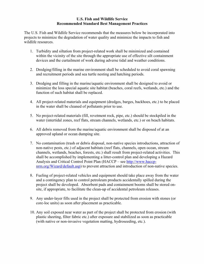
U.S. Fish and Wildlife Service Recommended Standard Best Management Practices
The U.S. Fish and Wildlife Service recommends that the measures below be incorporated into projects to minimize the degradation of water quality and minimize the impacts to fish and wildlife resources.
1. Turbidity and siltation from project-related work shall be minimized and contained within the vicinity of the site through the appropriate use of effective silt containment devices and the curtailment of work during adverse tidal and weather conditions.
2. Dredging/filling in the marine environment shall be scheduled to avoid coral spawning
and recruitment periods and sea turtle nesting and hatching periods.
3. Dredging and filling in the marine/aquatic environment shall be designed to avoid or minimize the loss special aquatic site habitat (beaches, coral reefs, wetlands, etc.) and the function of such habitat shall be replaced.
4. All project-related materials and equipment (dredges, barges, backhoes, etc.) to be placed
in the water shall be cleaned of pollutants prior to use.
5. No project-related materials (fill, revetment rock, pipe, etc.) should be stockpiled in the water (intertidal zones, reef flats, stream channels, wetlands, etc.) or on beach habitats.
6. All debris removed from the marine/aquatic environment shall be disposed of at an
approved upland or ocean dumping site.
7. No contamination (trash or debris disposal, non-native species introductions, attraction of non-native pests, etc.) of adjacent habitats (reef flats, channels, open ocean, stream channels, wetlands, beaches, forests, etc.) shall result from project-related activities. This shall be accomplished by implementing a litter-control plan and developing a Hazard Analysis and Critical Control Point Plan (HACCP – see http://www.haccp-nrm.org/Wizard/default.asp) to prevent attraction and introduction of non-native species.
8. Fueling of project-related vehicles and equipment should take place away from the water
and a contingency plan to control petroleum products accidentally spilled during the project shall be developed. Absorbent pads and containment booms shall be stored on-site, if appropriate, to facilitate the clean-up of accidental petroleum releases.
9. Any under-layer fills used in the project shall be protected from erosion with stones (or
core-loc units) as soon after placement as practicable.
10. Any soil exposed near water as part of the project shall be protected from erosion (with plastic sheeting, filter fabric etc.) after exposure and stabilized as soon as practicable (with native or non-invasive vegetation matting, hydroseeding, etc.).

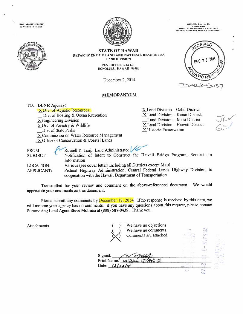


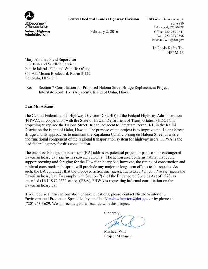
Central Federal Lands Highway Division 12300 West Dakota Avenue Suite 380 Lakewood, CO 80228 February 2, 2016 Office: 720-963-3647 Fax: 720-963-3596 [email protected] In Reply Refer To: HFPM-16
Mary Abrams, Field Supervisor U.S. Fish and Wildlife Service Pacific Islands Fish and Wildlife Office 300 Ala Moana Boulevard, Room 3-122 Honolulu, HI 96850 Re: Section 7 Consultation for Proposed Halona Street Bridge Replacement Project,
Interstate Route H-1 (Adjacent), Island of Oahu, Hawaii Dear Ms. Abrams: The Central Federal Lands Highway Division (CFLHD) of the Federal Highway Administration (FHWA), in cooperation with the State of Hawaii Department of Transportation (HDOT), is proposing to replace the Halona Street Bridge, adjacent to Interstate Route H-1, in the Kalihi District on the island of Oahu, Hawaii. The purpose of the project is to improve the Halona Street Bridge and its approaches to maintain the Kapalama Canal crossing on Halona Street as a safe and functional component of the regional transportation system for highway users. FHWA is the lead federal agency for this consultation.
The enclosed biological assessment (BA) addresses potential project impacts on the endangered Hawaiian hoary bat (Lasiurus cinereus semotus). The action area contains habitat that could support roosting and foraging for the Hawaiian hoary bat; however, the timing of construction and minimal construction footprint will preclude any major or long-term effects to the species. As such, the BA concludes that the proposed action may affect, but is not likely to adversely affect the Hawaiian hoary bat. To comply with Section 7(a) of the Endangered Species Act of 1973, as amended (16 U.S.C. 1531 et seq.)(ESA), FHWA is requesting informal consultation on the Hawaiian hoary bat.
If you require further information or have questions, please contact Nicole Winterton, Environmental Protection Specialist, by email at [email protected] or by phone at (720) 963-3689. We appreciate your assistance with this project. Sincerely,
Michael Will Project Manager

Central Federal Lands Highway Division 12300 West Dakota Avenue Suite 380 Lakewood, CO 80228 February 2, 2016 Office: 720-963-3647 Fax: 720-963-3596 [email protected] In Reply Refer To: HFPM-16 Michael Tosatto, Administrator National Marine Fisheries Service 1845 Wasp Boulevard, Building 176 Honolulu, HI 96818 Re: Section 7 Consultation for Proposed Halona Street Bridge Replacement Project,
Interstate Route H-1 (Adjacent), Island of Oahu, Hawaii Dear Mr. Tosatto: The Central Federal Lands Highway Division (CFLHD) of the Federal Highway Administration (FHWA), in cooperation with the State of Hawaii Department of Transportation (HDOT), is proposing to replace the Halona Street Bridge, adjacent to Interstate Route H-1, in the Kalihi District on the island of Oahu, Hawaii. The purpose of the project is to improve the Halona Street Bridge and its approaches to maintain the Kapalama Canal crossing on Halona Street as a safe and functional component of the regional transportation system for highway users. FHWA is the lead federal agency for this consultation.
The enclosed biological assessment (BA) addresses potential project impacts on the endangered Hawaiian hoary bat (Lasiurus cinereus semotus). The BA concludes that the proposed action may affect, but is not likely to adversely affect the Hawaiian hoary bat, and as such, FHWA is requesting informal consultation with the U.S. Fish and Wildlife Service regarding this species.
Federally listed marine species — the endangered Hawaiian monk seal (Neomonachus schauinslandi), threatened green sea turtle (Chelonia mydas), and endangered Hawksbill sea turtle (Eretmochelys imbricate) — are unlikely to occur in the action area. Therefore, it is concluded that the project would have No Effect on these species, and they are not evaluated in the BA. Based on your involvement in project-related discussions to date, we are sending you a copy of the BA for your records.
If you require further information or have questions, please contact Nicole Winterton, Environmental Protection Specialist, by email at [email protected] or by phone at (720) 963-3689. We appreciate your assistance with this project. Sincerely,
Michael Will Project Manager

2
Enclosure: Biological Assessment for the Proposed Halona Bridge Project in Kalihi, Oahu Island, Hawaii cc: Joel Moribe, National Marine Fisheries Service Mary Abrams, U.S. Fish and Wildlife Service Lisa Hadway, State of Hawaii Division of Forestry and Wildlife Frazer McGilvray, State of Hawaii Department of Aquatic Resources

2
Enclosure: Biological Assessment for the Proposed Halona Bridge Project in Kalihi, Oahu Island, Hawaii cc: Michael Tosatto, National Marine Fisheries Service Lisa Hadway, State of Hawaii Division of Forestry and Wildlife Frazer McGilvray, State of Hawaii Department of Aquatic Resources
Biological Assessment for the Proposed Hālona Bridge Project in Kalihi, O‘ahu Island, Hawai‘i
Prepared for
Federal Highway Administration, Central Federal Lands Highway Administration
and
CH2M HILL
Prepared by
SWCA Environmental Consultants
January 2016

BIOLOGICAL ASSESSMENT FOR THE PROPOSED HĀLONA BRIDGE PROJECT IN
KALIHI, O‘AHU ISLAND, HAWAI‘I
Prepared for
Federal Highway Administration, Central Federal Lands Highway Division 12300 West Dakota Avenue, Suite 280
Lakewood, Colorado 80228 (720) 963-3689
and
CH2M HILL
1132 Bishop Street, Suite 1100 Honolulu, Hawai‘i 96813
(808) 943-1133
Prepared by
SWCA Environmental Consultants Bishop Square ASB Tower
1001 Bishop Street, Suite 2800 Honolulu, Hawai‘i 96813
(808) 548-7922 www.swca.com
SWCA Project No. 27166
Revised January 27, 2016
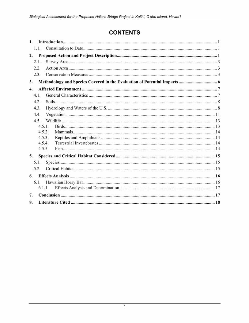
Biological Assessment for the Proposed Hālona Bridge Project in Kalihi, O‘ahu Island, Hawai‘i
CONTENTS 1. Introduction ......................................................................................................................................... 1
1.1. Consultation to Date ....................................................................................................................... 1
2. Proposed Action and Project Description ......................................................................................... 1 2.1. Survey Area .................................................................................................................................... 3 2.2. Action Area .................................................................................................................................... 3 2.3. Conservation Measures .................................................................................................................. 3
3. Methodology and Species Covered in the Evaluation of Potential Impacts .................................. 6
4. Affected Environment ........................................................................................................................ 7 4.1. General Characteristics .................................................................................................................. 7 4.2. Soils ................................................................................................................................................ 8 4.3. Hydrology and Waters of the U.S. ................................................................................................. 8 4.4. Vegetation .................................................................................................................................... 11 4.5. Wildlife ........................................................................................................................................ 13
4.5.1. Birds ..................................................................................................................................... 13 4.5.2. Mammals .............................................................................................................................. 14 4.5.3. Reptiles and Amphibians ..................................................................................................... 14 4.5.4. Terrestrial Invertebrates ....................................................................................................... 14 4.5.5. Fish ....................................................................................................................................... 14
5. Species and Critical Habitat Considered ........................................................................................ 15 5.1. Species .......................................................................................................................................... 15 5.2. Critical Habitat ............................................................................................................................. 15
6. Effects Analysis ................................................................................................................................. 16 6.1. Hawaiian Hoary Bat ..................................................................................................................... 16
6.1.1. Effects Analysis and Determination ..................................................................................... 17
7. Conclusion ......................................................................................................................................... 17
8. Literature Cited ................................................................................................................................ 18
1

Biological Assessment for the Proposed Hālona Bridge Project in Kalihi, O‘ahu Island, Hawai‘i
APPENDICES Appendix A. Photographs of Survey Area
FIGURES Figure 1. Hālona Bridge survey area. ........................................................................................................ 2 Figure 2. Hālona Bridge action area. ......................................................................................................... 4 Figure 3. Soil types in and near the survey area. ....................................................................................... 9 Figure 4. Delineated non-wetland waters of the U.S. in the survey area. ............................................... 10 Figure 5. National Wetlands Inventory classification in and near the survey area. ................................ 12
TABLES Table 1. Birds Observed by SWCA in and near the Survey Area ......................................................... 13 Table 2. Species Federally Listed as Endangered or Threatened with Potential to Occur near the
Action Area. ............................................................................................................................. 15
2

Biological Assessment for the Proposed Hālona Bridge Project in Kalihi, O‘ahu Island, Hawai‘i
1. INTRODUCTION The Federal Highway Administration, Central Federal Lands Highway Division (FHWA), in partnership with the Hawai‘i Department of Transportation (HDOT), is proposing to improve the Hālona Bridge (project) to meet current design standards for roadway width, load capacity, pedestrian and bicycle traffic, bridge railing and transitions, and bridge approaches. CH2M HILL contracted SWCA Environmental Consultants (SWCA) on behalf of FHWA to complete a biological assessment (BA) for the project. Hālona Street is located between the Vineyard Boulevard H-1 (northbound) on-ramp and the Houghtailing Street H-1 (southbound) off-ramp (Figure 1). Hālona Bridge was built in 1938.
The purpose of this BA is to evaluate the proposed project in sufficient detail to determine its potential effects on federally listed threatened and endangered species. No proposed or candidate species potentially occur in the project action area, and no proposed or designated critical habitat is present within the project action area.
Section 7(a)(1) of the Endangered Species Act (ESA) of 1973 (as amended) directs all Federal agencies to participate in the conservation and recovery of threatened and endangered species. Section 7(a)(2) of the ESA states that each Federal agency shall consult with the U.S. Fish and Wildlife Service (USFWS) to ensure that any action they authorize, fund, or carry out is not likely to jeopardize the continued existence of a listed species or result in the destruction or adverse modification of designated critical habitat. This project will be federally funded and FHWA is the lead agency for the Section 7 consultation.
1.1. Consultation to Date Michael Will, Project Manager from the U.S. Department of Transportation, FHWA-Central Federal Lands Highway Division sent a letter to the USFWS on November 21, 2014, requesting a list of federally threatened and endangered species, candidate species, plants and animals of special concern, and critical habitats near the proposed action. USFWS replied to the letter on December 22, 2014, listing the species that may occur on Kaua‘i along with recommended measures that USFWS believes will reduce impacts on each species (USFWS 2014a). Conservation measures that will be incorporated into the proposed project are listed in section 2.3.
CH2M HILL hosted a meeting in their Honolulu Office on March 13, 2015, to discuss the Hawai‘i Bridges Program with the FHWA-Central Federal Lands Highway Division, USFWS, CH2M HILL, State of Hawai‘i Division of Aquatic Resources, National Oceanic and Atmospheric Administration (NOAA), Environmental Protection Agency, and SWCA. On December 11, 2014, CH2M HILL and SWCA also met with the U.S. Army Corps of Engineers at their Honolulu District Office. The purpose of these meetings was to introduce the project locations, and generally discuss potential biological and regulatory issues associated with the Hawai‘i Bridges Program. As recommended by the USFWS, two Fish and Wildlife Coordination Act (FWCA) meetings were held on December 8 and December 15, 2015, to discuss avoidance and minimization measures for fish and wildlife resources and water quality.
2. PROPOSED ACTION AND PROJECT DESCRIPTION The proposed action in this BA consists of replacing the existing Hālona Bridge with a new precast bridge. The replacement bridge would be a three-span bridge with a total length of approximately 131 feet, a deck width of 39 feet, and a superstructure depth of 2.5 feet. The new bridge would be narrower than the existing bridge because of the removal of the landscaped buffer that sits atop the existing bridge deck. The bridge would be lengthened to match the span of the H-1 Freeway.
1
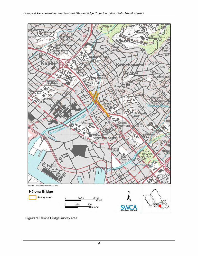
Biological Assessment for the Proposed Hālona Bridge Project in Kalihi, O‘ahu Island, Hawai‘i
Figure 1. Hālona Bridge survey area.
2

Biological Assessment for the Proposed Hālona Bridge Project in Kalihi, O‘ahu Island, Hawai‘i
The four existing piers would be removed and replaced with two piers that align with the two existing and adjacent H-1 Bridge piers. The proposed new bridge abutments would be set back from and behind the existing abutments.
Construction would last approximately 13 months. No temporary bridge is planned, and the entire bridge will likely be temporarily closed to expedite construction. Detours through the local county streets will be coordinated. No blasting or dredging is anticipated for the proposed action. To minimize impacts to the surrounding residential areas, night work is not anticipated.
2.1. Survey Area The survey area is the area within which field observations were made during a September 2014 site visit by SWCA biologists. The survey area consists of Hālona Street from Kaauwai Place to Palama Street, a segment of the Interstate Route H-1 (Lunalilo Freeway), and portions of Kokea Street and Kohou Street (Figure 1). It is 5.37 acres (2.17 hectares) of predominantly residential and developed habitat. Ornamental trees are present on Kohou and Hālona Streets. Elevations in the survey area range from roughly 2 to 24 feet (0.6 to 7.3 meters [m]) above sea level.
2.2. Action Area The ESA defines an action area as the area within which all of the direct and indirect impacts of the project would occur (50 Code of Federal Regulations 402.02). In other words, it is the geographic area that would be affected by construction and maintenance of the project. The Halona Bridge action area was determined based on potential for construction noise to travel through the surrounding areas. This is because noise would be the most far-reaching impact resulting from the proposed action. The Halona Bridge action area (see Figure 2) extends 1,000 feet (305 m) from the project footprint, covering a total of 111.5 acres. The 1,000-foot (305-m) buffer defines the action area based on the distance a 100-A-weighted-decibel (dBA) noise (such as a rock drill, paver, or impact pile driver) would attenuate to background levels (approximately 50 dBA) over flat terrain with little to no vegetation. This area is conservatively defined and likely encompasses an area larger than the area within which all impacts would occur. The actual distance that noise effects would occur is likely smaller than the action area because quieter equipment would be used and local topography and vegetation would shield the produced noise.
2.3. Conservation Measures Implementation of the proposed action will include a variety of conservation measures to reduce or eliminate proposed action–related impacts and avoid adverse effects to listed species. Conservation measures for the Hālona Bridge proposed action will consist of the following:
Hawaiian Hoary Bat
• Any fences that may be erected as part of the proposed action will have barbless top-strand wire to prevent entanglements of the Hawaiian hoary bat (Lasiurus cinereus semotus) on barbed wire.
• In general, no trees taller than 15 feet (4.6 m) would be trimmed or removed as a result of this project between June 1 and September 15, when juvenile bats that are not yet capable of flying may be roosting in the trees; however, if a limited number of trees would need to be cleared during that time period, a qualified biologist would use appropriate protocols to surveys for bats prior to trimming or cutting.
3

Biological Assessment for the Proposed Hālona Bridge Project in Kalihi, O‘ahu Island, Hawai‘i
Figure 2. Hālona Bridge action area.
4
Biological Assessment for the Proposed Hālona Bridge Project in Kalihi, O‘ahu Island, Hawai‘i
Monk Seal and Sea Turtles
• Although not expected to occur within the action area, construction activities will not begin if a monk seal (Neomonachus schauinslandi) or listed sea turtle is in the construction area or within 150 feet (46 m) of the construction area. Construction will only begin after the animal voluntarily leaves the area.
• Workers will not attempt to feed, touch, ride, or otherwise intentionally interact with any monk seals or sea turtles.
White Tern
• Tree removal and trimming will be conducted in the fall and early winter (roughly November to January), when white tern (Gygis alba) breeding rate is lowest (Vanderwerf 2003).
• Trees will be inspected for white tern eggs or chicks before tree removal.
In addition to the conservation measures, the following best management practices (BMPs) would be implemented to protect water quality, as recommended by the NMFS Protected Resources Division (NOAA NMFS 2015a) and USFWS (USFWS 2014a). The applicability of these measures to the proposed project will depend on the site-specific construction means and methods chosen. The project would also adhere to the requirements of all applicable permits.
• Erosion and sediment control measures would be in place before initiating earth-moving activities. Functionality would be maintained throughout the construction period.
• A contingency plan to control toxic materials will be developed.
• Appropriate materials to contain and clean potential spills will be stored at the work site and be readily available.
• All project-related materials and equipment placed in the water will be free of pollutants.
• The project manager and heavy equipment operators will perform daily pre-work equipment inspections for cleanliness and leaks. All heavy equipment operations will be postponed or halted if a leak is detected, and they will not proceed until the leak is repaired and the equipment is cleaned.
• Fueling of land-based vehicles and equipment will take place at least 50 feet (15.24 m) away from the water, preferably over an impervious surface. Fueling of vessels will be done at approved fueling facilities.
• Turbidity and siltation from project-related work will be minimized and contained through the appropriate use of erosion control practices, effective silt containment devices, and the curtailment of work during adverse weather and flow conditions.
• No project-related materials (fill, revetment rock, pipe, etc.) will be stockpiled in the water (intertidal zones, reef flats, stream channels, wetlands, etc.) or on beach habitats.
• No contamination (trash or debris disposal, invasive species introductions, attraction of non-native pests, etc.) of adjacent habitats (reef flats, channels, open ocean, stream channels, wetlands, beaches, forests, etc.) shall result from project-related activities.
• Any soil exposed near water as part of the project shall be protected from erosion (with plastic sheeting, filter fabric etc.) after exposure and stabilized as soon as practicable (with native or non-invasive vegetation matting, hydroseeding, etc.).
5

Biological Assessment for the Proposed Hālona Bridge Project in Kalihi, O‘ahu Island, Hawai‘i
3. METHODOLOGY AND SPECIES COVERED IN THE EVALUATION OF POTENTIAL IMPACTS
The USFWS maintains lists of endangered, threatened, proposed, and candidate species known or thought to occur in Hawai‘i. The USFWS also designates critical habitat in the state for some listed species. Endangered and threatened species are protected under the ESA (16 United States Code [USC] 1531 et seq.). The ESA specifically prohibits take, which means “to harass, harm, pursue, hunt, shoot, wound, kill, trap, capture, or collect, or to engage in any such conduct” of a listed species. Harm includes “significant habitat modification or degradation that kills or injures wildlife by significantly impairing essential behavioral patterns, including breeding, feeding or sheltering.”
The species evaluated in this report are all federally protected (endangered and threatened) species, proposed species, and candidates for federal listing.
All information on the vegetation and wildlife in the survey area was derived from biological surveys conducted by SWCA in September 2014 (see Figure 1). In addition to recording wildlife and plants encountered during the surveys, SWCA evaluated habitat for the possible occurrence of federally listed species. As part of that habitat evaluation effort, the presence of any water, wetlands, and special soils was documented.
The determination of potential for local species occurrence (as reported in section 5.1 of this BA) is based on 1) existing information on distribution and 2) qualitative comparisons of the habitat requirements of each species with vegetation communities, landscape features, and/or water quality conditions in the action area. Possible impacts to these species were evaluated based on reasonably foreseeable proposed action–related activities and the local loss of habitat.
The federally listed species in the action area were evaluated for potential to occur in the action area using the following categories:
• Unlikely to occur: The action area is within the species’ currently known range, but vegetation communities, soils, water quality conditions, etc., do not resemble those known to be used by the species, or the action area is clearly outside the species’ currently known range.
• May occur: The action area is within the species’ currently known range, and vegetation communities, soils, water quality conditions, etc., resemble those known to be used by the species.
• Known to occur: The species was documented in the action area either during or before the field surveys by a reliable observer.
Species with the potential to occur in the action area were then further evaluated for possible impacts from the proposed action. Federally protected (i.e., threatened or endangered) species were assigned to one of three categories of possible effect, following USFWS guidelines:
• No effect: A determination of no effect means there are absolutely no effects to the species and its critical habitat, either positive or negative. It does not include small effects or effects that are unlikely to occur.
• May affect, is not likely to adversely affect: Under this effect determination, all effects to the species and its critical habitat are beneficial, or discountable. Beneficial effects have contemporaneous positive effects without adverse effects to the species (for example, there cannot be “balancing,” so that the benefits of the action will outweigh the adverse effects). Insignificant effects relate to the magnitude of the impact and should not reach the scale where
6

Biological Assessment for the Proposed Hālona Bridge Project in Kalihi, O‘ahu Island, Hawai‘i
take occurs. Discountable effects are considered extremely unlikely to occur. Based on best judgment, a person will not 1) be able to meaningfully measure, detect, or evaluate discountable effects or 2) expect discountable effects to occur. Determinations of “not likely to adversely affect, due to beneficial, or discountable effects” require written concurrence from the USFWS.
• May affect, is likely to adversely affect: This effect determination means that the proposed action will have an adverse effect on the species or its critical habitat. Any action that will result in “take” of an endangered or threatened species is considered an adverse effect. A combination of beneficial and adverse effects is still considered “likely to adversely affect,” even if the net effect is neutral or positive. The effect on the species and/or critical habitat must be extremely small to qualify as a discountable effect. Likewise, an effect that can be detected in any way or that can be meaningfully articulated in a discussion of the results of the analysis is not discountable; it is an adverse effect.
As directed by the USFWS, species proposed or candidates for listing are evaluated using the following effect determination categories. Jeopardy is defined under the ESA as occurring when “an action is reasonably expected, directly or indirectly, to diminish a species’ numbers, reproduction, or distribution so that the likelihood of survival and recovery in the wild is appreciably reduced.”
• No effect.
• Not likely to jeopardize the continued existence of the species or result in the destruction or adverse modification of proposed critical habitat.
• Likely to jeopardize the continued existence of the species or result in the destruction or adverse modification of proposed critical habitat.
4. AFFECTED ENVIRONMENT SWCA conducted a review of available scientific and technical literature regarding natural resources in and near the survey area and action area. This literature review encompassed a thorough search of refereed scientific journals, technical journals and reports, environmental assessments and environmental impact statements, relevant government documents, and unpublished data that provide insight into the natural history and ecology of the area. SWCA also reviewed available geospatial data, aerial photographs, and topographic maps of the survey area.
A field reconnaissance of the survey area was conducted by two SWCA biologists on September 11, 2014. Representative portions of the area were driven or walked to describe vegetation types, fauna, and wetlands or streams, as well as known or suspected threatened, endangered, proposed, or candidate wildlife or plant species.
4.1. General Characteristics The survey area and action area is on a low-lying coastal plain within the Kapālama Watershed. Alluvial material was deposited in the area by the eroding Koʻolau Mountain Range and by changes in sea level (Sherrod et al. 2007). Mean annual rainfall for this area is approximately 37 inches (940 millimeters [mm]). Rainfall is typically highest in November–December and lowest in June–August (Giambelluca et al. 2013). Most of the action area is relatively flat. Elevations at the site range from roughly 2 to 24 feet (0.6 to 7.3 m) above sea level. Most of the action area is covered in asphalt and concrete-paved roadways. It is predominately characterized by urban residential development. Several schools, small parks, and businesses occur in the vicinity.
7

Biological Assessment for the Proposed Hālona Bridge Project in Kalihi, O‘ahu Island, Hawai‘i
4.2. Soils The Natural Resources Conservation Service (NRCS) identifies the following four soil types in the survey area: Kawaihapai stony clay loam, 2%–6% slopes (KlaB); Hanalei silty clay, 0%–2% slopes (HnA); Ewa silty clay loam, moderately shallow, 0%–2% slopes (EmA); and Water > 40 acres (W) (Foote et al. 1972; NRCS 2013) (Figure 3). The Hanalei silty clay, 0%–2% slopes soil type is listed as a hydric soil (NRCS 2012).
4.3. Hydrology and Waters of the U.S. A single perennial stream, Kapālama Stream, traverses the survey area. Kapālama Stream is approximately 5.6 miles (9 kilometers) (Parham et al. 2008) long, and approximately 0.97 acre (0.39 ha) of non-wetland waters of the U.S. (i.e., open water) was delineated in the survey area (Figure 4).
The stream is channelized and entirely surrounded by urban development; therefore, the original drainage course has been extensively modified. The channelized stream forks in the north portion of the survey area, approximately 300 feet (91 m) upstream of the existing bridge, The channel bed is concrete-lined in the immediate vicinity of the fork; however, according to project engineers, the channel bed comprises natural material closer to the bridge.
According to National Wetlands Inventory (NWI) data, the unnamed right fork terminates before the intersection with North School Street (outside of the action area). The left fork (formally named Kapālama Stream) continues mauka toward the Koʻolau Mountain Range. Downstream of the action area, Kapālama Stream flows southwest between Kokea and Kohou Streets and eventually empties into Honolulu Harbor roughly 0.8 mile (1.3 kilometers) from the survey area.
Standing water was observed in the stream during the survey (Appendix A, Figures A3 and A4). Most of Kapālama Stream in the survey area is tidally influenced from the presence of marine/estuarine fish (striped mullet and great barracuda) near the bridge and observed changes in water levels throughout the day. It is unknown how often water within the channelized forks is tidally influenced.
8

Biological Assessment for the Proposed Hālona Bridge Project in Kalihi, O‘ahu Island, Hawai‘i
Figure 3. Soil types in and near the survey area.
9

Biological Assessment for the Proposed Hālona Bridge Project in Kalihi, O‘ahu Island, Hawai‘i
Figure 4. Delineated non-wetland waters of the U.S. in the survey area.
10

Biological Assessment for the Proposed Hālona Bridge Project in Kalihi, O‘ahu Island, Hawai‘i
The NWI program identifies five wetlands or waterways in the survey area (Figure 5). These comprise E2EM1N (Estuarine, Intertidal, Emergent, Persistent, Regularly Flooded), E1UBL (Estuarine, Subtidal, Unconsolidated bottom), R2USCx (Riverine, Lower Perennial, Unconsolidated Shore, Seasonally Flooded, Excavated), R2USC (Riverine, Lower Perennial, Unconsolidated Shore, Seasonally Flooded), and R4SBCx (Riverine, Intermittent, Streambed, Seasonally Flooded, Excavated). The NWI program identifies an additional Riverine feature — R2UBHx (Riverine, Lower Perennial, Unconsolidated Bottom, Permanently Flooded, Excavated) — immediately adjacent to the survey area (Figure 5).
4.4. Vegetation No state or federally listed threatened, endangered, proposed, or candidate plant species were recorded in the survey area and none are expected to occur within the larger action area. Two native Hawaiian plants — ‘ae‘ae (Bacopa monnieri) and Cyperus polystachyos — were seen during the survey. 1 These species are indigenous, or found in Hawaiʻi and elsewhere.
The vegetation in the action area is composed of mowed grasses, interspersed with weedy non-native grasses and herbaceous plants, as well as scattered ornamental trees and shrubs. Mowed lawns adjacent to houses and the Kapālama Canal (or Kapālama Stream) consist mainly of swollen fingergrass (Chloris barbata), Bermuda grass (Cynodon dactylon), wire grass (Eleusine indica), and Panama paspalum (Paspalum fimbriatum). Non-native herbaceous weeds common in the grassy areas include creeping indigo (Indigofera spicata), morning glory (Ipomoea obscura), pitted beardgrass (Bothriochloa pertusa), Guinea grass (Urochloa maxima), buffel grass (Cenchrus ciliaris), khaki weed (Alternanthera pungens), and spiny amaranth (Amaranthus spinosus).
A few large monkey pod trees (Samanea saman) and rainbow shower trees (Cassia x nealiae) are planted along Kohou Street and Hālona Street (Appendix A, Figures A1 and A2). Other ornamental plantings in the survey area include kou haole (Cordia sebestena), manila palm (Veitchia merrillii), lantana (Lantana camara), wedelia (Sphagneticola trilobata), and mock orange (Murraya paniculata). Sesban tree (Sesbania grandiflora) and sweet potato (Ipomoea batatas) are planted in a garden in the northern portion of Kokea Street in the survey area. Similar ornamental plants are expected to occur in the larger action area.
Within the canal, hydrophytic plants are present near the northern portion of the action area. These include umbrella sedge (Cyperus involucratus), California grass (Urochloa mutica), Cyperus polystachyos, (Ludwigia octovalvis), and ‘ae‘ae.
1 The taxonomy and nomenclature of the flowering plants are in accordance with Wagner et al. (1999), Wagner and Herbst (2003), and Staples and Herbst (2005). Recent name changes are those recorded in Wagner et al. (2012). Common/Hawaiian names are provided first, followed by scientific names in parenthesis. If no common or Hawaiian name is known, only the scientific name is provided.
11

Biological Assessment for the Proposed Hālona Bridge Project in Kalihi, O‘ahu Island, Hawai‘i
Figure 5. National Wetlands Inventory classification in and near the survey area.
12
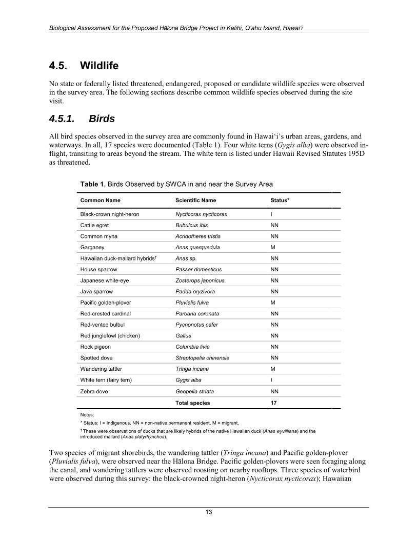
Biological Assessment for the Proposed Hālona Bridge Project in Kalihi, O‘ahu Island, Hawai‘i
4.5. Wildlife No state or federally listed threatened, endangered, proposed or candidate wildlife species were observed in the survey area. The following sections describe common wildlife species observed during the site visit.
4.5.1. Birds All bird species observed in the survey area are commonly found in Hawai‘i’s urban areas, gardens, and waterways. In all, 17 species were documented (Table 1). Four white terns (Gygis alba) were observed in-flight, transiting to areas beyond the stream. The white tern is listed under Hawaii Revised Statutes 195D as threatened.
Table 1. Birds Observed by SWCA in and near the Survey Area
Common Name Scientific Name Status*
Black-crown night-heron Nycticorax nycticorax I
Cattle egret Bubulcus ibis NN
Common myna Acridotheres tristis NN
Garganey Anas querquedula M
Hawaiian duck-mallard hybrids† Anas sp. NN
House sparrow Passer domesticus NN
Japanese white-eye Zosterops japonicus NN
Java sparrow Padda oryzivora NN
Pacific golden-plover Pluvialis fulva M
Red-crested cardinal Paroaria coronata NN
Red-vented bulbul Pycnonotus cafer NN
Red junglefowl (chicken) Gallus NN
Rock pigeon Columbia livia NN
Spotted dove Streptopelia chinensis NN
Wandering tattler Tringa incana M
White tern (fairy tern) Gygis alba I
Zebra dove Geopelia striata NN
Total species 17
Notes:
* Status: I = Indigenous, NN = non-native permanent resident, M = migrant. † These were observations of ducks that are likely hybrids of the native Hawaiian duck (Anas wyvilliana) and the introduced mallard (Anas platyrhynchos).
Two species of migrant shorebirds, the wandering tattler (Tringa incana) and Pacific golden-plover (Pluvialis fulva), were observed near the Hālona Bridge. Pacific golden-plovers were seen foraging along the canal, and wandering tattlers were observed roosting on nearby rooftops. Three species of waterbird were observed during this survey: the black-crowned night-heron (Nycticorax nycticorax); Hawaiian
13
Biological Assessment for the Proposed Hālona Bridge Project in Kalihi, O‘ahu Island, Hawai‘i
duck–like ducks (Anas sp.), which are likely to be mallard–Hawaiian duck hybrids; and a pair of garganey (Anas querquedula) ducks. One adult and one juvenile black-crowned night-heron were observed foraging along the northern edge of the canal. Eleven duck hybrids were observed foraging and swimming near the vegetated areas of the canal, and the pair of garganey was observed in water near the bridge. All other bird species observed are introduced species common to developed areas.
Suitable nesting habitat for native Hawaiian waterbirds is not present in the action area. The action area does not provide suitable nesting or foraging habitat for listed seabirds.
4.5.2. Mammals The Hālona Bridge and Kapālama Canal are bordered by residential areas, where it is common to find people walking dogs (Canis familiaris). No other mammals were observed during the pedestrian surveys. Mammals that could be expected in the action area include cats (Felis catus), mongoose (Herpestes auropunctatus), rats (Rattus spp.), and mice (Mus musculus).
An evaluation of the action area as habitat for the Hawaiian hoary bat, a federally listed mammal, is presented in section 6.
4.5.3. Reptiles and Amphibians The brown anole (Anolis sagrei) was frequently observed during the pedestrian survey; individuals were foraging or basking in the sun along the cement sidewalk in the residential area around the canal. A mature red-eared slider turtle (Trachemys scripta elegans) was observed swimming in the canal between Olomea Street and Lunalilo Freeway. No other reptiles or amphibians were seen during the survey. None of the observed reptiles are native to the Hawaiian Islands. No threatened green sea turtles (Chelonia mydas) were observed during the survey and no records of green sea turtles were found in the survey area; however, these animals have been observed inland in stream as far as approximately 1.8 miles (3 km) on O‘ahu (Clark et al. 2011).
4.5.4. Terrestrial Invertebrates Rambur’s forktail (Ischnura ramburii), a non-native damselfly, as well as the introduced Chinese dragonfly (Crocothemis servilia), were observed during the survey. A Sonoran carpenter bee (Xylocopa sonorina) was also observed. No native invertebrate species were recorded during the survey.
4.5.5. Fish In the north portion of the survey area, freshwater from mauka areas of Kapālama Stream mixes into the brackish-water estuarine system. Although the water is turbid, several fish species were observed. Indigenous species observed include striped mullet (Mugil cephalus) and great barracuda (Sphyraena barracuda) juveniles, both of which occur in estuarine and marine waters. Non-native Poeciliids (Gambusia affinis or Poecilia mexicana) and tilapia (Oreochromis sp. or Sarotherodon sp.) were also seen.
14

Biological Assessment for the Proposed Hālona Bridge Project in Kalihi, O‘ahu Island, Hawai‘i
5. SPECIES AND CRITICAL HABITAT CONSIDERED
5.1. Species The species evaluated in this BA consist of all federally protected (i.e., endangered and threatened) species with potential to occur in this portion of O‘ahu.
Federally-listed species that may occur in the action area were identified in a letter from USFWS dated December 22, 2014 and from agency meetings on March 13, 2015, and December 15, 2015 (Section 1.1). Based on current distribution and habitat requirements, one federally-listed species—the Hawaiian hoary bat—may occur in the action area and has potential to use the habitat of the action area. Three marine species — the endangered Hawaiian monk seal, threatened green sea turtle, and endangered Hawksbill sea turtle — are unlikely to occur in the action area and are therefore not evaluated in this BA.
5.2. Critical Habitat No designated or proposed critical habitat for threatened or endangered species occurs in the action area; therefore, critical habitat is not discussed further in this BA.
Table 2. Species Federally Listed as Endangered or Threatened with Potential to Occur near the Action Area.
Common Name (scientific name)
Status* Range or Habitat Requirements†
Potential for Occurrence in Action Area
Determination of Effect
Mammals
Hawaiian monk seal (Neomonachus schauinslandi)
Endangered Endemic to the Hawaiian archipelago and found mostly in the Northwestern Hawaiian Islands. Increasing sightings reported from main Hawaiian Islands. Hawaiian monk seals spend most of their time in the ocean but like to rest on sandy beaches. There are accounts of seals traveling up some rivers and streams.
Unlikely to occur; have not been recorded in the action area.
No effect.
Hawaiian hoary bat (Lasiurus cinereus semotus)
Endangered This species is found primarily from sea level to 7,500 feet, although it has also been observed above 13,000 feet. Most of the available documentation suggests that this elusive bat roosts among trees in forested areas. It has been observed on the islands of Hawai‘i, Maui, Moloka‘i, Oʻahu, and Kaua‘i.
May occur in the action area. Bat roosting could occur in the ornamental landscaping of the action area, and foraging could occur in the stream corridor.
May affect, but is not likely to adversely affect.
Reptiles
Green sea turtle (Chelonia mydas)
Threatened The green sea turtle is found worldwide in warm seas. They occupy three habitat types: open beaches, open sea, and feeding grounds in shallow, protected waters. Nesting occurs throughout the Hawaiian archipelago. They have been documented transiting some Hawai‘i rivers up to 2 miles (3 km) inland.
Unlikely to occur; have not been recorded in the action area.
No effect.
15

Biological Assessment for the Proposed Hālona Bridge Project in Kalihi, O‘ahu Island, Hawai‘i
Table 2. Species Federally Listed as Endangered or Threatened with Potential to Occur near the Action Area.
Common Name (scientific name)
Status* Range or Habitat Requirements†
Potential for Occurrence in Action Area
Determination of Effect
Hawksbill sea turtle (Eretmochelys imbricata)
Endangered The hawksbill sea turtle is found in warm tropical waters worldwide. The hawksbill turtle is a shy tropical reef dwelling species that feeds on jellyfish, sea urchins, and sea sponges. It may also eat algae that grows on the reef. In Hawai‘i, nesting occurs on the islands of Hawai‘i, Maui, Moloka‘i, and O‘ahu.
Unlikely to occur; have not been recorded in the action area.
No effect.
Notes: * Federal (USFWS) status definitions: Endangered: Any species considered by the USFWS as being in danger of extinction throughout all or a significant portion of its range. The ESA specifically prohibits the take of a species listed as endangered. Take is defined by the ESA as to harass, harm, pursue, hunt, shoot, wound, kill, trap, capture, or collect; or to engage in any such conduct. Threatened: Any species that is likely to become an endangered species within the foreseeable future throughout all or a significant portion of its range. The ESA specifically prohibits the take (see definition above) of a species listed as threatened. † Unless otherwise noted, data are from USFWS (2014b). Suitable nesting habitat for native Hawaiian waterbirds is not present in the action area. The action area does not provide suitable nesting or foraging habitat for listed seabirds
6. EFFECTS ANALYSIS Federally protected species that may be affected by the proposed action are discussed in detail in this section2.
6.1. Hawaiian Hoary Bat The Hawaiian hoary bat was listed as an endangered species on October 13, 1970, under the ESA and the State of Hawai‘i's Endangered Species List. Hawaiian hoary bats are found on Hawai‘i, Maui, Moloka‘i, O‘ahu, and Kaua‘i and has been observed from sea level to approximately 13,000 feet (3,963 m) (USFWS 2014b).
The Hawaiian hoary bat is the only native terrestrial mammal that is still extant within the Hawaiian Islands (USFWS 1998). Hawaiian hoary bats use both closed habitats near vegetation such as tunneled roadways, and open habitats adjacent to forests, above tree canopies, and over open oceans (Jacobs 1996). Hawaiian hoary bats are insectivores and are regularly observed foraging over streams, reservoirs, and wetlands up to 300 feet (100 m) offshore (U.S. Department of Agriculture 2009). Hawaiian hoary bats forage in open, wooded, and linear habitats with a wide range of vegetation types (USFWS 2014b).
Acoustic surveys for Hawaiian hoary bats were not conducted for the proposed action, but areas of suitable habitat for roosting and foraging were noted during the biological survey. Several of the tree species in the action area—monkey pod, rainbow shower, kou haole, and Manila palms—could be used
2 Species that become federally listed as endangered or threatened also become listed under the same classification (endangered or threatened) in the State of Hawai‘i (Hawaii Revised Statutes 195D-4).
16

Biological Assessment for the Proposed Hālona Bridge Project in Kalihi, O‘ahu Island, Hawai‘i
by Hawaiian hoary bats for roosting. The stream corridor in the action area is suitable bat foraging habitat.
Hawaiian hoary bats are believed to be threatened by habitat loss, pesticides, predation, and roost disturbance. Reduction of tree cover and indirect impacts from the use of pesticides may be the primary causes of recent declines (USFWS 2014b).
6.1.1. Effects Analysis and Determination Acoustic surveys for Hawaiian hoary bats were not conducted, but Hawaiian hoary bats are known to occur on Oʻahu in various habitats (U.S. Department of Agriculture 2009; USFWS 1998). They have been documented roosting in kukui (Aleurites moluccana) and mango (Mangifera sp.) trees, and they may roost in other trees in the action area (e.g., monkey pod) based on their foliage structure. The stream corridor in the action area is also suitable bat foraging habitat.
Direct impacts on bats could occur during vegetation removal if a juvenile bat that is too small to fly but too large to be carried by a parent is present in a tree or branch that is cut down. However, because of the conservation measure that trees would not be cut during the breeding season (June 1 through September 15), direct impacts are unlikely to occur. If a limited number of trees would need to be cleared during that time period, a qualified biologist would use appropriate protocols to surveys for bats prior to trimming or cutting. The potential for direct impacts would also be reduced by ensuring the top wire strand of surrounding fences (if present) is barbless, as listed in the conservation measures in section 2.3.
In the short term, the human noise and disturbance associated with construction activities could temporarily displace bats from roosting and/or foraging habitats. This displacement could alter an individual’s typical foraging and roosting patterns, forcing it to expend energy to search for new foraging and roosting locations. Displacement from roosting habitat could lead to increased predation on individual bats, especially if a bat is forced to leave its roost during daylight hours, making it more visible to potential predators. The potential for these impacts is low considering the project would occur on and immediately adjacent to a heavily traveled highway, and therefore the bats present would already be accustomed to high levels of background noise. Furthermore, roosting and foraging areas occur in the action area, into which bats could be displaced.
Because all impacts on the Hawaiian hoary bat would be discountable or insignificant, the proposed action may affect, but is not likely to adversely affect, individuals or populations of the species.
7. CONCLUSION One federally listed species has the potential to occur in the action area: Hawaiian hoary bat. Potential impacts from the proposed action to this species are expected to be temporary, discountable, and insignificant. As detailed above, the timing of tree trimming and the minimal construction footprint would ensure that there are no significant or long-term effects to this federally listed species. In general, no major or long-term effects are anticipated from the implementation of the proposed action.
In conclusion, the proposed project may affect, but is not likely to adversely affect the federally listed Hawaiian hoary bat.
17
Biological Assessment for the Proposed Hālona Bridge Project in Kalihi, O‘ahu Island, Hawai‘i
8. LITERATURE CITED Clark, D.L. G. Balazs, and S. Hargrove. 2011. Hawaiian Green Turtles Up and Down the Anahulu River.
Proceedings of the Thirty-First Annual Symposium on Sea Turtle Biology and Conservation. San Diego, California.
Foote, D.E., E.L. Hill, S. Nakamura, and F. Stephens. 1972. Soil Survey of the Islands of Kaua‘i, O‘ahu, Maui, Moloka‘i, and Lana‘i, State of Hawai‘i. U.S. Department of Agriculture.
Giambelluca, T.W., Q. Chen, A.G. Frazier, J.P. Price, Y.L. Chen, P.S. Chu, J.K. Eischeid, and D.M. Delparte. 2013. Online Rainfall Atlas of Hawai‘i. Bull. Amer. Meteor. Soc. 94, 313–316, doi: 10.1175/BAMS-D-11-00228.1. Available at: http://rainfall.geography.hawaii.edu. Accessed on September 12, 2014.
Hawaiʻi State Department of Health. 2014. 2014 State of Hawaii Water Quality Monitoring and Assessment Report. Integrated Report to the U.S. Environmental Protection Agency and the U.S. Congress Pursuant to Sections 303(D) and 305(B), Clean Water Act (Public Law 97-117).
Jacobs, D.S. 1996. Morphological divergence in an insular bat, Lasiurus cinereus semotus. Functional Ecology 10:622–630.
Natural Resources Conservation Service (NRCS). 2012. Hydric Soils State Lists, Hydric Soils of Hawai‘i. Available at: ftp://ftp-fc.sc.egov.usda.gov/NSSC/Hydric_Soils/Lists/hydric_soils.xlsx. Accessed December 7, 2012.
———. 2013. Web Soil Survey. Available at: http://websoilsurvey.nrcs.usda.gov/. Accessed October 16, 2014.
Parham, J.E., G.R. Higashi, E.K. Lapp, D.G.K. Kuamoo, R.T. Nishimoto, S. Hau, J.M. Fitzsimons, D.A. Polhemus, and W.S. Devick. 2008. Atlas of Hawaiian Watersheds & Their Aquatic Resources. Copyrighted website published by the Hawai‘i Division of Aquatic Resources. Available at: http://hawaiiwatershedatlas.com/. Accessed June 20, 2015.
Sherrod, D.R., J.M. Sinton, S.E. Watkins, and K.M. Brunt. 2007. Geologic Map of the State of Hawai‘i. U.S. Geological Survey Open-File Report 2007-1089, 83 p., 8 plates, scales 1:100,000 and 1:250,000, with GIS database.
Staples, G.W., and D.R. Herbst. 2005. A Tropical Garden Flora: Plants Cultivated in the Hawaiian Islands and Other Tropical Places. Honolulu, Hawai‘i: Bishop Museum Press.
U.S. Department of Agriculture. 2009. Bats of the U.S. Pacific Islands. Biology Technical Note No. 20. Natural Resources Conservation Service, Pacific Islands Area.
U.S. Fish and Wildlife Service (USFWS). 1998. Recovery Plan for the Hawaiian Hoary Bat (Lasiurus cinereus semotus). Portland, Oregon: USFWS, Region 1.
———. 2014a. Species List for Hawaii Bridges Program, Hawai‘i, Kaua‘i, and Oʻahu. Pacific Islands USFWS, Honolulu, Hawai‘i. Letter from Aaron Nadig, USFWS. December 22, 2015.
———. 2014b. Endangered Species in the Pacific Islands. Available at: http://www.fws.gov/pacificislands/teslist.html. Accessed July 2015.
18

Biological Assessment for the Proposed Hālona Bridge Project in Kalihi, O‘ahu Island, Hawai‘i
Vanderwerf, E. 2003. Distribution, Abundance, and Breeding Biology of White Terns on Oahu, Hawaii. The Wilson Bulletin 115(3):258–262.
Wagner, W.L., D.R. Herbst, and S.H. Sohmer. 1999. Manual of the Flowering Plants of Hawai‘i. Volumes I and II. Revised edition. Honolulu: University of Hawai‘i Press.
Wagner, W.L., and D.R. Herbst. 2003. Supplement to the Manual of the Flowering Plants of Hawai‘i. Version 3.1 (12 Dec 2003).
Wagner, W.L., D.R. Herbst, N. Khan, and T. Flynn. 2012. Hawaiian Vascular Plant Updates: A Supplement to the Manual of the Flowering Plants of Hawai‘i and Hawai‘i’s Ferns and Fern Allies. Version 1.3.
19

Appendix A
Photographs of the Survey Area

Biological Assessment for the Proposed Hālona Bridge Project in Kalihi, Hawai‘i
Figure A1. Typical vegetation in the survey area, showing monkey pod trees planted in a mowed grassy area on Kohou Street and some hydrophytic plants within sections of the canal.
Figure A2. View of rainbow shower trees and weedy herbs along Hālona Street.
A-1

Biological Assessment for the Proposed Hālona Bridge Project in Kalihi, Hawai‘i
Figure A3. Kapālama Stream looking upstream from the bridge.
Figure A4. Kapālama Stream looking downstream toward the bridge.
A-2


Appendix D National Historic Preservation Act Section ('5
and Hawaii Revised Statutes Chapter 5E Consultation Documentation

Central Federal Lands Highway Division 12300 West Dakota Avenue
Suite 380
Lakewood, CO 80228
July 10, 2015 Office: 720-963-3647 Fax: 720-963-3596
In Reply Refer To:
HFPM-16
TO:
FROM: J. MICHAEL WILL, P.E.
PROJECT MANAGER
SUBJECT: NATIONAL HISTORIC PRESERVATION ACT, SECTION 106 AND HAWAII
REVISED STATUTES, CHAPTER 6E CONSULTATION
HALONA STREET (KAPALAMA CANAL) BRIDGE REPLACEMENT
PROJECT
HONOLULU (KONA) DISTRICT, OAHU ISLAND, KAPALAMA AHUPUAA
PROJECT NO. HI STP H1 (1)
TAX MAP KEY: (1)1-6-002 (Olomea Street and H-1 Interstate Highway Rights-
of-Way, and Kapalama Canal)
(1)1-6-006 (Halona Street, Kokea Street, Kohou Street and H-1
Interstate Highway Rights-of-Way, and Kapalama
Canal)
Dear :
The Federal Highway Administration (FHWA) Central Federal Lands Highway Division
(CFLHD), in partnership with the State of Hawaii Department of Transportation (HDOT), is
proposing to replace the Halona Bridge over the Kapalama Canal on Hawaii State Highway 98
(HI-98) adjacent to Interstate H-1 (H-1), also known as Halona Street, at Mile Post 20.21 (see
attached Area of Potential Effects USGS Map for project location). The proposed project is
considered a federal action and undertaking, and will comply with Section 106 of the National
Historic Preservation Act (NHPA) of 1966, as amended (2006), as well as Hawaii Revised
Statutes (HRS) Chapter 6E. We would like to invite you to participate in the Section 106
consultation for the proposed project in accordance with Title 36 of the Code of Federal
Regulations, Section 800.3, by providing information and/or by requesting to be a consulting
party. This letter also initiates consultations in accordance with HRS Chapter 6E.
Overview of the Undertaking
The proposed project would replace the existing Halona Bridge and its approaches to maintain the
Kapalama Canal crossing on Halona Street as a safe and functional component of the regional
transportation system for roadway users. The project would also address safety concerns related
to public access to the canal below the adjacent H-1 and Olomea Street bridges.

2
The existing Halona Bridge would be demolished and removed. The replacement bridge would be
a three-span bridge with a total length of approximately 131 feet. The bridge would have a deck
width of 39 feet and a depth of 2.5 feet.
The four existing piers would be removed and replaced with two piers that would be aligned with
the two existing and adjacent H-1 bridge piers. The pier shapes would be similar to the existing
H-1 bridge piers. The proposed new bridge abutments would be set back from and behind the
existing abutments. The existing abutments would not be removed to minimize impacts to the
canal. The canal’s lava rock lining walls, which are located upstream of the Halona Bridge and
downstream of the H-1 and Olomea Street bridges, would be retained and protected in place. The
existing Kapalama Canal and its lava rock lining walls are potentially eligible for listing on the
National Register of Historic Places (NRHP).
The drain pipe outfall makai of the Olomea bridge, in the northwestern corner of the Olomea
Street and Kohou Street intersection, would be cut back so that it is flush with the channel wall
and would no longer provide an access point for individuals to climb down and access areas
beneath the Olomea bridge. The fencing between Olomea Street and H-1 would also be improved.
Vertical or cantilevered retaining walls would be added adjacent to the existing Olomea Street
bridge on both sides of the canal to deter people from accessing the underside of the bridge.
The proposed improvements would occur within the existing HDOT right-of-way. However, 0.44
acres of land would be needed from four temporary construction parcels to accommodate bridge
construction and paving improvements. One of these parcels, the Kapalama Canal, is potentially
eligible for listing on the NRHP.
Staging of personnel and equipment would occur within the project limits. Possible staging areas
are located along Halona Street (on pavement) north and south of the bridge as well as areas
adjacent to the Kohou Street and Kokea Street intersections. The work area would be accessed
from the sides of the canal. Construction would occur within the Kapalama Canal under the
Halona Bridge and H-1 Bridge, and near the existing pipe outlet makai of the Olomea Bridge.
The Halona Bridge would likely be closed to normal vehicular traffic for the duration of the
project, and traffic would be detoured during this time. However, pedestrian and bicyclist access
would be maintained in a temporary pedestrian route within the existing landscaped area between
the construction work and the H-1 freeway. Access to the H-1 on-ramp would be maintained
during construction.
Area of Potential Effects
The archaeological and historic architectural Areas of Potential Effects (APE) are illustrated in
the attached APE Aerial Imagery map, and include both temporary and permanent impact areas.
Cultural, Archaeological, and Historical Studies
To provide you information on the cultural, archaeological, and historical settings of the project
area, we are including two studies prepared for this project. Please note that the study areas
indicated in the reports are larger than the attached APE map. At the start of the project, we
3
assumed a large study area so that field findings could inform the conceptual design process at an
early stage to help avoid or minimize effects to potentially sensitive sites.
1. Draft Archaeological Inventory Survey Report for the Halona Bridge Replacement
Project, Kapalama Ahupuaa, Honolulu District, Oahu
2. Hawaii State Historic Preservation Division (SHPD) Historic Resource Inventory Form
(Reconnaissance Level) for Halona Bridge
Consultations
Section 106 notice/advertisement will be included in the Honolulu Star Advertiser. Native
Hawaiian organizations and Native Hawaiian descendants with ancestral, lineal, or cultural ties to,
cultural knowledge or concerns for, and cultural or religious attachment to the proposed project
area are asked to provide a response within 30 days of notification.
Letters for this project are being sent to the following NHOs as well as other organizations with
knowledge of cultural, archaeological, and historical resources:
• Office of Hawaiian Affairs
• Kalihi-Palama Hawaiian Civic Club
• Hawaiian Civic Club of Honolulu
• Koolauloa Hawaiian Civic Club
• Oahu Island Burial Council
• Hui Malama I Na Kupuna O Hawaii Nei
• Paulette Kaanohiokalani Kaleikini
• Historic Hawaii Foundation
We welcome any comments you have on this project’s proposed improvements or APE. We are
particularly interested in any information you may have on the historic and cultural sites that have
been recorded in the area, or other historic or cultural sites about which you may have knowledge.
In addition, if you are acquainted with any person or organization that is knowledgeable about the
proposed project area, or any descendants with ancestral, lineal, or cultural ties to or cultural
knowledge or concerns for, and cultural or religious attachment to the proposed project area, we
would appreciate receiving their names and contact information.
If you have information and/or would like to be a Consulting Party, we would appreciate a written
response within 30 days from date of receipt, by email at [email protected] or by US Postal
Service to 12300 West Dakota Avenue, Suite 380, Lakewood, CO 80228.
4
Please feel free to contact Nicole Winterton, Environmental Protection Specialist, by telephone at
(720) 963-3689, or email [email protected], if you have any questions.
Sincerely yours,
J. Michael Will, P.E.
Project Manager
Enclosures:
• Area of Potential Effects (USGS Map)
• Area of Potential Effects (Aerial Imagery)
• On CD: Draft Archaeological Inventory Survey Report for the Halona Bridge Improvements
Project, Kapalama Ahupuaa, Honolulu District, Oahu
• On CD: SHPD Historic Resource Inventory Form (Reconnaissance Level) for Halona Bridge
cc (with enclosures on CD):
Christine Yamasaki, HDOT
Jessica Puff, SHPD
Dr. Susan Lebo, SHPD

Halona Street Bridge ProjectArea of Potential Effects (USGS Map)Central Federal Lands - Kalihi, Oahu
VICINITY MAP
LEGENDArea of Potential Effects
$
HalonaStreetBridgeProject
0 2,000 4,000Feet
Notes:1. Imagery Source: ESRI USA Topographic Maps
Halona StreetBridge Project APE
\\CREOLE\Groups\GIS\00_Proj\C\CentralFedLands_HI_499085\MapFiles\APE_062515\Halona_USGS_11x17_062915.mxd
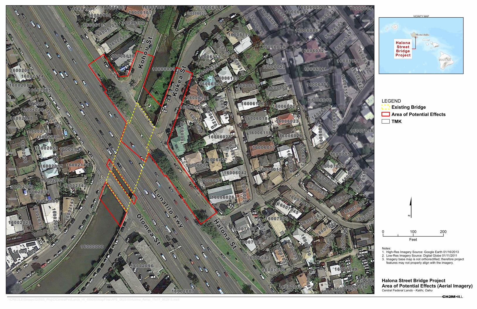
1 6 0 0 2 0 7 9
1 6 0 0 7 0 3 3
1 6 0 0 6 0 8 2
1 6 0 0 7 0 3 2
1 6 0 0 2 1 1 5
1 6 0 0 2 0 5 8
1 6 0 0 2 0 9 0
1 6 0 0 2 1 4 1
1 6 0 0 7 0 5 0
1 6 0 0 7 0 7 1
1 6 0 0 6 0 3 0
1 6 0 0 6 1 2 1
1 6 0 0 6 1 2 2
1 6 0 0 7 0 4 7
1 6 0 0 7 0 4 0
1 6 0 0 7 0 5 4
1 6 0 0 7 0 6 0
1 6 0 0 2 0 4 7
1 6 0 0 7 0 4 4
1 6 0 0 7 0 1 7
1 6 0 0 6 0 9 2
1 6 0 0 2 0 9 6 1 6 0 0 7 0 4 9
1 6 0 0 6 0 0 4
1 6 0 0 7 0 4 5
1 6 0 0 2 1 4 2
1 6 0 0 2 0 3 7
1 6 0 0 2 0 3 5
1 6 0 0 2 1 4 0
1 6 0 0 2 0 4 9
1 6 0 0 3 0 1 7
1 6 0 0 6 0 4 5
1 6 0 0 6 0 1 7
1 6 0 0 6 1 4 9
1 6 0 0 2 0 0 7
1 6 0 0 6 0 1 0
1 6 0 0 6 0 0 3
1 6 0 0 6 0 2 9
1 6 0 0 6 0 9 4
1 6 0 0 6 1 0 5
1 6 0 0 7 0 5 7
1 6 0 0 6 1 1 6
1 6 0 0 6 1 1 4
1 6 0 0 4 0 0 1
1 6 0 0 6 0 1 2
1 6 0 0 6 0 1 11 6 0 0 2 1 1 4
1 6 0 0 6 1 2 4
1 6 0 0 7 1 0 5
1 6 0 0 6 1 1 7
1 6 0 0 6 1 0 7
1 6 0 0 7 0 5 3
1 6 0 0 6 0 4 2
1 6 0 0 6 0 3 8
1 6 0 0 2 0 3 2
1 6 0 0 6 1 1 8
1 6 0 0 6 0 0 9
1 6 0 0 6 1 4 8
1 6 0 0 6 0 25
1 6 0 0 6 0 3 2
1 6 0 0 2 1 3 7
1 6 0 0 6 0 9 0
1 6 0 0 6 0 9 3
1 6 0 0 6 1 2 7
1 6 0 0 7 0 6 2
1 6 0 0 6 0 2 3
1 6 0 0 6 0 5 41 6 0 0 7 0 5 1
1600
604 7
1 6 0 0 7 0 5 9
1 6 0 0 6 1 1 5
1 6 0 02 1
4 3
1 6 0 0 2 0 8 5
1 6 0 0 2 0 8 8
1 6 0 0 2 036
1 6 0 0 2 0 8 7
1 6 0 0 7 0 58
1 6 0 0 2 0 4 8
1 6 0 0 7 1 0 0
1 6 0 0 2 1 3 6
1 6 0 0 6 1 0 4
1 6 0 0 6 1 1 3
1 6 0 0 6 0 8 8
1 6 0 0 6 0 2 6
1 6 0 0 7 0 5 5
1 6 0 0 6 1 0 0
1 6 0 0 6 1 4 7
1 6 0 0 2 0 5 5
1 6 0 0 2 0 8 1
1 6 0 0 2 0 3 3
1 6 0 0 6 1 2 8
1 6 0 0 6 0 1 9
1 6 0 0 2 0 4 6
1 6 0 0 7 0 8 4
1 6 0 0 6 1 2 3
1600 7
0 4 1
1 6 0 0 6 0 4 3
1 6 0 0 2 0 3 1
1 6 0 0 6 0 2 1
1 6 0 0 6 1 2 6
1 6 0 0 6 0 8 91 6 0 0 7 0 7 3
1 6 0 0 6 1 0 6
1 6 0 0 6 1 0 3
1 6 0 0 2 1 3 9
1 6 0 0 6 1 5 1
1 6 0 0 2 0 2 8
1 6 0 0 6 0 9 11 6 0 0 6 0 141 6 0 0 6 0 1 5
1 6 0 0 0 0 0 0
1 6 0 0 0 0 0 0
1 6 0 0 6 1 2 5
1 6 0 0 6 0 2 4
1 6 0 0 6 1 0 2
1 6 0 0 6 0 2 7
1 6 0 0 7 0 5 6
1 6 0 0 6 0 2 0
16 0 0 6 0 0 8
1 6 0 0 7 0 3 7
1 6 0 0 7 0 9 9
1 6 0 0 2 0 3 4
1 6 0 0 7 0 6 4
1 6 0 0 7 0 4 2
1 6 0 0 7 0 4 6
1 6 0 0 6 0 2 2
1 6 0 0 7 1 0 7
160 0
6006
1 6 0 0 2 0 5 6
1 6 0 0 2 1 3 8
1 6 0 0 7 0 3 5
1 6 0 0 7 0 8 3
1 6 0 0 2 0 8 0
1 6 0 0 7 1 0 6
1 6 0 0 6 1 1 9
1 6 0 0 6 1 1 2
1 6 0 0 7 0 5 2
1 6 0 0 6 0 2 8
1 6 0 0 6 1 0 1
1 6 0 0 2 0 5 7
1 6 0 0 2 0 5 4
1 6 0 0 6 1 5 01 6 0 0 7 0 1 8
1 6 0 0 7 0 4 3
1 6 0 0 6 0 1 8
1 6 0 0 6 1 1 1
1600 7
0 48
1 6 0 0 6 1 2 0
1 6 0 0 2 0 8 6
1 6 0 0 2 0 7 5
1 6 0 0 2 1 0 8
1 6 0 0 2 1 0 2
1 6 0 0 6 013
1 6 0 0 7 0 3 4H a l o n a S t r e e t B r i d g e P r o j e c tA r e a o f P o t e n t i a l E f f e c t s ( A e r i a l I m a g e r y )Central Federal Lands - Kalihi, Oahu
VICINITY MAP
LEGENDE x i s t i n g B r i d g eA r e a o f P o t e n t i a l E f f e c t sT M K
$
H a l o n aS t r e e t
B r i d g eP r o j e c t
0 100 200Feet
O l o m e a S t
Notes:1. High-Res Imagery Source: Google Earth 01/16/20132. Low-Res Imagery Source: Digital Globe 01/11/20113. Imagery base map is not orthorectified; therefore project features may not properly align with the imagery.
L u n a l i l o F w y H a l o n a S t
K o k e a S
tK o h o u St
\\CREOLE\Groups\GIS\00_Proj\C\CentralFedLands_HI_499085\MapFiles\APE_062515\Halona_Aerial_11x17_062915.mxd
O‘ahu Office P.O. Box 1114 Kailua, Hawai‘i 96734 Ph.: (808) 262-9972 Fax: (808) 262-4950
www.culturalsurveys.com
Maui Office 1860 Main St. Wailuku, Hawai‘i 96793Ph.: (808) 242-9882 Fax: (808) 244-1994
Final
Archaeological Inventory Survey Report for the Halona Street Bridge (H-1 on-ramp at Vineyard Street)
Replacement Project Kapālama Ahupua‘a, Honolulu (Kona) District, O‘ahu,
Federal Highway Administration/ Central Federal Lands Highway Division (FHWA/CFLHD)
Contract DTFH68-13-R-00027 TMKs: [1] 1-6-002 (Olomea Street and H-1 Interstate
Highway Rights-of-Way, and Kapālama Canal) and 1-6-006 (Halona Street, Kokea Street, Kohou Street and H-1
Interstate Highway Rights-of-Way, and Kapālama Canal)
Prepared for CH2M HILL
and on behalf of the Federal Highway Administration (FHWA)
Central Federal Lands Highway Division (CFLHD)
Prepared by Trevor M. Yucha, B.S.
and Hallett H. Hammatt, Ph.D.
Cultural Surveys Hawai‘i, Inc. Kailua, Hawai‘i
(Job Code: KAPALAMA 24)
July 2016

Cultural Surveys Hawai‘i Job Code: KAPALAMA 24 Management Summary
AISR for the Halona Street Bridge (H-1 on-ramp at Vineyard Street), Kapālama, Honolulu, O‘ahu
TMKs: [1] 1-6-002 (Olomea St and H-1 Interstate Hwy ROW, and Kapālama Canal) and 1-6-006 (Halona St., Kohou St., Kokea St., and H-1 Interstate Hwy ROW, and Kapālama Canal)
i
Management Summary
Reference Archaeological Inventory Survey Report for the Halona Street Bridge (H-1 on-ramp at Vineyard Street) Replacement Project, Kapālama Ahupua‘a, Honolulu (Kona) District, O‘ahu, Federal Highway Administration/Central Federal Lands Highway Division (FHWA/ CFLHD) Contract DTFH68-13-R-00027, TMKs: [1] 1-6-002 (Olomea Street and H-1 Interstate Highway Rights-of-Way, and Kapālama Canal) and 1-6-006 (Halona Street, Kokea Street, Kohou Street and H-1 Interstate Highway Rights-of-Way, and Kapālama Canal) (Yucha and Hammatt 2016)
Date July 2016 Project Number(s) FHWA/CFLHD Contract DTFH68-13-R-00027
CH2MHILL Project Task ID: 499069.10SU.CS Cultural Surveys Hawai‘i, Inc. (CSH) Job Code: KAPALAMA 24
Investigation Permit Number
CSH completed the archaeological inventory survey (AIS) fieldwork under archaeological permit number 14-04 (for 2014) and 15-03 (for 2015), issued by the Hawai‘i State Historic Preservation Division (SHPD) per Hawai‘i Administrative Rules (HAR) §13-13-282.
Agencies FHWA/CFLHD, SHPD Land Jurisdiction State of Hawai‘i Project Proponent FHWA/CFLHD, HDOT Project Funding FHWA/CFLHD, HDOT Project Location The project area is located within Kapālama Ahupua‘a at the location of
the Halona Street Bridge and the Kapālama Drainage Canal and includes portions of the H-1 Interstate Highway, and Halona Street from the intersection of Kuipaakea Lane to just beyond Kohou Street. The project area is depicted on a portion of the 1998 Honolulu U.S. Geological Survey (USGS) 7.5-minute topographic quadrangle.
Project Description The purpose of the project is to replace the existing bridge to amend structurally deficient conditions and to meet current design standards for roadway width, load capacity, pedestrian/bicycle traffic, bridge railing and transitions, and bridge approaches. This existing bridge was built in 1938. HDOT, in partnership with the FHWA-CFLHD, proposes improvements to the Halona Street Bridge (crossing the Kapālama Canal). This decision was made in Spring 2015 considering the purpose and need for the action and the conditions of the facility. The bridge will be replaced to meet current design standards for roadway width, load capacity, bridge railing and transitions, and bridge approaches, and the bridge will be brought up to current so the new bridge is structurally adequate. Without replacement of the structure the bridge may no longer provide a safe support for vehicle, pedestrian, and bicycle traffic and could face closure.

Cultural Surveys Hawai‘i Job Code: KAPALAMA 24 Management Summary
AISR for the Halona Street Bridge (H-1 on-ramp at Vineyard Street), Kapālama, Honolulu, O‘ahu
TMKs: [1] 1-6-002 (Olomea St and H-1 Interstate Hwy ROW, and Kapālama Canal) and 1-6-006 (Halona St., Kohou St., Kokea St., and H-1 Interstate Hwy ROW, and Kapālama Canal)
ii
A single span bridge is preferred, but if additional vertical clearance is needed, a reduced structure depth could be accommodated by using a multiple-span bridge with pier locations matching H-1’s pier locations in the channel. New abutments are proposed to be located behind existing abutments to match the H-1 abutment locations and minimize impacts to the masonry walls along the channel. The proposed bridge width is approximately 46 ft.(14.0 m). A bridge barrier study will be conducted as part of the project development to consider a variety of types and shapes to meet TL-3 requirements. The bridge railing height will be a minimum of 3 ft 6 inches (1.07 m). Additional bridge width and features will be explored to restrict access to the underside of the bridge. Foundations for the new bridge are expected to consist of deep foundations.
Project Acreage The project area comprises approximately 2.2 acres (0.9 hectares). Area of Potential Effect (APE)
The APE for the current project is defined as the entire 2.2-acre (0.9 hectare) project area.
Historic Preservation Regulatory Context
This AIS investigation was designed to be compliant with both Federal and Hawai‘i State environmental and historic preservation review legislation. Due to federal funding, this project is a federal undertaking, requiring compliance with Section 106 of the National Historic Preservation Act, the National Environmental Policy Act, and, due to funding from the U.S. Department of Transportation, Section 4(f) of the Department of Transportation Act. The proposed project is also subject to Hawai‘i State environmental and historic preservation review legislation (Hawai‘i Revised Statutes [HRS] §343 and HRS §6E-8/HAR §13-275, respectively).
In consultation with the SHPD, this AIS investigation fulfills the requirements of HAR §13-13-276 and the Secretary of the Interior’s Standards for Archaeology and Historic Preservation. It was conducted to identify, document, and to make site significance assessments per HAR §13-13-276-6 and also to evaluate eligibility for inclusion on the National Register of Historic Places (National Register) for all historic properties within the project APE. It was also conducted to make Hawai‘i Register of Historic Places (Hawai‘i Register) eligibility recommendations for any historic properties. This report is also intended to support any project-related historic preservation consultation with stakeholders, such as State and County agencies and interested Native Hawaiian Organizations (NHOs) and community groups, as required.
A companion architectural study (Ruzicka 2016) was conducted in conjunction with this AISR. An SHPD “Historic Resource Inventory Form–Reconnaissance Level” was prepared to make a determination of eligibility for the bridge and canal. This study includes a condition assessment, narrative description, historical context discussion, and significance statement and references the historic drawings consulted. The
Cultural Surveys Hawai‘i Job Code: KAPALAMA 24 Management Summary
AISR for the Halona Street Bridge (H-1 on-ramp at Vineyard Street), Kapālama, Honolulu, O‘ahu
TMKs: [1] 1-6-002 (Olomea St and H-1 Interstate Hwy ROW, and Kapālama Canal) and 1-6-006 (Halona St., Kohou St., Kokea St., and H-1 Interstate Hwy ROW, and Kapālama Canal)
iii
architectural study has been incorporated into the present AIS document as Appendix A.
No previous archaeological studies have been conducted and no previously documented historic properties have been reported within the project APE.
Fieldwork Effort Fieldwork was conducted on 19 September 2014 by CSH archaeologists Joanne DeMaio Starr, M.A. and Nifae Hunkin, B.A., under the general supervision of Hallett H. Hammatt, Ph.D. (principal investigator). This work required approximately 1 person-day to complete.
Consultation The Halona Street Bridge Replacement project is a HDOT and FHWA/CFLHD partnership project. It is one of a number of proposed bridge improvement and replacement projects in the State of Hawai‘i. National Historic Preservation Act Section 106 consultation with community, agency, and Native Hawaiian Organizations has been initiated. As part of this process, a draft of this AIS was sent to these entities and no information was received relative to the identification of historic properties. The National Historic Preservation Act Section 106 consultation process is an ongoing effort that will continue until the completion of the Section 106 process. Community consultation was conducted by CSH for a cultural impact assessment (CIA) for the Halona Street Bridge (Ishihara et al. 2016) as part of the overall Section 106 process and is on-going.
Historic Properties Identified, Significance Assessments, and Eligibility Recommendations
Two historic properties were identified within the project APE:
SIHP # 50-80-14-7807 is a bridge named the Halona Street Bridge, assessed under HAR §13-275-6 and in consultation with a Mason Architects, Inc. architectural historian as significant under Criterion a (“Be associated with events that have made an important contribution to the broad patterns of our history”), specifically the development of Vineyard Street and the Kapālama Drainage Canal. While Halona Street Bridge solely retains undiminished integrity of location, it has been assessed as lacking integrity of design, setting, materials, workmanship, feeling, and association and therefore, the Halona Street Bridge does not retain sufficient integrity to be considered significant. The Halona Street Bridge (SIHP # -7807) was recommended by Ruzicka (2016) as not eligible to the National Register of Historic Places (National Register) (pursuant to 36 CFR 60.4) and Hawai‘i Register of Historic Places (Hawai‘i Register) (pursuant to HAR §13-198-8) due to a lack of sufficient integrity as described above. CSH concurs with this recommendation. In consultation with a Mason Architects, Inc. architectural historian, the 1965 modified version of the bridge was also evaluated for significance under HAR §13-275-6 and for eligibility for listing on the National Register and Hawai‘i Register as retaining sufficient integrity but lacking significance under any of the significance criteria.

Cultural Surveys Hawai‘i Job Code: KAPALAMA 24 Management Summary
AISR for the Halona Street Bridge (H-1 on-ramp at Vineyard Street), Kapālama, Honolulu, O‘ahu
TMKs: [1] 1-6-002 (Olomea St and H-1 Interstate Hwy ROW, and Kapālama Canal) and 1-6-006 (Halona St., Kohou St., Kokea St., and H-1 Interstate Hwy ROW, and Kapālama Canal)
iv
SIHP # 50-80-14-7808, a canal named the Kapālama Drainage Canal, is assessed under HAR §13-275-6, in consultation with a Mason Architects, Inc. architectural historian, as significant under Criterion a (“Be associated with events that have made an important contribution to the broad patterns of our history”), specifically for the association with WPA projects in Hawai‘i, and Criterion c (“Embody the distinctive characteristics of a type, period, or method of construction, represent the work of a master, or possess high artistic value”) due to its being an example of the use of vernacular building materials. The canal is considered to have integrity of location, setting, design, materials, and workmanship. SIHP # -7808 was recommended by Ruzicka (2016) as eligible for inclusion on the National Register (per 36 CFR 60.4) and the Hawai‘i Register (per HAR §13-198-8) due to its significance under Criterion A (“associated with events that have made a significant contribution to the broad patterns of our history”), specifically for the association with WPA projects in Hawai‘i, and Criterion C (“that embody the distinctive characteristics of a type, period, or method of construction, or that represent that work of a master, or that possess high artistic values, or that represent a significant and distinguishable entity whose components may lack individual distinction”) due to its being an example of the use of vernacular building materials, and is considered to have sufficient integrity of location, setting, design, materials, and workmanship for eligibility. CSH concurs with this recommendation.
Effect Recommendation
In accordance with Federal regulations (36 CFR 800.5[b]), CSH’s project-specific effect recommendation is “No adverse effect” on the basis of conditions being imposed to avoid adverse effects. Under Hawai‘i State historic preservation review legislation, the project’s effect recommendation is “Effect, with proposed mitigation commitments” (in accordance with HAR §13-13-275-7). The projects undertaking has the potential to affect SIHP # -7808, the Kapālama Drainage Canal.
Mitigation/ Conditions Recommendations
This AIS report recommends conditions to be imposed under Section 106 and mitigation commitment under HRS §6E for SIHP # -7808, the Kapālama Drainage Canal. Detailed documentation of the stonework of SIHP # -7808 (Kapālama Drainage Canal), with profiles, descriptions, and photos, will be conducted in accordance with a mitigation plan that meets the requirements of HAR §13-278. This plan will be submitted to SHPD for review and acceptance prior to initiation of the project. To help avoid impact to the rock walls of the Kapālama Drainage Canal (SIHP # -7808), the existing abutments for the Halona Bridge (SIHP # -7807) will not be removed; however, the tops of the existing abutments will be cut down to accommodate deeper bridge girders. The implementation of best management practices (BMP) as well as restoration of any damaged areas would further mitigate/avoid any adverse effect.

Cultural Surveys Hawai‘i Job Code: KAPALAMA 24
AISR for the Halona Street Bridge (H-1 on-ramp at Vineyard Street), Kapālama, Honolulu, O‘ahu
TMKs: [1] 1-6-002 (Olomea St and H-1 Interstate Hwy ROW, and Kapālama Canal) and 1-6-006 (Halona St., Kohou St., Kokea St., and H-1 Interstate Hwy ROW, and Kapālama Canal)
v
Table of Contents Management Summary ............................................................................................................ i
Section 1 Introduction ............................................................................................................. 1
Project Background ....................................................................................................................... 1 Historic Preservation Regulatory Context ..................................................................................... 1 Environmental Setting ................................................................................................................... 6
1.3.1 Natural Environment............................................................................................................... 6 1.3.2 Built Environment .................................................................................................................. 7
Section 2 Methods .................................................................................................................... 9
Field Methods ................................................................................................................................ 9 2.1.1 Pedestrian Survey ................................................................................................................... 9 2.1.1 GPS Data Collection ............................................................................................................... 9 Laboratory Methods ....................................................................................................................... 9 Research Methods .......................................................................................................................... 9 Consultation Methods .................................................................................................................... 9
Section 3 Background Research ........................................................................................... 11
Traditional and Historical Background ........................................................................................ 11 3.1.1 Mythological and Traditional Accounts ............................................................................... 11 3.1.2 Stories of Heroes and Gods .................................................................................................. 11 3.1.3 Legend of the Tapa Board .................................................................................................... 12 3.1.4 Keanakamanō, the Cave of the Shark ................................................................................... 13 3.1.6 Early Historic Period ............................................................................................................ 15 3.1.7 The Māhele and the Kuleana Act ......................................................................................... 18 3.1.8 Mid-1800s to Early 1900s ..................................................................................................... 20 3.1.9 Mid- to Late 1900s ................................................................................................................ 24 Previous Archaeological Research .............................................................................................. 36
3.2.1 Palama Fire Station (Neller 1980) ........................................................................................ 36 3.2.2 Dunn et al. 1991 .................................................................................................................... 36 3.2.3 Bishop Museum (Dixon 1993) ............................................................................................. 36 3.2.4 Austin Lane, Kapālama (Jourdane 1994; Hammatt 1995) .................................................... 43 3.2.5 Corner of North King and Houghtailing Streets (Nakamura et al. 1994) ............................. 43 3.2.6 Kamehameha Homes Project, Kapālama (Borthwick et al. 1995) ....................................... 43 3.2.7 Kamehameha Heights, Puea and Ka‘ahumanu Cemeteries (McIntosh and Cleghorn 2006) 43 3.2.8 Walgreens Development Project, North School Street (Dey and Hammatt 2008) ............... 43 3.2.9 Kalihi Beretania 24-Inch Water Main Project (Hammatt and Chiogioji 2008) .................... 43 3.2.11 Kalihi/Nu‘uanu Sewer Rehabilitation Project (Hunkin et al. 2012) ................................... 44 3.2.12 Honolulu High-Capacity Transit Corridor Project (Hammatt 2013) .................................. 44 3.2.13 Kalihi Valley Sewer System Improvements, Kapālama (Hunkin and Hammatt 2013) ...... 44 3.2.14 Medina and Hammatt 2013 ................................................................................................. 44 3.2.15 Traffic Control Signal Improvements along Dillingham Boulevard (Medina et al. 2013) . 44 3.2.16 Honolulu Community College (Pammer and McDermott 2014) ........................................ 45 3.2.17 Farrington High School (Stine et al. 2014 and Stine et al. 2015) ....................................... 45 Background Summary and Predictive Model .............................................................................. 45
Section 4 Results of Fieldwork .............................................................................................. 47

Cultural Surveys Hawai‘i Job Code: KAPALAMA 24
AISR for the Halona Street Bridge (H-1 on-ramp at Vineyard Street), Kapālama, Honolulu, O‘ahu
TMKs: [1] 1-6-002 (Olomea St and H-1 Interstate Hwy ROW, and Kapālama Canal) and 1-6-006 (Halona St., Kohou St., Kokea St., and H-1 Interstate Hwy ROW, and Kapālama Canal)
vi
Section 5 Historic Property Descriptions ............................................................................. 48
SIHP # 50-80-14-7807 ................................................................................................................. 51 SIHP # 50-80-14-7808 ................................................................................................................. 55
Section 6 Summary and Interpretation................................................................................ 61
Section 7 Significance Assessment and Eligibility Determinations ................................... 63
Significance Assessments under HRS §6E .................................................................................. 63 National Register and Hawai‘i Register Eligibility Determination ............................................. 65
Section 8 Project Effect and Mitigation Recommendations ............................................... 67
Project Effect ............................................................................................................................... 67 Mitigation Recommendations ...................................................................................................... 67
Section 9 References Cited .................................................................................................... 68
Appendix A Ruzicka (2016) Study ....................................................................................... 75
Appendix B Land Commission Awards ............................................................................... 86
B.1 LCA 732 (to Kuinui) ............................................................................................................... 86 B.2 LCA 918 (to Upai) .................................................................................................................. 88

Cultural Surveys Hawai‘i Job Code: KAPALAMA 24
AISR for the Halona Street Bridge (H-1 on-ramp at Vineyard Street), Kapālama, Honolulu, O‘ahu
TMKs: [1] 1-6-002 (Olomea St and H-1 Interstate Hwy ROW, and Kapālama Canal) and 1-6-006 (Halona St., Kohou St., Kokea St., and H-1 Interstate Hwy ROW, and Kapālama Canal)
vii
List of Figures Figure 1. Portion of the 1998 USGS 7.5-minute topographic Honolulu quadrangle showing
the location of the project APE ......................................................................................2 Figure 2. Tax Map Key (TMK) 1-6-002, showing the project APE at the H-1 Interstate
Highway crossing at Kapālama Drainage Canal (Hawai‘i TMK Service) ....................3 Figure 3. TMK: 1-6-006, showing the project APE at the H-1 Interstate Highway crossing at
Kapālama Drainage Canal (Hawai‘i TMK Service) ......................................................4 Figure 4. Aerial photograph (Google Earth 2013), showing the project APE at the H-1
Interstate Highway crossing at Kapālama Drainage Canal ............................................5 Figure 5. 2013 aerial photograph (Google Earth 2013) with an overlay of the USDA
SSURGO database (2001) and soil survey data gathered by Foote et al. (1972) ..........8 Figure 6. 1817 map of south coast of O‘ahu by Otto von Kotzebue (1817) of the Russian ship
Rurik, showing density of habitations and agriculture around Kapālama (The project APE and map have been geo-referenced. The project APE is located on a ridge, and it should be noted that this early map should be understood as a “sketch”) ................16
Figure 7. 1855 map of Honolulu by Lt. Joseph de LaPasse of the French vessel, L’Eurydice (reprinted in Fitzpatrick 1986:82-83), showing lo‘i, habitations, and fishponds in Kapālama .....................................................................................................................17
Figure 8. 1885 Brown map of Kapālama depicting LCAs in the vicinity of the project APE and the planned extension of the Vineyard Street right-of-way ..................................19
Figure 9. 2013 aerial photograph with an overlay of land commissions awards in the vicinity of the project APE (Google Earth 2013) ......................................................................21
Figure 10. 1893 Wall map of Honolulu showing the project APE surrounded by rice fields ......22 Figure 11. 1897 Monsarrat map of the Honolulu District showing the project APE in a rice
plantation......................................................................................................................23 Figure 12. 1919 U.S. Army War Department map, Honolulu Quadrangle, showing commercial
and residential development in Kapālama and the Nuhelewai (Niuhelewai) Stream extending on the east side of the project APE .............................................................25
Figure 13. 1927 Sanborn Company Fire Insurance map showing structures, the proposed extension of North Vineyard Street and two ditches (the west ditch being the channelized Niuhelewai Stream) in the vicinity of the project APE ...........................26
Figure 14. 1933 U.S. Army War Department map, Honolulu Quadrangle, showing commercial and residential development in Kapālama and the Niuhelewai Stream following a similar path as illustrated on the 1927 Sanborn map (see Figure 13) ..........................27
Figure 15. 1943 U.S. Army War Department map, Honolulu Quadrangle showing commercial and residential development in Kapālama and the Niuhelewai Stream redirected into the Kapālama Drainage Canal (note map is georeferenced suggesting the canal is illustrated west of its current location) .....................................................................28
Figure 16. 1950 Sanborn Company Fire Insurance map showing additional development as well as the Kapālama Drainage Canal extending through the project area in its present alignment .........................................................................................................29
Figure 17. 1952 USGS aerial photograph showing Kapālama Drainage Canal in its present location and North Vineyard Boulevard extending through the project APE .............30

Cultural Surveys Hawai‘i Job Code: KAPALAMA 24
AISR for the Halona Street Bridge (H-1 on-ramp at Vineyard Street), Kapālama, Honolulu, O‘ahu
TMKs: [1] 1-6-002 (Olomea St and H-1 Interstate Hwy ROW, and Kapālama Canal) and 1-6-006 (Halona St., Kohou St., Kokea St., and H-1 Interstate Hwy ROW, and Kapālama Canal)
viii
Figure 18. 1953 Honolulu USGS Topographic Quadrangle, showing commercial and residential development in Kapālama, no visible change to the Kapālama Drainage Canal, North Vineyard Boulevard and Kohou and Kokea streets ...............................31
Figure 19. 1978 USGS aerial photograph, Honolulu Quadrangle, showing commercial and residential development in Kapālama, the completion of the H-1 freeway, Kohou and Kokea streets, and the modification to North Vineyard Boulevard near the project APE ..................................................................................................................32
Figure 20. Previous archaeological studies within a 0.8 km (0.5 mile) radius of the project APE ..............................................................................................................................37
Figure 21. Previously identified historic properties within a 0.8 km (0.5 mile) radius of the project APE ..................................................................................................................41
Figure 22. 2013 Google Earth aerial photograph showing the locations of historic properties identified within the project APE ................................................................................49
Figure 23. Portion of 1998 Honolulu USGS topographic quadrangle showing the locations of historic properties identified within the project APE ..................................................50
Figure 24. Department of Public Works plan for Kapālama Drainage Vineyard Street Bridge (Halona Street Bridge) dated 1937 ..............................................................................52
Figure 25. SIHP # -7807, Halona Street Bridge, view to southwest .............................................53 Figure 26. SIHP # -7807, Halona Street Bridge including date inscription of “1938” on the
northeast corner of the bridge, view to north ...............................................................53 Figure 27. SIHP # -7807, Halona Street Bridge including inscription of “KAPALAMA
CANAL” on the northwest corner of the bridge, view to east .....................................54 Figure 28. SIHP # -7808, Kapālama Drainage Canal from the Halona Street Bridge (SIHP #
-7807), view to north....................................................................................................58 Figure 29. SIHP # -7808, Kapālama Drainage Canal from north end of the project APE, view
to south .........................................................................................................................58 Figure 30. SIHP # -7808, Kapālama Drainage Canal from the south side of the H-1 Interstate
Highway, view to north................................................................................................59 Figure 31. SIHP # -7808, Kapālama Drainage Canal from the south side of the H-1 Interstate
Highway, view to southwest ........................................................................................59 Figure 32. SIHP # -7808, Kapālama Drainage Canal showing potential multiple construction
phases of the canal walls, view to southwest ...............................................................60 Figure 33. SIHP # -7808, Kapālama Drainage Canal showing inscription on concrete wall of
“Kapalama Canal 1965,” view to northwest ................................................................60
Cultural Surveys Hawai‘i Job Code: KAPALAMA 24
AISR for the Halona Street Bridge (H-1 on-ramp at Vineyard Street), Kapālama, Honolulu, O‘ahu
TMKs: [1] 1-6-002 (Olomea St and H-1 Interstate Hwy ROW, and Kapālama Canal) and 1-6-006 (Halona St., Kohou St., Kokea St., and H-1 Interstate Hwy ROW, and Kapālama Canal)
ix
List of Tables Table 1. Construction Timeline of Hawaii 72, Later Renumbered as H-1 Interstate Highway ....35 Table 2. Previous Archaeological Studies within a 0.8 km (0.5 mile) Radius of the Project
APE (arranged chronologically) .....................................................................................38 Table 3. Previously Identified Historic Properties within a 0.8 km (0.5 mile) Radius of the
Project APE .....................................................................................................................42 Table 4. Sites Identified within the Project APE ..........................................................................48 Table 5. Archaeological Historic Property Integrity, Significance/Eligibility, and Mitigation/
Conditions Recommendations ........................................................................................64

Cultural Surveys Hawai‘i Job Code: KAPALAMA 24 Introduction
AISR for the Halona Street Bridge (H-1 on-ramp at Vineyard Street), Kapālama, Honolulu, O‘ahu
TMKs: [1] 1-6-002 (Olomea St and H-1 Interstate Hwy ROW, and Kapālama Canal) and 1-6-006 (Halona St., Kohou St., Kokea St., and H-1 Interstate Hwy ROW, and Kapālama Canal)
1
Section 1 Introduction
Project Background At the request of CH2M HILL and on behalf of the Federal Highway Administration (FHWA)
Central Federal Lands Highway Division (CFLHD), Cultural Surveys Hawai‘i, Inc. (CSH) has completed this archaeological inventory survey report for the Halona Street Bridge Replacement project, Kapālama Ahupua‘a, Honolulu (Kona) District, O‘ahu, FHWA/CFLHD Contract DTFH68-13-R-00027, TMKs: [1] 1-6-002 (Olomea Street and H-1 Interstate Highway Rights-of-Way, and Kapālama Canal) and 1-6-006 (Halona Street, Kokea Street, Kohou Street and H-1 Interstate Highway Rights-of-Way, and Kapālama Canal). The project area is located within Kapālama Ahupua‘a at the location of the Halona Street Bridge and the Kapālama Drainage Canal and includes portions of the H-1 Interstate Highway, and Halona Street from the intersection of Kuipaakea Lane to just beyond Kohou Street. The project area comprises approximately 2.2 acres (0.9 hectares). The area of potential effect (APE) for the current project is defined as the entire 2.2-acre (0.9 hectare) project area. The project APE is depicted on a portion of the 1998 Honolulu U.S. Geological Survey (USGS) 7.5-minute topographic quadrangle (Figure 1), tax map plats (Figure 2 and Figure 3), and a 2013 aerial photograph (Figure 4).
The purpose of the project is to replace the existing bridge to amend structurally deficient conditions and to meet current design standards for roadway width, load capacity, pedestrian/bicycle traffic, bridge railing and transitions, and bridge approaches. This existing bridge was built in 1938. The Hawai‘i Department of Transportation (HDOT), in partnership with the FHWA-CFLHD, proposes improvements to the Halona Street Bridge (crossing the Kapālama Canal). This decision was made in Spring 2015 considering the purpose and need for the action and the conditions of the facility. The bridge will be replaced to meet current design standards for roadway width, load capacity, bridge railing and transitions, and bridge approaches, and the bridge will be brought current so the new bridge is structurally adequate. Without replacement of the structure the bridge may no longer provide a safe support for vehicle, pedestrian, and bicycle traffic, and could face closure.
A single span bridge is preferred, but if additional vertical clearance is needed, a reduced structure depth could be accommodated by using a multiple-span bridge with pier locations matching H-1’s pier locations in the channel. New abutments are proposed to be located behind existing abutments to match the H-1 abutment locations and minimize impacts to the masonry walls along the channel. The proposed bridge width is approximately 46 ft (14.0 m). A bridge barrier study will be conducted as part of the project development to consider a variety of types and shapes to meet TL-3 requirements. The bridge railing height will be a minimum of 3 ft 6 inches (1.07 m). Additional bridge width and features will be explored to restrict access to the underside of the bridge. Foundations for the new bridge are expected to consist of deep foundations.
Historic Preservation Regulatory Context This AIS investigation was designed to be compliant with both Federal and Hawai‘i State
environmental and historic preservation review legislation. Due to federal funding, this project is a federal undertaking, requiring compliance with Section 106 of the National Historic Preservation

Cultural Surveys Hawai‘i Job Code: KAPALAMA 24 Introduction
AISR for the Halona Street Bridge (H-1 on-ramp at Vineyard Street), Kapālama, Honolulu, O‘ahu
TMKs: [1] 1-6-002 (Olomea St and H-1 Interstate Hwy ROW, and Kapālama Canal) and 1-6-006 (Halona St., Kohou St., Kokea St., and H-1 Interstate Hwy ROW, and Kapālama Canal)
2
Figure 1. Portion of the 1998 USGS 7.5-minute topographic Honolulu quadrangle showing the
location of the project APE

Cultural Surveys Hawai‘i Job Code: KAPALAMA 24 Introduction
AISR for the Halona Street Bridge (H-1 on-ramp at Vineyard Street), Kapālama, Honolulu, O‘ahu
TMKs: [1] 1-6-002 (Olomea St and H-1 Interstate Hwy ROW, and Kapālama Canal) and 1-6-006 (Halona St., Kohou St., Kokea St., and H-1 Interstate Hwy ROW, and Kapālama Canal) 3
Figure 2. Tax Map Key (TMK) 1-6-002, showing the project APE at the H-1 Interstate Highway crossing at Kapālama Drainage Canal
(Hawai‘i TMK Service)

Cultural Surveys Hawai‘i Job Code: KAPALAMA 24 Introduction
AISR for the Halona Street Bridge (H-1 on-ramp at Vineyard Street), Kapālama, Honolulu, O‘ahu
TMKs: [1] 1-6-002 (Olomea St and H-1 Interstate Hwy ROW, and Kapālama Canal) and 1-6-006 (Halona St., Kohou St., Kokea St., and H-1 Interstate Hwy ROW, and Kapālama Canal) 4
Figure 3. TMK: 1-6-006, showing the project APE at the H-1 Interstate Highway crossing at Kapālama Drainage Canal (Hawai‘i
TMK Service)
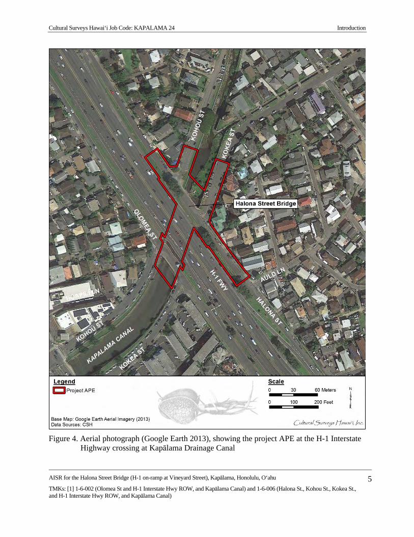
Cultural Surveys Hawai‘i Job Code: KAPALAMA 24 Introduction
AISR for the Halona Street Bridge (H-1 on-ramp at Vineyard Street), Kapālama, Honolulu, O‘ahu
TMKs: [1] 1-6-002 (Olomea St and H-1 Interstate Hwy ROW, and Kapālama Canal) and 1-6-006 (Halona St., Kohou St., Kokea St., and H-1 Interstate Hwy ROW, and Kapālama Canal)
5
Figure 4. Aerial photograph (Google Earth 2013), showing the project APE at the H-1 Interstate
Highway crossing at Kapālama Drainage Canal

Cultural Surveys Hawai‘i Job Code: KAPALAMA 24 Introduction
AISR for the Halona Street Bridge (H-1 on-ramp at Vineyard Street), Kapālama, Honolulu, O‘ahu
TMKs: [1] 1-6-002 (Olomea St and H-1 Interstate Hwy ROW, and Kapālama Canal) and 1-6-006 (Halona St., Kohou St., Kokea St., and H-1 Interstate Hwy ROW, and Kapālama Canal)
6
Act, the National Environmental Policy Act, and, due to funding from the U.S. Department of Transportation, Section 4(f) of the Department of Transportation Act. The proposed project is also subject to Hawai‘i State environmental and historic preservation review legislation (Hawai‘i Revised Statutes [HRS] §343 and HRS §6E-8 and Hawai‘i Administrative Rules [HAR] §13-275, respectively).
In consultation with the SHPD, this AIS investigation fulfills the requirements of HAR §13-13-276 and the Secretary of the Interior’s Standards for Archaeology and Historic Preservation. It was conducted to identify, document, and to make site significance assessments per HAR §13-13-276-6 and also to evaluate eligibility for inclusion on the National Register of Historic Places (National Register) for all historic properties within the project APE. It was also conducted to make Hawai‘i Register of Historic Places (Hawai‘i Register) eligibility recommendations for any historic properties. This report is also intended to support any project-related historic preservation consultation with stakeholders, such as State and County agencies and interested Native Hawaiian Organizations (NHOs) and community groups, as required.
A companion architectural study (Ruzicka 2016) was conducted in conjunction with this AISR. An SHPD “Historic Resource Inventory Form–Reconnaissance Level” was prepared to make a determination of eligibility for the bridge and canal. This study includes a condition assessment, narrative description, historical context discussion, and significance statement and references the historic drawings consulted. The architectural study has been incorporated into the present AIS document as Appendix A.
No previous archaeological studies have been conducted and no previously documented historic properties have been reported within the project APE.
Environmental Setting 1.3.1 Natural Environment
Kapālama is a small valley, which was once watered by two small streams, the Kapālama and Niuhelewai streams. The ahupua‘a (land division) of Kapālama is pie-shaped with its apex at approximately 609 m (2,000 ft) AMSL (above mean sea level) on the ridge that separates Nu‘uanu and Kalihi valleys. The shore frontage (presently “Kapālama Basin”) is part of the Honolulu Harbor protected shoreline. In 1961, the development of the Kapālama Drainage Canal, which follows the lower course of Niuhelewai Stream, channelized the lower streams. Temperatures in the project APE range from 60–90° F, while rainfall varies from 50–127 cm (20–50 inches) per year (Juvik and Juvik 1998:62–64).
According to the U.S. Department of Agriculture (USDA) Soil Survey Geographic (SSURGO) database (2001) and soil survey data gathered by Foote et al. (1972), soils within the project APE include Kawaihapai stony clay loam, 2 to 6% slopes (KlaB) and Hanalei silty clay loam, 0 to 2% slopes (HnA) (Figure 5).
Soils of the Kawaihapai Series are described as follows:
This series consists of well-drained soils in drainage-ways and on alluvial fans on coastal plains on the islands of Oahu and Molokai. These soils formed in alluvium derived from basic igneous rock in humid uplands. They are nearly level to
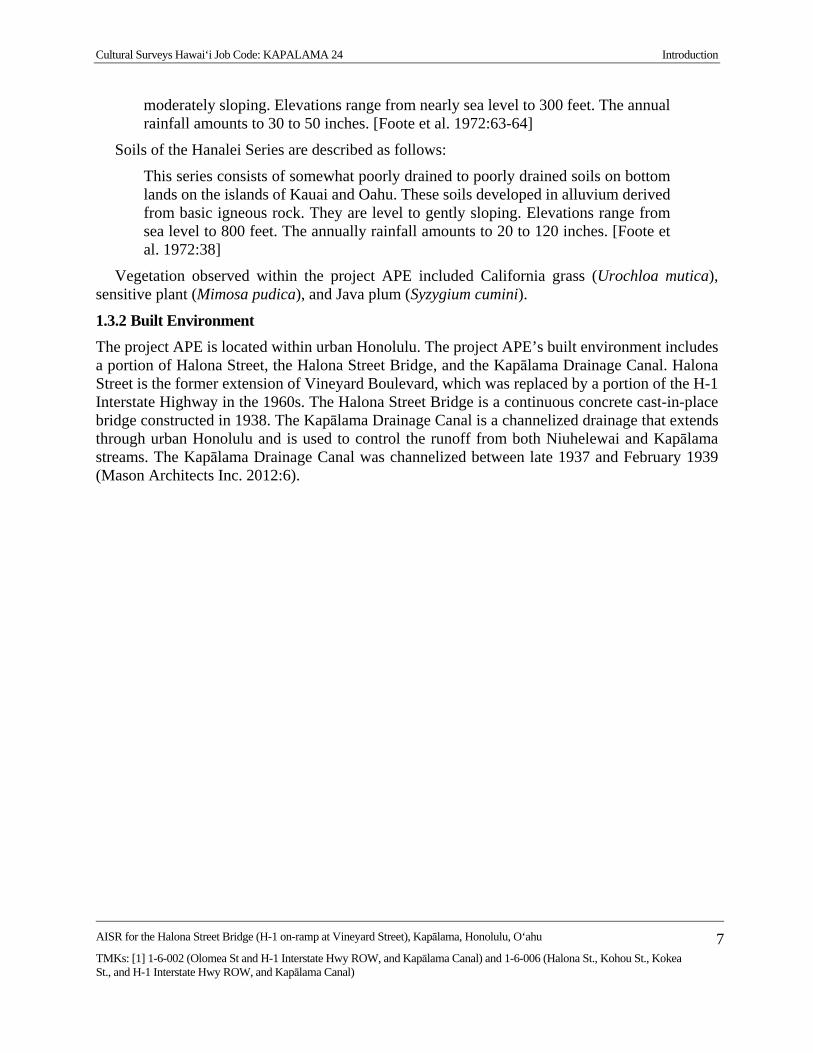
Cultural Surveys Hawai‘i Job Code: KAPALAMA 24 Introduction
AISR for the Halona Street Bridge (H-1 on-ramp at Vineyard Street), Kapālama, Honolulu, O‘ahu
TMKs: [1] 1-6-002 (Olomea St and H-1 Interstate Hwy ROW, and Kapālama Canal) and 1-6-006 (Halona St., Kohou St., Kokea St., and H-1 Interstate Hwy ROW, and Kapālama Canal)
7
moderately sloping. Elevations range from nearly sea level to 300 feet. The annual rainfall amounts to 30 to 50 inches. [Foote et al. 1972:63-64]
Soils of the Hanalei Series are described as follows:
This series consists of somewhat poorly drained to poorly drained soils on bottom lands on the islands of Kauai and Oahu. These soils developed in alluvium derived from basic igneous rock. They are level to gently sloping. Elevations range from sea level to 800 feet. The annually rainfall amounts to 20 to 120 inches. [Foote et al. 1972:38]
Vegetation observed within the project APE included California grass (Urochloa mutica), sensitive plant (Mimosa pudica), and Java plum (Syzygium cumini).
1.3.2 Built Environment
The project APE is located within urban Honolulu. The project APE’s built environment includes a portion of Halona Street, the Halona Street Bridge, and the Kapālama Drainage Canal. Halona Street is the former extension of Vineyard Boulevard, which was replaced by a portion of the H-1 Interstate Highway in the 1960s. The Halona Street Bridge is a continuous concrete cast-in-place bridge constructed in 1938. The Kapālama Drainage Canal is a channelized drainage that extends through urban Honolulu and is used to control the runoff from both Niuhelewai and Kapālama streams. The Kapālama Drainage Canal was channelized between late 1937 and February 1939 (Mason Architects Inc. 2012:6).
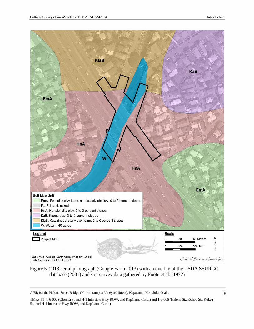
Cultural Surveys Hawai‘i Job Code: KAPALAMA 24 Introduction
AISR for the Halona Street Bridge (H-1 on-ramp at Vineyard Street), Kapālama, Honolulu, O‘ahu
TMKs: [1] 1-6-002 (Olomea St and H-1 Interstate Hwy ROW, and Kapālama Canal) and 1-6-006 (Halona St., Kohou St., Kokea St., and H-1 Interstate Hwy ROW, and Kapālama Canal)
8
Figure 5. 2013 aerial photograph (Google Earth 2013) with an overlay of the USDA SSURGO
database (2001) and soil survey data gathered by Foote et al. (1972)

Cultural Surveys Hawai‘i Job Code: KAPALAMA 24 Methods
AISR for the Halona Street Bridge (H-1 on-ramp at Vineyard Street), Kapālama, Honolulu, O‘ahu
TMKs: [1] 1-6-002 (Olomea St and H-1 Interstate Hwy ROW, and Kapālama Canal) and 1-6-006 (Halona St., Kohou St., Kokea St., and H-1 Interstate Hwy ROW, and Kapālama Canal)
9
Section 2 Methods
Field Methods CSH completed the fieldwork component of this AIS under archaeological permit number 14-
04 (for 2014) and 15-03 (for 2015), issued by the SHPD pursuant to HAR §13-13-282. Fieldwork was conducted on 19 September 2014 by CSH archaeologists Joanne DeMaio Starr, M.A. and Nifae Hunkin, B.A. under the general supervision of Hallett H. Hammatt, Ph.D. (principal investigator). This work required approximately 1 person-day to complete.
Fieldwork included 100% pedestrian inspection of the project APE and GPS data collection.
2.1.1 Pedestrian Survey
A 100%-coverage pedestrian inspection of the project APE was undertaken for the purpose of historic property identification and documentation. The pedestrian survey was accomplished through systematic sweeps spaced 5 m apart.
2.1.1 GPS Data Collection
Historic properties were located using a Trimble Pro XH mapping grade GPS unit with a real-time differential correction. This unit provided sub-meter horizontal accuracy in the field. GPS field data was post-processed, yielding horizontal accuracy between 0.5 and 0.3 m. GPS location information was converted into GIS shape files using Trimble’s Pathfinder Office software, version 2.80, and graphically displayed using ESRI’s ArcGIS 9.1.
Laboratory Methods No cultural material was collected during the AIS. No laboratory analysis was conducted.
Research Methods Background research included a review of previous archaeological studies on file at the SHPD;
review of documents at Hamilton Library of the University of Hawai‘i at Mānoa, the Hawai‘i State Archives, the Mission Houses Museum Library, the Hawai‘i Public Library, and the Bishop Museum Archives; study of historic photographs at the Hawai‘i State Archives and the Bishop Museum Archives; and study of historic maps at the Survey Office of the Department of Land and Natural Resources. Historic maps and photographs from the CSH library were also consulted. In addition, Māhele records were examined from the Waihona ‘Aina database (Waihona ‘Aina 2000).
This research provided the environmental, cultural, historic, and archaeological background for the project APE. The sources studied were used to formulate a predictive model regarding the expected types and locations of historic properties in the project APE.
Consultation Methods The Halona Street Bridge Replacement project is a HDOT and FHWA/CFLHD partnership
project. It is one of a number of proposed bridge improvement and replacement projects in the State of Hawai‘i. National Historic Preservation Act Section 106 consultation with community, agency, and Native Hawaiian Organizations has been initiated. As part of this process, a draft of

Cultural Surveys Hawai‘i Job Code: KAPALAMA 24 Methods
AISR for the Halona Street Bridge (H-1 on-ramp at Vineyard Street), Kapālama, Honolulu, O‘ahu
TMKs: [1] 1-6-002 (Olomea St and H-1 Interstate Hwy ROW, and Kapālama Canal) and 1-6-006 (Halona St., Kohou St., Kokea St., and H-1 Interstate Hwy ROW, and Kapālama Canal)
10
this AIS was sent to these entities and no information was received relative to the identification of historic properties. The National Historic Preservation Act Section 106 consultation process is an ongoing effort that will continue until the completion of the Section 106 process. Community consultation was conducted by CSH for a cultural impact assessment (CIA) for the Halona Street Bridge (Ishihara et al. 2016) as part of the overall Section 106 process and is on-going.

Cultural Surveys Hawai‘i Job Code: KAPALAMA 24 Background Research
AISR for the Halona Street Bridge (H-1 on-ramp at Vineyard Street), Kapālama, Honolulu, O‘ahu
TMKs: [1] 1-6-002 (Olomea St and H-1 Interstate Hwy ROW, and Kapālama Canal) and 1-6-006 (Halona St., Kohou St., Kokea St., and H-1 Interstate Hwy ROW, and Kapālama Canal)
11
Section 3 Background Research
Traditional and Historical Background The project is located within the ahupua‘a (traditional land division) of Kapālama in the O‘ahu
moku (district) of Kona, now called the District of Honolulu. The ahupua‘a of Kalihi lies to the west and the ahupua‘a of Nu‘uanu lies to the east.
3.1.1 Mythological and Traditional Accounts
The place name Kapālama is often understood to refer to an enclosure (pā) of lama wood that surrounded the place of residence of high ranking ali‘i (chiefs) (Pukui et al. 1974:87). McAllister (1933:88) relates, “Kapālama is said to have obtained its name from an establishment in which the young ali‘i were kept just before pairing off for offspring.” This information probably came from Nathaniel Emerson, who translated David Malo’s Ka Mo‘olelo Hawai‘i. Emerson added many notes to his English translation, including the following:
Hoonoho ia means put in an establishment, placed under the care of a guardian or duenna [chaperone]. Such an establishment was surrounded by an enclosure, pa, made of the sacred lama . . . Hence this special care or guardianship was called palama. It is said that an establishment of this kind was anciently placed at that suburb of Honolulu which to this day bears the name of Ka-pa-lama. [Malo 1951:139; note by N.B. Emerson]
Westervelt (1923:165) attributes the O‘ahu place name to a chiefess of O‘ahu who lived in that area. This chiefess was named Kapālama, the grandmother of Lepeamoa (Hawaiian for “cockscomb”). A chief of Kaua‘i named Keāhua traveled to O‘ahu to take Kauhao, the daughter of Kapālama, as his wife. He angered a kupua (supernatural being that can change form) called Akuapehuale (god of swollen billows) who forced the couple to hide in the uplands of the Wailua River valley of Kaua‘i.
Keāhua’s daughter was born as an egg, and was adopted by the chiefess Kapālama to raise on O‘ahu at her home, also named Kapālama. When the egg hatched, Lepeamoa was a bird with feathers in all the colors of the rainbow. She became able to turn herself into a beautiful young woman wearing a feather lei. The girl was so beautiful that a rainbow was always present above her. The girl was guarded by her ancestress, Keaolewa (“the moving cloud”), who could also change forms between human and bird. The lower ridge separating Kapālama and Nu‘uanu (‘Ālewa Heights) may have been named for this ancestress.
The parents of Lepeamoa had another child, a son called Kau‘ilani, who was so strong that he was able to defeat the kupua who had threatened his parents. After Kau‘ilani’s victory over the kupua he went to find his sister, searching for the rainbow sign of her presence. In her compound he found Kapālama who advised him to hide in Lepeamoa’s house, wait until she was asleep in her bird form, and catch and hold her until she acknowledged him as her brother. Her advice worked, and Lepeamoa lived with her brother thereafter (Westervelt 1923:164-184).
3.1.2 Stories of Heroes and Gods
In the legend of Palila, the hero’s war club could magically carry him far distances in a single flight. Palila came to the plain of Keahumoa in ‘Ewa to participate in the athletic games given by

Cultural Surveys Hawai‘i Job Code: KAPALAMA 24 Background Research
AISR for the Halona Street Bridge (H-1 on-ramp at Vineyard Street), Kapālama, Honolulu, O‘ahu
TMKs: [1] 1-6-002 (Olomea St and H-1 Interstate Hwy ROW, and Kapālama Canal) and 1-6-006 (Halona St., Kohou St., Kokea St., and H-1 Interstate Hwy ROW, and Kapālama Canal)
12
the O‘ahu king, Ahuapau. The residence of this chief was said to be at Kalaepōhaku, near Wailuakio in Kapālama (Fornander 1917:5(1):142). Kalaepōhaku Peak (meaning “the stone promontory”) is near the intersection of School and Alaneo streets in Kapālama.
A place named Niuhelewai (lit. “coconut going in water”) in lower Kapālama, located makai (seaward) of King Street (Fornander 1917:4(3):530-531; Fornander 1919:5(2):368) was associated with the deity Haumea and the hero, Kaulu, who was known for his great strength.
Kaulu was born in Kailua on the windward side of O‘ahu. His older brother Kaeha was taken by the spirits to a realm of gods in the sky. For love of his brother, Kaulu followed him to this realm, playing a number of tricks on the gods including Makali‘i, the god of plenty, who had a magic fish net that would fill with fish whenever used. After playing the tricks, Kaulu then had to rescue his brother from the wrath of the various spirits. The brothers finally returned to the land of men on O‘ahu, setting down at Moanalua (ahupua‘a [land division] west of Kapālama).
A hiki laua ma Moanalua, i Papakolea, hoonoho o Kaulu ia Kaeha ilaila; hele mai la o Kaulu a loaa o Haumea i Kapālama. He ‘kua o Haumea no Oahu nei, e noho ana ia i Niuhelewai, he wahine of Haumea.
When they arrived at Papakolea, Moanalua, Kaulu left Kaeha at this place while he continued on his way to Kapālama in search of Haumea. Haumea was a spirit that lived at Niuhelewai, Oahu. It was a female spirit. [Fornander 1917:4(3):530-531]
Haumea, the goddess of childbirth, had a home at Niuhelewai in Kapālama; she challenged anyone who passed by, often killing them. Kaulu challenged Haumea to a fight on the following day. That night he flew back up to the spirit land in the clouds and borrowed the magic nets of Makali‘i, and then threw them over Haumea’s house. When Haumea could not break through these nets, she fell asleep in exhaustion, tangled in the nets. While asleep, Kaulu burned down her house, killing her.
3.1.3 Legend of the Tapa Board
A brief mention is made of Kapālama in the Legend of the Tapa Board, which has several different versions (Sterling and Summers 1978:25–26, 149; Thrum 1910:129–131). Tapa was placed on a wooden board (also called an anvil), and beaten by women with tapa sticks to soften and smooth out the fibers. This pounding made a resonant sound, and women could often identify the owner of the board by its sound. One day a woman in Kahuku on O‘ahu took her favorite tapa board to a pool to clean it and left it at the side of the pool. The next day the board was missing. The pool is identified as Waiakaole, Punaho‘olapa, or Waikalai, all in Kahuku, in various versions. The woman first searched the windward districts of the island, but never heard the distinctive ringing sound of her own favorite board. After several months without finding her board, she traveled to the leeward side of O‘ahu.
She went from Kahuku on the Koolau side to Kaneohe where she spent the night. There was no sign of the anvil in Koolau, because the sign she sought was the sound it made . . . She went on and spent the night at Wailupe but did not find hers. She heard other anvils but they were not hers. The night turned into day and she went on to Kapālama where she slept but did not hear what she sought till she came to

Cultural Surveys Hawai‘i Job Code: KAPALAMA 24 Background Research
AISR for the Halona Street Bridge (H-1 on-ramp at Vineyard Street), Kapālama, Honolulu, O‘ahu
TMKs: [1] 1-6-002 (Olomea St and H-1 Interstate Hwy ROW, and Kapālama Canal) and 1-6-006 (Halona St., Kohou St., Kokea St., and H-1 Interstate Hwy ROW, and Kapālama Canal)
13
Waipahu. [Ka Loea Kalaiaina, 10 June 1899; English translation in Sterling and Summers 1978:25]
At Waipahu Spring in the ‘Ewa District, she finally heard the sound of her own board. She followed the sound to the uplands of Waikele and found a woman beating tapa on her board. The woman claimed she had found the board one day floating on the water at a spring near her house. This legend illustrates the belief of the ancient Hawaiians that there were underground streams and passages that led from one side of the island to the other. In one version of this story, the people of ‘Ewa followed the woman back to Kahuku so she could prove the board was the same one she had lost. They wrapped a bundle of tī leaves and cast them into the pool near the house of the Kahuku woman. Then returning to ‘Ewa, they saw the same bundle of ti leaves a few days later in Waipahu at the spring. Because of this, the Waipahu spring was called Ka-puka-na-wai-o-Kahuku, which means “outlet of water from Kahuku.”
3.1.4 Keanakamanō, the Cave of the Shark
Near the Kamehameha Schools there was once a cave called Keanakamanō, which means “cave of the shark” (Sterling and Summers 1978:323). The Hawaiians have many stories concerning legendary caves that connected inland springs to the sea or extended below the Ko‘olau Mountains, connecting the leeward and windward sides of the island.
On the Kamanaiki side of the Kalihi Valley there was once a shallow cave called Keana Kamano. It was called the cave of the sharks because the big shark gods from Pearl Harbor often went there to rest.
Keana Kamano led into the fabulous underground cave believed in olden times to occupy the center of the island of Oahu.
One branch of the cave led around and under the mountains to Pearl Harbor. Another branch of the cave led to the center of the Island where there was a sacred pool for swimming.
Hawaiians living today can tell of elders who once traveled these caves and who once swam in the sacred pool. An earthquake about 1900 closed up the caves and no one has been known to travel them since.
It may be that the cave-in of the Wilson Tunnel occurred over the old lava tube leading to Pearl Harbor. [Taylor 1954]
An access street called Kealamanō (“the way of the shark”) on the Kamehameha School’s Kapālama Heights campus is named for this cave. The shark referred to is Kamohoali‘i, king of the sharks, who is the older brother of Pele, the Hawaiian volcano goddess. On the long trip Pele’s family made to Hawai‘i, it was Kamohoali‘i who acted as the navigator. Don Mitchell, who said that earthquakes in 1900 caused the collapse of the cave (1993), states the following:
His [Kamohoali‘i] favorite pastime was to swim through the extensive water-filled lava tubes or tunnels that extended from Pearl Harbor to areas under Kalihi Valley. As the tunnels rose above sea level, he assumed his human form and walked to his cave, Keanakamanō, on Kapālama Heights. [Mitchell 1993:146]

Cultural Surveys Hawai‘i Job Code: KAPALAMA 24 Background Research
AISR for the Halona Street Bridge (H-1 on-ramp at Vineyard Street), Kapālama, Honolulu, O‘ahu
TMKs: [1] 1-6-002 (Olomea St and H-1 Interstate Hwy ROW, and Kapālama Canal) and 1-6-006 (Halona St., Kohou St., Kokea St., and H-1 Interstate Hwy ROW, and Kapālama Canal)
14
3.1.5 Traditional Accounts of Battles at Niuhelewai Stream in Kapālama
Two accounts of traditional Hawaiian warfare suggest mass killings in the vicinity of “Niuhelewai” which is the stream generally now known as Kapālama Drainage Canal.
3.1.5.1 Kahahawai‘a Defeat of Kahāhana (AD 1780-1783)
Niuhelewai Stream was the location for a famous battle between Kahahawa‘i, the war chief of Kahekili, king of Maui, and the O‘ahu ruling chief Kahāhana. Fornander (1919:498) states in a footnote to a story that Niuhelewai was the name of the locality of the Pālama cane field between the fire and pumping stations. Ross Cordy (2002:19) places Kahāhana’s reign on O‘ahu around the year 1780 to his death in 1783 after this battle.
I ka wa e noho ana o Kahekili he ‘lii no Maui, a o Kahahana he li‘ i no Oahu nei iloko oia kau i holo mai ai o Kahahawai me na koa e kaua ia Oahu. Ma keia kaua ana ua hee a ua luku ia na kanaka Oahu, ma Niuhelewai, a ua hoi ka wai i uka o ka muliwai, no ka piha i na kanaka.
When Kahekili was reigning as king of Maui, and Kahahana was king of O‘ahu, it was during this period that Kahahawai with a number of warriors came to make war on O‘ahu. In this battle the people of O‘ahu were defeated and slaughtered at Niuhelewai, and the waters of the stream were turned back, the stream being dammed by the corpses of the men. [Fornander 1919:498-499]
3.1.5.2 The Rebellions of the ‘Ewa and Kona Chiefs (post-1783)
After Kahāhana’s death, the chiefs of Maui took over O‘ahu. Some of the chiefs from the O‘ahu districts of ‘Ewa and Kona conceived a plot to murder their new overlords but the Maui chiefs were warned. Although the main backers of the plot were the chiefs of Waipi‘o, ‘Ewa, they were temporarily able to convince Kahekili that the conspiracy originated on Kaua‘i, thus the phrase, Waipi‘o kīmopō, “Waipi‘o of the secret rebellion” (Pukui 1983:319). Eventually the truth was revealed and:
A no kēia mea, ulu maila ke kaua kūloko o Kona me ‘Ewa, nā moku o O‘ahu i luku nui ‘ia; ua luku ‘ia nā moku o O‘ahu i luku nui ‘ia; ua luku ‘ia nā kāne, nā wāhine a me nā keiki, a ua pani kūmano ‘ia nā kahawai a me nā muliwai i nā heana o nā kānaka o Kona a me ‘Ewa. ‘O nā kahawai i ‘oi aku ka nui o nā heana, a ho‘i hou ka wai i uka, ‘o ia nō ‘o Makaho a me Niuhelewai ma Kona, a ‘o Kaho‘ā‘ia‘i ho‘i ko ‘Ewa. He kūmukena ka nui o nā mea he make, ke lilo ka wai i mea ‘awa-‘awa ke inu aku. Ua ‘ōlelo mai ho‘i ka po‘e ‘ike maka ‘O ka lolo ka mea i ‘awa-‘awa ai ‘o ka wai.’ [Kamakau 1996:91, Ka Nūpepa Kū‘oko‘a, 39 March 1867]
. . . the districts of Kona and ‘Ewa were attacked, and men, women, and children were massacred, until the streams of Makaho and Niuhelewai in Kona [in Kapālama] and of Kahoa‘ai‘ai in ‘Ewa were choked with the bodies of the dead, and their waters became bitter to the taste, as eyewitnesses say, from the brains that turned the water bitter. All the O‘ahu chiefs were killed and the chiefesses tortured. [Kamakau 1992:138]

Cultural Surveys Hawai‘i Job Code: KAPALAMA 24 Background Research
AISR for the Halona Street Bridge (H-1 on-ramp at Vineyard Street), Kapālama, Honolulu, O‘ahu
TMKs: [1] 1-6-002 (Olomea St and H-1 Interstate Hwy ROW, and Kapālama Canal) and 1-6-006 (Halona St., Kohou St., Kokea St., and H-1 Interstate Hwy ROW, and Kapālama Canal)
15
3.1.6 Early Historic Period
The ahupua‘a of Kapālama is between the ahupua‘a of Nu‘uanu to the east and Kalihi to the west. Although Kapālama is not a major river valley like Nu‘uanu or Kalihi, it is watered by two smaller streams, the Kapālama and Niuhelewai. The shore frontage (presently “Kapālama Basin”) is part of the Honolulu Harbor protected shoreline. Kapālama Ahupua‘a offered desirable environmental conditions for traditional Hawaiian subsistence practices. The well-watered flood plain would have allowed for the development of an extensive lo‘i (irrigated terrace, especially for taro) system, and the protected shoreline and fringing reef would have allowed for ease of ocean access to the productive near-shore fisheries. E.S. Craighill Handy, who gathered information on former planting areas from local informants in the 1930s and 1940s, reported the following: “Kapālama had two streams watering its terrace area [for taro], which was almost continuous from Iwilei up to the foothills above School Street, an area measuring about three quarters of a mile both in depth inland and in breadth” (Handy 1940:79).
The lower lands were used for taro cultivation; the uplands also had considerable resources. In the early nineteenth century, sandalwood trees were still present in the forests. These trees were extensively harvested between 1810 and 1830 as the fragrant wood could be sold to ship captains sailing to China to trade for exotic Asian goods.
Otto von Kotzebue’s journal and map of Honolulu provide one of our earliest accounts of the environs of Kapālama ca. 1817 (Kotzebue 1967:339-341). Kotzebue’s 1817 map of Honolulu (Figure 6), shows large taro fields (and trees) on both sides of the mouth of Kalihi and Nu‘uanu streams extending to the coast. The path shown was probably the main trail and the route traveled by Kotzebue himself. The 1817 map does not show any taro fields in Kapālama, but a later 1855 map by LaPasse (Figure 7) does show extensive taro lo‘i in the makai section of Kapālama.
Kamehameha I, after the devastations to the population caused by the wars of conquest and a ca. 1804 epidemic, encouraged people to replant the land and he set aside several large tracts, including tracts in Kapālama, for them to grow crops for their own use and for trade with visiting ships. The Hawaiian historian Samuel Kamakau noted, “After the pestilence had subsided the chiefs again took up farming, and Kamehameha cultivated land at Waikiki, Honolulu, and Kapālama, and fed the people” (Kamakau 1992:190).
Another early Hawaiian historian, John Papa ‘Ī‘ī, knew personally that, “He [Kamehameha] also lived in Honolulu, where his farms at Kapālama, Keoneula, and other places became famous. These tasks Kamehameha tended to personally, and he participated in all the projects” (‘Ī‘ī 1959:69).
Rev. Hiram Bingham, arriving in Honolulu in 1820, described a predominantly Native Hawaiian environment—still a “village”—on the brink of western-induced transformation:
We can anchor in the roadstead abreast of Honolulu village, on the south side of the island, about 17 miles from the eastern extremity. . . . Passing through the irregular village of some thousands of inhabitants, whose grass thatched habitations were mostly small and mean, while some were more spacious, we walked about a mile northwardly to the opening of the valley of Pauoa, then turning south-easterly,

Cultural Surveys Hawai‘i Job Code: KAPALAMA 24 Background Research
AISR for the Halona Street Bridge (H-1 on-ramp at Vineyard Street), Kapālama, Honolulu, O‘ahu
TMKs: [1] 1-6-002 (Olomea St and H-1 Interstate Hwy ROW, and Kapālama Canal) and 1-6-006 (Halona St., Kohou St., Kokea St., and H-1 Interstate Hwy ROW, and Kapālama Canal)
16
Figure 6. 1817 map of south coast of O‘ahu by Otto von Kotzebue (1817) of the Russian ship
Rurik, showing density of habitations and agriculture around Kapālama (The project APE and map have been geo-referenced. The project APE is located on a ridge, and it should be noted that this early map should be understood as a “sketch”)

Cultural Surveys Hawai‘i Job Code: KAPALAMA 24 Background Research
AISR for the Halona Street Bridge (H-1 on-ramp at Vineyard Street), Kapālama, Honolulu, O‘ahu
TMKs: [1] 1-6-002 (Olomea St and H-1 Interstate Hwy ROW, and Kapālama Canal) and 1-6-006 (Halona St., Kohou St., Kokea St., and H-1 Interstate Hwy ROW, and Kapālama Canal)
17
Figure 7. 1855 map of Honolulu by Lt. Joseph de LaPasse of the French vessel, L’Eurydice
(reprinted in Fitzpatrick 1986:82-83), showing lo‘i, habitations, and fishponds in Kapālama

Cultural Surveys Hawai‘i Job Code: KAPALAMA 24 Background Research
AISR for the Halona Street Bridge (H-1 on-ramp at Vineyard Street), Kapālama, Honolulu, O‘ahu
TMKs: [1] 1-6-002 (Olomea St and H-1 Interstate Hwy ROW, and Kapālama Canal) and 1-6-006 (Halona St., Kohou St., Kokea St., and H-1 Interstate Hwy ROW, and Kapālama Canal)
18
ascending to the top of Punchbowl Hill, an extinguished crater, whose base bounds the north-east part of the village or town . . .
Below us, on the south and west, spread the plain of Honolulu, having its fish-ponds and salt making pools along the sea-shore, the village and fort between us and the harbor, and the valley stretching a few miles north into the interior, which presented its scattered habitations and numerous beds of kalo (arum esculentum) in its various stages of growth, with its large green leaves, beautifully embossed on the silvery water, in which it flourishes. [Bingham 1981:92–93]
3.1.7 The Māhele and the Kuleana Act
In 1845, the Hawaii Board of Commissioners to Quiet Land Titles, also called the Land Commission, was established “for the investigation and final ascertainment or rejection of all claims of private individuals, whether natives or foreigners, to any landed property” (Chinen 1958:8). This led to the Māhele, the division of lands between the Hawaiian government, the King, the ali‘i (royalty), and the common people as codified in the Māhele Book (1848), which introduced the concept of private property into Hawaiian society.
In 1848, the crown (Hawaiian government), Kamehameha III, and other ali‘i such as Victoria Kamāmalu received their land titles, called Konohiki Awards. The Konohiki award claimant had to pay a commutation fee of one-third of the value of their unimproved lands. Usually this fee was settled when the ali‘i “returned” some of his awarded lands, and “retained” others. The returned lands usually then became Government Lands, which were set aside to generate revenue for the government, or Crown Lands, which were lands reserved for the monarchy (Chinen 1958:8). In the petitioning for Land Commission Awards (LCAs) for their kuleana (lands), the commoners had to provide testimony from witnesses, including statements regarding the boundaries of the land and its use. In the 1790s, after Kamehameha had conquered O‘ahu, Kapālama is specifically mentioned along with Nu‘uanu, Mānoa, and Waikīkī as having been “farmed” by Kamehameha. The desirability of Kapālama Ahupua‘a is supported by the fact that Kamehameha “kept of himself” the ahupua‘a during the post-1795 division of O‘ahu lands (Kame‘eleihiwa 1992:59). The ahupua‘a of Kapālama was awarded to Moses Kekūāiwa, son of Kekūanao‘a and Kīna‘u (who had earlier been married to Kamehameha I). The lands passed down in turn to his sister Victoria Kamāmalu, to her brother Lot Kamehameha, to his half-sister Ruth Ke‘elikōlani, and then to her first cousin, Bernice Pauahi Bishop. The will of Mrs. Bishop set many of her lands as a trust to provide financial aid to educational and charitable institutions, including the schools she founded to educate Hawaiian children (Mitchell 1993:9).
Subsequent to the Māhele award for the bulk of the ahupua‘a, individual kuleana (commoner) lots were awarded pursuant to the 1850s Kuleana Act. The first detailed map of Kapālama, made by J.F. Brown in 1885 (Figure 8), shows a traditional Hawaiian landscape of small kuleana LCA parcels extending across the Kapālama plain. Mid-nineteenth century Māhele documents identify these kuleana parcels as comprising house sites and irrigated taro fields. The map also indicates large areas set aside for rice fields near the central ‘auwai (ditch) in land managed by the konohiki (land agent for the ali‘i; in this case Moses Kekūāiwa).The LCA testimony for Kapālama indicates there was intensive cultivation of taro in the area, maintenance of fishponds, habitation, and some indication of the use of the kula (pasture or waste land). The kuleana lots conveyed to Hawaiian maka‘āinana were located on the flood plain to the east of Waiakamilo/Houghtailing Street and

Cultural Surveys Hawai‘i Job Code: KAPALAMA 24 Background Research
AISR for the Halona Street Bridge (H-1 on-ramp at Vineyard Street), Kapālama, Honolulu, O‘ahu
TMKs: [1] 1-6-002 (Olomea St and H-1 Interstate Hwy ROW, and Kapālama Canal) and 1-6-006 (Halona St., Kohou St., Kokea St., and H-1 Interstate Hwy ROW, and Kapālama Canal)
19
Figure 8. 1885 Brown map of Kapālama depicting LCAs in the vicinity of the project APE and
the planned extension of the Vineyard Street right-of-way

Cultural Surveys Hawai‘i Job Code: KAPALAMA 24 Background Research
AISR for the Halona Street Bridge (H-1 on-ramp at Vineyard Street), Kapālama, Honolulu, O‘ahu
TMKs: [1] 1-6-002 (Olomea St and H-1 Interstate Hwy ROW, and Kapālama Canal) and 1-6-006 (Halona St., Kohou St., Kokea St., and H-1 Interstate Hwy ROW, and Kapālama Canal)
20
included houses and lo‘i (pond fields) for the cultivation of kalo (taro). The taro patches in the vicinity were just downstream of Niuhelewai (Kapālama) Stream. Roughly 100 kuleana lots were awarded in Kapālama. The claimants were generally awarded one to six separate ‘āpana (lots), sometimes contiguous or in the same ‘ili (land division smaller than an ahupua‘a), but also sometimes scattered through several ‘ili. LCA documentation notes the presence of house sites, irrigated taro fields (lo‘i), and aquaculture fishponds in the immediate vicinity. The pattern of land-award distribution shown in the LCAs suggests the traditional Hawaiian practice of maintaining residences dispersed within and throughout their agricultural fields continued in Kapālama at least until the mid-nineteenth century.
The project APE is located within portions of LCA 732:2 (to Kuinui) and 918:2 (to Upai) (Figure 9 and Appendix B). The claims include house lots and associated taro patches and pastureland.
3.1.8 Mid-1800s to Early 1900s
The project APE vicinity is shown on the 1893 Wall map of Honolulu (Figure 10) as surrounded by rice cultivation but with a north/south trending railroad spur crossing the east portion of the project APE. The purpose of the railroad spur is unclear and may have been just to facilitate the loading of rice.
The Kapālama area on the 1897 Monsarrat map (Figure 11) is dominated by the Kamehameha Schools complex with only a few scattered houses such as the Houghtailing home. The main street is King Street, which extends through Kapālama, including a mule-drawn tramway, which had its stables southwest of the Kapālama Drainage Canal project block. The O‘ahu Insane Asylum and a rice mill was mauka (inland) of the future H-1 Interstate Highway corridor. The project APE is shown in the middle of a rice plantation.
A site in Kapālama called Kaiwi‘ula (“the red bone”) was chosen for the first Kamehameha School for Boys, which opened in 1887. The construction of many wood frame buildings followed including a principal’s house, dormitories, faculty cottages, a preparatory school, a dining hall and kitchen, gymnasiums, and manual school shops. Two stone buildings were constructed first. The Bishop Hall, the main administration building for the school, was completed in 1891 and the Bishop Memorial Chapel was completed in 1897. In 1938, the grounds, the chapel, and the preparatory buildings were sold to the territorial government in order to build an auditorium for the Wallace R. Farrington High School. The chapel was demolished in 1954 (Mitchell 1993:1–42). The first buildings of Farrington High School were constructed in 1940, designed by the noted Hawaiian architect Charles W. Dickey (Farrington High School 2014).
Mr. Charles Bishop was interested in preserving the many artifacts in the possession of his late wife and those of the late Queen Emma, who in 1884 willed her “native curiosities” to him “on the condition that at some future day, they together with all similar articles belonging to the late Bernice Pauahi Bishop . . . be presented to him as trustees of an institution to be called the Kamehameha Museum . . .” (Rose 1980:10). The trustees of Bishop Estate chose a site near the Kamehameha School for Boys and the museum, housed in Bishop Hall, opened to the public in 1891. The official name of the institution was the Bernice Pauahi Bishop Museum but it was also called Hale Hō‘ike‘ike o Kamehameha, or Museum of Kamehameha, the name Queen Emma preferred (Rose 1980:21). In 1894, a new Polynesian Hall was added, in 1903 a Hawaiian Hall, in

Cultural Surveys Hawai‘i Job Code: KAPALAMA 24 Background Research
AISR for the Halona Street Bridge (H-1 on-ramp at Vineyard Street), Kapālama, Honolulu, O‘ahu
TMKs: [1] 1-6-002 (Olomea St and H-1 Interstate Hwy ROW, and Kapālama Canal) and 1-6-006 (Halona St., Kohou St., Kokea St., and H-1 Interstate Hwy ROW, and Kapālama Canal)
21
Figure 9. 2013 aerial photograph with an overlay of land commissions awards in the vicinity of
the project APE (Google Earth 2013)
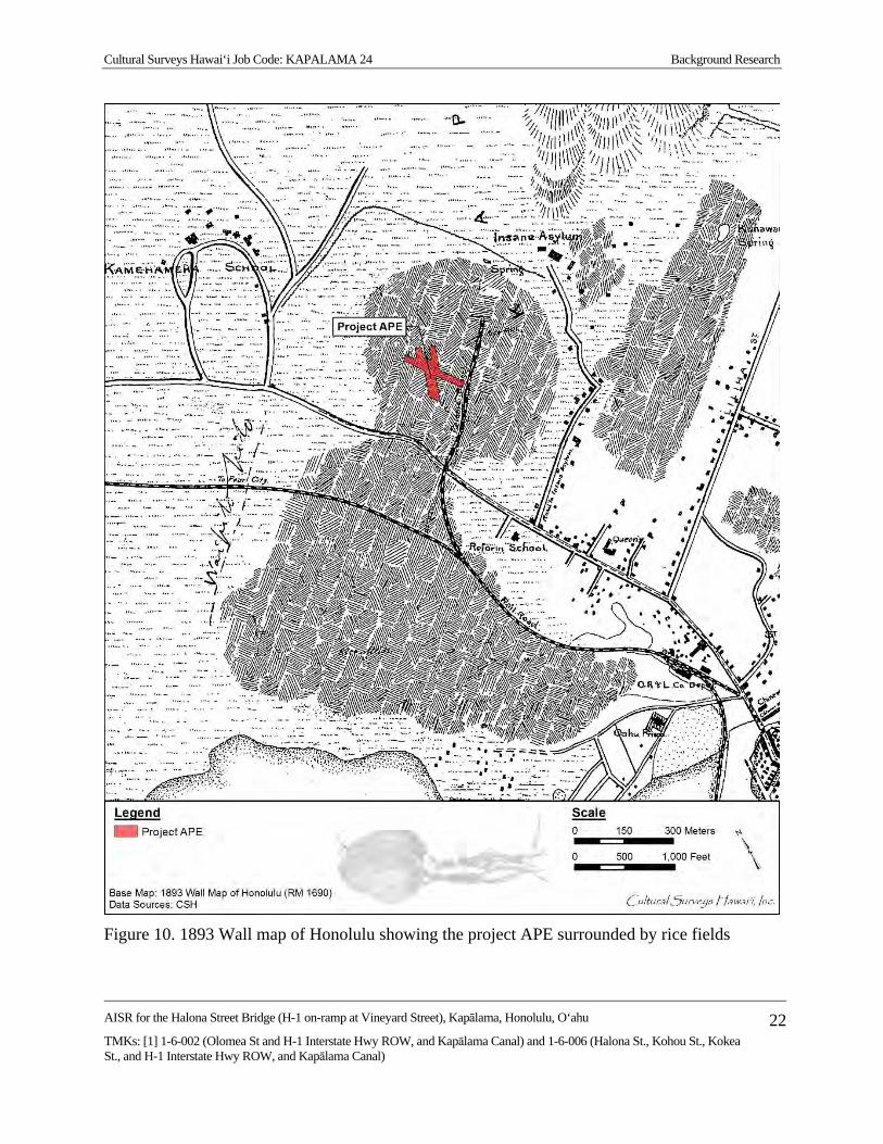
Cultural Surveys Hawai‘i Job Code: KAPALAMA 24 Background Research
AISR for the Halona Street Bridge (H-1 on-ramp at Vineyard Street), Kapālama, Honolulu, O‘ahu
TMKs: [1] 1-6-002 (Olomea St and H-1 Interstate Hwy ROW, and Kapālama Canal) and 1-6-006 (Halona St., Kohou St., Kokea St., and H-1 Interstate Hwy ROW, and Kapālama Canal)
22
Figure 10. 1893 Wall map of Honolulu showing the project APE surrounded by rice fields
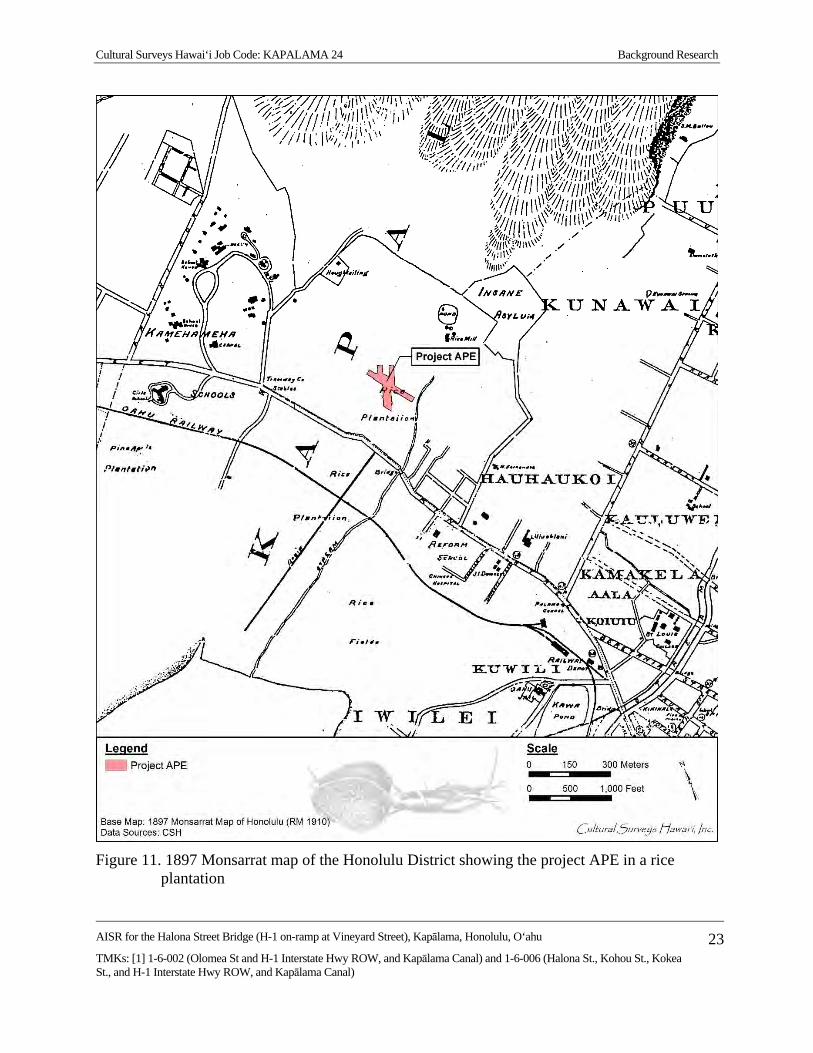
Cultural Surveys Hawai‘i Job Code: KAPALAMA 24 Background Research
AISR for the Halona Street Bridge (H-1 on-ramp at Vineyard Street), Kapālama, Honolulu, O‘ahu
TMKs: [1] 1-6-002 (Olomea St and H-1 Interstate Hwy ROW, and Kapālama Canal) and 1-6-006 (Halona St., Kohou St., Kokea St., and H-1 Interstate Hwy ROW, and Kapālama Canal)
23
Figure 11. 1897 Monsarrat map of the Honolulu District showing the project APE in a rice
plantation
Cultural Surveys Hawai‘i Job Code: KAPALAMA 24 Background Research
AISR for the Halona Street Bridge (H-1 on-ramp at Vineyard Street), Kapālama, Honolulu, O‘ahu
TMKs: [1] 1-6-002 (Olomea St and H-1 Interstate Hwy ROW, and Kapālama Canal) and 1-6-006 (Halona St., Kohou St., Kokea St., and H-1 Interstate Hwy ROW, and Kapālama Canal)
24
1911 the Pākī Hall, and in 1925 the Konia Hall. In 1947, the Kamehameha Schools moved their campus to Kapālama Heights and the former school grounds were transferred to the Bishop Museum Trust. Bishop Hall was formally transferred to the Bishop Museum in 1980 (Rose 1980:18–62).
The Oahu Insane Asylum was established by the Hawaii Legislature in 1862, proposing that “A building is to be erected for the reception of insane persons. This facility will furnish restraint till the person becomes of sane mind or is discharged” (Kimmich 1956:345). The hospital was completed in 1866 and the first six patients were transferred to the hospital from the jails where the mentally ill had previously been kept. In 1930, all 549 patients in the then-named Territorial Hospital were transferred to the new Territorial Hospital in Kāne‘ohe, O‘ahu.
Mr. George Houghtailing’s grandfather came to Hawai‘i around 1845, married a Hawaiian woman in 1850 and ran the Bay Horse Saloon on Bethel and Hotel Street in Honolulu. During the Māhele, he was given several kuleana, later consolidated into a 15-acre tract along a road later named after him, Houghtailing Road. The family home was between School and Vineyard streets, now the location of Damien High School, as described by Mr. Houghtailing:
On the premises there was a large pond which had a natural spring and which also fed the lower land where we had taro patches and cultivated the other truck gardening on the land. The land was quite open. We had a couple of bay horses and raised chickens and pigs for family consumption. There was a large open area fronting Houghtailing Road which was used as a park for the neighborhood kids. [UH 1984:1099]
Mr. Houghtailing located the ponds, taro fields, and rice patches from School Street to Liliha Street; other taro patches were in the area “between Palama Street and Liliha Street, below School Street down to what in now Vineyard Street” (UH 1984:1100). These rice ponds and taro patches, usually operated by the Chinese, were cultivated up to the 1920s when many were filled in for the development of residential subdivisions. The Japanese took over some of the land as truck farms, and Japanese also gradually took over the small stores once operated by Chinese.
A 1919 map (Figure 12) depicts the grid-like establishment of residential neighborhoods surrounding the Kamehameha School complex in Kalihi-Pālama. The rice paddies and pineapple plantations are no longer shown, although some of the open areas on the map mauka of King Street may still have been cultivated for these crops, or turned into truck farms. There are no open spaces shown in the Nu‘uanu area at this time. On the 1897 Monsarrat map, (see Figure 11) houses were spaced only along the main roads. By 1919, homes are packed in small residential blocks.
A 1927 Sanborn map shows more structures near the project area as well as proposed extension of North Vineyard Street (see Figure 13). Two ditches appear to be more organized near the project APE, but have not yet been redirected and developed into their present form.
3.1.9 Mid- to Late 1900s
A series of USGS maps, U.S. Army War Department maps, and aerial photographs (Figure 14 through Figure 19) depict the accelerated development of residential neighborhoods and commercial centers in the first half of the twentieth century.

Cultural Surveys Hawai‘i Job Code: KAPALAMA 24 Background Research
AISR for the Halona Street Bridge (H-1 on-ramp at Vineyard Street), Kapālama, Honolulu, O‘ahu
TMKs: [1] 1-6-002 (Olomea St and H-1 Interstate Hwy ROW, and Kapālama Canal) and 1-6-006 (Halona St., Kohou St., Kokea St., and H-1 Interstate Hwy ROW, and Kapālama Canal)
25
Figure 12. 1919 U.S. Army War Department map, Honolulu Quadrangle, showing commercial
and residential development in Kapālama and the Nuhelewai (Niuhelewai) Stream extending on the east side of the project APE
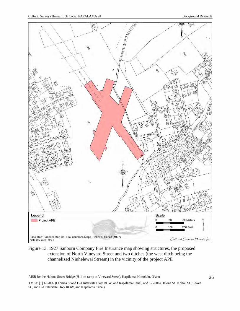
Cultural Surveys Hawai‘i Job Code: KAPALAMA 24 Background Research
AISR for the Halona Street Bridge (H-1 on-ramp at Vineyard Street), Kapālama, Honolulu, O‘ahu
TMKs: [1] 1-6-002 (Olomea St and H-1 Interstate Hwy ROW, and Kapālama Canal) and 1-6-006 (Halona St., Kohou St., Kokea St., and H-1 Interstate Hwy ROW, and Kapālama Canal)
26
Figure 13. 1927 Sanborn Company Fire Insurance map showing structures, the proposed
extension of North Vineyard Street and two ditches (the west ditch being the channelized Niuhelewai Stream) in the vicinity of the project APE
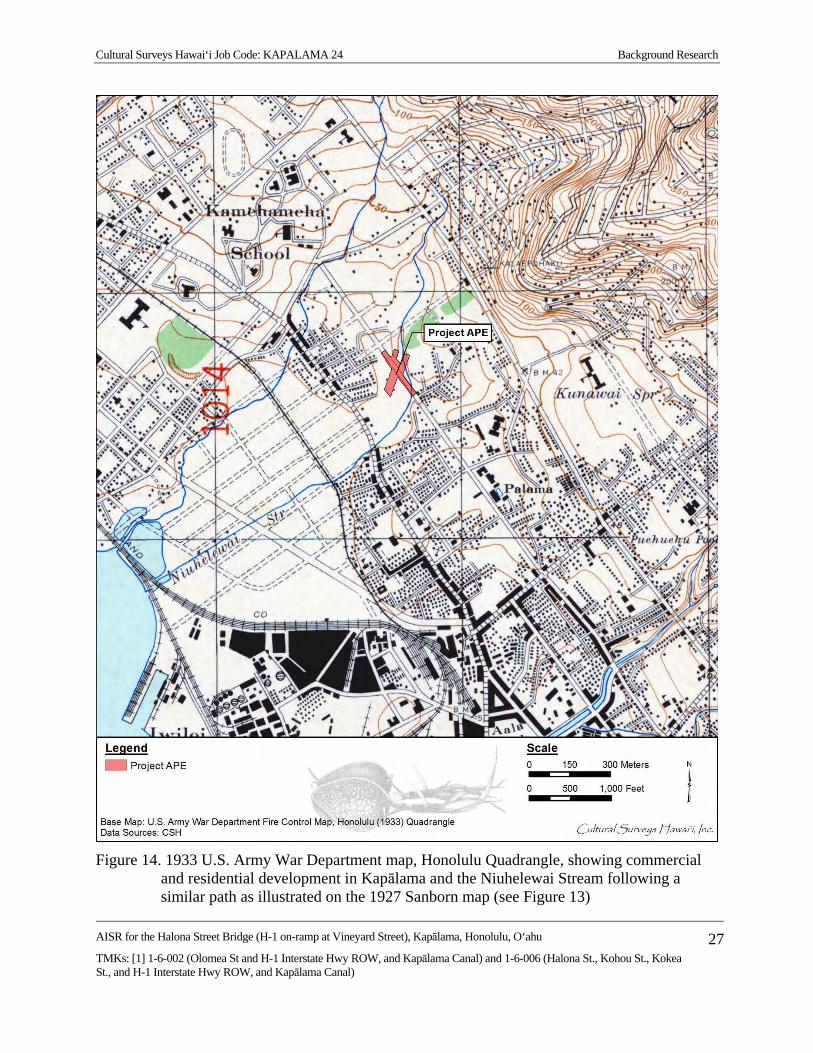
Cultural Surveys Hawai‘i Job Code: KAPALAMA 24 Background Research
AISR for the Halona Street Bridge (H-1 on-ramp at Vineyard Street), Kapālama, Honolulu, O‘ahu
TMKs: [1] 1-6-002 (Olomea St and H-1 Interstate Hwy ROW, and Kapālama Canal) and 1-6-006 (Halona St., Kohou St., Kokea St., and H-1 Interstate Hwy ROW, and Kapālama Canal)
27
Figure 14. 1933 U.S. Army War Department map, Honolulu Quadrangle, showing commercial
and residential development in Kapālama and the Niuhelewai Stream following a similar path as illustrated on the 1927 Sanborn map (see Figure 13)

Cultural Surveys Hawai‘i Job Code: KAPALAMA 24 Background Research
AISR for the Halona Street Bridge (H-1 on-ramp at Vineyard Street), Kapālama, Honolulu, O‘ahu
TMKs: [1] 1-6-002 (Olomea St and H-1 Interstate Hwy ROW, and Kapālama Canal) and 1-6-006 (Halona St., Kohou St., Kokea St., and H-1 Interstate Hwy ROW, and Kapālama Canal)
28
Figure 15. 1943 U.S. Army War Department map, Honolulu Quadrangle showing commercial
and residential development in Kapālama and the Niuhelewai Stream redirected into the Kapālama Drainage Canal (note map is georeferenced suggesting the canal is illustrated west of its current location)

Cultural Surveys Hawai‘i Job Code: KAPALAMA 24 Background Research
AISR for the Halona Street Bridge (H-1 on-ramp at Vineyard Street), Kapālama, Honolulu, O‘ahu
TMKs: [1] 1-6-002 (Olomea St and H-1 Interstate Hwy ROW, and Kapālama Canal) and 1-6-006 (Halona St., Kohou St., Kokea St., and H-1 Interstate Hwy ROW, and Kapālama Canal)
29
Figure 16. 1950 Sanborn Company Fire Insurance map showing additional development as well
as the Kapālama Drainage Canal extending through the project area in its present alignment

Cultural Surveys Hawai‘i Job Code: KAPALAMA 24 Background Research
AISR for the Halona Street Bridge (H-1 on-ramp at Vineyard Street), Kapālama, Honolulu, O‘ahu
TMKs: [1] 1-6-002 (Olomea St and H-1 Interstate Hwy ROW, and Kapālama Canal) and 1-6-006 (Halona St., Kohou St., Kokea St., and H-1 Interstate Hwy ROW, and Kapālama Canal)
30
Figure 17. 1952 USGS aerial photograph showing Kapālama Drainage Canal in its present
location and North Vineyard Boulevard extending through the project APE
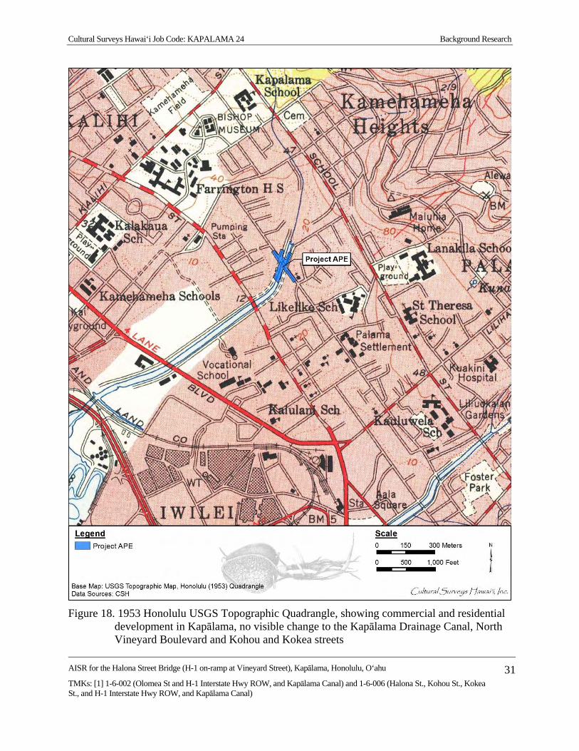
Cultural Surveys Hawai‘i Job Code: KAPALAMA 24 Background Research
AISR for the Halona Street Bridge (H-1 on-ramp at Vineyard Street), Kapālama, Honolulu, O‘ahu
TMKs: [1] 1-6-002 (Olomea St and H-1 Interstate Hwy ROW, and Kapālama Canal) and 1-6-006 (Halona St., Kohou St., Kokea St., and H-1 Interstate Hwy ROW, and Kapālama Canal)
31
Figure 18. 1953 Honolulu USGS Topographic Quadrangle, showing commercial and residential
development in Kapālama, no visible change to the Kapālama Drainage Canal, North Vineyard Boulevard and Kohou and Kokea streets

Cultural Surveys Hawai‘i Job Code: KAPALAMA 24 Background Research
AISR for the Halona Street Bridge (H-1 on-ramp at Vineyard Street), Kapālama, Honolulu, O‘ahu
TMKs: [1] 1-6-002 (Olomea St and H-1 Interstate Hwy ROW, and Kapālama Canal) and 1-6-006 (Halona St., Kohou St., Kokea St., and H-1 Interstate Hwy ROW, and Kapālama Canal)
32
Figure 19. 1978 USGS aerial photograph, Honolulu Quadrangle, showing commercial and
residential development in Kapālama, the completion of the H-1 freeway, Kohou and Kokea streets, and the modification to North Vineyard Boulevard near the project APE

Cultural Surveys Hawai‘i Job Code: KAPALAMA 24 Background Research
AISR for the Halona Street Bridge (H-1 on-ramp at Vineyard Street), Kapālama, Honolulu, O‘ahu
TMKs: [1] 1-6-002 (Olomea St and H-1 Interstate Hwy ROW, and Kapālama Canal) and 1-6-006 (Halona St., Kohou St., Kokea St., and H-1 Interstate Hwy ROW, and Kapālama Canal)
33
A 1933 U.S. Army War Department map (see Figure 14) continues the trend to greater density in grid-like residential blocks. On this map dashed lines, representing planned roads, are shown in the once empty space east of the Kamehameha Schools campus. North Vineyard Boulevard has been extended through the project APE. The area east of Niuhelewai Stream is also a densely packed neighborhood. This is in contrast to the Nu‘uanu area which still has large houses separated by large yards. A 1943 U.S. Army War Department map (see Figure 15) illustrates the density of homes along the street grids in lower and upper Kalihi-Kapālama. In upper Kalihi, Farrington High School has now taken the place of the Kamehameha Schools. The street grid east of the high school is still in the planning stages. Pālama has now become not only a residential area, but has commercial warehouses and stores, mainly lined along King Street. In Nu‘uanu many of the large houses and wide spaces between houses have been lost.
The construction of the Halona Street Bridge and Kapālama Drainage Canal located within the project APE was completed in 1938 and 1939, respectively. According to Ruzicka (2016):
The Halona Street Bridge, in its present five-span form, was built in 1938 by the City and County of Honolulu under Job No. 44-37. This 1938 construction added two, approximate 25' spans on each side of the existing center three spans (approximately 16' spans). At the time of this 1938 construction, it carried Vineyard Street across the canal and was called the Vineyard Street Bridge. The original construction date for the older, three span bridge is not known, but it is likely to be ca. 1930, which is the date of construction for the Dillingham Boulevard bridge, about one mile downstream from the Halona Street Bridge. The Dillingham Boulevard Bridge was built about eight years before the Kapalama Drainage Canal was built (1938). The canal banks at Dillingham are earth and not stabilized with retaining walls, as are the banks at Halona Street. It appears that the 1938 canal was built under the Dillingham Bridge without disturbing it. At Halona Street (Vineyard) in 1938 when the canal was built, the existing 3 span bridge was lengthened with two additional spans to cross the canal between its newly built lava rock retaining walls. The stabilization of the banks of the canal using the lava rock retaining walls was extended downstream to the King Street Bridge (1938). [Ruzicka 2016:10]
The Kapalama Drainage Canal was completed in February 1939 after about a year of construction by the Hawaiian Contracting Company. Planning for the canal dates to the early 1920s when the potential commercial value of the low-lying land of the Kapalama area was recognized. Beginning in 1924, dredging spoils from Honolulu Harbor were used to fill about 11 acres of a 58-acre section makai of Vineyard Street that had been condemned by the [Territorial] Board of Health as unsanitary. Spoils from the 1925-26 dredging of the Kapalama Basin were used to bring the remaining acreage up to grade level. Along with this filling project, the City and County of Honolulu formed a drainage plan to prevent heavy rains from inundating the new land. This design combined the two streams of the area, Niuhelewai and Kapalama in to the Kapalama Drainage Canal, that was ultimately routed along the approximate contour of Niuhelewai Stream.
The plans for the canal languished until late 1937 or early 1938, when construction got underway. The canal and stonework was accomplished under a Works Progress
Cultural Surveys Hawai‘i Job Code: KAPALAMA 24 Background Research
AISR for the Halona Street Bridge (H-1 on-ramp at Vineyard Street), Kapālama, Honolulu, O‘ahu
TMKs: [1] 1-6-002 (Olomea St and H-1 Interstate Hwy ROW, and Kapālama Canal) and 1-6-006 (Halona St., Kohou St., Kokea St., and H-1 Interstate Hwy ROW, and Kapālama Canal)
34
Administration (WPA) project that built the Kapalama Drainage Canal. A WPA grant of $310,000 partially funded the overall $670,000 cost of the canal. Most of the balance was funded by bond sales by the City and county of Honolulu and from the flood control fund of the city and county. [Ruzicka 2016:6]
The 1950 Sanborn Fire Insurance map depicts the density of houses and house lots located in the general vicinity of the project APE (see Figure 16). There are also large areas of vacant land within the project APE. The map does not show the northeast end of the bridge and retains a section of the ditch that appears to extend across the canal. According to a 1952 aerial photograph (see Figure 17) the ditch is absent and the northeast end of the bridge are present. The aerial photograph also shows substantial housing development near the project APE. Shown on both figures is the development of a portion of Kohou Street (Ala Ewa) and Kokea Street.
The 1953 USGS map (see Figure 18) illustrates the large number of schools and churches near the H-1 Interstate Highway corridor. Labeled are Fern School, Kalihi Waena School, Kalākaua School, St. Anthony’s School, and Pu‘uhale School. Lower Kalihi holds Farrington High School, Likelike, St. Theresa School, and the Kaiulani School in Kapālama. The Nu‘uanu survey area is near Kauluwala School, Kuakini Hospital, Liliuokalani Gardens, and Foster Park (Foster Botanical Garden).
As the project APE is located directly adjacent to the H-1 right-of-way, it is appropriate to give a little background on the history of H-1. It appears construction for the H-1 in the area of Kalihi-Kapālama started in 1960 from Fort Shafter to Houghtailing Street. Although this was not the place of origin for the H-1 system, it was the first time federal money was to be used in Hawai‘i for an Interstate system. Prior to 1960 the H-1 was called the Lunalilo Freeway. This early highway is shown on a 1978 aerial photograph (see Figure 19). The website AARoads has compiled a timeline for the H-1 construction (Table 1).
AARoads (2012) reports that, “Portions of H1 predate statehood, as an upgrade of Lunalilo Street, the freeway’s namesake. The oldest section, from Punahou Street east to King Street (Exits 23-25), was open before 1959. Originally signed as Hawaii 72.”
The Hawaiian Historical Society provides a timeline in a little more detail for the earliest stretch of H-1, the Mauka Arterial.
The pioneering highway in Hawai‘i was the Mauka Arterial (later christened Lunalilo Freeway). The three ‘Ewa-bound lanes, extending one mile between Old Wai‘alae Road and Alexander Street, were opened to traffic November 9, 1953. The Kaimuki-bound lanes along the same stretch were opened and the highway was formally dedicated on January 5, 1954. [Schmitt 2013]
The H-1 freeway project redesigned the alignment of North Vineyard Boulevard to only allow for one-way (westbound) traffic. As a result, the 1938 Halona Street Bridge was modified in 1963 by removing the southwest parapet in concert with the reduction of the roadway width for the construction of the adjacent H-1 freeway bridge immediately adjacent to the southwest (Ruzicka 2016).

Cultural Surveys Hawai‘i Job Code: KAPALAMA 24 Background Research
AISR for the Halona Street Bridge (H-1 on-ramp at Vineyard Street), Kapālama, Honolulu, O‘ahu
TMKs: [1] 1-6-002 (Olomea St and H-1 Interstate Hwy ROW, and Kapālama Canal) and 1-6-006 (Halona St., Kohou St., Kokea St., and H-1 Interstate Hwy ROW, and Kapālama Canal)
35
Table 1. Construction Timeline of Hawaii 72, Later Renumbered as H-1 Interstate Highway
Year Development
1953 First section of the Mauka Arterial opened; Mauka Arterial was approximately a mile section around University Avenue, present-day Mile 24
1959 At statehood, first section of what is now called Lunalilo Freeway opened between Punahou St (Mile 23) and King St (Mile 25); maps show proposed route from Punahou St west to Middle St (present H-1/H-201 interchange)
1960 Lunalilo Freeway extended west to Ke‘eaumoku St (approx. 1/2 mile west of Punahou St); section of present-day H-201 opened through Fort Shafter, signed as Hawaii 72; sections from Fort Shafter east to Houghtailing St (Exit 20B) and Pali Hwy interchange (exit 21A/B) under construction
1961 Open sections are Pu‘uloa Rd (present-day H-201) to Houghtailing St (Exit 20B), Pali Hwy interchange, and Ke‘eaumoku St to King St
1963 Halona Street Bridge modified and N. Vineyard Blvd narrowed 1964 Section from Kapahulu St (Mile 25) east to Koko Head Ave (Exit 26A) under
construction 1965 Kapahulu St to Koko Head Ave opened; short 1/2 mile section under construction,
filling gap in existing freeway sections between King St and Kapahulu St 1967 H-1 first appears on maps, cosigned with Hawaii 72; freeway continuous from Pu‘uloa
Rd east to Pele St (just east of Pali Hwy, Hawaii 61), as well as existing sections from Ke‘eaumoku St to King St and Kapahulu St to Koko Head Ave; western section between Kunia Rd and Kamehameha Hwy (Exits 5 through Exit 8A) open, with section between Miles 0 and 5 under construction
1968 Gap between King St and Kapahulu St opened; H-1 extended east to present terminus east of Kilauea Ave; still a gap between Pele and Ke‘eaumoku Streets
1972 H-1 opened from Kamehameha Hwy (Western terminus) to Kaimakani St, immediately west of Hālawa interchange; Hālawa interchange and sections of H-1 to Middle St proposed; from Middle St east to Kilauea Ave completed freeway; Hawaii 72 truncated at eastern end of H-1; orphaned section between Pu‘uloa Rd and Middle St is re-signed as Hawaii 78
1986 H-1 completed between Nimitz Hwy and Middle St (Miles 18-19); through lanes of H-1 east use Middle St tunnel, completed in 1961 for Middle St off-ramp

Cultural Surveys Hawai‘i Job Code: KAPALAMA 24 Background Research
AISR for the Halona Street Bridge (H-1 on-ramp at Vineyard Street), Kapālama, Honolulu, O‘ahu
TMKs: [1] 1-6-002 (Olomea St and H-1 Interstate Hwy ROW, and Kapālama Canal) and 1-6-006 (Halona St., Kohou St., Kokea St., and H-1 Interstate Hwy ROW, and Kapālama Canal)
36
Previous Archaeological Research Development within a 0.8 km (0.5 mile) radius of the project APE is primarily residential with
some light industry. Most of the development in the area, including the H-1 Interstate Highway corridor itself, has occurred prior to the late 1970s when archaeological investigation became standard during project planning and construction activities. The locations of previous archaeological studies conducted within a 0.8 km (0.5 mile) radius of the project APE are shown in Figure 20 and listed in Table 2. The findings of these archaeological studies are shown in Figure 21 and listed in Table 3. These studies and their findings are discussed in more detail in the following paragraphs.
3.2.1 Palama Fire Station (Neller 1980)
During excavations at the Palama Fire Station in September 1980, the SHPD made a site visit to the project. A large charcoal deposit was observed in an excavation sidewall which contained several basalt cobbles. No further information was obtained due to the backfilling of the excavation prior to the SHPD’s return to document the feature. It could not be determined whether the deposit represented a historic feature or a traditional imu (earth oven) pit; however, no historic artifacts were observed in association with the feature.
3.2.2 Dunn et al. 1991
During archaeological monitoring conducted by Paul H. Rosendahl, Inc. (PHRI) at the Palama Chevron Station, highly fragmented human skeletal remains were observed (Dunn et al. 1991). The minimum number of individuals (MNI) appeared to be five—but this was not altogether clear. Of interest was the following comment:
A parishioner of Kaumakapili Church mentioned to PHRI field personnel that the survey area was once a cemetery. Mr. Tom Dye of the DLNR [Department of Land and Natural Resources] said that older residents of the area had once mentioned that when they were younger they regarded the area as ‘spooky,’ and that this may be attributable to the fact that they had heard there were burials in the area. [Dunn et al. 1991:10]
Fragmentary human skeletal remains were reported at 80 cm below surface, 105 cm below surface, and 120 cm below surface (Dunn et al. 1991:1, 4).
3.2.3 Bishop Museum (Dixon 1993)
This archaeological monitoring project at the Bishop Museum took place during installation of electrical service for the Space Exhibit in August 1992. Museum staff recognized the potential for subsurface pre- and post-Contact Hawaiian cultural material and human remains as well as the possibility of early historic material on museum property. Stratigraphy and back dirt was observed during mechanical trenching conducted on the Great Lawn. Dixon found no evidence of pre-Contact deposits; however, some historic artifacts were found in a fill layer possibly dating back to the Kamehameha Schools period and given State Inventory of Historic Places (SIHP) # 50-80-14-1353 and Bishop Museum site number 50-Oa-A6-26.

Cultural Surveys Hawai‘i Job Code: KAPALAMA 24 Background Research
AISR for the Halona Street Bridge (H-1 on-ramp at Vineyard Street), Kapālama, Honolulu, O‘ahu
TMKs: [1] 1-6-002 (Olomea St and H-1 Interstate Hwy ROW, and Kapālama Canal) and 1-6-006 (Halona St., Kohou St., Kokea St., and H-1 Interstate Hwy ROW, and Kapālama Canal)
37
Figure 20. Previous archaeological studies within a 0.8 km (0.5 mile) radius of the project APE
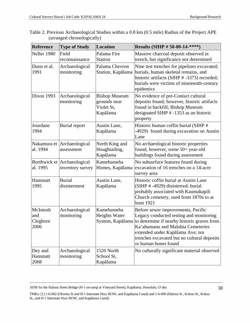
Cultural Surveys Hawai‘i Job Code: KAPALAMA 24 Background Research
AISR for the Halona Street Bridge (H-1 on-ramp at Vineyard Street), Kapālama, Honolulu, O‘ahu
TMKs: [1] 1-6-002 (Olomea St and H-1 Interstate Hwy ROW, and Kapālama Canal) and 1-6-006 (Halona St., Kohou St., Kokea St., and H-1 Interstate Hwy ROW, and Kapālama Canal)
38
Table 2. Previous Archaeological Studies within a 0.8 km (0.5 mile) Radius of the Project APE (arranged chronologically)
Reference Type of Study Location Results (SIHP # 50-80-14-****)
Neller 1980 Field reconnaissance
Palama Fire Station
Massive charcoal deposit observed in trench, but significance not determined
Dunn et al. 1991
Archaeological monitoring
Palama Chevron Station, Kapālama
Nine test trenches for pipelines excavated; burials, human skeletal remains, and historic artifacts (SIHP # -3373) recorded; burials were victims of nineteenth-century epidemics
Dixon 1993 Archaeological monitoring
Bishop Museum grounds near Violet St, Kapālama
No evidence of pre-Contact cultural deposits found; however, historic artifacts found in backfill; Bishop Museum designated SIHP # -1353 as an historic property
Jourdane 1994
Burial report Austin Lane, Kapālama
Historic human coffin burial (SIHP # -4929) found during excavation on Austin Lane
Nakamura et al. 1994
Archaeological assessment
North King and Houghtailing, Kapālama
No archaeological historic properties found, however, some 50+ year-old buildings found during assessment
Borthwick et al. 1995
Archaeological inventory survey
Kamehameha Homes, Kapālama
No subsurface features found during excavation of 16 trenches on a 14-acre survey area
Hammatt 1995
Burial disinterment
Austin Lane, Kapālama
Historic coffin burial at Austin Lane (SIHP # -4929) disinterred; burial probably associated with Kaumakapili Church cemetery, used from 1870s to at least 1921
McIntosh and Cleghorn 2006
Archaeological monitoring
Kamehameha Heights Water System, Kapālama
Before sewer improvements, Pacific Legacy conducted testing and monitoring to determine if nearby historic graves from Ka‘ahumanu and Maluhia Cemeteries extended under Kapālama Ave; ten trenches excavated but no cultural deposits or human bones found
Dey and Hammatt 2008
Archaeological monitoring
1520 North School St, Kapālama
No culturally significant material observed
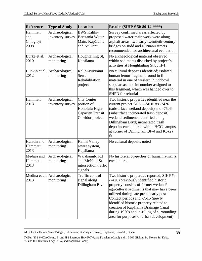
Cultural Surveys Hawai‘i Job Code: KAPALAMA 24 Background Research
AISR for the Halona Street Bridge (H-1 on-ramp at Vineyard Street), Kapālama, Honolulu, O‘ahu
TMKs: [1] 1-6-002 (Olomea St and H-1 Interstate Hwy ROW, and Kapālama Canal) and 1-6-006 (Halona St., Kohou St., Kokea St., and H-1 Interstate Hwy ROW, and Kapālama Canal)
39
Reference Type of Study Location Results (SIHP # 50-80-14-****)
Hammatt and Chiogioji 2008
Archaeological inventory survey
BWS Kalihi-Beretania Water Main, Kapālama and Nu‘uanu
Survey confirmed areas affected by proposed water main work were along asphalt areas; two early twentieth-century bridges on Judd and Nu‘uanu streets recommended for architectural evaluation
Burke et al. 2010
Archaeological monitoring
Houghtailing St, Kapālama
No archaeological material observed within sediments disturbed by project’s activities at Houghtailing St by H-1
Hunkin et al. 2012
Archaeological monitoring
Kalihi-Nu‘uanu Sewer Rehabilitation project
No cultural deposits identified; isolated human femur fragment found in fill material in one of western Punchbowl slope areas; no site number assigned to this fragment, which was handed over to SHPD for reburial
Hammatt 2013
Archaeological inventory survey
City Center portion of Honolulu High-Capacity Transit Corridor project
Two historic properties identified near the current project APE —SIHP #s -7426 (subsurface wetland deposit) and -7506 (subsurface incinerated trash deposit); wetland sediments identified along Dillingham Blvd; incinerated trash deposits encountered within HCC campus at corner of Dillingham Blvd and Kokea St
Hunkin and Hammatt 2013
Archaeological monitoring
Kalihi Valley sewer system, Kapālama
No cultural deposits noted
Medina and Hammatt 2013
Archaeological monitoring
Waiakamilo Rd and McNeill St intersection traffic signals
No historical properties or human remains encountered
Medina et al. 2013
Archaeological monitoring
Traffic control signal along Dillingham Blvd
Two historic properties reported, SIHP #s -7426 (previously identified historic property consists of former wetland/ agricultural sediments that may have been utilized during late pre-to early post-Contact period) and -7515 (newly identified historic property related to creation of Kapālama Drainage Canal during 1920s and in-filling of surrounding area for purposes of urban development)
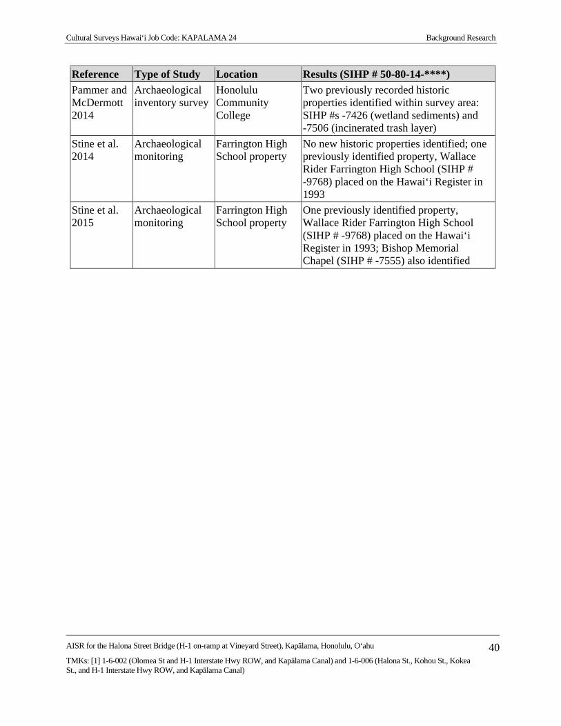
Cultural Surveys Hawai‘i Job Code: KAPALAMA 24 Background Research
AISR for the Halona Street Bridge (H-1 on-ramp at Vineyard Street), Kapālama, Honolulu, O‘ahu
TMKs: [1] 1-6-002 (Olomea St and H-1 Interstate Hwy ROW, and Kapālama Canal) and 1-6-006 (Halona St., Kohou St., Kokea St., and H-1 Interstate Hwy ROW, and Kapālama Canal)
40
Reference Type of Study Location Results (SIHP # 50-80-14-****)
Pammer and McDermott 2014
Archaeological inventory survey
Honolulu Community College
Two previously recorded historic properties identified within survey area: SIHP #s -7426 (wetland sediments) and -7506 (incinerated trash layer)
Stine et al. 2014
Archaeological monitoring
Farrington High School property
No new historic properties identified; one previously identified property, Wallace Rider Farrington High School (SIHP # -9768) placed on the Hawai‘i Register in 1993
Stine et al. 2015
Archaeological monitoring
Farrington High School property
One previously identified property, Wallace Rider Farrington High School (SIHP # -9768) placed on the Hawai‘i Register in 1993; Bishop Memorial Chapel (SIHP # -7555) also identified
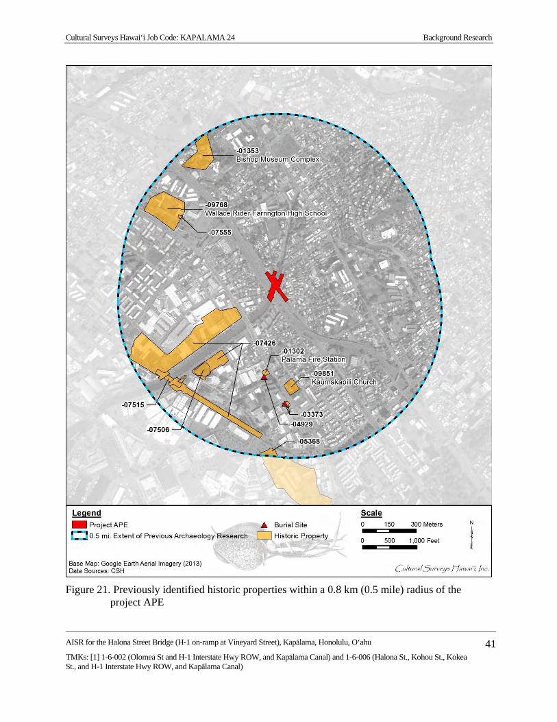
Cultural Surveys Hawai‘i Job Code: KAPALAMA 24 Background Research
AISR for the Halona Street Bridge (H-1 on-ramp at Vineyard Street), Kapālama, Honolulu, O‘ahu
TMKs: [1] 1-6-002 (Olomea St and H-1 Interstate Hwy ROW, and Kapālama Canal) and 1-6-006 (Halona St., Kohou St., Kokea St., and H-1 Interstate Hwy ROW, and Kapālama Canal)
41
Figure 21. Previously identified historic properties within a 0.8 km (0.5 mile) radius of the
project APE

Cultural Surveys Hawai‘i Job Code: KAPALAMA 24 Background Research
AISR for the Halona Street Bridge (H-1 on-ramp at Vineyard Street), Kapālama, Honolulu, O‘ahu
TMKs: [1] 1-6-002 (Olomea St and H-1 Interstate Hwy ROW, and Kapālama Canal) and 1-6-006 (Halona St., Kohou St., Kokea St., and H-1 Interstate Hwy ROW, and Kapālama Canal)
42
Table 3. Previously Identified Historic Properties within a 0.8 km (0.5 mile) Radius of the Project APE
SIHP # Site Type/ Name Source
50-80-14-1302 Palama Fire Station Neller 1980 50-80-14-1353 Bishop Museum complex Dixon 1993 50-80-14-3373 Subsurface cultural deposit, burial Dunn et al. 1991 50-80-14-4929 Burial (coffin) Jourdane 1994; Hammatt 1995 50-80-14-5368 Kūwili Fishpond McDermott and Mann 2001 50-80-14-7426 Subsurface wetland sediments Hammatt 2013, Medina et al. 2013 50-80-14-7506 Subsurface incinerated trash deposit Hammatt, 2013; Pammer and
McDermott 2014 50-80-14-7515 Subsurface dredge sediment Medina et al. 2013 50-80-14-7555 Bishop Memorial Chapel Stine et al. 2015 50-80-14-9768 Wallace Rider Farrington High School Hawai‘i Register Nomination form 50-80-14-9851 Kaumakapili Church Hawai‘i Register Nomination form
Cultural Surveys Hawai‘i Job Code: KAPALAMA 24 Background Research
AISR for the Halona Street Bridge (H-1 on-ramp at Vineyard Street), Kapālama, Honolulu, O‘ahu
TMKs: [1] 1-6-002 (Olomea St and H-1 Interstate Hwy ROW, and Kapālama Canal) and 1-6-006 (Halona St., Kohou St., Kokea St., and H-1 Interstate Hwy ROW, and Kapālama Canal)
43
3.2.4 Austin Lane, Kapālama (Jourdane 1994; Hammatt 1995)
A coffin burial was found during construction of a water line on Austin Lane and reported to the SHPD (Jourdane 1994). CSH (Hammatt 1995) conducted background on the property and disinterred the burial. The human remains, designated SIHP # 50-80-14-4929, were turned over to the SHPD for reburial.
3.2.5 Corner of North King and Houghtailing Streets (Nakamura et al. 1994)
The Bernice Pauahi Bishop Museum carried out an archaeological assessment of land in Kapālama on the corner of North King and Houghtailing streets (Nakamura et al. 1994). Background research identified no archaeological sites within the survey area. Research indicated pre- and early post-Contact use of the area for agriculture but suggested that disturbance in the area from urbanization in the 1900s had reduced the possibility of finding intact deposits from an earlier time.
3.2.6 Kamehameha Homes Project, Kapālama (Borthwick et al. 1995)
CSH (Borthwick et al. 1995) carried out an archaeological subsurface inventory survey of the Kamehameha Homes project in Kapālama. The crew excavated 16 trenches spaced to provide adequate coverage of the 13.96-acre survey area. All of the trenches exposed a landscape layer associated with bulldozer terracing of the area. No significant finds were reported.
3.2.7 Kamehameha Heights, Puea and Ka‘ahumanu Cemeteries (McIntosh and Cleghorn 2006)
In 2006, Pacific Legacy, Inc. conducted pre-construction testing along the outer peripheries of the Puea and Ka‘ahumanu cemeteries before improvements were made to the Kamehameha Heights water system, due to concerns that unmarked graves could lie outside the modern boundary of the cemeteries. No cultural deposits or human remains were found in the ten test trenches along the north and east streets bounding the cemeteries.
3.2.8 Walgreens Development Project, North School Street (Dey and Hammatt 2008)
In 2008, CSH completed an archaeological monitoring program for a Walgreens development project. Background research identified no historic sites, a low potential for pre-Contact or early post-Contact Hawaiian cultural remains, and a low to moderate potential for early historic remains. Subsequent fieldwork confirmed a lack of pre-Contact or early post-Contact cultural material within that survey area.
3.2.9 Kalihi Beretania 24-Inch Water Main Project (Hammatt and Chiogioji 2008)
CSH carried out an archaeological inventory survey of the proposed Board of Water Supply Kalihi Beretania 24-Inch Water Main project in Nu‘uanu and Kapālama. No prehistoric properties were identified within the survey area. The study also emphasized the need to consider the Judd Street and Nu‘uanu Avenue bridges as historic properties. Background research showed the survey area to be part of an expansive agricultural system during the pre- and early post-Contact period. As the survey area was confined to roadway corridors, subsequent testing revealed mostly grading and fill disturbance from roadway construction and utility trenching. No pre- or early post-Contact cultural material was observed during archaeological testing within the survey area.

Cultural Surveys Hawai‘i Job Code: KAPALAMA 24 Background Research
AISR for the Halona Street Bridge (H-1 on-ramp at Vineyard Street), Kapālama, Honolulu, O‘ahu
TMKs: [1] 1-6-002 (Olomea St and H-1 Interstate Hwy ROW, and Kapālama Canal) and 1-6-006 (Halona St., Kohou St., Kokea St., and H-1 Interstate Hwy ROW, and Kapālama Canal)
44
3.2.10 Traffic Management System Project, Houghtailing Street by the H-1 (Burke et al. 2010)
In 2010, CSH completed an archaeological monitoring program for a Traffic Management System PH 1 project. Background research identified no sites but suggested a potential for early historic remains. Subsequent field monitoring produced no significant finds within the survey area.
3.2.11 Kalihi/Nu‘uanu Sewer Rehabilitation Project (Hunkin et al. 2012)
In 2012, CSH conducted monitoring for the Kalihi-Nu‘uanu Sewer project. No cultural deposits were identified in any of the monitored excavation trenches. One isolated human femur fragment was found in fill material in one of the western Punchbowl slope areas. No site number was assigned to this fragment, which was handed over to the SHPD for reburial.
3.2.12 Honolulu High-Capacity Transit Corridor Project (Hammatt 2013)
CSH conducted AIS testing for the Honolulu High-Capacity Transit Corridor project (City Center) within numerous locations between Middle Street and Ala Moana Center. Testing identified multiple sites, two of which were identified near the current project APE—SIHP #s -7426 (subsurface wetland deposit) and -7506 (subsurface incinerated trash deposit). The wetland sediments were identified within 28 AIS test excavations along Dillingham Boulevard, makai of the current project (T-054 through T-082). The incinerated trash deposits were encountered within three test excavations (T-064, T-066, and T-067) within the HCC campus at the corner of Dillingham Boulevard and Kokea Street.
3.2.13 Kalihi Valley Sewer System Improvements, Kapālama (Hunkin and Hammatt 2013)
In 2013, CSH monitored a portion of the Kalihi Valley Sewer System Improvement project near the junction of Houghtailing Street and North School Street in Kalihi. Due to the survey area’s close proximity to Ka‘ahumanu, Puea, and Maluhia Cemeteries, project proponents decided to enact a monitoring project for the installation of two water lines to mitigate any adverse effect to historic properties or burials in the survey area. No cultural deposits or historic properties were present during excavations. The stratigraphy consisted of various layers of imported fill associated with historic and modern development overlying naturally deposited sediment and bedrock.
3.2.14 Medina and Hammatt 2013
In 2013, CSH (Medina and Hammatt 2013) reported on the results of archaeological monitoring for traffic control signal improvements for the Waiakamilo Road and McNeill Street intersection. No historical properties or human remains were encountered as a result of construction activities.
3.2.15 Traffic Control Signal Improvements along Dillingham Boulevard (Medina et al. 2013)
In 2013, CSH (Medina et al. 2013) reported on the results of archaeological monitoring for traffic control signal improvements along Dillingham Boulevard between Kokea Street and Kohou Street, involving excavations within city streets and sidewalks for subsurface electrical lines, conduits, and boxes. Two historic properties were observed during the course of archaeological monitoring consisting of SIHP #s -7426, a previously identified historic property consisting of former wetland/agricultural sediments that may have been utilized during the late pre-to early post-Contact period, and -7515, a newly identified historic property related to the creation of Kapālama Drainage Canal during the 1920s and the in-filling of the surrounding area for the purposes of urban development.

Cultural Surveys Hawai‘i Job Code: KAPALAMA 24 Background Research
AISR for the Halona Street Bridge (H-1 on-ramp at Vineyard Street), Kapālama, Honolulu, O‘ahu
TMKs: [1] 1-6-002 (Olomea St and H-1 Interstate Hwy ROW, and Kapālama Canal) and 1-6-006 (Halona St., Kohou St., Kokea St., and H-1 Interstate Hwy ROW, and Kapālama Canal)
45
3.2.16 Honolulu Community College (Pammer and McDermott 2014)
In 2013, CSH conducted an archaeological inventory survey on the campus of Honolulu Community College. A total of eight backhoe-assisted excavations were excavated to assess the stratigraphy and determine the potential for buried archaeological deposits. Two previously recorded historic properties were identified with the survey area, SIHP #s -7526 (wetland sediments) and -7506 (incinerated trash deposit). Both sites were assessed as significant under criterion “d,” but no further work was recommended.
3.2.17 Farrington High School (Stine et al. 2014 and Stine et al. 2015)
In 2012, CSH (Stine et al. 2015) conducted archaeological monitoring for renovations at Farrington High School (SIHP # -9768), placed on the Hawai‘i Register in 1993. Fieldwork was conducted from 24 January to 21 February 2012. A foundation associated with the former Bishop Memorial Chapel, demolished in 1954, was identified and partially removed (SIHP # -7555).
In 2012, CSH conducted archaeological monitoring for renovations and replacements of electrical vaults and lines at Farrington High School. Fieldwork was conducted from 27–29 June 2012. No new historic properties were identified. One previously identified property, Wallace Rider Farrington High School (SIHP # -9768) was placed on the Hawai‘i Register in 1993. No significant cultural material or human remains were observed during monitoring.
Background Summary and Predictive Model Based on background research, the primary area of traditional Hawaiian settlement and
intensive agriculture within Kapālama seems to have been in the upper valleys, as well as near streams and springs. The project sits within the central area of Kapālama along the drainage of Kapālama and Niuhelewai streams. Historically, agriculture and habitation were intensive in this area. Historically, the area encompassed by the survey area was used for rice cultivation, but immediate habitation within the survey area does not seem to have been prevalent.
Traditional Hawaiian land use indicated in the adjacent land commission awards (LCAs) documentation consisted of habitation, irrigated taro fields (lo‘i), kula (dryland plots used for cultivation and/or pasture), and aquaculture via fishponds. The majority of kuleana land claims located near the project APE were located near the freshwater sources of Kalihi and Niuhelewai streams as they were the most arable sources of land. This is the area described as an uncultivated plain in John Papa ‘Ī‘ī’s (1959) account of the area in 1810, until you reached “the taro patches of Kalihi.” Major strife is indicated ca. 1782 in the defeat of the O‘ahu ruling chief Kahāhana when the dead backed up the lagoonal backwaters (muliwai) of Niuhelewai Stream—but this may have been well seaward of the project APE. Another uncertainty pertains to the indicated ca. 1855 burial ground on the plains of Kaiwi‘ula which may have been near the project APE.
By the twentieth century, the coastal and central sections of Kapālama had become suburbs of Honolulu. Much development in Kapālama primarily occurred prior to the late 1970s when archaeological investigation became standard during construction activities. As a result, few archaeological studies have been conducted in this area. No previously recorded archaeological sites are located within or directly adjacent to the project APE.
Cultural Surveys Hawai‘i Job Code: KAPALAMA 24 Background Research
AISR for the Halona Street Bridge (H-1 on-ramp at Vineyard Street), Kapālama, Honolulu, O‘ahu
TMKs: [1] 1-6-002 (Olomea St and H-1 Interstate Hwy ROW, and Kapālama Canal) and 1-6-006 (Halona St., Kohou St., Kokea St., and H-1 Interstate Hwy ROW, and Kapālama Canal)
46
In the early twentieth century, the area near the project APE began to be developed. The Niuhelewai Stream had been ditched and diverted in various forms historically. With the extension of North Vineyard Boulevard, historic infrastructure such as the Halona Street Bridge and the Kapālama Drainage Canal were constructed to accommodate the growing urbanization of the area. The Niuhelewai Stream and the nearby Kapālama Stream were channelized into the Kapālama Drainage Canal, completed in 1939. The Halona Street Bridge was completed in 1938 and the Kapālama Drainage Canal allowed the (at the time) two-way North Vineyard Boulevard to pass over the canal. In 1963, for the construction of the H-1 freeway, which extends directly adjacent to the project APE, the Halona Street Bridge was modified to provide space for the H-1 Bridge still extant. As a result, North Vineyard Boulevard was narrowed into a one-way, two-lane road.
It is anticipated that portions of the Kapālama Canal and the Halona Street Bridge are located within the project APE. The large-scale construction of major engineering projects in the project APE, historically, suggests natural and cultural subsurface deposits, if present, are likely heavily disturbed or removed in the majority of the project area, with the exception of the areas beneath Kohou and Kokea streets. These areas, however, are likely well below the ground surface under substantial fill deposits. Specifically, the areas in the immediate vicinity of the H-1 freeway and the Halona Street Bridge are likely heavily disturbed.
Cultural Surveys Hawai‘i Job Code: KAPALAMA 24 Results of Fieldwork
AISR for the Halona Street Bridge (H-1 on-ramp at Vineyard Street), Kapālama, Honolulu, O‘ahu
TMKs: [1] 1-6-002 (Olomea St and H-1 Interstate Hwy ROW, and Kapālama Canal) and 1-6-006 (Halona St., Kohou St., Kokea St., and H-1 Interstate Hwy ROW, and Kapālama Canal)
47
Section 4 Results of Fieldwork
A 100% pedestrian inspection of the project APE in conjunction with GPS data collection was conducted on 19 September 2014 by Joanne DeMaio Starr, M.A. and Nifae Hunkin, B.A under the general supervision of principal investigator, Hallett H. Hammatt, PhD. The pedestrian inspection was conducted per the methods described in Section 2.1. The pedestrian inspection included the documentation of two historic properties within the project APE and a description of the overall project APE including ground visibility, modern use or disturbance, and vegetation.
The project APE includes the Halona Street Bridge (SIHP # -7807) and portions of the Kapālama Drainage Canal (SIHP # -7808), both of which were constructed in the early part of the twentieth century. The Halona Street Bridge is a continuous concrete cast-in-place bridge constructed in 1938. The Kapālama Drainage Canal is a channelized drainage that extends through urban Honolulu and is used to control the runoff from both Niuhelewai and Kapālama streams. Complete descriptions of these historic properties are provided in Section 5.
The project APE also includes a portion of Halona Street, which is the former extension of Vineyard Boulevard that was replaced by a portion of the H-1 Interstate Highway in the 1960s. The total extent of Halona Street includes approximately 0.9 km of two-lane, asphalt paved roadway extending one way from Vineyard Boulevard at the entrance of Likelike Elementary School in the southeast to the intersection of Houghtailing Street to the northwest.
The project APE is completely developed. The only vegetation present within the project APE includes small portions of mowed grass islands along the Kapālama Drainage Canal and between Halona Street and the westbound lanes of the H-1 Interstate.

Cultural Surveys Hawai‘i Job Code: KAPALAMA 24 Historic Property Descriptions
AISR for the Halona Street Bridge (H-1 on-ramp at Vineyard Street), Kapālama, Honolulu, O‘ahu
TMKs: [1] 1-6-002 (Olomea St and H-1 Interstate Hwy ROW, and Kapālama Canal) and 1-6-006 (Halona St., Kohou St., Kokea St., and H-1 Interstate Hwy ROW, and Kapālama Canal)
48
Section 5 Historic Property Descriptions
Two historic properties were identified within the project APE. They are summarized in Table 4 and depicted on Figure 22 and Figure 23.
Table 4. Sites Identified within the Project APE
SIHP # Formal Type Function
50-80-14-7807 Bridge (Halona Street Bridge) Transportation 50-80-14-7808 Canal (Kapālama Drainage Canal) Water Control

Cultural Surveys Hawai‘i Job Code: KAPALAMA 24 Historic Property Descriptions
AISR for the Halona Street Bridge (H-1 on-ramp at Vineyard Street), Kapālama, Honolulu, O‘ahu
TMKs: [1] 1-6-002 (Olomea St and H-1 Interstate Hwy ROW, and Kapālama Canal) and 1-6-006 (Halona St., Kohou St., Kokea St., and H-1 Interstate Hwy ROW, and Kapālama Canal)
49
Figure 22. 2013 Google Earth aerial photograph showing the locations of historic properties
identified within the project APE
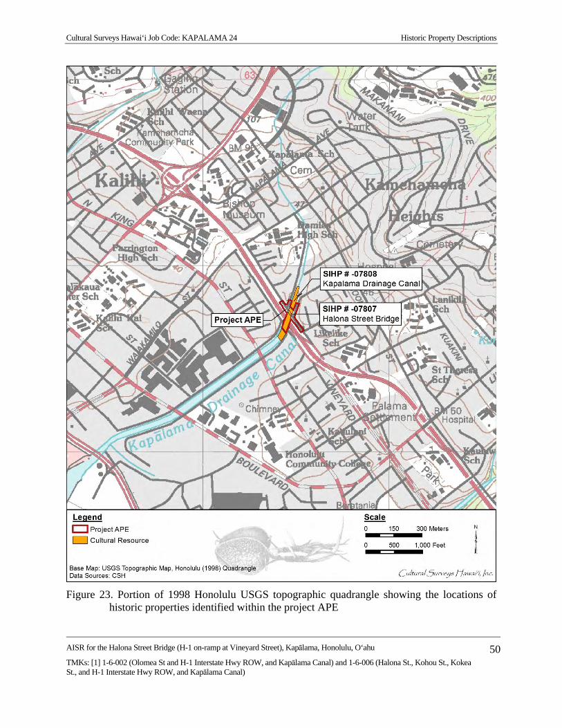
Cultural Surveys Hawai‘i Job Code: KAPALAMA 24 Historic Property Descriptions
AISR for the Halona Street Bridge (H-1 on-ramp at Vineyard Street), Kapālama, Honolulu, O‘ahu
TMKs: [1] 1-6-002 (Olomea St and H-1 Interstate Hwy ROW, and Kapālama Canal) and 1-6-006 (Halona St., Kohou St., Kokea St., and H-1 Interstate Hwy ROW, and Kapālama Canal)
50
Figure 23. Portion of 1998 Honolulu USGS topographic quadrangle showing the locations of
historic properties identified within the project APE
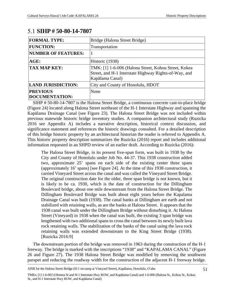
Cultural Surveys Hawai‘i Job Code: KAPALAMA 24 Historic Property Descriptions
AISR for the Halona Street Bridge (H-1 on-ramp at Vineyard Street), Kapālama, Honolulu, O‘ahu
TMKs: [1] 1-6-002 (Olomea St and H-1 Interstate Hwy ROW, and Kapālama Canal) and 1-6-006 (Halona St., Kohou St., Kokea St., and H-1 Interstate Hwy ROW, and Kapālama Canal)
51
SIHP # 50-80-14-7807
FORMAL TYPE: Bridge (Halona Street Bridge) FUNCTION: Transportation NUMBER OF FEATURES: 1
AGE: Historic (1938) TAX MAP KEY: TMK: [1] 1-6-006 (Halona Street, Kohou Street, Kokea
Street, and H-1 Interstate Highway Rights-of-Way, and Kapālama Canal)
LAND JURISDICTION: City and County of Honolulu, HDOT PREVIOUS DOCUMENTATION:
None
SIHP # 50-80-14-7807 is the Halona Street Bridge, a continuous concrete cast-in-place bridge (Figure 24) located along Halona Street northeast of the H-1 Interstate Highway and spanning the Kapālama Drainage Canal (see Figure 23). The Halona Street Bridge was not included within previous statewide historic bridge inventory studies. A companion architectural study (Ruzicka 2016 see Appendix A) includes a narrative description, historical context discussion, and significance statement and references the historic drawings consulted. For a detailed description of this bridge historic property by an architectural historian the reader is referred to Appendix A. This historic property description summarizes the Ruzicka (2016) report and includes additional information requested in an SHPD review of an earlier draft. According to Ruzicka (2016):
The Halona Street Bridge, in its present five-span form, was built in 1938 by the City and County of Honolulu under Job No. 44-37. This 1938 construction added two, approximate 25’ spans on each side of the existing center three spans (approximately 16’ spans) [see Figure 24]. At the time of this 1938 construction, it carried Vineyard Street across the canal and was called the Vineyard Street Bridge. The original construction date for the older, three span bridge is not known, but it is likely to be ca. 1930, which is the date of construction for the Dillingham Boulevard bridge, about one mile downstream from the Halona Street Bridge. The Dillingham Boulevard Bridge was built about eight years before the Kapalama Drainage Canal was built (1938). The canal banks at Dillingham are earth and not stabilized with retaining walls, as are the banks at Halona Street. It appears that the 1938 canal was built under the Dillingham Bridge without disturbing it. At Halona Street (Vineyard) in 1938 when the canal was built, the existing 3 span bridge was lengthened with two additional spans to cross the canal between its newly built lava rock retaining walls. The stabilization of the banks of the canal using the lava rock retaining walls was extended downstream to the King Street Bridge (1938). [Ruzicka 2016:9]
The downstream portion of the bridge was removed in 1963 during the construction of the H-1 freeway. The bridge is marked with the inscriptions “1938” and “KAPALAMA CANAL” (Figure 26 and Figure 27). The 1938 Halona Street Bridge was modified by removing the southwest parapet and reducing the roadway width for the construction of the adjacent H-1 freeway bridge.
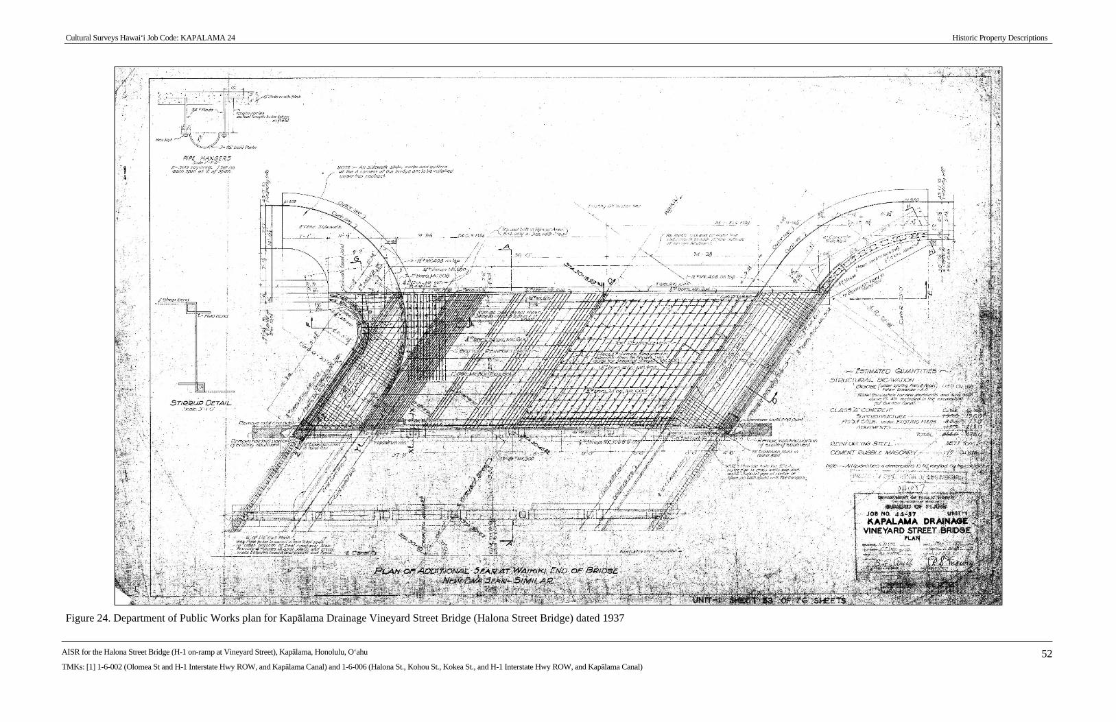
Cultural Surveys Hawai‘i Job Code: KAPALAMA 24 Historic Property Descriptions
AISR for the Halona Street Bridge (H-1 on-ramp at Vineyard Street), Kapālama, Honolulu, O‘ahu
TMKs: [1] 1-6-002 (Olomea St and H-1 Interstate Hwy ROW, and Kapālama Canal) and 1-6-006 (Halona St., Kohou St., Kokea St., and H-1 Interstate Hwy ROW, and Kapālama Canal) 52
Figure 24. Department of Public Works plan for Kapālama Drainage Vineyard Street Bridge (Halona Street Bridge) dated 1937

Cultural Surveys Hawai‘i Job Code: KAPALAMA 24 Historic Property Descriptions
AISR for the Halona Street Bridge (H-1 on-ramp at Vineyard Street), Kapālama, Honolulu, O‘ahu
TMKs: [1] 1-6-002 (Olomea St and H-1 Interstate Hwy ROW, and Kapālama Canal) and 1-6-006 (Halona St., Kohou St., Kokea St., and H-1 Interstate Hwy ROW, and Kapālama Canal)
53
Figure 25. SIHP # -7807, Halona Street Bridge, view to southwest
Figure 26. SIHP # -7807, Halona Street Bridge including date inscription of “1938” on the
northeast corner of the bridge, view to north

Cultural Surveys Hawai‘i Job Code: KAPALAMA 24 Historic Property Descriptions
AISR for the Halona Street Bridge (H-1 on-ramp at Vineyard Street), Kapālama, Honolulu, O‘ahu
TMKs: [1] 1-6-002 (Olomea St and H-1 Interstate Hwy ROW, and Kapālama Canal) and 1-6-006 (Halona St., Kohou St., Kokea St., and H-1 Interstate Hwy ROW, and Kapālama Canal)
54
Figure 27. SIHP # -7807, Halona Street Bridge including inscription of “KAPALAMA CANAL”
on the northwest corner of the bridge, view to east
CSH has no knowledge of plans or other drawings showing modifications. Mason Architects has indicated that they have five sheets of original construction drawings of the 1938 bridge (see Figure 24) but has not located photos of the bridge prior to the 1963 modifications.
SIHP # 50-80-14-7807, a bridge named the Halona Street Bridge, is assessed under HAR §13-275-6, in consultation with a Mason Architects, Inc. architectural historian, as significant under Criterion a (“Be associated with events that have made an important contribution to the broad patterns of our history”), specifically the development of Vineyard Street and the Kapālama Drainage Canal. While Halona Street Bridge solely retains undiminished integrity of location, it has been assessed as lacking integrity of design, setting, materials, workmanship, feeling, and association and therefore, the Halona Street Bridge does not retain sufficient integrity to be considered significant. The Halona Street Bridge (SIHP # -7807) was recommended by Ruzicka (2016) as not eligible to the National Register (pursuant to 36 CFR 60.4) and Hawai‘i Register (pursuant to HAR §13-198-8) due to a lack of sufficient integrity as described above. CSH concurs with this recommendation. In consultation with a Mason Architects, Inc. architectural historian, the 1963 modified version of the bridge was also evaluated for significance under HAR §13-275-6 and for eligibility for listing on the National Register and Hawai‘i Register as retaining sufficient integrity but lacking significance under any of the significance criteria. For a detailed assessment of significance and recommendations of eligibility, see Section 7.
Cultural Surveys Hawai‘i Job Code: KAPALAMA 24 Historic Property Descriptions
AISR for the Halona Street Bridge (H-1 on-ramp at Vineyard Street), Kapālama, Honolulu, O‘ahu
TMKs: [1] 1-6-002 (Olomea St and H-1 Interstate Hwy ROW, and Kapālama Canal) and 1-6-006 (Halona St., Kohou St., Kokea St., and H-1 Interstate Hwy ROW, and Kapālama Canal)
55
SIHP # 50-80-14-7808
FORMAL TYPE: Canal (Kapālama Drainage Canal) FUNCTION: Water control NUMBER OF FEATURES:
1
AGE: Historic (1939) TAX MAP KEY: TMKs: [1] 1-6-002 (Olomea Street and H-1 Interstate Highway
Rights-of-Way, and Kapālama Canal) and 1-6-006 (Halona Street, Kohou Street, Kokea Street, and H-1 Interstate Highway Rights-of-Way, and Kapālama Canal)
LAND JURISDICTION: City and County of Honolulu, HDOT PREVIOUS DOCUMENTATION:
Mason Architects, Inc. (2012) (HAER No. HI-125) and Ruzicka (2016) (architectural reconnaissance level survey)
SIHP # 50-80-14-7808 is the Kapālama Drainage Canal extending from Niuhelewai and Kapālama streams to Kapālama Basin in Honolulu Harbor, of which the portion extending northeast to southwest beneath the Halona Street Bridge and Halona Street is within the project APE (see Figure 23). The Kapālama Drainage Canal is a channelized drainage that extends through urban Honolulu and controls the runoff from both streams. The total extent of the Kapālama Drainage Canal includes approximately 1.5 km from Kapālama Basin in Honolulu Harbor in the southwest to 0.9 km north of Halona Street Bridge where the canal splits into two drainages along Kohou Street and Kokea Street. Previous architectural documentation, which in part documented the Kapālama Drainage Canal, was conducted by Mason Architects, Inc. in the form of an Historic American Engineering Record (HAER) for the Kapālama Canal Bridge (Mason Architects, Inc. 2012; HAER No. HI-125) and a reconnaissance level survey for the current project (Ruzicka 2016).
According to architectural historian Ruzicka (2016):
The Kapalama Drainage Canal was completed in February 1939 after about a year of construction by the Hawaiian Contracting Company. Planning for the canal dates to the early 1920s when the potential commercial value of the low-lying land of the Kapalama area was recognized. Beginning in 1924, dredging spoils from Honolulu Harbor were used to fill about 11 acres of a 58-acre section makai of Vineyard Street that had been condemned by the [Territorial] Board of Health as unsanitary. Spoils from the 1925-26 dredging of the Kapalama Basin were used to bring the remaining acreage up to grade level. Along with this filling project, the City and County of Honolulu formed a drainage plan to prevent heavy rains from inundating the new land. This design combined the two streams of the area, Niuhelewai and Kapalama in to the Kapalama Drainage Canal, that was ultimately routed along the approximate contour of Niuhelewai Stream.
The plans for the canal languished until late 1937 or early 1938, when construction got underway. The canal and stonework was accomplished under a Works Progress

Cultural Surveys Hawai‘i Job Code: KAPALAMA 24 Historic Property Descriptions
AISR for the Halona Street Bridge (H-1 on-ramp at Vineyard Street), Kapālama, Honolulu, O‘ahu
TMKs: [1] 1-6-002 (Olomea St and H-1 Interstate Hwy ROW, and Kapālama Canal) and 1-6-006 (Halona St., Kohou St., Kokea St., and H-1 Interstate Hwy ROW, and Kapālama Canal)
56
Administration (WPA) project that built the Kapalama Drainage Canal. A WPA grant of $310,000 partially funded the overall $670,000 cost of the canal. Most of the balance was funded by bond sales by the City and county of Honolulu and from the flood control fund of the city and county. [Ruzicka 2016:6]
According to Mason Architects, Inc. (2012):
The Hawaiian Contracting Company of Honolulu completed the Kapalama Drainage Canal in February 1939 in just under a year. The shape and configuration of the final drainage system included a canal extending mauka from Kapalama Basin along the approximate contour of Niuhelewai Stream, to about Vineyard Street where narrower branch channels extend to School Street and Kapalama Avenue, School and Houghtailing Streets, and School and Liliha Streets. When completed, the system contained 2.6 miles of canal and other drainage structures, and drained an area of 1,145 acres. [Mason Architects, Inc. 2012:6]
The portion of SIHP # -7808 within the project APE measures 209.6 m (687.7 ft) long with a variable width between 24.0 m (78.7 ft) and 31.0 m (101.7 ft). This portion of the canal is defined by basalt stone walls that extend from the base of the canal to above the street level (Figure 28 through Figure 31). The stonework observed on the canal walls mauka of the Halona Street Bridge suggests multiple phases of construction. Where exposed, the foundation of the canal walls was observed as one to two courses of water-rounded, dry-stacked basalt boulders. Two subsequent phases of mortared dressed basalt stonework are visible, one extending from the base of the canal to the modern ground surface (six to eight courses), and one extending above the ground surface forming a low wall or curb (two to three courses) (Figure 32).
The differing appearance of the stone sidewalls of the canal is likely associated with the 1963 construction of the H-1 freeway bridge, when drainage was improved by routing drain pipes into the canal. Drawings from that project detail the reconstruction of concrete rubble masonry canal walls at the makai side of the 1963-altered Halona Street Bridge (Hawai‘i DOT drawings U07210300.210 and .211, sheets 242 and 243). This location is under the H-1 bridge and was not accessed. Visible alterations to the stonework at the mauka side of the Halona Street Bridge appear to have reused the existing (historic) stone with lighter color repair mortar. This modification does not adversely affect the integrity of the canal since the repairs were undertaken with in-kind materials and similar workmanship techniques. This stone work at the mauka side of Halona Street Bridge is very similar to alteration stonework done in 1963 when installing a drain pipe at the makai/ Diamond Head side of the Olomea Street Bridge, makai of H-1 freeway (Hawai‘i DOT drawing U07210300.70).
The majority of the wall is constructed of dressed basalt blocks measuring approximately 0.3 m (1 ft) by 0.3 m (1 ft). The canal walls are approximately 2.5 m (8.2 ft) tall from the base to the top. The top of the wall is capped with concrete and a chain-link fence has been installed along the top of the wall to prevent intrusion. Several culvert pipes are exposed within the wall that provide drainage for the surrounding urban community.
The distinctive dressed basalt block walls of the Kapālama Drainage Canal (see Figure 28 through Figure 32) are a contributing feature of the Kapālama Drainage Canal. These dressed basalt block walls are not present under the SIHP # -7807 Halona Street Bridge (see Figure 25)
Cultural Surveys Hawai‘i Job Code: KAPALAMA 24 Historic Property Descriptions
AISR for the Halona Street Bridge (H-1 on-ramp at Vineyard Street), Kapālama, Honolulu, O‘ahu
TMKs: [1] 1-6-002 (Olomea St and H-1 Interstate Hwy ROW, and Kapālama Canal) and 1-6-006 (Halona St., Kohou St., Kokea St., and H-1 Interstate Hwy ROW, and Kapālama Canal)
57
which is supported by concrete bridge abutments. The concrete bridge abutments of the Halona Street Bridge are not regarded as contributing features to the Kapālama Drainage Canal.
The earliest depiction of the channelization of Kapālama and Niuhelewai streams is shown on the 1943 U.S. Army War Department map extending along the northwestern boundary of the project APE (see Figure 15). This early alignment closely conforms to the natural stream channels of Kapālama and Niuhelewai streams and may have been a temporary design to allow for the construction of Kapālama Drainage Canal to the southwest. Historic maps indicate the Kapālama Drainage Canal was constructed before 1950 (see Figure 16). An inscription in the concrete wall adjacent to the Halona Street Bridge reads “Kapalama Canal 1965,” which may be indicative of improvements to the canal during the construction of the H-1 Interstate Highway (Figure 33).
SIHP # -7808, a canal named the Kapālama Drainage Canal, is assessed under HAR §13-275-6, in consultation with a Mason Architects, Inc. architectural historian, as significant under Criterion a (“Be associated with events that have made an important contribution to the broad patterns of our history”), specifically for the association with WPA projects in Hawai‘i, and Criterion c (“Embody the distinctive characteristics of a type, period, or method of construction, represent the work of a master, or possess high artistic value”) due to its being an example of the use of vernacular building materials. It is not assessed as significant under Criterion d, as it is not considered to have the potential to contribute information important to our understanding of history that is not available from other sources. The canal is considered to have integrity of location, setting, design, materials, and workmanship. SIHP # -7808 was recommended by Ruzicka (2016) as eligible for inclusion on the National Register (per 36 CFR 60.4) and the Hawai‘i Register (per HAR §13-198-8) due to its significance under Criterion A (“associated with events that have made a significant contribution to the broad patterns of our history”), specifically for the association with WPA projects in Hawai‘i, and Criterion C (“that embody the distinctive characteristics of a type, period, or method of construction, or that represent that work of a master, or that possess high artistic values, or that represent a significant and distinguishable entity whose components may lack individual distinction”) due to its being an example of the use of vernacular building materials, and is considered to have sufficient integrity of location, setting, design, materials, and workmanship for eligibility. It is not assessed as significant under Criterion D, as it is not considered to have the potential to contribute information important to our understanding of history that is not available from other sources. CSH concurs with this determination of eligibility.

Cultural Surveys Hawai‘i Job Code: KAPALAMA 24 Historic Property Descriptions
AISR for the Halona Street Bridge (H-1 on-ramp at Vineyard Street), Kapālama, Honolulu, O‘ahu
TMKs: [1] 1-6-002 (Olomea St and H-1 Interstate Hwy ROW, and Kapālama Canal) and 1-6-006 (Halona St., Kohou St., Kokea St., and H-1 Interstate Hwy ROW, and Kapālama Canal)
58
Figure 28. SIHP # -7808, Kapālama Drainage Canal from the Halona Street Bridge (SIHP # -
7807), view to north
Figure 29. SIHP # -7808, Kapālama Drainage Canal from north end of the project APE, view to
south

Cultural Surveys Hawai‘i Job Code: KAPALAMA 24 Historic Property Descriptions
AISR for the Halona Street Bridge (H-1 on-ramp at Vineyard Street), Kapālama, Honolulu, O‘ahu
TMKs: [1] 1-6-002 (Olomea St and H-1 Interstate Hwy ROW, and Kapālama Canal) and 1-6-006 (Halona St., Kohou St., Kokea St., and H-1 Interstate Hwy ROW, and Kapālama Canal)
59
Figure 30. SIHP # -7808, Kapālama Drainage Canal from the south side of the H-1 Interstate
Highway, view to north
Figure 31. SIHP # -7808, Kapālama Drainage Canal from the south side of the H-1 Interstate
Highway, view to southwest

Cultural Surveys Hawai‘i Job Code: KAPALAMA 24 Historic Property Descriptions
AISR for the Halona Street Bridge (H-1 on-ramp at Vineyard Street), Kapālama, Honolulu, O‘ahu
TMKs: [1] 1-6-002 (Olomea St and H-1 Interstate Hwy ROW, and Kapālama Canal) and 1-6-006 (Halona St., Kohou St., Kokea St., and H-1 Interstate Hwy ROW, and Kapālama Canal)
60
Figure 32. SIHP # -7808, Kapālama Drainage Canal showing potential multiple construction
phases of the canal walls, view to southwest
Figure 33. SIHP # -7808, Kapālama Drainage Canal showing inscription on concrete wall of
“Kapalama Canal 1965,” view to northwest

Cultural Surveys Hawai‘i Job Code: KAPALAMA 24 Summary and Interpretation
AISR for the Halona Street Bridge (H-1 on-ramp at Vineyard Street), Kapālama, Honolulu, O‘ahu
TMKs: [1] 1-6-002 (Olomea St and H-1 Interstate Hwy ROW, and Kapālama Canal) and 1-6-006 (Halona St., Kohou St., Kokea St., and H-1 Interstate Hwy ROW, and Kapālama Canal)
61
Section 6 Summary and Interpretation
At the request of CH2M HILL and on behalf of the FHWA/CFLHD, CSH has prepared this archaeological inventory survey report for the Halona Street Bridge replacement project, Kapālama Ahupua‘a, Honolulu (Kona) District, O‘ahu, TMKs: [1] 1-6-002 (Olomea Street and H-1 Interstate Highway Rights-of-Way, and Kapālama Canal) and 1-6-006 (Halona Street, Kohou Street, Kokea Street, and H-1 Interstate Highway Rights-of-Way, and Kapālama Canal).
Background research has indicated Kapālama was a focus for habitation and agriculture in the pre-Contact and post-Contact periods, although it was not as densely inhabited as Nu‘uanu Valley to the east and Kalihi Valley to the west. Stretching out from the base of the ridge toward Honolulu Harbor was the well-watered taro area of Kapālama described by Handy and Handy (1972:475) as “almost continuous from Iwilei up to the foothills of above School Street, an area measuring about three quarters of a mile both in depth inland and in breadth.” Historic information indicates that traditionally, habitation was focused within the same well-watered plain, which extended to the shoreline. John Papa ‘Ī‘ī (1959:58) noted “innumerable people all over the farming area.”
During and after the Māhele, the importance of Kapālama is evident in the fact that Kamehameha kept these lands for himself and then passed them on to his family through his grandchildren Moses Kekūāiwa, Victoria Kamāmalu, and Lot Kamehameha, and eventually to Bernice Pauahi Bishop where they became part of her estate. Roughly 100 kuleana lots were awarded to Hawaiian commoners in Kapālama. These kuleana lands were located on the flood plains to the east of Waiakamilo/Houghtailing Street and included house and lo‘i for the cultivation of kalo.
The first detailed map of Kapālama, made by J.F. Brown in 1885, shows a traditional Hawaiian landscape of small kuleana LCA parcels extending across the Kapālama plain (see Figure 8). The project APE is located within portions of LCA 732:2 (to Kuinui), 918:2 (to Upai), 1746 (to Nakaikuaana), 2266:3 (to Kuhiana), 2268:1 (to Kapahu), and 2937 Part 2:2 (to Wm. Harbottle) (see Figure 9 and Appendix B). The claims include house lots and associated taro patches and pastureland.
The former taro land that the entire project APE was converted to rice fields between the 1870s and 1910. Subsequently it became housing and industrial subdivisions in the early twentieth century. This land use change was facilitated by the construction of Kapālama Drainage Canal. The canal channelized Kapālama and Niuhelewai streams and allowed for sub-street storm drain runoff collection. During the last half of the twentieth century, the Kapālama area continued to undergo changes associated with the urban expansion of Honolulu. Increased housing, industrial, and commercial activities continue to occur today.
Previous archaeological studies have documented architectural historic properties such as the Palama Fire Station (SIHP # 50-80-14-1302), Kaumakapili Church (SIHP # 50-80-14-9851), Wallace Rider Farrington High School (SIHP # 50-80-14-9768), and the Bishop Museum Complex (SIHP # 50-80-14-1353) as well as subsurface cultural deposits including wetland sediments (SIHP # 50-80-14-7426), incinerated trash deposits (SIHP # 50-80-14-7506), and burials (SIHP #s 50-80-14-3373 and 50-80-14-4929).

Cultural Surveys Hawai‘i Job Code: KAPALAMA 24 Summary and Interpretation
AISR for the Halona Street Bridge (H-1 on-ramp at Vineyard Street), Kapālama, Honolulu, O‘ahu
TMKs: [1] 1-6-002 (Olomea St and H-1 Interstate Hwy ROW, and Kapālama Canal) and 1-6-006 (Halona St., Kohou St., Kokea St., and H-1 Interstate Hwy ROW, and Kapālama Canal)
62
Two historic properties have been identified within the project APE. These historic properties include the Halona Street Bridge (SIHP # 50-80-14-7807) and portions of the Kapālama Drainage Canal (SIHP # 50-80-14-7808), both of which were constructed in the early part of the twentieth century.
Halona Street Bridge (SIHP # 50-80-14-7807) is identified as a continuous concrete cast-in-place bridge. The existing structure was built in 1938, however half of the bridge (the downstream/makai portion) was removed during the construction of the H-1 freeway. The bridge is marked with the inscriptions “1938” and “KAPALAMA CANAL.” This bridge was determined by Ruzicka (2016) to not be a significant historic property.
The Kapālama Drainage Canal (SIHP # 50-80-14-7808) is a channelized drainage that extends through urban Honolulu and is used to control the runoff from both Niuhelewai and Kapālama streams. The total extent of the Kapālama Drainage Canal includes approximately 1.5 km from Kapālama Basin in Honolulu Harbor in the southwest to 0.9 km north of Halona Street Bridge where the canal splits into two drainages along Kohou Street and Kokea Street.

Cultural Surveys Hawai‘i Job Code: KAPALAMA 24 Significance Assessments and Eligibility Determinations
AISR for the Halona Street Bridge (H-1 on-ramp at Vineyard Street), Kapālama, Honolulu, O‘ahu
TMKs: [1] 1-6-002 (Olomea St and H-1 Interstate Hwy ROW, and Kapālama Canal) and 1-6-006 (Halona St., Kohou St., Kokea St., and H-1 Interstate Hwy ROW, and Kapālama Canal)
63
Section 7 Significance Assessment and Eligibility Determinations
Historic properties identified within the project APE were assessed for significance and eligibility for listing on the National Register and Hawai‘i Register was determined.
Significance Assessments under HRS §6E Under HRS §6E, for a historic property to be significant under HAR §13-275-6, the historic
property should possess integrity of location, design, setting, materials, workmanship, feeling, and/or association, and meet one or more of the following criterion:
a Be associated with events that have made an important contribution to the broad patterns of our history;
b Be associated with the lives of persons important in our past;
c Embody the distinctive characteristics of a type, period, or method of construction, represent the work of a master, or possess high artistic value;
d Have yielded, or is likely to yield, information important for research on prehistory or history; or
e Have an important value to the native Hawaiian people or to another ethnic group of the state due to associations with cultural practices once carried out, or still carried out, at the property or due to associations with traditional beliefs, events or oral accounts—these associations being important to the group’s history and cultural identity.
SIHP # 50-80-14-7807, is a bridge named the Halona Street Bridge and is assessed under HAR §13-275-6 as significant under Criterion a (“Be associated with events that have made an important contribution to the broad patterns of our history”), specifically the development of Vineyard Street and the Kapālama Drainage Canal; however, the Halona Street Bridge does not retain sufficient integrity to be considered significant (Table 5). CSH’s understanding is that the bridge is specifically not significant under Criterion d (“Have yielded, or is likely to yield, information important for research on prehistory or history”) as the physical bridge offers no information not available from other sources. Ruzicka (2016) identified that sheets of original construction drawings capture all of the information regarding bridge construction and the subsequent modifications have been summarized by an architectural historian.
The original 1938 bridge is evaluated, in consultation with a Mason Architects, Inc. architectural historian, as not retaining sufficient integrity. Integrity of SIHP # -7807 is evaluated as retaining integrity of location only. Integrity of design, materials, workmanship were reduced due to removal of the parapet and a portion of roadway; integrity of feeling and association are reduced due to the H-1 freeway construction and removal of the parapet. The bridge does not express a historic sense of the period before 1965 and is no longer sufficiently intact to convey to an observer its relationship with the period before 1965. Integrity of setting is not retained due to construction of the H-1 freeway. CSH concurs with this evaluation of integrity.

Cultural Surveys Hawai‘i Job Code: KAPALAMA 24 Significance Assessments and Eligibility Determinations
AISR for the Halona Street Bridge (H-1 on-ramp at Vineyard Street), Kapālama, Honolulu, O‘ahu
TMKs: [1] 1-6-002 (Olomea St and H-1 Interstate Hwy ROW, and Kapālama Canal) and 1-6-006 (Halona St., Kohou St., Kokea St., and H-1 Interstate Hwy ROW, and Kapālama Canal)
64
Table 5. Archaeological Historic Property Integrity, Significance/Eligibility, and Mitigation/ Conditions Recommendations
SIHP #
Formal Type/ Description
Integrity Significance/ Eligibility
Mitigation/Conditions Recommendation
Location
Design
Settin
g
Materials
Work
man
ship
Feelin
g
Association
HA
R §
13-275-6
Haw
aiʻi R
egister
Nation
al R
egister -7807 Bridge (Halona
Street Bridge) Y N N N N N N a A/ Not
eligibleA/ Not eligible
N/A
-7808 Canal (Kapālama Drainage Canal)
Y Y Y Y Y N N a,c A,C A,C Additional detailed documentation of canal walls near the bridge, and implementation of best management practices
The bridge was modified in 1965 by the removal of approximately half of its structure. The modifications are older than 50 years old, therefore a significance assessment is also included for the modified version of the bridge. The modified bridge is evaluated, in consultation with a Mason Architects, Inc. architectural historian, as lacking significance. This 1965 modification does not contribute significantly to an understanding of the development of the roadways involved. Under Criterion a, the Halona Street Bridge has no known important association with a historic event, since the modification to the 1938 bridge is an inadvertent rather than primary purpose of the 1965 project. Under Criterion b, it has no known association with the life of a significant person. Under Criterion c, it does not embody the distinctive characteristics of the period. It is not assessed as significant under Criterion d, as it is not considered to have the potential to contribute information important to our understanding of history that is not available from other sources. For example, as-built maps of the bridge are available, which provide the information potential that the physical bridge may provide. A Mason Architects, Inc. architectural historian and CSH are in agreement that the 1938 bridge lacks integrity and that the 1965 modified bridge lacks significance.
SIHP # 50-80-14-7808, a canal named the Kapālama Drainage Canal, is assessed under HAR §13-275-6, in consultation with a Mason Architects, Inc. architectural historian, as significant under Criterion a (“Be associated with events that have made an important contribution to the broad patterns of our history”), specifically for the association with WPA projects in Hawai‘i, and Criterion c (“Embody the distinctive characteristics of a type, period, or method of construction, represent the work of a master, or possess high artistic value”) due to its being an example of the use of vernacular building materials. It is not assessed as significant under Criterion d, as it is not considered to have the potential to contribute information important to our understanding of history that is not available from other sources. The canal is considered to have integrity of location,
Cultural Surveys Hawai‘i Job Code: KAPALAMA 24 Significance Assessments and Eligibility Determinations
AISR for the Halona Street Bridge (H-1 on-ramp at Vineyard Street), Kapālama, Honolulu, O‘ahu
TMKs: [1] 1-6-002 (Olomea St and H-1 Interstate Hwy ROW, and Kapālama Canal) and 1-6-006 (Halona St., Kohou St., Kokea St., and H-1 Interstate Hwy ROW, and Kapālama Canal)
65
setting, design, materials, and workmanship (see Table 5). The distinctive dressed basalt block walls of the Kapālama Drainage Canal (see Figure 28 through Figure 32) are a contributing feature of the Kapālama Drainage Canal’s significance assessment. These dressed basalt block walls are not present under the SIHP # -7807 Halona Street Bridge (see Figure 25), which is supported by concrete bridge abutments. The concrete bridge abutments of the Halona Street Bridge are not regarded as contributing features to the significance of the Kapālama Drainage Canal.
National Register and Hawai‘i Register Eligibility Determination Under Section 106, historic property significance is evaluated as eligibility for listing on the
National Register pursuant to 36 CFR 60.4. An evaluation of eligibility for listing on the Hawai‘i Register pursuant to HAR §13-198-8 is also included in this section. To be considered eligible for listing on the National Register and/or Hawai‘i Register, a historic property should possess integrity as described above, and meet one or more of the following broad significance criteria:
A that are associated with events that have made a significant contribution to the broad patterns of our history;
B that are associated with the lives of persons significant in our past;
C that embody the distinctive characteristics of a type, period, or method of construction, or that represent that work of a master, or that possess high artistic values, or that represent a significant and distinguishable entity whose components may lack individual distinction;
D that have yielded, or may be likely to yield, information important in prehistory or history;
SIHP # -7807, a bridge named the Halona Street Bridge, was evaluated by a Mason Architects, Inc. architectural historian (Ruzicka 2016) as not eligible for listing on the National Register (per 36 CFR 60.4) and Hawai‘i Register (per HAR §13-198-8) due to a lack of integrity (see Table 5). Ruzicka (2016) evaluated SIHP # -7807 for significance under Criterion A (“associated with events that have made a significant contribution to the broad patterns of our history”), specifically the development of Vineyard Street and the Kapālama Drainage Canal. In consultation with a Mason Architects, Inc. architectural historian, the bridge is assessed as not significant under Criterion D (“that have yielded, or may be likely to yield, information important in prehistory or history”) as the identified sheets of original construction drawings capture all of the information regarding bridge construction and the subsequent modifications have been summarized by an architectural historian. Therefore, the physical bridge offers no information not available from other sources. CSH concurs with the Ruzicka (2016) assessment of significance.
The 1938 bridge was evaluated by Ruzicka (2016), as not retaining sufficient integrity to be eligible for the National Register and the Hawai‘i Register. Integrity is evaluated as retaining integrity of location. Integrity of design, materials, workmanship were reduced due to removal of the parapet and a portion of roadway; integrity of feeling and association are reduced due to the H-1 freeway construction and removal of the parapet. The bridge does not express a historic sense of the period before 1965 and is no longer sufficiently intact to convey to an observer its relationship with the period before 1965. Integrity of setting is not retained due to construction of the H-1 freeway. CSH concurs with this evaluation of integrity.

Cultural Surveys Hawai‘i Job Code: KAPALAMA 24 Significance Assessments and Eligibility Determinations
AISR for the Halona Street Bridge (H-1 on-ramp at Vineyard Street), Kapālama, Honolulu, O‘ahu
TMKs: [1] 1-6-002 (Olomea St and H-1 Interstate Hwy ROW, and Kapālama Canal) and 1-6-006 (Halona St., Kohou St., Kokea St., and H-1 Interstate Hwy ROW, and Kapālama Canal)
66
The bridge was modified in 1965 by the removal of approximately half of its structure. The modifications are older than 50 years old, therefore an eligibility assessment is also included for the modified version of the bridge. The modified bridge is evaluated, in consultation with a Mason Architects, Inc. architectural historian, as lacking significance. This 1965 modification does not contribute significantly to an understanding of the development of the roadways involved. Under Criterion A, the Halona Street Bridge has no known important association with a historic event (NR Bulletin #15, p 12), since the modification to the 1938 bridge is an inadvertent rather than primary purpose of the 1965 project. Under Criterion B, it has no known association with the life of a significant person (NR Bulletin #15, p 14). Under Criterion C, it does not embody the distinctive characteristics of the period (NR Bulletin #15, p 18). Under Criterion D, it is not considered to have the potential to contribute information important to our understanding of history (NR Bulletin #15, p 21). CSH concurs with the Ruzicka (2016) assessment of eligibility for the modified version of the bridge.
CSH agrees with the architectural historian’s assessment that the 1938 bridge lacks sufficient integrity and that the 1965 modified bridge lacks significance necessary to be eligible for listing on the National Register or Hawai‘i Register.
SIHP # -7808 was recommended by Ruzicka (2016) as eligible for inclusion on the National Register (per 36 CFR 60.4) and the Hawai‘i Register (per HAR §13-198-8) due to its significance under Criterion A (“associated with events that have made a significant contribution to the broad patterns of our history”), specifically for the association with WPA projects in Hawai‘i, and Criterion C (“that embody the distinctive characteristics of a type, period, or method of construction, or that represent that work of a master, or that possess high artistic values, or that represent a significant and distinguishable entity whose components may lack individual distinction”) due to its being an example of the use of vernacular building materials, and is considered to have sufficient integrity of location, setting, design, materials, and workmanship for eligibility. It is not assessed as significant under Criterion D, as it is not considered to have the potential to contribute information important to our understanding of history that is not available from other sources.

Cultural Surveys Hawai‘i Job Code: KAPALAMA 24 Project Effect and Mitigation Recommendations
AISR for the Halona Street Bridge (H-1 on-ramp at Vineyard Street), Kapālama, Honolulu, O‘ahu
TMKs: [1] 1-6-002 (Olomea St and H-1 Interstate Hwy ROW, and Kapālama Canal) and 1-6-006 (Halona St., Kohou St., Kokea St., and H-1 Interstate Hwy ROW, and Kapālama Canal)
67
Section 8 Project Effect and Mitigation Recommendations
Project Effect In accordance with Federal regulations (36 CFR 800.5), CSH’s project-specific effect
recommendation is “No adverse effect.” Under Hawai‘i State historic preservation review legislation, the project’s effect recommendation is ““Effect, with proposed mitigation commitments” (in accordance with HAR §13-13-275-7).
Mitigation Recommendations This AIS report recommends conditions to be imposed under Section 106 and mitigation
commitment under HRS §6E for SIHP # -7808, the Kapālama Drainage Canal. Detailed documentation of the stonework of SIHP # -7808 (Kapālama Drainage Canal), with profiles, descriptions, and photos, will be conducted in accordance with a mitigation plan that meets the requirements of HAR §13-278. This plan will be submitted to SHPD for review and acceptance prior to initiation of the project. To help avoid impact to the rock walls of the Kapālama Drainage Canal (SIHP # -7808), the existing abutments for the Halona Bridge (SIHP # -7807) will not be removed; however, the tops of the existing abutments will be cut down to accommodate deeper bridge girders. The implementation of best management practices (BMP) as well as restoration of any damaged areas would further mitigate/avoid any adverse effect.
Cultural Surveys Hawai‘i Job Code: KAPALAMA 24 References Cited
AISR for the Halona Street Bridge (H-1 on-ramp at Vineyard Street), Kapālama, Honolulu, O‘ahu
TMKs: [1] 1-6-002 (Olomea St and H-1 Interstate Hwy ROW, and Kapālama Canal) and 1-6-006 (Halona St., Kohou St., Kokea St., and H-1 Interstate Hwy ROW, and Kapālama Canal)
68
Section 9 References Cited
AA Roads 2012 Interstate H1/Lunalilo Freeway/Queen Liliuokani [sic] Freeway Routing. AA
Roads history of roads website. Electronic document, http://www.aaroads.com/ guide.php?page=i00h1hi
Bingham, Hiram 1981 A Residence of Twenty-One Years in the Sandwich Islands. Charles E. Tuttle
Company, Rutland, Vermont. Borthwick, Douglas, Ian Masterson, Victoria Creed, and Hallett H. Hammatt
1995 An Archaeological Inventory Survey of the Kamehameha Homes Project, Kapālama, O‘ahu. Cultural Surveys Hawai‘i, Inc., Kailua, Hawai‘i.
Brown, J.F. 1885 Map of Kalihi and Kapālama, Makai Sections. Registered Map 1039. Hawai‘i Land
Survey Division, Department of Accounting and General Services, Honolulu. Burke, Kelley, Douglas F. Borthwick, and Hallett H. Hammatt
2010 Final Archaeological Monitoring Report for the Traffic Management System PH 1 Project, Houghtailing Street by the H-1 Kapalama Ahupua‘a, Honolulu (Kona) District, O‘ahu Island (TMK: [1] 1-6-023:066). Cultural Surveys Hawai‘i, Inc., Kailua, Hawai‘i.
Chinen, Jon J. 1958 The Great Māhele, Hawaii’s Land Division of 1848. University of Hawaii Press,
Honolulu. Cordy, Ross
2002 The Rise and the Fall of the O‘ahu Kingdom. Mutual Publishing, Honolulu. Dey, Darienne and Hallett H. Hammatt
2008 Archaeological Monitoring Report For the Walgreens Development Project, Kapalama Ahupua‘a, Honolulu District, O‘ahu Island (TMK: [1] 1-6-027:076). Cultural Surveys Hawai‘i, Inc., Kailua, Hawai‘i.
Dixon, Boyd 1993 Bishop Museum, Site 50-Oa-A6-26, Kaiwiula. Memorandum Regarding
Mechanical Trenching on Great Lawn at Bishop Museum during Installation of Electrical Lines. Bernice Pauahi Bishop Museum, Honolulu.
Dunn, Amy E., Patricia A. Kalima, Lehua Kalima, and Susan Goodfellow 1991 Palama Chevron Station Site Monitoring Project, Land of Kapālama, District of
North Kona, Island of O‘ahu, (TMK: 1-5-08:17, 18, 23). Paul H. Rosendahl, Ph.D., Inc., Hilo, Hawai‘i.
Farrington High School 2014 General Information, Farrington High School. Electronic document, http://
farringtonhighschool.org/about-fhs/general-information.html.
Cultural Surveys Hawai‘i Job Code: KAPALAMA 24 References Cited
AISR for the Halona Street Bridge (H-1 on-ramp at Vineyard Street), Kapālama, Honolulu, O‘ahu
TMKs: [1] 1-6-002 (Olomea St and H-1 Interstate Hwy ROW, and Kapālama Canal) and 1-6-006 (Halona St., Kohou St., Kokea St., and H-1 Interstate Hwy ROW, and Kapālama Canal)
69
Fitzpatrick, Gary 1986 The Early Mapping of Hawai‘i. Editions Limited, Honolulu.
Foote, Donald E., Elmer L. Hill, Sakuichi Nakamura, and Floyd Stephens 1972 Soil Survey of the Islands of Kauai, Oahu, Maui, Molokai, and Lanai, State of
Hawaii. U.S. Department of Agriculture, Soil Conservation Service, in cooperation with the University of Hawai‘i Agricultural Experiment Station. U.S. Government Printing Office, Washington, D.C.
Fornander, Abraham 1917 Legend of Kaulu. In Fornander Collection of Hawaiian Antiquities and Folk-Lore,
Vol. IV, Part III. Bishop Museum Press, Honolulu 1919 Famous Men of Early Days. In Fornander Collection of Hawaiian Antiquities and
Folk-Lore, Vol. V, Part II. Bishop Museum Press, Honolulu. Google Earth
2013 Aerial photographs of Hawai‘i. Google Inc., Mountain View, California. Available online at www.google.com/earth.html.
Hammatt, Hallett 1995 Archaeological Disinterment and Investigation of an Inadvertent Burial Find at
Austin Lane in Kalihi, Island of O‘ahu (TMK: 1-5-05). Cultural Surveys Hawai‘i, Inc., Kailua, Hawai‘i.
2013 Archaeological Inventory Survey Report for City Center (Section 4) of the Honolulu High-Capacity Transit Corridor Project, Kalihi, Kapālama, Honolulu, and Waikīkī Ahupua‘a, Honolulu (Kona) District, Island of O‘ahu TMK [1] 1-2, 1-5, 1-7, 2-1, 2-3. Cultural Surveys Hawai‘i, Inc., Kailua, Hawai‘i.
Hammatt, Hallett H. and Rodney Chiogioji 2008 Archaeological Inventory Survey of the Proposed Board of Water Supply Kalihi
Beretania 24-Inch Water Main Project, Nu‘uanu and Kapālama Ahupua‘a, Honolulu District (Kona moku), O‘ahu Island (TMK: [1] 1-6, 1-7-, 2-1, and 2-2). Cultural Surveys Hawai‘i, Inc., Kailua, Hawai‘i.
Handy, E.S. Craighill 1940 The Hawaiian Planter. Bishop Museum Bulletin Volume 1, No. 161. Bernice
Pauahi Bishop Museum, Honolulu. Handy, E.S. Craighill and Elizabeth G. Handy
1972 Native Planters in Old Hawaii: Their Life, Lore, and Environment. Bishop Museum Bulletin 233. Bishop Museum Press, Honolulu.
Hawai‘i TMK Service Tax Map Key [1] 1-6-002 and 006. Hawai‘i TMK Service, Honolulu.

Cultural Surveys Hawai‘i Job Code: KAPALAMA 24 References Cited
AISR for the Halona Street Bridge (H-1 on-ramp at Vineyard Street), Kapālama, Honolulu, O‘ahu
TMKs: [1] 1-6-002 (Olomea St and H-1 Interstate Hwy ROW, and Kapālama Canal) and 1-6-006 (Halona St., Kohou St., Kokea St., and H-1 Interstate Hwy ROW, and Kapālama Canal)
70
Hunkin, Nifae, Douglas Borthwick, and Hallett H. Hammatt 2012 Archaeological Monitoring Report for Phase 1 Kalihi/Nu‘uanu Sewer
Rehabilitation Project, Kalihi, Kapālama, Nu‘uanu, Pauoa, and Makiki Ahupua‘a, Honolulu District, Island of O‘ahu (TMKs: [1] 1-2-001 to 003, -009 to -011; 1-3-001, -003 to -005, 007 to-012, -015, -016, -018, -019, -021; 1-6-009 to -011; 1-7-009 to -011, -014 to -017, -019, -020, -023, -032, -033, -036; 1-8-004, -012 to -015; 2-2-001, -003 to -007, -009, -010, -013, -014, -019, -024). Cultural Surveys Hawai‘i, Inc., Kailua, Hawai‘i.
Hunkin, Nifae and Hallett H. Hammatt 2013 Archaeological Monitoring Report for the Kalihi Valley Sewer System
Improvement Project, Kapālama Ahupua‘a, Kona District, O‘ahu Island (TMK: [1] 1-6-025:049). Cultural Surveys Hawai‘i, Inc., Kailua, Hawai‘i.
‘Ī‘ī, John Papa 1959 Fragments of Hawaiian History as Recorded by John Papa ‘Ī‘ī. Bishop Museum
Press, Honolulu. Ishihara, Nicole, Brittany Beauchan, and Hallett H. Hammatt
2016 Cultural Impact Assessment Report for the Halona Street Bridge (H-1 on-ramp at Vineyard Street), Kapālama Ahupua‘a, Honolulu (Kona) District, O‘ahu, Federal Highway Administration/Central Federal Lands Highway Division (FHWA/CFLHD) Contract DTFH68-13-R-00027, TMKs: [1] 1-6-002 (Olomea Street and H-1 Interstate Highway Rights-of-Way and Kapālama Canal) and 1-6-006 (Halona Street, Kokea Street, Kohou Street, and H-1 Interstate Highway Rights-of-Way, and Kapālama Canal). Cultural Surveys Hawai‘i, Inc., Kailua Hawai‘i.
Jourdane, Elaine 1994 Inadvertent Discovery of Human Remains at Austin Lane, Honolulu, Hawai‘i.
Department of Land and Natural Resources, State Historic Preservation Division, Kapolei, Hawai‘i.
Juvik, Sonia P. and James O. Juvik (editors) 1998 Atlas of Hawai‘i. Third edition. University of Hawai‘i Press, Honolulu.
Kamakau, Samuel Manaiakalani 1992 Ruling Chiefs of Hawai‘i. Revised edition. Kamehameha Schools Press, Honolulu. 1996 Ke Kumu Aupuni: Ka Mo‘olelo Hawai‘i No Kamehameha Ka Na‘i Aupuni A Me
Kāna Aupuni I Ho‘okumu Ai. ‘Ahahui ‘Ōlelo Hawai‘i, Honolulu. Kame‘eleihiwa, Lilikala
1992 Native Land and Foreign Desires. Pehea La E Pono Ai? Bishop Museum Press, Honolulu.
Kimmich, Robert A. 1956 100 Years of Hawaiian Psychiatry. Hawaii Medical Journal 15 (4):345–347.

Cultural Surveys Hawai‘i Job Code: KAPALAMA 24 References Cited
AISR for the Halona Street Bridge (H-1 on-ramp at Vineyard Street), Kapālama, Honolulu, O‘ahu
TMKs: [1] 1-6-002 (Olomea St and H-1 Interstate Hwy ROW, and Kapālama Canal) and 1-6-006 (Halona St., Kohou St., Kokea St., and H-1 Interstate Hwy ROW, and Kapālama Canal)
71
Kotzebue, Otto von 1817 South O‘ahu. Map by Otto von Kotzebue. Reprinted in The Early Mapping of
Hawai‘i, by Gary L. Fitzpatrick, 1986, pp. 48–49. Editions Limited, Honolulu. 1967 A Voyage of Discovery into the South Seas and Bering’s Straits, Vol. I. Longman,
Hurst, Rees, Orme and Brown, London and Da Capo Press, New York. LaPasse, Lt. Joseph de
1855 Plan du Mouillage [Anchorages] d’Honolulu [map]. Lt. Joseph de LaPasse. In The Early Mapping of Hawaii, Gary L. Fitzpatrick, 1986, pp. 82–83. Editions Limited, Honolulu.
Malo, David 1951 Hawaiian Antiquities (Moolelo Hawaii). Nathaniel B. Emerson, translator and
editor. Second edition. Bishop Museum Special Publication No. 2. Bernice Pauahi Bishop Museum, Honolulu.
Mason Architects, Inc. 2012 Kapalama Canal Bridge HAER No. HI-125 Dillingham Boulevard and Kapalama
Drainage Canal Honolulu Honolulu County Hawaii. Mason Architects, Inc., Honolulu.
McAllister, J. Gilbert 1933 Archaeology of Oahu. Bishop Museum Bulletin 104. Bernice Pauahi Bishop
Museum, Honolulu. McDermott, Matthew and Melanie M. Mann
2001 Archaeological Inventory Survey for the Proposed Nimitz Highway Water System Improvements, Part I, Downtown Honolulu, Nu‘uanu Ahupua‘a, District of Kona, Island of O‘ahu (TMK: 1-5-08, 1-7-01, 2-1-02). Cultural Surveys Hawai‘i, Inc., Kailua, Hawai‘i.
McIntosh, James and Paul L. Cleghorn 2006 Archaeological Pre-Construction Testing and Construction Monitoring for the
Kamehameha Heights Water System Improvements part II Project: Kapālama Avenue, Alani Street, Kona Street, Apaki Street, Waihe‘e, and Ahiahi Street, Kona District, O‘ahu Island (TMKs: 10 1-6-015 and 1-6-016). Pacific Legacy, Inc., Kailua, Hawai‘i.
Medina, Leandra and Hallett H. Hammatt 2013 Archaeological Monitoring Report (AMR) for the Waiakamilo Road and McNeill
Street Intersection Traffic Signals Improvement Federal Aid Project No. STP-0001(36) Honolulu Ahupua‘a, Kona District, Island of O‘ahu TMK: [1] 1-5-023:008, 009; 1-5-024:001; 1-5-026:001. Cultural Surveys Hawai‘i, Inc., Kailua, Hawai‘i.
Medina, Leandra, Jon Lance, and Hallett H. Hammatt 2013 Archaeological Monitoring Report for the Traffic Control Signal Improvements
along Dillingham Boulevard (Federal Aid Project No. STP-0001[36]), Honolulu Ahupua‘a, Kona District, O‘ahu Island TMKs: (1) 1-5-017, 020, and 022 por. Cultural Surveys Hawai‘i, Inc., Kailua, Hawai‘i.

Cultural Surveys Hawai‘i Job Code: KAPALAMA 24 References Cited
AISR for the Halona Street Bridge (H-1 on-ramp at Vineyard Street), Kapālama, Honolulu, O‘ahu
TMKs: [1] 1-6-002 (Olomea St and H-1 Interstate Hwy ROW, and Kapālama Canal) and 1-6-006 (Halona St., Kohou St., Kokea St., and H-1 Interstate Hwy ROW, and Kapālama Canal)
72
Mitchell, Donald D. Kilolani 1993 Kū Kilakila ‘O Kamehameha. A Historical Account of the Campuses of the
Kamehameha Schools. Kamehameha Schools/Bernice Pauahi Bishop Estate, Honolulu.
Monsarrat, M.D. 1897 Map of Honolulu. Registered Map 1910. Hawai‘i Land Survey Division,
Department of Accounting and General Services, Honolulu. Nakamura, Barry, Jeffrey Pantaleo, and Aki Sinoto
1994 An Archaeological Assessment of a Parcel of Land in Kapālama on the Corner of North King and Houghtailing Streets, Kapālama, Kona District, O‘ahu Island. Aki Sinoto Consulting, Honolulu.
Neller, Earl 1980 Archaeology of the Palama Fire Station, Honolulu, Hawai‘i (TMK 1-5-05:14). A
Field Reconnaissance Made During Building Renovation. Department of Land and Natural Resources, State Historic Preservation Division, Kapolei, Hawai‘i.
Pammer, Michelle and Matt McDermott 2014 Archaeological Inventory Survey for the Honolulu Community College Advanced
Technology Training Center (ATTC) Project Kapalama Ahupua‘a, Honolulu (Kona) District, Oahu TMKs: [1] 1-5-017:006 por. and 999 (Dillingham Boulevard Right-of-Way), 1-5-018:001–004. Cultural Surveys Hawai‘i, Inc., Kailua, Hawai‘i.
Pukui, Mary K., Samuel H. Elbert, and Esther Mookini 1974 Place Names of Hawaii. University of Hawaii Press, Honolulu.
Pukui, Mary Kawena 1983 ‘Ōlelo No‘eau: Hawaiian Proverbs & Poetical Sayings. Bishop Museum Press,
Honolulu. Rose, Roger G.
1980 A Museum to Instruct and Delight. William T. Brigham and the Founding of Bernice Pauahi Bishop Museum. Bishop Museum Press, Honolulu.
Ruzicka, Dee 2016 SHPD Historic Recourse Inventory Form – Reconnaissance Level for Halona
Street Bridge. Mason Architects, Inc., Honolulu. Sanborn Map Company
1927 Fire Insurance Maps of Honolulu, Oahu, Territory of Hawaii. Hawai‘i State Archives, Honolulu.
1950 Fire Insurance Maps of Honolulu, Oahu, Territory of Hawaii. Hawai‘i State Archives, Honolulu.
Schmitt, Robert C. 2013 Life in the Islands. Streets and Sidewalks. Hawaiian Historical Society Electronic
document, https://www.hawaiianhistory.org/time-capsules/daily-life/streets-and-sidewalks/
Cultural Surveys Hawai‘i Job Code: KAPALAMA 24 References Cited
AISR for the Halona Street Bridge (H-1 on-ramp at Vineyard Street), Kapālama, Honolulu, O‘ahu
TMKs: [1] 1-6-002 (Olomea St and H-1 Interstate Hwy ROW, and Kapālama Canal) and 1-6-006 (Halona St., Kohou St., Kokea St., and H-1 Interstate Hwy ROW, and Kapālama Canal)
73
Sterling, Elspeth P. and Catherine C. Summers 1978 Sites of O‘ahu. Department of Anthropology, Bishop Museum. Bishop Museum
Press, Honolulu. Stine, Cary, Hallett H. Hammatt, and David Shideler
2014 Archaeological Monitoring Report for the Farrington High School Renovations Project Electrical Upgrade Kapālama Ahupua‘a, Honolulu District, O‘ahu, TKM: [1] -1-6-021:005. Cultural Surveys Hawai‘i, Inc., Kailua, Hawai‘i.
2015 Archaeological Monitoring Report (AMR) For the Farrington High School (FHS) Renovations Project, Kapālama Ahupua‘a, Honolulu District, TMK: [1] 1-6-021:005. Cultural Surveys Hawai‘i, Inc., Kailua, Hawai‘i.
Taylor, Clarice 1954 Keana Kamano. Honolulu Star-Bulletin 19 August 1954.
Thrum, Thomas G. 1910 Hawaiian Almanac and Annual for 1911. Thomas G. Thrum, Honolulu
UH (University of Hawai‘i, Oral History Project) 1984 Kalihi: Place of Transition. Vols. I–III. Ethnic Studies Oral History Project, Social
Science Research Institute, University of Hawai‘i at Mānoa, Honolulu. U.S. Army War Department
1919 U.S. Army War Department fire control map of O‘ahu, Honolulu Quadrangle. Available at USGS Information Services, Denver, Colorado.
1933 U.S. Army War Department fire control map of O‘ahu, Honolulu Quadrangle. Available at USGS Information Services, Denver, Colorado.
1943 U.S. Amy War Department terrain map of O‘ahu, Honolulu Quadrangle. USGS Information Services, Denver, Colorado.
U.S. Department of Agriculture 2001 Soil Survey Geographic (SSURGO) database. U.S. Department of Agriculture,
Natural Resources Conservation Service. Fort Worth, Texas. http://www.ncgc.nrcs.usda.gov/products/datasets/ssurgo/ (accessed March 2005).
U.S. Geological Survey 1952 Kapalama USGS aerial photograph. USGS Information Services, Denver,
Colorado. 1953 Honolulu USGS Survey 7.5-Minute Series Topographic Quadrangle. USGS
Information Services, Denver, Colorado. 1978 USGS Orthophotograph, Honolulu Quad (Aerial photograph). USGS Information
Services, Denver, Colorado. 1998 Honolulu USGS Survey 7.5-Minute Series Topographic Quadrangle. USGS
Information Services, Denver, Colorado. Waihona ‘Aina
2000 The Māhele Database. Electronic document, http://waihona.com (accessed 10 April 2014).
Cultural Surveys Hawai‘i Job Code: KAPALAMA 24 References Cited
AISR for the Halona Street Bridge (H-1 on-ramp at Vineyard Street), Kapālama, Honolulu, O‘ahu
TMKs: [1] 1-6-002 (Olomea St and H-1 Interstate Hwy ROW, and Kapālama Canal) and 1-6-006 (Halona St., Kohou St., Kokea St., and H-1 Interstate Hwy ROW, and Kapālama Canal)
74
Wall, Walter E. 1893 Map of Honolulu. Registered Map 1690. Hawai‘i Land Survey Division,
Department of Accounting and General Services, Honolulu. Westervelt, W.D.
1923 Hawaiian Historical Legends. Fleming H. Revell Company, New York.

Cultural Surveys Hawai‘i Job Code: KAPALAMA 24 Appendix A
AISR for the Halona Street Bridge (H-1 on-ramp at Vineyard Street), Kapālama, Honolulu, O‘ahu
TMKs: [1] 1-6-002 (Olomea St and H-1 Interstate Hwy ROW, and Kapālama Canal) and 1-6-006 (Halona St., Kohou St., Kokea St., and H-1 Interstate Hwy ROW, and Kapālama Canal)
75
Appendix A Ruzicka (2016) Study

Cultural Surveys Hawai‘i Job Code: KAPALAMA 24 Appendix A
AISR for the Halona Street Bridge (H-1 on-ramp at Vineyard Street), Kapālama, Honolulu, O‘ahu
TMKs: [1] 1-6-002 (Olomea St and H-1 Interstate Hwy ROW, and Kapālama Canal) and 1-6-006 (Halona St., Kohou St., Kokea St., and H-1 Interstate Hwy ROW, and Kapālama Canal)
76

Cultural Surveys Hawai‘i Job Code: KAPALAMA 24 Appendix A
AISR for the Halona Street Bridge (H-1 on-ramp at Vineyard Street), Kapālama, Honolulu, O‘ahu
TMKs: [1] 1-6-002 (Olomea St and H-1 Interstate Hwy ROW, and Kapālama Canal) and 1-6-006 (Halona St., Kohou St., Kokea St., and H-1 Interstate Hwy ROW, and Kapālama Canal)
77

Cultural Surveys Hawai‘i Job Code: KAPALAMA 24 Appendix A
AISR for the Halona Street Bridge (H-1 on-ramp at Vineyard Street), Kapālama, Honolulu, O‘ahu
TMKs: [1] 1-6-002 (Olomea St and H-1 Interstate Hwy ROW, and Kapālama Canal) and 1-6-006 (Halona St., Kohou St., Kokea St., and H-1 Interstate Hwy ROW, and Kapālama Canal)
78

Cultural Surveys Hawai‘i Job Code: KAPALAMA 24 Appendix A
AISR for the Halona Street Bridge (H-1 on-ramp at Vineyard Street), Kapālama, Honolulu, O‘ahu
TMKs: [1] 1-6-002 (Olomea St and H-1 Interstate Hwy ROW, and Kapālama Canal) and 1-6-006 (Halona St., Kohou St., Kokea St., and H-1 Interstate Hwy ROW, and Kapālama Canal)
79

Cultural Surveys Hawai‘i Job Code: KAPALAMA 24 Appendix A
AISR for the Halona Street Bridge (H-1 on-ramp at Vineyard Street), Kapālama, Honolulu, O‘ahu
TMKs: [1] 1-6-002 (Olomea St and H-1 Interstate Hwy ROW, and Kapālama Canal) and 1-6-006 (Halona St., Kohou St., Kokea St., and H-1 Interstate Hwy ROW, and Kapālama Canal)
80

Cultural Surveys Hawai‘i Job Code: KAPALAMA 24 Appendix A
AISR for the Halona Street Bridge (H-1 on-ramp at Vineyard Street), Kapālama, Honolulu, O‘ahu
TMKs: [1] 1-6-002 (Olomea St and H-1 Interstate Hwy ROW, and Kapālama Canal) and 1-6-006 (Halona St., Kohou St., Kokea St., and H-1 Interstate Hwy ROW, and Kapālama Canal)
81
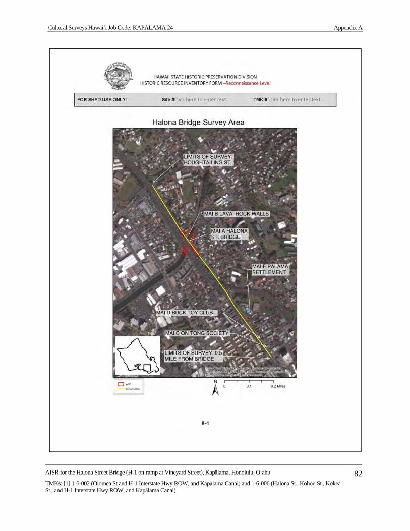
Cultural Surveys Hawai‘i Job Code: KAPALAMA 24 Appendix A
AISR for the Halona Street Bridge (H-1 on-ramp at Vineyard Street), Kapālama, Honolulu, O‘ahu
TMKs: [1] 1-6-002 (Olomea St and H-1 Interstate Hwy ROW, and Kapālama Canal) and 1-6-006 (Halona St., Kohou St., Kokea St., and H-1 Interstate Hwy ROW, and Kapālama Canal)
82

Cultural Surveys Hawai‘i Job Code: KAPALAMA 24 Appendix A
AISR for the Halona Street Bridge (H-1 on-ramp at Vineyard Street), Kapālama, Honolulu, O‘ahu
TMKs: [1] 1-6-002 (Olomea St and H-1 Interstate Hwy ROW, and Kapālama Canal) and 1-6-006 (Halona St., Kohou St., Kokea St., and H-1 Interstate Hwy ROW, and Kapālama Canal)
83

Cultural Surveys Hawai‘i Job Code: KAPALAMA 24 Appendix A
AISR for the Halona Street Bridge (H-1 on-ramp at Vineyard Street), Kapālama, Honolulu, O‘ahu
TMKs: [1] 1-6-002 (Olomea St and H-1 Interstate Hwy ROW, and Kapālama Canal) and 1-6-006 (Halona St., Kohou St., Kokea St., and H-1 Interstate Hwy ROW, and Kapālama Canal)
84
Cultural Surveys Hawai‘i Job Code: KAPALAMA 24 Appendix A
AISR for the Halona Street Bridge (H-1 on-ramp at Vineyard Street), Kapālama, Honolulu, O‘ahu
TMKs: [1] 1-6-002 (Olomea St and H-1 Interstate Hwy ROW, and Kapālama Canal) and 1-6-006 (Halona St., Kohou St., Kokea St., and H-1 Interstate Hwy ROW, and Kapālama Canal)
85

Cultural Surveys Hawai‘i Job Code: KAPALAMA 24 Appendix B
AISR for the Halona Street Bridge (H-1 on-ramp at Vineyard Street), Kapālama, Honolulu, O‘ahu
TMKs: [1] 1-6-002 (Olomea St and H-1 Interstate Hwy ROW, and Kapālama Canal) and 1-6-006 (Halona St., Kohou St., Kokea St., and H-1 Interstate Hwy ROW, and Kapālama Canal)
86
Appendix B Land Commission Awards
B.1 LCA 732 (to Kuinui) Greetings to the Land Commissioners: I hereby tell of my claim for my house lot at Leleo in
Honolulu. The boundaries are: north, a hog enclosure; east, an irrigation channel; south, the irrigation channel; west, the house lot of Kuluahi. The interest in this place was from Kamehameha I. My interest is from my wahine, whose own kupunas and makuas lived here and are buried here. It was I who made the fence; one house stands here, which is mine. No one has objected until this time. I also have four taro patches which are adjacent to the po'alima patches and the stream. They were planted so the stream could irrigate the taro, from the side which adjoins my patches. When I got these taro patches, they were only weed grown, no food was planted and I myself made the patches. They are under the authority of the konohiki.
I am, with aloha,
KUINUI X
F.T. 200v2
Claim 732, Kuinui, February [1848]
Umi, sworn, this place is in Leleo, Honolulu aina, consisting of two pieces, a house lot
and kalo ground bounded:
Waititi and Mauka by a water run called Kahala
Ewa by land of Kulamai
Makai by lot of Kulaaka.
It is fenced and and [sic] has 3 house on it; two belong to claimant and one to
Kamakakoa, wahine. Claimant got it from Malaikoa in 1828 and has occupied it ever
since. I know of no counter claimant.
Kalo land is in Palama, bounded:
Waititi by William Stevens's
Mauka and Ewa by land of Lauu and kalo patches
Makai by land of Puloa.
There are 4 patches. Claimant held it formerly under Keaniani, and since her death
under rent to Kanau. He has held it since 1834 and pays his labour days for possession.
I do not know of any counter claimant.
F.T. 205-206v2
Claim 732, Kuinui, February 23 [1848]

Cultural Surveys Hawai‘i Job Code: KAPALAMA 24 Appendix B
AISR for the Halona Street Bridge (H-1 on-ramp at Vineyard Street), Kapālama, Honolulu, O‘ahu
TMKs: [1] 1-6-002 (Olomea St and H-1 Interstate Hwy ROW, and Kapālama Canal) and 1-6-006 (Halona St., Kohou St., Kokea St., and H-1 Interstate Hwy ROW, and Kapālama Canal)
87
Umi, sworn, I know this land it is in Leleo, Honolulu aina. It consists of two parts, i.e.
house lot & kalo land.
1. The house lot is bounded:
Mauka & Waititi by alaala water course
Ewa by Kukuwai
Makai by land of Kulauuka.
It is fenced & has 3 houses on it; two of which are claimants and one is Kamakakoa's.
Claimant got his title in 1828 from Malaikoa and has occupied it in peace ever since.
N.T. 527-528v2
No. 732, Kuinui
Umi, sworn by the Bible and stated, "I have seen this place. It is at Leleo in Honolulu
district.
Aala is on the Waikiki and toward the mountainside
Kuluahi's lot, Ewa and
Kulauka is toward the sea.
This place has been enclosed and there are three houses on the inside. Kuinui had
received his interest from Malaekoa. Probably that was the year 1828 and he has lived
there since that time to this day. I have also known that Kuinui also has taro land at
Kapalama;
Kiwini's lot is Waikiki
Naluaii's lot, toward the mountain
He (Kuinui) is on the Ewa side and
Paoaaloa, toward the sea.
Kuinui's interest is from Keaniani and he had this land in the year 1834. Kanoa is the
konohiki at this time and has four patches. I have not known that anyone has objected
to Kuinui, altho' he is working for the konohikis at this time.
See page 536
N.T. 536v2
No. 732, Kuinui, From page 527, February 23 [1848]
Haikauai, sworn by the Bible and stated, "My testimony of the house lot and the taro
land of Kuinui is the same as the statements of Umi which have been read here, and I

Cultural Surveys Hawai‘i Job Code: KAPALAMA 24 Appendix B
AISR for the Halona Street Bridge (H-1 on-ramp at Vineyard Street), Kapālama, Honolulu, O‘ahu
TMKs: [1] 1-6-002 (Olomea St and H-1 Interstate Hwy ROW, and Kapālama Canal) and 1-6-006 (Halona St., Kohou St., Kokea St., and H-1 Interstate Hwy ROW, and Kapālama Canal)
88
believe they are very authentic.
Page 527
[Award 732; R.P. 2465; Leleo Honolulu Kona; 1 ap.; .56 Ac.; R.P. 2465 & 6726;
Kapalama Kona; 2 ap.; 1.55 Acs]
B.2 LCA 918 (to Upai) To the Land Commissioners, Greetings: I hereby tell you of my house lot claim at Iwilei in
Honolulu. The boundaries are: north, the lot of Kanakanui, east, the lot of Kalaeloa, South, the lot of Haaliku, west, a road. I have occupied this place from the time of Kamehameha 1. It was infertile kula with spiny nohu weed, but at this time it has been improved and completely fenced and a house stands in it which is mine. I held it peacefully and at this time Kelliahonui is objecting. There are also some taro patches; there are three together in one place at Kumuhau in Kapalama, which adjoin the patches of Kauoiaoao and Halulu which have been held peacefully under the konohiki.
I am, with thanks,
UPAI X
F.T. 263v2
Claim 918, Upai, 3 April [1848]
Kekai, sworn, This is a house lot in Honolulu aina, bounded:
Ewa by Kauahanui's place
Mauka by Kailailoa's
Waititi by Poaliku's
Makai by Kealiiahonu's waste land.
It is fenced and claimant has one house on it, who I know to have lived there without
dispute ever since 1834. He [She] took it up as waste land.
Kalaeloa, sworn, confirmed the previous testimony and knew of no counter claim.
N.T. 605v2
No. 918, Upai, April 3 [1848]
Kekai, sworn and stated, "I have seen this place in Honolulu here adjoining to
Kapalama and the boundaries are:
Kanakanui's land, Ewa
Kalaeloa's land, mountain-side
the konohiki's land, oceanside and

Cultural Surveys Hawai‘i Job Code: KAPALAMA 24 Appendix B
AISR for the Halona Street Bridge (H-1 on-ramp at Vineyard Street), Kapālama, Honolulu, O‘ahu
TMKs: [1] 1-6-002 (Olomea St and H-1 Interstate Hwy ROW, and Kapālama Canal) and 1-6-006 (Halona St., Kohou St., Kokea St., and H-1 Interstate Hwy ROW, and Kapālama Canal)
89
Koaliku's land, Waikiki.
This place has been enclosed, it is idle and Upai has lived here in peace to this time."
Kalaeloa, sworn and said, "I have seen this place and everything is just as Kekai has
related here and no one has ever objected."
N.T. 19v10
No. 918, Upai, Land Office, 1 July 1851
Kekai, sworn, he has seen his [her] land at Kumuohau, Kapalama - 3 taro patches in 1
land section.
Mauka and Waikiki, Makai by the king's land
Ewa by a ditch.
Land from Upai's husband named Kealaiki. He had received it from 0liver Holmes at
the time of Kamehameha I. No disputes to the present.
Kaiuiaaao, sworn, both known in the same way.
[Award 918; R.P. 4428; Iwilei Honolulu Kona; 1 ap.; .2 Ac.; R.P., 691; Kumuulu
Kapalama Kona; 1 ap.; .4 Ac.]

DAVID Y. IGE GOVERNOR OF HAWAII
SUZANNE D. CASE
CHAIRPERSON BOARD OF LAND AND NATURAL RESOURCES
COMMISSION ON WATER RESOURCE MANAGEMENT
KEKOA KALUHIWA FIRST DEPUTY
JEFFREY T. PEARSON
DEPUTY DIRECTOR - WATER
AQUATIC RESOURCES BOATING AND OCEAN RECREATION
BUREAU OF CONVEYANCES COMMISSION ON WATER RESOURCE MANAGEMENT
CONSERVATION AND COASTAL LANDS CONSERVATION AND RESOURCES ENFORCEMENT
ENGINEERING FORESTRY AND WILDLIFE HISTORIC PRESERVATION
KAHOOLAWE ISLAND RESERVE COMMISSION LAND
STATE PARKS
STATE OF HAWAII DEPARTMENT OF LAND AND NATURAL RESOURCES
STATE HISTORIC PRESERVATION DIVISION KAKUHIHEWA BUILDING
601 KAMOKILA BLVD, STE 555 KAPOLEI, HAWAII 96707
July 27, 2016 IN REPLY REFER TO: Thomas W. Parker Log No. 2016.01603 Central Federal Lands Doc. No. 1607KM31 12300 W. Dakota Ave, Suite 280 Archaeology, Architecture Lakewood, CO 80228-2583 Dear Mr. Parker, SUBJECT: Chapter 6E-8 and National Historic Preservation Act (NHPA) Section 106 Review– Archaeological Inventory Survey for Halona Street Bridge Replacement Project Kapālama Ahupua‘a, Honolulu (Kona) District, Island of O‘ahu TMK: (1) 1-6-002 Olomea Street and H-1 Interstate Highway Rights-of-Way, Kapālama Canal; 1-6-006 Halona Street, Kokea Street, Kohou Street, and H-1 Interstate Highway Rights-of-Way, and Kapālama Canal Thank you for the opportunity to review the revised draft report titled Archaeological Inventory Survey Report for Halona Street Bridge (H-1 on-ramp at Vineyard Street) Replacement Project, Kapālama Ahupua‘a, Honolulu (Kona) District, Island of O‘ahu, Federal Highway Administration/Central Federal Lands Highway Division (FHWA/CFLHD), Contract DTFH68-13-R-00027, TMK: (1) 1-6-002 (Olomea Street and H-1 Interstate Highway Rights-of-Way, Kapālama Canal) and 1-6-006 (Halona Street, Kokea Street, Kohou Street, and H-1 Interstate Highway Rights-of-Way, and Kapālama Canal) (Yucha and Hammatt, January 2016). The State Historic Preservation Division (SHPD) received the original submittal on January 20, 2016 and requested revisions (Log No. 2016.00116, Doc. No. 1605KM17). We received revised submittals on July 6, 2016 (Log No. 2016.01603) and July 11, 2016 (2016.01635). This archaeological inventory survey (AIS) report was prepared at the request of CH2M HILL, on behalf of the Federal Highways Administration (FHWA) Central Federal Lands Highway Division (CFLHD) in support of the Halona Street Bridge replacement project. The area of potential effect (APE) totals 2.2 acres. The proposed project involves State of Hawaii owned land and is subject to review under Hawaii Revised (HRS) Statutes Chapter 6E-8. Additionally, the proposed project is expected to receive funding from FHWA (Contract DTFH68-13-R-00027) and is therefore determined to be a federal undertaking defined by 36 CFR 800.16(y) and is subject to the National Historic Preservation Act (NHPA) Section 106 process. This AIS report was completed in support of the Halona Street Bridge replacement project. The proposed undertaking involves the complete replacement of the existing bridge and construction a new bridge structure. The new structure is anticipated to be a single-span bridge approximately 46 ft. in width, but may become a multi-span bridge if additional overhead clearance is necessary. The new bridge installation will require construction of foundation footings. Additionally, several new bridge abutments shall be installed behind the existing H-1 Interstate Highway abutments. Ground disturbance will include excavations for the removal of the existing bridge, and installation of bridge piers, foundations, and abutments. The AIS fieldwork involved a pedestrian survey of the proposed undertaking’s APE and identified two historic properties, the Halona Street Bridge (Site 50-80-14-7807) and the Kapālama Canal (Site 50-80-14-7808). The Halona Street Bridge (Site 7807) was originally constructed in 1938 and a portion of the bridge was subsequently removed ca. 1965 during the H-1 Interstate Highway construction. The Kapālama Canal (Site 7808) was constructed

Mr. Parker July 27, 2016 Page 2 ca. 1950s and consists of the channelized areas of Kapālama and Niuhelewai streams. An approximately 210 m portion of the canal is within the proposed undertaking’s APE. This 210-m portion varies from 24 to 31 m in width and displays dressed basalt stone walls. The canal walls exhibit various styles of construction, possibly suggesting multiple stages of construction. An architectural study (Ruzicka 2016), completed in support of the proposed undertaking, evaluated both the Halona Street Bridge (Site 7807) and Kapālama Canal (Site 7808) for their register eligibility. Ruzicka (2016) determined that neither the 1938 or 1965 portion of the Halona Street Bridge (Site 7807) are eligible for listing on either the Hawaii Register of Historic Places (HRHP) or the National Register of Historic Places (NRHP). Although the 1938 portion of the bridge is assessed significant under Criterion “a”, per Hawaii Administrative Rules (HAR) §13-275-6, it lacks integrity. The 1965 portion of the bridge lacks significance. However, the study determined that the Kapālama Canal (Site 7808) was eligible for listing on the HRHP and NRHP under Criteria A and C and assessed significant under HAR §13-275-6 Criteria “a” and “c”. The AIS report concurs with the Ruzicka (2016) study’s significance assessments and eligibility recommendations for both the Halona Street Bridge (Site 7807) and the Kapālama Canal (Site 7808). The AIS report provides a project effect determination of “no adverse effect” under NHPA Section 106, and “effect with proposed mitigation commitments” under Hawaii Administrative Rules (HAR) §13-275-7. Although no further archaeological work is necessary, the report recommends detailed documentation, including photo documentation and profile recordation, of the Kapālama Canal (Site 7808) be completed. This documentation will be conducted in accordance with a mitigation plan that meets the requirements of HAR §13-278. Additionally, the existing bridge abutments will no longer be removed, best management practices (BMPs) shall be implemented, and restoration of damaged areas shall be repaired. The revisions adequately address the issues and concerns identified in our earlier correspondence. The SHPD has reviewed the submittal and the State Historic Preservation Officer (SHPO) concurs with the eligibility evaluation for Halona Street Bridge, the effect determination recommendation, and mitigation recommendations. The report is accepted. Please send one hardcopy of the document, clearly marked FINAL, along with a copy of this review letter and a text-searchable to Heather Kaufman, SHPD Librarian/Archivist, at [email protected]. SHPD looks forward to receiving a mitigation plan meeting the requirements of HAR §13-278 for review and acceptance prior to initiation of the project. In addition to the documentation of Kapālama Canal (Site 7808), the mitigation plan will identify appropriate BMPs and restoration measures for any adverse effect to Site 7808 during bridge removal and/or replacement. Please contact Jessica Puff, Architectural Historian, at (808) 692-8023 or at [email protected] for questions regarding architectural resources. Please contact the Susan A. Lebo, Archaeology Branch Chief, at (808) 692-8019 or at [email protected] for questions regarding archaeological resources or this letter, or if there is a change in the scope of work of this project. Aloha,
Alan S. Downer, PhD Administrator, State Historic Preservation Division Deputy State Historic Preservation Officer cc: David Shideler, Cultural Surveys Hawaii, Inc. ([email protected])
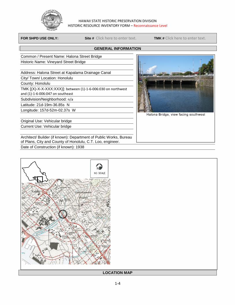
HAWAII STATE HISTORIC PRESERVATION DIVISION
HISTORIC RESOURCE INVENTORY FORM – Reconnaissance Level
FOR SHPD USE ONLY: Site # Click here to enter text. TMK # Click here to enter text.
GENERAL INFORMATION
Common / Present Name: Halona Street Bridge Historic Name: Vineyard Street Bridge Address: Halona Street at Kapalama Drainage Canal City/ Town/ Location: Honolulu County: Honolulu TMK [(X)-X-X-XXX:XXX)]: between (1)-1-6-006:030 on northwest and (1)-1-6-006:047 on southeast Subdivision/Neighborhood: n/a Latitude: 21d-19m-36.85s N Longitude: 157d-52m-02.37s W Original Use: Vehicular bridge Current Use: Vehicular bridge Architect/ Builder (if known): Department of Public Works, Bureau of Plans, City and County of Honolulu, C.T. Loo, engineer. Date of Construction (if known): 1938
LOCATION MAP
1-4

HAWAII STATE HISTORIC PRESERVATION DIVISION
HISTORIC RESOURCE INVENTORY FORM – Reconnaissance Level
FOR SHPD USE ONLY: Site # Click here to enter text. TMK # Click here to enter text.
Prepared By: Dee Ruzicka Consulting Firm: Mason Architects, Inc. Address: 119 Merchant St. Suite 501 Honolulu, HI 96813 Telephone Number: 808-536-0556 Email:[email protected] Date: 26NOV2014
CONDITION ASSESSMENT
Category (select all that apply): Building(s) Residential Commercial Educational Public/Civic Religious Structure(s) Object(s) Site(s)/Landscape(s) Archaeology or potential for archaeology Describe: Alterations (additions, etc.) if known: The five span, 1938 bridge was altered in 1963 when the adjacent H1 freeway was constructed. The southwest parapet and end stanchions were removed and the roadway width reduced from about 40' to 26'-6". The abandoned sidewalk on the southwest side that abuts the H1 freeway concrete barrier is likely the original sidewalk from the 1938 bridge. The curb edge of this abandoned sidewalk is about 40' from the curb at the opposite sidewalk at the extant bridge parapet. This corresponds to the approximate 40' roadway width in 1938 when the bridge carried Vineyard Street. It is likely that the bridge parapet that was removed ca. 1963 was at about the position of the current H1 freeway concrete barrier. Original Location, if moved: Reason for move (if known): Condition:
Excellent Good Fair Deteriorated
Condition Explanation: Eligibility (select all that apply):
National Register of Historic Places State Register of Historic Places
Not Eligible Eligible
2-4

HAWAII STATE HISTORIC PRESERVATION DIVISION
HISTORIC RESOURCE INVENTORY FORM –Reconnaissance Level
FOR SHPD USE ONLY: Site #Click here to enter text. TMK # Click here to enter text.
Listed Contributing to Historic District:
Name of District: Unknown Criteria of Significance (select all that apply) A: Associated with Events Event: Development of Vineyard St. and Kapalama Canal. B: Associated with Significant Person(s) Person(s):
C: Distinctive characteristics of a type, period or method of construction; work of a master; possess high artistic values (Architecture, Engineering, Design)
D: Have yielded or may be likely to yield information important to history or prehistory. Explain:
DESCRIPTION Materials (please check those materials that are visible): Height
Stories: Below Ground
N/A Other: bridge
Exterior Walls (siding):
Aluminum Siding Asbestos Brick Ceramic
Concrete Horizontal Wood
Siding
Log Metal
Shingles-Asphalt Shingles-Wood Stone Stucco Vertical Wood Siding
Vinyl Siding Engineered Siding
Plywood OSB Fiberboard Fiber Cement
Other: Roof:
Asphalt, shingle Asphalt, roll
Other:
Metal Slate
Built Up
Ceramic Tile Wood Shingle None
Foundation: Brick Concrete Block
Concrete Slab
None – on earth Poured Concrete Raised/Pile
Stone Other:
Structural Support:
Baled Hay Concrete Block Concrete Framed Concrete Poured
Frame-wood Frame-metal/steel Brick-load bearing Stone-load bearing
Puddled Clay Rammed Earth Sod Other:
3-4
HAWAII STATE HISTORIC PRESERVATION DIVISION
HISTORIC RESOURCE INVENTORY FORM –Reconnaissance Level
FOR SHPD USE ONLY: Site #Click here to enter text. TMK # Click here to enter text.
Windows:
Double Hung Sash Single Hung Sash Casement Fixed Stained Glass
Replacement Aluminum Vinyl Jalousie Ribbon
Glass Block None/Unknown Other:
Lanai(s)
Arcade Balcony Porte-Cochere Recessed
Stoop Portico Verandah Wrap-around
None Other:
Chimney
Brick Concrete Stuccoed Masonry
Stone Stove Pipe Siding
None Other:
4-4
HAWAII STATE HISTORIC PRESERVATION DIVISION
HISTORIC RESOURCE INVENTORY FORM –Reconnaissance Level
FOR SHPD USE ONLY: Site #Click here to enter text. TMK # Click here to enter text.
Narrative Description Narrative Description:
The Halona Street Bridge (Feature MAI A) is a 108' long, five span, reinforced concrete deck bridge that carries the two traffic lanes of Halona Street one way over the Kapalama Drainage Canal in the Kalihi-Palama neighborhood of Honolulu. The overall width of the bridge includes the 26'-6" wide roadway and a 7'-2" wide sidewalk at the upstream (northeast) side of the bridge. The bridge has only one parapet at the upstream side. The other was removed ca. 1963 for the construction of the H1 freeway bridge.
The setting of the bridge is urban with the H1 freeway paralleling Halona Street and abutting the bridge on the southwest side. The upstream sides of the Kapalama Drainage Canal are lined with roughly coursed concrete rubble masonry. To the northeast (upstream) there is a wide view along Kokea and Kohou Streets upstream to where the canal ends at the mouth of Kapalama Stream and the junction of an unnamed drainage channel. Houses line Kokea and Kohou Streets. In the distance, the Koolau Range is visible.
The 3'-3" high concrete parapet of the Halona Street Bridge has narrow arched openings that are typical of 1930s concrete bridges in Hawaii. The arched openings are 6" wide and 1'-2" high and are on 1' horizontal spacing and are set in a 1'-9" high portion of the parapet that is between the 7" high cap rail and the 11" high (typical) base. The parapet is 88'-6" long between the end stanchions which are curved in plan. Each end stanchion is about 3'-6" high on a 9" high (typical) base and is about 1'-10" thick. The curving end stanchions measure about 5'-9" around the front curve and about 4'-3" around the rear curve. Each has a large incised panel, 5' wide x 2' high that has the inscription "KAPALAMA CANAL" or "1938" in 3" high block letters.
The Halona Street roadway has one 14' wide lane and one 12'-6" wide lane. Both lanes are northbound, Halona Street is one way. Off the Halona Street roadway on the southwest side, a curb leads to a 13'-8" wide strip of level earth that is sparsely planted with grass and short weeds. This strip has a chain-link fence, about 6' from the Halona Street curb, which prevents entry to the H1 freeway. At the southwest side of the earth strip, on the freeway side of the fence, is an abandoned sidewalk about 6' or 7' wide that is abutted on the southwest side by the concrete traffic barrier of the freeway. The outer two spans of the five-span bridge are each about 25' and the three center spans are each about 16'. The bridge has concrete abutments. The concrete rubble masonry of the canal lining begins at the edge of the abutments. Four transverse beams on concrete piles driven into the bed of the canal support the bridge.The beams have chamfered noses on their upstream ends and the concrete piles are typically 1' square and set on about 8' spacing.
Halona Street Bridge is bridge number 003000H10202075 in the National Bridge Inventory database. It was last inspected on June 26, 2013 by the State of Hawaii, Department of Transportation, Highways Division.
Integrity: The ca. 1963 construction of the adjacent H1 Freeway has removed about half of the bridge, only the upstream parapet, sidewalk, and two traffic lanes remain. The bridge is on its original location, but all other
5-4
HAWAII STATE HISTORIC PRESERVATION DIVISION
HISTORIC RESOURCE INVENTORY FORM –Reconnaissance Level
FOR SHPD USE ONLY: Site #Click here to enter text. TMK # Click here to enter text.
aspects of integrity have been reduced by the freeway construction and removal of the bridges historic fabric. The bridge does not retain the integrity necessary for eligibility to the National Register of Historic Places.
Nearby Resources:
Within the Area of Potential Effect (APE), additional resources were identified:
Feature MAI B: Kapalama Drainage Canal including lava rock lining walls. Location: The canal extends under the bridge in a general northeast to southwest orientation. Lava rock lining walls are upstream of Halona Street Bridge, and downstream of the H1 and Olomea Street bridges. Description and evaluation: The Kapalama Drainage Canal extends from Honolulu Harbor about 1 3/8 miles to Kapalama Avenue. The Halona Street Bridge is about ¾ mile from the harbor. For most of its length, from the harbor to a fork in the canal that is about 350' above the Halona Street Bridge, the canal is between about 60' to 100' wide. At the fork, the main branch of the canal extending north toward Kapalama Street is about 35' wide. The lesser channel, extending east along Kokea Street is about 15' wide.
The canal typically has 6' high earthen banks below King Street. Above King Street the canal is channelized with hardened side walls of lava rock and concrete mortar that are about 8' high. The walls feature faced stones set in rough courses with protruding, V-profile mortar joints.
The Kapalama Drainage Canal was completed in February 1939 after about a year of construction by the Hawaiian Contracting Company. Planning for the canal dates to the early 1920s when the potential commercial value of the low-lying land of the Kapalama area was recognized. Beginning in 1924, dredging spoils from Honolulu Harbor were used to fill about 11 acres of a 58-acre section makai of Vineyard Street that had been condemned by the Terriotirial Board of Health as unsanitary. Spoils from the 1925-26 dredging of the Kapalama Basin were used to bring the remaining acreage up to grade level. Along with this filling project, the City and County of Honolulu formed a drainage plan to prevent heavy rains from inundating the new land. This design combined the two streams of the area, Niuhelewai and Kapalama in to the Kapalama Drainage Canal, that was ultimately routed along the approximate contour of Niuhelewai Stream.
The plans for the canal languished until late 1937 or early 1938, when construction got underway. The canal and stonework was accomplished under a Works Progress Administration (WPA) project that built the Kapalama Drainage Canal. A WPA grant of $310,000 partially funded the overall $670,000 cost of the canal. Most of the balance was funded by bond sales by the City and county of Honolulu and from the flood control fund of the city and county.
The Kapalama Drainage Canal and its lava rock and concrete side walls are evaluated as potentially eligible for the National Register under Criterion A for their association with WPA projects in Hawaii and under Criterion C as an example of vernacular building materials.
6-4
HAWAII STATE HISTORIC PRESERVATION DIVISION
HISTORIC RESOURCE INVENTORY FORM –Reconnaissance Level
FOR SHPD USE ONLY: Site #Click here to enter text. TMK # Click here to enter text.
During the field inspection of Halona Street/ Vineyard Boulevard for a distance of up to about ½ mile on either side of the Halona Street Bridge the following features were noted which are outside the APE.
Feature MAI C: On Tong Tung Heong Society building, 544 N. Vineyard Blvd. (TMK 1-7-032: 082). Location: About ½ mile southeast of the Halona Street Bridge on Vineyard Blvd. Description and evaluation: This two-story, residential-scale building, built in 1937, is of wood construction with a gable roof. It has a projecting second floor lanai over the front entry that is supported by paired, square columns. This building is outside the APE and was not evaluated for eligibility for the National Register of Historic Places.
Feature MAI D: Buck Toy Club building, 572 N. Vineyard Blvd. (TMK 1-7-032: 025). Location: About 2200' south east of the Halona Street Bridge on Vineyard Blvd. Description and evaluation: This 1957 building , designed by Honolulu architect Ray Akagi, is two-story, built of concrete block with retail spaces on the first floor and areas for club members on the second floor. The building has a gablet on hip roof with “Orientalist” upturned corners and closed eaves that is covered with green glazed tiles. The front façade has a cantilevered canopy. An interior stairway has a moon gate entrance on the front façade that is closed by a Chinese-motif metal gate. The upper part of the front façade has two panels faced with thin courses of stone that flank three bays of windows with Chinese-detailed muntins. Each stone-work panel has a small window, and a small octagonal window is set in the second floor above the moon gate. All three of these small windows have Chinese-inspired decorative grilles. The sashes, muntins, and grilles of all windows, as well as the moon gate are painted bright red. This building is outside the APE and was not evaluated for eligibility for the National Register of Historic Places.
Feature MAI E: Palama Settlement, 810 N. Vineyard Blvd. (TMK 1-7-045: 001). Location: About 1100' southeast of the Halona Street Bridge. Description and evaluation: Two large, two-story Greek Revival Style wooden buildings built ca. 1925 with full-height entry porch with square columns, broken pediment and rectangular transom at the entry. The buildings are outside the APE and were not evaluated for eligibility for the National Register of Historic Places.
7-4

HAWAII STATE HISTORIC PRESERVATION DIVISION
HISTORIC RESOURCE INVENTORY FORM –Reconnaissance Level
FOR SHPD USE ONLY: Site #Click here to enter text. TMK # Click here to enter text.
8-4

HAWAII STATE HISTORIC PRESERVATION DIVISION
HISTORIC RESOURCE INVENTORY FORM –Reconnaissance Level
FOR SHPD USE ONLY: Site #Click here to enter text. TMK # Click here to enter text.
9-4

HAWAII STATE HISTORIC PRESERVATION DIVISION
HISTORIC RESOURCE INVENTORY FORM –Reconnaissance Level
FOR SHPD USE ONLY: Site #Click here to enter text. TMK # Click here to enter text.
Statement of Significance Historical Context:
The Halona Street Bridge, in its present five-span form, was built in 1938 by the City and County of Honolulu under Job No. 44-37. This 1938 construction added two, approximate 25' spans on each side of the existing center three spans (approximately 16' spans). At the time of this 1938 construction, it carried Vineyard Street across the canal and was called the Vineyard Street Bridge. The original construction date for the older, three span bridge is not known, but it is likely to be ca. 1930, which is the date of construction for the Dillingham Boulevard bridge, about one mile downstream from the Halona Street Bridge. The Dillingham Boulevard Bridge was built about eight years before the Kapalama Drainage Canal was built (1938). The canal banks at Dillingham are earth and not stabilized with retaining walls, as are the banks at Halona Street. It appears that the 1938 canal was built under the Dillingham Bridge without disturbing it. At Halona Street (Vineyard) in 1938 when the canal was built, the existing 3 span bridge was lengthened with two additional spans to cross the canal between its newly built lava rock retaining walls. The stabilization of the banks of the canal using the lava rock retaining walls was extended downstream to the King Street Bridge (1938).
At the time of the 1938 construction, the older parapets of the bridge (of unknown design) were removed and parapets with arched openings and curved end stanchions were built. The 1938 bridge was about 56' wide.
Original drawings for the five span (1938) bridge are dated November 17, 1937. They were produced by the Department of Public Works, Bureau of Plans, City and County of Honolulu and are signed by the City and County Engineer, B. F. Rush. The engineer of the bridge is indicated in the title block as C. T. Loo.
Significance Statement:
Halona Street Bridge is not included in the November 2013 Hawaii State Historic Bridge Inventory and Evaluation by MKE Associates, LLC, and Fung Associates, Inc. It is also not included in the 1983 Historic Bridge Inventory, Island of Oahu by Bethany Thompson.
Although the Halona Street Bridge is significant under Criterion A for it association with the transportation history of the area, it does not appear to be eligible for the Hawaii or National Register of Historic Places due to a lack of integrity of its 1938 form. This is due to the ca. 1963 removal of the southwest parapet, reduction of roadway width, and construction of the adjacent H1 Freeway.
References Drawings:
Historic drawings are available at the Hawaii Department of Transportation, Highway Design Section database as electronic scans. These include:
10-4

HAWAII STATE HISTORIC PRESERVATION DIVISION
HISTORIC RESOURCE INVENTORY FORM –Reconnaissance Level
FOR SHPD USE ONLY: Site #Click here to enter text. TMK # Click here to enter text.
Job No. 44-37 Kapalama Drainage, 5 sheets. Dated 1937
FAP No. U-072-1(3) Lunalilo Freeway, 106 sheets. Dated 1963
Sources:
"Another Step Forward in Flood Control." Honolulu Advertiser. February 25, 1939. p. 12.
"Captain Charles R. Welsh Submits First Report To City Planning Commission On Drainage Plan for Kapalama District." Honolulu Advertiser. August 10, 1924. p. 12.
City Planning Commission, City and County of Honolulu, map "Proposed Street Plan Kapalama Section," December 1922.
Cultural Surveys Hawaii, Inc. "Draft, Phase I Archaeological Survey Report for the Halona Bridge Improvements Project." Prepared for CH2MHill on behalf of the Federal Highways Administration Central Federal Lands Highway Division. October 2014.
"Delay Seen On Flood Project." Honolulu Advertiser. October 1, 1937. p. 3.
Hawaii Highway Planning Survey, Territorial Highway Department. Bridge Inventory for the Island of Oahu. Honolulu: Hawaii Territorial Highway Department. September 1950.
"Kapalama Flood Control Bonds May Be Sold In Issue." Honolulu Advertiser. October 1, 1937. p. 4.
"Proposed Kapalama Plan Discussed At Meeting Of Planners and Public." Honolulu Advertiser. November 16, 1924. p. 14.
Ruzicka, Dee. "Kapalama Canal Bridge." Draft of National Register of Historic Places Nomination Form. Prepared for Honolulu High Capacity Transit Corridor, April 15, 2013.
"Start Canal At Kapalama In December." Honolulu Advertiser. October 1, 1937. p. 1.
State of Hawaii, Department of Transportation, Highways Division. "NBI Bridge Inspection Report, Bridge Number 003000H10202075." June 26, 2013. The current bridge inspection report for this bridge, available at the Hawaii Department of Transportation, Highway Division, Bridge Design Office.
Superintendent of Public Works, Territory of Hawaii. Report to the Governor, Territory of Hawaii by the Superintendent of Public Works. Honolulu: Advertiser Publishing Co., LTD. Various dates. .
11-4
Mason Architects, Inc. 1 1/08/2016
NATIONAL HISTORIC PRESERVATION ACT, SECTION 106 CONSULTATION HALONA STREET BRIDGE REPLACEMENT PROJECT
HONOLULU [KALIHI] DISTRICT, OAHU, KAPALAMA AHUPUAA PROJECT NO. HI STP H1 (1)
TAX MAP KEY: (1)1-6-002 AND (1)1-6-006 DETERMINATION OF EFFECT 1.0 INTRODUCTION
The Central Federal Lands Highway Division (CFLHD) of the Federal Highway Administration (FHWA), in cooperation with the State of Hawaii Department of Transportation (HDOT) is proposing to replace the Halona Street Bridge over the Kapalama Canal located on Hawaii State Highway 98 adjacent to Interstate H-1 at Mile Post 20.21. Halona Street is a principal urban arterial on the Island of Oahu. The purpose of this project is to replace the existing Halona Street Bridge to maintain the Kapalama Canal crossing on Halona Street as a safe and functional component of the regional transportation system for highway users. The existing bridge was built in 1938, and extensively altered ca. 1963 by the removal of the south parapet to facilitate the construction of Interstate H-1. The bridge does not meet current standards for roadway width, load capacity, pedestrian traffic, bridge railing and transitions, and bridge approaches. The proposed project would replace the existing bridge to meet current standards and to accommodate channel flows in the Kapalama Canal. The Historic Resource Inventory, prepared by Mason Architects, Inc. (MAI) in July 2015 and included in Appendix A of this report, determined that the Halona Street Bridge (Hawaii State Inventory of Historic Places # 50-80-14-7807) is not eligible for listing on the National Register and the Hawai’i State Register of Historic Places. However, the associated features of the Kapalama Canal (Hawaii State Inventory of Historic Places # 50-80-14-7808) are within the Area of Potential Effect (APE) of the project and appear to be eligible. The proposed bridge replacement project is considered a federal action and undertaking, and will comply with Section 106 of the National Historic Preservation Act (NHPA) of 1966, as amended (2006). MAI has been tasked with evaluating whether the project would pose an adverse effect on the historic resources within the APE. Concurrence with these findings will be confirmed in consultation with SHPD.

Mason Architects, Inc. 2 1/08/2016
Area of Potential Effect
The historic architectural Areas of Potential Effects (APE) are illustrated in Figure 1 and includes both temporary and permanent impact areas.
Figure 1: Area of Potential Effect

Mason Architects, Inc. 3 1/08/2016
2.0 HISTORIC AND CULTURAL RESOURCES
2.1 Summary of Historic and Cultural Properties within the APE
The Archaeological Survey Report prepared by Cultural Surveys Hawaii indicated that two cultural resources have been identified within the Area of Potential Effect (APE), the Halona Street Bridge and the Kapalama Canal. Of these two resources, the Historic Resource Inventory Form (Mason Architects, July 2015) identified one, the Kapalama Canal and its associated lava rock side walls, as eligible for listing on the National Register of Historic Places (National Register) and the Hawaii State Register of Historic Places (State Register). Other sites not eligible for listing (including the Halona Street Bridge) or located outside of the APE have been identified and are summarized in the attached Historic Resource Inventory Form.
2.2 Identification of Historic Character-defining Features
The Secretary of the Interior's Standards for the Treatment of Historic Properties embody two important goals: 1) the preservation of historic materials and 2) the preservation of a building's distinguishing character. Character refers to those visual aspects and physical features that comprise the appearance of every historic resource.
Primary historic character-defining architectural features of the Kapalama Canal include:
Setting, low-rise residential neighborhood. Channelized canal with hardened banks of near-vertical side walls, typically about 8'
high. Side walls constructed of faced lava rock stones set in rough courses with protruding v-
profile mortar joints. Some areas of stone work feature faced, roughly squared stones. Some areas of stone work feature faced rubble stones.
Secondary historic character-defining architectural features include:
Side walls typically rise about 16" above grade. Side walls typically about 18" thick with concrete cap. Side walls have small rectangular scupper openings at grade, typically spaced between
15' to 25'.
Missing or deteriorated historic character-defining features that could be restored or recreated. Not applicable
Non-contributing features that may be altered or removed without adversely affecting historic character:
Chain link fencing atop sidewalls.
Non-contributing features are typically built or added outside the historical period of significance and are not considered to be historic character-defining. Their removal and alteration would have little or no impact on the historic integrity of the site.

Mason Architects, Inc. 4 1/08/2016
3.0 PROPOSED PROJECT AND EFFECTS
3.1 Overview: The proposed project would replace the existing Halona Street Bridge to meet current standards for load capacity, pedestrian traffic, bridge railing and transitions, and bridge approaches. To accomplish this a new, three-span bridge will be constructed after the existing bridge is removed. This new bridge will have two 12-ft lanes, a 7-ft sidewalk on the mauka side, and a curb with a bridge rail on the makai side. The proposed length of the new bridge is 130'-11" and the proposed width is 39'-0", close to existing dimensions. The new bridge would raise the road profile slightly higher than the existing bridge. Widening of the existing bridge is not needed. The existing canal sidewalls are to be retained and protected in place. Any incidental damage to this feature due to removal of the existing bridge will be repaired in-kind using salvaged, original material.
3.2 Discussion: Setting: Construction access and staging areas will be located along the public streets adjacent to the bridge and within the APE. The proposed work is designed to avoid degradation of the environment and/or impacts to the stream and landscape.
Kapalama Canal: The canal's lava rock side walls will be retained and protected during the construction of the new bridge. Utmost care will be taken to avoid damage to the lava rock canal walls. To help avoid impact to the side walls, the existing abutments for the Halona Bridge will not be removed; however, the tops of the existing abutments will be cut down to accommodate deeper bridge girders. New abutments will be constructed behind the existing. The Contractors responsible for bridge demolition will take digital photos of the lava rock canal walls prior to the start of work. If the walls are affected during construction, the stones will be salvaged and used in reconstructing the walls, guided by the photos, to match its existing condition.
4.0 SUMMARY DETERMINATION OF EFFECT
FHWA has determined that the undertaking will result in a No Adverse Effect finding on the Kapalama Canal (SIHP #50-80-14-7808) in accordance with Federal regulations (36 CFR 800.5).
Further, FHWA and HDOT have determined the project will result in an Effect, With Agreed Upon Mitigation finding on the Kapalama Canal in accordance with HAR §13-13-275-7. The removal of the existing bridge superstructure that is in contact with the lava rock lining walls may cause minor and incidental damage to the Kapalama Canal walls on the upstream east and upstream west portions of the bridge abutments. The area in contact with lava rock lining walls is approximately 13 square feet at each location for a total of 26 square feet. Every effort will be made to avoid impacting the lava rock lining walls. Documentary photos of the lava rock walls will be taken prior to the start of construction. In the event of loosened lava rock stones or cracked mortar, the stones will be salvaged and replaced and the mortar restored to match the existing condition.
Central Federal Lands Highway Division 12300 West Dakota Avenue Suite 380A Lakewood, CO 80228-2583 January 12, 2016 Office: 720-963-3647 Fax: 720-963-3596 [email protected] In Reply Refer To: HFPM-16 TO: THE HONORABLE SUZANNE CASE, CHAIRPERSON DEPARTMENT OF LAND AND NATURAL RESOURCES ATTN: SUZANNE CASE
STATE HISTORIC PRESERVATION OFFICER
FROM: J. MICHAEL WILL, P.E. PROJECT MANAGER SUBJECT: NATIONAL HISTORIC PRESERVATION ACT, SECTION 106 AND HAWAII
REVISED STATUTES, CHAPTER 6E CONSULTATION HALONA STREET (KAPALAMA CANAL) BRIDGE REPLACEMENT PROJECT HONOLULU (KONA) DISTRICT, OAHU ISLAND, KAPALAMA AHUPUAA PROJECT NO. HI STP H1 (1) TAX MAP KEY: (1)1-6-002 (Olomea Street and H-1 Interstate Highway Rights-
of-Way, and Kapalama Canal) (1)1-6-006 (Halona Street, Kokea Street, Kohou Street and H-1
Interstate Highway Rights-of-Way, and Kapalama Canal)
Dear Ms. Case: The Federal Highway Administration (FHWA) Central Federal Lands Highway Division CFLHD), in partnership with the State of Hawaii Department of Transportation (HDOT), is proposing to replace the Halona Street Bridge over the Kapalama Canal on Hawaii State Highway 98 (HI-98) adjacent to Interstate H-1 (H-1), also known as Halona Street, at Mile Post 20.21 (see attached Area of Potential Effects [APE] U.S. Geological Survey map for project location). The proposed project is considered a federal action and undertaking, and will comply with Section 106 of the National Historic Preservation Act (NHPA) of 1966, as amended (2006), as well as Hawaii Revised Statutes (HRS) Chapter 6E. This letter is to initiate consultation with the State Historic Preservation Division (SHPD) under Section 106 in accordance with Title 36 of the Code of Federal Regulations (CFR), Section 800.3, and with HRS Chapter 6E-8.
Overview of the Undertaking
The proposed project would replace the existing Halona Street Bridge and its approaches to maintain the Kapalama Canal crossing on Halona Street as a safe and functional component of the regional transportation system for roadway users.
The existing Halona Street Bridge would be demolished and removed. The replacement bridge would be a precast three-span bridge with a total length of approximately 131 feet. The bridge

2
would have a deck width of 39 feet and a depth of 2.5 feet. The new bridge would raise the road profile slightly higher than the existing bridge but would be narrower because of the removal of the landscaped buffer that sits atop the existing bridge deck.
The four existing piers would be removed and replaced with two piers that would be aligned with the two existing and adjacent H-1 bridge piers. The pier shapes would be similar to the existing H-1 bridge piers. The proposed new bridge abutments would be set back from and behind the existing abutments. The tops of the existing abutments would be cut down to accommodate the deeper bridge girders. The canal’s lava rock lining walls, which are located upstream of the Halona Street Bridge and downstream of the H-1 and Olomea Street bridges, would be retained and protected in place adjacent to the bridge; however, removal of the existing bridge features may result in some physical damage to the lava rock walls. The existing Kapalama Canal and its lava rock lining walls have been determined by FHWA to be eligible for listing on the National Register of Historic Places (NRHP) (see eligibility discussion below). Photos will be taken prior to the start of construction. If the walls are physically affected during construction, the stone will be salvaged and repaired to match its existing condition.
The proposed improvements would occur within the existing HDOT right-of-way. In addition, 0.44 acre of land would be needed from four temporary construction parcels owned by the City of Honolulu to accommodate bridge construction and paving improvements. One of these parcels, the Kapalama Canal, is eligible for listing on the NRHP.
Staging of personnel and equipment would occur within the project limits. Possible staging areas are located along Halona Street (on pavement) north and south of the bridge, as well as areas adjacent to the Kohou Street and Kokea Street intersections. The work area would be accessed from the sides of the canal. Construction would occur within the Kapalama Canal under the Halona Street Bridge.
The Halona Street Bridge would likely be closed to vehicular traffic for the duration of the project, and traffic would be detoured during this time. However, pedestrian and bicyclist access would be maintained in a temporary pedestrian route within the existing landscaped area between the construction work and the H-1 freeway. Access to the H-1 on-ramp would be maintained during construction. Archaeological monitoring will be conducted for all initial ground disturbance and excavation activities during construction.
Area of Potential Effects
The archaeological and historic architectural APE are illustrated in the attached APE Aerial Imagery map, and includes both temporary and permanent impact areas. The APE was developed to be sufficiently large to accommodate potential improvements on the other side of H-1; however, none were identified as necessary. The APE comprises 1.5 acres and includes the following TMKs: (1)1-6-002 (Olomea Street and H-1 Interstate Highway Rights-of-Way, and Kapalama Canal), and (1)1-6-006 (Halona Street, Kokea Street, Kohou Street and H-1 Interstate Highway Rights-of-Way, and Kapalama Canal).
Determination of Eligibility
Pursuant to NHPA Section 106 and HRS Chapter 6E-8, a cultural resources investigation was performed within a field survey area that included the project’s APE. The cultural resources investigation comprised an archival literature review, an architectural reconnaissance survey, and an archaeological inventory survey. The surveys identified two resources within the APE: the Halona Street Bridge (SIHP #50-80-14-7807) and the Kapalama Canal and associated lava rock walls (SIHP #50-80-14-7808). The surveys did not identify any new archaeological or

3
architectural resources within the APE. FHWA believes all historic properties with potential to be affected by the undertaking have been identified.
The Halona Street Bridge lacks integrity and is evaluated by Mason Architects as not eligible for listing on the NRHP or the Hawai‘i Register of Historic Places (HRHP). Mason Architects evaluated the Kapalama Canal and its lava rock walls as eligible for the NRHP and HRHP under Criterion A and Criterion C.
FHWA is in agreement with the recommendations of Mason Architects and has therefore determined that SIHP #50-80-14-7808, the Kapalama Canal and associated lava rock walls, is eligible for the NRHP under Criterion A for its association with Works Project Administration projects in Hawaii and Criterion C as an example of vernacular building materials. FHWA has also determined that the Halona Street Bridge (SIHP #50-80-14-7807) lacks integrity and is therefore not eligible for listing on the NRHP.
Detailed information on the cultural, archaeological, and historical settings of the project area and the evaluation of eligibility are provided in two studies prepared for this project, included on the enclosed CD:
1. Draft Archaeological Inventory Survey Report for the Halona Bridge Replacement Project, Kapalama Ahupuaa, Honolulu District, Oahu
2. SHPD Historic Resource Inventory Form (Reconnaissance Level) for Halona Bridge
Determination of Effects
FHWA has determined that the undertaking will result in a No Adverse Effect finding on the Kapalama Canal (SIHP #50-80-14-7808) in accordance with Federal regulations (36 CFR 800.5). In addition, FHWA and HDOT have determined the project will result in an Effect, With Agreed Upon Mitigation finding on the Kapalama Canal in accordance with HAR §13-13-275-7. The removal of the existing bridge superstructure that is in contact with the lava rock lining walls may cause minor and incidental damage to the Kapalama Canal wall on the upstream east and upstream west portions of the bridge abutments. The area in contact with lava rock lining walls is approximately 13 square feet at each location to total 26 square feet. Every effort will be made to not impact the lava rock lining walls. Photos of the lava rock walls will be taken prior to the start of construction. In the event of cracked mortar or loosened lava rock stones they will be salvaged and replaced and the mortar restored to match the existing condition. A detailed Determination of Effects memorandum is enclosed with this letter.
As part of the environmental process for this undertaking, FHWA must also comply with Section 4(f) of the U.S. Department of Transportation (USDOT) Act of 1966. The intent of the Section 4(f) Statute, 49 U.S.C. Section 303, and the policy of the FHWA is to strive to avoid transportation use of historic sites and publicly owned recreational areas, parks, wildlife and waterfowl refuges. However, the legislation states that a transportation project may be approved if it results in a de minimis impact. As defined in FHWA’s implementing regulations (23 CFR 774), “for historic sites, de minimis impact means that the FHWA has determined, in accordance with 36 CFR part 800, that no historic property is affected by the project or that the project will have “no adverse effect” on the historic property in question.” This project has been determined to have no adverse effect on the Kapalama Canal. Based on the findings outlined above, FHWA-CFLHD may make a de minimis finding for the Section 4(f) requirements for the Kapalama Canal.

4
Consultations
Section 106 notice/advertisement was published in the Honolulu Star-Advertiser on July 24, 2015. Native Hawaiian Organizations and Native Hawaiian descendants with ancestral, lineal, or cultural ties to, cultural knowledge or concerns for, and cultural or religious attachment to the proposed project area were asked to provide a response within 30 days of notification.
Section 106 consultation letters were sent to the following organizations as potential consulting parties:
Office of Hawaiian Affairs Kalihi Palama Hawaiian Civic Club Hawaiian Civic Club of Honolulu Koolauloa Hawaiian Civic Club Oahu Island Burial Council Paulette Kaanohiokalani Kaleikini Historic Hawaii Foundation
Request for Concurrence
We request your concurrence with the APE and Determinations of Eligibility and Effects. We would appreciate a written response within 30 days from date of receipt, by email at [email protected] or by U.S. Postal Service to 12300 West Dakota Avenue, Suite 380A, Lakewood, CO 80228-2583.
Please feel free to contact Nicole Winterton, Environmental Protection Specialist, at (720) 963-3689 or by email at [email protected], if you have any questions. We look forward to working with the SHPO on these needed improvements.
Sincerely yours,
J. Michael Will, P.E. Project Manager Enclosures: Area of Potential Effects (USGS Map) Area of Potential Effects (Aerial Imagery) Determination of Effects Memorandum, with attached design drawings On CD: Draft Archaeological Inventory Survey Report for the Halona Bridge Improvements
Project, Kapalama Ahupuaa, Honolulu District, Oahu On CD: SHPD Historic Resource Inventory Form (Reconnaissance Level) for Halona Bridge
cc (with enclosures on CD): Kevin Ito, HDOT Todd Nishioka, HDOT Jessica Puff, SHPD Susan Lebo, SHPD

DAVID Y. IGE GOVERNOR OF HAWAII
SUZANNE D. CASE
CHAIRPERSON BOARD OF LAND AND NATURAL RESOURCES
COMMISSION ON WATER RESOURCE MANAGEMENT
KEKOA KALUHIWA FIRST DEPUTY
JEFFREY T. PEARSON
DEPUTY DIRECTOR - WATER
AQUATIC RESOURCES BOATING AND OCEAN RECREATION
BUREAU OF CONVEYANCES COMMISSION ON WATER RESOURCE MANAGEMENT
CONSERVATION AND COASTAL LANDS CONSERVATION AND RESOURCES ENFORCEMENT
ENGINEERING FORESTRY AND WILDLIFE HISTORIC PRESERVATION
KAHOOLAWE ISLAND RESERVE COMMISSION LAND
STATE PARKS
STATE OF HAWAII DEPARTMENT OF LAND AND NATURAL RESOURCES
STATE HISTORIC PRESERVATION DIVISION KAKUHIHEWA BUILDING
601 KAMOKILA BLVD, STE 555 KAPOLEI, HAWAII 96707
August 9, 2016 IN REPLY REFER TO: Thomas Parker Log No. 2016.01054 Central Federal Lands Doc. No. 1608KM03 12300 W. Dakota Ave, Suite 280 Archaeology, Architecture Lakewood, CO 80228-2583 Dear Mr. Parker, SUBJECT: National Historic Preservation Act (NHPA) Section 106 Review– Request for Concurrence for Halona Street Bridge Replacement Project, HFPM-16 Kapālama Ahupua‘a, Honolulu (Kona) District, Island of O‘ahu TMK: (1) 1-6-002 Olomea Street and H-1 Interstate Highway Rights-of-Way, Kapālama Canal; 1-6-006 Halona Street, Kokea Street, Kohou Street, and H-1 Interstate Highway Rights-of-Way, and Kapālama Canal Thank you for the request for concurrence on the revised area of potential effects (APE), the determination of eligibility, and the determination of effect for the Halona Street Bridge replacement project. The State Historic Preservation Division (SHPD) originally received this request on January 20, 2016 (Log No. 2016.00117) along with a draft archaeological inventory survey (AIS) report (Log No. 2016.00116) and a reconnaissance level survey (RLS) (Log No. 2016.00118). SHPD requested revisions (Log No. 2016.00116, Doc. No. 1605KM17). SHPD received revised submittals on July 6, 2016 (Log No. 2016.01603) and July 11, 2016 (Log No. 2016.01635) and received revised drafts on July 6 and July 11, 2016 (Log No. 2016.01603 and Log No. 2016.01635). SHPD accepted the AIS report (Yucha and Hammatt 2016) on July 27, 2016 (Log No. 2016.01603, Doc. No. 1607KM31). The proposed project is the Halona Street Bridge replacement project. The proposed project involves State of Hawaii owned land and is subject to review under Hawaii Revised (HRS) Statutes Chapter 6E-8. Additionally, the proposed project is expected to receive funding from Federal Highway Administration ( FHWA Contract DTFH68-13-R-00027) and is therefore determined to be a federal undertaking defined by 36 CFR 800.16(y) and is subject to the National Historic Preservation Act (NHPA) Section 106 process. The proposed undertaking involves the complete replacement of the existing bridge and construction a new bridge structure. The new structure is anticipated to be a single-span bridge approximately 46 ft. in width, but may become a multi-span bridge if additional overhead clearance is necessary. The new bridge installation will require construction of foundation footings. Additionally, several new bridge abutments shall be installed behind the existing H-1 Interstate Highway abutments. Ground disturbance will include excavations for the removal of the existing bridge, and installation of bridge piers, foundations, and abutments. The revised area of potential effect (APE) totals 2.2 acres. The archaeological inventory survey (AIS) report was prepared at the request of CH2M HILL, on behalf of the Federal Highways Administration (FHWA) Central Federal Lands Highway Division (CFLHD). The AIS fieldwork involved a pedestrian survey of the APE and identified two historic properties, the Halona Street Bridge (Site 50-80-14-7807) and the Kapālama Canal (Site 50-80-14-7808). The Halona Street Bridge (Site 7807) was originally constructed in 1938 and a portion of the bridge was subsequently removed ca. 1965 during the H-1 Interstate Highway construction. The Kapālama Canal (Site 7808) was constructed ca. 1950s and consists of the channelized areas of Kapālama and Niuhelewai streams. An approximately 210 m portion of the canal is within the proposed

Mr. Parker August 9, 2016 Page 2 undertaking’s APE. This 210-m portion varies from 24 to 31 m in width and displays dressed basalt stone walls. The canal walls exhibit various styles of construction, possibly suggesting multiple stages of construction. An architectural study (Ruzicka 2016), completed in support of the proposed undertaking, evaluated both the Halona Street Bridge (Site 7807) and Kapālama Canal (Site 7808) for their register eligibility. Ruzicka (2016) determined that neither the 1938 or 1965 portion of the Halona Street Bridge (Site 7807) are eligible for listing on either the Hawaii Register of Historic Places (HRHP) or the National Register of Historic Places (NRHP). Although the 1938 portion of the bridge is assessed significant under Criterion a, per Hawaii Administrative Rules (HAR) §13-275-6, it lacks sufficient integrity for the NRHP. The 1965 portion of the bridge lacks significance. However, the study determined that the Kapālama Canal (Site 7808) is eligible for listing on the HRHP and NRHP under Criteria A and C and is assessed significant under HAR §13-275-6 Criterion a and Criterion c. The AIS report concurs with the Ruzicka (2016) study’s significance assessments and eligibility recommendations for both the Halona Street Bridge (Site 7807) and the Kapālama Canal (Site 7808). The AIS report provided a project effect determination of “no adverse effect” under NHPA Section 106, and “effect with proposed mitigation commitments” under HAR §13-275-7. Although no further archaeological work is necessary, the report recommended detailed documentation, including photo documentation and profile recordation, of the Kapālama Canal (Site 7808) be completed. The documentation will be conducted in accordance with a mitigation plan that meets the requirements of HAR §13-278. Additionally, the existing bridge abutments will no longer be removed, best management practices (BMPs) shall be implemented, and restoration of damaged areas shall be repaired. SHPD concurred with the report’s effect determinations, eligibility recommendation, and mitigation recommendations. Your April 28, 2016 letter (HFPM-16) requests concurrence on the APE, determination of eligibility for the Halona Street Bridge and the Kapalama Canal (Site 7808), and effect determination for the undertaking. As mentioned above, the APE has been revised to total 2.2 acres from the 1.5 acres stated in your letter. The FHWA provided additional information and acknowledged the revised APE via email correspondence on August 7, 2016 (Thomas Parker [CFL] and Nancy Nishikawa [CH2M Hill] to Susan Lebo [SHPD]). The FHWA has determined that the Halona Street Bridge is not eligible for listing on the NRHP but that the Kapalama Canal is eligible for listing on the NRHP under Criteria A and C. Furthermore, the FHWA has determined that the undertaking will result in no adverse effect under NHPA Section 106 and “effect with agreed upon mitigation” under HAR §3-275-7, provided that appropriate mitigation measures are implemented. Mitigation shall include photo documentation and profile recordation of the canal, and possible salvage and/or restoration of areas of the canal damaged by project work. Based on the above information, the SHPD has reviewed the undertaking and the State Historic Preservation Officer (SHPO) concurs with the FHWA’s revised APE of 2.2 acres, determination of eligibility for the Kapalama Canal (Site 7808) under Criteria A and C for inclusion in the NRHP, and determination of no adverse effect per NHPA Section 106 and effect with agreed upon mitigation per HAR Chapter 6E-8. SHPD looks forward to receiving a mitigation plan meeting HAR §13-278 for the Kapalama Canal prior to project work commencing. FHWA is the office of record for this undertaking. Please maintain a copy of this letter for your records. Please contact Jessica Puff, Architectural Historian, at (808) 692-8023 or at [email protected] for questions regarding architectural resources. Please contact the Archaeology Branch Chief, Susan A. Lebo, at (808) 692-8019 or at [email protected] for questions regarding archaeological resources or this letter, or if there is a change in the scope of work of this project. Aloha,
Alan S. Downer, PhD Administrator, State Historic Preservation Division Deputy State Historic Preservation Officer
Appendix E Cultural Impact Assessment for the Halona Street
Bridge (April &'(5)

O‘ahu Office P.O. Box 1114 Kailua, Hawai‘i 96734 Ph.: (808) 262-9972 Fax: (808) 262-4950
www.culturalsurveys.com
Maui Office 1860 Main St. Wailuku, Hawai‘i 96793 Ph.: (808) 242-9882 Fax: (808) 244-1994
Final
Cultural Impact Assessment for the
Halona Street Bridge (H-1 on-ramp at Vineyard Street) Kapālama Ahupua‘a, Honolulu (Kona) District, O‘ahu,
Federal Highway Administration/ Central Federal Lands Highway Division (FHWA/CFLHD)
Contract DTFH68-13-R-00027 TMKs: [1] 1-6-002 (Olomea Street and H-1 Interstate Highway Rights-of-Way and Kapālama Canal) and
1-6-006 (Halona Street, Kokea Street, Kohou Street, and H-1 Interstate Highway Rights-of-Way and Kapālama Canal)
Prepared for CH2M HILL
and on behalf of the Federal Highway Administration (FHWA)
Central Federal Lands Highway Division (CFLHD)
Prepared by
Nicole Ishihara, B.A., Brittany Beauchan, M.A.,
and Hallett H. Hammatt, Ph.D.
Cultural Surveys Hawai‘i, Inc. Kailua, Hawai‘i
(Job Code: KAPALAMA 25)
April 2016

Cultural Surveys Hawai‘i Job Code: KAPALAMA 25 Management Summary
CIA for the Halona Street Bridge (H-1 on-ramp at Vineyard Street), Kapālama, Honolulu, O‘ahu
TMKs: [1] 1-6-002 and 1-6-006 i
Management Summary
Reference Cultural Impact Assessment Report for the Halona Street Bridge (H-1 on-ramp at Vineyard Street), Kapālama Ahupua‘a, Honolulu (Kona) District, O‘ahu, Federal Highway Administration/Central Federal Lands Highway Division (FHWA/CFLHD) Contract DTFH68-13-R-00027, TMKs: [1] 1-6-002 (Olomea Street and H-1 Interstate Highway Rights-of-Way and Kapālama Canal) and 1-6-006 (Halona Street, Kokea Street, Kohou Street, and H-1 Interstate Highway Rights-of-Way, and Kapālama Canal) (Ishihara et al. 2016)
Date April 2016 Project Number(s) • FHWA/CFLHD Contract Code: DTFH68-13-R-00027
• CH2MHILL Project Task ID: 499069.10SU.CS • Cultural Surveys Hawai‘i, Inc. (CSH) Job Code: KAPALAMA
25 Agencies FHWA/CFLHD, SHPD Land Jurisdiction State Department of Transportation (HDOT) Project Proponent FHWA/CFLHD, HDOT Project Funding FHWA/CFLHD Project Location The study area is located within Kapālama Ahupua‘a at the location of
the Halona Street Bridge and the Kapālama Canal and includes portions of the H-1 Interstate Highway and Halona Street from the intersection of Kuipaakea Lane to just beyond Kohou Street. The study area is depicted on a portion of the 1998 Honolulu U.S. Geological Survey (USGS) 7.5-minute topographic quadrangle.
Project Description The purpose of the project is to replace the existing bridge to meet current design standards for roadway width, load capacity, pedestrian traffic, bridge railing and transitions, and bridge approaches. This existing bridge was built in 1938 and is structurally deficient and functionally obsolete. The replacement bridge would be a three-span, concrete structure. It would be supported on two piers similar to, and aligned with, the existing H-1 Bridge piers. New abutments would be set back from and behind the existing abutments which would be left in place, thereby minimizing impacts to the masonry walls along the canal. For safety reasons, another consideration is to develop provisions to discourage individuals from accessing the area under the bridge.
Project Acreage The study area includes approximately 0.9 hectares (2.2 acres). Document Purpose This cultural impact assessment (CIA) was prepared to comply with the
State of Hawai‘i’s environmental review process under Hawai‘i Revised Statutes (HRS) §343, which requires consideration of the proposed project’s potential effect on cultural beliefs, practices, and resources. Through document research and cultural consultation efforts, this report

Cultural Surveys Hawai‘i Job Code: KAPALAMA 25 Management Summary
CIA for the Halona Street Bridge (H-1 on-ramp at Vineyard Street), Kapālama, Honolulu, O‘ahu
TMKs: [1] 1-6-002 and 1-6-006 ii
provides information compiled to date pertinent to the assessment of the proposed project’s potential impacts to cultural beliefs, practices, and resources (pursuant to the Office of Environmental Quality Control’s Guidelines for Assessing Cultural Impacts) which may include traditional cultural properties (TCPs). These TCPs may be significant historic properties under State of Hawai‘i significance criterion “e,” pursuant to Hawai‘i Administrative Rules (HAR) §13-275-6 and §13-284-6. Significance criterion “e” refers to historic properties that “have an important value to the native Hawaiian people or to another ethnic group of the state due to associations with cultural practices once carried out, or still carried out, at the property or due to associations with traditional beliefs, events or oral accounts—these associations being important to the group’s history and cultural identity” (HAR §13-275-6 and §13-284-6). The document will likely also support the project’s historic preservation review under HRS §6E and HAR §13-275 and §13-284. The document is intended to support the project’s environmental review and may also serve to support the project’s historic preservation review under HRS §6E-8 and HAR §13-284.
Results of Background Research
Background for this project yielded the following results (presented in approximately chronological order):
1. Kapālama is often understood to refer to an enclosure (pā) of lama wood that surrounded the residences of high ranking ali‘i (chief) (Pukui et al. 1974:87). McAllister (1933:88) relates that Kapālama is said to obtain its name from an establishment for young ali‘i who were paired off for producing offspring. Westervelt (1923:165) attributes the place name to a chiefess of O‘ahu named Kapālama, the grandmother of Lepeamoa.
2. Kapālama Ahupua‘a consists of two streams: Kapālama and Niuhelewai (“coconut going [in] water”). The two streams merge and extend through the central fertile former taro and rice fields draining into Kūwili II, a fishpond. Other fishponds within Kapālama include Loko Kapukai and Loko Kealia. Pukui et al. (1974) do not offer any translations, however, the word keālia is the word for “salt bed,” which may indicate at least one of these ponds was used for salt collection.
3. Two accounts tell of warfare that occurred in Kapālama: Kahahawa‘i defeated Kahāhana with Niuhelewai as the location of the battle; and the rebellion of the ‘Ewa and Kona chiefs, which occurred after Kahāhana’s death. The latter battle took place at Makaho and Niuhelewai streams as well as Kahoa‘ai‘ai Stream in ‘Ewa.
4. LCA testimonies for Kapālama Ahupua‘a indicate intense taro cultivation of the area, maintenance of fishpond, habitation, and some use of kula (pasture, plain) lands. Large areas were also set aside for the cultivation of rice.
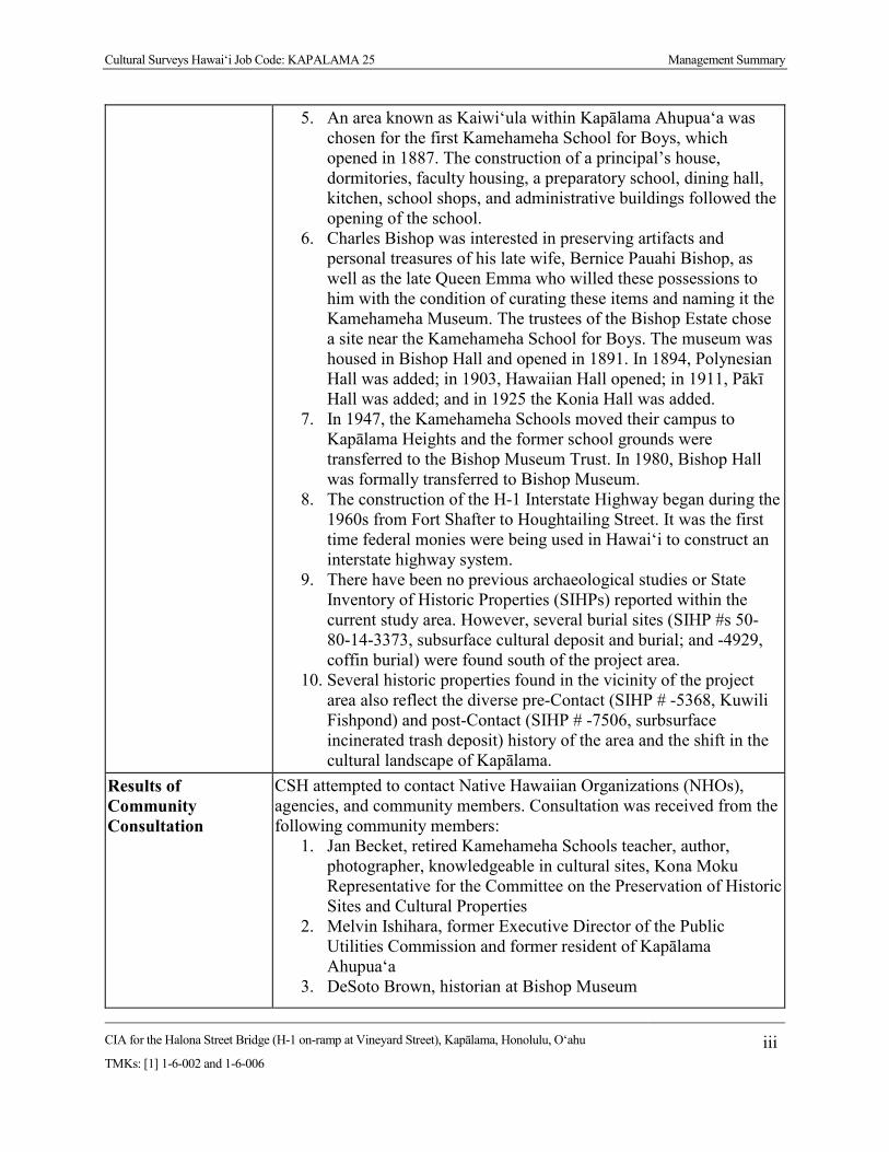
Cultural Surveys Hawai‘i Job Code: KAPALAMA 25 Management Summary
CIA for the Halona Street Bridge (H-1 on-ramp at Vineyard Street), Kapālama, Honolulu, O‘ahu
TMKs: [1] 1-6-002 and 1-6-006 iii
5. An area known as Kaiwi‘ula within Kapālama Ahupua‘a was chosen for the first Kamehameha School for Boys, which opened in 1887. The construction of a principal’s house, dormitories, faculty housing, a preparatory school, dining hall, kitchen, school shops, and administrative buildings followed the opening of the school.
6. Charles Bishop was interested in preserving artifacts and personal treasures of his late wife, Bernice Pauahi Bishop, as well as the late Queen Emma who willed these possessions to him with the condition of curating these items and naming it the Kamehameha Museum. The trustees of the Bishop Estate chose a site near the Kamehameha School for Boys. The museum was housed in Bishop Hall and opened in 1891. In 1894, Polynesian Hall was added; in 1903, Hawaiian Hall opened; in 1911, Pākī Hall was added; and in 1925 the Konia Hall was added.
7. In 1947, the Kamehameha Schools moved their campus to Kapālama Heights and the former school grounds were transferred to the Bishop Museum Trust. In 1980, Bishop Hall was formally transferred to Bishop Museum.
8. The construction of the H-1 Interstate Highway began during the 1960s from Fort Shafter to Houghtailing Street. It was the first time federal monies were being used in Hawai‘i to construct an interstate highway system.
9. There have been no previous archaeological studies or State Inventory of Historic Properties (SIHPs) reported within the current study area. However, several burial sites (SIHP #s 50-80-14-3373, subsurface cultural deposit and burial; and -4929, coffin burial) were found south of the project area.
10. Several historic properties found in the vicinity of the project area also reflect the diverse pre-Contact (SIHP # -5368, Kuwili Fishpond) and post-Contact (SIHP # -7506, surbsurface incinerated trash deposit) history of the area and the shift in the cultural landscape of Kapālama.
Results of Community Consultation
CSH attempted to contact Native Hawaiian Organizations (NHOs), agencies, and community members. Consultation was received from the following community members:
1. Jan Becket, retired Kamehameha Schools teacher, author, photographer, knowledgeable in cultural sites, Kona Moku Representative for the Committee on the Preservation of Historic Sites and Cultural Properties
2. Melvin Ishihara, former Executive Director of the Public Utilities Commission and former resident of Kapālama Ahupua‘a
3. DeSoto Brown, historian at Bishop Museum
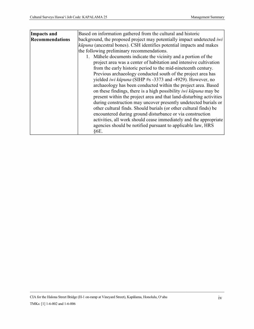
Cultural Surveys Hawai‘i Job Code: KAPALAMA 25 Management Summary
CIA for the Halona Street Bridge (H-1 on-ramp at Vineyard Street), Kapālama, Honolulu, O‘ahu
TMKs: [1] 1-6-002 and 1-6-006 iv
Impacts and Recommendations
Based on information gathered from the cultural and historic background, the proposed project may potentially impact undetected iwi kūpuna (ancestral bones). CSH identifies potential impacts and makes the following preliminary recommendations.
1. Māhele documents indicate the vicinity and a portion of the project area was a center of habitation and intensive cultivation from the early historic period to the mid-nineteenth century. Previous archaeology conducted south of the project area has yielded iwi kūpuna (SIHP #s -3373 and -4929). However, no archaeology has been conducted within the project area. Based on these findings, there is a high possibility iwi kūpuna may be present within the project area and that land-disturbing activities during construction may uncover presently undetected burials or other cultural finds. Should burials (or other cultural finds) be encountered during ground disturbance or via construction activities, all work should cease immediately and the appropriate agencies should be notified pursuant to applicable law, HRS §6E.

Cultural Surveys Hawai‘i Job Code: KAPALAMA 25
CIA for the Halona Street Bridge (H-1 on-ramp at Vineyard Street), Kapālama, Honolulu, O‘ahu
TMKs: [1] 1-6-002 and 1-6-006 v
Table of Contents Management Summary ............................................................................................................ i Section 1 Introduction ............................................................................................................. 1
Project Background ....................................................................................................................... 1 Document Purpose ......................................................................................................................... 1 Scope of Work ............................................................................................................................... 6 Environmental Setting ................................................................................................................... 6
1.4.1 Natural Environment............................................................................................................... 6 1.4.2 Winds, Rains, and Seas of Kapālama ..................................................................................... 8 1.4.3 Built Environment................................................................................................................... 9
Section 2 Methods .................................................................................................................. 10
Archival Research ........................................................................................................................ 10 Community Consultation ............................................................................................................. 10
2.2.1 Scoping for Participants ........................................................................................................ 10 2.2.2 “Talk Story” Sessions ........................................................................................................... 10 2.2.3 Interview Completion ........................................................................................................... 11
Section 3 Ka‘ao and Mo‘olelo (Legends and Stories) .......................................................... 12
Traditional Legends ..................................................................................................................... 12 3.1.1 Kapālama and Lepeamoa, the Bird Maiden of Pālama ......................................................... 12 3.1.2 Legend of Palila .................................................................................................................... 13 3.1.3 Keanakamanō, the Cave of the Shark ................................................................................... 14 Wahi Pana (Legendary Places).................................................................................................... 14
3.2.1 Pōhaku in Kapālama ............................................................................................................. 15 3.2.2 Fishponds of Kapālama and Iwilei ....................................................................................... 17 ‘Ōlelo No‘eau (Proverbs)............................................................................................................. 17
3.3.1 ‘Ōlelo No‘eau #1732 ............................................................................................................ 17 3.3.2 ‘Ōlelo No‘eau #2918 ............................................................................................................ 18 Oli (Chants) ................................................................................................................................. 18
3.4.1 The Epic Tale of Hi‘iakaikapoliopele ................................................................................... 18 Mele (Song) ................................................................................................................................. 19
3.5.1 Pu‘uhonua Nani Beautiful Refuge .................................................................................. 19 3.5.2 Moana-lua Moanalua ...................................................................................................... 20 3.5.3 Pua Hē‘ī Papaya Flower ................................................................................................ 21
Section 4 Traditional and Historical Accounts .................................................................... 22
Traditional Accounts of Battles at Niuhelewai Stream in Kapālama .......................................... 22 4.1.1 Kahahawa‘i’s Defeat of Kahāhana (AD 1780-1783) ............................................................ 22 4.1.2 The Rebellions of the ‘Ewa and Kona Chiefs (post-1783) ................................................... 22 Early Historic Period ................................................................................................................... 23 The Māhele and the Kuleana Act ................................................................................................ 27 Mid- to Late 1800s ....................................................................................................................... 29 1900s ............................................................................................................................................ 38
4.5.1 Residential and Commercial Development .......................................................................... 38 Previous Archaeological Research .............................................................................................. 48
4.6.1 Palama Fire Station (Neller 1980) ........................................................................................ 48 4.6.2 Dunn et al. 1991 .................................................................................................................... 48

Cultural Surveys Hawai‘i Job Code: KAPALAMA 25
CIA for the Halona Street Bridge (H-1 on-ramp at Vineyard Street), Kapālama, Honolulu, O‘ahu
TMKs: [1] 1-6-002 and 1-6-006 vi
4.6.3 Bishop Museum (Dixon 1993) ............................................................................................. 55 4.6.4 Austin Lane, Kapālama (Jourdane 1994; Hammatt 1995) .................................................... 55 4.6.5 Corner of North King and Houghtailing Streets (Nakamura et al. 1994) ............................. 55 4.6.6 Kamehameha Homes Project, Kapālama (Borthwick et al. 1995) ....................................... 55 4.6.7 Kamehameha Heights, Puea and Ka‘ahumanu Cemeteries (McIntosh and Cleghorn 2006) 55 4.6.8 Kalihi/Nu‘uanu Sewer Rehabilitation Project (Hunkin et al. 2012) ..................................... 55 4.6.9 Walgreens Development Project, North School Street (Dey and Hammatt 2008) ............... 56 4.6.10 Traffic Management System Project, Houghtailing Street by the H-1 (Burke et al. 2010) 56 4.6.11 Kalihi Beretania 24-Inch Water Main Project (Hammatt and Chiogioji 2008) .................. 56 4.6.12 Kalihi/Nu‘uanu Sewer Rehabilitation Project (Hunkin et al. 2012) ................................... 56 4.6.13 Honolulu High-Capacity Transit Corridor Project (Hammatt 2013) .................................. 56 4.6.14 Kalihi Valley Sewer System Improvements, Kapālama (Hunkin and Hammatt 2013) ...... 56 4.6.15 Medina and Hammatt 2013 ................................................................................................. 57 4.6.16 Traffic Control Signal Improvements along Dillingham Boulevard (Medina et al. 2013) . 57 4.6.17 Honolulu Community College (Pammer and McDermott 2014) ........................................ 57 4.6.18 Farrington High School (Stine et al. 2014) ......................................................................... 57 Background Summary and Predictive Model .............................................................................. 57
Section 5 Community Consultation ...................................................................................... 59
Introduction.................................................................................................................................. 59 Community Contact Letter .......................................................................................................... 59 Community Contact Table ........................................................................................................... 64 Kama‘āina Interviews ................................................................................................................. 67
5.4.1 Summary of Melvin Ishihara Interview ................................................................................ 67 5.4.2 Summary of Jan Becket Interview ........................................................................................ 70 Summary of Kama‘āina Interviews ............................................................................................. 74
Section 6 Traditional Cultural Practices.............................................................................. 77
Gathering of Plant Resources ...................................................................................................... 77 Burials .......................................................................................................................................... 80 Wahi Pana ................................................................................................................................... 80 Trails ............................................................................................................................................ 81
Section 7 Summary and Recommendations ........................................................................ 82
Results of Background Research ................................................................................................. 82 Results of Community Consultations .......................................................................................... 83 Impacts and Recommendations ................................................................................................... 83
Section 8 References Cited .................................................................................................... 84
Appendix A Land Commission Awards ............................................................................... 92
A.1 LCA 732 (to Kuinui) ............................................................................................................... 92 A.2 LCA 918 (to Upai) .................................................................................................................. 94 A.3 LCA 1746 (to Nakaikuaana) ................................................................................................... 95 A.4 LCA 2266 (to Kuhiana) .......................................................................................................... 96 A.5 LCA 2268 (to Kapahu) ........................................................................................................... 97 A.6 LCA 2937 (to Wm. Harbottle) ................................................................................................ 98
Appendix B OHA Response Letter ..................................................................................... 104
Appendix C Melvin Ishihara Transcription ...................................................................... 105
Cultural Surveys Hawai‘i Job Code: KAPALAMA 25
CIA for the Halona Street Bridge (H-1 on-ramp at Vineyard Street), Kapālama, Honolulu, O‘ahu
TMKs: [1] 1-6-002 and 1-6-006 vii
Appendix D Jan Becket Transcription ............................................................................... 140
Appendix E Authorization and Release Forms ................................................................. 149
E.1 Melvin Ishihara ......................................................................................................................... 149 E.2 Jan Becket ................................................................................................................................. 150

Cultural Surveys Hawai‘i Job Code: KAPALAMA 25
CIA for the Halona Street Bridge (H-1 on-ramp at Vineyard Street), Kapālama, Honolulu, O‘ahu
TMKs: [1] 1-6-002 and 1-6-006 viii
List of Figures Figure 1. Portion of the 1998 USGS 7.5-minute topographic Honolulu quadrangle showing
the location of the study area .........................................................................................2 Figure 2. Tax Map Key (TMK) [1] 1-6-002, showing study area at the H-1 Interstate Highway
crossing at Kapālama Canal (Hawai‘i TMK Service) ...................................................3 Figure 3. TMK: [1] 1-6-006, showing study area at the H-1 Interstate Highway crossing at
Kapālama Canal (Hawai‘i TMK Service) ......................................................................4 Figure 4. Aerial photograph (Google Earth 2013), showing study area at the H-1 Interstate
Highway crossing at Kapālama Canal ...........................................................................5 Figure 5. 2013 aerial photograph (Google Earth 2013) with an overlay of the USDA
SSURGO database (2001) and soil survey data gathered by Foote et al. (1972) ..........7 Figure 6. Paka‘alana Heiau in Kapālama Ahupua‘a (courtesy of Pacific Worlds) .......................16 Figure 7. 1817 map of south coast of O‘ahu by Otto von Kotzebue (1817) of the Russian
ship Rurik, showing density of habitations and agriculture around Kapālama (The study area and map have been geo-referenced; the study area is located on a ridge, and it should be noted that this early map should be understood as a “sketch”) ......................................................................................................................24
Figure 8. 1855 map of Honolulu by Lt. Joseph de LaPasse of the French vessel, L’Eurydice, showing lo‘i, habitations, and fishponds in Kapālama ................................................25
Figure 9. Image by Robert Dampier, Fishponds of Honoruru, Oahu, ca. 1825 ............................28 Figure 10. 1885 Brown map of Kapālama depicting LCA parcels in the vicinity of the study
area and the planned extension of the Vineyard Street right-of-way ...........................30 Figure 11. 2013 aerial photograph with an overlay of Land Commission Awards in the
vicinity of the study area (Google Earth 2013) ............................................................32 Figure 12. 1893 Wall map of Honolulu showing study area surrounded by rice fields ................33 Figure 13. 1897 Monsarrat map of the Honolulu District showing the study area in a rice
plantation......................................................................................................................34 Figure 14. Photo of Kamehameha School for Boys, ca. 1933 .......................................................36 Figure 15. Photo of the Bishop Museum ca. 1889 .........................................................................37 Figure 16. Photo of the Houghtailing sisters’ plantation home, now the location of Damien
Memorial School., ca. 1912-1913 ................................................................................37 Figure 17. 1919 U.S. Army War Department map, Honolulu Quadrangle, showing
commercial and residential development in Kapālama, near the study area ...............39 Figure 18. 1927 Sanborn Company Fire Insurance map showing a relative lack of
development in the vicinity of the study area ..............................................................40 Figure 19. 1933 U.S. Army War Department map, Honolulu Quadrangle, showing
commercial and residential development in Kapālama, near the study area ...............41 Figure 20. 1943 U.S. Army War Department map, Honolulu Quadrangle showing
commercial and residential development in Kapālama, near the study area ...............42 Figure 21. 1950 Sanborn Company Fire Insurance map showing a relative lack of
development in the vicinity of the study area ..............................................................43 Figure 22. 1952 aerial photograph showing study area (USGS) ...................................................44 Figure 23. Portion of 1953 Honolulu USGS topographic quadrangle, showing commercial
and residential development in Kapālama, near the study area ...................................45
Cultural Surveys Hawai‘i Job Code: KAPALAMA 25
CIA for the Halona Street Bridge (H-1 on-ramp at Vineyard Street), Kapālama, Honolulu, O‘ahu
TMKs: [1] 1-6-002 and 1-6-006 ix
Figure 24. 1978 USGS aerial photograph, Honolulu Quadrangle, showing commercial and residential development in Kapālama near the study area ...........................................46
Figure 25. Previous archaeological studies within a 0.8-km (0.5-mile) radius of the study area ...............................................................................................................................49
Figure 26. Previously identified historic properties within a 0.8-km (0.5-mile) radius of the study area .....................................................................................................................53
Figure 27. Community consultation letter, page one .....................................................................60 Figure 28. Community consultation letter, page two .....................................................................61 Figure 29. Community consultation letter regarding change to project area .................................63
List of Tables
Table 1. LCAs within the Project Area ..........................................................................................31 Table 2. Construction Timeline of Hawaii 72, Later Renumbered as H-1 Interstate Highway ....47 Table 3. Previous Archaeological Studies within a 0.8-km (0.5-mile) Radius of the Study
Area (arranged chronologically) .....................................................................................50 Table 4. Previously Identified Historic Properties within a 0.8-km (0.5-mile) Radius of the
Study Area ......................................................................................................................54 Table 5. Results of Community Consultation ................................................................................64
Cultural Surveys Hawai‘i Job Code: KAPALAMA 25 Introduction
CIA for the Halona Street Bridge (H-1 on-ramp at Vineyard Street), Kapālama, Honolulu, O‘ahu
TMKs: [1] 1-6-002 and 1-6-006 1
Section 1 Introduction
Project Background At the request of CH2M HILL and on behalf of the Federal Highway Administration (FHWA)
Central Federal Lands Highway Division (CFLHD), Cultural Surveys Hawai‘i, Inc. (CSH) has completed this cultural impact assessment report for the Halona Street Bridge replacement project, Kapālama Ahupua‘a, Honolulu (Kona) District, O‘ahu, FHWA/CFLHD Contract DTFH68-13-R-00027, TMKs: [1] 1-6-002 (Halona Street Right-of-Way) and [1] 1-6-006 (Kapālama Canal). The study area is located within Kapālama Ahupua‘a at the location of the Halona Street Bridge and the Kapālama Canal and includes portions of the H-1 Interstate Highway and Halona Street from the intersection of Kuipaakea Lane to just beyond Kohou Street. The study area is depicted on a portion of the 1998 Honolulu U.S. Geological Survey (USGS) 7.5-minute topographic quadrangle (Figure 1), tax map plats (Figure 2 and Figure 3), and a 2013 aerial photograph (Figure 4).
The purpose of the project is to replace the existing bridge to meet current design standards for roadway width, load capacity, pedestrian traffic, bridge railing and transitions, and bridge approaches. The existing bridge was built in 1938 and is structurally deficient and functionally obsolete. The replacement bridge would be a three-span, concrete structure. It would be supported on two piers similar to, and aligned with, the existing H-1 Bridge piers. New abutments would be set back from and behind the existing abutments which would be left in place, thereby minimizing impacts to the masonry walls along the canal. For safety reasons, another consideration is to develop provisions to discourage individuals from accessing the area under the bridge.
The study area includes approximately 0.9 ha (2.2 acres). The area of potential effect (APE) for the current project is defined as the entire 2.2-acre project area.
Document Purpose The purpose of this cultural impact assessment (CIA) is to comply with the State of Hawai‘i’s
environmental review process under Hawai‘i Revised Statutes (HRS) §343, which requires consideration of the project’s potential effect on cultural beliefs, practices, and resources. Through document research and cultural consultation efforts, this report provides information compiled to date pertinent to the assessment of the proposed project’s potential impacts on cultural beliefs, practices, and resources (pursuant to the Office of Environmental Quality Control’s Guidelines for Assessing Cultural Impacts), which may include traditional cultural properties (TCPs). These TCPs may be significant historic properties under State of Hawai‘i significance criterion “e,” pursuant to Hawai‘i Administrative Rules (HAR) §13-275-6 and §13-284-6. Significance criterion “e” refers to historic properties that “have an important value to the native Hawaiian people or to another ethnic group of the state due to associations with cultural practices once carried out, or still carried out, at the property or due to associations with traditional beliefs, events or oral accounts—these associations being important to the group’s history and cultural identity” (HAR §13-275-6 and§13-284-6). The document will likely also support the project’s historic preservation review under HRS §6E and HAR §13-275 and §13-284. The document is intended to

Cultural Surveys Hawai‘i Job Code: KAPALAMA 25 Introduction
CIA for the Halona Street Bridge (H-1 on-ramp at Vineyard Street), Kapālama, Honolulu, O‘ahu
TMKs: [1] 1-6-002 and 1-6-006 2
Figure 1. Portion of the 1998 USGS 7.5-minute topographic Honolulu quadrangle showing the
location of the study area

Cultural Surveys Hawai‘i Job Code: KAPALAMA 25 Introduction
CIA for the Halona Street Bridge (H-1 on-ramp at Vineyard Street), Kapālama, Honolulu, O‘ahu
TMKs: [1] 1-6-002 and 1-6-006 3
Figure 2. Tax Map Key (TMK) [1] 1-6-002, showing study area at the H-1 Interstate Highway crossing at Kapālama Canal (Hawai‘i
TMK Service)

Cultural Surveys Hawai‘i Job Code: KAPALAMA 25 Introduction
CIA for the Halona Street Bridge (H-1 on-ramp at Vineyard Street), Kapālama, Honolulu, O‘ahu
TMKs: [1] 1-6-002 and 1-6-006 4
Figure 3. TMK: [1] 1-6-006, showing study area at the H-1 Interstate Highway crossing at Kapālama Canal (Hawai‘i TMK Service)
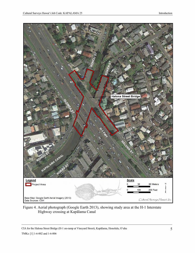
Cultural Surveys Hawai‘i Job Code: KAPALAMA 25 Introduction
CIA for the Halona Street Bridge (H-1 on-ramp at Vineyard Street), Kapālama, Honolulu, O‘ahu
TMKs: [1] 1-6-002 and 1-6-006 5
Figure 4. Aerial photograph (Google Earth 2013), showing study area at the H-1 Interstate
Highway crossing at Kapālama Canal
Cultural Surveys Hawai‘i Job Code: KAPALAMA 25 Introduction
CIA for the Halona Street Bridge (H-1 on-ramp at Vineyard Street), Kapālama, Honolulu, O‘ahu
TMKs: [1] 1-6-002 and 1-6-006 6
support the project’s environmental review and may also serve to support the project’s historic preservation review under HRS §6E-8 and HAR §13-284.
Due to federal funding, this project is a federal undertaking, requiring compliance with Section 106 of the National Historic Preservation Act, the National Environmental Policy Act, and Section 4(f) of the Department of Transportation Act. The proposed project is also subject to Hawai‘i State environmental and historic preservation review legislation (HRS §343 and HRS §6E-8/ HAR §13-275, respectively).
Scope of Work The scope of work for this CIA includes the following:
1. Examination of cultural and historical resources, including Land Commission documents, historic maps, and previous research reports with the specific purpose of identifying traditional Hawaiian activities including gathering of plant, animal, and other resources or agricultural pursuits as may be indicated in the historic record.
2. Review of previous archaeological work at and near the subject parcel that may be relevant to reconstructions of traditional land use activities; and to the identification and description of cultural resources, practices, and beliefs associated with the parcel.
3. Consultation and interviews with knowledgeable parties regarding cultural and natural resources and practices at or near the parcel; present and past uses of the parcel; and/or other practices, uses, or traditions associated with the parcel and environs.
4. Preparation of a report that summarizes the results of these research activities and provides recommendations based on findings.
Environmental Setting 1.4.1 Natural Environment
Kapālama is a small valley that was once watered by two small streams, the Kapālama and Niuhelewai streams. The ahupua‘a (land division) of Kapālama is pie-shaped with its apex at approximately 609 m (2,000 feet [ft]) AMSL (above mean sea level) on the ridge that separates Nu‘uanu and Kalihi valleys. The shore frontage (presently “Kapālama Basin”) is part of the Honolulu Harbor protected shoreline. In 1961, the development of the Kapālama Canal, which follows the lower course of Niuhelewai Stream, channelized the lower streams. Temperatures in the study area range from 60–90° F, while rainfall varies from 50–127 cm (20–50 inches) per year (Juvik and Juvik 1998:62–64).
According to the U.S. Department of Agriculture (USDA) Soil Survey Geographic (SSURGO) database (2001) and soil survey data gathered by Foote et al. (1972), soils within the study area include Kawaihapai stony clay loam, 2 to 6% slopes (KlaB), Hanalei silty clay loam, 0 to 2% slopes (HnA), and Ewa silty clay loam, moderately shallow, 0 to 2% slopes (EmA) (Figure 5).
Soils of the Kawaihapai Series are described as follows:
This series consists of well-drained soils in drainage-ways and on alluvial fans on coastal plains on the islands of Oahu and Molokai. These soils formed in alluvium derived from basic igneous rock in humid uplands. They are nearly level to

Cultural Surveys Hawai‘i Job Code: KAPALAMA 25 Introduction
CIA for the Halona Street Bridge (H-1 on-ramp at Vineyard Street), Kapālama, Honolulu, O‘ahu
TMKs: [1] 1-6-002 and 1-6-006 7
Figure 5. 2013 aerial photograph (Google Earth 2013) with an overlay of the USDA SSURGO
database (2001) and soil survey data gathered by Foote et al. (1972)

Cultural Surveys Hawai‘i Job Code: KAPALAMA 25 Introduction
CIA for the Halona Street Bridge (H-1 on-ramp at Vineyard Street), Kapālama, Honolulu, O‘ahu
TMKs: [1] 1-6-002 and 1-6-006 8
moderately sloping. Elevations range from nearly sea level to 300 feet. The annual rainfall amounts to 30 to 50 inches. [Foote et al. 1972:63–64]
Soils of the Hanalei Series are described as follows:
This series consists of somewhat poorly drained to poorly drained soils on bottom lands on the islands of Kauai and Oahu. These soils developed in alluvium derived from basic igneous rock. They are level to gently sloping. Elevations range from sea level to 800 feet. The annually rainfall amounts to 20 to 120 inches. [Foote et al. 1972:38]
Soils of the Ewa Series are described as follows:
This series consists of well-drained soils in basins and on alluvial fans on the islands of Maui and Oahu. These soils developed in alluvium derived from basic igneous rock. They are nearly level to moderately sloping. Elevations range from near sea level to 150 feet. The annual rainfall amounts to 10 to 30 inches. [Foote et al. 1972:29]
Vegetation observed within the study area includes California grass (Urochloa mutica), sensitive plant (Mimosa pudica), and Java plum (Syzygium cumini).
1.4.2 Winds, Rains, and Seas of Kapālama Each small geographic area on O‘ahu had a Hawaiian name for its own wind, rain, and seas.
The name of the winds of O‘ahu are listed in a chant concerning a powerful gourd called the wind gourd of La‘amaomao. When the gourd was opened, a specific wind could be called to fill the sails of a canoe and take the person in the desired direction. The chant lists the winds of the Honolulu area from east to west.
Kukalahale is of Honolulu,
‘Ao‘oa is of Māmala,
‘Ōluniu is of Kapālama,
Haupe‘epe‘e is of Kalihi,
Ko-momona is of Kahauiki.
[Nakuina 1990:43]
The names of the seas of southeastern O‘ahu are listed in a chant for the high chief Kūali‘i, paramount chief of the Hawaiian Islands from 1720 to 1740 (Cordy 2002:19). From the east end of Waikīkī to the west boundary of the Kona district at Moanalua Ahupua‘a, the seas were as follows:
A sea for surf swimming is Kahaloa [sic] [in Waikīkī]
A sea for net fishing is Kalia [in Waikīkī]
A sea for going naked is Mamala [mouth of Honolulu Harbor]
A sea for swimming is Kapuuone [in Kapālama/Kalihi]
A sea for surf-swimming sideways is Makaiwa [in Kapālama/Kalihi]

Cultural Surveys Hawai‘i Job Code: KAPALAMA 25 Introduction
CIA for the Halona Street Bridge (H-1 on-ramp at Vineyard Street), Kapālama, Honolulu, O‘ahu
TMKs: [1] 1-6-002 and 1-6-006 9
A sea for catching ‘anae [mullet] is Keeia [in Moanalua]
A sea for crabs is Leleiwi [in Moanalua].
[Fornander 1980:390]
1.4.3 Built Environment The study area is located within urban Honolulu. The study area’s built environment includes
a portion of Halona Street, the Halona Street Bridge, and the Kapālama Canal. Halona Street is the former extension of Vineyard Boulevard, which was replaced by a portion of the H-1 Interstate Highway in the 1960s. The Halona Street Bridge is a continuous concrete cast-in-place bridge constructed in 1938. The Kapālama Canal is a channelized drainage that extends through urban Honolulu and is used to control the runoff from both Niuhelewai and Kapālama streams.
Cultural Surveys Hawai‘i Job Code: KAPLAMA 25 Methods
CIA for the Halona Street Bridge (H-1 on-ramp at Vineyard Street), Kapālama, Honolulu, O‘ahu
TMKs: [1] 1-6-002 and 1-6-006 10
Section 2 Methods
Archival Research Research centers on Hawaiian activities including ka‘ao (legends), wahi pana (storied places),
‘ōlelo no‘eau (proverbs), oli (chants), mele (songs), traditional mo‘olelo (stories), traditional subsistence and gathering methods, ritual and ceremonial practices, and more. Background research focuses on land transformation, development, and population changes beginning with the early post-Contact era to the present day.
Cultural documents, primary and secondary cultural and historical sources, historic maps, and photographs were reviewed for information pertaining to the study area. Research was primarily conducted at the CSH library. Other archives and libraries including the Hawai‘i State Archives, the Bishop Museum Archives, the University of Hawai‘i at Mānoa’s Hamilton Library, Ulukau, The Hawaiian Electronic Library (Ulukau.org 2014), the State Historic Preservation Division (SHPD) Library, the State of Hawai‘i Land Survey Division, the Hawaiian Historical Society, and the Hawaiian Mission Houses Historic Site and Archives are also repositories where CSH cultural researchers gather information. Information on Land Commission Awards (LCAs) were accessed via Waihona ‘Aina Corporation’s Māhele database (Waihona ‘Aina 2000), the Office of Hawaiian Affairs (OHA) Papakilo Database (Office of Hawaiian Affairs 2015), and the Ava Konohiki Ancestral Visions of ‘Āina website (Ava Konohiki 2015).
Community Consultation 2.2.1 Scoping for Participants
The cultural department commences our consultation efforts by utilizing our previous community contact list to facilitate the interview process. We then review an in-house database of kūpuna (elders), kama‘āina (native born), cultural practitioners, lineal and cultural descendants, Native Hawaiian Organizations (NHOs; includes Hawaiian Civic Clubs and those listed on the Department of Interior’s NHO list), and community groups. CSH also contacts agencies such as State Historic Preservation Division (SHPD), OHA, and the appropriate Island Burial Council where the proposed project is located for their response on the project and to identify lineal and cultural descendants, individuals and/or NHO with cultural expertise and/or knowledge of the study area. CSH is also open to referrals and new contacts.
2.2.2 “Talk Story” Sessions Prior to the interview, CSH cultural researchers explain the role of a CIA, how the consent
process works, the project purpose, the intent of the study, and how their ‘ike (knowledge) and mana‘o (thought, opinion) will be used in the report. The interviewee is given an Authorization and Release Form to read and sign.
“Talk Story” sessions range from the formal (e.g., sit down and kūkā [consultation, discussion] in the participant’s place of choice over set interview questions) to the informal (e.g., hiking to cultural sites near the study area and asking questions based on findings during the field outing). In some cases, interviews are recorded and transcribed later.

Cultural Surveys Hawai‘i Job Code: KAPLAMA 25 Methods
CIA for the Halona Street Bridge (H-1 on-ramp at Vineyard Street), Kapālama, Honolulu, O‘ahu
TMKs: [1] 1-6-002 and 1-6-006 11
CSH also conducts group interviews, which range in size. Group interviews usually begin with set, formal questions. As the group interview progresses, questions are based on interviewees’ answers. Group interviews are always transcribed and notes are taken. Recorded interviews assist the cultural researcher in 1) conveying accurate information for interview summaries, 2) reducing misinterpretation, and 3) adding missing details to mo‘olelo.
CSH seeks kōkua (assistance) and guidance in identifying past and current traditional cultural practices of the study area. Those aspects include general history of the ahupua‘a (traditional land division extending from the mountain to the sea); past and present land use of the study area; knowledge of cultural sites (for example, wahi pana, archaeological sites, and burials); knowledge of traditional gathering practices (past and present) within the study area; cultural associations (ka‘ao and mo‘olelo); referrals; and any other cultural concerns the community might have related to Hawaiian cultural practices within or in the vicinity of the study area.
2.2.3 Interview Completion After an interview, CSH cultural researchers transcribe and create an interview summary based
on information provided by the interviewee. Cultural researchers give a copy of the transcription and interview summary to the interviewee for review and ask that they make any necessary edits. Once the interviewee has made those edits, CSH incorporates their ‘ike and mana‘o into the report. When the draft report is submitted to the client, cultural researchers then prepare a finalized packet of the participant’s transcription, interview summary, and any photos taken during the interview. We also include a thank you card and honoraria.
It is important that CSH cultural researchers cultivate and maintain community relationships. The CIA report may be completed, but CSH researchers continuously keep in touch with the community and interviewees throughout the year—such as checking in to say hello via email or by phone, volunteering with past interviewees on community service projects, and sending holiday cards to them and their ‘ohana (family). CSH researchers feel this is an important component to building relationships and being part of an ‘ohana and community.
“I ulu no ka lālā i ke kumu—the branches grow because of the trunk,” is an ‘ōlelo no‘eau (#1261) shared by Mary Kawena Pukui with the simple explanation: “Without our ancestors we would not be here” (Pukui 1983:137). As cultural researchers, we often lose our kūpuna but we do not lose their wisdom and words. We routinely check obituaries and gather information from other community contacts if we have lost our kūpuna. CSH makes it a point to reach out to the ‘ohana of our kūpuna who have passed on and pay our respects including sending all past transcriptions, interview summaries, and photos for families to have on file for genealogical and historical reference.
Cultural Surveys Hawai‘i Job Code: KAPALAMA 25 Ka‘ao and Mo‘olelo
CIA for the Halona Street Bridge (H-1 on-ramp at Vineyard Street), Kapālama, Honolulu, O‘ahu
TMKs: [1] 1-6-002 and 1-6-006 12
Section 3 Ka‘ao and Mo‘olelo (Legends and Stories)
Traditional Legends 3.1.1 Kapālama and Lepeamoa, the Bird Maiden of Pālama
The place name Kapālama is often understood to refer to an enclosure (pā) of lama wood that surrounded the place of residence of high ranking ali‘i (chiefs) (Pukui et al. 1974:87). McAllister (1933:88) relates: “Kapalama is said to have obtained its name from an establishment in which the young ali‘i were kept just before pairing off for offspring.” This information probably came from Nathaniel Emerson, who translated David Malo’s “Ka Mo‘olelo Hawai‘i.” Emerson added many notes to his English translation, including the following:
Hoonoho ia means put in an establishment, placed under the care of a guardian or duenna [chaperone]. Such an establishment was surrounded by an enclosure, pa, made of the sacred lama . . . Hence this special care or guardianship was called palama. It is said that an establishment of this kind was anciently placed at that suburb of Honolulu which to this day bears the name of Ka-pa-lama. [Malo 1951:139; note by N.B. Emerson]
Westervelt (1923:165) attributes the O‘ahu place name to a chiefess of O‘ahu who lived in that area. This chiefess was Kapālama, the grandmother of Lepeamoa (Hawaiian for “cockscomb”). There are several retellings of this story (Knudsen and Noble 1945:63-69; Pukui and Curtis 1949:118–126; Westervelt 1963:204–245), but all seem to use Westervelt (1923) as their source. A chief of Kaua‘i named Keāhua traveled to O‘ahu to take Kauhao, the daughter of Kapālama, as his wife. He angered the kupua (supernatural being that can change form) called Akuapehuale (god of swollen billows), who forced the couple to hide in the uplands of the Wailua River valley of Kaua‘i.
Keāhua’s daughter was born as an egg, and was adopted by the chiefess Kapālama to raise on O‘ahu at her home, also named Kapālama. When the egg hatched, Lepeamoa was a bird with feathers all the colors of the rainbow. She became able to turn herself into a beautiful young woman wearing a feather lei. The girl was so beautiful that a rainbow was always present above her. The girl was guarded by her ancestress, Keaolewa (“the moving cloud”), who could also change forms between human and bird. The lower ridge separating Kapālama and Nu‘uanu (‘Ālewa Heights) may have been named for this ancestress.
The parents of Lepeamoa had another child, a son called Kau‘ilani, who was so strong he was able to defeat the kupua who had threatened his parents. On Kaua‘i, there are several place names associated with this story. Kauhao (meaning “the scooping”), is the name of a deep valley in the ahupua‘a of Miloli‘i in the Waimea District. Lepeamoa is a point at the mouth of Ka‘auhau Valley in the same ahupua‘a. The valley in Wailua Ahupua‘a in the Puna District where Kau‘ilani defeated Akuapehuale was named Keāhua (meaning “hillock”) after the chief, his father (Wichman 1998:81, 158).
After Kau‘ilani’s victory over the kupua, he went to O‘ahu to find his sister, searching for the rainbow sign of her presence. In her compound, he found Kapālama, who advised him to hide in Lepeamoa’s house, wait until she was asleep in her bird form, and catch and hold her until she

Cultural Surveys Hawai‘i Job Code: KAPALAMA 25 Ka‘ao and Mo‘olelo
CIA for the Halona Street Bridge (H-1 on-ramp at Vineyard Street), Kapālama, Honolulu, O‘ahu
TMKs: [1] 1-6-002 and 1-6-006 13
acknowledged him as her brother. Her advice worked, and Lepeamoa lived with her brother thereafter (Westervelt 1923:164–184).
Additional stories are told of Kau‘ilani and his magical sister Lepeamoa. In one story, the Maui chief, Mauinui, had a fighting rooster. This rooster was also a kupua named Ka‘auhelemoa that could change forms; by the use of its magic it always defeated any challenger. Lepeamoa, however, was also the granddaughter of the kupua Ka‘auhelemoa. The O‘ahu chief Kakuhihewa was hosting the Maui chief at his residence in Waikīkī and was losing many goods while betting on the cock-fighting, which the Maui chief’s rooster always won. Kakuhihewa had heard about the hero Kau‘ilani and asked him if he could find some way to defeat the Maui rooster. When Kau‘ilani agreed, Kakuhihewa gave him his daughter in marriage. Kau‘ilani asked for the help of his sister, who turned into a beautiful hen to fight the rooster. The two combatants both changed forms several times during the battle, but eventually Lepeamoa won. The daughter of the king had a child, called Kamano, who Lepeamoa took back to Kapālama to care for (Westervelt 1923:227–245).
3.1.2 Legend of Palila In the legend of Palila, the hero’s war club could magically carry him far distances in a single
flight. Palila came to the plain of Keahumoa in ‘Ewa to participate in the athletic games given by the O‘ahu king, Ahuapau. The residence of this chief was said to be at Kalaepōhaku, near Wailuakio in Kapālama (Fornander 1917:5[1]:142). Kalaepōhaku Peak (meaning “the stone promontory”) is near the intersection of School and Alaneo streets in Kapālama.
A place named Niuhelewai (lit. “coconut going in water”) in lower Kapālama, located makai (seaward) of King Street (Fornander 1917:4[3]:530–531; Fornander 1919:5[2]:368) was associated with the deity Haumea and the hero, Kaulu, who was known for his great strength.
Kaulu was born in Kailua on the windward side of O‘ahu. His older brother Kaeha was taken by the spirits to a realm of gods in the sky. For love of his brother, Kaulu followed him to this realm, playing a number of tricks on the gods including Makali‘i, the god of plenty, who had a magic fish net that would fill with fish whenever used. After playing the tricks, Kaulu then had to rescue his brother from the wrath of the various spirits. The brothers finally returned to the land of men on O‘ahu, setting down at Moanalua (ahupua‘a [land division] west of Kapālama).
A hiki laua ma Moanalua, i Papakolea, hoonoho o Kaulu ia Kaeha ilaila; hele mai la o Kaulu a loaa o Haumea i Kapālama. He ‘kua o Haumea no Oahu nei, e noho ana ia i Niuhelewai, he wahine of Haumea. When they arrived at Papakolea, Moanalua, Kaulu left Kaeha at this place while he continued on his way to Kapālama in search of Haumea. Haumea was a spirit that lived at Niuhelewai, Oahu. It was a female spirit. [Fornander 1917:4(3):530–531]
Haumea, the goddess of childbirth, had a home at Niuhelewai in Kapālama; she challenged anyone who passed by, often killing them. Kaulu challenged Haumea to a fight on the following day. That night he flew back up to the spirit land in the clouds and borrowed the magic nets of Makali‘i, and then threw them over Haumea’s house. When Haumea could not break through these nets, she fell asleep in exhaustion, tangled in the nets. While asleep, Kaulu burned down her house, killing her.

Cultural Surveys Hawai‘i Job Code: KAPALAMA 25 Ka‘ao and Mo‘olelo
CIA for the Halona Street Bridge (H-1 on-ramp at Vineyard Street), Kapālama, Honolulu, O‘ahu
TMKs: [1] 1-6-002 and 1-6-006 14
3.1.3 Keanakamanō, the Cave of the Shark Near the Kamehameha Schools campus there was once a cave called Keanakamanō, which
means “cave of the shark” (Sterling and Summers 1978:323). The Hawaiians have many stories concerning legendary caves that connected inland springs to the sea or extended below the Ko‘olau Mountains, connecting the leeward and windward sides of the island.
On the Kamanaiki side of the Kalihi Valley there was once a shallow cave called Keana Kamano. It was called the cave of the sharks because the big shark gods from Pearl Harbor often went there to rest.
Keana Kamano led into the fabulous underground cave believed in olden times to occupy the center of the island of Oahu.
One branch of the cave led around and under the mountains to Pearl Harbor. Another branch of the cave led to the center of the Island where there was a sacred pool for swimming.
Hawaiians living today can tell of elders who once traveled these caves and who once swam in the sacred pool. An earthquake about 1900 closed up the caves and no one has been known to travel them since.
It may be that the cave-in of the Wilson Tunnel occurred over the old lava tube leading to Pearl Harbor. [Taylor 1954]
An access street called Kealamanō (“the way of the shark”) on the Kamehameha Schools’ Kapālama Heights campus is named for this cave. The shark referred to is Kamohoali‘i, king of the sharks, who is the older brother of Pele, the Hawaiian volcano goddess. On the long trip of Pele’s family to Hawai‘i, it was Kamohoali‘i who acted as the navigator. Don Mitchell, who said that earthquakes in 1900 caused the collapse of the cave (1993:146), states,
His [Kamohoali‘i] favorite pastime was to swim through the extensive water-filled lava tubes or tunnels that extended from Pearl Harbor to areas under Kalihi Valley. As the tunnels rose above sea level, he assumed his human form and walked to his cave, Keanakamanō, on Kapālama Heights. [Mitchell 1993:146]
Wahi Pana (Legendary Places) Kapālama Ahupua‘a extends from the seacoast to the head of Kapālama (“the lama wood
enclosure”) Gulch at approximately 4 km from the coast. In the upper section of Kapālama, the high point of the ridge surrounding Kapālama Gulch defines the eastern and western boundary. Unlike most O‘ahu leeward ahupua‘a, it does not extend all the way to the Ko‘olau Mountains; instead it is “cut off” by Kalihi (“the edge”) Ahupua‘a on the western boundary and Nu‘uanu (“cool height”) Ahupua‘a on the eastern boundary.
The highest peak in Kapālama is Nāpu‘umai‘a (“the banana hills”), at the head of Waolani (“heavenly mountain area”) Valley, the western section of Nu‘uanu. An alternate name for this high peak may be Pāka‘aluna (meaning unknown). Waolani is also the name of a peak on the ridge separating Kapālama from Nu‘uanu’s Waolani Valley. The boundary with Nu‘uanu then extends along the western boundary of ‘Ālewa (“suspended on a height”) Heights and then down to the coast on the east side of a high, rocky area called Kalaepōhaku (“the stone promontory”). The

Cultural Surveys Hawai‘i Job Code: KAPALAMA 25 Ka‘ao and Mo‘olelo
CIA for the Halona Street Bridge (H-1 on-ramp at Vineyard Street), Kapālama, Honolulu, O‘ahu
TMKs: [1] 1-6-002 and 1-6-006 15
lower eastern boundary of Kapālama is ambiguous, as the early development of Honolulu town obscured boundary lines in the Honolulu coastal plain. On one early map, the eastern boundary of the ahupua‘a extends all the way to Nu‘uanu Stream, and includes within the ahupua‘a the large ‘ili (smaller land division) of Kūwili (“stand swirling”) and Iwilei (“collarbone” or “a unit of measurement”), and the ponds (loko) Kūwili I and Kawa (possibly “precipice or leaping place”; Pukui and Elbert 1986:139). During the Māhele, Iwilei was considered an ‘ili of Honolulu, rather than Kapālama, and thus the eastern boundary of Kapālama extended only to the western point of Kūwili I Pond, generally following the modern alignment of Pālama and Alaneo streets, west of Liliha Street.
Keanakamanō is the name of a peak at the head of a narrow valley, on the western side of Kapālama. Tradition also talks of a cave called Keanakamanō, but its exact location is unknown. At the level coastal flats, the western boundary extends from the mouth of Keanakamanō Valley along a low pali (cliff) that separates Kapālama from the ‘ili of Mokauea (possibly “broken turtle place”) (Thrum 1922:660) in Kalihi. This division line is generally the same as the present alignment of Waiakamilo Street and Houghtailing Street. The boundary point at the coast is the eastern edge of Ananoho Pond (possibly “dweller’s cave”) (Thrum 1922:627) in Kalihi.
The ahupua‘a has two streams, the Kapālama and the Niuhelewai (“coconut going [in] water”; Pukui et al. 1974:166). They merge and extend through the central fertile former taro and rice fields, an area also called Niuhelewai. This area drains into a pond called Kūwili II. There were two other named ponds, Kealia (possibly, “salt bed”) and Kapukui (meaning unknown), to the east of Kūwili II, shown as part of Kapālama or as part of Iwilei, depending on the map. The offshore waters were divided into the Iwilei, Kūwili, Kapālama, and Mokauea Fisheries, between the shore and a high reef called Koholaloa (“long reef”; Pukui et al. 1974:115). At low tide, several islands were clearly visible above this reef, Mokauea Island off Kalihi, and Koholaloa off Kapālama. In the early historic period, the island off Kapālama had several other names, including Mauliola (named for “a god of health”), Kamoku‘ākulikuli (‘Ākulikuli plant island) or Akulikuli Island. Beginning in the 1840s, the reef area was dredged and the resulting material was used to connect and expand some of the small islands off the coast to form Quarantine Island and ultimately Sand Island.
Early historians have reported there were at least four ceremonial structures in Kapālama, a shrine called Puea, and three heiau (pre-Christian place of worship) called Pāka‘aluna (or Pāka‘alanaluna), Oomaunahele, and Paepaenuileimoku. Pāka‘aluna Heiau may have been located on or near Pāka‘aluna Peak, but the locations of the other three features are unknown (Figure 6). The meanings for these heiau names are also unknown.
3.2.1 Pōhaku in Kapālama A stone measuring 5 ft 8 inches long and 5 ft in height in the shape of a crouching animal when
viewed from the west stands on the west side of a ridge in Kapālama Valley (Sterling and Summers 1979:321). The pōhaku is located in a direct line between Violet Street and a building at the Kamehameha Schools.
According to an informant, the stone was revered by Native Hawaiians. The informant, William J. Vierra, resided below the pōhaku in Kapālama. Mr. Vierra first saw the pōhaku in 1911 when his older brother pointed it out to him. He also learned of its importance from Native Hawaiians

Cultural Surveys Hawai‘i Job Code: KAPALAMA 25 Ka‘ao and Mo‘olelo
CIA for the Halona Street Bridge (H-1 on-ramp at Vineyard Street), Kapālama, Honolulu, O‘ahu
TMKs: [1] 1-6-002 and 1-6-006 16
Figure 6. Paka‘alana Heiau in Kapālama Ahupua‘a (courtesy of Pacific Worlds)
Cultural Surveys Hawai‘i Job Code: KAPALAMA 25 Ka‘ao and Mo‘olelo
CIA for the Halona Street Bridge (H-1 on-ramp at Vineyard Street), Kapālama, Honolulu, O‘ahu
TMKs: [1] 1-6-002 and 1-6-006 17
in the area (Sterling and Summers 1979:321). He recalls Hawaiians laying out mats on the ridge between Kapālama and Kamanaiki valleys, spending their entire day worshipping the pōhaku from a distance. Worshippers would chew on kō (sugarcane) and leave the stalks. It was not indicated whether the chewed kō stalks were part of a ritual or not. Mr. Vierra also shared that the pōhaku was visited by the “bell stone” located in Kalihi Ahupua‘a; the “bell stone” would manifest as a mist, allowing it to visit the pōhaku in Kapālama (Sterling and Summers 1979:321). Kenneth P. Emory, an American anthropologist, visited the pōhaku in January 1954 and believed it was a phallic rock.
3.2.2 Fishponds of Kapālama and Iwilei According to Māhele documents, Kūwili Pond (Kūwili I), Kawa Pond, and the land surrounding
them in the ‘ili of Kūwili were considered part of the ahupua‘a of Honolulu, not Kapālama. However, these ponds are surrounded by Kapālama lands and were an important resource for the inhabitants of the area.
Kūwili [Kūwili I] Pond is mentioned in the legend of Kū‘ula, the fish god of Hawai‘i. ‘Ai‘ai, son of Kū‘ula, gave the sacred pā (fishhook), called Kahuai, to his son Puniaiki who used it to summon a school of aku (Ocean bonito; Katsuwonus pelamys) in Honolulu Harbor. The aku “unprecedented in number, fairly leaped into the canoes . . . and the shore people shouted as the akus which filled the harbor swam toward the fishpond of Kuwili and on to the mouth of Leleo stream” (Manu 1898:247–248). No oral traditions, legends, or other ethnographic information have been found regarding Kawa Fishpond. The Hawaiian word “kawa” literally translates as a precipice or leaping place, or the pool below a precipice into which swimmers leap (Pukui and Elbert 1986:139).
Three other ponds are labeled on historic maps, Loko Kūwili II and Loko Kapukui in Kapālama and Loko Kealia in Iwilei (See Section 4.2). Pukui et al. (1974) do not give meanings for Loko Kapukui or Loko Kealia, but keālia is the Hawaiian word for salt bed, which may indicate at least one of these ponds was used for salt collection. Of the fishponds discussed, Kūwili Pond and Kawa Pond are identified in the McDermott and Mann (2001) Archaeological Inventory Survey (AIS) report.
‘Ōlelo No‘eau (Proverbs) Hawaiian knowledge was shared by way of oral histories. The following section draws from author
and historian Mary Kawena Pukui and her knowledge of Hawaiian proverbs describing ‘āina (land), weather, and places.
3.3.1 ‘Ōlelo No‘eau #1732 The following proverb talks about the sea of Pu‘uhale, which falls in the ahupua‘a of Honolulu and
not Kapālama. As previously mentioned, the ponds and ocean resources that surrounded Kapālama were utilized by those who inhabited the area.
Ke kai nehe o Pu‘uhale
The murmuring sea of Pu‘uhale. The sea at Pu‘uhale in Kalihi, O‘ahu, was said to murmur softly as it washed ashore. There were once many fishponds there. [Pukui 1983:186]
Cultural Surveys Hawai‘i Job Code: KAPALAMA 25 Ka‘ao and Mo‘olelo
CIA for the Halona Street Bridge (H-1 on-ramp at Vineyard Street), Kapālama, Honolulu, O‘ahu
TMKs: [1] 1-6-002 and 1-6-006 18
3.3.2 ‘Ōlelo No‘eau #2918 The following ‘ōlelo no‘eau is actually centered around Waipi‘o on O‘ahu, however, it relates to a
mo‘olelo that glosses wahi pana in Kapālama Ahupua‘a. For an expanded mo‘olelo, see Section 4.1.
Waipi‘o kīmopō.
Waipi‘o of the secret rebellion. An epithet for the people of Waipi‘o, O‘ahu. After the death of Kahāhana, the chiefs of Waipi‘o plotted to murder the chiefs of Maui, who were then in ‘Ewa. Someone warned the Maui chiefs and all but one escaped. To throw off suspicion, the Waipi‘o chiefs claimed that the one was killed by someone from Kaua‘i. Later Kahekili learned that Elani, chief of ‘Ewa, was in the plot, so he launched a massacre that choked the streams of Niuhelewai and Makāho in Palama with the bodies of the dead. [Pukui 1983:319]
Oli (Chants) 3.4.1 The Epic Tale of Hi‘iakaikapoliopele
The Epic Tale of Hi‘iakaikapoliopele takes the reader on a literary adventure throughout the Hawaiian Islands. The saga begins with the fire goddess, Pele, in pursuit of a lover. Hi‘iakaikapoliopele, Pele’s younger sister, is tasked with bringing back the handsome ali‘i of Kaua‘i, Lohi‘au.
Hi‘iakaikapoliopele, her aikāne (friend) Wahine‘ōma‘o, and Lohi‘au board a canoe at Pu‘uloa (now known as Pearl Harbor) and sail off. When the party of three reach the outskirts of Pu‘uloa, Hi‘iaka looks mauka (toward the mountain) and sees Kinimakalehua, Leinono, and Keālia (Kamehameha Heights). Hi‘iaka says, “I must not forget you, and have it said that I did not offer greeting chants to all of you,” and then offers an oli:
Polenaehu i ka ua Kinimakalehua.
Ka waha i ka la luna o Leinono (Leinono)
Hoahoa Leinono, kiekie Puuloa makai.
Ke hele i ke one kui lima laula o Eewa.
Ma Ewa hoi au.
E uwe hoi au ia oe e Leinono-e
Hoa aloha wale kakou-e [Ka Na‘i Aupuni, Buke II, Helu 10, 13 Iune 1906]
Translated:
Kinimakalehua is misty gold in the rain
A cleft in Leinono’s brow
Leinono appears harsh, Pu‘uloa stands tall toward the sea
When on the broad sands of ‘Ewa traveled arm in arm
Here I am in ‘Ewa
Cultural Surveys Hawai‘i Job Code: KAPALAMA 25 Ka‘ao and Mo‘olelo
CIA for the Halona Street Bridge (H-1 on-ramp at Vineyard Street), Kapālama, Honolulu, O‘ahu
TMKs: [1] 1-6-002 and 1-6-006 19
I cry out to you, Leinono
Dear friends, one and all. [Ho‘oulumāhiehie 2006:278]
Upon finishing her chant, the three sailed to Kalihi where Hi‘iaka turned and looked at the mountains. Hi‘iaka could still see Leinono as well as Keālia and called out in oli once again:
Aloha oe, e Leinono, e Kinimakalehua,
E Kealia ilalo-e-Aloha,
Eia ke kanaenae, ka mohair
A ka mea hele-la, he leo-e
He leo wale nohoi-e [Ka Na‘i Aupuni, Buke II, Helu 10, 13 Iune 1906]
Translated:
Greetings to you, O Leinono, O Kinimakalehua
O Keālia there below, aloha
Here is a greeting chant, an offering
From the traveler, a voice
Only a voice. [Ho‘oulumāhiehie 2006:278]
Mele (Song) There are a number of late nineteenth century and twentieth century mele (songs) that concern
or mention Kapālama, presented below.
3.5.1 Pu‘uhonua Nani Beautiful Refuge Pō nei iā‘u e ho‘ola‘i mālie ana Last night, as I sat quietly in the calm I ka nani o ka mahina Observing the beauty of the moon Lana ka mana‘o i kau kauoha A thought came to me of your will I pu‘uhonua wahi e maha ai To have a refuge, a place of peace No na mu‘o kama aloha au For your beloved young people Nou ka welina e Lili‘uokalani. For you, our fond affection, o Lili‘uokalani.
Kaulana i‘o nō ‘o Mu‘olaulani Famed indeed is Mu‘olaulani, Malama ola nō nā lei A preserver of life for youth ‘Imi ana i kau ‘i‘ini ai Now come seeking what you had desired Ke aloha ka na‘auao ka no‘eau Love, education, and wisdom too Keia no na pono no mākou These are the benefits bestowed to us Mahalo iā ‘oe e Lili‘uokalani. Thank you, o Lili‘uokalani.
Hanohano ‘oe e Kapālama Honored indeed are you, of Kapālama Ka ‘ōpua ha‘aheo o ka lewa lani Like a cloud proudly reposing in the sky I laila no i ‘ike maka ‘ia There, all can see for themselves Kou lokomaika‘i no na kama Your generosity to your children, Ua piha lākou me ka hau‘oli They are filled with happiness Aloha noe e Lili‘uokalani. And love for you, o Lili‘uokalani.

Cultural Surveys Hawai‘i Job Code: KAPALAMA 25 Ka‘ao and Mo‘olelo
CIA for the Halona Street Bridge (H-1 on-ramp at Vineyard Street), Kapālama, Honolulu, O‘ahu
TMKs: [1] 1-6-002 and 1-6-006 20
Ha‘ina ‘ia ka puana i lohe ‘ia This ends my praise; may all hear Pu‘uhonua nani a maika‘i A place of refuge, beautiful and good Ka‘apuni nei a puni Hawai‘i In every nook here in Hawai‘i No na pono ana kama lehulehu For the benefit of many children Pu‘uhonua no ka launa aloha A place of refuge, a contact with love E mau kou inoa e Lili‘uokalani. May your name live on, o Lili‘uokalani.
This mele was written by Malia Craver, a social worker with the Liliu‘okalani Trust, which is the “Beautiful Refuge” of the song. Mu‘olaulani was the name of Queen Liliu‘okalani’s home in Kapālama (Grant 499 to Liliuokalani in the ‘ili of Kamookahi), which became the Queen Lili‘uokalani Children’s Center (now at 1300-A Halona Street). In a 1911 document, Lili‘uokalani entrusted her estate to provide for orphan and destitute children, with preference to those of Hawaiian descent; her home in Kapālama became the Kapālama branch of the Queen Lili‘uokalani Children’s Center. The mele is part of the Kimo Alama Keaulana Collection at the Bishop Museum Archives and was translated by Mary Kawena Pukui.
3.5.2 Moana-lua Moanalua I Moana-lua ha‘i ke ‘au, At Moana-lua the shaft breaks, I Ka-hau-iki hemo ka ‘umoki. At Ka-hau-iki take out the cork.
‘O ke kula loa ho‘i o Ka-lihi, The long plain of Ka-lihi, ‘O Ka‘iwi‘ula kīki‘i pau. At Ka-iwi-‘ula tilt back.
‘O Ka-pā-lama lo‘i laiki, At Ka-pā-lama rice patches, I Ke-one-‘ula malu ke kiawe. At Ke-one‘-ula, kiawe shade.
‘O Leleo, a he loko wai, At Leleo, a pond, Ha‘alili-a-manu honi kāua. At Ha‘alili‘a-manu, we kiss.
‘O Ka-pu‘u-kolo, i Ka-nēkina At Ka-pu‘u-kolo and Ka-nēkina Holo lio lā‘au me ka ulua. Ride a merry-go-round with an ulua fish.
‘O Ka-manu-wai moa li‘ili‘i, At Ka-manu-wai, little chicks, Hauna ke kai ‘eha ‘oe ia‘u. Strong-smelling soup and I hurt you.
He aha ‘ē ke kumu o ka ‘eha ‘ana? What’s the reason for the pain? ‘Ōno‘onou ‘ia i ka hua noni. A noni fruit forced in.
Auwē ‘eha ‘ino i ku‘u kīkala, Auwē, how my hips hurt, Pehea la ia e lewa hou ai? How then to wander anew?
This mele was arranged by David Nape and collected by Samuel H. Elbert and Noehani Mahoe. In their interpretation (Elbert and Mahoe1970:77–78), this is a traveling song about a girl taking a trip from west to east, from Moanalua Ahupua‘a, through Kahauiki, Kalihi, Kapālama, Nu‘uanu, and to Honolulu. In Moanalua, her carriage breaks down; in Kahauiki she uncorks a liquor bottle, then passes through Kalihi; in Kaiwi‘ula (site of the Bishop Museum in western Kapālama) she staggers from the drink, she then crosses the rice patches of Kapālama; in Keone‘ula (site of Ka‘iulani School and Kauamakapili Church in eastern Kapālama) she seeks the shade of the kiawe trees. At Leleō she notes a pond (probably Kūwili II Pond); she crosses Nu‘uanu Stream to Ha‘alili-a-manu; at Ka-pu‘u-kolo and Ka-nēkina (near Hotel Street and Nu‘uanu Stream) she rides
Cultural Surveys Hawai‘i Job Code: KAPALAMA 25 Ka‘ao and Mo‘olelo
CIA for the Halona Street Bridge (H-1 on-ramp at Vineyard Street), Kapālama, Honolulu, O‘ahu
TMKs: [1] 1-6-002 and 1-6-006 21
a merry-go-round with her sweetheart (called an ulua fish); and, at Ka-manu-wai (an ‘ili of Nu‘uanu near the lower part of the stream) she woos youngsters who she plans to hurt. The noni (Morinda citrofilia) is a bitter fruit.
3.5.3 Pua Hē‘ī Papaya Flower Aloha no paha ‘oe Perhaps you’re dearly loved E ka pua o ka hē‘ī Oh papaya flower, Ke ī a‘e nei nō wau I hold in the highest esteem O ka ‘oi o Kapālama The greatness of Kapālama, Mālama ‘ia ko kino Your person is protected ‘O lilo mai ia nei To be won over by me, Ia nei nō māua Just you and I I ka malu o ke kukui. In the shade of the kukui.
Hui: Sweet rosebud o ka uka onaona Chorus: Sweet rosebud of the perfumed island Pulupē i ka hunahuna wai Drenched in watery spray I noho a kama‘āina Just to abide with to be familiar with Ka makani ‘Ōlauniu. The ‘Ōlauniu wind.
Aloha no paha ‘oe Perhaps you’re dearly adored E ke anu o Waimea Oh chill of Waimea K ka ua Kīpu‘upu‘u Oh, the Kīpu‘upu‘u rain Lei kōkō‘ula i ke pili That lays a bright low-lying rainbow upon the grass Hāli‘i mai la i luna Spread out in the heights I ka welelau o ke kuahiwi To the peaks of the mountains, Kuahiwi kū kilakila Mountains that stand so regal Māpu ke ‘ala onaona. Where sweet fragrance drifts in the air.
This song, copyrighted in 1928 by Johnny Noble (1929:98–99), uses the winds of the islands to stand for actions or emotions. The ‘Ōlauniu wind, which means “thrusting coconut fronds” suggests sexual play, while the Kīpu‘upu‘u wind of Waimea on Hawai‘i suggests chilliness.

Cultural Surveys Hawai‘i Job Code: KAPALAMA 25 Traditional and Historical Accounts
CIA for the Halona Street Bridge (H-1 on-ramp at Vineyard Street), Kapālama, Honolulu, O‘ahu
TMKs: [1] 1-6-002 and 1-6-006 22
Section 4 Traditional and Historical Accounts The project is located within the ahupua‘a of Kapālama in the O‘ahu moku of Kona, now called
the District of Honolulu. The ahupua‘a of Kalihi lies to the west and the ahupua‘a of Nu‘uanu lies to the east.
Traditional Accounts of Battles at Niuhelewai Stream in Kapālama Two accounts of traditional Hawaiian warfare suggest mass killings in the vicinity of
“Niuhelewai,” which is the stream generally now known as Kapālama Canal.
4.1.1 Kahahawa‘i’s Defeat of Kahāhana (AD 1780-1783) Niuhelewai Stream was the location for a famous battle between Kahahawa‘i, the war chief of
Kahekili, king of Maui, and the O‘ahu ruling chief Kahāhana. Fornander (1919:498) states in a footnote to a story that Niuhelewai was the name of the locality of the Pālama cane field between the fire and pumping stations. Ross Cordy (2002:19) places Kahāhana’s reign on O‘ahu around the year 1780 to his death in 1783 after this battle.
I ka wa e noho ana o Kahekili he ‘lii no Maui, a o Kahahana he li‘ i no Oahu nei iloko oia kau i holo mai ai o Kahahawai me na koa e kaua ia Oahu. Ma keia kaua ana ua hee a ua luku ia na kanaka Oahu, ma Niuhelewai, a ua hoi ka wai i uka o ka muliwai, no ka piha i na kanaka. When Kahekili was reigning as king of Maui, and Kahahana was king of O‘ahu, it was during this period that Kahahawai with a number of warriors came to make war on O‘ahu. In this battle the people of O‘ahu were defeated and slaughtered at Niuhelewai, and the waters of the stream were turned back, the stream being dammed by the corpses of the men. [Fornander 1919:498–499]
4.1.2 The Rebellions of the ‘Ewa and Kona Chiefs (post-1783) After Kahāhana’s death, the chiefs of Maui took over O‘ahu. Some of the chiefs from the O‘ahu
districts of ‘Ewa and Kona conceived a plot to murder their new overlords but the Maui chiefs were warned. Although the main backers of the plot were the chiefs of Waipi‘o, ‘Ewa, they were temporarily able to convince Kahekili that the conspiracy originated on Kaua‘i, thus the phrase, Waipi‘o kīmopō, “Waipi‘o of the secret rebellion” (Pukui 1983:319). Eventually the truth was revealed and:
A no kēia mea, ulu maila ke kaua kūloko o Kona me ‘Ewa, nā moku o O‘ahu i luku nui ‘ia; ua luku ‘ia nā moku o O‘ahu i luku nui ‘ia; ua luku ‘ia nā kāne, nā wāhine a me nā keiki, a ua pani kūmano ‘ia nā kahawai a me nā muliwai i nā heana o nā kānaka o Kona a me ‘Ewa. ‘O nā kahawai i ‘oi aku ka nui o nā heana, a ho‘i hou ka wai i uka, ‘o ia nō ‘o Makaho a me Niuhelewai ma Kona, a ‘o Kaho‘ā‘ia‘i ho‘i ko ‘Ewa. He kūmukena ka nui o nā mea he make, ke lilo ka wai i mea ‘awa-‘awa ke inu aku. Ua ‘ōlelo mai ho‘i ka po‘e ‘ike maka ‘O ka lolo ka mea i ‘awa-‘awa ai ‘o ka wai.’ [Kamakau 1996:91, Ka Nūpepa Kū‘oko‘a, 39 March 1867]
. . . the districts of Kona and ‘Ewa were attacked, and men, women, and children were massacred, until the streams of Makaho and Niuhelewai in Kona [in Kapālama] and of Kahoa‘ai‘ai in ‘Ewa were choked with the bodies of the dead,

Cultural Surveys Hawai‘i Job Code: KAPALAMA 25 Traditional and Historical Accounts
CIA for the Halona Street Bridge (H-1 on-ramp at Vineyard Street), Kapālama, Honolulu, O‘ahu
TMKs: [1] 1-6-002 and 1-6-006 23
and their waters became bitter to the taste, as eyewitnesses say, from the brains that turned the water bitter. All the O‘ahu chiefs were killed and the chiefesses tortured. [Kamakau 1992:138]
Early Historic Period The ahupua‘a of Kapālama is between the ahupua‘a of Nu‘uanu to the east and Kalihi to the
west. Although Kapālama is not a major river valley like Nu‘uanu or Kalihi, it is watered by two smaller streams, the Kapālama and Niuhelewai. The shore frontage (presently “Kapālama Basin”) is part of the Honolulu Harbor protected shoreline. Kapālama Ahupua‘a offered desirable environmental conditions for traditional Hawaiian subsistence practices. The well-watered flood plain would have allowed for the development of an extensive lo‘i (taro pond field) system, and the protected shoreline and fringing reef would have allowed for ease of ocean access to the productive nearshore fisheries. E.S. Craighill Handy, who gathered information on former planting areas from local informants in the 1930s and 1940s, reported the following: “Kapālama had two streams watering its terrace area [for taro], which was almost continuous from Iwilei up to the foothills above School Street, an area measuring about three quarters of a mile both in depth inland and in breadth” (Handy 1940:79).
The lower lands were used for taro cultivation; the uplands also had considerable resources. In the early nineteenth century, sandalwood trees were still present in the forests. These trees were extensively harvested between 1810 and 1830 as the fragrant wood could be sold to ship captains sailing to China to trade for exotic Asian goods.
Otto von Kotzebue’s journal and map of Honolulu provide one of our earliest accounts of the environs of Kapālama ca. 1817 (Kotzebue 1967:339–341). Kotzebue’s 1817 map of Honolulu (Figure 7), shows large taro fields (and trees) on both sides of the mouth of Kalihi and Nu‘uanu streams extending to the coast. The path shown was probably the main trail and the route traveled by Kotzebue himself. The 1817 map does not show any taro fields in Kapālama, but a later 1855 map by LaPasse (Figure 8) does show extensive taro lo‘i in the makai (seaward) section of Kapālama. La Passe’s map also shows two fishponds, Kūwili I and Kawa. These ponds are on the eastern side of Kapālama, but the land around them was considered part of Kūwili, an ‘ili of Honolulu rather than Kapālama.
Kūwili [Kūwili I] Pond is classified as a Type II pond (Kikuchi 1973), a loko pu‘one or loko hakuone, an isolated shore fishpond usually formed by the development of a barrier beach building a single elongated sand ridge (pu‘one or hakuone) parallel to the coast. It was adjacent to Kawa Fishpond, a Type I pond, a loko kuapā, a fishpond of littoral water whose side or sides facing the sea consist of a stone or coral wall containing one or more sluice grates (Kikuchi 1973:227–228).
Fishponds of Types I and II had the largest variety of fish as food resources. The most common ones were the fish called āholehole (Kuhlia taeniura, Kuhlia sandwichensis, etc.); mullet; tenpounder; milkfish, ‘awa‘aua; barracuda (Sphryaena barracuda), kākū, anchovy (Anchoviella purpirea), nehu, the fish identified by the Hawaiians as ‘o‘opu; and the eel, puhi. The uncommon fish were: amber fish (Caranx mate), kahala; goatfish (Upeneus prophyreus), kūmū, three surgeonfish called manini, palani, and puwalu; bonefish; parrot fish, and crevally. [Kikuchi 1973:93]

Cultural Surveys Hawai‘i Job Code: KAPALAMA 25 Traditional and Historical Accounts
CIA for the Halona Street Bridge (H-1 on-ramp at Vineyard Street), Kapālama, Honolulu, O‘ahu
TMKs: [1] 1-6-002 and 1-6-006 24
Figure 7. 1817 map of south coast of O‘ahu by Otto von Kotzebue (1817) of the Russian ship
Rurik, showing density of habitations and agriculture around Kapālama (The study area and map have been geo-referenced; the study area is located on a ridge, and it should be noted that this early map should be understood as a “sketch”)

Cultural Surveys Hawai‘i Job Code: KAPALAMA 25 Traditional and Historical Accounts
CIA for the Halona Street Bridge (H-1 on-ramp at Vineyard Street), Kapālama, Honolulu, O‘ahu
TMKs: [1] 1-6-002 and 1-6-006 25
Figure 8. 1855 map of Honolulu by Lt. Joseph de LaPasse of the French vessel, L’Eurydice,
showing lo‘i, habitations, and fishponds in Kapālama

Cultural Surveys Hawai‘i Job Code: KAPALAMA 25 Traditional and Historical Accounts
CIA for the Halona Street Bridge (H-1 on-ramp at Vineyard Street), Kapālama, Honolulu, O‘ahu
TMKs: [1] 1-6-002 and 1-6-006 26
In 1869, Samuel Kamakau described the loko pu‘one: The pu‘one ponds near the sea (loko kai pu‘uone) were much desired by farmers, and these ponds they stocked (ho‘oholo) with fish. Pu‘uone ponds were close to shore ponds, loko kuapa, or to the seashore, and next to the mouths (nuku) of streams. The farmers cleared away the mokae sedges, ‘aka‘akai bulrushes, and the weeds, and deepened the pond, piling up the muck on the sides, until he had a clean pond. Then he stocked it with awa fish. After two or three years the fish from the first gourd would have grown to a ha‘ilima (18 inches) in length. [Kamakau 1976:49]
Kamakau noted there were often structures on or near the ponds, hale kia‘i, or guard houses, where the fishpond keepers would stay on certain nights to deter poachers.
On the nights when the tide was high every kia‘i (keeper) slept by the mākaha (sluice gate) of which he had charge, and it was the kia‘i loko (keeper of the pond) custom to build small hale kia‘i from which to guard the fish from being stolen or from being killed by pigs and dogs. [Kamakau 1976:48]
Kamehameha I, after the devastations to the population caused by the wars of conquest and a ca. 1804 epidemic, encouraged people to replant the land and he set aside several large tracts, including tracts in Kapālama, for them to grow crops for their own use and for trade with visiting ships. The Hawaiian historian Samuel Kamakau noted, “After the pestilence had subsided the chiefs again took up farming, and Kamehameha cultivated land at Waikiki, Honolulu, and Kapālama, and fed the people” (Kamakau 1992:190).
Another early Hawaiian historian, John Papa ‘Ī‘ī, knew personally that, “He [Kamehameha] also lived in Honolulu, where his farms at Kapālama, Keoneula, and other places became famous. These tasks Kamehameha tended to personally, and he participated in all the projects” (‘Ī‘ī 1959:69).
Rev. Hiram Bingham, arriving in Honolulu in 1820, described a predominantly Native Hawaiian environment—still a “village”—on the brink of western-induced transformation:
We can anchor in the roadstead abreast of Honolulu village, on the south side of the island, about 17 miles from the eastern extremity. . . . Passing through the irregular village of some thousands of inhabitants, whose grass thatched habitations were mostly small and mean, while some were more spacious, we walked about a mile northwardly to the opening of the valley of Pauoa, then turning south-easterly, ascending to the top of Punchbowl Hill, an extinguished crater, whose base bounds the north-east part of the village or town . . .
Below us, on the south and west, spread the plain of Honolulu, having its fish-ponds and salt making pools along the sea-shore, the village and fort between us and the harbor, and the valley stretching a few miles north into the interior, which presented its scattered habitations and numerous beds of kalo (arum esculentum) in its various stages of growth, with its large green leaves, beautifully embossed on the silvery water, in which it flourishes. [Bingham 1981:92–93]

Cultural Surveys Hawai‘i Job Code: KAPALAMA 25 Traditional and Historical Accounts
CIA for the Halona Street Bridge (H-1 on-ramp at Vineyard Street), Kapālama, Honolulu, O‘ahu
TMKs: [1] 1-6-002 and 1-6-006 27
Robert Dampier’s ca. 1825 wash drawing “Fishponds of Honoruru, Oahu” (Figure 9) documents a rather idyllic collection of grass huts scattered along the lower portions of Nu‘uanu Stream and along Honolulu Harbor. The fishponds depicted in the center foreground of the painting are in the right geographical position to be Kawa and Kūwili I Fishponds. In 1828, the fishponds were described by a Dutch merchant:
. . . we arrived at the beach and came upon a small hamlet of several scattered fishermen’s huts. The whole arrangement of the place seemed pleasant and cozy.
Now we had to wade through the water and our horses along the banks of the fish ponds of the king of these islands, situated north of the port of Honoruru. These ponds are irregularly shaped basins enclosed by walls of stone from the coral banks. These walls have openings through which the fish can enter the pond, but not, I was assured, leave it again to seek their freedom in the sea. When we approached this part of our trip, it happened to be at low tide so it was very easy to step through the water with the horse. [Broeze 1988:69]
In his history of Hawai‘i written in the 1860s, John Papa ‘Ī‘ī describes the appearance of the trail (around the year 1810) from Nu‘uanu to Moanalua through Kapālama:
When the trail reached a certain bridge, it began going along the banks of taro patches, up to the other side of Kapalama, to the plain of Kaiwiula; on to the taro patches of Kalihi; down to the other stream and up the other side; turned right to the houses of the Portuguese people . . . [‘Ī‘ī 1959: 95]
While somewhat general, the ‘Ī‘ī account supports that of von Kotzebue in relating an abundance of lo‘i where the main trail crossed Nu‘uanu and Niuhelewai streams, and Kapālama Stream, a relatively uncultivated plain as the trail traversed the western section of Kapālama in the ‘ili of Kaiwi‘ula (area now occupied by the Farrington High School), and then to more lo‘i on Kalihi Stream.
The Māhele and the Kuleana Act In 1845, the Hawaii Board of Commissioners to Quiet Land Titles, also called the Land
Commission, was established “for the investigation and final ascertainment or rejection of all claims of private individuals, whether natives or foreigners, to any landed property” (Chinen 1958:8). This led to the Māhele, the division of lands among the Hawaiian government, the King, the ali‘i (royalty), and the common people as codified in the Māhele Book (1848), which introduced the concept of private property into Hawaiian society.
In 1848, the crown (Hawaiian government), Kamehameha III, and other ali‘i such as Victoria Kamāmalu received their land titles, called Konohiki Awards. The Konohiki award claimant had to pay a commutation fee of one-third of the value of their unimproved lands. Usually this fee was settled when the ali‘i “returned” some of his awarded lands, and “retained” others. The returned lands usually then became Government Lands, which were set aside to generate revenue for the government, or Crown Lands, which were lands reserved for the monarchy (Chinen 1958:8). In the petitioning for Land Commission Awards (LCAs) for their kuleana (lands), the commoners had to provide testimony from witnesses, including statements regarding the boundaries of the land and its use. In the 1790s, after Kamehameha had conquered O‘ahu, Kapālama is specifically

Cultural Surveys Hawai‘i Job Code: KAPALAMA 25 Traditional and Historical Accounts
CIA for the Halona Street Bridge (H-1 on-ramp at Vineyard Street), Kapālama, Honolulu, O‘ahu
TMKs: [1] 1-6-002 and 1-6-006 28
Figure 9. Image by Robert Dampier, Fishponds of Honoruru, Oahu, ca. 1825

Cultural Surveys Hawai‘i Job Code: KAPALAMA 25 Traditional and Historical Accounts
CIA for the Halona Street Bridge (H-1 on-ramp at Vineyard Street), Kapālama, Honolulu, O‘ahu
TMKs: [1] 1-6-002 and 1-6-006 29
mentioned along with Nu‘uanu, Mānoa, and Waikīkī as having been “farmed” by Kamehameha. The desirability of Kapālama Ahupua‘a is supported by the fact that Kamehameha “kept of himself” the ahupua‘a during the post-1795 division of O‘ahu lands (Kame‘eleihiwa 1992:59). The ahupua‘a of Kapālama was awarded to Moses Kekūāiwa, son of Kekūanao‘a and Kīna‘u (who had earlier been married to Kamehameha I). The lands passed down in turn to his sister Victoria Kamāmalu, to her brother Lot Kamehameha, to his half-sister Ruth Ke‘elikōlani, and then to her first cousin, Bernice Pauahi Bishop. The will of Mrs. Bishop set many of her lands as a trust to provide financial aid to educational and charitable institutions, including the schools she founded to educate Hawaiian children (Mitchell 1993:9).
Subsequent to the Māhele award for the bulk of the ahupua‘a, individual kuleana (commoner) lots were awarded pursuant to the 1850s Kuleana Act. The first detailed map of Kapālama, made by J.F. Brown in 1885 (Figure 10), shows a traditional Hawaiian landscape of small kuleana LCA parcels extending across the Kapālama plain. Mid-nineteenth century Māhele documents identify these kuleana parcels as comprising house sites and irrigated taro fields. The map also indicates large areas set aside for rice fields near the central ‘auwai (irrigated ditch) in land managed by the konohiki (land agent for the ali‘i; in this case Moses Kekūāiwa).The LCA testimony for Kapālama indicates there was intensive cultivation of taro in the area, maintenance of fishponds, habitation, and some indication of the use of the kula (pasture or waste land). The kuleana to Hawaiian maka‘āinana were located on the flood plain to the east of Waiakamilo/Houghtailing Street and included houses and lo‘i for the cultivation of kalo (taro). The taro patches in the vicinity were just downstream of Niuhelewai (Kapālama) Stream. Roughly 100 kuleana lots were awarded in Kapālama (Figure 11). The claimants were generally awarded one to six separate ‘āpana (lots), sometimes contiguous or in the same ‘ili, but also sometimes scattered through several ‘ili. LCA documentation notes the presence of house sites, irrigated taro fields (lo‘i), and aquaculture fishponds in the immediate vicinity. The pattern of land-award distribution shown in the LCAs suggests the traditional Hawaiian practice of maintaining residences dispersed within and throughout their agricultural fields continued in Kapālama at least until the mid-nineteenth century.
The study area is located within portions of LCA 732:2 (to Kuinui), 918:2 (to Upai), 1746 (to Nakaikuaana), 2266:3 (to Kuhiana), 2268:1 (to Kapahu), and 2937 Part 2:2 (to Wm. Harbottle) (Figure 11, Table 1 and Appendix A ). The claims include house lots and associated taro patches and pastureland.
Mid- to Late 1800s The study area vicinity is shown on the 1893 Wall map of Honolulu (Figure 12) as surrounded
by rice cultivation but with a north/south trending railroad spur crossing the east portion of the study area. The purpose of the railroad spur is unclear and may have been to facilitate the loading of rice.
The Kapālama area on the 1897 Monsarrat map (Figure 13) is dominated by the Kamehameha Schools complex with only a few scattered houses such as the Houghtailing home. The main street is King Street, which extends through Kapālama, including a mule-drawn tramway, which had its stables southwest of the Kapālama Canal project block. The O‘ahu Insane Asylum was mauka of the future H-1 Interstate Highway corridor. The study area is shown in the middle of a rice plantation.

Cultural Surveys Hawai‘i Job Code: KAPALAMA 25 Traditional and Historical Accounts
CIA for the Halona Street Bridge (H-1 on-ramp at Vineyard Street), Kapālama, Honolulu, O‘ahu
TMKs: [1] 1-6-002 and 1-6-006 30
Figure 10. 1885 Brown map of Kapālama depicting LCA parcels in the vicinity of the study area
and the planned extension of the Vineyard Street right-of-way
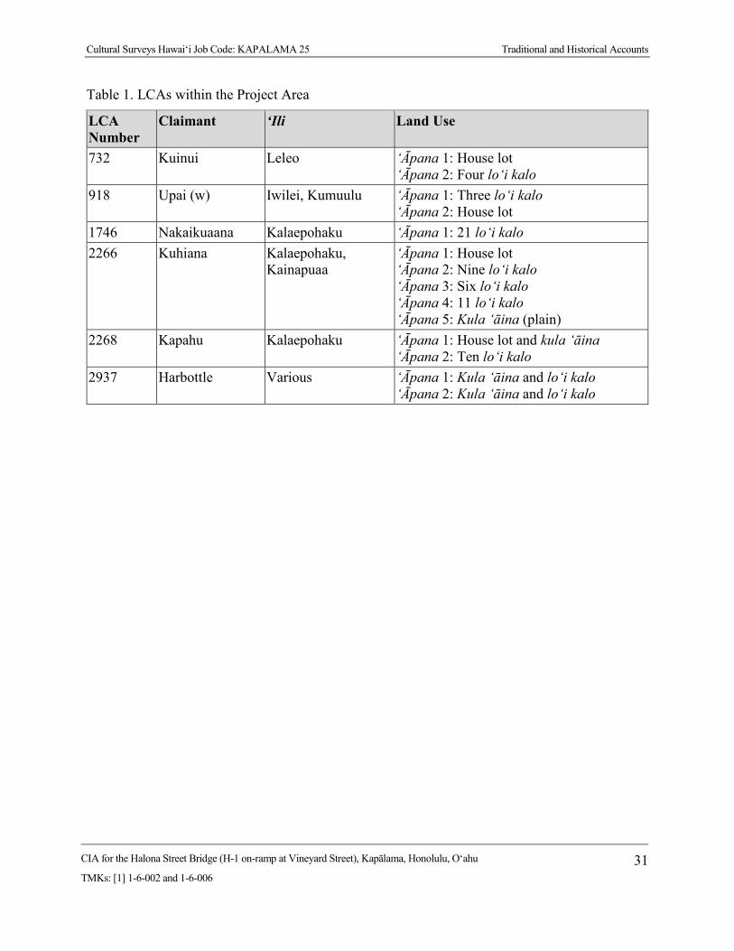
Cultural Surveys Hawai‘i Job Code: KAPALAMA 25 Traditional and Historical Accounts
CIA for the Halona Street Bridge (H-1 on-ramp at Vineyard Street), Kapālama, Honolulu, O‘ahu
TMKs: [1] 1-6-002 and 1-6-006 31
Table 1. LCAs within the Project Area
LCA Number
Claimant ‘Ili Land Use
732 Kuinui Leleo ‘Āpana 1: House lot ‘Āpana 2: Four lo‘i kalo
918 Upai (w) Iwilei, Kumuulu ‘Āpana 1: Three lo‘i kalo ‘Āpana 2: House lot
1746 Nakaikuaana Kalaepohaku ‘Āpana 1: 21 lo‘i kalo 2266 Kuhiana Kalaepohaku,
Kainapuaa ‘Āpana 1: House lot ‘Āpana 2: Nine lo‘i kalo ‘Āpana 3: Six lo‘i kalo ‘Āpana 4: 11 lo‘i kalo ‘Āpana 5: Kula ‘āina (plain)
2268 Kapahu Kalaepohaku ‘Āpana 1: House lot and kula ‘āina ‘Āpana 2: Ten lo‘i kalo
2937 Harbottle Various ‘Āpana 1: Kula ‘āina and lo‘i kalo ‘Āpana 2: Kula ‘āina and lo‘i kalo
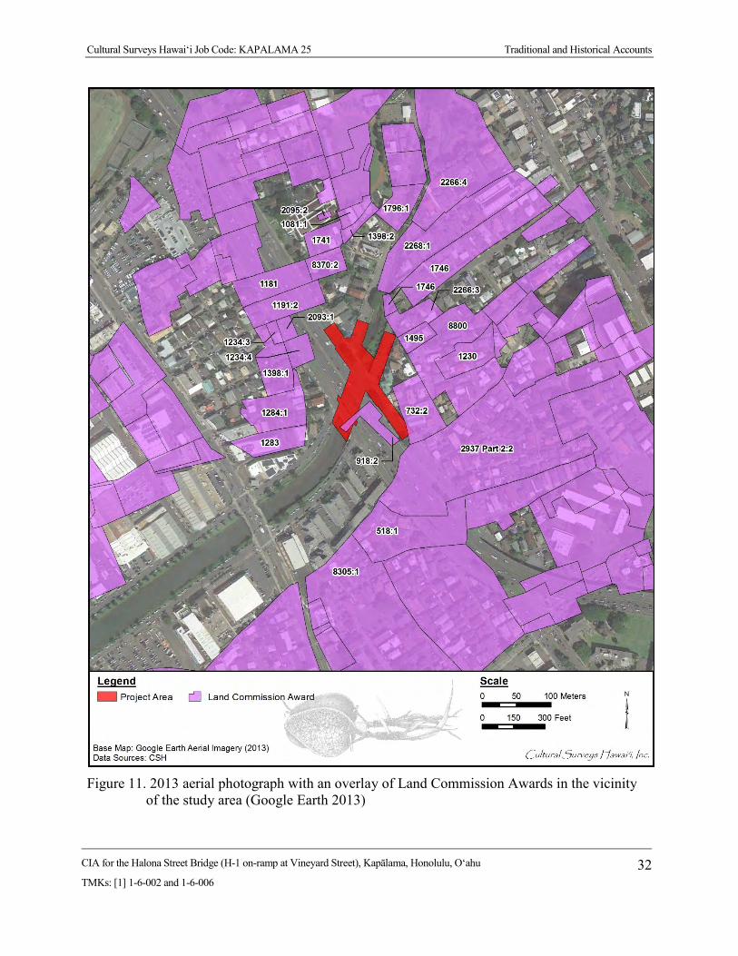
Cultural Surveys Hawai‘i Job Code: KAPALAMA 25 Traditional and Historical Accounts
CIA for the Halona Street Bridge (H-1 on-ramp at Vineyard Street), Kapālama, Honolulu, O‘ahu
TMKs: [1] 1-6-002 and 1-6-006 32
Figure 11. 2013 aerial photograph with an overlay of Land Commission Awards in the vicinity
of the study area (Google Earth 2013)

Cultural Surveys Hawai‘i Job Code: KAPALAMA 25 Traditional and Historical Accounts
CIA for the Halona Street Bridge (H-1 on-ramp at Vineyard Street), Kapālama, Honolulu, O‘ahu
TMKs: [1] 1-6-002 and 1-6-006 33
Figure 12. 1893 Wall map of Honolulu showing study area surrounded by rice fields

Cultural Surveys Hawai‘i Job Code: KAPALAMA 25 Traditional and Historical Accounts
CIA for the Halona Street Bridge (H-1 on-ramp at Vineyard Street), Kapālama, Honolulu, O‘ahu
TMKs: [1] 1-6-002 and 1-6-006 34
Figure 13. 1897 Monsarrat map of the Honolulu District showing the study area in a rice
plantation
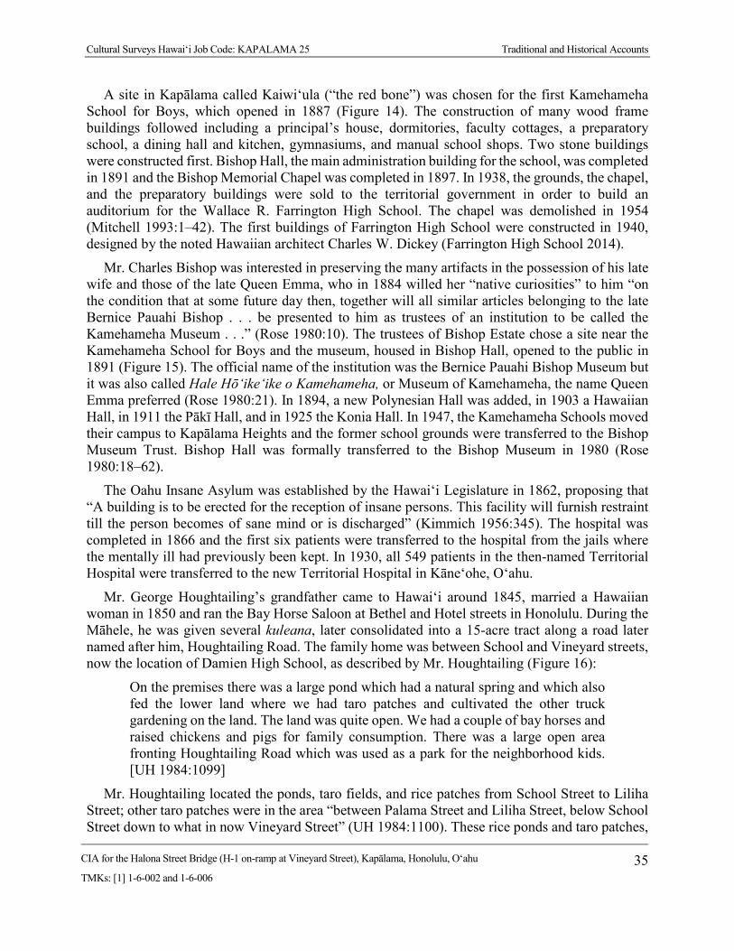
Cultural Surveys Hawai‘i Job Code: KAPALAMA 25 Traditional and Historical Accounts
CIA for the Halona Street Bridge (H-1 on-ramp at Vineyard Street), Kapālama, Honolulu, O‘ahu
TMKs: [1] 1-6-002 and 1-6-006 35
A site in Kapālama called Kaiwi‘ula (“the red bone”) was chosen for the first Kamehameha School for Boys, which opened in 1887 (Figure 14). The construction of many wood frame buildings followed including a principal’s house, dormitories, faculty cottages, a preparatory school, a dining hall and kitchen, gymnasiums, and manual school shops. Two stone buildings were constructed first. Bishop Hall, the main administration building for the school, was completed in 1891 and the Bishop Memorial Chapel was completed in 1897. In 1938, the grounds, the chapel, and the preparatory buildings were sold to the territorial government in order to build an auditorium for the Wallace R. Farrington High School. The chapel was demolished in 1954 (Mitchell 1993:1–42). The first buildings of Farrington High School were constructed in 1940, designed by the noted Hawaiian architect Charles W. Dickey (Farrington High School 2014).
Mr. Charles Bishop was interested in preserving the many artifacts in the possession of his late wife and those of the late Queen Emma, who in 1884 willed her “native curiosities” to him “on the condition that at some future day then, together will all similar articles belonging to the late Bernice Pauahi Bishop . . . be presented to him as trustees of an institution to be called the Kamehameha Museum . . .” (Rose 1980:10). The trustees of Bishop Estate chose a site near the Kamehameha School for Boys and the museum, housed in Bishop Hall, opened to the public in 1891 (Figure 15). The official name of the institution was the Bernice Pauahi Bishop Museum but it was also called Hale Hō‘ike‘ike o Kamehameha, or Museum of Kamehameha, the name Queen Emma preferred (Rose 1980:21). In 1894, a new Polynesian Hall was added, in 1903 a Hawaiian Hall, in 1911 the Pākī Hall, and in 1925 the Konia Hall. In 1947, the Kamehameha Schools moved their campus to Kapālama Heights and the former school grounds were transferred to the Bishop Museum Trust. Bishop Hall was formally transferred to the Bishop Museum in 1980 (Rose 1980:18–62).
The Oahu Insane Asylum was established by the Hawai‘i Legislature in 1862, proposing that “A building is to be erected for the reception of insane persons. This facility will furnish restraint till the person becomes of sane mind or is discharged” (Kimmich 1956:345). The hospital was completed in 1866 and the first six patients were transferred to the hospital from the jails where the mentally ill had previously been kept. In 1930, all 549 patients in the then-named Territorial Hospital were transferred to the new Territorial Hospital in Kāne‘ohe, O‘ahu.
Mr. George Houghtailing’s grandfather came to Hawai‘i around 1845, married a Hawaiian woman in 1850 and ran the Bay Horse Saloon at Bethel and Hotel streets in Honolulu. During the Māhele, he was given several kuleana, later consolidated into a 15-acre tract along a road later named after him, Houghtailing Road. The family home was between School and Vineyard streets, now the location of Damien High School, as described by Mr. Houghtailing (Figure 16):
On the premises there was a large pond which had a natural spring and which also fed the lower land where we had taro patches and cultivated the other truck gardening on the land. The land was quite open. We had a couple of bay horses and raised chickens and pigs for family consumption. There was a large open area fronting Houghtailing Road which was used as a park for the neighborhood kids. [UH 1984:1099]
Mr. Houghtailing located the ponds, taro fields, and rice patches from School Street to Liliha Street; other taro patches were in the area “between Palama Street and Liliha Street, below School Street down to what in now Vineyard Street” (UH 1984:1100). These rice ponds and taro patches,
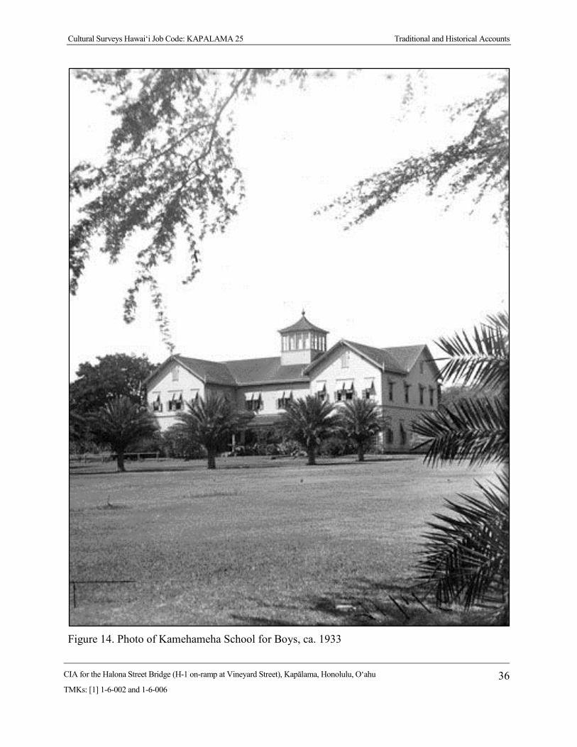
Cultural Surveys Hawai‘i Job Code: KAPALAMA 25 Traditional and Historical Accounts
CIA for the Halona Street Bridge (H-1 on-ramp at Vineyard Street), Kapālama, Honolulu, O‘ahu
TMKs: [1] 1-6-002 and 1-6-006 36
Figure 14. Photo of Kamehameha School for Boys, ca. 1933

Cultural Surveys Hawai‘i Job Code: KAPALAMA 25 Traditional and Historical Accounts
CIA for the Halona Street Bridge (H-1 on-ramp at Vineyard Street), Kapālama, Honolulu, O‘ahu
TMKs: [1] 1-6-002 and 1-6-006 37
Figure 15. Photo of the Bishop Museum ca. 1889
Figure 16. Photo of the Houghtailing sisters’ plantation home, now the location of Damien
Memorial School., ca. 1912-1913
Cultural Surveys Hawai‘i Job Code: KAPALAMA 25 Traditional and Historical Accounts
CIA for the Halona Street Bridge (H-1 on-ramp at Vineyard Street), Kapālama, Honolulu, O‘ahu
TMKs: [1] 1-6-002 and 1-6-006 38
usually operated by Chinese, were cultivated up to the 1920s when many were filled in for the development of residential subdivisions. Japanese took over some of the land as truck farms, and Japanese also gradually took over the small stores once operated by Chinese.
Portions of the H-1 Interstate Highway corridor extend through these rice fields and near the pineapple plantations, which are generally makai of King Street, although there was a rice mill mauka of the study area near the Insane Asylum. Again, there is an established bridge on King Street at the Kapālama Stream crossing. There are no specific structures within or adjacent to the Kapālama study area block.
1900s 4.5.1 Residential and Commercial Development
A series of USGS maps, U.S. Army War Department maps, and aerial photographs (Figure 17 through Figure 24) depict the accelerated development of residential neighborhoods and commercial centers in the first half of the twentieth century.
A 1919 map (see Figure 17) depicts the establishment of grid-like residential neighborhoods surrounding the Kamehameha School Complex in Kalihi-Pālama. The rice paddies and pineapple plantations are no longer shown, although some of the open areas on the map mauka of King Street may still have been cultivated for these crops, or turned into truck farms. There are no open spaces shown in the Nu‘uanu area at this time. On the 1897 Monsarrat map, (see Figure 13) houses were spaced only along the main roads. By 1919, homes are packed in small residential blocks.
A 1933 U.S. Army War Department map (see Figure 19) continues the trend to greater density in grid-like residential blocks. On this map dashed lines representing planned roads are shown in the once empty space east of the Kamehameha Schools campus. The area around Pālama Settlement east of Niuhelewai Stream is also a densely packed neighborhood. This is in contrast to the Nu‘uanu area which still has large houses separated by large yards.
A 1943 U.S. Army War Department map (see Figure 20) illustrates the density of homes along the street grids in lower and upper Kalihi-Kapālama. In upper Kalihi, Farrington High School has now taken the place of the Kamehameha Schools. The street grid east of the high school is still in the planning stages. Palama has now become not only a residential area, but has commercial warehouses and stores, mainly lined along King Street. In Nu‘uanu many of the large houses and wide spaces between houses have been lost.
The 1950 Sanborn Fire Insurance map depicts the density of houses and house lots located in the general vicinity of the study area (see Figure 21). There are also large areas of vacant land within the current study area.
A 1952 aerial photograph (see Figure 22) shows substantial housing development but the north and south portions of the study area are still in areas of vacant land.
The 1953 USGS map (see Figure 23) illustrates the large number of schools and churches near the H-1 Interstate Highway corridor. Labeled are Fern School, Kalihi Waena School, Kalākaua School, St. Anthony’s School, and Pu‘uhale School. Lower Kalihi holds Farrington High School, Likelike, St. Theresa School, and the Kaiulani School in Kapālama. The Nu‘uanu survey area is near Kauluwala School, Kuakini Hospital, Liliuokalani Gardens, and Foster Park (Foster Botanical Garden).

Cultural Surveys Hawai‘i Job Code: KAPALAMA 25 Traditional and Historical Accounts
CIA for the Halona Street Bridge (H-1 on-ramp at Vineyard Street), Kapālama, Honolulu, O‘ahu
TMKs: [1] 1-6-002 and 1-6-006 39
Figure 17. 1919 U.S. Army War Department map, Honolulu Quadrangle, showing commercial
and residential development in Kapālama, near the study area

Cultural Surveys Hawai‘i Job Code: KAPALAMA 25 Traditional and Historical Accounts
CIA for the Halona Street Bridge (H-1 on-ramp at Vineyard Street), Kapālama, Honolulu, O‘ahu
TMKs: [1] 1-6-002 and 1-6-006 40
Figure 18. 1927 Sanborn Company Fire Insurance map showing a relative lack of development
in the vicinity of the study area

Cultural Surveys Hawai‘i Job Code: KAPALAMA 25 Traditional and Historical Accounts
CIA for the Halona Street Bridge (H-1 on-ramp at Vineyard Street), Kapālama, Honolulu, O‘ahu
TMKs: [1] 1-6-002 and 1-6-006 41
Figure 19. 1933 U.S. Army War Department map, Honolulu Quadrangle, showing commercial
and residential development in Kapālama, near the study area

Cultural Surveys Hawai‘i Job Code: KAPALAMA 25 Traditional and Historical Accounts
CIA for the Halona Street Bridge (H-1 on-ramp at Vineyard Street), Kapālama, Honolulu, O‘ahu
TMKs: [1] 1-6-002 and 1-6-006 42
Figure 20. 1943 U.S. Army War Department map, Honolulu Quadrangle showing commercial
and residential development in Kapālama, near the study area
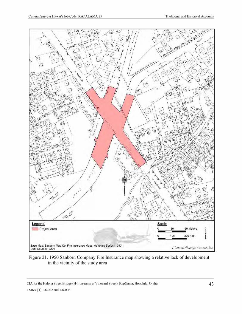
Cultural Surveys Hawai‘i Job Code: KAPALAMA 25 Traditional and Historical Accounts
CIA for the Halona Street Bridge (H-1 on-ramp at Vineyard Street), Kapālama, Honolulu, O‘ahu
TMKs: [1] 1-6-002 and 1-6-006 43
Figure 21. 1950 Sanborn Company Fire Insurance map showing a relative lack of development
in the vicinity of the study area

Cultural Surveys Hawai‘i Job Code: KAPALAMA 25 Traditional and Historical Accounts
CIA for the Halona Street Bridge (H-1 on-ramp at Vineyard Street), Kapālama, Honolulu, O‘ahu
TMKs: [1] 1-6-002 and 1-6-006 44
Figure 22. 1952 aerial photograph showing study area (USGS)

Cultural Surveys Hawai‘i Job Code: KAPALAMA 25 Traditional and Historical Accounts
CIA for the Halona Street Bridge (H-1 on-ramp at Vineyard Street), Kapālama, Honolulu, O‘ahu
TMKs: [1] 1-6-002 and 1-6-006 45
Figure 23. Portion of 1953 Honolulu USGS topographic quadrangle, showing commercial and
residential development in Kapālama, near the study area

Cultural Surveys Hawai‘i Job Code: KAPALAMA 25 Traditional and Historical Accounts
CIA for the Halona Street Bridge (H-1 on-ramp at Vineyard Street), Kapālama, Honolulu, O‘ahu
TMKs: [1] 1-6-002 and 1-6-006 46
Figure 24. 1978 USGS aerial photograph, Honolulu Quadrangle, showing commercial and
residential development in Kapālama near the study area

Cultural Surveys Hawai‘i Job Code: KAPALAMA 25 Traditional and Historical Accounts
CIA for the Halona Street Bridge (H-1 on-ramp at Vineyard Street), Kapālama, Honolulu, O‘ahu
TMKs: [1] 1-6-002 and 1-6-006 47
4.5.1.1 H-1 Interstate Highway
As the study area lies directly adjacent to the H-1 right-of-way, it is appropriate to give a little background on the history of H-1. It appears construction for the H-1 in the area of Kalihi-Kapālama started in 1960 from Fort Shafter to Houghtailing Street. Although this was not the place of origin for the H-1 system, it was the first time federal money was used in Hawai‘i for an Interstate system. Prior to 1960, the H-1 was called the Lunalilo Freeway. This early highway is shown on a 1978 aerial photograph (see Figure 24). The website AARoads has compiled a timeline for the H-1 construction (Table 2).
AARoads (2012) writes, “Portions of H1 predate statehood, as an upgrade of Lunalilo Street, the freeway’s namesake. The oldest section, from Punahou street east to King Street (Exits 23-25), was open before 1959. Originally signed as Hawaii 72.”
The Hawaiian Historical Society provides a timeline in a little more detail for the earliest stretch of H-1, the Mauka Arterial.
The pioneering highway in Hawai‘i was the Mauka Arterial (later christened Lunalilo Freeway). The three ‘Ewa-bound lanes, extending one mile between Old Wai‘alae Road and Alexander Street, were opened to traffic November 9, 1953. The Kaimuki-bound lanes along the same stretch were opened and the highway was formally dedicated on January 5, 1954. [Schmitt 2013]
Table 2. Construction Timeline of Hawaii 72, Later Renumbered as H-1 Interstate Highway
Year Development 1953 First section of the Mauka Arterial opened; Mauka Arterial was approximately a mile
section around University Avenue, present-day Mile 24 1959 At statehood, first section of what is now called Lunalilo Freeway opened between
Punahou St (Mile 23) and King St (Mile 25); maps show proposed route from Punahou St west to Middle St (present H-1/H-201 interchange)
1960 Lunalilo Freeway extended west to Ke‘eaumoku St (approx. 1/2 mile west of Punahou St); section of present-day H-201 opened through Fort Shafter, signed as Hawaii 72; sections from Fort Shafter east to Houghtailing St (Exit 20B) and Pali Hwy interchange (exit 21A/B) under construction
1961 Open sections are Pu‘uloa Rd (present-day H-201) to Houghtailing St (Exit 20B), Pali Hwy interchange, and Ke‘eaumoku St to King St
1964 Section from Kapahulu St (Mile 25) east to Koko Head Ave (Exit 26A) under construction
1965 Kapahulu St to Koko Head Ave opened; short 1/2 mile section under construction, filling gap in existing freeway sections between King St and Kapahulu St
1967 H-1 first appears on maps, co-signed with Hawaii 72; freeway continuous from Pu‘uloa Rd east to Pele St (just east of Pali Hwy, Hawaii 61), as well as existing sections from Ke‘eaumoku St to King St and Kapahulu St to Koko Head Ave; western section between Kunia Rd and Kamehameha Hwy (Exits 5 through Exit 8A) open, with section between Miles 0 and 5 under construction
Cultural Surveys Hawai‘i Job Code: KAPALAMA 25 Traditional and Historical Accounts
CIA for the Halona Street Bridge (H-1 on-ramp at Vineyard Street), Kapālama, Honolulu, O‘ahu
TMKs: [1] 1-6-002 and 1-6-006 48
Year Development 1968 Gap between King St and Kapahulu St opened; H-1 extended east to present terminus
east of Kilauea Ave; still a gap between Pele and Ke‘eaumoku streets 1972 H-1 opened from Kamehameha Hwy (western terminus) to Kaimakani St, immediately
west of Hālawa interchange; Hālawa interchange and sections of H-1 to Middle St proposed; from Middle St east to Kilauea Ave completed freeway; Hawaii 72 truncated at eastern end of H-1; orphaned section between Pu‘uloa Rd and Middle St is re-signed as Hawaii 78
1986 H-1 completed between Nimitz Hwy and Middle St (Miles 18-19); through lanes of H-1 east use Middle St tunnel, completed in 1961 for Middle St off-ramp
Previous Archaeological Research Development within a 0.8-km (0.5-mile) radius of the study area is primarily residential with
some light industry. Most of the development in the area, including the H-1 Interstate Highway corridor itself, has occurred prior to the late 1970s when archaeological investigation became standard during project planning and construction activities. The locations of previous archaeological studies conducted within a 0.8-km (0.5-mile) radius of the study area are shown in Figure 25 and listed in Table 3. The findings of these archaeological studies are shown in Figure 26 and listed in Table 4. These studies and their findings are discussed in more detail in the following paragraphs.
4.6.1 Palama Fire Station (Neller 1980) During excavations at the Palama Fire Station in September 1980, the SHPD made a site visit
to the project. A large charcoal deposit was observed in an excavation sidewall which contained several basalt cobbles. No further information was obtained due to the backfilling of the excavation prior to the SHPD’s return to document the feature. It could not be determined whether the deposit represented a historic feature or a traditional imu (earth oven) pit; however, no historic artifacts were observed in association with the feature.
4.6.2 Dunn et al. 1991 During archaeological monitoring at the Pālama Chevron Station, highly fragmented human
skeletal remains were observed (Dunn et al. 1991). The minimum number of individuals (MNI) appeared to be five—but this was not altogether clear. Of interest was the following comment:
A parishioner of Kaumakapili Church mentioned to PHRI field personnel that the survey area was once a cemetery. Mr. Tom Dye of the DLNR said that older residents of the area had once mentioned that when they were younger they regarded the area as ‘spooky,’ and that this may be attributable to the fact that they had heard there were burials in the area. [Dunn et al. 1991:10]
Fragmentary human skeletal remains were reported at 80 cm below surface, 105 cm below surface, and 120 cm below surface (Dunn et al. 1991:1, 4).

Cultural Surveys Hawai‘i Job Code: KAPALAMA 25 Traditional and Historical Accounts
CIA for the Halona Street Bridge (H-1 on-ramp at Vineyard Street), Kapālama, Honolulu, O‘ahu
TMKs: [1] 1-6-002 and 1-6-006 49
Figure 25. Previous archaeological studies within a 0.8-km (0.5-mile) radius of the study area
Cultural Surveys Hawai‘i Job Code: KAPALAMA 25 Traditional and Historical Accounts
CIA for the Halona Street Bridge (H-1 on-ramp at Vineyard Street), Kapālama, Honolulu, O‘ahu
TMKs: [1] 1-6-002 and 1-6-006 50
Table 3. Previous Archaeological Studies within a 0.8-km (0.5-mile) Radius of the Study Area (arranged chronologically)
Reference Type of Study Location Results (SIHP # 50-80-14****)
Neller 1980 Field reconnaissance
Kapālama Fire Station
Massive charcoal deposit observed in trench, but significance not determined
Dunn et al. 1991
Archaeological monitoring
Pālama Chevron Station, Kapālama
Nine test trenches for pipelines excavated; burials, human skeletal remains, and historic artifacts (SIHP # -3373) recorded; burials were victims of nineteenth century epidemics
Dixon 1993 Archaeological monitoring
Bishop Museum grounds near Violet St, Kapālama
No evidence of pre-Contact cultural deposits found; however, historic artifacts found in backfill; Bishop Museum designated SIHP # -1353 as an historic property
Jourdane 1994
Burial report Austin Lane, Kapālama
Historic human coffin burial (SIHP # -4929) found during excavation on Austin Lane
Nakamura et al. 1994
Archaeological assessment
North King and Houghtailing, Kapālama
No archaeological historic properties found, however, some 50+ year-old buildings found during assessment
Borthwick et al. 1995
Archaeological inventory survey
Kamehameha Homes, Kapālama
No subsurface features found during excavation of 16 trenches on a 14-acre survey area
Hammatt 1995
Burial disinterment
Austin Lane, Kapālama
Historic coffin burial at Austin Lane (SIHP # -4929) disinterred; burial probably associated with Kaumakapili Church cemetery, used from 1870s to at least 1921
McIntosh and Cleghorn 2006
Archaeological monitoring
Kamehameha Heights Water System, Kapālama
Before sewer improvements, Pacific Legacy conducted testing and monitoring to determine if nearby historic graves from Ka‘ahumanu and Maluhia Cemeteries extended under Kapālama Ave; ten trenches excavated but no cultural deposits or human bones found
Dey and Hammatt 2008
Archaeological monitoring
1520 North School St, Kapālama
No culturally significant material identified
Cultural Surveys Hawai‘i Job Code: KAPALAMA 25 Traditional and Historical Accounts
CIA for the Halona Street Bridge (H-1 on-ramp at Vineyard Street), Kapālama, Honolulu, O‘ahu
TMKs: [1] 1-6-002 and 1-6-006 51
Reference Type of Study Location Results (SIHP # 50-80-14****)
Hammatt and Chiogioji 2008
Archaeological inventory survey
BWS Kalihi-Beretania Water Main, Kapālama and Nu‘uanu
Survey confirmed areas affected by proposed water main work were along asphalt areas; two early twentieth century bridges on Judd and Nu‘uanu streets recommended for architectural evaluation
Burke et al. 2010
Archaeological monitoring
Houghtailing St, Kapālama
No archaeological material observed within sediments disturbed by project’s activities at Houghtailing St by H-1
Hunkin et al. 2012
Archaeological monitoring
Kalihi-Nu‘uanu Sewer Rehabilitation project
No cultural deposits identified; isolated human femur fragment found in fill material in one of western Punchbowl slope areas; no site number assigned to this fragment, which was handed over to SHPD for reburial
Hammatt 2013
Archaeological inventory survey
City Center portion of Honolulu High-Capacity Transit Corridor project
Two historic properties identified near current study area—SIHP #s -7426 (subsurface wetland deposit) and -7506 (subsurface incinerated trash deposit); wetland sediments identified along Dillingham Blvd; incinerated trash deposits encountered within HCC campus at corner of Dillingham Blvd and Kokea St
Hunkin and Hammatt 2013
Archaeological monitoring
Kalihi Valley sewer system, Kapālama
No cultural deposits noted
Medina and Hammatt 2013
Archaeological monitoring
Waiakamilo Rd and McNeill St intersection traffic signals
No historical properties or human remains encountered
Medina et al. 2013
Archaeological monitoring
Traffic control signal along Dillingham Blvd
Two historic properties observed during course of archaeological monitoring: SIHP #s -7426 (previously identified historic property consists of former wetland/ agricultural sediments that may have been utilized during late pre- to early post-Contact period) and -7515 (newly identified historic property related to creation of Kapālama Canal during 1920s and in-filling of surrounding area for purposes of urban development)

Cultural Surveys Hawai‘i Job Code: KAPALAMA 25 Traditional and Historical Accounts
CIA for the Halona Street Bridge (H-1 on-ramp at Vineyard Street), Kapālama, Honolulu, O‘ahu
TMKs: [1] 1-6-002 and 1-6-006 52
Reference Type of Study Location Results (SIHP # 50-80-14****)
Pammer and McDermott 2014
Archaeological inventory survey
Honolulu Community College
Two previously recorded historic properties identified within survey area: SIHP #s -7426 (wetland sediments) and -7506 (incinerated trash layer)
Stine et al. 2014
Archaeological monitoring
Farrington High School property
No cultural deposits identified during monitoring of three excavations

Cultural Surveys Hawai‘i Job Code: KAPALAMA 25 Traditional and Historical Accounts
CIA for the Halona Street Bridge (H-1 on-ramp at Vineyard Street), Kapālama, Honolulu, O‘ahu
TMKs: [1] 1-6-002 and 1-6-006 53
Figure 26. Previously identified historic properties within a 0.8-km (0.5-mile) radius of the study
area
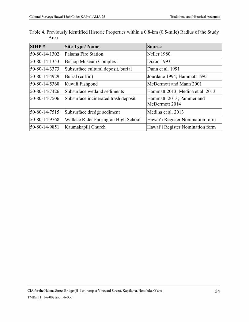
Cultural Surveys Hawai‘i Job Code: KAPALAMA 25 Traditional and Historical Accounts
CIA for the Halona Street Bridge (H-1 on-ramp at Vineyard Street), Kapālama, Honolulu, O‘ahu
TMKs: [1] 1-6-002 and 1-6-006 54
Table 4. Previously Identified Historic Properties within a 0.8-km (0.5-mile) Radius of the Study Area
SIHP # Site Type/ Name Source 50-80-14-1302 Palama Fire Station Neller 1980 50-80-14-1353 Bishop Museum Complex Dixon 1993 50-80-14-3373 Subsurface cultural deposit, burial Dunn et al. 1991 50-80-14-4929 Burial (coffin) Jourdane 1994; Hammatt 1995 50-80-14-5368 Kuwili Fishpond McDermott and Mann 2001 50-80-14-7426 Subsurface wetland sediments Hammatt 2013, Medina et al. 2013 50-80-14-7506 Subsurface incinerated trash deposit Hammatt, 2013; Pammer and
McDermott 2014
50-80-14-7515 Subsurface dredge sediment Medina et al. 2013 50-80-14-9768 Wallace Rider Farrington High School Hawai‘i Register Nomination form 50-80-14-9851 Kaumakapili Church Hawai‘i Register Nomination form

Cultural Surveys Hawai‘i Job Code: KAPALAMA 25 Traditional and Historical Accounts
CIA for the Halona Street Bridge (H-1 on-ramp at Vineyard Street), Kapālama, Honolulu, O‘ahu
TMKs: [1] 1-6-002 and 1-6-006 55
4.6.3 Bishop Museum (Dixon 1993) This archaeological monitoring project at the Bishop Museum took place during installation of
electrical service for the Space Exhibit in August 1992. Museum staff recognized the potential for subsurface pre- and post-Contact Hawaiian cultural material and human remains as well as the possibility of early historic material on museum property. Stratigraphy and backdirt was observed during mechanical trenching conducted on the Great Lawn. Dixon found no evidence of pre-Contact deposits; however, some historic artifacts were found in a fill layer possibly dating back to the Kamehameha Schools period. This fill layer and artifacts were given SHPD site number 50-Oa-A6-26.
4.6.4 Austin Lane, Kapālama (Jourdane 1994; Hammatt 1995) A burial in a coffin was found during construction of a water line on Austin Lane and reported
to the SHPD (Jourdane 1994). CSH (Hammatt 1995) conducted background on the property and disinterred the burial. The human remains, designated SIHP # -4929, were turned over to the SHPD for reburial.
4.6.5 Corner of North King and Houghtailing Streets (Nakamura et al. 1994) The Bernice Pauahi Bishop Museum (Nakamura, Pantaleo, and Sinoto 1994) carried out an
archaeological assessment of land in Kapālama on the corner of North King and Houghtailing streets. Background research identified no historic sites within the survey area. Research also showed pre- and early post-Contact use of the area for agriculture but suggested that disturbance in the area from urbanization in the 1900s had reduced the possibility of finding intact deposits from an earlier time.
4.6.6 Kamehameha Homes Project, Kapālama (Borthwick et al. 1995) CSH (Borthwick et al. 1995) carried out an archaeological subsurface inventory survey of the
Kamehameha Homes project in Kapālama. The crew excavated 16 trenches spaced to cover the entire 13.96-acre survey area. All of the trenches had a landscape layer associated with mechanical terracing of the area by bulldozers. No significant finds were reported.
4.6.7 Kamehameha Heights, Puea and Ka‘ahumanu Cemeteries (McIntosh and Cleghorn 2006)
In 2006, Pacific Legacy (McIntosh and Cleghorn 2006) conducted pre-construction testing along the Puea and Ka‘ahumanu Cemeteries before improvements were made to the Kamehameha Heights water system, due to concerns that unmarked graves could lie outside the modern boundary of the cemeteries. No cultural deposits or human remains were found in the ten test trenches along the north and east streets bounding the cemeteries.
4.6.8 Kalihi/Nu‘uanu Sewer Rehabilitation Project (Hunkin et al. 2012) In 2012, CSH conducted monitoring for the Kalihi-Nu‘uanu Sewer project. No cultural deposits
were identified in any of the monitored excavation trenches. One isolated human femur fragment was found in fill material in one of the western Punchbowl slope areas. No site number was assigned to this fragment, which was handed over to the SHPD for reburial.

Cultural Surveys Hawai‘i Job Code: KAPALAMA 25 Traditional and Historical Accounts
CIA for the Halona Street Bridge (H-1 on-ramp at Vineyard Street), Kapālama, Honolulu, O‘ahu
TMKs: [1] 1-6-002 and 1-6-006 56
4.6.9 Walgreens Development Project, North School Street (Dey and Hammatt 2008) In 2008, CSH completed an archaeological monitoring program for a Walgreens development
project. Background research identified no historic sites, a low potential for pre-Contact or early post-Contact Hawaiian cultural remains, and a low to moderate potential for early historic remains. Subsequent fieldwork confirmed a lack of pre-Contact or early post-Contact cultural material within that survey area.
4.6.10 Traffic Management System Project, Houghtailing Street by the H-1 (Burke et al. 2010) In 2010, CSH (Burke et al. 2010) completed an archaeological monitoring program for a Traffic
Management System PH 1 project. Background research identified no sites but suggested a potential for early historic remains. Subsequent field monitoring produced no significant finds within the survey area.
4.6.11 Kalihi Beretania 24-Inch Water Main Project (Hammatt and Chiogioji 2008) CSH carried out an archaeological inventory survey of the proposed Board of Water Supply
Kalihi Beretania 24-Inch Water Main project in Nu‘uanu and Kapālama (Hammatt and Chiogioji 2008). No prehistoric properties were identified within the survey area but the study emphasized the need to consider the Judd Street and Nu‘uanu Avenue bridges as historic properties. Background research showed the survey area to be part of an expansive agricultural system during the pre- and early post-Contact period. As the survey area was confined to roadway corridors, subsequent testing revealed mostly grading and fill disturbance from roadway construction and utility trenching. No pre- or early post-Contact cultural material was observed during archaeological testing within the survey area.
4.6.12 Kalihi/Nu‘uanu Sewer Rehabilitation Project (Hunkin et al. 2012) Archaeological monitoring for Phase 1 of the Kalihi/Nu‘uanu Sewer Rehabilitation project
included limited work just east of the present survey area in their “Area 4-Lanakila” area. The nearest results reported were from along Alaneo Street more than 400 m (1312.3 ft) east of the present study area. There were no historic properties identified near the present survey area.
4.6.13 Honolulu High-Capacity Transit Corridor Project (Hammatt 2013) CSH performed AIS testing for the Honolulu High-Capacity Transit Corridor project (City
Center) within numerous locations between Middle Street and Ala Moana Center (Hammatt 2013). Testing identified multiple sites, two of which were identified near the current study area—SIHP #s -7426 (subsurface wetland deposit) and -7506 (subsurface incinerated trash deposit). The wetland sediments were identified within 28 AIS test excavations along Dillingham Boulevard, makai of the current project (T-054 through T-082). The incinerated trash deposits were encountered within three test excavations (T-064, T-066, and T-067) within the HCC campus at the corner of Dillingham Boulevard and Kokea Street.
4.6.14 Kalihi Valley Sewer System Improvements, Kapālama (Hunkin and Hammatt 2013) In 2013, CSH monitored a portion of the Kalihi Valley Sewer System Improvement project
near the junction of Houghtailing Street and North School Street in Kalihi (Hunkin and Hammatt 2013). Due to the survey area’s close proximity to Ka‘ahumanu, Puea, and Maluhia cemeteries, project proponents decided to enact a monitoring project for the installation of two water lines to

Cultural Surveys Hawai‘i Job Code: KAPALAMA 25 Traditional and Historical Accounts
CIA for the Halona Street Bridge (H-1 on-ramp at Vineyard Street), Kapālama, Honolulu, O‘ahu
TMKs: [1] 1-6-002 and 1-6-006 57
mitigate any adverse effect to historic properties or burials in the survey area. No cultural deposits or historic properties were observed during excavations. The stratigraphy consisted of various layers of imported fill associated with historic and modern development overlying naturally deposited sediment and bedrock.
4.6.15 Medina and Hammatt 2013 In 2013, CSH (Medina and Hammatt 2013) reported on the results of archaeological monitoring
for traffic control signal improvements for the Waiakamilo Road and McNeill Street intersection. No historical properties or human remains were encountered as a result of construction activities.
4.6.16 Traffic Control Signal Improvements along Dillingham Boulevard (Medina et al. 2013) In 2013, CSH (Medina et al. 2013) reported on the results of archaeological monitoring for
traffic control signal improvements along Dillingham Boulevard between Kokea and Kohou streets, involving excavations within city streets and sidewalks for subsurface electrical lines, conduits, and boxes. Two historic properties were observed during the course of archaeological monitoring consisting of SIHP #s -7426, a previously identified historic property consisting of former wetland/agricultural sediments that may have been utilized during the late pre-to early post-Contact period, and -7515, a newly identified historic property related to the creation of Kapālama Canal during the 1920s and the in-filling of the surrounding area for the purposes of urban development.
4.6.17 Honolulu Community College (Pammer and McDermott 2014) In 2013, CSH conducted an archaeological inventory survey on the campus of Honolulu
Community College (Pammer and McDermott 2014). A total of eight backhoe-assisted excavations were excavated to assess the stratigraphy and determine the potential for buried archaeological deposits. Two previously recorded historic properties were identified with the survey area, SIHP #s -7526 (wetland sediments) and -7506 (incinerated trash deposit). Both sites were assessed as significant under criterion “d,” but no further work was recommended.
4.6.18 Farrington High School (Stine et al. 2014) In 2013, CSH conducted archaeological monitoring for renovations and replacements of
electrical vaults and lines at Farrington High School (Stine et al. 2014). Fieldwork was conducted from 27–29 June 2012. No new historic properties were identified. One previously identified property, Wallace Rider Farrington High School (SIHP # -9768) had been placed on the State Register of Historic Places in 1993. No significant cultural material or human remains were observed during monitoring.
Background Summary and Predictive Model Based on background research, the primary area of traditional Hawaiian settlement and
intensive agriculture within Kapālama seems to have been in the upper valleys, as well as near streams and springs. The project sits within the central area of Kapālama along the drainage of Kapālama and Niuhelewai streams. Historically, agriculture and habitation were intensive in this area. The area encompassed by the survey area was used for rice cultivation, but immediate habitation within the survey area does not seem to have been prevalent.
Cultural Surveys Hawai‘i Job Code: KAPALAMA 25 Traditional and Historical Accounts
CIA for the Halona Street Bridge (H-1 on-ramp at Vineyard Street), Kapālama, Honolulu, O‘ahu
TMKs: [1] 1-6-002 and 1-6-006 58
Traditional Hawaiian land use indicated in the adjacent land commission awards (LCAs) documentation consisted of habitation, irrigated taro fields (lo‘i), kula (dryland plots used for cultivation and/or pasture), and aquaculture via fishponds. The majority of kuleana land claims located near the study area were located near the freshwater sources of Kalihi and Niuhelewai streams as they were the most arable sources of land. This is the area described as an uncultivated plain in John Papa ‘Ī‘ī’s (1959) account of the area in 1810, until you reached “the taro patches of Kalihi.” Major strife is indicated ca. 1782 in the defeat of the O‘ahu ruling chief Kahāhana when the dead backed up the lagoonal backwaters (muliwai) of Niuhelewai Stream—but this may have been well seaward of the current study area. Another uncertainty pertains to the indicated ca. 1855 burial ground on the plains of Kaiwi‘ula which may have been near the current study area.
By the twentieth century, the coastal and central sections of Kapālama had become suburbs of Honolulu. Much development in Kapālama primarily occurred prior to the late 1970s when archaeological investigation became standard during construction activities. As a result, few archaeological studies have been conducted in this area. The only previous projects located within the current study area consist of projects dealing with the H-1 Interstate Highway. No previously recorded archaeological sites are located within or directly adjacent to the current study area. Historic infrastructure relating to the Halona Street Bridge and the Kapālama Canal are anticipated within the study area.
Cultural Surveys Hawai‘i Job Code: KAPALAMA 25 Traditional and Historical Accounts
CIA for the Halona Street Bridge (H-1 on-ramp at Vineyard Street), Kapālama, Honolulu, O‘ahu
TMKs: [1] 1-6-002 and 1-6-006 59
Section 5 Community Consultation
Introduction Throughout the course of this assessment, an effort was made to contact and consult with Native
Hawaiian Organizations (NHO), agencies, and community members including descendants of the area, in order to identify individuals with cultural expertise and/or knowledge of the ahupua‘a of Honolulu. CSH initiated its outreach effort in August 2015 through letters, email, telephone calls, and in-person contact. CSH completed the community consultation in December 2015.
Community Contact Letter In the majority of cases, letters (Figure 27 and Figure 28) along with a map and an aerial
photograph of the project were mailed with the following text:
At the request of CH2M HILL and on behalf of the Federal Highway Administration (FHWA) Central Federal Lands Highway Division (CFLHD), Cultural Surveys Hawai‘i, Inc. (CSH) is conducting a cultural impact assessment (CIA) for the Halona Street Bridge replacement project, Kapālama Ahupua‘a, Honolulu (Kona) District, O‘ahu, FHWA/CFLHD Contract DTFH68-13-R-00027, TMKs: [1] 1-6-002 (Olomea Street and H-1 Interstate Highway Rights-of-Way, Kapālama Canal) and [1] 1-6-006 (Halona Street, Kokea Street, Kohou Street). The project area is located within Kapālama Ahupua‘a at the location of the Halona Street Bridge and the Kapālama Canal and includes portions of the H-1 Interstate Highway, and Halona Street from the intersection of Kuipaakea Lane to just beyond Kohou Street. The project area is depicted on a portion of the 1998 Honolulu U.S. Geological Survey (USGS) 7.5-minute topographic quadrangle and a 2013 aerial photograph (see attachments), and covers approximately 1.5 acres.
The purpose of the project is to replace the existing bridge to meet current design standards for roadway width, load capacity, pedestrian traffic, bridge railing and transitions, and bridge approaches. This existing bridge was built in 1938 and is structurally deficient and functionally obsolete. The replacement bridge would be a three-span, concrete structure. It would be supported on two piers similar to, and aligned with, the existing H-1 Bridge piers. New abutments would be set back from and behind the existing abutments which would be left in place, thereby minimizing impacts to the masonry walls along the canal. For safety reasons, another consideration is to develop provisions to discourage individuals from accessing the area under the bridge.
The purpose of the CIA is to gather information about the project area and its surroundings through research and interviews with individuals that are knowledgeable about this area. The research and interview assists us when assessing potential impacts to the cultural resources, cultural practices, and beliefs identified as a result of the planned project. We are seeking your kōkua (assistance) and guidance regarding the following aspects of our study:

Cultural Surveys Hawai‘i Job Code: KAPALAMA 25 Community Consultation
CIA for the Halona Street Bridge (H-1 on-ramp at Vineyard Street), Kapālama, Honolulu, O‘ahu
TMKs: [1] 1-6-002 and 1-6-006 60
Figure 27. Community consultation letter, page one

Cultural Surveys Hawai‘i Job Code: KAPALAMA 25 Community Consultation
CIA for the Halona Street Bridge (H-1 on-ramp at Vineyard Street), Kapālama, Honolulu, O‘ahu
TMKs: [1] 1-6-002 and 1-6-006 61
Figure 28. Community consultation letter, page two

Cultural Surveys Hawai‘i Job Code: KAPALAMA 25 Community Consultation
CIA for the Halona Street Bridge (H-1 on-ramp at Vineyard Street), Kapālama, Honolulu, O‘ahu
TMKs: [1] 1-6-002 and 1-6-006 62
•General history and present and past land use of the project area. •Knowledge of cultural sites- for example, historic sites, archaeological sites, and burials. •Knowledge of traditional gathering practices in the project area, both past and ongoing. •Cultural associations of the project area, such as legends and traditional uses. •Referrals of kūpuna or elders and kama‘āina who might be willing to share their cultural knowledge of the project area and the surrounding ahupua‘a lands. •Any other cultural concerns the community might have related to Hawaiian cultural practices within or in the vicinity of the project area.
In most cases, two or three attempts were made to contact individuals, organizations, and agencies.
In April 2016, CSH was contacted by CH2M HILL, acting on behalf of the Federal Highway Administration (FHWA) Central Federal Lands Highway Division (CFLHD), regarding a change to the project area. The original project area included approximately 4.9 acres, the new project area, however, includes approximately 2.2 acres; this represents a total change of approximately 2.7 acres to the total project area.The project area remains located within Kapālama Ahupua‘a at the location of the Halona Street Bridge and the Kapālama Canal and includes portions of the H-1 Interstate Highway, and Halona Street from the intersection of Kuipaakea Lane to just beyond Kohou Street. All individuals who had participated in CSH’s Kama‘āina Interviews (Section 5.4) were contacted by email and phone regarding this change. Letters along with aerial photographs and TMK maps of both the old and the new project area were mailed with the following text (Figure 29):
In recent months, Cultural Surveys Hawai‘i (CSH) at the request of CH2M HILL, and on behalf of the Federal Highway Administration (FHWA) Central Federal Lands Highway Division (CFLHD) has reached out to you regarding a cultural impact assessment report (CIA) for the Halona Street Bridge replacement project, Kapālama Ahupua‘a, Honolulu (Kona) District, O‘ahu, FHWA/CFLHD Contract DTFH68-13-R-00027, TMKs: [1] 1-6-002 (Olomea Street and H-1 Interstate Highway Rights-of-Way, Kapālama Canal) and [1] 1-6-006 (Halona Street, Kokea Street, Kohou Street). We would once again like to thank you for all your assistance and your valuable mana‘o on this project. In recent days, CSH has been notified regarding a change to the project area. This change to the project area is depicted in the attached figures (please refer to figures noting “Original Project Area” and “New Project Area as of April 4, 2016” to observe the changes to the project area). The original project area included approximately 4.9 acres, the new project area, however, includes approximately 2.2 acres; this represents a total change of approximately 2.7 acre to the total project area. We would like to inform you of these changes, and kindly ask again for your kokua and guidance in this matter. Please do not hesitate to contact us by telephone or email if your mana‘o has changed or been affected by the changes to the project area.

Cultural Surveys Hawai‘i Job Code: KAPALAMA 25 Community Consultation
CIA for the Halona Street Bridge (H-1 on-ramp at Vineyard Street), Kapālama, Honolulu, O‘ahu
TMKs: [1] 1-6-002 and 1-6-006 63
Figure 29. Community consultation letter regarding change to project area
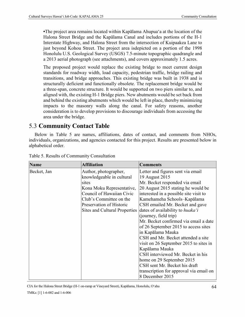
Cultural Surveys Hawai‘i Job Code: KAPALAMA 25 Community Consultation
CIA for the Halona Street Bridge (H-1 on-ramp at Vineyard Street), Kapālama, Honolulu, O‘ahu
TMKs: [1] 1-6-002 and 1-6-006 64
•The project area remains located within Kapālama Ahupua‘a at the location of the Halona Street Bridge and the Kapālama Canal and includes portions of the H-1 Interstate Highway, and Halona Street from the intersection of Kuipaakea Lane to just beyond Kohou Street. The project area isdepicted on a portion of the 1998 Honolulu U.S. Geological Survey (USGS) 7.5-minute topographic quadrangle and a 2013 aerial photograph (see attachments), and covers approximately 1.5 acres.
The proposed project would replace the existing bridge to meet current design standards for roadway width, load capacity, pedestrian traffic, bridge railing and transitions, and bridge approaches. This existing bridge was built in 1938 and is structurally deficient and functionally obsolete. The replacement bridge would be a three-span, concrete structure. It would be supported on two piers similar to, and aligned with, the existing H-1 Bridge piers. New abutments would be set back from and behind the existing abutments which would be left in place, thereby minimizing impacts to the masonry walls along the canal. For safety reasons, another consideration is to develop provisions to discourage individuals from accessing the area under the bridge.
Community Contact Table Below in Table 5 are names, affiliations, dates of contact, and comments from NHOs,
individuals, organizations, and agencies contacted for this project. Results are presented below in alphabetical order.
Table 5. Results of Community Consultation
Name Affiliation Comments Becket, Jan Author, photographer,
knowledgeable in cultural sites Kona Moku Representative, Council of Hawaiian Civic Club’s Committee on the Preservation of Historic Sites and Cultural Properties
Letter and figures sent via email 19 August 2015 Mr. Becket responded via email 20 August 2015 stating he would be interested in a possible site visit to Kamehameha Schools–Kapālama CSH emailed Mr. Becket and gave dates of availability to huaka‘i (journey, field trip) Mr. Becket confirmed via email a date of 26 September 2015 to access sites in Kapālama Mauka CSH and Mr. Becket attended a site visit on 26 September 2015 to sites in Kapālama Mauka CSH interviewed Mr. Becket in his home on 29 September 2015 CSH sent Mr. Becket his draft transcription for approval via email on 8 December 2015

Cultural Surveys Hawai‘i Job Code: KAPALAMA 25 Community Consultation
CIA for the Halona Street Bridge (H-1 on-ramp at Vineyard Street), Kapālama, Honolulu, O‘ahu
TMKs: [1] 1-6-002 and 1-6-006 65
Name Affiliation Comments Mr. Becket emailed CSH on 8 December 2015 stating he would review the transcription Mr. Becket emailed CSH on 9 December 2015 stating he had edits to his transcription and would email later CSH emailed Mr. Becket revised letter and figures regarding change to project area on 4 April 2016. Mr. Becket emailed CSH with minor edits to transcription and summary; no additional comments regarding change to project area
Brown, Desoto Historian, Bishop Museum Letter and figures sent via email 13 August 2015 Mr. Brown emailed CSH on 14 August 2015 stating he forwarded letter to Cultural Collections Department that can advise on specific traditional practices for the area and the Archives photo collection has pictures of Kapālama Stream in 1938 “after Hawaiian Dredging had completed the construction of the walls that line the stream. This was when the bridge was built as well.” CSH emailed Mr. Brown on 17 August 2015 thanking him for the referral
Carganilla, Alfredo “Al” Principal, Farrington High School
Letter and figures sent via U.S. Postal Service (USPS) 11 August 2015
Casey, Brother Daniel Principal, Damien High School
Letter and figures sent via email 13 August 2015 Brother Daniel Casey responded to CSH via email 4 September 2015 stating that he can find someone at Damien High School or kama‘āina who may be interested; he recently moved to the Islands and has no background CSH emailed Brother Daniel Casey on 4 September 2015 thanking him for his assistance and would be open to

Cultural Surveys Hawai‘i Job Code: KAPALAMA 25 Community Consultation
CIA for the Halona Street Bridge (H-1 on-ramp at Vineyard Street), Kapālama, Honolulu, O‘ahu
TMKs: [1] 1-6-002 and 1-6-006 66
Name Affiliation Comments communicating with any interested parties or referrals
Crabbe, Kamana‘opono Ka Pouhana (Chief Executive Officer), Office of Hawaiian Affairs (OHA)
Letter and figures sent via USPS 11 August 2015 CSH received a letter from Mr. Crabbe dated 3 September 2015; had no comments or information to provide to CSH See Appendix B for OHA response letter
Farden, Hailama Vice Principal, Kamehameha Schools
Letter and figures sent via email 13 August 2015
Hilo, Regina O‘ahu Island Burial Sites Specialist, Department of Land and Natural Resources (DLNR)–State Historic Preservation Division (SHPD)
Letter and figures sent via email 13 August 2015
Ishihara, Melvin Raised in Kapālama Ahupua‘a
Letter and figures hand delivered 10 August 2015 Interview scheduled for 24 August 2015 Interview with Mr. Ishihara on 24 August 2015 at his home in Kāne‘ohe Hand delivered draft interview transcription to Mr. Ishihara on 16 September 2015 Mr. Ishihara provided CSH edits to his draft interview transcription on 6 October 2015 CSH provided Mr. Ishihara with a draft interview summary on 18 November 2015 Mr. Ishihara provided CSH with edits to his draft interview summary on 19 November 2015; Mr. Ishihara reviewed and approved interview See Section 5.4.1 for his interview CSH emailed revised letter and figures regarding change to project area on 4 April 2016.

Cultural Surveys Hawai‘i Job Code: KAPALAMA 25 Community Consultation
CIA for the Halona Street Bridge (H-1 on-ramp at Vineyard Street), Kapālama, Honolulu, O‘ahu
TMKs: [1] 1-6-002 and 1-6-006 67
Name Affiliation Comments On 19 April 2016 Mr. Ishihara communicated he had no additional comments regarding change to project area.
Kalihi-Pālama Hawaiian Civic Club
Letter and figures sent via email 13 August 2015 Ms. Khan forwarded to Kalihi-Pālama Hawaiian Civic Club members via email on 13 August 2015; CSH was cc’d; no responses
Palama Settlement Letter and figures sent via USPS 11 August 2015
Rodrigues, Hinano Branch Chief of History and Culture, DLNR–SHPD
Letter and figures sent via email 13 August 2015
Wong, Hinaleimoana O‘ahu Island Burial Council (OIBC) Chair and Kona Moku Representative
Letter and figures sent via email 13 August 2015
Zisk, Janet Archivist, Kamehameha Schools
Letter and figures sent via email 13 August 2015
Kama‘āina Interviews The authors and researchers of this report extend our deep appreciation to everyone who took
time to speak and share their mana‘o and ‘ike with CSH whether in interviews or brief consultations. We request that if these interviews are used in future documents, the words of contributors are reproduced accurately and in no way altered, and that if large excerpts from interviews are used, report preparers obtain the express written consent of the interviewee/s.
5.4.1 Summary of Melvin Ishihara Interview CSH interviewed Melvin Ishihara, former Executive Director of the Public Utilities
Commission, on 24 August 2015 at his home in Kāne‘ohe, O‘ahu. Melvin Shigeru Shimokawa was born on 24 July 1933 to Shigeru Shimokawa and Elsie Kochiyama. Shigeru Shimokawa was born on Kaua‘i. He worked for Theodore H. Richards, a contracting firm in Honolulu that built bridges. One bridge in particular that Shigeru Shimokawa worked on was a bridge that crosses Nu‘uanu Stream on Vineyard Street. He later died from contracting tetanus:
. . . he didn’t die according to grandma from poisoning on the job . . . it was . . .he played a lot of sports. He played sports with Alan Nagata who was the Assistant Coach to Neil Blaisdell . . . and whenever he wasn’t feeling well with an injury—according to Alan Nagata, he went to get acupuncture treatment by this lady in Mō‘ili‘ili . . . he died in 1938 . . . But if it was infected that way [the acupuncture needle]—that’s how you can get tetanus poisoning.

Cultural Surveys Hawai‘i Job Code: KAPALAMA 25 Community Consultation
CIA for the Halona Street Bridge (H-1 on-ramp at Vineyard Street), Kapālama, Honolulu, O‘ahu
TMKs: [1] 1-6-002 and 1-6-006 68
His mother, Elsie Kochiyama, was employed as a housekeeper to wealthy families and businessmen. She also raised her children—Melvin and Pat. She was pregnant with her son Roy when Shigeru passed away from tetanus. She raised her family at the Shimokawa Camp where the Hawaiian Humane Society is today. The Shimokawa family owned a large piece of property in Mō‘ili‘ili. For the construction of the H-1 Freeway, the Shimokawa’s property was condemned and they were compensated. In turn, the Shimokawas purchased a large property on 12th Avenue in Kaimuki where approximately six homes were built. Elsie Kochiyama remarried in the early 1940s.
Robert Ishihara was born on Maui and later relocated to Honolulu where he worked at Pearl Harbor. He was injured from an explosion during the construction of Pearl Harbor. He joined the United States Army and was part of the 100th Battalion until he was discharged due to his previous injury. Elsie and Robert married and relocated to Kukui Street and lived with the Kochiyama family in Kapālama. During this time, Robert also adopted Melvin, Pat, and Roy.
Mr. Ishihara recalls living on King Street in Kapālama where the United States Post Office is today. He states that the family did not live in a house but a commercial complex. One end of the building consisted of a foundry while the other end had a furniture store. Mr. Ishihara’s grandfather also had a stall for his business as a vegetable peddler. He describes the layout of the complex:
What it is, is a building that had all of these segments. And the first one in this lane was Yamashita General Store where we used to buy shave ice. They lived upstairs in the back. Every house, every unit inside there other than the Chinese restaurant and the barber shop and the furniture and the foundry—we were the only ones with family that lived inside that complex.
Approximately 8-10 people in their family lived in the complex, which did not have a bedroom. Instead futons (Japanese mattress) were placed in an open area during the evening and stored in small cabinets during the day. Mr. Ishihara’s uncle slept on a deck in the hallway near the entrance to the complex, “Every night Uncle Jig used to have to climb up there to go to sleep. That’s where he slept.” Across from the kitchen was a toilet. In addition, there was a separate area for the furo (Japanese bath with water). The family would heat the furo with a fire on their own and would wash clothes in the bathroom as well.
As a child, Mr. Ishihara recalls peddling vegetables with his Grandpa Yamane from Waiakamilo Road to Libby Cannery. The area where he peddled his vegetables consisted of homes, dirt streets, and patches of pastureland. Leftover vegetables from Grandpa Yamane’s cart would be used for the family’s cooking, which was a traditional Japanese diet.
Mr. Ishihara described the Kapālama area as a “mixture of nationalities.” Neighbors of different ethnic backgrounds including Hawaiian, Japanese, Chinese, and African-American lived in the area. Growing up, the neighborhood children often played in a large pasture bounded by Dillingham Boulevard and adjacent to Kohou Street. The pasture contained horses, cows, and bushes such as koa haole (Leucaena leucocephala). While out playing with the neighborhood children, they often snacked on what was available in the fields. Mr. Ishihara shared his memory of catching doves and consuming them:
And then the stream ran in and then there was a big mango tree and we’d go up in the mango tree and Willie Keola [a neighbor] was a little bit older than us. He used
Cultural Surveys Hawai‘i Job Code: KAPALAMA 25 Community Consultation
CIA for the Halona Street Bridge (H-1 on-ramp at Vineyard Street), Kapālama, Honolulu, O‘ahu
TMKs: [1] 1-6-002 and 1-6-006 69
to catch doves. The way he catch doves two ways: the old style and Indian way where you get the—you know the wire. You make the wire da kine and make the entrance and then they go in and cannot come out. And the other stuff, I really remember, clearly, clearly, clearly was an Indian type . . . He bends the haole koa branch down and makes it . . . ties a string on it. Make a loop. Make a platform and build a platform like that—put sticks on it. And then he puts his corn down and we sitting in the tree now! The dove pick it up, pick it up, pick it up. As soon as he stepped on that platform it unhooks the da kine the thing and the da kine snaps up and catches the thing by the leg and we run down from the tree, we pick it up, put it in the cage . . . And then we barbeque ‘um . . . Yeah, you gotta make hot water and make it like chicken.
He also utilized Kapālama Canal to catch mullet and Samoan crab. He added that the canal was very clean and was made up of mostly rainwater. Because the canal was so clean, he would swim in the canal regularly and ride in homemade boats made of totong (Hawaiian Creole English for corrugated roofing):
We’d bend it and we’d nail it on both ends and it becomes a boat. We put outriggers on it . . . Cover it up with tar from the road. We chew the tar after we dig um out from the road. Heat it up. I used to literally chew it . . . the canal was kind of deep. Maybe about seven, eight feet.
Another place he frequented was Kotohira Jinsha, a Japanese temple in the vicinity of the current project area. Growing up, the neighborhood kids referred to the temple as Kompira because that’s what they thought they heard when it was pronounced. The temple often showcased sumo (Japanese competitive full-contact wrestling sport where a wrestler forces another wrestler out of a circular ring), kendo (Japanese martial arts), Japanese movies, and bon dances (Japanese Buddhist custom to honor the ancestors’ spirits).
Mr. Ishihara remembers several historic events that took place during his lifetime, including World War II and the Tsunami of 1946. On 7 December 1941, he recalls hearing an explosion. The explosion was the result of a bomb dropping in pastureland (Kohou Street, Dillingham Boulevard, and Waiakamilo Road). In addition, a home on Dillingham Boulevard and Mokuea Street was strafed with machine gun bullets. World War II changed the dynamics of the Kapālama area. Farrington High School was converted into a makeshift hospital from 1941 to 1945. Barracks and warehouses were set up next to the school for the war. And although his family was of Japanese descent, they had no fear of being transferred to a relocation camp because the women in his family volunteered at Kotohira Jinsha to make slippers for patients at Tripler Hospital.
Occasionally, between 1940-1943, when he was younger, Mr. Ishihara would swim in Honolulu Harbor at Pier 19. In 1946, Pier 19 is where he saw the tsunami (Japanese for tidal wave) recede and rise, specifically at Nu‘uanu Stream, which is parallel to River Street:
1946, I was going to school. Ok, we live right next to the canal so I was going to school about 7:30 in the morning. Everybody was yelling, ‘TIGER WAVE! TIGER WAVE!’ I was like, ‘What kind of wave? Tiger wave?!’ . . . They said tidal wave but I thought they said ‘tiger wave’ because we never used the term tsunami . . . Anyway, that’s what we saw. The thing would recede and all of the mullet—cause all the mullet inside that river—and pāpio [juvenile crevalle]—‘cause it was a

Cultural Surveys Hawai‘i Job Code: KAPALAMA 25 Community Consultation
CIA for the Halona Street Bridge (H-1 on-ramp at Vineyard Street), Kapālama, Honolulu, O‘ahu
TMKs: [1] 1-6-002 and 1-6-006 70
mixture of salt water and fresh water coming from Waiakalulu Falls . . . Yeah and the guys go all run down and pick um up . . . all local guys. Young guys.
As the water began to rise, those who were gathering the fish below had to exit the streambed quickly. The water eventually reached the height of the concrete archway over the bridge that spans Nu‘uanu Stream at Beretania Street and ‘A‘ala Park. The archway does not exist today.
Farther up Nu‘uanu Stream near School Street is where cars would get washed in the streambed. Cars would drive to the Kawahara Nursery where there was a driveway. Cars would regularly park in the streambed and people would wash their cars. This is also where Mr. Ishihara caught ‘o‘opu (general name for fishes in the families Eleotridae, Gobiidae, and Blennidae), ‘ōpae (general name for shrimp), and crab. In addition he discussed several waterways including Waikalulu Falls; a spring near Sacred Hearts Convent near Liliha Street; and another spring near Saint Francis Hospital. He recalls his Aunty Florence’s parents having a lo‘i on their property in Liliha during the 1940s where Saint Francis Hospital stands today.
Prior to the construction of the H-1 Freeway, the area between School and Kukui streets was a park. Several homes were located makai of the freeway, however, the majority of the area was a park. When the H-1 Freeway was being constructed, they needed to dig deep to create the roadway below. He remembers Foster Botanical Gardens being a much larger property until parts of the garden were condemned for the major roadways that border the area (H-1 Freeway, North Vineyard Boulevard, and Nu‘uanu Avenue). The original entrance to Foster Botanical Gardens was on Nu‘uanu Avenue. Today, the main entrance is on North Vineyard Boulevard. Many other streets were altered or constructed for the freeway including Olomea Street. According to Mr. Ishihara, while growing up there was no Olomea Street—it was previously an open field.
Although the landscape of Kapālama has changed, Mr. Ishihara noted that some historic buildings still exist in the area. On the corner of Kamenani Street (near Waiakamilo Road and North King Street) is an old, two-story building and in the back of that is another old building that Mr. Ishihara remembers from when he was younger. Across from the Board of Water Supply Pumping Station are two old, wooden buildings as well. He remembers that while growing up the bottom portion of the building was a furniture store and the upstairs was where a family resided. Near Diners Drive Inn was a row of buildings. Coyne Mattress was in the first building and still continues to make mattresses today. Mr. Ishihara pointed out that these buildings that still exist in Kapālama were constructed before he was born.
5.4.2 Summary of Jan Becket Interview CSH interviewed Jan Becket at his home in Mānoa on 29 September 2015 for the Hālona Street
Bridge Replacement project. Born on 25 February 1949, Mr. Becket grew up in Kailua and Mānoa Valley on the island of O‘ahu. Mr. Becket’s father, Robert Becket, was from Seattle but moved to Hawai‘i in the 1930s with the Navy Reserve. When World War II transpired, his father was then placed on a battleship. Mr. Becket’s mother, Marietje, was born in Hilo and later moved with her family to Honolulu where they resided on Makee Road, which is adjacent to the Honolulu Zoo. His mother was a surfer. She attended Punahou School in Mānoa Valley and went on to Mills College. His mother worked on the mainland but later moved back home. Mr. Becket’s parents met before Pearl Harbor. Mr. Becket has one brother who resides in Portland, Oregon.
Cultural Surveys Hawai‘i Job Code: KAPALAMA 25 Community Consultation
CIA for the Halona Street Bridge (H-1 on-ramp at Vineyard Street), Kapālama, Honolulu, O‘ahu
TMKs: [1] 1-6-002 and 1-6-006 71
Mr. Becket is a retired teacher with Kamehameha Schools. He started out as a long-term substitute teacher before he had a permanent position as an English and photography teacher. He retired after 28 years of service with Kamehameha Schools.
Prior to the sit down interview, Mr. Becket escorted CSH to the Kamehameha Schools’ Kapālama Campus on 26 September 2015 where we went to mālama (take care of) cultural sites in valley on the ‘Ewa (direction west of Honolulu) side of the property. During our huaka‘i, Mr. Becket and several Kamehameha Schools’ faculty members pointed out and discussed possible functions of these cultural sites within the valley. During our huaka‘i we also conducted vegetation clearance by removing any invasive trees, plants, and grass. Mr. Becket also discussed several cultural sites that he found on the campus.
Mr. Becket began working at Kamehameha Schools in Kapālama during the late 1980s. He was told by administration that there were no cultural sites on campus. However, the book Sites of O‘ahu by Elspeth P. Sterling and Catherine C. Summers (1978) listed two sites: Site 1010 and Site 411. Site 1010 is identified as a heiau (pre-Christian place of worship) while Site 411 is a phallic-like stone half-way down the ridge of Kapālama Valley. People sat on the opposite side of the valley on a platform worshipping the stone from afar all day long while eating kō (sugarcane).
During this time, Mr. Becket was embarking on a personal project that highlighted his black-and-white photographic documentation of sacred sites alongside text describing these wahi pana (storied places):
I was starting to work on Pana O‘ahu so I was learning what a site looks like, a Hawaiian site, pre-Contact site. And I was getting pretty good at identifying alignments of stones that were not totally natural. So, I don’t know why, but at a certain point in the early 90’s, so I just started poking around on weekends.
As the newspaper advisor, he had to be on campus every Saturday because the staff was producing the newspaper. As a result of that, Mr. Becket began to drive around the campus and look in the bushes for any indications of cultural sites:
Right away, I started finding things. Right away. It was amazing! It was all on the ‘Ālewa Heights side of campus, which is now Wao Na Hele Road. And it was before they put in the road to the water tank above Wao Na Hele Road, so that was all just open forest. And even walking through there, just a few yards from the road, there was a beautiful site with an upright stone, quite an elaborate thing with an area behind it was paved with big flat flagstones. Not a small site. And then areas above that were obviously paved with ‘ili‘ili [pebbles]. Maybe house sites. I don’t know. But you’d be in open forest with dirt and pine needles and then suddenly there was a bunch of small stones all together, paving.
So along the stream there was terracing, there were little platforms. So, quite a bit on the ‘Ālewa Heights side. And a cave. I found a cave with terracing below it. So it just went on and on and on. And even at the very entrance to Kamehameha Schools, just inside Puna Gate, there is a stone that has been set up, a big basalt upright, standing stone with a little platform, and it had a piece of coral on the platform.
Cultural Surveys Hawai‘i Job Code: KAPALAMA 25 Community Consultation
CIA for the Halona Street Bridge (H-1 on-ramp at Vineyard Street), Kapālama, Honolulu, O‘ahu
TMKs: [1] 1-6-002 and 1-6-006 72
Mr. Becket recalls being told by cultural practitioners that branch coral at a structure might indicate a ceremonial function or a burial. The cave that he knows of might be Keanakamanō, which translates to “the cave of the shark.” A large indicator is that the cave is also found within the ‘ili known as Keanakamanō. Mr. Becket pointed out that over the years, the name has been altered:
It’s funny, nowadays, they say Keana-o-ka-manō and in the early maps, like the Hawaiian Government map [of] 1876, the place name is there and it’s Keana-a-ka-manō. So that’s changed. Sometimes I’ve heard it keana-ka-manō too.
Another interesting site and somewhat of a mystery to Mr. Becket was a quarry in the woods near the Puna Gate. Large stones with niho, teeth, were observed along the edges of the stones. Dozens of stones were also found in the same manner at Site 1010, the site archaeologist Kenneth Emory identified as a heiau. Stones with these markings were found around campus:
And then as you are going in the main gate, up the valley, there is a big structure in the valley, in the bushes, on the stream, on the ‘Ewa side of the stream that also has lots of those niho marks and a stone bowl. So the niho marks were quarried and it looks like they were done with metal tools. Except there’s a few stones that have these marks that are so weathered that you can barely, barely see unless you can see the pattern on other stones that is more clear. Then you move back and you look. So the question is, how long ago did those stones need to be there to get that weathered? And rounded. And was it a pre-Contact pattern that was then picked up with metal tools? And continued? What’s going on there?
As Mr. Becket began to discover more sites on campus, he pointed them out to Kehaunani Abad, former Hawaiian Culture and History Specialist at Kamehameha Schools; and Janet Zisk, former Kamehameha Schools’ archivist. Both Ms. Abad and Ms. Zisk were impressed with the sites. The three faculty members then approached Dr. Michael Chun, former president and headmaster of Kamehameha Schools, and stated that the campus contained numerous cultural sites. Dr. Chun discounted what the three faculty members were presenting him. Eventually, Dr. Chun agreed to a tour of the sites with Ms. Abad explaining the sites. During one point of the tour, Dr. Chun stopped and said, “You know, these are just piles of stone.” Mr. Becket noted how the former president and headmaster was not “tuned into the stones” and “pre-Contact stone structures.” Instead, Dr. Chun was analyzing the stones from an engineering perspective rather than a cultural perspective. In 2003, the school finally agreed to conduct an archaeological survey of the 600-acre campus, which yielded over 100 cultural sites.
He also pointed out sections of pre-Contact trails that traverse up and down Kapālama Valley. He questioned why anyone would frequent the narrow valley because the land slopes tremendously and would be difficult to grow food on. The productive lands were in the flatlands of Kalihi rather than the hilly mauka sections of Kapālama. Another possible connection to the pre-Contact trails is that historian Samuel Kamakau points out there was two heiau on the ‘Ālewa Heights ridge. One heiau looked down into Waolani (in Nu‘uanu) while the other looked into Keanakamanō (in Kapālama). Both heiau belonged to the E‘epa people—the strange, little people who inhabited Hawai‘i prior to Native Hawaiians. The mini trails could have also served as a path to the E‘epa. Don Harvey, Visual Arts Department Head at Kamehameha Schools and Instructor, suggests the trails were used by Kamehameha students in the 1950s and 1960s. Students from the boys dorm

Cultural Surveys Hawai‘i Job Code: KAPALAMA 25 Community Consultation
CIA for the Halona Street Bridge (H-1 on-ramp at Vineyard Street), Kapālama, Honolulu, O‘ahu
TMKs: [1] 1-6-002 and 1-6-006 73
would venture uphill to the girls dorm. Fred Cachola, former student of Kamehameha Schools and Ms. Abad’s father, confirmed to Mr. Becket the boys’ dorm antics:
And Fred Cachola told me that’s what they used to do—go visit the girls, go swimming. There was a big swimming pool and the guys would go down and swim . . . in the stream and that stream was still flowing when he was a student, it was a perennial stream. So something bad happened between the—I think he was a student in the 50s—high school student, so something happened to change that into an intermittent stream.
He shared a mo‘olelo in relation to the site of Kamehameha Schools:
I know the school was a training place for young ali‘i, who were segregated there at a certain spot. I assume in the uplands where the campus is now. And I’ve often thought that’s the kaona behind the selection of that hillside for the school. It was a training area for young ali‘i and it had to do with keeping them apart from women. I think . . . For training purposes before they were allowed to marry. Yeah, it was a place for training. And there were several heiau connected with campus whose names I think still exist—but we’ve never been able to attach the names to specific structures. So we just don’t know that.
Other sites within Kapālama Ahupua‘a that Mr. Becket knows of include a lo‘i off School Street. Another site was where the Ford dealership stands today on Houghtailing. The dealership was once the site of Helena’s Hawaiian Food and a strip of old stores than ran along King Street. Behind the former site of Helena’s was a large empty lot. In the makai ‘Ewa corner was a dry-stacked platform of masonry stone. Mr. Becket added that the platform has since been dozed for the Ford dealership parking lot.
Mr. Becket knows of a couple of burials within Kapālama Ahupua‘a. He was part of a reburial for two iwi, which included a molar and a fragment of a femur found near the habitation cave in the ‘ili of Keanakamanō. In addition to the large cave in Keanakamanō, there are two smaller caves nearby that contain reinterred iwi as well:
I was part of the oversight committee in [the] 2003 survey of the campus. So I was involved in getting information. It was nice of them [Kamehameha Schools] to involve me in the final re-interment of the bones are where they were located, so they are just buried a little deeper into the cave, sandy. Not much of a cave, more like little indents in the rock face. . . . There is a reburial of other iwi, it’s probably gotten back from Bishop Museum, taken from that area [Keanakamanō], so there is a structure up in that little valley of Kapālama Stream, that’s a burial structure that was made by some people. And I wasn’t part of that so I don’t know too much about it. I know it’s up there though.
Another reinterment area is located near the main gate at Kamehameha Schools. Although Mr. Becket is unsure where the iwi derived from, he knows there are more bones in the main gate reinterment area than were reinterred in the Keanakamanō area. The reinterment area near the main gate is located below the large banana patch to the west.
In addition to the area being a large reinterment site, it also served as a World War II Italian prisoner of war camp. An archaeological survey yielded a set of eight bacce (Italian game of lawn
Cultural Surveys Hawai‘i Job Code: KAPALAMA 25 Community Consultation
CIA for the Halona Street Bridge (H-1 on-ramp at Vineyard Street), Kapālama, Honolulu, O‘ahu
TMKs: [1] 1-6-002 and 1-6-006 74
bowling) balls and several stone alignments. Subsurface testing was done and it was determined that the stone alignment were from the same time period as World War II. Although the latter features are classified as historic, there is one feature that may be pre-Contact: a large terrace facing that forms one side of a platform located on the west side near the main gate. Billy Fields, former owner of Fields masonry and master in the art of traditional Hawaiian drystack masonry, was involved in the identification of the platform near the main gate:
He identified that structure that as identical to various heiau he has disassembled and rebuilt. So his feeling is that it’s either a heiau or a residence of a very high-ranking ali‘i that merited all the effort that went into it. Or it was [a] training place for young Hawaiian ali‘i. That could be the location of that training place.
In regards to the project, Mr. Becket has no recommendations or concerns.
Summary of Kama‘āina Interviews Based on Mr. Ishihara’s and Mr. Becket’s reviewed and approved summaries, the following is
a synthesis of findings within Kapālama Ahupua‘a.
Mr. Ishihara recalls living on King Street in Kapālama where the United States Post Office is located today. He did not live in a house, but rather a commercial complex that consisted of multiple businesses including a general store, Chinese restaurant, barber shop, furniture store, and foundry. Mr. Ishihara’s grandfather was a vegetable peddler who parked his cart daily in one of the stalls within the commercial complex.
Kāpalama consisted of mixed ethnic neighborhoods bound by pasturelands. Mr. Ishihara shared his memory of playing in a large pasture bound by Dillingham Boulevard and adjacent to Kohou Street. The pasture contained horses, cows, and bushes such as koa haole. He recalls catching doves in the pastureland while out playing and cooking them “like chicken.” He would also catch mullet and Samoan crab in Kapālama Canal. The canal was very clean consisting of mostly rainwater, therefore he would often swim in the canal and ride in homemade boats made of corrugated roofing.
Several historic events occurred during Mr. Ishihara’s lifetime, some of which directly impacted the ahupua‘a of Kapālama. During the Japanese attack on O‘ahu on 7 December 1941, Mr. Ishihara recalls hearing an explosion. The explosion was the result of a bomb dropping within the pasturelands that he played in bound by Dillingham Boulevard, Kohou Street, and Waiakamilo Road. A home on Dillingham Boulevard and Mokuea Street was strafed with machine gun bullets. Farrington High School was converted into a makeshift hospital from 1941 to 1945. Barracks and warehouses were set up next to the high school for military purposes. Although Mr. Ishihara and his family are of Japanese descent, they had no fear of being transferred to a relocation camp because the women in his family volunteered at a nearby hongwanji, Kotohira Jinsha, to make slippers for patients at Tripler Hospital.
Another historic event that occurred was the tsunami of 1946. Walking to school one morning near Nu‘uanu Stream, Mr. Ishihara heard people yelling, “TIGER WAVE!” He misunderstood the screams “tidal wave” as “TIGER WAVE” because the word tsunami was not widely used at the time. He recalls seeing the water recede from Nu‘uanu Stream revealing mullet and pāpio. Young men jumped into the streambed gathering the fish. As the water began to rise, those who were in

Cultural Surveys Hawai‘i Job Code: KAPALAMA 25 Community Consultation
CIA for the Halona Street Bridge (H-1 on-ramp at Vineyard Street), Kapālama, Honolulu, O‘ahu
TMKs: [1] 1-6-002 and 1-6-006 75
the streambed quickly exited. The water eventually reached the height of the concrete archway that was once over the bridge that spanned Nu‘uanu Stream at Beretania Street and ‘A‘ala Park. Farther up Nu‘uanu Stream is where Mr. Ishihara caught ‘o‘opu, ‘ōpae, and crab.
Prior to the construction of the H-1 Freeway, the area between School and Kukui streets was a park. The construction of major roadways in the area altered neighboring businesses. Foster Botanical Gardens was much larger than it is today. Parts of the garden property were condemned for the major roadways that border the area including H-1 Freeway, North Vineyard Boulevard, and Nu‘uanu Avenue. The original entrance to Foster Botanical Gardens was on Nu‘uanu Avenue. Today the main entrance is located on North Vineyard Bouelvard. Olomea Street, which is within the current project area, had not yet been constructed when Mr. Ishihara was younger. He recalls that the area where Olomea Street is today was an open field.
Although the cultural landscape of Kapālama has changed, he noted that some historic buildings still exist in the area. Historic buildings of Kapālama include a two-story building on Kamenani Street; two wooden buildings across from the Board of Water Supply Pumping Station; and a building near Diners Drive Inn where Coyne Mattress was located. The significance of these buildings was that they were constructed prior to Mr. Ishihara’s birth in 1933. The buildings are at least 83 years old.
Mr. Becket, a former Kamehameha Schools teacher (with 28 years dedicated to teaching at the institution), is knowledgable about various pre-Contact sites throughout Kapālama Ahupua‘a, however, he is an expert on those sites located either on campus grounds, ‘Ewa of the campus, or within Kapālama Valley. Mr. Becket led CSH on a huaka‘i to mālama significant cultural sites affiliated with the Kamehameha Schools campus, located ‘Ewa and within the valley. Mr. Becket’s interest in these cultural sites was piqued when he began teaching at the school, although administration had informed him that no cultural sites existed on campus. Upon further investigation he discovered there had been two sites previously identified and documented within Sterling and Summers’ Sites of O‘ahu (1978); this information resulted in Mr. Becket beginning preliminary pedestrian surveys of the campus. These “field inspections” yielded significant results, with Mr. Becket identifying numerous cultural sites. At the time, however, administration within the school did not concur with faculty members regarding the presence of sites, and if they were indeed culturally and/or historically significant. It was not until 2003, when an archaeological inventory survey of the 600-acre campus was conducted, that nearly 100 sites were identified and documented (Rieth et al. 2004). According to the Rieth et al. report, the cultural resources identified “represent a long history of land use in the Kapālama Valley and surrounding area” (Rieth et al. 2004:37).
Cultural sites described by Mr. Becket included an upright basalt stone with a small platform, and piece of branch coral near the Puna Gate of Kamehameha Schools, a cave believed to be Keanakamanō, or “the cave of the shark,” and a quarry with stones exhibiting niho marks or patterning. These niho stones were described as “one of the more abundant and widespread features” throughout Kamehameha Schools (Reith 2004:37). The presence of pre-Contact trails in the valley was also discussed, with the suggestion that these trails were not affiliated with agriculture but were instead associated with two heiau on the ‘Ālewa Heights Ridge. These heiau were said to belong to the E‘epa, a race of people described as either disfigured, or odd, but
Cultural Surveys Hawai‘i Job Code: KAPALAMA 25 Community Consultation
CIA for the Halona Street Bridge (H-1 on-ramp at Vineyard Street), Kapālama, Honolulu, O‘ahu
TMKs: [1] 1-6-002 and 1-6-006 76
oftentimes mischievous in spirit and imbued with supernatural powers. It was also suggested that trails were also utilized by Kamehameha students in the 1950s and 1960s for recreational purposes.
Mr. Becket also stated he had knowledge regarding burials within Kapālama Ahupua‘a, specifically within the ‘ili of Keanakamanō. Mr. Becket had participated in the re-interment ceremony for two fragments of human remains; final deposition of these remains or iwi followed traditional burial protocol and occurred within a cave once utilized for habitation by pre-Contact Hawaiians. Another reinterment occurred in the valley for two additional sets of iwi (believed to have originated from Keanakamanō ‘Ili, and repatriated from Bishop Museum). These iwi were placed within a constructed burial preserve near Kapalāma Stream. Mr. Becket also shared the location of a burial preserve area; the preserve sits west of the Kamehameha Schools main gate and below the school’s banana patch.
Historic-era features were also included within Mr. Becket’s descriptions of cultural sites. Located in the vicinity of the burial preserve (near the main gate) was a World War II Italian prisoner of war (POW) camp. During subsurface testing in the area, a set of bacce balls and a series of stone alignments associated with POW camp infrastructure were identified. One stone alignment, however, was described as possibly being pre-Contact in age; traditional master mason Billy Fields was consulted, who verified the alignment as traditional Hawaiian in origin. Additional historic-era sites described by Mr. Becket included a strip of old stores along King Street (currently the site of a Ford dealership), and a former lo‘i (currently infilled and developed) off School Street. Both Mr. Ishihara and Mr. Becket agree the Kapālama landscape has been significantly altered. The numerous changes to the Kapālama landscape are largely attributable to the twentieth century development of the area for residential and commercial use. Mr. Becket commented he had no concerns regarding the Halona Street Bridge project.

Cultural Surveys Hawai‘i Job Code: KAPALAMA 25 Traditional Cultural Practices
CIA for the Halona Street Bridge (H-1 on-ramp at Vineyard Street), Kapālama, Honolulu, O‘ahu
TMKs: [1] 1-6-002 and 1-6-006 77
Section 6 Traditional Cultural Practices
Husbandry and Gathering of Plant Resources Kapālama Ahupua‘a was watered by two small streams: Kāpalama and Niuhelewai. These
offered desirable conditions for traditional Hawaiian subsistence practices. The well-irrigated plain also allowed for an extensive lo‘i system. The protected shoreline and reef allowed for easy access to the ocean. Sandalwood trees were found in the mauka sections of Kapālama Ahupua‘a. Early travelers such as Otto von Kotzebue detailed early Honolulu in a journal and map. An 1817 map drawn by Kotzebue indicates large taro fields and trees on both sides of Kalihi and Nu‘uanu streams. An 1855 map by LaPasse indicates extensive lo‘i in the makai section of Kapālama. The map also depicts two fishponds: Kūwili I and Kawa. Kūwili was classified as a Type II pond (Kikuchi 1973), a loko pu‘uone or loko hakuone, an isolated shore fishpond formed by the development of a barrier beach building a single elongated sand ridge parallel to the coast. Kawa was classified as a Type I pond, a loko kuapā, a fishpond where one side or sides face the sea and consist of stone or coral walls with one or more sluice gates (Kikuchi 1973:227–228).
The arable, natural environment of Kāpalama Ahupua‘a, as described above, presented desirable conditions (to be utilized and/or manipulated) for pre-Contact and early post-Contact agriculturalists. Before and at the time of contact with westerners Hawai‘i’s subsistence economy consisted of planting taro/kalo (Colocasia esculenta) ‘uala/sweet potato (Ipomoea batatas), ‘awa (Piper methysticum) and wauke (Broussonetia papyrifera) and other essential plants.
There was fishing, hunting birds for food or feathers, hunting rats for sport as well as a kind of vector control. Gathering plants for medicinal use, planting and maintaining trees and shrubs for clothing, shelter and canoes, and making tools were part of the seasonal routine and were constrained by a system of taboos (kapu). The knowledge and practice of planting and fishing also figured largely within the preservation and success of the nuclear and extended family. According to Kamakau, during marriage rites, parents commanded that the wedded pair take care of one another:
[…]that the boy take care of the girl, and the girl the boy, and that they learn to work in order to be prepared for their living together. The boy would learn to plant and to fish, and the parents of the girl would teach her woman's work (Kamakau 1964:25).
On numerous levels, the gathering of plant resources, and general husbandry were vital to the preservation of social structure, especially to the ka po‘e kahiko, or the people of old. It may be inferred from the above Kamakau statement that the learning and teaching of the proper ways of planting and fishing was an understood and accepted kuleana for all members of an ‘ohana, both nuclear and extended.
The ways in which the ka po‘e kahiko planted and fished were varied based upon the environment, seasons, availability of fresh water sources, and the island upon which they lived. Handy (1940) notes these variations, but provides a general overview of traditional planting practices. From his work, The Hawaiian Planter Volume I: His Plants, Medthods and Areas of Cultivation, it is possible to glean additional information regarding the ways of planting and gathering, especially of kalo. Within Kāpalama Ahupua‘a, “broad terraces in valley bottoms, on

Cultural Surveys Hawai‘i Job Code: KAPALAMA 25 Traditional Cultural Practices
CIA for the Halona Street Bridge (H-1 on-ramp at Vineyard Street), Kapālama, Honolulu, O‘ahu
TMKs: [1] 1-6-002 and 1-6-006 78
lower slopes, and in lowlands, irrigated from streams and springs,” were created for kalo cultivation (Handy 1940:75). Kāpalama was also known as a location where “swamp planting” occurred. Swamp planting refers to a method of cultivating “taro in spring-watered marshland” (Handy 1940:10). Cultivation within this marshland environment involved planting in or on little mounds known as pu‘epu‘e (Handy 1940:10). The technique of creating mounds for planting in marshland was termed kuawehi (overexposure to the sun) and described by Kamakau:
Cultivation of wet taro in boggy places was marshland cultivating, mahi‘ai kalo poho; it was miry work. A man sank into mud up to the thighs, the loins, the chest, while the water rose as high as the chin. This was called kuawehi, "black back," planting because the back of the planter was burned black by the sun. This is how such lands were planted. On a certain day, the planter went to pull up whatever ‘ilima and other suitable shrubs he could find and laid them in a heap, and went on gathering until he had enough. Then he sought as much grass, trash, morning glory, and castor bean leaves as he needed, tied them together with wilted morning glory vines, and heaped them up on the banks. On a warm day, when the sun shone brightly, he ate heartily, went to the planting place, removed his malo, bunched up his private parts and tied up "the snout of the pig," bound bulrushes around his head [to shield him from the sun], and entered the water. He set the ‘ilima bushes upright in circles of some ten meters, more or less, in circumference, bound these ‘ilima mounds securely with four or five lengths of morning glory vines, and filled each mound with trash, morning glory leaves and grasses, and then with mud. He reached for the mud with his hands where it was shallow, and where it was deep, he brought up the mud with his foot, and when it was close to the surface, reached down with his hand and transferred it to the mound. One accustomed to doing this was very skillful, but the inexperienced was awkward. The latter stirred up the mud and lost it in the water, and his mound was bound loosely. The kama‘aina, however, built up his mound neatly and trimly, whether he shaped it round or square or in whatever shape he chose (1976:33).
Regarding soils, traditional Hawaiian terms for soil types exist. Typological terms such as, lepo ula (“red earth or clay; that of the kula slopes is good for dry taro and potatoes”), lepo palolo (“grayish clay which clings to a digging stick, not good; used medicinally”), lepo ulika (“black clay, poor for planting”), lepo ukele (mud), papa‘a kea (“whitish, occurring in flat slabs as on Waianae (Oahu) flats, becomes powdery when decomposed, poor for planting”), pahulu (“worn out soil in a taro patch which needs fertilizing”), lepo oneone (sandy or cindery soils), one (beach sand or cinder), wela (“virgin soil”), and alaea (“red haematite occurring in pockets or veins”) (Handy 1940:4) were utilized in a kind of soil analysis, and helped to determine if soil was suitable for planting or in need of enrichment. According to Handy, the value of green manure was understood, with fallow lands flooded, softened with a digging pole, and the soil subsequently conditioned with green wastes such as grass, weeds, and old kalo leaves (1940:4).
Current soils in the project area consist of Kawaihapai stony clay loam, 2 to 6% slopes (KlaB) and Hanalei silty clay loam, 0 to 2% slopes (HnA). The Kawaihapai stony clay loam is characterized by a dark-brown color (Foote et al. 1972:64). This soil was typically used for kō, truck crops, and pasture (Foote et al. 1972:64). The Hanalei silty clay loam is characterized by a reddish brown color; a representative profile described within Foote et al. (1972) lists soil color

Cultural Surveys Hawai‘i Job Code: KAPALAMA 25 Traditional Cultural Practices
CIA for the Halona Street Bridge (H-1 on-ramp at Vineyard Street), Kapālama, Honolulu, O‘ahu
TMKs: [1] 1-6-002 and 1-6-006 79
being varied from dark-gray to very dark gray with dark-brown and reddish mottles (38). This soil was typically used for kalo, kō, pasture, or various vegetables (Foote et al. 1972:28). The presence of soils suitable for the cultivation of kō is notable as the use of kō is associated with a wahi pana of Kāpalama Ahupua‘a. This wahi pana consists of a large pōhaku on the west side of a ridge in Kapālama Valley (Sterling and Summers 1979:321). Descriptions of this wahi pana by Sterling and Summers (1979) includes the statement of a man named Mr. William J. Vierra who recalled that Hawaiians would lay out mats on the ridge between Kapālama and Kamanaiki valleys, and spend their entire day worshipping the pōhaku from a distance. Worshippers would chew on kō and leave the stalks. Sterling and Summers (1979) noted that he did not indicate whether the chewed kō stalks were part of a ritual or not.
Māhele documents indicate Kapālama was in fact a very productive land. Land Commission Awards indicate ‘āpana (parcels) were used for house lots, lo‘i kalo, and kula ‘āina. The project area is surrounded by LCAs as well. Kapālama Stream was most likely tapped and used for ‘auwai to irritage surrounding lo‘i kalo. Lo‘i kalo as well as rice patches were identified by Mr. George Houghtailing, and noted to be in use until the 1920’s. Mr. Houghtailing had located lo‘i within the area from School Street to Liliha Street; and “between Palama Street and Liliha Street, below School Street down to what in now Vineyard Street” (UH 1984:1100).
Interviewee Melvin Ishihara fished for mullet and caught Samoan crab from Kapālama Canal when he was younger. He added that the canal was very clean and mostly comprised of rainwater. Although outside Kapālama Ahupua‘a, Mr. Ishihara caught ‘o‘opu, ‘ōpae, and crab in Nu‘uanu Stream. His Aunty Florence’s parents had a lo‘i on their property in Liliha during the 1940s where Saint Francis Hospital is today.
Interviewee Jan Becket described the importance of the area surrounding the Kamehameha Schools Kapālama Campus main gate. The area is traditionally known as Keanakamanō, and contains 38 documented cultural sites. In particular, a stone alignment and kahua (platform) were documented. It is believed the area served as a location for gatherings, including those that were ceremonial in nature. Four terraces were identified below the upper stone alignment and kahua. These terraces served as the inspiration for Kamehameha School’s creation of a native Hawaiian plant garden in the area. According to Kamehameha Schools, the purpose of the restoration of the area and creation of a garden derived from the desire to:
[…] reestablish the site as a cultural and educational space that would reflect a sense of aloha and respect for the land, the culture, and the community. The Task Force also envisioned that the site would promote the cultivation of Hawaiian plants and would be aesthetically pleasing. [Ka‘iwakiloumoku Hawaiian Cultural Center n.d.:i]
The māla (garden) is currently utilized by students as an outdoor classroom to understand Hawaiian ancestral knowledge regarding native plants and their varied uses for food, clothing, medicine, tools, shelter, and religious practice (Ka‘iwakiloumoku Hawaiian Cultural Center n.d.:iii). Native plants are gathered for lā‘au lapa‘au (herbal medicine) workshops, survival learning projects, and makahiki (New Year) celebrations. There are over 118 varieties of native Hawaiian plants within the Kamehameha Schools gardens.

Cultural Surveys Hawai‘i Job Code: KAPALAMA 25 Traditional Cultural Practices
CIA for the Halona Street Bridge (H-1 on-ramp at Vineyard Street), Kapālama, Honolulu, O‘ahu
TMKs: [1] 1-6-002 and 1-6-006 80
Burials Previous archaeological studies indicate two burials were found south of the current project
area. In 1991 during archaeological monitoring at the Pālama Chevron Station, burials, human skeletal remains, and historic artifacts were recovered (SIHP # -3373; Dunn et al. 1991). According to a parishioner of Kaumakapili Church, the area was part of a cemetary and burials were victims of nineteenth century epidemics. In 1994, a human coffin burial was found during excavation on Austin Lane (SIHP # -4929; Jourdane 1994).
Interviewee Jan Becket shared that he had been involved in a burial reinterment within a cave in Kapālama Valley, Keanakamanō ‘Ili. Another reinterment occurred in the valley for two additional sets of iwi (believed to have originated from Keanakamanō ‘Ili, and repatriated from Bishop Museum). While he was not a participant during this particular reinterment process, he was aware of the fact that a burial preserve had been built to protect these iwi. Mauka of the project area, and within Kamehameha Schools lands, an additional burial preserve area has been established. Information regarding the original context of burial finds or the original location of burial finds (reinterred within the Kamehameha Schools Burial Preserve) was not known or stated by Mr. Becket.
Wahi Pana Keanakamanō (“the cave of the shark”) is the name of a peak on the western side of Kapālama
Ahupua‘a. There is also a cave called Keanakamanō, however, the exact location is unknown. Sterling and Summers (1978:323) place the cave near the Kamehameha Schools and relate mo‘olelo concering the cave with springs to the ocean or that extended to the Ko‘olau Mountain range that connected the leeward and windward sides of the island. According to one mo‘olelo, the cave was called the “cave of the sharks” because the shark gods of Pearl Harbor would rest at the cave (Taylor 1954). One branch of the cave led around and under the mountains to Pearl Harbor while another led to the center of O‘ahu (presumably Kūkaniloko) where there was a sacred pool. An earthquake closed up the caves in the early 1900s cutting off access to the sacred pool. An access street called Kealamanō (“the way of the shark”) is located on the Kamehameha Schools campus in Kapālama Heights. The street is named after the cave. The shark referred to for the access street is Kamohoali‘i, king of the sharks and elder brother of Pele.
At least four heiau have been reported in Kapālama including Puea, Pāka‘aluna (also known as Pāka‘alanluna), Oomaunahele, and Paepaenuileimoku. Pāka‘aluna Heiau may have been located on or near Pāka‘aluna Peak since the names are associated. The names for the heiau are unknown.
A large pōhaku measuring 5 ft 8 inches in length and 5 ft in height with a shape resembling a crouching animal when viewed from the west stands on the west side of a ridge in Kapālama Valley (Sterling and Summers 1978:321). The pōhaku is located in a direct line between Violet Street and a building at the Kamehameha Schools. An informant documented by Sterling and Summers (1978:321) stated he first saw the pōhaku in 1911 when his brother pointed it out to him. Native Hawaiians who resided in the area also indicated the importance of this rock. He recalled Hawaiians laying out on mats on the ridge between Kapālama Valley and Kamanaiki Valley, spending the entire day worshipping the rock from afar, while chewing on sugarcane and leaving the stalks behind. It was not indicated if the chewing of sugarcane or leaving the stalks behind were part of a ritual or not.

Cultural Surveys Hawai‘i Job Code: KAPALAMA 25 Traditional Cultural Practices
CIA for the Halona Street Bridge (H-1 on-ramp at Vineyard Street), Kapālama, Honolulu, O‘ahu
TMKs: [1] 1-6-002 and 1-6-006 81
Trails An 1817 map drawn by Otton von Kotzebue indicated several trails traversing the plains of
Kona Moku with some trails traveling mauka. Two trails can be found mauka and makai of the current project area. Kotzebue’s 1817 map of Honolulu depicts large swaths of lo‘i and forested area on both sides of the mouth of Kalihi and Nu‘uanu streams extending to the coast. In Kapalāma Ahupua‘a, though, no lo‘i kalo were depicted in Kotzebue’s maps. Trails depicted on the map are believed to have been utilized by Kotzebue himself as a means to survey the surrounding area.
Trails may have been utilized in the pre-Contact to early post-Contact period to connect upper and lower lands within the ahupua‘a. The lower lands of Kapālama were devoted to taro cultivation; while the uplands were forested, containing the much coveted sandalwood trees. Sandalwood trees were extensively harvested between 1810 and 1830. These trees were a valuable commodity, and were typically sold to Asian merchants for various Asian goods in return.
According to interviewee Jan Becket, the area mauka of the campus, within Kapālama Valley, contains sections of pre-Contact trails. During his own inspections of the area, he had observed that the area surrounding these trails was inarable land. The environment and landscape did not give any indication of being a viable choice for cultivation or resource extraction. He believes these trails functioned for more ceremonial purposes, and possibly were utilized for the training of young ali‘i. He noted a hōlua (long slide) slide near the trails. The hōlua or he‘e hōlua (slide surfing) was a type of land sledding requiring riders to balance on a long and narrow sled (papa hōlua) lashed together with coconut fibers (National Parks Service n.d.). The steep incline and curvature of the hōlua slide track required the utmost in skill; miscalculations by riders often resulted in serious injury or death. The level of skill and physical fitness required resulted in the sport being reserved for, and solely practiced by, ali‘i (National Parks Service n.d.). Mr. Becket believes these trails are related to the training of ali‘i nearby at Keanakamanō.

Cultural Surveys Hawai‘i Job Code: KAPALAMA 25 Summary and Recommendations
CIA for the Halona Street Bridge (H-1 on-ramp at Vineyard Street), Kapālama, Honolulu, O‘ahu
TMKs: [1] 1-6-002 and 1-6-006 82
Section 7 Summary and Recommendations CSH undertook this CIA at the request of CH2M HILL and on behalf of the FHWA/CFLHD.
The research broadly covered the entire ahupua‘a of Kapālama, including the current project area.
Results of Background Research Background research for this study yielded the following results:
1. Kapālama is often understood to refer to an enclosure (pā) of lama wood that surrounded the residences of high ranking ali‘i (Pukui et al. 1974:87). McAllister (1933:88) relates that Kapālama is said to obtain its name from an establishment for young ali‘i who were paired off for producing offspring. Westervelt (1923:165) attributes the place name to a chiefess of O‘ahu named Kapālama, the grandmother of Lepeamoa.
2. Kapālama Ahupua‘a consists of two streams: Kapālama and Niuhelewai (“coconut going [in] water”). The two streams merge and extend through the central fertile former taro and rice fields draining into Kūwili II, a fishpond. Other fishponds within Kapālama include Loko Kapukai and Loko Kealia. Pukui et al. (1974) do not offer any translations, however, the word keālia is the word for “salt bed,” which may indicate at least one of these ponds was used for salt collection.
3. Two accounts tell of warfare that occurred in Kapālama: Kahahawa‘i defeated Kahāhana with Niuhelewai as the location of the battle; and the rebellion of the ‘Ewa and Kona chiefs, which occurred after Kahāhana’s death. The latter battle took place at Makaho and Niuhelewai streams as well as Kahoa‘ai‘ai Stream in ‘Ewa.
4. LCA testimonies for Kapālama Ahupua‘a indicate intense taro cultivation of the area, maintenance of fishpond, habitation, and some use of kula lands. Large areas were also set aside for the cultivation of rice.
5. An area known as Kaiwi‘ula within Kapālama Ahupua‘a was chosen for the first Kamehameha School for Boys, which opened in 1887. The construction of a principal’s house, dormitories, faculty housing, a preparatory school, dining hall, kitchen, school shops, and administrative buildings followed the opening of the school.
6. Charles Bishop was interested in preserving artifacts and personal treasures of his late wife, Bernice Pauahi Bishop, as well as the late Queen Emma who willed these possessions to him with the condition of curating these items and naming it the Kamehameha Museum. The trustees of the Bishop Estate chose a site near the Kamehameha School for Boys. The museum was housed in Bishop Hall and opened in 1891. In 1894, Polynesian Hall was added; in 1903, Hawaiian Hall opened; in 1911, Pākī Hall was added; and in 1925 the Konia Hall was added.
7. In 1947, the Kamehameha Schools moved their campus to Kapālama Heights and the former school grounds were transferred to the Bishop Museum Trust. In 1980, Bishop Hall was formally transferred to Bishop Museum.
8. The construction of the H-1 Interstate Highway began during the 1960s from Fort Shafter to Houghtailing Street. It was the first time federal monies were used in Hawai‘i to construct an interstate highway system.
9. There have been no previous archaeological studies or historic properties that have been reported within the current study area. However, several burial sites (SIHP #s -3373,
Cultural Surveys Hawai‘i Job Code: KAPALAMA 25 Summary and Recommendations
CIA for the Halona Street Bridge (H-1 on-ramp at Vineyard Street), Kapālama, Honolulu, O‘ahu
TMKs: [1] 1-6-002 and 1-6-006 83
subsurface cultural deposit and burial; and -4929, coffin burial) were found south of the project area.
10. Several historic properties found in the vicinity of the project area also reflect the diverse pre-Contact (SIHP # -5368, Kuwili Fishpond) and post-Contact (SIHP # -7506, surbsurface incinerated trash deposit) history of the area and the shift in the cultural landscape of Kapālama.
Results of Community Consultations CSH attempted to contact NHOs, agencies, and community members. Below is a list of
individuals who shared their mana‘o and ‘ike about the project area and Kapālama Ahupua‘a:
1. Jan Becket, retired Kamehameha Schools teacher, author, photographer, knowledgeable in cultural sites, Kona Moku Representative for the Committee on the Preservation of Historic Sites and Cultural Properties
2. Melvin Ishihara, former Executive Director of the Public Utilities Commission and former resident of Kapālama Ahupua‘a
3. DeSoto Brown, historian at Bishop Museum
Impacts and Recommendations Based on information gathered from the cultural and historic background, the proposed project
may potentially impact undetected iwi kūpuna (ancestral bones). CSH identifies potential impacts and makes the following preliminary recommendations.
1. Māhele documents indicate the vicinity and a portion of the project area was a center of habitation and intensive cultivation from the early historic period to the mid-nineteenth century. Previous archaeology conducted south of the project area has yielded iwi kūpuna (SIHP #s -3373 and -4929). However, no archaeology has been conducted within the project area. Based on these findings, there is a high possibility iwi kūpuna may be present within the project area and that land-disturbing activities during construction may uncover presently undetected burials or other cultural finds. Should burials (or other cultural finds) be encountered during ground disturbance or via construction activities, all work should cease immediately and the appropriate agencies should be notified pursuant to applicable law, HRS §6E.

Cultural Surveys Hawai‘i Job Code: KAPALAMA 25 References Cited
CIA for the Halona Street Bridge (H-1 on-ramp at Vineyard Street), Kapālama, Honolulu, O‘ahu
TMKs: [1] 1-6-002 and 1-6-006 84
Section 8 References Cited AA Roads
2012 Interstate H1/Lunalilo Freeway/Queen Liliuokani [sic] Freeway Routing. AA Roads history of roads website. Electronic document, http://www.aaroads.com /guide.php?page=i00h1hi
Ava Konohiki 2015 Ancentral Visions of ‘Āina website. Available online at
http://www.avakonohiki.org/. Bingham, Hiram
1981 A Residence of Twenty-One Years in the Sandwich Islands. Charles E. Tuttle Company, Rutland, Vermont.
Borthwick, Douglas, Ian Masterson, Victoria Creed, and Hallett H. Hammatt 1995 An Archaeological Inventory Survey of the Kamehameha Homes Project,
Kapālama, O‘ahu. Cultural Surveys Hawai‘i, Inc., Kailua, Hawai‘i. Broeze, Frank J.A. (editor)
1988 A Merchant’s Perspective: Captain Jacobus Boelen’s Narrative of his Visit to Hawai‘i in 1828. Hawaiian Historical Society, Honolulu.
Brown, J.F. 1885 Map of Kalihi and Kapālama, Makai Sections. Registered Map 1039. Hawai‘i Land
Survey Division, Department of Accounting and General Services, Honolulu. Burke, Kelley, Douglas F. Borthwick, and Hallett H. Hammatt
2010 Final Archaeological Monitoring Report for the Traffic Management System PH 1 Project, Houghtailing Street by the H-1 Kapalama Ahupua‘a, Honolulu (Kona) District, O‘ahu Island (TMK: [1] 1-6-023:066). Cultural Surveys Hawai‘i, Inc., Kailua, Hawai‘i.
Chinen, Jon J. 1958 The Great Māhele, Hawaii’s Land Division of 1848. University of Hawaii Press,
Honolulu. Cordy, Ross
2002 The Rise and the Fall of the O‘ahu Kingdom. Mutual Publishing, Honolulu. Dampier, Robert
1825 “View of Saltwater Fish Ponds near Honoruru, Sandwich Islands” [pencil sketch]. Original photograph at Bernice Pauahi Bishop Museum, Honolulu.
Dey, Darienne and Hallett H. Hammatt 2008 Archaeological Monitoring Report For the Walgreens Development Project,
Kapalama Ahupua‘a, Honolulu District, O‘ahu Island (TMK: [1] 1-6-027:076). Cultural Surveys Hawai‘i, Inc., Kailua, Hawai‘i.
Dixon, Boyd 1993 Bishop Museum, Site 50-Oa-A6-26, Kaiwiula. Memorandum Regarding
Mechanical Trenching on Great Lawn at Bishop Museum during Installation of Electrical Lines. Bernice Pauahi Bishop Museum, Honolulu.

Cultural Surveys Hawai‘i Job Code: KAPALAMA 25 References Cited
CIA for the Halona Street Bridge (H-1 on-ramp at Vineyard Street), Kapālama, Honolulu, O‘ahu
TMKs: [1] 1-6-002 and 1-6-006 85
Dunn, Amy E., Patricia A. Kalima, Lehua Kalima, and Susan Goodfellow 1991 Palama Chevron Station Site Monitoring Project, Land of Kapālama, District of
North Kona, Island of O‘ahu, (TMK: 1-5-08:17, 18, 23). Paul H. Rosendahl, Ph.D., Inc., Hilo, Hawai‘i.
Elbert, Samuel H. and Noelani K. Mahoe 1970 Nā Mele o Hawai‘i Nei. University of Hawaii Press, Honolulu.
Farrington High School 2014 General Information, Farrington High School. Electronic document, http://
farringtonhighschool.org/about-fhs/general-information.html. Fitzpatrick, Gary
1986 The Early Mapping of Hawai‘i. Editions Limited, Honolulu. Foote, Donald E., Elmer L. Hill, Sakuichi Nakamura, and Floyd Stephens
1972 Soil Survey of the Islands of Kauai, Oahu, Maui, Molokai, and Lanai, State of Hawaii. U.S. Department of Agriculture, Soil Conservation Service, in cooperation with the University of Hawai‘i Agricultural Experiment Station. U.S. Government Printing Office, Washington, D.C.
Fornander, Abraham 1917 Legend of Kaulu. In Fornander Collection of Hawaiian Antiquities and Folk-Lore,
Vol. IV, Part III. Bishop Museum Press, Honolulu 1919 Famous Men of Early Days. In Fornander Collection of Hawaiian Antiquities and
Folk-Lore, Vol. V, Part II. Bishop Museum Press, Honolulu. 1980 An Account of the Polynesian Race, Its Origin and Migrations and the Ancient
History of the Hawaiian People to the Time of Kamehameha I. Tuttle and Company, Rutland, Vermont.
Google Earth 2013 Aerial photographs of Hawai‘i. Google Inc., Mountain View, California. Available
online at www.google.com/earth.html. Hammatt, Hallett
1995 Archaeological Disinterment and Investigation of an Inadvertent Burial Find at Austin Lane in Kalihi, Island of O‘ahu (TMK: 1-5-05). Cultural Surveys Hawai‘i, Inc., Kailua, Hawai‘i.
2013 Archaeological Inventory Survey Report for City Center (Section 4) of the Honolulu High-Capacity Transit Corridor Project, Kalihi, Kapālama, Honolulu, and Waikīkī Ahupua‘a, Honolulu (Kona) District, Island of O‘ahu TMK [1] 1-2, 1-5, 1-7, 2-1, 2-3. Cultural Surveys Hawai‘i, Inc., Kailua, Hawai‘i.
Hammatt, Hallett H. and Rodney Chiogioji 2008 Archaeological Inventory Survey of the Proposed Board of Water Supply Kalihi
Beretania 24-Inch Water Main Project, Nu‘uanu and Kapālama Ahupua‘a, Honolulu District (Kona moku), O‘ahu Island (TMK: [1] 1-6, 1-7-, 2-1, and 2-2). Cultural Surveys Hawai‘i, Inc., Kailua, Hawai‘i.

Cultural Surveys Hawai‘i Job Code: KAPALAMA 25 References Cited
CIA for the Halona Street Bridge (H-1 on-ramp at Vineyard Street), Kapālama, Honolulu, O‘ahu
TMKs: [1] 1-6-002 and 1-6-006 86
Handy, E.S. Craighill 1940 The Hawaiian Planter. Bishop Museum Bulletin Volume 1, No. 161. Bernice
Pauahi Bishop Museum, Honolulu. Handy, E.S. Craighill and Elizabeth G. Handy
1972 Native Planters in Old Hawaii: Their Life, Lore, and Environment. Bishop Museum Bulletin 233. Bishop Museum Press, Honolulu.
Hawai‘i TMK Service Tax Map Key [1] 1-6-002 and 006. Hawai‘i TMK Service, Honolulu.
Ho‘oulumāhiehie 2008 The Epic Tale Of Hi‘iakaikapoliopele. Puakea Nogelmeier, translator. Awaiaulu
Press, Honolulu. Hunkin, Nifae, Douglas Borthwick, and Hallett H. Hammatt
2012 Archaeological Monitoring Report for Phase 1 Kalihi/Nu‘uanu Sewer Rehabilitation Project, Kalihi, Kapālama, Nu‘uanu, Pauoa, and Makiki Ahupua‘a, Honolulu District, Island of O‘ahu (TMKs: [1] 1-2-001 to 003, -009 to -011; 1-3-001, -003 to -005, 007 to-012, -015, -016, -018, -019, -021; 1-6-009 to -011; 1-7-009 to -011, -014 to -017, -019, -020, -023, -032, -033, -036; 1-8-004, -012 to -015; 2-2-001, -003 to -007, -009, -010, -013, -014, -019, -024). Cultural Surveys Hawai‘i, Inc., Kailua, Hawai‘i.
Hunkin, Nifae and Hallett H. Hammatt 2013 Archaeological Monitoring Report for the Kalihi Valley Sewer System
Improvement Project, Kapālama Ahupua‘a, Kona District, O‘ahu Island (TMK: [1] 1-6-025:049). Cultural Surveys Hawai‘i, Inc., Kailua, Hawai‘i.
‘Ī‘ī, John Papa 1959 Fragments of Hawaiian History as Recorded by John Papa ‘Ī‘ī. Bishop Museum
Press, Honolulu. Jourdane, Elaine
1994 Inadvertent Discovery of Human Remains at Austin Lane, Honolulu, Hawai‘i. Department of Land and Natural Resources, State Historic Preservation Division, Kapolei, Hawai‘i.
Juvik, Sonia P. and James O. Juvik (editors) 1998 Atlas of Hawai‘i. Third edition. University of Hawai‘i Press, Honolulu.
Ka‘iwakiloumoku Hawaiian Cultural Center n.d. Keanakamaō: Kapālama Campus [brochure]. Kamehameha Schools, Honolulu.
Available at http://kaiwakiloumoku.ksbe.edu/. Kamakau, Samuel Manaiakalani
1976 The Works of the People of Old, Na Hana a ka Po‘e Kahiko. Bishop Museum Special Publication 61. Bishop Museum Press, Honolulu.
1992 Ruling Chiefs of Hawai‘i. Revised edition. Kamehameha Schools Press, Honolulu.
1996 Ke Kumu Aupuni: Ka Mo‘olelo Hawai‘i No Kamehameha Ka Na‘i Aupuni A Me Kāna Aupuni I Ho‘okumu Ai. ‘Ahahui ‘Ōlelo Hawai‘i, Honolulu.

Cultural Surveys Hawai‘i Job Code: KAPALAMA 25 References Cited
CIA for the Halona Street Bridge (H-1 on-ramp at Vineyard Street), Kapālama, Honolulu, O‘ahu
TMKs: [1] 1-6-002 and 1-6-006 87
Kame‘eleihiwa, Lilikala 1992 Native Land and Foreign Desires. Pehea La E Pono Ai? Bishop Museum Press,
Honolulu. Kikuchi, William K.
1973 Hawaiian Aquaculture System. Ph.D. Dissertation. Department of Anthropology, University of Arizona, Tempe, Arizona.
Kimmich, Robert A. 1956 100 Years of Hawaiian Psychiatry. Hawaii Medical Journal 15(4):345–347.
Knudsen, Eric A. and Gurre P. Noble 1945 Kanuka of Kauai. Tongg Publishing Company, Honolulu.
Kotzebue, Otto von 1817 South O‘ahu. Map by Otto von Kotzebue. Reprinted in The Early Mapping of
Hawai‘i, by Gary L. Fitzpatrick, 1986, pp. 48–49. Editions Limited, Honolulu. 1967 A Voyage of Discovery into the South Seas and Bering’s Straits, Vol. I. Longman,
Hurst, Rees, Orme and Brown, London and Da Capo Press, New York. LaPasse, Lt. Joseph de
1855 Plan du Mouillage [Anchorages] d’Honolulu [map]. Lt. Joseph de LaPasse. In The Early Mapping of Hawaii, Gary L. Fitzpatrick, 1986, pp. 82–83. Editions Limited, Honolulu.
Māhele Book 1848 Buke Kakau Paa no ka Māhele aina i hooholoia iwaena o Kamehameha 3 a me Na
Lii a me Na Konohii ana. Hale Alii Honolulu. Ianuari 1848. [He kope 1868.] Hawai‘i State Archives, Honolulu.
Malo, David 1951 Hawaiian Antiquities (Moolelo Hawaii). Nathaniel B. Emerson, translator and
editor. Second edition. Bishop Museum Special Publication No. 2. Bernice Pauahi Bishop Museum, Honolulu.
2006 Ka Moolelo Hawaii. First People’s Productions, Honolulu. Manu, Moke
1898 Aiai, Son of Ku‘ula: Part II of the Legend of Ku‘ula, the Fish God of Hawaii. Translated from Moke Manu by M.K. Nakuina. In Hawaiian Folk Tales: A Collection of Native Legends, compiled by Thomas G. Thrum, pp. 230–249. Mutual Publishing, Honolulu.
McAllister, J. Gilbert 1933 Archaeology of Oahu. Bishop Museum Bulletin 104. Bernice Pauahi Bishop
Museum, Honolulu. McDermott, Matthew and Melanie M. Mann
2001 Archaeological Inventory Survey for the Proposed Nimitz Highway Water System Improvements, Part I, Downtown Honolulu, Nu‘uanu Ahupua‘a, District of Kona, Island of O‘ahu (TMK: 1-5-08, 1-7-01, 2-1-02). Cultural Surveys Hawai‘i, Inc., Kailua, Hawai‘i.

Cultural Surveys Hawai‘i Job Code: KAPALAMA 25 References Cited
CIA for the Halona Street Bridge (H-1 on-ramp at Vineyard Street), Kapālama, Honolulu, O‘ahu
TMKs: [1] 1-6-002 and 1-6-006 88
McIntosh, James and Paul L. Cleghorn 2006 Archaeological Pre-Construction Testing and Construction Monitoring for the
Kamehameha Heights Water System Improvements part II Project: Kapālama Avenue, Alani Street, Kona Street, Apaki Street, Waihe‘e, and Ahiahi Street, Kona District, O‘ahu Island (TMKs: 10 1-6-015 and 1-6-016). Pacific Legacy, Inc., Kailua, Hawai‘i.
Medina, Leandra and Hallett H. Hammatt 2013 Archaeological Monitoring Report (AMR) for the Waiakamilo Road and McNeill
Street Intersection Traffic Signals Improvement Federal Aid Project No. STP-0001(36) Honolulu Ahupua‘a, Kona District, Island of O‘ahu TMK: [1] 1-5-023:008, 009; 1-5-024:001; 1-5-026:001. Cultural Surveys Hawai‘i, Inc., Kailua, Hawai‘i.
Medina, Leandra, Jon Lance, and Hallett H. Hammatt 2013 Archaeological Monitoring Report for the Traffic Control Signal Improvements
along Dillingham Boulevard (Federal Aid Project No. STP-0001[36]), Honolulu Ahupua‘a, Kona District, O‘ahu Island TMKs: (1) 1-5-017, 020, and 022 por. Cultural Surveys Hawai‘i, Inc., Kailua, Hawai‘i.
Mitchell, Donald D. Kilolani 1993 Kū Kilakila ‘O Kamehameha. A Historical Account of the Campuses of the
Kamehameha Schools. Kamehameha Schools/Bernice Pauahi Bishop Estate, Honolulu.
Monsarrat, M.D. 1897 Map of Honolulu. Registered Map 1910. Hawai‘i Land Survey Division,
Department of Accounting and General Services, Honolulu. Nakamura, Barry, Jeffrey Pantaleo, and Aki Sinoto
1994 An Archaeological Assessment of a Parcel of Land in Kapālama on the Corner of North King and Houghtailing Streets, Kapālama, Kona District, O‘ahu Island. Aki Sinoto Consulting, Honolulu.
Nakuina, Moses K. 1990 The Wind Gourd of La‘amaomao. First edition. Esther T. Mookini and Sarah
Nākoa, translators. Kalamakū Press, Honolulu. National Park Service
n.d. Keauhou Holua Slide: Kailua-Kona, Hawaii. Asian American and Pacific Islander Heritage. Available at: <http:// www.nps.gov/nr/travel/Asian_American _and_Pacific_Islander_Heritage/Keauhou-Holua-Slide.htm>.
Neller, Earl 1980 Archaeology of the Palama Fire Station, Honolulu, Hawai‘i (TMK 1-5-05:14). A
Field Reconnaissance Made During Building Renovation. Department of Land and Natural Resources, State Historic Preservation Division, Kapolei, Hawai‘i.
Noble, Johnny 1929 Johnny Noble’s Royal Collection of Hawaiian Songs. Miller Music, New York.
Cultural Surveys Hawai‘i Job Code: KAPALAMA 25 References Cited
CIA for the Halona Street Bridge (H-1 on-ramp at Vineyard Street), Kapālama, Honolulu, O‘ahu
TMKs: [1] 1-6-002 and 1-6-006 89
Office of Hawaiian Affairs 2015 Papakilo Database. Office of Hawaiian Affairs cultural and historical database.
Electronic document, http://papakilodatabase.com/main/index.php Pammer, Michelle and Christopher Monahan
2011 Archaeological Literature Review and Field Inspection with Limited Subsurface Testing for the Kapalama Shopping Center Redevelopment Project, Kapalama Ahupua‘a, Honolulu (Kona) District, O‘ahu Island (TMK: [1] 1-5-002: 001, 002). Cultural Surveys Hawai‘i, Inc., Kailua, Hawai‘i.
Pammer, Michelle and Matt McDermott 2014 Archaeological Inventory Survey for the Honolulu Community College Advanced
Technology Training Center (ATTC) Project Kapalama Ahupua‘a, Honolulu (Kona) District, Oahu TMKs: [1] 1-5-017:006 por. and 999 (Dillingham Boulevard Right-of-Way), 1-5-018:001–004. Cultural Surveys Hawai‘i, Inc., Kailua, Hawai‘i.
Pukui, Mary Kawena 1983 ‘Ōlelo No‘eau: Hawaiian Proverbs & Poetical Sayings. Bishop Museum Press,
Honolulu. Pukui, Mary Kawena and Caroline Curtis
1949 Pikoi, and Other Legends of the Island of Hawai‘i. Complied by Mary Kawena Puku‘i and retold by Caroline Curtis. Kamehameha Schools, Honolulu.
Pukui, Mary K. and Samuel H. Elbert 1986 Hawaiian Dictionary. Second edition. University of Hawaii Press, Honolulu.
Pukui, Mary K., Samuel H. Elbert, and Esther Mookini 1974 Place Names of Hawaii. University of Hawaii Press, Honolulu.
Rieth, Timothy, Christopher Roos, and David J. Welch 2004 Phase I Cultural Resources Survey of the Kamehameha Schools Kapalama
Campus. International Archaeological Research Institute, Inc., Honolulu. Rose, Roger G.
1980 A Museum to Instruct and Delight. William T. Brigham and the Founding of Bernice Pauahi Bishop Museum. Bishop Museum Press, Honolulu.
Sanborn Map Company 1927 Fire Insurance Maps of Honolulu, Oahu, Territory of Hawaii. Hawai‘i State
Archives, Honolulu. 1950 Fire Insurance Maps of Honolulu, Oahu, Territory of Hawaii. Hawai‘i State
Archives, Honolulu. Schmitt, Robert C.
2013 Life in the Islands. Streets and Sidewalks. Hawaiian Historical Society. Electronic document, https://www.hawaiianhistory.org/time-capsules/daily-life/streets-and-sidewalks/
Sterling, Elspeth P. and Catherine C. Summers 1978 Sites of O‘ahu. Department of Anthropology, Bishop Museum. Bishop Museum
Press, Honolulu.

Cultural Surveys Hawai‘i Job Code: KAPALAMA 25 References Cited
CIA for the Halona Street Bridge (H-1 on-ramp at Vineyard Street), Kapālama, Honolulu, O‘ahu
TMKs: [1] 1-6-002 and 1-6-006 90
Stine, Cary, Hallett H. Hammatt, and David Shideler 2014 Archaeological Monitoring Report for the Farrington High School Renovations
Project Electrical Upgrade Kapālama Ahupua‘a, Honolulu District, O‘ahu, TKM: [1] -1-6-021:005. Cultural Surveys Hawai‘i, Inc., Kailua, Hawai‘i.
Taylor, Clarice 1954 Keana Kamano. Honolulu Star-Bulletin 19 August 1954.
Thrum, Thomas G. 1922 Hawaiian Place Names. In A Dictionary of the Hawaiian Language. Originally
published 1865. Revised by Henry Parker. Board of Commissioners of Public Archives of the Territory of Hawaii, Honolulu.
UH (University of Hawai‘i, Oral History Project) 1984 Kalihi: Place of Transition. Vols. I–III. Ethnic Studies Oral History Project, Social
Science Research Institute, University of Hawai‘i at Mānoa, Honolulu. Ulukau
2014 Māhele Database. Hawaiian Electronic Library, http://ulukau.org/cgi-bin/ vicki?l=en..
U.S. Army War Department 1919 U.S. Army War Department fire control map of O‘ahu, Honolulu Quadrangle.
Available at USGS Information Services, Denver, Colorado. 1933 U.S. Army War Department fire control map of O‘ahu, Honolulu Quadrangle.
Available at USGS Information Services, Denver, Colorado.
1943 U.S. Amy War Department terrain map of O‘ahu, Honolulu Quadrangle. USGS Information Services, Denver, Colorado.
U.S. Army Map Service 1953 U.S. Army Map Service 7.5-minute topographic map of O‘ahu, Honolulu
Quadrangle. USGS Information Services, Denver, Colorado. U.S. Department of Agriculture
2001 Soil Survey Geographic (SSURGO) database. U.S. Department of Agriculture, Natural Resources Conservation Service. Fort Worth, Texas. http://www.ncgc.nrcs.usda.gov/products/datasets/ssurgo/ (accessed March 2005).
USGS (U.S. Geological Survey) 1952 Kapalama USGS aerial photograph. USGS Information Services, Denver,
Colorado. 1953 Honolulu USGS Survey 7.5-Minute Series Topographic Quadrangle. USGS
Information Services, Denver, Colorado. 1978 USGS Orthophotograph aerial photograph, Honolulu Quad. USGS Information
Services, Denver, Colorado. 1998 Honolulu USGS Survey 7.5-Minute Series Topographic Quadrangle. USGS
Information Services, Denver, Colorado.
Cultural Surveys Hawai‘i Job Code: KAPALAMA 25 References Cited
CIA for the Halona Street Bridge (H-1 on-ramp at Vineyard Street), Kapālama, Honolulu, O‘ahu
TMKs: [1] 1-6-002 and 1-6-006 91
Waihona ‘Aina 2000 The Māhele Database. Electronic document, http://waihona.com (accessed
10 April 2014). Wall, Walter E.
1893 Map of Honolulu. Registered Map 1690. Hawai‘i Land Survey Division, Department of Accounting and General Services, Honolulu.
Westervelt, W.D. 1923 Hawaiian Historical Legends. Fleming H. Revell Company, New York. 1963 Hawaiian Legends of Old Honolulu. Charles Tuttle Company, Rutland, Vermont.
Wichman, Frederick B. 1998 Kaua‘i. Ancient Place-Names and Their Stories. University of Hawai‘i Press,
Honolulu.
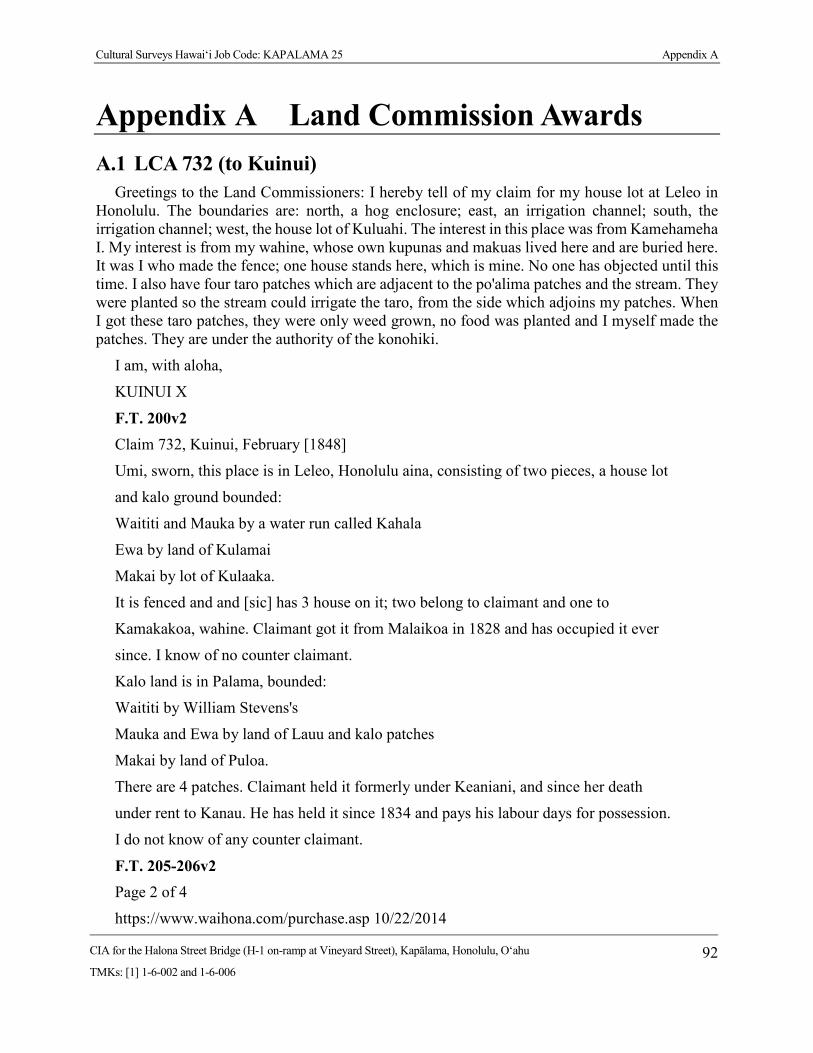
Cultural Surveys Hawai‘i Job Code: KAPALAMA 25 Appendix A
CIA for the Halona Street Bridge (H-1 on-ramp at Vineyard Street), Kapālama, Honolulu, O‘ahu
TMKs: [1] 1-6-002 and 1-6-006 92
Appendix A Land Commission Awards A.1 LCA 732 (to Kuinui)
Greetings to the Land Commissioners: I hereby tell of my claim for my house lot at Leleo in Honolulu. The boundaries are: north, a hog enclosure; east, an irrigation channel; south, the irrigation channel; west, the house lot of Kuluahi. The interest in this place was from Kamehameha I. My interest is from my wahine, whose own kupunas and makuas lived here and are buried here. It was I who made the fence; one house stands here, which is mine. No one has objected until this time. I also have four taro patches which are adjacent to the po'alima patches and the stream. They were planted so the stream could irrigate the taro, from the side which adjoins my patches. When I got these taro patches, they were only weed grown, no food was planted and I myself made the patches. They are under the authority of the konohiki.
I am, with aloha,
KUINUI X
F.T. 200v2 Claim 732, Kuinui, February [1848]
Umi, sworn, this place is in Leleo, Honolulu aina, consisting of two pieces, a house lot
and kalo ground bounded:
Waititi and Mauka by a water run called Kahala
Ewa by land of Kulamai
Makai by lot of Kulaaka.
It is fenced and and [sic] has 3 house on it; two belong to claimant and one to
Kamakakoa, wahine. Claimant got it from Malaikoa in 1828 and has occupied it ever
since. I know of no counter claimant.
Kalo land is in Palama, bounded:
Waititi by William Stevens's
Mauka and Ewa by land of Lauu and kalo patches
Makai by land of Puloa.
There are 4 patches. Claimant held it formerly under Keaniani, and since her death
under rent to Kanau. He has held it since 1834 and pays his labour days for possession.
I do not know of any counter claimant.
F.T. 205-206v2 Page 2 of 4
https://www.waihona.com/purchase.asp 10/22/2014

Cultural Surveys Hawai‘i Job Code: KAPALAMA 25 Appendix A
CIA for the Halona Street Bridge (H-1 on-ramp at Vineyard Street), Kapālama, Honolulu, O‘ahu
TMKs: [1] 1-6-002 and 1-6-006 93
Claim 732, Kuinui, February 23 [1848]
Umi, sworn, I know this land it is in Leleo, Honolulu aina. It consists of two parts, i.e.
house lot & kalo land.
1. The house lot is bounded:
Mauka & Waititi by alaala water course
Ewa by Kukuwai
Makai by land of Kulauuka.
It is fenced & has 3 houses on it; two of which are claimants and one is Kamakakoa's.
Claimant got his title in 1828 from Malaikoa and has occupied it in peace ever since.
N.T. 527-528v2 No. 732, Kuinui
Umi, sworn by the Bible and stated, "I have seen this place. It is at Leleo in Honolulu
district.
Aala is on the Waikiki and toward the mountainside
Kuluahi's lot, Ewa and
Kulauka is toward the sea.
This place has been enclosed and there are three houses on the inside. Kuinui had
received his interest from Malaekoa. Probably that was the year 1828 and he has lived
there since that time to this day. I have also known that Kuinui also has taro land at
Kapalama;
Kiwini's lot is Waikiki
Naluaii's lot, toward the mountain
He (Kuinui) is on the Ewa side and
Paoaaloa, toward the sea.
Kuinui's interest is from Keaniani and he had this land in the year 1834. Kanoa is the
konohiki at this time and has four patches. I have not known that anyone has objected
to Kuinui, altho' he is working for the konohikis at this time.
See page 536
N.T. 536v2 No. 732, Kuinui, From page 527, February 23 [1848]
Haikauai, sworn by the Bible and stated, "My testimony of the house lot and the taro
land of Kuinui is the same as the statements of Umi which have been read here, and I

Cultural Surveys Hawai‘i Job Code: KAPALAMA 25 Appendix A
CIA for the Halona Street Bridge (H-1 on-ramp at Vineyard Street), Kapālama, Honolulu, O‘ahu
TMKs: [1] 1-6-002 and 1-6-006 94
believe they are very authentic.
Page 527
[Award 732; R.P. 2465; Leleo Honolulu Kona; 1 ap.; .56 Ac.; R.P. 2465 & 6726;
Kapalama Kona; 2 ap.; 1.55 Acs]
A.2 LCA 918 (to Upai) To the Land Commissioners, Greetings: I hereby tell you of my house lot claim at Iwilei in
Honolulu. The boundaries are: north, the lot of Kanakanui, east, the lot of Kalaeloa, South, the lot of Haaliku, west, a road. I have occupied this place from the time of Kamehameha 1. It was infertile kula with spiny nohu weed, but at this time it has been improved and completely fenced and a house stands in it which is mine. I held it peacefully and at this time Kelliahonui is objecting. There are also some taro patches; there are three together in one place at Kumuhau in Kapalama, which adjoin the patches of Kauoiaoao and Halulu which have been held peacefully under the konohiki.
I am, with thanks,
UPAI X
F.T. 263v2
Claim 918, Upai, 3 April [1848]
Kekai, sworn, This is a house lot in Honolulu aina, bounded:
Ewa by Kauahanui's place
Mauka by Kailailoa's
Waititi by Poaliku's
Makai by Kealiiahonu's waste land.
It is fenced and claimant has one house on it, who I know to have lived there without
dispute ever since 1834. He [She] took it up as waste land.
Kalaeloa, sworn, confirmed the previous testimony and knew of no counter claim.
N.T. 605v2
No. 918, Upai, April 3 [1848]
Kekai, sworn and stated, "I have seen this place in Honolulu here adjoining to
Kapalama and the boundaries are:
Kanakanui's land, Ewa
Kalaeloa's land, mountain-side
the konohiki's land, oceanside and

Cultural Surveys Hawai‘i Job Code: KAPALAMA 25 Appendix A
CIA for the Halona Street Bridge (H-1 on-ramp at Vineyard Street), Kapālama, Honolulu, O‘ahu
TMKs: [1] 1-6-002 and 1-6-006 95
Koaliku's land, Waikiki.
This place has been enclosed, it is idle and Upai has lived here in peace to this time."
Kalaeloa, sworn and said, "I have seen this place and everything is just as Kekai has
related here and no one has ever objected."
N.T. 19v10
No. 918, Upai, Land Office, 1 July 1851
Kekai, sworn, he has seen his [her] land at Kumuohau, Kapalama - 3 taro patches in 1
land section.
Mauka and Waikiki, Makai by the king's land
Ewa by a ditch.
Land from Upai's husband named Kealaiki. He had received it from 0liver Holmes at
the time of Kamehameha I. No disputes to the present.
Kaiuiaaao, sworn, both known in the same way.
[Award 918; R.P. 4428; Iwilei Honolulu Kona; 1 ap.; .2 Ac.; R.P., 691; Kumuulu
Kapalama Kona; 1 ap.; .4 Ac.]
A.3 LCA 1746 (to Nakaikuaana) To the Honorable Mr. Lee and the Land Commissioners, Greetings: I, Nakaikuaana, hereby
state my claim for land at Kalaepohaku in Kapalama. The name of my mo`o is Kalauhulumoa. From the time of Kawailepolepo, through Keaniani, to Kanoa at this time, I have had three landlords on my mo`o.
NAKAIKUAANA
Kaloihulumoa, Kapalama
N.T. 92v10
No. 1746, Nakaikuaana, 17 January 1852
Hueu, sworn, I have seen his land at Kalepohaku in Kapalama, Oahu - 21 patches, 1 ditch and pasture in 1 section.
Mauka, Nalauai's land
Honolulu, Moo's land
Makai, Kaupena's land
Ewa, Kupahu's land.

Cultural Surveys Hawai‘i Job Code: KAPALAMA 25 Appendix A
CIA for the Halona Street Bridge (H-1 on-ramp at Vineyard Street), Kapālama, Honolulu, O‘ahu
TMKs: [1] 1-6-002 and 1-6-006 96
Land from Nakaikuaana's older brother Hao at the time of Kawailepolepo before
1831. Life has been peaceful.
Kupahu, sworn, every statement above is true, I have known in the same way.
[Award 1746; R.P. 2493; Kalaepohaku Kapalama Kona; 1 ap.; 2.4 Acs]
A.4 LCA 2266 (to Kuhiana) To the Land Commissioners, Greetings: I, the one whose name is below, hereby state my claim
for land in the `ili of Kalaepohaku, Ahupua`a of Kapalama, Island of Oahu. There are 10 lo`i.
KUHIENA December 25, 1847 N.T. 207-208v10 No. 2266, Kuhiana, 4 March 1853 Ualanai, sworn, I have seen his land sections in Kalaepohaku, Kapalama, Oahu of five land sections. Section 1 - House lot at Kainapuaa. Section 2 - 9 taro patches at Kalaepohaku. Section 3 - 6 taro patches at Kalaepohaku. Section 4 - 11 taro patches at Kalaepohaku. Section 5 - pasture sections in Kalaepohaku. Section 1: Mauka and Waikiki by Hanoa's land Makai to Ewa, a trail Ewa, Peahi's house lot. Section 2: Mauka by Kanoa's land Waikiki by Wm. Harbottle's land Makai by Bil Haole's land Ewa by Hauna, Keomuku, konohiki's land. Section 3: Mauka by Moo's land Waikiki by Kaaoaolahilahi's land, Palakiko's land Makai by konohiki's land Ewa by Nakaikuaana's land.

Cultural Surveys Hawai‘i Job Code: KAPALAMA 25 Appendix A
CIA for the Halona Street Bridge (H-1 on-ramp at Vineyard Street), Kapālama, Honolulu, O‘ahu
TMKs: [1] 1-6-002 and 1-6-006 97
Section 4: Mauka by konohiki's land Waikiki by Kaia's land Makai by Kaupena's land Ewa by Kupahu's house lot. Section 5: Mauka, Waikiki, Makai by konohiki's land Ewa by Kupahu's land. Land sections from Ualanai in 1843 and Kuhiana's life has been peaceful to the 3/19/13 https://www.waihona.com/purchase.asp https://www.waihona.com/purchase.asp 3/3 Land sections from Ualanai in 1843 and Kuhiana's life has been peaceful to the present time. Ualanai is assistant konohiki. [Award 2266; R.P. 2816; Kainapuaa Kapalama Kona; 1 ap.; .50 Ac.; Kalaepohaku
Kapalama Kona; 1 ap.; 7.45 Acs]
A.5 LCA 2268 (to Kapahu) To the Land Commissioners, Greetings: I, the one whose name is below, hereby state my claim
for land in the `ili of Kalaepohaku, Ahupua`a of Kapalama, Island of Oahu. There are 11 lo`i, 1 kula.
KUPAHU
December 25, 1847
N.T. 193v10
No. 2268, Kupahu, 2 Febrary 1853
Pahua, sworn, I have seen his land sections in the moo of Kumuhahane in the ili of Kalaepohaku, Kapalama, Oahu.
Section 1 - House lot and pasture at Puea.
Section 2 - 10 patches at Kumuhahane.
Section 1:
Mauka by Kanoa's land
Honolulu by Nalanai's land
Makai by Kaupena's land
Ewa by Kanoa's land.

Cultural Surveys Hawai‘i Job Code: KAPALAMA 25 Appendix A
CIA for the Halona Street Bridge (H-1 on-ramp at Vineyard Street), Kapālama, Honolulu, O‘ahu
TMKs: [1] 1-6-002 and 1-6-006 98
Section 2:
Mauka by Kanoa's land
Honolulu by Nakaikuaana's land
Makai by Kaupena's land
Ewa by Kaia's land.
Land sections from Nalanai before 1839 and he has lived peacefully to the present day.
Nalanai (assistant konohiki), sworn, I am the assistant konohiki, no objections.
[Award 2268; R.P. 2521; Kalaepohaku Kapalama Kona; 2 ap.; 3.76 Acs]
A.6 LCA 2937 (to Wm. Harbottle) No. 2937*O, William Harbottle, Honolulu, Oahu, January 10 1848
N.R. 701-702v3
To the Land Commissioners of the Hawaiian Islands, Greetings: I hereby state my claim, for my house lot in Honolulu, whose boundaries are: north, Nuuanu Street and Mr. Boyd's place, east, house lot of Keo Bu /George Booth/, south, lot of M. Peke /Beck?/, west, house lot of E. Dennis. Those are the boundaries - those of these house lots. The original right to this claim was from John Harbottle, who had it from Kamehameha I, and another claim from Paki which is combined with this house lot where I am living, without dissent from any one.
Also, there are the lands of Kuipaakea in Kapalama /Oahu/, and Iloli on Molokai which were left to us, the keikis of John Harbottle, who had these lands from Kamehameha I.
The lands which were taken by the Mo`i are: Ohikilolo, Waiape, on Oahu, Waipio District, Kumunui on Maui. These lands were for John Harbottle, who had them from Kamehameha I. Hanapouli on Oahu, is for Edward Harbottle, from the Mo`i, Kamehameha III. Keana, in Kaneohe,
is mine, from Kamehameha III.
I am, with thanks,
WILLIAM HARBOTTLE
F.T. 501v3
No. 2937, Part 6, William Harbottle
Komo, sworn, says he knows the ili of "Hanapouli," Ewa, Oahu, claimed by W. Harbottle. The father of claimant received this ili from the King, in ancient times. Claimant and his father have held undisputed possession of this land since the gift of the King. I saw Mr. Bishop survey this

Cultural Surveys Hawai‘i Job Code: KAPALAMA 25 Appendix A
CIA for the Halona Street Bridge (H-1 on-ramp at Vineyard Street), Kapālama, Honolulu, O‘ahu
TMKs: [1] 1-6-002 and 1-6-006 99
land from claimant, leaving out the part taken up in kuleanas. The survey made by Mr. Bishop of the kalo land is correct.
N.T. 1-4v10
No. 2937, William Harbottle, Honolulu, 18 April 18, 1851
Holowale, sworn, He has seen his house lot sections in Honolulu - 2 house lot sections, the boundaries:
Section 1:
Mauka by Boyd and J. Booth's house lots
Waikiki by Beck and Nicholson's house lots
Makai by Dennis's house lot
Ewa by Nuuanu street.
3 houses in this lot.
Section 2 - 2nd house lot.
Mauka by M. Kekuanaoa lot, Kuapanio lot
Waikiki by Kuapanio lot, J.Booth
Makai by J. Booth lot
Ewa by Nuuanu street.
Land to William Harbottle from his father, Jack Harbottle, father's land from Kamehameha I. William Harbottle inherited land in 1832, upon father's death, no objections.
Kauliokamoa, sworn, certifies above statements, he has known in the same way.
No. 2937, William Harbottle, (Section 2), 18 April 1851
Paele, sworn he has seen his land named Kuipaakea, an ili land in Kapalama, Kona, Oahu - 2 land sections.
Section 1 - Pasture land with taro.
Mauka by M. Kekuanaoa and R. G. Davis's land
Waikiki by Naopala and Mossom's land
Makai by Hakuohia and Pila's land

Cultural Surveys Hawai‘i Job Code: KAPALAMA 25 Appendix A
CIA for the Halona Street Bridge (H-1 on-ramp at Vineyard Street), Kapālama, Honolulu, O‘ahu
TMKs: [1] 1-6-002 and 1-6-006 100
Ewa by a stream.
Section 2 - Pasture land with taro.
Mauka by George Holmes [LCA 8504] and Kekai's land [LCA 7681]
Waikiki by Kekai's land, ditch
Makai by M. Kekauonohi's land
Ewa by M. Kekuanaoa's land, Kekai and Zupplien's land [LCA 275B-1], Government land.
Land from father John Harbottle from Kamehameha I. John Harbottle died in 1832, land inherited by children, no disputes.
Kanamu, sworn, certifies all statements above.
No. 2927, William Harbottle, (Section 3), 18 April 1851
Mahi, sworn, he has 6een his land named Ilohi, an ahupuaa in Molokai - 2 land sections.
Section 1 - A pond and pasture land.
Mauka M. Kekauonohi's land
Kaluaaha by Hoolehua land
Makai by outer surf.
Malalo (below) "Punakou."
Section 2 - Pasture land of Kaahaloa: Surrounded by M. Kekauonohi's land.
Land from William Harbottle's father, who had received it from Kamehameha I, upon his death in 1832, the children inherited the land and they have it to the present time without disputes.
Oihi, sworn, they both have known in the same way, no objections.
No. 2937, William Harbottle, (section 4), 18 April 1851
Oili, sworn, he has seen his land named Ohikilolo, an ahupuaa in Waianae, Oahu. This is
pasture land only. The boundaries are:
Cultural Surveys Hawai‘i Job Code: KAPALAMA 25 Appendix A
CIA for the Halona Street Bridge (H-1 on-ramp at Vineyard Street), Kapālama, Honolulu, O‘ahu
TMKs: [1] 1-6-002 and 1-6-006 101
Mauka by Government land
Honolulu by M. Kekuanaoa's land
Makai by M. Kekuanaoa's land
Kaena by Government land.
The father had received this land from Kamehameha I, he had lived peacefully all his life and upon his death had bequested this land to his children. They have it now, no disputes.
No. 2937, William Harbottle, (section 5), 18 April 1851
Pahia, sworn, he has seen his ili land named Waiape, in Kaneohe, Koolaupoko, Oahu.
The boundaries are:
Mauka by Kuaana's land of "Kaluaahuawa"
Koolauloa by Kuaana's land of "Kaluaahuawa"
Makai by Paul F. Marin's land of Punaluu
Kailua by The King's land.
Land from Kamehameha I to John Harbottle, William Harbottle's father. John Harbottle had lived peacefully and upon his death had bequested this land to his children. They have it at the present time, no disputes.
No. 2937, William Harbottle, (section 7), 18 April 1851
Kanamu, sworn, he has seen his land named "Opana" in Hamakualoa, Maui, it is an ahupuaa.
Mauka by Lot Kamehameha's land
Wailuku by Haiku, Kaalaea, Ulumalu, Kaupakulua,
Makai by sea
Hana by Keaaula, Uaoa, Peahi ahupua`a
Land from Kamehameha I to John Harbottle, his (Wm. Harbottle) father where on he had
lived peacefully until his death. The children have inherited the land and are there at the present time.
Mahi, sworn, Both have known in the same way, no one has objected.

Cultural Surveys Hawai‘i Job Code: KAPALAMA 25 Appendix A
CIA for the Halona Street Bridge (H-1 on-ramp at Vineyard Street), Kapālama, Honolulu, O‘ahu
TMKs: [1] 1-6-002 and 1-6-006 102
No. 2937, William Harbottle (section 8)
Kanamu, sworn, he has seen his land named "Kamakialoa" in Waipio ahupuaa. The boundaries are:
Mauka, Lot Kamehameha's land
Wailuku, Mokupapakua, Mokupapa-kanaka, Holowa ahupuaas
Makai, Sea
Hana, Waipio 2, Puolua, Huelo
Land to John Harbottle from Kamehameha I, upon Harbottle's death, land was inherited by his children and they still have it today, no objections.
Mahi, sworn, both have known in the same way.
William Harbottle states, "There is in these lands mentioned above the interest of Kanaka, but it should be separated according to what is proper about their place."
No. 2937, William Harbottle (section (9)
William L. Lee has worked on this claim. No. 10893, William Harbottle: Work done by W. Lee (L.)
No. 2937, Section 10, William Harbottle
Paihaihowale, sworn, he has seen his ili land Keana, in Kaneohe, Koolaupoko of 5 land sections.
Section 1 - 5 sand dunes, sea and a pasture, the boundaries are:
Mauka by Kalama's land
Koolauloa by Ocean
Makai by Kalama and the King's land
Kailua by Kalama's land.
Section 2 - 4 patches, 3 sand dunes, the sea and a pasture.
Mauka by the King's land
Koolauloa by the King's land
Makai by J. Pukoi's [Piikoi's] land
Cultural Surveys Hawai‘i Job Code: KAPALAMA 25 Appendix A
CIA for the Halona Street Bridge (H-1 on-ramp at Vineyard Street), Kapālama, Honolulu, O‘ahu
TMKs: [1] 1-6-002 and 1-6-006 103
Kailua by a pali.
Section 3 - 20 patches and a pasture.
Mauka by Hoopupule, Uluhoaloha's land
Koolauloa by stream
Makai by Pupule's land, the King's land
Kailua by pali.
Section 4 - 10 patches.
Mauka by "Waiakalua," Kawana's land
Koolauloa by Kekia's land
Makai by Kapu's land
Koolauloa by Paiku's land
Makai by Kauwana's land
Kailua by Keaukee's land.
Land from Kamehameha III in 1833. And he has lived there continuously to this time.
[Award 2937; R.P. 577; Nuuanu St. Honolulu Kona; 1 ap.; .11 Ac.; R.P. 3589; Nuuanu St. Honolulu Kona; 1 ap.; .11 Ac.; R.P. 3588; Kalaepohaku Kapalama Kona; 1 ap.; 8.32 Acs; R.P. 4539 & 7505; Kuipaakea Kapalama Kona; 1 ap.; 5.78 Acs; R.P. 5583; Keana Kaneohe Koolaupoko; 4 ap.; 141.20 Acs; R.P. 7391; Hanapouli Waipio Ewa; 1 ap.; 20 sq. chains; R.P. 8468, Kaneohe Koolaupoko (ap. 5); Ohikilolo Waianae; 1 ap.; 532.2 Acs]

Cultural Surveys Hawai‘i Job Code: KAPALAMA 25 Appendix B
CIA for the Halona Street Bridge (H-1 on-ramp at Vineyard Street), Kapālama, Honolulu, O‘ahu
TMKs: [1] 1-6-002 and 1-6-006 104
Appendix B OHA Response Letter

Cultural Surveys Hawai‘i Job Code: KAPALAMA 25 Appendix C
CIA for the Halona Street Bridge (H-1 on-ramp at Vineyard Street), Kapālama, Honolulu, O‘ahu
TMKs: [1] 1-6-002 and 1-6-006 105
Appendix C Melvin Ishihara Transcription Cultural Impact Assessment, Hālona Street Bridge: Cultural Surveys Hawai‘i (CSH) interview with Melvin Ishihara (MI), former resident of Kapālama, on August 24, 2015 at his home in Kāne‘ohe CSH: Nicole Ishihara MI2: Muriel Ishihara, wife of Melvin Ishihara CSH: Ok, so I have to record this. Are you OK with that? MI: Yeah.
CSH: Ok. Ok, so we can do that after at the end.
MI: No, this is important in the beginning.
CSH: Ok.
MI: So you have a pictorial picture of what I’m talking about.
CSH: Ok. Sure.
MI: Ok, you see that title on the top it says “Kapālama Canal Area”?
CSH: Ok.
MI: Ok. That’s the so-called project area.
CSH: Ok.
MI: But that’s before, that’s before, you see the period is from 19—39--1938, 1939 to 1945. So that’s a period of six years.
CSH: Ok.
MI: Well, when I was growing up because I stayed with grandma them.
CSH: Ok. Can we start from, like, your name and where you were born and all that?
MI: Ok.
CSH: Ok, let’s start with all that.
MI: Ok.
CSH: Ok, so you are obviously you are Melvin Ishihara.
MI: No.
CSH: Oh no?
MI: Initially I was Melvin Shigeru Shimokawa.
CSH: That’s right.

Cultural Surveys Hawai‘i Job Code: KAPALAMA 25 Appendix C
CIA for the Halona Street Bridge (H-1 on-ramp at Vineyard Street), Kapālama, Honolulu, O‘ahu
TMKs: [1] 1-6-002 and 1-6-006 106
MI: I was adopted in the 1940s. Early…mid…1940s prior, Ishihara, before he went off with the 100th Battalion.
CSH: So who are your parents? Who’s your birth mother and….
MI: Well, grandma was a Kochiyama.
CSH: Elsie. Kochiyama.
MI: Yeah.
CSH: Was she born here?
MI: Sheesh, not so sure she was born here. I think she was born in Japan, I think.
CSH: And then your father?
MI: My father was Shigeru Shimokawa. And he was…he died at such a young age. He must’ve been born on Kaua‘i.
CSH: Thank you [talking to MI2]
MI: Because he died when he was only 30-something years old.
CSH: Wow, so young. He was born on Kaua‘i?
MI: Yeah, that’s what my mom told me.
CSH: Was he was son of plantation workers or immigrants? I thought he was born here. Or no?
MI: Not in Honolulu. I think he was born on Kaua‘i. Because I always wanted to go back to Kaua‘i and grandma used to always tell me, “Oh how come? Because that’s where your father was born.”
CSH: Interesting. What did he do? Shigeru?
MI: Oh, he worked for Theodore H. Richards.
CSH: What is that?
MI: A contracting firm in Honolulu that built all the bridges.
CSH: Oh.
MI: You know like the bridge on Nu‘uanu Stream?
CSH: Ok.
MI: The one on Vineyard Street and all of those? But he worked for Theodore H. Richards as an operator…construction….construction job. And he died because of that job.
CSH: Which job?
MI: Working at….
CSH: The Nu‘uanu one?
MI: Yeah. He died from…tetanus poisoning. But he didn’t die according to grandma from poisoning on the job…it was…he played a lot of sports. He played sports with Alan Nagata who was the Assistant Coach to Neil Blaisdell. He used to like to sumo. I have pictures of him when he used to sumo with Alan Nagata and them. But he used to baseball for this Mō‘ili‘ili baseball team

Cultural Surveys Hawai‘i Job Code: KAPALAMA 25 Appendix C
CIA for the Halona Street Bridge (H-1 on-ramp at Vineyard Street), Kapālama, Honolulu, O‘ahu
TMKs: [1] 1-6-002 and 1-6-006 107
and whenever he wasn’t feeling well with an injury--according to Alan Nagata, he went to get acupuncture treatment by this lady in Mō‘ili‘ili. By the way, we used to live right next to the—I was born next to that Honolulu Stadium on Algaroba Street. I mean, right next to it. On the side street that runs right parallel to the stadium. But anyway, when I was a…he died in 1930…’38. He died 1938. So…
CSH: Was it because of a...the needle was infected?
MI: Well, that’s what Alan Nagata thinks it was.
CSH: Oh, ok.
MI: But if it was infected that way—that’s how you can get tetanus poisoning.
CSH: Right.
MI: So grandma was really upset with the hospital at the time. I think that was Queen’s Hospital because when he died, he died at such a young age.
CSH: What did Baban do for a living? Was she a homemaker or did she work?
MI: She worked but I think she was more of a housekeeper for one of the high makamaka….you know the old, the old guard. When I say the old guard, I mean, the ones at like Punahou and all like that. And she was like a housemaid. Then she just raised children—me, Uncle Pat. Uncle Pat was two years after me—and Uncle Roy was born—well, she was pregnant with Uncle Roy when my father died. My father died in November of 1938. And Uncle Roy was born in January of 1939.
CSH: And then when ….what did… was his first name for Ishihara?
MI: Robert.
CSH: Robert. So when did he enter the picture?
MI: Ok, he died…dad died in 1938. At that time we lived at the Shimokawa Camp. The Shimokawa Camp was that area in which the H-1 freeway runs right by Humane Society. They owned all that property.
CSH: Wow.
MI: So in payment for that property they were compensated, they bought, Grandma and Grandpa Shimokawa bought this multiple, this good sized property up on 12th Avenue in Kaimuki with houses on it because in the Shimokawa Camp there was 1, 2, 3, 4, 5...about 6 houses. It was a big piece of property.
CSH: So when did she meet Robert Ishihara?
MI: Well, it was just after the war started in 1941….must’ve been in 1942 when they sent the 100th Battalion over to the mainland. You know? The 100th Battalion was the forerunner to the 442nd.
CSH: Which is like….Dan Inouye?
MI: Yeah, because them guys was only like 18 years old.
CSH: Ok. So somewhere around there?

Cultural Surveys Hawai‘i Job Code: KAPALAMA 25 Appendix C
CIA for the Halona Street Bridge (H-1 on-ramp at Vineyard Street), Kapālama, Honolulu, O‘ahu
TMKs: [1] 1-6-002 and 1-6-006 108
MI: Yes. By the way, my stepdad was born on Maui and then he worked at Pearl Harbor. And then he had an injury from an explosion, not by the war, but by the construction when they were building Pearl Harbor. Water Town, what they call Water Town. Anyway, so he joined the Army and was sent to….the mainland. And then because of that injury I think he was discharged, he came home in 1943 or ’44 and that’s when they got married. And that’s when he married mom. But in the meantime, we were staying with the Shimokawa’s in Mō‘ili‘ili—you know the [inaudible]. And then she married him—must’ve been in the early 40s—I mean, ’43 or ’44 because in ’43—sometime in ’43—he moved us to Kapālama in that area.
CSH: Your stepdad?
MI: Yeah.
CSH: Why did he move you guys over there?
MI: Because that’s where Grandma Kochiyama-Yamane lived there. Grandma’s mother lived there.
CSH: Oh!
MI: She was married to —she came over with Grandma, Uncle Bob, Aunty Chieko, Uncle Jigs…
MI2: Are you talking about when she came from Japan?
CSH: No, we’re talking about when he lived in ….
MI2: Kalihi?
CSH: Yeah.
MI2: That’s right then.
CSH: Ok. So this is Baban’s….
MI: Family. Her name was Kochiyama but her mother married a Yamane.
MI2: Second marriage.
MI: Ok and that’s why we lived—and that’s why I showed this map…we lived…
CSH: Must be where this X is?
MI: No, that’s the temple.
CSH: OH!
MI: Right here. See this area right here? This is where the industrial is now but before that it was a pasture land. This street—this is King Street—‘cause we lived right where the Post Office is now.
CSH: Ok.
MI: I mean, literally right where the Post Office is now.
CSH: What kind of house was it? Before you used to say you used to take a bath in a furo.
Cultural Surveys Hawai‘i Job Code: KAPALAMA 25 Appendix C
CIA for the Halona Street Bridge (H-1 on-ramp at Vineyard Street), Kapālama, Honolulu, O‘ahu
TMKs: [1] 1-6-002 and 1-6-006 109
MI: Right, it was a furo. But we did not live in a house. It was a complex. It was a commercial complex where one end had a foundry and another one was a furniture store. Another one was a rental by Grandpa.
CSH: So you’re saying he lived at Gems? [laughing]
MI: Something like it.
CSH: Interesting.
MI: What it is, is a building that had all of these segments. And the first one in this lane was Yamashita General Store where we used to buy shave ice. They lived upstairs in the back. Every house, every unit inside there other than the Chinese restaurant and the barber shop and the furniture store and the foundry—we were the only ones with family that lived inside that complex.
CSH: You were the only ones?
MI: Uh huh. There was no bedroom you know? It was actually a storefront. We literally bordered King Street.
CSH: Why did you guys live in there?
MI2: Don’t look at me!
MI: What do you mean why did we live in there?
CSH: Did you family own the building or some of the stores?
MI: No. Well, ok. Grandpa Yamane was a vegetable peddler.
CSH: Oh.
MI: He pushed this great big wagon around the---you know Waiakamilo and Kalākaua and down by Libby Cannery?
CSH: Uh huh.
MI: He pushed that wagon all over that place with me inside.
CSH: Cute.
MI: But it wasn’t that cute when he ran over my toe.
CSH: [Laughing]
MI: Don’t laugh cause from that day on—I was just a young baby—I would run around and I didn’t go to school yet. From that day on, my toenail, my big toe—had a crack. And that crack existed until I retired 55 years later.
CSH: Oh my God! It never grew out and….
MI: It grew. But it was never infected—it just had a crack right in that big toe nail and it just kept—the new nail just kept growing.
CSH: So weird.
MI: Today there’s no line. But for many years it always had that crack. But anyway, he would push me around that neighborhood in what they call Waiakamilo Road behind Kalākaua School

Cultural Surveys Hawai‘i Job Code: KAPALAMA 25 Appendix C
CIA for the Halona Street Bridge (H-1 on-ramp at Vineyard Street), Kapālama, Honolulu, O‘ahu
TMKs: [1] 1-6-002 and 1-6-006 110
because all of that used to have houses and streets. Dirt streets. Ok, that area that I showed you was pasture land, today is an industrial area where Sears Warehouse is and everything else. You see that part that says “Pasture Land”? And a bomb dropped there on December 7th. Ok…
CSH: Can you describe what that was like?
MI: Well….
CSH: Did you guys know it was a bomb?
MI: Oh yeah, we heard the explosion and everything. ‘Cause I moved there right after the war had started. Well, I was there in 1941 to 1945. In 1939 we stayed with Grandma them in that house. Ok, this is…this is Kalihi Street right here. Ok, this Kalākaua School. Right down on Dillingham Boulevard next to Mokauea and it’s almost by the prison, one house was strafed with machine gun bullets.
CSH: Oh my God.
MI: On Dillingham Boulevard.
CSH: Was anybody in there?
MI: Yeah, they lived there. People lived there but nobody died that I know of [pause]. Ok so this map is my recollection of what it was like in 1940—from the time I stayed with Grandma and Grandpa Yamane in Kalihi-Kapālama.
CSH: I have a bigger map. If you want to mark it. I wanted to wait until the end but…
MI: What you mean a bigger map?
CSH: I mean, you can mark it up if you want. And then later on I’m going to give it to our map people and they can put points on it.
MI: You can take this one here.
CSH: But this one is way better!
MI: Well, the only thing that’s not better is that this does not have the freeway.
CSH: Oh yeah, that’s true! That’s true cause never had the freeway.
MI: Right.
CSH: Ok. Well, maybe I’ll just save it for later?
MI: And never had the buildings. You see where I show the pasture land?
CSH: Yeah.
MI: That was literally a pasture land.
CSH: Was there cows on it?
MI: There was horses and cows. And just bushes. And the stream. You see that little stream I drew inside there?
CSH: Uh huh.
MI: We used to catch crayfish inside there.

Cultural Surveys Hawai‘i Job Code: KAPALAMA 25 Appendix C
CIA for the Halona Street Bridge (H-1 on-ramp at Vineyard Street), Kapālama, Honolulu, O‘ahu
TMKs: [1] 1-6-002 and 1-6-006 111
CSH: Is that Kapālama Canal today?
MI: No, this is Kapālama Canal. It’s always been Kapālama Canal. This the pasture land.
CSH: What is…where is the little stream you’re talking about?
MI: Right here, you see this blue line?
CSH: Oh, ok, ok. Where did it originate from—the water?
MI: That line went across the street and came up here and ran up on Houghtailing and eventually it became like a drainage canal. And the other part that you can see here is that you see—this canal—you see the canal?
CSH: Uh huh.
MI; You see this line here that I have going?
CSH: Uh huh.
MI: That was a feeder line that came up in Kalihi. All the way up in Kalihi. You see that blue line going up?
CSH: Uh huh.
MI: Went up into Kalihi Valley that fed that stream. That fed Kapālama Canal.
CSH: Is that the one that goes up to Ice Pond or all the way up?
MI: Yeah, just about.
CSH: Did you go to Ice Pond?
MI: Nope. We couldn’t go that far in.
CSH: Why?
MI: We too young! You see where Kapālama School is right here? Okay, that drainage canal literally had a wall and I walked on that wall and I was looking at the mango tree and I fell down eight feet. Into the ditch but it was all concrete. So I got up and went home but it hurt like hell. But that….the other thing that I have to point out. You see I drew this, this map because, this map doesn’t have the freeway! You see where this portion is?
CSH: Vineyard?
MI: Yeah. That’s where the freeway is now today! Because it kind of came this way and when make a big turn to go down along this way not along Vineyard. Came along this way—big turn. But Vineyard used to end right on where Halona Street is today. You know the street that runs parallel to the freeway?
CSH: Uh huh.
MI: That’s Halona Street. Never had that street before. It was Vineyard. Vineyard would come to Palama Settlement about here and then go under that bridge and that’s what your gonna be doing when you work on the bridge—go under the bridge, go alongside the H-1, and then there was a gate here. And that’s how you went into Bishop Museum. Right as you entered the gate, they had a gymnasium. Beyond the gymnasium they had elementary school for the boys and dormitories.

Cultural Surveys Hawai‘i Job Code: KAPALAMA 25 Appendix C
CIA for the Halona Street Bridge (H-1 on-ramp at Vineyard Street), Kapālama, Honolulu, O‘ahu
TMKs: [1] 1-6-002 and 1-6-006 112
CSH: So that was the original location of Kamehameha Schools?
MI: Only the boy’s elementary portion. The school was already up on the heights. The girls were not located there now. Mom would tell you where they were located. You know where they were located?
CSH: No.
MI: On King Street. You know where the Kamehameha Schools Administrative building is now?
CSH: Kawaiha‘o Plaza? By the Missionary Homes….
MI: Yeah, right behind that. That’s where the girl’s dormitories were at.
CSH: And their school? Just the school or the dorms?
MI: The school would be up at the heights.
CSH: They really wanted them to be far apart.
MI: But later they moved the dorms even up to the heights. But that’s why this map is….for that period up until 1945 and before the freeway.
CSH: So you know how the freeway—obviously it’s down—right? There’s a big cut out.
MI: Right. It is really down.
CSH: Right. So how did they—did they dig that all out?
MI: They did. However, I was not there because I was away in school.
CSH: What was there….
MI: It was built in 1950 or so. About 1950-something.
CSH: What was there before? Was there homes before?
MI: Oh yeah. Oh yeah! You know where School Street is?
CSH: Yes.
MI: Where’s School Street? Here’s School Street. Well, once it went past…well, it never went—this map doesn’t show beyond Liliha Street. Anyway, once it passed Liliha and continued on to Nu‘uanu. Not Nu‘uanu, Fort Street. Actually it was Fort Street. It passed Nu‘uanu, where Kukui Plaza, where Foster Garden is.
CSH: Yes.
MI: Between Nu‘uanu and Fort Street. By the way, Fort Street went all the way to Pauoa Valley, you know? It was…there was no Pali Highway. Pali Highway—today, if you recall goes from Bishop Street right straight up. It never used to. It used to stop right at Beretania. And Pali Highway went from the fire station and Princess Theater straight up Fort Street. Up Fort Street. So Fort Street used to go up all the Pauoa Valley. Anyway, on School Street—let’s see—School Street—on School Street. This is School Street, between Foster Garden and Fort Street there used to be a theater called—where Kaneda’s—you know where Kaneda’s Catering—there’s a catering service right on the mauka side. On the makai side was a park!
CSH: You mean where Zippy’s would be today?

Cultural Surveys Hawai‘i Job Code: KAPALAMA 25 Appendix C
CIA for the Halona Street Bridge (H-1 on-ramp at Vineyard Street), Kapālama, Honolulu, O‘ahu
TMKs: [1] 1-6-002 and 1-6-006 113
MI: No, no. This is up. Zippy’s is on Vineyard.
CSH: Oh, I see where you’re saying.
MI: This is above Kukui Gardens. You know Kukui Gardens? You know where they built Kukui Gardens? By the way, that’s where Grandma Ishihara them used to live. Was all Chinese families inside there. Used to walk from the Kukui Apartments go down on Vineyard Street, walk over to Nu‘uanu, walk over to Grandma Ishihara’s. Grandma Ishihara was blind from diabetes. Grandpa Ishihara was an amputee. Both legs. From diabetes.
CSH: Oh my gosh. That’s horrible.
MI: And that’s why, the Ishihara line and when I say the Ishihara line, Uncle Gary, Aunty Emi, and Wayne all have…all was diabetic. Type 1. Anyway, that’s basically the line that Vineyard took. It went right into Bishop Museum. Now there’s no freeway on this map. But the freeway was all dug down.
CSH: Uh huh, but you’re saying there was homes there, right? Where the freeway is today. Like sitting on top, right? There was homes?
MI: Yeah.
CSH: Was it pastureland?
MI: Not really, I’ll tell you why. You see where this Vineyard is?
CSH: Uh huh.
MI: Ok, that street where Vineyard Boulevard was there but there was a lot of pasture land there. Now, the ironic part of it is this. You see, Waiakamilo Road went to King Street. That’s King Street right there. It was called Waiakamilo. For some reason that portion that goes mauka all the way up to Kamehameha Heights is called Houghtailing. Named after George Houghtailing who was one of the political big wigs. So that’s strange—if you go past King Street, “Oh you talking about Waiakamilo on the mauka side of King?” But no, that’s Houghtailing. Ok, it went into, it went into. Ok—the interesting part I want to tell you is that on Houghtailing from Vineyard is School Street. On the side where Damien and the Carpenter’s Union and all those others it used to be nothing but bushes. And it was only a dirt road. There was—if you notice in this map here—there is no homes on Bishop Estate land. It was not built until sometime in the 1950s. That’s why I don’t have the streets and everything inside there.
CSH: Oh yeah, yeah. All the little side streets.
MI: You see, Tatsuku used to lived right down on this Kapālama Street that goes down here in Bishop Estate land. He lived right off of School Street but I didn’t drive any of those units inside there.
CSH: The what?! The suku?
MI: Tatsuku.
CSH: Who’s that?
MI: Tatsuku. You don’t know Tatsuku? He used to work for the court. He used come here all the time. He was a court clerk.
Cultural Surveys Hawai‘i Job Code: KAPALAMA 25 Appendix C
CIA for the Halona Street Bridge (H-1 on-ramp at Vineyard Street), Kapālama, Honolulu, O‘ahu
TMKs: [1] 1-6-002 and 1-6-006 114
CSH: That’s your friend?
MI: Yeah, he belonged to the Y’s Men Club. He used to come here all the time. Nice guy. But then he got into trouble because he was gambling. And then he left the court system and then he worked for a travel agency. Nice guy, he didn’t do anything criminal! He didn’t go to jail for it but he had to leave the job. Anyway, that’s why I don’t have any buildings at Bishop Estate or this development because this development was not in existence in 1945. This area did have development because this where the Puerto Rican community is located.
CSH: Interesting. So where the freeway would be today?
MI: Huh?
CSH: Is that where the freeway would be today?
MI; No, this is School Street.
CSH: Ok, so makai of that.
MI: Yeah, makai of that. From here to here there was houses. This side had houses. This is…right here is ok, this is Pālama. You know Pālama Street? You see on this corner right here?
CSH: The church thing?
MI: Right here. No, right here. Right here.
CSH: Ok.
MI: Yeah, this yeah. You see this street right here?
CSH: Yeah.
MI: It’s Banyan. And it’s a dead end. And at the end of the dead end is where Grandma and Uncle Bob’s ashes are stored at that Japanese temple. So there is a Japanese temple there, a Japanese temple there, and a Japanese temple across the street on here someplace. Right here.
CSH: So, was this….was Kalihi-Kapālama a mixed community?
MI: Oh yeah….
CSH: Like how Kaka‘ako was?
MI: Oh more so. Because we had Japanese, Chinese, Hawaiian, haole, pōpolo.
CSH: And they lived in like little areas together? Or was it all mixed up?
MI: Oh no, this whole area was all congested. All congested. All Japanese and everything inside there.
CSH: So all mixed up?
MI: All mixed up! The lane that I lived in—you see this little lane right here? Significant because that’s where Calvin McGregor lived.
CSH: Who’s that?
MI: Calvin McGregor is a judge. He’s also a major contributor to Kamehameha Schools. His wife—there’s one trophy named the McGregor trophy in the Kamehameha Song Contest.
Cultural Surveys Hawai‘i Job Code: KAPALAMA 25 Appendix C
CIA for the Halona Street Bridge (H-1 on-ramp at Vineyard Street), Kapālama, Honolulu, O‘ahu
TMKs: [1] 1-6-002 and 1-6-006 115
CSH: OH! So it’s named after him!
MI: Yeah, Calvin McGregor. And his wife for many years used to make that presentation. McGregor.
CSH: So where….
MI: That’s McGregor Lane.
CSH: So where you lived…was it just stores?
MI: Yeah, you see that block right there?
CSH: Even around you? Besides what you lived in?
MI: What you mean stores?
CSH: Well, you lived in a store. But was there other stores around you or were there homes around you?
MI: Not on that side of the street. It was on this side of the street there was.
CSH: And how many people lived in your house or area?
MI: Well, it was the three of us—Uncle Roy, me, and Uncle Pat. Then there was Aunty Florence, Uncle Bob. Later Merle and Milton came but it was much later than 1945. Uncle Jigs. Aunty Violet, Uncle Reggie. Grandma and Grandpa. So there was about 8, 9, 10 people. And there was no bedroom.
CSH: So you guys all slept on futons or something?
MI: Futons on a big open area. It was like a….like a hall-like, you know. You know you see some of these Japanese movies where they have this kendo or sword da kine instruction place? Like that. And you lay your futon down and you store your futon in little cabinets. Oh, there was one area that Uncle Jigs slept on cause to go from the, from the main entrance in, Grandpa Yamane used to park his vegetable wagon in front of there. Then to get to the living area you had to go down this hallway. The hallway. And above the hallway there was this deck and every night Uncle Jig used to have to climb up there to go to sleep. That’s where he slept. Uncle Bob, Aunty Florence at that time they were just married. Aunty Chieko, Uncle Reggie—Uncle Reggie left and went right into the military right after high school. And then from there he went to England, Florida, and we never saw him after that.
CSH: Wow.
MI: Other than the pictures that he sent home. But he must’ve passed away and we never knew that.
CSH: So what would you guys eat? Would you guys eat the vegetables—the leftover the vegetables?
MI: Oh yeah, grandma would do the cooking. By the way, the kitchen was something else! You would not believe what the kitchen looked like. Right after she does the cooking, on the adjacent side of it was a toilet.
CSH: That’s clean [laughing].

Cultural Surveys Hawai‘i Job Code: KAPALAMA 25 Appendix C
CIA for the Halona Street Bridge (H-1 on-ramp at Vineyard Street), Kapālama, Honolulu, O‘ahu
TMKs: [1] 1-6-002 and 1-6-006 116
MI: No, it’s separated but it’s a furo.
CSH: Ah so you guys had your own furo there!
MI: Yeah, we used to have to make the fire on our own and everything there. And then the bathroom. So she had to wash the clothes in there too.
CSH: Did you guys eat traditional Japanese food?
MI: Yeah, definitely. Everything was traditionally Japanese. I mean straight Japanese.
CSH: Did you ever eat local stuff? You were saying you caught crayfish. Did you ever eat that?
MI: Not at home. We ate it outside in the field.
CSH: Like as a snack?
MI: Like I told you, it was a mixture of nationalities, right? Ok, one of the guys was Willie Keola. Willie Keola played football for Farrington. His son got a scholarship to ‘Iolani. He made all-star but Willie Keola was about a 250 pound guy. Nice Hawaiian guy. He lived next to George Okanishi, one Japanese guy. And then had some Chinese guys. And then down the street was the Nicholas family which was a pōpolo guy.
CSH: So this was your childhood friends that you hung out with?
MI: They lived in the neighborhood. So the kitchen was one level, the same level as how the hallway and the wagon was parked. The living area was little bit raised.
CSH: The what?
MI: Living area. Where I told you. Where we slept. Was little bit up. But you gotta go up. It’s not that high a da kine.
CSH: A step?
MI: Not that high you gotta climb up. The eating area was like that, you gotta climb up into a little cubby hole like. And they had this—the table was like from here to there wide. And about that—not even that long so you gotta sit inside there to eat.
CSH: Wow.
MI: [laughing]
CSH: So when you would eat traditional Japanese food at home, but when you’re out playing you would eat crayfish?
MI: Crayfish. Pigeon.
CSH: Ew. So you’d catch it and then fire it up?
MI: Yeah, ok, like I said, you see this pasture land? By the way, you see this other lane here? Naipers Lane. Right between those two was O‘ahu Lumber and Hardware. In the back of O‘ahu Lumber and Hardware was a junkyard. When I say junkyard they had all these soda cans….not soda….soda water bottles, palettes, and left over stuff all stack up. And then they had a tree. You know Kohou Street where they just when move the guys?
CSH: Yes. Yes.

Cultural Surveys Hawai‘i Job Code: KAPALAMA 25 Appendix C
CIA for the Halona Street Bridge (H-1 on-ramp at Vineyard Street), Kapālama, Honolulu, O‘ahu
TMKs: [1] 1-6-002 and 1-6-006 117
MI: It wasn’t a street. It was just a dirt road.
CSH: Yes, ok.
MI: That’s why I showed that as a dirt road. And then the stream ran in and then there was a big mango tree and we’d go up in the mango tree and Willie Keola was a little bit older than us. He used to go catch doves. The way he catch doves two ways: the old style and Indian way where you get the—you know the wire. You make the wire da kine and make the entrance and then they go in and cannot come out. And the other stuff, I really remember clearly, clearly, clearly was an Indian type. See all of that area had koa bushes. You know what koa bushes look like ah? You know the koa bean ah?
CSH: Yeah.
MI: They grow so high.
CSH: You’re talking about haole koa?
MI: Haole koa, yeah. So he goes and bends it down.
CSH: Hah yeah!
MI: He bends the haole koa branch down and makes it…ties a string on it. Make a loop. Make a platform and build a platform like that—put sticks on it. And then he put his corn down and we sitting in the tree now! The dove pick it up, pick it up, pick it up. As soon as he stepped on that platform it unhooks the da kine the thing and the da kine snaps up and catches the thing by the leg and we run down from the tree, we pick it up, put it in the cage. He had at one time six mountain doves. You know mountain doves? The big ones. You know the big ones we see out here.
CSH: Yeah.
MI: And then we barbeque ‘um.
CSH: And you’d just pick off all the feathers and boil it?
MI: Yeah, you gotta make hot water and make it like chicken. You only…
CSH: So that was like your outside play snack? Or you guys would camp in the pasture land?
MI: No, we wouldn’t camp in the pasture land. We were still only like…1946….I was about seventh, eighth grade. No, not even seventh grade about sixth grade. Fifth, sixth grade.
CSH: Ok, would you guys eat the mangoes too in the mango…
MI: Oh yeah, mango, guava, all kinds of stuff.
CSH: Would you guys go far mauka? Far up towards where Kamehameha Heights. No?
MI: No, the farthest we would go was on Houghtailing. On Houghtailing both sides of the streets, before Bishop Museum was developed, both side of the street was kuahiwi.
CSH: Kuahiwi?
MI: BUSHES!
CSH: OH, BUSHES!
MI: [laughing]

Cultural Surveys Hawai‘i Job Code: KAPALAMA 25 Appendix C
CIA for the Halona Street Bridge (H-1 on-ramp at Vineyard Street), Kapālama, Honolulu, O‘ahu
TMKs: [1] 1-6-002 and 1-6-006 118
CSH: What kind of bush? Was it haole koa too?
MI: Oh all kinds, koa trees, kukus.
MI2: Kiawe?
MI: Yeah, kiawe, kiawe too.
CSH: It’s kind of hard to imagine Kapālama like that now.
MI: Ok, this thing says culturally etc. Now let me give you background. Now I said Chinese, Hawaiian, Japanese, and Filipino. And which reminds me, next to that McGregor Lane right there the Filipino guys had fighting chickens over there.
CSH: So regularly had gambling?
MI: Yeah. And they had Mao Lane and all that. Now Farrington High School was here but in 1941, 1942, 43, 44, 45—it was a hospital. Farrington High School was. Next to the high school they had these barracks-like. Warehouses.
CSH: Was that for the war?
MI: Yeah. They had barracks like. Ok. So there was a separation between Farrington and the Kamehameha property, you know Bishop Museum? But it was not anything that was barb wire or anything like that. You know? Just separated and we knew we couldn’t go over there and they couldn’t come over. Had a gymnasium right inside the gate—nice gymnasium—we used to use it. And then the museum. You know the big building that’s up there? The main one?
MI2: The museum?
MI: The museum. Bishop Museum.
CSH: Yeah.
MI: That’s the original one. No more the new ones on the side. But that’s how the Bishop Museum was. So they had all that property and this is all Bishop Estate from here. And then there’s a park across the street—the park is still there. Ok. But there’s a temple there. There’s a temple here. There’s a temple there—where I told you grandma and Uncle Bob is. And right on the corner there is Palama Settlement. See that Palama Settlement?
CSH: Were you just confined to this area? You just kind of stayed in this area during this time?
MI: Well, we used to go to Palama Settlement.
CSH: No, but from Liliha Street to Kalihi Street, you kind of just stayed in…
MI: Yeah, yeah, yeah, yeah, yeah. And by the way, you can go—see I told you this pasture land went to Dillingham Boulevard. Beyond Dillingham Boulevard was like had gardens and da kine—taro patches.
CSH: Ahhh.
MI: There was no Nimitz Highway.
CSH: So did anybody live there?
MI: Yeah, guys that would take care of the place.

Cultural Surveys Hawai‘i Job Code: KAPALAMA 25 Appendix C
CIA for the Halona Street Bridge (H-1 on-ramp at Vineyard Street), Kapālama, Honolulu, O‘ahu
TMKs: [1] 1-6-002 and 1-6-006 119
CSH: So tell me about this rubbish incinerator.
MI: Ok, that was—that was a—see….they had it there kind of long because they used to burn the rubbish you know from the rubbish truck? And then they got rid of it because—the syndicate used to throw guys inside there [laughing].
CSH: So they would find bodies or they would….
MI: Riiiiight [laughing]. You know if you didn’t get along with the syndicate that’s where you’d end up. At one time the syndicate was really, really bad. Really bad. They would not hesitate to wipe guys out. They’d go to Maunalua Bay.
MI2: They’d leave bodies in cars.
MI: Maunalua Bay they kill the two Korean guys—the Hong Brothers. Or they go up to Camp Erdman side and bury them in the sand over there.
CSH: Right. So they were the gang of Honolulu?
MI: They called them the syndicate. And they—the guy who headed it ended up in jail. You know?
CSH: So those guys don’t exist out on the streets anymore?
MI2: No.
CSH: They’re grandpas? [laughing]
MI: Oh yeah, definitely. Now Grandpa Ishihara, after he got out of the Army and then we moved to airport side, by the way, we moved to John Rogers.
CSH: Right. By the airport.
MI; He went to work for the prison and two of the guys he had to watch all the time was Majors and Palakiko.
MI2: Oh.
MI: [laughing]
CSH: I don’t know who that is.
MI: Ok, James Major and the other guy Palakiko murdered—what the wahines name? Up in Nu‘uanu. She was a rich wahine.
CSH: Massey?
MI2: I heard about that one. No, not Massey. No, Wilder.
MI: Anyways, they murdered her and she was an old lady. But they caught them because they were escapees at that time so they were looking for them. But Grandpa Ishihara was a guard and he became friends with them two guys. One guy could never get straightened out. The other guy served his time and he got out.
MI2: There was no death penalty?
MI: No, death penalty. There was, but they never got the death penalty—the time they came out never got the death penalty. Because he said they—he didn’t like the job because he didn’t want

Cultural Surveys Hawai‘i Job Code: KAPALAMA 25 Appendix C
CIA for the Halona Street Bridge (H-1 on-ramp at Vineyard Street), Kapālama, Honolulu, O‘ahu
TMKs: [1] 1-6-002 and 1-6-006 120
to be the guy who had to pull the lever for hanging. It was hanging. The death penalty was hanging. And that was something he would not do.
CSH: So the rubbish incinerator—that would be where KCC is? HCC!
MI: No, it’s middle of the da kine….
MI2: It’s right across the canal from HCC side.
CSH: Yeah.
MI2: Middle of the block.
MI: Commercial stuff—bars and stuff like that.
MI2: It’s on the opposite side where HCC is? The incinerator was?
MI: Yeah, it’s on the mauka side.
MI2: Is it on the HCC side of the canal?
MI; Yeah, because ok—I never had this map drawn by scale because along here—
MI2: She has a big map over here!
MI: Pua Lane, ok, Palama Theater. Right? And then there’s Robello Lane. And Kai‘ulani School was about there. Kai‘ulani School is just before the incinerator because it’s what is by Austin Lane.
CSH: That’s kind of like by Kaumakapili, right?
MI: Yeah, right. You see this banyan? Between here and here—you see the church? There’s a church there? That’s Kaumakapili Church.
CSH: Uh huh.
MI: And on this corner is Tamashiro Market. Ok, there’s a park right in the—at the end of the lane because it was not too far from Palama Settlement. Which reminds me, you know Vineyard Boulevard?
CSH: Uh huh.
MI: It was not four lanes. It was only two lanes on the downside. The upside was part of Palama Settlement and the houses. Because they took some of the property of the Chinese church and everything. You know if you go down past Pua Lane there’s a Chinese church right before you get to Liliha, eh? So that mauka side lane on Vineyard didn’t exist. It was only a two lane road.
CSH: Ok. So going back to cultural stuff….you said this whole area was lo‘i. Was there anywhere else that was lo‘i in this area? Or even above.
MI: No, my recollection is only this area was.
CSH: And they were all Hawaiian families that took care of that area?
MI: Yeah, probably.
CSH: Do you remember any heiau or anything?
MI: No, that’s one thing…ok up here is a cemetery. You know going up Kamehameha?

Cultural Surveys Hawai‘i Job Code: KAPALAMA 25 Appendix C
CIA for the Halona Street Bridge (H-1 on-ramp at Vineyard Street), Kapālama, Honolulu, O‘ahu
TMKs: [1] 1-6-002 and 1-6-006 121
CSH: Oh yeah, by the bus terminal.
MI: There’s a big cemetery there. Three. Three different cemeteries in the same area. Yeah, right over here.
CSH: And what about the cemetery?
MI: No, it’s just that it was an open area now they get fence up. But before it was just overgrown.
CSH: Uh huh.
MI: They had to watch for….because opposite, right opposite that on Houghtailing—this side. Is a bus terminal, right? Because Tatsuku lives over here. On Kalihi Street going up was just bushes. Never had any development there.
CSH: So you would….so going back to when you catch stuff in the streams…you said you catch crayfish? Was there any other fish?
MI: ‘Ōpae. ‘Ōpae.
CSH: How would you make that? Would you use it part of your Japanese cooking too?
MI: ‘Ōpae, your Uncle Jay them would catch them out by Waikāne and eat them just like that.
CSH: Yeah, but how would you eat it?
MI: Oh, just boil it.
MI2: They not like the Hawaiians.
CSH: What kind of fish? That would be it? Just crayfish and ‘ōpae? Never had like…
MI: Well, inside there. Inside here had mullet.
CSH: So that’s the canal….
MI: No tilapias. The canal was clean. It has Samoan crab.
CSH: Ok.
MI: We used to catch crab inside there.
CSH: Samoan crab, mullet. Tilapia?
MI: No tilapia.
MI2: Oh, tilapia did not exist.
MI: Did not exist at that time [laughing].
MI2: About the 60s it came.
CSH: So what kind of fish? That was it?
MI: Basically it.
CSH: And it was clean the water?
MI: Clean. Yeah, cause it was just drainage canal that would take the rainwater and stuff like that.
CSH: Would you swim in it?

Cultural Surveys Hawai‘i Job Code: KAPALAMA 25 Appendix C
CIA for the Halona Street Bridge (H-1 on-ramp at Vineyard Street), Kapālama, Honolulu, O‘ahu
TMKs: [1] 1-6-002 and 1-6-006 122
MI: Yeah, we used to ride in it and made tin boats. Do you know what tin boats are?
CSH: I have an idea.
MI: Totong. You know what totong is?
CSH: Uhhh no.
MI: Corrugated roofing?
CSH: Oh yeah. Corrugated roofing!
MI: We’d bend it and we’d nail it on both ends and it becomes a boat. We put outriggers on it.
CSH: Oh fancy.
MI: Cover it up with tar from the road. We chew the tar after we dig um out from the road. Heat it up. I used to literally chew it.
CSH: Like gum?
MI: Yeah, like gum. That was our past time.
CSH: How deep was the canal?
MI: Oh, the canal was kind of deep. Maybe about seven, eight feet.
CSH: But there would be no sharks that swam up?
MI: None. None. See actually it’s a fresh water stream to begin with so you cannot have anything like that. Only swim in salt water. Fishes cannot survive in that kind of water. Anyway, the area of that temple—that was our grounds, ok? We used to call it Kompira. For many years while we were growing up we called it Kompira. K-O-M-P-I-R-A. And that is the wrong name. It’s Koto Hira. K-O-T-O-H-I-R-A.
CSH: We have it over here. Jinsha. Kotohira Jinsha.
MI: Yeah, but we used to call it Kompira cause that’s what we thought we heard. That was one.
CSH: And you’d hang out there?
MI: Oh yeah, because you know why? They had sumo there. They had a martial arts training hall and they had kendo. Kendo and all that other kind stuff. And then they showed Japanese movies in the temple. And then during the war, in that hall, what Grandma them used to do—the old Japanese ladies was make slippers for Tripler Hospital. I mean, literally—slippers—you know how they cut it to pattern and sew it and everything? That’s what their volunteer was. Yeah, behind that da kine—where Vineyard is—you see that open area? That was quite a big area you know? It was just open field. Could play softball and what have you. But they had sumo too. They put up a sumo ring. So if you go to that temple at the end of that road before you enter that property—there is literally a gate way. I mean if it’s still is there but there used to be a gate way that they decorate because they had bon dances this time of the year. Today what they do is at the new year they bless the animals.
CSH: I didn’t know they did that.
MI2: Yeah!

Cultural Surveys Hawai‘i Job Code: KAPALAMA 25 Appendix C
CIA for the Halona Street Bridge (H-1 on-ramp at Vineyard Street), Kapālama, Honolulu, O‘ahu
TMKs: [1] 1-6-002 and 1-6-006 123
MI: Oh yeah it’s a big deal!
MI2: I’ve seen it. I mean, it’s in the newspapers.
MI: In the old days they didn’t have that but in the new days they do.
MI2: Now a days they have that.
MI: They went so far as to really…. Promote and sell some of these things. Guys was stealing that. You supposed to make a donation.
MI2: Supposed to make a donation.
CSH: Did you ever go past Nimitz? Where the harbor is?
MI: No, that’s why I said…we never went below that. Because you were already at the harbor. We used to swim in that harbor. I used to swim down there when we were on Kukui. We used to go all the way down to Pier 19. That’s where we saw the…mom knows the….the so-called tsunami coming up.
CSH: Oh.
MI2: By River Street.
MI: Down by River Street.
CSH: What year was this? 1946?
MI: 1946, I was going to school. Ok, we live right next to the canal so I was going to school about 7:30 in the morning. Everybody was yelling, “TIGER WAVE! TIGER WAVE!” I was like, “What kind of wave? Tiger wave?!”
MI2: They were yelling tidal wave.
MI: They said tidal wave but I thought they said “Tiger Wave” because we never used the tern tsunami until 1946. No, 19—the one that hit Hilo.
CSH: Was that ’48? Or 52?
MI: 60-something ah?
MI2: They still called it a tidal wave.
MI: Anyway, that’s what we saw. The thing would recede and all of the mullet—cause all the mullet inside that river—and papio—‘cause it was a mixture of salt water and fresh water coming from Waiakalulu Falls.
CSH: That was at River Street? Brackish.
MI: Yeah, it was brackish. Because used to wash cars further up on School Street you know? You drive down this parkway and mom’s classmate was there too. The Kawahara Nursery. You go down, park it down in the, in the stream and they wash their car. Had ‘o‘opu.
MI2: I didn’t know they wash cars. In our neighborhood nobody wash cars like that.
MI: You know ‘o‘opu?
CSH: Yeah.

Cultural Surveys Hawai‘i Job Code: KAPALAMA 25 Appendix C
CIA for the Halona Street Bridge (H-1 on-ramp at Vineyard Street), Kapālama, Honolulu, O‘ahu
TMKs: [1] 1-6-002 and 1-6-006 124
MI: That was loaded with ‘o‘opu, ‘ōpae, crab.
CSH: At the River Street?
MI: At Nu‘uanu Stream, what they call Nu‘uanu Stream.
CSH: Nu‘uanu Stream?
MI2: Yeah, way up School Street.
MI: It runs from Kuakini actually. Cause there’s a waterfall up there. You go up inside there there’s a waterfall park.
MI2: It’s not that big is it the waterfall?
MI: It’s a big waterfall!
MI2: Oh yeah?
MI: Yeah because you gotta take all the water from Nu‘uanu.
CSH: Are you talking about…what’s that one?
MI: Waikalulu Falls, Waikalulu Falls, I think.
CSH: Oh, is that what it’s called? Not the kine ah…Kapena Falls? Not that one.
MI/MI2: Oh no. Nu‘uanu area.
MI: This one would come from….Nu‘uanu and….Sacred Hearts Convent.
MI2: What’s the place they call Lili‘uokalani or something?
MI: You know the rehab center? You know where the rehab center is?
CSH: You talking about Lana….no.
MI2: Talking about Kuakini Street just before…
CSH: Lanakila? Here, hold this for Papa. Anyways, ‘o‘opu and what else had?
MI: ‘O‘opu, ‘ōpae….
CSH: What kind of fish? No more fish. Besides the ‘o‘opu?
MI2: I don’t even know….I heard of ‘o‘opu fish but I never seen those things.
CSH: [laughing] So, so what happened? You saw the water recede and you saw all the fish in the wa—in the bottom of the river.
MI: Yeah and the guys go all run down and pick um up.
CSH: Chinese guys?
MI: No, all local guys. Young guys.
CSH: And then how long did it take until the water came back up?
MI: [laughing] Because you can see it coming---come down the ocean. You know on Beretania Street?
CSH: Yeah.
Cultural Surveys Hawai‘i Job Code: KAPALAMA 25 Appendix C
CIA for the Halona Street Bridge (H-1 on-ramp at Vineyard Street), Kapālama, Honolulu, O‘ahu
TMKs: [1] 1-6-002 and 1-6-006 125
MI: Where Beretania Street and Aala Park is? Right over used to have an arch…over the bridge, over the bridge—one concrete arch. The water was that high.
CSH: [gasps]
MI: That’s when they know they had to get out of there quick [laughing].
MI2: You know the bridge has that wall-like, yeah?
CSH: Yeah.
MI2: The arch went over that way—like that. Yeah, like that.
CSH: So it wasn’t coming fast? It was coming kinda of slow…
MI: Oh it comes! Because it’s a surge, ah?
CSH: Yeah, yeah. So what? Chinatown was all inundated?
MI: No. It never went over the wall. It never went over the wall.
MI2: Over the sides, you mean.
MI: There’s a wall you know. If you look at that river today there’s a wall on both sides.
MI2: It never came that high.
MI: No more the name of the the spring.
MI2: What spring?
MI: The one in [inaudible].
CSH: I can go look it up at work.
MI2: What spring are you talking about?
MI: The one by the Sacred Hearts Convent.
MI2: Oh, there’s a river there.
MI: Yeah, you know Sacred Hearts Convent?
MI2: Yeah, there’s a river there. Right along the side of that street.
MI: Yeah, because that river runs, runs right into that stream.
MI2: What I find interesting there is the Kunawai Springs.
CSH: Oh, I’ve been there.
MI2: Oh yeah?
CSH: That’s really interesting.
MI2: Uncle Herbert’s them side—their grandpa—they lived on Kunawai Lane. That is Fatty and he had a lo‘i.
CSH: Well…
MI2: They had spring waters, yeah?

Cultural Surveys Hawai‘i Job Code: KAPALAMA 25 Appendix C
CIA for the Halona Street Bridge (H-1 on-ramp at Vineyard Street), Kapālama, Honolulu, O‘ahu
TMKs: [1] 1-6-002 and 1-6-006 126
CSH: Actually…
MI2: So I heard about it. Fatty had their lo‘i.
CSH: Yeah, so Kunawai is…..[looking at map]….
MI2: I saw Pu‘u Nui is up here.
MI: Liliha Street. It’s off of Liliha Street.
CSH: So this is where the spring is, yeah? And then what’s really interesting is that there’s three or four springs over here. Jan took me over here.
MI: Oh?!
MI2: Oh yeah? Ok.
CSH: And right down, you know where Mistuken is?
MI/MI2: Yeah.
MI2: Because…
MI: That’s School Street.
CSH: There’s a park. There’s a park. By Mitsuken. And there’s still lo‘i there and they have a banana patch.
MI2: Oh yeah? Ok, because this is Kunawai. Kunawai Lane. And this is Kuakini Street. When I was very young, I lived in this area. I was only about two and I left there when I was four, but I do remember a stream way on one side. You know? But um, so, but I never knew where the stream went. Cause when we went outside to School Street—there was a road and the bus turn around across.
CSH: Yeah.
MI: Where the Liliha Theater used to be.
CSH: Cause what was happening, Jan was telling me that when we went to Kunawai. There’s a pool there and there’s ducks.
MI2: Oh so interesting!
CSH: And then on the right side of the pond, it drains down and there’s an apartment building there.
MI: Yeah.
CSH: Then it goes to the back of these homes and what was happening was…
MI: You know who lives there, ah? Bob Kuwahara….
MI2: Bob Kuwahara’s parents used to have a property back there—they sold it though.
CSH: What was happening was all those people who lived—what is that—Kunawai was draining out, the people were siphoning the water and using it for their gardens.
MI2: Fresh water.

Cultural Surveys Hawai‘i Job Code: KAPALAMA 25 Appendix C
CIA for the Halona Street Bridge (H-1 on-ramp at Vineyard Street), Kapālama, Honolulu, O‘ahu
TMKs: [1] 1-6-002 and 1-6-006 127
CSH: It’s fresh water…not like…
MI: You know what the misnomer is? It didn’t start at Kunawai Lane. If you look at Kunawai Lane and go straight up Liliha to Saint Francis Hospital.
MI2: Is there a hospital you have marked?
MI: Further up. I mean, further up. That’s where the springs where. Cause you know why? Aunty Florence’s mother them used to live outside Saint Francis. They had a lo‘i there.
CSH: What year was this?
MI2: They had a lo‘i?
CSH: Who is this person? Aunty Florence?
MI2: Aunty Florence.
CSH: Aunty Flo? Shimokawa?
MI/MI2: Kochiyama.
MI2: Uncle Bob’s…she married ah….
CSH: Oh, what year was this?
MI: Sheesh. I was a little boy maybe.
MI2: In the 40s?
MI: Yeah. Must’ve been in the 40s.
MI2: Late 40s.
MI: I was there in about ‘47, ‘48. Because it was before I went to Farrington.
CSH: So she lived in….
MI: Liliha. Almost Pu‘u Nui. When you go that far up, it’s almost Pu‘u Nui.
CSH: And she had a lo‘i?
MI: Yeah, because…
CSH: And would she use it though?
MI: Yeah, they were like farmers. Because where they used to live….you won’t believe where they used to live before that. The used to live at the quarry. You know University of Hawai‘i quarry?
MI2: In Moilili?
MI: Yeah, above looking down into the quarry.
MI2: When you take the old road…
CSH: I don’t even know where the quarry is.
MI2: Oh, ok.
MI: Stan Sheriff? Stan Sheriff Center?

Cultural Surveys Hawai‘i Job Code: KAPALAMA 25 Appendix C
CIA for the Halona Street Bridge (H-1 on-ramp at Vineyard Street), Kapālama, Honolulu, O‘ahu
TMKs: [1] 1-6-002 and 1-6-006 128
MI2: That used to be a quarry before.
CSH: Quarry, like Kapa‘a Quarry—that kine?
MI: Yeah.
CSH: Like cement?
MI: Yeah, because they used to crush rocks inside there.
MI2: I always thought for some reason it was a vineyard.
MI: You know why?
MI2: They had these great round tanks there.
MI: They were gas tanks. Gas tanks.
MI2: Gas tanks.
MI: On the Diamond Head side of the quarry there was the Japanese tea house.
MI2: Oh, my friend’s tea house.
MI: Up on that plateau, on that side, the Shimokawa’s had their rose garden. They literally sold roses in Mō‘ili‘ili.
CSH: So did they live—their compound—the Shimokawa compound—was it by the haunted condo?
MI: What condo?
MI2: Oh, oh, oh! On King Street.
MI: No, it was across the street.
MI2: That’s the old Hawaiian church and graveyard.
MI: That was a graveyard.
MI2: That’s what happens when they dig up the iwi.
MI: You know who still have it and still there? Right next to it is the Furuya Lumber Company. Clarence Furuya.
MI2: By the river.
MI: Next to the river. See the river was right behind the Shimokawa property. You know, we used to go down into that river to catch ‘ōpae. But yeah, they had a big piece of property because Uncle Jimmy, Dado’s father—Takeshi, the family, the family’s big house had all the daughters living in the back. One of the bungalows on the side, we used to stay there.
MI2: I don’t know what it looked like way back then.
MI: They had bungalows adjacent to Uncle Jimmy’s house.
MI2: All I know is the bus used to pass.
MI: On old Waialae Road.

Cultural Surveys Hawai‘i Job Code: KAPALAMA 25 Appendix C
CIA for the Halona Street Bridge (H-1 on-ramp at Vineyard Street), Kapālama, Honolulu, O‘ahu
TMKs: [1] 1-6-002 and 1-6-006 129
MI2: Once I went there with Verna. I told you Verna and her boyfriend were going to take me home. But Verna wanted to stop at the house. But by then we had the freeway so there wasn’t much property.
MI: Ok, you know Mom talking about the freeway and then the spring water?
CSH: Where? Over here?
MI: Yeah, in Liliha.
CSH: Yeah.
MI: If you go there today…
CSH: At Kunawai? Or Pu‘u Nui?
MI/MI2: No, on School Street.
MI2: You looking at school Street.
MI: No, at School Street. You go over there and you see how deep they had to dig to get the freeway down below.
CSH: I know.
MI: Because where you standing is where the land used to go parallel across the street.
CSH: Yeah.
MI: Because across the street was Liliha Theater.
MI2: No, directly across from where we lived, yeah? Because we lived on School street side, there was the bus turnaround but the theater was on Liliha Street.
MI: Liliha Street.
CSH: I didn’t know you lived there too!
MI2: Only when I was two but I moved out when I was four.
MI: But that shows you the topography that freeway.
MI2: But I have a memory of that area.
MI: The question is where did all that dirt go?
MI2: I don’t know.
MI: Because you know remember where I told you where School street and Kukui Gardens is? They dug that land too.
CSH: I know, that’s why I asked if anyone lived there.
MI2: Kukui Street.
CSH: ‘Cause it’s supposed to go straight and now there’s this huge chunk missing—so did people live over there?
MI2: You have to remember….a lot of people must’ve lived in that area?

Cultural Surveys Hawai‘i Job Code: KAPALAMA 25 Appendix C
CIA for the Halona Street Bridge (H-1 on-ramp at Vineyard Street), Kapālama, Honolulu, O‘ahu
TMKs: [1] 1-6-002 and 1-6-006 130
MI: Not really cause right where they dug—between that and Kukui—yeah, there was some houses on, on the makai side. But right across School Street from School Street to the width of the freeway down below was a park.
CSH: Ok.
MI: There was a park. Literally a park. Big park.
CSH: Seems there was plenty parks in that area.
MI: But you know what? They took a part…you keep going Nu‘uanu…
CSH: Uh huh.
MI: They took a part of Foster Gardens.
CSH: Oh really?
MI: Yeah.
CSH: So it used to be larger then?
MI2: Foster Garden is not what it was before. The entrance has changed.
MI2: [laughing]
MI: Entrance used to be on Nu‘uanu Avenue.
MI: That’s where the entrance was—Nu‘uanu Avenue. And next to that entrance was one church! [laughing]
CSH: Here it is right here. Looks like there’s a church there and a church there. So Nu‘uanu would be more down?
MI: Where’s School Street?
CSH: School Street is right here.
MI: Yeah, see that’s why they took that corner. See, this map….this map with all the buildings is from the United States Geographic Survey, yeah?
CSH: Yeah, this is USGS. But this is a 1998 map. If you want, I can get one from 1939? And where it doesn’t have the freeway and stuff so….
MI: Yeah!
CSH: So let me get another map then!
MI: That’s why, yeah.
CSH: Would you like it earlier than that? 1918? Or you think 1925?
MI: No, no, no.
CSH: Or is 1939 better?
MI: This map really shows you what it is because this is Vineyard right here. Right? But you see, you get down here just before that bridge? They made that curve. Oh no, this is Vineyard. This is Vineyard! So you see the line, the dotted red line. That’s Halona. That’s where Vineyard used to

Cultural Surveys Hawai‘i Job Code: KAPALAMA 25 Appendix C
CIA for the Halona Street Bridge (H-1 on-ramp at Vineyard Street), Kapālama, Honolulu, O‘ahu
TMKs: [1] 1-6-002 and 1-6-006 131
be. So then they made this curve to come this way and on this side they call it Olomea. But never used to have an Olomea Street! Like I told you was all open grounds. Open fields. No such animal as Olomea.
MI2: All I remember is cause we lived on School Street—right off School Street, you know? So Saint Theresa’s was down the street from us.
CSH: Uh hm. Hmm. Let’s see. What else? I think that’s kind of it!
MI: Culturally, like I said, the general history and past and present land use—land use hasn’t been that much in Kalihi-Pālama. Never made any rezoning other than down by the waterfront, you know?
CSH: Right.
MI: Because there was no Nimitz Highway. Admiral Nimitz came during the war years.
CSH: Yeah.
MI: Knowledge of cultural sites?
CSH: Yeah, well we talked about lo‘i but you said you don’t remember heiau.
MI: I don’t think there’s any heiau there.
MI2: Who’s that? Uncle Kekoa used to live Makanani Drive. Makanani Drive used to go right into the back gate of Kamehameha, right?
CSH: Yeah. [Pause]. And what?
MI2: No, they lived there for a while.
CSH: [laughing] I thought you were going to tell me something show stopping here!
MI2: But I think our insurance man used to live on Makanani before, yeah? We had an insurance man and he lived on Makanani.
CSH: Trying to think of anything else that maybe….we talked about your family home. OH! I don’t have your birthdate. I know it’s July 24th—
MI: 1933.
CSH: 1933. Thought it was that!
MI: Ok, there’s some interesting facts that you should know.
CSH: Ok.
MI: Ok, you see right at this corner of Waiakamilo and King Street…
CSH: Uh hm.
MI: Right on the corner there is the pumping station.
CSH: Yeah, the Board of Water Supply.
MI: Yeah, that’s been like forever…in the back of that, however, used to be the royal Hawaiian band practice. That’s where they used to practice their music. Royal Hawaiian Band.

Cultural Surveys Hawai‘i Job Code: KAPALAMA 25 Appendix C
CIA for the Halona Street Bridge (H-1 on-ramp at Vineyard Street), Kapālama, Honolulu, O‘ahu
TMKs: [1] 1-6-002 and 1-6-006 132
MI2: In back of the Board of Water Supply pumping station.
MI: Yeah.
MI2: That area has changed a lot because it’s a wide boulevard there now.
MI: Ok. The other thing is….at the same spot.
CSH: Uh hm.
MI: There’s a street. It’s an itty bitty little street. Kamakani Street, I think. Try look at it next to Waiakamailo and King Street. That goes to Au’s Garden.
CSH: I don’t think it’s labeled.
MI: Ok, it’s inside here. Anyway, that street is still there. But the point that I’m trying to make is on that corner, on that corner if you look at it closely you will see, you will see an old building right on the corner.
CSH: Ok.
MI: That building still exists there. It’s a two story building. In the back of that, on that corner is another old building that was also there from day one. From the time that I remember.
MI2: Ok, I found King and Waiakamilo but King according to this map is running back of Farrington High School. It runs in the front of Farrington High School.
CSH: That’s North King.
MI: It doesn’t matter it cannot run behind Farrington High School.
MI2: Yeah, North King runs actually in front of Farrington High School. They have it in the back here. So it would run actually, it would run here.
MI: Oh no, no, no, no.
MI2: This is Waiakamilo. This is Farrington.
CSH: No, no, no. No, that’s just the label.
MI: Often times you get the [inaudible].
CSH: You have to look at the buildings.
MI2: Ok, this is where the chop suey house is.
CSH: So what’s the significance of those buildings?
MI: It was before my time.
MI2: Oh yeah, across the pumping station…there is a tiny little side street, yeah? And on the—across the tiny street from the pumping station are these two very old buildings.
MI: Wooden buildings. Wooden buildings. One is if I can recall correctly…
MI2: I don’t know if people live in there…
MI: Well they did, because if I can recall correctly the bottom portion is a furniture store and the upper portion the family lived in it.
Cultural Surveys Hawai‘i Job Code: KAPALAMA 25 Appendix C
CIA for the Halona Street Bridge (H-1 on-ramp at Vineyard Street), Kapālama, Honolulu, O‘ahu
TMKs: [1] 1-6-002 and 1-6-006 133
MI2: Really? Those were there when you lived there.
MI: Because I told you the next building, the next building before Diners…Diners Drive Inn…that building had a row of….well, not row, but a slight row and then the driveway went down. Then there was another…another bunch of buildings. The first building was Coin Mattress.
MI2: Oh.
MI: The guys who make mattresses?
MI2: Yeah.
MI: They still in business today. They still make mattresses. Chinese family. Anyway, you go down that alley way, you go down on that corner. King Street went like that but you kept going—but the funny part is that building that we lived in was off. You know when the bus used to come, he never stopped on the street you know? He would stop on this—like a parking area. Because the thing…because at the end of this building, it kind of jogged in. The sidewalk kind of jogged in and the sidewalk was right in the front of the stores all the way down into that alleyway. I told you that alleyway we used to play with the tires, ah?
MI2: I knew you guys played with tires but I didn’t know you…
MI: But I didn’t tell you HOW we played with it?
MI2: You went inside the tire, right?
MI: But you know what, the guys on the bottom of the hill would try to knock us off.
CSH: That’s safe.
MI/CSH: [laughing]
MI2: Well, bottom line is I lived in Kaimuki. I never saw boys doing that.
MI: Cause there was a slight hill.
CSH: That’s kind of fun. But dangerous. I’m kind of curious—how was it during the war. After the war? Did you guys have to do the black out?
MI2: Yes.
MI: Oh yeah, yeah. Ok, now during the war. You see Kama Lane? You see that lane right there? Right on the corner there, there’s a delicatessen that’s where we used to eat lunch during my high school year. But before my high school year, they always was there. One old family. And it was a furniture store then it was another store then there was a big market. Where the corner was, there was a two story building.
CSH: Meems, can you check Kasen?
MI2: Yeah, he’s very quiet.
MI: It was a two story building. Upstairs was a house of prostitution. Why?! Because Farrington High School was a hospital.
CSH: That’s right. Yeah.
MI: And this part was a military supply area. See this area?
Cultural Surveys Hawai‘i Job Code: KAPALAMA 25 Appendix C
CIA for the Halona Street Bridge (H-1 on-ramp at Vineyard Street), Kapālama, Honolulu, O‘ahu
TMKs: [1] 1-6-002 and 1-6-006 134
CSH: Yeah.
MI: It used to be barracks. But they used to store da kine—a lot of materials there.
CSH: Was it scary living at that time because you were Japanese? And….
MI: No. Because I told you grandma them and all the Japanese ladies used to work to….
CSH: So they knew you were not an enemy.
MI: ….do things for da kine. Because no one that I knew in that area was put in a….
CSH: A camp.
MI: Relocation camp. You know at Honouliuli?
CSH: Did you have to do the rations thing too? I know grandma talks about going to catch the bus.
MI: Oh yeah, that lasted a long time. Even when we went to Kukui Street. Even when you buy liquor you gotta have a ration card or they limit you to so much. Ok, when I moved to Kukui Street in 1946—‘45, ‘46—Mamie Stover was in operation.
CSH: What is that?
MI: [laughing]. Ok, you know where ‘A‘ala Park is?
CSH: Yes.
MI: Right across the street was all the food distribution—oh not food distribution. Used to the vegetable distributors and stuff like that. My friend’s mother had a barber shop on the corner of the Yamashiro Produce was. Yamashiro Produce. Upstairs was a house of prostitution. The biggest name was Mamie Stover.
CSH: So you have a house of prosecution down the street? And the house of prostitution there? Or you’re talking about….
MI: No, this is in Kalihi. The other was in ‘A‘ala Park.
CSH: So there’s two houses of prostitution?
MI: Oh yeah! More than that probably! That was the only two that I knew of. You know? It was legal. It was legal.
CSH: Oh this all for the Army. The military….
MI: Yeah, so the guys went upstairs. So every time I went to visit my friend’s mother—the mother run the barber shop, I go play with my friend downstairs. There’s a line, literally a line going down the block.
CSH: Was it all military guys?
MI: All military guys.
CSH: Mimi Stover….
MI: M-A-M-I-E.
CSH: MAMI.

Cultural Surveys Hawai‘i Job Code: KAPALAMA 25 Appendix C
CIA for the Halona Street Bridge (H-1 on-ramp at Vineyard Street), Kapālama, Honolulu, O‘ahu
TMKs: [1] 1-6-002 and 1-6-006 135
MI: I call it Mamie. Mamie Stover.
CSH: She was….
MI: She was the biggest thing in Hawai‘i.
CSH: Was she like—the person or was she the madam?
MI: She was the person. She take ‘um all.
CSH: Geez.
MI: She take um all!
CSH: Ok.
MI: There’s always a joke I tell everybody: She had a room in the center, ok?
CSH: Uh hm.
MI: There was one room door that open, there was one room that goes out. The joke was—how do you—do you know what nationality the three guys are?
CSH: What?
MI: Him-a-layin. The guy that was inside. Him-a-coming. And the other was Him-finnish. [laughing]
CSH: Horrible.
MI: Perfect, right? Him-a-layin. Him-a-coming. Him-a-finnish.
CSH: Oh God. Ok.
MI: But yes, she was the biggest. The police would just let it go.
CSH: Well, they probably had other things.
MI: They probably had cumshaw on it. You know what cumshaw is?
CSH: No. They were probably the very ones?
MI: Cumshaw is payoff for looking the other way. And that’s what the guys at the hotels did. You know when the tourists come out? The guy would blow his whistle and he signal the taxi guy to come out. And that’s a cumshaw. Because the guy who comes up, gotta pay off the guy that’s getting the business.
CSH: Interesting. I don’t know all these terms.
MI: Cumshaw. [laughing]. Anyway, that’s basically the—da kine. Basically I did this to show what it looks like without the freeway.
CSH: Ok. You know what I didn’t get? I didn’t get your occupation and all that. So what happened after you moved out of this area?
MI: I went to school at Kaluwela School. My sixth, seventh—my fifth, sixth grade I went to Kaluwela School. Seventh, eighth, ninth grade I went to Central Intermediate School. Tenth, eleventh grade I went to Farrington High School. Why? Because I went into the service the end of my junior year. 1950. 1951.

Cultural Surveys Hawai‘i Job Code: KAPALAMA 25 Appendix C
CIA for the Halona Street Bridge (H-1 on-ramp at Vineyard Street), Kapālama, Honolulu, O‘ahu
TMKs: [1] 1-6-002 and 1-6-006 136
CSH: Ok.
MI: I’m sorry, 1950. Because in 1950 when I joined the Marine Corps reserve I was only 16 years old and I lied, I told them I Was 17. So when I went to—the war broke out in June of 1950. So when I went to Camp Pendleton in June, one week later the Korean War broke out. The guys says, he gets up and said, “Ok, you guys are now in the Marine Corps. You will go back to Hawai‘i and you will be reactivated and be back here in one month.” And sure to their word, flew back to California in 1950.
CSH: Ok. And then you served in the Korean War?
MI: From 1950 to 1952—September. I went to Korea in 19—51, September.
CSH: So you were there for a year?
MI: Yeah and that’s why the military says if you’re in the front line for one year, you must get out and go home. So they had to fly me home. Within that time otherwise they would be violating ah?
CSH: Ok.
MI: So I came home. But in the meantime, in 195—early 1951—I took the GED test. Which is a high school test.
CSH: Right.
MI; And I passed and they sent the results to Farrington High School says, “Oh, you passed. We’ll give you your diploma in 1951!” So I have my diploma from Farrington High School in 1951 by passing the one year test on my GED, which is a one day test.
CSH: And then…
MI: And it was so good—this is the proudest time of my life—I applied to San Jose State and they accepted me without any probation—just on my high school diploma. Which means I must’ve had better than a B+ average.
CSH: So you went to San Jose State?
MI: Yeah. For four years.
CSH: On the GI Bill?
MI: Four years, on the GI Bill. And the reason is, on the GI Bill you get every month, you know, every month and a half for every month of service. So I was in for 28 months. So that meant I would have 36—a little better than 36—38 months of school. I graduated in 36 months. Right? Nine months out of the year?
CSH: Uh hm.
MI: So I went four years, I had two more years. I was gonna go to Stanford. When I applied Stanford said, “You have to have a B average. I had a C+ average.” [laughing] So I said, THE HECK WITH IT! I DON’T NEED MY MASTERS! I wanted to go to Stanford for my Masters at least. At least for the two years.
CSH: Uh hm. And then you came home?
MI: Yep and I went to work for Castle and Cooke.

Cultural Surveys Hawai‘i Job Code: KAPALAMA 25 Appendix C
CIA for the Halona Street Bridge (H-1 on-ramp at Vineyard Street), Kapālama, Honolulu, O‘ahu
TMKs: [1] 1-6-002 and 1-6-006 137
CSH: What did you do there?
MI: I was a freight cashier. And a rate analyst. Then the State says, “Come work for us under contact.” And I had a contract with the Attorney General’s office. The reason is because they wanted to send me to Washington to figure out what Aloha Airlines was doing with their service. And at the same time, keep an eye on Matson.
CSH: On who?
MI: MATSON. Because they were raising their rates. But they just wanted to know how they go about doing these things.
CSH: So you’re kind of like—investigating?
MI: Yeah. Well not really investigating but getting an update on them. You know? What they have to know. So in a way was good ‘cause the guy I was working with—he eventually became a circuit court judge.
CSH: Who was it?
MI: Arthur Fong.
CSH: Ok, then what happened after the AG’s office?
MI: Then Matson called me back.
CSH: And you worked there?
MI: Ohhhh—only little while. Then I went to the PUC.
CSH: What did you do at Matson?
MI: I was the rates and records handler.
CSH: Rates and rackets?
MI: Records.
CSH: And then you worked at the Public Utilities Commission?
MI: Yeah.
CSH: In what year?
MI: 1964.
CSH: To what?
MI: Only one year, I guess. Then I went back to Matson [laughing].
CSH: Oh.
MI: Then the State wanted me back [laughing]. But by that time, I decided to take the job as an Executive Director. Until 1988. But I had like almost 25 years of service because by the time I went to the State in 1962—all of that time counted.
CSH: Oh yeah. So what did you do at the PUC as the Executive Director?

Cultural Surveys Hawai‘i Job Code: KAPALAMA 25 Appendix C
CIA for the Halona Street Bridge (H-1 on-ramp at Vineyard Street), Kapālama, Honolulu, O‘ahu
TMKs: [1] 1-6-002 and 1-6-006 138
MI: I was in charge of the division. Regulating the electric, gas, telephone, motor carriers, and the sewer companies [laughing].
CSH: Ok.
MI: Transportation too.
CSH: And then you got married to grandma.
MI: Oh yeah, I got married to grandma in 1957.
CSH: 1957. And then you guys had five kids?
MI: Yeah.
CSH: Debra, Lance, Vance, Jay, Chris. Ok!
MI: So I don’t know if that’s enough information on that Kapālama area?
CSH: Well, I’m going to transcribe all of this and then I’m going to have you look at the transcription, read it, if you don’t like it, you can make changes. And then from when you….OK it…then….
MI: The main thing is that there’s a change in the area.
CSH: I’ll make a summary.
MI: Actually for the purpose of your bridge work, it’s significant.
CSH: Yeah, that is!
MI: Because they realigned Vineyard Boulevard.
CSH: Uh hm.
MI: To put that freeway in. And that…see the question is….that canal is very small but yet did they do a good a job on structure support and design?
CSH: Is it because you have a personal investment in it because your dad you’re asking about that?
MI: Yeah! Because that bridge was always there!
CSH: I can see about Nu‘uanu Stream and bridge.
MI: By the way, T.H. Richards built that.
CSH: We have a catalog on it.
MI: 1930s. 1920s maybe.
CSH: We have a catalog of when the bridges were built and what kind of structure it is. And I think the State—they’re trying to figure out—obviously, what needs to get repaired. This one was built in 1938 and it’s structurally deficient. That’s why they’re gonna…
MI; 1938?
CSH: Uh hmm that’s when this bridge was built. Halona.
MI: NO, I don’t think so.

Cultural Surveys Hawai‘i Job Code: KAPALAMA 25 Appendix C
CIA for the Halona Street Bridge (H-1 on-ramp at Vineyard Street), Kapālama, Honolulu, O‘ahu
TMKs: [1] 1-6-002 and 1-6-006 139
CSH: That’s what it says. We have a catalog, I’ll go look at it at work.
MI: Hmmm [thinking]. I can’t, I can’t visualize that bridge being built over the canal at that time. Other than having Vineyard Boulevard go over it. Not the freeway! The freeway wasn’t built till later!
CSH: Maybe they started construction at that time?
MI: 1938?
CSH: I don’t know. It says here it was built in 1938, but….
MI2: What was built?
CSH: That bridge.
MI: It could’ve been built in 1938. Just like that Theodore H Richards was built in 1920-something but it doesn’t mean it’s structurally sound for freeway use.
CSH: I know! That’s why they’re re-evaluation all these bridges because even—what is the one in Wahiawa—Karsten Thot?
MI2: Oh that one! Wahiawa….
CSH: Yeah.
MI: It’s only a two lane bridge!
CSH: Yeah, but if it’s built in whatever year and you never make repairs and you get one big rig go over it and it’s in bad shape it’s gonna go—BLOOP!
MI: Theodore H. Richards Bridge was only a two lane bridge, you know? Vineyard at that time in 1945—was only two lane. Now to put that into a four lane bridge for the H-1….you talking a big improvement.
CSH: Ok. So you have any other concerns about the bridge? I’ll check on the Nu‘uanu one for you.
MI: Yeah because the way it, the da kine is—the explanation that they have—inside there is that they gonna strengthen it from what it was when they first put it up. They put it up in 1938—it was only to take care of a two lane highway.
MI2: What areas did you want to know about?
CSH: Oh, are you pau then?
MI: Yeah.
CSH: I’m gonna stop this…um….
[END INTERVIEW 1:40:13.4]
Cultural Surveys Hawai‘i Job Code: KAPALAMA 25 Appendix D
CIA for the Halona Street Bridge (H-1 on-ramp at Vineyard Street), Kapālama, Honolulu, O‘ahu
TMKs: [1] 1-6-002 and 1-6-006 140
Appendix D Jan Becket Transcription Cultural Impact Assessment, Hālona Street Bridge: Cultural Surveys Hawai‘i (CSH) interview with Jan Becket (JB), retired teacher at Kamehameha Schools at Kapalāma, author, photographer, and knowledgeable in cultural sites on September 29, 2015 at his home in Mānoa CSH: Nicole Ishihara CSH: Ok. Let’s start with…you are Jan Becket. When were you born?
JB: February 25, 1949. CSH: And where did you grow up?
JB: First 8 years in Kailua, O‘ahu and then Mānoa Valley until college. On Kahawai Street.
CSH: Okay. And tell me about your parents--your mom and dad.
JB: Okay, my dad came here in the 30s with the Navy Reserve. He’s from Seattle. Then in World War II, he got sucked into the regular Navy, was on a battleship and he met my mom when he was here in the late 30s. She was born here.
CSH: What was your dad’s name?
JB: Robert. Robert Becket.
CSH: And your mom?
JB: My mom, her name was Marietje--M-a-r-i-e-t-j-e, that’s a Dutch name, Marietje. And I won’t tell you her maiden name it’s Dutch. It’s long and it’s Dutch.
CSH: Okay [laughing].
JB: So anyway, she was born in Hilo, grew up early years in Hilo and then the family came to Honolulu and lived near the zoo, on Makee Lane. Makee Road. Makee Road, I guess it is. So, she was a surfer. Had a big redwood board and surfed. She then went to Punahou and Mills [College], worked a while on mainland but came and met my dad, right before Pearl Harbor.
CSH: And then you have one brother, you said.
JB: One brother, yeah, who lives in Portland.
CSH: Okay, and so, we know that you were a former teacher at KS [Kamehameha Schools].
JB: Yup.
CSH: For how many years?
JB: 27 years, it depends, it could be 28. I started out as a long-term sub.
CSH: Okay, so tell me about Kapālama. The sites, I guess--pre-Contact.
JB: Pre-Contact. Okay, when I started working there about 1988 or ‘87 or ‘88. The official story was that there were no sites on campus, no pre-Contact sites. Although in Sites of O‘ahu there are two listed. There’s site 1010 and site 411. Site 1010 is identified as a heiau, and site 411 is a stone

Cultural Surveys Hawai‘i Job Code: KAPALAMA 25 Appendix D
CIA for the Halona Street Bridge (H-1 on-ramp at Vineyard Street), Kapālama, Honolulu, O‘ahu
TMKs: [1] 1-6-002 and 1-6-006 141
way up the hillside above the main gate, in a really obscure place. But anyway, that’s what I was told. No sites on campus.
CSH: Mmmhmm.
JB: And so I just took that. But I was starting to work on Pana O‘ahu so I was learning what a site looks like, a Hawaiian site, pre-Contact site. And I was getting pretty good at identifying alignments of stones that were not totally natural. So, I don’t know why, but at a certain point in the early ‘90s, so I just started poking around on weekends. I was the newspaper advisor so I had to be there anyway on Saturdays and some weekends because the staff was producing the newspaper and there was a deadline, and so on. So anyway I was there, so I would just drive the car and park and get out and go into the bushes and look around. Right away, I started finding things. Right away. It was amazing! It was all on the ‘Ālewa Heights side of campus, which is now Wao Na Hele Road. And it was before they put in the road to the water tank up above Wao Na Hele Road, so that was just all just open forest. And even walking through there, just a few yards from the road, there was a beautiful site with an upright stone, quite an elaborate thing with an area behind it was paved with big flat flagstones. Not a small site. And then areas above that were obviously paved with ‘ili‘ili. Maybe house sites. I don’t know. But you’d be in open forest with dirt and pine needles and then suddenly there was a bunch of small stones all together, paving.
So along the stream there was terracing, there were little platforms. So, quite a bit on the ‘Ālewa Heights side. And a cave. I found a cave with terracing below it. So it just went on and on and on. And even at the very entrance to Kamehameha Schools, on Kapuna Gate, there is a stone that has been set up, a big basalt upright, standing stone with a little platform, and it had a piece of coral on the platform.
CSH: And the coral indicates?
JB: Some ceremonial purpose.
CSH: Okay.
JB: Usually something ceremonial. But the standing stone is pretty obvious if you just look to your right as you’re going in Puna Gate, just a few yards from the gate there is a big stone with and an alignment. So I showed Kehau Abad some of the sites and she was very impressed. And I showed them to Janet Zisk, the school archivist, and she was very impressed. So we went to Mike Chun and said, “Hey, there are lots of sites on campus.” He just laughed and said, “Naw, there is nothing here.”
CSH & JB: [laughing]
JB: Sort of just patted us on the head. So we got him to agree to a tour. We went out on the tour. We showed him this and showed him that. Kehau was the trained one, so she did most the talking. And he should have been a little more open. At one point he just stopped and said, “You know, these are just piles of stone.” So, he wasn’t a really tuned into the stones, pre-Contact stone structures. He had more of an engineer, a civil engineer kind of orientation. So, but anyway, he finally did agree to do a survey in 2003 because we wouldn’t shut up about it. So they shelled out about $60,000 and paid a contract firm to do a walk through survey of the 600-acre campus. And they found over 100 sites.
CSH: Wow.

Cultural Surveys Hawai‘i Job Code: KAPALAMA 25 Appendix D
CIA for the Halona Street Bridge (H-1 on-ramp at Vineyard Street), Kapālama, Honolulu, O‘ahu
TMKs: [1] 1-6-002 and 1-6-006 142
JB: So there is a report now with sites identified.
CSH: So that’s property of KS?
CSH: So how did you learn about identifying all these sites? You know, you’re talking about getting better at recognizing these sites.
JB: I hung out with archaeologists. Especially my friend, Buddy Neller. When I was first starting to photograph, Joe Singer and I would go out on weekends with Buddy. He would give us little lectures about what a site is and what to look for. You know, we learned it has to have definite borders. And the stones need to be sorted by size and so on. He basically taught us what to…what goes into a site and how to differentiate a cultural site from something that is just natural talis of stones. So we learned quite a bit from Buddy. And from a few other people over the years. Just sort of hanging out with people.
CSH: What about the makai regions of Kapālama Ahupua‘a? Do you know of any sites down on the plain?
JB: I know of one. Well, okay 20 years ago there was one area with lo‘i off of School Street, on the makai side of School Street, towards Liliha. And I always wanted to go poke around there, but I never did. Oh well! Where the Ford dealership is now on Houghtailing, that used to be Helena’s Hawaiian food and a bank of old shops along King Street. And behind Helena’s was a big empty lot and in the makai ‘Ewa corner was a big stone platform. It was dry-stacked, masonry stone. I don’t know what that was, but it was dry-stacked. Big and just kind of sitting there. So that was potentially something pre-Contact but that is now the Ford Dealership. In the parking lot.
CSH: Wow, interesting. Do you know any mo‘olelo of Kapālama Ahupua‘a?
JB: Hmmm. [Thinking]. I know the school was a training place for young ali’i, who were segregated there at a certain spot. I assume in the uplands where the campus is now. And I’ve often thought that’s the kaona behind the selection of that hillside for the school. It was a training area for young ali‘i and it had to do with keeping them apart from women. I think.
CSH: Ah, that’s interesting.
JB: For training purposes before they were allowed to marry. Yeah, it was a place for training. And there were several heiau connected with campus whose names I think still exist – but we’ve never been able to attach the names to specific structures. So we just don’t know that.
CSH: What about…I know you talked about a pōhaku, where people sat and ate kō.
JB: Oh yeah.
CSH: I know we talked about that on Saturday.
JB: That has to do with Site 411. It’s kind of a phallic looking stone on the Kalihi--halfway down the Kalihi slope--down the ridge of Kapālama Valley. So you go up the valley quite a ways, and halfway up the ridge is the stone, which is pretty big. You can see it if there weren’t trees, you could see it from the other side of the ridge. The valley. It’s a narrow little valley, anyway. So you’re not talking too many, several, I don’t know how many yards. 100 yards, maybe 200 yards.

Cultural Surveys Hawai‘i Job Code: KAPALAMA 25 Appendix D
CIA for the Halona Street Bridge (H-1 on-ramp at Vineyard Street), Kapālama, Honolulu, O‘ahu
TMKs: [1] 1-6-002 and 1-6-006 143
It’s a pretty narrow, little valley. So what’s recorded for the stone, is that people sat on the opposite side of the valley, which is where Dorm Circle is no, opposite the stone--at a platform and they worshipped the stone all day long and ate kō. It’s a little fragmentary information about that stone. What the stone signified or why they worshipped I don’t know, I’m clueless.
CSH: But the stone is not there anymore?
JB: No, the stone is there. I have photographed it.
CSH: It is! It’s down on the hillside though.
JB: I have the GPS point.
CSH: I don’t even remember seeing it when we were there.
JB: No, that is a totally different hike. In fact you…
CSH: I thought we were at the Dorm Circle.
JB: We were. But the stone was on the opposite side of the ridge.
CSH: Ohhh. Okay, okay.
JB: Across the ridge. You have to drop down to the stream and walk down the stream quite a ways. And that is not easy.
CSH: Yeah.
JB: Because there are some places where bushes are blocking it, the rocks are huge and it’s a little dicey getting past some waterfall areas. And then you got to know where to go up, to get to the stone, because some places you go up and you hit a rock face or cliff. So there is only a certain way to get to the stone from the stream. Or you go along the ridge and you have to know exactly where to drop down to get to the stone. I did that a couple of times. I took Fred Cachola there, he wanted to see the stone. So he and I visited the stone. And the person who found the stone was Buddy, my friend Buddy Neller. He was pretty obsessive about re-locating McAllister’s sites. He went out--I don’t know how long it took, because locating that stone was not easy because he did not have a good map. Just the little dot on Sites of O‘ahu.
CSH: Right. Okay. Mmmm. Gosh. Are there any other sites? I feel that’s all that we’re going to cover. [Laughing]
JB: The one other site I would love to pin down is the cave. Because the name of the land section is Keanakamanō
CSH: Which translates to…
JB: Which translates to “cave of the shark.” It’s funny, nowadays, they say Keana-o-ka-manō and in the early maps, like the Hawaiian Government map 1876, the place name is there and it’s Keana-a-ka-manō. So that’s changed. Sometimes I’ve heard it Keana-ka-manō too. I think so people just…
CSH: So the other cave that you saw with the terracing is not Keanakamanō?
JB: I suspect it may be. But the weird thing is that that land section is above where we were standing near the wall, the third site that we went to was that wall, which is quite a ways mauka.
Cultural Surveys Hawai‘i Job Code: KAPALAMA 25 Appendix D
CIA for the Halona Street Bridge (H-1 on-ramp at Vineyard Street), Kapālama, Honolulu, O‘ahu
TMKs: [1] 1-6-002 and 1-6-006 144
CSH: Oh, mauka. By the stream?
JB: Yeah. Yeah. And that’s the beginning of Keanaakamanō.
CSH: Okay, so it’s before that?
JB: It goes up mauka from that area up towards the peak.
CSH: Unless it’s a lele?
JB: So who knows? I guess you could have an ‘ana that’s not in the Keanaakamanō land section or the maps were a little inaccurate? I don’t know.
CSH: Uh hmm. Okay.
JB: A little vague. A little ambiguous. But that’s the biggest cave there. That’ true. That I’ve seen. It’s huge.
CSH: What about any trails?
JB: There are sections of really obviously pre-Contact trails, up and down that little valley. Which is so weird because why would anybody go there? It’s not productive land. There’s almost no flat land anywhere, and it’s just not an easy place to get producing food. You go there now, you can see, that would not be your first choice. You would stay in the flatlands of Kalihi and have all the nice mud down there. So, it’s a real puzzle why there are sites up there. At all.
CSH: Yeah. Do you think it’s related to the training ground? Or this is for habitation?
JB: I think it might be related to the training, the fact that it was an ali‘i place, and there were probably more significant big, big heiau a little lower down, maybe where the houses are now that got destroyed. Oh, there was a holua slide as well. Going down from the elementary school area, down where the houses are now, towards the bus terminal. So that would have been also… holua were used by ali’i in their training. Makahiki games and…so that would match that place being a place for ali‘i the fact that there was a holua there.
CSH: Ok. Hmmmm….
JB: The other thing about that little place called Keanaakamanō. Okay, Kamakau says that there are two heiau up on the ridge, on the ‘Ālewa Heights ridge. And one of them looked down into Waolani and the other into Keanaakamanō. Take your spelling, Keanaakamanō or Keanaokamanō.
CSH: He’s hungry.
JB: He does that to be a bad bird. Keanakamanō or –okamanō, you can pick your spelling. Or Keanakamanō [laughing]—there’s so many ways that thing is spelled!
CSH: One looked into Waolani and the other looked into Keanaakamanō.
JB: Yeah.
CSH: Interesting.
JB: They were the heiau of the E’epa people, the strange, little, miraculous E‘epa people. So I guess there was a population of pre-pre-Contact people up there.
CSH: Yeah, Waolani was Menehune, E‘epa.

Cultural Surveys Hawai‘i Job Code: KAPALAMA 25 Appendix D
CIA for the Halona Street Bridge (H-1 on-ramp at Vineyard Street), Kapālama, Honolulu, O‘ahu
TMKs: [1] 1-6-002 and 1-6-006 145
JB: Yeah.
CSH: But I just thought it was that area, not….
JB: But I guess it went up and over.
CSH: Wow. Maybe that’s why there are all these little mini trails?
JB: Many little trails. Lots of little people. Well, I think Don Harvey has a story. It was the boys from the boy’s dorm sneaking uphill into the Girl’s dorm area in the ‘50s and ‘60s. So they made their trails too.
CSH: Yeah. So it’s multi-use.
JB: Yeah. And I’ve seen old, old beer bottles up there. Obvious “Guy guzzling things” happening.
CSH & JB: [laughing]
CSH: Right. Okay.
JB: And Fred Cachola told me that what’s they used to do—go visit the girls, go swimming. There was a big swimming pool and the guys would go down and swim.
CSH: In that streambed?
JB: Uh hmm in the stream and that stream was still flowing when he was a student, it was a perennial stream. So something bad happened between the—I think he was student in the ‘50s—high school student, so something happened change that into an intermittent stream.
CSH: But this is farther up, like up into the valley, you’re talking about?
JB: The whole stream used to flow.
CSH: It had to have happened above Kamehameha Schools or deeper into the valley. You think?
JB: Well, my theory is that…
CSH: Or they rerouted the water?
JB: No, I asked Mahealani Decosta because she’s on the Board of Water Supply and she said there’s nothing up there. There is no reason. The Board of Water Supply didn’t do anything up there to change the water.
CSH: Yeah. Does that end up going to Kapālama Canal?
JB: Yeah, that is Kapālama Stream going down to the canal, that’s its name. So it stopped flowing in sometime after the ‘50s. And my theory is that it was the change in vegetation that changed the hydrology of the soil and the ability to absorb water.
CSH: So maybe the types of vegetation that’s around the stream? The non-natives?
JB: Yeah, the non-natives suck it all up. It used to just flow down. And the sad thing is that it was the early trustees, even in the ‘40s, who sent teams of Kamehameha School students up into the woods, because the school was at the Bishop Museum at that point. But they still send kids up to do “reforestation.” So they, Kamehameha Schools kids, were the ones who planted all the eucalyptus.
CSH: Ohhh…and probably the pine trees.
Cultural Surveys Hawai‘i Job Code: KAPALAMA 25 Appendix D
CIA for the Halona Street Bridge (H-1 on-ramp at Vineyard Street), Kapālama, Honolulu, O‘ahu
TMKs: [1] 1-6-002 and 1-6-006 146
JB: The pine trees, the Norfolk Island pine, those are all our kids going up there…
CSH: I thought that was the Army.
JB: At the behest of the early trustees, reforesting the area. Of course, there was still native forest up there, but it was smaller, a kipuka, it wasn’t massive forest, like it is now. So, I think they did it [laughing]. The Kamehameha Schools’ kids did it--they killed the stream. I hate to say that. The trustees’ got them to plant the eucalyptus. That’s just a guess. I don’t know.
CSH: Can you tell me anything about Kapālama Canal?
JB: No, I don’t know a thing about the canal area. Not a thing.
CSH: Do you know anybody who is a cultural practitioner who used the Kapālama area? Could be fishing, gathering either mauka or makai? Or who utilizes the sites?
JB: No. I cannot.
CSH: Do you have any referrals for anyone who knows the Kapālama area good?
CSH: Okay […] So, do you know of any burials?
JB: Yes, I do. I was part of the reburial for two iwi – and that iwi is just like a molar and a little piece of a femur bone near the big cave--the habitation cave with all the cultural features. There are two smaller caves that have the reburials nearby. And I was part of that because I was part of the oversight committee in 2003 survey of the campus. So I was involved in getting information. It was nice of them to involve me in the final re-interment of the bones are where they were located, so they are just buried a little deeper into the cave, sandy. Not much of a cave, more like little indents in the rock face.
CSH: Yeah.
JB: Well one of them, actually was a fairly decent sized cave, fairly high up. And the other an indent. There is a reburial of other iwi, it’s probably gotten back from Bishop Museum, taken from that area, so there is a structure up in that little valley of Kapālama Stream, that’s a burial structure that was made by some people. And I wasn’t part of that so I don’t know too much about it. I know it’s up there though. Then, below that, by the main gate, is an official reburial place that has even more bones in it. And I’m not too sure exactly which bones went into that structure. You can see it as you go up, right below the big banana patch they planted.
CSH: You were saying that area too was a camp?
JB: Yes, a World War II Italian prisoner of war camp. A bunch of bocci balls was found buried there. It was not clear initially, if some of the stone alignments if they were pre-contact or not. But they hired a survey crew to do some sub-surface testing. It was determined that the alignments were all World War II era. They found things under the soil, like under some of the stones that indicated, yeah, World War II time.
CSH: Historic.
JB: Historic. The only probable pre-historic structure is the big, big terrace facing that forms one side of a platform, a flat grassy platform on your left as you go into the campus. That is very probably pre-Contact.

Cultural Surveys Hawai‘i Job Code: KAPALAMA 25 Appendix D
CIA for the Halona Street Bridge (H-1 on-ramp at Vineyard Street), Kapālama, Honolulu, O‘ahu
TMKs: [1] 1-6-002 and 1-6-006 147
CSH: Yeah. You were saying….Billy Fields? Was involved?
JB: Billy Fields. Yeah, he identified that structure that as identical to various heiau he has dis-assembled and rebuilt. So his feeling is that it’s either a heiau or a residence of a very high-ranking ali’i that merited all the effort that went into it. Or it was training place for young Hawaiian ali‘i. That could be the location of that training place.
CSH: Okay. Do you have any…this for the Halona Bridge, do you have any I guess, recommendations or concerns with the project area for the Halona Bridge?
JB: No, not at all.
CSH: Okay. Alrighty. That was it.
JB: Oh wait! There is one more mystery about campus. There are niho marks on the stones. There are stones there with niho marks. Like incised teeth marks. And it’s not just a few, there’s many, many, many of them.
CSH: All over?
JB: Well, only in two. Well, okay,three places.
CSH & JB: [Laughing]
JB: As you’re coming in Puna Gate, on your right, there is a quarry, in the woods. You wouldn’t know it. But there are stones, stone chips and big, big, big stones that have been quarried and niho marks are along the edge of the stone. So it’s a straight line, a tooth, a triangle, a straight line, a triangle, straight line, triangle. And then the niho marks, there are dozens and dozens and dozens of stones of that with the same pattern at Site 1010, which is the site that Kenneth Emory identified as a heiau below the Admin building, next to Maudepost Dorm D. I spent a lot of time there, so I saw a lot of those stones. Quarried stones. And then as you are going in the main gate, up the valley, there is a big structure in the valley, in the bushes, on the stream, on the ‘Ewa side of the stream that also has lots of those niho marks and a stone bowl. So the niho marks were quarried and it looks like they were done with metal tools. Except that there’s a few stones that have these marks that are so weathered that you can barely, barely see unless you can see the pattern on other stones that is more clear. Then you move back and you look. So the question is, how long ago did those stones need to be there to get that weathered?
CSH: Yeah.
JB: And rounded. And was it a pre-Contact pattern that was then picked up with metal tools?
CSH: Mhmm.
JB: And continued? What’s going on there?
CSH: Yeah.
JB: It was definitely a quarry. But, it looks like it was, very likely, something in pre-Contact times, maybe a heiau, that’s the one that Emory said is a heiau.
CSH: Hmmh. That’s interesting. I’m sure you mentioned niho and then there’s a cave that’s named after a shark.

Cultural Surveys Hawai‘i Job Code: KAPALAMA 25 Appendix D
CIA for the Halona Street Bridge (H-1 on-ramp at Vineyard Street), Kapālama, Honolulu, O‘ahu
TMKs: [1] 1-6-002 and 1-6-006 148
JB: Yeah.
CSH: So it’s like, what is the connection? Very interesting.
JB: I have picture. I can show you a picture.
CSH: Okay. Okay, that was really quick.
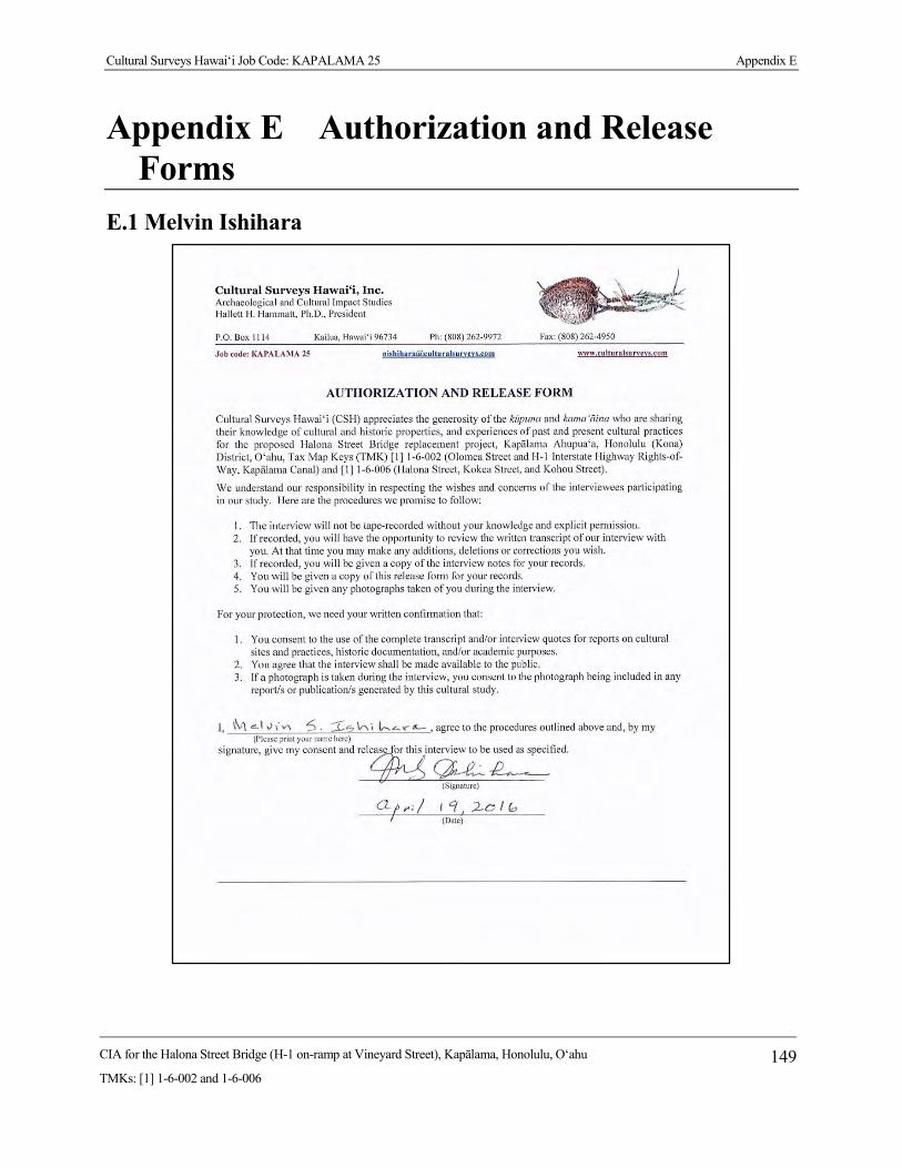
Cultural Surveys Hawai‘i Job Code: KAPALAMA 25 Appendix E
CIA for the Halona Street Bridge (H-1 on-ramp at Vineyard Street), Kapālama, Honolulu, O‘ahu
TMKs: [1] 1-6-002 and 1-6-006 149
Appendix E Authorization and Release Forms
E.1 Melvin Ishihara

Cultural Surveys Hawai‘i Job Code: KAPALAMA 25 Appendix E
CIA for the Halona Street Bridge (H-1 on-ramp at Vineyard Street), Kapālama, Honolulu, O‘ahu
TMKs: [1] 1-6-002 and 1-6-006 150
E.2 Jan Becket

Appendix F Pre-Assessment Comments and Responses

Central Federal Lands Highway Division 12300 West Dakota Avenue Suite 380 Lakewood, CO 80228 March 24, 2015 720-963-3647 [email protected] In Reply Refer To: HFPM-16
Michael Formby, Director Department of Transportation Services City and County of Honolulu 650 South King Street, 3rd Floor Honolulu, HI 96813 Dear Mr. Formby:
Subject: Hawaii Bridge Program for Island of Oahu
Federal Highway Administration, Central Federal Lands Highway Division
Pre-Assessment Consultation
Chapter 343, Hawaii Revised Statutes and National Environmental Policy
Act
The Federal Highway Administration, Central Federal Lands Highway Division (CFLHD), in partnership with the Hawaii Department of Transportation (HDOT), is conducting environmental studies to examine the impacts of three projects to improve four bridges on the island of Oahu. We are assisted in this effort by our consultant, CH2M HILL.
• Halona Street Bridge on Halona Street, adjacent to the H-1 Freeway Honolulu District, TMK: [1] 1-6
• Roosevelt Bridge on Kamehameha Highway crossing Kipapa Gulch Ewa District, TMK: [1] 9-4
• Nanahu Bridge on Kamehameha Highway Koolauloa District, TMK: [1] 5-6
• Kawela Bridge on Kamehameha Highway Koolauloa District, TMK: [1] 5-7
Attached to this letter are fact sheets for each of the bridge projects, including photos and maps. We are requesting comments and input regarding environmental concerns in all resource areas, and information that might help us to evaluate the projects. The environmental review for this project is being conducted in accordance with the National Environmental Policy Act (NEPA) and Hawaii Revised Statutes (HRS), Chapter 343.
nnishika
Text Box
Template for Pre-assessment Letter (Halona Street Bridge attachment only)
nnishika
Rectangle
nnishika
Rectangle

2
Please send any concerns or comments to Kathleen Chu, CH2M Hill program manager (CH2M Hill, Inc, 1132 Bishop Street, Suite 1100, Honolulu, HI 96813) or myself, within 30 days receipt of this letter. If you have questions, please contact Ms. Chu at Ph. 440-0283 or [email protected] or myself at Ph. 720-963-3647 or [email protected]. Thank you.
Sincerely,
J. Michael Will, P.E. Program Engineering Manager Enclosure: Fact Sheets for Roosevelt Bridge, Halona Street Bridge, Kawela Bridge and Nanahu Bridge cc: Nicole Winterton/FHWA-CFLHD Kathleen Chu/CH2M HILL Paul Luersen/CH2M HILL Elizabeth Cutler/CH2M HILL

Halona Bridge
Kalihi, Honolulu, Oahu TMK: [1] 6-0-060
Location
The project area for the improvements includes Halona Bridge and its immediate environs on the south side of Oahu. The bridge is located on Halona Street at milepost 20.21 on the adjacent Interstate Route H-1 (see Project Location Map). The bridge crosses over Kapalama Canal.
Existing Conditions
Built in 1938, Halona Bridge is a 2-lane bridge with 5 spans and a total length of about 130 feet. The bridge has a total width of approximately 55 feet. It is assumed that the foundations are spread footings supporting the abutments and piers. Halona Street is classified as a minor urban arterial. There is no posted speed along this segment of the roadway but it is assumed to be 30 mph.
Purpose and Need
The purpose of this project is to improve Halona Bridge and its approaches, by rehabilitation or replacement, to create a canal crossing of Halona Street that remains a safe and functional component of the regional transportation system for all users. Based on bridge inspections and studies, a number of conditions were identified that need to be remedied, including: replace the existing bridge to meet current design standards for roadway width, load capacity, pedestrian traffic, bridge railing and transitions, and bridge approaches.
Project Description
Bridge design alternatives are being developed in conjunction with ongoing environmental studies. However, design options will include the following components:
• Restore structural integrity of the stream crossing via bridge rehabilitation or replacement • Meet live load and seismic requirements • Provide for adequate hydrological flow under flood conditions • Mitigate scouring on foundations • Upgrade bridge railings in compliance with crash test requirements • Replace/relocate existing utilities, as necessary • Develop a traffic management plan
This project is included in the Statewide Transportation Improvement Program (STIP) and will be funded, in part, with federal monies.
Photo 1: View of Halona Bridge looking makai
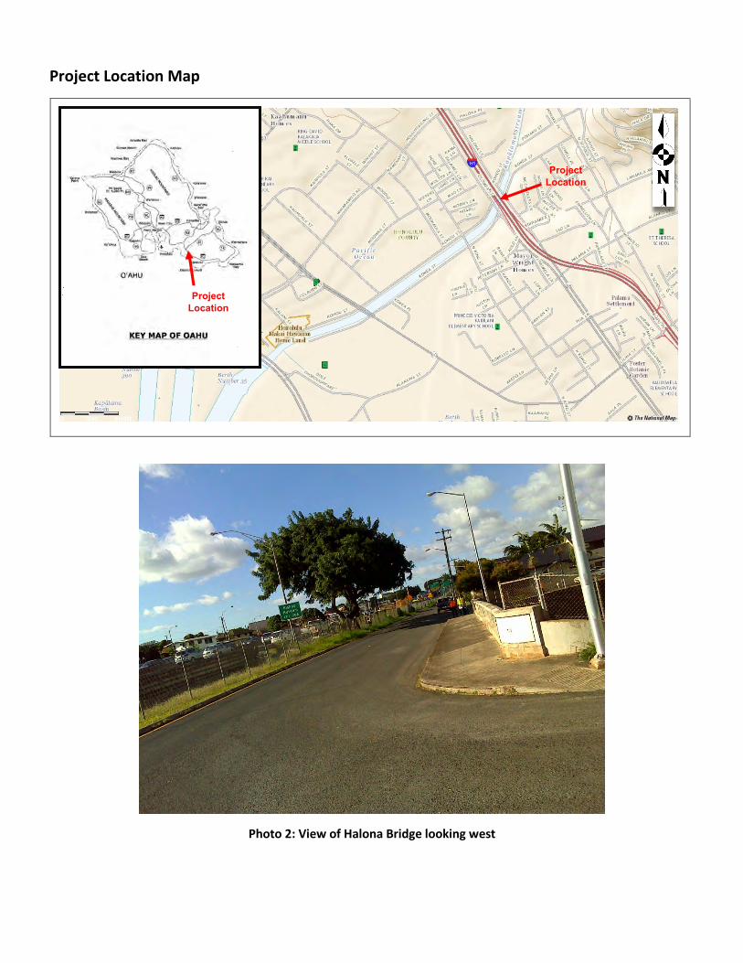
Project Location Map
Photo 2: View of Halona Bridge looking west
Project Location
Project Location
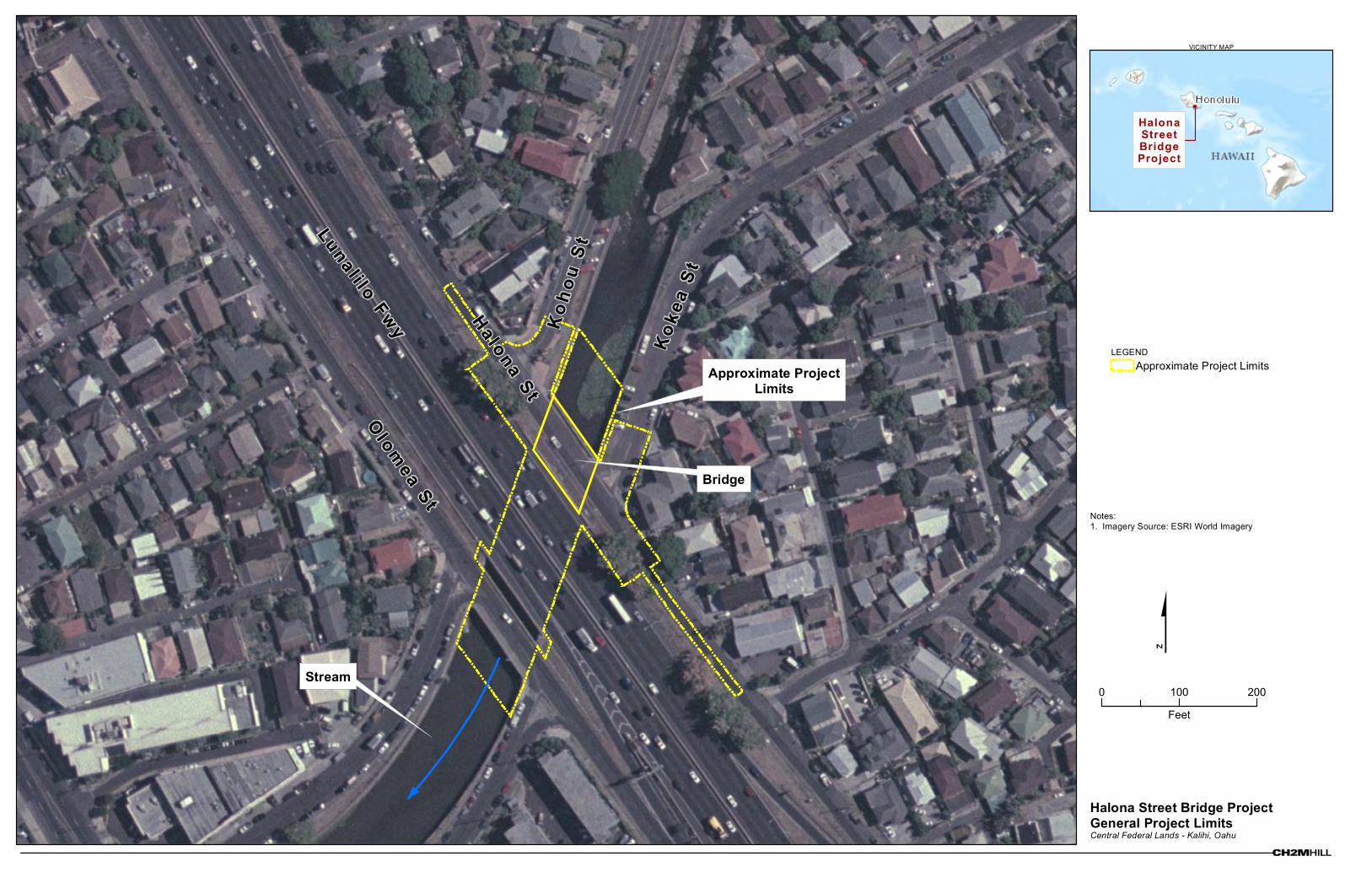
Halona Street Bridge ProjectGeneral Project LimitsCentral Federal Lands - Kalihi, Oahu
VICINITY MAP
LEGENDApproximate Project Limits
$
HalonaStreetBridgeProject
0 100 200
Feet
Olom
ea St
Notes:1. Imagery Source: ESRI World Imagery
Bridge
Approximate ProjectLimits
Stream
Luna l i lo Fwy Ha lona S t
Kok
ea S
t
Ko
hou
St


Central Federal Lands Highway Division 12300 West Dakota Avenue Suite 380 Lakewood, CO 80228 December 7, 2015 Office: 720-963-3647 Fax: 720-963-3596 [email protected] In Reply Refer To: HFPM-16 TO: ALEC WONG, P.E. CHIEF, CLEAN WATER BRANCH DEPARTMENT OF HEALTH P.O. BOX 3378 HONOLULU, HI 96801 FROM: J. MICHAEL WILL, P.E. PROJECT MANAGER SUBJECT: PRE-ASSESSMENT CONSULTATION
HAWAII BRIDGE PROGRAM KAUAI PROJECTS: BRIDGE 7E, HANAPEPE, KAPAA OAHU PROJECTS: HALONA, ROOSEVELT, KAWELA, NANAHU HAWAII ISLAND PROJECTS: HILEA, NINOLE
Dear Mr. Wong: Thank you for pre-assessment comments on the subject projects transmitted by letter dated May 18, 2015.
The project team is aware that certain projects may require certification or permits under the Clean Water Act. We have been engaged in early consultation with your staff and greatly appreciate their assistance. We appreciate your participation in the environmental review process. A copy of the Draft Environmental Assessment will be sent to your office when available for public review and comment. If you have any questions, please contact me at (720) 963-3647, or by email at [email protected].
Sincerely yours,
J. Michael Will, P.E. Project Manager Cc: Christine Yamasaki, HDOT Kevin Ito, HDOT Nicole Winterton, CFLHD Kathleen Chu, CH2M HILL

STATE OF HAWAII DEPARTMENT OF HEALTH
P. O. BOX 3378 HONOLULU, HI 96801-3378
May 12, 2015
Mr. J. Michael Will, P.E. Program Engineering Manager Central Federal Lands Highway Division U.S. Department of Transportation 12300 West Dakota Avenue, Suite 380 Lakewood, Colorado 80228 Via email: [email protected]
Dear Mr. Will: SUBJECT: Pre- Assessment Consultation (PC) for Hawaii Bridge Program for State of Hawaii The Department of Health (DOH), Environmental Planning Office (EPO), acknowledges receipt of your PC to our office on March 24, 2015. Thank you for allowing us to review and comment on the proposed project. The PC was routed to the Clean Water Branch, and the District Health Offices on Kauai and Hawaii. They will provide specific comments to you if necessary. EPO recommends that you review the standard comments and available strategies to support sustainable and healthy design provided at: http://health.hawaii.gov/epo/home/landuse-planning-review-program. Projects are required to adhere to all applicable standard comments. We encourage you to examine and utilize the Hawaii Environmental Health Portal. The portal provides links to our e-Permitting Portal, Environmental Health Warehouse, Groundwater Contamination Viewer, Hawaii Emergency Response Exchange, Hawaii State and Local Emission Inventory System, Water Pollution Control Viewer, Water Quality Data, Warnings, Advisories and Postings. The Portal is continually updated. Please visit it regularly at: https://eha-cloud.doh.hawaii.gov You may also wish to review the revised Water Quality Standards Maps that have been updated for all islands. The Water Quality Standards Maps can be found at: http://health.hawaii.gov/cwb/site-map/clean-water-branch-home-page/water-quality-standards The University of Hawaii has examined potential sea level rise changes in Hawaii. You may find it useful to review their studies at: http://www.soest.hawaii.edu/coasts/sealevel We request that you utilize all of this information on your proposed project to increase sustainable, innovative, inspirational, transparent and healthy design. Mahalo nui loa, Laura Leialoha Phillips McIntyre, AICP Program Manager, Environmental Planning Office c: Kathleen Chu, CH2M Hill program manager – [email protected] {via email only} CWB, DHO Kauai, DHO Hawaii {via email only}
DAVID Y. IGE GOVERNOR OF HAWAII
VIRGINIA PRESSLER, M.D. DIRECTOR OF HEALTH
In reply, please refer to: File:
HFPM-16
EPO 15-094
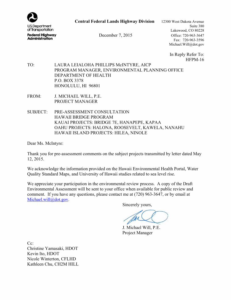
Central Federal Lands Highway Division 12300 West Dakota Avenue Suite 380 Lakewood, CO 80228 December 7, 2015 Office: 720-963-3647 Fax: 720-963-3596 [email protected] In Reply Refer To: HFPM-16 TO: LAURA LEIALOHA PHILLIPS McINTYRE, AICP PROGRAM MANAGER, ENVIRONMENTAL PLANNING OFFICE DEPARTMENT OF HEALTH P.O. BOX 3378 HONOLULU, HI 96801 FROM: J. MICHAEL WILL, P.E. PROJECT MANAGER SUBJECT: PRE-ASSESSMENT CONSULTATION
HAWAII BRIDGE PROGRAM KAUAI PROJECTS: BRIDGE 7E, HANAPEPE, KAPAA OAHU PROJECTS: HALONA, ROOSEVELT, KAWELA, NANAHU HAWAII ISLAND PROJECTS: HILEA, NINOLE
Dear Ms. McIntyre: Thank you for pre-assessment comments on the subject projects transmitted by letter dated May 12, 2015.
We acknowledge the information provided on the Hawaii Environmental Health Portal, Water Quality Standard Maps, and University of Hawaii studies related to sea level rise.
We appreciate your participation in the environmental review process. A copy of the Draft Environmental Assessment will be sent to your office when available for public review and comment. If you have any questions, please contact me at (720) 963-3647, or by email at [email protected].
Sincerely yours,
J. Michael Will, P.E. Project Manager Cc: Christine Yamasaki, HDOT Kevin Ito, HDOT Nicole Winterton, CFLHD Kathleen Chu, CH2M HILL

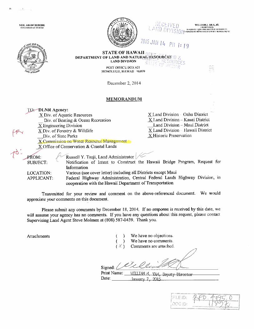

Central Federal Lands Highway Division 12300 West Dakota Avenue Suite 380 Lakewood, CO 80228 December 7, 2015 Office: 720-963-3647 Fax: 720-963-3596 [email protected] In Reply Refer To: HFPM-16 TO: ROY HARDY DEPUTY DIRECTOR COMMISSION ON WATER RESOURCE MANAGEMENT
DEPARTMENT OF LAND AND NATURAL RESOURCES P.O. BOX 621 HONOLULU, HI 96809 FROM: J. MICHAEL WILL, P.E. PROJECT MANAGER SUBJECT: PRE-ASSESSMENT CONSULTATION
HAWAII BRIDGE PROGRAM KAUAI PROJECTS: BRIDGE 7E, HANAPEPE, KAPAA OAHU PROJECTS: HALONA, ROOSEVELT, KAWELA, NANAHU HAWAII ISLAND PROJECTS: HILEA, NINOLE
Dear Mr. Hardy: Thank you for pre-assessment comments on the subject projects transmitted by letter dated January 7, 2015.
We acknowledge that projects may require a Stream Channel Alteration Permit, and will initiate the application process as needed.
We appreciate your participation in the environmental review process. A copy of the Draft Environmental Assessment will be sent to your office when available for public review and comment. If you have any questions, please contact me at (720) 963-3647, or by email at [email protected].
Sincerely yours,
J. Michael Will, P.E. Project Manager Cc: Christine Yamasaki, HDOT Kevin Ito, HDOT Nicole Winterton, CFLHD Kathleen Chu, CH2M HILL


Central Federal Lands Highway Division 12300 West Dakota Avenue Suite 380 Lakewood, CO 80228 December 7, 2015 Office: 720-963-3647 Fax: 720-963-3596 [email protected] In Reply Refer To: HFPM-16 TO: LEO R. ASUNCION DIRECTOR OFFICE OF PLANNING 235 SOUTH BERETANIA STREET, 6TH FLOOR HONOLULU, HI 96813 FROM: J. MICHAEL WILL, P.E. PROJECT MANAGER SUBJECT: PRE-ASSESSMENT CONSULTATION
HAWAII BRIDGE PROGRAM KAUAI PROJECTS: BRIDGE 7E, HANAPEPE, KAPAA OAHU PROJECTS: HALONA, ROOSEVELT, KAWELA, NANAHU HAWAII ISLAND PROJECTS: HILEA, NINOLE
Dear Mr. Asuncion: Thank you for pre-assessment comments on the subject projects transmitted by letter dated May 1, 2015. We offer the following responses in the order presented in your letter:
1. Tax Map Key numbers will be verified.
2. The Draft Environmental Assessment (DEA) will discuss consistency with the Hawaii State Plan.
3. The DEA will discuss consistency with Coastal Zone Management objectives.
4. Where relevant, the Special Management Area permit will be listed as a potential requirement.
5. Federal Consistency Review will be listed as a potential requirement.
6. The DEA will assess potential impacts on water resources.
7. We acknowledge the availability of the Office of Planning’s Stormwater Impact Assessment as an environmental planning resource.
8. Stormwater management measures are being considered in project design and will be addressed in the DEA.

2
We appreciate your participation in the environmental review process. A copy of the DEA will be sent to your office when available for public review and comment. If you have any questions, please contact me at (720) 963-3647, or by email at [email protected].
Sincerely yours,
J. Michael Will, P.E. Project Manager Cc: Christine Yamasaki, HDOT Kevin Ito, HDOT Nicole Winterton, CFLHD Kathleen Chu, CH2M HILL


Central Federal Lands Highway Division 12300 West Dakota Avenue Suite 380 Lakewood, CO 80228 December 7, 2015 Office: 720-963-3647 Fax: 720-963-3596 [email protected] In Reply Refer To: HFPM-16 TO: MICHAEL D. FORMBY DIRECTOR DEPARTMENT OF TRANSPORTATION SERVICES 650 SOUTH KING STREET, 3RD FLOOR HONOLULU, HI 96813 FROM: J. MICHAEL WILL, P.E. PROJECT MANAGER SUBJECT: PRE-ASSESSMENT CONSULTATION
HAWAII BRIDGE PROGRAM, OAHU PROJECTS HALONA STREET BRIDGE ROOSEVELT (KIPAPA) BRIDGE KAWELA BRIDGE NANAHU BRIDGE
Dear Mr. Formby: Thank you for pre-assessment comments on the subject projects transmitted by letter dated May 13, 2015. We offer the following responses in the order presented in your letter:
1. We note that the Nanahu and Kawela projects will not affect City roads.
2. Traffic Management Plans (TMPs) are being prepared for the Roosevelt and Halona projects and will be addressed in environmental documents.
3-4. Public information meetings were held in July for the Halona and Roosevelt projects. The enclosed exhibits show proposed detour routes that were shared with members of the community who attended the meetings. The project team is continuing to evaluate detour options through the environmental review process in an effort to maintain a safe construction zone and to minimize impacts on affected neighborhoods and the traveling public.
5. Community outreach will continue and project information will be disseminated through the construction period.
6. Transport of construction and materials to project sites will be considered in developing project-specific TMPs.
2
We appreciate your participation in the environmental review process. A copy of the Draft Environmental Assessment will be sent to your office when available for public review and comment. If you have any questions, please contact me at (720) 963-3647, or by email at [email protected].
Sincerely yours,
J. Michael Will, P.E. Project Manager Cc: Christine Yamasaki, HDOT Kevin Ito, HDOT Nicole Winterton, CFLHD Kathleen Chu, CH2M HILL
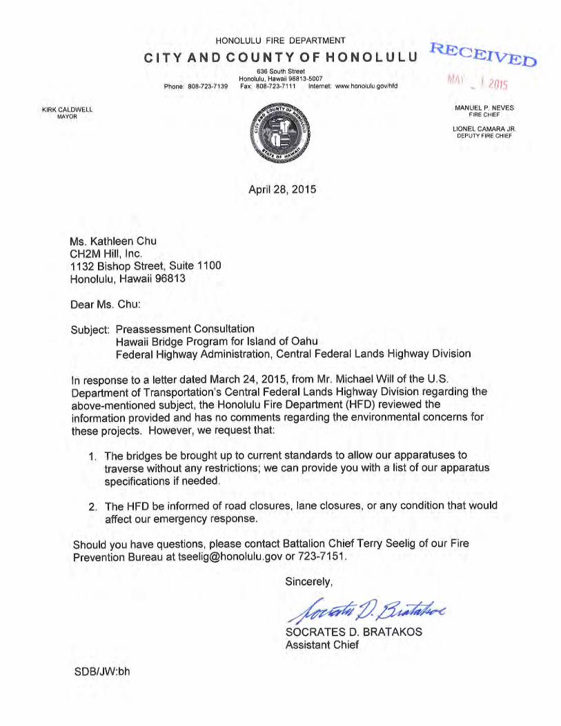

Central Federal Lands Highway Division 12300 West Dakota Avenue Suite 380 Lakewood, CO 80228 December 7, 2015 Office: 720-963-3647 Fax: 720-963-3596 [email protected] In Reply Refer To: HFPM-16 TO: SOCRATES D. BRATAKOS ASSISTANT CHIEF HONOLULU FIRE DEPARTMENT 636 SOUTH STREET HONOLULU, HI 96813 FROM: J. MICHAEL WILL, P.E. PROJECT MANAGER SUBJECT: PRE-ASSESSMENT CONSULTATION
HAWAII BRIDGE PROGRAM, OAHU PROJECTS HALONA STREET BRIDGE ROOSEVELT (KIPAPA) BRIDGE KAWELA BRIDGE NANAHU BRIDGE
Dear Mr. Bratakos: Thank you for pre-assessment comments on the subject projects transmitted by letter dated April 28, 2015.
Bridge improvements will be designed to meet current AASHTO standards and, therefore, will support unrestricted use by fire apparatuses. The construction management team will keep the Honolulu Fire Department and other emergency responders apprised of access modifications during the construction period.
We appreciate your participation in the environmental review process. A copy of the Draft Environmental Assessment will be sent to your office when available for public review and comment. If you have any questions, please contact me at (720) 963-3647, or by email at [email protected].
Sincerely yours,
J. Michael Will, P.E. Project Manager Cc: Christine Yamasaki, HDOT Kevin Ito, HDOT Nicole Winterton, CFLHD Kathleen Chu, CH2M HILL

Central Federal Lands Highway Division 12300 West Dakota Avenue Suite 380 Lakewood, CO 80228 December 7, 2015 Office: 720-963-3647 Fax: 720-963-3596 [email protected] In Reply Refer To: HFPM-16 TO: MARK TSUYEMURA FOR LOUIS M. KEALOHA HONOLULU POLICE DEPARTMENT 801 SOUTH BERETANIA STREET HONOLULU, HI 96813 FROM: J. MICHAEL WILL, P.E. PROJECT MANAGER SUBJECT: PRE-ASSESSMENT CONSULTATION
HAWAII BRIDGE PROGRAM, OAHU PROJECTS HALONA STREET BRIDGE ROOSEVELT (KIPAPA) BRIDGE KAWELA BRIDGE NANAHU BRIDGE
Dear Mr. Tsuyemura: Thank you for pre-assessment comments on the subject projects transmitted by letter dated April 27, 2015. We offer the following responses:
Traffic Management Plans will be prepared for all bridge projects.
Bridges are being designed to meet current standards, including standards for structural integrity and seismic resistance.
Traffic control devices will be provided through the construction zone in accordance with the Manual of Uniform Traffic Control Devices.
We appreciate your participation in the environmental review process. A copy of the Draft Environmental Assessment will be sent to your office when available for public review and comment. If you have any questions, please contact me at (720) 963-3647, or by email at [email protected].
Sincerely yours,
J. Michael Will, P.E. Project Manager Cc: Christine Yamasaki, HDOT Kevin Ito, HDOT Nicole Winterton, CFLHD Kathleen Chu, CH2M HILL


Central Federal Lands Highway Division 12300 West Dakota Avenue Suite 380 Lakewood, CO 80228 December 7, 2015 Office: 720-963-3647 Fax: 720-963-3596 [email protected] In Reply Refer To: HFPM-16 TO: ROSS S. SASAMURA, P.E. DIRECTOR AND CHIEF ENGINEER DEPARTMENT OF FACILITY MAINTENANCE 1000 ULU’OHIA STREET, SUITE 215 KAPOLEI, HI 96707 FROM: J. MICHAEL WILL, P.E. PROJECT MANAGER SUBJECT: PRE-ASSESSMENT CONSULTATION
HAWAII BRIDGE PROGRAM, OAHU PROJECTS HALONA STREET BRIDGE ROOSEVELT (KIPAPA) BRIDGE KAWELA BRIDGE NANAHU BRIDGE
Dear Mr. Sasamura: Thank you for pre-assessment comments on the subject projects transmitted by letter dated July 22, 2015.
We acknowledge that you have no environmental concerns at this time.
Additionally, we note that the proximity of two City-maintained storm drains in the vicinity of Halona Street Bridge will be considered during design.
We appreciate your participation in the environmental review process. A copy of the Draft Environmental Assessment will be sent to your office when available for public review and comment. If you have any questions, please contact me at (720) 963-3647, or by email at [email protected].
Sincerely yours,
J. Michael Will, P.E. Project Manager Cc: Christine Yamasaki, HDOT Kevin Ito, HDOT Nicole Winterton, CFLHD Kathleen Chu, CH2M HILL
Related Documents