CERTIFICATE OF COMPLIANCE REQUEST SE48-2424 Coastal Bank Stabilization 103 Eel Pint Road Map 32 Parcel 6 Nantucket, Massachusetts Prepared for: Margaret T. Cunningham Qualified Personal Residence Trust C/O Elizabeth Braudis Foster Dykema Cabot & Co 101 Arch Street Boston, MA 02110 Prepared By: Site Design Engineering, LLC 11 Cushman Street Middleboro, MA 02346 November 3, 2021 SDE No.: 11141

Welcome message from author
This document is posted to help you gain knowledge. Please leave a comment to let me know what you think about it! Share it to your friends and learn new things together.
Transcript

CERTIFICATE OF COMPLIANCE REQUEST
SE48-2424
Coastal Bank Stabilization
103 Eel Pint Road Map 32 Parcel 6
Nantucket, Massachusetts
Prepared for:
Margaret T. Cunningham Qualified Personal Residence Trust C/O Elizabeth Braudis
Foster Dykema Cabot & Co 101 Arch Street
Boston, MA 02110
Prepared By:
Site Design Engineering, LLC 11 Cushman Street
Middleboro, MA 02346
November 3, 2021
SDE No.: 11141

SITE DESIGN ENGINEERING, LLC.11 Cushman Street, Middleboro, MA 02346
P: 508-967-0673 F: 508-967-0674
WPA FORM 8A

wpaform8a.doc •• rev. 5/29/14 Page 1 of 2
Massachusetts Department of Environmental Protection Bureau of Resource Protection - Wetlands
WPA Form 8A – Request for Certificate of ComplianceMassachusetts Wetlands Protection Act M.G.L. c. 131, §40
DEP File Number:
SE48-2424 Provided by DEP
A. Project Information
Important:When filling out forms on the computer, use only the tab key to move your cursor - do not use the return key.
1. This request is being made by:(current Title holder):
Margaret T. Cunningham Qualified Personal Residence Trust. C/O Elizabeth Braudis Name
Foster Dykema Cabot & Co. 101 Arch Street Mailing Address
Boston City/Town
MA State
02110 Zip Code
Phone Number
2. This request is in reference to work regulated by a final Order of Conditions issued to:
Margaret T. Cunningham Qualified Personal Residence Trust. C/O Elizabeth Braudis Applicant
May 30, 2018 Dated
SE48-2424 DEP File Number
Upon completion of the work authorized in an Order of Conditions, the property owner must request a Certificate of Compliance from the issuing authority stating that the work or portion of the work has been satisfactorily completed.
3. The project site is located at:
103 eel Point Road Street Address
Nantucket City/Town
32 Assessors Map/Plat Number
6 Parcel/Lot Number
4. The final Order of Conditions was recorded at the Registry of Deeds for: (name on Order)
Soundview Realty Trust Property Owner (if different)
Nantucket County Book Page
15185 Certificate (if registered land)
5. This request is for certification that (check one):
the work regulated by the above-referenced Order of Conditions has been satisfactorily completed.
the following portions of the work regulated by the above-referenced Order of Conditions have been satisfactorily completed (use additional paper if necessary).
the above-referenced Order of Conditions has lapsed and is therefore no longer valid, and the work regulated by it was never started.

wpaform8a.doc •• rev. 5/29/14 Page 2 of 2
Massachusetts Department of Environmental Protection Bureau of Resource Protection - Wetlands
WPA Form 8A – Request for Certificate of ComplianceMassachusetts Wetlands Protection Act M.G.L. c. 131, §40
DEP File Number:
SE48-2424 Provided by DEP
A. Project Information (cont.)
6. Did the Order of Conditions for this project, or the portion of the project subject to this request, contain an approval of any plans stamped by a registered professional engineer, architect, landscape architect, or land surveyor?
Yes If yes, attach a written statement by such a professional certifying substantial compliance with the plans and describing what deviation, if any, exists from the plans approved in the Order.
No
B. Submittal Requirements
Requests for Certificates of Compliance should be directed to the issuing authority that issued the final Order of Conditions (OOC). If the project received an OOC from the Conservation Commission, submit this request to that Commission. If the project was issued a Superseding Order of Conditions or was the subject of an Adjudicatory Hearing Final Decision, submit this request to the appropriate DEP Regional Office (see http://www.mass.gov/eea/agencies/massdep/about/contacts/find-the-massdep-regional-office-for-your-city-or-town.html).

SITE DESIGN ENGINEERING, LLC.11 Cushman Street, Middleboro, MA 02346
P: 508-967-0673 F: 508-967-0674
PROJECT NARRATIVE

November 3, 2021 SDE No. 11141
Jeff Carlson Nantucket Conservation Commission 2 Bathing Beach Road Nantucket, MA 02554
Subject: Request for Certificate of Compliance 103 Eel Point Road, Nantucket MA Assessors Map 32, Parcel 6 DEP File No.: SE48-2424
Dear Mr. Carlson:
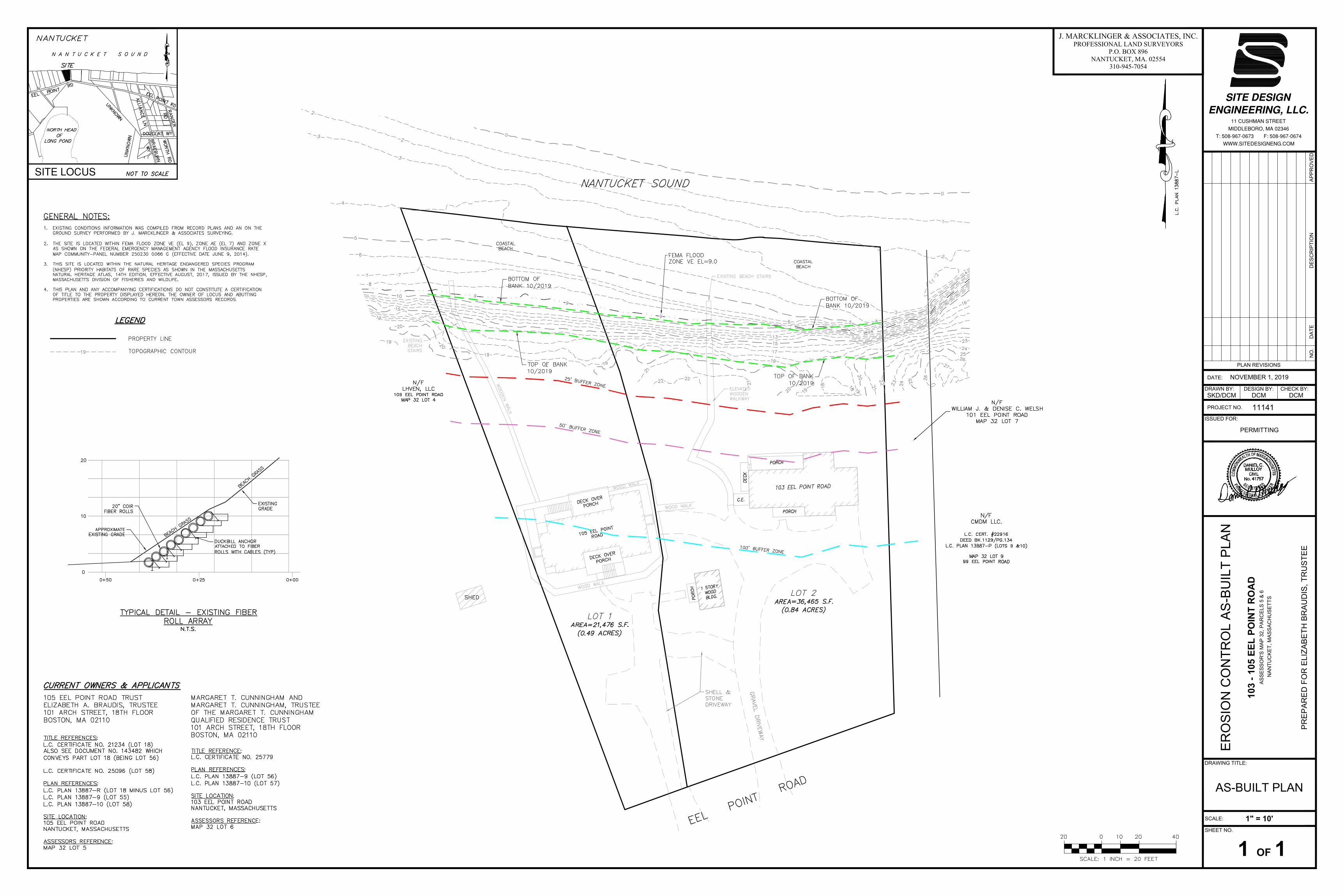
The purpose of this letter is to request that the Conservation Commission (Commission) issue a Certificate of Compliance (COC) for the above referenced Order of Conditions (OOC). The OOC allowed the Applicant to construct an elevated walkway and a set of beach stairs down the face of the Coastal Bank. The work was approved under SE48-2424 issued on November 10, 2011. The work had been previously completed but has been superseded by work permitted under SE48-3076. A certificate of compliance was issued for SE48-3076 on November 6, 2019. Since the previous site work has been modified and completed under a subsequent OOC and a COC has been issued for that work, the Applicant respectfully requests that the Commission grant a COC for the above referenced OOC. A copy of the Existing Conditions Site Plan submitted as part of the SE48-3076 COC is attached.
If you have any questions, please feel free to call me at (508) 802-5832 or email me at ([email protected]).
Respectfully,
Mark Rits Site Design Engineering, LLC.

SITE DESIGN ENGINEERING, LLC.11 Cushman Street, Middleboro, MA 02346
P: 508-967-0673 F: 508-967-0674
SITE PLANS


SITE DESIGN ENGINEERING, LLC.11 Cushman Street, Middleboro, MA 02346
P: 508-967-0673 F: 508-967-0674
FILING FEE INFORMATION

SITE DESIGN ENGINEERING, LLC.11 Cushman Street, Middleboro, MA 02346
P: 508-967-0673 F: 508-967-0674
RECORDED ORDER OF CONDITIONS

ER
OS
IO
N C
ON
TR
OL
A
S-B
UIL
T P
LA
N
10
3 - 1
05
E
EL
P
OIN
T R
OA
D
AS
SE
SS
OR
'S
M
AP
3
2, P
AR
CE
LS
5
&
6
N
AN
TU
CK
ET
, M
AS
SA
CH
US
ET
TS
1 OF 1
PERMITTING
ISSUED FOR:
1" = 10'
PR
EP
AR
ED
F
OR
E
LIZ
AB
ET
H B
RA
UD
IS
, T
RU
ST
EE
NOVEMBER 1, 2019
DCMSKD/DCM DCM
AS-BUILT PLAN
AP
PR
OV
ED
DE
SC
RIP
TIO
ND
AT
EN
O.
PLAN REVISIONS
DATE:
PROJECT NO.
CHECK BY:DESIGN BY:
SCALE:
11141
SHEET NO.
DRAWN BY:
DRAWING TITLE:
11 CUSHMAN STREET
MIDDLEBORO, MA 02346
T: 508-967-0673 F: 508-967-0674
WWW.SITEDESIGNENG.COM
SITE LOCUS
J. MARCKLINGER & ASSOCIATES, INC.PROFESSIONAL LAND SURVEYORS
P.O. BOX 896NANTUCKET, MA. 02554
310-945-7054
AutoCAD SHX Text
SHED
AutoCAD SHX Text
EEL POINT ROAD
AutoCAD SHX Text
GRAVEL DRIVEWAY
AutoCAD SHX Text
PORCH
AutoCAD SHX Text
PORCH
AutoCAD SHX Text
DECK
AutoCAD SHX Text
C.E.
AutoCAD SHX Text
PORCH
AutoCAD SHX Text
103 EEL POINT ROAD
AutoCAD SHX Text
1 STORY WOOD BLDG.
AutoCAD SHX Text
HOUSE #109
AutoCAD SHX Text
LEACHING TRENCH
AutoCAD SHX Text
SEPTIC TANK
AutoCAD SHX Text
PORCH
AutoCAD SHX Text
PORCH
AutoCAD SHX Text
ELEVATED WOODEN WALKWAY
AutoCAD SHX Text
25-FT. WETLAND BUFFER LINE
AutoCAD SHX Text
25-FT. WETLAND BUFFER LINE
AutoCAD SHX Text
WLF-4
AutoCAD SHX Text
WLF-5
AutoCAD SHX Text
WLF-6
AutoCAD SHX Text
WLF-3
AutoCAD SHX Text
COASTAL BEACH
AutoCAD SHX Text
LOT 1 AREA=21,476 S.F. (0.49 ACRES)
AutoCAD SHX Text
LOT 2 AREA=36,465 S.F. (0.84 ACRES)
AutoCAD SHX Text
N/F CMDM LLC. L.C. CERT. #22916 DEED BK.1129/PG.134 L.C. PLAN 13887-P (LOTS 9 &10) MAP 32 LOT 9 99 EEL POINT ROAD
AutoCAD SHX Text
N/F LHVEN, LLC 109 EEL POINT ROAD MAP 32 LOT 4
AutoCAD SHX Text
N/F WILLIAM J. & DENISE C. WELSH 101 EEL POINT ROAD MAP 32 LOT 7
AutoCAD SHX Text
SHELL & STONE DRIVEWAY
AutoCAD SHX Text
WOOD WALK
AutoCAD SHX Text
WOOD WALK
AutoCAD SHX Text
WOOD WALK
AutoCAD SHX Text
105 EEL POINT ROAD
AutoCAD SHX Text
DECK OVER PORCH
AutoCAD SHX Text
DECK OVER PORCH
AutoCAD SHX Text
LEACHING TRENCH
AutoCAD SHX Text
WOODEN WALK
AutoCAD SHX Text
COASTAL BEACH
AutoCAD SHX Text
EXISTING BEACH STAIRS
AutoCAD SHX Text
EXISTING BEACH STAIRS
AutoCAD SHX Text
BOTTOM OF BANK 10/2019
AutoCAD SHX Text
TOP OF BANK 10/2019
AutoCAD SHX Text
BOTTOM OF BANK 10/2019
AutoCAD SHX Text
TOP OF BANK 10/2019
AutoCAD SHX Text
FEMA FLOOD ZONE VE EL=9.0
AutoCAD SHX Text
25' BUFFER ZONE
AutoCAD SHX Text
50' BUFFER ZONE
AutoCAD SHX Text
100' BUFFER ZONE
AutoCAD SHX Text
NANTUCKET SOUND
AutoCAD SHX Text
L.C. PLAN 13887-L
AutoCAD SHX Text
DUCKBILL ANCHOR ATTACHED TO FIBER ROLLS WITH CABLES (TYP)
AutoCAD SHX Text
EXISTING GRADE
AutoCAD SHX Text
0+25
AutoCAD SHX Text
0+00
AutoCAD SHX Text
0+50
AutoCAD SHX Text
0
AutoCAD SHX Text
10
AutoCAD SHX Text
20
AutoCAD SHX Text
APPROXIMATE EXISTING GRADE
AutoCAD SHX Text
20" COIR FIBER ROLLS
AutoCAD SHX Text
BEACH GRASS
AutoCAD SHX Text
TYPICAL DETAIL - EXISTING FIBER ROLL ARRAY N.T.S.
AutoCAD SHX Text
BEACH GRASS
AutoCAD SHX Text
20
AutoCAD SHX Text
SCALE: 1 INCH = 20 FEET
AutoCAD SHX Text
10
AutoCAD SHX Text
0
AutoCAD SHX Text
20
AutoCAD SHX Text
40
AutoCAD SHX Text
EEL POINT RD
AutoCAD SHX Text
EEL POINT
AutoCAD SHX Text
ALLIANCE LN
AutoCAD SHX Text
UNKNOWN
AutoCAD SHX Text
RANGER
AutoCAD SHX Text
DOUGLAS WY
AutoCAD SHX Text
WORTH RD
AutoCAD SHX Text
BRAEBURN
AutoCAD SHX Text
UNKNOWN
AutoCAD SHX Text
N A N T U C K E T S O U N D
AutoCAD SHX Text
NORTH HEAD
AutoCAD SHX Text
OF
AutoCAD SHX Text
NANTUCKET
AutoCAD SHX Text
NOT TO SCALE
AutoCAD SHX Text
SITE
AutoCAD SHX Text
RD
AutoCAD SHX Text
WY
AutoCAD SHX Text
RD
AutoCAD SHX Text
LONG POND
AutoCAD SHX Text
GENERAL NOTES: 1. EXISTING CONDITIONS INFORMATION WAS COMPILED FROM RECORD PLANS AND AN ON THE EXISTING CONDITIONS INFORMATION WAS COMPILED FROM RECORD PLANS AND AN ON THE GROUND SURVEY PERFORMED BY J. MARCKLINGER & ASSOCIATES SURVEYING. 2. THE SITE IS LOCATED WITHIN FEMA FLOOD ZONE VE (EL 9), ZONE AE (EL 7) AND ZONE X THE SITE IS LOCATED WITHIN FEMA FLOOD ZONE VE (EL 9), ZONE AE (EL 7) AND ZONE X AS SHOWN ON THE FEDERAL EMERGENCY MANAGEMENT AGENCY FLOOD INSURANCE RATE MAP COMMUNITY-PANEL NUMBER 250230 0066 G (EFFECTIVE DATE JUNE 9, 2014). 3. THIS SITE IS LOCATED WITHIN THE NATURAL HERITAGE ENDANGERED SPECIES PROGRAM THIS SITE IS LOCATED WITHIN THE NATURAL HERITAGE ENDANGERED SPECIES PROGRAM (NHESP) PRIORITY HABITATS OF RARE SPECIES AS SHOWN IN THE MASSACHUSETTS NATURAL HERITAGE ATLAS, 14TH EDITION, EFFECTIVE AUGUST, 2017, ISSUED BY THE NHESP, MASSACHUSETTS DIVISION OF FISHERIES AND WILDLIFE. 4. THIS PLAN AND ANY ACCOMPANYING CERTIFICATIONS DO NOT CONSTITUTE A CERTIFICATION THIS PLAN AND ANY ACCOMPANYING CERTIFICATIONS DO NOT CONSTITUTE A CERTIFICATION OF TITLE TO THE PROPERTY DISPLAYED HEREON. THE OWNER OF LOCUS AND ABUTTING PROPERTIES ARE SHOWN ACCORDING TO CURRENT TOWN ASSESSORS RECORDS.
AutoCAD SHX Text
PROPERTY LINE TOPOGRAPHIC CONTOUR
AutoCAD SHX Text
LEGEND
AutoCAD SHX Text
TITLE REFERENCES: : L.C. CERTIFICATE NO. 21234 (LOT 18) ALSO SEE DOCUMENT NO. 143482 WHICH CONVEYS PART LOT 18 (BEING LOT 56) L.C. CERTIFICATE NO. 25096 (LOT 58) PLAN REFERENCES: : L.C. PLAN 13887-R (LOT 18 MINUS LOT 56) L.C. PLAN 13887-9 (LOT 55) L.C. PLAN 13887-10 (LOT 58) SITE LOCATION: : 105 EEL POINT ROAD NANTUCKET, MASSACHUSETTS ASSESSORS REFERENCE: : MAP 32 LOT 5
AutoCAD SHX Text
105 EEL POINT ROAD TRUST ELIZABETH A. BRAUDIS, TRUSTEE 101 ARCH STREET, 18TH FLOOR BOSTON, MA 02110
AutoCAD SHX Text
CURRENT OWNERS & APPLICANTS
AutoCAD SHX Text
TITLE REFERENCE: : L.C. CERTIFICATE NO. 25779 PLAN REFERENCES: : L.C. PLAN 13887-9 (LOT 56) L.C. PLAN 13887-10 (LOT 57) SITE LOCATION: : 103 EEL POINT ROAD NANTUCKET, MASSACHUSETTS ASSESSORS REFERENCE: E: MAP 32 LOT 6
AutoCAD SHX Text
MARGARET T. CUNNINGHAM AND MARGARET T. CUNNINGHAM, TRUSTEE OF THE MARGARET T. CUNNINGHAM QUALIFIED RESIDENCE TRUST 101 ARCH STREET, 18TH FLOOR BOSTON, MA 02110
AutoCAD SHX Text
19
Related Documents