CERIAS Tech Report 2009-04 Implementation Challenges in Spatio-temporal Multigranularity by Elena Camossi, Michela Bertollo Center for Education and Research Information Assurance and Security Purdue University, West Lafayette, IN 47907-2086

Welcome message from author
This document is posted to help you gain knowledge. Please leave a comment to let me know what you think about it! Share it to your friends and learn new things together.
Transcript

CERIAS Tech Report 2009-04Implementation Challenges in Spatio-temporal Multigranularity
by Elena Camossi, Michela BertolloCenter for Education and ResearchInformation Assurance and Security
Purdue University, West Lafayette, IN 47907-2086

Implementation Challenges in
Spatio-temporal Multigranularity
Elena Camossi ∗
School of Computer Science and Informatics - University College Dublin, Belfield,
Dublin 4, Ireland. Phone: +353 (0)1 7162-913. Fax: +353 (0)1 2697-262
Michela Bertolotto
School of Computer Science and Informatics - University College Dublin, Belfield,
Dublin 4, Ireland. Phone: +353 (0)1 7162-913. Fax: +353 (0)1 2697-262
Elisa Bertino
CERIAS - Purdue University, 250 N. University Street West Lafayette, Indiana,
USA 47907-2066. Phone: +1 765 496-2399 Fax: +1 765 494-0739
Abstract
Multiple granularities are essential to extract significant knowledge from spatio-
temporal datasets at different levels of detail. They enable to zoom-in and zoom-out
spatio-temporal datasets, thus enhancing the data modelling flexibility and improv-
ing the analysis of information. In this paper we discuss effective solutions to imple-
mentation issues arising when a data model and a query language are enriched with
spatio-temporal multigranularity. We propose appropriate representations for space
and time dimensions, granularities, granules, and multi-granular values. In partic-
ular the design of granularities and their relationships is illustrated with respect to
Preprint submitted to Elsevier 8 April 2009
the application of multigranular conversions for data access. Finally, we describe
how multigranular spatio-temporal conversions affect data usability and how such
important property may be guaranteed. In our discussion, we refer to an exist-
ing multigranular spatio-temporal model, whose design was previously proposed as
extension of the ODMG data model.
Key words: Spatio-temporal databases, spatial and temporal granularities,
multiresolution, multirepresentation
1 Introduction
The capability of representing spatio-temporal datasets with respect to both
their spatial layout and their temporal evolution is fundamental to analyse and
monitor the changes in the spatial configuration of a geographical area over a
period of time. Moreover, to trace modifications according to different tempo-
ral frequencies, the history of the areas under observation has to be maintained
and retrieved at multiple temporal granularities (e.g., years, months, decades).
Similarly, multigranular modelling offers interesting capabilities in the spatial
domain: from support to automated cartography, to efficient browsing over
large datasets, to structured solutions in wayfinding, planning and design, to
rendering of virtual reality environments. The approaches able to present the
data at different granularities represent an effective solution to facilitate the
analysis when fewer or additional details are required for specific subsets of
∗ Corresponding authorEmail addresses: [email protected] (Elena Camossi),
[email protected] (Michela Bertolotto), [email protected]
(Elisa Bertino).
2

the data. For example, zoom-out operations may improve the efficiency of
spatio-temporal data mining algorithms, which are time consuming [3]. On
the other hand, zoom-in operations may help in refining the mining of specific
data subsets.
Granularities intuitively represent the units of measure of a dataset, and
may be defined on all data dimensions (i.e., Space and Time for spatio-
temporal data). For each dimension, a connected set of granularities may be
defined, and the different sets are independent. Multigranularity, multires-
olution and multiple representation have been investigated first for tempo-
ral [11,28] and spatial data [6,27,35] separately, and more recently for spatio-
temporal data [14,19,23,34].
The choice of the correct granularity allows the system to store the minimal
amount of data, according to the most appropriate level of detail. In many
applications different granularities may exist, neither of which is inherently
better than the others. Therefore, a database system for such applications
should support a wide range of granularities and allow the user to define
his/her own application-specific granularities.
Extending a data model with spatio-temporal multigranularity entails to ad-
dress several design and implementation issues. The first category of problems
one has to face with **is** modelling issues, that are related to the formal
design of the base entities that make up the multigranular data model. First
of them, the modelling of the spatial and the temporal domains on which the
granularity mappings are given, that, for instance, may be considered discrete
or continuous, mutually dependent or independent, and may be application
driven. It is equally important to find a proper design for granularities and
3

granules, whose implementation affects the efficiency of the representation of
multigranular values, that in turn impacts on the performance of queries exe-
cution.
Another category of problems, which arise when implementing the query lan-
guage, **is** comparison issues. Indeed, in multigranular queries it is crucial
to guarantee that a common level of detail for two multigranular data of the
same type (i.e., number, alphanumeric, geometric information) always exists
in order these data be compared in queries. To obtain that, granularities must
be mutually related and multigranular data have to be converted to different
levels of detail. Furthermore, the functions we use to shift granularity levels,
namely multigranular conversions, must preserve data semantics and usability
and do not introduce errors on the converted data.
Finally, optimization issues must be considered in order to improve the perfor-
mance of all the data storage and retrieval process. Strategies for a fast access
to multigranular spatio-temporal data include the definition of auxiliary data
structure, both as extension of existing spatio-temporal indexes and through
the definition of novel techniques for the optimization of queries involving
multigranular aggregates.
In this paper we discuss these issues, proposing different implementation so-
lutions. In particular, the advisability of two separate representations for the
temporal and spatial domains is discussed. Furthermore, we illustrate the de-
sign requirements for granularities and granules, proposing a data type design
to implement them and suggesting how user defined granularities may be spec-
ified. Moreover, optimizations for the storage and the retrieval of multigranular
values are described. Finally, the inconsistencies arising from the application
4

of multigranular conversions are discussed, proposing effective solutions to
prevent them.
In this discussion, we refer to the multigranular model and query language
we formally defined in [19,21]. This model extends ODMG [22], the reference
model for object-oriented databases, with multigranular spatio-temporal ca-
pabilities. The design in [19,21] is formal: it relies on de facto standards, like
the ODMG and OQL, and on agreed definitions for granularities [11]. Fur-
thermore, it provide formal proposal for all the main components of a multi-
granular data model like granularities and their relationships and a validated
spatio-temporal type system. Moreover, differently from other multigranular
models proposed in the literature, granularity conversions and data access
have been properly defined. Therefore, it is an appropriate candidate to refer
in our discussion, which aim to investigates very closely how to provide an
established implementation to spatio-temporal multigranularity.
To demonstrate the feasibility of the proposed solutions, we developed an
object-relational spatio-temporal prototype which supports spatio-temporal
multigranularity, built on top of ORACLER© 11g (www.oracle.com), which is
based on the implementation considerations we provide,. In its design, we take
advantage of the object-relational features, like extensibility of the design and
data type encapsulation, and of the spatial type system already provided by
the DBMS. However, this does not represent a limit to the proposed implemen-
tation because the same capabilities are also provided by other mainstream
spatial database products, like MicrosoftR© SQL ServerR© 1 , PostgreSQL with
1 http://www.microsoft.com/sqlserver/2008/en/us/default.aspx (accessed Febru-
ary 2009).
5

its spatial extension PostGIS 2 , MySQLR© 3 . Moreover, we describe some im-
plementation details of two existing multigranular object-oriented prototypes
implementations which solve other issues we consider in our dissertation. In
particular, we describe a DLL extension for the automatic implementation of
multiple temporal granularities.
This paper extends the work presented in [20], where a preliminary discussion
on multigranularity issues was presented. With respect to [20], we discuss feasi-
ble solutions to multigranular issues. In particular, we describe how multigran-
ular issues have been addressed in both object-oriented and object-relational
multigranular prototypes we developed.
The paper is organized as follows. First, In Section 2 we present the scientific
literature related to this work. Then, we discuss modelling, comparison and
optimization issues, respectively in Sections 3, 4 and Section 5. In Section 6
we describe the design of a multigranular spatio-temporal object-relational
prototype that adopts the implementation solutions we propose. Moreover,
we show also a working solution to the automatic implementation of user
defined temporal granularities. Finally, in Section 7 we give a final discussion,
and outline future research directions.
2 http://www.postgresql.org and http://postgis.refractions.net/ (accessed Febru-
ary 2009).3 http://www.mysql.com/ (accessed February 2009).
6

2 Background and Related Work
Spatio-temporal multigranularity has been mainly investigated separately in
the temporal and spatial domains. The pioneering research work on temporal
granularities is by Anderson [2], but many other proposals aimed at formalising
temporal granularities (e.g., [28]). A consensus among the different disciplines
interested in temporal granularity representation has been achieved with the
formalization proposed by Bettini et al. [11], who give a comprehensive dis-
cussion on temporal granularities for databases, data mining, and temporal
reasoning.
Temporal granularity issues related to temporal databases have been investi-
gated both for the relational and the object-oriented data models. In its first
release [44] TSQL2, the temporal extension of the SQL-92 standard, supported
multiple granularities, but many important issues, such as scaling from one
granularity to another, were not considered. Elaborating on the theoretical
framework of Bettini et. al [11], Dyreson et al. [25] solve some of the problems
of TSQL2 related to the treatment of multiple granularities. In particular, they
introduce the notion of “scaling mass function” to address the indeterminacy
of temporal conversions, and discuss how to deal with multiple calendars.
The introduction of multiple temporal granularities in an object-oriented data
model poses additional issues with respect to the relational context, due to
the semantic richness of such a model. In contrast to the relational context,
the introduction of temporal granularities in object-oriented data models is, in
most cases, informal. By contrast, Bertino et al. [9] investigate the impact of
temporal granularities in an object-oriented model compliant with the ODMG
7

standard.
In the spatial domain, plenty of research has been undertaken on multiple
representations [6] (i.e., sequences of representations of a given object based
on different decompositions, each corresponding to a given level of detail) and
multiple resolutions (i.e., the data model reporting the different representa-
tions includes also information on how the representations are linked together).
In the GIS context, much research addresses the development of data mod-
els for the multiresolution representation of geographic maps [32]. Stell and
Worboys [45] formally define a “stratified map space”, which denotes a set of
maps representing the same spatial extent at different granularities related to
form a granularity lattice by conversion operators.
Research on multiple resolutions addresses in particular model-oriented gen-
eralization [37], which applies techniques used in cartography for representing
spatial data at different levels of abstraction, by taking into account also the
semantics of data and some notion of consistency to preserve data usability.
Several model-oriented generalization operators [48] have been defined in the
literature (e.g., aggregation, line simplification).
Recently, also the area of qualitative spatial reasoning has shown a growing
interest in spatial representation at multiple levels of detail [16]. Most of the
work in this area has focused on the imprecision, the imperfection, and on the
vagueness of spatial representations [24]. All these concepts are closely related
to the notion of spatial granularity. Indeed, granularities are intended as a
fundamental issue for the definition of a spatial ontology that formalize all
the above mentioned concepts.
Few proposals in the literature address the multigranular representation of
8

spatio-temporal data. Claramunt and Juang [23] propose the application of
nested hierarchies for modelling space and time to extract quantitative infor-
mation about spatio-temporal relationships in a data set. Griffiths et al. [29]
define the Tripod spatio-historical model, which integrates the definition of
granular histories. No operators are provided to convert multigranular data,
but the histories are always internally represented at the chronon [31] gran-
ularity. Katri et al. [34] define an annotation-model for the specification of
spatio-temporal data at multiple granularities. Their granularity model relies
on the concepts of temporal indeterminacy [26] and spatial imprecision [24].
The resulting model and the granularity systems are effective only for data
specification, because the conversion from a granularity to another is com-
pletely left to the user.
3 Modelling Issues
With modelling issues we indicate the difficulties of multigranular data mod-
elling strictly related to data representation. Representation issues are mod-
elling problems, which arise when representing information at different levels
of detail. They include the effective implementation of the spatio-temporal
domain, and the design of efficient data-types and structures for granules,
granularities, and multigranular values.
3.1 Temporal and Spatial Domains
It is often debated whether the temporal and the spatial domains in a spatio-
temporal model have to be orthogonal or should instead space depend on
9

time, reflecting the historical change of geo-referenced data. The choice may
depend on the specific application, but the first solution enables to represent
also how the spatial domain may depend on time. Moreover, it is more flexible
to represent space and time separately, to reflect the intrinsic differences of the
two domains. Indeed, in most applications, the time domain is linear, discrete
and one-dimensional. The spatial domain, may be either continuous, as in the
raster representation, or discrete, as it is provided by the vector support. Space
is usually two- (e.g., in carthography), two and half (e.g., in digital elevation
models), or three-dimensional (e.g., in urban models).
A crucial difference between the spatial and the temporal domains is that all
the operations connected with the temporal domain rely strictly on its mono-
tonic order. By contrast, operations involving spatial objects mainly depend
on the topological relationships holding among them.
For the implementation of the spatial representation, whenever the multigran-
ular model is built on top of a SDBMS, one may rely on the internal support
for spatial data such systems already provide. By contrast, the representation
of the temporal time line, whenever discrete, may rely directly on the CPU
time, which is accessible by programming languages. In this case, the chronon
granularity [31], that is the finest temporal granularity supported by the sys-
tem, corresponds to the smallest unit of time the programming language can
handle.
If space and time have an orthogonal representations, also the spatial and
temporal granularities, which reflect the intrinsic characteristics of the domain
on which they are defined, must belong to orthogonal sets.
10

3.2 Granularities and Granules
Different proposals exist formalizing the notions of granularities, in particular
for the temporal domain (see Section 2). Relying on the approach given in [11],
in[19] temporal and spatial granularities are defined as mappings from an in-
dex set IS to the power set of the temporal and the spatial domains, respec-
tively. For instance, days, weeks, years are temporal granularities; meters,
kilometers, feet, yards, provinces and countries are spatial granularities.
The temporal domain is totally ordered.
Each subset of the temporal and spatial domains corresponding to a single
granularity mapping is referred to as a (temporal or spatial) granule, i.e., given
a granularity G and an index i ∈ IS, G(i) is a granule of G that identifies
a subset of the corresponding domain. Granules give the temporal bounds
and the areas where spatio-temporal values are valid. For instance, we may
say that a value reporting the measure of the daily temperature in Rome is
defined for the first and the second day of January 2000. In this example, we
may apply the labels “01/01/2000”, “02/01/2000”, and “Rome” to denote two
temporal granules at granularity days and one spatial granule at granularity
municipalities, respectively. The interior of granules of the same granularity
cannot overlap 4 . Moreover, non-empty temporal granules must preserve the
order of the temporal domain.
According to the formalization adopted, various granularities and granules
representations may be adopted in a multigranular model. Dyreson et al. [25]
4 Temporal granules, according to the definition in [11], do not overlap, while spatial
granules may touch along the boundaries.
11

discuss the implementation of temporal granularities, but the approach they
propose may be used also for spatial granularities.
A granularity may be conveniently specified with respect to its relationships
with other granularities, avoiding its exhaustive mapping onto the domain.
Indeed, granularities differ according to how they partition their domain of
reference. In [19] spatial and temporal granularities are related by the finer-
than relationship [11] and its inverse coarser-than (see Fig. 1. When finer-than
holds between two granularities G and H, we may say that given a granule
g of the finer granularity G, a granule h of the coarser granularity H always
exists that properly includes g. In this case we also say that H is coarser-than
G. Both finer-than and coarser-than are transitive relationships. According
to this relationship, for example, granularity days is finer-than months, and
granularity months is finer-than years. Likewise, municipalities is finer-than
countries.
Fig. 1: The finer-than relationship.
Assuming that granularities are related by the finer-than relationship, spa-
tial and temporal granularities form two Directed Acyclic Graphs (DAG). In
these graphs, the nodes represent the granularities, and the edges represent
the relationships among the granularities. We denote each of these graphs as
granularity graph. Examples of granularities graphs for spatial and temporal
granularities are depicted in Fig. 2. To simplify the illustration, the edges rep-
resenting instances of finer-than that may be derived by transitivity are not
drown in the figure. Note that the finest granularities in the granularity graphs
12

(a)
minutes
hours
days
weeksmonths
years
(b)
µms
ms inches
kms feet
Fig. 2: Examples of granularity graphs. (a) Temporal granularities. (b) Spatial gran-
ularities.
give the measure of the precision applied for multigranular values, i.e., they
represent the tolerance on the stored data. Often such granularities correspond
to the chronon and quantum granularities.
Given a granularity system as that depicted in Fig. 2, an explicit representa-
tion is needed only for the chronon and quantum granularities [31], that are
minutes and µms, which are implemented as direct mappings with the tem-
poral and the spatial domains, respectively. Other granularities, that may be
regularly subdivided in terms of minutes and µms, may conveniently use these
mappings. Straightforward definitions may be obtained whenever other rela-
tionships, such as partition and groups-periodically-into [11], hold among the
granularities. For instance, months groups-periodically-into years, because
one year always corresponds to twelve months. These granularity properties
have been exploited to extend the DDL of the multigranular temporal model
described in [9] with the syntax for user-defined granularities, which are auto-
matically generated by the model engine. This prototype is briefly described
in Section 6. Such a specification, which is particularly suitable for temporal
granularities, may be applied also to spatial granularities with even subdivi-
13

sions (e.g., ms and ks). Symbolic specifications for temporal granularities are
proposed in [12], relying on collection and slice formalisms.
Granularities that may not be regularly represented may be effectively mod-
elled adopting weaker granularity relationships. If we assume for example a
model relying on finer-than and coarser-than, such as that described in [19],
we have two possibilities to map a granularity G: we may either specify all
granularities coarser-than (finer-than) G, or represent only those for which
G is the coarser among the finer granularities. In this second case the set
of relationships represented is similar to those represented in the graphs of
Fig. 2, because the instances of finer-than we may derive by transitivity are
discarded. Moreover, we may represent both finer-than and coarser-than, giv-
ing the specification for a bi-directional granularity graph.
A design that implements this specification of granules and granularities is
given in Fig. 3, where the corresponding UML abstract data types are depicted.
Fig. 3: Granularity and Granule data types
For each granularity, two operations, namely getFiner() and getCoarser(),
14
are given for retrieving its finer and its coarser granularities. Moreover, we
specify also the conversions among different granule representations (i.e., la-
bel, index, and physical representation). In particular, the physical represen-
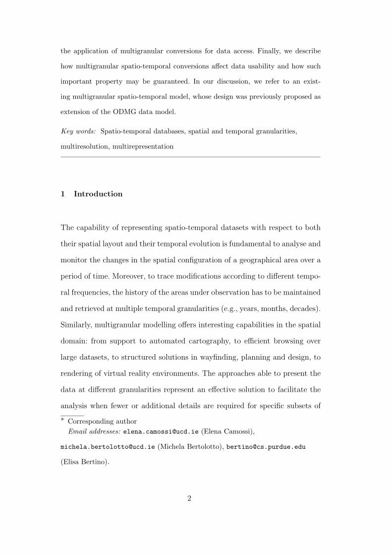
tation of each granule in the corresponding domain as anchored temporal
interval [31] or as a set of geo-referenced features is given by the operation
getExtension(index int). For example, given granule g with index i, repre-
senting county Dublin in Ireland, getExtension(i) vould return the geometry
reported in Fig. 4.
Fig. 4: County Dublin
For temporal granularities, the label format of granules (e.g., “mm/dd/yyyy”
for days) is also stored.
Spatial and temporal granules have to conform to data type Granule, speci-
fying the granularity of reference, a numeric index and an alphanumeric label.
Given granule g at granularity G, the granules of a finer granularity K that
are included in g are retrieved by applying getFiner(). For example, given
the granule at granularity years 2010, through such operation we retrieve
the finer granules at granularity months that represent the months of year
2010. Similarly, getCoarser() returns the unique coarser granule of a spec-
ified granularity H that includes g (see Fig. 1). For example, given granule
g representing the month of May 2010, g.getCoarser() would retrieve the
15

granule representing year 2010.
3.3 Storage of Multigranular Spatio-temporal Values
A multigranular spatio-temporal database schema may include conventional,
multigranular spatial, temporal, and spatio-temporal attributes. In [19] multi-
granular data are defined as instances of the types Spatial and Temporal,
which are specified by a granularity (spatial and temporal, respectively) and
an inner type. The inner type for Spatial may be a conventional type, i.e., a
type without spatio-temporal characteristics, or a geometric type, i.e., a vec-
tor type, e.g., Point, Line, Polygon. The inner type for Temporal may be a
conventional type, or a Spatial type. In the latter case, the resulting type
is multigranular spatio-temporal. In Figures 5 and 6 we report the Unified
Modeling Language (UML, http://www.uml.org/) schemas that define multi-
granular spatio-temporal types.
Fig. 5: Spatio-Temporal data types
The following is an example of spatio-temporal value, defined at temporal
granularity years and at spatial granularity countries, with an alphanumeric
inner type, which represents (the names of) some of the European Heads of
16

Fig. 6: Spatio-Temporal inner types
(a) 1946 (b) 1989
Fig. 7: A spatio-temporal geometric value representing the German borders
government:
{〈2004, {〈France,‘Raffarin’〉, 〈UK,‘Blair’〉}countries〉,
〈2007, {〈France,‘Fillon’〉, 〈UK,‘Brown’〉}countries〉}years.
By contrast, in Fig. 7, where the historical changes in the German political
boundaries are shown, we represent a spatio-temporal value defined at granu-
larities years and countries, where each country is depicted through a closed
polyline.
Various policies may be adopted to reduce the size of multigranular spatio-
temporal values and to improve the efficiency of values retrieval.
To improve the efficiency in space of the representation of multigranular val-
ues, we may coalesce the values defined for contiguous granules. Coalescing
17

is straigthforward for temporal values, because intervals of granules may be
used whenever the value defined for contiguous granules is the same (e.g.,
{〈2000,100〉, 〈2001,100〉, 〈2003, 100〉}years could be represented as {〈2000-
2003,100〉}years).
With the same purpose, we may enrich the data type specification with tem-
poral semantic assumptions [13]. For instance, in a data structure storing the
historical values of a bank account, one may assume that the value of the de-
posit does not change between two operations. In this case, the following value:
{〈1/1/2000,1500〉, 〈1/2/2000,1500〉, . . ., 〈1/10/2000,1500〉, 〈1/11/2000,2100〉}days
could be equivalently represented as: {〈1/1/2000,1500〉,〈1/11/2000,2100〉}days
specifying that for this value the persistence semantic assumption [13] holds 5 .
Similar strategies may be adopted for multigranular spatial values, whenever
homogeneous areas may be identified in the represented data. In this case, the
values may be conveniently converted to coarser granularities, improving the
complexity in space of the representation. For instance, in a map storing the
values of temperature of a given area, the spatial values may be coalesced in
homogeneous (coarser) areas, and, at request, the value may be easily refined
to a finer granularity.
4 Comparison Issues
With comparison issues we indicate the problems arising when comparing
multigranular data, in particular in queries, including how to guarantee the
existence of a common level of detail for performing a comparison, and the
issues involved by converting values at different granularities.
5 Note that this representation requires the values be ordered.
18

4.1 Guaranteeing a common representation
Expressing the relationships among different granularities is important not
only for obtaining smart representations, but also for enabling the comparison
of multigranular values in queries. For instance, in a query we might require
to compare the values of seasonal sales of two similar products, one stored
at spatial granularity countries and one at temporal granularity provinces,
to decide which one to sell in our chain of shops. To perform a meaningful
comparison, we may not compare such values as they are, but they have to be
expressed at the same spatial granularity.
Assuming a granularity system relying on finer-than, such as that described
in [19], it is sufficient to convert one of the two values at the other granu-
larity with a suitable granularity conversion, because provinces is finer-than
countries. For example, the value at granularity countries may be split among
the different provinces of each country or viceversa. But what if the two granu-
larities were for example feet and kms in Fig. 2 In this case a third granularity,
for example µms, which is finer-than both granularities, may be used.
In the most general case, given two multigranular values, one at granularity
G and one at granularity H such that G and H are not directly related by
finer-than, such values may be compared if the two values may be represented
(i.e., converted) at the same granularity K, that is finer-than or coarser-than
both G and H. K is chosen as the granularity that minimizes the number of
conversions applied, that correspond to the number of hops in the granularity
graph (see Fig. 2). If K is the coarsest among the granularities in the graph
that are finer-than G and H, K is referred to as the greatest lower bound
19

(GLB) of G and H. For example µms is the GLB of feet and kms. Otherwise,
if K is the finest among the granularities in the graph that are coarser-than
G and H, it is referred to as the least upper bound (LUB) of G and H.
The existence of one between the GLB or the LUB is essential to guarantee
the comparison of every granular value with another expressed at different
granularity (but with the same inner type). Dyreson et al. [25] observe that
pairs of granularities that do not have a unique GLB are very rare. The lack
of a unique GLB is a situation that arises much less frequently than the lack
of a unique LUB. Furthermore, the assumption of the existence of a unique
GLB for each pair of granularities is enforced whenever a granularity is used
to represent the domain, i.e., the chronon and the quantum granularities are
included in the granularities graphs, as suggested in the previous section.
4.2 Multigranular Conversions
Multigranular models should enable to convert multigranular spatio-temporal
information at different granularities, to improve or reduce the level of detail
used for data representation. Conversions are essential in order to represent
data at the most appropriate level of detail for each task, and they enable
the consistent comparison of data at different granularities, thus improving
the expressive power of spatio-temporal query languages. In this respect, a
key feature in a multigranular model is the support for different conversion
semantics, that is, for different transformations for converting values between
different granularities.
Specific problems arise for the implementation of conversions, like the defini-
tion of the domain of a conversion, the design of optimal strategies for im-
20

proving the execution performance. Moreover, additional issues arise because
of the multigranular representation. For example, guaranteeing that data con-
sistency and usability are preserved is more challenging than in traditional
models, specifically for spatial data. Moreover, the interpretation of aggre-
gated values at coarser granularities require to deal with imprecise values, and
conversion to finer granularities introduce indeterminacy on values. Finally,
granularity conversions are usually non-invertible, and this may affect the def-
inition of the query execution plan. All these problems must be addressed
when implementing granularity conversions, and their side effects must be
considered when defining the strategy for answering queries on multigranular
values. In the rest of the section they are discussed separately, figuring out
design solutions to address them.
4.2.1 Spatial Conversions Problems
A DBMS which enables to maintain geographical representations of the same
area at different resolutions has to guarantee the topological consistency be-
tween different representation of the same entity at different resolutions: a
query evaluated at a coarser level must give a result consistent with that
we would obtain at a more detailed level. In Fig. 8 a topological consistent
transformation of a spatial value representing a city is reported. The city is
represented at progressively coarser levels of detail as (a) set of regions; (b)
single region; (c) point; and the topological relationships with the roads cross-
ing it, represented in red as polylines, are preserved along the transformations.
If the spatial operators applied to solve the query do not assure to generate
consistent maps, a posteriori check must be performed.
In [19] the conversion of multigranular geometrical features is obtained through
21

(a) (b) (c)
Fig. 8: A topological consistent transformation
the composition of model-oriented and cartographic map generalisation opera-
tors that guarantee topological consistency [10,41]. In particular, in [10] it has
been proved that each consistent (i.e., preserving topological relationships)
map transformation may be defined as a composition of the set of atomic
operators supported in [19], which are characterized in terms of minimal mor-
phisms in the category of a specific class of abstract cell complexes. This set
has been extended with the topologically consistent algorithm proposed by
Saalfeld [41] for line simplification, and with the refinement operators that
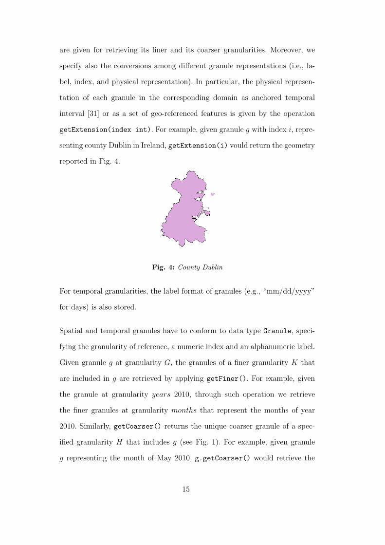
perform the inverse functions. Such operators, which are represented in Ta-
ble 1, may be classified with respect to the semantics of the conversion per-
formed. Contraction and thinning operators reduce the dimension of vector
features, whereas expansion operators increase it; merge operators merge adja-
cent features of the same dimension into a single one, while splitting operators
subdivide single features in adjacent features of the same dimension; abstrac-
tion and simplification operators discard isolated features from polygons and
remove shape points from a line, respectively, whereas addition operators add
isolated features to polygons and shape points to lines.
22
Operator Generalization Refinement
l contr−−−−→←−−−−exp p2l
l contr: Contracts an openline to a point
exp pl2: Expands a pointinto a line
r contr−−−−→←−−−−−exp p2r
r contr: Contracts a sim-ple connected region and itsboundary to a point
exp p2r: Expands a pointinto a region
r thin−−−−→←−−−−exp l2r
r thin: Reduces a regionand its boundary to anopen line
exp l2r: Expands an openline into a region
l merge−−−−−→←−−−l split
l merge: Merge two linessharing an endpoint into asingle line
l split: Splits a line intotwo lines
r merge−−−−−→←−−−−r split
r merge: Merge two regionssharing a boundary lineinto a single region
r split: Splits a regioninto two regions sharing aboundary line
p abs−−−→←−−−−−add p2r
p abs: Eliminates an iso-lated point from a region
add p2r: Add a point insidea region
l abs−−→←−−−−add l2r
l abs: Eliminates an iso-lated line from a region
add l2r: Add a line inside aregion
l simpl−−−−→←−−−−−add p2l
l simpl: Removes a shapepoint from a line
add p2l: Add a shape pointto a line
Table 1: Geometric Operators
4.2.2 Partial Mappings of Conversions
Granularity conversions may be either total or partial functions depending non
only on the values domain to which they are applied, but depending also on
the relationships among granularities. Therefore, even when applied to legal
spatio-temporal values, for some granular values, they may be undefined.
For instance, when the finer-than relationship holds between granularities,
conversions to coarser granularities may be defined as total functions, whereas
conversions to finer granularities may be partial functions. Indeed, according
to the definition of finer-than, given two granularities G and H such that G is
finer-than H, a (unique) H-granule that includes each G-granule always exists
(see Fig. 1). Then, supposing a conversion function that maps G-values into H-
23
values is defined on the inner domain of the multigranular values, it is always
defined. By contrast, the inverse condition may not hold. Therefore, when
converting from coarser to finer granules, the conversion may be undefined.
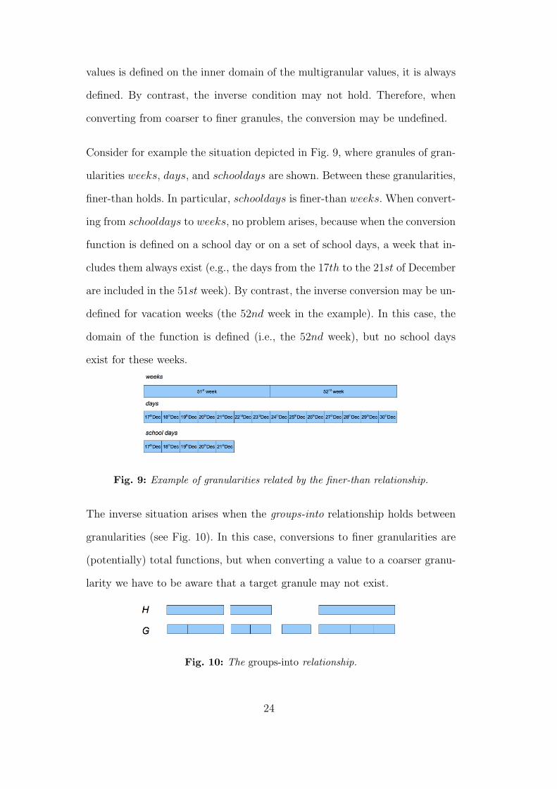
Consider for example the situation depicted in Fig. 9, where granules of gran-
ularities weeks, days, and schooldays are shown. Between these granularities,
finer-than holds. In particular, schooldays is finer-than weeks. When convert-
ing from schooldays to weeks, no problem arises, because when the conversion
function is defined on a school day or on a set of school days, a week that in-
cludes them always exist (e.g., the days from the 17th to the 21st of December
are included in the 51st week). By contrast, the inverse conversion may be un-
defined for vacation weeks (the 52nd week in the example). In this case, the
domain of the function is defined (i.e., the 52nd week), but no school days
exist for these weeks.
Fig. 9: Example of granularities related by the finer-than relationship.
The inverse situation arises when the groups-into relationship holds between
granularities (see Fig. 10). In this case, conversions to finer granularities are
(potentially) total functions, but when converting a value to a coarser granu-
larity we have to be aware that a target granule may not exist.
Fig. 10: The groups-into relationship.
24

In the above cases, the system could check in advance the existence of the
target granules, thus avoiding the execution of a granularity conversion when
they do not exist, even if values are defined for the corresponding portion of the
spatio-temporal domain. This a-priori check would enable to save execution
time, because usually granularity conversions are expensive operations. To
distinguish these cases from situations where no value is actually defined at
other granularities, a message error or warning may be returned, instead of a
generic ”undefined value”.
To prevent partial mappings of the spatio-temporal domain between differ-
ent granularities, other, more restrictive relationships may be adopted. For
instance, a total definition for all conversions is given by the relationship
partitions, that holds whenever both finer-than and groups-into hold [11]).
However, supporting partition would not allow to support a wide range of
granularities, such as businessweeks (-days, -months). In particular, gran-
ularities with gaps between granules may not be supported if granularities
with completely partition the domain are considered (e.g., Gregorian calendar
granularities, boundary subdivisions).
4.2.3 Conversions to Coarser Granularities of Quantitative Values
Conversions of quantitative values to coarser granularities involving the com-
putation of aggregates may be affected by anomalies that have been widely
studied, in particular in the spatial field, where they are known as the Modifi-
able Area Unit Problem (MAUP) and the Ecological Fallacy (EF) [5]. MAUP
occurs when the geographical units considered in an aggregation are arbitrary
and consequently modifiable according to the purpose of the operation. For
example, in countries where the polical elections rely on the intermediate re-
25

sults obtained in political subdivisions and there is not a direct proportion
of the results with respect to the votes obtained, (for which, in turn, overall
the rule ”one man one vote” does not hold), different results may be obtained
considering different intermediate aggregations (e.g., introducing new regions
or provinces, or removing some of them on purpose).
By contrast, EF arises when aggregated data are misused for making infer-
ences about individuals. For instance, knowing that the average salary of the
population of a country is 1,500 Euro, does not mean that every person in
that area earns exactly 1,500 Euro.
Both anomalies rely in turn due on how aggregations are performed and inter-
preted, thus the same problems may occur also for scaling of temporal data.
To give the user the possibility to evaluate correctly a granular value, this
should give also a measure of the imprecision, or the indeterminacy, it is af-
fected with. This error should be computed every time a multigranular conver-
sion is applied. Moreover, a support wider as possible of conversion functions
for quantitative (non-geometric) values should give the user the possibility to
chose which conversion less affect the value.
For instance, in [19] the conversions to coarser granularities described in Ta-
ble 2 are supported. They are referred to as coercion functions, and perform
selection and aggregation.
4.2.4 Conversion to Finer Granularities
Even when they are defined functions, conversions to finer granularities in-
trinsically result in undetermined values [34,26]. This is particularly evident
for geometric conversions. The conversion of regions to their barycenters, for
26

conversion family conversion semantics
Aggregation
max Selects the maximum value definedmin Selects the minimum value definedavg Computes the average of the values definedsum Computes the sum of the values defined
Selection
main Selects the most frequent valueall If all the finer values are the same, selects this value; otherwise
it is undefinedproj(n) Selects the nth defined valuefirst Selects the first defined valuelast Selects the last defined value
Table 2: Coercion functions [19]
instance, is usually considered an appropriate choice for representing them
at a coarser granularity. By contrast, when scaling to a finer granularity and
converting points to regions, for instance, the choice of the region to repre-
sent may be totally arbitrary. Similarly, the conversion of non-geometric data
to a finer representation is affected by indeterminacy. For instance, given the
value of rainfall stored for the 1st of June 2000 in Rome, we may not infer
from this value the exact value of rainfall in a particular neighbourhood of
Rome, at 12:00 AM (See also [15]). Therefore, when converting from coarser
to finer granularities, we have to be aware of the error, or indeterminacy, we
are introducing on data.
In [19], refinement functions enable to convert multigranular values to finer
granularities. As described in Table 3, they perform restriction and splitting
of values. Restriction functions apply downward inheritance property [43] that
assumes that if a multigranular value is defined as v in a granule g, value v
also refers to any finer granule g′ included in g. For each attribute value for
which downward inheritance is not appropriate (e.g., a temporal value storing
the salary of an employee), split functions subdivide each coarser value among
the finer granules included in it either uniformly (i.e., all the finer values will
be the same), or according to a non-uniform distribution (split[p(n)] and
restr[p(n)]).
27

Operations split[p(n)] and restr[p(n)] defined in [19], which implement
“scale mass functions” as defined by Dyreson et al. [25], specifically address
the indeterminacy arising from non-geometric conversions to finer granulari-
ties. The probability distribution considered in the computation may be de-
fined, for instance, taking into account the semantics of the attribute value
converted, or considering the distributions of legacy values. Different imple-
mentations for these functions have to be provided for each probability dis-
tribution supported. The parameterization of restriction and split functions
with a probability distribution
conversion family conversion semantics
Restrictionrestr The coarser value is assigned to each finer granulerestr[p(n)] The coarser value is assigned to the finer granules, according to
the probability distribution [p(n)]
Splitsplit The coarser value is split among the finer granulessplit[p(n)] The coarser value is split among finer granules, according to the
probability distribution [p(n)]
Table 3: Refinement functions [19]
4.2.5 Invertibility of Conversions
Intuitively, when converting a multigranular value to a different granular-
ity, and then performing the inverse conversion, we would expect to obtain
the original value. Unfortunately, granularity conversions rarely are invert-
ible: when converting from a finer to a coarser granularity, we loose some
details that we cannot usually re-obtain by applying the inverse conversion
to the finer granularity, unless we do not save the finer values in an auxiliary
structure. By contrast, when converting from a coarser to a finer granular-
ity, we introduce details that we should be able to forget, if we are no longer
interested in them; in this case we may re-obtain the original value.
Then, we may identify pair of conversions which are invertible, and pairs that
are not. For instance, we shown in [8] that sum is the inverse of split, restr is
28

the quasi-inverse of avg (see Tables 2 and 3), because restr(avg(v)) = ±∆,
where ∆ is a maximum quantifiable error introduced by the application of
conversions.
The property of invertibility is important for the definition of the query exe-
cution plan, whenever more values at different granularities are available for
the same spatio-temporal snapshot (see Fig. 11). In this case, a query result
may be affected by a quantifiable error, according to it is computed starting
from available values at coarser or finer granularities [8].
5 Optimization Issues
The application of granularity conversion can be expensive in term of the use
of computational resources, in particular for geometric conversions whenever
they are applied to extensive geographic areas. Optimizations, in this case, are
possibile only at algorithm level [38]. Performance may improve also applying
techniques for parallel computations [30].
Other optimization strategies may be applied to reduce the amount of data
on which conversions are applied. For instance, rewriting algebraic techniques
such those applied by database query engines when preparing the queries
execution plans could improve the performance of data access. These tech-
niques should give precedence to the application of target clauses, to reduce
the amount of data affected by conversions, as well as to the execution of
temporal conversions on spatio-temporal data on that of spatial conversions.
Traditional Index structures for ordered (e.g., temporal) and spatial vector
data, like BTree+ and RTree and its variants (e.g., R+-Tree [42], R∗-Tree [7],
29

Hilbert R-Tree [33], PR-Tree [4]), may be applied to improve the efficiency of
the retrieval of spatio-temporal values. Moreover, auxiliary data structures for
spatio-temporal data have been proposed in the literature, and some of them
may be extended to the multigranular case (HR+-Tree [46], MV3R-Tree [47],
2-3TR-tree [1]).
Whenever the queries to enhance involve value aggregates, auxiliary structures
that summarize spatio-temporal multigranular values at coarser granularities
may be used (e.g., aggregate Historical RB-tree [39]). For example, in [18] a
data structure for the efficient storage and access to dynamic attributes has
been proposed. Dynamic attributes are historical attributes whose values are
tuples of temporal values, maintained at different levels of detail according to
the age of data and to the execution of expiration conditions. An expiration
condition is given by an expiration frequency and by a reaction policy to be
applied when data expire: either evolution at a coarser granularity, or deletion
of values, or both. For instance, it is possible to specify that an attribute may
be evolved to a coarser granularity after a period of time, obtaining summa-
rized information (through aggregation, selection, or user defined operations)
from historical data.
In [17], such evolution capability has been extended to the spatio-temporal
domain, enabling to obtain summarized information also from spatial and
spatio-temporal data, according to given areas of interest. In Fig. 11 an ex-
ample of such an auxiliary structure for a spatio-temporal value recording tax
information is depicted. For this value (represented on top of the figure), two
different aggregate structures are provided (at the figure bottom). The first
one stores temporal aggregates (computed every five years), while the second
summarizes tax information according to the macro area of reference.
30

2000 Italy 2400 Germany 1300 2001 Italy 2000 . . .
2000− 2005 Italy 7500 Germany 6000 France 4000 . . .
2000 EU 3700 2001 EU 4500 . . .
Fig. 11: Auxiliary structure for spatio-temporal data
6 Implementing Multigranularity
In our previous work [9,19] we have exploited the potentiality of object-
oriented (OO) databases for supporting temporal multigranularity. In partic-
ular, the design of the temporal prototype described in [9] has been extended
according to the model described in [19] integrating vector data and their
conversions, thus enabling the application to the the spatio-temporal domain.
The use of OODBMS models for supporting multigranularity implies to face
with additional issues regarding object inheritance, such as attribute redefini-
tion and method override.
In what follows, we exploit the potentiality offered by the object-relational
(OR) model, which integrate the benefits of relational models (i.e., simple
design, declarative query language) with the advanced capabilities provided
by the object-oriented approach (e.g., support for defining user defined data
types, object inheritance, data types encapsulation), for implementing multi-
ple spatio-temporal granularities.
Although the object-relational features supported by commercial products
are somehow limited, the resulting design has the advantage of relying on the
widely accepted standard SQL:99 [36]. Indeed, despite the considerable effort
done to achieve the same result, ODMG, which is the reference model for
object-oriented databases, is not yet a standard and thus it has not been fully
31

acknowledged by commercial products.
Furthermore, some commercial DBMS adopting the OR approach already pro-
vide a preliminary extension for handling spatial data. They may be preferred
to GIS products for user-defined queries, because the latter are proprietary
systems, thus difficult to extend. Moreover, in GIS products, spatial and non-
spatial attributes are stored and manipulated separately according to a loosely
coupled storage model [40]. By contrast the so-called Spatial DBMS (SDBMS)
provide an integrated approach to the representation of spatial data that en-
ables to store both spatial and non-spatial aspects of data within the same
tables. Therefore SQL (extended with functionalities to directly support spa-
tial queries) may be used to manipulate and query spatial data. However,
current SDBMS and GIS packages do not provide either effective functionali-
ties to manipulate temporal data, or multigranular support.
To enhance its computational capability, ORDBMS products provide the so
called imperative extensions of SQL. OODBMS do not need similar extensions,
because the query languages may be uniformly integrated with OO program-
ming languages, which rely on the same paradigm. As a matter of fact, the
complexity of use of OO query languages, if compared to the simplicity of the
declarative approach of SQL, often encompasses this advantage.
Therefore, in the following we give the implementation detail of an OR multi-
granular implementation realized on Oracle 11g, which adopts the design so-
lutions discussed in the previous section.
To conclude the section, we briefly describe also a syntax for the definition
of user defined granularities which is included in the prototype in [9], that
demonstrates the effectiveness of an efficient representation for granularities.
32

6.1 A Multigranular OR Spatio-temporal Type System
As we pointed out above, commercial DBMS products currently implement
only a subset of object-relational features: for instance, methods override is
not supported, and only very simple operations may be performed through
types methods. Therefore, in what follows the data types for granularities,
granules and multigranular types are somewhere redundant from a design
point of view, and method declaration appears only in the leaves of the type
hierarchy. The operations that have not been implemented as methods of
user defined data types are realized through PL/SQL stored procedures and
functions, which allow for improved performances than external procedures.
In particular, functions may be used directly in SQL queries.
6.1.1 Granularities and Granules
In our prototype, we followed the design guidelines we described in Sections 3
and 4. The design of granularities and granules, whose Oracle data types are
reported in Fig. 12, is compliant with the abstract data types of Fig. 3.
CREATE TYPE Granularity AS (granID NUMBER,granName VARCHAR(32),labelFormat VARCHAR(32),finer List<REF(Granularity)>,coarser List<REF(Granularity)>)METHOD getFiner() RETURN LIST<Granularity>,METHOD getCoarser() RETURN LIST<Granularity>;
CREATE TYPE Granule AS (g REF(Granularity),label VARCHAR(32),index NUMBER);
Fig. 12: Oracle Data Types for granularities and granules
Each granularity is represented by a unique identifier, its name, and the format
of the labels of its granules. The lists of finer and coarser granularities are also
33

provided, with the methods getFiner and getCoarser for returning them.
Type Granularity may be conveniently used to create a table storing the
main information on the granularities supported by the system. Once a new
granularity is created, it is sufficient to add a new tuple in this table. Each
granularity is completely represented thanks to the implementation of the
operations that convert the different granules representations: index2label,
label2index and getExtension. In particular, the last operation maps a
granularity granule (identified through its index) to the corresponding domain.
These operations have been implemented as stored procedures and functions
for each granularity supported by the model. We have for example the follow-
ing functions for granularity days
days index2label(index NUMBER) RETURN VARCHAR
days label2index(label VARCHAR) RETURN NUMBER
days getExtension(IN index NUMBER) RETURN Anch TemporalInterval
and the following operations for granularity countries:
countries index2label(index NUMBER) RETURN VARCHAR
countries label2index(IN label VARCHAR) RETURN NUMBER
countries getExtension(IN index NUMBER) RETURN SDO Geometry.
The data type SDO Geometry , returned by the function countries getExtension,
represents the top hierarchy type for vector features as provided by the SDBMS
(e.g., ORACLE SDO Geometry ). Anch TemporalInterval is a data type for
anchored temporal interval [31] (i.e., temporal intervals specified by the start-
ing and the ending instants, then referring to the time domain).
34

CREATE TYPE SpatialValue AS (granule Granule,value Value S);
CREATE TYPE Spatial AS (g Granularity,value List(SpatialValue)) UNDER Value T;
CREATE TYPE TemporalValue AS (granule Granule,value Value T);
CREATE TYPE Temporal AS (g Granularity,value TemporalValue);
Fig. 13: Multigranular Data Types
A Granule is represented by the reference to its granularity, by its label and
granularity index (cf. Fig. 12). Other stored procedures are required to im-
plement the operations getFiner and getCoarser defined for type Granule
that return the (set of) finer or coarser granules of a granularity that inter-
sect a given granule. The implementation differs according to the granularity
cathegory. For instance, for temporal granularities such operations rely on the
inclusion property of the anchored temporal intervals representing temporal
granules, and the algorithm applied is similar for all granularities without
gaps among granules and holes within the granules [11]. For those particular
granularities, specific implementations are required.
The implementation of these operations for spatial granularities is more diffi-
cult, and requires to handle the extensive mapping of each granularity to the
spatial domain.
6.1.2 Multigranular Spatio-temporal Values
Spatio-temporal values are implemented as structured lists of pairs of granules
and values (< granule, value >) as defined in Figures 5. The corresponding
ORACLE data types are shown in Fig. 13.
Data types SpatialValue and TemporalValue define a single pair (< granule,
35

CREATE TYPE Value S AS ();
CREATE TYPE Value T AS ();
CREATE TYPE Number S AS (value number) UNDER Value S;
CREATE TYPE Number T AS (value number) UNDER Value T;
CREATE TYPE String S AS (value VARCHAR(128)) UNDER Value S;
CREATE TYPE String T AS (value VARCHAR(128)) UNDER Value T;
CREATE TYPE Geometry S AS (value Geometry) UNDER Value S;
Fig. 14: Inner Data Types for Multigranular Values
value >), while the granularity is referred to in the “wrapping” types Spatial
and Temporal , that include the list of the pairs (< granule, value >) that
represent the granular values. Note that type Spatial may be an inner type
of Temporal , then spatio-temporal values are implemented as nested lists.
Inner types of granular values are defined according to the design specification
given in Section 3, and are reported in Fig. 14. Two types hierarchies are
created, Value S and Value T , that give inner types for spatial and temporal
values, respectively. In particular, the definition of inner types of multigranular
vector data relies on the data type already provided by the DBMS, that is
SDO Geometry .
Given such a specification, the internal representation of a spatio-temporal
value storing the names of the European Heads of government would be rep-
resented as in Fig. 15.
36
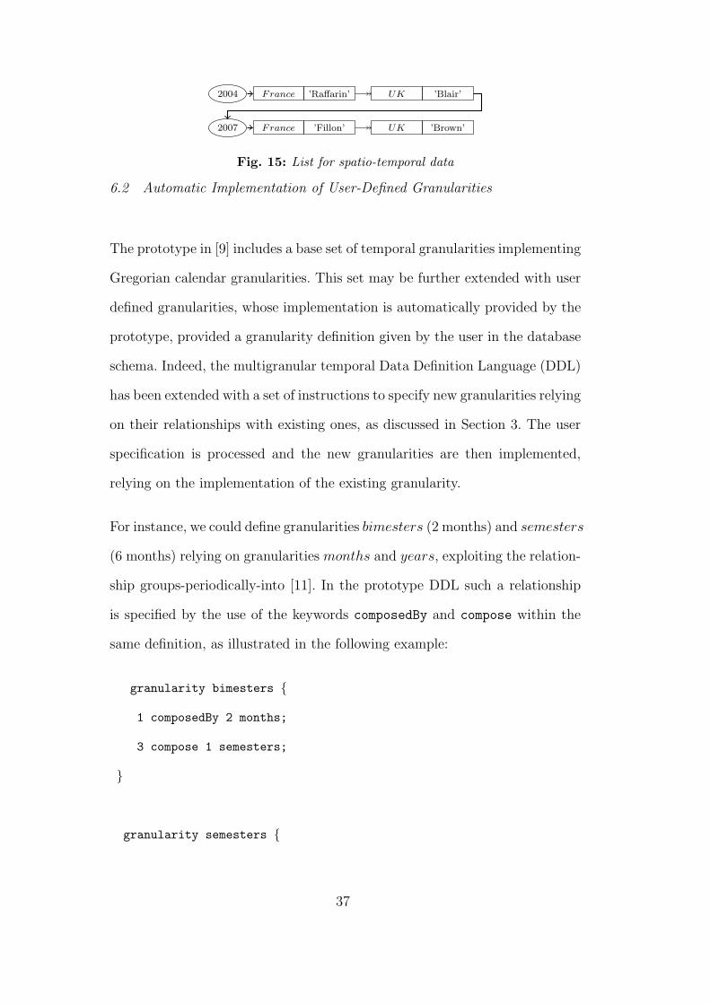
2004 France ’Raffarin’ UK ’Blair’
2007 France ’Fillon’ UK ’Brown’
Fig. 15: List for spatio-temporal data
6.2 Automatic Implementation of User-Defined Granularities
The prototype in [9] includes a base set of temporal granularities implementing
Gregorian calendar granularities. This set may be further extended with user
defined granularities, whose implementation is automatically provided by the
prototype, provided a granularity definition given by the user in the database
schema. Indeed, the multigranular temporal Data Definition Language (DDL)
has been extended with a set of instructions to specify new granularities relying
on their relationships with existing ones, as discussed in Section 3. The user
specification is processed and the new granularities are then implemented,
relying on the implementation of the existing granularity.
For instance, we could define granularities bimesters (2 months) and semesters
(6 months) relying on granularities months and years, exploiting the relation-
ship groups-periodically-into [11]. In the prototype DDL such a relationship
is specified by the use of the keywords composedBy and compose within the
same definition, as illustrated in the following example:
granularity bimesters {
1 composedBy 2 months;
3 compose 1 semesters;
}
granularity semesters {
37

1 composedBy 3 bimesters;
2 compose 1 years;
}
Given the above specifications, the prototype automatically generates the im-
plementation for the new granularities bimesters and semesters, relying on
the existing implementation of months and years. In particular, the conver-
sion among different granules representations (e.g., indexes, temporal intervals,
label) relies on the regular subdivisions of these temporal granularities.
With this support we may easily specify a set of granularities for each applica-
tion, allowing to tailor granularities to the domain represented and to specific
requirements.
7 Conclusions
In this paper we have discussed implementation issues of spatio-temporal
multigranularity. For a better comprehension of the details, we referred to
a multigranular model we previously defined [19]. Nevertheless the problems
we discussed apply to every data model providing a multigranular support.
Among these problems, the issues related to the efficient representation of
granules, granularities and spatio-temporal values are particularly relevant.
We showed a possible solution defined as extension of the object-relational
model as supported by most commercial database products. Furthermore,
multigranular conversions presented in the paper are specifically designed to
prevent data inconsistency and to reduce indeterminacy.
We have also described an existing multigranular temporal object-oriented
38

prototype implementation addressing some of the issues we discussed, thus
demonstrating the solutions we propose are feasible. We plan the porting of
this implementation to the object-relational paradigm, and its extension to
the spatio-temporal domain. The resulting prototype would enable to store
and query spatio-temporal datasets at different levels of details. Thus we will
be able to test its performances on real world datasets such as the Hurricane
Isabel dataset (http://www.tpc.ncep. noaa.gov/2003isabel.shtml).
Acknowledgements
Research presented in this paper was funded by a Strategic Research Cluster
grant (07/SRC/I1168) by Science Foundation Ireland under the National De-
velopment Plan. The authors gratefully acknowledge this support. The work
of Elena Camossi is supported by the Irish Research Council for Science, En-
gineering and Technology.
References
[1] M. Abdelguerfi, J. Givaudan, K. Shaw, and R. Ladner. The 2-3TR-tree, atrajectory-oriented index structure for fully evolving valid-time spatio-temporaldatasets. In Proc. of the 10th ACM international symposium on Advances ingeographic information systems, pages 29–34, 2002.
[2] T.L. Anderson. Modeling time at the conceptual level. In Proceedingsof the International Conference on Databases: Improving Usability andResponsiveness, pages 273–297, 1982.
[3] G. Andrienko, D. Malerba, M. May, and M. Teisseire. Mining spatio-temporaldata. Journal of Intelligent Information Systems, 27(3):187–190, 2006.
[4] L. Arge, M. de Berg, H. J. Haverkort, and K. Yi. The Priority R-Tree: APractically Efcient and Worst-Case Optimal R-Tree. In Proc. of SIGMODInternational Conference on Management of Data, pages 347–358. ACM, 2004.
[5] T. C. Bailey and A. C. Gatrell. Interactive Spatial Data Analysis, SecondEdition. Longman, 1995.
39
[6] S. Balley, C. Parent, and S. Spaccapietra. Modelling Geographic Data withMultiple Representations. International Journal of Geographical InformationScience, 18(4):327–352, 2004.
[7] N. Beckmann, H-P. Kriegel, R. Schneider, and B. Seeger. The R∗-Tree: anefficient and robust access method for points and rectangles. In ACM SIGMODRecord, pages 322–331, 1990.
[8] E. Bertino, E. Camossi, and G. Guerrini. Access to Multigranular TemporalObjects. In Proceedings of the 6th Int. Conference On Flexible Query AnsweringSystems (FQAS 2004), number 3055 in Lecture Notes in Artificial Intelligence,pages 320–333. Springer-Verlag, 2004.
[9] E. Bertino, E. Ferrari, G. Guerrini, and I. Merlo. T ODMG: AnODMG Compliant Temporal Object Model Supporting Multiple GranularityManagement. Information Systems, 28(8):885–927, 2003.
[10] M. Bertolotto. Geometric Modeling of Spatial Entities at Multiple Levels ofResolution. PhD thesis, Universita degli Studi di Genova, 1998.
[11] C. Bettini, S. Jajodia, and X. Wang. Time Granularities in Databases, DataMining, and Temporal Reasoning. Springer-Verlag, 2000.
[12] C. Bettini and R. De Sibi. Symbolic Representation of User-defined TimeGranularities. Annals of Mathematics and Artifical Intelligence, Special Issueson Temporal Representation and Reasoning, 30(1-4):53–92, 1999.
[13] C. Bettini, X.S. Wang, and S. Jajodia. Temporal semantic assumptions andtheir use in databases. IEEE Transactions on Knowledge and Data Engineering,10(2):277–296, 1998.
[14] T. Bittner. Reasoning about qualitative spatio-temporal relations at multiplelevels of granularity. In F. van Harmelen, editor, Proceedings of the 15th
European Conference on Artificial Intelligence. IOS Press, 2002.
[15] T. Bittner. Indeterminacy and Rough Approximation. In Proceedings of the16th International FLorida Artificial Intelligence Research Society (FLAIRS)Conference, pages 450–454. AAAI Press, 2003.
[16] T. Bittner and J.G. Stell. Stratified Rough Sets and Vagueness. In Proceedingsof the 2003 Conference on Spatial Information Theory, number 2825 in LectureNotes in Computer Science, pages 270–286, 2003.
[17] E. Camossi. Spatio-temporal Multigranularity in an Object Data Model. PhDthesis, Universita degli Studi di Milano, 2005.
[18] E. Camossi, E. Bertino, G. Guerrini, and M. Mesiti. Handling Expirationof Multigranular Temporal Objects. Special Issue of Journal of Logic andComputation, 14(1):23–50, 2004.
[19] E. Camossi, M. Bertolotto, and E. Bertino. A multigranular Object-orientedFramework Supporting Spatio-temporal Granularity Conversions. InternationalJournal of Geographical Information Science, 20(5):511–534, 2006.
40

[20] E. Camossi, M. Bertolotto, and E. Bertino. Multigranular Spatio-temporalModels: Implementation Challenges. In Proceedings of the 16th InternationalSymposium on Advances in Geographic Information Systems (ACM GIS08),2008.
[21] E. Camossi, M. Bertolotto, and E. Bertino. Querying multi-granular spatio-temporal objects. In Proceedings 19th International Conference on Database andExpert Systems Application (to appear), Lecture Notes in Computer Science,pages 390–403. Springer Verlag, Berlin, 2008.
[22] R. Cattel, D. Barry, M. Berler, J. Eastman, D. Jordan, C. Russel, O. Schadow,T. Stanienda, and F. Velez. The Object Database Standard: ODMG 3.0.Morgan-Kaufmann, 2000.
[23] C. Claramunt and B. Jiang. Hierarchical Reasoning in Time e Space. InProceedings of 9th International Symposium on Spatial Data Handling, pages41–51, 2000.
[24] M. Dukham, K. Mason, J.G. Stell, and M.F. Worboys. A formal approach toimperfection in geographic information. Computer, Environment and UrbanSystems, 25:89–103, 2001.
[25] C.E. Dyreson, W.S. Evans, H. Lin, and R.T. Snodgrass. EfficentlySpporting Temporal Granularities. IEEE Transactions on Knowledge and DataEngineering, 12(4):568–587, 2000.
[26] C.E. Dyreson and R.T. Snodgrass. Supporting Valid-time Indeterminacy. ACMTransactions on Database Systems, 23(1):1–57, 1998.
[27] F. Fonseca, M.J. Egenhofer, C. Davis, and G. Camara. Semantic Granularityin Ontology Driven Geographic Information Systems. Annals of Mathematicsand Artificial Intelligence, Special Issue on Spatial and Temporal Granularity,36(1-2), 2002.
[28] I.A. Gorawalla, Y. Leontiev, M.T.Oszu, D. Szafron, and C. Combi. TemporalGranularity: Completing the Puzzle. Journal of Intelligent InformationSystems, 16(1):41–63, 2001.
[29] T. Griffiths, A.A.A. Fernandes, N.W. Paton, and R. Barr. The Tripod spatio-historical data model. Data Knowledge and Engineering, 49(1):23–65, 2004.
[30] R. Healey, S. Dowers, B. Gittings, and M. J. Mineter, editors. ParallelProcessing Algorithms For GIS. CRC, 1997.
[31] C.S. Jensen, C.E. Dyreson, M. Bohlen, J. Clifford, and al. A Consensus Glossaryof Temporal Database Concepts. In O. Etzion, S. Jajodia, and S.Sripada,editors, Temporal Databases: Research and Practice, number 1399 in LectureNotes in Computer Science, pages 366–405. Springer-Verlag, 1998.
[32] B. Jiang and C. Claramunt. A Structural Approach to the Model Generalizationof a Urban Street Network. Geoinformatica, 8(2):157–171, 2004.
41

[33] I. Kamel and C. Faloutsos. Hilbert R-Tree: An Improved R-Tree Using Fractals.In Proc. of the 20th Int’l Conf. on Very Large Databases, pages 500–509, 1994.
[34] V. Khatri, S. Ram, R.T. Snodgrass, and G. O’Brien. Supporting UserDefined Granularities and Indeterminacy in a Spatiotemporal ConceptualModel. Annals of Mathematics and Artificial Intelligence, Special Issue onSpatial and Temporal Granularity, 36(1-2):195–232, 2002.
[35] L. Kulik, M. Duckham, and M.J. Egenhofer. Ontology driven MapGeneralization. Journal of Visual Language and Computing, 16(2):245–267,2005.
[36] J. Melton, A. Simon, and J. Gray. SQL:1999 - Understanding RelationalLanguage Components. Morgan Kaufmann, 2001.
[37] J-C. Muller, J.P. Lagrange, and R.Weibel, editors. GIS and Generalization:methodology and practice. London: Taylor and Francis, 1995.
[38] M. Neun, D. Burghardt, and R. Weibel. Automated processing for mapgeneralization using web services (to appear). GeoInformatica, 2009.
[39] D. Papadias, Y. Tao, P. Kalnis, and J. Zhang. Indexing Spatio-Temporal DataWarehouses. In Proc. of the 18th International Conference on Data Engineering,pages 166–175. IEEE, 2002.
[40] P. Rigaux, M. Scholl, and A. Voisard. Spatial Databases with Application toGIS. Morgan Kaufmann, Academic Press, 2002.
[41] A. Saalfeld. Topologically Consistent Line Simplification with the Douglas-Peucker Algorithm. Cartography and Geographic Information Science, 26(1):7–18, 1999.
[42] T Sellis, N Roussopoulos, and C Faloutsos. The R+-Tree: A Dynamic Indexfor Multi-dimensional Data. In Proc. of the 13th Int’l Conf. on Very LargeDatabases, pages 507–518, 1987.
[43] Y. Shoham. Temporal Logics in AI: Semantical and Ontological Considerations.Artificial Intelligence, 33(1):89–104, 1987.
[44] R.T. Snodgrass. The TSQL2 Temporal Query Language. Kluwer AcademicPublishers, 1995.
[45] J.G. Stell and M. Worboys. Stratified Map Spaces: A Fomal Basis forMulti-Resolution Spatial Databases. In T.K. Poiker and N. Chrisman,editors, Proceedings of 8th International Symposium on Spatial Data Handling(International Geographical Union), pages 180–189, 1998.
[46] Y. Tao and D. Papadias. Indexing Spatio-Temporal Data Warehouses. In Proc.of the 13th Int’l Conf. on Scientific and Statistical Database Management, pages223–232. IEEE, 2001.
[47] Y. Tao and D. Papadias. MV3R-Tree: A Spatio-Temporal Access Method forTimestamp and Interval Queries. In Proc. of the 27th International Conferenceon Very Large Data Bases, pages 431–440, 2001.
42
[48] R. Weibel and G. Dutton. Generalizing Spatial Data and Dealing withMultiple Representations. In P.A. Longley, D.j Maguire, M.F. Goodchild, andD.W. Rhind, editors, Geographical Information Systems: Principles, techniques,management and applications, chapter 10. New York: John Wiley, 1999.
43
Related Documents