MSSL/DEPARTMENT OF SPACE & CLIMATE PHYSICS CEOS-WGCV37 Terrain Mapping Sub-group: Current Status and GEO IN-02-C2.1 report Jan-Peter Muller [email protected] Point-of-Contact, GEOSS Task IN-02 Chairperson, CEOS-WGCV Sub-group on Terrain mapping from satellites Chairperson, ISPRS Commission IV WG on “Global DEM Interoperability” Head, Imaging Group Professor of Image Understanding and Remote Sensing HRSC Science Team Member (ESA Mars Express 2003) Stereo Panoramic Camera Science Team Member (ESA EXOMARS) MODIS & MISR Science Team Member (NASA EOS Project) TerraSAR-X and TANDEM-X science team member (DLR-Astrium) *partially supported by UK Space Agency

Welcome message from author
This document is posted to help you gain knowledge. Please leave a comment to let me know what you think about it! Share it to your friends and learn new things together.
Transcript
MSSL/DEPARTMENT OF SPACE & CLIMATE PHYSICS
CEOS-WGCV37 Terrain Mapping Sub-group: Current Status and GEO IN-02-C2.1 report
Jan-Peter Muller [email protected]
Point-of-Contact, GEOSS Task IN-02 Chairperson, CEOS-WGCV Sub-group on Terrain mapping from satellites
Chairperson, ISPRS Commission IV WG on “Global DEM Interoperability” Head, Imaging Group
Professor of Image Understanding and Remote Sensing HRSC Science Team Member (ESA Mars Express 2003)
Stereo Panoramic Camera Science Team Member (ESA EXOMARS) MODIS & MISR Science Team Member (NASA EOS Project)
TerraSAR-X and TANDEM-X science team member (DLR-Astrium)
*partially supported by UK Space Agency
MSSL/DEPARTMENT OF SPACE & CLIMATE PHYSICS
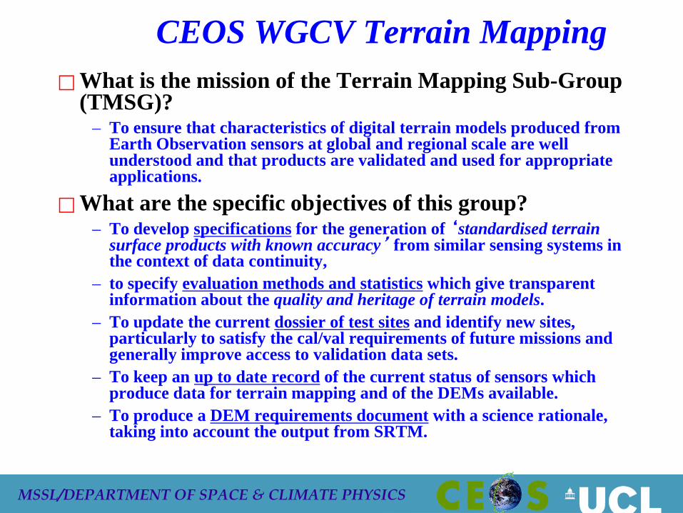
CEOS WGCV Terrain Mapping What is the mission of the Terrain Mapping Sub-Group
(TMSG)? – To ensure that characteristics of digital terrain models produced from
Earth Observation sensors at global and regional scale are well understood and that products are validated and used for appropriate applications.
What are the specific objectives of this group? – To develop specifications for the generation of ‘standardised terrain
surface products with known accuracy’ from similar sensing systems in the context of data continuity,
– to specify evaluation methods and statistics which give transparent information about the quality and heritage of terrain models.
– To update the current dossier of test sites and identify new sites, particularly to satisfy the cal/val requirements of future missions and generally improve access to validation data sets.
– To keep an up to date record of the current status of sensors which produce data for terrain mapping and of the DEMs available.
– To produce a DEM requirements document with a science rationale, taking into account the output from SRTM.
MSSL/DEPARTMENT OF SPACE & CLIMATE PHYSICS
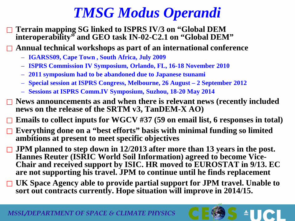
TMSG Modus Operandi Terrain mapping SG linked to ISPRS IV/3 on “Global DEM
interoperability” and GEO task IN-02-C2.1 on “Global DEM” Annual technical workshops as part of an international conference
– IGARSS09, Cape Town , South Africa, July 2009 – ISPRS Commission IV Symposium, Orlando, FL, 16-18 November 2010 – 2011 symposium had to be abandoned due to Japanese tsunami – Special session at ISPRS Congress, Melbourne, 26 August – 2 September 2012 – Sessions at ISPRS Comm.IV Symposium, Suzhou, 18-20 May 2014
News announcements as and when there is relevant news (recently included news on the release of the SRTM v3, TanDEM-X AO)
Emails to collect inputs for WGCV #37 (59 on email list, 6 responses in total) Everything done on a “best efforts” basis with minimal funding so limited
ambitions at present to meet specific objectives JPM planned to step down in 12/2013 after more than 13 years in the post.
Hannes Reuter (ISRIC World Soil Information) agreed to become Vice-Chair and received support by ISIC. HR moved to EUROSTAT in 9/13. EC are not supporting his travel. JPM to continue until he finds replacement
UK Space Agency able to provide partial support for JPM travel. Unable to sort out contracts currently. Hope situation will improve in 2014/15.
MSSL/DEPARTMENT OF SPACE & CLIMATE PHYSICS
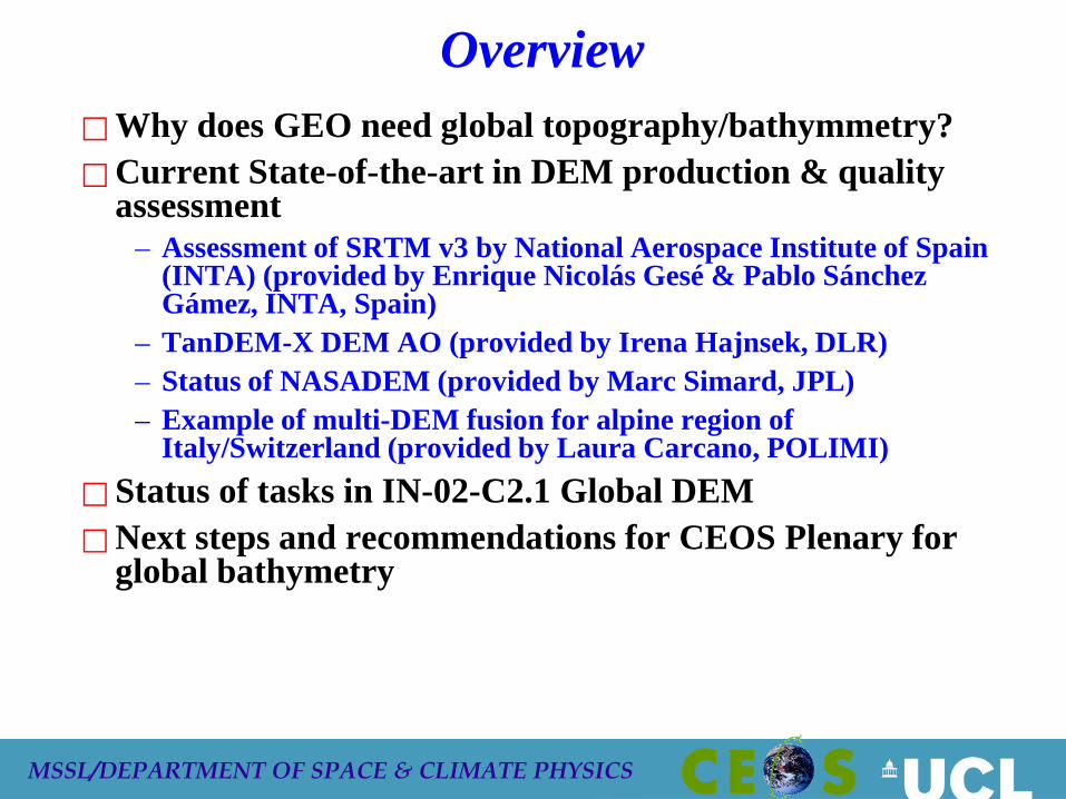
Overview Why does GEO need global topography/bathymmetry? Current State-of-the-art in DEM production & quality
assessment – Assessment of SRTM v3 by National Aerospace Institute of Spain
(INTA) (provided by Enrique Nicolás Gesé & Pablo Sánchez Gámez, INTA, Spain)
– TanDEM-X DEM AO (provided by Irena Hajnsek, DLR) – Status of NASADEM (provided by Marc Simard, JPL) – Example of multi-DEM fusion for alpine region of
Italy/Switzerland (provided by Laura Carcano, POLIMI) Status of tasks in IN-02-C2.1 Global DEM Next steps and recommendations for CEOS Plenary for
global bathymetry
MSSL/DEPARTMENT OF SPACE & CLIMATE PHYSICS
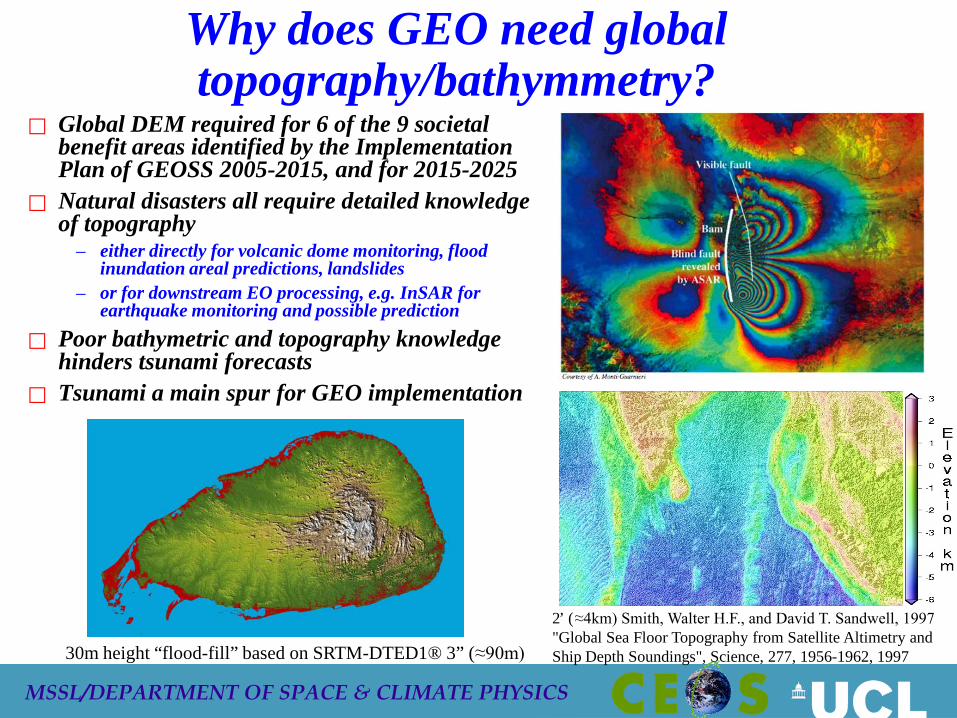
Why does GEO need global topography/bathymmetry?
Global DEM required for 6 of the 9 societal benefit areas identified by the Implementation Plan of GEOSS 2005-2015, and for 2015-2025
Natural disasters all require detailed knowledge of topography
– either directly for volcanic dome monitoring, flood inundation areal predictions, landslides
– or for downstream EO processing, e.g. InSAR for earthquake monitoring and possible prediction
Poor bathymetric and topography knowledge hinders tsunami forecasts
Tsunami a main spur for GEO implementation
2’ (≈4km) Smith, Walter H.F., and David T. Sandwell, 1997 "Global Sea Floor Topography from Satellite Altimetry and Ship Depth Soundings", Science, 277, 1956-1962, 1997 30m height “flood-fill” based on SRTM-DTED1® 3” (≈90m)
Feb 2014
CEOS-WGCV-TMSG / GEO IN-02-C2.1
6
VALIDATION STUDIES OF SRTM V3 DEM
Enrique Nicolás Gesé National Aerospace Institute of Spain (INTA).
Earth Observation, Remote Sensing and Atmosphere Department. Observation Systems Area / Image Processing Laboratory.
Feb 2014
CEOS-WGCV-TMSG / GEO IN-02-C2.1
7
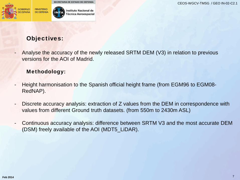
Objectives:
- Analyse the accuracy of the newly released SRTM DEM (V3) in relation to previous versions for the AOI of Madrid.
Methodology: - Height harmonisation to the Spanish official height frame (from EGM96 to EGM08-
RedNAP). - Discrete accuracy analysis: extraction of Z values from the DEM in correspondence with
values from different Ground truth datasets. (from 550m to 2430m ASL)
- Continuous accuracy analysis: difference between SRTM V3 and the most accurate DEM (DSM) freely available of the AOI (MDT5_LiDAR).
Feb 2014
CEOS-WGCV-TMSG / GEO IN-02-C2.1
8
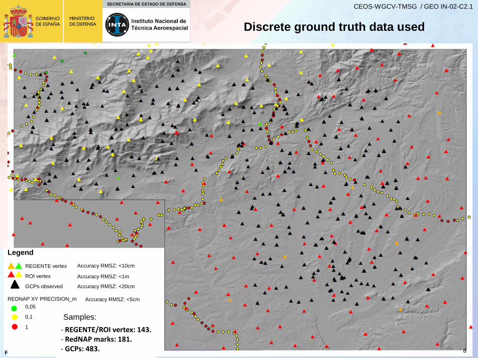
Discrete ground truth data used
Legend
REGENTE vertex
ROI vertex
GCPs observed
REDNAP XY PRECISION_m 0,05
0,1
1 - REGENTE/ROI vertex: 143. - RedNAP marks: 181. - GCPs: 483.
Accuracy RMSZ: <10cm
Accuracy RMSZ: <1m
Accuracy RMSZ: <20cm
Accuracy RMSZ: <5cm
Samples:
Feb 2014
CEOS-WGCV-TMSG / GEO IN-02-C2.1
9
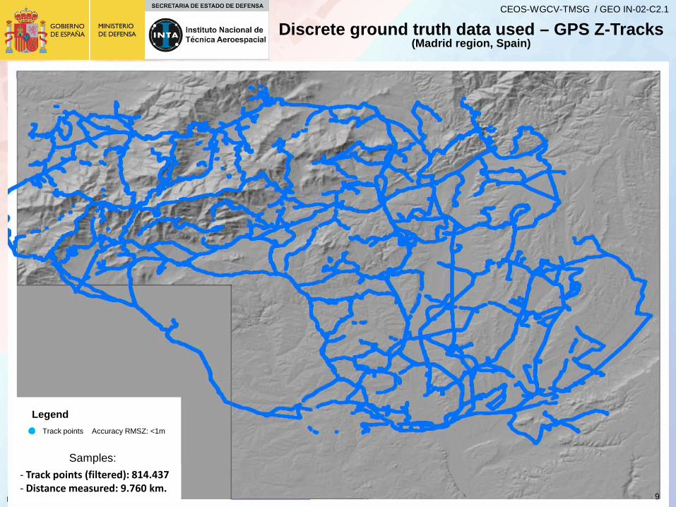
Discrete ground truth data used – GPS Z-Tracks (Madrid region, Spain)
Legend
- Track points (filtered): 814.437 - Distance measured: 9.760 km.
Track points Accuracy RMSZ: <1m
Samples:
Feb 2014
CEOS-WGCV-TMSG / GEO IN-02-C2.1
10
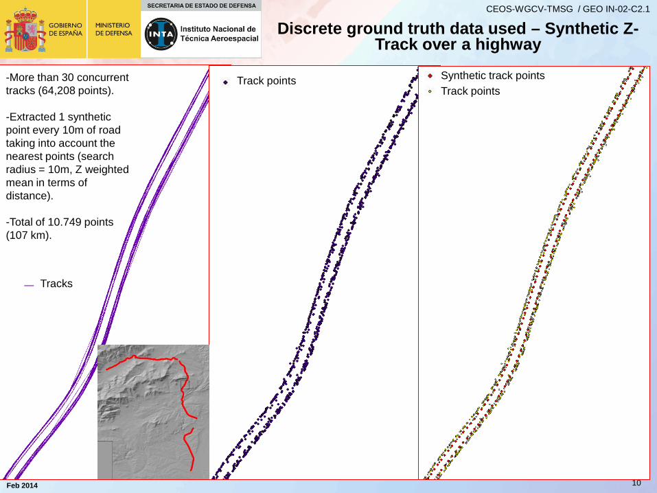
Tracks
Track points Track points Synthetic track points -More than 30 concurrent
tracks (64,208 points). -Extracted 1 synthetic point every 10m of road taking into account the nearest points (search radius = 10m, Z weighted mean in terms of distance). -Total of 10.749 points (107 km).
Discrete ground truth data used – Synthetic Z-Track over a highway
Feb 2014
CEOS-WGCV-TMSG / GEO IN-02-C2.1
11
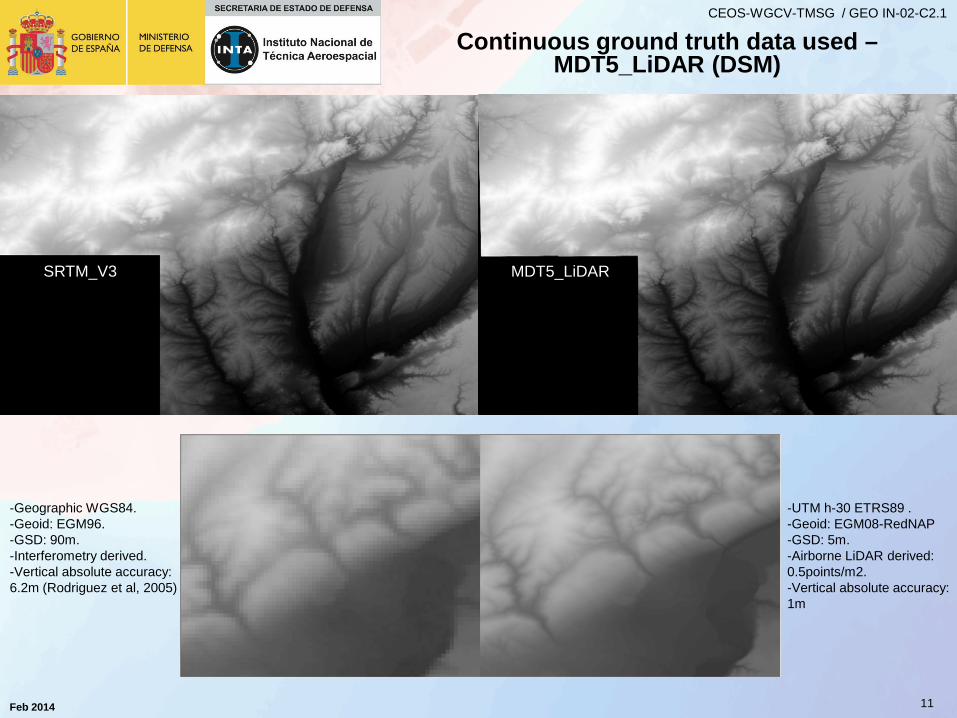
Continuous ground truth data used – MDT5_LiDAR (DSM)
SRTM_V3 MDT5_LiDAR
-UTM h-30 ETRS89 . -Geoid: EGM08-RedNAP -GSD: 5m. -Airborne LiDAR derived: 0.5points/m2. -Vertical absolute accuracy: 1m
-Geographic WGS84. -Geoid: EGM96. -GSD: 90m. -Interferometry derived. -Vertical absolute accuracy: 6.2m (Rodriguez et al, 2005)
Feb 2014
CEOS-WGCV-TMSG / GEO IN-02-C2.1
12
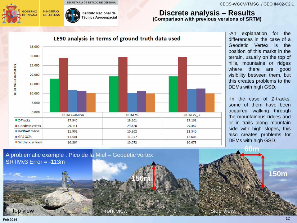
Discrete analysis – Results (Comparison with previous versions of SRTM)
-An explanation for the differences in the case of a Geodetic Vertex is the position of this marks in the terrain, usually on the top of hills, mountains or ridges where there are good visibility between them, but this creates problems to the DEMs with high GSD.
-In the case of Z-tracks, some of them have been acquired walking through the mountainous ridges and or in trails along mountain side with high slopes, this also creates problems for DEMs with high GSD.
A problematic example : Pico de la Miel – Geodetic vertex SRTMv3 Error = -113m
150m
60m
Side view Front view Top view
150m
Feb 2014
CEOS-WGCV-TMSG / GEO IN-02-C2.1
13
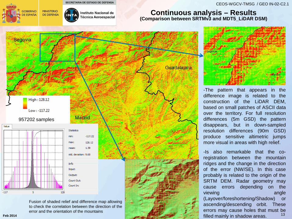
Continuous analysis – Results (Comparison between SRTMv3 and MDT5_LiDAR DSM)
-The pattern that appears in the difference image is related to the construction of the LiDAR DEM, based on small patches of ASCII data over the territory. For full resolution differences (5m GSD) the pattern disappears, but in down-sampled resolution differences (90m GSD) produce sensitive altimetric jumps more visual in areas with high relief.
-Is also remarkable that the co-registration between the mountain ridges and the change in the direction of the error (NW/SE). In this case probably is related to the origin of the SRTM DEM. Radar geometry may cause errors depending on the viewing angle (Layover/foreshortening/Shadow) or ascending/descending orbit. These errors may cause holes that must be filled mainly in shadow areas.
957202 samples
Fusion of shaded relief and difference map allowing to check the correlation between the direction of the error and the orientation of the mountains
Feb 2014
CEOS-WGCV-TMSG / GEO IN-02-C2.1
14
CONCLUSIONS
-The use of different sources of ground truth allows us to approximate to the real accuracy of the DEMs.
-Each particular ground truth has their own restrictions in relation to the actual relief and the GSD of the DEM. A more in depth study must be carried out to evaluate the real accuracy of the DEMs in very complex areas and in relation to its building origin.
-Traditionally, ground truth sources avoid the use of measurements in high relief areas (difficult access). A complete validation must take into account all the natural scenarios available in a validation area in terms of make realistic validation of DEMs.
-SRTM v3 in the AOI of Madrid doesn´t show remarkable improvements with respect to its predecessor SRTM V2_1. Mainly because there are few holes interpolated in the area with the source GDEMv2 and other sources.
-The accuracy over high relief areas can be degraded up to 3 times the accuracy over flat areas in the case of SRTMv3. (see Synthetic Z-track vs Geodetic vertex ground truth sources).
TanDEM-X: Science Activities Irena Hajnsek1/2 and Thomas Busche1 1 Microwaves and Radar Institute, DLR 2 Institute of Environmental Engineering, ETH Oberpfaffenhofen, Feb 2014
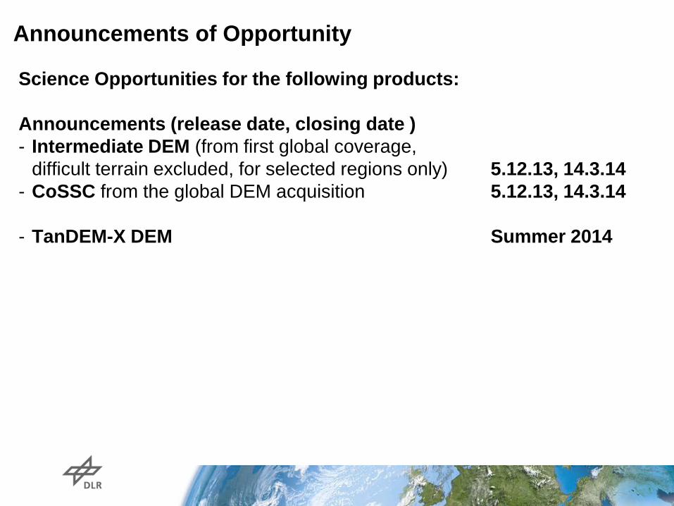
Announcements of Opportunity
Science Opportunities for the following products: Announcements (release date, closing date ) - Intermediate DEM (from first global coverage,
difficult terrain excluded, for selected regions only) 5.12.13, 14.3.14 - CoSSC from the global DEM acquisition 5.12.13, 14.3.14 - TanDEM-X DEM Summer 2014
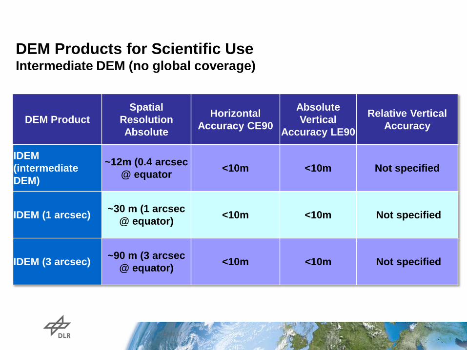
DEM Products for Scientific Use Intermediate DEM (no global coverage)
Slide 17
DEM Product Spatial
Resolution Absolute
Horizontal Accuracy CE90
Absolute Vertical
Accuracy LE90
Relative Vertical Accuracy
IDEM (intermediate DEM)
~12m (0.4 arcsec @ equator <10m <10m Not specified
IDEM (1 arcsec) ~30 m (1 arcsec @ equator) <10m <10m Not specified
IDEM (3 arcsec) ~90 m (3 arcsec @ equator) <10m <10m Not specified
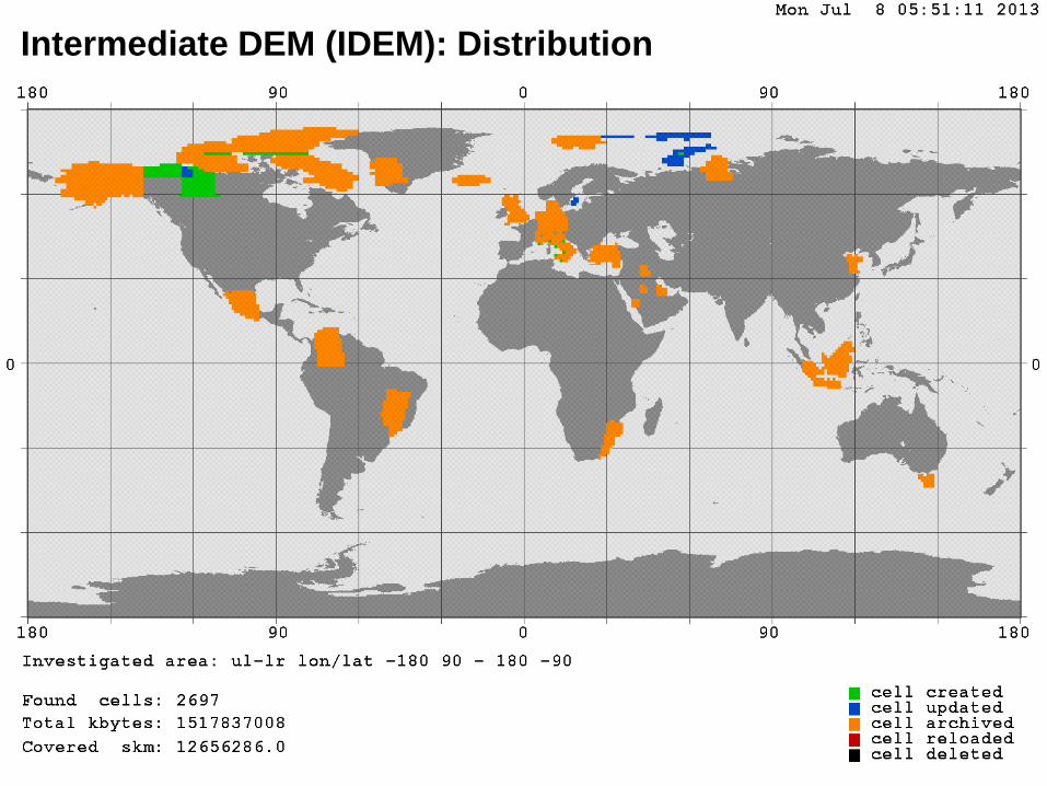
Intermediate DEM (IDEM): Distribution
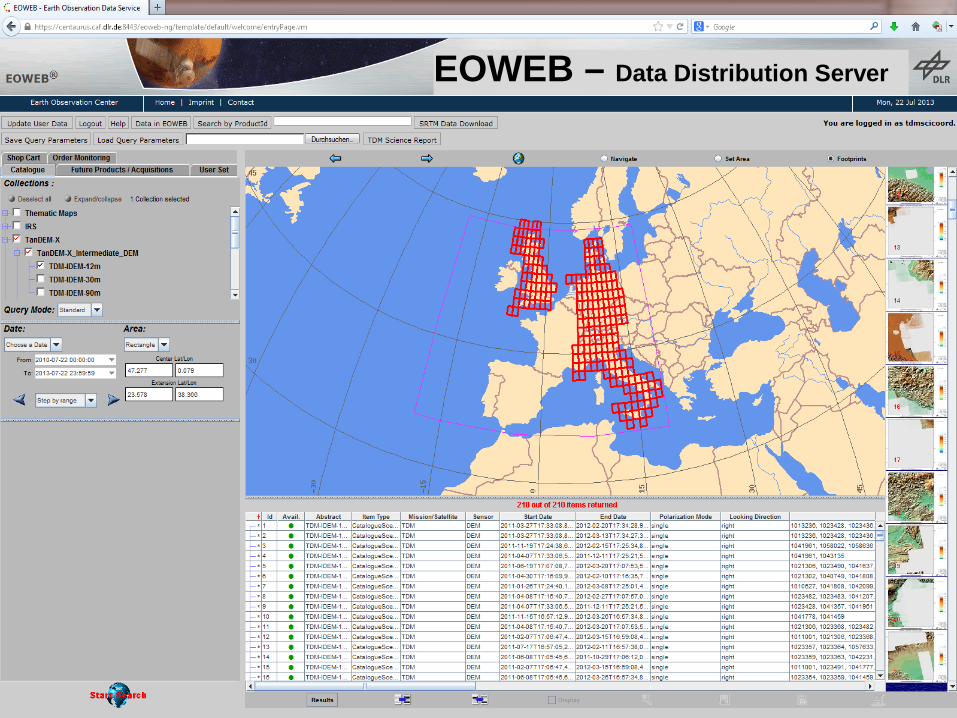
EOWEB – Data Distribution Server
Slide 20
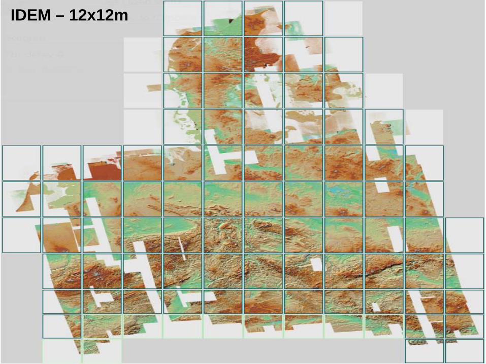
IDEM – 12x12m
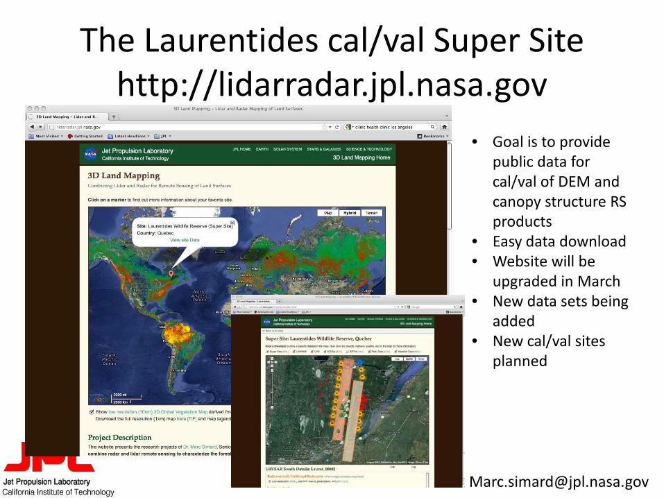
The Laurentides cal/val Super Site http://lidarradar.jpl.nasa.gov
• Goal is to provide public data for cal/val of DEM and canopy structure RS products
• Easy data download • Website will be
upgraded in March • New data sets being
added • New cal/val sites
planned
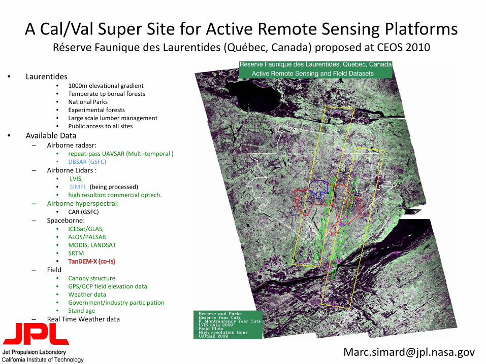
A Cal/Val Super Site for Active Remote Sensing Platforms Réserve Faunique des Laurentides (Québec, Canada) proposed at CEOS 2010
• Laurentides • 1000m elevational gradient • Temperate tp boreal forests • National Parks • Experimental forests • Large scale lumber management • Public access to all sites
• Available Data – Airborne radasr:
• repeat-pass UAVSAR (Multi-temporal ) • DBSAR (GSFC)
– Airborne Lidars : • LVIS, • SIMPL (being processed) • high resoltion commercial optech.
– Airborne hyperspectral: • CAR (GSFC)
– Spaceborne: • ICESat/GLAS, • ALOS/PALSAR • MODIS, LANDSAT • SRTM
– Field • Canopy structure • GPS/GCP field elevation data • Weather data • Government/industry participation • Stand age
– Real Time Weather data
1000m
500m
0m
NASADEM Objectives Buckley, Simard, Crippen, Hensley, Kobrick, Rosen, +
1. Reprocess SRTM data from raw sensor measurements with several enhancements to the original processing algorithms and including an integrated ICESat control to produce an SRTM DEM with improved spatial resolution, vertical accuracy and geographic coverage
2. Fill voids and merge the new SRTM DEM with ASTER/GDEM2 and ICESat control to create a spatially continuous global one-arcsecond DEM product
3. Create new SRTM- and DEM-related products such as pixel-based elevation error propagated from SRTM system parameters; estimated vegetation bias maps; radar backscatter imagery; interferometric coherence; and DEM slope, aspect and curvature
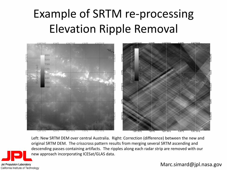
Example of SRTM re-processing Elevation Ripple Removal
Left: New SRTM DEM over central Australia. Right: Correction (difference) between the new and original SRTM DEM. The crisscross pattern results from merging several SRTM ascending and descending passes containing artifacts. The ripples along each radar strip are removed with our new approach incorporating ICESat/GLAS data.
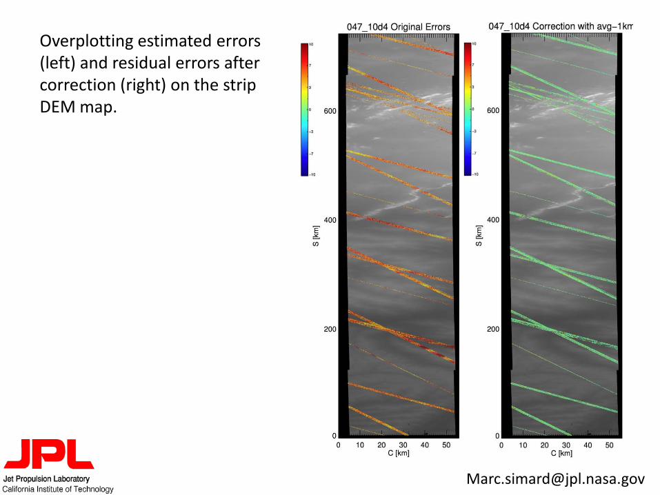
Overplotting estimated errors (left) and residual errors after correction (right) on the strip DEM map.
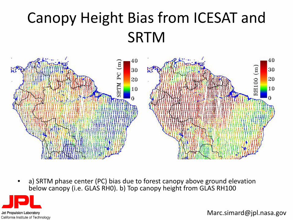
Canopy Height Bias from ICESAT and SRTM
• a) SRTM phase center (PC) bias due to forest canopy above ground elevation below canopy (i.e. GLAS RH0). b) Top canopy height from GLAS RH100
DICA, Laboratorio di Geomatica del Polo Territoriale di Como
Merging of regional DTMs: the HELI-DEM project, problems and solutions
Ph.D supervisor: Ludovico Biagi Ph.D tutor: Sansò Fernando
Ph.D student: Laura Carcano
DIIAR, Laboratorio di Geomatica del Polo Territoriale di Como
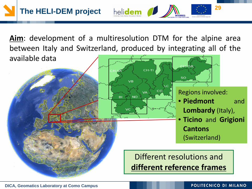
29 29 The HELI-DEM project
Aim: development of a multiresolution DTM for the alpine area between Italy and Switzerland, produced by integrating all of the available data
Regions involved: • Piedmont and
Lombardy (Italy), • Ticino and Grigioni
Cantons (Switzerland)
Different resolutions and different reference frames
DICA, Geomatics Laboratory at Como Campus
DIIAR, Laboratorio di Geomatica del Polo Territoriale di Como
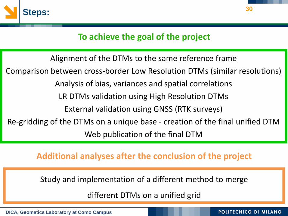
Alignment of the DTMs to the same reference frame
Comparison between cross-border Low Resolution DTMs (similar resolutions)
Analysis of bias, variances and spatial correlations
LR DTMs validation using High Resolution DTMs
External validation using GNSS (RTK surveys)
Re-gridding of the DTMs on a unique base - creation of the final unified DTM
Web publication of the final DTM
To achieve the goal of the project
Steps:
Study and implementation of a different method to merge
different DTMs on a unified grid
Additional analyses after the conclusion of the project
30
DICA, Geomatics Laboratory at Como Campus
DIIAR, Laboratorio di Geomatica del Polo Territoriale di Como
31
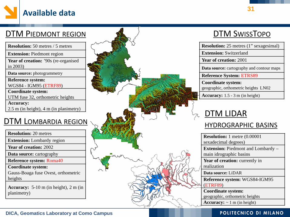
DTM PIEDMONT REGION
DTM LOMBARDIA REGION LOMBARDIA
Resolution: 50 metres / 5 metres
Extension: Piedmont region
Year of creation: ’90s (re-organised in 2003) Data source: photogrammetry Reference system: WGS84 - IGM95 (ETRF89) Coordinate system: UTM fuse 32, orthometric heights Accuracy: 2.5 m (in height), 4 m (in planimetry)
Resolution: 20 metres
Extension: Lombardy region Year of creation: 2002 Data source: cartography Reference system: Roma40 Coordinate system: Gauss-Boaga fuse Ovest, orthometric heights
Accuracy: 5-10 m (in height), 2 m (in planimetry)
DTM SWISSTOPO Resolution: 25 metres (1” sexagesimal) Extension: Switzerland
Year of creation: 2001
Data source: cartography and contour maps
Reference System: ETRS89
Coordinate system: geographic, orthometric heights LN02
Accuracy: 1.5 - 3 m (in height)
DTM LIDAR HYDROGRAPHIC BASINS Resolution: 1 metre (0.00001 sexadecimal degrees) Extension: Piedmont and Lombardy – main idrographic basins Year of creation: currently in realization Data source: LiDAR Reference system: WGS84-IGM95 (ETRF89) Coordinate system: geographic, orthometric heights Accuracy: ~ 1 m (in height)
Available data
DICA, Geomatics Laboratory at Como Campus
DIIAR, Laboratorio di Geomatica del Polo Territoriale di Como
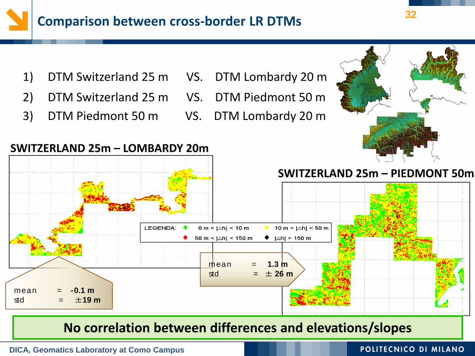
DTM Switzerland 25 m VS. DTM Lombardy 20 m 1)
DTM Switzerland 25 m VS. DTM Piedmont 50 m 2) DTM Piedmont 50 m VS. DTM Lombardy 20 m 3)
SWITZERLAND 25m – LOMBARDY 20m
SWITZERLAND 25m – PIEDMONT 50m
mean = -0.1 m std = ±19 m
mean = 1.3 m std = ± 26 m
No correlation between differences and elevations/slopes
32
DICA, Geomatics Laboratory at Como Campus
Comparison between cross-border LR DTMs
DIIAR, Laboratorio di Geomatica del Polo Territoriale di Como
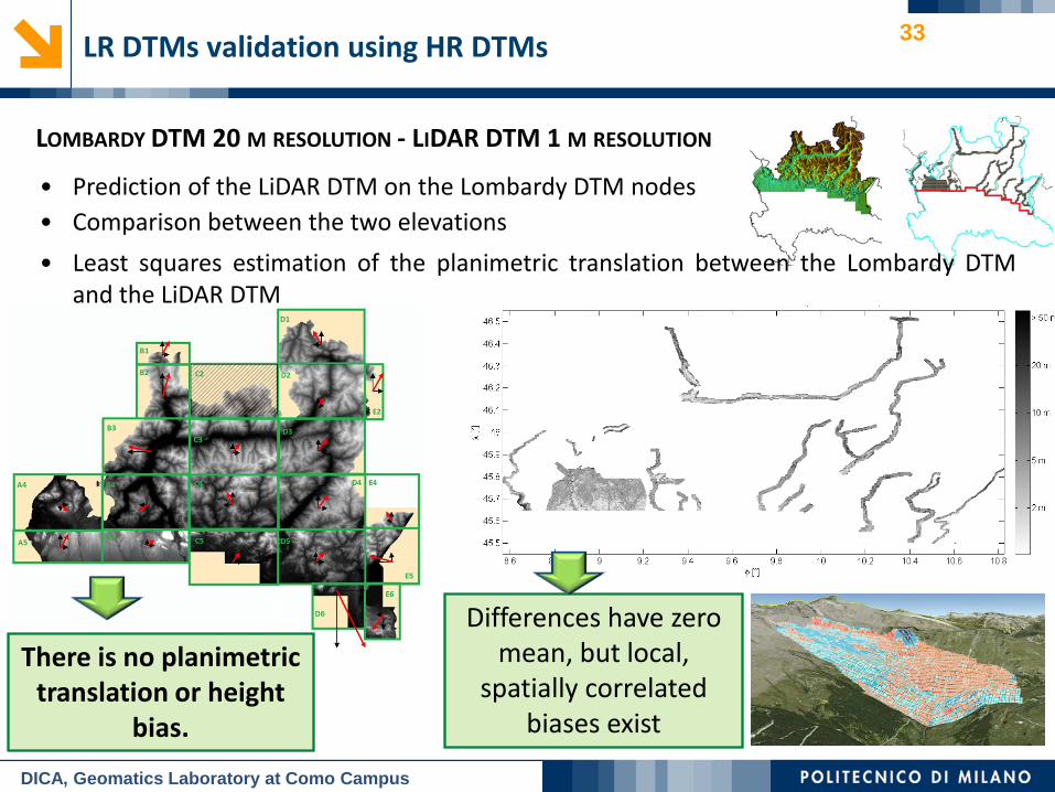
• Prediction of the LiDAR DTM on the Lombardy DTM nodes • Comparison between the two elevations
There is no planimetric translation or height
bias.
LOMBARDY DTM 20 M RESOLUTION - LIDAR DTM 1 M RESOLUTION
• Least squares estimation of the planimetric translation between the Lombardy DTM and the LiDAR DTM
33
DICA, Geomatics Laboratory at Como Campus
LR DTMs validation using HR DTMs
Differences have zero mean, but local,
spatially correlated biases exist
DIIAR, Laboratorio di Geomatica del Polo Territoriale di Como
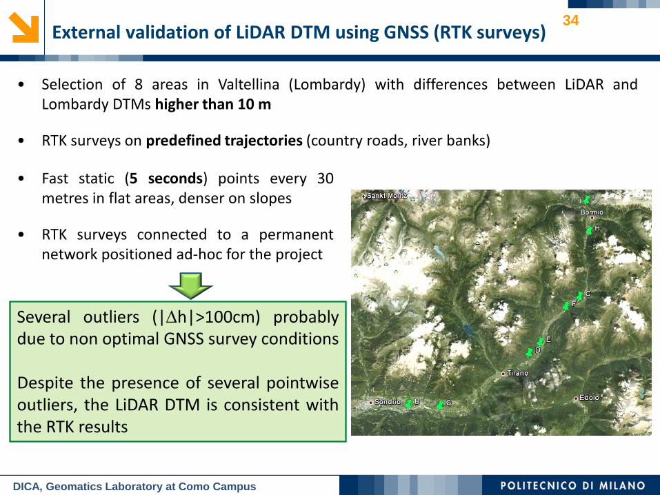
• Selection of 8 areas in Valtellina (Lombardy) with differences between LiDAR and Lombardy DTMs higher than 10 m
• RTK surveys on predefined trajectories (country roads, river banks)
34
DICA, Geomatics Laboratory at Como Campus
External validation of LiDAR DTM using GNSS (RTK surveys)
Several outliers (|∆h|>100cm) probably due to non optimal GNSS survey conditions Despite the presence of several pointwise outliers, the LiDAR DTM is consistent with the RTK results
• Fast static (5 seconds) points every 30 metres in flat areas, denser on slopes
• RTK surveys connected to a permanent network positioned ad-hoc for the project
DIIAR, Laboratorio di Geomatica del Polo Territoriale di Como
35 Creation of the final unified DTM
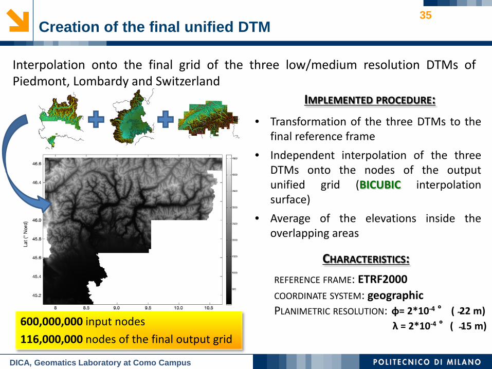
Interpolation onto the final grid of the three low/medium resolution DTMs of Piedmont, Lombardy and Switzerland
DICA, Geomatics Laboratory at Como Campus
600,000,000 input nodes
116,000,000 nodes of the final output grid
• Transformation of the three DTMs to the final reference frame
• Independent interpolation of the three DTMs onto the nodes of the output unified grid (BICUBIC interpolation surface)
• Average of the elevations inside the overlapping areas
IMPLEMENTED PROCEDURE:
REFERENCE FRAME: ETRF2000 COORDINATE SYSTEM: geographic
φ= 2*10-4 ° ( ̴22 m) λ = 2*10-4 °( ̴15 m)
PLANIMETRIC RESOLUTION:
CHARACTERISTICS:
DIIAR, Laboratorio di Geomatica del Polo Territoriale di Como
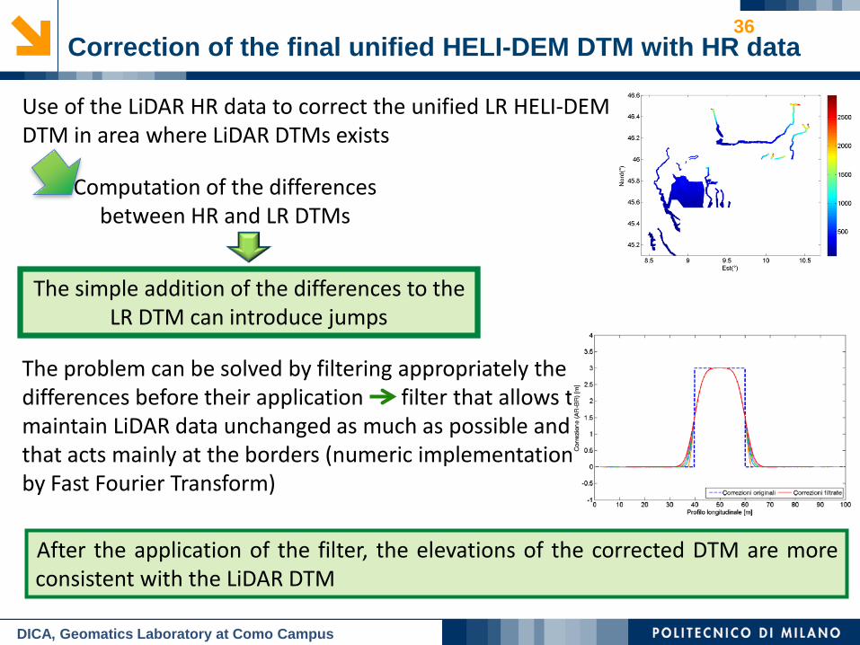
36 Correction of the final unified HELI-DEM DTM with HR data
The simple addition of the differences to the LR DTM can introduce jumps
Computation of the differences between HR and LR DTMs
Use of the LiDAR HR data to correct the unified LR HELI-DEM DTM in area where LiDAR DTMs exists
DICA, Geomatics Laboratory at Como Campus
The problem can be solved by filtering appropriately the differences before their application filter that allows to maintain LiDAR data unchanged as much as possible and that acts mainly at the borders (numeric implementation by Fast Fourier Transform)
After the application of the filter, the elevations of the corrected DTM are more consistent with the LiDAR DTM
DIIAR, Laboratorio di Geomatica del Polo Territoriale di Como
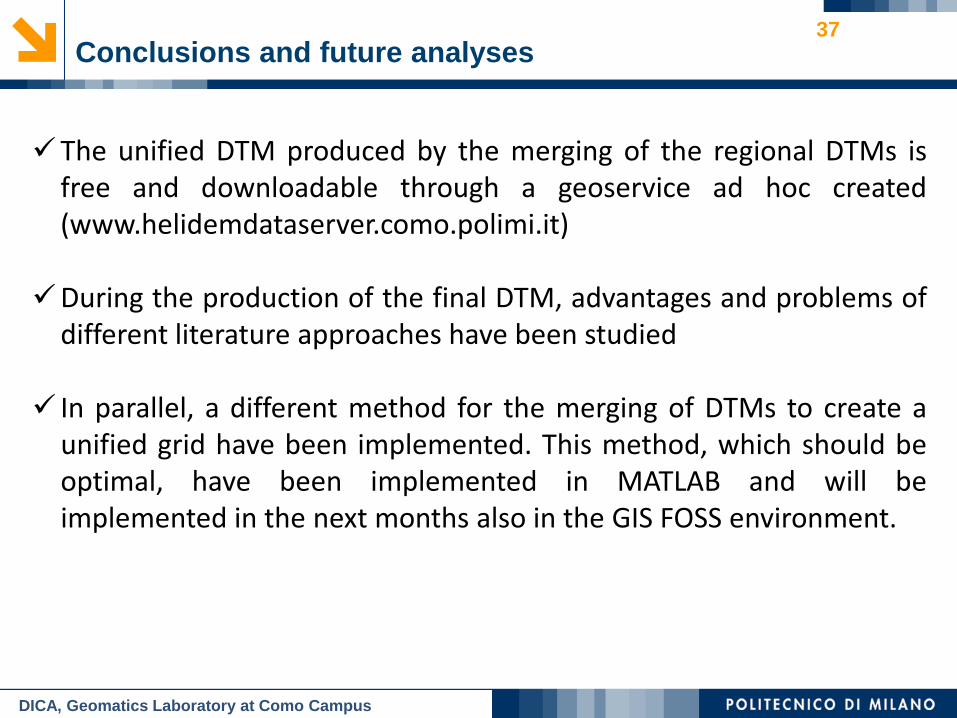
37 Conclusions and future analyses
The unified DTM produced by the merging of the regional DTMs is free and downloadable through a geoservice ad hoc created (www.helidemdataserver.como.polimi.it)
During the production of the final DTM, advantages and problems of different literature approaches have been studied
In parallel, a different method for the merging of DTMs to create a unified grid have been implemented. This method, which should be optimal, have been implemented in MATLAB and will be implemented in the next months also in the GIS FOSS environment.
DICA, Geomatics Laboratory at Como Campus
MSSL/DEPARTMENT OF SPACE & CLIMATE PHYSICS
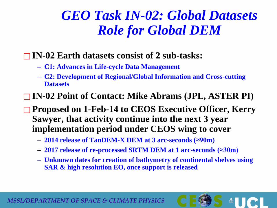
GEO Task IN-02: Global Datasets Role for Global DEM
IN-02 Earth datasets consist of 2 sub-tasks: – C1: Advances in Life-cycle Data Management – C2: Development of Regional/Global Information and Cross-cutting
Datasets
IN-02 Point of Contact: Mike Abrams (JPL, ASTER PI) Proposed on 1-Feb-14 to CEOS Executive Officer, Kerry
Sawyer, that activity continue into the next 3 year implementation period under CEOS wing to cover
– 2014 release of TanDEM-X DEM at 3 arc-seconds (≈90m) – 2017 release of re-processed SRTM DEM at 1 arc-seconds (≈30m) – Unknown dates for creation of bathymetry of continental shelves using
SAR & high resolution EO, once support is released
MSSL/DEPARTMENT OF SPACE & CLIMATE PHYSICS
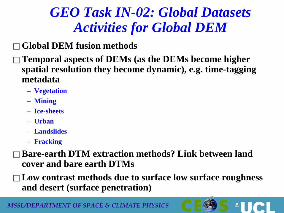
GEO Task IN-02: Global Datasets Activities for Global DEM
Global DEM fusion methods Temporal aspects of DEMs (as the DEMs become higher
spatial resolution they become dynamic), e.g. time-tagging metadata
– Vegetation – Mining – Ice-sheets – Urban – Landslides – Fracking
Bare-earth DTM extraction methods? Link between land cover and bare earth DTMs
Low contrast methods due to surface low surface roughness and desert (surface penetration)
MSSL/DEPARTMENT OF SPACE & CLIMATE PHYSICS
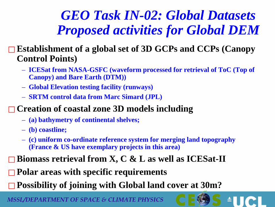
GEO Task IN-02: Global Datasets Proposed activities for Global DEM
Establishment of a global set of 3D GCPs and CCPs (Canopy Control Points)
– ICESat from NASA-GSFC (waveform processed for retrieval of ToC (Top of Canopy) and Bare Earth (DTM))
– Global Elevation testing facility (runways) – SRTM control data from Marc Simard (JPL)
Creation of coastal zone 3D models including – (a) bathymetry of continental shelves; – (b) coastline; – (c) uniform co-ordinate reference system for merging land topography
(France & US have exemplary projects in this area)
Biomass retrieval from X, C & L as well as ICESat-II Polar areas with specific requirements Possibility of joining with Global land cover at 30m?
MSSL/DEPARTMENT OF SPACE & CLIMATE PHYSICS
Global DEM for continental shelves and coastal zones: a new GEO sub-task EO visible/near-IR data can be employed to derive
bathymetry for shallow water with low turbidity for depths up to 30m
Turbidity is mapped from ocean colour sensors such as the ESA MERIS and could be used to decide when higher resolution systems such as Landsat-8 or Sentinel-2 could be employed to map water depth
EO SAR high resolution (1-3m) data can be employed to map how swell-wave patterns are transformed and these SAR amplitude images can then be inverted to provide bathymetry as demonstrated by Susanne Lehner and colleagues at DLR/OP
Coastal zones, particularly those with wetlands are extremely difficult to map. Work needs to focus on use of higher resolution VIS/NIR and SAR
MSSL/DEPARTMENT OF SPACE & CLIMATE PHYSICS
Recommendation to CEOS Plenary: Bathymetry from Space
CEOS should encourage its constituent space agencies to provide EO data for TMSG to establish Global test sites for assessing the accuracy and reliability of retrieving continental-shelf bathymetry on 30m grids from EO sensors over sites which are (a) clearwater; (b) turbid water
Existing bathymetry is either non-existent or copyright-bound. Bathymetry is required for retrieval of water-leaving radiance and derived products in Case II waters. Bathymetry also required for modelling tsunami landfall
Endorsement is required to enable TMSG to move forward with a plan to set-up and populate these test sites
Request that CEOS space agencies supply data (e.g. high resolution multispectral visible/NIR, very high resolution SAR (TSX, Cosmo-SkyMEd, Radarsat-2, NASA-NOAA SHOALS) that could be employed to evaluate different approaches for mapping continental shelves
Related Documents