CentropeMAP und CentropeSTATISTICS Grenzüberschreitende Geoinfrastruktur gemäß INSPIRE-Richtlinie Im Auftrag der Planungsgemeinschaft Ost (PGO) Manfred Schrenk* Clemens Beyer* Christian Eizinger* W lt P k** Walter Pozarek** * CEIT ALANOVA Central European Institute of Technology, Dept. for Urbanism, Transport, Environment & Information Society Schwechat, http://www.ceit.at/ ** PLANUNGSGEMEINSCHAFT OST, Wien, http://www.planungsgemeinschaft-ost.at/

Welcome message from author
This document is posted to help you gain knowledge. Please leave a comment to let me know what you think about it! Share it to your friends and learn new things together.
Transcript

CentropeMAP und CentropeSTATISTICSGrenzüberschreitende Geoinfrastruktur gemäß INSPIRE-Richtlinie
Im Auftrag derPlanungsgemeinschaft Ost (PGO)
Manfred Schrenk*Clemens Beyer*Christian Eizinger*W lt P k**Walter Pozarek**
* CEIT ALANOVACentral European Institute of Technology, p gy,Dept. for Urbanism, Transport, Environment & Information SocietySchwechat, http://www.ceit.at/
** PLANUNGSGEMEINSCHAFT OST,Wien, http://www.planungsgemeinschaft-ost.at/

I Die Centrope-RegionI. Die Centrope Region
II. CentropeMAP
III. CentropeSTATISTICS
IV T h i h U tIV. Technische Umsetzung
V. ZukunftsaussichtenV. Zukunftsaussichten

CENTROPE-Region
• RegionRegionÖsterreichTschechische RepublikUUngarnSlowakische Republik
•

CENTROPE-Partnerregionen
• Tschechische RepublikGebietskörperschaft:Gebietskörperschaft:Südmähren (Jihomoravsky)Stadt: BrnoInteressiert: Olomouc
• Slowakische RepublikGebietskörperschaften:Bratislava, TrnavaStädte: Bratislava, Trnava
Ungarn• UngarnGebietskörperschaft: Györ-Moson-SopronStädte: Györ, Sopron
• ÖsterreichGebietskörperschaften: Burgenland, Niederösterreich, WienStädte: Eisenstadt St Pölten WienStädte: Eisenstadt, St. Pölten, WienInteressiert: Wiener Neustadt

CENTROPE-Region
Bevölkerung6 Millionen
Wirtschaft3 8 Mio Beschäftigte6 Millionen
davon 3 Millionen in Städten3,8 Mio Beschäftigte55 – 65 % Beschäftigte im DientleistungssektorA b it l t i h 4 d 14 %Arbeitslosenrate zwischen 4 und 14 %BIP-Wachstum zwischen 0,8 % und3,6 % seit 2003
Infrastruktur3 internationale Flughäfen (Brno, Bratislava, Wien)Bratislava, Wien)2 Donauhäfen (Wien, Bratislava)pan-europäische Korridore
(Q: Wikipedia)(Q: Wikipedia)

Politische Deklaration von Kittsee, 2003
+ politisches Memorandum St. Pölten, 2005

CENTROPE-Region
Hauptzielsetzungeninternationale Attraktivitätnachhaltige Integrationnachhaltige IntegrationStandort mit hoher Lebensqualitätprofessionelle Zusammenarbeit
Träger der Regionmultilaterale Centrope Plattformmultilaterale Centrope-Plattformmultilaterales Centrope-Gremiumnationale Centrope-FührungskomiteesCl b C tClub Centrope

I Die Centrope-RegionI. Die Centrope Region
II. CentropeMAP
III. CentropeSTATISTICS
IV T h i h U tIV. Technische Umsetzung
V. ZukunftsaussichtenV. Zukunftsaussichten

Herausforderungen
Herausforderungen bei CentropeMAP
Rechtliche Planungszuständigkeit auf unterschiedlichen Ebenenunterschiedlichen Ebenen
Verantwortung für Datenbestände ebenfalls auf unterschiedlichen Ebenenunterschiedlichen Ebenen
Verwaltungsgrenzen = Datengrenzen
Es gibt keine gemeinsame Dateninfrastruktur, sondern nur isolierte Datenbestände.

Projektansatz
CentropeMAP ist ein Prozess, kein Einzelprojekt – ein ständiger grenzüberschreitender Austausch von planungsrelevanter Information, von dem alle Partner profitierenalle Partner profitieren.
CentropeMAP erzeugt keine neuen Daten, sondern betreibt die Integration, St kt i d H i i i ti d D t b tä d diStrukturierung und Harmonisierung existierender Datenbestände, die von den jeweiligen Partnern zur Verfügung gestellt werden.
Die Qualität der CentropeMAP-Inhalte hängt nur von der Qualität und Aktua-lität der von den Partnern zur Verfügung gestellten Datenbestände ab.
CentropeMAP ist ein offenes System, die CentropeMAP-Daten können auch in externen Anwendungen über OGC-konforme WMS zum Einsatz gelangen.
Im Vergleich mit anderen WMS-Angeboten im Internet gibt es kein anderes Portal, das einen derartigen Fachdatenumfang bietet!
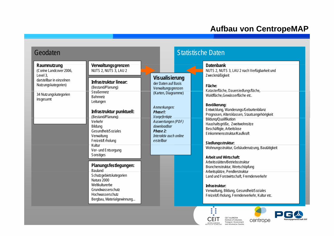
Aufbau von CentropeMAP
Geodaten Statistische DatenRa mn t ng Ver alt ngsgren en Datenbank Raumnutzung(Corine Landcover 2006,Level 3,darstellbar in einzelnen Nutzungskategorien) Infrastruktur linear:
(Bestand/Planung)Straßennet
VerwaltungsgrenzenNUTS 2, NUTS 3, LAU 2
Datenbank NUTS 2, NUTS 3, LAU 2 nach Verfügbarkeit und Zweckmäßigkeit
Fläche:Katasterfläche Dauersiedlungsfläche
Visualisierungder Daten auf Basis Verwaltungsgrenzen
34 Nutzungskategorien insgesamt
StraßennetzBahnnetzLeitungen
Infrastruktur punktuell:(Bestand/Planung)
Katasterfläche, Dauersiedlungsfläche,Waldfläche,Gewässerfläche etc.
Bevölkerung:Entwicklung, Wanderungs/GeburtenbilanzPrognosen, Altersklassen, StaatsangehörigkeitBild /Q lifik ti
(Karten, Diagramme)
Anmerkungen:Phase1:Vorgefertigte (Bestand/Planung)
VerkehrBildungGesundheit/SozialesVerwaltungFreizeit/ErholungKultur
Bildung/QualifikationHaushaltsgröße, ZweitwohnsitzeBeschäftigte, ArbeitsloseEinkommensstruktur/Kaufkraft
Siedlungsstruktur:
Vorgefertigte Auswertungen (PDF) downloadbarPhase 2:Interaktiv auch online erstellbar
KulturVer- und EntsorgungSonstiges
Planungsfestlegungen:Bauland
gWohnungsstruktur, Gebäudenutzung, Bautätigkeit
Arbeit und Wirtschaft:Arbeitsstätten/BetriebsstrukturBranchenstruktur, WertschöpfungArbeitsplätze PendlerstrukturBauland
SchutzgebietskategorienNatura 2000WeltkulturerbeGrundwasserschutzHochwasserschutzBergba Materialge inn ng
Arbeitsplätze, PendlerstrukturLand und Forstwirtschaft, Fremdenverkehr
Infrastruktur:Verwaltung, Bildung, Gesundheit/SozialesFreizeit/Erholung, Fremdenverkehr, Kultur etc.
Bergbau, Materialgewinnung...

CentropeMAP-Internetportal
Daten kommen direkt von Projektpartnern j pkeine Redundanz, immer aktuellFunktionen: Zoom, ,Verschieben, Suchen, Messen, Mitteilen (Tell-A-Friend)hunderte Layer für Gesamtregion und TeilregionengHintergrundkarten reichen von einfacher Darstellung bis hin zu ghochauflösenden Satellitenbildern und OrthophotosKarten werden live erzeugt

Beispiele
Höhenmodell, Straßen- und Bahnnetz, Stadtgebiete, Gewässer (Trnava, SK)

Beispiele
Hochauflösendes Orthophoto, Naturschutzgebiete (Znojmo, CZ)

Beispiele
städtische Struktur, Gewässer, hochwassergefährdete Gebiete, Grundwasserhochstandsgebiete (<2m). (Donauraum, Niederösterreich)

Beispiele
Corine Land Cover Level 2 (Region Neusiedler See, Burgenland/Ungarn)

Beispiele
Bauland (Wohnen/Gewerbe), Straßennetz (Krems, Niederösterreich)

I Die Centrope-RegionI. Die Centrope Region
II. CentropeMAP
III. CentropeSTATISTICS
IV T h i h U tIV. Technische Umsetzung
V. ZukunftsaussichtenV. Zukunftsaussichten

Projektpartner
CentropeSTATISTICS ist ein grenzüberschreitendes Datenbankprojekt folgender Statistikstellen in der Centrope-Region(im Auftrag der PGO - Planungsgemeinschaft Ost,technische Umsetzung durch CEIT ALANOVA gemeinnützige GmbH)
• Tschechische Republik:CZSO - Czech Statistical Office – Český statistický úřad (ČSÚ)
• Slowakische Republik:Statistical Office of the SR – Štatistický úrad Slovenskej republiky
U• Ungarn:HCSO - Hungarian Central Statistical Office – KSH - Központi Statisztikai Hivatal
• Österreich:St ti tik bt il d Ä t d L d i B l dStatistikabteilungen der Ämter der Landesregierungen von Burgenland, Niederösterreich und Wien
Workshops:Workshops:September 2008 in Schwechat, März 2009 in Schwechat,September 2009 in Brno,Juni 2010 in Schwechat,Dezember 2010 in Schwechat

Herausforderungen bei CentropeSTATISTICS
Entwicklung einer Raum-Zeit-Matrix für AttributdatenWelche Daten für welche Region? Aktualität? Klassifikation?
Definition eines Attributkataloges für die meistverlangten DatenklassenDatenklassen
Demographie, Migration erste Datengruppe, online seit 2010Wirtschaft, HaushaltseinkommenPendler- und VerkehrsstatistikUmweltindikatoren, ...
Hauptaufgabe: Überwindung der Sprachbarriere (hierbei hilft auch auptau gabe Übe du g de Sp ac ba e e ( e be aucdas CentropeMAP Online Dictionary, eine Datenbank mit Fachbegriffen aus Statistik und Planung, die von jedermann bearbeitet und ergänzt werden kann)bearbeitet und ergänzt werden kann)Zwei Modi: Basic Mode für Schnellabfragen, Expert Mode für detaillierte Analysen

CentropeSTATISTICS-Benutzerschnittstelle
•Funktionen:Anzeigen – Exportieren –Abfragen – Sortieren
•Alle verfügbaren Indikatoren sind angezeigtg g g
•Mehrfachauswahl möglich
•Ergebnisse werden als Tabelle angezeigt
•Dynamische Live-Datenbankabfrage
Kartenerzeugung on the fly

CentropeSTATISTICS-Benutzerschnittstelle
Kartenerzeugung on the fly

I Die Centrope-RegionI. Die Centrope Region
II. CentropeMAP
III. CentropeSTATISTICS
IV T h i h U tIV. Technische Umsetzung
V. ZukunftsaussichtenV. Zukunftsaussichten

Systemarchitektur
Web browser (thin client)
MapClientMAPBENDER
Application Server/Map Server [UMN]
CentropeSTATISTICS(PHP, Javascript)
Map Server [UMN]
WMS WFS WCSSLD
WMSWMS WFSWFS WCSWCSDistributed Services
Distributed DataDistributed Data

Technische Umsetzung
Statistikdatenunterschiedlicher
H k ftHerkunft
CentropeSTATISTICS
CentropeM SQL CentropeMAPCentrope CentropeMySQL Ce t opeCentrope
PostgresCentropeMapserver

Technische Umsetzung
Statistikdatenunterschiedlicher
H k ftHerkunft
CentropeSTATISTICS
CentropeM SQL CentropeMAPCentrope CentropeMySQL Ce t opeCentrope
PostgresCentropeMapserver

Technische Umsetzung
Statistikdatenunterschiedlicher
H k ftHerkunft
CentropeSTATISTICS
CentropeM SQL CentropeMAPCentrope CentropeMySQL Ce t opeCentrope
PostgresCentropeMapserver

Technische Umsetzung
Statistikdatenunterschiedlicher
H k ftHerkunft
CentropeSTATISTICS
CentropeM SQL CentropeMAPCentrope CentropeMySQL Ce t opeCentrope
PostgresCentropeMapserver
SLD für KartenerzeugungSLD für Kartenerzeugung

Open-Source-Software
Warum Open Source für CentropeMAP and CentropeSTATISTICS?Kein Problem mit Lizenzen/LizenzgebührenKein Problem mit Lizenzen/LizenzgebührenEs existiert bereits eine große Open-Source-Gemeinschaft im Bereich des Web MappingOpen-Source-Software wird in diesem Bereich schon lang verwendet und ist daher technisch ausgereiftNeue Softwareeigenschaften können aufgrund von Rückmeldungen undNeue Softwareeigenschaften können aufgrund von Rückmeldungen und Benutzerwünschen realisiert werdenEs ist auch möglich, eigene Softwareerweiterungen gemeinsam mit den Web-Mapping-Software-Entwicklern zu kreierenOGC (Open Geospatial Consortium) – Kompatibilität der verwendeten OS-Produkte, mitunter keine vollständige OGC-Kompatibilität vonOS Produkte, mitunter keine vollständige OGC Kompatibilität von proprietärer SoftwareMöglichkeit, ähnliche Installationen bei Projektpartnern in anderen Regionen nterstüt en nd Eigenent ickl ngen eiter gebenRegionen zu unterstützen und Eigenentwicklungen weiterzugeben

I Die Centrope-RegionI. Die Centrope Region
II. CentropeMAP
III. CentropeSTATISTICS
IV T h i h U tIV. Technische Umsetzung
V. ZukunftsaussichtenV. Zukunftsaussichten

Zukunftsaussichten
Geodateninfrastrukturen sind eingesamteuropäisches Thema!gesamteuropäisches Thema!
INSPIRE – Infrastructure for Spatial InformationINSPIRE Infrastructure for Spatial Informationin the European CommunityDie Infrastructure for Spatial Information in the European Community (INSPIRE) ist eineInitiative der europäischen Kommission mit dem Ziel, eine europäische Geodaten-Basismit integrierten raumbezogenen Informationsdiensten zu schaffenmit integrierten raumbezogenen Informationsdiensten zu schaffen.
Beispielprojekt Plan4allDatenharmonisierung und Zugang zuDatenharmonisierung und Zugang zuplanungsrelevanten Daten in Europahttp://www.plan4all.eu/
Benutzergenerierte Inhalte,OPEN-SOURCE-DATEN(Open Street Map, …)

Danke für Ihre Aufmerksamkeit!
www.centropemap.org
Kontakt:
Central European Institute of TechnologyCentral European Institute of TechnologyCEIT ALANOVA
Concorde Business Park 2/F2320 Schwechat2320 Schwechat
Österreich
c eizinger@ceit [email protected]
www.ceit.at
Related Documents


![PublishingPlanetaryMapsusingOpenStandardsandOpenSourceSoftware · MapServer [5] is a popular open source project whose purpose is to display dynamic spatial maps over the Internet.](https://static.cupdf.com/doc/110x72/5f4bf23a7c11ae244b2a3099/publishingplanetarymapsusingopenstandardsando-mapserver-5-is-a-popular-open-source.jpg)


