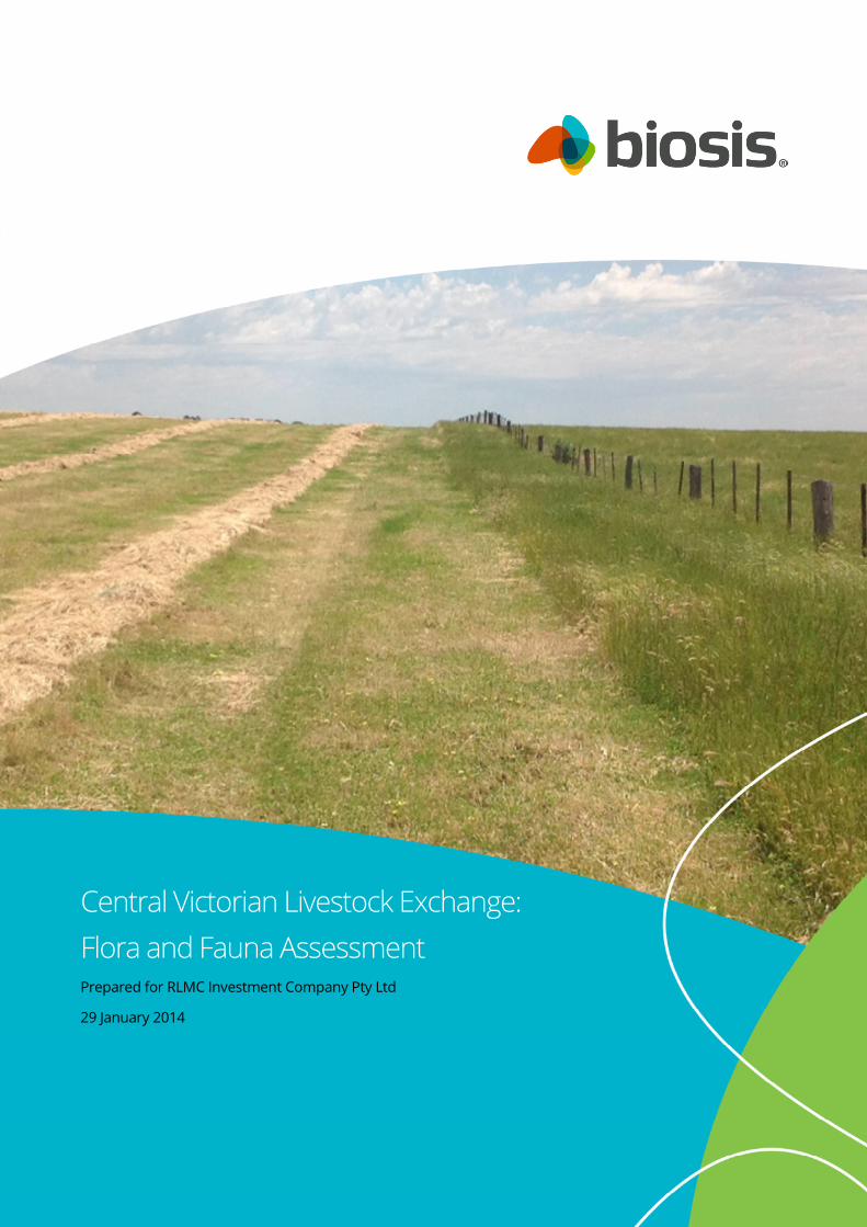
© Biosis September 2012 – Leading ecology and heritage consultants 1 Central Victorian Livestock Exchange: Flora and Fauna Assessment Prepared for RLMC Investment Company Pty Ltd 29 January 2014

Welcome message from author
This document is posted to help you gain knowledge. Please leave a comment to let me know what you think about it! Share it to your friends and learn new things together.
Transcript
© Biosis September 2012 – Leading ecology and heritage consultants 1
Central Victorian Livestock Exchange:
Flora and Fauna Assessment Prepared for RLMC Investment Company Pty Ltd
29 January 2014

© Biosis 2013 – Leaders in Ecology and Heritage Consulting www.biosis.com.au II
Biosis Pty Ltd
This document is and shall remain the property of Biosis Pty Ltd. The document may only be used
for the purposes for which it was commissioned and in accordance with the Terms of the
Engagement for the commission. Unauthorised use of this document in any form whatsoever is
prohibited.
Disclaimer:
Biosis Pty Ltd has completed this assessment in accordance with the relevant federal, state
and local legislation and current industry best practice. The company accepts no liability for
any damages or loss incurred as a result of reliance placed upon the report content or for
any purpose other than that for which it was intended.
Biosis offices
AUSTRALIAN CAPITAL TERRITORY
Canberra
Floor 1, Unit 3, 38 Essington Street
Mitchell ACT 2911
Phone: (02) 6241 2333
Fax: (03) 9646 9242
Email: [email protected]
NEW SOUTH WALES
Sydney
Unit 14 17-27 Power Avenue
Alexandria NSW 2015
Phone: (02) 9690 2777
Fax: (02) 9690 2577
Email: [email protected]
Wollongong
8 Tate Street
Wollongong NSW 2500
Phone: (02) 4229 5222
Fax: (02) 4229 5500
Email: [email protected]
QUEENSLAND
Brisbane
Suite 4 First Floor, 72 Wickham Street
Fortitude Valley QLD 4006
Phone: (07) 3831 7400
Fax: (07) 3831 7411
Email: [email protected]
VICTORIA
Ballarat
506 Macarthur Street
Ballarat VIC 3350
Phone: (03) 5331 7000
Fax: (03) 5331 7033
Email: [email protected]
Melbourne (Head Office)
38 Bertie Street
Port Melbourne VIC 3207
Phone: (03) 9646 9499
Fax: (03) 9646 9242
Email: [email protected]
Wangaratta
16 Templeton Street
Wangaratta VIC 3677
Phone: (03) 5721 9453
Fax: (03) 5721 9454
Email: [email protected]
Document information
Report to: RLMC Investment Company Pty Ltd
Prepared by: Matthew Gibson
Biosis project no.: 16029
File name: 16029.MinersRest.FFA.FIN.29012014.docx
Citation: Biosis 2014. Central Victorian Livestock Exchange: Flora and
Fauna Assessment. Report for RLMC Investment Company Pty Ltd. Author:
Gibson, M. Biosis Pty Ltd, Ballarat. Project no. 16029.
Document control
Version Internal reviewer Date issued
Draft version 01 SLA 17/12/2013
Final MSG 14/01/2014
Final MSG 29/01/2014
Acknowledgements
Biosis acknowledges the contribution of the following people and
organisations in undertaking this study:
• Spiire: Anthony Wansink
• Department of Environment and Primary Industries for
access to the Victorian Biodiversity Atlas
The following Biosis staff were involved in this project:
• James Shepherd for mapping
© Biosis 2013 – Leaders in Ecology and Heritage Consulting III
Contents
Summary ................................................................................................................................................................. V
1 Introduction .................................................................................................................................................... 1
1.1 Project background ......................................................................................................................................................... 1
1.2 Scope of assessment ...................................................................................................................................................... 1
1.3 Location of the study area ............................................................................................................................................. 1
2 Methods ........................................................................................................................................................... 4
2.1 Literature and database review ................................................................................................................................... 4
2.2 Definitions of significance .............................................................................................................................................. 5
2.2.1 Species and ecological communities............................................................................................................ 5
2.2.2 NaturePrint areas ............................................................................................................................................. 5
2.3 Likelihood of occurrence ............................................................................................................................................... 5
2.4 Site investigation.............................................................................................................................................................. 6
2.4.1 Flora assessment .............................................................................................................................................. 6
2.4.2 Fauna assessment ............................................................................................................................................ 6
2.4.3 Permits ................................................................................................................................................................ 6
2.5 Qualifications .................................................................................................................................................................... 6
2.6 Legislation and policy ..................................................................................................................................................... 7
2.7 Mapping............................................................................................................................................................................. 7
3 Results .............................................................................................................................................................. 8
3.1 Vegetation & fauna habitat ........................................................................................................................................... 8
3.2 Landscape context ....................................................................................................................................................... 12
3.3 Significant species and ecological communities ................................................................................................... 12
3.3.1 EPBC Act, FFG Act & DSE Advisory listed species .................................................................................... 12
3.3.2 Significant ecological communities ............................................................................................................ 12
3.4 Further survey recommendations ........................................................................................................................... 12
4 Biodiversity Legislation and Government Policy ................................................................................... 14
4.1 Commonwealth ............................................................................................................................................................ 14
4.1.1 Environment Protection and Biodiversity Conservation Act 1999 ..................................................... 14
4.2 State ................................................................................................................................................................................. 15
4.2.1 Flora and Fauna Guarantee Act 1988 (FFG Act) ...................................................................................... 15
4.2.2 Planning and Environment Act 1987 (incl. Planning Schemes) ........................................................... 16
4.2.3 Native Vegetation Management Framework .......................................................................................... 17
4.2.4 Wildlife Act 1975 and associated Regulations ......................................................................................... 17
5 Victoria’s Native Vegetation Management Framework (Net Gain) ................................................... 18
5.1 Quantifying native vegetation on site ...................................................................................................................... 18
© Biosis 2013 – Leaders in Ecology and Heritage Consulting IV
5.1.1 Patches of native vegetation ....................................................................................................................... 18
5.1.2 Scattered Trees .............................................................................................................................................. 20
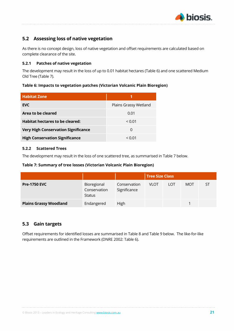
5.2 Assessing loss of native vegetation .......................................................................................................................... 21
5.2.1 Patches of native vegetation ....................................................................................................................... 21
5.2.2 Scattered Trees .............................................................................................................................................. 21
5.3 Gain targets ................................................................................................................................................................... 21
6 Key Ecological Values and Recommendations........................................................................................ 24
References ............................................................................................................................................................. 25
Appendices ............................................................................................................................................................ 26
List of Figures
Figure 1: Location of the study area, Victoria ...................................................................................................... 3
Figure 2: Ecological features of the study area, Victoria .................................................................................. 13
List of Tables
Table 1: Criteria for determining significance of species & ecological communities ..................................... 5
Table 2: Summary of significant species most likely to occur in the study area .......................................... 12
Table 3: Assessment of project in relation to the EPBC Act ............................................................................ 14
Table 4: Quantification and significance of native vegetation patches. ........................................................ 19
Table 5: Determination of best/remaining habitat for rare or threatened species. .................................... 20
Table 6: Impacts to vegetation patches (Victorian Volcanic Plain Bioregion) ............................................... 21
Table 7: Summary of tree losses (Victorian Volcanic Plain Bioregion) ........................................................... 21
Table 8: Gain targets for clearing patches of native vegetation (Victorian Volcanic Plain Bioregion) ....... 22
Table 9: Gain targets for clearing scattered trees (Victorian Volcanic Plain Bioregion) ............................... 22
Table 10: Summary of key ecological values, potential implications of developing the study area and
recommendations to minimise ecological impacts during the design phase. ............................................. 24

© Biosis 2013 – Leaders in Ecology and Heritage Consulting V
Summary
Biosis Pty Ltd was commissioned by RLMC Investment Company Pty Ltd to undertake a flora and fauna
assessment of an area of land proposed for development of the Central Victorian Livestock Exchange. The
study area is located near the intersection of the Sunraysia Highway and the Western Highway approximately
1.5 km south-west of Miners Rest (Figure 1).
The study area is 45.6 ha in size, and consists of the following parcels:
• Lot 1 – TP840697
• Lot 2 – TP840697
• Lot 1 – TP915649
The study area also includes two areas of road reserve (crown land):
• A fenced un-used road reserve bordering the site to the west
• An un-fenced road reserve running in a north-south direction near the eastern edge of the site
Ecological values
The site is predominantly cleared pasture.
Ecological values identified within the study area are as follows:
• 0.01 ha of remnant vegetation - Plains Grassy Wetland Ecological Vegetation Class
• One remnant tree
Government legislation and policy
An assessment of the project in relation to key biodiversity legislation and policy is provided and summarised
below.
Legislation /
Policy
Relevant ecological
feature on site
Permit / Approval
required
Notes
EPBC Act No threatened species or
communities are
considered likely to occur
within the site.
Referral not required
FFG Act No threatened species or
communities are
considered likely to occur
within the site.
Protected Flora Permit
not required
Site includes private and
public land.
Planning &
Environment
Act
The site contains a small
patch of remnant
vegetation and one
remnant tree. Cleared
paddocks support scattered
native grasses and rushes.
Planning permit
required, including
permission to lop or
remove native
vegetation.
Permit application needs to
outline measures taken to
address steps 1 and 2 of Net
Gain policy (Victoria’s Native
Vegetation Management
Framework).

© Biosis 2013 – Leaders in Ecology and Heritage Consulting VI
Legislation /
Policy
Relevant ecological
feature on site
Permit / Approval
required
Notes
Comply with 3 step
approach to Net Gain
May require provision of Net
Gain offsets if removal of
remnant vegetation cannot
be avoided.
CaLP Act Four noxious weed species
recorded within the site.
N/A Comply with requirements
to control/eradicate
Note: Guidance provided in this report does not constitute legal advice.
Native Vegetation Management Framework (the Framework)
Losses of native vegetation and offset requirements identified for the current design through the Net Gain
calculation process are summarised below:
Native vegetation Losses Offsets
Patches < 0.01 habitat hectares 0.02 habitat hectares
Scattered trees One Medium Old Tree Source and permanently protect two Medium Old
Trees if removal of the one tree present is required.
This will also allow for associated recruitment of 10
new trees.
Native vegetation is very limited within the site and if may be possible to design the development to avoid
impacts to the small areas of vegetation present. If this is not possible, off-site offsets will be required, as
specified above.
Recommendations
The results of this assessment should be incorporated into the project design, by adding the flora and fauna
mapping information into the planning maps and investigating options to retain as much of the mapped
vegetation/habitats as possible.
No further survey is considered necessary.
© Biosis 2013 – Leaders in Ecology and Heritage Consulting 1
1 Introduction
1.1 Project background
Biosis Pty Ltd was commissioned by RLMC Investment Company Pty Ltd to undertake a flora and fauna
assessment of an area of land proposed for development of the Central Victorian Livestock Exchange.
1.2 Scope of assessment
The objectives of this investigation are to:
• Describe the vascular flora (ferns, conifers, flowering plants) and vertebrate fauna (mammals, birds,
reptiles, frogs, fishes)
• Map native vegetation and other habitat features
• Conduct a vegetation quality assessment
• Review the implications of relevant biodiversity legislation and policy, including Victoria’s Native
Vegetation Management Framework (Net Gain policy)
• Identify potential implications of the proposed development and provide recommendations to assist
with development design
• Recommend any further assessments of the site that may be required (such as a Net Gain
assessment or targeted searches for significant species).
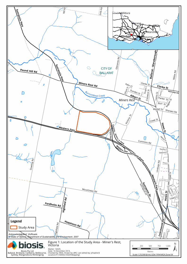
1.3 Location of the study area
The study area is located near the intersection of the Sunraysia Highway and the Western Highway
approximately 1.5 km south-west of Miners Rest (Figure 1).
The study area is 45.6 ha in size, and consists of the following parcels:
• Lot 1 – TP840697
• Lot 2 – TP840697
• Lot 1 – TP915649
The study area also includes two areas of road reserve (crown land):
• A fenced un-used road reserve bordering the site to the west.
This crown land road reserve is outside the property, but has been included in this assessment to
gain an understanding of the vegetation present and the potential implications of extending the
development into the reserve.
• An un-fenced road reserve running in a north-south direction near the eastern edge of the site.
This crown land road reserve is subject to a long term lease and has been assessed as part of the
study area.
© Biosis 2013 – Leaders in Ecology and Heritage Consulting 2
The study area is within the:
• Victorian Volcanic Plain Bioregion
• Burrumbeet Creek Basin (Hopkins catchment)
• Glenelg Hopkins Catchment Management Authority
• City of Ballarat
!Miners Rest
CITY OFCITY OFBALLARATBALLARAT
Burrumbeet Creek
Sharpes Rd
Dowli
ng Rd
Carriers Arms Dr
Pettett Cl
Felix Ct
Namr
on Ct
Mckellar Dr
Bowra
l Pl
Yarramie Ct
Mill R
d
There
se Ct
Victor
iaSt
Calloway Cl
Yootha Ct
Loxton Ct
Oldaker Ct
Doug
las Cl
Osborne Ct
Lowry Cr
Giffar
d St
Cummins Rd
Mega
n St
James
Ct
Glena
nes R
d
Raglan
StLyons
St
Clarke St
Kelly
St
Market St
Mida
s Rd
Nelson St
Grills
Rd
Davenport Rd
Burr St
Creek St
Davey
dukeDr
Parker St
Highfi
eld Rd
Buttery Rd
Blind Creek Rd
Linds
ays R
d
Mccartneys Rd
Howe
St
Norm lytt le Pde
Cresw
ick St
Sunraysia Dr
Dundas StKennedys RdAlbert St
Pound Hill Rd
Lear
mont
h Rd
Clarke StMiners Rest Rd
Sunraysia Hwy
High
field
Rd
Fordholm Rd
Sunraysia Hwy
Western Fwy
Howe
St
Howe St
Balla
rat - M
aryb
orou
gh Rd
Sunraysia Dr
Hopetoun Rd
Sunraysia Hwy
Sun raysia - Western In RampWestern Out - Sunraysia Ramp
Western Fwy
!
!
!
! !
!!
!!
!
!!
!
!
!!
!
!!! !
!
!
!
!
!
!
!
AlburyKerang
Mildura
HamiltonMansfield
Melbourne
Acknowledgement: VicRoads© State of Victoria, Department of Sustainability and Environment, 2007
Matter: 16029,Date: 16 December 2013,Checked by: MSG, Drawn by: JMS, Last edited by: jshepherdLocation:P:\16000s\16029\Mapping\
LegendStudy Area
Scale 1:25,000 @ A4, GDA 1994 MGA Zone 54
0 250 500 750 1,000
Metres ±Biosis Pty LtdBallarat, Brisbane, Canberra, Melbourne, Sydney, Wangaratta & Wollongong
Figure 1: Location of the Study Area - Miner's Rest,Victoria
© Biosis 2013 – Leaders in Ecology and Heritage Consulting 4
2 Methods
2.1 Literature and database review
In order to provide a context for the study site, information about flora and fauna from within 5 km of the
study area (the ‘local area’) was obtained from relevant public databases. Records from the following
databases were collated and reviewed:
• Flora Information System which includes records from the Victorian Biodiversity Atlas ‘VBA_FLORA25,
FLORA100 & FLORA Restricted’ August 2012 © The State of Victoria, Department of Environment and
Primary Industries (DEPI). The contribution of the Royal Botanical Gardens Melbourne to the
database is acknowledged.
• Victorian Biodiversity Atlas ‘VBA_FAUNA25, FAUNA100 & FAUNA Restricted’ August 2012 © The State
of Victoria,
• DEPI Biodiversity Interactive Map (BIM)
• BirdLife Australia, the New Atlas of Australian Birds 1998-2012 (BA)
• Protected Matters Search Tool of the Australian Government Department of Sustainability,
Environment, Water, Population and Communities (DSEWPaC) for matters protected by the
Environment Protection and Biodiversity Conservation Act 1999 (EPBC Act).
Other sources of biodiversity information:
• DEPI NaturePrint; accessed through the Biodiversity Interactive Map
© Biosis 2013 – Leaders in Ecology and Heritage Consulting 5
2.2 Definitions of significance
2.2.1 Species and ecological communities
The significance of a species or community is determined by its listing as rare or threatened under
Commonwealth or State legislation / policy. The sources used to categorise significance of species and
communities in this report are summarised below in Table 1.
Table 1: Criteria for determining significance of species & ecological communities
Significance
National Listed as threatened (critically endangered, endangered, vulnerable or conservation
dependent) under the Environment Protection and Biodiversity Conservation Act 1999
State Listed as threatened (critically endangered, endangered, vulnerable) or rare for flora species,
in Victoria on a DEPI Advisory List (DSE 2005, 2013a)
Listed as threatened under the Flora and Fauna Guarantee Act 1988
Fauna species listed as near threatened or data deficient are listed in Appendix 2, however in accordance with
advice from DEPI these fauna species are not considered to be at the same level of risk as higher categories of
threat. These species are generally not discussed in detail in this report.
2.2.2 NaturePrint areas
Areas of conservation significance were formerly documented in the DEPI Biodiversity Interactive Map as
Biosites ranked as significant at national, state and regional levels. DEPI have advised that the Biosite reports
are obsolete and their replacement layer on the Biodiversity Interactive Map is now NaturePrint which
identifies areas that contribute most to protecting a range of biodiversity values and identifies their relative
contribution.
2.3 Likelihood of occurrence
The likelihood of occurrence is a broad categorisation used by Biosis to indicate the potential for a species to
occur within the site: it is based on expert opinion and implies the relative value of a site for a particular
species.
The likelihood of species occurring within the site is ranked as negligible, low, medium or high. The rationale
for the rank assigned is provided for each species in Appendix 1 (flora) and Appendix 2 (fauna).
Species which have at least medium likelihood of occurrence are given further consideration in this report.
Those species listed as rare or threatened on the DEPI Advisory Lists are also addressed in the assessment of
conservation significance for Net Gain (DSE 2007). The need for targeted survey for these species is also
considered.
© Biosis 2013 – Leaders in Ecology and Heritage Consulting 6
2.4 Site investigation
2.4.1 Flora assessment
The flora assessment was undertaken on 3 December 2013 and a list of flora species was collected
(#S1446700). This list will be submitted to DEPI for incorporation into the Victorian Biodiversity Atlas.
The general condition of native vegetation was observed as well as the effects of current seasonal conditions.
Notes were made on specific issues such as noxious weed infestations, evidence of management works,
current grazing impacts and the regeneration capacity of the vegetation.
Classification of native vegetation is based on ecological vegetation classes (EVCs). An EVC contains one or
more floristic (plant) communities, and represents a grouping of broadly similar environments. Definitions of
EVCs and benchmarks (condition against which vegetation quality at the site can be compared) are as
determined by DEPI.
Where native vegetation was identified within the study area, an assessment in relation to the Native
Vegetation Management Framework (Net Gain policy) according to standard methods provided by DEPI (DSE
2004) was also undertaken while on-site.
2.4.2 Fauna assessment
The study area was investigated on 3 December 2013 to determine its values for fauna. These were
determined primarily on the basis of the types and qualities of habitat(s) present. All species of fauna
observed during the assessment were noted and active searching for fauna was undertaken. This included
direct observation, searching under rocks and logs, examination of tracks and scats and identifying calls.
Particular attention was given to searching for significant species and their habitats. Fauna species were
recorded with a view to characterising the values of the site and the investigation was not intended to provide
a comprehensive survey of all fauna that has potential to utilise the site over time.
2.4.3 Permits
Biosis undertakes flora and fauna assessments under the following permits and approvals:
• Research Permit/Management Authorisation and Permit to Take Protected Flora & Protected Fish
issued by the Department of Environment and Primary Industries under the Wildlife Act 1975, Flora
and Fauna Guarantee Act 1988 and National Parks Act 1975 (Permit number 10006240, expiry date 9
May 2015)
• Approvals 04.12 and 14.12 from the Wildlife and Small Institutions Animal Ethics Committee
• Permit RP1071 issued by the Department of Environment and Primary Industries (Fisheries Victoria)
under the Fisheries Act 1995
2.5 Qualifications
Ecological surveys provide a sampling of flora and fauna at a given time and season. There are a number of
reasons why not all species will be detected at a site during survey, such as low abundance, patchy
distribution, species dormancy, seasonal conditions, and migration and breeding behaviours. In many cases
these factors do not present a significant limitation to assessing the overall biodiversity values of a site.
The current flora and fauna assessment was conducted in early summer, which is an optimal time for survey.

© Biosis 2013 – Leaders in Ecology and Heritage Consulting 7
2.6 Legislation and policy
The implications for the project were assessed in relation to key biodiversity legislation and policy including:
• Matters listed under the Environment Protection and Biodiversity Conservation Act 1999 (EPBC Act);
associated policy statements, significant impacts guidelines, listing advice and key threatening
processes
• Threatened taxa, communities and threatening processes listed under Section 10 of the Flora & Fauna
Guarantee Act 1988 (FFG Act); associated action statements and listing advice
• Victoria’s Native Vegetation Management – a Framework for Action (the Framework; DNRE 2002).
• Native Vegetation Management Plans prepared by Catchment Management Authorities
• Planning and Environment Act 1987 – specifically Clauses 12.01-2, 52.17 and 66.02 and Overlays in the
relevant Planning Scheme
• Wildlife Act 1975 and associated Regulations
• Fisheries Act 1995
• Water Act 1989
• Environment Protection Act 1971: State Environmental Protection Policy (Waters of Victoria) 2003.
2.7 Mapping
Mapping was conducted using hand-held (uncorrected) GPS units (WGS84) and aerial photo interpretation.
The accuracy of this mapping is therefore subject to the accuracy of the GPS units (generally ± 7 m) and
dependent on the limitations of aerial photo rectification and registration.
Mapping has been produced using a Geographic Information System (GIS). Electronic GIS files which contain
our flora and fauna spatial data are available to incorporate into design concept plans. However this
mapping may not be sufficiently precise for detailed design purposes.
© Biosis 2013 – Leaders in Ecology and Heritage Consulting 8
3 Results
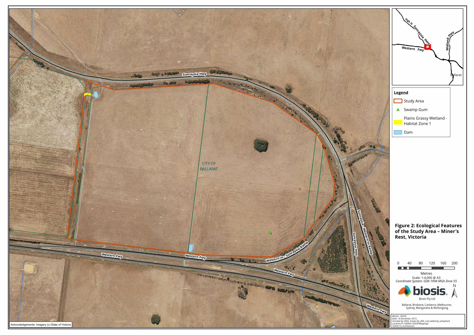
The ecological features of the study area are described below and mapped in Figure 2.
Species recorded during the flora and fauna assessment are listed in Appendix 1 (flora) and Appendix 2
(fauna). Unless of particular note, these species are not discussed further.
A list of significant species recorded or predicted to occur in the local area is also provided in those
appendices, along with an assessment of the likelihood of the species occurring within the study area.
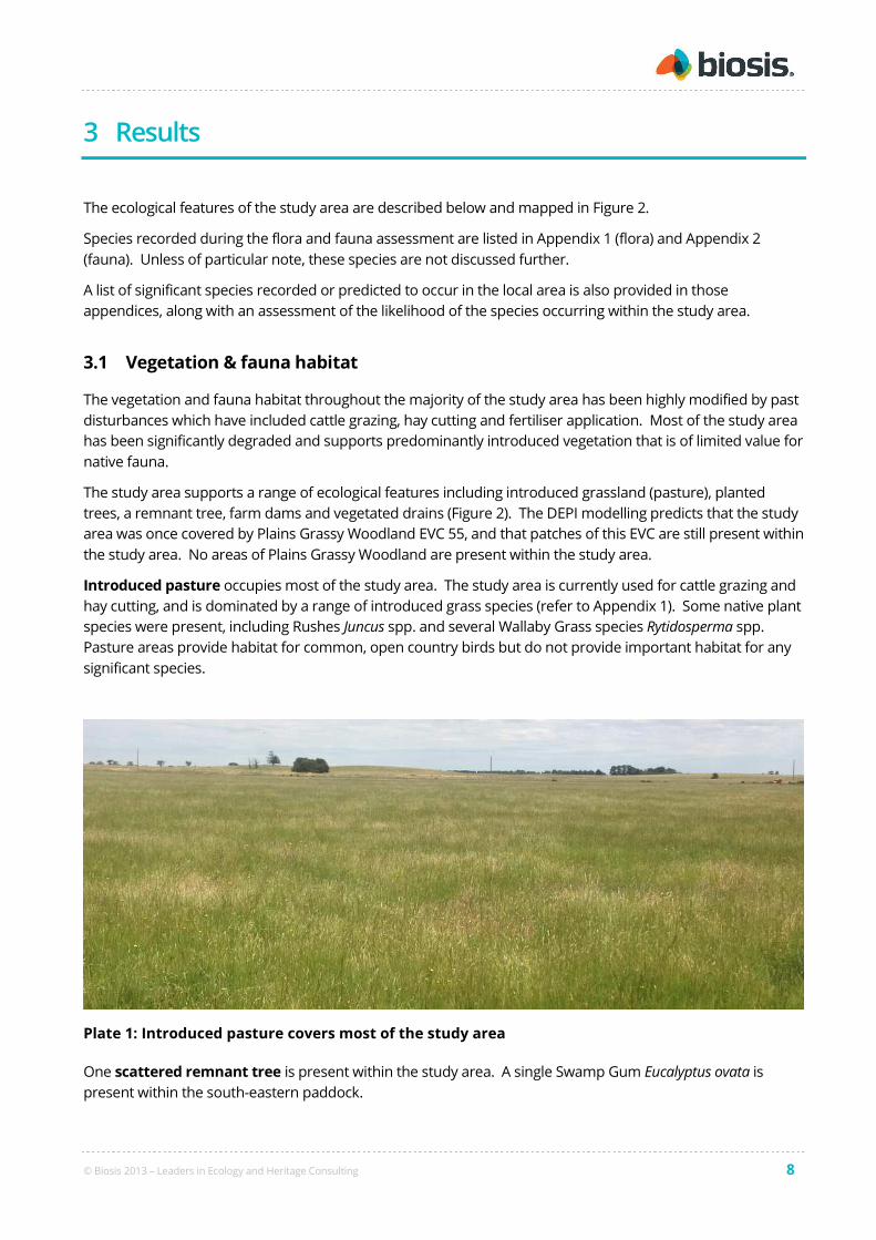
3.1 Vegetation & fauna habitat
The vegetation and fauna habitat throughout the majority of the study area has been highly modified by past
disturbances which have included cattle grazing, hay cutting and fertiliser application. Most of the study area
has been significantly degraded and supports predominantly introduced vegetation that is of limited value for
native fauna.
The study area supports a range of ecological features including introduced grassland (pasture), planted
trees, a remnant tree, farm dams and vegetated drains (Figure 2). The DEPI modelling predicts that the study
area was once covered by Plains Grassy Woodland EVC 55, and that patches of this EVC are still present within
the study area. No areas of Plains Grassy Woodland are present within the study area.
Introduced pasture occupies most of the study area. The study area is currently used for cattle grazing and
hay cutting, and is dominated by a range of introduced grass species (refer to Appendix 1). Some native plant
species were present, including Rushes Juncus spp. and several Wallaby Grass species Rytidosperma spp.
Pasture areas provide habitat for common, open country birds but do not provide important habitat for any
significant species.
Plate 1: Introduced pasture covers most of the study area
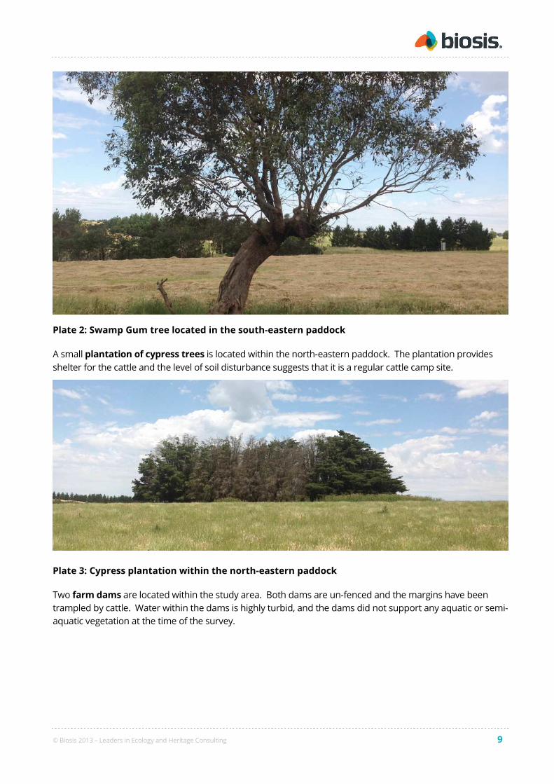
One scattered remnant tree is present within the study area. A single Swamp Gum Eucalyptus ovata is
present within the south-eastern paddock.
© Biosis 2013 – Leaders in Ecology and Heritage Consulting 9
Plate 2: Swamp Gum tree located in the south-eastern paddock
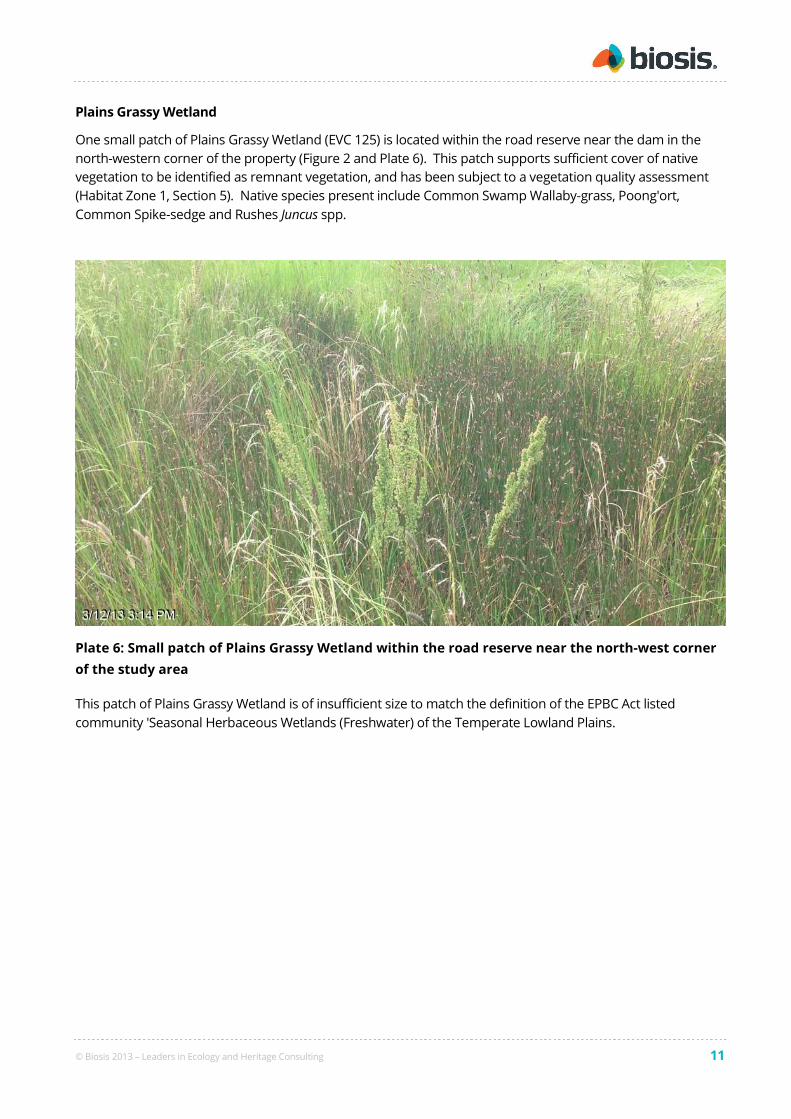
A small plantation of cypress trees is located within the north-eastern paddock. The plantation provides
shelter for the cattle and the level of soil disturbance suggests that it is a regular cattle camp site.
Plate 3: Cypress plantation within the north-eastern paddock
Two farm dams are located within the study area. Both dams are un-fenced and the margins have been
trampled by cattle. Water within the dams is highly turbid, and the dams did not support any aquatic or semi-
aquatic vegetation at the time of the survey.

© Biosis 2013 – Leaders in Ecology and Heritage Consulting 10
Plate 4: Dam near the southern boundary of the study area adjacent to the Western Highway
Plate 5: Dam in the north-west corner of the property
The road reserve adjacent to the western boundary of the study area is dominated by a similar suite of
introduced pasture species to the remainder of the study area. Several woody weed species are also present,
including Gorse Ulex europeus, Hawthorn Crataegus monogyna and Sweet Briar Rosa rubiginosa. The disused
road formation is slightly raised, with signs of old drains running to either side of the road. These low-lying
areas support several semi-aquatic species including both natives (including Common Swamp Wallaby-grass
Amphibromus nervosus, Poong'ort Carex tereticaulis and Common Spike-sedge Eleocharis acuta) and weeds
(including Meadow Fox-tail Alopecurus pratensis and Toowoomba canary-grass Phalaris aquatica).
© Biosis 2013 – Leaders in Ecology and Heritage Consulting 11
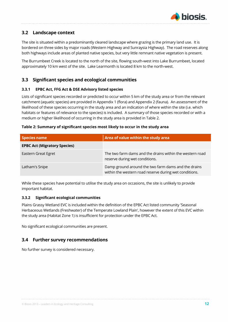
Plains Grassy Wetland
One small patch of Plains Grassy Wetland (EVC 125) is located within the road reserve near the dam in the
north-western corner of the property (Figure 2 and Plate 6). This patch supports sufficient cover of native
vegetation to be identified as remnant vegetation, and has been subject to a vegetation quality assessment
(Habitat Zone 1, Section 5). Native species present include Common Swamp Wallaby-grass, Poong'ort,
Common Spike-sedge and Rushes Juncus spp.
Plate 6: Small patch of Plains Grassy Wetland within the road reserve near the north-west corner
of the study area
This patch of Plains Grassy Wetland is of insufficient size to match the definition of the EPBC Act listed
community 'Seasonal Herbaceous Wetlands (Freshwater) of the Temperate Lowland Plains.
© Biosis 2013 – Leaders in Ecology and Heritage Consulting 12
3.2 Landscape context
The site is situated within a predominantly cleared landscape where grazing is the primary land use. It is
bordered on three sides by major roads (Western Highway and Sunraysia Highway). The road reserves along
both highways include areas of planted native species, but very little remnant native vegetation is present.
The Burrumbeet Creek is located to the north of the site, flowing south-west into Lake Burrumbeet, located
approximately 10 km west of the site. Lake Learmonth is located 8 km to the north-west.
3.3 Significant species and ecological communities
3.3.1 EPBC Act, FFG Act & DSE Advisory listed species
Lists of significant species recorded or predicted to occur within 5 km of the study area or from the relevant
catchment (aquatic species) are provided in Appendix 1 (flora) and Appendix 2 (fauna). An assessment of the
likelihood of these species occurring in the study area and an indication of where within the site (i.e. which
habitats or features of relevance to the species) is included. A summary of those species recorded or with a
medium or higher likelihood of occurring in the study area is provided in Table 2.
Table 2: Summary of significant species most likely to occur in the study area
Species name Area of value within the study area
EPBC Act (Migratory Species)
Eastern Great Egret The two farm dams and the drains within the western road
reserve during wet conditions.
Latham's Snipe Damp ground around the two farm dams and the drains
within the western road reserve during wet conditions.
While these species have potential to utilise the study area on occasions, the site is unlikely to provide
important habitat.
3.3.2 Significant ecological communities
Plains Grassy Wetland EVC is included within the definition of the EPBC Act listed community 'Seasonal
Herbaceous Wetlands (Freshwater) of the Temperate Lowland Plain', however the extent of this EVC within
the study area (Habitat Zone 1) is insufficient for protection under the EPBC Act.
No significant ecological communities are present.
3.4 Further survey recommendations
No further survey is considered necessary.
#*
CITY OFCITY OFBALLARATBALLARAT
Wes tern Fwy
Wes tern Fwy
Sunrays ia Hwy
Sunrays iaHwy
Sunrays ia - Wes tern In Ramp
Wes tern Fwy
Wes ternIn-Sunrays iaRamp
Wes tern Fwy0 40 80 120 160 200
Metres
LegendStudy Area
#* Swamp GumPlains Grassy Wetland - Habitat Zone 1Dam
±Ma tter: 16029, Da te : 16 D ecem b er 2 013, Ch ecked by: M SG , D ra w n by: JM S, La st ed ited b y: jsh eph erdLocation :P:\16000s\16029\M a pp in g\16029_F2 _EcoFeatu res
Biosis Pty LtdBallarat, Brisbane, Canberra, Melbourne,
Sydney, Wangaratta & Wollongong
!Ballarat
Sunrays ia HwyWes tern Fwy
High St
Midla
nd
Hwy
Scale: 1:4,000 @ A3
Figure 2: Ecological Featuresof the Study Area – Miner'sRes t, Victoria
Coordinate System: GDA 1994 MGA Zone 55
Acknowledgements: Imagery (c) State of Victoria

© Biosis 2013 – Leaders in Ecology and Heritage Consulting 14
4 Biodiversity Legislation and Government Policy
This section provides an assessment of the project in relation to key biodiversity legislation and government
policy. Where available, links to further information are provided. This section does not describe the
legislation and policy in detail and guidance provided here does not constitute legal advice.
4.1 Commonwealth
4.1.1 Environment Protection and Biodiversity Conservation Act 1999
The EPBC Act applies to developments and associated activities that have the potential to significantly impact
on Matters of National Environmental Significance (NES) protected under the Act.
Link for further information including a guide to the referral process is available at:
http://www.environment.gov.au/epbc/index.html
Matters of National Environmental Significance relevant to the project are summarised in Table 3. It includes
an assessment against the EPBC Act policy statements published by the Australian Government which
provide guidance on the practical application of EPBC Act.
Table 3: Assessment of project in relation to the EPBC Act
Matter of NES Project specifics Assessment against Guidelines
Threatened
species
Twenty-one species have been
recorded or predicted to occur in
the project search area.
None of these species are considered likely to occur
within the study area (Appendix 1 and 2). The
development is not likely to constitute a significant
impact.
Threatened
ecological
communities
Five threatened ecological
communities have been predicted
to occur within the project search
area.
Plains Grassy Wetland EVC is included within the
definition of Seasonal Herbaceous Wetlands
(Freshwater) of the Temperate Lowland Plain, but the
extent of this EVC within the study area (Habitat Zone
1) is insufficient for protection under the EPBC Act.
The other four threatened communities are not
present within the study area.
Migratory
species
Thirteen migratory species have
been recorded or predicted to
occur in the project search area
(Appendix 2).
While some of these species would be expected to use
the study area on occasions, in particular Eastern Great
Egret and Latham's Snipe, it does not provide
important habitat for an ecologically significant
proportion of any of these species.
Wetlands of
international
importance
(Ramsar sites).
The study area is identified as
upstream from five Ramsar Sites
The study area does not drain directly into either
Ramsar site and the development is not likely to result
in a significant impact.
On the basis of criteria outlined in the relevant Significant Impact Guidelines it is considered unlikely that a
significant impact on a Matter of National Environmental Significance would result from the proposed action.
© Biosis 2013 – Leaders in Ecology and Heritage Consulting 15
4.2 State
4.2.1 Flora and Fauna Guarantee Act 1988 (FFG Act)
The FFG Act is the key piece of Victorian legislation for the conservation of threatened species and
communities and for the management of potentially threatening processes. Under the FFG Act a permit is
required from DSE to 'take' protected flora species from public land. A permit is generally not required for
removal of protected flora from private land. Authorisation under the FFG Act is required to collect, kill, injure
or disturb listed fish.
No threatened species or protected species were recorded within the study area.
No threatened communities were recorded within the study area.
A protected flora permit is not required.

© Biosis 2013 – Leaders in Ecology and Heritage Consulting 16
4.2.2 Planning and Environment Act 1987 (incl. Planning Schemes)
The Planning and Environment Act 1987 controls the planning and development of land in Victoria, and
provides for the development of planning schemes for all municipalities. As part of the planning process
regard needs to be given to Action Statements that have been produced under the FFG Act.
Reforms to the native vegetation permitted clearing regulations are underway and will include amendments
to clauses in the Victorian Planning Provisions in all planning schemes in Victoria.
The study area supports one remnant Swamp Gum tree and several native species which are scattered
throughout the paddocks, including Wallaby Grasses Rytidosperma spp. and Rushes Juncus spp. Clearance of
these paddocks will require a planning permit, pursuant to Clause 72 of the City of Ballarat Planning Scheme
which defines native vegetation as 'plants that are indigenous to Victoria, including trees, shrubs, herbs and
grasses'.
Clause 12.01-2 of the State Planning Policy Framework Clause (Native Vegetation Management) requires that
a net gain in the extent and quality of native vegetation is achieved and planning must consider as relevant
Victoria’s Native Vegetation Management – a Framework for Action. An assessment of the proposed
development in relation to the Framework is provided in Section 5.
Clause 66.02 vegetation removal thresholds (15 trees < 40cm DBH or 5 trees > 40 cm DBH or >0.5 hectares of
EVC vegetation) are not likely to be triggered and thus DEPI will not be a mandatory referral authority.
The study area is not covered by any overlays relevant to biodiversity under the City of Ballarat Planning
Scheme.

© Biosis 2013 – Leaders in Ecology and Heritage Consulting 17
4.2.3 Native Vegetation Management Framework
The Framework provides State Government policy (referred to as the Net Gain policy) for the protection,
enhancement and revegetation of native vegetation in Victoria (DNRE 2002) and is an incorporated document
in all planning schemes. The Framework is due to be replaced with the Permitted clearing of native vegetation –
Biodiversity assessment guidelines (DEPI 2013) as part of reforms to the Victoria Planning Provisions.
If the development seeks to remove native vegetation identified in this report, an application will need to be
made under clause 52.17 of the City of Ballarat Planning Scheme to remove, destroy or lop native vegetation.
Within the application the proponent must state (Clause 52.17-3) its response to the three step approach to
Net Gain that have been taken to:
• avoid adverse impacts, particularly native vegetation clearance, where possible.
• minimise impacts through appropriate consideration in the planning process and utilise expert input
to project design and/or management, if impacts cannot be avoided.
• identify appropriate offset options for the loss of native vegetation, if required.
This flora and fauna assessment establishes the extent, distribution and quality of native vegetation within
the study area. An assessment against Victoria’s Net Gain policy is included in Section 5. Responses and
offset requirements for clearing native vegetation outlined in the Glenelg Hopkins Native Vegetation Plan are
included in the assessment.
Regional Native Vegetation Plans provide a strategic and co-ordinated approach to the management of native
vegetation within a given Catchment Management Authority region, and complement the Native Vegetation
Management Framework.
4.2.4 Wildlife Act 1975 and associated Regulations
The Wildlife Act 1975 (Wildlife Act) is the primary piece of legislation in Victoria providing for protection and
management of wildlife. The Wildlife Act does not apply to fish, as defined under the Fisheries Act 1995.
The Wildlife Regulations 2002 prescribe penalties for persons who wilfully damage, disturb or destroy any
wildlife habitat without appropriate authorisation. DEPI advise that a planning permit (under the planning
scheme) constitutes appropriate authorisation and therefore the habitat protection provisions under the
Wildlife Regulations 2002 are not applicable once the planning permit has been granted for this project.
© Biosis 2013 – Leaders in Ecology and Heritage Consulting 18
5 Victoria’s Native Vegetation Management Framework
(Net Gain)
The Framework is state government policy providing the strategic direction for the protection, enhancements
and revegetation of native vegetation within Victoria (DNRE 2002). It forms part of the State Policy Planning
Framework. The Framework’s primary goal is to achieve ‘a reversal across the entire landscape, of the long-
term decline in the extent and quality of native vegetation, leading to a Net Gain’.
The approach for applying the three-step approach of Net Gain to the current proposal is described in this
section. According to the design concept / plan proposed, impacts to native vegetation cannot be avoided if
the project is approved. In order to determine appropriate offsets the quality and extent of native vegetation
within the study area must be quantified.
5.1 Quantifying native vegetation on site
Native vegetation within the study area was mapped (Figure 2) and assessed in relation to Net Gain policy
according to standard methods provided by DSE (2004). Vegetation quality of identified patches was
assessed using the DSE Vegetation Quality Assessment Sheet (DSE 2004) and pre-determined EVC
benchmarks: http://www.dse.vic.gov.au/conservation-and-environment/ecological-vegetation-class-evc-
benchmarks-by-bioregion.
One scattered Medium Old Tree (MOT) was mapped (outside of patch vegetation) and diameter at breast
height (DBH) measured (DSE 2007).
Areas of uniform quality for each EVC within the patches are termed ‘habitat zones’ and assessed separately.
All remaining areas that are not EVC patches or scattered remnant canopy trees are termed Degraded
Treeless Vegetation (DTV; DSE 2007).
5.1.1 Patches of native vegetation
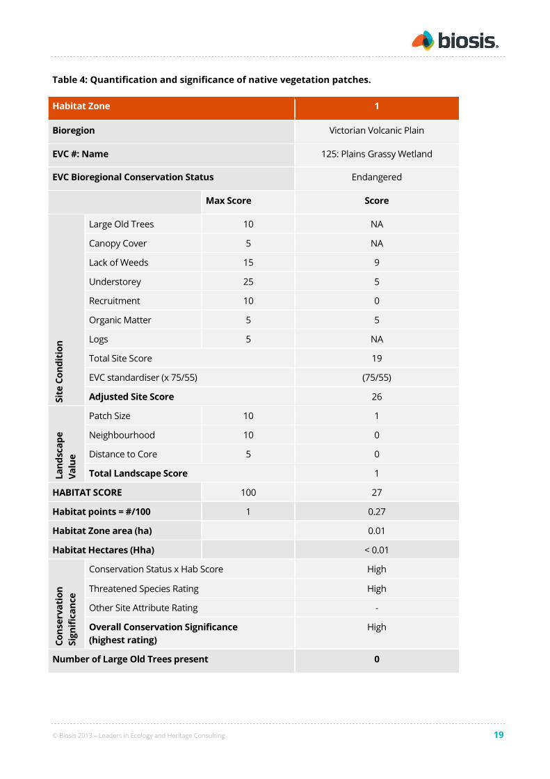
One habitat zones was identified within the study area (Figure 2). The results of the vegetation quality
assessment are provided in Table 4.
© Biosis 2013 – Leaders in Ecology and Heritage Consulting 19
Table 4: Quantification and significance of native vegetation patches.
Habitat Zone 1
Bioregion Victorian Volcanic Plain
EVC #: Name 125: Plains Grassy Wetland
EVC Bioregional Conservation Status Endangered
Max Score Score
Sit
e C
on
dit
ion
Large Old Trees 10 NA
Canopy Cover 5 NA
Lack of Weeds 15 9
Understorey 25 5
Recruitment 10 0
Organic Matter 5 5
Logs 5 NA
Total Site Score 19
EVC standardiser (x 75/55) (75/55)
Adjusted Site Score 26
La
nd
sca
pe
Va
lue
Patch Size 10 1
Neighbourhood 10 0
Distance to Core 5 0
Total Landscape Score 1
HABITAT SCORE 100 27
Habitat points = #/100 1 0.27
Habitat Zone area (ha) 0.01
Habitat Hectares (Hha) < 0.01
Co
nse
rva
tio
n
Sig
nif
ica
nce
Conservation Status x Hab Score High
Threatened Species Rating High
Other Site Attribute Rating -
Overall Conservation Significance
(highest rating)
High
Number of Large Old Trees present 0
© Biosis 2013 – Leaders in Ecology and Heritage Consulting 20
Conservation significance for threatened species
Part of the assessment of conservation significance for Net Gain involves consideration of the value of habitat
for threatened species in Victoria. Only species listed as threatened or rare under the DEPI Advisory lists (DSE
2005, 2007a) are considered in this process. The term 'threatened' is used to describe species that are
classified as vulnerable, endangered or critically endangered. Species classified as data deficient or near
threatened are not considered to be 'threatened' (DSE 2013). The term 'rare' has application for flora species
only (DSE 2005).
Threatened or rare flora and threatened fauna species listed under DEPI Advisory Lists that have been
recorded or have at least medium likelihood of occurrence within the study area are considered in the
assessment of conservation significance provided they have potential to occur in areas of remnant vegetation
that have been mapped and assessed.
The value of each habitat zone for each species is assessed against DEPI’s criteria (DSE 2007, page 13). The
pathway for each decision made (in accordance with DEPI’s Table 2) is outlined in Table 5 below.
Only one species (Eastern Great Egret) requires consideration in this study. This species has the potential to
occasionally visit the two dams or habitat zone 1. These features are in poor condition, however, and do not
provide important habitat for this species.
Table 5: Determination of best/remaining habitat for rare or threatened species.
Species Conservation
Status
Habitat
zone
Steps* Outcome Conservation
Significance
(threatened
species rating)
Fauna
Eastern Great Egret Threatened HZ1 ADF-No Remaining 50% of
habitat
High
* Steps taken to determine best or remaining 50 % of habitat. From Table 2 in the Guide for Assessment of Referred
Planning Permit Applications (DSE 2007).
HZ = Habitat Zone
The overall threatened species rating for each habitat zone is determined by the highest threatened species
rating scored for any one species. This result is included in Table 4.
Summary
The study area contains 0.01 ha of native vegetation, which comprises less than 0.01 Hha.
5.1.2 Scattered Trees
The study area contains one scattered tree. A single Swamp Gum Eucalyptus ovata (DBH 51 cm) is located in
the open paddock near the south-eastern corner of the study area. As a scattered medium old tree within a
remnant of Plains Grassy Woodland EVC, considered endangered within the Victorian Volcanic Plain
Bioregion, this tree has high conservation significance.
© Biosis 2013 – Leaders in Ecology and Heritage Consulting www.biosis.com.au 21
5.2 Assessing loss of native vegetation
As there is no concept design, loss of native vegetation and offset requirements are calculated based on
complete clearance of the site.
5.2.1 Patches of native vegetation
The development may result in the loss of up to 0.01 habitat hectares (Table 6) and one scattered Medium
Old Tree (Table 7).
Table 6: Impacts to vegetation patches (Victorian Volcanic Plain Bioregion)
Habitat Zone 1
EVC Plains Grassy Wetland
Area to be cleared 0.01
Habitat hectares to be cleared: < 0.01
Very High Conservation Significance 0
High Conservation Significance < 0.01
5.2.2 Scattered Trees
The development may result in the loss of one scattered tree, as summarised in Table 7 below.
Table 7: Summary of tree losses (Victorian Volcanic Plain Bioregion)
Tree Size Class
Pre-1750 EVC Bioregional
Conservation
Status
Conservation
Significance
VLOT LOT MOT ST
Plains Grassy Woodland Endangered High 1
5.3 Gain targets
Offset requirements for identified losses are summarised in Table 8 and Table 9 below. The like-for-like
requirements are outlined in the Framework (DNRE 2002: Table 6).

© Biosis 2013 – Leaders in Ecology and Heritage Consulting www.biosis.com.au 22
Table 8: Gain targets for clearing patches of native vegetation (Victorian Volcanic Plain Bioregion)
Habitat Hectares Target Large Tree Protection Target
Target
No.
Habitat
Zones
EVC #: Name Conservation
Significance
Min
Habitat
score for
target*
Other Like-for-like
reqts*
Total
Losses
(Hha)
Net
outcome
ratio
Gain
Target
(Hha)
Total
LOTs
Lost
Protection
multiplier
LOTs to be
protected
H1 HZ 1 175: Plains Grassy
Wetland
High 20 The same vegetation
type or a very high
significance
vegetation type in the
Victorian Volcanic
Plain Bioregion
<0.01 1.5 0.02 0 N/A 0
* Based on the quality objectives for the offset specified in Table 6 of the Framework (DNRE 2002).
Table 9: Gain targets for clearing scattered trees (Victorian Volcanic Plain Bioregion)
Tree Protection Recruit Only
Target No. Pre 1750 EVC #: Name Conservation
Significance
Tree
Size
# Trees to
be
removed
Multiplier^ Offset Total*
OR
Multiplier Offset Total
H1 55: Plains Grassy Woodland High MOT 1 1 1 n/a n/a
TOTAL number of plants to be recruited n/a
*By protecting a Medium or Large Old Tree, it is assumed five recruits will be generated. To be considered protected, twice the canopy diameter for a tree must be fenced and protected from
adverse impacts. It has therefore been assumed that protection of a tree will generate five recruits and no separate recruitment targets have been calculated.
^The Framework (DNRE 2002) multiplier for Medium Old Trees within parcels of land >4 ha with eight or more scattered trees (table 6) has been applied in this case as the Glenelg-Hopkins Native
Vegetation Plan does not provide protection and recruitment targets for removal of indigenous canopy trees.

© Biosis 2013 – Leaders in Ecology and Heritage Consulting 23
In summary, complete clearance of the site would require the following offsets:
• Generate 0.02 habitat hectares of native vegetation through sourcing, permanent protection and
management of another area of vegetation.
• Source and permanently protect one Medium Old Trees (for the loss of the scattered tree), which will
also allow for associated recruitment of five new plants (protect and recruit method).
© Biosis 2013 – Leaders in Ecology and Heritage Consulting 24
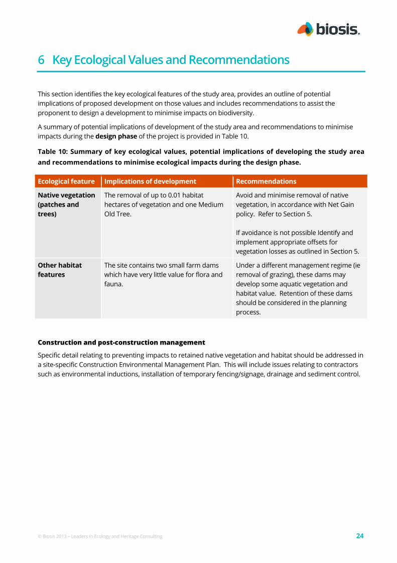
6 Key Ecological Values and Recommendations
This section identifies the key ecological features of the study area, provides an outline of potential
implications of proposed development on those values and includes recommendations to assist the
proponent to design a development to minimise impacts on biodiversity.
A summary of potential implications of development of the study area and recommendations to minimise
impacts during the design phase of the project is provided in Table 10.
Table 10: Summary of key ecological values, potential implications of developing the study area
and recommendations to minimise ecological impacts during the design phase.
Ecological feature Implications of development Recommendations
Native vegetation
(patches and
trees)
The removal of up to 0.01 habitat
hectares of vegetation and one Medium
Old Tree.
Avoid and minimise removal of native
vegetation, in accordance with Net Gain
policy. Refer to Section 5.
If avoidance is not possible Identify and
implement appropriate offsets for
vegetation losses as outlined in Section 5.
Other habitat
features
The site contains two small farm dams
which have very little value for flora and
fauna.
Under a different management regime (ie
removal of grazing), these dams may
develop some aquatic vegetation and
habitat value. Retention of these dams
should be considered in the planning
process.
Construction and post-construction management
Specific detail relating to preventing impacts to retained native vegetation and habitat should be addressed in
a site-specific Construction Environmental Management Plan. This will include issues relating to contractors
such as environmental inductions, installation of temporary fencing/signage, drainage and sediment control.
© Biosis 2013 – Leaders in Ecology and Heritage Consulting 25
References
DEPI 2013. Permitted clearing of native vegetation - Biodiversity assessment guidelines. Victorian Government
Department of Environment and Primary Industries, Melbourne.
DNRE 2002. Victoria's Native Vegetation Management: A Framework for Action. Victorian Government
Department of Natural Resources & Environment, East Melbourne.
DSE 2004. Native Vegetation: Sustaining a living landscape. Vegetation Quality Assessment Manual – Guidelines for
applying the habitat hectares scoring method. Version 1.3. Victorian Government Department of Sustainability &
Environment, Melbourne.
DSE 2005. Advisory List of Rare or Threatened Plants in Victoria – 2005. Victorian Government Department of
Sustainability & Environment, East Melbourne.
DSE 2013. Advisory List of Threatened Vertebrate Fauna in Victoria – 2013. Victorian Government Department of
Environment & Primary Industries, Melbourne.
DSE 2007. Native Vegetation – Guide for assessment of referred planning permit applications. Victorian
Government Department of Sustainability & Environment, East Melbourne.
DSE 2010. Victorian Biodiversity Atlas ‘VBA_FAUNA25, FAUNA100 & FAUNARestricted, FLORA25, FLORA100 &
FLORARestricted’ August 2010 © The State of Victoria. Victorian Government Department of Sustainability &
Environment, Melbourne.
GHCMA (2000) Glenelg Hopkins Draft Native Vegetation Plan. Glenelg Hopkins Catchment Management
Authority, Hamilton.
Walsh, N.G. & Stajsic, V. 2007. A Census of the Vascular Plants of Victoria. Eighth edition, Royal Botanic Gardens
Melbourne.

© Biosis 2013 – Leaders in Ecology and Heritage Consulting 26
Appendices
© Biosis 2013 – Leaders in Ecology and Heritage Consulting 27
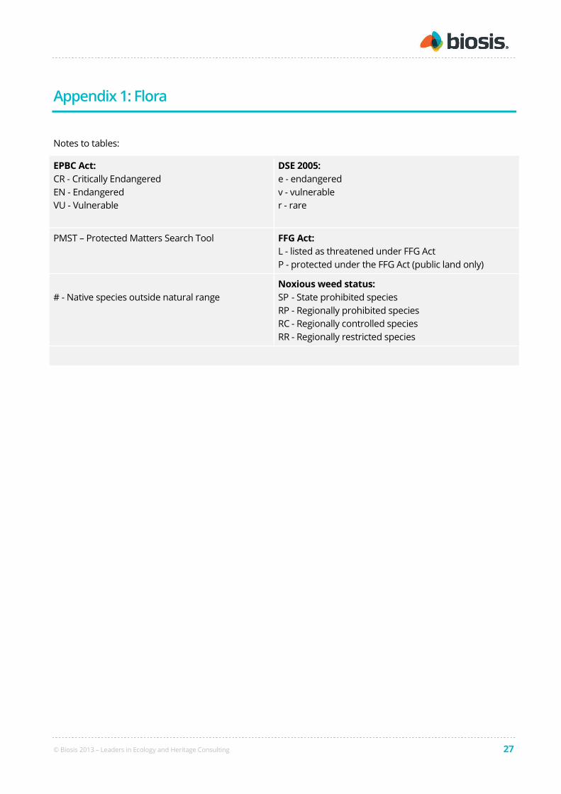
Appendix 1: Flora
Notes to tables:
EPBC Act:
CR - Critically Endangered
EN - Endangered
VU - Vulnerable
DSE 2005:
e - endangered
v - vulnerable
r - rare
PMST – Protected Matters Search Tool FFG Act:
L - listed as threatened under FFG Act
P - protected under the FFG Act (public land only)
# - Native species outside natural range
Noxious weed status:
SP - State prohibited species
RP - Regionally prohibited species
RC - Regionally controlled species
RR - Regionally restricted species

© Biosis 2013 – Leaders in Ecology and Heritage Consulting 28
A1.1 Flora species recorded from the study area
Table A1.1. Flora species recorded from the study area.
Status Scientific name Common name
Indigenous species:
Amphibromus nervosus Common Swamp Wallaby-grass
Anthosachne scabra Common Wheat-grass
Carex tereticaulis Poong'ort
Cyperus sp. Flat Sedge
Eleocharis acuta Common Spike-sedge
Epilobium hirtigerum Hairy Willow-herb
Eucalyptus ovata Swamp Gum
Geranium sp. Crane's Bill
Juncus amabilis Hollow Rush
Juncus bufonius Toad Rush
Juncus flavidus Gold Rush
Juncus pallidus Pale Rush
Juncus subsecundus Finger Rush
Lythrum hyssopifolia Small Loosestrife
Rytidosperma caespitosum Common Wallaby-grass
Rytidosperma duttonianum Brown-back Wallaby-grass
Rytidosperma racemosum var. racemosum Slender Wallaby-grass
Rytidosperma setaceum Bristly Wallaby-grass
Introduced species:
Acetosella vulgaris Sheep Sorrel
Aira cupaniana Quicksilver Grass
Alopecurus pratensis Meadow Fox-tail
Anthoxanthum odoratum Sweet Vernal-grass
Arctotheca calendula Cape Weed
Avena barbata Bearded Oat
Avena fatua Wild Oat
Brachypodium distachyon False Brome

© Biosis 2013 – Leaders in Ecology and Heritage Consulting 29
Status Scientific name Common name
Briza minor Lesser Quaking-grass
Bromus diandrus Great Brome
Bromus hordeaceus subsp. hordeaceus Soft Brome
RR Cirsium vulgare Spear Thistle
RR Crataegus monogyna Hawthorn
Cupressus macrocarpa Monterey Cypress
Erodium cicutarium Common Heron's-bill
Holcus lanatus Yorkshire Fog
Hordeum hystrix Mediterranean Barley-grass
Hypochaeris radicata Flatweed
Leontodon taraxacoides subsp. taraxacoides Hairy Hawkbit
Lolium perenne Perennial Rye-grass
Lysimachia arvensis (Red-flowered variant) Scarlet Pimpernel
Malva parviflora Small-flower Mallow
Phalaris aquatica Toowoomba Canary-grass
Pinus radiata Radiata Pine
Plantago coronopus Buck's-horn Plantain
Plantago lanceolata Ribwort
Poa annua Annual Meadow-grass
Polygonum aviculare Prostrate Knotweed
RC Rosa rubiginosa Sweet Briar
Rumex crispus Curled Dock
Sanguisorba minor Salad Burnet
Sonchus asper Rough Sow-thistle
Sonchus oleraceus Common Sow-thistle
Trifolium repens var. repens White Clover
RC Ulex europaeus Gorse
Vulpia bromoides Squirrel-tail Fescue
Vulpia myuros Rat's-tail Fescue
© Biosis 2012 – Leaders in Ecology and Heritage Consulting 30
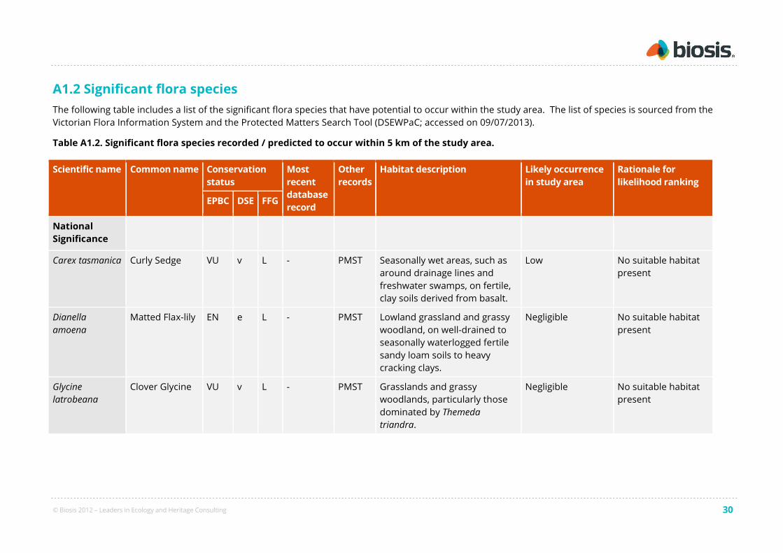
A1.2 Significant flora species
The following table includes a list of the significant flora species that have potential to occur within the study area. The list of species is sourced from the
Victorian Flora Information System and the Protected Matters Search Tool (DSEWPaC; accessed on 09/07/2013).
Table A1.2. Significant flora species recorded / predicted to occur within 5 km of the study area.
Scientific name Common name Conservation
status
Most
recent
database
record
Other
records
Habitat description Likely occurrence
in study area
Rationale for
likelihood ranking
EPBC DSE FFG
National
Significance
Carex tasmanica Curly Sedge VU v L - PMST Seasonally wet areas, such as
around drainage lines and
freshwater swamps, on fertile,
clay soils derived from basalt.
Low No suitable habitat
present
Dianella
amoena
Matted Flax-lily EN e L - PMST Lowland grassland and grassy
woodland, on well-drained to
seasonally waterlogged fertile
sandy loam soils to heavy
cracking clays.
Negligible No suitable habitat
present
Glycine
latrobeana
Clover Glycine VU v L - PMST Grasslands and grassy
woodlands, particularly those
dominated by Themeda
triandra.
Negligible No suitable habitat
present

© Biosis 2012 – Leaders in Ecology and Heritage Consulting 31
Scientific name Common name Conservation
status
Most
recent
database
record
Other
records
Habitat description Likely occurrence
in study area
Rationale for
likelihood ranking
EPBC DSE FFG
Pimelea
spinescens
subsp.
spinescens
Spiny Rice-
flower
CR e L - PMST Primarily grasslands featuring a
moderate diversity of other
native species and inter-
tussock spaces, although also
recorded in grassland
dominated by introduced
perennial grasses.
Negligible No suitable habitat
present
Poa sallacustris Salt-lake
Tussock-grass
VU v L - PMST Grasslands and herblands on
the sloping verges of saline
lakes.
Negligible No suitable habitat
present
Prasophyllum
frenchii
Maroon Leek-
orchid
EN e L - PMST Grassland and grassy
woodland environments on
sandy or black clay loam soils,
that are generally damp but
well drained.
Negligible No suitable habitat
present
Prasophyllum
suaveolens
Fragrant Leek-
orchid
EN e L 2007 PMST Open, species rich grasslands
dominated by Themeda triandra
on poorly draining red-brown
soils in western Victoria.
Low Recorded in
grassland near the
Burrumbeet Creek,
but no suitable
habitat present
within study area.
Senecio
behrianus
Stiff Groundsel EN e L 2007 PMST Specific habitat requirements
of this species are poorly
understood, but they are
known to occur in seasonally
Low Not recorded during
field survey.
Suitable habitat not
present
© Biosis 2012 – Leaders in Ecology and Heritage Consulting 32
Scientific name Common name Conservation
status
Most
recent
database
record
Other
records
Habitat description Likely occurrence
in study area
Rationale for
likelihood ranking
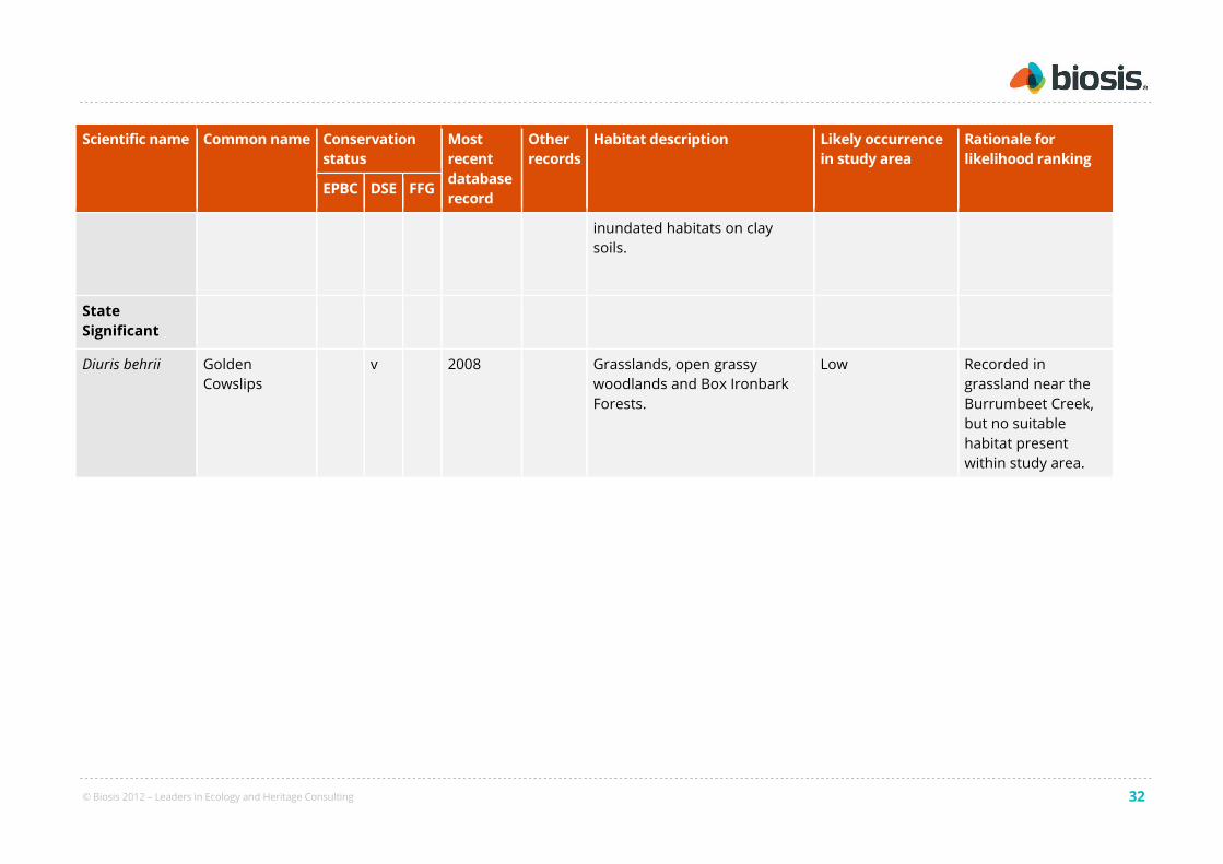
EPBC DSE FFG
inundated habitats on clay
soils.
State
Significant
Diuris behrii Golden
Cowslips
v 2008 Grasslands, open grassy
woodlands and Box Ironbark
Forests.
Low Recorded in
grassland near the
Burrumbeet Creek,
but no suitable
habitat present
within study area.
© Biosis 2013 – Leaders in Ecology and Heritage Consulting 33
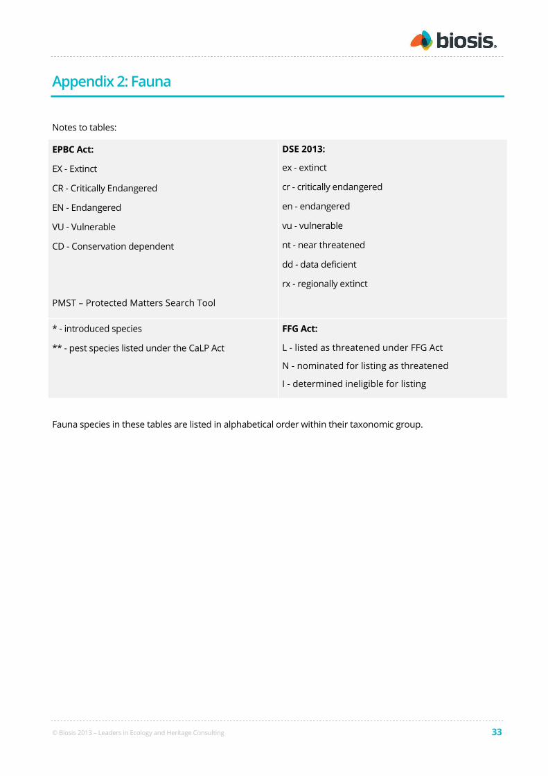
Appendix 2: Fauna
Notes to tables:
EPBC Act:
EX - Extinct
CR - Critically Endangered
EN - Endangered
VU - Vulnerable
CD - Conservation dependent
PMST – Protected Matters Search Tool
DSE 2013:
ex - extinct
cr - critically endangered
en - endangered
vu - vulnerable
nt - near threatened
dd - data deficient
rx - regionally extinct
* - introduced species
** - pest species listed under the CaLP Act
FFG Act:
L - listed as threatened under FFG Act
N - nominated for listing as threatened
I - determined ineligible for listing
Fauna species in these tables are listed in alphabetical order within their taxonomic group.

© Biosis 2013 – Leaders in Ecology and Heritage Consulting 34
A2.1 Fauna species recorded from the study area
Table A2.1. Vertebrate fauna recorded from the study area (present assessment)
Status Scientific name Common name
Birds
Acanthiza chrysorrhoa Yellow-rumped Thornbill
Acanthiza pusilla Brown Thornbill
* Alauda arvensis Eurasian Skylark
Anthus novaeseelandiae Australasian Pipit
* Carduelis chloris Common Greenfinch
Cracticus tibicen Australian Magpie
Cinclorhamphus cruralis Brown Songlark
Corvus coronoides Australian Raven
Malurus cyaneus Superb Fairy-wren
Pardalotus striatus Striated Pardalote
Petrochelidon ariel Fairy Martin
Rhipidura leucophrys Willie Wagtail
* Turdus merula Common Blackbird
© Biosis 2013 – Leaders in Ecology and Heritage Consulting 35
A2.2 Significant fauna species
The following table includes a list of the significant fauna species that have potential to occur within the study area. The list of species is sourced from
the Victorian Biodiversity Atlas and the Protected Matters Search Tool (DSEWPaC; accessed on 09/07/2013).
Table A2.2. Significant fauna species recorded, or predicted to occur, within 5 km of the study area.
Species Conservation
status
Most
recent
database
record
Other
records
Habitat description Likely
occurrence in
study area
Rationale for
likelihood ranking
EPBC DSE FFG
Mammals
Petrogale penicillata
Brush-tailed Rock-
wallaby
VU cr L - PMST Currently known only from the tributaries of the Snowy
River in East Gippsland and the Grampians in the west.
Found in a variety of habitat types, including rainforest
gullies, wet and dry sclerophyll forest, and open
woodlands, preferring rock faces with large tumbled
boulders, ledges and caves and areas that are relatively
open and receiving direct sunlight for much of the day.
Negligible No suitable habitat.
Pteropus
poliocephalus
Grey-headed Flying-
fox
VU vu L - PMST Utilises a wide range of habitats from lowland rainforest
in East Gippsland and coastal Stringybark forests to
agricultural land and suburban gardens, with
permanently established colonies in Melbourne,
Geelong and Mallacoota.
Negligible No suitable habitat.
Birds
Anas rhynchotis
Australasian
Shoveler
vu 2003 Prefers large, permanent lakes and swamps with deep
water, stable conditions and abundant aquatic
vegetation. Less commonly recorded in small or shallow
waters, such as billabongs, sewage ponds, freshwater
rivers and densely vegetated farm dams. Forages in
Low Insufficient aquatic
habitat within study
area.
© Biosis 2013 – Leaders in Ecology and Heritage Consulting 36
Species Conservation
status
Most
recent
database
record
Other
records
Habitat description Likely
occurrence in
study area
Rationale for
likelihood ranking
EPBC DSE FFG
open water but nests in densely vegetated freshwater
wetlands, where fringing vegetation may be an
important habitat feature.
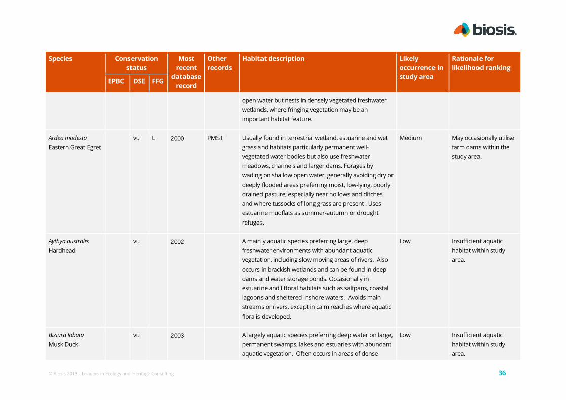
Ardea modesta
Eastern Great Egret
vu L 2000 PMST Usually found in terrestrial wetland, estuarine and wet
grassland habitats particularly permanent well-
vegetated water bodies but also use freshwater
meadows, channels and larger dams. Forages by
wading on shallow open water, generally avoiding dry or
deeply flooded areas preferring moist, low-lying, poorly
drained pasture, especially near hollows and ditches
and where tussocks of long grass are present . Uses
estuarine mudflats as summer-autumn or drought
refuges.
Medium May occasionally utilise
farm dams within the
study area.
Aythya australis
Hardhead
vu 2002 A mainly aquatic species preferring large, deep
freshwater environments with abundant aquatic
vegetation, including slow moving areas of rivers. Also
occurs in brackish wetlands and can be found in deep
dams and water storage ponds. Occasionally in
estuarine and littoral habitats such as saltpans, coastal
lagoons and sheltered inshore waters. Avoids main
streams or rivers, except in calm reaches where aquatic
flora is developed.
Low Insufficient aquatic
habitat within study
area.
Biziura lobata
Musk Duck
vu 2003 A largely aquatic species preferring deep water on large,
permanent swamps, lakes and estuaries with abundant
aquatic vegetation. Often occurs in areas of dense
Low Insufficient aquatic
habitat within study
area.

© Biosis 2013 – Leaders in Ecology and Heritage Consulting 37
Species Conservation
status
Most
recent
database
record
Other
records
Habitat description Likely
occurrence in
study area
Rationale for
likelihood ranking
EPBC DSE FFG
vegetated cover within a wetland. Less commonly
recorded in small or shallow waters, such as billabongs,
sewage ponds, freshwater rivers and densely vegetated
farm dams.
Botaurus
poiciloptilus
Australasian Bittern
EN en L - PMST Occurs in wetlands with tall, dense vegetation where it
forages in shallow water at the edges of pools or
waterways. Prefers permanent freshwater habitats,
particularly when dominated by sedges, rushes and
reeds.
Negligible No suitable habitat.
Chlidonias hybrid
Whiskered Tern
nt 2010 A breeding migrant to Australia from September to
March where it occurs in wetlands, lakes, swamps,
rivers, and other water bodies with submerged and
emergent vegetation such as grasses, sedges, reeds and
rushes. Rarely recorded along rivers or creeks.
Low Insufficient aquatic
habitat within study
area.
Gallinago hardwickii
Latham's Snipe
nt 2003 PMST A migrant to Australia from July to April occurring in a
wide variety of permanent and ephemeral wetlands.
Prefers open freshwater wetlands with nearby cover,
but also recorded on the edges of creeks and rivers,
river-pools and floodplains. Forages in soft mud at edge
of wetlands and roosts in a variety of vegetation around
wetlands including tussock grasslands, reeds and
rushes, tea-tree scrub, woodlands and forests.
Medium May occasionally utilise
damp areas associated
with dams.
Haliaeetus
leucogaster
vu L - PMST Occurs in marine habitats and terrestrial wetlands along
or near coastal areas in eastern Victoria, particularly
Low Insufficient aquatic
habitat within study

© Biosis 2013 – Leaders in Ecology and Heritage Consulting 38
Species Conservation
status
Most
recent
database
record
Other
records
Habitat description Likely
occurrence in
study area
Rationale for
likelihood ranking
EPBC DSE FFG
White-bellied Sea-
Eagle
around large open wetlands such as deep freshwater
swamps, lakes, reservoirs and billabongs. Uses tall trees
in or near water for breeding.
area.
Hirundapus
caudacutus
White-throated
Needletail
vu - PMST An almost exclusively aerial species within Australia,
occurring over most types of habitat, particularly
wooded areas. Less often seen over open farm
paddocks but has been recorded in vineyards flying
between the rows of trees.
Low Potential occasional
visitor.
Lathamus discolour
Swift Parrot
EN en L - PMST Migrates to south-east mainland Australia during the
winter months where it prefers dry, open eucalypt
forests and woodlands, especially Box Ironbark Forest in
north-central Victoria. Has also been recorded in urban
parks, gardens, street trees and golf courses with
flowering ornamental trees and shrubs.
Negligible No suitable habitat.
Leipoa ocellata
Malleefowl
VU en L - PMST Malleefowl occur mainly in semi-arid mallee habitats; in
Victoria this type of habitat is largely restricted to the
north-west area of the State. Malleefowl are sedentary
birds that establish home ranges within which they
forage on the ground in leaf litter and low vegetation
and nest in distinctive mounds constructed with light
soil and leaf litter.
Negligible No suitable habitat.
Oxyura australis
Blue-billed Duck
en L 2002 A largely aquatic species preferring deep, large
permanent wetlands with stable conditions and
abundant aquatic vegetation, including Melaleuca
Low Insufficient aquatic
habitat within study
area.

© Biosis 2013 – Leaders in Ecology and Heritage Consulting 39
Species Conservation
status
Most
recent
database
record
Other
records
Habitat description Likely
occurrence in
study area
Rationale for
likelihood ranking
EPBC DSE FFG
swamps. Occurs less commonly on river frontages,
billabongs and flooded depressions. It is a secretive
bird, rarely venturing far from dense vegetative cover in
wetland areas.
Rostratula australis
Australian Painted
Snipe
EN cr L - PMST Generally found in shallow, terrestrial freshwater
wetlands with rank, emergent tussocks of grass, sedges
and rushes. Australian Painted Snipe can occur in well
vegetated lakes, swamps, inundated pasture, saltmarsh
and dams.
Low Insufficient aquatic
habitat within study
area.
Reptiles
Delma impar
Striped Legless
Lizard
VU en L - PMST Inhabits native and modified grasslands, where
sufficient cover is available to provide protection from
predators. Often associated with soils of cracking clays
with embedded and surface rocks. Occasionally
recorded from grassy woodlands.
Low No suitable habitat
present.
Frogs
Litoria raniformis
Growling Grass
Frog
VU en L - PMST Occupies a variety of permanent and semi-permanent
water bodies generally containing abundant submerged
and emergent vegetation, within lowland grasslands,
woodlands and open forests.
Low The two dams on site
do not have sufficient
cover of aquatic
vegetation for breeding
habitat. Potential
habitat during
migration.
Fishes

© Biosis 2013 – Leaders in Ecology and Heritage Consulting 40
Species Conservation
status
Most
recent
database
record
Other
records
Habitat description Likely
occurrence in
study area
Rationale for
likelihood ranking
EPBC DSE FFG
Galaxiella pusilla
Dwarf Galaxias
VU en L - PMST Occurs in relatively shallow still or slow flowing water
bodies including streams, wetlands, drains, that in many
instances are ephemeral and partially dry up over
summer. Typically requires abundant marginal and
aquatic vegetation.
Low Insufficient aquatic
habitat within study
area.
Maccullochella peelii
peelii
Murray Cod
VU vu L - PMST Found within the Murray River catchment usually in
sluggish turbid rivers, in deep holes or amongst fallen
timber and other debris. Also occurs in upper reaches
of rivers where water is clear and there is little fallen
timber.
Negligible Insufficient aquatic
habitat within study
area.
Macquaria
australasica
Macquarie Perch
EN en L - PMST A riverine fish preferring deep holes, its natural
distribution extends north of the Great Dividing Range
in tributaries of the Murray River. Early this century it
was introduced to many waters south of the Great
Dividing Range but has only been recorded in the Yarra
with any regularity since.
Negligible Insufficient aquatic
habitat within study
area.
Prototroctes
maraena
Australian Grayling
VU vu L - PMST A diadromous species which spends most of its life in
freshwater within rivers and large creeks. Juveniles
inhabit estuaries and coastal seas. Adults occur in
freshwater habitats, typically rivers and streams with
cool, clear waters and gravel substrates, but
occasionally also in turbid waters.
Negligible Insufficient aquatic
habitat within study
area.

© Biosis 2013 – Leaders in Ecology and Heritage Consulting 41
Species Conservation
status
Most
recent
database
record
Other
records
Habitat description Likely
occurrence in
study area
Rationale for
likelihood ranking
EPBC DSE FFG
Invertebrates
Synemon plana
Golden Sun Moth
CR cr L - PMST This medium-sized diurnal moth inhabits grassy
woodlands and grasslands. Once thought to be a
specialised species inhabiting grasslands dominated by
Wallaby-grasses, it is now recognised that this species
can occur in exotic grasslands dominated by Chilean
Needle Grass Nassella neesiana.
Low Insufficient cover of
host plants.
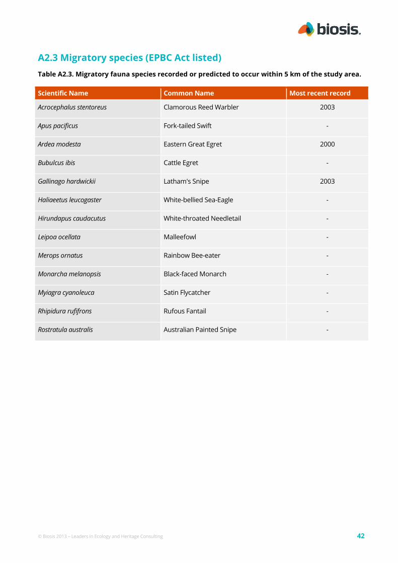
© Biosis 2013 – Leaders in Ecology and Heritage Consulting 42
A2.3 Migratory species (EPBC Act listed)
Table A2.3. Migratory fauna species recorded or predicted to occur within 5 km of the study area.
Scientific Name Common Name Most recent record
Acrocephalus stentoreus Clamorous Reed Warbler 2003
Apus pacificus Fork-tailed Swift -
Ardea modesta Eastern Great Egret 2000
Bubulcus ibis Cattle Egret -
Gallinago hardwickii Latham's Snipe 2003
Haliaeetus leucogaster White-bellied Sea-Eagle -
Hirundapus caudacutus White-throated Needletail -
Leipoa ocellata Malleefowl -
Merops ornatus Rainbow Bee-eater -
Monarcha melanopsis Black-faced Monarch -
Myiagra cyanoleuca Satin Flycatcher -
Rhipidura rufifrons Rufous Fantail -
Rostratula australis Australian Painted Snipe -
© Biosis 2013 – Leaders in Ecology and Heritage Consulting 43
A5.1 Net Gain Glossary
Items marked with an asterisk (*) are cited from DSE (2007b).
Benchmark*
A standard vegetation –quality reference point,
dependent on vegetation type, which is applied
in habitat hectare assessments. Represents the
average characteristics of a mature and
apparently long undisturbed state of the same
vegetation type.
Biodiversity*
The variety of all life-forms, the different plants,
animals and micro-organisms, the genes they
contain, and the ecosystems of which they form
a part. The Framework applies this definition to
those native species indigenous to or expected
to visit the site.
Biodiversity Interactive Map (BIM)
Web based interactive map available on the DSE
website that provides information on the
biodiversity of Victoria and displays flora and
fauna data from the Victorian Biodiversity Atlas.
Bioregion*
Biogeographic areas that capture the patterns of
ecological characteristics in the landscape or
seascape, providing a natural framework for
recognising and responding to biodiversity
values. A landscape based approach to
classifying the land surface using a range of
environmental attributes such as climate,
geomorphology, lithology and vegetation.
Bioregional conservation status (of an EVC)*
A state-wide classification of the degree of
depletion in the extent and/or quality of an
Ecological Conservation Class (EVC) within a
bioregion in comparison to the State’s
estimation of its pre-1750 extent and condition.
The assessment takes account of how
commonly it originally occurred, the current
level of depletion due to clearing, and the level
of degradation of condition typical of remaining
stands. There are 6 classes: Presumed Extinct,
Endangered, Vulnerable, Depleted, Rare and
Least Concern as described on page 51 of the
Framework (NRE 2002).
Conservation status (see Bioregional
conservation status)
Degraded treeless vegetation*
Vegetation that is neither a wetland, a remnant
patch nor scattered tree(s).
DBH (Diameter at Breast Height)*
The diameter of the main trunk of a tree
measured 1.3 m above ground level.
Ecological Vegetation Class (EVC) *
A type of native vegetation classification that is
described through a combination of its floristic,
life form and ecological characteristics, and
though an inferred fidelity to particular
environmental attributes. Each EVC includes a
collection of floristic communities (i.e. lower
level in the classification that is based solely on
groups of the same species) that occur across a
biogeographic range, and although differing in
species, have similar habitat and ecological
processes operating.
EVC (see Ecological vegetation class) *
Forb
A herbaceous flowering plant that is not a
graminoid (grass, sedge or rush).
Gain*
An increase in the extent and/or quality of a site
either by management or maintenance
commitments and actions.
Gain Target*
The amount of gain that needs to be achieved to
offset a loss measured in habitat hectares.
Habitat hectare*
A site based measure of quality and quantity of
native vegetation that is assessed in the context
of the relevant native vegetation.
Habitat score*
The score assigned to a habitat zone that
indicates the quality of the vegetation relative to

© Biosis 2013 – Leaders in Ecology and Heritage Consulting 44
the ecological vegetation class benchmark – sum
of the site condition score and landscape
context score, usually expressed as a
percentage or on a scale of 0 to 1.
Habitat zone*
A discrete area of native vegetation consisting of
a single vegetation type (EVC) within an assumed
similar quality. This is the base spatial unit for
conducting a habitat hectare assessment.
Separate Vegetation Quality Assessments (or
habitat hectare assessments) are conducted for
each habitat zone within the designated
assessment area.
Improvement gain*
This is gain resulting from management
commitments beyond existing obligations under
legislation to improve the current vegetation
quality. Achieving improvement gain is
predicated on maintenance commitments being
already in place. For example, control of any
threats such as grazing that could otherwise
damage the native vegetation must already be
agreed. Typical actions leading to an
improvement gain include reducing or
eliminating environmental weeds, enhancement
planting or revegetation over a 10-year
management period. If the vegetation is to be
used as an offset, a commitment to maintain the
improvement gain (i.e. no subsequent decline in
quality) will be required in perpetuity.
Indigenous vegetation*
The type of native vegetation that would have
normally been expected to occur on the site
prior to European settlement.
Large Old Tree (LOT)*
A tree with a DBH equal to or greater than the
large tree diameter as specified in the relevant
EVC benchmark.
Like-for-like*
These are part of the criteria for determination
of an offset and provide a direct link between
the loss and the offset gain, in terms of
vegetation type or landscape function. There
are more specific requirements for higher
conservation significance vegetation and more
flexible requirements for lower significance.
Maintenance Gain*
This is gain from commitments that contribute
to the maintenance of the current vegetation
quality over time (i.e. avoiding any decline).
Includes foregoing certain entitled activities that
could otherwise damage or remove native
vegetation, such as grazing or firewood
collection. Also typically requires a commitment
to ensure no further spread of environmental
weeds that may otherwise result in the loss of
vegetation quality over time. If the vegetation is
to be used as an offset, a commitment to
maintain the vegetation quality will be required
in perpetuity.
Medium Old Tree (MOT)*
A tree with a DBH equal to or greater than 0.75
of the large tree diameter in the relevant EVC
benchmark but less than the DBH for a large old
tree.
Native (indigenous) vegetation*
Native vegetation is plants that are indigenous
to Victoria, including trees, shrubs, herbs and
grasses (as defined in Clause 72 of the planning
scheme).
Net Gain*
Where, over a specified area and period of time,
losses of native vegetation and habitat, as
measured by a combined quality-quantity
measure (habitat-hectare), are reduced,
minimised and more than balanced by
commensurate gains.
Net outcome*
The result of applying conservation significance
criteria to protection, investment and offset
decisions. This results in a range of outcomes
from short term losses for Low conservation
significance to substantial net gain for Very High
conservation significance. For offsets, the
Framework (Table 6) specifies a multiplier on the
calculated loss (in habitat hectares) to achieve
the net outcome. This is graded according to
conservation significance.
Offset Management Plan (OMP)
A document which sets out the requirements for
establishment, protection and management of a
Net Gain offset site.
© Biosis 2013 – Leaders in Ecology and Heritage Consulting 45
Old tree*
A tree with a DBH equal to or greater than 0.75
of the large tree diameter as specified in the
relevant EVC benchmark. Includes medium old
trees and large old trees (see separate
definitions). Some Regional Native Vegetation
Plans additionally define very large old trees (1.5
times large tree diameter).
Offset*
A native vegetation offset is any works, or other
actions to make reparation for the loss of native
vegetation arising from the removal or
destruction of native vegetation. The gains
achieved must be permanent and ongoing, and
linked to a specific clearing site. See also on-site
offset and third-party offset.
On-site offset*
An offset located on the same property as the
clearing.
Third-party offset*
An offset located on a property owned by a
person other than the landowner who incurs the
native vegetation loss being offset.
Patch (see Remnant Patch)
Prior management gain
This gain acknowledges actions to manage
vegetation since State-wide planning permit
controls for native vegetation removal were
introduced in 1989.
Property Vegetation Plan*
A plan which relates to the management of
native vegetation within a property, and which is
contained within an agreement made pursuant
to section 69 of the Conservation, Forests and
Lands Act 1987.
Protection (of a tree) *
An area with twice the canopy diameter of the
tree(s) fenced and protected from adverse
impacts: grazing, burning and soil disturbance
not permitted, fallen timber retained, weeds
controlled, and other intervention and/or
management if necessary to ensure adequate
natural regeneration or planting can occur.
Recruitment*
The production of new generations of plants,
either by allowing natural ecological processes
to occur (regeneration etc), by facilitating such
processes such as regeneration to occur, or by
actively revegetating (replanting, reseeding). See
Revegetation.
Remnant patch or patch*
An area of vegetation, with or without trees,
where native plants constitute more than 25% of
the total understorey plant cover (bare ground is
not included); or an area of treed vegetation
where the density of the trees is such that
canopy tree cover is at least at benchmark
canopy cover.
Remnant vegetation*
Native vegetation that is established or has
regenerated on a largely natural landform. The
species present are those normally expected in
that vegetation community. Largely natural
landforms may have been subject to some past
surface disturbance such as some clearing or
cultivation (or even the activities of the
nineteenth century gold rushes) but do not
include man-made structures such as dam walls
and quarry floors.
Revegetation*
Establishment of native vegetation to a
minimum standard in formerly cleared areas,
outside of a remnant patch.
Scattered trees
Canopy trees within an area where total
understorey plant cover comprises more than
75% of weeds or non-native plants and the
overall canopy cover for a group (i.e. Three or
more trees) is less than 20%.
Section 173 agreements*
A management agreement primarily between a
landowner and the responsible authority
according to section 173 of the Planning and
Environment Act 1987.

© Biosis 2013 – Leaders in Ecology and Heritage Consulting 46
Security Gain
This is gain from actions to enhance security of
the on-going management and protection of
native vegetation at the offset site, either by
entering into an on-title agreement (for example
under Section 173 of the Planning and
Environment Act 1987), or by locating the offset
on land that has greater security than the
clearing site, or by transferring private land to a
secure public conservation reserve.
Small tree*
A tree with a DBH equal to or greater than 0.25
of the large tree diameter in the relevant EVC
benchmark but less than the DBH for a medium
old tree.
sp.
Species (one species).
spp.
Species (more than one species).
Supplementary planting
Establishment of overstorey and/or understorey
plants within a remnant patch. Typically
includes the planting or direct-seeding of
understorey life forms.
Taxon (plural taxa)
A term used to describe any taxonomic unit.
This term is typically used when referring
broadly to any scientifically recognised species,
subspecies or variety.
Understorey
Understorey is all vegetation other than mature
canopy trees – includes immature trees, shrubs,
grasses, herbs, mosses, lichens and soil crust. It
does not include dead plant material that is not
attached to a living plant. More information on
understorey life forms is set out in the
Vegetation Quality Assessment Manual (DSE
2004).
Vegetation Quality Assessment
The standard DSE method for assessing
remnant patches of vegetation. Details of the
method are outlined in the Vegetation Quality
Assessment Method (DSE 2004). The results of
the assessment are expressed in habitat
hectares. Also referred to as a ‘habitat hectare
assessment’.
Very Large Old Tree (VLOT)
A tree with a DBH of at least 1.5 times that of the
large tree DBH as specified in the relevant EVC
benchmark
Related Documents